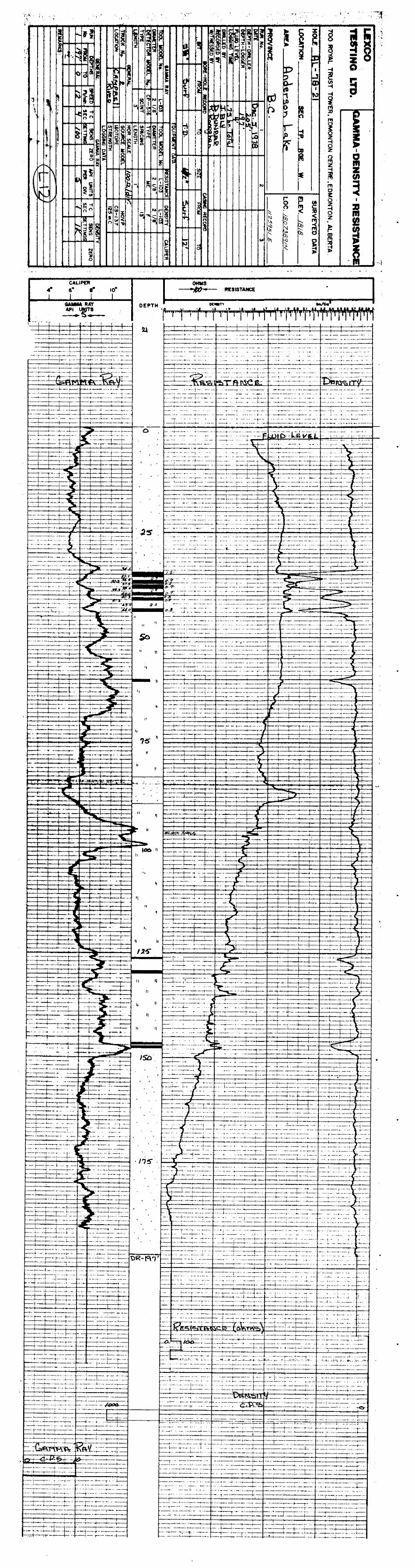
~eqlogicalbranch assessmfr~tp~~~~rt · t -2- l topography & drainage all of the exploration was...
TRANSCRIPT
GEOLOGY & RESERVES
ANDERSON LAKE AREA
-COURTENAY,BaC, _
SUBMITTED BY: MICHELE Pm CURCIO
DATE : MAY, 197g*
~EQLOGICALBRANCH ASSESSMFR~TP~~~~RT
W
SECTION A
SECTION B
SECTION C
SECTION D
SECTION E
SECTION F
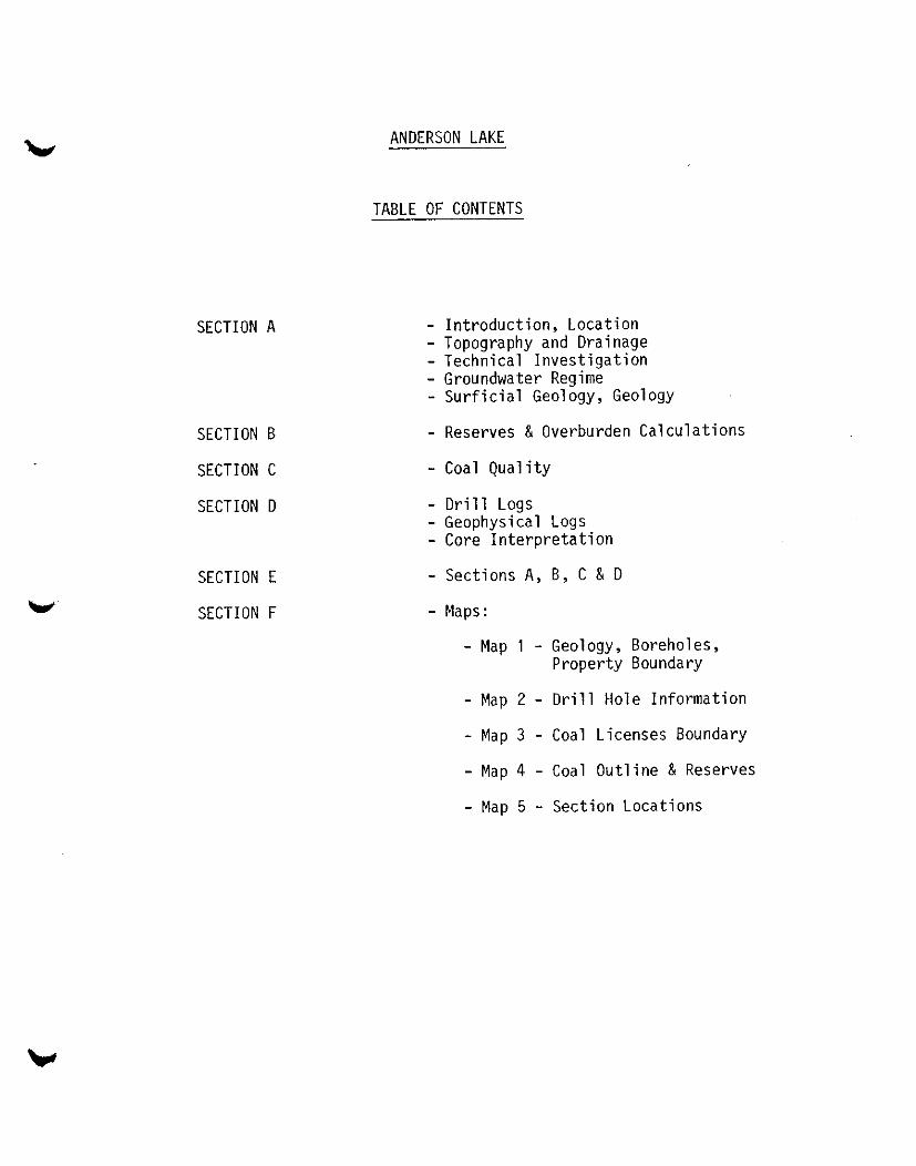
ANDERSON LAKE
TABLE OF CONTENTS
- Introduction, Location - Topography and Drainage - Technical Investigation - Groundwater Regime - Surficial Geology, Geology
- Reserves & Overburden Calculations
- Coal Quality
- Drill Logs - Geophysical Logs - Core Interpretation
- Sections A, B, C & D
- Maps:
- Map 1 - Geology, Boreholes, Property Boundary
- Map 2 - Drill Hole Information
- Map 3 - Coal Licenses Boundary
- Map 4 - Coal Outline & Reserves
- Map 5 - Section Locations
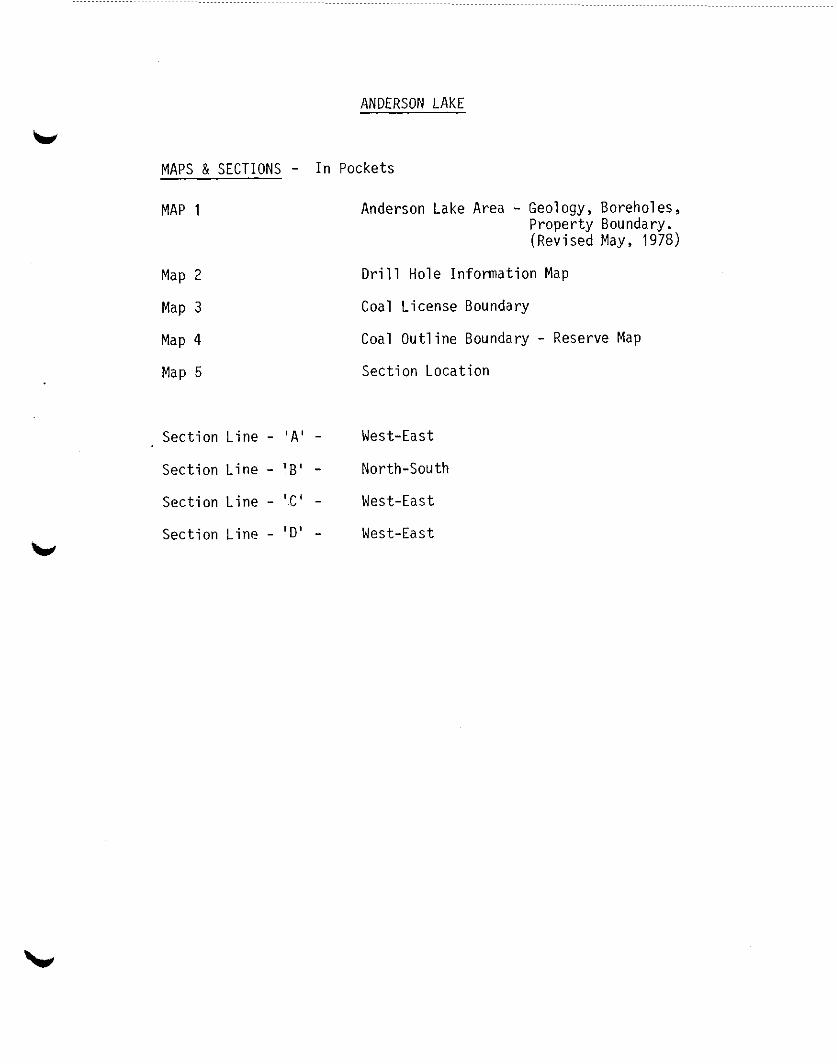
ANDERSON LAKE
MAPS & SECTIONS - In Pockets
MAP 1 Anderson Lake Area - Geology, Boreholes, Property Boundary. (Revised May, 1978)
Map 2 Drill Hole Information Map
Map 3 Coal License Boundary
Map 4 Coal Outline Boundary - Reserve Map
Map 5 Section Location
Section Line - 'A' - West-East
Section Line - !B' - North-South
Section Line - ',C' - West-East
Section Line - 'D' - West-East
ANDERSON LAKE
INTRODUCTION - LOCATION
TOPOGRAPHY - DRAINAGE
TECHNICAL INVESTIGATIONS
GROUNDWATER
SURFICIAL GEOLOGY
GEOLOGY
v
V
-l-
ANDERSON LAKE
INTRODUCTION -
In 1978 exploration work was carried out on Coal Licenses 3687
to 3694 inclusive. This program was contiguous to the work
conducted in 1975, and contained in the report entitled "Coal
Resource Study of Comox Basin - Nanaimo Series, Vancouver
Island", (Curcio).
Twenty drill holes and two coal cores were constructed over the
area, and in conjunction with the previous work of 1975, it was
possible to determine the coal boundaries within the area, and
obtain further analysis of coal quality.
Two mineable zones were outlined, ("A" Zone and "B" Zone) both
containing an average clean coal thickness of 2.96 feet and an
average overburden ratio of 9.92:1. The two zones are situated
between Dove Creek on the north and Brown's River to the south.
LOCATION
Exploration was conducted on Block 695 in the Comox Land
District, southwest of Wolf Lake and Constitution Hill. Access
to the site is via the Crown Zellerbach logging roads.
V
t
-2-
L
TOPOGRAPHY & DRAINAGE
All of the exploration was conducted on the Comox sediments within
the elevation of 1300 feet to 1800 feet A.S.L.
The topography rises gently from the east end of the License
boundaries to the western limits of Licenses 3692 and 3693.
Drainage is rapid to the southeast.
TECHNICAL INVESTIGATION
All aspects of the exploration program including drilling, coring
survey and laboratory services were under contract to Lexco Testing
Ltd., a subsidiary of Luscar Ltd. of Edmonton, Alberta.
Drilling equipment consisted of two rotary drills, using downhole
hammers for subsurface penetration, and in the case of coring, em-
ployed a Christiensen core barrel.
GROUNDWATER REGIME
No groundwater was encountered in any of the drill holes, within
the coal Blocks "A" & "6". Insignificant traces of groundwater
(less than l/4 1.q.p.m.) was observed in Hole 78-12 and 78-23.
SURFICIAL GEOLOGY -
Erosion on both the north and south of the coal boundary (Map 4)
has eliminated all till on the upper plateaus. The only till,
coarse to medium sand and gravel occurring in any appreciable thick-
ness was observed in holes in 78-12 in the valley south of the coal
Block "B" and in the Glacio-fluvial erosion of holes 78-22 and
78-23 in License 3689.

-4-
GEOLOGY, cont'd.
Erosion of the uplifted Comox Sediments in Mining Blocks "A" & "6"
has removed all but two and in some cases three of the coal seams
in the beds.
In the Anderson Lake area, the Comox formation lies unconformably
above the Triassie-Karmutsen formation, and the coal seams appear in
an alternating succession of shales and standstones.
w
W

-3-
GEOLOGY
Coal of economic importance occur in the Comox Group of the
Nanaimo Series, near Anderson Lake. The Comox Group occurs
in the Late Cretaceous of the Nanaimo Series as described in
the "Coal Resource Study - 1975" (Curcio) and lies unconform-
ibly on the Karmutsen Basalt Lavas. The Comox block explored,
lies between two Tertiary Intrusives, to the north and south-
east and bounded on the west by the Karmutsen Basalt
The area is heavily faulted. The normal thickness of the
sediments in the Anderson Lake area west of Block 695 is in
the range of 600 feet.
On Block 695, the average thickness of sediments is in the
range of 300 feet. This would suggest that following
deposition the Tertiary Intrusives, uplifted the Comox and
the lateral stress against the westerly Vancouver Group bound-
ary, created a series of lateral and radial faults within the
confined boundaries of the Tertiary Intrusives, resulting in
the uplifting of the Comox Group. Subsequent erosion elimin-
ated part of the Comox Group including some of the upper coal
beds.
Within the valley deltas of both the Dove and Brown's Rivers,
all the Comox was eroded and during the Recent Pleistocene
Era, was filled with coarse gravel and sands with the matrix
consisting of basalt and granite boulders.
Seam splitting is evident in the formation as a result of
the faulting.

RESERVE AND OVERBURDEN CALCULATIONS

ANDERSON LAKE
RESERVE COMPUTATION __-. - ..__ ~__,~ _.._ -. BASIS OF CALCULATION:
1. Area calculated by Planimeter -
1.494 = 1 sq. mile = 27,878,400 ,I 1.494 = 18,660,240 sq.ft. (Ix)
2. Only coal seams greater than 1 foot in thickness calculated.
3. Only coal seams and overburden to 200 foot depth used in calculation.
AREA "A"
Average Seam Thickness - Clean Coal = 3.03 feet
Average Overburden Thickness = 39.0 feet
Area - (lx) 18,660,240 x 1.112 (Planimeter) = 20.75 million sq.ft.
Seam Volume
20.75 million square feet x 3.03 feet I 27 cubic feet
= 2.33 million cubic yards x 1.2 tons per cubic yards = 2.80 million tons
Overburden Volume
20.75 million square feet x 39.0 feet I 27 cubic feet
= 29.97 million cubic yards
AREA "B"
Average Seam Thickness - Clean Coal = 2.88 feet
Average.Overburden Thickness = 29.69 feet
Area - (lx) 18,660,240 x 0.666 (Planimeter) = 12.428 million square feet
Seam Volume
12.428 million square feet x 2.88 feet I 27 cubic feet
= 1.33 million cubic yards x 1.2 tons per cubic yard = 1.64 million tons
Overburden Volume ___-
,12.428 million square feet x 29.69 feet I 27 cubic feet
= 13.67 million cubic yards
RATIO:
AREA "A" - 2.80 million tons coal - 29.97 cubic yards Overburden - 10.7O:l f- w
AREA "B" 1' 1.60 million tons coal - 13.67 cubic yards Overburden - 8.54:l
TOTAL 4.40 million tons coal - 43.64 cubic yards Overburden - 9.92:1 ==t=ZZZ --
MPC:aey 215179
.
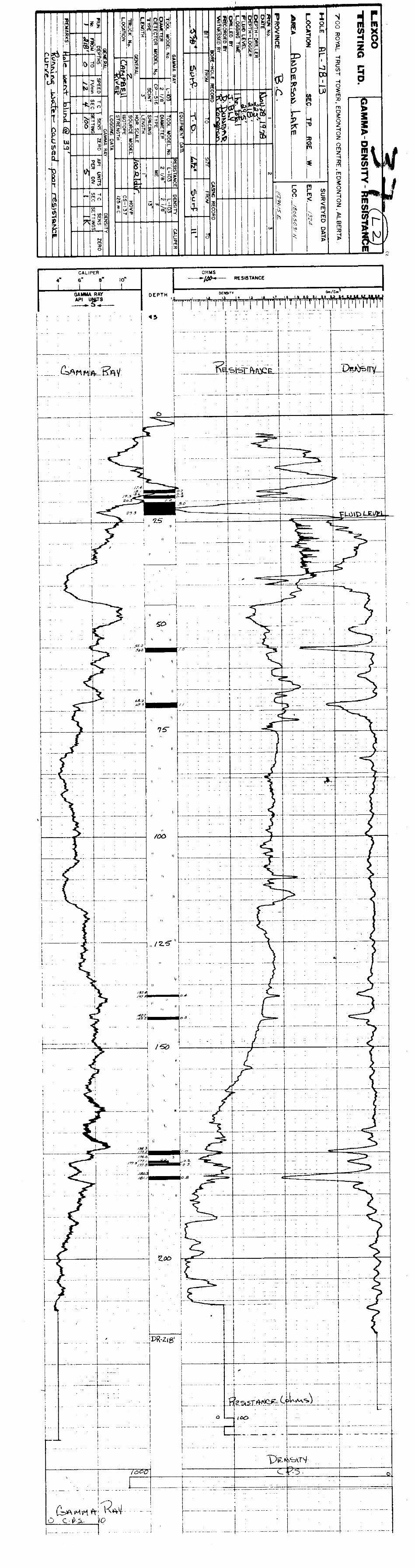
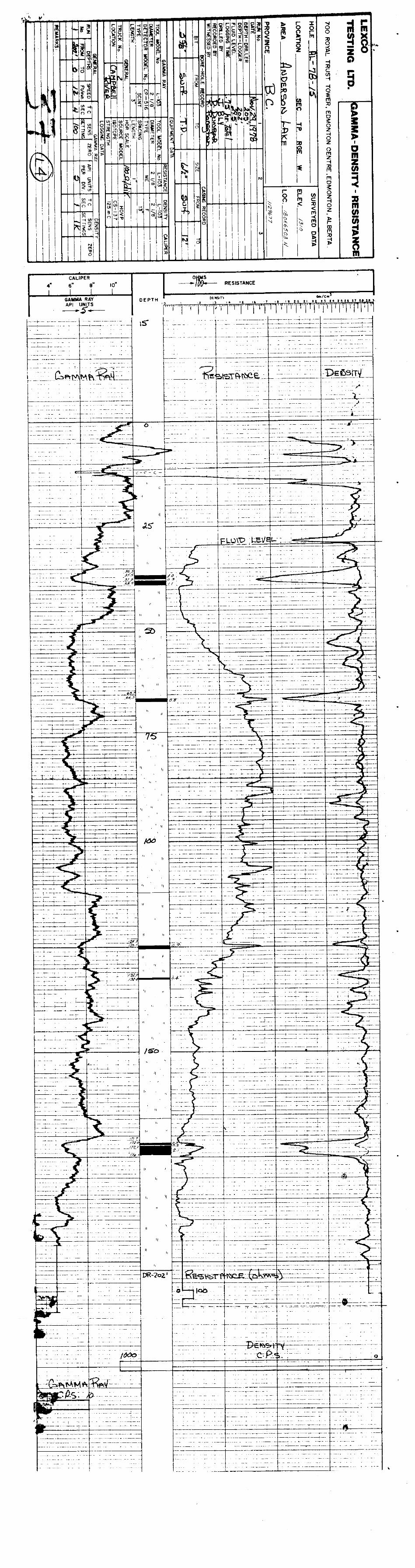
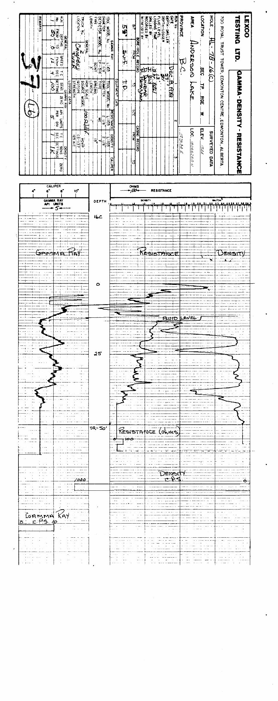
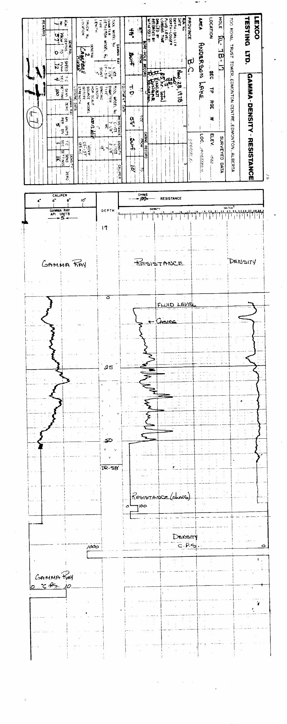
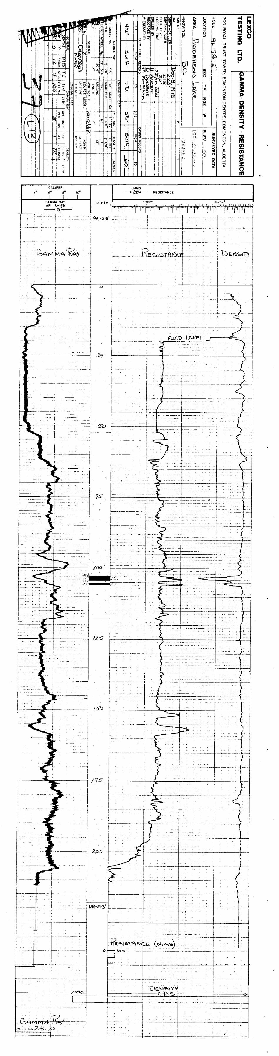
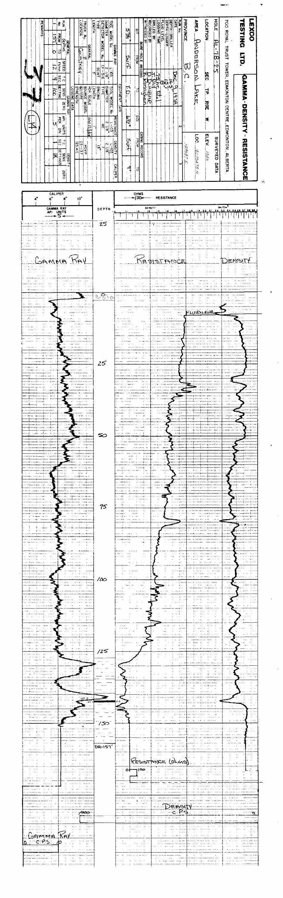
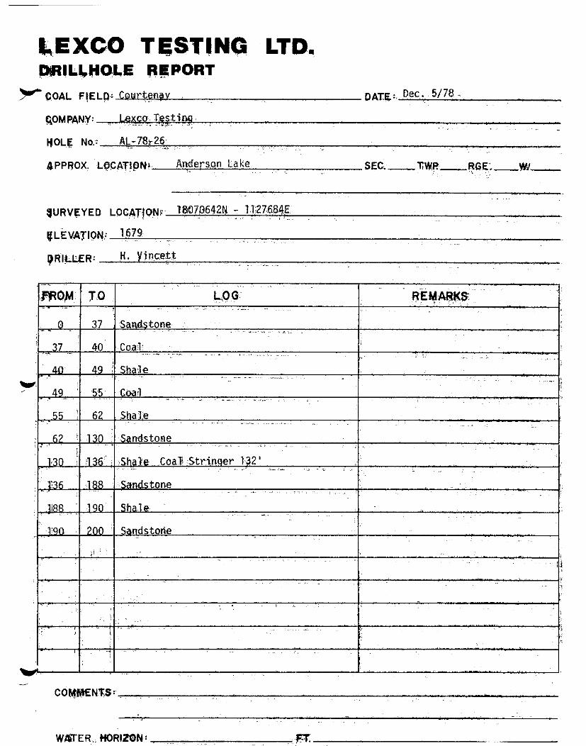
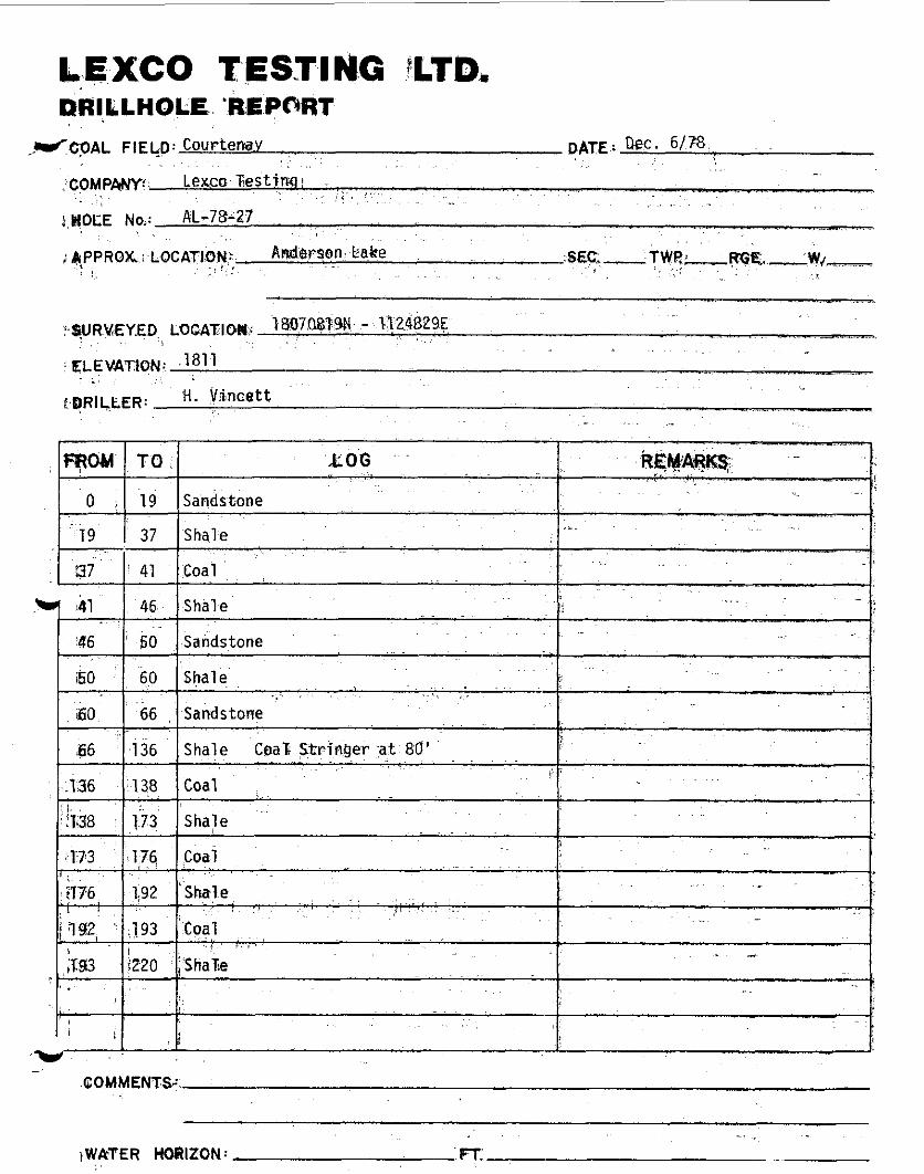
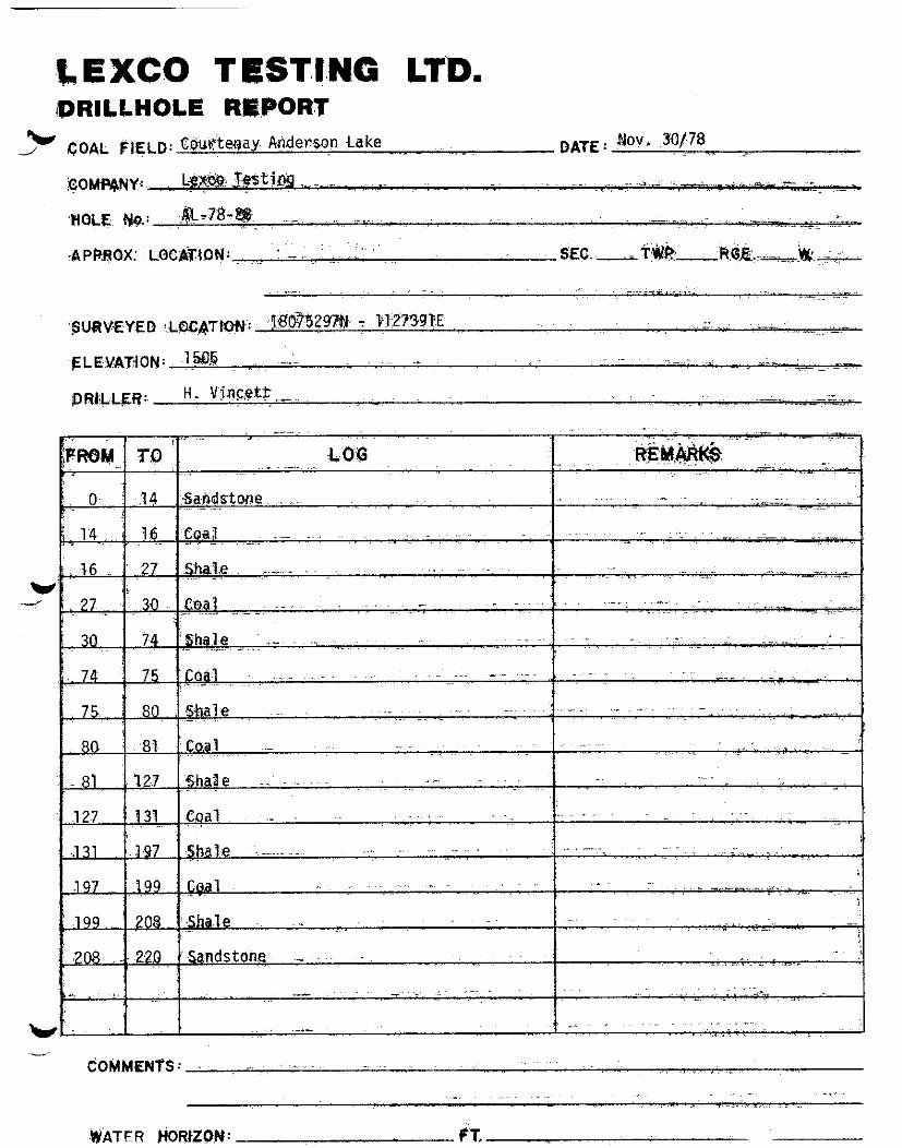
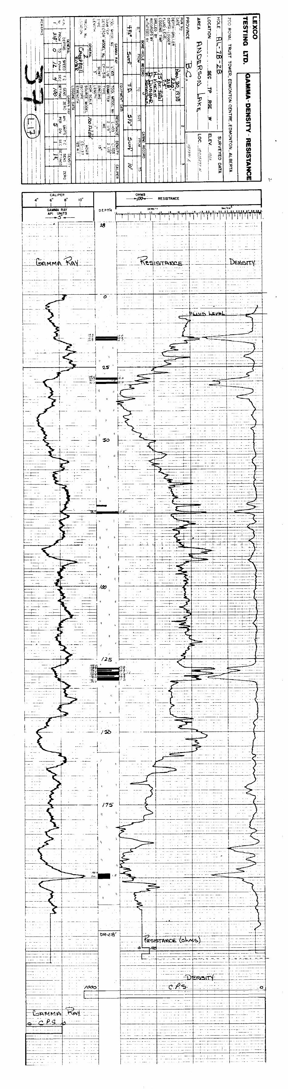
DRILL LOGS
GEOPHYSICAL LOGS
CORE INTERPRETATION
D
GEOLOGICAL BRANCW ASSESSMENT REPOPT

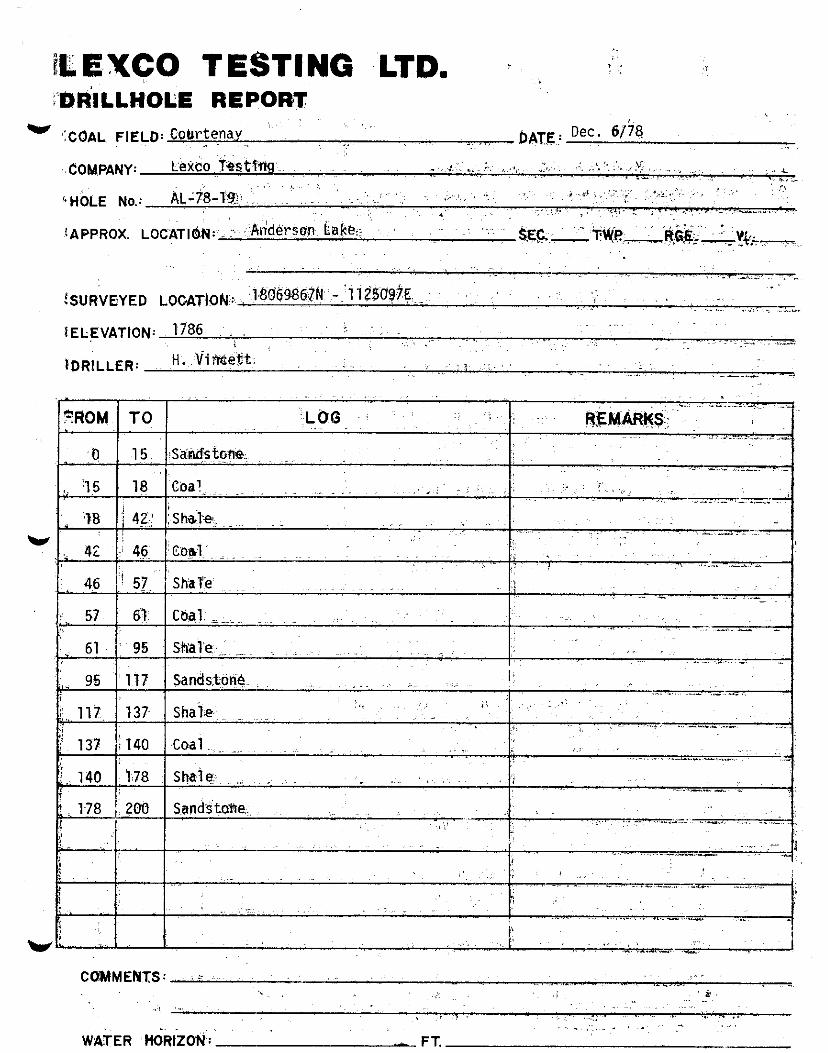
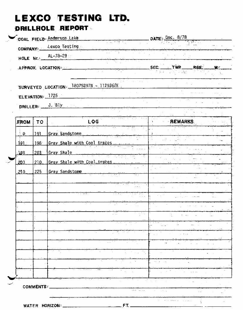
LEXCO: TESTING LTD. DRILLHOLE REPORT
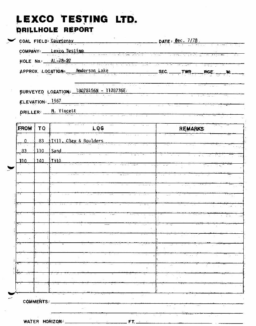
” COAL FIELD: Courter DATE: Nov. 29/78
COMPANY: Lexco Testinq
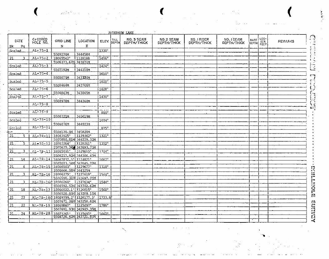
HOLE No.: AL-78-11
APPROX. LOCATION:- Anderson Lake
-
SURVEYED LOCAT,ON:~063925N - 1,129362E
ELEVATION: 132'1
DRILLER: H. Vincett
SEC. -TW!?m RGE.-W.-
0 14
14 38
'v J 38 40
40 64
LOG REMARKS
Sandstone
Shale
Coal
Sandstone
Gray Shale
Sandstone
Coal Shale Partings
Shale
Sandstone
COMMENTS:
WATER HORIZON:- FT.

.~ :.: : ‘.


GQMMENTS: ,~
. .- ., ,.
. WATER HORIZON: - ,CFT. ~.
LEXCO TESTING ,LfD. DRILLHOLE .REPC)RT
w ,. ~i~OA~'F~E~~: Andetqon-Lake
<COMPANY: Lexco,Testing
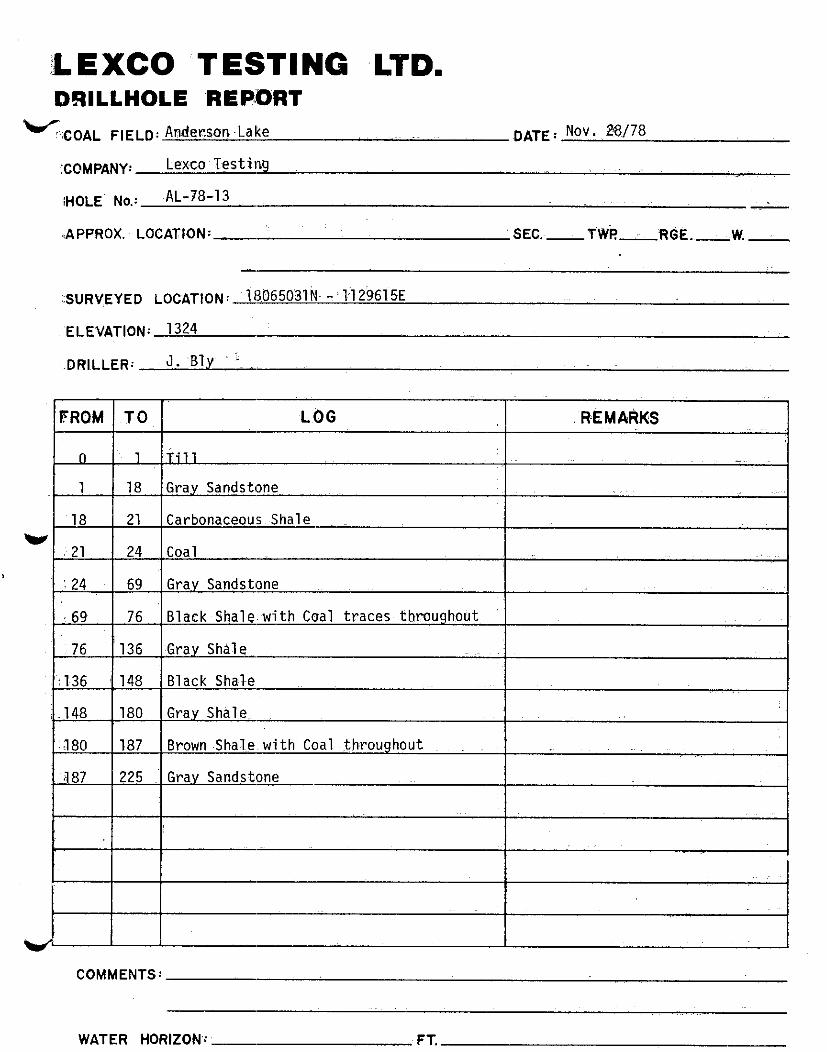
'{HOLE No.: AL-78-13
.IAPPROX. LOCATION:
::s”R!(EYEo LO~A~[~N: ~m65osk - ti h615E
'ELE'VATION: 1324
.DRILLER: J. 3ly~ i. _,
TO LOG R-EM nwcs
1 Till -.
18 Grar Sandstone
21 Carbonaceous Shale-
24 Coal
69 Grav Sandstone
76 Black Shalewith Coal traces throughout
136 Grav Shale
148 Black Shale
180 Gray Shtil~e.
la7 Brown.ShaT~e,with Coalthroughout _ ..~
225 Grav Sandstone
COMMENTS:
WATER HORIZONS:'- FT.


CO’fr(MENTS:
WATER ‘%ORIZON: __ FT.-
,;QRlLLHOLE “a,EPORT W, .$OAL :FkELD:d$gkpnbke.
‘COMPANY: Lwtdns; ~. .,~ .,,.
,
WATER ~+iORkOtd - F-r.
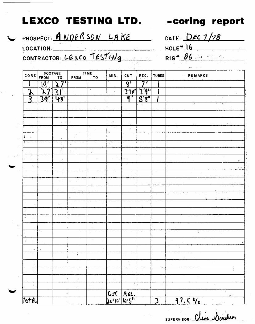
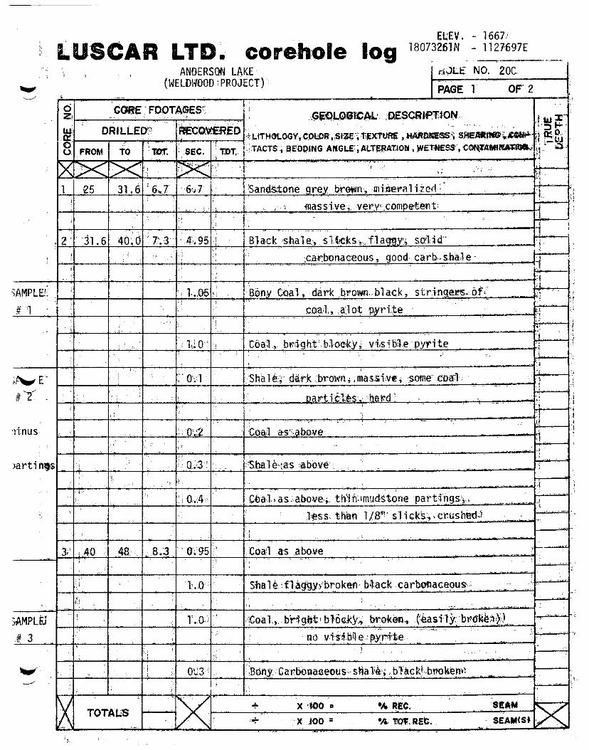
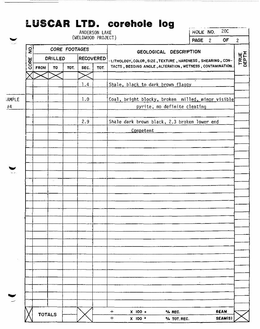
LEXCO TESTING LTD. -coring report
SUPERVISOR: ,&A Jh&

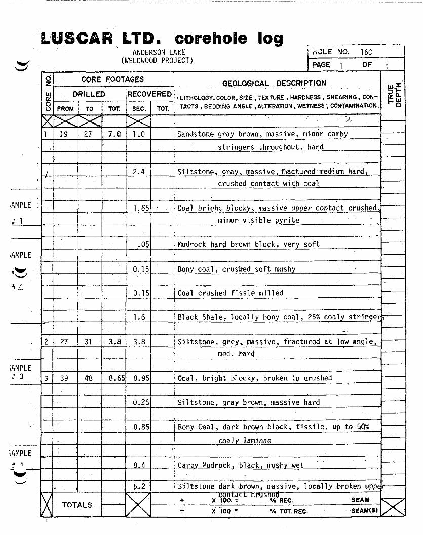
CAR,. LT ANDERSON LAKE
(WELDWOOD PROJECT)
crus,bed contact with coal
#AMPLE : ,' 1.65 Coal bright blocky,~,massive upper,coptact &shed,-
#l _~-...&-_--p--- minor visible pyrite ~.
.05 Mudrock hard brown block, very soft ;AMPLE
"25,
4 L
0.15 Bony coal, crushed sof
0.15 Coal crushed fissle milled
I 1 I 1.6
2 27 31 3.8 3.8 med. hard
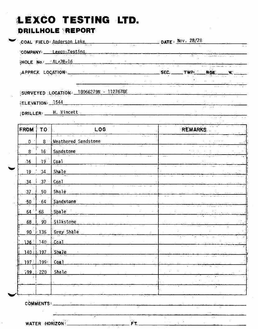
LEXCO TESTING ~LTD. DRILLHOLE REPORT
* COAL FIELD: Anderson Lake
COMPANY: lexco TestSm
H’OLE No.: AL-78-16C
APPROX. LOCATION:-
S"R"EyED LCCAT,ON:A8066260N - 1127634E
ELEVATION: 1544
DRILLER: J. Bly.
DATE: Dec. 7178
*I .,
_SEC.~ TWR- RGE.-..mW.-
I 6
,./
COMMENTS.
WATER HORIZON: - FT.

.Js EXCO T EST1 NG ~b.7’0,
WATER tlOi3lZO,N : - FT. .;~-’


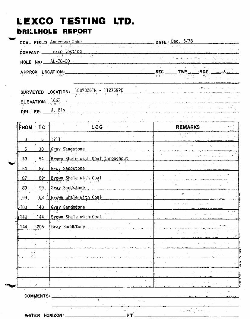
b$XCO TESTING LTD.
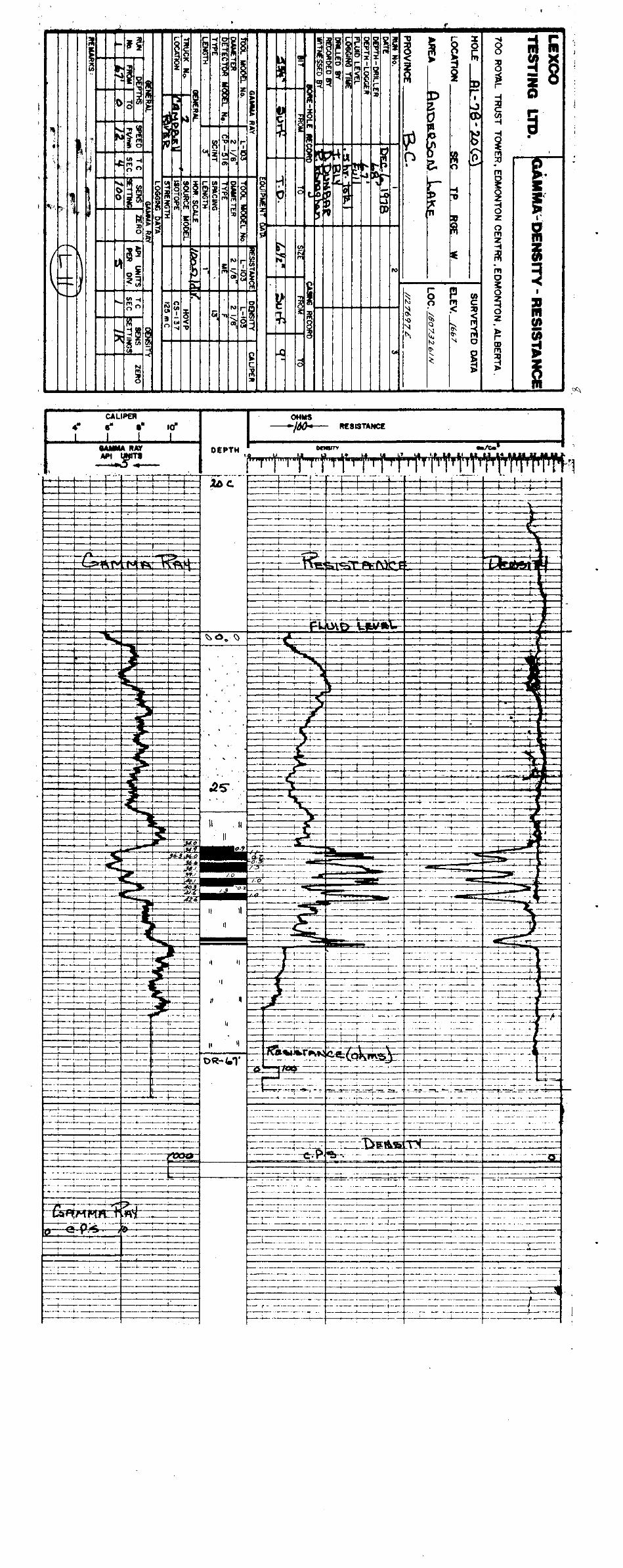
L CO&L FIELD: Anderson Lake, I DATE : Dec. .5/78 ._ . ., ._ 1 ~: ,,
+MPANY: , Lexca Testina .~~
fHO\E NY.’ AL-7,8-20, _ _. _
~PpROX. \?CATIO,tyJ:- ..--,I. .L i : i.3: ~’
-.. --- _- .,. ,. -
1.807326TN - 1:1276.9TE SURVEYEI? LfJ$4TkpN: , ~,_~ . _ ._ ,,._ ~.--. .--,. ,.-
,,EVATION: :6!?, .
DftILLER: J. ply
- .,. .,
WATER HORIZON: FT.
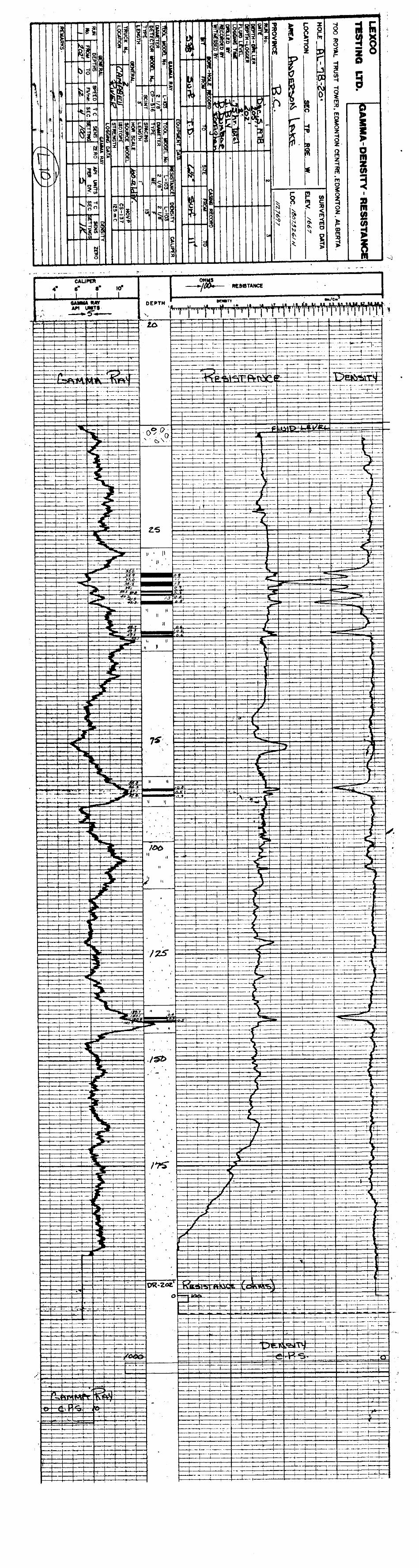
ELEV. - 1667;
(WELDWOD:PROJECT)
,,. ,:
Y 4
ANDERSON LAKE
GEOLOGICAL DESCRIPTION
I I I
I ,.i I I I I I

1
PROSPECT: Anderson Lake Dec. 6/78 /
DATE: u LOCATION: 2oc HOLE* 2oc I
CONTRACTdR: Lexco Testing RIG* 06 i I I
s"p~~~~so~~ Clive Gardner I
1

j:t32 r5” Zi35 ; Gray Sandstone
~. COMMENTS: _
i WbTER H6RIZON : FT.
T EST1 NG LTD. REPORT
LEXCO DRILLHOLE
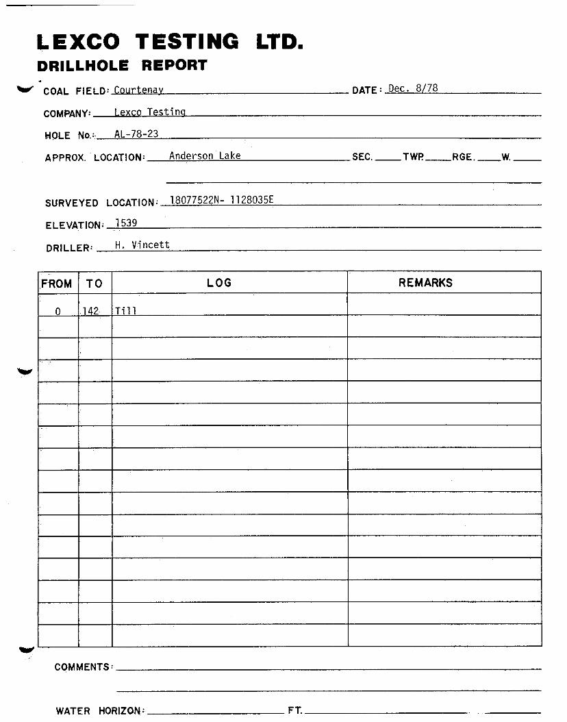
w COAL FIELD: Courtenav
COMPANY: Lexco Testins
HQLE No.:, k-78-23
APPROX. LOCATION: Anderson Lake
DATE: Dec. 8/78
-SEC.- TWP -v..-RGE.-W.-
S”R”EyED LOCATION: 1,8077522N- 112803%
ELEVATION: ,I539
DRILLER: H. Cncett
w
CQMMENTS:
WATER HORIZON: FT.
TESTING LTD. REPQRT
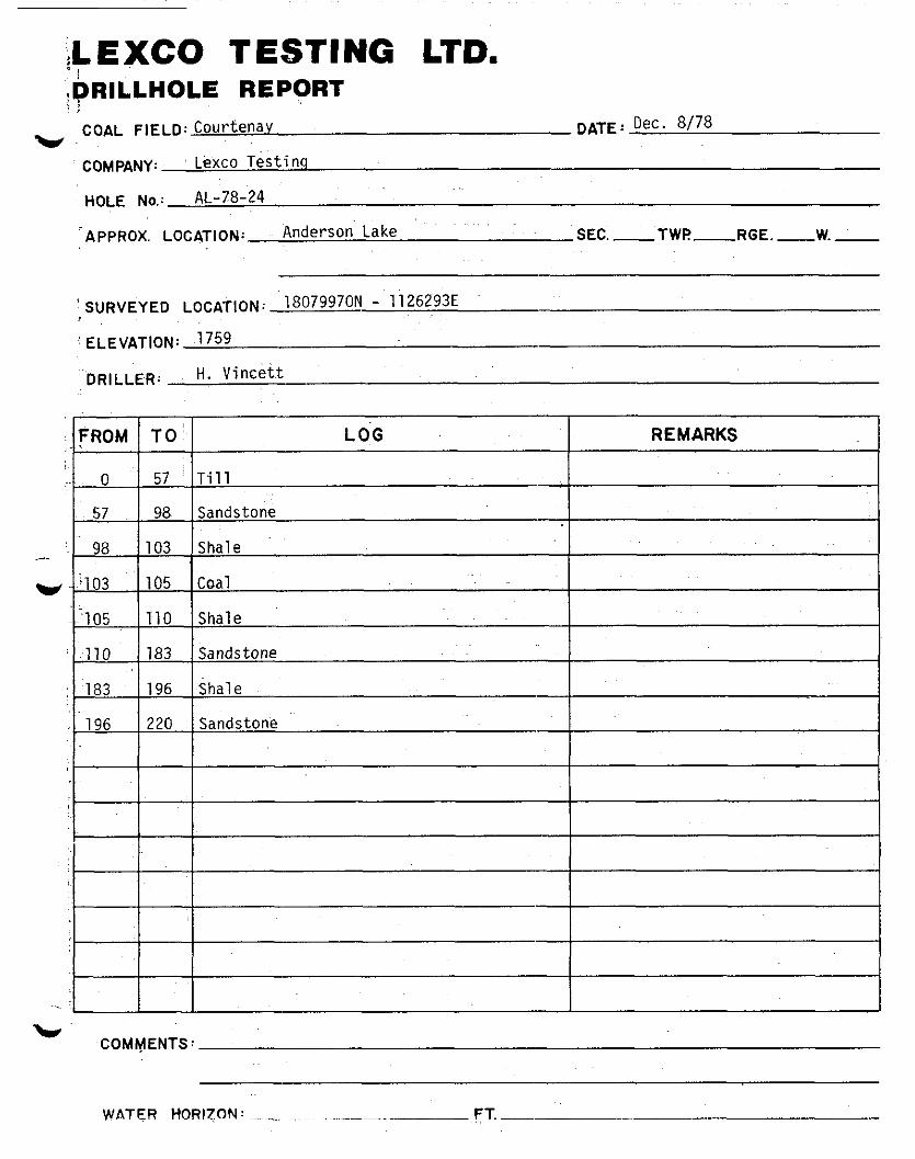
COAL FIELD: CoUrtenav w.,
COMPANY: L+xco Testinq
AL-78-24 HOLE No.:
‘APPROX. LOCATION; Anderson Lake
‘ S”R”EYED LOCAT,ON: 180799~ - 1126293E
: ELEVATION: ,175g
DRILLER: H. Vincett
DATE: Dec. a/78
SEC. -TWF!- RGE .-W.-
L’ COMMENTS:

WPO-TER,. +lORl;rON: _ ~-pi


WATER HORIZON’: ;FT.-

C
COAL QUALITY
GEO.LOGICAL BRANCH ASSESSMENT REPORT

ANDERSON LAKE
I. Corehole #16C
Lab # Sample # Basis Moist. Ash Vol. Fixed Matter Carbon Sulfur Btu/lb
79-10 1 Air dry 0.24 17.72 17.35 64.69 1.10 12567 79-11 2 A.D. 0.37 69.75 16.60 13.28 0.28 2873 79-12 3 A.D. 0.25 26.80 20.42 52.53 0.76 10968
I 79-13 4 A.D. 0.37 62.02 15.66 21.95 0.34 4353
II. Corehole #2OC
79-14 1 A.D. 0.32 51.99 12.39 35.30 9.00 6196 9458
10692 79-17 4 A.D. 0.20 13.33 18.20 68.27 2.08 13533
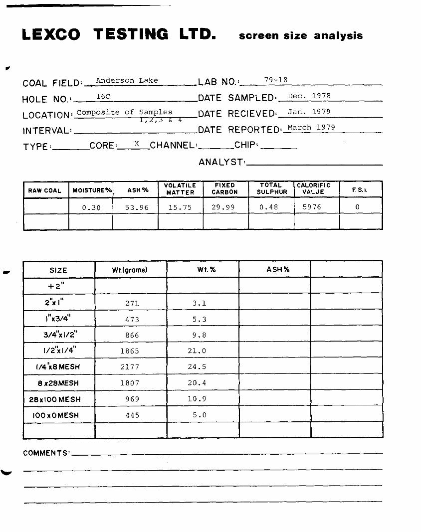
LEXCO TESTING LTD. screen size analysis
v
COAL FIELD: Anderson Lake LAB NO.1 79-18
HOLE NO.: 16C DATE LOCATIONS Composite of Samples DATE
l,L,j & 4
INTERVAL: DATE
SAMPLED: Dec. 1978
RECIEVEI-J Jan. 1979
REPORTED: March 1979
TYPE: CORE: x CHANNEL: CHIP:
ANALYST:
MOISTURE% ASH% VOLATILE FIXED TOTAL CALORIFI C
RAW COAL MATTER CARBON SULPHUR VALUE F. S. I.
0.30 53.96 15.75 29.99 0.48 5976 0
COMMENTS’

LEXCO TESTING LTD. screen size analysis
I COAL FIELD: Anderson Lake LAB NO.1 79-19
HOLE NO.: 2oc DATE SAMPLED: Dec- lg7’ Composite of Samples 1,
LOCATION ’ 7.. -3d4 DATE RECIEVED: Jan. 1979
INTERVAL: DATE REPORTED~March
TYPE: CORE: x CHANNEL: CHIP:
ANALYST:
FIXED TOTAL CALORIFIC RAW COAL MOISTURE% ASH%
VOLATILE MATTER CARBON SULPHUR VALUE F. S. I.
0.29 36.66 13.53 49.52 3.60 9129 0
I SIZE I Wr.(grams) wt. % ASH%
l"X3A' I 39 0.6
5.4
19.9
31.3
27.7
11.6
3.4
COMMENTS’
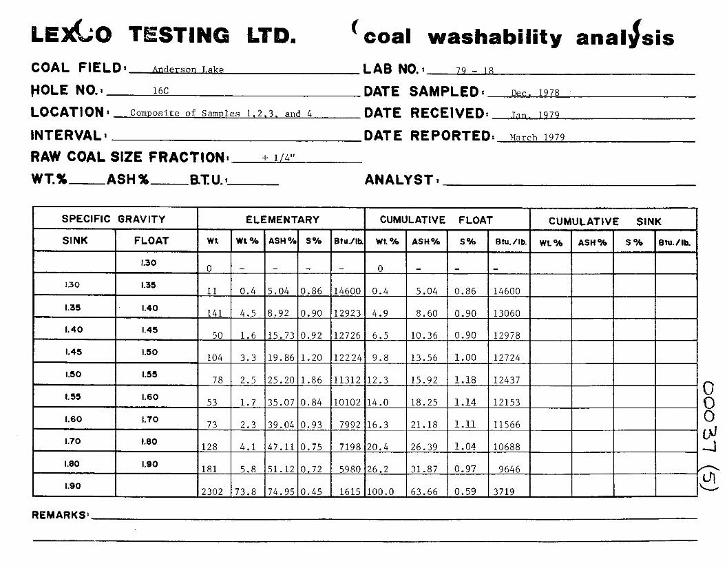
COAL FIELD: Anderson Lake
HOLE NO.: 16C
LOCATION 1 Composite of Samples 1.2.3. and 4
INTERVAL1
RAW COAL SIZE FRACTION: + 114”
WT.% ASH% RTU.:
LAB NO.2 79 - 18
DATE SAMPLED% ~ec. 1978 DATE RECEIVED: Jan. 1979
DATE REPORTED: March 1979
ANALYST;
ELEMENTARY CUMULATIVE F
REMARKS:
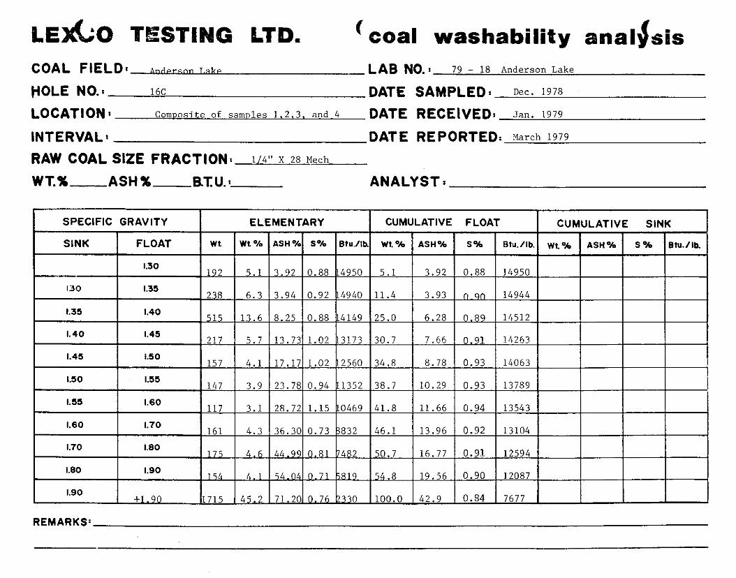
‘coal washability anal&is COAL FlELD:nnn~rson ~.akP LAB NO.: 79 - 18 Anderson Lake
POLE NO.: 16C DATE SAMPLED I Dec. 1978
LOCATION: Commsite of samples 1.2.3. and 4 DATE RECEIVED: fan. 1979
INTERVAL’ DATE REPORTED: March 1979
RAW COAL SIZE FRACTION: l/4” x 28 Mech
WT.% ASH% BTU.: ANALYST7
SPECIFIC GRAVITY
SINK FLOAT
ELEMENTARY
wt. Wt% ASH% 5% Btu./lb
CUMULATIVE FLOAT I CUMULATIVE SINK I
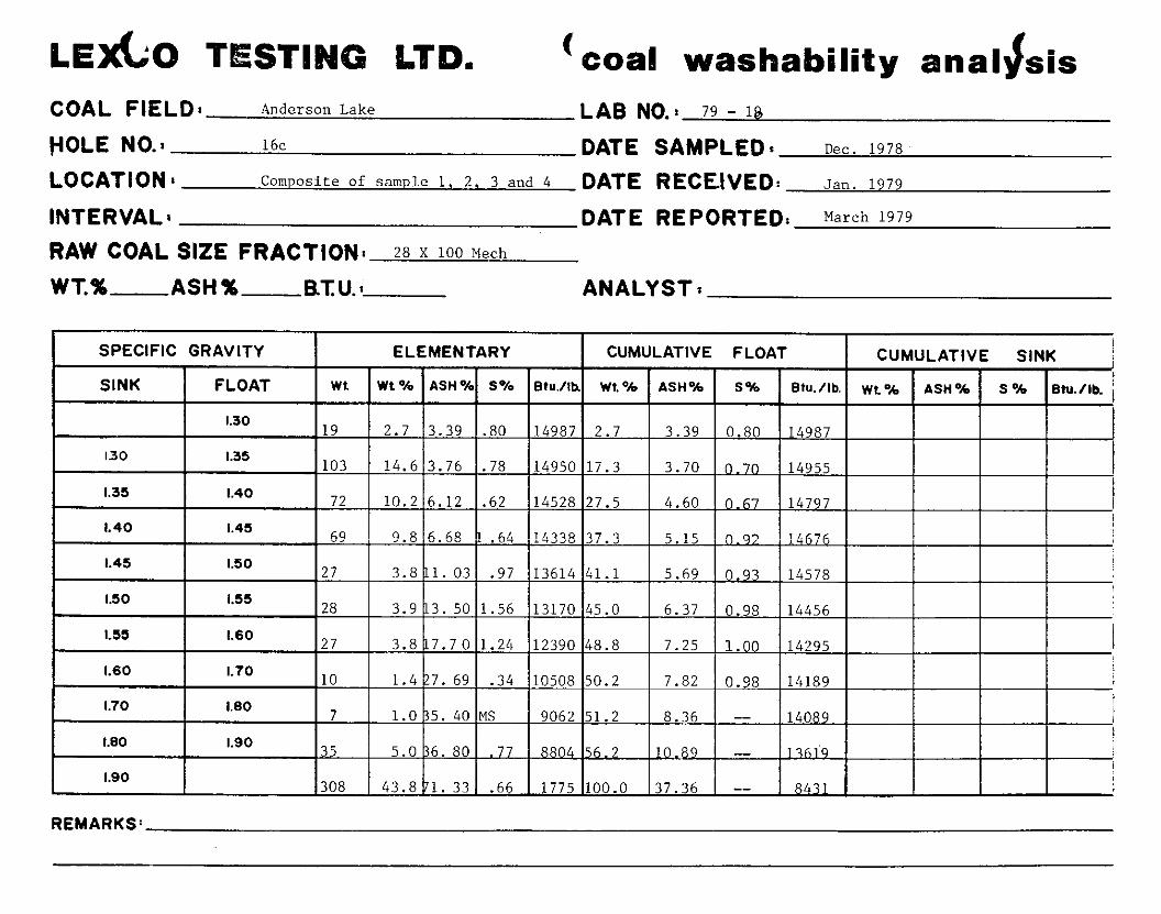
( coal washability anal If sis COAL FIELD: Anderson Lake LAB NO.: 79 - 18
VOLE NO.1 16~ DATE SAMPLED* Dec. 1978,
LOCATION * Composite of sample 1. 2, 3 and 4 DATE RECEIVED: Jan. 1979
INTERVAL 8 DATE REPORTED: March 1979
RAW COAL SIZE FRACTION: 28 x 100 Mech
WT.% ASH% BTU.: ANALYST;
1775 100.0 37.36 --
REMARKS:
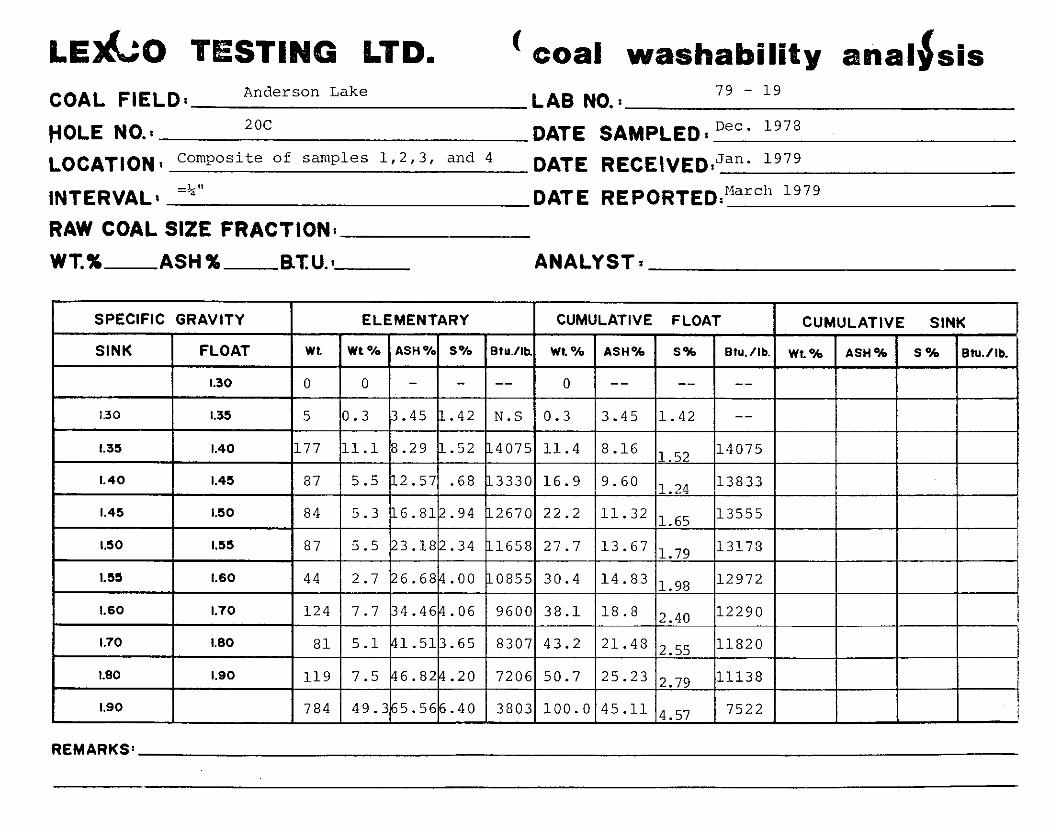
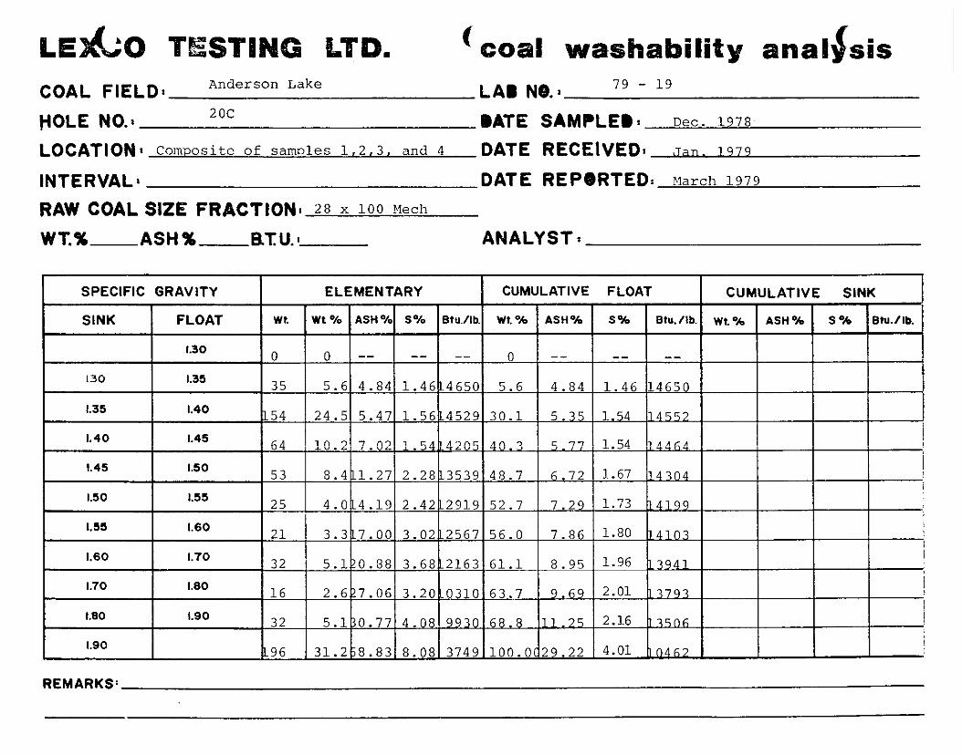
LEAGO T STING LTD. ( 00al washability anial#sis COAL FIELD: Anderson Lake LAB NO.: 79 - 19
HOLE NO.: 2oc DATE LOCATION 8 Composite of samples 1,2,3, and 4 DATE
INTERVAL8 =%‘I DATE
RAW COAL SIZE FRACTION:
SAMPLED t Dec- lg7*
RECEIVED:Jan* lg7’ RE,,ORTED;“arc” 1979
WT.% ASH% RTU.8 ANALYST1
1.90 784 49.3 5.56 .40 3803 100.0 45.11 4.57 7522 I
REMARKS:

’ COZJI washability anal&is
COAL FIELD: Anderson Lake LAB NO.1 79 - 19
HOLE NO.1 2oc DATE SAMPLED% Dec. 1978
LOCAJ-~ON,C~EI~~~~~~ of samples 1,2,3 and 4 DATE RECEIVED: Jan. 1979
INTERVAL1 DATE REPORTED: Mar- 1979
RAW COAL SIZE FRACTION: Lz" x 28 Mech
WT.% ASH % B.TlJ.~ ANALYST :
REMARKS’
COAL FIELD: Anderson Lake LAB N8.: 79 - 19
HOLE NO.1 2oc BATE SAMPLEBc Dec. 1978
LOCATIONI Composite of samnles 1,2,3, and 4 DATE RECEIVED: Jan. 1979
INTERVAL, DATE REPORTED: March 1979
RAW COAL SIZE FRACTIONI 28 x 100 mcll
WT.% ASH% BTU.: ANALYST;
CUMULATIVE FLOAT