eruption in washington causes the largest landslide in
TRANSCRIPT

1Preparedness Ambassadors – Case Studies
VOLCANO: Mount St. Helens Volcanic Eruption CS5
Eruption in Washington causes the largest landslide in recorded history.
Two Months of Warnings
On March 16, 1980, Mount St. Helens awoke when a series of small earthquakes began. Hundreds more occurred over the next 11 days. On March 27, a steam explosion created a crater through the summit ice cap. A week later the crater had grown to 1,300 ft wide, and two giant cracks crossed the entire summit of the mountain. By May 17, two months after the volcano first awoke, over 10,000 earthquakes had shaken the mountain, due to magma rising high into the volcano. The north side of the mountain was bulging out 450 feet! Geologists, local authorities, townspeople, and tourists all wondered if and when the volcano would erupt.
Ash billows from the crater where the summit of Mount St. Helens had been only hours earlier during a huge eruption on May 18th, 1980. (USGS/Robert Krimmel) https://www.theatlantic.com/photo/2015/05/the-eruption-of-mount-st-helens-in-1980/393557/ (accessed March 12, 2020)
Mount St. Helens is a stratovolcano in the state of Washington. It is one of 13 volcanoes that have erupted in the past 4,000 years in the Cascade Mountain Range. Together, these volcanoes erupt at a rate of 2 eruptions every 100 years. Sometimes these are small eruptions, but sometimes they are cataclysmic!
2 Preparedness Ambassadors – Case Studies
Sequence of Mount St. Helens photos of the colossal landslide and ensuing lateral blast following the Mw 5.1 earthquake, 1980. Timestamps indicate the time following the earthquake. https://volcanoes.usgs.gov/volcanic_ash/mount_st_helens_1980.html (accessed July 26, 2020)
The Volcano Erupts
On May 18, a magnitude 5.1 earthquake occurred, and the volcano’s summit slid away in a huge landslide—the largest on Earth in recorded history. With the weight of the rock gone, the magma could explode like a shock wave out of the volcano. Rocks, ash, volcanic gas, and steam were blasted upward and outward to the north. These materials accelerated out over 300 miles per hour, then slowed as the rocks and ash fell to the ground miles from the volcano. The blast reached 17 miles north, and the debris from the landslide slid 14 miles west down the North Fork of the Toutle River.
Mount St. Helens Eruption Zones
Volcanic ash and gas rose more than 15 miles into the atmosphere in only 15 minutes. People across the country were affected as winds blew 520 million tons of ash across the United States. It caused complete darkness in Spokane, Washington, 250 miles from the volcano.
Eruptions continued throughout the day with avalanches of hot ash, pumice, and gas spouting out of the crater. These avalanches, known as pyroclastic flows, quickly melted some of the snow and ice capping the volcano, creating flash flooding. Flood water mixed with loose rock and ash forms a cement-like mudflow, known as a lahar. Several lahars poured down the volcano into
https://www.theatlantic.com/photo/2015/05/the-erup-tion-of-mount-st-helens-in-1980/393557/ (accessed March 12, 2020)
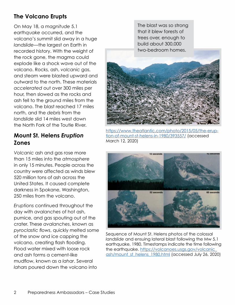
The blast was so strong that it blew forests of trees over, enough to build about 300,000 two-bedroom homes.

3Preparedness Ambassadors – Case Studies
https://www.fs.usda.gov/pnw/galleries/mount-st-helens-disturbance-zones-map (accessed July 26, 2020)
river valleys, ripping trees from their roots and destroying roads and bridges. The largest and most destructive lahar again went down the North Fork Toutle River destroying bridges and homes.
Local Authorities Work with Geologists
Geologists are credited with saving many lives by evacuating the area around the volcano before the large landslide eruption occurred. These scientists convinced local authorities to limit access to the area around the volcano and to keep it closed. There were two months between the time the volcano awoke with earthquakes until the time it finally blew. Townspeople pressured the local authorities to reopen the area, to allow families back to their homes, and for tourism to take place. They weren’t convinced the volcano was going to erupt. Thanks to local authorities and the geologists who kept the area closed, only 57 people died when Mount St. Helens erupted in Washington. Most of them died from inhaling hot ash, according to the U.S. Geological Survey. Due to the cooperation between the geologists and the local authorities, the death toll was only a few tens instead of hundreds or thousands of people.

4 Preparedness Ambassadors – Case Studies
A mudflow deposit covers Washington State Highway 504, near the town of Toutle, northwest of Mt. Saint Helens, to a depth of 2m (6 feet). Geologist for scale. (USGS/R.L. Schuster) http://archive.boston.com/bigpicture/2010/05/mount_st_helens_30_years_ago.html (accessed March 12, 2020)
David Johnston, volcanologist, observes Mount St. Helens before the eruption. He was observing too close to the volcano and passed away moments after the volcano erupted. (USGS/Harry Glicken). https://www.usatoday.com/story/news/nation-now/2015/05/17/mount-st-hel-ens-people-stayed/27311467/ (accessed March 12, 2020)
Volcano Hazard Risk in California
California is home to dozens of volcanoes with three of them listed as “Very High Threat”: Mount Shasta, Lassen Volcanic Center, and Long Valley Caldera. Volcanoes listed as “High Threat” include Mono-Inyo Craters, Clear Lake Volcanic Field, Medicine Lake, and the Salton Buttes. About ten eruptions have occurred in the past 1,000 years, making the probability of an eruption about once every 100 years. Many of California’s volcanoes show signs of activity daily—without incident—ranging from small earthquakes to sluggish explosions that are rarely considered a large eruption. Those living nearest a volcano should know the hazards of a volcano; however if one were to erupt, ash and fallout can affect nearby states and travel for hundreds of miles affecting the air quality for long periods of time. Find California volcanoes near your community using the map on the next page.

5Preparedness Ambassadors – Case Studies
##
#
## ##
#
####
#
#
#
#
#
#
SISKIYOU
DELNORTE MODOC
HUMBOLDT
LASSEN
PLUMAS
BUTTEMENDOCINO GLENNSIERRA
YUBALAKE
NEVADACOLUSA
PLACER
SUTT
ER
EL DORADO
ALPINEYOLO
NAPASONOMA
SACRAMENTO
MONOAMADOR
SOLANOCALAVERAS
MARIN CONTRACOSTA
STANISLAUSMARIPOSA
MADERA
SANMATEO
MERCEDSANTACLARA
SANTACRUZ
SANBENITO
TULARE
KINGS
SAN BERNARDINO
KERN
SAN LUISOBISPO
SANTABARBARA
VENTURA LOSANGELES
RIVERSIDE
SANDIEGO
IMPERIAL
MONTEREY
FRESNO
TUOLUMNE
SHASTATRINITY
TEHAMA
INYO
SANFRANCISCO
ALAMEDA
ORANGE
§̈¦210
§̈¦5
§̈¦80
§̈¦15
§̈¦505
§̈¦8
§̈¦280
§̈¦215
§̈¦580
§̈¦680
§̈¦10
§̈¦5
§̈¦405
§̈¦40
£¤95
£¤97
£¤395
£¤50
£¤101
£¤199
·|}46
·|}78
·|}74
·|}33
·|}79
·|}115
·|}155
·|}96
·|}146
·|}38
·|}145
·|}62
·|}76
·|}14
·|}86
·|}139
·|}44
·|}127
·|}138
·|}180
·|}99
·|}65
·|}178·|}41
·|}263
·|}25
·|}58
·|}136
·|}169
·|}177
·|}247
·|}3 ·|}89
·|}190§̈¦5
·|}1
·|}36
·|}32 ·|}70
·|}20·|}128
·|}29
·|}37 ·|}12
·|}4
·|}88
·|}108
·|}120
·|}49
·|}140
·|}152
·|}129
·|}68
·|}168
Mount Shasta
Tumble Buttes
Lassen Volcanic Center
Silver Lake Volcanic Field
Medicine Lake
Brushy Butte
Twin Buttes
Eagle Lake Volcanic Field
Clear LakeVolcanic Field
Mono Lake Volcanic Field
Mono - Inyo Craters
Inyo Craters
Long Valley Caldera
Ubehebe Craters
Golden Trout Creek
Coso Volcanic Field
Lavic Lake
Salton Buttes
0 25 50 75 10012.5
Miles
:Created by Cal-OES GIS, June9, 2015
N:\Data\GEOLOGIC\Volcanoes\projects\CA_Volcanos_A.mxd
Data Sources:Transportation: Thomas Bros Inc and ESRIFederal Ownership: US Forest ServiceDigital Elevation Model: US Geological Survey
Active Volcanoes In CaliforniaGOVERNOR'S OFFICE OF EMERGENCY SERVICES
State of Cali forn ia
Threat Potential# High to Very High
# Moderate
# Low/Very Low
Administrative BoundaryCounty
TransportationInterstateState Highway
Pa
ci
fi
c
Oc
ea
n
California Governor’s Office of Emergency Services (June 9, 2015). Active Volcanoes in California.