es - smiths lake bush fire management plan › files › assets › ... · bushfire an uncontrolled...
TRANSCRIPT

ENGINEERING SERVICES
ATTACHMENT A
ES - SMITHS LAKE BUSH FIRE MANAGEMENT PLAN
ORDINARY MEETING
13 DECEMBER 2011

Great Lakes Council Smiths Lake Reserves Fire Mitigation Plan
04 October 2011


Glossary of Terms/List of Abbreviations The following terms are generally sourced from the Australasian Fire Authorities Council Wildfire Glossary.
AMSL Above Mean Sea Level
APZ Asset protection zone. An area between an asset and a bushfire hazard where bushfire fuel has been reduced significantly to protect the asset
AS 3959-2009 The Australian Standard for construction of buildings in bushfire prone areas
BFCC NSW Bush Fire Coordinating Committee
BFMC NSW Bush Fire Management Committee
BKDI Byram-Keetch Drought Index – see KBDI
BoM Bureau of Meteorology
Bushfire An uncontrolled fire burning in forest scrub or grassland vegetation, also referred to as a wildfire
Bush Fire Alert A formal notification issued by an Emergency Services agency to provide information to affected communities by radio, television, internet or telephone, and consisting of three levels:
- Advice – A fire has started – there is no immediate danger - Watch and Act – There is a heightened level of threat - Emergency Warning – This is the highest level of Bush Fire Alert. You may
be in danger and need to take action immediately.
Bushfire attack Attack by burning debris, radiant heat or flame generated by a bushfire which might result in ignition and subsequent destruction of a building
Bushfire hazard The potential severity of a fire, usually measured in terms of intensity (kW/m)
Bushfire-prone area An area that can support a bushfire or is likely to be subject to bushfire attack.
Category 9 Fire Tanker Light weight quick response support fire fighting vehicle, such as modified commercial 4wd utility, suitable for arduous terrain. Tank capacity ~450 L
Category 7 Fire Tanker All wheel drive rural forest tanker suitable for arduous terrain and carrying 800-1600 L
Category 1 Fire Tanker All wheel drive large crew cab tanker suitable for arduous terrain carrying 3000+ litres
Crown fire A fire that advances from top to top of trees or shrubs
Crown scorch Browning of the needles or leaves in the crown of a tree or shrub caused by heat from a fire
Direct Flame Zone See Flame Zone
DECCW Department of Environment, Climate Change and Water
EEC Endangered Ecological Community
Ember Attack Attack by smouldering or flaming windborne debris that is capable of entering or

accumulating around a building, and may ignite the building and other combustible materials and debris. (AS3959-2009)
EPBC Environment Protection Biodiversity Conservation Act 1999
FDI Fire Danger Index: A relative number denoting an evaluation of rate of spread, or suppression difficulty for specific combinations of temperature, relative humidity, drought effects and wind speed. The numbers range from 1 to 100 and form classes that equate to FDR (see FDR)
FDR Fire Danger Rating: A relative class denoting an evaluation of rate of spread, or suppression difficulty for specific combinations of temperature, relative humidity, drought effects and wind speed. Rated as low-moderate (FDI 0-11), high (FDI 12-24), very high (25-49), severe (50-74), extreme (75-100) or catastrophic (100+), indicating the relative evaluation of fire danger
FEZ Fire Exclusion Zone
Fine fuel Fuel such as grass, leaves, bark and twigs less than 6mm in diameter that ignite readily and are burnt rapidly when dry
Fireline or Fire Control Advantage A natural (such as a creekline) or constructed barrier (such as a trail or mineral earth break), or treated fire edge, used in fire suppression and prescribed burning to limit the spread of fire
Flame Zone The highest level of bushfire attack as a consequence of direct exposure to flames from the fire front in addition to heat flux and ember attack (AS 3959-2009)
FMP Fire Mitigation Plan
Fuel Any material such as grass, leaf litter and live vegetation which can be ignited and sustains a fire. Fuel is usually measured in tonnes per hectare. Related Terms: Available fuel, Coarse fuel, Dead fuel, Elevated dead fuel, Fine fuel Ladder fuels, Surface fuels, Total fine fuel, Overall fuel hazard
Fuel layer Fuel layers within dry eucalypt forests that can be linked to fire behaviour. The four main fuel layers consist of Surface fuel (including fine fuel), Near surface fuel, Elevated fuel and Bark fuel
F&R NSW Fire and Rescue New South Wales
GIS Geographic Information System
GLC Great Lakes Council
HI Haines Index
IC Incident Controller. Related Term: Emergency Control Officer (ECO)
ICS Incident Control System
Keetch-Byram Drought Index (KBDI)
A numerical value reflecting the dryness of soils, deep forest litter, logs and living vegetation, and expressed as a scale from 0 - 200 where the number represents the amounts of rainfall (mm) to return the soil to saturation. Related Term: BKDI
LMZ Land Management Zone
Mop up Cooling of the burn area including wetting-down of heavy fuels; conducted after fire

suppression and often involving patrol for embers and flare-ups
NSF Near Surface Fuels
NSW RFS New South Wales Rural Fire Service
Prescribed burning The controlled application of fire under specified environmental conditions to a predetermined area and at the time, intensity, and rate of spread required to attain planned resource management objectives. It is undertaken in specified environmental conditions
Radiant Heat The measure of heat energy from a fire impacting on a surface (measured in kilowatts per metre (kW/m2)).
RSPCA Royal Society for the Prevention of Cruelty to Animals
SF Surface Fuels
SFAZ Strategic Fire Advantage Zone
TOBAN Total Fire Ban
TSC Threatened Species Conservation Act 1995
Water point Any natural or constructed supply of water that is readily available for fire control operations
WIRES Wildlife Information and Rescue Service


Contents Introduction 1
1. Bushfire Resource Information 6
1.1 Locality Overview 6 1.2 Bushfire history analysis 9 1.3 Weather and Climate Factors 10 1.4 Site Topography Factors 14 1.5 Vegetation and Fuel Factors 15 1.6 Values 21 1.7 Fire Management Zones and Mitigation Measures 26 1.8 Bushfire Resources 30
2 Bushfire Mitigation Works Program 31
2.1 Aims 31 2.2 Mitigation Activities 31 2.3 Standards Applying to Bushfire Mitigation Works 34
2 Bushfire Awareness Program 37
3.1 Bushfire Awareness Program Objectives 37 3.2 Shared Responsibility 37 3.3 Community awareness and preparedness programs 38 3.4 Existing Awareness Programs 39 3.5 Community Bushfire Preparedness Guide 40
3 Bushfire Response Strategy 41
4.1 Response Objectives 41 4.2 Readiness and Restrictions 41 4.3 Bushfire Detection and Reporting 44 4.4 Command and Control 44 4.5 Evacuation Arrangements 44
4 Bushfire Recovery Requirements 46
5.1 Human Aspects 46 5.2 Infrastructure and Utility Aspects 46 5.3 Post-fire Debriefings 46 5.4 Animal Welfare 46

5.5 Environmental Rehabilitation 46
5 Monitoring, Recording and Analysis 49
6.1 Bushfire Hazard Monitoring 49 6.2 Monitoring after prescribed burns 49 6.3 Fire Recording 51
6 Compilation of Recommendations 52
7 References 55
Table Index Table 1 Vegetation Communities 15 Table 2 Vegetation Fuel Accumulation 20 Table 3 Generic fire regimes by vegetation formation 23 Table 4 Conservation significance of threatened flora
species 24 Table 5 Conservation significance of threatened fauna
species 24 Table 6 Bushfire Protection and Mitigation Measures 27 Table 7 GLC Reserves within Smiths Lake 32 Table 8 Bushfire Readiness and Restrictions 42 Table 9 Post Fire Rehabilitation Options 47 Table 10 Basic Post Fire Monitoring Schedule 49 Table 11 Table of Recommendations 52
Figure Index Figure 1 Locality Map 3
Figure 2 Great Lakes Region 8
Figure 3 Mean maximum temperature and rainfall – Forster and Williamtown (BOM 2011) 11
Figure 4 Forest Types – Smiths Lake 17
Figure 5 Vegetation Formations – Smiths Lake 18
Figure 6 Asset Protection Zone Example Works 29
Figure 7 Slope Classes 35

Appendices Reserve Plans Vegetation Fire Behaviour Characteristics Environmental Assessment Smiths Lake Community Preparedness Guide


GHD | Great Lakes Council - Fire Mitigation Plan | 1
Introduction
Background This Fire Mitigation Plan (FMP) details the fire management and mitigation requirements for Great Lakes Council (GLC) managed properties at Smiths Lake NSW.
Smiths Lake is a lakeside township of 1036 persons (2006 census) situated on a broad peninsula on the northern side of Smiths Lake. The township is 28 km south of Forster and 40 km east of Bulahdelah.
Within Smiths Lake, Great Lakes Council manages 52.0 hectares in ten individual reserves (Figure 1), including the 26.1 hectare foreshore reserve. These reserves are primarily managed for active and
passive recreation. This Fire Management Plan specifically addresses fire mitigation options for the GLC reserves within Smiths Lake. Note this plan does not address or make specific mitigation recommendations for the wider locality, or those reserves managed by water utilities.
GLC reserves comprise a very small component of the overall fuel landscape at Smiths Lake and
management actions employed by GLC on its reserves requires complimentary actions across the entire fuel landscape by private and public partners to effectively mitigate risk.
Purpose This plan has been developed in a practical and user friendly format to assist implementation. It addresses life and property protection, and biodiversity conservation goals of bushfire management for GLC reserves at Smiths Lake.
The effectiveness of bushfire prevention, mitigation and management works undertaken on GLC reserves within Smiths Lake are dependent on a cooperative approach, engagement and participation of major stakeholders. This plan demonstrates GLC commitment to mitigating bushfire risk on its land as a
responsible land manager as part of a cooperative relationship with stakeholders to mitigate the risk across the landscape.
Fire is a part of the Australian environment and occurs regularly in temperate climates. The responsibility
to address and prepare strategies for bushfire management is essential to protect life, property and community assets, and environmental attributes.
Objectives The primary objectives of bushfire management and mitigation are to:
a) Protect human life;
b) Protect assets to maintain capability before, during and after the passage of destructive
bushfires;
c) Minimise the physical and environmental impact of bushfires;
d) Provide for bushfire protection work to be undertaken in an environmentally sustainable and cost
effective manner; and
2 | GHD | Great Lakes Council - Fire Mitigation Plan
e) Maintain fire regimes that are appropriate and necessary to conserve the environmental values found on GLC properties.
This plan has been prepared with consideration of the above objectives.
GLC has a responsibility to minimise the risk of bushfires impacting on its properties, spreading from its properties into neighbouring property or spreading uncontrolled on GLC reserves.
This FMP documents guiding principles for bushfire management. It incorporates bushfire research,
awareness, fuel reduction, mitigation and response strategies that aim to reduce the rate of spread and intensity of bushfires as well as to protect the values of GLC reserves.
Plan Structure This Fire Mitigation Plan is divided into two parts as follows:
Fire Mitigation Plan (Report Format) - Background site information and reference material (this
document).
FMP Reserve Plans – Individual property specific fire management maps (A2 or A3) providing an
overview of site information, specific responsibilities and actions, and summarised operational
reference information (Appendix A).
This approach allows consolidation of background and reference information into a single document complimented by a user friendly map-based compilation of specific information for site users.
The FMP is structured according to headings that conform to the PPRR1 approach used as the benchmark for emergency management in Australia as follows:
Section 1 - Bushfire Resource Information
Section 2 - Bushfire Mitigation Works Program
Section 3 – Bushfire Awareness Program
Section 4 – Bushfire Response Strategy
Section 5 – Bushfire Recovery Requirements
Section 6 – Monitoring, Recording and Analysis
Section 7 – Reporting
1 PPRR – Preparedness, Prevention, Response and Recovery

5161

4 | GHD | Great Lakes Council - Fire Mitigation Plan
Consultation Consultation and information collection for this plan comprised of the following stages:
Project inception including the provision of background information and confirmation of project
timeframes;
Stakeholder consultation with key internal and external stakeholders identified by GLC (including NSW Rural Fire Service (local and State Headquarters)); and
Circulation of the draft FMP.
Information provided at these stages was incorporated in the development of this FMP.
The Planning Environment Relevant legislative, planning and policy obligations relating to bushfire management are summarised in
the following sections.
Great Lakes Council Plans and Policies
Commitment to the Environment Policy;
Erosion and Sediment Control Policy;
Management of Illegal Removal of Vegetation from Council Controlled Reserves Policy;
Noxious Weeds Policy;
Council Procedure (PR-BLD-002) - Erosion and Sediment Control;
Fire Management for Council Controlled Natural Areas Policy;
Great Lakes Local Environment Plan (1996)
NSW Legislation
Local Government Act 1993
Environmental Planning and Assessment Act 1979;
Fire Brigades Act 1989;
Heritage Act 1977;
National Parks and Wildlife Act 1979;
Rural Fires Act 1997;
State Emergency and Rescue Management Act 1989; and
Threatened Species Conservation Act 1995.
NSW Regulatory Instruments and Strategies
Bush Fire Coordinating Committee (BFCC) Policy No. 2/2007 – Fire Trails (BFCC 2007a);
BFCC Policy No 3/2007– Bush Fire Risk Management (BFCC 2007b);

GHD | Great Lakes Council - Fire Mitigation Plan | 5
BFCC Policy No 3/2007- Bush Fire Risk Management Planning Guidelines for Bush Fire Management Committees (Annex B to BFCC Policy No. 3/2007 Bush Fire Risk Management) (BFCC 2007b);
Bush Fire Environmental Assessment Code for NSW (NSW RFS 2006a); and
Planning for Bushfire Protection (NSW RFS 2006b)).
Relevant Plans
Great Lakes Local Disaster Plan (DISPLAN)
Great Lakes Bush Fire Risk Management Plan (2008);
DEC (2006) Wallingat National Park Fire Management Strategy, NSW Department of Environment and Conservation (DEC), Hunter Region;
Commonwealth Legislation
Aboriginal and Torres Strait Islander Heritage Protection Act 1984;
Environmental Protection and Biodiversity Conservation Act 1999; and
Environment Protection and Biodiversity Conservation Regulations 2000.
6 | GHD | Great Lakes Council - Fire Mitigation Plan
1. Bushfire Resource Information
1.1 Locality Overview
Smiths Lake village adjoins a large and continuous area of bushfire prone vegetation (Figure 2). The
nature of the vegetation and historical fire occurrence indicates that adjacent bushland is likely to be impacted by bushfires at some time in the future. Due to the relatively small dimensions of Smiths Lake village, the retention of numerous retained bushland remnants within the village perimeter, and the
retention and planting of native vegetation in gardens, means there is a very real prospect that a large bushfire running under adverse fire weather conditions will burn into the village. The locality is located in a fire prone region and for several months each year the area is exposed to significant bushfire risk. The
vegetation adjacent to the village can carry very high fuel and bark levels, with the result that the village is prone to spotting and impact by a high intensity bushfire.
Bushfires impacts are not always restricted to rural or natural forest areas – there are many recent
examples of bushfires that have penetrated into urban areas, and through rural residential areas. Continuing demand for a leafy outlook has led to increased rural-urban interface, with more people and assets situated within or adjacent to bushfire hazard.
Smiths Lake includes a high number of non-permanent or absentee property owners, with properties carrying elevated overall fuel hazard, and varying understanding of bushfire hazard factors or appreciation of mitigation requirements. Historically, fire events have shown that where the interval
between significant bushfire events is long, levels of bushfire risk appreciation can diminish leading to sub-optimal understanding of bushfire preparedness, mitigation and response actions to improve resilience. There is also a significant number of seasonal holiday makers visiting Smiths Lake that, as
well as having varying appreciation of bushfire issues, may also be unfamiliar with the local constraints and risk factors. With little exposure to bushfire, communities may not be sympathetic to mitigation activities, such as hazard reduction or vegetation modification, or where greater responsibility may be
placed on residents living within or seeking to move to areas adjacent to bushfire hazard.
Successful fire suppression over several decades by fire services and land management agencies has significantly reduced the number of fires that would have otherwise threatened or impacted Smiths Lake.
As a result a significant proportion of local residents may never have experienced major bushfire threats before, and it can be assumed that many people in the local community will under-estimate the bushfire threat potential that exists. Under adverse fire weather conditions, bushfires can very quickly become
uncontrollable. A fire breaking out under Severe to Catastrophic fire danger conditions has a high probability of overwhelming local suppression capacity, and develops into a fire beyond the generational experience of local people. Past suppression success certainly does not guarantee future suppression
success. When fire suppression fails, other bushfire risk management measures bushfire mitigation measures, house and property preparedness measures, and bushfire survival planning by individuals and families are vitally important to maximising life and property protection.
Acknowledging the bushfire risk of the town, Smiths Lake is categorised as ‘Extreme’ risk in the Great Lakes Bush Fire Risk Management Plan (BFCC 2008).

GHD | Great Lakes Council - Fire Mitigation Plan | 7
Summary of Risk Factors
Smiths Lake has a range of natural and demographic attributes that contribute to bushfire, including:
A significant proportion of the landscape within and surrounding Smiths Lake is covered is fire prone
vegetation including Dry Sclerophyll and Wet Sclerophyll Forests;
A relatively long fire season commencing from mid spring (September), triggered by seasonal strong north-southwest winds and relatively dry periods from late winter through to early summer. In
seasons that are drought affected the landscape may be fire prone for months on end from mid spring through summer;
Regularly occurring days of Very High and Severe fire danger, particularly ahead of strong weather fronts in late spring and through summer, which have in the past has caused fires to make high
intensity runs of many kilometres in a single day, and are uncontrollable in such conditions;
A dominance of local vegetation types which are ‘fire maintained’ and require fire at appropriate intervals to maintain their range, health and diversity;
A fire developing in the surrounding landscape has the potential to generate significant impacts on
Smiths Lake. The continuous forested landscape to north and north-west (Wallingat State Forest, Wallingat National Park and Bachelor State Forest) (Figure 2) can support the development of a landscape scale high intensity fire, generating embers and spotfires in advance of the main front and
with significant consequences for Smiths Lake. To the south, the large expanse of forest (Myall Lakes National Park) can also support fires that under a south-westerly wind could generate significant ember and smoke effects across the lake into the township. These embers may result spotfires within
the township;
The main emergency access routes from the village traverse significant areas of fire prone vegetation, isolating the village in the event of a bushfire and making travel along these routes very
dangerous;
The high proportion of tourists that visit and stay at Smiths Lake, in the event of a bushfire, may be:
- unfamiliar with access routes particularly if the township is affected by smoke;
- have limited experience of bushfire and are unprepared for a bushfire event;
- may be unaware or have unrealistic perceptions of the bushfire risk factors, and chose a ‘wait
and see’ approach (stay and then ‘flee at the last minute’) that has proven elsewhere to be fatal.
A local community has a range of perceptions about the mitigation and management of fire risk.
GLC Recommendation 1
As a responsible land manager, GLC has identified the need to undertake mitigation works on its lands and lead community mitigation activities. However, as a significant proportion of the overall fuel hazard is located on adjoining private lands, it is recommended GLC continue to participate in and facilitate a
cooperative whole of community approach to mitigation.


GHD | Great Lakes Council - Fire Mitigation Plan | 9
1.2 Bushfire history analysis
History Minor and major fires are a regular occurrence within Great Lakes Shire and large fires, often burning
under adverse conditions, are recorded from the municipality. Annually the Great Lakes Bush Fire Management Committee (BFMC) area has 180 bushfires, with an average of seven major fires (BFCC 2008). There are not records of recent fires within the Smiths Lake township.
The most recent large fire recorded near Smiths Lake occurred in April 2006 in Wallingat National Park. This fire burnt approximately 1400 hectares of National Park and private property, threatened the village of Bungwahl and resulted in closure of The Lakes Way. The fire occurred outside the usual fire season,
as a defined summer/autumn rainfall peak (Section 1.3) that usually signals the end of the fire season at Great Lakes. This fire was preceded by significantly lower than average rainfall in March and April 2006
Significant regional fires are recorded in 1968-69, 1979-80, 1991-92 and 2002-2003 (GLC 20062).
Causes Bushfire cause falls into three categories:
Natural – fires caused by lightning in late spring (in those seasons of reduced late-spring rainfall);
Accidental – fires caused through sparks from machinery use (welders, vehicles, dozers), escaped prescribed burning operations, landholder burnoffs or campfires, and motor vehicle accidents; or
Deliberate – fires caused by arson, the occurrence of which can correspond with distance from urban areas, proximity of major roads and school holidays.
GLC Recommendation 2
As the incidence of deliberate fires can relate to accessibility, restrictions placed on access are a means used to reduce the potential for arson. As it is difficult to restrict access to GLC reserves due to the large
area of interface, fuel reduction is applied in areas where arson has occurred historically (such as along The Lakes Way near Reserve 5251).
GLC Recommendation 3
Routine maintenance activities have the potential to cause accidental ignition (for example the welders, or slashing on rocky ground) and specific strategies can be incorporated into staff and contractor instructions to restrict or modify activities with increases in forecast fire weather (Section 4).
2 ). Fire Mitigation Plan ~ Coomba ~ Great Lakes Council July 2006

10 | GHD | Great Lakes Council - Fire Mitigation Plan
1.2.1 Prescribed Fire History
Regular prescribed burns have not been undertaken GLC managed reserves in more than a decade, and
potentially significantly longer (Conacher Travers Pty Ltd 2000).
In the broader landscape the NSW RFS has undertaken prescribed burning on private property and vacant crown lands, targeting those areas where fire runs are likely or in areas of previous incendiarism
(such as along The Lakes Way).
GLC Recommendation 4
Prescribed burns are identified and completed for GLC Reserves to reduce fuel hazard (as detailed in Reserve Plans (Appendix A)).
1.3 Weather and Climate Factors
Weather and climate have a significant effect on bushfire occurrence and behaviour. The timing and
length of bushfire seasons is driven by seasonal climate and weather factors.
The behaviour of fires is strongly influenced by weather conditions at the time fire is burning. Furthermore, historical weather patterns can be used as a general indication of bushfire behaviour
potential, and the historical direction, intensity and spread of bushfires.
1.3.1 Typical Bushfire Season
The bushfire season for Smiths Lake is driven by the temperate local climate of the mid North Coast of typically warm, wet summers and drier, cool winters and warming springs. Bureau of Metrology climate data for Forster-Tuncurry and comparative data from Williamtown RAAF (BoM 2011) provide an
indication of annual rainfall distribution and temperature trend for Smiths Lake3 (Figure 3).
The region experiences a well-defined seasonal rainfall pattern, with approximately 60% of rainfall occurring in the first six calendar months, with a drier phase in the second part of the year. Mean annual
rainfall at Smiths Lake is 1423 mm (compared to 1217 mm for Forster Tuncurry and 1123 mm at Williamtown).
Mean maximum summer temperature occurs in January (26.40 at Forster-Tuncurry, 28.0° at
Williamtown) with July the coolest month (18.1 at Forster-Tuncurry, 17.0° at Williamtown (mean maximum)).
The bushfire season usually commences in late August and September with reducing rainfall and the
onset of drier north-westerly winds drying out forest fuels. Fuels may be dry enough to support fires and weather conditions may attain levels which can create difficulty for fire containment. While the NSW formal Statutory Bushfire Danger Period extends from 1 October to 31 March, on the northern NSW
Coast this is generally brought forward to 1 September to account for the drying regional conditions.
3 Complete rainfall and temperature dataset for Smiths Lake is not available

GHD | Great Lakes Council - Fire Mitigation Plan | 11
Figure 3 Mean maximum temperature and rainfall – Forster and Williamtown (BOM 2011)

12 | GHD | Great Lakes Council - Fire Mitigation Plan
Bushfire danger decreases with the onset of a higher rainfall period between January through to June,
although below average summer rainfall can extend the fire season into autumn. Drier weather conditions suitable for bushfires are also possible outside the Statutory Bushfire Danger Period.
Very High to Catastrophic fire weather conditions generally develop when a slow moving high pressure system establishes in the Tasman Sea resulting in hot and dry north westerly winds. Low-pressure fronts that follow may create dry lightning storms with little rain, and may cause lightning ignited fires. Fires
developing under these conditions are generally characterised by significant south easterly runs ahead of the front followed by northerly runs with the wind change. The onset of such weather patterns is usually forecast two to three days in advance and a preliminary advice may be issued by fire authorities.
The greatest potential for large, high intensity fires occurs in the late spring to early summer months (September-December), however adverse fire conditions (High to Severe fire danger) can and do occur in late summer and early autumn. It is rare for such conditions to occur in winter, but High fire danger can
occur on dry windy days.
GLC Recommendation 5
The fire danger period usually commences from the start of September (sometimes earlier in prolonged drought years) and GLC should aim to have mitigation works and community programs completed by this date.
GLC Recommendation 6 Higher fire danger days can arrive with short notice, and GLC and the community may only receive a maximum of three days notice of a deterioration in weather conditions. Maintaining preparedness levels
in response to increasing Fire Danger (Section 4) provide a means for GLC is prepared in the event of a bushfire.
1.3.2 Drought Affected Fire Seasons
In drought years bushfire risks are increased both in length and severity, as fires are more likely to start, spread more readily, and remain alight for extended periods than in an average or wet year. In Australia
there is a strong correlation between drought years and high consequence bushfire events (for example the 1939 fires in Victoria; 1968 fires in NSW; early 1980’s fires in NSW and Victoria; 1994 fires in NSW; 2000/01 and 2001/02 fires in NSW; 2003 fires in NSW; ACT and Victoria; 2005/06 fires in Victoria and
SA; and the 2009 fires in Victoria).
Analysis of Bureau of Meteorology data indicates that droughts affecting the wider Region occur three times per decade (CSIRO 2007). A characteristic of the region is for winter drought periods to occur that
extend into a summer with significant soil dryness (KBDI >100) and consequently forest fuels.
Severe hydrological droughts, which can be categorised as extended periods (several years) of well below average rainfall (e.g. 1939, 1958, 1968, 1982, 2003), have occurred approximately every 20 years.
The potential for large scale high intensity fires is high during fire seasons occurring in severe drought years.
GLC Recommendation 7
During drought affected fire seasons GLC may place a great emphasis on community consultation programs in conjunction with fire authorities.

GHD | Great Lakes Council - Fire Mitigation Plan | 13
1.3.3 Fire Danger Levels
Fire danger is a combination of factors that determine if fires are likely to start, spread, impact on assets or be controlled. The Forest Fire Danger Rating (FDR) (McArthur 1973) is displayed on fire danger signs
and provides a measure to modify or restrict activities, or increase bushfire preparedness levels (Section 4). FDR is calculated from wind speed, temperature, relative humidity, and long term dryness (how moist
forest fuels are and are likely to burn). It is expressed as Low, Moderate, High, Very High, Severe, Extreme or Catastrophic. Fires burning under High or greater FDR become difficult to control.
The correlation between very dangerous fire weather conditions, major wildfire events and long hot dry
periods is strong. Significant examples include Black Friday in Victoria (1939), Tasmania fires in 1967 and 2006/07, Ash Wednesday in Victoria and South Australia (1983), east coast fires in 1994 and 2001, ACT fires in 1983 and 2003, and the Victorian ‘Black Saturday’ fires in 2009.
1.3.4 Significant Climate/ Weather Bushfire Risk Factors
Following is a summary of the effects of local climate and weather on bushfire risk at Smiths Lake:
During spring Smiths Lake can expect days of High bushfire danger, with Very High fire danger days likely every two to four weeks. Whilst Severe fire danger days can occur in the shoulder season they are more likely in spring than autumn.
During summer a typical early summer weather pattern generates Very High fire danger days every one to two weeks, generally ahead of the passage of a frontal system. During these conditions strong dry north westerly winds are of sufficient strength that they may prevent or delay moderating
sea breezes. Days of Severe fire danger will typically occur about once per summer, but can occur more frequently. Based on data for Williamtown to the south (that is more exposed to drier westerly winds) Extreme fire danger days (FDR >75) have been experienced about once per decade.
Generally summer days reach the High fire danger level (except on days of sustained rainfall).
During summer: watchout conditions occur when higher fire dangers are forecast coinciding with a moderate (5) or high (6) Haines Index (10-12 if a Continuous Haines Index is used).
During summer watchout conditions occur when grasses are above 80% cured, and higher fire
dangers are forecast. Grasses will carry a fire when >60% cured.
Days of low to moderate fire danger suitable for prescribed burning occur chiefly in autumn and winter.
The Great Lakes region is subject to cyclical drought. Years with below average winter, spring and
early summer rainfall significantly elevate bushfire risk. During drought affected fire seasons a greater proportion of fuel in the landscape is in a condition available for burning, with fires more likely to remain alight and spread through the night and through areas that may not support fires in less
dry seasons. Fires can also be more intense, spread faster, and be more difficult to suppress and mop up. The Great Lakes Region is likely to face drought affected bushfire seasons up to 3 times a decade.
Severe and prolonged drought is experienced cyclically. Severe seasons in the Hunter region
include 1977, 1982, 1994 and 2001/02 when large fires were experienced in the eastern NSW. During such periods large destructive fires can occur and are can be very difficult to contain.

14 | GHD | Great Lakes Council - Fire Mitigation Plan
1.3.5 Worst case weather/climate scenario
The worst case scenario for the residents of Smiths Lake is a drought affected season in which a fire
starts to the north, north-west or west of Smiths Lake and spreads south-east during the heat of the afternoon driven by hot dry north to westerly winds and coinciding with an unstable atmosphere (moderate or high Haines Index). A fire starting under such conditions may impact Smiths Lake in a very
short period and prior to any official warning being issued or significant fire fighting resources mobilised.
A bushfire starting at 12 pm east of the Pacific Highway approximately 15 kilometres north-west of Smiths Lake (See Figure 2) on a Severe fire danger4 day may develop with a fast moving fire front:
- Spreading up to 3.5 kilometres per hour5; and
- Spotting up to 6.5 kilometres ahead of the fire front;
In under two hours a fire moving under such conditions may be generating spotfires around Smith Lakes (by 1400hrs), with the main fire front impacting on the village by 1600 hrs. A fire front may arrive earlier where a spotfire, in advance of the main fire front, develops into a separate bushfire. Thick smoke may
impact village well in advance of the fire at early stages, creating potentially fatal traffic conditions and heightened anxiety of those residents electing to stay at Smiths Lake. A fire entering the village under such conditions would result in significant property losses and potentially fatalities where residents had not made preparations to leave early based on the forecast conditions (the previous night).
GLC Recommendation 8 The GLC Local Emergency Management Committee representative liaise with the Local Emergency
Operations Controller (LEACON) or (where appointed) a Section 44 Incident Controller about preparedness arrangements prior to a forecasted Severe, Extreme or Catastrophic fire day.
1.4 Site Topography Factors
Smiths Lake is at the south-eastern of end of a broken range that extends north-west through the
Wallingat National Park to the Wallingat River. Topography across Smiths Lake is undulating, with a number of main ridgelines intersected with steep gullies. Elevation ranges from sea-level to 75 m AMSL.
GLC reserves within Smiths Lake generally surround drainage features and steeper gully headwaters.
Features of GLC properties that provide advantages for fire management include;
Vegetation around watercourses retain greater moisture than the surrounding landscape acting as a natural fire advantage that other potential control lines can be linked to;
A high standard and distribution of roads providing access around the perimeter of most sites; and
Slashed or formed access supplementing access at strategic locations;
The main impediments for fire management on the sites are:
High fuel moisture and wet vegetation types may limit opportunities for prescribed burning; and
Steeper slopes in sections make some areas unsuitable for mechanical hazard reduction.
4 Extreme FDR based on: FFDI 50 using: Drought factor 10; temperature 28 degrees; relative humidity 15%; open wind speed
40km/h) 5 Based on ‘High’ hazard ratings for Surface Fuel, Near-surface Fuel, Elevated Fuel and Bark Fuel (Gould et al. 2007a) and an rate
of spread adjusted from 1450 to 3500 m/hr using a fuel moisture content of 4%.

GHD | Great Lakes Council - Fire Mitigation Plan | 15
1.5 Vegetation and Fuel Factors
1.5.1 Historical Influences
Smiths Lake includes a range of vegetation communities that, as well as having significant ecological value, are also fire prone. Historical activities and land use has influenced present vegetation structure and condition.
Smiths Lake forms part of the traditional country of the Worimi, for which fire was an important tool for domestic use and broader application to the landscape (Leon 2011). Generally the regular use of fire across the landscape favours fire maintained vegetation over fire sensitive groups such as rainforest.
Conversion of the land to agriculture and timber harvesting commenced in the region in the early 1800’s and prior to its subdivision in the late 1950’s, Smiths Lake was partially cleared for agriculture and timber harvesting. Since subdivision there has been a gradual revegetation of previously cleared areas and a
reduction in the fire interval favouring fire sensitive species (such as rainforest elements). Present forest vegetation is likely to be in a different state than the pre-European condition, having been significantly affected by prior clearing and grazing activity, a change in historic fire frequency, and more recently the
introduction of exotic plant species and pests.
1.5.2 Vegetation Types
Vegetation at Smiths Lake is classified into forest types (Figure 4)(Forestry Commission of NSW 1979), that have been assigned a corresponding vegetation class and vegetation formation at a desktop level (Table 1, Figure 5). These vegetation formations are consistent with those used by the NSW RFS in
Bush Fire Risk Management Planning and Planning for Bushfire Protection (NSW RFS 2006b).
Table 1 Vegetation Communities
Forest Type RN 17
Vegetation Class (Keith 2004)
Vegetation Formation (Keith 2004)
Blackbutt-Bloodwood/Apple 41 Coastal Dune Dry Sclerophyll Forests
Dry sclerophyll forests (shrubby sub-formation)
Dry Blackbutt 37 Coastal Dune Dry Sclerophyll Forests
Dry sclerophyll forests (shrubby sub-formation)
Flooded Gum 48 North Coast Wet Sclerophyll Forests
Wet sclerophyll forests (shrubby sub-formation)
Forest Red Gum 64 Hunter-Macleay Dry Sclerophyll Forests
Dry sclerophyll forests (shrub/grass sub-formation)
Grey Gum/Grey Ironbark/White Mahogany
62 Sydney Hinterland Dry Sclerophyll Forests
Dry sclerophyll forests (shrubby sub-formation)
Inland Brush Box 53 North Coast Wet Sclerophyll Forests
Wet sclerophyll forests (shrubby sub-formation)
Moist Blackbutt 36 Northern Hinterland Wet Sclerophyll Forests
Wet sclerophyll forests (grassy sub-formation)
Paperbark 31 Coastal Swamp Forests Forested wetlands
Paperbark/Blackbutt Coastal Dune Dry Sclerophyll Forests
Dry sclerophyll forests (shrubby sub-formation)

16 | GHD | Great Lakes Council - Fire Mitigation Plan
Forest Type RN 17
Vegetation Class (Keith 2004)
Vegetation Formation (Keith 2004)
Sand Ridge 233 Sand Ridge Sand Ridge
Smooth-barked Apple 105 Sydney Coastal Dry Sclerophyll Forests
Dry sclerophyll forests (shrubby sub-formation)
Spotted Gum 70 Hunter-Macleay Dry Sclerophyll Forests
Dry sclerophyll forests (shrub/grass sub-formation)
Swamp Swamp Swamp
Swamp Oak 32 Coastal Swamp Forests Forested wetlands
Sydney Blue Gum 46 North Coast Wet Sclerophyll Forests
Wet sclerophyll forests (shrubby sub-formation)
Sydney Peppermint-Stringybark 115 North Coast Dry Sclerophyll Forests
Dry sclerophyll forests (shrubby sub-formation)
Tallowwood 45 North Coast Wet Sclerophyll Forests
Wet sclerophyll forests (shrubby sub-formation)
Tallowwood/Grey Gum (60) Northern Hinterland Wet Sclerophyll Forests
Wet sclerophyll forests (grassy sub-formation)
White & Red Mahogany/Grey Ironbark/Grey Gum
60 Northern Hinterland Wet Sclerophyll Forests
Wet sclerophyll forests (grassy sub-formation)


GHD | Great Lakes Council - Fire Mitigation Plan | 19
1.5.3 Fuel Accumulation
Reducing fuels through prescribed burning is an effective and economic means of reducing the potential
for wildfires impacting life and assets, and degrading environmental and cultural values. The Victorian Bushfires Royal Commission identified prescribed burning makes communities safer by reducing the amount of combustible fuel, thereby reducing fire intensity, rate of spread and bushfire risk, and protects
flora and fauna from destructive high intensity fires by preferentially applying a low intensity fire regime under controlled conditions (Victorian Bushfires Royal Commission 2009). Planning of prescribed burning should aim to break up the continuity of fuel in the landscape through the application of mosaic burning.
Fine fuels are those that contribute significantly to fire rate of spread and intensity and include:
ground fuel (such as bark, twigs and leaves <6 mm thickness);
near-surface fuel;
elevated fuel; and
bark fuels.
These components make up the overall fuel hazard (Hines et al 2010). Fuel assessment and monitoring
requirements are detailed in the Bushfire Mitigation Works (Section 2) and Section 6 of this report.
Fuel accumulation rates vary with each vegetation formation with maximum fuel loads identified (NSW
RFS 2006b) on a statewide basis as follows:
Grasslands 6 t/ha
Dry Sclerophyll (shrubby)/(shrubby/grassy) 25 t/ha
Wet Sclerophyll (shrubby)/(grassy) 25 t/ha
Forested Wetland 15 – 20 t/ha
Heathland 15 – 25 t/ha
Fuel characteristics of each vegetation formation vary with time since fire and maximum fuel loads, particularly for the Dry Sclerophyll (shrubby) formation.
Grasslands have a relatively short fuel cycle and if burnt or slashed will quickly recover their biomass.
The following table (Table 1-2) is broadly indicative of fuel accumulation after fire for more densely stocked regrowth eucalypt woodland/ forest stands with shrubby understorey vegetation (GHD 2008, Gould et al. 2007a). An important objective of fuel monitoring should be to validate (or quantify variances
for localising the model) the modelled fuel accumulation.

20 | GHD | Great Lakes Council - Fire Mitigation Plan
Table 2 Vegetation Fuel Accumulation
Time Since Fire
Surface Fine (SF) Fuels Near Surface Fine (NSF) Fuels Bark Fuels
12 months Sparse and patchy,
Up to 2 t/ha (SF Score: 1.0)
Very high proportion of fuels are live (emergent seedlings)
About 1 t/ha (NSF Score 0.5)
Bark hazard score:
LOW
3 years 50 – 75% cover
Up to 6 t/ha (SF Score: 2.0)
High proportion of fuels are live (young regeneration)
Up to 3 t/ha (NSF Score 2.0)
Bark hazard score:
MODERATE
6 years 95+% cover
Up to 9 t/ha (SF Score 3.0)
Mix of live and dead fine fuels
Up to 4 t/ha (NSF Score 3.0)
Bark hazard score:
HIGH
10 years Continuous cover
10 – 11 t/ha (SF Score 3.25)
Mix of live and dead fine fuels
Up to 4 t/ha (NSF Score 2.5 – 3.0)
Bark hazard score:
HIGH – VERY HIGH
15 years Continuous cover
12 – 13 t/ha (SF Score 3.5)
Mix of live and dead fine fuels
Up to 4 t/ha (NSF Score 2.75 – 3.25)
Bark hazard score:
VERY HIGH
Note: For fire behaviour prediction the Fuel Assessment and Fire Behaviour Prediction in Dry Eucalypt Forest Field Guide (Gould et al. 2007a) requires fuel inputs for surface fuels, near surface fuels and bark
fuels. Where these are unknown, fuel scores from Table 1-2 can be used as assumptions, with appropriate caution.
GLC Recommendation 9
Fuel accumulation rates can be used to guide the scheduling of areas for fuel reduction (mechanical or prescribed burning). Overall fuel hazard (Hines et al 2010) should be assessed at each site routinely to
monitor if treatment is required (Section 6).
1.5.4 Fire Behaviour Characteristics for Smiths Lake Vegetation Formations
GLC reserves include the following vegetation formations (Keith 2004):
Dry sclerophyll forest (shrubby)
Wet sclerophyll forest (grassy)
Wet sclerophyll forest (shrubby)
Fire behaviour within these vegetation types can vary from creeping, low intensity fires (as typically occur
at low fire danger indices) to high intensity wind driven crown fires that can reach rates of spread exceeding 10 km/hour (for limited periods) in extreme fire weather conditions or up steep slopes. Fire behaviour at any given location will be a function of the fuel arrangement and quantity (the greater the
available fuel, the greater the fire intensity), the weather factors influencing the site (the higher the FDR the greater the fire behaviour) and slope factors. Crown fires can propagate more easily in areas with a

GHD | Great Lakes Council - Fire Mitigation Plan | 21
well-developed shrub layer. Typical fuel and fire behaviour characteristics for the dominant fuel types occurring in Smiths Lake are shown in Appendix B.
Recently burnt areas carry lower quantities or surface and near surface fuels and where the previous fire
was of moderate to high intensity they are also likely to have significantly reduced quantities of available bark fuels. Accordingly, under the same weather conditions, recently burnt areas will support fires that have lower rates of spread and intensity than areas burnt less recently.
Fires spreading in Very High or greater fire danger may still spread through areas burnt less than 12 months before, particularly where the dimensions of the recently burnt area are relatively small. However, under the vast majority of weather conditions, fuel reduced areas will provide substantial fire
behaviour reduction benefits that can improve bushfire containment options and make fire control safer and easier. Fire regimes and fuel accumulation characteristics for vegetation formations are detailed in Section 1.6.2.
Prediction of fire behaviour for the Great Lakes region should be made using the following:
For Dry Sclerophyll (shrubby) use the Fuel Assessment and Fire Behaviour Prediction in Dry Eucalypt Forest Field Guide (Gould et al. 2007a); and
For fires in Grasslands use the Grassland Fire Spread Meter (CSIRO 1997).
Note: The above fire behaviour prediction models are for fires with a head fire at least 100 metres wide.
1.6 Values
1.6.1 Life and Property
Bushfires have the potential to adversely impact life, property and environmental assets in and around GLC properties. Smiths Lake has a population of 1036 (2006 Census (ABS 20116)), that can be broken
down by thirds into under 24 years, from 25 to 49 years, and over 50 years age groupings. Of the total 15% are over 65 years and 14% are under 9 years, the age groups most likely to require special assistance with evacuation in an emergency. Between 2001 and 2006 the population grew by
approximately 12%, with more than a third indicating they had moved to the locality in the last five years. Approximately 4% of the population indicated they have a disability with a need for special assistance.
Based on census data there may be a high proportion of the population at Smiths Lake that:
Are more vulnerable and require assistance in the event of an evacuation (seniors and infants, those with a disability).
Are new to the locality and may be unfamiliar with bushfire risk and the need to mitigate the risk on
their property; and
May not be physically able to implement mitigation or preparedness works on their properties (vulnerable community members).
These trends may be compounded by an influx of visitors unfamiliar with the locality and absentee
landlords that have not prepared their properties for the bushfire season.
6 Australian Bureau of Statistics (ABS)(2011) 2006 Census Data – Community Profile Data. ABS Website
http://www.abs.gov.au/websitedbs/d3310114.nsf/home/census+data Accessed 30 August 2011

22 | GHD | Great Lakes Council - Fire Mitigation Plan
Well planned and managed bushfire mitigation works can reduce the risk of bushfire damage. Protection of human life is the highest priority objective of all bushfire suppression and management activities. The most likely fire scenario to result in loss of life and large scale or high consequence property loss is from
a large scale, fast moving high intensity fire event which burns into Smiths Lake.
A significant level of preparatory planning may be required to consider options for the evacuation of high proportion of vulnerable community members (infants, seniors and special needs persons) within Smiths
Lake. Nearly half of those that died during the Victorian Black Saturday were classified as vulnerable, and a proportion tourists (Victorian Bushfires Royal Commission 2010).
Vulnerable community members can also register on the NSWRFS’s Assist Infirm Disabled and Elderly Residents (AIDER) program for assistance with mitigation works (Note this database is not for use to
register or locate vulnerable groups for evacuation purposes).
The following are assets occur within or directly adjoining GLC properties at Smiths Lake:
Child care centre;
Residential properties including houses, storage sheds, garages and fences
Public toilet facilities
Recreation facilities including skateboard ramps
Gates and bollards
Kindergarten; and
Playgroup building.
Water tanks;
Pumping stations.
Gates;
Water points; and
Electricity transmission lines.
GLC Recommendation 10 GLC review existing emergency evacuation arrangements (such as those identified in the DISPLAN) in
relation to provisions for vulnerable community members.
1.6.2 Vegetation Fire Regimes
Inappropriate fire regimes have been identified as a key threatening process that may impact on biodiversity values or the loss of vegetation structure or composition in an area. Fire regimes are a function of fire frequency, intensity, seasonality and type of fire (Gill et al. 2002).
Vegetation within GLC managed properties requires a minimum burn interval of between 7-30 years (NSW NPWS 2002) and based on fire history the current burning regime is too infrequent. The application of low intensity fires, to reduce the likelihood of higher intensity fires and increase fire
heterogeneity is addressed through the scheduling of prescribed burns as identified in Reserve Plans (Appendix B).

GHD | Great Lakes Council - Fire Mitigation Plan | 23
To maintain the natural heritage values it is important appropriate fire regimes are identified and applied and fire management prescriptions for threatened species implemented. Also widespread moderate to high intensity fire in wetland areas adjacent to watercourses may result in water pollution, particularly if
heavy rains occur before a ground cover of vegetation regenerates.
The NSW National Parks and Wildlife Service (NSW NPWS) and the NSW RFS developed generic fire frequency guidelines for vegetation formations generally across NSW (NSW RFS 2006a) for application through the Hazard Reduction Environmental Assessment Code. These are shown for the dominant
vegetation formations occurring within GLC Reserves in Table 3 based on zoning (Section 1.7).
Table 3 Generic fire regimes by vegetation formation
Vegetation Formation Minimum Interval Between Fires by Zone
SFAZ LMZ
Dry Sclerophyll Forests (shrubby sub-formation) 7 years 10 years
Wet Sclerophyll (shrubby) 25 years 30 years
Wet Sclerophyll (shrubby – grassy) 10 years 15 years
The above guidelines are generic and it may be considered appropriate to conduct prescribed burning earlier than the timing identified where overall fuel hazard reaches the recommended limit for that zone
or where low intensity prescribed burning is conducted to increase heterogeneity of the fire regime.
Burning prescriptions should seek to achieve a low (Wet Sclerophyll (shrubby)) to moderate (Wet Sclerophyll (shrubby –grassy), Dry Sclerophyll (shrubby)) intensity burns outside the bushfire danger period (autumn burns and occasional spring burn) to maintain species richness.
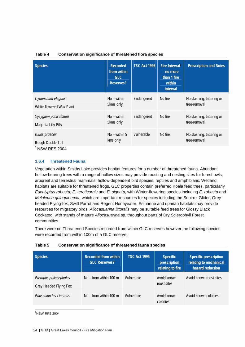
1.6.3 Threatened Flora
Inappropriate fire regimes are a potential threat to a number of species and communities that are listed
on Schedules of the NSW TSC Act and the Commonwealth EPBC Act. Based on available records there are no threatened species recorded from within GLC reserves at Smiths Lake, or within 100 m of a reserve. The following threatened Flora are recorded from within five kilometres of Smiths Lake:
24 | GHD | Great Lakes Council - Fire Mitigation Plan
Table 4 Conservation significance of threatened flora species
Species Recorded from within
GLC Reserves?
TSC Act 1995 Fire Interval7 - no more than 1 fire
within interval
Prescription and Notes
Cynanchum elegans
White-flowered Wax Plant
No – within 5kms only
Endangered No fire No slashing, trittering or tree-removal
Syzygium paniculatum
Magenta Lilly Pilly
No – within 5kms only
Endangered No fire No slashing, trittering or tree-removal
Diuris praecox
Rough Double Tail
No – within 5 kms only
Vulnerable No fire No slashing, trittering or tree-removal
1 NSW RFS 2004
1.6.4 Threatened Fauna
Vegetation within Smiths Lake provides habitat features for a number of threatened fauna. Abundant hollow-bearing trees with a range of hollow sizes may provide roosting and nesting sites for forest owls,
arboreal and terrestrial mammals, hollow-dependent bird species, reptiles and amphibians. Wetland habitats are suitable for threatened frogs. GLC properties contain preferred Koala feed trees, particularly Eucalyptus robusta, E. tereticornis and E. signata, with Winter-flowering species including E. robusta and
Melaleuca quinquinervia, which are important resources for species including the Squirrel Glider, Grey-
headed Flying-fox, Swift Parrot and Regent Honeyeater. Estuarine and riparian habitats may provide resources for migratory birds. Allocasuarina littoralis may be suitable feed trees for Glossy Black
Cockatoo, with stands of mature Allocasuarina sp. throughout parts of Dry Sclerophyll Forest
communities.
There were no Threatened Species recorded from within GLC reserves however the following species
were recorded from within 100m of a GLC reserve:
Table 5 Conservation significance of threatened fauna species
Species Recorded from within GLC Reserves?
TSC Act 1995 Specific prescription
relating to fire
Specific prescription relating to mechanical
hazard reduction
Pteropus poliocephalus
Grey Headed Flying Fox
No – from within 100 m Vulnerable Avoid known roost sites
Avoid known roost sites
Phascolarctos cinereus No – from within 100 m Vulnerable Avoid known colonies
Avoid known colonies
7NSW RFS 2004

GHD | Great Lakes Council - Fire Mitigation Plan | 25
Species Recorded from within GLC Reserves?
TSC Act 1995 Specific prescription
relating to fire
Specific prescription relating to mechanical
hazard reduction
Koala
Petaurus australis
Yellow-bellied Glider
No – from within 100 m Vulnerable No specific prescription
Pandion haliaetus
Osprey
No – from within 100 m Vulnerable Nil No slashing, trittering or tree removal of (or around) known nesting sites
Hoplocephalus stephensii
Stephens' Banded Snake
No – from within 100 m Vulnerable Nil No slashing, trittering or tree removal
Environmental assessments prior to prescribed burning activities determine if specific prescriptions are required around a specific record type to mitigate the risk to species. Record types that require specific
prescriptions include known roost, nest and maternity sites, specific habitat or foraging resources or high use areas. In NSW an environmental assessment for prescribed burning can be completed using the Bush Fire Environmental Assessment Code (Code) (NSW RFS 2006a), providing a streamlined
approach to environmental assessment of bushfire hazard reduction works. An environmental assessment under the Code for prescribed burning and mechanical works at Smiths Lake is provided in Appendix C.
1.6.5 Heritage
Aboriginal Heritage
There are no specific Aboriginal cultural heritage sites recorded on GLC reserves within Smiths Lake, although sites do exist within the locality and adjacent to the Foreshore Reserve.
If new sites are identified the NSW Bushfire Assessment Code (Conditions for Hazard Reduction and Aboriginal Heritage) (NSW RFS 2006a) can be used as a guide to identify options for prescribed burning,
and the placement of fire control lines, slashing/trittering and the use of earthmoving machinery to
minimise the risk to sites. Where there is uncertainty advice may be sought from the local Aboriginal Land Council and/or the NSW Office of Heritage and Environment.
Non-Indigenous Heritage
There are no historic heritage items identified within GLC reserves at Smiths Lake, although there are three heritage items of interest located within or adjacent to the Foreshore Reserve (Great Lakes Council 20078).
8 Great Lakes Council (2007) Great Lakes Council Heritage Study - A community based study. Prepared by
Great Lakes Council in partnership with the NSW Heritage Office. Adopted May 2007

26 | GHD | Great Lakes Council - Fire Mitigation Plan
1.7 Fire Management Zones and Mitigation Measures
Partition of the landscape into management units allows specific fire management strategies and actions to be implemented based on fuels, proximity to assets and bushfire risk. Management units are usually bounded by roads or trails, and where necessary by natural landscape features that provide barriers to
fire spread under low to moderate fire danger conditions. Types of zones applied in this plan and complimentary bushfire protection measures are identified in Table 6.
Asset Protection Zones
The threat from flame contact and radiant heat to property can be reduced by the establishment of APZs immediately surrounding dwellings, buildings and other assets at risk on private and public lands. APZs
are areas surrounding an asset where fuels (e.g. vegetation) are managed to reduce radiant heat and minimise the likelihood of flame contact with buildings. However, levels of ember attack may still be prolific, therefore if residents occupying dwellings adjacent to the Asset Protection Zone have not
properly maintained and prepared their house and garden for bushfire, the APZ is likely to be of negligible benefit.
Residents living at the interface of GLC managed bushland areas can have polarised views regarding
the management of adjoining vegetation to mitigate bushfire risk, and variable understanding and experience of bushfire events and consequences. The following are the characteristics of the bushfire risk profile of the interface:
There are a number of residences where the proximity of vegetation within the residential lot would permit direct flame contact and house to house fire spread in the event of a bushfire.
Properties along the interface and in the adjoining streets are susceptible to ember attack in the event of a high intensity bushfire.
The interface includes a large number of ‘older stock’ properties and a smaller number of newer properties that do not have bushfire mitigation design enhancements that now apply to houses constructed adjacent to a bushfire hazard (Building Code of Australia (AS3959) and Planning for
Bushfire Protection (NSW RFS 2006) requirements).
Some properties along the interface are not permanently occupied and/or are holiday rentals and houses and yards may not be cleared of bushfire fuels or maintained prior to and during the fire season.
There is an expectation from fire services that property owners are responsible for actively mitigating the bushfire risk on their property. Shared responsibility is explicit within the provisions of the NSW Rural Fires Act 1997, notably Section 63(2); “It is the duty of the owner or occupier of land to take the
notified steps (if any) and any other practicable steps to prevent the occurrence of bush fires on, and to minimise the danger of the spread of bush fires on or from, that land.”
A number of properties along the interface through design or situation are not defendable in the event of a high intensity bushfire.
Continuous access along the extent of the interface is impeded in parts by steeper slopes, drainage features, vegetation, gates, green waste piles, and residential encroachments (boats, trailers, stored building materials, garden beds).

GHD | Great Lakes Council - Fire Mitigation Plan | 27
Table 6 Bushfire Protection and Mitigation Measures
Measure Description Responsibilities
Asset Protection Zones (APZ)
An area between the bush fire hazard and the dwelling (or other asset) which is managed to minimise fuel loads to inhibit a fire path and reduce the effects of heat, flame, and ember attack.
APZs can also incorporate fire trail access and can serve as a defendable space for fire suppression, for residents and fire fighters after the passage of the fire.
APZs for GLC reserves in Smiths Lake are shown in Reserve Plans (Appendix A) and reference standards identified in Figure 6.
Private lands - Private residential owners and occupiers, mandated through a development approval process
Public lands - GLC, NPWS, Crown Lands
NSW RFS can issue hazard reduction notices in accordance with the NSW Rural Fires Act 1997.
Strategic Fire Advantage Zones (SFAZ)
Areas identified for higher frequency prescribed burning or other treatments to reduce fuel loads, rate of spread and intensity of bushfires, and levels of ember attack.
Public lands - GLC, NPWS, Crown Lands (refer to Great Lakes Bush Fire Risk Plan (GLBFMC 2008)
Fire appliance access along interface
Access to the interface during fire suppression and prescribed burning operations, and for routine maintenance.
Public lands - GLC, NPWS, Crown Lands
Building standards
(AS 3959, Standards Australia 2009)
Mandatory building enhancements for new residences in designated bushfire prone areas to better withstand bushfire attack.
Can also be utilised as a guide to ’retro-fit’ existing buildings (not mandatory).
GLC through development application processes.
Private residents for non-mandatory ‘retro-fitting’
Backyard and building maintenance
Includes measures that remove flammable materials from on and around dwellings and reduces potential for direct flame contact and ember attack
Home owners and occupiers (non-mandatory).
Active bushfire protection equipment
Suppression equipment for use by residents to protect their home (such as water tanks, pumps, hoses, nozzles, sprinkler / drenching systems)
Home owners and occupiers (non-mandatory).

28 | GHD | Great Lakes Council - Fire Mitigation Plan
It is not possible for Great Lakes Council to fully mitigate the residual risk along the interface of GLC
properties and private residential allotments, however implementing the Asset Protection Zones identified in this plan will retain access and the level of defendable space at strategic locations, enhance options
for mitigation activities such as prescribed burning and compliment the mitigation measures undertaken by residents on individual allotments.
It should be noted that only those properties that implement APZs on their property will gain protection
advantage from GLC’s implementation of APZ and other mitigation works adjacent to their property. Also where a neighbouring property does not implement mitigation works on their own property there also may be an increased risk of direct flame and ember attack.
GLC Recommendation 11 Management units identified for each property and the fuel management objective of each unit are
detailed in Reserve Plans (Appendix A). GLC should monitor the desired fuel load for each management unit and implement procedures for the maintenance of APZs (as detailed in Section 2).
Strategic Fire Advantage Zones
Hazard reduction by prescribed burning reduces the rate of spread, flame height and intensity of a fire, as well as the number and distance of spotfires by changing the structure of the fuel bed and reducing the total fuel load (Gould et al. 2007b). Project Vesta (Gould et al. 2007b) has also demonstrated the
following:
The effects of hazard reduction burning (reduction of intensity and rate of spread) may persist for a
considerable time (up to 20 years) in forests containing rough-barked trees and shrubby understorey;
Post fire stimulation of the shrub layer will not increase the rate of spread until such time as a significant near-surface fuel layer accumulates; and
Younger fuels produce fewer firebrands because fire intensities are low and less bark is consumed
than older fuel types.
The strategic placement of hazard reduced areas in the landscape is therefore an important strategy helping to reduce the size that bushfires might otherwise attain (by providing areas in the landscape where fire suppression will have greater success probability). This complements work done to reduce
asset vulnerability and hazards adjacent to assets and therefore enhances efforts to reduce risks to life, property and other assets.
GLC Recommendation 12
Reserve 5251 is identified as a SFAZ in the Great Lakes Bush Fire Risk Plan (BFCC 2008) and is scheduled for prescribed burning at part of this plan. Fuel reduction within this SFAZ seeks to reduce the
potential for fires to spread from the north-west into Smiths Lake, and limit the potential for fires establishing in this locality through accidental or intentional ignition (along The Lakes Way and around the Paradise Drive recreation facilities). GLC should liaise with fire authorities to implement prescribed
burning in identified for GLC managed SFAZs at Smiths Lake.

GHD | Great Lakes Council - Fire Mitigation Plan | 29
Figure 6 Asset Protection Zone Example Works
Note: these guidelines are developed from the ‘Inner Protection Area’ standard of Planning for Bushfire Protection 2006 (NSW RFS 2006b) (Note alternative standards apply to SEPP 14 wetlands).
Components of an Asset Protection Zone (Source: NSW RFS 2006b)
Where buildings/dwellings occur adjacent to/or at the interface with an area of bushfire hazard:
Existing larger trees (> 200 mm dbh (diameter at breast height)) can remain within the APZ provided
that:
no part of their crown occurs within 5 m of any building (significant habitat trees can remain 2 m out from the building line)
canopies are discontinuous, i.e., canopies are separated by at least 2 m
they are smoothed barked species or, if rough barked, are maintained free of hanging bark and other ladder fuels
low branches holding fine fuel (i.e. leaves and twigs of <6 mm in diameter) are pruned to 2 m from the ground.
Smaller trees (i.e. less than 200 mm in diameter), shrubs, fallen trees and tree-limbs and stumps may be removed and continuously suppressed.
All shrubs and tree saplings may be removed off-site or mulched.
A minimal ground fuel is to be maintained to include either mown grass or less than 3 tonnes per hectare of fine fuel (i.e. material of <6 mm in diameter).

30 | GHD | Great Lakes Council - Fire Mitigation Plan
1.8 Bushfire Resources
1.8.1 Water Supply
Fixed hydrant water supplies for fire suppression are located throughout Smiths Lake and in close proximity to GLC reserves. Water supply points are shown on Reserve Plans (Appendix A).
1.8.2 Access and Access Points
Sealed roads provide a means for fire crews to access GLC properties for fire suppression and prescribed burning operations. They also may serve as an effective control line for prescribed burning
and back burning. Access to GLC properties and strategic access points are shown on Reserve Maps (Appendix A). The only GLC property with a formal Category 1 tanker accessible fire trail is Macwood Reserve.
Access to and from, and within Smiths Lake during a bushfire may be constrained by the proximity of hazardous bushfire prone vegetation. The routes west to Bulahdelah (39 km) and north to Pacific Palms (7 km) both traverse bushfire prone vegetation and may become blocked by fire or fallen trees during an
emergency. Experience has shown that travel on a road during a bushfire can be fatal due to reduced visibility from smoke increasing the risk of motor vehicle accidents, roads blocked by trees or accidents creating vehicle entrapments, or a wind change dramatically changing the direction of rate of spread.
Closed roads also may restrict access by emergency services.
A formed helipad is located at the Bowling Club (corner of Paradise Drive and Macwood Road) (Lat: 32.372257S, Long: 152.500120E) (Note: powerlines in vicinity).
1.8.3 Fire Fighting Equipment
GLC relies on the NSW RFS and NSW Fire and Rescue to undertake fire suppression and prescribed
burning on its reserves in accordance with established procedures. Fire fighting capacity in Smiths Lake is limited to one Category 1 and one Category 7 NSW RFS Brigade tanker located at Smiths Lake (Macwood Drive).
Additional NSW RFS resources are available at:
Bungwahl (8km)
Coomba Park (24 km)
Green Point (20km)
Forster (28 km)
Bulahdelah (39 km)
Response times for these resources will vary based on existing commitments and the incident location. In a significant bushfire emergency it is unrealistic to assume fire fighting equipment will be available to defend the majority of property at risk.

GHD | Great Lakes Council - Fire Mitigation Plan | 31
2 Bushfire Mitigation Works Program
2.1 Aims
GLC undertake mitigation works on its reserves to reduce the impact of fire on values at risk (Section
1.6). Mitigation is achieved by a combination of the following and as documented in the in the individual reserve plans (Appendix A):
Altering property characteristics to improve the probability of successful fire response – Implementing
site works (such as maintenance of access points and strategic hazard reduction) that make safe fire suppression more likely to succeed, reducing the risk of fires being able to develop to large, high consequence fires;
Hazard Modification – Altering the characteristics of bushfire hazards, particularly adjacent to assets,
so that fires occurring have less damaging characteristics;
Vulnerability Reduction – Constructing or managing assets in such a way that they are less vulnerable to fire damage; and
Ignition Reduction – Managing operational activities such that unplanned fire ignitions are minimised.
2.2 Mitigation Activities
Mitigation activities identified for GLC reserves include but are not limited to:
Bushfire fuel reduction through prescribed burning or mechanical means (slashing, trittering);
Ecological burning;
Maintenance of fire trails, breaks and other fire control infrastructure; and
Implementation of APZs, and SFAZs.
Works are identified based on the following considerations:
Proximity of natural vegetation (forest, shrubs or grasslands) adjacent to assets (constructed, heritage or natural) and the effectiveness of the proposed works (considering overall fuel hazard in adjoining land, and location and design of adjoining asset);
Amount and type of fuel requiring modification (grass fuels (by slashing), surface and near surface fuels in heavier vegetation) to reduce bushfire risk to an asset (direct flame contact or ember attack);
Strategic location of fuels so potential fire runs and intensity can be reduced through fuel management (strategic burning);
Ecological requirements to maintain fire regimes (for communities or species) and lower intensity fuel reduction to re-establish heterogeneity of fuel ages across the property; and
Previous burn history (either high intensity bushfire or low intensity prescribed burns).
Reserve mitigation activities are summarised in Table 7 and detailed in Reserve Plans (Appendix B).

32 | GHD | Great Lakes Council - Fire Mitigation Plan
Table 7 GLC Reserves within Smiths Lake
Reserve ID Location Reserve
Area (hectares)
GLC Treatment ID
Treatment Type / Timing Area Vegetation Formation Area
5251 Paradise Drive 5.42
A21 Mechanical hazard reduction / annual 0.243 Dry Sclerophyll (Shrubby) 1.47
Prescribed Burn Prescribed burning 4.605
Wet Sclerophyll (Shrubby) 1.45
Wet Sclerophyll (Grassy) 2.12
Cleared 0.38
5237 Charles St 0.97 Nil Private residential works only Dry Sclerophyll (Shrubby) 0.61
Wet Sclerophyll (Shrubby) 0.36
5104 Nature Pl 1.01 A7 Mechanical hazard reduction / annual 0.076 Dry Sclerophyll (Shrubby) 0.86
Wet Sclerophyll (Shrubby) 0.15
Macwood First Ridge Road 2.82 Nil Private residential works only
Dry Sclerophyll (Shrubby) 0.89
Wet Sclerophyll (Grassy) 0.47
Wet Sclerophyll (Shrubby) 1.46
5146 Box Tree Rd / Orange
Grove / Patsys Flat Rd
4.16
A19 Mechanical hazard reduction / annual 0.245 Residential Lots 1.57
A9 Mechanical hazard reduction / annual 0.42 Wet Sclerophyll (Grassy) 0.28
A10 Mechanical hazard reduction / annual 0.011 Wet Sclerophyll (Shrubby) 1.97

GHD | Great Lakes Council - Fire Mitigation Plan | 33
Dry Sclerophyll (Shrubby) 0.34
5041 Box Tree Road 1.06 A20 Mechanical hazard reduction / annual 0.018 Dry Sclerophyll (Shrubby) 0.02
Wet Sclerophyll (Shrubby) 1.04
5014 The Jack / Charles St 1.21 A1 Mechanical hazard reduction / annual 0.077 Dry Sclerophyll (Shrubby) 1.21
5103 Amaroo Dr 1.26 A15 Mechanical hazard reduction / annual 0.032 Wet Sclerophyll (Shrubby) 0.70
Dry Sclerophyll (Shrubby) 0.56
5052 Macwood Dr 6.95
Prescribed Burn Prescribed burning 0.473 Wet Sclerophyll (Grassy) 2.46
A17 Mechanical hazard reduction / annual 0.087 Dry Sclerophyll (Shrubby) 4.49
A16 Mechanical hazard reduction / annual 0.057
5159 New Forster Rd 0.67 Prescribed Burn Prescribed burning 0.673 Residential Lots 0.67
5160 Valley Road 0.40 Nil Private residential works only Nil Residential Lots 0.40
Foreshore Entire Smiths Lake
foreshore 26.2 Nil
Prescribed burning may be possible but technically difficult due to linear
shape, slope and boundary demarcation issues. It could be carried out as a joint multi-tenure burn with the most effective locations at the western
(adjoining Lakes Way) and eastern (adjoining private property south of
Sandbar Road) extents.
Nil
Cleared 0.32 Dry Sclerophyll (grass) 0.01
Dry Sclerophyll (shrubby) 18.49 Forested Wetland 2.36
Sand Ridge 0.19 Swamp 0.21 Urban 0.12
Wet Sclerophyll (grassy) 2.77 Wet Sclerophyll (shrubby) 0.20
Unmapped 1.44
TOTAL 52.13 52.13

34 | GHD | Great Lakes Council - Fire Mitigation Plan
2.3 Standards Applying to Bushfire Mitigation Works
2.3.1 Asset protection zone works
Standards
Standards for vegetation management within APZs are provided in Standards for Asset Protection Zones (NSW RFS 2005). The dimensions of APZs are developed in accordance with the objectives of Planning for Bushfire Protection (NSW RFS 2006b), the Bush Fire Environmental Assessment Code for NSW
(NSW RFS 2006a) or as identified in GLC plans or policies. Planning for Bushfire Protection is given legal effect through s.79BA, s.91 and s.91A of the Environmental Planning and Assessment Act (1979).
Objective
At strategic locations on GLC reserves an APZ is maintained with an average width of 20-25 metres measured from the dwelling and, in line with Planning for Bushfire Protection, located within the
residential allotment where possible. A width of 20 metres is applied to flat surfaces or where the hazard
is upslope, and 25m where the hazard is downslope of residence. The distance is based on the flame zone bushfire attack levels identified in AS 3959-2009, however may have been reduced where drainage feature impacts or erosion issues may result. The proportion of APZ on public land to private land is
highly variable along the interface extent depending on where the residence is located on the allotment. Along parts of the interface the entire APZ width can be accommodated within the private allotment boundary.
APZ’s are not established on all boundaries of GLC reserves where:
The setback distance can be accommodated within the existing private lot;
Slopes are too steep for the establishment of an APZ (Slope classes shown in Figure 7);
An unacceptable level of vegetation clearing would be required on the reserve;
Due to vegetation on the private allotment, or the location or design of the residence, establishment of
an APZ would not improve access or mitigate bushfire risk; or
Clearing would be required within a drainage feature or stream.
A number of previously identified GLC managed APZ’s have been removed in the development of this plan where:
Located in moister areas unlikely to support a bushfire and where works may have resulted in water pollution (Reserves 5237 and 5041 (including a reduction in APZ A20); or
The APZ did not improve access or mitigate risk (5161).
Planning for Bushfire Protection (NSW RFS 2006b) provides information that can be used to guide the
maintenance of APZs. A summary guide provided for managing the interface with areas of bushfire hazard is provided in Figure 6.
Those vulnerable groups who physically may have difficulty undertaking mitigation works (such as
clearing gutters, trimming branches, mowing or slashing vegetation) and may have limited domestic support may be able to register for assistance through the NSW RFS Assist Infirm Disabled and Elderly Residents (AIDER) program.


36 | GHD | Great Lakes Council - Fire Mitigation Plan
2.3.2 Prescribed burning operations
Standards
For the protection of a range of environmental values, prescribed burning operations can be guided by NSW RFS Standards for Low Intensity Bushfire Hazard Reduction Burning(NSW RFS undated), with an
environmental assessment undertaken using the Bush Fire Environmental Assessment Code for NSW (NSW RFS 2006a).
Objectives As identified by the Victorian Bushfires Royal Commission (2009 Victorian Bushfires Royal Commission 2010), prescribed burning makes communities safer by reducing the amount of combustible fuel, thereby
reducing fire intensity, rate of spread and bushfire risk, and protects flora and fauna from destructive high intensity fires by preferentially applying a low intensity fire regime under controlled conditions.
Prescribed burning at Smiths Lake is used to enhance existing control lines (such as along Macwood
Drive in Reserve 5052), provide a fuel reduced area in potential fire paths (such as in Reserve 5159) or reduce fuels around areas of potential ignition (5251). Prescribed burning is currently identified for Reserve 5052, Reserve 5251 Reserve 5159 with further details provided in specific reserve plans
(Appendix A).
The eastern and western extent of the Foreshore Reserve, while not identified in this plan as a discrete prescribed burning block, may be incorporated into part of a larger multiple tenure burn that provides a strategic edge burn to the township (See 2.8.3). The linear shape of this reserve and lack of a clearly
demarcated boundary in section means that it is best suited to a multiple tenure burn.
Prescribed burning operations are undertaken during autumn, winter or early spring to limit the impact of summer fires and to permit safer execution and delivery of burning operations. Fuel moisture content is
extremely important in the timing of prescribed burning operations, particularly if the moisture differential of a natural fire advantage is being used to provide a control line. Therefore monitoring of conditions is essential to determine appropriate timing.
Environmental considerations are identified in Section 1, including fire frequency thresholds and general
burning prescriptions aimed at providing fire regimes appropriate to vegetation types (Section 1.5). An environmental assessment under the Bush Fire Environmental Assessment Code (2006a) is provided in
Appendix C.
2.3.3 Broader landscape risk reduction
Whilst GLC can undertake small scale Asset Protection Zone and fuel reduction works in its small
reserves within the township of Smiths Lake, the value of such work needs to be complemented by fuel reduction works on lands (private and public) surrounding Smiths Lake. In a major bushfire, ember attack from such areas is likely to be substantial. Therefore, a key bushfire risk management strategy for GLC is
to advocate through the local Bush Fire Management Committee for appropriate bushfire fuel reduction works to occur on lands adjacent to Smiths Lake. Implementation of a Strategic Fire Advantage Zone is beneficial on lands (regardless of tenure) bounded by Smiths Lake, The Lakes Way, and Sandbar Road
GLC Recommendation 13 GLC to seek RFS assistance in establishing the SFAZ identified for Smiths Lake through bushfire mitigation activities, as identified in the Bush Fire Risk Management Plan.

GHD | Great Lakes Council - Fire Mitigation Plan | 37
2 Bushfire Awareness Program
3.1 Bushfire Awareness Program Objectives
A Bushfire Awareness Program aims to communicate information about fire and associated management
activities to people who use, manage, work on, or live in areas neighbouring GLC Reserves. This information can include:
Awareness of the bushfire risks associated with their property;
Knowledge of what to do in the case of a bushfire emergency;
Key messages about the management and potential risks posed by bushfire fuels;
Advice of upcoming fuel reduction burns; and
A contact point for questions about or to report bushfire matters.
Cooperation with the NSW RFS and neighbours is the key to successful fire management within Smiths Lake.
3.2 Shared Responsibility
Amongst emergency services agencies and their partners, bushfire risk management is regarded as a shared responsibility. With this management principle is the obligation and significant challenge to educate individuals of their role in managing bushfire risk and personal safety. Local government has a
key share of the responsibility for bushfire risk management, as a both a land manager, and custodian of local knowledge about bushfire risks and local community safety issues.
The following statements elaborate on the importance of ‘shared responsibility’ as a key principle for
bushfire risk management:
The Australasian Fire and Emergency Service Authorities Council (AFAC) views the concept of shared responsibility as follows:
AFAC believes managing risk and reducing loss is a shared responsibility between government, householders, property owners and land managers. Fire agencies and some land management agencies have statutory responsibilities for managing bushfires. However, the steps that householders and business owners take to prepare for bushfires are crucial to the protection of their life and property. Communities need to be assisted in building their resilience to be able to better cope with bushfires.
AFAC, 20109
The Victorian Bushfires Royal Commission (VBRC) considered the notion of shared responsibility in some depth, devoting a whole chapter of their report to its consideration. The VBRC noted:
Pervading the Commission’s report is the idea that responsibility for community safety during bushfires is shared by the State, municipal councils, individuals, household members and the
9 Australasian Fire Authorities Council (AFAC)(2010) Bushfires and Community Safety. AFAC Position Paper Version 4.1 8
September 2010, AFAC, Melbourne

38 | GHD | Great Lakes Council - Fire Mitigation Plan
broader community. A fundamental aspect of the Commission’s recommendations is the notion that each of these groups must accept increased responsibility for bushfire safety in the future and that many of these responsibilities must be shared.
VBRC, 2010
The recent Special Inquiry into the 2011 bushfires in the Perth Hills, undertaken by former Federal Police Commissioner Mick Keelty was titled ‘A Shared Responsibility’. The report emphasised:
The Special Inquiry strongly believes that bushfire risk management is a shared responsibility, which relies upon all relevant agencies and community members working together effectively. This shared responsibility, understanding and commitment needs to be underpinned by contemporary and relevant policies and legislation, effective coordination mechanisms at the State and local level and active engagement with local communities.
M. Keelty, 201110
3.3 Community awareness and preparedness programs
A key finding of the Victorian Bushfires Royal Commission (VBRC) was that contemporary approaches to community bushfire awareness and preparedness at the time of the Black Saturday fires may have contributed to the unprecedented number of fatalities. Specifically the VBRC examined the nationally adopted bushfire safety policy of ‘prepare, stay and defend, or go early’. Under this policy, fire and
emergency services encouraged members of the public residing in, visiting or working in bushfire prone areas to prepare their own personal or family unit ‘bushfire survival plans’. Some agencies provided
templates and/or on-line tools and guidelines on their websites to assist members of the public prepare such plans, accompanied by media campaigns and other community engagement activities to encourage people to undertake bushfire survival planning. Having adopted such an approach, it was common
practice prior to 2009 that when fire threats or extreme fire danger emerged in an area, warnings issued by authorities to communities were commonly generic ‘activate your personal bushfire survival plan’ type messages.
The VBRC hearings identified that:
a high proportion of people didn’t have any bushfire survival plan;
of those that did have a bushfire survival plan many didn’t fully appreciate the conditions they would
face in staying to defend (many changed their mind at the last minute, some were trapped with inadequate capability to defend); and
a high proportion of people adopted a ‘wait and see’ strategy.
In response to the lessons learnt from the Black Saturday fires and recommendations made by the
VBRC, National community preparedness planning approaches have been revised to include:
Planning scales have been brought down to specific communities at risk level so that information and messages can be tailored to the needs of local residents;
10 Kelty, M. (2011) A Shared Responsibility – The Report of the Perth Hills Bushfire February 2011 Review. Report prepared for
the Public Sector Commissioner, Government of Western Australia

GHD | Great Lakes Council - Fire Mitigation Plan | 39
Messages about levels of local bushfire risk and the factors that drive the risk are more ‘direct’ than in the past (explanation goes further than just stating an area is ‘high fire risk’) and include some description of what potential fire behaviour could be anticipated;
Messaging is explicit that in the event of a fire, residents ‘should not expect a fire truck at their property’, and there is no guarantee fire authorities will be able to issue timely warnings of approaching fire that will allow early evacuation;
Messaging emphasizes that even if an individual’s plan is to go early, to enhance a home’s prospects
of survival, appropriate maintenance and preparedness is still required. With a plan to stay and defend, an individual’s survival depends on having made such preparations and death may be a consequence of this decision;
Emphasis on ‘going early’ as the safest option, with added emphasis that this entails leaving the night before on the higher fire danger days;
Locally specific advice is given on where the location of safe places to relocate to are, with route and distance information provided;
Local radio and emergency broadcaster details, websites and emergency contact details are identified to assist people maintain awareness about the local fire situation; and
A local map showing the location of Neighbourhood Safer Places (of last resort) and key community facilities such as hospitals, fire and police stations
3.4 Existing Awareness Programs
GLC-initiated bushfire awareness programs include involvement in cooperative management relationships (Great Lakes Local Emergency Management Committee and District Bush Fire Management Committees).
NSW RFS also conduct bushfire awareness programs in Smiths Lake including:
Maintenance of websites that provide information on:
Preparing for bushfires;
What to do in the event of a bushfire;
Fire hazard notices and inspections; and
Development in bush fire prone areas.
Development and dissemination of bushfire-related brochures at annual RFS open days and community preparedness sessions;
NSW RFS bushfire awareness training courses;
Bushfire education lines;
Media releases and announcements; and
School visits by fire fighters.
NSW Police in association with Fire & Rescue NSW and NSW RFS are responsible for the prevention and investigation of accidental or deliberate ignition by members of the public at the urban interface. GLC will, as far as is practical, assist these authorities in their actions.

40 | GHD | Great Lakes Council - Fire Mitigation Plan
A secondary source of bushfire ignition may be GLC staff and contractors undertaking activities involving fire on GLC managed properties. Standard operating procedures or conditions in hot-works permits regarding restricting certain activities during fire danger periods and the immediate suppression of fires
will contribute towards preventing ignitions on GLC lands (Section 4).
GLC Recommendation 14
GLC maintain its strong relationship with NSW RFS and Fire & Rescue NSW as part of shared responsibility for maintaining bushfire awareness in the community.
3.5 Community Bushfire Preparedness Guide
Individuals understanding their local bushfire risks, how they can prepare themselves and their property to reduce risks, and what to do in the event of a fire or extreme fire danger is critical to maximising their
chances of survival. Fire authorities and local government have a shared responsibility for bushfire risk management, in relating local knowledge about bushfire risks and local community safety issues to the community (Sections 3.2 and 3.3)
As Smiths Lake is classified as extreme bushfire risk based on a large number of risk factors (Section 1.1), the vulnerability of the community (Section 1.6) and the potential for a bushfire to impact the locality in a very short time (Section 1.3) advance planning is essential for community resilience. A locally
tailored Community Bushfire Preparedness Guide can provide essential summary information about local bushfire risk factors in a concise format, with reference to further information sources. The Guide prepared for Smiths Lake (Appendix D) is based on the Victorian Country Fire Authority template
updated with NSW content. There is currently no NSW Bush Fire Coordinating Committee template for a Community Bushfire Preparedness Guide in NSW. The guide is structured around the National ‘Prepare – Act – Survive’ community messaging theme.
GLC Recommendation 15 The Community Preparedness Guide should be issued annually to Smiths Lake property owners and
tenants, and on arrival to holiday tenants. The guide could be circulated using the following mechanisms:
With August rate notices (prior to the fire season) to reach property owners (resident and non-
resident);
As a mail out to all Smiths Lake properties including local businesses (to ensure all occupiers receive relevant information);
Provided to local Real Estate agents to provide to holiday renters as keys are issued;
As part of RFS community engagement and preparation exercises;
On GLC website; and
Displayed on community notice boards at Macwood shops and John DeBert Reserve.
A Community Preparedness Guide provides a concise mechanism to relate bushfire risk information to the community, however it is not an end to itself and must be integrated with existing programs (Section
3.4) to maximise effectiveness.

GHD | Great Lakes Council - Fire Mitigation Plan | 41
3 Bushfire Response Strategy
4.1 Response Objectives
The key bushfire response objectives for GLC Reserves are to:
Maintain the safety of GLC personnel, fire fighters and residents;
Ensure bushfires are extinguished as soon as possible (unless conditions are mild (FDR <12) and permit safe burning out to a containment line);
Adhere to previously prepared mitigation strategies (including prescribed burning) that will effectively
assist in reducing bushfire spread, intensity and impact;
Cooperate with adjacent land owners and fire authorities to achieve success in bushfire suppression operations;
Support rapid initial attack to extinguish bushfires in accordance with GLC responsibilities as a
support agency identified in the local DISPLAN (GLC 2006) and Great Lakes BFMC Plan of Operations; and
Support evacuation coordinated by NSW Police in accordance with emergency management procedures and responsibilities detailed in the local DISPLAN (GLC 2006).
4.2 Readiness and Restrictions
Fire Danger Ratings issued by the BoM (Section 1.3) provide a mechanism to restrict certain activities and increase preparedness levels to reduce the likelihood of fire incidence and provide a quick response if a bushfire occurs.
Generic bushfire readiness levels in Table 8 apply to GLC Reserves and the community. The readiness levels and triggers to those readiness levels are a key determinant for rapid response and prevention of fire.
Where GLC personnel or contractor activities occur within areas of hazardous vegetation, maintaining awareness of fire danger is critical in preventing accidental ignitions. All GLC personnel and civilian contractors operating in the areas of bushfire hazard should confirm the FDR (for ‘Mid-North Coast’ or
‘North Coast Fire Area’) prior to conducting their planned program. The FDR is displayed at the Macwood Drive and The Lakes Way intersection, broadcast on ABC local radio and available on the Bureau of Meteorology website.
GLC Recommendation 16 All GLC personnel and contractors should modify operations according to forecast Fire Danger when working in areas of bushland hazard.
GLC personnel should maintain a level of preparedness in accordance with the Fire Danger level.

42 | GHD | Great Lakes Council - Fire Mitigation Plan
Table 8 Bushfire Readiness and Restrictions
Outside Fire Season - See Section 2: Bushfire Mitigation Works Program
During Fire Season (01 October to 31 March (or earlier as amended)) Standards below
Fire Danger Rating GLC Reserves Smiths Lake Community Recommendation (from Community Preparedness Guide)
Low to Moderate
No specific restrictions in place for GLC personnel or contractors working within areas of bushfire hazard. Activities must be consistent with GLC standard procedures or contract conditions (including Hot Works Permit conditions). During daylight hours Local Emergency Management Officer (LEMO) may maintain a listening watch on ABC Radio for any official bushfire warnings broadcast by fire emergency services. The LEMO or delegate may consider promulgation of changes in the forecast FDR to appropriate GLC site representatives.
Review and prepare to activate your Bush Fire Survival Plan with your family. Keep yourself and your family informed and monitor conditions. Be ready to act if necessary.
High
As for Low-Moderate plus: All personnel working in or adjacent to continuous fuels are briefed/ advised in established briefing procedure specific instruction on appropriate ignition prevention measures and what to do in a fire. GLC site supervisor and contractor supervisor operating within areas of bushfire hazard should have an emergency contact system in place using either a portable radio or mobile phone. Consideration given to suspending activities with the potential to cause accidental ignitions (e.g. slashing, external welding, machinery operations in continuous dry or cured fuels with rocks present) in native vegetated areas.
Very High
As for High plus: Suspension of activities with the potential to cause accidental ignitions and consider promulgation of FDR/TOBAN advice to appropriate GLC representatives (as above). The LEMO may confirm the location and availability of GLC resources that may be called on in the event of a fire (such as plant).
As for High / Low-Moderate plus Contain pets so that they can be easily found; Check water pumps and generators; Listen to ABC Local Radio for information and Bush Fire Alerts Watch for signs of fire, especially smoke or the smell of smoke

GHD | Great Lakes Council - Fire Mitigation Plan | 43
Outside Fire Season - See Section 2: Bushfire Mitigation Works Program
Severe [Total Fire Ban]
As for Very High plus: Suspension of activities within GLC reserves with the potential to cause ignitions. LEMO to liaise with LEACON regarding: Preparedness and availability of GLC resources;
Arrangements for evacuation and opening of evacuation centres; and
Arrangements for community advice and warnings.
As for Very High plus Leaving early is the safest option for your survival. Well prepared homes that are actively defended can provide safety – but only if you are physically and mentally prepared to defend in these conditions. If you are not prepared, leave early in the day - do not just wait and see what happens as this can be fatal.
Extreme [Total Fire Ban]
Leaving early is the safest option for your survival - do not just wait and see what happens as this can be fatal. If you are not prepared to the highest level, leave early in the day. Only consider staying if you are prepared to the highest level – such as your home is specifically designed, constructed or modified, and is situated to withstand a fire, you are well prepared and can actively defend it if a fire starts.
CATASTROPHIC [Total Fire Ban]
For your survival, leaving early is the only option. Leave bush fire prone areas the night before or early in the day – do not just wait and see what happens as this can be fatal. Make a decision about when you will leave, where you will go, how you will get there and when you will return. Homes are not designed to withstand fires in catastrophic conditions, so you should leave early.

44 | GHD | Great Lakes Council - Fire Mitigation Plan
4.3 Bushfire Detection and Reporting
Early fire detection contributes to improving initial attack response success. GLC reserves in Smiths Lake are located in close proximity to residences and any ignitions will be reported promptly. Therefore
GLC reserves have lower risk factors than an area with limited visibility or poor coverage.
All fire ignitions must be reported immediately through “000”.
When reporting fires the following information may be useful to fire authorities:
Size and location of the fire;
Assets at risk;
Site specific issues (such as accessibility to the area);
Fire behaviour, e.g. size, rate of spread, terrain, flame heights, direction of fire spread, proximity to
assets;
Resources currently tasked to the fire, likelihood of control with current resources and additional resources required;
Prognosis, i.e. the likely development of the fire over a nominated period of time;
Current weather conditions/observations at the fireground; and
The fire should also be reported to the relevant GLC representative after Triple 0 has been notified.
4.4 Command and Control
The Australian Inter-Service Incident Management System Incident Control System (ICS) is the command and control structure utilised across Australia for the management of emergency events including bushfires. The ICS framework can be applied to an incident of any size, with roles divided along
functional lines (operations, planning, logistics) reporting to a single IC.
Initially the IC and other incident team roles will be nominated by the lead fire fighting or emergency management authority in accordance with the local BFMC Plan of Operations or DISPLAN. Shift patterns
and briefing arrangements are set by the lead agency commensurate with the size of the incident.
Control centres for the management of emergency operations are nominated by the lead fire fighting agency. The Smiths Lake RFS station or the Bowling Club are potential staging areas.
4.5 Evacuation Arrangements
In the event of a bushfire, or where potentially dangerous fire weather conditions are forecast, a decision may be made to make arrangements for the evacuation of the residents of Smiths Lake. The control and coordination of this evacuation is, as identified in the DISPLAN (GLC 2006), the responsibility of the
NSW Police.
As detailed in the Smiths Lakes Community Preparedness Guide (Appendix D) residents are encouraged to identify their place of evacuation and route in advance in their personal bushfire survival plan. They
are also encouraged to ‘Leave Early’ if Fire Danger worsens (Table 8). Options for evacuation include:
Relatives or friends in an area of low bushfire hazard (such as Forster);

GHD | Great Lakes Council - Fire Mitigation Plan | 45
Shopping centres or a town centre;
An evacuation centre (where activated); or
Neighbourhood Safer Places (NSP) or places of last resort.
NSP are areas free of bushland that persons can assemble on a short-term basis from the immediate
threat of a bush fire. They are not Fire Refuges, Evacuation Centres, Welfare Centres, Recovery Centres, Assembly Areas or private bush fire shelters such as bunkers. The nearest NSP identified by the NSW RFS to Smiths Lake is at Blueys Way, Blueys Beach (7 km). It should be noted this NSP is:
Open space without shelter and not protected from the elements;
Limited in area and could not accommodate a large number of vehicles;
Unsuitable for those with special needs or vulnerable community members;
Unsuitable for pets;
Limited to very basic toilet facilities; and
Does not have established catering facilities.
The closest formal evacuation centre to Smiths Lake is the Pacific Palms Recreation Club/Community Centre, Lakes Way Pacific Palms. The opening of this evacuation centre is in accordance with the delegations and requirements detailed in the DISPLAN.
GLC Recommendation 17
GLC will, in accordance with the emergency arrangements identified in the DISPLAN:
Support NSW Police in the event of an evacuation of Smiths Lake;
Assisting in the opening and staffing of evacuation centres; and
Provide identified support plant and services.

46 | GHD | Great Lakes Council - Fire Mitigation Plan
4 Bushfire Recovery Requirements Implementation of effective and timely recovery actions following bushfires and prescribed burning
operations is essential to address human aspects, provide opportunities for debriefing and lessons learnt, ensure that GLC infrastructure is maintained and to minimise environmental impact.
5.1 Human Aspects
The NSW State Emergency and Rescue Act 1989 and the NSW State Disaster Plan provide for
community recovery, coordinated by the Local Emergency Management Committees.
5.2 Infrastructure and Utility Aspects
Coordination with the respective authorities so that post-fire repairs are conducted in a timely manner is essential to ensure disruptions to residents and GLC activities are minimised.
5.3 Post-fire Debriefings
Debriefings provide an important forum to discuss and review the effectiveness of fire operations and
management and the need for changes. Debriefings can take place at many different levels, from informal discussions with the position that undertook the role of IC (small fires without asset damage) to more complex multi-agency investigations (large multi-tenure fires with life and property harm).
GLC Recommendation 18
Relevant GLC personnel should seek to participate in all formal fire and emergency debriefs involving GLC Reserves, assets or Council interests.
5.4 Animal Welfare
Fire may have an impact on animals through injury and loss of habitat. The Office of Heritage and Environment, WIRES and the RSPCA may be able to treat animals affected by fire.
Relevant contact details are:
WIRES (NSW): 1300 0WIRES or 1300 094 737;
Animal Rescue Taree Ph: 0439 022 797
Native Animal Trust Fund: 0418 628 483
RSPCA (emergencies only): (02) 9770 7556; and
NSW Office of Heritage and Environment Environmental Information (business hours) 13 15 55
Personnel from wildlife carer organisations are not be permitted onto the fireground to rescue injured
wildlife until the Incident Controller has provided permission and it is safe to do so.
5.5 Environmental Rehabilitation
There can be significant environmental impacts following a fire. These include soil erosion, reduced water quality, poor recruitment of native vegetation, impacts on threatened species and cultural heritage

GHD | Great Lakes Council - Fire Mitigation Plan | 47
sites, and the spread of weeds, pests and pathogens. Short-term emergency works for stabilisation or rehabilitation should be instituted during or immediately following fire suppression operations to protect life and property, water quality and catchment values, and to prevent degradation of natural or cultural
assets.
Table 9 provides potential options for rehabilitation against anticipated causes of damage from bushfire within the GLC Reserves.
Table 9 Post Fire Rehabilitation Options
Cause Potential Impacts Recovery Options
New access trails constructed
Increased maintenance costs Erosion
Assess trails immediately after fire event Options will be dependent on whether the trail is useful for other purposes or is strategically located for future fire management Close and install erosion controls and/or keep and upgrade to a stable, trafficable surface Assess disturbed areas for weed infestations 6-12 months after fire event Implement primary weed and follow up weed control
Damage to existing fire access trails
Erosion Widening to an excessive width Weed infestation
Assess trails immediately after fire event Install temporary and permanent erosion controls Revegetate damaged areas and restrict access Assess disturbed areas for weed infestations 6-12 months after fire event Implement primary weed and follow up weed control
Vegetation removed Soil instability Increase in weeds
Reduced habitat and shelter for animals and increased predation
Increased grazing/browsing or regeneration flora
Natural and/or assisted revegetation Assess disturbed areas for weed infestations 6-12 months after fire event Post-fire pest and weed control, and access restrictions
Notify and seek advice from NSW Office of Environment and Heritage, and Commonwealth Department of Environment, Water Heritage and the Arts if TSC Act or EPBC Act species and communities affected Control of pests and overabundant species
Damage to unknown Aboriginal sites
Artefacts could be damaged Artefacts can be exposed
If artefacts are found notify the NSW Office of Environment and Heritage, and the Commonwealth Department of Environment, Water Heritage and the Arts for advice

48 | GHD | Great Lakes Council - Fire Mitigation Plan
The following significant noxious weeds are identified from GLC reserves:
Bitou Bush
Red Lantana
Giant Rats Tail Grass
Blackberry
Green Cestrum
Giant Parramatta Grass
St Johns Wort
Pampas Grass
Groundsel bush
Mother of Millions
Weed response following a bushfire or prescribed burn will vary by reserve, burn intensity, post fire conditions and species. Monitoring and scheduling is identified in Section 6.
GLC Recommendation 19
GLC begin to implement rehabilitation actions immediately after a fire event on GLC reserves, and follow up monitoring and activities as required.

GHD | Great Lakes Council - Fire Mitigation Plan | 49
5 Monitoring, Recording and Analysis
6.1 Bushfire Hazard Monitoring
A fuel hazard monitoring and recording procedure consistent with the Overall Fuel Hazard Assessment Guide (Hines et al. 2010) should be undertaken targeting areas where fuel management is a priority
(SFAZs and APZs) or where concerns about fuel levels have been raised to confirm if treatment should be applied.
Objectives for APZs and SFAZs and subsequent mitigation works/fuel reduction works should reflect the desired overall fuel hazard level.
6.2 Monitoring after prescribed burns
Monitoring prescribed burning operations is an important component of any fire management or fuel
reduction burn program. Monitoring allows an assessment of the fuel reduction burn in meeting its objectives. It may also allow management to:
Assess the need for fire rehabilitation/environmental recovery works;
Adjust future fuel reduction burning activities;
Rapidly detect and control infestations of weeds and pests;
Evaluate the impact of the imposed fire regime on conservation;
Monitor and ‘fine tune’ recovery programs (e.g. erosion controls, revegetation);
Establish and/or ‘fine tune’ fire regime requirements for conservation of threatened species and biodiversity; and
Evaluate the impact and value of fuel reduction burns.
A basic post fire monitoring schedule that may be utilised for both prescribed burns and bushfires is provided as Table 10. Improvements to the schedule can be made through the development of a more scientific method of study such as the pre-burn establishment of survey transects and quadrants and the
subsequent recording of floristic data.
All records should be entered on a suitable database, or at least kept together with the fire report to facilitate reporting and analysis of impacts.
Table 10 Basic Post Fire Monitoring Schedule
When What How Who
Immediately after fire
The burn area (size and location) including presence of unburnt islands.
GPS burn area perimeter and internal unburnt islands island Aerial imagery
‘Marking up’ topographic maps to be digitised and converted to a GIS shapefile
GLC

50 | GHD | Great Lakes Council - Fire Mitigation Plan
When What How Who
Extent of scorch and combustion.
Measure scorch height Measure fuel load remaining (utilise Overall Fuel Hazard Assessment Guide (Hines et al. 2010)) Note % of ground cover remaining
GLC
Determine if threatened species or Endangered Ecological Communities may have been affected.
Review previous records and studies GLC
Presence of severe disturbance caused by fire suppression operations.
Record and map disturbance areas such as newly created firebreaks, dozer trails, and heavy trafficked areas
GLC
Presence of Aboriginal sites/relics
Record if exposed Notify and seek advice from NSW DECCW, and Commonwealth Department of Environment, Water Resources, and the Arts (Heritage Division)
GLC
6, 12, and 24 months after a fire
If relevant, the presence or absence of threatened species or Endangered Ecological Communities (timing may need to be adjusted to suit the growth stage of the plant).
Survey previous known sites and note presence/absence and numbers
Survey surrounding areas for the emergence of additional populations or individuals
GLC
Presence of overabundant native species, weeds, and feral animal pests.
Observations, sightings, scats and markings Evidence of excessive browsing/grazing Identification of weeds species
GLC
The progress and effectiveness of rehabilitation works. Additional rectification works.
Review progress against rehabilitation plans (if prepared) Note and record continued presence of environmental degradation
GLC
4, 8, and 12 years after the fire
The progress and effectiveness of rehabilitation works. Identify additional rectification works.
Review progress against rehabilitation plans (if prepared) Note and recorded continued presence of environmental degradation
GLC
Presence of overabundant native species, weeds, and feral animal pests.
Observations, scats and markings Evidence of excessive browsing/grazing Identification of weeds species
GLC
Fuel hazard accumulation Undertake Overall Fuel Hazard Assessment GLC / RFS

GHD | Great Lakes Council - Fire Mitigation Plan | 51
6.3 Fire Recording
As the IC, NSW RFS/Fire & Rescue NSW is to prepare bushfire reports.
Fire reports are to be obtained from NSW RFS for any fire event (including small fires and ignitions).
All NSW RFS fire records are to be numbered by the identified responsible GLC Officer for filing and
archiving.
The following records (electronic and hardcopy) should be stored:
Post-fire debrief reports;
Bushfire reports; and
Results of bushfire hazard monitoring.
GLC Recommendation 20
GLC will seek from the NSW RFS reports in relation to any fire event on GLC reserves, and place these on a GLC file.

52 | GHD | Great Lakes Council - Fire Mitigation Plan
6 Compilation of Recommendations Table 11 Table of Recommendations
No. Recommendation Section
1 As a responsible land manager, GLC has identified the need to undertake mitigation works on its lands and lead community mitigation activities. However, as a significant proportion of the overall fuel hazard is located on adjoining private lands, it is recommended GLC continue to participate in and facilitate a cooperative whole of community approach to mitigation.
1.1
2 As the incidence of deliberate fires can relate to accessibility, restrictions placed on access are a means used to reduce the potential for arson. As it is difficult to restrict access to GLC reserves due to the large area of interface, fuel reduction is applied in areas where arson has occurred historically (such as along The Lakes Way near Reserve 5251).
1.2
3 Routine maintenance activities have the potential to cause accidental ignition (for example the welders, or slashing on rocky ground) and specific strategies can be incorporated into staff and contractor instructions to restrict or modify activities with increases in forecast fire weather (Section 4).
1.2
4 Prescribed burns are identified and completed for GLC Reserves to reduce fuel hazard (as detailed in Reserve Plans (Appendix A)).
1.2
5 The fire danger period usually commences from the start of September (sometimes earlier in prolonged drought years) and GLC should aim to have mitigation works and community programs completed by this date.
1.3
6 Higher fire danger days can arrive with short notice, and GLC and the community may only receive a maximum of three days notice of a deterioration in weather conditions. Maintaining preparedness levels in response to increasing Fire Danger (Section 4) provide a means for GLC is prepared in the event of a bushfire.
1.3
7 During drought affected fire seasons GLC may place a great emphasis on community consultation programs in conjunction with fire authorities.
1.3
8 The GLC Local Emergency Management Committee representative liaise with the Local Emergency Operations Controller (LEACON) or (where appointed) a Section 44 Incident Controller about preparedness arrangements prior to a forecasted Severe, Extreme or Catastrophic fire day.
1.3
9 Fuel accumulation rates can be used to guide the scheduling of areas for fuel reduction (mechanical or prescribed burning). Overall fuel hazard (Hines et al 2010) should be assessed at each site routinely to monitor if treatment is required (Section 6).
1.5
10 GLC review existing emergency evacuation arrangements (such as those identified in the DISPLAN) in relation to provisions for vulnerable community members.
1.6
11 Management units identified for each property and the fuel management objective of each unit are detailed in Reserve Plans (Appendix A). GLC should monitor the desired
1.7

GHD | Great Lakes Council - Fire Mitigation Plan | 53
No. Recommendation Section
fuel load for each management unit and implement procedures for the maintenance of APZs (as detailed in Section 2).
12 Reserve 5251 is identified as a SFAZ in the Great Lakes Bush Fire Risk Plan (BFCC 2008) and is scheduled for prescribed burning at part of this plan. Fuel reduction within this SFAZ seeks to reduce the potential for fires to spread from the north-west into Smiths Lake, and limit the potential for fires establishing in this locality through accidental or intentional ignition (along The Lakes Way and around the Paradise Drive recreation facilities). GLC should liaise with fire authorities to implement prescribed burning in identified for GLC managed SFAZs at Smiths Lake.
1.7
13 GLC to seek RFS assistance in establishing the SFAZ identified for Smiths Lake through bushfire mitigation activities, as identified in the Bush Fire Risk Management Plan.
2.3
14 GLC maintain its strong relationship with NSW RFS and Fire & Rescue NSW as part of shared responsibility for maintaining bushfire awareness in the community.
3.4
15 The Community Preparedness Guide should be issued annually to Smiths Lake property owners and tenants, and on arrival to holiday tenants. The guide could be circulated using the following mechanisms:
With August rate notices (prior to the fire season) to reach property owners
(resident and non-resident);
As a mail out to all Smiths Lake properties including local businesses (to ensure all occupiers receive relevant information);
Provided to local Real Estate agents to provide to holiday renters as keys are
issued;
As part of RFS community engagement and preparation exercises;
On GLC website; and
Displayed on community notice boards at Macwood shops and John DeBert Reserve.
A Community Preparedness Guide provides a concise mechanism to relate bushfire risk information to the community, however it is not an end to itself and must be integrated with existing programs (Section 3.4) to maximise effectiveness.
3.5
16 All GLC personnel and contractors should modify operations according to forecast Fire Danger when working in areas of bushland hazard.
GLC personnel should maintain a level of preparedness in accordance with the Fire Danger level.
4.2
17 GLC will, in accordance with the emergency arrangements identified in the DISPLAN:
Support NSW Police in the event of an evacuation of Smiths Lake;
Assisting in the opening and staffing of evacuation centres; and
Provide identified support plant and services.
4.5

54 | GHD | Great Lakes Council - Fire Mitigation Plan
No. Recommendation Section
18 Relevant GLC personnel should seek to participate in all formal fire and emergency debriefs involving GLC Reserves, assets or Council interests.
5.3
19 GLC begin to implement rehabilitation actions immediately after a fire event on GLC reserves, and follow up monitoring and activities as required.
5.5
20 GLC will seek from the NSW RFS reports in relation to any fire event on GLC reserves, and place these on a GLC file.
6.3

GHD | Great Lakes Council - Fire Mitigation Plan | 55
7 References 2009 Victorian Bushfires Royal Commission.& Teague, Bernard (2010) 2009 Victorian Bushfires Royal Commission : final report 2009 Victorian Bushfires Royal Commission, http://www.royalcommission.vic.gov.au/Commission-Reports
Bureau of Meteorology (BoM) (2011) Average annual, seasonal and monthly rainfall, BoM, viewed 20
January 2011, http://www.bom.gov.au/jsp/ncc/climate_averages/rainfall/index.jsp
Bush Fire Coordinating Committee (BFCC) (2003) Fire Trails and Guidelines for the Classification of Fire Trails. Policy No 1/2003
Bush Fire Coordinating Committee (BFCC) (2007a) Fire Trails Policy No 2/2007
Bush Fire Coordinating Committee (BFCC) (2007b) Bush Fire Risk Management 20 No 3/07
Conacher Travers Pty Ltd (2000) Bush Fire Management Plan for the Village of Smiths Lake, Great Lakes Council. Report prepared for Great Lakes Council May 2000
Country Fire Authority (CFA) (1999) Grassland Curing Guide, Country Fire Authority (Victoria), Fiskville
Victoria, viewed 8 June 2010, http://www.cfa.vic.gov.au/documents/curingguide.pdf
CSIRO (2007) Climate Change in the Hunter-Central Rivers Catchment, CSIRO Commonwealth of
Australia
Department of Environment, Climate Change and Water (DECCW) (2005) ‘Species, Populations and Ecological Communities’, in Threatened Species, Department of Environment, Climate Change and
Water, NSW
Department of Environment, Climate Change and Water (DECCW) (2010a) NPWS Wildlife Atlas data.
Department of Environment, Climate Change and Water, NSW
Fogerty, L (unpubl.) Bushfire on the Edge – An Historical and Scientific Basis for Policy and Practice of Shared Responsibility, paper in preparation
Forestry Commission of New South Wales (1979) Forest types in New South Wales. Edited by Baur, George N. Research Note ; 17 Forestry Commission of New South Wales, Sydney NSW
Gill, A M, Bradstock, R A, and Williams, J E (2002) ‘Fire Regimes and Biodiversity’, pp 429-446. in Bradstock, R.A., Williams, J.E. and Gill, A.M. (eds) Flammable Australia. The Fire Regimes and Biodiversity of a Continent, Cambridge University Press, Cambridge, UK
Gould, J S, McCaw, W L, Cheney, N P, Ellis, P F, and Matthews, S (2007a) Field Guide – Fuel assessment and fire behaviour prediction in Dry Eucalypt Forest, Ensis-CSIRO, Canberra, ACT and
Department of Environment and Conservation, Perth, WA
Gould, J S, McCaw, W L, Cheney, N P, Ellis, P F, Knight, I K, and Sullivan, A L (2007b) Project Vesta – Fire in Dry Eucalypt Forest: Fuel structure, fuel dynamics and fire behaviour, Ensis-CSIRO, Canberra
ACT, and Department of Environment and Conservation, Perth, WA
Hennessy, K J, Fawcett, R, Kirono, D, Mpelasoka, F, Jones, D, Bathols, J, Whetton, P, Stafford Smith, M, Howden, M, Mitchell, C, and Plummer, N (2008) An assessment of the impact of climate change on the nature and frequency of exceptional climatic events, CSIRO and the Australian Bureau of
Meteorology

56 | GHD | Great Lakes Council - Fire Mitigation Plan
Hines, F, Tolhurst, K G, Wilson, A G and McCarthy, G J (2010) Overall Fuel Hazard and Assessment Guide, 4th edn., Department of Sustainability and Environment, Victoria
Keith, D (2004) Ocean Shores to Desert Dunes, Department of Environment and Conservation, Sydney
Leon, M.,(2011) The History of the Worimi People, Towabba Website
(http://www.tobwabba.com.au/worimi/) Accessed 9 September 2011
McArthur, A (1973) Forest Fire Danger Meter Mk5, CSIRO Forestry and Forest Products – Bushfire
Behaviour and Management
NSW Bush Fire Coordinating Committee (2008) Great Lakes Bush Fire Management Committee – Bush Fire Risk Management Plan. Prepared by the Great Lakes BFMC for the NSW BFCC
NSW National Parks and Wildlife Service (NSW NPWS) (2002) Fire Interval Guidelines for Broad Vegetation Types, prepared by the NSW National Parks and Wildlife Service Hurstville NSW
NSW Rural Fire Service (NSW RFS) (undated) Standards for Low Intensity Bushfire Hazard Reduction Burning, New South Wales Rural Fire Service
NSW Rural Fire Service (NSW RFS) (2004) Threatened species hazard reduction list - Part 1 - Plants,
New South Wales Rural Fire Service
NSW Rural Fire Service (NSW RFS) (2006a) Bush Fire Environmental Assessment Code for New South Wales, New South Wales Rural Fire Service
NSW Rural Fire Service (NSW RFS) (2006b) Planning for Bushfire Protection: A guideline for Councils, Planners, Fire Authorities and Developers, New South Wales Rural Fire Service

2 | GHD | Great Lakes Council - Fire Mitigation Plan
Appendix A
Reserve Plans

SECTION 2 Bushfire Mitigation Works Program
Works GLC Reserve (APZ ID) Zone Timing Responsibility Procedures
Asset protection zone maintenance and seasonal bushfire preparedness
5251 (A21), 5104 (A7), 5146 (A19, A9, A10), 5041 (A20), 5014 (A1), 5103 (A15), 5052 (A17, A16)
Asset Protection Zone (APZ)
Annually prior to fire season (September) if fuels reach threshold levels
Great Lakes Council (implementation and monitoring)
Maintain existing APZ as shown in Figure 2 to a width 20-25 metres measured from edge of house (except where constrained by drainage feature (part of A11) or slope) Maintain existing grass areas to a height less than 10cm and existing cleared areas to low overall fuel hazard through slashing / brushcutting. Prune trees (adjacent to buildings) on GLC reserve to 3 m above ground and overhanging vegetation adjacent to buildings on GLC reserve
Fuel monitoring All reserves Annually Great Lakes Council
Monitor overall fuel hazard in GLC reserves to determine if additional fuel reduction activities are required or should be brought forward
Hazard reduction burning works
5052, 5251 & 5159
SFAZ & LMZ 2012 GLC / NSWRFS Prepare hazard reduction burn plan 12 months before scheduled month/season. Engage resources for burning 2 months before scheduled burn period. Mobilise identified burning resources in accordance with burn plan.
Smiths Lake Reserve Fire Mitigation Plan – Great Lakes CouncilThis A2 plan contains site specific information only and compliments the Smiths Lake Fire Mitigation Plan Report
Figure 2. Site Map
Reserve Area (ha) APZ ID Area Vegetation Formation Area (ha)
5251 5.42
A21 0.243 Dry Sclerophyll (Shrubby) 1.47
Prescribed Burn 4.605
Wet Sclerophyll (Shrubby) 1.45
Wet Sclerophyll (Grassy) 2.12
Cleared 0.38
5237 0.97 Nil Dry Sclerophyll (Shrubby) 0.61 Wet Sclerophyll (Shrubby) 0.36
5104 1.01 A7 0.076 Dry Sclerophyll (Shrubby) 0.86
Wet Sclerophyll (Shrubby) 0.15
Macwood 2.82 Nil
Dry Sclerophyll (Shrubby) 0.89
Wet Sclerophyll (Grassy) 0.47
Wet Sclerophyll (Shrubby) 1.46
5146 4.16
A19 0.245 Residential Lots 1.57
A9 0.42 Wet Sclerophyll (Grassy) 0.28
A10 0.011 Wet Sclerophyll (Shrubby) 1.97 Dry Sclerophyll (Shrubby) 0.34
5041 1.06 A20 0.018 Dry Sclerophyll (Shrubby) 0.02 Wet Sclerophyll (Shrubby) 1.04
5014 1.21 A1 0.077 Dry Sclerophyll (Shrubby) 1.21
5103 1.26 A15 0.032 Wet Sclerophyll (Shrubby) 0.70
Dry Sclerophyll (Shrubby) 0.56
5052 6.95 Prescribed Burn 0.473 Wet Sclerophyll (Grassy) 2.46
A17 0.087 Dry Sclerophyll (Shrubby) 4.49
A16 0.057 5159 0.67 Prescribed Burn 0.673 Residential Lots 0.67
5160 0.40 Nil Nil Residential Lots 0.40
Foreshore 26.2 Nil Nil
Cleared 0.32
Dry Sclerophyll (grass) 0.01 Dry Sclerophyll (shrubby) 18.49
Forested Wetland 2.36 Sand Ridge 0.19
Swamp 0.21 Urban 0.12
Wet Sclerophyll (grassy) 2.77 Wet Sclerophyll (shrubby) 0.20
Unmapped 1.44 TOTAL 52.13
Fire Danger GLC Working Restrictions Community Messages
Low [FDI 1-4] No specific restrictions in place for GLC personnel or contractors working within areas of bushfire hazard. Activities must be consistent with GLC standard procedures or contract conditions (including Hot Works Permit conditions). During daylight hours Local Emergency Management Officer (LEMO) may maintain a listening watch on ABC Radio for bushfire warnings broadcast by fire emergency services. The LEMO or delegate may consider promulgation of changes in the forecast FDR to appropriate GLC site representatives.
Review and prepare to activate your Bush Fire Survival Plan with your family. Keep yourself and your family informed and monitor conditions. Be ready to act if necessary.
Moderate [FDI 5-11]
High [FDI 12-24]
As for Low-Moderate plus: All personnel working in or adjacent to continuous fuels are briefed/ advised to include in established procedure instruction on appropriate ignition prevention measures and what to do in a fire. GLC site supervisor and contractor supervisor operating within areas of bushfire hazard should have an emergency contact system in place (portable radio /phone). Consideration given to suspending activities with the potential to cause accidental ignitions (e.g. slashing, external welding, machinery operations in continuous dry or cured fuels with rocks present) in native vegetated areas.
As for High / Low-Moderate plus: Contain pets so that they can be easily found; Check water pumps and generators; Listen to ABC Local Radio for information and Bush Fire Alerts Watch for signs of fire, especially smoke or the smell of smoke
SECTION 4: Bushfire Response Strategy Bushfire Detection and Reporting For all fires call Triple Zero (000) (112 on a mobile).
Initiate emergency evacuation.
Command and Control Incident Control is the NSW RFS on arrival
Contact Number Area Code (02)
Great Lakes Council Report Fire Dial 0-000 or 112
(mobile) Great Lakes Council 6591 7222 GLC LEMO GLC Environment Officer Neighbours / Stakeholders Emergency Services Dial 0-000 or 112
(mobile) NSW RFS Great Lakes 6555 5782 Energy Emergency 13 13 88 Gas Emergency 13 19 09 Hospital Bulahdelah 4997 4346 NSW Police (Forster) 6555 1299 National Parks Duty Officer 0429 144880
Refer to the Smiths Lake Fire Mitigation Plan for requirements relating to:
Bushfire Recovery (SECTION 5)
Monitoring, Recording and Analysis (SECTION 6)
§ GHD 2011. While GHD has taken care to ensure the accuracy of this product, GHD (Australia) Pty Ltd and GLC make no representations or warranties about its accuracy, completeness or suitability for any particular purpose. GHD and GLC cannot accept liability of any kind (whether in contract, tort or otherwise) for any expenses, losses, damages and/or costs (including indirect or consequential damage) which are or may be incurred as a result of the product being inaccurate, incomplete or unsuitable in any way and for any reason. Data source: GLC. Created by S. Duce.
Fire Danger GLC Working Restrictions Community Messages
Very High [FDI 25-49]
As for High plus: Suspension of activities with the potential to cause accidental ignitions and consider promulgation of FDR/TOBAN advice to appropriate GLC representatives (as above). The LEMO may confirm the location and availability of GLC resources that may be called on in the event of a fire (such as plant).
As for Very High plus: Leaving early is the safest option for your survival. Well prepared homes that are actively defended can provide safety – but only if you are physically and mentally prepared to defend in these conditions. If you are not prepared, leave early in the day - do not just wait and see what happens as this can be fatal.
SEVERE [FDI 50-74] EXTREME [FDI 75-99] CATASTROPHIC[FDI 100+] All result in TOTAL FIRE BAN issue
As for Very High plus: Suspension of activities within GLC reserves with the potential to cause ignitions. LEMO to liaise with LEACON regarding: • Preparedness and availability of GLC resources; • Arrangements for evacuation and opening of evacuation centres; and • Arrangements for community advice and warnings.
Leaving early is the safest option for your survival - do not just wait and see what happens as this can be fatal. If you are not prepared to the highest level, leave early in the day. Only consider staying if you are prepared to the highest level – such as your home is specifically designed, constructed or modified, and is situated to withstand a fire, you are well prepared and can actively defend it if a fire starts. Catastrophic: For your survival, leaving early is the only option. Leave bush fire prone areas the night before or early in the day – do not just wait and see what happens as this can be fatal. Make a decision now about when you will leave, where you will go, how you will get there and when you will return. Homes are not designed to withstand fires in catastrophic conditions, so you should leave early.
SECTION 3 Bushfire Awareness Program Activity Performance indicator / timing Responsibility Contractor maintenance works Contractors to be aware of restrictions relating to fire danger/ total fire bans, including Hot Works
Permits. Great Lakes Council
Emergency preparedness procedures and dissemination of information
Disseminate Community Preparedness Guide to residents, owners, visitors, letting agents and GLC contractors. Display on notice boards. Community preparedness days.
Great Lakes Council / NSW RFS
SECTION 1: Bushfire Resource Information Location: see Figure 1
Figure 1. Locality Map
The site is Bushfire Prone due to fire prone vegetation within and adjacent to Smiths Lake. The town is identified as at extreme risk from bushfire. Continuous areas of vegetation surrounding and within the township can support the establishment and spread of a high intensity fast moving bushfire with the potential for significant life and property loss. Annual Bushfire Danger Period: 1 Oct - 31 March
Access to Smiths Lake is via the Lakes Way (Figure 1). Water: hydrants throughout Smiths Lake Fire Fighting Resources: NSW RFS Smiths Lake
Staging Area and Helicopter Landing: Bowling Club (cnr Paradise Drive and Macwood Road) (Lat: 32.372257S, Long: 152.500120E) (Note: powerlines).

Fire Danger Rating GLC Working Restrictions
Low [FDI 1-4] No specific restrictions in place for GLC personnel or contractors working within areas of bushfire hazard. Activities must be consistent with GLC standard procedures or contract conditions (including Hot Works Permit conditions). During daylight hours Local Emergency Management Officer (LEMO) may maintain a listening watch on ABC Radio for any official bushfire warnings broadcast by fire emergency services. The LEMO or delegate may consider promulgation of changes in the forecast FDR to appropriate GLC site representatives.
Moderate [FDI 5-11]
High [FDI 12-24] As for Low-Moderate plus: All personnel working in or adjacent to continuous fuels are briefed/ advised are to include in established briefing procedure instruction on appropriate ignition prevention measures and what to do in a fire. GLC site supervisor and contractor supervisor operating within areas of bushfire hazard should have an emergency contact system in place using either a portable radio or mobile phone. Consideration given to suspending activities with the potential to cause accidental ignitions (e.g. slashing, external welding, machinery operations in continuous dry or cured fuels with rocks present) in native vegetated areas.
Very High [FDI 25-49] As for High plus: Suspension of activities with the potential to cause accidental ignitions and consider promulgation of FDR/TOBAN advice to appropriate GLC representatives (as above). The LEMO may confirm the location and availability of GLC resources that may be called on in the event of a fire (such as plant).
SEVERE [FDI 50-74] EXTREME [FDI 75-99] CATASTROPHIC [FDI 100+] All result in TOTAL FIRE BAN issue
As for Very High plus: Suspension of activities within GLC reserves with the potential to cause ignitions. LEMO to liaise with LEACON regarding: • Preparedness and availability of GLC resources; • Arrangements for evacuation and opening of evacuation centres; and • Arrangements for community advice and warnings.
SECTION 1: Bushfire Resource Information Figure 1. Locality Map
Location: Box Tree Rd, Orange Grove, Patsys Flat Rd and The Jack, Smiths Lake (Figure 1).
Reserve Area (ha)
APZ ID
APZ Area
Vegetation Formation Area
5146 4.16
A19 0.245 Residential Lots 1.57
A9 0.42 Wet Sclerophyll (Grassy) 0.28
A10 0.011 Wet Sclerophyll (Shrubby) 1.97
5237 0.97 Nil Dry Sclerophyll (Shrubby) 0.61
Wet Sclerophyll (Shrubby) 0.36
5041 1.06 A20 0.018 Dry Sclerophyll (Shrubby) 0.02
Wet Sclerophyll (Shrubby) 1.04
5014 1.21 A1 0.077 Dry Sclerophyll (Shrubby) 1.21
The site is Bushfire Prone due to fire prone vegetation within and adjacent to the site. A bushfire generating ember attack to buildings in the southern boundary of Reserve 5146 is possible under adverse weather conditions. Asset protection zones (APZs) are established on to provide access between a property and council reserve, and mitigate against direct flame contact with adjacent structures. Annual Bushfire Danger Period: 1 Oct - 31 Mar.
Access is via Box Tree Road, Karen Place, The Jack and Charles Street Staging Area and Helicopter Landing Point: Bowling Club (corner of Paradise Drive and Macwood Road) (Lat: 32.372257S, Long: 152.500120E) (Note: powerlines in vicinity). Water can be sourced from hydrants adjoining the site (see Figure 2). Fire Fighting Resources: NSW RFS Smiths Lake.
SECTION 4: Bushfire Response Strategy Bushfire Detection and Reporting For all fires call Triple Zero (000) (112 on a mobile). Initiate emergency evacuation. Command and Control Incident Control is the NSW RFS on arrival Contact Number Area Code
(02) Great Lakes Council Report Fire Dial 0-000 or 112
(mobile) Great Lakes Council 6591 7222 GLC LEMO GLC Environment Officer Neighbours / Stakeholders Emergency Services Dial 0-000 or 112
(mobile) NSW RFS Great Lakes 6555 5782 Energy Emergency 13 13 88 Gas Emergency 13 19 09 Hospital Bulahdelah 4997 4346 NSW Police (Forster) 6555 1299 National Parks Duty Officer 0429 144880 Refer to the Smiths Lake Fire Management Plan for requirements relating to: Bushfire Recovery (SECTION 5) Monitoring, Recording and Analysis (SECTION 6)
GHD 2011. While GHD has taken care to ensure the accuracy of this product, GHD (Australia) Pty Ltd and GLC make no representations or warranties about its accuracy, completeness or suitability for any particular purpose. GHD and GLC cannot accept liability of any kind (whether in contract, tort or otherwise) for any expenses, losses, damages and/or costs (including indirect or consequential damage) which are or may be incurred as a result of the product being inaccurate, incomplete or unsuitable in any way and for any reason. Data source: GLC. Created by S. Duce.
Reserves 5146, 5041, 5237 & 5014 Fire Management Plan - Smiths LakeThis A3 plan contains site specific information only and compliments the Smiths Lake Fire Mitigation Plan
Figure 2. Site Map
Fire• Bushfire Observed on Site or Likely to
Enter Reserve
Stop• Stop activities, advise persons in the area
and activate alarm
Report• REPORT FIRE (000 or 112 mobile)
Action• Fight fire if safe to do so and trained,
otherwise EVACUATE area safely
SECTION 3 Bushfire Awareness Program Activity Performance indicator / timing Responsibility Contractor maintenance works Contractors to be aware of restrictions relating to fire danger/ total fire bans, including Hot
Works Permits. Great Lakes Council
Emergency preparedness procedures and dissemination of information
Disseminate Community Preparedness Guide to residents, owners, visitors, letting agents and GLC contractors. Display on notice boards. Community preparedness days.
Great Lakes Council / NSW RFS
SECTION 2 Bushfire Mitigation Works Program
Works Location on GLC Reserve Zone Timing Responsibility Procedures
Asset Protection Zone Maintenance
Existing grassed areas surrounding Fire Vulnerable Assets
Asset Protection Zone (APZ) (Figure 2)
As required and annually prior to commencement of the fire season (September)
Great Lakes Council (Implementation and checking completed works)
Maintain existing grassed areas to a height of less than 10cm. Maintain existing cleared areas to low overall fuel hazard through slashing/ brushcutting (see Figure 2). Prune trees (adjacent to buildings) on GLC Reserve to 3m above ground and overhanging vegetation adjacent to buildings on GLC Reserve.

Fire Danger Rating GLC Working Restrictions
Low [FDI 1-4] No specific restrictions in place for GLC personnel or contractors working within areas of bushfire hazard. Activities must be consistent with GLC standard procedures or contract conditions (including Hot Works Permit conditions). During daylight hours Local Emergency Management Officer (LEMO) may maintain a listening watch on ABC Radio for any official bushfire warnings broadcast by fire emergency services. The LEMO or delegate may consider promulgation of changes in the forecast FDR to appropriate GLC site representatives.
Moderate [FDI 5-11]
High [FDI 12-24] As for Low-Moderate plus: All personnel working in or adjacent to continuous fuels are briefed/ advised are to include in established briefing procedure instruction on appropriate ignition prevention measures and what to do in a fire. GLC site supervisor and contractor supervisor operating within areas of bushfire hazard should have an emergency contact system in place using either a portable radio or mobile phone. Consideration given to suspending activities with the potential to cause accidental ignitions (e.g. slashing, external welding, machinery operations in continuous dry or cured fuels with rocks present) in native vegetated areas.
Very High [FDI 25-49] As for High plus: Suspension of activities with the potential to cause accidental ignitions and consider promulgation of FDR/TOBAN advice to appropriate GLC representatives (as above). The LEMO may confirm the location and availability of GLC resources that may be called on in the event of a fire (such as plant).
SEVERE [FDI 50-74] EXTREME [FDI 75-99] CATASTROPHIC [FDI 100+] All result in TOTAL FIRE BAN issue
As for Very High plus: Suspension of activities within GLC reserves with the potential to cause ignitions. LEMO to liaise with LEACON regarding: • Preparedness and availability of GLC resources; • Arrangements for evacuation and opening of evacuation centres; and • Arrangements for community advice and warnings.
SECTION 4: Bushfire Response Strategy Bushfire Detection and Reporting For all fires call Triple Zero (000) (112 on a mobile). Initiate emergency evacuation. Command and Control Incident Control is the NSW RFS on arrival Contact Number Area Code
(02) Great Lakes Council Report Fire Dial 0-000 or 112
(mobile) Great Lakes Council 6591 7222 GLC LEMO GLC Environment Officer Neighbours / Stakeholders Emergency Services Dial 0-000 or 112
(mobile) NSW RFS Great Lakes 6555 5782 Energy Emergency 13 13 88 Gas Emergency 13 19 09 Hospital Bulahdelah 4997 4346 NSW Police (Forster) 6555 1299 National Parks Duty Officer 0429 144880 Refer to the Smiths Lake Fire Management Plan for requirements relating to: Bushfire Recovery (SECTION 5) Monitoring, Recording and Analysis (SECTION 6)
GHD 2011. While GHD has taken care to ensure the accuracy of this product, GHD (Australia) Pty Ltd and GLC make no representations or warranties about its accuracy, completeness or suitability for any particular purpose. GHD and GLC cannot accept liability of any kind (whether in contract, tort or otherwise) for any expenses, losses, damages and/or costs (including indirect or consequential damage) which are or may be incurred as a result of the product being inaccurate, incomplete or unsuitable in any way and for any reason. Data source: GLC. Created by S. Duce.
Reserves 5159, 5052 & 5103 Fire Management Plan - Smiths LakeThis A3 plan contains site specific information only and compliments the Smiths Lake Fire Mitigation Plan
Figure 2. Site Map
Fire• Bushfire Observed on Site or Likely to
Enter Reserve
Stop• Stop activities, advise persons in the area
and activate alarm
Report• REPORT FIRE (000 or 112 mobile)
Action• Fight fire if safe to do so and trained,
otherwise EVACUATE area safely
SECTION 2 Bushfire Mitigation Works Program
Works Location on GLC Reserve Zone Timing Responsibility Procedures
Asset Protection Zone Maintenance
Existing grassed areas surrounding Fire Vulnerable Assets
Asset Protection Zone (APZ) (Figure 2)
As required and annually prior to commencement of the fire season (September)
Great Lakes Council (Implementation and checking completed works)
Maintain existing grassed areas to a height of less than 10cm. Maintain existing cleared areas to low overall fuel hazard through slashing/ brushcutting (see Figure 2). Prune trees (adjacent to buildings) on GLC Reserve to 3m above ground and overhanging vegetation adjacent to buildings on GLC Reserve.
Hazard reduction burning works
5052 LMZ 2012 GLC / NSWRFS Prepare hazard reduction burn plan 12 months before scheduled month/season. Engage resources for burning 2 months before scheduled burn period. Mobilise identified burning resources in accordance with burn plan.
SECTION 1: Bushfire Resource Information Figure 1. Locality Map
Location: Macwood Road. Amaroo Drive and Valley Road, Smiths Lake (Figure 1).
Reserve Area (ha)
APZ ID APZ Area
Vegetation Formation Area
5103 1.26 A15 0.032 Wet Sclerophyll (Shrubby) 0.70
Dry Sclerophyll (Shrubby) 0.56
5052 6.95
Prescribed Burn
0.473 Wet Sclerophyll (Grassy) 2.46
A17 0.087 Dry Sclerophyll (Shrubby) 4.49
A16 0.057
5159 0.67 Prescribed
Burn 0.673 Residential Lots 0.67
The site is Bushfire Prone due to fire prone vegetation within and adjacent to the site. A bushfire generating ember attack to buildings in the northern boundary of Reserve 5052 is possible under adverse weather conditions. Asset protection zones (APZs) are established on to provide access between a property and council reserve, and mitigate against direct flame contact with adjacent structures. Annual Bushfire Danger Period: 1 Oct - 31 March
Access is via Macwood Road, Fourth Ridge Road, Valley Road and Phillip Road Staging Area and Helicopter Landing Point: Bowling Club (corner of Paradise Drive and Macwood Road) (Lat: 32.372257S, Long: 152.500120E) (Note: powerlines in vicinity). Water can be sourced from hydrants adjoining the site (see Figure 2). Fire Fighting Resources: NSW RFS Smiths Lake.
SECTION 3 Bushfire Awareness Program Activity Performance indicator / timing Responsibility Contractor maintenance works Contractors to be aware of restrictions relating to fire danger/ total fire bans, including Hot Works
Permits. Great Lakes Council
Emergency preparedness procedures and dissemination of information
Disseminate Community Preparedness Guide to residents, owners, visitors, letting agents and GLC contractors. Display on notice boards. Community preparedness days.
Great Lakes Council / NSW RFS

SECTION 1: Bushfire Resource Information Figure 1. Locality Map
Location: Paradise Drive, Smiths Lake (Figure 1).
Reserve Area (ha)
APZ ID Area Vegetation Formation Area (ha)
5251 5.42
A21 0.243 Dry Sclerophyll
(Shrubby) 1.47
Prescribed Burn
4.605
Wet Sclerophyll (Shrubby)
1.45
Wet Sclerophyll (Grassy)
2.12
Cleared 0.38
The site is Bushfire Prone due to fire prone vegetation within and adjacent to the west and south-western part of the site. A bushfire generating ember attack to buildings in the northern and eastern boundary of the site is possible under adverse weather conditions. An asset protection zone (APZ) is established on the north-east boundary to provide access between property and council reserve, and mitigate against direct flame contact with adjacent structures (including Children’s Daycare Centre). Annual Bushfire Danger Period: 1 Oct - 31 March
Access to the site is via Paradise Drive, The Lakes Way, Macwood Road and Palm Close. Nearest Helicopter Landing Point: Bowling Club (corner of Paradise Drive and Macwood Road) (Lat: 32.372257S, Long: 152.500120E) (Note: powerlines in vicinity). Water can be sourced from hydrants adjoining the site (see Figure 2). Fire Fighting Resources: NSW RFS Smiths Lake.
GHD 2011. While GHD has taken care to ensure the accuracy of this product, GHD (Australia) Pty Ltd and GLC make no representations or warranties about its accuracy, completeness or suitability for any particular purpose. GHD and GLC cannot accept liability of any kind (whether in contract, tort or otherwise) for any expenses, losses, damages and/or costs (including indirect or consequential damage) which are or may be incurred as a result of the product being inaccurate, incomplete or unsuitable in any way and for any reason. Data source: GLC. Created by S. Duce.
Reserve 5251 Fire Management Plan - Paradise Drive, Smiths LakeThis A3 plan contains site specific information only and compliments the Smiths Lake Fire Mitigation Plan
Figure 2. Site Map
Fire• Bushfire Observed on Site or Likely to
Enter Reserve
Stop• Stop activities, advise persons in the area
and activate alarm
Report• REPORT FIRE (000 or 112 mobile)
Action• Fight fire if safe to do so and trained,
otherwise EVACUATE area safely
SECTION 2 Bushfire Mitigation Works Program
Works Location on GLC Reserve Zone Timing Responsibility Procedures
Asset Protection Zone Maintenance
Existing grassed areas surrounding Fire Vulnerable Assets
Asset Protection Zone (APZ) (Figure 2)
As required and annually prior to commencement of the fire season (September)
Great Lakes Council (Implementation and checking completed works)
Maintain existing grassed areas to a height of less than 10cm. Maintain existing cleared areas to low overall fuel hazard through slashing/ brushcutting (see Figure 2). Prune trees (adjacent to buildings) on GLC Reserve to 3m above ground and overhanging vegetation adjacent to buildings on GLC Reserve.
Hazard reduction burning works
5052 SFAZ 2012 GLC / NSWRFS Prepare hazard reduction burn plan 12 months before scheduled month/season. Engage resources for burning 2 months before scheduled burn period. Mobilise identified burning resources in accordance with burn plan.
SECTION 3 Bushfire Awareness Program Activity Performance indicator / timing Responsibility Contractor maintenance works Contractors to be aware of restrictions relating to fire danger/ total fire bans, including Hot Works
Permits. Great Lakes Council
Emergency preparedness procedures and dissemination of information
Disseminate Community Preparedness Guide to residents, owners, visitors, letting agents and GLC contractors. Display on notice boards. Community preparedness days.
Great Lakes Council / NSW RFS
Fire Danger Rating GLC Working Restrictions
Low [FDI 1-4] No specific restrictions in place for GLC personnel or contractors working within areas of bushfire hazard. Activities must be consistent with GLC standard procedures or contract conditions (including Hot Works Permit conditions). During daylight hours Local Emergency Management Officer (LEMO) may maintain a listening watch on ABC Radio for any official bushfire warnings broadcast by fire emergency services. The LEMO or delegate may consider promulgation of changes in the forecast FDR to appropriate GLC site representatives.
Moderate [FDI 5-11]
High [FDI 12-24] As for Low-Moderate plus: All personnel working in or adjacent to continuous fuels are briefed/ advised are to include in established briefing procedure instruction on appropriate ignition prevention measures and what to do in a fire. GLC site supervisor and contractor supervisor operating within areas of bushfire hazard should have an emergency contact system in place using either a portable radio or mobile phone. Consideration given to suspending activities with the potential to cause accidental ignitions (e.g. slashing, external welding, machinery operations in continuous dry or cured fuels with rocks present) in native vegetated areas.
Very High [FDI 25-49] As for High plus: Suspension of activities with the potential to cause accidental ignitions and consider promulgation of FDR/TOBAN advice to appropriate GLC representatives (as above). The LEMO may confirm the location and availability of GLC resources that may be called on in the event of a fire (such as plant).
SEVERE [FDI 50-74] EXTREME [FDI 75-99] CATASTROPHIC [FDI 100+] All result in TOTAL FIRE BAN issue
As for Very High plus: Suspension of activities within GLC reserves with the potential to cause ignitions. LEMO to liaise with LEACON regarding: • Preparedness and availability of GLC resources; • Arrangements for evacuation and opening of evacuation centres; and • Arrangements for community advice and warnings.
SECTION 4: Bushfire Response Strategy Bushfire Detection and Reporting For all fires call Triple Zero (000) (112 on a mobile). Initiate emergency evacuation. Command and Control Incident Control is the NSW RFS on arrival Contact Number Area Code
(02) Great Lakes Council Report Fire Dial 0-000 or 112
(mobile) Great Lakes Council 6591 7222 GLC LEMO GLC Environment Officer Neighbours / Stakeholders Emergency Services Dial 0-000 or 112
(mobile) NSW RFS Great Lakes 6555 5782 Energy Emergency 13 13 88 Gas Emergency 13 19 09 Hospital Bulahdelah 4997 4346 NSW Police (Forster) 6555 1299 National Parks Duty Officer 0429 144880 Refer to the Smiths Lake Fire Management Plan for requirements relating to: Bushfire Recovery (SECTION 5) Monitoring, Recording and Analysis (SECTION 6)

Fire Danger Rating GLC Working Restrictions
Low [FDI 1-4] No specific restrictions in place for GLC personnel or contractors working within areas of bushfire hazard. Activities must be consistent with GLC standard procedures or contract conditions (including Hot Works Permit conditions). During daylight hours Local Emergency Management Officer (LEMO) may maintain a listening watch on ABC Radio for any official bushfire warnings broadcast by fire emergency services. The LEMO or delegate may consider promulgation of changes in the forecast FDR to appropriate GLC site representatives.
Moderate [FDI 5-11]
High [FDI 12-24] As for Low-Moderate plus: All personnel working in or adjacent to continuous fuels are briefed/ advised are to include in established briefing procedure instruction on appropriate ignition prevention measures and what to do in a fire. GLC site supervisor and contractor supervisor operating within areas of bushfire hazard should have an emergency contact system in place using either a portable radio or mobile phone. Consideration given to suspending activities with the potential to cause accidental ignitions (e.g. slashing, external welding, machinery operations in continuous dry or cured fuels with rocks present) in native vegetated areas.
Very High [FDI 25-49] As for High plus: Suspension of activities with the potential to cause accidental ignitions and consider promulgation of FDR/TOBAN advice to appropriate GLC representatives (as above). The LEMO may confirm the location and availability of GLC resources that may be called on in the event of a fire (such as plant).
SEVERE [FDI 50-74] EXTREME [FDI 75-99] CATASTROPHIC [FDI 100+] All result in TOTAL FIRE BAN issue
As for Very High plus: Suspension of activities within GLC reserves with the potential to cause ignitions. LEMO to liaise with LEACON regarding: • Preparedness and availability of GLC resources; • Arrangements for evacuation and opening of evacuation centres; and • Arrangements for community advice and warnings.
SECTION 1: Bushfire Resource Information Figure 1. Locality Map
Location: New Forester Road, Smiths Lake (Figure 1).
Reserve Area (ha)
APZ ID APZ Area
Vegetation Formation Area
5159 0.67 Prescribed
Burn 0.673 Residential Lots 0.67
The site is Bushfire Prone due to fire prone vegetation within and adjacent to the site. A bushfire generating ember attack to buildings adjoining the reserve is possible under adverse weather conditions. Annual Bushfire Danger Period: 1 Oct - 31 March
Access is via New Forester Road. Staging Area and Helicopter Landing Point: Bowling Club (corner of Paradise Drive and Macwood Road) (Lat: 32.372257S, Long: 152.500120E) (Note: powerlines in vicinity). Water can be sourced from hydrants adjoining the site (see Figure 2). Fire Fighting Resources: NSW RFS Smiths Lake.
SECTION 4: Bushfire Response Strategy Bushfire Detection and Reporting For all fires call Triple Zero (000) (112 on a mobile). Initiate emergency evacuation. Command and Control Incident Control is the NSW RFS on arrival Contact Number Area Code
(02) Great Lakes Council Report Fire Dial 0-000 or 112
(mobile) Great Lakes Council 6591 7222 GLC LEMO GLC Environment Officer Neighbours / Stakeholders Emergency Services Dial 0-000 or 112
(mobile) NSW RFS Great Lakes 6555 5782 Energy Emergency 13 13 88 Gas Emergency 13 19 09 Hospital Bulahdelah 4997 4346 NSW Police (Forster) 6555 1299 National Parks Duty Officer 0429 144880 Refer to the Smiths Lake Fire Management Plan for requirements relating to: Bushfire Recovery (SECTION 5) Monitoring, Recording and Analysis (SECTION 6)
GHD 2011. While GHD has taken care to ensure the accuracy of this product, GHD (Australia) Pty Ltd and GLC make no representations or warranties about its accuracy, completeness or suitability for any particular purpose. GHD and GLC cannot accept liability of any kind (whether in contract, tort or otherwise) for any expenses, losses, damages and/or costs (including indirect or consequential damage) which are or may be incurred as a result of the product being inaccurate, incomplete or unsuitable in any way and for any reason. Data source: GLC. Created by S. Duce.
Reserve 5159 Fire Management Plan - Smiths LakeThis A3 plan contains site specific information only and compliments the Smiths Lake Fire Mitigation Plan
Figure 2. Site Map
Fire• Bushfire Observed on Site or Likely to
Enter Reserve
Stop• Stop activities, advise persons in the area
and activate alarm
Report• REPORT FIRE (000 or 112 mobile)
Action• Fight fire if safe to do so and trained,
otherwise EVACUATE area safely
SECTION 3 Bushfire Awareness Program Activity Performance indicator / timing Responsibility Contractor maintenance works Contractors to be aware of restrictions relating to fire danger/ total fire bans, including Hot Works
Permits. Great Lakes Council
Emergency preparedness procedures and dissemination of information
Disseminate Community Preparedness Guide to residents, owners, visitors, letting agents and GLC contractors. Display on notice boards. Community preparedness days.
Great Lakes Council / NSW RFS
SECTION 2 Bushfire Mitigation Works Program
Works Location on GLC Reserve Zone Timing Responsibility Procedures
Hazard reduction burning works
5159 LMZ 2012 GLC / NSWRFS Prepare hazard reduction burn plan 12 months before scheduled month/season. Engage resources for burning 2 months before scheduled burn period. Mobilise identified burning resources in accordance with burn plan.

3 GHD | Great Lakes Council - Fire Mitigation Plan
Appenidix B
Vegetation Fire Behaviour Characteristics

4 | GHD | Great Lakes Council - Fire Mitigation Plan
Formation Class Fuel (Hazard) Characteristics General Fire Behaviour Characteristics
Dry Sclerophyll forest (shrubby understorey) Timbered land dominated by eucalypts with crowns rarely touching, and typically 15 – 35m tall. Understorey is dominated by shrubs with a typically sparse ground cover of mainly hard leaved sedges.
Note: Drought index and fuel moisture content are very important as they determine the proportion of the fuel (hazard) that is available to burn. Fuels dominated by surface and near-surface fuel being a combination of litter fuels (surface) and shrubs with suspended litter (near surface fuels). Some grassy components may also be present.
Shrub regeneration may be prolific after fire, particularly if the previous fire interval was long allowing heavy seed bank accumulation. In such cases, surface and near-surface fuels may recover to around 80% or more of pre-fire levels within 5 to 7 years.
Bark fuels of rough and smooth barked Eucalypts can be significant in long-unburnt areas. Bark fuel reduction effects after fire persist for considerably longer than surface and near-surface fuel reductions.
Warning: Do not rely on generalised fire behaviour characterisation during fire management operations. Predict Dry Sclerophyll Forest fire behaviour using the Fuel Assessment and Fire Behaviour Prediction in Dry Eucalypt Forest Field Guide (Gould et al. 2007a).
At High to Catastrophic FDR fast moving fires in windy conditions, with extended burn-out times where downed timber is present. Crown fires can propagate in areas with a well developed shrub layer and are likely in such areas at high to extreme FDR, particularly on upslope sections. High to extreme bark fuels in long-unburnt areas generate prolific short distance spotting potential, and less prolific long distance spotting potential where smooth bark ribbons or loose fibrous bark is present. In moderate FDR, low to moderate intensity fires can spread when wind speeds are sufficient. Higher intensity fire can occur in dry, heavy fuels and on upslope areas. At low FDR fire can sustain itself when fuel moisture is low (<12%), and can burn for extended periods in heavier fuel pockets and downed timber when drought indices are elevated.
Fire behaviour may be increased from usual levels in drought affected periods.
Forested Wetlands Closed tree canopy composed of relatively soft, horizontally-held leaves. Dominated by eucalypts, paperbarks, she-oaks or tea-trees. Understorey typically includes sedges, rushes and herbs.
Usually occurring on sheltered, riparian or southerly aspects the fuel moisture content of dead surface fuels (predominantly leaf litter) is too high to sustain fire in all but the most severe drought seasons.
Warning: Do not rely on generalised fire behaviour characterisation during fire management operations. Predict Dry Sclerophyll Forest fire behaviour using the Fuel Assessment and Fire Behaviour Prediction in Dry Eucalypt Forest Field Guide (Gould et al. 2007a). Will not sustain fire except in seasons affected by severe drought. Fire may burn through small forested wetland patches in less severe droughts.

5 GHD | Great Lakes Council - Fire Mitigation Plan
Formation Class Fuel (Hazard) Characteristics General Fire Behaviour Characteristics
Wet Sclerophyll forest (grassy) Eucalypt dominated forest with a tall (>30m) open canopy, generally occurring in high rainfall areas (>900mm/yr). The forest floor typically is covered with grasses and herbs, with sparse shrub presence.
Note: Grassy understorey less than 50 - 60% cured does not constitute a hazard except under extreme conditions. However, long-lived, clump forming grasses in long-unburnt forest areas may appear green on the outside but may contain a high proportion of dead fine fuel inside the clump and can burn freely.
Fuels dominated by surface fuel; being a combination of grass and litter fuels. Grassy fuel components cover recover quickly after fire. In long-unburnt areas, grass fuels can extend from the surface into the near-surface fuel layer, which in some cases may be added to by an increase in shrub components as time since fire increases. Grazing by stock reduces near-surface fuels (trampled and eaten); palatable surface fuels are also reduced. Bark fuels of rough and smooth barked Eucalypts can be significant in long-unburnt areas.
Warning: Do not rely on generalised fire behaviour characterisation during fire management operations. There is no national fire behaviour guide specific to wet sclerophyll forests. Predict wet sclerophyll forest fire behaviour using the Fuel Assessment and Fire Behaviour Prediction in Dry Eucalypt Forest Field Guide – Interim Edition (CSIRO, 2007). General fire characteristics At High to Catastrophic FDR fast moving fires in windy conditions, with extended burn-out times where downed timber is present. Crown fires may develop, particularly in long unburnt and/or ungrazed fuels, and/or on upslope areas. High to Extreme bark fuels in long-unburnt areas generate prolific short distance spotting potential.
At Moderate FDR, low intensity fires can spread in the grassy understorey when wind speeds are sufficient. At Low FDR fire has difficulty sustaining itself in grassy fuels, being restricted to heavier fuel pockets and downed timber.

6 | GHD | Great Lakes Council - Fire Mitigation Plan
Formation Class Fuel (Hazard) Characteristics General Fire Behaviour Characteristics
Dry sclerophyll forest (grassy understorey) Timbered land dominated by eucalypts with crowns rarely touching, and typically 15 – 35m tall. Understorey is dominated by long-lived perennial grasses and herbs.
Note: Grassy understorey less than 50 - 60% cured does not constitute a hazard except under extreme conditions. However, long-lived, clump forming grasses in long-unburnt forest areas may appear green on the outside but may contain a high proportion of dead fine fuel inside the clump and can burn freely. Use the CFA Grass Curing Guide for curing assessment in southern Australia (CFA 1999). Fuels dominated by surface fuel; being a combination of grass and litter fuels. Grassy fuel components recover quickly after fire. In long-unburnt areas, grass fuels can extend from the surface into the near-surface fuel layer, which in some cases may be added to by an increase in shrub components as time since fire increases. Bark fuels of rough barked Eucalypts can be significant in long-unburnt areas.
Warning: Do not rely on generalised fire behaviour characterisation during fire management operations. Predict dry sclerophyll forest fire behaviour using the Fuel Assessment and Fire Behaviour Prediction in Dry Eucalypt Forest Field Guide (Gould et al 2007a). At High to Catastrophic FDR fast moving fires in windy conditions, with
extended burn-out times where downed timber is present. Crown fires may develop, particularly in long unburnt and/or ungrazed fuels, and/or on upslope areas.
High to extreme bark fuels in long-unburnt areas generate prolific short distance spotting potential.
At moderate FDR, low intensity fires can spread in the grassy understorey when wind speeds are sufficient.
At low FDR, with light and variable wind, fire has difficulty sustaining itself in grassy fuels, being restricted to heavier and continuous fuel pockets and downed timber.

7 GHD | Great Lakes Council - Fire Mitigation Plan
Formation Class Fuel (Hazard) Characteristics General Fire Behaviour Characteristics
Wet Sclerophyll forest (shrubby) Eucalypt dominated forest with a tall (>30m) open canopy, generally occurring in high rainfall areas (>900mm/yr). The understorey is frequently dominated by soft leaved shrubs, ferns and herbs and typically becomes increasingly dense with time since fire.
Note: Drought index and fuel moisture content are very important as they determine the proportion of the fuel (hazard) that is available to burn. Fuels comprised of surface, near-surface and elevated fuel layers being a combination of litter fuels (surface) and shrubs with suspended litter (near surface fuels) and tall understorey canopy. Surface and near surface fuels can build up to very high or extreme levels in the long term absence of fire. With increasing time since fire, surface and near-surface fuels become increasingly shaded by the thickening understorey, reducing the period during the year when they are sufficiently dry to burn. Where a prolific understorey develops, fuels may only become sufficiently dry to burn in summer, or in other seasons during drought. Bark fuels of rough and smooth barked Eucalypts can be significant in long-unburnt areas. Bark fuel reduction effects after fire persist for considerably longer than surface and near-surface fuel reductions.
Warning: Do not rely on generalised fire behaviour characterisation during fire management operations. There is no national fire behaviour guide specific to wet sclerophyll forests. Predict wet sclerophyll forest fire behaviour using the Fuel Assessment and Fire Behaviour Prediction in Dry Eucalypt Forest Field Guide – Interim Edition (CSIRO, 2007). General fire characteristics At High to Catastrophic FDR fast moving fires in windy conditions, with extended burn-out times. Crown fires can propagate in areas with a well developed shrub layer and are likely in such areas at high to extreme FDR, particularly on upslope sections.
High to Extreme bark fuels in long-unburnt areas generate prolific short distance spotting potential, and less prolific long distance spotting potential where smooth bark ribbons or loose fibrous bark is present. At Moderate FDR, low to moderate intensity fires can spread when wind speeds are sufficient. Higher intensity fire can occur in dry, heavy fuels and on upslope areas.
At Low FDR fire can sustain itself when fuel moisture is low (<12%), and can burn for extended low FDR periods in heavier fuel pockets and downed timber when drought indices are elevated. Fire behaviour may be increased from usual levels in drought affected periods.

21/20705/173755 Smiths Lake Reserves Fire Mitigation Plan
Appendix C
Environmental Assessment

Great Lakes Council Fire Mitigation Plan for Smiths Lake Environmental Assessment of Mitigation Works
14 September 2010


21/20705/173216 Fire Mitigation Plan for Smiths Lake Environmental Assessment of Mitigation Works
Contents
Introduction 1
Site Details 3
Reserve and Treatment Area 3 Vegetation Communities 6 Summary Details 10
Applicability of Land for Assessment 12
Area of Hazard Reduction 13
Mechanical Hazard Reduction 14
Prescribed Burning Hazard Reduction 15
Summary Assessment 17
References 18
Table Index Table 1 GLC Reserves within Smiths Lake 3 Table 2 Vegetation Communities 6 Table 3 Application Summary 10
Figure Index Figure 1 GLC Properties at Smiths Lake 5
Figure 2 Forest Types – Smiths Lake 8
Figure 3 Vegetation Formations - Smiths Lake 9
Figure 4 Reserve 5251 - Smiths Lake 20
Figure 5 Reserves 5014, 5237, 5146 - Smiths Lake 21
Figure 6 Reserves 5161, 5052, 5103 - Smiths Lake 22
Figure 7 Reserve 5159 - Smiths Lake 23
Figure 8 Reserve 5104 & Macwood Reserve - Smiths Lake 24

Appendices A Maps

GHD | Great Lakes Council - Environmental Assessment of Mitigation Works | 1
Introduction
Great Lakes Council (GLC) commissioned GHD Pty Ltd (GHD) to undertake an environmental assessment under the Bush Fire Environmental Assessment Code (Code) (NSW RFS 2006) for
mitigation works on GLC managed properties at Smiths Lake (Figure 1). This assessment is part of Project 18/11 – Fire Mitigation Plan for Smiths Lake.
Vegetation within and around the Smiths Lakes village includes communities that, as well as having
significant ecological value, is identified as an extreme fire risk to the community (Great Lakes Bush Fire Management Committee 2010). These vegetation communities occur on National Park, State Forest and private holdings, with a smaller proportion on GLC managed lands. As vegetation within the locality
occurs in a largely continuous band across all tenures a cooperative approach to mitigate bushfire risk is required, however it is probably not possible to fully mitigate the bushfire risk at Smiths Lake. GLC has an established bushfire mitigation works program within Smiths Lake including:
Mechanical works, such as slashing, pruning and minor vegetation removal, within established GLC asset protection zones; and
Prescribed burning.
These activities are an efficient and effective approach to fuel reduction but require complimentary
mitigation works, such as broad area prescribed burning and private house hold fuel management works, to improve effectiveness. The Victorian Bushfires Royal Commission identified prescribed burning makes communities safer by reducing the amount of combustible fuel, thereby reducing fire intensity,
rate of spread and bushfire risk, and protects flora and fauna from destructive high intensity fires by preferentially applying a low intensity fire regime under controlled conditions (Victorian Bushfires Royal Commission 2009).
Bushfire Environmental Assessment Code Approval to undertake works in NSW, as detailed in Standards for Low Intensity Bush Fire Hazard Reduction Burning (for private landholders), can be completed using the Bush Fire Environmental Assessment Code (NSW RFS 2006). The Code provides a streamlined approach to the environmental assessment of bushfire hazard reduction works under the Environmental Planning and Assessment Act (EP&A Act) 1979. This report is prepared in a format corresponding to the format applied in the Code
and the BRIMS database from which an approval certificate is issued for works.
Fire Mitigation Plan for Smiths Lake This environmental assessment is consistent with the Fire Mitigation Plan for Smiths Lake (GHD 2011),
that should be referred to for greater detail of
terminology applied
site context and bushfire risk factors; and
strategies applied to mitigate bushfire risk, conserve threatened species, Aboriginal and cultural
heritage, and protect community assets.

2 | GHD | Great Lakes Council - Environmental Assessment of Mitigation Works
Determination of asset protection zones and prescribed burning blocks As detailed in the Fire Mitigation Plan for Smiths Lake there are a number of established asset protection
zones within Smiths Lake. These areas have been established with the following considerations:
Proximity of natural vegetation (forest, shrubs or grasslands) adjacent to assets (constructed, heritage or natural);
Amount and type of fuel requiring modification (grass fuels by slashing, surface and near surface fuels in heavier vegetation) to reduce bushfire risk to an asset (direct flame contact or ember attack);
Strategic location of fuels in GLC managed allotments, so potential fire runs and intensity can be reduced and control options enhanced through fuel management (strategic burning or slashing);
Ecological requirements to maintain fire regimes (for communities or species) and lower intensity fuel reduction or to re-establish heterogeneity of fuel ages; and
Previous burn history (either high intensity bushfire or low intensity prescribed burns).
The NSW Rural Fire Service (RFS) was consulted in the determination of these blocks and the management of asset protection zones within Smiths Lake.
The proposed timing of prescribed burns is identified through comparison of existing overall fuel hazard
and recommendations of the Code, where statewide burning intervals are prepared for vegetation communities and individual threatened species.

GHD | Great Lakes Council - Environmental Assessment of Mitigation Works | 3
Site Details
Reserve and Treatment Area
Areas of bushfire mitigation works within GLC lands at Smiths Lake are detailed in Table 1 and shown in Figure 1.
Table 1 GLC Reserves within Smiths Lake
Reserve ID
Location Reserve Area
(hectares)
GLC Treatment ID
Treatment Type / Timing
Area
5237 Charles St 0.97 Nil Private residential works only
5104 Nature Pl 1.01 A7 Mechanical hazard reduction / annual
0.076
Macwood First Ridge Road 2.82 Nil Private residential works only
5146 Box Tree Rd / Orange Grove / Patsys Flat Rd
4.16
A19 Mechanical hazard reduction / annual
0.245
A9 Mechanical hazard reduction / annual
0.42
A10 Mechanical hazard reduction / annual
0.011
5041 Box Tree Road 1.06 A20 Mechanical hazard reduction / annual
0.018
5014 The Jack / Charles St 1.21 A1 Mechanical hazard reduction / annual
0.077
5103 Amaroo Dr 1.26 A15 Mechanical hazard reduction / annual
0.032
5052 Macwood Dr 6.95 Prescribed Burn
Prescribed burning 0.473

4 | GHD | Great Lakes Council - Environmental Assessment of Mitigation Works
Reserve ID
Location Reserve Area
(hectares)
GLC Treatment ID
Treatment Type / Timing
Area
A17 Mechanical hazard reduction / annual
0.087
A16 Mechanical hazard reduction / annual
0.057
5159 New Forster Rd 0.67 Prescribed Burn
Prescribed burning 0.673
5160 Valley Road 0.40 Nil Private residential works only
Nil
5251 Paradise Drive 5.42
Prescribed Burn
Prescribed burning 4.605
A21 Mechanical hazard reduction / annual
0.243
Foreshore Reserve
Smiths Lake foreshore 26.2 Nil proposed Potential prescribed burning as multi-tenure burn only
Nil
TOTAL 52.13

5161

6 | GHD | Great Lakes Council - Environmental Assessment of Mitigation Works
Vegetation Communities
The vegetation at Smiths Lake has been classified into forest types (Figure 2)(Forestry Commission of NSW 19791) and can be assigned a corresponding vegetation class and vegetation formation at a desktop level (Table 2, Figure 3). These vegetation formations used are consistent with those used by
the NSW RFS in Bush Fire Risk Management Planning and Planning for Bushfire Protection (NSW RFS 2006b).
Table 2 Vegetation Communities
Forest Type RN 17 Vegetation Class (Keith 2004)
Vegetation Formation (Keith 2004)
Blackbutt-Bloodwood/Apple 41 Coastal Dune Dry Sclerophyll Forests
Dry sclerophyll forests (shrubby sub-formation)
Dry Blackbutt 37 Coastal Dune Dry Sclerophyll Forests
Dry sclerophyll forests (shrubby sub-formation)
Flooded Gum 48 North Coast Wet Sclerophyll Forests
Wet sclerophyll forests (shrubby sub-formation)
Forest Red Gum 64 Hunter-Macleay Dry Sclerophyll Forests
Dry sclerophyll forests (shrub/grass sub-formation)
Grey Gum/Grey Ironbark/White Mahogany
62 Sydney Hinterland Dry Sclerophyll Forests
Dry sclerophyll forests (shrubby sub-formation)
Inland Brush Box 53 North Coast Wet Sclerophyll Forests
Wet sclerophyll forests (shrubby sub-formation)
Moist Blackbutt 36 Northern Hinterland Wet Sclerophyll Forests
Wet sclerophyll forests (grassy sub-formation)
Paperbark 31 Coastal Swamp Forests Forested wetlands
Paperbark/Blackbutt Coastal Dune Dry Sclerophyll Forests
Dry sclerophyll forests (shrubby sub-formation)
Sand Ridge 233 Sand Ridge Sand Ridge
Smooth-barked Apple 105 Sydney Coastal Dry Sclerophyll Forests
Dry sclerophyll forests (shrubby sub-formation)
Spotted Gum 70 Hunter-Macleay Dry Sclerophyll Forests
Dry sclerophyll forests (shrub/grass sub-formation)
Swamp Swamp Swamp
Swamp Oak 32 Coastal Swamp Forests Forested wetlands
Sydney Blue Gum 46 North Coast Wet Sclerophyll Forests
Wet sclerophyll forests (shrubby sub-formation)
1 Forestry Commission of New South Wales (1979) Forest types in New South Wales. Edited by Baur, George N. Research Note ;
17 Forestry Commission of New South Wales, Sydney NSW

GHD | Great Lakes Council - Environmental Assessment of Mitigation Works | 7
Forest Type RN 17 Vegetation Class (Keith 2004)
Vegetation Formation (Keith 2004)
Sydney Peppermint-Stringybark
115 North Coast Dry Sclerophyll Forests
Dry sclerophyll forests (shrubby sub-formation)
Tallowwood 45 North Coast Wet Sclerophyll Forests
Wet sclerophyll forests (shrubby sub-formation)
Tallowwood/Grey Gum (60) Northern Hinterland Wet Sclerophyll Forests
Wet sclerophyll forests (grassy sub-formation)
White Mahogany/Red Mahogany/Grey Ironbark/Grey Gum
60 Northern Hinterland Wet Sclerophyll Forests
Wet sclerophyll forests (grassy sub-formation)


10 | GHD | Great Lakes Council - Environmental Assessment of Mitigation Works
Summary Details
The following is the summary detail of areas identified for prescribed burning and mechanical hazard reduction works for GLC reserves at Smiths Lake. It is formatted in same sequence as NSW RFS application for a Bush Fire Hazard Reduction Certificate.
Table 3 Application Summary
1. Applicant details Great Lakes Council
2. Location of bushfire hazard reduction works.
See Figure 1
3. Assets being protected? Community Assets within Smiths Lake
4. Method of reducing fuel Prescribed burning and mechanical hazard reduction (hand clearing, brush cutting, slashing /trittering, tree removal / pruning)
Further details see Table 1 and Figures 4-9 (Appendix A).
5. Proposed date Prescribed burning:
Reserve 5251 – 2011/12
Reserve 5159 – 2011/12
Reserve 5052 – 2012/13
Mechanical hazard reduction:
Identified council asset protection zones – annually / as required to maintain fuel reduced area:
A21 (Reserve 5251)
A20 (Reserve 5041)
A9, A19, A10 (Reserve 5146)
A1 (Reserve 5014)
A16, A17 (Reserve 5052)
A15 (Reserve 5103)
A7 (Reserve 5104)
For location see maps – Appendix A
6 & 7. Date of last fuel reduction
Prescribed burning: >20 years / unknown
Mechanical hazard reduction: <12 months
8. Previous vegetation application
An application for removal of vegetation/trees on these lands has not been refused within the last three years
9. Is there any known threatened species,
No threatened species are recorded from within the treatment areas.
The following threatened species are recorded from within 100 m of

GHD | Great Lakes Council - Environmental Assessment of Mitigation Works | 11
populations or ecological community?
the treatment area:
Pteropus poliocephalus Grey Headed Flying Fox
Phascolarctos cinereus Koala
Petaurus australis Yellow-bellied Glider
Pandion haliaetus Osprey
Hoplocephalus stephensii Stephens' Banded Snake
10. Any known aboriginal relic or place, or any known cultural heritage site?
No, there are no Aboriginal cultural heritage sites identified within or within 100m of treatment areas.
11. Do you have a land management agreement listed below?
No
12. Work on neighbouring land?
Not proposed

12 | GHD | Great Lakes Council - Environmental Assessment of Mitigation Works
Applicability of Land for Assessment
‘Land’ in the following table refers to the GLC managed Asset Protection Zones and prescribed burning blocks.
Criteria Application
A bushfire risk plan applies to the land Great Lakes Bush Fire Risk Management Plan (GLBFMC 2010)
SEPP 14 Coastal Wetlands, RAMSAR wetlands & SEPP 26 Littoral Wetlands are not present
The Code applies to the land criteria
The land does not include the following
vegetation formations:
rainforest
saline wetland
montane bogs and fens
coastal freshwater lagoons,
montane lakes
alpine complex vegetation formations
The Code applies to the land criteria
The land does not include the following:
Threatened Species critical habitat
Wilderness areas
Coastal dune vegetation (within 100m mean high water)
The Code applies to the land criteria
The activity on the land does not involve:
Track, trail or road construction or maintenance (except for temporary control lines permitted under Section 5)
Agricultural burning
Waste burning (including green garden waste)
Non plantation windrow burning
Bush regeneration or ecological burning
Activity contrary to a conservation or property agreement, or development consent.
The Code applies to the land criteria

GHD | Great Lakes Council - Environmental Assessment of Mitigation Works | 13
Area of Hazard Reduction
Criteria Application
Asset protection zones are established for
residential buildings, major buildings, special fire
protection buildings and boundary fences, and is within:
20 m of upslope and downslope (<10o)
hazard from a building
30 m of downslope (10o<20o) from a building
6 m of a boundary fence
The Code applies to the land criteria
Asset protection zone and strategic fire
advantage zone mitigation works meet the requirements addressed in Section 4
The Code applies to the activity

14 | GHD | Great Lakes Council - Environmental Assessment of Mitigation Works
Mechanical Hazard Reduction
The ‘land’ as referred to in this section relates to asset protection zones identified on GLC lands.
Criteria Application
The land is not an isolated patch (less than one
hectare and separated from larger vegetation
patches by more 100m OR a linear strip less than 20m wide)
The Code applies to the land criteria
Asset protection zone mitigation works involve:
Use of hand tools and hand held machinery on all slopes
Slashing on slopes* less than 18o, and where required on slopes > 10o cutting height is >10cm
Grader, ploughing or dozers (if required) on slopes <10o
Tree pruning and removal on slopes* <18o, and where trees are removed on slopes <10o the root structure is retained, or where tree pruning is on slopes >18o then >75% of the canopy is retained
* Works not planned on areas >18o
The Code applies to the activity
Asset protection zone works are outside:
A 5m first order drainage feature buffer for handtool, slashing and tree removal (10m for dozer works)
A 5 m second order buffer for handtool works (10 m for slashing and tree removal, 15 m for dozer work)
The Code applies to the activity
Mechanical works do not include areas with identified threatened species or Aboriginal
cultural heritage values.
The Code applies to the activity

GHD | Great Lakes Council - Environmental Assessment of Mitigation Works | 15
Prescribed Burning Hazard Reduction
The ‘land’ as referred to in this section relates to blocks identified for prescribed burning within GLC reserves.
Criteria Application
The land does not contain peat soils or is not identified
as a fire exclusion zone in the Bush Fire Risk Management Plan.
The Code applies to the land criteria
The prescribed burn is not proposed as high intensity,
and where a moderate intensity burn is required it will be completed in accordance with NSW RFS
requirements.
The Code applies to the activity
Temporary control lines constructed will not exceed 4
metres, are outside drainage feature buffers and include drainage structures where there is a risk of
erosion.
The Code applies to the activity
There are no threatened species or Aboriginal cultural
heritage sites recorded from the land.
The Code applies to the activity
The time since fire in vegetation communities within the land is greater than 20 years exceeding the
recommended fire interval for Strategic Fire Advantage Zones (Block 5251) and Land Management Zones (Blocks 5159 and Block 5052)
Block 5251 (SFAZ)
Dry sclerophyll (shrubby) (7 years)
Wet sclerophyll grassy (10 years)
Block 5159 (LMZ)
Wet sclerophyll grassy (10 years)
Block 5052 (LMZ)
Dry sclerophyll (shrubby) (7 years)
Wet sclerophyll grassy (10 years)
Smoke Management
Neighbouring residences within:
50 metres of Block 5159 and 5052
200 metres of Blocks 5251
are given 24 hours notice of the prescribed burn.
The Code applies to the activity

16 | GHD | Great Lakes Council - Environmental Assessment of Mitigation Works
A sensitive location (Sea Shells child care facility)
directly adjoins Block 5251 therefore:
Sea Shells owner/manager is given 7 days notice of the prescribed burn, and
Burning is carried out when the facility is closed or not operating (weekends), or prevailing conditions will keep the wind blowing away from it.
The Code applies to the activity
Smoke has the potential to detrimentally affect traffic
on:
The Lakes Way and Macwood Drive (Block 5251), and
Macwood Drive (Block 5052)
Requiring liaison:
two weeks prior to the burn with the relevant road
authority and police to identify road closure / control conditions, AND
follow up advice 24 hours before the proposed
burn with the same parties.
The Code applies to the activity
Tourism issues should be considered when planning
burn timing including peak periods (long weekends and school holidays) and planned community and sports events.
The Code applies to the activity
Powerlines (33kv) are located within and along the
boundary of Block 5251. Powerlines are also located on the opposite side of the road to the prescribed burns in Blocks 5159 and 5052. Therefore:
the relevant energy provider must be contacted to determine requirements at least 7 days before the burn
requirements issued must be complied with.
The Code applies to the activity
There are no significant bat colonies identified with any
of the burning blocks proposed.
The Code applies to the activity
Will work be not be undertaken in conjunction with
works on adjoining tenure
The Code applies to the activity

GHD | Great Lakes Council - Environmental Assessment of Mitigation Works | 17
Summary Assessment
The prescribed burning proposed and continuation of the existing asset protection zone works are permissible under the Bush Fire Environmental Assessment Code (NSW RFS 2006).

18 | GHD | Great Lakes Council - Environmental Assessment of Mitigation Works
References
2009 Victorian Bushfires Royal Commission.& Teague, Bernard (2010) 2009 Victorian Bushfires Royal Commission : final report 2009 Victorian Bushfires Royal Commission, http://www.royalcommission.vic.gov.au/Commission-Reports
NSW Rural Fire Service (NSW RFS) (2006) Bush Fire Environmental Assessment Code for New South Wales, New South Wales Rural Fire Service

GHD | Great Lakes Council - Environmental Assessment of Mitigation Works | 19
Appendix A
Maps

����
$��
%RZOLQJ&OXE
&KLOGFDUH�&HQWUH
3$5$
',6(�'5
6$1'%$5�5'
3$/0�&/26
��
��
��
��
��
��
��
����
��
��
����
��
�������
�������
����
����
�
����
����
�
�����
����
�����
����
*�?��?�����?*,6?0DSV?0;'?��B�����B=���B$HULDO0DSB5HY%�P[G
/(*(1'
� �� ������
0HWUHV
0DS�3URMHFWLRQ��7UDQVYHUVH�0HUFDWRU+RUL]RQWDO�'DWXP���*'$�����*ULG��*'$������0*$�=RQH��� N
���������:KLOVW�HYHU\�FDUH�KDV�EHHQ�WDNHQ�WR�SUHSDUH�WKLV�PDS��*+'��DQG�*UHDW�/DNHV�&RXQFLO� �PDNH�QR�UHSUHVHQWDWLRQV�RU�ZDUUDQWLHV�DERXW�LWV�DFFXUDF\��UHOLDELOLW\��FRPSOHWHQHVV�RU�VXLWDELOLW\�IRU�DQ\�SDUWLFXODU�SXUSRVH�DQG�FDQQRW�DFFHSW�OLDELOLW\�DQG�UHVSRQVLELOLW\�RI�DQ\�NLQG��ZKHWKHU�LQ�FRQWUDFW��WRUW�RU�RWKHUZLVH��IRU�DQ\�H[SHQVHV��ORVVHV��GDPDJHV�DQG�RU�FRVWV��LQFOXGLQJ�LQGLUHFW�RU�FRQVHTXHQWLDO�GDPDJH��ZKLFK�DUH�RU�PD\�EH�LQFXUUHG�E\�DQ\�SDUW\�DV�D�UHVXOW�RI�WKH�PDS�EHLQJ�LQDFFXUDWH��LQFRPSOHWH�RU�XQVXLWDEOH�LQ�DQ\�ZD\�DQG�IRU�DQ\�UHDVRQ�
*UHDW�/DNHV�&RXQFLO
6PLWKV�/DNH�)LUH�0LWLJDWLRQ�6WXG\
-RE�1XPEHU5HYLVLRQ %
��������
���1RY�����'DWH
'DWD�VRXUFH���*UHDW�/DNHV�&RXQFLO��&DGDVWUH��$3�=RQHV��&RQWRXUV����������&UHDWHG�E\�VMGXFH
/HYHO���������&DVWOHUHDJK�6WUHHW�6\GQH\�16:�������7�����������������)�����������������(�V\GPDLO#JKG�FRP�DX��:�ZZZ�JKG�FRP�DX
3DSHU�6L]H�$�
1 +HOLSDG
* 3XEOLF�7RLOHWV
$6 6WDJLQJ�$UHD
7 :DWHU�3RLQW
��P�&RQWRXUV
&DWHJRU\���)LUH�7UDLO
3RZHUOLQHV
��3ODQQHG�3UHVFULEHG�%XUQ�%RXQGDU\
*/&�$VVHW�3URWHFWLRQ�=RQH
)RUHVKRUH�5HVHUYH
&RXQFLO�3URSHUWLHV
�������
6PLWKV�/DNH
��������(
��������(
���������(
���������(
��������(
��������(
���������(
���������(
��������(
��������(
��������6
��������6
�������6
�������6
5HVHUYH��������6PLWKV�/DNH )LJXUH��4

����
����
����
����
$��
$�
$��
$��
$�
$��
7+(�-$&.
&+$5/(6�67
%2;�75
((�5
'
*25'21�&5(6
6&$5)(
�67
+$5&2857�&5(6
25$1*(�*59
+,%,6&86�&5(6
.$5(
1�3/
��
��
��
��
��
��
��
��
��
��
��
��
��
�������
�������
�������
�������
����
����
�
����
����
�
��������
�
��������
�
*�?��?�����?*,6?0DSV?0;'?��B�����B=���B$HULDO0DSB5HY%�P[G
/(*(1'
� �� ������
0HWUHV
0DS�3URMHFWLRQ��7UDQVYHUVH�0HUFDWRU+RUL]RQWDO�'DWXP���*'$�����*ULG��*'$������0*$�=RQH��� N
���������:KLOVW�HYHU\�FDUH�KDV�EHHQ�WDNHQ�WR�SUHSDUH�WKLV�PDS��*+'��DQG�*UHDW�/DNHV�&RXQFLO� �PDNH�QR�UHSUHVHQWDWLRQV�RU�ZDUUDQWLHV�DERXW�LWV�DFFXUDF\��UHOLDELOLW\��FRPSOHWHQHVV�RU�VXLWDELOLW\�IRU�DQ\�SDUWLFXODU�SXUSRVH�DQG�FDQQRW�DFFHSW�OLDELOLW\�DQG�UHVSRQVLELOLW\�RI�DQ\�NLQG��ZKHWKHU�LQ�FRQWUDFW��WRUW�RU�RWKHUZLVH��IRU�DQ\�H[SHQVHV��ORVVHV��GDPDJHV�DQG�RU�FRVWV��LQFOXGLQJ�LQGLUHFW�RU�FRQVHTXHQWLDO�GDPDJH��ZKLFK�DUH�RU�PD\�EH�LQFXUUHG�E\�DQ\�SDUW\�DV�D�UHVXOW�RI�WKH�PDS�EHLQJ�LQDFFXUDWH��LQFRPSOHWH�RU�XQVXLWDEOH�LQ�DQ\�ZD\�DQG�IRU�DQ\�UHDVRQ�
*UHDW�/DNHV�&RXQFLO
6PLWKV�/DNH�)LUH�0LWLJDWLRQ�6WXG\
-RE�1XPEHU5HYLVLRQ %
��������
���1RY�����'DWH
'DWD�VRXUFH���*UHDW�/DNHV�&RXQFLO��&DGDVWUH��$3�=RQHV��&RQWRXUV����������&UHDWHG�E\�VMGXFH
/HYHO���������&DVWOHUHDJK�6WUHHW�6\GQH\�16:�������7�����������������)�����������������(�V\GPDLO#JKG�FRP�DX��:�ZZZ�JKG�FRP�DX
3DSHU�6L]H�$�
1 +HOLSDG
* 3XEOLF�7RLOHWV
$6 6WDJLQJ�$UHD
7 :DWHU�3RLQW
��P�&RQWRXUV
&DWHJRU\���)LUH�7UDLO
3RZHUOLQHV
��3ODQQHG�3UHVFULEHG�%XUQ�%RXQGDU\
*/&�$VVHW�3URWHFWLRQ�=RQH
)RUHVKRUH�5HVHUYH
&RXQFLO�3URSHUWLHV
�������
6PLWKV�/DNH
��������(
��������(
���������(
���������(
��������(
��������(
���������(
���������(
��������(
��������(
��������6
��������6
�������6
�������6
5HVHUYHV��������������������������6PLWKV�/DNH )LJXUH��5

����
����
����
$��
$��
$��
����
$0$522�'5
/<1�&5(6
3+,//,3�5'
6&$5)(
�67
6.,�&29(�67
7+(�-$
&.
9$//(<�5'
$16(77� '5
/$8))�5
'
+($1(<�67
0$&:22'�5'
6(&21'�5,
'*(�5'
($*/(�1(67�3$5'
.(,7+�&5(6
6$1'%$5�9,(:�3/
��
��
��
��
��
��
��
��
��
��
��
�������
�������
�������
�������
�����
����
�����
����
����
����
�
����
����
�
*�?��?�����?*,6?0DSV?0;'?��B�����B=���B$HULDO0DSB5HY%�P[G
/(*(1'
� �� ������
0HWUHV
0DS�3URMHFWLRQ��7UDQVYHUVH�0HUFDWRU+RUL]RQWDO�'DWXP���*'$�����*ULG��*'$������0*$�=RQH��� N
���������:KLOVW�HYHU\�FDUH�KDV�EHHQ�WDNHQ�WR�SUHSDUH�WKLV�PDS��*+'��DQG�*UHDW�/DNHV�&RXQFLO� �PDNH�QR�UHSUHVHQWDWLRQV�RU�ZDUUDQWLHV�DERXW�LWV�DFFXUDF\��UHOLDELOLW\��FRPSOHWHQHVV�RU�VXLWDELOLW\�IRU�DQ\�SDUWLFXODU�SXUSRVH�DQG�FDQQRW�DFFHSW�OLDELOLW\�DQG�UHVSRQVLELOLW\�RI�DQ\�NLQG��ZKHWKHU�LQ�FRQWUDFW��WRUW�RU�RWKHUZLVH��IRU�DQ\�H[SHQVHV��ORVVHV��GDPDJHV�DQG�RU�FRVWV��LQFOXGLQJ�LQGLUHFW�RU�FRQVHTXHQWLDO�GDPDJH��ZKLFK�DUH�RU�PD\�EH�LQFXUUHG�E\�DQ\�SDUW\�DV�D�UHVXOW�RI�WKH�PDS�EHLQJ�LQDFFXUDWH��LQFRPSOHWH�RU�XQVXLWDEOH�LQ�DQ\�ZD\�DQG�IRU�DQ\�UHDVRQ�
*UHDW�/DNHV�&RXQFLO
6PLWKV�/DNH�)LUH�0LWLJDWLRQ�6WXG\
-RE�1XPEHU5HYLVLRQ %
��������
���1RY�����'DWH
'DWD�VRXUFH���*UHDW�/DNHV�&RXQFLO��&DGDVWUH��$3�=RQHV��&RQWRXUV����������&UHDWHG�E\�VMGXFH
/HYHO���������&DVWOHUHDJK�6WUHHW�6\GQH\�16:�������7�����������������)�����������������(�V\GPDLO#JKG�FRP�DX��:�ZZZ�JKG�FRP�DX
3DSHU�6L]H�$�
1 +HOLSDG
* 3XEOLF�7RLOHWV
$6 6WDJLQJ�$UHD
7 :DWHU�3RLQW
��P�&RQWRXUV
&DWHJRU\���)LUH�7UDLO
3RZHUOLQHV
��3ODQQHG�3UHVFULEHG�%XUQ�%RXQGDU\
*/&�$VVHW�3URWHFWLRQ�=RQH
)RUHVKRUH�5HVHUYH
&RXQFLO�3URSHUWLHV
�������
6PLWKV�/DNH
��������(
��������(
���������(
���������(
��������(
��������(
���������(
���������(
��������(
��������(
��������6
��������6
�������6
�������6
5HVHUYHV��������������������6PLWKV�/DNH )LJXUH��5161

����
1(:
�)2567(5
�5'
$0$5
22�'5
��
��
��
��
��
��
��
�������
�������
*�?��?�����?*,6?0DSV?0;'?��B�����B=���B$HULDO0DSB5HY%�P[G
/(*(1'
� �� ������
0HWUHV
0DS�3URMHFWLRQ��7UDQVYHUVH�0HUFDWRU+RUL]RQWDO�'DWXP���*'$�����*ULG��*'$������0*$�=RQH��� N
���������:KLOVW�HYHU\�FDUH�KDV�EHHQ�WDNHQ�WR�SUHSDUH�WKLV�PDS��*+'��DQG�*UHDW�/DNHV�&RXQFLO� �PDNH�QR�UHSUHVHQWDWLRQV�RU�ZDUUDQWLHV�DERXW�LWV�DFFXUDF\��UHOLDELOLW\��FRPSOHWHQHVV�RU�VXLWDELOLW\�IRU�DQ\�SDUWLFXODU�SXUSRVH�DQG�FDQQRW�DFFHSW�OLDELOLW\�DQG�UHVSRQVLELOLW\�RI�DQ\�NLQG��ZKHWKHU�LQ�FRQWUDFW��WRUW�RU�RWKHUZLVH��IRU�DQ\�H[SHQVHV��ORVVHV��GDPDJHV�DQG�RU�FRVWV��LQFOXGLQJ�LQGLUHFW�RU�FRQVHTXHQWLDO�GDPDJH��ZKLFK�DUH�RU�PD\�EH�LQFXUUHG�E\�DQ\�SDUW\�DV�D�UHVXOW�RI�WKH�PDS�EHLQJ�LQDFFXUDWH��LQFRPSOHWH�RU�XQVXLWDEOH�LQ�DQ\�ZD\�DQG�IRU�DQ\�UHDVRQ�
*UHDW�/DNHV�&RXQFLO
6PLWKV�/DNH�)LUH�0LWLJDWLRQ�6WXG\
-RE�1XPEHU5HYLVLRQ %
��������
���1RY�����'DWH
'DWD�VRXUFH���*UHDW�/DNHV�&RXQFLO��&DGDVWUH��$3�=RQHV��&RQWRXUV����������&UHDWHG�E\�VMGXFH
/HYHO���������&DVWOHUHDJK�6WUHHW�6\GQH\�16:�������7�����������������)�����������������(�V\GPDLO#JKG�FRP�DX��:�ZZZ�JKG�FRP�DX
3DSHU�6L]H�$�
1 +HOLSDG
* 3XEOLF�7RLOHWV
$6 6WDJLQJ�$UHD
7 :DWHU�3RLQW
��P�&RQWRXUV
&DWHJRU\���)LUH�7UDLO
3RZHUOLQHV
��3ODQQHG�3UHVFULEHG�%XUQ�%RXQGDU\
*/&�$VVHW�3URWHFWLRQ�=RQH
)RUHVKRUH�5HVHUYH
&RXQFLO�3URSHUWLHV
�������
6PLWKV�/DNH
��������(
��������(
���������(
���������(
��������(
��������(
���������(
���������(
��������(
��������(
��������6
��������6
�������6
�������6
5HVHUYH��������6PLWKV�/DNH )LJXUH��5159 7

0DFZRRG�5HVHUYH
����
$�
����
$��
����
$0$522�'5
/<1�&5(6
3+,//,3�5'
6(&21'�5,'*
(�5'
9$//(<�5'
.(,7+�&5(6
1(:�)2567(5�5'
1$785(�3/
$0$5
22�'5
��
��
��
��
��
��
��
��
$*/(�1(67�3$5
�������
�������
�������
�������
����
����
�
����
����
�
��������
�
��������
�
*�?��?�����?*,6?0DSV?0;'?��B�����B=���B$HULDO0DSB5HY%�P[G
/(*(1'
� �� ������
0HWUHV
0DS�3URMHFWLRQ��7UDQVYHUVH�0HUFDWRU+RUL]RQWDO�'DWXP���*'$�����*ULG��*'$������0*$�=RQH��� N
���������:KLOVW�HYHU\�FDUH�KDV�EHHQ�WDNHQ�WR�SUHSDUH�WKLV�PDS��*+'��DQG�*UHDW�/DNHV�&RXQFLO� �PDNH�QR�UHSUHVHQWDWLRQV�RU�ZDUUDQWLHV�DERXW�LWV�DFFXUDF\��UHOLDELOLW\��FRPSOHWHQHVV�RU�VXLWDELOLW\�IRU�DQ\�SDUWLFXODU�SXUSRVH�DQG�FDQQRW�DFFHSW�OLDELOLW\�DQG�UHVSRQVLELOLW\�RI�DQ\�NLQG��ZKHWKHU�LQ�FRQWUDFW��WRUW�RU�RWKHUZLVH��IRU�DQ\�H[SHQVHV��ORVVHV��GDPDJHV�DQG�RU�FRVWV��LQFOXGLQJ�LQGLUHFW�RU�FRQVHTXHQWLDO�GDPDJH��ZKLFK�DUH�RU�PD\�EH�LQFXUUHG�E\�DQ\�SDUW\�DV�D�UHVXOW�RI�WKH�PDS�EHLQJ�LQDFFXUDWH��LQFRPSOHWH�RU�XQVXLWDEOH�LQ�DQ\�ZD\�DQG�IRU�DQ\�UHDVRQ�
*UHDW�/DNHV�&RXQFLO
6PLWKV�/DNH�)LUH�0LWLJDWLRQ�6WXG\
-RE�1XPEHU5HYLVLRQ %
��������
���1RY�����'DWH
'DWD�VRXUFH���*UHDW�/DNHV�&RXQFLO��&DGDVWUH��$3�=RQHV��&RQWRXUV����������&UHDWHG�E\�VMGXFH
/HYHO���������&DVWOHUHDJK�6WUHHW�6\GQH\�16:�������7�����������������)�����������������(�V\GPDLO#JKG�FRP�DX��:�ZZZ�JKG�FRP�DX
3DSHU�6L]H�$�
1 +HOLSDG
* 3XEOLF�7RLOHWV
$6 6WDJLQJ�$UHD
7 :DWHU�3RLQW
��P�&RQWRXUV
&DWHJRU\���)LUH�7UDLO
3RZHUOLQHV
��3ODQQHG�3UHVFULEHG�%XUQ�%RXQGDU\
*/&�$VVHW�3URWHFWLRQ�=RQH
)RUHVKRUH�5HVHUYH
&RXQFLO�3URSHUWLHV
�������
6PLWKV�/DNH
��������(
��������(
���������(
���������(
��������(
��������(
���������(
���������(
��������(
��������(
��������6
��������6
�������6
�������6
5HVHUYH�������0DFZRRG�5HVHUYH���6PLWKV�/DNH )LJXUH��8

26 | GHD | Great Lakes Council - Environmental Assessment of Mitigation Works
GHD
133 Castlereagh St Sydney NSW 2000 -
T: 2 9239 7100 F: 2 9239 7199 E: [email protected]
© GHD 2011
This document is and shall remain the property of GHD. The document may only be used for the purpose
for which it was commissioned and in accordance with the Terms of Engagement for the commission. Unauthorised use of this document in any form whatsoever is prohibited.
Document Status
Rev No.
Author Reviewer Approved for Issue
Name Signature Name Signature Date
0 D.Adshead P.deMar
draft
1 D.Adshead P.deMar
D.Adshead
22/11/11

10 | GHD | Great Lakes Council - Fire Mitigation Plan
Appendix D
Smiths Lake Community Preparedness Guide

Smiths Lake Community Preparedness Guide
About Smiths Lake
The lakeside township of 1036 persons (2006 census) is situated a broad peninsula, on the northern side of Smiths Lake. Under Severe, Extreme or Catastrophic fire danger the township is at extreme risk from bushfire due to the following risk factors:
It is adjacent to continuous forested areas of National Park, State forest and private holdings that can support a high intensity fast moving bushfire;
Flammable native vegetation is extensive within the township both in bush reserves and on private properties – high intensity fires can spread within the township;
A high proportion of houses are built in very close proximity to bushland, are not built to withstand bushfires and are not defendable in adverse fire weather conditions;
Smith Lake has a single access/egress road (Macwood Road) that runs through forest, and in the direction from which the most dangerous fires may come; and
There is presently no approved Neighbourhood Safer Place in Smiths Lake, and relocation to safer localities north or south along The Lakes Way will involve road travel through fire prone forests – late evacuation can be a deadly option.
This Community Preparedness Guide is to assist you to prepare yourself, your family and your home for the threat of bushfire. You will need to act decisively in accordance with your Bush Fire Survival Plan as may not receive an official warning of a bushfire and cannot expect a bushfire tanker at your property. Your survival depends on your preparations and the decisions you make. This Guide contains important bushfire safety information and information sources to assist residents and visitors to make informed decisions to survive a bushfire.
PREPARE–ACT–SURVIVE Protect your family – Protect your life
Every family in Smiths Lake is strongly encouraged to prepare a Bush Fire Survival Plan
Prepare: You must make important decisions before the fire season starts.
Act: The higher the fire danger the more dangerous are the conditions.
Survive: Fires may threaten you without warning so enact your plan to survive.
Important Emergency Contact Information
Emergency Information for local bush fire alerts
ABC Local Radio: Listen to 756AM, 1233AM or 95.5FM
Bush Fire Information Line 1800 NSW RFS (1800 679 737)
Rural Fire Service website www.rfs.nsw.gov.au
Road Closures www.rta.nsw.gov.au or ph:132 701
Other Information
Great Lakes Council website www.greatlakes.nsw.gov.au
Great Lakes Council 6591 7222
Rural Fire Service – Great Lakes 6555 5782
Fire and Rescue NSW www.fire.nsw.gov.au
State Emergency Service 132 500
State Disaster Recovery Centre 1800 018 444
Bureau of Meteorology www.bom.gov.au
Crimestoppers 1800 333 000
IN AN EMERGENCY DIAL 000 (Text Emergency Call 106) Do not call Triple Zero for information or advice. Calling Triple Zero
unnecessarily may put others who are in a genuine emergency situation at risk.

UNDERSTAND YOUR BUSHFIRE RISK
Smiths Lake is at extreme risk from bushfire, and a large landscape fire burning into Smiths Lake under higher fire danger is likely to have significant consequences. You, your family and your home may be at risk of fire, including ember attack, radiant heat and direct flame contact.
Use the bush fire household assessment tool to assess the bushfire risk on your property – your home may not be defendable. If your house is within the Flame Zone or Radiant Heat Zone, and is not built to current Australian Standards for Building in Bushfire Prone Areas, it will not be safe to defend. Your only safe option is to leave early.
If the distance1 between your house and vegetation is within:
350 m You may
be subject to:
ember attack - one ember can result in house loss
100 m radiant heat - fatal to an unprotected person
50 m direct flame zone - most structures cannot withstand
! These distances are extended on sloping ground.
REDUCE YOUR BUSHFIRE RISK
As your home may be at risk of bush fire you need to have a bush fire survival plan. Your plan will help you make decisions that will give you and your family the best chance of surviving a bush fire, including:
1. How will you Prepare, Act and Survive? 2. Will you Leave Early or will you Stay and Defend? Leaving at the last minute is not an option and
experience shows that it can be fatal. 3. What will your triggers be to act? 4. What will your back up plan be?
Update and practice your bush fire survival plan annually. Understand your risk by attending a community information session conducted by the NSW Rural Fire Service.
PREPARE YOURSELF AND YOUR PROPERTY
Regardless of your decision to Leave Early or Stay and Defend, your property should be prepared for direct flames, radiant heat or ember attack from bushfire.
Your property is better prepared (even if you choose to go) and potentially defendable if by the start of the fire season (annually before 1 September for Smiths Lake properties) and during the fire season if you have:
1 Zone dimensions are calculated using Australian Standard 3959-2009 (Building in bushfire prone areas) based a Fire Danger Index of 100 (Catastrophic) and fire burning up hill through forest on slopes of 15 to 20 degrees.
Sealed and painted gaps in external walls and cladding
Installed metal flyscreens or solid screens on outside doors and windows
Stored flammable items well away from the house
Kept garden mulch and woodchips more than 10 metres from house and grass kept very short
Underfloor areas and eaves are enclosed and roofs are intact
Trimmed overhanging trees and relocated flammable shrubs that are planted near windows, doors or the walls of your house
Gutters, roof and downpipes are clear of leaves. Fit metal leaf guards
Checked your water supply is sufficient and not reliant on electricity and with long hose lengths
Purchased a battery powered radio. Mobile phone coverage at Smiths Lake is generally good but may not work in an emergency. Cordless handsets may not work.
For all houses built in a bushfire prone such as Smiths Lake, if you have not undertaken these preparations your house may not be safe to defend.
LEAVING EARLY
Leaving early is always the safest option, preferably the night before or early in the morning on higher Fire Danger days. You should leave early when:
Severe, Extreme or Catastrophic fire danger is forecast for ‘North Coast fire weather area’.
You are not physically or mentally prepared, and are not capable. Your house is not defendable. You are instructed by authorities to do so.
Where can you go? – Family and friends in a low fire risk area, a shopping complex or large regional centre (such as Forster), or an evacuation centre (if activated).
STAY AND DEFEND
You cannot Stay and Defend without careful planning and preparation. In preparing your bush fire survival plan and using the bush fire household assessment tool you need to carefully consider all the risk factors in developing your plan, and a backup plan. A decision to commit to the ordeal to Stay and Defend is very serious and should not be taken lightly.

Maintaining Bushfire Awareness
Monitor the Fire Danger Rating daily during spring and summer. This rating gives you an indication of the consequences of a fire, if it were to start.
The Fire Danger Rating is based on the forecasted temperature, humidity, wind speed and the landscape dryness. It provides an indication of how a bush fire behaves under particular conditions.
As the Fire Danger Rating changes daily you must be prepared, as a bushfire can happen without warning.
Smiths Lake is in the North Coast Fire Weather Area – Listen for Fire Danger or Total Fire Ban advice for the North Coast area on ABC Local Radio.
FORECAST FIRE DANGER RATING
WHAT YOU SHOULD DO?
CATASTROPHIC
[Total Fire Ban]
For your survival, leaving early is the only option. Leave bush fire prone areas the night before or early in the day – do not just wait and see what happens as this can be fatal.
Make a decision about when you will leave, where you will go, how you will get there and when you will return. Homes are not designed to withstand fires in catastrophic conditions, so you should leave early.
EXTREME
[Total Fire Ban]
Leaving early is the safest option for your survival - do not just wait and see what happens as this can be fatal.
If you are not prepared to the highest level, leave early in the day.
Only consider staying if you are prepared to the highest level – such as your home is specifically designed, constructed or modified, and is situated to withstand a fire, you are well prepared and can actively defend it if a fire starts.
SEVERE
[Total Fire Ban]
As for Very High plus
Leaving early is the safest option for your survival. Well prepared homes that are actively defended can provide safety – but only if you are physically and mentally prepared to defend in these conditions. If you are not prepared, leave early in the day - do not just wait and see what happens as this can be fatal.
VERY HIGH As for High / Low-Moderate plus
Contain pets so that they can be easily found;
Check water pumps and generators;
Listen to ABC Local Radio for information and Bush Fire Alerts
Watch for signs of fire, especially smoke or the smell of smoke
HIGH Review and prepare to activate your Bush Fire Survival Plan with your family.
Keep yourself and your family informed and monitor conditions.
Be ready to act if necessary. LOW MODERATE
Bush Fire Alerts
You may or may not receive an official Bush Fire Alert warning message of a bush fire that is threating Smiths Lake. Some fires start so quickly there is not time for a warning. Bushfire alerts are as follows:
ADVICE
A fire has started - there is no immediate danger
Stay aware in case the situation changes
WATCH AND ACT There is a heightened level of threat
Conditions are changing and you need to start taking action now to protect you and your family
EMERGENCY WARNING
This is the highest level of Bush Fire Alert
You may be in danger and need to take action immediately.
Any delay now puts your life at risk.
Leaving Late is Dangerous
Fleeing at the last minute has proven to be fatal – activate your bush fire survival plan early. Traveling on the road is dangerous, visibility may be poor due to smoke and roads may be
blocked by fallen trees or motor vehicle accidents.
Neighbour Hood Safer Place / Place of Last Resort
Should only be used if your bush fire survival plan fails and you have nowhere else to go.
There is no neighbourhood safer place – place of last resort (NSP) at Smiths Lake.
Opening of an Evacuation Centre will be broadcast formally. The closest evacuation centre is at Pacific Palms Recreation Club / Community Centre (see below). If you self-evacuate please register at the evacuation centre.

There is not a designated Neighbourhood Safer Place / Place of Last Resort at Smiths Lake
FURTHER INFORMATION
To prepare your bush fire survival plan, household checklist and bush fire household assessment tool visit the NSW Rural Fire Service (http://www.rfs.nsw.gov.au) or Fire and Rescue NSW (http://www.fire.nsw.gov.au) websites.

21/20705/173755 Smiths Lake Reserves Fire Mitigation Plan
GHD
21/20705/173755
133 Castlereagh St Sydney NSW 2000
- T: 2 9239 7100 F: 2 9239 7199 E: [email protected]
© GHD 2011
This document is and shall remain the property of GHD. The document may only be used for the purpose for which it was commissioned and in accordance with the Terms of Engagement for the commission. Unauthorised use of this document in any form whatsoever is prohibited.
Document Status
Rev No.
Author Reviewer Approved for Issue
Name Signature Name Signature Date
0 D.Adshead P.de Mar
D.Adshead
30/9/11
1 D.Adshead P.de Mar
D.Adshead
21/11/11