esr/2016/1999 baseline assessment guideline · guideline baseline assessments page 6 of 23 •...
TRANSCRIPT
Guideline
Page 1 of 23 • ESR/2016/1999 • Version 3.02 • Effective: 05 JUL 2017
Baseline assessments
This guideline provides details about the minimum requirements for undertaking a baseline assessment on a
water bore and has been authorised under section 395 of the Water Act 2000.
Table of contents
1 Introduction and background ..................................................................................................... 3
1.1 What is an authorised water bore? .......................................................................................... 3
1.2 What is a baseline assessment? ............................................................................................. 3
1.3 Why are baseline assessments required? ............................................................................... 3
1.4 Notice of intention to undertake a baseline assessment .......................................................... 4
1.5 Bore owner responsibilities ..................................................................................................... 4
1.6 Outcome of baseline assessment form ................................................................................... 4
2 Collection of data and qualifications ......................................................................................... 5
2.1 Qualifications for persons conducting baseline assessments .................................................. 5
2.2 Quality assurance and quality control ...................................................................................... 5
2.3 Independent third party certification ........................................................................................ 6
3 Essential elements of a baseline assessment ........................................................................... 7
3.1 PART A—Document identification and bore site information ................................................... 7
3.2 PART B—Bore construction details ......................................................................................... 8
3.3 PART C—Bore equipment and condition details ..................................................................... 9
3.4 PART D—Bore supply information ........................................................................................ 10
3.5 PART E—Water level measurement ..................................................................................... 11
3.5.1 Bore pumping at time of inspection ............................................................................................ 12
3.5.2 Datum .............................................................................................................................................. 12
3.5.3 Accuracy and calibration .............................................................................................................. 13
3.6 PART F—Water quality assessment ..................................................................................... 13
3.6.1 Obtaining water quality samples .................................................................................................. 13
3.6.2 Selection of sampling location ..................................................................................................... 14
3.6.3 Sampling procedure ...................................................................................................................... 15
3.6.4 Field parameters and laboratory analytes ................................................................................... 16
3.6.5 Presence and analysis of gas ....................................................................................................... 17
3.6.6 Additional water quality analytes ................................................................................................. 17
3.6.7 Sample identification, preservation and transportation ............................................................ 18
3.6.8 Rescheduling of water sampling .................................................................................................. 19
3.7 PART G—Assessment field officer details ............................................................................ 19
3.8 PART H—Declaration ........................................................................................................... 19

Guideline
Baseline assessments
Page 2 of 23 • ESR/2016/1999 • Version 3.02 • Effective: 05 JUL 2017 Department of Environment and Science
3.9 PART I—Property owner/manager details ............................................................................. 19
4 Definitions/Glossary .................................................................................................................. 20
5 References ................................................................................................................................. 22
Appendix 1—Water consumption estimates .................................................................................. 23
Guideline
Baseline assessments
Page 3 of 23 • ESR/2016/1999 • Version 3.02 • Effective: 05 JUL 2017 Department of Environment and Science
1 Introduction and background
This guideline provides details about the minimum requirements for undertaking a baseline assessment and has
been authorised under section 395 of the Water Act 2000 (Water Act). The underground water impact
management framework under Chapter 3 of the Water Act, including the requirement for resource tenure
holders to undertake baseline assessments, applies to all authorised water bores potentially affected by the
exercise of underground water rights by resource tenure holders.
The Water Act sets out a range of circumstances where a resource tenure holder must undertake a baseline
assessment including:
in accordance with a resource tenure holder’s approved baseline assessment plan (BAP);
if the chief executive of the Department of Environment and Science (the department) reasonably
considers the bore is likely, in the future, to be affected by the exercise of a resource tenure holder’s
underground water rights, the chief executive may direct that a baseline assessment be undertaken
under section 402 of the Water Act; or
if an underground water impact report (UWIR) identifies a long term affected area (LTAA)1 and there are
bores within the LTAA that are located outside the area of a resource tenure.
Under section 396 of the Water Act, it is an offence to not comply with the minimum requirements set out in this
guideline when undertaking a baseline assessment:
The maximum penalty for an individual is 50 penalty units.
The maximum penalty for a corporation is 250 penalty units.
1.1 What is an authorised water bore?
An authorised water bore includes water bores for which the taking of, or interference with, water is authorised
under the Water Act, and if required, a development approval has been granted under the Planning Act 2016 (or
was granted under the repealed Sustainable Planning Act 2009 or Integrated Planning Act 1997).
This includes water bores from which the taking or interference with water is authorised without the requirement
for a water entitlement under section 20 of the Water Act. However, in accordance with section 363 of the Water
Act, the requirements for Chapter 3 do not apply to a water bore if it is only used for water monitoring.
1.2 What is a baseline assessment?
A baseline assessment is defined in section 394 of the Water Act as an assessment of a water bore, undertaken
by a resource tenure holder, to obtain information about the bore, including the following:
the level and quality of water in the bore;
how the bore is constructed; and
the type of infrastructure used to pump water from the bore.
Undertaking a baseline assessment includes analysing the data obtained during the assessment to establish
the three matters mentioned above.
1.3 Why are baseline assessments required?
The information collected in baseline assessments establishes benchmark data prior to the bore experiencing
any impact from the resource tenure holder exercising their underground water rights.
1 A long term affected area is an area where aquifer levels are predicted to decline by more than the relevant bore trigger threshold (5m for consolidated aquifers and 2m for unconsolidated aquifers), but not within three years.

Guideline
Baseline assessments
Page 4 of 23 • ESR/2016/1999 • Version 3.02 • Effective: 05 JUL 2017 Department of Environment and Science
Baseline assessments are intended to:
Provide a measure of security for both bore owners and resource tenure holders by providing information
about the current condition and pumping capacity for a water bore.
Provide a reference point for comparison with subsequent bore assessments to assist in the negotiation of
make good agreements and assist in the development of underground water data modelling.
Assist in resolution of any future disputes that may arise between bore owners and resource tenure holders
following a bore assessment or in the negotiation of a make good agreement. However, it should be noted
that comparison with baseline assessments will be only one consideration when determining impaired
capacity through bore assessments.
1.4 Notice of intention to undertake a baseline assessment
Under section 403 of the Water Act, a resource tenure holder must give the bore owner a notice stating when
the baseline assessment will be undertaken and who will be undertaking the baseline assessment. This notice
must be given to the bore owner at least 10 business days prior to undertaking a baseline assessment.
1.5 Bore owner responsibilities
Section 404 of the Water Act gives resource tenure holders the power to ask bore owners for information about:
the location of any water bores on the owner’s land; and
any other information the resource tenure holder reasonably requires to undertake a baseline
assessment of any bores on the owner’s land.
Bore owners with water bores on their land are expected to comply with any reasonable request for information
from the resource tenure holder if they possess the information. It is intended that the provision of this
information will result in more accurate baseline assessments and consequently greater confidence around any
future make good obligations.
1.6 Outcome of baseline assessment form
Under section 405 of the Water Act, the information collected during a baseline assessment must be provided,
using the approved form (Outcome of baseline assessment (ESR/2016/1918)2), to the bore owner and the
Office of Groundwater Impact Assessment (OGIA) within 30 business days after undertaking the assessment.
It is an offence to not comply with this requirement:
The maximum penalty for an individual is 500 penalty units.
The maximum penalty for a corporation is 2,500 penalty units.
It should be noted that the assessment includes analysing data obtained about water level, water quality, bore
construction and infrastructure therefore, the 30 business day period commences once laboratory results are
received and this information has been analysed.
Baseline information will assist in regional underground water flow modelling, providing more accurate
predictions of underground water impacts. The information collected during baseline assessments should also
be retained by both the bore owner and the resource tenure holder.
2 This form is available from the Queensland Government website at www.qld.gov.au, using the publication number ‘ESR/2016/1918’ as a search term.
Guideline
Baseline assessments
Page 5 of 23 • ESR/2016/1999 • Version 3.02 • Effective: 05 JUL 2017 Department of Environment and Science
2 Collection of data and qualifications
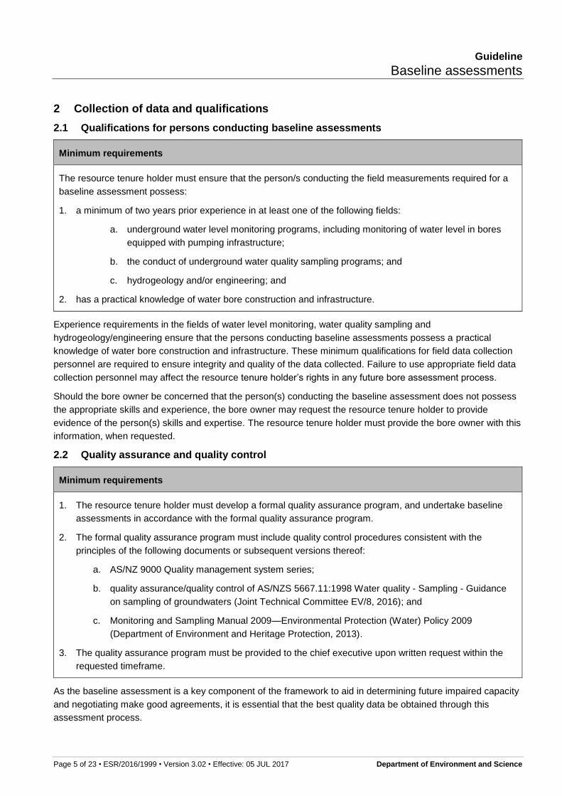
2.1 Qualifications for persons conducting baseline assessments
Minimum requirements
The resource tenure holder must ensure that the person/s conducting the field measurements required for a
baseline assessment possess:
1. a minimum of two years prior experience in at least one of the following fields:
a. underground water level monitoring programs, including monitoring of water level in bores
equipped with pumping infrastructure;
b. the conduct of underground water quality sampling programs; and
c. hydrogeology and/or engineering; and
2. has a practical knowledge of water bore construction and infrastructure.
Experience requirements in the fields of water level monitoring, water quality sampling and
hydrogeology/engineering ensure that the persons conducting baseline assessments possess a practical
knowledge of water bore construction and infrastructure. These minimum qualifications for field data collection
personnel are required to ensure integrity and quality of the data collected. Failure to use appropriate field data
collection personnel may affect the resource tenure holder’s rights in any future bore assessment process.
Should the bore owner be concerned that the person(s) conducting the baseline assessment does not possess
the appropriate skills and experience, the bore owner may request the resource tenure holder to provide
evidence of the person(s) skills and expertise. The resource tenure holder must provide the bore owner with this
information, when requested.
2.2 Quality assurance and quality control
Minimum requirements
1. The resource tenure holder must develop a formal quality assurance program, and undertake baseline
assessments in accordance with the formal quality assurance program.
2. The formal quality assurance program must include quality control procedures consistent with the
principles of the following documents or subsequent versions thereof:
a. AS/NZ 9000 Quality management system series;
b. quality assurance/quality control of AS/NZS 5667.11:1998 Water quality - Sampling - Guidance
on sampling of groundwaters (Joint Technical Committee EV/8, 2016); and
c. Monitoring and Sampling Manual 2009—Environmental Protection (Water) Policy 2009
(Department of Environment and Heritage Protection, 2013).
3. The quality assurance program must be provided to the chief executive upon written request within the
requested timeframe.
As the baseline assessment is a key component of the framework to aid in determining future impaired capacity
and negotiating make good agreements, it is essential that the best quality data be obtained through this
assessment process.
Guideline
Baseline assessments
Page 6 of 23 • ESR/2016/1999 • Version 3.02 • Effective: 05 JUL 2017 Department of Environment and Science
The primary purpose of a formal quality assurance program is to document the procedures and protocols for all
aspects of the baseline assessment and including quality control procedures. Quality control procedures may
include requirements such as performance of work by two personnel, thus enabling field checks, and analysis of
duplicate water quality samples. Field verification by an independent third party on 10% of all assessments
conducted is considered good practice. It is the responsibility of the resource tenure holder to develop relevant
best practice quality control procedures.
Considerable literature already exists on the topic of underground water monitoring and sampling. In addition to
the minimum requirements for quality assurance and quality control, relevant industry standards that should be
referenced include, but are not limited to, the below or subsequent versions thereof:
EPA Guidelines: Regulatory Monitoring and Testing—Groundwater Sampling (Environment Protection
Authority, 2007)
Groundwater Sampling and Analysis—A Field Guide (Sundaram, et al., 2009).
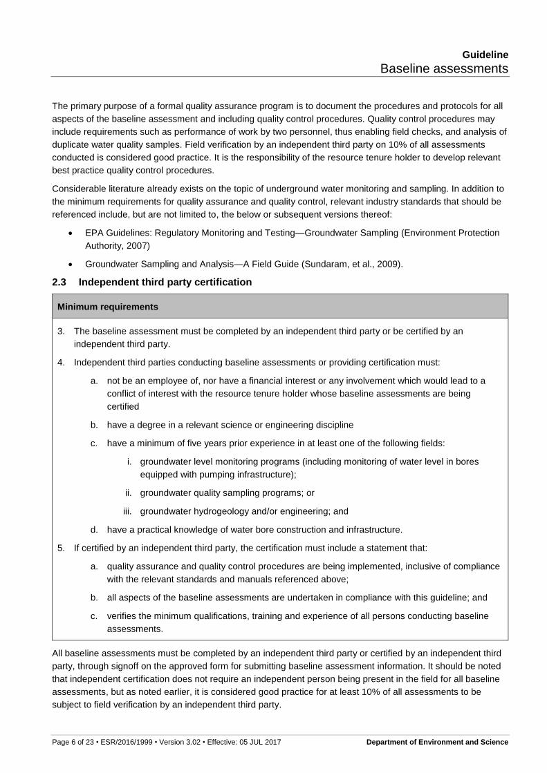
2.3 Independent third party certification
Minimum requirements
3. The baseline assessment must be completed by an independent third party or be certified by an
independent third party.
4. Independent third parties conducting baseline assessments or providing certification must:
a. not be an employee of, nor have a financial interest or any involvement which would lead to a
conflict of interest with the resource tenure holder whose baseline assessments are being
certified
b. have a degree in a relevant science or engineering discipline
c. have a minimum of five years prior experience in at least one of the following fields:
i. groundwater level monitoring programs (including monitoring of water level in bores
equipped with pumping infrastructure);
ii. groundwater quality sampling programs; or
iii. groundwater hydrogeology and/or engineering; and
d. have a practical knowledge of water bore construction and infrastructure.
5. If certified by an independent third party, the certification must include a statement that:
a. quality assurance and quality control procedures are being implemented, inclusive of compliance
with the relevant standards and manuals referenced above;
b. all aspects of the baseline assessments are undertaken in compliance with this guideline; and
c. verifies the minimum qualifications, training and experience of all persons conducting baseline
assessments.
All baseline assessments must be completed by an independent third party or certified by an independent third
party, through signoff on the approved form for submitting baseline assessment information. It should be noted
that independent certification does not require an independent person being present in the field for all baseline
assessments, but as noted earlier, it is considered good practice for at least 10% of all assessments to be
subject to field verification by an independent third party.

Guideline
Baseline assessments
Page 7 of 23 • ESR/2016/1999 • Version 3.02 • Effective: 05 JUL 2017 Department of Environment and Science
3 Essential elements of a baseline assessment
Carrying out a baseline assessment must involve the following parts:
Part A—Document identification and bore site information
Part B—Bore construction details
Part C—Bore equipment and condition details
Part D—Bore supply information
Part E—Water level measurement
Part F—Water quality assessment
Part G—Assessment field officer details
Part H—Declaration
Part I—Property owner/manager details
The minimum requirements specified in the tables below must be complied with when undertaking a baseline
assessment. Information supplied underneath the minimum requirement tables provides supporting information
to assist resource tenure holders in complying with the minimum requirements. Where a minimum requirement
cannot be met, justification as to the reasonable excuse for not being able to meet the requirement may be
required.
3.1 PART A—Document identification and bore site information
Minimum requirements
1. A unique identifier for the bore (Bore ID) must be recorded.
2. If the bore owner has a local name for the bore, this information must be recorded.
3. The location of the bore site referenced to GDA94 must be recorded.
Prior to the resource tenure holder visiting the bore site to undertake a baseline assessment, it is recommended
that the resource tenure holder obtain all relevant information from the Department of Natural Resources and
Mines’ groundwater database (GWDB). Water authorisation information should also be obtained from the
Department of Natural Resources and Mines’ Water Services. This enables the resource tenure holder to have
a record of relevant details about the bore prior to visiting the bore site. This data can then be verified with the
bore owner and through the baseline assessment.
When undertaking a baseline assessment, it is essential that each bore is assigned a unique identifier to assist
in identifying the correct bore in any future bore assessment.
In the GWDB, each water bore is given a registration number (the Bore RN). However, there are some
difficulties in using the registration number as a unique identifier for survey purposes, as it may be difficult to
correlate a bore’s physical location with the registration number details. For example, there may be two bores
located within close proximity to one another, and this may lead to confusion over which bore registration
number is assigned to which bore.
In addition, there may be other authorised bores which may not be recorded in the GWDB, and these bores may
not have a registration number. Therefore, assigning a unique identifier (Bore ID) for each bore at the time of
survey is required. This unique identifier should be a sequential number with a reference to the resource tenure
holder e.g. ‘resource tenure holder 123’. Where a registration number is known for that bore, this should also be
Guideline
Baseline assessments
Page 8 of 23 • ESR/2016/1999 • Version 3.02 • Effective: 05 JUL 2017 Department of Environment and Science
recorded separately as additional information for cross referencing. In instances where there could be a
possibility of more than one registration number correlating to a bore, more than one registration number can be
provided.
If the bore owner has a local name for the bore, this information must also be recorded to ensure that the bore
can be cross-referenced as accurately as possible. The bore owner may also have a bore registration number
for their water bore.
If there is some doubt over the registration number, it is necessary to record commentary around the confidence
level or accuracy for the purposes of identifying the bore in future.
The purpose of this information is for cross-reference and comparison with other nearby bores that have been
baseline assessed by the resource tenure holder. This is important for evaluating the likely accuracy of the
standing water level measurement in Part F.
The resource tenure holder must record the location of the bore site referenced to GDA94, to ensure that the
bore site has been accurately captured. One possibility is to utilise a GPS-ready digital camera to capture the
bore site.
3.2 PART B—Bore construction details
Minimum requirements
1. The following information regarding the bore’s construction must be recorded:
a. name of drilling contractor;
b. date of construction;
c. type of casing;
d. casing diameter;
e. perforated intervals and/or screens that have been installed in the bore;
f. details of any seals and cement grouting installed in the bore annulus; and
g. bore strata log.
2. The source aquifer for the bore must be recorded.
3. Despite 2, where the supply source is uncertain or unknown, the reasons for the uncertainty must be
analysed and reported.
4. Commentary on the confidence level of the source aquifer must be recorded.
Information regarding the bore construction and supply source must be recorded. Where this information is not
available, the department considers this circumstance to likely be a reasonable excuse for not including the
information in the baseline assessment. This information should be available from drilling logs for the bore. The
purpose for collecting construction information of the water bore is shown in Table 1.
The name of the source aquifer or geological formation that is the supply source for the bore is to be recorded.
Where the supply source is uncertain or unknown, the reasons for the uncertainty must be analysed and
reported. It is noted that, in many cases, it may be difficult to be certain that the bore is accessing a certain
geological formation. Therefore, commentary on the confidence level of the source aquifer (e.g. how confident is
the assessor that the bore is in fact accessing the Springbok formation) is to be recorded.

Guideline
Baseline assessments
Page 9 of 23 • ESR/2016/1999 • Version 3.02 • Effective: 05 JUL 2017 Department of Environment and Science
Table 1: Bore construction information
Information required Purpose for which information is used
Name of drilling contractor Drilling contractor may be contacted for construction details if they
are unknown to bore owner.
Date of construction Indication of the likely condition of the casing and perforated
interval/s.
Type of casing Assists in the interpretation of the chemical composition of the
water from the bore and the condition of the casing. The most
commonly used materials are steel or PVC.
Casing diameter Calculation of the volume of water that is contained within casing
storage prior to purging the water bore for water sampling. This
information is usually found only on the driller’s log for the water
bore. In some cases it is also contained in property records.
Perforated intervals and / or screens
that have been installed in the bore
Important for assessing the aquifer/s that the water bore taps for its
supply.
Details of any seals and cement
grouting installed in the bore annulus
Important for assessing whether there is any possibility of corrosion
of the casing and invasion of the bore’s supply (e.g. saline aquifer
water).
Bore strata log Generally contains most of the information listed above. Also
assists in assessment of aquifer that the water bore intersects.
Details of the water supply bore’s capacity (yield) would normally have been established at the time of
development of the bore. The Minimum Construction Requirements for Water Bores in Australia recommend
that “on completion of any production bore, the driller should carry out adequate testing to provide the client with
a reasonable indication of the capacity of the bore. This test will also demonstrate to the client that the bore has
been constructed properly and is therefore capable of producing clean water.” (National Uniform Drillers
Licensing Committee 2011, 2012).
In addition, Section 128(g) of the Water Regulation 2016 (Queensland) requires that records for water bores
drilled contain “an estimation of the rate at which water may be produced from the bore.”
Consequently, whenever capacity information is available from driller’s records, this information should also be
obtained from these records and recorded, rather than undertaking a capacity assessment at the time of
baseline assessment.
3.3 PART C—Bore equipment and condition details
Minimum requirements
1. Information about the pumping equipment for a water bore including the following, must be recorded:
a. if the bore is in operating condition or has been decommissioned;
b. the pump type and make;
c. pump setting depth;
d. if the bore is metered;
Guideline
Baseline assessments
Page 10 of 23 • ESR/2016/1999 • Version 3.02 • Effective: 05 JUL 2017 Department of Environment and Science
e. the power source for the bore;
f. details on the riser; and
g. details on the headworks.
2. A photo of the bore and bore equipment must be taken and attached to the notice of outcome.
Resource tenure holders must record information about the bore’s condition and equipment. A photograph of
the bore and the bore equipment is required to accurately capture the condition of the bore and equipment at
the time of the baseline assessment. The pictures should be representative of the bore and detail each site
individually, including a shot of the headworks.
The resource tenure holder should also record any details that the bore owner has about any repairs or
maintenance that has previously been undertaken on the bore. For example, it is useful to record information
about who has carried out the maintenance on the bore, as well as when and what sort of maintenance that was
undertaken. These records will be useful background information to support any future bore assessment and
assist in determining whether the bore has an impaired capacity.
3.4 PART D—Bore supply information
Minimum requirements
1. The authorised use or purpose of the bore must be identified and recorded, in consultation with the bore
owner.
2. How often the bore is utilised (i.e. hours pumped/day) must be recorded.
3. The operating capacity of the bore and any associated commentary on the operating capacity, including
any seasonal variation in use, must be recorded.
4. Peak usage information for the bore (including maximum volumes extracted and period of peak
extraction) must be recorded.
Understanding the purpose of the bore at the time of baseline assessment is a vitally important component of
the assessment and any subsequent make good agreements. Additional commentary as to how often the bore
is utilised (hours pumped per day) must be recorded. This information will support any future bore assessment
and provide a point for comparison in determining whether the bore has an impaired capacity. The tenure holder
should consult the bore owner to verify this information, and the bore owner has an obligation to provide
information that the tenure holder reasonably requires to undertake a baseline assessment.
The operating capacity of the bore and any associated commentary on the operating capacity of the bore that
the bore owner can supply, including any seasonal variation in use, must be recorded. The bore owner should
provide the resource tenure holder with any historical water use records that are available for the bore. These
records will be valuable background information for the resource tenure holder and will assist both the resource
tenure holder and the Office of Groundwater Impact Assessment (OGIA) in understanding regional groundwater
trends.
Peak usage information for the bore, including maximum volumes extracted and period of peak extraction, is to
be recorded. If this information is not available, accurate information relating to the use of the water extracted
from the bore that needs to be captured should include, as a minimum:
stock watering (type, head)
domestic use (number of households supplied, area of gardens watered).

Guideline
Baseline assessments
Page 11 of 23 • ESR/2016/1999 • Version 3.02 • Effective: 05 JUL 2017 Department of Environment and Science
Where no volumetric usage information is available, the figures supplied in Appendix 1 should be used to
estimate volumes supplied by the bore. Section 404 of the Water Act gives resource tenure holders the power to
ask bore owners for evidence to confirm stocking rates to support the estimated volumes.
3.5 PART E—Water level measurement
Minimum requirements
1. A standing water level (SWL) must be recorded.
2. Where a SWL cannot be recorded, as it is not practicable for a bore owner to cease pumping, the
following information must be recorded:
a. duration of pumping and rest periods; and
b. maximum pumping rates.
3. A photograph of the bore clearly showing the following must be taken and attached to the notice of
outcome:
a. a datum for SWL
b. the unique identification number of the bore and the GWDB registered number if available;
c. the bore owner’s name;
d. property name; and
e. the date of the photograph.
4. The height of the datum above ground level must be recorded.
It is a requirement of the baseline assessment that a standing water level (SWL) be obtained for the water bore.
As this is an essential component of the baseline assessment, resource tenure holders must use its best
endeavours to obtain this information.
Where this information is not practicable to be obtained, the resource tenure holder should provide reasons for
being unable to obtain this information. Resource tenure holders should be aware that if a SWL cannot be taken
as part of a baseline assessment, and it becomes evident that this baseline information is required, the
department may issue a direction under section 402 of the Water Act to require the resource tenure holder to
undertake a further baseline assessment that includes a SWL measurement.
Before a SWL can be obtained from a bore, consideration must be given to the condition of the bore, and
whether a meaningful SWL can be obtained without causing significant modifications or damage to the bore. For
example, significant modification would include pulling windmills or removing pumps, and in these
circumstances a SWL is not required. However the resource tenure holder should discuss with the landholder
the future schedule for bore maintenance, so the resource tenure holder can reschedule a SWL assessment to
be undertaken at that time.
If a bore is not equipped with a pump, the bore may still be of use to the bore owner and therefore will require a
SWL measurement.
For those bores that are equipped with a pump, there is often limited space in the annulus of the bore to allow
for unobstructed access for the water level probe. If access can be provided through minor works of a non-
structural nature, these works should only be undertaken with the permission of the bore owner. As an example,
minor works to obtain access may include removing a face plate or jacking up a well head.

Guideline
Baseline assessments
Page 12 of 23 • ESR/2016/1999 • Version 3.02 • Effective: 05 JUL 2017 Department of Environment and Science
3.5.1 Bore pumping at time of inspection
It may be possible that at the time of the site visit to obtain a SWL, the bore could be pumping or has recently
ceased pumping. In these circumstances, the optimal course of action is to revisit the bore when the water level
has fully recovered from the influence of pumping and has stabilised.
The residual drawdown of the water level of a bore can take many hours or days to recover to a SWL. It has
been assumed that the time for the water level to recover is a function of the yield of the bore; the higher the
yield, then the greater the amount of time needed for the bore to recover.
As a guide, a bore that has a yield less than five litres per second should be given at least 48 hours to recover.
A bore that has a yield greater than five litres per second, should be given at least 96 hours to recover.
However, the recovery period for each bore should be considered on its own merit and these estimates are
indicative only, and the resource tenure holder should discuss time frame for recovery of the bore with the bore
owner.
It is acknowledged that in some circumstances, such as where an extensive irrigation campaign is underway, it
is not practicable for the bore owner to cease pumping the bore for an extended period of time. In these cases,
best endeavours must be made to take the most representative SWL measurement possible. In these
circumstances, it is important that detailed information relating to the antecedent conditions of the bore are
obtained and recorded. This information must include periods of pumping and rest periods and maximum
pumping rates whenever this information is available.
Where an appropriate recovery period cannot be achieved, the use of automatic water level data loggers may
be adopted to obtain detailed information regarding impacts of extraction from the bore and nearby bores. It
should be noted that while data-loggers are considered a very useful tool to improve the accuracy of bore level
measurements, they are not considered necessary to meet the minimum requirements of a baseline
assessment.
Where automatic data loggers are not being used, the water level should be measured for as long as possible to
record recovery and specify the bore recovery rate at the time the final water level was recorded.
Where the above measures are not feasible, a return visit at a later time may be scheduled. In these
circumstances, the timetable requirements of the approved BAP should be taken into account when
rescheduling. If it becomes apparent that rescheduling may not be possible within the timetable requirements of
the approved BAP, the resource tenure holder should apply to amend the plan.
3.5.2 Datum
Before a water level measurement is taken for a bore, a datum must be established on the water bore to ensure
that any future measurements taken in the water bore will be referenced back to the same point.
All depth measurements are conventionally taken from the top of the bore casing or bore cover (at a marked
point, such as the padlocking point). When selected, this point will need to be documented for each individual
bore. This is to be achieved by photographing the bore head with the datum point clearly marked.
The photograph must also include a legible written record of:
the unique identification number of the bore and the GWDB registered number if available;
the bore owner’s name;
property name; and
the date of the photograph.
The height of the datum above ground level is also to be measured and recorded.

Guideline
Baseline assessments
Page 13 of 23 • ESR/2016/1999 • Version 3.02 • Effective: 05 JUL 2017 Department of Environment and Science
Underground water levels are expressed as a level relative to the ground surface. The distance between the
measuring point (e.g. datum at the top of casing) and the ground surface is subtracted from the measured
distance between the measuring point (e.g. datum at the top of casing) and the level in the bore. If the water
level in the bore is below ground, the result is recorded as negative (–), and positive (+) if it is above ground (i.e.
water standing in the casing above ground).
3.5.3 Accuracy and calibration
The instruments that are used to take SWL measurements need to be regularly checked to ensure that they are
within calibration. This means that the device must be checked against an applied standard value to ensure that
the device is indicating that value within a specified accuracy. Accuracy and calibration should be part of quality
assurance and quality control procedures for baseline assessments, and error should not exceed ±50mm for
water level measurements.
3.6 PART F—Water quality assessment
The water quality assessment consists of the following four sub-parts:
obtaining water quality samples;
field parameters and laboratory analytes;
presence and analysis of gas; and
sample identification, preservation and transportation.
3.6.1 Obtaining water quality samples
Minimum requirements
1. Water quality samples must be collected.
2. Sample collection must occur as close to the water bore as possible, and where possible, before any
other pipework joins the bore discharge pipework.
3. The location of the sampling point must be documented.
4. Where the sampling point is not within 15m of the bore:
a. A photograph of the sampling point must be taken and attached; and
b. The location referenced to GDA94 must be recorded.
5. Prior to sampling a water bore, the volume of stagnant water within the bore casing and discharge piping
(upstream of the sampling point) must be calculated.
6. Water quality samples must only be collected:
a. after three times the volume of stagnant water in the bore casing and the discharge piping
(including a sufficient additional volume to account for any error in volume calculations) have
been discharged, and
b. when the field water quality parameters have stabilised.
7. Where full purging as stated in requirement 6 is not practicable, but a meaningful sample can still be
collected, the pumping history of the bore, including when the bore was last used must be recorded.
8. When water quality samples are taken where there is no pumping equipment in place in the bore,
photographs showing the bore and sampling setup must be taken and attached.
Guideline
Baseline assessments
Page 14 of 23 • ESR/2016/1999 • Version 3.02 • Effective: 05 JUL 2017 Department of Environment and Science
9. When taking samples, potential sources of contamination must be identified and avoided.
10. When taking samples, disturbance to the existing infrastructure must be minimised.
Water quality data is to be collected consistent with the approved use or purpose of the bore. This may include
activities such as stock watering, irrigation, industrial or potable uses. A comprehensive water quality
assessment ensures that data exists should a bore assessment be required or a bore's approved use change.
It should be noted that only changes in water quality caused by a decline in water level which results from the
exercise of underground water rights, form part of the make good framework. However, water quality
information is also important as it can provide information about other issues with the bore such as faults in
casing or cementing integrity.
Potential water quality impacts that may have resulted from other activities such as hydraulic fracturing
(fraccing) are managed under the Environmental Protection Act 1994 (EP Act). Water quality analytes which
may be associated with such matters are therefore not a mandatory requirement of a baseline assessment.
However, resource tenure holders may consider assessing further water quality analytes on a voluntary basis.
Water quality samples must be collected from all bores equipped with pumping infrastructure. If a bore is not
equipped with pumping infrastructure, the resource tenure holder must exercise best endeavours to obtain
water quality samples. However, it is recognised that in some circumstances difficulties in purging the bore will
mean that obtaining a representative water quality sample is not practicable. Further guidance is provided in the
“Sampling procedure” section below about what actions may be taken in order to obtain a water quality sample.
Resource tenure holders should be aware that if no water quality sample is able to be taken as part of a
baseline assessment and it becomes evident this baseline water quality information is required, the department
may issue a direction under section 402 of the Water Act to require the resource tenure holder to undertake a
baseline assessment, including the requirement to obtain a water quality sample.
3.6.2 Selection of sampling location
Sample collection must occur as close to the water bore as possible, and where possible, before any other
pipework joins the bore discharge pipework. Manipulation of headworks for access is not required. This will
minimise the effects of temperature and pressure changes on the sample and avoid contamination of the
sample from other sources.
The resource tenure holder and the bore owner should reach agreement on the most appropriate place to
obtain a sample that will be representative of the bore water. When taking samples, potential sources of
contamination must be identified and avoided wherever practicable and disturbance to the existing infrastructure
must be minimised. The location of the sampling point must be documented and where the sampling point is not
within 15m of the bore, it must be photographed. Its position must also be recorded using a handheld GPS.
Samples of bore water should not be collected from storages such as water tanks, troughs or dams. Refer to
Figure 1 for a schematic of acceptable water samples for an example bore.

Guideline
Baseline assessments
Page 15 of 23 • ESR/2016/1999 • Version 3.02 • Effective: 05 JUL 2017 Department of Environment and Science
Figure 1: Schematic of acceptable water sampling locations from Bore A
3.6.3 Sampling procedure
Prior to sampling a water bore, wherever practicable, the volume of stagnant water within the bore casing and
discharge piping (upstream of the sampling point) must be calculated. Water quality samples must only be
collected:
after three times the volume of stagnant water in the bore casing and the discharge piping (including a
sufficient additional volume to account for any error in volume calculations) have been discharged; and
when the field water quality parameters have stabilised.
Stabilisation of the water quality parameters indicates the bore is producing formation water.
It is recognised that there may be circumstances where full purging of a bore in compliance with the above
requirements prior to sampling is not practicable, such as when the bore is not equipped with pumping
equipment or where there are restrictions on disposing of the purge water. In such cases, the resource tenure
holder should develop an appropriate strategy for purging and sampling bores. This strategy should be
consistent with recognised standards and guidelines for purging and sampling bores. Methods such as low flow
micro-purging techniques may be a viable sampling method under some circumstances with a flow controller
and flow through cell.
In cases where full purging is not practicable but a meaningful sample can still be collected, the pumping history
of the bore, including when the bore was last used must be recorded in detail. When water quality samples are
taken where there is no pumping equipment in place in the bore, photographs showing the bore and sampling
setup are to be taken by the resource tenure holder to assist in demonstrating the integrity of the sampling
process.
Possible options for obtaining a sample when pumping equipment is already in place may include:
sampling from an existing valve and pipe;
temporarily replacing another piece of equipment (e.g. a pressure gauge) with a valve to enable a
sample to be obtained from this point; or
installing a temporary valve and piping setup to be removed after sampling with reinstatement of the
original piping.
Storage Dam
Bore B
Bore A
Storage Dam
River
Acceptable sample point
Unacceptable sample point
Guideline
Baseline assessments
Page 16 of 23 • ESR/2016/1999 • Version 3.02 • Effective: 05 JUL 2017 Department of Environment and Science
The preferred option is that which allows sample collection to occur in a controlled manner and avoids
disturbance to the sample by contamination from physical, chemical or biological processes. Use of a diversion
pipe and flow regulating valve is therefore recommended.
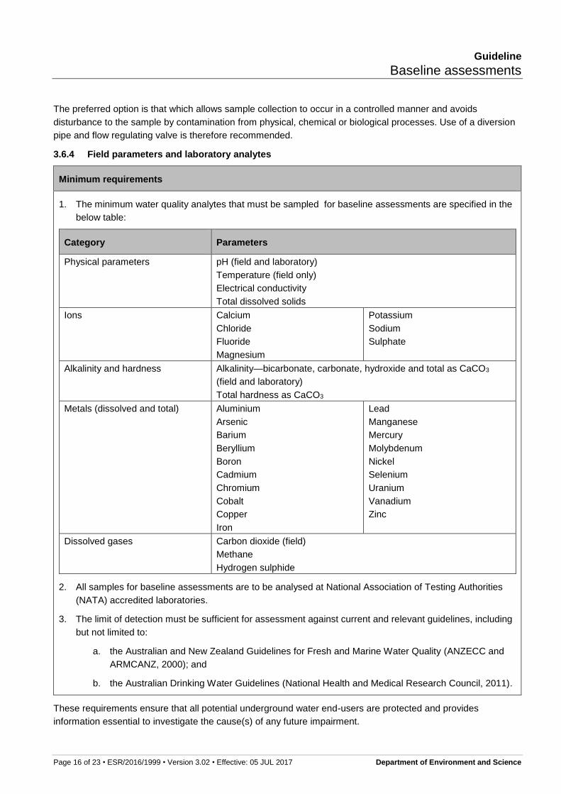
3.6.4 Field parameters and laboratory analytes
Minimum requirements
1. The minimum water quality analytes that must be sampled for baseline assessments are specified in the
below table:
Category Parameters
Physical parameters pH (field and laboratory)
Temperature (field only)
Electrical conductivity
Total dissolved solids
Ions Calcium
Chloride
Fluoride
Magnesium
Potassium
Sodium
Sulphate
Alkalinity and hardness Alkalinity—bicarbonate, carbonate, hydroxide and total as CaCO3
(field and laboratory)
Total hardness as CaCO3
Metals (dissolved and total) Aluminium
Arsenic
Barium
Beryllium
Boron
Cadmium
Chromium
Cobalt
Copper
Iron
Lead
Manganese
Mercury
Molybdenum
Nickel
Selenium
Uranium
Vanadium
Zinc
Dissolved gases Carbon dioxide (field)
Methane
Hydrogen sulphide
2. All samples for baseline assessments are to be analysed at National Association of Testing Authorities
(NATA) accredited laboratories.
3. The limit of detection must be sufficient for assessment against current and relevant guidelines, including
but not limited to:
a. the Australian and New Zealand Guidelines for Fresh and Marine Water Quality (ANZECC and
ARMCANZ, 2000); and
b. the Australian Drinking Water Guidelines (National Health and Medical Research Council, 2011).
These requirements ensure that all potential underground water end-users are protected and provides
information essential to investigate the cause(s) of any future impairment.

Guideline
Baseline assessments
Page 17 of 23 • ESR/2016/1999 • Version 3.02 • Effective: 05 JUL 2017 Department of Environment and Science
For example, dissolved carbon dioxide can lead to deposition of calcium carbonate where calcium and
bicarbonate ions are in solution and is also responsible for enhanced corrosion of steel when the carbon dioxide
concentration typically exceeds 40-50 mg/L. Reduced water levels and aquifer depressurisation therefore have
the potential to both increase fouling and corrosion, hence obtaining data on these parameters is imperative
prior to resource and gas activities.
3.6.5 Presence and analysis of gas
Minimum requirements
1. All bores must be measured for the presence of carbon dioxide, methane and hydrogen sulphide using a
multi-parameter gas detector and in compliance with the latest version of the Code of practice for coal
seam gas well head emissions detection and reporting (Department of Natural Resources and Mines,
2011).
2. Where present, dissolved gas samples must be collected through a flow-through cell.
3. If a flow-through cell cannot practicable be used, dissolved gas samples must be collected using the
methods outlined in section 7.2 of Groundwater Sampling and Analysis—A Field Guide (Sundaram, et al.,
2009).
4. The pumping regime prior to assessing the presence or absence of gas, must be recorded.
The bore owner must advise the resource tenure holder if gas is present in the bore and information should be
sought on under what conditions it occurs. All bores must be measured for the presence of carbon dioxide,
methane and hydrogen sulphide using a multi-parameter gas detector and in compliance with the latest version
of the Code of Practice for coal seam gas well head emissions detection and reporting (Department of Natural
Resources and Mines, 2011).
Samples for dissolved gas are required to be collected whenever water quality samples are being collected. The
preferred method to obtain dissolved gas samples is through the use of a flow-through cell (or gas
separator/stripper) installed on the bore discharge pipework where this can be achieved without modifications to
the bore infrastructure. Where a flow-through cell can be utilised, the quantity of gas to water is to be
determined and should gas be present, field measurements of concentration are to be obtained using a suitably
calibrated gas analyser sampling directly from the flow-through cell (or gas separator/stripper), or via a field
titration test kit. In such cases, the resource tenure holder must obtain a sample of gas for compositional
analysis by a laboratory via the flow-through cell (or gas separator/stripper).
Where water quality samples are being collected but a flow-through cell cannot practicably be used, dissolved
gas samples must be collected using the methods outlined in section 7.2 of Groundwater Sampling and
Analysis—A Field Guide (Sundaram, et al., 2009).
It is recognised that the presence or absence of gas may be affected by factors including resource and gas
activities, biogenic sources, seasonal factors or the bore’s use. Therefore, the pumping regime prior to
assessing the presence or absence of gas, must be recorded as part of the baseline assessment.
3.6.6 Additional water quality analytes
Potential water quality impacts that may have resulted from other resource and gas activities, such as fraccing
or injection of CSG water into aquifers are managed through the EP Act. The following additional constituents
are not considered minimum requirements of a baseline assessment under the Water Act, but may be analysed
as deemed necessary by the resource tenure holder, or as required by the chief executive under the EP Act.
Guideline
Baseline assessments
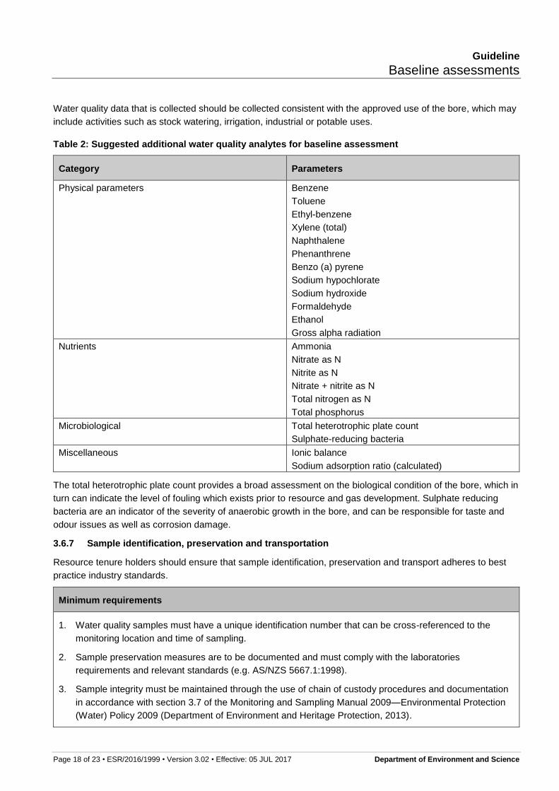
Page 18 of 23 • ESR/2016/1999 • Version 3.02 • Effective: 05 JUL 2017 Department of Environment and Science
Water quality data that is collected should be collected consistent with the approved use of the bore, which may
include activities such as stock watering, irrigation, industrial or potable uses.
Table 2: Suggested additional water quality analytes for baseline assessment
Category Parameters
Physical parameters Benzene
Toluene
Ethyl-benzene
Xylene (total)
Naphthalene
Phenanthrene
Benzo (a) pyrene
Sodium hypochlorate
Sodium hydroxide
Formaldehyde
Ethanol
Gross alpha radiation
Nutrients Ammonia
Nitrate as N
Nitrite as N
Nitrate + nitrite as N
Total nitrogen as N
Total phosphorus
Microbiological Total heterotrophic plate count
Sulphate-reducing bacteria
Miscellaneous Ionic balance
Sodium adsorption ratio (calculated)
The total heterotrophic plate count provides a broad assessment on the biological condition of the bore, which in
turn can indicate the level of fouling which exists prior to resource and gas development. Sulphate reducing
bacteria are an indicator of the severity of anaerobic growth in the bore, and can be responsible for taste and
odour issues as well as corrosion damage.
3.6.7 Sample identification, preservation and transportation
Resource tenure holders should ensure that sample identification, preservation and transport adheres to best
practice industry standards.
Minimum requirements
1. Water quality samples must have a unique identification number that can be cross-referenced to the
monitoring location and time of sampling.
2. Sample preservation measures are to be documented and must comply with the laboratories
requirements and relevant standards (e.g. AS/NZS 5667.1:1998).
3. Sample integrity must be maintained through the use of chain of custody procedures and documentation
in accordance with section 3.7 of the Monitoring and Sampling Manual 2009—Environmental Protection
(Water) Policy 2009 (Department of Environment and Heritage Protection, 2013).
Guideline
Baseline assessments
Page 19 of 23 • ESR/2016/1999 • Version 3.02 • Effective: 05 JUL 2017 Department of Environment and Science
3.6.8 Rescheduling of water sampling
Should sampling of the water from the water bore not be feasible at the time of the initial field visit, the bore
owner and resource tenure holder may choose to agree on another time for obtaining a sample. If sampling is
rescheduled, then, both parties should formally record the agreed rescheduled timeframe. It should be noted
that the rescheduled timeframe for obtaining a sample must be within the timetabled date in the relevant
approved BAP, or if this is not possible, the BAP should be amended to account for the new agreed timeframe.
Should the bore owner choose not to reschedule a time for water quality sampling, the resource tenure holder
must record this within the results of the baseline assessment.
3.7 PART G—Assessment field officer details
Minimum requirements
1. The person responsible for conducting the baseline assessment must be recorded.
3.8 PART H—Declaration
Minimum requirements
1. The resource tenure holder declaration must be completed by an officer accountable for “sign off” on the
data collected during the baseline assessment.
The contact details of the officer accountable for “sign off” on the data collected during the baseline assessment
must be recorded.
3.9 PART I—Property owner/manager details
Minimum requirements
1. The contact details of the bore owner, and any person who has provided information to the resource
tenure holder about the bore’s condition for the baseline assessment, must be recorded.
The contact details of the person responsible for providing information to the resource tenure holder about the
baseline assessment, including the bore owner’s details, must be recorded.
Where a person, other than the resource tenure holder, has provided information about the bore’s condition for
the baseline assessment, it is recommended that the resource tenure holder specifically identify the information
provided by this person.

Guideline
Baseline assessments
Page 20 of 23 • ESR/2016/1999 • Version 3.02 • Effective: 05 JUL 2017 Department of Environment and Science
4 Definitions/Glossary
Analyte A chemical parameter determined by either physical measurement at the bore head (e.g. electrical conductivity), or by laboratory analysis.
Aquifer Aquifer has the meaning in Schedule 4 of the Water Act and means a geological structure, formation or formations that holds water in sufficient quantity to provide a source of water that can be tapped by a bore.
Artesian bore Artesian bore has the meaning in Schedule 4 of the Water Act and means a shaft, well, gallery, spear or excavation, and any works constructed in connection with the shaft, well, gallery, spear or excavation, that taps an aquifer and the water flows, or has flowed, naturally to the surface.
Authorised water bore An authorised water bore includes water bores for which the taking of, or interfering with, water is authorised under the Water Act, and if required, a development approval has been granted under the Planning Act 2016 (or was granted under the repealed Sustainable Planning Act 2009 or Integrated Planning Act 1997).
This includes water bores from which the taking or interference with water is authorised without the requirement for a water entitlement under Section 20 of the Water Act.
Bore trigger threshold Bore trigger threshold has the meaning in section 362 of the Water Act and means a decline in water level in an aquifer prescribed by regulation, or otherwise 5 metres for consolidated aquifers and 2 metres for unconsolidated aquifers.
Consolidated aquifer Consolidated aquifer has the meaning in section 362 of the Water Act and means an aquifer consisting predominantly of consolidated sediment. The term includes geological formations such as sandstone, fractured mudstone and basalt.
Datum An agreed reference point at the bore head. This is usually the top of the casing.
Make good obligations Make good obligations has the meaning in section 409 of the Water Act and means the obligations of resource tenure holder for an immediately affected area bore, which are:
undertaking a bore assessment of the bore,
entering into a make good agreement with the bore owner,
complying with the make good agreement, and
if asked to vary the make good agreement, negotiating a variation of the make good agreement.
Meaningful sample A meaningful sample means that the material sampled is genuinely representative of the body of water from which it was collected (from the location of interest), that in situ measurements are reliable, and that the integrity of materials sent for laboratory analysis has not been compromised by contamination, degradation, transformation or losses.
Resource tenure holder Resource tenure holder has the meaning in section 364 of the Water Act and means the holder of an authority to prospect or petroleum lease issued under either the Petroleum Act 1923 or the Petroleum and Gas (Production and Safety) Act 2004 or the holder of a mineral development licence or mining lease issued under the Mineral Resources Act 1989.
Guideline
Baseline assessments
Page 21 of 23 • ESR/2016/1999 • Version 3.02 • Effective: 05 JUL 2017 Department of Environment and Science
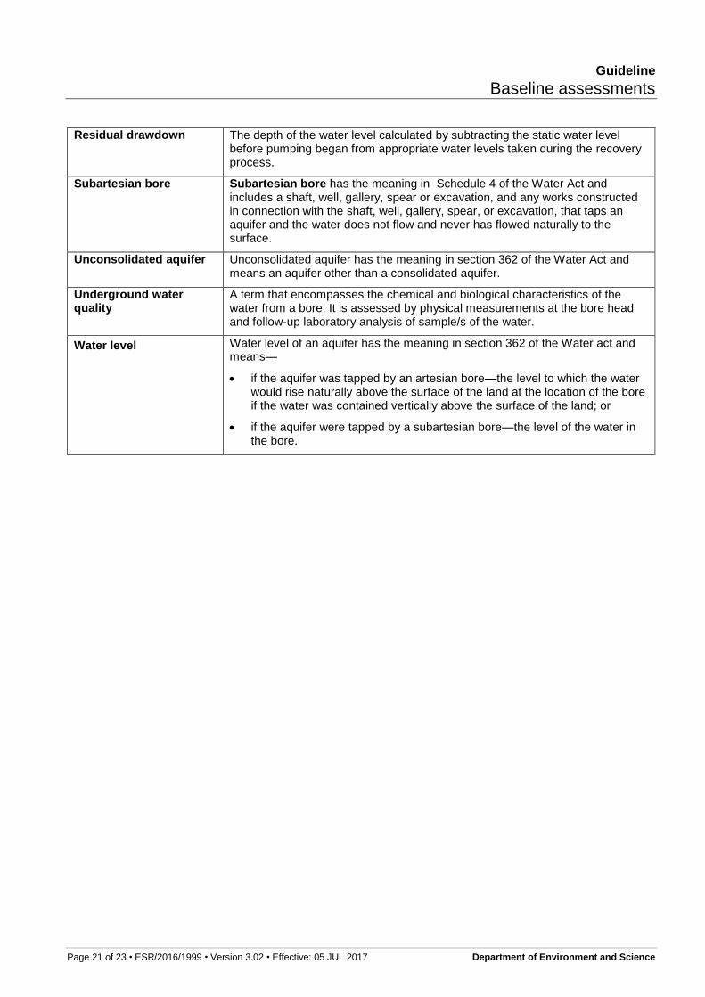
Residual drawdown The depth of the water level calculated by subtracting the static water level before pumping began from appropriate water levels taken during the recovery process.
Subartesian bore Subartesian bore has the meaning in Schedule 4 of the Water Act and includes a shaft, well, gallery, spear or excavation, and any works constructed in connection with the shaft, well, gallery, spear, or excavation, that taps an aquifer and the water does not flow and never has flowed naturally to the surface.
Unconsolidated aquifer Unconsolidated aquifer has the meaning in section 362 of the Water Act and means an aquifer other than a consolidated aquifer.
Underground water quality
A term that encompasses the chemical and biological characteristics of the water from a bore. It is assessed by physical measurements at the bore head and follow-up laboratory analysis of sample/s of the water.
Water level Water level of an aquifer has the meaning in section 362 of the Water act and means—
if the aquifer was tapped by an artesian bore—the level to which the water would rise naturally above the surface of the land at the location of the bore if the water was contained vertically above the surface of the land; or
if the aquifer were tapped by a subartesian bore—the level of the water in the bore.

Guideline
Baseline assessments
Page 22 of 23 • ESR/2016/1999 • Version 3.02 • Effective: 05 JUL 2017 Department of Environment and Science
5 References
ANZECC and ARMCANZ, 2000. Australian and New Zealand Guidelines for Fresh and Marine Water Quality, Artarmon: Australian Water Association.
Committee CE/28, 1990. AS2368—1990 Test pumping of water wells, Sydney: Standards Australia.
Department of Environment and Heritage Protection, 2013. Monitoring and Sampling Manual 2009—Environmental Protection (Water) Policy 2009, Brisbane: Queensland Government.
Department of Natural Resources and Mines, 2011. Code of practice for coal seam gas well head emissions detection and reporting, Brisbane: Department of Natural Resources and Mines.
Department of Primary Industries, 1982. Farm management handbook. 6th ed. Brisbane: Department of Primary Industries.
Environment Protection Authority, 2007. Regulatory monitoring and testing—Groundwater sampling, Adelaide: Environment Protection Authority.
Joint Technical Committee EV/8, 2016. AS/NZS 5667:11 1998 Water quality - Sampling - Guidance on sampling of groundwaters, Sydney: Standards Australia.
National Health and Medical Research Council, 2011. Australian Drinking Water Guidelines, Canberra: Commonwealth of Australia.
National Uniform Drillers Licensing Committee 2011, 2012. Minimum construction requirements for water bores in Australia, West Lakes: National Water Commission.
Sundaram, B. et al., 2009. Groundwater Sampling and Analysis—A Field Guide, Canberra: Commonwealth of Australia.
Disclaimer
While this document has been prepared with care it contains general information and does not profess to offer legal, professional or commercial advice. The Queensland Government accepts no liability for any external decisions or actions taken on the basis of this document. Persons external to the Department of Environment and Science should satisfy themselves independently and by consulting their own professional advisors before embarking on any proposed course of action.
Approved:
5 July 2017
Enquiries: Permit and Licence Management
Ph. 1300 130 372 (select option 4)
Ph:13 QGOV (13 74 68)
Fax. (07) 3330 5875
Email: [email protected]
Version history
Version Effective date Description of changes
1.00 26 March 2013 First published version of the guideline.
2.00 26 March 2013 Minor changes.
3.00 02 March 2017
Updated to reflect changes to Chapter 3 of the Water Act as a result of Water Reform and Other Legislation Amendment Act 2014, Water Legislation Amendment Bill 2015 and Environmental Protection (Underground Water Management) and Other Legislation Amendment Bill 2016.
3.01 5 July 2017 Updated to reflect the repeal of the Sustainable Planning Act 2009 and the commencement of the Planning Act 2016.
3.02 17 May 2018 The document template, header and footer have been updated to reflect current Queensland Government corporate identity requirements and comply with the Policy Register.
Guideline
Baseline assessments
Page 23 of 23 • ESR/2016/1999 • Version 3.02 • Effective: 05 JUL 2017 Department of Environment and Science
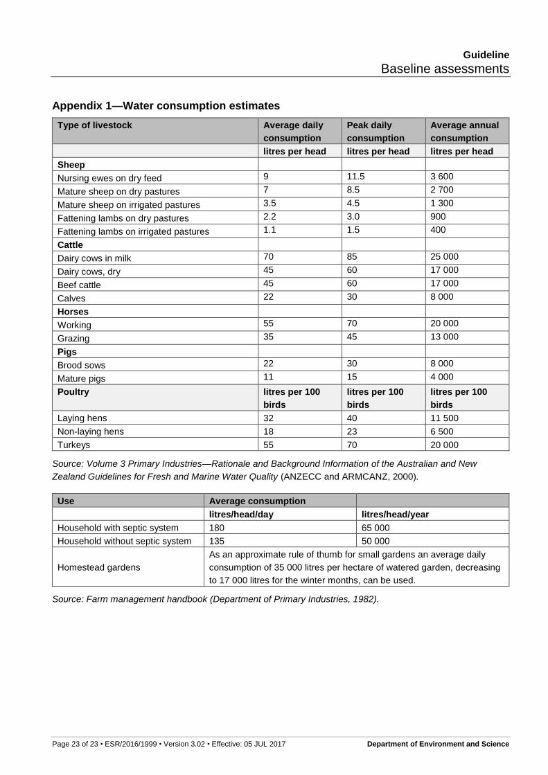
Appendix 1—Water consumption estimates
Type of livestock Average daily
consumption
Peak daily
consumption
Average annual
consumption
litres per head litres per head litres per head
Sheep
Nursing ewes on dry feed 9 11.5 3 600
Mature sheep on dry pastures 7 8.5 2 700
Mature sheep on irrigated pastures 3.5 4.5 1 300
Fattening lambs on dry pastures 2.2 3.0 900
Fattening lambs on irrigated pastures 1.1 1.5 400
Cattle
Dairy cows in milk 70 85 25 000
Dairy cows, dry 45 60 17 000
Beef cattle 45 60 17 000
Calves 22 30 8 000
Horses
Working 55 70 20 000
Grazing 35 45 13 000
Pigs
Brood sows 22 30 8 000
Mature pigs 11 15 4 000
Poultry litres per 100
birds
litres per 100
birds
litres per 100
birds
Laying hens 32 40 11 500
Non-laying hens 18 23 6 500
Turkeys 55 70 20 000
Source: Volume 3 Primary Industries—Rationale and Background Information of the Australian and New
Zealand Guidelines for Fresh and Marine Water Quality (ANZECC and ARMCANZ, 2000).
Use Average consumption
litres/head/day litres/head/year
Household with septic system 180 65 000
Household without septic system 135 50 000
Homestead gardens
As an approximate rule of thumb for small gardens an average daily
consumption of 35 000 litres per hectare of watered garden, decreasing
to 17 000 litres for the winter months, can be used.
Source: Farm management handbook (Department of Primary Industries, 1982).