essex wharf, lea bridge road, clapton, london borough · pdf file1 essex wharf, lea bridge...
TRANSCRIPT

Essex Wharf, Lea Bridge Road, Clapton, London Borough of Waltham Forest
An Archaeological Desk-Based Assessment
for Mr Alan Cole
by Steve Preston
Thames Valley Archaeological Services Ltd
Site Code EWW07/80
July 2007

i
Thames Valley Archaeological Services Ltd, 47–49 De Beauvoir Road, Reading RG1 5NR Tel. (0118) 926 0552; Fax (0118) 926 0553; email [email protected]; website : www.tvas.co.uk
Summary
Site name: Essex Wharf, Lead Bridge Road, Clapton, London Borough of Waltham Forest Grid reference: TQ3553 8667 Site activity: Desk-based assessment Project manager: Steve Ford Site supervisor: Steve Preston Site code: EWW07/80 Area of site: c. 0.6ha Summary of results: The site lies in an area of very considerable general archaeological potential; it is in an Archaeological Priority Zone defined in the unitary development plan. Although it was almost fully built over in the 20th century, it is possible that the archaeologically relevant horizons may have survived intact below this. It would be advisable to provide more information on the survival of archaeological deposits by means of trial trenching. This report may be copied for bona fide research or planning purposes without the explicit permission of the copyright holder Report edited/checked by: Steve Ford 09.07.07 Jo Pine 09.07.07

1
Essex Wharf, Lea Bridge Road, Clapton, London Borough of Waltham Forest An Archaeological Desk-Based Assessment
by Steve Preston
Report 07/80
Introduction
This desk-based study is an assessment of the archaeological potential of a plot of land of about 0.6ha located on
the north side of Lea Bridge Road, on the north-east bank of the river Lea in Waltham Forest (Fig. 1). The
project was commissioned by Mr Kieran Rushe of Dalton Warner Davies LLP, 21 Garlick Hill, London EC4V
2AU on behalf of Mr Alan Cole, Molecroft, Braughing Friars, Braughing, Ware, Hertfordshire SG11 2NS, and
comprises the first stage of a process to determine the presence/absence, extent, character, quality and date of
any archaeological remains which may be affected by redevelopment of the area.
Planning permission is to be sought to redevelop the site for housing. No detailed proposals have yet been
drawn up and it is intended that the results of the initial archaeological assessment of the site will inform the
nature of the scheme to be proposed. The desk-based assessment will also accompany any planning application
so as to provide information on which the Borough’s archaeological advisers may base recommendations for the
site.
Site description, location and geology
A site visit on 6th July 2007 confirmed that the site currently consists of containerized storage facilities, accessed
from the bridge. The west and north-west boundaries are formed by the River Lea, which is also the boundary
between Hackney and Waltham Forest, the south-east boundary is Lea Bridge and the north-east boundary is the
car park for the Lea Valley ice rink. Across Lea Bridge road to the south is a water works. The ground surface of
the site is mainly brickwork. There is only one permanent building on the site, towards the centre (Fig. 10). The
development area is centred on NGR, TQ3553 8667 and covers approximately 0.6 ha. The site is located on the
Lea floodplain, which according to the British Geological Survey is located on alluvium over London Clay
rather than gravel as anticipated (BGS 1994). It is level, at a height of approximately 10m above Ordnance
Datum.
Planning background and development proposals
Planning permission is to be sought for residential development on the site. No detailed proposals have yet been
drawn up.
2
Archaeology and Planning (PPG 16 1990) provides guidance relating to archaeology within the planning
process. It points out that where a desk-based assessment has shown that there is a strong possibility of
significant archaeological deposits in a development area it is reasonable to provide more detailed information
from a field evaluation so that an appropriate strategy to mitigate the effects of development on archaeology can
be devised:
Paragraph 21 states:
‘Where early discussions with local planning authorities or the developer’s own research indicate
that important archaeological remains may exist, it is reasonable for the planning authority to
request the prospective developer to arrange for an archaeological field evaluation to be carried
out...’
Should the presence of archaeological deposits be confirmed further guidance is provided. Archaeology and
Planning stresses preservation in situ of archaeological deposits as a first consideration as in paragraphs 8 and
18.
Paragraph 8 states:
‘...Where nationally important archaeological remains, whether scheduled or not, and their
settings, are affected by proposed development there should be a presumption in favour of their
physical preservation...’
Paragraph 18 states:
‘The desirability of preserving an ancient monument and its setting is a material consideration in
determining planning applications whether that monument is scheduled or unscheduled...’
However, for archaeological deposits that are not of such significance it is appropriate for them to be ‘preserved
by record’ (i.e., fully excavated and recorded by a competent archaeological contractor) prior to their destruction
or damage.
Paragraph 25 states:
‘Where planning authorities decide that the physical preservation in situ of archaeological remains
is not justified in the circumstances of the development and that development resulting in the

3
destruction of the archaeological remains should proceed, it would be entirely reasonable for the
planning authority to satisfy itself ... that the developer has made appropriate and satisfactory
provision for the excavation and recording of remains.’
Waltham Forest’s Unitary Development Plan (first review, 2006) includes policies on the archaeological
heritage (BHE17)
‘The Council will ensure the preservation, protection and where possible the enhancement of the
archaeological heritage of the borough.
‘8.86 The history of Waltham Forest dates from the time of the earliest settlements in the Forest.
Archaeology is an important way in which greater knowledge about the history of the borough can
be discovered. However, the opportunity to carry out archaeological investigations usually only
arises during the course of new development when foundations are exposed.
‘8.87 The Greater London Archaeological Advisory Service has defined a number of
Archaeological Priority Zones (APZs) which have been identified as having particular
archaeological interest. Some of the APZs are extensive and include the whole of the Lee Valley,
the valleys of The Ching and The Fillebrook Rivers and areas around former Saxon and Mediaeval
settlements such as Chingford, Walthamstow, Leyton, Highams Park and Leytonstone.
‘8.88 The Council will seek to encourage the conservation, protection and enhancement of the
archaeological heritage of the borough. When any development involving a site of 0.16 hectares or
more is proposed within the archaeological priority zones (as shown on the Proposals Map and
Schedule 36), or for any site identified by a recognised archaeological authority, the archaeological
significance of the site will be considered. The Council may require a preliminary archaeological
site evaluation before development proposals are considered.’
Other policies cover Listed Buildings, locally listed buildings, parks and gardens, etc, none of which is relevant
to the proposal site. The site is within an Archaeological Priority Zone as defined on the Proposals Map, and is
above 0.16ha in extent. It is not within a Conservation Area.

4
Methodology
The assessment of the site was carried out by the examination of pre-existing information from a number of
sources recommended by the Institute of Field Archaeologists paper ‘Standards in British Archaeology’ covering
desk-based studies. These sources include historic and modern maps, the Greater London Sites and Monuments
Record, geological maps and any relevant publications or reports.
Archaeological background
General background
The lower stretch of the Thames Valley is rich in finds of many periods (Williams and Brown 1999). Many
archaeological deposits, covering extensive tracts of the gravel terraces north of the estuary, have been
discovered by aerial photography but the nature and extent of occupation and use of lower-lying areas has only
come to light in more recent times. River margins, creeks and inlets, including those of the Thames, were
preferred areas of settlement in earlier periods, but study of this use is hampered by subsequent inundation due to
a rise in sea level and the deposition of deep alluvium. Fieldwork has, nevertheless, located areas of occupation
with good preservation of organic remains typified by the examples of wooden trackways laid down to cross
low-lying ground in the Bronze Age and earlier (Meddens 1996). The areas of higher ground (e.g. gravel terrace
margins) overlooking lower-lying, seasonally-flooded land are a preferred topographic location for occupation.
The Lea catchment area is recognized as a rich source of prehistoric archaeology, particularly for the
otherwise elusive Mesolithic period (Jacobi 1980; 1996), with activity apparently attracted to riverine locations
(Reynier 1998). Mesolithic finds, in particular, have been found within or below stratified peat deposits in the
Lea floodplain , notably at Broxbourne (Herts) (Warren et al. 1934; Allison et al. 1952; Austin 1997, 9).
It is becoming increasingly clear that the idea that the gravels overwhelmingly attracted prehistoric activity
is at least to some degree distorted by the concentration of archaeological research on gravels, and other
geologies can also often now be seen to have been densely used in the past. An indication of the potential of the
area for prehistoric studies is the recent instigation of a Thames Northern Tributaries Survey aimed at identifying
archaeologically sensitive alluvial deposits in the Lea Valley (Glazebrook 2000, 61).
This area’s archaeology is, unusually, dominated by the very earliest remains. The recent survey of
London’s archaeology (MoLAS 2000) shows an almost total blank in this part of east Hackney and west
Waltham Forest, for all periods except the Palaeolithic and Medieval. Clapton and neighbouring areas just above

5
the valley floor, are chiefly noted for Palaeolithic archaeology, with over 150 Lower Palaeolithic artefacts,
mostly handaxes, recorded from Clapton alone. This is thanks mainly to the pioneering efforts of Worthington
Smith in the late 19th century, although his finds in Clapton are not so notable as the remarkable collection from
Stoke Newington, nor, unfortunately, so precisely recorded (Wymer 1968, 301; 1999 map 9). Worthington Smith
recorded one instance of a handaxe resting on a mammoth shoulder blade from Lower Clapton. It has recently
been demonstrated, moreover, that some of the deposits believed by Smith to be in situ ‘floors’ are indeed
primary preserved contexts which have been covered by colluvial deposits (Wymer 1999, 63–4; Gibbard 1994,
80–6).
The Lea Valley floor around Walthamstow and Leyton has produced less archaeology of any period, than
the gravel terraces, even stray finds being rare from the alluvium, while the river itself in this vicinity has not
produced the quantity of finds associated with the Thames. Of note, however, is a Bronze Age hoard of
spearheads from Lea Bridge Road itself, found in 1885. One may suspect, however, that this picture reflects the
distribution of research rather than the distribution of archaeological finds and sites (as highlighted by
comparison with, for example the valley of the Ravensbourne which flows into the Thames from the south,
where more research has been undertaken in recent years).
Waterfront archaeology
The topographic location of this site, on the banks of the river Lea, in an area where this river seems to have
occupied several courses, indicates that the presence of waterfront archaeology needs to be considered. River and
stream channel deposits are characterized by anaerobic conditions that inhibit the decay of organic material and
the timber foundations of structures such as revetments, bridge piers and buildings such as water mills can
survive (Hawkes and Fasham 1997), as indeed is attested at several points in the vicinity (see below).
Excavations elsewhere in conditions and locations similar to those of the proposal site have revealed evidence of
the survival of medieval (and even earlier) works along streams and rivers.
Revetment types vary according to chronology and purpose, and can range from early marking of channel
alignments by stakes, to stakes bound by willow wattling, to complex constructions of posts and planks with
back bracing. Excavated bridge structures are rare (MoLAS 2000, 224) but examples include those at Kingston
and London Bridge. In Reading, where sites along the waterfront produced morphologically similar structures,
dating and artefactual evidence support the hypothesis that a broadly chronological progression of revetment
types is valid for the town (Hawkes and Fasham 1997).

6
Should any waterlogged deposits survive, or even non-waterlogged fluvial silts, these would present the
possibility of a significant sequence of organic survival and offer the prospect of detailed palaeoenvironmental
reconstruction.
Greater London Sites and Monuments Record
A search was made on the Greater London Sites and Monuments Record (SMR) on 29th June 2007 for a radius
of 1km around the proposal site. This revealed 73 entries within the search radius. These are summarized as
Appendix 1 and their locations are plotted on Figure 1.
Prehistoric A significant number of the GLSMR entries from the 1km search radius are findspots of Palaeolithic tools [Fig.
1: 1–7, 14]. Almost all of these were discovered in the late 19th century, and the locations of some are only
given in general terms, but some are better recorded than many finds of that era, and together they certainly
amount to a significant concentration of artefacts of this earliest period. It is presumably largely on the strength
of these finds that the Archaeological Priority Zone has been defined. One findspot came from a more recent
evaluation [7], close to the site, although this appears to have been unstratified. Indeed, finds from the valley
floor can probably safely be regarded as redeposited in any case. One record is for finds recorded by
Worthington Smith with what he called ‘floors’ nearby [2]; these can be regarded as potentially in situ land
surfaces of Palaeolithic date. Although reasonably close to the site, this findspot is some 15m above the elevation
of the site, on the valley side, and cannot be regarded as closely related topographically.
Later prehistoric periods are less well represented. Mesolithic flints have been found in the area, but their
precise findspots are not known [6] while only a single axe represents the Neolithic [7]. The latter is however,
from recent work close to the proposal site. There is only one entry in the search area for the Bronze Age, a
hoard of spearheads recovered in 1885 during the digging of a well at the pumping station [8]. Only one of these
artefacts can now be traced, it is in Vestry House Museum. It is described as a pegged, leaf-shaped spearhead
with fillet decoration. There is no particularly close correlation between Bronze Age metalwork hoards and
settlements, and in fact metalwork of this period is as often recovered from bogs and rivers as from dry land.
Lacking details of the circumstances of the discovery, it is unclear if this hoard had also been deposited in the
river or buried on land.
Roman Roman finds form the area are limited to a marble sarcophagus (with skeleton) found in 1867, well to the south
of the site [9], two coins found separately near this, and an unspecified coin found more recently during test

7
pitting as part of Time Team’s ‘Big Dig’ [10]. None of these records is particularly close to the site; overall they
suggest a cemetery and thus presumably settlement on the valley slopes or the higher ground in the Lower
Clapton area. A further record is for unspecified works thought to have uncovered a Roman road surface [11];
both the date and nature of this observation and, more especially, the nature and date of the ‘road’ are unclear
from the GLSMR entry. A Roman river crossing here is certainly plausible, and Lea Bridge Road is accepted by
Margary (1955, 219) as ‘probably’ the western end of a road (his route 30) to Dunmow in Essex, but the
evidence seems meagre. The main road to the east (route 3) crossed the Lea much further south (Margary 1955,
215).
Saxon There are three entries relating to the Saxon period in the 1km search radius. One merely records the existence of
the placename Clopton [6]. Two records [4, 12] refer to the finding of a Saxon boat in 1830, presumably only
one boat is meant. The boat was 20 feet long with a 6-foot beam, clinker built. It has been suggested to be an
early ferry, or part of a 9th-century Danish fleet. Again, it is unclear how the date of this boat was derived. A
supposed Viking boat discovered in 1900 at Walthamstow has since been carbon-dated to the 16th or 17th
century (Fenwick 1978) and a recent survey (MoLAS 2002; cf. Marsden 1994) concludes that only one Saxon
boat is known from London, a dug-out canoe from Walthamstow. Recorded at the same spot as one of the
records for this boat [12] was found a line of ‘old stumps’ taken to be a revetment for an old course of the river;
no date has been assigned to these.
Medieval The medieval period is better represented. Clopton is first mentioned in 1339 [6]. The Lea Bridge is known from
at least 1486 [13]. ‘Walthamstow slip’ is recorded as a large stretch of land dividing north from south Leyton,
possibly dating back as far as the 12th century [13]. In the 19th century, an old reservoir was backfilled, south of
the site, and it was thought this might be as old as the 15th century [14]. To the north-east, there is a record
summarizing what the VCH (1973) has to say on a wooden causeway, consisting of 12 bridges, built or perhaps
repaired in 1544, and although ruinous by the end of the 17th century, were apparently still visible in the 19th
century (see further below) [15]. Brooke House in Clapton was built on the site of a 15th century courtyard
house [16].
Post-medieval, modern Many of the GLSMR entries for the search radius refer to the post-medieval period. The entry for Lea Bridge
[13] summarizes the VCH account (and see below). It was already in disrepair in 1551 and collapsed in the early
17th century; it was replaced by a ferry in 1646, and a new bridge was not built until 1757; it was replaced in

8
iron in 1821. The reservoir and the causeway, mentioned above, might both be post-medieval [14, 15]. Brooke
House [16] was owned by the Grevilles (Lords Brooke) from 1609 to 1820. It was bombed in World War II and
demolished in the 1950s. Several entries are for cartographic or documentary evidence of roads [17, 19, 20, 24],
buildings [6, 18, 26], or other features. The latter include the River Lea Navigation (19th century) [26] and a
‘shanty town’ that grew up between the 1880s and 1930s, on the edge of new development at Leyton [25]. This
consisted of wooden buildings, including a church, and the inhabitants dug wells, raised livestock and had
extensive market gardens. Close to the site, one entry is for the ‘Ferry Inn’, already described as ‘ancient’ in
1757 (although this might mean ‘former’ rather than ‘very old’) later the Horse and Groom, which was
demolished c. 1850 [26].
Several recent evaluations in the area have revealed only post-medieval and modern finds and/or features
pits, garden features or quarries [7, 10, 21, 22, 23]. A watching brief carried out in 2000 (not yet on the GLSMR)
also showed no archaeology [39] (Maloney and Holroyd 2001, 91).
Numerous entries are for listed buildings [27–34]. Only one of these is close to the proposal site, a 19th-
century building probably originally a school but listed as a mill-wright’s workshop [31].
There are three entries for cartographic evidence for modern landfill sites [4, 35, 36], including one
adjacent to the proposal area [36].
Finally, in 1909, undated wooden water pipes were discovered, well south of the proposal area [38]. It is
entirely possible these relate to early post-medieval drainage works.
Scheduled Ancient Monuments
There are no Scheduled Ancient Monuments within 1km of the proposal site.
Cartographic and documentary sources
Administratively the site is today within Waltham Forest, historically part of Essex but now a London Borough.
Until very recent boundary changes, the site was within Hackney borough (Middlesex) (as shown on Figure 1,
from an Ordnance Survey map of 1985). The site is still regarded as part of Clapton, the rest of which is in
modern Hackney. The surrounding areas of Lea floodplain are variously known as Hackney Marsh (to the south)
and Walthamstow Marsh (north).

9
Clapton is a very common Old English (Anglo-Saxon) place-name, derived from clopp(a) (hill(s)) and tun
(hamlet, village), cognate with Clapham (Mills 1998). Until the 18th century, it was usually rendered Clopton,
although it appeared as Clapton as early as 1593 (VCH 1995, 44). The word clopp is recorded only in place-
names. It is not clear when this instance of the name Clapton is first recorded. Neither Clapton nor Hackney
appears in Domesday Book (AD1086; Williams and Martin 2002). Hackney (‘Haca’s marsh’) is also Old
English, (Haca, personal name +genitive -n and ēg, ‘marsh’, or more often, ‘land raised from a marsh’) and first
appears in AD1198.
Walthamstow is also Old English but of uncertain derivation (Mills 1998, 363), from stow (simply ‘place’,
but often meaning ‘holy place’) and either ‘wilcuma’ (welcome) or a woman’s name (Wilcume). Place names
from female Saxon names are rare, however, so it probably means ‘place of welcome [for travellers?]’, but it
cannot be ruled out that Wilcume may have been a holy person, deserving of a place name. Waltham Forest
takes its name (somewhat artificially and circumstantially) from the manor. The manor of Walthamstow is
recorded in the Essex segment of Domesday Book (as Wilcumestou), when it was held by Waltheof Earl of
Northumberland and Huntingdon, a Saxon who had accompanied Duke William to Normandy in 1066, although
whether as ally or hostage is unclear; it need not necessarily follow that because he became a major landowner
he must have been a willing ally, and indeed the Anglo-Saxon Chronicles have him making his peace only in
1069/70 (Swanton 2000, 204). The manor was assessed at 10 and a half hides, and had some 24 ploughs, a
particularly large number. Some 61 taxable tenants are noted, and four slaves, showing a population more than
double the pre-Conquest number, a difference which is both hard to explain and rarely matched elsewhere. The
manor also included very large areas of woodland and meadow, and was valued at £28 plus two ounces of gold;
again, a very considerable sum. There were six fisheries before the conquest, but only one at the time of Little
Domesday (AD1087); and a mill is also noted (Williams and Martin 2002, 1039–40). It is probable that the site
would have been within Walthamstow at this time.
Clapton’s early history is somewhat obscure. It appears to have originated in a subdivision of the large
estate of the Bishop of London in Stepney, which covered most of Hackney in the pre-Conquest period; it is
possible it was already separate in 1086 (VCH 1995, 78). The manor passed to the Knights Templar and when
they were suppressed, to the Hospitallers, the Crown eventually acquiring it. By the 16th century the freehold
estate was attached to a seat known as the King’s Place, later Brooke House.
Throughout the growth of metropolitan Hackney in the 18th, and especially 19th centuries, Clapton
remained a select area, with wealthy residents, large properties, and spacious parks. The 20th century was less

10
kind, with industrial and commercial development encroaching in the early part of the century, and housing
estates in the second half, although the area broadly still ‘keeps memories of its former prosperity’ (Pevsner and
Cherry 1998, 497).
A tiny parcel of land on the east bank of the river Lea, corresponding almost precisely with the proposal
site, was historically attached to the manor and later Borough of Hackney. It is not clear how far back this
arrangement can be dated. It seems to have been brought about to enable Hackney to control (and pay for) the
ferry which predates the bridge here (VCH 1973, 177), presumably land on the far bank was required for the
smooth operation of the ferry. Bureaucratic land divisions in the area have been complicated for several
centuries. The Walthamstow Slip was an area of land no more than 100 yards wide, belonging to Walthamstow,
but lying across the middle of Leyton. It was rationalized into Leyton in the 1870s.
The history of the river crossing too is complicated. There was certainly an early ford, and a bridge
(Lockbridge) is recorded from as early as 1486; it was in disrepair in 1551 and collapsed totally sometime
between 1612 and 1630, when it was replaced by a ferry (which has had several names but is generally known as
Hackney ferry or Jeremy’s ferry); a second ferry also operated slightly further north. The ford continued to be
known (confusingly) as Lockbridge, and it is reported that the river was tidal as high as Lockbridge in the 16th
century (VCH 1973, 175–7). The ferries belonged to Hackney, accounting for the addition of a tiny plot of land
on the east bank (this site, in fact) to that Borough until recently. There was also a causeway of some twelve
bridges across the marsh, extending from Blackbridge to Lockbridge, built or repaired in 1544, repaired in 1580,
and in a dangerous state in 1611. By 1694 nothing remained of this but ruins, and it is claimed the stumps of
posts were still visible in the 19th century (VCH 1973, 177).
The Lea Bridge Turnpike Road Act of 1757 provided for the building of a bridge to replace Jeremy’s Ford
(and possibly the smaller Smith’s Ford just to the north) and fund it by means of toll booths. A permanent
(wooden) bridge was not erected until 1772, but presumably this replaced a temporary structure (VCH 1995, 8).
It was replaced by an iron bridge in 1820-1 and rebuilt 1896-7. The Clapton toll booth was removed in 1863
although the toll on the Essex side remained in place until 1872. It is indicative of how heavily the local
economy depended on the exploitation of the marshes, however, that carts for the harvest of hay from the
marshes, and animals to be grazed there, were exempted from the tolls.
The drainage of the marshes has always been a problem, with flooding and pollution endemic. The local
tradition that King Alfred first drained them in AD895 has no foundation (VCH 1973, 203) and indeed the Lea
levels were always poorly regarded even compared to nearby Thames marshes. In the 19th century much of the

11
marshland was bought up for railways, waterworks, reservoirs and gasworks, and the growing settlements in the
area pumped sewage into the marshes. A comprehensive plan to deal with the problem was not drawn up until
the 1930s, and not fully implemented until the 1950s, with the cutting of a flood relief channel and widening and
stabilization of the Lea itself.
It has been suggested that Lea Bridge Road might follow the course of a Roman road to Dunmow in Essex,
but another possible route for this is via Marsh Lane and Temple Mills to the south (VCH 1973, 175).
Leyton is also an Anglo-Saxon place name, incorporating the Celtic river name (-tun a term of many
meanings: enclosure, farm, manor, estate or village, and Ley = Lea, possibly ‘light’, in reference to the stream?).
It first appears (as Legetune) in Domesday Book, when there were no fewer than six estates in the manor. It is
unclear to which estate this particular area would have belonged (assuming it was not already in Hackney), and
arrangements along the river seem to have been complicated already by this date (VCH 1973, 184–6). Oddly,
Leyton had nine and a half fisheries and a mill at the date of the Conquest, but no fisheries and no mill by the
time of Domesday Book.
Leyton has little other history of note. It was always primarily agricultural until swallowed by the growth of
London. It was still a small village in 1851 (population under 4000) but the population doubled in the 1860s and
then doubled again in the 1870s, and almost trebled during the 1880s, to reach 63,000 by 1891 (albeit by then
with enlarged boundaries compared to the earlier censuses). Walthamstow’s growth was not quite so rapid, from
3000 in 1801, to 5000 in 1851, and 11,000 in 1871.
A range of Ordnance Survey and other historical maps of the area were consulted at Waltham Forest Local
Studies Library and the Hackney Local Studies Archives in order to ascertain what activity had been taking place
throughout the site’s later history and whether this may have affected any possible archaeological deposits within
the proposal area (see Appendix 2).
The earliest map available of the area is Saxton’s county map of Essex, from 1576 (Fig. 2). This shows
only schematic details, but does indicate several Lea bridges. There is no indication of a settlement at Clapton,
although Leyton and Walthamstow are shown. Ogilvy’s map of Middlesex of 1672 (Fig. 3) provides a little more
detail. Clapton is now established, but there are no bridges north of West Ham. This corresponds with the
documentary sources, which have the bridge collapsed before 1630. Two (or three) ferries are marked at
Walthamstow and Hackney, which appear to fix the location of the proposal site approximately. There is still no
depiction of settlement in this area. More detail is provided by Warburton’s map of 1749 (Fig. 4). Here, the
12
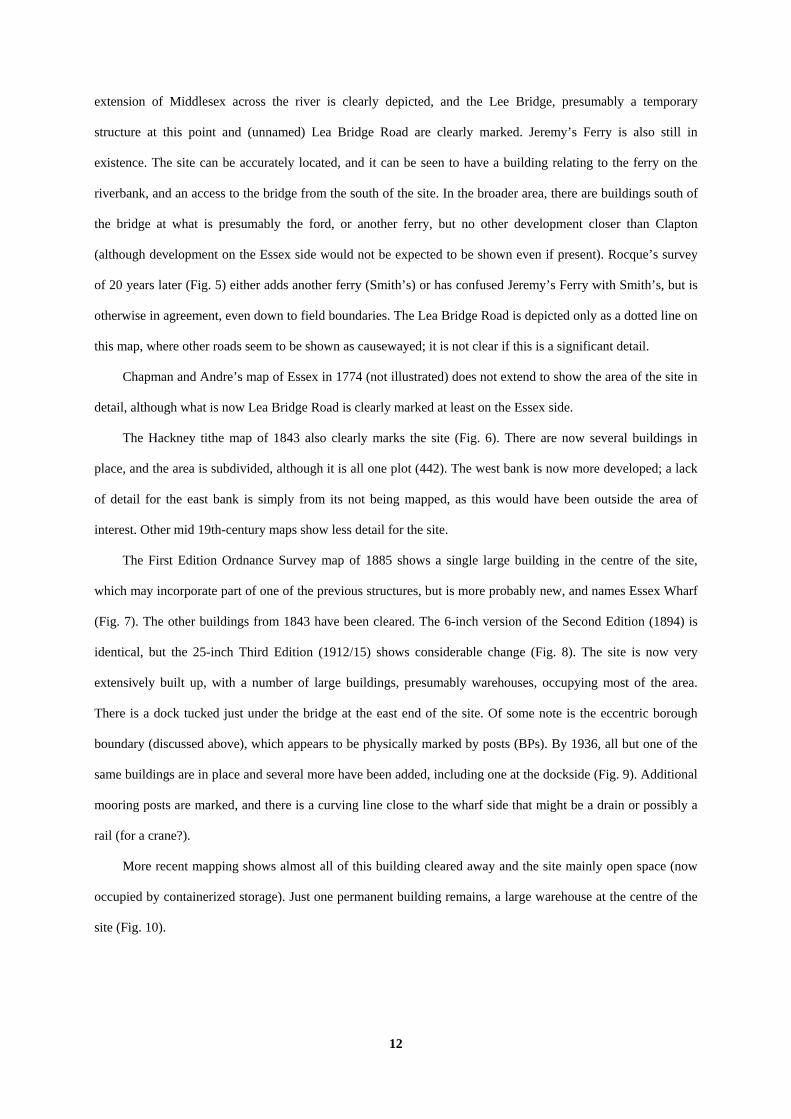
extension of Middlesex across the river is clearly depicted, and the Lee Bridge, presumably a temporary
structure at this point and (unnamed) Lea Bridge Road are clearly marked. Jeremy’s Ferry is also still in
existence. The site can be accurately located, and it can be seen to have a building relating to the ferry on the
riverbank, and an access to the bridge from the south of the site. In the broader area, there are buildings south of
the bridge at what is presumably the ford, or another ferry, but no other development closer than Clapton
(although development on the Essex side would not be expected to be shown even if present). Rocque’s survey
of 20 years later (Fig. 5) either adds another ferry (Smith’s) or has confused Jeremy’s Ferry with Smith’s, but is
otherwise in agreement, even down to field boundaries. The Lea Bridge Road is depicted only as a dotted line on
this map, where other roads seem to be shown as causewayed; it is not clear if this is a significant detail.
Chapman and Andre’s map of Essex in 1774 (not illustrated) does not extend to show the area of the site in
detail, although what is now Lea Bridge Road is clearly marked at least on the Essex side.
The Hackney tithe map of 1843 also clearly marks the site (Fig. 6). There are now several buildings in
place, and the area is subdivided, although it is all one plot (442). The west bank is now more developed; a lack
of detail for the east bank is simply from its not being mapped, as this would have been outside the area of
interest. Other mid 19th-century maps show less detail for the site.
The First Edition Ordnance Survey map of 1885 shows a single large building in the centre of the site,
which may incorporate part of one of the previous structures, but is more probably new, and names Essex Wharf
(Fig. 7). The other buildings from 1843 have been cleared. The 6-inch version of the Second Edition (1894) is
identical, but the 25-inch Third Edition (1912/15) shows considerable change (Fig. 8). The site is now very
extensively built up, with a number of large buildings, presumably warehouses, occupying most of the area.
There is a dock tucked just under the bridge at the east end of the site. Of some note is the eccentric borough
boundary (discussed above), which appears to be physically marked by posts (BPs). By 1936, all but one of the
same buildings are in place and several more have been added, including one at the dockside (Fig. 9). Additional
mooring posts are marked, and there is a curving line close to the wharf side that might be a drain or possibly a
rail (for a crane?).
More recent mapping shows almost all of this building cleared away and the site mainly open space (now
occupied by containerized storage). Just one permanent building remains, a large warehouse at the centre of the
site (Fig. 10).
13
Listed buildings
Just across the bridge at 1 Waterworks Lane is a mid 19th-century building, probably originally a school,
converted into a workshop, and listed as the premises of Testi and Sons, Millwrights. Development on the
proposal site will not affect this building.
Registered Parks and Gardens; Registered Battlefields
There are no registered parks and gardens or registered battlefields within close proximity of the site.
Historic Hedgerows
There are no hedgerows, historic or otherwise, on the site.
Aerial Photographs
The site areas lies within an urban area which has been developed since before the advent of aerial photography,
and on alluvium which is not suitable for the creation of cropmarks. No photographic collections have therefore
been consulted.
Discussion
In considering the archaeological potential of the study area, various factors must be taken into account,
including previously recorded archaeological sites, previous land-use and disturbance and future land-use
including the proposed development.
The chief element of archaeological potential for this site clearly lies in its proximity to an ancient river
crossing. Lea Bridge Road might be on the line of, or at least close to, a Roman road, a bridge is known to have
stood here in the 15th century, and either a bridge or a ferry operated from this spot from then onwards.
Evidence for an earlier crossing would be of considerable importance, particularly for the Roman and Saxon
periods. The area has also provided significant prehistoric finds. Furthermore, the topographic setting of the site
holds out the possibility that palaeoenvironmental evidence might be present. Given the known history of
flooding in the area, and reports of prehistoric finds at considerable depths, it must also be considered that
deposits, possibly waterlogged, might be present at some depth. In such cases, mitigation of construction impacts

14
especially on organic remains, is as yet an imperfectly understood business, the implications of schemes aiming
at ‘preservation in situ’ are not always fully predictable (Nixon 2004; Davis et al. 2004).
The site did see extensive development in the late 19th and early 20th century. However this was probably
all warehousing and may not have involved deep foundations or basements. Indeed, it is likely that the site
would have been levelled up to raise it above the flood threat, possibly protecting any archaeological deposits
beneath made ground. It is thus not necessarily clear that any potential archaeological levels need have been
extensively disturbed or truncated even though the site has been almost fully built over.
It will be necessary to provide further information about the potential of the site from field observations in
order to draw up a scheme to mitigate the impact of development on any below-ground archaeological deposits if
necessary. A scheme for this evaluation will need to be drawn up and approved by the archaeological advisers to
the Borough and implemented by a competent archaeological contractor, such as an organization registered with
the Institute of Field Archaeologists
References
Allison, J, Godwin, H and Warren, S H, 1952, ‘Late glacial deposits at Nazeing in the Lea Valley, North London’, Phil Trans Roy Soc London, ser B, 236, 169–240
Austin, L, 1997, ‘Palaeolithic and Mesolithic’, in J Glazebrook (ed), Research and Archaeology: a framework for the Eastern counties, 1: resource assessment, E Anglian Archaeol Occas Pap 3, Norwich, 5–11
BGS, 1994, British Geological Survey, 1:50000 Sheet 256, Solid and Drift Edition, Keyworth Davis, M, Gdaniec, K L A, Brice, M and White, L, 2004, Mitigation of construction impacts on archaeological
remains, London Fenwick, V, 1978, ‘Was there a body beneath the Walthamstow boat?’ Internat J Nautical Archaeol 7.3, 187–94 Gibbard, P L, 1994, Pleistocene History of the Lower Thames Valley, Cambridge Glazebrook, J (ed), 2000, Research and Archaeology: a framework for the Eastern counties: 2 - Research
agenda and strategy, E Anglian Archaeol Occas Pap 8, Norwich Hawkes, J W and Fasham, P J, 1997, Excavations on Reading waterfront sites, 1979–88, Wessex Archaeol Rep
5, Salisbury Jacobi, R M, 1980, ‘The Mesolithic of Essex’, in Buckley D G (ed), Archaeology in Essex to AD 1500, CBA Res
Rep 34, 14–25 Jacobi, R M, 1996, ‘The Late Upper Palaeolithic and Mesolithic in Essex’, in O Bedwin (ed), The Archaeology
of Essex; Proceedings of the Writtle Conference, 10–14, Chelmsford Maloney, C and Holroyd, I, 2001, ‘London Fieldwork and Publication Round-up 2000’ London Archaeologist
10 supplement 1 Margary, I D, 1955, Roman roads in Britain, vol. 1 south of the Foss Way–Bristol Channel, London Marsden, A, 1994, Ships of the port of London: first to the eleventh centuries AD, Engl Heritage Archaeol rep 3,
London Meddens, F M, 1996, ‘Sites from the Thames Estuary, England and their Bronze Age use’, Antiquity, 70, 325–34 Mills, A D, 1998, Dictionary of English Place-Names, Oxford MoLAS, 2000, The archaeology of Greater London; an assessment of archaeological evidence for human
presence in the area now covered by Greater London Museum of London Archaeology Service Monogr MoLAS, 2002, A research framework for London Archaeology 2002, London Nixon, T, (ed), 2004, Preserving archaeological remains in situ?, London Pevsner, N and Cherry, B, 1998, Buildings of England, London 4: North, London PPG16, 1990, Dept of the Environment Planning Policy Guidance 16, Archaeology and Planning, HMSO

15
Reynier, M J, 1998, ‘Early Mesolithic settlement in England and Wales: some preliminary observations’ in N Ashton, F Healy and P Pettitt (eds), Stone Age Archaeology; essays in honour of John Wymer Oxbow Monogr 102/Lithic Stud Soc Occas Pap 6
Swanton, M, 2000, The Anglo-Saxon Chronicles, London VCH, 1973, Victoria History of the Counties of England; Essex, vi, London VCH, 1995, Victoria History of the Counties of England; Middlesex, x, London Warren, S H, Clark, J G D, Godwin, H, Godwin, M E and MacFadyean, W A, 1934, ‘An early Mesolithic site at
Broxbourne sealed under Boreal peat’, J Roy Anthropol Inst 64, 101–8 WFBC, 2006, Waltham Forest Unitary Development Plan (first review), Waltham Forest Borough Council Williams, A and Martin, G H, 2002, Domesday Book, A complete Translation, London Williams, J and Brown, N (eds), 1999, An Archaeological Research Framework for the Greater Thames
Estuary, Chelmsford Wymer, J, 1968, Lower Palaeolithic Archaeology in Britain, London Wymer, J J, 1999, The Lower Palaeolithic occupation of Britain, Salisbury

16
APPENDIX 1: Sites and Monuments Records within a 1km search radius of the development site
No SMR Ref Grid Ref (TQ) Type Period Comment 1 MLO11629 3460 8640 Findspot Palaeolithic Three flakes (1 retouched); 19th-century finds 2 MLO22079 3480 8655 Findspot Palaeolithic Six handaxes from disturbed deposits. Smith noted
‘floors’ just to south in 1883 3 MLO12131 3480 8730 Findspot Palaeolithic Nine handaxes, a roughout, 8 flakes (4 retouched) 4 MLO25856
MLO22329 MLO72844
3580 8660 Findspot Cartographic
Palaeolithic Saxon Modern
Palaeolithic Flint flake. 1830s find of Saxon boat, almost certainly same as MLO12067 Site of landfill
5 MLO24990 360 875 Findspot Palaeolithic Another late 19th century findspot, ‘crude handaxe’ 14 feet (c. 3.5m) deep in alluvium
ELO5519 MLO11639 MLO10665 MLO1575 MLO9177
35 86 Findspot Documentary
Palaeolithic Mesolithic Saxon Medieval Post-medieval
Twelve handaxes, 14 flakes (2 retouched), 19th century finds. 5 Tranchet axes. References to Clopton in 1339; Saxon placename. Post-medieval toll gate shown in oil painting.
6
MLO12924 3500 8602 Findspot Palaeolithic Neolithic
Confused record of at least 4 flint implements, probably one Neolithic axe and one Palaeolithic, and two flakes (undated?); but could be as many as 4 axes and 4 flakes
7 ELO3841 MLO66490 MLO66491
3544 8648 Evaluation Palaeolithic Post-medieval
122 Lea Bridge Road: Levallois flake and rolled flint flake, post-medieval well
8 MLO24988 3593 8679 Findspot Bronze Age Hoard of spearheads found in 1885 in well-digging at pumping station. GLSMR gives date as ‘c.500BC’, presumably 1500 is intended.
MLO1680 3550 8570 Findspot Roman Coin of Nero (AD54–68) found c. 1843 9 MLO1673 MLO38374
3556 8571 3556 8571
Findspot Roman Decorated marble sarcophagus with male skeleton, found in 1867, set into the gravel. Coin of Gallienus (AD253–68) found nearby
10 ELO6696 MLO97877
34902 86002 Test pits Roman Post-medieval
Test pits for Time Team’s ‘Big Dig’ recovered a Roman coin and post-medieval pottery
11 MLO8253 3563 8661 Observation ?Roman Unspecified works uncovered supposed Roman road surface; identification and dating unsubstantiated.
12 ELO5121 MLO12067 MLO11640
3590 8650 Saxon Unknown
Old channel of the Lea recorded in 1830 below Hackney marsh in digging of canal and reservoir. Line of ‘old stumps’ seems to have been a revetment; also a boat (or impression of one) and antler.
13 MLO18794 MLO18787
3560 8665 3766 8785
Documentary Medieval Post-medieval
Bridge at least by 1486; in disrepair 1551, collapsed between 1612 and 1630, replaced by ferry 1646. New Lea bridge 1757, replaced by iron bridge 1821. Walthamstow slip, a portion of land dividing north and south Leyton, might be 12th century.
14 MLO22987 MLO25846
36 86 Cartographic Observation
Medieval Post-medieval Prehistoric
15th or 16th century reservoir filled in by East London Waterworks company (date?). Unspecified observations in 1880s revealed various prehistoric artefacts from the valley gravels, including a ‘Chellean’ hand axe and Palaeolithic flakes
15 MLO23446 3619 8705 Documentary Medieval Post-medieval
Wooden causeway of 12 foot bridges, built or perhaps repaired by 1544, repaired 1580, in disrepair c. 1612, only ruins remained by 1694: piles apparently still visible in 19th century
16 MLO10200 3481 8626 Documentary Excavation
Medieval Post-medieval
Brooke House Site of brick courtyard house, late 15th century, rebuilt by Thomas Cromwell, used by Henry VIII, named for the Grevilles (Lords Brooke) who owned it 1609–1820. Bombed 1940, demolished 1955
17 MLO10516 (3418 8670) Cartographic Post-medieval Road marked on Rocque’s map; could be medieval 18 MLO1626
MLO3745 3490 8610 Documentary Post-medieval House, Lower Clapton Road. House opposite St
James Church. Date of 1630 on cistern. Unclear what these entries are for.
19 MLO303 3520 8630 Documentary Post-medieval Bridge and road, built 1757 with toll gate, toll gate removed early 19th century
20 MLO10521 3520 8642 Cartographic Post-medieval Road marked on Rocque’s map; could be medieval 21 ELO6724
MLO98160 MLO98106
35222 86921 Evaluation Post-medieval Two separate evaluations close together. Pits, well, dumping. Pits, possibly brickearth quarries, remains of a wall, dumps.
22 MLO59973 MLO59975
3547 8614 Evaluation Post-medieval Market garden features (bedding trenches or gullies), building rubble
23 ELO3023 MLO59413
3617 8595 Evaluation Post-medieval 19th century ploughsoil, residual 17th century pottery

17
No SMR Ref Grid Ref (TQ) Type Period Comment 24 MLO58266 3626 8709 Documentary Post-medieval Road mentioned in 1601, and bridge 25 MLO24577 3630 8695 Documentary Post-medieval ‘Shanty town’ in 1880s, demolished 1930s, around
Lea Bridge on edge of new development in Leyton. Wooden houses, church, wells, livestock rearing and market gardening.
26 MLO20073 MLO69212
3565 8658 Documentary Post-medieval Ferry Inn from at least 1702, already ‘ancient’ 1757, later called Horse and Groom; demolished c. 1850. River Lea Navigation, 19th-century canal
27 MLO83594 MLO83592 MLO83593 MLO83610 MLO83609
34961 85970 34983 85925 34961 85949 34984 85949
Listed Building Post-medieval Bishop Wood’s almshouses, late 17th century and later. 158–62 Lower Clapton Road, Early 19th century pair of town houses (158–60), with wall and stable to 162. 162 Grade II*, c. 1800 large villa.
28 MLO35616 MLO34222 MLO34223 MLO34224 MLO7041 MLO7042 MLO83585
3510 8580 3513 8581 35132 85817
unknown Listed Building
Post-medieval 9-12 Laura Place, semi-detached houses; 4 records for the houses, one for demolition 1975–6. Demolition of 8 Laura Place (1975-6) listed separately, no listing for building. No indication why these might be worthy of inclusion or under what category. 7 Laura Place Small 19th century villa, listed.
29 MLO83596 34844 86068 Listed Building Post-medieval Modern
Church of St James the Great, 1840–1, later additions
30 MLO83871 35010 86746 Listed Building Post-medieval Modern
Southwold Junior School, late 19th century
31 MLO83831 35558 86556 Listed Building Post-medieval Modern
Mid 19th century millwrights workshop, probably originally a school
32 MLO83861 36001 86065 Listed Building Post-medieval Modern
Clapton Park Lower School, late 19th century
33 MLO83786 34576 86710 Listed Building Modern Rossendale Street Air raid precaution centre bunker, 1938
34 MLO83793 MLO83791 MLO83792
35914 86171 35887 86215 35908 86192
Listed Building Modern Caretaker’s lodge for disinfecting station, 1900–1; disinfecting station itself. Shelter House, accommodation for those being disinfected
35 MLO72826 3550 8750 Cartographic Modern Site of landfill 36 MLO72823 3570 8690 Cartographic Modern Site of landfill 37 ELO4456
MLO64622 3453 8674 Watching brief Unknown 1 Rossington Street; no archaeology but did show
the interface between gravels and brickearth survived.
38 MLO327 353 858 Findspot? Unknown Wooden water pipe(s) found in 1909 39 - 3625 8680 Watching brief Negative No archaeology; not on GLSMR
Listed Buildings all Grade II unless noted

18
APPENDIX 2: Historic and modern maps consulted
1576 Saxton, Essex (Fig. 2)
1593 Norden, Myddlesex
1672 Ogilvy, An Actuall Survey of Middlesex (Fig. 3)
1745 Anon, Map of the parish of Hackney before its division into district parishes
1749 Warburton, Middlesex (Fig. 4)
1762/9 Rocque, London (from the Atlas, second edition, surveyed 1762; with revisions by his followers to 1769) (Fig. 5)
1799 Anon, Hackney and Stratford
1774 Chapman and Andre, Essex
1834 Map of the Tyssen Estate in the parish of St John of Hackney
1843 Hackney tithe map (Fig. 6)
1847 Anon, Map of the parish of Hackney
1862 Stanford, Map of London and its suburbs
1864 Hackney Borough Map
1885 Ordnance Survey First Edition 25 inch series Middlesex sheet xii.5 (London sheet xxx) (Fig. 7)
1894 Ordnance Survey Second Edition 6 inch series London Sheet ii
1896 Ordnance Survey Second Edition 25 inch series London Sheet ii.15
1912 Ordnance Survey Third Edition 6 inch series London Sheet ii
1915 Ordnance Survey Third Edition 25 inch series London Sheet ii.15 (Fig. 8)
1936 Ordnance Survey revision 25 inch series London Sheet ii.15 (Fig. 9)
1952 Ordnance Survey Sheet TQ3486

Essex Wharf, Lea Bridge Road, Clapton, London Borough of Waltham Forest, 2007
Archaeological Desk-based Assessment
Figure 1. Location of site within Hackney andGreater London, showing GLSMR entries.
Reproduced from Ordnance Survey Pathfinder 1159 TQ28/38 at1:12500 Ordnance Survey Licence 100025880
86000
87000
88000
TQ35000 36000
SITE
EWW07/80
SITE
1
3
5
6
7
4
10
12
13
14
11
21
20
1916
24
25
38
37
36
35
39
34
26
27
28
29
30
31
32
33
23
2218
17
15
9
8
2
Key:Prehistoric, Roman, Medieval:
Post-medieval and later; negative: 28
6

Essex Wharf, Lea Bridge Road, Clapton, London Borough of Waltham Forest, 2007
Archaeological Desk-based Assessment
Figure 2. Saxton’s map of Essex, 1576.
Approximatelocation of site
EWW07/80

Essex Wharf, Lea Bridge Road, Clapton, London Borough of Waltham Forest, 2007
Archaeological Desk-based Assessment
Figure 3. Ogilvy, 1672.
EWW07/80
Approximatelocation of Site

Essex Wharf, Lea Bridge Road, Clapton, London Borough of Waltham Forest, 2007
Archaeological Desk-based Assessment
Figure 4. Warburton 1749.
EWW07/80
SITE

Essex Wharf, Lea Bridge Road, Clapton, London Borough of Waltham Forest, 2007
Archaeological Desk-based Assessment
Figure 5. Rocque, 1769.
EWW07/80
Approximatelocation of site

Essex Wharf, Lea Bridge Road, Clapton, London Borough of Waltham Forest, 2007
Archaeological Desk-based Assessment
Figure 6. Hackney Tithe map, 1843.
EWW07/80
SITE

Essex Wharf, Lea Bridge Road, Clapton, London Borough of Waltham Forest, 2007
Archaeological Desk-based Assessment
Figure 7. Ordnance Survey First Edition 1885.
EWW07/80
SITE

Essex Wharf, Lea Bridge Road, Clapton, London Borough of Waltham Forest, 2007
Archaeological Desk-based Assessment
Figure 8. Ordnance Survey Third Edition 1912/15
EWW07/80
SITE

Essex Wharf, Lea Bridge Road, Clapton, London Borough of Waltham Forest, 2007
Archaeological Desk-based Assessment
Figure 9. Ordnance Survey Revision, 1936
EWW07/80
SITE

Essex Wharf, Lea Bridge Road, Clapton, London Borough of Waltham Forest, 2007
Archaeological Desk-based Assessment
Figure 10. Current layout
EWW07/80
SITE