esso deepwater gippsland pty ltd (“esso”)
TRANSCRIPT
Esso Deepwater Gippsland Pty Ltd (“Esso”)
BALDFISH DRILLING ENVIRONMENT PLAN SUMMARY
Rev Revision / Status Date Prepared
1 Revised incorporating NOPSEMA comments 24 July 2018 RT
0 Issued for NOPSEMA Review 13 July 2018 SL/RT
Baldfish Drilling Environment Plan Summary
Rev. 0 ii 27 Jul. 18
Table of Contents
Table of Contents .............................................................................................................ii
List of Figures .................................................................................................................. iv
List of Tables ................................................................................................................... vi
Definitions ...................................................................................................................... vii
Abbreviations ................................................................................................................. vii
1 INTRODUCTION ..................................................................................................... 11
1.1 Overview ........................................................................................................... 11
1.2 Titleholder .......................................................................................................... 11
2 DESCRIPTION OF THE ACTIVITY ......................................................................... 12
2.1 Location ............................................................................................................. 12
2.2 Baldfish Operational Area .................................................................................. 13
2.3 The Ocean Monarch MODU .............................................................................. 13
2.4 Support Vessels ................................................................................................ 24
2.5 Helicopter Support ............................................................................................. 24
2.6 Subsea Well design ........................................................................................... 24
2.7 Reservoir Evaluation .......................................................................................... 26
2.8 Remotely Operated Vehicle (ROV) support ....................................................... 26
3 DESCRIPTION OF THE ENVIRONMENT ............................................................... 27
3.1 Zone of Potential Impact .................................................................................... 27
3.2 Physical Environment ........................................................................................ 28
3.3 Nearshore and Shoreline Environments ............................................................ 29
3.4 Offshore Marine Environment ............................................................................ 29
3.5 Ecological and Social Receptors ........................................................................ 31
3.6 Conservation Values within the Operational ZPI ................................................ 38
3.7 Commercial Fishing ........................................................................................... 56
3.8 Commercial Shipping ......................................................................................... 63
3.9 Oil and Gas Industry .......................................................................................... 64
3.10 Recreational Fishing, Boating and Tourism........................................................ 65
3.11 Cultural Heritage ................................................................................................ 66
4 ENVIRONMENTAL IMPACT AND RISK ASSESSMENT METHODOLOGY .......... 69
4.1 Risk Assessment Methodology .......................................................................... 69
4.2 Demonstration of ALARP ................................................................................... 69
4.3 Demonstration of Acceptable Level ................................................................... 71
5 ENVIRONMENTAL RISK AND IMPACT EVALUATION ......................................... 72
5.1 MODU/Vessel Sewage discharge (RA 1) ........................................................... 72
5.2 MODU/Vessel Seawater intakes (RA 2) ............................................................. 74
5.3 Disposal of food wastes from MODU/vessels (RA 3) ......................................... 75
5.4 Accidental release of general, solid or hazardous waste (RA 4) ......................... 77
5.5 MODU/Vessel deck drainage (RA 5) .................................................................. 79
5.6 MODU/Vessel oily water (bilge) discharge (RA 6) .............................................. 81
5.7 MODU/Vessel ballast water discharge (RA 7) .................................................... 83
Baldfish Drilling Environment Plan Summary
Rev. 0 iii 27 Jul. 18
5.8 MODU/Vessel Biosecurity & Hull Biofouling (RA 8) ............................................ 86
5.9 Vessel and helicopter movements - Interaction with fauna (RA 9) ..................... 88
5.10 Emissions to Air from MODU/Vessels (RA 10) ................................................... 91
5.11 Cooling Water and Brine Discharges (RA 11) .................................................... 93
5.12 Hydraulic fluid discharge during ROV operations (RA 12) .................................. 96
5.13 Hydraulic fluid discharge from BOP operations (RA 13) ..................................... 97
5.14 Planned Discharge - drilling mud and cuttings to seabed (RA 14) ...................... 98
5.15 Planned Discharge - Drilling mud and cuttings at the sea surface (RA 15) ...... 102
5.16 Planned Discharge - Cement discharges at the seabed (RA 16) ..................... 105
5.17 Planned Discharge - Cement at the sea surface (RA 17) ................................. 107
5.18 Drilling Operations - Use and storage of radioactive sources (RA 18) .............. 108
5.19 Physical presence - Noise and light (RA 19) .................................................... 109
5.20 Physical presence - Interference with Commercial Fishing (RA 20) ................. 112
5.21 Physical presence - Interference with Commercial Shipping (RA 21) ............... 115
5.22 Physical presence – Seabed Disturbance (RA 22) ........................................... 118
5.23 Accidental Release – Dropped Objects (RA 23)............................................... 120
5.24 Accidental Release - Loss of containment from vessel collision (RA 24) .......... 122
5.25 Accidental Release - Spills during Bulk transfer via bunkering hose (RA 25) ... 137
5.26 Accidental Release - Foam Deluge System (RA 26) ........................................ 139
5.27 Accidental Release - Spills during chemical and oils storage and handling (RA 27) ................................................................................................................... 141
5.28 Accidental Release - Loss of well integrity (RA 28) .......................................... 142
5.29 Accidental Release - Mooring failure/Emergency Disconnect (RA 29) ............. 161
5.30 Impacts resulting from Spill Response Strategies (RA 30) ............................... 162
5.31 Environmental Performance Outcomes, Performance Standards and Measurement Criteria ...................................................................................... 168
6 EMERGENCY RESPONSE PLANNING ............................................................... 208
6.1 Oil Spill Planning Scenario Development ......................................................... 208
6.2 Response Strategy Options ............................................................................. 208
6.3 Tactical Response ........................................................................................... 210
6.4 Monitoring, Evaluation and Surveillance (MES) ............................................... 218
6.5 Source control ................................................................................................. 218
6.6 Operational Scientific Monitoring Plan ............................................................. 218
7 IMPLEMENTATION STRATEGY .......................................................................... 221
7.1 Esso Operations Integrity Management System (OIMS) .................................. 221
7.2 Diamond Offshore Safety and Environmental Management System (SEMS) ... 221
7.3 Baldfish Exploration Drilling Documents .......................................................... 221
7.4 Training and Competency ................................................................................ 222
7.5 Reporting and Inspections ............................................................................... 222
7.6 Environmental Performance Review ................................................................ 225
7.7 Emergency and Oil Spill Preparedness and Response .................................... 226
7.8 Operational Control .......................................................................................... 227
8 STAKEHOLDER CONSULTATION ...................................................................... 228
8.1 Stakeholder Identification ................................................................................. 228
8.2 Mechanisms for Consultation ........................................................................... 230
Baldfish Drilling Environment Plan Summary
Rev. 0 iv 27 Jul. 18
8.3 Consultation Outcomes.................................................................................... 232
8.4 Ongoing Consultation ...................................................................................... 233
9 REFERENCES USED IN THE ENVIRONMENT PLAN ......................................... 234
List of Figures
Figure 2-1 The Baldfish drilling location in Block VIC/P70, Deepwater Gippsland Basin 12 Figure 2-2 Location of Temporary Fairways 13 Figure 2-3 Ocean Monarch MODU 15 Figure 2-4 General Arrangement – Main Deck 17 Figure 2-5 Pontoon and Column Layout and location of diesel fuel tanks (CPT3 and CST3) 18 Figure 2-6 Ocean Monarch Mud System Overview 20 Figure 2-7 Baldfish Generalised Well Design 25 Figure 3-1 Baldfish Exploration Drilling Zone of Potential Impact (Operational ZPI), based on
hydrocarbon exposures above impact thresholds 27 Figure 3-2 Environmental Monitoring ZPI: Geographic extend of potential impacts from entrained
hydrocarbons at ANZECC reference level (7 ppb, 96 hrs) resulting from a 98 day blowout scenario at the Baldfish location (APASA 2018) 28
Figure 3-3 Baldfish-1 and Hairtail 1- well locations relative to seafloor bathymetry of the Offshore Gippsland Basin and Bass Canyon (after Mitchel et al., 2007) 30
Figure 3-4 Key Ecological Features within the South-east Marine Region Profile (DoEE 2015) 39 Figure 3-5 Biologically Important Areas within the South-east Marine Region Profile (DoEE
2015) 39 Figure 3-6 IMCRA bioregions in Victoria 41 Figure 3-7 Sites of conservation significance along Gippsland Coastline relative to Baldfish
operational area 41 Figure 3-8 Commonwealth Trawl Sector and East Coast Deepwater Trawl Sector of Victoria
coastline within the Southern and Eastern Scalefish and Shark Fishery (SESSF) (AFMA 2010) 56
Figure 3-9 Relative fishing intensity in the Commonwealth Trawl Sector, 2016–17 fishing season (ABARES 2017) 57
Figure 3-10 Relative fishing intensity in the Scalefish Hook Sector (SHS), 2016–17 fishing season (ABARES 2017) 58
Figure 3-11 Relative fishing intensity by Danish-seine operations, 2016–17 fishing season (ABARES 2017) 59
Figure 3-12 Area fished in the Small Pelagic Fishery, 2016–17 (ABARES 2017) 60 Figure 3-13 Shipping activity through Traffic Separation Scheme (TSS) and Baldfish operational
area between April 2018 64 Figure 3-14 Offshore operations in Gippsland Basin 65 Figure 3-15 Gunai-Kurnai Native Title Determination Area (VCD2010/01) 67 Figure 3-16 Shipwreck sites around the Gippsland Basin 68 Figure 4-1 ALARP Decision Support Framework 70 Figure 5-1 Conceptual diagram showing the behaviour of cuttings and muds (Neff, 2005) 99 Figure 5-2 Predicted thickness and coverage from drill cuttings and muds on the seafloor 100 Figure 5-3 Temporary Fairways around the Baldfish-1 and Hairtail-1 wells during Baldfish
exploration drilling activities as implemented by AMSA and AHS (Feb 2018) 116 Figure 5-4 Notice to mariners 126(T)/2018 Australia - Victoria - Ninety Mile Beach - Traffic
separation scheme southwestwards (9 Feb 2018) 116 Figure 5-5 Admiralty Notice to mariners 1143(T)/18 AUSTRALIA - Victoria - Tasman Sea W -
Fairways. Traffic separation scheme (8 March 2018) 117 Figure 5-6 Predicted weathering and fates volume balance of MDO at Hairtail-1 127 Figure 5-7 Predicted weathering and fates volume balance for a single spill trajectory, based on
a well blowout and relief well over 98 days at Hairtail-1 (APASA 2018) 145 Figure 5-8 Predicted weathering and fates volume balance for a single spill trajectory, based on
a well blowout and use of capping stack over 49 days at Hairtail-1 (APASA 2018) 145 Figure 6-1 Esso emergency management and response system 214

Baldfish Drilling Environment Plan Summary
Rev. 0 v 27 Jul. 18
Figure 6-2 Organisation Chart – Esso Emergency Support Group (ESG) structure 214 Figure 6-3 Organisation Chart – Esso Incident Management Team (IMT) structure 215 Figure 6-4 Organisation Chart – Esso Source Control Branch (SCB) 217
Baldfish Drilling Environment Plan Summary
Rev. 0 vi 27 Jul. 18
List of Tables
Table 2-1 Location of Baldfish-1 and Hairtail-1 drill centres 12 Table 2-2 Facility Registration Details 13 Table 2-3 General Information on Storage Capacities 14 Table 2-4 Ocean Monarch Diesel Fuel Tank Capacities 16 Table 2-5 Cutting volume estimates 21 Table 2-6 Baldfish Typical well operations sequence (provisional) 26 Table 3-1 Ecological receptors that may occur within the Operational ZPI 32 Table 3-2 Social receptors that may occur within the operational area and Operational ZPI 35 Table 3-3 Summary of conservation values and sensitivities within the Operational ZPI 38 Table 3-4 EPBC Act Threatemed and Migratory Species potentially occurring in the Baldfish
Operational ZPI 44 Table 3-5 EPBC Act listed seals potentially occurring in the Operational ZPI 50 Table 3-6 Whale Migration in Bass Strait region 51 Table 3-7 Conservation advice for EPBC listed species considered during environmental risk
assessment 52 Table 3-8 Production licences, Exploration Permits and Retention Leases within Gippsland
Basins 64 Table 5-1 Summary of Impacts and Risks associated with Baldfish Campaign 72 Table 5-2 General and Hazardous waste generated during drilling campaign 77 Table 5-3 The Bonn Agreement Oil Appearance Code 123 Table 5-4 Hydrocarbon exposure thresholds in surface waters 123 Table 5-5 Hydrocarbon exposure thresholds used to classify the zones of shoreline contact 123 Table 5-6 Hydrocarbon exposure thresholds for dissolved aromatic exposure 124 Table 5-7 Hydrocarbon exposure thresholds for entrained hydrocarbon exposure 126 Table 5-8 MDO LOC Scenario - Summary of predicted spill impacts 129 Table 5-9 MDO Loss of Containment - Consequence evaluation for Hydrocarbon Exposure 130 Table 5-10 Worst Credible Spill Scenario – Well blow-out (WCDS) assumptions 142 Table 5-11 Well blow-out Scenario: Summary of predicted spill impacts 147 Table 5-12 Potential Environmental receptors that may be affected by an Oil Spill 149 Table 5-13 Well blow-out - Consequence evaluation for Hydrocarbon Exposure 154 Table 5-14 List of values and sensitivities identified within and near the Operational ZPI (RA30)
164 Table 5-15 Environmental performance outcomes, standards and measurement criteria 169 Table 6-1 Credible spill scenarios identified response planning 208 Table 6-2 Response technique evaluation for a Marine Diesel Oil (MDO) spill (NEBA) 208 Table 6-3 Response technique evaluation for Loss of Well Control scenario 209 Table 6-4 Tactical response for Level 1 spill scenario 210 Table 6-5 Tactical response for Level 2 spill scenario 210 Table 6-6 Tactical response for Level 3 spill scenario 211 Table 6-7 OSMP Studies and Monitoring Performance Objectives and reference to OSMP
Sections for each study’s strategy and implementation 218 Table 6-8 Sensitivities which may be to be monitored as part of the OSMP in the event of a
Level 2 spill 220 Table 7-1 External Notification and Reporting Requirements 222 Table 7-2 Summary environmental monitoring/recording and reporting requirements 223 Table 7-3 Reporting to AMSA and other government agencies - marine pollution
incidents/injuries 224 Table 7-4 Summary of Assessments and Inspections 225 Table 7-5 Environmental Performance Indicators 226 Table 8-1 Identified Stakeholders 228 Table 8-2 Summary of Key Issues, Merits and Measures Adopted 232
Baldfish Drilling Environment Plan Summary
Rev. 0 vii 27 Jul. 18
Definitions
In this document "Esso Deepwater” means Esso Deepwater Gippsland Pty Ltd.
Esso Deepwater is the designated operator for Block VIC/P70. Esso Deepwater receives services,
including personnel, from ExxonMobil Corporation subsidiary, Esso Australia Pty Ltd (EAPL).
The Baldfish Exploration Drilling Campaign is managed by EAPL.
"Esso" may be used to refer to the ExxonMobil subsidiaries.
"Diamond Offshore" refers to Diamond Offshore Services Company and/or Diamond Offshore General
Company.
This document, the Baldfish Drilling Environment Plan Summary, is generally referred to as the "Baldfish
EP Summary".
The Baldfish Operational area refers to the 2 NM buffer zone around each of the wells.
The Operational Zone of Potential Impact refers to the area that is potentially impacted as a result
from a major blowout scenario, as outlined in Section 3.1.
Abbreviations
ABWMIS Australian Ballast Water Management Information System
AFFF Aqueous Film-Forming Foam Concentrates
AFMA Australian Fisheries Management Authority
AHT Anchor Handling Tug
AIS Automatic Identification System
ALARP As Low As Reasonably Practicable
AMOSC Australian Marine Oil Spill Centre
AMSA Australian Maritime Safety Authority
ANZECC Australian and New Zealand Environment and Conservation Council
APASA RPS Asia Pacific Applied Science Association
APPEA Australian Petroleum Production and Exploration Association
AQIS Australian Quarantine Inspection Service (now Department of Agriculture and Water Resources; DAWR)
ATBA Area To Be Avoided
BBMT Barry Beach Marine Terminal
BCR Ballast Control Room
BHPB BHP Billiton Petroleum (Bass Strait) Pty Ltd
BIA Biologically Important Area
BKA Blackback subsea facility
BOM Bureau of Meteorology
BOP Blow Out Preventer
BSCZSF Bass Strait Central Zone Scallop Fishery
CHARM Chemical Hazard and Risk Management Model
CMMS Computerised Maintenance Management System (Ocean Monarch)
CSS Check-shot Survey
CVIT Commonwealth Victoria Inshore Trawl
DAWR Department of Agriculture and Water Resources (previously AQIS; also Ag. Dept.)
DEDJTR Department of Economic Development, Jobs, Transport and Resources Victoria
DELWP Department of Environment, Land, Water and Planning Victoria
DO Diesel Oil
DoEE Department of the Environment and Energy
DoIIS Department of Industry, Innovation and Science
Baldfish Drilling Environment Plan Summary
Rev. 0 viii 27 Jul. 18
DSV Dive Support Vessel
DWH Deepwater Horizon
EAPL Esso Australia Pty Ltd
EARPL Esso Australia Resources Pty Ltd
EEZ Exclusive Economic Zone
EMBA Environment that May Be Affected (also see Operational ZPI)
ENVID Environmental Hazard Identification workshops
EP Environment Plan
EPA Environment Protection Authority
EPBC Environment Protection and Biodiversity Conservation
ERA Environmental Risk Assessment
ERM Emergency Response Manual
ESD Ecologically Sustainable Development
ESG Emergency Support Group
EWMM Esso Work Management Manual
FIMS Facility Integrity Management System
FVO First Valve On
GBJVOA Gippsland Basin Joint Venture Operational Agreement
GEMS Diamond Offshore GEMS Procedures (Global Excellence Management System)
GHG Greenhouse Gases
GOR Gas to Oil Ratio
HAZID Hazard Identification workshops
HMCS OSPAR Harmonised Mandatory Control Scheme (HMCS)
HOCNF OSPAR Harmonised Offshore Chemical Notification Format (OCNS)
HP High Pressure
ICS Incident Control System IMO International Maritime Organisation
IOPP International Oil Pollution Prevention certificate
IMT Incident Management Team
JV Joint Venture
KEF Key Ecological Feature
KPI Key Performance Indicators
LEFCOL Lakes Entrance Fishing Co-operative Limited
LEL Lower Exposure Limit
LMRP Lower Marine Riser Package
LO Lubricating Oil
LPG Liquid Petroleum Gas
LMRP Lower Marine Riser Package
LOWC Loss of Well Control
LWD Logging While Drilling
MARPOL 73/78 International Convention for the Prevention of Pollution from Ships
MDO Marine Diesel Oil
MDRT Measured Depth from Rotary Table
MEPC (IMO) Marine Environment Protection Committee
MES Monitoring, Evaluation and Surveillance
MLWL Mean Low Water Level
MODU Mobile Offshore Drilling Unit (rig)
MOL Main Oil Line
MMSCFD Million Standard Cubic Feet per Day
MT Metric Ton
SDS Safety Data Sheet (previously Material Safety Data Sheet, MSDS)
MSL Mean Sea Level
NEBA Net Environmental Benefit Analysis (see OPEP)
NEPM National Environment Pollution Measures
Baldfish Drilling Environment Plan Summary
Rev. 0 ix 27 Jul. 18
NM Nautical Mile
NOPSEMA National Offshore Petroleum Safety and Environmental Management Authority
NSW New South Wales
OCNS Offshore Chemical Notification Scheme (CEFAS 2017)
OI Operations Integrity
OGUK Oil and Gas UK (previously UKOOA)
OICSS Offset Installation Capping Stack System
OIE Offset Installation Equipment
OIMS Operations Integrity Management System
OIW Oil-In-Water
OWS Oil-water separators
OSMP Operational and Scientific Monitoring Program
OSPAR OSPAR Commission - manages Harmonised Mandatory Control Scheme (HMCS)
OSRA Oil Spill Resource Atlas
OSRL Oil Spill Response Limited
OSV Offshore Support Vessel
OPEP Oil Pollution Emergency Plan
OPGGS Act Offshore Petroleum and Greenhouse Gas Storage Act 2006
OPGGS(E) Regs Offshore Petroleum and Greenhouse Gas Storage Environment Regulations 2009
ORCA Oil spill Resources Company of Australia
OSR Oil Spill Response
OSTM Oil Spill Trajectory Modelling
PEC Predicted Environmental Concentration
PFAS Per- and poly-Fluoroalkyl Substances
PFOA Perfluorooctanoic acid
PFOS Perfluorooctanoic sulfonate
PMS Diamond Planned Maintenance System
PNEC Predicted No Effect Concentrations
PIC Person In Charge
PSZ Petroleum Safety Zone
RA Risk Assessment RAMSAR Convention on Wetlands of International Importance
RC Required Competencies
RO Reverse Osmosis
ROV Remotely Operated Vehicle
RRT Regional Response Team
SCB Source Control Branch
SEMS Safety and Environmental Management System (Ocean Monarch)
SESSF Southern and Eastern Scale-fish and Shark Fishery
SETF South Eastern Trawl Fishery
SFRT Subsea First Relief Toolkit
SIV Seafood Industry Victoria
SMART Special Monitoring of Applied Response Technologies
SMC Subject Matter Contact
SOOB Summary of operational boundaries
SSHE Safety, Security, Health, Environment
TD Total Depth
TSS Traffic Separation Scheme
VICSS Vertical Installation Capping Stack System
VSP Vertical Seismic Profiling
WBM Water Based Mud
WCDS Worst Credible Discharge Scenario
WMP Waste Management Plan
WOMP Well Operations Management Plan

Baldfish Drilling Environment Plan Summary
Rev. 0 x 27 Jul. 18
WWC Wild Well Control
Operational ZPI Zone of Potential Impact
Baldfish Drilling Environment Plan Summary
Rev. 0 11 27 Jul. 18
1 Introduction
1.1 Overview
This Environment Plan (EP) Summary has been prepared in accordance with the requirements of the
Commonwealth Offshore Petroleum and Greenhouse Gas Storage Act 2006 and the Offshore
Petroleum and Greenhouse Gas Storage (Environment) (OPGGS(E)) Regulations 2009, per the
amended Act and Regulations as at 01 January 2015. The EP development has been guided by
N04750-GN1344 Environment Plan Content Requirements (NOPSEMA 2016).
The scope of the EP is to manage the environmental impacts and risks associated with all activities
relating to the Baldfish exploration drilling activities, to be completed by a Mobile Offshore Drilling Unit
(MODU). Activities included in the scope of the EP include pre-mooring activities, drilling, well
abandonment, well suspension, anchor handling, guard and support vessels, ROV activities and use of
helicopters.
The Baldfish exploration campaign involves drilling two wells into a reservoir expected to contain gas.
The Baldfish location is approximately 90km off the Victorian coast line, south of Lakes Entrance and
drilling is expected to start in Q3 2018 and take around 60 days. The Baldfish operational area within
Exploration Block VIC/P70 consists of the 2 NM buffer zone around the wells, and the AHT and guard
vessels when supporting the MODU.
The EP was accepted by NOPSEMA on the 4th July 2018.
1.2 Titleholder
Esso Deepwater is the titleholder of VIC/P70, which it wholly owns, as defined in the OPGGS
(Environment) Regulations 2009, details as below:
Esso Deepwater Gippsland Pty Ltd (ACN 602 257 821)
664 Collins Street
Docklands, Victoria, VIC 3008
Telephone: +61 3 9261 0000
The environmental contact for this activity is:
Carolyn Thomas
Esso Australia Pty Ltd for and on behalf of Esso Deepwater Gippsland Pty Ltd
Risk, Environment and Regulatory Supervisor
Telephone: (03) 9261 0260
Email: [email protected]
Esso Deepwater is the designated operator for Block VIC/P70. Esso Deepwater receives services,
including personnel, from ExxonMobil Corporation subsidiary, Esso Australia Pty Ltd (EAPL).
Baldfish Drilling Environment Plan Summary
Rev. 0 12 27 Jul. 18
2 Description of the Activity
The Baldfish exploration drilling program is targeting gas reserves in Block VIC/P70. Drilling is
scheduled for Q3 2018, during an approximate 60 day drilling campaign, subject to weather and
operational performance, and will be undertaken using the Ocean Monarch drill rig.
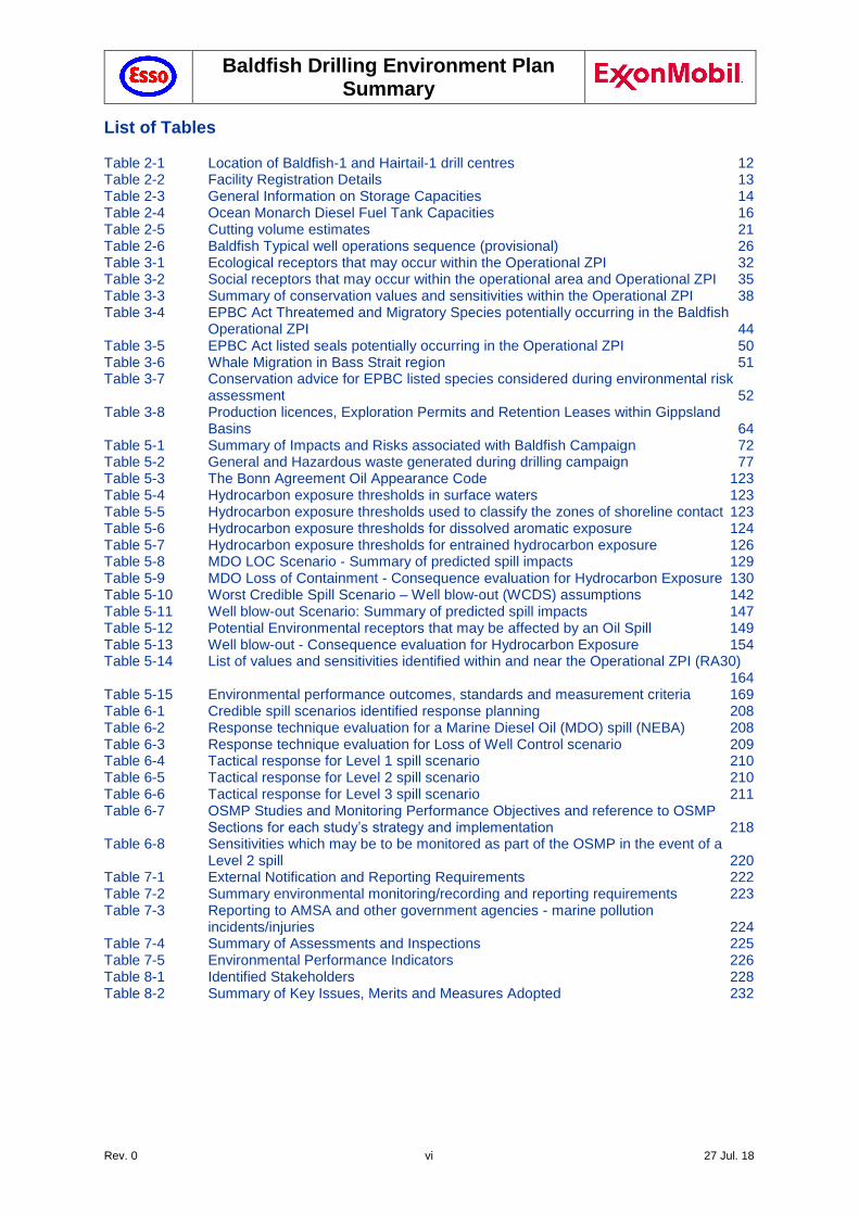
2.1 Location
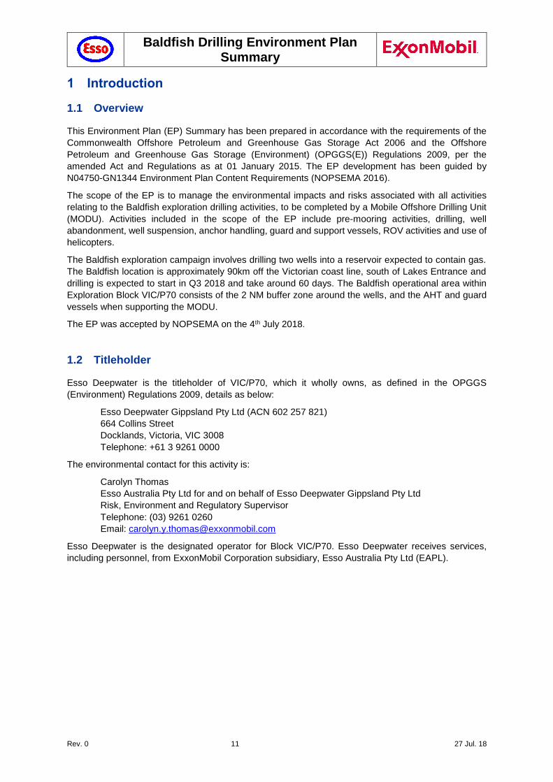
The proposed Baldfish drilling locations are located approximately 90 km off the Gippsland coast,
between approximately 359 m and 665 m of water depth (Figure 2-1). The distance between the two
wells, Hairtail-1 and Baldfish-1, is approximately 3.5 km. The coordinates for Baldfish and Hairtail are
provided in Table 2-1.
Figure 2-1 The Baldfish drilling location in Block VIC/P70, Deepwater Gippsland Basin
Table 2-1 Location of Baldfish-1 and Hairtail-1 drill centres
Production Licence
No.
Well Name Latitude Longitude Depth (m)
VIC/P70 Baldfish-1 38° 36’ south 148° 35 east 665
VIC/P70 Hairtail-1 38° 37’ south 148° 31’ east 359
There are no producing assets in VIC/P70, although a number of wells have previously been drilled in
this block. The nearest production facility is the Blackback subsea facility (BKA), about 7 km to the north
in VIC/L20.
VIC/L05 VIC/L06
VIC/L07
VIC/L19
VIC/L20
VIC/P70 (100%)
Traffic Separation
Scheme
Baldfish Drilling Environment Plan Summary
Rev. 0 13 27 Jul. 18
2.2 Baldfish Operational Area
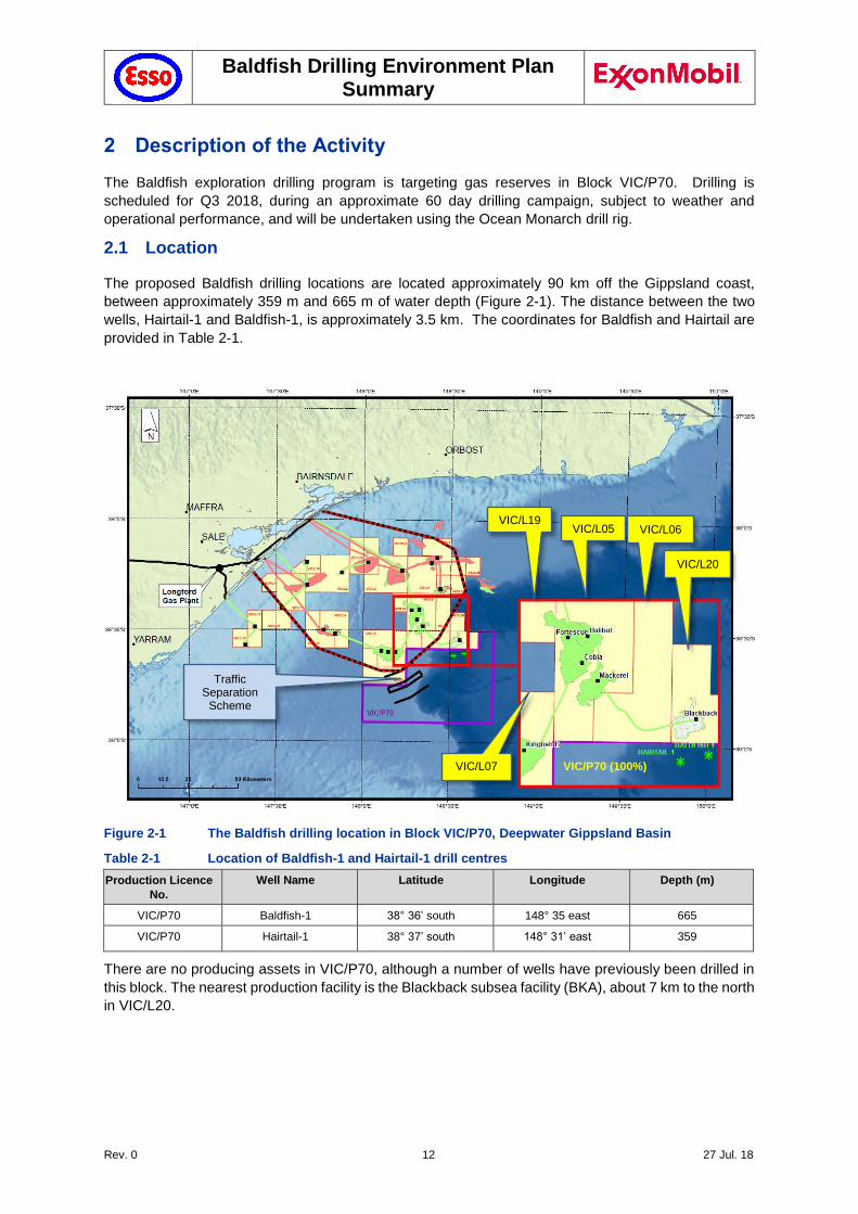
In dialogue with AMSA and AHS it was agreed that AMSA/AHS would establish temporary fairways
around the Baldfish drilling locations, (Figure 2-2), in order to deviate commercial shipping away from
these locations. These temporary fairways were established in February 2018 (NTM 126(T)/2018 of 9
February 2018, and Admiralty NTM 1143-10 published 8 March 2018).
Figure 2-2 Location of Temporary Fairways
The Baldfish operational area applicable to the scope of this Environment Plan (EP) consists of the 2
NM radius buffer zone around the Baldfish-1 and Hairtail-1 wells in Block VIC/P70, as established by
AMSA (Section 5.21), and the AHT and guard vessels when supporting the MODU. Note that the buffer
zone encompasses the petroleum safety zone (PSZ) and the mooring spread of the anchors.
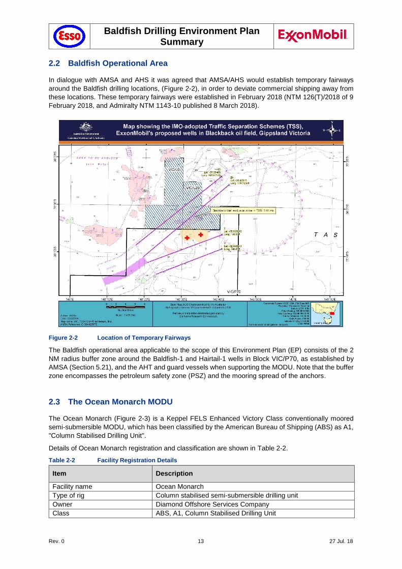
2.3 The Ocean Monarch MODU
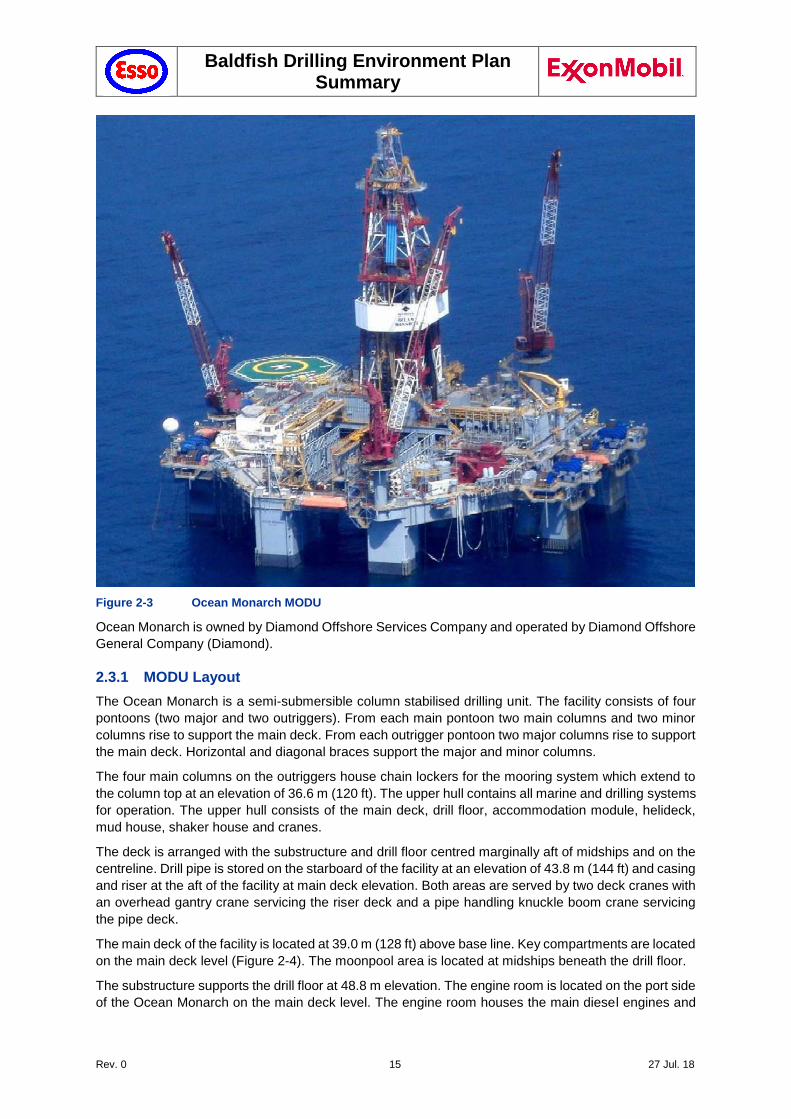
The Ocean Monarch (Figure 2-3) is a Keppel FELS Enhanced Victory Class conventionally moored
semi-submersible MODU, which has been classified by the American Bureau of Shipping (ABS) as A1,
"Column Stabilised Drilling Unit".
Details of Ocean Monarch registration and classification are shown in Table 2-2.
Table 2-2 Facility Registration Details
Item Description
Facility name Ocean Monarch
Type of rig Column stabilised semi-submersible drilling unit
Owner Diamond Offshore Services Company
Class ABS, A1, Column Stabilised Drilling Unit
Baldfish Drilling Environment Plan Summary
Rev. 0 14 27 Jul. 18
IMO number 8751368
International call sign V7IY3
Registration Majuro, Republic of Marshall Islands
Maximum Accommodation 150 Persons on board (POB)
Builder, prime build Nylands Verksted A.S
Location of build Oslo, Norway (1973-74)
Builder, facility conversion Keppel Fels, Ltd
Location of Refit Singapore (2008)
The Ocean Monarch was originally designed and constructed in the Nylands Verksted shipyard in Oslo,
Norway, and delivered in 1974. The most recent and relevant major modification to convert the facility
into its current configuration began in 2006. The purpose of this modification was to upgrade the facility
to a moored column stabilised drilling unit compliant with the International Maritime Organization (IMO)
Code for the Construction and Equipment of Mobile Offshore Drilling Units 1989 (MODU Code 1989).
Table 2-3 General Information on Storage Capacities
Material Capacity
Water ballast 19,686 m3 123,820 bbl
Diesel oil (See Table 2-4 for details) 1,097 m3 (two main tanks) 6,901 bbl
Helifuel 5.68 m3 35.7 bbl
Lubrication oil 3.59 m3 22.6 bbl
Hydraulic / gear oil 6.76 m3 42.5 bbl
Potable water 462 m3 2,904 bbl
Liquid mud 1,582 m3 9,949 bbl
Cement 311 m3 1,959 bbl
Barite / bentonite 265 m3 1,667 bbl
Sewage 24.5 m3 154 bbl
Sack storage 6,000 sacks
Drill pipe, outfitted 14,066 m 46,148 ft
Riser, outfitted 2,035 m 6,675 ft
The facility is equipped with eight electric anchor winches. The winches hold a combination of wire rope
and chain specifically designed for deepwater anchoring purposes. Each of the eight main anchor legs
consists of a 15.0 MT Stevpris anchor, 975 m of 82.6 mm R5 stud link anchor chain with a breaking
strength of 712 T and 700 m of 95.3 mm diameter independent wire rope core (IWRC) wire with a
breaking strength of 785 MT. These specifications are subject to change in line with Safety Case
provisions.
The range of the anchor pattern depends on water depth. For Baldfish-1, each of the anchors will reach
1,800 – 2,100 m from the MODU.
Baldfish Drilling Environment Plan Summary
Rev. 0 15 27 Jul. 18
Figure 2-3 Ocean Monarch MODU
Ocean Monarch is owned by Diamond Offshore Services Company and operated by Diamond Offshore
General Company (Diamond).
2.3.1 MODU Layout
The Ocean Monarch is a semi-submersible column stabilised drilling unit. The facility consists of four
pontoons (two major and two outriggers). From each main pontoon two main columns and two minor
columns rise to support the main deck. From each outrigger pontoon two major columns rise to support
the main deck. Horizontal and diagonal braces support the major and minor columns.
The four main columns on the outriggers house chain lockers for the mooring system which extend to
the column top at an elevation of 36.6 m (120 ft). The upper hull contains all marine and drilling systems
for operation. The upper hull consists of the main deck, drill floor, accommodation module, helideck,
mud house, shaker house and cranes.
The deck is arranged with the substructure and drill floor centred marginally aft of midships and on the
centreline. Drill pipe is stored on the starboard of the facility at an elevation of 43.8 m (144 ft) and casing
and riser at the aft of the facility at main deck elevation. Both areas are served by two deck cranes with
an overhead gantry crane servicing the riser deck and a pipe handling knuckle boom crane servicing the pipe deck.
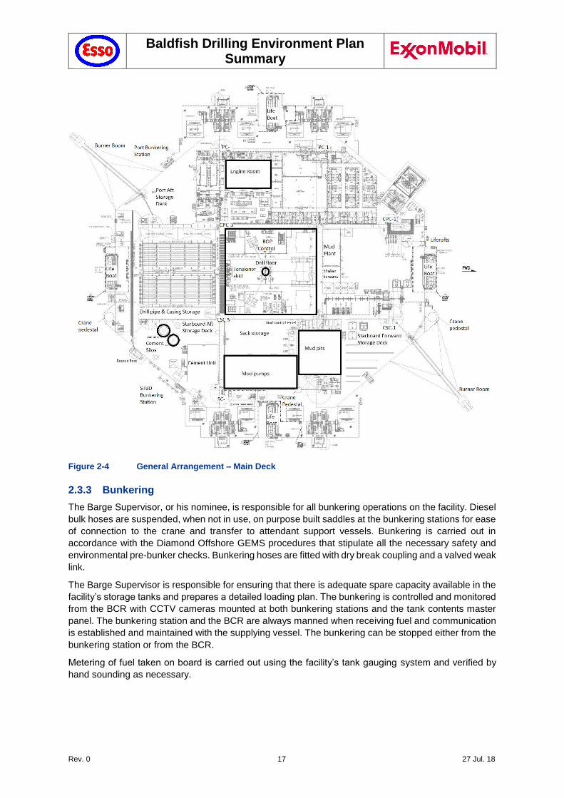
The main deck of the facility is located at 39.0 m (128 ft) above base line. Key compartments are located
on the main deck level (Figure 2-4). The moonpool area is located at midships beneath the drill floor.
The substructure supports the drill floor at 48.8 m elevation. The engine room is located on the port side
of the Ocean Monarch on the main deck level. The engine room houses the main diesel engines and
Baldfish Drilling Environment Plan Summary
Rev. 0 16 27 Jul. 18
generators and the auxiliary machinery pit. The mechanical office, workshop and store are also located
within the structural envelope of the engine room.
There are two designated control stations on board the facility where critical emergency functions are
available, the Ballast Control Room (BCR) and the Driller’s cabin. The BCR is the primary or central
control station for all marine related activities and emergency systems.
A total crew compliment of up to 150 persons is provided for by 51 two-man berths and 12 four-man
berths. The accommodation module is located at the port of the facility and is comprised of three levels.
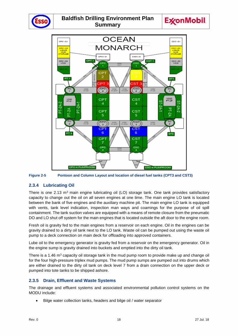
Diesel fuel tank capacities are summarised in Table 2-4, with the location of the two major diesel fuel
tanks shown in Figure 2-5.
2.3.2 Diesel Oil
The facility has two diesel oil (DO) tanks, totalling 1,059 m3, one located in each of the inboard pontoons
(Table 2-4; Figure 2-5). These tanks can be filled through 102 mm deck connections, located at both
the port and starboard loading stations. The tanks are equipped with sounding tubes and pressure
transducers for fluid level monitoring and vent lines. The DO storage tanks are fitted with high and low
suction tail pipes.
Table 2-4 Ocean Monarch Diesel Fuel Tank Capacities
Lower Hull (Inboard only) Main Deck Tanks
CPT-3 530 m3 (90%: 475 m3) Box Girder- 34.15 m3
CST-3 530 m3 (90%: 475 m3) Box Girder Overflow 3.64 m3
Day Tank 12.4 m3
Lifeboats
#1 Lifeboat 0.215 m3 #3 Lifeboat 0.215 m3
#2 Lifeboat 0.215 m3 #4 Lifeboat 0.215 m3
The DO transfer system is operated from the BCR via the pump and valve control panel. There are two
rotary gear type positive displacement DO transfer pumps, located one in each pontoon pump room.
These pumps are used primarily to transfer fuel to the main engine room DO settling tanks.
The DO service tank is located in the box girder between the two aft engines and five forward engines
and feeds the DO purifiers and are discharged into the DO day tank located on the aft bulkhead of the
engine room. The DO day tank supplies fuel to the seven diesel engines that power the facility. The DO
service and day tanks are equipped with inspection man-ways, vents and spill containment coamings.
The DO day tank is also equipped with a level gauge. The DO settling tank and DO day tank overflow
back into the pontoon storage tanks via the DO overflow tank.
Baldfish Drilling Environment Plan Summary
Rev. 0 17 27 Jul. 18
Figure 2-4 General Arrangement – Main Deck
2.3.3 Bunkering
The Barge Supervisor, or his nominee, is responsible for all bunkering operations on the facility. Diesel
bulk hoses are suspended, when not in use, on purpose built saddles at the bunkering stations for ease
of connection to the crane and transfer to attendant support vessels. Bunkering is carried out in
accordance with the Diamond Offshore GEMS procedures that stipulate all the necessary safety and
environmental pre-bunker checks. Bunkering hoses are fitted with dry break coupling and a valved weak
link.
The Barge Supervisor is responsible for ensuring that there is adequate spare capacity available in the
facility’s storage tanks and prepares a detailed loading plan. The bunkering is controlled and monitored
from the BCR with CCTV cameras mounted at both bunkering stations and the tank contents master
panel. The bunkering station and the BCR are always manned when receiving fuel and communication
is established and maintained with the supplying vessel. The bunkering can be stopped either from the
bunkering station or from the BCR.
Metering of fuel taken on board is carried out using the facility’s tank gauging system and verified by
hand sounding as necessary.
Baldfish Drilling Environment Plan Summary
Rev. 0 18 27 Jul. 18
Figure 2-5 Pontoon and Column Layout and location of diesel fuel tanks (CPT3 and CST3)
2.3.4 Lubricating Oil
There is one 2.13 m3 main engine lubricating oil (LO) storage tank. One tank provides satisfactory
capacity to change out the oil on all seven engines at one time. The main engine LO tank is located
between the bank of five engines and the auxiliary machine pit. The main engine LO tank is equipped
with vents, tank level indication, inspection man ways and coamings for the purpose of oil spill
containment. The tank suction valves are equipped with a means of remote closure from the pneumatic
DO and LO shut off system for the main engines that is located outside the aft door to the engine room.
Fresh oil is gravity fed to the main engines from a reservoir on each engine. Oil in the engines can be
gravity drained to a dirty oil tank next to the LO tank. Waste oil can be pumped out using the waste oil
pump to a deck connection on main deck for offloading into approved containers.
Lube oil to the emergency generator is gravity fed from a reservoir on the emergency generator. Oil in
the engine sump is gravity drained into buckets and emptied into the dirty oil tank.
There is a 1.46 m3 capacity oil storage tank in the mud pump room to provide make up and change oil
for the four high-pressure triplex mud pumps. The mud pump sumps are pumped out into drums which
are either drained to the dirty oil tank on deck level 7 from a drain connection on the upper deck or
pumped into tote tanks to be shipped ashore.
2.3.5 Drain, Effluent and Waste Systems
The drainage and effluent systems and associated environmental pollution control systems on the
MODU include:
Bilge water collection tanks, headers and bilge oil / water separator
Baldfish Drilling Environment Plan Summary
Rev. 0 19 27 Jul. 18
Domestic waste segregation and disposal
Drill floor drilling mud spill drains and rain water collection system
Domestic grey water drainage
Black water drainage and sewage treatment plant
Galley waste disposal including macerator
Helideck drainage and containment system
Equipment bunding
Rain and wash down drainage
Scuppers for fuel at oil loading stations.
The effluent and waste disposal systems on the MODU include:
Different types of waste are segregated onboard in containers for transport by supply vessels for onshore disposal by contracted waste disposal or recycling companies.
Grey water is disposed of to sea, as is sewage water following treatment by an Omnipure
marine sewage treatment plant.
Garbage is compacted by a pneumatic Enviro-Pak unit and shipped ashore for disposal and
compliant with MARPOL requirements.
Biodegradable food scraps are macerated and disposed of to sea by a Tuff-Gutt grinder
compliant with MARPOL requirements.
Hazardous area drains, including rig floor drains, bilges and equipment coaming drains, are
processed by the oil / water separator and the water is discharged overboard.
Nonhazardous drains including the deck scupper system are discharged directly overboard.
2.3.5.1 Deck Drainage and waste oil
Drainage of non-hazardous water from the decks passes through a scupper system directly to the sea
by way of piping chutes or dumps.
Drainage from separate higher risk collection areas, where the fluids may contain mud, are passed
through the barite separator from where the fluid phase is led directly to the inlet of the three section
skimmer tank on the forward cellar deck. From the third stage of this unit, the fluid is directed to an
adjacent automatic oily water separator (OWS). The OWS processes the fluid, passing the clean phase
with less than 15 ppm oil directly to the sea and any oil is forced to the dirty oil tank for eventual disposal
to shore facilities. Any discharge detected with higher than 15 ppm oil is redirected back to the skimmer
tank. Equipment with the potential to leak hazardous materials have coamings fitted to contain any
potentially polluting fluids and these are either drained to drain tanks or emptied manually into storage
containers for disposal.
The drainage from engine room and auxiliary machine pit bilges is collected in the 5.31 m3 dirty oil tank
for eventual onshore transfer for disposal. Spent grease and lubricants for other equipment is collected
in storage drums and stored in a designated hazardous storage area away from potential sources of
heat or flames. All fuel and bulk lubricant disposal is fully documented using an oil record book.
2.3.5.2 Sewage Treatment
The Ocean Monarch is equipped with an Omnipure 12MX marine sewage treatment plant (Certified to
MARPOL IMO Resolution MEPC.2 (VI)) which treats both black and grey water. The black and grey
water is collected from toilets, sinks, showers, urinals and associated sanitary waste systems and is
gravity fed into the sewage collection tank. It is then pumped by a macerator pump through an
electrolytic cell which utilises electrolysed seawater to generate hypochlorite and then into a residence
tank. In the residence tank the treated water is aerated and retained for an appropriate amount of time
to ensure any remaining bacteria are destroyed. It is then discharged overboard. Regular sample testing
of the discharge water is carried out to confirm correct operation.
Baldfish Drilling Environment Plan Summary
Rev. 0 20 27 Jul. 18
2.3.5.3 Segregation and Storage of Waste
The different types of waste onboard are, where possible, segregated and placed in containers for
onshore disposal by contracted waste disposal / recycling companies.
Garbage that remains onboard is packaged for disposal and a full record is kept using a garbage
management log. Every package or item that leaves the facility must be fully documented. Garbage is
compacted by an Enviro‐Pak pneumatic garbage compactor and then shipped onshore for disposal.
Biodegradable food scraps are macerated and discharged directly into the sea from the Tuff-Gutt food
macerator.
2.3.6 Mud System
Drilling mud performs several functions; cooling and lubrication of the drill bit, transportation of drill
cuttings to the surface and most importantly serving as the primary well control barrier, preventing the
influx of hydrocarbons from the formation into the wellbore. The mud system consists of two
subsystems, high pressure and low pressure.
Mud is either mixed on board via the bulk mud system or brought onboard via the bunkering stations
from supply vessels. Mud is transferred from the storage location to the active mud pits, and supply
mud to the high pressure mud pumps. These pumps pump the mud downhole at high pressure. The
mud returns to the surface with cuttings and potentially hydrocarbons from the formation, via the riser
to the flowline.
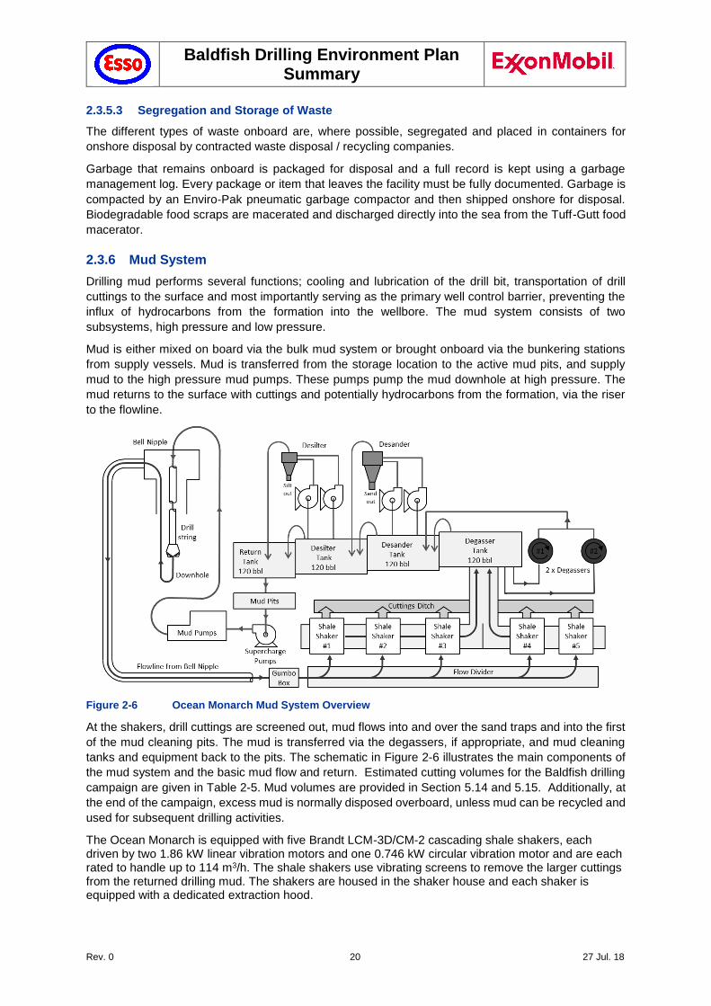
Figure 2-6 Ocean Monarch Mud System Overview
At the shakers, drill cuttings are screened out, mud flows into and over the sand traps and into the first
of the mud cleaning pits. The mud is transferred via the degassers, if appropriate, and mud cleaning
tanks and equipment back to the pits. The schematic in Figure 2-6 illustrates the main components of
the mud system and the basic mud flow and return. Estimated cutting volumes for the Baldfish drilling
campaign are given in Table 2-5. Mud volumes are provided in Section 5.14 and 5.15. Additionally, at
the end of the campaign, excess mud is normally disposed overboard, unless mud can be recycled and
used for subsequent drilling activities.
The Ocean Monarch is equipped with five Brandt LCM-3D/CM-2 cascading shale shakers, each driven by two 1.86 kW linear vibration motors and one 0.746 kW circular vibration motor and are each rated to handle up to 114 m3/h. The shale shakers use vibrating screens to remove the larger cuttings from the returned drilling mud. The shakers are housed in the shaker house and each shaker is equipped with a dedicated extraction hood.
Baldfish Drilling Environment Plan Summary
Rev. 0 21 27 Jul. 18
The shakers combine the efficiency of a circular-motion shaker with the high throughput of a linear-motion shaker and are highly effective in rapidly separating and discharging solids, thus providing high throughput. The screens are repairable, and are furbished with individual seals to eliminate screen leakage.
Table 2-5 Cutting volume estimates
Parameter Baldfish-1 Hairtail-1
Cuttings Volume (m3)
Top hole (SW + Sweeps)
Bottom section (WBM)
155 106
155 106
Discharge duration
Top hole (SW + Sweeps)
Bottom section (WBM)
3-5 days
10-15 days
3-5 days
10-15 days
2.3.7 Cement System
The cement unit and associated equipment are supplied by a third party on campaign-specific basis to
meet the specific needs of the clients well construction program. The cement unit is primarily used to
pump cement into the well bore to cement casing into position or to set cement plugs. The cement unit
interfaces with the high pressure mud system through the cementing manifold and interconnecting
hoses or through the test connectors at the choke manifold.
Cements are transported as dry bulk to the MODU by support vessels. The dry bulk storage tanks on
the MODU vent excess compressed air to atmosphere. This venting process carries small amounts of
cement which is discharged below the MODU (maximum volume approximately 10 MT per well).
After a string of casing or a liner has been installed into the well it is cemented. During riserless drilling,
a cement spacer is displaced by the cement slurry and discharged directly to the seabed at the mudline
(approximately 100 bbl, or 9.615.9 m3 per well). Cement slurry is pumped down the inside of the casing.
The cement is then displaced by drilling fluid, and forced up into the annular space between the casing
and the borehole wall.
Upon completion of each cementing activity, the cementing head and blending tanks are cleaned which
results in a release of approximately 160 bbl (26m3) of cement contaminated water to the ocean per
well..
2.3.8 MODU Communication and Navigation Systems
Ocean Monarch is fitted out with extensive communication and navigation aids in accordance with
Safety Case requirements, including normal and emergency communications facilities to allow
communications between the facility and aircraft, vessels, shore base and emergency response entities
as required.
The emergency communication systems are designed to fulfil the current capabilities of a Global
Maritime Distress and Safety System (GMDSS) and the system is designed to work in all areas between
approximately 70°N and 70°S. The facility is equipped with the following GMDSS and other external
communication equipment:
Two Global Maritime Distress and Safety System (GMDSS) stations, each consisting of:
• Marine medium frequency / high frequency single side band transceiver
• Marine very high frequency (VHF) digital selective calling (DSC) radio telephone
• Mini-C Inmarsat C transceiver
• Marine VHF DSC radio telephone
Six Standard VHF DSC radios with AIS and GPS receiver
20 Standard portable marine VHF transceivers
Four portable marine VHF GMDSS radios
Single IP66 EC aeronautical radio beacon transmitter
Three aeronautical VHF transceiver
Baldfish Drilling Environment Plan Summary
Rev. 0 22 27 Jul. 18
Iridium satellite communication system
Satellite broadband data system
Distress alarm panel
Six search and rescue transponders (SART)
GMDSS emergency position indicating radio beacons (EPIRB)
Marine asset tracking system.
In addition to the above external communications equipment, the lifeboats are also equipped with a
variety of communications equipment.
Additionally, the MODU is equipped with an automatic tracking system for identifying and locating
vessels by electronically exchanging data with other nearby ships, Automatic Identification System
(AIS) base stations and satellites. AIS information supplements marine radar on PSV/AHV, which is the
primary method of collision avoidance for water transport. Information provided by AIS equipment, such
as unique identification, position, course and speed, can be displayed on a screen or an electronic chart
display and information system.
AIS is intended to assist MODU officers and allow maritime authorities to track and monitor vessel
movements. Vessels fitted with AIS transceivers and transponders can be tracked by AIS base stations
located along coast lines or, when out of range of terrestrial networks and through a growing number
of satellites that are fitted with special AIS receivers which are capable of deconflicting a large number
of signatures. The AIS is fitted to the Ocean Monarch in accordance with IMO International Convention
for the Safety of Life at Sea (SOLAS) (IMO 1974) requirements.
In addition to the abovementioned navigation tools, Diamond agreed with the installation of additional
Navaids as a result from the Safety Case Revision workshop (February 2018) and in discussion with
AMSA (see Chapter 8). These include:
A Kongsberg BS 610 AIS base station: The base station provides slot management and
integrity monitoring of the AIS AtoN. All AIS AtoN and AIS base stations are to be identified in
accordance with the most recent edition of Recommendation ITU-R M.585.
If the AIS AtoN is not within VHF radio range of an existing AIS base station, then a new AIS
base station should be established within the VHF radio range of the AIS AtoN to ensure the
integrity of the FATDMA reservations and monitoring of the AIS AtoN.
Since the MODU will be operating at distances greater than 100NM from any existing AIS
infrastructure, it has selected the Kongsberg BS 610 base station to satisfy the regulatory
requirement.
There is a brief process required for relocating the MODU and ensuring the AIS is configured
correctly. The required AMSA forms will be completed by Diamond Offshore, with assistance
from AMS Maritime. This process establishes communication with NOPSEMA, AMSA and
other support and Search and Rescue authorities. Requisite notice to mariners through the
Australian Hydrography service will also be triggered through this process.
AMEC Mando 303 AIS AtoN: The AIS AtoN will transmit Random Access Time Division
Multiple Access (RATDMA). The AtoN will be configured so all vessels receiving the
transmission are provided correct and accurate platform information including dimensions,
position, etc. The system will be completely configured prior to delivery and will in essence be
“plug and play” assuming the platform will have infrastructure as detailed post site survey.
AIS can be used on offshore structures and facilities to assist with positive identification by
transiting and service vessels. AIS may also be used to assist those operating offshore facilities
to monitor vessel traffic in their vicinity including potential and real incursions into exclusion or
restricted areas.
Baldfish Drilling Environment Plan Summary
Rev. 0 23 27 Jul. 18
Given many AIS transmitters may be used in any one area, a level of control, integrity and
protection of the AIS VDL is required in accordance with IMO Resolution MSC.347 (91). AMSA
monitors the use of the AIS VDL and issues all Australian MMSI numbers, AIS licences and
FATDMA time slots to owners of non-shipborne AIS transmitters to ensure there is no
interference from co-located services and provide a level of control to ensure integrity and
protection of the AIS VDL.
Offshore facilities marked with AIS AtoN will use the appropriate Message 21 coding as
contained in the most recent version of Recommendation ITU-R M.1371.
FPSOs and MODUs are considered fixed offshore facilities, however, as they are SOLAS
vessels, they should change their AIS navigational status when they are connecting to a riser
or the seabed, to indicate “moored” or “at anchor”. This status will also apply when using
dynamic positioning to conducting undersea operations.
AIS AtoN has full functionality of the Type 3 AMS Mando unit to satisfy the requirement under
IEC 62320-2.
CNS Horizon Software and Charting: Horizon provides a complete AIS interface that
includes the ability to view and track all vessels, display specific vessel information, and send
and receive safety related text messages. Horizon’s interface and display of AIS related
information offers a substantial leap forward in the ability to communicate and interact with
vessels. Indicative incursion/exclusion zones are displayed as rings with the MODU in the
centre. These rings are configurable.
2.3.9 Well control
The Baldfish reservoir target interval is a single zone and normally pressured. The Dory-1 well provides
good offset well control for reservoir pressure prediction.
The well’s system of physical barrier when drilling the target interval is comprised of:
weighted drilling fluids whose hydrostatic pressure exceeds pore pressure;
casings strings that are run in the well that seal off / isolate the formations and formation fluids; and
the BOP stack that connects to the wellhead and is tied back to the MODU with the marine riser
Well control criteria barrier requirements include:
A minimum of two physical barriers in each potential flow path;
At least one barrier must be active at all times
A controlled column of fluid monitored with sufficient density to overbalance formation pressures can be one barrier
Each physical barrier (e.g., cement, plugs, packers, valves, BOPs) is pressure tested, preferably in the direction of flow. The pressure test amount shall be greater than the expected maximum well pressure at the barrier
If testing in the direction of flow is not possible, a pressure test in the opposite direction shall still be conducted
If pressure testing is not possible, the integrity of the barrier is verified through diagnostics and/ or analysis of the operation by which the barrier was installed
If reducing hydrostatic overbalance below pore pressure is planned and failure of a single physical barrier could cause the well to flow, that barrier will be negatively tested in the direction of flow
MODU has blind shear rams, capable of sealing
Emergency Disconnect System (EDS) function tested prior to deployment of the BOPs
Baldfish Drilling Environment Plan Summary
Rev. 0 24 27 Jul. 18
If practicable, Remotely Operated Vehicle (ROV) hot stabs to be surface tested with the ROV pump or equivalent
Both the Auto-shear and Deadman systems to be surface tested prior to deployment of the BOPs
Well shut-in procedures
Ocean Monarch is equipped with a National Oilwell PS2-1000 electric top drive assembly. It is equipped
with two inside blowout preventers (IBOP) which are rated to 1,034 bar (15,000 psi) and there are four
identical spares.
2.3.9.1 Blowout Preventer (BOP)
The BOP system serves as a secondary means of well control. When a formation influx occurs during
drilling, one or more BOP preventers are activated to seal the annulus, or wellbore, to “shut in” the well.
Denser or heavier mud is then circulated into the wellbore to re-establish primary well control. Mud is
pumped down the drill string, up the annulus, out the choke line at the BOP stack, and then up the high-
pressure lines on the riser and through the choke manifold until the downhole pressure is controlled
and the influx is circulated out of the well. Once this “kill weight” mud extends from the bottom of the
well to the top, the well is back in balance and has been “killed”. The primary functions of the BOP stack
include:
Confining well fluid to the wellbore
Providing a means to add fluid to the wellbore
Allowing controlled volumes of fluid to be withdrawn from the wellbore.
While performing these primary functions, the BOP stack also:
Regulates and monitors wellbore pressure
Centralises and hangs off the drill string in the wellbore
Seals the annulus between the drill pipe and the casing to shut in the well
Prevents additional influx from the reservoir into the wellbore
Seals the well by completely closing off the wellbore if no pipe is in the hole
Allows stripping drill-pipe
Severs the drill pipe to seal the well in emergencies.
The BOP systems on Ocean Monarch have redundancy integrated inherently within the design of the
system.
2.4 Support Vessels
Drilling operations will be supported by at least two Anchor Handling Tugs (AHTs). Although details
remain to be finalised, AHTs supporting Ocean Monarch in Bass Strait will have comparable
specifications to the Far Statesman and Far Saracen. Additionally, a guard and/or supply vessel (OSV)
may be engaged to patrol the temporary fairways (Section 5.21.2.1), to deliver supplies to the MODU
and to return wastes to shore.
2.5 Helicopter Support
Helicopter support will be from a suitable helicopter base. While it is likely that helicopter activities will
be from the Esso helicopter base in Longford, another heliport may be chosen for operational and
commercial reasons.
2.6 Subsea Well design
Esso will drill the two well from mudline locations to bottom-hole targets. The approximate seafloor
coordinates of the wellheads are provided in Table 2-1. Esso has designed the wells for the Baldfish
work scope to allow for P&A on completion of wireline logging.
Baldfish Drilling Environment Plan Summary
Rev. 0 25 27 Jul. 18
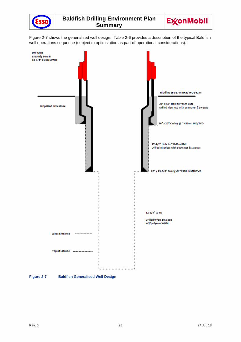
Figure 2-7 shows the generalised well design. Table 2-6 provides a description of the typical Baldfish
well operations sequence (subject to optimization as part of operational considerations).
Figure 2-7 Baldfish Generalised Well Design
Baldfish Drilling Environment Plan Summary
Rev. 0 26 27 Jul. 18
Table 2-6 Baldfish Typical well operations sequence (provisional) ..
Baldfish Typical well operations sequence
1 Perform mooring operations and position MODU over the well location.
2 Pre-spud ROV seabed survey
3 Drill 26” x 42” hole riser-less with seawater.
4 Run and cement 36” x 20” casing/low pressure wellhead with cement returns to seafloor.
5 Drill 17-1/2” hole riser-less with seawater.
6 Run and cement 22” x 13-3/8” casing/high pressure wellhead with cement returns to seafloor.
7 Run BOPs and riser.
8 Drill 12-1/4” hole with water based mud to well TD.
9 Perform wireline logging operations.
10 Permanently plug and abandon the well.
11 Post-drilling ROV seabed survey
12 Perform de-mooring operations.
2.7 Reservoir Evaluation
Each well will undergo an evaluation program once the target formations have been reached. Well
evaluation will consist of well logging including check-shot surveys (CSS), and wireline logging. CSS
is carried out using geophones inside the wellbore and a seismic source that is hung over the side of
the MODU. CSS is used for correlation with surface seismic data to produce images of higher resolution
than surface seismic images.
2.8 Remotely Operated Vehicle (ROV) support
Subsea activities will be supported by a remotely operated vehicle (ROV). The ROV will be used to
undertake subsea surveys and observations, will undertake remote activities during drilling operations
and may also be used to operate the BOP in emergencies, such as malfunction or when BOP control
from the MODU is not possible. The ROV and its support modules are leased independent of the rig
spread, and depending on project-specific operational needs.
Baldfish Drilling Environment Plan Summary
Rev. 0 27 27 Jul. 18
3 Description of the Environment
3.1 Zone of Potential Impact
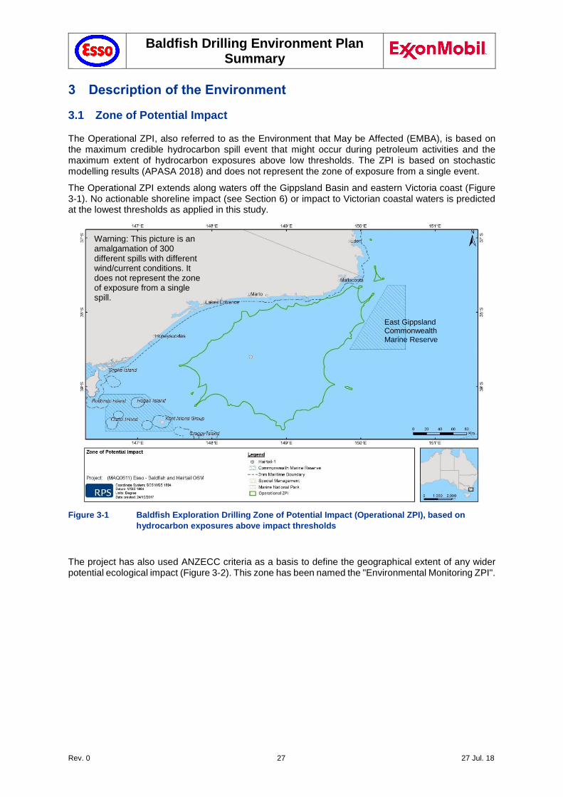
The Operational ZPI, also referred to as the Environment that May be Affected (EMBA), is based on the maximum credible hydrocarbon spill event that might occur during petroleum activities and the maximum extent of hydrocarbon exposures above low thresholds. The ZPI is based on stochastic modelling results (APASA 2018) and does not represent the zone of exposure from a single event.
The Operational ZPI extends along waters off the Gippsland Basin and eastern Victoria coast (Figure 3-1). No actionable shoreline impact (see Section 6) or impact to Victorian coastal waters is predicted at the lowest thresholds as applied in this study.
Figure 3-1 Baldfish Exploration Drilling Zone of Potential Impact (Operational ZPI), based on
hydrocarbon exposures above impact thresholds
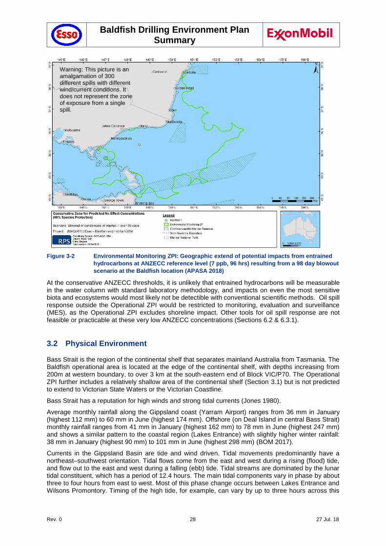
The project has also used ANZECC criteria as a basis to define the geographical extent of any wider potential ecological impact (Figure 3-2). This zone has been named the "Environmental Monitoring ZPI".
Warning: This picture is an amalgamation of 300 different spills with different wind/current conditions. It does not represent the zone of exposure from a single spill.
East Gippsland Commonwealth Marine Reserve
Baldfish Drilling Environment Plan Summary
Rev. 0 28 27 Jul. 18
Figure 3-2 Environmental Monitoring ZPI: Geographic extend of potential impacts from entrained
hydrocarbons at ANZECC reference level (7 ppb, 96 hrs) resulting from a 98 day blowout
scenario at the Baldfish location (APASA 2018)
At the conservative ANZECC thresholds, it is unlikely that entrained hydrocarbons will be measurable in the water column with standard laboratory methodology, and impacts on even the most sensitive biota and ecosystems would most likely not be detectible with conventional scientific methods. Oil spill response outside the Operational ZPI would be restricted to monitoring, evaluation and surveillance (MES), as the Operational ZPI excludes shoreline impact. Other tools for oil spill response are not feasible or practicable at these very low ANZECC concentrations (Sections 6.2 & 6.3.1).
3.2 Physical Environment
Bass Strait is the region of the continental shelf that separates mainland Australia from Tasmania. The Baldfish operational area is located at the edge of the continental shelf, with depths increasing from 200m at western boundary, to over 3 km at the south-eastern end of Block VIC/P70. The Operational ZPI further includes a relatively shallow area of the continental shelf (Section 3.1) but is not predicted to extend to Victorian State Waters or the Victorian Coastline.
Bass Strait has a reputation for high winds and strong tidal currents (Jones 1980).
Average monthly rainfall along the Gippsland coast (Yarram Airport) ranges from 36 mm in January (highest 112 mm) to 60 mm in June (highest 174 mm). Offshore (on Deal Island in central Bass Strait) monthly rainfall ranges from 41 mm in January (highest 162 mm) to 78 mm in June (highest 247 mm) and shows a similar pattern to the coastal region (Lakes Entrance) with slightly higher winter rainfall: 38 mm in January (highest 90 mm) to 101 mm in June (highest 298 mm) (BOM 2017).
Currents in the Gippsland Basin are tide and wind driven. Tidal movements predominantly have a northeast–southwest orientation. Tidal flows come from the east and west during a rising (flood) tide, and flow out to the east and west during a falling (ebb) tide. Tidal streams are dominated by the lunar tidal constituent, which has a period of 12.4 hours. The main tidal components vary in phase by about three to four hours from east to west. Most of this phase change occurs between Lakes Entrance and Wilsons Promontory. Timing of the high tide, for example, can vary by up to three hours across this
Warning: This picture is an amalgamation of 300 different spills with different wind/current conditions. It does not represent the zone of exposure from a single spill.
Baldfish Drilling Environment Plan Summary
Rev. 0 29 27 Jul. 18
region. Tides in the area from Lakes Entrance to Gabo Island are, however, relatively weak in comparison to other areas of Bass Strait (GEMS 2005).
Temperatures measured at the seabed confirmed a decrease in temperature with depth of measurement. The survey also showed a period (July to September) of uniformity of temperature at all measured depths, indicating flow down the continental slope (Bass Strait Cascade). The range of water temperatures observed at the seabed is from a maximum of 17°C at 93 m to a minimum of 7°C at 480 m. The minimum temperatures at depth were recorded in summer, possibly because of stronger stabilising stratification and absence of the cascade of relatively warmer water during winter.
The area around the Baldfish operational area is a high energy environment exposed to frequent storms and significant wave heights. High wave conditions are generally associated with strong west to southwest winds caused by the eastward passage of low pressure systems across Bass Strait. Storms may occur several times a month resulting in wave heights of 3 to 4 m or more. In severe cases, southwest storms can result in significant wave heights of greater than 6 m (Jones 1980).
Block VIC/P70 is at the edge of the Bass Canyon, with water depth of less than 100m at the western side, dropping to 2,500m at the eastern side. The Baldfish operational area lies between approximately 450 – 700 m water depths.
3.3 Nearshore and Shoreline Environments
The Operational ZPI does not extend into Victorian state waters and no actionable shoreline impact is expected based on the oil spill modelling (Section 3.1), therefore a description of the nearshore and shoreline environments of the Gippsland basin was largely omitted from the EP.
The shoreline, from Wilson’s Promontory in the west to Cape Howe in the east, including the offshore islands at the extremities of the region, consists mainly of steep rock, sand beaches and rocky outcrops. The shoreline is generally one of high sea activity due to prevailing weather patterns.
Nearshore environments include:
Intertidal rocky shores.
Intertidal, emergent, sub tidal aquatic vegetation.
Subtidal Rocky Reefs
Estuaries
Sheltered intertidal flats and bare sediment (mudflats).
Marshes.
Mangroves.
Sandy beaches and dunes.
Cliffs/exposed rocky headlands.
3.4 Offshore Marine Environment
Offshore marine environments that occur in the operational area operational area and Operational ZPI include:
Open Marine Environment
Seabed
Offshore waters are those where the water depth is >10 metres with no surrounding land.
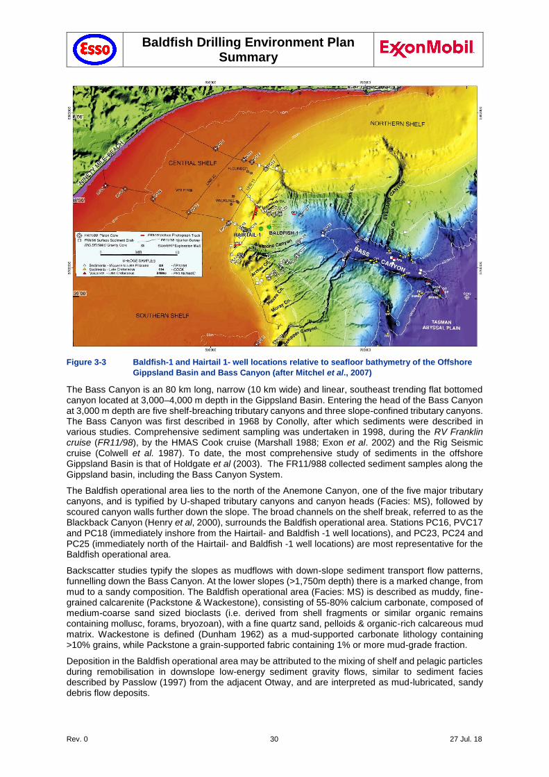
The Baldfish wells are located close to the continental drop off and the Bass Canyon System see Figure 3-3. This area was the subject of a comprehensive study (Mitchell et al, 2007). The study comprised bottom core sampling, sediment grabs and seabed photography. The Bass Strait canyons are characterised by dense shelf water cascades (Godfrey et al. 1980).
Baldfish Drilling Environment Plan Summary
Rev. 0 30 27 Jul. 18
Figure 3-3 Baldfish-1 and Hairtail 1- well locations relative to seafloor bathymetry of the Offshore
Gippsland Basin and Bass Canyon (after Mitchel et al., 2007)
The Bass Canyon is an 80 km long, narrow (10 km wide) and linear, southeast trending flat bottomed canyon located at 3,000–4,000 m depth in the Gippsland Basin. Entering the head of the Bass Canyon at 3,000 m depth are five shelf-breaching tributary canyons and three slope-confined tributary canyons. The Bass Canyon was first described in 1968 by Conolly, after which sediments were described in various studies. Comprehensive sediment sampling was undertaken in 1998, during the RV Franklin cruise (FR11/98), by the HMAS Cook cruise (Marshall 1988; Exon et al. 2002) and the Rig Seismic cruise (Colwell et al. 1987). To date, the most comprehensive study of sediments in the offshore Gippsland Basin is that of Holdgate et al (2003). The FR11/988 collected sediment samples along the Gippsland basin, including the Bass Canyon System.
The Baldfish operational area lies to the north of the Anemone Canyon, one of the five major tributary canyons, and is typified by U-shaped tributary canyons and canyon heads (Facies: MS), followed by scoured canyon walls further down the slope. The broad channels on the shelf break, referred to as the Blackback Canyon (Henry et al, 2000), surrounds the Baldfish operational area. Stations PC16, PVC17 and PC18 (immediately inshore from the Hairtail- and Baldfish -1 well locations), and PC23, PC24 and PC25 (immediately north of the Hairtail- and Baldfish -1 well locations) are most representative for the Baldfish operational area.
Backscatter studies typify the slopes as mudflows with down-slope sediment transport flow patterns, funnelling down the Bass Canyon. At the lower slopes (>1,750m depth) there is a marked change, from mud to a sandy composition. The Baldfish operational area (Facies: MS) is described as muddy, fine-grained calcarenite (Packstone & Wackestone), consisting of 55-80% calcium carbonate, composed of medium-coarse sand sized bioclasts (i.e. derived from shell fragments or similar organic remains containing mollusc, forams, bryozoan), with a fine quartz sand, pelloids & organic-rich calcareous mud matrix. Wackestone is defined (Dunham 1962) as a mud-supported carbonate lithology containing >10% grains, while Packstone a grain-supported fabric containing 1% or more mud-grade fraction.
Deposition in the Baldfish operational area may be attributed to the mixing of shelf and pelagic particles during remobilisation in downslope low-energy sediment gravity flows, similar to sediment facies described by Passlow (1997) from the adjacent Otway, and are interpreted as mud-lubricated, sandy debris flow deposits.
Baldfish Drilling Environment Plan Summary
Rev. 0 31 27 Jul. 18
Because of the lack of had substrate and relative sediment mobility, canyon fauna in the area is expected to be generally impoverished, in analogy with similar observations for canyons with high rates of flow and sediment accumulation (see above).
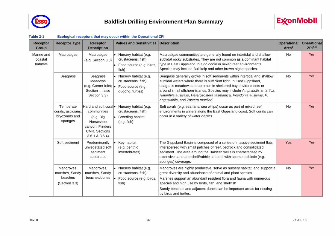
3.5 Ecological and Social Receptors
The Baldfish operational area and Operational ZPI supports a range of diverse benthic invertebrate fauna as well as a variety of vertebrate species such as fish, birds, seals and whales, including listed endangered and vulnerable species. A summary of the ecological receptors values and sensitivities are provided in the following table.
Baldfish Drilling Environment Plan Summary
Rev. 0 32 27 Jul. 18
Table 3-1 Ecological receptors that may occur within the Operational ZPI
Receptor
Group
Receptor Type Receptor
Description
Values and Sensitivities Description Operational
Area1
Operational
ZPI2, 3
Marine and
coastal
habitats
Macroalgae Macroalgae
(e.g. Section 3.3)
Nursery habitat (e.g.
crustaceans, fish)
Food source (e.g. birds,
fish)
Macroalgae communities are generally found on intertidal and shallow
subtidal rocky substrates. They are not common as a dominant habitat
type in East Gippsland, but do occur in mixed reef environments.
Species may include Bull kelp and other brown algae species.
No Yes
Seagrass Seagrass
Meadows
(e.g. Corner Inlet;
Section , also
Section 3.3)
Nursery habitat (e.g.
crustaceans, fish)
Food source (e.g.
dugong, turtles)
Seagrass generally grows in soft sediments within intertidal and shallow
subtidal waters where there is sufficient light. In East Gippsland,
seagrass meadows are common in sheltered bay environments or
around small offshore islands. Species may include Amphibolis antartica,
Halophila australis, Heterozostera tasmanica, Posidonia australis, P.
angustifolia, and Zostera muelleri.
No Yes
Temperate
corals, ascidians,
bryozoans and
sponges
Hard and soft coral
communities
(e.g. Big
Horseshoe
canyon, Flinders
CMR, Sections
3.6.1 & 3.6.4)
Nursery habitat (e.g.
crustaceans, fish)
Breeding habitat
(e.g. fish)
Soft corals (e.g. sea fans, sea whips) occur as part of mixed reef
environments in waters along the East Gippsland coast. Soft corals can
occur in a variety of water depths.
No Yes
Soft sediment
Predominantly
unvegetated soft
sediment
substrates
Key habitat
(e.g. benthic
invertebrates)
The Gippsland Basin is composed of a series of massive sediment flats,
interspersed with small patches of reef, bedrock and consolidated
sediment. The area around the Baldfish wells is characterised by
extensive sand and shell/rubble seabed, with sparse epibiotic (e.g.
sponges) coverage.
Yes Yes
Mangroves,
marshes, Sandy
beaches
(Section 3.3)
Mangroves,
marshes, Sandy
beaches/dunes
Nursery habitat (e.g.
crustaceans, fish)
Food source (e.g. birds,
fish)
Mangroves are highly productive, serve as nursery habitat, and support a
great diversity and abundance of animal and plant species.
Marshes support an abundant resident flora and fauna with numerous
species and high use by birds, fish, and shellfish
Sandy beaches and adjacent dunes can be important areas for nesting
by birds and turtles.
No Yes
Baldfish Drilling Environment Plan Summary
Rev. 0 33 27 Jul. 18
Receptor
Group
Receptor Type Receptor
Description
Values and Sensitivities Description Operational
Area1
Operational
ZPI2, 3
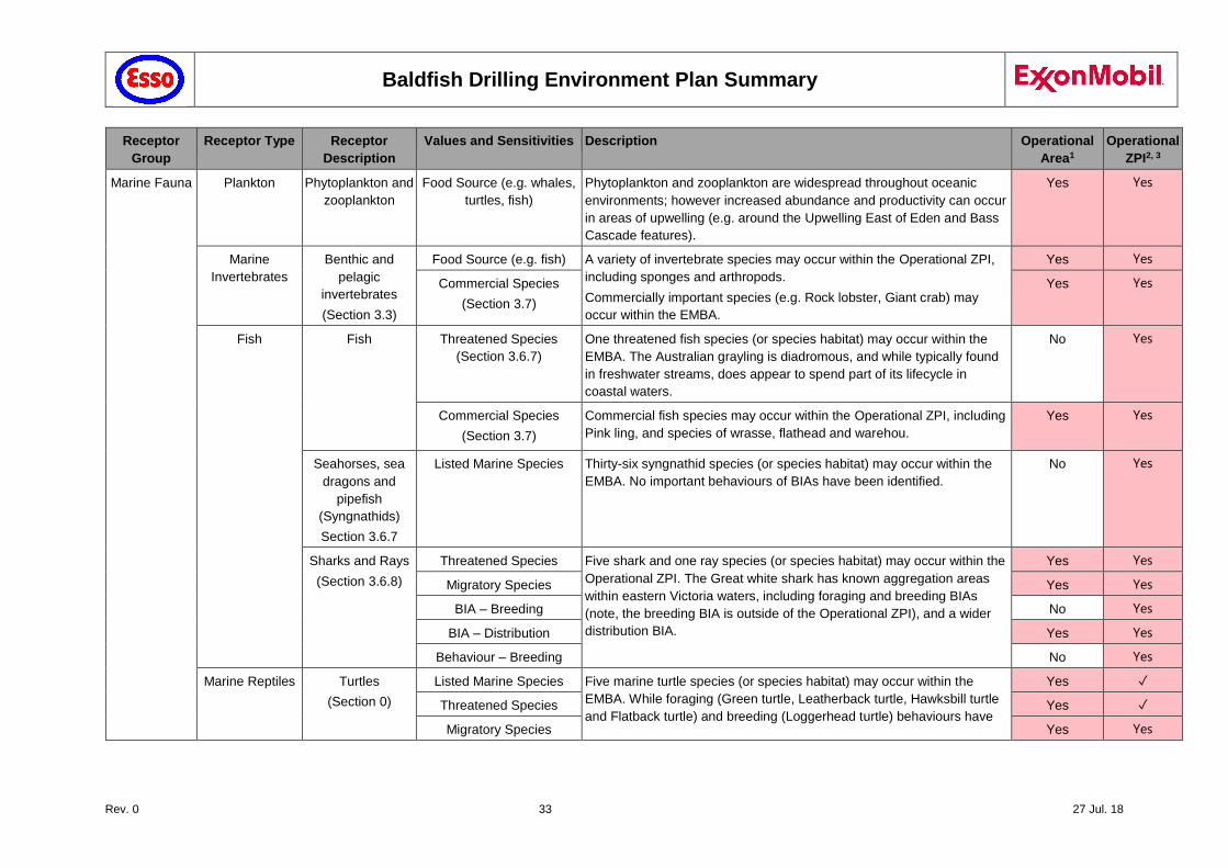
Marine Fauna Plankton Phytoplankton and
zooplankton
Food Source (e.g. whales,
turtles, fish)
Phytoplankton and zooplankton are widespread throughout oceanic
environments; however increased abundance and productivity can occur
in areas of upwelling (e.g. around the Upwelling East of Eden and Bass
Cascade features).
Yes Yes
Marine
Invertebrates
Benthic and
pelagic
invertebrates
(Section 3.3)
Food Source (e.g. fish) A variety of invertebrate species may occur within the Operational ZPI,
including sponges and arthropods.
Commercially important species (e.g. Rock lobster, Giant crab) may
occur within the EMBA.
Yes Yes
Commercial Species
(Section 3.7)
Yes Yes
Fish Fish Threatened Species
(Section 3.6.7)
One threatened fish species (or species habitat) may occur within the
EMBA. The Australian grayling is diadromous, and while typically found
in freshwater streams, does appear to spend part of its lifecycle in
coastal waters.
No Yes
Commercial Species
(Section 3.7)
Commercial fish species may occur within the Operational ZPI, including
Pink ling, and species of wrasse, flathead and warehou.
Yes Yes
Seahorses, sea
dragons and
pipefish
(Syngnathids)
Section 3.6.7
Listed Marine Species Thirty-six syngnathid species (or species habitat) may occur within the
EMBA. No important behaviours of BIAs have been identified.
No Yes
Sharks and Rays
(Section 3.6.8)
Threatened Species Five shark and one ray species (or species habitat) may occur within the
Operational ZPI. The Great white shark has known aggregation areas
within eastern Victoria waters, including foraging and breeding BIAs
(note, the breeding BIA is outside of the Operational ZPI), and a wider
distribution BIA.
Yes Yes
Migratory Species Yes Yes
BIA – Breeding No Yes
BIA – Distribution Yes Yes
Behaviour – Breeding No Yes
Marine Reptiles Turtles
(Section 0)
Listed Marine Species Five marine turtle species (or species habitat) may occur within the
EMBA. While foraging (Green turtle, Leatherback turtle, Hawksbill turtle
and Flatback turtle) and breeding (Loggerhead turtle) behaviours have
Yes ✓
Threatened Species Yes ✓
Migratory Species Yes Yes
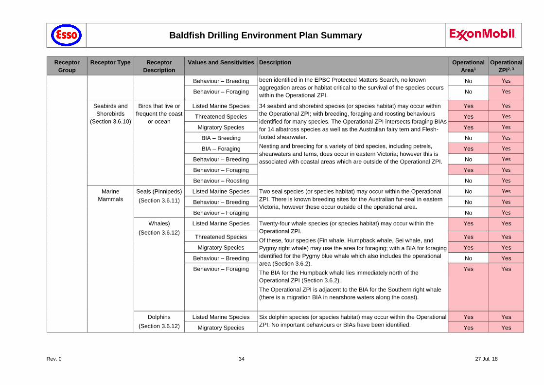
Baldfish Drilling Environment Plan Summary
Rev. 0 34 27 Jul. 18
Receptor
Group
Receptor Type Receptor
Description
Values and Sensitivities Description Operational
Area1
Operational
ZPI2, 3
Behaviour – Breeding been identified in the EPBC Protected Matters Search, no known
aggregation areas or habitat critical to the survival of the species occurs
within the Operational ZPI.
No Yes
Behaviour – Foraging No Yes
Seabirds and
Shorebirds
(Section 3.6.10)
Birds that live or
frequent the coast
or ocean
Listed Marine Species 34 seabird and shorebird species (or species habitat) may occur within
the Operational ZPI; with breeding, foraging and roosting behaviours
identified for many species. The Operational ZPI intersects foraging BIAs
for 14 albatross species as well as the Australian fairy tern and Flesh-
footed shearwater.
Nesting and breeding for a variety of bird species, including petrels,
shearwaters and terns, does occur in eastern Victoria; however this is
associated with coastal areas which are outside of the Operational ZPI.
Yes Yes
Threatened Species Yes Yes
Migratory Species Yes Yes
BIA – Breeding No Yes
BIA – Foraging Yes Yes
Behaviour – Breeding No Yes
Behaviour – Foraging Yes Yes
Behaviour – Roosting No Yes
Marine
Mammals
Seals (Pinnipeds)
(Section 3.6.11)
Listed Marine Species Two seal species (or species habitat) may occur within the Operational
ZPI. There is known breeding sites for the Australian fur-seal in eastern
Victoria, however these occur outside of the operational area.
No Yes
Behaviour – Breeding No Yes
Behaviour – Foraging No Yes
Whales)
(Section 3.6.12)
Listed Marine Species Twenty-four whale species (or species habitat) may occur within the
Operational ZPI.
Of these, four species (Fin whale, Humpback whale, Sei whale, and
Pygmy right whale) may use the area for foraging; with a BIA for foraging
identified for the Pygmy blue whale which also includes the operational
area (Section 3.6.2).
The BIA for the Humpback whale lies immediately north of the
Operational ZPI (Section 3.6.2).
The Operational ZPI is adjacent to the BIA for the Southern right whale
(there is a migration BIA in nearshore waters along the coast).
Yes Yes
Threatened Species Yes Yes
Migratory Species Yes Yes
Behaviour – Breeding No Yes
Behaviour – Foraging Yes Yes
Dolphins
(Section 3.6.12)
Listed Marine Species Six dolphin species (or species habitat) may occur within the Operational
ZPI. No important behaviours or BIAs have been identified.
Yes Yes
Migratory Species Yes Yes
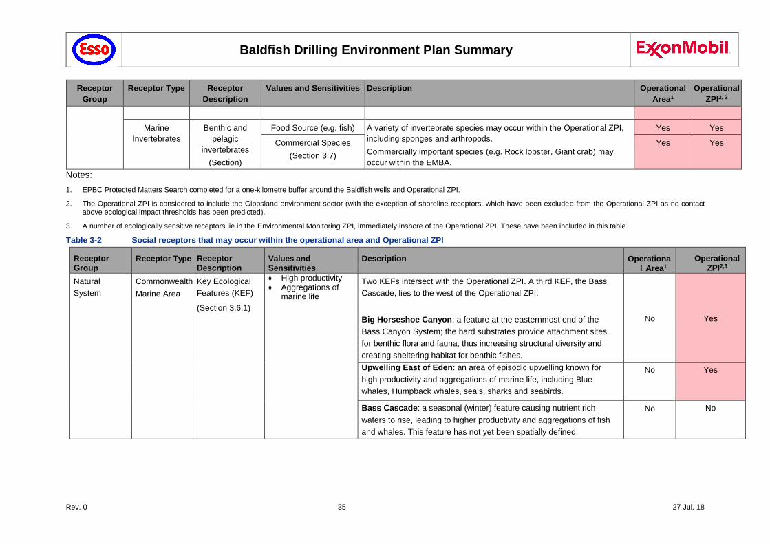
Baldfish Drilling Environment Plan Summary
Rev. 0 35 27 Jul. 18
Receptor
Group
Receptor Type Receptor
Description
Values and Sensitivities Description Operational
Area1
Operational
ZPI2, 3
Marine
Invertebrates
Benthic and
pelagic
invertebrates
(Section)
Food Source (e.g. fish) A variety of invertebrate species may occur within the Operational ZPI,
including sponges and arthropods.
Commercially important species (e.g. Rock lobster, Giant crab) may
occur within the EMBA.
Yes Yes
Commercial Species
(Section 3.7)
Yes Yes
Notes:
1. EPBC Protected Matters Search completed for a one-kilometre buffer around the Baldfish wells and Operational ZPI.
2. The Operational ZPI is considered to include the Gippsland environment sector (with the exception of shoreline receptors, which have been excluded from the Operational ZPI as no contact above ecological impact thresholds has been predicted).
3. A number of ecologically sensitive receptors lie in the Environmental Monitoring ZPI, immediately inshore of the Operational ZPI. These have been included in this table.
Table 3-2 Social receptors that may occur within the operational area and Operational ZPI
Receptor Group
Receptor Type Receptor Description
Values and Sensitivities
Description Operational Area1
Operational ZPI2,3
Natural
System
Commonwealth
Marine Area
Key Ecological
Features (KEF)
(Section 3.6.1)
● High productivity ● Aggregations of
marine life
Two KEFs intersect with the Operational ZPI. A third KEF, the Bass
Cascade, lies to the west of the Operational ZPI:
Big Horseshoe Canyon: a feature at the easternmost end of the
Bass Canyon System; the hard substrates provide attachment sites
for benthic flora and fauna, thus increasing structural diversity and
creating sheltering habitat for benthic fishes.
No
Yes
Upwelling East of Eden: an area of episodic upwelling known for
high productivity and aggregations of marine life, including Blue
whales, Humpback whales, seals, sharks and seabirds.
No Yes
Bass Cascade: a seasonal (winter) feature causing nutrient rich
waters to rise, leading to higher productivity and aggregations of fish
and whales. This feature has not yet been spatially defined.
No No
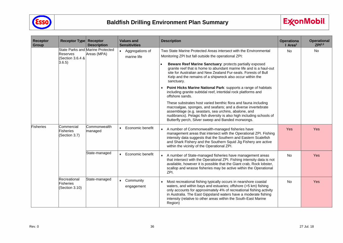
Baldfish Drilling Environment Plan Summary
Rev. 0 36 27 Jul. 18
Receptor Group
Receptor Type Receptor Description
Values and Sensitivities
Description Operational Area1
Operational ZPI2,3
State Parks and Reserves (Section 3.6.4 & 3.6.5)
Marine Protected Areas (MPA)
● Aggregations of
marine life
Two State Marine Protected Areas intersect with the Environmental
Monitoring ZPI but fall outside the operational ZPI:
Beware Reef Marine Sanctuary: protects partially exposed
granite reef that is home to abundant marine life and is a haul-out site for Australian and New Zealand Fur-seals. Forests of Bull Kelp and the remains of a shipwreck also occur within the sanctuary.
● Point Hicks Marine National Park: supports a range of habitats
including granite subtidal reef, intertidal rock platforms and offshore sands.
These substrates host varied benthic flora and fauna including macroalgae, sponges, and seafans; and a diverse invertebrate assemblage (e.g. seastars, sea urchins, abalone, and nudibrancs). Pelagic fish diversity is also high including schools of Butterfly perch, Silver sweep and Banded morwongs.
No No
Fisheries Commercial Fisheries (Section 3.7)
Commonwealth managed
● Economic benefit ● A number of Commonwealth-managed fisheries have management areas that intersect with the Operational ZPI. Fishing intensity data suggests that the Southern and Eastern Scalefish and Shark Fishery and the Southern Squid Jig Fishery are active within the vicinity of the Operational ZPI.
Yes Yes
State-managed ● Economic benefit ● A number of State-managed fisheries have management areas that intersect with the Operational ZPI. Fishing intensity data is not available, however it is possible that the Giant crab, Rock lobster, scallop and wrasse fisheries may be active within the Operational ZPI.
No Yes
Recreational Fisheries (Section 3.10)
State-managed ● Community
engagement
● Most recreational fishing typically occurs in nearshore coastal waters, and within bays and estuaries; offshore (>5 km) fishing only accounts for approximately 4% of recreational fishing activity in Australia. The East Gippsland waters have a moderate fishing intensity (relative to other areas within the South-East Marine Region)
No Yes
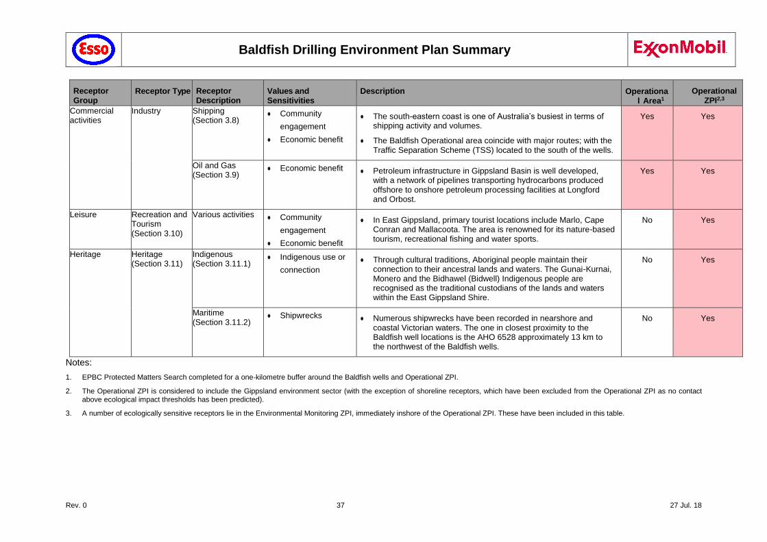
Baldfish Drilling Environment Plan Summary
Rev. 0 37 27 Jul. 18
Receptor Group
Receptor Type Receptor Description
Values and Sensitivities
Description Operational Area1
Operational ZPI2,3
Commercial activities
Industry Shipping (Section 3.8)
● Community
engagement
● Economic benefit
● The south-eastern coast is one of Australia’s busiest in terms of shipping activity and volumes.
● The Baldfish Operational area coincide with major routes; with the Traffic Separation Scheme (TSS) located to the south of the wells.
Yes Yes
Oil and Gas (Section 3.9)
● Economic benefit ● Petroleum infrastructure in Gippsland Basin is well developed, with a network of pipelines transporting hydrocarbons produced offshore to onshore petroleum processing facilities at Longford and Orbost.
Yes Yes
Leisure Recreation and Tourism (Section 3.10)
Various activities ● Community
engagement
● Economic benefit
● In East Gippsland, primary tourist locations include Marlo, Cape Conran and Mallacoota. The area is renowned for its nature-based tourism, recreational fishing and water sports.
No Yes
Heritage Heritage (Section 3.11)
Indigenous (Section 3.11.1)
● Indigenous use or
connection
● Through cultural traditions, Aboriginal people maintain their connection to their ancestral lands and waters. The Gunai-Kurnai, Monero and the Bidhawel (Bidwell) Indigenous people are recognised as the traditional custodians of the lands and waters within the East Gippsland Shire.
No Yes
Maritime (Section 3.11.2)
● Shipwrecks ● Numerous shipwrecks have been recorded in nearshore and coastal Victorian waters. The one in closest proximity to the Baldfish well locations is the AHO 6528 approximately 13 km to the northwest of the Baldfish wells.
No Yes
Notes:
1. EPBC Protected Matters Search completed for a one-kilometre buffer around the Baldfish wells and Operational ZPI.
2. The Operational ZPI is considered to include the Gippsland environment sector (with the exception of shoreline receptors, which have been excluded from the Operational ZPI as no contact above ecological impact thresholds has been predicted).
3. A number of ecologically sensitive receptors lie in the Environmental Monitoring ZPI, immediately inshore of the Operational ZPI. These have been included in this table.

Baldfish Drilling Environment Plan Summary
Rev. 0 38 27 Jul. 18
3.6 Conservation Values within the Operational ZPI
Table 3-3 provides details of the features present within the Operational ZPI for those receptors identified by Regulation 13(3) of the OPGGS(E) Regulations. Note, no Commonwealth Marine Reserves, internationally (Ramsar) or nationally important wetlands, World, National or Commonwealth heritage places occur within the Operational ZPI. Descriptions of the features or species and species habitats are provided further in this chapter (see references within Table 3-3).
Table 3-3 Summary of conservation values and sensitivities within the Operational ZPI
Receptor Type Value and Sensitivities Features present within the Operational ZPI
Commonwealth Marine Area (Section 3.6.2)
Key Ecological Features Big Horseshoe Canyon Upwelling East of Eden
Fish (Section 3.6.7)
Threatened and/or migratory species
Two threatened fish species or species habitat present (Australian grayling, Black rockcod)
Sharks & rays (Section 3.6.8)
Threatened and/or migratory species
Three threatened (Grey nurse shark, Great white shark, Whale shark) and four migratory (Great white shark, Shortfin mako shark, Porbeagle shark, Whale shark) shark species or species habitat present
Marine Reptiles (Section 0)
Threatened and/or migratory species
Four threatened and migratory marine turtle species or species habitat present (Loggerhead turtle, Green turtle, Leatherback turtle, Flatback turtle)
Seabirds and Shorebirds (Section 3.6.10
Threatened and/or migratory species
Numerous threatened (26) and migratory (18) species or species habitat present (including various albatross, petrel, plover, sandpiper, shearwater and tern species)
Marine Mammals (Section 3.6.12)
Threatened and/or migratory species
Five threatened whale species or species habitat present (Sei whale, Blue whale, Fin whale, Southern right whale, Humpback
whale); and ten migratory whale species or species habitat present One migratory dolphin species or species habitat
present (Dusky dolphin)
3.6.1 Key Ecological Features (KEF)
Key Ecological Features (KEF) are elements of the Commonwealth marine environment that are considered to be of regional importance for either a region's biodiversity or its ecosystem function and integrity. KEFs are not matters of national environmental significance and have no legal status in their own right. However, they may be considered as components of the Commonwealth marine area. Two KEFs, identified in the Conservation Values Atlas (DoEE 2015b), intersect with the Operational ZPI:
Big Horseshoe Canyon: a feature at the easternmost end of the Bass Canyon System; the hard substrates provide attachment sites for benthic flora and fauna, thus increasing structural diversity and creating sheltering habitat for benthic fishes.
Upwelling East of Eden: an area of episodic upwelling known for high productivity and aggregations of marine life, including Blue whales, Humpback whales, seals, sharks and seabirds.
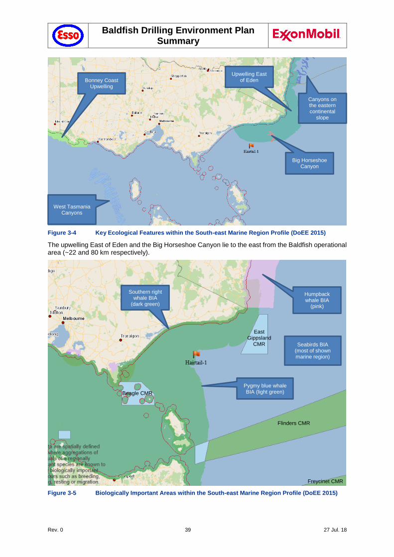
Baldfish Drilling Environment Plan Summary
Rev. 0 39 27 Jul. 18
Figure 3-4 Key Ecological Features within the South-east Marine Region Profile (DoEE 2015)
The upwelling East of Eden and the Big Horseshoe Canyon lie to the east from the Baldfish operational area (~22 and 80 km respectively).
Figure 3-5 Biologically Important Areas within the South-east Marine Region Profile (DoEE 2015)
Big Horseshoe Canyon
Upwelling East of Eden
East Gippsland
CMR
Humpback whale BIA
(pink)
Pygmy blue whale BIA (light green)
Southern right whale BIA
(dark green)
Bonney Coast Upwelling
Canyons on the eastern continental
slope
West Tasmania Canyons
Beagle CMR
Flinders CMR
Freycinet CMR
Seabirds BIA (most of shown marine region)
Baldfish Drilling Environment Plan Summary
Rev. 0 40 27 Jul. 18
3.6.1.1 Big Horseshoe Canyon
Big horseshoe canyon lies south off the coast of eastern Victoria and is the easternmost arm of the Bass Canyon System (Figure 3-4). The steep, rocky slopes provide hard substrate habitat for attached large megafauna. Sponges and other habitat forming species provide structural refuges for benthic fishes, including the commercially important pink ling.
The Big Horseshoe Canyon is the largest southeastern canyon sampled for benthic biodiversity (Williams et al. 2009). It has a total area of 319 km2 in 1500-m depth that supports a rich, abundant, filter-feeding benthic megafauna, including large sponges in dense beds of large individuals at 120 m and at 300–400 m, dense stands of the stalked crinoid Metacrinus cyaneus in 200–300 m, and many species of octocoral (especially gold corals) at depths >700 m (Kloser et al., 2001). The conservation value of this feature is highlighted by this being the type locality for M. cyaneus and it’s only known location off southeastern Australia.
3.6.1.2 Upwelling East of Eden
The Upwelling East of Eden is designated a KEF for the high productivity and aggregations of marine life (Figure 3-4). Dynamic eddies of the East Australian Current cause episodic productivity events when they interact with the continental shelf and headlands. Phytoplankton blooms, resulting from mixing and nutrient enrichment, are the basis of productive food chains including zooplankton, copepods, krill and small pelagic fish (DoEE 2015ab).
The upwelling supports high primary productivity that supports higher trophic levels, including top order predators, marine mammals and seabirds. The area supports foraging Blue and Humpback whales, known to arrive when significant krill aggregations form. The area is also important for seals, other cetaceans, sharks and seabirds.
3.6.2 Biologically Important Areas (BIA)
Biologically Important Areas (BIAS) are identified in the Conservation Values Atlas, developed by the Commonwealth Government (DoEE 2015b). BIAs are spatially defined areas where aggregations of individuals of a species are known to display biologically important behaviour such as breeding, foraging, resting or migration. Biologically important areas are designed to assist decision-making under the Environment Protection and Biodiversity Conservation Act 1999 (EPBC Act).
The Operational ZPI and operational area overlap with BIAs for seabirds (Section 3.6.10) and whales (Section 3.6.12) (Figure 3-5).
3.6.3 International, National and State Sites of Significance or Sensitivity
There are no areas of high conservation significance present in the operational area itself, although there are a number of habitats of conservation value, mostly immediately inshore from the Operational ZPI (Section 3.1).
3.6.4 Declared Protected Areas – Commonwealth Protected Areas and National Parks
There are no International Declared Protected Areas or National Parks within the Operational ZPI, although there are a number of habitats of conservation value immediately outside of the Operational ZPI (Section 3.6.6).
3.6.4.1 The Australian Whale Sanctuary
The Australian Whale Sanctuary, a Commonwealth Protected Areas overlaps with the Operational ZPI.
The Australian Whale Sanctuary includes all Commonwealth waters from the three nautical mile State waters limit out to the boundary of the Exclusive Economic Zone (i.e., out to 200 nautical miles and further in some places) (DoEE 2017l). Both the Baldfish operational area and the Operational ZPI lie within the Australian Whale Sanctuary.
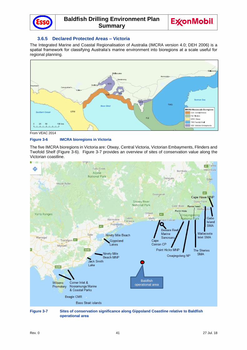
Baldfish Drilling Environment Plan Summary
Rev. 0 41 27 Jul. 18
3.6.5 Declared Protected Areas – Victoria
The Integrated Marine and Coastal Regionalisation of Australia (IMCRA version 4.0; DEH 2006) is a spatial framework for classifying Australia’s marine environment into bioregions at a scale useful for regional planning.
From VEAC 2014
Figure 3-6 IMCRA bioregions in Victoria
The five IMCRA bioregions in Victoria are: Otway, Central Victoria, Victorian Embayments, Flinders and Twofold Shelf (Figure 3-6). Figure 3-7 provides an overview of sites of conservation value along the Victorian coastline.
Figure 3-7 Sites of conservation significance along Gippsland Coastline relative to Baldfish
operational area
Baldfish operational area
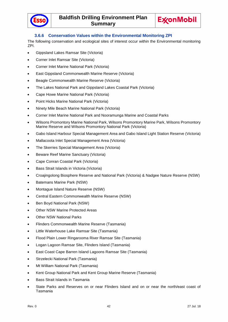
Baldfish Drilling Environment Plan Summary
Rev. 0 42 27 Jul. 18
3.6.6 Conservation Values within the Environmental Monitoring ZPI
The following conservation and ecological sites of interest occur within the Environmental monitoring ZPI.
Gippsland Lakes Ramsar Site (Victoria)
Corner Inlet Ramsar Site (Victoria)
Corner Inlet Marine National Park (Victoria)
East Gippsland Commonwealth Marine Reserve (Victoria)
Beagle Commonwealth Marine Reserve (Victoria)
The Lakes National Park and Gippsland Lakes Coastal Park (Victoria)
Cape Howe Marine National Park (Victoria)
Point Hicks Marine National Park (Victoria)
Ninety Mile Beach Marine National Park (Victoria)
Corner Inlet Marine National Park and Nooramunga Marine and Coastal Parks
Wilsons Promontory Marine National Park, Wilsons Promontory Marine Park, Wilsons Promontory Marine Reserve and Wilsons Promontory National Park (Victoria)
Gabo Island Harbour Special Management Area and Gabo Island Light Station Reserve (Victoria)
Mallacoota Inlet Special Management Area (Victoria)
The Skerries Special Management Area (Victoria)
Beware Reef Marine Sanctuary (Victoria)
Cape Conran Coastal Park (Victoria)
Bass Strait Islands in Victoria (Victoria)
Croajingolong Biosphere Reserve and National Park (Victoria) & Nadgee Nature Reserve (NSW)
Batemans Marine Park (NSW)
Montague Island Nature Reserve (NSW)
Central Eastern Commonwealth Marine Reserve (NSW)
Ben Boyd National Park (NSW)
Other NSW Marine Protected Areas
Other NSW National Parks
Flinders Commonwealth Marine Reserve (Tasmania)
Little Waterhouse Lake Ramsar Site (Tasmania)
Flood Plain Lower Ringarooma River Ramsar Site (Tasmania)
Logan Lagoon Ramsar Site, Flinders Island (Tasmania)
East Coast Cape Barren Island Lagoons Ramsar Site (Tasmania)
Strzelecki National Park (Tasmania)
Mt William National Park (Tasmania)
Kent Group National Park and Kent Group Marine Reserve (Tasmania)
Bass Strait Islands in Tasmania
State Parks and Reserves on or near Flinders Island and on or near the north/east coast of Tasmania
Baldfish Drilling Environment Plan Summary
Rev. 0 43 27 Jul. 18
3.6.7 Fish and Shellfish
Fish species listed under the EPBC Act that may occur in the Baldfish operational area and Operational ZPI are given in Table 3-4. Two fish species potentially occurring within the Operational ZPI were listed as ‘vulnerable’ under the EPBC Act; the Australian grayling (Prototroctes maraena) and the Black rockcod (Epinephelus daemelii) (DoEE 2017a). No EPBC Act listed threatened species were found to occur within the Baldfish operational area (DoEE 2018a,b).
Pipefishes, seahorses and seadragons, as listed under the EPBC Act, require a permit to remove them from the area. Generally, the pipefishes, seahorses and seadragons are associated with vegetation in sheltered to moderately exposed reef areas at a range of depths from 0 to 50 m, depending on the species (Edgar 1997), but usually at depths of between 5 and 25 m. Given that these species normally inhabit shallow reefs and kelp beds, they are not found within the Baldfish operational area itself but occur around adjacent shorelines in the Operational ZPI (Kuiter 2000).
A review of data collected in 1998 and 1999 by Neira (2005) suggested that the presence of Bass Strait offshore production facilities (and subsea infrastructure) within and near the Gippsland Basin Exclusion Zone provides additional habitat for early life stages of a large suite of teleost fish families. However, it is likely that both species composition and abundance around the Baldfish Operational ZPI are closely linked to the ichthyofauna inhabiting hard/soft megahabitats off the Gippsland coastline and, to a lesser extent, those at the south-east corner of mainland Australia (e.g. Howe/Gabo complex).
Baldfish Drilling Environment Plan Summary
Rev. 0 44 27 Jul. 18
Table 3-4 EPBC Act Threatemed and Migratory Species potentially occurring in the Baldfish Operational ZPI
Common Name Scientific Name Status Presence Management Plan/ Recovery Plan and
Approved Conservation Advice Presence of
BIA Relevant Management
Actions
Fish
Australian Grayling Prototroctes maraena V MO National recovery plan for the Australian Grayling (DEWHA, 2008)
No threats applicable
Black Rockcod Epinephelus daemelii V MO
Sharks & Rays
Great white shark Carcharodon carcharias V, MM BKO Recovery Plan for the White Shark (SEWPC 2013)
Known Distribution
Area
No threats applicable
Grey nurse shark (east coast population)
Chacharias taurus CE MO
Mackerel shark Lamna nasus MM LO
Whale shark Rhincodon typus V, MM MO
Shortfin mako Isurus oxyrinchus MM LO
Turtles
Green turtle Chelonia mydas V, MM KO
Recovery Plan for Marine Turtles in Australia 2017-2027 (CoA, 2017)
Implement legislative requirements for
garbage discharge
Integrate oil pollution plans with National Plan
requirements
Hawksbill turtle Eretmochelys imbricata V, MM KO
Leatherback turtle Dermochelys coriacea E, MM KO
Loggerhead turtle Caretta caretta E, MM LO
Birds – Albatross & Petrel
Antipodean albatross Diomedea antipodensis V, FLO
National Recovery Plan for threatened albatrosses and giant petrels 2011-2016
(SEWPC 2011)
Known Foraging Area
for species
Evaluate marine debris risk to species
Black-browed albatross Thalassarche melanophris
V, MM FLO
Buller’s albatross Thalassarche bulleri V, MM FLO
Campbell albatross Thalassarche impavida V FLO
Chatham albatross Thalassarche eremita E FLO
Baldfish Drilling Environment Plan Summary
Rev. 0 45 27 Jul. 18
Common Name Scientific Name Status Presence Management Plan/ Recovery Plan and
Approved Conservation Advice Presence of
BIA Relevant Management
Actions
Gibson’s albatross Diomedea gibsoni V FLO
Grey-headed albatross Thalassarche chrysostoma
E, MM MO
Northern Buller’s albatros Thalassarche bulleri platei
V FLO
Northern royal albatross Diomedea sanfordi E FLO
Pacific albatross Thalasarche sp.nov. V FLO
Salvin’s albatross Thalassarche salvini V FLO
Southern royal albatross Diomedea epomophora V, MM FLO
Tasmanian shy albatross Thalassarche cauta V, MM FLO
Wandering albatross Diomedea exulans V, MM FLO
White-capped albatross Thalassarche steadi V FLO
Northern giant-petrel Macronectes halli V, MM MO
Southern giant-petrel Macronectes giganteus E, MM MO
Sooty albatross Phoebetria fusca V, MM MO -
Blue petrel Halobaena caerulea V MO Approved Conservation Advice for Halobaena caerulea (blue petrel). (TSSC,
2015d)
Gould’s petrel Pterodroma leucoptera E MO
Birds-Other
Common sandpiper Actitis hypoleucos MW MO
Curlew sandpiper Calidris ferruginea CE, MW
MO Approved Conservation Advice for Calidris ferruginea (Curlew Sandpiper)
(TSSC, 2015e)
Pollution threats Manage
disturbanceactivities (vehicle access, etc.) at
important sites
White bellied storm petrel Fregetta grallaria V LO
Baldfish Drilling Environment Plan Summary
Rev. 0 46 27 Jul. 18
Common Name Scientific Name Status Presence Management Plan/ Recovery Plan and
Approved Conservation Advice Presence of
BIA Relevant Management
Actions
Australian fairy tern Sternula nereis V FLO Commonwealth Conservation Advice on Sternula nereis nereis (Fairy Tern) (TSSC
2011)
Known Foraging Area
for species
Ensure relevant management measures are adopted during any spill response activities which require shoreline
access.
Pectoral sandpiper Calidris melanotos MW MO - -
Sharp-tailed sandpiper Calidris acuminate MW MO - -
Eastern curlew Numenius madagascariensis
CE, MW
MO - -
Fairy prion Pachyptila turtur subantarctica
V MO - -
Flesh-footed shearwater Puffinus carneipes MM FLO - Known Foraging Area
for species
Fork-tailed swift Apus pacificus MM LO - -
Osprey Pandion haliaetus MW MO - -
Red knot Calidris canutus E, MW MO Approved Conservation Advice for Calidris canutus (Red Knot) (TSSC,
2016a)
- Pollution threats Manage
disturbanceactivities (vehicle access, etc.) at
important sites
Whales & Dolphins
Antarctic minke whale Balaenoptera bonaerensis
MM LO -
Blue whale (pygmy) Balaenoptera musculus E, MM LO Blue whale Conservation Management Plan (DoE 2015a)
Assess and reduce anthropogenic impacts; minimise collision risk; report cetacean strikes
Bryde's whale Balaenoptera edeni MM MO -
Dusky dolphin Lagenorhynchus obscurus
MM LO -
Baldfish Drilling Environment Plan Summary
Rev. 0 47 27 Jul. 18
Common Name Scientific Name Status Presence Management Plan/ Recovery Plan and
Approved Conservation Advice Presence of
BIA Relevant Management
Actions
Fin whale Balaenoptera physalus V, MM FLO Fin Whale TSSC Conservation Advice (2015cb)
Known Foraging Area
Assess and reduce anthropogenic impacts; minimise collision risk; report cetacean strikes
Humpback whale Megaptera novaeangliae V, MM FLO Humpback Whale TSSC Conservation Advice (2015a)
Killer whale, Orca Orcinus orca MM LO -
Pygmy right whale Caperea marginata MM FLO -
Known Foraging Area
Sei whale Balaenoptera borealis V, MM FLO Sei Whale TSSC Conservation Advice (2015b)
Assess and reduce anthropogenic impacts; minimise collision risk; report cetacean strikes
Southern right whale Eubalaena australis E, MM KO Conservation Management Plan for Southern Right Whale (SEWPC, 2012a)
Aggregation, Migratory
Assess and reduce anthropogenic impacts; minimise collision risk; report cetacean strikes
Sperm whale Physeter macrocephalus MM MO - -
Status Key: Likelihood of Occurrence Key:
MM–Migratory marine species KO–Species or species habitat known to occur within area MW–Migratory wetland species LO–Species or species habitat likely to occur within area E–Endangered (threatened) FLO-Feeding likely to occur within area V–Vulnerable (threatened) BKO–Breeding known to occur within area CE – Critically Endangered MO–Species or species habitat may occur within area MM–Migratory marine species
Baldfish Drilling Environment Plan Summary
Rev. 0 48 27 Jul. 18
3.6.8 Sharks and Rays
Shark and ray species listed under the EPBC Act that may occur in the Baldfish operational area and Operational ZPI are given in Table 3-4. Three shark species potentially occurring within the Operational ZPI were listed as ‘threatened’ under the EPBC Act; the Grey nurse shark (east coast population) (Chacharias taurus), the Great white shark (Carcharodon carchari) and the Whale shark (Rhincodon typus) (DoEE 2017a). The Great white shark was also identified as known to occur within the Baldfish operational area (DoEE 2018a,b).
The Grey nurse shark (east coast population) (Chacharias taurus) is commonly found in coastal waters off southern Queensland and along the entire NSW coast (Environment Australia, 2002). The species is rarely found travelling in the northern section of the Commonwealth south-east marine bioregion (DoEE 2015) and is uncommon in Victorian, South Australian and Tasmanian waters. Not much is known about the migratory habits of Grey nurse sharks in Australian waters, however evidence suggests migrational movement is up and down the east coast. The sharks are found mainly in warmer waters, in water depths of 15 to 40 m but also down to 230 m on the continental and generally occur either alone or in small to medium sized groups (Environment Australia 2002).
The Great white shark (Carcharodon carcharias) is normally found in nearshore waters around the areas of rocky reefs and seal colonies. Studies of great white sharks indicate that they are largely transitory. Observations of adult sharks are more frequent around seal and sea lion colonies, at onshore locations including Wilson’s Promontory and The Skerries. There is a tendency for juveniles to occur in different areas to adults and these are most likely pupping grounds. In Victoria the areas off Portland and Ninety Mile Beach are seasonally important to juveniles and are frequented between the months of December and June (Holliday 2003). Given their transitory nature and the proximity of known congregation areas it is likely that Great white sharks may transit the Baldfish operational area on occasion.
Whale sharks (Rhincodon typus) are generally found in warmer oceanic waters (where temperatures range from 21 to 25°C) and mainly occur in waters off the Northern Territory, Queensland and northern Western Australia. However, there have been a few isolated reports of immature male whale sharks in New South Wales and Victoria (Last & Stevens 1994). The Whale sharks are not likely to occur in the Baldfish operational area.
Two other species of shark, Shortfin mako (Isurus oxyrinchus) and Porbeagle or Mackerel shark (Lamna nasus), are listed as migratory marine species under the EPBC Act, likely to occur in the Operational ZPI.
3.6.9 Reptiles
Three threatened species of turtle, the Loggerhead turtle (Caretta caretta) (endangered and migratory), the Leatherback turtle (Dermochelys coriacea) (endangered and migratory) and the Green turtle (Chelonia mydas) (vulnerable and migratory) are listed as potentially having habitat in the Baldfish operational area and Operational ZPI (DoEE 2017e and 2017d). In addition to these species, the Hawksbill turtle (Eretmochelys imbricata) (vulnerable) is also listed as threatened and potentially occurring in the Operational ZPI.
The Loggerhead turtle occurs in Australian waters of coral and rocky reefs, seagrass beds and muddy bars throughout eastern, northern and western Australia. Nesting is mainly concentrated in southern Queensland and from Shark Bay to the North West Cape in Western Australia, which are not in the Operational ZPI. Foraging areas are more widely distributed, but also not expected to be present in the Operational ZPI (DoEE 2017d).
The Leatherback turtle is a pelagic feeder found in tropical, sub-tropical and temperate waters. The species is regularly found in the high latitudes of all oceans including waters offshore from NSW, Victoria, Tasmania and Western Australia. Bass Strait is considered to have one of the three largest concentrations of feeding Leatherback turtles in Australia (Parks Victoria, 2017n); however, even though they have not been seen anecdotally in the operational area in the last five years, they may occur in the operational area. No major nesting areas have been recorded in Australia, although scattered isolated nesting occurs outside the Operational ZPI in southern Queensland and the Northern Territory (DoEE 2017j).
Baldfish Drilling Environment Plan Summary
Rev. 0 49 27 Jul. 18
The Green turtle are mostly known to nest, forage and migrate across tropical northern Australia. Their distribution in Australia is concentrated around Queensland, the Northern Territory and Western Australia. Green turtles can migrate more than 2,600 km between their feeding and nesting grounds.
The Hawksbill turtle (Eretmochelys imbricata) typically occurs in tidal and sub-tidal coral and rocky reef habitats throughout tropical waters, extending into warm temperate areas as far south as northern New South Wales. In Australia the main feeding area extends along the east coast, including the Great Barrier Reef. Other feeding areas include Torres Strait and the archipelagos of the Northern Territory and Western Australia, possibly as far south as Shark Bay or beyond. Hawksbill turtles also feed at Christmas Island and the Cocos (Keeling) Islands. (DoEE 2017g). It is not expected in the Baldfish operational area although it may occur further inshore.
3.6.10 Birds
Birds listed under the EPBC Act that may occur in the Baldfish operational area and Operational ZPI are given in Table 3-4. Many are protected by international agreements (Bonn Convention, JAMBA, CAMBA and ROKAMBA) and periodically pass through the Operational ZPI on their way to or from the Bass Strait islands and mainlands of Victoria, NSW and Tasmania.
The Victorian coast and neighbouring islands provide feeding and nesting habitats for many coastal and migratory bird species. Seabirds spend much of their lives at sea in search of prey only to return for a short time to breed and raise chicks. Most species tend to forage on their own, though large feeding flocks will gather at rich or passing food sources. Squid, fish and krill are common sources of food.
No islands are located within the Operational ZPI, although islands in the Gippsland Basin are nesting sites for many seabird species, many of which migrate to these islands each year. Colonies of seabirds occur to the west of the operational area in Corner Inlet and on the islands around Wilsons Promontory, to the east at The Skerries, Tullaberga Island and Gabo Island and to the south on Curtis Island and the Hogan Island Group (Harris & Norman 1981). Species that nest and breed on these islands include the listed marine species, little penguin (Eudyptula minor), white-faced storm petrel (Pelagodroma marina), short-tailed shearwater (Puffinus tenuirostris) and the fairy prion (Pachyptila turtur). Recent research investigating feeding movements of the little penguin has found individuals that nest on these islands move into eastern Bass Strait (Hoskins et al. 2008). Eastern Bass Strait is also a foraging area for at least 16 listed species of albatross, six listed species of petrel and one species of skua. Most also forage in eastern Bass Strait within the Operational ZPI and are expected to occur within the Baldfish operational area. The BIA for many of the migratory marine birds overlap the Operational ZPI and Baldfish operational area (Section 3.6.2 and Figure 3-5).
The Operational ZPI excludes the state waters and any of the wetlands along the Gippsland basin. Nearby wetlands periodically inhabit waders (birds), such as Corner Inlet and the Gippsland Lakes due to their migratory nature. Migratory species include the red-necked stint (Calidris ruficollis), curlew sandpiper (Calidris ferruginea), great knot (Calidris tenuirostris), bar-tailed godwit (Limosa lapponica) and eastern curlew (Numenius madagascariensis). Similarly, a number of oceanic seabirds, such as the little tern (Sterna albifrons), crested tern (Sterna bergii) and short-tailed shearwater (Puffinus tenuirostris) migrate to the East Gippsland region. Over 20 million short-tailed shearwaters nest on Bass Strait islands during summer (Pizzey 2003). Of these, only the curlew sandpiper (Calidris ferruginea), and eastern curlew (Numenius madagascariensis) may also occur in the Baldfish operational area.
Both the hooded plover (Thinornis rubricollis) and Australian fairy tern (Sternula nereis nereis) nest along the sandy beaches of the Gippsland coast. Nests are predominantly located in the adjacent sparsely vegetated dunes above the high tide level (DoEE 2017h and 2017i) but are not expected within the Baldfish operational area.
Little penguins (Eudyptula minor) breed in colonies along the southern coast of Australia. They seek prey in shallow short dives, frequently between the 10 to 30 m range and very occasionally extending to 60 m. Its diet varies in different locations but consists mainly of small school fish, some squid or krill (shrimp-like crustaceans). Little penguin colonies can be found at Gabo Island, Tullaberga Island, The Skerries, Rabbit Island, Monkey Point (Wilsons Promontory), Seal Island, Notch Island, Rag Island, Hogan Island Group (Tas.), Curtis Island (Tas) (DoEE 2017m).
It is common to see some migratory birds rest on offshore facilities in the Gippsland Basin before continuing on their migratory flight, however, the presence of the operational area does not appear to significantly disrupt or divert their migratory route or disorient the birds.
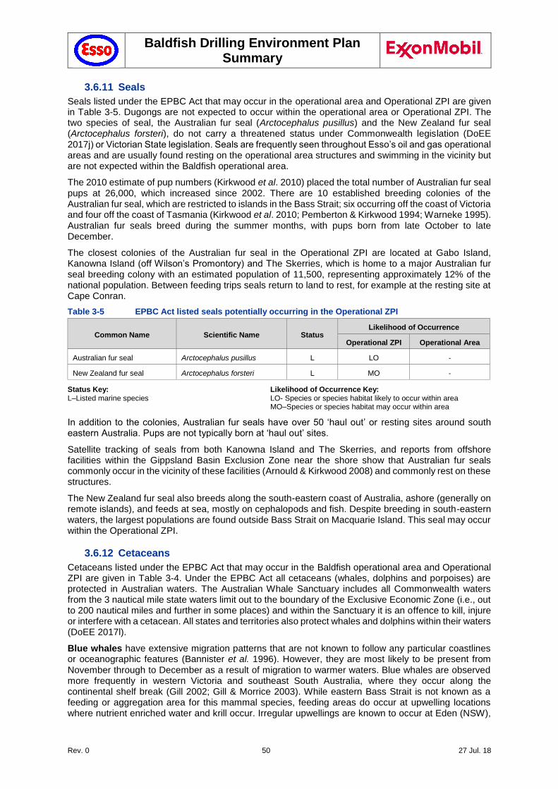
Baldfish Drilling Environment Plan Summary
Rev. 0 50 27 Jul. 18
3.6.11 Seals
Seals listed under the EPBC Act that may occur in the operational area and Operational ZPI are given in Table 3-5. Dugongs are not expected to occur within the operational area or Operational ZPI. The two species of seal, the Australian fur seal (Arctocephalus pusillus) and the New Zealand fur seal (Arctocephalus forsteri), do not carry a threatened status under Commonwealth legislation (DoEE 2017j) or Victorian State legislation. Seals are frequently seen throughout Esso’s oil and gas operational areas and are usually found resting on the operational area structures and swimming in the vicinity but are not expected within the Baldfish operational area.
The 2010 estimate of pup numbers (Kirkwood et al. 2010) placed the total number of Australian fur seal pups at 26,000, which increased since 2002. There are 10 established breeding colonies of the Australian fur seal, which are restricted to islands in the Bass Strait; six occurring off the coast of Victoria and four off the coast of Tasmania (Kirkwood et al. 2010; Pemberton & Kirkwood 1994; Warneke 1995). Australian fur seals breed during the summer months, with pups born from late October to late December.
The closest colonies of the Australian fur seal in the Operational ZPI are located at Gabo Island, Kanowna Island (off Wilson’s Promontory) and The Skerries, which is home to a major Australian fur seal breeding colony with an estimated population of 11,500, representing approximately 12% of the national population. Between feeding trips seals return to land to rest, for example at the resting site at Cape Conran.
Table 3-5 EPBC Act listed seals potentially occurring in the Operational ZPI
Common Name Scientific Name Status Likelihood of Occurrence
Operational ZPI Operational Area
Australian fur seal Arctocephalus pusillus L LO -
New Zealand fur seal Arctocephalus forsteri L MO -
Status Key: Likelihood of Occurrence Key: L–Listed marine species LO- Species or species habitat likely to occur within area MO–Species or species habitat may occur within area
In addition to the colonies, Australian fur seals have over 50 ‘haul out’ or resting sites around south eastern Australia. Pups are not typically born at ‘haul out’ sites.
Satellite tracking of seals from both Kanowna Island and The Skerries, and reports from offshore facilities within the Gippsland Basin Exclusion Zone near the shore show that Australian fur seals commonly occur in the vicinity of these facilities (Arnould & Kirkwood 2008) and commonly rest on these structures.
The New Zealand fur seal also breeds along the south-eastern coast of Australia, ashore (generally on remote islands), and feeds at sea, mostly on cephalopods and fish. Despite breeding in south-eastern waters, the largest populations are found outside Bass Strait on Macquarie Island. This seal may occur within the Operational ZPI.
3.6.12 Cetaceans
Cetaceans listed under the EPBC Act that may occur in the Baldfish operational area and Operational ZPI are given in Table 3-4. Under the EPBC Act all cetaceans (whales, dolphins and porpoises) are protected in Australian waters. The Australian Whale Sanctuary includes all Commonwealth waters from the 3 nautical mile state waters limit out to the boundary of the Exclusive Economic Zone (i.e., out to 200 nautical miles and further in some places) and within the Sanctuary it is an offence to kill, injure or interfere with a cetacean. All states and territories also protect whales and dolphins within their waters (DoEE 2017l).
Blue whales have extensive migration patterns that are not known to follow any particular coastlines or oceanographic features (Bannister et al. 1996). However, they are most likely to be present from November through to December as a result of migration to warmer waters. Blue whales are observed more frequently in western Victoria and southeast South Australia, where they occur along the continental shelf break (Gill 2002; Gill & Morrice 2003). While eastern Bass Strait is not known as a feeding or aggregation area for this mammal species, feeding areas do occur at upwelling locations where nutrient enriched water and krill occur. Irregular upwellings are known to occur at Eden (NSW),
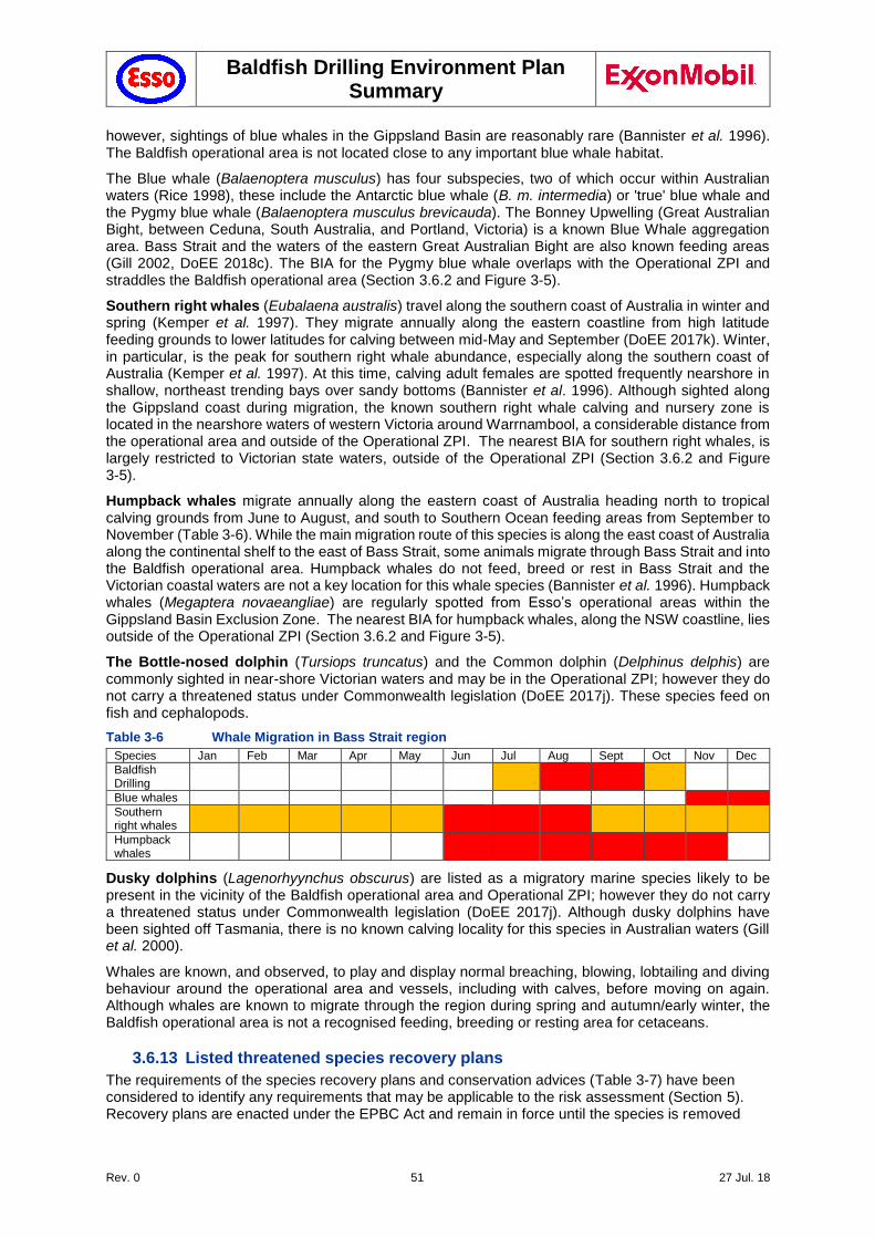
Baldfish Drilling Environment Plan Summary
Rev. 0 51 27 Jul. 18
however, sightings of blue whales in the Gippsland Basin are reasonably rare (Bannister et al. 1996). The Baldfish operational area is not located close to any important blue whale habitat.
The Blue whale (Balaenoptera musculus) has four subspecies, two of which occur within Australian waters (Rice 1998), these include the Antarctic blue whale (B. m. intermedia) or 'true' blue whale and the Pygmy blue whale (Balaenoptera musculus brevicauda). The Bonney Upwelling (Great Australian Bight, between Ceduna, South Australia, and Portland, Victoria) is a known Blue Whale aggregation area. Bass Strait and the waters of the eastern Great Australian Bight are also known feeding areas (Gill 2002, DoEE 2018c). The BIA for the Pygmy blue whale overlaps with the Operational ZPI and straddles the Baldfish operational area (Section 3.6.2 and Figure 3-5).
Southern right whales (Eubalaena australis) travel along the southern coast of Australia in winter and spring (Kemper et al. 1997). They migrate annually along the eastern coastline from high latitude feeding grounds to lower latitudes for calving between mid-May and September (DoEE 2017k). Winter, in particular, is the peak for southern right whale abundance, especially along the southern coast of Australia (Kemper et al. 1997). At this time, calving adult females are spotted frequently nearshore in shallow, northeast trending bays over sandy bottoms (Bannister et al. 1996). Although sighted along the Gippsland coast during migration, the known southern right whale calving and nursery zone is located in the nearshore waters of western Victoria around Warrnambool, a considerable distance from the operational area and outside of the Operational ZPI. The nearest BIA for southern right whales, is largely restricted to Victorian state waters, outside of the Operational ZPI (Section 3.6.2 and Figure 3-5).
Humpback whales migrate annually along the eastern coast of Australia heading north to tropical calving grounds from June to August, and south to Southern Ocean feeding areas from September to November (Table 3-6). While the main migration route of this species is along the east coast of Australia along the continental shelf to the east of Bass Strait, some animals migrate through Bass Strait and into the Baldfish operational area. Humpback whales do not feed, breed or rest in Bass Strait and the Victorian coastal waters are not a key location for this whale species (Bannister et al. 1996). Humpback whales (Megaptera novaeangliae) are regularly spotted from Esso’s operational areas within the Gippsland Basin Exclusion Zone. The nearest BIA for humpback whales, along the NSW coastline, lies outside of the Operational ZPI (Section 3.6.2 and Figure 3-5).
The Bottle-nosed dolphin (Tursiops truncatus) and the Common dolphin (Delphinus delphis) are commonly sighted in near-shore Victorian waters and may be in the Operational ZPI; however they do not carry a threatened status under Commonwealth legislation (DoEE 2017j). These species feed on fish and cephalopods.
Table 3-6 Whale Migration in Bass Strait region
Species Jan Feb Mar Apr May Jun Jul Aug Sept Oct Nov Dec
Baldfish Drilling
Blue whales
Southern right whales
Humpback whales
Dusky dolphins (Lagenorhyynchus obscurus) are listed as a migratory marine species likely to be present in the vicinity of the Baldfish operational area and Operational ZPI; however they do not carry a threatened status under Commonwealth legislation (DoEE 2017j). Although dusky dolphins have been sighted off Tasmania, there is no known calving locality for this species in Australian waters (Gill et al. 2000).
Whales are known, and observed, to play and display normal breaching, blowing, lobtailing and diving behaviour around the operational area and vessels, including with calves, before moving on again. Although whales are known to migrate through the region during spring and autumn/early winter, the Baldfish operational area is not a recognised feeding, breeding or resting area for cetaceans.
3.6.13 Listed threatened species recovery plans
The requirements of the species recovery plans and conservation advices (Table 3-7) have been considered to identify any requirements that may be applicable to the risk assessment (Section 5). Recovery plans are enacted under the EPBC Act and remain in force until the species is removed
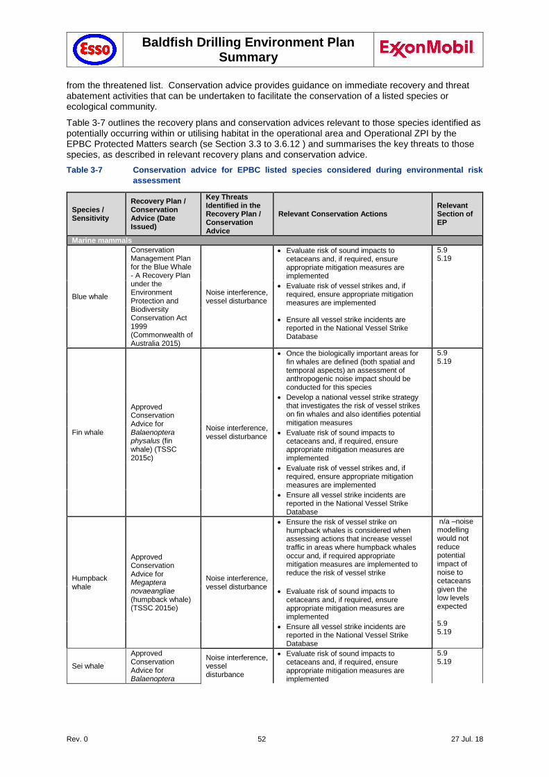
Baldfish Drilling Environment Plan Summary
Rev. 0 52 27 Jul. 18
from the threatened list. Conservation advice provides guidance on immediate recovery and threat abatement activities that can be undertaken to facilitate the conservation of a listed species or ecological community.
Table 3-7 outlines the recovery plans and conservation advices relevant to those species identified as potentially occurring within or utilising habitat in the operational area and Operational ZPI by the EPBC Protected Matters search (se Section 3.3 to 3.6.12 ) and summarises the key threats to those species, as described in relevant recovery plans and conservation advice.
Table 3-7 Conservation advice for EPBC listed species considered during environmental risk
assessment
Species / Sensitivity
Recovery Plan / Conservation Advice (Date Issued)
Key Threats Identified in the Recovery Plan / Conservation Advice
Relevant Conservation Actions Relevant Section of EP
Marine mammals
Blue whale
Conservation Management Plan for the Blue Whale - A Recovery Plan under the Environment Protection and Biodiversity Conservation Act 1999 (Commonwealth of Australia 2015)
Noise interference, vessel disturbance
Evaluate risk of sound impacts to cetaceans and, if required, ensure appropriate mitigation measures are implemented
5.9 5.19
Evaluate risk of vessel strikes and, if required, ensure appropriate mitigation measures are implemented
Ensure all vessel strike incidents are reported in the National Vessel Strike Database
Fin whale
Approved Conservation Advice for Balaenoptera physalus (fin whale) (TSSC 2015c)
Noise interference, vessel disturbance
Once the biologically important areas for fin whales are defined (both spatial and temporal aspects) an assessment of anthropogenic noise impact should be conducted for this species
5.9 5.19
Develop a national vessel strike strategy that investigates the risk of vessel strikes on fin whales and also identifies potential mitigation measures
Evaluate risk of sound impacts to cetaceans and, if required, ensure appropriate mitigation measures are implemented
Evaluate risk of vessel strikes and, if required, ensure appropriate mitigation measures are implemented
Ensure all vessel strike incidents are reported in the National Vessel Strike Database
Humpback whale
Approved Conservation Advice for Megaptera novaeangliae (humpback whale) (TSSC 2015e)
Noise interference, vessel disturbance
Ensure the risk of vessel strike on humpback whales is considered when assessing actions that increase vessel traffic in areas where humpback whales occur and, if required appropriate mitigation measures are implemented to reduce the risk of vessel strike
n/a –noise modelling would not reduce potential impact of noise to cetaceans given the low levels expected 5.9 5.19
Evaluate risk of sound impacts to cetaceans and, if required, ensure appropriate mitigation measures are implemented
Ensure all vessel strike incidents are reported in the National Vessel Strike Database
Sei whale
Approved Conservation Advice for Balaenoptera
Noise interference, vessel disturbance
Evaluate risk of sound impacts to cetaceans and, if required, ensure appropriate mitigation measures are implemented
5.9 5.19
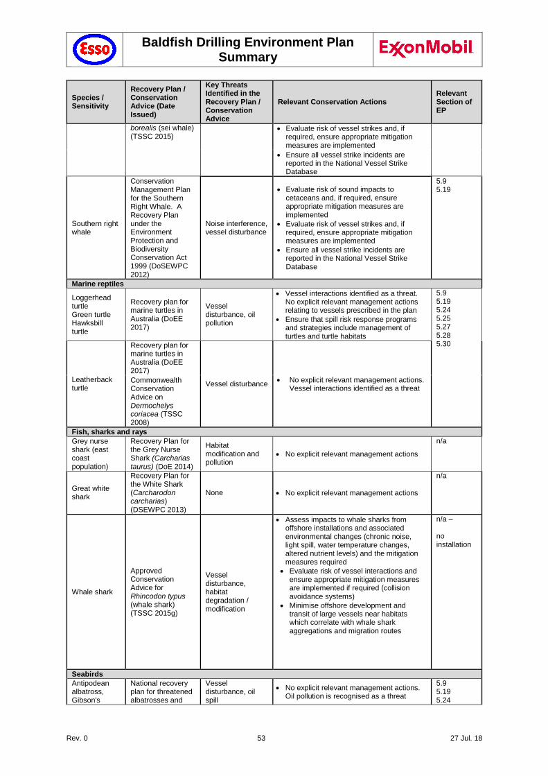
Baldfish Drilling Environment Plan Summary
Rev. 0 53 27 Jul. 18
Species / Sensitivity
Recovery Plan / Conservation Advice (Date Issued)
Key Threats Identified in the Recovery Plan / Conservation Advice
Relevant Conservation Actions Relevant Section of EP
borealis (sei whale) (TSSC 2015)
Evaluate risk of vessel strikes and, if required, ensure appropriate mitigation measures are implemented
Ensure all vessel strike incidents are reported in the National Vessel Strike Database
Southern right whale
Conservation Management Plan for the Southern Right Whale. A Recovery Plan under the Environment Protection and Biodiversity Conservation Act 1999 (DoSEWPC 2012)
Noise interference, vessel disturbance
Evaluate risk of sound impacts to cetaceans and, if required, ensure appropriate mitigation measures are implemented
Evaluate risk of vessel strikes and, if required, ensure appropriate mitigation measures are implemented
Ensure all vessel strike incidents are reported in the National Vessel Strike Database
5.9 5.19
Marine reptiles
Loggerhead turtle Green turtle Hawksbill turtle
Recovery plan for marine turtles in Australia (DoEE 2017)
Vessel disturbance, oil pollution
Vessel interactions identified as a threat. No explicit relevant management actions relating to vessels prescribed in the plan
Ensure that spill risk response programs and strategies include management of turtles and turtle habitats
5.9 5.19 5.24 5.25 5.27 5.28 5.30
Leatherback turtle
Recovery plan for marine turtles in Australia (DoEE 2017)
Vessel disturbance No explicit relevant management actions.
Vessel interactions identified as a threat Commonwealth Conservation Advice on Dermochelys coriacea (TSSC 2008)
Fish, sharks and rays
Grey nurse shark (east coast population)
Recovery Plan for the Grey Nurse Shark (Carcharias taurus) (DoE 2014)
Habitat modification and pollution
No explicit relevant management actions
n/a
Great white shark
Recovery Plan for the White Shark (Carcharodon carcharias) (DSEWPC 2013)
None No explicit relevant management actions
n/a
Whale shark
Approved Conservation Advice for Rhincodon typus (whale shark) (TSSC 2015g)
Vessel disturbance, habitat degradation / modification
Assess impacts to whale sharks from offshore installations and associated environmental changes (chronic noise, light spill, water temperature changes, altered nutrient levels) and the mitigation measures required
Evaluate risk of vessel interactions and ensure appropriate mitigation measures are implemented if required (collision avoidance systems)
Minimise offshore development and transit of large vessels near habitats which correlate with whale shark aggregations and migration routes
n/a – no installation
Seabirds
Antipodean albatross, Gibson's
National recovery plan for threatened albatrosses and
Vessel disturbance, oil spill
No explicit relevant management actions. Oil pollution is recognised as a threat
5.9 5.19 5.24
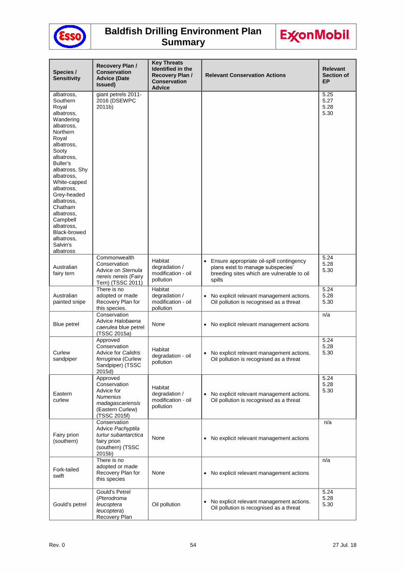
Baldfish Drilling Environment Plan Summary
Rev. 0 54 27 Jul. 18
Species / Sensitivity
Recovery Plan / Conservation Advice (Date Issued)
Key Threats Identified in the Recovery Plan / Conservation Advice
Relevant Conservation Actions Relevant Section of EP
albatross, Southern Royal albatross, Wandering albatross, Northern Royal albatross, Sooty albatross, Buller's albatross, Shy albatross, White-capped albatross, Grey-headed albatross, Chatham albatross, Campbell albatross, Black-browed albatross, Salvin's albatross
giant petrels 2011-2016 (DSEWPC 2011b)
5.25 5.27 5.28 5.30
Australian fairy tern
Commonwealth Conservation Advice on Sternula nereis nereis (Fairy Tern) (TSSC 2011)
Habitat degradation / modification - oil pollution
Ensure appropriate oil-spill contingency plans exist to manage subspecies’ breeding sites which are vulnerable to oil spills
5.24 5.28 5.30
Australian painted snipe
There is no adopted or made Recovery Plan for this species.
Habitat degradation / modification - oil pollution
No explicit relevant management actions. Oil pollution is recognised as a threat
5.24 5.28 5.30
Blue petrel
Conservation Advice Halobaena caerulea blue petrel (TSSC 2015a)
None No explicit relevant management actions
n/a
Curlew sandpiper
Approved Conservation Advice for Calidris ferruginea (Curlew Sandpiper) (TSSC 2015d)
Habitat degradation - oil pollution
No explicit relevant management actions. Oil pollution is recognised as a threat
5.24 5.28 5.30
Eastern curlew
Approved Conservation Advice for Numenius madagascariensis (Eastern Curlew) (TSSC 2015f)
Habitat degradation / modification - oil pollution
No explicit relevant management actions. Oil pollution is recognised as a threat
5.24 5.28 5.30
Fairy prion (southern)
Conservation Advice Pachyptila turtur subantarctica fairy prion (southern) (TSSC 2015b)
None No explicit relevant management actions
n/a
Fork-tailed swift
There is no adopted or made Recovery Plan for this species
None No explicit relevant management actions
n/a
Gould's petrel
Gould's Petrel (Pterodroma leucoptera leucoptera) Recovery Plan
Oil pollution No explicit relevant management actions.
Oil pollution is recognised as a threat
5.24 5.28 5.30
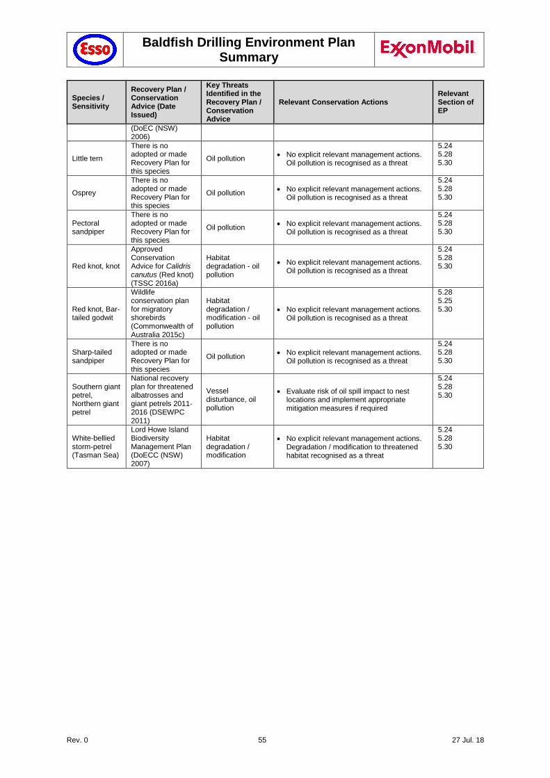
Baldfish Drilling Environment Plan Summary
Rev. 0 55 27 Jul. 18
Species / Sensitivity
Recovery Plan / Conservation Advice (Date Issued)
Key Threats Identified in the Recovery Plan / Conservation Advice
Relevant Conservation Actions Relevant Section of EP
(DoEC (NSW) 2006)
Little tern
There is no adopted or made Recovery Plan for this species
Oil pollution No explicit relevant management actions.
Oil pollution is recognised as a threat
5.24 5.28 5.30
Osprey
There is no adopted or made Recovery Plan for this species
Oil pollution No explicit relevant management actions.
Oil pollution is recognised as a threat
5.24 5.28 5.30
Pectoral sandpiper
There is no adopted or made Recovery Plan for this species
Oil pollution No explicit relevant management actions.
Oil pollution is recognised as a threat
5.24 5.28 5.30
Red knot, knot
Approved Conservation Advice for Calidris canutus (Red knot) (TSSC 2016a)
Habitat degradation - oil pollution
No explicit relevant management actions. Oil pollution is recognised as a threat
5.24 5.28 5.30
Red knot, Bar-tailed godwit
Wildlife conservation plan for migratory shorebirds (Commonwealth of Australia 2015c)
Habitat degradation / modification - oil pollution
No explicit relevant management actions. Oil pollution is recognised as a threat
5.28 5.25 5.30
Sharp-tailed sandpiper
There is no adopted or made Recovery Plan for this species
Oil pollution No explicit relevant management actions.
Oil pollution is recognised as a threat
5.24 5.28 5.30
Southern giant petrel, Northern giant petrel
National recovery plan for threatened albatrosses and giant petrels 2011-2016 (DSEWPC 2011)
Vessel disturbance, oil pollution
Evaluate risk of oil spill impact to nest locations and implement appropriate mitigation measures if required
5.24 5.28 5.30
White-bellied storm-petrel (Tasman Sea)
Lord Howe Island Biodiversity Management Plan (DoECC (NSW) 2007)
Habitat degradation / modification
No explicit relevant management actions. Degradation / modification to threatened habitat recognised as a threat
5.24 5.28 5.30
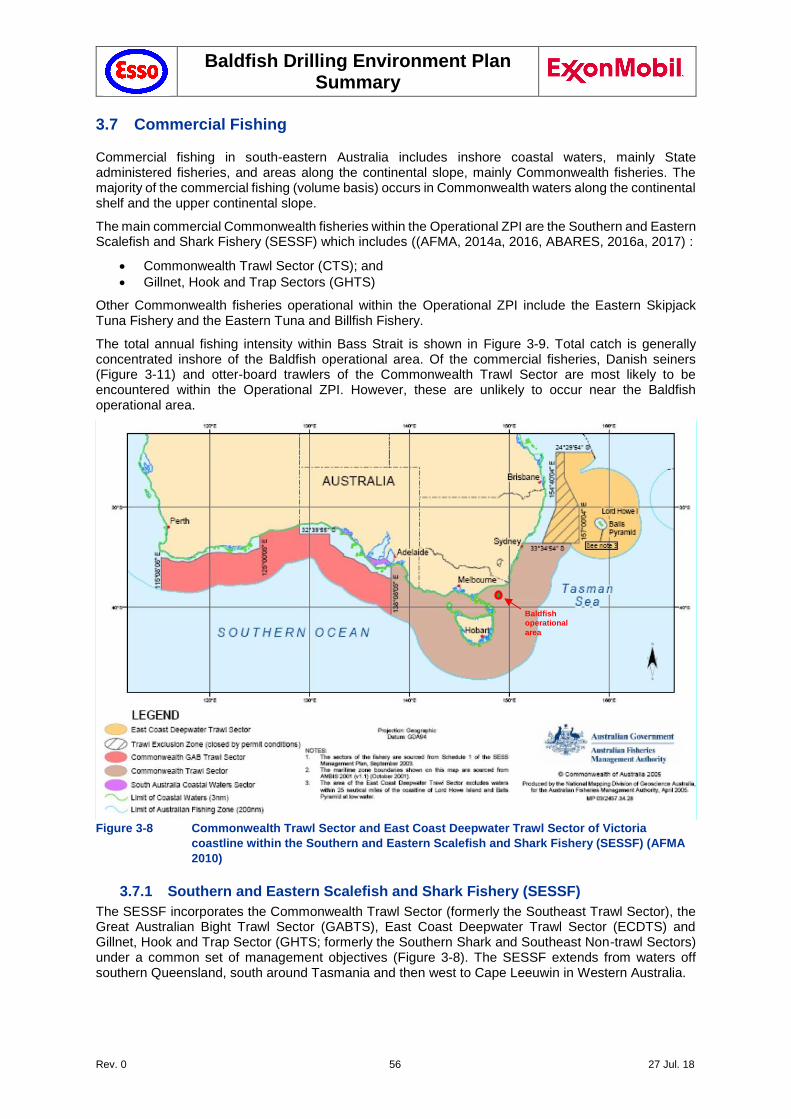
Baldfish Drilling Environment Plan Summary
Rev. 0 56 27 Jul. 18
3.7 Commercial Fishing
Commercial fishing in south-eastern Australia includes inshore coastal waters, mainly State administered fisheries, and areas along the continental slope, mainly Commonwealth fisheries. The majority of the commercial fishing (volume basis) occurs in Commonwealth waters along the continental shelf and the upper continental slope.
The main commercial Commonwealth fisheries within the Operational ZPI are the Southern and Eastern Scalefish and Shark Fishery (SESSF) which includes ((AFMA, 2014a, 2016, ABARES, 2016a, 2017) :
Commonwealth Trawl Sector (CTS); and
Gillnet, Hook and Trap Sectors (GHTS)
Other Commonwealth fisheries operational within the Operational ZPI include the Eastern Skipjack Tuna Fishery and the Eastern Tuna and Billfish Fishery.
The total annual fishing intensity within Bass Strait is shown in Figure 3-9. Total catch is generally concentrated inshore of the Baldfish operational area. Of the commercial fisheries, Danish seiners (Figure 3-11) and otter-board trawlers of the Commonwealth Trawl Sector are most likely to be encountered within the Operational ZPI. However, these are unlikely to occur near the Baldfish operational area.
Figure 3-8 Commonwealth Trawl Sector and East Coast Deepwater Trawl Sector of Victoria
coastline within the Southern and Eastern Scalefish and Shark Fishery (SESSF) (AFMA
2010)
3.7.1 Southern and Eastern Scalefish and Shark Fishery (SESSF)
The SESSF incorporates the Commonwealth Trawl Sector (formerly the Southeast Trawl Sector), the Great Australian Bight Trawl Sector (GABTS), East Coast Deepwater Trawl Sector (ECDTS) and Gillnet, Hook and Trap Sector (GHTS; formerly the Southern Shark and Southeast Non-trawl Sectors) under a common set of management objectives (Figure 3-8). The SESSF extends from waters off southern Queensland, south around Tasmania and then west to Cape Leeuwin in Western Australia.
Baldfish operational
area
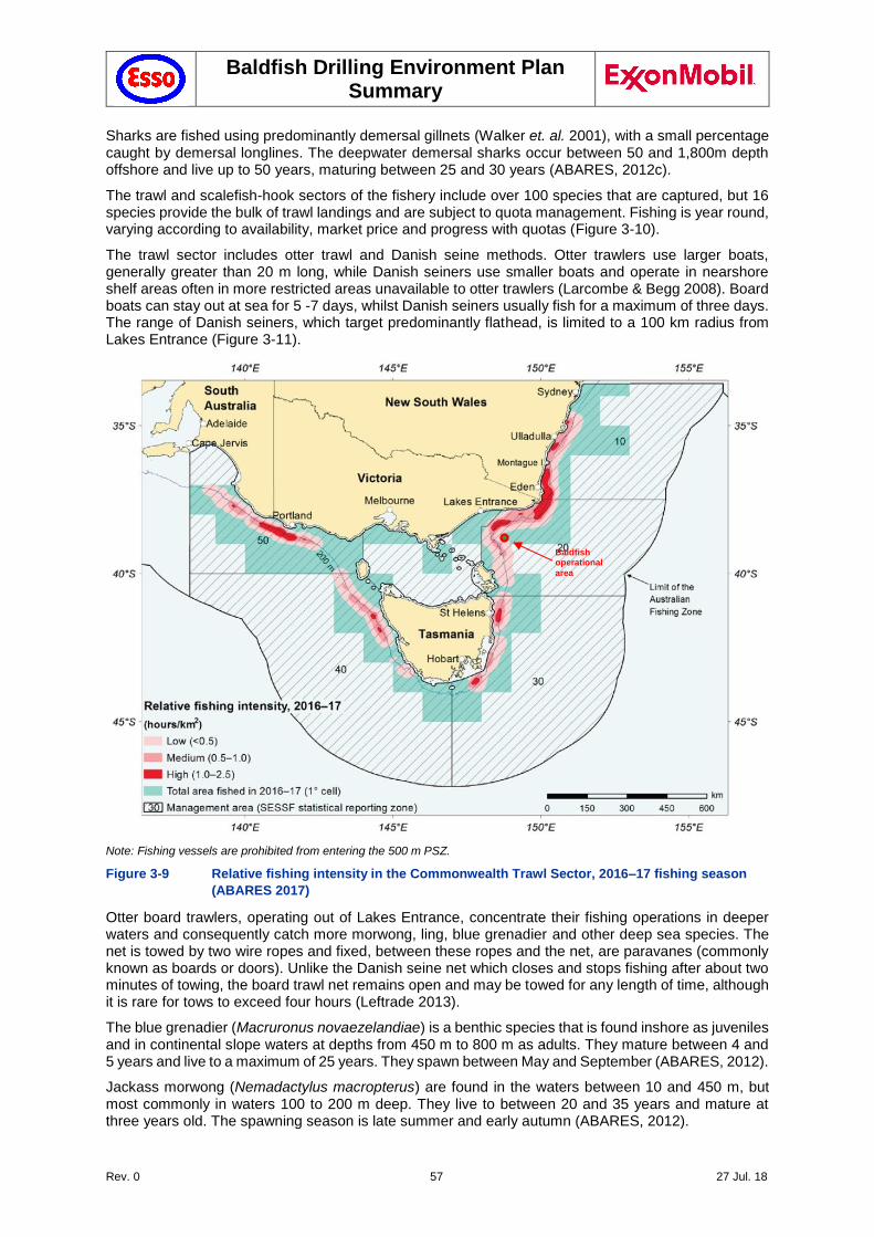
Baldfish Drilling Environment Plan Summary
Rev. 0 57 27 Jul. 18
Sharks are fished using predominantly demersal gillnets (Walker et. al. 2001), with a small percentage caught by demersal longlines. The deepwater demersal sharks occur between 50 and 1,800m depth offshore and live up to 50 years, maturing between 25 and 30 years (ABARES, 2012c).
The trawl and scalefish-hook sectors of the fishery include over 100 species that are captured, but 16 species provide the bulk of trawl landings and are subject to quota management. Fishing is year round, varying according to availability, market price and progress with quotas (Figure 3-10).
The trawl sector includes otter trawl and Danish seine methods. Otter trawlers use larger boats, generally greater than 20 m long, while Danish seiners use smaller boats and operate in nearshore shelf areas often in more restricted areas unavailable to otter trawlers (Larcombe & Begg 2008). Board boats can stay out at sea for 5 -7 days, whilst Danish seiners usually fish for a maximum of three days. The range of Danish seiners, which target predominantly flathead, is limited to a 100 km radius from Lakes Entrance (Figure 3-11).
Note: Fishing vessels are prohibited from entering the 500 m PSZ.
Figure 3-9 Relative fishing intensity in the Commonwealth Trawl Sector, 2016–17 fishing season
(ABARES 2017)
Otter board trawlers, operating out of Lakes Entrance, concentrate their fishing operations in deeper waters and consequently catch more morwong, ling, blue grenadier and other deep sea species. The net is towed by two wire ropes and fixed, between these ropes and the net, are paravanes (commonly known as boards or doors). Unlike the Danish seine net which closes and stops fishing after about two minutes of towing, the board trawl net remains open and may be towed for any length of time, although it is rare for tows to exceed four hours (Leftrade 2013).
The blue grenadier (Macruronus novaezelandiae) is a benthic species that is found inshore as juveniles and in continental slope waters at depths from 450 m to 800 m as adults. They mature between 4 and 5 years and live to a maximum of 25 years. They spawn between May and September (ABARES, 2012).
Jackass morwong (Nemadactylus macropterus) are found in the waters between 10 and 450 m, but most commonly in waters 100 to 200 m deep. They live to between 20 and 35 years and mature at three years old. The spawning season is late summer and early autumn (ABARES, 2012).
Baldfish operational
area
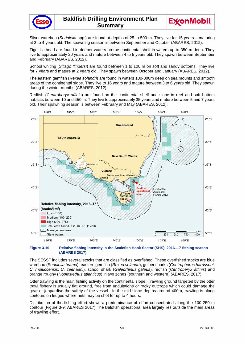
Baldfish Drilling Environment Plan Summary
Rev. 0 58 27 Jul. 18
Silver warehou (Seriolella spp.) are found at depths of 25 to 500 m. They live for 15 years – maturing at 3 to 4 years old. The spawning season is between September and October (ABARES, 2012).
Tiger flathead are found in deeper waters on the continental shelf in waters up to 350 m deep. They live to approximately 20 years and mature between 4 to 5 years old. They spawn between September and February (ABARES, 2012).
School whiting (Sillago flindersi) are found between 1 to 100 m on soft and sandy bottoms. They live for 7 years and mature at 2 years old. They spawn between October and January (ABARES, 2012).
The eastern gemfish (Rexea solandri) are found in waters 100-800m deep on sea mounts and smooth areas of the continental slope. They live to 16 years and mature between 3 to 6 years old. They spawn during the winter months (ABARES, 2012).
Redfish (Centroberyx affinis) are found on the continental shelf and slope in reef and soft bottom habitats between 10 and 450 m. They live to approximately 35 years and mature between 5 and 7 years old. Their spawning season is between February and May (ABARES, 2012).
Figure 3-10 Relative fishing intensity in the Scalefish Hook Sector (SHS), 2016–17 fishing season
(ABARES 2017)
The SESSF includes several stocks that are classified as overfished. These overfished stocks are blue warehou (Seriolella brama), eastern gemfish (Rexea solandri), gulper sharks (Centrophorus harrissoni, C. moluccensis, C. zeehaani), school shark (Galeorhinus galeus), redfish (Centroberyx affinis) and orange roughy (Hoplostethus atlanticus) in two zones (southern and western) (ABARES, 2017).
Otter trawling is the main fishing activity on the continental slope. Trawling ground targeted by the otter trawl fishery is usually flat ground, free from undulations or rocky outcrops which could damage the gear or jeopardise the safety of the vessel. In the mid-slope depths around 400m, trawling is along contours on ledges where nets may be shot for up to 4 hours.
Distribution of the fishing effort shows a predominance of effort concentrated along the 100-250 m contour (Figure 3-9; ABARES 2017) The Baldfish operational area largely lies outside the main areas of trawling effort.
Baldfish operational
area
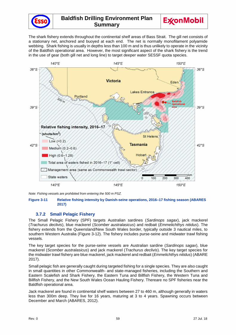
Baldfish Drilling Environment Plan Summary
Rev. 0 59 27 Jul. 18
The shark fishery extends throughout the continental shelf areas of Bass Strait. The gill net consists of a stationary net, anchored and buoyed at each end. The net is normally monofilament polyamide webbing. Shark fishing is usually in depths less than 100 m and is thus unlikely to operate in the vicinity of the Baldfish operational area. However, the most significant aspect of the shark fishery is the trend in the use of gear (both gill net and long line) to target deeper water SESSF quota species.
Note: Fishing vessels are prohibited from entering the 500 m PSZ.
Figure 3-11 Relative fishing intensity by Danish-seine operations, 2016–17 fishing season (ABARES
2017)
3.7.2 Small Pelagic Fishery
The Small Pelagic Fishery (SPF) targets Australian sardines (Sardinops sagax), jack mackerel (Trachurus declivis), blue mackerel (Scomber australasicus) and redbait (Emmelichthys nitidus). The fishery extends from the Queensland/New South Wales border, typically outside 3 nautical miles, to southern Western Australia (Figure 3-12). The fishery includes purse-seine and midwater trawl fishing vessels.
The key target species for the purse-seine vessels are Australian sardine (Sardinops sagax), blue mackerel (Scomber australasicus) and jack mackerel (Trachurus declivis). The key target species for the midwater trawl fishery are blue mackerel, jack mackerel and redbait (Emmelichthys nitidus) (ABARE 2017).
Small pelagic fish are generally caught during targeted fishing for a single species. They are also caught in small quantities in other Commonwealth- and state-managed fisheries, including the Southern and Eastern Scalefish and Shark Fishery, the Eastern Tuna and Billfish Fishery, the Western Tuna and Billfish Fishery, and the New South Wales Ocean Hauling Fishery. Thereare no SPF fisheries near the Baldfish operational area.
Jack mackerel are found in continental shelf waters between 27 to 460 m, although generally in waters less than 300m deep. They live for 16 years, maturing at 3 to 4 years. Spawning occurs between December and March (ABARES, 2012).
Baldfish operational
area
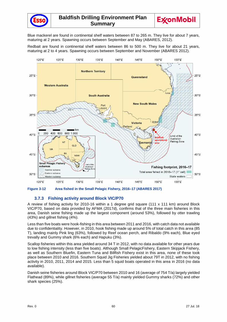
Baldfish Drilling Environment Plan Summary
Rev. 0 60 27 Jul. 18
Blue mackerel are found in continental shelf waters between 87 to 265 m. They live for about 7 years, maturing at 2 years. Spawning occurs between September and May (ABARES, 2012).
Redbait are found in continental shelf waters between 86 to 500 m. They live for about 21 years, maturing at 2 to 4 years. Spawning occurs between September and November (ABARES 2012).
Figure 3-12 Area fished in the Small Pelagic Fishery, 2016–17 (ABARES 2017)
3.7.3 Fishing activity around Block VIC/P70
A review of fishing activity for 2010-16 within a 1 degree grid square (111 x 111 km) around Block VIC/P70, based on data provided by AFMA (2017d), confirms that of the three main fisheries in this area, Danish seine fishing made up the largest component (around 53%), followed by otter trawling (43%) and gillnet fishing (4%).
Less than five boats were hook-fishing in this area between 2011 and 2016, with catch data not available due to confidentiality. However, in 2010, hook fishing made up around 5% of total catch in this area (85 T), landing mainly Pink ling (63%), followed by Reef ocean perch, and Ribaldo (9% each), Blue eyed trevally and Gummy shark (6% each) and Hapuku (3%).
Scallop fisheries within this area yielded around 34 T in 2012, with no data available for other years due to low fishing intensity (less than five boats). Although Small PelagicFishery, Eastern Skipjack Fishery, as well as Southern Bluefin, Eastern Tuna and Billfish Fishery exist in this area, none of these took place between 2010 and 2016. Southern Squid Jig Fisheries yielded about 79T in 2012, with no fishing activity in 2010, 2011, 2014 and 2015. Less than 5 squid boats operated in this area in 2016 (no data available).
Danish seine fisheries around Block VIC/P70 between 2010 and 16 (average of 754 T/a) largely yielded Flathead (89%), while gillnet fisheries (average 55 T/a) mainly yielded Gummy sharks (72%) and other shark species (25%).
Baldfish operational
area
Baldfish Drilling Environment Plan Summary
Rev. 0 61 27 Jul. 18
Otter trawling within the Commonwealth Trawl Sector around Block VIC/P70 between 2010-16 (average 609 T/a), yielded a range of fish species, dominated by Flathead (33%), Pink ling (12%), Blue grenadier (9%) and Silver warehou (7%). An average of 0.9 T/a of Orange roughy was landed in this area between 2010 and 2016, decreasing from 1.4 T in 2010 to 0.4 T in 2016.
However, as outlined above, the fisheries around Block VIC/P70 are largely concentrated in shallower waters, further inshore from the Baldfish operational area.
3.7.4 Scallop Fisheries (BSCZSF, Victorian and Tasmanian)
The Bass Strait scallop fisheries are predominantly single-species fisheries targeting aggregations (‘beds’) of the commercial scallop (Pecten fumatus) using scallop dredges, which are towed along the bottom of the sea in much the same way as trawl equipment (ABARES 2016b). The management of scallops in Bass Strait is divided into three zones, of which the Commonwealth manages the Central Zone (the Bass Strait Central Zone Scallop Fishery; BSCZSF). The remaining zones, which extend up to 20 nautical miles off the coasts of Victoria (Victorian Scallop Fishery) and Tasmania (Tasmanian Scallop Fishery), are managed by those states respectively (AFMA, 2017c).
The areas open to fishing vary from year to year depending on the location of commercially viable scallop beds. In 2015 fishing was concentrated on beds east of King Island (well outside the operational area) (ABARES 2016b). The season typically extends from May to December but the fishery is not opened unless the abundance of scallops in specific locations meets regulatory criteria.
The commercial scallop usually matures at about 12 to 18 months of age. Once maturity has been reached (fecundity increases with age), spawning occurs from winter to spring (June to November) although there are periods when spawning may be at a peak. The timing of these peaks may vary according to location and also according to environmental conditions, but appears to be in spring in Victoria (Sause et al. 1987). There is also some very limited evidence for a smaller, autumn peak in spawning for scallop populations in Bass Strait (Coleman 1988).
Scallop populations throughout the world fluctuate quite dramatically in response to variable environmental conditions. Relatively high populations occur in some years. These can be followed by relative scarcity, but populations can quickly rebound to large numbers provided enough adults remain for successful breeding and recruitment (VFA 2017a). Scallops are seldom found in commercial quantities in depths greater than 60-70 m.
3.7.5 Abalone Fisheries
The blacklip abalone (Haliotis rubra) forms the basis of the abalone fisheries in NSW, Victoria and Tasmania, however greenlip abalone (Haliotis laevegata) are also targeted. Blacklip abalone are commonly found, mainly on rocky substrates, from 0 m to 40 m depth range and are widely distributed along the southern half of Australia as far as Rottnest Island in the West to Coffs Harbour in the East, but are not present at the Baldfish operational area.
Abalone are sourced from the wild and from coastal farms. There are about 40 reefs from Iron Prince to Marlo Reef in Victoria. In NSW, most commercial abalone fishing takes place on the south coast, primarily from Jervis Bay to the Victorian border (DPI 2014). The Tasmanian abalone fishery is the largest wild abalone fishery in the world and the fishery area surrounds the entire island extending northwards into Bass Strait to include Bass Strait islands such as the Furneaux Group.
Victoria’s abalone farms are situated primarily in Port Phillip Bay and southwest Victoria, however farms are also located off Tullaberga Island and Gabo Island (as shown in the Oil Spill Response Atlas for Victoria).
Abalone are hand harvested by divers, who typically operate from small, trailable or tender vessels using low-pressure surface–air supply equipment (hookah). Abalone are removed from the reef using a tool known as an abalone iron. Fishing is open all year round.
Abalone grow to at least 21 cm in length and growth rates vary with location and time of year. Abalone mature at 6 to 10 years of age in Tasmania and spawning occurs from October through to March.
Baldfish Drilling Environment Plan Summary
Rev. 0 62 27 Jul. 18
3.7.6 Rock Lobster Fisheries
The Victorian and Tasmanian Rock Lobster Fisheries are based primarily on one species, the southern rock lobster (Jasus edwardsii). Eastern rock lobster (Jasus verreauxi) is the main species harvested by the NSW Lobster Fishery, but occasionally southern rock lobster, and tropical rock lobster are also caught.
Rock lobster fishing grounds exist around Ulladulla and Bateman’s Bay, the southern tip of Wilson’s Promontory and around Bass Strait islands, such as the Hogan Group, Curtis Group, Kent Group islands and Flinders Island. Most fishing occurs between mid-November and March, outside the June to mid-November spawning season. Fishers use baited rock lobster pots which are lowered to the bottom in rocky areas. The lobsters crawl down the funnel in the top of the pots and are unable to escape.
3.7.7 Victorian Commercial Bay and Inlet Fisheries
The commercial bay and inlet fisheries of Victoria are a collection of complex multi-species, multi-gear fisheries which operate in environments that are ecologically distinct to those existing in waters of both their catchment tributaries and the nearby ocean. Although between 60 to 80 fish species have been recorded from commercial bay and inlet catches, only about a dozen or so key species, including King George whiting, black bream, snapper, flathead, mullet, garfish, flounder, anchovies and pilchards, are usually targeted by commercial fishers.
Commercial fishing for fin fish occurs in Port Phillip Bay, Corner Inlet/Nooramunga and the Gippsland Lakes. All other Victorian bays, inlets and estuaries are closed to commercial fishing (other than for eels and bait). The main bay and inlet commercial fishing methods are seine nets and gillnets.
3.7.8 Tasmanian Shellfish Fishery
The commercial shellfish fishery includes clams (Veneruptis largillierti) for which there are three licences restricted to Georges Bay, native oyster (Ostrea angasi) for which there are two licences restricted to Georges Bay and cockles (Katelysia scalarina) for which there are four licences restricted to Ansons Bay and wild Pacific oyster (Crassostrea gigas) (DPIPWE 2017).
Temperate climate bivalves generally have two spawning periods within a year following spring and autumnal peaks in phytoplankton production.
3.7.9 NSW Ocean Trawl Fishery
There are two sectors to the NSW Ocean Trawl Fishery: The prawn trawl sector (within 1.5 NM of the coastline) and the fish trawl sector (west of the 90 m depth contour). Both sectors use the otter trawl net (see Section 6.9.1). The major species taken in this fishery include school whiting (comprising of stout whiting and red spot whiting), eastern king, school and royal red prawns, tiger flathead, silver trevally, various species of sharks and rays, squid, octopus and bugs (DPI 2014).
3.7.10 NSW Ocean Trap and Line Fishery
The Ocean Trap and Line fishery is a multi-method, multi species fishery targeting demersal and pelagic fish along the entire NSW coast, in continental shelf and slope waters. The fishery uses a variety of methods, most commonly involving traps or lines with hooks. Snapper, yellowtail kingfish, leatherjackets, bonito and silver trevally form the bulk of the commercial catch. Other key species include rubberlip (grey) morwong, blue-eye trevalla, sharks, bar cod and yellowfin bream (DPI 2014).
3.7.11 NSW Estuary General Fishery
The Estuary General Fishery is a diverse, multi-species, multi-method fishery that operates in many of the State’s estuarine systems. The fishery includes all forms of commercial estuarine fishing (other than estuary prawn trawling) in addition to the gathering of pipis and beachworms from ocean beaches. The most frequently used fishing methods are mesh and haul netting. Other methods used include trapping, hand-lining and hand-gathering. Sea mullet, luderick, yellowfin bream, school prawn, blue swimmer crab, dusky flathead, sand whiting, pipi, mud crab and silver biddy make up over 80% of the catch (DPI 2014).
Baldfish Drilling Environment Plan Summary
Rev. 0 63 27 Jul. 18
3.7.12 NSW Ocean Hauling Fishery
The Ocean Hauling Fishery targets approximately 20 finfish species using commercial hauling and purse seine nets from sea beaches and in ocean waters within 3 NM of the NSW coast. The catch is mainly made up of pilchards, sea mullet, Australian salmon, blue mackerel, yellowtail scad and yellowfin bream (DPI 2014).
3.7.13 NSW Oyster Aquaculture
The Sydney rock oyster (Saccostrea glomerata) is the main species grown in NSW. Commercial production in the State occurs in 41 estuaries between Eden in the south to the Tweed River in the north. Wallis Lake and the Hawkesbury River are the main producing areas.
The Sydney rock oyster industry in NSW is largely dependent on natural spatfall. The first spawning of a Sydney rock oyster is usually as a male and subsequent spawnings as a female. During spawning, adult females disperse up to 20 million eggs and males hundreds of millions of sperms into the water when the tide and current are optimal for the widest distribution. Fertilisation takes place in the water column and development continues for up to 3 to 4 weeks as the larval stages of the oyster grow, with the ‘spat’ ultimately being caught on ‘sticks’. Oysters are knocked off these sticks at 0.5 to 3 years of age for growing intertidally on trays until maturity in 3 to 4 years. Alternative growing systems such as baskets and tumblers are also being used, and some oysters are grown subtidally on rafts or on floating culture.
3.8 Commercial Shipping
Bass Strait is one of Australia’s busiest shipping areas, with more than 3,000 vessels passing through Bass Strait each year (see Figure 3-13). Bass Strait is a transit route for shipping traffic connecting the eastern and western ports of Australia (NOO 2002). A shipping exclusion area (Area to Be Avoided; Refer chart AUS357) surrounds much of the Gippsland basin operational area.
Block VIC/P70 contains an International Maritime Organization (IMO) adopted Traffic Separation Scheme (TSS). While the Baldfish operational area lies 13 NM to the north east of the TSS boundary, it was in the middle of the north east traffic lane of the TSS. This area has some of the heaviest commercial shipping traffic in Australia, temporary fairways have therefore been implemented to direct vesssels around the Baldfish and Hairtail well locations as shown in Figure 3-13.
Each dot on the plot in Figure 3-13 represents a vessel’s position, as broadcast by AIS (Automatic Identification System; at 15 minute intervals. Analysis (AMSA, 2017b) reveals that some 80% of the vessels are cargo vessels, 12% are tankers and 2% are passenger ships. The rest are a combination of fishing vessels, pleasure craft, tugs etc. On average, every day, one large vessel will transit the TSS every 2 hours in the vicinity of the Baldfish operational area.
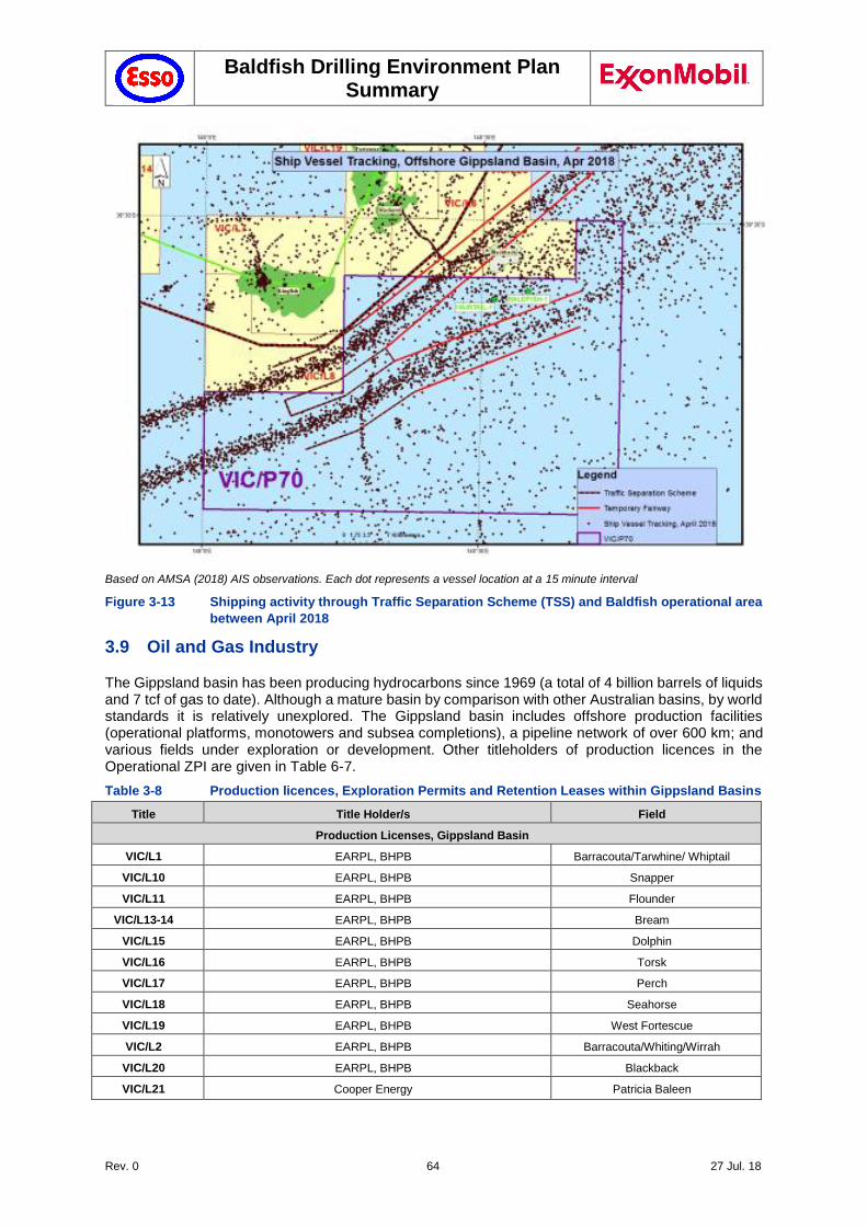
Baldfish Drilling Environment Plan Summary
Rev. 0 64 27 Jul. 18
Based on AMSA (2018) AIS observations. Each dot represents a vessel location at a 15 minute interval
Figure 3-13 Shipping activity through Traffic Separation Scheme (TSS) and Baldfish operational area
between April 2018
3.9 Oil and Gas Industry
The Gippsland basin has been producing hydrocarbons since 1969 (a total of 4 billion barrels of liquids and 7 tcf of gas to date). Although a mature basin by comparison with other Australian basins, by world standards it is relatively unexplored. The Gippsland basin includes offshore production facilities (operational platforms, monotowers and subsea completions), a pipeline network of over 600 km; and various fields under exploration or development. Other titleholders of production licences in the Operational ZPI are given in Table 6-7.
Table 3-8 Production licences, Exploration Permits and Retention Leases within Gippsland Basins
Title Title Holder/s Field
Production Licenses, Gippsland Basin
VIC/L1 EARPL, BHPB Barracouta/Tarwhine/ Whiptail
VIC/L10 EARPL, BHPB Snapper
VIC/L11 EARPL, BHPB Flounder
VIC/L13-14 EARPL, BHPB Bream
VIC/L15 EARPL, BHPB Dolphin
VIC/L16 EARPL, BHPB Torsk
VIC/L17 EARPL, BHPB Perch
VIC/L18 EARPL, BHPB Seahorse
VIC/L19 EARPL, BHPB West Fortescue
VIC/L2 EARPL, BHPB Barracouta/Whiting/Wirrah
VIC/L20 EARPL, BHPB Blackback
VIC/L21 Cooper Energy Patricia Baleen
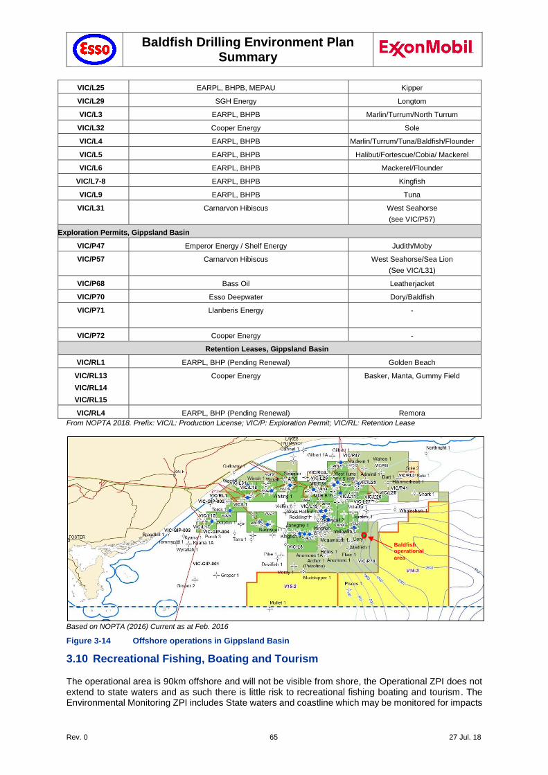
Baldfish Drilling Environment Plan Summary
Rev. 0 65 27 Jul. 18
VIC/L25 EARPL, BHPB, MEPAU Kipper
VIC/L29 SGH Energy Longtom
VIC/L3 EARPL, BHPB Marlin/Turrum/North Turrum
VIC/L32 Cooper Energy Sole
VIC/L4 EARPL, BHPB Marlin/Turrum/Tuna/Baldfish/Flounder
VIC/L5 EARPL, BHPB Halibut/Fortescue/Cobia/ Mackerel
VIC/L6 EARPL, BHPB Mackerel/Flounder
VIC/L7-8 EARPL, BHPB Kingfish
VIC/L9 EARPL, BHPB Tuna
VIC/L31 Carnarvon Hibiscus West Seahorse
(see VIC/P57)
Exploration Permits, Gippsland Basin
VIC/P47 Emperor Energy / Shelf Energy Judith/Moby
VIC/P57 Carnarvon Hibiscus West Seahorse/Sea Lion
(See VIC/L31)
VIC/P68 Bass Oil Leatherjacket
VIC/P70 Esso Deepwater Dory/Baldfish
VIC/P71 Llanberis Energy
-
VIC/P72 Cooper Energy -
Retention Leases, Gippsland Basin
VIC/RL1 EARPL, BHP (Pending Renewal) Golden Beach
VIC/RL13
VIC/RL14
VIC/RL15
Cooper Energy Basker, Manta, Gummy Field
VIC/RL4 EARPL, BHP (Pending Renewal) Remora
From NOPTA 2018. Prefix: VIC/L: Production License; VIC/P: Exploration Permit; VIC/RL: Retention Lease
Based on NOPTA (2016) Current as at Feb. 2016
Figure 3-14 Offshore operations in Gippsland Basin
3.10 Recreational Fishing, Boating and Tourism
The operational area is 90km offshore and will not be visible from shore, the Operational ZPI does not extend to state waters and as such there is little risk to recreational fishing boating and tourism. The Environmental Monitoring ZPI includes State waters and coastline which may be monitored for impacts
Baldfish operational
area
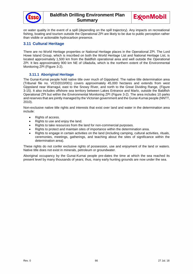
Baldfish Drilling Environment Plan Summary
Rev. 0 66 27 Jul. 18
on water quality in the event of a spill (depending on the spill trajectory). Any impacts on recreational fishing, boating and tourism outside the Operational ZPI are likely to be due to public perception rather than visible or actionable hydrocarbon presence.
3.11 Cultural Heritage
There are no World Heritage properties or National Heritage places in the Operational ZPI. The Lord Howe Island Group, which is inscribed on both the World Heritage List and National Heritage List, is located approximately 1,500 km from the Baldfish operational area and well outside the Operational ZPI. It lies approximately 900 km NE of Ulladulla, which is the northern extent of the Environmental Monitoring ZPI (Figure 3-2).
3.11.1 Aboriginal Heritage
The Gunai-Kurnai people hold native title over much of Gippsland. The native title determination area (Tribunal file no. VCD2010/001) covers approximately 45,000 hectares and extends from west Gippsland near Warragul, east to the Snowy River, and north to the Great Dividing Range, (Figure 3-15). It also includes offshore sea territory between Lakes Entrance and Marlo, outside the Baldfish Operational ZPI but within the Environmental Monitoring ZPI (Figure 3-2). The area includes 10 parks and reserves that are jointly managed by the Victorian government and the Gunai-Kurnai people (NNTT, 2010).
Non-exclusive native title rights and interests that exist over land and water in the determination area include:
Rights of access.
Rights to use and enjoy the land.
Rights to take resources from the land for non-commercial purposes.
Rights to protect and maintain sites of importance within the determination area.
Rights to engage in certain activities on the land (including camping, cultural activities, rituals, ceremonies, meetings, gatherings, and teaching about the sites of significance within the determination area).
These rights do not confer exclusive rights of possession, use and enjoyment of the land or waters. Native title does not exist in minerals, petroleum or groundwater.
Aboriginal occupancy by the Gunai-Kurnai people pre-dates the time at which the sea reached its present level by many thousands of years; thus, many early hunting grounds are now under the sea.
Baldfish Drilling Environment Plan Summary
Rev. 0 67 27 Jul. 18
Figure 3-15 Gunai-Kurnai Native Title Determination Area (VCD2010/01)
In the past, coastal wetlands were highly productive areas for hunter-gatherer people, having a variety of habitats and species, so the majority of archaeological sites in Victoria are found within 1 km of the coast (LCC 1993). Along the Gippsland coast, stone artefacts that have been found were mostly made from silcrete and quartz from the hinterland. Middens on offshore islands indicate that in the past, Aboriginal people from the area now known as Wilsons Promontory were likely to have visited (Jones & Allen 1979).
3.11.2 Shipwrecks
A search of the National Shipwrecks Database identified 255 wrecks between Latitude 37° 00’ to 40° 00’, and Longitude 146° 00’ to 150° 00’, with none in the Baldfish operational area (Figure 3-16). One wreck, AHO 6528 (wrecked in 1940; Latitude 38° 33, Longitude 148° 30), lies near the Baldfish Operational area. No further details are available on this wreck (DoEE, 2017c).
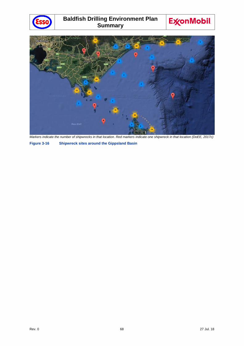
Baldfish Drilling Environment Plan Summary
Rev. 0 68 27 Jul. 18
Markers indicate the number of shipwrecks in that location. Red markers indicate one shipwreck in that location (DoEE, 2017c)
Figure 3-16 Shipwreck sites around the Gippsland Basin
Baldfish Drilling Environment Plan Summary
Rev. 0 69 27 Jul. 18
4 Environmental Impact and Risk Assessment Methodology
The ExxonMobil risk assessment approach and methodology used for the Baldfish drilling activity is consistent with AS/NZS ISO 31000 Risk management – Principles and Guidelines and AS/NZS ISO14001 Environmental Management Systems – Requirements with Guidance for Use.
4.1 Risk Assessment Methodology
Environmental impacts and risks for planned activities that have the potential to impact the environment and for unplanned spill scenarios were evaluated first by determining the consequence severity, and estimating the probability or likelihood that the consequences could occur.
Consequence severity: There are four consequence categories (I through IV, with I being the highest consequence level). The consequence categories consider environmental effects (in terms of duration, size/scale, and intensity) and sensitivity (in terms of irreplaceability, vulnerability and influence).
Probability: There are five probability categories (A through E, with A being the most likely level). The probability categories consider the probability for each failure, event or condition necessary to produce the consequences, given the implementation of controls that prevent and mitigate the risk.
The combination of consequence severity and probability of occurrence determines the position on the ExxonMobil Risk Matrix. The ExxonMobil Risk Matrix is divided into four categories, with Category 1 being the highest risk category and Category 4, the lowest. A risk could have a low consequence severity and high probability of occurrence, and result in the same risk ranking as a risk with a high consequence severity and low probability of occurrence.
4.2 Demonstration of ALARP
As described above the Risk Matrix is divided into four risk categories. The significance of each Risk Category is as follows:
Category 1: A higher risk where specific controls should be established in the short term and should, when possible, be reduced to a Category 2 risk or below. Continued operation requires annual review and approval by the Production Manager or equivalent.
Category 2: A medium risk that should be reduced unless it is not "reasonably practicable" to do so.
Category 3: A lower level medium risk that should again be reduced unless it is not "reasonably practicable" to do so.
Category 4: A lower risk that is expected to be effectively managed in base OIMS practices and therefore typically requires "No Further Action." Risk mitigation measures that are in place to manage the risk to Category 4 should be continued.
RA 21 (Interference with commercial shipping activity) and RA 28 (Loss of well control/well blowout) were categorised as Category 3 risks. All other environmental hazards and impacts were assessed to be Category 4 risks.
Determining whether risks have been reduced to ALARP requires an understanding of the nature and cause of the risk to be avoided and the sacrifice (in terms of impact on personal safety and/or the environment, time, effort and cost) involved in avoiding that risk. Where the nature of a risk is well-understood, in the context of the receiving environment, and the activity is a well-established practice, the application of control measures specific to systems and specified in international standards or design codes may be sufficient and obvious to demonstrate that the risk is ALARP. For complex situations it may be difficult to reach a decision on the basis of ‘good practice’ or standards alone. Therefore for each risk, a discussion on ALARP demonstration has been provided which considers elimination of the activity, availability of practical alternatives where they exist, and the decision to rule out adoption of additional control measures (where they exist) because they involve grossly disproportionate sacrifices to the resultant reduction in risk.
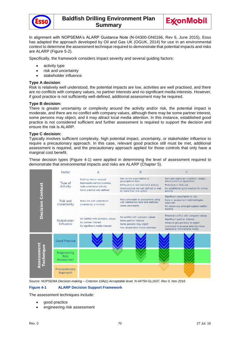
Baldfish Drilling Environment Plan Summary
Rev. 0 70 27 Jul. 18
In alignment with NOPSEMA’s ALARP Guidance Note (N-04300-GN0166, Rev 6, June 2015), Esso has adapted the approach developed by Oil and Gas UK (OGUK, 2014) for use in an environmental context to determine the assessment technique required to demonstrate that potential impacts and risks are ALARP (Figure 5-2).
Specifically, the framework considers impact severity and several guiding factors:
activity type
risk and uncertainty
stakeholder influence.
Type A decision: Risk is relatively well understood, the potential impacts are low, activities are well practised, and there are no conflicts with company values, no partner interests and no significant media interests. However, if good practice is not sufficiently well-defined, additional assessment may be required.
Type B decision: There is greater uncertainty or complexity around the activity and/or risk, the potential impact is moderate, and there are no conflict with company values, although there may be some partner interest, some persons may object, and it may attract local media attention. In this instance, established good practice is not considered sufficient and further assessment is required to support the decision and ensure the risk is ALARP.
Type C decision: Typically involves sufficient complexity, high potential impact, uncertainty, or stakeholder influence to require a precautionary approach. In this case, relevant good practice still must be met, additional assessment is required, and the precautionary approach applied for those controls that only have a marginal cost benefit.
These decision types (Figure 4-1) were applied in determining the level of assessment required to demonstrate that environmental impacts and risks are ALARP (Chapter 5).
Source: NOPSEMA Decision-making – Criterion 10A(c) Acceptable level. N-04750-GL1637, Rev 0, Nov 2016
Figure 4-1 ALARP Decision Support Framework
The assessment techniques include:
good practice
engineering risk assessment
Baldfish Drilling Environment Plan Summary
Rev. 0 71 27 Jul. 18
precautionary approach.
4.2.1 Good Practice
OGUK (2014) defines ‘Good Practice’ as: "The recognised risk management practices and measures that are used by competent organisations to manage well-understood hazards arising from their activities".
‘Good Practice’ can also be used as the generic term for those measures that are recognised as satisfying the law. For this EP, sources of good practice include:
requirements from Australian legislation and regulations
relevant Australian policies
relevant Australian Government guidance
relevant industry standards
relevant international conventions.
If the ALARP technique is determined to be ‘Good Practice’, further assessment (‘Engineering Risk Assessment’) is not required to identify additional controls. However, additional controls that provide a suitable environmental benefit for an insignificant cost are also identified at this point.
4.2.2 Engineering Risk Assessment
All potential impacts and risks that require further assessment are subject to an ‘Engineering Risk Assessment’. In accordance with OGUK (2014), a comparative assessment of risks, costs, and environmental benefit was applied, based on a cost–benefit analysis between the environmental benefit and the cost of implementing the identified measure.
4.2.3 Precautionary Approach
Where the assessment, considering all available engineering and scientific evidence, is insufficient, inconclusive, or uncertain, then a precautionary approach to hazard management is applied (OGUK 2014).
Under the precautionary principle, environmental considerations take precedence over economic considerations, and a control measure that may reduce environmental impact is more likely to be implemented. This approach could have significant economic consequences to an organisation.
4.3 Demonstration of Acceptable Level
In addition to demonstrating ALARP, the environmental impacts and risks must also be acceptable. The approach used by Esso was that environmental impacts and risks are considered to be reduced to acceptable levels if:
The level of residual environmental risk was assessed as being as low as reasonably practicable (ALARP; per Section 4.2; and
The level of residual environmental risk associated with the activity was either Category 2, 3 or 4; and
The activity is commonplace in current offshore / marine practice (i.e., benchmarked), and is compliant with current industry/ExxonMobil Australia policy and standards, and Australian legislation; and
Valid claims or objections to the risk from relevant persons or stakeholders, if any, are considered.
These factors are used to demonstrate acceptability for eah of the impacts and risks in Section 5.
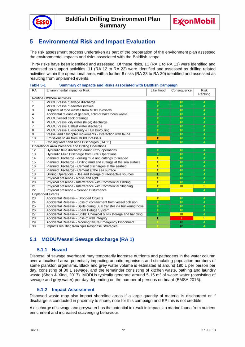
Baldfish Drilling Environment Plan Summary
Rev. 0 72 27 Jul. 18
5 Environmental Risk and Impact Evaluation
The risk assessment process undertaken as part of the preparation of the environment plan assessed the environmental impacts and risks associated with the Baldfish scope.
Thirty risks have been identified and assessed. Of these risks, 11 (RA 1 to RA 11) were identified and assessed as support activities, 11 (RA 12 to RA 22) were identified and assessed as drilling related activities within the operational area, with a further 8 risks (RA 23 to RA 30) identified and assessed as resulting from unplanned events.
Table 5-1 Summary of Impacts and Risks associated with Baldfish Campaign
RA Environmental Impact or Risk Likelihood Consequence Risk Ranking
Routine Offshore Activities
1 MODU/Vessel Sewage discharge D IV 4
2 MODU/Vessel Seawater intakes D IV 4
3 Disposal of food wastes from MODU/vessels D IV 4
4 Accidental release of general, solid or hazardous waste D IV 4
5 MODU/vessel deck drainage D IV 4
6 MODU/Vessel oily water (bilge) discharge D IV 4
7 MODU/Vessel Ballast water discharge D IV 4
8 MODU/Vessel Biosecurity & Hull Biofouling D IV 4
9 Vessel and helicopter movements - Interaction with fauna D IV 4
10 Emissions to Air from MODU/Vessels B IV 4
11 Cooling water and brine Discharges (RA 11) D IV 4
Operational Area Presence and Drilling Operations
12 Hydraulic fluid discharge during ROV operations D IV 4
13 Hydraulic Fluid Discharge from BOP Operations D IV 4
14 Planned Discharge - drilling mud and cuttings to seabed C IV 4
15 Planned Discharge - Drilling mud and cuttings at the sea surface C IV 4
16 Planned Discharge - Cement discharges at the seabed C IV 4
17 Planned Discharge - Cement at the sea surface C IV 4
18 Drilling Operations - Use and storage of radioactive sources E IV 4
19 Physical presence - Noise and light C IV 4
20 Physical presence - Interference with Commercial Fishing C IV 4
21 Physical presence - Interference with Commercial Shipping C III 3
22 Physical presence – Seabed Disturbance D III 4
Unplanned Events
23 Accidental Release – Dropped Objects D IV 4
24 Accidental Release - Loss of containment from vessel collision D IV 4
25 Accidental Release - Spills during Bulk transfer via bunkering hose D IV 4
26 Accidental Release - Foam Deluge System D IV 4
27 Accidental Release – Spills: Chemical & oils storage and handling D III 4
28 Accidental Release - Loss of well integrity E I 3
29 Accidental Release - Mooring failure/Emergency Disconnect E IV 4
30 Impacts resulting from Spill Response Strategies E IV 4
5.1 MODU/Vessel Sewage discharge (RA 1)
5.1.1 Hazard
Disposal of sewage overboard may temporarily increase nutrients and pathogens in the water column over a localised area, potentially impacting aquatic organisms and stimulating population numbers of some plankton organisms. Black and grey water volume is estimated at around 190 L per person per day, consisting of 30 L sewage, and the remainder consisting of kitchen waste, bathing and laundry waste (Shen & Xing, 2017). MODUs typically generate around 5-15 m3 of waste water (consisting of sewage and grey water) per day depending on the number of persons on board (EMSA 2016).
5.1.2 Impact Assessment
Disposed waste may also impact shoreline areas if a large quantity of material is discharged or if discharge is conducted in proximity to shore, note for this campaign and EP this is not credible.
A discharge of sewage and greywater has the potential to result in impacts to marine fauna from nutrient enrichment and increased scavenging behaviour.
Baldfish Drilling Environment Plan Summary
Rev. 0 73 27 Jul. 18
The discharge of sewage and grey water from a moving vessel is broadly acceptable due to the high level of dilution achieved on release to the receiving waters. Several studies have quantified the high levels of dilution which are in the order of approx. 200,000 – 640,000 for effluents discharged behind large ships (USEPA 2002; Loehr et al. 2006). The discharge and subsequent level of dilution was shown to be adequate for mitigating localised toxicity impacts to marine biota from any changes in water quality.
This mixing zone boundary has been studied in the industry. Monitoring of sewage discharges has demonstrated that a 10 m3 sewage discharge over 24hrs from a stationary source in shallow water, reduced to approximately 1% of its original concentration within 50 m of the discharge location. In addition to this, monitoring at distances 50, 100 and 200 m downstream of the platform and at five different water depths confirmed that discharges were rapidly diluted or nutrients rapidly metabolised and no elevations in water quality monitoring parameters (e.g. total nitrogen, total phosphorous and selected metals) were recorded above background levels at any station (NERA 2017b).
The ecological receptors with the potential to be exposed to changes in surface water quality are transient marine fauna, including whales, sharks, fish and marine reptiles. Specifically, the operational area lies within a foraging BIA for the Pygmy Blue Whale.
McIntyre and Johnson (1975) indicate that the influence of nutrients in open marine areas is much less significant than that experienced in enclosed areas and suggest that zooplankton composition and distribution are not affected in these areas. Black et al. (1994) state that BOD of treated effluent is not expected to lead to oxygen depletion in the receiving waters.
Sewage discharges promote scavenging behaviour by marine fauna or seabirds, resulting in localised increases, in turn promoting predatory behaviour. This may impact on plankton, marine mammals, fish and seabirds near the point of discharge (the operational area lies within a foraging BIA for the Pygmy Blue Whale). The rapid consumption of this food waste by scavenging fauna, and physical and microbial breakdown, ensures that the impacts of food waste discharges are insignificant and temporary, and receptors that may potentially be in the water column are not impacted.
The release of grey-water, sewage and their associated cleaning agents into the marine environment will increase nutrient availability and biological oxygen demand and potentially impact on the water quality around the discharge point. However, there have been no recent observations of phytoplankton blooms in the Gippsland Basin as a result of sewage discharge from platforms. No significant impacts are expected from the release of grey-water, sewage and their associated cleaning agents given the small quantities involved, the localised area of impact, rapid mixing in the high energy environment and high biodegradability/low persistence of the wastes.
As impacts on plankton are highly localised and temporary, impacts to the Pygmy Blue Whale (or other fauna) food source and any predator-prey dynamics is negligible. Several species of seabirds are known to have a large foraging range, and consequently may be exposed to these discharges. However, as impacts from sewage discharge on water quality is highly localised, any potential change to scavenging behaviours from seabirds is expected to be incidental.
Consequently, the potential impacts and risks from the planned discharge of sewage and greywater have been evaluated as Category 4 (low), given this type of event is very unlikely to result in localised short-term impacts to a species of conservation value (seabirds; Pygmy Blue Whale) through impacting their foraging habitat.
5.1.3 Controls
The disposal of sewage and grey-water from MODU and vessels (AHT, Standby) is required to be in accordance with MARPOL Annex IV – Regulations for the Prevention of Pollution by Sewage from Ships, which requires appropriate processing of sewage wastes prior to discharge to the marine environment, through a certified sewage treatment system in accordance with MARPOL Annex IV - Regulation 11 - Discharge of sewage).
Comminuted and disinfected sewage using a MARPOL approved system is permitted as long as no less than 3 nautical miles from nearest land, while sewage not comminuted or disinfected may be discharged as long as no less than 12 nautical miles from nearest land (AMSA Discharge Standards under Protection of the Sea (Prevention of Pollution from Ships) Act 1983, AMSA Marine Orders Part 96 - Marine Pollution Prevention (Sewage) and the Navigation Act 2012).
Baldfish Drilling Environment Plan Summary
Rev. 0 74 27 Jul. 18
Despite this, all project vessels are fitted with a MARPOL compliant sewage treatment system. Compliance of support vessel will be verified as part of premobilisation audits (Section 7.5.4). The MODU is also fitted with a MARPOL compliant sewage treatment system (Omnipure 12MX) which treats black and grey water and is suitable for a POB of 150. Sewage is disposed of onshore if the vessel cannot meet the regulatory requirements for sewage discharge. Therefore the likelihood of impacts to marine organisms within the drilling area are considered to be low. Sewage discharges are within parameters as defined within the draft Reference Case for Sewage discharges (NERA 2017b).
Maintained and operational MARPOL compliant sewage treatment facility.
A Planned Maintenance System (PMS) is in place to ensure that the MARPOL-approved sewage system continue to operate at the required standard.
OIMS System 8-1 (Evaluating, Selecting and Monitoring Third Parties) ensures MODU/vessel contractors have a certified sewage treatment system for sewage treatment prior to discharge, via the pre-mobilisation inspection of the MODU and support vessels.
5.1.4 Risk Ranking
Likelihood Consequence Risk Ranking
D IV 4
5.1.5 Demonstration of ALARP
Having a maintained and operational MARPOL compliant sewage treatment plant, confirmed by the pre-mobilisation inspection of the MODU, is considered sufficient to reduce the impacts and risks associated with this hazard to ALARP. As the nature of this risk is well understood, the activity is a well-established practice and the control measures are well established, the residual risk resulting from this activity is considered to be low (Category 4). The requirements under MARPOL for the sewage treatment plant to be operational and maintained, combined with inspection to confirm the MARPOL requirements are being complied with, are appropriate for managing the day to day risk of this activity.
The potential impact associated with this aspect is limited to a localised short-term impact, which is not considered as having the potential to affect biological diversity and ecological integrity. The activity is not considered as having the potential to result in serious or irreversible environmental damage. Consequently, no further evaluation against the principles of ESD is required. No stakeholder concerns have been raised to date regarding treated sewage discharges.
The alternatives, such as onboard holding tanks and onshore disposal, are not considered practicable due to cost considerations (i.e., the costs of implementing these measures are grossly disproportionate to the reduction in risk) and the environmental impacts (emissions, additional fuel use) associated with alternatives (onshore disposal; evaporation units). On this basis Esso considers the risk to be ALARP.
5.1.6 Demonstration of Acceptability
For this hazard the residual risk was assessed at Category 4 low risk. This is a type A ALARP decision. As all relevant standards (Esso, Australian Standards, MARPOL and Industry best practice) have been met and there were no valid claims or objections to this risk from relevant persons, Esso considers the impacts and risk are acceptable.
5.2 MODU/Vessel Seawater intakes (RA 2)
5.2.1 Hazard
Marine fauna may be trapped or entrained in seawater intakes. This may result in morbidity or mortality.
5.2.2 Impact Assessment
Open ocean intakes are equipped with coarse bar screens, which have openings between the bars of 20 mm to 150 mm followed by smaller-size screens with openings of 1 mm to 10 mm, which preclude the majority of the adult and juvenile marine organisms (fish, crabs, etc.) from entering the plants. Most marine organisms are removed by screening and downstream filtration before this seawater enters the plant.
Baldfish Drilling Environment Plan Summary
Rev. 0 75 27 Jul. 18
5.2.3 Controls
All seawater intakes on MODU and support vessels are designed so that the risk of entrapment of marine fauna is minimised.
A Planned Maintenance System is in place to ensure that grating on the seawater intakes are maintained and in good working order.
OIMS System 8-1 (Evaluating, Selecting and Monitoring Third Parties) ensures vessel design meets industry best practise with regards to seawater intakes, via the pre-mobilisation inspection of the MODU and support vessels.
5.2.4 Risk Ranking
Likelihood Consequence Risk Ranking
D IV 4
5.2.5 Demonstration of ALARP
Ensuring that the grating on the seawater intakes is in place and maintained is considered a sufficient control measure to reduce the impacts and risks associated with this hazard to ALARP.
Use of fine screens would further reduce the risk of entrapment, especially for smaller organisms. However, this would result in rapid fouling and blockages of the seawater intakes, requiring in-water intervention and /or regular disassembly to rectify. The expense, operational losses and the additional safety considerations are not considered justifiable against the benefits. This is a Type A ALARP decision, as this approach is best industry practise, the risks are well understood, and the potential impacts are low.
The potential impact is localised and short-term, and is not considered as having the potential to affect biological diversity and ecological integrity or result in serious or irreversible environmental damage. Consequently, no further evaluation against the principles of ESD is required. There were no further controls identified. On this basis Esso considers the risk to be ALARP.
5.2.6 Demonstration of Acceptability
For this hazard the residual risk was assessed as a Category 4 low risk. As all relevant standards (Esso, Australian Standards, MARPOL and Industry best practice) have been met, Esso considers the impacts and risk are acceptable.
5.3 Disposal of food wastes from MODU/vessels (RA 3)
5.3.1 Hazard
Disposal of food scraps/putrescible wastes overboard may temporarily increase nutrients in the water column over a localised area, potentially impacting aquatic organisms and stimulating population numbers of some plankton organisms, fish and seals. Ingestion by marine fauna may result in morbidity or mortality.
5.3.2 Impact Assessment
The food scraps from the vessels are required to be treated in accordance with MARPOL Annex V – Regulations for the Prevention of Pollution by Garbage from Ships (MARPOL, 2007), which requires macerating of food waste prior to discharge to the marine environment . The MODU has adopted MARPOL requirements.
Food scraps are biodegradable and macerated scraps (to <25 mm diameter) will be rapidly dispersed and assimilated in the high energy marine environment. Food scraps are disposed of onshore if the vessel cannot meet the regulatory requirements for discharge. Therefore the likelihood of impacts to marine organisms within the drilling area is considered to be low (see Section 5.1.2).
There have been no recent observations of phytoplankton blooms as a result of food scraps discharge from vessels in the Gippsland Basin. No significant impacts are expected from food waste given the small quantities involved, the localised area of impact, the rapid mixing in the high energy environment and the high biodegradability/low persistence of the wastes. Disposal of food wastes within parameters,
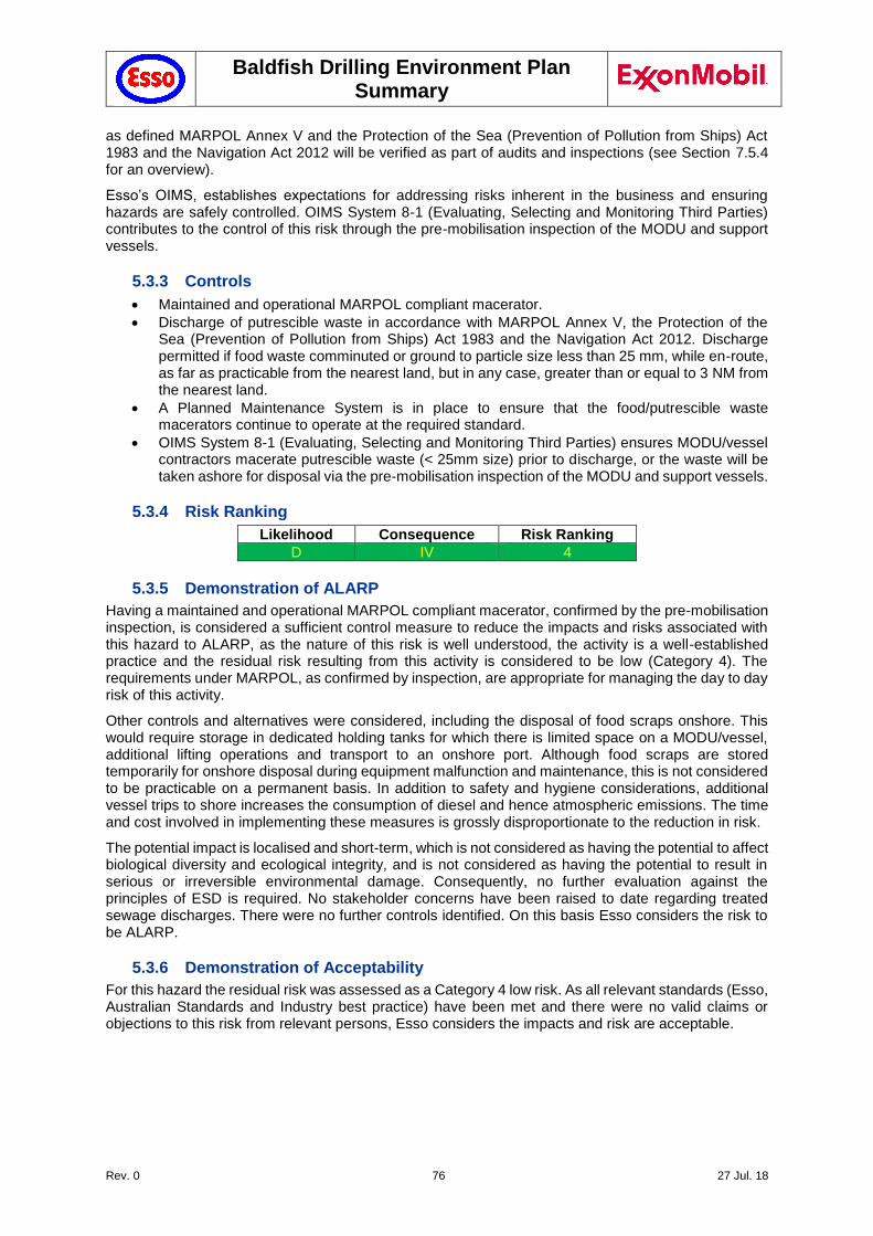
Baldfish Drilling Environment Plan Summary
Rev. 0 76 27 Jul. 18
as defined MARPOL Annex V and the Protection of the Sea (Prevention of Pollution from Ships) Act 1983 and the Navigation Act 2012 will be verified as part of audits and inspections (see Section 7.5.4 for an overview).
Esso’s OIMS, establishes expectations for addressing risks inherent in the business and ensuring hazards are safely controlled. OIMS System 8-1 (Evaluating, Selecting and Monitoring Third Parties) contributes to the control of this risk through the pre-mobilisation inspection of the MODU and support vessels.
5.3.3 Controls
Maintained and operational MARPOL compliant macerator.
Discharge of putrescible waste in accordance with MARPOL Annex V, the Protection of the Sea (Prevention of Pollution from Ships) Act 1983 and the Navigation Act 2012. Discharge permitted if food waste comminuted or ground to particle size less than 25 mm, while en-route, as far as practicable from the nearest land, but in any case, greater than or equal to 3 NM from the nearest land.
A Planned Maintenance System is in place to ensure that the food/putrescible waste macerators continue to operate at the required standard.
OIMS System 8-1 (Evaluating, Selecting and Monitoring Third Parties) ensures MODU/vessel contractors macerate putrescible waste (< 25mm size) prior to discharge, or the waste will be taken ashore for disposal via the pre-mobilisation inspection of the MODU and support vessels.
5.3.4 Risk Ranking
Likelihood Consequence Risk Ranking
D IV 4
5.3.5 Demonstration of ALARP
Having a maintained and operational MARPOL compliant macerator, confirmed by the pre-mobilisation inspection, is considered a sufficient control measure to reduce the impacts and risks associated with this hazard to ALARP, as the nature of this risk is well understood, the activity is a well-established practice and the residual risk resulting from this activity is considered to be low (Category 4). The requirements under MARPOL, as confirmed by inspection, are appropriate for managing the day to day risk of this activity.
Other controls and alternatives were considered, including the disposal of food scraps onshore. This would require storage in dedicated holding tanks for which there is limited space on a MODU/vessel, additional lifting operations and transport to an onshore port. Although food scraps are stored temporarily for onshore disposal during equipment malfunction and maintenance, this is not considered to be practicable on a permanent basis. In addition to safety and hygiene considerations, additional vessel trips to shore increases the consumption of diesel and hence atmospheric emissions. The time and cost involved in implementing these measures is grossly disproportionate to the reduction in risk.
The potential impact is localised and short-term, which is not considered as having the potential to affect biological diversity and ecological integrity, and is not considered as having the potential to result in serious or irreversible environmental damage. Consequently, no further evaluation against the principles of ESD is required. No stakeholder concerns have been raised to date regarding treated sewage discharges. There were no further controls identified. On this basis Esso considers the risk to be ALARP.
5.3.6 Demonstration of Acceptability
For this hazard the residual risk was assessed as a Category 4 low risk. As all relevant standards (Esso, Australian Standards and Industry best practice) have been met and there were no valid claims or objections to this risk from relevant persons, Esso considers the impacts and risk are acceptable.
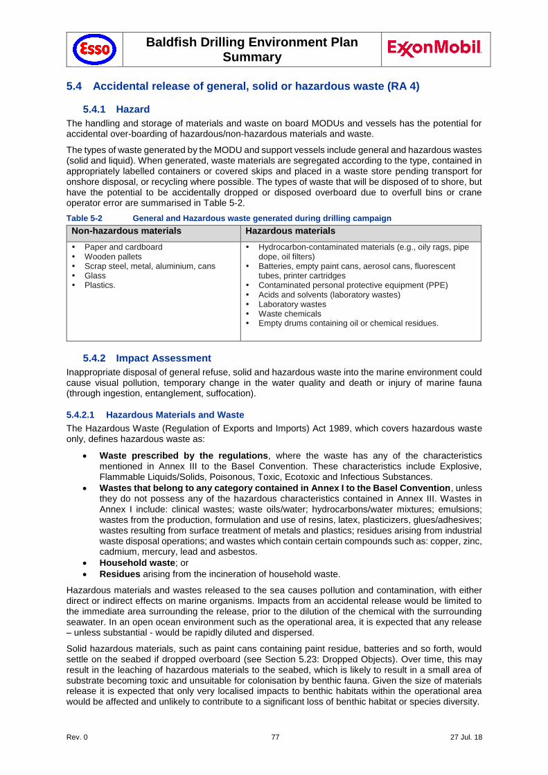
Baldfish Drilling Environment Plan Summary
Rev. 0 77 27 Jul. 18
5.4 Accidental release of general, solid or hazardous waste (RA 4)
5.4.1 Hazard
The handling and storage of materials and waste on board MODUs and vessels has the potential for accidental over-boarding of hazardous/non-hazardous materials and waste.
The types of waste generated by the MODU and support vessels include general and hazardous wastes (solid and liquid). When generated, waste materials are segregated according to the type, contained in appropriately labelled containers or covered skips and placed in a waste store pending transport for onshore disposal, or recycling where possible. The types of waste that will be disposed of to shore, but have the potential to be accidentally dropped or disposed overboard due to overfull bins or crane operator error are summarised in Table 5-2.
Table 5-2 General and Hazardous waste generated during drilling campaign
Non-hazardous materials Hazardous materials
Paper and cardboard Wooden pallets Scrap steel, metal, aluminium, cans Glass Plastics.
Hydrocarbon-contaminated materials (e.g., oily rags, pipe dope, oil filters)
Batteries, empty paint cans, aerosol cans, fluorescent tubes, printer cartridges
Contaminated personal protective equipment (PPE) Acids and solvents (laboratory wastes) Laboratory wastes Waste chemicals Empty drums containing oil or chemical residues.
5.4.2 Impact Assessment
Inappropriate disposal of general refuse, solid and hazardous waste into the marine environment could cause visual pollution, temporary change in the water quality and death or injury of marine fauna (through ingestion, entanglement, suffocation).
5.4.2.1 Hazardous Materials and Waste
The Hazardous Waste (Regulation of Exports and Imports) Act 1989, which covers hazardous waste only, defines hazardous waste as:
Waste prescribed by the regulations, where the waste has any of the characteristics mentioned in Annex III to the Basel Convention. These characteristics include Explosive, Flammable Liquids/Solids, Poisonous, Toxic, Ecotoxic and Infectious Substances.
Wastes that belong to any category contained in Annex I to the Basel Convention, unless they do not possess any of the hazardous characteristics contained in Annex III. Wastes in Annex I include: clinical wastes; waste oils/water; hydrocarbons/water mixtures; emulsions; wastes from the production, formulation and use of resins, latex, plasticizers, glues/adhesives; wastes resulting from surface treatment of metals and plastics; residues arising from industrial waste disposal operations; and wastes which contain certain compounds such as: copper, zinc, cadmium, mercury, lead and asbestos.
Household waste; or
Residues arising from the incineration of household waste.
Hazardous materials and wastes released to the sea causes pollution and contamination, with either direct or indirect effects on marine organisms. Impacts from an accidental release would be limited to the immediate area surrounding the release, prior to the dilution of the chemical with the surrounding seawater. In an open ocean environment such as the operational area, it is expected that any release – unless substantial - would be rapidly diluted and dispersed.
Solid hazardous materials, such as paint cans containing paint residue, batteries and so forth, would settle on the seabed if dropped overboard (see Section 5.23: Dropped Objects). Over time, this may result in the leaching of hazardous materials to the seabed, which is likely to result in a small area of substrate becoming toxic and unsuitable for colonisation by benthic fauna. Given the size of materials release it is expected that only very localised impacts to benthic habitats within the operational area would be affected and unlikely to contribute to a significant loss of benthic habitat or species diversity.
Baldfish Drilling Environment Plan Summary
Rev. 0 78 27 Jul. 18
All hazardous waste will be disposed of at appropriately licensed facilities, by licenced contractors, therefore impacts such as illegal dumping or disposal to an unauthorised onshore landfill that is not properly lined are unlikely to result from the project.
5.4.2.2 Non-hazardous Materials and Waste
Discharged overboard, non-hazardous wastes can cause smothering of benthic habitats as well as injury or death to marine fauna or seabirds through ingestion or entanglement (e.g., plastics caught around the necks of seals or ingested by seabirds and fish).
C&R Consulting (2009) reported that at least 77 species of marine wildlife found in Australian waters have been impacted by entanglement in, or ingestion of, plastic debris during the last three and a half decades (1974-2008). The affected species include six species of marine turtles, 12 species of cetaceans, at least 34 species of seabirds, dugongs, six species of pinnipeds, at least 10 species of sharks and rays, and at least eight other species groups.
Most records of impacts of plastic debris on wildlife relate to entanglement, rather than ingestion. However, the rate of ingestion of plastic debris by marine wildlife is difficult to assess as not all dead animals are necropsied or ingested plastic debris may not be recorded where it is not considered as the primary cause of death.
The patterns of reports of entanglement in and ingestion of plastic debris by wildlife in Australian waters are likely to be influenced by factors such as the size and distribution of populations, foraging areas, migration patterns, diets, proximity of species to urban centres, changes in fisheries equipment and practices, weather patterns, and ocean currents, as well as the frequency of monitoring and/or observation of wildlife.
Species dominating existing entanglement and ingestion records are turtles and humpback whales. Australian pelicans and a number of cormorant species are also frequently reported. If dropped objects such as bins are not retrievable by ROV, these items may permanently alter very small areas of seabed, resulting in the loss of benthic habitat. However, as with most subsea infrastructure, the items themselves are likely to become colonised by benthic fauna over time (e.g., sponges) and become a focal area for sea life, so the net environmental impact is likely to be neutral. This would affect extremely localised areas of seabed and would be unlikely to contribute to the loss of benthic habitat or species diversity.
Seals have been observed offshore with injuries from entanglement with plastic that have occurred either onshore or en-route to offshore facilities within Gippsland basin. There are no recent records of incidents associated with the disposal of floating waste to the marine environment from offshore facilities within Gippsland basin that has caused either visual pollution or death or injury to marine fauna.
Given the restricted exposures and limited quantity of marine pollution expected from this program, it is expected that any impacts from marine pollution may have an impact resulting from a localised short-term impact to species/habitats of recognised conservation value but not affecting local ecosystem functioning.
Vessels are required to be compliant with MARPOL Annex V, while MODU waste management procedures are in compliance with MARPOL Annex V (Regulations for the Prevention of Pollution by Garbage from Ships). This is enforced through AMSA Marine Order Part 95 (Marine pollution prevention — garbage) and Marine Order Part 94, (Packaged harmful substance). MARPOL Annex V requires that a garbage / waste management plan and garbage record book is in place and implemented.
Victorian legislative instruments for waste management include the Environment Protection Act 1970 (Vic) and the State Environment Protection Policy (Waters of Victoria) – Clause 47 (Ports, marinas and vessels).
Vessel waste management procedures require housekeeping provisions be made for the safe handling and storage of materials such as dirty rags, trash, waste oil, and chemicals. Flammable liquids and chemicals spilled on vessel should be immediately cleaned up. Particular care should be taken to provide proper storage for paint and chemicals.
The potential impact is localised and short-term, and is not considered as having the potential to affect biological diversity and ecological integrity, or to result in serious or irreversible environmental damage.
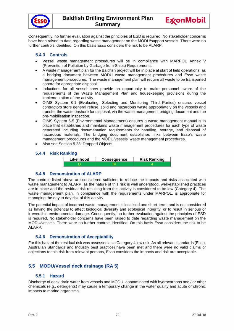
Baldfish Drilling Environment Plan Summary
Rev. 0 79 27 Jul. 18
Consequently, no further evaluation against the principles of ESD is required. No stakeholder concerns have been raised to date regarding waste management on the MODU/support vessels. There were no further controls identified. On this basis Esso considers the risk to be ALARP.
5.4.3 Controls
Vessel waste management procedures will be in compliance with MARPOL Annex V (Prevention of Pollution by Garbage from Ships) Requirements.
A waste management plan for the Baldfish project will be in place at start of field operations, as a bridging document between MODU waste management procedures and Esso waste management procedures. The waste management plan will require all waste to be transported ashore for appropriate disposal.
Inductions for all vessel crew provide an opportunity to make personnel aware of the requirements of the Waste Management Plan and housekeeping provisions during the implementation of the activity
OIMS System 8-1 (Evaluating, Selecting and Monitoring Third Parties) ensures vessel contractors store general refuse, solid and hazardous waste appropriately on the vessels and transfer the waste onshore for disposal, via the waste management bridging document and the pre-mobilisation inspection.
OIMS System 6-5 (Environmental Management) ensures a waste management manual is in place that establishes and maintains waste management procedures for each type of waste generated including documentation requirements for handling, storage, and disposal of hazardous materials. The bridging document establishes links between Esso’s waste management procedures and the MODU/vessels’ waste management procedures.
Also see Section 5.23: Dropped Objects.
5.4.4 Risk Ranking
Likelihood Consequence Risk Ranking
D IV 4
5.4.5 Demonstration of ALARP
The controls listed above are considered sufficient to reduce the impacts and risks associated with waste management to ALARP, as the nature of this risk is well understood, well-established practices are in place and the residual risk resulting from this activity is considered to be low (Category 4). The waste management plan, in compliance with the requirements under MARPOL, is appropriate for managing the day to day risk of this activity.
The potential impact of incorrect waste management is localised and short-term, and is not considered as having the potential to affect biological diversity and ecological integrity, or to result in serious or irreversible environmental damage. Consequently, no further evaluation against the principles of ESD is required. No stakeholder concerns have been raised to date regarding waste management on the MODU/vessels. There were no further controls identified. On this basis Esso considers the risk to be ALARP.
5.4.6 Demonstration of Acceptability
For this hazard the residual risk was assessed as a Category 4 low risk. As all relevant standards (Esso, Australian Standards and Industry best practice) have been met and there were no valid claims or objections to this risk from relevant persons, Esso considers the impacts and risk are acceptable.
5.5 MODU/Vessel deck drainage (RA 5)
5.5.1 Hazard
Discharge of deck drain water from vessels and MODU, contaminated with hydrocarbons and / or other chemicals (e.g., detergents) may cause a temporary change in the water quality and acute or chronic impacts to marine organisms.
Baldfish Drilling Environment Plan Summary
Rev. 0 80 27 Jul. 18
Periodic deck wash-down is necessary to prevent the build-up of dirt and grime which causes decks to become slippery and unsafe. During these wash-down events it is possible that minor diluted quantities of oil and grease, mud and chemicals may be discharged.
Spills within designated deck containment areas where chemicals, oils and wastes are stored are either pumped out to the waste oil settling tank or mopped up utilising spill clean-up materials.
5.5.2 Impact Assessment
A discharge of contaminated deck drain water has the potential to result in chronic effects to plankton through potential toxicity in the water column.
Decks or deck drains which only contain rainwater are directed overboard and all overboard drains are fitted with scupper plugs to be closed in the event of a spill on the deck. MODU drainage meets industry best practise while vessel drainage is required to meet MARPOL requirements (Annex 1: Regulations for the Prevention of Pollution by Oil). Low concentrations of contaminants are likely to be present in the overboard discharges and any localised change in water quality will rapidly disperse in the high energy marine environment; therefore the impact on marine organisms is assessed to be low.
Deck drainage onboard the MODU is separated in open and closed drain systems:
Uncontaminated open drain system: non-hazardous water from the decks (e.g. stormwater) passes through a scupper system directly to the sea by way of piping chutes or dumps.
Contaminated open drain system: Drainage from separate higher risk collection areas is led directly to the skimmer tank and automatic oily water separator (OWS). The OWS processes the fluid, passing the clean phase with less than 15 ppm oil directly to the sea and any oil is forced to the dirty oil tank for eventual disposal to shore facilities (as per bilge water). Any discharge detected with higher than 15 ppm oil is redirected back to the skimmer tank. Equipment with the potential to leak hazardous materials have coamings fitted to contain any potentially polluting fluids and these are either drained to drain tanks or emptied manually into storage containers for disposal.
Bilge water system (Section 5.6): The drainage from engine room and auxiliary machine pit bilges is collected in the dirty oil tank for eventual onshore transfer for disposal. Spent grease and lubricants for other equipment is collected in storage drums and stored in a designated hazardous storage area away from potential sources of heat or flames. All fuel and bulk lubricant disposal is fully documented using an oil record book.
Discharge of deck drainage is permissible under MARPOL Annex I (Regulations for the Prevention of Pollution by Oil), provided it meets MARPOL requirements.
The drain, effluent and waste systems onboard the MODU are designed to comply with the requirements of:
ABS Rules for Building and Classing Mobile Offshore Drilling Units 2001; and applicable updates and corrigenda’s, effective at 10 March 2006, Part 4, Chapter 2, Section 4, Fuel oil and other piping systems
IMO Code for the Construction and Equipment of Mobile Offshore Drilling Units, 1989, Chapter 9 Fire Safety
IMO International Convention for Prevention of Pollution from Ships, 1973, 1978 Protocol (MARPOL 73/78)
IMO Resolution MEPC.107(49) 2003, Revised Guidelines and Specifications for Pollution Prevention Equipment for Machinery Space Bilges of Ships.
Given the low concentration of hydrocarbon being discharged, the infrequent nature of this discharge, the rapid dispersion in the high energy marine environment, the dilution effect once discharged and the low number of sensitive receptors known to occur in the operational area, the discharge is anticipated to have little or no impact on the receiving environment.
There is potential for short-term impacts to species that rely on plankton as a food source. Any impact to prey species would be temporary as the duration of exposure would be limited, and fish larvae and other plankton are expected to rapidly recover as they are known to have high levels of natural mortality and a rapid replacement rate (UNEP 1985).
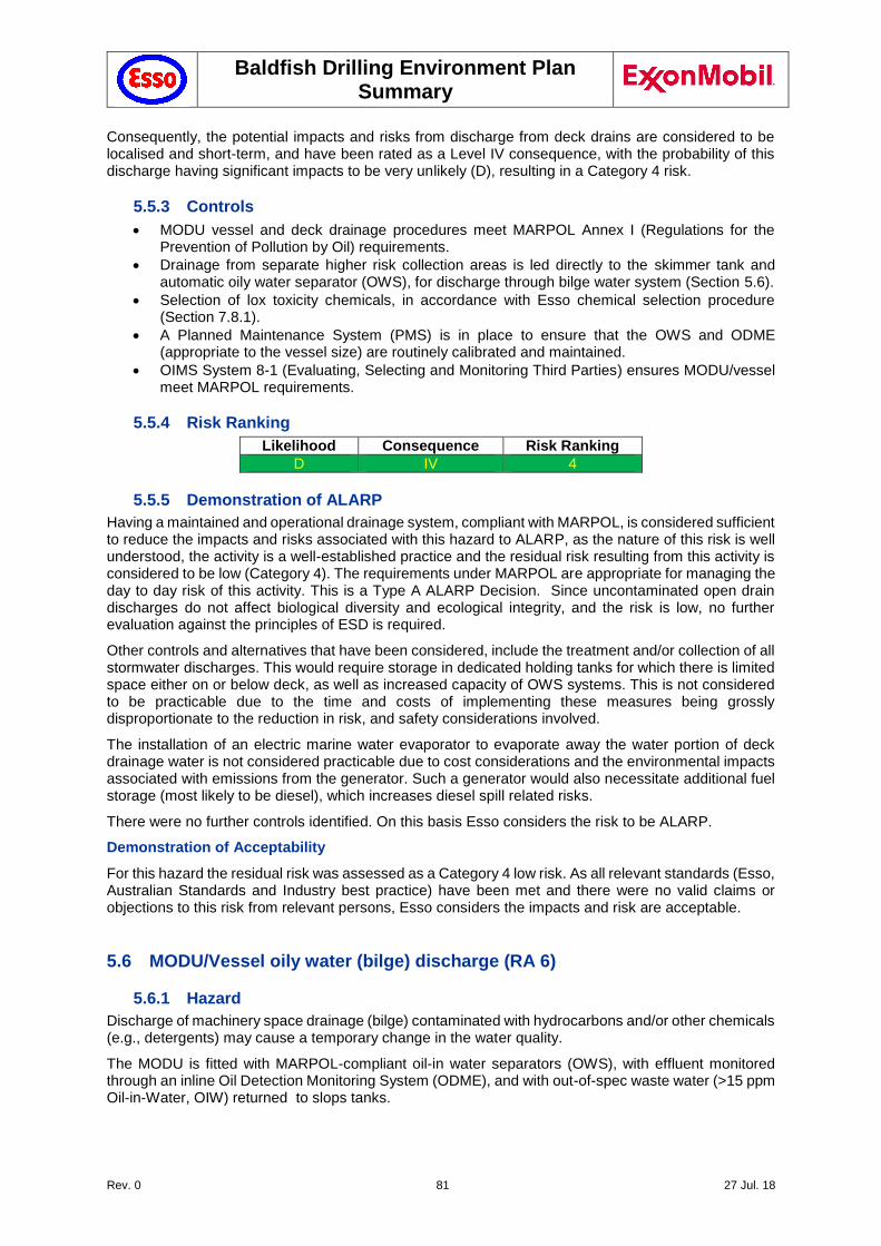
Baldfish Drilling Environment Plan Summary
Rev. 0 81 27 Jul. 18
Consequently, the potential impacts and risks from discharge from deck drains are considered to be localised and short-term, and have been rated as a Level IV consequence, with the probability of this discharge having significant impacts to be very unlikely (D), resulting in a Category 4 risk.
5.5.3 Controls
MODU vessel and deck drainage procedures meet MARPOL Annex I (Regulations for the Prevention of Pollution by Oil) requirements.
Drainage from separate higher risk collection areas is led directly to the skimmer tank and automatic oily water separator (OWS), for discharge through bilge water system (Section 5.6).
Selection of lox toxicity chemicals, in accordance with Esso chemical selection procedure (Section 7.8.1).
A Planned Maintenance System (PMS) is in place to ensure that the OWS and ODME (appropriate to the vessel size) are routinely calibrated and maintained.
OIMS System 8-1 (Evaluating, Selecting and Monitoring Third Parties) ensures MODU/vessel meet MARPOL requirements.
5.5.4 Risk Ranking
Likelihood Consequence Risk Ranking
D IV 4
5.5.5 Demonstration of ALARP
Having a maintained and operational drainage system, compliant with MARPOL, is considered sufficient to reduce the impacts and risks associated with this hazard to ALARP, as the nature of this risk is well understood, the activity is a well-established practice and the residual risk resulting from this activity is considered to be low (Category 4). The requirements under MARPOL are appropriate for managing the day to day risk of this activity. This is a Type A ALARP Decision. Since uncontaminated open drain discharges do not affect biological diversity and ecological integrity, and the risk is low, no further evaluation against the principles of ESD is required.
Other controls and alternatives that have been considered, include the treatment and/or collection of all stormwater discharges. This would require storage in dedicated holding tanks for which there is limited space either on or below deck, as well as increased capacity of OWS systems. This is not considered to be practicable due to the time and costs of implementing these measures being grossly disproportionate to the reduction in risk, and safety considerations involved.
The installation of an electric marine water evaporator to evaporate away the water portion of deck drainage water is not considered practicable due to cost considerations and the environmental impacts associated with emissions from the generator. Such a generator would also necessitate additional fuel storage (most likely to be diesel), which increases diesel spill related risks.
There were no further controls identified. On this basis Esso considers the risk to be ALARP.
Demonstration of Acceptability
For this hazard the residual risk was assessed as a Category 4 low risk. As all relevant standards (Esso, Australian Standards and Industry best practice) have been met and there were no valid claims or objections to this risk from relevant persons, Esso considers the impacts and risk are acceptable.
5.6 MODU/Vessel oily water (bilge) discharge (RA 6)
5.6.1 Hazard
Discharge of machinery space drainage (bilge) contaminated with hydrocarbons and/or other chemicals (e.g., detergents) may cause a temporary change in the water quality.
The MODU is fitted with MARPOL-compliant oil-in water separators (OWS), with effluent monitored through an inline Oil Detection Monitoring System (ODME), and with out-of-spec waste water (>15 ppm Oil-in-Water, OIW) returned to slops tanks.
Baldfish Drilling Environment Plan Summary
Rev. 0 82 27 Jul. 18
5.6.2 Impact Assessment
A discharge of contaminated bilge water has the potential to result in chronic effects to plankton through potential toxicity in the water column.
Marine equipment and machinery spaces on the MODU/vessels are fully contained and have dedicated drains leading to the oily water separator system, which is required to comply with MARPOL and is tested and certified to verify compliance. Oily residues/concentrate generated in this process are containerised in transit tanks and returned to shore for disposal at licenced waste disposal facilities. Each shipment of wastes to shore is accompanied by a manifest and recorded in the shipboard oil record book.
Discharge of treated effluent from vessel bilges is permissible under MARPOL Annex I (Regulations for the Prevention of Pollution by Oil), provided it meets MARPOL requirements for vessels over 400 T (MARPOL compliant OWS, OIW <15 ppm, ODMS), and vessels contracted to undertake activities for Esso are equipped with an oil-water separator capable of achieving effluent standards specified by the Marine Environment Protection Committee of the IMO.
The drain, effluent and waste systems onboard the MODU are designed to comply with the requirements of:
ABS Rules for Building and Classing Mobile Offshore Drilling Units 2001; and applicable updates and corrigenda’s, effective at 10 March 2006, Part 4, Chapter 2, Section 4, Fuel oil and other piping systems
IMO Code for the Construction and Equipment of Mobile Offshore Drilling Units, 1989, Chapter 9 Fire Safety
IMO International Convention for Prevention of Pollution from Ships, 1973, 1978 Protocol (MARPOL 73/78)
IMO Resolution MEPC.107(49) 2003, Revised Guidelines and Specifications for Pollution Prevention Equipment for Machinery Space Bilges of Ships.
OSPAR (2014) indicates that the predicted no effect concentration (PNEC) for marine organisms exposed to dispersed oil is 70.5 ppb. It should be noted that this PNEC is based upon no observed effect concentrations (NOEC) after exposure to certain concentrations for an extended period that was greater than 7 days (OSPAR 2014).
USEPA (2002) modelled the plume off liquid discharges, in addition to tracking the plume of liquid. The effluent was marked with a fluorescent dye for tracing dilution rates in the plume. Predicted initial dilution rate was 40,000:1, whereas measured values varied between 200,000:1 and 640,000:1.
Given the low concentration of hydrocarbon being discharged, the infrequent nature of this discharge, the rapid dispersion in the high energy marine environment, the dilution effect once discharged and the low number of sensitive receptors known to occur in the operational area, the discharge is anticipated to have little or no impact on the receiving environment.
There is potential for short-term impacts to species that rely on plankton as a food source. Any impact to prey species would be temporary as the duration of exposure would be limited, and fish larvae and other plankton are expected to rapidly recover as they are known to have high levels of natural mortality and a rapid replacement rate (UNEP 1985).
Consequently, the potential impacts and risks from planned discharge of treated bilge are considered to be localised and short-term, and have been rated as a Level IV consequence, with the probability of this discharge having significant impacts being very unlikely (D), resulting in a Category 4 risk.
5.6.3 Controls
Maintained and operational oily water separator and oil in water analyser compliant with MARPOL Annex I: Regulations for the Prevention of Pollution by Oil
MODU procedures for oily water discharges
OIMS System 8-1 (Evaluating, Selecting and Monitoring Third Parties) ensures MODU/vessels meet MARPOL requirements.
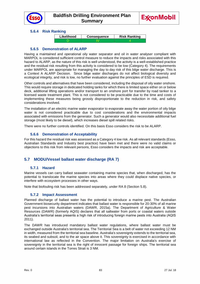
Baldfish Drilling Environment Plan Summary
Rev. 0 83 27 Jul. 18
5.6.4 Risk Ranking
Likelihood Consequence Risk Ranking
D IV 4
5.6.5 Demonstration of ALARP
Having a maintained and operational oily water separator and oil in water analyser compliant with MARPOL is considered sufficient control measure to reduce the impacts and risks associated with this hazard to ALARP, as the nature of this risk is well understood, the activity is a well-established practice and the residual risk resulting from this activity is considered to be low (Category 4). The requirements under MARPOL are appropriate for managing the day to day risk of this bilge water discharge. This is a Context A ALARP Decision. Since bilge water discharges do not affect biological diversity and ecological integrity, and risk is low, no further evaluation against the principles of ESD is required.
Other controls and alternatives that have been considered, including the disposal of oily water onshore. This would require storage in dedicated holding tanks for which there is limited space either on or below deck, additional lifting operations and/or transport to an onshore port for transfer by road tanker to a licensed waste treatment plant. This is not considered to be practicable due to the time and costs of implementing these measures being grossly disproportionate to the reduction in risk, and safety considerations involved.
The installation of an electric marine water evaporator to evaporate away the water portion of oily bilge water is not considered practicable due to cost considerations and the environmental impacts associated with emissions from the generator. Such a generator would also necessitate additional fuel storage (most likely to be diesel), which increases diesel spill related risks.
There were no further controls identified. On this basis Esso considers the risk to be ALARP.
5.6.6 Demonstration of Acceptability
For this hazard the residual risk was assessed as a Category 4 low risk. As all relevant standards (Esso, Australian Standards and Industry best practice) have been met and there were no valid claims or objections to this risk from relevant persons, Esso considers the impacts and risk are acceptable.
5.7 MODU/Vessel ballast water discharge (RA 7)
5.7.1 Hazard
Marine vessels can carry ballast seawater containing marine species that, when discharged, has the potential to translocate the marine species into areas where they could displace native species, or interfere with ecosystem processes in other ways.
Note that biofouling risk has been addressed separately, under RA 8 (Section 5.8).
5.7.2 Impact Assessment
Planned discharge of ballast water has the potential to introduce a marine pest. The Australian Government biosecurity department indicates that ballast water is responsible for 20-30% of all marine pest incursions into Australian waters (DAWR, 2015a). The Department of Agriculture & Water Resources (DAWR) (formerly AQIS) declares that all saltwater from ports or coastal waters outside Australia’s territorial seas presents a high risk of introducing foreign marine pests into Australia (AQIS 2011).
The DAWR has introduced mandatory ballast water regulations, where ballast water must be exchanged outside Australia's territorial sea. The Territorial Sea is a belt of water not exceeding 12 NM in width, measured from the territorial sea baseline. Australia's sovereignty extends to the territorial sea, its seabed and subsoil, and to the air space above it. This sovereignty is exercised in accordance with international law as reflected in the Convention. The major limitation on Australia's exercise of sovereignty in the territorial sea is the right of innocent passage for foreign ships. The territorial sea around certain islands in the Torres Strait is 3 NM.
Baldfish Drilling Environment Plan Summary
Rev. 0 84 27 Jul. 18
This measure greatly reduces the risk of Invasive Marine Pests (IMPs) from international shipping, so that the risk of IMP introduction into territorial waters from international shipping should be negligible to low. Risk from ballast water exchange by domestic ships within the territorial sea (e.g. at any Australian port) depends on where the ballast water was last acquired.
The Marine Pests Interactive Map (DAFF 2017) indicates that ports such as Portland, Geelong, Melbourne and Eden are known to harbour the following species:
Northern pacific sea star – See Section 5.8.2.
European shore crab – See Section 5.8.2.
New Zealand screw shell – See Section 5.8.2
European fan worms (Sabella spallanzannii and Euchone sp.) – attaches to hard surfaces, artificial structures and soft sediments, preferring sheltered waters up to 30 m deep. It reached Port Phillip Bay in the mid-1980s and is a nuisance fouler (ParksVic 2017).
Japanese kelp (Undaria pinnatifida) – occupies cold temperate oceanic waters up to 20 m deep, growing on rock, reef, stones and artificial structures. It rapidly forms dense forests and overgrows native species. It first established in Port Phillip Bay in the 1980s (ParksVic 2017).
Asian date mussel (Musculista senhousia) – prefers soft sediments in waters up to 20 m deep, forming mats and altering food availability for marine fauna.
European shell clam (Varicorbula gibba) – burrows into soft-bottomed habitats in waters up to 150 m deep in temperate waters, forming mats and altering food availability for marine fauna.
These species have the potential to be picked up in the ballast water and transferred to other areas. Two of these species (Pacific oyster and European green crab) are also known to occur in the Gippsland Lakes (Hirst & Bott 2016).
The known and potential impacts of IMP introduction include:
Reduction in native marine species diversity and abundance;
Displacement of native marine species;
Socio-economic impacts on commercial fisheries; and
Changes to conservation values of protected areas.
No ballast water discharge or exchange is expected to occur within the Australian territorial sea boundary. Open-ocean ballast water discharge or exchange is considered the best compromise between efficacy, environmental safety and economic practicality to manage the potential risk if IMPs (DOF 2009). The two key assumptions underpinning this are:
Changes in biological condition (including salinity) of source and recipient waters (i.e. coastal or estuarine IMPs) are presumed unlikely to survive in ocean waters, and vice versa.
The transport of viable released non-indigenous organisms from open-ocean to coastal and estuarine waters, by ocean currents, is considered extremely unlikely.
Research indicates that biofouling has been responsible for more foreign marine introductions than ballast water (DAWR 2015b). Section 5.8 (Vessel Biosecurity) provides an overview of recent biosecurity incidents in Victorian waters, largely relating to hull biofouling.
The potential risks from ballast water discharge are considered to be low, considering that support vessels and MODU are operating well outside the Australian Territorial Sea, are required to meet Australian Ballast Water Management Requirements (DAWR 2017). The MODU and support vessels have been continuously operating in Australian waters, thereby further reducing this risk. Consequently, this risk has been rated as a Level IV consequence, with the probability of ballast water impacts to be very unlikely (D), resulting in a Category 4 risk.
5.7.3 Controls
All project vessels have fulfilled the requirements of the Australian Ballast Water Management Requirements (DAWR 2017) if they have mobilised from outside of Australian territorial waters.
Under the Biosecurity Act 2015, pre-arrival information must be reported through the Maritime Arrivals Reporting System (MARS) before arriving in Australian waters.
Vessel adherence to the Australian Ballast Water Management Requirements (DAWR 2017)
Vessels only discharge low-risk domestic ballast water into Victorian state waters (on entry to a Victorian port and throughout the survey) in accordance with:
Baldfish Drilling Environment Plan Summary
Rev. 0 85 27 Jul. 18
The Victorian Environment Protection (Ships Ballast Water) Regulations 2017 (EPA 2017a).
EPA Protocol for Environmental Management (PEM): Domestic Ballast Water Management in Victorian Waters (Publication 949.7, EPA 2017b).
DAWR Ballast water risk assessment undertaken (Australian Ballast Water Management Information Tool1) and submitted by the Vessel Master prior to entering Victorian state waters (https://management.marinepests.gov.au/bw/).
Non-compliant discharges of domestic ballast water are reported to the EPA Victoria immediately.
Suspected or known introductions of IMS will be reported to the DELWP immediately.
OIMS System 8-1 (Evaluating, Selecting and Monitoring Third Parties) requires pre-mobilisation inspection to ensure MODU/vessel contractors comply with the requirements of the Biosecurity Act which includes exchange at sea outside of Australian territorial waters for ‘high risk’ ballast water from port or coastal waters.
5.7.4 Risk Ranking
Likelihood Consequence Risk Ranking
D IV 4
5.7.5 Demonstration of ALARP
Compliance with Australian Ballast Water Management Requirements (DAWR 2017) is considered a sufficient control measure to reduce the impacts and risks associated with this hazard to ALARP, as the nature of this risk is well understood, the activity is a well-established practice and the residual risk resulting from this activity is considered to be low (Category 4). This is a Context A ALARP Decision.
The project aims to use vessels / MODUs that are currently operating in Commonwealth Waters to reduce the potential for introducing IMS. However, use of international vessels (e.g. during well intervention / source control; Section 6.5) cannot be fully eliminated. Limiting vessel / MODU selection to use of those currently operating in Commonwealth Waters could potentially pose a significant risk in terms of time and duration for sourcing a vessel, as well as the ability of those chosen to perform the required tasks. This potential cost is grossly disproportionate to the minor environmental gain (of reducing the potential likelihood of IMS introduction) achieved, and is not reasonably practicable.
There is potential for a localised, but irreversible, impact to benthic communities. However, Baldfish operations are in deep water (>350m), and a long distance from the shore (90 km), so that the potential for irreversible impacts is very unlikely to affect biological diversity and ecological integrity.
Further considerations against the remaining Principles of ESD include that there is little uncertainty associated with this aspect as the activities are well known, the cause pathways are well known, and activities are well regulated and managed. It is not considered that there is significant scientific uncertainty associated with this aspect. Therefore, the precautionary principle has not been applied.
Other controls and alternatives were considered, including the use of ballast free vessels; however ballast free vessels are not commercially available or viable. No stakeholder concerns have been raised for this risk. On this basis Esso considers the risk to be ALARP.
5.7.6 Demonstration of Acceptability
For this hazard the residual risk was assessed as a Category 4 low risk. As all relevant standards (Esso, Australian Standards and Industry best practice) have been met and there were no valid claims or objections to this risk from relevant persons, Esso considers the impacts and risk are acceptable.
1 Developed by the Australian Ballast Water Unit (ABWU), custodian of the of Australian Ballast Water Management
Infoirmation System (ABWMIS)
Baldfish Drilling Environment Plan Summary
Rev. 0 86 27 Jul. 18
5.8 MODU/Vessel Biosecurity & Hull Biofouling (RA 8)
5.8.1 Hazard
Biological fouling on MODU/vessel hulls has the potential to translocate marine species into areas where they could displace native species or interfere with ecosystem processes in other ways.
International goods also have the potential to introduce non-native species into Australia.
5.8.2 Impact Assessment
In the South-east Marine Region, 115 marine pest species have been introduced and an additional 84 have been identified as possible introductions, or ‘cryptogenic’ species (NOO 2002). Several introduced species have become pests either by displacing native species, dominating habitats or causing algal blooms.
Marine pests known to occur in South Gippsland, according to ParksVic (2017o) and VEAC (2014) include:
Pacific oyster (Crassostrea gigas) – small number of this oyster species are reported to occur in Western Port Bay and at Tidal River in the Wilsons Promontory National Park (DELWP, 2015).
Northern pacific seastar (Asterias amurensis) – prefer soft sediment habitat, but also use artificial structures and rocky reefs, living in water depths usually less than 25 m (but up to 200 m water depths). It is thought to have been introduced in 1995 through ballast water from Japan.
New Zealand screw shell (Maoricolpus roseus) – lies on or partially buried in sand, mud or gravel in waters up to 130 m deep. It can densely blanket the sea floor with live and dead shells and compete with native scallops and other shellfish for food. This species is present in eastern Bass Strait, forming extensive and dense beds on sandy seabeds (Patil et al., 2004). It is known to occur in the Point Hicks Marine National Park.
European shore crab (Carcinus maenas) – prefers intertidal areas, bays, estuaries, mudflats and subtidal seagrass beds, but occurs in waters up to 60 m deep. It is presumed to occur on the intertidal reefs of all the marine national parks in Gippsland, except the Ninety Mile Beach MNP (which has no intertidal reef).
Successful Invasive Marine Species (IMS) invasion requires the following three steps:
1. Colonisation and establishment of the marine pest on a vector (e.g., vessel hull) in a donor region (e.g., home port).
2. Survival of the settled marine species on the vector during the voyage from the donor to the recipient region (e.g., project area).
3. Colonisation (e.g., dislodgement or reproduction) of the marine species in the recipient region, followed by successful establishment of a viable new local population.
At this point, the IMS is likely to have little or no natural competition or predation, thus potentially outcompeting native species for food or space, preying on native species or changing the nature of the environment.
Marine pest species can also deplete fishing grounds and aquaculture stock, with between 10% and 40% of Australia’s fishing industry being potentially vulnerable to marine pest incursion (AMSA n.d.). For example, the introduction of the Northern Pacific seastar (Asterias amurensis) in Victorian and Tasmanian waters was linked to a decline in scallop fisheries.
Maintenance plans for vessels are in place and include dry-docking, inspection and re-application of anti-fouling systems. This ensures that impacts from biofouling are minimised. The MODU was subjected to a biofouling inspection prior to mobilisation to Australian waters (Singapore, May 2017) and has been continuously operating in Australian Waters since that inspection. Support vessel are also planned to be sourced from those already operating in Australian waters. Nonetheless, all project vessels must undertake an IMS risk assessment, in accordance with the Esso Invasive Marine Species - Risk Assessment Procedure (IMS-RAP). IMS-RAP evaluates the following parameters:
Transport method (dry verses wet haulage)
Presence and age of antifouling coating (AFC)
Baldfish Drilling Environment Plan Summary
Rev. 0 87 27 Jul. 18
Evidence of recent dry dock or in-water IMS inspections and cleaning
Presence and operation of internal seawater treatment systems if applicable
Duration of stay in overseas or interstate coastal waters
IMS risk assessment is based on the "Vessel Check Risk Assessment Tool", developed by WA Department of Fisheries (DOF 2015).
The known and potential impacts of IMS introduction include:
Reduction in native marine species diversity and abundance;
Displacement of native marine species;
Socio-economic impacts on commercial fisheries; and
Changes to conservation values of protected areas.
There is potential for a localised, but irreversible, impact to benthic communities. However, Baldfish operations are in deep water (>350m), and a long distance from the shore (90 km), so that the potential for irreversible impacts is very unlikely to affect biological diversity and ecological integrity. The two key assumptions underpinning this are:
Changes in biological condition (including salinity) of source and recipient waters (i.e. coastal or estuarine IMPs) are presumed unlikely to survive in ocean waters, and vice versa.
The transport of viable released non-indigenous organisms from open-ocean to coastal and estuarine waters, by ocean currents, is considered extremely unlikely.
Research indicates that biofouling has been responsible for more foreign marine introductions than ballast water (DAWR 2015b).
The project aims to use vessels / MODUs that are currently operating in Commonwealth Waters to reduce the potential for introducing IMS. Additionally, the expectation is that all project vessels, except the supply vessel, will remain in deep water, outside the Australia's territorial sea (>12 NM from shore), where IMS risk is considered to be insignificant (se IMS-RAP and DOF 2015 for details).
The potential risk from hull biofouling is considered to be low, given that support vessels and MODU are operating well outside the Australian Territorial Sea (>12 NM from nearest shore). However, use of international vessels (e.g. during well intervention / source control; Section 6.5), and entry into Australia's territorial sea (<12 NM from shore) cannot be fully eliminated. All project vessels will undergo an IMS risk assessment as part of vessel pre-mobilisation inspection, using the Esso IMS-RAP. Additionally, all vessels are required to abide by the National Biofouling Management Guidance for the Petroleum Production and Exploration Industry (AQIS 2009).
Limiting vessel / MODU selection to use of those currently operating in Commonwealth Waters could potentially pose a significant risk in terms of time and duration for sourcing a vessel, as well as the ability of those chosen to perform the required tasks. This potential cost is grossly disproportionate to the environmental gain achieved by further reducing the potential likelihood of IMS introduction, and is not reasonably practicable.
5.8.3 Controls
Prior to mobilisation in the field a risk assessment for vessels originating from international ports will be performed in accordance with the National Biofouling Management Guidance for the Petroleum Production and Exploration Industry (DAFF 2009) and Esso IMS-RAP.
The following control measures will be implemented to minimise the risk of introduction of IMS:
Esso undertakes a vessel contractor pre-qualification, including IMS-RAP, to ensure vessel biofouling risk is acceptable in accordance with:
National Biofouling Management Guidance for the Petroleum Production and Exploration Industry (DAFF 2009c), and
IMO guidelines for the control and management of ships' biofouling to minimize the transfer of invasive aquatic species (IMO 2011; RESOLUTION MEPC.207(62). Adopted on 15 July 2011).
For vessels <500 gross tonnes and/or <50 m in length, Esso will use the IMCA Marine Inspection for Small Workboats Inspection Template (IMCA, 2016) as part of the pre-qualification process.
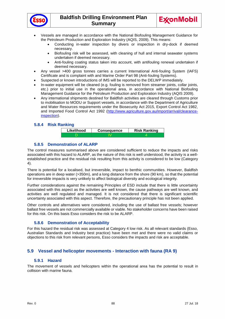
Baldfish Drilling Environment Plan Summary
Rev. 0 88 27 Jul. 18
Vessels are managed in accordance with the National Biofouling Management Guidance for the Petroleum Production and Exploration Industry (AQIS, 2009). This means:
Conducting in-water inspection by divers or inspection in dry-dock if deemed necessary.
Biofouling risk will be assessed, with cleaning of hull and internal seawater systems undertaken if deemed necessary.
Anti-fouling coating status taken into account, with antifouling renewal undertaken if deemed necessary.
Any vessel >400 gross tonnes carries a current International Anti-fouling System (IAFS) Certificate and is complaint with and Marine Order Part 98 (Anti-fouling Systems).
Suspected or known introductions of IMS will be reported to the DELWP immediately.
In-water equipment will be cleaned (e.g. fouling is removed from streamer joints, collar joints, etc.) prior to initial use in the operational area, in accordance with National Biofouling Management Guidance for the Petroleum Production and Exploration Industry (AQIS 2009).
Any international shipments destined for Baldfish activities are cleared through Customs prior to mobilisation to MODU or Support vessels, in accordance with the Department of Agriculture and Water Resources requirements under the Biosecurity Act 2015, Export Control Act 1982, and Imported Food Control Act 1992 (http://www.agriculture.gov.au/import/arrival/clearance-inspection).
5.8.4 Risk Ranking
Likelihood Consequence Risk Ranking
D IV 4
5.8.5 Demonstration of ALARP
The control measures summarised above are considered sufficient to reduce the impacts and risks associated with this hazard to ALARP, as the nature of this risk is well understood, the activity is a well-established practice and the residual risk resulting from this activity is considered to be low (Category 4).
There is potential for a localised, but irreversible, impact to benthic communities. However, Baldfish operations are in deep water (>350m), and a long distance from the shore (90 km), so that the potential for irreversible impacts is very unlikely to affect biological diversity and ecological integrity.
Further considerations against the remaining Principles of ESD include that there is little uncertainty associated with this aspect as the activities are well known, the cause pathways are well known, and activities are well regulated and managed. It is not considered that there is significant scientific uncertainty associated with this aspect. Therefore, the precautionary principle has not been applied.
Other controls and alternatives were considered, including the use of ballast free vessels; however ballast free vessels are not commercially available or viable. No stakeholder concerns have been raised for this risk. On this basis Esso considers the risk to be ALARP.
5.8.6 Demonstration of Acceptability
For this hazard the residual risk was assessed at Category 4 low risk. As all relevant standards (Esso, Australian Standards and Industry best practice) have been met and there were no valid claims or objections to this risk from relevant persons, Esso considers the impacts and risk are acceptable.
5.9 Vessel and helicopter movements - Interaction with fauna (RA 9)
5.9.1 Hazard
The movement of vessels and helicopters within the operational area has the potential to result in collision with marine fauna.

Baldfish Drilling Environment Plan Summary
Rev. 0 89 27 Jul. 18
5.9.2 Impact Assessment
Vessel collision with marine fauna can lead to injury or mortality of sensitive marine species. Several whale species are known to transit through Bass Strait on annual migration and may occur within the Baldfish Operational area, including those listed as either threatened and/or migratory under the EPBC Act (Section 3.6.12). Dolphins, seals and turtle species may also frequent the Baldfish operational area, although seals are not expected to frequently venture as far out as the Baldfish Operational area (see Section 3.6.11). Seabirds may also be found around the MODU and support vessels, and have been reported to use these structures as a resting place, and may be attracted by fish which tend to concentrate around offshore facilities.
The Baldfish operational area lies in a busy shipping route (Section 3.8). The establishment of temporary fairways around the Baldfish operational area (Section 5.21.2.1 and Figure 5-3) reduces the risk of fauna interactions by third party commercial vessels, but does not eliminate this risk for project vessels. As there are no aggregation or feeding areas in the Baldfish operational area, the presence of whales is expected to be transient and occasional and therefore the risk of impacts to cetaceans is considered to be low.
Cetaceans are naturally inquisitive marine mammals that are often attracted to offshore vessels and facilities. The reaction of whales to the approach of a vessel is quite variable. Some species remain motionless when in the vicinity of a vessel, while others are curious and often approach ships that have stopped or are slow moving, although they generally do not approach, and sometimes avoid, faster-moving ships (Richardson et al. 1995).
Collisions between larger vessels with reduced manoeuvrability and large, slow-moving cetaceans occur more frequently where high vessel traffic and cetacean habitat occurs (Dolman et al. 2006). Laist et al. (2001) identified that larger vessels with reduced manoeuvrability moving in excess of 10 knots may cause fatal or severe injuries to cetaceans, with the most severe injuries caused by vessels travelling faster than 14 knots.
Baldfish support vessels typically have a high level of manoeuvrability (DP) and would not be moving at these speeds while in the Baldfish operational area. The MODU is stationary, except when moving between well locations, when transit speeds are low (typically less than 2 knots).
Fur seals use Esso operational facilities in the Gippsland Basin as a resting place and as a source of food, and this may result in vessel interactions near these facilities.
Peel et al. (2016) reviewed vessel strike data for marine species in Australian waters:
Whales were identified as having interacted with vessels. Of these, interaction with the Humpback Whale and the Southern Right Whale was most frequent.
Dolphins were also identified as interacting with vessels, with interaction with the Common Bottlenose Dolphin most common.
No vessel interactions were reported for the Australian or New Zealand Fur Seal, although seal injury by boat propellers has been reported, often resulting from the seal interacting/playing with a boat. The incidence of boat strike for seals is thought to be very low.
All vessels, when in the field, adopt proximity / speed restrictions near cetaceans as provided in the EPBC Regulations Part 8: Interacting with cetaceans and whale watching (DoEE 2000). Cetaceans tend to practice avoidance around vessels with high noise signatures and therefore the likelihood of a cetacean strike is considered very unlikely. There have been no reported recent incidents of cetacean strikes across all Bass Strait operational areas.
Esso’s helicopter traffic flies at slow speeds near operational areas, for safety reasons, enabling pilots to take avoidance action if seabirds are present on the helideck; however, there have been isolated recent incidents of bird strikes (individuals only) during Esso helicopter operations in Bass Strait. Impacts to seabirds are considered to be low.
The duration of fauna exposure to vessel strike is limited to the duration of Baldfish field operations (expected to be approximately 60 days). If a fauna strike occurred and resulted in death, it is not expected that it would have a detrimental effect on the overall population.
Consequently, the potential impacts and risks from vessel or helicopter interaction with fauna are considered to be localised and short-term, as this type of event may result in impact to individuals from a species of recognised conservation value but is not expected to affect the population or local
Baldfish Drilling Environment Plan Summary
Rev. 0 90 27 Jul. 18
ecosystem function. The consequence has been rated as Level IV, with the probability very unlikely (D), resulting in a Category 4 risk.
5.9.3 Controls
Vessel masters will be briefed on caution and ‘no approach zones’ and interaction management actions as defined in the EPBC Regulations 2000 – Part 8 Division 8.1
A vessel master (or delegate) will be on duty at all times
Vessels adhere to the distances and vessel management practices of EPBC Regulations (Part 8) and Wildlife (Marine Mammals) Regulations 2009 (Part 3(9)):
Vessels will travel at less than 5 knots within the caution zone of a cetacean and minimise noise (Caution Zone is 150m radius for dolphins, 300 m for whales and 50m for seals).
The vessel must not drift closer than 50 m (dolphins and seals) and 100 m (whale);
If whale comes within above limits, the vessel master must disengage gears and let the whale approach or reduce the speed of the vessel and continue on a course away from the whale;
The vessel must not restrict the path of a marine mammal.
The vessel must not separate any individual from a group of marine mammals or come between a mother whale and calf or a seal and pup;
If the vessel is within the caution zone of a marine mammal the vessel must move at a constant speed that does not exceed 5 knots, avoids sudden changes in speed or direction and manoeuvres the vessel to outside the caution zone if the marine mammal shows any sign of disturbance;
Additionally, if a vessel is within the caution zone of a marine mammal, the vessel shall not approach a marine mammal from head on, from the rear or be in the path ahead of a marine mammal at an angle closer than 30° to its observed direction of travel.
A helicopter maintains a minimum distance of 500-metre from a marine mammal in accordance EPBC Regulations (Part 8) and Wildlife (Marine Mammals) Regulations 2009 Part 3(8). Further it will not:
approach a marine mammal from head on;
fly directly over or pass the shadow of the aircraft directly over a marine mammal;
land on water to observe marine mammals
operate a helicopter in the vicinity of a marine mammal if the marine mammal shows signs of disturbance.
Unless it is necessary for the helicopter to:
avoid damage or prevent further damage to person or property; allow take-off or landing
comply with an Act or regulations relating to the operation of a helicopter.
Trained crew members on active duty will report observations of megafauna located within the cautionary zone (as defined in The Australian Guidelines for Whale and Dolphin Watching) to the vessel master (or their delegate), as soon as it is safe to do so.
All personnel have completed an environmental induction covering the requirements for marine mammal/vessel interaction consistent with EPBC Regulations 2000 (Chapter 8) and Victorian Wildlife (Marine Mammals) Regulations 2009 (Part 2/Part 3) and are familiar with the requirements. This includes a requirement to notify the bridge if marine mammals are sighted in the caution zone.
Any injury to, or mortality of, an EPBC Act Listed Threatened or Migratory Species (including those from a vessel strike) will be recorded on the National Ship Strike database within 72 hours (https://data.marinemammals.gov.au/report/shipstrike).
OIMS System 8-1 (Evaluating, Selecting and Monitoring Third Parties) ensures vessel contractors have adopted these procedures to maintain adequate standoff distance from marine mammals (where possible and safe to do so) as they move into and out of the operational area, and employ avoidance measures such as reducing speed (where possible and safe to do so) should listed marine species (such as cetaceans or seals) be sighted.
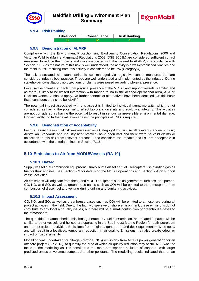
Baldfish Drilling Environment Plan Summary
Rev. 0 91 27 Jul. 18
5.9.4 Risk Ranking
Likelihood Consequence Risk Ranking
D IV 4
5.9.5 Demonstration of ALARP
Compliance with the Environment Protection and Biodiversity Conservation Regulations 2000 and Victorian Wildlife (Marine Mammals) Regulations 2009 (DSE 2009b) are considered sufficient control measures to reduce the impacts and risks associated with this hazard to ALARP, in accordance with Section 7.1.5, as the nature of this risk is well understood, the activity is a well-established practice and the residual risk resulting from this activity is considered to be low (Category 4).
The risk associated with fauna strike is well managed via legislative control measures that are considered industry best practice. These are well understood and implemented by the industry. During stakeholder consultation, no objections or claims were raised regarding physical presence.
Because the potential impacts from physical presence of the MODU and support vessels is limited and as there is likely to be limited interaction with marine fauna in the defined operational area, ALARP Decision Context A should apply. No further controls or alternatives have been identified. On this basis Esso considers the risk to be ALARP.
The potential impact associated with this aspect is limited to individual fauna mortality, which is not considered as having the potential to affect biological diversity and ecological integrity. The activities are not considered as having the potential to result in serious or irreversible environmental damage. Consequently, no further evaluation against the principles of ESD is required.
5.9.6 Demonstration of Acceptability
For this hazard the residual risk was assessed as a Category 4 low risk. As all relevant standards (Esso, Australian Standards and Industry best practice) have been met and there were no valid claims or objections to this risk from relevant persons, Esso considers the impacts and risk are acceptable in accordance with the criteria defined in Section 7.1.6.
5.10 Emissions to Air from MODU/Vessels (RA 10)
5.10.1 Hazard
Supply vessel fuel combustion equipment usually burns diesel as fuel. Helicopters use aviation gas as fuel for their engines. See Section 2.3 for details on the MODU operations and Section 2.4 on support vessel activities.
Air emissions will originate from these and MODU equipment such as generators, turbines, and pumps. CO, NOx and SOx as well as greenhouse gases such as CO2 will be emitted to the atmosphere from combustion of diesel fuel and venting during drilling and bunkering activities.
5.10.2 Impact Assessment
CO, NOx and SOx as well as greenhouse gases such as CO2 will be emitted to atmosphere during all project activities in the field. Due to the highly dispersive offshore environment, these emissions do not contribute to any local air quality issues, but there will be a small contribution of greenhouse gases to the atmosphere.
The quantities of atmospheric emissions generated by fuel consumption, and related impacts, will be similar to other vessels and helicopters operating in the South-east Marine Region for both petroleum and non-petroleum activities. Emissions from engines, generators and deck equipment may be toxic, and will result in a localised, temporary reduction in air quality. Emissions may also create odour or impact on visual amenity.
Modelling was undertaken for nitrogen dioxide (NO2) emissions from MODU power generation for an offshore project (BP 2013), to quantify the area of which air quality reduction may occur. NO2 was the focus of the modelling as it is considered the main atmospheric pollutant of concern, with larger predicted emission volumes compared to other pollutants. The modelling results indicated that, on an
Baldfish Drilling Environment Plan Summary
Rev. 0 92 27 Jul. 18
hourly average, there is the potential for an insignificant increase in ambient NO2 concentrations within 10 km of the source and an increase of less than 0.1 μg/m3 (0.00005 ppm) in ambient NO2 concentrations more than 40 km away.
The Australian Ambient Air Quality National Environmental Protection (Air Quality) Measures (NEPM) recommends that hourly exposure to NO2 is <0.12 ppm and annual average exposure is <0.03 ppm. BP modelling indicated that even the highest hourly averages were restricted to a distance ~5 km from the MODU (BP 2013). Since Baldfish operational area is 90 km from the nearest shore, no social impacts are expected from Baldfish air emissions.
Any exposure from Baldfish operations in the field are expected to be below NEPM standards. Additionally, MARPOL Annex VI (Regulations for the Prevention of Air Pollution from Ships). All vessels will comply with Marine Orders – Part 97: Marine Pollution Prevention – Air Pollution (appropriate to vessel class) for emissions from combustion of fuel including:
Vessels will hold a valid International Air Pollution Prevention (IAPP) certificate and a current international energy efficiency (IEE) certificate.
All vessels (as appropriate to vessel class) will have a Ship Energy Efficiency Management Plan (SEEMP) as per MARPOL 73/78 Annex VI.
Vessel engine NOx emission levels will comply with Regulation 13 of MARPOL 73/78 Annex VI.
Operation of engines, generators and deck equipment in accordance with manufacturer’s instructions and ongoing maintenance to ensure efficient operation.
Potential receptors above the sea surface within 5 km of the activity that may be exposed to reduced air quality include seabirds and marine megafauna that surface for air (e.g. cetaceans and marine turtles). The operational area is within known foraging BIAs for the Pygmy Blue Whale, and some seabird species. Emissions will be small in quantity and will dissipate quickly into the surrounding atmosphere, therefore any reduction in air quality will be localised and impacts would be limited.
The contribution of greenhouse gases from fuel combustion equipment on vessels is insignificant on a global scale. Therefore no further evaluation of this aspect has been undertaken. Consequently, the potential impacts and risks from air emissions are considered to be localised, as this type of event may result in a localised short-term impact to species of recognised conservation value but is not expected to affect the population or local ecosystem function, and have been rated as a Level IV consequence, with the probability of an environmental impact to be somewhat likely (B), resulting in a Category 4 risk.
5.10.3 Controls
Low sulphur diesel fuel used as fuel source to comply with Marine Order Part 97 and Regulation 14 of MARPOL 73/78 Annex VI (fuel oil with sulphur content less than 3.50% mass/mass).
Preventive maintenance programmes in place for fuel combustion equipment and energy usage equipment to maximise efficiency.
Certified emission standards as per Ship Energy Efficiency Management Plan: Esso undertakes a pre-mobilisation inspection with the MODU/vessel contractor(s) to review their environmental performance (via certification records) and to correct any deficiencies in their systems.
Vessels with diesel engines>130 kW must be certified to emission standards (e.g. IAPP, EIAPP).
Vessels >400 gross tonnes and involved in an international voyage implement their Ship Energy Efficiency Management Plan (SEEMP) as per MARPOL 73/78 Annex VI.
Vessel engine NOx emission levels will comply with Regulation 13 of MARPOL 73/78 Annex VI.
OIMS System 8-1 (Evaluating, Selecting and Monitoring Third Parties) ensures MODU/vessel contractors have certified fuel-combustion equipment and operate in accordance with a current Air Pollution Prevention Certificate, where applicable. This will be verified during a pre-mobilisation inspection and operational inspections (Section 7.5)
5.10.4 Risk Ranking
Likelihood Consequence Risk Ranking
Baldfish Drilling Environment Plan Summary
Rev. 0 93 27 Jul. 18
B IV 4
5.10.5 Demonstration of ALARP
Atmospheric emissions, from fuel combustion and venting by vessels and MODU is a common occurrence both nationally and internationally. Emissions will be low in comparison to other marine traffic, and will be reduced to below measurable levels in close proximity to the release location.
Managing the risks from atmospheric emissions is well understood with good practice controls that are understood and generally well implemented by the industry. During stakeholder consultation, no objections or claims regarding atmospheric emissions were made. Given the limited potential impact ALARP Decision Context A should apply.
Compliance with MARPOL Annex VI are considered sufficient control measures to reduce the impacts and risks associated with this hazard to ALARP, as the nature of this risk is well understood, the activity is a well-established practice and the residual risk resulting from this activity is considered to be low (Category 4).
Other controls and alternatives were considered, in accordance with Section 7.1.5, including alternative sources of energy, such as solar powered generators, however these would require considerable space (which is limited on deck) to meet the operational area power demands and are not considered practicable for most offshore applications due to technical feasibility. In addition, the costs of implementing these measures are grossly disproportionate to the reduction in risk.
As the Baldfish exploration drilling project will not include well testing, venting during drilling activities will be minimised.
During bunkering operations, the diesel fuel displaces air in fuel tanks. This air is in equilibrium with fuel in the tanks, so that venting during bunkering will result in the release of volatile gasses to air (VOCs). There are a number of commercially available technologies for treating VOC emissions from ship loading. These include reducing volatility, vapour balancing, thermal oxidation, absorption, adsorption, membrane separation and cryogenic condensation (e.g. Rudd & Hill 2001). Many ports now have vapour recovery systems. However, this requires each vessel to install compatible equipment to enable it to transfer vapour to shore, while this option is not feasible when bunkering offshore.
Methodologies that may be applied offshore include absorption, condensation of VOC using refrigeration, hydrocarbon blanketing and vapour balancing. These systems are designed for crude offloading activities to oil tankers, where the large volumes of VOCs may justify expenditure. Cost-benefit analysis shows that the installation of VOC reduction measures cannot be justified, for the benefits that can be achieved, based on the relatively small volumes of VOCs released and low frequency of offshore bunkering operations.
No stakeholder concerns have been raised for air emissions. The potential impact associated with this aspect is considered localised and temporary, with full recovery to background levels once the activity ceases. Consequently, this aspect is not considered as having the potential to affect biological diversity and ecological integrity. Therefore, no further evaluation against the Principles of ESD is required.
There were no further controls identified. On this basis Esso considers the risk to be ALARP.
5.10.6 Demonstration of Acceptability
For this hazard the residual risk was assessed at Category 4 low risk. These emissions represent an insignificant contribution to global greenhouse gas emissions and the environmental impact is therefore considered acceptable. As all relevant standards (Esso, Australian Standards and Industry best practice) have been met and there were no valid claims or objections to this risk from relevant persons, Esso considers the impacts and risk are acceptable.
5.11 Cooling Water and Brine Discharges (RA 11)
5.11.1 Hazard
Concentrated brine is a waste stream created through the vessels’ desalination equipment for potable water generation. Potable water is generated through reverse osmosis (RO) or distillation resulting in
Baldfish Drilling Environment Plan Summary
Rev. 0 94 27 Jul. 18
the discharge of seawater with a slightly elevated salinity (~10-15% higher than seawater), however this is dependent on throughput and plant efficiency. Freshwater produced is then stored in tanks on board.
Seawater is used as a heat exchange medium for cooling machinery engines on vessels. Seawater is drawn up from the ocean, where it is de-oxygenated and sterilised by electrolysis (by release of chlorine from the salt solution) and then circulated as coolant for various equipment through the heat exchangers (in the process transferring heat from the machinery) and is then discharged to the ocean at depth (caisson on MODU) or near the surface. Upon discharge, it will be warmer than the surrounding ambient water and may contain low concentrations of residual biocide if used to control biofouling. Note that some of the Ocean Monarch MODU facilities utilise a closed cooling system, where seawater is not discharged from the MODU as part of the cooling process. Other facilities are cooled using a dual open loop water cooling system with a heat exchanger (e.g. top drive and rotary table).
5.11.2 Impact Assessment
The Ocean Monarch usually obtains its potable water by reverse osmosis (RO) desalination of sea water; however supply vessels may supply potable water, if required. Potable water is used to supply the accommodation module, hot water heaters, eye wash stations and some safety showers. Reject RO water consists of a brine which will rapidly disperse. Should the RO membranes fail, then the system will produce brine with a lower salt concentration. The known and potential environmental impact of brine discharges is a temporary and localised increase in sea surface salinity, potentially causing harm to fauna unable to tolerate higher salinity.
Brine water will sink through the water column where it will be rapidly mixed with receiving waters and dispersed by ocean currents. As such, any potential impacts are expected to be limited to the source of the discharge where concentrations are highest. This is confirmed by studies that indicate effects from increased salinity on planktonic communities in areas of high mixing and dispersion are generally limited to the point of discharge only (Azis et al. 2003).
The receptors with the potential to be exposed to an increase in salinity include pelagic fish species and plankton found in surface waters within the operational area. Because of the water depth (>350 m), benthic communities are not affected. Most marine species are able to tolerate short-term fluctuations in salinity in the order of 20% to 30% (Walker and McComb, 1990). However, larval stages, which are crucial transition periods for marine species, are known to be more susceptible to impacts of increased salinity (Neuparth et al. 2002). Pelagic species may be subjected to slightly elevated salinity levels (~10-15% higher than seawater) for a very short period which they are expected to be able to tolerate and are able to move away from the plume. As such, transient species are not expected to experience chronic or acute effects.
Cooling water discharges may locally elevate water temperatures, which has the potential to cause localised impact on the marine ecosystem. Seawater cooling flow rates can vary from 0.5 m3/hr for smaller, diesel-powered ships to flows of greater than 40,000 m3/hr for aircraft carriers during full-power steaming. Seawater cooling overboard discharge is primarily seawater that contains trace materials from seawater cooling system (copper, iron, aluminium, zinc, nickel, tin, titanium, arsenic, manganese, chromium, lead, and possibly oil and grease). None of the expected constituents is a bioaccumulator (UNEP 1999).
There are no prescriptive legislative controls regarding cooling water and brine discharges from vessels. ANZECC (2000) criteria for cooling water discharges mainly relate to discharge from nearshore industrial activities (power plants, cooling towers, processing industry). It recommends that temperature changes return to within natural range (20 – 80%-ile of background levels) outside the mixing zone, except for aquaculture species, where a threshold of <2.0°C change over 1 hour applies, and for recreational waters (15–35°C for prolonged exposure). Cooling water discharges in open ocean experience high mixing so that ANZECC criteria are easily met, as has been confirmed by modelling studies and verified by field observations. RPS (2017) demonstrated that cooling water discharges from the Barossa FPSO (discharge of 288,000 – 360,567 m3/d) generally returned to background levels within 3°C of ambient temperature within <5 m from the point of discharge.
The potential for seawater cooling overboard discharge to cause thermal environmental effects was evaluated by modelling the thermal plume generated under conditions tending to produce the greatest temperature rise and then compared to state plume thermal discharge requirements (UNEP 1999).
Baldfish Drilling Environment Plan Summary
Rev. 0 95 27 Jul. 18
Thermal effects of seawater cooling water overboard discharge were modelled to estimate the plume size and temperature gradients in the receiving water body. The discharge was assumed to occur during winter when the ambient water temperatures are lowest. Thermal plumes from models of ships (except very large aircraft carriers) do not exceed regulatory limits.
The environmental receptors with the potential to be exposed to an increase in temperature are transient marine fauna, including whales, sharks, fish, and reptiles. Marine mammals and fish passing through the area will be able to actively avoid entrainment in any heated plume (Langford 1990), and reptiles and sharks would be expected to behave similarly. Acclimation of test organisms at 15, 20 and 25°C allowed them to tolerate temperature increments of 8-9°C without damage (UNEP 1985).
The duration of fauna exposure to cooling water and RO water discharges is limited to the duration of Baldfish field operations (expected to be approximately 60 days) and localised. The potential impact associated with this aspect is considered localised and temporary, with full recovery to background levels once the activity ceases. Consequently, this aspect is not considered as having the potential to affect biological diversity and ecological integrity. Therefore, no further evaluation against the Principles of ESD is required. No stakeholder concerns have been raised for cooling water and RO discharges Risk has been rated as a Level IV consequence, with the probability of such impacts being very unlikely (D), resulting in a Category 4 risk.
5.11.3 Controls
RO Units are operating and maintained in accordance with manufacturer specifications.
Quality of potable water from RO unit monitored.
Use of stored potable water as back-up.
Engines and associated equipment that require cooling by water are operating in accordance with manufacturer specifications.
5.11.4 Risk Ranking
Likelihood Consequence Risk Ranking
D IV 4
5.11.5 Demonstration of ALARP
Planned discharges of cooling water and brine by vessels and MODUs is a common occurrence both nationally and internationally. Temperature and salinity changes in the vicinity of the surface discharge will be quick to dissipate. There is potential for chemical discharges (release of chlorine from the salt solution) to result in localised impacts to surface marine fauna. As thermal and RO discharges from vessels in open ocean, and resulting dilution, are well understood not to create unacceptable impacts, it is not considered appropriate to undertake ecological monitoring of the discharge. Instead, operation in accordance with manufacturer specifications is considered adequate.
Managing the risks from planned discharges of cooling water and brine is well understood with good practice controls that are understood and generally well implemented by the industry. Other controls and alternatives were considered, such as limiting vessels and MODU to potable water from tanks, however this would result in multiple supply runs during the Baldfish drilling campaign and require additional storage facilities for potable water. This is not considered practicable given the negligible environmental impact of the brine discharge. In addition, the costs of implementing these measures are grossly disproportionate to the reduction in risk.
During stakeholder consultation, no objections or claims regarding planned discharges of cooling water and brine were made. Given the limited potential impact, ALARP Decision Context A should apply, as the nature of this risk is well understood, the activity is a well-established practice and the residual risk resulting from this activity is considered to be low (Category 4). The potential impact associated with this aspect is considered localised and temporary, with full recovery to background levels once the activity ceases. Consequently, this aspect is not considered as having the potential to affect biological diversity and ecological integrity. Therefore, no further evaluation against the Principles of ESD is required. There were no further controls identified. On this basis Esso considers the risk to be ALARP.
Baldfish Drilling Environment Plan Summary
Rev. 0 96 27 Jul. 18
5.11.6 Demonstration of Acceptability
For this hazard the residual risk was assessed at Category 4 low risk. As all relevant standards (Esso, Australian Standards and Industry best practice) have been met and there were no valid claims or objections to this risk from relevant persons, Esso considers the impacts and risk are acceptable.
5.12 Hydraulic fluid discharge during ROV operations (RA 12)
5.12.1 Hazard
Hydraulic fluid may be discharged from some ROV-operated hydraulic tools as part of normal operations (e.g. on tool changeover, estimated release of <2 L) or released on failure of hydraulic hoses or connections. These losses are normally contained onboard the MODU.
Unplanned events may also occur where a hose may leak or a seal may fail. The ROV preventative maintenance system prevents the majority of these events and the ROV has built in safe guards (automatic shut downs) to shut systems down if there is a drop in the levels of the fluid tanks.
The discharge of small amounts of hydraulic fluid could cause localised short term changes to water quality and acute or chronic impacts on marine organisms in the immediate vicinity.
5.12.2 Impact Assessment
The fluid used in ROV operated hydraulic tools and the ROV itself is a low toxicity fluid (Ecoterra Hydraulic Oil). Ecoterra Hydraulic Oil is a high-quality, zinc-free hydraulic oil specifically developed for use in equipment operating in environmentally sensitive areas. It is specially formulated for reduced environmental impact in case of leaks or spills. It is non-toxic to fish and aquatic species as determined by OECD Test Method 203 1-12, and is classified as inherently biodegradable by the OECD Test Method 301B. It passes the visual “no sheen” requirements of the U.S. EPA Static Sheen Test. Acute aquatic toxicity to fish, Daphnia, Veriodaphnia and algal species are above 1000 mg/L. Results from chronic toxicity tests show that the no observed effect level (NOEC) exceeds 1000 mg/L.
Less than 20 L is typically stored on the ROV unit itself, with a total of about 200 L on board the MODU or vessel winch. It is a closed-loop system, with no planned release to the environment. However, should a spill occur, then an underwater release (maximum 20L) is rapidly diluted and dispersed in the high energy environment with minimal environmental impact. Accidental releases are addressed in RA 27 (Section 5.27). Seabed interactions are covered under RA 22 (Section 5.22).
This risk has no impact on KEF. No stakeholder concerns have been raised on RA12. No further evaluation against the principles of ESD is required.
5.12.3 Controls
Closed loop system – no planned release to marine environment
Storage, use and selection of chemicals meets Esso chemical selection procedure (Section 7.8.1).
Ocean Monarch Management Procedures in accordance with "Technical Services and Maintenance Manual" (SEMS 8) and Computerised Maintenance Management System (CMMS) as per SEMS (Safety and Environmental Management System) (OM-SC-001-02).
5.12.4 Risk Ranking
Likelihood Consequence Risk Ranking
D IV 4
5.12.5 Demonstration of ALARP
To demonstrate that the impacts and risk associated with this hazard have been reduced to ALARP, other controls and alternatives were considered. The use of compressed air or inert gas for ROV movement is not considered feasible for this application and introduces other safety risks for ROV operations.
Baldfish Drilling Environment Plan Summary
Rev. 0 97 27 Jul. 18
ROV Contractor maintenance procedures are considered sufficient control measures to reduce the impacts and risks associated with this hazard to ALARP, as the nature of this risk is well understood, the activity is a well-established practice and the residual risk resulting from this activity is considered to be low (Category 4).
There were no further controls identified. On this basis Esso considers the risk to be ALARP.
5.12.6 Demonstration of Acceptability
For this hazard the residual risk was assessed at Category 4 low risk. As all relevant standards (Esso, Australian Standards and Industry best practice) have been met and there were no valid claims or objections to this risk from relevant persons, Esso considers the impacts and risk are acceptable.
5.13 Hydraulic fluid discharge from BOP operations (RA 13)
5.13.1 Hazard
The BOP includes hydraulically controlled actuators and connections (Section 2.3.9.1). Routine/operational releases of hydraulic fluid occur when the actuator valve changes position. Hydraulic fluid may also be released as a result of the failure of subsea hydraulic connections or damage to umbilicals. Hydraulic fluid could be released due to routine subsea equipment discharges through valve operations. The discharge of hydraulic fluid can cause temporary and localised changes to water quality.
5.13.2 Impact Assessment
A release of hydraulic fluid to the marine environment could cause localised and temporary decrease in water quality and may impact on marine ecosystems, such as soft sediment, infauna communities, and sparse epibiotic communities, as well as transient marine fauna, including whales, sharks, fish, and reptiles. Hydraulic fluid from the BOP are normally discharges close to the seabed of the seabed (the BOP stack is approximately 7 m high). Given the volume and nature of the planned releases described above, exposure to receptors is expected to be temporary in nature.
The BOP hydraulic system is a separate system to the rig’s ring line hydraulics. It uses a 4% Houghton STACK-MAGIC ECO-F V2 fluid, mixed with potable water for the BOP and Diverter system functions. It is OCNS rated as non-CHARMable Cat D, reserved for low toxicity chemicals (Aquatic-toxicity >100-1,000 ppm; OCNS Reg. 24101). This fluid meets Esso's chemical selection procedure (Section 7.8.1), which uses the CHARM OCNS ranking in conjunction with toxicity, biodegradation and bioaccumulation data to determine potential impacts to the environment and acceptability of planned discharges.
The fluid is not expected to have a significant impact on the environment. The amount released during normal BOP operations will be rapidly dispersed and assimilated in the high energy marine environment resulting in only minor temporary and localised effects on water quality.
Little to no impact is expected on benthic fauna at the release location given the low toxicity, low bioaccumulation and biodegradability characteristics of the proposed chemical discharges, and the dispersion characteristics of the release. For seabed invertebrates present near the wellhead, it is possible that low-level concentrations of chemical may be present on a short term and episodic basis.
Given the low toxicity of the chemicals, the low frequency and short-term nature of the exposure, the consequence level was assessed at Level IV (Low impact), with risk of an unacceptable impact assessed to be very unlikely (D), resulting in a Level IV Consequence.
A similar risk level was determined for mobile demersal and pelagic species which may be present at the wellheads during the activity, given the localised and short-term nature of the discharge, the low toxicity and low frequency nature of the discharge and the species mobility which limits exposure.
Other seabed discharges from the BOP during drilling activities include the potential release of small quantities of methane and other gasses, and release of metals shavings and grit during the cutting of the wellhead. The release of gas during drilling operations is considered to have a negligible impact, and is comparable to gas releases from natural seeps. The release of metal shavings is considered to be adequately addressed under seabed disturbance (RA 22) and dropped objects (RA 23) and are not further addressed here.
Baldfish Drilling Environment Plan Summary
Rev. 0 98 27 Jul. 18
This risk has no impact on KEF. No stakeholder concerns have been raised on RA13. No further evaluation against the principles of ESD is required.
5.13.3 Controls
The hydraulic fluid used in the BOP is CHARM gold / silver or OCNS E / D rated or equivalent, in accordance with Esso chemical selection procedure (Section 7.8.1).
OIMS System 8-1 (Evaluating, Selecting and Monitoring Third Parties) ensures MODU/vessel contractors meet Essos expectation for chemical selection.
5.13.4 Risk Ranking
Likelihood Consequence Risk Ranking
D IV 4
5.13.5 Demonstration of ALARP
Esso chemical selection procedure (Section 7.8.1) and Ocean Monarch operating and maintenance procedures are considered sufficient control measures to reduce the impacts and risks associated with this hazard to ALARP, as the nature of this risk is well understood, the activity is a well-established practice and the residual risk resulting from this activity is considered to be low (Category 4).
To demonstrate that the impacts and risk associated with this hazard have been reduced to ALARP, other controls and alternatives were considered. The use of compressed air or inert gas instead of a liquid to operate the subsea equipment is not considered feasible, as this would require the installation of air/inert gas compressors and other supporting equipment on the host operational areas, for which there is already limited space. Additionally, it introduces an increased risk of the BOP not closing in an emergency. Since the BOP operates at high pressures in order to fulfil its vital role, these hydraulic operations are considered a safety critical element.
Local containment of operational releases of hydraulic fluid is not considered practical, as this would add the safety and environmental risk of the valve being prohibited from venting and therefore not closing when demanded in an emergency isolation scenario. Open loop systems are widely used in the industry, as closed systems would require return loop and supporting control systems, introducing further reliability issues.
The discharge of hydraulic fluids associated with BOP operations are well-practiced activities, both nationally and internationally. Given the small volumes of fluid released, rapid dilution, as well as the absence of sensitive features and sedentary behaviours from marine fauna, the potential impact associated with this discharge is Category 4 (low risk).
No stakeholder objections or claims were raised with regards to this activity. ALARP Decision Context A applies. There were no further controls identified. On this basis Esso considers the risk to be ALARP.
5.13.6 Demonstration of Acceptability
For this hazard the residual risk was assessed at Category 4 low risk. As all relevant standards (Esso, Australian Standards and Industry best practice) have been met and there were no valid claims or objections to this risk from relevant persons, Esso considers the impacts and risk are acceptable.
5.14 Planned Discharge - drilling mud and cuttings to seabed (RA 14)
5.14.1 Hazard
Drilling activities will result in planned discharges of drill cuttings and adhered drilling fluids. During riserless drilling, approximately 310 m3 of drill cuttings will be discharged from the wellbore. The larger particles of the drill cuttings will settle in the immediate vicinity of the well, with smaller particles spreading further from the source aided by ocean currents (Section 5.14.2).
Once the riser is installed, approximately 212 m3 of drill cuttings will be discharged to the sea surface, resulting in dissipation of the cuttings over a larger area. The largest discharge will occur during riserless drilling, which may take up to 3-5 days per well (discontinuous operation). Discharge of drill
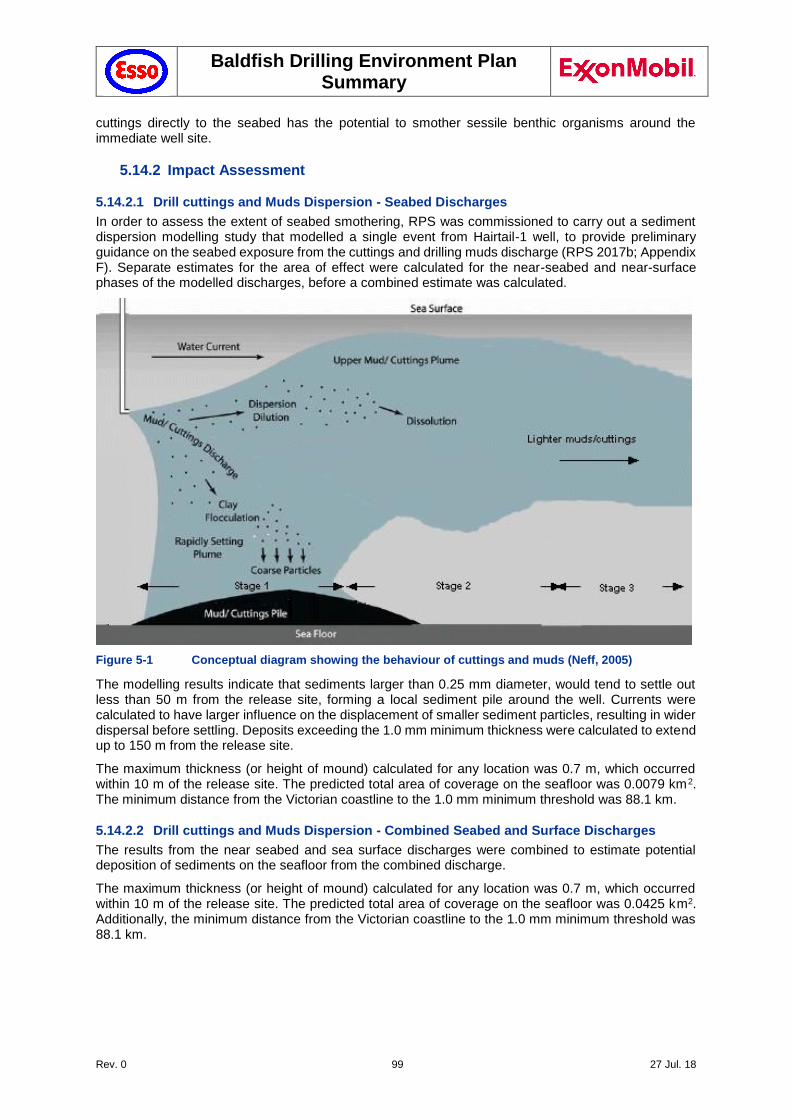
Baldfish Drilling Environment Plan Summary
Rev. 0 99 27 Jul. 18
cuttings directly to the seabed has the potential to smother sessile benthic organisms around the immediate well site.
5.14.2 Impact Assessment
5.14.2.1 Drill cuttings and Muds Dispersion - Seabed Discharges
In order to assess the extent of seabed smothering, RPS was commissioned to carry out a sediment dispersion modelling study that modelled a single event from Hairtail-1 well, to provide preliminary guidance on the seabed exposure from the cuttings and drilling muds discharge (RPS 2017b; Appendix F). Separate estimates for the area of effect were calculated for the near-seabed and near-surface phases of the modelled discharges, before a combined estimate was calculated.
Figure 5-1 Conceptual diagram showing the behaviour of cuttings and muds (Neff, 2005)
The modelling results indicate that sediments larger than 0.25 mm diameter, would tend to settle out less than 50 m from the release site, forming a local sediment pile around the well. Currents were calculated to have larger influence on the displacement of smaller sediment particles, resulting in wider dispersal before settling. Deposits exceeding the 1.0 mm minimum thickness were calculated to extend up to 150 m from the release site.
The maximum thickness (or height of mound) calculated for any location was 0.7 m, which occurred within 10 m of the release site. The predicted total area of coverage on the seafloor was 0.0079 km2. The minimum distance from the Victorian coastline to the 1.0 mm minimum threshold was 88.1 km.
5.14.2.2 Drill cuttings and Muds Dispersion - Combined Seabed and Surface Discharges
The results from the near seabed and sea surface discharges were combined to estimate potential deposition of sediments on the seafloor from the combined discharge.
The maximum thickness (or height of mound) calculated for any location was 0.7 m, which occurred within 10 m of the release site. The predicted total area of coverage on the seafloor was 0.0425 km2. Additionally, the minimum distance from the Victorian coastline to the 1.0 mm minimum threshold was 88.1 km.
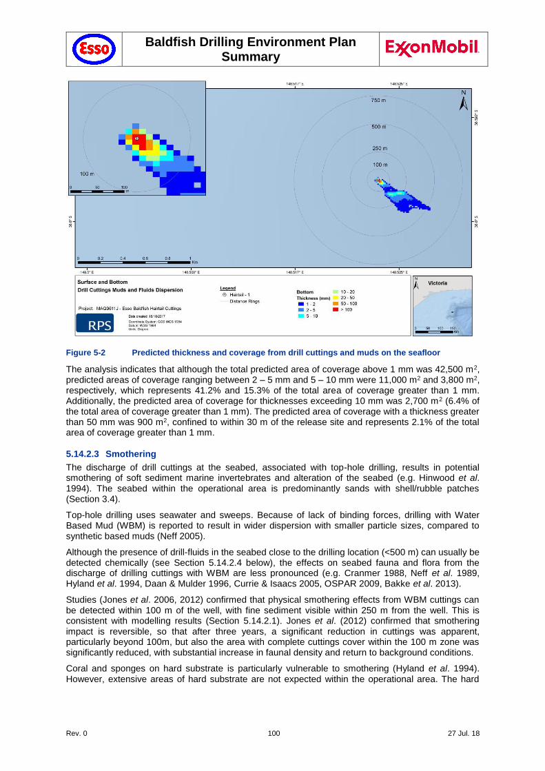
Baldfish Drilling Environment Plan Summary
Rev. 0 100 27 Jul. 18
Figure 5-2 Predicted thickness and coverage from drill cuttings and muds on the seafloor
The analysis indicates that although the total predicted area of coverage above 1 mm was 42,500 m2, predicted areas of coverage ranging between 2 – 5 mm and 5 – 10 mm were 11,000 m2 and 3,800 m2, respectively, which represents 41.2% and 15.3% of the total area of coverage greater than 1 mm. Additionally, the predicted area of coverage for thicknesses exceeding 10 mm was 2,700 m2 (6.4% of the total area of coverage greater than 1 mm). The predicted area of coverage with a thickness greater than 50 mm was 900 m2, confined to within 30 m of the release site and represents 2.1% of the total area of coverage greater than 1 mm.
5.14.2.3 Smothering
The discharge of drill cuttings at the seabed, associated with top-hole drilling, results in potential smothering of soft sediment marine invertebrates and alteration of the seabed (e.g. Hinwood et al. 1994). The seabed within the operational area is predominantly sands with shell/rubble patches (Section 3.4).
Top-hole drilling uses seawater and sweeps. Because of lack of binding forces, drilling with Water Based Mud (WBM) is reported to result in wider dispersion with smaller particle sizes, compared to synthetic based muds (Neff 2005).
Although the presence of drill-fluids in the seabed close to the drilling location (<500 m) can usually be detected chemically (see Section 5.14.2.4 below), the effects on seabed fauna and flora from the discharge of drilling cuttings with WBM are less pronounced (e.g. Cranmer 1988, Neff et al. 1989, Hyland et al. 1994, Daan & Mulder 1996, Currie & Isaacs 2005, OSPAR 2009, Bakke et al. 2013).
Studies (Jones et al. 2006, 2012) confirmed that physical smothering effects from WBM cuttings can be detected within 100 m of the well, with fine sediment visible within 250 m from the well. This is consistent with modelling results (Section 5.14.2.1). Jones et al. (2012) confirmed that smothering impact is reversible, so that after three years, a significant reduction in cuttings was apparent, particularly beyond 100m, but also the area with complete cuttings cover within the 100 m zone was significantly reduced, with substantial increase in faunal density and return to background conditions.
Coral and sponges on hard substrate is particularly vulnerable to smothering (Hyland et al. 1994). However, extensive areas of hard substrate are not expected within the operational area. The hard
Baldfish Drilling Environment Plan Summary
Rev. 0 101 27 Jul. 18
substrates associated with the Big Horseshoe Canyon KEF are located approximately 80 km from the operational area, and not at risk of exposure.
Research suggests that any smothering impacts within the operational area will be limited to 500 m from the well site, and full recovery is expected. Given the inert nature of the drill cuttings and the limited volume being discharged from riserless drilling, the impacts to benthic habitats are expected to be limited. Consequently, the potential impacts and risks from smothering and alteration of seabed substrate are considered to be Category 4 as this type of event may result in localised short-term impacts to species of recognised conservation value, but is not expected to affect local ecosystem functions.
5.14.2.4 Chemical toxicity
The environmental receptors which may be impacted by elevated chemical toxicity in the benthos include demersal fish species, plankton, marine invertebrates and soft sediments.
Due to the inert / PLONOR nature of its components, WBM have been shown to have little or no toxicity to marine organisms (Jones et al. 1996). Barite (a major insoluble component of water-based mud discharges) has been widely shown to accumulate in sediments following drilling (reviewed by Hartley 1996). Barium sulphate is of low bioavailability and toxicity to benthic organisms. Other metals, present mainly as salts, in drilling wastes may originate from formation cuttings, or from impurities in barite and other mud components, however do not contribute to mud toxicity due to their low bioavailability (Schaanning et al. 2002).
The Esso chemical selection procedure (Section 7.8.1) defines the process for assessment of the offshore operational use and discharge of chemicals during Baldfish drilling activities. All chemicals planned for use and discharge must be assessed prior to use. Where a chemical is initially assessed as PLONOR or OCNS Gold, Silver, E or D ranking, no further assessment is required, and chemicals are approved for use. For any chemicals with a higher ranking, steps for assessment are provided in the process.
Neff (2010) explains that the lack of toxicity and low bioaccumulation potential of the drilling muds means that the effects of the discharges are highly localised and are not expected to spread through the food web.
As described in Section 3.4, the seabed at the Baldfish location does not support significant benthic communities due to the water depth. Any existing benthic species are sparse and depauperate. The area is also not known to be a feeding ground for any significant species. The cuttings may cause localised smothering of sessile benthic fauna. However, this is largely reversible and not assessed to have an effect at the population level.
The area affected represents an insignificant portion of the overall permit area (VIC/P70) and therefore the impact is not assessed to be significant. Modelling of release of drilling cuttings at the seabed and at the surface (Section 5.14.2.1) has confirmed that release of drill cuttings at the seabed would result in only a localised impact to the seabed. Given the inert nature of the drill cuttings and the limited volume being discharged from riserless drilling, the impacts to benthic habitats are expected to be limited.
The potential impacts and risks from chemical toxicity are considered to be Category 4 as this type of event may result in localised short-term impacts to species of recognised conservation value, but is not expected to affect local ecosystem functions.
5.14.3 Controls
Post-drilling ROV survey around the wellhead area will record the condition of the seabed at the completion of the program to ensure that no dropped objects or subsea equipment intended for removal remain on the seabed (see Section 5.22).
Use of low toxicity constituents, which meet Esso's chemical selection procedure (Section 7.8.1).
5.14.4 Risk Ranking
It is expected that a cuttings pile will be generated at the wellhead during riserless drilling, followed by a plume footprint when riser fluids are discharged at the surface.
Baldfish Drilling Environment Plan Summary
Rev. 0 102 27 Jul. 18
Discharged cuttings will be uncontaminated, and formed of similar sediment types to those found on the seabed, so the likelihood of causing localised short-term impacts to species of recognised conservation value is considered unlikely (C), with a consequence level IV.
The potential impact associated with this aspect is limited to a localised short-term impact, which is not considered as having the potential to affect biological diversity and ecological integrity.
The activities were evaluated as having the potential to result in a Category 4 risk ranking, not considered as having the potential to result in serious or irreversible environmental damage. Consequently, no further evaluation against the principles of ESD is required.
Likelihood Consequence Risk Ranking
C IV 4
5.14.5 Demonstration of ALARP
To demonstrate that the impacts and risk associated with this hazard have been reduced to ALARP, other controls and alternatives were considered.
The upper sections are drilled without a riser, with cuttings returned to the seabed (Section 2.6). Use of a Riserless Mud Recovery (RMR) system was considered. These systems have recently been applied in sensitive ecosystems, especially where unconsolidated substrate (e.g. coarse sand) increases the risk of collapsing. These systems have largely been applied in relatively shallow waters (<450m), although recent advances also allow the operation of these systems in deep water and ultra-deepwater (Myers 2008). Considering that the Baldfish project area is at relatively large depths, with a highly dynamic seabed and low biodiversity, as well as the relatively short Baldfish project duration, with limited wells, the benefits of operating such systems versus costs was not considered justifiable.
The planned release of drill cuttings and adhered fluids offshore is a well understood and practiced activity both nationally and internationally. The potential impacts and risks are well regulated via various treaties and legislation, which specify industry best practice control measures. These are well understood and implemented by the industry. There were no further controls identified.
The use of low toxicity constituents and pre and post drilling ROV surveys, are considered sufficient control measures to reduce the impacts and risks associated with this hazard to ALARP, as the nature of this risk is well understood, the activity is a well-established practice and the residual risk resulting from this activity is considered to be low (Category 4).
There are no KEF within the affected area. No stakeholder concerns have been raised on RA14. Consequently, no further evaluation against the principles of ESD is required. Consequently, ALARP Decision Context A applies.
5.14.6 Demonstration of Acceptability
For this hazard the residual risk was assessed at Category 4 low risk. As all relevant standards (Esso, Australian Standards and Industry best practice) have been met and there were no valid claims or objections to this risk from relevant persons, Esso considers the impacts and risk are acceptable.
5.15 Planned Discharge - Drilling mud and cuttings at the sea surface (RA 15)
5.15.1 Hazard
Drilling activities will result in planned discharges of drill cuttings and adhered drilling fluids. Once the riser is installed, approximately 212 m3 of drill cuttings will be discharged just below the sea surface, resulting in dissipation of the cuttings over a larger area (Section 4.4.2). Although muds are recycled onboard the MODU, approximately 10% of muds will be retained on the drill cuttings. On completion of the project scope, residual muds are flushed from the mud-system and disposed offshore, unless these can be re-used for subsequent activities.
Discharge of cuttings and whole WBM (Water-Based Mud) at the sea surface has the potential to change water quality, causing toxicity to marine species. Additionally, it has the potential to smother organisms by drilling cuttings accumulating at the seabed (Section 5.14).

Baldfish Drilling Environment Plan Summary
Rev. 0 103 27 Jul. 18
5.15.2 Impact Assessment
Once the 22” x 13-3/8” top-hole casing and BOP have been installed, the riser can be connected, thereby allowing circulation of WBM / drilling fluids and drill cutting to the MODU. There, cuttings can be separated from WBM, allowing re-use of WBM and minimising discharge to sea. The primary WBM components are freshwater, Potassium Chloride, Polymers and Glycol and Barite. WBM may contain some trace heavy metal concentrations, but not in a readily bio-available form. WBM is considered by OSPAR to pose little or no risk to the environment (OSPAR, 2004).
The impacts from drilling mud discharges to the seabed are addressed in Section 5.14. Discharge of drilling mud at the sea surface results in dispersion of particles over a large area (Section 5.15.2.1) and will contribute to localized smothering at the seabed. Additionally, surface discharges will result in increased turbidity, as discussed further in Section 5.15.2.2.
WBM have little or no toxicity to marine organisms (Jones et al. 1996). Barite (a major WBM Component) is of low bioavailability and toxicity to benthic organisms, although it has been shown to accumulate in sediments following drilling (Hartley 1996). Other components may originate from formation cuttings, or from impurities in barite and other mud components, but do not contribute to mud toxicity due to their low bioavailability (Schaanning et al. 2002). WBM additives are generally classified as HQ Band "Gold", with concentrations in released fluids below toxicity levels (PEC/PNEC <1) (OCNS, CEFAS 2017).
The effects of WBM discharges are highly localised due to their low toxicity and bioaccumulation potential (Neff, 2010). Consequently, the potential impacts and risks associated with WBM represent localised short-term impacts, and are not expected to affect local ecosystem functions.
5.15.2.1 Drill cuttings and Muds Dispersion - Surface Discharges
Modelling results (RPS 2017b) showed that, due to the height of the near-surface discharge, water currents would have a greater effect on dispersing sediments, including those larger than 0.4 mm, which were calculated to typically settle out within 500 m from the well, with settlement displaced in response to the prevailing currents. Finer sediments were calculated to disperse more widely under the influence of the currents due to the decreased setting velocities.
The maximum thickness (or height of mound) calculated for any location was 1.1 cm, which occurred approximately 230 m from the release site. The predicted total area of coverage on the seafloor was 0.017 km2 (i.e. just over double the area affected by discharge near the substrate, but at a fraction of the height), immediately around the drill location.
5.15.2.2 Increased Turbidity
Neff (2005) states that although the total volumes of muds and cuttings discharged to the ocean during drilling a well are large, the impacts in the water column environment are minimal, because discharges of small amounts of materials are intermittent.
When cuttings are discharged to the ocean, the larger particles, representing about 90% of the mass of the mud solids, form a plume that settles quickly to the bottom (or until the plume entrains enough seawater to reach neutral buoyancy). About 10% of the mass of the mud solids form another plume in the upper water column that drifts with prevailing currents away from the discharge point and is diluted rapidly in the receiving waters (Neff, 2005; 2010).
Environmental receptors with the potential to be exposed and most at risk of impact to an increase in turbidity levels include pelagic fish species and plankton found in the area around the well locations. The operational area is also located within a Pygmy Blue Whale foraging BIA, and seabird foraging BIAs.
Jenkins and McKinnon (2006) reported that levels of suspended sediments greater than 500 mg/L are likely to produce a measurable impact upon larvae of most fish species, and that levels of 100 mg/L will affect the larvae of some species if exposed for periods greater than 96 hours. Jenkins and McKinnon (2006) also indicated that levels of 100 mg/L may affect the larvae of several marine invertebrate species, and that fish eggs and larvae are more vulnerable to suspended sediments than older life stages.
Assuming that solids control equipment reduces residual on solids to below 10% leaving the material discharged comprising 90% solid cuttings, and based upon dilutions identified by Hinwood et al. (1994)
Baldfish Drilling Environment Plan Summary
Rev. 0 104 27 Jul. 18
and Neff (2005), turbidity in the water column is expected to be reduced to below 10 mg/L (9 ppm) within 100 m of release.
Consequently, any impact to fish larvae would be limited due to the small exposure footprint, high natural mortality of larvae (McGurk, 1986), and dispersive characteristics of the open water in the operational area.
Considering the relatively short-lived nature of the intermittent plumes, and that concentrations of suspended solids rapidly dissipate with the prevailing currents, the potential impacts on fish and their larvae are expected to be minimal.
5.15.2.3 Chemical toxicity
Neff (2005) discusses that, in well-mixed ocean waters, drilling muds and cuttings are diluted by 100-fold within 10 m of the discharge and by 1000-fold after a transport time of about 10 minutes at a distance of about 100 m from discharge. Because of the rapid dilution of the drilling mud and cuttings plume in the water column, “harm to communities of water column plants and animals is unlikely and has never been demonstrated” (Neff, 2005).
The environmental receptors which may be impacted by elevated chemical toxicity in the surface waters include pelagic fish and plankton; and in the lower water column and benthos include demersal fish species, plankton, marine invertebrates and soft sediments.
The Esso chemical selection procedure (Section 7.8.1) defines the process for assessment of the offshore operational use and discharge of chemicals during Baldfish drilling activities. All chemicals planned for use and discharge must be assessed prior to use. Where a chemical is initially assessed as PLONOR or OCNS Gold, Silver, E or D ranking, no further assessment is required, and chemicals are approved for use. For any chemicals with a higher ranking, steps for assessment are provided in the process.
Due to the inert / PLONOR nature of its components, WBM have been shown to have little or no toxicity to marine organisms (Jones et al. 1996). Barite (a major insoluble component of water-based mud discharges) has been widely shown to accumulate in sediments following drilling (reviewed by Hartley 1996). Barium sulphate is of low bioavailability and toxicity to benthic organisms. Other metals, present mainly as salts, in drilling wastes may originate from formation cuttings, or from impurities in barite and other mud components, however do not contribute to mud toxicity due to their low bioavailability (Schaanning et al. 2002).
Neff (2010) explains that the lack of toxicity and low bioaccumulation potential of the drilling muds means that the effects of the discharges are highly localised and are not expected to spread through the food web. Consequently, the potential impacts and risks from chemical toxicity are considered to be Category 4 as this type of event may result in localised short-term impacts to species of recognised conservation value, but is not expected to affect local ecosystem functions.
5.15.3 Controls
Use of low toxicity constituents, which meet Esso's chemical selection procedure (Section 7.8.1).
The LCM-3D/CM-2 Cascade Solid Control Equipment will be maintained in accordance with manufacturer specifications (Brandt). Screens will be monitored for wear and tear, and damaged screens will be repaired or replaced immediately.
5.15.4 Risk Ranking
It is expected that discharge of riser fluids at the surface will result in a plume footprint. Discharged cuttings will be uncontaminated, and formed of similar sediment types to those found on the seabed, and the likelihood of causing localised short-term impacts to species of recognised conservation value is considered Unlikely (C), with a consequence level IV (inconsequential or no adverse effect).
Likelihood Consequence Risk Ranking
C IV 4
Baldfish Drilling Environment Plan Summary
Rev. 0 105 27 Jul. 18
5.15.5 Demonstration of ALARP
The planned release of drill cuttings and adhered fluids offshore is a well understood and practiced activity both nationally and internationally. The potential impacts and risks are well regulated via various treaties and legislation, which specify industry best practice control measures. These are well understood and implemented by the industry. There were no further controls identified.
The 12-1/4” hole section is drilled using a riser, allowing recycling of drilling muds, with cuttings to be discharged at sea level. This distributes the cuttings over a larger area and further reduces the effect of a cuttings pile. Therefore, the impact of discharge of drilling cuttings and associated muds can be further reduced.
Collecting the cuttings on board the MODU and shipping them to shore for onshore disposal would require significant space to store accumulated cuttings, coupled with the added risks and costs associated with increased vessel movements to shore and the need to dispose of the cuttings at suitable waste sites. The risks and costs associated with these measures are assessed to be disproportionate to the benefits which may be gained in reducing risk to benthic species.
The use of low toxicity constituents, combined with drilling mud recycling and cutting discharge at sea level to aid dispersion over a wider area, are considered sufficient control measures to reduce the impacts and risks associated with this hazard to ALARP, in accordance with Section 5.1.5, as the nature of this risk is well understood, the activity is a well-established practice and the residual risk resulting from this activity is considered to be low (Category 4).
There are no KEF within the affected area. No stakeholder concerns have been raised on RA15. Consequently, no further evaluation against the principles of ESD is required. Consequently, ALARP Decision Context A applies.
5.15.6 Demonstration of Acceptability
For this hazard the residual risk was assessed at Category 4 low risk. As all relevant standards (Esso, Australian Standards and Industry best practice) have been met and there were no valid claims or objections to this risk from relevant persons, Esso considers the impacts and risk are acceptable.
Capture, storage and onshore disposal of fluid returns generated during drilling operations is not practicable. There were no further controls identified. On this basis Esso considers the risk to be ALARP.
5.16 Planned Discharge - Cement discharges at the seabed (RA 16)
A 42” conductor hole will be drilled to ± 50m below the seabed before the conductor casing is run and cemented in place. The surface hole will then be drilled riserless, with all returns released at the seabed.
Excess cement, created during the cementing of conductor and surface casings, will accumulate around the well location. Some solids from the drill site (e.g. sand) will also be deposited around the well location with excess cement (approx.60 bbl, or 9.6 m3 per well). Once good cement returns are observed around the wellhead the cement operations will stop. Once cementing is complete and all mixed cement has been pumped, the equipment needs to be washed and cleaned. Diluted cement wash and/or small volumes of cement slurry (approximately 160 litres from hopper washing) will therefore be discharged. A similar process is followed for cementing the remaining casings.
The release of cement or sand onto the seabed may result in smothering of benthic communities. Additionally, planned discharge of cement will result in increased turbidity, potentially affecting marine fauna, while there are also potential toxicity impacts.
5.16.1 Impact Assessment
The cement and chemical additives in the cement are subjected to detailed assessment prior to use to ensure they are of the lowest environmental impact practicable for the application, in accordance with Esso's chemical selection procedure (Section 7.8.1). Cementing and sand discharge are infrequent activities, and the resultant temporary and localised effect on the seabed is localised.
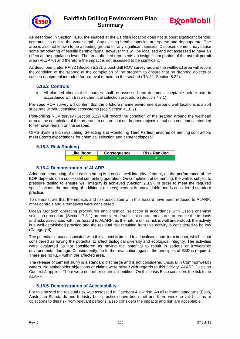
Baldfish Drilling Environment Plan Summary
Rev. 0 106 27 Jul. 18
As described in Section. 4.10, the seabed at the Baldfish location does not support significant benthic communities due to the water depth. Any existing benthic species are sparse and depauperate. The area is also not known to be a feeding ground for any significant species. Disposed cement may cause some smothering of sessile benthic fauna, however this will be localised and not assessed to have an effect at the population level. The area affected represents an insignificant portion of the overall permit area (VIC/P70) and therefore the impact is not assessed to be significant.
As described under RA 22 (Section 5.22), a post-drill ROV survey around the wellhead area will record the condition of the seabed at the completion of the program to ensure that no dropped objects or subsea equipment intended for removal remain on the seabed (RA 22, Section 5.22).
5.16.2 Controls
All planned chemical discharges shall be assessed and deemed acceptable before use, in accordance with Esso's chemical selection procedure (Section 7.8.1)
Pre-spud ROV survey will confirm that the offshore marine environment around well locations is a soft substrate without sensitive ecosystems (see Section 4.10.2).
Post-drilling ROV survey (Section 5.22) will record the condition of the seabed around the wellhead area at the completion of the program to ensure that no dropped objects or subsea equipment intended for removal remain on the seabed.
OIMS System 8-1 (Evaluating, Selecting and Monitoring Third Parties) ensures cementing contractors meet Esso's expectations for chemical selection and cement disposal.
5.16.3 Risk Ranking
Likelihood Consequence Risk Ranking
C IV 4
5.16.4 Demonstration of ALARP
Adequate cementing of the casing string is a critical well integrity element, as the performance of the BOP depends on a successful cementing operation. On completion of cementing, the well is subject to pressure testing to ensure well integrity is achieved (Section 2.3.9). In order to meet the required specifications, the pumping of additional (excess) cement is unavoidable and is considered standard practice.
To demonstrate that the impacts and risk associated with this hazard have been reduced to ALARP, other controls and alternatives were considered.
Ocean Monarch operating procedures and chemical selection in accordance with Esso's chemical selection procedure (Section 7.8.1) are considered sufficient control measures to reduce the impacts and risks associated with this hazard to ALARP, as the nature of this risk is well understood, the activity is a well-established practice and the residual risk resulting from this activity is considered to be low (Category 4).
The potential impact associated with this aspect is limited to a localised short-term impact, which is not considered as having the potential to affect biological diversity and ecological integrity. The activities were evaluated as not considered as having the potential to result in serious or irreversible environmental damage. Consequently, no further evaluation against the principles of ESD is required. There are no KEF within the affected area.
The release of cement slurry is a standard discharge and is not considered unusual in Commonwealth waters. No stakeholder objections or claims were raised with regards to this activity. ALARP Decision Context A applies. There were no further controls identified. On this basis Esso considers the risk to be ALARP.
5.16.5 Demonstration of Acceptability
For this hazard the residual risk was assessed at Category 4 low risk. As all relevant standards (Esso, Australian Standards and Industry best practice) have been met and there were no valid claims or objections to this risk from relevant persons, Esso considers the impacts and risk are acceptable.
Baldfish Drilling Environment Plan Summary
Rev. 0 107 27 Jul. 18
5.17 Planned Discharge - Cement at the sea surface (RA 17)
5.17.1 Hazard
When the 36” and 13-3/8” casing shoes are drilled out, small quantities of hardened cement are circulated to surface, and discharged overboard. The cement and chemical additives in the cement are subjected to detailed assessment prior to use to ensure they are of the lowest environmental impact practicable for the application (Section 7.8.1). Discharge of cement may result in a temporary increase in turbidity in the water column and may result in smothering effects.
Washing the cementing head and blending tanks with seawater to prevent curing, will result in a release of cement / water mix (~160 bbl, or 26 m3 at the seabed and ~20 bbl, or 4 m3 discharge at the surface per well). A small proportion of dry cement may also be blown overboard during bulk transfer operations from supply vessel to MODU.
5.17.2 Impact Assessment
The discharge of cement fluids will consist of cement and additives including extenders, accelerators, thinners, fluid loss control agents and defoamers. All the components of the cement mix are of low toxicity. The cement pump and piping used during cement operations is flushed with water following cement operations and washings are discharged overboard. In addition, on completion of cementing operations, remaining cement contained within the batch mixer, tanks and spacers are discharged overboard. Cement mix and additives will also be discharged at surface as part of commissioning of the cementing unit. Small quantities of dry cement will discharged to atmosphere during operation of the pneumatic cement delivery system.
The release of cement or sand onto the seabed may result in smothering of benthic communities. Additionally, planned discharge of cement will result in increased turbidity, potentially affecting marine fauna, while there are also potential toxicity impacts.
The cement and chemical additives in the cement are subjected to detailed assessment prior to use to ensure they are of the lowest environmental impact practicable for the application, in accordance with Esso's chemical selection procedure (Section 7.8.1). Cementing and sand discharge are infrequent activities, and the resultant temporary and localised effect on the seabed is localised.
The low quantities of cement that are discharged to sea will cause a temporary and minor reduction of water quality in the area around the well locations. However as all the constituents of the cement have been chosen because they have been rated as having low toxicity, the reduction in the water quality is assessed to be low. In addition, the Baldfish operational area does not have any significant sensitive receptors. The impact of changes in water quality due to discharged cement on marine species is assessed to be low.
As described in Section 4.10, the seabed at the Baldfish location does not support significant benthic communities due to the water depth. Any existing benthic species are sparse and depauperate. The area is also not known to be a feeding ground for any significant species. Disposed cement may cause some smothering of sessile benthic fauna, however this will be localised and not assessed to have an effect at the population level. The area affected represents an insignificant portion of the overall permit area (VIC/P70) and therefore the impact is not assessed to be significant.
As described under RA 22 (Section 5.22), a post-drill ROV survey will record the condition of the seabed at the completion of the program to ensure that no dropped objects or subsea equipment intended for removal remain on the seabed (RA 22, Section 5.22).
5.17.3 Controls
All planned chemical discharges shall be assessed and deemed acceptable before use, in accordance with Esso's chemical selection procedure (Section 7.8.1)
Post-drilling ROV survey (Section 5.22) will record the condition of the seabed at the completion of the program to ensure that no dropped objects or subsea equipment intended for removal remain on the seabed.
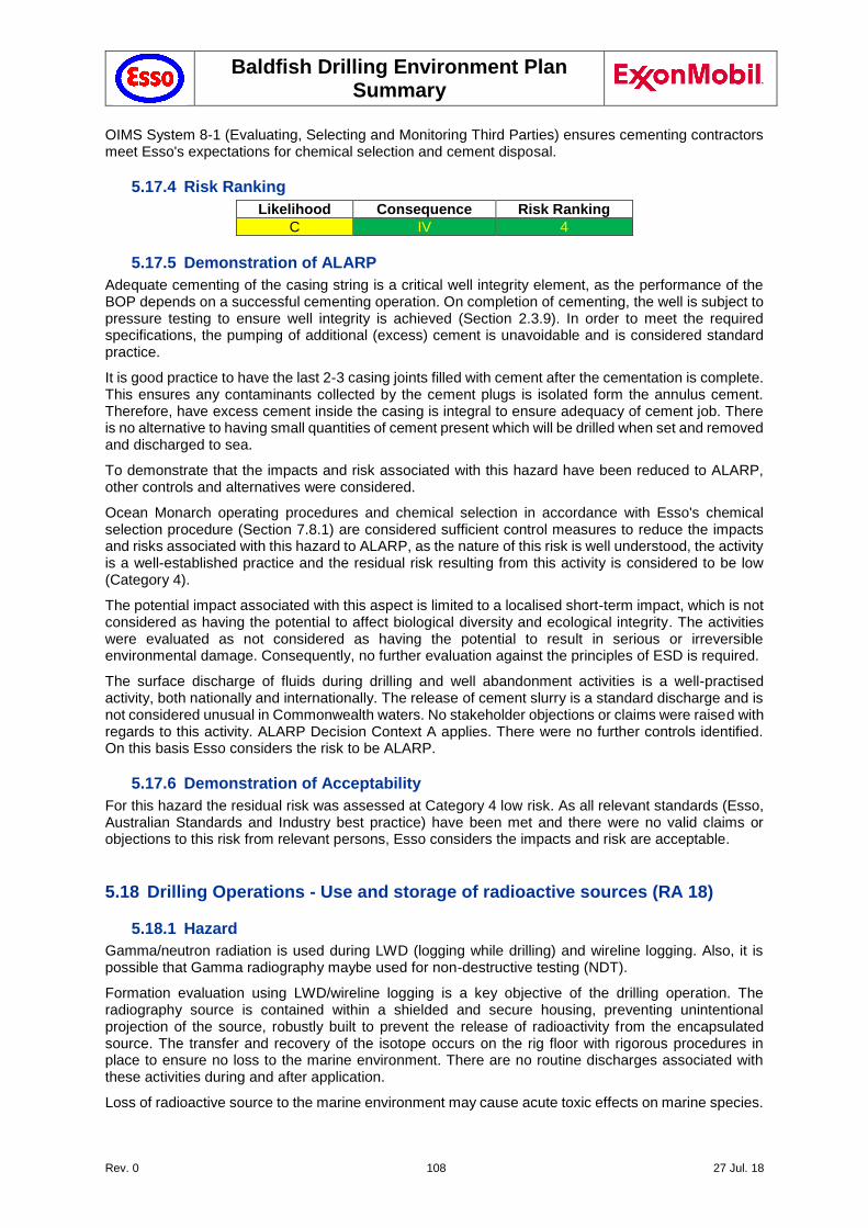
Baldfish Drilling Environment Plan Summary
Rev. 0 108 27 Jul. 18
OIMS System 8-1 (Evaluating, Selecting and Monitoring Third Parties) ensures cementing contractors meet Esso's expectations for chemical selection and cement disposal.
5.17.4 Risk Ranking
Likelihood Consequence Risk Ranking
C IV 4
5.17.5 Demonstration of ALARP
Adequate cementing of the casing string is a critical well integrity element, as the performance of the BOP depends on a successful cementing operation. On completion of cementing, the well is subject to pressure testing to ensure well integrity is achieved (Section 2.3.9). In order to meet the required specifications, the pumping of additional (excess) cement is unavoidable and is considered standard practice.
It is good practice to have the last 2-3 casing joints filled with cement after the cementation is complete. This ensures any contaminants collected by the cement plugs is isolated form the annulus cement. Therefore, have excess cement inside the casing is integral to ensure adequacy of cement job. There is no alternative to having small quantities of cement present which will be drilled when set and removed and discharged to sea.
To demonstrate that the impacts and risk associated with this hazard have been reduced to ALARP, other controls and alternatives were considered.
Ocean Monarch operating procedures and chemical selection in accordance with Esso's chemical selection procedure (Section 7.8.1) are considered sufficient control measures to reduce the impacts and risks associated with this hazard to ALARP, as the nature of this risk is well understood, the activity is a well-established practice and the residual risk resulting from this activity is considered to be low (Category 4).
The potential impact associated with this aspect is limited to a localised short-term impact, which is not considered as having the potential to affect biological diversity and ecological integrity. The activities were evaluated as not considered as having the potential to result in serious or irreversible environmental damage. Consequently, no further evaluation against the principles of ESD is required.
The surface discharge of fluids during drilling and well abandonment activities is a well-practised activity, both nationally and internationally. The release of cement slurry is a standard discharge and is not considered unusual in Commonwealth waters. No stakeholder objections or claims were raised with regards to this activity. ALARP Decision Context A applies. There were no further controls identified. On this basis Esso considers the risk to be ALARP.
5.17.6 Demonstration of Acceptability
For this hazard the residual risk was assessed at Category 4 low risk. As all relevant standards (Esso, Australian Standards and Industry best practice) have been met and there were no valid claims or objections to this risk from relevant persons, Esso considers the impacts and risk are acceptable.
5.18 Drilling Operations - Use and storage of radioactive sources (RA 18)
5.18.1 Hazard
Gamma/neutron radiation is used during LWD (logging while drilling) and wireline logging. Also, it is possible that Gamma radiography maybe used for non-destructive testing (NDT).
Formation evaluation using LWD/wireline logging is a key objective of the drilling operation. The radiography source is contained within a shielded and secure housing, preventing unintentional projection of the source, robustly built to prevent the release of radioactivity from the encapsulated source. The transfer and recovery of the isotope occurs on the rig floor with rigorous procedures in place to ensure no loss to the marine environment. There are no routine discharges associated with these activities during and after application.
Loss of radioactive source to the marine environment may cause acute toxic effects on marine species.
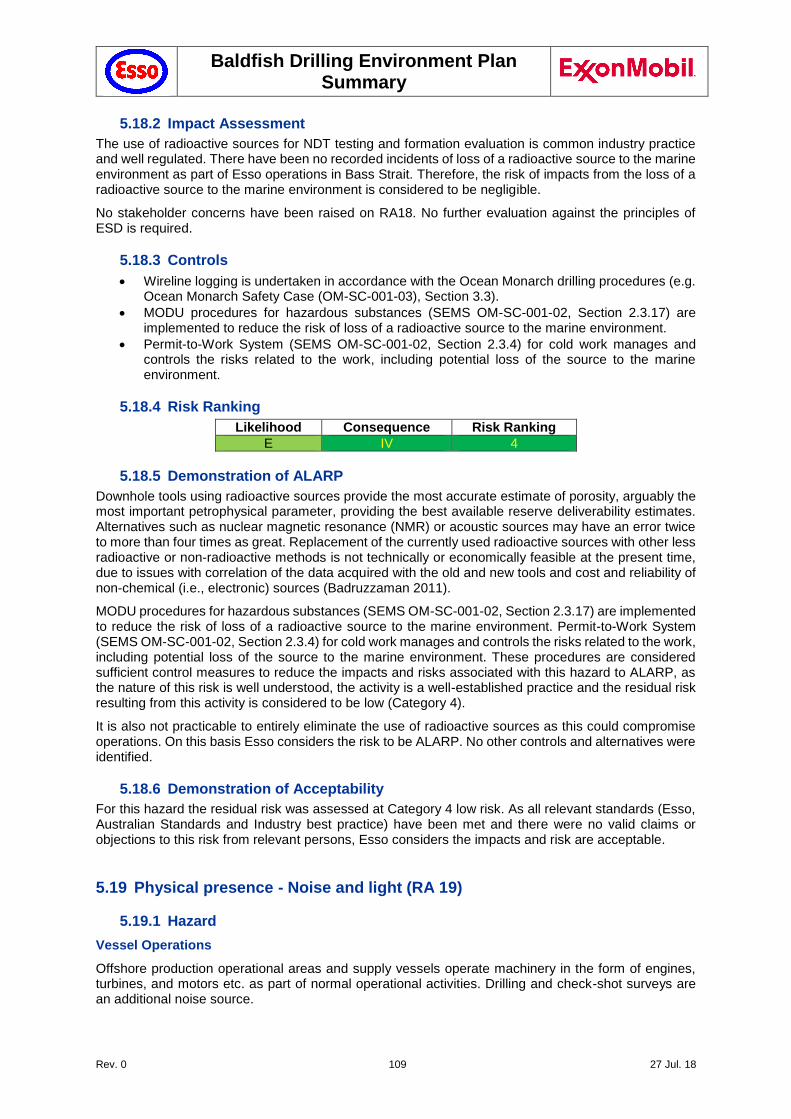
Baldfish Drilling Environment Plan Summary
Rev. 0 109 27 Jul. 18
5.18.2 Impact Assessment
The use of radioactive sources for NDT testing and formation evaluation is common industry practice and well regulated. There have been no recorded incidents of loss of a radioactive source to the marine environment as part of Esso operations in Bass Strait. Therefore, the risk of impacts from the loss of a radioactive source to the marine environment is considered to be negligible.
No stakeholder concerns have been raised on RA18. No further evaluation against the principles of ESD is required.
5.18.3 Controls
Wireline logging is undertaken in accordance with the Ocean Monarch drilling procedures (e.g. Ocean Monarch Safety Case (OM-SC-001-03), Section 3.3).
MODU procedures for hazardous substances (SEMS OM-SC-001-02, Section 2.3.17) are implemented to reduce the risk of loss of a radioactive source to the marine environment.
Permit-to-Work System (SEMS OM-SC-001-02, Section 2.3.4) for cold work manages and controls the risks related to the work, including potential loss of the source to the marine environment.
5.18.4 Risk Ranking
Likelihood Consequence Risk Ranking
E IV 4
5.18.5 Demonstration of ALARP
Downhole tools using radioactive sources provide the most accurate estimate of porosity, arguably the most important petrophysical parameter, providing the best available reserve deliverability estimates. Alternatives such as nuclear magnetic resonance (NMR) or acoustic sources may have an error twice to more than four times as great. Replacement of the currently used radioactive sources with other less radioactive or non-radioactive methods is not technically or economically feasible at the present time, due to issues with correlation of the data acquired with the old and new tools and cost and reliability of non-chemical (i.e., electronic) sources (Badruzzaman 2011).
MODU procedures for hazardous substances (SEMS OM-SC-001-02, Section 2.3.17) are implemented to reduce the risk of loss of a radioactive source to the marine environment. Permit-to-Work System (SEMS OM-SC-001-02, Section 2.3.4) for cold work manages and controls the risks related to the work, including potential loss of the source to the marine environment. These procedures are considered sufficient control measures to reduce the impacts and risks associated with this hazard to ALARP, as the nature of this risk is well understood, the activity is a well-established practice and the residual risk resulting from this activity is considered to be low (Category 4).
It is also not practicable to entirely eliminate the use of radioactive sources as this could compromise operations. On this basis Esso considers the risk to be ALARP. No other controls and alternatives were identified.
5.18.6 Demonstration of Acceptability
For this hazard the residual risk was assessed at Category 4 low risk. As all relevant standards (Esso, Australian Standards and Industry best practice) have been met and there were no valid claims or objections to this risk from relevant persons, Esso considers the impacts and risk are acceptable.
5.19 Physical presence - Noise and light (RA 19)
5.19.1 Hazard
Vessel Operations
Offshore production operational areas and supply vessels operate machinery in the form of engines, turbines, and motors etc. as part of normal operational activities. Drilling and check-shot surveys are an additional noise source.
Baldfish Drilling Environment Plan Summary
Rev. 0 110 27 Jul. 18
Noise from operational area and support operations has the potential to cause disruption to underwater marine fauna. This can include:
Behavioural change;
Hearing impairment and pathological damage;
Increased stress; and
Disruption to underwater cues.
Both Ocean Monarch and ATHs are equipped with navigation lights. Ocean Monarch also has crane clearance lights, helipad lights and radio tower lights. The Baldfish Operational area is remote from seabird and turtle nesting areas and therefore lighting from associated structures and vessels has a low potential for impacting marine fauna. The presence of operational area lighting does not appear to disrupt or disorient fish or marine mammals such as seals or cetaceans.
Helicopter Operations (4.1.4)
A fleet of aircraft operate out of the Longford base on a scheduled basis. In addition to transporting personnel, the helicopters carry urgent freight and critical spares for the operation of the facilities in Bass Strait. The helicopter base for the Baldfish operations has not been finalised. Refer to Section 0 for further details.
5.19.2 Impact Assessment
Noise
Major continuous noise generators on the operational area include the diesel generators and drilling activities, the DP thrusters on the support vessels, as well as the helicopter engines. A noise survey for Ocean Monarch was carried out in 2013, confirming that the facility complies with all regulatory requirements regarding noise management. To ensure that all noise hazards are managed to a level that is ALARP, Diamond Offshore developed a noise management plan (NMP) for the facility, in force prior to commencing operations in Australia. After allowing for the protection offered by hearing protectors, the level of operational noise exposure is less than an LAeq,12h of 82 dB(A); or an LCpeak of 140 dB(C).
The guideline threshold for the level of noise that may cause interference to cetaceans is 155 to 183 dB (SELcum; impulsive, for HF and LF respectively), with behavioural disturbance occurring between 120-160 dBrms (for non-impulsive and impulsive noise respectively (NOAA (2016). Noise from check-shot surveys are expected to reach 168 db re 1 μPa/Hz at 25 m below the source and 160 dB re 1 μPa/Hz within a 20 m horizontal radius (Drilling activities ae expected to generate peak source levels of 154-170dB re 1 μPa @ 1 m in the range of 10 – 4,000 Hz. AHTs generate underwater noise in the range 145 – 171 dB re 1 μPa @ 1 m in the range of 1,000 – 5,000 (URS 2009).
By comparison, noise from large tankers and container ships ranges between 177 – 186 re 1 μPa @ 1 m over a similar bandwidth (URS 2009). Ambient ocean noise as a result of wind and wave activities have been assessed at 90 to 110 dB re 1 µPa (Cato & Bell 1992, Cato & Tavener 1997, McCauley 1998, McCauley et al. 2000). Noise levels underwater as a result of drilling operations or supply vessel operations are expected to be below NOAA guideline levels, especially when considering that noise levels drop of rapidly beyond 1 m from the drilling activity.
Although whales are known to migrate through the region during spring and autumn/early winter, the operational area is not a recognised feeding, breeding or resting area for cetaceans. It has been observed that birds habituate well to routine noise (Swan et al. 1994) and there are no known rookeries in the operational areas. It is common to see some migratory birds rest on the operational area before continuing on their migratory flight, however, the presence of the operational area does not appear to significantly disrupt or divert their migratory route or disorient the birds.
Recent reports that zooplankton is affected by seismic activity (McCauley et al. 2017) are ambiguous and largely not applicable to this activity. While drilling activities, and check-shot surveys may impact on zooplankton, these impacts would be highly localised and of short duration (CSS/VSP would take a day on average).
Potential impacts from offshore activities on planned biannual Fishery Independent Survey (FIS) in August-September 2018 have been discussed with SETFIA (Section 5.20 and Chapter 8). The survey locations are largely away from Baldfish drilling activities, with the nearest survey point (Station 107)
Baldfish Drilling Environment Plan Summary
Rev. 0 111 27 Jul. 18
over 20 km to the NE of the Baldfish drilling location. As noise levels from drilling activities are comparable to that of commercial shipping vessels passing through the TSS (Section 5.21), the planned drilling activity is expected to have negligible impact in the FIS.
Seals have been observed to congregate and rest on the legs of offshore facilities further inshore, and at times on the sea deck of offshore platforms; they appear to be unperturbed or impacted by noise. Whales are also known, and observed, to play and display normal breaching, blowing, lobtailing and diving behaviour around the offshore facilities and vessels, including with calves.
Esso’s helicopter traffic fly at an appropriate altitude for safety reasons and this is not expected and has not been observed to affect whale behaviour to any significant extent in the operational area. Sound levels are generally minimised, where possible, by pilots maintaining a straight flight path and avoiding sharp deviations (which increases rotor blade-vortex interaction noise).
Light
Light studies in the North Sea confirmed that lighting can attract birds from large catchment areas (Weise et al. 2001). Although the operational area overlaps several foraging BIAs for seabirds, it is not expected that light emissions acting as an attractant to a small number of individual seabirds would result in any impact to the individual or to the greater population.
Cetaceans predominantly utilise acoustic senses to monitor their environment rather than visual sources (Simmonds et al. 2004), so light is not considered to be a significant factor in cetacean behaviour or survival.
Other marine life may also be attracted to the MODU or support vessels (e.g., fish, squid and plankton) that can aggregate directly under downward facing lights. These are prey species to many species of marine fauna and given the nature of the activity, any impacts arising from light emissions will be localised and temporary.
Artificial light can cause significant impacts on burrow-nesting petrels and shearwaters. Fledglings often become disoriented and grounded because of artificial light adjacent to rookeries as they attempt to make their first flights to sea, a phenomenon known as ‘fallout’ (Birdlife International 2012). Rodriguez at al. (2014) investigated the effects of artificial lighting from road lighting on short-tailed shearwater fledglings. The study established by removing the light source from nesting areas, there was a decrease in grounded fledglings and a corresponding reduction in bird fatalities.
Light pollution can be an issue near turtle nesting beaches where emerging hatchlings orient to, and head towards, the low light of the horizon (EA 2003). Given that the operational area is approximately 40 km offshore, impacts to nesting adult turtles is not expected. Consequently, the potential impacts and risks from light emissions are considered to be negligible.
Consequently, the potential impacts and risks from noise and light due to activities in the Baldfish operational area are considered to be localised and short-term, as this type of event may result in a localised short-term impact to species of recognised conservation value but is not expected to affect the population or local ecosystem function, and have been rated as a Level IV consequence, with the probability to be unlikely (C), resulting in a Category 4 risk.
5.19.3 Controls
Fauna interaction management actions in compliance with EPBC Regulations Part 8, Division 8.1: Interacting with cetaceans and whale watching.
Victorian Wildlife (Marine Mammals) Regulations 2009, Part 3: General restrictions on activities relating to marine mammals (DSE 2009b).
CSS and/or VSP in compliance with EPBC Act Policy Statement 2.1 - Interaction between offshore seismic exploration and whales: Industry guidelines.
Lighting limited to that required for safe navigation and work requirements, minimising light spill to sea.
Planned Maintenance System to maintain vessel engines and propulsion systems to minimise noise impacts.
Environmental induction on requirements of EPBC Regulations Part 8 Division 8.1 and EPBC Act Policy Statement 2.1, and whale and dolphin identification.
Baldfish Drilling Environment Plan Summary
Rev. 0 112 27 Jul. 18
OIMS System 8-1 (Evaluating, Selecting and Monitoring Third Parties) ensures vessel contractors have adopted these procedures to minimise impacts form noise and light on marine mammals and birds.
5.19.4 Risk Ranking
Likelihood Consequence Risk Ranking
C IV 4
5.19.5 Demonstration of ALARP
Compliance with EPBC Regulations Part 8, Division 8.1: Interacting with cetaceans and whale watching and EPBC Act Policy Statement 2.1 - Interaction between offshore seismic exploration and whales: Industry guidelines, as well as the controls described above are considered sufficient control measures to reduce the impacts and risks associated with this hazard to ALARP, as the nature of this risk is well understood, the activity is a well-established practice and the residual risk resulting from this activity is considered to be low (Category 4).
Offshore activities involving drilling are widely undertaken both nationally and internationally. Underwater sound emissions from vessel thrusters and ROVs is unavoidable, however will be intermittent during the activity. Other controls and alternatives were considered, including imposing a minimum flight altitude. This may result in a safety risk, and was therefore rejected.
The potential to use vessels to transport personnel around the offshore facilities instead of helicopters to reduce above-water noise levels has been considered and rejected. This would increase the frequency of vessel visits to the operational areas above existing levels, increasing the risk of potential vessel collision into a producing operational area, and transfer of personnel off the vessel to the operational area (e.g. via a billy pugh) poses a greater safety risk than direct disembarkation from a helicopter onto a deck.
During stakeholder consultation, SETFIA raised concern about any oil and gas related activities within the 6 months prior to the FIS, being February to mid-September 2018 (see RA 20; Section 5.20). Following extensive consultation (Chapter 8), SETFIA has confirmed that they have no further concerns or objections to the proposed activity.
The use of navigational lights and other lights to enable 24-hour operations to be undertaken, are routine activities in the offshore petroleum sector and are required for the safety of the MODU/vessels and the crew. The impacts and risks associated with light emissions are well understood, with most significant impacts generally associated with operating within close proximity of shorelines that support light sensitive species.
The potential impact associated with this aspect is limited to a localised short-term impact, which is not considered as having the potential to affect biological diversity and ecological integrity. The activities are not considered as having the potential to result in serious or irreversible environmental damage. Consequently, no further evaluation against the principles of ESD is required.
Because the potential impacts associated with underwater noise and light from these activities is limited, ALARP Decision Context A should apply. No further controls or alternatives have been identified. On this basis Esso considers the risk to be ALARP.
5.19.6 Demonstration of Acceptability
For this hazard the residual risk was assessed at Category 4 low risk. As all relevant standards (Esso, Australian Standards and Industry best practice) have been met and there were no valid claims or objections to this risk from relevant persons, Esso considers the impacts and risk are acceptable.
5.20 Physical presence - Interference with Commercial Fishing (RA 20)
5.20.1 Hazard
The presence of the MODU and associated supply vessels at the Baldfish operational area has the potential to disrupt commercial and recreational fisheries. In addition to interference with fishing activities, there is the potential to impact on the Fishery Independent Survey (FIS), planned to take place between August and September 2018.
Baldfish Drilling Environment Plan Summary
Rev. 0 113 27 Jul. 18
During consultation with SEFTIA (Section 8), the location of the FIS sites nearest to the Baldfish-1 and Hairtail-1 well locations were identified. Transect 105 is nearest to the well locations (11 NM to Hairtail-1, 12 NM to Baldish -1), followed by Transect 106 (18 NM from the well locations at its nearest point. Because of the distance from the well locations, and timing of drilling activities relative to planned FIS Survey, no major concerns were raised by the fishing community for impact on the FIS survey.
Vessel collision risk is addressed separately under RA 24 (Section 5.24).
5.20.2 Impact Assessment
During the drilling of the Baldfish wells the only vessels that will be present in the Baldfish operational area (as defined by the PSZ) are:
the Ocean Monarch, which is on site for the duration of the drilling campaign;
support/supply vessels (AHTs, Standby/Guard Vessel) to provide mooring, resupply and safety support (at all times).
AMSA, in dialogue with AHS, has established temporary fairways and buffer zones around the drill locations (Section 5.21.2.1) in order to minimise the risk of shipping collisions. The establishment of these temporary fairways and buffer zones present no restrictions to commercial fisheries outside the PSZ. Fisheries in Bass Strait are generally focused inshore of the drilling location (Section 3.7). As the duration of the drilling campaign is also of limited duration, the presence of the MODU and support vessels are not expected to have a significant impact on commercial fishing activity.
Once well evaluation has been completed, the wellheads will be removed from the seabed to minimise the risk of marine interactions and entanglement of fishing gear.
The only recreational fishing known to occur in the deep water areas around the Baldfish operational area is game-fishing (swordfish, sharks, tuna etc.) and this takes place from a limited number of vessels with the capability to safely fish at this distance offshore. Based on the limited deepwater game-fishing activity and the duration of the drilling campaign the impact is considered insignificant.
This aspect is not applicable to KEF. Stakeholder concerns regarding impact of drilling activities on FIS Survey have been addressed as part of RA20. No further evaluation against the principles of ESD is required.
5.20.3 Controls
Ongoing dialogue with fisheries and provision of information material on importance of 500 m PSZ, role of temporary fairways around Baldfish drilling locations, and a 2 NM buffer zone around well locations (Section 5.21.2.1).
SMS alerts: Esso are also planning to have SMS alerts issued to SETFIA fishing contacts to raise the awareness of the project activities, including when and where they are taking place.
Pre-start notifications:
The AHS will be notified no less than four working weeks before operations commence to enable Notices to Mariners to be published.
AMSA’s JRCC will be notified 24–48 hours before operations commence to enable AMSA to distribute an AUSCOAST warning
Relevant Stakeholders will be notified of activities approximately one month and again one week prior to commencement
Temporary fairway: Establishment of temporary fairways and 2 NM buffer zone through AMSA (Section 5.21.2.1)
Wellhead removal: On completion of well exploration, the well will be plugged and abandoned (P&A), and the wellhead removed to below the mudline
Petroleum Safety Zone: A 500m Petroleum Safety Zone (PSZ) is in place around the MODU and support vessels (NOPSEMA Notice A604295 of 17 April 2018).
NavAids:
Extensive navigation aids and communication systems on MODU and support vessels (Section 2.3.8).
Installation of further NavAids in response to MODU Safety Case Revision, and in dialogue with AMSA/AHS (Section 2.3.8).
MODU Procedures:
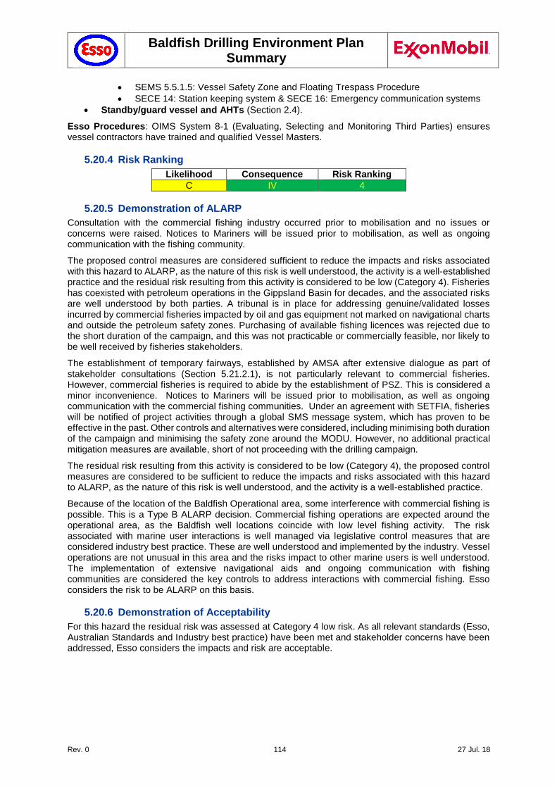
Baldfish Drilling Environment Plan Summary
Rev. 0 114 27 Jul. 18
SEMS 5.5.1.5: Vessel Safety Zone and Floating Trespass Procedure
SECE 14: Station keeping system & SECE 16: Emergency communication systems
Standby/guard vessel and AHTs (Section 2.4).
Esso Procedures: OIMS System 8-1 (Evaluating, Selecting and Monitoring Third Parties) ensures vessel contractors have trained and qualified Vessel Masters.
5.20.4 Risk Ranking
Likelihood Consequence Risk Ranking
C IV 4
5.20.5 Demonstration of ALARP
Consultation with the commercial fishing industry occurred prior to mobilisation and no issues or concerns were raised. Notices to Mariners will be issued prior to mobilisation, as well as ongoing communication with the fishing community.
The proposed control measures are considered sufficient to reduce the impacts and risks associated with this hazard to ALARP, as the nature of this risk is well understood, the activity is a well-established practice and the residual risk resulting from this activity is considered to be low (Category 4). Fisheries has coexisted with petroleum operations in the Gippsland Basin for decades, and the associated risks are well understood by both parties. A tribunal is in place for addressing genuine/validated losses incurred by commercial fisheries impacted by oil and gas equipment not marked on navigational charts and outside the petroleum safety zones. Purchasing of available fishing licences was rejected due to the short duration of the campaign, and this was not practicable or commercially feasible, nor likely to be well received by fisheries stakeholders.
The establishment of temporary fairways, established by AMSA after extensive dialogue as part of stakeholder consultations (Section 5.21.2.1), is not particularly relevant to commercial fisheries. However, commercial fisheries is required to abide by the establishment of PSZ. This is considered a minor inconvenience. Notices to Mariners will be issued prior to mobilisation, as well as ongoing communication with the commercial fishing communities. Under an agreement with SETFIA, fisheries will be notified of project activities through a global SMS message system, which has proven to be effective in the past. Other controls and alternatives were considered, including minimising both duration of the campaign and minimising the safety zone around the MODU. However, no additional practical mitigation measures are available, short of not proceeding with the drilling campaign.
The residual risk resulting from this activity is considered to be low (Category 4), the proposed control measures are considered to be sufficient to reduce the impacts and risks associated with this hazard to ALARP, as the nature of this risk is well understood, and the activity is a well-established practice.
Because of the location of the Baldfish Operational area, some interference with commercial fishing is possible. This is a Type B ALARP decision. Commercial fishing operations are expected around the operational area, as the Baldfish well locations coincide with low level fishing activity. The risk associated with marine user interactions is well managed via legislative control measures that are considered industry best practice. These are well understood and implemented by the industry. Vessel operations are not unusual in this area and the risks impact to other marine users is well understood. The implementation of extensive navigational aids and ongoing communication with fishing communities are considered the key controls to address interactions with commercial fishing. Esso considers the risk to be ALARP on this basis.
5.20.6 Demonstration of Acceptability
For this hazard the residual risk was assessed at Category 4 low risk. As all relevant standards (Esso, Australian Standards and Industry best practice) have been met and stakeholder concerns have been addressed, Esso considers the impacts and risk are acceptable.
Baldfish Drilling Environment Plan Summary
Rev. 0 115 27 Jul. 18
5.21 Physical presence - Interference with Commercial Shipping (RA 21)
5.21.1 Hazard
The presence of the MODU and associated supply vessels at the Baldfish operational area has the potential to disrupt marine traffic due to the proximity to the Bass Strait Traffic Separation Scheme. (TSS) and implementation of temporary shipping fairways to protect the MODU (Section 6.25.2.1).
Once well evaluation has been completed, the wellheads will be removed from the seabed to minimise the risk of marine interactions. Approved PSZs are in place around the Baldfish well locations (NOPSEMA Notice A604295 of 17 April 2018). Note that interactions with recreational activities have not been considered, due to distance of operational area from shore, the presence of the PSZ, and the water depth.
Vessel collision risk is addressed separately under RA 24 (Section 5.24).
5.21.2 Impact Assessment
During the drilling of the Baldfish wells the only vessels that will be present in the Baldfish operational area are:
The Ocean Monarch, which is on site for the duration of the drilling campaign;
Support/supply vessels (AHTs, Standby/Guard Vessel) to provide mooring, resupply and safety support.
A Traffic Separation Scheme (TSS) and an ‘Area to Be Avoided’ exist in Bass Strait (Section 3.8). The TSS operates to control coastal shipping whereby all ships operational in or near the scheme must comply with Rule 10 of the International Regulations for Preventing Collisions at Sea 1972. Other navigation and safety measures will be in place for the duration of the campaign, and are further discussed in Section 0.
Stakeholder concerns regarding RA21 have been addressed through the establishment of temporary fairways (Section 5.21.2.1). The presence of these will impact on commercial shipping activities. However, as these fairways provide clarity on safe shipping routes, it is expected that the benefits outweigh these impacts.
5.21.2.1 Gippsland Basin Temporary Fairways (4.11.2)
Esso has undertaken extensive communication with the Australian Maritime Safety Authority (AMSA) and the Australian Hydrographic Service (AHS) in order to find a way to manage shipping interactions and minimise the risk of collisions during the Baldfish drilling campaign (Section 8). In dialogue with AMSA and AHS it was agreed that AMSA/AHS will establish temporary fairways around the Baldfish drilling locations, with a 2 NM radius buffer around each location (Figure 5-3, Figure 5-4, Figure 5-5), in order to deviate commercial shipping away from these locations. These temporary fairways were established in February 2018 (NTM 126(T)/2018 of 9 February 2018, and Admiralty NTM 1143-10 published 8 Mach 2018), in order to ensure that commercial shipping is accustomed to these deviations well before the start of drilling activities.
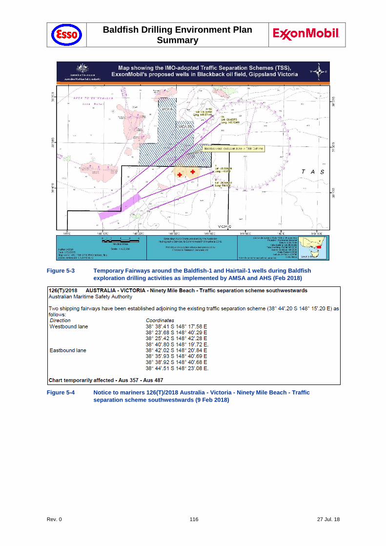
Baldfish Drilling Environment Plan Summary
Rev. 0 116 27 Jul. 18
Figure 5-3 Temporary Fairways around the Baldfish-1 and Hairtail-1 wells during Baldfish
exploration drilling activities as implemented by AMSA and AHS (Feb 2018)
Figure 5-4 Notice to mariners 126(T)/2018 Australia - Victoria - Ninety Mile Beach - Traffic
separation scheme southwestwards (9 Feb 2018)
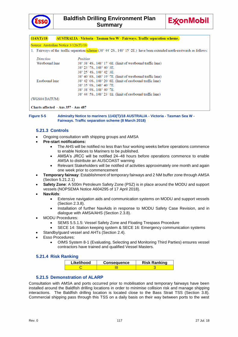
Baldfish Drilling Environment Plan Summary
Rev. 0 117 27 Jul. 18
Figure 5-5 Admiralty Notice to mariners 1143(T)/18 AUSTRALIA - Victoria - Tasman Sea W -
Fairways. Traffic separation scheme (8 March 2018)
5.21.3 Controls
Ongoing consultation with shipping groups and AMSA
Pre-start notifications:
The AHS will be notified no less than four working weeks before operations commence to enable Notices to Mariners to be published.
AMSA’s JRCC will be notified 24–48 hours before operations commence to enable AMSA to distribute an AUSCOAST warning
Relevant Stakeholders will be notified of activities approximately one month and again one week prior to commencement
Temporary fairway: Establishment of temporary fairways and 2 NM buffer zone through AMSA (Section 5.21.2.1)
Safety Zone: A 500m Petroleum Safety Zone (PSZ) is in place around the MODU and support vessels (NOPSEMA Notice A604295 of 17 April 2018).
NavAids:
Extensive navigation aids and communication systems on MODU and support vessels (Section 2.3.8).
Installation of further NavAids in response to MODU Safety Case Revision, and in dialogue with AMSA/AHS (Section 2.3.8).
MODU Procedures:
SEMS 5.5.1.5: Vessel Safety Zone and Floating Trespass Procedure
SECE 14: Station keeping system & SECE 16: Emergency communication systems
Standby/guard vessel and AHTs (Section 2.4).
Esso Procedures:
OIMS System 8-1 (Evaluating, Selecting and Monitoring Third Parties) ensures vessel contractors have trained and qualified Vessel Masters.
5.21.4 Risk Ranking
Likelihood Consequence Risk Ranking
C III 3
5.21.5 Demonstration of ALARP
Consultation with AMSA and ports occurred prior to mobilisation and temporary fairways have been installed around the Baldfish drilling locations in order to minimise collision risk and manage shipping interactions. The Baldfish drilling location is located close to the Bass Strait TSS (Section 3.8). Commercial shipping pass through this TSS on a daily basis on their way between ports to the west
Baldfish Drilling Environment Plan Summary
Rev. 0 118 27 Jul. 18
(Melbourne, Geelong and beyond) to eastern locations, including Sydney, Brisbane, New Zealand, Asia and beyond.
The establishment of temporary fairways, established by AMSA after extensive dialogue as part of stakeholder consultations (Section 5.21.2.1), represents a minor inconvenience to commercial shipping. In addition to this, Notices to Mariners will be issued prior to mobilisation, as well as ongoing communication with AMSA, Port of Melbourne and other ports where relevant.
Other controls and alternatives were considered, including minimising both duration of the campaign and minimising the safety zone around the MODU. The option to move the Baldfish location away from the shipping route has been considered. This would require horizontal directional drilling (HDD) over a long distance, which in turn would be costly, would require the use of NADF (Non-Aqueous Drilling Fluids; resulting in additional risk associated with the use of these drilling fluids), and would also substantially extend the duration of the drilling campaign. The associated risk is adequately managed through extensive measures put in place, including the establishment of temporary fairway and extensive communication and navigation aids. The additional risk and costs associated with HDD Technology is considered grossly disproportionate to the reduction in risk. No other mitigation measures are available, short of not proceeding with the drilling campaign.
Because of the location of the Baldfish Operational area, some interference with commercial shipping is possible. However, the consequence is minor and of short duration, so that the risk is assessed as Category 3 (medium). This is a Type B ALARP decision. Offshore commercial vessel operations are widely undertaken both locally, nationally and internationally. Shipping and commercial fishing activity is expected around the operational area, as the Baldfish well locations coincide with major shipping routes near the TSS. The risk associated with marine user interactions is well managed via legislative control measures that are considered industry best practice. These are well understood and implemented by the industry. Vessel operations are not unusual in this area and the risks impact to other marine users is well understood. The implementation of temporary fairways and extensive navigational aids are considered the key controls to address operations near a major shipping route.
Although the residual risk resulting from this activity is considered to be medium (Category 3), the proposed control measures are considered to be sufficient to reduce the impacts and risks associated with this hazard to ALARP, as the nature of this risk is well understood, and the activity is a well-established practice.
5.21.6 Demonstration of Acceptability
For this hazard the residual risk was assessed at Category 3 medium risk. As all relevant standards (Esso, Australian Standards and Industry best practice) have been met and there were no valid claims or objections to this risk from relevant persons, Esso considers the impacts and risk are acceptable.
5.22 Physical presence – Seabed Disturbance (RA 22)
5.22.1 Hazard
During drilling activities, the MODU will be anchored to the seabed to enable drilling activities to be undertaken. Drilling activities will directly disturb the seabed through presence of the wellbore – each wellhead, assuming a 26” (660 mm) surface hole and 17 1/2” (445 mm) conductor casing, will occupy an area of <0.5 m2 for each well, or <1 m2 in total for both wells.
Seabed disturbance resulting from the discharge of drilling cuttings and cement is addressed in Sections 5.14 (Cuttings to seabed), 5.15 (Cuttings at sea surface), 5.16 (Cement to seabed) and 5.17 (Cement at sea surface) respectively. The physical presence of these assets may result in some seabed disturbance and minor temporary changes to the water quality in the immediate vicinity.
5.22.2 Impact Assessment
Seabed disturbance has the potential to impact on receptors, including benthic habitats and assemblages and demersal fish, through smothering and alteration of benthic habitats and localised and temporary increase in turbidity near the seabed. Any impact will be limited to the immediate vicinity of the well locations, and thus the extent of potential impact is considered to be localised.
Baldfish Drilling Environment Plan Summary
Rev. 0 119 27 Jul. 18
The MODU is positioned by the installation of eight anchors (Section 2.3), attached by anchor chains and anchor cables to winches on-board the MODU. The positioning of the anchors at each of the two well locations, and sections of the anchor chain dragging over the seabed, will result in seabed disturbance.
Anchors are positioned by the AHTs on commencement of drilling activities at each of the two well locations and will be retrieved by the AHTs on completion of the well activities. AHTs and supply vessels will use dynamic positioning (DP) systems while within the PSZ.
The area of benthic habitat expected to be disturbed by planned activities is approximately 30 m2 per anchor (8 anchors in total) and 10 m2 per clump weight (8 in total). Some further scouring is likely to occur from the anchor chain. Nonetheless, the total disturbance area is expected to be relatively small.
The benthic habitat within the operational area is characterised by a soft sediment and shell/rubble seabed, supporting infauna communities. The type of damage that could be sustained by smothering may include destruction of habitat. However, due to the similarity of surrounding habitat, and lack of sensitive benthic habitats, it is expected that recovery is likely. There are minimal pressures on this value and the damage would only occur within a small area. It is expected that any localised impacts from anchoring would rapidly recolonise and recover following any disturbance.
Benthic fauna may be disturbed through the temporary increase in turbidity near the seafloor as a result of seabed disturbance during anchoring. The area of increased turbidity is likely to be a very small area localised around the disturbance points where anchors or weights sit on the seabed. Monitoring of large-scale capital dredging programs has shown that turbidity plumes are highly localised and result in only short-term exposures. This disturbance is considered to be substantially less than that resulting from the release of drill cuttings and cement at the sea surface, so that the resulting impact is adequately addressed by these risks (see Sections 5.15 and 5.17). The location of the wells within a homogenous seabed area, and lack of sensitive benthic features, means that turbidity resulting from the described activities is not expected to result in any environmental impacts and hence have not been discussed further.
On completion of the Baldfish scope, the well will be plugged in accordance with Esso P&A philosophy (Section 2.3.9), with the casing cut just below the seabed (1.5 to -3 m below the seabed). Based upon previous wellhead removal, the typical time to cut the wellhead is in the order of 3 – 7hrs. The wellhead is then pulled free and recovered to the MODU.
Once the wellhead is removed, an ROV is deployed from the MODU to conduct a post operation survey. This survey records the condition of the seabed at the completion of the program to ensure that no dropped objects or subsea equipment intended for removal remain on the seabed.
This involves a 50 m radius visual check and 100 m sonar inspection from each wellhead location. If subsea equipment is temporarily stored on the seabed, the ROV survey will also record the geographic coordinates of each piece of equipment. Removal of the wellhead and ROV survey may result in further localised seabed disturbance.
There are no KEF within the affected area. No stakeholder concerns have been raised on RA22. No further evaluation against the principles of ESD is required.
5.22.3 Controls
Post-drilling ROV survey will record the condition of the seabed at the completion of the program to ensure that no dropped objects or subsea equipment intended for removal remain on the seabed.
Mooring Analysis conducted to confirm adequacy of proposed anchoring system (API RP 2005: Design and Analysis of Station keeping Systems for Floating Structures).
Mooring line tensions measured, recorded and monitored to prevent anchor drag as per ISO 19901-7:2013.
Retrieval of anchors, anchor chains and wellhead on completion of well activities
Esso Procedure OIMS System 8-1 (Evaluating, Selecting and Monitoring Third Parties) ensures that adequate mooring analysis has been completed prior to anchoring and that mooring line tension is monitored.
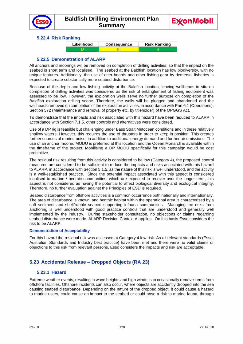
Baldfish Drilling Environment Plan Summary
Rev. 0 120 27 Jul. 18
5.22.4 Risk Ranking
Likelihood Consequence Risk Ranking
D III 4
5.22.5 Demonstration of ALARP
All anchors and moorings will be removed on completion of drilling activities, so that the impact on the seabed is short term and localised. The seabed at the Baldfish location has low biodiversity, with no unique features. Additionally, the use of otter boards and other fishing gear by demersal fisheries is expected to create substantially more seabed disturbance.
Because of the depth and low fishing activity at the Baldfish location, leaving wellheads in situ on completion of drilling activities was considered as the risk of entanglement of fishing equipment was assessed to be low. However, the exploration wells serve no further purpose on completion of the Baldfish exploration drilling scope. Therefore, the wells will be plugged and abandoned and the wellheads removed on completion of the exploration activities, in accordance with Part 6.1 (Operations), Section 572 (Maintenance and removal of property etc. by titleholder) of the OPGGS Act.
To demonstrate that the impacts and risk associated with this hazard have been reduced to ALARP in accordance with Section 7.1.5, other controls and alternatives were considered.
Use of a DP rig is feasible but challenging under Bass Strait Metocean conditions and in these relatively shallow waters. However, this requires the use of thrusters in order to keep in position. This creates further sources of marine noise, in addition to additional energy demand and further air emissions. The use of an anchor moored MODU is preferred at this location and the Ocean Monarch is available within the timeframe of the project. Mobilising a DP MODU specifically for this campaign would be cost prohibitive.
The residual risk resulting from this activity is considered to be low (Category 4), the proposed control measures are considered to be sufficient to reduce the impacts and risks associated with this hazard to ALARP, in accordance with Section 5.1.5, as the nature of this risk is well understood, and the activity is a well-established practice. Since the potential impact associated with this aspect is considered localised to marine / benthic communities, which are expected to recover over the longer term, this aspect is not considered as having the potential to affect biological diversity and ecological integrity. Therefore, no further evaluation against the Principles of ESD is required.
Seabed disturbance from offshore activities is a common occurrence both nationally and internationally. The area of disturbance is known, and benthic habitat within the operational area is characterised by a soft sediment and shell/rubble seabed supporting infauna communities. Managing the risks from anchoring is well understood with good practice controls that are understood and generally well implemented by the industry. During stakeholder consultation, no objections or claims regarding seabed disturbance were made. ALARP Decision Context A applies. On this basis Esso considers the risk to be ALARP.
Demonstration of Acceptability
For this hazard the residual risk was assessed at Category 4 low risk. As all relevant standards (Esso, Australian Standards and Industry best practice) have been met and there were no valid claims or objections to this risk from relevant persons, Esso considers the impacts and risk are acceptable.
5.23 Accidental Release – Dropped Objects (RA 23)
5.23.1 Hazard
Extreme weather events, resulting in wave heights and high winds, can occasionally remove items from offshore facilities. Offshore incidents can also occur, where objects are accidently dropped into the sea causing seabed disturbance. Depending on the nature of the dropped object, it could cause a hazard to marine users, could cause an impact to the seabed or could pose a risk to marine fauna, through
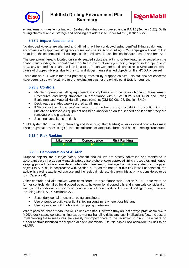
Baldfish Drilling Environment Plan Summary
Rev. 0 121 27 Jul. 18
entanglement, ingestion or impact. Seabed disturbance is covered under RA 22 (Section 5.22). Spills during chemical and oil storage and handling are addressed under RA 27 (Section 5.27).
5.23.2 Impact Assessment
No dropped objects are planned and all lifting will be conducted using certified lifting equipment, in accordance with approved lifting procedures and checks. A post drilling ROV campaign will confirm that apart from the cement and drill cuttings, unplanned items left on the sea floor are located and removed.
The operational area is located on sandy seabed substrate, with no or few features observed on the seabed surrounding the operational area. In the event of an object being dropped in the operational area, any seabed disturbance will be localised. Rough weather conditions in Bass Strait are the main cause of dropped objects, due to the storm dislodging unrestrained objects on the MODU or vessel.
There are no KEF within the area potentially affected by dropped objects. No stakeholder concerns have been raised on RA23. No further evaluation against the principles of ESD is required.
5.23.3 Controls
Maintain operational lifting equipment in compliance with the Ocean Monarch Management Procedures and lifting standards in accordance with SEMS (OM-SC-001-02) and Lifting Equipment and Material Handling requirements (OM-SC-001-03, Section 3.4.9)
Deck loads are adequately secured at all times
ROV inspection of the seafloor around the wellhead area, post drilling to confirm that no unplanned retrievable equipment has been abandoned on the seabed and if so that they are removed where practicable.
Securing loose items on deck.
OIMS System 8-1 (Evaluating, Selecting and Monitoring Third Parties) ensures vessel contractors meet Esso's expectations for lifting equipment maintenance and procedures, and house-keeping procedures.
5.23.4 Risk Ranking
Likelihood Consequence Risk Ranking
D IV 4
5.23.5 Demonstration of ALARP
Dropped objects are a major safety concern and all lifts are strictly controlled and monitored in accordance with the Ocean Monarch safety case. Adherence to approved lifting procedures and house-keeping procedures are considered adequate measures to manage the risk associated with dropped objects to ALARP, in accordance with Section 7.1.5, as the nature of this risk is well understood, the activity is a well-established practice and the residual risk resulting from this activity is considered to be low (Category 4).
Other controls and alternatives were considered, in accordance with Section 7.1.5. There were no further controls identified for dropped objects, however for dropped oils and chemicals consideration was given to additional containment measures which could reduce the risk of spillage during transfer, including (see RA 27, Section 5.27):
Secondary containment in shipping containers;
Use of purpose built water tight shipping containers where possible; and
Use of purpose built roof-opening shipping containers.
Where possible, these measures will be implemented. However, they are not always practicable due to MODU deck space constraints, increased manual handling risks, and cost implications (i.e., the cost of implementing these measures are grossly disproportionate to the reduction in risk). There were no further controls identified for dropped oils and chemicals. On this basis Esso considers the risk to be ALARP.
Baldfish Drilling Environment Plan Summary
Rev. 0 122 27 Jul. 18
Demonstration of Acceptability
For this hazard the residual risk was assessed as a Category 4 low risk. As all relevant standards (Esso, Australian Standards and Industry best practice) have been met and there were no valid claims or objections to this risk from relevant persons, Esso considers the impacts and risk are acceptable.
5.24 Accidental Release - Loss of containment from vessel collision (RA 24)
5.24.1 Hazard
A vessel to vessel or vessel to MODU collision could result in a release of diesel or other hazardous chemicals (in storage in the hull) to the marine environment. This could lead to changes in the water column biochemistry, causing acute or chronic impacts or mortality in seabirds, marine mammals and reptiles, fish and other marine organisms. It could also impact on shoreline and intertidal communities along the mainland or nearby islands.
5.24.2 Modelling Methodology and Thresholds
A vessel collision with another vessel or with the MODU, resulting in a rupture of the hull and the loss of a fuel tank (280,000 L of diesel) over 6 hours was conservatively modelled.
The following parameters were applied for MDO modelling:
Density: 829 kg/m3 @ 15˚C
API: 37.6
Dynamic viscosity: 4.0 cP @ 25°C
Pour Point: -14 ºC
Oil Property Category: Group II (Light-persistent oil)
5.24.2.1 Oil Spill Trajectory modelling
Esso commissioned RPS APASA (APASA) to undertake OSTM using a three-dimensional oil spill trajectory and weathering model, SIMAP (Spill Impact Mapping and Analysis Program) (APASA, 2018). SIMAP was run multiple times to simulate the defined spill scenarios, using different samples of current and wind data, based on randomly selected historic time-series of wind and current data (5 years duration), representative of the study area as follows:
100 simulations were completed.
The model ran 100 single spill trajectories, using the same spill information (i.e. spill volume, duration and oil type) but with varying start times, and in turn, prevailing wind and current conditions.
The probability of exposure to the sea surface, in-water and shoreline contacts for the hypothetical spill scenario over a 5-year period was quantified.
For the diesel spill scenario, the spill was tracked for 20 days
The potential for sensitive receptors to be exposed to surface, entrained and dissolved hydrocarbons has been assessed by the application of assessment thresholds. Assessment thresholds for hydrocarbon exposure (sea surface, shoreline, and water column dissolved aromatics and entrained hydrocarbons) are described below.
5.24.2.2 Thresholds
Surface Hydrocarbon Thresholds
A surface hydrocarbon level of 0.5 g/m2 equates approximately to an average thickness of ~0.5 μm (Table 5-3). Oil of this thickness is described as a silvery to rainbow sheen in appearance, according to the Bonn Agreement Oil Appearance Code (Bonn Agreement, 2009) is considered the practical limit of observing oil in the marine environment (AMSA 2012). This threshold is considered below levels which would cause environmental harm and it is more indicative of the areas perceived to be affected due to its visibility on the sea surface and potential to trigger temporary closures of areas (i.e. fishing grounds) as a precautionary measure. Hence, the 0.5 g/m2 threshold has been selected to define the zone of potential low exposure on the sea surface (Table 5-4).

Baldfish Drilling Environment Plan Summary
Rev. 0 123 27 Jul. 18
Table 5-3 The Bonn Agreement Oil Appearance Code
Code Description Appearance Layer Thickness Interval (g/m2 or μm)
Litres per km2
1 Sheen (silvery/grey) 0.04 – 0.30 40 – 300
2 Rainbow 0.30 – 5.0 300 – 5,000
3 Metallic 5.0 – 50 5,000 – 50,000
4 Discontinuous True Oil Colour 50 – 200 50,000 – 200,000
5 Continuous True Oil Colour 200 –> 200,000 –>
Table 5-4 Hydrocarbon exposure thresholds in surface waters
Threshold Range Basis Receptors*
Low Impact 0.5 – 10 g/m2
Socio-economic impact. 0.5g/m2 considered the practical limit of observing oil in the marine environment (AMSA 2012) (French-McCay (2016) concluded 1g/m2 was an appropriate threshold for sub-lethal effects on water birds, marine mammals and turtles.)
Social • Coastal Settlements • Recreation and Tourism • Heritage
Moderate Impact
10 – 25 g/m2
Lethal threshold for water birds, marine mammals and turtles. 10g/m2 derived by French-McCay (2016) based on observations made by the Deep Water Horizon Trustees (2015).
Ecological • Seabirds and Shorebirds • Marine Reptiles • Marine Mammals Social • Commonwealth Areas, Parks and
Reserves • State Parks and Reserves
High Impact >25 g/m2 Scholten et al. (1996) and Koops et al. (2004) indicated that a concentration of surface oil equal to 25 g/m2 or greater would be harmful for all birds that contact the slick.
* Based on available information, concentration thresholds for use in the impact assessment have been defined for the different exposure types (surface, in-water, shoreline). These impact thresholds and exposure pathways are then applied at a receptor level for use in the consequence evaluations.
Shoreline Exposure Thresholds
There are many different types of shorelines, ranging from cliffs, rocky beaches, sandy beaches, mud flats and mangroves, and each of these influence the volume of oil that can remain stranded ashore and its thickness before the shoreline saturation point occurs. For instance, a sandy beach may allow oil to percolate through the sand, thus increasing its ability to hold more oil ashore over tidal cycles and various wave actions than an equivalent area of water; hence oil can increase in thickness onshore over time. A sandy beach shoreline was assumed as the default shoreline type for the modelling herein, as it allows for the highest carrying capacity of oil (of the available open/exposed shoreline types). Hence the results contained herein would be indicative of a worst case scenario, where the highest volume of oil may be stranded on the shoreline (when compared to other shoreline types, such as exposed rocky shores). The thresholds for shoreline impacts are summarised in Table 5-5.
Table 5-5 Hydrocarbon exposure thresholds used to classify the zones of shoreline contact
Threshold Range Basis Receptors*
Low Impact 10-100 g/m2 French-McCay et al. (2005a, 2005b) 10g/m2 used to define regions of socio-economic impact (e.g. temporary closure of fisheries, need to clean up man-made structures or amenity beaches)
Moderate Impact
100 – 1000 g/m2 AMSA’s Foreshore Assessment Guide (2012) defines 100g/m2 as the minimum thickness that does not inhibit recovery and is best remediated by natural processes alone.
Sub-lethal and lethal impacts for shorebirds and wildlife (French et al. 1996).
Ecological • Shoreline (e.g. sandy, rock etc.) • Soft Sediment • Marine Invertebrates • Seabirds and Shorebirds • Marine Reptiles • Marine Mammals Social • Commonwealth Areas, Parks and
Reserves • State Parks and Reserves • Coastal Settlements • Recreation and Tourism
Baldfish Drilling Environment Plan Summary
Rev. 0 124 27 Jul. 18
• Heritage
High Impact >1000g/m2 Significant impact on marsh plants (Lin & Mendelssohn, 1996) and mangroves (Grant et al. 1993; Suprayogi & Murray, 1999).
Ecological • Mangroves • Saltmarshes Social • Wetlands
* Based on available information, concentration thresholds for use in the impact assessment have been defined for the different exposure types (surface, in-water, shoreline). These impact thresholds and exposure pathways are then applied at a receptor level for use in the consequence evaluations.
Water Column Exposure Thresholds
Dispersed oil are small, discrete insoluble dispersed oil droplets, suspended in the water column. In essence the oil has been partitioned (naturally separated) from gas/oil/water mixture by solubility (water washing) and vapour pressure (evaporation) based on the individual hydrocarbon chemical properties.
While dissolved aromatics are the largest contributor to the toxicity of solutions generated by mixing hydrocarbons into water, it is still important to model the fate of entrained hydrocarbons because they are the mechanism of delivering soluble aromatics to the water column.
Dissolved Aromatic Hydrocarbons
The threshold value for species toxicity in the water column is based on global data from French et al. (1999) and French-McCay (2002, 2003), which showed that species sensitivity (fish and invertebrates) to dissolved aromatics exposure >4 days (96-hour LC50) under different environmental conditions varied from 6 to 400 ppb, with an average of 50 ppb. This range covered 95% of aquatic organisms tested, which included species during sensitive life stages (eggs and larvae). Thresholds for dissolved hydrocarbons, and their rationale are summarised in Table 5-6.
Entrained Hydrocarbons
There has been a considerable amount of dialogue among scientists on what entrained hydrocarbon levels represent realistic thresholds. The selected thresholds for entrained hydrocarbons are summarised in Table 5-7.
Exposure thresholds used to assess entrained hydrocarbon exposure were based on OSPAR guidelines. OSPAR has published a predicted no effect concentration (PNEC) for produced formation water (PFW), which accounts for the dispersed fractions of oil that is more representative of entrained oil droplets.
There are practical limitations to OSTM as a tool to assess spill risk, and thresholds, no matter how carefully chosen, are a simplification of the actual situation because:
Thresholds do not distinguish between the various marine species. Instead, a conservative scientifically defensible value is selected, allowing for the generally agreed species protection levels (NOEC is based on to 95% protection of species).
Thresholds do not distinguish between life stages (eggs, larvae, juveniles, adults).
Thresholds do not distinguish between the wide range of chemicals that may comprise released hydrocarbons.
Thresholds do not take into further account the various levels of exposure times, but instead choose between acute (96 hrs) or chronic exposure levels (168 hrs).
Table 5-6 Hydrocarbon exposure thresholds for dissolved aromatic exposure
Exposure level
Threshold Basis Receptors
Low Exposure (99% species
protection)
6 ppb for 96 hours (576 ppb.hrs)
LC50 from French-McCay (2002, 2003), using lower limit of sensitivity range (6 ppb).
Exposure of 96 hours chosen as conservative for acute effects (acute studies generally observe toxicity over 48-96 hours).
Baldfish Drilling Environment Plan Summary
Rev. 0 125 27 Jul. 18
Moderate Exposure
(95% species protection)
50 ppb for 96 hours
(4,800 ppb.hrs)
LC50 from French-McCay (2002, 2003), using average of reported sensitivity values (50 ppb).
Species sensitivity (fish and invertebrates) to dissolved aromatics exposure >4 days (96-hour LC50) under different environmental conditions varied from 6 to 400 μg/l (ppb), with an average of 50 ppb.
An average 96 hr LC50 of 50 ppb could serve as an acute lethal threshold to 5% of biota.
Ecological • Seagrass • Algae • Coral • Plankton • Marine Invertebrates • Fish & Sharks • Marine Mammals Social • Commonwealth Areas, Parks and
Reserves • State Parks and Reserves • Commercial and Recreational Fisheries • Recreation and Tourism
High Exposure (50% species
protection)
400 ppb for 96 hours
(38,400 ppb.hrs)
LC50 from French-McCay (2002, 2003), using upper limit of sensitivity range (400 ppb).
An average 96 hr LC50 of 400 ppb could serve as an acute lethal threshold to 50% of biota.
* Based on available information, concentration thresholds for use in the impact assessment have been defined for the different exposure types (surface, in-water, shoreline). These impact thresholds and exposure pathways are then applied at a receptor level for use in the consequence evaluations.
Additionally, there are limitations on the model itself (e.g. McKay et al., 1999, French-McCay 2004):
Available temperature, wind, wave and current data,
Grid resolution and bathymetry simplification,
Tidal forcing,
Assumptions made around weathering and fate,
Limitations to the number of computations which restricts the number of particles that are traced during each run, and which in turn limits the lowest concentrations that can be reliably traced.
A further complication is that modelled volumes and composition of hydrocarbons are conservatively chosen based on theoretical values and the available reservoir data. Released volumes and actual duration of the release is likely to be substantially less.
In order to take above considerations into account, model assumptions and selection of thresholds are conservative. Nonetheless, low level impacts may extend beyond the lowest thresholds. The geographical extent of such impacts was determined by applying the ANZECC criteria for TPH to entrained hydrocarbons.
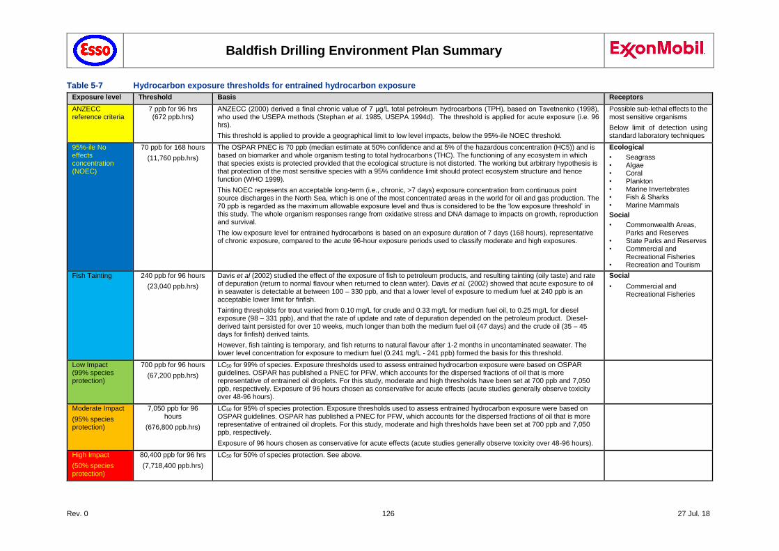
Baldfish Drilling Environment Plan Summary
Rev. 0 126 27 Jul. 18
Table 5-7 Hydrocarbon exposure thresholds for entrained hydrocarbon exposure
Exposure level Threshold Basis Receptors
ANZECC reference criteria
7 ppb for 96 hrs (672 ppb.hrs)
ANZECC (2000) derived a final chronic value of 7 μg/L total petroleum hydrocarbons (TPH), based on Tsvetnenko (1998), who used the USEPA methods (Stephan et al. 1985, USEPA 1994d). The threshold is applied for acute exposure (i.e. 96 hrs).
This threshold is applied to provide a geographical limit to low level impacts, below the 95%-ile NOEC threshold.
Possible sub-lethal effects to the most sensitive organisms
Below limit of detection using standard laboratory techniques
95%-ile No effects concentration (NOEC)
70 ppb for 168 hours
(11,760 ppb.hrs)
The OSPAR PNEC is 70 ppb (median estimate at 50% confidence and at 5% of the hazardous concentration (HC5)) and is based on biomarker and whole organism testing to total hydrocarbons (THC). The functioning of any ecosystem in which that species exists is protected provided that the ecological structure is not distorted. The working but arbitrary hypothesis is that protection of the most sensitive species with a 95% confidence limit should protect ecosystem structure and hence function (WHO 1999).
This NOEC represents an acceptable long-term (i.e., chronic, >7 days) exposure concentration from continuous point source discharges in the North Sea, which is one of the most concentrated areas in the world for oil and gas production. The 70 ppb is regarded as the maximum allowable exposure level and thus is considered to be the ‘low exposure threshold’ in this study. The whole organism responses range from oxidative stress and DNA damage to impacts on growth, reproduction and survival.
The low exposure level for entrained hydrocarbons is based on an exposure duration of 7 days (168 hours), representative of chronic exposure, compared to the acute 96-hour exposure periods used to classify moderate and high exposures.
Ecological
• Seagrass • Algae • Coral • Plankton • Marine Invertebrates • Fish & Sharks • Marine Mammals
Social
• Commonwealth Areas, Parks and Reserves
• State Parks and Reserves • Commercial and
Recreational Fisheries • Recreation and Tourism
Fish Tainting 240 ppb for 96 hours
(23,040 ppb.hrs)
Davis et al (2002) studied the effect of the exposure of fish to petroleum products, and resulting tainting (oily taste) and rate of depuration (return to normal flavour when returned to clean water). Davis et al. (2002) showed that acute exposure to oil in seawater is detectable at between 100 – 330 ppb, and that a lower level of exposure to medium fuel at 240 ppb is an acceptable lower limit for finfish.
Tainting thresholds for trout varied from 0.10 mg/L for crude and 0.33 mg/L for medium fuel oil, to 0.25 mg/L for diesel exposure (98 – 331 ppb), and that the rate of update and rate of depuration depended on the petroleum product. Diesel-derived taint persisted for over 10 weeks, much longer than both the medium fuel oil (47 days) and the crude oil (35 – 45 days for finfish) derived taints.
However, fish tainting is temporary, and fish returns to natural flavour after 1-2 months in uncontaminated seawater. The lower level concentration for exposure to medium fuel (0.241 mg/L - 241 ppb) formed the basis for this threshold.
Social
• Commercial and Recreational Fisheries
Low Impact (99% species protection)
700 ppb for 96 hours
(67,200 ppb.hrs)
LC50 for 99% of species. Exposure thresholds used to assess entrained hydrocarbon exposure were based on OSPAR guidelines. OSPAR has published a PNEC for PFW, which accounts for the dispersed fractions of oil that is more representative of entrained oil droplets. For this study, moderate and high thresholds have been set at 700 ppb and 7,050 ppb, respectively. Exposure of 96 hours chosen as conservative for acute effects (acute studies generally observe toxicity over 48-96 hours).
Moderate Impact
(95% species protection)
7,050 ppb for 96 hours
(676,800 ppb.hrs)
LC50 for 95% of species protection. Exposure thresholds used to assess entrained hydrocarbon exposure were based on OSPAR guidelines. OSPAR has published a PNEC for PFW, which accounts for the dispersed fractions of oil that is more representative of entrained oil droplets. For this study, moderate and high thresholds have been set at 700 ppb and 7,050 ppb, respectively.
Exposure of 96 hours chosen as conservative for acute effects (acute studies generally observe toxicity over 48-96 hours).
High Impact
(50% species protection)
80,400 ppb for 96 hrs
(7,718,400 ppb.hrs)
LC50 for 50% of species protection. See above.
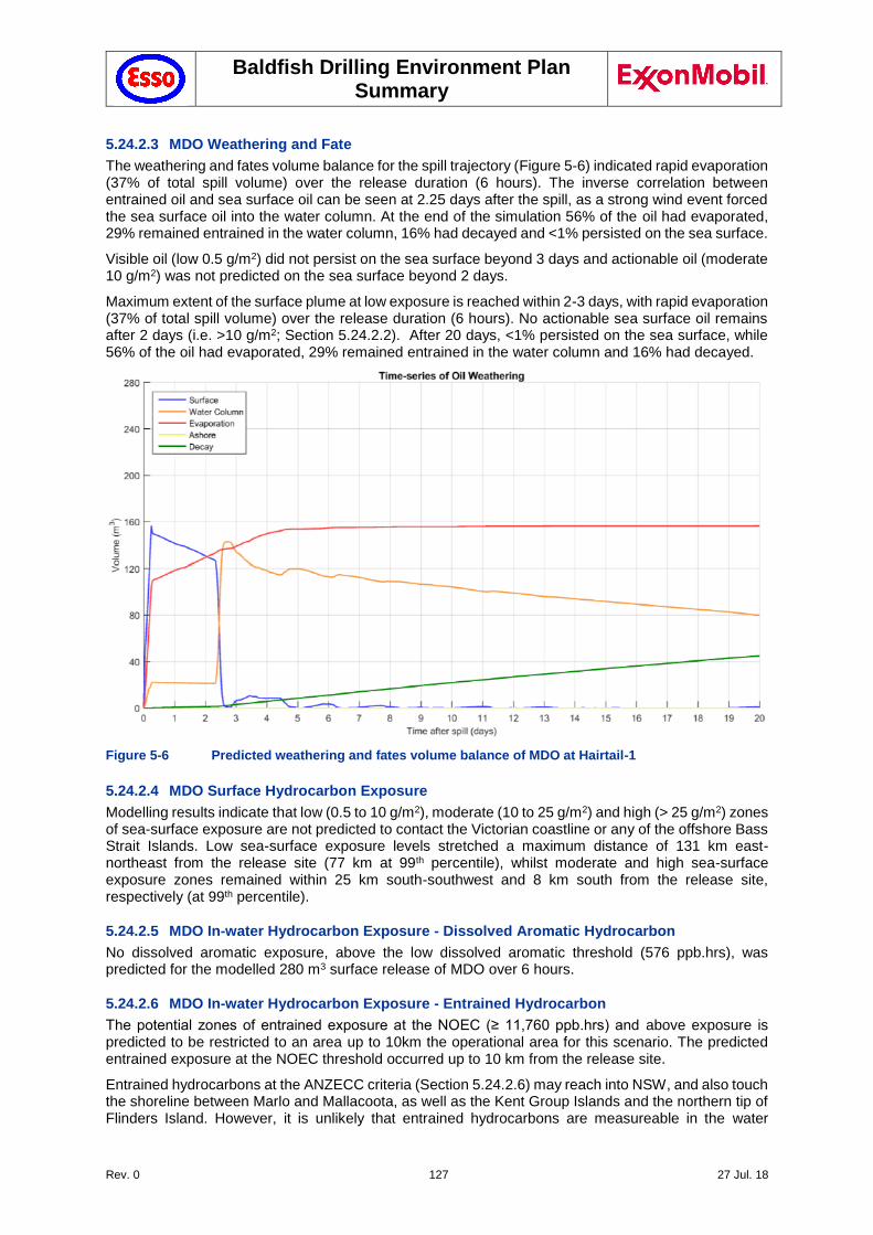
Baldfish Drilling Environment Plan Summary
Rev. 0 127 27 Jul. 18
5.24.2.3 MDO Weathering and Fate
The weathering and fates volume balance for the spill trajectory (Figure 5-6) indicated rapid evaporation (37% of total spill volume) over the release duration (6 hours). The inverse correlation between entrained oil and sea surface oil can be seen at 2.25 days after the spill, as a strong wind event forced the sea surface oil into the water column. At the end of the simulation 56% of the oil had evaporated, 29% remained entrained in the water column, 16% had decayed and <1% persisted on the sea surface.
Visible oil (low 0.5 g/m2) did not persist on the sea surface beyond 3 days and actionable oil (moderate 10 g/m2) was not predicted on the sea surface beyond 2 days.
Maximum extent of the surface plume at low exposure is reached within 2-3 days, with rapid evaporation (37% of total spill volume) over the release duration (6 hours). No actionable sea surface oil remains after 2 days (i.e. >10 g/m2; Section 5.24.2.2). After 20 days, <1% persisted on the sea surface, while 56% of the oil had evaporated, 29% remained entrained in the water column and 16% had decayed.
Figure 5-6 Predicted weathering and fates volume balance of MDO at Hairtail-1
5.24.2.4 MDO Surface Hydrocarbon Exposure
Modelling results indicate that low (0.5 to 10 g/m2), moderate (10 to 25 g/m2) and high (> 25 g/m2) zones of sea-surface exposure are not predicted to contact the Victorian coastline or any of the offshore Bass Strait Islands. Low sea-surface exposure levels stretched a maximum distance of 131 km east-northeast from the release site (77 km at 99th percentile), whilst moderate and high sea-surface exposure zones remained within 25 km south-southwest and 8 km south from the release site, respectively (at 99th percentile).
5.24.2.5 MDO In-water Hydrocarbon Exposure - Dissolved Aromatic Hydrocarbon
No dissolved aromatic exposure, above the low dissolved aromatic threshold (576 ppb.hrs), was predicted for the modelled 280 m3 surface release of MDO over 6 hours.
5.24.2.6 MDO In-water Hydrocarbon Exposure - Entrained Hydrocarbon
The potential zones of entrained exposure at the NOEC (≥ 11,760 ppb.hrs) and above exposure is predicted to be restricted to an area up to 10km the operational area for this scenario. The predicted entrained exposure at the NOEC threshold occurred up to 10 km from the release site.
Entrained hydrocarbons at the ANZECC criteria (Section 5.24.2.6) may reach into NSW, and also touch the shoreline between Marlo and Mallacoota, as well as the Kent Group Islands and the northern tip of Flinders Island. However, it is unlikely that entrained hydrocarbons are measureable in the water
Baldfish Drilling Environment Plan Summary
Rev. 0 128 27 Jul. 18
column at these levels with standard laboratory methodology, while impacts on even the most sensitive biota and ecosystems would most likely not be detectable with conventional scientific methods.
5.24.2.7 MDO Shoreline contact
No shoreline contact, above the low shoreline contact threshold (10 g/m2), was predicted for the modelled 280 m3 surface release of MDO over 6 hours, except at the ANZECC reference threshold for entrained hydrocarbons.
5.24.3 Impact Assessment
A release of diesel or other hazardous chemicals to the marine environment may result in acute or chronic impacts, or mortality, of marine organisms. A vessel collision event also has the potential to impact on social receptors, resulting from surface; and in water exposure (entrained only).
The potential impacts include direct impacts (potential toxicity effects / physical oiling; potential for reduction in intrinsic values / visual aesthetics) and indirect impacts (potential damage to commercial businesses). Based on the impact thresholds identified in Section 5.24.2, the potential risks are summarised below.
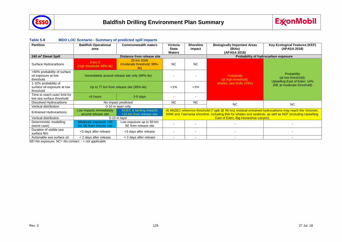
Baldfish Drilling Environment Plan Summary
Rev. 0 129 27 Jul. 18
Table 5-8 MDO LOC Scenario - Summary of predicted spill impacts
Partition Baldfish Operational area
Commonwealth waters Victoria State
Waters
Shoreline impact
Biologically Important Areas (BIAs)
(APASA 2018)
Key Ecological Features (KEF) (APASA 2018)
240 m3 Diesel Spill Distance from release site Probability of hydrocarbon exposure
Surface Hydrocarbons 8 km S
(high threshold; 99%-ile)
25 km SSW (moderate threshold; 99%-
ile) NC NC
Probability (at high threshold):
whales, sea birds: (43%)
Probability (at low threshold):
Upwelling East of Eden: 14% (NE at moderate threshold)
>50% probability of surface oil exposure at low threshold
Immediately around release site only (99%-ile) - -
1-10% probability of surface oil exposure at low threshold
Up to 77 km from release site (99%-ile) <1% <1%
Time to reach outer limit for low sea surface threshold
<6 hours 2-5 days - -
Dissolved Hydrocarbons No impact predicted NC NC NC NC
Vertical distribution 0-10 m layer only
Entrained Hydrocarbons Low impacts immediately
around release site NOEC & tainting impacts <10 km from release site
At ANZEC reference threshold (7 ppb @ 96 hrs) residual entrained hydrocarbons may reach the Victorian, NSW and Tasmania shoreline, including BIA for whales and seabirds, as well as KEF (including Upwelling
East of Eden, Big Horseshoe canyon) Vertical distribution 0-10 m layer
Deterministic modelling (worst case)
Moderate exposure <20 km SE from release site
Low exposure up to 50 km SE from release site
- - - -
Duration of visible sea surface film
<3 days after release <3 days after release - - - -
Actionable sea surface oil < 2 days after release < 2 days after release - - - -
NE=No exposure; NC= No contact; - = not applicable
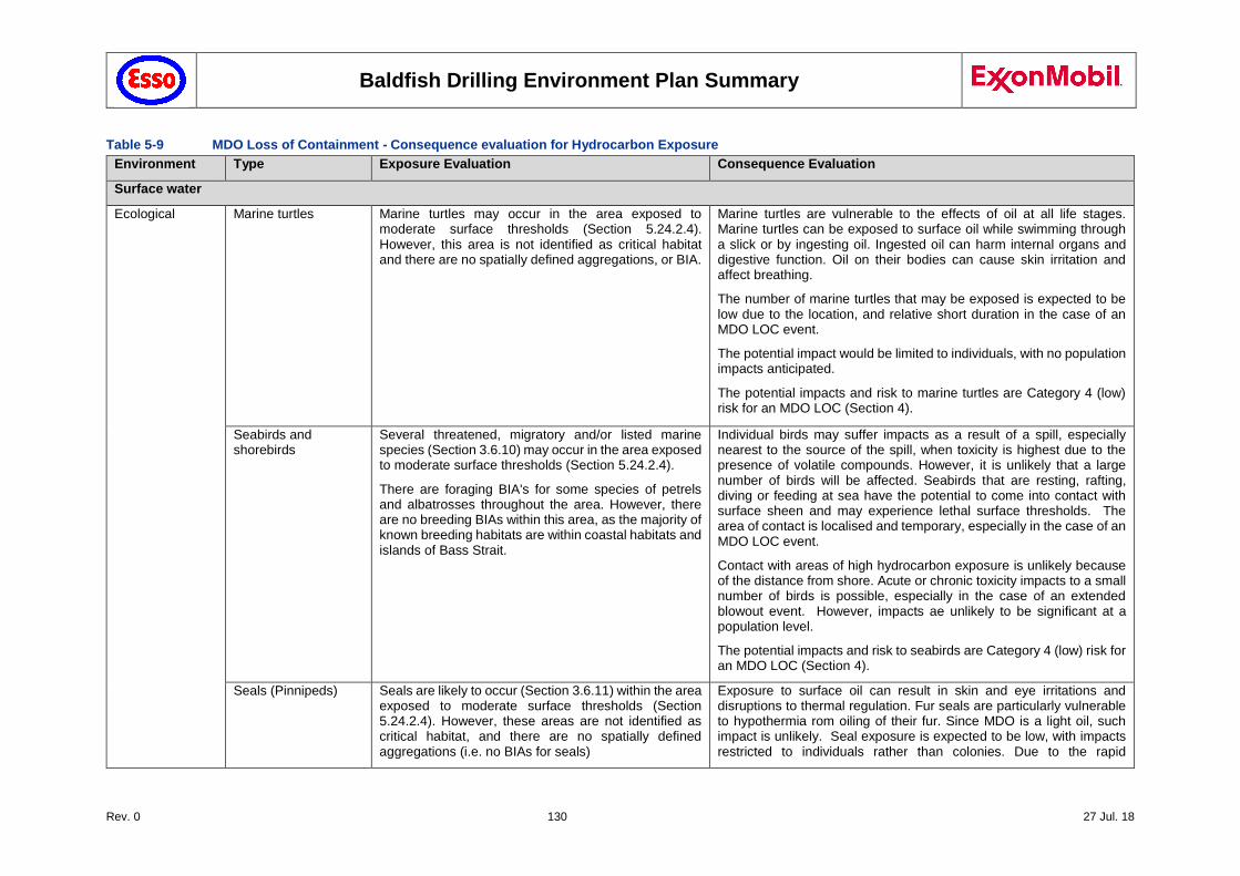
Baldfish Drilling Environment Plan Summary
Rev. 0 130 27 Jul. 18
Table 5-9 MDO Loss of Containment - Consequence evaluation for Hydrocarbon Exposure
Environment Type Exposure Evaluation Consequence Evaluation
Surface water
Ecological Marine turtles Marine turtles may occur in the area exposed to moderate surface thresholds (Section 5.24.2.4). However, this area is not identified as critical habitat and there are no spatially defined aggregations, or BIA.
Marine turtles are vulnerable to the effects of oil at all life stages. Marine turtles can be exposed to surface oil while swimming through a slick or by ingesting oil. Ingested oil can harm internal organs and digestive function. Oil on their bodies can cause skin irritation and affect breathing.
The number of marine turtles that may be exposed is expected to be low due to the location, and relative short duration in the case of an MDO LOC event.
The potential impact would be limited to individuals, with no population impacts anticipated.
The potential impacts and risk to marine turtles are Category 4 (low) risk for an MDO LOC (Section 4).
Seabirds and shorebirds
Several threatened, migratory and/or listed marine species (Section 3.6.10) may occur in the area exposed to moderate surface thresholds (Section 5.24.2.4).
There are foraging BIA's for some species of petrels and albatrosses throughout the area. However, there are no breeding BIAs within this area, as the majority of known breeding habitats are within coastal habitats and islands of Bass Strait.
Individual birds may suffer impacts as a result of a spill, especially nearest to the source of the spill, when toxicity is highest due to the presence of volatile compounds. However, it is unlikely that a large number of birds will be affected. Seabirds that are resting, rafting, diving or feeding at sea have the potential to come into contact with surface sheen and may experience lethal surface thresholds. The area of contact is localised and temporary, especially in the case of an MDO LOC event.
Contact with areas of high hydrocarbon exposure is unlikely because of the distance from shore. Acute or chronic toxicity impacts to a small number of birds is possible, especially in the case of an extended blowout event. However, impacts ae unlikely to be significant at a population level.
The potential impacts and risk to seabirds are Category 4 (low) risk for an MDO LOC (Section 4).
Seals (Pinnipeds) Seals are likely to occur (Section 3.6.11) within the area exposed to moderate surface thresholds (Section 5.24.2.4). However, these areas are not identified as critical habitat, and there are no spatially defined aggregations (i.e. no BIAs for seals)
Exposure to surface oil can result in skin and eye irritations and disruptions to thermal regulation. Fur seals are particularly vulnerable to hypothermia rom oiling of their fur. Since MDO is a light oil, such impact is unlikely. Seal exposure is expected to be low, with impacts restricted to individuals rather than colonies. Due to the rapid
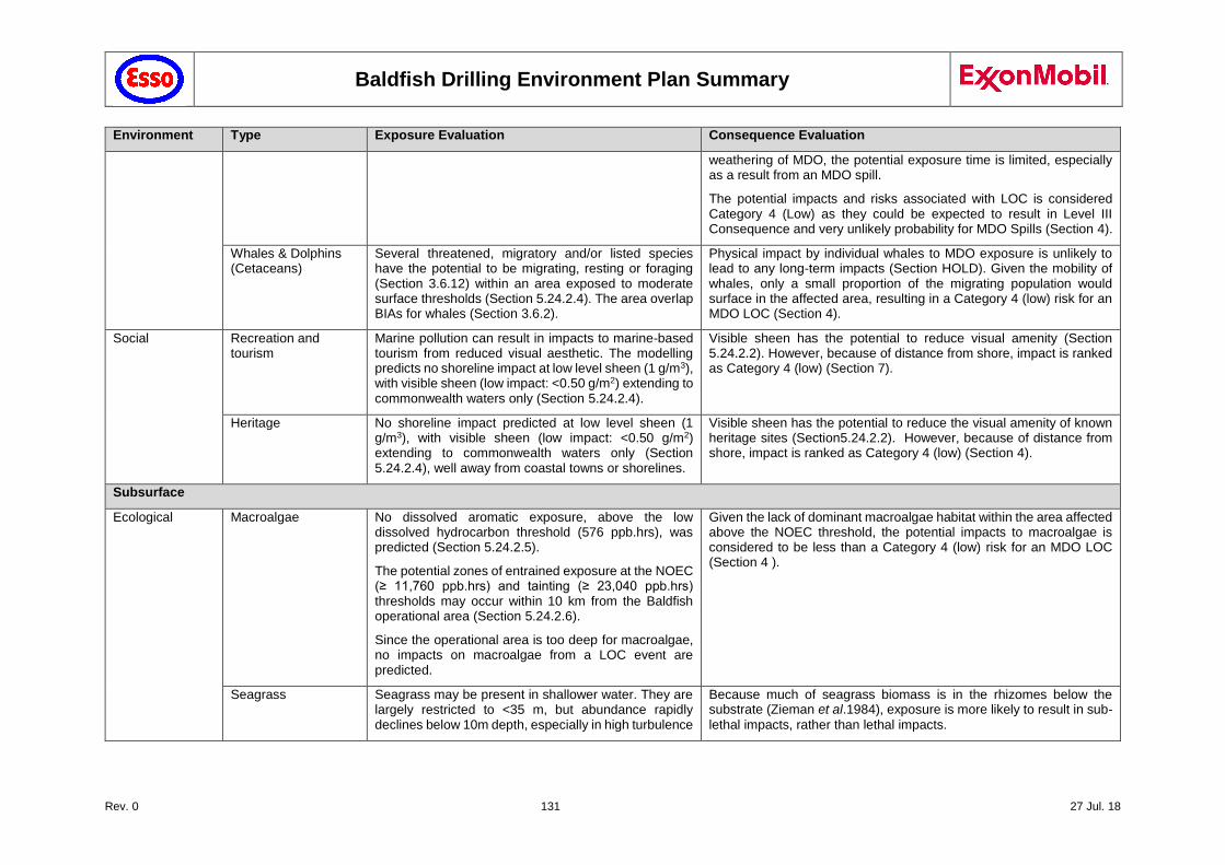
Baldfish Drilling Environment Plan Summary
Rev. 0 131 27 Jul. 18
Environment Type Exposure Evaluation Consequence Evaluation
weathering of MDO, the potential exposure time is limited, especially as a result from an MDO spill.
The potential impacts and risks associated with LOC is considered Category 4 (Low) as they could be expected to result in Level III Consequence and very unlikely probability for MDO Spills (Section 4).
Whales & Dolphins (Cetaceans)
Several threatened, migratory and/or listed species have the potential to be migrating, resting or foraging (Section 3.6.12) within an area exposed to moderate surface thresholds (Section 5.24.2.4). The area overlap BIAs for whales (Section 3.6.2).
Physical impact by individual whales to MDO exposure is unlikely to lead to any long-term impacts (Section HOLD). Given the mobility of whales, only a small proportion of the migrating population would surface in the affected area, resulting in a Category 4 (low) risk for an MDO LOC (Section 4).
Social Recreation and tourism
Marine pollution can result in impacts to marine-based tourism from reduced visual aesthetic. The modelling predicts no shoreline impact at low level sheen (1 g/m3), with visible sheen (low impact: <0.50 g/m2) extending to commonwealth waters only (Section 5.24.2.4).
Visible sheen has the potential to reduce visual amenity (Section 5.24.2.2). However, because of distance from shore, impact is ranked as Category 4 (low) (Section 7).
Heritage No shoreline impact predicted at low level sheen (1 g/m3), with visible sheen (low impact: <0.50 g/m2) extending to commonwealth waters only (Section 5.24.2.4), well away from coastal towns or shorelines.
Visible sheen has the potential to reduce the visual amenity of known heritage sites (Section5.24.2.2). However, because of distance from shore, impact is ranked as Category 4 (low) (Section 4).
Subsurface
Ecological Macroalgae No dissolved aromatic exposure, above the low dissolved hydrocarbon threshold (576 ppb.hrs), was predicted (Section 5.24.2.5).
The potential zones of entrained exposure at the NOEC (≥ 11,760 ppb.hrs) and tainting (≥ 23,040 ppb.hrs) thresholds may occur within 10 km from the Baldfish operational area (Section 5.24.2.6).
Since the operational area is too deep for macroalgae, no impacts on macroalgae from a LOC event are predicted.
Given the lack of dominant macroalgae habitat within the area affected above the NOEC threshold, the potential impacts to macroalgae is considered to be less than a Category 4 (low) risk for an MDO LOC (Section 4 ).
Seagrass Seagrass may be present in shallower water. They are largely restricted to <35 m, but abundance rapidly declines below 10m depth, especially in high turbulence
Because much of seagrass biomass is in the rhizomes below the substrate (Zieman et al.1984), exposure is more likely to result in sub-
lethal impacts, rather than lethal impacts.
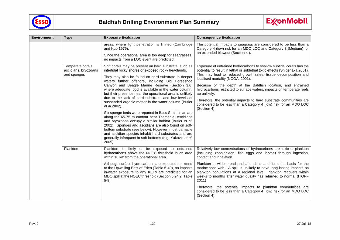
Baldfish Drilling Environment Plan Summary
Rev. 0 132 27 Jul. 18
Environment Type Exposure Evaluation Consequence Evaluation
areas, where light penetration is limited (Cambridge and Kuo 1979).
Since the operational area is too deep for seagrasses, no impacts from a LOC event are predicted.
The potential impacts to seagrass are considered to be less than a Category 4 (low) risk for an MDO LOC and Category 3 (Medium) for an extended blowout (Section 4 ).
Temperate corals, ascidians, bryozoans and sponges
Soft corals may be present on hard substrate, such as intertidal rocky shores or exposed rocky headlands.
They may also be found on hard substrate in deeper waters further offshore, including Big Horseshoe Canyon and Beagle Marine Reserve (Section 3.6) where adequate food is available in the water column, but their presence near the operational area is unlikely due to the lack of hard substrate, and low levels of suspended organic matter in the water column (Butler et al.2002).
Six sponge beds were reported in Bass Strait, in an arc along the 65-75 m contour near Tasmania. Ascidians and bryozoans occupy a similar habitat (Butler et al. 2002). Sponges and ascidians are also found on soft-bottom substrate (see below). However, most barnacle and ascidian species inhabit hard substrates and are generally infrequent in soft bottoms (e.g. Yakovis et al. 2005).
Exposure of entrained hydrocarbons to shallow subtidal corals has the potential to result in lethal or sublethal toxic effects (Shigenaka 2001). This may lead to reduced growth rates, tissue decomposition and localised mortality (NOOA, 2001).
Because of the depth at the Baldfish location, and entrained hydrocarbons restricted to surface waters, impacts on temperate reefs ae unlikely.
Therefore, the potential impacts to hard substrate communities are considered to be less than a Category 4 (low) risk for an MDO LOC (Section 4).
Plankton Plankton is likely to be exposed to entrained hydrocarbons above the NOEC threshold in an area within 10 km from the operational area.
Although surface hydrocarbons are expected to extend to the Upwelling East of Eden (Table 6-40), no impacts in-water exposure to any KEFs are predicted for an MDO spill at the NOEC threshold (Section 5.24.2; Table 5-8).
Relatively low concentrations of hydrocarbons are toxic to plankton (including zooplankton, fish eggs and larvae) through ingestion, contact and inhalation.
Plankton is widespread and abundant, and form the basis for the marine food web. A spill is unlikely to have long-lasting impacts on plankton populations at a regional level. Plankton recovers within weeks to months after water quality has returned to normal (ITOPF 2011)
Therefore, the potential impacts to plankton communities are considered to be less than a Category 4 (low) risk for an MDO LOC (Section 4).
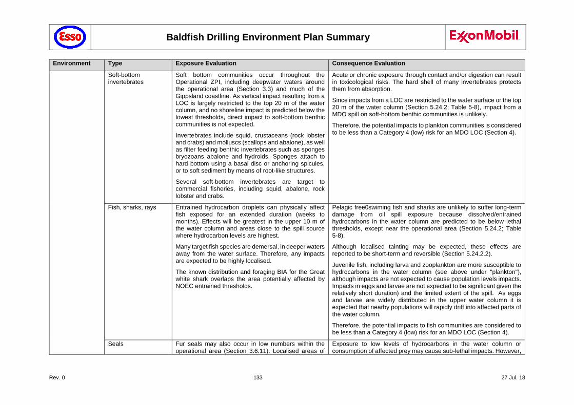
Baldfish Drilling Environment Plan Summary
Rev. 0 133 27 Jul. 18
Environment Type Exposure Evaluation Consequence Evaluation
Soft-bottom invertebrates
Soft bottom communities occur throughout the Operational ZPI, including deepwater waters around the operational area (Section 3.3) and much of the Gippsland coastline. As vertical impact resulting from a LOC is largely restricted to the top 20 m of the water column, and no shoreline impact is predicted below the lowest thresholds, direct impact to soft-bottom benthic communities is not expected.
Invertebrates include squid, crustaceans (rock lobster and crabs) and molluscs (scallops and abalone), as well as filter feeding benthic invertebrates such as sponges bryozoans abalone and hydroids. Sponges attach to hard bottom using a basal disc or anchoring spicules, or to soft sediment by means of root-like structures.
Several soft-bottom invertebrates are target to commercial fisheries, including squid, abalone, rock lobster and crabs.
Acute or chronic exposure through contact and/or digestion can result in toxicological risks. The hard shell of many invertebrates protects them from absorption.
Since impacts from a LOC are restricted to the water surface or the top 20 m of the water column (Section 5.24.2; Table 5-8), impact from a MDO spill on soft-bottom benthic communities is unlikely.
Therefore, the potential impacts to plankton communities is considered to be less than a Category 4 (low) risk for an MDO LOC (Section 4).
Fish, sharks, rays Entrained hydrocarbon droplets can physically affect fish exposed for an extended duration (weeks to months). Effects will be greatest in the upper 10 m of the water column and areas close to the spill source where hydrocarbon levels are highest.
Many target fish species are demersal, in deeper waters away from the water surface. Therefore, any impacts are expected to be highly localised.
The known distribution and foraging BIA for the Great white shark overlaps the area potentially affected by NOEC entrained thresholds.
Pelagic free0swiming fish and sharks are unlikely to suffer long-term damage from oil spill exposure because dissolved/entrained hydrocarbons in the water column are predicted to be below lethal thresholds, except near the operational area (Section 5.24.2; Table 5-8).
Although localised tainting may be expected, these effects are reported to be short-term and reversible (Section 5.24.2.2).
Juvenile fish, including larva and zooplankton are more susceptible to hydrocarbons in the water column (see above under "plankton"), although impacts are not expected to cause population levels impacts. Impacts in eggs and larvae are not expected to be significant given the relatively short duration) and the limited extent of the spill. As eggs and larvae are widely distributed in the upper water column it is expected that nearby populations will rapidly drift into affected parts of the water column.
Therefore, the potential impacts to fish communities are considered to be less than a Category 4 (low) risk for an MDO LOC (Section 4).
Seals Fur seals may also occur in low numbers within the operational area (Section 3.6.11). Localised areas of
Exposure to low levels of hydrocarbons in the water column or consumption of affected prey may cause sub-lethal impacts. However,
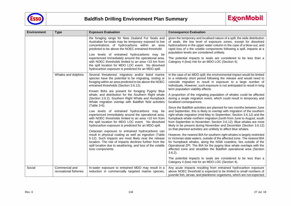
Baldfish Drilling Environment Plan Summary
Rev. 0 134 27 Jul. 18
Environment Type Exposure Evaluation Consequence Evaluation
the foraging range for New Zealand Fur Seals and Australian fur-seals may be temporary exposed to low concentrations of hydrocarbons within an area predicted to be above the NOEC entrained threshold.
Low levels of entrained hydrocarbons may be experienced immediately around the operational area, with NOEC thresholds limited to an area <10 km from the spill location for MDO LOC event. No dissolved hydrocarbon exposure is predicted for an MDO spill.
given the temporary and localised nature of a spill, the wide distribution of seals, the low level of exposure zones, except for dissolved hydrocarbons in the upper water column in the case of a blow-out, and rapid loss of o the volatile components following a spill, impacts at a population levels are considered unlikely.
The potential impacts to seals are considered to be less than a Category 4 (low) risk for an MDO LOC (Section 4).
Whales and dolphins Several threatened, migratory and/or listed marine species have the potential to be migrating, resting or foraging within an area predicted to be above the NOEC entrained thresholds (Section 3.6.12).
Known BIAs are present for foraging Pygmy Blue whale; and distribution for the Southern Right whale (Section 3.6.2). Southern Right Whale and Humpback Whale migration overlap with Baldfish field activities (Table 3-6).
Low levels of entrained hydrocarbons may be experienced immediately around the operational area, with NOEC thresholds limited to an area <10 km from the spill location for MDO LOC event. No dissolved hydrocarbon exposure is predicted for an MDO spill.
Cetacean exposure to entrained hydrocarbons can result in physical coating as well as ingestion (Table 5-12). Such impacts are most likely near the release location. The risk of impacts declines further from the spill location due to weathering, and loss of the volatile toxic components.
In the case of an MDO spill, the environmental impact would be limited to a relatively short period following the release and would need to coincide migration to result in exposure to a large number of individuals. However, such exposure is not anticipated to result in long term population viability effects.
A proportion of the migrating population of whales could be affected during a single migration event, which could result in temporary and localised consequences.
Since the Baldfish activities are planned for two months between June and September, this is likely to overlap with migration of the southern right whale migration (mid-May to September; Section 3.6.12) and the humpback whale northern migration (north from June to August; south from September to November; Section 3.6.12). Blue whales are most likely to be present during November and December (Section 3.6.12) so that planned activities are unlikely to affect blue whales.
However, the nearest BIA for southern right whales is largely restricted to Victorian state waters, outside of the affected zone. The nearest BIA for humpback whales, along the NSW coastline, lies outside of the Operational ZPI. The BIA for the pygmy blue whale overlaps with the affected zone and straddles the Baldfish operational area (Section 3.6.2).
The potential impacts to seals are considered to be less than a Category 4 (low) risk for an MDO LOC (Section 4).
Social Commercial and recreational fisheries
In-water exposure to entrained MDO may result in a reduction in commercially targeted marine species,
Any acute impacts resulting from entrained hydrocarbon exposure above NOEC threshold is expected to be limited to small numbers of juvenile fish, larvae, and planktonic organisms, which are not expected
Baldfish Drilling Environment Plan Summary
Rev. 0 135 27 Jul. 18
Environment Type Exposure Evaluation Consequence Evaluation
resulting in impacts to commercial fishing and aquaculture.
Actual or potential contamination of seafood can affect commercial and recreational fishing and can impact seafood markets, which can have economic impacts to the industry.
Several commercial fisheries may operate in the affected area and overlap the spatial extent of the water column hydrocarbon predictions.
to affect population viability or recruitment. Impacts from entrained exposure are unlikely to manifest at a fish population viability level.
Any exclusion zone established around a spill location would be limited to the immediate vicinity of the release point, and due to the rapid weathering of MDO would only be in place 1-2 days after release, therefore physical displacement to vessels is unlikely to be a significant impact.
Tainting occurs at much higher exposure levels, further limiting exposure risk, while fish tainting is largely reversible (Section 5.24.2.2) Also see above: fish & sharks, and invertebrates.
The potential impacts to seals are considered to be less than a Category 4 (low) risk for an MDO LOC (Section 4).
Recreation and tourism
Tourism and recreation is also linked to the presence of marine fauna (e.g. whales), to a number of nature areas that are frequented by tourists, and to recreational fishing.
Any impact to receptors that are of interest to nature-based tourism (e.g. whales, recreational fishing, natural parks and reserves) may cause a subsequent negative impact to recreation and tourism activities.
The potential impacts to whales, recreational fisheries and impacts to nature are described above and were assessed to be less than a Category 4 (low) risk for an MDO LOC (Section 4).
Baldfish Drilling Environment Plan Summary
Rev. 0 136 27 Jul. 18
5.24.4 Controls
Temporary fairway: Establishment of temporary fairways and 2 NM buffer zone through AMSA (Section 5.21.2.1)
Petroleum Safety Zone: A 500m Petroleum Safety Zone (PSZ) is in place around the MODU and support vessels (NOPSEMA Notice A604295 of 17 April 2018).
NavAids:
Extensive navigation aids and communication systems on MODU and support vessels (Section 2.3.8).
Installation of further NavAids in response to MODU Safety Case Revision and in dialogue with AMSA/AHS (Section 2.3.8).
MODU Procedures:
Vessel Safety Zone and Floating Trespass Procedure (SEMS 5.5.1.5).
Station keeping system & SECE 16: Emergency communication systems (SECE 14).
Any vessel that enters the 500m PSZ will be required to complete a checklist, before contacting the Ballast Control Operator over the radio and ask for permission to enter the 500m exclusion zone. Once they enter the 500m PSZ the entry is logged.
The MODU AIS system will register an unauthorised entry into the 500m PSZ, as will AHT/guard vessel radar, which will intercept any unauthorised vessels breaching PSZ. Any such incidences are logged in MODU log book. A MODU Unidentified Approaching Vessel Plan is in place and made available to all support vessels.
Standby/guard vessel and AHTs (Section 2.4) monitor vessel movements near and within the 2 NM Buffer zone around the MODU, established as part of the temporary fairways (Section 5.21), and will intervene when an Errant Passing Marine Vessel (commercial/fishing) approaches the 2 NM Buffer zone.
OPEP & ERP: Project specific Oil Pollution Emergency Plans and Emergency Response Plans have been developed, in addition to vessel SOPEP requirements under MARPOL.
OSMP: The OSMP details the arrangements and capability in place for operational monitoring (to inform response activities) and scientific monitoring (of environmental impacts of the spill and response activities). Operational monitoring will allow adequate information to be provided to aid decision making to ensure response activities are timely, safe, and appropriate. Scientific monitoring will identify if potential longer-term remediation activities may be required.
Esso Procedures:
OIMS System 8-1 (Evaluating, Selecting and Monitoring Third Parties) ensures MODU and vessel contractors have trained and qualified Vessel Masters.
OIMS System 10-2 (Emergency Preparedness and Response) ensures effective emergency preparedness and response plans are in place, which provide for well-maintained equipment and trained personnel.
5.24.5 Risk Ranking
Likelihood Consequence Risk Ranking
D III 4
5.24.6 Demonstration of ALARP
Adequate procedures and plans (including a vessel SOPEP) are in place on the vessel to respond to a spill. Esso also maintains spill response capability for responding in the event of a spill, which is outlined in the OPEP, and considers timeframes to mobilise and stage a response. In accordance with OIMS System 10-2, emergency response procedures are activated when required, which includes bringing the vessel or MODU back into a safe state where possible.
A PSZ of 500 m has been gazetted around the Baldfish wells to exclude the approach of any vessel not involved in Baldfish activities around the MODU (NOPSEMA Notice A604295 of 17 April 2018). The 500 m exclusion zone aims to prevent collision with the MODU while in operation. Although the Baldfish location is near the Bass Strait TSS (Section 3.8), extensive safety measures have been put in place to minimise the risk of vessel collisions (Sections 2.3, 2.4, 5.21).
Baldfish Drilling Environment Plan Summary
Rev. 0 137 27 Jul. 18
Any vessel that enters the 500m PSZ will be required to complete a checklist, before contacting the Ballast Control Operator over the radio and ask for permission to enter the 500m exclusion zone. Once they enter the 500m PSZ the entry is logged.
The MODU AIS system will register an unauthorised entry into the 500m PSZ, as will AHT/guard vessel radar, which will intercept any unauthorised vessels breaching PSZ. Any such incidences are logged in MODU log book. A MODU Unidentified Approaching Vessel Plan is in place and made available to all support vessels.
Further measures include: the establishment of temporary fairways around the Baldfish well locations, a 2NM radius buffer zone around each well location (Section 5.21.2.1); support from a guard vessel (Section 2.4) and navigational aids (Section 0; also RA 21 Section 5.21); and the ability for the MODU to disconnect and move when required. Therefore the residual risk of interference with shipping is considered low.
The Baldfish OPEP contains information on proposed response actions to a Level 1, 2 or 3 spill event from any of these scenarios.
Esso’s OIMS Framework, as described in Section 7.1, establishes expectations for addressing risks inherent in the business and ensuring hazards are safely controlled. OIMS Systems 8-1 (Evaluating, Selecting and Monitoring Third Parties) and 10-2 (Emergency Preparedness and Response) contribute to the control of this risk.
There are no KEF within the affected area. Stakeholder (AMSA) concerns regarding RA24 have been addressed through the establishment of temporary fairways (Section 5.21.2.1) and installation of further NavAids. No further evaluation against the principles of ESD is required.
The control measures described above are considered sufficient to reduce the impacts and risks associated with this hazard to ALARP, in accordance with Section 7.1.5, as the nature of this risk is well understood, the activity is a well-established practice and the residual risk resulting from this activity is considered to be low (Category 4).
In the unlikely event of a spill, Esso's well-practiced oil spill response systems would be activated (per the OPEP) and the impacts minimised. On this basis Esso considers the risk to be ALARP.
5.24.7 Demonstration of Acceptability
For this hazard the residual risk was assessed at Category 4 low risk. As all relevant standards (Esso, Australian Standards and Industry best practice) have been met and there were no valid claims or objections to this risk from relevant persons, Esso considers the impacts and risk are acceptable.
5.25 Accidental Release - Spills during Bulk transfer via bunkering hose (RA 25)
5.25.1 Hazard
Oils and chemicals are used as part of the daily operation of the MODU (e.g., cleaning decks, fuelling crane, includes paints and solvents etc.). Oils, including diesel, and chemicals are transferred via crane and stored as either packaged goods, in drums or in intermediate bulk containers (IBCs) or transferred via hose into a tank. Packaged goods are addressed under RA 23 (Dropped Objects) and not further addressed here.
Bulk transfer of freshwater, bentonite, barite, cement, brine and diesel fuel from vessel to MODU is conducted using flexible hoses. Accidental release may occur with hose failure. The release of any of these materials, but primarily diesel, into the marine environment can cause changes in the water quality.
5.25.2 Impact Assessment
A spill from a transfer incident is based on the loss of a volume equivalent to the volume in the hose plus the pumped amount before a shutdown is initiated. Due to the small volumes potentially released and dispersion in the high energy environment, the impacts on water quality are expected to be low. Since volumes are substantially less than that modelled for a loss of containment from a support vessel (RA 24), associated impacts are well within the parameters defined for that scenario (RA 24). A loss of
Baldfish Drilling Environment Plan Summary
Rev. 0 138 27 Jul. 18
50 m3 of diesel or chemicals upon release would be expected to result in changes to water quality in both surface waters and the pelagic environment.
As evaluated in Section 5.24 (RA 24), the potential impacts associated with a larger loss of diesel fuel, resulting from a vessel collision, were determined to be a Category 4 risk. Impacts resulting from a spill during bunkering is expected to be less and therefore adequately covered by the impact assessment under RA 24.
Regulation 37 of MARPOL Annex I requires that oil tankers of 150 gross tonnage and above and all ships of 400 gross tonnage and above carry an approved Shipboard Oil Pollution Emergency Plan (SOPEP). Article 3 of the International Convention on Oil Pollution Preparedness, Response and Co-operation, 1990, also requires such a plan for certain ships.
Regulation 17 of MARPOL Annex II makes similar stipulations that all ships of 150 gross tonnage and above carrying noxious liquid substances in bulk carry an approved shipboard marine pollution emergency plan for noxious liquid substances.
There are no KEF within the affected area. No stakeholder concerns have been raised on RA25. No further evaluation against the principles of ESD is required.
5.25.3 Controls
Bulk fluid transfer procedures will be in place before commencing operations ("Fuel Oil and Drilling / Completion Fluid Transfers from Dynamically Positioned Supply Boats Procedure"). The process will include:
MODU to vessel communication protocols
Transfer hose pressure testing
Continuous visual monitoring
Tank volume monitoring
Transfer hoses equipped with sufficient floating devices and self-sealing weak-link couplings in the mid-section of the hose string, in accordance with Guidelines for Offshore Marine Operations G-OMO 0611- 1401
Bulk fluid transfer hoses will be maintained in accordance with the requirements of the MODU Planned Maintenance System.
OPEP & ERP: Project specific Oil Pollution Emergency Plans and Emergency Response Plans have been developed, in addition to vessel SOPEP requirements under MARPOL.
OSMP: The OSMP details the arrangements and capability in place for operational monitoring (to inform response activities) and scientific monitoring (of environmental impacts of the spill and response activities). Operational monitoring will allow adequate information to be provided to aid decision making to ensure response activities are timely, safe, and appropriate. Scientific monitoring will identify if potential longer-term remediation activities may be required.
OIMS System 8-1 (Evaluating, Selecting and Monitoring Third Parties) ensures vessel contractors have a SOPEP in place.
OIMS System 10-2 (Emergency Preparedness and Response) ensures effective emergency preparedness and response plans are in place, which provide for well-maintained equipment and trained personnel, and oil spill equipment is appropriately maintained.
5.25.4 Risk Ranking
Likelihood Consequence Risk Ranking
D IV 4
5.25.5 Demonstration of ALARP
The bunkering procedures, hose maintenance and emergency response plans described above are considered sufficient control measures to reduce the impacts and risks associated with this hazard to ALARP, as the nature of this risk is well understood, the activity is a well-established practice and the residual risk resulting from this activity is considered to be low (Category 4). The performance of vessel and MODU specific procedures are appropriate for managing the day to day risk of the activity.
Baldfish Drilling Environment Plan Summary
Rev. 0 139 27 Jul. 18
Other controls and alternatives were considered, in accordance with Section 7.1.5. Instead of hose transfer, transfer using bulk containers was considered. This was not considered to provide any significant benefits and would actually increase the safety related level of risk and as such was rejected.
Alternative energy sources were considered instead of using diesel to eliminate the need for diesel bunkering, however powering equipment via solar or wind generation is not considered practical due to limited space on the deck and grossly disproportionate cost to install enough generation and battery storage to enable reliable 24 hr operations. There were no further controls identified. On this basis Esso considers the risk to be ALARP.
5.25.6 Demonstration of Acceptability
For this hazard the residual risk was assessed at Category 4 low risk. As all relevant standards (Esso, Australian Standards and Industry best practice) have been met and there were no valid claims or objections to this risk from relevant persons, Esso considers the impacts and risk are acceptable.
5.26 Accidental Release - Foam Deluge System (RA 26)
5.26.1 Hazard
An aqueous film forming foam (AFFF) foam fire-fighting system services the following areas of the MODU:
Helifuel storage area
Helifuel pump skid
Helideck foam deluge system
Helideck foam firefighting monitors
Main diesel engine coamings.
AFFFs are water-based firefighting foam products used to suppress flammable liquid fires by cooling the fire and coating the fuel, preventing its contact with oxygen.
AFFFs contain some PFAS (per- and poly-fluoroalkyl substances) – based products (FFFC 2017). PFAS are a class of stable man-made chemical substances containing carbon and fluorine in chemically combined form. These fluorosurfactants are the key ingredient that provide AFFF with the required low surface tension and positive spreading coefficient that enables aqueous film formation, and the foam’s effectiveness against Class B flammable liquid fires.
Some PFAS-based products are considered persistent (i.e. do not break down), bioaccumulative and toxic (PBT) are therefore being phased out. In the past PFAS-based products have been used in a range of common household products and specialty applications, including in the manufacture of non-stick cookware; fabric, furniture and carpet stain protection applications; and food packaging (DOD 2017).
Ocean Monarch utilises Fomtec AFFF 3% which;
does not contain or break down into PFOS (perfluoro-octane sulfonate) or homologues of PFOS such as PFHxS (perfluorohexane sulfonate).
does not contain or break down into any chemicals that are currently listed as persistent organic pollutants (POPs) under the Stockholm Convention.
is not made with PFOA (perfluoro-octanoic acid) or any PFOA-based products.
is not made with any chemicals that are currently considered to be PBT.
Operation of the foam deluge system occurs either:
As part of testing of the system. This allows verification of the system functionality, and tests the ability of the system to aspirate a concentrated fire-fighting foam solution and deliver it to the correct dilution and flow rate at the foam application areas. During testing and activation of the foam system AFFF foam may be discharged overboard via the drainage system;
Baldfish Drilling Environment Plan Summary
Rev. 0 140 27 Jul. 18
As demanded during an actual fire event.
5.26.2 Impact Assessment
The AFFF foam selected for use on the MODU is Fomtec AFFF 3% which contains no PFOS or PFOA. It is a C6-based (i.e. short chain flourosurfactant - based) fluorinated foam which has low aquatic toxicity (Environ 2016) and will disperse rapidly in the high energy environment. Consequently in the unlikely event of an unplanned release of foam solution negligible impacts on the marine environment are expected.
There are no KEF within the affected area. No stakeholder concerns have been raised on RA26. No further evaluation against the principles of ESD is required.
5.26.3 Controls
No testing of the foam fire-fighting system involving release of AFFF to the marine environment.
5.26.4 Risk Ranking
Likelihood Consequence Risk Ranking
D IV 4
5.26.5 Demonstration of ALARP
To demonstrate that the impacts and risk associated with this hazard have been reduced to ALARP, other controls and alternatives were considered.
The MODU utilises a C6-based fluorinated foam which does not contain PFOS or PFOA. To further minimise the potential environmental impact of a single large release of fire-fighting foam during an incident, its use has been limited to situations which present a significant flammable liquid hazard i.e. the helideck, helifuel storage and main diesel engines. The drill floor is protected by the water deluge system and the well test area by a water monitor. The accommodation, galley, engine room and auxiliary machinery pit, emergency generator room, paint locker and cementing unit are protected by a high pressure water mist system. The use of fluorine free foam is possible but is not considered to provide substantial benefit during the short drilling campaign.
To prevent the potential impacts of smaller releases foam fire-fighting systems may be tested without charging the system with AFFF (seawater only), or using a surrogate foam with similar physicochemical properties. However, this does not provide assurance that the aspiration system used will therefore perform (in terms of concentration delivered and rate of delivery) with the exact foam that would be used in an emergency and such substitution must be approved by the appropriate authority to ensure the adequacy of this testing method. During the drilling campaign there will be no testing of the system which may result in the release of AFFF to the marine environment.
Collection of foam solution from testing, or firewater from an actual event, with subsequent onshore disposal is not considered feasible as:
This would require edge bunding of every area on the MODU that utilises foam, reducing personnel accessibility to these areas and introducing tripping hazards at stair entrances, compromising escape / evacuation routes.
Piping would need to be retrospectively fitted to allow collection of the foam from the drain system, in addition to requiring large areas for temporary storage of collected foam on generally space constrained units. This can compromise escape / evacuation routes.
Additional lifting operations and additional vessel visits would be required, with associated dropped object risks, increased potential for vessel collision and increased consumption of diesel with associated atmospheric emissions.
Testing of the fire fighting system which may result in the release of AFFF to the marine environment will not be undertaken. In case of an emergency, such as a significant flammable fuel fire, safety considerations are the overriding factor. In such a situation the release of firewater directly to the marine environment may be unavoidable, however as the foam is PFOS and PFOA free and a low aquatic toxicity foam Esso considers the risk to be ALARP.
Baldfish Drilling Environment Plan Summary
Rev. 0 141 27 Jul. 18
5.26.6 Demonstration of Acceptability
For this hazard the residual risk was assessed at Category 4 low risk. As all relevant standards (Esso, Australian Standards and Industry best practice) have been met and there were no valid claims or objections to this risk from relevant persons, Esso considers the impacts and risk are acceptable.
5.27 Accidental Release - Spills during chemical and oils storage and handling (RA 27)
5.27.1 Hazard
Some hydrocarbons or chemicals in equipment (e.g., coolers, diesel engines and fire pumps, hydraulic equipment) are required to be changed out or topped-up and the excess or replaced fluids disposed. Where possible, these chemicals are collected for onshore disposal (e.g. using waste containers such as IBCs). No offshore chemical disposal is acceptable, unless discharge to sea is approved in accordance with Esso's chemical selection procedure (Section 7.8.1). Examples where these exceptions apply include chemicals that are used in sewage treatment systems (Section 0), deck drainage (Section 5.5), bilge water discharges (Section 5.6) and brine discharges (Section 5.11) (planned discharges). Packaged goods are addressed under RA 23 (Dropped Objects) and not further addressed here.
A spill of water-soluble chemicals on the MODU or support vessel to the drain could result in release to the marine environment causing a reduction of water quality or toxic impacts to marine species. A spill of chemicals or oils that overcomes secondary containment may also result in similar impacts to the environment.
5.27.2 Impact Assessment
Spills due to failure of primary containment may be either fully contained within a bund (or other secondary containment) or discharged into the drain system (such as from chemical tanks, chemical store, IBC or topsides equipment). Hydrocarbons spilled to the drain are recovered back, while water-soluble chemicals may be released to the marine environment (RA 5, Section 5.5).
A potential spill to the sea is likely to be of a small to moderate volume, which would disperse and dilute rapidly in the open ocean environment. Any change in water quality would be temporary and is assessed to have a small impact.'
As evaluated in Section 5.24 (RA 24), the potential impacts associated with a larger loss of diesel fuel, resulting from a vessel collision, were determined to be a Category 4 risk. Impacts resulting from a spill during bunkering is covered under RA 25 (Section 5.25). The management of hazardous waste is addressed under RA 4 (Section 5.4). Impacts resulting from a spill during chemical and oils storage and handling is considered adequately covered under these risks.
There are no KEF within the affected area. No stakeholder concerns have been raised on RA27. No further evaluation against the principles of ESD is required.
5.27.3 Controls
Storage of chemicals in bunds and handling and storage of hazardous waste in accordance with approved rig/vessel waste management procedures
Project specific Oil Pollution Emergency Plans and Emergency Response Plans have been developed, in addition to vessel SOPEP requirements under MARPOL.
Bulk fluid transfer procedures will be in place before commencing operations. The process will include:
MODU to vessel communication protocols
Transfer hose pressure testing
Continuous visual monitoring
Tank volume monitoring
OPEP & ERP: Project specific Oil Pollution Emergency Plans and Emergency Response Plans have been developed, in addition to vessel SOPEP requirements under MARPOL.
Baldfish Drilling Environment Plan Summary
Rev. 0 142 27 Jul. 18
OSMP: The OSMP details the arrangements and capability in place for operational monitoring (to inform response activities) and scientific monitoring (of environmental impacts of the spill and response activities). Operational monitoring will allow adequate information to be provided to aid decision making to ensure response activities are timely, safe, and appropriate. Scientific monitoring will identify if potential longer-term remediation activities may be required.
OIMS System 8-1 (Evaluating, Selecting and Monitoring Third Parties) ensures vessel contractors have a SOPEP in place.
OIMS System 10-2 (Emergency Preparedness and Response) ensures effective emergency preparedness and response plans are in place, which provide for well-maintained equipment and trained personnel, and oil spill equipment is appropriately maintained.
5.27.4 Risk Ranking
Likelihood Consequence Risk Ranking
D III 4
5.27.5 Demonstration of ALARP
Project chemical selection, handling and waste management procedures, as well as emergency response procedures, are considered sufficient control measures to reduce the impacts and risks associated with this hazard to ALARP, as the nature of this risk is well understood, the activity is a well-established practice and the residual risk resulting from this activity is considered to be low (Category 4). The vessel and MODU specific procedures are appropriate for managing the day to day operations.
Other controls and alternatives were considered, in accordance with Section 7.1.5. Disposal to sea is minimised, and restricted to chemicals which are low toxicity. However, use of chemicals is unavoidable (e.g. cleaning chemicals) in order to maintain a safe environment, free from contaminants. Oily decks represent a slip risk, so that occasional deck cleaning is a requirement.
There were no further controls identified. On this basis Esso considers the risk to be ALARP.
5.27.6 Demonstration of Acceptability
For this hazard the residual risk was assessed at Category 4 low risk. As all relevant standards (Esso, Australian Standards and Industry best practice) have been met and there were no valid claims or objections to this risk from relevant persons, Esso considers the impacts and risk are acceptable.
5.28 Accidental Release - Loss of well integrity (RA 28)
5.28.1 Hazard
During drilling operations there is a risk of a loss of well control (LOWC) event, leading to a well blowout. Uncontrolled hydrocarbon fluids released into the marine environment could lead to changes in the water column biochemistry and could impact seabirds, marine mammals and reptiles, fish and other marine organisms through surface fouling, ingestion or inhalation. It could also result in impacts on shoreline and intertidal communities along the mainland or nearby islands.
5.28.2 Oil Spill Trajectory Modelling
5.28.2.1 Spill Scenario Identification
An extended duration loss of well control/well blowout from well integrity failure (loss of containment of a Group I (non-persistent) condensate at seabed, RA 28) presented the worst credible discharge scenario (WCDS) and was modelled.
The WCDS for the loss of hydrocarbon is a subsea release of condensate as a result from a loss of well control (well blowout event).The assumptions for the blowout scenario are summarised in Table 5-10.
Table 5-10 Worst Credible Spill Scenario – Well blow-out (WCDS) assumptions
Parameter Details
EP Reference RA 28: Loss of Well Integrity (Section 5.28)
Baldfish Drilling Environment Plan Summary
Rev. 0 143 27 Jul. 18
EP Scenario Loss of well control / well blowout.
Loss of well control/well blowout (subsea release) can eventuate from a blowout while drilling, coinciding with partial closure of BOP shear rams.
Release would be from the annulus between casing and drill stem.
Product • Condensate (Group I: Non-persistent)
• A density of 770.6 kg/m3 and a dynamic viscosity of 1.4 cP @ 25°C,
• A gas to oil ratio of 45,545 scf/bbl,
• 80% volatiles, 12% semi-volatiles, 6.5% low volatiles and 1.5% persistent compounds.
Modelled release depth Subsea release at 462 m water depth (Hairtail-1) was modelled, based on preliminary well location.
Final well location was re-located about 1.75 km further offshore, at a revised depth of 359 m. APASA nearfield modelling confirmed that modelling outcome remains valid for revised well location and well depth*.
A subsea loss of well control/well blowout event at the Baldfish-1 mudline (665 m water depth) is considered to result in a similar release volume, but a slightly smaller Operational ZPI than the modelled scenario, due to a higher water pressure, resulting in finer entrained condensate droplets, in turn resulting in a slightly smaller Operational ZPI.
Nearfield simulations have confirmed that a 100 m decrease in water depth results in a 3% reduction in the oil droplet diameters. Therefore, a subsea condensate release at Baldfish-1 has been covered by the modelled scenario for Hairtail-1.
Modelled location of release Hairtail-1*: A subsea loss of well control/well blowout event at Hairtail-1, resulting in a subsea release of condensate over 98 days.
Modelled blowout duration – relief well
14 weeks (98 days), based on initial estimates for relief well completion and well kill. Actual release duration estimated to be substantially less (88 days for wet-tow scenario; 70 days for HLV transport; See Section 6.5 for further details).
This conservative early estimate was calculated based on the time to mobilise a rig from Australia or South East Asia, drill and intersect the well and complete the well kill activities. Subsequent review indicates that well kill can be achieved more quickly, thereby further reducing the released hydrocarbon volume.
Modelled blowout duration – capping stack
Early estimates of 49 day (7 weeks) release at seabed due to early intervention and installation of a capping stack. This option would result in halving of total release volume, from 172,200 kL to 86,100 kL.
Subsequent review confirms that capping stack installation can be achieved in 38 days, thereby further reducing the release volume (Section 6.5)
Scenario basis Two scenarios were reviewed:
1) 1 day release from surface (rig location) through the riser, followed by 97 days subsurface release following rig disconnect.
2) 49 day (7 weeks) release at seabed due to early intervention and installation of a capping stack. This option would result in halving of total release volume, from 172,200 kL to 86,100 kL
Modelled release volume • 1,760 kL/d or 11.05 kbd: 172,200 kL over 98 days
• Modelled at the total drilling depth,
• Annular flow: A 6 5/8” drill pipe in drill-hole and 12 ¼ wellbore,
• No hydrate blockage or choke effects: hydrate formation, however, is highly likely, substantially reducing release rates),
• Due to the expectation of strong aquifer support, discharge rates are expected to remain constant until a relief well is drilled. This aligns with a worst credible scenario as the potential for lower pressure support would result in reduced discharge rates. It is also assumed that in a worst credible scenario, no water coning would occur,
WCDS Assumptions Based on the ExxonMobil WCDS Process Guide. • An open-hole blowout while drilling, • A sea-floor release, occurring at the BOP, • Partially closed BOP shear rams, • Requiring a capping stack to be installed and a relief well to be drilled
Modelled Reservoir parameters
• Reservoir temperature is based on nearby wells including Dory-1. • No wellbore collapse or bridging. • Permeability is based on the mobility testing results from the Dory-1 well which are
consistent with analogue porosity-permeability data.
• Reservoir characteristics based on predicted permeability and net pay zone thickness,
• Prosper models were used to calculate inflow performance relationships (IPR) for each reservoir sand, with inputs as per the inflow and fluid properties,
• A GAP model (fluid mechanics solver) applies the IPR from each sand and relevant wellbore conditions to calculate total outflow, with inputs as per the outflow properties,
* RPS reassessed the near-field (blowout) modelling to compare the initial behaviour of the oil. In both cases the oil/gas/water
plume ruptured the surface, while the oil droplet sizes were approximately 3% smaller, due to the decreased hydrostatic
Baldfish Drilling Environment Plan Summary
Rev. 0 144 27 Jul. 18
pressure acting on the release point. The decrease in hydrostatic pressure results in the gas escaping from the well
occupying more space, which in turn results in a faster exit velocity. The increased exit velocity means there is more
turbulence during the jet release phase, which causes the oil to tear apart in to smaller droplets.
This minor change in droplet sizes would not have any perceivable impacts on the stochastic modelling completed for
Hairtail-1. The same can be said for the change in location. Moving the well slightly south would not cause the volumes of
oil ashore, or the timings to change by a meaningful amount (APASA 2017a).
The outcome of the Oil Spill Trajectory Modelling (OSTM) for the selected worst case credible spill scenario is presented below. It focuses on defining the likelihood of oil contact (surface, entrained and dissolved) with specific sensitive locations above the lowest threshold and shows the furthest possible extent from the release location that oil could reach, at the lowest threshold, if the spill scenario occurred.
5.28.2.2 Defining the Zone of Potential Impact
One objective of the spill modelling was to establish a Zone of Potential Impact (Operational ZPI) that may be exposed to surface or in-water hydrocarbons, resulting from a marine hydrocarbon spill. Delineation of the Operational ZPI is based on the furthest feasible extent from the release location (lowest exposure zone) of all modelled scenarios where hydrocarbon thresholds, including surface, entrained and dissolved aromatic hydrocarbons could be exceeded.
In the unlikely event of a worst case credible spill event (i.e. subsea well blowout scenario), the Operational ZPI includes sensitive marine environments, although shoreline impact is only predicted below the thresholds defined in Section 5.24.2.2. The Operational ZPI is largely defined by the surface hydrocarbon spread (Table 5-11) and is summarised in Figure 3-1 in Section 3.1.
Only at levels below the adopted 95%-ile NOEC (Table 5-7), are entrained hydrocarbons predicted to extend beyond this Operational ZPI (See Figure 3-2 in Chapter 3). Impacts resulting from these exposures, based on ANZECC criteria (Section 6.28.2.8), would be sub-lethal and minor (e.g. water quality impacts). This area is defined as the Environmental Monitoring ZPI. At this highly conservative threshold, it is unlikely that entrained hydrocarbons are measureable in the water column with standard laboratory methodology, while impacts on even the most sensitive biota and ecosystems would most likely not be detectible with conventional scientific methods.
The potential impacts to offshore (potentially occurring within the Baldfish operational area) and nearshore (potentially occurring within the Operational ZPI) environments and the Key Ecological Features (KEF) within the Operational ZPI that may be contacted are summarised in Table 5-13.
The key environmental sensitivities within and immediately outside the Operational ZPI are described in Section 3.6.
Operational and scientific monitoring will utilise hydrocarbon thresholds (as defined in the OSMP Operational Monitoring Modules and Scientific Monitoring Modules) to determine the termination point for operational and scientific monitoring.
5.28.2.3 Blowout scenario - Weathering and fate
The weathering and fates volume balance of the deterministic spill trajectory indicated very little oil would persist on the sea surface as it rapidly evaporated over the 98 days release. Decay steadily increased over 108 day simulation, as the oil entrained in the water column underwent natural biodegradation processes (Figure 5-6).
Visible oil (low 0.5 g/m2) did not persist on the sea surface beyond 3 days following well intervention (101 days) and actionable oil (moderate 10 g/m2) was not predicted on the sea surface following successful well intervention (98 days) (APASA 2018).
Note that review of timing for well intervention indicates that this can be achieved within 70 days when an HLV is used and within 88 days for the wet tow scenario (Section 6.5).
The installation of a capping stack (after 49 days) was conservatively modelled, although planning indicates that this may be achieved within 38 days.
In this scenario, visible oil (low 0.5 g/m2) did not persist on the sea surface beyond 51 days and actionable oil (moderate 10 g/m2) was not predicted on the sea surface beyond 50 days.
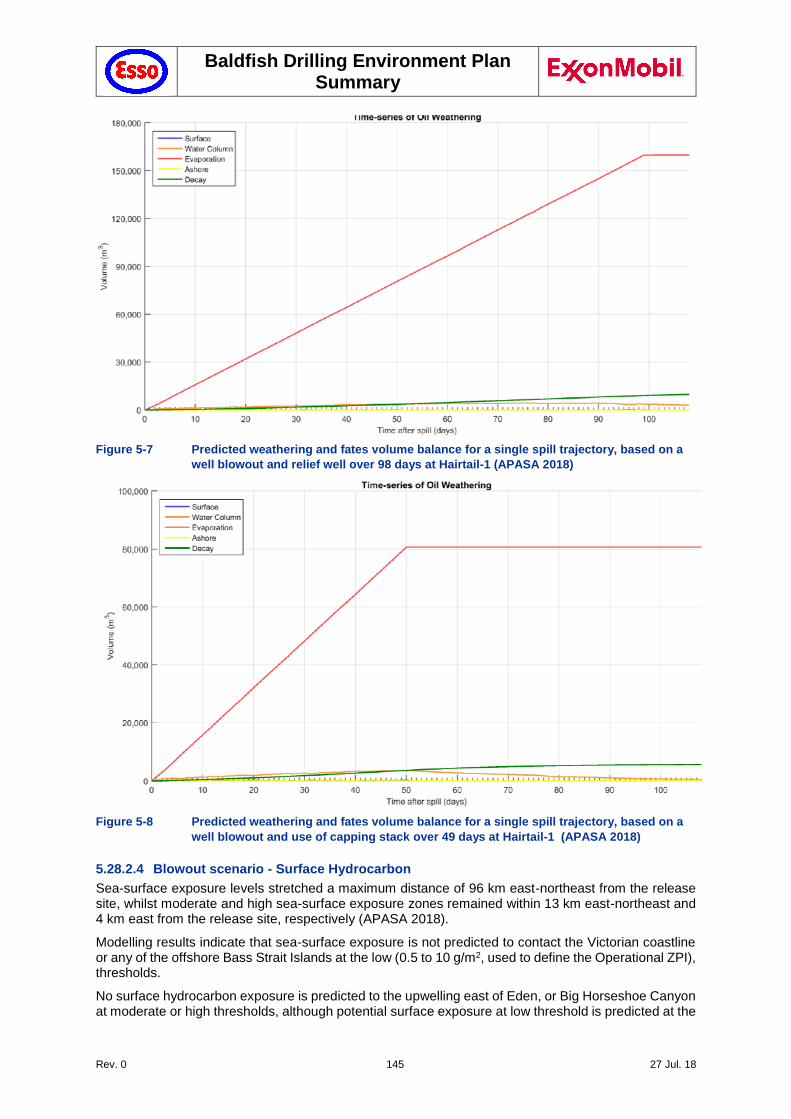
Baldfish Drilling Environment Plan Summary
Rev. 0 145 27 Jul. 18
Figure 5-7 Predicted weathering and fates volume balance for a single spill trajectory, based on a
well blowout and relief well over 98 days at Hairtail-1 (APASA 2018)
Figure 5-8 Predicted weathering and fates volume balance for a single spill trajectory, based on a
well blowout and use of capping stack over 49 days at Hairtail-1 (APASA 2018)
5.28.2.4 Blowout scenario - Surface Hydrocarbon
Sea-surface exposure levels stretched a maximum distance of 96 km east-northeast from the release site, whilst moderate and high sea-surface exposure zones remained within 13 km east-northeast and 4 km east from the release site, respectively (APASA 2018).
Modelling results indicate that sea-surface exposure is not predicted to contact the Victorian coastline or any of the offshore Bass Strait Islands at the low (0.5 to 10 g/m2, used to define the Operational ZPI), thresholds.
No surface hydrocarbon exposure is predicted to the upwelling east of Eden, or Big Horseshoe Canyon at moderate or high thresholds, although potential surface exposure at low threshold is predicted at the
Baldfish Drilling Environment Plan Summary
Rev. 0 146 27 Jul. 18
upwelling east of Eden (100% probability; after 52 hrs) and Big Horseshoe Canyon (11% probability; after 250 hrs).
5.28.2.5 Blowout scenario In-water Hydrocarbon Exposure - Dissolved Aromatic Hydrocarbon
Low dissolved aromatic exposure (576-4,800 ppb.hrs) in the 0-10 m depth layer was observed up to 167 km from the Hairtail-1 release site while moderate exposure (4,800 -38,400 ppb.hrs) was limited to within 5 km of the release site.
No dissolved aromatic hydrocarbon exposure is predicted to the upwelling east of Eden, or Big Horseshoe Canyon at moderate or high thresholds, although two KEFs were predicted to be impacted in the 0-10 m depth layer at low threshold: Upwelling East of Eden (41% at low dissolved thresholds) and Big Horseshoe Canyon (2% at low dissolved thresholds).
Several Biologically Important Areas (BIAs; whales and foraging sea birds) were predicted to have a 100% probably of low dissolved aromatic exposure (576-4,800 ppb.hrs) in the 0-10 m depth layer.
5.28.2.6 Blowout scenario In-water Hydrocarbon Exposure - Entrained Hydrocarbon
The predicted entrained exposure was minimal and occurred within 2 km of the Hairtail-1 release site, while sub-lethal effects may extend up to 15 km from the release site.
Figure 3-2 represents the geographical extent of water quality impacts from entrained hydrocarbons beyond the 95%-ile NOEC, based on ANZECC criteria (Section 5.24.2.6). At this conservative threshold, entrained hydrocarbons may reach as far north as Ulladulla in NSW, westwards past Mornington Peninsula and southwards along the Tasmanian islands and the northern shore of Tasmania. However, it is unlikely that entrained hydrocarbons are measureable in the water column at these levels with standard laboratory methodology, while impacts on even the most sensitive biota and ecosystems would most likely not be detectable with conventional scientific methods.
5.28.2.7 Blowout scenario - Shoreline contact
No shoreline contact, above the lowest shoreline contact threshold (≥10 g/m2), was predicted for the modelled well blowout at a Hairtail-1. There was also no predicted impacts within state waters of Victoria or Tasmania, except at the ANZECC reference threshold for entrained hydrocarbons. Due to uncertainties in the assumptions used to build the models, there is a small chance of detectable water quality impacts in the state waters of Victoria or Tasmania. Depending on the specific spill trajectory, these impacts would be managed through consultation with impacted stakeholders and implementation of scientific monitoring where required.
98 days blow-out
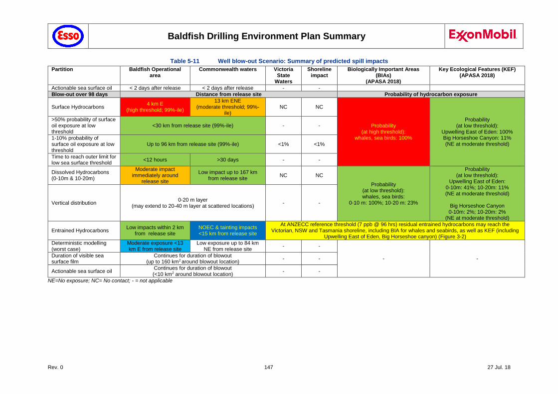
Baldfish Drilling Environment Plan Summary
Rev. 0 147 27 Jul. 18
Table 5-11 Well blow-out Scenario: Summary of predicted spill impacts
Partition Baldfish Operational area
Commonwealth waters Victoria State
Waters
Shoreline impact
Biologically Important Areas (BIAs)
(APASA 2018)
Key Ecological Features (KEF) (APASA 2018)
Actionable sea surface oil < 2 days after release < 2 days after release - -
Blow-out over 98 days Distance from release site Probability of hydrocarbon exposure
Surface Hydrocarbons 4 km E
(high threshold; 99%-ile)
13 km ENE (moderate threshold; 99%-
ile) NC NC
Probability (at high threshold):
whales, sea birds: 100%
Probability (at low threshold):
Upwelling East of Eden: 100% Big Horseshoe Canyon: 11% (NE at moderate threshold)
>50% probability of surface oil exposure at low threshold
<30 km from release site (99%-ile) - -
1-10% probability of surface oil exposure at low threshold
Up to 96 km from release site (99%-ile) <1% <1%
Time to reach outer limit for low sea surface threshold
<12 hours >30 days - -
Dissolved Hydrocarbons (0-10m & 10-20m)
Moderate impact immediately around
release site
Low impact up to 167 km from release site
NC NC
Probability (at low threshold): whales, sea birds:
0-10 m: 100%; 10-20 m: 23%
Probability (at low threshold):
Upwelling East of Eden: 0-10m: 41%; 10-20m: 11% (NE at moderate threshold)
Big Horseshoe Canyon 0-10m: 2%; 10-20m: 2%
(NE at moderate threshold)
Vertical distribution 0-20 m layer
(may extend to 20-40 m layer at scattered locations) - -
Entrained Hydrocarbons Low impacts within 2 km
from release site NOEC & tainting impacts <15 km from release site
At ANZECC reference threshold (7 ppb @ 96 hrs) residual entrained hydrocarbons may reach the Victorian, NSW and Tasmania shoreline, including BIA for whales and seabirds, as well as KEF (including
Upwelling East of Eden, Big Horseshoe canyon) (Figure 3-2)
Deterministic modelling (worst case)
Moderate exposure <13 km E from release site
Low exposure up to 84 km NE from release site
- -
- - Duration of visible sea surface film
Continues for duration of blowout (up to 160 km2 around blowout location)
- -
Actionable sea surface oil Continues for duration of blowout (<10 km2 around blowout location)
- -
NE=No exposure; NC= No contact; - = not applicable
Baldfish Drilling Environment Plan Summary
Rev. 0 148 27 Jul. 18
5.28.3 Impact Assessment
A well blowout was identified as the worst case spill scenario and may result in acute or chronic impacts, or mortality, of marine organisms.
The potential impacts include direct impacts (potential toxicity effects / physical oiling; potential for reduction in intrinsic values / visual aesthetics) and indirect impacts (potential damage to commercial businesses). Based on the impact thresholds identified in Section 5.24.2.2, the potential risks associated with a hydrocarbon spill are summarised below.
5.28.3.1 Potential Impacts to Offshore Open Water Environments and Receptors
As discussed in Chapter 3, a number of EBPC-Act listed species, including marine mammals, seabirds and marine reptiles could be present in an offshore spill affected area. A spill will potentially expose the fauna to surface, entrained or dissolved hydrocarbons, resulting in physical oiling and toxicity effects.
The possible effects of such an event on the offshore environment are further detailed below (Table 5-13). Our understanding of the environmental impacts resulting from a subsea blowout was greatly expanded by scientific studies following the subsea blowout at the Macondo field in the Gulf of Mexico (April 2010), where an estimated 4.9 barrels of oil was released, until the well was finally sealed in September 2010.
The Deepwater Horizon (DWH) oil spill covered over 110,000 km2 of the ocean surface and reached over 2,000 km of shoreline in the northern Gulf of Mexico. This extensive oiling contaminated vital foraging, migratory, and breeding habitats at the surface, in the water column, and on the ocean bottom throughout the northern Gulf of Mexico. This event generated a large body of scientific research on the potential impacts from a deepwater hydrocarbon blow-out on marine and coastal ecosystems.
There are many differences between the Macondo wells and the planned Baldfish wells:
GOR: Baldfish is a gas reservoir with GOR of 45,545 scf/bbl condensate (Hairtail-1), or 8,112 Sm3/Sm3, Macondo has an estimated GOR of 2,800 scf/bbl oil (500 Sm3/Sm3). Ryerson (2011) estimated the Macondo reservoir to contain as much as 62% oil in mass, compared with approximately 1% for the Baldfish reservoir.
Oil type: The DWH released a typical light Louisiana crude oil, contained saturated n-alkanes, PAHs and their alkylated homologues (alkylated PAHs), with over 50% as low-molecular-weight (LMW) hydrocarbons (methane and C2–C11) (Ryerson et al. 2011). By comparison, the Baldfish condensate is characterised as a Group I oil (non-persistent oil) with 80% volatiles and 1.5% persistent compounds (Section 142). PAHs are expected to make up around 0.3 % of volume, with >85% methane, ~ 10% LMW alkanes.
Depth: Baldfish and Hairtail are between 359-665 m deep, Macondo is in 1,500m water depth. Not only does the depth affect the trajectory of the release and potential trapping by a thermocline, but it also reduces the number of available rigs for well intervention.
Flow rate: Macondo was estimated to flow at between 50,000 – 70,000 bbl/d. The estimated volume of released condensate is around 260 million gallons of crude oil (6.2 million bbl) over 87 days. Hairtail-1: 11,051 bbl/day of light condensate, modelled volume of 1,083,000 bbl over 98 days.
Reservoir pressure: Macondo has a reservoir pressure of 825 bars (11,966 psi) at 128°C, compared with 4,105 psi (283 bar) for Baldfish wells.
Shoreline impact: Macondo resulted in extensive shoreline impact. No shoreline impact is predicted for the Baldfish wells above defined thresholds, except for entrained hydrocarbons at the ANZECC reference threshold (Section 5.28.2.2).
Early intervention: In response to the Macondo spill, various methods for early intervention and plugging of deepwater wells have been developed, including the availability of capping stacks and associated tools and equipment, as well as methods for well intervention. These were not readily available at the time. Since then, capping stacks are readily available and extensively tested.
Baldfish Drilling Environment Plan Summary
Rev. 0 149 27 Jul. 18
Subsea dispersant injection: Approximately 2,730 m3 (17,170 bbl) of dispersant was injected at the Macondo wellhead until oil spill from the Macondo well was stopped after 87 days, in an attempt to stop the oil rising to the surface. This resulted in a large volume of hydrocarbons remaining in the water column (e.g. Gros et al. 2016). In contrast, hydrocarbons from the Baldfish reservoir are predicted to rapidly rise to the surface, thereby achieving a high level of natural weathering (Section 5.28.2.5).
Despite these differences, the Deepwater Horizon incident provided a plethora of scientific data, greatly expanding our understanding of the impacts from a deepwater blow-out. Azwell et al. (2011) summarised the impacts from the DWH spill:
The event resulted in a significant volume of entrained hydrocarbons, trapped in the water column. This slowed natural weathering and increased the risk of interaction with marine life.
Additionally, the spill resulted in widespread emulsification, further slowing down natural degradation. When the emulsion reached the shore, it resulted in damage to root systems, inhibiting the plants’ ability to regenerate.
The National Incident Command's Flow Rate Technical Group estimated that 25% of the oil was skimmed, burned or captured, 24% was either naturally or chemically dispersed, 25% was evaporated or dissolved, and 26% remained in the water, 4 months after the start of the blow-out
Although widespread use of subsea dispersant injection reduced the volume of oil reaching the surface, it resulted in an increase in dissolved and entrained hydrocarbon, affecting subsurface marine life, while slowing down natural decomposition.
Burning of surface oil – as a means to reduce the volume of oil reaching the shore - resulted in the release of airborne toxicants. These posed a health threat to clean-up workers.
The spill resulted in a large volume of waste (80, 276 T of solid waste and almost a million bbls of liquid waste).
Recent research on the potential impact from a hydrocarbon spill on a range of ecosystems are summarised in Table 5-12.
Table 5-12 Potential Environmental receptors that may be affected by an Oil Spill
Region Group Summary of impacts
Offshore deep water
Fish (6.11.3.1) Mass fish mortalities are rare following oil spills, particularly in open ocean waters (Scholtz et al. 1992). Due to their high mobility, this is generally attributed to the ability of pelagic fish to avoid surface waters underneath oil spills by swimming into deeper water or away from the affected areas (ITOPF 2011.) Indirect exposure may occur via consumption of contaminated prey. Owing to their ability to metabolise hydrocarbon toxicants, fish exposed to sub lethal dissolved aromatics are likely to recover (NOAA 2002). A condensate or oil release may result in stress in fish in spill affected areas.
Modification of habitat due to the effects of hydrocarbon on other marine organisms (such as seagrasses) may adversely affect some fish species (Jewett et al. 1999 in Ecos 2001). Turbulent waters can disperse hydrocarbon throughout the water column, thereby exposing fish at depths to contamination or by reducing the amount of dissolved oxygen, which could potentially cause suffocation. Dispersal throughout the water column is highly likely in these scenarios due to high-energy oceanic conditions in Bass Strait.
Gagnon and Rawson (2011) studied the effect from the Montara spill on fish. The study concluded that for each species, all individuals were in good physical condition at all sites, suggesting good health status. In the short-term, fish were exposed to, and metabolised petroleum hydrocarbons, however no consistent adverse effects on fish health or on their reproductive activity were detected.
Continuing exposure to petroleum hydrocarbons was evidenced by elevated liver detoxification enzymes and PAH biliary metabolites in three out of four species collected close to the rig; in addition, red emperor collected close to the MODU had enlarged livers and elevated oxidative DNA damage. Biomarkers of fish health showed a trend towards a return to reference levels with often, but not always, comparable biomarker levels in fish collected from reference and impacted sites.
Burns et al. (2011) analysed demersal and pelagic fish species after the Montara oil leak had stopped, although some were collected only a few days after the ‘well
Baldfish Drilling Environment Plan Summary
Rev. 0 150 27 Jul. 18
Region Group Summary of impacts
kill”, two months after capping of the leak. It concluded that the fish species would probably have been safe to eat as no detectable petroleum hydrocarbons were found in the fish muscle samples.
Sharks and Rays (6.11.3.2)
No reported studies of the impacts of oil spills on cartilaginous fish (including sharks, rays and sawfish) were found in the literature. It is not known how the data on the sensitivity of bony fishes would relate to toxicity in cartilaginous fishes. All EPBC listed sharks and rays in the area of interest are viviparous or ovoviviparous and so do not have a free swimming larval stage. These species are also larger than the bony fish species for which toxicity has been studied.
Sharks may be exposed to and ingest hydrocarbons entrained in the water column. Dispersal throughout the water column is highly likely in these scenarios, due to high-energy oceanic conditions of Bass Strait.
Marine Reptiles (6.11.3.3)
Marine turtles exhibit no avoidance behaviour to oil spills. Physical oiling may lead to irritation of mucous membranes in the nose, throat and eyes leading to inflammation and infection or irritation and injury to skin where oil adheres (Etkins 1997; IPIECA 1995). Inhalation of vapours may lead to lung and other internal damage including neurological impairment (IPIECA 1995). Marine turtles are likely to occur in low densities in spill affected areas.
The effects of the Deepwater Horizon (DWH) oil spill on protected marine species, and specifically sea turtles and marine mammals was studied as part of the DWH Natural Resource Damage Assessment (NRDA) (e.g. Wallace et al 2017).
The research by NOAA scientists on some of the long term effects of the Deepwater Horizon oil spill indicates that populations of several sea turtle species will take decades to rebound, while requiring significant habitat restoration in the region (e.g. Wallace et al. 2017; Ylitano et al. 2017, Stacy et al. 2017, Mitchelmore et al. 2017, McDonald et al. 2017, Lauritsen et al. 2017, Reich et al. 2017).
Seabirds (6.11.3.4)
Seabirds typically exhibit no avoidance behaviour to oil spills and may contact surface slicks when foraging or resting on the water surface. Matting of feathers on heavily oiled birds may lead to hypothermia, starvation due to loss of ability to fly and forage, and drowning due to loss of buoyancy. Oiled birds will directly ingest hydrocarbons when preening or indirectly by consuming contaminated prey. Ingestion and oiling can also lead to internal injury to sensitive membranes and organs (IPIECA 2004; AMSA 2012). Longer term exposure effects that may potentially impact seabird populations include a loss of reproductive success due to loss of breeding adults and malformation of eggs or chicks (AMSA 2012).
Watson et al. (2009) undertook a rapid survey of the ‘megafauna’ in the Montara oil spill region. The surveys at sea revealed a high level of diversity and abundance of birds while surveys on land found 35 bird species of which 10 species were in a stage of breeding. Presence of a dead or dying birds was evidence that some species are negatively affected by the oil spill. Although some birds appeared to avoid slicks, a number of bird, cetacean and sea snake species were found in higher numbers in oil affected waters. The study could not confirm the true impact and recommended it be followed up by a long term toxicological study to assess if toxic chemicals are present in the tissue of the animals.
Seals (6.11.3.5) Oiling of pinniped mammals (seals and sea lions) may destroy the waterproofing and insulating properties of their feathers or fur resulting in hypothermia and affecting balance. The matted oil can also inhibit limb movement making swimming difficult and may also cause skin lesions and eye irritations (NRC 1989, Walraven 1992, Volkman et al. 1994; Jenssen 1996). Toxic effects following ingestion of oil from grooming as well as the consumption of food items that have been exposed to oil can include ulceration and bleeding in the gastrointestinal tract, kidney damage and altered reproductive cycles (Volkman et al. 1994 in Brady et al. 2002). However, internal effects of oil ingestion after the Exxon Valdez oil spill were observed to be not serious and although some pups lost weight, all recovered (Michel et al. 1992 in Ecos 2001).
Cetaceans (6.11.3.6)
In the event of an extended duration loss of well control event, there is potential for surface slick and entrained hydrocarbons exceeding threshold concentrations to sweep across the seasonal migratory routes of EPBC Act listed whale species, including humpback whales, southern right whales and blue whales. Marine mammals that have direct physical contact with surface slicks and entrained oil may suffer surface fouling or ingestion of hydrocarbons and inhalation of toxic vapours. This may result in the irritation of sensitive membranes such as the eyes, mouth, digestive and respiratory tracts and organs, impairment of the immune system or neurological damage (IPIECA 1995).
Baldfish Drilling Environment Plan Summary
Rev. 0 151 27 Jul. 18
Region Group Summary of impacts
Observational evidence indicates in some instances cetaceans may detect and exhibit avoidance behaviour and potentially move away from the spill-affected area (IPIECA, 1995). Previous studies have suggested that cetaceans would be able to detect and avoid oiled waters and, when in contact, oil would not adhere to their slick skin. However, recent studies (Aichinger Dias et al. 2017), following the Deepwater Horizon oil spill at the Macondo field (Gulf of Mexico, April – July 2010), confirmed persistence of the oil on their skin of cetacean response to an oil spill, so that direct exposure should be taken into account during response activities.
Other NOOA studies on marine mammal (whales, dolphins) impacts from the DWH event include Takeshita et al. 2017, Wilkin et al. 2017, Aichinger Dias et al. 2017, Smith et al. 2017, Kellar et al. 2017, Wells et al. 2017, Hornsby et al. 2017, McDonald et al. 2017, Fauquier et al. 2017, Rosel et al. 2017, Hohn et al. 2017, Thomas et al. 2017, Schwacke et al. 2017, De Guise et al. 2017.
Given that the Baldfish location is not a known breeding, feeding or aggregation area for marine mammals, only low numbers of individuals that are transiting through the area would be potentially impacted. Fin, Humpback, Pygmy Right whale and Sei whale are likely to forage in the area during transit (Section 3.6.12).
Humpback whales pass along the Gippsland Basin during late Autumn on their annual migratory route to the tropical calving grounds, returning south in Spring. The proposed drilling period (Q3, 2018) overlaps the peak migration periods (Table 5-11, Section 4.8.15). Southern right whales have a similar migration pattern. On the east coast, southern right whales tend to migrate between Cape Byron and Antarctica, but have been seen as far north as Hervey Bay, Queensland.
Invertebrates and Plankton (6.11.3.7)
Deep-water benthic invertebrates are usually protected from oiling by the buoyant nature of hydrocarbons, although the depth of oil penetration is dependent on turbulence in the water column. Hydrocarbons can also reach the benthos through the settlement of oiled particles such as faeces, dead plankton or inorganic sand particles (Jewett et al., 1999 in Ecos 2001). Like protected shorelines, intertidal areas are sensitive to heavy oiling and contaminated sediments.
Exposure to oil can induce changes in burrowing depth into the substrate (which can lead to higher predation rates on some species) and can limit the growth, recruitment and reproductive capacity of some marine invertebrates (Fukuyama et al. 1998 in Ecos 2001). Benthic communities may also be at risk from sinking oil.
Both oil and oil dispersants can be toxic to crustaceans, limpets, bivalves and sea stars (Michel et al., 1992; Fukuyama et al., 1998; Jewett et al., 1999). Commercial invertebrates, such as lobsters or scallops, may become tainted or suffer from sub-lethal effects. Polychaetes are less susceptible to the negative effects of oil and can show large fluctuations in abundances and species composition over time (Fukyama et al. 1998; Jewett et al. 1999 in Ecos 2001).
Impacts on plankton communities are likely to occur in areas where dissolved or entrained hydrocarbon threshold concentrations are exceeded. Exposure to hydrocarbons in the water column can lead to changes in species composition with declines or increases in one or more species or taxonomic groups (Batten 1998). Exposure can lead to reduced photosynthetic rates in phytoplankton (Tomajka 1985) and suffocation, or behavioural changes or environmental changes that make them more susceptible to predation (Chamberlain, 1999). Due to rapid turnover, planktonic communities recover quickly (within weeks or months) (ITOPF 2011). Further note that plankton concentrations generally are higher in shallow inshore waters, with phytoplankton largely restricted to less than 100m water depth (Section 6.4.2).
Felder et al 2014 reported that crustacean communities on Gulf Deep Banks (55–80 m deep in the Gulf of Mexico) declined in both abundance and diversity after the Macondo oil spill and exhibited major shifts in species dominance. The study postulated that this decline was due to decreased seaweed abundance having a cascading effect on direct consumers and higher trophic levels.
Heritage Values and Shipwrecks (6.11.3.8)
Coastal waters within declared native title boundaries are unlikely to be exposed to entrained hydrocarbons or dissolved aromatics.
There are a number of shipwrecks in proximity to the operational area and Operational ZPI location. No impacts are expected on shipwrecks from the worst case credible scenario.
Commercial Fisheries (6.11.3.9)
In the event of a loss of well containment, fishers may be excluded from the spill affected area for an extended period.
Exposure to hydrocarbons can result in tainting (off-flavour) of seafood at very low concentrations (e.g. Davis et al. 2002). Tainting may be reversible depending on
Baldfish Drilling Environment Plan Summary
Rev. 0 152 27 Jul. 18
Region Group Summary of impacts
the magnitude of exposure and type of organism affected. For example, fish have a high capacity to metabolise these hydrocarbons while crustaceans (such as prawns) have a reduced ability (NOAA 2002). Concern for seafood safety can affect the marketability of seafood including long after any actual risk has subsided (NOAA 2002). In the event of a major spill, economic impacts to fisheries can therefore occur due to lost fishing effort from the exclusion zone set up around spill affected areas and impacts to seafood markets.
Oil and Gas Industry (6.11.3.10)
Worst case hydrocarbon spills imposing exclusion zones and requiring response activities could potentially impact other operators within the Operational ZPI (Section 6.10). Exclusion zones are likely to be imposed for the duration that the hydrocarbon poses a safety risk or may cause additional contamination. Impacts are also possible where surface hydrocarbons can interrupt operations/structures for Esso and other operators within the Operational ZPI (e.g. interference can occur with water intakes).
Shipping (6.11.3.11)
Shipping traffic is likely to be affected by the imposition of exclusion zones in case of a major spill. The Baldfish Operational area coincides with intensive shipping activity neat the Bass Strait TSS (Section 3.8). As outlined in Section 6.9.2, AMSA has proposed to establish temporary fairways around the Baldfish operational area, and established a 2 NM buffer zone around each of the proposed Baldfish well locations for the duration of the campaign (Section 5.21.2.1), in addition to a 500 m safety zone around the MODU, in order to deviate vessel traffic away from the Baldfish operational area and minimise the risk of shipping collisions.
Potential Impacts to Nearshore Marine Environments and Shoreline (6.11.4)
Fish (6.11.4.1) Fish spawning including for commercially targeted species occurs in nearshore waters at certain times of the year. The early life stages (eggs, larvae and juveniles) of fish and other commercially-targeted taxa are at their most sensitive to exposure to hydrocarbons and the most sensitive habitats include seagrass beds and mangroves which in particular may serve as nursery areas (ITOPF 2011). A major blowout scenario, coinciding with fish spawning periods, has the potential for lethal effects to fish larvae in affected areas. However, based on the outcome of modelled spill scenarios (see Section 5) such impacts to nearshore waters are not predicted.
Seabirds and Shorebirds (6.11.4.2)
A major blowout scenario has the potential for surface slicks and entrained oil to contact nearshore waters and shoreline habitats such as sandy shores, marshes, mangroves and reef flats that seabirds and resident and non-breeding overwintering shorebirds utilise for foraging and resting. However, based on the outcome of modelled spill scenarios (see Section 5) such impacts on seabirds and shorebirds are not predicted in coastal waters.
While breeding oceanic seabird species can travel long distances to forage in offshore waters, most breeding seabirds will tend to forage in nearshore waters near their breeding colony resulting in higher seabird densities in nearshore waters and therefore higher sensitivity of these areas during breeding season.
Consumption of contaminated fish from nearshore waters or invertebrates from intertidal foraging habitats such as sandy shores, mudflats and reef flats has the potential for lethal or sub lethal effects in seabirds and shorebirds. Ingestion can lead to internal injury to sensitive membranes and organs (IPIECA, 2004; AMSA, 2012). Longer term population effects may occur if there is a decline in reproductive performance and survivorship of chicks and adult birds.
Cetaceans (6.11.4.3)
Felder et al. 2014 reported that crustacean communities on Gulf Deep Banks declined in both abundance and diversity after the Macondo Oil Spill and exhibited major shifts in species dominance.
Heritage Values (6.11.4.4)
There are a number of shipwrecks in proximity to the operational area and Operational ZPI location (Section 6.13.2). No impacts are expected on shipwrecks or other areas of heritage value from the worst case credible scenario.
Nearshore Commercial Fisheries (State) (6.11.4.5)
In the event of a loss of well containment, fishers may be excluded from the spill affected area. Exposure to hydrocarbons can result in tainting (off-flavour) of seafood at very low concentrations. Tainting effects crustaceans (e.g., prawns) more than fish as fish have the ability to metabolise hydrocarbons. Concern for seafood safety can affect the marketability of seafood including long after any actual risk has subsided. Predicted tainting impacts are restricted to an area immediately around the Baldfish operation area (Section 5.3.5) and are not affecting nearshore commercial fisheries.
Recreational Fishing (6.11.4.6)
A major impact on survival of pelagic fish populations in open waters of the region may result in sub-lethal impacts on fish. Recreational users unlikely to be impacted if an exclusion zone were to be established around the spill affected areas due to the distance of the Operational ZPI from the shore.
Baldfish Drilling Environment Plan Summary
Rev. 0 153 27 Jul. 18
Region Group Summary of impacts
Tourism (6.11.4.7) Typically, an oil spill that results in a visible oil slick in coastal waters and reaching shorelines will disrupt recreational activities, particularly tourism and its supporting services. For large scenarios, the tourism sector of the region may experience economic impacts. However, spill modelling indicates that in case of a major blowout scenario from the Baldfish operational area, no visible sheen is expected to reach state waters (see Section 5).
Ships and Ports (6.11.4.8)
Impacts are expected where surface hydrocarbons can interrupt operations and by the imposition of exclusion zones. No impacts to ports are predicted, based on spill modelling in case of a major blowout scenario from the Baldfish operational area (see Section 5). However, impacts on commercial shipping, as outlined in Section 6.9, are possible in case of a major spill.
5.28.3.2 Blow-out - Surface Hydrocarbon Exposure
Surface hydrocarbons are predicted to extend approximately 4 km from the release site at high thresholds (99%-ile) and 13 km at moderate thresholds. There is >50% probability that the surface hydrocarbons would extend to 30 km from the release site, and <10% probability that it would extend up to 96 km from the release site.
The BIA for whales and seabirds falls within the Operational ZPI, with surface hydrocarbons overlapping this BIA at high thresholds (100% probability). Whales, seabirds, seals and turtles may be affected by exposure to surface hydrocarbons, as summarised in Table 5-12 and Table 5-13.
Surface hydrocarbons resulting from a blow-out are expected to overlap two KEFs at low threshold: Upwelling east of Eden (100% probability) and Big Horseshoe Canyon (11% probability). As Big Horseshoe Canyon is subsurface, surface hydrocarbons are not expected to affect this feature. Potential impacts to the Upwelling east of Eden is largely restricted to in-water hydrocarbon exposure (see below).
5.28.3.3 Blow-out - In-water Hydrocarbon Exposure
In-water hydrocarbon exposures (from dissolved and entrained hydrocarbons) resulting from a blow-out will impact those receptors that are exposed to the water column. The ecological and social receptors with the potential to be exposed to in-water hydrocarbons are evaluated in Table 5-12 and Table 5-13. Only those predicted to be exposed to hydrocarbon levels above the threshold value for that receptor (Table 5-7) are evaluated further below.
Exposure above the in-water (entrained) NOEC impact threshold (Table 5-7) was predicted to extend up to 15 km around the release site, and is largely restricted to the surface (0-20 m) layers. The water depth in the area predicted to be exposed above the impact threshold is more than 350 m deep, which generally precludes the more sensitive benthic flora and fauna. No Commonwealth Marine Parks or State Marine Protected Areas were predicted to be exposed to entrained oil above the impact threshold, although low level ecological and water quality impacts may extend beyond the Operational ZPI (Section 5.28.2.2).
The probability of dissolved hydrocarbons reaching the nearby BIA at low thresholds is 100% for the 0-10 m layer and 23% for 10-20 m water depth (Table 5-11). The potential effects of this hydrocarbon exposure, especially to whales and seabirds, but also seals and turtles is summarised in Table 5-13.
Two KEFs may be affected by dissolved hydrocarbons resulting from a blow-out (Table 5-11): Upwelling east of Eden (41% probability for 0-10 m; 11% for the 10-20 m water depth) and Big Horseshoe Canyon 2% probability for 0-10 m and for the 10-20 m water depth). The potential effects of this hydrocarbon exposure is summarised in Table 5-13. Because of the depth of Big Horseshoe Canyon, no significant impacts are predicted. Exposure of the Upwelling East of Eden is expected to mainly affect plankton, with potential indirect impacts on the local food chain, which is localised and of relatively short duration, until successful source control (38 – 88 days; Section 6.5).
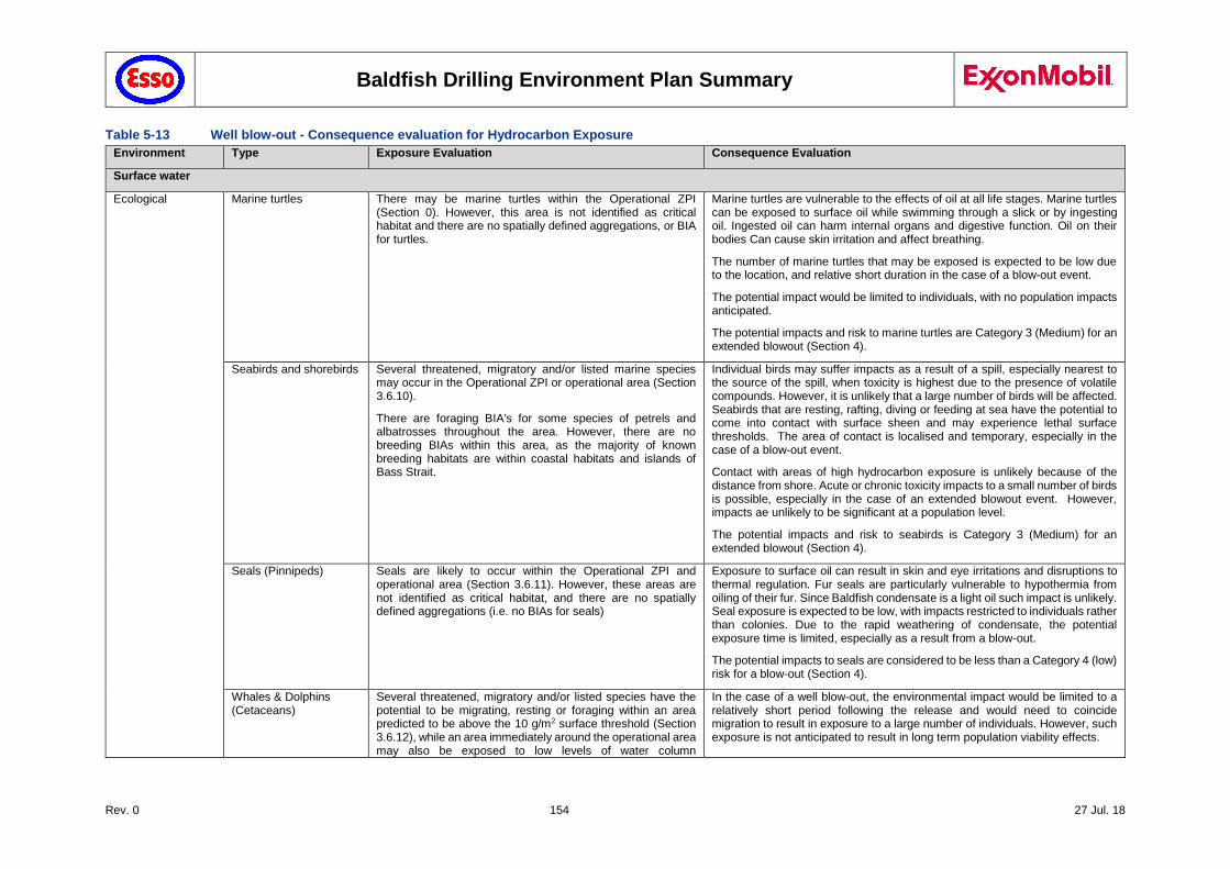
Baldfish Drilling Environment Plan Summary
Rev. 0 154 27 Jul. 18
Table 5-13 Well blow-out - Consequence evaluation for Hydrocarbon Exposure
Environment Type Exposure Evaluation Consequence Evaluation
Surface water
Ecological Marine turtles There may be marine turtles within the Operational ZPI (Section 0). However, this area is not identified as critical habitat and there are no spatially defined aggregations, or BIA for turtles.
Marine turtles are vulnerable to the effects of oil at all life stages. Marine turtles can be exposed to surface oil while swimming through a slick or by ingesting oil. Ingested oil can harm internal organs and digestive function. Oil on their bodies Can cause skin irritation and affect breathing.
The number of marine turtles that may be exposed is expected to be low due to the location, and relative short duration in the case of a blow-out event.
The potential impact would be limited to individuals, with no population impacts anticipated.
The potential impacts and risk to marine turtles are Category 3 (Medium) for an extended blowout (Section 4).
Seabirds and shorebirds Several threatened, migratory and/or listed marine species may occur in the Operational ZPI or operational area (Section 3.6.10).
There are foraging BIA's for some species of petrels and albatrosses throughout the area. However, there are no breeding BIAs within this area, as the majority of known breeding habitats are within coastal habitats and islands of Bass Strait.
Individual birds may suffer impacts as a result of a spill, especially nearest to the source of the spill, when toxicity is highest due to the presence of volatile compounds. However, it is unlikely that a large number of birds will be affected. Seabirds that are resting, rafting, diving or feeding at sea have the potential to come into contact with surface sheen and may experience lethal surface thresholds. The area of contact is localised and temporary, especially in the case of a blow-out event.
Contact with areas of high hydrocarbon exposure is unlikely because of the distance from shore. Acute or chronic toxicity impacts to a small number of birds is possible, especially in the case of an extended blowout event. However, impacts ae unlikely to be significant at a population level.
The potential impacts and risk to seabirds is Category 3 (Medium) for an extended blowout (Section 4).
Seals (Pinnipeds) Seals are likely to occur within the Operational ZPI and operational area (Section 3.6.11). However, these areas are not identified as critical habitat, and there are no spatially defined aggregations (i.e. no BIAs for seals)
Exposure to surface oil can result in skin and eye irritations and disruptions to thermal regulation. Fur seals are particularly vulnerable to hypothermia from oiling of their fur. Since Baldfish condensate is a light oil such impact is unlikely. Seal exposure is expected to be low, with impacts restricted to individuals rather than colonies. Due to the rapid weathering of condensate, the potential exposure time is limited, especially as a result from a blow-out.
The potential impacts to seals are considered to be less than a Category 4 (low) risk for a blow-out (Section 4).
Whales & Dolphins (Cetaceans)
Several threatened, migratory and/or listed species have the potential to be migrating, resting or foraging within an area predicted to be above the 10 g/m2 surface threshold (Section 3.6.12), while an area immediately around the operational area may also be exposed to low levels of water column
In the case of a well blow-out, the environmental impact would be limited to a relatively short period following the release and would need to coincide migration to result in exposure to a large number of individuals. However, such exposure is not anticipated to result in long term population viability effects.
Baldfish Drilling Environment Plan Summary
Rev. 0 155 27 Jul. 18
Environment Type Exposure Evaluation Consequence Evaluation
hydrocarbons in the case of a loss of well integrity (Section 5.28.3).
Southern Right Whale and Humpback whale migration overlap with Baldfish field activities (Table 3-6).
The Operational ZPI and operational area overlap BIAs for whales (Section 3.6.2).
A proportion of the migrating population of whales could be affected during a single migration event, which could result in temporary and localised consequences.
Since the Baldfish activities are planned for two months between June and September, this is likely to overlap with migration of the southern right whale migration (mid-May to September; Section 3.6.12) and the humpback whale northern migration (north from June to August; south from September to November; Section 3.6.12). Blue whales are most likely to be present during November and December (Section 3.6.12) so that planned activities are unlikely to affect blue whales.
However, the nearest BIA for southern right whales is largely restricted to Victorian state waters, outside of the affected zone. The nearest BIA for humpback whales, along the NSW coastline, lies outside of the Operational ZPI. The BIA for the pygmy blue whale overlaps with the affected zone and straddles the Baldfish operational area (Section 3.6.2).
Physical impact by individual whales to hydrocarbon exposure is unlikely to lead to any long-term impacts (Table 5-12). Given the mobility of whales, only a small proportion of the migrating population would surface in the affected area, resulting in a Category 3 (Medium) for an extended blowout (Section 4).
Social Recreation and tourism Marine pollution can result in impacts to marine-based tourism from reduced visual aesthetic. The modelling predicted no shoreline impact (Section 5.28.2.4), with visible sheen (low impact: <0.30g/m2) extending to commonwealth waters (Section 5.28.3)
Visible sheen has the potential to reduce visual amenity. However, because of distance from shore, impact is ranked as Category 4 (low) (Section 7).
Heritage No shoreline impact. Vertical impact restricted to top 20 m (Section 5.28.3)
Sheen has the potential to reduce the visual amenity of known heritage sites (5.28.3). However, because of distance from shore and limited vertical distribution, impact is ranked as Category 3 (Medium) for an extended blowout (Section 4).
Subsurface
Ecological Macroalgae Macroalgae may be present within reef and hard substrate within the Operational ZPI, but this is not a dominant habitat in Gippsland Basin. Since the Operational ZPI excludes shallow waters along the coastline, and the operational area is too deep for macroalgae, while vertical distribution of hydrocarbons as a result from a spill is largely restricted to the top 20 m (Section 5.28.3), significant impacts on macroalgae from a LOC event are unlikely
Given the lack of dominant macroalgae habitat within the Operational ZPI and the operational area, impacts in macroalgae are considered to be limited. Reported toxic responses to oils include physiological changes to enzyme systems, photosynthesis, respiration and nucleic acid synthesis (Lewis & Pryor 2013). Macroalgae respond differently to a spill but appear to be able to recover rapidly (Connell et al.1981).
The potential impacts to macroalgae are considered to be a Category 3 (Medium) for an extended blowout (Section 4).
Baldfish Drilling Environment Plan Summary
Rev. 0 156 27 Jul. 18
Environment Type Exposure Evaluation Consequence Evaluation
Seagrass Seagrass may be present in shallower water within the Operational ZPI. However it is not a dominant ecosystem, and is restricted to shallow water, largely due to light attenuation (Duarte 1991). They are largely restricted to <35 m, but abundance rapidly declines below 10m depth, especially in high turbulence areas, where light penetration is limited (Cambridge and Kuo 1979).
Because much of seagrass biomass is in the rhizomes below the substrate (Zieman et al. 1984), exposure is more likely to result in sub-lethal impacts, rather than lethal impacts.
The potential impacts to seagrass are considered to be less than a Category 3 (Medium) for an extended blowout (Section 4).
Temperate corals, ascidians, bryozoans and sponges
Soft corals may be present on hard substrate within the Operational ZPI, such as intertidal rocky shores or exposed rocky headlands.
They may also be found on hard substrate in deeper waters further offshore, including Big Horseshoe Canyon and Beagle Marine Reserve (Section 3.6.1) where adequate food is available in the water column, but their presence near the operational area is unlikely due to the lack of hard substrate, and low levels of suspended organic matter in the water column (Butler et al. 2002).
Six sponge beds were reported in Bass Strait, in an arc along the 65-75 m contour near Tasmania. Ascidians and bryozoans occupy a similar habitat (Butler et al. 2002). Sponges and ascidians are also found on soft-bottom substrate (see below). However, most barnacle and ascidian species inhabit hard substrates and are generally infrequent in soft bottoms (e.g. Yakovis et al. 2005).
Exposure of entrained hydrocarbons to shallow subtidal corals has the potential to result in lethal or sublethal toxic effects (Shigenaka 2001). This may lead to reduced growth rates, tissue decomposition and localised mortality (NOOA, 2001).
However, given the distribution of hard substrate relative to Operational ZPI and operational area, and limit of entrained hydrocarbons to top 20m of the water column immediately around the operational area (Section 5.28.3), such impacts are considered limited to isolated organisms.
The risk of impact resulting from a blow-out to Horseshoe Canyon is low (surface: 11% at low threshold) with dissolved hydrocarbons restricted to <10 m (2% at low threshold), with no entrained hydrocarbon exposure predicted (Section 5.28.3).
Therefore, the potential impacts to hard substrate communities are considered to be less than a Category 3 (Medium) for an extended blowout (Section 4).
Plankton Plankton is likely to be exposed to entrained hydrocarbons above the NOEC threshold in an area within 15 km from the operational area (Section 5.28.3).
The probability of Upwelling East Of Eden to be affected by surface hydrocarbons at low threshold is 100% for a well blowout. Dissolved hydrocarbons may affect the upper layers of the water column around the Upwelling East of Eden at low threshold (0-10m: 41%; 10-20m: 11%). However, no impact from entrained hydrocarbons is predicted (Section 5.28.3).
Relatively low concentrations of hydrocarbons are toxic to plankton (including zooplankton, fish eggs and larvae) through ingestion, contact and inhalation.
Plankton is widespread and abundant, and form the basis for the marine food web. A spill is unlikely to have long-lasting impacts on plankton populations at a regional level. Plankton recovers within weeks to months after water quality has returned to normal (ITOPF 2011)
Therefore, the potential impacts to plankton communities are considered to be less than a Category 3 (Medium) for an extended blowout (Section 4).
Soft-bottom invertebrates
Soft bottom communities occur throughout the Operational ZPI, including deeper waters around the operational area and much of the Gippsland coastline (Section 3.3). As vertical impact resulting from a LOC or blowout is largely restricted to the top 20 m of the water column, and no shoreline impact is predicted below the lowest thresholds, direct impact to soft-bottom benthic communities is not expected.
Acute or chronic exposure through contact and/or digestion can result in toxicological risks. The hard shell of many invertebrates protects them from absorption.
Since no shoreline impact is predicted, and impacts from a LOC are restricted to the water surface and the top 20 m of the water column, impact from a well blow-out on benthic communities are unlikely.
Baldfish Drilling Environment Plan Summary
Rev. 0 157 27 Jul. 18
Environment Type Exposure Evaluation Consequence Evaluation
Invertebrates include squid, crustaceans (rock lobster and crabs) and molluscs (scallops and abalone)
Filter feeding benthic invertebrates such as sponges bryozoans, abalone and hydroids may be exposed to sub-lethal impacts. However, population level impact are unlikely. Sponges attach to hard bottom using a basal disc or anchoring spicules, or to soft sediment by means of root-like structures.
Several soft-bottom invertebrates are target to commercial fisheries, including squid, abalone, rock lobster and crabs.
Therefore, the potential impacts to soft-bottom invertebrates are considered to be less than a Category 3 (Medium) for an extended blowout (Section 4).
Fish, sharks, rays Entrained hydrocarbon droplets can physically affect fish exposed for an extended duration (weeks to months). Effects will be greatest in the upper 10 m of the water column and areas close to the spill source where hydrocarbon levels are highest.
Many target fish species are demersal, in deeper waters away from the water surface. Therefore, any impacts are expected to be highly localised.
There is a known distribution and foraging BIA for the Great white shark within the Operational ZPI.
Pelagic free-swimming fish and sharks are unlikely to suffer long-term damage from oil spill exposure because dissolved/entrained hydrocarbons in the water column are predicted to be below lethal thresholds, except near the operational area (Section 5.28.2.6).
Although localised tainting may be expected, these effects are reported to be short-term and reversible (Section 5.24.2.2).
Juvenile fish, including larva and zooplankton ae more susceptible to hydrocarbons in the water column. Although impacts are not expected to cause population levels impacts. Impacts in eggs and larvae are not expected to be significant given the relatively short duration even in the case of a blow-out) and the limited extent of the spill. As eggs and larvae are widely distributed in the upper water column it is expected that nearby populations will rapidly drift into affected parts of the water column.
Therefore, the potential impacts to fish communities are considered to be Category 3 (Medium) for an extended blowout (Section 4).
Seals Fur seals occur within the Operational ZPI and may also occur in low numbers within the operational area (Section 3.6.11). Localised areas of the foraging range for New Zealand Fur Seals and Australian fur-seals may be temporary exposed to low concentrations of hydrocarbons within an area predicted to be above the 10g/m2 surface threshold, while an area immediately around the operational area may also be exposed to low levels of water column hydrocarbons in the case of a spill or loss of well integrity.
Low levels of entrained hydrocarbons may be experienced immediately around the operational area, with NOEC thresholds limited to an area <10 km from the spill location for a blow-out event. In the case of a major well blowout, low thresholds of dissolved hydrocarbons ae predicted to extend up to 167 km from the release site (largely in the upper 20 m of the water column), with low thresholds of entrained
Exposure to low levels of hydrocarbons in the water column or consumption of affected prey may cause sub-lethal impacts. However, given the temporary and localised nature of a spill, the wide distribution of seals, the low level of exposure zones, except for dissolved hydrocarbons in the upper water column in the case of a blow-out, and rapid loss of o the volatile components following a spill, impacts at a population levels are considered unlikely.
The potential impacts to seals are considered to be Category 3 (Medium) for an extended blowout (Section 4).
Baldfish Drilling Environment Plan Summary
Rev. 0 158 27 Jul. 18
Environment Type Exposure Evaluation Consequence Evaluation
hydrocarbons extending to about 2 km from the release site and <15 km for NOEC threshold (Section 5.28.2.6).
Whales and dolphins Several threatened, migratory and/or listed marine species have the potential to be migrating, resting or foraging within an area predicted to be above the surface thresholds (Section 3.6.12).
Known BIAs are present for foraging Pygmy Blue whale; and distribution for the Southern Right whale (Section 3.6.2).
Low levels of entrained hydrocarbons may be experienced immediately around the operational area, with NOEC thresholds limited to an area <10 km from the spill location for a blow-out event.
In the case of a major well blow-out, low thresholds of dissolved hydrocarbons are predicted to extend up to 167 km from the release site (largely in the upper 20 m of the water column), with low thresholds of entrained hydrocarbons extending to about 2 km from the release site and <15 km for NOEC threshold (Section 5.28.3).
Cetacean exposure to entrained hydrocarbons can result in physical coating as well as ingestion (Table 5-12). Such impacts are most likely near the release location. The risk of impacts declines further from the spill location due to weathering, and loss of the volatile toxic components.
In the case of a blow-out event, the environmental impact would be limited to a relatively short period following the release and would need to coincide migration to result in exposure to a large number of individuals. However, such exposure is not anticipated to result in long term population viability effects.
A proportion of the migrating population of whales could be affected during a single migration event, which could result in temporary and localised consequences.
Since the Baldfish activities are planned for two months between June and September, this is likely to overlap with migration of the southern right whale migration (mid-May to September; Section 3.6.12) and the humpback whale northern migration (north from June to August; south from September to November; Section 3.6.12). Blue whales are most likely to be present during November and December (Section 3.6.12) so that planned activities are less likely to affect blue whales.
However, the nearest BIA for southern right whales is largely restricted to Victorian state waters, outside of the Operational ZPI. The nearest BIA for humpback whales, along the NSW coastline, lies outside of the Operational ZPI. The BIA for the pygmy blue whale overlaps with the Operational ZPI and straddles the Baldfish operational area (Section 3.6.2).
Physical impact by individual whales to hydrocarbon exposure is unlikely to lead to any long-term impacts (Table 5-12). Given the mobility of whales, only a small proportion of the migrating population would surface in the affected area, resulting in a Category 3 (Medium) for an extended blowout (Section 4).
Commercial and recreational fisheries
In-water exposure to entrained hydrocarbons may result in a reduction in commercially targeted marine species, resulting in impacts to commercial fishing and aquaculture.
Actual or potential contamination of seafood can affect commercial and recreational fishing and can impact seafood markets, which can have economic impacts to the industry.
Several commercial fisheries may operate in the affected area and overlap the spatial extent of the water column hydrocarbon predictions.
Any acute impacts resulting from entrained hydrocarbon exposure above NOEC threshold is expected to be limited to small numbers of juvenile fish, larvae, and planktonic organisms, which are not expected to affect population viability or recruitment. Impacts from entrained exposure are unlikely to manifest at a fish population viability level.
Any exclusion zone established around a spill location would be limited to the immediate vicinity of the release point, and due to the rapid weathering of condensate would only be in place 1-2 days after release, therefore physical displacement to vessels is unlikely to be a significant impact.
Tainting occurs at much higher exposure levels, further limiting exposure risk, while fish tainting is largely reversible (Section 5.24.2.2). Also see above: fish & sharks, and Invertebrates.

Baldfish Drilling Environment Plan Summary
Rev. 0 159 27 Jul. 18
Environment Type Exposure Evaluation Consequence Evaluation
The potential impacts to commercial and recreational fisheries are considered to be less than a Category 3 (Medium) for an extended blowout (Section 4).
Recreation and tourism Tourism and recreation is also linked to the presence of marine fauna (e.g. whales), to a number of nature areas that are frequented by tourists, and to recreational fishing.
Any impact to receptors that are of interest to nature-based tourism (e.g. whales, recreational fishing, natural parks and reserves) may cause a subsequent negative impact to recreation and tourism activities.
The potential impacts to whales, recreational fisheries and impacts to nature are described above and were assessed to be less than a Category 3 (Medium) for an extended blowout (Section 4).
In-water gas exposure
Ecological Plankton
Marine Invertebrates
Marine Reptiles
Fish and Sharks
Seals
Cetaceans
Gas released at the seabed will rapidly dissipate through the water column with only temporary and minor water quality reduction.
The rapid rise of gas to surface in a LOWC event will release gas to the atmosphere rather than being trapped at depth in the water column. A portion will remain in the waters near the gas plume, but this would not be expected to result in significant oxygen depletion given surrounding waters are generally well mixed.
Low-oxygen conditions could threaten small marine organisms (e.g. plankton, fish larvae, and other creatures that can't roam large distances). These are a vital link in the food chain.
However, given the well mixed and relatively shallow (359 – 665 m) surrounding waters, this is not considered likely to occur on a broader scale.
Consequently, the potential impacts and risks to marine fauna from a LOWC event are considered to be Category 3 (Medium) at most for an extended blowout (Section 5).), as they could be expected to result in localised short-term impacts to species/habitats of recognised conservation value but not affecting local ecosystem functioning.
Baldfish Drilling Environment Plan Summary
Rev. 0 160 27 Jul. 18
5.28.4 Controls
An approved WOMP, in accordance with the Offshore Petroleum and Greenhouse Gas Storage (Resource Management and Administration) Regulations 2011 will be in place prior to the start of drilling activities. This WOMP demonstrates how the integrity of wells is maintained by ensuring that risks to well integrity are reduced to as low as reasonably practicable. '
Esso’s OIMS, establishes expectations for addressing risks inherent in the business and ensuring hazards are safely controlled. OIMS Systems 5-1 (Personnel Selection, Training and Competency) and 10-2 (Emergency Preparedness and Response) contribute to the control of this risk.
Compliance with an approved Well Operations Management Plan (WOMP); this includes:
- Selection of mud weights to balance the well
- Pressure and mud return monitoring
- Cementing and cement test to confirm casing integrity
- Casing design
- Presence of two barriers to the reservoir at all times
- Training and competency of personnel involved with the well
- Well designed in accordance with ExxonMobil Standards for well control
- Emergency Response and Well Control Contingency plans
Compliance with an approved Safety Case; this includes;
o Well design reviewed and approved
o Maintained and operational BOP installed on well head prior to drilling the bottom section
Well control equipment is maintained and tested per Esso Australia OIMS requirements and MODU Maintenance Procedures.
Project specific Oil Pollution Emergency Plans (OPEP), Operational and Scientific Monitoring Plan (OSMP) and Emergency Response Plans (ERP) have been developed, including procedures for oil spill response, the mobilisation of a capping stack and for the drilling of a relief well.
OIMS System 10-2 (Emergency Preparedness and Response) ensures effective emergency preparedness and response plans are in place, which provide for well-maintained equipment and trained personnel and oil spill equipment is appropriately maintained.
All well control incidents will be managed using Ocean Monarch Well control procedures as outlined in the Ocean Monarch Safety Case, in the Baldfish Well Operations Management Plan (WOMP), the Baldfish Safety Case Revision and the Ocean Monarch Well Control Bridging Document (Bridging documentation to Esso well control procedures). The MODU response plans for well control will also be applied in the event of a well blowout.
In the event of a blowout occurring, spill response measures will be activated in accordance with the Baldfish OPEP, OSMP and WOMP, which includes measures for controlling the well (source control) and managing impacts of the spill.
Personnel involved in the operation of a MODU (including wellbore integrity testing) are required to have specific training and competencies (RCs, Required Competencies) appropriate for that facility.
Drilling activities are subject to stringent safety measures, including pressure monitoring and testing as part of routine drilling activities.
Esso maintains spill response capability for responding in the event of a spill, which is outlined in the OPEP and considers timeframes to mobilise and stage a response. These complement MODU procedures, which form part of the safety case (Section 2.3.9). In accordance with OIMS System 10-2, emergency response procedures are activated when required, which includes bringing the facility back into a safe state where possible.
Baldfish Drilling Environment Plan Summary
Rev. 0 161 27 Jul. 18
5.28.5 Risk Ranking
The consequences of a LOWC are High (I), as it may lead to localised, medium term, significant adverse effects. This results from a medium term duration, moderate impact, high intensity, moderate irreplaceability, and of moderate influence. Probability is very highly unlikely (E). However, LOWC is a primary concern for stakeholder as an event could impact their livelihoods and amenities.
Likelihood Consequence Risk Ranking
E I 3
5.28.6 Demonstration of ALARP
Drilling and well intervention is a standard offshore activity. The controls and risks associated with a loss of well control are well understood. The consequences of a LOWC are High (I). Consequently, ALARP Decision Context C should be applied.
MODU operation in accordance with an approved Safety Case, drilling in compliance with an approved WOMP and emergency response procedures as described in the OPEP, ERP, WOMP and OSMP, are considered sufficient control measures to reduce the impacts and risks associated with this hazard to ALARP, as the nature of this risk is well understood, the activity is a well-established practice and the residual risk resulting from this activity is considered to be medium (Category 3).
Other controls, such as adding a third level of well control barriers or running multiple BOP stacks could be implemented, however the BOP stack already has multiple barriers with redundancy specifically designed to reduce the risk to ALARP (refer to WOMP).
The existing controls, the regime for function testing, together with the procedural safeguards during operations, as accepted by the regulatory authorities through the Well Operations Management Plan (WOMP) and the Ocean Monarch Safety Case Revision, incorporate industry best practice for well control. As part of the preparation of the WOMP, emergency intervention procedures have been evaluated by WWC (WWC 2017a). This evaluation included means of well intervention, the drilling of a relief well, and the installation of a capping stack. WWC findings are summarised in the WOMP.
In the unlikely event of a spill, Esso's well-practiced oil spill response systems would be activated (per the OPEP and source control procedures; Chapter 6) and the impacts minimised.
KEF within the affected area and risks associated with a potential spill event are identified in Section 3.6.1. No further stakeholder concerns have been raised on RA28. Adequate controls are in place to manage associated impacts to ALARP (Section 5.28.4). No further evaluation against the principles of ESD is required. On this basis Esso considers the risk to be ALARP.
5.28.7 Demonstration of Acceptability
For this hazard the residual risk was assessed at Category 3 medium risk. As all relevant standards (Esso, Australian Standards and Industry best practice) have been met and there were no valid claims or objections to this risk from relevant persons, Esso considers the impacts and risk are acceptable in accordance with the criteria defined in Section 7.1.6.
5.29 Accidental Release - Mooring failure/Emergency Disconnect (RA 29)
5.29.1 Hazard
In the unlikely event of a mooring failure or emergency disconnect (e.g. during heavy weather conditions) at a time when drilling was occurring, the MODU could drift off its position, requiring the riser to be disconnected from the BOP to maintain well integrity (Section 2.3.9). The emergency disconnect would lead to a loss of containment from the riser which could reduce water quality and potentially cause toxicity to marine species. The BOP is configured with autoshear / deadman functionality which is a safety feature that automatically closes the blind shear rams if all electrical and hydraulic pressure communication between the pod and the receiver manifolds is interrupted.
Baldfish Drilling Environment Plan Summary
Rev. 0 162 27 Jul. 18
5.29.2 Impact Assessment
As described in Section 5.14 and 5.15, WBM and drilling fluids used during the Baldfish campaign are low toxicity fluid, so that impact from such release are considered negligible. In the event the riser is disconnected then a release of WBM and drilling fluids would occur.
There are no KEF within the potentially affected area. No stakeholder concerns have been raised on RA29. No further evaluation against the principles of ESD is required.
5.29.3 Controls
As described by NOPSEMA (2015), the API Recommended Practice 2SK: Design and Analysis of Station keeping Systems for Floating Structures (API RP, 2005) is common industry practice for MODUs operating in Australian waters. Specifically, this recommended practice describes the approach for designing mooring systems.
ISO 19901-7:2013: Station keeping systems for floating offshore structures and mobile offshore
units (ISO 19901‐7, 2013) states that mooring line tensions should be measured and recorded during normal operations to ensure that drag is reduced.
Use of low toxicity constituents (WBM and drilling fluids), which meet Esso's chemical selection procedure (Section 7.8.1). This Risk Control Practice requires that new chemicals must be approved prior to use. This practice assesses chemicals that have the potential to be discharged to the environment (i.e. not household chemicals) to ensure the lowest toxicity, most biodegradable and least accumulative chemicals are selected which meet the technical requirements of the application (see RA 14 & 15).
5.29.4 Risk Ranking
Likelihood Consequence Risk Ranking
E IV 4
5.29.5 Demonstration of ALARP
The ability to maintain position is critical for drilling activities and hence the highest level of control has been applied. In addition to this, a trained operator must be continuously monitoring the system and prevent a need for emergency disconnect resulting in loss of riser drilling fluids.
The volume of WBM that would be released is based on the length of the riser which is determined by the water depth and therefore cannot be reduced. The volume is already limited as the shear rams would prevent additional fluids released from the well and all drilling systems are shut down before disconnect is activated. On this basis Esso accepts the risk to be ALARP.
5.29.6 Demonstration of Acceptability
For this hazard the residual risk was assessed at Category 4 low risk. As all relevant standards (Esso, Australian Standards and Industry best practice) have been met and there were no valid claims or objections to this risk from relevant persons, Esso considers the impacts and risk are acceptable in accordance with the criteria defined in Section 7.1.6.
5.30 Impacts resulting from Spill Response Strategies (RA 30)
5.30.1 Hazard
Table 5-14 lists the values and sensitivities within and near the Operational ZPI (Figure 4-1), based upon the modelling outcomes for both spill events described in Section 5.24 (vessel collision) and Section 5.28 (blow-out event) ; to support response planning in the event of a spill. No shoreline contact is predicted, so that no formal protection priorities were identified. However, Esso has sufficient capability to respond to the worst-case shoreline as part its Gippsland Basin operations. The information provided in Table 5-14 would support activation of operational and scientific monitoring programs in the event of a worst-case spill event.
Baldfish Drilling Environment Plan Summary
Rev. 0 163 27 Jul. 18
5.30.2 Impact Assessment
The sensitivities within and near the Operational ZPI that may be impacted by spill response activities are summarised in Table 5-14. Associated impacts are as described for planned drilling activities:
Source Control
As described in Section 5.28 and Chapter 6, source control to respond to a LOWC emergency event may include drilling a relief well and deploying a capping stack. The potential impacts and risks associated with performing these activities is covered in Chapter 5, and thus are not considered further.
Monitoring, Evaluation and Surveillance (MES)
Specific risks associated with MES include:
Localised and temporary fauna behavioural disturbance that significantly affects migration or social behaviours;
Auditory impairment, Permanent Threshold Shift (PTS).
Physical interaction with marine fauna.
Oiled Wildlife Response (OWR) Impact Evaluation
Although OWR activities have the potential to generate environmental aspects, the potential impacts and risks associated with physical interaction with marine fauna are evaluated in Section 5.9 (Interaction with fauna). Based upon the nature and scale of the activities, and the low likelihood for OWR, the evaluation is considered appropriate for any physical interaction with marine fauna, and thus has not been considered further in this Section. See OPEP Section 7.2.1 for further details.
5.30.3 Controls
Emergency response planning is outlined in Chapter 7. Well-related source control activities (RA 28) may range from:
ROV intervention utilising specialist ROV tooling; and/or
Well capping; and/or
Relief well installation.
The potential impacts and risks associated with performing these activities is covered under the aspects evaluated in the EP (Sections 6.1 to 6.18), and thus are not considered further.
Source control arrangements for LOC from vessel failures (RA 24) includes:
Closing water tight doors;
Checking bulkheads;
Determining whether vessel separation will increase spillage;
Isolating penetrated tanks;
Tank lightering, etc.
Implementation of source control for vessels is detailed within the below documents, and is not discussed further:
Vessel-specific Shipboard Oil Pollution Emergency Plan (SOPEP)
National Plan for Maritime Environmental Emergencies (NationalPlan)
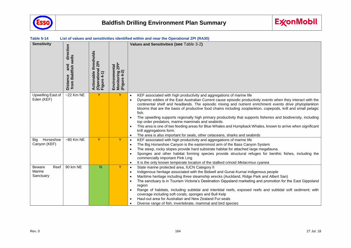
Baldfish Drilling Environment Plan Summary
Rev. 0 164 27 Jul. 18
Table 5-14 List of values and sensitivities identified within and near the Operational ZPI (RA30)
Sensitivity
Dis
tan
ce
an
d
dir
ec
tio
n
fro
m B
ald
fis
h w
ell
s
Acti
on
ab
le t
hre
sh
old
s
(Op
era
tio
na
l Z
PI
Fig
ure
4-1
)
En
vir
on
men
tal
Mo
nit
ori
ng
ZP
I*
(Fig
ure
4-2
)
Values and Sensitivities (see Table 3-2)
Upwelling East of Eden (KEF)
~22 Km NE Y Y KEF associated with high productivity and aggregations of marine life
Dynamic eddies of the East Australian Current cause episodic productivity events when they interact with the continental shelf and headlands. The episodic mixing and nutrient enrichment events drive phytoplankton blooms that are the basis of productive food chains including zooplankton, copepods, krill and small pelagic fish.
The upwelling supports regionally high primary productivity that supports fisheries and biodiversity, including top order predators, marine mammals and seabirds.
This area is one of two feeding areas for Blue Whales and Humpback Whales, known to arrive when significant krill aggregations form.
The area is also important for seals, other cetaceans, sharks and seabirds
Big Horseshoe Canyon (KEF)
~80 Km NE Y Y KEF associated with high productivity and aggregations of marine life
The Big Horseshoe Canyon is the easternmost arm of the Bass Canyon System
The steep, rocky slopes provide hard substrate habitat for attached large megafauna.
Sponges and other habitat forming species provide structural refuges for benthic fishes, including the commercially important Pink Ling
It is the only known temperate location of the stalked crinoid Metacrinus cyanea
Beware Reef Marine Sanctuary
90 km NE N Y State marine protected area, IUCN Category II
Indigenous heritage associated with the Bidwell and Gunai-Kurnai Indigenous people
Maritime heritage including three steamship wrecks (Auckland, Ridge Park and Albert San)
The sanctuary is in Tourism Victoria’s Destination Gippsland marketing and promotion for the East Gippsland region
Range of habitats, including subtidal and intertidal reefs, exposed reefs and subtidal soft sediment; with coverage including soft corals, sponges and Bull Kelp
Haul-out area for Australian and New Zealand Fur-seals
Diverse range of fish, invertebrate, mammal and bird species
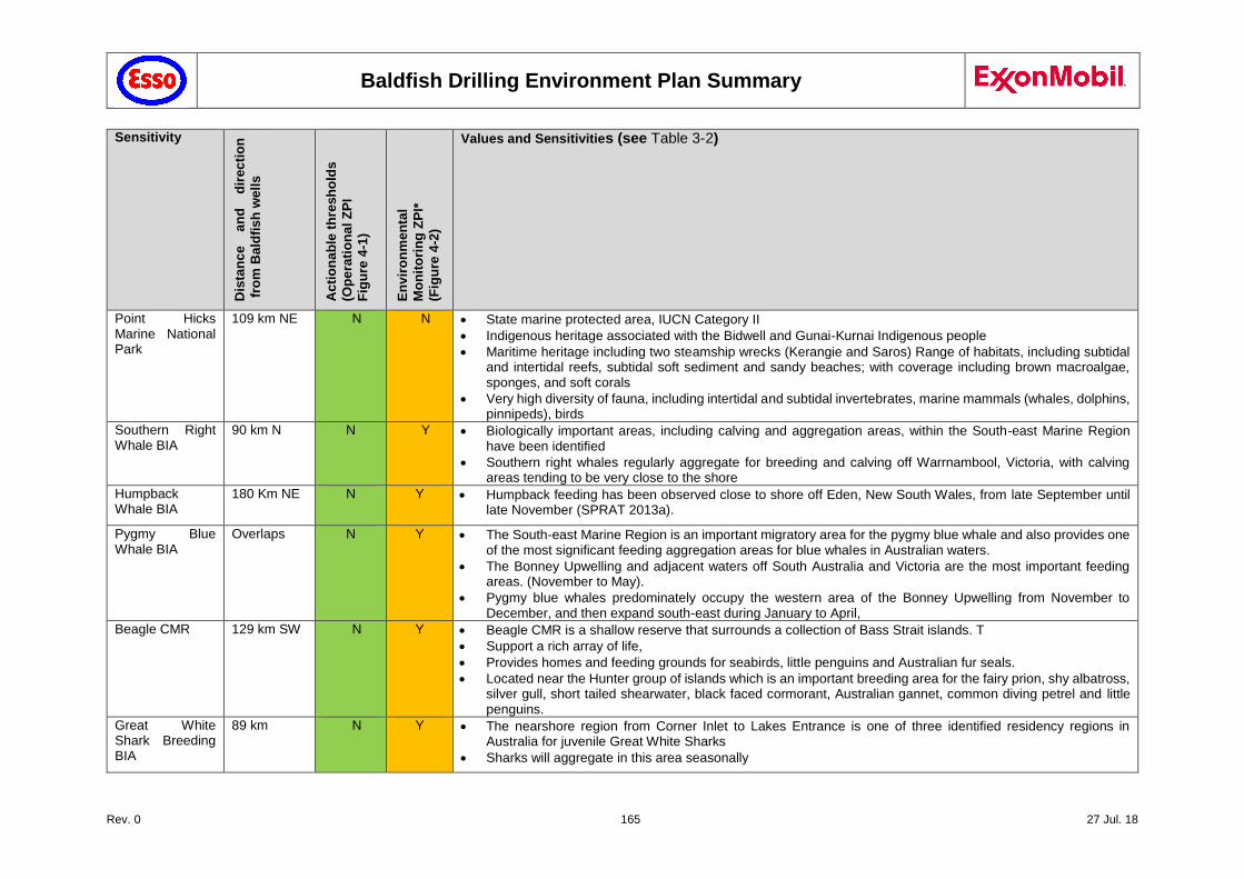
Baldfish Drilling Environment Plan Summary
Rev. 0 165 27 Jul. 18
Sensitivity
Dis
tan
ce
an
d
dir
ec
tio
n
fro
m B
ald
fis
h w
ell
s
Acti
on
ab
le t
hre
sh
old
s
(Op
era
tio
na
l Z
PI
Fig
ure
4-1
)
En
vir
on
men
tal
Mo
nit
ori
ng
ZP
I*
(Fig
ure
4-2
)
Values and Sensitivities (see Table 3-2)
Point Hicks Marine National Park
109 km NE N N State marine protected area, IUCN Category II
Indigenous heritage associated with the Bidwell and Gunai-Kurnai Indigenous people
Maritime heritage including two steamship wrecks (Kerangie and Saros) Range of habitats, including subtidal and intertidal reefs, subtidal soft sediment and sandy beaches; with coverage including brown macroalgae, sponges, and soft corals
Very high diversity of fauna, including intertidal and subtidal invertebrates, marine mammals (whales, dolphins, pinnipeds), birds
Southern Right Whale BIA
90 km N N Y Biologically important areas, including calving and aggregation areas, within the South-east Marine Region have been identified
Southern right whales regularly aggregate for breeding and calving off Warrnambool, Victoria, with calving areas tending to be very close to the shore
Humpback Whale BIA
180 Km NE N Y Humpback feeding has been observed close to shore off Eden, New South Wales, from late September until late November (SPRAT 2013a).
Pygmy Blue Whale BIA
Overlaps N Y The South-east Marine Region is an important migratory area for the pygmy blue whale and also provides one of the most significant feeding aggregation areas for blue whales in Australian waters.
The Bonney Upwelling and adjacent waters off South Australia and Victoria are the most important feeding areas. (November to May).
Pygmy blue whales predominately occupy the western area of the Bonney Upwelling from November to December, and then expand south-east during January to April,
Beagle CMR 129 km SW N Y Beagle CMR is a shallow reserve that surrounds a collection of Bass Strait islands. T
Support a rich array of life,
Provides homes and feeding grounds for seabirds, little penguins and Australian fur seals.
Located near the Hunter group of islands which is an important breeding area for the fairy prion, shy albatross, silver gull, short tailed shearwater, black faced cormorant, Australian gannet, common diving petrel and little penguins.
Great White Shark Breeding BIA
89 km N Y The nearshore region from Corner Inlet to Lakes Entrance is one of three identified residency regions in Australia for juvenile Great White Sharks
Sharks will aggregate in this area seasonally
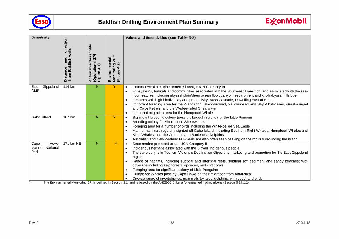
Baldfish Drilling Environment Plan Summary
Rev. 0 166 27 Jul. 18
Sensitivity
Dis
tan
ce
an
d
dir
ec
tio
n
fro
m B
ald
fis
h w
ell
s
Acti
on
ab
le t
hre
sh
old
s
(Op
era
tio
na
l Z
PI
Fig
ure
4-1
)
En
vir
on
men
tal
Mo
nit
ori
ng
ZP
I*
(Fig
ure
4-2
)
Values and Sensitivities (see Table 3-2)
East Gippsland CMP
116 km N Y Commonwealth marine protected area, IUCN Category VI
Ecosystems, habitats and communities associated with the Southeast Transition, and associated with the sea-floor features including abyssal plain/deep ocean floor, canyon, escarpment and knoll/abyssal hillslope
Features with high biodiversity and productivity: Bass Cascade; Upwelling East of Eden
Important foraging area for the Wandering, Black-browed, Yellownosed and Shy Albatrosses, Great-winged and Cape Petrels, and the Wedge-tailed Shearwater
Important migration area for the Humpback Whale
Gabo Island 167 km N Y Significant breeding colony (possibly largest in world) for the Little Penguin
Breeding colony for Short-tailed Shearwaters
Foraging area for a number of birds including the White-belled Sea Eagle
Marine mammals regularly sighted off Gabo Island, including Southern Right Whales, Humpback Whales and Killer Whales; and the Common and Bottlenose Dolphins
Australian and New Zealand Fur-Seals are also often seen basking on the rocks surrounding the island
Cape Howe Marine National Park
171 km NE N Y State marine protected area, IUCN Category II
Indigenous heritage associated with the Bidwell Indigenous people
The sanctuary is in Tourism Victoria’s Destination Gippsland marketing and promotion for the East Gippsland region
Range of habitats, including subtidal and intertidal reefs, subtidal soft sediment and sandy beaches; with coverage including kelp forests, sponges, and soft corals
Foraging area for significant colony of Little Penguins
Humpback Whales pass by Cape Howe on their migration from Antarctica
Diverse range of invertebrates, mammals (whales, dolphins, pinnipeds) and birds * The Environmental Monitoring ZPI is defined in Section 3.1, and is based on the ANZECC Criteria for entrained hydrocarbons (Section 5.24.2.2).
Baldfish Drilling Environment Plan Summary
Rev. 0 167 27 Jul. 18
The controls that relate to response strategies are summarised below:
Esso maintains capability to implement operational monitoring in a Level 2 or 3 spill event.
Agreements: AMOSC membership, AMSA MoU, Aviation support, Marine support services
Oil Spill Tracking Buoys
As requested by the relevant CA, Esso implements operational monitoring to inform spill response (Level 2 or 3 spill only). Key tools include:
Oil Spill Tracking Buoy Deployment
Response - Observation
Oil Spill Trajectory Modelling
Response – Oil Spill Vector Calculation
Esso maintains capability to implement its Baldfish Blowout Contingency Plan (part of WOMP). For this, it has access to Well Response Resources (Well Control Specialists, including capping stack capability); ROV Contractors; Subsea Engineering Company; Well Engineering Contractor; APPEA Mutual Assistance Agreement, SFRT agreements with AMOSC.
Implement Baldfish Blowout Contingency Plan:
Level 2 Response: Inspection class ROV SFRT
Level 3 Response: Well control specialists Capping stack installation Relief Well
Esso maintains capability to support oiled wildlife management in a Level 2 or 3 spill event.
Esso provides resources to support oiled wildlife response strategies as directed by DELWP.
5.30.4 Risk Ranking
The risks evaluation for emergency response tools are outlined in Chapter 7. The environmental risks associated with emergency response are largely addressed under the risks for planned drilling operations.
Table 6-2: Response technique evaluation for MDO Spill Risks are as per project activities: Noise, Vessel collisions, Spills etc. (as described in Chapter 6)
Table 6-3: Response technique evaluation for Loss of Well Control
Table 7-20: Response technique evaluation for Source Control Risks are as per drilling activities (Discharge of drill cuttings, cement, drilling fluids, bunkering, noise light, etc.) – no additional controls
5.30.5 Demonstration of ALARP
To demonstrate that the impacts and risk associated with response strategies have been reduced to ALARP, other controls and alternatives were considered as summarised in Chapter 7.
Modelling shows that shoreline contact is not expected to occur after a spill, either resulting from a major collision or from a well blowout event (Section 5.24.3 and 5.28.3). Therefore no specific shore-based contingencies will be in place for the Baldfish campaign, other than those already in place as part of Esso operations in Bass Strait.
There were no further alternatives identified to the response strategies as they are defined in Section 6 and the OPEP. On this basis Esso considers the risk to be ALARP.
5.30.6 Demonstration of Acceptability
Details of Esso’s capability to mount a suitable spill response is included in Chapter 6, the OPEP and OSMP.
The response strategies, as detailed in Chapter 6, are consistent with standard industry practice. This includes:
Baldfish Drilling Environment Plan Summary
Rev. 0 168 27 Jul. 18
Having a well-resourced response team, equipment, resources and logistics for industry to consult with relevant authorities on spill plans in line with the "Polluter pays" principle in the OPGGS Act and ‘consultation’ principles in the OPGGS(E) Regulations.
Isolating the spill source by means of transfer, shut-in, dynamic kill, drilling a relief well.
Establishing exclusion zones (which are commonly established for any emergency operations).
Developed procedures as part of the WOMP for the mobilisation of a second MODU in case the drilling of a relief well is required.
Simultaneously, establish procedures as part of the WOMP for the mobilisation of a capping stack in order to further minimise the environmental impact from a potential well blow-out.
5.31 Environmental Performance Outcomes, Performance Standards and Measurement Criteria
This section outlines:
The environmental performance outcomes against which the performance in protecting the environment can be measured and set the overall goals for the project.
The performance standards that are applied to ensure control measures are operational at a level of performance which will manage the identified environmental impacts and risks of the activity to ALARP and acceptable levels.
The measurement criteria that will define how environmental performance is measured against performance outcomes and performance standards.
The list of performance outcomes, performance standards and measurement criteria that have been developed for Esso’s Baldfish exploration drilling operations are tabled under each risk element in the following sections. The responsibility for each performance standard has been assigned and accepted by the person in the designated role.
Note each line item numbered refers to the environmental “RA” Number for each item listed in Chapter 5.
Every control listed in Chapter 5 is listed with the corresponding Environmental Performance Outcomes (EPO), Environmental Performance Standards (EPS) and Measurement Criteria.
5.31.1 Environmental Performance Outcomes (EPO)
Performance outcomes are a measurable level of performance required for the management of the environmental impacts and risks to ALARP and to an acceptable level.
Environmental performance outcomes have been developed for each environmental hazard in Section 5 as defined in the OPGGS(E) Regulations 2009.
5.31.2 Environmental Performance Standards (EPS)
Performance standards are a statement of performance required of a control measure. The Performance Standards have been set for every outcome and every control outlined in Section 5 in order to demonstrate how these controls will perform effectively to ensure that the risk of impacts to the environment are managed to ALARP and to an acceptable level.
5.31.3 Measurement Criteria
Measurement criteria have been outlined to demonstrate how the Outcomes and Standards are measured. This forms an auditable trail and can be used to measure and monitor the performance of all controls, to ensure they are working effectively to reduce the risk of impacts to the environment to ALARP and to an acceptable level.
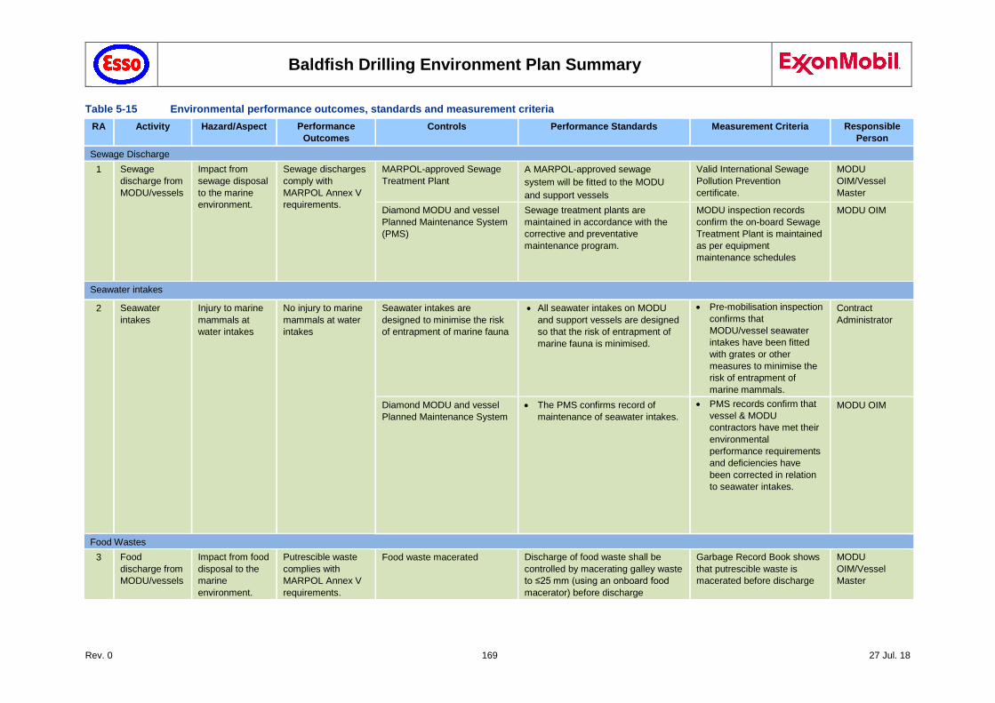
Baldfish Drilling Environment Plan Summary
Rev. 0 169 27 Jul. 18
Table 5-15 Environmental performance outcomes, standards and measurement criteria
RA Activity Hazard/Aspect Performance
Outcomes
Controls Performance Standards Measurement Criteria Responsible
Person
Sewage Discharge
1 Sewage
discharge from
MODU/vessels
Impact from
sewage disposal
to the marine
environment.
Sewage discharges
comply with
MARPOL Annex V
requirements.
MARPOL-approved Sewage
Treatment Plant
A MARPOL-approved sewage
system will be fitted to the MODU
and support vessels
Valid International Sewage
Pollution Prevention
certificate.
MODU
OIM/Vessel
Master
Diamond MODU and vessel
Planned Maintenance System
(PMS)
Sewage treatment plants are
maintained in accordance with the
corrective and preventative
maintenance program.
MODU inspection records
confirm the on-board Sewage
Treatment Plant is maintained
as per equipment
maintenance schedules
MODU OIM
Seawater intakes
2 Seawater
intakes
Injury to marine
mammals at
water intakes
No injury to marine
mammals at water
intakes
Seawater intakes are
designed to minimise the risk
of entrapment of marine fauna
All seawater intakes on MODU
and support vessels are designed
so that the risk of entrapment of
marine fauna is minimised.
Pre-mobilisation inspection
confirms that
MODU/vessel seawater
intakes have been fitted
with grates or other
measures to minimise the
risk of entrapment of
marine mammals.
Contract
Administrator
Diamond MODU and vessel
Planned Maintenance System
The PMS confirms record of
maintenance of seawater intakes.
PMS records confirm that
vessel & MODU
contractors have met their
environmental
performance requirements
and deficiencies have
been corrected in relation
to seawater intakes.
MODU OIM
Food Wastes
3 Food
discharge from
MODU/vessels
Impact from food
disposal to the
marine
environment.
Putrescible waste
complies with
MARPOL Annex V
requirements.
Food waste macerated Discharge of food waste shall be
controlled by macerating galley waste
to ≤25 mm (using an onboard food
macerator) before discharge
Garbage Record Book shows
that putrescible waste is
macerated before discharge
MODU
OIM/Vessel
Master
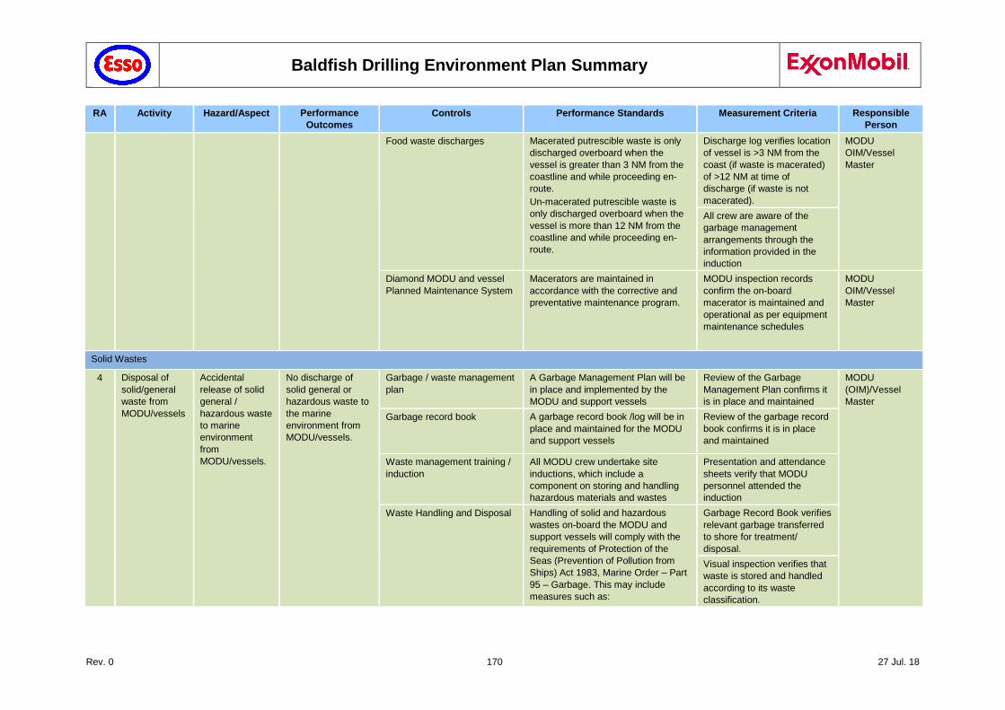
Baldfish Drilling Environment Plan Summary
Rev. 0 170 27 Jul. 18
RA Activity Hazard/Aspect Performance
Outcomes
Controls Performance Standards Measurement Criteria Responsible
Person
Food waste discharges Macerated putrescible waste is only
discharged overboard when the
vessel is greater than 3 NM from the
coastline and while proceeding en-
route.
Un-macerated putrescible waste is
only discharged overboard when the
vessel is more than 12 NM from the
coastline and while proceeding en-
route.
Discharge log verifies location
of vessel is >3 NM from the
coast (if waste is macerated)
of >12 NM at time of
discharge (if waste is not
macerated).
MODU
OIM/Vessel
Master
All crew are aware of the
garbage management
arrangements through the
information provided in the
induction
Diamond MODU and vessel
Planned Maintenance System
Macerators are maintained in
accordance with the corrective and
preventative maintenance program.
MODU inspection records
confirm the on-board
macerator is maintained and
operational as per equipment
maintenance schedules
MODU
OIM/Vessel
Master
Solid Wastes
4 Disposal of
solid/general
waste from
MODU/vessels
Accidental
release of solid
general /
hazardous waste
to marine
environment
from
MODU/vessels.
No discharge of
solid general or
hazardous waste to
the marine
environment from
MODU/vessels.
Garbage / waste management
plan
A Garbage Management Plan will be
in place and implemented by the
MODU and support vessels
Review of the Garbage
Management Plan confirms it
is in place and maintained
MODU
(OIM)/Vessel
Master
Garbage record book A garbage record book /log will be in
place and maintained for the MODU
and support vessels
Review of the garbage record
book confirms it is in place
and maintained
Waste management training /
induction
All MODU crew undertake site
inductions, which include a
component on storing and handling
hazardous materials and wastes
Presentation and attendance
sheets verify that MODU
personnel attended the
induction
Waste Handling and Disposal Handling of solid and hazardous
wastes on-board the MODU and
support vessels will comply with the
requirements of Protection of the
Seas (Prevention of Pollution from
Ships) Act 1983, Marine Order – Part
95 – Garbage. This may include
measures such as:
Garbage Record Book verifies
relevant garbage transferred
to shore for treatment/
disposal.
Visual inspection verifies that
waste is stored and handled
according to its waste
classification.
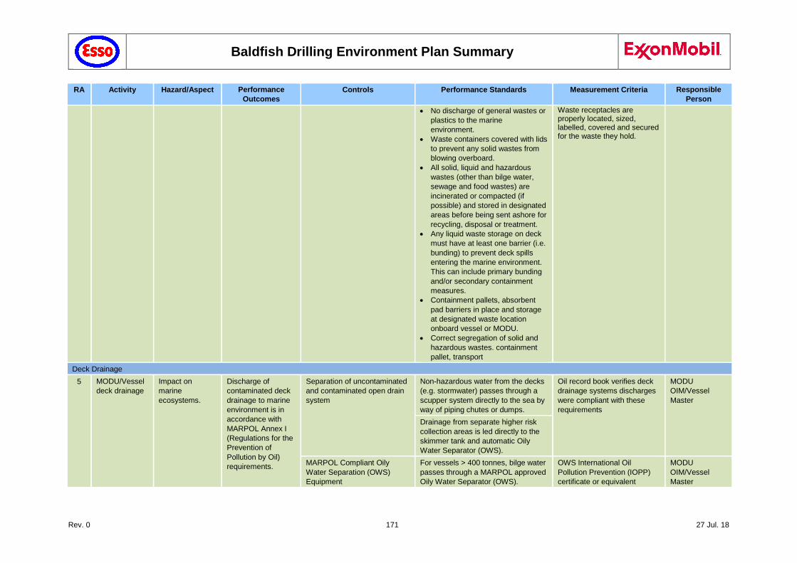
Baldfish Drilling Environment Plan Summary
Rev. 0 171 27 Jul. 18
RA Activity Hazard/Aspect Performance
Outcomes
Controls Performance Standards Measurement Criteria Responsible
Person
No discharge of general wastes or
plastics to the marine
environment.
Waste containers covered with lids
to prevent any solid wastes from
blowing overboard.
All solid, liquid and hazardous
wastes (other than bilge water,
sewage and food wastes) are
incinerated or compacted (if
possible) and stored in designated
areas before being sent ashore for
recycling, disposal or treatment.
Any liquid waste storage on deck
must have at least one barrier (i.e.
bunding) to prevent deck spills
entering the marine environment.
This can include primary bunding
and/or secondary containment
measures.
Containment pallets, absorbent
pad barriers in place and storage
at designated waste location
onboard vessel or MODU.
Correct segregation of solid and
hazardous wastes. containment
pallet, transport
Waste receptacles are properly located, sized, labelled, covered and secured for the waste they hold.
Deck Drainage
5 MODU/Vessel
deck drainage
Impact on
marine
ecosystems.
Discharge of
contaminated deck
drainage to marine
environment is in
accordance with
MARPOL Annex I
(Regulations for the
Prevention of
Pollution by Oil)
requirements.
Separation of uncontaminated
and contaminated open drain
system
Non-hazardous water from the decks
(e.g. stormwater) passes through a
scupper system directly to the sea by
way of piping chutes or dumps.
Oil record book verifies deck
drainage systems discharges
were compliant with these
requirements
MODU
OIM/Vessel
Master
Drainage from separate higher risk
collection areas is led directly to the
skimmer tank and automatic Oily
Water Separator (OWS).
MARPOL Compliant Oily
Water Separation (OWS)
Equipment
For vessels > 400 tonnes, bilge water
passes through a MARPOL approved
Oily Water Separator (OWS).
OWS International Oil
Pollution Prevention (IOPP)
certificate or equivalent
MODU
OIM/Vessel
Master
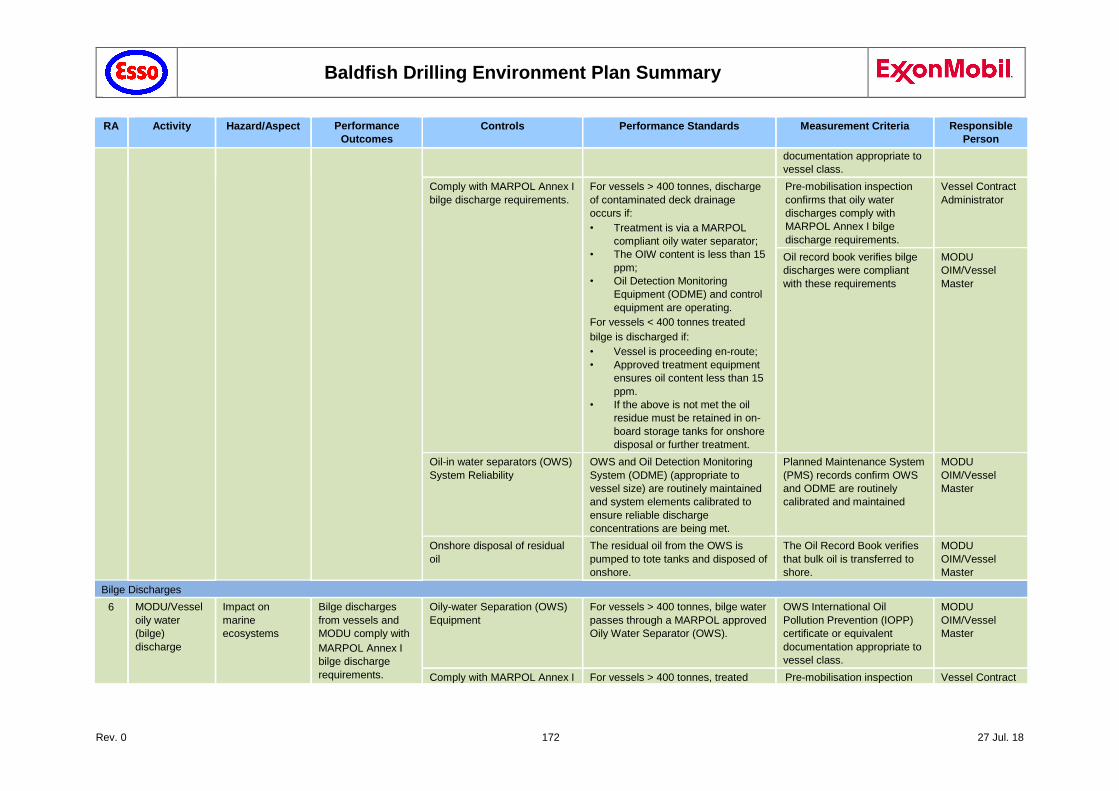
Baldfish Drilling Environment Plan Summary
Rev. 0 172 27 Jul. 18
RA Activity Hazard/Aspect Performance
Outcomes
Controls Performance Standards Measurement Criteria Responsible
Person
documentation appropriate to
vessel class.
Comply with MARPOL Annex I
bilge discharge requirements.
For vessels > 400 tonnes, discharge
of contaminated deck drainage
occurs if:
• Treatment is via a MARPOL
compliant oily water separator;
• The OIW content is less than 15
ppm;
• Oil Detection Monitoring
Equipment (ODME) and control
equipment are operating.
For vessels < 400 tonnes treated
bilge is discharged if:
• Vessel is proceeding en-route;
• Approved treatment equipment
ensures oil content less than 15
ppm.
• If the above is not met the oil
residue must be retained in on-
board storage tanks for onshore
disposal or further treatment.
Pre-mobilisation inspection
confirms that oily water
discharges comply with
MARPOL Annex I bilge
discharge requirements.
Vessel Contract
Administrator
Oil record book verifies bilge
discharges were compliant
with these requirements
MODU
OIM/Vessel
Master
Oil-in water separators (OWS)
System Reliability
OWS and Oil Detection Monitoring
System (ODME) (appropriate to
vessel size) are routinely maintained
and system elements calibrated to
ensure reliable discharge
concentrations are being met.
Planned Maintenance System
(PMS) records confirm OWS
and ODME are routinely
calibrated and maintained
MODU
OIM/Vessel
Master
Onshore disposal of residual
oil
The residual oil from the OWS is
pumped to tote tanks and disposed of
onshore.
The Oil Record Book verifies
that bulk oil is transferred to
shore.
MODU
OIM/Vessel
Master
Bilge Discharges
6 MODU/Vessel
oily water
(bilge)
discharge
Impact on
marine
ecosystems
Bilge discharges
from vessels and
MODU comply with
MARPOL Annex I
bilge discharge
requirements.
Oily-water Separation (OWS)
Equipment
For vessels > 400 tonnes, bilge water
passes through a MARPOL approved
Oily Water Separator (OWS).
OWS International Oil
Pollution Prevention (IOPP)
certificate or equivalent
documentation appropriate to
vessel class.
MODU
OIM/Vessel
Master
Comply with MARPOL Annex I For vessels > 400 tonnes, treated Pre-mobilisation inspection Vessel Contract
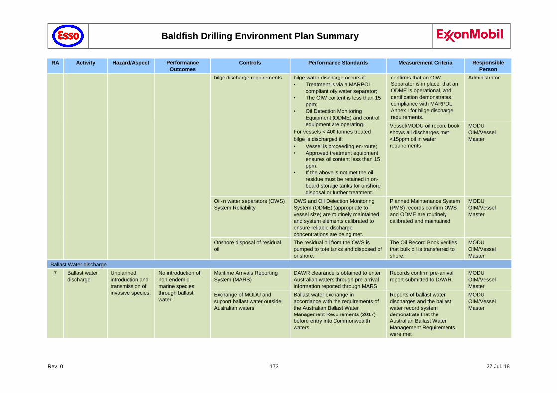
Baldfish Drilling Environment Plan Summary
Rev. 0 173 27 Jul. 18
RA Activity Hazard/Aspect Performance
Outcomes
Controls Performance Standards Measurement Criteria Responsible
Person
bilge discharge requirements. bilge water discharge occurs if:
• Treatment is via a MARPOL
compliant oily water separator;
• The OIW content is less than 15
ppm;
• Oil Detection Monitoring
Equipment (ODME) and control
equipment are operating.
For vessels < 400 tonnes treated
bilge is discharged if:
• Vessel is proceeding en-route;
• Approved treatment equipment
ensures oil content less than 15
ppm.
• If the above is not met the oil
residue must be retained in on-
board storage tanks for onshore
disposal or further treatment.
confirms that an OIW
Separator is in place, that an
ODME is operational, and
certification demonstrates
compliance with MARPOL
Annex I for bilge discharge
requirements.
Administrator
Vessel/MODU oil record book
shows all discharges met
<15ppm oil in water
requirements
MODU
OIM/Vessel
Master
Oil-in water separators (OWS)
System Reliability
OWS and Oil Detection Monitoring
System (ODME) (appropriate to
vessel size) are routinely maintained
and system elements calibrated to
ensure reliable discharge
concentrations are being met.
Planned Maintenance System
(PMS) records confirm OWS
and ODME are routinely
calibrated and maintained
MODU
OIM/Vessel
Master
Onshore disposal of residual
oil
The residual oil from the OWS is
pumped to tote tanks and disposed of
onshore.
The Oil Record Book verifies
that bulk oil is transferred to
shore.
MODU
OIM/Vessel
Master
Ballast Water discharge
7 Ballast water
discharge
Unplanned
introduction and
transmission of
invasive species.
No introduction of
non-endemic
marine species
through ballast
water.
Maritime Arrivals Reporting
System (MARS)
DAWR clearance is obtained to enter
Australian waters through pre-arrival
information reported through MARS
Records confirm pre-arrival
report submitted to DAWR
MODU
OIM/Vessel
Master
Exchange of MODU and
support ballast water outside
Australian waters
Ballast water exchange in
accordance with the requirements of
the Australian Ballast Water
Management Requirements (2017)
before entry into Commonwealth
waters
Reports of ballast water
discharges and the ballast
water record system
demonstrate that the
Australian Ballast Water
Management Requirements
were met
MODU
OIM/Vessel
Master
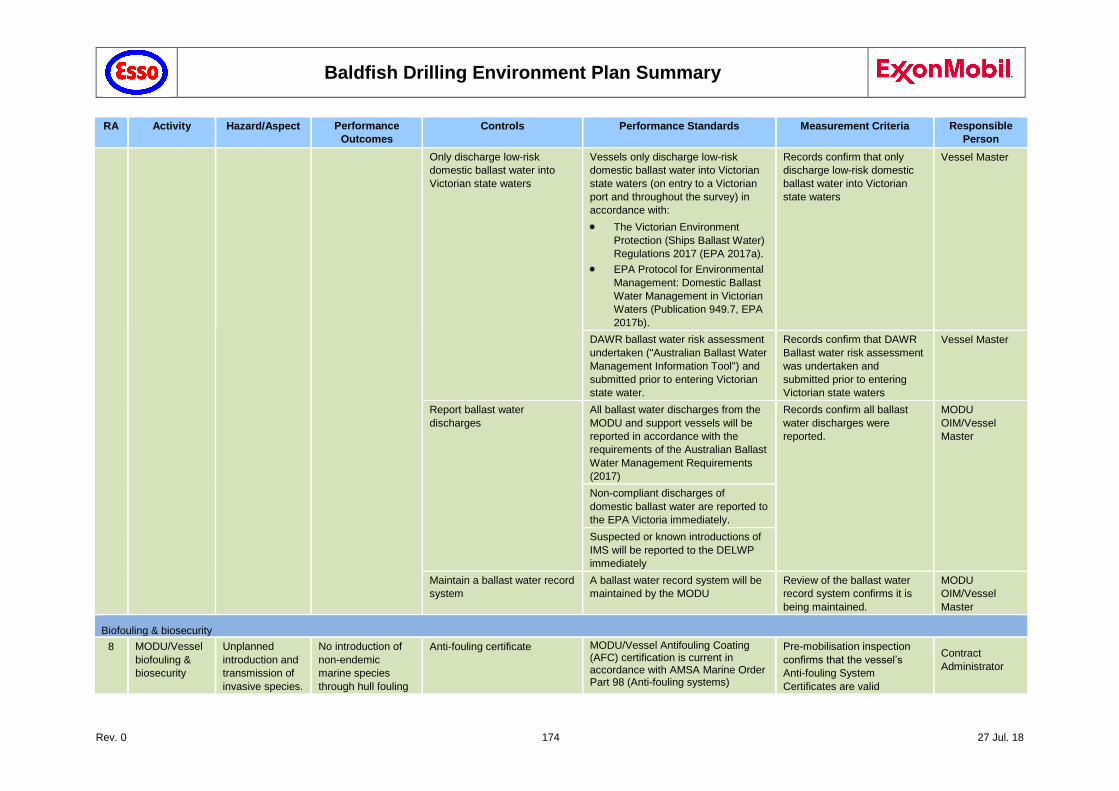
Baldfish Drilling Environment Plan Summary
Rev. 0 174 27 Jul. 18
RA Activity Hazard/Aspect Performance
Outcomes
Controls Performance Standards Measurement Criteria Responsible
Person
Only discharge low-risk
domestic ballast water into
Victorian state waters
Vessels only discharge low-risk
domestic ballast water into Victorian
state waters (on entry to a Victorian
port and throughout the survey) in
accordance with:
The Victorian Environment
Protection (Ships Ballast Water)
Regulations 2017 (EPA 2017a).
EPA Protocol for Environmental
Management: Domestic Ballast
Water Management in Victorian
Waters (Publication 949.7, EPA
2017b).
Records confirm that only
discharge low-risk domestic
ballast water into Victorian
state waters
Vessel Master
DAWR ballast water risk assessment
undertaken ("Australian Ballast Water
Management Information Tool") and
submitted prior to entering Victorian
state water.
Records confirm that DAWR
Ballast water risk assessment
was undertaken and
submitted prior to entering
Victorian state waters
Vessel Master
Report ballast water
discharges
All ballast water discharges from the
MODU and support vessels will be
reported in accordance with the
requirements of the Australian Ballast
Water Management Requirements
(2017)
Records confirm all ballast
water discharges were
reported.
MODU
OIM/Vessel
Master
Non-compliant discharges of
domestic ballast water are reported to
the EPA Victoria immediately.
Suspected or known introductions of
IMS will be reported to the DELWP
immediately
Maintain a ballast water record
system
A ballast water record system will be
maintained by the MODU
Review of the ballast water
record system confirms it is
being maintained.
MODU
OIM/Vessel
Master
Biofouling & biosecurity
8 MODU/Vessel
biofouling &
biosecurity
Unplanned
introduction and
transmission of
invasive species.
No introduction of
non-endemic
marine species
through hull fouling
Anti-fouling certificate MODU/Vessel Antifouling Coating (AFC) certification is current in accordance with AMSA Marine Order Part 98 (Anti-fouling systems)
Pre-mobilisation inspection
confirms that the vessel’s
Anti-fouling System
Certificates are valid
Contract
Administrator
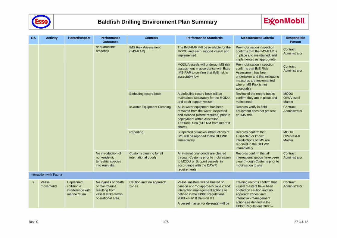
Baldfish Drilling Environment Plan Summary
Rev. 0 175 27 Jul. 18
RA Activity Hazard/Aspect Performance
Outcomes
Controls Performance Standards Measurement Criteria Responsible
Person
or quarantine
breaches IMS Risk Assessment
(IMS-RAP)
The IMS-RAP will be available for the
MODU and each support vessel and
implemented
Pre-mobilisation inspection
confirms that the IMS-RAP is
in place and maintained, and
implemented as appropriate.
Contract
Administrator
MODU/Vessels will undergo IMS risk
assessment in accordance with Esso
IMS-RAP to confirm that IMS risk is
acceptably low
Pre-mobilisation inspection
confirms that IMS Risk
Assessment has been
undertaken and that mitigating
measures are implemented
where IMS Risk is not
acceptable
Contract
Administrator
Biofouling record book A biofouling record book will be
maintained separately for the MODU
and each support vessel
Review of the record books
confirm they are in place and
maintained.
MODU
OIM/Vessel
Master
In-water Equipment Cleaning All in-water equipment has been
removed from the water, inspected
and cleaned (where required) prior to
deployment within Australian
Territorial Sea (<12 NM from nearest
shore).
Records verify in-field
equipment does not present
an IMS risk.
Contract
Administrator
Reporting Suspected or known introductions of
IMS will be reported to the DELWP
immediately
Records confirm that
suspected or known
introductions of IMS are
reported to the DELWP
immediately
MODU
OIM/Vessel
Master
No introduction of
non-endemic
terrestrial species
into Australia
Customs clearing for all
international goods
All international goods are cleared
through Customs prior to mobilisation
to MODU or Support vessels, in
accordance with the DAWR
requirements
Records confirm that all
international goods have been
clear through Customs prior to
mobilisation to site
Contract
Administrator
Interaction with Fauna
9 Vessel
movements
Unplanned
collision &
interference with
marine fauna
No injuries or death
of macrofauna
resulting from
vessel strike within
operational area.
Caution and ‘no approach
zones
Vessel masters will be briefed on
caution and ‘no approach zones’ and
interaction management actions as
defined in the EPBC Regulations
2000 – Part 8 Division 8.1
A vessel master (or delegate) will be
Training records confirm that
vessel masters have been
briefed on caution and ‘no
approach zones’ and
interaction management
actions as defined in the
EPBC Regulations 2000 –
Contract
Administrator
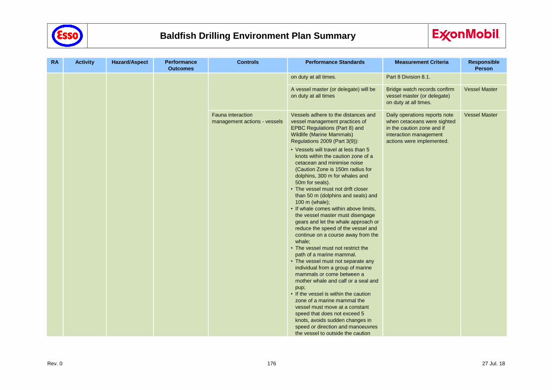
Baldfish Drilling Environment Plan Summary
Rev. 0 176 27 Jul. 18
RA Activity Hazard/Aspect Performance
Outcomes
Controls Performance Standards Measurement Criteria Responsible
Person
on duty at all times. Part 8 Division 8.1.
A vessel master (or delegate) will be
on duty at all times
Bridge watch records confirm
vessel master (or delegate)
on duty at all times.
Vessel Master
Fauna interaction
management actions - vessels
Vessels adhere to the distances and
vessel management practices of
EPBC Regulations (Part 8) and
Wildlife (Marine Mammals)
Regulations 2009 (Part 3(9)):
• Vessels will travel at less than 5
knots within the caution zone of a
cetacean and minimise noise
(Caution Zone is 150m radius for
dolphins, 300 m for whales and
50m for seals).
• The vessel must not drift closer
than 50 m (dolphins and seals) and
100 m (whale);
• If whale comes within above limits,
the vessel master must disengage
gears and let the whale approach or
reduce the speed of the vessel and
continue on a course away from the
whale;
• The vessel must not restrict the
path of a marine mammal.
• The vessel must not separate any
individual from a group of marine
mammals or come between a
mother whale and calf or a seal and
pup;
• If the vessel is within the caution
zone of a marine mammal the
vessel must move at a constant
speed that does not exceed 5
knots, avoids sudden changes in
speed or direction and manoeuvres
the vessel to outside the caution
Daily operations reports note
when cetaceans were sighted
in the caution zone and if
interaction management
actions were implemented.
Vessel Master
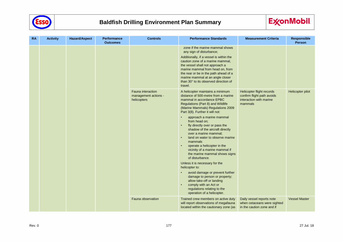
Baldfish Drilling Environment Plan Summary
Rev. 0 177 27 Jul. 18
RA Activity Hazard/Aspect Performance
Outcomes
Controls Performance Standards Measurement Criteria Responsible
Person
zone if the marine mammal shows
any sign of disturbance;
Additionally, if a vessel is within the
caution zone of a marine mammal,
the vessel shall not approach a
marine mammal from head on, from
the rear or be in the path ahead of a
marine mammal at an angle closer
than 30° to its observed direction of
travel.
Fauna interaction
management actions -
helicopters
A helicopter maintains a minimum
distance of 500-metre from a marine
mammal in accordance EPBC
Regulations (Part 8) and Wildlife
(Marine Mammals) Regulations 2009
Part 3(8). Further it will not:
• approach a marine mammal
from head on;
• fly directly over or pass the
shadow of the aircraft directly
over a marine mammal;
• land on water to observe marine
mammals
• operate a helicopter in the
vicinity of a marine mammal if
the marine mammal shows signs
of disturbance.
Unless it is necessary for the
helicopter to:
• avoid damage or prevent further
damage to person or property;
allow take-off or landing
• comply with an Act or
regulations relating to the
operation of a helicopter.
Helicopter flight records
confirm flight path avoids
interaction with marine
mammals
Helicopter pilot
Fauna observation Trained crew members on active duty
will report observations of megafauna
located within the cautionary zone (as
Daily vessel reports note
when cetaceans were sighted
in the caution zone and if
Vessel Master
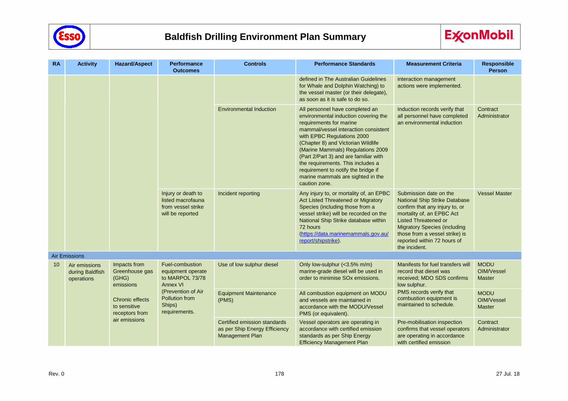
Baldfish Drilling Environment Plan Summary
Rev. 0 178 27 Jul. 18
RA Activity Hazard/Aspect Performance
Outcomes
Controls Performance Standards Measurement Criteria Responsible
Person
defined in The Australian Guidelines
for Whale and Dolphin Watching) to
the vessel master (or their delegate),
as soon as it is safe to do so.
interaction management
actions were implemented.
Environmental Induction All personnel have completed an
environmental induction covering the
requirements for marine
mammal/vessel interaction consistent
with EPBC Regulations 2000
(Chapter 8) and Victorian Wildlife
(Marine Mammals) Regulations 2009
(Part 2/Part 3) and are familiar with
the requirements. This includes a
requirement to notify the bridge if
marine mammals are sighted in the
caution zone.
Induction records verify that
all personnel have completed
an environmental induction
Contract
Administrator
Injury or death to
listed macrofauna
from vessel strike
will be reported
Incident reporting Any injury to, or mortality of, an EPBC
Act Listed Threatened or Migratory
Species (including those from a
vessel strike) will be recorded on the
National Ship Strike database within
72 hours
(https://data.marinemammals.gov.au/
report/shipstrike).
Submission date on the
National Ship Strike Database
confirm that any injury to, or
mortality of, an EPBC Act
Listed Threatened or
Migratory Species (including
those from a vessel strike) is
reported within 72 hours of
the incident.
Vessel Master
Air Emissions
10 Air emissions
during Baldfish
operations
Impacts from
Greenhouse gas
(GHG)
emissions
Chronic effects
to sensitive
receptors from
air emissions
Fuel-combustion
equipment operate
to MARPOL 73/78
Annex VI
(Prevention of Air
Pollution from
Ships)
requirements.
Use of low sulphur diesel Only low-sulphur (<3.5% m/m)
marine-grade diesel will be used in
order to minimise SOx emissions.
Manifests for fuel transfers will
record that diesel was
received; MDO SDS confirms
low sulphur.
MODU
OIM/Vessel
Master
Equipment Maintenance
(PMS)
All combustion equipment on MODU
and vessels are maintained in
accordance with the MODU/Vessel
PMS (or equivalent).
PMS records verify that combustion equipment is maintained to schedule.
MODU
OIM/Vessel
Master
Certified emission standards
as per Ship Energy Efficiency
Management Plan
Vessel operators are operating in
accordance with certified emission
standards as per Ship Energy
Efficiency Management Plan
Pre-mobilisation inspection
confirms that vessel operators
are operating in accordance
with certified emission
Contract
Administrator
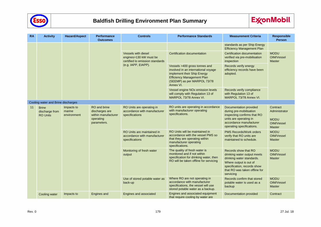
Baldfish Drilling Environment Plan Summary
Rev. 0 179 27 Jul. 18
RA Activity Hazard/Aspect Performance
Outcomes
Controls Performance Standards Measurement Criteria Responsible
Person
standards as per Ship Energy
Efficiency Management Plan
Vessels with diesel
engines>130 kW must be
certified to emission standards
(e.g. IAPP, EIAPP).
Certification documentation Certification documentation
verified via pre-mobilisation
inspection
MODU
OIM/Vessel
Master
Vessels >400 gross tonnes and
involved in an international voyage
implement their Ship Energy
Efficiency Management Plan
(SEEMP) as per MARPOL 73/78
Annex VI.
Records verify energy
efficiency records have been
adopted.
Vessel engine NOx emission levels
will comply with Regulation 13 of
MARPOL 73/78 Annex VI.
Records verify compliance
with Regulation 13 of
MARPOL 73/78 Annex VI.
Cooling water and Brine discharges
11 Brine
discharge from
RO Units
Impacts to
marine
environment
RO and brine
discharges are
within manufacturer
operating
parameters.
RO Units are operating in
accordance with manufacturer
specifications
RO units are operating in accordance with manufacturer operating specifications.
Documentation provided
during pre-mobilisation
inspecting confirms that RO
units are operating in
accordance manufacturer
operating specifications.
Contract
Administrator
MODU
OIM/Vessel
Master
RO Units are maintained in
accordance with manufacturer
specifications
RO Units will be maintained in accordance with the vessel PMS so that they are operating within manufacturer operating specifications.
PMS Records/Work orders
verify that RO units are
maintained to schedule.
MODU
OIM/Vessel
Master
Monitoring of fresh water
output
The quality of fresh water is monitored and if not within specification for drinking water, then RO will be taken offline for servicing
Records show that RO
drinking water output meets
drinking water standards.
Where output is out of
specification, records show
that RO was taken offline for
servicing
MODU
OIM/Vessel
Master
Use of stored potable water as
back-up
Where RO are not operating in accordance with manufacturer specifications, the vessel will use stored potable water as a backup.
Records confirm that stored
potable water is used as a
backup
MODU
OIM/Vessel
Master
Cooling water Impacts to Engines and Engines and associated Engines and associated equipment that require cooling by water are
Documentation provided Contract
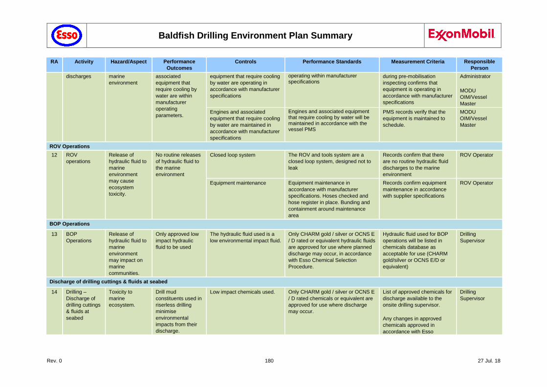
Baldfish Drilling Environment Plan Summary
Rev. 0 180 27 Jul. 18
RA Activity Hazard/Aspect Performance
Outcomes
Controls Performance Standards Measurement Criteria Responsible
Person
discharges marine
environment
associated
equipment that
require cooling by
water are within
manufacturer
operating
parameters.
equipment that require cooling
by water are operating in
accordance with manufacturer
specifications
operating within manufacturer specifications
during pre-mobilisation
inspecting confirms that
equipment is operating in
accordance with manufacturer
specifications
Administrator
MODU
OIM/Vessel
Master
Engines and associated
equipment that require cooling
by water are maintained in
accordance with manufacturer
specifications
Engines and associated equipment that require cooling by water will be maintained in accordance with the vessel PMS
PMS records verify that the
equipment is maintained to
schedule.
MODU
OIM/Vessel
Master
ROV Operations
12 ROV
operations
Release of
hydraulic fluid to
marine
environment
may cause
ecosystem
toxicity.
No routine releases
of hydraulic fluid to
the marine
environment
Closed loop system The ROV and tools system are a
closed loop system, designed not to
leak
Records confirm that there
are no routine hydraulic fluid
discharges to the marine
environment
ROV Operator
Equipment maintenance Equipment maintenance in
accordance with manufacturer
specifications. Hoses checked and
hose register in place. Bunding and
containment around maintenance
area
Records confirm equipment
maintenance in accordance
with supplier specifications
ROV Operator
BOP Operations
13 BOP
Operations
Release of
hydraulic fluid to
marine
environment
may impact on
marine
communities.
Only approved low
impact hydraulic
fluid to be used
The hydraulic fluid used is a
low environmental impact fluid.
Only CHARM gold / silver or OCNS E
/ D rated or equivalent hydraulic fluids
are approved for use where planned
discharge may occur, in accordance
with Esso Chemical Selection
Procedure.
Hydraulic fluid used for BOP
operations will be listed in
chemicals database as
acceptable for use (CHARM
gold/silver or OCNS E/D or
equivalent)
Drilling
Supervisor
Discharge of drilling cuttings & fluids at seabed
14 Drilling –
Discharge of
drilling cuttings
& fluids at
seabed
Toxicity to
marine
ecosystem.
Drill mud
constituents used in
riserless drilling
minimise
environmental
impacts from their
discharge.
Low impact chemicals used. Only CHARM gold / silver or OCNS E
/ D rated chemicals or equivalent are
approved for use where discharge
may occur.
List of approved chemicals for
discharge available to the
onsite drilling supervisor.
Any changes in approved
chemicals approved in
accordance with Esso
Drilling
Supervisor
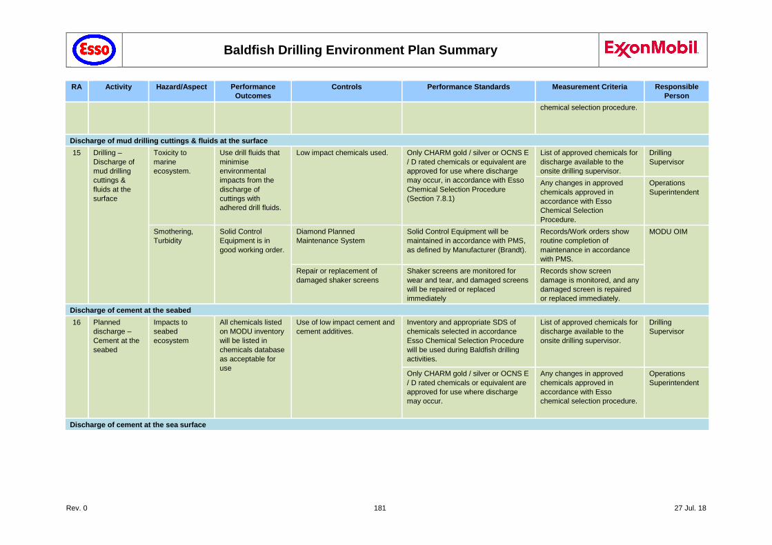
Baldfish Drilling Environment Plan Summary
Rev. 0 181 27 Jul. 18
RA Activity Hazard/Aspect Performance
Outcomes
Controls Performance Standards Measurement Criteria Responsible
Person
chemical selection procedure.
Discharge of mud drilling cuttings & fluids at the surface
15 Drilling –
Discharge of
mud drilling
cuttings &
fluids at the
surface
Toxicity to
marine
ecosystem.
Use drill fluids that
minimise
environmental
impacts from the
discharge of
cuttings with
adhered drill fluids.
Low impact chemicals used. Only CHARM gold / silver or OCNS E
/ D rated chemicals or equivalent are
approved for use where discharge
may occur, in accordance with Esso
Chemical Selection Procedure
(Section 7.8.1)
List of approved chemicals for
discharge available to the
onsite drilling supervisor.
Drilling
Supervisor
Any changes in approved
chemicals approved in
accordance with Esso
Chemical Selection
Procedure.
Operations
Superintendent
Smothering,
Turbidity
Solid Control
Equipment is in
good working order.
Diamond Planned
Maintenance System
Solid Control Equipment will be
maintained in accordance with PMS,
as defined by Manufacturer (Brandt).
Records/Work orders show
routine completion of
maintenance in accordance
with PMS.
MODU OIM
Repair or replacement of
damaged shaker screens
Shaker screens are monitored for
wear and tear, and damaged screens
will be repaired or replaced
immediately
Records show screen
damage is monitored, and any
damaged screen is repaired
or replaced immediately.
Discharge of cement at the seabed
16 Planned
discharge –
Cement at the
seabed
Impacts to
seabed
ecosystem
All chemicals listed
on MODU inventory
will be listed in
chemicals database
as acceptable for
use
Use of low impact cement and
cement additives.
Inventory and appropriate SDS of
chemicals selected in accordance
Esso Chemical Selection Procedure
will be used during Baldfish drilling
activities.
List of approved chemicals for
discharge available to the
onsite drilling supervisor.
Drilling
Supervisor
Only CHARM gold / silver or OCNS E
/ D rated chemicals or equivalent are
approved for use where discharge
may occur.
Any changes in approved
chemicals approved in
accordance with Esso
chemical selection procedure.
Operations
Superintendent
Discharge of cement at the sea surface
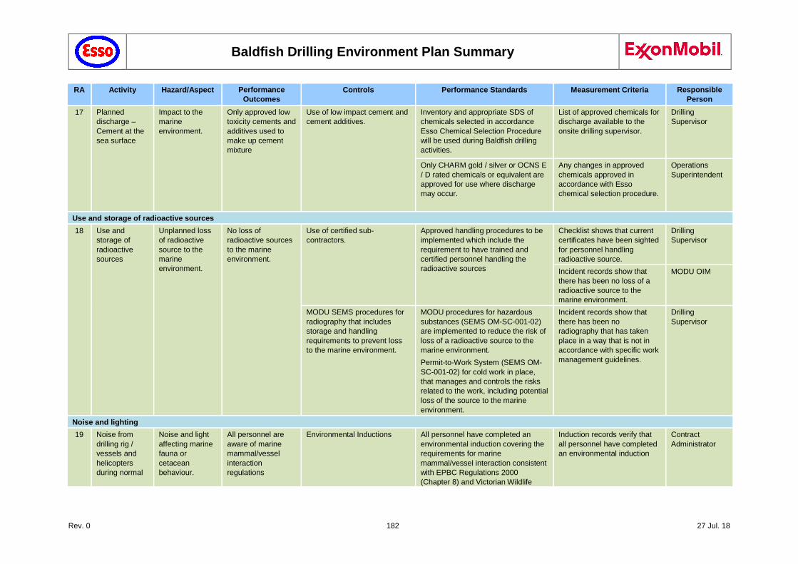
Baldfish Drilling Environment Plan Summary
Rev. 0 182 27 Jul. 18
RA Activity Hazard/Aspect Performance
Outcomes
Controls Performance Standards Measurement Criteria Responsible
Person
17 Planned
discharge –
Cement at the
sea surface
Impact to the
marine
environment.
Only approved low
toxicity cements and
additives used to
make up cement
mixture
Use of low impact cement and
cement additives.
Inventory and appropriate SDS of
chemicals selected in accordance
Esso Chemical Selection Procedure
will be used during Baldfish drilling
activities.
List of approved chemicals for
discharge available to the
onsite drilling supervisor.
Drilling
Supervisor
Only CHARM gold / silver or OCNS E
/ D rated chemicals or equivalent are
approved for use where discharge
may occur.
Any changes in approved
chemicals approved in
accordance with Esso
chemical selection procedure.
Operations
Superintendent
Use and storage of radioactive sources
18 Use and
storage of
radioactive
sources
Unplanned loss
of radioactive
source to the
marine
environment.
No loss of
radioactive sources
to the marine
environment.
Use of certified sub‐contractors.
Approved handling procedures to be
implemented which include the
requirement to have trained and
certified personnel handling the
radioactive sources
Checklist shows that current
certificates have been sighted
for personnel handling
radioactive source.
Drilling
Supervisor
Incident records show that
there has been no loss of a
radioactive source to the
marine environment.
MODU OIM
MODU SEMS procedures for
radiography that includes
storage and handling
requirements to prevent loss
to the marine environment.
MODU procedures for hazardous
substances (SEMS OM-SC-001-02)
are implemented to reduce the risk of
loss of a radioactive source to the
marine environment.
Permit-to-Work System (SEMS OM-
SC-001-02) for cold work in place,
that manages and controls the risks
related to the work, including potential
loss of the source to the marine
environment.
Incident records show that
there has been no
radiography that has taken
place in a way that is not in
accordance with specific work
management guidelines.
Drilling
Supervisor
Noise and lighting
19 Noise from
drilling rig /
vessels and
helicopters
during normal
Noise and light
affecting marine
fauna or
cetacean
behaviour.
All personnel are
aware of marine
mammal/vessel
interaction
regulations
Environmental Inductions All personnel have completed an
environmental induction covering the
requirements for marine
mammal/vessel interaction consistent
with EPBC Regulations 2000
(Chapter 8) and Victorian Wildlife
Induction records verify that
all personnel have completed
an environmental induction
Contract
Administrator
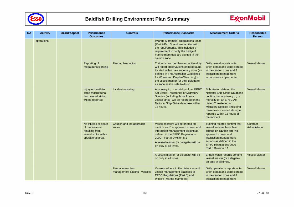
Baldfish Drilling Environment Plan Summary
Rev. 0 183 27 Jul. 18
RA Activity Hazard/Aspect Performance
Outcomes
Controls Performance Standards Measurement Criteria Responsible
Person
operations (Marine Mammals) Regulations 2009
(Part 2/Part 3) and are familiar with
the requirements. This includes a
requirement to notify the bridge if
marine mammals are sighted in the
caution zone.
Reporting of
megafauna sighting
Fauna observation Trained crew members on active duty
will report observations of megafauna
located within the cautionary zone (as
defined in The Australian Guidelines
for Whale and Dolphin Watching) to
the vessel master (or their delegate),
as soon as it is safe to do so.
Daily vessel reports note
when cetaceans were sighted
in the caution zone and if
interaction management
actions were implemented.
Vessel Master
Injury or death to
listed macrofauna
from vessel strike
will be reported
Incident reporting Any injury to, or mortality of, an EPBC
Act Listed Threatened or Migratory
Species (including those from a
vessel strike) will be recorded on the
National Ship Strike database within
72 hours.
Submission date on the
National Ship Strike Database
confirm that any injury to, or
mortality of, an EPBC Act
Listed Threatened or
Migratory Species (including
those from a vessel strike) is
reported within 72 hours of
the incident.
Vessel Master
No injuries or death
of macrofauna
resulting from
vessel strike within
operational area.
Caution and ‘no approach
zones
Vessel masters will be briefed on
caution and ‘no approach zones’ and
interaction management actions as
defined in the EPBC Regulations
2000 – Part 8 Division 8.1
A vessel master (or delegate) will be
on duty at all times.
Training records confirm that
vessel masters have been
briefed on caution and ‘no
approach zones’ and
interaction management
actions as defined in the
EPBC Regulations 2000 –
Part 8 Division 8.1.
Contract
Administrator
A vessel master (or delegate) will be
on duty at all times
Bridge watch records confirm
vessel master (or delegate)
on duty at all times.
Vessel Master
Fauna interaction
management actions - vessels
Vessels adhere to the distances and
vessel management practices of
EPBC Regulations (Part 8) and
Wildlife (Marine Mammals)
Daily operations reports note
when cetaceans were sighted
in the caution zone and if
interaction management
Vessel Master
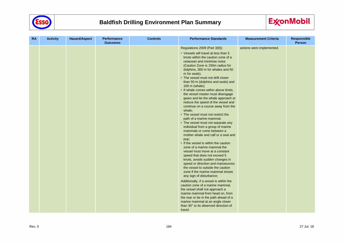
Baldfish Drilling Environment Plan Summary
Rev. 0 184 27 Jul. 18
RA Activity Hazard/Aspect Performance
Outcomes
Controls Performance Standards Measurement Criteria Responsible
Person
Regulations 2009 (Part 3(9)):
• Vessels will travel at less than 5
knots within the caution zone of a
cetacean and minimise noise
(Caution Zone is 150m radius for
dolphins, 300 m for whales and 50
m for seals).
• The vessel must not drift closer
than 50 m (dolphins and seals) and
100 m (whale);
• If whale comes within above limits,
the vessel master must disengage
gears and let the whale approach or
reduce the speed of the vessel and
continue on a course away from the
whale;
• The vessel must not restrict the
path of a marine mammal.
• The vessel must not separate any
individual from a group of marine
mammals or come between a
mother whale and calf or a seal and
pup;
• If the vessel is within the caution
zone of a marine mammal the
vessel must move at a constant
speed that does not exceed 5
knots, avoids sudden changes in
speed or direction and manoeuvres
the vessel to outside the caution
zone if the marine mammal shows
any sign of disturbance;
Additionally, if a vessel is within the
caution zone of a marine mammal,
the vessel shall not approach a
marine mammal from head on, from
the rear or be in the path ahead of a
marine mammal at an angle closer
than 30° to its observed direction of
travel.
actions were implemented.
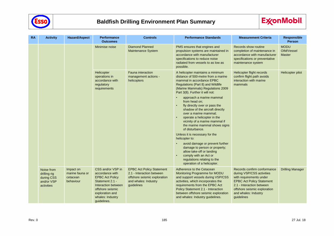
Baldfish Drilling Environment Plan Summary
Rev. 0 185 27 Jul. 18
RA Activity Hazard/Aspect Performance
Outcomes
Controls Performance Standards Measurement Criteria Responsible
Person
Minimise noise Diamond Planned
Maintenance System
PMS ensures that engines and
propulsion systems are maintained in
accordance with manufacturer
specifications to reduce noise
radiated from vessels to as low as
possible.
Records show routine
completion of maintenance in
accordance with manufacturer
specifications or preventative
maintenance system
MODU
OIM/Vessel
Master
Helicopter
operations in
accordance with
regulatory
requirements
Fauna interaction
management actions -
helicopters
A helicopter maintains a minimum
distance of 500-metre from a marine
mammal in accordance EPBC
Regulations (Part 8) and Wildlife
(Marine Mammals) Regulations 2009
Part 3(8). Further it will not:
• approach a marine mammal
from head on;
• fly directly over or pass the
shadow of the aircraft directly
over a marine mammal;
• operate a helicopter in the
vicinity of a marine mammal if
the marine mammal shows signs
of disturbance.
Unless it is necessary for the
helicopter to:
• avoid damage or prevent further
damage to person or property;
allow take-off or landing
• comply with an Act or
regulations relating to the
operation of a helicopter.
Helicopter flight records
confirm flight path avoids
interaction with marine
mammals
Helicopter pilot
Noise from
drilling rig
during CSS
and/or VSP
activities
Impact on
marine fauna or
cetacean
behaviour
CSS and/or VSP in
accordance with
EPBC Act Policy
Statement 2.1 -
Interaction between
offshore seismic
exploration and
whales: Industry
guidelines.
EPBC Act Policy Statement
2.1 - Interaction between
offshore seismic exploration
and whales: Industry
guidelines
Adherence to the Cetacean
Monitoring Programme for MODU
and support vessels during VSP/CSS
activities, which incorporates the
requirements from the EPBC Act
Policy Statement 2.1 - Interaction
between offshore seismic exploration
and whales: Industry guidelines.
Records confirm conformance
during VSP/CSS activities
with requirements under
EPBC Act Policy Statement
2.1 - Interaction between
offshore seismic exploration
and whales: Industry
guidelines
Drilling Manager
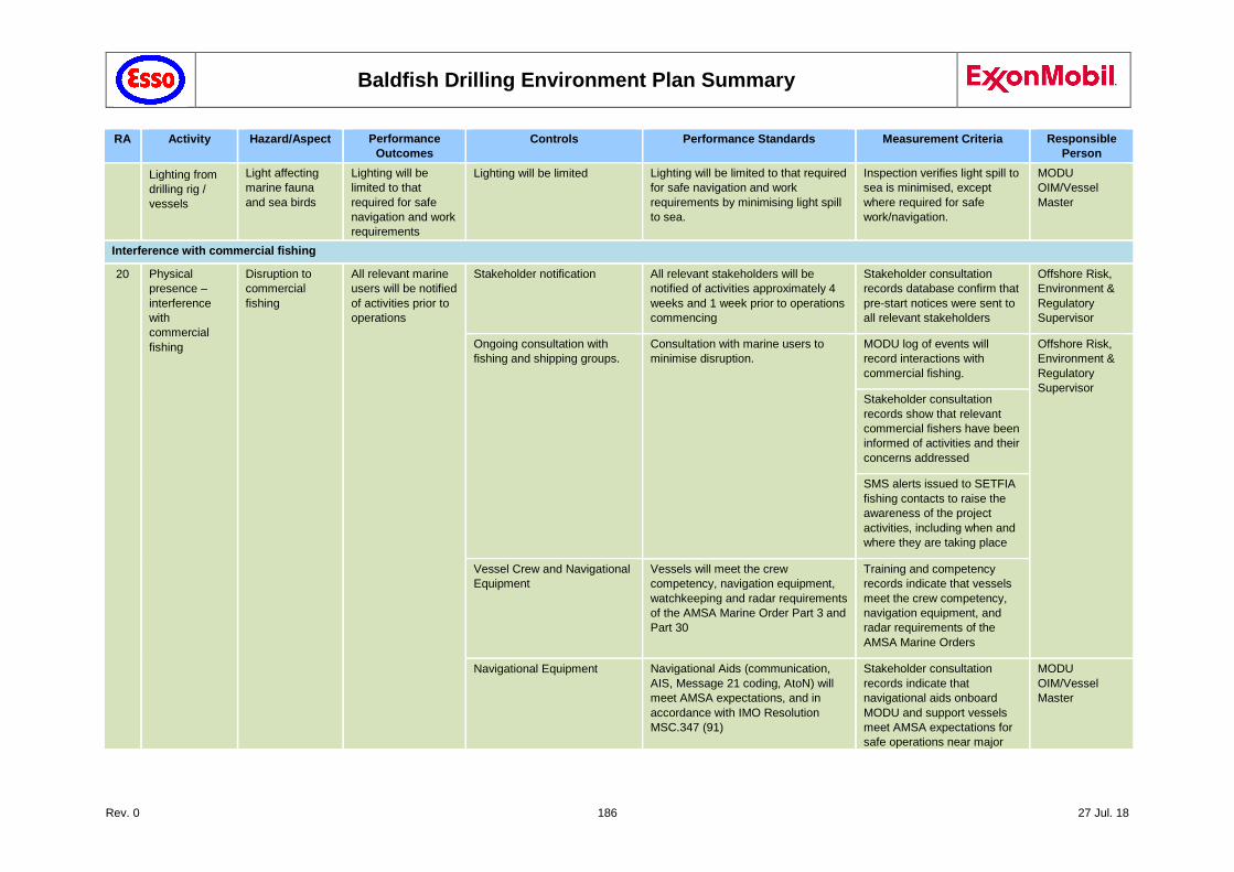
Baldfish Drilling Environment Plan Summary
Rev. 0 186 27 Jul. 18
RA Activity Hazard/Aspect Performance
Outcomes
Controls Performance Standards Measurement Criteria Responsible
Person
Lighting from
drilling rig /
vessels
Light affecting
marine fauna
and sea birds
Lighting will be
limited to that
required for safe
navigation and work
requirements
Lighting will be limited Lighting will be limited to that required
for safe navigation and work
requirements by minimising light spill
to sea.
Inspection verifies light spill to
sea is minimised, except
where required for safe
work/navigation.
MODU
OIM/Vessel
Master
Interference with commercial fishing
20 Physical
presence –
interference
with
commercial
fishing
Disruption to
commercial
fishing
All relevant marine
users will be notified
of activities prior to
operations
Stakeholder notification All relevant stakeholders will be
notified of activities approximately 4
weeks and 1 week prior to operations
commencing
Stakeholder consultation
records database confirm that
pre-start notices were sent to
all relevant stakeholders
Offshore Risk,
Environment &
Regulatory
Supervisor
Ongoing consultation with
fishing and shipping groups.
Consultation with marine users to
minimise disruption.
MODU log of events will
record interactions with
commercial fishing.
Offshore Risk,
Environment &
Regulatory
Supervisor Stakeholder consultation
records show that relevant
commercial fishers have been
informed of activities and their
concerns addressed
SMS alerts issued to SETFIA
fishing contacts to raise the
awareness of the project
activities, including when and
where they are taking place
Vessel Crew and Navigational
Equipment
Vessels will meet the crew
competency, navigation equipment,
watchkeeping and radar requirements
of the AMSA Marine Order Part 3 and
Part 30
Training and competency
records indicate that vessels
meet the crew competency,
navigation equipment, and
radar requirements of the
AMSA Marine Orders
Navigational Equipment Navigational Aids (communication,
AIS, Message 21 coding, AtoN) will
meet AMSA expectations, and in
accordance with IMO Resolution
MSC.347 (91)
Stakeholder consultation
records indicate that
navigational aids onboard
MODU and support vessels
meet AMSA expectations for
safe operations near major
MODU
OIM/Vessel
Master
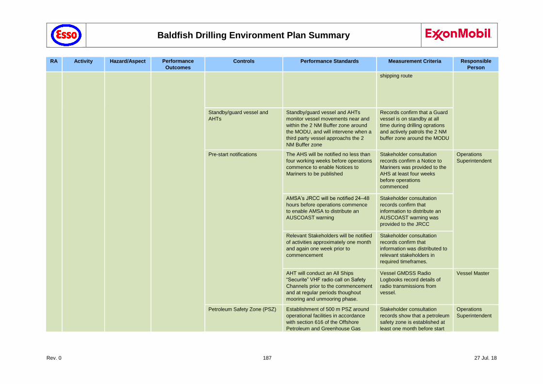
Baldfish Drilling Environment Plan Summary
Rev. 0 187 27 Jul. 18
RA Activity Hazard/Aspect Performance
Outcomes
Controls Performance Standards Measurement Criteria Responsible
Person
shipping route
Standby/guard vessel and
AHTs
Standby/guard vessel and AHTs
monitor vessel movements near and
within the 2 NM Buffer zone around
the MODU, and will intervene when a
third party vessel approachs the 2
NM Buffer zone
Records confirm that a Guard
vessel is on standby at all
time during drilling oprations
and actively patrols the 2 NM
buffer zone around the MODU
Pre-start notifications The AHS will be notified no less than
four working weeks before operations
commence to enable Notices to
Mariners to be published
Stakeholder consultation
records confirm a Notice to
Mariners was provided to the
AHS at least four weeks
before operations
commenced
Operations
Superintendent
AMSA’s JRCC will be notified 24–48
hours before operations commence
to enable AMSA to distribute an
AUSCOAST warning
Stakeholder consultation
records confirm that
information to distribute an
AUSCOAST warning was
provided to the JRCC
Relevant Stakeholders will be notified
of activities approximately one month
and again one week prior to
commencement
Stakeholder consultation
records confirm that
information was distributed to
relevant stakeholders in
required timeframes.
AHT will conduct an All Ships
“Securite” VHF radio call on Safety
Channels prior to the commencement
and at regular periods thoughout
mooring and unmooring phase.
Vessel GMDSS Radio
Logbooks record details of
radio transmissions from
vessel.
Vessel Master
Petroleum Safety Zone (PSZ) Establishment of 500 m PSZ around
operational facilities in accordance
with section 616 of the Offshore
Petroleum and Greenhouse Gas
Stakeholder consultation
records show that a petroleum
safety zone is established at
least one month before start
Operations
Superintendent
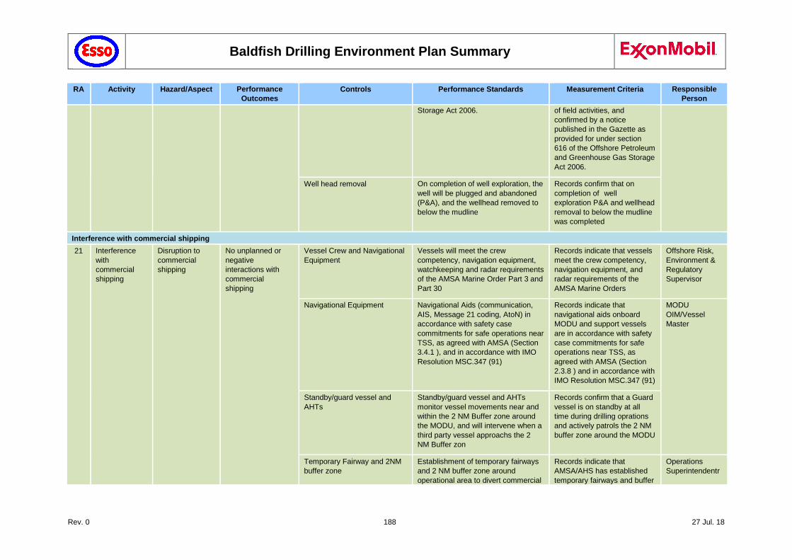
Baldfish Drilling Environment Plan Summary
Rev. 0 188 27 Jul. 18
RA Activity Hazard/Aspect Performance
Outcomes
Controls Performance Standards Measurement Criteria Responsible
Person
Storage Act 2006. of field activities, and
confirmed by a notice
published in the Gazette as
provided for under section
616 of the Offshore Petroleum
and Greenhouse Gas Storage
Act 2006.
Well head removal On completion of well exploration, the
well will be plugged and abandoned
(P&A), and the wellhead removed to
below the mudline
Records confirm that on
completion of well
exploration P&A and wellhead
removal to below the mudline
was completed
Interference with commercial shipping
21 Interference
with
commercial
shipping
Disruption to
commercial
shipping
No unplanned or
negative
interactions with
commercial
shipping
Vessel Crew and Navigational
Equipment
Vessels will meet the crew
competency, navigation equipment,
watchkeeping and radar requirements
of the AMSA Marine Order Part 3 and
Part 30
Records indicate that vessels
meet the crew competency,
navigation equipment, and
radar requirements of the
AMSA Marine Orders
Offshore Risk,
Environment &
Regulatory
Supervisor
Navigational Equipment Navigational Aids (communication,
AIS, Message 21 coding, AtoN) in
accordance with safety case
commitments for safe operations near
TSS, as agreed with AMSA (Section
3.4.1 ), and in accordance with IMO
Resolution MSC.347 (91)
Records indicate that
navigational aids onboard
MODU and support vessels
are in accordance with safety
case commitments for safe
operations near TSS, as
agreed with AMSA (Section
2.3.8 ) and in accordance with
IMO Resolution MSC.347 (91)
MODU
OIM/Vessel
Master
Standby/guard vessel and
AHTs
Standby/guard vessel and AHTs
monitor vessel movements near and
within the 2 NM Buffer zone around
the MODU, and will intervene when a
third party vessel approachs the 2
NM Buffer zon
Records confirm that a Guard
vessel is on standby at all
time during drilling oprations
and actively patrols the 2 NM
buffer zone around the MODU
Temporary Fairway and 2NM
buffer zone
Establishment of temporary fairways
and 2 NM buffer zone around
operational area to divert commercial
Records indicate that
AMSA/AHS has established
temporary fairways and buffer
Operations
Superintendentr
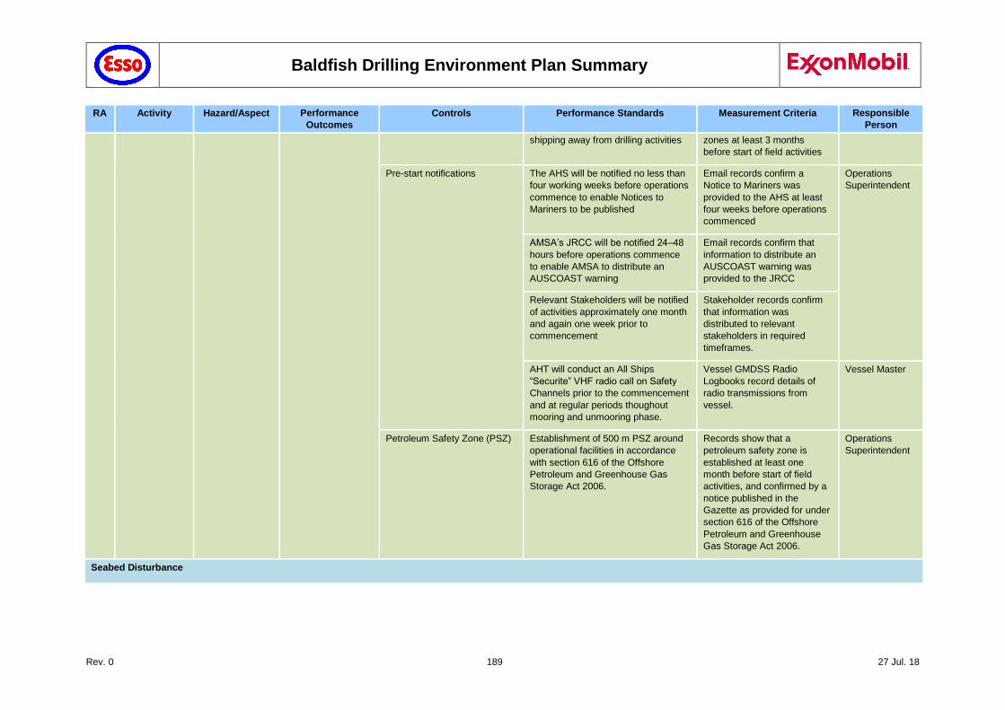
Baldfish Drilling Environment Plan Summary
Rev. 0 189 27 Jul. 18
RA Activity Hazard/Aspect Performance
Outcomes
Controls Performance Standards Measurement Criteria Responsible
Person
shipping away from drilling activities zones at least 3 months
before start of field activities
Pre-start notifications The AHS will be notified no less than
four working weeks before operations
commence to enable Notices to
Mariners to be published
Email records confirm a
Notice to Mariners was
provided to the AHS at least
four weeks before operations
commenced
Operations
Superintendent
AMSA’s JRCC will be notified 24–48
hours before operations commence
to enable AMSA to distribute an
AUSCOAST warning
Email records confirm that
information to distribute an
AUSCOAST warning was
provided to the JRCC
Relevant Stakeholders will be notified
of activities approximately one month
and again one week prior to
commencement
Stakeholder records confirm
that information was
distributed to relevant
stakeholders in required
timeframes.
AHT will conduct an All Ships
“Securite” VHF radio call on Safety
Channels prior to the commencement
and at regular periods thoughout
mooring and unmooring phase.
Vessel GMDSS Radio
Logbooks record details of
radio transmissions from
vessel.
Vessel Master
Petroleum Safety Zone (PSZ) Establishment of 500 m PSZ around
operational facilities in accordance
with section 616 of the Offshore
Petroleum and Greenhouse Gas
Storage Act 2006.
Records show that a
petroleum safety zone is
established at least one
month before start of field
activities, and confirmed by a
notice published in the
Gazette as provided for under
section 616 of the Offshore
Petroleum and Greenhouse
Gas Storage Act 2006.
Operations
Superintendent
Seabed Disturbance
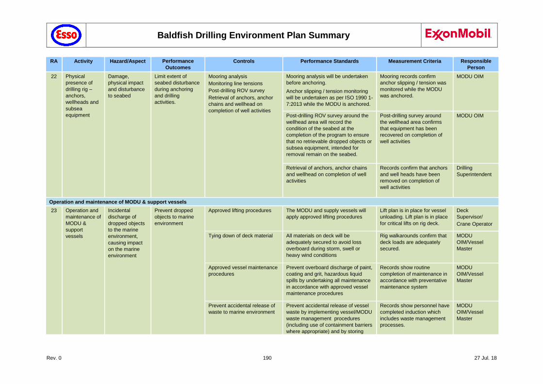
Baldfish Drilling Environment Plan Summary
Rev. 0 190 27 Jul. 18
RA Activity Hazard/Aspect Performance
Outcomes
Controls Performance Standards Measurement Criteria Responsible
Person
22 Physical
presence of
drilling rig –
anchors,
wellheads and
subsea
equipment
Damage,
physical impact
and disturbance
to seabed
Limit extent of
seabed disturbance
during anchoring
and drilling
activities.
Mooring analysis
Monitoring line tensions
Post-drilling ROV survey
Retrieval of anchors, anchor
chains and wellhead on
completion of well activities
Mooring analysis will be undertaken
before anchoring.
Anchor slipping / tension monitoring
will be undertaken as per ISO 1990 1-
7:2013 while the MODU is anchored.
Mooring records confirm
anchor slipping / tension was
monitored while the MODU
was anchored.
MODU OIM
Post-drilling ROV survey around the
wellhead area will record the
condition of the seabed at the
completion of the program to ensure
that no retrievable dropped objects or
subsea equipment, intended for
removal remain on the seabed.
Post-drilling survey around
the wellhead area confirms
that equipment has been
recovered on completion of
well activities
MODU OIM
Retrieval of anchors, anchor chains
and wellhead on completion of well
activities
Records confirm that anchors
and well heads have been
removed on completion of
well activities
Drilling
Superintendent
Operation and maintenance of MODU & support vessels
23 Operation and
maintenance of
MODU &
support
vessels
Incidental
discharge of
dropped objects
to the marine
environment,
causing impact
on the marine
environment
Prevent dropped
objects to marine
environment
Approved lifting procedures The MODU and supply vessels will
apply approved lifting procedures
Lift plan is in place for vessel
unloading. Lift plan is in place
for critical lifts on rig deck.
Deck
Supervisor/
Crane Operator
Tying down of deck material All materials on deck will be
adequately secured to avoid loss
overboard during storm, swell or
heavy wind conditions
Rig walkarounds confirm that
deck loads are adequately
secured.
MODU
OIM/Vessel
Master
Approved vessel maintenance
procedures
Prevent overboard discharge of paint,
coating and grit, hazardous liquid
spills by undertaking all maintenance
in accordance with approved vessel
maintenance procedures
Records show routine
completion of maintenance in
accordance with preventative
maintenance system
MODU
OIM/Vessel
Master
Prevent accidental release of
waste to marine environment
Prevent accidental release of vessel
waste by implementing vessel/MODU
waste management procedures
(including use of containment barriers
where appropriate) and by storing
Records show personnel have
completed induction which
includes waste management
processes.
MODU
OIM/Vessel
Master
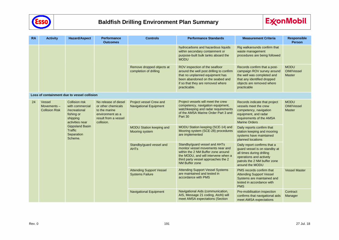
Baldfish Drilling Environment Plan Summary
Rev. 0 191 27 Jul. 18
RA Activity Hazard/Aspect Performance
Outcomes
Controls Performance Standards Measurement Criteria Responsible
Person
hydrocarbons and hazardous liquids
within secondary containment or
purpose-built bulk tanks aboard the
MODU
Rig walkarounds confirm that
waste management
procedures are being followed
Remove dropped objects at
completion of drilling
ROV inspection of the seafloor
around the well post drilling to confirm
that no unplanned equipment has
been abandoned on the seabed and
if so that they are removed where
practicable.
Records confirm that a post-
campaign ROV survey around
the well was completed and
that any identified dropped
objects are removed where
practicable
MODU
OIM/Vessel
Master
Loss of containment due to vessel collision
24 Vessel
Movements –
Collision Risk
Collision risk
with commercial
/recreational
fishing or
shipping
activities near
Gippsland Basin
Traffic
Separation
Scheme.
No release of diesel
or other chemicals
to the marine
environment as a
result from a vessel
collision.
Project vessel Crew and
Navigational Equipment
Project vessels will meet the crew competency, navigation equipment, watchkeeping and radar requirements of the AMSA Marine Order Part 3 and Part 30
Records indicate that project
vessels meet the crew
competency, navigation
equipment, and radar
requirements of the AMSA
Marine Orders
MODU
OIM/Vessel
Master
MODU Station keeping and
Mooring system
MODU Station keeping (SCE-14) and Mooring system (SCE-28) procedures are implemented
Daily reports confirm that
station keeping and mooring
systems have maintained
planned locations
Standby/guard vessel and
AHTs
Standby/guard vessel and AHTs monitor vessel movements near and within the 2 NM Buffer zone around the MODU, and will intervene when a third party vessel approaches the 2 NM Buffer zone
Daily report confirms that a
guard vessel is on standby at
all times during drilling
operations and actively
patrols the 2 NM buffer zone
around the MODU
Attending Support Vessel
Systems Failure
Attending Support Vessel Systems are maintained and tested in accordance with PMS
PMS records confirm that
Attending Support Vessel
Systems are maintained and
tested in accordance with
PMS
Vessel Master
Navigational Equipment Navigational Aids (communication, AIS, Message 21 coding, AtoN) will meet AMSA expectations (Section
Pre-mobilisation inspection
confirms that navigational aids
meet AMSA expectations
Contract
Manager
Baldfish Drilling Environment Plan Summary
Rev. 0 192 27 Jul. 18
RA Activity Hazard/Aspect Performance
Outcomes
Controls Performance Standards Measurement Criteria Responsible
Person
2.3.8), and in accordance with IMO Resolution MSC.347 (91)
Daily report confirms that
navigational aids onboard
MODU and support vessels
are operational
Vessel master
/MODU OIM
Temporary Fairway and 2NM
buffer zone
Establishment of temporary fairways and 2 NM buffer zone around operational area to divert commercial shipping away from drilling activities
Records indicate that
AMSA/AHS has established
temporary fairways and buffer
zones at least 3 months
before start of field activities
Operations
Superintendent
Pre-start notifications The AHS will be notified no less than four working weeks before operations commence to enable Notices to Mariners to be published
Stakeholder consultation log
confirms a Notice to Mariners
was provided to the AHS at
least four weeks before
operations commenced
AMSA’s JRCC will be notified 24–48 hours before operations commence to enable AMSA to distribute an AUSCOAST warning
Stakeholder consultation log
confirms that information to
distribute an AUSCOAST
warning was provided to the
JRCC
Relevant Stakeholders will be notified of activities approximately one month and again one week prior to commencement
Stakeholder consultation log
confirms that information was
distributed to relevant
stakeholders in required
timeframes.
Petroleum Safety Zone (PSZ) Establishment of 500 m PSZ around operational facilities in accordance with section 616 of the Offshore Petroleum and Greenhouse Gas Storage Act 2006.
Records show that a
petroleum safety zone is
established at least one
month before start of field
activities, and confirmed by a
notice published in the
Gazette as provided for under
section 616 of the Offshore
Petroleum and Greenhouse
Gas Storage Act 2006.
Operations
superintendent
Any vessel that enters the PSZ will be required to complete a checklist, before requesting MODU permission to enter the PSZ. All PSZ entries are logged.
MODU bridge log confirms
authorised entries into PSZ.
Vessel master
/MODU OIM
Baldfish Drilling Environment Plan Summary
Rev. 0 193 27 Jul. 18
RA Activity Hazard/Aspect Performance
Outcomes
Controls Performance Standards Measurement Criteria Responsible
Person
The MODU AIS system will register an unauthorised entry into the PSZ, and will also register on AHT/guard vessel radar, which will intercept any unauthorised vessels breaching PSZ, in accordance with Unidentified Approaching Vessel Plan. Any such incidences are logged in MODU log book.
Support vessels have access
to Unidentified Approaching
Vessel Plan.
MODU log book confirms any
unauthorised PSZ entries
Vessel master
/MODU OIM
Minimise the impact
on the environment
as a result from a
LOC
Emergency Response
Preparedness
Emergency response capability will be maintained in accordance with EP, OPEP and related documentation.
Outcomes of internal audits
and exercises demonstrate
preparedness.
Operations
superintendent
SOPEP (or equivalent) Emergency response activities will be implemented in accordance with the vessel SOPEP
Records confirm that
emergency response activities
have been implemented in
accordance with the vessel
SOPEP
MODU
OIM/Vessel
Master
OPEP Under the OPGGS(E) Regulations, the petroleum activity must have an accepted Oil Pollution Emergency Plan (OPEP) in place before the activity commences. In the event of a LOWC, the OPEP will be implemented.
An approved OPEP is in place
before the start of field
activities.
Operations
superintendent
Records confirm that
emergency response activities
have been implemented in
accordance with the OPEP
Offshore Risk,
Environment &
Regulatory
Supervisor
The OPEP shall be tested in accordance with the OPGGS (E) Regulations.
Records indicate tests
undertaken in accordance
with the exercises according
to the schedule given in the
approved EP (Section 7.7).
Emergency
Management
Team (EMT)
Incident
Controller (IC)
Esso shall maintain a full time emergency response capability for the duration of the drilling activities
IMT roster.
Training records current in
relation to oil spill response.
IMT
In the event that initiation criteria for
MES activities are triggered, MES
shall be undertaken within the
timeframes specified in the OPEP
and OSMP.
Pre-drill oil spill response
audit confirms that minimum
performance standards are
achievable.
Pre-mobilisation audit and
IMT
Baldfish Drilling Environment Plan Summary
Rev. 0 194 27 Jul. 18
RA Activity Hazard/Aspect Performance
Outcomes
Controls Performance Standards Measurement Criteria Responsible
Person
MES activities shall continue until termination criteria are met.
ongoing audits confirm that
measures identified in Section
10: Emergency Response
Planning are met for the
duration of the campaign.
In the event of an incident,
Daily logs of response
activities prepared by IMT
show that minimum time
frames for response are met.
OSMP Operational and scientific monitoring
will be implemented in accordance
with the OSMP
Records confirm that
operational and scientific
monitoring have been
implemented in accordance
with the OSMP
Emergency
Management
Team (EMT)
Incident
Controller (IC)
Bunkering
25 Bulk transfer
from vessel to
MODU via
hose
Unplanned
release of diesel
or other
chemicals to the
marine
environment
during bulk
transfer may
cause localised
short term
impact on water
quality.
No unplanned
release of diesel or
other chemicals into
the marine
environment during
bulk transfer.
Bulk fluid transfer procedures MODU has bulk fluid transfer procedures in place before commencing operations. The process will include:
MODU to vessel communication protocols
Transfer hose pressure testing
Continuous visual monitoring
Tank volume monitoring
Secondary containment (bunding) around hose connections, air breathers etc.
Pre-mobilisation inspection
confirms that approved
bunkering procedures ("Fuel
Oil and Drilling / Completion
Fluid Transfers from
Dynamically Positioned
Supply Boats Procedure") are
in place
Contract
manager
Records confirm that
approved bunkering
procedures are implemented
MODU OIM
Hoses and connections Transfer hoses shall comprise sufficient floating devices and self-sealing weak-link couplings in the mid-section of the hose string, in accordance with GOMO 0611- 14012.
Pre-mobilisation inspection
confirms records demonstrate
transfer hoses meet GOMO
0611-1401 requirements
MODU OIM
2 Guidelines for Offshore Marine Operations. Revision: 0611-1401. 06/11/2013. www.g-omo.info/wp-content/uploads/2016/06/201311-GOMOfinal.pdf.
Baldfish Drilling Environment Plan Summary
Rev. 0 195 27 Jul. 18
RA Activity Hazard/Aspect Performance
Outcomes
Controls Performance Standards Measurement Criteria Responsible
Person
Diamond Planned
Maintenance System (PMS)
Prevent transfer spills by maintaining bulk fluid transfer hoses, in accordance with the MODU maintenance system
Pre-mobilisation inspection
confirms PMS records show
bulk fluid transfer hoses have
been maintained in
accordance with the MODU
maintenance system
Contract
manager
Records show routine
completion of maintenance in
accordance with manufacturer
specifications or preventative
maintenance system
MODU OIM
Mitigate impact on
the environment
from a spill during
bulk transfer.
Emergency Response
Preparedness
Emergency response capability will be maintained in accordance with EP, OPEP and related documentation.
Outcomes of internal audits
and exercises demonstrate
preparedness.
Operations
superintendent
SOPEP (or equivalent) An approved vessel emergency response plan is in place, in accordance with Regulation 37 of MARPOL Annex I to mitigate against spills
Records confirm that an
approved vessel emergency
response plan is in place
MODU
OIM/Vessel
Master
Records confirm oil spill
training exercises were
undertaken in accordance
with the MODU Operator’s
emergency response exercise
program
OPEP Under the OPGGS(E) Regulations, the petroleum activity must have an accepted Oil Pollution Emergency Plan (OPEP) in place before the activity commences. In the event of a LOWC, the OPEP will be implemented.
An approved OPEP is in place
before the start of field
activities.
Operations
superintendent
Records confirm that
emergency response activities
have been implemented in
accordance with the OPEP
Offshore Risk,
Environment &
Regulatory
Supervisor
The OPEP shall be tested in accordance with the OPGGS (E) Regulations.
Records indicate tests
undertaken in accordance
with the exercises according
to the schedule given in the
approved EP (Section 7.7).
Drilling Manager
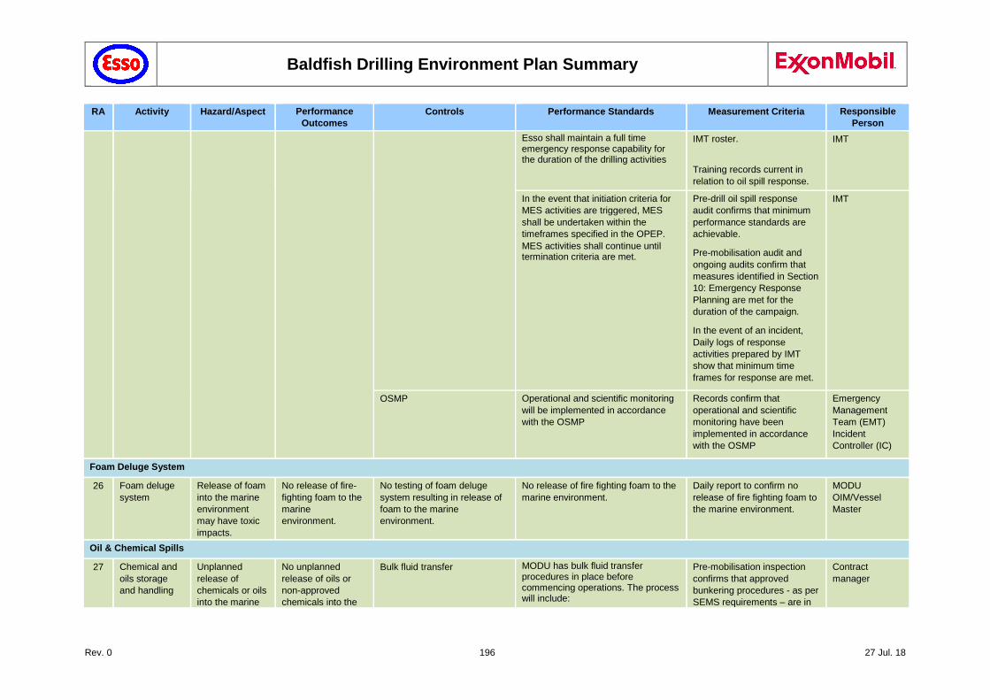
Baldfish Drilling Environment Plan Summary
Rev. 0 196 27 Jul. 18
RA Activity Hazard/Aspect Performance
Outcomes
Controls Performance Standards Measurement Criteria Responsible
Person
Esso shall maintain a full time emergency response capability for the duration of the drilling activities
IMT roster.
Training records current in
relation to oil spill response.
IMT
In the event that initiation criteria for
MES activities are triggered, MES
shall be undertaken within the
timeframes specified in the OPEP.
MES activities shall continue until termination criteria are met.
Pre-drill oil spill response
audit confirms that minimum
performance standards are
achievable.
Pre-mobilisation audit and
ongoing audits confirm that
measures identified in Section
10: Emergency Response
Planning are met for the
duration of the campaign.
In the event of an incident,
Daily logs of response
activities prepared by IMT
show that minimum time
frames for response are met.
IMT
OSMP Operational and scientific monitoring
will be implemented in accordance
with the OSMP
Records confirm that
operational and scientific
monitoring have been
implemented in accordance
with the OSMP
Emergency
Management
Team (EMT)
Incident
Controller (IC)
Foam Deluge System
26 Foam deluge
system
Release of foam
into the marine
environment
may have toxic
impacts.
No release of fire-
fighting foam to the
marine
environment.
No testing of foam deluge
system resulting in release of
foam to the marine
environment.
No release of fire fighting foam to the
marine environment.
Daily report to confirm no
release of fire fighting foam to
the marine environment.
MODU
OIM/Vessel
Master
Oil & Chemical Spills
27 Chemical and
oils storage
and handling
Unplanned
release of
chemicals or oils
into the marine
No unplanned
release of oils or
non-approved
chemicals into the
Bulk fluid transfer MODU has bulk fluid transfer procedures in place before commencing operations. The process will include:
Pre-mobilisation inspection
confirms that approved
bunkering procedures - as per
SEMS requirements – are in
Contract
manager
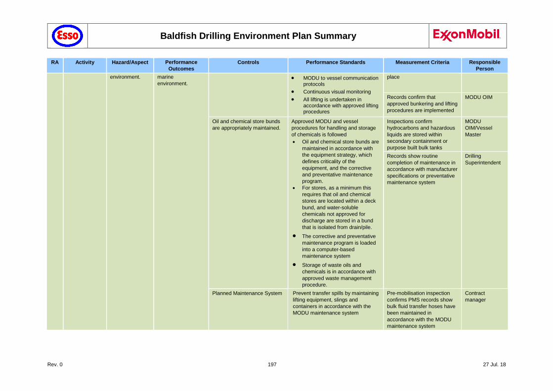
Baldfish Drilling Environment Plan Summary
Rev. 0 197 27 Jul. 18
RA Activity Hazard/Aspect Performance
Outcomes
Controls Performance Standards Measurement Criteria Responsible
Person
environment. marine
environment. MODU to vessel communication
protocols
Continuous visual monitoring
All lifting is undertaken in accordance with approved lifting procedures
place
Records confirm that
approved bunkering and lifting
procedures are implemented
MODU OIM
Oil and chemical store bunds
are appropriately maintained.
Approved MODU and vessel
procedures for handling and storage
of chemicals is followed
Oil and chemical store bunds are
maintained in accordance with
the equipment strategy, which
defines criticality of the
equipment, and the corrective
and preventative maintenance
program.
For stores, as a minimum this
requires that oil and chemical
stores are located within a deck
bund, and water-soluble
chemicals not approved for
discharge are stored in a bund
that is isolated from drain/pile.
The corrective and preventative
maintenance program is loaded
into a computer-based
maintenance system
Storage of waste oils and
chemicals is in accordance with
approved waste management
procedure.
Inspections confirm
hydrocarbons and hazardous
liquids are stored within
secondary containment or
purpose built bulk tanks
MODU
OIM/Vessel
Master
Records show routine
completion of maintenance in
accordance with manufacturer
specifications or preventative
maintenance system
Drilling
Superintendent
Planned Maintenance System Prevent transfer spills by maintaining
lifting equipment, slings and
containers in accordance with the
MODU maintenance system
Pre-mobilisation inspection
confirms PMS records show
bulk fluid transfer hoses have
been maintained in
accordance with the MODU
maintenance system
Contract
manager
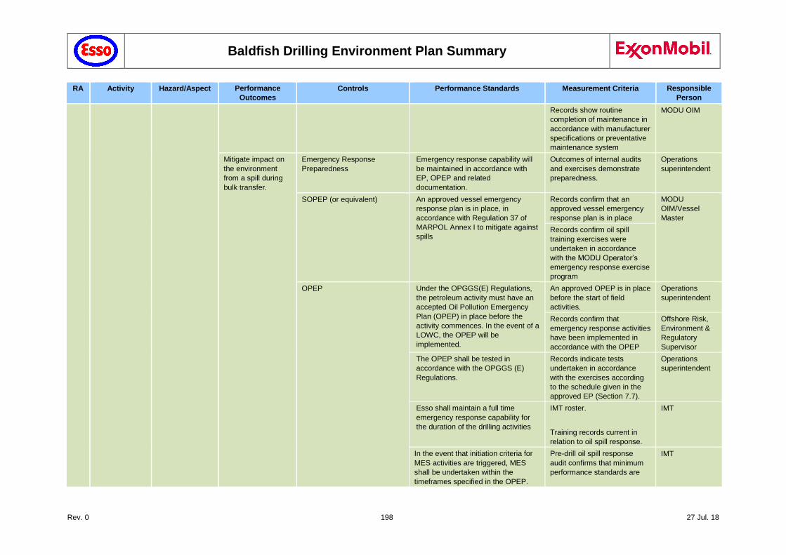
Baldfish Drilling Environment Plan Summary
Rev. 0 198 27 Jul. 18
RA Activity Hazard/Aspect Performance
Outcomes
Controls Performance Standards Measurement Criteria Responsible
Person
Records show routine
completion of maintenance in
accordance with manufacturer
specifications or preventative
maintenance system
MODU OIM
Mitigate impact on
the environment
from a spill during
bulk transfer.
Emergency Response
Preparedness
Emergency response capability will
be maintained in accordance with
EP, OPEP and related
documentation.
Outcomes of internal audits
and exercises demonstrate
preparedness.
Operations
superintendent
SOPEP (or equivalent) An approved vessel emergency
response plan is in place, in
accordance with Regulation 37 of
MARPOL Annex I to mitigate against
spills
Records confirm that an
approved vessel emergency
response plan is in place
MODU
OIM/Vessel
Master
Records confirm oil spill
training exercises were
undertaken in accordance
with the MODU Operator’s
emergency response exercise
program
OPEP Under the OPGGS(E) Regulations,
the petroleum activity must have an
accepted Oil Pollution Emergency
Plan (OPEP) in place before the
activity commences. In the event of a
LOWC, the OPEP will be
implemented.
An approved OPEP is in place
before the start of field
activities.
Operations
superintendent
Records confirm that
emergency response activities
have been implemented in
accordance with the OPEP
Offshore Risk,
Environment &
Regulatory
Supervisor
The OPEP shall be tested in
accordance with the OPGGS (E)
Regulations.
Records indicate tests
undertaken in accordance
with the exercises according
to the schedule given in the
approved EP (Section 7.7).
Operations
superintendent
Esso shall maintain a full time
emergency response capability for
the duration of the drilling activities
IMT roster.
Training records current in
relation to oil spill response.
IMT
In the event that initiation criteria for
MES activities are triggered, MES
shall be undertaken within the
timeframes specified in the OPEP.
Pre-drill oil spill response
audit confirms that minimum
performance standards are
IMT
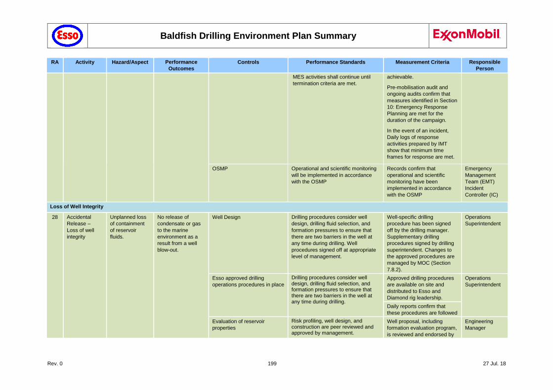
Baldfish Drilling Environment Plan Summary
Rev. 0 199 27 Jul. 18
RA Activity Hazard/Aspect Performance
Outcomes
Controls Performance Standards Measurement Criteria Responsible
Person
MES activities shall continue until
termination criteria are met.
achievable.
Pre-mobilisation audit and
ongoing audits confirm that
measures identified in Section
10: Emergency Response
Planning are met for the
duration of the campaign.
In the event of an incident,
Daily logs of response
activities prepared by IMT
show that minimum time
frames for response are met.
OSMP Operational and scientific monitoring
will be implemented in accordance
with the OSMP
Records confirm that
operational and scientific
monitoring have been
implemented in accordance
with the OSMP
Emergency
Management
Team (EMT)
Incident
Controller (IC)
Loss of Well Integrity
28 Accidental
Release –
Loss of well
integrity
Unplanned loss
of containment
of reservoir
fluids.
No release of
condensate or gas
to the marine
environment as a
result from a well
blow-out.
Well Design Drilling procedures consider well
design, drilling fluid selection, and
formation pressures to ensure that
there are two barriers in the well at
any time during drilling. Well
procedures signed off at appropriate
level of management.
Well-specific drilling
procedure has been signed
off by the drilling manager.
Supplementary drilling
procedures signed by drilling
superintendent. Changes to
the approved procedures are
managed by MOC (Section
7.8.2).
Operations
Superintendent
Esso approved drilling
operations procedures in place
Drilling procedures consider well design, drilling fluid selection, and formation pressures to ensure that there are two barriers in the well at any time during drilling.
Approved drilling procedures
are available on site and
distributed to Esso and
Diamond rig leadership.
Operations
Superintendent
Daily reports confirm that
these procedures are followed
Evaluation of reservoir
properties
Risk profiling, well design, and construction are peer reviewed and approved by management.
Well proposal, including
formation evaluation program,
is reviewed and endorsed by
Engineering
Manager
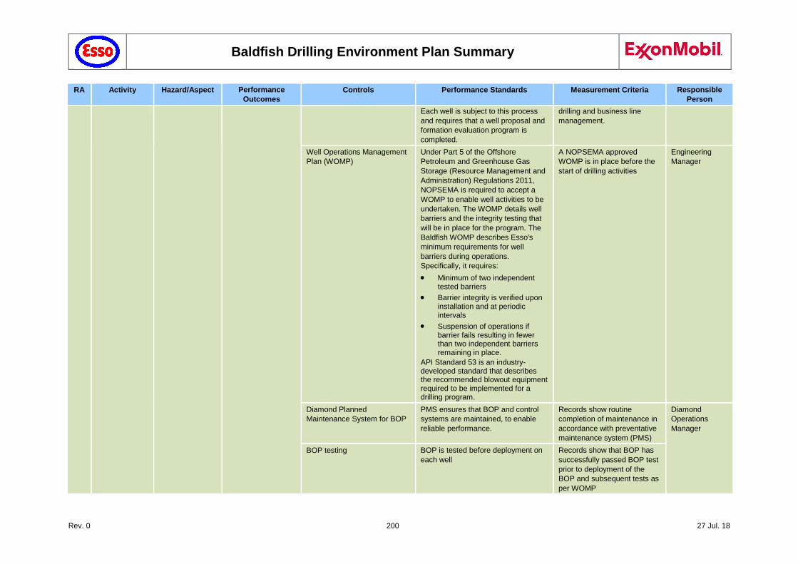
Baldfish Drilling Environment Plan Summary
Rev. 0 200 27 Jul. 18
RA Activity Hazard/Aspect Performance
Outcomes
Controls Performance Standards Measurement Criteria Responsible
Person
Each well is subject to this process
and requires that a well proposal and
formation evaluation program is
completed.
drilling and business line
management.
Well Operations Management
Plan (WOMP)
Under Part 5 of the Offshore
Petroleum and Greenhouse Gas
Storage (Resource Management and
Administration) Regulations 2011,
NOPSEMA is required to accept a
WOMP to enable well activities to be
undertaken. The WOMP details well
barriers and the integrity testing that
will be in place for the program. The
Baldfish WOMP describes Esso's
minimum requirements for well
barriers during operations.
Specifically, it requires:
Minimum of two independent tested barriers
Barrier integrity is verified upon installation and at periodic intervals
Suspension of operations if barrier fails resulting in fewer than two independent barriers remaining in place.
API Standard 53 is an industry-developed standard that describes the recommended blowout equipment required to be implemented for a drilling program.
A NOPSEMA approved
WOMP is in place before the
start of drilling activities
Engineering
Manager
Diamond Planned
Maintenance System for BOP
PMS ensures that BOP and control
systems are maintained, to enable
reliable performance.
Records show routine
completion of maintenance in
accordance with preventative
maintenance system (PMS)
Diamond
Operations
Manager
BOP testing BOP is tested before deployment on
each well
Records show that BOP has
successfully passed BOP test
prior to deployment of the
BOP and subsequent tests as
per WOMP

Baldfish Drilling Environment Plan Summary
Rev. 0 201 27 Jul. 18
RA Activity Hazard/Aspect Performance
Outcomes
Controls Performance Standards Measurement Criteria Responsible
Person
Training & competency Competencies of Esso Drilling
Supervisors is tracked and training
plans are established to ensure
closure of any overdue refresher
training as soon as practicable.
Training records shows that
Esso drilling supervisors have
the required competencies
and there is a plan in place to
address any RC gaps.
Operatrions
Superintendent
Minimise the impact
on the environment
as a result from a
LOC
Emergency Response
Preparedness
Emergency response capability will
be maintained in accordance with EP,
OPEP and related documentation.
Outcomes of internal audits
and exercises demonstrate
preparedness.
Operatrions
Superintendent
OPEP Under the OPGGS(E) Regulations,
the petroleum activity must have an
accepted Oil Pollution Emergency
Plan (OPEP) in place before the
activity commences. In the event of a
LOWC, the OPEP will be
implemented.
An approved OPEP is in place
before the start of field
activities.
Operatrions
Superintendent
Records confirm that
emergency response activities
have been implemented in
accordance with the OPEP
Offshore Risk,
Environment &
Regulatory
Supervisor
The OPEP shall be tested in
accordance with the OPGGS (E)
Regulations.
Records indicate tests
undertaken in accordance
with the schedule given in the
approved EP (Section 7.7).
Operatrions
Superintendent
Esso shall maintain a full time
emergency response capability for
the duration of the drilling activities
IMT roster.
Training records current in
relation to oil spill response.
IMT
In the event that initiation criteria for
MES activities are triggered, MES
shall be undertaken within the
timeframes specified in the OPEP.
MES activities shall continue until
termination criteria are met.
Pre-drill oil spill response
audit confirms that minimum
performance standards are
achievable.
Pre-mobilisation audit and
ongoing audits confirm that
measures identified in Section
7: Emergency Response
Planning are met for the
duration of the campaign.
In the event of an incident,
Daily logs of response
activities prepared by IMT
show that minimum time
IMT
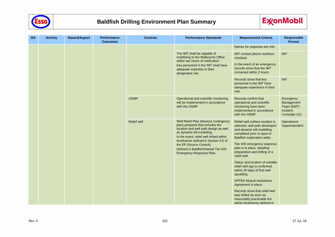
Baldfish Drilling Environment Plan Summary
Rev. 0 202 27 Jul. 18
RA Activity Hazard/Aspect Performance
Outcomes
Controls Performance Standards Measurement Criteria Responsible
Person
frames for response are met.
The IMT shall be capable of mobilising to the Melbourne Office within two hours of notification
Key personnel in the IMT shall have
adequate expertise in their
designated role.
IMT contact phone numbers
checked.
In the event of an emergency,
records show that the IMT
convened within 2 hours.
IMT
Records show that key
personnel in the IMT have
adequate experience in their
role.
IMT
OSMP Operational and scientific monitoring
will be implemented in accordance
with the OSMP
Records confirm that
operational and scientific
monitoring have been
implemented in accordance
with the OSMP
Emergency
Management
Team (EMT)
Incident
Controller (IC)
Relief well Well Relief Plan (blowout contingency plan) prepared that includes the location and well path design as well as dynamic kill modelling.
In the event, relief well drilled within
timeframes defined in Section 6.5 of
the EP (Source Control).
Defined in Baldfish/Hairtail Tier II/III
Emergency Response Plan.
Relief well surface location is
selected, well path developed
and dynamic kill modelling
completed prior to spud of
Baldfish exploration wells.
Tier II/III emergency response
plan is in place, detailing
preparation and drilling of a
relief well.
Status and location of suitable
relief well rigs is confirmed
within 30 days of first well
spudding.
APPEA Mutual Assistance
Agreement in place.
Records show that relief well
was drilled as soon as
reasonably practicable but
within timeframes defined in
Operatrions
Superintendent
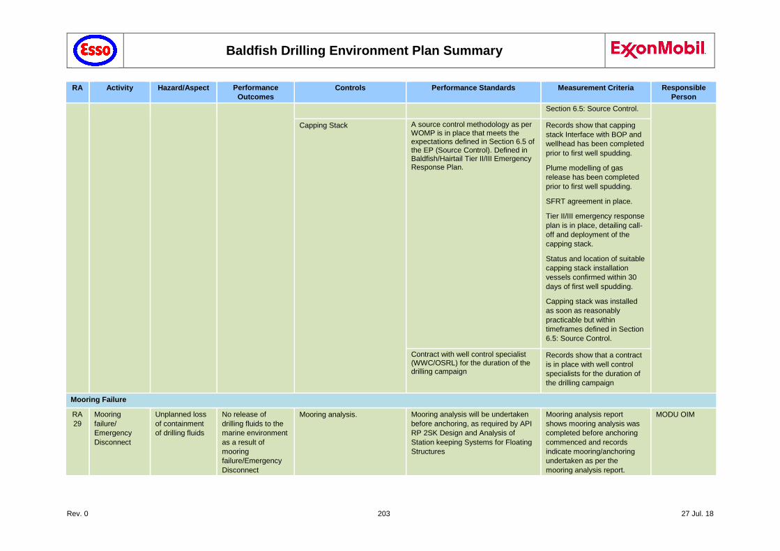
Baldfish Drilling Environment Plan Summary
Rev. 0 203 27 Jul. 18
RA Activity Hazard/Aspect Performance
Outcomes
Controls Performance Standards Measurement Criteria Responsible
Person
Section 6.5: Source Control.
Capping Stack A source control methodology as per WOMP is in place that meets the expectations defined in Section 6.5 of the EP (Source Control). Defined in Baldfish/Hairtail Tier II/III Emergency Response Plan.
Records show that capping
stack Interface with BOP and
wellhead has been completed
prior to first well spudding.
Plume modelling of gas
release has been completed
prior to first well spudding.
SFRT agreement in place.
Tier II/III emergency response
plan is in place, detailing call-
off and deployment of the
capping stack.
Status and location of suitable
capping stack installation
vessels confirmed within 30
days of first well spudding.
Capping stack was installed
as soon as reasonably
practicable but within
timeframes defined in Section
6.5: Source Control.
Contract with well control specialist (WWC/OSRL) for the duration of the drilling campaign
Records show that a contract
is in place with well control
specialists for the duration of
the drilling campaign
Mooring Failure
RA
29
Mooring
failure/
Emergency
Disconnect
Unplanned loss
of containment
of drilling fluids
No release of
drilling fluids to the
marine environment
as a result of
mooring
failure/Emergency
Disconnect
Mooring analysis. Mooring analysis will be undertaken
before anchoring, as required by API
RP 2SK Design and Analysis of
Station keeping Systems for Floating
Structures
Mooring analysis report
shows mooring analysis was
completed before anchoring
commenced and records
indicate mooring/anchoring
undertaken as per the
mooring analysis report.
MODU OIM
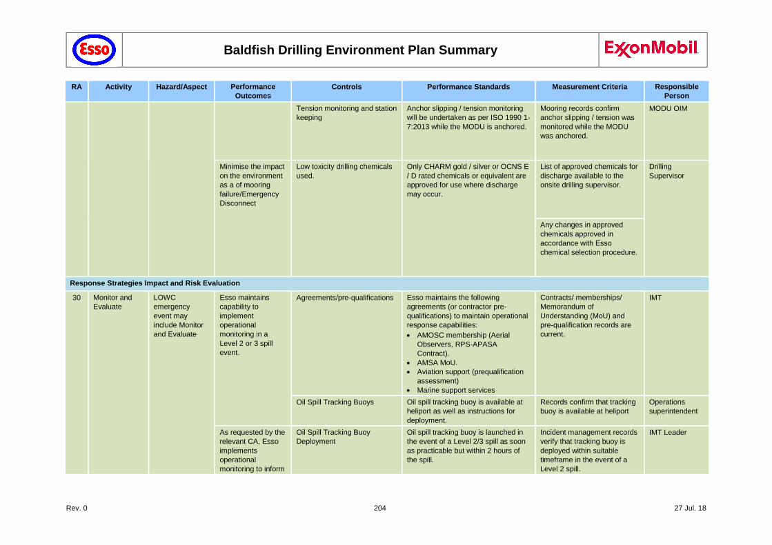
Baldfish Drilling Environment Plan Summary
Rev. 0 204 27 Jul. 18
RA Activity Hazard/Aspect Performance
Outcomes
Controls Performance Standards Measurement Criteria Responsible
Person
Tension monitoring and station
keeping
Anchor slipping / tension monitoring
will be undertaken as per ISO 1990 1-
7:2013 while the MODU is anchored.
Mooring records confirm
anchor slipping / tension was
monitored while the MODU
was anchored.
MODU OIM
Minimise the impact
on the environment
as a of mooring
failure/Emergency
Disconnect
Low toxicity drilling chemicals
used.
Only CHARM gold / silver or OCNS E
/ D rated chemicals or equivalent are
approved for use where discharge
may occur.
List of approved chemicals for
discharge available to the
onsite drilling supervisor.
Drilling
Supervisor
Any changes in approved
chemicals approved in
accordance with Esso
chemical selection procedure.
Response Strategies Impact and Risk Evaluation
30 Monitor and
Evaluate
LOWC
emergency
event may
include Monitor
and Evaluate
Esso maintains
capability to
implement
operational
monitoring in a
Level 2 or 3 spill
event.
Agreements/pre-qualifications Esso maintains the following
agreements (or contractor pre-
qualifications) to maintain operational
response capabilities:
AMOSC membership (Aerial
Observers, RPS-APASA
Contract).
AMSA MoU.
Aviation support (prequalification
assessment)
Marine support services
Contracts/ memberships/
Memorandum of
Understanding (MoU) and
pre-qualification records are
current.
IMT
Oil Spill Tracking Buoys Oil spill tracking buoy is available at
heliport as well as instructions for
deployment.
Records confirm that tracking
buoy is available at heliport
Operations
superintendent
As requested by the
relevant CA, Esso
implements
operational
monitoring to inform
Oil Spill Tracking Buoy
Deployment
Oil spill tracking buoy is launched in
the event of a Level 2/3 spill as soon
as practicable but within 2 hours of
the spill.
Incident management records
verify that tracking buoy is
deployed within suitable
timeframe in the event of a
Level 2 spill.
IMT Leader
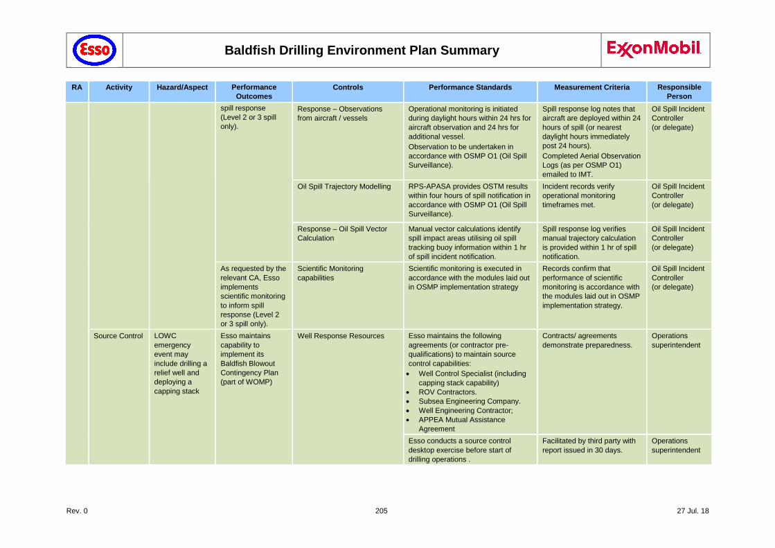
Baldfish Drilling Environment Plan Summary
Rev. 0 205 27 Jul. 18
RA Activity Hazard/Aspect Performance
Outcomes
Controls Performance Standards Measurement Criteria Responsible
Person
spill response
(Level 2 or 3 spill
only).
Response – Observations
from aircraft / vessels
Operational monitoring is initiated
during daylight hours within 24 hrs for
aircraft observation and 24 hrs for
additional vessel.
Observation to be undertaken in
accordance with OSMP O1 (Oil Spill
Surveillance).
Spill response log notes that
aircraft are deployed within 24
hours of spill (or nearest
daylight hours immediately
post 24 hours).
Completed Aerial Observation
Logs (as per OSMP O1)
emailed to IMT.
Oil Spill Incident
Controller
(or delegate)
Oil Spill Trajectory Modelling RPS-APASA provides OSTM results
within four hours of spill notification in
accordance with OSMP O1 (Oil Spill
Surveillance).
Incident records verify
operational monitoring
timeframes met.
Oil Spill Incident
Controller
(or delegate)
Response – Oil Spill Vector
Calculation
Manual vector calculations identify
spill impact areas utilising oil spill
tracking buoy information within 1 hr
of spill incident notification.
Spill response log verifies
manual trajectory calculation
is provided within 1 hr of spill
notification.
Oil Spill Incident
Controller
(or delegate)
As requested by the
relevant CA, Esso
implements
scientific monitoring
to inform spill
response (Level 2
or 3 spill only).
Scientific Monitoring
capabilities
Scientific monitoring is executed in
accordance with the modules laid out
in OSMP implementation strategy
Records confirm that
performance of scientific
monitoring is accordance with
the modules laid out in OSMP
implementation strategy.
Oil Spill Incident
Controller
(or delegate)
Source Control LOWC
emergency
event may
include drilling a
relief well and
deploying a
capping stack
Esso maintains
capability to
implement its
Baldfish Blowout
Contingency Plan
(part of WOMP)
Well Response Resources Esso maintains the following
agreements (or contractor pre-
qualifications) to maintain source
control capabilities:
Well Control Specialist (including
capping stack capability)
ROV Contractors.
Subsea Engineering Company.
Well Engineering Contractor;
APPEA Mutual Assistance
Agreement
Contracts/ agreements
demonstrate preparedness.
Operations
superintendent
Esso conducts a source control
desktop exercise before start of
drilling operations .
Facilitated by third party with
report issued in 30 days.
Operations
superintendent
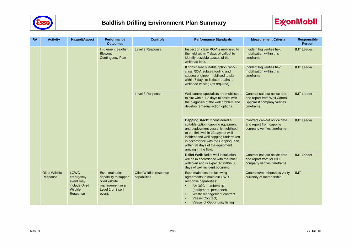
Baldfish Drilling Environment Plan Summary
Rev. 0 206 27 Jul. 18
RA Activity Hazard/Aspect Performance
Outcomes
Controls Performance Standards Measurement Criteria Responsible
Person
Implement Baldfish
Blowout
Contingency Plan
Level 2 Response Inspection class ROV is mobilised to
the field within 7 days of callout to
identify possible causes of the
wellhead leak.
Incident log verifies field
mobilisation within this
timeframe.
IMT Leader
If considered suitable option, work-
class ROV, subsea tooling and
subsea engineer mobilised to site
within 7 days to initiate repairs to
wellhead valving (as required).
Incident log verifies field
mobilisation within this
timeframe.
IMT Leader
Level 3 Response Well control specialists are mobilised
to site within 1-2 days to assist with
the diagnosis of the well problem and
develop remedial action options.
Contract call-out notice date
and report from Well Control
Specialist company verifies
timeframe.
IMT Leader
Capping stack: If considered a
suitable option, capping equipment
and deployment vessel is mobilised
to the field within 23 days of well
incident and well capping undertaken
in accordance with the Capping Plan
within 38 days of the equipment
arriving in the field.
Contract call-out notice date
and report from capping
company verifies timeframe
IMT Leader
Relief Well: Relief well installation
will be in accordance with the relief
well plan and is expected within 88
days of well incident occurring
Contract call-out notice date
and report from MODU
company verifies timeframe
IMT Leader
Oiled Wildlife
Response
LOWC
emergency
event may
include Oiled
Wildlife
Response
Esso maintains
capability to support
oiled wildlife
management in a
Level 2 or 3 spill
event.
Oiled Wildlife response
capabilities
Esso maintains the following
agreements to maintain OWR
response capabilities:
• AMOSC membership
(equipment, personnel).
• Waste management contract.
• Vessel Contract;
• Vessel of Opportunity listing
Contracts/memberships verify
currency of membership.
IMT
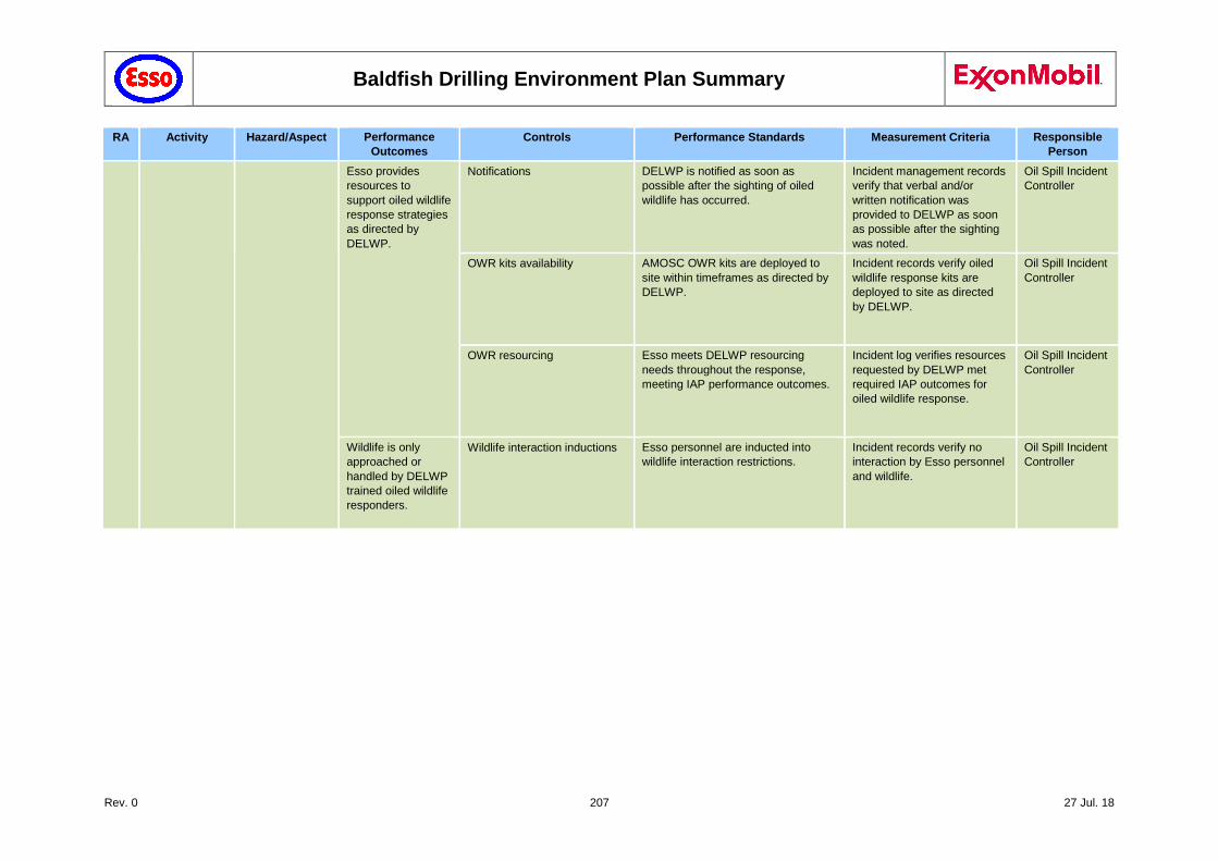
Baldfish Drilling Environment Plan Summary
Rev. 0 207 27 Jul. 18
RA Activity Hazard/Aspect Performance
Outcomes
Controls Performance Standards Measurement Criteria Responsible
Person
Esso provides
resources to
support oiled wildlife
response strategies
as directed by
DELWP.
Notifications DELWP is notified as soon as
possible after the sighting of oiled
wildlife has occurred.
Incident management records
verify that verbal and/or
written notification was
provided to DELWP as soon
as possible after the sighting
was noted.
Oil Spill Incident
Controller
OWR kits availability AMOSC OWR kits are deployed to
site within timeframes as directed by
DELWP.
Incident records verify oiled
wildlife response kits are
deployed to site as directed
by DELWP.
Oil Spill Incident
Controller
OWR resourcing Esso meets DELWP resourcing
needs throughout the response,
meeting IAP performance outcomes.
Incident log verifies resources
requested by DELWP met
required IAP outcomes for
oiled wildlife response.
Oil Spill Incident
Controller
Wildlife is only
approached or
handled by DELWP
trained oiled wildlife
responders.
Wildlife interaction inductions Esso personnel are inducted into
wildlife interaction restrictions.
Incident records verify no
interaction by Esso personnel
and wildlife.
Oil Spill Incident
Controller
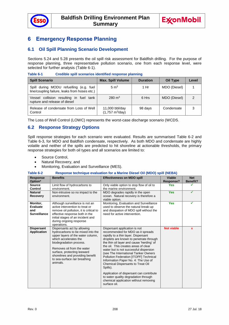
Baldfish Drilling Environment Plan Summary
Rev. 0 208 27 Jul. 18
6 Emergency Response Planning
6.1 Oil Spill Planning Scenario Development
Sections 5.24 and 5.28 presents the oil spill risk assessment for Baldfish drilling. For the purpose of response planning, three representative pollution scenario, one from each response level, were selected for further analysis (Table 6-1).
Table 6-1 Credible spill scenarios identified response planning
Spill Scenario Max. Spill Volume Duration Oil Type Level
Spill during MODU refuelling (e.g. fuel line/coupling failure, leaks from hoses etc.)
5 m3 1 Hr MDO (Diesel) 1
Vessel collision resulting in fuel tank rupture and release of diesel
280 m3 6 Hrs MDO (Diesel) 2
Release of condensate from Loss of Well Control
11,000 bbl/day (1,757 m3/day)
98 days Condensate 3
The Loss of Well Control (LOWC) represents the worst-case discharge scenario (WCDS.
6.2 Response Strategy Options
Spill response strategies for each scenario were evaluated. Results are summarised Table 6-2 and Table 6-3, for MDO and Baldfish condensate, respectively. As both MDO and condensate are highly volatile and neither of the spills are predicted to hit shoreline at actionable thresholds, the primary response strategies for both oil types and all scenarios are limited to:
Source Control,
Natural Recovery, and
Monitoring, Evaluation and Surveillance (MES).
Table 6-2 Response technique evaluation for a Marine Diesel Oil (MDO) spill (NEBA)
Response Option*
Benefits Effectiveness on MDO spill Viable Response?
Net Benefit?
Source Control
Limit flow of hydrocarbons to environment.
Only viable option to stop flow of oil to the marine environment.
Yes
Natural Recovery
Non-intrusive so no impact to the environment.
MDO degrades rapidly in the open ocean. Natural recovery is therefore a viable option.
Yes
Monitor, Evaluate and Surveillance
Although surveillance is not an active intervention to treat or remove oil pollution, it is critical to effective response both in the initial stages of an incident and during ongoing response operations.
Monitoring, Evaluation and Surveillance used to observe the natural break-up and dissipation of MDO spill without the need for active intervention.
Yes
Dispersant Application
Dispersants act by allowing hydrocarbons to be mixed into the upper layers of the water column, which accelerates the biodegradation process.
Removes oil from the water surface, protecting leeward shorelines and providing benefit to sea-surface /air breathing animals.
Dispersant application is not recommended for MDO as it spreads rapidly to a thin layer. Dispersant droplets are known to penetrate through the thin oil layer and cause ‘herding’ of the oil. This creates areas of clear water but is not successful dispersion (see The International Tanker Owners Pollution Federation [ITOPF] Technical Information Paper No. 4: The Use of Chemical Dispersants to Treat Oil Spills).
Application of dispersant can contribute to water quality degradation through chemical application without removing surface oil.
Not viable x
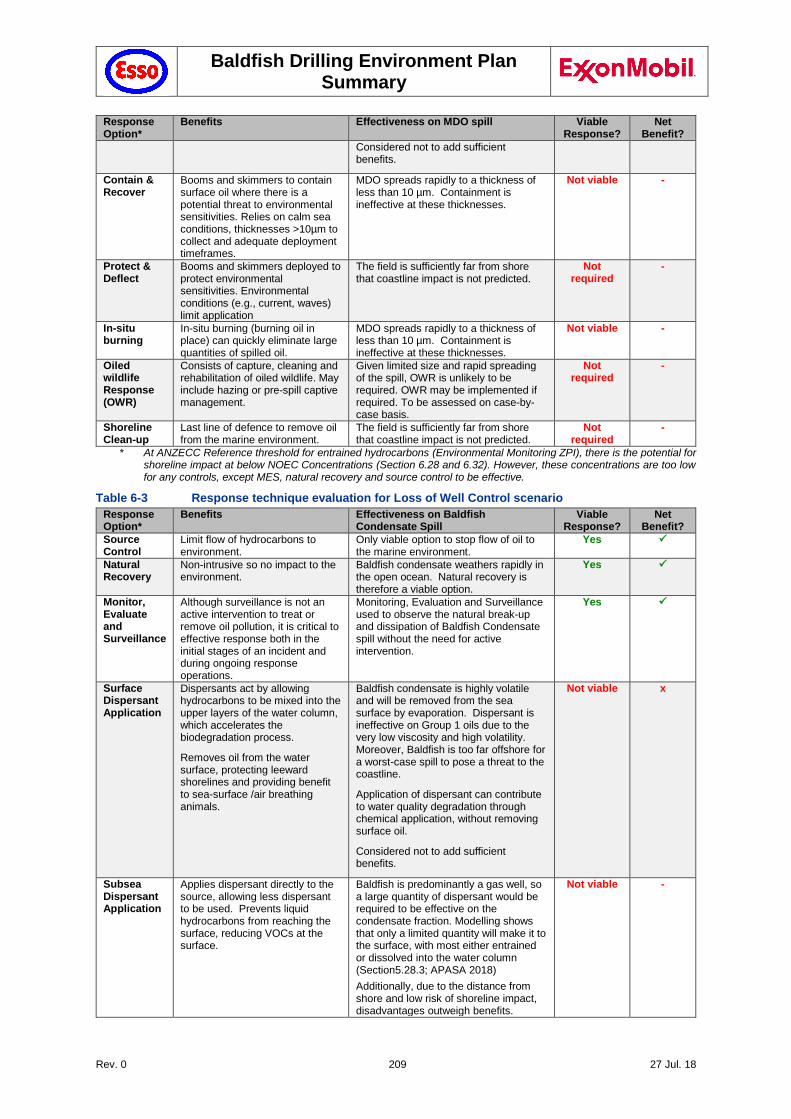
Baldfish Drilling Environment Plan Summary
Rev. 0 209 27 Jul. 18
Response Option*
Benefits Effectiveness on MDO spill Viable Response?
Net Benefit?
Considered not to add sufficient benefits.
Contain & Recover
Booms and skimmers to contain surface oil where there is a potential threat to environmental sensitivities. Relies on calm sea conditions, thicknesses >10µm to collect and adequate deployment timeframes.
MDO spreads rapidly to a thickness of less than 10 µm. Containment is ineffective at these thicknesses.
Not viable -
Protect & Deflect
Booms and skimmers deployed to protect environmental sensitivities. Environmental conditions (e.g., current, waves) limit application
The field is sufficiently far from shore that coastline impact is not predicted.
Not required
-
In-situ burning
In-situ burning (burning oil in place) can quickly eliminate large quantities of spilled oil.
MDO spreads rapidly to a thickness of less than 10 µm. Containment is ineffective at these thicknesses.
Not viable -
Oiled wildlife Response (OWR)
Consists of capture, cleaning and rehabilitation of oiled wildlife. May include hazing or pre-spill captive management.
Given limited size and rapid spreading of the spill, OWR is unlikely to be required. OWR may be implemented if required. To be assessed on case-by-case basis.
Not required
-
Shoreline Clean-up
Last line of defence to remove oil from the marine environment.
The field is sufficiently far from shore that coastline impact is not predicted.
Not required
-
* At ANZECC Reference threshold for entrained hydrocarbons (Environmental Monitoring ZPI), there is the potential for shoreline impact at below NOEC Concentrations (Section 6.28 and 6.32). However, these concentrations are too low for any controls, except MES, natural recovery and source control to be effective.
Table 6-3 Response technique evaluation for Loss of Well Control scenario
Response Option*
Benefits Effectiveness on Baldfish Condensate Spill
Viable Response?
Net Benefit?
Source Control
Limit flow of hydrocarbons to environment.
Only viable option to stop flow of oil to the marine environment.
Yes
Natural Recovery
Non-intrusive so no impact to the environment.
Baldfish condensate weathers rapidly in the open ocean. Natural recovery is therefore a viable option.
Yes
Monitor, Evaluate and Surveillance
Although surveillance is not an active intervention to treat or remove oil pollution, it is critical to effective response both in the initial stages of an incident and during ongoing response operations.
Monitoring, Evaluation and Surveillance used to observe the natural break-up and dissipation of Baldfish Condensate spill without the need for active intervention.
Yes
Surface Dispersant Application
Dispersants act by allowing hydrocarbons to be mixed into the upper layers of the water column, which accelerates the biodegradation process.
Removes oil from the water surface, protecting leeward shorelines and providing benefit to sea-surface /air breathing animals.
Baldfish condensate is highly volatile and will be removed from the sea surface by evaporation. Dispersant is ineffective on Group 1 oils due to the very low viscosity and high volatility. Moreover, Baldfish is too far offshore for a worst-case spill to pose a threat to the coastline.
Application of dispersant can contribute to water quality degradation through chemical application, without removing surface oil.
Considered not to add sufficient benefits.
Not viable x
Subsea Dispersant Application
Applies dispersant directly to the source, allowing less dispersant to be used. Prevents liquid hydrocarbons from reaching the surface, reducing VOCs at the surface.
Baldfish is predominantly a gas well, so a large quantity of dispersant would be required to be effective on the condensate fraction. Modelling shows that only a limited quantity will make it to the surface, with most either entrained or dissolved into the water column (Section5.28.3; APASA 2018)
Additionally, due to the distance from shore and low risk of shoreline impact, disadvantages outweigh benefits.
Not viable -
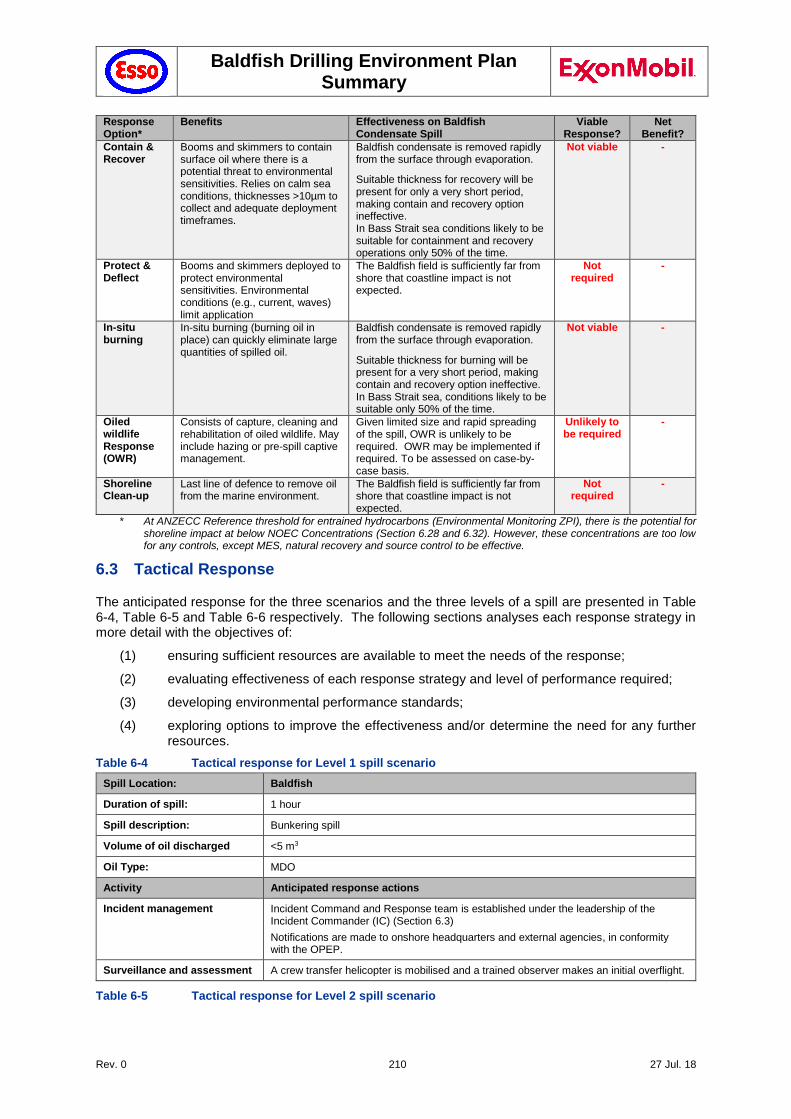
Baldfish Drilling Environment Plan Summary
Rev. 0 210 27 Jul. 18
Response Option*
Benefits Effectiveness on Baldfish Condensate Spill
Viable Response?
Net Benefit?
Contain & Recover
Booms and skimmers to contain surface oil where there is a potential threat to environmental sensitivities. Relies on calm sea conditions, thicknesses >10µm to collect and adequate deployment timeframes.
Baldfish condensate is removed rapidly from the surface through evaporation.
Suitable thickness for recovery will be present for only a very short period, making contain and recovery option ineffective. In Bass Strait sea conditions likely to be suitable for containment and recovery operations only 50% of the time.
Not viable -
Protect & Deflect
Booms and skimmers deployed to protect environmental sensitivities. Environmental conditions (e.g., current, waves) limit application
The Baldfish field is sufficiently far from shore that coastline impact is not expected.
Not required
-
In-situ burning
In-situ burning (burning oil in place) can quickly eliminate large quantities of spilled oil.
Baldfish condensate is removed rapidly from the surface through evaporation.
Suitable thickness for burning will be present for a very short period, making contain and recovery option ineffective. In Bass Strait sea, conditions likely to be suitable only 50% of the time.
Not viable -
Oiled wildlife Response (OWR)
Consists of capture, cleaning and rehabilitation of oiled wildlife. May include hazing or pre-spill captive management.
Given limited size and rapid spreading of the spill, OWR is unlikely to be required. OWR may be implemented if required. To be assessed on case-by-case basis.
Unlikely to be required
-
Shoreline Clean-up
Last line of defence to remove oil from the marine environment.
The Baldfish field is sufficiently far from shore that coastline impact is not expected.
Not required
-
* At ANZECC Reference threshold for entrained hydrocarbons (Environmental Monitoring ZPI), there is the potential for shoreline impact at below NOEC Concentrations (Section 6.28 and 6.32). However, these concentrations are too low for any controls, except MES, natural recovery and source control to be effective.
6.3 Tactical Response
The anticipated response for the three scenarios and the three levels of a spill are presented in Table 6-4, Table 6-5 and Table 6-6 respectively. The following sections analyses each response strategy in more detail with the objectives of:
(1) ensuring sufficient resources are available to meet the needs of the response;
(2) evaluating effectiveness of each response strategy and level of performance required;
(3) developing environmental performance standards;
(4) exploring options to improve the effectiveness and/or determine the need for any further resources.
Table 6-4 Tactical response for Level 1 spill scenario
Spill Location: Baldfish
Duration of spill: 1 hour
Spill description: Bunkering spill
Volume of oil discharged <5 m3
Oil Type: MDO
Activity Anticipated response actions
Incident management Incident Command and Response team is established under the leadership of the Incident Commander (IC) (Section 6.3)
Notifications are made to onshore headquarters and external agencies, in conformity with the OPEP.
Surveillance and assessment A crew transfer helicopter is mobilised and a trained observer makes an initial overflight.
Table 6-5 Tactical response for Level 2 spill scenario
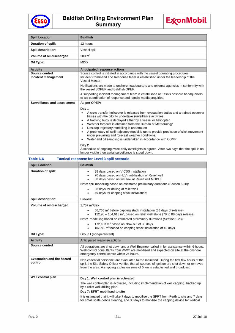
Baldfish Drilling Environment Plan Summary
Rev. 0 211 27 Jul. 18
Spill Location: Baldfish
Duration of spill: 12 hours
Spill description: Vessel spill
Volume of oil discharged 280 m3
Oil Type: MDO
Activity Anticipated response actions
Source control Source control is initiated in accordance with the vessel operating procedures.
Incident management Incident Command and Response team is established under the leadership of the Vessel Master.
Notifications are made to onshore headquarters and external agencies in conformity with the vessel SOPEP and Baldfish OPEP.
A supporting incident management team is established at Esso's onshore headquarters to aid coordination of response and handle media enquiries.
Surveillance and assessment As per OPEP:
Day 1
A crew transfer helicopter is released from evacuation duties and a trained observer liaises with the pilot to undertake surveillance activities.
A tracking buoy is deployed either by a vessel or helicopter.
Weather forecast is obtained from the Bureau of Meteorology
Desktop trajectory modelling is undertaken
A proprietary oil spill trajectory model is run to provide prediction of slick movement under prevailing and forecast weather conditions.
Water and oil sampling is undertaken in accordance with OSMP
Day 2 A schedule of ongoing twice-daily overflights is agreed. After two days that the spill is no longer visible then aerial surveillance is stood down.
Table 6-6 Tactical response for Level 3 spill scenario
Spill Location: Baldfish
Duration of spill: 38 days based on VICSS installation
70 days based on HLV mobilisation of Relief well
88 days based on wet tow of Relief well MODU
Note: spill modelling based on estimated preliminary durations (Section 5.28):
98 days for drilling of relief well
49 days for capping stack installation;
Spill description: Blowout
Volume of oil discharged 1,757 m3/day
66,765 m3 before capping stack installation (38 days of release)
122,98 – 154,613 m3, based on relief well alone (70 to 88 days release)
Note: modelling based on estimated preliminary durations (Section 5.28):
172,183 m3 based on blow-out of 98 days
86,091 m3 based on capping stack installation of 49 days
Oil Type: Group I (non-persistent)
Activity Anticipated response actions
Source control All operations are shut down and a Well Engineer called in for assistance within 6 hours. Well control consultants from WWC are mobilised and expected on site at the onshore emergency control centre within 24 hours.
Evacuation and fire hazard control
Non-essential personnel are evacuated to the mainland. During the first few hours of the spill, the Site Safety Officer verifies that all sources of ignition are shut down or removed from the area. A shipping exclusion zone of 5 km is established and broadcast.
Well control plan
Day 1: Well control plan is activated
The well control plan is activated, including implementation of well capping, backed up by a relief well drilling plan.
Day 7: SFRT mobilised to site
It is estimated that it will take 7 days to mobilise the SFRT from Perth to site and 7 days for small scale debris clearing, and 30 days to mobilise the capping device for vertical
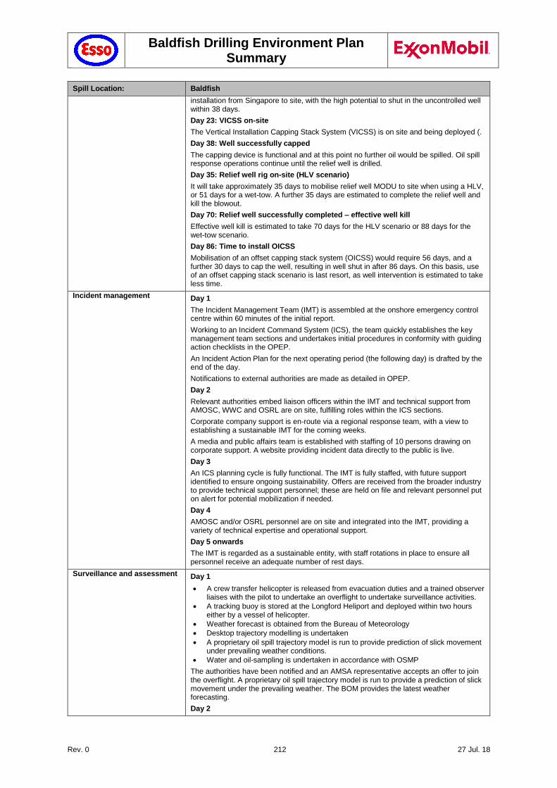
Baldfish Drilling Environment Plan Summary
Rev. 0 212 27 Jul. 18
Spill Location: Baldfish
installation from Singapore to site, with the high potential to shut in the uncontrolled well within 38 days.
Day 23: VICSS on-site
The Vertical Installation Capping Stack System (VICSS) is on site and being deployed (.
Day 38: Well successfully capped
The capping device is functional and at this point no further oil would be spilled. Oil spill response operations continue until the relief well is drilled.
Day 35: Relief well rig on-site (HLV scenario)
It will take approximately 35 days to mobilise relief well MODU to site when using a HLV, or 51 days for a wet-tow. A further 35 days are estimated to complete the relief well and kill the blowout.
Day 70: Relief well successfully completed – effective well kill
Effective well kill is estimated to take 70 days for the HLV scenario or 88 days for the wet-tow scenario.
Day 86: Time to install OICSS
Mobilisation of an offset capping stack system (OICSS) would require 56 days, and a further 30 days to cap the well, resulting in well shut in after 86 days. On this basis, use of an offset capping stack scenario is last resort, as well intervention is estimated to take less time.
Incident management Day 1
The Incident Management Team (IMT) is assembled at the onshore emergency control centre within 60 minutes of the initial report.
Working to an Incident Command System (ICS), the team quickly establishes the key management team sections and undertakes initial procedures in conformity with guiding action checklists in the OPEP.
An Incident Action Plan for the next operating period (the following day) is drafted by the end of the day.
Notifications to external authorities are made as detailed in OPEP.
Day 2
Relevant authorities embed liaison officers within the IMT and technical support from AMOSC, WWC and OSRL are on site, fulfilling roles within the ICS sections.
Corporate company support is en-route via a regional response team, with a view to establishing a sustainable IMT for the coming weeks.
A media and public affairs team is established with staffing of 10 persons drawing on corporate support. A website providing incident data directly to the public is live.
Day 3
An ICS planning cycle is fully functional. The IMT is fully staffed, with future support identified to ensure ongoing sustainability. Offers are received from the broader industry to provide technical support personnel; these are held on file and relevant personnel put on alert for potential mobilization if needed.
Day 4
AMOSC and/or OSRL personnel are on site and integrated into the IMT, providing a variety of technical expertise and operational support.
Day 5 onwards
The IMT is regarded as a sustainable entity, with staff rotations in place to ensure all personnel receive an adequate number of rest days.
Surveillance and assessment Day 1
A crew transfer helicopter is released from evacuation duties and a trained observer liaises with the pilot to undertake an overflight to undertake surveillance activities.
A tracking buoy is stored at the Longford Heliport and deployed within two hours either by a vessel of helicopter.
Weather forecast is obtained from the Bureau of Meteorology
Desktop trajectory modelling is undertaken
A proprietary oil spill trajectory model is run to provide prediction of slick movement under prevailing weather conditions.
Water and oil-sampling is undertaken in accordance with OSMP
The authorities have been notified and an AMSA representative accepts an offer to join the overflight. A proprietary oil spill trajectory model is run to provide a prediction of slick movement under the prevailing weather. The BOM provides the latest weather forecasting.
Day 2
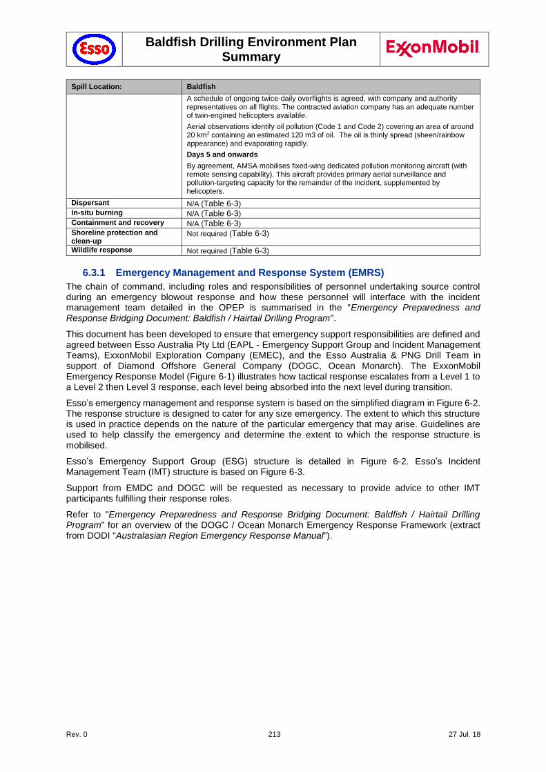
Baldfish Drilling Environment Plan Summary
Rev. 0 213 27 Jul. 18
Spill Location: Baldfish
A schedule of ongoing twice-daily overflights is agreed, with company and authority representatives on all flights. The contracted aviation company has an adequate number of twin-engined helicopters available.
Aerial observations identify oil pollution (Code 1 and Code 2) covering an area of around 20 km2 containing an estimated 120 m3 of oil. The oil is thinly spread (sheen/rainbow appearance) and evaporating rapidly.
Days 5 and onwards
By agreement, AMSA mobilises fixed-wing dedicated pollution monitoring aircraft (with remote sensing capability). This aircraft provides primary aerial surveillance and pollution-targeting capacity for the remainder of the incident, supplemented by helicopters.
Dispersant N/A (Table 6-3)
In-situ burning N/A (Table 6-3)
Containment and recovery N/A (Table 6-3)
Shoreline protection and clean-up
Not required (Table 6-3)
Wildlife response Not required (Table 6-3)
6.3.1 Emergency Management and Response System (EMRS)
The chain of command, including roles and responsibilities of personnel undertaking source control during an emergency blowout response and how these personnel will interface with the incident management team detailed in the OPEP is summarised in the "Emergency Preparedness and Response Bridging Document: Baldfish / Hairtail Drilling Program".
This document has been developed to ensure that emergency support responsibilities are defined and agreed between Esso Australia Pty Ltd (EAPL - Emergency Support Group and Incident Management Teams), ExxonMobil Exploration Company (EMEC), and the Esso Australia & PNG Drill Team in support of Diamond Offshore General Company (DOGC, Ocean Monarch). The ExxonMobil Emergency Response Model (Figure 6-1) illustrates how tactical response escalates from a Level 1 to a Level 2 then Level 3 response, each level being absorbed into the next level during transition.
Esso’s emergency management and response system is based on the simplified diagram in Figure 6-2. The response structure is designed to cater for any size emergency. The extent to which this structure is used in practice depends on the nature of the particular emergency that may arise. Guidelines are used to help classify the emergency and determine the extent to which the response structure is mobilised.
Esso’s Emergency Support Group (ESG) structure is detailed in Figure 6-2. Esso’s Incident Management Team (IMT) structure is based on Figure 6-3.
Support from EMDC and DOGC will be requested as necessary to provide advice to other IMT participants fulfilling their response roles.
Refer to "Emergency Preparedness and Response Bridging Document: Baldfish / Hairtail Drilling Program" for an overview of the DOGC / Ocean Monarch Emergency Response Framework (extract from DODI "Australasian Region Emergency Response Manual").
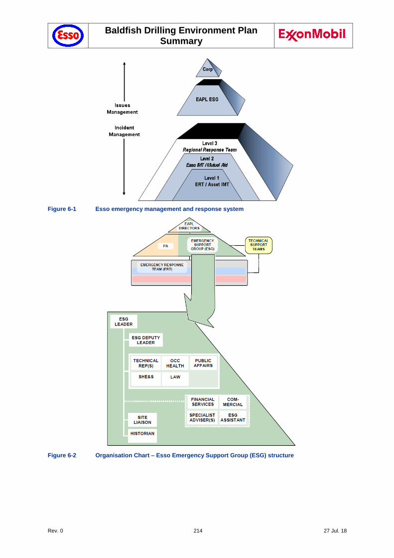
Baldfish Drilling Environment Plan Summary
Rev. 0 214 27 Jul. 18
Figure 6-1 Esso emergency management and response system
Figure 6-2 Organisation Chart – Esso Emergency Support Group (ESG) structure
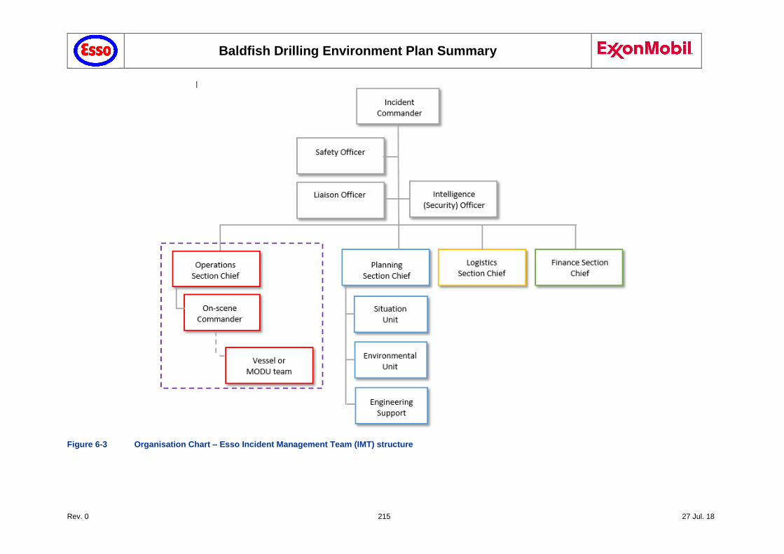
Baldfish Drilling Environment Plan Summary
Rev. 0 215 27 Jul. 18
Figure 6-3 Organisation Chart – Esso Incident Management Team (IMT) structure
Baldfish Drilling Environment Plan Summary
Rev. 0 216 27 Jul. 18
6.3.2 Incident Management Team (IMT)
The structure of the IMT (Figure 6-3) is based on the Incident Command System, detailed in the Incident Management Handbook (The Response Group, 2015). The structure is consistent with the Australasian Inter-Service Incident Management System (AIIMS), which ensures that any interface between Commonwealth and State incident and emergency response organisations are aligned.
The structure of the team is scalable and flexible such that, if the incident dictates, not all roles need to be filled or one person can fill multiple roles. The role holders can also evolve over time. As the responsibility for the response moves from one organisation to another, a role may be replaced with a more suitable or more competent individual or the incident may be of such duration that shift change is required.
The IMT Leader (or Incident Commander (IC)), assisted by the IMT, is responsible for command, control and coordination of the response to incidents and for supporting the On-scene Commander (OC) in the tactical response to any incident. Responsibilities and checklists for IMT members are provided in the Incident Management Handbook (The Response Group, 2015).
The responsibilities highlighted by the purple box in Figure 7-3 will be undertaken by the Esso Australia & PNG Drill Team and Diamond Offshore personnel. The Operations Section Chief (OSC) will be a senior member of the Esso Australia & PNG Drill Team whenever possible, with the on-scene roles being filled by MODU personnel (e.g. the MODU OIM would be the OC).
6.3.3 Source Control Branch (SCB)
Figure 6-4 outlines the organisation chart for the Source Control Branch (SCB), as further described in the ExxonMobil Incident Management Handbook (ExxonMobil 2015). The SCB reports to the IMT through communication between the IMT Operations Section and the SCB Director. The SCB consists of the following roles, assigned to specific source control tasks:
SCB Director
Well Intervention & Containment team
Debris Removal team
Subsea Dispersant team
Relief Well team
Flow Engineering team
SSH&E and Risk Assessment Support
Human Resources and legal support
Logistics, Finance and Planning support
Additionally, the SCB is supported by SIMOPS and the On-Scene Commander.
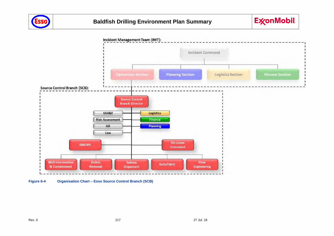
Baldfish Drilling Environment Plan Summary
Rev. 0 217 27 Jul. 18
Figure 6-4 Organisation Chart – Esso Source Control Branch (SCB)
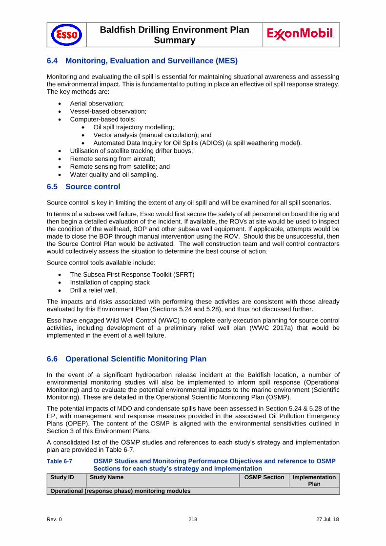
Baldfish Drilling Environment Plan Summary
Rev. 0 218 27 Jul. 18
6.4 Monitoring, Evaluation and Surveillance (MES)
Monitoring and evaluating the oil spill is essential for maintaining situational awareness and assessing the environmental impact. This is fundamental to putting in place an effective oil spill response strategy. The key methods are:
Aerial observation;
Vessel-based observation;
Computer-based tools:
Oil spill trajectory modelling;
Vector analysis (manual calculation); and
Automated Data Inquiry for Oil Spills (ADIOS) (a spill weathering model).
Utilisation of satellite tracking drifter buoys;
Remote sensing from aircraft;
Remote sensing from satellite; and
Water quality and oil sampling.
6.5 Source control
Source control is key in limiting the extent of any oil spill and will be examined for all spill scenarios.
In terms of a subsea well failure, Esso would first secure the safety of all personnel on board the rig and then begin a detailed evaluation of the incident. If available, the ROVs at site would be used to inspect the condition of the wellhead, BOP and other subsea well equipment. If applicable, attempts would be made to close the BOP through manual intervention using the ROV. Should this be unsuccessful, then the Source Control Plan would be activated. The well construction team and well control contractors would collectively assess the situation to determine the best course of action.
Source control tools available include:
The Subsea First Response Toolkit (SFRT)
Installation of capping stack
Drill a relief well.
The impacts and risks associated with performing these activities are consistent with those already evaluated by this Environment Plan (Sections 5.24 and 5.28), and thus not discussed further.
Esso have engaged Wild Well Control (WWC) to complete early execution planning for source control activities, including development of a preliminary relief well plan (WWC 2017a) that would be implemented in the event of a well failure.
6.6 Operational Scientific Monitoring Plan
In the event of a significant hydrocarbon release incident at the Baldfish location, a number of environmental monitoring studies will also be implemented to inform spill response (Operational Monitoring) and to evaluate the potential environmental impacts to the marine environment (Scientific Monitoring). These are detailed in the Operational Scientific Monitoring Plan (OSMP).
The potential impacts of MDO and condensate spills have been assessed in Section 5.24 & 5.28 of the EP, with management and response measures provided in the associated Oil Pollution Emergency Plans (OPEP). The content of the OSMP is aligned with the environmental sensitivities outlined in Section 3 of this Environment Plans.
A consolidated list of the OSMP studies and references to each study’s strategy and implementation plan are provided in Table 6-7.
Table 6-7 OSMP Studies and Monitoring Performance Objectives and reference to OSMP Sections for each study’s strategy and implementation
Study ID Study Name OSMP Section Implementation Plan
Operational (response phase) monitoring modules
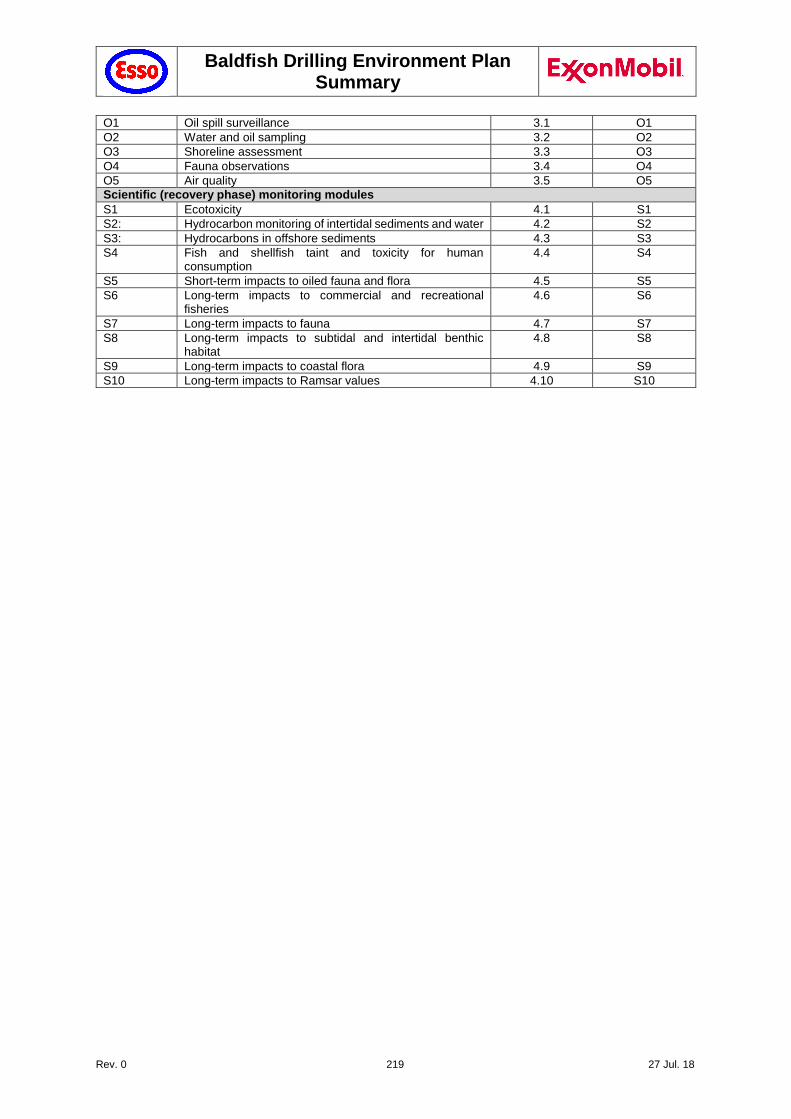
Baldfish Drilling Environment Plan Summary
Rev. 0 219 27 Jul. 18
O1 Oil spill surveillance 3.1 O1
O2 Water and oil sampling 3.2 O2
O3 Shoreline assessment 3.3 O3
O4 Fauna observations 3.4 O4
O5 Air quality 3.5 O5
Scientific (recovery phase) monitoring modules
S1 Ecotoxicity 4.1 S1
S2: Hydrocarbon monitoring of intertidal sediments and water 4.2 S2
S3: Hydrocarbons in offshore sediments 4.3 S3
S4 Fish and shellfish taint and toxicity for human consumption
4.4 S4
S5 Short-term impacts to oiled fauna and flora 4.5 S5
S6 Long-term impacts to commercial and recreational fisheries
4.6 S6
S7 Long-term impacts to fauna 4.7 S7
S8 Long-term impacts to subtidal and intertidal benthic habitat
4.8 S8
S9 Long-term impacts to coastal flora 4.9 S9
S10 Long-term impacts to Ramsar values 4.10 S10
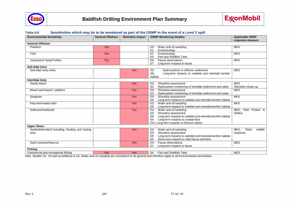
Baldfish Drilling Environment Plan Summary
Rev. 0 220 27 Jul. 18
Table 6-8 Sensitivities which may be to be monitored as part of the OSMP in the event of a Level 2 spill
Environmental Sensitivity General Offshore Shoreline impact OSMP Monitoring Studies Applicable OPEP response measure
General Offshore
Plankton Yes O2: Water and oil sampling S1: Ecotoxicology
MES
Fish/ Yes S1: Ecotoxicology S4: Fish and Shellfish Taint
MES
Cetaceans/ Seals/Turtles Yes O4: Fauna observations S7: Long-term impacts to fauna
MES
Sub-tidal Zone
Sub-tidal rocky reefs Yes S3: Hydrocarbons in offshore sediments S8: Long-term impacts to subtidal and intertidal benthic habitat
MES
Intertidal Zone
Sandy beach Yes O3: Shoreline assessment S2: Hydrocarbon monitoring of intertidal sediments and water
MES Shoreline Clean-up
Mixed sand beach / platform Yes O3: Shoreline assessment S2: Hydrocarbon monitoring of intertidal sediments and water
MES
Seagrass Yes O3: Shoreline assessment S8: Long-term impacts to subtidal and intertidal benthic habitat
MES
Kelp-dominated reefs Yes O2: Water and oil sampling S8: Long-term impacts to subtidal and intertidal benthic habitat
MES
Saltmarsh/wetlands Yes O2: Water and oil sampling O3: Shoreline assessment S8: Long-term impacts to subtidal and intertidal benthic habitat S9: Long-term impacts to coastal flora S10: Long-term impacts to Ramsar values
MES, P&D Protect & Deflect
Upper Shore
Seabird/shorebird breeding, feeding and resting area
Yes O2: Water and oil sampling O3: Shoreline assessment S8: Long-term impacts to subtidal and intertidal benthic habitat S5: Short-term impacts to oiled fauna and flora
MES, Oiled wildlife response
Seal Colonies/Haul-out Yes O4: Fauna observations S7: Long-term impacts to fauna
MES
Fishing
Commercial and recreational fishing Yes Yes S4: Fish and Shellfish Taint MES
Note. Studies O1: Oil spill surveillance & O2: Water and oil sampling are considered to be general and therefore apply to all environmental sensitivities.
Baldfish Drilling Environment Plan Summary
Rev. 0 221 27 Jul. 18
7 Implementation Strategy
The implementation strategy described in this section identifies systems, practices and procedures that will be used to ensure that the environmental impacts and risks of the activity are reduced to As Low As Reasonably Practicable (ALARP) and acceptable levels, and that the environmental performance outcomes and standards in the Environment Plan are met.
7.1 Esso Operations Integrity Management System (OIMS)
Esso is committed to conducting business in a manner that is compatible with the environmental and economic needs of the communities in which it operates, and that protects the safety, security, and health of its employees, those involved with its operations, its customers, and the public. These commitments are documented in the Safety, Security, Health, Environmental, and Product Safety policies.
These policies are put into practice through a management system called the OIMS. Esso’s OIMS Framework establishes common worldwide expectations for addressing risks inherent in the business. The term Operations Integrity (OI) is used by Esso to address all aspects of its business that can impact personnel and process safety, security, health and environmental performance.
The Baldfish Drilling program will operate in accordance with the proprietary ExxonMobil Operations Integrity Management System (OIMS). OIMS is adopted by all ExxonMobil affiliates worldwide.
7.2 Diamond Offshore Safety and Environmental Management System (SEMS)
This project is being implemented under the umbrella of the ExxonMobil Environmental Policy and OIMS which the drilling contractor, supply vessels and any other contractors, must abide by. The drilling contractor and supply vessels and contractors have in place formal, written systems, practices and procedures for management of HSE.
Through the Third Party Services Element of OIMS (Element 8), third party systems practices and procedures are reviewed and assessed for acceptability by Esso prior to commencement of operations. Third party servicers and systems are subject to regular audits throughout the program, at a minimum these are conducted annually as part of the critical contractor’s evaluation program.
Diamond Offshore, as the nominated Facility Operator of the Ocean Monarch MODU, has in place a comprehensive Safety and Environmental Management System (SEMS) and Risk Management process.
Diamond Offshore ensures that all activities undertaken on the MODU are conducted and managed under the Ocean Monarch SEMS and all personnel including third party contractors are provided with induction training into the SEMS system prior to undertaking work on the Ocean Monarch.
Spill prevention controls include inspection/audit procedures that address housekeeping, leaks/spills, and storage areas, Marine Operations Procedures and Fuel Oil Transfer Procedures.
MODU operations are conducted within a framework of environmental awareness training, routine inspections, job safety analysis and incident reporting.
7.3 Baldfish Exploration Drilling Documents
The following documents have been developed for the Baldfish Drilling program and set the standards and requirements to be met for the Drilling campaign by all parties (Esso, Diamond Offshore MODU, Support Vessels and Contractors):
The Baldfish Exploration Drilling Environmental Plan (EP)
The Baldfish Exploration Drilling Bridging Emergency Response Plan (ERP)
The Baldfish Exploration Drilling Oil Pollution Response Plan (OPEP)
The Baldfish Exploration Drilling Waste Management Plan (WMP)
Baldfish Drilling Environment Plan Summary
Rev. 0 222 27 Jul. 18
The content of these documents is introduced as part of the induction process for personnel on-board the MODU and supply vessels, and copies are made available to crew members prior to the commencement of any work.
7.4 Training and Competency
Esso requires that all personnel be trained in accordance with their respective contractor- established training requirements as well as Esso contractually specified requirements.
The Diamond Offshore Human Resources Manager ensures that personnel assigned to HSE positions are adequately experienced and qualified for their roles.
Diamond have established the worldwide competency program, which is integrated with the company’s personnel and payroll systems and provides system controls and documentation of completion. Audits of the competency program are conducted through the internal annual GEMS, regulator, customer and IADC accreditation audits. Each third party service provider is also required to maintain training files for their personnel. These records are verified as part of initial contract requirements and then audited at a minimum of annually for critical contractors.
7.5 Reporting and Inspections
The following table provides a summary of the external notifications and reporting arrangements.
Table 7-1 External Notification and Reporting Requirements
Notification Timing Reference/Comments
All relevant non-government stakeholders
At least 1 month and 1 week prior to planned activity commencement
All relevant stakeholders listed in the stakeholder register (email)
Within 10 days of activity completion
NOPSEMA At least 10 days prior to activity OPGGS(E) Reg 29
([email protected]) Within 10 days of activity completion
At activity finalisation and obligation completion
OPGGS(E) Reg 25A
AHS - commencement date and duration
At least 4 weeks prior to activity AHS issues a Notice to Mariners ([email protected]).
Transport Safety Victoria (TSV) - commencement date and duration.
At least 2 weeks prior to activity commencement.
TSV to issue Notice to Mariners ([email protected]).
AMSA 24-48 hrs before start of activity.
Reconfirm on activity commencement
AMSA issues AusCoast Warnings for activity ([email protected])
On vessel demobilisation from field
Provide cetacean observation data to the DoEE.
Within 3 months of activity completion
Upload information to:
https://data.marinemammals.gov.au/csa
Baldfish Drilling Environment Plan Summary
Rev. 0 223 27 Jul. 18
7.5.1 Monitoring and recording emissions and discharges
Table 7-2 provides a summary of the environmental risk monitoring requirements for the drilling activities. This should be considered along with the Performance Standards, Objectives and Criteria in Chapter 5. The MODU OIM and Esso Drilling Superintendent are responsible for ensuring the monitoring is undertaken as per the EP.
Table 7-2 Summary environmental monitoring/recording and reporting requirements
Environmental Risk Criteria to be Monitored Frequency of Monitoring and Reporting
Hazardous waste disposal Type and volume Ongoing (EPR)
Diesel usage Volume Ongoing (EPR)
Oil spills Type and volume Each incident (IR)
Chemical spills Type and volume Each incident (IR)
WBM & cuttings discharge Volume of cuttings Daily During Drilling (EPR)
Discharges of cement Volume of cement discharges Daily During Drilling (EPR)
Chemical Inventory Type Ongoing (EPR)
Fuel use (MODU, support vessels)
Volume Ongoing (EPR)
Vessels entering safety zone Per incident Ongoing
Oily water discharge volume Continuous during discharge Ongoing (EPR)
Waste to shore from MODU Volume and type Event/consignment (EPR)
Domestic waste discharge (Sewage/Food Scraps)
Discharge volumes; Compliance with MARPOL 73/78
Ongoing (EPR)
Incinerator waste (if present and used)
Volume, incineration temperature
Ongoing (EPR)
Ballast Water Discharges Exchanged volume Ongoing (EPR)
Sightings and Impacts to wildlife
Type Ongoing (EPR/IR)
EPR: Environmental Performance Report IR: Incident Report (see Section 7.5.2)
7.5.2 Incident Notification and Reporting
The OPGGS(E) Regulations define "Recordable Incidents" and "Reportable Incidents", and also defines reporting requirements for each type of incident.
All environmental incidents and near misses are reported by Diamond Offshore and the supply vessels to Esso. Esso notifies and reports incidents to NOPSEMA in accordance with OPGGS(E) Regulations.
Incidents are managed internally by Esso in accordance with OIMS System 9-1 (Incident Management) to ensure valuable information and lessons learnt are available to improve operations and prevent the recurrence of similar incidents.
In addition to the OPGGS(E) Regulations 2009 requirements, unplanned releases of hydrocarbon liquid or non-approved chemicals exceeding 80 litres into the marine environment (while performing a petroleum activity) are to be reported to AMSA.
Other vessel incidents (while not performing a petroleum activity) must also be reported in accordance with the Navigation Act 2012 and other regulations.

Baldfish Drilling Environment Plan Summary
Rev. 0 224 27 Jul. 18
Table 7-3 Reporting to AMSA and other government agencies - marine pollution incidents/injuries
Petroleum Activity:
Actual or potential unplanned releases of hydrocarbon liquid or non-approved chemicals exceeding 80 litres into the marine environment (while performing a petroleum activity).
https://www.amsa.gov.au/contact-us/index.asp#report
POLREP: https://amsa-forms.nogginoca.com/public/
Verbally at the first available opportunity
POLREP report within 3 days (see OPEP)
AMSA 24 Hour Emergency Contact Numbers
1800 641 792 (Maritime)
1800 815 257 (Aviation)
or
+612 6230 6811 (Maritime)
+612 6230 6899 (Aviation)
Vessel Master outside 500m petroleum safety zone
OIM within the 500m petroleum safety zone
Outside 500m petroleum Safety Zone:
AMSA will be notified by the Vessel Master if any of the following incidents occur (while not performing a petroleum activity):
An oil pollution incident from a vessel has occurred in Commonwealth waters (Marine Notice 1/1996);
The vessel has sustained or caused an accident occasioning loss of life or serious injury;
The vessel has received damage or is defective affecting its seaworthiness; or
There is a serious danger to navigation resulting from a vessel (e.g. a sizable piece of equipment likely to float is lost overboard).
https://www.amsa.gov.au/environment/regulations/marpol/reporting-pollution/index.asp
Verbally at the first available opportunity
POLREP report within 2 hours
AMSA 24 Hour Emergency Contact Numbers
1800 641 792 (Maritime)
1800 815 257 (Aviation)
or
+612 6230 6811 (Maritime)
+612 6230 6899 (Aviation)
Vessel Master
Notify port and government agencies in the event of a Level 1 (Port Authority) or Level 2 (Port Authority & DEDJTR) vessel spill
Immediately
DEDJTR (Transport) - 0409 858 715 (24 hrs).
NOPSEMA: 08 6461 7090.
(Commonwealth waters)
Port of Portland: (03) 5525 0900
Vessel Master
Notify DELWP in the event of oiled wildlife. Immediately
1300 134 444 (24 hrs).
Vessel Master/OIM
Notify DELWP of any incidents of injury or death to native fauna including whales and dolphins.
Immediately.
Whale & Dolphin Emergency Hotline: 1300 136 017.
Seals, Penguins or Marine Turtles: 136 186 (Mon-Fri 8am to 6pm) or
AGL Marine Response Unit: 0447 158 676.
Vessel Master/OIM
Notify the DoEE of any impacts to MNES, specifically injury to or death of EPBC Act-listed species.
Within 7 days
Phone 1800 110 395; Email: [email protected]
Vessel Master/OIM
Baldfish Drilling Environment Plan Summary
Rev. 0 225 27 Jul. 18
Vessel strike with cetacean is reported to the DoEE.
Upload information to:
https://data.marinemammals.gov.au/report/shipstrike
Within 72 hours of incident.
Vessel Master/OIM
7.5.3 Incident Investigation
Investigations into environmental incidents are conducted in accordance with Esso's incident investigation procedures and guidelines. Investigation teams may include Diamond Offshore or supply vessel representative(s) as agreed in consultation with the Diamond Offshore MODU Manager and the Esso Operations Superintendent; the team leader for investigations will be either an Esso investigator or Esso appointed objective third party. They are reported using the Esso reporting format.
Diamond Offshore will also undertake an investigation as per their operating procedures and safety case requirements.
7.5.4 Auditing and Inspections
Requirements for compliance with the EP under OPGGS(E) Regulation 14(3) are met through ongoing monitoring and reporting and auditing and inspections (outlined below).
Table 7-4 Summary of Assessments and Inspections
Inspection/Assessment Party/Responsibility Status/Plan
OIMS Risk Assessment Esso Australia & PNG Drill Team, Diamond Offshore
Manager and 3rd party contractor reps
Completed prior to start up. Corrective actions closed out prior to the start of operations.
Critical Contractor OIMS Evaluations
Esso QA/QC Coordinator Completed on completion of drilling campaign.
Lifting Equipment Certification 3rd Party Inspection Prior to start up, during drilling campaign as required.
Rig Inspection D-210 Esso Operations Superintendent During drilling operations.
BOP/Well Control systems inspection
3rd Party Inspection by MODU Operator, in dialogue with Drilling Superintendent
Prior to initial running of BOP, as required thereafter.
Pre-mobilisation environmental inspection
Esso Operations Superintendent Completed prior to start up. Corrective actions closed out prior to the start of operations.
Vessel and MODU inspections Vessel/MODU Operator Weekly walk-arounds, documented on inspection checklists. Basis for monthly recordable incident reports.
Compliance Audit Esso Offshore Risk, Environment and Regulatory Supervisor
During drilling operations. Summarised in the Environmental Performance Report to NOPSEMA
7.6 Environmental Performance Review
7.6.1 Daily Rig Calls
Daily rig calls are undertaken to keep all personnel involved up to date with the activities that are planned for the day and allows for input from the Management team to assist with work planning.
7.6.2 Toolbox Meetings
Toolbox meetings are conducted twice daily to plan for any events that are occurring during the shift. This allows for relevant permits and Work Risk assessments to be undertaken and to make sure that personnel completing the tasks understand all the safety and environmental risks associated.
Environmental matters will be included in daily toolbox talks as required for the specific task being risk assessed. Environmental issues will also be addressed in daily or weekly HSE meetings where all
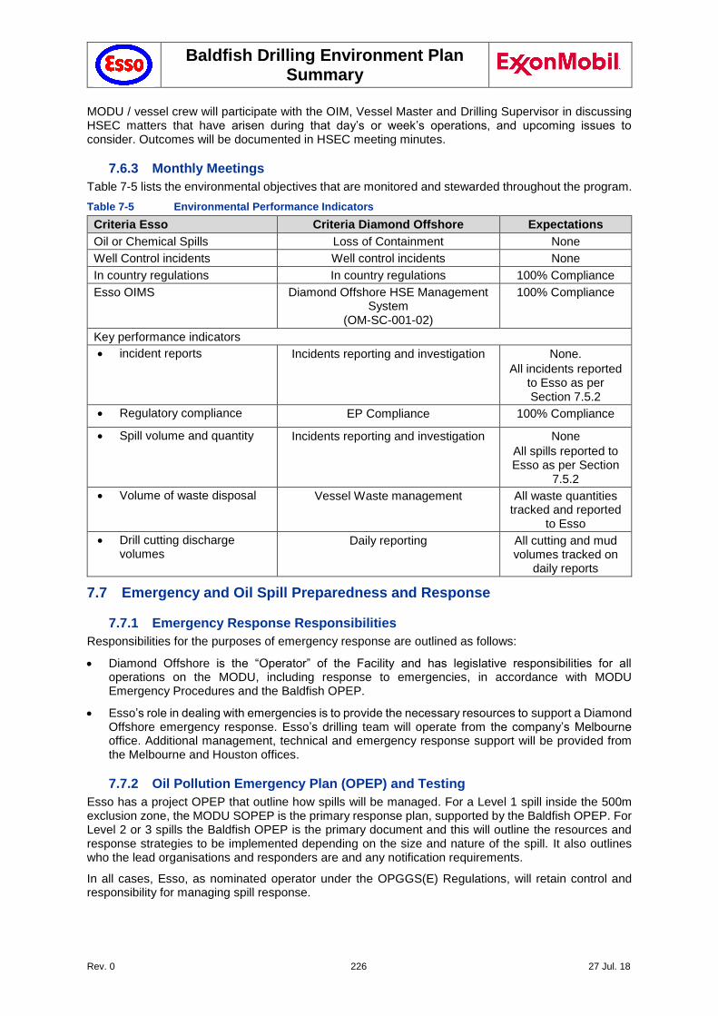
Baldfish Drilling Environment Plan Summary
Rev. 0 226 27 Jul. 18
MODU / vessel crew will participate with the OIM, Vessel Master and Drilling Supervisor in discussing HSEC matters that have arisen during that day’s or week’s operations, and upcoming issues to consider. Outcomes will be documented in HSEC meeting minutes.
7.6.3 Monthly Meetings
Table 7-5 lists the environmental objectives that are monitored and stewarded throughout the program.
Table 7-5 Environmental Performance Indicators
Criteria Esso Criteria Diamond Offshore Expectations
Oil or Chemical Spills Loss of Containment None
Well Control incidents Well control incidents None
In country regulations In country regulations 100% Compliance
Esso OIMS Diamond Offshore HSE Management System
(OM-SC-001-02)
100% Compliance
Key performance indicators
incident reports Incidents reporting and investigation None.
All incidents reported to Esso as per Section 7.5.2
Regulatory compliance EP Compliance 100% Compliance
Spill volume and quantity Incidents reporting and investigation None
All spills reported to Esso as per Section
7.5.2
Volume of waste disposal Vessel Waste management All waste quantities tracked and reported
to Esso
Drill cutting discharge volumes
Daily reporting All cutting and mud volumes tracked on
daily reports
7.7 Emergency and Oil Spill Preparedness and Response
7.7.1 Emergency Response Responsibilities
Responsibilities for the purposes of emergency response are outlined as follows:
Diamond Offshore is the “Operator” of the Facility and has legislative responsibilities for all operations on the MODU, including response to emergencies, in accordance with MODU Emergency Procedures and the Baldfish OPEP.
Esso’s role in dealing with emergencies is to provide the necessary resources to support a Diamond Offshore emergency response. Esso’s drilling team will operate from the company’s Melbourne office. Additional management, technical and emergency response support will be provided from the Melbourne and Houston offices.
7.7.2 Oil Pollution Emergency Plan (OPEP) and Testing
Esso has a project OPEP that outline how spills will be managed. For a Level 1 spill inside the 500m exclusion zone, the MODU SOPEP is the primary response plan, supported by the Baldfish OPEP. For Level 2 or 3 spills the Baldfish OPEP is the primary document and this will outline the resources and response strategies to be implemented depending on the size and nature of the spill. It also outlines who the lead organisations and responders are and any notification requirements.
In all cases, Esso, as nominated operator under the OPGGS(E) Regulations, will retain control and responsibility for managing spill response.
Baldfish Drilling Environment Plan Summary
Rev. 0 227 27 Jul. 18
In accordance with the Commonwealth OPGGS(E) Regulation 14 (8C) and in accordance with OIMS System 10-2: Emergency Preparedness and Response, the OPEP will be tested:
Prior to the commencement of a drilling campaign.
When there is a significant amendment to the OPEP.
The effectiveness of response arrangements will be measured by the performance standards of each exercise type. These exercises may be externally or internally facilitated.
7.8 Operational Control
7.8.1 Chemical Selection Procedure and Approval for Discharge
Any chemical that is planned to be discharged to the marine environment is selected based on their lowest toxicity. All drilling fluids meet OCNS Gold or non-CHARMable Category E (lowest toxicity). Where any of the chosen chemicals needs to be substituted, the lowest toxicity substitute is chosen, in accordance with Esso's chemical selection procedure (Workplace Substances Manual, Form WSM2). Any chemical that is the subject of a planned discharge to the marine environment must meet the requirements under the Esso chemical selection procedure.
7.8.2 Management of change
The objective of the MOC process is to ensure that additional risks are not introduced by changes that could increase the risk of harm to people, assets or the environment.
Environmentally relevant changes include:
New activities, assets, equipment, processes or procedures proposed to be undertaken or implemented that have the potential to impact on the environment and have not been:
• Assessed for environmental impact previously, in accordance with the relevant standard, or
• Authorised in the existing management plans, procedures, work instructions or maintenance plans.
Proposed changes to activities, assets, equipment, processes or procedures that have the potential to impact on the environment or interface with the environmental receptor; and
Changes to the requirements of an existing external approval (e.g. changes to conditions of environmental licences).
For any MOC with identified environmental impacts or risks, an impact/risk assessment will be undertaken to consider the impact of the proposed change on the environmental impacts/risks and the adopted control measures.
7.8.3 Review and update of the Environment Plan
In the event that a proposed change, including new stages or significant modifications identified under MOC, triggers the requirement for a revision under OPGGS Regulation 17 see below), the EP will be revised for re-submission to NOPSEMA.
Note all changes to the accepted EP will be traceable via ‘track-changes’ within the revision document and any changes made are fully justified. This process, including information around changes that trigger a formal revision, are documented.
In accordance with Regulation 17 of the OPGGS(E) Regulations 2009, a revision of the EP will be submitted to NOPSEMA where any significant new environmental impact or risk, or significant increase in an existing environmental impact or risk, has been identified, not provided for in the EP.

Baldfish Drilling Environment Plan Summary
Rev. 0 228 27 Jul. 18
8 Stakeholder Consultation
Esso Australia, on behalf of Esso Deepwater, has undertaken consultation with all relevant stakeholders
potentially affected by the Baldfish Exploration Drilling Campaign.
The principles of stakeholder engagement are to:
Provide meaningful information in a format and language that is readily understandable and
tailored to the needs of the target stakeholder group(s).
Provide information in advance of consultation activities and decision-making.
Disseminate information in ways and locations that make it easy for stakeholders to access it.
Respect local timeframes and decision making processes.
Establish two-way dialogue that gives both sides the opportunity to exchange views and
information, to listen, and to have their issues heard and addressed.
Adopt processes free of intimidation or coercion.
Develop clear mechanisms for responding to people's concerns, suggestions, and grievances.
Incorporate feedback into program design, and report back to stakeholders.
Demonstrate that stakeholders have been consulted in accordance with the requirements of
the OPGGS (Environment) Regulations 2009
8.1 Stakeholder Identification
Esso identified all stakeholders potentially affected by the Baldfish Exploration Drilling Campaign. Esso
classified these stakeholders into three categories for the EP:
Primary stakeholders are those expected to provide direct advice or collaborate on plans and
who may be impacted by the project.
Secondary stakeholders are those with functions, interests or activities in the Operational ZPI
that could be potentially affected by the activities to be carried out under the environment plan;
and
Tertiary stakeholders are other persons and organisations who may have an interest in the
activities, but are unlikely to be affected or unknown stakeholders with whom Esso extended
an opportunity to self-identify as having an interest in activities, by way of a public consultation
forum in Lakes Entrance, which was promoted through various newspaper advertisements.
A total of 73 stakeholders were identified, as given in Table 9-1.
Table 8-1 Identified Stakeholders ..
Stakeholder Name
Commonwealth
Australian Maritime Safety Authority (AMSA) / Australian Hydrographic Office (AHO)
Australian Fisheries Management Authority (AFMA)
Department of Environment and Energy (DoEE)
Director of National Parks
Department of Agriculture and Water Resources
Department of Foreign Affairs & Trade
Director of National Parks
Department of Agriculture and Water Resources
Department of Foreign Affairs & Trade
Victoria
State Emergency Service
Department of Economic Development, Jobs, Transport and Resources (DEDJTR Transport)
(Manager Marine Pollution – Emergency Management Division)
Department of Primary Industries (Marine and Estuarine Fisheries)
Department of Economic Development, Jobs, Transport and Resources (DEDJTR Earth Resources Regulation)
Department of Environment, Land, Water and Planning (DELWP)
VicPlan Operations Group (VPOG)
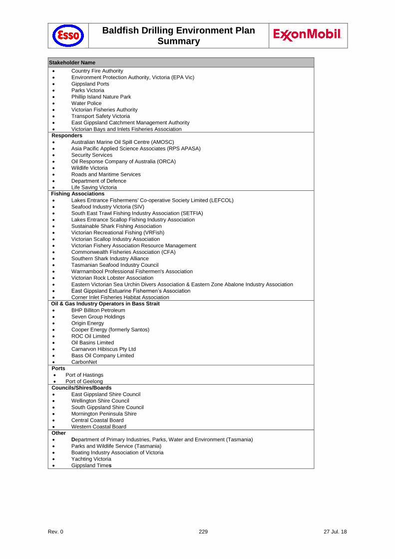
Baldfish Drilling Environment Plan Summary
Rev. 0 229 27 Jul. 18
Stakeholder Name
Country Fire Authority
Environment Protection Authority, Victoria (EPA Vic)
Gippsland Ports
Parks Victoria
Phillip Island Nature Park
Water Police
Victorian Fisheries Authority
Transport Safety Victoria
East Gippsland Catchment Management Authority
Victorian Bays and Inlets Fisheries Association
Responders
Australian Marine Oil Spill Centre (AMOSC)
Asia Pacific Applied Science Associates (RPS APASA)
Security Services
Oil Response Company of Australia (ORCA)
Wildlife Victoria
Roads and Maritime Services
Department of Defence
Life Saving Victoria
Fishing Associations
Lakes Entrance Fishermens' Co-operative Society Limited (LEFCOL)
Seafood Industry Victoria (SIV)
South East Trawl Fishing Industry Association (SETFIA)
Lakes Entrance Scallop Fishing Industry Association
Sustainable Shark Fishing Association
Victorian Recreational Fishing (VRFish)
Victorian Scallop Industry Association
Victorian Fishery Association Resource Management
Commonwealth Fisheries Association (CFA)
Southern Shark Industry Alliance
Tasmanian Seafood Industry Council
Warrnambool Professional Fishermen's Association
Victorian Rock Lobster Association
Eastern Victorian Sea Urchin Divers Association & Eastern Zone Abalone Industry Association
East Gippsland Estuarine Fishermen’s Association
Corner Inlet Fisheries Habitat Association
Oil & Gas Industry Operators in Bass Strait
BHP Billiton Petroleum
Seven Group Holdings
Origin Energy
Cooper Energy (formerly Santos)
ROC Oil Limited
Oil Basins Limited
Carnarvon Hibiscus Pty Ltd
Bass Oil Company Limited
CarbonNet
Ports
Port of Hastings
Port of Geelong
Councils/Shires/Boards
East Gippsland Shire Council
Wellington Shire Council
South Gippsland Shire Council
Mornington Peninsula Shire
Central Coastal Board
Western Coastal Board
Other
Department of Primary Industries, Parks, Water and Environment (Tasmania)
Parks and Wildlife Service (Tasmania)
Boating Industry Association of Victoria
Yachting Victoria
Gippsland Times
Baldfish Drilling Environment Plan Summary
Rev. 0 230 27 Jul. 18
8.2 Mechanisms for Consultation
A number of mechanisms to communicate with stakeholders have been used to ensure stakeholders can make an informed assessment of the possible consequences of the activity on their functions, interests or activities.
The following mechanisms were used to communicate with stakeholders:
written communications
one-on-one discussions via telephone and in-person.
public consultation session in Lakes Entrance (17 November 2017)
Esso community news webpage
8.2.1 Written communications
Early in October 2017, an email update was sent to Esso’s Public and Government Affairs existing offshore stakeholder database, informing them about upcoming activities in the Gippsland Basin and reason Esso was seeking to consult with the stakeholders. A three-page fact sheet (Esso Offshore Projects) was attached, providing details of the planned Baldfish Exploration activities. Additionally, it included an invitation to attend the public consultation session in November 2017, or arrange an alternative meeting time at their convenience.
Personal invitations for the Lakes Entrance consultation forum went out to relevant stakeholders in October 2017.In addition to the letter drop and fact sheet, the Lakes Entrance consultation forum was promoted through a series of announcements in a local newspaper (Gippsland Times: "Back in the hunt for Gippsland gas", 26 September 2017), with ongoing communications in fishing trade magazines (SETFIA, LEFCOL).
At that point of the consultation process some stakeholders indicated they had received adequate information, had no comments, and would like to be ‘considered consulted’. A greater number indicated a general interest in being ‘kept in the loop’ without any specific comments or queries about the planned activity.
8.2.2 One-on-one discussions via telephone and in-person
Depending on the stakeholders’ preference, telephone and in-person discussions were held to clarify and discuss the EP and OPEP. This also included meetings held in Southbank and Lakes Entrance.
8.2.3 Public consultation session in Lakes Entrance
The public consultation session was held in Lakes Entrance on 17 November 2017 and was intended to consult about the project, as documented in this Environment Plan and supporting OPEP, and provide an opportunity for both known stakeholders and unknown stakeholders to learn more about Esso’s offshore operations. Invitations were announced widely, followed up by individual follow-up invitations by telephone in the week before the public consultation session.
The session was well attended, with 32 stakeholders confirmed, from a wide range of backgrounds, of which 27 attended on the day. Key stakeholders with particular relevance to the Baldfish location included Seafood Industry Victoria and LEFCOL. Esso was represented by the Offshore Operations Manager, the Offshore Risk, Environmental & Regulatory Supervisor, Public and Government Affairs and the Project SSHE Coordinator. A brief overview of planned activities, including the Baldfish Exploration Drilling program, was presented by the Esso Offshore Operations Manager. This was followed by a Q&A session and one-on-one conversations.
A series of informative posters were also presented at the session, which visitors were invited to read and discuss with Esso personnel. In addition, the flyer with information on the Baldfish Exploration Drilling Campaign was available for visitors to take away.
No major concerns were raised with regards the Baldfish drilling campaign. Areas discussed included the proximity to shipping lanes and how this would be managed (Section 5.21) and the proximity to the Fishery Independent Survey (FIS) Sites (Section 5.20). Further details summarised below.
Baldfish Drilling Environment Plan Summary
Rev. 0 231 27 Jul. 18
Tourist Information: introduced them to the project and Esso operations, minor issues raised included a request for additional information sheets and posters that they could provide to interested members of the public, introduced them to Joanne. They also wanted to know the names of the nearest platforms and where they were supported from.
LEFCOL/SETFIA: informal talk about the various projects and what impact there could be on the local fishermen. Baldfish drilling campaign may be the closest (11 NM) to the proposed July / August 2018 FIS locations. The Baldfish drilling campaign is unlikely to have any impact on the FIS locations. The level of noise and discharges is unlikely to be significant and may be hard to differentiate from the passing marine traffic. No major concerns raised and post the EP Esso have been notified that the FIS survey has been put on hold and may not occur until 2020.
SIV (Seafood Industry Victoria): Informal talk, discussing seismic campaigns and they raised the issue that seismic campaigns can result in environmental impacts – rock lobsters developing deformed tails was raised. Reiterated that none of the current Esso projects are seismic surveys and that when and if Esso plans to conduct a future seismic survey this will be discussed with stakeholders and planned operations will be explained.
The nature of consultation and the amount of consultation that LEFCOL and SIV are asked to participate in was discussed. Feedback is that there is a lot of consultation (too much) and that any way that the oil and gas industry could help in reducing these, or making these more efficient would be gratefully received. It was pointed out that Esso had combined three offshore projects in Gippsland Basin in a single flyer for this reason, and also combined these during the public forum in order to try and minimise the number of requests for consultation. In addition, the SIV newsletter (which is issued quarterly) was discussed as a means of further disseminating the information to a greater number of fishermen. SIV and LEFCOL were both supportive of this as it may be the only real way in which individual fishermen will be made aware of the various projects.
SES: Discussion about oil and gas developments and explained what condensate was. Discussed the three projects at a high level. No specific issues raised. Mainly interested to know more about the O&G industry and what it was doing.
Also the regulatory process and how oil and gas facilities gain approval was discussed. Stakeholders were interested to hear about the various regulatory approvals and submissions required. No specific concerns raised.
8.2.4 Project-specific webpage
In August 2017, Esso updated its offshore webpage (www.exxonmobil.com.au/) with information about the acquisition of permit VIC/P70 and the hunt for new gas ("Back in the hunt for Gippsland gas", Richard Owen, Lead Country Manager, 3 August 2017).
Esso also created a portal of information throughout the consultation period (Esso community news webpage), which included:
Downloadable PDF of the fact sheet ("Esso Offshore Projects") on Baldfish and other planned activities in Gippsland Basin, which included an announcement about the upcoming consultation session (Oct. 2017).
Information about Esso plans to extend field life of Gippsland basin through exploration in Block VIC/P70:
- "Back in the hunt for Gippsland gas" (Aug. 2017); - "Key gas fields nearing the end but news not all bad" (Oct. 2017); - "East coast gas supply Q&As"
The webpage also features a clear “contact us” link for interested parties to email Esso.
An "Offshore projects" page was created in November 2017, to provide ongoing updates on Esso offshore activities (http://www.exxonmobil.com.au/en-au/energy/natural-gas/natural-gas-operations/offshore-projects).
Baldfish Drilling Environment Plan Summary
Rev. 0 232 27 Jul. 18
8.3 Consultation Outcomes
Much of the interaction with stakeholders during the consultative process was administrative in nature, rather than specific feedback about the campaign and the EP. Common reasons for providing feedback throughout the process were to:
Re-direct Esso’s communication to another position in the organisation.
Advise Esso the stakeholder would like to be kept updated about Esso’s offshore operations.
Notification they had received the information and considered themselves consulted.
A number of stakeholders either asked clarifying questions about, or provided comment to, the activity outlined in the Environment Plan. These questions and Esso’s assessments and responses are summarised in the following table.
Table 8-2 Summary of Key Issues, Merits and Measures Adopted
Issue Raised by Merit and Measures Adopted
Interference with commercial shipping and potential risk of collision
AMSA This issue had already been identified by Esso as one of the key safety and environmental concerns with the proposed drilling locations and the proximity to the Bass Strait Traffic Separation Scheme.
Esso have worked with AMSA to identify temporary fairways that could be established to
re-route marine traffic and these have been adopted (Section 5.21.2.1). In addition 2 NM buffer zones will be established to provide the rig and support vessels protection, in
addition to the temporary Petroleum Safety Zones.
AMSA also provided input in the necessary navigation aids (Section 2.3.8) and confirmed that the tool in place exceed AMSA's expectations.
Notices to mariners have been issued and Esso has consulted with key ports and 3rd parties as recommended by AMSA – no further issues or objections have been raised.
PSZ has been established around the Baldfish wells (NOPSEMA Notice A604295 of 17 April 2018).
Proximity to Fishery Independent Survey (FIS) locations and the potential to impact the quality of this survey
SETFIA Based on the FIS locations and the planned well locations, there will be an 11nm separation between the two activities. The well location and the FIS locations are also separated by a busy shipping lane. The additional noise from drilling activities is not considered to have any significant impact to fish densities.
This has been discussed with LEFCOL and SETFIA. The timing of the FIS is uncertain, it was supposed to be mid-year but may not even proceed this year. Esso and SETFIA will continue to consult and if the FIS proceeds, Esso will be checking to see if supply vessel routing should be reviewed.
Post EP note – FIS survey will not take place in 2018.
Consultation with fishermen LEFCOL, SETFIA,
SIV
All the main fishing organisation have expressed a concern about how individual fishermen can be made aware of the various projects.
Baldfish Drilling Environment Plan Summary
Rev. 0 233 27 Jul. 18
Through discussions with SIV, Esso is planning to publish information about its projects, including Baldfish within the SIV quarterly newsletter PROFISH.
Through discussions with SETFIA, Esso are also planning to have SMS alerts issued to SETFIA fishing contacts to raise the awareness of the project activities, including when and where they are taking place.
Further means of consultation will also be assessed as and when they are identified. Given the level of fishing based on the ABARES data Esso consider that the consultation with SETFIA, LEFCOL and SIV and the use of the SIV newsletter and SETFIA SMS system should be sufficient.
A detailed summary of the consultation that has taken place (names and contact details deleted for
privacy of information) is included in Appendix 1.
8.4 Ongoing Consultation
Esso will continue to consult with stakeholders on an ongoing basis. This will consist of:
Maintaining the database of relevant stakeholders potentially affected by offshore production operations and maintains records of consultation for each stakeholder.
Follow up with stakeholders after the EP is accepted by NOPSEMA, to thank them for their involvement, update them of the outcome, notify them of next steps going forward, and make available to them the Environment Plan summary.
Provide an update to stakeholders at the end of the campaign, which will contain an update about the drilling campaign, including information such as environmental performance data.
Providing any new relevant information through the dedicated website content at https://www.exxonmobil.com.au/en-au/energy/natural-gas/natural-gas-operations/offshore-projects.
Baldfish Drilling Environment Plan
Rev. 0 234 27 Jul. 18
9 References used in the Environment Plan
ABARES (Australian Bureau of Agricultural and Resource Economics). 2016a. Fishery Status Reports 2016.
Department of Agriculture, Fisheries and Forestry. A WWW publication accessed in September 2017 at
http://www.agriculture.gov.au/abares/publications/publications
ABARES 2016b. Fisheries status reports 2016. Chapter 2: Bass Strait Central Zone Scallop Fishery. L. Georgeson,
R. Green and S. Nicol. A WWW publication accessed in September 2017 at
http://www.agriculture.gov.au/abares/publications/publications.
ABARES 2016c. Fisheries status reports 2016. Chapter 8: Southern and Eastern Scalefish and Shark Fishery. N
Marton and R Green. A WWW publication accessed in September 2017 at
http://www.agriculture.gov.au/abares/publications/publications.
ABARES (Australian Bureau of Agricultural and Resource Economics). 2017. Fishery Status Reports 2016.
Department of Agriculture, Fisheries and Forestry. A WWW publication accessed in October 2017 at
http://www.agriculture.gov.au/abares/publications/publications.
AFMA (Australian Fisheries Management Authority) 2010. Commonwealth Trawl Sector. Commonwealth Trawl
Sector. A WWW publication accessed in September 2017 at http://www.afma.gov.au/wp-
content/uploads/2010/07/fs_trawl.pdf.
AFMA 2014a. Small Pelagic Fishery Management Arrangements Booklet 2013-2014. A WWW publication
accessed in September 2017. http://www.afma.gov.au/wp-content/uploads/2014/11/Small-Pelagic-Fishery-
management-arrangements-booklet-2014-15.pdf.
AFMA 2014b. Re-opening of a commercial fishery for orange roughy (Hoplostethus atlanticus) in Australia.
Accessed in September 2017 at http://www.afma.gov.au/wp-content/uploads/2014/03/Orange-roughy-
Handout.pdf.
AFMA 2014c. Orange Roughy (Hoplostethus atlanticus) stock rebuilding strategy. Accessed in September 2017 at
http://www.afma.gov.au/sustainability-environment/protected-species-management-strategies/.
AFMA 2014d. School Shark (Galeorhinus galeus) Stock Rebuilding Strategy-Revised 2015. A WWW publication
accessed in September 2017 at http://www.afma.gov.au/wp-content/uploads/2014/12/School-Shark-
Rebuilding-Strategy.pdf.
AFMA 2016. Southern and Eastern Scalefish and Shark Fishery 2016 Management Arrangements Booklet.
Accessed in September 2017 at http://www.afma.gov.au/wp-content/uploads/2016/04/SESSF-Management-
Arrangements-Booklet-2016.pdf.
AFMA 2017a. Commonwealth fisheries annual catch data. Accessed in September 2017 at
http://www.afma.gov.au/resources/catch-data/.
AFMA 2017b. Petroleum industry consultation with the commercial fishing industry. Accessed in September 2017
at http://www.afma.gov.au/sustainability-environment/petroleum-industry-consultation/.
AFMA 2017c. Bass Strait Central Zone Scallop Fishery Management Arrangements Booklet (July 2017). Accessed
September 2017 at http://www.afma.gov.au/wp-content/uploads/2017/07/BSCZSF-Management-
Arrangements-Booklet-2017-final.pdf.
AFMA 2017d. Catch data Commonwealth Fisheries around Block VIC/P70 for 2010 to 2016. Dataset made
available through AFMA, 10 November 2017.
Agriculture Victorina 2017. Victorian Emergency Animal Welfare Plan (Revision 1) A WWW publication accessed
in September 2017 at http://agriculture.vic.gov.au/__data/assets/pdf_file/0003/365088/Victorian-Animal-
Emergency-Welfare-Plan_updated.pdf.
Aichinger Dias LA, J Litz, L Garrison, A Martinez, K Barry and T Speakman 2017. Exposure of cetaceans to
petroleum products following the Deepwater Horizon oil spill in the Gulf of Mexico. Endang. Species Res. 33:
119–125.
Ainsaar, M., Ruzzene, M., and Abbinga, E. 2007. Gippsland sustainable tourism: Project summary report. Urban
Enterprise Pty Ltd.
Allen, S., H. Marsh and A. Hodgson, 2004. Occurrence and Conservation of the Dugong (Sirenia: Dugongidae) in
New South Wales. Proceedings of the Linnean Society of New South Wales. 125:211-216.
AMSA 2012. NatPlan to Combat the Pollution of the Sea by Oil and other Noxious and Hazardous Substances,
Interim Technical Guideline for the Preparation of Marine Pollution Contingency Plans for Marine and Coastal
Facilities, July 2012, Australian Government.
AMSA 2015a. Technical guidelines for preparing contingency plans for marine and coastal facilities, 1-63.
https://www.amsa.gov.au/forms-and-publications/Publications/AMSA413.pdf.
AMSA 2015b. National plan. Response, assessment and Termination of cleaning for Oil contaminated foreshores.
Guidance Reference: NP-GUI-025. Endorsed by the NPSCC November 2015. A WWW publication accessed
Baldfish Drilling Environment Plan
Rev. 0 235 27 Jul. 18
in September 2017 at https://www.amsa.gov.au/marine-environment/national-plan-maritime-environmental-
emergencies/index-supporting-documents. AMSA 2017a. Automatic Identification System (AIS). A WWW publication accessed in September 2017 at
https://www.amsa.gov.au/navigation/services/ais/.AMSA 2017b. Vessel Traffic Data - Historic Vessel Tracking
Request. A WWW publication accessed in September 2017 at https://www.operations.amsa.gov.au/Spatial/.
AMSA 2017c. The International Convention for the Prevention of Pollution from Ships (MARPOL). A WWW
publication accessed in September 2017 at https://www.amsa.gov.au/environment/regulations/marpol/.
ANZECC (2000). National water quality management strategy. Australian and New Zealand Guidelines for Fresh
and Marine Water Quality. Australian and New Zealand Environment and Conservation Council / Agriculture
and Resource Management Council of Australia and New Zealand. October 2000.
Apache 2008. Gippsland Basin 2008 Drilling Environment Plan: Public Summary February 2008.
APASA 2017a. Memo. Impact from revised Esso - Baldfish Hairtail Well Location on modelling results. 2Nov 2017
APASA, 2017b. Baldfish & Hairtail Exploration, Gippsland Basin. Drill Cuttings and Muds Dispersion Modelling
Study. Prepared for Esso Australia Pty Ltd by RPS Asia-Pacific Applied Science Associates. Report Number:
MAQ0611J, November 2017 (RPS APASA).
Arnould, J. P. Y. and Kirkwood, R. 2008. Habitat selection by female Australian fur seals (Arctocephalus pusillus
doriferus). Aquatic Conservation: Marine and Freshwater Ecosystems. 17: S53–S67.
ANZECC (Australian and New Zealand Environment and Conservation Council) 2000. Australian and New Zealand
Guidelines for Fresh and Marine Water Quality, Volume 1 The Guidelines (Chapters 1-7).
ANZECC 2000. Australian and New Zealand guidelines for fresh and marine water quality. Volume 1, The
guidelines (National water quality management strategy; no.4). Australian and New Zealand Environment and
Conservation Council, Agriculture and Resource Management Council of Australia and New Zealand
AQIS. 2011. Australian Ballast Water Management Requirements. Version 5. Australian Quarantine Inspection
Service, Department of Agriculture, Fisheries and Forestry. Canberra.
Azis P, Al-Tisan I, Daili M, Green T, Dalvi A and Javeed M 2003. Chlorophyll and plankton of the Gulf coastal
waters of Saudi Arabia bordering a desalination plant Desalination, 154 (2003), pp. 291–302.
Azwell, TMS, MJ Blum, A Hare, S Joye, S Kubendran, A Laleian, G Lane, DJ Meffert, EB Overton, J Thomas & LE
White 2011. The Macondo Blowout Environmental Report - Deepwater Horizon Study Group Environmental
Report – January 2011.
Balch, A. H., and M. W. Lee, eds., 1984, Vertical seismic profiling—technique, applications, and case histories:
Boston, MA, IHRDC, 488 p.
Badruzzaman, A. 2011. Radioactive sources: their importance, challenges and opportunities. A WWW publication
accessed in September 2017 at https://www.epmag.com/radioactive-sources-their-importance-challenges-
and-opportunities-658506.
Bannister, J. L., Kemper, C. M., and Warneke, R. M. 1996. The Action Plan for Australian Cetaceans. Department
of Environment and Water Resources (DEW). Canberra. Accessed online in September 2017 at
https://www.environment.gov.au/system/files/resources/2711a6fd-dbf3-4aad-b79b-
14ef6ba2687d/files/whaleplan.pdf.
Batten SD, Allen RJS and Wotton COM, 1998, The effects of the Sea Empress Oil Spill on the Plankton of the
Southern Irish Sea. Marine Pollution Bulletin 36(10): 764-774.
Baumgartner, D. J., W. E. Frick, P. J. W. Roberts, and C. A. Bodeen. 1992. Dilution Models for Effluent Discharges.
Standards and Applied Science Division, Office of Science and Technology; Oceans and Coastal Protection
Division, Office of Wetlands, Oceans, and Watersheds; Pacific Ecosystems Branch, ERL-N, 2111 S. E. Marine
Science Drive, Newport, Oregon 97365-5260, U. S. Environmental Protection Agency.
Bax, N. J., and Williams, A. 2001. Seabed habitat on the south-eastern Australian continental shelf: context,
vulnerability and monitoring. Marine and Freshwater Research 52: 491–512.
Bejarano AC, JK. Farr, P Jenne, V Chu, and A Hielscher 2016. The chemical aquatic fate and effects database
(CAFE), a tool that supports assessments of chemical spills in aquatic environments. Env Tox Chem 35(6):
1576–1586.
Bejaranoa AC, Gardiner WW, Barron MG, Word JQ, 2017, Relative sensitivity of Arctic species to physically and
chemically dispersed oil determined from three hydrocarbon measures of aquatic toxicity. Mar Poll Bull
122:316-322.
BirdLife International. 2012. Light pollution has a negative impact on many seabirds including several globally
threatened species. Available online at: http://www.birdlife.org/datazone/sowb/casestudy/488.
Black KP, Brand GW, Grynberg H, Gwyther D, Hammond LS, Mourtikas S, Richardson BJ and Wardrop JA 1994.
Production facilities. In: Environmental implications of offshore oil and gas development in Australia – the
findings of an independent scientific review. Swan, J.M., Neff, J.M. and Young, P.C. (eds) Australian Petroleum
Exploration Association. Sydney. pp 209–407.
Baldfish Drilling Environment Plan
Rev. 0 236 27 Jul. 18
Black, K., Rosenberg, M., Hatton, D., Colman, R., Symmonds, G., Simons, R, Pattiaratchi, C., and Nielsen, P.
1991. Hydrodynamic and sediment dynamic measurements in eastern Bass Strait. Volume 2. Sea bed
description and sediment size analysis. Working paper No. 21, Victorian Institute of Marine Sciences.
BOM (Bureau of Meteorology) 2017. Climate Averages. A WWW database accessed in September 2017 at
http://www.bom.gov.au/climate/.
Boon, P.I., Allen, T., Brook, J., Carr, G., Frood, D., Hoye, J., Harty, C., McMahon, A., Mathews, S., Rosengren, N.,
Sinclair, S., White, M. and Yugovoc, J. 2011. Mangroves and coastal saltmarsh of Victoria: distribution,
condition, threats and management. Report to Department of Sustainability and Environment by Institute for
Sustainability and Innovation, Victoria University, Melbourne. 513pp.
BP 2013. Shah Deniz 2 Project. Environmental & Socio-Economic Impact Assessment. BP Development Pty Ltd.
Brandsma, M. G., Smith, J.P., O'Reilly, J.E., Ayers, R.C. and Holmquist, A.L. 1992 Modeling Offshore Discharges
of Produced Water in Produced Water. Edited by J. P. Ray and F. R. Englehardt, Plenum Press, New York,
pp. 59-71.
Brady, B., Morris, L. and Ball, D, 2002. Oil Spill Dispersants and Temperate Marine Environments. A Literature
Review to Support Development of Dispersant Use Protocols for Victoria. Marine and Freshwater Resources
Institute Report No. 51. September 2002.
Bruce, B.D., Bradford, R., Daley, R., Green, M., Phillips, K., 2002. Targeted review of biological and ecological
information from fisheries research in the South Ease Marine Region. December. Prepared for the National
Oceans Office.
Bruinzeel, LW, van Belle, J and Davids, L 2009. The Impact of Conventional Illumination of Offshore Operational
areas in the North Sea on Migratory Bird Populations. Presented at the OSPAR Convention for the Protection
of the Marine Environment of the North-East Atlantic meeting of the Working Group on the Environmental
Impact of Human Activities. November 2009.
Burton, GA, Batley, G.E., Chapman, P.M., Forbes, V.E., Schlekat, C.E., Smith, E.P., den Besten, P.J., Bailer, J.,
Reynoldson, T., Green, A.S., Dwyer, R.L., Berti, W.R. 2002. A weight-of-evidence framework for assessing
ecosystem impairment: improving certainty in the decision-making process. Human Ecology and Risk
Assessment. 8: 1675-1696.
Burns K, Slee D, Lloyd J, Hanlon M, Skepper C & Mitsopoulos G 2011. Monitoring plan for the montara well release,
Timor Sea monitoring study S3 “Assessement of fish for the presence of oil”. WA Department of Fisheries.
Cambridge ML and Kuo J 1979. Two new species of seagrasses from Australia, Posidonia sinuosa and P.
angustifolia (Posidoniaceae). Aquatic Botany, 6: 307-328.
Cardno, 2017. Metocean Criteria for Drilling-Baldfish, Bass Strait. Report 59918018. Prepared for ExxonMobil by
Cardno (NSW/ACT), St Leonards NSW, October 2017.
Cato, DH, Bell, M.J., 1992. Ultrasonic ambient noise in Australian shallow waters at frequencies up to 200 kHz.
Defence Science and Technology Organisation,Sydney.
Cato, DH, Tavener, S., 1997. Ambient sea noise dependence on local, regional and geostrophic wind speeds:
implications for forecasting noise. Applied Acoustics 51, 317–338.
CEFAS (Centre for Environment, Fisheries and Aquaculture Science) 2017. Offshore Chemical Notification
Scheme. Accessed in September 2017 at https://www.cefas.co.uk/cefas-data-hub/offshore-chemical-
notification-scheme/.
Clarke RH 2010. The Status of Seabirds and Shorebirds at Ashmore Reef, Cartier Island and Browse Island.
Monitoring Program for the Montara Well Release. Pre-impact Assessment and First Post-Impact Field Survey.
Prepared on behalf of PTTEP Australasia and the Department of the Environment, Water, Heritage and the
Arts by the Australian Centre for Biodiversity, Monash University. Melbourne.
Coffey 2010. Snapper platform seabed survey- January 2010. Report CR 946_13_v3. Prepared for Esso Australia
Pty Ltd by Coffey Environments Pty Ltd, Perth, Australia.
Coleman, N. (1988) Monitoring of scallop spatfall and growth rates at Lakes Entrance, September 1987 to May
1988.
Conolly, R. 1968. Submarine canyons of the continental margin, East Bass Strait (Australia). Mar. Geol. 6, 449–
461.
CNR (Victorina Department of Conservation and Natural Resources; now Department of Natural Resources and
Environment), 2003. Map 4 Resource Uses, Marine and Coastal Special Investigations. Land Conservation
Council, Victoria.
Cogger HG 2000. The Status of Marine Reptiles in New South Wales. A Report prepared for the New South Wales.
National Parks and Wildlife Service by. Dr Harold G. Cogger.
Coleman N. 1988. Monitoring of scallop spatfall and growth rates at Lakes Entrance, September 1987 to May 1988.
Baldfish Drilling Environment Plan
Rev. 0 237 27 Jul. 18
C&R Consulting 2009. Impacts of plastic debris on Australian marine wildlife. Report by C&R Consulting for The
Department of the Environment, Water, Heritage and the Arts19th June 2009. Available online:
http://www.environment.gov.au/marine/publications/impacts-plastic-debris-australian-marine-wildlife.
CSIRO 2014. Orange Roughy (Hoplostethus atlanticus) Eastern Zone stock assessment incorporating data up to
2014. Accessed in September 2017 at http://www.afma.gov.au/wp-content/uploads/2014/03/SESSF-CSIRO-
Orange-Roughy-Eastern-Assessment-Final-2014.pdf.
DAFF (Department of Agriculture, Fisheries and Forestry) 2009. The National Biofouling Management Guidance
for the Petroleum Production and Exploration Industry. A WWW document downloaded from
http://www.marinepests.gov.au/marine_pests/publications/Pages/petroleum-exportation.aspx.
DAFF. 2017. Marine Pests Interactive Map. A WWW database accessed in April 2017 at
http://www.marinepests.gov.au/Pages/marinepest-map.aspx
DAWR 2015. Ballast Water. A WWW database accessed at
http://www.agriculture.gov.au/biosecurity/avm/vessels/quarantine-concerns/ballast.. Department of
Agriculture and Water Resources. Canberra.
DAWR (Department of Agriculture and Water Resources) 2016. The Australian Ballast Water Management
Requirements (v6). http://www.agriculture.gov.au/biosecurity/avm/vessels/ballast/australian-ballast-water-
management-requirements-version6.
DAWR 2017. Australian Ballast Water Management Requirements, Version 7. Accessed in January 2018 at
http://www.agriculture.gov.au/biosecurity/avm/vessels/ballast/australian-ballast-water-management-
requirements.
Davis HK, CF Moffat, NJ Shepherd (2002). Experimental Tainting of Marine Fish by Three Chemically Dispersed
Petroleum Products, with Comparisons to the Braer Oil Spill. Spill Science & Technology Bulletin, Vol. 7, Nos.
5–6, pp. 257–278, 2002.
Davies J.M., Bedborough D.M., Blackman R.A.A., Addy J.M., Appelbee J.F., Grogan W.C., Parker J.G. and
Whitehead A. 1989. The Environmental Effect of Oil-based Mud Drilling in the North Sea. In:DrillingWastes.
Edited by Engelhardt F.R., Ray J.P. and Gillam A.H. Elsevier Applied Science, London.
DEDJTR (Victoria Department of Economic Development, Jobs, Transport and Resources) 2017. Victorian
Emergency Animal Welfare Plan (Revision 1) A WWW publication accessed in September 2017 at
http://agriculture.vic.gov.au/__data/assets/pdf_file/0003/365088/Victorian-Animal-Emergency-Welfare-
Plan_updated.pdf.
De Guise S, Levin M, Gebhard E, Jasperse L, Burdett Hart L, Smith CR, Venn-Watson S, Townsend F, Wells R,
Balmer B, Zolman E, Rowles T, Schwacke L 2017. Changes in immune functions in bottlenose dolphins in
the northern Gulf of Mexico associated with the Deepwater Horizon oil spill. Endang. Species Res. 33:291-
303.
DEH (Department of the Environment and Heritage), 2005. Humpback Whale Recovery Plan 2005 - 2010. [Online].
(Now Department of the Environment and Energy (DoEE). Canberra, Commonwealth of Australia. Available
from: http://155.187.2.69/biodiversity/threatened/publications/recovery/m-novaeangliae/index.html.
DEH 2006. A Guide to the Integrated Marine and Coastal Regionalisation of Australia IMCRA Version 4.0.
Department of the Environment and Heritage, Canberra, Australia.
De Leo FC, Smith CR, Rowden AA, Bowden DA, Clark MR. 2010. Submarine canyons: hotspots of benthic biomass
and productivity in the deep sea. Proceedings of the Royal Society B: Biological Sciences. 2010:
277(1695):2783-2792. doi:10.1098/rspb.2010.0462.
DELWP (Victoria Department of Environment, Land, Water and Planning), 1998. Commercial Fishing Methods in
Victoria. John Tomkin. Note Number: FN0105 A WWW publication accessed in September 2017 at
http://pandora.nla.gov.au/pan/59217/20060524-0000/FN0105.pdf.
DELWP. 2017a. Victorian biodiversity atlas. A WWW database accessed at https://vba.dse.vic.gov.au/vba/#/.
DELWP 2017b. Wildlife emergencies. A WWW publication accessed in September 2017 at
https://www.wildlife.vic.gov.au/wildlife-emergencies/wildlife-emergencies.
Diamond Offshore 2015. Diamond Offshore - GEMS Customer Portal, [Online] Available at:
https://gemscustomer.dodi.com/SitePages/Home.aspx.
Diamond Offshore 2017. Diamond Offshore Safety Case Ocean Monarch Mobile Offshore Drilling Unit Portal,
[Online] Available at: www.HSECase.com.
DMP (WA Department of Mines and Petroleum), 2013. Environmental Risk Assessment of Chemicals used in WA
Petroleum Activities Guideline. Available online at http://www.dmp.wa.gov.au/Documents/Environment/ENV-
PEB-165.pdf.
DNV 2011. Shipping and Offshore Activity Data for Australian Ports and Waters. Prepared by DET NORSKE
VERITAS for Australian Maritime Safety Authority, December 2011. Available online at
Baldfish Drilling Environment Plan
Rev. 0 238 27 Jul. 18
https://www.amsa.gov.au/forms-and-publications/environment/publications/Other-
Reports/documents/DNVApp1.pdf.
DOD (Department of Defence) 2017. Aqueous Film Forming Foams (AFFF)/PFAS Information Sheet.
http://www.defence.gov.au/whs/_Master/docs/programs/Aqueous%20Film%20Forming%20Foams.pdf.
DoEE (Department of Environment and Energy) 2000. EPBC Regulations (Part 8: Interacting with cetaceans and
whale watching). Version SR 2000 No. 181 of 17 October 2016 (F2016C00914). Administered by: Environment
and Energy. Accessed in September 2017 at http://www.environment.gov.au/epbc/about.
DoEE 2008. EPBC Act Policy Statement 2.1 - Interaction between offshore seismic exploration and whales:
Industry guidelines. http://www.environment.gov.au/resource/epbc-act-policy-statement-21-interaction-
between-offshore-seismic-exploration-and-whales
DoEE 2015a. South-east marine region profile. Accessed in September 2017 at
http://www.environment.gov.au/system/files/resources/7a110303-f9c7-44e4-b337-00cb2e4b9fbf/files/south-
east-marine-region-profile.pdf.
DoEE 2015b. Conservation Values Atlas. Accessed online at
http://www.environment.gov.au/topics/marine/marine-bioregional-plans/conservation-values-atlas.
DoEE 2017a. EPBC Act Protected Matters Report for the Baldfish Operational ZPI. Department of Environment.
October 2017.
DoEE, 2017b. Flinders Commonwealth Marine Reserve. Accessed in September 2017 at
http://www.environment.gov.au/topics/marine/marine-reserves/south-east/flinders.
DoEE 2017c. Shipwrecks Database. A WWW publication accessed in September 2017 at
http://www.environment.gov.au/topics/heritage/historic-shipwrecks/australian-national-shipwreck-database.
DoEE 2017d. Loggerhead turtle. A WWW publication accessed in September 2017 at
http://www.environment.gov.au/coasts/species/turtles/loggerhead.html.
DoEE 2017e. Leatherback turtle. A WWW publication accessed in September 2017 at
http://www.environment.gov.au/coasts/species/turtles/leatherback.html.
DoEE 2017f. Green turtle. A WWW publication accessed in September 2017 at
http://www.environment.gov.au/marine/marine-species/marine-turtles/green.
DoEE 2017g. Hawksbill turtle (Eretmochelys imbricata). Accessed in September 2017 at http://www.environment.gov.au/marine/marine-species/marine-turtles/hawksbill.
DoEE 2017h. Hooded plover. A WWW publication accessed in September 2017 at
http://www.environment.gov.au/cgi-bin/sprat/public/publicspecies.pl?taxon_id=66726.
DoEE 2017i. Fairy tern. A WWW publication accessed in September 2017 at http://www.environment.gov.au/cgi-
bin/sprat/public/publicspecies.pl?taxon_id=82950.
DoEE 2017j. Species Profile and Threats (SPRAT) Database - EPBC Act List of Threatened Fauna. Accessed in
September 2017 at http://www.environment.gov.au/cgi-bin/sprat/public/publicthreatenedlist.pl.
DoEE 2017k. Species Profile and Threats (SPRAT) Database - Eubalaena australis — Southern Right Whale.
Accessed in September 2017 at http://www.environment.gov.au/cgi-
bin/sprat/public/publicspecies.pl?taxon_id=40.
DoEE 2017l. Australian Whale Sanctuary. Accessed in September 2017 at
http://www.environment.gov.au/marine/marine-species/cetaceans/australian-whale-sanctuary.
DoEE 2017m. Species Profile and Threats Database (SPRAT), Eudyptula minor — Little Penguin
Accessed in September 2017 at http://www.environment.gov.au/cgi-
bin/sprat/public/publicspecies.pl?taxon_id=1085http://www.environment.gov.au/marine/marine-
species/marine-turtles/hawksbill.
DoEE 2017n. East Gippsland Commonwealth Marine Reserve. Accessed in September 2017 at
http://www.environment.gov.au/topics/marine/marine-reserves/south-east/east-gippsland.
DoEE 2017o. Australian National Guidelines for Whale and Dolphin Watching 2017. Accessed in November
2017 at http://www.environment.gov.au/marine/publications/australian-national-guidelines-whale-and-
dolphin-watching-2017.
DoEE 2017p. Commonwealth Marine Reserves. A WWW publication accessed September 2017 at
http://www.environment.gov.au/topics/marine/marine-reserves.
DoEE 2017q. Freycinet Commonwealth Marine Reserve. Accessed in September 2017 at.
http://www.environment.gov.au/topics/marine/marine-reserves/south-east/freycinet.
DoEE, 2017r. Australian Wetlands Database – Ramsar wetlands, Corner Inlet. A WWW publication accessed in
September 2017 at http://www.environment.gov.au/cgi-bin/wetlands/ramsardetails.pl?refcode=13.
DoEE, 2017s. Australian Wetlands Database – Ramsar wetlands, Gippsland Lakes. A WWW publication accessed
in September 2017 at http://www.environment.gov.au/cgi-bin/wetlands/ramsardetails.pl?refcode=21.
Baldfish Drilling Environment Plan
Rev. 0 239 27 Jul. 18
DoEE, 2017t. Littoral rainforests and coastal vine thickets of eastern Australia. Accessed in September 2017 at
http://www.environment.gov.au/epbc/publications/littoral-rainforest.
DoEE, 2017u. Beagle Commonwealth Marine Reserve. Accessed in September 2017 at
http://www.environment.gov.au/topics/marine/marine-reserves/south-east/beagle.
DoEE, 2017v. Australian Wetlands Database – Ramsar wetlands, Towra Point Nature Reserve. A WWW
publication accessed in September 2017 at http://www.environment.gov.au/cgi-
bin/wetlands/ramsardetails.pl?refcode=23.
DoEE, 2017w. Central Eastern Commonwealth Marine Reserve. A WWW publication accessed in September 2017
at http://www.environment.gov.au/topics/marine/marine-reserves/temperate-east/central-eastern.
DoEE, 2017x. Australian Wetlands Database – Ramsar wetlands, Logan Lagoon. A WWW publication accessed
in September 2017 at http://www.environment.gov.au/cgi-bin/wetlands/ramsardetails.pl?refcode=4.
DoEE, 2017y. Australian Wetlands Database – Ramsar wetlands, East Coast Cape Barren Island Lagoons. A
WWW publication accessed in September 2017 at http://www.environment.gov.au/cgi-
bin/wetlands/ramsardetails.pl?refcode=8.
DoEE, 2017z. Australian Wetlands Database – Ramsar wetlands, Flood Plain Lower Ringarooma River. A WWW
publication accessed in September 2017 at http://www.environment.gov.au/cgi-
bin/wetlands/ramsardetails.pl?refcode=9.
DoEE, 2017aa. Australian Wetlands Database – Ramsar wetlands, Little Waterhouse Lake. A WWW publication
accessed in September 2017 at http://www.environment.gov.au/cgi-
bin/wetlands/ramsardetails.pl?refcode=12.
DoEE 2018a. EPBC Act Protected Matters Report for the Baldfish operational area – Hairtail-1. Department of
Environment. February 2018.
DoEE 2018b. EPBC Act Protected Matters Report for the Baldfish operational area – Baldfish -1. Department of
Environment. February 2018.
DoEE 2018c. Species Profile and Threats Database Balaenoptera musculus — Blue Whale. A WWW publication
accessed in February 2018 at http://www.environment.gov.au/cgi-
bin/sprat/public/publicspecies.pl?taxon_id=36.
DoEE, 2018d. New Lord Howe Commonwealth Marine Reserve. A WWW publication accessed in February 2018 at http://www.environment.gov.au/topics/marine/marine-reserves/temperate-east/lord-howe.
DoEE 2018e. Species Profile and Threats Database. Mesoplodon ginkgodens — Gingko-toothed Beaked Whale,
Gingko-toothed Whale, Gingko Beaked Whale. A WWW publication accessed in April 2018 at
http://www.environment.gov.au/cgi-bin/sprat/public/publicspecies.pl?taxon_id=83756.
DoEE 2018f. Species Profile and Threats Database. Thymichthys politus — Red Handfish. A WWW publication
accessed in April 2018 at http://www.environment.gov.au/cgi-
bin/sprat/public/publicspecies.pl?taxon_id=83756.
DOF (WA Department of Fisheries) 2009. A Review: Biosecurity Risks Posed by Vessels and Mitigation Options.
Fisheries Occasional Publication No. 55. Department of Fisheries. Government of Western Australia.
DOF 2015. Vessel Check User Guide - Biofouling Risk Assessment Tool for Commercial / Non-Trading / Petroleum
/ Commercial Fishing Vessel for International and Interstate Movements
Dolman S, Williams-Grey V, Asmutis-Silvia R & Isaac S. 2006. Vessel collisions and cetaceans: What happens
when they don’t miss the boat. A WDCS Science Report. 25 p.
DPI (NSW Department Primary Industries) 2017a. Port Stephens - Great Lakes Marine Park. A WWW publication
accessed in September 2017 at http://www.dpi.nsw.gov.au/fishing/marine-protected-areas/marine-parks/port-
stephens-marine-park.
DPI 2017b. Lord Howe Island Marine Park. A WWW publication accessed in September 2017 at
http://www.dpi.nsw.gov.au/fishing/marine-protected-areas/marine-parks/lord-howe-island-marine-park.
DPI, 2017. Our fisheries. A WWW publication accessed in September 2017 at
http://www.dpi.nsw.gov.au/fisheries/commercial/fisheries.
DPIWE (Department of Primary Industries, Parks, Water and Environment, Tasmania) 2011. Islands of the Hogan
Group - Bass Strait. Biodiversity & Oil Spill Response Survey. A WWW publication accessed in September
2017 at http://dpipwe.tas.gov.au/Documents/Oil-Spill-Response-Survey.pdf.
DPIWE 2017a. Marine Reserves. A WWW publication accessed in September 2017 at
http://dpipwe.tas.gov.au/sea-fishing-aquaculture/recreational-fishing/area-restrictions/marine-reserves.
DPIPWE, 2017b. Commercial Fishing. A WWW publication accessed in September 2017 at
http://dpipwe.tas.gov.au/sea-fishing-aquaculture/commercial-fishing.
DSE (Victoria Department of Sustainability and Environment) 2009a. Wildlife Emergencies Factsheet No 4: Wildlife
Impacted by Marine Pollution. A WWW publication accessed in September 2017 at
Baldfish Drilling Environment Plan
Rev. 0 240 27 Jul. 18
http://www.dse.vic.gov.au/__data/assets/pdf_file/0019/103591/6.4_Oiled_Wildlife_Emergencies_Fact_Sheet
v1.pdf.
DSE 2009b. Wildlife (Marine Mammals) Regulations 2009 - REG 8. A WWW publication at
http://www8.austlii.edu.au/cgi-bin/viewdb/au/legis/vic/consol_reg/wmr2009321/.
Duarte CM 1991. Seagrass depth limits. Aquatic Botany Vol 40(4): 363-377.
Dunham R.J. 1962. Classification of carbonate rocks according to depositional texture. In: Classification of
Carbonate Rocks (Ed. W.E. Ham), Am. Assoc. Pet. Geol. Mem., 1, 108–121.
EA (Environment Australia) 2002. Recovery Plan for the Grey Nurse Shark (Carcharias taurus) in Australia.
Available from DoEE website: http://www.environment.gov.au/coasts/publications/grey-nurse-plan/index.html.
EA 2003. Recovery Plan for Marine Turtles in Australia. Prepared by the Marine Species Section, Approvals and
Wildlife Division, Environment Australia in consultation with the Marine Turtle Recovery Team. July 2003.
www.environment.sa.gov.au/files/sharedassets/public/plants_and_animals/fauna_recovery_plans/pa-rec-
marineturtles.pdf.
Ecos Consulting (Aust) Pty Ltd, 2001. National Oceans Office South East Regional Marine Plan – Impacts of
Petroleum.
Edgar, G. J. 1997. Australian Marine Life: The plants and animals of temperate waters. Reed New Holland, Sydney,
Australia.
Edgar, G. J. 2001. Australian Marine Habitats in Temperate Waters. Reed New Holland, Sydney, Australia.
EMSA, 2016 http://www.emsa.europa.eu/news-a-press-centre/external-news/item/2925-the-management-of-ship-
generated-waste-on-board-ships.html.
Environ International (Environ), 2016. Assessment of POP Criteria for Specific Short-Chain Perfluorinated Alkyl
Substances https://fluorocouncil.com/wp-content/uploads/2017/03/ENVIRON-Assessment-of-POP-Criteria-
Resources-1.pdf
EPA 2017a. The Victorian Environment Protection (Ships' Ballast Water) Regulations 2017 (S.R. No. 28/2017).
http://www.epa.vic.gov.au/your-environment/water/ballast-water.
EPA 2017b Protocol for Environmental Management: Domestic Ballast Water Management in Victorian Waters.
http://www.epa.vic.gov.au/our-work/publications/publication/2017/march/949-7.
EPR. 1993. Baldfish discharge study. Memorandum to Esso Australia Ltd 1993. Exxon Production Research.
Esso Australia Ltd. 1990. 1989 Metocean Design Criteria for Bass Strait fixed platforms. Vols. 1 - 4.
Esso 2015. Incident Management Handbook – Proces, Organisation and Language for Incident Response
Management. Developeed by The Response Group, Texas, USA for ExxonMobil.
Etter, RJ, Grassle, JF, 1992. Patterns of species diversity in the deep sea as a function of sediment particle size
diversity. Nature 360, 576-578.
Etkins, D.S., 1997. The impacts of oil spills on marine mammals. OSIR Report – Special Report. OSIR Baker
Hughes INTEQ.
Exon, NF, Hill, PJ, Keene, JB, Smith, SM, 1999. The “SOJOURN 7” Swath-Mapping Cruise of R.V. Melville off
eastern Tasmania and in the Gippsland Basin. AGSO Record 1999/7 Record 1999/7, pp. 1–50.
Exxon Mobil 2012. Environmental Aspects Guide. Effective - January 1, 2012.
Fauquier DA, Litz J, Sanchez S, Colegrove K, Schwacke LH, Hart L, Saliki J, Smith C, Goldstein T, Bowen-Stevens
S, McFee W, Fougeres E, Mase-Guthrie B, Stratton E, Ewing R, Venn-Watson S, Carmichael RH, Clemons-
Chevis C, Hatchett W, Shannon D, Shippee S, Smith S, Staggs L, Tumlin MC, Wingers NL, Rowles TK 2017.
Evaluation of morbillivirus exposure in cetaceans from the northern Gulf of Mexico 2010−2014. Endang.
Species Res. 33:211-220.
Felder DL, Thoma BP, Schmidt WE, Sauvage T, Self-Krayesky SL, Christoserdov A, Bracken-Grissom HD and
Fredericq S. 2014. Seaweeds and Decapod Crustaceans on Gulf Deep Banks after the Macondo Oil Spill.
Bioscience 64: 808–819.
FFFC (Fire Fighting Foam Coalition), 2017. Fact Sheet on AFFF Fire-fighting Agents
https://docs.wixstatic.com/ugd/331cad_fa5766eb867b4a5080330ce96db195fa.pdf
French DP, Schuttenberg, H.Z., and Isaji, T., 1999. Probabilities of oil exceeding thresholds of concern: example
from an evaluation for the Florida power and light. In: proceedings: AMOP 99 Technical Seminar, June 2nd–
4th 1999, Calgary, Alberta, Canada, pp. 243-260.
French-McCay DP, 2002. Development and application of an oil toxicity and exposure model, OilToxEx.
Environmental Toxicology and Chemistry 21, 2080-2094.
French McCay D, 2003. Development and application of damage assessment modelling: Example assessment for
the North Cape oil spill. Mar Pollut Bull 47:341–359.French McCay, D.P., 2004. Oil Spill Impact Modeling:
Development and Validation. Environmental Toxicology and Chemistry 23, 2441–2456.
Baldfish Drilling Environment Plan
Rev. 0 241 27 Jul. 18
French-McCay, D (2016). Potential Effects Thresholds for Oil Spill Risk Assessments. By: Deborah French McCay,
RPS-ASA, USA. Proceedings of the Thirty-ninth AMOP Technical Seminar, Environment and Climate Change
Canada, Ottawa, ON pp. 285-303, 2016.
Fugro. 1995. Blackback Project Site Survey and Pipeline Route Investigation Survey Report. Project HY11760
(Prepared for Esso) February 1995.
Fugro. 1996. Blackback Project Subsea Site Investigation along Route ‘A’. Project HY11760 (Prepared for Esso)
June 1996.
Fukuyama, AK, G Shigenaka, and GR VanBlaricom. 1998. Oil spill impacts and the biological basis for response
guidance: an applied synthesis of research on three subarctic intertidal communities. NOAA Technical
Memorandum NOS ORCA 125. Seattle: Hazardous Materials Response and Assessment Division, National
Oceanic and Atmospheric Administration. 73 pp.
Gage, JD, Lamount, PA, Tyler, PA, 1995. Deep-sea macrobenthic communities at contrasting sites off Portugal,
preliminary results: I – Introduction and diversity comparisons. Internationale Revue Gesamten Hydrobiologie
80, 235-250.
Gagnon MM and Rawson C 2011. Montara Well Release, Monitoring Study S4A – Assessment of Effects on Timor
Sea Fish. Curtin University, Perth, Australia.
GEMS. 2005. Nexus Petroleum. Oil Spill Risk Assessment Longtom-3 Bass Strait VIC. Global Environmental
Modelling System.
Geoscience Australia, 2017. Australian Marine Spatial Information System. Accessed in September 2017 at
http://www.ga.gov.au/scientific-topics/marine/jurisdiction/amsis.
Gibbs CF, Arnott GH, Longmore AR and Marchant JW, 1991. Nutrient and plankton distribution near a shelf break
front in the region of the Bass Strait cascade. Australian Journal of Marine and Freshwater Research 42(2)
201 – 217.
Gill, P. C., 2002. A blue whale (Balaenoptera musculus) feeding ground in a southern Australian coastal upwelling
zone. Journal of Cetacean Research and Management 4:179–184.
Gill, P.C., and Morrice, M.G., 2003. Blue Whale research in the Bonney Upwelling, South-east Australia - current
information. Deakin University, School of Ecology and Environment, Technical paper 2001/1. November 2003.
Godfrey JS, Jones ISF,Maxwell JGH, Scott BD, 1980. On the winter cascade from Bass Strait into the Tasman
Sea. Australian Journal of Marine and Freshwater Research 31, 275–286.
Gonzalez, AM, 1996. A laboratory-formulated sediment incorporating synthetic acid volatile sulfide. Environmental
Toxicology and Chemistry, 15: 2209-2220.
Gros J, CM. Reddy, RK. Nelson, SA. Socolofsky, and JS Arey 2016. Simulating Gas−Liquid−Water Partitioning
and Fluid Properties of Petroleum under Pressure: Implications for Deep-Sea Blowouts. Env Sci Technol.
50:7397-7408.
Hardage BA, 1985, Vertical seismic profiling, Part A— principles, 2nd ed.: Oxford, U., K., Pergamon Press, 509 p.
Harris, M.P. and Norman, F.I. 1981. Distribution and status of coastal colonies of seabirds in Victoria. Memoires of
the Museum of Victoria. 42: 89–106.
Hartley JP 1996. Environmental monitoring of offshore oil and gas drilling discharges – A caution on the use of
barium as a tracer. Mar. Pollut. Bull. 32:727-733.
Heislers S and Parry GD 2007. Species diversity and composition of benthic infaunal communities found in Marine
National Parks along the outer Victorian coast. Parks Victoria Technical Paper Series No. 53. Fisheries
Victoria, Department of Primary Industries, Queenscliff.
Henry, WC, Hyden, AM, Williams, SL, 2000. Innovations in subsea development and operation. APPEA J. 40, 439–
449.
Heyward A, Moore C, Radford B and Colquhoun J. 2010. Monitoring Program for the Montara Well Release Timor
Sea: Final Report on the Nature of Barracouta and Vulcan Shoals. Prepared by the Australian Institute of
Marine Science for PTTEP Australasia (Ashmore Cartier) Pty Ltd.
Hirst, A. and Bott, N.J. 2016. Marine pests in the Gippsland Lakes: Existing threats and future monitoring. RMIT
Centre for Environmental Sustainability and Remediation. Melbourne.
Hohn AA, Thomas L, Carmichael RH, Litz J, Clemons-Chevis C, Shippee SF, Sinclair C, Smith S, Speakman TR,
Tumlin MC, Zolman ES 2017. Assigning stranded bottlenose dolphins to source stocks using stable isotope
ratios following the Deepwater Horizon oil spill. Endang. Species Res. 33:235-252.
Holdgate, GR, Wallace, MW, Gallagher, SJ, Smith, AJ,Keene, JB, Moore, D, Shafik, S, 2003. Plio-Pleistocene
tectonics and eustasy in the Gippsland Basin, southeast Australia: evidence from magnetic imagery andmarine
geological data. Aust. J. Earth Sci. 50, 403–426.
Hook S, Batley G, Holloway M, Irving P & Ross A 2016. Oil Spill Monitoring Handbook. CSIRO Publishing.
Baldfish Drilling Environment Plan
Rev. 0 242 27 Jul. 18
Hornsby FE, McDonald TL, Balmer BC, Speakman TR, Mullin KD, Rosel PE, Wells RS, Telander AC, Marcy PW,
Schwacke LH 2017. Using salinity to identify common bottlenose dolphin habitat in Barataria Bay, Louisiana,
USA. Endang. Species Res. 33:181-192.
IMCA. 2016. Marine Inspection for Small Workboats. A WWW document downloaded from www.imca-
int.com/marine. International Marine Contractors Association. IMCA M 189 Rev 3, June 2016.
IPIECA (International Petroleum Industry Conservation Association), 1995. Biological Impacts of Oil Pollution:
Rocky Shores, International Petroleum Industry Environmental Conservation Association, No. 7.
IPIECA (International Petroleum Industry Conservation Association), 2004. A guide to Oiled Wildlife Response
Planning, International Petroleum Industry Conservation Association, no. 13.
ITOPF (International Tank Owners Pollution Federation), 2011. Effects of Oil Pollution on the Marine Environment.
Technical Information Paper. Technical paper No. 13. The International Tank Owners Pollution Federation
Limited.
IMO (International Maritime Organization) 1974, Convention for the Safety of Life at Sea (SOLAS), as amended,
London.
IMO 2011. IMO guidelines for the control and management of ships' biofouling to minimize the transfer of invasive
aquatic species (RESOLUTION MEPC.207(62). Adopted on 15 July 2011.
http://www.imo.org/en/OurWork/Environment/Biofouling/Pages/default.aspx.
IMO. 2015. GESAMP Composite List of Hazard Profiles 2015. A WWW publication accessed at
http://www.imo.org/en/OurWork/Environment/PollutionPrevention/ChemicalPollution/Documents/GESAMP%
20CompList%202015.pdf.
Incardona JP, LD Gardner, TL Linbo, TL Brown, AJ Esbaugh, EM Mager, JD Stieglitz, BL French, JS Labenia, CA
Laetz, M Tagal, CA Sloan, A Elizur, DD Benetti, M Grosell,. BA Block and NL Scholz 2014. Deepwater Horizon
crude oil impacts the developing hearts of large predatory pelagic fish. PNAS 111(15): E1510-E1518.
https://doi.org/10.1073/pnas.1320950111.
Jenssen, BM 1996. An overview of exposure to, and effects of, petroleum oil and organochlorine pollution in grey
seals (Halichoerus grypus). Sci Total Environ. 1996 Jul 16;186(1-2):109-18.
Jewett, S.C., T.A. Dean, R.O. Smith, & A. Blanchard. 1999. The Exxon Valdez oil spill: impacts and recovery of the
soft-bottom benthic community in and adjacent to eelgrass beds. Marine Ecology Progress Series 185:59-83.
Jones, I.S.F., 1980. Tidal and wind-driven currents in Bass Strait. Australian Journal of Marine and Freshwater
Research 31: 109–117.
Jones, R. and Allen, J., 1979. A stratified archaeological site on great Glennie Island, Bass Strait. Australian
Archaeology 9: 2–11.
Jones H. A. & Davies P.J. 1983. Superficial sediments of the Tasmanian continental shelf and part of Bass Strait.
Bureau of Mineral Resources Bulletin 218.
Kellar NM, Speakman TR, Smith CR, Lane SM, Balmer BC, Trego ML, Catelani KN, Robbins MN, Allen CD, Wells
RS, Zolman ES, Rowles TK, Schwacke LH 2017. Low reproductive success rates of common bottlenose
dolphins Tursiops truncatus in the northern Gulf of Mexico following the Deepwater Horizon disaster
(2010−2015). Endang. Species Res. 33:143-158.
Kirkwood, R., Pemberton, D., Gales, R., Hoskins, A.J., Mitchell, T., Shaughnessy, P.D. and Arnould, J.P.Y., 2010.
Continued population recovery by Australian fur seals. Marine and Freshwater Research. 61:695-701.
Kroops, W, Jak, R. G., Van der Veen, D.P.C., 2004. Use of dispersants in oil spill response to minimize
environmental damage to birds and aquatic organisms. Interspill 2004. Presentation no. 429
Klimey, AP and Anderson SD, 1996. Residency patterns of white sharks at the South Farrallone Islands, California.
In Great White Sharks: The biology of Carcharodon cacharias. A.P. Klimey & D.G. Ainley (Eds).pp 365-373.
Academic Press, New York.
Kloser RJ, Williams A, and Butler A 2001. Assessment of acoustic mapping of seabed habitats: marine biological
and resource surveys South-East Region. Cooperative Program, Report 2 to the National Oceans Office. 332
pp.
Kuiter, RH 2000. Coastal Fishes of South-eastern Australia. GA Pty Ltd., Sydney Land Conservation Council (LCC).
1993. Marine and coastal special investigation descriptive report. Victorian Government, Melbourne
Laist DW, Knowlton AR, Mead JG, Collet AS & Podesta M 2001. Collisions between Ships and Whales. Marine
Mammal Science, Vol. 17, Issue 1, pp 35-75.
Land Conservation Council (LCC). 1993. Marine and Coastal Development Report (special investigation) June
1993.
Langford TEL 1990. Ecological effects of thermal discharges, xi, 468p. Elsevier.
Larcombe, J and Begg, G 2008, Fishery status reports 2007: Status of fish stocks managed by the Australian
Government, Bureau of Rural Sciences, Canberra.

Baldfish Drilling Environment Plan
Rev. 0 243 27 Jul. 18
Lawson and Treloar Pty Ltd. (1990). "Bass Strait Metocean Data, Kingfish B, Wave, Current and Wind Data".
Unpublished report prepared for Esso Australia Limited. Lawson and Treloar Pty Ltd report REP1182, issued
October 1987 and revised March 1990.
Lawson and Treloar Pty Ltd. (1991). "Bass Strait Metocean Data, Marlin 500mm Gas Pipeline Stability Criteria".
Unpublished report prepared for Esso Australia Limited. Lawson and Treloar Report No. R1331, issued
October 1990 and revised March 1991 and July 1991.
Lawson and Treloar Pty Ltd. (1994). "Blackback Oceanographic Study''. Unpublished report prepared for Esso
Australia Limited. Lawson and Treloar Pty Ltd report R1487, February 1994.
Lawson and Treloar, (1996). “Blackback Oceanographic Measurement Program”. Unpublished report prepared by
Lawson and Treloar Pty Ltd for Esso Australia Limited, Report #J1449/R1665.
Lawson and Treloar, (1998). “Prediction of Bass Strait Cascade Currents”. Unpublished report prepared by Lawson
and Treloar Pty Ltd for Esso Australia Limited, Report # Rm1030/J5146.
Lawson and Treloar, (1999a). “First Generation Platforms, Data for Riser Analysis”. Unpublished report prepared
by Lawson and Treloar Pty Ltd for Esso Australia Limited, Report # Rm1039/J5158.
Lawson and Treloar, (1999b). “Oceanographic Measurements during Blackback Drilling and Completion”.
Unpublished report prepared by Lawson and Treloar Pty Ltd for Esso Australia Limited, Report #
Rm1039/J5158.
Lawson and Treloar, (2000). “Water Temperature in Bass Strait”. Unpublished report prepared by Lawson and
Treloar Pty Ltd for Esso Australia Limited, Report # Rm1055/J5170.
Leftrade Ltd. 2013. Types of fishing. A www publication accessed at Lakes Entrance Fishermen's Co-Op website:
http://www.leftrade.com.au/operations/types-of-fishing.html.
Loehr L C, Beegle-Krause CJ, George K, McGee C D, Mearns AJ, Atkinson MJ 2006. The significance of dilution
in evaluating possible impacts of wastewater discharges from large cruise ships. Marine Pollution Bulletin, Vol
52, pp 681–688.
Marshall, NG, 1988. A Santonian dinoflagellate assemblage from the Gippsland Basin, Southeastern Australia,
Association of Australasian Palaeontologists. Memoir 5, 195–215.
McCauley, R., 1998. Radiated Underwater Noise Measured from the Drilling Rig Ocean General, Rig Tenders
Pacific Ariki and Pacific Frontier, Fishing Vessel Reef Venture and Natural Sources in the Timor Sea, Northern
Australia, report prepared for Shell Australia, Melbourne, July 1998.
McCauley R.D., C Jenner C., JL Bannister, DH Cato & AJ Duncan 2000. Blue whale calling in the Rottnest trench,
Western Australia, and low frequency sea noise. In: Australian Acoustical Society Conference (pp. 1–6).
Joondalup, Western Australia.
McCauley RD, R . Day, KM. Swadling, QP Fitzgibbon, RA Watson & JM Semmens 2017. Widely used marine
seismic survey air gun operations negatively impact zooplankton. Nature Ecology & Evolution 1, 0195 (2017).
McDonald TL, Hornsby FE, Speakman TR, Zolman ES, Mullin KD, Sinclair C, Rosel PE, Thomas L, Schwacke LH
2017. Survival, density, and abundance of common bottlenose dolphins in Barataria Bay (USA) following the
Deepwater Horizon oil spill. Endang. Species Res. 33:193-209.
McIntyre AD & Johnson R 1975. Effects of nutrient enrichment from sewage in the sea. In: ALH Gameson, ed.
Discharge of sewage from sea outfalls. New York, Pergamon Press. pp. 131–141.
McKay MD, Morrison JD, Upton SC 1999. Evaluating prediction uncertainty in simulation models. Computer
Physics Communications 117(1–2): 44-51.
Mitchell, JK, GR Holdgate, MW Wallace, SJ Gallagher (2007). Marine geology of the Quaternary Bass Canyon
System, southeast Australia: A cool-water carbonate system. Marine Geology 237 (2007) 71–96.
Morrow, R. A., Jones, I. S. F., Smith, R. L. and Stabeno, P. J., 1990. Bass Strait forcing of coastal trapped waves:
ACE revisited. Journal of Physical Oceanography 20: 1528–1538.
Munro P., Croce B., Moffit C., Brown N., McIntosh A., Hird S. and Stagg R. 1998. Solid-Phase Test for Comparison
of Degradation Rates of Synthetic-Mud Base Fluids Used in the Off-Shore Drilling Industry. Environmental
Toxicology and Chemistry 17(10): 1951-1959.
Myers, G 2008. Ultra-Deepwater Riserless Mud Circulation with Dual Gradient Drilling. Scientific Drilling, No. 6,
July 2008.
National Oceans Office, 2002. Sea Country – an Indigenous perspective The South-east Regional Marine Plan
Assessment Reports. Available online at http://www.environment.gov.au/system/files/resources/271c0bfc-
34a2-4c6c-9b02-01204ebc0f43/files/indigenous.pdf
Neff, J.M. 2010. Fates and Effects of Water Based Drilling Muds and Cuttings in Cold-Water Environments.
Prepared by Neff & Associates LLC for Shell Exploration and Production Company.
Neira, F.J., 2005. Summer and winter plankton fish assemblages around offshore oil and gas operational areas in
south-eastern Australia .Estuarine, Coastal and Shelf Science. 2005, Vol.63(4), pp.589-604
Baldfish Drilling Environment Plan
Rev. 0 244 27 Jul. 18
NERA (National Energy Resources Australia) 2017a. Reference Case Project. Accessed online in November 2017
at https://referencecases.nopsema.gov.au/about-the-project/.
NERA 2017b. Environment Plan Reference Case – Planned discharge of sewage, putrescible waste and greey
water. https://referencecases.nopsema.gov.au/assets/reference-case-project/2017-1001-Sewage-grey-
water-and-putrescible-waste-discharges.pdf
Neuparth T, Costa FO & Costa MH 2002. Effects of temperature and salinity on life history of the marine amphipod
Gammarus locusta. Implications for ecotoxicological testing. Ecotoxicology, 11, 61–73.
NNTT (National Native Title Tribunal), 2010. Native Title Determination Details - VCD2010/001 – Gunai-Kurnai
People. A WWW publication accessed in September 2017 at
http://www.nntt.gov.au/searchRegApps/NativeTitleClaims/Pages/Determination_details.aspx?NNTT_Fileno=
VCD2010/001.
NOAA (U.S. Department of Commerce National Oceanic and Atmospheric Administration National Ocean Service
Office of Response and Restoration, Emergency Response Division), 2002. Managing seafood safety after an
oil spill. Seattle: Hazardous Materials Response Division, Office of Response and Restoration, National
Oceanic and Atmospheric Administration. 72pp.
NOAA 2006. Special Monitoring of Applied Response Technologies (SMART). Accessed online at
https://response.restoration.noaa.gov/sites/default/files/SMART_protocol.pdf.
NOAA, 2010a. Oil and sea turtles: biology planning and response. US Department of Commerce, National Oceanic
and Atmospheric Administration, National Ocean Service, Office of Response and Restoration, 116 pp.
NOAA, 2010b. Oil spills in coral reefs: planning and response considerations, US Department of Commerce,
National Oceanic and Atmospheric Administration, National Ocean Service, Office of Response and
Restoration, 84 pp.
NOAA, 2010c Oil spills in mangroves: planning and response considerations. US Department of Commerce,
National Oceanic and Atmospheric Administration, National Ocean Service, Office of Response and
Restoration, 71 pp.
NOAA 2010d. Characteristic Coastal Habitats - Choosing Spill Response Alternatives.
NOAA 2016. Technical Guidance for Assessing the Effects of Anthropogenic Noise on Marine Mammal Hearing.
NOAA Technical Memorandum NMFS-OPR-55, July 2016
http://www.nmfs.noaa.gov/pr/acoustics/Acoustic%20Guidance%20Files/opr-
55_acoustic_guidance_tech_memo.pdf.
NOO. 2002. Ecosystems - Nature’s Diversity. The South-East Regional Marine Plan Assessment Reports. National
Oceans Office. Hobart.
NOPTA 2018. Titleholders report - National Offshore Petroleum Titles Administrator. Accessed in May 2018 at
www.nopta.gov.au/_documents/neats/titleholders-report-20180331.xlsx.
NOPSEMA 2013, Validation Guideline, N-04200-GL0525, Revision 13, April 2016.
https://www.nopsema.gov.au/assets/Guidelines/A52424.pdf.
NOPSEMA, 2016. Environment plan content requirements. Guidance noteN04750-GN1344 Revision No 3 April
2016. Accessed in September 2017 at https://www.nopsema.gov.au/assets/Guidance-notes/A339814.pdf.
NOPSEMA 2016a, Validation Policy, N-04200-PL0286, Revision 9, June 2016 .
https://www.nopsema.gov.au/assets/Policies/A15457-Validation-Rev-9.pdf.
NOPSEMA 2016b. Operational and Scientific Monitoring Programs – Information paper (N-04700-IP1349, Rev 2,
March 2016) https://www.nopsema.gov.au/assets/Information-papers/A343826.pdf
NOPSEMA 2017a, Scope of Validation Matrix, N-04200-FM0325 (March 2017)..
https://www.nopsema.gov.au/assets/Forms/A15410.pdf.
NOPSEMA 2017b. Reference case briefing, Perth, Melbourne, and Adelaide - August/September 2017. Accessed
online in November 2017 at https://referencecases.nopsema.gov.au/about-the-project/ and
https://www.nopsema.gov.au/assets/Presentations/A573288.pdf.
NOPSEMA, 2018.Oil pollution risk management – Guidance Note (N-04700-GN1488, Rev 2, February 2018)
https://www.nopsema.gov.au/assets/Guidance-notes/A382148.pdf
NRC (National Research Council) 1989. Using oil spill dispersants on the sea. Washington DC National Academy
Press. 335 p.
NSW Health 2017. Fact Sheet - PFOS and PFOA. Accessed online in November 2017 at
http://www.health.nsw.gov.au/environment/factsheets/Pages/pfos.aspx.
NPWS (NSW National Parks and Wildlife Service), 2017a. Nadgee Nature Reserve. A WWW publication accessed
at http://www.environment.nsw.gov.au/NationalParks/parkHome.aspx?id=N0458 in September 2017.
NPWS 2017b. Ben Boyd National Park. A WWW publication accessed at
http://www.nationalparks.nsw.gov.au/visit-a-park/parks/ben-boyd-national-park in September 2017.
Baldfish Drilling Environment Plan
Rev. 0 245 27 Jul. 18
OECD 2002. Manual for investigation of HPV chemicals . Chapter 4: Initial assessment of data. 4.2. Guidance for
the Initial Assessment of Aquatic Effects.
Offshore Petroleum and Greenhouse Gas Storage Act 2006 (Cwlth).
Offshore Petroleum and Greenhouse Gas Storage (Safety) Regulations 2009 (Cwlth).
Offshore Petroleum and Greenhouse Gas Storage (Environment) Regulations 2009 (Cwlth).
OGUK. 2014. Guidance on Risk Related Decision Making. Accessed in January 2018 at
http://oilandgasuk.co.uk/product/guidance-on-risk-related-decision-making-issue-2-july-2014/.
O’Hara, T and Barmby, V. 2000. Victorian Marine Species of Conservation Concern: Molluscs, Echinoderms and
Decapod Crustaceans. Department of Natural Resources and Environment.
OSPAR, 2004. Report on Discharges, Spills and Emissions from Offshore Oil and Gas Installations, OSPAR
Commission, 2004.
OSPAR 2012. OSPAR Guidelines in support of Recommendation 2012/5 for a Risk-based Approach to the
Management of Produced Water Discharges from Offshore Installations. Source: OSPAR 12/22/1, Annex 19
(OSPAR Agreement: 2012-7, updated by OIC 2014).
ParksVic, 1998. The Lakes National Park and Gippsland Lakes Coastal Park Management Plan. Accessed in
September 2017 at http://trove.nla.gov.au/work/7878610?selectedversion=NBD13768438.
ParksVic 2003. Gippsland Lakes Ramsar Site Strategic Management Plan. Accessed in September 2017 at
http://parkweb.vic.gov.au/__data/assets/pdf_file/0007/313279/gippsland-lakes-ramsar-site.pdf
ParksVic 2005. Corner Inlet Ramsar Site Strategic Management Plan. A WWW publication accessed in September
2017 at http://parkweb.vic.gov.au/explore/parks/corner-inlet-marine-national-park
ParksVic 2006. Management Plan for Cape Howe Marine National Park. A WWW publication accessed on in
September 2017 at http://parkweb.vic.gov.au/explore/parks/cape-howe-marine-national-park.
ParksVic, 2017a. Point Hicks Marine National Park. A WWW publication accessed in September 2017 at
http://parkweb.vic.gov.au/explore/parks/point-hicks-marine-national-park.
ParksVic, 2017b. Beware Reef Marine Sanctuary. A WWW publication accessed in September 2017 at
http://parkweb.vic.gov.au/explore/parks/beware-reef-marine-sanctuary.
ParksVic, 2017c. Ninety Mile Beach Marine National Park. A WWW publication accessed in September 2017 at
http://parkweb.vic.gov.au/explore/parks/ninety-mile-beach-marine-national-park.
ParksVic, 2017d. Nooramunga Marine and Coastal Park. A WWW publication accessed in September 2017 at
http://parkweb.vic.gov.au/explore/parks/nooramunga-marine-and-coastal-park.
ParksVic, 2017e. Corner Inlet Marine and Coastal Park. A WWW publication accessed in September 2017 at
http://parkweb.vic.gov.au/explore/parks/corner-inlet-marine-and-coastal-park.
ParksVic, 2017f. Corner Inlet Marine National Park. A WWW publication accessed in September 2017 at
http://parkweb.vic.gov.au/explore/parks/corner-inlet-marine-national-park.
ParksVic, 2017g. Wilsons Promontory Marine Park. A WWW publication accessed in September 2017 at
http://parkweb.vic.gov.au/explore/parks/wilsons-promontory-national-park.
ParksVic, 2017h. Croajingolong National Park. A WWW publication accessed in September 2017 at
http://parkweb.vic.gov.au/explore/parks/croajingolong-national-park.
ParksVic, 2017i. Cape Conran Coastal Park. A WWW publication accessed in September 2017 at
http://parkweb.vic.gov.au/explore/parks/cape-conran-coastal-park.
ParksVic, 2017j. Gippsland Lakes Coastal Park. A WWW publication accessed in September 2017 at
http://parkweb.vic.gov.au/explore/parks/gippsland-lakes-coastal-park.
ParksVic, 2017k. The Lakes National Park. A WWW publication accessed in September 2017 at
http://parkweb.vic.gov.au/explore/parks/the-lakes-national-park.
ParksVic, 2017l. Cape Howe Marine National Park. A WWW publication accessed in September 2017 at
http://parkweb.vic.gov.au/explore/parks/cape-howe-marine-national-park.
ParksVic, 2017m. Subtidal rocky reefs. WWW publication accessed in September 2017 at
http://parkweb.vic.gov.au/park-management/environment/ecosystems/marine/subtidal-rocky-reefs.
ParksVic, 2017n. The Lakes National Park. WWW publication accessed in September 2017 at http://parkweb.vic.gov.au/explore/parks/the-lakes-national-park/environment.
ParksVic. 2017o. Marine pests. A WWW database accessed at http://parkweb.vic.gov.au/park-
management/environment/weeds-and-pests/marine-pests. Parks Victoria. Kew.
Parry, G.D., Campbell, S.J. and Hobday, D.K. 1990. Marine resources off East Gippsland, southeastern Australia.
Technical Report No. 72, Marine Science Laboratories, Queenscliff, Victoria, Australia.
Passlow, V, 1997. Slope sedimentation and shelf to basin transfer: a cool-water carbonate example from the Otway
Margin, Southeast Australia. In: James, N.P.C., Jonathan, A.D. (Eds.), SEPM, vol. 56. SEPM, pp. 107–125.
Baldfish Drilling Environment Plan
Rev. 0 246 27 Jul. 18
Patil JG, Hayes KR, Gunasekera RM, Deagle BE, McEnnulty FR, Bax NJ, & Hewitt CL 2004a. Port of Hastings
National Demonstration Project – Verification of the Type II error rate of the Ballast Water Decision Support
System (DSS). Final report prepared for the EPA, www.marine.csiro.au/crimp.
Patil, J, Gunasekera R, McEnnulty F, Bax, N 2004b. Development of genetic probes for the rapid assessment of
the impacts of marine invasive species on native biodiversity - Maoricolpus roseus. Final report for the
Department of Environment and Heritage by CSIRO Marine Research, November 2004.
Peel D, Smith JN & Childerhouse S. (2016) Historical Data on Australian whale vessel strikes. IWC June 2016
(SC/66b/HIM/05 Rev1). https://www.nespmarine.edu.au/document/historical-data-australian-whale-vessel-
strikes-international-whaling-commission-june-2016.
Pemberton, D. & Kirkwood, R.J. 1994. Pup production and distribution of the Australian fur seal, Arctocephalus
pusillus doriferus, in Tasmania. Wildlife Research. 21:341-352.
Pizzey, G. 2003. The Field Guide to the Birds of Australia. HarperCollins, Pymble, NSW.
PTTEP. 2013. Montara Environmental Monitoring Program. Report of Research. A WWW publication accessed at:
www.au.pttep.com/sustainable-development/environmentalmonitoring. PTTEP Australasia. Perth.
Rawson, C., Gagnon, M.M. and Williams, H. 2011. Montara Well Release Olfactory Analysis of Timor Sea Fish
Fillets. Curtin University, Perth, Western Australia, November 2011.
Ralf B. Schafer, Nadine Gerner, Ben J. Kefford, Jes J. Rasmussen, Mikhail A. Beketov,Dick de Zwart, Matthias
Liess, and Peter C. von der Ohe 2013. How to Characterize Chemical Exposure to Predict Ecologic Effects
on Aquatic Communities?, Environmental Science and Technology, Vol 47, pp 7996-8004.
Reddy, C. M., Arey, J. S., Seewald, J. S. et al. (2011). Composition and fate of gas and oil released to the water
column during the Deepwater Horizon oil spill. Proceedings of the National Academy of Sciences. DOI
10.1073.
Reich KJ, López-Castro MC, Shaver DJ, Iseton C, Hart KM, Hooper MJ, Schmitt CJ 2017. δ13C and d15N in the
endangered Kemp’s ridley sea turtle Lepidochelys kempii after the Deepwater Horizon oil spill. Endang.
Species Res. 33:281-289.
Reilly & York. (2001). Guidance on Sensory Testing and Monitoring of Seafood for Presence of Petroleum Taint
Following an Oil Spill. Environmental Health Perspectives 119:1062-1069 (2011).
Rice DW 1998. Marine mammals of the world. Systematics and distribution. Special publication number 4. Kansas:
Society for Marine Mammalogy.
Rochford, DJ 1975. The physical setting. In "Resources of the Sea" (Eds. MR Banks and TG Dix). Symposium
Bicheno, Tasmania (Royal Society of Tasmania: Hobart).
Rodríguez A, Burgan G, Dann P, Jessop R, Negro JJ, Chiaradia A 2014. Fatal attraction of short-tailed shearwaters
to artificial lights. PLoS One 9(10):e110114.
Rosel PE, Wilcox LA, Sinclair C, Speakman TR, Tumlin MC, Litz JA, Zolman ES 2017. Genetic assignment to
stock of stranded common bottlenose dolphins in southeastern Louisiana after the Deepwater Horizon oil spill.
Endang. Species Res. 33:221-234.
Rowe, G.T., Polloni, P.T., Haedrich, R.L., 1982. The deep-sea macrobenthos on the continental margin of the
Northwest Atlantic Ocean. Deep-Sea Research 29, 257-278.
RPS 2009. Effects of a desalination plant discharge on the marine environment of Barrow Island. Prepared by
RPS for Chevron Australia Pty Ltd.
RPS 2017. Appendix 1: ConocoPhillips Barossa Project Cooling Water Dispersion Modelling. Prepared by RPS for
Conocophillips Australia. Report Number: MAQ0540J.000, 7 March 2017.
Rudd HJ & NA Hill 2001. Measures to Reduce Emissions of VOCs during Loading and Unloading of Ships in the
EU. A report produced for the European Commission, Directorate General – Environment. AEAT/ENV/R/0469
Issue 2. August 2001. Accessed in January 2018 at ec.europa.eu/environment/air/pdf/vocloading.pdf.
Ryerson TB, KC Aikin, WM Angevine, EL Atlas, DR Blake, CA Brock, FC Fehsenfeld, RS Gao, JA de Gouw, DW
Fahey, JS Holloway, DA Lack, RA Lueb, S Meinardi, AM Middlebrook, DM Murphy, JA Neuman, JB Nowak,
DD Parrish, J Peischl, AE Perring, IB Pollack, AR Ravishankara, JM Roberts, JP Schwarz, R Spackman, H
Stark, C Warneke and LA Watts 2011. Atmospheric emissions from the Deepwater Horizon spill constrain air–
water partitioning, hydrocarbon fate, and leak rate. Geophys. Res. Lett. 38 L07803
http://onlinelibrary.wiley.com/doi/10.1029/2011GL046726/pdf.
Sabri Y., Ippolito S, Tardio J and Bhargava S 2012. Understanding mercury accumulation in MEG and its fate in
the MEG regeneration process. A report for Esso by the Research Laboratory for Mercury Sensing and
Abatement, Centre for Advanced Materials and Industrial Chemistry (AMIC), RMIT.
Sause BL. Gwyther D, Hanna PJ and O’Connor NA 1987. Evidence for winter – spring spawning of the scallop
Pectan alba (Tate) in Port Phillip bay, Victoria, Australia, J. Mar. Freshwat. Res. 38: 329-337.
Baldfish Drilling Environment Plan
Rev. 0 247 27 Jul. 18
Schaanning MT, K Hylland, GØ Eriksen, TD Bergan, JS Gunnarson and J Skei. 1996. Interactions between
eutrophication and contaminants II. Mobilization and bioaccumulation of Hg and Cd from marine sediments.
Mar. Pollut. Bull. 33:71-79.
Scholten, M.C.Th., Kaag, N.H.B.M., Dokkum, H.P. van, Jak, R.G., Schobben, H.P.M., and Slob, W., 1996. Toxische
effecten van olie in het aquatische milieu, TNO report TNO-MEP – R96/230, Den Helder, The Netherlands.
Scholz, D., Michael, J. Shigenaka, G. and Hoff, R., 1992. Biological resources, In: An introduction to coastal
habitats and biological resources for oil spill response, Report HMRAD 92-4, NOAA Hazardous Materials
Response and Assessment Division, Seattle.
Schlacher, T.A., Schlacher-Hoenlinger, M.A., Williams, A., Althaus, F., Hooper, J.N.A., Kloser, R., 2007. Richness
and distribution of sponge megabenthos in continental margin canyons off southeastern Australia. Marine
Ecology Progress Series 340, 73-88.
Schwacke LH, Thomas L, Wells RS, McFee WE, Hohn AA, Mullin KD, Zolman ES, Quigley BM, Rowles TK,
Schwacke JH 2017. Quantifying injury to common bottlenose dolphins from the Deepwater Horizon oil spill
using an age-, sex- and class-structured population model. Endang. Species Res. 33:265-279.
Shaughnessy PD 1999 The Action Plan for Australian Seals. Environment Australia. April 1999.
Shen W & Xing G 2017. Study on Vessel Sewage Treatment Technologies. AIP Conference Proceedings 1890,
040041 (2017).
Shepherd SA and Edgar GJ (2013). Ecology of Australian temperate reefs : the unique South. CSIRO Publishing.
Simmonds M, Dolman S. Weilgart L (eds.) 2004. Oceans of noise A Whale and Dolphin Conservation Society
WDCS Science report. https://uk.whales.org/sites/default/files/oceans-of-noise.pdf.
Smit MGD, RK. Bechmann, AJ Hendriks, A Skadsheim, BK. Larsen, T Baussant, A Bamber and S Sanni, 2009.
Relating biomarkers to whole-organism effects using species sensitivity distributions: a pilot study for marine
species exposed to oil. Env Tox Chem 28(5):1104–1109.
Stevens, J.D., Pillans, R.D. and Salini, J., 2005. Conservation Assessment of Glyphis sp. A (Speartooth Shark),
Glyphis sp. C (Northern River Shark), Pristis microdon (Freshwater Sawfish) and Pristis zijsron (Green
Sawfish). [Online]. Hobart, Tasmania: CSIRO Marine Research. Available from:
http://www.environment.gov.au/resource/conservation-assessment-glyphis-sp-speartooth-shark-glyphis-sp-
c-northern-river-shark.
Stewart K, Crozier J, Gilmour P and Edmunds M (2007). Victorian Subtidal Reef Monitoring Program: The Reef
Biota at Bunurong Marine National Park. Parks Victoria Technical Series No. 48. Parks Victoria, Melbourne.
Stivala, J. (2005) Statement of Management Arrangements for the Victorian Commercial Scallop (Pecten fumatus)
Fishery. Fisheries Victoria, Department of Primary Industries.
Swan, J.M., Neff, J.M. and Young, P.C. (Eds.), 1994. Environmental Implications of Offshore Oil and Gas
Development in Australia, The Findings of an Independent Scientific Review. Australian Petroleum Exploration
Association (APEA), Energy Research and Development Corporation (ERDC), Australia.
Takeuchi, I., Miyoshi, N., et al. (2009). Biomagnification profiles of polycyclic aromatic hydrocarbons, alkylphenols
and polychlorinated biphenyls in Tokyo Bay elucidated by d13C and d 15N isotope ratios as guides to trophic
web structure. Mar Poll Bull 58:663-671.
Thomas L, Booth CG, Rosel PE, Hohn A, Litz J, Schwacke LH 2017. Where were they from? Modelling the source
stock of dolphins stranded after the Deepwater Horizon oil spill using genetic and stable isotope data. Endang.
Species Res. 33:253-264.
TPWS (Tasmania Parks and Wildlife Service), 2017a. Kent Group Marine Reserve. A WWW publication accessed
in September 2017 at http://www.parks.tas.gov.au/index.aspx?base=3110.
TPWS 2017b. Strzelecki National Park. A WWW publication accessed in September 2017 at
http://www.parks.tas.gov.au/?base=3834.
TPWS 2017c. Mt William National Park. A WWW publication accessed in September 2017 at
http://www.parks.tas.gov.au/index.aspx?base=3634.
TSSC (Threatened Species Scientific Committee), 2009. Commonwealth Listing Advice on Galeorhinus galeus
under EPBC Act 1999. A WWW publication accessed in September 2017 at
http://www.environment.gov.au/biodiversity/threatened/species/pubs/68453-listing-advice.pdf.
Tomczak, M. Jr 1985. The Bass Strait water cascade during winter 1981. Continental Shelf Research
4, 255-278.
Tourism Victoria, 2017. Visit Melbourne. A WWW publication accessed in September 2017 at
www.visitmelbourne.com/Regions/Gippsland.aspx.
TriSurv 2008. Dory-1 Site Survey. Prepared for Apache Energy Limited by Tri-Surv Pty Ltd Western Australia.
Report No.: 8A270-RR-001-R0. August 2008.
Baldfish Drilling Environment Plan
Rev. 0 248 27 Jul. 18
UNEP (United Nations Environment Programme) 1985. GESAMP: Thermal discharges in the marine environment.
UNEP Regional Seas Reports and Studies No. 45.
UNEP 1999. Seawater Cooling Overboard Discharge: Nature of Discharge - Phase I Final Rule and Technical
Development Document of Uniform National Discharge Standards (UNDS). Published in April 1999. Reference
number: EPA-842-R-99-001.
USEPA (United States Environmental Protection Agency). 2000. Environmental assessment of final effluent
limitations guidelines and standards for synthetic-based drilling fluids and other non-aqueous drilling fluids in
the oil and gas extraction point source category. United States Environmental Protection Agency, Washington.
US-EPA 2002. Cruise Ship Plume Tracking Survey Report. EPA842-R-02-001, September 2002.
VEAC (Victorian Environmental Assessment Council) 2014. Marine Investigation Final Report. A WWW publication
accessed in September 2017 at
https://www.parliament.vic.gov.au/file_uploads/VEAC_Marine_Investigation_Final_Report_int_Rq704ZkR.pd
f.
Vetter, E.W., Dayton, P.K., 1998. Macrofaunal communities within and adjacent to a detritus-rich submarine
canyon. Deep Sea Research II 45, 25-54.
Vetter, E.W., Dayton, P.K., 1999. Organic enrichment by macrophyte detritus, and abundance patterns of
megafaunal populations in submarine canyons. Marine Ecology Progress Series 186, 137-148.
Vetter, E.W., Smith, C.R., De Leo, F.C., 2010. Hawaiian Hotspots: Enhanced Megafaunal Abundance and Diversity
in Submarine Canyons on the Oceanic Islands of Hawaii. Marine Ecology 31, 183-199.
VFA (Victorian Fisheries Authority) 2017a. Abalone Disease. A WWW publication accessed in September 2017 at
https://vfa.vic.gov.au/operational-policy/marine-pests-and-diseases/abalone-disease.
VFA 2017b. Victorian Fish Stock Status Report. A WWW publication accessed in September 2017 at
https://vfa.vic.gov.au/operational-policy/publications-and-resources/status-of-victorian-fisheries.
Volkman, J. K., Miller, G. J., Revill, A. T. and Connell, D. W. (1994). Oil spills. In Environmental implications of
offshore oil and gas development in Australia. Swan, J. M., Neff, J. M. and Young, P. C. (eds). Australian
Petroleum Exploration Association, Sydney, pp. 509-695.
URS, 2000. Blackback Seabed Monitoring Programme. Report prepared for Esso Australia Pty Ltd.
URS, 2001. Review of Environmental Impacts of Petroleum Exploration and Appraisal Activities in Commonwealth
Waters. Report prepared for the Department of Science and Resources.
URS 2009. Ichthys Gas Field Development Project EIS Appendix 15: Review of Literature on Sound in the Ocean
and Effects of Noise on Marine Fauna. Prepared for INPEX Browse, Ltd. Doc No. C036-AH-REP-0020, Rev
2. 27 July 2009.
USEPA 2002. Cruise Ship Plume Tracking Survey Report. Report EPA842-R-02-001, Office of Water, Washington,
DC.
Vikebø FB, P Rønningen, VS Lien, S Meier, M Reed, B Adlandsvik and T Kristiansen, 2014. Spatio-temporal
overlap of oil spills and early life stages of fish International Council for the Exploration of the Sea (ICES)
Journal of Marine Science 71(4): 970–981.
Visit NSW, 2017. South Coast. A WWW publication accessed in September 2017 at
http://www.visitnsw.com/destinations/south-coast.
Walker DI and McComb AJ 1990. Salinity response of the seagrass Amphibolis Antarctica (Labill.) Sonder et
Aschers: an experimental validation of field results. Aquat Bot. 36:359–366.
Walker, T. I., Taylor, B. L., and Hudon, R. J, 2001. Southern shark catch and effort 1970–2000. Report to Australian
Fisheries Management Authority. July 2001. Marine and Freshwater Resources Institute.
Wallace BP, Brosnan T, McLamb D, Rowles T, Ruder E, Schroeder B, Schwacke L, Stacy B, Sullivan L, Takeshita
R, Wehner D 2017. Overview: Effects of the Deepwater Horizon oil spill on protected marine species. Endang.
Species Res. 33:1-7.
Walraven E. (1992). Rescue and Rehabilitation of Oiled Birds (Pub. Zoological Parks Board of NSW, Taronga Zoo
Sydney).
Wan Y, Jin X, Hu J, Jin F. (2007). Trophic dilution of polycyclic aromatic hydrocarbons (PAHs) in a marine food
web from Bohai Bay, North China. Environ Sci Technol 41:3109-3114
Warneke, R.M., 1995. Family Otariidae. In: Mammals of Victoria; distribution, ecology and conservation. pp 251-
256.
WateReuse Association (2011). Desalination Plant Intakes – Impingement and Entrainment Impacts and Solutions.
White Paper March 2011, Revised June 2011. A WWW publication accessed in November 2017 at
https://www3.epa.gov/region1/npdes/schillerstation/pdfs/AR-026.pdf.
Watson, GF, and Chaloupka, M. Y., 1982. Zooplankton of Bass Strait: Species composition, systematics and
artificial key to species. Victorian Institute of Marine Science Technical Report No. 1. 1–128.
Baldfish Drilling Environment Plan
Rev. 0 249 27 Jul. 18
Watson JEM, Joseph LN. & Watson AWT 2009). A Rapid Assessment of the Impacts of the Montara Oil Leak on
Birds, Cetaceans and Marine Reptiles. Prepared on behalf of the Department of the Environment, Water,
Heritage and the Arts by the Spatial Ecology Laboratory, University of Queensland, Brisbane.
Weise, FK, Montevecchi WA, Davoren GK, Huettmanns F, Diamond AW and Linke J (2001. Seabirds at risk around
offshore oil platforms in the North-west Atlantic. Mar Poll Bull 42(12): 1285-1290.
www.opc.ca.gov/webmaster/_media_library/2016/01/Wiese-et-al-2001-offshore-lighting-and-seabirds.pdf.
Wells RS, Schwacke LH, Rowles TK, Balmer BC, Zolman E, Speakman T, Townsend FI, Tumlin MC, Barleycorn
A, Wilkinson KA 2017. Ranging patterns of common bottlenose dolphins Tursiops truncatus in Barataria Bay,
Louisiana, following the Deepwater Horizon oil spill. Endang. Species Res. 33:159-180.
Wildwell Control 2017a. Licence VIC/P70 Hairtail-1 Relief Well and Dynamic Kill Analysis. Report prepared by
Willdwell Control for ExxonMobil. Report 2017-296, November 2017.
Wildwell Control 2017b. Gas dispersion and radiant heat study - Hairtail-1 Well. Document Number: 2017-296-
001R-A. Report prepared by Willdwell Control for ExxonMobil. December 2017.
Wildwell Control 2018a. Capping Stack Interface Check Ocean Monarch. Report prepared by Willdwell Control
Document No: WC-CS-ALL-INT. January 2018.
Wildwell Control 2018b. WellCONTAINED™ Subsea Containment Solutions. http://wildwell.com/wellcontained/.
Williams A, Bax NJ, Kloser RJ, Althaus F, Barker B and Keith G 2009. Australia’s deep-water reserve network:
implications of false homogeneity for classifying abiotic surrogates of biodiversity ICES J Mar Sci 66: 214–
224.
Wilson MJ, S Frickel, D Nguyen, T Bui, S Echsner, BR Simon JL Howard, K Miller and JK Wickliffe, 2016, A
Targeted Health Risk Assessment Following the Deepwater Horizon Oil Spill: Polycyclic Aromatic Hydrocarbon
Exposure in Vietnamese-American Shrimp Consumers. Environmental Health Perspectives 123(2): 152-159.
February 2015. http://dx.doi.org/10.1289/ehp.1408684.
Worley Parsons, 2013. Mercury Dispersion Modelling WTN & MLA and B Operational areas. Report prepared for
Esso Kipper Mercury Removal Project – FEED.
Yakovis EL, AV. Artemieva, MV. Fokin, AV. Grishankov, NN. Shunatova 2005. Patches of barnacles and ascidians
in soft bottoms: Associated motile fauna in relation to the surrounding assemblage. J Exp. Mar. Biol. Ecol
327(2):210-224.
Yender R. Michel J & C. Lord C. 2002. Managing Seafood Safety after an Oil Spill. Seattle: Hazardous Materials
Response Division, Office of Response and Restoration, National Oceanic and Atmospheric Administration.
72 pp.
Ylitalo GM, MM Krahn, WW Dickhoff, JE Steina, CC Walker, CL Lassitterb, ES Garrett, LL. Desfosse, KM. Mitchell,
BT. Noblec, S Wilson, NB Becke, RA. Benner, PN Koufopoulos and RW Dickey 2012. Federal seafood safety
response to the Deepwater Horizon oil spill. Proceedings of the National Academy of Sciences of the USA
(PNAS) 109(50): 20274–20279. December 2012.
Ylitalo GM, Collier TK, Anulacion BF, Juaire K, Boyer RH, da Silva DAM, Keene JL, Stacy BA 2017. Determining
oil and dispersant exposure in sea turtles from the northern Gulf of Mexico resulting from the Deepwater
Horizon oil spill. Endang. Species Res. 33:9-24.
Zieman, J.C.O., Phillips, R.C., Thayer, G., Thorhaug, A., 1984. The effects on seagrass ecosystems. Restoration
of habitats impacted by Oil Spills. JB Cairns, AL Boston, Butterworth: 37-64

Baldfish Drilling Environment Plan
Rev. 0 250 27 Jul. 18
10 Appendix 1 - Consultation Log Summary
Position: Deputy General Manager
Organisation: Australian Marine Oil Spill Centre ID 1
Corresp Date Closed OutF/U Objections/Claims/Issues/MeritsCorespID Summary
10-Oct-17 Email received from enquiring about further details of field / asset sales. (EAPL)s and have touched based re Esso activities which may interface with AMOS and & look forward to consultation on drilling activity EP / OPEP & opportunity to input.
142 ISSUE: Requested Esso contact re maintenance of dispersant at BBMT.MERIT: Yes and contact provided.
10-Oct-17
15-Dec-17 Meeting at Esso House with where oil spill modelling and OPEPs for Baldfish and GG campaign were discussed.
1165 ISSUE: Copy of OPEPs to be provided to AMOSC to review.
Merit: Yes and OPEP subsequently provided
18-Dec-17
21-Dec-17 Letter received from advising AMOSC have reviewed the Baldfish Drilling OPEP and have noted the following:AMOSC is aware of the stipulated OPEP requirements for the activation, mobilization and utilization of AMOSC staff, equipment and capabilities. In particular, and noting the OPEP requirements for AMOSC under this plan, AMOSC will provide (through a Service Contract) direct support through:- provision of AMOSC personnel as required- provision of AMOSC equipment as required- coordination of Australian industry mutual aid including equipment and personnel resouces (Core Group) - noting that mutual aid is contingent on these resources being released from AMOSC member companies- coordination of overseas involvement to the extent detailed in the OSRL/AMOSC alliance agreement, and - general advice and inter-agency coodination with industry advisor and external agencies.
Please note that the only issue noted is an overstatement of AMOSC's involvement in assistance with the incoming international equipment and personnel from OSRL. Specifically, on page 25 in the section outlining the activation of OSRL it suggests that "…AMOSC will provide support in acquiring landing approval for aircraft, support with customs clearance, immigration support, etc". This section needs to be consistent with OSRL/AMOSC alliance agreement.
I trust this letter will serve as consultation within the OPEP framework for EAPL. Additionally, AMOSC would appreciate a copy of the accepted OPEP in order to update our records.
1469 ISSUE: overstatement of AMOSC's involvement in assistance with the incoming international equipment and personnel from OSRL. Specifically, on page 25 in the section outlining the activation of OSRL it suggests that "…AMOSC will provide support in acquiring landing approval for aircraft, support with customs clearance, immigration support, etc". This section needs to be consistent with OSRL/AMOSC alliance agreement.
MERIT: Yes and issue has been updated in the OPEP
20-Feb-18
Monday, 23 July 2018 Page 1 of 242018 Baldfish EP Summary of Responses
Position: Senior Advisor Nautical & Hydrographic
Organisation: Australian Maritime Safety Authority ID 2
Corresp Date Closed OutF/U Objections/Claims/Issues/MeritsCorespID Summary
04-Sep-17 Online data between Jun2016-Sept 2016 show only 9 vessels passing through separation lane
1429 ISSUE: Poor data on shipping. is plotting monthly data on shipping activity (approx dozen vessels a day through separation lane)
MERIT: GID data not very good. Discussions with AMSA indicate high shipping levels and Temporary Fairways have been established via Notice to Mariners 126(T)2018.
09-Feb-18
07-Sep-17 Detailed response, warning against any petroleum activities in or near TSS1434 ISSUE: Concern raised by AMSA about drilling in a shipping lane near the TSS MERIT: Esso agree that risk needs to be managed
18-Sep-17
05-Oct-17 Temporary Fairways1446 ISSUE: Interference with commercial shipping AHS supports a Preliminary notice to mariners (6-8 weeks in advance) informing about the upcoming introduction of a two-way routing measure followed up by a Temporary notice while effective. The ENCs will have the feature added and removed accordingly. MERIT: Yes - Esso agree with notice to mariners and project will proceed on this basis
12-Oct-17
06-Nov-17 follow up email sent by (EAPL) asking if further consultation with the shipping community on this matter is required or advisable. Awaiting response.
108 ISSUE: follow up email sent by (EAPL) asking if further consultation with the shipping community on this matter is required or advisable. Awaiting response.
15/2/17: (AMSA) responded to (EAPL) that consultation with the entire shipping community would be too complex. He suggested contacting the Harbour Masters of Ports: Portland, Geelong, Melbourne and Transport Safety Victoria.
MERIT: (EAPL) has contacted the Harbour Masters of Ports: Portland, Geelong, Melbourne and Transport Safety Victoria.
20-Feb-18
15-Nov-17 responded to (EAPL) that consultation with the entire shipping community would be too complex. He suggested contacting the Harbour Masters of Ports: Portland, Geelong, Melbourne and Transport Safety Victoria.
109 ISSUE: Interference with commercial shipping - responded to (EAPL) that consultation with the entire shipping
community would be too complex. He suggested contacting the Harbour Masters of Ports: Portland, Geelong, Melbourne and Transport Safety Victoria.MERIT: Yes and (EAPL) has contacted the Harbour Masters of Ports: Portland, Geelong, Melbourne and Transport Safety Victoria.
16-Nov-17
21-Dec-17 Emailed updated Fact SheetResponse received from requesting the ESRI ArcGIS shapefiles for the seabed survey and operational areas.
1180 ISSUE: requested the ESRI ArcGIS shapefiles for the seabed survey and operational areas.MERIT: Carolyn Thomas (EAPL) emailed shape files to (attached)
21-Dec-17
Monday, 23 July 2018 Page 2 of 242018 Baldfish EP Summary of Responses
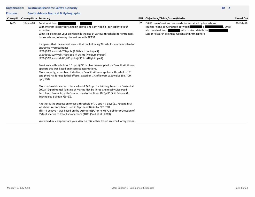
Position: Senior Advisor Nautical & Hydrographic
Organisation: Australian Maritime Safety Authority ID 2
Corresp Date Closed OutF/U Objections/Claims/Issues/MeritsCorespID Summary
19-Jan-18 Email sent from to : With interest I read your Linkedin profile and I am hoping I can tap into your expertise.What I’d like to get your opinion in is the use of various thresholds for entrained hydrocarbons, following discussions with APASA.
It appears that the current view is that the following Thresholds are defensible for entrained hydrocarbons:LC50 (99% survival) 700 ppb @ 96 hrs (Low impact)LC50 (95% survival) 7,050 ppb @ 96 hrs (Medium impact)LC50 (50% survival) 80,400 ppb @ 96 hrs (High impact)
Previously, a threshold of 10 ppb @ 96 hrs has been applied for Bass Strait; it now appears this was based on incorrect assumptions.More recently, a number of studies in Bass Strait have applied a threshold of 7 ppb @ 96 hrs for sub-lethal effects, based on 1% of lowest LC50 value (i.e. 700 ppb/100).
More defensible seems to be a value of 240 ppb for tainting, based on Davis et al 2002 (“Experimental Tainting of Marine Fish by Three Chemically Dispersed Petroleum Products, with Comparisons to the Braer Oil Spill”; Spill Science & Technology Bulletin 7(5–6)).
Another is the suggestion to use a threshold of 70 ppb x 7 days (11,760ppb.hrs), which has recently been used in Gippsland Basin by DEDJTER.This – I believe – was based on the OSPAR PNEC for PFW: 70 ppb for protection of 95% of species to total hydrocarbons (THC) (Smit et al., 2009).
We would much appreciate your view on this, either by return email, or by phone.
1465 ISSUE: use of various thresholds for entrained hydrocarbonsMERIT: Phone conversation between & . Email also received from with contact details for , Senior Research Scientist, Oceans and Atmosphere
20-Feb-18
Monday, 23 July 2018 Page 3 of 242018 Baldfish EP Summary of Responses
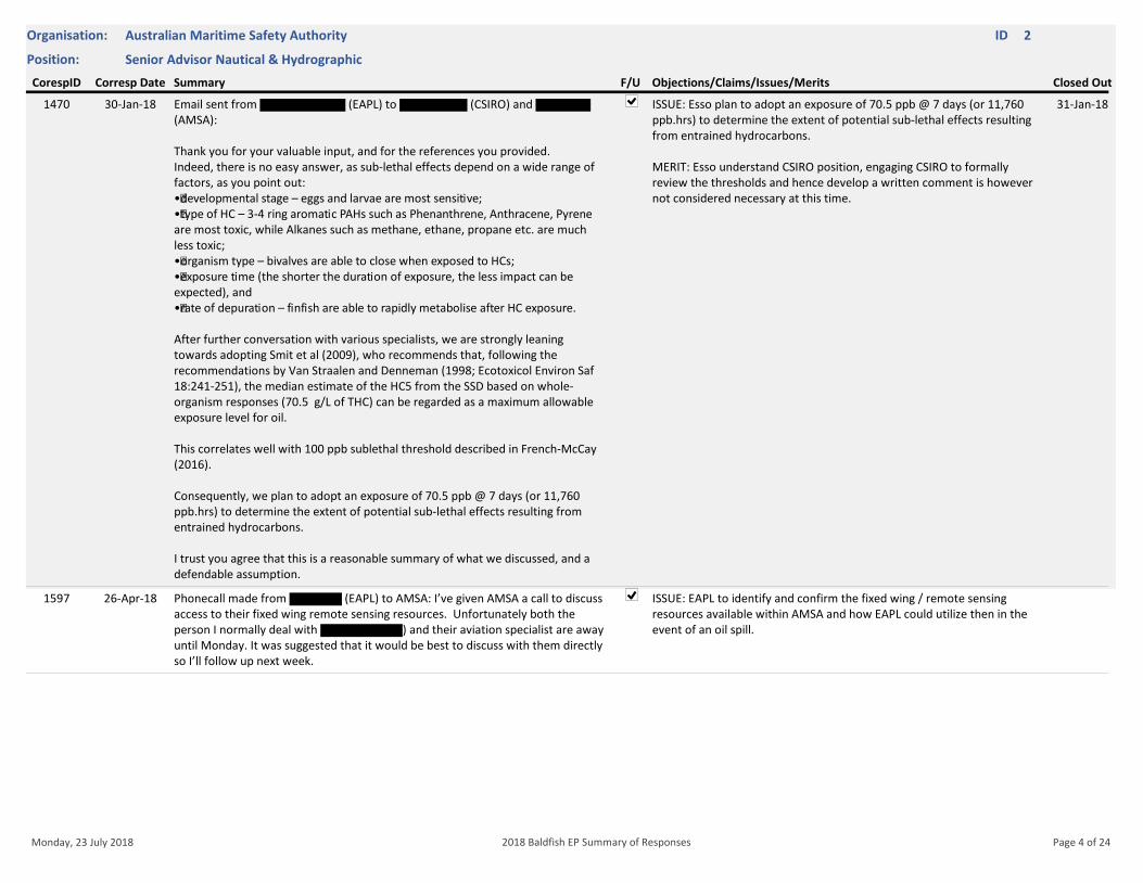
Position: Senior Advisor Nautical & Hydrographic
Organisation: Australian Maritime Safety Authority ID 2
Corresp Date Closed OutF/U Objections/Claims/Issues/MeritsCorespID Summary
30-Jan-18 Email sent from (EAPL) to (CSIRO) and (AMSA):
Thank you for your valuable input, and for the references you provided. Indeed, there is no easy answer, as sub-lethal effects depend on a wide range of factors, as you point out:•developmental stage – eggs and larvae are most sensitive; •type of HC – 3-4 ring aromatic PAHs such as Phenanthrene, Anthracene, Pyrene are most toxic, while Alkanes such as methane, ethane, propane etc. are much less toxic; •organism type – bivalves are able to close when exposed to HCs;•exposure time (the shorter the duration of exposure, the less impact can be expected), and •rate of depuration – finfish are able to rapidly metabolise after HC exposure.
After further conversation with various specialists, we are strongly leaning towards adopting Smit et al (2009), who recommends that, following the recommendations by Van Straalen and Denneman (1998; Ecotoxicol Environ Saf 18:241-251), the median estimate of the HC5 from the SSD based on whole-organism responses (70.5 g/L of THC) can be regarded as a maximum allowable exposure level for oil.
This correlates well with 100 ppb sublethal threshold described in French-McCay (2016).
Consequently, we plan to adopt an exposure of 70.5 ppb @ 7 days (or 11,760 ppb.hrs) to determine the extent of potential sub-lethal effects resulting from entrained hydrocarbons.
I trust you agree that this is a reasonable summary of what we discussed, and a defendable assumption.
1470 ISSUE: Esso plan to adopt an exposure of 70.5 ppb @ 7 days (or 11,760 ppb.hrs) to determine the extent of potential sub-lethal effects resulting from entrained hydrocarbons.
MERIT: Esso understand CSIRO position, engaging CSIRO to formally review the thresholds and hence develop a written comment is however not considered necessary at this time.
31-Jan-18
26-Apr-18 Phonecall made from (EAPL) to AMSA: I’ve given AMSA a call to discuss access to their fixed wing remote sensing resources. Unfortunately both the person I normally deal with ) and their aviation specialist are away until Monday. It was suggested that it would be best to discuss with them directly so I’ll follow up next week.
1597 ISSUE: EAPL to identify and confirm the fixed wing / remote sensing resources available within AMSA and how EAPL could utilize then in the event of an oil spill.
Monday, 23 July 2018 Page 4 of 242018 Baldfish EP Summary of Responses
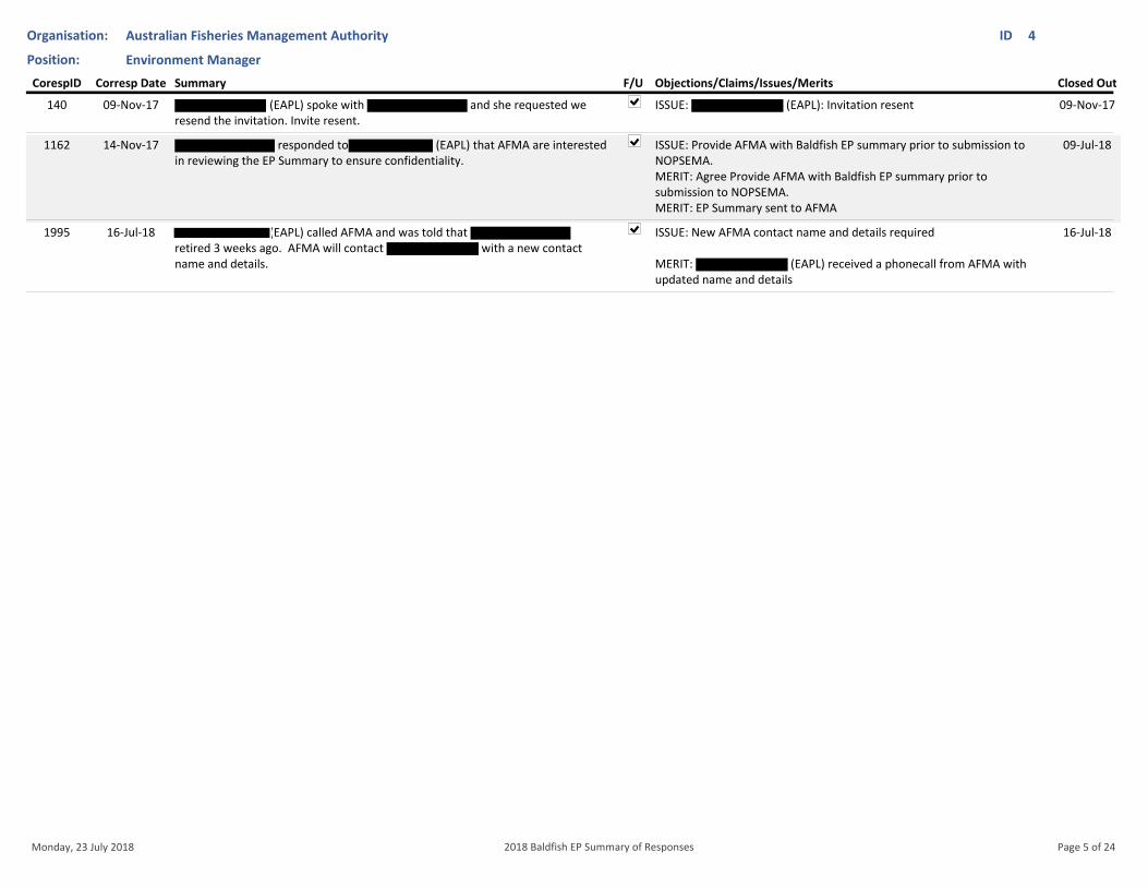
Position: Environment Manager
Organisation: Australian Fisheries Management Authority ID 4
Corresp Date Closed OutF/U Objections/Claims/Issues/MeritsCorespID Summary
09-Nov-17 (EAPL) spoke with and she requested we resend the invitation. Invite resent.
140 ISSUE: (EAPL): Invitation resent 09-Nov-17
14-Nov-17 responded to (EAPL) that AFMA are interested in reviewing the EP Summary to ensure confidentiality.
1162 ISSUE: Provide AFMA with Baldfish EP summary prior to submission to NOPSEMA.MERIT: Agree Provide AFMA with Baldfish EP summary prior to submission to NOPSEMA.MERIT: EP Summary sent to AFMA
09-Jul-18
16-Jul-18 (EAPL) called AFMA and was told that retired 3 weeks ago. AFMA will contact with a new contact name and details.
1995 ISSUE: New AFMA contact name and details required
MERIT: (EAPL) received a phonecall from AFMA with updated name and details
16-Jul-18
Monday, 23 July 2018 Page 5 of 242018 Baldfish EP Summary of Responses
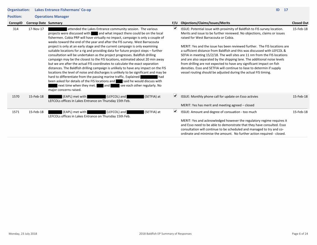
Position: Operations Manager
Organisation: Lakes Entrance Fishermans' Co-op ID 17
Corresp Date Closed OutF/U Objections/Claims/Issues/MeritsCorespID Summary
17-Nov-17 attended the Lakes Entrance community session. The various projects were discussed with and what impact there could be on the local fishermen. Cobia PRP will have virtually no impact, campaign is only a couple of weeks toward the end of the year and after the FIS survey. West Barracouta project is only at an early stage and the current campaign is only examining suitable locations for a rig and providing data for future project steps – further consultation will be undertaken as the project progresses. Baldfish drilling campaign may be the closest to the FIS locations, estimated about 20 min away but we are after the actual FIS coordinates to calculate the exact separation distances. The Baldfish drilling campaign is unlikely to have any impact on the FIS locations the level of noise and discharges is unlikely to be significant and may be hard to differentiate from the passing marine traffic. Explained had been asked for details of the FIS locations and said he would discuss with
next time when they met. and see each other regularly. No major concerns raised.
314 ISSUE: Potential issue with proximity of Baldfish to FIS survey location. Merits and issue to be further reviewed. No objections, claims or issues raised for West Barracouta or Cobia.
MERIT: Yes and the issue has been reviewed further. The FIS locations are a sufficient distance from Baldfish and this was discussed with LEFCOL & SEFIA in meeting 15/2/18. The well sites are 11 nm from the FIS locations and are also separated by the shipping lane. The additional noise levels from drilling are not expected to have any significant impact on fish densities. Esso and SETFIA will continue to liase to determin if supply vessel routing should be adjusted during the actual FIS timing.
15-Feb-18
15-Feb-18 (EAPL) met with (LEFCOL) and (SETFIA) at LEFCOLs offices in Lakes Entrance on Thursday 15th Feb.
1570 ISSUE: Monthly phone call for update on Esso activies
MERIT: Yes has merit and meeting agreed – closed
15-Feb-18
15-Feb-18 (EAPL) met with (LEFCOL) and (SETFIA) at LEFCOLs offices in Lakes Entrance on Thursday 15th Feb.
1571 ISSUE: Amount and degree of consuation - too much
MERIT: Yes and acknowledged however the regulatory regime requires it and Esso need to be able to demonstrate that they have consulted. Esso consultation will continue to be scheduled and managed to try and co-ordinate and minimise the amount. No further action required - closed.
15-Feb-18
Monday, 23 July 2018 Page 6 of 242018 Baldfish EP Summary of Responses
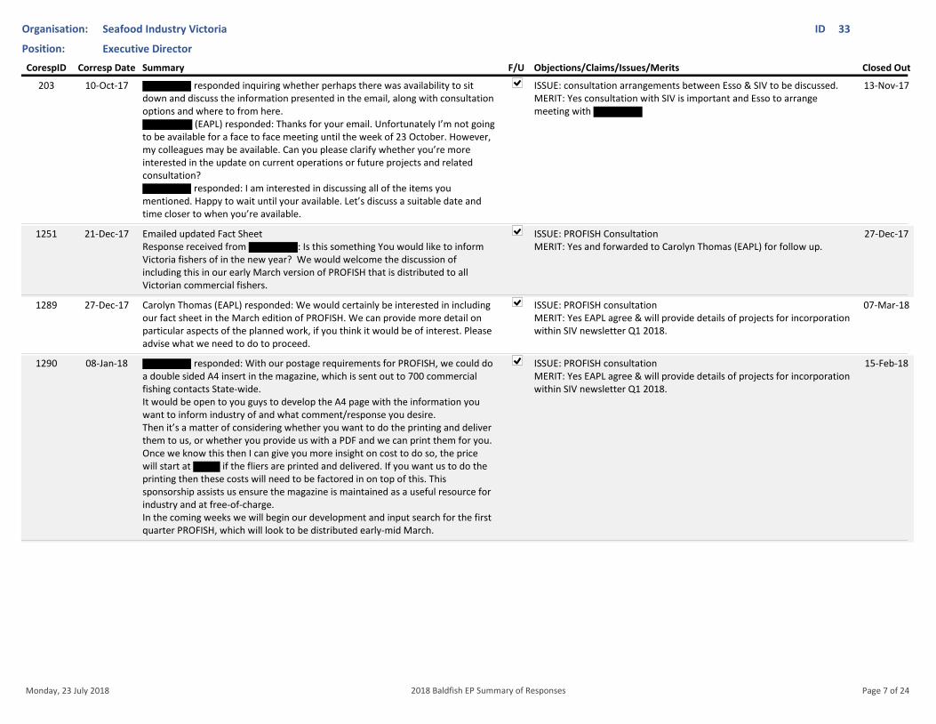
Position: Executive Director
Organisation: Seafood Industry Victoria ID 33
Corresp Date Closed OutF/U Objections/Claims/Issues/MeritsCorespID Summary
10-Oct-17 responded inquiring whether perhaps there was availability to sit down and discuss the information presented in the email, along with consultation options and where to from here.
(EAPL) responded: Thanks for your email. Unfortunately I’m not going to be available for a face to face meeting until the week of 23 October. However, my colleagues may be available. Can you please clarify whether you’re more interested in the update on current operations or future projects and related consultation?
responded: I am interested in discussing all of the items you mentioned. Happy to wait until your available. Let’s discuss a suitable date and time closer to when you’re available.
203 ISSUE: consultation arrangements between Esso & SIV to be discussed.MERIT: Yes consultation with SIV is important and Esso to arrange meeting with
13-Nov-17
21-Dec-17 Emailed updated Fact SheetResponse received from : Is this something You would like to inform Victoria fishers of in the new year? We would welcome the discussion of including this in our early March version of PROFISH that is distributed to all Victorian commercial fishers.
1251 ISSUE: PROFISH ConsultationMERIT: Yes and forwarded to Carolyn Thomas (EAPL) for follow up.
27-Dec-17
27-Dec-17 Carolyn Thomas (EAPL) responded: We would certainly be interested in including our fact sheet in the March edition of PROFISH. We can provide more detail on particular aspects of the planned work, if you think it would be of interest. Please advise what we need to do to proceed.
1289 ISSUE: PROFISH consultationMERIT: Yes EAPL agree & will provide details of projects for incorporation within SIV newsletter Q1 2018.
07-Mar-18
08-Jan-18 responded: With our postage requirements for PROFISH, we could do a double sided A4 insert in the magazine, which is sent out to 700 commercial fishing contacts State-wide. It would be open to you guys to develop the A4 page with the information you want to inform industry of and what comment/response you desire.Then it’s a matter of considering whether you want to do the printing and deliver them to us, or whether you provide us with a PDF and we can print them for you.Once we know this then I can give you more insight on cost to do so, the price will start at if the fliers are printed and delivered. If you want us to do the printing then these costs will need to be factored in on top of this. This sponsorship assists us ensure the magazine is maintained as a useful resource for industry and at free-of-charge. In the coming weeks we will begin our development and input search for the first quarter PROFISH, which will look to be distributed early-mid March.
1290 ISSUE: PROFISH consultationMERIT: Yes EAPL agree & will provide details of projects for incorporation within SIV newsletter Q1 2018.
15-Feb-18
Monday, 23 July 2018 Page 7 of 242018 Baldfish EP Summary of Responses
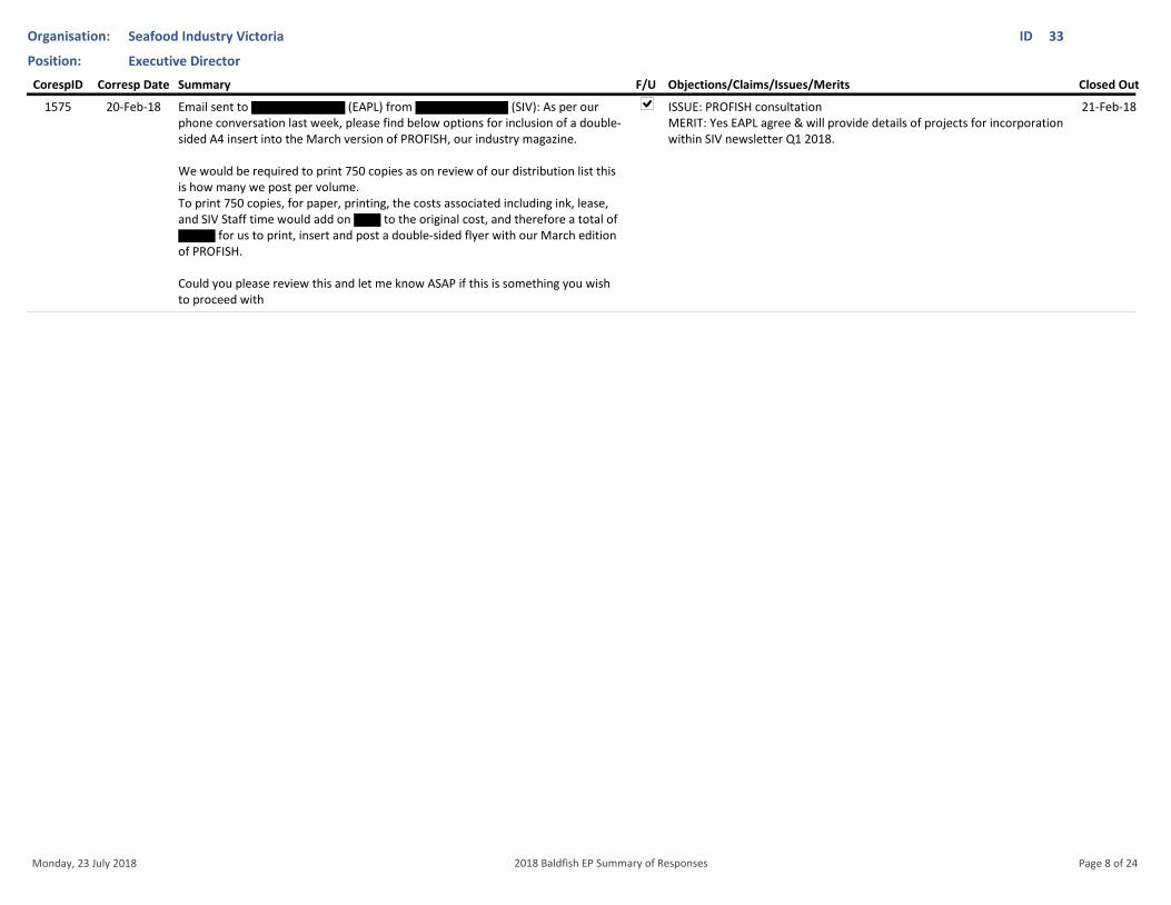
Position: Executive Director
Organisation: Seafood Industry Victoria ID 33
Corresp Date Closed OutF/U Objections/Claims/Issues/MeritsCorespID Summary
20-Feb-18 Email sent to (EAPL) from (SIV): As per our phone conversation last week, please find below options for inclusion of a double-sided A4 insert into the March version of PROFISH, our industry magazine.
We would be required to print 750 copies as on review of our distribution list this is how many we post per volume. To print 750 copies, for paper, printing, the costs associated including ink, lease, and SIV Staff time would add on to the original cost, and therefore a total of
for us to print, insert and post a double-sided flyer with our March edition of PROFISH.
Could you please review this and let me know ASAP if this is something you wish to proceed with
1575 ISSUE: PROFISH consultationMERIT: Yes EAPL agree & will provide details of projects for incorporation within SIV newsletter Q1 2018.
21-Feb-18
Monday, 23 July 2018 Page 8 of 242018 Baldfish EP Summary of Responses
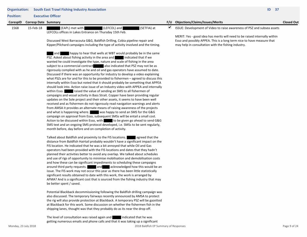
Position: Executive Officer
Organisation: South East Trawl Fishing Industry Association ID 37
Corresp Date Closed OutF/U Objections/Claims/Issues/MeritsCorespID Summary
15-Feb-18 (EAPL) met with (LEFCOL) and (SETFIA) at LEFCOLs offices in Lakes Entrance on Thursday 15th Feb.
Discussed West Barracouta G&G, Baldfish Drilling, Cobia pipeline repair and Kipper/Pilchard campaigns including the type of activity involved and the timing.
and happy to hear that wells at WBT would probably be in the same PSZ. Asked about fishing activity in the area and indicated that if we wanted he could investigate the type, nature and scale of fishing in the area subject to a commercial contract also indicated that PSZ may not be as rigorously complied with as he and oil and gas operators have assumed to date. Discussed if there was an opportunity for industry to develop a video explaining what PSZs are for and for this to be provided to fishermen – agreed to discuss this internally within Esso but noted that it should probably be something that APPEA should look into. Action raise issue of an Industry video with APPEA and internally within Esso. raised the value of sending an SMS to all fishermen of campaigns and vessel activity in Bass Strait. Copper have been providing regular updates on the Sole project and their other assets, it seems to have been well received and as fishermen do not rigorously read navigation warnings and alerts from AMSA it provides an alternate means of raising awareness of the projects and what is happening where. was happy to send an SMS for the G&G campaign on approval from Esso, subsequent SMSs will be entail a small cost. Action to be discussed within Esso, with to be given go ahead to send G&G SMS text and an ongoing SMS protocol developed, i.e. SMSs to be sent regularly, month before, day before and on completion of activity.
Talked about Baldfish and proximity to the FIS locations. agreed that the distance from Baldfish Hairtail probably wouldn’t have a significant impact on the FIS location. He indicated that he was a bit annoyed that while Oil and Gas operators had been provided with the FIS locations and dates that they hadn’t planned their activities better to avoid any overlap. We talked about schedules and use of rigs of opportunity to minimise mobilisation and demobilisation costs and how these can be significant impediments to scheduling these campaigns around third party requests. and acknowledged how this would be an issue. The FIS work may not occur this year as there has been little statistically significant results obtained to date with this work, the work is arranged by AFMA? And is a significant cost that is sourced from the fishing industry that may be better spent / saved.
Potential Blackback decommissioning following the Baldfish drilling campaign was also discussed. The temporary fairways recently announced by AMSA to protect the rig will also provide protection at Blackback. A temporary PSZ will be gazetted at Blackback for this work. Some discussion on whether the fishermen fish in the shipping lanes, thought was that they probably do as its near the drop off.
The level of consultation was raised again and indicated that he was getting numerous emails and phone calls and that it was taking up a significant
1568 ISSUE: Development of Video to raise awareness of PSZ and subsea assets
MERIT: Yes - good idea has merits will need to be raised internally within Esso and possibly APPEA. This is a long term nice to have measure that may help in consultation with the fishing industry.
Monday, 23 July 2018 Page 9 of 242018 Baldfish EP Summary of Responses
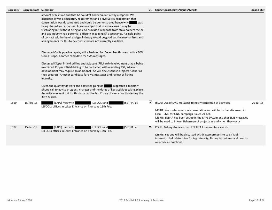
Corresp Date Closed OutF/U Objections/Claims/Issues/MeritsCorespID Summary
amount of his time and that he couldn’t and wouldn’t always respond. We discussed it was a regulatory requirement and a NOPSEMA expectation that consultation was documented and could be demonstrated hence why was being chased for responses. Acknowledged that in some cases it may be frustrating but without being able to provide a response from stakeholders the oil and gas industry had potential difficulty in gaining EP acceptance. A single point of contact within the oil and gas industry would be good but the mechanisms and arrangements for this to be conducted are not currently available.
Discussed Cobia pipeline repair, still scheduled for December this year with a DSV from Europe. Another candidate for SMS messages.
Discussed Kipper infield drilling and adjacent (Pilchard) development that is being examined. Kipper infield drilling to be contained within existing PSZ, adjacent development may require an additional PSZ will discuss these projects further as they progress. Another candidate for SMS messages and review of fishing intensity.
Given the quantity of work and activities going on suggested a monthly phone call to advise progress, changes and the dates of key activities taking place. An invite was sent out for this to occur the last Friday of every month starting the 30th March.
15-Feb-18 (EAPL) met with (LEFCOL) and (SETFIA) at LEFCOLs offices in Lakes Entrance on Thursday 15th Feb.
1569 ISSUE: Use of SMS messages to notify fishermen of activities
MERIT: Yes useful means of consultation and will be further discussed in Esso – SMS for G&G campaign issued 21 FebMERIT: SETFIA has been set up in the EAPL system and that SMS messages will be used to inform fishermen of projects as and when they occur
20-Jul-18
15-Feb-18 (EAPL) met with (LEFCOL) and (SETFIA) at LEFCOLs offices in Lakes Entrance on Thursday 15th Feb.
1572 ISSUE: Fishing studies – use of SETFIA for consultancy work
MERIT: Yes and will be discussed within Esso projects to see if it of interest to help determine fishing intensity, fishing techniques and how to minimise interactions.
Monday, 23 July 2018 Page 10 of 242018 Baldfish EP Summary of Responses
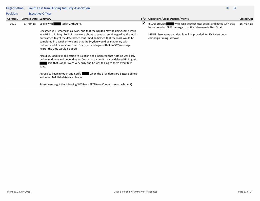
Position: Executive Officer
Organisation: South East Trawl Fishing Industry Association ID 37
Corresp Date Closed OutF/U Objections/Claims/Issues/MeritsCorespID Summary
27-Apr-18 Spoke with today 27th April.
Discussed WBT geotechnical work and that the Dryden may be doing some work at WBT in mid May. Told him we were about to send an email regarding the work but wanted to get the date better confirmed. Indicated that the work would be completed in a week or two and that the Dryden would be stationary with reduced mobility for some time. Discussed and agreed that an SMS message nearer the time would be good.
Also discussed rig mobilization to Baldfish and I indicated that nothing was likely before mid June and depending on Cooper activities it may be delayed till August.
said that Cooper were very busy and he was talking to them every few days.
Agreed to keep in touch and notify when the BTW dates are better defined and when Baldfish dates are clearer. Subsequently got the following SMS from SETFIA on Cooper (see attachment)
1601 ISSUE: provide with WBT geotechnical details and dates such that he can send an SMS message to notify fishermen in Bass Strait
MERIT: Esso agree and details will be provided for SMS alert once campaign timing is known.
16-May-18
Monday, 23 July 2018 Page 11 of 242018 Baldfish EP Summary of Responses
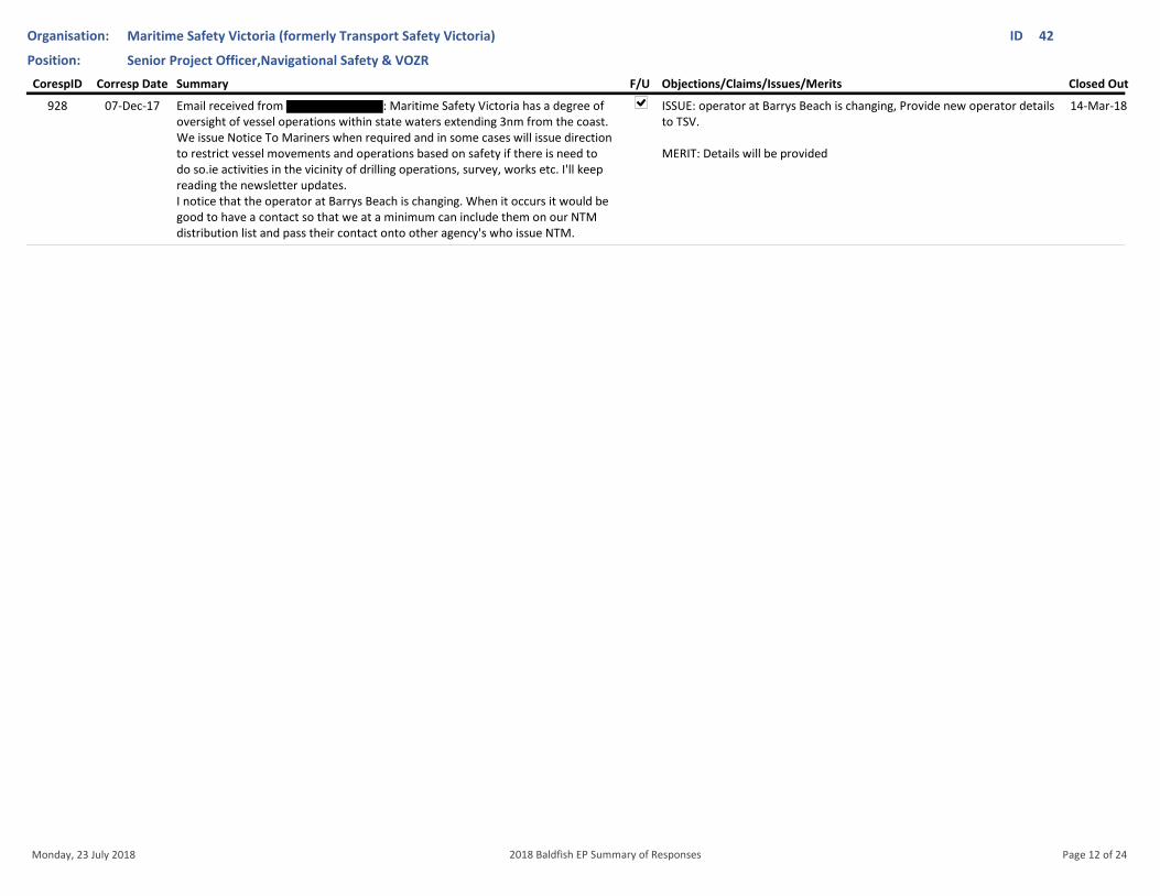
Position: Senior Project Officer,Navigational Safety & VOZR
Organisation: Maritime Safety Victoria (formerly Transport Safety Victoria) ID 42
Corresp Date Closed OutF/U Objections/Claims/Issues/MeritsCorespID Summary
07-Dec-17 Email received from : Maritime Safety Victoria has a degree of oversight of vessel operations within state waters extending 3nm from the coast. We issue Notice To Mariners when required and in some cases will issue direction to restrict vessel movements and operations based on safety if there is need to do so.ie activities in the vicinity of drilling operations, survey, works etc. I'll keep reading the newsletter updates. I notice that the operator at Barrys Beach is changing. When it occurs it would be good to have a contact so that we at a minimum can include them on our NTM distribution list and pass their contact onto other agency's who issue NTM.
928 ISSUE: operator at Barrys Beach is changing, Provide new operator details to TSV.
MERIT: Details will be provided
14-Mar-18
Monday, 23 July 2018 Page 12 of 242018 Baldfish EP Summary of Responses
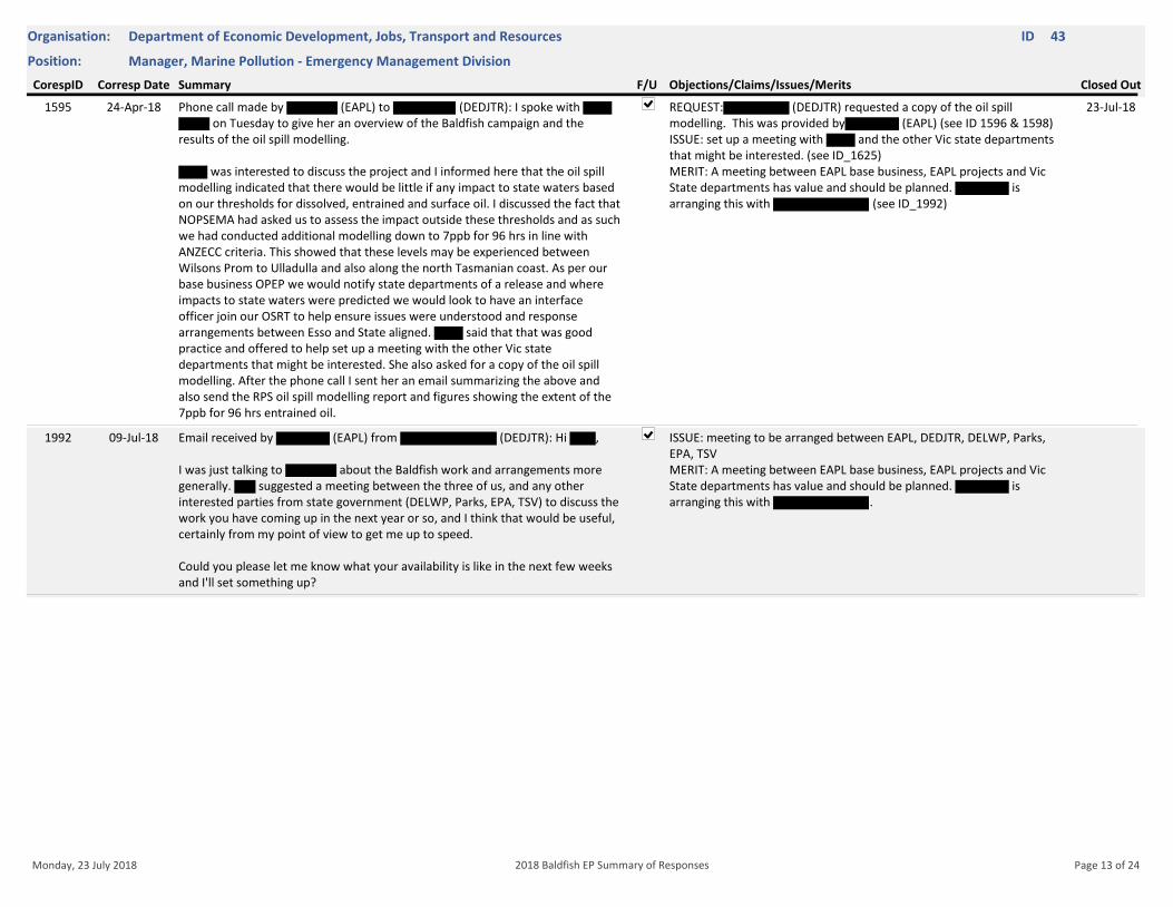
Position: Manager, Marine Pollution - Emergency Management Division
Organisation: Department of Economic Development, Jobs, Transport and Resources ID 43
Corresp Date Closed OutF/U Objections/Claims/Issues/MeritsCorespID Summary
24-Apr-18 Phone call made by (EAPL) to (DEDJTR): I spoke with on Tuesday to give her an overview of the Baldfish campaign and the
results of the oil spill modelling.
was interested to discuss the project and I informed here that the oil spill modelling indicated that there would be little if any impact to state waters based on our thresholds for dissolved, entrained and surface oil. I discussed the fact that NOPSEMA had asked us to assess the impact outside these thresholds and as such we had conducted additional modelling down to 7ppb for 96 hrs in line with ANZECC criteria. This showed that these levels may be experienced between Wilsons Prom to Ulladulla and also along the north Tasmanian coast. As per our base business OPEP we would notify state departments of a release and where impacts to state waters were predicted we would look to have an interface officer join our OSRT to help ensure issues were understood and response arrangements between Esso and State aligned. said that that was good practice and offered to help set up a meeting with the other Vic state departments that might be interested. She also asked for a copy of the oil spill modelling. After the phone call I sent her an email summarizing the above and also send the RPS oil spill modelling report and figures showing the extent of the 7ppb for 96 hrs entrained oil.
1595 REQUEST: (DEDJTR) requested a copy of the oil spill modelling. This was provided by (EAPL) (see ID 1596 & 1598)ISSUE: set up a meeting with and the other Vic state departments that might be interested. (see ID_1625)MERIT: A meeting between EAPL base business, EAPL projects and Vic State departments has value and should be planned. is arranging this with (see ID_1992)
23-Jul-18
09-Jul-18 Email received by (EAPL) from (DEDJTR): Hi ,
I was just talking to about the Baldfish work and arrangements more generally. suggested a meeting between the three of us, and any other interested parties from state government (DELWP, Parks, EPA, TSV) to discuss the work you have coming up in the next year or so, and I think that would be useful, certainly from my point of view to get me up to speed.
Could you please let me know what your availability is like in the next few weeks and I'll set something up?
1992 ISSUE: meeting to be arranged between EAPL, DEDJTR, DELWP, Parks, EPA, TSVMERIT: A meeting between EAPL base business, EAPL projects and Vic State departments has value and should be planned. is arranging this with .
Monday, 23 July 2018 Page 13 of 242018 Baldfish EP Summary of Responses
Position: Director Management, Policy, Science and Licensing
Organisation: Department of Economic Development, Jobs, Transport and Resources ID 44
Corresp Date Closed OutF/U Objections/Claims/Issues/MeritsCorespID Summary
21-Dec-17 Emailed updated Fact SheetBOUNCED
1199 ISSUE: Fact sheet resent to update email 10-Jan-18
10-Jan-18 Response received: I am on leave until mid- December 2018. Please contact 1294 ISSUE: Fact sheet resent to updated contact: 10-Jan-18
Monday, 23 July 2018 Page 14 of 242018 Baldfish EP Summary of Responses
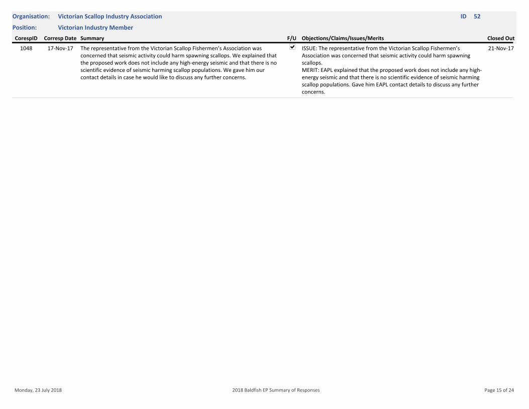
Position: Victorian Industry Member
Organisation: Victorian Scallop Industry Association ID 52
Corresp Date Closed OutF/U Objections/Claims/Issues/MeritsCorespID Summary
17-Nov-17 The representative from the Victorian Scallop Fishermen’s Association was concerned that seismic activity could harm spawning scallops. We explained that the proposed work does not include any high-energy seismic and that there is no scientific evidence of seismic harming scallop populations. We gave him our contact details in case he would like to discuss any further concerns.
1048 ISSUE: The representative from the Victorian Scallop Fishermen’s Association was concerned that seismic activity could harm spawning scallops.MERIT: EAPL explained that the proposed work does not include any high-energy seismic and that there is no scientific evidence of seismic harming scallop populations. Gave him EAPL contact details to discuss any further concerns.
21-Nov-17
Monday, 23 July 2018 Page 15 of 242018 Baldfish EP Summary of Responses

Position: Senior Manager Marine Pollution Response
Organisation: Roads and Maritime Services ID 62
Corresp Date Closed OutF/U Objections/Claims/Issues/MeritsCorespID Summary
26-Apr-18 Phone call between (EAPL) and (RAMS): he is still the correct person to talk to and consult with. He is currently out of the office and will be back on the 30th April. He has received the email and will be in Melbourne in the next couple of weeks. Plan will be to catch up then and discuss Esso operations in general and Baldfish drilling campaign in further detail.
1599 ISSUE: Schedule meeting with (RAMS)MERIT: A meeting between EAPL base business, EAPL projects and
has value and should be planned the next time that is in Melbourne.
Monday, 23 July 2018 Page 16 of 242018 Baldfish EP Summary of Responses
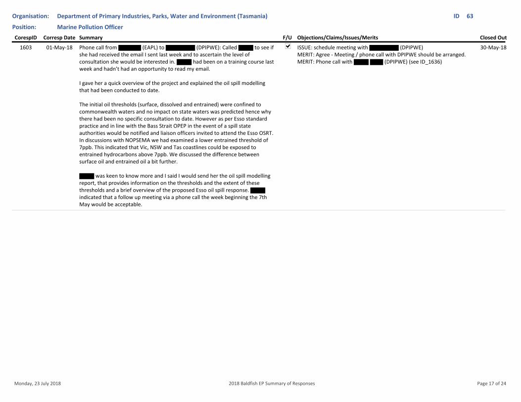
Position: Marine Pollution Officer
Organisation: Department of Primary Industries, Parks, Water and Environment (Tasmania) ID 63
Corresp Date Closed OutF/U Objections/Claims/Issues/MeritsCorespID Summary
01-May-18 Phone call from (EAPL) to (DPIPWE): Called to see if she had received the email I sent last week and to ascertain the level of consultation she would be interested in. had been on a training course last week and hadn’t had an opportunity to read my email.
I gave her a quick overview of the project and explained the oil spill modelling that had been conducted to date.
The initial oil thresholds (surface, dissolved and entrained) were confined to commonwealth waters and no impact on state waters was predicted hence why there had been no specific consultation to date. However as per Esso standard practice and in line with the Bass Strait OPEP in the event of a spill state authorities would be notified and liaison officers invited to attend the Esso OSRT. In discussions with NOPSEMA we had examined a lower entrained threshold of 7ppb. This indicated that Vic, NSW and Tas coastlines could be exposed to entrained hydrocarbons above 7ppb. We discussed the difference between surface oil and entrained oil a bit further.
was keen to know more and I said I would send her the oil spill modelling report, that provides information on the thresholds and the extent of these thresholds and a brief overview of the proposed Esso oil spill response. indicated that a follow up meeting via a phone call the week beginning the 7th May would be acceptable.
1603 ISSUE: schedule meeting with (DPIPWE)MERIT: Agree - Meeting / phone call with DPIPWE should be arranged.MERIT: Phone call with (DPIPWE) (see ID_1636)
30-May-18
Monday, 23 July 2018 Page 17 of 242018 Baldfish EP Summary of Responses
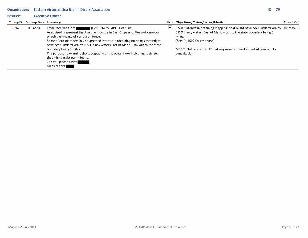
Position: Executive Officer
Organisation: Eastern Victorian Sea Urchin Divers Association ID 79
Corresp Date Closed OutF/U Objections/Claims/Issues/MeritsCorespID Summary
09-Apr-18 Email received from (EVSUDA) to EAPL: Dear Sirs, As advised I represent the Abalone Industry in East Gippsland. We welcome our ongoing exchange of correspondence.Some of our members have expressed interest in obtaining mappings that might have been undertaken by ESSO in any waters East of Marlo – say out to the state boundary being 3 miles.The purpose to examine the topography of the ocean floor indicating reefs etc that might assist our industry.Can you please assist Many thanks
1594 ISSUE: interest in obtaining mappings that might have been undertaken by ESSO in any waters East of Marlo – out to the state boundary being 3 miles.(See ID_1602 for response)
MERIT: Not relevant to EP but response required as part of community consultation
01-May-18
Monday, 23 July 2018 Page 18 of 242018 Baldfish EP Summary of Responses
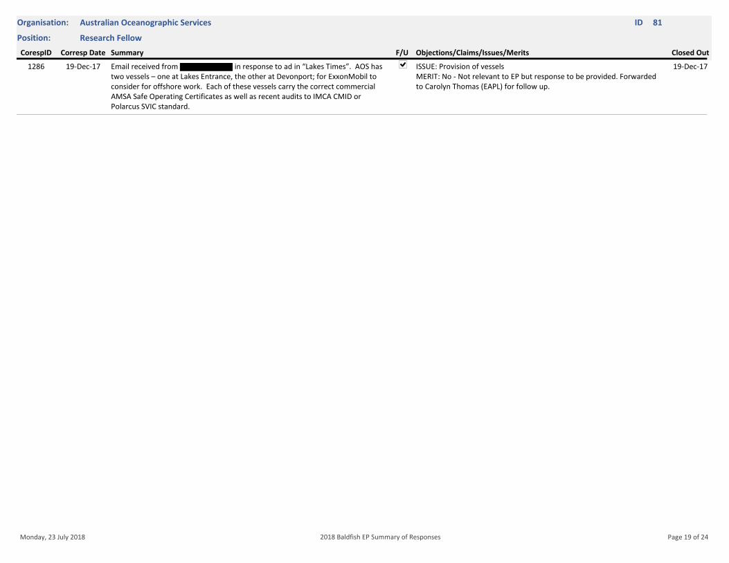
Position: Research Fellow
Organisation: Australian Oceanographic Services ID 81
Corresp Date Closed OutF/U Objections/Claims/Issues/MeritsCorespID Summary
19-Dec-17 Email received from in response to ad in “Lakes Times”. AOS has two vessels – one at Lakes Entrance, the other at Devonport; for ExxonMobil to consider for offshore work. Each of these vessels carry the correct commercial AMSA Safe Operating Certificates as well as recent audits to IMCA CMID or Polarcus SVIC standard.
1286 ISSUE: Provision of vesselsMERIT: No - Not relevant to EP but response to be provided. Forwarded to Carolyn Thomas (EAPL) for follow up.
19-Dec-17
Monday, 23 July 2018 Page 19 of 242018 Baldfish EP Summary of Responses
Position: Deputy Chair
Organisation: East Gippsland Estuarine Fishermen's Association ID 82
Corresp Date Closed OutF/U Objections/Claims/Issues/MeritsCorespID Summary
21-Dec-17 Emailed updated Fact SheetBOUNCED
1208 ISSUE: Resent Fact Sheet to updated email 10-Jan-18
Monday, 23 July 2018 Page 20 of 242018 Baldfish EP Summary of Responses
Position: A/Senior Data Compliance Coordinator - Surveys
Organisation: National Offshore Petroleum Titles Administrator ID 85
Corresp Date Closed OutF/U Objections/Claims/Issues/MeritsCorespID Summary
21-Dec-17 Emailed updated Fact SheetBOUNCED
1231 ISSUE: Resent fact sheet to updated email address: 10-Jan-18
Monday, 23 July 2018 Page 21 of 242018 Baldfish EP Summary of Responses
Position: Acting Senior Sergeant
Organisation: Water Police ID 90
Corresp Date Closed OutF/U Objections/Claims/Issues/MeritsCorespID Summary
17-Nov-17 The water police told us that the swordfish fishing tourist operator numbers in Bass Strait are expanding rapidly. They are looking for support / funding for an awareness campaign regarding our facilities and the 500m safety zones (signage, pamphlets, coastguard personnel). (EAPL) was going to look into whether we have any funding available.
1047 ISSUE: Water Police are looking for support / funding for an awareness campaign regarding our facilities and the 500m safety zones (signage, pamphlets, coastguard personnel).MERIT: EAPL to look into whether any funding available. (EAPL) sent an email to the Paynesville Volunteer Coast Guard as there are funds left over in this year’s budget. She will follow up again but too late now to try get payment in 2017.
11-Dec-17
11-Dec-17 (EAPL) sent an email to the Paynesville Volunteer Coast Guard as there are funds left over in this year’s budget. She will follow up again but too late now to try get payment in 2017.
1140 ISSUE: Follow up on funding with volunteer coastguard in 2018
MERIT: Yes community benefits but not EP related action
27-Apr-18
Monday, 23 July 2018 Page 22 of 242018 Baldfish EP Summary of Responses
Position: Australian Hydrographic Office
Organisation: Department of Defence ID 104
Corresp Date Closed OutF/U Objections/Claims/Issues/MeritsCorespID Summary
05-Oct-17 Temporary Fairways1455 ISSUE: Interference with commercial shipping - Provide further details to AHSAHS supports a Preliminary notice to mariners (6-8 weeks in advance) informing about the upcoming introduction of a two-way routing measure followed up by a Temporary notice while effective The ENCs will have the feature added and removed accordingly. Esso to confirm all the details including starting and ending date, coordinates, purpose of the routeing measure, etc. The AHS POC for this matter is
- Manager of the chart maintenance section).
MERIT: See ID_1473
09-Feb-18
Monday, 23 July 2018 Page 23 of 242018 Baldfish EP Summary of Responses

Position:
Organisation: Australian Hydrographic Service ID 125
Corresp Date Closed OutF/U Objections/Claims/Issues/MeritsCorespID Summary
05-Oct-17 Temporary Fairways1827 ISSUE: Interference with commercial shipping - Provide further details to AHSAHS supports a Preliminary notice to mariners (6-8 weeks in advance) informing about the upcoming introduction of a two-way routing measure followed up by a Temporary notice while effective The ENCs will have the feature added and removed accordingly. Esso to confirm all the details including starting and ending date, coordinates, purpose of the routeing measure, etc. The AHS POC for this matter is
- Manager of the chart maintenance section).
MERIT: See ID_1473
09-Feb-18
Monday, 23 July 2018 Page 24 of 242018 Baldfish EP Summary of Responses