eupalinos surveying software
TRANSCRIPT

DATASHEET SOFTWARE
we turn data into information
1GEODATA Group / Hans-Kudlich-Strasse 28, A-8700 Leoben / Phone: +43-(0)3842-26555-0, Fax: -5 / [email protected] / www.geodata.com
EUPALINOS
Surveying Software
Offers all the computations required for underground cons-truction
Administration of all relevant planning data
User-friendly and clear menu structure
Many data interfaces
Numerous online functions for the control of total stations
Extensive graphics functions
HIGHLIGHTS
Field of Application
The EUPALINOS software package for the first time offers a high-performance tool for the solution of all geodetic tasks in the fields of tunnel construction and geotechnics. This software therefore constitutes a core component of our ITMS (Integrated Tunnel Monitoring System) which, in combination with a variety of hardware components, offers a total solution in the fields of tunnel surveying, monitoring, tunnelling heading control and geotechnics.
EUPALINOS has many functions for management and processing of project, measurement and point data and enables, via fully implemented data flow starting from registered observations, the fast and simple compilation of different analyses such as profile controls, geotechnical displacement diagrams, setting-out data, etc. The analyses, diagrams, protocols and calculations created in this way form the basis for tunnel heading surveys, control measurements and geotechnical interpretation of the rock mass behaviour. ntegration of the wide range of functionalities in the system deserves special recognition. All the EUPALINOS functions are therefore available at all times, which significantly increases the flexibility of various applications.
date: 06/2008
Plan-view plot of a tunnel axis
The 1.036 m long tunnel of Eupalinos on Samos Island excavated in the 6th century BC by two-way construction

2
EUPALINOS
Surveying Software
DATASHEET SOFTWARE we turn data into information
GEODATA Group / Hans-Kudlich-Strasse 28, A-8700 Leoben / Phone: +43-(0)3842-26555-0, Fax: -5 / [email protected] / www.geodata.com
Motor laser systems can therefore be directly utilised for online monitoring, if required. Analyses of profile checks, network extensions or control measurements can be performed directly at the control computer of a TBM guidance system.
Description of services
Management of all necessary planning data, such as axes in the ground plan and vertical projection, standard cross sections, block partitioning plans, profile points, etc.
Strict computation and control of axes, incl. graphic diagrams
Management of trigonometric and levelling measurement data
Management of reference, object and profile control points
Administration of the heading chainages
Analysis of tacheometric and levelling measurements
Analysis of gyro measurements (Gyromat 2000)
Net adjustment of planimetric and vertical control survey nets with extensive options for grid positioning and weighting
Profile checks and cubature calculation
Comprehensive graphical display options for the results of the 3D deformation measurement for geotechnical evaluation
Online monitoring incl. alarm control (optional link to the KRONOS Tunnel Information System)
Online profile control (together with the KRIOS Online Profiler)
Fully automated free stationing for all online functions
Online convergence measurement (for TBM drives)
Fully automatic control of the GYROMAT 2000/Leica TPS gyro system
Motor laser functions for tunnel drive control and pipe umbrella setting-out (see TALOS motor laser system)
Various transformations and additional functions (e.g. for determining the loading of the shotcrete shell in accordance with the flow rate method through 3D displacement measurements)
High performance setting-out functions (e.g. for the Atlas Copco DCS system)
Online control of partial and full face boring machines (see TAUROS machine controls)
Evaluation of profi le measurement
Sketch of a network (portal and tunnel net) with error ellipses
Diagram of roof settlement with certain time differences to the zero-reading

3
EUPALINOS
Surveying Software
DATASHEET SOFTWARE we turn data into information
GEODATA Group / Hans-Kudlich-Strasse 28, A-8700 Leoben / Phone: +43-(0)3842-26555-0, Fax: -5 / [email protected] / www.geodata.com
Program description
General
Project-related data organisation
Arrangement of all functions in clear menus
Implementation of the functions via user-friendly dialogues
Numerous ASCII interfaces for data input and output
Management of all plan data (axes, standard cross sections etc.) and parameters
Testing the plan data (axis elements) for consistency
Visualisation of the plan data (profiles and axes)
Checking of the axes data via integrated alignment calculations
High performance functions for handling of standard cross sections (interpolation, profile offset, etc.)
Preparation of all graphics (displacement diagrams, profile checks, etc) via meta-files (-> placing on site networks or dispatch via e-mail) or in WMF or PDF format
Easy and simple analysis of trigonometric and levelling observations
Automatic allocation of point numbers during analysis to facilitate and speed up surveying work
Analysis and graphical preparation of profile checks, including cubature calculations
Extensive setting-out functions for excavation and inner shell (e.g. conventional laser cut-off, block gap calculation, 3D setting-out of profile related points)
Analysis of geotechnical measurements with respect to time vs cross-section and tunnel advance
Data management
Differentiated management of points in accordance with their purpose
Extensive management functions for reference, object and profile control points
ASCII data interfaces for input and output of large quantities of data
2D and 3D transformations
Transfer of points from and to the total station for direct setting-out
Axis-data (sheer plan, horizontal and ver-tical off-set, superelevation, plan-view, chainage)
Observation overview
4
EUPALINOS
Surveying Software
DATASHEET SOFTWARE we turn data into information
GEODATA Group / Hans-Kudlich-Strasse 28, A-8700 Leoben / Phone: +43-(0)3842-26555-0, Fax: -5 / [email protected] / www.geodata.com
Analysis
Fully automatic analysis of tacheometric measurements and levelling by means of a special coding system
Automatic allocation of point numbers (not necessary to enter the correct point numbers of the reference points)
Differentiated treatment of position and/or fixed elevation points with respect to their accuracy, in the course of the analysis
Determination of the locations through free stationing (1D, 2D or 3D)
Analysis of complex geotechnical measuring arrangements with several instrument positions via strict compensation for position and elevation
Graphical representation of observation configurations (network plots with error ellipses)
Detailed record of the calculations
Fully automated storage of the results in the database through allocation of corresponding measuring codes
Powerful equalisation module for the calculation of position and/or elevation networks with automatic computation of approximation coordinates and error finding algorithms for correction of allocation errors (point number confusions, etc.)
Extensive possibilities for net datum through transformation and “soft positioning” and differentiated weighting approaches
Combination of trigonometric and levelling networks, incorporating gyroscope azimuths and plumbing, for strict net-adjustments of net sections above and below ground (shafts)
Tunnel heading control
Profile recording manually (without reflector or with profiled disk), program controlled via total station or online via an industrialised control computer
Strict orthogonal profile recording for expansion sections
Use of arbitrary reference lines within a profile
Automatic consideration of lay-by sections through profile interpolation
Calculation of over- and under- excavation (cubatures)
Graphical output via meta-plot files or PDF (for e-mail dispatch)
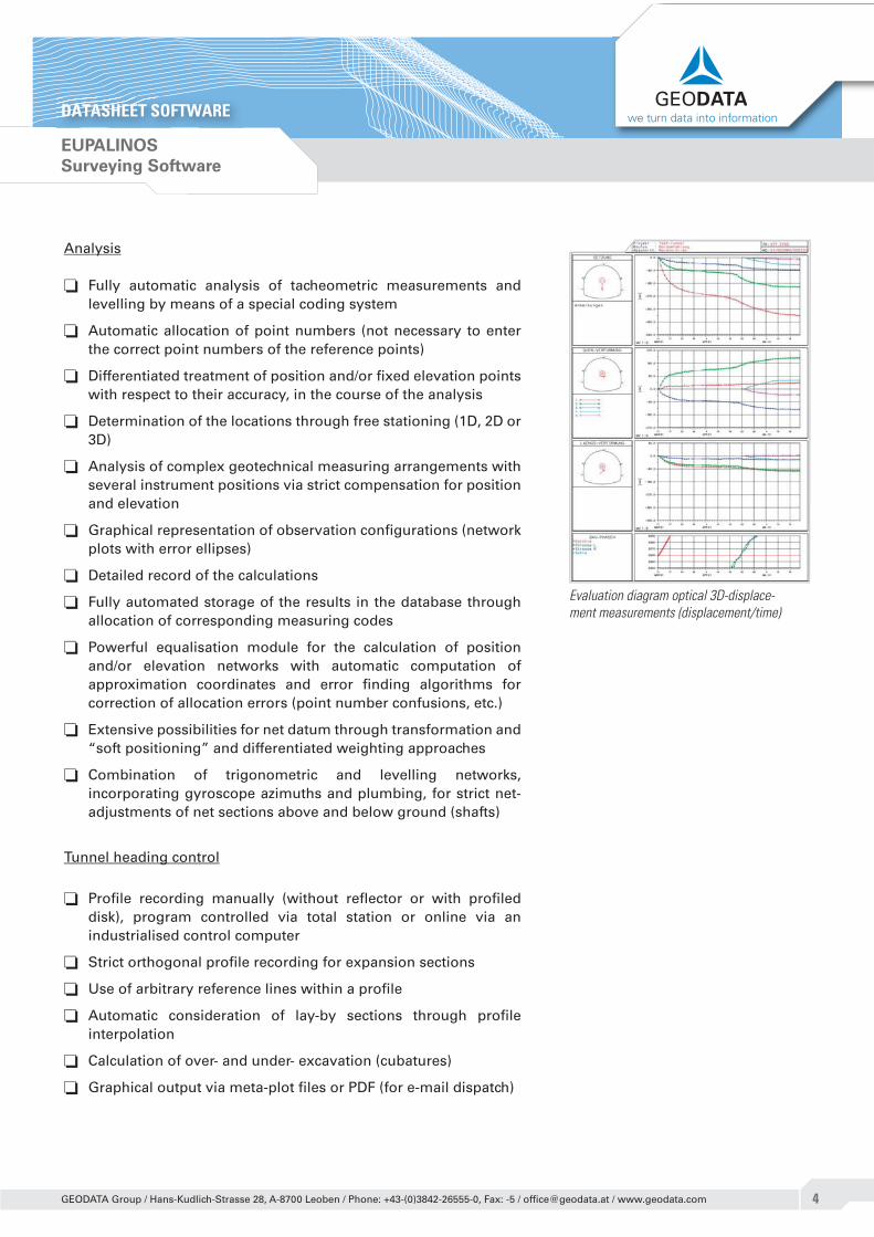
Evaluation diagram optical 3D-displace-ment measurements (displacement/time)

5
EUPALINOS
Surveying Software
DATASHEET SOFTWARE we turn data into information
GEODATA Group / Hans-Kudlich-Strasse 28, A-8700 Leoben / Phone: +43-(0)3842-26555-0, Fax: -5 / [email protected] / www.geodata.com
Geotechnical analyses
The coordinates of the observed object points are stored in the database immediately after the measurement data stream has been transferred and analysed, together with the tunnel heading chainage forming the basis of the geotechnical analysis. All analyses are performed without an intermediate step or data export, directly using the 3D points administered in the Eupalinos database. New analyses and changes in the database therefore have immediate effect in the graphical representation. Points which are queried (outliers) are not deleted, but only flagged and optionally deactivated in the visualisation.
Time-dependent analysis for absolute displacements
Displacement differentials and displacement speeds
Cross-section related analyses
Tunnel advance related analyses with constant measurement interval or time difference with respect to the zero measurement (lines of influence, ratios of individual displacement components)
Analysis with stereographic projection
Numerical and graphical output of the total deformation including deformation speeds
Computation of the shotcrete load in accordance with the flow rate method
Setting-out
Automatic computation of profile-related points, taking into account offsets
Computation of general profile-related points in the project system and transfer to the total station via GSI interface
Setting-out functions for conventional break-out (laser off-sets)
Automatic setting-out of points on the excavation face using the TALOS motor laser system
Automatic (iterative) setting-out of points of intersection (e.g. intersection of 2 tunnel cross sections) with the use of reflector-free total stations
Automatic setting-out of pipe umbrellas
Automatic online setting-out of block gaps, elevations, profiles, drill starting point, etc.
Tunnel vault shutter setting-out based on the block partition plan
Vector-diagram 3D-displacement measurement
Relation between longitudinal and lateral displacement

6
EUPALINOS
Surveying Software
DATASHEET SOFTWARE we turn data into information
GEODATA Group / Hans-Kudlich-Strasse 28, A-8700 Leoben / Phone: +43-(0)3842-26555-0, Fax: -5 / [email protected] / www.geodata.com
The following other data sheets are associated with this data sheet:
Services: Network and Control Surveys Tunnel heading surveys Construction Surveying and Setting Out Optical 3D-Deformation Monitoring Gyroscopic survey using the Gyromat 2000/3000 Settlement Levelling Profi le ChecksSystems: TALOS III Motor Laser System TAUROS TBM Guidance System GeoRobot - Automatic 3D-Deformation Monitoring System KRIOS Online Setting-Out and Profi le Measurement System

7
EUPALINOS
Surveying Software
DATASHEET SOFTWARE we turn data into information
GEODATA Group / Hans-Kudlich-Strasse 28, A-8700 Leoben / Phone: +43-(0)3842-26555-0, Fax: -5 / [email protected] / www.geodata.com
Evaluation examples - Optical 3D-displacement monitoring
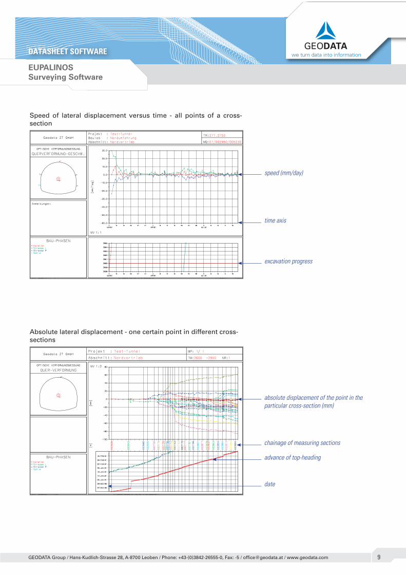
Lateral displacement versus time - all points of a cross section
Diagram of displacement vectors in a cross-section
absolute displacement (mm)
time axis
excavation progress
longitudinal displacement
settlement + lateral displacement
predefi ned target area
measuring date

8
EUPALINOS
Surveying Software
DATASHEET SOFTWARE we turn data into information
GEODATA Group / Hans-Kudlich-Strasse 28, A-8700 Leoben / Phone: +43-(0)3842-26555-0, Fax: -5 / [email protected] / www.geodata.com
Spheric projection of the vector orientation - all points of a cross-section
Convergency between several points in a cross-section versus time
vector orientation
measuring date
Convergency (mm)
time axis
excavation progress
9
EUPALINOS
Surveying Software
DATASHEET SOFTWARE we turn data into information
GEODATA Group / Hans-Kudlich-Strasse 28, A-8700 Leoben / Phone: +43-(0)3842-26555-0, Fax: -5 / [email protected] / www.geodata.com
Absolute lateral displacement - one certain point in different cross-sections
Speed of lateral displacement versus time - all points of a cross-section
speed (mm/day)
time axis
excavation progress
absolute displacement of the point in the particular cross-section (mm)
chainage of measuring sections
date
advance of top-heading

10
EUPALINOS
Surveying Software
DATASHEET SOFTWARE we turn data into information
GEODATA Group / Hans-Kudlich-Strasse 28, A-8700 Leoben / Phone: +43-(0)3842-26555-0, Fax: -5 / [email protected] / www.geodata.com
Settlement of a certain point in different cross sections at a certain date (deflection lines)
Settlement of a certain point in different cross sections at a certain time difference related to the zero-reading
measuring date according to timelegend
settlement at a certain date (mm)
chainage of measuring sections
time legend
settlement of certain time differences related to zero-reading (mm)
chainage of measuring sections
days after zero-reading

11
EUPALINOS
Surveying Software
DATASHEET SOFTWARE we turn data into information
GEODATA Group / Hans-Kudlich-Strasse 28, A-8700 Leoben / Phone: +43-(0)3842-26555-0, Fax: -5 / [email protected] / www.geodata.com
Differences of lateral displacement between two certain points in different cross-sections at a certain date (deflection lines)
Relation between longitudinal and lateral displacement of a certain point in different cross sections at certain time differences retated to the zero-reading
measuring date according to timelegend
chainage of measuring sections
days after zero-reading
displacement differences at a certain date (mm)
date
relation longitudinal / lateral displace-ment
chainage of measuring sections
days after zero-reading
area of vectors (logitudinal / lateral displacement)