european geophysical union, wien, 6 april 2011 institute of oceanography university of hamburg...
TRANSCRIPT

European Geophysical Union, Wien, 6 April 2011Institute of OceanographyUniversity of Hamburg
Werner Alpers Institute of Oceanography, University of Hamburg,
Hamburg, Germany
Andrei IvanovP.P. Shirshov Institute of Oceanology, Russian Academy of Sciences,
Moscow, Russia
Knut-Frode DagestadNansen Environmental and Remote Sensing Center, Bergen, Norway
Investigation of Bora and Foehn winds over the Black Sea using Envisat synthetic
aperture radar images

European Geophysical Union, Wien, 6 April 2011Institute of OceanographyUniversity of Hamburg
The sea area off the east coast of the Black Sea is an area where often pronounced local winds are encountered due to its coastal topography.
The most prominent one is the Novorossiskaya Bora, which is strong wind blowing from the coastal mountains onto the sea, which can attain speeds of up to 40 m/s.
But often also Foehn winds are encountered.

European Geophysical Union, Wien, 6 April 2011Institute of OceanographyUniversity of Hamburg
Novorossiyskaya boras
Foehn winds
Novorossiyskaya boras
European Geophysical Union, Wien, 6 April 2011Institute of OceanographyUniversity of Hamburg
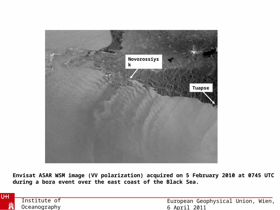
Envisat ASAR WSM image (VV polarization) acquired on 5 February 2010 at 0745 UTC during a bora event over the east coast of the Black Sea.
Novorossiysk
Tuapse

European Geophysical Union, Wien, 6 April 2011Institute of OceanographyUniversity of Hamburg
Envisat 7:45 UTC
0
5
10
15
20
25
30
35
0 24 48 72 96 120 144 168
time (2-8.02.2010), hours
win
d s
pee
d,
m/s
Wind speed measured at the Novorossiysk (dark blue) and Tuapse (violet) weather stations from 00:00 local time (UTC +3 h) on 2 February to 21:00 local time on 8 February 2010 during a bora event. The time of the ASAR data on 5 February at 0745 UTC is marked by the vertical dark line.
Wind speed measured at meteorological stations

European Geophysical Union, Wien, 6 April 2011Institute of OceanographyUniversity of Hamburg
Near-surface wind field retrieved from the ASAR image by using the wind direction from the NCEP model showing wind jets with embedded atmospheric gravity waves.
Atmospheric gravity waves

European Geophysical Union, Wien, 6 April 2011
aStreamlines associated with a nonlinear atmospheric gravity wave (lee wave). In the shadowed region the airflow associated with the wave is opposite to the ambient wind direction (adapted from Doyle, and Durran,2002).
σ
σ0
b Variation of the normalized radar cross section σ caused by this nonlinear atmospheric gravity wave. σ0 is the undisturbed (background) value. On the SAR SAR image the atmospheric gravity wave appears as a broad bright band bordered by two narrow dark bands.
Wave propagation direction
Wind direction
a
Atmospheric gravity waves behind a mountain (lee waves)

European Geophysical Union, Wien, 6 April 2011Institute of OceanographyUniversity of Hamburg
Novorossiysk MODIS Terra color composite image of the east coast of the Black Sea around Novorossiysk acquired on 5 February 2010 at 0805 UTC showing in the cloud pattern a cyclonic eddy (marked by the inserted arrow) and atmospheric gravity waves near Novorossiysk).
TuapseBlack Sea
European Geophysical Union, Wien, 6 April 2011Institute of OceanographyUniversity of Hamburg
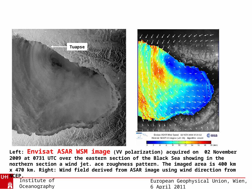
Left: Envisat ASAR WSM image (VV polarization) acquired on 02 November 2009 at 0731 UTC over the eastern section of the Black Sea showing in the northern section a wind jet. ace roughness pattern. The imaged area is 400 km x 470 km. Right: Wind field derived from ASAR image using wind direction from NCEP.
Tuapse

European Geophysical Union, Wien, 6 April 2011Institute of OceanographyUniversity of Hamburg
Novorossiyskaya boras
Foehn winds Foehn winds
Interaction of Foehn wind with an atmospheric eddy over the Black Sea
(submitted to Monthly Weather Review as “Picture of the Month”)

European Geophysical Union, Wien, 6 April 2011Institute of OceanographyUniversity of Hamburg
Section of a SAR image acquired by Envisat in the Wide Swath mode (VV polarization) at 0732 UTC (0932 LST) 13 September 2010 over the eastern section of the Black Sea. The imaged area is 400 km x 480 km. The inset shows the location of the SAR scene. The features denoted by numbers are explained in the text. © ESA
Foehn wind

European Geophysical Union, Wien, 6 April 2011Institute of OceanographyUniversity of Hamburg
MODIS Terra color composite image acquired at 0830 UTC 13 September 2010 showing in the eastern section of the Black Sea a cyclonic eddy in the cloud pattern. The inserted latitude and longitude lines have a grid spacing of 50 x 50 . © NASA GSFC.
Eddy
Black Sea

European Geophysical Union, Wien, 6 April 2011Institute of OceanographyUniversity of Hamburg
Near-surface wind field calculated from the NCEP GFS model for 0900 UTC 13 September 2010.

European Geophysical Union, Wien, 6 April 2011Institute of OceanographyUniversity of Hamburg
Near-surface wind field retrieved from the SAR image by using the wind retrieval algorithm of CLS.

European Geophysical Union, Wien, 6 April 2011Institute of OceanographyUniversity of Hamburg
MODIS Terra color composite image acquired at 0745 UTC 12 September 2010, approximately 24 hours before the SAR data acquisition, showing the eastern section of the Black Sea, the Caucasus area with the Kolkhida Lowland, and the western section of the Caspian Sea. The star denotes the location of the Kutaisi weather station. Note the blocking of the low-level clouds by the Likhi Ridge. © NASA GSFC.
Likhi Ridge
Black Sea
Caspian Sea
KolkhidaLowland
Cloud image

European Geophysical Union, Wien, 6 April 2011Institute of OceanographyUniversity of Hamburg
Wind speed (top) and and relative humidity (bottom) measured at the weather station at Kutaisi, Georgia, from 0000 UTC 11 September to 2100 UTC 15 September 2010. The squares above the wind speed curve denote speeds of wind gusts. The vertical lines mark the time of the Envisat data acquisition at 0732 UTC 13 September (meteodata from «Расписание погоды» http://rp5.ua).
Wind speed, m/s
Envisat 07:31 UTC
0
5
10
15
20
25
30
35
11-Sep 12-Sep 13-Sep 14-Sep 15-Sep
time, UTC
Relative humidity, %
Envisat 07:31 UTC
0
10
20
30
40
50
60
70
80
90
100
11-Sep 12-Sep 13-Sep 14-Sep 15-Sep
time, UTC
Wind speed and humidity measured at a meteorological station

European Geophysical Union, Wien, 6 April 2011Institute of OceanographyUniversity of Hamburg
Zoom of the SAR image on the eastern section of the Black Sea. Visible are two local wind fronts and (faintly) the sea surface signature of an atmospheric gravity wave (AGW) packet.
AGW
Wind front
Wind front
European Geophysical Union, Wien, 6 April 2011Institute of OceanographyUniversity of Hamburg
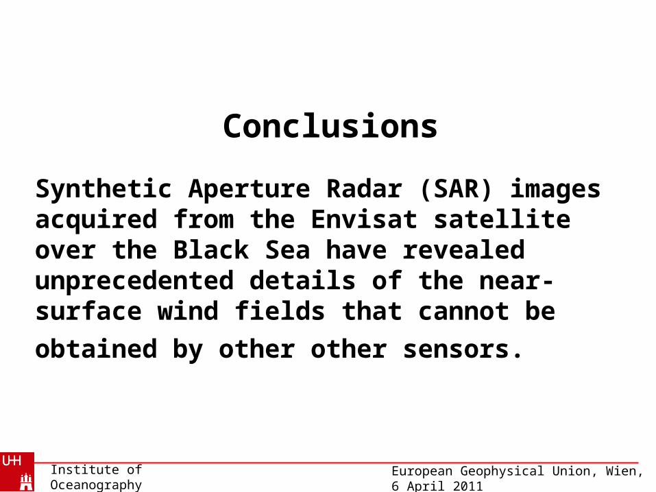
Conclusions
Synthetic Aperture Radar (SAR) images acquired from the Envisat satellite over the Black Sea have revealed unprecedented details of the near-surface wind fields that cannot be obtained by
other other sensors.

European Geophysical Union, Wien, 6 April 2011Institute of OceanographyUniversity of Hamburg
Thank you for your attention