evaluating housing proposals step-by-step - the...
TRANSCRIPT

Evaluating housing proposals stEp by stEpBuilding for Life is the national standard for well-designed homes and neighbourhoods
Contents8
8 intro how to use this guide8
1 2 3

introDuCtion
Building for Life is the national standard for well-designed homes and neighbourhoods. It is led by CABE and the Home Builders Federation and backed by the Housing Corporation, English Partnerships, The Civic Trust and Design for Homes.
this guide was commissioned and funded by the housing Corporation’s innovation and good practice programme to support housing designers and developers in producing well-designed developments and achieving building for life awards.
the building for life standard is made up of 20 criteria that embody the partners’ vision of what housing developments should be: functional, attractive and sustainable. these principles are based on government policy and CabE-backed guidance such as planning policy statement 3 (pps 3) and by design.
accurate, informative and relevant information is required for the stakeholders to develop their understanding of the strengths and weaknesses of a given design proposal and drive their shared vision forward through the development process. the building for life criteria provide a valuable framework to help planners and funding bodies assess the quality of a proposed development.
We have prepared this guide to help you understand what kind of information is relevant to the 20 building for life criteria. We have included examples of the kind of material a design team could prepare as evidence to help an assessor understand how a proposeddesign is going to address the 20 criteria.
those assessing schemes should use their judgement and expertise to evaluate how the proposed design responds to each building for life criterion. they should produce an
evaluation report, itemised by criterion, to explain their assessment. this is why it will help if the design team can set out the principles
of the design approach in diagrams, plans, visuals, models and other material that is simple and easy to understand.
Foundations for good design
to create high-quality places you need a shared vision and partnership approach to development. Working on the principles of good design can help you achieve this. good design is not about subjective tastes. It is about being fit for purpose, durable, well built and pleasing to the eye. a well-designed building combines functionality (does it work?), firmness (will it last?) and delight (does it look good?). For CABE and the Building for Life partners, this principle first adopted by the roman architect vitruvius still applies today. successfully balancing these objectives does not have to add expense to the project, and it is an effort well spent.
FunctionalityDoes it work?
FirmnessWill it last?
DelightDoes it look good?
Contents8
8 intro how to use this guide8
1 2 3

hoW to usE this guiDE
Contents8
8 intro
this guide explains in detail how to help assess and compare the quality of proposed developments using the building for life criteria. it gives examples of the materials a design team should prepare to help an assessor understand the design thinking behind a development. this evidenceis mainly qualitative and visual – drawings, diagramsand visualisations – but it can be supported by some quantitative data.
the guide is made up of two main sections:
• sect ion 1 explains each of the 20 building for life criteria, and points to key types of evidence that will help evaluate the proposed design
• section 2 describes and gives examples of the different types of evidence, and lists the building for life criteria for which they would provide useful information.
Each of the criteria included in the first section is linked to the examples of useful evidence set out in the second half – and vice versa.
rather than working through from the first question to the last, an assessor may need to refer back and forth between the 20 criteria to reach a conclusion. sometimes, one drawing can address several of the building for life questions at the same time. this is why we have provided a number of links to allow the reader to navigate freely between the 20 questions and the related evidence.
a formal assessment might be conducted by a trained local authority officer, or an accredited building for life assessor. More details can be found at www.buildingforlife.org/assessments.
notEs• T his guide is intended
for use on screen. It is not meant to be printed out as you need to view the document on screen to follow the navigation links. you can save this document to your computer as a digital file. However we recommend that you check the building for life website regularly for updated versions.
• The g uide is intended to show how to communicate the key characteristics of the proposed designs as clearly as possible. this is about providing sufficient detail to be helpful while avoiding producing an overwhelming amount of information that is too difficult to digest.
• T he guide presents the kinds of materials that are useful to illustrate a scheme for a Building for Life assessment. the examples have been chosen because they represent a successful method of communicating relevant information,
not because they promote the characteristics of the schemes in question.
Some d rawings can be useful for many criteria. it is possible to communicate the strengths of a chosen design approach with only a few drawings that are very well thought through. however, some criteria are quite complex and may need more than one illustration to help demonstrate how the relevant issues are being addressed.
Pro viding visuals of a certain type doesn’t automatically mean that the scheme has met the criteria, but it does provide the evidence base on which any subsequent discussion can be based.
A ll of the examples chosen could be included in a design and access statement. that document will often be the first place assessors look when undertaking a BFL assessment. Further guidance on design and access statements is available from CabE and is fully consistent with the requirements of building for life.
•
•
•
how to use this guide8
1 2 3

8 Further Reading
33
hoW to usE this guiDE:CritEria pagE
this panel shows examples of evidence relevant to the bfl criteria
this lists all criteria that can be evidenced by the illustration. Click on these to view the related criteria
these buttons link to the other criteria. those framed in a box are relevant to the illustration
this button links to contents page
this button links to the introduction page
this button will take you to a further reading list specific to the criteria
Contents8
8 intro how to use this guide8
1 2 3

Contents8
8 intro
hoW to usE this guiDE:EviDEnCE pagE
this section provides an overview of the criteria
these buttons allow you to view illustrative examples of relevant information
these buttons link to the other criteria
this button links to contents page
this button links to the introduction page
how to use this guide8
1 2 3

ContEnts
1
InTroDuCTIon
1
How To uSE THIS guIDE
EnVIronMEnT AnD CoMMunITY
1
1. Does the development provide (or is it close to) community facilities, such as a school, parks, play areas, shops, pubs or cafés?
1
2. Is there an accommodation mix that reflects the needs and aspirations of the local community?
1
3. Is there a tenure mix that reflects the needs of the local community?
1
4. D oes the development have easy access to public transport?
1
5. Does the development have any features that reduce its environmental impact?
CHArACTEr
1
6. I s the design specific to the scheme?
1
7. Does the scheme exploit existing buildings, landscape or topography?
1
8. Does t he scheme feel like a place with distinctive character?
1
9. Do the buildings and layout make it easy to find your way around?
1
10. Are st reets defined by a well-structured building layout?
STrEETS, PArKIng AnD PEDESTrIAnISATIon
1
11. Does t he building layout take priority over the streets and car parking, so that the highways do not dominate?
1
12. I s the car parking well integrated and situated to it supports the street scene?
1 13. Are t he streets pedestrian, cycle and vehicle friendly?
1
14. Does t he scheme integrate with existing streets, paths and surrounding development?
1
15. Are p ublic spaces and pedestrian routes overlooked and do they feel safe?
DESIgn AnD ConSTruCTIon1
16. I s public space well designed and does it have suitable management arrangements in place?
1
17. Do t he buildings exhibit architectural quality?
1
18. Do i nternal spaces and layout allow for adaptation, conversion or extension?
1
19. H as the scheme made use of advances in construction or technology that enhance its performance, quality and attractiveness?
1
20. Do b uildings or spaces outperform statutory minima, such as building regulations?
1
rECoMMEnDED DrAwIngS AnD InForMATIon
1
ADDITIonAL ASSESSMEnT ForM
1
FurTHEr rEADIng
1
CrEDITSContents8
8 intro how to use this guide8
1 2 3

8 Contents8 intro
1 2 3 4 5
6 7 8 9 10
11 12 13 14 15
16 17 18 19 20
EnvironMEnt anD CoMMunity
CharaCtEr
strEEts, parking anD pEDEstrianisation
DEsign anD ConstruCtion
8 Further Reading
EnVIronMEnT AnD CoMMunITY
1. DoES THE DEVELoPMEnT ProVIDE (or IS IT CLoSE To) CoMMunITY FACILITIES SuCH AS A SCHooL, PArKS, PLAY ArEAS, SHoPS, PuBS or CAFES?
33
relevant visual evidence
layouts (including context)
uses
Creating successful residential areas is about much more than just providing opportunities for homes that respond topeople’s needs.
it is about providing a framework within which communities can grow.
appropriate community facilities and services, such as open spaces, crèches, day-care and health services, local pubs and other places for residents, are important in this framework. large developments or schemes in urban areas should include facilities that help meet the needs of the area. Services benefit from being close together so planning should allow for this in areas with greatest access.
Consulting the local community can help make sure that plans reflect community needs as well as encouraging local people to get involved in making decisions about their neighbourhood. For smaller developments, features that might help unite the community could include play areas, a gym and health facilities. if facilities are not provided within the development, the layout should make sure people have easy access to nearby facilities.
Evidence should show that the proposed design:• provides adequate good quality open
space and play areas• includes, or provides access to
nursery/crèche, primary and secondary schools
• includes, or provides access to appropriate retail provision, e.g. local greengrocers/newsagents
• includes, or provides access to community facilities, e.g. gps practice, post office, place of worship, pub, village hall
This could be provided with evidence around the following themes:uses
And could include the following information:community consultation report

8 Contents8 intro
1 2 3 4 5
6 7 8 9 10
11 12 13 14 15
16 17 18 19 20
EnvironMEnt anD CoMMunity
CharaCtEr
strEEts, parking anD pEDEstrianisation
DEsign anD ConstruCtion
8 Further Reading
EnVIronMEnT AnD CoMMunITY
2. IS THErE An ACCoMMoDATIon MIx THAT rEFLECTS THE nEEDS AnD ASPIrATIonS oF THE LoCAL CoMMunITY?
3
relevant visual evidence
uses
neighbourhoods are more successful when they avoid large concentrations of housing of the same type.
a good mix of housing types and sizes is important in creating a basis for a balanced community. Even comparatively small developments can have a wide mix of types of property. also, a mix of housing types and uses can create more attractive residential environments with greater diversity in building forms and scales.
a mix of accommodation provides opportunities for communities where people can move home without leaving a neighbourhood. a well-designed neighbourhood will provide accommodation that meets the needs of single person households, small and large families as well as offering live-work possibilities. however, the mix needs to be designed and managed carefully. layouts should aim to reduce possible tensions between families, older people and students for example by considering the different activities of these groups and maintaining privacy between them.
Evidence should show that the proposed design:• provides a range of housing so
that people can trade up or down if they have a family or children leave home
• includes appropriate private and/or communal amenity space
• provides an appropriate distribution of different household types
• includes a viable strategy for the management and maintenance of the development
• meets the local housing need
This could be provided with evidence around the following themes:uses
And could include the following information:• table detailing mix of
accommodation by size/bed spaces
• local authority’s housing needs assessment
• analysis of local demographic data• community consultation report

8 Contents8 intro
1 2 3 4 5
6 7 8 9 10
11 12 13 14 15
16 17 18 19 20
EnvironMEnt anD CoMMunity
CharaCtEr
strEEts, parking anD pEDEstrianisation
DEsign anD ConstruCtion
8 Further Reading
EnVIronMEnT AnD CoMMunITY
3. I S THErE A TEnurE MIx THAT rEFLECTS THE nEEDS oF THE LoCAL CoMMunITY?
3
relevant visual evidence
uses
we can create neighbourhoods that cater for various socio-economic groups by having a mix of housing tenure.
this includes providing social and privately rented accommodation, shared ownership properties and houses for outright sale.
a poor mix of housing tenure, if continued across a number of developments can lead to a social imbalance and result in unsustainable communities. a large development should have the full range of tenures. For smaller developments, the tenure provision should support the existing mix of the area or introduce new tenures if necessary. the percentage of affordable housing should be based on an assessment of the area in question. successful development fully integrates the tenure mix avoiding differentiation between individual dwellings and parts of the scheme based on their tenure.
Evidence should show that the proposed design:• accommodates a range of individuals
and families on a variety of incomes• provides equal standards of
accommodation by taking a ‘tenure-blind’ approach
• meets the local housing need
This could be provided with evidence around the following themes:usesbuildings
And could include the following information:• table detailing mix of tenures• management strategy• local authority’s housing
needs assessment• analysis of local demographic data• community consultation report

8 Contents8 intro
1 2 3 4 5
6 7 8 9 10
11 12 13 14 15
16 17 18 19 20
EnvironMEnt anD CoMMunity
CharaCtEr
strEEts, parking anD pEDEstrianisation
DEsign anD ConstruCtion
8 Further Reading
EnVIronMEnT AnD CoMMunITY
4. DoES THE DEVELoPMEnT HAVE EASY ACCESS To PuBLIC TrAnSPorT?
33
3
relevant visual evidence
overall conceptlayouts (including context)
Movement and connections
Proximity to good public transport and facilities (see question 1) is essential in reducing the number of car journeys and making a place moreaccessible to a variety of groups.
the idea of new housing linked to a railway station, tram route or bus service is still a real possibility.
a certain amount of development is needed to justify a bus service at regular intervals that will provide a real alternative to the car. this will vary from place to place. Environmentally friendly travel plans, car pooling, car clubs and other management-led solutions should be considered as part of an overall car strategy. For smaller developments, public transport connections within a 400-metre radius or five-minute walk would be sufficient.
Evidence should show that the proposed design:• makes it easy for people to take
public transport to their destination• makes it easy for people to walk,
cycle or push a buggy to public transport stops
• respects key site connections and desire lines to local transport facilities
• improves public transport service through new bus/tram/underground links
• promotes sustainable inter-modal travel plans by providing safe and sheltered cycle storage near homes and public transport links
• promotes sustainable travel plans through car pools or other proposals
This could be provided with evidence around the following themes:layouts (including context)Movement and connections
And could include the following information:schedule of public transport availability, distance from scheme, and frequencies

8 Contents8 intro
1 2 3 4 5
6 7 8 9 10
11 12 13 14 15
16 17 18 19 20
EnvironMEnt anD CoMMunity
CharaCtEr
strEEts, parking anD pEDEstrianisation
DEsign anD ConstruCtion
8 Further Reading
EnVIronMEnT AnD CoMMunITY
5. DoES THE DEVELoPMEnT HAVE AnY FEATurES THAT rEDuCE ITS EnVIronMEnTAL IMPACT?
33
relevant visual evidence
buildings landscape
with growing concern about climate change, building for sustainability is a necessity.
Choices about where to build should be influenced by the resources and sustainability of a site. new solutions need to be explored that promote sustainable development, and should be considered from the start when doing risk assessments for land.
there is a wide variety of ways that house builders can reduce a scheme’s effect on the environment. this question relates to the overall development where site-wide environmental approaches have been adopted (environmental design for individual houses is covered in number 13).
Evidence should show that the proposed design:• exceeds the Building Regulations,
e.g. part l (2006)• conforms to, or exceeds the EcoHomes
standard required for hC grant supported housing
• conforms to, or exceeds the minimum star rating set out by the Code for sustainable homes
Proposals should comply with at least two of the above. If this is not the case, evidence should show that the proposed design:• includes the use of alternative and/or renewable
Energy sources, e.g. solar Collectors / pv, Windmills, geothermal, biomass
• minimises surface water run-off on sealed surfaces
• makes use of sustainable water management technologies, e.g. rain-water harvesting, grey-water systems, green roofs, suDs
• uses construction methods aimed at reducing waste
• includes a landscaping strategy which will increase biodiversity
• includes a landscaping strategy which is based on native species
• optimises passive solar gain• complies with the Passivhaus standard
This could be provided with evidence around the following themes:buildingslandscapeEnvironmental impact
And could include the following information:schedule of public transport availability, distance from scheme, and frequenciessustainability strategyEnvironmental impact assessment

8 Contents8 intro
1 2 3 4 5
6 7 8 9 10
11 12 13 14 15
16 17 18 19 20
EnvironMEnt anD CoMMunity
CharaCtEr
strEEts, parking anD pEDEstrianisation
DEsign anD ConstruCtion
8 Further Reading
3
3
3
3
3
3
3
3
relevant visual evidence
site and context analysis
overall concept
layouts (including context)
overall views
buildings landscape
views within the scheme
building arrangement
CHArACTEr
6. IS THE DESIgn SPECIFIC To THE SCHEME?
The design of individual homes and entire neighbourhoods should be specific to context, based on an understanding of the way the local area looks and works.
good design is about offering solutions that allow us to build and live more efficiently. it is not about style. a good design should make best use of the land, provide value and create successful places with character, variety and identity.
the overall look and feel of a new development should be considered in relation to neighbouring buildings and the local area more generally. new housing should promote or reinforce local distinctiveness without stifling innovation. The best schemes are usually those that recognise the individuality of a place, and either tailor standard solutions or create particular and original architecture for that site.
Evidence should show that the proposed design:• represents an individual response to
the specific site• gives the scheme with its own
character and a specific identity• relates well to the character of local
landscape and buildings• creates some variety in the built form• avoids excessive or inappropriate use
of standard building types
This could be provided with evidence around the following themes:site and context analysisoverall conceptlayouts (including context)overall viewsviews within the schemebuilding arrangement streetscapebuildingslandscape

8 Contents8 intro
1 2 3 4 5
6 7 8 9 10
11 12 13 14 15
16 17 18 19 20
EnvironMEnt anD CoMMunity
CharaCtEr
strEEts, parking anD pEDEstrianisation
DEsign anD ConstruCtion
8 Further Reading
CHArACTEr
7. DoES THE SCHEME ExPLoIT ExISTIng BuILDIngS, LAnDSCAPE or ToPogrAPHY?
3
3
3
3
3
3
3
3
relevant visual evidence
site and context analysis
overall concept
layouts (including context)
overall views
townscape and legibility landscape
views within the scheme
building arrangement
Few development sites come as empty blocks of land.
Many have existing buildings and some are rich with archaeology or important natural environments. in some cases, buildings are listed or within conservation areas. in others, preservation orders apply to some trees.
new housing should respond to and reinforce locally distinctive patterns of development, landscape and culture. historic environments and local landmarks can help give a neighbourhood a strong sense of identity, attracting residents and investors.
A design that reflects and improves the site and its surroundings will help create a sense of character. it does not have to copy the style of surrounding architecture to belong to an area, but may benefit by responding to the scale and materials of surrounding buildings, the aspect of the site and particular views.
Evidence should show that the proposed design:• successfully exploits the topology
of the site• achieves appropriate scale and massing
of built form• draws on a landscape strategy to
helps integrate the scheme with the surrounding context
• successfully integrates existing buildings or features into the proposals
This could be provided with evidence around the following themes:site and context analysisoverall conceptlayouts (including context)overall viewsviews within the schemebuilding arrangement townscape and legibilitylandscape

8 Contents8 intro
1 2 3 4 5
6 7 8 9 10
11 12 13 14 15
16 17 18 19 20
EnvironMEnt anD CoMMunity
CharaCtEr
strEEts, parking anD pEDEstrianisation
DEsign anD ConstruCtion
8 Further Reading
CHArACTEr
8. DoES THE SCHEME FEEL LIKE A PLACE wITH A DISTInCTIVE CHArACTEr?
3
3
3
3
3
3
3
3
3
relevant visual evidence
site and context analysis overall concept
layouts (including context)
overall views
townscape and legibility buildings
views within the scheme
building arrangement
landscape
Successful places tend to be those that have their own distinct identity.
how a neighbourhood looks affects how residents feel about where they live. Character and quality help increase community pride. the ability of a scheme to create a sense of place greatly depends on the quality of the buildings and the spaces around them. this not only needs architecture of a high standard but a strong landscape strategy. it is about character, identity and variety.
a design with character needs to be supported by strong ideas.
These ideas may be about reflecting contemporary society and culture or about responding to local patterns of development and landscape.
Evidence should show that the proposed design:• responds to its context• creates a strong and positive
sense of place• has its own distinct identity
This could be provided with evidence around the following themes:site and context analysisoverall concept layouts (including context)overall viewsviews within the schemebuilding arrangement townscape and legibilitybuildingslandscape

8 Contents8 intro
1 2 3 4 5
6 7 8 9 10
11 12 13 14 15
16 17 18 19 20
EnvironMEnt anD CoMMunity
CharaCtEr
strEEts, parking anD pEDEstrianisation
DEsign anD ConstruCtion
8 Further Reading
CHArACTEr
9. Do THE BuILDIngS AnD LAYouT MAKE IT EASY To FInD Your wAY ArounD?
3 3
3
3
3
3
3
3
3
3
relevant visual evidence
overall concept layouts (including context)
overall viewsviews within the scheme
townscape and legibility
scale and massing
building arrangement
Movement and connections
public realm / open space streetscape
A housing development should have a clear identity and be easy to understand for residents and visitors.
a neighbourhood that is easy to get around tends to feel safer and more secure. it will have a clear network of streets, courtyards and alleyways that are interesting, welcoming and people-friendly. this network should link to existing routes and developments.
navigation can be improved by creating landmarks and focal points, views, clear routes, gateways to particular areas, lighting, works of art and signs. layouts such as cul-de-sacs with winding roads and the same types of houses can make it more difficult to get around; they also encourage car use rather than walking or cycling. Corner buildings should be treated with particular care as they are often a useful way of giving directions and helping people to find places. looking at a sectional drawing through a neighbourhood will help identify the change of scale and heights at key points in the layout, such as junctions or public spaces.
Evidence should show that the proposed design:• uses views, gateways and landmarks
to aid wayfinding • encourages walking by making
pedestrian routes clear, convenient, safe and attractive
• frames streets and public spaces with active building frontages
• is based on a connected pattern of streets and spaces
• uses scale and massing to signal important spaces and intersections
This could be provided with evidence around the following themes:overall conceptlayouts (including context)overall viewsviews within the schemebuilding arrangement Movement and connectionstownscape and legibilityscale and massingstreetscape

8 Contents8 intro
1 2 3 4 5
6 7 8 9 10
11 12 13 14 15
16 17 18 19 20
EnvironMEnt anD CoMMunity
CharaCtEr
strEEts, parking anD pEDEstrianisation
DEsign anD ConstruCtion
8 Further Reading
CHArACTEr
10. ArE STrEETS DEFInED BY A wELL-STruCTurED BuILDIng LAYouT?
3
3
3
3
3
3
3
3
relevant visual evidence
overall conceptlayouts (including context)
overall viewsviews within the scheme
scale and massing streetscape
building arrangement
townscape and legibility
Streets, homes, gardens, places for leisure and parking must be carefully arranged.
a successful layout should be characterised by a framework of interconnected routes which define ‘blocks’ of housing, open spaces and other uses. streets, squares, courts, mews, circuses and avenues are tried and tested layouts which can successfully achieve this.
Streets work well if there is a clear definition of the public and private realm. this can be achieved by arranging buildings to follow a continuous line and by creating active edges with doors and windows opening onto the street, which also increases surveillance. Design should start with the arrangement of buildings. Footpaths and roads can then be included in that arrangement, and within the wider neighbourhood structure. generally, buildings should be positioned along and around public spaces, with small blocks that offer architectural variety and frequent entrances along the street.
Evidence should show that the proposed design:• creates a coherent and connected
street pattern• establishes clear distinctions between
public and private space• frames streets and public spaces with
active building frontages
This could be provided with evidence around the following themes:overall conceptlayouts (including context)overall viewsviews within the schemebuilding arrangement townscape and legibilityscale and massingstreetscape
8 Contents8 intro
1 2 3 4 5
6 7 8 9 10
11 12 13 14 15
16 17 18 19 20
EnvironMEnt anD CoMMunity
CharaCtEr
strEEts, parking anD pEDEstrianisation
DEsign anD ConstruCtion
8 Further Reading
STrEETS, PArKIng AnD PEDESTrIAnISATIon
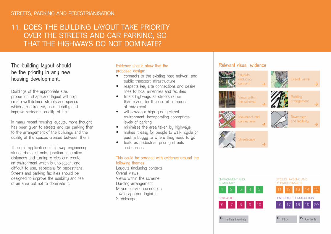
11. Do ES THE BuILDIng LAYouT TAKE PrIorITYoVEr THE STrEETS AnD CAr PArKIng, So THAT THE HIgHwAYS Do noT DoMInATE?
3
3
3
3
3
3
3
relevant visual evidence
layouts (including context)
overall views
views within the scheme
building arrangement
streetscape
Movement and connections
townscape and legibility
The building layout should be the priority in any new housing development.
buildings of the appropriate size, proportion, shape and layout will help create well-defined streets and spaces which are attractive, user-friendly, and improve residents’ quality of life.
in many recent housing layouts, more thought has been given to streets and car parking than to the arrangement of the buildings and the quality of the spaces created between them.
the rigid application of highway engineering standards for streets, junction separation distances and turning circles can create an environment which is unpleasant and difficult to use, especially for pedestrians. streets and parking facilities should be designed to improve the usability and feel of an area but not to dominate it.
Evidence should show that the proposed design:• connects to the existing road network and
public transport infrastructure• respects key site connections and desire
lines to local amenities and facilities• treats highways as streets rather
than roads, for the use of all modes of movement
• will provide a high quality street environment, incorporating appropriate levels of parking
• minimises the area taken by highways • makes it easy for people to walk, cycle or
push a buggy to where they need to go• features pedestrian priority streets
and spaces
This could be provided with evidence around the following themes:layouts (including context)overall viewsviews within the schemebuilding arrangement Movement and connectionstownscape and legibilitystreetscape

8 Contents8 intro
1 2 3 4 5
6 7 8 9 10
11 12 13 14 15
16 17 18 19 20
EnvironMEnt anD CoMMunity
CharaCtEr
strEEts, parking anD pEDEstrianisation
DEsign anD ConstruCtion
8 Further Reading
33
3
relevant visual evidence
streetscape parking
buildings
STrEETS, PArKIng AnD PEDESTrIAnISATIon
12. I S THE CAr PArKIng wELL InTEgrATED AnD SITuATED So IT SuPPorTS THE STrEET SCEnE?
Car parking is one of the most difficult challenges in housing design.
Discussions between planning authorities and developers should be influenced by a realistic assessment of likely patterns of car useas well as the possibility of alternative options for parking. in many cases, a mix of parking will achieve the best results.
at roughly 30 to 50 dwellings per hectare, limiting parking squares and courtyards to 10 spaces will help avoid visual dominance. on-street parking can bring activity to the street and have a traffic-calming effect. Car parking should be designed into the scheme, making sure that the fronts of properties are not dominated by cars, and that there is a good relationship between houses and the street. in denser developments, experience suggests that where commercial viability and conditions allow, on-street parking combined with well managed parking below buildings provides the most satisfactory solution. Where possible, below-building parking should be efficiently designed to free up more space for attractive streets and more shared public areas. any development should avoid large areas of unsupervised garage court parking.
Evidence should show that the proposed design:• integrates the car parking into the
overall layout and design• provides a variety of parking options,
e.g. on street and in courtyards• is not dominated by car parking • will provide a pleasant and safe
environment even in parking areas• includes a strategy for managing
car parking
This could be provided with evidence around the following themes:streetscapeparkingbuildings
And could include the following information:parking management strategy

8 Contents8 intro
1 2 3 4 5
6 7 8 9 10
11 12 13 14 15
16 17 18 19 20
EnvironMEnt anD CoMMunity
CharaCtEr
strEEts, parking anD pEDEstrianisation
DEsign anD ConstruCtion
8 Further Reading
3
33
3
relevant visual evidence
overall views views within the scheme
Movement and connections streetscape
STrEETS, PArKIng AnD PEDESTrIAnISATIon
13. ArE THE STrEETS PEDESTrIAn, CYCLE AnD VEHICLE FrIEnDLY?
Streets are the most used form of public space and they need to be designed to work well for us all.
pedestrians and cyclists need routes that are safe, direct, accessible and free from barriers. places with low speed limits are safer and can be achieved through the careful treatment of surfaces, junctions and crossings. in a low-speed environment, pedestrian, vehicular and cycle routes need not necessarily be segregated. homeZones use materials, textures, patterns, furniture and good planting to divert and slow traffic. For busier roads with fast traffic, cycle routes and pavements should be clearly defined.
a good streetscape will offer direct connections and crossings that are convenient and easy to use. it should be well lit, feel safe and make it easy for users to find and follow a route.
Evidence should show that the proposed design:• successfully integrates with the
surrounding context• is based on a clear hierarchy of
streets, accommodating pedestrian, cycle and vehicle movement
• treats highways as streets rather than roads
• features pedestrian priority streets and spaces
• successfully balances the needs of pedestrians, cyclists and drivers
• creates a layout which helps reduce traffic speeds where appropriate
This could be provided with evidence around the following themes:overall viewsviews within the schemeMovement and connectionsstreetscape

8 Contents8 intro
1 2 3 4 5
6 7 8 9 10
11 12 13 14 15
16 17 18 19 20
EnvironMEnt anD CoMMunity
CharaCtEr
strEEts, parking anD pEDEstrianisation
DEsign anD ConstruCtion
8 Further Reading
3
3
3
3
3
3
3
3
3
relevant visual evidence
site and context analysis
overall concept
layouts (including context)
overall views
Movement and connections
townscape and legibility
views within the scheme
building arrangement
streetscape
STrEETS, PArKIng AnD PEDESTrIAnISATIon
14. DoES THE SCHEME InTEgrATE wITH ExISTIng STrEETS, PATHS AnD SurrounDIng DEVELoPMEnT?
new housing does not exist on its own.
streets and footpaths should be connected to existing routes and neighbourhoods, creating a district that is accessible and easy to get around. a well-designed development should be easy to get to and move through, making the most of existing or proposed facilities in the area. this needs roads, footpaths and public spaces which link into well-used routes.
a seamless network of routes and public spaces will help create a community that includes all residents. safe access points into and through the development increase opportunities for walking and help reduce our reliance on cars.
Designing well-connected layouts depends on the local context (including local security issues) and how the development relates to existing areas. plans of the surrounding area are useful because they show the continuity between new and existing development.
Evidence should show that the proposed design:• connects to existing, well-used routes in
obvious and direct ways• makes it easy and convenient for people
to walk, cycle or push a buggy to where they need to go
• creates routes which are as short as possible, obvious and direct
• respects key site connections and desire lines to local amenities and facilities
• ensure that all routes are through or along well overlooked public spaces and streets
This could be provided with evidence around the following themes:site and context analysisoverall conceptlayouts (including context)overall viewsviews within the schemebuilding arrangement Movement and connectionstownscape and legibilitystreetscape

8 Contents8 intro
1 2 3 4 5
6 7 8 9 10
11 12 13 14 15
16 17 18 19 20
EnvironMEnt anD CoMMunity
CharaCtEr
strEEts, parking anD pEDEstrianisation
DEsign anD ConstruCtion
8 Further Reading
3
3
3
3
3
3
3
relevant visual evidence
layouts (including context)
overall views
views within the scheme
building arrangement
streetscape
Movement and connections
public realm / open space
STrEETS, PArKIng AnD PEDESTrIAnISATIon
15. ArE PuBLIC SPACES AnD PEDESTrIAn rouTES oVErLooKED AnD Do THEY FEEL SAFE?
Design has a crucial role to play in creating places that not only feel safe, but are safe.
Developments should be planned in a way that makes sure buildings overlook all public spaces, roads and footpaths to increase surveillance.
Windows and doors opening onto all streets and footpaths can provide greater security for users. bay and corner windows will provide views in different directions, as well as bringing more light into people’s homes. blank gable walls facing onto public spaces should be avoided. street lighting needs to be carefully considered to cover all vulnerable areas. light levels need to be fairly even through developments. areas which are in dark shadow or which suffer from too much direct light can make it difficult to see.
Evidence should show that the proposed design:• promotes natural and informal
surveillance of streets, public open spaces and courtyard areas
• frames and encloses streets and pedestrian routes with active building frontages
• ensures that routes, parking and entrances are overlooked and busy
• provides adequate lighting to enhance safety
• will feel equally safe during the day and at night
• is free of dangerous blind spots or dark corners which feel unsafe
• conforms to Secure by Design criteria or safer places guidance
This could be provided with evidence around the following themes:layouts (including context)overall viewsviews within the schemebuilding arrangement Movement and connectionsstreetscape

8 Contents8 intro
1 2 3 4 5
6 7 8 9 10
11 12 13 14 15
16 17 18 19 20
EnvironMEnt anD CoMMunity
CharaCtEr
strEEts, parking anD pEDEstrianisation
DEsign anD ConstruCtion
8 Further Reading
DESIgn AnD ConSTruCTIon
16. IS PuBLIC SPACE wELL DESIgnED AnD DoES IT HAVE SuITABLE MAnAgEMEnT ArrAngEMEnTS In PLACE?
3
3
3
3
3
3
relevant visual evidence
layouts (including context)
overall views
views within the scheme
building arrangement
public realm / open space streetscape
The space around buildings is as important as the buildings themselves.
any development should be able to provide some public open space, whether it is for children’s play and adventure, or for reflection and learning. If this is well designed it will result in a pleasurable place that will be popular and well used. this brings with it economic, social, environmental and cultural benefits.
good public space is usually planned for a particular use. too often, public space is the area left once buildings have been planned. this can lead to undefined areas with no specific use. Well-designed lighting, street furniture, careful detailing and attractive planting can improve the quality of public space. uncluttered and well-maintained areas that are designed for a variety of experiences will help create places which are lively, pleasant to use and develop a sense of wellbeing among users. a maintenance plan needs to be in place from the start to guarantee long-term success.
Evidence should show that the proposed design:• provides high quality external space
that will be well used• creates open spaces that are shaped
and defined by surrounding buildings• gives consideration to the best
location, access and planned uses for public space
• gives due care to the durability of chosen materials and detailing
• provides adequate lighting to enhance safety during the day and at night
• promotes natural and informal surveillance of streets, public open spaces and courtyard areas
• includes a viable strategy for the management and maintenance of the public realm
This could be provided with evidence around the following themes:layouts (including context)overall viewsviews within the schemepublic realm / open space
8 Contents8 intro
1 2 3 4 5
6 7 8 9 10
11 12 13 14 15
16 17 18 19 20
EnvironMEnt anD CoMMunity
CharaCtEr
strEEts, parking anD pEDEstrianisation
DEsign anD ConstruCtion
8 Further Reading
3
3
3
3
3
3
3
3
3
relevant visual evidence
layouts (including context)
overall views
views within the scheme
building arrangement
public realm / open space streetscape
townscape and legibility
scale and massing
buildings
DESIgn AnD ConSTruCTIon
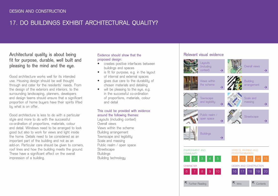
17. Do BuILDIngS ExHIBIT ArCHITECTurAL quALITY?
Architectural quality is about being fit for purpose, durable, well built and pleasing to the mind and the eye.
good architecture works well for its intended use. housing design should be well thought through and cater for the residents’ needs. From the design of the exteriors and interiors, to the surrounding landscaping, planners, developers and design teams should ensure that a significant proportion of home buyers have their spirits lifted by what is on offer.
good architecture is less to do with a particular style and more to do with the successful co-ordination of proportions, materials, colour and detail. Windows need to be arranged to look good but also to work for views and light inside the home. Details need to be considered as an important part of the building and not as an add-on. particular care should be given to corners, roof lines and how the building meets the ground. These have a significant effect on the overall impression of a building.
Evidence should show that the proposed design:• creates positive interfaces between
buildings and spaces• is fit for purpose, e.g. in the layout
of internal and external spaces• gives due care to the durability of
chosen materials and detailing• will be pleasing to the eye, e.g.
in the successful co-ordination of proportions, materials, colour and detail
This could be provided with evidence around the following themes:layouts (including context) overall viewsviews within the schemebuilding arrangement townscape and legibilityscale and massingpublic realm / open spacestreetscapebuildingsbuilding technology

8 Contents8 intro
1 2 3 4 5
6 7 8 9 10
11 12 13 14 15
16 17 18 19 20
EnvironMEnt anD CoMMunity
CharaCtEr
strEEts, parking anD pEDEstrianisation
DEsign anD ConstruCtion
8 Further Reading
DESIgn AnD ConSTruCTIon
18. Do InTErnAL SPACES AnD LAYouT ALLow For ADAPTATIon, ConVErSIon or ExTEnSIon?
3
relevant visual evidence
buildings
A well-designed home will need to take account of changing demands and lifestyles of the future by providing flexible internal layouts and allowing for cost-effective alterations.
housing should be able to respond to changing social, technological and economic conditions.
The main consideration is adaptability. For houses, the design could accommodate a downstairs toilet, wider doorways, level entrances and allow for a lift or stair lift to be fitted in the future. The potential to extend back or upwards, or to open up between rooms to allow open-plan living, is valuable, as is garden space and the space to allow a conservatory to be added.
For houses and apartments, if outside walls carry structural loads this allows for partitions to be added or removed inside to suit the owner’s needs. and if rooms are big enough to allow them to be used in a variety of ways, for example, as a work space, study, bedroom or playroom, this adds flexibility.
Evidence should show that the proposed design:• includes homes conforming to the
lifetime homes standard• makes it easy to add to, convert and
extend homes if necessary• allows rooms to be put to a variety
of uses• provides flexibility within each home
and each block• makes it possible to convert currently
unused spaces (e.g. lofts) for use in the future
This could be provided with evidence around the following themes:buildings
And could include the following information:schedule of compliance with lifetime homes standard

8 Contents8 intro
1 2 3 4 5
6 7 8 9 10
11 12 13 14 15
16 17 18 19 20
EnvironMEnt anD CoMMunity
CharaCtEr
strEEts, parking anD pEDEstrianisation
DEsign anD ConstruCtion
8 Further Reading
DESIgn AnD ConSTruCTIon
19. H AS THE SCHEME MADE uSE oF ADVAnCES In ConSTruCTIon or TECHnoLogY THAT EnHAnCE ITS PErForMAnCE, quALITY AnD ATTrACTIVEnESS?
33
relevant visual evidence
buildings building technology
Advanced building technology can help improve quality and reduce defects in construction, improve health and safety on site and improve the environmental performance of a home.
These are often classified as modern methods of construction, a broad category that covers both a variety of build approaches and products, including off-site manufacturing and innovations in process and the way people work.
Examples of systems that are considered as advanced forms of construction include prefabricated elements such as ‘thin joint blocks’ (glued brick panels), fast track foundations or advanced methods of cladding. they may involve more substantial forms of construction such as tunnel form (concrete formed units) or precast concrete panels, timber or steel panellised wall units and floor cassettes or volumetric construction (also known as modular construction) of kitchen or bathroom pods or even entire apartments fully fitted prior to installation on site.
Evidence should show that the proposed design:• derives a real benefit from the use
of modern methods of construction or technology
This could be provided with evidence around the following themes:buildings
And could include the following information:schedule of MMC used and benefits derived

8 Contents8 intro
1 2 3 4 5
6 7 8 9 10
11 12 13 14 15
16 17 18 19 20
EnvironMEnt anD CoMMunity
CharaCtEr
strEEts, parking anD pEDEstrianisation
DEsign anD ConstruCtion
8 Further Reading
DESIgn AnD ConSTruCTIon
20. Do BuILDIngS or SPACES ouTPErForM STATuTorY MInIMA, SuCH AS BuILDIng rEguLATIonS?
3
relevant visual evidence
buildings
Features such as generous space, goodnatural light, energy efficiency and goodsound insulation can greatly improve thepopularity of a home and the quality of life for the people who live in it.
Well-designed homes will excel in some, if not all, of these areas. this should not be achieved at the expense of the overall design quality of the scheme.• Good space standards contribute to the
long-term flexibility and future proofing (able to accommodate changing lifestyle demands) of a home
• For various aspects of building performance, including energy efficiency, the higher levels of achievement under Ecohomes or other equivalent standards are relevant reference points
• Good sound insulation between homes is important, especially for schemes where there are lots of houses close together. the biggest effect on privacy is sound coming through dividing walls
building for life recognises that grant-supported housing for social rent is required to meet higher standards than housing for market – rate sale. in order not to distort the evaluation process, the criterion will be met by grant-supported housing
which is compliant with these standards. For market-rate housing, the criterion will be met if it can be demonstrated that it is equally compliant with the hC standards thanks to a tenure-blind design approach, or that it in any other way exceeds the minimum standards set out in building regulations and the Code for sustainable homes.
Evidence should show that the proposed design:• exceeds the Building Regulations,
e.g. part l (2006)• conforms to, or exceeds (see above)
standards required for hC grant supported housing, e.g. sDs, Ecohomes.
• draws on high performance build methods or materials
• provides good space standards, even where not required through hC grant funding
• includes more than the required number of homes conforming to the lifetime homes standard
• exceeds the minimum star rating set out by the Code for sustainable homes
This could be provided with evidence around the following themes:buildings
And could include the following information:schedule of quality standards delivered

8 Contents8 intro
1 2 3 4 5
7 8 9 10
11 12 13 14 15
16 17 18 19 20
EnvironMEnt anD CoMMunity
roaDs, parking anD pEDEstrianisation
DEsign anD ConstruCtion
8 Further Reading
6
CharaCtEr
this plan locates the development in relation to the city centre and adjacent green areas and watercourses. the drawing provides a sense of the scale of development by showing it in relation to the medieval city centre. it also suggests that the design might provide the route leading directly towards the cathedral with continuous street frontage, integrating the development with the medieval centre.
relevant criteria 6 / 7 / 8 / 14
page 1 page 2 page 3
SITE AnD ConTExT AnALYSIS

8 Contents8 intro
1 2 3 4 5
6 7 8 9 10
11 12 13 14 15
16 17 18 19 20
EnvironMEnt anD CoMMunity
CharaCtEr
strEEts, parking anD pEDEstrianisation
DEsign anD ConstruCtion
8 Further Reading
in this instance, a physical model of the site has been used to explain its topography. this photograph of the model has been overlaid with a commentary to identify the site and key features that will have implications for the layout and design of homes, such as the north-facing slope. the model also gives an idea of the existing vegetation. It has been lit at a flat angle from the south to show shading as it might occur at mid-day in winter.
SITE AnD ConTExT AnALYSIS
page 1 page 2 page 3
relevant criteria 6 / 7 / 8 / 14

8 Contents8 intro
1 2 3 4 5
6 7 8 9 10
11 12 13 14 15
16 17 18 19 20
EnvironMEnt anD CoMMunity
CharaCtEr
strEEts, parking anD pEDEstrianisation
DEsign anD ConstruCtion
8 Further Reading
by providing this diagram, the designers are demonstrating their understanding of the site context. The annotation of the plan identifies existing and future edge conditions important for this site’s location at the urban / agricultural interface. the drawing also locates the site in relation to the village centre and recognizes the importance of views to nearby landscape features that could help the development gain a distinctive sense of local identity.
SITE AnD ConTExT AnALYSIS
page 1 page 2 page 3
relevant criteria 6 / 7 / 8 / 14
8 Contents8 intro
1 2 3 4 5
6 7 8 9 10
11 12 13 14 15
16 17 18 19 20
EnvironMEnt anD CoMMunity
CharaCtEr
strEEts, parking anD pEDEstrianisation
DEsign anD ConstruCtion
8 Further Reading
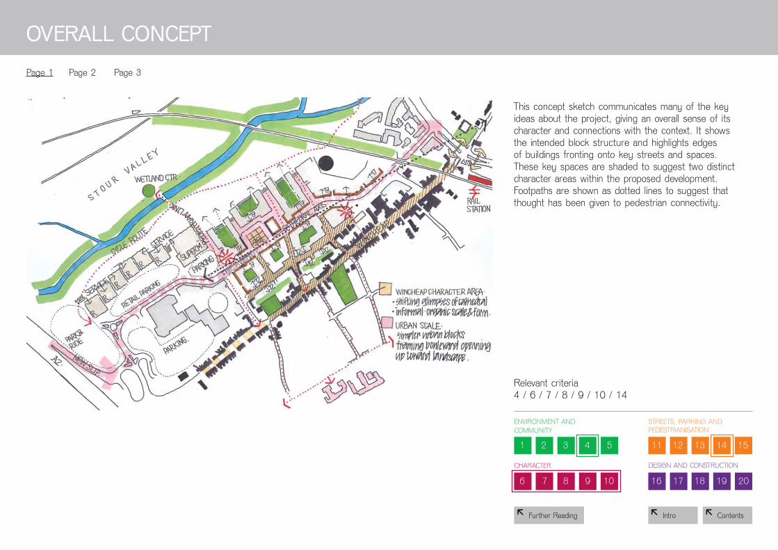
this concept sketch communicates many of the key ideas about the project, giving an overall sense of its character and connections with the context. it shows the intended block structure and highlights edges of buildings fronting onto key streets and spaces. these key spaces are shaded to suggest two distinct character areas within the proposed development. Footpaths are shown as dotted lines to suggest that thought has been given to pedestrian connectivity.
oVErALL ConCEPT
page 1 page 2 page 3
relevant criteria 4 / 6 / 7 / 8 / 9 / 10 / 14

8 Contents8 intro
1 2 3 4 5
6 7 8 9 10
11 12 13 14 15
16 17 18 19 20
EnvironMEnt anD CoMMunity
CharaCtEr
strEEts, parking anD pEDEstrianisation
DEsign anD ConstruCtion
8 Further Reading
this concept diagram shows the key elements driving the layout of the scheme, showing the key ideas in a very simple way. The drawing identifies key spaces, buildings and connections without providing too much detail that is not relevant to the basic idea. in some cases, only the edge of buildings are shown, highlighting that this aspect of the building is of primary importance for the underlying concept, whereas the other sides of the buildings could be treated more flexibly without undermining the integrity of the design.
oVErALL ConCEPT
page 1 page 2 page 3
relevant criteria 4 / 6 / 7 / 8 / 9 / 10 / 14

8 Contents8 intro
1 2 3 4 5
6 7 8 9 10
11 12 13 14 15
16 17 18 19 20
EnvironMEnt anD CoMMunity
CharaCtEr
strEEts, parking anD pEDEstrianisation
DEsign anD ConstruCtion
8 Further Reading
this concept diagram shows the key elements driving the layout of the scheme. it shows how the design team is thinking about the development in terms of “building blocks” of distinct use or character. it also shows the key connections and relationships between these “building blocks” and the surrounding area. to understand the basic idea informing the design approach at this stage, no further detail on the design of individual buildings is required.
oVErALL ConCEPT
page 1 page 2 page 3
relevant criteria 4 / 6 / 7 / 8 / 9 / 10 / 14

8 Contents8 intro
1 2 3 4 5
6 7 8 9 10
11 12 13 14 15
16 17 18 19 20
EnvironMEnt anD CoMMunity
CharaCtEr
strEEts, parking anD pEDEstrianisation
DEsign anD ConstruCtion
8 Further Reading
LAYouTS (InCLuDIng ConTExT)
page 1 page 2 page 3 page 4
relevant criteria 1 / 4 / 6 / 7 / 8 / 9 / 10 / 11 / 14 / 15 / 16 / 17
the technique of overlaying the layout as a montage over the aerial photograph of the whole area is very effective. it gives a good impression of how the proposed buildings and open spaces will fit into the surrounding area. although this example is of a very large masterplan, this technique can also be used for much smaller projects.

8 Contents8 intro
1 2 3 4 5
6 7 8 9 10
11 12 13 14 15
16 17 18 19 20
EnvironMEnt anD CoMMunity
CharaCtEr
strEEts, parking anD pEDEstrianisation
DEsign anD ConstruCtion
8 Further Reading
this drawing places the scheme in its urban context to show how both improving existing connections and introducing new ones will inform the layout of future adjoining stages of development.
page 1 page 2 page 3 page 4
relevant criteria 1 / 4 / 6 / 7 / 8 / 9 / 10 / 11 / 14 / 15 / 16 / 17
LAYouTS (InCLuDIng ConTExT)

8 Contents8 intro
1 2 3 4 5
6 7 8 9 10
11 12 13 14 15
16 17 18 19 20
EnvironMEnt anD CoMMunity
CharaCtEr
strEEts, parking anD pEDEstrianisation
DEsign anD ConstruCtion
8 Further Reading
this layout plan provides information on one phase of a staged masterplan. it gives a good overview of the proposed layout, and gives an indication of the type of spaces created.
page 1 page 2 page 3 page 4
relevant criteria 1 / 4 / 6 / 7 / 8 / 9 / 10 / 11 / 14 / 15 / 16 / 17
LAYouTS (InCLuDIng ConTExT)

8 Contents8 intro
1 2 3 4 5
6 7 8 9 10
11 12 13 14 15
16 17 18 19 20
EnvironMEnt anD CoMMunity
CharaCtEr
strEEts, parking anD pEDEstrianisation
DEsign anD ConstruCtion
8 Further Reading
this schematic layout is a good presentation technique for larger projects that have several infill elements within an established urban context. in this example, the dotted lines show how direct connections and views place the green space at the heart of the proposed new development. the drawing also shows how adjoining buildings provide good overlook by facing onto the central green space.
page 1 page 2 page 3 page 4
relevant criteria 1 / 4 / 6 / 7 / 8 / 9 / 10 / 11 / 14 / 15 / 16 / 17
LAYouTS (InCLuDIng ConTExT)

8 Contents8 intro
1 2 3 4 5
6 7 8 9 10
11 12 13 14 15
16 17 18 19 20
EnvironMEnt anD CoMMunity
CharaCtEr
strEEts, parking anD pEDEstrianisation
DEsign anD ConstruCtion
8 Further Reading
this perspective sketch provides an overall view of the scheme from the air, giving a good impression of the intended character of the development, and the typology of buildings and open spaces. it also shows how the proposed buildings relate to the public realm, providing clarity over fronts and backs of buildings and how they relate to streets and mews spaces.
oVErALL VIEwS
page 1 page 2 page 3
relevant criteria 6 / 7 / 8 / 9 / 10 / 11 / 13 / 14 / 15 / 16 / 17

8 Contents8 intro
1 2 3 4 5
6 7 8 9 10
11 12 13 14 15
16 17 18 19 20
EnvironMEnt anD CoMMunity
CharaCtEr
strEEts, parking anD pEDEstrianisation
DEsign anD ConstruCtion
8 Further Reading
this sketch, also a view from above, provides detail about the proposed type of buildings and their external appearance, as well as the character of streets, private gardens and communal amenity spaces.
page 1 page 2 page 3
relevant criteria 6 / 7 / 8 / 9 / 10 / 11 / 13 / 14 / 15 / 16 / 17
oVErALL VIEwS

8 Contents8 intro
1 2 3 4 5
6 7 8 9 10
11 12 13 14 15
16 17 18 19 20
EnvironMEnt anD CoMMunity
CharaCtEr
strEEts, parking anD pEDEstrianisation
DEsign anD ConstruCtion
8 Further Reading
this drawing provides an accurate view of the scale, massing and façade treatment of the proposed building and provides important information about the design’s response to the local setting. it helps us understand the likely relationship between the building and its neighbours and surrounding public realm.
page 1 page 2 page 3
relevant criteria 6 / 7 / 8 / 9 / 10 / 11 / 13 / 14 / 15 / 16 / 17
oVErALL VIEwS

8 Contents8 intro
1 2 3 4 5
6 7 8 9 10
11 12 13 14 15
16 17 18 19 20
EnvironMEnt anD CoMMunity
CharaCtEr
strEEts, parking anD pEDEstrianisation
DEsign anD ConstruCtion
8 Further Reading
VIEwS wITHIn THE SCHEME
page 1 page 2
relevant criteria 6 / 7 / 8 / 9 / 10 / 11 / 13 / 14 / 15 / 16 / 17
this image provides a sense of what it might feel like to walk through the proposed public space. it provides some information about the scale and proportion of surrounding buildings. it also provides some information about the overall effect the chosen surfacing materials, plantings and light fittings are intended to create.

8 Contents8 intro
1 2 3 4 5
6 7 8 9 10
11 12 13 14 15
16 17 18 19 20
EnvironMEnt anD CoMMunity
CharaCtEr
strEEts, parking anD pEDEstrianisation
DEsign anD ConstruCtion
8 Further Reading
these sketches explain the thinking behind the proposed layout for this scheme. The first sketch sets out the general block structure and its relationship to the adjoining green space and the river. the second sketch goes into a little more detail about the layout of buildings within each block. it is clear that some sort of green space is proposed for each block, however the line surrounding it suggests that this might be semi-private space.
BuILDIng ArrAngEMEnT
page 1 page 2 page 3
relevant criteria 6 / 7 / 8 / 9 / 10 / 11 / 13 / 14 / 15 / 16 / 17
8 Contents8 intro
1 2 3 4 5
6 7 8 9 10
11 12 13 14 15
16 17 18 19 20
EnvironMEnt anD CoMMunity
CharaCtEr
strEEts, parking anD pEDEstrianisation
DEsign anD ConstruCtion
8 Further Reading
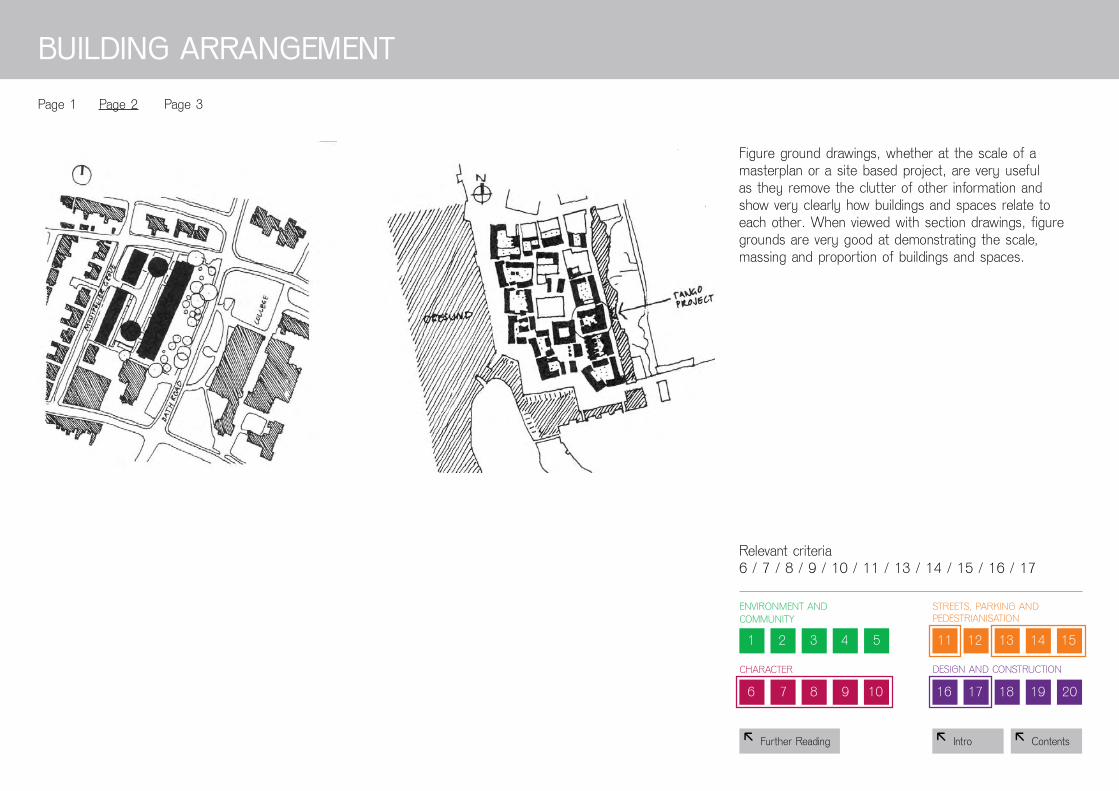
Figure ground drawings, whether at the scale of a masterplan or a site based project, are very useful as they remove the clutter of other information and show very clearly how buildings and spaces relate to each other. When viewed with section drawings, figure grounds are very good at demonstrating the scale, massing and proportion of buildings and spaces.
BuILDIng ArrAngEMEnT
page 1 page 2 page 3
relevant criteria 6 / 7 / 8 / 9 / 10 / 11 / 13 / 14 / 15 / 16 / 17

8 Contents8 intro
1 2 3 4 5
6 7 8 9 10
11 12 13 14 15
16 17 18 19 20
EnvironMEnt anD CoMMunity
CharaCtEr
strEEts, parking anD pEDEstrianisation
DEsign anD ConstruCtion
8 Further Reading
BuILDIng ArrAngEMEnT
page 1 page 2 page 3
relevant criteria 6 / 7 / 8 / 9 / 10 / 11 / 13 / 14 / 15 / 16 / 17
this more detailed diagram shows the placement of the building entrances and access to the various spaces. this kind of analysis drawing shows how active a façade will be on the street level.

8 Contents8 intro
1 2 3 4 5
6 7 8 9 10
11 12 13 14 15
16 17 18 19 20
EnvironMEnt anD CoMMunity
CharaCtEr
strEEts, parking anD pEDEstrianisation
DEsign anD ConstruCtion
8 Further Reading
this movement analysis drawing provides information about connections between the site and adjacent areas, and helps demonstrate how it will integrate with local movement networks.
MoVEMEnT AnD ConnECTIonS
page 1 page 2 page 3 page 4
relevant criteria 4 / 9 / 11 / 13 / 14 / 15

8 Contents8 intro
1 2 3 4 5
6 7 8 9 10
11 12 13 14 15
16 17 18 19 20
EnvironMEnt anD CoMMunity
CharaCtEr
strEEts, parking anD pEDEstrianisation
DEsign anD ConstruCtion
8 Further Reading
this diagram shows how the needs of pedestrians, cyclists and car drivers will be balanced. it shows how the design provides vehicle routes of different intensities and allows for necessary emergency access. the drawing identifies different types of streets, such as home zones and mews spaces.
page 1 page 2 page 3 page 4
relevant criteria 4 / 9 / 11 / 13 / 14 / 15
MoVEMEnT AnD ConnECTIonS

8 Contents8 intro
1 2 3 4 5
6 7 8 9 10
11 12 13 14 15
16 17 18 19 20
EnvironMEnt anD CoMMunity
CharaCtEr
strEEts, parking anD pEDEstrianisation
DEsign anD ConstruCtion
8 Further Reading
this drawing shows how the proposed design engages with the existing network of key connections in the area by providing links and open spaces in key locations.
page 1 page 2 page 3 page 4
relevant criteria 4 / 9 / 11 / 13 / 14 / 15
MoVEMEnT AnD ConnECTIonS

8 Contents8 intro
1 2 3 4 5
6 7 8 9 10
11 12 13 14 15
16 17 18 19 20
EnvironMEnt anD CoMMunity
CharaCtEr
strEEts, parking anD pEDEstrianisation
DEsign anD ConstruCtion
8 Further Reading
This plan clearly identifies the network of footpaths in the development, and maps the overlook from windows at ground and higher levels. this helps an understanding of how much overlook is provided to key routes, which allows an evaluation of whether pedestrians would feel safe walking around this development.
page 1 page 2 page 3 page 4
relevant criteria 4 / 9 / 11 / 13 / 14 / 15
MoVEMEnT AnD ConnECTIonS

8 Contents8 intro
1 2 3 4 5
6 7 8 9 10
11 12 13 14 15
16 17 18 19 20
EnvironMEnt anD CoMMunity
CharaCtEr
strEEts, parking anD pEDEstrianisation
DEsign anD ConstruCtion
8 Further Reading
this townscape analysis drawing helps explain the relationship of the scheme to its context. it illustrates the orientation of buildings, the framing of views, and the setting for historic buildings.
TownSCAPE AnD LEgIBILITY
page 1 page 2 page 3
relevant criteria 7 / 8 / 9 / 10 / 11 / 14 / 17

8 Contents8 intro
1 2 3 4 5
6 7 8 9 10
11 12 13 14 15
16 17 18 19 20
EnvironMEnt anD CoMMunity
CharaCtEr
strEEts, parking anD pEDEstrianisation
DEsign anD ConstruCtion
8 Further Reading
This conceptual diagram focuses specifically on the streets and key spaces within the new development. it helps highlight the clear structure of the proposed layout and how this could help people find their way.
TownSCAPE AnD LEgIBILITY
page 1 page 2 page 3
relevant criteria 7 / 8 / 9 / 10 / 11 / 14 / 17
8 Contents8 intro
1 2 3 4 5
6 7 8 9 10
11 12 13 14 15
16 17 18 19 20
EnvironMEnt anD CoMMunity
CharaCtEr
strEEts, parking anD pEDEstrianisation
DEsign anD ConstruCtion
8 Further Reading
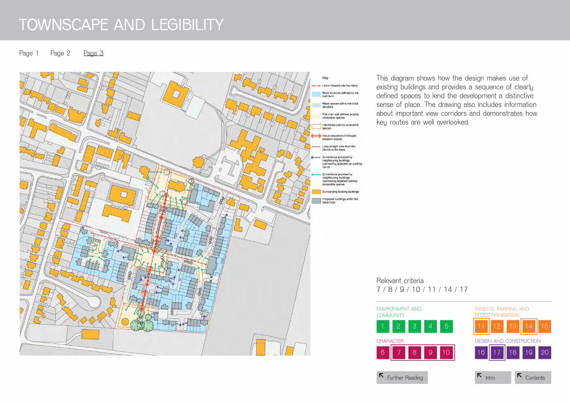
this diagram shows how the design makes use of existing buildings and provides a sequence of clearly defined spaces to lend the development a distinctive sense of place. the drawing also includes information about important view corridors and demonstrates how key routes are well overlooked.
TownSCAPE AnD LEgIBILITY
page 1 page 2 page 3
relevant criteria 7 / 8 / 9 / 10 / 11 / 14 / 17

8 Contents8 intro
1 2 3 4 5
6 7 8 9 10
11 12 13 14 15
16 17 18 19 20
EnvironMEnt anD CoMMunity
CharaCtEr
strEEts, parking anD pEDEstrianisation
DEsign anD ConstruCtion
8 Further Reading
this plan indicates the range of proposed building heights. this helps communicate the intended scale and massing of the proposed development.
SCALE AnD MASSIng
page 1 page 2 page 3
relevant criteria 9 / 10 / 17

8 Contents8 intro
1 2 3 4 5
6 7 8 9 10
11 12 13 14 15
16 17 18 19 20
EnvironMEnt anD CoMMunity
CharaCtEr
strEEts, parking anD pEDEstrianisation
DEsign anD ConstruCtion
8 Further Reading
this simple diagram uses colour to indicate the various proposed building heights across the scheme. in drawings like this, it is useful to include the building heights of neighbouring properties to provide the contextual scale.
SCALE AnD MASSIng
page 1 page 2 page 3
relevant criteria 9 / 10 / 17

8 Contents8 intro
1 2 3 4 5
6 7 8 9 10
11 12 13 14 15
16 17 18 19 20
EnvironMEnt anD CoMMunity
CharaCtEr
strEEts, parking anD pEDEstrianisation
DEsign anD ConstruCtion
8 Further Reading
this kind of section is very useful alongside a map of the building heights, as it gives a sense of the massing in relation to the context, and its impact on the streets and spaces within the scheme.
SCALE AnD MASSIng
page 1 page 2 page 3
relevant criteria 9 / 10 / 17

8 Contents8 intro
1 2 3 4 5
6 7 8 9 10
11 12 13 14 15
16 17 18 19 20
EnvironMEnt anD CoMMunity
CharaCtEr
strEEts, parking anD pEDEstrianisation
DEsign anD ConstruCtion
8 Further Reading
PuBLIC rEALM / oPEn SPACE
page 1 page 2 page 3
This diagram identifies the various types of open space that make up the public realm in this design proposal. it also helps explain how these spaces relate to each other and to the wider context.
relevant criteria 9 / 15 / 16 / 17

8 Contents8 intro
1 2 3 4 5
6 7 8 9 10
11 12 13 14 15
16 17 18 19 20
EnvironMEnt anD CoMMunity
CharaCtEr
strEEts, parking anD pEDEstrianisation
DEsign anD ConstruCtion
8 Further Reading
By providing a plan with a simplified overlay, this drawing helps explain the layout of the proposed design. it makes it easier to understand how key spaces relate to each other and to the surrounding area.
PuBLIC rEALM / oPEn SPACE
page 1 page 2 page 3
relevant criteria 9 / 15 / 16 / 17

8 Contents8 intro
1 2 3 4 5
6 7 8 9 10
11 12 13 14 15
16 17 18 19 20
EnvironMEnt anD CoMMunity
CharaCtEr
strEEts, parking anD pEDEstrianisation
DEsign anD ConstruCtion
8 Further Reading
this drawing provides detailed information about the proposed play area, to be located at the heart of the new development. it also shows how the design of the surrounding streets will help integrate this space into its context.
PuBLIC rEALM / oPEn SPACE
page 1 page 2 page 3
relevant criteria 9 / 15 / 16 / 17

8 Contents8 intro
1 2 3 4 5
6 7 8 9 10
11 12 13 14 15
16 17 18 19 20
EnvironMEnt anD CoMMunity
CharaCtEr
strEEts, parking anD pEDEstrianisation
DEsign anD ConstruCtion
8 Further Reading
this plan outlines the streets and spaces to be designed as home zones with pedestrian priority. it also illustrates how car parking has been integrated by providing a range of different spaces throughout the development.
STrEETSCAPE
page 1 page 2 page 3 page 4 page 5 page 6
relevant criteria 9 / 10 / 11 / 12 / 13 / 14 / 15 / 16 / 17

8 Contents8 intro
1 2 3 4 5
6 7 8 9 10
11 12 13 14 15
16 17 18 19 20
EnvironMEnt anD CoMMunity
CharaCtEr
strEEts, parking anD pEDEstrianisation
DEsign anD ConstruCtion
8 Further Reading
STrEETSCAPE
page 1 page 2 page 3 page 4 page 5 page 6
relevant criteria 9 / 10 / 11 / 12 / 13 / 14 / 15 / 16 / 17
this drawing proposes a palette of materials and street furnishing to be used in the scheme. it is useful in giving a clear idea of the intended quality of materials. by demonstrating how a consistent range of materials and elements will be used throughout the development, this kind of diagram can also help illustrate the distinctive character of the development.

8 Contents8 intro
1 2 3 4 5
6 7 8 9 10
11 12 13 14 15
16 17 18 19 20
EnvironMEnt anD CoMMunity
CharaCtEr
strEEts, parking anD pEDEstrianisation
DEsign anD ConstruCtion
8 Further Reading
this detail shows how materials and street furnishings are brought together to create a home zone with pedestrian priority. it also shows how car parking will be integrated into this space. the entrances to buildings are marked with arrows, which helps demonstrate how the design will create an active street.
STrEETSCAPE
page 1 page 2 page 3 page 4 page 5 page 6
relevant criteria 9 / 10 / 11 / 12 / 13 / 14 / 15 / 16 / 17

8 Contents8 intro
1 2 3 4 5
6 7 8 9 10
11 12 13 14 15
16 17 18 19 20
EnvironMEnt anD CoMMunity
CharaCtEr
strEEts, parking anD pEDEstrianisation
DEsign anD ConstruCtion
8 Further Reading
a street section like this helps explain how the street will work, and how the planting and materials are used to identify different zones and activities within it. the section identifies defensible, semi-private space between the street and the front of buildings.
STrEETSCAPE
page 1 page 2 page 3 page 4 page 5 page 6
relevant criteria 9 / 10 / 11 / 12 / 13 / 14 / 15 / 16 / 17

8 Contents8 intro
1 2 3 4 5
6 7 8 9 10
11 12 13 14 15
16 17 18 19 20
EnvironMEnt anD CoMMunity
CharaCtEr
strEEts, parking anD pEDEstrianisation
DEsign anD ConstruCtion
8 Further Reading
this drawing illustrates how the proposed palette of materials might be used in a specific situation. It is useful in giving a clear idea of the intended quality of materials and detailing.
STrEETSCAPE
page 1 page 2 page 3 page 4 page 5 page 6
relevant criteria 9 / 10 / 11 / 12 / 13 / 14 / 15 / 16 / 17

8 Contents8 intro
1 2 3 4 5
6 7 8 9 10
11 12 13 14 15
16 17 18 19 20
EnvironMEnt anD CoMMunity
CharaCtEr
strEEts, parking anD pEDEstrianisation
DEsign anD ConstruCtion
8 Further Reading
this section through a street provides information about the relationship between the buildings and the street. It demonstrates how vehicle and pedestrian traffic and parking will be accommodated, and how views from buildings will provide a good sense of overlook and safety.
STrEETSCAPE
page 1 page 2 page 3 page 4 page 5 page 6
relevant criteria 9 / 10 / 11 / 12 / 13 / 14 / 15 / 16 / 17

8 Contents8 intro
1 2 3 4 5
6 7 8 9 10
11 12 13 14 15
16 17 18 19 20
EnvironMEnt anD CoMMunity
CharaCtEr
strEEts, parking anD pEDEstrianisation
DEsign anD ConstruCtion
8 Further Reading
this plan and section through a block demonstrate how this design provides integrated parking within the block whilst creating active frontages and good overlook onto the streets.
PArKIng
page 1 page 2
relevant criteria 12

8 Contents8 intro
1 2 3 4 5
6 7 8 9 10
11 12 13 14 15
16 17 18 19 20
EnvironMEnt anD CoMMunity
CharaCtEr
strEEts, parking anD pEDEstrianisation
DEsign anD ConstruCtion
8 Further Reading
This diagram identifies each car parking space, demonstrating the range of ways in which car parking spaces are provided and how they have been integrated into streets, mews and courtyards.
PArKIng
page 1 page 2
relevant criteria 12

8 Contents8 intro
1 2 3 4 5
6 7 8 9 10
11 12 13 14 15
16 17 18 19 20
EnvironMEnt anD CoMMunity
CharaCtEr
strEEts, parking anD pEDEstrianisation
DEsign anD ConstruCtion
8 Further Reading
this plan maps out the various types and sizes of residential units that will be provided across the site. it provides an understanding of what mix of accommodation will be provided and how it will be distributed throughout the scheme.
uSES
page 1 page 2 page 3 page 4
relevant criteria 1 / 2 / 3

8 Contents8 intro
1 2 3 4 5
6 7 8 9 10
11 12 13 14 15
16 17 18 19 20
EnvironMEnt anD CoMMunity
CharaCtEr
strEEts, parking anD pEDEstrianisation
DEsign anD ConstruCtion
8 Further Reading
this plan maps out the various house types that will be provided across the site. it helps demonstrate what mix of accommodation will be provided and how it will be distributed throughout the scheme.
uSES
page 1 page 2 page 3 page 4
relevant criteria 1 / 2 / 3

8 Contents8 intro
1 2 3 4 5
6 7 8 9 10
11 12 13 14 15
16 17 18 19 20
EnvironMEnt anD CoMMunity
CharaCtEr
strEEts, parking anD pEDEstrianisation
DEsign anD ConstruCtion
8 Further Reading
this plan maps out the various types of tenure that will be provided across the site. it provides an understanding of what tenure mix will be provided and how it will be distributed throughout the scheme.
uSES
page 1 page 2 page 3 page 4
relevant criteria 1 / 2 / 3

8 Contents8 intro
1 2 3 4 5
6 7 8 9 10
11 12 13 14 15
16 17 18 19 20
EnvironMEnt anD CoMMunity
CharaCtEr
strEEts, parking anD pEDEstrianisation
DEsign anD ConstruCtion
8 Further Reading
This sketch shows how a ground floor residential unit could be converted into a retail unit or vice versa. it helps demonstrate how the proposed design could be adapted to meet changing needs in the future.
uSES
page 1 page 2 page 3 page 4
relevant criteria 1 / 2 / 3

8 Contents8 intro
1 2 3 4 5
6 7 8 9 10
11 12 13 14 15
16 17 18 19 20
EnvironMEnt anD CoMMunity
CharaCtEr
strEEts, parking anD pEDEstrianisation
DEsign anD ConstruCtion
8 Further Reading
this detailed elevation provides an overall impression of the character, style and materials of the proposed design.
the section is very useful in illustrating how parking will be provided off street below the courtyard. it also illustrates how the proposed buildings relate to the street. the section can also help clarify how the proposed design will treat the areas around the front and back of the home at ground level.
BuILDIngS
page 1 page 2 page 3
relevant criteria 5 / 6 / 8 / 12 / 17 / 18 / 19 / 20

8 Contents8 intro
1 2 3 4 5
6 7 8 9 10
11 12 13 14 15
16 17 18 19 20
EnvironMEnt anD CoMMunity
CharaCtEr
strEEts, parking anD pEDEstrianisation
DEsign anD ConstruCtion
8 Further Reading
Elevations of a number of houses drawn together show what the overall street frontage of the development will look like. it is important to recognise that the street will hardly ever be seen in this way when built, but that this type of drawing will help demonstrate how the design of the elevations could lend the development a coherent character and sense of place.
BuILDIngS
page 1 page 2 page 3
relevant criteria 5 / 6 / 8 / 12 / 17 / 18 / 19 / 20
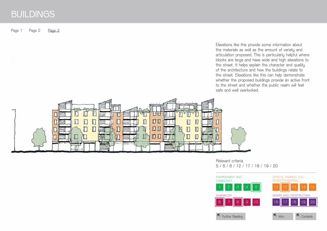
8 Contents8 intro
1 2 3 4 5
6 7 8 9 10
11 12 13 14 15
16 17 18 19 20
CharaCtEr
strEEts, parking anD pEDEstrianisation
DEsign anD ConstruCtion
8 Further Reading
Elevations like this provide some information about the materials as well as the amount of variety and articulation proposed. this is particularly helpful where blocks are large and have wide and high elevations to the street. it helps explain the character and quality of the architecture and how the buildings relate to the street. Elevations like this can help demonstrate whether the proposed buildings provide an active front to the street and whether the public realm will feel safe and well overlooked.
BuILDIngS
page 1 page 2 page 3
relevant criteria 5 / 6 / 8 / 12 / 17 / 18 / 19 / 20
EnvironMEnt anD CoMMunity

8 Contents8 intro
1 2 3 4 5
6 7 8 9 10
11 12 13 14 15
16 17 18 19 20
EnvironMEnt anD CoMMunity
CharaCtEr
strEEts, parking anD pEDEstrianisation
DEsign anD ConstruCtion
8 Further Reading
Whilst not providing much detail, concept drawings like this are useful in communicating the thinking behind the design of green space.
LAnDSCAPE
page 1 page 2 page 3
relevant criteria 5 / 6 / 7 / 8

8 Contents8 intro
1 2 3 4 5
6 7 8 9 10
11 12 13 14 15
16 17 18 19 20
EnvironMEnt anD CoMMunity
CharaCtEr
strEEts, parking anD pEDEstrianisation
DEsign anD ConstruCtion
8 Further Reading
Drawings like this show that the landscape concept extends not only to green spaces, but also to the surfacing and detailing of streets and footpaths. this helps demonstrate a coherent approach to the design of the public realm.
LAnDSCAPE
page 1 page 2 page 3
relevant criteria 5 / 6 / 7 / 8

8 Contents8 intro
1 2 3 4 5
6 7 8 9 10
11 12 13 14 15
16 17 18 19 20
EnvironMEnt anD CoMMunity
CharaCtEr
strEEts, parking anD pEDEstrianisation
DEsign anD ConstruCtion
8 Further Reading
Detailed drawings showing landscape proposals, for example suDs, give essential information about the sustainability approach to the scheme. rather than a vague statement of intent, specific information of this type is helpful in demonstrating how the environmental impact of the development will be reduced.
LAnDSCAPE
page 1 page 2 page 3
relevant criteria 5 / 6 / 7 / 8

8 Contents8 intro
1 2 3 4 5
6 7 8 9 10
11 12 13 14 15
16 17 18 19 20
EnvironMEnt anD CoMMunity
CharaCtEr
strEEts, parking anD pEDEstrianisation
DEsign anD ConstruCtion
8 Further Reading
BuILDIng TECHnoLogY
page 1 page 2
relevant criteria 19
these diagrams illustrate how the proposed design makes use of innovative construction methods and how these might improve the performance, quality, and attractiveness of the scheme.

8 Contents8 intro
1 2 3 4 5
6 7 8 9 10
11 12 13 14 15
16 17 18 19 20
EnvironMEnt anD CoMMunity
CharaCtEr
strEEts, parking anD pEDEstrianisation
DEsign anD ConstruCtion
8 Further Reading
BuILDIng TECHnoLogY
page 1 page 2
relevant criteria 19
this drawing illustrates how a house type is developed out of a modular system. in demonstrating the construction method, this drawing also helps explain how the method of construction and the resulting design are closely related.

Contents8
8 Intro
‘Red line’ site plan;
Proposed site plan;
Connectivity and route plan showing ‘desire lines’;
Contextual site plan showing distance to facilities;
Street and parking plan;
Figure ground site plan;
Site plan showing public/private green spaces;
Floor plan showing room size and construction;
Site plan showing overlook and ‘active frontages’;
Conceptual drawings showing tenure and dwelling types;
Street sections;
Reference to environmental sustainability standards;
Reference to safety standards;
Reference to use of modern methods of construction;
Reference to standards of adaptability;
Reference to how the scheme performs against statutory minima.
The Following PageS Show an exemPlaR SeT oF dRawingS and inFoRmaTion whiCh aRe needed To anSweR moST oF The Building FoR liFe queSTionS:
1111111111111111

8 Contents8 intro8 recommended drawings and information
‘rED LInE’ SITE PLAn ProPoSED SITE PLAn
this drawing shows the site in the context of the surrounding area. it locates the site and shows the existing buildings and spaces which need to be taken into account when planning the development. this type of drawing is very useful evidence for criteria 7 and 14.
this drawing shows the proposed development within the wider area. it shows the general layout of the proposed development and how the new buildings relate to nearby buildings and spaces. this type of drawing is very useful for criteria 7, 9, 10, 11 and 16
rECoMMEnDED DrAwIngS

8 Contents8 intro
ConnECTIVITY AnD rouTE PLAn SHowIng ‘DESIrE LInES’
this drawing is particularly helpful because it shows the location of things which are important for the local community, such as schools, parks, shops and public transport links. the dashed “desire lines” show the most direct route from one to the other if there were no obstacles in the way. building around these lines can be difficult, as it might result in a lot of triangular buildings which can be difficult to use. But this overlay shows how the layout of buildings and streets corresponds to the desire lines. the blue lines show how easy it will be to walk around the scheme. the closer the blue lines follow the desire lines the better. this type of drawing is good evidence for criteria 9, 10, 13 and 14.
rECoMMEnDED DrAwIngS
8 recommended drawings and information
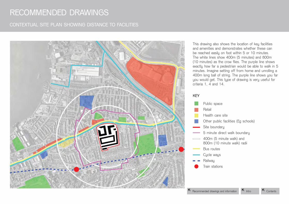
8 Contents8 intro
this drawing also shows the location of key facilities and amenities and demonstrates whether these can be reached easily on foot within 5 or 10 minutes. the white lines show 400m (5 minutes) and 800m (10 minutes) as the crow flies. The purple line shows exactly how far a pedestrian would be able to walk in 5 minutes. imagine setting off from home and unrolling a 400m long ball of string. the purple line shows you far you would get. this type of drawing is very useful for criteria 1, 4 and 14.
public spaceretail health care siteother public facilities (Eg schools)site boundary5 minute direct walk boundary400m (5 minute walk) and 800m (10 minute walk) radiibus routesCycle waysrailwaytrain stations
ConTExTuAL SITE PLAn SHowIng DISTAnCE To FACILITIES
rECoMMEnDED DrAwIngS
KEY
8 recommended drawings and information

8 Contents8 intro
larger parking plots broken up with planting
this drawing shows how much of the available land is taken up with streets and car parking spaces. it shows how car parking is distributed across the site, and how the car parking spaces relate to the buildings. this helps to assess and whether streets and car parking are dominating the scheme. this type of drawing is very useful for criteria 10, 11, 12 and 13
STrEET AnD PArKIng PLAn
rECoMMEnDED DrAwIngS
8 recommended drawings and information

8 Contents8 intro 8 Contents8 intro
this drawing shows the footprints of existing and proposed buildings in black. this highlights the spaces between the buildings and whether buildings shape spaces into streets, squares, mews or courtyards or other defined places. this type of drawing is very useful in examining criteria 7, 10, 11 and 14.
FIgurE grounD SITE PLAn
rECoMMEnDED DrAwIngS
8 recommended drawings and information

8 Contents8 intro
This drawing specifically highlights the green spaces, showing number size and type. by showing which areas are public, communal or private, it explains who has access to which kinds of green space. it can also help understand who has ownership and responsibility for these areas. this drawing would be useful for criteria 16.
SITE PLAn SHowIng PuBLIC/PrIVATE grEEn SPACES
rECoMMEnDED DrAwIngS
Existing buildings
private gardens
Communal/semi-public green space
public open space
KEY
8 recommended drawings and information

8 Contents8 intro
these plans are very helpful because they show example furnishing as well as the total floor area for each different type of home. this helps to evaluate whether the home is adequate for purpose and whether they are flexible and adaptable. Showing the structural and partition walls in different colours is a particularly useful way to demonstrate adaptability. Drawings such as these will provide evidence for criteria 17, 18 and 20
rECoMMEnDED DrAwIngSFLoor PLAn SHowIng rooM SIzE AnD ConSTruCTIon
structural walls
partition walls
KEY
8 recommended drawings and information

8 Contents8 intro
potential problem of blank gables
this drawing shows the “active frontages” of buildings – sides of the building that address the street or public space and are often in use. by showing front doors to buildings and windows onto the street it is possible to evaluate whether streets and footpaths will be well overlooked and whether they will feel safe. a drawing such as this would be a significant piece of evidence to answer questions 13 and 15.
rECoMMEnDED DrAwIngSSITE PLAn SHowIng oVErLooK AnD ‘ACTIVE FronTAgES’
Doorways onto street
Windows overlooking street
KEY
8 recommended drawings and information

8 Contents8 intro
these simple drawings explain the range and number of dwelling types and tenancy types included in the scheme. it also shows how these are distributed across the development. this type of drawing is very useful for criteria 2 and 3.
rECoMMEnDED DrAwIngSConCEPTuAL DrAwIngS SHowIng TEnurE AnD DwELLIng TYPES
general needs rentshared ownershipprivate sale
2 bedroom, 3/4 person, 70m² flat2 bedroom, 3 person, 60m²1 bedroom, 2 person, 50m²3 bedroom, 5 person, 96m² maisonette4 bedroom, 6 person, 118m² three storey house
KEY
KEY
8 recommended drawings and information

8 Contents8 intro
section drawings such as this help understand the different types of streets which will be created in the scheme. a section drawing should be produced for each street created or altered by new development.
section drawings can illustrate:• Street orientation• relationship between street width
and building height• type of planting and landscaping• car parking• width of pedestrian walkways
this can help evaluate:• whether spaces will benefit from good daylight • whether space will be susceptible to the
prevailing wind • how well spaces will work for pedestrians,
cycles and cars.
section drawings are good evidence for criteria 8, 12, 13, 15 and 16.
rECoMMEnDED DrAwIngSSTrEET SECTIonS
8 recommended drawings and information

8 Contents8 intro
rECoMMEnDED InForMATIon
Five further important pieces of written evidence (these may be supported by drawings) should be provided:
• R eference to the Code for Sustainable Homes (CSH) assessment of the dwellings and what level has been achieved or is hoped to be achieved. a Csh assessment has been mandatory for all new homes since May 1 2008. this evidence is necessary in order to answer questions 5 and 20.
• R eference to whether the scheme has been designed with crime safety in mind. this could include:
a) Whether the development adheres to the principles of Secured by Design (SBD) and whether an SBD certificate has been achieved;
b) Whether the development adheres to the 7 attributes of sustainability particularly relevant to crime prevention, as outlined in safer places: the planning system and Crime prevention.
this evidence will help to answer questions 15 and 16.
• R eference and demonstration of whether the development makes use of modern methods of construction such as off-site manufacturing of units or use of pre-fabricated elements. this will answer question 19.
• R eference to whether the development has achieved or will achieve the lifetime homes standard. this will answer question 18 and will provide evidence for question 20.
• R eference to all elements of the design of buildings and spaces which outperform statutory minima, for example if a home exceeds the building regulations on sound insulation. 8 recommended drawings and information

8 Contents8 intro8 Further Reading
EnVIronMEnT AnD CoMMunITY Evaluation Evidence Score
rEPorTIng TEMPLATE
1. Does the development provide (or is it close to) community facilities, such as a school, parks, play areas, shops, pubs or cafés?
2. Is there an accommodation mix that reflects the needs and aspirations of the local community?
3. Is there a tenure mix that reflects the needs of the local community?
4. D oes the development have easy access to public transport?
5. Does the development have any features that reduce its environmental impact?
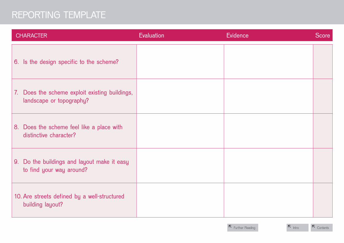
8 Contents8 intro8 Further Reading
CHArACTEr Evaluation Evidence Score
,
rEPorTIng TEMPLATE
6. Is the design specific to the scheme?
7. Does the scheme exploit existing buildingslandscape or topography?
8. Does the scheme feel like a place with distinctive character?
9. Do the buildings and layout make it easy to find your way around?
10. Are streets defined by a well-structured building layout?

8 Contents8 intro8 Further Reading
STrEETS, PArKIng AnD PEDESTrIAnISATIon Evaluation Evidence Score
rEPorTIng TEMPLATE
11. Does the building layout take priority over the streets and car parking, so that the highways do not dominate?
12. I s the car parking well integrated and situated to it supports the street scene?
13. A re the streets pedestrian, cycle and vehicle friendly?
14. Does the scheme integrate with existing streets, paths and surrounding development?
15. Are public spaces and pedestrian routes overlooked and do they feel safe?
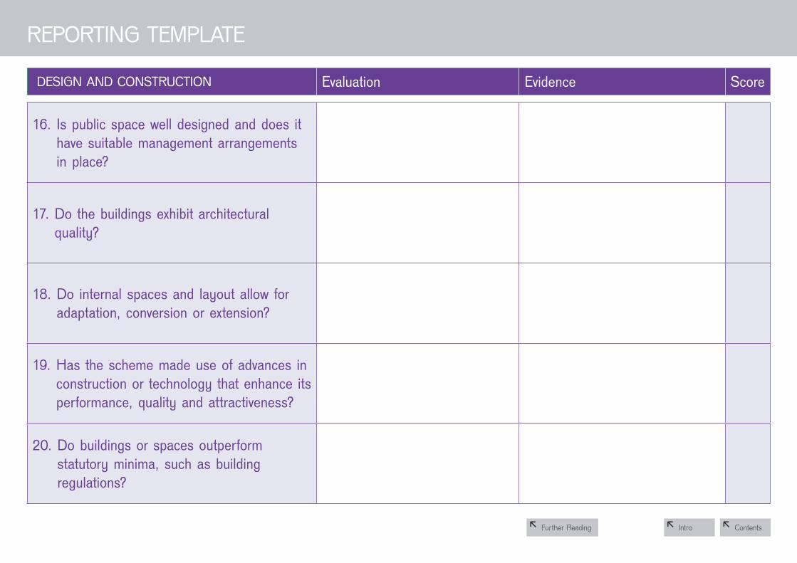
8 Contents8 intro8 Further Reading
DESIgn AnD ConSTruCTIon Evaluation Evidence Score
rEPorTIng TEMPLATE
16. Is public space well designed and does it have suitable management arrangements in place?
17. D o the buildings exhibit architectural quality?
18. D o internal spaces and layout allow for adaptation, conversion or extension?
19. Has the scheme made use of advances in construction or technology that enhance itsperformance, quality and attractiveness?
20. Do buildings or spaces outperform statutory minima, such as building regulations?

1
6
Further reading
environment & Community
1. does the development provide (or is it close to) community facilities such as a school, parks, play areas, shops, pubs or cafés?
• TheHomebuyers’guide:whattolookandaskforwhenbuyinganewhome(AlexEly,CABEandBlackDogPublishing,2004)
• Startwiththepark(CABESpace,2005)
• Urbandesigncompendium(EnglishPartnershipsandtheHousingCorporation,2000/2007)
• Creatingsuccessfulmasterplans:aguideforclients(CABE2004)
2. is there an accommodation mix that reflects the needs and aspirations of the local community?
• Capitalgains:makinghigh-densityhousingwork(LondonHousingFederation2002)
• Betterplacestolive:acompanionguidetoPPG3(DTLRandCABE,2001)
3. Is there a tenure mix that reflects the needs of the local community?
• Betterplacestolive:acompanionguidetoPPG3(DTLRandCABE,2001)
4. does the development have easy access to public transport?
• Betterplacestolive:acompanionguidetoPPG3(DTLRandCABE,2001)
• Urbandesigncompendium(EnglishPartnershipsandtheHousingCorporation,2000/2007)
5. does the development have any features that reduced its environmental impact?
• Thegreenguidetohousingspecification(AndersonandHoward,BRE,2000)
• CodeforSustainableHomes(DCLG,2006)
• www.ecohomes.org• Capitalgains:makinghigh-density
housingwork(LondonHousingFederation2002)
• Perceptionsofprivacyanddensity(DesignforHomes,PopularHousingResearch,2003)
• Urbandesigncompendium(EnglishPartnershipsandtheHousingCorporation,2000/2007)
6. Is the design specific to the scheme?
• Urbandesigncompendium(EnglishPartnershipsandtheHousingCorporation,2000/2007)
• Designreview:howCABEevaluatesqualityinarchitectureandurbandesign(CABE2006)
7. does the scheme exploit existing buildings, landscape or topography?
• Urbandesigncompendium(EnglishPartnershipsandtheHousingCorporation,2000/2007)
8. does the scheme feel like a place with distinct character?
• Bydesign-urbandesignandtheplanningsystem:towardsbetterpractice(DTLR,2001)
• Urbandesigncompendium(EnglishPartnershipsandtheHousingCorporation,2000/2007)
• Actionsforhousinggrowth:creatingalegacyofgreatplaces(CABE2007)
9. do the buildings and layout make it easy to find your way around?
• Saferplaces:theplanningsystemandcrimeprevention(ODPMandHomeOffice2004)
• Betterplacestolive:acompanionguidetoPPG3(DTLRandCABE,2001)
• Places,streetsandmovement:acompanionguidetodesignbulletin32(DETR,1998)
10. Are streets defined by a well-structured building layout?
• Betterplacestolive:acompanionguidetoPPG3(DTLRandCABE,2001)
• Bydesign-urbandesignandtheplanningsystem:towardsbetterpractice(DTLR,2001)
• Urbandesigncompendium(EnglishPartnershipsandtheHousingCorporation,2000/2007)
• Creatingsuccessfulmasterplans:aguideforclients(CABE2004)
CharaCter
Contents8
8 Intro Furtherreading8
1 2
1 2 3 4 5 6 7 8 9 10

1
6
11. Does the building layout take priority over the roads and car parking, so that the highways do not dominate?
• Betterplacestolive:acompanionguidetoPPG3(DTLRandCABE,2001)
12. Is the car parking well integrated and situated so it supports the street scheme?
• Carparking:whatworkswhere(EnglishPartnershipsandDesignforHomes,2006)
• Pavingtheway:howweachieveclean,safeandattractivestreets(ODPMandCABE,2002)
• ManualforStreets(DfT/DCLG,2007)
• Saferplaces:theplanningsystemandcrimeprevention(ODPMandHomeOffice2004)
• Betterplacestolive:acompanionguidetoPPG3(DTLRandCABE,2001)
13. Are the streets pedestrian, cycle and vehicle friendly?
• Betterplacestolive:acompanionguidetoPPG3(DTLRandCABE,2001)
• Pavingtheway:howweachieveclean,safeandattractivestreets(ODPMandCABE,2002)
• ManualforStreets(DfT/DCLG,2007)
• Places,streetsandmovement:acompanionguidetodesignbulletin32(DETR,1998)
• LivingStreetsCampaignwww.livingstreets.org.uk
14. Does the scheme integrate with existing roads, paths and surrounding development?
• Pavingtheway:howweachieveclean,safeandattractivestreets(ODPMandCABE,2002)
• ManualforStreets(DfT/DCLG,2007)
• Places,streetsandmovement:acompanionguidetodesignbulletin32(DETR,1998)
• TheHomebuyers’guide:whattolookandaskforwhenbuyinganewhome(AlexEly,CABEandBlackDogPublishing,2004)
• Saferplaces:theplanningsystemandcrimeprevention(ODPMandHomeOffice2004)
15. Are public spaces and pedestrian routes overlooked and do they feel safe?
• Pavingtheway:howweachieveclean,safeandattractivestreets(ODPMandCABE,2002)
• Saferplaces:theplanningsystemandcrimeprevention(ODPMandHomeOffice2004)
• ManualforStreets(DfT/DCLG,2007)
• Places,streetsandmovement:acompanionguidetodesignbulletin32(DETR,1998)
DesIgn & ConstruCtIon
16. Is public space well designed and does it have suitable management arrangements in place?
• Startwiththepark(CABESpace,2005)
• Pavingtheway:howweachieveclean,safeandattractivestreets(ODPMandCABE,2002)
• Actionsforhousinggrowth:creatingalegacyofgreatplaces(CABE2007)
17. Do buildings exhibit architectural quality?
• Bydesign-urbandesignandtheplanningsystem:towardsbetterpractice(DTLR,2001)
• Designreview:howCABEevaluatesqualityinarchitectureandurbandesign(CABE2006)
• TheHomebuyers’guide:whattolookandaskforwhenbuyinganewhome(AlexEly,CABEandBlackDogPublishing,2004)
18. Do internal spaces and layout allow for adaptation, conversion or extension?
• www.jrt.org.uk/housingandcare/lifetimehomes
• Betterplacestolive:acompanionguidetoPPG3(DTLRandCABE,2001)
• TheHomebuyers’guide:whattolookandaskforwhenbuyinganewhome(AlexEly,CABEandBlackDogPublishing,2004)
19. Has the scheme made use of advances in construction or technology that enhances its performance, quality and attractiveness?
• Hominginonexcellence:acommentaryontheuseofoffsitefabricationmethodsfortheUKhousebuildingindustry(TheHousingForum,RethinkingConstruction)
• Manufacturingexcellence:UKcapacityinoffsitemanufacturing(ConstructionExcellence,2004)
• Prefabuloushomes:thenewhousebuildingagenda(DavidBirkbeckandAndrewScoones,ConstructingExcellence,2005)
• Thegreenguidetohousingspecification(AndersonandHoward,BRE,2000)
• www.ecohomes.org
20. Do buildings or spaces outperform statutory minima, such as Building regulations?
• Housingqualityindicators:www.communities.gov.uk/housingqualityindicators
• Thegreenguidetohousingspecification(AndersonandHoward,BRE,2000)
• www.ecohomes.org• Perceptionsofprivacy
anddensity(DesignforHomes,PopularHousingResearch,2003)
• CodeforSustainableHomes(DCLG,2006)
Contents8
8 Intro
FurtHer reADIng
Furtherreading8
1 2
11 12 13 14 15 16 17 18 19 20
streets, PArkIng AnD PeDestrIAnIsAtIon

IMAgE CrEDITS
27 Wincheap masterplan, John Mcaslan and partners
28 Telford Millennium Community; lifschutz Davidson sandilands
29 Linton Hospital, Coxheath; sheppard robson
30 Wincheap masterplan, John Mcaslan and partners
31 haywards heath masterplan, John Mcaslan and partners
32 newbury park Way, bDp
33 Telford Millennium Community; lifschutz Davidson sandilands / Jon rowland urban Design
34 Dalston interchange masterplan, John Mcaslan and partners
35 Telford Millennium Community; lifschutz Davidson sandilands
36 Advance Crosby masterplan, Fluid
37 Telford Millennium Community; lifschutz Davidson sandilands
38 sally lewis, sml urban projects
39 sally lewis, sml urban projects
40 Telford Millennium Community; lifschutz Davidson sandilands
41 Telford Millennium Community; lifschutz Davidson sandilands
42 bath Western riverside, Feilden Clegg Bradley
43 S ally Lewis (From ‘Front to back: a design agenda for urban housing’)
44 Sally Lewis (From ‘Front to back: a design agenda for urban housing’)
45 W incheap masterplan, John Mcaslan and partners
46 Linton Hospital, Coxheath; sheppard robson
47 sally lewis, sml urban projects
48 Chapel, southampton, Chetwood associates
49 sally lewis, sml urban projects
50 bath Western riverside, Feilden Clegg Bradley
51 Linton Hospital, Coxheath; sheppard robson
52 T elford Millennium Community; lifschutz Davidson sandilands / Jon rowland urban Design
53 t ribal urban studio
54 Wincheap masterplan, John Mcaslan and partners
55 sally lewis, sml urban projects
56 Linton Hospital, Coxheath; sheppard robson
57 Linton Hospital, Coxheath; sheppard robson
58 Telford Millennium Community; lifschutz Davidson sandilands
59 Telford Millennium Community; lifschutz Davidson sandilands
60 Telford Millennium Community; lifschutz Davidson sandilands
61 tribal urban studio
62 tribal urban studio
63 W incheap masterplan, John Mcaslan and partners
64 Wincheap masterplan, John Mcaslan and partners
65 L inton Hospital, Coxheath; sheppard robson
66 tribal urban studio
67 Linton Hospital, Coxheath; sheppard robson
68 Linton Hospital, Coxheath; sheppard robson
69 Sally Lewis (From ‘Front to back: a design agenda for urban housing’)
70 Chapel, southampton, Chetwood associates
71 tribal urban studio
72 Wincheap masterplan, John Mcaslan and partners
73 tribal urban studio
74 tribal urban studio
75 Linton Hospital, Coxheath; sheppard robson
76 Linton Hospital, Coxheath; sheppard robson
77 Telford Millennium Community; lifschutz Davidson sandilands
79 mae llp/ hatC ltd
80 mae llp/ hatC ltd
81 m ae llp/ hatC ltd
82 m ae llp/ hatC ltd
83 m ae llp/ hatC ltd
84 m ae llp/ hatC ltd
85 m ae llp/ hatC ltd
86 mae llp/ hatC ltd
87 m ae llp/ hatC ltd
88 mae llp/ hatC ltd
Contents8
8 intro
published in 2008 by the Commission for architecture and the built Environment (CabE). graphic design by Draught associates.
building for life is led by:
www.buildingforlife.org