evaluation of designating a san marcos pool, … b.pdf · evaluation of designating a san marcos...
TRANSCRIPT

Evaluation of Designating a San Marcos Pool, Maintaining Minimum Spring Flows
at Comal and San Marcos Springs, and Adjusting the Critical Period Management Triggers
for San Marcos Springs
Report to the Steering Committee
for the Edwards Aquifer Recovery Implementation Program
The Edwards Aquifer Area Expert Science Subcommittee for the Edwards Aquifer Recovery Implementation Program
November 13, 2008

The photograph on the preceding page is of Texas wild-rice in Spring Lake at San Marcos Springs (photo by John Thomaides).

November 13, 2008
To: The Steering Committee for the Edwards Aquifer Recovery Implementation Program
From: The Edwards Aquifer Area Expert Science Subcommittee
Attached please find a final report titled Evaluation of Designating a San Marcos Pool, Maintaining Minimum Spring Flows at Comal and San Marcos Springs, and Adjusting the Critical Period Management Triggers for San Marcos Springs. This report meets the requirements of Article 12, Senate Bill 3, Regular Session, 80th Texas Legislature, Section 1.26A(k), and the requirements of your charges to us. This is a consensus report.
If you have any questions, please do not hesitate to contact Ms. Susan Aragon-Long with the U.S. Geological Survey.

This page is intentionally blank.

Evaluation of Designating a San Marcos Pool, Maintaining Minimum Spring Flows
at Comal and San Marcos Springs, and Adjusting the Critical Period Management Triggers
for San Marcos Springs
Report to the Steering Committee
for the Edwards Aquifer Recovery Implementation Program
The Edwards Aquifer Area Expert Science Subcommittee for the Edwards Aquifer Recovery Implementation Program
November 13, 2008

ii
This page is intentionally blank.

iii
The Edwards Aquifer Recovery Implementation Program Edwards Aquifer Area Expert Science Subcommittee
Chair
Susan Aragon-Long, U.S. Geological Survey (non-voting)
Members Rene Barker, P.G., Texas State University
Norman Boyd, Texas Parks and Wildlife Department
Thomas Brandt, Ph.D., U.S. Fish & Wildlife Service
Alan Dutton, Ph.D., P.G., The University of Texas at San Antonio
Michael Gonzales, San Antonio River Authority
Ron Green, Ph.D., P.G., Southwest Research Institute
Charles Kreitler, Ph.D., P.G., LBG-Guyton Associates (non-voting)
Glenn Longley, Ph.D., Texas State University
Robert E. Mace, Ph.D., P.G., Texas Water Development Board
Doyle Mosier, Texas Parks and Wildlife Department
Mary Musick, P.G., retired, Texas Commission on Environmental Quality
Edmund L. Oborny, Jr., BIO-WEST, Inc.
Jackie Poole, Texas Parks and Wildlife Department
Sam Vaugh, P.E., HDR Engineering, Inc.
John Waugh, P.G., San Antonio Water System

iv
This page is intentionally blank.

v
Texas wild-rice (photo by John Thomaides)
Executive Summary
In 2007, the 80th Texas Legislature passed Senate Bill 3 which, among other items, formalized the Edwards Aquifer Recovery Implementation Program. The legislation requires a group of stakeholders in a Steering Committee to develop a Program Document. The Program Document provides recommendations for withdrawal adjustments to protect threatened and endangered species at all times and includes provisions to pursue funding for programs to achieve that goal.
The Steering Committee is served by several subcommittees, one of which is the Edwards Aquifer Area Expert Science Subcommittee. Senate Bill 3 requires the formation of the Expert Science Subcommittee, its members appointed by the Steering Committee. The Expert Science Subcommittee’s initial primary charges from the Steering Committee were to (1) evaluate designating a San Marcos Pool, (2) evaluate the necessity of maintaining minimum spring flows, and (3) evaluate whether adjustments to drought triggers for San Marcos Springs should be made. The Steering Committee, in a memo dated February 21, 2008, provided additional guidance and clarifications of the initial three charges.
Regarding the first charge, to evaluate designating a San Marcos Pool, the subcommittee was specifically asked to evaluate the option of designating a separate San Marcos Pool, how such a designation would affect existing pools, and the need for an additional well(s) to measure the San Marcos Pool (if designated). We do not believe that there are sufficient data at this time to support the designation of a separate San Marcos Pool or to define its boundaries.
To reach these conclusions, we first identified what data and modeling currently exist and if there was enough detailed information to designate a separate San Marcos Pool. We considered the importance of hydrogeologic conceptualization, flowpath considerations, recharge assessments, water-balance estimates, water-chemistry analyses, and hydraulic

vi
correlation analyses on the designation of a separate San Marcos Pool in the San Antonio Segment of the Edwards Aquifer. We further evaluated the hydrogeology of the study area using results from existing numerical models and assessed the data and analyses to identify data gaps.
Hydrogeological conceptualizations, defined and inferred flowpaths, and water balance calculations of the Edwards Aquifer have been developed by multiple researchers. Though complex and sometimes conflicting, these studies generally indicate that portions of the Edwards Aquifer contributing significantly to San Marcos Springs extend beyond Hays and Comal counties. San Marcos Springs is more reliant on distant, rather than local, water sources within the aquifer to sustain springflow during drought. Water-chemistry analyses of discharges from multiple San Marcos Springs orifices indicate contributions from both recent, local recharge and older, regional recharge. Hydraulic correlation analyses show Comal Springs discharges are highly correlated with water levels in the Bexar County Index Well (J-17) and that San Marcos Springs discharges are correlated with Comal Springs discharges, despite some temporal anomalies at San Marcos Springs, likely caused by differences in local and regional recharge and storage recovery rates during the drought of 2006 and other droughts.
In short, the “unknowns” significantly outnumber the “knowns” when it comes to understanding the recognized hydrogeologic features and effects—much less the unrecognized controls—on groundwater levels and springflow associated with San Marcos Springs. From a scientific standpoint, we felt that at this time, we could not recommend segregation of the larger San Antonio Pool until the relationships among rainfall, recharge, and downgradient water levels and springflow become more predictable. In other words, a more complete understanding is required of the various elements of the hydrogeologic framework that control the flow and storage of groundwater in different segments of the Edwards aquifer. To improve this understanding, the subcommittee recommends several studies on hydrogeology and modeling.
On the second charge regarding the necessity of maintaining minimum spring flows, we believe that minimum spring flows are required within the context of a system flow regime for the survival and recovery of each species listed under the Endangered Species Act identified in Section 3.2 of the Edwards Aquifer Recovery Implementation Program Memorandum of Agreement. A system flow regime includes low flows, normal flows, and higher flows, each of which supports key ecological functions. We contend that minimum spring flows within the context of a system flow regime are important to both survival and recovery of these species. Minimum spring flows are vital to maintain conditions suitable for individuals of a species to continue to exist for some period (that is, survive). Minimum spring flows also play a role in genetic strengthening which serves a purpose in the recovery of a species.
To support this conclusion, we examined the available biological information for these species within the context of the hydrological regime present in the San Marcos and Comal rivers. These systems consist of relatively constant spring flow which provides unique, stable habitat within the aquifer and for some distance downstream. Flow has a direct effect on the amount of habitat available to these species. The hydraulic features of

vii
flow (depth and velocity), along with channel, aquatic vegetation, and substrate, contribute directly to physical habitat features of these systems. The rate of spring flow is also an important factor in determining the longitudinal extent of suitable conditions for water temperature, carbon dioxide, nutrient distribution, and other water quality constituents. Additionally, the natural timing, frequency, duration, and magnitude of spring flows are important in controlling invasive and non-native species.
Secondly, we concluded that, at this time, no proven alternatives exist as a replacement for minimum flows (for example, something other than flow) as discussed in this report; however, potential management strategies involving flow have been proposed, and we recommend that these strategies be further evaluated. Potential management strategies involving flow, such as spring flow augmentation, recirculation, and artificial recharge, may be proven in the future to maintain or enhance minimum flows and thus maintain the biological community.
The use of refugia has been proposed by stakeholders and was characterized as an alternative for consideration in this report. However, we concluded that, although refugia play a vital role in the protection of threatened and endangered species, refugia are not viable or effective alternatives to maintaining minimum flows. Additionally, the policy regarding controlled propagation of species listed under the Endangered Species Act states that “Controlled propagation is not a substitute for addressing factors responsible for an endangered or threatened species’ decline”. As no alternatives were identified as a replacement for minimum flows, the additional studies evaluation focuses on ways to enhance ex-situ or captive propagation via applied research and to explore in-situ refugia within these spring systems.
Our third charge was to evaluate whether or not the critical period management triggers for San Marcos Springs for the San Antonio Pool should be adjusted. We believe that trigger levels for San Marcos Springs should not be adjusted at this time. In reaching this conclusion, we examined the critical period management triggers for San Marcos Spring in context with other triggers by evaluating data provided by the Edwards Aquifer Authority for San Marcos Springs flow from 1980 to 2007. The data was processed to isolate information for when flows in San Marcos Springs, water levels in Index Well J-17, and flows in Comal Springs hit their different critical period management triggers for declining and increasing water levels and springflows. Evaluating this data in context with triggers contained in Senate Bill 3, 80th Texas Legislative Session, show that the current trigger for flow at San Marcos Springs would occasionally precede the triggers for Index Well J-17 and Comal Springs going into critical period drought and would occasionally lag Index Well J-17 and Comal Springs when coming out of critical period drought. In addition, review of results from modeling done by others of the current critical period triggers indicate that the triggers do not prevent the cessation of flow at Comal Springs during a repeat of the drought of record; however, these triggers do preserve flow at San Marcos. Given that the triggers may be revisited as part of the recovery implementation program and our current lack of understanding of flow with respect to San Marcos Springs found under our first task, at this time we are not able to recommend an adjustment to the critical period management triggers for San Marcos Springs.

viii
This page is intentionally blank.

ix
Table of Contents
Executive Summary .......................................................................................v Table of Contents .......................................................................................... ix List of Figures...............................................................................................xii Introduction ....................................................................................................................1 Task 1: Are the data sufficient to designate a San Marcos Pool? ...............4
Our interpretation of the task .......................................................................................4
Why is this task important? ..........................................................................................5
Our approach for addressing the task ..........................................................................5
Task 1.1: Identify the data and modeling that exist regarding whether a separate San Marcos Pool should be designated ................................................6
Task 1.2: Are the data sufficient to support the designation of a separate San Marcos Pool? ....................................................................................7
Task 1.3: Provide your evaluation of the hydrogeological evidence and identify the data gaps............................................................................................................8
Hydrogeological conceptualization .........................................................................8
Flowpath considerations ........................................................................................13
Recharge assessments ............................................................................................17
Water-balance estimates ........................................................................................20
Hydraulic correlation analyses...............................................................................20
Water chemistry analyses ......................................................................................27
Numerical Models..................................................................................................28
Klemt and others (1979) ..................................................................................28
Maclay and Land (1988)..................................................................................29
Lindgren and others (2004) and Lindgren (2006) ...........................................30
Summary ................................................................................................................32
Recommended Studies...........................................................................................32
Hydrogeology...................................................................................................33
Modeling ..........................................................................................................33
Task 1.4: If there are data to support the designation of such a pool, what should be the extent and boundaries of such pool?....................................33
Task 1.5: To what extent is this pool hydrologically independent? ..........................34

x
Task 1.6: Is there a need for an additional well or additional wells to measure the San Marcos pool, if one was designated. If so, what is the most effective location for such well(s)? .......................................................34
Task 1.7: The evaluation of this issue should include consideration of information provided by the members of the Recovery Implementation Program. ................................................................................................................34
Task 2: Are minimum spring flows necessary? ...............................................35 Task 2.1: Is a minimum springflow required for the survival and recovery
of each species listed under the Endangered Species Act identified in Section 3.2 of the Edwards Aquifer Recovery Implementation Program Memorandum of Agreement? ...............................................................36
Our interpretation of the task .................................................................................36
Discussion..............................................................................................................37
Surface-dwelling species .......................................................................................38
Fountain darter ................................................................................................38
Texas wild-rice.................................................................................................41
San Marcos salamander ..................................................................................45
Comal Springs riffle beetle ..............................................................................47
Subterranean species..............................................................................................48
Comal Springs dryopid beetle..........................................................................49
Peck’s cave amphipod......................................................................................50
Texas blind salamander ...................................................................................51
Task 2.2: If alternatives exist to minimum flows that may not reduce appreciably the likelihood of the survival and recovery in the wild by reducing the reproduction, numbers, or distribution of each species listed under the Endangered Species Act identified in Section 3.2 of the Edwards Aquifer Recovery Implementation Program Memorandum of Agreement, identify and provide a preliminary evaluation of those alternatives to protect those federally listed species.............................................52
Our interpretation of the task .................................................................................52
Discussion..............................................................................................................53
Task 2.2.1: Your consideration of alternatives should include an evaluation of information provided by Recovery Implementation Program members on this issue. ..........................................................................................................56
Task 2.2.2: Your consideration of alternatives also should be mindful of impacts on protected species other than those species listed under the Endangered Species Act identified in Section 3.2 of the Edwards Aquifer Recovery Implementation Program Memorandum of Agreement......................56

xi
Task 2.3: Identify existing studies regarding the ability of each alternative other than maintaining minimum springflows to protect federally threatened or endangered species. Identify additional studies or data needed to fully evaluate each of these alternatives, including an estimate of the time and cost to conduct such studies and any different alternatives that might be explored in the future. ....................................................................57
Discussion..............................................................................................................57
Task 2.4: Investigate spring flow volume measurement methodologies currently in use and evaluate their accuracy. If any are deemed to be inadequate, suggest alternative measuring methods. ..........................................61
Comal Springs........................................................................................................61
San Marcos Springs ...............................................................................................62
Task 3: Should the trigger levels for San Marcos Springs for the San Antonio Pool be adjusted? ........................................................................63 Our interpretation of the task .....................................................................................63
Task 3.1: Should the trigger levels for the San Antonio pool based on San Marcos Springs flow be adjusted?........................................................................63
Task 3.2: Investigate spring flow volume measurement methodologies currently in use and evaluate their accuracy. If any are deemed to be inadequate, suggest alternative measuring methods. ..........................................67
Acknowledgments .......................................................................................................68 References......................................................................................................................69 Appendix A: The formation and operation of the Edwards Aquifer
Area Expert Science Subcommittee .........................................................................79 Appendix B: Excerpts from the Edwards Aquifer Authority Act, as
amended by Senate Bill 3, Regular Session, 80th Legislature, that concern the Edwards Aquifer Area Expert Science Subcommittee......................81
Appendix C: Initial charges from the Steering Committee to the Edwards Aquifer Area Expert Science Subcommittee ...........................................................85
Appendix D: Memorandum of Agreement for the Edwards Aquifer Recovery Implementation Program ..........................................................................................89
Appendix E: Presentations made to the Edwards Aquifer Area Expert Science Subcommittee .............................................................................................................96
Appendix F: Position papers submitted by the Recovery Implementation Recovery stakeholders ...............................................................................................98
Appendix G: Additional references not cited in the text related to the Edwards Aquifer Recovery Implementation Program.........................................................124
xii
List of Figures
Figure 1: Comparison of Index Well J-17 water levels with Comal and San Marcos springflows for the period between November 2004 and February 2007. .............................................................................................6
Figure 2: Locations of hypothesized ground-water flow paths, northeastern Bexar and southern Comal counties, Texas. ..............................................10
Figure 3. Locations of fault blocks in the Edwards Aquifer in Comal and southwestern Hays counties.......................................................................11
Figure 4: General directions of groundwater flow in the Edwards Aquifer, between upgradient recharge areas and downgradient discharge areas.....12
Figure 5: Main geologic structural features in the Comal Springs area including a northwest-trending fault located east of Comal Springs.........14
Figure 6: Groundwater flow in the Artesian and Comal Springs fault blocks. .........15
Figure 7: Recharge basins in the Nueces River Basin...............................................18
Figure 8: Recharge basins in the Guadalupe-San Antonio River Basin....................18
Figure 9: Relationship between (1) water level elevation at Index Well J-17 and (2) flow at Comal Springs. ..................................................................22
Figure 10: Relationship between (1) water level elevations at Index Well J-17 and (2) flow at San Marcos Springs...........................................................22
Figure 11: Relationship between (1) water level elevation at Well 68-23-302 (Landa Park or Panther Canyon well) located in the Comal Springs Fault Block half a mile (0.8 kilometers) west of Comal Springs and (2) flow at Comal Springs..........................................................................23
Figure 12: Relationship between (1) hydraulic head above San Marcos Springs at Well 67-09-110 (Landa Park or Panther Canyon well) located in the Comal Springs Fault Block five miles (eight kilometers) southwest of San Marcos Springs and (2) flow at San Marcos Springs. ...24
Figure 13: Relationship between (1) water level elevations at Well 68-16-701 (Highway 306 Well) located in the Comal Springs Fault Block two miles (3 kilometers)) east of Hueco Springs and approximately three miles (five kilometers) north-northeast of Comal Springs and wells 68-16-702, 68-16-703, and 68-16-803 and (2) flow at San Marcos Springs. ......................................................................................................25
Figure 14: Flow at Comal and San Marcos springs for the period of 1988 to 1990. ..26
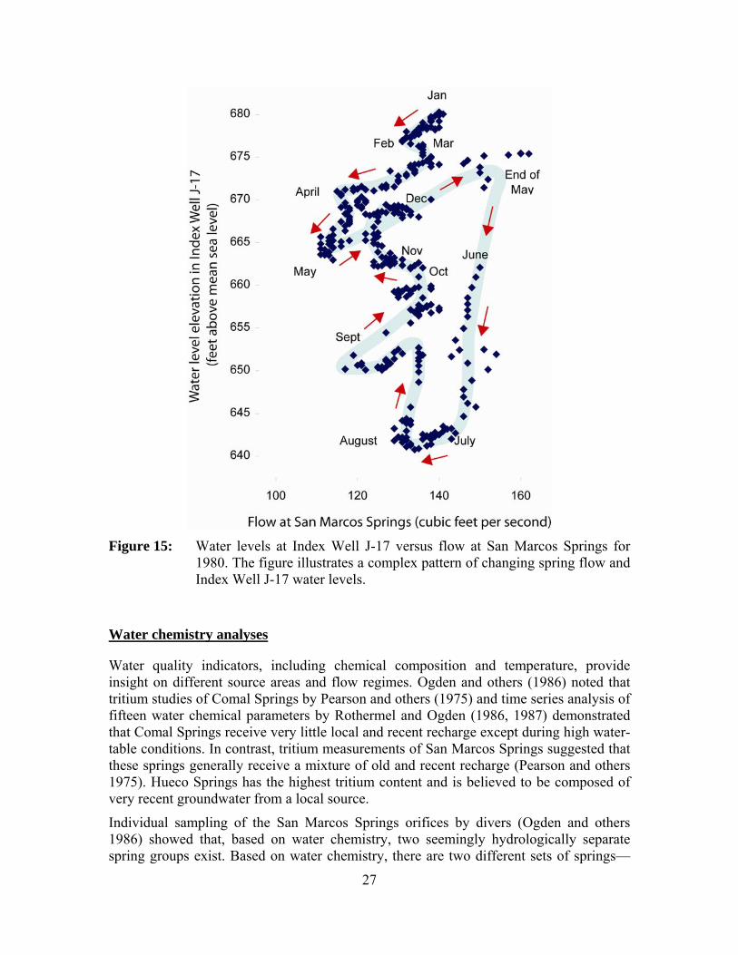
Figure 15: Water levels at Index Well J-17 versus flow at San Marcos Spring for 1980............................................................................................................27

xiii
Figure 16: Flow at San Marcos Springs for whenever the water level in Index Well J-17 was decreasing and crossing a critical period management trigger.........................................................................................................65
Figure 17: Flow at San Marcos Springs for whenever the water level in Index Well J-17 was increasing and crossing a critical period management trigger.........................................................................................................65
Figure 18: Flow at San Marcos Springs whenever flow at Comal Springs was declining and crossing its critical period management trigger. .................66
Figure 19: Flow at San Marcos Springs whenever flow at Comal Springs was increasing and crossing its critical period management trigger.................66

xiv
This page is intentionally blank.

1
Comal Springs in 2008 (photo by Steven Bereyso)
Introduction
The Edwards Aquifer is recognized as a vital water resource for a multitude of agricultural, environmental, industrial, municipal, and recreational uses. Several springs, namely Comal Springs and San Marcos Springs, provide habitat for a number of endangered species protected under the federal Endangered Species Act. After a lawsuit and the specter of federal control of the aquifer, the Texas Legislature created the Edwards Aquifer Authority to regulate pumping in the aquifer and to ensure that, by December 31, 2012, endangered and threatened species are protected.
In 2007, the Texas Legislature passed Senate Bill 3 which, among other items, formalized the Edwards Aquifer Recovery Implementation Program. The legislation requires a group of stakeholders in a Steering Committee to develop a Program Document. The Program Document provides recommendations for withdrawal adjustments to protect threatened and endangered species at all times and includes provisions to pursue funding for programs to achieve that goal. The document may be in the form of a Habitat Conservation Plan used in the issuance of an Incidental Take Permit. The Edwards Aquifer Authority, the Texas Commission on Environmental Quality, the Texas Water Development Board, and the U.S. Fish & Wildlife Service have to approve and execute the Program Document no later than September 30, 2012, with the document going into effect by December 31, 2012.
The Steering Committee is served by several subcommittees, one of which is the Edwards Aquifer Area Expert Science Subcommittee. Senate Bill 3 requires the formation of the Expert Science Subcommittee, its members appointed by the Steering

2
Committee (see Appendix A for information on the formation and operation of the subcommittee). The Expert Science Subcommittee’s initial charges are to (1) evaluate designating a San Marcos Pool, (2) evaluate the necessity of maintaining minimum spring flows, (3) evaluate whether adjustments to flow triggers for San Marcos Springs should be made, and (4) submit the recommendations to the Steering Committee and all other stakeholders involved in the Recovery Implementation Program by December 31, 2008 (Appendix B). The Expert Science Subcommittee is also required, at a later date, to (1) analyze species requirements for spring flow and aquifer levels as a function of recharge and withdrawal levels and (2) develop recommendations for withdrawal reductions for critical period management.
The Steering Committee, in a memo dated February 21, 2008, charged the Expert Science Subcommittee with the initial charges listed above and provided additional guidance and clarifications of those initial charges (Appendix C). These charges, with minor editing to break them into subtasks, were:
Task 1: The option of designating a separate San Marcos Pool, of how such a designation would affect existing pools, and of the need for an additional well(s) to measure the San Marcos Pool (if designated).
1.1 Identify the data and modeling that exist regarding whether a separate San Marcos Pool should be designated.
1.2 Are the data sufficient to support the designation of a separate San Marcos Pool?
1.3 Provide an evaluation of the hydrogeological evidence and identify the data gaps.
1.4 If there are data to support the designation of such a pool, what should be the extent and boundaries of such pool?
1.5 To what extent is this pool hydrologically independent?
1.6 Is there a need for an additional well or additional wells to measure the San Marcos Pool, if one were designated? If so, what is the most effective location for such well(s)?
1.7 The evaluation of this issue should include consideration of information provided by the members of the Recovery Implementation Program.
Task 2: The necessity to maintain minimum spring flows, including a specific review of the necessity to maintain a flow to protect the federally threatened and endangered species.
2.1 Is a minimum spring flow required for the survival and recovery of each species listed under the Endangered Species Act identified in Section 3.2 of the Memorandum of Agreement for the Edwards Aquifer Recovery Implementation Program (Appendix D)?
2.2 If alternatives exist to minimum flows that may not reduce appreciably the likelihood of the survival and recovery in the wild
3
by reducing the reproduction, numbers, or distribution of each species listed under the Endangered Species Act identified in Section 3.2 of the Memorandum of Agreement for the Edwards Aquifer Recovery Implementation Program (Appendix D), identify and provide a preliminary evaluation of those alternatives to protect those federally listed species.
2.2.1 Your consideration of alternatives should include an evaluation of information provided by members of the Edwards Aquifer Recovery Implementation Program on this issue.
2.2.2 Your consideration of alternatives also should be mindful of impacts on protected species other than those species listed under the Endangered Species Act identified in Section 3.2 of the Memorandum of Agreement for the Edwards Aquifer Recovery Implementation Program (Appendix D).
2.3 Identify existing studies regarding the ability of each alternative other than maintaining minimum spring flows to protect federally threatened or endangered species. Identify additional studies or data needed to fully evaluate each of these alternatives, including an estimate of the time and cost to conduct such studies, and any different alternatives that might be explored in the future.
2.4 Investigate spring flow volume measurement methodologies currently in use and evaluate their accuracy. If any are deemed to be inadequate, suggest alternative measuring methods.
Task 3: Whether adjustments in the trigger levels for the San Marcos Springs flow for the San Antonio Pool should be made.
3.1 Should the trigger levels for the San Antonio Pool based on San Marcos spring flow be adjusted? Identify the existing data available to develop recommendations regarding such adjustments and what additional information will be necessary to make such recommendations.
3.2 Investigate spring flow volume measurement methodologies currently in use and evaluate their accuracy. If any are deemed to be inadequate, suggest alternative measuring methods.
The purpose of this document is to report on these initial charges.
This report is organized according to the tasks listed above. Under each subtask, we list our recommendation followed by our interpretation of the subtask, the information we considered, and our analysis. Supporting documentation is included in the appendices.
4
Spring Lake at San Marcos Springs in 1901 (from Taylor 1904)
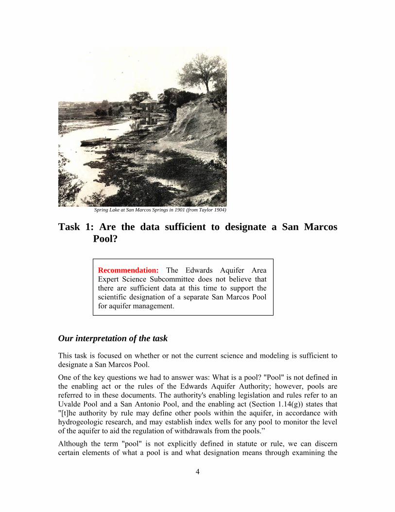
Task 1: Are the data sufficient to designate a San Marcos Pool?
Our interpretation of the task
This task is focused on whether or not the current science and modeling is sufficient to designate a San Marcos Pool.
One of the key questions we had to answer was: What is a pool? "Pool" is not defined in the enabling act or the rules of the Edwards Aquifer Authority; however, pools are referred to in these documents. The authority's enabling legislation and rules refer to an Uvalde Pool and a San Antonio Pool, and the enabling act (Section 1.14(g)) states that "[t]he authority by rule may define other pools within the aquifer, in accordance with hydrogeologic research, and may establish index wells for any pool to monitor the level of the aquifer to aid the regulation of withdrawals from the pools.”
Although the term "pool" is not explicitly defined in statute or rule, we can discern certain elements of what a pool is and what designation means through examining the
Recommendation: The Edwards Aquifer Area Expert Science Subcommittee does not believe that there are sufficient data at this time to support the scientific designation of a separate San Marcos Pool for aquifer management.

5
currently designated pools. Being designated as a pool does not infer hydrologic isolation from the rest of the aquifer as the Uvalde and San Antonio pools are hydrologically connected. The Uvalde Pool is defined as the part of the aquifer that underlies Uvalde County, and the San Antonio Pool is defined as the part of the aquifer that is within the bounds of the authority but outside of Uvalde County. The Knippa Gap, a hydrologic constriction in the groundwater flow from the western part of the aquifer to the eastern part, lies close to the line between Uvalde County and Medina County.
From a management perspective, a pool designation may affect permitting and critical period management, as seen in the statute and rules for the two existing pools. Therefore, we define a pool as a management construct supported by hydrogeologic data and descriptions that assist in managing the aquifer.
Why is this task important?
In 2006, after substantial rainfalls in some recharge basins, water levels in Index Well J-17 and flow from Comal Springs rebounded above their critical period management triggers while flow at San Marcos Springs remained below those triggers for an additional 125 days. Groundwater users in the San Antonio Pool were not allowed to reduce their pumping restrictions until Index Well J-17, Comal Springs, and San Marcos Springs all were above their respective triggers. This behavior in 2006 (Figure 1) as well as at other times in the past, has caused some to wonder whether or not a San Marcos Pool should be designated. A separate pool designation with separate triggers may allow some groundwater users outside of a San Marcos Pool to return to a lower, less restrictive, critical period withdrawal reduction stage while groundwater users within a San Marcos Pool area would remain at the higher withdrawal reduction stage until flow at San Marcos Springs exceeded a specified trigger level. A separate pool designation could also allow the Edwards Aquifer Authority to pass more stringent rules to protect the flow at San Marcos Springs.
Our approach for addressing the task
To address this task, we identified, reviewed, and discussed relevant literature and reports (noted below in the discussion) and listened to presentations by invited experts (Appendix E). Presentations relevant to our analysis included those by Geary Schindel of the Edwards Aquifer Authority on the Authority’s report on the San Marcos Pool question; Charles Kreitler of LBG-Guyton Associates on his company’s recent reports to the Authority on moving pumping locations to the east of Cibolo Creek and on augmenting spring flow; Rick Lindgren of the U.S. Geological Survey on his modeling work; Larry Land of HDR Engineering on recharge estimates and his work for the Guadalupe-Blanco River Authority on the effects on spring flow from the pumping of a power plant well near Comal Springs during the 1950s and the groundwater divide between San Marcos and Barton springs; and George Ozuna of the U.S. Geological Survey on spring flow measurements at Comal and San Marcos springs. The important

6
Figure 1: Comparison of Index Well J-17 water levels with Comal and San Marcos springflows for the period between November 2004 and February 2007 (from Johnson and Schindel 2008; cfs = cubic feet per second; ft msl = feet above mean sea level).
questions we sought to address were (1) Do we have a sufficient understanding of the geology and hydrodynamics of this part of the Edwards Aquifer to designate a separate pool for aquifer management? and (2) If we don’t have enough information, what addition information is needed?
Task 1.1: Identify the data and modeling that exist regarding whether a separate San Marcos Pool should be designated
We used data and analyses from the following studies in our evaluation:
• DeCook (1963),
• Rose (1972);
• Pearson and others (1975),
• Guyton (1979),
• Maclay and Small (1984),

7
• Ogden and others (1986),
• Rothermel and Ogden (1986, 1987),
• Deike ( 1990),
• HDR Engineering (1991),
• HDR Engineering (1993),
• Hovorka and others (1993),
• Maclay (1995),
• Barker and Ardis (1996),
• Groschen (1996),
• Hovorka and others (1998),
• HDR Engineering (2002),
• Slade and others (2002),
• LBG-Guyton Associates (2004),
• LBG-Guyton Associates (2005),
• Otero (2007), and
• Johnson and Schindel (2008).
The most relevant modeling work that related to this task included:
• Klemt and others (1979),
• Maclay and Land (1988),
• Thorkildsen and McElhaney (1992),
• Lindgren and others (2004), and
• Lindgren (2006).
These studies are discussed under Task 1.3.
Task 1.2: Are the data sufficient to support the designation of a separate San Marcos Pool?
At this time, the Edwards Aquifer Area Expert Science Subcommittee does not believe that there are sufficient data to support the designation of a separate San Marcos Pool. The support for this recommendation is discussed in the following sections.

8
Task 1.3: Provide your evaluation of the hydrogeological evidence and identify the data gaps.
To address this task, we carefully reviewed the documents noted under Task 1.1. For data and analyses, we considered the importance of the following on the designation of a separate San Marcos pool in the San Antonio segment of the Edwards Aquifer:
• hydrogeologic conceptualization,
• flowpath considerations,
• recharge assessments,
• water-balance estimates,
• water-chemistry analyses, and
• hydraulic correlation analyses.
We further evaluated the hydrogeology of the study area using results from the numerical models. We then used a comprehensive assessment of these data and analyses to identify perceived data gaps.
Hydrogeologic conceptualization
The area within the Edwards Aquifer considered for a separate San Marcos Pool lies within an extensively faulted and highly anisotropic and heterogeneous portion of the aquifer known as the Balcones Fault Zone (Rose 1972; “anisotropic” means that the aquifer has different flow properties depending on the direction of flow). The Balcones Fault Zone is characterized by a network of en echelon, high-angle, mostly down-to-the-east normal faults along the northwestern margin of the Gulf Coastal Plain (Maclay and Small 1984; “en echelon” means parallel or subparallel, closely spaced, and overlapping). Within the roughly 200-mile-long (320-kilometer-long) Balcones Fault Zone structural corridor, the carbonate strata were vertically displaced, intensively fractured, and differentially rotated within a series of southwest-to-northeast trending fault blocks (Barker and Ardis 1996).
The groundwater flowpaths that converge toward and ultimately determine the conditions at Hueco, Comal, and San Marcos springs must traverse structurally controlled and diagenetically altered pathways (Deike, 1990; “diagenetically altered” means alterations to the rock after it was deposited; in the case, dissolution). Factors that determine the internal configurations of the flowpaths—such as matrix porosity and permeability (Hovorka and others 1993, 1998), fractures, and karst conduits (Worthington 2003)—result from depositional, structural, diagenetic, and hydrologic imprints that have evolved since the Cretaceous Period, over the last 80 million years of geologic time.
The effect of geologic structure on groundwater flow near Hueco, Comal, and San Marcos springs is not fully understood. The alternating sets of nearly vertical, en echelon faults have been assumed to act as barriers to flow in some places and as conduits that enhance flow in other locations (Guyton 1979, Maclay and Land 1988). Faults can focus flow along the fault zone, for example, where zones of greater porosity and permeability

9
are developed around the fault zones. Conversely, faults may provide the flowpath that allows groundwater to move vertically between aquifer members or from a confined aquifer to a spring at ground surface. Large-displacement faults at Comal Springs and San Marcos Springs are examples of groundwater flow along faults.
Faults could become barriers to flow, however, where groundwater is prevented from flowing perpendicular to the faults. The barrier might form where the fault offsets blocks of the aquifer. The aquifer becomes discontinuous across the fault because of vertical displacement of the fault.
In addition, conduits exist that cut across faults. Recent tracer studies by the Edwards Aquifer Authority in northern Bexar County (Johnson and others, in review) show that conduits can be superimposed on the structurally controlled fault blocks, and that flow can readily cross between fault-bounded blocks where conduits have developed. The mean velocity of flow in conduits in northern Bexar County is approximately 1,120 feet per day (341 meters per day), with a maximum measured apparent velocity of more than 15,000 feet per day (4,570 meters per day) (Johnson and others, in review), much higher than flow velocities in the matrix porosity of the aquifer.
As groundwater flows toward Comal, Hueco, and San Marcos springs, groundwater flow may be focused within fault-bounded blocks but the role of flow in conduits that cross between fault-bounded blocks of the aquifer is still being evaluated by tracer tests. Otero (2007) and Johnson and Schindel (2008) provide the most current conceptual models of the fault blocks as they affect groundwater flow. These two studies focus on slightly different geographical areas and use different nomenclature to define the fault blocks. Otero (2007) extended her study southwest to Leon Creek while Johnson and Schindel (2008) limited their evaluation to that portion of the San Antonio Segment of the Edwards Aquifer located northeast of Cibolo Creek.
Otero (2007) identified three fault blocks designated in terms of groundwater flow as the Northern, Central, and Southern Comal flowpaths (Figure 2). The Southern Comal Flowpath is bounded on the northwest by the Comal Springs Fault and on the southeast by a freshwater/saline-water interface (Schultz 1994), where the concentration of dissolved solids exceeds 1,000 milligrams per liter. Although the interface is not everywhere coincident with physical barriers to flow, a major effect of the Comal Springs Fault is a resistance to the encroachment of saline water from the southeast.
Johnson and Schindel (2008) identified four fault blocks—Bat Cave, Hueco Springs, Comal Springs, and Artesian fault blocks—in Hays and Comal counties (Figure 3). The Bat Cave Fault Block receives water both from vertical infiltration in the fault block and lateral groundwater flow from the Trinity Aquifer where the Bear Creek Fault (Figure 2) juxtaposes the Trinity Aquifer against the Edwards Aquifer (Otero 2007, Johnson and Schindel 2008). As only the basal part of the Edwards Aquifer is present in the Bat Cave Fault Block, the flow and storage of groundwater is relatively limited in this updip, unsaturated-to-thinly-saturated part of the aquifer (“updip” means the upper part of a slanted geologic bed; in this context, it means up toward the recharge zone).

10
Figure 2: Locations of hypothesized groundwater flowpaths, northeastern Bexar and
southern Comal counties, Texas (from Otero 2007).

11
Figure 3. Locations of fault blocks in the Edwards Aquifer in Comal and
southwestern Hays counties (from Johnson and Schindel 2008).
In addition to the Bat Cave Fault Block, the Edwards Aquifer recharge zone lies in large parts the Hueco Springs Fault Block and smaller parts of the Comal Springs Fault Block. Although saturated thicknesses in the Hueco Springs and Comal Springs fault blocks are highly variable, they generally are greater than a few tens of feet (a few meters), particularly during wet,high-stage periods. The Edwards Aquifer is fully saturated in the Artesian Fault Block, which comprises the hydraulically confined part of the Edwards Aquifer in this area (Johnson and Schindel 2008).
The distributions of recharge and discharge are overriding controls on the distribution of groundwater in the Edwards Aquifer (Puente 1978). Recharge areas occur where the Edwards Aquifer receives water, where the aquifer is receptive to the infiltration of precipitation, vertical leakage through streambeds, and/or cross-formational flow from adjacent aquifers. Discharge areas are characterized by places on or near the land surface where water escapes through springs, seeps, or base flow to streams or as a result of evaporation, transpiration, and/or pumping. Aquifers can also discharge water to other aquifers or aquitards via subsurface cross-formational flow (in this context, “aquitard” refers to geologic formations that transmit water much more slowly than the aquifer).
Most recharge to the aquifer occurs west of Bexar County in Kinney, Uvalde, and Medina counties where streams originating north of the aquifer lose most or all of their

12
discharge as they flow over the highly fractured, permeable outcrop of the Edwards Aquifer. Additional water from precipitation enters the aquifer through recharge areas in updip, unconfined parts of the aquifer in Bexar, Comal, and Hays counties. After recharge enters the aquifer, groundwater moves in a generally eastward direction toward points of discharge that consist mainly of natural springs and irrigation and municipal (water-supply) wells. As the freshwater flowpaths approach the updip edge of a freshwater-saline water interface (Schultz 1994), groundwater is diverted toward the northeast along the northwestern limits of freshwater (Figure 4). Water that does not discharge to springs or wells in Kinney, Uvalde, Medina, or Bexar counties continues generally northeastward through conduits or alongside northeast-trending faults toward discharge points in Comal and Hays counties, primarily Comal and San Marcos springs.
Figure 4: General directions of groundwater flow in the Edwards Aquifer between
upgradient recharge areas and downgradient discharge areas (from Harden 1988, Figure 9).
A broad and changeable groundwater divide near Kyle (roughly 12 miles [19 kilometers] northeast of San Marcos Springs) is commonly used to separate the San Antonio Segment of the Edwards Aquifer from the Barton Springs Segment of the aquifer (LBG-Guyton Associates 1994, Scanlon and others 2002). However, the shifting nature of this groundwater “boundary” (Lindgren and others 2004) and its seemingly ephemeral existence during severe droughts (Land and Lemonds 2008) seems to preclude its use as a specific defining feature to distinguish between a separate San Marcos Pool and the Barton Springs Segment of the Edwards Aquifer.

13
Flowpath considerations
Groundwater flowpaths to Hueco, Comal, and San Marcos springs are significantly influenced by structural fault blocks as well as by conduits. An additional complexity is that these flowpaths may vary during high or low water level conditions. Otero (2007) combines flow in the Bat Cave and Hueco Springs fault blocks into the Northern Comal Flowpath. Flow in the Comal Springs Fault Block and flow to the southeast of the Comal Springs Fault are identified by Otero (2007) as the Central Comal and Southern Comal flowpaths, respectively. In comparison, Johnson and Schindel (2008) designate separate flowpaths for four fault blocks (the Bat Cave, Hueco Springs, Comal Springs, and Artesian fault blocks).
Johnson and Schindel (2008) interpret that groundwater flow is to the northeast in all four fault blocks (Figure 3). Conversely, Otero (2007) interprets groundwater flow in the southwestern end of the Central Comal Flowpath (designated as the Hueco Springs Fault Block by Johnson and Schindel [2008]) to be to the southwest. Elsewhere, Otero (2007) interprets that groundwater flow is to the northeast (Figure 5).
An unknown amount of water from the Northern Comal Flowpath is interpreted by Otero (2007) to migrate into the confined zones of the Central Comal Flowpath across the Hueco Springs Fault where it does not completely offset the Edwards Aquifer. Johnson and Schindel (2008) assert that much of the groundwater in the Bat Cave and Hueco Springs fault blocks likely discharges at Hueco Springs and that most of the water in the Comal Springs Fault Block discharges at San Marcos and Comal springs. Water in the Comal Springs Fault Block that does not discharge at either Hueco or Comal springs continues north-eastward toward San Marcos Springs. During low flow (low recharge) periods, Hueco Springs probably captures most of the water in the Hueco Springs Fault Block because water level elevations in the Hueco Springs Fault Block are lower than the elevation of San Marcos Springs.
Groundwater in the Artesian Fault Block flows to the northeast only as far as a point several miles (several kilometers) east of Comal Springs. LBG-Guyton Associates (2004) noted that the quality of water in the Artesian Fault Block has significantly higher total dissolved solids beyond this point. Otero (2007) attributes the change in water quality and direction of flow to a northwest trending fault that closes off northward flow within the Comal Springs Fault Block (Figures 3 and 5). Johnson and Schindel (2008) note that the water level in the Artesian Fault Block is mostly greater than in the Comal Springs Fault Block suggesting that groundwater flow is from the Artesian Fault Block to the Comal Springs Fault Block at this point (Figure 6). Johnson and Schindel (2008) state that the groundwater flow regime illustrated in Figure 6 is active during both normal flow (200 to 300 cubic feet per second [5.7 to 8.5 cubic meters per second] discharge at Comal Springs) and low flow (less than 100 cubic feet per second [2.8 cubic meters per second] at Comal Springs) conditions.

14
Figure 5: Main geologic structural features in the Comal Springs area including a northwest-trending fault located east of Comal Springs (modified from Otero 2007).

15
Figure 6: Groundwater flow in the Artesian and Comal Springs fault blocks (from
Johnson and Schindel 2008; cfs = cubic feet per second; ft msl = feet above mean sea level).
Johnson and Schindel (2008) note that water from the Artesian Fault Block enters the Comal Springs Fault Block when Comal Springs discharge is less than 100 cubic feet per second (2.8 cubic meters per second), bypassing Comal Springs and flowing to San Marcos Springs. This conceptual model explains why San Marcos Springs continued to flow during the drought of 1956 although flow at Comal Springs ceased. Johnson and Schindel (2008) speculate that cross-formational flow from the Trinity Aquifer contributes to San Marcos Springs discharge during periods of low flow. There is probably also cross-formational flow from the Trinity Aquifer into the Edwards Aquifer during high flows (Mace and others 2000). During periods with high water levels (abundant recharge), groundwater flows to the northeast and discharges in some proportion to both Hueco Springs and San Marcos Springs (Johnson and Schindel 2008).
There are two primary sources of water that discharge from the numerous springs at Comal Springs (LBG-Guyton Associates 2004). Spring #1 (Main Spring), Spring #2 (Panther Canyon Spring), and Spring Run #3 discharge from the upthrown (or Comal Springs Fault) block. Much of the Comal Springs discharge, however, comes from the bottom of Landa Lake (LBG-Guyton Associates 2004). About 75 percent of the total spring flow from Comal Springs is from the downthrown (or Artesian Fault) block in the bottom of the lake.

16
During the drought of the 1950s, springs that issued from the upthrown (or Comal Springs Fault) block (Springs #1, #2, and #3) stopped flowing when water levels in the upthrown block dropped below the elevations of the individual spring orifices (LBG-Guyton Associates 2004). Interestingly, water levels in the downthrown (or Artesian Fault) block remained above the elevation of the springs as they went dry, again indicating that springs #1, #2, and #3 are sourced from the upthrown block.
The Lower Colorado River Authority well, also known as the Comal Plant #3 Well, was drilled into the downthrown block at a position less than half a mile (0.8 kilometer) south of Landa Lake. The Lower Colorado River Authority started pumping this well at about 5,000 gallons per minute (0.3 cubic meters per second) in June 1956. Water levels in Landa Lake quickly started dropping and the lake almost went dry during the summer (LBG-Guyton Associates 2004). Under such conditions, water levels in the Comal Springs Fault Block are lower than the elevation of the Comal Springs orifices for spring runs #1, #2, and #3. During periods of low flow, Comal Springs is fed entirely or mostly by water from the Artesian Fault Block (Southern Comal flowpath) (LBG-Guyton Associates 2004).
San Marcos Springs depends on several sources of recharge (Johnson and Schindel 2008, LBG-Guyton Associates 2004). A significant component comes from the southwest through the Comal Springs Fault Block (Johnson and Schindel 2008). According to Guyton (1979), between 55 and 60 percent of the water that discharges from San Marcos Springs is water that by-passed (did not discharge at) Comal Springs. Recharge assessments described in the following section indicate that a long-term average of 35 to 45 percent of the water that discharges from San Marcos Springs is water that by-passed Comal Springs. In drought years during which San Marcos Springs discharge averages less than 100 cubic feet per second (2.8 cubic meters per second), these recharge assessments indicate that 45 to 80 percent of the water that discharges from San Marcos Springs is water that by-passed Comal Springs. Johnson and Schindel (2008) concluded that, under high-flow conditions, water not discharging from Hueco Springs continues northeastward through the Hueco Springs Fault Block and that “any” water crossing the Hueco Springs Fault “probably flows northeast toward San Marcos Springs.” San Marcos Springs is also sustained by water moving southeastward from the recharge area in southern Hays County (Maclay and Small 1984).
According to Johnson and Schindel (2008), local sources of recharge such as Purgatory Creek, York Creek, and the Blanco River may contribute up to 35 percent of the flow at San Marcos Springs. Recharge estimates from modeling efforts (LBG-Guyton Associates 2005) indicate that these specified local sources likely contribute between 60 to 70 percent of the long-term average discharge from San Marcos Springs.
The difference in hydrographs for Comal and San Marcos springs suggests the two springs are not fully correlated (LBG-Guyton Associates 2004). LBG-Guyton Associates (2004) interpreted this to indicate separate water sources: (1) a local source, which may be from the Blanco recharge basin, and (2) a more regional groundwater source, which may come from the major part of the aquifer located to the southwest of San Marcos. Additional sources of water discharged from San Marcos Springs may arrive as lateral

17
cross-formational flow from the Trinity Aquifer where the Bat Cave Fault juxtaposes the Trinity Aquifer against the Edwards Aquifer (Figure 3).
Recharge assessments
Recharge estimates have been calculated by the U.S. Geological Survey using methods developed in the late 1970s (Puente 1978) and published annually by the Edwards Aquifer Authority (2008). Estimates of recharge are reported for four recharge basins in the Nueces River Basin (Figure 7) and five recharge basins in the Guadalupe-San Antonio River Basin (Figure 8) (Puente 1978).
The Blanco and Guadalupe recharge basins are closest to San Marcos Springs. The Blanco Recharge Basin includes the Blanco River watershed as it traverses the Edwards Aquifer recharge zone located between streamflow gaging stations at Wimberley (USGS# 08117100) and Kyle (USGS# 081171300) and the ungaged watersheds of Sink, Purgatory, York, and Alligator creeks located on the recharge zone. The Guadalupe Recharge Basin includes the Guadalupe River watershed between the streamflow gaging station at Sattler (USGS# 08167700) and the City of New Braunfels.
The traditional recharge-estimation methodology relies on measured streamflow upstream and downstream of the outcrop of the Edwards Group with proportional estimates of potential runoff from the intervening subwatershed based on upstream or adjacent partner watersheds (Puente 1978). The traditional recharge-estimation method includes the components of recharge occurring in the primary streambed, smaller tributary water courses, and across the landscape. Recent studies (HDR Engineering, Inc., 2002, LBG-Guyton Associates 2005) suggest that recharge occurring in the primary streambed is variable and may be less than half of the calculated total recharge for some basins. Integration of all components of recharge, therefore, is important. Estimates from the traditional recharge-estimation method were used in calibration of the Texas Water Development Board’s Ground Water Simulation Program, Version IV (GWSIM-IV) model of the Edwards Aquifer in the late 1970s (Klemt and others 1979) and early 1990s (Thorkildsen and McElhaney 1992).
An alternate method for estimating Edwards Aquifer recharge was developed by HDR Engineering in the course of studies sponsored by the Edwards Underground Water District (HDR Engineering 1993) and the Texas Water Development Board (HDR Engineering 1991). Like the traditional recharge-estimation method of the U.S. Geological Survey, the alternate-method uses a monthly time step. Key differences between the models include elimination of base flow curves and use of alternative procedures for calculating potential runoff over the Edwards Aquifer recharge zone by integrating a representation of soil cover (Soil Conservation Service 1972) and a selection of different partner watersheds (HDR Engineering 1993). As a part of the Trans-Texas Water Program, HDR Engineering updated its alternate-method estimates of recharge through 1996 and compared results of traditional and alternate methods (HDR Engineering 1998).

18
Figure 7: Recharge basins in the Nueces River Basin (from HDR Engineering
1991).
Figure 8: Recharge basins in the Guadalupe-San Antonio River Basin (from HDR
Engineering 1993).

19
While overall estimates of long-term average recharge were quite similar, the geographic distribution proved significantly different. Recharge in the Blanco and Guadalupe watersheds, which are close to San Marcos Springs, was calculated to be greater by the alternate-method than by the traditional method. Differences in these two recharge estimates, in part, prompted additional research for selected recharge basins. Such research included an intensive, multi-year study of recharge in the Medina Lake System by the U.S. Geological Survey, a series of flow measurements to quantify losses and gains along the Guadalupe River between Canyon Dam and New Braunfels, and applications of Hydrologic Simulation Program-Fortran (HSPF) to estimate Edwards Aquifer recharge on a more refined time-step.
Pilot applications of HSPF for estimation of Edwards Aquifer recharge in the Nueces and Blanco recharge basins were completed in 2002 (HDR Engineering 2002), and comprehensive applications of HSPF for all recharge basins were completed in 2005 (LBG-Guyton Associates 2005). Models based on HSPF are thought to retain the strengths and overcome the weaknesses of either the traditional or alternate methods. Specific advantages of the HSPF models include (1) use of a water-balance approach integrating many relevant hydrologic parameters (such as measured streamflow at the upstream gaging station, precipitation, evaporation, diversions, soil type, antecedent moisture conditions, land use, interception, infiltration, and evapotranspiration) and (2) computation of recharge on a daily, rather than monthly, time step through direct simulation of watershed response to precipitation and streamflow inputs. Although review and refinement of historical recharge estimates based on the HSPF models are ongoing, it is likely that historical recharge in the Blanco and Guadalupe recharge basins was substantially greater than that estimated by the traditional U.S. Geological Survey method.
Lindgren and others (2004) specified recharge in their model using a modified version of the traditional U.S. Geological Survey recharge methodology. Modifications of the traditional estimates included estimation and consideration of recharge in the Guadalupe Recharge Basin at a long-term average of about 31,900 acre-feet per year (3,930 hectare-meters per year)(rather than zero) and reduction of recharge in the Blanco Recharge Basin in high flow years. The revised recharge estimates for the Blanco Recharge Basin give a long-term average of about 43,100 acre-feet per year (5,320 hectare-meters per year)(rather than about 46,200 acre-feet per year [5,700 hectare-meters per year]). Though individually quite different from the alternate-method and HSPF basin recharge estimates, the combined long-term average U.S. Geological Survey recharge estimates for these two basins were very similar to those reported by others.
For the drought period of 1950 through 1956, however, recharge for the Blanco and Guadalupe recharge basins by the modified-traditional method was less than half of the total reported by the other two methods. Nevertheless, San Marcos springflows simulated by the calibrated U.S. Geological Survey model match measured historical discharge reasonably well during this severe drought period.

20
Water-balance estimates
We reviewed comparisons of annual discharge from San Marcos Springs for the 1950 through 2000 historical period to the cumulative sums of annual recharge estimates for the Blanco (nearest), Guadalupe, Cibolo/Dry Comal, and Helotes/Salado recharge basins (respectively numbered 9, 8, 7, and 6 in Figure 8). Annual recharge and springflow estimates used for these preliminary comparisons are those used by the U.S. Geological Survey for calibration of the 2004 Edwards Aquifer groundwater flow model (Lindgren and others 2004), in part because the HSPF recharge estimates are being refined at this time. Observations based on these comparisons include the following:
1. Discharge from San Marcos Springs exceeded estimated recharge in the Blanco Recharge Basin in every year.
2. Discharge from San Marcos Springs exceeded combined estimated recharge in the Blanco and Guadalupe recharge basins in 94 percent of the years considered.
3. Discharge from San Marcos Springs exceeded combined estimated recharge in the Blanco, Guadalupe, and Cibolo/Dry Comal recharge basins in 35 percent of the years considered.
4. In some of the most severe drought years, discharge from San Marcos Springs exceeded combined estimated recharge from all four of the recharge basins considered.
5. On a long-term average basis, 100 percent of estimated recharge in the Blanco and Guadalupe recharge basins together with 40 percent of that in the Cibolo/Dry Comal basin account for the discharge from San Marcos Springs.
These water balance estimates focusing on recharge and springflow provide some preliminary insights into portions of the Edwards Aquifer that contribute most directly to discharge from San Marcos Springs. In addition to conventional estimates of Edwards Aquifer recharge, San Marcos Springs may be sustained by depletion of aquifer storage and/or inter-formational flux from the Trinity Aquifer. Preliminary water balance assessments illustrate some of the technical difficulties associated with designating a separate San Marcos Pool when portions of the Edwards Aquifer contributing significantly to San Marcos Springs extend through Hays and Comal counties and likely extend into Bexar County.
Hydraulic correlation analyses
LBG-Guyton Associates (2004) and Schindel and Johnson (2008) correlated hydrographs for spring discharge (Hueco, Comal, and San Marcos springs), hydrographs for rivers and stream stages, and hydrographs of water levels for selected index wells. Correlations between index well water elevations and spring discharge rates show the hydraulic relationship between the aquifer at the well location and at the point of spring discharge. Correlations between river stage and spring discharge provide an indication of whether the rivers act as recharge to groundwater feeding the springs. Correlations between spring discharge hydrographs measure the hydraulic communication between the springs, either in terms of sharing similar recharge zones or in terms of discharging from the same

21
groundwater reservoir. It is important to realize that the relationships exhibited by these data may be dependent on aquifer stage. For example, correlations between index wells and spring discharge may differ during high stage relative to low stage.
Key index wells are:
• J-17 (Bexar County Index Well) documented to be strongly correlated with discharge at Comal Springs and weakly correlated with discharge at San Marcos Springs (Figures 9 and 10).
• 68-23-302 (Landa Park or Panther Canyon well) located in the Comal Springs Fault Block half a mile (0.8 kilometer) west of Comal Springs. Water elevations at Well 68-23-302 have a strong correlation with Comal Springs discharge (Figure 11).
• 67-09-110 (Southwest Texas Farms Wells) located in the Comal Springs Fault Block five miles southwest of San Marcos Springs. The water level in this 674 foot (205 meter) deep well is strongly correlated with San Marcos Springs discharge (Figure 12).
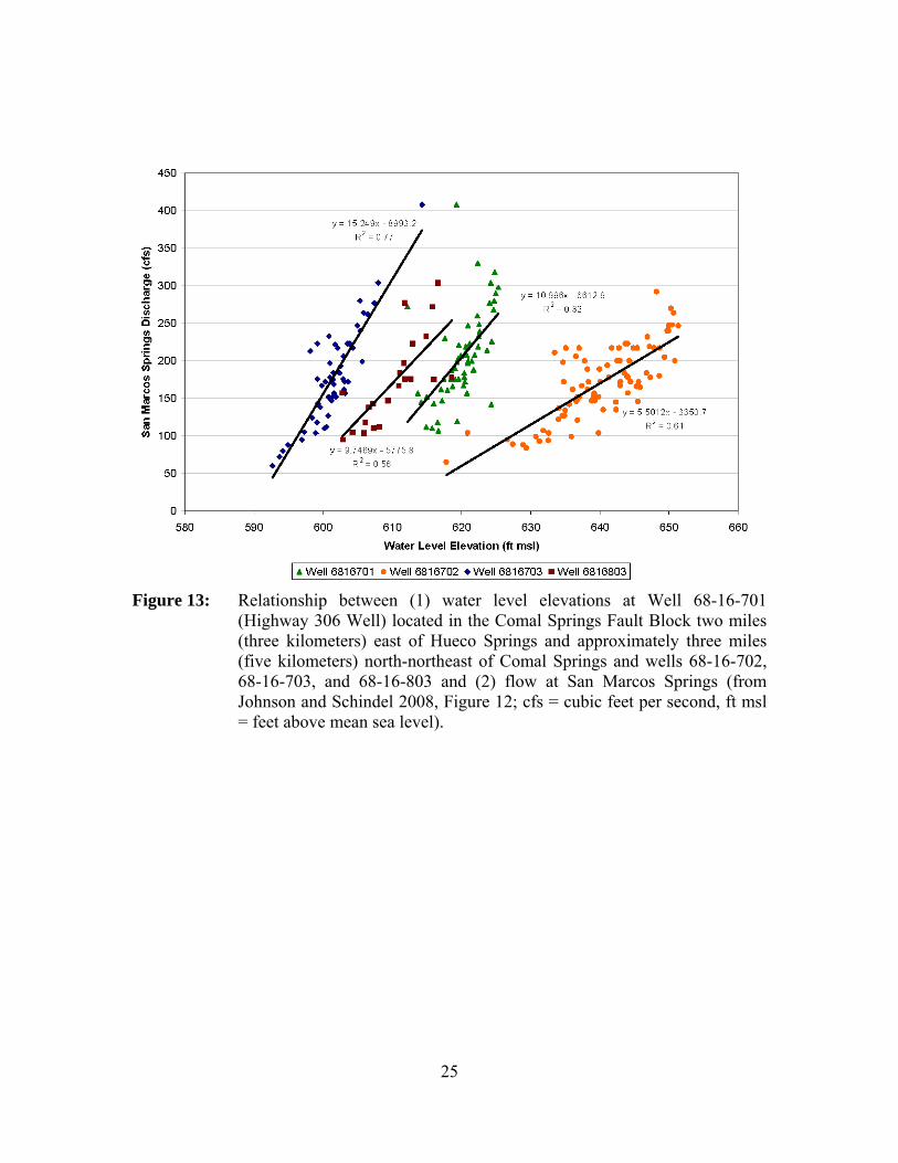
• 68-16-701 (Highway 306 Well) located in the Comal Springs Fault Block two miles (3.2 kilometers) east of Hueco Springs and approximately three miles (4.8 kilometers) north-northeast of Comal Springs. Water level measurements at this well strongly correlate with San Marcos Springs (Figure 13).
For several different time periods, discharge at San Marcos Springs did not correlate with discharge at Comal Springs or water levels at Index Well J-17 (Figures 14 and 15). Spring discharge from Comal Springs can be increasing while discharge from San Marcos Springs is decreasing due, in this particular time period, to the occurrence of significant local recharge proximate to and up-gradient of Comal Springs while below average recharge continued near San Marcos Springs Lake (LBG-Guyton Associates 2004). This suggests that the flow at Comal and San Marcos springs are influenced differently by the interaction of local and regional flow (LBG-Guyton Associates 2004). On the other hand, simple linear regression analyses of average discharges from Comal and San Marcos springs for each month during the 1956 through 1989 historical period shows a statistically significant correlation. More specifically, the coefficient of determination (r2) is found to be 0.55 for a linear regression equation considering Comal Springs discharge as the sole independent variable for estimation of San Marcos Springs discharge. In other words, about 55 percent of the variations in San Marcos Springs discharge can be explained by a simple linear relationship with Comal Springs discharge.

22
Figure 9: Relationship between (1) water level elevation at Index Well J-17 and (2)
flow at Comal Springs (modified from Votteler 2000, Figure 14).
Figure 10: Relationship between (1) water level elevations at Index Well J-17 and (2)
flow at San Marcos Springs (modified from Votteler 2000, Figure 17).

23
Figure 11: Relationship between (1) water level elevation at Well 68-23-302 (Landa
Park or Panther Canyon well) located in the Comal Springs Fault Block half a mile (0.8 kilometer) west of Comal Springs and (2) flow at Comal Springs (from LBG-Guyton Associates 2004, Figure B-13; cfs = cubic feet per second, ft MSL = feet above mean sea level, ‘ = feet, LCRA = reference to a well operated by the Lower Colorado River Authority during the 1950s).

24
Figure 12: Relationship between (1) hydraulic head above San Marcos Springs at
Well 67-09-110 (Landa Park or Panther Canyon well) located in the Comal Springs Fault Block five miles (eight kilometers) southwest of San Marcos Springs and (2) flow at San Marcos Springs (from Johnson and Schindel 2008, Figure 38; cfs = cubic feet per second).
25
Figure 13: Relationship between (1) water level elevations at Well 68-16-701
(Highway 306 Well) located in the Comal Springs Fault Block two miles (three kilometers) east of Hueco Springs and approximately three miles (five kilometers) north-northeast of Comal Springs and wells 68-16-702, 68-16-703, and 68-16-803 and (2) flow at San Marcos Springs (from Johnson and Schindel 2008, Figure 12; cfs = cubic feet per second, ft msl = feet above mean sea level).

26
Figure 14: Flow at Comal and San Marcos springs for the period of 1988 to 1990
(modified from LBG-Guyton Associates 2004, Figure B-28; cfs = cubic feet per second).
27
Figure 15: Water levels at Index Well J-17 versus flow at San Marcos Springs for
1980. The figure illustrates a complex pattern of changing spring flow and Index Well J-17 water levels.
Water chemistry analyses
Water quality indicators, including chemical composition and temperature, provide insight on different source areas and flow regimes. Ogden and others (1986) noted that tritium studies of Comal Springs by Pearson and others (1975) and time series analysis of fifteen water chemical parameters by Rothermel and Ogden (1986, 1987) demonstrated that Comal Springs receive very little local and recent recharge except during high water-table conditions. In contrast, tritium measurements of San Marcos Springs suggested that these springs generally receive a mixture of old and recent recharge (Pearson and others 1975). Hueco Springs has the highest tritium content and is believed to be composed of very recent groundwater from a local source.
Individual sampling of the San Marcos Springs orifices by divers (Ogden and others 1986) showed that, based on water chemistry, two seemingly hydrologically separate spring groups exist. Based on water chemistry, there are two different sets of springs—
28
the northern springs and the southern springs—discharging into Spring Lake (LBG-Guyton Associates 2004). The differences in water chemistries imply that different source areas are providing flow to the two spring groups. The northern springs may be discharging water from a more local source while the southern springs may be discharging water from a more regional flow system.
Numerical Models
Since 1979, more than a dozen groundwater models have been developed of the Edwards Aquifer. Several of these models have been used to simulate conditions of groundwater flow that appear to affect the San Marcos Springs flow regime. In regard to simulated results that most importantly influenced our evaluation of whether a separate pool for San Marcos Springs is appropriate, the most noteworthy of the Edwards Aquifer models are those by Klemt and others (1979), Maclay and Land (1988), Lindgren and others (2004), and Lindgren (2006). The major contributions of each of these models toward the current understanding of the San Marcos flow regime, and how their results influenced our decision as to whether the designation of a separate San Marcos Pool is justified, are summarized below. These models (and associated characteristics most related to conditions at San Marcos Springs) are discussed in order of their development.
Klemt and others (1979)
Klemt and others (1979) developed the first numerical model of the San Antonio Segment of the Edwards Aquifer. The associated investigation was directed primarily toward “quantitative aspects” of groundwater withdrawals, springflows, and aquifer characteristics. The purpose of this Texas Water Development Board model was to “determine the occurrence, availability, and dependability of the Edwards (Balcones Fault Zone) aquifer” and to “develop a groundwater resources management tool for use in a total water-resource management program.”
Klemt and others (1979) used their model to simulate the effects of various management scenarios that began in 1972 and continued through 2049. All projected groundwater withdrawals “assumed that the present water quality of the aquifer would remain constant in time…and possible changes in water quality were not considered in sizing or in locating pumpage centers.” The results of their simulations—based on projections of increased population growth, increased future water withdrawal, and climate—indicated that the aquifer was capable of meeting the projected demands. However, simulated discharge from San Marcos Springs showed “a declining trend” through the last year for which spring flow was simulated to occur, which was year 2009. Year 2000 was the first year for which spring flow was simulated to be less than the actual historical minimum, and water levels adjacent to San Marcos Springs showed “a downward trend similar to the trend observed for the water levels adjacent to Comal Springs.” The results of even the most fundamental projections of future conditions indicated that the fate of San Marcos springflow was tied closely to upgradient conditions at Comal Springs.
Additional simulations were made to determine how artificial recharge might affect the Edwards Aquifer. The additional recharge was assumed to have come from “newly established and proposed reservoirs designed to increase recharge.” The projections of

29
additional recharge indicated that both Comal and San Marcos springs would continue to flow for a longer period with the addition of artificial recharge.
Subsequent runs were made with the model to test whether San Marcos Springs might continue to flow at rates of at least 100 cubic feet per second (2.8 cubic meters per second), given assorted reductions in the projected rates of municipal and/or industrial pumpage. Under certain conditions, the simulated responses indicated that San Marcos Springs would continue to flow, albeit at rates far below average, through year 2002, but not without significant “joint” reductions in municipal and industrial pumpage. According to Klemt and others (1979), it was “important to note that the reduction in pumpage to maintain Comal Springs also resulted in continuous flow for San Marcos Springs.”
Maclay and Land (1988)
Maclay and Land (1988) identified four hydrologic “storage units” and four associated “flow units” within the Edwards Aquifer. As forerunners to the relatively detailed “flowpath” and “fault-block” designations and associated explanations of more recent investigation and modeling, Maclay and Land (1988) based the calibration of their model on the premise that “four subareas of the unconfined zone tended to function as independent storage units because of faults.” They explained that their division of such units was “strongly influenced by major faults, a narrowing of the recharge zone area, and a change from one stream basin to another.” Maclay and Land (1988) defined flow units as
“...an area of the aquifer that includes a storage unit and a zone in which water is transmitted from this storage unit to major points of discharge. Some interchange of ground water of the aquifer that includes a storage unit and a zone in which water is transmitted from this storage unit to major points of discharge. Some interchange of ground water from one flow unit to another probably occurs at different water-level conditions.”
Maclay and Land’s (1988) results advanced an appreciation of the need to simulate the hydraulic effects of structural compartmentalization on aquifer water levels and springflow. Despite the relatively large-scale nature of their model and its limited capacity to replicate historical water-level and springflow conditions, their contributions emphasized the need for future model studies to consider the effects of “ground-water storage and flow concepts.” Their results provided a better appreciation of the effects faults impose on the movement and storage of groundwater and on the magnitude of aquifer properties that would be incorporated into subsequent models. Of particular relevance to the scope of this document, Maclay and Land’s (1988) experience with this model left little doubt, in their opinion, that “Ground water in the unconfined zone of the aquifer in northwestern Bexar, Comal, and Hays counties is diverted by barrier faults toward San Marcos Springs.”

30
Lindgren and others (2004) and Lindgren (2006)
Lindgren and others (2004) based the design of their finite-difference model on the conceptualization that most groundwater flow in the Edwards Aquifer occurs primarily through a finite number of elongated solution cavities (conduits) rather than through an expansive network of relatively small, but countless, openings. This design attempted to add a conduit flow component to the standard diffuse flow conceptualization. It was adopted with the premise that it would provide a plausible approach toward simulating the aquifer’s relatively rapid response to short-term recharge (precipitation) events, including the associated increases in downgradient water levels and springflow. A key similarity shared with the design of past models was the objective of simulating the effects of barrier faults that tend to compartmentalize the storage and flow of groundwater within physically discrete fault blocks that, in places and in varying degrees, may be hydraulically linked.
The results of experimentation with this model (Figure 10 in Lindgren and others 2004), substantiate the importance of barrier faults, which appear to strongly influence the directions of groundwater flow by restricting it to preferential flowpaths within the fault-bounded blocks delineated earlier by Maclay and Land (1988). Although the fault blocks are not simulated as distinct entities (discrete partitions within the model) their presence is reflected by the concentration of simulated flow within a series of roughly parallel segments of the Edwards Aquifer. The preferential flowpaths are aligned, for the most part, with mapped barrier faults within the Balcones Fault Zone (Collins and Hovorka 1997).
Groschen (1996) postulated that the locations of most major springs in the Edwards Aquifer are structurally controlled. Groschen (1996) explained that springs tend to exist where confined water (under pressure) rises, through breaks in the overlying confining beds, to topographically low areas of the surface. The Lindgren and others (2004) model reflects this effect by simulating the movement of groundwater along specific conduits that “tend to facilitate” flow toward the springs, including Comal and San Marcos springs. Note that “conduits” are represented in the model as cells with high transmissivity and not as discrete features. The simulated rates of springflow in the Lindgren and others (2004) model were more dependent on the simulated orientation and hydraulic properties assigned to the conduits (based on regional structure and effects of karstification) than to the simulated elevations and spring-orifice properties of the springs themselves (due to local conditions).
By setting the model boundary at the Colorado River, Lindgren and others (2004, p. 73) were able to simulate the groundwater divide in the Edwards Aquifer near Kyle in south-central Hays County. From the location of this divide, groundwater flows northeastward toward Barton Springs or southwestward toward San Marcos Springs. The results of model simulations indicate that the position of this groundwater divide varies, depending on water-level conditions. For steady-state and above-normal rainfall and recharge conditions, the simulated position of the groundwater divide “is coincident with its commonly defined position near Kyle.” However, during low-recharge drought conditions and given the assumed distribution of pumping in the model, the position of the simulated groundwater divide “shifts westward to near San Marcos Springs, and

31
recharge from the Blanco River moves eastward toward Barton Springs, rather than westward toward San Marcos Springs.”
The conduit-dominated design of the Lindgren and others (2004) model was intended to allow a comparatively detailed account of the aquifer’s relatively quick response to short-term recharge activity conveyed to the springs along flowpaths associated with mapped flow units and presumed locations of major conduits. However, this model remains “regional in nature and, therefore, is best suited to evaluate variations in spring discharge, regional water-level changes, and the comparison of regional water-management scenarios.” Lindgren and others (2004) emphasized that the accuracy and applicability of the model decrease when “changing from the regional to the local scale.” The authors explain that the model is not considered appropriate for local issues, such as water-level declines surrounding individual wells, because of the model’s relatively coarse grid size (40-acre [16 hectare] grid cells). Other model limitations are related to an imperfect conceptualization of actual conditions, including having only approximated the locations and hydraulic properties of the conduits through which most of the groundwater-flow is simulated to occur.
Even before the conduit flow version of the Edwards Aquifer model (Lindgren and others 2004) was initiated, its basic design was questioned in that (1) the U.S. Geological Survey’s Modular three-dimensional finite-difference ground-water Flow (MODFLOW) code (Harbaugh and others 2000) was not specifically formulated for the simulation of conduit flow, (2) the unknown degree to which conduits actually control prevailing, observable conditions in the Edwards Aquifer and, therefore, influence the most important regional aspects of groundwater flow, including spring discharge, and (3) the exact location and regional connections of the specified major conduits. To address some of this uncertainty, a diffuse-flow version of the former Edwards Aquifer model was developed (Lindgren 2006).
The objectives of this extended study and alternative model (Lindgren 2006) were to modify the hydraulic conductivity distributions of the conduit-flow model by replacing the simulated conduits with relatively broad zones of elevated hydraulic conductivity. The distribution of hydraulic conductivity in the non-conduit, diffuse-flow model emphasized the small-cavity, fracture-flow component rather than the pattern of large, interconnected conduits that dominates the former design. Revision of model properties for the diffuse-flow approach was limited to changes in the distribution of simulated hydraulic conductivity. All other aspects of the model are the same as those representing the conduit flow Edwards Aquifer model.
According to Lindgren and others (2004, p. 97–101) and Lindgren (2006, p. 30–32), both the conduit-flow and the diffuse-flow versions of the Edwards Aquifer (MODFLOW) model appear to provide a reasonably appropriate simulation of measured springflow and hydraulic heads over the relatively long transient-calibration period of 1947 to 2000. Both models better replicate the timing and rates of discharge for the Comal and San Marcos springs than for the smaller springs. Although the distributions of simulated springflow in both models are similar for all simulated springs, the conduit-flow model appears to provide a closer approximation of discharge for Comal Springs than for San Marcos Springs.
32
The slightly smaller total springflow simulated with the diffuse-flow model (relative to that with the conduit-flow model) is believed to result from the general pattern of somewhat lower water levels simulated with the diffuse-flow model. This, coupled with the observation that greater differences occur during the periods of greatest springflow, might indicate that the diffuse-flow model is “somewhat less responsive” to short-term recharge events than the conduit-flow model. Despite having been calibrated with different emphases on different aspects of the groundwater-flow regime, Lindgren believes that—on balance—no model stands out as the “better” of the two in terms of their capacities to simulate regional effects of alternative water-management scenarios (Rick Lindgren, U.S. Geological Survey hydrologist, verbal communication, 2008).
Summary
Evaluation of available hydrogeological evidence by the Edwards Aquifer Area Expert Science Subcommittee leads to the conclusion that there are insufficient data to support the designation of a separate San Marcos Pool or to define its boundaries at this time. On the basis of available hydrogeologic evidence, the Expert Science Subcommittee further concludes that aquifer levels, recharge, and pumpage in Comal and Bexar counties have sufficient effects on San Marcos Springs that management of a fully separate San Marcos Pool would be an administrative action rather than a scientifically-based decision.
Hydrogeological conceptualizations as well as defined and inferred flowpaths of the Edwards Aquifer set forth by multiple researchers, though complex and sometimes conflicting, all generally indicate that physical pathways for groundwater at least as far away as Bexar County contribute significantly to discharge at San Marcos Springs. Water balance estimates indicate that recharge occurring in Hays, Comal, and Bexar counties contribute significantly to discharge at San Marcos Springs.
Flowpaths, recharge, and water-balances considered together demonstrate that San Marcos Springs is more reliant on distant, rather than local, water sources within the aquifer to sustain springflow during drought. Water-chemistry analyses of discharges from multiple San Marcos Springs orifices indicate contributions from recent, local recharge and older, regional recharge. Hydraulic correlation analyses reveal that Comal Springs discharges are highly correlated with water levels in the Bexar County Index Well (J-17) and that San Marcos Springs discharges are correlated with Comal Springs discharges, despite some temporal anomalies at San Marcos Springs likely caused by differences in local and regional recharge and storage recovery rates during the drought of 2006 and other droughts.
Recommended Studies
The “unknowns” still significantly outnumber the “knowns” when it comes to understanding the recognized hydrogeologic features and effects—much less the unrecognized controls—on groundwater levels and springflow associated with San Marcos Springs. From a scientific standpoint, it seems unwise to recommend segregation of the larger San Antonio Pool until the relationships among rainfall, recharge, and downgradient water levels and springflow become more predictable. In other words, a more complete understanding is required of the various elements of the hydrogeologic

33
framework that control the flow and storage of groundwater in different segments of the Edwards Aquifer. To improve this understanding, the Expert Science Subcommittee recommends the following studies on hydrogeology and modeling.
Hydrogeology
• Develop a better understanding of recharge, flow, and water budget with respect to San Marcos Springs.
• Conduct a detailed baseflow study and analysis of the Guadalupe River as it flows over the Edwards Aquifer recharge zone.
• Study the relationship between San Marcos Springs and recharge from the Blanco and upper San Marcos river basins.
• Establish a water-level monitoring network in the San Marcos Springs area and try to correlate groundwater levels to flow at San Marcos Springs.
• Study the hydrogeology and water chemistry of the individual springs that make up San Marcos and Comal springs.
• Conduct more tracer studies to better understand flow paths near the springs.
• Conduct a basic hydrogeologic investigation of Fern Bank Springs. • Understand why flow at San Marcos Springs at times does not correlate
well with either Comal Springs discharge or water levels at Index Well J-17.
• Study possible connection to Barton Springs and the behavior of the groundwater divide.
Modeling
• Update the groundwater model to (1) reflect the most recent conceptualization of local groundwater flow regimes affecting Comal and San Marcos springs and (2) include the best available estimates of recharge.
• Improve model performance in the unconfined zone. • Assess whether the model can be used to better evaluate San Marcos
Springs hydrology and management scenarios. • Study crossformational flow from the Trinity Aquifer to the Edwards
Aquifer in the eastern part of aquifer and determine if this flow is accurately represented in the model.
Task 1.4: If there are data to support the designation of such a pool, what should be the extent and boundaries of such pool?
This task is not applicable because of our response to Task 1.2.

34
Task 1.5: To what extent is this pool hydrologically independent?
This task is not applicable because of our response to Task 1.2.
Task 1.6: Is there a need for an additional well or additional wells to measure the San Marcos pool, if one was designated. If so, what is the most effective location for such well(s)?
This task is not applicable because of our response to Task 1.2.
Task 1.7: The evaluation of this issue should include consideration of information provided by the members of the Recovery Implementation Program.
We have evaluated and taken into consideration the information provided by members of the Recovery Implementation Program. Position papers submitted by the members are included in Appendix F.

35
Cream of Wheat Springs in Spring Lake (photo by Bridget Lewin)
Task 2: Are minimum spring flows necessary?
Minimum flows are a necessary part of a flow regime of a given aquatic ecosystem for the protection of its component species. The state of instream flow science has evolved to the point that the maintenance of minimum flows alone is not considered sufficient to maintain a sound ecological environment (National Research Council 2005). The Texas Instream Flow Program has adopted an approach (Texas Commission on Environmental Quality and others 2008) that involves the identification of ecologically significant flow components for Texas' rivers and streams. Each of these components can be described by the timing, frequency of occurrence, flow magnitude, and duration of individual events. It is important to recognize that the ecology of an aquatic ecosystem is defined by extreme events on both the high- and low-flow end of the spectrum and that having occasional extremes supports populations of native species that have evolved life history strategies in response to the natural flow regime (Poff and Allan 1995, Poff and others 1997, Bunn and Arthington 2002). Experiencing these natural extremes puts stress on non-native species and promotes the survival of the native flora and faunal community (Poff and Allan 1995, Poff and others 1997, Bunn and Arthington 2002). However, the frequency and duration of these extreme events are of critical importance and, if extended beyond the natural tendency of the system, can be detrimental to the resident ecological community.
For this evaluation, minimum springflows are defined as flow events that occur infrequently, have a magnitude sufficient to maintain critical ecological functions (that is, water quality and minimal habitat conditions), and do not last long enough to stress the ecosystem beyond a point where it can recover naturally. Additionally, the ability of an aquatic community to endure stressful, low-flow events is largely related to its condition

36
at the onset. Consequently, assuring that flows are maintained at sufficient levels with appropriate inter- and intra-year variability during more normal (not extreme) conditions is also required to maintain a healthy community, thus inherently protecting the threatened and endangered species.
Task 2.1: Is a minimum springflow required for the survival and recovery of each species listed under the Endangered Species Act identified in Section 3.2 of the Edwards Aquifer Recovery Implementation Program Memorandum of Agreement?
Our interpretation of the task
While the term “required” might imply that a single minimum springflow would alone be sufficient, our interpretation is that minimum springflows are “necessary” within the context of a system flow regime. We do not feel that minimum springflows alone are sufficient for the survival and recovery of a threatened or endangered species. The question also implies that there may be a single minimum springflow that permits both survival and recovery. We contend that minimum springflows within the context of a system flow regime are important to both survival and recovery, but not in the same way nor at the same level of importance. Minimum springflows are vital to maintain conditions suitable for individuals of a species to continue to exist for some period (that is, survive). Minimum springflows also play a role in genetic strengthening which serves a purpose in the recovery of a species. Recovery is defined as “the process by which the decline of an endangered or threatened species is arrested or reversed, and threats removed or reduced so that the species’ long-term survival in the wild can be ensured.” The following sections document our rationale for this task.
Recommendation: At this time, the Edwards Aquifer Area Expert Science Subcommittee believes that minimum springflows are required within the context of a system flow regime for the survival and recovery of each species listed under the Endangered Species Act identified in Section 3.2 of the Edwards Aquifer Recovery Implementation Program Memorandum of Agreement. A system flow regime includes low flows which support the survival of individuals for limited periods of time, normal flows which support reproduction within the population, and higher flows that periodically rejuvenate the system.

37
Discussion
The species listed under the Endangered Species Act identified in Section 3.2 of the Edwards Aquifer Recovery Implementation Program Memorandum of Agreement (Appendix D) consist of eight threatened and endangered species found in the Comal and San Marcos springs ecosystems. These include two fish [fountain darter (Etheostoma fonticola) and San Marcos gambusia (Gambusia georgei)], two salamanders [Texas blind salamander (Eurycea rathbuni) and San Marcos salamander (Eurycea nana)], one plant [Texas wild-rice (Zizania texana)], and three invertebrates [Comal Springs dryopid beetle (Stygoparnus comalensis), Comal Springs riffle beetle (Heterelmis comalensis), and Peck’s cave amphipod (Stygobromus pecki)]. Of these, only the San Marcos salamander is listed as threatened by the U.S. Fish & Wildlife Service; the rest are listed as endangered.
Each of these species has a restricted distribution limited to springs associated with the Edwards Aquifer, and several are found in either Comal Springs or San Marcos Springs, but not both. Originally, only the fountain darter was believed to occupy both spring ecosystems, but recent collections of the Comal Springs riffle beetle in Spring Lake at the headwaters of the San Marcos River (Gibson and others 2008) reveal that this species is also found in both ecosystems. Among the other species, San Marcos salamander and Texas wild-rice occur only in the San Marcos River, while the Texas blind salamander is found in the aquifer below San Marcos and nearby springs. Two of the three invertebrates, Comal Springs dryopid beetle and Peck’s cave amphipod, are found only in Comal and nearby springs (that is, Hueco and Fern Bank springs). The San Marcos gambusia is considered extinct as no individuals have been collected since 1982, despite subsequent intensive surveys (U.S. Fish & Wildlife Service 1996).
Comal Springs, which consists of many spring openings, is the largest spring system in Texas. The clear, thermally constant water issues from the downthrown side of the Comal Springs Fault Block. Although Comal Springs reportedly has the greatest discharge of any springs in the Southwest, the flows can diminish rapidly during drought conditions. The springs completely ceased to flow for several months during the summer and fall of 1956 during the drought of record. Despite this fact, Comal Springs is home to several extremely rare, listed species. The San Marcos Springs complex represents the second largest spring system in Texas. It has historically exhibited the greatest flow dependability and environmental stability of any spring complex in the Southwest (U.S. Fish & Wildlife Service 1996). The springs have never been known to cease flowing, even in the drought of record. Clear, thermally constant water issues from the upthrown block of the San Marcos Springs Fault. Before being inundated by Spring Lake, the springs sent water three feet (one meter) above the water surface.
The simple answer to the question posed in Task 2.1 is “Yes”. Unlike most Texas rivers and streams, which have highly variable flow patterns, the San Marcos and Comal rivers are stable systems. The relatively constant springflow provides a unique, stable habitat within the aquifer and for some distance downstream. Flow has a direct effect on the amount of habitat available. The hydraulic features of flow (depth and velocity), along with channel, aquatic vegetation, and substrate, contribute directly to physical habitat features of a stream. The rate of springflow is also an important factor in determining the

38
longitudinal extent of suitable conditions for water temperature, carbon dioxide, nutrient distribution, and other water quality constituents. Additionally, the natural timing, frequency, duration, and magnitude of springflows are important in controlling invasive and non-native species. Many organisms have adapted to, and become reliant upon, this relative stability. In a warm, semi-arid climate such as central Texas, having a reliable flow of clear, clean, relatively cool, thermally constant water has led to the formation of a diverse, highly endemic, spring-dependent fauna and flora. For the surface-dwelling species, such as the fountain darter, San Marcos salamander, Texas wild-rice, and Comal Springs riffle beetle, some amount of springflow is necessary for survival and for recovery. A detailed examination of individual species requirements for springflow is presented below for the surface-dwelling species. For the aquifer-dwelling listed species such as the Texas blind salamander, Peck’s cave amphipod, and Comal Springs dryopid beetle, a lack of discharge may not appear as critical; however, potential impacts are discussed following the individual species discussions.
Surface-dwelling species
(photo by Bridget Lewin)
Fountain darter
The fountain darter has been found to inhabit only the Comal and the upper San Marcos rivers where its density is influenced by the species of aquatic plants present (Schenck and Whiteside 1976; Linam and others 1993; Edwards Aquifer Authority 2007b). It only inhabits areas that are strongly influenced by the springs. Spring discharge level has an effect on water clarity, velocity, temperature, and carbon dioxide level. Each of these factors affects the aquatic plant species present and their abundance. As distance from the spring openings increases, plant species composition and fountain darter densities change in response to changes in water clarity, temperature, and carbon dioxide. In the Comal River, the fountain darter has access to the Guadalupe River but is not routinely found there. In the San Marcos River, the fountain darter is generally limited to portions of the river from the spring openings in Spring Lake to upstream of the outfall from the San Marcos wastewater treatment plant. The fountain darter has access to the river below the wastewater treatment plant but generally is not found there.
Both high- and low-flow events in the San Marcos and Comal rivers affect the fountain darter in various ways. While high-flow events rejuvenate the systems by causing

39
reduction of habitat-choking fine sediment and non-native snails (which consume native plants and harbor parasites), fountain darter numbers decrease in the immediate months following the flood event (Edwards Aquifer Authority 2007b). However, the typical response the following season is an increase in aquatic plant coverage and subsequent increase in fountain darter densities. It is evident that as aquatic plant coverage reestablishes, the invertebrates within the aquatic vegetation also rebound. This has repeatedly occurred during recent years in the Comal River in an area that extends from about 2,000 to 3,000 feet (600 to 900 meters) upstream from the confluence with the Guadalupe River. After floods in the San Marcos River, darter densities decline from about 500 to 900 feet (150 to 275 meters) downstream of the Cheatham Street bridge until the vegetation re-establishes itself (Thomas Brandt, U.S. Fish & Wildlife Service, personal observation). In the upper spring reach area of Landa Lake, when the springs in the area of the Blieder Creek confluence stop flowing and the bryophytes disappear, as happened in late 2000, the fountain darter density declined dramatically. The area affected extends from the confluence downstream to where other springs are still flowing just upstream of Spring Island. When springflows and the bryophytes return, darter densities subsequently increase. At some point, the carrying capacity of the system for aquatic vegetation is reached. The carrying capacity of the system is largely dependent on springflow. As spring flow deceases, water carbon dioxide levels decrease which causes a decrease in beneficial plants and a decrease in invertebrates and darters. The decreases in darter numbers first occur in the transition zone between suitable and unsuitable habitat. As springflow decreases, distances from spring openings that remain suitable habitat for fountain darters to reproduce decrease. Also, as springflow decreases, a flow will be reached where the number of darters being produced is less than the number dying. At this point, survival is still being maintained for some period, but recovery is compromised. When lack of springflow allows temperatures near the spring openings to rise above 84°F (29°C), fountain darter reproduction will likely cease. Between 84 and 90 °F (29 and 32°C) near the spring openings, mortality of some adults will likely occur.
Water clarity, velocity, temperature, and carbon dioxide level are important directly or indirectly to the fountain darter. Water clarity is important because the fountain darter is a sight feeder that consumes live invertebrates (Schenck and Whiteside 1977; Brandt and others 1993; Bergin 1996). As water clarity decreases, the ability of a fountain darter to detect and capture prey decreases. Also, as water clarity decreases, the ability of a fountain darter to detect a predator probably decreases. Fountain darters have definite water current preferences corresponding to their size. Adult fish are generally found in moderate to near zero currents. Juvenile darters occur in slower current than larger adults but, like adults, are found in areas with almost no current. It is assumed that current influences the ability of fountain darters to feed (as velocity increases the ability of the darter to maneuver and capture prey decreases) and to exchange gases across their gills (the stronger the current the less work the darter has to do to circulate water across the gills). Water temperature is known to affect fountain darter reproduction and survival (Brandt and others 1993, Bonner and others 1998, McDonald and others 2007). Fountain darter larval production significantly decreases at 77°F (25°C) and above (McDonald and others 2007). The upper temperature that will kill 50 percent of larval fountain darters after 24 hours is 89.4°F (31.9°C)(Bonner and others 1998).

40
While the direct effect of water carbon dioxide level on fountain darters is unknown, the effect of carbon dioxide level on some plants is known. For carbon dioxide obligates, such as Texas wild-rice (Power and Doyle 2004), a plant utilized by fountain darters (Catherine Phillips, U.S. Fish & Wildlife Service, personal observation), if carbon dioxide is not present in the water, photosynthesis by submersed leaves is probably limited. Aquatic plants provide fountain darters with cover, substrate that supports invertebrates, and spawning substrate.
Fountain darters populations have successfully been maintained only in flowing Edwards Aquifer water. In both the Comal and San Marcos rivers, the fountain darter densities decline when the beneficial effects of spring flow are negated by air temperature, loss of carbon dioxide to the atmosphere, and mixing with surface waters that cause changes in water clarity, water velocity, water temperature, and water carbon dioxide level. When Comal Springs stopped flowing in 1956, the fountain darter was eliminated from the Comal River. Fountain darters were restocked in the Comal River during the mid-1970s (Schenck and Whiteside 1976). A population exists today in the Comal River because of this re-introduction. The existence of the fountain darter requires springflows at levels that provide water clarity sufficient for detection and consumption of invertebrates, water temperatures that allow for survival and reproduction, and water velocities and carbon dioxide levels that support the growth of aquatic plants that provide the required cover and substrate needed for invertebrates and spawning.
Studies have shown that many fishes (especially species of a small size) have very similar food habitats (Hubbs and others 1978). If non-native species are added to the aquatic ecosystems, greater competition or overlap among species is possible. These non-native species may be able to acquire resources with greater efficiency than native species (U.S. Fish & Wildlife Service 1984). Suckermouth catfishes (Loricariidae) are a non-native fish species that have become established in the waters of Texas including the Comal and San Marcos rivers (Howells 2005). In particular, suckermouth catfishes that prefer to feed on periphyton and algae may be impacting fountain darter populations. The fountain darter lays eggs on algae and is believed to be threatened by the loss of spawning habitat and possibly egg predation (Hoover and others 2006). There is some concern that excessive numbers of suckermouth catfishes could directly displace or out compete fountain darters in the Comal and San Marcos rivers.
Two non-native gastropods [giant ramshorn snail (Marisa cornuarietis) and red-rimmed melania (Melanoides tuberculata)] also pose a threat to the ecosystem in the San Marcos and Comal rivers. The giant ramshorn snail, a species in the aquarium trade, was first discovered in the San Marcos River in 1983 and in Landa Lake in 1984 (McKinney and Sharp 1995). This snail grazes on aquatic plants and in the 1990s played a major role in reducing plant growth in Landa Lake. This snail prefers clear streams and pools with temperatures of at least 66°F (19°C). When exposed to lower temperatures, the snails withdraw into their shells and only survive for short periods. The warmest temperature that the giant ramshorn snail can withstand is 102°F (39°C). Although the population has diminished since the mid-1990s, the potential for future alteration of plant communities in these two ecosystems remains and could affect endangered species (McKinney and Sharp 1995, Edwards Aquifer Authority 2007b). The strong preference of fountain
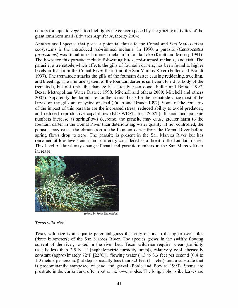
41
darters for aquatic vegetation highlights the concern posed by the grazing activities of the giant ramshorn snail (Edwards Aquifer Authority 2004).
Another snail species that poses a potential threat to the Comal and San Marcos river ecosystems is the introduced red-rimmed melania. In 1990, a parasite (Centrocestus formosanus) was found in red-rimmed melania in Landa Lake (Knott and Murray 1991). The hosts for this parasite include fish-eating birds, red-rimmed melania, and fish. The parasite, a trematode which affects the gills of fountain darters, has been found at higher levels in fish from the Comal River than from the San Marcos River (Fuller and Brandt 1997). The trematode attacks the gills of the fountain darter causing reddening, swelling, and bleeding. The immune system of the fountain darter is sufficient to rid its body of the trematode, but not until the damage has already been done (Fuller and Brandt 1997, Bexar Metropolitan Water District 1998, Mitchell and others 2000; Mitchell and others 2005). Apparently the darters are not the normal hosts for the trematode since most of the larvae on the gills are encysted or dead (Fuller and Brandt 1997). Some of the concerns of the impact of this parasite are the increased stress, reduced ability to avoid predators, and reduced reproductive capabilities (BIO-WEST, Inc. 2002b). If snail and parasite numbers increase as springflows decrease, the parasite may cause greater harm to the fountain darter in the Comal River than deteriorating water quality. If not controlled, the parasite may cause the elimination of the fountain darter from the Comal River before spring flows drop to zero. The parasite is present in the San Marcos River but has remained at low levels and is not currently considered as a threat to the fountain darter. This level of threat may change if snail and parasite numbers in the San Marcos River increase.
(photo by John Thomaides)
Texas wild-rice
Texas wild-rice is an aquatic perennial grass that only occurs in the upper two miles (three kilometers) of the San Marcos River. The species grows in the swiftly flowing current of the river, rooted in the river bed. Texas wild-rice requires clear (turbidity usually less than 2.5 NTU [nephelometric turbidity units]), relatively cool, thermally constant (approximately 72°F [22°C]), flowing water (1.3 to 3.3 feet per second [0.4 to 1.0 meters per second]) at depths usually less than 3.3 feet (1 meter), and a substrate that is predominantly composed of sand and gravel (Poole and Bowles 1999). Stems are prostrate in the current and often root at the lower nodes. The long, ribbon-like leaves are

42
submersed in the water. Flowering occurs primarily spring through fall. The reproductive stems are lifted above the water surface with male and female flowers on separate parts of the stem. The species is wind-pollinated, and seeds are assumed to be water-dispersed. The flowering stem dies after the seeds are dispersed. Thus, under certain conditions, the plant may act as an annual, growing from seed, flowering, fruiting, and dying in one season.
The effects of low flow on Texas wild-rice have been documented via field investigations and laboratory studies. Texas wild-rice’s requirement for some level of springflow is affected by physical habitat parameters (velocity, depth, substrate, and surrounding aquatic vegetation), water quality parameters (temperature and carbon dioxide), reproductive strategies, and non-native species. These components are intertwined and will be discussed holistically by necessity. For example, two water quality parameters that are considered important to Texas wild-rice growth are water temperature and carbon dioxide concentration. At lower flows, water temperature increases and carbon dioxide decreases, primarily as a function of springflow volume. In addition, at low-flow conditions the boundary layer through which gases and nutrients diffuse along the surface of aquatic plants is thicker, thus reducing the ability of the plant to uptake carbon dioxide and/or nutrients and potentially reducing plant growth and development (Crossley and others 2002). Swifter water flow increases nutrient and dissolved inorganic carbon uptake by plants (Stevens and Hurd 1997, Smith and Walker 1980) by reducing the unstirred boundary layer surrounding plant foliage (Chambers and others 1991). Depth and velocity affect reproductive success, as does herbivory (herbivory is the consumption of plants, algae, and photosynthesizing bacteria by herbivores).
Power (1996a, 2002) grew Texas wild-rice in three different current velocities (slow, moderate, and fast) in Spring Lake. The results of her investigations showed that Texas wild-rice had a better developed root system, produced more stems and overall biomass, and allocated more biomass to vegetative growth when grown in fast current (0.82 to 1.6 feet per second [0.25 to 0.49 meters per second]) as compared to plants grown in slow current (0 to 0.3 feet per second [0 to 0.1 meters per second]). Although slow current produced more reproductive stems, Power felt that it was at a cost of lower productivity and higher potential loss to herbivory. In still or shallow water, Texas wild-rice will send a flowering stalk above the water surface. In deeper, swifter water, the plant will remain submerged, and reproduce vegetatively by forming roots along the stem joints. Experimentation (Vaughan 1986) and observation has shown that Texas wild-rice will die in moist soil or even a few inches of water. The plant requires at least a foot of water flowing over its leaves and roots for survival.
Experimental work done by Power and Doyle (2004) indicated that Texas wild-rice is an obligate carbon dioxide user and that there is a positive relationship between current velocity and carbon dioxide. Faster-flowing water reduces the boundary layer thickness surrounding the leaves through which gases move primarily by diffusion. Still water or slower current leads to slower diffusion which in turn can limit photosynthesis. Texas wild-rice is carbon dioxide limited in slow flowing water, producing fewer submersed leaves and more reproductive growth (at the expense of less biomass overall, making the plant more subject to herbivory and reducing longevity).

43
BIO-WEST, Inc. (2004) also evaluated the response of Texas wild-rice to various levels of carbon dioxide in the water column. Texas wild-rice total and above-ground biomass varied substantially in the low carbon dioxide treatment. The large variation in the low treatment tanks may have been a result of Texas wild-rice leaves growing to the water surface before the end of the experiment (BIO-WEST, Inc. 2004). Since the below-ground biomass was significantly greater in the high carbon dioxide treatment than in the low carbon dioxide treatment, it appears that lower carbon dioxide conditions may cause Texas wild-rice to allocate more energy into above-ground growth and less into below-ground biomass to expedite reaching the water surface. Once plants reach the water surface, the leaves can draw carbon dioxide from the air which, in turn, would allow for increased plant growth. The Texas wild-rice plants used in the BIO-WEST, Inc. (2004) study were in the seedling/early growth stage where plants typically shift resources to below-ground biomass, presumably to exploit minerals needed for continued growth and to anchor the plant. Root biomass of plants in the high carbon dioxide treatment was significantly greater than low and moderate carbon dioxide treatments. This suggests that higher carbon dioxide tanks allowed higher photosynthetic rates to occur in submersed leaves and plants were able to shift the products of that photosynthesis to below ground biomass.
Water temperature affects the vegetative and reproductive growth of Texas wild-rice (Tolley-Jordan and Power 2007). Cool water (60°F [15.5°C]) slows vegetative growth and inhibits the formation of reproductive stems. In moderate temperate water (72.5°F [22.5°C]), biomass is first accumulated in vegetative parts and then shifted to reproductive growth later in the growing season. In warm water (83.3°F [28.5°C]) the shift of biomass from vegetative to reproductive growth is accelerated. Although reproduction is obviously necessary, the perennial habit allows accumulation of biomass from one growing season to the next. Also, because reproductive structures are lifted above the water, such parts are more vulnerable to herbivory.
One of the reasons that Texas wild-rice was listed as an endangered species was the lack of sexual reproduction in its natural habitat. In specific response to sexual reproduction, low flows have some benefit because lower depths and slower current velocity provide conditions that are conducive to sexual reproduction in Texas wild-rice. This is a specific case where some level of minimum flows with a limited frequency of occurrence can assist in the recovery of Texas wild-rice. However, relative to the survival of Texas wild-rice, if this was annually the condition, this growth form would make the plant more susceptible to herbivory and leave no vegetative growth to sustain the plant to the next growing season. Additionally, during lower flows, floating mats of vegetation catch on Texas wild-rice blocking sunlight and thus photosynthesis, shredding the leaves, interfering with reproductive culm emergence, and in some cases uprooting plants (Power 1996b). During low-flow events, lowered water depths combined with current velocity peel the root mats of Texas wild-rice off the substrate. This has been observed at both Sewell Park during low flows as well as within the large stands above the Interstate-35 bridge during the 2000 failure of Cape's Dam.
For the recovery of the species, the full range of the flow regime is necessary. Devastating floods or other extreme high flow events often temporarily reduce Texas wild-rice coverage. Plants are lost during floods due to the scouring action of the water

44
itself or from trees and debris scraping the river bottom. High flow events can also rip Texas wild-rice root mats from the substrate. Additionally, plants subjected to areas of low carbon dioxide are hypothesized to have limited root structure, thus potentially exacerbating the effect of floods and high-flow events in the lower reaches of the river. Perhaps this is reason for the almost total loss of Texas wild-rice below the Interstate-35 bridge following the 1998 flood as well as its lack of re-establishment (Poole 2002). However, such reduction in overall Texas wild-rice coverage is typically temporary, with these events rejuvenating the bulk of the population. Rapid responses in biomass have been observed following each flushing flow event in the past seven years (Edwards Aquifer Authority 2007b). Also, during higher flow conditions, floating mats of vegetation do not cling to the plants, blocking photosynthesis, hindering reproductive growth, and shredding the leaves. Faster flowing water increases root mass, stem number, and overall biomass.
As discussed above, the natural timing, frequency, duration, and magnitude of springflows are important in controlling invasive and non-native species. Similar to fountain darters, Texas wild-rice can also be affected during low-flow conditions directly and indirectly by non-native species. Lemke (1989) documented 31 species of aquatic macrophytes (plants large enough to see with the naked eye) in the upper San Marcos River. Of these, 23 were native. Increasing competition with non-native species and the resulting displacement of native species was noted. Three non-native plant species, hydrilla (Hydrilla verticillata), West Indian hygrophila (Hygrophila polysperma), and elephant ear (Colocasia esculenta), have significantly altered both the Comal and San Marcos ecosystems (LBG-Guyton Associates 2004). There is a concern that aggressive non-native plant species may gain a competitive advantage when conditions are sub-optimal for Texas wild-rice. Texas wild-rice is frequently found in areas of dense growth of the non-native macrophytes West Indian hygrophila and hydrilla (Poole and Bowles 1999). These and other non-native plants such as egeria (Egeria densa) have similar habitat requirements as Texas wild-rice and over the years have reduced the amount of suitable habitat for Texas wild-rice. All these non-native species occur at least in part in habitats that could be occupied by Texas wild-rice. While it is uncertain if Texas wild-rice ever occurred in abundance in the habitat currently occupied by elephant ears, it is possible that Texas wild-rice may have used the shallower, slower current areas near the river's edge as an area for the sexually reproductive, annual growth form.
A relatively new non-native species in the San Marcos Springs system is the water trumpet (Cryptocoryne beckettii) that has been observed forming colonies that extend from bank to bank excluding native plant species and threatening the habitats of Texas wild-rice and the fountain darter (Tu 2002). The invasion of the water trumpet has created a new and very serious threat to Texas wild-rice. Water trumpet is native to Southeast Asia and was introduced into the San Marcos River in 1993 (U.S. Fish & Wildlife Service 2003). The plant probably escaped into the river from a dumped aquarium as the plant is popular in the aquarium trade (Tu 2002). The plant has habitat preferences that are nearly identical to Texas wild-rice and had quickly established in the section of the San Marcos River from the A.E. Wood State Fish Hatchery to the confluence to the San Marcos and Blanco rivers, before extensive removal efforts were undertaken (U.S. Fish & Wildlife Service 2003).

45
The non-native suckermouth catfishes are believed to be impacting water quality and causing habitat degradation in areas where their numbers are not naturally controlled. Suckermouth catfishes reproduce by burrowing into banks and bottom sediments to create chambers for the females to lay eggs. When burrows are dense, erosion, sedimentation and elevated turbidity may result. Bank failure, shoreline collapse and terracing have been observed in rivers where suckermouth catfish populations are high (Hoover and others 2006). There is a growing concern that erosion, sedimentation, and elevated turbidity may be affecting Texas wild-rice populations, particularly during low-flow conditions that have the potential to magnify these effects.
Nutria (Myocastor coypus) is a large semi-aquatic rodent that is smaller than a beaver and larger than a muskrat with a round slightly haired tail. Nutria can breed year round and are extremely prolific. Nutria are well adapted for movement on land; however, they are more at home in the water. They are strict vegetarians and consume approximately 25 percent of their body weight daily, targeting plant stem bases and digging for roots and rhizomes. In the San Marcos River, herbivory by nutria is believed to be a significant factor in reducing the size and vigor of stands of Texas wild-rice (McKinney and Sharp 1995). During low-flow conditions, herbivory of Texas wild-rice has been shown to increase.
(photo by Joe Fries)
San Marcos salamander
San Marcos salamanders are found throughout Spring Lake (at the headwaters of the San Marcos River) where rocks are associated with spring openings and in rocky areas up to 500 feet (150 meters) below Spring Lake Dam (Nelson 1993). The San Marcos salamander is a small, neotenic form that retains gills throughout its life. It lacks a terrestrial phase, becoming sexually mature and breeding in the water. The primary concerns facing the San Marcos salamander are water temperature, available physical habitat, and water quality.
Temperature requirements are known only from research conducted to determine critical thermal maximum for the species: 96.4ºF and 99.1ºF (35.8ºC and 37.3ºC) for juveniles and adults, respectively (Berkhouse and Fries 1995). Temperatures at which sub-lethal effects, such as decreased fecundity and growth rates, begin to occur are unknown. Downstream of Spring Lake Dam there is a greater potential for water temperatures to increase; however, studies have shown that, typically, the temperature in this portion of the San Marcos salamander’s range remains virtually unchanged from the temperature at the spring orifice (Groeger and others 1997). Extended low-flow or especially no flow
46
conditions during hot summer months may cause temperature conditions to exceed the tolerance requirements for the San Marcos salamander.
One of the habitat requirements of the San Marcos salamander is silt-free rocks around the spring openings within Spring Lake and downstream of the dam (Tupa and Davis 1976, Nelson 1993, Edwards Aquifer Authority 2007b). Because the rocks used by the salamanders are located adjacent to spring openings, they are kept silt-free as long as water is issuing from the springs. Rocks within the habitat downstream of the dam are more susceptible to being covered with detritus or silt that washes over the dam. No research is available to determine what discharge levels are necessary to prevent buildup of silt and detritus in this reach; however, some level of discharge is assumed. This area is close to the headwaters (Spring Lake); thus, very little silt enters the system before it reaches this section. In addition, flow is generally rapid (sufficient to prevent siltation) in this reach as water travels over the dam and through this relatively shallow region just downstream.
In addition to using silt-free rocks, the San Marcos salamanders are abundant in the filamentous algae found in the upper end or “hotel reach” section of Spring Lake (Tupa and Davis 1976, Nelson 1993, Edwards Aquifer Authority 2007b). Investigators hypothesize that San Marcos salamanders find abundant food in the algae as well as increased protection from predators. Because of the constancy of water temperature, dissolved oxygen, and nutrients found in Spring Lake (McKinney and Sharp 1995), algae remains abundant in this section of the lake. Within the period of record, changes in discharge from the springs have had very little affect on these water quality parameters. However, no springflow is assumed to cause major impacts to this preferred habitat type.
Wetted perimeter is another concern for the San Marcos salamander, though the relative constancy of the water level in Spring Lake, even with changes in discharge, minimizes this concern. Unlike habitat in the lake itself, portions of the San Marcos salamander’s range found downstream of Spring Lake are subject to changes in wetted perimeter as discharge fluctuates.
Recreation is another factor that can impact the San Marcos salamander population in relation to springflow (Edwards Aquifer Authority 2007b). Recreation is regulated and generally prohibited on Spring Lake, although archeological excavations and other scientific investigations may disturb sites where San Marcos salamanders are found. Downstream of the dam, the river is open to the public and portions are heavily used for recreation especially during periods of lower springflow. During lower flow conditions, depth at the west spillway is reduced, and underwater hazards (the remains of an old dam at the east spillway) become visible, allowing safer use of this area, resulting in more recreational use.

47
(photo by Joe Fries)
Comal Springs riffle beetle
The Comal Springs riffle beetle (Heterelmis comalensis) was described by Bosse and others (1988) as having functional eyes, poor dispersal due to vestigial wings, and related to H. glabra, a winged species complex isolated in springs of west and central Texas (Gonzales 2008). The adults and larvae are primarily collected on cotton cloth lures and more rarely collected by hand and drift nets in springs, seeps, and upwellings of the spring runs, western shoreline, and Spring Island area of the Comal Springs system (but not in the headwater springs near Blieders Creek) and from a few springs and upwellings in the headwaters of the San Marcos River (Barr 1993, Fries and others 2004, Edwards Aquifer Authority 2007b, Gibson and others 2008).
Characteristic of the family, larvae have gills and are aquatic, often inhabiting similar habitat as adults, and subsisting on microorganisms and debris scraped from substrate (Brown 1987). The gills of elmid larvae can be expanded and contracted to increase ventilation when oxygen levels are lower (White and Roughley 2008). Typically, elmids pupate above the water line in moist soil, under rocks, or in rotting wood (White and Roughley 2008), but pupation requirements are not known for H. comalensis. In captivity at the National Fish Hatchery and Technology Center, hundreds of H. comalensis larvae have been produced, but successful pupation has rarely occurred.
Elmid adults (about 100 species, 27 genera in North America) are typically found in swifter portions of relatively clean rivers and streams (Brown 1987, White and Roughley 2008). The beetles are relatively slow moving, cannot swim, and respire through a plastron (gas film produced by an area of dense water-repelling hairs) which limits them to habitats with high dissolved oxygen (Brown 1987, Resh and others 2008, White and Roughley 2008). Elmids in the genus Heterelmis often occur on submerged wood (Brown 1976), presumably using it as a source of nutrition, and several species have been collected in large numbers from shoreline seeps and springs in Texas (Gonzales 2008). They likely feed on fungus and bacteria growing on roots, woody debris, and leaf litter within these areas. Thus, intact riparian areas with trees and shrubs are important (U.S. Fish & Wildlife Service 2007). Bowles and others (2003) and BIO-WEST, Inc. (2002a) found that the Comal Springs riffle beetles mainly occurred in areas with gravel and cobble and not in areas of high sedimentation. Reduction in springflow can cause areas to become unsuitable for the beetles by lowering dissolved oxygen and increasing sedimentation.
48
The Comal Springs riffle beetle appears to be strongly tied to surface spring habitat as opposed to the riverine species H. vulnerata which has been found on rocks and woody debris on the streambed surface just downstream of Landa Lake (Old Channel) and Spring Lake (East Dam). The Comal Springs riffle beetle has only been collected in or very near springs. When searching around upwellings within Landa Lake, they have not been observed outside of the spring openings in areas where water chemistry and substrate are very similar. They likely inhabit shallow subterranean areas within springs because this is a pigmented and eyed species that is collected in substantial numbers near the surface on cotton cloth lures (Edwards Aquifer Authority 2007b, Gibson and others 2008, Gonzales 2008) and is not morphologically adapted to subterranean life like the dryopid beetle (Stygoparnus). During drought conditions, the Comal Springs riffle beetle has similar constraints as Stygoparnus but is likely affected negatively to a greater extent than the dryopid beetle as the water table is reduced.
Recent mitochondrial DNA analysis indicated high levels of differentiation among most H. comalensis subpopulations (located at the three main spring runs, West Shoreline, and Spring Island at Comal Springs and the headwaters of San Marcos Springs). Populations of H. comalensis contained higher levels of genetic variation and exhibited greater differentiation than populations of the more widespread and common H. vulnerata. Populations of H. comalensis appear to be significantly isolated from each other despite relatively little geographic isolation and no obvious barriers to gene flow in most cases. However, H. comalensis populations do not appear to have suffered the loss of genetic variation expected with small population sizes. Instead, the West Shoreline, Spring Island and the San Marcos Springs H. comalensis populations contain surprising amounts of genetic variation, including several private haplotypes, which indicates that these localities probably support unexpectedly large populations. Within the Comal Springs system, the populations found in the higher elevation springs (spring runs 1, 2, and 3) contained the lowest amount of genetic variation and contained no unique haplotypes as compared to the West Shoreline and Spring Island populations. This and the fact that the beetles are not found in the higher elevation headwater springs (spring run 4 and 5 near Blieders Creek) could be the result of beetle population reductions (due to bottleneck effects) in these areas due to drought (Gonzales 2008).
Subterranean species
Given that we have a poor understanding of the range of the aquifer-dwelling species (Peck's cave amphipod, Comal Springs dryopid beetle, and Texas blind salamander), the question of minimum flows should be expanded to include sub-surface flows. For the aquifer-dwelling listed species, a lack of discharge may not only degrade habitat near the spring orifice, but lead to changes in the subterranean habitat such as water quality, siltation, and temperature changes, at least near the surface. Longley (1981) notes that there are at least 29 other species of invertebrates existing in the aquifer, most of these being endemic. The reason that these were not listed by agencies is primarily because it has been thought that listing one species from a community is sufficient to protect the community. In addition to the Texas blind salamander discussed later, there are at least four other vertebrate species that are found only in the aquifer and therefore are subject to the same issues affecting the Texas blind salamander. In recent years there have been

49
additional species discovered and all of these subterranean species are unique and in need of protection. Since the Federal Endangered Species Act is designed to protect the critical habitat of species, it has been thought that all of these species are afforded protection if one species from the ecosystem is listed. The following discussions provide some information on flow requirements for the listed species.
(photo by Joe Fries)
Comal Springs dryopid beetle
The Comal Springs dryopid beetle (Stygoparnus comalensis) described by Barr and Spangler (1992) is the only known subterranean adapted (vestigial eyes and wings and lacking pigment) beetle in the family Dryopidae. The adults and larvae have been rarely collected by hand, drift net, and cotton cloth lures in springs, seeps, and upwellings throughout the Comal Springs system. The species was also collected from Fern Bank Springs in 1992 (13 individuals from one of the small hillside seeps) and in 2003 (1 individual from a small spring outlet on the water’s edge of the Blanco River) (Barr 1993, Fries and others 2004, Edwards Aquifer Authority 2007b, Gibson and others 2008). This species has not been found in wells or caves.
Characteristic of this small family, larvae do not have gills and are considered terrestrial, inhabiting moist soil along stream banks (Brown 1987). The larvae of two species of Helichus (the nearest relatives to Stygoparnus) were found up to 16 feet (5 meters) from stream edge (Ulrich 1986). Barr and Spangler (1992) presumed the microhabitat to be soil, roots, and debris exposed above the waterline on the ceilings of spring orifices. Adult dryopids are found in relatively clean rivers and streams feeding on biofilm scraped from surfaces such as rocks, wood, and vegetation (Brown 1987). They are relatively slow moving, cannot swim, and respire through a plastron which limits them to habitats with high dissolved oxygen (Brown 1987, Resh and others 2008). As springflow is reduced, dissolved oxygen may also be reduced. A reduction in dissolved oxygen would likely result in a reduction of suitable habitat available to Stygoparnus, thus potentially reducing population size.
Although adapted for subterranean life, the beetle appears to live near the surface due to the terrestrial larvae and a diet which likely includes decaying root matter supplied by the riparian area associated with the springs (U.S. Fish & Wildlife Service 2007). The species survived the drought of 1956 when Comal Springs ceased to flow. During drought conditions, the beetle can likely retreat into the aquifer, but reduction in population likely occurs as suitable habitat for the species becomes reduced as the water table drops. If the

50
water drops below the root line for an extended time, extinction could follow. As the water recedes, the slow moving beetle might find difficulty in moving through the smaller interstitial spaces as well as finding required habitat for survival, growth, egg deposition, and pupation (including nutrients, oxygen levels, moisture, and pupation sites as well as increased predation). Extended drought conditions could negatively affect the riparian habitat associated with the springs resulting in lowered nutrient input which can reduce beetle populations and slow the recovery of the beetle population as this area is re-established.
(photo by Joe Fries)
Peck’s cave amphipod
Peck’s cave amphipod (Stygobromus pecki) was first collected by Peck in 1964 and later described by Holsinger (1967). They are members of the flagellatus group of Stygobromus which is distinguished as having insular patterns of speciation, being greatly restricted in ranges, and occupying deeper groundwater niches. This group is composed of four described and maybe the same number of undescribed species all found in the Edwards Aquifer of central Texas (Holsinger 1967). The genus Stygobromus has around 100 species; all are subterranean and found primarily in North America with a few in Eastern Europe and Siberia (Holsinger 1994).
Peck’s cave amphipods have been collected in springs, seeps, and upwellings throughout the Comal Springs system, Panther Canyon Well, and Hueco Springs (Barr 1993, Fries and others 2004, Edwards Aquifer Authority 2007b, Gibson and others 2008). They are found in gravel, rocks, and associated debris (leaves, roots, and wood) directly in or near springs or collected drifting out of spring orifices (Fries and others 2004, Edwards Aquifer Authority 2007b, Gibson and others 2008). They most likely are omnivores feeding on detritus and decomposing plant material, and scavenging or preying on other aquifer organisms (U.S. Fish & Wildlife Service 2007). They have been observed eating other invertebrates soon after capture from the wild (Fries and others 2004) and have been reared in captivity for at least 2.7 years with dried leaves as the primary nutrient source and rarely introduced tropical fish flakes as an additional source. At Comal Springs, Peck’s Cave amphipods were relatively abundant and usually bright orange in color, as opposed to Hueco Springs where they were relatively rare and were the typical white color exhibited by most unpigmented cave organisms. The color of some

51
amphipods, and crustaceans in general, often is dependent on diet, which usually includes carotienoids produced by plants, algae, and probably some bacteria (Negre-Sadargues and others 2000, Fraser and Bramley 2004, Gaillard and others 2004). It is possible that the orange coloration found within the Comal Springs population is derived from food sources (that is, roots, woody debris, and leaf litter) that are scarce at Hueco Springs (Gibson and others 2008). The relative abundance of the Peck’s cave amphipods near the surface at Comal Springs is likely due to a nutrient source supporting the population provided by the spring associated riparian area which could also be contributing to the orange color. This species appears to be restricted in range with the largest numbers supported in the shallow habitat of Comal Springs. During drought conditions, this species can likely inhabit deeper groundwater niches, but as the water recedes the nutrient base will be reduced and the population could be significantly affected. Population genetics of the Peck’s cave amphipod has just begun at Texas State University by Dr. Chris Nice.
(photo from U.S.Fish & Wildlife Service)
Texas blind salamander
This neotenic (retention of some juvenile characteristics as adults) salamander is aquatic throughout life and lives in the water-filled cavernous areas of the Edwards Aquifer in the San Marcos area. The Texas blind salamander is probably stenothermal (capable of surviving over only a narrow range of temperatures) and restricted to water temperatures near 69.8ºF (21°C). It feeds on the biota of the aquifer including shrimp, amphipods, isopods, and other invertebrates. The Texas blind salamanders apparently sense the movements of their prey with specialized structures on their head region. These salamanders have been able to lay eggs and have them develop in the laboratory at the Cincinnati Zoo, the San Marcos National Fish Hatchery and Technology Center, the Fort Worth Zoo, the Dallas Zoo, and Texas State University.
Primary concerns to the Texas blind salamander are depth of the water table and water temperature. The latter is an assumption based on the constant temperatures of the water in which the species is found; more research is needed to address the effects of temperature changes to the species. Regardless, the temperature of the water stored in the aquifer is constant at approximately 69.8ºF (21°C), which is unaffected by temperatures aboveground or fluctuations in discharge from spring openings. Depth of the water table fluctuates depending on recharge to the aquifer and withdrawals made from it. Despite

52
concern for a decline in the water table, the springs feeding the San Marcos River (in Spring Lake) have not ceased flowing in recorded history.
Water quality beyond just temperature is another area of potential concern to the Texas blind salamander. Concerns with water quality include human activities in the recharge zone (that is, non-point source runoff, sewage leaks, and other chemical contamination) and lowered aquifer levels preventing adequate dilution to these contaminants. There is also concern with encroachment of saline water into spring areas during extended low-flow periods. This would result from the movement of the “Fresh Water/Saline Water interface,” which is approximately 160 feet (50 meters) from some of the San Marcos Spring openings.
Task 2.2: If alternatives exist to minimum flows that may not reduce appreciably the likelihood of the survival and recovery in the wild by reducing the reproduction, numbers, or distribution of each species listed under the Endangered Species Act identified in Section 3.2 of the Edwards Aquifer Recovery Implementation Program Memorandum of Agreement, identify and provide a preliminary evaluation of those alternatives to protect those federally listed species.
Our interpretation of the task
Our interpretation of this task is that an “alternative” to minimum flows would be something other than “flow” (for example, a replacement for flow). The use of refugia has been proposed by stakeholders as one such alternative. As discussed below, although refugia play a vital role in the protection of threatened and endangered species, refugia are not viable or effective alternatives to maintaining minimum flows.
There are potential management strategies, such as springflow augmentation, recirculation, and artificial recharge, which may be proven in the future to maintain or enhance minimum springflows and thus maintain the biological community. However, our interpretation is that these strategies, if proved successful, may enhance minimum flows; thus, they are not considered “alternatives” to minimum flows.
We interpret “survival and recovery” in this task the same as we described in Task 2.1, with “survival” being the continued existence of individuals for some period of time and
Recommendation: At this time, the Edwards Aquifer Area Expert Science Subcommittee believes that no proven alternatives exist as a replacement for minimum flows as discussed below; however, potential management strategies involving flow have been proposed and should be further evaluated.

53
“recovery” constituting the conservation and survival of a species. Finally, we interpret “in the wild” as in the physical environments of the spring, river, and/or aquifer in which the species currently exist.
Discussion
The use of ex-situ (off-site) or captive propagation as a protective measure for certain Edwards Aquifer aquatic species has been employed by the U.S. Fish & Wildlife Service since 1990. In-situ (a Latin phrase meaning “in the place”) refugia, another type of refugia that has been discussed by stakeholders, refers to a subset of the available habitat in a given spring system that could be intensively managed to house a given species for some period. The goal of in-situ refugia would be to sustain species and habitat when conditions are poor, while also providing the opportunity for research in these areas when conditions are favorable. We agree that certain aspects of in-situ refugia have potential merit and should be evaluated. However, we believe that in-situ refugia are unproven for the Comal and San Marcos springs systems at this time. Therefore, our discussion in this section focuses solely on ex-situ refugia, with in-situ refugia discussed further in Task 2.3 (identification of additional studies).
The Policy Regarding Controlled Propagation of Species Listed under the Endangered Species Act states that “Controlled propagation is not a substitute for addressing factors responsible for an endangered or threatened species’ decline” (U.S. Fish & Wildlife Service and National Oceanic and Atmospheric Administration 2000). The policy supports controlled propagation associated research, the establishment of refugia, the production of plants and animals for restocking, and conservation of species to prevent extinction. The policy requires that a controlled propagation plan include the evaluation of the following risks: effects of removing individuals from the wild, effects of losing some or all of the individuals being maintained in captivity, genetic changes that controlled propagation individuals could convey to wild populations, and the effects of diseases that controlled propagation individuals could introduce to wild populations (U.S. Fish & Wildlife Service and National Oceanic and Atmospheric Administration 2000).
All risks associated with controlled propagation are greatly compounded when recovery of a species is solely reliant on a refugium to prevent extinction. Before Lake Amistad was filled, Gambusia amistadensis was collected from Goodenough Springs and placed in a refugium. The habitat utilized by G. amistadensis was destroyed when Lake Amistad was filled. It is assumed that G. affinis was unintentionally collected when G. amistadensis was collected. Gambusia affinis out competed G. amistadensis while they both were being held in the refugium, and G. amistadensis was lost and became extinct (Hubbs 1984).
Currently, there are only two Edwards Aquifer Recovery Implementation Program aquatic species (fountain darters and Texas wild-rice) that have been successfully propagated in captivity; however, it is unproven that both species can be maintained in captivity for multiple generations. The other five species (excluding the San Marcos gambusia, which is thought to be extinct) would thus lack protection. Captive propagation techniques for the San Marcos salamanders have not been fully developed. San Marcos salamander techniques have been developed to hatch eggs, feed the larvae,

54
feed juveniles, and feed adults. San Marcos salamander reproduction routinely occurs at the San Marcos National Fish Hatchery and Technology Center, but reproduction cannot be induced or predicted. Over 10 years have been invested in studying San Marcos salamander reproduction, yet the controlling factors have not been identified. Genetic manipulation of the species through the mating of given individuals is not currently possible. Without this ability, the genetic diversity of the salamanders used for restocking the native habitat cannot be assured. Over the years, the San Antonio Zoo, the Dallas Aquarium, the Cincinnati Zoo, the Detroit Zoological Institute, the National Aquarium in Washington, D.C., and the National Aquarium in Baltimore have maintained one or more salamander species associated with the Edwards Aquifer (San Marcos salamander and Texas blind salamander), but none of the facilities have maintained the number of salamanders that are routinely maintained at the San Marcos National Fish Hatchery and Technology Center. The zoos are viewed as research collaborators but not as refugia.
Comal Springs riffle beetles are being maintained at the San Marcos National Fish Hatchery and Technology Center, but captive propagation techniques require further improvement. Adult riffle beetles have been collected from the wild and have been successfully reared and reproduced. Eggs have hatched, and thousands of larvae reared. However, only a few larvae have pupated to the adult stage. Thus, adults could not be produced for restocking purposes. Only the San Marcos National Fish Hatchery and Technology Center is maintaining live Comal Springs riffle beetles in captivity.
The development of captive propagation techniques for the Peck’s cave amphipod is in its infancy. The San Marcos National Fish Hatchery and Technology Center is maintaining less than 100 individuals in captivity. Over a three year period, adults collected from the wild successfully reproduced, and a few offspring survived to adulthood and produced young. This species developed slowly in captivity and has been observed to be cannibalistic which can be problematic for culture. The Comal Springs dryopid beetle is rare; less than 20 beetles are collected annually. Until the availability of the Comal Springs dryopid beetle increases, it is unlikely that the San Marcos National Fish Hatchery and Technology Center will actively pursue the development of captive propagation techniques for this species. No facility is maintaining live Comal Springs dryopid beetles in captivity.
Even though fountain darters and Texas wild-rice could likely be maintained in refugia for several generations, potential problems exist. Captive populations are too easily lost for the existence of a species to be solely dependent on that technique. The two existing fountain darter refugia, San Marcos National Fish Hatchery and Technology Center and the Uvalde National Fish Hatchery, maintain only wild-captured fish. Fountain darters from the Comal and San Marcos rivers are collected generally in the spring and fall to replace darter losses that occurred during the preceding six months. Neither facility is designed to maintain captive populations that do not rely on a wild source of fish to produce offspring for stocking purposes. Existing facilities would not permit sufficient numbers of fountain darters and Texas wild-rice to be produced to assure that a re-introduced population would be genetically reflective of the natural population. Fountain darters are a short-lived species, 18 months in the wild (Schenck and Whiteside 1976). Texas wild-rice seeds cannot typically be stored longer than nine months. The longer the
55
species are held in refugia and the older the brood stock used to produce the fish and plants for stocking, the lower the probability of successful re-establishment.
Another component of maintaining a population for reintroduction is the probability of success that a given species can reestablish self-sustaining populations. Although not an example of a reintroduction from a refugium, a case study presented itself when the Comal Springs stopped flowing in 1956 and the fountain darter was subsequently eliminated from the Comal River. Fountain darters from the San Marcos Springs system were stocked into the Comal River during the mid 1970s, and a population exists in the Comal River today because of this reintroduction (Schenck and Whiteside 1976). It is currently unknown if a similar reintroduction and corresponding success could be achieved with just refugium populations. A major problem to successful reintroduction is whether or not the springs will be flowing at a sufficient level to permit the population to rapidly recover. The re-introduction of the existing aquatic invasive species (specifically the gill parasite Centrocestus formosanus) and new invasive species also have the potential to negatively effect the re-establishment of the fountain darter.
As with the fountain darter, the amount of Texas wild-rice in ex-situ refugia represents a small proportion of its wild population. Refugium populations are similar to small wild populations and face some of the same threats. Catastrophic stochastic events such as pests, pathogens, power loss, and contamination can wipe out refugium stocks as easily as a wild population. The genetic composition of a refugia population may change relative to a wild population through genetic drift (random loss of alleles or change of allele frequencies leading to fixation of alleles and loss of genetic diversity), artificial selection (adaptation to cultivation conditions such as nutrient, light, water, temperature and competitive regimes), mutation accumulations (less strenuous growing conditions can lead to the survivorship of less fit individuals), inbreeding depression (self-fertilization or breeding between closely related individuals can lead to a reduction in the fitness of the offspring), and outbreeding depression (individuals from widely separated populations may have unique genetic adaptations for their local environment; the breeding of such individuals may result in offspring that are poorly adapted to either parental environment). Additionally, the seeds for Texas wild-rice cannot typically be stored for longer than nine months (Power and Fonteyn 1995). Refugia also assume eventual reintroduction. Reintroduction, especially that of an entire community, is an extremely difficult, time-consuming, and expensive process.
The success of planting Texas wild-rice into the San Marcos River and other spring systems has not been good. Using plants grown in raceways on the campus of Southwest Texas State University, W.H.P. Emery, professor at Southwest Texas State University, tried to reintroduce Texas wild-rice into the San Marcos River in the 1970s (Power 1996c). Some of the transplants did survive, but their reason for success is not known (Power 1996c). An attempt was made to introduce the species outside of its historic range to Salado Creek in Bell County, Texas (Beaty 1976). The introduction was unsuccessful due to local recreation pressure and periodic vegetation removal from the creek. Terrell and others (1978) attempted to grow Texas wild-rice in a laboratory in Beltsville, Maryland. Although one plant flowered, all plants eventually succumbed to mites. In the late 1980s Fonteyn and Power (1989) removed elephant ears from along the banks of the San Marcos River and transplanted Texas wild-rice in its place. Despite a second planting

56
after a flood swept away all the original transplants, only one plant out of several hundred survived; it flowered and then died.
In 1992 to 1994, Power transplanted almost 700 young plants into Spring Lake in five different habitats defined by depth and current velocity (Rose and Power 1992, 1994; Power 1996a, 1996c). Although water depth did not appear to be limiting, velocity was. Plants in still or slow water (less than 0.13 feet per second [0.04 meters per second]) were gone within three years. The other transplants have maintained moderate-sized stands as of 2008. Power also transplanted Texas wild-rice above the Interstate-35 bridge and in the river between the state fish hatchery and the wastewater treatment plant. Some of these transplants were also alive as of 2008. During the breach of Cape's Dam in early 2000, plants were either moved immediately and replanted in deeper water or were taken to the San Marcos National Fish Hatchery and Technology Center. After plants were removed from the area of Clear Springs Apartments in summer 2006, Mara Alexander and other U.S. Fish & Wildlife Service staff replanted the area. Flooding washed away some of the transplants, but some remain as of 2008. Alexander also began a study planting seeds in degradable cloth bags to determine if seeds would be a more reliable and less resource-consuming method of establishing wild-rice than transplants.
The problems associated with how and where to plant Texas wild-rice in the San Marcos River are compounded by non-native plants out competing Texas wild-rice. After flood events, the gains made by wild-rice are small compared to the gains made by elephant ear, hydrilla, and water trumpet. It is safe to assume that other non-native plants that out compete Texas wild-rice will be introduced into the San Marcos River in the future. In conclusion, reintroduction of Texas wild-rice is still not an assured science. Although some reintroductions of Texas wild-rice appear to be successful, reintroduction or even restoration of the entire San Marcos ecosystem has not been attempted.
Task 2.2.1: Your consideration of alternatives should include an evaluation of information provided by Recovery Implementation Program members on this issue.
We have evaluated and taken into consideration the information provided by members of the Recovery Implementation Program. Position papers submitted by the members are included in Appendix F.
Task 2.2.2: Your consideration of alternatives also should be mindful of impacts on protected species other than those species listed under the Endangered Species Act identified in Section 3.2 of the Edwards Aquifer Recovery Implementation Program Memorandum of Agreement.
During the evaluation, we considered protected species (for example, subterranean species, Cagle’s map turtle, and whooping crane) other than the Edwards Aquifer Recovery Implementation Program species. The Edwards Aquifer Recovery Implementation Program species are members of complex biological communities that include many species that coexist in these specific environments. The goal of protecting

57
the listed species is to protect the ecosystem as a whole, which in turn offers protection to the full suite of organisms. However, as no alternative was identified as a replacement for minimum flows, no detailed response was necessary.
Task 2.3: Identify existing studies regarding the ability of each alternative other than maintaining minimum springflows to protect federally threatened or endangered species. Identify additional studies or data needed to fully evaluate each of these alternatives, including an estimate of the time and cost to conduct such studies and any different alternatives that might be explored in the future.
As no alternative was identified as a replacement for minimum flows, no response is necessary. However, we felt that some additional information on additional studies or data gaps relative to refugia would be informative. Therefore, we discuss both ex-situ refugia and in-situ refugia below.
Discussion
The establishment of fountain darter and Texas wild-rice refugia and the research associated with these refugia has led to the determination of the requirements needed to rear and reproduce these species in captivity. Similar research has been conducted for the other Edwards Aquifer Recovery Implementation Program species, and progress is being made to determine their respective requirements. As discussed under Task 2.2, life history information for the endangered invertebrates is extremely limited. The literature cited and additional references provided (Appendix G) include numerous studies that have been conducted over the years to improve the understanding of the Edwards Aquifer Recovery Implementation Program species. Goals for additional studies relative to the invertebrates would be to, first, gain a better understanding of the general life history requirements of these species and to, second, use that knowledge to develop protocols to rear and reproduce these species in captivity. These efforts have been initiated at the San Marcos National Fish Hatchery and Technology Center but will require substantial resources beyond what is currently available for any real chance of meeting these goals. Finally, should these goals be achieved, the vital component of reintroduction would need to be addressed. These additional studies would enhance the knowledge of species requirements and likely improve efficiency and effectiveness of ex-situ refugia. However, even with improvements to our understanding of life history requirements, plus technology advancements over time, we believe that ex-situ refugia will continue to provide only short-term protection from species extinction, and should not be considered an alternative to minimum flows.
In-situ refugia have only been evaluated for the Comal and San Marcos springs systems in a conceptual framework (LBG-Guyton Associates 2004). There are two aspects of in-situ refugia that warrant further investigation: (1) the redirection of springflow within either the San Marcos or Comal springs system during times of limited springflow and (2) the establishment of specific in-situ refugia areas for constant protection and potential

58
environmental research. It is most logical to focus these activities on surface-dwelling species. Additionally, it is probably most logical to focus on the fountain darter and Texas wild-rice because of the knowledge base already established. Several major questions would need to be addressed, including (1) Would in-situ activities be effective in maintaining survival for periods of time in the wild? and (2) Would the gain from protecting smaller areas in the systems outweigh the impacts required to sacrifice water to make this feasible? There are a host of other questions to be addressed including the physical possibility of constructing such areas or diversion devices, the cost, the length of effectiveness, species to be included, and other potential considerations.
One potential study would be to evaluate the use of existing structures or temporary dams to divert water from lower quality habitat to maintain acceptable quality habitat longer in other areas. Elevation of the upstream-most dam in the Comal River New Channel would permit maintenance of higher quality habitat in the Old Channel for a longer period of time. This is also true if the height of boards controlling the chute opening on the western spillway of Spring Lake dam was raised to divert all water over the eastern spillway. The use of inflatable dams in Spring Lake and Landa Lake to concentrate the flow of spring discharge across the best fountain darter and Texas wild-rice habitats while eliminating areas of low habitat quality has merit. In Spring Lake, an inflatable dam has been proposed to block off water flow into the slough (Sink Creek confluence area) portion of the lake. In Landa Lake, inflatable dams would be used to quarantine off the large Vallisneria sp. beds that support low densities of fountain darter. As with the use of re-circulated water, an evaluation needs to be done to determine if the benefits to populations in the proposed enhanced areas will exceed the damage done to the populations in the dammed off areas.
Another potential opportunity would be to explore environmental restoration and research feasibility within either the Comal or San Marcos springs systems. An area that is well suited for this type of activity is the Old Channel within the Comal system. The Old Channel has been overrun with non-native vegetation and is not the high quality habitat that it was merely five years ago (Edwards Aquifer Authority 2007b). A proposal to examine the effectiveness of an Intensively Managed Area at Comal Springs could be tested in the field. The goal of the Intensively Managed Area would be to provide in-situ refugia for species when conditions are poor, while also providing the opportunity for research when conditions are favorable. Conducting in-situ experiments to evaluate low discharge responses of fountain darters and their habitats (with a focus on aquatic vegetation) would assist in providing insight into habitat responses during low-flow conditions in the wild.
At this time, a companion strategy to an Intensively Managed Area pilot study would be to restore the higher quality (native) vegetative habitat for fountain darters within the Old Channel reach in the Comal Springs system. One proposed area would be between the culvert that directs flow from Landa Lake into the Old Channel and the low-water golf course road. The length of this segment of river is approximately 900 feet (275 meters). Flow enters the proposed study reach through two culverts, which are both controlled by the City of New Braunfels along with the U.S. Fish & Wildlife Service. In addition to the culvert that directs flow from Landa Lake into the head of the Old Channel, there is another culvert that directs water from the lake into the city swimming pool area and then

59
into the Old Channel about 575 feet (175 meters) downstream from the first culvert. The majority of the proposed Intensively Managed Area would be within the downstream-most 300 feet (100 meters) of this reach.
The basic conceptual design of the project is to install a diversion structure and pipeline to re-circulate a portion of the flow in the Old Channel from a point near the golf course road back up to a point near where the flow-through swimming pool water enters the channel. This could potentially provide higher discharge through the immediate project area during periods of limited recharge. It is anticipated that water chemistry conditions would not change substantively using this re-circulation design, but that component would also need to be evaluated prior to implementation. In addition to re-circulation, the pipeline would allow the transfer of water in both directions so that during normal to high flow periods a portion of the flow could be directed around the project area. The ability to lower discharge through the project area, without affecting the total flow available to downstream users, would provide an ideal situation for experimentation of the impacts of different streamflow conditions.
Although Intensively Managed Areas might have merit, there are a number of factors that would need to be studied in detail. Re-circulation of water to maintain fountain darter or Texas wild-rice habitat should be further evaluated before it is recommended. The effect of increased water temperature and total dissolved gas levels on fountain darter reproduction and health and the effect of increased water temperature and concomitant decreased carbon dioxide level on Texas wild-rice (and other native aquatic plants) growth are the factors that should receive priority attention. The effect of increased water temperature on darters in the area where the pumped water is discharged and the area below where the water is picked up and pumped upstream would need to be conducted. If the benefits to the populations in the re-circulated water area do not exceed the damage done by re-circulation to the habitat downstream of the re-circulated water area, water re-circulation should not be done. If the water temperature exceeds 77°F (25°C), a significant decrease in fountain darter fry production will probably occur (McDonald and others 2007). As water temperature increases, the ability of water to hold gases in solution decreases. As carbon dioxide levels decrease in the water, the quality of the habitat to support Texas wild-rice decreases (BIO-WEST, Inc. 2004). If the water temperature exceeds 84°F (29°C), Texas wild-rice would shift to an annual sexual reproductive mode (Tolley-Jordan and Power 2007). This could be detrimental to wild-rice as the annual sexual phase leaves no vegetative material behind as well as being more vulnerable to herbivory. Beyond this temperature, the effects on Texas wild-rice are unknown and should be studied. However, the two former concerns are more pertinent to recovery of species rather than survival. The latter concern could affect survival of Texas wild-rice. It is acknowledged that during extremely low-flow conditions (whether experienced naturally or artificially) fountain darter reproduction and Texas wild-rice growth may actually be non-existent for short periods of time.
To demonstrate the complexity of any ecological evaluation regarding threatened and endangered species we need only to examine a few of the obstacles involved in any Intensively Managed Area feasibility study or pilot project. Re-circulated water has been used for years to rear fountain darters at the San Marcos National Fish Hatchery and Technology Center. Chillers are used at the hatchery to maintain the re-circulated water

60
temperature below 73°F (23°C). During the summer months, moving water through uninsulated pipes causes an increase in water temperature. As water temperatures rise, the solubility of gases in water decreases. A rise of only a few degrees can cause unsaturated water to become saturated when the water is contained within a pipe. Minute gas bubbles form in saturated water, and these gas bubbles can pass through the gills into the blood stream of both salamanders and fishes. The bubbles can be fatal. As total gas saturation level increases above 100 percent, the mortality rate of both fountain darters and San Marcos salamanders increases (Schaefer 2000). Total dissolved gas levels in the re-circulated water at the hatchery are routinely monitored, and adjustments are made to keep total dissolved gas levels below saturation. If water is to be pumped and circulated within the Comal and San Marcos rivers, total dissolved gas levels within the water will need to be monitored, and mechanisms must be present that allow for total dissolved gas level adjustments to be made. Damage done to listed and unlisted organisms that pass through the pumps needs to be considered. It is assumed that fountain darters, San Marcos salamanders, and the invertebrates they consume will all pass through the pumps. Texas wild-rice tillers also break free from parent plants and drift down the river. The effect of the tillers passing through the pumps needs to be considered. The above are only a few of the ecological factors, and not the permitting, political, and economic considerations, that these types of efforts will no doubt entail.
In summary, additional studies would be required before a determination of the potential of in-situ refugia as a supplement to minimum flows could be adequately made.
61
Task 2.4: Investigate spring flow volume measurement methodologies currently in use and evaluate their accuracy. If any are deemed to be inadequate, suggest alternative measuring methods.
Spring flow measurements are important for understanding the magnitude and variability of flow as it relates to endangered species and critical period management triggers. Because the U.S. Geological Survey estimates spring flows at San Marcos and Comal springs, under contract with the Edwards Aquifer Authority, we invited George Ozuna of the survey to give us a presentation about measurements of flow at the springs. Note that we did not consider measurements of flow at Fern Bank Springs or Hueco Springs.
Comal Springs
The U.S. Geological Survey currently estimates flow at Comal Springs using a stage-discharge relationship to compute mean daily flows. The stage-discharge relationship is developed by measuring flow velocity profiles, using those profiles to calculate total flow, and then relating that flow to a stage level (water surface elevation). Flow measurements are made routinely at a selected cross section of the channel about 25 feet (10 meters) upstream of the control structure.
The accuracy of the stage-discharge relationship thus far in the 2008 water year is -1.92 percent. The independent manually measured flow accuracy range for the same period is -5.9 percent to -0.1 percent. At present there have been 675 discharge measurements made at this location. The accuracy of measurements has substantially defined the present rating in use.
The accuracy of measurements could be increased by additional measurements in the upper portions of the rating curve. Periodic discharge measurements could be made at a
Recommendation: The Edwards Aquifer Area Expert Science Subcommittee recommends that
• the accuracy of the stage-discharge relationships be reassessed whenever it appears spring flows are approaching the critical period management triggers and
• a concrete low-flow control section be installed in the San Marcos River at a location minimizing disturbance of endangered species and maximizing accuracy of continuous measurements.

62
cross section located about 150 feet (50 meters) downstream of the control structure and compared to the discharge measured at the upstream cross section to assess the accuracy of the measurements.
San Marcos Springs
Flows from San Marcos Springs are estimated in the same manner as for Comal Springs except for the location of the gage and where manual measurements of flow are made. There is also an acoustic velocity meter connected to the gage to continuously measure the velocity of the stream.
The accuracy of the stage-discharge relationship thus far in the 2008 water year is 11.6 percent. The independent manually measured flow accuracy range for the same period is -16.8 percent to +24.5 percent. The variability of accuracy is related to aquatic plant growth in the channel and the altering of flow caused by the addition or removal of water retention barriers of the upstream gated area.
Increased manual discharge measurements would provide a better relationship by reducing the computational efforts of rating shift applications and better define specific areas of the rating in use. More dramatic improvements could be achieved if a low-water control was added along with vegetation control.
One of the issues with past spring flow estimates has been the redefinition of the stage-discharge relationship. A stage-discharge relationship is affected by stream morphology, and stream morphology changes with time. Therefore, as time goes by, the stream-discharge relationship may become less accurate. This occurred in the fall of 2006 when a redefinition of the stream-discharge relationship caused the U.S. Geological Survey to revise spring flow rates for San Marcos Springs. These revisions elevated flows that had been under the Stage 2 critical period management trigger to above the trigger. Therefore, the Edwards Aquifer Area Science Subcommittee recommends that the U.S. Geological Survey measure flows to test to accuracy of the stage-discharge relationship whenever it appears spring flows may approach drought triggers. The subcommittee further recommends that the U.S. Geological Survey coordinate with the U.S. Fish & Wildlife Service and other resource agencies to select an appropriate location for a low-flow control section in the San Marcos River that minimizes the disturbance of endangered species and maximizes accuracy of continuous measurements.

63
Task 3: Should the trigger levels for San Marcos Springs for the San Antonio Pool be adjusted?
Our interpretation of the task
This task is focused on whether or not the critical period management triggers for San Marcos Springs for the San Antonio Pool should be adjusted. We interpreted this task, given its timing in the recovery implementation process, to refer to the current critical period management plan as expressed in Senate Bill 3 of the 80th Legislature, Regular Session.
Task 3.1: Should the trigger levels for the San Antonio pool based on San Marcos Springs flow be adjusted?
To address this task, we requested that the Edwards Aquifer Authority provide San Marcos Springs flow data for when water levels in Index Well J-17 and flows in Comal Springs hit their different critical period management triggers for declining and increasing water levels and springflows, respectively. We requested this for the period 1980 to 2007, a period when flow at San Marcos Springs was being measured most accurately. We asked for this information to evaluate the importance of the San Marcos Springs triggers in the context of the other triggers.
Current trigger levels for San Marcos Springs are 96 cubic feet per second (2.7 cubic meters per second) for Critical Period Stage I and 80 cubic feet per second (2.3 cubic meters per second) for Critical Period Stage II. For Index Well J-17, critical period triggers are water level elevations of 660 feet (201 meters) at Critical Period Stage I, 650
Recommendation: At this time, the Edwards Aquifer Area Expert Science Subcommittee believes that trigger levels for San Marcos Springs should not be adjusted.

64
feet (198 meters) at Critical Period Stage II, 640 feet (195 meters) at Critical Period Stage III, and 630 feet (192 meters) at Critical Period Stage IV. For Comal Springs, critical period triggers are flows of 225 cubic feet per second (6.4 cubic meters per second) at Critical Period Stage I, 200 cubic feet per second (5.7 cubic meters per second) at Critical Period Stage II, 150 cubic feet per second (4.2 cubic meters per second) at Critical Period Stage III, and 100 cubic feet per second (2.8 cubic meters per second) at Critical Period Stage IV. San Marcos Springs does not have trigger levels for stages III and IV.
When water levels are decreasing and hit the Critical Period Stage I trigger for Index Well J-17 (660 feet [201 meters]), most of the flows (94 percent) measured at San Marcos Springs are above the spring flow trigger (96 cubic feet per second [2.7 cubic meters per second]) (Figure 16). A similar pattern—most of the flows at San Marcos Springs are greater than the San Marcos Springs trigger—is observed for the Index Well J-17 Stage I trigger when water levels are rising (Figure 17). For the Stage II trigger for Index Well J-17 (650 feet [198 meters]), flows at San Marcos Springs have all been higher than the Stage II trigger for San Marcos Springs (80 cubic feet per second [2.3 cubic meters per second]; Figures 16 and 17). A similar pattern is observed for the Comal Springs triggers with respect to flow and San Marcos Springs—most if not all flows at San Marcos Springs are greater than its triggers when the triggers are hit for Comal Springs (Figures 18 and 19).
Based on modeling (Edwards Aquifer Authority 2007a, Mace and others 2007; Mace and Wade 2008), these current critical period triggers do not prevent the cessation of flow at Comal Springs during a repeat of the drought of record; however, these triggers do preserve flow at San Marcos Springs (Edwards Aquifer Authority 2007a). Given the broader purpose of the recovery implementation program, changes to these triggers may be recommended when the recovery implementation program has been developed.
Senate Bill 3 places the current trigger for flow at San Marcos Springs in a position where it occasionally leads Index Well J-17 and Comal Springs in hitting its trigger going into critical period drought and occasionally lags Index Well J-17 and Comal Springs when coming out of critical period drought. It is unclear from statute what the management goal is in the placement of this trigger; therefore, it is difficult for us to scientifically assess the appropriateness of the current trigger. Given this, the potential revisiting of the trigger as part of the recovery implementation program, and lack of understanding of flow with respect to San Marcos Springs as discussed in Task 1, we are not able to recommend an adjustment to the drought triggers for San Marcos Springs at this time.
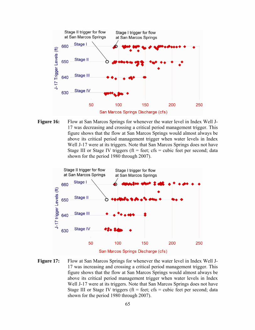
65
Figure 16: Flow at San Marcos Springs for whenever the water level in Index Well J-
17 was decreasing and crossing a critical period management trigger. This figure shows that the flow at San Marcos Springs would almost always be above its critical period management trigger when water levels in Index Well J-17 were at its triggers. Note that San Marcos Springs does not have Stage III or Stage IV triggers (ft = feet; cfs = cubic feet per second; data shown for the period 1980 through 2007).
Figure 17: Flow at San Marcos Springs for whenever the water level in Index Well J-
17 was increasing and crossing a critical period management trigger. This figure shows that the flow at San Marcos Springs would almost always be above its critical period management trigger when water levels in Index Well J-17 were at its triggers. Note that San Marcos Springs does not have Stage III or Stage IV triggers (ft = feet; cfs = cubic feet per second; data shown for the period 1980 through 2007).

66
Figure 18: Flow at San Marcos Springs whenever flow at Comal Springs was
declining and crossing its critical period management trigger. This figure shows that the flow at San Marcos Springs would almost always be above its critical period management trigger when flow at Comal Springs was at its triggers. Note that San Marcos Springs does not have Stage III or Stage IV triggers (cfs = cubic feet per second; data shown for the period 1980 through 2007).
Figure 19: Flow at San Marcos Springs whenever flow at Comal Springs was
increasing and crossing its critical period management trigger. This figure shows that the flow at San Marcos Springs would always be above its critical period management trigger when flow at Comal Springs was at its triggers. Note that San Marcos Springs does not have Stage III or Stage IV triggers (cfs = cubic feet per second; data shown for the period 1980 through 2007).

67
Task 3.2: Investigate spring flow volume measurement methodologies currently in use and evaluate their accuracy. If any are deemed to be inadequate, suggest alternative measuring methods.
This task is the same as Task 2.4. Please see our response to Task 2.4.

68
Comal Springs in 2005 (photo by Mary Musick)
Acknowledgments
We are grateful to the following people for assistance and support in addressing our tasks: Michael Abbott (River Systems Institute, Texas State University), Mara Alexander (U.S. Fish & Wildlife Department), Steve Bereyso (San Antonio Water System), Valentin Cantu (U.S. Fish & Wildlife Department), Brenner Brown (Texas Water Development Board), Patrick Connor (U.S. Fish & Wildlife Department), Ken Diehl (San Antonio Water System), Joe Fries (U.S. Fish & Wildlife Department), Gary Garrett (Texas Parks and Wildlife Department), Randy Gibson (U.S. Fish & Wildlife Department), Robert Gulley (Edwards Aquifer Recovery Implementation Program), Rick Illgner (Edwards Aquifer Authority), Larry Land (HDR-Engineering, Inc.), Rick Lindgren (U.S. Geological Survey), Anna Muñoz (Texas A&M University), Chad Norris (Texas Parks and Wildlife Department), George Ozuna (U.S. Geological Survey), Carol Patterson (Edwards Aquifer Authority), Kirk Patterson (Regional Clean Air and Water), Nathan Pence (City of New Braunfels), Katherine Phillips (U.S. Fish & Wildlife Department), Andrew Sansom (River Systems Institute, Texas State University), Geary Schindel (Edwards Aquifer Authority), Todd Votteler (Guadalupe-Blanco River Authority), Shirley Wade (Texas Water Development Board), Dianne Wassenich (San Marcos River Foundation), and Meredith Worthen (Texas Water Development Board).
We are also grateful to our invited speakers for freely sharing their knowledge and expertise, the River Systems Institute at Texas State University for providing meeting space and logistical support, and the Steering Committee for the Edwards Aquifer Recovery Implementation Program.
69
The old power plant near Comal Springs (photo by Carol Patterson)
References
Barker, R.A., and Ardis, A.F., 1996, Hydrogeologic framework of the Edwards-Trinity aquifer system, west-central Texas: U.S. Geological Survey Professional Paper 1421–B, 61 p.
Barr, C.B, 1993, Survey for two Edwards Aquifer invertebrates: Comal Springs dryopid beetle Stygoparnus comalensis Barr and Spangler (Coleoptera: Dryopidae) and Peck's cave amphipod Stygobromus pecki Holsinger (Amphipoda: Crangonyctidae): Report for U.S. Fish & Wildlife Service, Austin Ecological Services Field Office, Austin, Texas.
Barr, C.B., and Spangler, P.J., 1992, A new genus and species of Stygobiontic dryopid beetle, Stygoparnus comalensis (Coleoptera: Dryopidae), from Comal Springs, Texas: Proceedings of the Biological Society of Washington, v. 105, p. 40–54.
Beaty, H.E., 1976, Transplanting Zizania texana (Texas wild-rice) in Bell County, Texas: Baylor University, Waco, Texas.
Bergin, S.J., 1996, The diet of the fountain darter Etheostoma fonticola in the Comal River, Texas: Master thesis, Southwest Texas State University, San Marcos, Texas, 45 p.
Berkhouse, C.S., and Fries, J.N., 1995, Critical thermal maximum of San Marcos salamanders: Southwestern Naturalist, v. 40, p. 430–434.
Bexar Metropolitan Water District, 1998, Habitat conservation plan in support of Edwards Aquifer withdrawals affecting Edwards Aquifer dependent species for Endangered Species Act Section 10(a)(1)(B) Permit: Bexar Metropolitan Water District, San Antonio, Texas.
70
BIO-WEST, Inc., 2002a, Comal Springs riffle beetle habitat and population evaluation: Final report to the Edwards Aquifer Authority, San Antonio, Texas, 24 p.
BIO-WEST, Inc., 2002b, Fountain darter laboratory study—Reproductive response to parasites and temperature fluctuations: Final report to the Edwards Aquifer Authority, San Antonio, Texas, 12 p.
BIO-WEST, Inc., 2004, Aquatic vegetation laboratory study: Phase 1: Observations of water quality changes and plant growth under various flows, Phase 2: Effects of carbon dioxide level on aquatic plants found in the Comal and San Marcos springs/river ecosystems: Final report to the Edwards Aquifer Authority, San Antonio, Texas, 25 p.
Bonner, T.H., Brandt, T.M., Fries, J.N., and Whiteside, B.G., 1998, Effects of temperature on egg production and early life stages of the fountain darter: Transactions of the American Fisheries Society, v. 127, p. 971–978.
Bosse, L.S., Tuff, D.W., and Brown, H.P., 1988, A new species of Heterelmis from Texas (Coleoptera: Elmidae): Southwestern Naturalist, v. 33, p. 199–203.
Bowles, D.E., Barr, C.B., and Stanford, R., 2003, Habitat and phenology of the endangered riffle beetle Heterelmis comalensis and a coexisting species, Microcylloepus pusillus, (Coleoptera: Elmidae) at Comal Springs, Texas, USA: Archiv fur Hydrobiologie, v. 156, p. 361–383.
Brandt, T.M., Graves, K.G., Berkhouse, C.S., Simon, T.P., and Whiteside, B.G., 1993, Laboratory spawning and rearing of the endangered fountain darter: Progressive Fish-Culturist, v. 55, p. 149–156.
Brown, H.P., 1976, Aquatic dryopid beetles (Coleoptera) of the United States: Water pollution control research series 18050 ELD04/72, U.S. Environmental Protection Agency, Environmental Monitoring and Support Laboratory, Cincinnati, Ohio.
Brown, H.P., 1987, Biology of riffle beetles: Annual Review of Entomology, v. 32, p. 253–273.
Bunn, S.E., and Arthington, A.H., 2002, Basic principles and ecological consequences of altered flow regimes for aquatic biodiversity: Environmental Management, v. 30, no. 4, p. 492–507.
Chambers, P.A., Prepas, E.E., Hamilton, H.R., and Bothwell, M.L., 1991, Current velocity and its effects on aquatic macrophytes in flowing waters: Ecological Applications, v. 1, p. 249–257.
Collins, E.W., and Hovorka, S.D., 1997, Structure map of the San Antonio segment of the Edwards Aquifer and Balcones Fault Zone, south-central Texas—Structural framework of a major limestone aquifer—Kinney, Uvalde, Medina, Bexar, Comal and Hays Counties: The University of Texas at Austin, Bureau of Economic Geology, Miscellaneous Map 38.
Crossley, M.N., Dennison, W.C., Williams, R.R., and Wearing, A.H., 2002, The interaction of water flow and nutrients on aquatic plant growth: Hydrobiologia, v. 489, p. 63–70.

71
DeCook, K.J., 1963, Geology and ground-water resources of Hays County, Texas: U.S. Geological Survey, Water-Supply Paper 1612, 72 p.
Deike, R.G., 1990, Dolomite dissolution rates and possible Holocene dedolomitization of water-bearing units in the Edwards Aquifer, south-central Texas: Journal of Hydrology, v. 112, no. 3–4, p. 335–373.
Edwards Aquifer Authority, 2004, Draft Edwards Aquifer habitat conservation plan and environmental impact statement: Edwards Aquifer Authority, San Antonio, Texas.
Edwards Aquifer Authority, 2007a, Comparison of 450,000 acre-foot per year and 572,000 acre-foot per year groundwater withdrawal management scenarios using the Authority’s MODFLOW Groundwater Availability Model: A Model Simulation Memo Report prepared by the Aquifer Science Program for the Aquifer Management Planning Committee, dated August 22, 2007, 15 p.
Edwards Aquifer Authority, 2007b, Variable flows study—Seven years of monitoring and applied research: Edwards Aquifer Authority, San Antonio, Texas, 64 p.
Edwards Aquifer Authority, 2008, Hydrologic Data Report for 2007: Edwards Aquifer Authority, Report No. 08-02, 229 p.
Fonteyn, P.J. and Power, P., 1989, Texas wildrice, interim report: U.S. Fish & Wildlife Service, Albuquerque, New Mexico, 10 p.
Fraser, P.D., and Bramley, P.M., 2004, The biosynthesis and nutritional uses of carotenoids: Progress in Lipid Research, v. 43, p. 228–265.
Fries, J.N., Gibson, J.R., and Arsuffi, T.L., 2004, Edwards Aquifer spring invertebrate survey and captive maintenance of two species: Report for U.S. Fish & Wildlife Service, Austin Ecological Services Field Office, Austin, Texas.
Fuller, P., and Brandt, T., 1997, Exotic snail and trematode affecting endangered fish: American Fisheries Society, Texas Chapter Newsletter v. 23, no. 3, p.14.
Gaillard, M., Juillet, C., Cezilly, F., and Perrot-Minnot, M., 2004, Carotenoids of two freshwater amphipod species (Gammarus pulex and G. roeseli) and their common acanthocephalan parasite Polymorphus minutus. Comparative Biochemistry and Physiology Part B: Biochemistry and Molecular Biology, v. 139, p. 129–136.
Gibson, J.R., Harden, S.J., and Fries, J.N., 2008, Survey and distribution of invertebrates from selected Edwards Aquifer springs of Comal and Hays counties, Texas: Southwestern Naturalist, v. 53, p. 74–84.
Gonzales, T., 2008, Conservation genetics of the Comal Springs riffle beetle (Heterelmis comalensis) populations in central Texas, with examination of molecular and morphological variation in Heterelmis species throughout Texas: Unpublished Master thesis, Texas State University, San Marcos, Texas.
Groeger, A.W., Brown, P.F., Tietjen, T.E., and Kelsey, T.C., 1997, Water quality of the San Marcos River: Texas Journal of Science, v. 49, p. 279–294.
72
Groschen, G.E., 1996, Hydrogeologic factors that affect the flowpath of water in selected zones of the Edwards Aquifer, San Antonio region, Texas: U.S. Geological Survey, Water-Resources Investigations Report 96–4046, 73 p.
Guyton, W.F., 1979, Geohydrology of Comal, San Marcos, and Hueco springs: Texas Department of Water Resources, Report 234, 85 p.
Harbaugh, A.W., Banta, E.R., Hill, M.C., and McDonald, M.G., 2000, MODFLOW-2000, the U.S. Geological Survey modular ground-water model—User guide to modularization concepts and the ground-water flow process: U.S. Geological Survey, Open-File Report 00–92, 121 p.
Harden, R., 1988, Ground Water: Proceedings, San Marcos and Comal Springs Symposium, Southwest Texas State University, San Marcos, Texas, December 2–3, 1988.
HDR Engineering, Inc., 1991, Nueces River Basin Regional Water Supply Planning Study, Phase I, Vol. 2: Report to the Texas Water Development Board, Nueces River Authority, and others.
HDR Engineering, Inc., 1993, Guadalupe-San Antonio River Basin recharge enhancement study, Vol. 2: Report to the Edwards Underground Water District, San Antonio, Texas.
HDR Engineering, Inc., 1998, Edwards Aquifer Recharge Analyses, Edwards Aquifer recharge update, Trans-Texas Water Program, West Central Study Area, Phase II: Report to the Texas Water Development Board, San Antonio River Authority, and others.
HDR Engineering, Inc., 2002, Pilot recharge models of the Nueces and Blanco river basins: Report to the Edwards Aquifer Authority, San Antonio, Texas.
Holsinger, J.R., 1967, Systematics, speciation, and distribution of the subterranean amphipod genus Stygonectes (Gammaridae): U.S. National Museum Bulletin, v. 259, p. 1–176.
Holsinger, J.R., 1994, Pattern and process in the biogeography of subterranean amphipods: Hydrobiologia, v. 287, p. 131–145.
Hoover, J.J., Murphy, C.E., and Kilgore, J., 2006, The environmental impacts of Suckermouth Catfishes (Loricariidae) in North America: A Conceptual Model: U.S. Army Engineer Research and Development Center, Waterways Experiment Station, Vicksburg, Mississippi.
Hovorka, S.D., Mace, R.E., and Collins, E.W., 1998, Permeability structure of the Edwards Aquifer, south Texas—Implications for aquifer management: The University of Texas at Austin, Bureau of Economic Geology, Report of Investigations 250, 55 p.
Hovorka, S.D., Ruppel, S.C., Dutton, A.R., and Yeh, J.S., 1993, Edwards Aquifer storage assessment, Kinney County to Hays County, Texas: Report to the Edwards Underground Water District, San Antonio, Texas, 109 p.
73
Howells, R.G., 2005, Exotic suckermouth catfishes (Family Loricarriidae) in Texas Waters: Texas Parks and Wildlife Department, Austin, Texas.
Hubbs, C., 1984, Extinction of Gambusia amistadensis, an endangered fish: Copeia, v. 1984, p. 529–530.
Hubbs, C., Lucier, T., Marsh, E., Garrett, G.P., Edwards, R.J., and Millstead, E., 1978, Results of an eradication program on the ecological relationships of the fishes in Leon Creek, Texas: Southwestern Naturalist, v. 23, no. 3, p. 487–496.
Johnson, S.B., and Schindel, G.M., 2008, Evaluation of the option to designate a separate San Marcos pool for critical period management: Edwards Aquifer Authority, San Antonio, Texas, Report 08-01, 109 p.
Johnson, S.B., Schindel, G.M., and Veni, G.E., in review, Tracing groundwater flowpaths in the Edwards Aquifer recharge zone , Panther Springs Creek Basin, Northern Bexar County, Texas: Edwards Aquifer Authority, San Antonio, Texas.
Klemt, W.B., Knowles, T.R., Elder, G.R., and Sieh, T.W., 1979, Ground-water Resources and model applications for the Edwards (Balcones Fault Zone) Aquifer in the San Antonio region, Texas: Texas Department of Water Resources, Report 239, 88 p.
Knott, K.E., and Murray, H.D., 1991, Mystery fluke in Melanoides tuberculata (Gastropoda: Thiaridae) in the San Antonio Zoo, San Antonio, Texas: Combined Annual Meetings, Western Society of Malacologists and American Malacological Union, Proceedings and Abstracts from the Joint Annual Meeting. Berkeley, California.
Land, L., and Lemonds, P.J., 2008, Hydrologic connection of the Edwards Aquifer between San Marcos Springs and Barton Springs: Technical memo by HDR Engineering, Inc., to Tommy Hill and Todd Votteler of the Guadalupe-Blanco River Authority, Job No. 07081-1294, 36 p.
LBG-Guyton Associates, 1994, Edwards Aquifer ground-water divides assessment, San Antonio Region, Texas: Report to the Edwards Underground Water District, San Antonio, Texas.
LBG-Guyton Associates, 2004, Evaluation of augmentation methodologies in support of in-situ refugia at Comal and San Marcos springs, Texas: Report prepared for the Edwards Aquifer Authority, June 2004, variously paginated.
LBG-Guyton Associates, 2005, HSPF recharge models for the San Antonio Segment of the Balcones Fault Zone Aquifer: Report to the Edwards Aquifer Authority under Contract 02-87-AS.
Lemke, D.E., 1989, Aquatic macrophytes of the upper San Marcos River: Southwestern Naturalist, v. 34, no. 2, p. 289–291.
Lindgren, R.J., Dutton, A.R., Hovorka, S.D., Worthington, S.R.H., and Painter, S., 2004, Conceptualization and simulation of the Edwards Aquifer, San Antonio region, Texas: U.S. Geological Survey, Scientific Investigations Report. 2004-5277, 154 p. + 7 plates.

74
Lindgren, R.J., 2006, Diffuse-flow conceptualization and simulation of the Edwards Aquifer, San Antonio region, Texas: U.S. Geological Survey, Scientific Investigations, Report 2006-5319, 48 p. + 1 plate.
Linam, G.W., Mayes, K.B., and Saunders, K.S., 1993, Habitat utilization and population size estimate of fountain darters, Etheostoma fonticola, in the Comal River, Texas: Texas Journal of Science, v. 45, p. 341–348.
Longley, G., 1981, The Edwards Aquifer: Earth’s most diverse groundwater ecosystem? International Journal of Speleology, v. 11, no. 1-2, p. 123–128.
Mace, R.E., Chowdhury, A.H., Anaya, R., and Way, S.-C., 2000, Groundwater availability of the Middle Trinity Aquifer, Hill Country area, Texas—Numerical simulations through 2050: Texas Water Development Board, Report 353, 117 p.
Mace, R.E., Donnelly, A.C.A., and Wade, S., 2007, GAM Run 06-33a: Texas Water Development Board, Austin, Texas, 16 p.
Mace, R.E., and Wade, S.C., 2008, In hot water? How climate change may (or may not) affect the groundwater resources of Texas: Gulf Coast Association of Geological Societies Transactions, v. 58, p. 655–668.
Maclay, R.W., 1995, Geology and hydrology of the Edwards Aquifer in the San Antonio area, Texas: U.S. Geological Survey, Water-Resources Investigations Report 95–4186, 64 p.
Maclay, R.W., and Land, L.F., 1988, Simulation of flow in the Edwards Aquifer, San Antonio region, Texas, and refinement of storage and flow concepts: U.S. Geological Survey, Water-Supply Paper 2336-A.
Maclay, R.W., and Small, T.A., 1984, Carbonate geology and hydrology of the Edwards Aquifer in the San Antonio area, Texas: U.S. Geological Survey, Open-File Report 83–537, 72 p.
McDonald, D.L., Bonner, T.H., Oborny, E.L., and Brandt, T.M., 2007, Effects of fluctuating temperatures and gill parasites on reproduction of the fountain darter, Etheostoma fonticola: Journal of Freshwater Ecology, v. 22, no. 2, p. 311–318.
McKinney, D.C., and Sharp, J.M., 1995, Springflow augmentation of Comal Springs and San Marcos Springs, Texas: Phase I feasibility study: Center for Research in Water Resources, The University of Texas at Austin, Technical Report CRWR 247.
Mitchell, A.J., Salmon, M.J., Huffman, D.G., Goodwin, A.E., and Brandt, T.M., 2000, Prevalence and pathogenicity of a heterophyid trematode infecting the gills of an endangered fish, the fountain darter, in two central Texas spring-fed rivers: Journal of Aquatic Animal Health, v. 12, p. 283–289.
Mitchell, A.J., Overstreet, R.M., Goodwin, A.E., and Brandt, T.M., 2005, Spread of an exotic fish-gill trematode: A far-reaching and complex problem: Fisheries, v. 30, no. 8, p. 11–16.
National Research Council, 2005, The science of instream flows: A review of the Texas Instream Flow Program: National Academies Press, Washington, D.C.

75
Negre-Sadargues, G., Castillo, R., and Segonzac, M., 2000, Carotenoid pigments and trophic behaviour of deep-sea shrimps (Crustacea, Decapoda, Alvinocarididae) from a hydrothermal area of the Mid-Atlantic Ridge: Comparative Biochemistry and Physiology Part A: Molecular and Integrative Physiology, v. 127, p. 293–300.
Nelson, J.M., 1993, Population size, distribution, and life history of Eurycea nana in the San Marcos River: Master thesis, Texas State University, San Marcos, Texas.
Ogden, A.E., Quick, R.A., and Rothermel, S.R., 1986, Hydrochemistry of the Comal, Hueco, and San Marcos springs, Edwards Aquifer, Texas, in Abbott, P.L., and Woodruff, C.M., Jr., editors, The Balcones Escarpment, Central Texas: Geological Society of America, p. 115-130.
Otero, C.L., 2007, Geologic, hydrologic, and geochemical identification of flow paths in the Edwards Aquifer, northeastern Bexar and southern Comal Counties, Texas: U.S. Geological Survey, Scientific Investigations Report 2007–5285, 48 p.
Pearson, Jr., F.J., Rettman, P.L., and Wyerman, T.A., 1975, Environmental tritium in the Edwards Aquifer, Central Texas 1963-1971: U.S. Geological Survey, Open-File Report 74-3.
Poff, N.L., and Allan, J.D., 1995, Functional organization of stream fish assemblages in relation to hydrological variability: Ecology, v. 76, p. 606–627.
Poff, N.L., Allan, J.D., Bain, M.B., Karr, J.R., Prestegaard, K.L., Richter, B.D., Sparks, R.E., and Stromberg, J.C., 1997, The natural flow regime: BioScience, v. 47, p. 769–784.
Poole, J.M., 2002, Historical distribution of Texas wild-rice (Zizania texana) from 1989 to 2001. Section 6 Final Report: U.S. Fish & Wildlife Service, Albuquerque, New Mexico.
Poole, J.M., and Bowles, D.E., 1999, Habitat characterization of Texas wild-rice (Zizania texana), an endangered aquatic macrophyte from the San Marcos River, Texas, USA. Aquatic Conservation: Marine and Freshwater Ecosystems, v. 9, p. 291–302.
Power, P., 1996a, Effects of current velocity and substrate composition on growth of Texas wildrice (Zizania texana): Aquatic Botany, v. 55, p. 199–204.
Power, P., 1996b, Direct and indirect effects of floating vegetation mats on Texas wildrice (Zizania texana): Southwestern Naturalist, v. 41, p. 462–464.
Power, P., 1996c, Reintroduction of Texas wildrice (Zizania texana) in Spring Lake: Some important environmental and biotic considerations: in Maschinski, J., Hammond, H.D., and Holter, L., editors, Southwestern rare and endangered plants: Proceedings of the second conference, September 11–14, 1995; Flagstaff, Arizona, General Technical Report RM-GTR-283, U.S. Department of Agriculture, Forest Service, Rocky Mountain Forest and Range Experiment Station, Fort Collins, Colorado, p. 179–187.
Power, P., 2002, Resource allocation patterns and phenotypic plasticity in relation to current velocity in the endangered Texas wildrice (Zizania texana Hitchc.): Sida, v. 20, p. 571–582.

76
Power, P., and Doyle, R.D., 2004, Carbon use by the endangered Texas wild rice (Zizania texana, Poaceae): Sida, v. 21, p. 389–398.
Power, P., and Fonteyn, P.J., 1995, Effects of oxygen concentration and substrate on seed germination and seedling growth of Texas wildrice (Zizania texana): Southwestern Naturalist, v. 40, p. 1–4.
Puente, C., 1978, Method of estimating natural recharge to the Edwards Aquifer in the San Antonio area, Texas: U.S. Geological Survey, Water-Resources Investigations Report 78–10, 34 p.
Resh, V.H., Buchwalter, D.B., Lamberti, G.A., and Eriksen, C.H., 2008, Aquatic insect respiration, in Merritt, R.W., Cummins, K.W., and Berg, M.B., editors, An introduction to the aquatic insects of North America, Fourth Edition: Kendall/Hunt Publishing Company, Dubuque, Iowa, p. 39–53.
Rose, F.L., and Power, P., 1992, Effects of habitat and herbivory on growth and reproduction in Texas wildrice (Zizania texana): Report submitted to U.S. Fish & Wildlife Service, Albuquerque, New Mexico, 20 p.
Rose, F.L., and Power, P., 1994, Continued maintenance, reintroduction and research on Zizania texana (Texas wildrice). IV. Growth response by Zizania texana (Texas wildrice) under three current regimes and two sediments in Spring Lake, Hays County, Texas: Report to U.S. Fish & Wildlife Service, Albuquerque, New Mexico.
Rose, P.R., 1972, Edwards Group, surface and subsurface, central Texas: Bureau of Economic Geology, The University of Texas at Austin, Report of Investigations 74, 198 p.
Rothermel, S.R., and Ogden, A.E., 1986, Time-series analysis of Edwards Aquifer springs in Comal County, Texas, in Environmental Problems in Karst Terranes and Their Solutions Conference, Proceedings: Dublin, Ohio, National Water Well Association, p. 115–148.
Rothermel, S.R., and Ogden, A.E., 1987, Hydrochemical investigation of the Comal and Hueco spring systems, Comal County, Texas: Edwards Aquifer Research and Data Center, Southwest Texas State University, Report R1-87, 182 p.
Scanlon, B.R., Mace, R.E., Smith, B., Hovorka, S.D., Dutton, A.R., and Reedy, R.C., 2002, Groundwater availability of the Barton Springs Segment of the Edwards Aquifer, Texas—Numerical simulations through 2050: Bureau of Economic Geology, The University of Texas at Austin, final report prepared for the Lower Colorado River Authority under contract no. UTA99–0, 36 p.
Schaefer, P.E., 2000, The effects of supersaturated nitrogen on the endangered fountain darter and the San Marcos salamander: Master thesis, Southwest Texas State University, 27 p.
Schenck, J.R., and Whiteside, B.G., 1976, Distribution, habitat preference and population size estimate of Etheostoma fonticola: Copeia, v. 1976, no. 4, p. 697–703.

77
Schenck, J.R., and Whiteside, B.G., 1977, Food habits and feeding behavior of the fountain darter, Etheostoma fonticola (Osteichthyes: Percidae): Southwestern Naturalist, v. 21, p. 487–492.
Schultz, A.L., 1994, 1994 review and update of the position of the Edwards Aquifer freshwater/saline-water interface from Uvalde to Kyle, Texas: Edwards Underground Water District, Report 94–05, 31 p.
Slade, R.M., Jr., Bentley, J.T., and Michaud, D., 2002, Results of streamflow gain-loss studies in Texas, with emphasis on gains from and losses to major and minor aquifers: U.S. Geological Survey, Open-File Report 02-068, 131 p.
Smith, F.A., and Walker, N.A., 1980, Photosynthesis by aquatic plants: Effects of unstirred layers in relation to assimilation of CO2 and HCO3⎯ and to carbon isotopic discrimination: New Phytologist, v. 86, p. 245–259.
Soil Conservation Service, 1972, SCS National Engineering Handbook, Section 4, Hydrology: U.S. Department of Agriculture.
Stevens, C.L., and Hurd, C.L., 1997, Boundary layers around bladed aquatic macrophytes: Hydrobiologia, v. 346, p. 119–128.
Taylor, T.U., 1904, The water powers of Texas: U.S. Geological Survey, Water Supply and Irrigation Paper No. 105, 116 p.
Terrell, E.E., Emery, W.H.P., and Beaty, H.E., 1978, Observations on Zizania texana (Texas wildrice), an endangered species: Bulletin of the Torrey Botanical Club, v. 105, p. 50–57.
Texas Commission on Environmental Quality, Texas Parks and Wildlife, and Texas Water Development Board, 2008, Texas instream flow studies: Technical overview: Texas Water Development Board, Report 369, 137 p.
Thorkildsen, D. and McElhaney, P.D., 1992, Model refinement and applications for the Edwards (Balcones Fault Zone) aquifer in the San Antonio region, Texas: Texas Water Development Board, Report 340.
Tolley-Jordan, L.R., and Power, P., 2007, Effects of water temperature on growth of the federally endangered Texas wild rice (Zizania texana): Southwestern Naturalist, v. 51, p. 201–208.
Tu, M., 2002, Weed Alert! Cryptocoryne beckettii Thwaites ex Trimen (water trumpet): The Texas Nature Conservancy, Wildland Invasive Species Team.
Tupa, D.D., and Davis, W.K., 1976, Population dynamics of the San Marcos salamander, Eurycea nana Bishop: Texas Journal of Science, v. 27, p. 179–195.
Ulrich, G.W., 1986, The larvae and pupae of Helichus suturalis Leconte and Helichus productus Leconte (Coleoptera: Dryopidae): The Coleopterist Bulletin, v. 40, p. 325–334.
U.S. Fish & Wildlife Service, 1984, San Marcos River Recovery Plan: U.S. Fish & Wildlife Service, Albuquerque, New Mexico.

78
U.S. Fish & Wildlife Service, 1996, San Marcos and Comal springs and associated aquatic ecosystems (revised) recovery plan: U.S. Fish & Wildlife Service, Albuquerque, New Mexico.
U.S. Fish & Wildlife Service, 2003, Power point presentation developed by San Marcos National Fish Hatchery and e-mail correspondence from Carrie Thompson to Edwards Aquifer Authority dated June 27, 2003.
U.S. Fish & Wildlife Service, 2007, Endangered and threatened wildlife and plants: Designation of critical habitat for the Peck's Cave amphipod, Comal Springs dryopid beetle, and Comal Springs riffle beetle—Final rule: Federal Register 72 (17 July 2007):39248-39283.
U.S. Fish & Wildlife Service and National Oceanic and Atmospheric Administration, 2000, Policy regarding controlled propagation of species listed under the Endangered Species Act: Federal Register 65 (20 September 2000):56916-56922.
Vaughan, J.E., 1986, Populations and autecological assessment of Zizania texana Hitchc. (Poaceae) in the San Marcos River: Master thesis, Southwest Texas State University, San Marcos, Texas.
Votteler, T.H., 2000, Water from a Stone–The limits of the sustainable development of the Texas Edwards Aquifer: Ph.D. dissertation, Southwest Texas State University, San Marcos, Texas, 468 p.
White, D.S., and Roughley, R.E., 2008, Aquatic Coleoptera—Elmidea (Riffle Beetles) in Merritt, R.W., Cummins, K.W., and Berg, M.B., editors, An introduction to the aquatic insects of North America, Fourth Edition: Kendall/Hunt Publishing Company, Dubuque, Iowa, 632 p.
Worthington, S.R.H., 2003, Conduits and turbulent flow in the Edwards Aquifer: Report prepared for the Edwards Aquifer Authority, San Antonio, Texas, 42 p.

79
Appendix A: The formation and operation of the Edwards Aquifer Area Expert Science Subcommittee
The Texas Legislature required the Steering Committee for the Edwards Aquifer Recovery Implementation Program to establish an Edwards Aquifer Area Expert Science Subcommittee of individuals “with technical expertise regarding the Edwards Aquifer system, the threatened and endangered species that inhabit that system, springflows, or the development of withdrawal limitations.” The legislature required the subcommittee to prepare “initial recommendations by December 31, 2008”, regarding:
• The option of designating a separate San Marcos pool, of how such a designation would affect existing pools, and of the need for an additional well to measure the San Marcos pool if designated
• The necessity to maintain minimum springflows, including a specific review of the necessity to maintain a flow to protect federally threatened and endangered species; and
• Whether adjustments in the trigger levels for the San Marcos Springs flow for the San Antonio pool should be made.
The Steering Committee refers to these recommendations as the “k” charges. In making their recommendations, the Science Subcommittee was tasked to “consider all reasonably available science” and “base its recommendations solely on the best science available.” In addition, the legislature tasked the subcommittee to “operate on a consensus basis to the maximum extent possible.”
The Steering Committee appointed 15 scientists to serve on the Expert Science Subcommittee and one non-voting member. A list of the members and their affiliations is included at the beginning of this report (page iii).
Members were seated using a formal nomination and selection process:
• The Steering Committee established an Expert Science Subcommittee nominations workgroup to handle the application process.
• The workgroup accepted nominations from members of the Edwards Aquifer Recovery Implementation Program (an individual could also nominate themselves).
• Nominated individuals were asked to complete and submit an application summarizing their applicable areas of expertise and any possible conflicts of interest.
• The workgroup reviewed and compiled all applications by area of expertise. • The compiled applications information was made available to all members of the
Edwards Aquifer Recovery Implementation Program. • Members of the Edwards Aquifer Recovery Implementation Program were
invited to endorse nominees without limitation on the number of endorsements. • The workgroup presented the endorsement results to the Steering Committee. • At the January 2008 general Edwards Aquifer Recovery Implementation Program
meeting, the Steering Committee held open discussions regarding the selection of
80
the Expert Science Subcommittee members. Consensus was reached to seat seven members, and these seven members were tasked to make recommendations to the Steering Committee regarding filling the remaining eight vacancies from the original pool of nominees/applicants.
• The newly-formed Expert Science Subcommittee met in late January 2008 and reached consensus regarding recommendations to fill the remaining eight vacancies.
• At the February 2008 general Edwards Aquifer Recovery Implementation Program meeting, the Steering Committee reached consensus on the eight nominees recommended by the Expert Science Subcommittee. At this same meeting, the Steering Committee reached consensus on the addition of one non-voting member to the subcommittee.
• Subsequent filling of available Expert Science Subcommittee slots (due to resignations) was accomplished by the Expert Science Subcommittee reaching consensus on a nominee/applicant from the original pool and making a recommendation to the Steering Committee. In each case, the subcommittee’s recommendation was accepted by the Steering Committee.
Additional information about the establishment and the work of the Science Subcommittee can be found at http://earip.tamu.edu/SciComm.cfm.
81
Appendix B: Excerpts from the Edwards Aquifer Authority Act, as amended by Senate Bill 3, Regular Session, 80th Legislature, that concern the Edwards Aquifer Area Expert Science Subcommittee
Section 1.14 WITHDRAWALS (a) Authorizations to withdraw water from the aquifer and all authorizations and
rights to make a withdrawal under this Act shall be limited in accordance with this section to:
(1) protect the water quality of the aquifer;
(2) protect the water quality of the surface streams to which the aquifer provides springflow;
(3) achieve water conservation;
(4) maximize the beneficial use of water available for withdrawal from the aquifer;
(5) recognize the extent of the hydro-geologic connection and interaction between surface water and groundwater;
(6) protect aquatic and wildlife habitat;
(7) protect species that are designated as threatened or endangered under applicable federal or state law; and
(8) provide for instream uses, bays, and estuaries.
(b) Repealed by Act of May 28, 2007, 80th Leg., R.S., ch. 1351, § 2.09, 2007 Tex. Gen. Laws 4612, 4634; Act of May 28, 2007, 80th Leg., R.S., ch. 1430, § 12.09, 2007 Tex. Gen. Laws 5848, 5908.
(c) Except as provided by Subsections (f) and (h) of this section and Section 1.26 of this article, for the period beginning January 1, 2008, the amount of permitted withdrawals from the aquifer may not exceed or be less than 572,000 acre-feet of water for each calendar year, which is the sum of all regular permits issued or for which an application was filed and issuance was pending action by the authority as of January 1, 2005.
(d) Repealed by Act of May 28, 2007, 80th Leg., R.S., ch. 1351, § 2.09, 2007 Tex. Gen. Laws 4612, 4634; Act of May 28, 2007, 80th Leg., R.S., ch. 1430, § 12.09, 2007 Tex. Gen. Laws 5848, 5908.
(e) The authority may not allow withdrawals from the aquifer through wells drilled after June 1, 1993, except for replacement, test, or exempt wells or to the extent that the authority approves an amendment to an initial regular permit to authorize a change in the point of withdrawal under that permit.

82
(f) If the level of the aquifer is equal to or greater than 660 feet above mean sea level as measured at Well J-17, the authority may authorize withdrawal from the San Antonio pool, on an uninterruptible basis, of permitted amounts. If the level of the aquifer is equal to or greater than 845 feet at Well J-27, the authority may authorize withdrawal from the Uvalde pool, on an uninterruptible basis, of permitted amounts.
(h) To accomplish the purposes of this article, the authority, through a program, shall implement and enforce water management practices, procedures, and methods to ensure that, not later than December 31, 2012, the continuous minimum springflows of the Comal Springs and the San Marcos Springs are maintained to protect endangered and threatened species to the extent required by federal law and to achieve other purposes provided by Subsection (a) of this section and Section 1.26 of this article. The authority from time to time as appropriate may revise the practices, procedures, and methods. To meet this requirement, the authority shall require:
(1) phased adjustments to the amount of water that may be used or withdrawn by existing users or categories of other users, including adjustments in accordance with the authority's critical period management plan established under Section 1.26 of this article; or
(2) implementation of alternative management practices, procedures, and methods.
Act of May 30, 1993, 73rd Leg., R.S., ch. 626, § 1.14, 1993 Tex. Gen. Laws 2350, 2360; as amended by Act of May 28, 2007, 80th Leg., R.S., ch. 1351, § 2.02, 2007 Tex. Gen. Laws 4612, 4627; Act of May 28, 2007, 80th Leg., R.S., ch. 1430, § 12.02, 2007 Tex. Gen. Laws 5848, 5901.
Section 1.26A DEVELOPMENT OF WITHDRAWAL REDUCTION LEVELS AND STAGES FOR CRITICAL PERIOD MANAGEMENT THROUGH RECOVERY IMPLEMENTATION PROGRAM.
(h) Where reasonably practicable or as required by law, any meeting of the steering committee, the Edwards Aquifer area expert science subcommittee, or another subcommittee established by the steering committee must be open to the public.
(i) The steering committee appointed under this section shall appoint an Edwards Aquifer area expert science subcommittee not later than December 31, 2007. The expert science subcommittee must be composed of an odd number of not fewer than seven or more than 15 members who have technical expertise regarding the Edwards Aquifer system, the threatened and endangered species that inhabit that system, springflows, or the development of withdrawal limitations. The Bureau of Economic Geology of The University of Texas at Austin and the River Systems Institute at Texas State University shall assist the expert science subcommittee. Chapter 2110, Government Code, does not apply to the size, composition, or duration of the expert science subcommittee.
83
(j) The Edwards Aquifer area expert science subcommittee shall, among other things, analyze species requirements in relation to spring discharge rates and aquifer levels as a function of recharge and withdrawal levels. Based on that analysis and the elements required to be considered by the authority under Section 1.14 of this article, the expert science subcommittee shall, through a collaborative process designed to achieve consensus, develop recommendations for withdrawal reduction levels and stages for critical period management including, if appropriate, establishing separate and possibly different withdrawal reduction levels and stages for critical period management for different pools of the aquifer needed to maintain target spring discharge and aquifer levels. The expert science subcommittee shall submit its recommendations to the steering committee and all other stakeholders involved in the recovery implementation program under this section.
(k) The initial recommendations of the Edwards Aquifer area expert science subcommittee must be completed and submitted to the steering committee and other stakeholders not later than December 31, 2008, and should include an evaluation:
(1) of the option of designating a separate San Marcos pool, of how such a designation would affect existing pools, and of the need for an additional well to measure the San Marcos pool, if designated;
(2) of the necessity to maintain minimum springflows, including a specific review of the necessity to maintain a flow to protect the federally threatened and endangered species; and
(3) as to whether adjustments in the trigger levels for the San Marcos Springs flow for the San Antonio pool should be made.
(l) In developing its recommendations, the Edwards Aquifer area expert science subcommittee shall:
(1) consider all reasonably available science, including any Edwards Aquifer-specific studies, and base its recommendations solely on the best science available; and
(2) operate on a consensus basis to the maximum extent possible.
(m) After development of the cooperative agreement, the steering committee, with the assistance of the Edwards Aquifer area expert science subcommittee and with input from the other recovery implementation program stakeholders, shall prepare and submit recommendations to the authority. The recommendations must:
(1) include a review of the critical period management plan, to occur at least once every five years;
(2) include specific monitoring, studies, and activities that take into account changed conditions and information that more accurately reflects the importance of critical period management; and

84
(3) establish a schedule for continuing the validation or refinement of the critical period management plan adopted by the authority and the strategies to achieve the program and cooperative agreement described by this section.
Act of May 28, 2007, 80th Leg., R.S., ch. 1351, § 2.06, 2007 Tex. Gen. Laws 4612, 4630; Act of May 28, 2007, 80th Leg., R.S., ch. 1430, § 12.06, 2007 Tex. Gen. Laws 5848, 5904.

85
Appendix C: Initial charges from the Steering Committee to the Edwards Aquifer Area Expert Science Subcommittee

INITIAL CHARGE OF THE STEERING COMMITTEE TO THE SCIENCE SUBCOMMITTEE
February 21, 2008
The Steering Committee of the Edwards Aquifer Recovery Implementation Program (“EARIP”) requests the expert science subcommittee (“Science Subcommittee”), through an open and collaborative process designed to achieve consensus, to, among other things, analyze species requirements in relation to spring discharge rates and aquifer levels, as a function of recharge and withdrawal levels. The Steering Committee further requests the Science Subcommittee to review existing legislative critical period management triggers and levels for their scientific merit and develop recommendations for withdrawal reduction levels and stages for critical period management including, if appropriate, establishing separate and possibly different withdrawal reduction levels and stages for critical period management for different pools of the aquifer needed to maintain target spring discharge and aquifer levels. Any significant direct work on these recommendations should await the development of the specific decision evaluation framework regarding endangered species from the U.S. Fish and Wildlife Service and the development of specific charges by the EARIP. To begin fulfilling the request described above, the initial task of the Science Subcommittee will be to complete an evaluation of the following three items:
(1) The option of designating a separate San Marcos pool, how such a designation would affect existing pools, and of the need for an additional well(s) to measure the San Marcos pool, if designated; (2) The necessity to maintain minimum springflows, including a specific review of the necessity to maintain a flow to protect the federally threatened and endangered species; and (3) Whether adjustments in the trigger levels for the San Marcos Springs flow for the San Antonio pool should be made.
In conducting this evaluation, the EARIP expects the Science Subcommittee members to evaluate all reasonably available science and make its recommendations based solely on the best science available as determined by the Science Subcommittee. Because many of the members of the subcommittee have a history of involvement in the study and analysis of aquifer issues, we expect and require that they evaluate the reasonably available science with an unbiased perspective and considering the full range of options and issues. The Steering Committee encourages the Science Subcommittee to identify any issues that are policy issues and to seek input from the Steering Committee on those policy issues as well as any questions the Science Subcommittee may have regarding this charge. With respect to the three items listed above, we specifically ask the Science Subcommittee to develop the following information and provide answers to the following specific questions to assist the EARIP in evaluating their recommendations.

Item 1: The option of designating a separate San Marcos pool, of how such a designation would affect existing pools, and of the need for an additional well(s) to measure the San Marcos pool (if designated).
1.1 Identify the data and modeling that exist regarding whether a separate San Marcos pool should be designated? Are the data sufficient to support the designation of a separate San Marcos pool?
1.2 Provide your evaluation of the hydrogeological evidence and identify the data gaps.
1.3 If there are data to support the designation of such a pool, what should be the extent and boundaries of such pool?
1.4 To what extent is this pool hydrologically independent? 1.5 Is there a need for an additional well or additional wells to measure the
San Marcos pool, if one were designated. If so, what is the most effective location for such well(s)?
1.6 Your evaluation of this issue should include consideration of information provided by RIP members.
Item 2: The necessity to maintain minimum springflows, including a specific review of the necessity to maintain a flow to protect the federally threatened and endangered species
2.1. Is a minimum springflow required for the survival and recovery of each species listed under the Endangered Species Act identified in Section 3.2 of the EA RIP Memorandum of Agreement?
2.2. If alternatives exist to minimum flows that may not reduce appreciably the likelihood of the survival and recovery in the wild by reducing the reproduction, numbers, or distribution of each species listed under the Endangered Species Act identified in Section 3.2 of the EA RIP Memorandum of Agreement, identify and provide a preliminary evaluation of those alternatives to protect those federally-listed species.
2.2.1 Your consideration of alternatives, should include an evaluation of information provided by RIP members on this issue.
2.2.2 Your consideration of alternatives also should be mindful of impacts on protected species other than those species listed under the Endangered Species Act identified in Section 3.2 of the EA RIP Memorandum of Agreement.
2.3. Identify existing studies regarding the ability of each alternative other than maintaining minimum springflows to protect federally threatened or endangered species. Identify additional studies or data needed to fully evaluate each of these alternatives, including an estimate of the time and cost to conduct such studies, and any different alternatives that might be explored in the future.
2.4. Investigate springflow volume measurement methodologies currently in use and evaluate their accuracy. If any are deemed to be inadequate, suggest alternative measuring methods.

Item 3: Whether adjustments in the trigger levels for the San Marcos Springs flow for the San Antonio pool should be made
3.1. Should the trigger levels for the San Antonio pool based on San Marcos springflow be adjusted? Identify the existing data available to develop recommendations regarding such adjustments and what additional information will be necessary to make such recommendations.
3.2. Investigate springflow volume measurement methodologies currently in use and evaluate their accuracy. If any are deemed to be inadequate, suggest alternative measuring methods.
S.B. 3 requires the Science Subcommittee to employ “a collaborative process designed to achieve consensus” and to “operate on a consensus basis to the maximum extent possible.” Further, the meetings of the Science Subcommittee must be open to the public. In carrying out this charge, the Science Subcommittee is encouraged to invite outside scientists to participate in discussions, give presentations, or participate in any subgroups established by the Science Subcommittee.
The Science Subcommittee shall submit, in the form of a written initial report, its answers to these questions and a discussion of the basis for its answers and other relevant information to the steering committee and all other stakeholders involved in the EARIP no later than December 31, 2008. The Science Subcommittee shall present a brief report of its progress and its plans for future activities at each joint RIP and Steering Committee monthly meeting. These charges may be modified by the Steering Committee during the course of the Science Subcommittee’s discussions.

89
Appendix D: Memorandum of Agreement for the Edwards Aquifer Recovery Implementation Program

December 13, 2007 1
MEMORANDUM OF AGREEMENT FOR EDWARDS AQUIFER RECOVERY IMPLEMENTATION PROGRAM
This Memorandum of Agreement (“MOA”) is intended to serve as the Memorandum of Agreement for the Edwards Aquifer Recovery Implementation Program (the “Program”) under the Endangered Species Act and as the Memorandum of Agreement required by Senate Bill 3. It is made and agreed to by the Parties signing below and is effective on the Effective Date. The Parties will work together in good faith and cooperation to achieve the purposes and goals provided in the following provisions of this MOA. Article 1. Purposes Section 1.1. The purpose of this MOA is to formally initiate the development and implementation of the Edwards Aquifer Recovery Implementation Program. The Program is a collaborative initiative among stakeholders to participate in efforts to contribute to the recovery of the Edwards Species, develop aquifer management measures, and develop conservation measures for the Edwards Aquifer. Section 1.2. During the 80th Regular Session, the Texas Legislature enacted Senate Bill 3, establishing, among other things, minimum requirements applicable to the Program. It is the intent of the Parties to comply with those minimum requirements and to build upon them to ensure that the Program is as effective and as inclusive as is reasonably possible, while also maintaining compliance with applicable provisions of the Endangered Species Act.
Section 1.3. The Parties acknowledge that Program efforts will be mindful of minimizing impacts on other protected species when advancing Program initiatives. The Parties also acknowledge the necessity of finding ways to balance the Program’s contribution to recovery of Edwards Species with human water needs, while maintaining compliance with applicable provisions of the Endangered Species Act.
Article 2. Goals Section 2.1. The goals of the Program, which are intended to be broadly interpreted, include, but are not limited to, the following:
(a) review, develop, and implement sound scientific research, analysis and other measures which contribute to understanding and meeting the needs of the Edwards Species; (b) review, develop, and implement strategies which balance the needs of the Edwards Species with overall water use and supply in the Edwards Aquifer region; (c) develop and complete an implementing agreement by December 31, 2009; (d) develop and complete a program document by September 1, 2012, that shall take effect December 31, 2012, and may be in the form of a habitat conservation plan for the Edwards Species; (e) implement the program document; and

December 13, 2007 2
(f) secure federal, state, and other available funding to assist with the development and implementation of the Program.
Section 2.2. The Parties to this MOA will participate in good faith in a cooperative, consensus-based process consistent with the purposes of the Program, and the requirements and deadlines imposed by Senate Bill 3. The Parties acknowledge that reasonable flexibility to adapt Program activities, particularly in response to new information and changed circumstances, is necessary to effectively meet the purposes of the Program.
Article 3. Definitions and Construction.
Section 3.1. Definitions. In this MOA, the following terms shall have the meanings assigned in this section unless the context clearly specifies a different meaning:
“Edwards Aquifer” means the same as the definition for “Aquifer” used in The Edwards Aquifer Authority Act.
“Edwards Species” means aquatic species that (1) are listed as threatened or endangered pursuant to the Endangered Species Act, and (2) are found in the Edwards Aquifer or found in or around the springs associated with the Edwards Aquifer. The Edwards Species, as of the Effective Date, are as follows: fountain darter, San Marcos gambusia, San Marcos salamander, Texas blind salamander, Comal Springs riffle beetle, Comal Springs dryopid beetle, Peck’s cave amphipod, and Texas wild rice. This definition may be expanded by decision of the Steering Committee, without amending the MOA, to include additional species that are proposed for listing as threatened or endangered and that otherwise meet the definition of Edwards Species.
“Effective Date” means the date this MOA is effective, which shall be that date on which the MOA has been executed by duly authorized representatives of (1) the Edwards Aquifer Authority, United States Fish and Wildlife Service, Texas Commission on Environmental Quality, Texas Parks and Wildlife Department, Texas Department of Agriculture, Texas Water Development Board and (2) of other interests designated in Senate Bill 3 as initial members of the Steering Committee such that, collectively, at least 75% of the initial members of the Steering Committee have signed the document.
“Endangered Species Act” means the federal Endangered Species Act of 1973, as amended, 16 U.S.C. §§ 1531, et seq.
“Habitat Conservation Plan” means a conservation plan as referred to in Section 10 (a)(2), 16 U.S.C. § 1539 (a)(2), of the Endangered Species Act.
“Recovery” means the process by which the decline of an endangered or threatened species is arrested or reversed, and threats removed or reduced so that the species’ long term survival in the wild can be ensured.
“Senate Bill 3” means Article 12 of Senate Bill 3, 80th Regular Session, 2007, of the Texas Legislature and Article 2 of House Bill 3, 80th Regular Session, 2007, of the Texas Legislature.

December 13, 2007 3
The Articles amend the Edwards Aquifer Authority Act (“Act”), Chapter 626, Acts of the 73rd Legislature, Regular Session, 1993, Section 1.26(A) of the Act provides for the development of a recovery implementation program. Identical provisions are included in Article 2 of House Bill 3, 80th Regular Session of the Texas Legislature.
Section 3.2. Construction. The Parties intend this MOA to be construed to comply with Senate Bill 3 establishing, among other things, minimum requirements applicable to the Program and with applicable requirements of the Endangered Species Act. Article 4. Participation Section 4.1. The Parties pledge to participate in good faith in an open, voluntary, and cooperative process that will strive to reach consensus on issues that further the purposes and goals of the Program. To achieve these purposes and goals, the Program will be overseen by a Steering Committee designed to ensure opportunities for participation and adequate representation of stakeholders. The Steering Committee will adopt procedures consistent with the MOA to ensure the Program includes, but is not limited to, the following procedural elements: an open process, advance public notice of meetings and proposed actions, opportunity for stakeholder participation, open communication, and consensus-based decision-making. Section 4.2. Senate Bill 3 established the composition of an initial Steering Committee. Senate Bill 3 also allows, upon execution of this MOA, the initial Steering Committee to vote to add Members and to change the composition of the Steering Committee. In order to ensure adequate stakeholder representation on the Steering Committee, the signatories of this MOA recommend that the Steering Committee, at its earliest opportunity, add to the Steering Committee five other persons in the following categories:
(a) A representative of a holder of an Edwards Aquifer Authority initial regular permit issued to a small municipality (population under 50,000) located east of San Antonio,
(b) A representative of Edwards Aquifer region municipal ratepayers/general public, (c) A representative of Guadalupe River Basin municipal ratepayers/general public, (d) A representative of a conservation organization, and (e) A representative of the Nueces River Authority.
Section 4.3. The Steering Committee will adopt procedures for the designation of primary, alternate, and replacement members of the Steering Committee. When changing or adding members, including members in addition to those listed in Section 4.2, the Steering Committee shall seek to maintain the balance of interests represented in the initial Steering Committee as set out in Senate Bill 3. Section 4.4. In accordance with Senate Bill 3, the Steering Committee shall appoint an Edwards Aquifer area expert science subcommittee no later than December 31, 2007. As soon as reasonably possible, the Steering Committee shall establish a recharge facility feasibility subcommittee; other subcommittees shall be established as the Steering Committee determines appropriate. The Steering Committee shall ensure procedural elements are adopted to ensure an open process, advance public notice of meetings and proposed actions, opportunity for

December 13, 2007 4
stakeholder participation, open communication, and consensus-based decision-making are followed in subcommittees. Article 5. Governance Section 5.1. In addition to the responsibilities expressed in Senate Bill 3, the Steering Committee will adopt procedures to: address employment of a Program Manager and determine the Program Manager’s role in the Program; establish appropriate Program subcommittee processes, to include membership, responsibilities, and decision-making recommendations; obtain funding for the Program ; adopt or amend Program Operational Rules; and other matters for which the Steering Committee determines procedures are necessary. Section 5.2. The goal of the Steering Committee is to achieve consensus-based decision-making. Consensus is reached when no Member of the Steering Committee is opposed to a proposal. It is understood and accepted that in order to achieve a consensus on the Steering Committee, each Member will be open to pursuing “win-win” alternatives and to considering variations on the proposal that he or she might initially prefer. In its deliberations, the Steering Committee shall seek to exhaust every reasonable and practicable effort to reach consensus. Section 5.3. In furtherance of consensus-based decision-making, when a proposal to the Steering Committee involving a Tier 1 decision (as set out in Section 5.5) does not achieve consensus, the Steering Committee will adopt a process which requires further deliberation and development of the proposal by an Issue Team. The Issue Team will be a smaller team of stakeholders as appointed by the Steering Committee and will include, to the extent practicable, participants representing all different viewpoints on the proposal, which may include participants who are not members of the Steering Committee. The Issue Team process will provide an opportunity for input from other stakeholders. The goal of the Issue Team is to achieve consensus on the proposal, or to develop a restatement of the proposal that may better achieve consensus of the Steering Committee. If after resubmission to the Steering Committee, or restatement of the proposal and resubmission to the Steering Committee, consensus has not been achieved, the Steering Committee will then vote on the proposal. A resubmitted or restated proposal will be deemed to have been approved by the Steering Committee when at least 75 percent of the entire Steering Committee has voted in favor of the proposal in accordance with voting procedures to be adopted by the Steering Committee. Section 5.4. The Steering Committee will adopt procedures for appointment of Issue Teams, time requirements for resubmission and restatement of proposals, flexibility to continue to pursue consensus, an allowance for a minority report to be included with Tier 1 decisions, and voting procedures. These procedures to be adopted by the Steering Committee will apply to all Tier 1 decisions. Section 5.5. The following types of decisions are considered to be Tier 1 decisions:
(a) Hiring or terminating of Program Manager; (b) Approval of annual budget; (c) Formal Recommendations to the EAA;

December 13, 2007 5
(d) Recommendations or Reports to the Legislature; (e) Membership, responsibilities, and procedures of subcommittees; (f) Changes to the membership of the Steering Committee beyond initial changes set out in Section 4.2 above; (g) Adoption and amendment of the decision process of the Steering Committee; (h) Decisions related to adoption or amendment of any Program agreements including, but not limited to the Memorandum of Agreement, the Implementing Agreement, the Cooperative Agreement, and the Program Document; (i) Adoption or amendment of Program Operational Rules; and (j) Any significant action determined by the Steering Committee to require Tier 1 decision-making in accordance with procedures to be developed.
Section 5.6. The Steering Committee will adopt simplified procedures for all other decisions of the Steering Committee. For those decisions other than Tier 1 decisions, a decision will be deemed to have been approved by the Steering Committee when a majority of the entire Steering Committee has voted in favor of the proposal in accordance with voting procedures adopted by the Steering Committee. Non-Tier 1 decisions are not subject to the Issue Team process described in Section 5.3. Article 6. General Provisions
Section 6.1. This MOA shall remain in effect until the earlier of September 1, 2012 or the execution of a program document in compliance with the requirements of Senate Bill 3 and the Endangered Species Act. However, any signatory retains the ability to withdraw from the Program at any time by providing written notice of withdrawal to the Steering Committee. This MOA, including the term of the MOA, may be amended by action of the Parties in accordance with Senate Bill 3 and the decision processes established by the Steering Committee.
Section 6.2. Nothing herein shall constitute, nor be deemed to constitute, an obligation of future appropriations by the signatories to this MOA where creating such an obligation would be inconsistent with applicable federal, state, or local laws. Funding commitments made under this MOA by the signatories are understood to be contingent on obtaining approval and appropriations by the applicable local, state, or federal regulatory or legislative bodies. This MOA does not create an exclusive arrangement between the United States Fish and Wildlife Service (Service) or the Department of the Interior and the Parties to this agreement or commit the Service or the Department of the Interior to enter into any contract or other binding obligation. By entering into this MOA, no Party is obligated to enter into any contract or other binding obligation. This MOA is subject to and is intended to be consistent with all applicable federal, state, and local laws.
Section 6.3. All signatories to this MOA recognize that various parties have statutory responsibilities that cannot be delegated. Nothing in this MOA shall be construed to abrogate any of the statutory responsibilities of any signatory of the MOA, including:
(1) responsibilities that relate to implementing specific strategies included in the Program Document;

December 13, 2007 6
(2) authority to decide whether to approve any document, or amendment thereto, specifically required to be entered into by the parties under Senate Bill 3; or
(3) the Service's statutory authority under the Endangered Species Act.
Section 6.4. This MOA is effective on the date fully signed as described in the Definition of Effective Date. The MOA may be signed by additional stakeholders, including other appropriate federal agencies, following the Effective Date of the MOA.

96
Appendix E. Presentations made to the Edwards Aquifer Area Expert Science Subcommittee
Dr. Geary Schindel (Chief Technical Officer, Edwards Aquifer Authority)
TOPIC: EAA San Marcos Report (Evaluation of the option to designate a separate San Marcos pool for critical period management)
Dr. Todd Votteler (Executive Director - Guadalupe-Blanco River Trust/Executive Manager of Intergovernmental Relations and Policy)
TOPIC: Analysis of how Index Well J-17 predicts springflow
Doyle Mosier (Inland Fisheries, River Studies Program, Division Manager, Texas Parks and Wildlife Department)
TOPIC: Habitat and minimum springflows
Doyle Mosier (Inland Fisheries, River Studies Program, Division Manager, Texas Parks and Wildlife Department) and Michael Gonzales (Manager, San Antonio River Authority, Environmental Services Department)
TOPIC: Instream flows
Jackie Poole (Botanist, Texas Parks and Wildlife Department) & Dr. Mara Alexander (Botanist, U.S. Fish & Wildlife Service, San Marcos National Fish Hatchery and Technology Center )
TOPIC: Texas wild-rice and refugia operations
Dr. Tom Brandt (Director, San Marcos National Fish Hatchery and Technology Center, U.S. Fish & Wildlife Service)
TOPIC: Refugia
Larry Land (Engineer, HDR Engineering, Inc.)
TOPIC: Hydrologic connection of the Edwards Aquifer between San Marcos Springs and Barton Springs
TOPIC: Impact of pumping the LCRA well on flow from Comal Springs during the 1950s drought
TOPIC: Calculations and comparisons of Edwards Aquifer recharge in the eastern recharge basins.
Dr. Charles Kreitler (Vice President, LBG-Guyton Associates)
TOPIC: Augmentation report as related to the San Marcos Pool question
TOPIC: Cibolo Creek transfers
George Ozuna (Assistant Director, U.S. Geological Survey, Texas Water Science Center)

97
TOPIC: U.S. Geological Survey science activities in the Edwards Aquifer
TOPIC: U.S. Geological Survey Comal Springs flowpath study
Rick Lindgren: (Hydrologist, U.S. Geological Survey, Texas Water Science Center)
TOPIC: U.S. Geological Survey numerical groundwater flow models
Darwin Ockerman (Hydrologist, U.S. Geological Survey, Texas Water Science Center)
TOPIC: Streamflow and recharge simulations in the Cibolo Creek watershed using the hydrological simulation program—FORTRAN (HSPF) model
Eddie Collins (Research Associate, Bureau of Economic Geology, The University of Texas at Austin)
TOPIC: Structure of the aquifer and lithologic barriers
Dr. Chris Nice (Associate Professor, Department of Biology, Texas State University)
TOPIC: Edwards Aquifer species genetics and conservation

98
Appendix F. Position papers submitted by the Recovery Implementation Recovery stakeholders
The Edwards Aquifer Area Expert Science Subcommittee solicited position papers from any interested stakeholder involved with the Edwards Aquifer Recovery Implementation Program. Instructions were to identify, per task/charge, three references that the stakeholder felt the subcommittee needed to consider and a position paper limited to one page. The positions are given according to Senate Bill 3’s k(1), k(2), and k(3) charges to the subcommittee (see Appendix B) which correspond to tasks 1, 2, and 3, respectively, in this document. Except for formatting, we have not edited these submissions. This appendix includes these submissions, listed in alphabetical (citation style) order.

99
Guadalupe-Blanco River Authority k(1) Position
Submitted by: Todd Votteler, Ph.D., Guadalupe-Blanco River Authority Date: June 9, 2008 Supporting references/documentation:
1. Votteler, Todd H., Water from a Stone: The Limits of the Sustainable Development of the Texas Edwards Aquifer. Doctoral Dissertation, Southwest Texas State University, Chair Prof. Joe G. Moore, Jr., March 15, 2000, pp 468.
2. Mace, Robert, Andrew Donnelly, Shirley Wade, GAM Run 06-33a, Texas Water Development Board, February 12, 2007.
3. Milly, Betancourt, Hirsch, et al., “Stationarity Is Dead: Whither Water management?” Science, 319(2008): 573-574.
Position: Based on current available information, there is no compelling reason for designating a separate San Marcos pool within the San Antonio segment of the Edwards Aquifer. Hydrologically, it appears correct that springflows from one or more of the spring openings at San Marcos Springs are driven by something other than, or in addition to, levels of the Aquifer as measured by groundwater index well J-17, but this does not mean that the flow system for San Marcos Springs is "separate" or "independent" from J-17 levels or the flow system for Comal Springs. To the contrary, it is clear that withdrawals of water from anywhere in the San Antonio segment of the Edwards Aquifer cause reductions in springflows at both San Marcos and Comal Springs, and that San Marcos springflows can be generally predicted, to some level of accuracy, based on J-17 levels. It may be that some additional source of water is driving, at least in part, flows from one or more of the spring openings at San Marcos Springs, and it may also be that this source extends beyond the boundaries of the San Antonio segment of the Edwards Aquifer. A serious effort should be made to determine whether there is such an additional source of water and, if so, to attempt to better predict San Marcos springflows based on both J-17 levels and the levels of water in the additional source.
In any case, it is also clear that current critical period withdrawal reduction measures are grossly insufficient to prevent Comal Springs from ceasing to flow, or to prevent San Marcos Springs from ceasing to flow or dropping to a trickle, during a repeat of the drought or record. This gross deficiency should be corrected first, before considering designation of any additional pools or other fine tuning. The drought of record has always been the MINIMUM standard to apply to determine the adequacy of water planning in Texas and other Western States, and it continues to be the minimum standard, especially in light of recent global warming concerns.

100
Guadalupe-Blanco River Authority k(2) Position
Submitted by: Todd Votteler, Ph.D., Guadalupe-Blanco River Authority Date: June 9, 2008 Supporting references/documentation:
1. Brandt, Thomas, Refugia, presentation to Edwards Aquifer Recovery Implementation Program Science Subcommittee, Texas River Systems Institute, May 19, 2008.
2. U.S. Fish and Wildlife Service, San Marcos/Comal Recovery Team, San Marcos and Comal Springs and Associated Aquatic Ecosystems (Revised) Recovery Plan. 121. Austin, Texas: U.S. Fish and Wildlife Service, 1996.
3. Shockey, Charles R. Notice of Filing of Springflow Determinations Regarding 'Take' of Endangered and Threatened Species, in Sierra Club et al. v. Babbitt et al. Washington, D.C.: U.S. Department of Justice 1993; and Shockey, Charles R. Notice of Filing of Springflow Determinations Regarding Survival and Recovery and Critical Habitat of Endangered and Threatened Species, in Sierra Club et al. v. Babbitt et al. Washington, D.C.: U.S. Department of Justice, 1993.
Position: The implication of this charge is that a zero natural springflow system could be considered. Given that natural springflows ARE the natural habitat of the species at and downstream of the springs, zero natural springflows would preclude recovery, so it is not clear how such a concept could be included in a recovery implementation plan. Zero natural springflows for any period of time unquestionably would “appreciably reduce the likelihood of the survival and recovery of the species in the wild,” which of course is prohibited by the Endangered Species Act. See, e.g., Section 10(a)(2)(B)(iv) of the Act; USFWS publication entitled “Endangered Species Recovery Program” (April, 2008); etc. If this issue is being raised in an effort to promote some form of springflow augmentation, then the response is simple: keeping species alive by artificial flows is not “recovery of the species in the wild” – at best, such an artificial system would be nothing more than an outdoor aquarium, subject to all the known and unknown risks of upsets, malfunctions and unintended consequences as any other aquarium. In addition, if the Aquifer is allowed to be drawn down to and below the point where natural springflows cease, there is the potential for contamination of the fresh water in the Aquifer because of intrusion of adjacent bad-quality water, and the discharge of contaminated water through the spring openings after the Aquifer rises again, thereby threatening the continued existence of species that live underground in the Aquifer as well as any residual populations of other species that might have somehow survived the zero natural springflow event. Failure to maintain minimum natural, high-quality springflows also would impact downstream river environmental flows, bay and estuary inflows, and downstream water rights, with direct adverse effects and indirect effects such as shifting

101
the burden to downstream parties to maintain adequate amounts and quality of flows or to suffer environmental and economic consequences.

102
Guadalupe-Blanco River Authority k(3) Position
Submitted by: Todd Votteler, Ph.D., Guadalupe-Blanco River Authority Date: June 9, 2008 Top Three Supporting References/Documentation:
1. Milly, Betancourt, Hirsch, et al., “Stationarity Is Dead: Whither Water management?” Science, 319(2008): 573-574.
Position: Trigger levels for the San Antonio pool, as well as for the Uvalde pool, definitely should be changed based on springflows from both Comal Springs and San Marcos Springs. As noted in position statement k(1), current critical period withdrawal reduction measures are grossly insufficient to prevent Comal Springs from ceasing to flow, or to prevent San Marcos Springs from ceasing to flow or dropping to a trickle, during a repeat of the drought of record. This gross deficiency must be corrected. The drought of record has always been the MINIMUM standard to apply to determine the adequacy of water planning in Texas and other Western States, and it continues to be the minimum standard, especially in light of recent global warming concerns.
The only alterations that should be considered at this time are substantially higher trigger levels, and substantially greater decreases in aquifer pumping across the Edwards Aquifer region at every trigger level, in the absence of alternative water supplies to the nearly sole reliance on the Edwards Aquifer by Uvalde, Medina and Bexar Counties.

103
Kirk Patterson k(1) Position
Submitted by: Kirk Patterson Date: May 9, 2008
Supporting references/documentation: 1. MODFLOW model prepared by USGS for the EAA; 2. MODFLOW model prepared by USGS using “diffuse” high transmissivity areas 3. Kreitler’s studies for the EAA, including the recent “Cibolo Transfer” study
Position: Using the MODFLOW model, modeling needs to be done to show what geographic area (represented by cells in the MODFLOW model) would send a significant portion, such as over 70%, of the water saved by “not pumping” under critical period reduction rules to San Marcos Springs (instead of to aquifer storage or other springs). This geographic area could be the proposed “San Marcos pool” area in which special critical period reduction rules apply. Since this modeling has not yet been done, it is recommended that this modeling be done before the option of “designating a separate San Marcos pool” in k(1) is evaluated.
Another essential piece of information needed is to identify, map and quantify the present pumping permits, as well as the historic actual pumping, from the Edwards Aquifer in Hays and Comal County. Once this permit and pumping information is supplied, then the effect of creating special “critical period reduction rules” in a proposed “San Marcos pool area” on the springflows at San Marcos Springs can be evaluated. Since this information has not yet been provided, it is recommended that such information be provided by the EAA and other agencies.
Since the existing critical period rules found in S.B. 3 for the Edwards Aquifer provides a “baseline” for comparison, it is also recommended that a “baseline” run be prepared on the MODFLOW model to show what the effect of the present statutory critical period rules are on flows at San Marcos Springs during critical period times. Then, the springflows resulting from the “baseline” run based on existing critical period rules could be compared to the springflows resulting from various scenarios of critical period rules that might be proposed that would include a new “San Marcos Pool” with its own critical period pumping reduction rules.
Locating a possible new “index well” to measure the San Marcos pool needs to be done. The historic correlation between well levels in some proposed monitoring wells and the critical period flows at San Marcos Springs needs to be described. We also need to understand the issues presented when “spring flow” as presently measured at the gauging stations below San Marcos Springs are used as a “trigger” for critical period reductions.
If this information will not or cannot be developed by December 31, 2008, then some suggestion about how such information might be developed might be provided by the Science Committee, along with other recommendations as to what other items of

104
information the Science Committee believes that policy makers might need to know before a separate San Marcos Pool is designated.

105
Kirk Patterson k(2) Position
Submitted by: Kirk Patterson Date: May 9, 2008
Supporting references/documentation: 1. Springflow Augmentation of Comal Springs and San Marcos Springs, Texas:
Phase I – Feasibility Study. Technical Report CRWR 247, Center for Research in Water Sources, College of Engineering, the University of Texas at Austin
2. Evaluation of Augmentation Methodologies in Support of In-Situ Refugia at Comal and San Marcos Springs, Texas. June 2004 – done for EAA by LBG-Guyton Associates in association with BIO-WEST, Inc., Espey Consultants and URS Corp.
3. Trans-Texas Water Program,West Central Study Area, Phase II, Summary Report of Water Supply Alternatives. (Including Option L-21). March 1998.
Position:
Part 2.2.1 of the charge provided by the Steering Committee calls for the Science Committee to provide a preliminary evaluation of “alternatives” provided by RIP members. Part 2.3 of the charge directs the Science Committee to “Identify existing studies regarding the ability of each alternative other than maintaining minimum springflows to protect federally threatened or endangered spedies. Identify additional studies or data needed to fully evaluate each of these alternatives, including an estimate of the time and cost to conduct such studies, and any different alternatives that might be explored in the future.” With these charges in mind, the existing studies listed above with their multiple suggested “alternatives” are identified for your evaluation, and the following “additional studies and data and different alternatives that might be explored in the future,” are proposed:
(1) Refugia at existing fish hatcheries, zoos and aquariums dedicated to maintaining
the endangered species covered by the MOA, as well as improving the refugia that exist and creating new locations for refugia in the future.
(2) In-situ refugia as proposed by LBG-Guyton Associates/BIO-WEST and other refugia as proposed by Daene C. McKinney and John M. Sharp, Jr. in Technical Report CRWR 247, and other refugia created by bringing in Edwards waters and possible other waters to the spring/downstream locations from distant sources in the Edwards Aquifer and nearby surface water sources; and
(3) Recharge, both locally and regionally, that could provide water to San Marcos Springs and Comal Springs in time of severe drought and water supply, such as is being studied under the Scope of Work for Recharge & Recirculation Analyses for the EAA; and
(4) Springflow Augmentation and the multiple Recharge options identified in Trans-Texas Water Program, which can be analyzed both separately and in combinations.

106
If this information will not or cannot be developed by December 31, 2008, then some suggestion about how such information might be developed might be provided by the Science Committee, including an estimate of the time and cost to conduct such studies and any different alternatives that might be explored in the future.

107
Kirk Patterson k(3) Position
Submitted by: Kirk Patterson Date: May 9, 2008
Supporting references/documentation: 1. MODFLOW model prepared by USGS for the EAA; 2. MODFLOW model prepared by USGS using “diffuse” high transmissivity areas 3. Kreitler’s studies for the EAA, including the recent “Cibolo Transfer” study
Position:
Since the existing critical period rules found in S.B. 3 for the Edwards Aquifer provides a “baseline” for comparison, it is also recommended that a “baseline” run be prepared on the MODFLOW model to show what the effect of the present statutory critical period rules are on flows at San Marcos Springs during critical period times. Then, the springflows resulting from the “baseline” run based on existing critical period rules could be compared to the springflows resulting from various scenarios of critical period rules that might be proposed that would include a modified “San Marcos Trigger” for the San Antonio Pool.
Information needed to inform the decisions called for under k(3) include determining the effect on the springs of designating a separate San Marcos Pool with its own critical period rules while adjusting the triggers based on San Marcos Springs flow for the remaining San Antonio Pool. By describing the effect of a separate San Marcos Pool on critical period flows at San Marcos and Comal Springs, both with and without changes in the “triggers” in the San Antonio Pool critical period rules, the effect of designating a separate San Marcos Pool, along with proposed adjustments in the critical period “triggers” in the remaining San Antonio Pool could be understood by policy makers.
As “adjustments in the “trigger levels” based on San Marcos Springs flow for the San Antonio pool are proposed, we need to understand what changes in “trigger levels” for the San Antonio Pool based on San Marcos Springs flow would do to critical time flows at both San Marcos Springs and Comal Springs.
Since the problem occurred in critical period stages I and II – a problem created by rising J-17 levels while San Marcos Springs flow was decreasing - analyzing adjustments to critical period stages I and II separately and apart from analyzing adjustments in critical period stages III and IV needs to be done. Remember that if the remaining San Antonio Pool is taken off the San Marcos Trigger for stages I and II, the Comal Springs and J-17 triggers will remain in effect.
If this information will not or cannot be developed by December 31, 2008, then some suggestion about how such information might be developed might be provided by the Science Committee, along with other recommendations as to what other items of information the Science Committee believes that policy makers might need to know before a separate San Marcos Pool is designated or adjustments are made in the triggers based on San Marcos Springs flow for the San Antonio Pool.

108
San Antonio River Authority
k(1) Position Submitted by: Steve Raabe, San Antonio River Authority (SARA) Date: June 9, 2008 k(1) of the option of designating a separate San Marcos pool, of how such a designation would affect existing pools, and the need for an additional well to measure the San Marcos pool if designates Supporting references/documentation:
1. Johnson, Steven B. & Geary M. Schindel. 2008. Evaluation of the Option to Designate a Separate San Marcos Pool for Critical Period Management. Edwards Aquifer Authority. Report No. 08-01
2. Ockerman, Darwin J., 2007. Simulation of Streamflow and Estimation of Groundwater Recharge in the Upper Cibolo Creek Watershed, South-Central Texas, 1992-2004. United States Geological Survey. Scientific Investigations Report 2007-5202
3. Otero, Cassi, L. 2007. Geologic, Hydrologic, Geochemical Identification for Flow Paths in the Edwards Aquifer, Northeastern Bexar and Southern Comal Counties, Texas. United States Geological Survey. Scientific Investigations Report 2007-5285
Position: An investigation by the USGS (Ockerman 2007) utilizing data from 1992 - 2004 indicates that 56% of the flow in the Upper Cibolo Creek is lost to groundwater recharge. The average groundwater recharge for the watershed was estimated to be 79,800 af/yr. 77% of the recharge occurred in the Trinity aquifer outcrop, 13% in the transition area and 6.4% in the Edwards outcrop.
An examination of flow paths by the USGS (Otero 2007) states that an increase in discharge at Hueco Springs in 2005 had no corresponding increase at Comal Springs, indicating that the pulse of water causing the increased discharge at Hueco Springs either was not sourced in the Central Comal Flow Path or did not reach Comal Springs. Otero also surmises that the lack of linear correlation between Hueco Springs and other Edwards aquifer sites could be the influence of inflow by the Trinity aquifer. Otero also indicates that during periods of low discharge, Hueco Springs might receive a larger contribution from the Trinity aquifer than periods of high discharge. An undetermined amount of water from the North Comal Flow Path might flow into the confined sections of the Central Comal Flow Path across Hueco Springs fault in areas where the fault does not completely offset the Edwards aquifer. The water remaining north of the Hueco Springs fault flows towards San Marcos Springs. Water that is not discharged at either Hueco or Comal Springs continues north-eastward toward the San Marcos Springs (Otero 2007).
109
The EAA (Johnson and Schindel 2008) investigated the hydrogeology and hydrodynamics of water discharging from San Marcos Springs to collect data that might provide justification for the development of distinct aquifer management rules and justification for the creation of a separate San Marcos pool. EAA findings indicate that most of the water discharging at Comal Springs originates from the Artesian fault block. During high water levels the Artesian fault block recharges the Comal fault block which provides water to both Comal and San Marcos Springs. When flows from Comal Springs are less than 100 cfs, a significant volume of water bypasses Comal Springs to discharge at San Marcos Springs. The findings also indicate that during low-flow conditions at San Marcos Springs, more than 90% of the water comes from the western (Trinity) portion of the aquifer. During normal and high flow conditions, water flows through the Artesian then Comal fault blocks, bypasses Comal Springs and discharges at San Marcos Springs. At higher discharge rates, supporting recharge occurs along Cibolo Creek, the Guadalupe River, Dry Comal Creek, Sink Creek and other streams. Because most of the flow at San Marcos Springs is derived from the western portion of the aquifer, during low-flow conditions, there is little technical justification at this time to create a separate San Marcos “Pool”.
Based on the connection between water that recharges the Trinity Aquifer along the Upper Cibolo Creek, the Comal Flow Paths that move water in a northeasterly direction past the Hueco Springs and towards San Marcos Springs, SARA concludes that the San Marcos Springs is integrally connected to a complex dual aquifer system. Depending on the flow rate it seems that the San Marcos Springs are supported by both the Trinity and Edwards aquifers and is not a single aquifer system. The Edwards Aquifer Authority has recently initiated a second study to collect important information about whether or not the San Marcos Springs are supported by a separate underground reservoir. Until the second EAA study is complete and a separate pool is supported by additional technical information, SARA does not support the designation of a separate “San Marcos” Pool.
110
San Antonio River Authority
k(2) Position Submitted by: Steve Raabe, San Antonio River Authority (SARA) Date: June 9, 2008 k(2) of the necessity to maintain minimum spring flows, including a specific review of the necessity to maintain a flow to protect the federally threatened and endangered species Supporting references/documentation:
1. LBG-Guyton and Associates. 2004. Evaluation of Augmentation Methodologies in Support of In-situ Refugia at Comal and San Marcos Springs. Prepared for the Edwards Aquifer Authority.
2. U.S. Fish and Wildlife Service. 1996. San Marcos and Comal Springs and Associated Aquatic Ecosystems (Revised) Recovery Plan. United States Fish and Wildlife Service, Austin, Texas.
3. U.S. Fish and Wildlife Service. 1984. San Marcos River Recovery Plan. U.S. Fish and Wildlife Service, Albuquerque, New Mexico.
k(2) Position: Securing the survival and recovery of the endangered species supported by the Comal and San Marcos Springs can only be achieved through the protection of their natural ecosystem with assured minimum spring flows. The ecosystems and sensitive biota are endangered by a number of threats to the required supply of thermally constant, clear, clean spring water. Threats include over drafting of groundwater from the Edwards aquifer, habitat modifications, and anthropogenic actions around the springs, rivers and watersheds. Additionally exotic and invasive species combined with habitat modifications may have synergistic effects that may extirpate endangered species. Some endangered species may be down listed to threatened when it is assured that spring flows with in natural cycles of variation can be assured. Off site Refugia can only provide limited short term protection for only 1 or 2 growing seasons. Even if an endangered species is able to survive in refugia, the natural habitat may have been reduced to the point that it will not be able to support all the life stages of the re-introduced endangered species. The cost of augmentation methodologies (LBG-Guyton 2004) to support in-situ refugia is excessive and is rising with inflation. Augmentation strategies do not seem to be able to increase the likelihood of endangered species survival into the future. It is unlikely that aquifer water users and rate payers will be willing to fund augmentation strategies.
Recovery goals (USFW 1996) to secure the survival of the endangered species in their native ecosystems; developing ecosystem approaches to address local, site specific and broad regional issues; and to conserve the integrity and function of the aquifer and spring

111
fed ecosystems, can realistically only be achieved by the maintenance of minimum spring flows.
SARA is supportive of the necessity to maintain minimum spring flows without jeopardizing human health and safety, and recommends a specific review of the necessity, and resulting impacts, of maintaining a flow to protect the federally threatened and endangered species.
112
San Antonio River Authority
k(3) Position Submitted by: Steve Raabe, San Antonio River Authority (SARA) Date: June 9, 2008 k(3) as to whether adjustments in the trigger levels for the San Marcos Springs flow for the San Antonio Pool should be made Supporting references/documentation:
1. Johnson, Steven B. & Geary M. Schindel. 2008. Evaluation of the Option to Designate a Separate San Marcos Pool for Critical Period Management. Edwards Aquifer Authority. Report No. 08-01
2. Otero, Cassi, L. 2007. Geologic, Hydrologic, Geochemical Identification for Flow Paths in the Edwards Aquifer, Northeastern Bexar and Southern Comal Counties, Texas. United States Geological Survey. Scientific Investigations Report 2007-5285
3. Edwards Aquifer Authority. 2004. Draft Edwards Aquifer Habitat Conservation Plan and Draft Environmental Impact Statement. Edwards Aquifer Authority, San Antonio, Texas.
k(3) Position: In 2006 the discharge at San Marcos Springs declined to less than 100 cfs, which required users of the Edwards Aquifer, in Medina, Bexar, Comal, Hays, Atascosa, Guadalupe, and Caldwell counties to reduce water use pursuant to Edwards Aquifer Authority rules. Although water levels at the Bexar County Index Well (J-17) and the discharge at Comal Springs in Comal County also declined in 2006, San Marcos Springs was more severely impacted by the dry conditions. When rainfall returned to normal or above normal conditions in early 2007, Comal Springs discharge increased, but San Marcos Springs remained below average and did not recover to average conditions until later in 2007 (Johnson and Schindel 2008).
Based on their findings, Johnson and Schindel recommend that: “Hays and Comal Counties should continue to be included within the San Antonio Pool for critical period management. Critical Period rules for the San Antonio Pool should continue to be based on water levels in the Bexar County Index Well and flows at Comal and San Marcos Springs”.
The 2006 implementation of a trigger level associated with San Marcos Spring flow successfully assisted with management of Edwards aquifer withdrawals and water uses. Even though the San Marcos Springs recovery did not correlate with the Bexar County Index Well and responded to rainfall slower than Comal Springs, the San Marcos Springs “trigger” provided a buffer in the water management strategies implemented at the time. The Edwards Aquifer Authority has recently initiated a second study to collect important information about whether or not the San Marcos Springs are supported by a separate

113
underground reservoir. Until the second EAA study is complete and a separate pool is supported by technical information, SARA does not support adjusting current management strategies.

114
San Antonio Water System k(1) Position
Submitted by: Calvin Finch, San Antonio Water System Date: June 9, 2008 Supporting references/documentation:
1. LBG-Guyton Associates, 2004, Evaluation of Augmentation Methodologies in Support of In-situ Refugia at Comal and San Marcos Springs, Texas: Report prepared for the Edwards Aquifer Authority.
2. Edwards Aquifer Authority, 2008, Evaluation of the Option to Designate a Separate San Marcos Pool for Critical period Management.
3. LBG-Guyton Associates, 1994, Edwards Aquifer Ground-Water Divides Assessment, San Antonio Region, TX. Report Prepared for Edwards Underground Water District, EUWD Report 95-01.
Position: The scientific reports which have considered this issue clearly indicate that the San Marcos Pool (or some sort of separate local management designation) should be considered a separate system for Edwards Aquifer management purposes. The LBG-Guyton Report (2004) and the data in the EAA report (2008) provide evidence that there is poor correlation and limited hydrogeologic connectivity between the San Antonio pool and San Marcos Springs. The aforementioned reports also document a poor correlation between Comal Springs and San Marcos Springs. According to both reports, most significant sources of San Marcos springflows in normal or high flow conditions are from the Hueco Springs fault block, the unconfined Edwards block in the San Marcos area. This shows that the most profound affects on springflows at the San Marcos Springs are due to increased localized pumping and water usage in the springs area and are unaffected by pumping from the San Antonio pool. As recently shown in dry conditions in 2006, the San Marcos Springs continued to trigger Stage 1 reductions under EAA’s critical period management scheme, when both the Comal Springs and J-17 indicators showed that the Aquifer had rebounded to normal levels due to increased rainfall. The rapid population growth in the I-35 corridor in Hays County has resulted in greater water usage in the area. Previous reports (LBG-Guyton Report of 1994) of water level data prior to this growth have also indicated a seasonal cone of depression in the Edwards Aquifer north of San Marcos each summer. This cone of depression may capture more groundwater that would otherwise have been destined for San Marcos springflow.
This body of evidence could be the basis for a separate pool (or local management area) for portions of Comal County north and east of Comal Springs, the City of San Marcos, and the remainder of Hays County north to the groundwater divide near Onion Creek. The existing documentation of the importance of local sources of San Marcos springflow above the range of 60cfs reinforces the necessity of local management strategies and regulations that realize the truly limited effects of regional pumping curtailments in terms of positive effects on San Marcos springflow.

115
The EAA report (2008) states that a Hays County index well should be established in the Comal Springs fault block near the City of San Marcos. A second Hays County index well should also be established in the Hueco Springs fault block near the San Marcos Springs area. These would gather data concerning flow contribution from the confined and unconfined Edwards in the San Marcos area which would be critical to monitoring springflow and triggering local management responses before management measures are initiated for the entire San Antonio Pool.

116
San Antonio Water System k(2) Position
Submitted by: Calvin Finch, San Antonio Water System Date: June 9, 2008 Supporting references/documentation:
1. BIO-WEST, 2007, Variable Flow Study: Seven Years of Monitoring and Applied Research. Report prepared for the Edwards Aquifer Authority.
2. LBG-Guyton Associates, 2004, Evaluation of Augmentation Methodologies in Support of In-situ Refugia at Comal and San Marcos Springs, Texas: Report prepared for the Edwards Aquifer Authority.
3. Horizon Environmental Services, Inc., for Crowell & Moring, LLP, 2004, An Analysis of the Take and Jeopardy Flows for the Fountain Darter Including Potential Flows required by the Endangered Invertebrates of Comal Springs.
Position: As reports have shown, there is a paucity of data on the springflow needs of the Edwards Aquifer species. It is our position that continuous minimum springflows are not essential to the survival of the species, as the species have survived periods of extreme drought, and current aquifer management strategies have ensured more than adequate springflow for the species based on what have been recognized as extremely conservative “take” and “jeopardy” numbers for the Edwards Aquifer species. A science-based review of the data on springflow will likely result in a determination of no minimum springflow requirements for the species.
Work by BIO-WEST (2007) also demonstrates that the more frequent flood flow events have shown to be as detrimental, or more so, as low spring flows to the aquatic ecosystem. Development of management strategies should be considered to address response to flood events as well as low flows. Additionally, other factors affecting survival and health of the threatened and endangered species and their habitat, including recreational damage and non-native species, also must be evaluated. In addition to these threats, any need there may be to find alternative habitat for some species during periods of extremely low flow or cessation of flow, should consider the requirement for sound management of a captive refugia population. The implementation of such measures will benefit the species and lessen the perception that permitted Edwards Aquifer groundwater withdrawals and springflow are the only factors to consider when evaluating effects on the species.
Since aquifer management and regulation has hinged on water levels in specific Index wells and springflow, it is vital to accurately measure these “triggers” if they are going to continue to be used. Springflow is not currently well-measured, yet the water uses of the Edwards Aquifer region depend on the development of accurate springflow measurement methodologies.

117
The San Antonio Water System believes that the statutory task of the Science Subcommittee to determine the necessity to maintain minimum springflows cannot be pursued in a vacuum. The task includes a scientific responsibility to understand the implications of the “necessity,” if any, of a minimum springflow requirement in the context of a program document to be used in issuance of an incidental take permit, while considering, among other things, maximizing the beneficial use of water available for withdrawal from the aquifer to meet the human needs of between one and two million people for whom the Edwards Aquifer will always be the cornerstone source of water.

118
San Antonio Water System k(3) Position
Submitted by: Calvin Finch, San Antonio Water System Date: June 9, 2008 Supporting references/documentation:
1. LBG-Guyton Associates, 2004, Evaluation of Augmentation Methodologies in Support of In-situ Refugia at Comal and San Marcos Springs, Texas: Report prepared for the Edwards Aquifer Authority.
2. Edwards Aquifer Authority, 2008, Evaluation of the Option to Designate a Separate San Marcos Pool for Critical period Management.
3. USGS Scientific Investigations Report 2007- 5285, by Cassi L. Otero, in cooperation with the San Antonio Water System.
Position: The current trigger levels for San Marcos Springs require adjustment to ensure that those trigger levels accurately reflect the nonexistent or limited correlation with the San Antonio Pool. Currently, these trigger levels would require reduction in withdrawals from the San Antonio pool even when average levels at Comal Springs and J-17 Index Well would not require such a reduction. Therefore, in addition to adjustments to the current Critical Period Withdrawal Reduction Stages for the San Antonio Pool outlined in Senate Bill 3, it is recommended that water management strategies for the I-35 corridor north of New Braunfels should also be considered to address the separate and direct impact that activities in those areas have on the San Marcos Springs.
As indicated in the EAA report (2008), Hays and Comal counties should continue to be included within the San Antonio Pool for critical period management. The critical period rules for the San Antonio Pool should be based on water levels in the Bexar County Index Well and flows at Comal and San Marcos springs. However, the San Marcos Springs triggers for Stage 1 and Stage 2 should accurately reflect the limited correlation, if any, to Comal Springs and the J-17 Index Well. Data needs to be evaluated in higher flow regimes to adequately determine what the contribution is from the local unconfined portion of the aquifer during normal and low flow conditions. Local management plans must be developed and implemented to address the effects of local pumping on declining springflows in order to arrest the decline before that pumping has an unwarranted and disconnected effect on the withdrawals of municipal, domestic, agricultural, livestock, and industrial users of the Edwards Aquifer.
119
San Marcos River Foundation k(1), (2), (3) Positions
Submitted by: Dianne Wassenich, San Marcos River Foundation Date: June 9, 2008 Supporting references/documentation:
1. USGS website: River Gauge for San Marcos River at University Drive, on May 20, 2008, as boards are inserted into the dam, and EAA aquifer level readings in Ezell’s Cave, five to six hours later.
2. Additional readings on instruments that EAA is placing in Spring Lake, Ezell’s Cave, and wells between the lake and the cave as the Spring Lake dam boards are removed on Wednesday, June 11, 2008. Also again, the USGS website for the river gauge at University Drive, on June 11, if dam board removal happens as planned.
3. EAA dye tracing studies going on in May and June in wells and recharge features, and perhaps some done previously, on the Blanco side of San Marcos Springs, as well as the opposite side of the springs, toward San Antonio.
k(1) Position: We believe that the San Marcos springs are fed by a “conduit” of aquifer water that comes from the direction of San Antonio and New Braunfels, as the recent study by EAA of well levels indicates (the study already presented to the Science Subcommittee). When Spring Lake dam boards were built up on May 20, 2008, in order to dry an area near the spillway for a construction project, the river flow was slowed, according to the USGS river gauge online, even after the lake filled and the water started flowing from a second spillway into the river channel. About 5 or 6 hours later, a small rise in aquifer levels was noticed by EAA in Ezell’s Cave, on instruments in the cave in San Marcos. The cave is located in the direction of San Antonio, from the Springs. We hope that the additional information that will be gained by EAA’s additional instrumentation being placed in wells, the cave, and the river during the removal of the boards from the dam on June 11, 2008, will be useful to this Science Committee in determining the connection between the San Antonio pool and the San Marcos Springs. We also think that the dye tracing studies going on by EAA staff this summer, and the past few months, should also be useful to the Science Subcommittee in determining what direction water flows in the aquifer during dry periods, like the current drought. If it rains this summer, it may also be useful to see if the flow direction changes in the aquifer during wetter periods. But it is the direction during dry periods that must be especially noted, since those are the conditions in which water conservation rules are triggered. EAA, with all their dye tracing studies, should be able to determine which wells should be monitored, if additional wells are needed to keep watch on flow direction in the future.
k(2) Position: The information that Jackie Poole and Tom Brandt presented to the Science Committee regarding wild rice should be sufficient to conclude that springflows must be maintained,
120
since healthy, genetically diverse, and reproducing wild rice needs its natural habitat of the river to succeed in surviving and reproducing.
k(3) Position: The San Marcos River Foundation has commented to EAA during rules changes that we believe the trigger levels should include an "anticipation factor" based on the rate of decrease of the J-17 well level. Without any "anticipation factor" there is little hope of reducing pumping in time to affect spring flow, when well levels are plummeting over a foot a day. It takes some time for the water from the San Antonio area to reach San Marcos, underground in the aquifer’s faults and holey karst, and in our opinion, the trigger levels for Stage 1 should start much earlier to make sure that springflows are protected during droughts. It takes the public a while to get into the conservation mode, and to get the word out to all those using wells or city or rural coop water from aquifer wells. In fact, this winter, many months before the J-17 got near 660, the salinity levels reached excessively high levels in San Antonio Bay, negatively affecting food and water sources for the endangered whooping crane. (I don’t have data on this, but heard this from Tom Stehn who does have such salinity data. He is the USFWS Whooping Crane Coordinator at Aransas National Wildlife Refuge, and he could send or present salinity data if the Science Committee wants to see it. I’d be glad to help provide that, and compare it to spring flow levels for those dates as well.) There was not any effort in the aquifer region to step up water conservation this past winter, while the springflow levels steadily dropped. There should also be real-time gauges on wells, which can be accessed electronically, to truly monitor pumping. With the current system to regulate aquifer pumping, long periods pass before EAA is able to learn whether a pumper is violating their permit. During critical periods, this would be unacceptable if the objective is to keep the springs flowing.
121
Texas Parks and Wildlife Department
k(2) Position
Submitted by: Chad Norris, Jackie Poole, Doyle Mosier, Gary Garrett, and Norman Boyd; Texas Parks and Wildlife Department Date: June 9, 2008 Supporting references/documentation:
1. Saunders, K.S., K.B. Mayes, T.A. Jurgensen, J.F. Trungale, L.J. Kleinsasser, K. Aziz, J.R. Fields, and R.M. Moss. 2001. An evaluation of springs flows to support the upper San Marcos River Spring Ecosystem, Hays County, Texas. River Studies Report No. 16. Texas Parks and Wildlife Department, Austin.
2. Fries, J.N., J.R. Gibson, and T.L. Arsuffi. 2004. Edwards Aquifer spring invertebrate survey and captive maintenance of two species - Final Report. Prepared for U.S. Fish and Wildlife Service, Austin, TX.
3. Poole, J. and D.E. Bowles. 1999. Habitat characterization of Texas wild-rice (Zizania texana), an endangered aquatic macrophyte from the San Marcos River, Texas, USA. Aquatic Conservation: Marine and Freshwater Ecosystems 9:291-302.
Position: TPWD staff believes it is imperative to maintain at least minimum springflows during periods of drought, and preferably a flow regime that mimics natural hydrologic conditions at all times, in order to maintain the federally listed species in their native habitat. It should go without saying that aquatic organisms need water. However, not all aquatic organisms have the same needs in terms of the quantity, quality, duration, and seasonality of flow. Discharge, or flow, has been termed the “master variable” in the structure and function of aquatic ecosystems. Springs, in general, are recognized for their consistency in terms of the quantity and quality of water they produce and many of the organisms that inhabit springs are adapted to their relative stability.
While little is known about specific life history requirements for many of the listed species, it is clear they are adapted to the thermal and hydrologic stability that characterizes the major springs issuing from the Edwards Aquifer (e.g. Comal, San Marcos, and Hueco springs). Their dependence on the characteristics of these springs is reflected not only in their restricted distribution, but also by the close association many species display with spring orifices (e.g. dryopid and riffle beetles, Peck’s Cave amphipod, and epigean salamanders). The possible effects of not maintaining minimum springflows are many, including changes in the quality of water in the Aquifer and at the springs, a decrease in current velocity and corresponding reductions in habitat, increase in siltation, proliferation of exotic species, and an increase in temperature and temperature fluctuations in the aquatic habitat. All of these potential impacts would result in some form of degradation to the aquatic habitat and could potentially “jeopardize” the continued existence of these rare species with apparent narrow life history requirements.

122
Although little is known about specific life history requirements for many of the listed species, some information can be gleaned from reported observations, scientific research, and the life history of similar, closely related species. For example, flowing water is considered important to the respiration processes of riffle beetles and the Comal Springs riffle beetle (larvae and adults) is known to aggregate around spring upwellings. This information suggests the Comal Springs riffle beetle requires flowing water and has an affinity for spring orifices likely related to life history. The fountain darter requires undisturbed stream floor habitats, a mix of submerged vegetation, clear, clean water, a food supply of living organisms, constant temperatures within normal gradients and adequate spring flows. Texas wild-rice requires clear, thermally constant (72-75 degrees) water and must be submerged in water at least 6 inches deep, although it prefers depths of 1-6 feet. It cannot survive in dry or moist soil; it must be submerged. These and other life history requirements of the listed species are detailed in the Comal and San Marcos Springs Recovery Plan.
It is also important to note that the same species may have different requirements during different life stages (e.g. larvae vs. adult) and at different times of the year. Thus it is important to consider the different requirements that must be met to successfully maintain populations and recognize that these requirements do not have a single, minimum number associated with them, but are instead time dependent (season, duration, etc.). Mimicking the historical hydrology, in terms of the frequency and duration of flows, is perhaps the only way to ensure these requirements are met without understanding the interrelated intricacies of these parameters.
The observations and research of numerous individuals at Comal and San Marcos springs were used to develop specific criteria in the Recovery Plan. This document should be viewed as valuable information based on the experience of many scientists. Most research done over the last decade has been in surface water habitats and has focused on correlating occurrence to specific parameters, such as velocity, discharge, and substrate type. While this data is useful, little to no information has been gathered at the microhabitat level or in subterranean habitats which are likely critical for all of the listed species, especially the macroinvertebrates. Without understanding what changes may occur at the microhabitat level in relation to overall reduced springflows, it is difficult to truly assess potential impacts on these listed species. Furthermore, so little is known about the use of subterranean habitats by the listed species, especially the macroinvertebrates and salamanders, that any attempt to define a “minimum” would be purely conjecture.
The fountain darter was extirpated from Comal Springs when it ceased to flow during the drought of the 1950’s. Despite the survival of the listed species through the 1950’s drought and the successful reintroduction of the fountain darter that followed, other factors might preclude a similar outcome if the springs should cease to flow again. Foremost, groundwater pumping has increased since the 1950’s so the springs are more likely have reduced flows or to be dry for a much longer period of time given the recent response of the aquifer to much shorter droughts (e.g. summer 2000 and 2006). As such, it is likely that a reoccurrence of the drought of record would have a more severe impact on the Comal and San Marcos springs ecosystems and their resident biota.

123
The argument that the rare species survived the drought of record and therefore must have mechanisms by which to survive drought is not scientifically sound. The biological community (especially the invertebrate community) was not thoroughly studied prior to the drought of record, thus there are no available means to ascertain what impacts, if any, the drought of record had on these species. It is also important to note that many of the exotic species found in these systems, such as the giant rams-horn snail, suckermouth catfish, and tilapia were not present during the drought of the 1950’s. The presence of these species may have large and potentially cascading effects on the ecosystem as exotic species often thrive in new environments where they are not subject to many of their natural controls.
Attempting to maintain species in refugia is not a viable option for several reasons. First, the ESA states that species will be conserved in their habitat, not apart from it. Second, keeping any species in refugia for an extended period of time will result in genetic drift and the potential loss of adaptations to the natural habitat. Third, so little is known about the life history of many of the species (e.g. Peck’s Cave amphipod, Comal Springs dryopid and riffle beetles), it is currently unclear if successful refugia can be established.
Given the importance of springflows in maintaining baseflows that sustain streams, rivers, estuaries, and their resident biota during times of drought, TPWD staff believes it is important to also consider the impacts that reduced springflows will have on instream flows and freshwater inflows. The regional importance of Comal and San Marcos springs in maintaining baseflows to their respective river systems and the greater Guadalupe River Basin cannot be overstated as they collectively account for over 30% of the baseflow to the lower Guadalupe River and 70% or more during periods of drought. These flows not only sustain fish and wildlife resources along the river, but they provide freshwater inflow to San Antonio Bay. The loss of freshwater inflows into these estuaries represents a potential loss of biological resources in these systems in addition to economic losses associated with recreation, and the commercial and sport fishing industries.

124
Appendix G. Additional references not cited in the text related to the Edwards Aquifer Recovery Implementation Program species
Beaty, H.E., 1972, Zizania texana Hitchc. (Texas wildrice): A rare and endangered species: M.S. thesis, Baylor University, Waco, Texas.
BIO-WEST, Inc., 2002, Comal Springs riffle beetle laboratory evaluation study: Evaluation under variable flow conditions: Final report to the Edwards Aquifer Authority, 27 p.
BIO-WEST, Inc., 2003a, Comprehensive and critical period monitoring program to evaluate the effects of variable flow on biological resources in the Comal Springs/River aquatic ecosystem: Final 2002 Annual Report submitted to the Edwards Aquifer Authority, San Antonio, Texas, variously paginated.
BIO-WEST, Inc., 2003b, Comprehensive and critical period monitoring program to evaluate the effects of variable flow on biological resources in the San Marcos Springs/River aquatic ecosystem: Final 2002 Annual Report submitted to the Edwards Aquifer Authority, San Antonio, Texas, variously paginated.
BIO-WEST, Inc., 2004a, Comprehensive and critical period monitoring program to evaluate the effects of variable flow on biological resources in the Comal Springs/River aquatic ecosystem: Final 2003 Annual Report submitted to the Edwards Aquifer Authority, San Antonio, Texas, variously paginated.
BIO-WEST, Inc., 2004b, Comprehensive and critical period monitoring program to evaluate the effects of variable flow on biological resources in the San Marcos Springs/River aquatic ecosystem, Final 2003 Annual Report submitted to the Edwards Aquifer Authority, San Antonio, Texas, variously paginated.
BIO-WEST, Inc., 2005a, Comprehensive and critical period monitoring program to evaluate the effects of variable flow on biological resources in the Comal Springs/River aquatic ecosystem: Final 2004 Annual Report submitted to the Edwards Aquifer Authority, San Antonio, Texas, variously paginated.
BIO-WEST, Inc., 2005b, Comprehensive and critical period monitoring program to evaluate the effects of variable flow on biological resources in the San Marcos Springs/River aquatic ecosystem: Final 2004 Annual Report submitted to the Edwards Aquifer Authority, San Antonio, Texas, variously paginated.
BIO-WEST, Inc., 2006a, Comprehensive and critical period monitoring program to evaluate the effects of variable flow on biological resources in the Comal Springs/River aquatic ecosystem: Final 2005 Annual Report submitted to the Edwards Aquifer Authority, San Antonio, Texas, variously paginated.
BIO-WEST, Inc., 2006b, Comprehensive and critical period monitoring program to evaluate the effects of variable flow on biological resources in the San Marcos Springs/River aquatic ecosystem: Final 2005 Annual Report to the Edwards Aquifer Authority, San Antonio, Texas, variously paginated.

125
BIO-WEST, Inc., 2007a, Comprehensive and critical period monitoring program to evaluate the effects of variable flow on biological resources in the Comal Springs/River aquatic ecosystem: Final 2006 Annual Report to the Edwards Aquifer Authority, San Antonio, Texas, variously paginated.
BIO-WEST, Inc., 2007b, Comprehensive and critical period monitoring program to evaluate the effects of variable flow on biological resources in the San Marcos Springs/River aquatic ecosystem: Final 2006 Annual Report to the Edwards Aquifer Authority, San Antonio, Texas, variously paginated.
Bishop, S.C., 1941, Notes on the salamanders with descriptions of several new forms: Occasional Papers from the Museum of Zoology, University of Michigan, v. 451, p. 1–21.
Bogart, J.P., 1967, Life history and chromosomes of some of the neotenic salamanders of the Edward's Plateau: Master's thesis, The University of Texas at Austin, Texas.
Breslin, S.L., 1997, The impact of recreation on Texas wild-rice: M.S. thesis, Southwest Texas State University.
Brown, H.P., 1973, Survival records for elmid beetles with notes on laboratory rearing of various dryopids (Coleoptera): Entomological News, v. 84, p. 278–284.
Canadian Wildlife Service and U.S. Fish & Wildlife Service, 2007, International recovery plan for the whooping crane. Ottawa: Recovery of Nationally Endangered Wildlife (RENEW) and U.S. Fish & Wildlife Service, Albuquerque, New Mexico, 162 p.
Cantu, V., 2003, Spatial and temporal variation of Centrocestus formosanus in river water and endangered fountain darters (Etheostoma fonticola) in the Comal River, Texas: Masters thesis, Texas State University-San Marcos, 58 p.
Crowe, J.C., 1994, Detailed hydrogeologic maps of the Comal and San Marcos rivers for endangered species habitat definition: M.S. thesis, The University. of Texas at Austin, 154 p.
Devall, L.L., 1940, A comparative study of plant dominance in a spring-fed lake: M.S. thesis, Southwest Texas State University, 49 p.
Doyle, R.D., Power, P., and Kennedy, K., 2000, Reintroduction potential of Texas wildrice (Zizania texana) into the San Marcos River, Texas: in Proceedings of the Wildrice Conference, Carlton, Minnesota, July 1999.
Doyle, R.D., and Smart, R.M., 2000, Restoring Texas wildrice and other vegetation needed for fountain darters in the Comal and San Marcos Rivers: Progress report to U.S. Fish & Wildlife Service, 1/99 to 12/99, Interagency Number 1448-20181-97-N795.
Espey, Huston, and Associates, Inc., 1975, Investigation of flow requirements from Comal and San Marcos springs to maintain associated aquatic ecosystems: Final Report to the Texas Water Development Board, 141 p.
Emery, W.H.P., 1967, The decline and threatened extinction of Texas wildrice: Southwestern Naturalist, v. 12, p. 203–204.
126
Emery, W.H.P., 1977, Current status of Texas wild-rice: Southwestern Naturalist, v. 22, p. 393–394.
Emery, W.H.P., 1978, Unpublished map of the 1976 distribution of Texas wild-rice in the San Marcos River, Texas Parks and Wildlife Department files, Austin, Texas.
Emery, W.H.P., 1981, Status of Texas wild rice—1981: Texas Parks and Wildlife Department, Austin, Texas.
Emery, W.H.P. and Guy, M.N., 1979, Reproduction and embryo development in Texas wildrice (Zizania texana Hitchc.): Bulletin of the Torrey Botanical Club, v. 106, p. 29–31.
Fries, J.N., 2002, Upwelling flow velocity preferences of captive adult San Marcos salamanders: North American Journal of Aquaculture, v. 64, p. 113–116.
Griffin, K.L., 2006, An analysis of changes in Texas wild-rice distribution following the 1998 flood of the San Marcos River, Texas: Masters Thesis, Texas State University-San Marcos, 68 p.
Guadalupe Blanco River Authority, 1988, The Edwards Aquifer, underground river of Texas: Guadalupe Blanco River Authority, Seguin, Texas.
Linam, L.A., 1993, A reassessment of the distribution, habitat preference, and population size estimate of the fountain darter (Etheostoma fonticola) in the San Marcos River, Texas: Section 6 report, U.S. Fish & Wildlife Service, Albuquerque, New Mexico, 34 p.
Longley, G., 1978, Status of Typhlomolge (=Eurycea) rathbuni, the Texas Blind Salamander. Endangered Species, Report 2: U.S. Fish & Wildlife Service, Albuquerque, New Mexico.
Longley, G., 1995, The relationship between long term climate change and Edwards Aquifer levels, with an emphasis on droughts and spring flows, in Proceedings of the 24th Water for Texas Conference, Research Leads the Way, Texas Water Development Board, Texas Water Research Institute, and Texas Water Conservation Association, Austin, Texas, p. 109–119.
Longley, G., 1992, The subterranean aquatic ecosystem of the Balcones Fault Zone Edwards Aquifer in Texas—Threats from over pumping, in Proceedings of the First International Conference on Ground Water Ecology, April, Tampa, Florida, American Water Resources Association, p. 291–300.
McDonald, D.L., 2003, Effects of fluctuation temperature and an introduced trematode on reproduction and mortality of Etheostoma fonticola: Masters thesis, Texas State University-San Marcos, 35 p.
Najvar, P.A., 2001, The effects of diel water quality fluctuation on reproduction and growth in the San Marcos salamander: Master's thesis, Texas State University-San Marcos.
Norris, C.W., 2002, Effects of variable flows on invertebrate drift in Comal Springs, Texas: Masters thesis, Southwest Texas State University, 112 p.

127
Owens, C.S., Madsen, J.D., Smart, R.M., and Stewart, R.M., 2001, Dispersal of native and nonnative aquatic plant species in the San Marcos River, Texas: Journal Aquatic Plant Management, v. 39, p. 75–79.
Oxley, F.M., Echlin, A., Power, P., Tolley-Jordan, L., and Alexander, M., 2008, Travel of pollen in experimental raceways in the endangered Texas wild rice (Zizania texana): Southwestern Naturalist, v. 53, p. 169–174.
Pennington, T., 1999, Identifying sediment nutrients that further characterize the habitat associated with the endangered Texas wild-rice (Zizania texana Hitch.): M.S. thesis, Southwest Texas State University, San Marcos, Texas.
Power, P., 1990, Effects of oxygen concentration and substrate on seed germination and seedling growth of Zizania texana (Texas wildrice): M.S. thesis, Southwest Texas State University, San Marcos, Texas, 36 p.
Power, P., 1996, Growth of Texas wild-rice (Zizania texana) in three sediments from the San Marcos River: Journal Aquatic Plant Management, v. 34, p. 21–23.
Power, P., 1997, Moisture, seeds and reproductive failure in Texas wildrice (Zizania texana): Southwestern Naturalist, v. 42, p. 435–440.
Power, P., 2001, Continued maintenance, reintroduction, and research on Texas wild-rice (Zizania texana): Section 6 Final Report, U.S. Fish & Wildlife Service, Albuquerque, New Mexico, 160 p.
Power, P., 2002, Responding to the Cape’s dam failure: Zizania texana (Texas wild-rice), a rescue and transplants in the San Marcos River: U.S. Fish & Wildlife Service, Albuquerque, New Mexico, 19 p.
Power, P., and Oxley, F.M., 2004, Assessment of factors influencing Texas wild-rice (Zizania texana) sexual and asexual reproduction: 2004 Final Report prepared for Edwards Aquifer Authority, San Antonio, Texas, 155 p.
Richards, C.M., Antolin, M.F., and Walters, C., 2002, Maintenance of genetic variability in a cryopreserved population of Zizana texana embryos: 39th Meeting of the Society for Cryobiology, July 28-31, 2002, Breckenridge, Colorado.
Richards, C.M., Reilley, A., Touchell, D.H., Antolin, M.F., and Walters, C., 2004, Microsatellite primers for Texas wild rice (Zizania texana), and a preliminary test of the impact of cryogenic storage on allele frequency at these loci: Conservation Genetics, v. 5, p. 853–859.
Richards, C.M., Antolin, M.F., Reilley, A., Poole, J.M., and Walters, C., 2007, Capturing genetic diversity of wild populations for ex situ conservation: Texas wildrice (Zizania texana) as a model: Genetic Resources and Crop Evolution, v. 54, p. 837–848.
Rose, F., Power, P., and Doyle, R., 1998, Restoration of Texas wild-rice (Zizania texana) in the San Marcos River: Annual report, U.S. Fish & Wildlife Service, Albuquerque, New Mexico, 13 p.
Saunders, K.S., Mayes, K.B., Jurgensen, T.A., Trungale, J.F., Kleinsasser, L.J., Aziz, K., Fields, J.R., and Moss, R.E., 2001, An evaluation of spring flows to support the upper San Marcos River Spring ecosystem, Hays County, Texas: River Studies Report No.

128
16, Resource Protection Division, Texas Parks and Wildlife Department, Austin, Texas.
Schenck, J.R., and Whiteside, B.G., 1977, Reproduction, fecundity, sexual dimorphism and sex ratio of Etheostoma fonticola (Osteichthyes: Percidae): American Midland Naturalist, v. 98, p. 365–375.
Staton, L.L., 1992, Assessment of changes in the aquatic macrophyte community in the upper San Marcos River, San Marcos, Texas: M.S. thesis, Southwest Texas State University, San Marcos, 74 p.
Steele, P. and Perry, H.M., editors, 1990, The blue crab fishery of the Gulf Of Mexico United States: A regional management plan: Gulf States Marine Fisheries Commission, Ocean Springs, Mississippi, Publication Number 21.
Texas Parks and Wildlife Department, 1992, Section 6 final report: Conservation of the upper San Marcos River ecosystem: U.S. Fish & Wildlife Service, Albuquerque, New Mexico.
U.S. Fish and Wildlife Service, 1978, Endangered and threatened wildlife and plants: Determination that 11 plant taxa are Endangered Species and 2 plant taxa are Threatened Species: Federal Register, v. 43, no. 81, p. 17910–17916.
U.S. Fish and Wildlife Service, 1980, Endangered and threatened wildlife and plants; listing of the San Marcos salamander as Threatened, the San Marcos gambusia as Endangered, and the listing of critical habitat for Texas wild rice, San Marcos salamander, San Marcos gambusia, and fountain darter: Federal Register, v. 45, no. 136, p. 47355–47364.
U.S. Fish and Wildlife Service, 1996, San Marcos/Comal/Edwards Aquifer rare, threatened, and endangered species contingency plan.
U.S. Fish and Wildlife Service, 1997, Endangered and threatened wildlife and plants; final rule to list three aquatic invertebrates in Comal and Hays counties, TX, as endangered: Federal Register, v. 62 (18 December 1997), p. 66295–66304.
Vertucci, C.W., Crane, J., Porter, R.A., and Oelke, E.A., 1994, Physical properties of water in Zizania embryos in relation to maturity status, water content and temperature: Seed Science Research, v. 4, p. 211–224.
Vertucci, C.W., Crane, J., Porter, R.A., and Oelke, E.A., 1995, Survival of Zizania embryos in relation to water content, temperature and maturity status: Seed Science Research, v. 5, p. 31–40.
Walters, C., Touchell, D.H., Power, P., Wesley-Smith, J., and Antolin, M.F., 2002, A cryopreservation protocol for embryos of the endangered species Zizania texana: CryoLetters, v. 23, p. 291–298.
Watkins, G.M., 1930, Vegetation of San Marcos Springs: M.A. thesis, The University of Texas at Austin, Austin, Texas.

1

2