evaluation of green infrastructure designs using the ... materials/2016...outline • integrated...
TRANSCRIPT

Evaluation of Green Infrastructure Designs Using the Automated Geospatial Watershed
Assessment ToolD. Phillip Guertin1, Yoganand Korgaonkar1, I. Shea Burns1,
Jane Barlow1, Carl Unkrich2, David C. Goodrich2, and William Kepner3
1University of Arizona 2Agricultural Research Service 3U.S. EPA

Outline• Integrated Watershed Management in Arid Built Environments• Urban Toolkit in the Automated Geospatial Watershed Assessment Tool• Case Study in Sierra Vista, AZ• Conclusions and Future Directions

Integrated Watershed Management Integrated Watershed Management (IWM) is a comprehensive multi-resource management process, involving all stakeholders within the watershed, who together as a group, cooperatively work toward identifying the watershed’s resource issues and concerns.IWM addresses the interrelationships between: Water Supply – The Primary Driver in Built Arid Environments
Flood Control Water Quality
Biological Resources (Natural and Landscaping)Sustainable Communities (Greenness)
Social/Economic Issues

‘Harvestable’ Water (Rainwater/Stormwater) - Potential to Augment Water Supply (From: Dr. Evan Canfield – Pima County Flood Control)
Low Impact Development (LID) Practices • The effectiveness of a practice depends on your objective.• If your objective is to capture stormwater to mitigate flood and water
quality• Pervious Surfaces – driveways, roads, parking lots are very effective
• But if your primary goal is to augment water supplies then• Water Harvesting • Rain Gardens• Bio-retention Cells – with vegetation, are more effective
• Need tools that can assess the effects of different combinations of LID practices and evaluate between different development designs.

• Endpoints: volume & peak runoff, sediment, plus N and P • Simple, direct method for model parameterization• Provide repeatable results for relative change assessments• Five hydrologic models to address multiple scales
• SWAT (2000, 2005) for large basins, daily time steps• KINEROS2 and KINEROS-OPUS for small basins, sub-hour time steps• Hillslope Runoff and Erosion Models (RHEM)
• Basic GIS functionality • watershed delineation• watershed discretization• model parameterization• execute the models• visualize results spatially and difference results across
multiple simulations
Automated Geospatial Watershed Assessment Tool AGWA

Urban Toolkit• Within the KINEROS2 Model• Flow Route Delineation – routing water down streets
or swales• Lot Representation – potential to uniquely represent
each lot• Impervious Area• Contributing Area• Flow Off Flow On Processes• LIDs on Lots
• Basins• Water Harvesting• Pervious Surfaces
• Gray Infrastructure• Detention/Retention Ponds
• Visualization of Results

Lot Representation • Each Home or Commercial Lot can have its own design.• Based on the Lot Characteristics (setback, etc.) and LID practices, a lot
is broken up into planes with difference input parameters.• Flow Off Flow On processes can be modeled. • Water can be captured and non-contributing areas can be identified.

Case Study• La Terraza Subdivision in Sierra Vista, AZ (13 ha)• Two Events (SCS Type II Design Storm)
• 10 year Return Period (34.29 mm; 1 hour)• 100 year Return Period (51.82 mm; 1 hour)
• Three LID Practices – Lot Only• Small Retention Basin (1.7 m3; Ks = 201 mm/hr)• Pervious Driveway (Ks = 210 mm/hr)• Water Harvesting (1.9 m3; Empty)
• Ten Scenarios• No LID Practices• Single LID Practice• Two LID Practices• All Three LID Practices
Flume
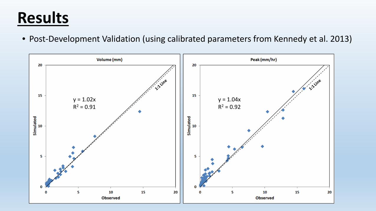
Results• Post-Development Validation (using calibrated parameters from Kennedy et al. 2013)
y = 1.02xR2 = 0.91
y = 1.04xR2 = 0.92

Results
Scenario Peak Runoff (m3/s)
% Change in Peak Runoff wrt Pre-development
% Change in Peak Runoff wrt Post-
Development
Pre-development 1.49 NA NAPost-development without LID 2.28 53.37 NARetention Basin 2.24 50.26 -2.03Permeable Pavements 2.25 51.21 -1.41Rainwater Harvesting 2.12 42.29 -7.22Retention Basin + Permeable Pavements 2.20 48.03 -3.48Retention Basin + Rainwater Harvesting 2.07 38.88 -9.45Permeable Pavements + Rainwater Harvesting 2.08 40.09 -8.66All LID practices 2.03 36.66 -10.90
10 Year Return Period

Results100 Year Return Period
Scenario Peak Runoff (m3/s)
% Change in Peak Runoff wrt Pre-development
% Change in Peak Runoff wrt Post-
Development
Pre-development 2.92 NA NAPost-development without LID 3.85 31.75 NARetention Basin 3.80 30.08 -1.27Permeable Pavements 3.80 30.05 -1.29Rainwater Harvesting 3.77 29.03 -2.06Retention Basin + Permeable Pavements 3.75 28.37 -2.56Retention Basin + Rainwater Harvesting 3.72 27.29 -3.38Permeable Pavements + Rainwater Harvesting 3.72 27.33 -3.35All LID practices 3.67 25.59 -4.67

ResultsLot and Street Visualization

Conclusions• Modeling framework works well on developed watersheds • Supports the evaluation of different designs. • Supports the assessment of the accumulative impacts of LID practices.• Supports detailed representation and modeling of lot and drainage features
on a small catchment.• Future research includes:
• Adding more LID and gray infrastructure practices.• Improve the hydrological representation of LID practices.• Improve the parameterization for LID practices.• Validation of LID Simulation. Data Sets? • Provide linkages to other software (e.g. SWMM).• Add water quality (N & P) modeling capability.

Acknowledgements • Special thanks are accorded to Dr. David Woolhiser and Dr. Roger Smith for
their many contributions to the K2 model. • A host of graduate students, too numerous to list here, are commended for
their contributions to and testing of K2 and AGWA.• The U.S. Environmental Protection Agency provided support for this
research.