evaluation of long-term cloud-resolving model simulations ... · 17 2003; masunaga et al. 2008). 18...
TRANSCRIPT

1
1
Evaluation of Long-Term Cloud-Resolving Model Simulations Using 2
Satellite Radiance Observations and Multi-Frequency Satellite Simulators3
4
5
Toshihisa Matsui1,2, Xiping Zeng1,2, Wei-Kuo Tao1, Hirohiko Masunaga3, William S. 6
Olson1,4, and Stephen Lang1,57
8
1 Laboratory for Atmospheres, NASA Goddard Space Flight Center, Greenbelt, 9
Maryland, USA102 Goddard Earth Science and Technology Center, University of Maryland Baltimore 11
County, Baltimore, Maryland, USA123Hydrospheric Atmospheric Research Center Nagoya University, Nagoya, Japan134 Joint Center for Earth Systems Technology, University of Maryland Baltimore County, 14
Baltimore, Maryland, USA155 Science Systems and Applications Inc, Lanham, Maryland, USA16
17
Submitted to Journal of Atmospheric and Oceanic Technology18
on May 2 200819
20
Corresponding Author:21
Toshihisa Matsui22
Code 613.1, NASA Goddard Space Flight Center23
Greenbelt, MD 2077124
Tell: 301-614-565825
Email: [email protected]
27
28
https://ntrs.nasa.gov/search.jsp?R=20080038646 2019-02-21T03:33:47+00:00Z

2
Abstract. 1
This paper proposes a methodology known as the Tropical Rainfall Measuring 2
Mission (TRMM) Triple-Sensor Three-step Evaluation Framework (T3EF) for the 3
systematic evaluation of precipitating cloud types and microphysics in a cloud-resolving 4
model (CRM). T3EF utilizes multi-frequency satellite simulators and novel statistics of 5
multi-frequency radiance and backscattering signals observed from the TRMM satellite. 6
Specifically, T3EF compares CRM and satellite observations in the form of combined 7
probability distributions of precipitation radar (PR) reflectivity, polarization-corrected 8
microwave brightness temperature (Tb), and infrared Tb to evaluate the candidate CRM.9
T3EF is used to evaluate the Goddard Cumulus Ensemble (GCE) model for cases 10
involving the South China Sea Monsoon Experiment (SCSMEX) and Kwajalein 11
Experiment (KWAJEX). This evaluation reveals that the GCE properly captures the 12
satellite-measured frequencies of different precipitating cloud types in the SCSMEX case13
but underestimates the frequencies of deep convective and deep stratiform types in the 14
KWAJEX case. Moreover, the GCE tends to simulate excessively large and abundant15
frozen condensates in deep convective clouds as inferred from the overestimated GCE-16
simulated radar reflectivities and microwave Tb depressions. Unveiling the detailed 17
errors in the GCE’s performance provides the best direction for model improvements. 18
19
20
21
22
23

3
1. Introduction1
Cloud-resolving models (CRMs) explicitly resolve convective clouds and cloud 2
systems on fine spatial and temporal scales for relatively short-time periods. A one-3
moment-bulk microphysics scheme predicts the evolution of liquid and ice condensates 4
and their associated latent heating and evaporative cooling in contrast to the implicit 5
prediction in single-column schemes (Tao et al. 2003). With significant improvements in 6
computational power over the last decade, CRM simulations can now be conducted for 7
longer time periods in a 3D model configuration to obtain a better understanding of cloud 8
and precipitation ensembles and radiative-convective equilibrium (Zeng et al. 2007; Zhou 9
et al. 2007; Blossey et al. 2007; and many others). While they explicitly simulate cloud 10
dynamics and microphysics evolution, CRMs are still subject to many uncertainties in 11
cloud microphysical processes due to a lack of practical evaluation frameworks that can 12
contrast CRM simulations with routine, extensive observations such as satellite 13
measurements. Lang et al. (2007) recently initiated a more systematic approach to 14
improving the microphysics in the Goddard Cumulus Ensemble model (GCE) based 15
mainly on probability distributions from ground-based radar observations and limited 16
satellite observations, but the two simulations used in the study were short-term and from 17
a single location. 18
The Tropical Rainfall Measuring Mission (TRMM) satellite has operated 19
continuously for over a decade, providing numerous, valuable observations of 20
precipitating tropical cloud systems from its sensors: the Visible/Infrared Scanner 21
(VIRS), TRMM Microwave Imager (TMI), and Precipitation Radar (PR, Kummerow et 22
al. 1998). The retrieved rainfall rates and hydrometeor products are useful datasets for 23

4
model evaluation (e.g., Zhou et al. 2007). However, TRMM-derived physical products 1
could contain their own biases due to uncertainties in the particle size spectra, particularly 2
at the freezing level, in the retrieval algorithms (Kummerow et al. 2006). Therefore, it is 3
often difficult to make a detailed evaluation of CRMs using TRMM-derived physical 4
products due to differences in their estimation methods and microphysics assumptions. 5
Thus, in order to evaluate CRMs more precisely against satellite observations, it is 6
preferable to estimate satellite-consistent radiances from the model-generated 7
microphysical distributions using radiative transfer calculations (i.e., satellite simulators,8
Chaboureau et al. 2002; Chevallier and Bauer 2003; Masunaga et al. 2008), since direct 9
satellite measurements (radiances) have much less uncertainty than retrieved physical 10
parameters. 11
This paper introduces a practical CRM-evaluation framework using multi-12
frequency satellite simulators and fine-resolution radiance measurements from the 13
TRMM satellite. The evaluation framework consists of i) a CRM coupled with multi-14
frequency satellite simulators and ii) a three-step statistical evaluation of brightness 15
temperatures (Tbs) and radar reflectivities from the CRM simulations and TRMM 16
observations. The approach is applied to long-term simulations from the GCE for two 17
cases: the South China Sea Monsoon Experiment (SCSMEX) and the Kwajalein 18
Experiment (KWAJEX). These two cases are based on well-established field campaigns 19
and have already been used previously for long-term CRM simulations to study tropical 20
cloud and precipitation processes (Zeng et al. 2007; Zhou et al. 2007; Blossey et al. 21
2007). Those studies demonstrated that CRMs driven by the large-scale forcing could 22

5
simulate the general features of the observed cloud processes but with essentially similar 1
biases. 2
Zeng et al. (2007) found that the GCE tended to overestimate surface precipitation 3
throughout the simulation periods for both SCSMEX and KWAJEX, and, as a result, 4
column-integrated water vapor was largely underestimated compared to observations. 5
They also found more convective cores with stronger updrafts in the 3D model 6
configuration than in the 2D; therefore, regardless of the chosen microphysical 7
parameterization, simulated precipitating cloud systems can be quite sensitive to 8
differences in the dimensionality of the model. Zhou et al. (2007) found that GCE 9
simulations for the SCSMEX case tended to produce a slightly larger convective to 10
stratiform rain ratio than was estimated from the PR and TMI due to having less anvil 11
(stratiform) cloud. They also found that underestimated high cloud fractions lead to an12
overestimation of outgoing longwave radiation in comparison with that estimated from 13
Clouds and the Earth’s Radiant Energy System (CERES) sensors. Although using a14
different CRM and different observational data, Blossey et al. (2007) also found that their 15
CRM also tended to underestimate high-cloud fraction, leading to an overestimate of the 16
outgoing longwave radiation and an underestimate of the top-of-the-atmosphere (TOA) 17
albedo during less rainy periods. These studies evaluated the CRM physical parameters 18
as domain-averaged values. 19
In contrast to the previous studies, this paper focuses on a satellite radiance-based 20
systematic evaluation of long-term CRM simulations by assessing the frequency of 21
occurrence of different precipitation types as well as the microphysics of each 22
precipitation type using multi-frequency satellite simulators. The paper is organized as 23

6
follows. Section 2.1 details the configuration and setup of the long-term CRM 1
simulations for the KWAJEX and SCSMEX cases. Section 2.2 describes the TRMM 2
multi-sensor observations and the combinations used for evaluation. Section 2.3 3
describes the multi-sensor satellite simulators. Section 3 introduces a new satellite-based 4
CRM evaluation framework. The framework is then used to evaluate the long-term CRM 5
simulations in section 4. Section 5 discusses and summarizes issues related to the CRM 6
simulations raised by the evaluation. 7
8
9
2. Numerical Experiments and Satellite Measurements10
2.1 Cloud-Resolving Model Simulations 11
In this study, long-term CRM simulations are performed using the GCE model 12
(Tao 2003) for environments observed during the SCSMEX and KWAJEX field 13
campaigns. The simulations are driven by surface turbulent fluxes, large-scale advective 14
forcing for temperature and humidity, and horizontal wind tendencies derived from 15
objective analysis, which statistically combines a variety of field measurements (Zhang et 16
al. 2001). For a given high-quality long-term meteorological forcing, the GCE with 17
imposed forcing provides a way to evaluate model configurations and physical processes 18
(including the microphysics and cloud properties), if the simulated fields can be validated 19
using independent observations. Two microphysics schemes are used in this study. One 20
is the default Goddard microphysics (denoted as GM03) with three-ice species (Tao21
2003), and the other is a newly-implemented microphysics scheme (denoted as GM07, 22
Zeng et al. 2007; Lang et al. 2007). GM07 includes ice-nuclei concentrations for the 23

7
Bergeron process (Zeng et al. 2007) and lowered collection efficiencies to reduce 1
excessive amounts of graupel (Lang et al. 2007). 2
The grid configurations, dynamic core, and other physical parameterizations are 3
identical except for the microphysics schemes (i.e., GM03 and GM07). The grid domain 4
consists of 256×256×4l grid points in a Cartesian coordinate with a horizontal grid 5
spacing of 1 km. The simulation domain is centered at 9°N and 167°E for the KWAJEX 6
case and at 21°N and 116°E for the SCSMEX case. The time step is 6 seconds, and the 7
simulations periods are from July 24 to September 14, 1999 for KWAJEX and from May 8
6 to June 14, 1998 for SCSMEX (Zeng et al. 2007). 9
Zeng et al. (2007) examined the sensitivity of simulated precipitation condensate 10
to model dimensionality (i.e., 2D versus 3D grids) and microphysics (i.e., GM03 and 11
GM07). Because precise and extensive measurements of water contents and drop-size 12
distributions (DSDs) of precipitation particles are limited even within a well-designed 13
field campaign, in the present study, these uncertain microphysical parameters are best14
evaluated through their impact on simulated multi-frequency radiance and backscattering 15
signals in contrast to satellite observations (Chaboureau et al. 2002; Chevallier and Bauer 16
2003; Masunaga et al. 2008).17
18
19
2.2 TRMM Measurements 20
In this study, TRMM PR 13.8-GHz attenuation-corrected reflectivity from the21
TRMM 2A25 product, VIRS 12-µm infrared brightness temperature (TbIR) from TRMM 22
1B01, and TMI 85.5-GHz dual-polarization microwave brightness temperature (Tb85) 23

8
from TRMM 1B11 (Kummerow et al. 1998) are used to evaluate the GCE simulations. 1
PR reflectivity is sensitive to precipitating liquid and frozen condensates. VIRS TbIR2
represents the cloud-top temperature above optically thick clouds. TMI Tb85 depression 3
(i.e., scattering) is correlated with the amount of precipitation-sized ice particles (Liu and 4
Curry 1996). Observations from these three sensors were collected over the KWAJEX 5
and SCSMEX sites during the GCE simulation periods. Significant PR reflectivity 6
(above 17 dBZ) is also used to identify the radar echo-top height (HET). Because the TMI 7
sampled mixed land-ocean areas over the KWAJEX and SCSMEX sites, a polarization-8
corrected brightness temperature (PCTb85) is computed (Kidd 1998) in order to 9
compensate for the inhomogeneity of surface emissivity via 10
PCT85 = Tb85V + a(Tb85V + Tb85 H ) ,11
where Tb85V and Tb85H are the Tb from the vertical and horizontal polarization channels at 12
85 GHz, respectively, and a=0.8, which ensures that the inhomogeneity in surface 13
emission is visually masked out over the two sites. VIRS TbIR and TMI PCTb85 are 14
collocated on the PR instantaneous field of view (IFOV). The PR and high-frequency 15
TMI measurements have a fine IFOV of ~5 km, close to the horizontal resolution of 16
typical CRMs (i.e., dx=dy=1 km in this study; thus a minimum resolvable dynamical-17
spatial scale for the GCE simulations should be ~5 km). VIRS TbIR measurements are 18
convolved within the PR IFOV (i.e., 4.3 km at the surface) via a Gaussian beam pattern 19
due to the smaller IFOV (i.e., 2.2 km at the surface) of the VIRS measurements 20
(Masunaga and Kummerow 2005). 21
22
2.3 Satellite Simulators 23

9
The Goddard Satellite Data Simulation Unit (SDSU) is an end-to-end satellite 1
simulator being built upon the original version developed at HyARC, Nagoya University 2
(available from http://precip.hyarc.nagoya-u.ac.jp/sdsu/sdsu-main.html). The Goddard 3
SDSU simulates satellite-consistent radiances or backscattering from vertical profiles of 4
model-simulated atmospheric variables and condensates obtained from the Goddard 5
Multi-Scale Modeling System with unified physics (Tao et al. 2008). At present, the 6
framework includes passive microwave, radar, visible-infrared, lidar, broadband 7
shortwave and longwave, and ISCCP-like simulators. 8
In this study, GCE-simulated atmospheric and condensate profiles are used to 9
simulate TRMM PR-consistent reflectivity profiles via a radar simulator (Masunaga and 10
Kummerow 2005), VIRS-consistent TbIR through a spectrum infrared simulator (discrete 11
ordinate radiative transfer, Nakajima and Tanaka 1986; Stamnes et al. 1988), and TMI-12
consistent Tb85 through a passive microwave simulator (delta-Eddington two-stream 13
radiative transfer with slant path view, Kummerow 1993; Olson and Kummerow 1996). 14
All of the simulators are currently 1D and do not include 3D scattering effects. Within 15
the simulators, the optical properties for condensates are derived via Mie theory 16
(spherical assumption), while the DSD parameters for precipitation particles are specified 17
in accordance with the GCE model (i.e., exponential size distributions with prescribed 18
exponent-intercept parameters and particle densities). The simulated Tbs and radar 19
reflectivities are then convolved within the IFOV corresponding to each TRMM sensor 20
through a Gaussian beam pattern (Masunaga and Kummerow 2005) and sampled only at 21
the actual TRMM orbiting time over the respective KWAJEX or SCSMEX sites. It 22

10
should be noted that CRM-simulated non-precipitating cloud systems are not evaluated in 1
this framework. 2
3
3. TRMM Triple-sensor Three-step Evaluation Framework (T3EF)4
Due to the inability of CRMs to accurately predict the location of precipitating 5
cloud systems relative to the satellite observations, ensemble statistics of Tbs and radar 6
reflectivities from the satellite observations and GCE simulations are compared. As a 7
result, it is critical to identify subsets of the simulations and observations that represent 8
similar cloud/precipitation systems. To this end, a TRMM Triple-sensor Three-step 9
Evaluation Framework (T3EF) is introduced that systematically examines discrepancies 10
between the model and observations by i) creating joint diagrams of precipitating cloud 11
types from collocated VIRS TbIR and PR HET (Masunaga et al. 2005), ii) constructing 12
contoured frequency with altitude diagrams (CFADs) of PR reflectivity (Yuter and 13
Houze 1995) for each precipitating cloud type, and iii) constructing cumulative 14
probability distributions of TMI PCTb85. Prior to actually evaluating the CRM, an 15
observational sketch of T3EF is introduced to address the physical aspects of each 16
radiance-based statistical evaluation. 17
18
3.1 Joint TbIR-HET Diagrams19
Long-term simulations of the GCE model predict precipitating cloud ensembles 20
over the same periods as TRMM-observed tropical precipitation systems. Different 21
precipitating cloud systems are associated with different mesoscale processes and 22
therefore differing amounts of latent heat release, evaporative cooling, and radiative 23
11
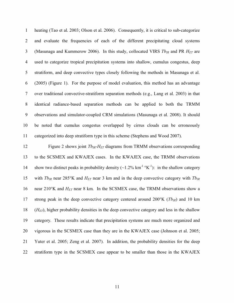
heating (Tao et al. 2003; Olson et al. 2006). Consequently, it is critical to sub-categorize 1
and evaluate the frequencies of each of the different precipitating cloud systems 2
(Masunaga and Kummerow 2006). In this study, collocated VIRS TbIR and PR HET are 3
used to categorize tropical precipitation systems into shallow, cumulus congestus, deep 4
stratiform, and deep convective types closely following the methods in Masunaga et al.5
(2005) (Figure 1). For the purpose of model evaluation, this method has an advantage 6
over traditional convective-stratiform separation methods (e.g., Lang et al. 2003) in that7
identical radiance-based separation methods can be applied to both the TRMM 8
observations and simulator-coupled CRM simulations (Masunaga et al. 2008). It should 9
be noted that cumulus congestus overlapped by cirrus clouds can be erroneously 10
categorized into deep stratiform type in this scheme (Stephens and Wood 2007). 11
Figure 2 shows joint TbIR-HET diagrams from TRMM observations corresponding 12
to the SCSMEX and KWAJEX cases. In the KWAJEX case, the TRMM observations 13
show two distinct peaks in probability density (~1.2% km-1 °K-1): in the shallow category 14
with TbIR near 285°K and HET near 3 km and in the deep convective category with TbIR15
near 210°K and HET near 8 km. In the SCSMEX case, the TRMM observations show a 16
strong peak in the deep convective category centered around 200°K (TbIR) and 10 km 17
(HET), higher probability densities in the deep convective category and less in the shallow 18
category. These results indicate that precipitation systems are much more organized and 19
vigorous in the SCSMEX case than they are in the KWAJEX case (Johnson et al. 2005; 20
Yuter et al. 2005; Zeng et al. 2007). In addition, the probability densities for the deep 21
stratiform type in the SCSMEX case appear to be smaller than those in the KWAJEX 22

12
case. Johnson et al. (2005) reported that the stratiform rain fraction (26%) for convective 1
systems from SCSMEX is smaller than that typical (40%) in the Tropics.2
3
3.2 Type-Classified Reflectivity CFADs4
CFADs are height-dependent probability density distributions of geophysical 5
parameters (Yuter and Houze 1995). Thus, CFADs of PR reflectivities provide a useful 6
statistical description that illustrates the effects of precipitation microphysics at different7
altitudes (Lang et al. 2007; Zhou et al. 2007; Blossey et al. 2007). Lumping the different 8
precipitating cloud categories together in the analysis could, however, smear together the 9
important microphysical characteristics associated with each precipitating cloud type 10
(Lang et al. 2007; Blossey et al. 2007). For example, in the previous section, it was 11
shown that SCSMEX has a higher probability of deep convective clouds. As such, 12
grouping all of the cloud categories together would generate CFADs biased toward the 13
characteristics of deep convective clouds. In order to avoid this kind of bias, reflectivity 14
CFADs should be separately constructed for at least the convective and stratiform 15
portions of precipitation systems (Yuter et al. 2005; Zhou et al. 2007). This study 16
differentiates the CFADs into separate shallow, cumulus congestus, deep stratiform, and 17
deep convective categories as defined by the joint TbIR-HET diagrams.18
Figure 3 shows type-classified reflectivity CFADs for the KWAJEX and 19
SCSMEX cases. Reflectivity CFADs were constructed by binning the reflectivities into 20
1-dBZ bins at each height increment (250m). Shallow is the weakest category in terms of 21
reflectivity intensity. Peak modal and maximum reflectivities are limited below 25 dBZ 22
and 44 dBZ, respectively. Cumulus congestus is a more vigorous category with larger 23

13
peak modal and maximum reflectivities than the shallow type. For shallow and cumulus 1
congestus types, the reflectivity distribution broadens towards the surface, indicating the 2
importance of coalescence and collection processes, which widen the raindrop spectra. 3
CFADs for the deep stratiform type appear to be relatively similar to those for cumulus 4
congestus, but the effect of melting ice particles is noticeable, especially in the SCSMEX 5
case along the edge of the CFAD (at an altitude of about 5km). The SCSMEX 6
precipitation systems likely produced larger ice particles aloft and consequently more 7
enhanced “bright bands” in the stratiform regions compared to those in KWAJEX. 8
Below the melting layer, the reflectivity distributions are relatively uniform with height 9
in contrast to the shallow and cumulus congestus types wherein the peak modes gradually 10
increased towards the surface.11
The most remarkable CFADs are associated with the deep convective type. At12
high altitudes (i.e., above 10km), reflectivities are narrowly distributed, and maximum 13
values remain below ~30 dBZ. These low PR reflectivities can be attributed to the 14
presence of smaller frozen precipitation particles. At middle altitudes (i.e., between 5 15
and 10 km), maximum reflectivities increase toward lower altitudes, which suggests a 16
broadening and increase in particle sizes due to the aggregation of frozen particles. Peak 17
modal reflectivity increases dramatically below 6 km due to the melting of frozen 18
particles. At low altitudes (i.e., below 5 km), frozen condensates are almost completely 19
melted, allowing liquid raindrops to dominate the radar backscattering signals. The high 20
dielectric constant of liquid water results in larger reflectivities than at high altitudes. 21
Reflectivity distributions below the melting layer are relatively uniform with height, an22
indication that raindrop breakup and stochastic collection are combining to stabilize the23

14
raindrop size spectra. Compared to KWAJEX, the SCSMEX deep convective category 1
has broader and larger reflectivities.2
3
4
3.3 Type-Classified Cumulative Probability Distributions of PCTb855
Although a passive microwave radiometer provides less specific information on 6
the vertical profiles of condensates than the TRMM PR, the 85-GHz TMI channels are 7
fairly sensitive to ice water path in the upper portions of precipitating cloud systems 8
(Yuter et al. 2005). At this frequency, precipitation-sized particles scatter the upwelling 9
microwave radiation emission, and thereby depress the outgoing microwave radiances at 10
the TOA (Liu and Curry 1996). Therefore, to augment the reflectivity CFADs, Tbs from 11
the TRMM satellite are assessed in terms of cumulative probability distributions of 12
PCTb85 for the different precipitating cloud types. This evaluation is also important for 13
the assessment of passive microwave sensor-based rainfall/latent heating retrieval 14
algorithms, because the GCE simulations and simulated Tbs are used in the a priori15
databases of retrieval algorithms (Kummerow et al. 2006; Olson et al. 2006).16
Figure 4 shows cumulative probability distributions of PCTb85 (bin size is 10°K). 17
It is quite discernible, particularly for the SCSMEX case, that the probability distributions 18
trend toward lower PCTb85 values as the cloud types progress from shallow to cumulus 19
congestus to deep stratiform to deep convective. This essentially means that the amount 20
of frozen precipitation particles increases from shallow to deep convective type clouds. It 21
is worth noting that the probability distributions for the deep stratiform type have larger 22
PCTb85 depressions than do the cumulus congestus type, although the structures of their 23

15
reflectivity CFADs appeared to be quite similar (Figure 3). This is a manifestation of1
PCTb85 depressions being highly sensitive to smaller-sized frozen precipitation particles, 2
to which the PR is relatively insensitive due to its longer wavelength. In contrast to 3
SCSMEX, the probability distributions for deep convective and deep stratiform types are 4
nearly the same in KWAJEX, although the CFADs for these two types are dissimilar 5
(Figure 3). The KWAJEX PCTb85 depressions are also suppressed compared to those 6
from SCSMEX, an indication that deep convective precipitation is more isolated and less 7
vigorous in KWAJEX. These results highlight the utility of evaluating PCTb85 in 8
addition to PR reflectivity.9
10
11
4. Evaluating the GCE simulations through T3EF12
This section, T3EF is used to evaluate the GCE simulations for KWAJEX and 13
SCSMEX. It should again be noted that TRMM-consistent radiances are computed from 14
the GCE simulations using multi-frequency satellite simulators, and those radiances are 15
then contrasted against observed radiances in a three-step statistical evaluation. 16
17
4.1 Evaluation of Precipitating Cloud Types by Joint TbIR-HET Diagrams 18
Joint TbIR-HET diagrams are constructed from the GCE simulations for two 19
different microphysics schemes (GM03 and GM07) using the satellite simulators (Figure 20
5). In the KWAJEX case, it is clear that both of the GCE experiments (i.e., GM03 and 21
GM07) strongly overestimate the probability densities of shallow and cumulus congestus 22
types; the combined shallow and cumulus congestus probability densities are 71.7% for23

16
GM03 and 69.3% for GM07 compared with just 33.1% from the TRMM observations. 1
On the other hand, combined probability densities of the deep convective and stratiform 2
types (25.8% in GM03 and 28.8% in GM07) largely underestimate the TRMM 3
observations (65.2%). GM07 performs slightly better in terms of the TbIR (≈ cloud-top 4
temperature) probability distributions for deep stratiform and convective systems 5
compared to GM03. It should be noted that the probability densities for deep convective 6
clouds in the GCE simulations have a corrugated texture along the HET axis. This is an 7
artifact of the current GCE (and almost all other CRM) grid configurations that use a 8
stretched vertical coordinate, which results in a coarser layer thickness (~1 km) than the 9
PR resolution (0.25 km) in the upper troposphere.10
Overall, the GCE performs better in the SCSMEX environment than in the 11
KWAJEX environment. The structure of the probability densities, particularly in GM03, 12
is similar to that of the TRMM observations. Although the combined deep convective13
and stratiform precipitation probability densities (71.5% for GM03 and 82.2% for GM07) 14
slightly overestimate the TRMM observations (65.2%), the probability densities of 15
shallow precipitation are very close (9.01~11.5%). Unlike the KWAJEX case, GM03 16
performs slightly better than GM07. As noted earlier, there is a significant difference 17
between the KWAJEX and SCSMEX cases that is attributable to differences in the18
environmental forcing and hence dynamics of the precipitation systems. The fact that the 19
GCE performs better for SCSMEX is probably due to it having more organized 20
precipitation systems driven by stronger large-scale forcing (Johnson et al. 2005), which 21
are better resolved by the 1-km horizontal grid spacing. The less vigorous KWAJEX 22

17
case probably requires a finer horizontal resolution to resolve the evolution of weaker, 1
isolated, less-organized cumulus systems as demonstrated by Lang et al. (2007).2
3
4.2 Evaluating Precipitation Microphysics by Type-Classified Reflectivity CFADs4
Instead of showing the entire probability distributions, the mean and maximum 5
reflectivities are highlighted and compared between the TRMM observations and GCE 6
simulations for the KWAJEX and SCSMEX cases. Although not shown here, the 7
minimum reflectivity is always 17 dBZ (the minimum PR-detectable echo) for all cases 8
(Figure 6).9
Shallow: In both SCSMEX and KWAJEX, the mean reflectivity profiles of the 10
TRMM observations gradually increase from 18 dBZ at the echo top altitude to 25 dBZ 11
near the surface; both the GM03 and GM07 profiles from the model agree quite well with 12
these observations (within an accuracy of 2 dBZ). The maximum TRMM-observed 13
reflectivities in KWAJEX are slightly smaller (24 dBZ to 38 dBZ) than those in14
SCSMEX (27 dBZ to 42 dBZ) but again, both are well captured by GM03 and GM07. 15
Cumulus congestus: Mean reflectivity profiles from the TRMM observations for 16
both cases range from 18 dBZ at the echo top altitude to 29 dBZ near the surface. While17
the GCE simulations slightly overestimate the TRMM mean reflectivities by about 3 18
dBZ, the most discernible discrepancy between the model and observations appears in the 19
maximum reflectivity profiles for the KWAJEX case. The GCE simulations overestimate 20
the maximum reflectivities by as much as 16 dBZ near the echo top and by 10 dBZ near 21
the surface. The overestimated reflectivity in the upper layer is most likely due to the22
presence of large frozen precipitation particles (see details in next section). For a given 23

18
drop-size distribution and number concentration, a 16-dBZ bias is equivalent to a mean 1
particle diameter in the GCE simulations that is nearly twice as large as that of the 2
TRMM observations in the Rayleigh approximation. As parameterized in the GCE, the 3
presence of large-sized particles will enhance the mean particle terminal velocity that 4
suppress deeper ice particle aloft. Thus, the presence of large ice-phase condensates could 5
explain why the GCE overestimates the frequency of cumulus congestus, while 6
underestimating the frequency of the deep convective and stratiform categories. On the 7
other hand, maximum reflectivities from the GCE simulations agree reasonably well with 8
the TRMM observations for the SCSMEX case. Model deviations from the observed9
mean and maximum reflectivities are limited to 3 and 4 dBZ, respectively. In all cases, 10
there is almost no difference in performance between GM03 and GM07.11
Deep Stratiform: Although the GCE simulations in this study do not produce a 12
robust melting signature in the reflectivity profiles, GM03 and GM07 generally agree 13
well with the TRMM observations in terms of the mean and maximum reflectivities 14
particularly in the KWAJEX case. In the SCSMEX case, GM03 and GM07 tend to 15
overestimate the maximum reflectivities by around 6 dBZ below an altitude of 4 km. 16
Below an altitude of 1 km, the TRMM observations show a strong reduction in the 17
maximum reflectivities probably due to rain evaporation. None of the GCE simulations 18
capture this feature. This is the most prominent difference between the modeled and 19
observed radar profiles for the deep stratiform type. Again GM03 and GM07 do not have20
discernible differences in their reflectivity CFADs. 21
Deep Convective: Among the four different cloud types, the largest discrepancies 22
between the model and observations appear in the deep convective type. Although 23

19
GM07 does perform somewhat better at higher altitudes in the KWAJEX case, the GCE 1
simulations still generally do not capture the dramatic transitions in the reflectivity 2
profiles observed by the TRMM satellite. At high altitudes, GM03 overestimates the 3
mean and maximum reflectivities by as much as 5 dBZ and 12 dBZ, respectively, which 4
suggests that the GCE-simulated frozen precipitation particles are excessive both in size 5
and amount. Near the melting layer (~5 km), both GM03 and GM07 underestimate the 6
mean and maximum reflectivities by as much as 6 dBZ due to the lack of a melting 7
signature in the simulations. Near the surface, both GM03 and GM07 agree well with the 8
TRMM SCSMEX observations, but they tend to overestimate reflectivities for the 9
KWAJEX case. As discussed in other previous modeling studies (Zhou et al. 2007; 10
Blossey et al. 2007), the classified reflectivity CFADs highlight the uncertainties in the11
microphysics of simulated mixed-phase clouds.12
13
4.3 Evaluating Ice Water Paths by Type-Classified Cumulative Probability 14
Distributions of PCTb8515
Cumulative probability distributions of PCTb85 were constructed from PCTb8516
values calculated from the GCE simulations for the KWAJEX and SCSMEX cases 17
(Figure 7). To better understand this statistical evaluation, condensates from the GCE 18
simulations are vertically integrated over the same sampling periods for the shallow, 19
cumulus congestus, deep stratiform, and deep convective types (Table 1). 20
Shallow: Due to the absence of appreciable amounts of ice particles in this 21
category (Table 1), cumulative probability distributions of shallow clouds can be 22
characterized by the following parameters: background Tb, radiance emission from 23

20
clouds, scattering of microwave radiance due to raindrops, and scattering of ice water 1
path from overlapped neighboring pixels. Errors in the background PCTb85 are very 2
small, because the GCE simulations are forced by an observation-assimilated variational 3
analysis (Zhang et al. 2001). The emission of microwave radiance from cloud is also a 4
small contribution (Liu and Curry 1996). The amount of rain is also very small (Table 1). 5
Thus, discrepancies between the model and observations in the probability distributions 6
most likely represent noise from neighboring pixels. Because the conical-tracking view 7
of precipitation systems from the TMI channels is collocated with the cross-tracking view 8
from the VIRS and PR sensors, so is the combination of simulated radiances. In 9
particular, the GCE simulations for the SCSMEX case tend to have unrealistically large 10
depressions of PCTb85 for the shallow type. Precipitation systems in SCSMEX are so 11
organized that shallow precipitation types are frequently accompanied with deep 12
convective precipitation. In addition, due to the cyclic boundary conditions used in the 13
GCE simulations, precipitation systems with fast propagation speeds tend to be densely 14
populated within the simulation domain. These factors increase the likelihood of deep 15
clouds overlapping shallow ones along the slant view of the TMI sensor.16
Cumulus congestus: The GCE simulations tend to overestimate PCTb8517
depressions for both KWAJEX and SCSMEX. These depressions can also be attributed 18
to noise from neighboring pixels, but for cumulus congestus, the GCE simulates19
appreciable amounts of snow and graupel that can increase PCTb85 depressions (Table 1). 20
This is unlikely to be observed in real cumulus congestus as they commonly do not 21
glaciate (Johnson et al. 1999). The GM07 simulations produce less graupel than the 22
GM03, while increasing the combined amount of liquid cloud, rain, and snow (Table 1). 23

21
As graupel is defined to be a higher-density frozen particle in the GCE model and so too 1
in the passive microwave simulator, it has a greater single scattering albedo for a given 2
ice water content. As a result, the PCTb85 depressions in GM03 are slightly reduced in 3
GM07. The GCE simulations for KWAJEX generate nearly twice as much graupel than 4
those for SCSMEX. This could explain the overestimation of maximum radar reflectivity 5
near echo top in the cumulus congestus for the KWAJEX simulations (Figure 6). 6
Deep stratiform: The GCE simulations slightly overestimate, but in general, 7
reasonably capture the observed probability distributions in the SCSMEX case. Probably 8
due to the relatively low amount of graupel (0.14 kg/m2, Table 1), the PCTb859
depressions in GM07 are suppressed in comparison with GM03. In conjunction with the 10
reflectivity CFAD analysis, it appears that the GCE SCSMEX simulations fairly well 11
predict the precipitation-sized ice water path for deep stratiform systems in this particular 12
environment, which would lend more confidence to the passive-microwave retrieval 13
algorithms (Kummerow et al. 2006; Olson et al. 2006). Similarly, GM07 performs better 14
than GM03 for the KWAJEX case; however, both simulations overpredict PCTb8515
depressions, implying the GCE simulations contain too much precipitation-sized ice16
(graupel and snow). 17
Deep convective: Similar to the deep stratiform type, the GCE overpredicts the 18
PCTb85 depressions probably due to excessive amounts of frozen precipitation particles. 19
For both the KWAJEX and SCSMEX cases, GM07 performs better than GM03, because 20
GM07 tends to reduce the amount of high-density frozen condensate (graupel) in deep 21
convection by as much as ~40% (Table 1). These results suggest that simulated Tb85s 22
from the GCE are biased toward lower values for deep convective precipitation.23

22
Together with the reflectivity CFAD analysis (section 4.2), it appears that the GCE 1
generates too much frozen precipitation in deep convective clouds for both the KWAJEX 2
and SCSMEX cases. Note that large frozen particle amounts translate into larger particle 3
sizes in the exponential drop-size distributions with their fixed intercept. Therefore, 4
excessive amounts of simulated frozen particles could exacerbate the model biases in the 5
reflectivity CFADs and PCTb85 probability distributions.6
7
5. Summary and Discussion8
Long-term simulations of convective cloud systems observed during SCSMEX 9
and KWAJEX using the GCE model are evaluated through via comparison between 10
TRMM observations and simulated radiances and reflectivities using multi-frequency 11
simulators in the Goddard SDSU. A proposed methodology for evaluating the simulated 12
radiances and reflectivites using three of TRMM’s sensors, known as T3EF, was used to 13
systematically evaluate the performance of the GCE. While the GCE simulations are in14
reasonable agreement with the TRMM measurements in some aspects, major simulation 15
biases found in this study include:16
• A tendency for the GCE to overestimate the frequency of cumulus congestus and 17
underestimate the occurance of deep convective and stratiform cloud types in 18
KWAJEX case. 19
• A tendency for the GCE to produce excessive amounts and therefore sizes of 20
frozen condensate in convective precipitation systems.21

23
These biases appear to be common features in long-term CRM simulations with one-1
moment bulk microphysics (Zeng et al. 2007; Zhou et al. 2007; Blossey et al. 2007), and 2
could be related to the following three issues: 3
i) Large-scale forcing: The long-term GCE simulations were driven by imposed 4
meteorological forcing obtained from variational analysis (Zhang et al. 2001). 5
This analysis blended all possible observations to obtain the best estimates of 6
area-averaged variables for the analysis domain over the KWAJEX and SCSMEX 7
sites. Unlike KWAJEX, the precipitation systems in SCSMEX are dominated by 8
mesoscale convective systems (MCSs) driven by stronger large-scale 9
environmental forcing (Johnson et al. 2005). Thus, it may be more realistic to 10
drive the GCE with area-averaged (~hundreds of kilometers) forcing from 11
SCSMEX than from KWAJEX . 12
ii) Grid configurations: In addition to the scale of the meteorological forcing, a finer 13
horizontal resolution in the GCE may be needed to better simulate the less-14
organized precipitation systems in the KWAJEX case. For example, Lang et al. 15
(2007) found that GCE simulations using 1-km grid spacing tended to form deep 16
convection abruptly, while 250-m grid spacing realistically simulated the gradual 17
transition from shallow to deep convection that was observed during TRMM 18
Large-Scale Biosphere-Atmosphere Experiment in Amazonia (TRMM LBA).19
However, at present, it is impractical to conduct long-term CRM simulations with 20
250-m grid spacing. This would require a lot more (~ 50 times) computing time.21
iii) Ice microphysics: Besides the issues related to large-scale forcing and grid 22
configurations, the GCE simulates overly large radar reflectivities in the upper 23

24
troposphere and overly strong microwave Tb depressions. All of these results 1
suggest the bulk microphysics tends to simulate excessively large amounts and 2
sizes of precipitation ice. The new Goddard Microphysics (GM07) results in 3
some improvement in terms of microwave Tbs by reducing the amount of graupel; 4
however, it worsened the already poor estimation of shallow and cumulus 5
congestus frequencies in the SCSMEX case. The ice microphysics issues have6
been discussed in previous modeling studies (e.g., Lang et al. 2007; Zeng et al. 7
2007; Zhou et al. 2007; Blossey et al. 2007). The overly large-sized precipitation 8
ice simulated by the model could enhance their terminal velocity and thus the 9
precipitation efficiency, suppressing deeper convection in the KWAJEX case. 10
This could be the reason that the GCE simulations generate too many cumulus 11
congestus and too few deep convective and stratiform systems in the KWAJEX 12
case. Blossey et al. (2007) proposed a similar hypothesis from their long-term 13
simulations for KWAJEX. 14
Technically, these three modeling deficiencies could interact nonlinearly, and complete 15
resolution of these deficiencies is not attempted in this manuscript. However, this paper 16
introduces a new practical CRM evaluation framework using direct satellite observations.17
The new framework (T3EF), which uses multi-frequency satellite simulators and high-18
resolution satellite radiance observations, revealed detailed errors in the CRM’s19
performance that could not be assessed by precipitation analysis only. Therefore, in 20
addition to the traditional comparisons between satellite products and simulations, 21
satellite simulator-based evaluation techniques will be most valuable for evaluating and 22
improving model performance. T3EF makes it possible to evaluate CRMs over most of 23

25
the Tropics, including over land and ocean. Therefore, with accurate large-scale 1
meteorological forcing, a satellite-radiance-based CRM inter-comparison study over 2
different tropical environments can be proposed in the near future.3
4
5
Acknowledgment6
This research was supported by the NASA Headquarters Atmospheric Dynamics and 7
Thermodynamics Program and the NASA Tropical Rainfall Measuring Mission 8
(TRMM). The authors are grateful to Dr. R. Kakar at NASA HQ for his support of this 9
research. This program was also supported by the NASA MAP. The authors are grateful 10
to Dr. D. Anderson at NASA HQ. The authors also acknowledge NASA GSFC and 11
Ames Research Center for computer time used in this research. 12
13
14
15
16
17
18
19

26
References1
Blossey, P.N., C.S. Bretherton, J. Cetrone, and M. Kharoutdinov, 2007: Cloud-Resolving 2
Model Simulations of KWAJEX: Model Sensitivities and Comparisons with 3
Satellite and Radar Observations. J. Atmos. Sci., 64, 1488–1508.4
Chaboureau, J.-P., J.-P. Cammas, P. J. Mascart, J.-P. Pinty, and J.-P. Lafore, 2002: 5
Mesoscale model cloud scheme assessment using satellite observations. J. 6
Geophys. Res., 107(D16), 4301, doi:10.1029/2001JD000714.7
Chevallier, F., and P. Bauer, 2003: Model Rain and Clouds over Oceans: Comparison 8
with SSM/I Observations. Mon. Wea. Rev., 131, 1240–1255.9
Johnson, R.H., S.L. Aves, P.E. Ciesielski, and T.D. Keenan, 2005: Organization of 10
Oceanic Convection during the Onset of the 1998 East Asian Summer Monsoon. 11
Mon. Wea. Rev., 133, 131–148.12
Johnson, R.H., T.M. Rickenbach, S.A. Rutledge, P.E. Ciesielski, and W.H. Schubert, 13
1999: Trimodal Characteristics of Tropical Convection. J. Climate, 12, 2397–14
2418.15
Kidd, C., 1998: On rainfall retrieval using polarization-corrected temperatures. Int. J. 16
Remote Sens., 19, 981–996.17
Kummerow, C., 1993: On the accuracy of the Eddington approximation for radiative 18
transfer in the microwave frequencies. J. Geophys. Res., 98, 2757-2765.19
Kummerow C., W. Barnes, J. Shiue, and J. Simpson, 1998: The Tropical Rainfall 20
Measuring Mission (TRMM) sensor package. J. Atmos. Oceanic Technol., 15, 21
809–817. 22

27
Kummerow, C., W. Berg, J. Thomas-Stahle, and H. Masunaga, 2006: Quantifying 1
Global Uncertainties in a Simple Microwave Rainfall Algorithm. J. Atmos. 2
Oceanic Technol., 23, 23–37.3
Lang, S., W.-K. Tao, J. Simpson, and B. Ferrier, 2003: Modeling of convective-4
stratiform precipitation processes: Sensitivity to partitioning methods. J. Applied. 5
Meteor., 42, 505-527.6
Lang, S., W.K. Tao, R. Cifelli, W. Olson, J. Halverson, S. Rutledge, and J. Simpson, 7
2007: Improving Simulations of Convective Systems from TRMM LBA: 8
Easterly and Westerly Regimes. J. Atmos. Sci., 64, 1141–1164.9
Liu, G., and .A. Curry, 1996: Large-scale cloud features during January 1993 in the 10
North Atlantic Ocean as determined from SSM/I and SSM/T2 observations. J. 11
Geophys. Res., 101, 7019-7032.12
Masunaga, H., T.S. L’Ecuyer, and C.D. Kummerow, 2005: Variability in the 13
Characteristics of Precipitation Systems in the Tropical Pacific. Part I: Spatial 14
Structure. J. Climate, 18, 823–840.15
Masunaga, H., and C.D. Kummerow, 2005: Combined Radar and Radiometer Analysis 16
of Precipitation Profiles for a Parametric Retrieval Algorithm. J. Atmos. Oceanic 17
Technol., 22, 909–929.18
Masunaga, H., and C.D. Kummerow, 2006: Observations of Tropical Precipitating 19
Clouds Ranging from Shallow to Deep Convective Systems. Geophys. Res. Lett., 20
33, L16805, doi:10.1029/2006GL02654721
Masunaga, H., M. Satoh, and H. Miura, 2008: A joint satellite and global CRM analysis 22
of an MJO event: Model Diagnosis, J. Geophys. Res. (submitted). 23

28
Nakajima, T., and Tanaka, M., 1986: Matrix formulations for the transfer of solar 1
radiation in a plane-parallel scattering atmosphere. J. Quant. Spec. Rad. Trans., 35, 2
13-21.3
Olson W. S., and C. D. Kummerow, 1996: Simulated retrieval of precipitation profiles 4
from TRMM Microwave Imager and precipitation radar data. Preprints, Eighth 5
Conf. on Satellite Meteorology and Oceanography, Atlanta, GA, Amer. Meteor. 6
Soc., 248–251.7
Olson, W.S., C.D. Kummerow, S. Yang, G.W. Petty, W.K. Tao, T.L. Bell, S.A. Braun, 8
Y. Wang, S.E. Lang, D.E. Johnson, and C. Chiu, 2006: Precipitation and Latent 9
Heating Distributions from Satellite Passive Microwave Radiometry. Part I: 10
Improved Method and Uncertainties. J. Appl. Meteor. Climatol., 45, 702–720.11
Stamnes, K. H., S.-C. Tsay, W. Wisecombe, and K. Jayaweera, 1988: Numerical stable 12
algorithm for descrete-ordinate-method radiative transfer in multiple scattering 13
and emitting layered media. Appl. Opt., 27, 2502–2509.14
Stephens, G. L., and N. B. Wood, 2007: Properties of tropical convection observed by15
millimeter-wave radar systems, Mon. Wea. Rev., 135, 821–842.16
Tao, W.K., 2003: Goddard Cumulus Ensemble (GCE) Model: Application for 17
Understanding Precipitation Processes. Meteor. Monogr., 29, 107.18
Tao, W.-K., D. Starr, A. Hou, P. Newman, and Y. Sud, 2003: Summary of cumulus 19
parameterization workshop. Bull. Amer. Meteor. Soc., 84, 1055-1062.20
Tao, W.K., D. Anderson, R. Atlas, P. Houser, A. Hou, S. Lang, W. Lau, C. Peters-Lidard, 21
R. Kakar, S. Kumar, W. Lapenta, X. Li1,, T. Matsui, M. Rienecker, B.-W. Shen,22

29
J.J. Shi, J. Simpson, X. Zeng, 2008: Goddard Multi-Scale Modeling Systems 1
with Unified Physics, GEWEX news letter, 18 (1), 6-9. 2
Yuter, S.E., and R.A. Houze, 1995: Three-Dimensional Kinematic and Microphysical 3
Evolution of Florida Cumulonimbus. Part II: Frequency Distributions of Vertical 4
Velocity, Reflectivity, and Differential Reflectivity. Mon. Wea. Rev., 123, 1941–5
1963.6
Yuter, S. E., R. A. Houze, Jr., E. A. Smith, T. T. Wilheit, and E. Zipser, 2005: Physical 7
characterization of tropical oceanic convection observed in KWAJEX. J. Appl. 8
Meteor., 44, 385-415.9
Zeng, X., W.K. Tao, S. Lang, A. Y. Hou, M. Zhang, and J. Simpson, 2008: On the 10
sensitivity of atmospheric ensemble states to cloud microphysics in long-term 11
cloud-resolving model simulations, Journal of the Meteorological Society of 12
Japan, (In press).13
Zhang, M. H., J. L. Lin, R. T. Cederwall, J. J. Yio, and S. C. Xie, 2001: Objective 14
analysis of the ARM IOP data: method and sensitivity. Monthly Weather 15
Review. 129, 295-311.16
Zhou, Y.P., W.K. Tao, A.Y. Hou, W.S. Olson, C.L. Shie, K.M. Lau, M.D. Chou, X. Lin, 17
and M. Grecu, 2007: Use of High-Resolution Satellite Observations to Evaluate 18
Cloud and Precipitation Statistics from Cloud-Resolving Model Simulations. Part 19
I: South China Sea Monsoon Experiment. J. Atmos. Sci., 64, 4309–4329.20
21
22
23

Shallow Cumulus Congestus Deep Stratiform Deep ConvectiveKWAJEX GM03 GM07 GM03 GM07 GM03 GM07 GM03 GM07Cloud 0.16 0.16 0.35 0.37 0.03 0.27 0.24 0.31Rain 0.12 0.12 0.70 0.78 0.18 0.46 1.39 1.33
Cloud ice 0.00 0.00 0.00 0.00 0.06 0.19 0.37 0.47Snow 0.01 0.01 0.05 0.10 0.09 0.17 0.15 0.43
Graupel 0.01 0.00 0.31 0.23 0.24 0.19 2.32 1.42
Shallow Cumulus Congestus Deep Stratiform Deep ConvectiveSCSMEX GM03 GM07 GM03 GM07 GM03 GM07 GM03 GM07Cloud 0.27 0.30 0.39 0.42 0.18 0.23 0.25 0.24Rain 0.15 0.15 0.64 0.78 0.41 0.47 1.03 0.95
Cloud ice 0.00 0.00 0.00 0.00 0.07 0.28 0.65 0.88Snow 0.01 0.01 0.04 0.08 0.12 0.25 0.22 0.82
Graupel 0.01 0.00 0.18 0.13 0.29 0.14 2.70 1.67
Table 1. Mean vertically-integrated condensates (kg/m2) for shallow, cumulus congestus, deep stratiform, and deep convective types.

Figure 1. Schematics of precipitating cloud types closely following the method in Masunaga et al. (2005). Gray shading represents cloud ice and liquid condensates, and contoured lines represent precipitation radar reflectivity (dotted lines represent the minimum detectable radar echo while thicker solid lines represents larger echoes). Precipitation systems are categorized into 1) shallow, 2) cumulus congestus, 3) deep stratiform, and 4) deep convective systems based upon infrared brightness temperature (closely related tocloud-top temperature) and precipitation radar echo-top height (Masunaga et al. 2005).

Figure 2. Joint infrared brightness temperature (TbIR)-radar echo-top height (HET) diagrams based on TRMM observations for the KWAJEX and SCSMEX cases.

Figure 3. Contoured frequency with altitude diagrams (CFADs) of precipitation radar reflectivity for shallow, cumulus, deep stratiform, and deep convective types for a) KWAJEX and b) SCSMEX.

Figure 4. Cumulative probability distributions of polarization-corrected TMI brightness temperature at 85 GHz (PCTb85: ○ shallow, □
cumulus congestus, ◇ deep stratiform, and △ deep convective) for KWAJEX and SCSMEX.

Figure 5. Comparison of joint TbIR-HET diagrams and probability densities for each precipitating cloud type between the TRMM observations and GCE simulations (GM03 and GM07) in a) KWAJEX and b) SCSMEX. Values represent the total probability densities for each (1-shallow, 2-cumulus congestus, 3-deep stratiform, 4-deep convective) precipitating cloud type.

Figure 6. Mean (○ TRMM, □ GM03, △ GM07) and maximum (● TRMM, ■ GM03, ▲ GM07) reflectivity profiles from PR reflectivity CFADs for a) KWAJEX and b) SCSMEX cases. Different vertical scales are used for each type of precipitating cloud.

Figure 7. Cumulative probability distributions of polarization-corrected TMI brightness temperature at 85 GHz (PCTb85: ● TRMM, □
GM03, △ GM07) for shallow, cumulus congestus, deep stratiform, and deep convective systems for a) KWAJEX and b) SCSMEX.