evaluation of the relative suitability of … doc.pdfevaluation of the relative suitability of...
TRANSCRIPT

EVALUATION OF THE RELATIVE SUITABILITY OF POTENTIAL JAGUAR
HABITAT IN NEW MEXICO
KURT A. MENKE, Earth Data Analysis Center, MSC01 1110
1 University of New Mexico, Albuquerque, NM 87131-0001
CHARLES L. HAYES, New Mexico Department of Game and Fish, One
Wildlife Way, Santa Fe, NM 87507.
_____________________________________________________________
Abstract: We conducted a spatial analysis of potential habitat
for the jaguar (Panthera onca) in New Mexico. We used a
geographic information system (GIS) model to combine data
layers for landscape features influencing suitability for
jaguar habitat, and created a composite potential habitat map.
The model predicted two areas with the highest probability of
being able to support jaguars in New Mexico. These areas were
the Peloncillo and Animas Mountains in far southwestern New
Mexico, and the river canyon and adjacent areas of the Gila and
San Francisco River drainages along the New Mexico-Arizona
border and to the east. We did not define these two areas as
“suitable” for breeding populations of jaguars, nor were
slightly less suitable habitats classified as “unsuitable”.
The results of this study should be combined with similar
efforts from Arizona and Mexico to help further evaluate the
connectivity of suitable habitats, and their ability support a
jaguar metapopulation at the northern end of the species range.

Menke and Hayes . Potential jaguar habitat in New Mexico 2
TABLE OF CONTENTS
TABLE OF CONTENTS .............................................2INTRODUCTION ..................................................3STUDY AREA ....................................................5METHODS .......................................................8Selection of Variables ......................................8Human Density ...............................................9Vegetation Community .......................................13Distance to Water ..........................................15Prey Availability ..........................................16Terrain Ruggedness .........................................18
RESULTS ......................................................19DISCUSSION ...................................................23ACKNOWLEDGEMENTS .............................................26LITERATURE CITED .............................................26
LIST OF FIGURES
Figure 1 Study_Area_Delineation ..............................4Figure 2 Study_Area ..........................................7Figure 3 Population_Density .................................10Figure 4 Road_Density .......................................11Figure 5 Vegetation_Community ...............................15Figure 6 Proximity_to_Water_Sources .........................16Figure 7 Prey_Distribution ..................................18Figure 8 Terrain_Ruggedness .................................19Figure 9 Results_of_Potential_Habitat_Modeling ..............20
Menke and Hayes . Potential jaguar habitat in New Mexico 3
INTRODUCTION
The jaguar reaches the northern extent of its geographic
range in the southwestern United States (Bailey 1932, Goldman
1932, Halloran 1946, Findley 1975, Seymour 1989, Rabinowitz
1999). Fossil and historic records place the jaguar among
fauna that was regularly present in the southern United States
(Nelson and Goldman 1933, Findley 1975, Seymour 1989, Brown and
Lopez Gonzalez 2000). The scarcity of jaguar specimens from
the United States since about 1910 has led to significant
debate as to whether more recent observations indicate presence
of a breeding population, or transient individuals from Mexico
(Findley 1975, Hoffmeister 1986, Rabinowitz 1999, Brown and
Lopez Gonzalez 2001). Based on the distributional decline of
the jaguar and threats of take by illegal harvest and other
means, the jaguar north of the U.S.- Mexico border was listed
as ″endangered″ under the Endangered Species Act (ESA) in 1997
(Federal Register 1997). This action reversed the removal of
ESA protection for jaguars in the United States that resulted
from a procedural oversight when the ESA superceded the
Endangered Species Conservation Act in 1973.
During the period when the jaguar was proposed for listing
under the ESA, a multi-party, multi-agency group wrote and
signed a Memorandum of Understanding implementing the

Menke and Hayes . Potential jaguar habitat in New Mexico 4
Conservation Assessment and Strategy for the Jaguar in Arizona
and New Mexico (Johnson and Van Pelt 1997). Together, these
documents comprised a conservation agreement (CA) and called
for the establishment of a jaguar conservation team (JAGCT),
jaguar scientific advisory group (JAGSAG), and jaguar habitat
subcommittee (JAGHAB). One of the tasks described within the
CA was to identify suitable habitat for jaguars in New Mexico
and Arizona. Results of this analysis are beneficial in
helping to focus conservation efforts on those areas with the
greatest probability of jaguar occurrence within the United
States, and to thereby direct any management actions in to
those areas where the greatest conservation benefits would be
expected.
Figure 1. Study Area Delineation

Menke and Hayes . Potential jaguar habitat in New Mexico 5
STUDY AREA
We defined the geographic extent of the study area (Figure
1) as areas within 50 miles of jaguar observations accompanied
by physical evidence (Class 1) or reported as first-hand
observations from a reliable source (Class 2). We included
only those sightings that were reported with sufficient
locational precision to reliably plot and analyze their
locations (Table 1). For example, the study area definition
did not consider sightings that were reported only with general
locations e.g., ″Otero County″. We extended the study area
boundary to include entire New Mexico Big Game Management Units
(19.30.4.8 New Mexico Administrative Code renumbered 2001) that
intersected the 50-mile buffer, to be inclusive of (as opposed
to bisecting) contiguous mountain ranges and potential prey
populations (Figure 2).
Table 1. Jaguar reports and records from New Mexico used to define the boundaries of thestudy area.
Year County/Mountain Range Observed By Reported In
1900 Sierra/Black Range N. Straw Barber (1902)1903 Hidalgo/Peloncillo Mtns. W. P. Burchfield Bailey (1932)1905 Catron/Datil Mtns. N. Hollister Bailey (1932)1937 Sierra/San Andres Mtns. Bannerman Halloran (1946)1990 Sierra/Black Range G. Z. Jacobi Jacobi memo (1990)1995 Hidalgo/Peloncillo Mtns. B. L. Starret Holycross memo (1997)1996 Hidalgo/Peloncillo Mtns. W. Glenn Glenn (1996)

Menke and Hayes . Potential jaguar habitat in New Mexico 6

Menke and Hayes . Potential jaguar habitat in New Mexico 7
Figure 2. Study Area

Menke and Hayes . Potential jaguar habitat in New Mexico 8
METHODS
Selection of Variables
Due to the small number of documented jaguar locations, we
did not attempt to determine patterns of habitat use for
jaguars in New Mexico. We identified positive and negative
potential habitat features for jaguars based on literature
sources and evaluations from the JAGHAB and JAGSAG. We plotted
reported jaguar observations for comparison purposes, but did
not conduct any spatial analyses of these points, other than to
delineate the study area. We incorporated potential habitat
variables in New Mexico that were identified by the JAGSAG
(Miller et al. 2000) and in the analysis of potential jaguar
habitat in Arizona (Hatten et al. 2002). These variables were
human density, vegetation community, distance to water, prey
abundance, and terrain ruggedness. We obtained spatial New
Mexico data layers for these variables and overlaid them using
a GIS (ArcView Spatial Analyst/Model Builder 2.0a, ESRI,
Redlands, CA). We used an arithmetic overlay to create a
composite map identifying relative habitat suitability for
jaguars, and weighted positive habitat indicators equally among
the variables. We then classified the grid cells on the
composite map into categories of relative suitability ranging
from lowest habitat potential to highest habitat potential

Menke and Hayes . Potential jaguar habitat in New Mexico 9
based upon visually-identified discontinuities (breaks) in the
distribution of the data. However, because the number of
verified, historical locations was too small to determine
habitat requirements, we did not attempt to establish a
threshold for suitable vs. unsuitable potential habitat, nor to
determine whether or not any specific area could sustain a
resident population of jaguars.
Human Density
The Arizona potential habitat characterization removed
areas > 1 house/10 acres, and areas of contiguous row crop
agriculture > 1 mi.2 (Hatten et al. 2002). The lack of
equivalent data sets for New Mexico necessitated the use of
alternative indices to human presence as they would apply to
the suitability of potential jaguar habitat. We evaluated two
separate data sets to potentially represent the effects of
human density on potential jaguar habitat in New Mexico. We
obtained 2000 U.S. Census Bureau data population data by census
block, and U.S Census Bureau TIGER road files. The human
population density provided the more direct index to human
presence within the study area (Figure 3), but was not ideal
for accurately locating the spatial extent of uninhabited
areas. For example, "blocks" from Silver City area extended
into the designated Forest Service wilderness areas.

Menke and Hayes . Potential jaguar habitat in New Mexico 10
Figure 3. Population Density
In contrast to the human population density layer, the
road density coverage offered a more indirect measure of human
presence on the landscape. However, the presence of roads
themselves can influence the suitability and use of potential
habitats, and can offer a more spatially precise indicator of
human presence on the landscape than census blocks. This data
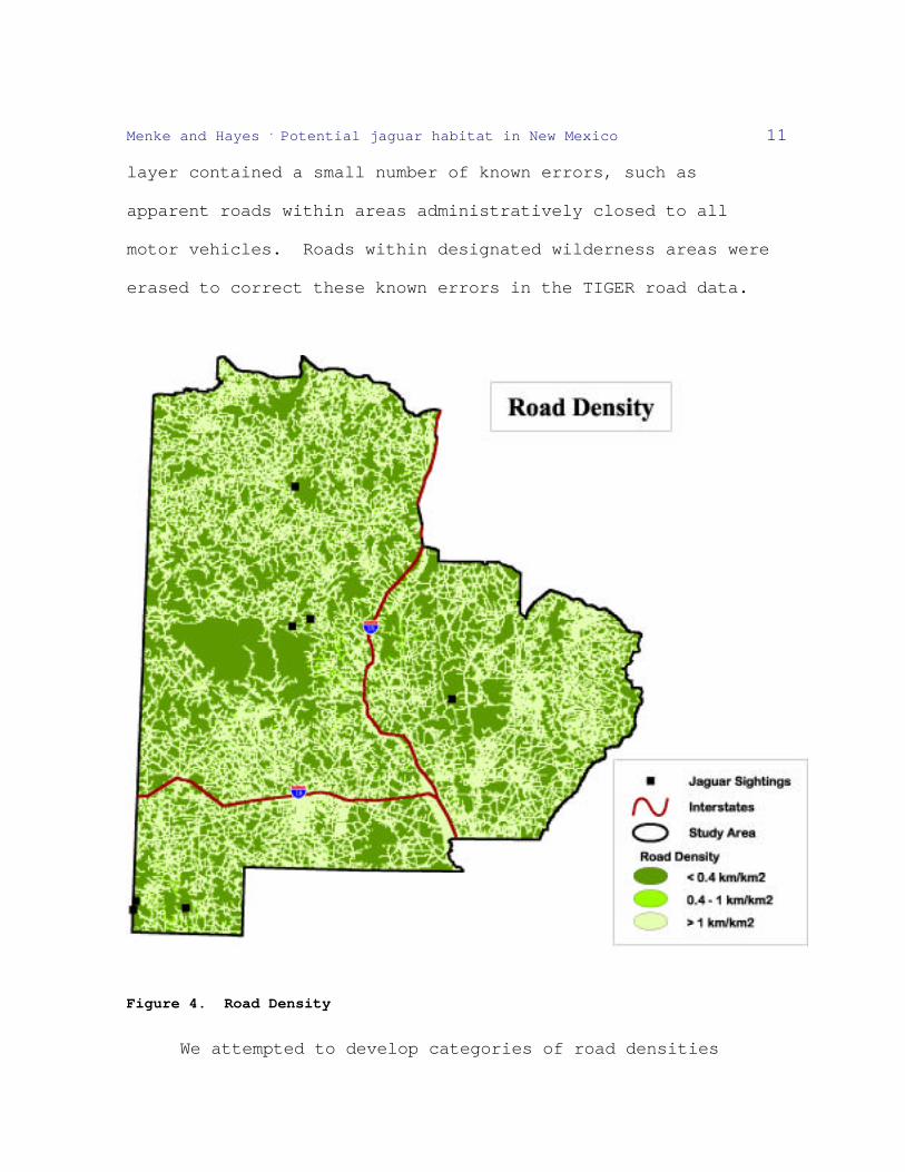
Menke and Hayes . Potential jaguar habitat in New Mexico 11
layer contained a small number of known errors, such as
apparent roads within areas administratively closed to all
motor vehicles. Roads within designated wilderness areas were
erased to correct these known errors in the TIGER road data.
Figure 4. Road Density
We attempted to develop categories of road densities

Menke and Hayes . Potential jaguar habitat in New Mexico 12
relative to jaguar habitat suitability, based on a review of
available literature. However, the published literature
regarding jaguar habitat use and roads is both limited and
equivocal. In Central America, Rabinowitz and Nottingham
(1986) documented regular use of timber roads (presumably
unimproved) and trails by jaguars, and even suggested that
these roads may serve as a limited resource used for hunting
and directional travel. For carnivores in general, the impacts
of high road density have been well documented and thoroughly
reviewed (e.g., Noss et al. 1996, Carroll et al. 2001). Roads
may have direct impacts to carnivores and carnivore habitats,
including roadkill, disturbance, habitat fragmentation, changes
in prey numbers or distribution, and providing increased access
for legal or illegal harvest. In some cases, the relationship
between use by large predators and road density has been
quantitatively analyzed (Thiel 1985, Jensen et al. 1986, Van
Dyke et al. 1986a, Fuller 1989, Mladenhoff et al. 1999). For
example, a model of recolonizing wolves in northern Wisconsin
used a road density of 0.45 km/km2 to classify favorable vs.
unfavorable habitat (Mladenhoff et al. 1999). Other studies
have suggested that a suggested similar thresholds of road
densities for mountain lions (Van Dyke et al. 1986b) and for
brown bears in Europe (Clevenger et al. 1997). Based on

Menke and Hayes . Potential jaguar habitat in New Mexico 13
examples from the published literature, we created a data layer
of road density per square kilometer and classified it into the
following categories: < 0.4, 0.4-1.0, and > 1.0 km roads/km2.
The lowest category was considered to be most suitable, and the
highest category least suitable for potential jaguar habitat.
Vegetation Community
We evaluated biotic communities based on classifications
described within Brown et al. (1980). The JAGSAG had
considered several biotic communities to be potentially
suitable for jaguars. The Arizona Upland Sonoran Desertscrub
biome was a notable exclusion from the JAGSAG’s assessment of
potential habitat, despite the occurrence of a few jaguar
observations within that biome. However, the Arizona Upland
Sonoran Desertscrub biome did not occur within New Mexico, and
no biotic communities were eliminated from further analysis of
potentially suitable habitats.
We did not attempt to conduct analyses of jaguar habitat
use vs. availability based on observations from New Mexico,
Arizona, or anywhere else within the United States. However,
we considered the Madrean Evergreen Woodland biotic community
(Figure 3) most similar to habitats used by breeding
populations of jaguars in closest proximity to the southwestern
United States. This biome encompasses over half of the

Menke and Hayes . Potential jaguar habitat in New Mexico 14
documented kills of jaguars within the United States and
Chihuahua (Brown and Lopez Gonzalez 2001). We therefore
assigned a positive suitability value to the Madrean Evergreen
Woodland biotic community. We did not consider any other biotic
communities within New Mexico to be limiting to potential
jaguar habitat in New Mexico, and did not assign negative
suitability values to any other biomes found within the study
area.

Menke and Hayes . Potential jaguar habitat in New Mexico 15
Figure 5. Madrean Evergreen Woodland Vegetation Community
Distance to Water
We created a model to generate a proximity to water index
for the study area. The input data consisted of perennial and
intermittent streams from the USGS National Hydrographic
Dataset and the USGS GNIS data set. We did not attempt to
incorporate anthropogenic point water sources (e.g., stock
tanks), because it is unknown to what extent riparian
vegetation (which is commonly absent from these anthropogenic
water sources) influences the probability of their use by
jaguars.
The proximity to water index classified the study area
into categories based on proximity to both perennial and
intermittent water sources (Figure 6). We used both the Arizona
modeling suitability threshold of 10 km for proximity to
streams or rivers (Hatten et al. 2002), plus an expanded
category of lands within 16 km of a water source and a smaller
distance of 5 km. We also weighted perennial sources over
intermittent sources, and proximity to multiple water sources
over proximity to a single source. A proximity to water index
was developed by combining these buffered data sets in an
arithmetic overlay.

Menke and Hayes . Potential jaguar habitat in New Mexico 16
Figure 6. Proximity to Water Sources
Prey Availability
Jaguars have been documented to feed upon over 85
different prey species (Seymour 1989). Given the variety and
adaptability in the jaguar’s diet across its range, and the
potential for changes in biomass of available large prey with
changes in wildlife management, we did not attempt to evaluate
total biomass of potential jaguar prey as a limiting factor.

Menke and Hayes . Potential jaguar habitat in New Mexico 17
The jaguar’s preferred prey has been described as terrestrial
mammals > 1 kg (Seymour 1989, Lopez Gonzalez and Miller 2002).
Applying this information to the southwestern United States,
we expect jaguar prey to include, and jaguars to be sympatric
with, the collared peccary (Tayassu tajacu), white-tailed deer
(Odocoileus virgianus), mule deer (O. hemionus), elk (Cervus
elaphus), and coatimundi (Nasua nasua). Despite the variation
in jaguar diets, several authors have postulated that collared
peccaries and deer are the staple foods of jaguars at the far
northern end of their range (Findley 1975, Federal Register
1997, Rabinowitz 1997,
Brown and Lopez Gonzalez 2001).
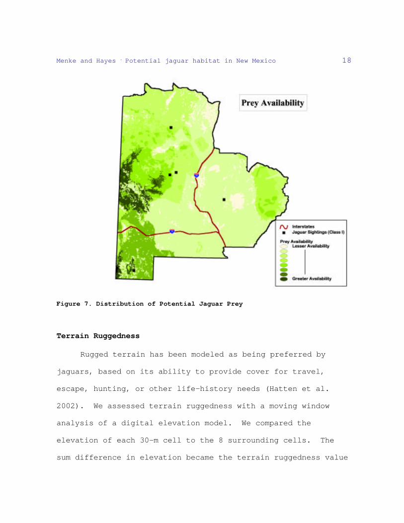
We created a GIS layer (Figure 7) representing the
combined distribution (indicating diversity of prey species
present) of the five potential prey species listed above, using
New Mexico Gap Analysis and Rocky Mountain Elk Foundation data
layers. We doubled the weighting of the distribution for
collared peccaries and white-tailed deer to reflect their
assumed importance in the diet of jaguars within those areas of
most recent jaguar sightings in New Mexico. In the overall
model, we assigned a value proportional to the weighted number
of prey species present in a grid cell.
Menke and Hayes . Potential jaguar habitat in New Mexico 18
Figure 7. Distribution of Potential Jaguar Prey
Terrain Ruggedness
Rugged terrain has been modeled as being preferred by
jaguars, based on its ability to provide cover for travel,
escape, hunting, or other life-history needs (Hatten et al.
2002). We assessed terrain ruggedness with a moving window
analysis of a digital elevation model. We compared the
elevation of each 30-m cell to the 8 surrounding cells. The
sum difference in elevation became the terrain ruggedness value

Menke and Hayes . Potential jaguar habitat in New Mexico 19
for each cell (Riley et al. 1999)(Figure 6). The grid was
classified into seven ruggedness categories based on natural
breaks in the data. Incrementally higher weights were assigned
to categories as the ruggedness values increased. The highest
category of ruggedness (e.g., sheer cliffs) was considered to
be too rough and was weighted less.
Figure 8. Terrain Ruggedness
RESULTS
We combined five potential habitat variables (road
density, Madrean Evergreen Woodland biotic community,
proximity to water, prey availability, terrain ruggedness) into

Menke and Hayes . Potential jaguar habitat in New Mexico 20
a relative habitat suitability model. We classified the
results of the combined potential habitat grid into five
suitability categories based on natural breaks in the data
(Figure 9). Two general locations within the study area
contained relatively contiguous blocks of land that fell within
the two highest relative suitability classes. The two areas
were the Animas/Peloncillo Mountains of extreme southwestern
New Mexico, and the portions of the Gila/San Francisco River
drainages on the far west-central portion of the study area.
The more rugged and remote portions of the Sacramento Mountains
were also identified as having high potential habitat
suitability, but were surrounded in all directions by areas of
lower habitat potential. The two areas with the highest
relative suitability are generally contiguous with the New
Mexico-Arizona border, and the Animas/Peloncillo area also
abuts the United States-Mexico border. The developed areas
around the cities of Deming, Silver City, Las Cruces, and
Alamogordo were rated as least suitable by the model. The
three documented Class 1 or Class 2 sightings from the 1990s
were from areas falling within the three highest relative
suitability categories. All documented Class 1 or Class 2
sighting locations occurred in areas assigned a high ruggedness
value, and terrain ruggedness was the single variable that

Menke and Hayes . Potential jaguar habitat in New Mexico 21
appeared to have a high degree of correlation with locations of
jaguar observations. This is likely due at least in part to the
temporally static nature of this variable. Conversely,
proximity to water appeared to have the least correlation with
observed jaguar locations, and the 1990s locations were from
the two categories of least proximity to water sources.

Menke and Hayes . Potential jaguar habitat in New Mexico 22
Figure 9. Results of Potential Jaguar Habitat Mapping in New Mexico

Menke and Hayes . Potential jaguar habitat in New Mexico 23
DISCUSSION
This study considered only current potential habitat for
jaguars within the state of New Mexico. Historic range of
jaguars in New Mexico is defined, in part, by reports of
jaguars having been killed in New Mexico as far north as Colfax
County, and as far east as Otero County (Findley 1975, Schmitt
1998). This is a much broader area than was evaluated as
potential habitat within this study. However, no observations
accompanied by physical evidence or reported as first-hand
observations from a reliable source were documented in New
Mexico for a period of over 50 years prior to the 1990s.
During the 1990s, observers documented jaguar sightings,
including photographic evidence of jaguars and jaguar tracks,
in southwestern New Mexico (Glenn 1996, Brown and Lopez
Gonzalez 2001). Although there are sufficient historical
observations of jaguars (of varying degrees of reliability)
from other portions of New Mexico, the limited number of
observations from the past century suggests that landscape-
level changes have reduced current potential habitat to
fragmented patches that closer to extant populations of jaguars
in northern Mexico.
The potential habitat suitability map appeared to be
qualitatively consistent with jaguar observations in New Mexico

Menke and Hayes . Potential jaguar habitat in New Mexico 24
over the last 50 years. Despite some differences in specific
methodology used compared to jaguar habitat suitability mapping
in Arizona (Hatten et al. 2002), the most highly suitable
habitats from New Mexico generally connected with delineated
areas of suitable habitat directly across the New Mexico-
Arizona border. This finding provides some level of validation
for the techniques and results of each study.
The relative suitability map for potential jaguar habitat
in New Mexico identifies areas that would be most likely to
support any jaguars that were present within those areas. It
does not predict the probability of jaguars occurring within
any specific area, nor does it predict the likelihood of any
area to support a self-sustaining population of jaguars. The
model does predict those areas expected to be most suitable for
use by jaguars, and can lead to some evaluation of potential
corridors and routes of travel for jaguars in the United
States. For example, Barber (1902) predicted that jaguars were
reaching the Mogollon Mountains of New Mexico by ascending the
Gila River from the west, based on observations made from 1897-
1902. The present degree of connectivity between potential
jaguar habitats in New Mexico and those in both Arizona and
Mexico can now be quantitatively and objectively evaluated,
using results of this study and other jaguar habitat models for

Menke and Hayes . Potential jaguar habitat in New Mexico 25
Arizona and northern Mexico. A complete evaluation of the
prospects for long-term persistence of the jaguar in the United
States must encompass information regarding not only the
availability of potential habitat, but must also consider the
potential linkages to habitats that currently sustain breeding
populations of jaguars.
Both theoretical and empirical studies of wildlife
metapopulations indicate the vulnerability of small and
peripheral populations or subpopulations, and their dependence
on dispersal and recolonization from core populations (Grinnell
1922, Pulliam 1988, Stacey and Taper 1992, Fahrig and Merriam
1994). Management actions with positive impacts to jaguars
will be necessary for the long-term persistence of jaguars in
areas that do not currently support self-sustaining
populations. In order to most effectively focus these actions
on areas providing the greatest benefit to the jaguar, we
recommend that habitat linkage modeling and least-cost movement
analyses be performed (e.g., Walker and Craighead 1997,
Singleton et al. 2002) for potential jaguar habitats in New
Mexico, Arizona, and northern Mexico. Additional jaguar
habitat use data from the northern end of the jaguar’s range is
needed to test and improve the existing habitat models.
Identification and implementation of appropriate habitat

Menke and Hayes . Potential jaguar habitat in New Mexico 26
management actions for jaguar conservation will require fully
engaged local land managers to refine existing habitat models,
direct conservation actions to areas of greatest potential
benefit, and to monitor the success of these actions.
ACKNOWLEDGEMENTS
This project was conducted in cooperation between the New
Mexico Department of Game and Fish (NMDGF) and the University
of New Mexico’s Earth Data Analysis Center with funding
obtained by the NMDGF from the Federal Aid in Wildlife
Restoration Act. We thank C. G. Schmitt for providing
technical input to this study, and to the JAGCT for providing
input during this process, and M. E. Soule for reviewing an
earlier version of this draft. J. R. Hatten and W. E. Van Pelt
of the Arizona Game and Fish Department provided valuable
information regarding potential jaguar habitat mapping efforts
in Arizona.
LITERATURE CITED
Bailey, V. 1932. Mammals of New Mexico. North American
Fauna 53:1-412.
Barber, C. M. 1902. Notes on little-known New Mexican
mammals and species apparently not recorded from the
territory. Proceedings of the Biological Society of
Washington XV:191-193.

Menke and Hayes . Potential jaguar habitat in New Mexico 27
Brown, D. E. and C. A. Lopez Gonzalez. 2000. Notes on the
occurrences of jaguars in Arizona and New Mexico.
Southwestern Naturalist 45:537-546.
_____. 2001. Borderland Jaguars/Tigres de la Frontera.
University of Utah Press, Salt Lake City, Utah, USA.
Brown, D. E., C. H. Lowe, and C. P. Pase. 1980. A digitized
systematic classification for ecosystems with an
illustrated summary of the natural vegetation of North
America. U.S. Forest Service General Technical Report
RM-73.
Carroll, C., R. F. Noss, and P. C. Paquet. 2001. Carnivores
as focal species for conservation planning in the Rocky
Mountain region. Ecological Applications 11:961-980.
Clevenger, A. P., F. J. Purroy, and M. A. Campos. 1997.
Habitat assessment of a relict brown bear Ursos arctos
population in northern Spain. Biological Conservation
80:17-22.
Fahrig, L., and G. Merriam. 1994. Conservation of
fragmented populations. Conservation Biology 8:50-59.
Federal Register. 1997. Endangered and threatened wildlife
and plants: final rule to extend endangered status to
the jaguar in the United States. Volume 62:39147-39157.
Findley, J. S., A. H. Harris, D. E. Wilson, and C. Jones.

Menke and Hayes . Potential jaguar habitat in New Mexico 28
1975. Mammals of New Mexico. University of New Mexico
Press, Albuquerque, New Mexico, USA.
Fuller, T. K. 1989. Population dynamics of wolves in north-
central Minnesota. Wildlife Monographs 105:1-41.
Glenn, W. 1996. Eyes of fire: encounter with a borderlands
jaguar. Printing Corner Press, El Paso, Texas, USA.
Goldman, E. A. 1932. The jaguars of North America.
Proceedings of the Biological Society of Washington
45:143-146.
Grinnell, J. B. The role of "accidental". Auk 39:373-380.
Halloran, A. F. 1946. The carnivores of the San Andres
Mountains, New Mexico. Journal of Mammalogy 27:154-161.
Hatten, J. R., A. Averill-Murray, and W. E. Van Pelt. 2002.
Characterizing and mapping potential jaguar habitat in
Arizona. Nongame and Endangered Wildlife Program
Technical Report 203. Arizona Game and Fish Department,
Phoenix, Arizona, USA.
Hoffmeister, D. F. 1986. Mammals of Arizona. The
University of Arizona Press and Arizona Game and Fish
Department, Tucson and Phoenix, Arizona, USA.
Jensen, W.F., T.K. Fuller, and W. L. Robinson. 1986. Wolf,
Canis lupus, distribution on the Ontario-Michigan border
near Sault Ste. Marie. Canadian Field Naturalist 100:363-

Menke and Hayes . Potential jaguar habitat in New Mexico 29
366.
Johnson, T. B. and W. E. Van Pelt. 1997. Conservation
assessment and strategy for the jaguar in Arizona and New
Mexico. Nongame and Endangered Wildlife Program Technical
Report 105. Arizona Game and Fish Department
Lopez Gonzalez, C. A., and B. J. Miller. 2002. Do jaguars
(Panthera onca) depend on large prey? Western North
American Naturalist 62(2):218-222.
Miller, B., A. R. Rabinowitz, and C. A. Lopez Gonzalez.
2000. Memorandum to jaguar scientific advisory group
11/14/00.
Mladenhoff, D. J., T. A. Sickley, and A. P. Wydeven. 1999.
Predicting gray wolf landscape recolonization: logistic
regression models vs. new field data. Ecological
Applications 9:37-44.
Nelson, E. W., and E. A. Goldman. 1933. Revision of the
jaguars. Journal of Mammalogy 14:221-240.
Noss, R. F., H. B. Quigley, M. G. Hornocker, T. Merrill, and
P. C. Paquet. 1996. Conservation biology and carnivore
conservation in the Rocky Mountains. Conservation Biology
10:949-963.
Pulliam, H. R. 1988. Sources, sinks, and population
regulation. American Naturalist 132:652-651.

Menke and Hayes . Potential jaguar habitat in New Mexico 30
Rabinowitz, A. R. 1997. The status of jaguars in the United
States: Trip report. Wildlife Conservation Society,
Bronx Zoo, Bronx, New York, USA.
_____. 1999. The present status of jaguars (Panthera onca)
in the southwestern United States. Southwestern
Naturalist 44:96-100.
Rabinowitz, A. R., and J. R. Nottingham Jr. 1986. Ecology
and behaviour of the jaguar (Panthera onca) in Belize,
Central America. Journal of the Zoology, London 210:149-
159.
Riley, S. J., S. D. DeGloria, and R. Elliot. 1999 A Terrain
Ruggedness Index That Quantifies Topographic
Heterogeneity. Intermountain Journal of Sciences 5:23-
27.
Schmitt, C. G. 1988. Jaguar (Panthera onca) reports and
Records from New Mexico. New Mexico Department of Game
and Fish, Santa Fe, New Mexico, USA.
Seymour, K. L. 1989. Panthera onca. Mammalian Species
340:1-9.
Singleton, P. H., W. L. Gaines, and J. F. Lehmkul. 2002.
Landscape permeability for carnivores in Washington: a
geographic information system weighted-distance and least-
cost corridor assessment. Res. Pap. PNW-RP-549. U.S.
Menke and Hayes . Potential jaguar habitat in New Mexico 31
Department of Agriculture, Forest Service, Pacific
Northwest Research Station, Portland, Oregon, USA.
Stacey, P. B., and M. Taper. 1992. Environmental variation
and the persistence of small populations. Ecological
Applications 2:18-29.
Thiel, R. P. 1985. Relationship between road density and
wolf habitat suitability in Wisconsin. American Midland
Naturalist 113:404-407.
Van Dyke, F. G., R. H. Brocke, and H. G. Shaw. 1986a. Use
of road and track counts as indices of mountain lion
presence. Journal of Wildlife Management 50:102-109.
Van Dyke, F. G., R. H. Brocke, H. G. Shaw, and B. B.
Ackerman. 1986b. Reactions of mountain lions to
logging and human activity. Journal of Wildlife
Management 50:95102.
Walker, R., and Craighead, L. 1997. Analyzing wildlife
movement corridors in Montana using GIS. In: Proceedings
of the 1997 ESRI user conference. Environmental Sciences
Research Institute, Redlands, California, USA.
http://www.esri.com/library/userconf/proc97/to150/pap116/p
116.htm