evaluation of urban planning implementation from …...evaluation of urban planning implementation...
TRANSCRIPT
Habitat International 101 (2020) 102197
0197-3975/© 2020 Elsevier Ltd. All rights reserved.
Evaluation of urban planning implementation from spatial dimension: An analytical framework for Chinese cities and case study of Beijing
Ying Long a,*, Haoying Han b, Shih-Kung Lai c, Zimu Jia d, Wenyue Li d, Wanting Hsu d
a School of Architecture and Hang Lung Center for Real Estate, Key Laboratory of Eco Planning & Green Building, Ministry of Education, Tsinghua University, Beijing, 100084, China b School of Architecture Engineering, Zhejiang University, Hangzhou, 310029, China c College of Architecture and Urban Planning, Tongji University, Shanghai, 200092, China d School of Architecture, Tsinghua University, Beijing, 100084, China
A R T I C L E I N F O
Keywords: Urban planning implementation evaluation Plan assessment Development permits Redevelopment Beijing
A B S T R A C T
Most existing studies on urban planning implementation (UPI) evaluation examine the conformity between planned and observed spatial urban development. The results are, however, typically too general to provide adequate policy recommendations for planners and researchers. The stages between creating a plan and its outcome are seldom discussed in detail, primarily because of the absence of an applicable analytic framework and data. In the paper, we propose a framework for UPI evaluation from spatial dimension which provides an in- depth and accurate application to show how the conceptual framework can be applied for assessing conformance and performance (sequential conformance) of plans proposed by Hopkins (2012) could be applied in practice. We examined the degrees of conformance and sequential conformance between an urban master plan, detailed plans, development permits and observed development outcomes, using Beijing as an example. The results reveal discrepancies between all basic stages of plan implementation, and the poor planning implementation was primarily due to the existence of large areas of development without development permits. These results suggest that the poor match between a plan and its outcomes may result from poor plan using, not poor planning. Therefore, attention needs to be paid not only to creating plans but also to monitoring the performance of various levels of plans and development permits in the UPI.
1. Introduction
Contemporary urbanization in China has attracted worldwide attention for its striking speed and scale, driven by a huge migration of population from rural to urban areas. The annual population growth in urban areas in China has steadily been higher than 10 million (Han & Lai, 2012), as the standard of construction land per capita in urban planning is about 100 square meters, the population growth trend means cities and towns in China have to provide over 1000 square kilometers of land each year to accommodate new urban residents. In many large cities, the urban growth juggernaut has made efforts to control devel-opment difficult. In addition, the urban planning and control system in China has been criticized by empirical studies for its inability to manage
urban growth, as many planners argue that illegal development is rampant under the seemingly strict planning and control systems in the cities of China1 (Long et al., 2012; Mao et al., 2008; Tian & Shen, 2011).
With the increasing availability of planning and land use data in recent decades, studies on urban planning implementation (UPI) eval-uation have been widely conducted (Alexander & Faludi, 1989; Berkeet et al., 2006; Brody & Highfield, 2005; Brody et al., 2006; Hopkins, 2012; , 2004b, 2010; Talen, 1996a, 1996b, 1997). UPI evaluation has been popular despite its intrinsic difficulties primarily that “researchers must acknowledge that a determinate relationship exists between the desires of decision makers and outcomes” (Talen, 1996a), and they need to understand such a relationship. In China, UPI evaluation has been a mandate of the Urban and Rural Planning Law since 2007 (China Urban
* Corresponding author. E-mail addresses: [email protected] (Y. Long), [email protected] (H. Han), [email protected] (S.-K. Lai), [email protected] (Z. Jia),
[email protected] (W. Li), [email protected] (W. Hsu). 1 Illegal development means development without complete registered planning permit. Although it challenges urban planning, it is not necessarily linked to bad
outcomes considering the doubtful reasonability of the planning itself. This is, however, not addressed in this article, which focuses on examining plan effectiveness and does not address the outcome of a successfully implemented plan.
Contents lists available at ScienceDirect
Habitat International
journal homepage: http://www.elsevier.com/locate/habitatint
https://doi.org/10.1016/j.habitatint.2020.102197 Received 11 November 2018; Received in revised form 18 January 2020; Accepted 12 June 2020

Habitat International 101 (2020) 102197
2
and Rural Planning Law, Article 46 and 47). According to Hopkins (2012), plan assessment addresses two ele-
ments, making plans well and using plans well. The literature on using plans well has two approaches, conformance (Alexander & Faludi, 1989) and performance (Mastop & Faludi, 1997). UPI evaluation focuses more on using plans than on making plans. Therefore, both conformance and performance approaches are the basis of UPI evaluation.
As it is easier to measure, the conformance approach has been more extensively discussed in previous researches (Bear, 1997; Han et al., 2009; Wildavsky, 1973). In the PPIP (Policy--Plan/Programme-Implementation-Process) plan evaluation model pro-posed by Alexander and Faludi (1989), UPI was evaluated using five criteria: conformity, rational process, optimality ex ante, optimality ex post and utilization, among which the conformity criterion is the most commonly used.
Precise measurement of UPI is typically based on the conformity criterion by comparing plans with their outcomes. Wildavsky (1973) argued that a plan/policy should be implemented within a fixed time frame and that the higher the conformity between the result and the original urban plan, the more successful the UPI. Based on this principle, Han et al. (2009) examined urban growth within the 6th Ring Road of Beijing from 1983 to 1993 and from 1993 to 2005 with TM data and planning maps and found that the conformance between the eventual urban growth and the layout of the urban growth boundaries (UGBs),2
which were established in the CMP (city master plan), was very low. They concluded that the UGBs were very limited in their ability to contain urban growth. Similar results have been found in Shanghai, Shenzhen and other large cities in China (Long et al., 2012; Mao et al., 2008; Tian & Shen, 2011). While these studies illustrated and quanti-tatively calculated the extent to which urban plans failed in achieving their expected outcomes, they had some limitations. First, as land use planning and control include many processes, the results were insuffi-cient to explain in which phase and to what degree the nonconformance appeared. Second, the data from satellite images, especially from low- or medium-resolution images, were not precise enough to delineate ur-banized and non-urbanized areas. Third, only urban expansion has been accounted in these previous studies, and urban redevelopments were absent from them. The significance of urban redevelopment in Chinese cities frequently focuses on the functional and structural adjustment of urban land. Rapid urban development has resulted in dramatic urban expansion, as well as an increasing demand for reusing urban lands once occupied by old factories and low-density villages inside the city. The redevelopment of such urban areas helps improve the efficiency of land use and raise land value by land use conversion, which is conducive to addressing the problem of land supply scarcity (Han et al., 2019; Loures & Vaz, 2018; Pan et al., 2019; Wu et al., 2014). Considering these lim-itations, to explain how plans are implemented and how illegal de-velopments occur, a different logic of assessment and more accurate, detailed data need to be provided.
This study develops a framework for UPI evaluation in China that overcomes the limitations of existing methods by considering both conformance and performance in measuring consistency between a master plan, detailed plans, development permits and actual urban development. Considering urban planning is a very comprehensive concept and system, we focus on the spatial dimension of UPI in the proposed framework. In general, the spatial dimension of it corresponds to spatial developments in a city, especially planned spatial de-velopments in a master plan and detailed plans, issued permits for spatial developments, as well as observed spatial developments in the real world. Based on this framework, we attempt to use the case of
Beijing as an exemplar, using planning and development data to address the above questions. In particular, we used data on the development permits issued in Beijing for the analyses. To our knowledge, this is the first time such data have been used for research in China. It should be mentioned that we focus on the spatial dimension of UPI and more attention has been paid on the conformity and performance of UGBs. However, the proposed methodological framework also works for the other dimensions of UPI, e.g. land use type.
2. A Chinese UPI evaluation framework in spatial dimension
2.1. Planning system in China
The planning system in China is theoretically hierarchical, but, in reality, there may exist multiple plans interacting with each other at different levels of the system. For example, at the national level of land management, there is strategic interaction between the central and local governments (Han & Lai, 2012). These interacting plans result in un-predictable development outcomes that may differ from what was initially planned. Evaluating the effectiveness of plans is an important but difficult in terms of planning scholarship (Hopkins, 2001). For example, in a hierarchical planning system, we are inclined to ask whether plans have achieved what was intended, a conformance ques-tion, or whether plans matter, a performance question.
Although planning functions in China are dispersed between three different authorities, the Ministry of Housing and Urban-Rural Devel-opment (MHURD), the Ministry of Land and Resources and the National Development and Reform Commission, the MHURD traditionally leads land use planning and control in urban planning areas. This used to be defined as a built-up area plus a buffer zone but has been extended to include the entire administrative area of a city or prefecture by the Urban and Rural Planning Act in 2007. Fig. 1 illustrates the framework of the urban land use planning and control system in China.
This land use planning system (see Fig. 1) adopted by the MHURD is a two-tier planning system, which includes master planning and detailed planning. The time horizon of a master plan is typically 20 years. A master plan is responsible for predicting what the total population and land use will be at the end of the planning horizon and outlines the general land use pattern in the form of parcels with boundaries and land uses to be implemented in this time frame. A detailed plan is created in areas when facing immediate development or is specified in the master plan. It is classified into two types, the regulatory detailed plan (RDP) and the detailed construction plan. The regulatory detailed plan is prepared in urban planning districts where future development projects are uncertain, while the detailed construction plan is prepared in areas that are facing immediate construction (Yeh & Wu, 1999). Note that detailed plan is not a replication of master plan at a finer spatial scale.
The MHURD’s land use control system (see Fig. 1) uses three types of development permits: construction project site-selection notes (jianshe xiangmu xuanzhi yijianshu in Chinese Pinyin), CLUPPs (construction land use planning permits or jianshe yongdi guihua xukezheng in Chinese Pinyin), and construction engineering planning permits (jianshe gong-cheng guihua xukezheng in Chinese Pinyin). A construction project site- selection note is required only for specific types of development requested by the state or when land is administratively allocated. It ensures that the location and layout of construction projects, especially large state capital construction projects, conform to urban planning. For urban expansion inside the UDPs, a CLUPP prevents state projects from acquiring rural land directly from farmers. It also ensures that the location, area and layout conform to the regulatory detailed planning. A construction engineering planning permit ensures that development, including the new construction, extension and alteration of buildings, structures, roads, pipelines and other engineering works, within the urban planning area meet the requirements of the urban plans. The three permits should be applied one after another. In addition, as a supple-ment to these three traditional types of permits, rural construction
2 UGBs in China are equivalent to the term “Urban Construction Boundaries (UCBs)” according to their descriptions in the Urban and Rural Planning Act issued in 2007 and are typically manifested as the maximum boundaries to allow urban area expansion.
Y. Long et al.

Habitat International 101 (2020) 102197
3
planning permits (xiangcun jianshe guihua xukezheng in Chinese Pinyin) are now required to control construction in rural areas by the Urban and Rural Planning Act issued in 2007.
2.2. UPI evaluation framework
Looking at the current land use planning and control system in China, we established a UPI evaluation framework for China based on the framework proposed by Hopkins (2012) that assesses plans using the definitions of conformance and performance. Hopkins (2012) argues that the conformance approach asks whether decisions, actions, or outcomes conform to the content of the plan, while the performance approach, in contrast, tracks progress from plans to decisions to actions to outcomes to assess how well a plan helps decision makers accomplish what they intended. Following this line of thought, we proposed a UPI evaluation framework that is more concrete and specifically practical for the Chinese case. In this framework, the conformance approach exam-ines the consistency between a master plan and detailed plans, between a master plan and development permits, and between a master plan and development outcomes. The performance approach discusses the pro-gression from a master plan to detailed plans to development permits to development outcomes (see Fig. 2). We also notice that Millard-Ball (2013) argued that Hopkins (2012) used “performance” as a synonym for causal mechanism or explanation, which is not consistent with earlier uses of the term “performance” by others in the planning litera-ture. Therefore, “performance” can be regarded as “sequential confor-mance” in our framework. In the following context, we would use the term “sequential conformance” for our proposed framework. Other related works are, however, focused on “conformance” of plans in
relation to outcomes, mandates, and procedures (e.g., Alexander & Faludi, 1989; Berke & French, 1994; (Dalton and Burby, 1994); Talen, 1996a). The conformance focuses on linkages between plan objectives and actual development. Plans reflect the principles and intents of the government to shape development outcomes. The higher conformity between the result and the original urban plan means the less uncer-tainty in UPI processes. A better conformance between plans and their outcomes should help policy makers both to more effectively understand the likely impacts of plans and to ensure development projects to meet the plan objectives (Burby, 2003; , 2004b; Tian & Shen, 2011).
With this framework, we are able to rigorously assess whether a master plan has achieved what was intended, by discussing the three types of conformance, and whether a master plan was effective, by discussing the three types of sequential conformance. The higher de-grees of conformance or sequential conformance between spatial di-mensions of UPI in the proposed framework, the fewer loopholes in between the stages of plan implementation. Previous studies have shown that development outcomes in Beijing have largely deviated from master plans and have exceeded the constraints of urban plans (Han et al., 2009). Therefore, this framework can help identify in detail why these plans failed.
3. Study area and data
3.1. Study area
The study area for testing the proposed framework is the Beijing Metropolitan Area (BMA). The BMA has a total area of 16410 km2. Mountains cover an area of 10072 km2, 61% of the study area (see Yang
Fig. 1. Urban land use planning and control system in China.
Y. Long et al.

Habitat International 101 (2020) 102197
4
et al., (2013) for more background information on Beijing). The BMA has experienced rapid urbanization with growing GDP and population since the Reform and Opening-up policy was established in 1978. In addition, urban expansion in the BMA is expected by the Beijing municipal government to keep increasing for the next two decades (Long et al., 2009).
Five different versions of the urban master plan for the BMA have been carried out since 1958, issued in 1958, 1973, 1982, 1992 and 2004. During the implementation of the 1992 plan (1991–2010), Han et al. (2009) found that up to 51.8% of urban developments from 1991 to 2005 within the sixth ring road occurred outside of the UGBs. Long et al. (2012) evaluated all the master plans in Beijing and found that devel-opment beyond the planned urban growth boundaries (UGBs at the master plan level) was significant.
3.2. Data
3.2.1. Urban plans To evaluate the conformity between the master and detailed plans in
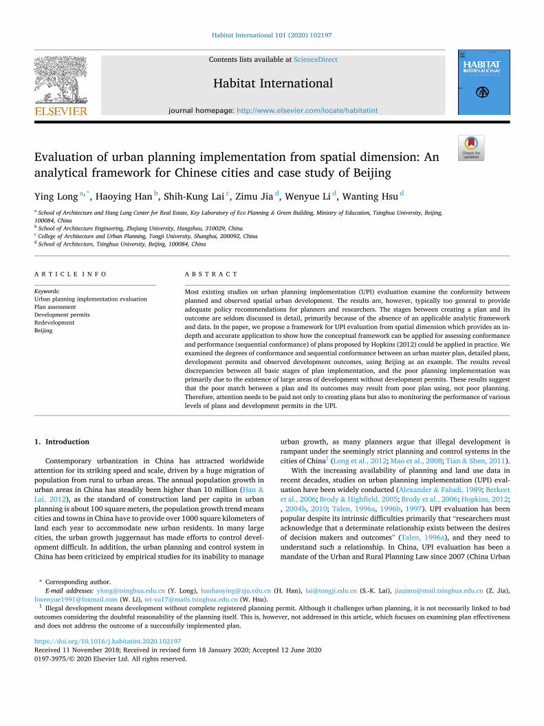
Beijing, the UGBs of each plan (Fig. 3) were derived from the planned land use map. The current master plan, which was proposed in 2004 and approved by the State Council in 2005, has been followed by a large number of RDPs3 by district or township governments. These RDPs were drafted independently at different times from 2005 to 2007, but we merged them together to show all the UGBs from the RDPs in Beijing. Note that most of the parcels in the UGBs were from various local RDPs, while in the suburban area where there were no RDPs, the parcels from the master plan were kept (around 10% of the planned urban area).
The UGBs in the Beijing urban master plan have a total area of 2449
km2 and include 9047 parcels (the average parcel size being 27.1 ha), while those in the RDPs have a total area of 2735 km2 and include 77966 parcels (the average parcel size being 3.5 ha). This means that 2449 km2
in the master plan and 2735 km2 in the RDPs were designated as planned urban areas according to the definition of a UGB. The urban parcels in RDPs are smaller than those in the master plan.
In addition, we noticed that the population in the base year 2004 of the master plan was 14.9 million, and planned population in the target year 2020 of the master plan was 18.0 million, according to the master plan. The observed population in 2010, however, was 19.6 million (Beijing bureau of statistics and national bureau of statistics Beijing survey team, 2011), which exceeded the planned population in 2020. This indicates that the master plan underestimated the actual develop-ment in Beijing. This condition is not rare among large Chinese cities. An over high population increasing in master plans is not encouraged or would be even denied by the State Council, which is due to the linkage between planned population increase and urban land quota allowed to be developed officially. This illustrates the general picture for planning implementation evaluation in this study.
3.2.2. Development permits As discussed above, development permits include construction
project site-selection notes, CLUPPs, construction engineering planning permits and rural construction planning permits. According to the functions of these permits, construction engineering planning permits and rural construction planning permits are the final steps to approve urban development projects in urban and rural areas, respectively. We accessed the inventory of CLUPPs and their attributes from the official
Fig. 2. The analytical framework for urban planning implementation in spatial dimension in China.
3 Detailed construction plans are not applied because land use types, densities and other basic development indices are all decided in RDPs.
Y. Long et al.
Habitat International 101 (2020) 102197
5
website of the Beijing Planning Commission,4 and their geometric boundaries were collected from Beijing Institute of City Planning which is responsible for analyzing all permits for the Beijing Planning Com-mission. We can assume that these CLUPPs include most urban devel-opment due to the following reasons: (1) urban developments with CLUPPs but without construction engineering planning permits are very rare in practice; (2) urban developments have been restricted and kept very few in rural areas where the land property right is different from cities and towns; and (3) rural construction planning permits have only been required since 2008.
We selected the CLUPPs issued from 2003 to 2010 for the following analyses (see Fig. 4). Generally, one parcel indicates a particular permit in the urban management, urban expansion or urban redevelopment process. From 2003 to 2010, there were 15245 CLUPPs, including the residential, commercial, industrial, transportation, municipal infra-structure, and green space categories. The total area of the CLUPPs was 463 km2 (over 57 km2 per year) and the average area of a CLUPP was about 3.0 ha, similar to the average parcel size in the RDPs. Each CLUPP includes detailed information on the geometric boundary, land use type (urban), and developer(s). Required by the national urban planning guidelines, the land use classification is the same between CLUPPs and master plans/RDPs, thus making CLUPPs and parcels in plans are comparable in land use type. In addition, each CLUPP reflects a short term urban development activity, which may not be comparable with the implementation period of a master plan or RDPs. However, we have collected eight years (2003–2010) of CLUPPs to benchmark with the master plan and RDPs. The temporal period of them is then comparable and consistent.
As for the data quality of CLUPPs, we believe that they are associated with very good quality since the online list has been paid much attention from citizens and developers. We also admit that some “sensitive” de-velopments for the central government and military units are absent
from the online list of CLUPPs, according to our rigorous review on the 2003–2010 CLUPPs. These developments may be less than 1% of all developments according to our in-person discussion with officers in the Beijing Planning Commission.
3.2.3. Urban development outcomes The outcomes of urban development have two forms, urban expan-
sion (from rural to urban) and urban redevelopment (e.g., urban land use transition and densification). Urban development patterns were interpreted from remote sensing images with incorporated points of interest (POIs) and field survey data, which were used for inferring the urban function of each parcel. We acquired two land use maps from March 2003 and December 2010 based primarily on satellite images: SPOT images (with a resolution of 2.5 m, covering the whole BMA) and Quick Bird images (with a resolution of 0.5 m, limited to the area within the 6th ring road). Both land use maps were at the parcel level and each parcel corresponds to a unique land use.5
According to these two maps, the urbanized area was 1295 km2 in 2003 and 2067 km2 in 2010. There was no observed transformation from urbanized to non-urbanized use (that is, no de-urbanization or urban shrinkage) during this stage in Beijing. Therefore, the total urban expansion from 2003 to 2010 was 772 km2.
Unlike previous studies to calculate urban expansion only (Han et al., 2009; Long et al., 2012; Mao et al., 2008; Tian & Shen, 2011),we also calculated urban redevelopment in addition. Such redevelopment can be observed in the conversion of land use types. Overlaying the 2003 and 2010 land use maps, we labeled all the polygons where land use changed from one type to another. The polygons (the whole or subdivided par-cels) converted from one urban land use type to another were identified as being redeveloped, e.g., from residential to industrial land use. The total redevelopment area was 235 km2 in the BMA and 162 km2 in the 6th ring road. Note that urban densification is not included in this paper, as we did not have sufficient information on the development density in
Fig. 3. Planned UGBs in Beijing (a: master plan; b: regulatory detailed plans) Source: Beijing Planning Commission.
4 The website is http://www.bjghw.gov.cn/query/business/query/queryTab leAction$searchTable1Di.action?searchContent¼. We downloaded all permits and geocoded them using the API provided by Google.
5 In addition to remote sensing images, extensive field surveys and points-of- interest are generally incorporated into land use maps in China.
Y. Long et al.

Habitat International 101 (2020) 102197
6
each parcel. For instance, a parcel that remained as residential land use from 2003–2010 may have been redeveloped from a low-rise commu-nity to a high-rise community but was not counted as a redevelopment parcel.
The total urban development area from 2003 to 2010 was calculated by summing up the areas of urban expansion and urban redevelopment and was 1007 km2.
4. Empirical evaluation in Beijing
4.1. Evaluation methodology in Beijing
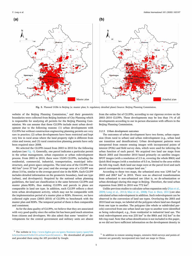
Taking Beijing as an example in this section, the UPI evaluation framework described in Section 2 was used to evaluate three types of sequential conformance and three types of conformance. The former includes the sequential conformance from the master plan to the RDPs, from the RDPs to the CLUPPs, and from the CLUPPs to the outcomes (see Fig. 5). The latter includes the conformance between the master plan and the RDPs, between the master plan and the CLUPPs, and between the master plan and the outcomes (see Fig. 6). As mentioned above, we focused on the urban construction land use and evaluated the urban planning implementation. Therefore, the assessment was made by overlaying two types of urban construction land maps. The land areas inside and outside each boundary were mapped and calculated. Finally, to better illustrate the evaluation results, matching rate was calculated to measure the degree of coherence between two stages (see Figs. 5 and 6, matching rate is the proportion of area in “both” part).
4.2. Evaluation of sequential conformance
4.2.1. Sequential conformance 1: from the master plan to the regulatory detailed plans
To examine the conformance between the master plan and the RDPs or the sequential conformance from the master plan to the RDPs, we overlaid the UGBs delineated in the master plan and those from the RDPs in Beijing. Generally, it is hard for local governments (like those in towns) to influence the municipal master plan of Beijing. Therefore, they are much more interested in the RDPs that focus on specific areas under various jurisdictions and typically on development in the near future. The results suggest that an area of 1891 km2 was included in the UGBs of both the master plan and the RDPs, an area of 844 km2 was designated by the RDPs but not by the master plan, and an area of 558 km2 was designated by the master plan but not by the RDPs. The remaining area, 13117 km2, remained non-urban in both types of plans (see Fig. 7a). Planned areas in the RDPs outnumber those in the master plan.
4.2.2. Sequential conformance 2: from the regulatory detailed plans to the CLUPPs
The overlay analysis of the UGBs in the RDPs and the CLUPPs in Beijing showed that an area of 456 km2 was covered by both the UGBs in the RDPs and by the CLUPPs. Ninety permits with a total area of 7 km2
were outside the UGBs in the RDPs. A UGB area of 2279 km2 (83.3%) in the RDPs was not issued CLUPPs (see Fig. 7b).
4.2.3. Sequential conformance 3: from the CLUPPs to the outcomes The overlay analysis of the CLUPP area and the observed urbanized
area (area interpreted as urbanized from the satellite images) showed that only 198 km2 of urbanized area was issued CLUPPs, compared with 809 km2 of urbanized area (both expanded or redeveloped) not being issued CLUPPs (see Fig. 7c), indicating the limited impact of CLUPPs on development outcomes.
The analysis of expansion and redevelopment suggests that 80% (623 km2 of 772 km2) of urban expansion (see Fig. 7d) and 79% (186 km2 of 235 km2) of urban redevelopment had not been issued CLUPPs (see Fig. 7e).
Fig. 4. The profile of construction land use planning permits from 2003 to 2010 in Beijing (a: in the whole BMA; b: CLUPPs by issue year in km2; c: CLUPPs by land use type in km2) Note that the land use types in (c) are from the Chinese city planning technical standards and their meanings are as follows: residential (R), commercial and administrative (C), industrial (M), warehouse (W), military (D), urban water (E), unconfirmed (X), transportation infrastructure (T/S), municipal infra-structure (U), green space (G), and reserved land (CB). (For interpretation of the references to color in this figure legend, the reader is referred to the Web version of this article.)
Y. Long et al.
Habitat International 101 (2020) 102197
7
4.3. Evaluation of conformance
4.3.1. Conformance 1: between the master plan and the regulatory detailed plans
Conformance 1 is the same as Sequential Conformance 1.
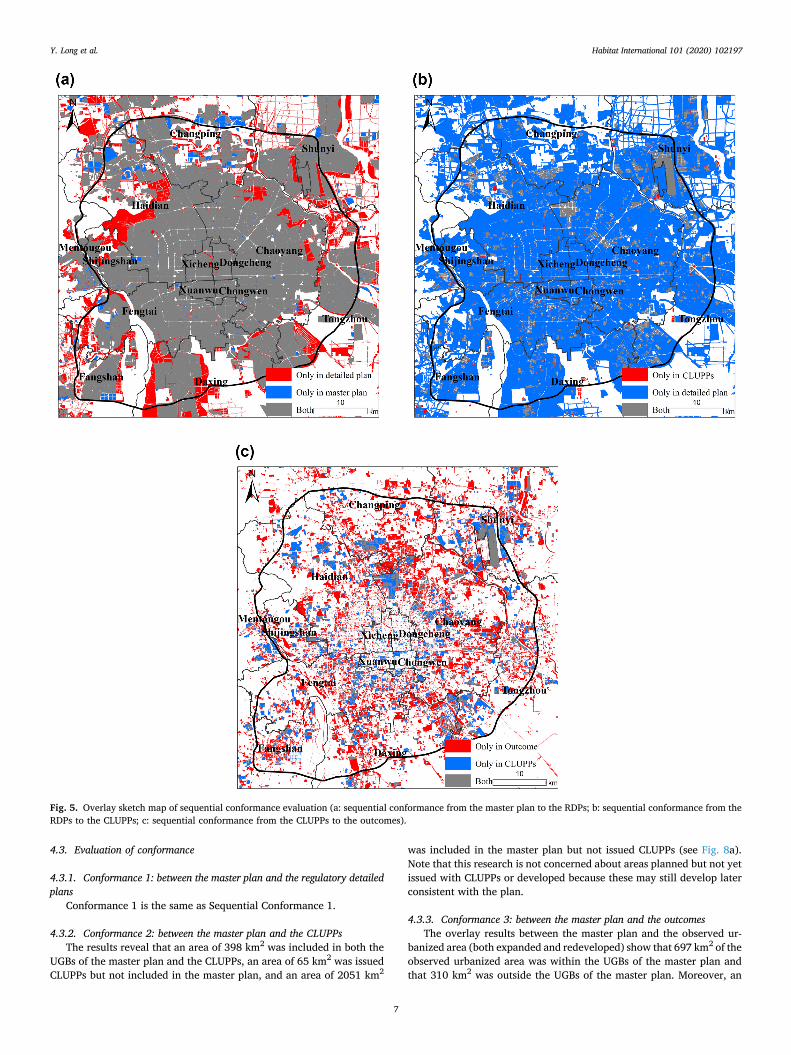
4.3.2. Conformance 2: between the master plan and the CLUPPs The results reveal that an area of 398 km2 was included in both the
UGBs of the master plan and the CLUPPs, an area of 65 km2 was issued CLUPPs but not included in the master plan, and an area of 2051 km2
was included in the master plan but not issued CLUPPs (see Fig. 8a). Note that this research is not concerned about areas planned but not yet issued with CLUPPs or developed because these may still develop later consistent with the plan.
4.3.3. Conformance 3: between the master plan and the outcomes The overlay results between the master plan and the observed ur-
banized area (both expanded and redeveloped) show that 697 km2 of the observed urbanized area was within the UGBs of the master plan and that 310 km2 was outside the UGBs of the master plan. Moreover, an
Fig. 5. Overlay sketch map of sequential conformance evaluation (a: sequential conformance from the master plan to the RDPs; b: sequential conformance from the RDPs to the CLUPPs; c: sequential conformance from the CLUPPs to the outcomes).
Y. Long et al.

Habitat International 101 (2020) 102197
8
area of 1752 km2 within the UGBs of the master plan was not yet developed (see Fig. 8b). More specifically, of the total 772 km2 of urban expansion, 491 km2 was located within the UGBs of the master plan (see Fig. 8c); of the total 235 km2 of urban redevelopment, 206 km2 was located within the UGBs of the master plan (see Fig. 8d).
4.4. Matching rates of sequential conformance and conformance
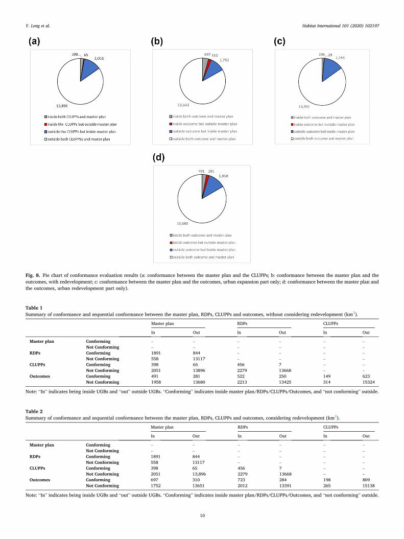
The evaluation of sequential conformance and conformance proved that inconsistencies existed between all four basic stages of the plan implementation process. Table 1 and Table 2 summarize these results.
To better illustrate the conformance and sequential conformance results, we introduce a variable to measure the degree of coherence between two stages: matching rate. The matching rate is defined as the total planned or actual urbanized area at the later of the two stages divided by the planned or actual urbanized area common to both stages. For instance, the matching rate between the master plan and the RDPs is the UGB area in the RDPs divided by the UGB area present in both the master plan and the RDPs. The matching rate reveals how much an event in one stage matches the same event in the previous stage of urban development. Therefore, we can use it to represent degree of confor-mance or sequential conformance, which can also serve as the confor-mance rate or the sequential conformance rate.
Based on all types of development area in Table 1, we calculated that the rates of Conformance 1, Conformance 2 and Conformance 3 were 69%, 86% and 64%, respectively, while the rates of Sequential Conformance 1, Sequential Conformance 2 and Sequential Conformance 3 were 69%, 98% and 19%, respectively, if redevelopment was not considered.
However, if we consider redevelopment, the rates of Conformance 1, Conformance 2 and Conformance 3 would be 69%, 86% and 69%, respectively, and those of Sequential Conformance 1, Sequential Conformance 2 and Sequential Conformance 3 would be 69%, 98% and 20%, respectively (Fig. 9). The rates are slightly higher than those when not considering redevelopment.
The sequential conformance rates clearly indicate that there were
loopholes in all three stages of plan implementation: from the master plan to the RDPs, from the RDPs to the CLUPPs, and from the CLUPPs to the outcomes. They also suggest very uneven discrepancies: the CLUPPs matched the RDPs very well, but the outcomes matched the CLUPPs very poorly. Moreover, the conformance rates were different from what would be expected if there were loopholes at all three stages of plan implementation. In such a scenario, the later conformance rates would be smaller than the earlier ones. For example, the rate of Conformance 3 would be smaller than that of Conformance 2 and that of Conformance 2 would be smaller than that of Conformance 1. However, the results suggest that the rate of Conformance 2 was higher than that of Conformance 1, and the rate of Conformance 3 was as high as that of Conformance 1. The CLUPPs may sometimes have been issued according to the master plan instead of to the RDPs. Furthermore, some projects may have been approved without being issued a CLUPP.
5. Discussion
5.1. Different problems reflected by the evaluations and corresponding policy implications
The sequential conformance and conformance rates represent different specific problems. For instance, Sequential Conformance 1, Sequential Conformance 2 and Sequential Conformance 3 represent a plan coherence problem, a legal control problem, and an implementation-monitoring problem, respectively. Each problem needs to be addressed with appropriate measures. In addition, policy impli-cations could be derived according to the evaluation results in Section 4. We elaborate them in three aspects, each of with corresponds with one step of sequential conformance evaluation (or performance evaluation).
(1) To improve plan coherence, regulations and requirements need to be created to ensure that RDPs do not deviate too much from the master plan. In the two-tier urban planning system, variation from the master plan by RDPs is inevitable as the master plan provides only basic guidelines for development for a long time
Fig. 6. Overlay sketch map of conformance evaluation (a: conformance between the master plan and the RDPs; b: conformance between the master plan and the CLUPPs; c: conformance between the master plan and the outcomes).
Y. Long et al.

Habitat International 101 (2020) 102197
9
horizon, typically 15–25 years. Under the decision situation of rapid urbanization, which contains uncertainties and complex-ities, RDPs are supposed to follow the basic outlines in the master plan, but may be able to make necessary changes. In addition, RDPs are generally prepared by the lower-level local government like a town, a sub-district or a district, and the total area of planned UGBs in RDPs is more likely to be greater than those predefined in the master plan which may be resulted from a lot of gaming processes between the two levels of government. A 69% matching rate between the master plan and RDPs means there is room for planners and governments to improve the formulation of RDPs. Another factor deserving attention is that the UGB area in the RDPs but not in the master plan was more than the area in the master plan but not in the RDPs in 2010. As the observed population in the 2010 had already exceeded the planned pop-ulation in the master plan, and the area of planned urban development land is related to the planned population, the large gap of UGB between the two plans indicates that the UGBs in the master plan were not sufficient to accommodate new develop-ment. Therefore, making good plans and updating them in a timely manner needs to be fully considered.
(2) The local government should improve the legal control of urban development. Just as land permits and building permits in the US are issued by planning authorities according to zoning, issuing CLUPPs in China is done according to the RDPs made by the planning authorities of the local governments. Issuing CLUPPs and formulating and implementing RDPs are conducted by local governments. Therefore, local governments are responsible for any discrepancy between these two stages. Although CLUPPs can
be issued for development outside of the planned UGBs through independent applications, the RDPs need to be reformulated or revised before the CLUPP is issued according to the city planning law of China. The results of our analysis suggest a very high matching rate between the CLUPPs and the RDPs, 98%, indi-cating that the legal control process is good compared with the other two processes. However, a small proportion of CLUPPs still did not match with the RDPs, proving that problems still exist in the legal control process.
(3) Improvement of implementation monitoring is also a government responsibility. The low matching rate between outcomes and CLUPPs, 19% without considering redevelopment and 20% considering redevelopment, suggests that illegal development has become prevalent and has greatly impeded plan imple-mentation. Loopholes may arise out of several factors. First, some projects were allowed to develop without applying for CLUPPs. For instance, the Lvtong projects were proposed to accelerate the local economy during the economic crisis of 2009–2011, and some of them are still not registered with CLUPPs. Second, the Beijing Municipal Planning Commission, which was responsible for monitoring illegal developments, focused on the conformity of developments with issued CLUPPs rather than on illegal de-velopments without CLUPPs. This means the planning commis-sion did not control all illegal developments. Third, CLUPPs in remote districts were not registered, although this issue was very limited. This would have caused underestimation of the matching rate. Fourth, the CLUPPs did not include some high priority de-velopments (Yiji kaifa in Chinese Pinyin). This may also have caused underestimation of the matching rate. Fifth, during the
Fig. 7. Pie chart of sequential conformance evaluation results (a: sequential conformance from the master plan to the RDPs; b: sequential conformance from the RDPs to the CLUPPs; c: sequential conformance from the CLUPPs to the outcomes, with redevelopment; d: sequential conformance from CLUPPs to outcomes, urban expansion only; e: sequential conformance from CLUPPs to outcomes, urban redevelopment only).
Y. Long et al.
Habitat International 101 (2020) 102197
10
Fig. 8. Pie chart of conformance evaluation results (a: conformance between the master plan and the CLUPPs; b: conformance between the master plan and the outcomes, with redevelopment; c: conformance between the master plan and the outcomes, urban expansion part only; d: conformance between the master plan and the outcomes, urban redevelopment part only).
Table 1 Summary of conformance and sequential conformance between the master plan, RDPs, CLUPPs and outcomes, without considering redevelopment (km2).
Master plan RDPs CLUPPs
In Out In Out In Out
Master plan Conforming – – – – – – Not Conforming – – – – – –
RDPs Conforming 1891 844 – – – – Not Conforming 558 13117 – – – –
CLUPPs Conforming 398 65 456 7 – – Not Conforming 2051 13896 2279 13668 – –
Outcomes Conforming 491 281 522 250 149 623 Not Conforming 1958 13680 2213 13425 314 15324
Note: “In” indicates being inside UGBs and “out” outside UGBs. “Conforming” indicates inside master plan/RDPs/CLUPPs/Outcomes, and “not conforming” outside.
Table 2 Summary of conformance and sequential conformance between the master plan, RDPs, CLUPPs and outcomes, considering redevelopment (km2).
Master plan RDPs CLUPPs
In Out In Out In Out
Master plan Conforming – – – – – – Not Conforming – – – – – –
RDPs Conforming 1891 844 – – – – Not Conforming 558 13117 – – – –
CLUPPs Conforming 398 65 456 7 – – Not Conforming 2051 13,896 2279 13668 – –
Outcomes Conforming 697 310 723 284 198 809 Not Conforming 1752 13651 2012 13391 265 15138
Note: “In” indicates being inside UGBs and “out” outside UGBs. “Conforming” indicates inside master plan/RDPs/CLUPPs/Outcomes, and “not conforming” outside.
Y. Long et al.

Habitat International 101 (2020) 102197
11
compilation of the 2004 master plan, issuing CLUPPs was sus-pended in some areas, and some areas were allowed to be ur-banized without CLUPPs.
5.2. Potential reasons for the poor match between the master plan, regulatory detailed plans, CLUPPs and outcomes
The poor match between the master plan, RDPs, CLUPPs, and out-comes can be attributed in part to developers’ acquisitions of property rights, the psychology of residential development, and the chaotic na-ture of government policy making. A large amount of development fell outside the UGBs of the master plan partly because the delineation of the UGBs might have raised the land and housing prices within their boundaries, where the property rights were already secured by land-owners. Developers in turn sought cheaper land outside the UGBs where property rights were in the public domain (Wang et al., 2014). Mean-while, according to Mohamed (2006), land control policies that make the development process more transparent would encourage developers to seek land in exurban areas for development, due to the psychological traits of residential developers. For example, the village collectives (cun jiti in Chinese pinyin) were keen on the development of houses with limited property (xiao chanquan fang in Chinese pinyin) at one time. Finally, the policy making process for land management in China, though hierarchical in nature, is best characterized by the garbage can model of organizational choice where strategic behavior prevails resulting in a chaotic decision making process (Han & Lai, 2012; King-don, 2002). So simplification of the planning system needs to be considered.
5.3. Potential biases of this study
There are some limitations of the present research. First, the iden-tification of legal development would be more accurate using the data for construction engineering planning permits rather than those for construction land use planning permits. However, we were only able to access the latter. Second, there is typically a time lag between receiving permits and full development of a land parcel, which needs to be considered when comparing development permits and observed devel-opment. However, identifying these time lags requires further data and analysis, which were not yet available for this study. Third, we examined conformance and sequential conformance only in the locations and area of urbanized land but did not analyze detailed land use types and development density. Future research may improve upon this by providing richer and more precise data and considering a longer time span. Fourth, the discrepancy between simplicity of straightforward framework and complex real picture of land use planning and control system in China makes the presented conformity analysis evaluate only part of that system and thus it is not a holistic tool to assess it. Future
research may consider the whole system based on richer and more precise data. Fifth, the matching rate does show what portion of events at lower level matches the same events at upper level. But it doesn’t demonstrate a degree of deviation between lower level development and planned area prescribed by upper level plans, which needs to be further considered.
6. Conclusions
In this paper, we proposed a framework for the assessment of the UPI, which provides a more in-depth and accurate application to show how the conceptual framework for assessing conformance and sequen-tial conformance of plans proposed by Hopkins (2012) could be applied in practice. According to our literature review, this study fills the gap of UPI for Chinese cities, which mainly focuses on the consistence between master plans and urban expansion. The dimension has been largely extended by our proposed methodological framework. The consistence method has been extended from only focusing on the consistence be-tween master plans and observed urban expansion to the consistence during each step of UPI like master plans to detailed plans, detailed plans to permits, as well as permits to developments. The method has been enriched by the sequential conformance part, while referring to Hopkins’ method.
According to the indicator of “matching rate” which was devised to measure the degree of conformance or sequential conformance in this paper, we found that discrepancies existed between all four basic stages of plan implementation in Beijing. Of the three stages of sequential conformance, the CLUPPs matched the regulatory detailed plans very well, and the outcomes matched the CLUPPs very poorly. This indicates that the discrepancies between plans and final development outcomes may largely result from the existence of large areas of development without CLUPPs. Therefore, improvement of implementation moni-toring may be adopted as a key issue to make plan implementation better.
Moreover, conformance rates did not follow what would be expected if there were loopholes in all three stages of plan implementation, as conformance rates in later stages would then be smaller than those in earlier stages. The highest conformance rate was not between the master plan and the regulatory detailed plans but between the master plan and the CLUPPs. The results also prove that the inclusion of redevelopment led to a higher sequential conformance rate for CLUPPs and a higher conformance rate between the master plan and outcomes. That is pri-marily because the redevelopments matched better with the master and CLUPPs.
The results suggest that the poor match between the intended and real outcomes of a plan may result from poor plan using. The intrinsic reason is perhaps that the hierarchical UPI system is linear, sequential in nature, while the actual urban development process is much more complex than what is stipulated in the system. This requires the UPI system to focus more on the sequential conformance (or performance) than conformance aspects of planning evaluation, allowing planners and governments to develop policies that could bridge the gap between the plan and the realized development.
The contributions of this paper mainly lie in the following aspects. Theoretically (and methodologically), the proposed framework for examining UPI from spatial dimension integrates spatial developments in various urban planning and development stages, ranging from a master plan, detailed plans, development permits to actual urban development, thus contributing to existing theories/approaches on UPI (especially for Chinese cities) which mainly focus on the consistence between master plans and urban expansion. Empirically, the findings aforementioned contribute to our understanding upon urban develop-ment and planning process, the decision making process of local urban planning as well as potential revisions to existing urban planning system in China.
Fig. 9. Overall illustration of the rates of conformance and sequential confor-mance (SC in the figure).
Y. Long et al.

Habitat International 101 (2020) 102197
12
CRediT authorship contribution statement
Ying Long: Conceptualization, Methodology, Writing - original draft, Supervision. Haoying Han: Validation, Formal analysis, Data curation. Shih-Kung Lai: Investigation, Resources. Zimu Jia: Writing - review & editing, Data curation. Wenyue Li: Writing - review & editing, Visualization. Wanting Hsu: Data curation, Visualization.
Acknowledgments
We are grateful for the financial support of Natural Science Foun-dation of China (Grant No. 51778319 & 71834005) and Beijing Nature Science Foundation Project (Grant No. 8161003).
References
Alexander, E. R., & Faludi, A. (1989). Planning and plan implementation - notes on evaluation criteria. Environment and Planning B: Planning and Design, 16(2), 127–140.
Baer, W. C. (1997). General plan evaluation criteria: An approach to making better plans. Journal of the American Planning Association, 63(3), 329–344.
Berke, P., Backhurst, M., Day, M., Ericksen, N., Laurian, L., Crawford, J., & Dixon, J. (2006). What makes plan implementation successful? An evaluation of local plans and implementation practices in New Zealand. Environment and Planning B: Planning and Design, 33(4), 581–600.
Berke, P., & French, S. P. (1994). The influence of state planning mandates on local plan quality. Journal of Planning Education and Research, 13(4), 237–250.
Brody, S. D., & Highfield, W. E. (2005). Does planning work? Testing the implementation of local environmental planning in Florida. Journal of the American Planning Association, 71(2), 159–175.
Brody, S. D., Highfield, W. E., & Thornton, S. (2006). Planning at the urban fringe: An examination of the factors influencing nonconforming development patterns in southern Florida. Environment and Planning B: Planning and Design, 33(1), 75–96.
Burby, R. J. (2003). Making plans that matter: Citizen involvement and government action. Journal of the American Planning Association, 69(1), 33–49.
Dalton, L. C., & Burby, R. J. (1994). Mandates, plans, and planners. Journal of the American Planning Association, 60(4), 444–461.
Han, H., & Lai, S. (2012). National land use management in China: An analytical framework. Journal of Urban Management, 1(1), 3–38.
Han, H., Lai, S., Dang, A., Tan, Z., & Wu, C. (2009). Effectiveness of urban construction boundaries in Beijing: An assessment. Journal of Zhejiang University - Science, 10(9), 1285–1295.
Han, Z., Long, Y., Wang, X., & Hou, J. (2019). Urban redevelopment at the block level: Methodology and its application to all Chinese cities. Environment and Planning B: Urban Analytics and City Science. https://doi.org/10.1177/2399808319843928.
Hopkins, L. D. (2001). Urban development: The logic of making plans. London: Island Press.
Hopkins, L. D. (2012). Plan assessment: Making and using plans well. In R. Crane, & R. Weber (Eds.), The oxford handbook of urban planning. New York: Oxford University Press.
Kingdon, J. W. (2002). Agendas, alternatives, and public policies (2nd ed.). Longman. Laurian, L., Crawford, J., Day, M., Kouwenhoven, P., Mason, G., Ericksen, N., &
Beattie, L. (2010). Evaluating the outcomes of plans: Theory, practice, and methodology. Environment and Planning B: Planning and Design, 37(4), 740–757.
Laurian, L., Day, M., Berke, P., Ericksen, N., Backhurst, M., Crawford, J., & Dixon, J. (2004b). Evaluating plan implementation: A conformance-based methodology. Journal of the American Planning Association, 70(4), 471–480.
Long, Y., Gu, Y., & Han, H. (2012). Spatiotemporal heterogeneity of urban planning implementation effectiveness: Evidence from five master plans of Beijing. Landscape and Urban Planning, 108(2–4), 103–111.
Long, Y., Mao, Q., & Dang, A. (2009). Beijing urban development model: Urban growth analysis and simulation. Tsinghua Science and Technology, 14(6), 787–794.
Loures, L., & Vaz, E. (2018). Exploring expert perception towards brownfield redevelopment benefits according to their typology. Habitat International, 72, 66–76.
Mao, J., Yan, X., Li, Z., & Zhou, S. (2008). The effect of urban planning control upon land use in Shenzhen. Acta Geographica Sinica, 63(3), 311–320 (in Chinese with English abstract).
Mastop, H., & Faludi, A. (1997). Evaluation of strategic plans: The performance principle. Environment and Planning B: Planning and Design, 24(6), 815–832.
Millard-Ball, A. (2013). The limits to planning: Causal impacts of city climate action plans. Journal of Planning Education and Research, 33(1), 5–19.
Mohamed, R. (2006). The psychology of residential developers: Lessons from behavioral economics and additional explanations for satisficing. Journal of Planning Education and Research, 26(1), 28–37.
Pan, Z., Wang, G., Hu, Y., & Cao, B. (2019). Characterizing urban redevelopment process by quantifying thermal dynamic and landscape analysis. Habitat International, 86, 61–70.
Talen, E. (1996a). Do plans get implemented? A review of evaluation in planning. Journal of Planning Literature, 10(3), 248–259.
Talen, E. (1996b). After the plans: Methods to evaluate the implementation success of plans. Journal of Planning Education and Research, 16(2), 79–91.
Talen, E. (1997). Success, failure, and conformance: An alternative approach to planning evaluation. Environment and Planning B: Planning and Design, 24(4), 573–587.
Tian, L., & Shen, T. (2011). Evaluation of plan implementation in the transitional China: A case of guangzhou city master plan. Cities, 28(1), 11–27.
Wang, L., Han, H., & Lai, S. (2014). Do plans contain urban sprawl? A comparison of beijing and taipei. Habitat International, 42, 121–130.
Wildavsky, A. (1973). If planning is everything, maybe it’s nothing. Policy Sciences, 4(2), 127–153.
Wu, J. G., Xiang, W. N., & Zhao, J. Z. (2014). Urban ecology in China: Historical developments and future directions. Landscape and Urban Planning, 125, 222–233.
Yang, Z., Cai, J., Ottens, H. F. L., & Sliuzas, R. (2013). Beijing. Cities, 31, 491–506. Yeh, G. A., & Wu, F. (1999). The transformation of the urban planning system in China
from a centrally-planned to transitional economy. Progress in Planning, 51(3), 167–252.
Y. Long et al.