evidence of an emerging levee failure mechanism causing
TRANSCRIPT
RESEARCH ARTICLE10.1002/2015WR017426
Evidence of an emerging levee failure mechanism causingdisastrous floods in ItalyStefano Orlandini1, Giovanni Moretti1, and John D. Albertson2
1Dipartimento di Ingegneria Enzo Ferrari, Universit�a degli Studi di Modena e Reggio Emilia, Modena, Italy, 2School of Civiland Environmental Engineering, Cornell University, Ithaca, New York, USA
Abstract A levee failure occurred along the Secchia River, Northern Italy, on 19 January 2014, resulting inflood damage in excess of $500 million. In response to this failure, immediate surveillance of other levees inthe region led to the identification of a second breach developing on the neighboring Panaro River, whererapid mitigation efforts were successful in averting a full levee failure. The paired breach events that occurredalong the Secchia and Panaro Rivers provided an excellent window on an emerging levee failure mechanism.In the Secchia River, by combining the information content of photographs taken from helicopters in the earlystage of breach development and 10 cm resolution aerial photographs taken in 2010 and 2012, animal bur-rows were found to exist in the precise levee location where the breach originated. In the Panaro River, inter-nal erosion was observed to occur at a location where a crested porcupine den was known to exist and thiserosion led to the collapse of the levee top. This paper uses detailed numerical modeling of rainfall, river flow,and variably saturated flow in the levee to explore the hydraulic and geotechnical mechanisms that were trig-gered along the Secchia and Panaro Rivers by activities of burrowing animals leading to levee failures. As hab-itats become more fragmented and constrained along river corridors, it is possible that this failure mechanismcould become more prevalent and, therefore, will demand greater attention in both the design and mainte-nance of earthen hydraulic structures as well as in wildlife management.
1. Introduction
Burrowing animals are acknowledged by agencies responsible for earthen dams and levees to have anadverse impact on the integrity of these flood control structures [e.g., Federal Emergency Management Agency,2005]. Such degradation of earthen dams and levees have been observed in the field, and advanced methodsfor the continuous monitoring of these structures have been proposed [Chlaib et al., 2014; Perri et al., 2014].Only a few papers, however, have explicitly and mechanistically connected piping erosion responsible for thefailure of earthen structures to preferential flow extending along paths developed by burrowing animals[Carroll, 1949; Masannat, 1980; Bayoumi and Meguid, 2011]. Information about wildlife activity and relatedearthen structure safety is generally limited to the gray literature and maintenance reports [e.g., Federal Emer-gency Management Agency, 2005]. Wildlife activity is not even mentioned among the relevant factors causingthe failure of earthen dams and levees in many classical geotechnical engineering textbooks and specific tech-nical reports [e.g., Terzaghi et al., 1996; Resio et al., 2011]. In fact, animal burrows are still rarely acknowledgedby engineers, technicians, and land managers to be a serious threat of dam and levee failure.
On the other hand, wildlife activity along fluvial systems is rapidly increasing in many regions of the worldas a result of the institution of fluvial parks acting efficiently as wildlife movement corridors [Soul�e andGilpin, 1991; McEuen, 1993; Bennett, 1999]. There is therefore an urgent need to raise awareness about theemergent risk connected to impacts on earthen flood control structures of animals, including added pres-sures by invasive species, habitat fragmentation and shifts, as often driven by development and climatepressures. Relevant pieces of the puzzle are available. For example, extensive biological studies exist on thestructure and function of wild animal dens [e.g., Reynolds and Wakkinen, 1987; Roper, 1992a; Monetti et al.,2005]. In addition, several attempts have been made to provide a hydraulic characterization of natural pipessubjected to flow and internal erosion processes [e.g., Wilson et al., 2012]. However, the full picture has notyet been examined at the field scale in the context of a documented failure. Key broader research questionsthat need to be addressed include the following:
Key Points:� Animal burrows are demonstrated to
be a serious threat of earthen leveefailure� Internal flow and erosion around a
den can cause the collapse of thelevee top� Internal flow may initiate due to
direct inflow into the den or den wallfailure
Supporting Information:� Supporting Information S1� Figure S1� Figure S2
Correspondence to:S. Orlandini,[email protected]
Citation:Orlandini, S., G. Moretti, andJ. D. Albertson (2015), Evidence of anemerging levee failure mechanismcausing disastrous floods in Italy,Water Resour. Res., 51, 7995–8011,doi:10.1002/2015WR017426.
Received 21 APR 2015
Accepted 27 AUG 2015
Accepted article online 18 SEP 2015
Published online 12 OCT 2015
VC 2015. The Authors.
This is an open access article under the
terms of the Creative Commons
Attribution-NonCommercial-NoDerivs
License, which permits use and
distribution in any medium, provided
the original work is properly cited,
the use is non-commercial and no
modifications or adaptations are
made.
ORLANDINI ET AL. AN EMERGING LEVEE FAILURE MECHANISM 7995
Water Resources Research
PUBLICATIONS

1. What are the ecological processes that drive burrowing animals to interact with earthen flood controlstructures?
2. What are the geophysical interactions between water flows and disturbed earthen structures?3. What are the triggers of failure mechanisms affecting disturbed earthen structures?
This paper seeks to address the last two questions, while motivating work on the first question and raisingawareness for design, maintenance, and risk considerations. Furthermore, within a scientific context inwhich ecohydrology has been expanding the appreciation for the importance of biological and physicalconnections in hydrology, a parallel set of interactions are highlighted here with invasive animal speciesbehavior and impacts on hydrological and geotechnical function. The investigation reported in this paperprovides observational evidence of the role played by burrowing animals in the disastrous levee failureoccurred on 19 January 2014, along the Secchia River, Northern Italy. In addition, a mechanism causing thefailure of earthen levees disturbed by burrowing animals is revealed by the observation of a second leveefailure that occurred in the same day, under similar hydroclimatic and levee conditions, along the neighbor-ing Panaro River. Finally, hypotheses on the related triggering processes are explored through detailednumerical modeling of rainfall, river flow, and variably saturated flow occurring in disturbed levees inresponse to complex hydroclimatic forcing.
2. Driving Forces
2.1. Disastrous Levee Failure on the Secchia RiverOn 19 January 2014, a levee failure occurred along the Secchia River at San Matteo, Northern Italy(44
�41
057:85
00N, 10
�56
041:68
00E, Figure 1a). The breach formed on the right side of the river system (from the
perspective of looking downstream) was first observed in the morning around 6:30. Since a rapid repair wasimpracticable at that time, the breach developed by releasing to the surrounding plain a water volume ofabout 363106 m3 with a peak flow discharge of about 434 m3 s21 (section A1). The ultimate extent of theflooded area was about 52 km2 and the estimated flooding damage was in excess of $500 million (Figure1). The levees of the Secchia River are, at least in the perspective of the present investigation, representativeof the levee systems developed in the Po Valley from the sixteenth century and now extending for about2300 km (levees on both sides of the river) along the Po River and its tributaries. The Po Valley is the mostdensely populated and economically developed area in Italy.
The Secchia River flood was produced by a stratiform rainfall event that released an areal rainfall depth of about125 mm over a 1305 km2 contributing drainage basin. The total rainfall volume was about 163 3 106 m3. About65% of this volume entered the Rubiera flood control reservoir as flood volume (Figure 1). In addition to thehigh precipitation depth that occurred in the contributing drainage basin of the Secchia River, convectivethunderstorms occurred in the low-gradient portion of the fluvial system extending downstream fromRubiera during the flood wave propagation, thus directly wetting the levee from above. The spatial distribu-tion of rainfall depth that occurred around the location of the breach is represented by the radar imagereported in Figure 2a. The rainfall hyetographs obtained by combining rain gauge and radar data for thelocations of San Matteo, along the Secchia River, and Via Tronco, along the Panaro River, are reported in Fig-ures 2b and 2c, respectively [Orlandini and Morlini, 2000]. These rainfall events were atypical for the consid-ered area in the month of January. Normally winter precipitation falling in the mountainous portion of thedrainage basin is in the form of snow, and thunderstorms occur normally in the low-gradient portion of thefluvial system in summer.
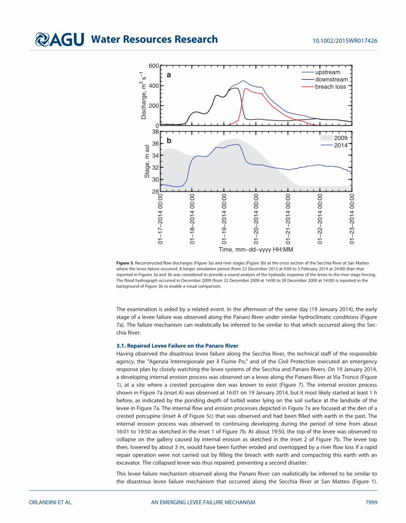
The flood hydrographs from December 2013 and January 2014 at the cross section of the failed levee werereconstructed by developing a level pool routing model and a dynamic wave model (section A1). Recon-structed flow discharge and river stage for the period 17–22 January 2014 are reported in Figures 3a and3b, respectively. The breach flow loss was computed by incorporating into the dynamic wave model anexplicit description of the breach evolution, obtained from photographs taken during the event (Figure 4).The combined use of observations and models yielded the results reported in Figure 3, revealing that (1)the maximum stage reached by the river flow in January 2014 was about 1.5 m below the top of the leveeand (2) the magnitude of the peak river stage and the duration of high river stages along the Secchia Riverin January 2014 were smaller than the corresponding quantities observed in previous events such as, forinstance, those observed in December 2009 (Figure 3b).
Water Resources Research 10.1002/2015WR017426
ORLANDINI ET AL. AN EMERGING LEVEE FAILURE MECHANISM 7996

2.2. Wildlife Impact on the LeveeEvidence of wildlife impact on the failed levee was derived from the analysis of 10 cm resolution aerial pho-tographs taken in 2010 and 2012 (Figures 5a and 5b, respectively). This evidence was confirmed by fieldinspection of the Secchia River after the disaster (Figure 5c). More generally, extensive field inspection con-ducted along the Secchia and Panaro Rivers revealed an emergent risk connected to the activity of crestedporcupines Hystrix cristata (Linnaeus, 1758), European badgers Meles meles (Linnaeus, 1758), red foxesVulpes vulpes (Linnaeus, 1758), and nutria Myocastor coypus (Molina, 1758) (insets A, B, C, and D, respectively,in Figure 5c). The information of the photographs taken from helicopters in the early stage of breach devel-opment, at 10:11 and 12:22 (Figure 4), and of previously taken aerial photographs (Figures 5a and 5b) werecombined to determine the precise location of the levee where the failure mechanism originated (sectionA2). Animal burrows (B1, B2, B3, and B4) were found to exist in the levee location where the breach origi-nated (Figures 5a and 5b). In addition, terrain analysis based on a 1 m resolution digital elevation model(DEM) generated from a lidar survey revealed the positions of the animal burrows observed in Figure 5balong the cross section of the failed levee (section A2). Results are reported in Figure 6.
3. Failure Mechanism
The breach that occurred along the Secchia River on 19 January 2014 (Figures 1 and 4) was first detected at6:30. It has been reported by several observers that the breach developed from above and that a large ero-sive flow was spilling out from the river to the landside bank of the levee at the time of the detection. Given
Modena
MedollaSan Felice sul Panaro Finale Emilia
Bastiglia
Camposanto
Bomporto
San Prospero
Bondeno
Santa Bianca
650000 660000 670000 680000 690000
4950
000
4960
000
4970
000
San Matteo
htroN
ing,
m
b
44°41’57.85"N
a10°56’41.68"E
Elevation, m asl
Panaro River
Via Tronco
Mirandola
Pioppa
Ponte Bacchello
Ponte AltoRubiera
Easting, m
5 5010 20 30 40
Secc
hia
Riv
er
Sant’Ambrogio
Figure 1. (a) Map of the land flooded after the levee failure occurred along the Secchia River at San Matteo (Northern Italy) on 19 January 2014. (b) The delineation of the flooded areasis based on aerial surveys carried out by the Civil Protection as part of the emergency response plan for the occurred disaster. A volume of water of about 363106 m3 (Figure 3a, areaunder the breach loss hydrograph) left the Secchia River by flooding (red arrows) an area of about 52 km2. Topographic gradients and barriers are shown by the 1 m resolution digitalelevation model reported in the background.
Water Resources Research 10.1002/2015WR017426
ORLANDINI ET AL. AN EMERGING LEVEE FAILURE MECHANISM 7997

the advanced state of development of the breach at the time of the detection, no attempt to repair thealtered levee was readily possible. While the observed clues are helpful, nonetheless, the failure mechanismcausing the breach along the Secchia River was not entirely observed. Therefore, plausible hypothesesabout the actual failure mechanism and the related triggering processes are explored here.
Easting, m
Nor
thin
g, m
a
Marzaglia Castelfranco Emilia
Bacchello
Formigine
Via Tronco
San Matteo
4940
000
4950
000
4960
000
640000 650000 660000 670000
Cumulative rainfall depth, mm0 10 20 30 40 50 60 70 80 90
Rai
nfal
l, m
m h
−1 b
Secchia River at San Matteo
inte
rnal
ero
sion
failu
re
0
5
10
15
01−
18−
2014
00:
00
01−
18−
2014
04:
00
01−
18−
2014
08:
00
01−
18−
2014
12:
00
01−
18−
2014
16:
00
01−
18−
2014
20:
00
01−
19−
2014
00:
00
01−
19−
2014
04:
00
01−
19−
2014
08:
00
01−
19−
2014
12:
00
01−
19−
2014
16:
00
01−
19−
2014
20:
00
01−
20−
2014
00:
00
Time, mm−dd−yyyy HH:MM
Rai
nfal
l, m
m h
−1 c
Panaro River at Via Troncoin
tern
al e
rosi
on
failu
re
0
5
10
15
Figure 2. Rainfall occurred along the Secchia and Panaro Rivers in the period of time from 18 January 2014 at 2:00 to 19 January 2014 at2:00. A radar image at 1 km 3 1 km spatial resolution of the cumulative rainfall depth is shown in Figure 2a. The hyetographs extractedfrom radar images at 5 min temporal resolution, for the locations of the levee failures occurred along the Secchia River at San Matteo andthe Panaro River at Via Tronco, are shown in Figures 2b and 2c, respectively. The estimated times at which the internal erosion was trig-gered and levee failure occurred are indicated in Figures 2b and 2c by the yellow and red bands, respectively.
Water Resources Research 10.1002/2015WR017426
ORLANDINI ET AL. AN EMERGING LEVEE FAILURE MECHANISM 7998
The examination is aided by a related event. In the afternoon of the same day (19 January 2014), the earlystage of a levee failure was observed along the Panaro River under similar hydroclimatic conditions (Figure7a). The failure mechanism can realistically be inferred to be similar to that which occurred along the Sec-chia River.
3.1. Repaired Levee Failure on the Panaro RiverHaving observed the disastrous levee failure along the Secchia River, the technical staff of the responsibleagency, the ‘‘Agenzia Interregionale per il Fiume Po,’’ and of the Civil Protection executed an emergencyresponse plan by closely watching the levee systems of the Secchia and Panaro Rivers. On 19 January 2014,a developing internal erosion process was observed on a levee along the Panaro River at Via Tronco (Figure1), at a site where a crested porcupine den was known to exist (Figure 7). The internal erosion processshown in Figure 7a (inset A) was observed at 16:01 on 19 January 2014, but it most likely started at least 1 hbefore, as indicated by the ponding depth of turbid water lying on the soil surface at the landside of thelevee in Figure 7a. The internal flow and erosion processes depicted in Figure 7a are focused at the den of acrested porcupine (inset A of Figure 5c) that was observed and had been filled with earth in the past. Theinternal erosion process was observed to continuing developing during the period of time from about16:01 to 19:50 as sketched in the inset 1 of Figure 7b. At about 19:50, the top of the levee was observed tocollapse on the gallery caused by internal erosion as sketched in the inset 2 of Figure 7b. The levee topthen, lowered by about 3 m, would have been further eroded and overtopped by a river flow loss if a rapidrepair operation were not carried out by filling the breach with earth and compacting this earth with anexcavator. The collapsed levee was thus repaired, preventing a second disaster.
This levee failure mechanism observed along the Panaro River can realistically be inferred to be similar tothe disastrous levee failure mechanism that occurred along the Secchia River at San Matteo (Figure 1).
Dis
char
ge, m
3 s−
1 a
0
200
400
600upstreamdownstreambreach loss
01−
17−
2014
00:
00
01−
18−
2014
00:
00
01−
19−
2014
00:
00
01−
20−
2014
00:
00
01−
21−
2014
00:
00
01−
22−
2014
00:
00
01−
23−
2014
00:
00
Time, mm−dd−yyyy HH:MM
Sta
ge, m
asl
b
28
30
32
34
36
3820092014
Figure 3. Reconstructed flow discharges (Figure 3a) and river stages (Figure 3b) at the cross section of the Secchia River at San Matteowhere the levee failure occurred. A longer simulation period (from 22 December 2013 at 0:00 to 3 February 2014 at 24:00) than thatreported in Figures 3a and 3b was considered to provide a sound analysis of the hydraulic response of the levee to the river stage forcing.The flood hydrograph occurred in December 2009 (from 23 December 2009 at 14:00 to 28 December 2009 at 14:00) is reported in thebackground of Figure 3b to enable a visual comparison.
Water Resources Research 10.1002/2015WR017426
ORLANDINI ET AL. AN EMERGING LEVEE FAILURE MECHANISM 7999
First, the hydroclimatic conditions were very similar in the two cases, with both the failed levees directlywetted by vertical infiltration from local convective rainfall during the transit of the flood wave (Figure 2).Second, high river stages were reconstructed or observed to occur in both the river systems before thelevee failures, but these stages were significantly below the top of the levees, so that overtopping of theoriginal levee top can be excluded. Thirdly, in both the cases, dens of burrowing animals were found toexist in the locations in which the levees failed (Figures 5 and 7). In addition, other possible causes oflevee failure were evaluated and found, in the cases of the considered levee structures and hydroclimaticevents, to be significantly less plausible than a levee failure induced by burrowing animals [D’Alpaos et al.,2014]. In any case, the event observed along the Panaro River and documented in Figure 7 provides clearevidence of this levee failure mechanism caused by burrowing animals. This is examined mechanisticallybelow.
L
I H G F E D C B A
T1
T4
T201-19-2014 10:11
a
LI
HGFE
DCBA
T1T4 T2T5T6T7T8T9
01-19-2014 12:22
b
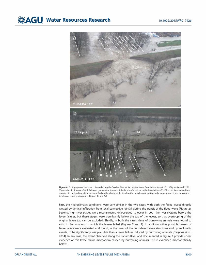
Figure 4. Photographs of the breach formed along the Secchia River at San Matteo taken from helicopters at 10:11 (Figure 4a) and 12:22(Figure 4b) of 19 January 2014. Relevant geometrical features of the land surface close to the breach (trees T1–T9 in the riverbed and treerows A–L in the landside plain) are identified on the photographs to allow the breach configuration to be georeferenced and transferredto relevant aerial photographs (Figures 5b and 5c).
Water Resources Research 10.1002/2015WR017426
ORLANDINI ET AL. AN EMERGING LEVEE FAILURE MECHANISM 8000

10:11
10:1112:22
12:22
T9
T7
T5
T4
T3
T2
T1I
HG
E
C
A
L
0 10 20 m
T8
T6
B
DF
10:11
B2
a
10:11
10:11
12:22
12:22
T9
T7
T5
T4
T3
T2
T1I
HG
E
C
A
L
0 10 20 m
T8
T6
B
DF
10:11
B2
B3
B4
B1
b
mm400 20
A
B
C
D
c
Figure 5. Evidence of burrowing animals in the location of the Secchia River levee that failed on 19 January 2014. Long parallel lines mark thetop and landside bottom boundaries of the levee. Figure 5a shows animal burrows appearing in the 10 cm resolution aerial photography takenon 27 March 2010. Figure 5b indicates that on 29 March 2012, animal burrows were further developed. Figure 5c shows the footprint of a wildanimal (probably a badger or a crested porcupine) observed on 24 February 2014, along the repaired levee. The burrowing animals that haveimpacted the levees of the Secchia River include those shown in the insets of Figure 5c: (a) crested porcupine Hystrix cristata (Linnaeus, 1758),(b) European badger Meles meles (Linnaeus, 1758), (c) red fox Vulpes vulpes (Linnaeus, 1758), and (d) nutria Myocastor coypus (Molina, 1758).
Water Resources Research 10.1002/2015WR017426
ORLANDINI ET AL. AN EMERGING LEVEE FAILURE MECHANISM 8001

4. Possible Triggers
The justification for attributing the Secchia levee failure to the same mechanism as that observed on the Panarolevee include (1) direct rainfall on the levee surface, (2) river stage, and (3) biological disturbance of the levee.These factors are combined by advancing the three competing hypotheses for failure triggers.
Distance, m
Ele
vatio
n, m
asl B1 (36.3) B2 (37.1)
B3 (34.8)B4 (35.1)
35.70 m asl at 4:20
0 5 10 15 20 25 30 35 40 45 5025
30
35
40
Figure 6. Geometrical relationship between the elevations of burrows B1, B2, B3, and B4 observed (in 2010 and 2012) in aerial photographs(Figures 5a and 5b) of the Secchia River at San Matteo and the river stage reconstructed from hydraulic modeling for the same levee locationon 19 January 2014 at 4:20 (Figure 3). Direct river inflow into the den system can be considered possible if an uncertainty of 0.3 m in thedetermination of both burrow elevations (uncertainty bars) and river stages (light blue band) is acknowledged (hypothesis 1 and section 4.1).
A
a
01−19−2014 16:01
01−19−2014 19:48
b 1
2
Figure 7. Observational evidence of the levee failure mechanism occurred along the Panaro River at Via Tronco (Figure 1) on 19 January2014, under hydroclimatic conditions similar to those occurred along the Secchia River at San Matteo (Figure 2). An internal erosion pro-cess was observed at 16:01 as documented in Figure 7a. This internal flow process developed around a crested porcupine den that wasobserved and filled with earth in the past. The collapse of the levee top over the gallery formed by internal erosion was documented at19:48 as reported in Figure 7b. The picture reported in Figure 7b was taken from the top of the levee close to the collapsed portion high-lighted by the arrow directed downward. The failure mechanism consisted therefore of two stages. In stage 1 (Figure 7a and sketchlabeled ‘‘1’’ in Figure 7b), the internal erosion develops around the animal den. In stage 2 (Figure 7b and sketch labeled ‘‘2’’ in Figure 7b),the levee top collapses by filling the gallery in the eroded levee and by exposing the collapsed material to further erosion and overtop-ping. The collapsed levee was rapidly repaired, preventing a second disaster.
Water Resources Research 10.1002/2015WR017426
ORLANDINI ET AL. AN EMERGING LEVEE FAILURE MECHANISM 8002

4.1. Hypothesis 1: Pipe FlowOnlyThe first hypothesis explored inthe present investigation is thatof direct inflow into the den sys-tem as simply due to river stageraising. From image processingand terrain analysis, it was foundthat the elevation of the animalburrow B1 located on the leveeriverside was at about 36.3 mabove sea level (asl), whereas theelevations of the animal burrowsB2, B3, and B4 located on thelevee landside were in the rangefrom 34.8 to 37.1 m asl (Figure 6).From river flow modeling, it wasfound that river stages on 19January 2014 did not reach theburrow elevation observed (in2012) on the levee riverside, butthey significantly overcome theburrow elevations observed (in2012) on the levee landside (Fig-ure 3b). However, by simplyacknowledging uncertainties onthe order of 0.30 m on bothreconstructed burrow elevationsand river stages, it may be con-cluded that even by consideringthe positions of the animal bur-rows observed in 2012, the riverflow may have reached the bur-
row located on the riverside of the levee (36.3 6 0.3 m asl) at 4:20, when the river stage was estimated to be35.70 6 0.30 m asl (Figures 3b and 6). Since it can be clearly observed that the system of dens developed sig-nificantly from 2010 (Figure 5a) to 2012 (Figure 5b), and burrowing animals like badgers or crested porcupineswere still living along the repaired levee in 2014 (Figure 5c), it is likely that the den system was more devel-oped at the time of the levee failure than shown in the photograph taken in 2012 (Figure 5b). This would fur-ther support the triggering of internal flow and erosion processes by direct river inflow into the riversideentrance of the den system.
4.2. Hypothesis 2: Pipe Flow Following the Collapse of the Riverside Den EntranceThe second hypothesis explored in the present investigation is the collapse of the riverside den entranceunder the effects of direct rainfall on the levee surface and simultaneous river stage raising. The instabilityof the riverside slope of the disturbed levee would provide an explanation for the triggering of internal flowand erosion. The investigated system is sketched in Figure 8. Unsteady seepage flows in the variably satu-rated, disturbed levee system are reconstructed by solving the 3-D Richards equation (section A3). Initialconditions of soil saturation were assigned on 22 December 2013, at 0:00, in order to mitigate the memoryeffects on the reconstructed seepage flow and soil matric potential at the time of the levee failure. Bound-ary conditions were assigned to each surface node of the levee and den systems by switching automaticallyfrom Neumann-type (assigned flux) to Dirichlet-type (assigned potential) conditions to represent the hydro-climatic forcing composed of direct rainfall on the levee surface (Figure 2b) and river stage wetting thelevee riverside (Figure 3b) [Camporese et al., 2010]. Surface runoff generation over the levee and
i
TiTi
Wi
den tunnel
iNi N
O
O
O
adirect rainfall on the levee
b
W
stability analysis of an
undisturbed levee segment
stability analysis of a
levee segment disturbed
by an animal burrow
c
Figure 8. Sketch of the slope stability analysis performed to assess the impact of animalburrows on equilibrium conditions (hypothesis 2 and section 4.2). The bold line in Figure8a indicates the levee portion on which the analysis focuses. The equilibrium of green seg-ments shown in Figures 8b and 8c is evaluated: O is the center of the circular sliding sur-face, Wi is the weight of the ith element composing the sliding segment, Ti and Ni are theshear and normal components of Wi to the sliding surface. The blue vertical arrows indi-cate the direct rainfall on the levee. The blue horizontal line indicates the river stage. Thetwo cases in which the animal burrow is not present (Figure 8b) or is present (Figure 8c)are considered.
Water Resources Research 10.1002/2015WR017426
ORLANDINI ET AL. AN EMERGING LEVEE FAILURE MECHANISM 8003

evaporation from the levee were both assumed to be insignificant during the considered events. Underthese assumptions, conservative representations of infiltrated rainfall and soil saturation are obtained.
A Fellenius slope stability analysis was then performed by varying the center of the circular sliding surfaceand considering all the forces acting on the variably saturated sliding soil segment (section A4). It is impor-tant to note that this was a simplified 2-D stability analysis, and as such the results should be both meaning-ful for evaluating hypothesis 2 and on the conservative side. The results are reported in Figure 9. A first setof numerical experiments reveals that no instabilities occur by considering a realistic configuration of thetunnel extending from the riverside den entrance into the levee (Figures 9a–9c). No red lines indicating crit-ical sliding surfaces are shown in Figures 9d–9f. The (unknown) internal tunnel geometry is varied in thesecond set of numerical experiments until red lines indicating critical sliding surfaces came out (Figures 9g–9i). These critical geometrical settings are, however, found to be unrealistic because they produce levee fail-ures also in times when no failures were observed to occur (Figures 9j–9l).
4.3. Hypothesis 3: Pipe Flow Following the Collapse of a Den Chamber WallThe third hypothesis explored in the present investigation is that a den system similar to the one sketchedin Figure 10 was present at the time of the levee failure [Roper, 1992a,1992b]. A hypothetical 1 m earthenwall separating the levee riverside from an internal den chamber was assumed to exist. This is a realistichypothesis given the development of the den system observed in aerial photographs from 2010 to 2012
Figure 9. Simulated response of the levee of the Secchia River at San Matteo to direct rainfall on the levee (Figure 2b) and river stage (Figure 3b) in the case sketched in Figure 8(hypothesis 2). Two possible hypothetical configurations for the tunnel extending from the riverside animal burrow into the levee are reported in Figures 9a–9f and 9g–9l, respectively.The simulation period started at time 22 December 2013 at 0:00 to mitigate the memory effects on the reconstructed levee status. The reconstructed fields of volumetric soil water con-tent are reported at times 18 January 2014 at 22:00 (Figures 9a, 9d, 9g, and 9j), 19 January 2014 at 0:30 (Figures 9b, 9e, 9h, and 9k), and 19 January 2014 at 4:00 (Figures 9c, 9f, 9i, and 9l).The term ‘‘saturation’’ reported in the legend of Figure 9a is used in the FEFLOW program to denote the volumetric soil water content. The white line in Figures 9a–9c and 11g–11idenotes the phreatic (zero pressure) surface.
Water Resources Research 10.1002/2015WR017426
ORLANDINI ET AL. AN EMERGING LEVEE FAILURE MECHANISM 8004

(Figures 5a and 5b, respectively) andthe reconstructed elevations of theburrows on riverside and landside ofthe failed levee (Figure 6). In addition,since burrowing animals typically exca-vate in soils that are easy to dig [Vleck,1979; Roper, 1992b], a weak soil portionis assumed to exist around the denentrance as sketched in Figure 10 (sec-tion A5).
Unsteady seepage flows in the variablysaturated, disturbed levee system arereconstructed by solving the 3-D Rich-ards equation under the effects of directrainfall on the levee surface (Figure 2b)and river stage (Figure 3b) (section A3).Results are reported in Figure 11. It wasfound that the volumetric soil watercontent (Figures 11a–11c) and water
pressure (Figures 11d–11f) become critical at 4:00 of the day 19 January 2014 (Figures 11c and 11f), and thatthese critical conditions do not occur in other times of the simulation period (December 2013 and January2014) as should be expected (e.g., Figures 11a–11c and 11f). At 4:00 of 19 January 2014, the ceiling of thechamber became saturated and the soil water pressure became positive. This occurrence would have likelyimplied the collapse of the den system and the triggering of internal flow and erosion, even with the eleva-tions of animal burrows observed in 2012 (section A5).
It is remarked that the geometry of the considered den system is hypothetical. However, the resultsreported in Figure 11 provide a reliable proof-of-concept about the processes that may have triggered inter-nal flow and erosion along the Secchia River on 19 January 2014, because critical conditions are only repro-duced at the day of the observed failure and not in other days of the simulation period. It is finally reportedthat numerical modeling of the system considered in the present section (hypothesis 3) reveals that no criti-cal soil saturation around the den chamber occurs by applying separately one of the two components ofthe observed hydroclimatic forcing, namely river stage and direct rainfall on the levee (see supporting
den tunnelden chamber
weak soil portiondirect rainfall on the levee
a
b
Figure 10. Sketch of the den system hypothesized to explore the possible trig-gers of internal flow and erosion processes occurred on 19 January 2014, alongthe Secchia River at San Matteo (hypothesis 3 and section 4.3). Plan and profileviews are reported in Figures 10a and 10b, respectively. The bold line in Figure10a indicates the levee portion on which the analysis focuses. The red circularsegment indicates the portion of weak soil centered around the den entrance.The blue vertical arrows indicate the direct rainfall on the levee. The blue horizon-tal line indicates the river stage.
Figure 11. Simulated response of the levee of the Secchia River at San Matteo to direct rainfall on the levee (Figure 2b) and river stage (Figure 3b) in the case sketched in Figure 10(hypothesis 3). The simulation period started at time 22 December 2013 at 0:00 to mitigate memory effects on the reconstructed levee status. The reconstructed fields of volumetric soilwater content and pressure are reported at times 18 January 2014 at 22:00 (Figures 11a and 11d), 19 January 2014 at 0:30 (Figures 11b and 11e), and 19 January 2014 at 4:00 (Figures11c and 11f). The term ‘‘saturation’’ reported in the legend of Figure 11a is used in the FEFLOW program to denote the volumetric soil water content. The white line denotes the phreatic(zero pressure) surface.
Water Resources Research 10.1002/2015WR017426
ORLANDINI ET AL. AN EMERGING LEVEE FAILURE MECHANISM 8005

information, Figures S1 and S2). This suggests that the combination of the two factors may indeed providea critical hydroclimatic condition.
5. Discussion
The reconstructed flood hydrographs that have forced the levee of the Secchia River at San Matteo inDecember 2013 and January 2014 were found to be smaller in terms of peak river stage and duration ofhigh river stages than other recent flood hydrographs (e.g., the 2009 hydrograph reported in Figure 3b).The causes of the levee failure on the Secchia River at San Matteo were, therefore, sought by consideringother factors that could have induced a variation in the hydroclimatic forcing or a disturbance of thelevee. As shown in Figure 2, direct convective rainfall on the levees of the Secchia River at San Matteo(Figure 2b) and the Panaro River at Via Tronco (Figure 2c) occurred before the failures of these levees. Thesimultaneous occurrence of high river stages and intense direct rainfall on the levees is atypical forthe considered geographical area and season. Flood events normally form in the mountain portions ofthe Secchia and Panaro River drainage basins in response to intense stratiform precipitations occurringgenerally in fall or in spring, or to rapid snowmelt events occurring in winter. Flood waves propagatealong the low-gradient portion of these drainage basins by displaying a lag of about 12 h from the cent-roids of the generating hyetographs. Normally, neither local stratiform rainfall nor convective storms affectdirectly the levees during the lagged transit of the flood waves in the low-gradient portions of the fluvialsystems. In addition, the aerial photographs reported in Figure 5 indicate clearly that a den system wasrapidly developing from 2010 (Figure 5a) to 2012 (Figure 5b), and was likely to be even more developedin 2014 due to the activity of burrowing animals (Figure 5c). The combination of an atypical hydroclimaticforcing composed of simultaneous high river stages and direct rainfall on the levees, with a disturbanceof the levee system produced by burrowing animals was investigated in the present study. Since the con-ditions of the animal dens at the time of the levee failure are unknown, the analysis reported in the pres-ent study was based on the levee condition observed in 2012 and hypothetical geometries of dentunnels and chambers (Figures 5b, 9, and 11).
By considering that burrowing animals were disturbing both the levees of the Secchia River at San Matteo(Figure 5b) and the Panaro River at Via Tronco (Figure 7) and that the hydroclimatic forcing to the two leveesystems was similar (Figures 2b and 2c), the levee failure mechanism observed along the Panaro River at ViaTronco (Figure 7) can realistically be inferred to be similar to the levee failure mechanism occurred alongthe Secchia River at San Matteo (Figures 1 and 4). The event observed along the Panaro River (Figure 7) pro-vides scientists and engineers with an extraordinary evidence of the levee failure mechanism that mayoccur in earthen levees disturbed by borrowing animals. The documentation of this event was made possi-ble by the exceptionally large number of watchers employed along the Secchia and Panaro Rivers after thedisastrous levee failure occurred in the morning of 19 January 2014 (Figure 1). In addition, the operationalability of the technical staff of the responsible agency and the Civil Protection has allowed watchers to bedirected towards the sites where animal dens were observed in the past and filled with earth. The evidencepresented in Figure 7 would have hardly been collected if a severe hydroclimatic forcing would not havecaused a disaster along the Secchia River and similar conditions along the Panaro Rivers a few hours later.Clearly, the event observed along the Panaro River (Figure 7) provides further support to the belief that theintegrity of earthen levees cannot be simply ensured by filling periodically observed animal dens with earth[Bayoumi and Meguid, 2011].
Levees disturbed by crested porcupines, badgers, and red foxes were repaired in the past (before thedisaster occurred on 19 January 2014), along the Secchia and Panaro Rivers, by filling the detecteddens with earth. In some cases, the earthen levees around the detected dens were demolished andrebuilt with an excavator, and the soil was compacted. However, for dens extending along tunnels hav-ing lengths as large as 10 m or more, the repair may not have been performed over the full extent ofthe tunnel system. This is because the excavation associated with a complete levee repair would inpractice expose, although temporarily, the protected lands to a risk level comparable to or larger thanthe one associated with keeping the levees in their disturbed condition, especially in the periods whenfloods are more likely to occur. In addition, burrowing animals were often observed to re-excavate theirdens in the same locations where the levees were repaired, despite the presence of protective metallic
Water Resources Research 10.1002/2015WR017426
ORLANDINI ET AL. AN EMERGING LEVEE FAILURE MECHANISM 8006

nets applied locally around the repairs. In some cases, new dens were excavated close to the repairedportions of the earthen levees. In fact, recent geophysical surveys carried out (after the disasteroccurred on 19 January 2014) by using (1) electrical resistivity tomography, (2) frequency domain elec-tromagnetic induction, (3) ground penetrating radar, and (4) infrared imaging have revealed the pres-ence of levee segments that are still disturbed, despite previous repair efforts (F. Pellegrini, personalcommunication, 2015).
Burrowing animals like crested porcupines and badgers can dig a den in a few days, and introducetherefore a significant source of risk in low-gradient areas protected against floods by earthen dams andlevees. Since effective detection and corresponding correction of these animal-induced internal erosionchannels during the flood event is very challenging, prevention plans remain the most suitable protec-tive measure. An interdisciplinary effort is needed to cope with complex meteorological, hydrological,geotechnical problems induced by time-dependent biological disturbances impacting engineering sys-tems. To promote this interdisciplinary effort, it is first important to acknowledge that the problemaddressed in this investigation is an emergent one. Field inspections conducted along the Secchia andPanaro Rivers after the events of 19 January 2014, revealed that burrowing animals like crested porcu-pines are now widespread along these fluvial systems. For instance, at least 30 dens actively frequentedby crested porcupines were found immediately after the events of 19 January 2014, along a 45 kmreach of the Panaro River extending downstream from Sant’Ambrogio to Finale Emilia (Figure 1). Theseanimals (an invasive species from the South) have never been observed along the low-gradient courseof the Panaro River before 2010, and were not even present in the mountain part of the Panaro Riverdrainage basin before 1970. Shifts could have been driven by population growth (due to the decreaseof competitors, hunters, and poachers), as well as development and climate pressures [Monetti et al.,2005].
Second, it is important to acknowledge all the biological factors explaining the activity of burrowing animalsin low-gradient areas protected by earthen dams and levees. For instance, it may be relevant to considerthat burrowing animals like to dig where there is a steep slope, such as on the side of a hill, or in a bank.Water drains away better on a slope, and this means that the den stays dry. Roughly 90% of badger settsare in areas of sloping ground [Neal, 1977; Roper, 1992b; Clements et al., 1988; Thornton, 1988]. In this per-spective, earthen dams and levees may represent quiet, sought-after places for burrowing animals shiftedfrom mountain to plain areas. As also mentioned in section 4.3, given that digging is a costly activity, densare typically excavated in soils that are easy to dig [Vleck, 1979; Roper, 1992b]. Hence, the weakest sites thatcan be found along an earthen structure represent the best places for a burrowing animal where to exca-vate a den. Therefore, effective monitoring of animal burrows disturbing earthen dams and levees can helpdetecting the weakest portions of the structures that need to be reinforced and certainly not to be leftexposed to further weakening induced by burrowing animals.
Since the triggers of the levee failures occurred along the Secchia (Figures 1–5) and Panaro (Figure 7) Riv-ers were not observed, three hypotheses for these triggers were explored in the present investigation byevaluating the compatibility of assumptions with observed data. The hypothesis that internal flow anderosion were simply triggered when the river stage has reached the animal burrow located on the river-side (hypothesis 1) can be considered consistent with the reconstructed elevations of the animal burrowsobserved in 2012 (Figure 6) and of the river stage on 19 January 2014 at 4:20 (Figures 3b and 6) if uncer-tainties on the order of 0.3 m of both burrow elevation and river stage are acknowledged (Figure 6). Inaddition, riverside animal burrows at lower elevations than the one observed in 2012 were possible in2014, just before the levee failure, and compatible with the observed evolution of the den system (Figures5a and 5b). While the hypothesis of slope instability around the animal burrow observed (in 2012) on theriverside of the levee (hypothesis 2) was not supported by numerical experiments (Figure 9), the existenceof a den chamber separated from the riverside of the levee by a 1 m earthen wall (hypothesis 3) wasfound to provide a plausible explanation of the failure occurred during the night of 19 January 2014, atabout 4:00, and not in other previous circumstances (Figure 11). All the triggering conditions compatiblewith observed data were found to occur between 4:00 and 4:20 of 19 January 2014, indicating that amore rapid internal flow and erosion process occurred in the Secchia River (about 2 h between the yellowand red bands in Figure 2b) than in the Panaro River (about 4 h between the yellow and red bands inFigure 2c).
Water Resources Research 10.1002/2015WR017426
ORLANDINI ET AL. AN EMERGING LEVEE FAILURE MECHANISM 8007
6. Conclusions
The present investigation revealed the role played by burrowing animals in the disastrous levee failureoccurred along the Secchia River at San Matteo on 19 January 2014 (Figures 1–6), and thus raises thedistinct possibility that other disastrous levee failures in Italy may have been connected to the activityof burrowing animals [e.g., Camici et al., 2015]. Evidence collected suggested that it is quite likely thatthe levee failure of the Secchia River was of a similar mechanism as the observed failure of the PanaroRiver (Figure 7). Detailed numerical modeling of rainfall, river flow, and variably saturated flow occurringin disturbed levees in response to complex hydroclimatic forcing indicated that the levee failure of theSecchia River may have been triggered by direct river inflow into the den system or collapse of a hypo-thetical den separated by a 1 m earthen wall from the levee riverside, which saturated during thehydroclimatic event (Figures 6 and 11, respectively). The plausible scenarios obtained from detailedmodeling suggested that the levee failure of the Secchia River was more rapid than the one observedin the Panaro River (Figures 2, 6, and 11).
The investigation reported in the present paper informs flood risk analysis as classically conceived byhydrologists and geotechnical engineers, but it also points to future interdisciplinary considerations suchas: (1) the meteorological conditions needed significant rains on the levee surfaces at a time delay from theheadwater rainfall that is comparable to the river flood wave travel time, (2) the hydrological analysisinvolves river flows, variably saturated infiltration, and pipe erosions, (3) the geotechnical stability analysisinvolves complex 3-D domains, and (4) the animal activity may increase with shifts and fragmentation ofhabitats of both native and invasive species. Especially in the shorter term, geophysical survey methods areuseful tools for determining the extent and degree of damage caused by burrowing animals to earthendams and levees, as well as for evaluating the effectiveness of structural repairs. In a broader perspective, itis important to bring the processes highlighted in this paper to the attention of hydrologists and geotechni-cal engineers as well as to trigger an interdisciplinary discussion on habitat fragmentation and shifts due todevelopment and climate pressures. These all come together with changes in extreme events to inform thebroader concern of risk analysis due to floods.
Appendix A: Methods
A1. River Flow ModelingThe flood waves from December 2013 and January 2014 along the Secchia River were reconstructed bydeveloping a level pool routing model [Fiorentini and Orlandini, 2013] of the Rubiera flood control reservoirand a dynamic wave model (full De-Saint Venant equations) [Brunner, 2010] of the river reach extendingdownstream from the Rubiera reservoir to Pioppa (Figure 1). The characteristic ‘‘water level-storage’’ and‘‘storage-outflow discharge’’ relationships of the Rubiera reservoir were determined from the 1 m resolutionDEM and the known geometry of both gated bottom outlets and spillways [Fiorentini and Orlandini, 2013].The hydraulic geometry of the river reach was described by combining bathymetric topographic surveysand a 1 m resolution DEM generated from a lidar survey carried out in 2009. Friction slopes Sf are estimatedthrough the Gauckler-Manning-Strickler constitutive equation U5kS R2=3 S1=2
f , where U is the mean flowvelocity, kS is the Gauckler-Strickler coefficient, and R is the hydraulic radius. Coefficients kS were allowed tovary in space and time [Orlandini, 2002], so that the obtained parameterization is compatible with theexperimental flow rating curves at the stations of Ponte Alto, Ponte Bacchello, and Pioppa (Figure 1). Theconsidered values of kS were in the range 10–16 m1=3 s21. The breach formed on 19 January 2014, at SanMatteo was described explicitly in the dynamic wave model by synthesizing the observations collected dur-ing the event (Figures 1 and 4). The breach length varied from 0 to 80 m during the event. The flood hydro-graph observed at the station of Rubiera was used to provide a Neumann-type (assigned flow discharge)upstream boundary condition for the fluvial system, and the river stages observed at the station of Pioppawere used to provide a Dirichlet-type (assigned river stage) downstream boundary condition. The reliabilityof the developed river flow model was tested against available observations of the river stage (Rubiera floodcontrol reservoir, Ponte Alto, and Ponte Bacchello stations reported in Figure 1) and water level marks lefton trees located near the breach. The reconstructed flow discharges and river stages at the cross section ofthe failed levee are reported in Figures 3a and 3b, respectively. The uncertainty in the reconstructed riverstages is on the order of 0.3 m.
Water Resources Research 10.1002/2015WR017426
ORLANDINI ET AL. AN EMERGING LEVEE FAILURE MECHANISM 8008

A2. Image Processing and Terrain AnalysisA metric analysis of the photographs of the breach taken on 19 January 2014, at 10:11 and 12:22 (Figure 4),and of the aerial photographs taken in 2010 and 2012 (Figures 5a and 5b, respectively) was performed byusing the program Blom Desktop Viewer developed by Blom CGR SpA. The positions of relevant geometri-cal features of the land surface that can be found in Figures 4, 5a, and 5b, such as the trees T1–T9 in the riv-erbed and tree rows A–L in the landside plain, were determined and used as a reference to determine thepositions of the observed breach limits. The obtained results are reported in Figures 5a and 5b. In addition,a 1 m DEM generated from a lidar survey was used to determine the geometry of the failed levee and theelevations of the animal burrows observed in the most recent aerial photograph, so that these animal bur-rows could be positioned along the profile of the failed levee. The obtained results are reported in Figure 6.The uncertainty in the reconstructed burrow elevations is on the order of 0.3 m.
A3. Seepage Flow ModelingSeepage fluxes, soil moisture status, and related soil matric potential that occurred in the (disturbed)earthen levees in response to the reconstructed hydroclimatic forcing were determined by solving the 3-DRichards equation through the FEFLOW model [Diersch, 2014]. The computational soil domain was definedby considering the land surface profile described by the 1 m resolution DEM generated from a lidar survey,a planar extension along the river cross section of about 330 m, and a soil thickness of about 30 m. A por-tion of this domain is shown in Figure 6. The hydraulic properties of the soil were determined experimen-tally from undisturbed soil samples collected after the flood disaster in a levee cross section locatedimmediately downstream from the site of the levee failure [Romano and Santini, 1999]. The constitutiveequation relating volumetric soil water content h and soil matric potential w (w5p=c, where p is the soilwater pressure and c is the specific weight of water) was given by the van Genuchten equationH5f1=½11ðajwjÞn�gm, where H5ðh2hrÞ=ðhs2hrÞ, hr50:079, hs50:404, n 5 1.495, m5121=n50:331. Theconstitutive equation relating the (unsaturated) hydraulic conductivity K to the volumetric soil water con-tent h was given by the Mualem model as K5Ks Kr , where Ks51:88 3 1026 m s21, andKr5H1=2f12½12H1=m�mg2. The hydroclimatic forcing was determined from rainfall and river flow modelingas reported in Figures 2b and 3b, respectively (section A1). Boundary conditions assigned to the land sur-face can switch automatically from Neumann-type (assigned flux) conditions, representing a levee bound-ary affected by direct rainfall on the levee surface, to Dirichlet-type (assigned potential) conditions,representing a levee boundary wetted by river flow [Camporese et al., 2010]. A no-flux boundary conditionis assigned to the bottom of the domain, whereas a Dirichlet-type (assigned potential) was assigned to thelateral boundaries (far from the levee) to represent a water table depth of about 2 m.
A4. Slope Stability AnalysisThe stability of the riverside slope of the disturbed levee under the reconstructed hydroclimatic conditionswas assessed by applying the Fellenius method [Fellenius, 1927] to the hypothetical system sketched in Fig-ure 8. The hypothetical tunnel geometries considered are compatible with reconstructed animal burrows(section A2) and data describing badger setts in the literature [Roper, 1992a,1992b]. The hydroclimatic forc-ing was determined from rainfall and river flow modeling as reported in Figures 2b and 3b, respectively(section A1). Soil saturation and soil matric potential were determined by solving the 3-D Richards equationthrough the FEFLOW model [Diersch, 2014] (section A3). The center of the circular segment subjected to sta-bility analysis was varied numerically to consider all the possible geometries of the potentially unstable (dis-turbed) levee portions. The weight of the elements composing the segment were computed by consideringthe porous medium and the water (partially) filling the voids in response to variable infiltrated rainfall andriver stage as obtained from detailed seepage flow modeling. In the performed analysis, the effective cohe-sion was assumed to be c050, the effective angle of internal friction was assumed to be /0532
�, and the
unit weight in saturated state was assumed to be csat519; 000 N m23.
A5. Wall Stability AnalysisThe stability of a hypothetical earthen wall separating the riverside of the levee from a hypothetical denchamber located inside the levee was assessed by considering the disturbed levee sketched in Figure 10.The hypothetical tunnel and chamber geometries are compatible with the reconstructed animal burrows(section A2) and data describing badger setts in the literature [Roper, 1992a,1992b]. The hydroclimatic forc-ing was determined from rainfall and river flow modeling as reported in Figures 2b and 3b, respectively
Water Resources Research 10.1002/2015WR017426
ORLANDINI ET AL. AN EMERGING LEVEE FAILURE MECHANISM 8009

(section A1). Soil saturation and soil matric potential were determined by solving the 3-D Richards equationthrough the FEFLOW model [Diersch, 2014] (section A3). The saturated hydraulic conductivity of the weaksoil portion around the den entrance sketched in Figure 10 was assumed to be Ks511:1031026 m s21, avalue on the order of magnitude of the largest values observed in the undisturbed soil samples mentionedin section A3. The collapse of the hypothetical den is assumed to occur when the ceiling of the denbecomes fully saturated (h5hs) and both soil matric potential (w) and soil water pressure (p) become greaterthan or equal to zero. The related loss of soil matric suction is related directly to a critical decrease in theshear strength of the soil.
In geotechnical terms, the collapsing behavior of the granular soils around the den system can be describedby using the principle of effective stress for unsaturated soils [e.g., Fredlund and Rahardjo, 1993; Lu andLikos, 2004; Lu et al., 2014]. Bishop’s [1959] effective stress for unsaturated soils can be expressed asr05ðr2uaÞ1vðua2uwÞ, where r is the total stress, ua is the pore air pressure, ðr2uaÞ is the net normalstress, v is the effective stress parameter, uw is the pore water pressure, ðua2uwÞ is the matric suction, and vðua2uwÞ is the suction stress. The pore water pressure uw is the same quantity as the soil water pressure pintroduced in section A3. The parameter v is often set equal to the degree of saturation H introduced insection A3. In any case, v is imposed to vary from 0 for dry soils to 1 for saturated soils, enabling a simpletransition from partially to fully saturated states, and recovering Terzaghi’s [1923, 1936] expression r05r2
uw for the saturated case. The granular soil with little or no classical effective cohesion (i.e., c0 � 0Þ placedaround the den chamber reaches a critical condition for stability at saturation because the suction stressand the related capillary cohesion (i.e., c005vf ðua2uwÞf tan /0, where vf ðua2uwÞf is the maximum suctionstress at failure and /0 is the effective angle of internal friction) drop to zero [e.g., Lu and Likos, 2004, p. 253].In the saturated soil placed around the den chamber, where r2ua � 0 and vðua2uwÞ � 0, the effectivestress reduces essentially to zero. The related complete loss of shear strength causes soil liquefaction and,especially for a weak soil (in the sense specified in section 4.3) under seepage, progressive collapse of thesaturated wall separating the levee riverside from the internal den chamber.
ReferencesBayoumi, A., and M. A. Meguid (2011), Wildlife and safety of earthen structures: A review, J. Fail Anal. Preven., 11(4), 295–319, doi:10.1007/
s11668-011-9439-y.Bennett, A. F. (1999), Linkages in the Landscape: The Role of Corridors and Connectivity in Wildlife Conservation, 254 pp., Int. Union for Con-
serv. of Nat., Gland, Switzerland.Bishop, A. W. (1959), The principle of effective stress, Tek. Ukebl., 106(39), 859–863.Brunner, G. W. (2010), HEC-RAS: River analysis system, in Hydraulic Reference Manual, U.S. Army Corps of Eng., Hydrol. Eng. Cent., Davis,
Calif.Camici, S., S. Barbetta, and T. Moramarco (2015), Levee body vulnerability to seepage: The case study of the levee failure along the Foenna
stream on 1 January 2006 (central Italy), J. Flood Risk Manage., doi:10.1111/jfr3.12137.Camporese, M., C. Paniconi, M. Putti, and S. Orlandini (2010), Surface-subsurface flow modeling with path-based runoff routing, boundary
condition-based coupling, and assimilation of multisource observation data, Water Resour. Res., 46, W02512, doi:10.1029/2008WR007536.
Carroll, P. H. (1949), Soil piping in southeastern Arizona, in Regional Bulletin, Soil Ser., vol. 110, U.S. Dep. of Agric., Soil Conserv. Serv.,Albuquerque, N. M.
Chlaib, H. K., H. Mahdi, H. Al-Shukri, M. M. Su, A. Catakli, and N. Abd (2014), Using ground penetrating radar in levee assessment to detectsmall scale animal burrows, J. Appl. Geophys., 103, 121–131.
Clements, E. D., E. G. Neal, and D. W. Yalden (1988), The national badger sett survey, Mammal Rev., 18, 1–9.D’Alpaos, L., A. Brath, V. Fioravante, G. Gottardi, P. Mignosa, and S. Orlandini (2014), Causes of the levee failure occurred on the Secchia
River at San Matteo on January 19, 2014 (In Italian), final report, Reg. Emilia-Romagna Comm., Bologna, Italy.Diersch, H.-J. G. (2014), FEFLOW: Finite Element Modeling of Flow, Mass and Heat Transport in Porous and Fractured Media, 996 pp., Springer,
Berlin.Federal Emergency Management Agency (2005), Technical manual for dam owners: Impacts of animals on earthen dams, FEMA Rep. 473,
Washington, D. C.Fellenius, W. K. A. (1927), Erdstatische Berechnungen mit Reibung und Koh€asion (Adh€asion) und unter Annahme kreiszylindrischer
Gleitfl€achen, 48 pp., W. Ernst & Sohn, Berlin.Fiorentini, M., and S. Orlandini (2013), Robust numerical solution of the reservoir routing equation, Adv. Water Resour., 59(9), 123–132, doi:
10.1016/j.advwatres.2013.05.013.Fredlund, D. G., and H. Rahardjo (1993), Soil Mechanics for Unsaturated Soils, 544 pp., John Wiley, N. Y.Lu, N., and W. J. Likos (2004), Unsaturated Soil Mechanics, 584 pp., John Wiley, N. Y.Lu, N., N. Khalili, E. Nikooee, and S. M. Hassanizadeh (2014), Principle of effective stress in variably saturated porous media, Vadose Zone J.,
13(5), 1–4, doi:10.2136/vzj2014.04.0038.Masannat, Y. M. (1980), Development of piping erosion conditions in the Benson area, Arizona, U.S.A., Q. J. Eng. Geol., 13(1), 53–61.McEuen, A. (1993), The wildlife corridor controversy: A review, Endanger. Species Update, 10(11), 1–6.Monetti, L., A. Massolo, A. Sforzi, and S. Lovari (2005), Site selection and fidelity by crested porcupines for denning, Am. Midl. Nat., 17(2),
149–159.
AcknowledgmentsThis work was partially supported byItalian Ministry of Education,University, and Research through thePRIN 2010–2011 Program grant2010JHF437. The authors thank LucaLombroso, Marcello Fiorentini,Eleonora Bertacchini, and CristinaCastagnetti (Universit�a degli Studi diModena e Reggio Emilia, Modena,Italy) for the support provided inspecific step of the research activitydescribed in the present paper.Hydroclimatic data were provided by‘‘ARPA Servizio Idro-meteo-clima’’ ofthe ‘‘Regione Emilia-Romagna’’(Bologna, Italy). Aerial photographsand the software for their metricanalysis were provided by Blom CGRSpA (Parma, Italy). Hydraulic propertiesof soil were experimentallydetermined by Nunzio Romano(Universit�a degli Studi di NapoliFederico II, Napoli, Italy). The data inour article can be provided uponrequest to Stefano Orlandini ([email protected]) or GiovanniMoretti ([email protected]).The authors are grateful to theAssociate Editor and two anonymousreviewers for comments that led toimprovements in the manuscript.
Water Resources Research 10.1002/2015WR017426
ORLANDINI ET AL. AN EMERGING LEVEE FAILURE MECHANISM 8010
Neal, E. (1977), Badgers, 330 pp., Blandford Press, Dorset, U. K.Orlandini, S. (2002), On the spatial variation of resistance to flow in upland channel networks, Water Resour. Res., 38(10), 1197, doi:10.1029/
2001WR001187.Orlandini, S., and I. Morlini (2000), Artificial neural network estimation of rainfall intensity from radar observations, J. Geophys. Res.,
105(D20), 24,849–24,861.Perri, M. T., J. Boaga, S. Bersan, G. Cassiani, S. Cola, R. Deiana, P. Simonini, and S. Patti (2014), River embankment characterization: The joint
use of geophysical and geotechnical techniques, J. Appl. Geophys., 110, 5–22.Resio, D., S. Boc, D. Ward, A. Kleinman, and J. Fowler (2011), U.S. Army Engineer Research and Development Center: Rapid repair of levee
breaches, SERRI Rep. 81000-01, Oak Ridge Natl. Lab., Oak Ridge, Tenn.Reynolds, T. D., and W. L. Wakkinen (1987), Characteristics of the burrows of four species of rodents in undisturbed soils in southeastern
Idaho, Am. Midl. Nat., 118(2), 245–250.Romano, N., and A. Santini (1999), Determining soil hydraulic functions from evaporation experiments by a parameter estimation
approach: Experimental verifications and numerical studies, Water Resour. Res., 35(11), 3343–3359.Roper, T. J. (1992a), The structure and function of badger setts, J. Zool. London, 227, 691–698.Roper, T. J. (1992b), Badger Meles meles setts: Architecture, internal environment and function, Mammal Rev., 22(1), 43–53.Soul�e, M. E., and M. E. Gilpin (1991), The theory of wildlife corridor capability, in Nature Conservation 2: The Role of Corridors, edited by
D. A. Saunders and R. J. Hobbs, pp. 3–8, Surrey Beatty and Sons, Chipping Norton, N. S. W., Australia.Terzaghi, K. (1923), Die berechnung der durchl€assigkeitsziffer des tones aus dem verlauf der hydrodynamischen spannungserscheinungen
[In German], Sitz. Akad. Wiss. Wien, Math.-Nat. Kl. Abt. IIa, 132, 105–124.Terzaghi, K. (1936), The shearing resistance of saturated soils and the angle between the planes of shear, in Proceedings of the International
Conference on Soil Mechanics and Foundation Engineering, vol. I, pp. 54–56, Graduate School of Engineering, Harvard University, Cam-bridge, Mass.
Terzaghi, K., R. B. Peck, and G. Mesri (1996), Soil Mechanics in Engineering Practice, 3rd ed., 592 pp., John Wiley, N. Y.Thornton, P. S. (1988), Density and distribution of badgers in south-west England: A predictive model, Mammal Rev., 18(1), 11–23.Vleck, D. (1979), The energy cost of burrowing by the pocket gopher Thomomys bottae, Physiol. Zool., 52(2), 122–136.Wilson, G. V., J. L. Nieber, R. C. Sidle, and G. A. Fox. (2012), Internal erosion during soil pipeflow: State of science for experimental and
numerical analysis, Trans. ASABE, 56(2), 465–478.
Water Resources Research 10.1002/2015WR017426
ORLANDINI ET AL. AN EMERGING LEVEE FAILURE MECHANISM 8011