ew simulator way to smart warfare - geospatial world · ew simulator way to smart warfare p.32...
TRANSCRIPT

` 100 US$ 10
Vol. 1 Issue. 2 MAR – APR 2011
S-AISS-AIS Redefining Redefining maritime securitymaritime security
P.18
Aero India 2011 Touching the sky
EW SimulatorWay to smart warfare
P.32
P.38

Chairman MP NarayananPublisher Sanjay Kumar
Publication TeamDirector Publications NirajAssociate Editor Bhanu RekhaAssistant Editor Deepali Roy, Aditi BhanSub-Editor Anand Kashyap
Designed by Deepak KumarManoj Kumar Singh
Circulation TeamCirculation Manager Priyanka Ujwal, Vijay Kumar Singh
Owner, Publisher & Printer Sanjay Kumar Printed at M. P. Printers, B - 220, Phase-II, Noida - 201 301, Gautam Budh Nagar (UP) India Publication Address A - 92, Sector - 52, Gautam Budh Nagar, Noida, India Editor Sanjay Kumar
Price ` 100, US$ 10
GIS Development Pvt LtdA-145, Sector 63, Noida, IndiaTel +91 120 4612500 Fax +91 120 4612555/666
GIS Development does not necessarily subscribe to the views expressed in the publication. All views expressed in this issue are those of the contributors. The publication is not responsible for any loss to anyone due to the information provided.
With the advent of Satellite based Automatic
identifi cation System (S-AIS), monitoring
maritime traffi c once it’s out of range of
land-based surveillance systems is no longer a
challenge for authorities. Today, this technology
forms the crux of effective Maritime Domain
Awareness (MDA).
Way to smart warfare 32With GIS-based electronic warfare simulator, which brings the realistic warlike scenario to the classroom, soldiers are able to create diff erent air situational scenarios and train.
EVENT REPORT
Aero India 2011 38Th e eighth edition of the biennial event had world’s leading aerospace industries displaying their aircraft and latest technology in civilian and military domain
Brig. General Jack PellicciPresident and CEO
Intergraph Government Solutions (IGS)
SECTIONSNews.................................................... 4People in News.................................. 16Events................................................ 37Picture This....................................... 42
MAR - APR 2011 INSIDE
24
18
ARTICLES
Th e winning edge 28Today’s geospatial intelligence users are bombarded with information. Hence providing users with the ability to focus on what they want without the arduous task of sifting through layers of information that does not apply in their situation is crucial.
INTERVIEW
Brochure of GeoIntelligence Asia 2011 released - 17
MAR – APR 2011 GEOINTELLIGENCE I 3
NEWSC
ourt
esy:
SA
AB
Rolta and SELEX Communications join hands
Rolta recently announced that it has signed a Strategic Partnership Teaming Agreement with SELEX Communications, a Finmeccanica company, for the Indian Tactical Communication System (TCS) programme, in the frame of which the companies will collaborate to provide comprehensive tactical military communications solutions to Indian Army.
Under this agreement, SELEX Communications will undertake transfer of its state-of-the-art technology for Radio relay systems, switching systems and fi eld wireless systems etc, to address the TCS programme needs. With a high level of Indian content, these sophisticated military communication systems will fulfi ll the longstanding national need of indigenous technology in this critical area, said the company.
Cyberabad Police launch TETRA network
N.Kiran Kumar Reddy, Chief Minister of Andhra Pradesh, recently inaugurated the TETRA communication network for Cyberabad city. Th e installation, commissioning and activation of the system were done by Cassidian India in cooperation with Cassidian’s Indian Value Added Reseller, Sanchar Telesystems, and with the support of Andhra Pradesh's police communication offi cers. Th e system comprises nine base stations, covers an area of 3600 sq. km and can initially accommodate about 500 users.
“Th e new TETRA network will provide the Cyberabad Police with a reliable, fl exible, and much more effi cient means of communication with clear voice and data/image transmission, including an Automatic Vehicle Location (AVL) system. Th e network will provide secure communication and features which are not available in any existing alternative technology,” said Dr V. Gunasekhar Reddy, Deputy Inspector General (DIG), Communication, Andhra Pradesh Police.
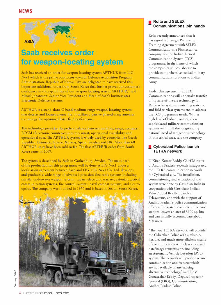
Saab has received an order for weapon locating system ARTHUR from LIG Nex1 which is the prime contractor towards Defence Acquisition Program Administration, Republic of Korea. “We are delighted to have received this important additional order from South Korea that further proves our customer’s confi dence in the capabilities of our weapon locating system ARTHUR," said Micael Johansson, Senior Vice President and Head of Saab’s business area Electronic Defence Systems.
ARTHUR is a stand alone C-band medium-range weapon-locating system that detects and locates enemy fi re. It utilises a passive phased-array antenna technology for optimised battlefi eld performance.
Th e technology provides the perfect balance between mobility, range, accuracy, ECCM (Electronic counter-countermeasures), operational availability and operational cost. Th e ARTHUR system is widely used by countries like Czech Republic, Denmark, Greece, Norway, Spain, Sweden and UK. More than 60 ARTHUR units have been sold so far. Th e fi rst ARTHUR order from South Korea came in 2007.
Th e system is developed by Saab in Gothenburg, Sweden. Th e main part of the production for this programme will be done at LIG Nex1 under a localisation agreement between Saab and LIG. LIG Nex1 Co. Ltd. develops and produces a wide range of advanced precision electronic systems including missile, underwater weapon systems, radars, electronic warfare, avionics, tactical communication systems, fi re control systems, naval combat systems, and electro-optics. Th e company was founded in 1976 and is based in Seoul, South Korea.
Saab receives order for weapon-locating system
4 I GEOINTELLIGENCE MAR – APR 2011
AFRICA
Cou
rtes
y: D
igita
lGlo
be
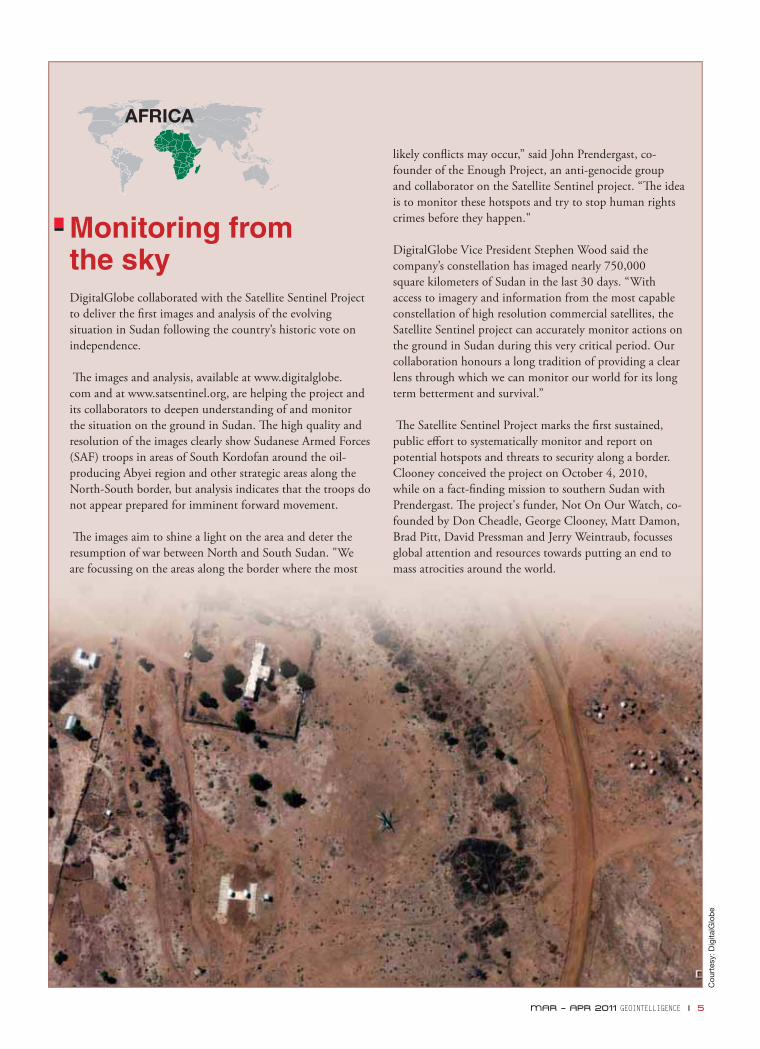
Monitoring from the skyDigitalGlobe collaborated with the Satellite Sentinel Project to deliver the fi rst images and analysis of the evolving situation in Sudan following the country’s historic vote on independence.
Th e images and analysis, available at www.digitalglobe.com and at www.satsentinel.org, are helping the project and its collaborators to deepen understanding of and monitor the situation on the ground in Sudan. Th e high quality and resolution of the images clearly show Sudanese Armed Forces (SAF) troops in areas of South Kordofan around the oil-producing Abyei region and other strategic areas along the North-South border, but analysis indicates that the troops do not appear prepared for imminent forward movement.
Th e images aim to shine a light on the area and deter the resumption of war between North and South Sudan. "We are focussing on the areas along the border where the most
likely confl icts may occur,” said John Prendergast, co-founder of the Enough Project, an anti-genocide group and collaborator on the Satellite Sentinel project. “Th e idea is to monitor these hotspots and try to stop human rights crimes before they happen."
DigitalGlobe Vice President Stephen Wood said the company’s constellation has imaged nearly 750,000 square kilometers of Sudan in the last 30 days. “With access to imagery and information from the most capable constellation of high resolution commercial satellites, the Satellite Sentinel project can accurately monitor actions on the ground in Sudan during this very critical period. Our collaboration honours a long tradition of providing a clear lens through which we can monitor our world for its long term betterment and survival.”
Th e Satellite Sentinel Project marks the fi rst sustained, public eff ort to systematically monitor and report on potential hotspots and threats to security along a border. Clooney conceived the project on October 4, 2010, while on a fact-fi nding mission to southern Sudan with Prendergast. Th e project's funder, Not On Our Watch, co-founded by Don Cheadle, George Clooney, Matt Damon, Brad Pitt, David Pressman and Jerry Weintraub, focusses global attention and resources towards putting an end to mass atrocities around the world.
MAR – APR 2011 GEOINTELLIGENCE I 5
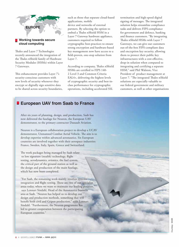
European UAV from Saab to France
After six years of planning, design, and production, Saab has now delivered the fuselage for Neuron, the European UAV demonstrator, to the primary contractor Dassault Aviation.
Neuron is a European collaboration project to develop a UCAV demonstrator, Unmanned Combat Aerial Vehicle. Th e aim is to develop expertise within advanced aeronautics. Six European countries are involved together with their aerospace industries: France, Sweden, Italy, Spain, Greece and Switzerland.
Th e work packages being managed by Saab relate to low signature (stealth) technology, fl ight testing, aerodynamics, avionics, the fuel system, the critical part of the ground station as well as the design and production of the main fuselage, which has now been completed.
"For Saab, the remaining work mainly involves systemsintegration and fl ight testing. Th ese are two of our specialist areas today, where we want to maintain our leading position," says Lennart Sindahl, Head of the Aeronautics business area at Saab. "Neuron has helped us to develop our design and production methods, something that will benefi t both civil and Gripen production," adds Lennart Sindahl. "Furthermore, the Neuron programme has led to greater cooperation between the participating European countries."
Working towards secure cloud computing
Th ales and Layer 7 Technologies recently announced the integration of the Th ales nShield family of Hardware Security Modules (HSMs) within Layer 7 Gateways.
Th is enhancement provides Layer 7’s security-conscious customers with new levels of security whenever they encrypt or digitally sign sensitive data to be shared across security boundaries,
such as those that separate cloud-based applications, mobile device and networks of external partners. By selecting the option to embed a Th ales nShield HSM in a Layer 7 Gateway hardware appliance, customers required to follow cryptographic best-practices to ensure strong encryption and hardware-based key management now have access to a fi eld-proven, one-stop solution from Layer 7.
According to company, Th ales nShield HSMs are certifi ed to FIPS 140-2 Level 3 and Common Criteria EAL4+, delivering the highest levels of cryptographic security and best-in-class performance for cryptographic operations, including accelerated SSL
termination and high-speed digital signing of messages. Th e integrated solution helps streamline compliance tasks and delivers FIPS-compliance for government and defence, banking and fi nance customers. “By integrating Th ales nShield HSMs with Layer 7 Gateways, we can give our customers out-of-the-box FIPS-compliant data and encryption key security, allowing them to protect their public key infrastructures with a cost-eff ective, drop-in solution when compared to integrating and certifying a separate HSM,” said Phil Walston, Vice President of product management at Layer 7. “Th e integrated Th ales nShield solutions are especially valuable to our federal government and military customers, as well as other organisations
Cou
rtes
y: S
AA
B
6 I GEOINTELLIGENCE MAR – APR 2011

in regulated industries like healthcare and fi nancial services, who must demonstrate FIPS-compliance around password security and other user access issues.”
AESA RBE2 radar validated on Rafale
Th ales has announced that the production model AESA RBE2 radar with active electronically scanned array antenna has been validated on the Rafale omnirole combat aircraft. Following a comprehensive programme of fl ight tests, Dassault Aviation confi rmed that all aspects of the radar’s performance comply with the technical specifi cations of the ‘Roadmap’ contract, awarded by the French defence procurement agency (DGA). According to company, this latest major milestone confi rms the AESA RBE2 radar’s high level of maturity and will give Rafale a number of key advantages:
•Extended range for compatibility with the latest generation long range missiles and ability to detect low-signature targets
• Higher module reliability for reduced cost of ownership (no maintenance required on the active array for 10 years)
• Extended waveform agility, making it possible to acquire submetric synthetic aperture (SAR) imagery while increasing the radar’s resistance to jamming
With the AESA RBE2’s performance now validated, in line with the contract schedule, Th ales will begin series production of equipment for installation on the aircraft under Tranche 4 of the Rafale programme. Th e Tranche 4 aircraft were ordered by the DGA in 2009 and will be delivered by Dassault Aviation to the French Air Force from 2013. Rafale will then become the only European combat aircraft to benefi t from the operational advantages of AESA radar technology, adds the company.
Thales delivers SSARF to UK
Th ales UK has delivered the fi nal batch of SSARF (Surveillance System and Range Finder) units to the UK Ministry of Defence (MoD) two months ahead of programme schedule. A total of 707 SSARF units have now been built at Th ales UK’s world-class optronics facility in Glasgow under the terms of a GBP 30 million contract awarded in February 2008.
Th e DSS Leader at the MoD’s Defence Equipment and Support organisation, Colonel Bill Pointing, said: “Th e SSARF project has been a great success; Th ales and the DSS team have incorporated the experience of delivering the earlier Surveillance and Target Location System Urgent Operational Requirement into this important programme and delivered excellent kit early, which the user is already exploiting on operations.” Th e SSARF units, which are the size of a large pair of binoculars and are used in a similar way, combine daylight and thermal vision with eye-safe laser range fi nding; embedded military Global Positioning Satellite and azimuth angular referencing provide accurate target location data for both mortar and artillery fi re control. SSARF has now been deployed operationally and are providing UK troops in the fi eld with an ultra-lightweight, compact, multi-role, night vision target locator capability.
Cou
rtes
y: T
hale
s U
K
MAR – APR 2011 GEOINTELLIGENCE I 7
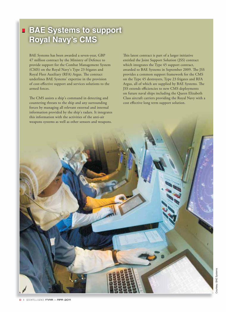
BAE Systems to support Royal Navy’s CMS
BAE Systems has been awarded a seven-year, GBP 47 million contract by the Ministry of Defence to provide support for the Combat Management System (CMS) on the Royal Navy's Type 23 frigates and Royal Fleet Auxiliary (RFA) Argus. Th e contract underlines BAE Systems' expertise in the provision of cost-eff ective support and services solutions to the armed forces.
Th e CMS assists a ship's command in detecting and countering threats to the ship and any surrounding forces by managing all relevant external and internal information provided by the ship's radars. It integrates this information with the activities of the anti-air weapons systems as well as other sensors and weapons.
Th is latest contract is part of a larger initiative entitled the Joint Support Solution (JSS) contract which integrates the Type 45 support contract, awarded to BAE Systems in September 2009. Th e JSS provides a common support framework for the CMS on the Type 45 destroyers, Type 23 frigates and RFA Argus, all of which are supplied by BAE Systems. Th e JSS extends effi ciencies to new CMS deployments on future naval ships including the Queen Elizabeth Class aircraft carriers providing the Royal Navy with a cost eff ective long term support solution.
Cou
rtes
y: B
AE
Sys
tem
s
8 I GEOINTELLIGENCE MAR – APR 2011
Thales to supply APX RESM systems to the Netherland
Th ales has been awarded a contract from the Defence Materiel Organisation (DMO) of the Netherlands Ministry of Defence to supply APX radar electronic support measures (RESM) systems to the navies of the Netherlands and Belgium. Th e contract, which is part of a wider modernisation agreement between the two navies, will supply four APX systems for the M-Class frigates.
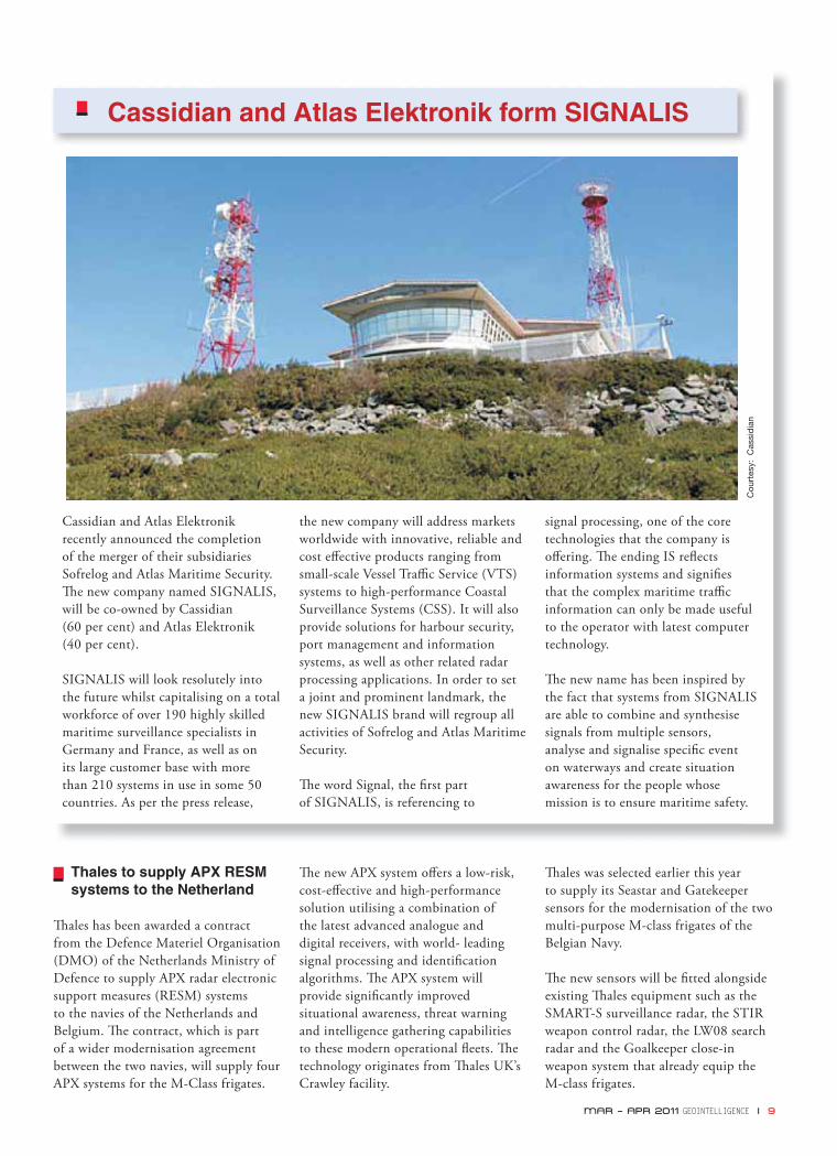
Cassidian and Atlas Elektronik recently announced the completion of the merger of their subsidiaries Sofrelog and Atlas Maritime Security. Th e new company named SIGNALIS, will be co-owned by Cassidian (60 per cent) and Atlas Elektronik (40 per cent).
SIGNALIS will look resolutely into the future whilst capitalising on a total workforce of over 190 highly skilled maritime surveillance specialists in Germany and France, as well as on its large customer base with more than 210 systems in use in some 50 countries. As per the press release,
Th e new APX system off ers a low-risk, cost-eff ective and high-performance solution utilising a combination of the latest advanced analogue and digital receivers, with world- leading signal processing and identifi cation algorithms. Th e APX system will provide signifi cantly improved situational awareness, threat warning and intelligence gathering capabilities to these modern operational fl eets. Th e technology originates from Th ales UK’s Crawley facility.
Th ales was selected earlier this year to supply its Seastar and Gatekeeper sensors for the modernisation of the two multi-purpose M-class frigates of the Belgian Navy.
Th e new sensors will be fi tted alongside existing Th ales equipment such as the SMART-S surveillance radar, the STIR weapon control radar, the LW08 search radar and the Goalkeeper close-in weapon system that already equip the M-class frigates.
Cassidian and Atlas Elektronik form SIGNALIS
the new company will address markets worldwide with innovative, reliable and cost eff ective products ranging from small-scale Vessel Traffi c Service (VTS) systems to high-performance Coastal Surveillance Systems (CSS). It will also provide solutions for harbour security, port management and information systems, as well as other related radar processing applications. In order to set a joint and prominent landmark, the new SIGNALIS brand will regroup all activities of Sofrelog and Atlas Maritime Security.
Th e word Signal, the fi rst part of SIGNALIS, is referencing to
signal processing, one of the core technologies that the company is off ering. Th e ending IS refl ects information systems and signifi es that the complex maritime traffi c information can only be made useful to the operator with latest computer technology.
Th e new name has been inspired by the fact that systems from SIGNALIS are able to combine and synthesise signals from multiple sensors, analyse and signalise specifi c event on waterways and create situation awareness for the people whose mission is to ensure maritime safety.
Cou
rtes
y: C
assi
dia
n
MAR – APR 2011 GEOINTELLIGENCE I 9

US Navy validates new navigation capability for DDG 1000
Th e US Navy achieved a critical milestone with the successful testing of the Next Generation Navigation System (NAVDDX) produced by Raytheon, prime contractor for mission systems equipment for the DDG 1000-class destroyer. NAVDDX is a modern open architecture solution for distributing navigation and high-precision time
data to ship mission systems. Th e open architecture design provides the fl exibility and commonality to be easily integrated into the DDG 1000 class and other ship platforms, including new construction and modernisation programmes. "NAVDDX is the product of a successful government-industry partnership," said Pete Shaw, deputy, Marine Navigation Division, Space and Naval Warfare System Command. "Together, we are delivering the most advanced, mission-critical combat-support positioning, navigation and timing system available today." Th e DDG 1000-class destroyer is the latest evolution in warfi ghting technology for surface combatant ships, providing unmatched capability to the US Navy. Th e DDG 1000-class destroyer's advancements can be incorporated into future and modernised platforms. Th e
benefi ts of DDG 1000's systems reuse potential across the fl eet are already being realised, including the application of the Dual Band Radar for the new Ford-class aircraft carrier (CVN 78) as well as the application of the Total Ship Computing Environment infrastructure for the USS Nimitz (CVN 68) and USS San Antonio (LPD 17) technology refresh eff orts. Th e systems and software engineering approach used on DDG 1000 yields an open architecture well suited for capability enhancements to counter emerging threats.
Highly-capable SIGINT Systems for the warfighter
Northrop Grumman Corporation will fi eld the fi rst systems in the upgraded RC-12X Guardrail fl eet, providing the US Army with unparalleled signals intelligence (SIGINT) capability, under a recent task order awarded by the US Army. Th is is a critical step toward making this mission-critical capability operational, scheduled for second quarter of this year. Th e RC-12X Guardrail is the Army's premier airborne SIGINT sensor and ground processing system, providing instantaneous precision geo-location and identifi cation of threats to enable the Brigade Combat Team's Find, Fix, Finish, Exploit, Analyze and Disseminate (F3EAD) battle command process. Th e RC-12X Guardrail Modernization programme extends the life of the aircraft through 2025 and introduces new payloads to the system with enhanced capabilities to sense and exploit emerging and rapidly evolving irregular and conventional warfare threats. Th e programme also enhances the sustainability of the RC-12X through commonality, a new glass cockpit, structural upgrades and signifi cant hardware and software improvements.
Harris Corporation awarded USD 11 million contract
Harris Corporation was awarded a one-year, USD 11 million contract by the US Air National Guard to provide IT system standardisation and upgrades at nine initial sites. Th ese system upgrades
Boeing partners with Raytheon for P-8A aircraft
Boeing has awarded Raytheon a low rate initial production contract to develop six long-range, multimission maritime and overland surveillance radars plus spares for its P-8A Poseidon aircraft.
"Our APY-10 radar will provide Boeing with advanced technology built on generations of successful Raytheon radar systems," said Tim Carey, Vice President for Intelligence, Surveillance and Reconnaissance Systems. "We're committed to providing reliable systems that keep our customers safe and help them achieve mission success."
Th e radars will be delivered to Boeing as part of the P-8A contract with the US Navy. Th e P-8A replaces the P-3 aircraft and will be used for surveillance along the US coastline.
Th e APY-10, the premier sensor for maritime and overland missions, was designed for the Navy's Poseidon aircraft and will replace the APS-137 radar. According to company, the radar delivers accurate and actionable information in all weather, day and night, for anti-submarine warfare, anti-surface warfare and intelligence, surveillance and reconnaissance missions.
Cou
rtes
y: h
ttp
://c
dn-
ww
w.a
irlin
ers.
net
10 I GEOINTELLIGENCE MAR – APR 2011
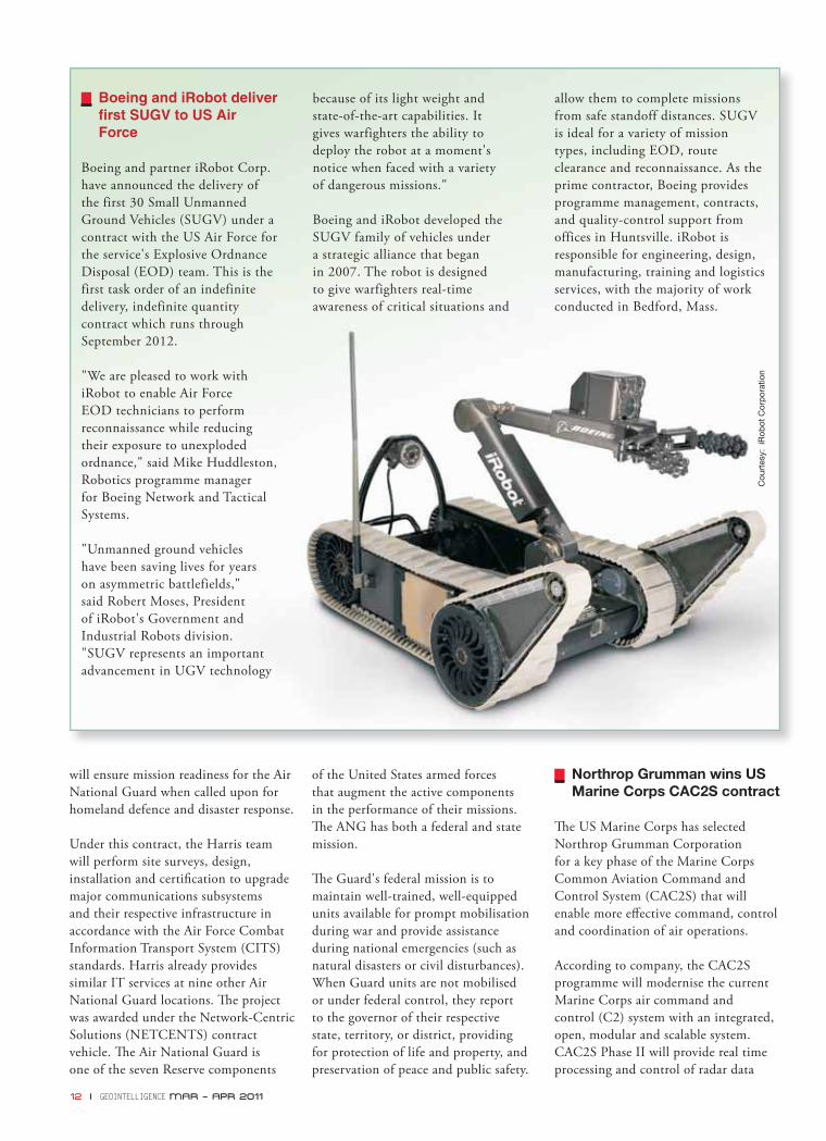
Boeing and iRobot deliver first SUGV to US Air Force
Boeing and partner iRobot Corp. have announced the delivery of the first 30 Small Unmanned Ground Vehicles (SUGV) under a contract with the US Air Force for the service's Explosive Ordnance Disposal (EOD) team. This is the first task order of an indefinite delivery, indefinite quantity contract which runs through September 2012.
"We are pleased to work with iRobot to enable Air Force EOD technicians to perform reconnaissance while reducing their exposure to unexploded ordnance," said Mike Huddleston, Robotics programme manager for Boeing Network and Tactical Systems.
"Unmanned ground vehicles have been saving lives for years on asymmetric battlefields," said Robert Moses, President of iRobot's Government and Industrial Robots division. "SUGV represents an important advancement in UGV technology
because of its light weight and state-of-the-art capabilities. It gives warfighters the ability to deploy the robot at a moment's notice when faced with a variety of dangerous missions."
Boeing and iRobot developed the SUGV family of vehicles under a strategic alliance that began in 2007. The robot is designed to give warfighters real-time awareness of critical situations and
allow them to complete missions from safe standoff distances. SUGV is ideal for a variety of mission types, including EOD, route clearance and reconnaissance. As the prime contractor, Boeing provides programme management, contracts, and quality-control support from offices in Huntsville. iRobot is responsible for engineering, design, manufacturing, training and logistics services, with the majority of work conducted in Bedford, Mass.
will ensure mission readiness for the Air National Guard when called upon for homeland defence and disaster response.
Under this contract, the Harris team will perform site surveys, design, installation and certifi cation to upgrade major communications subsystems and their respective infrastructure in accordance with the Air Force Combat Information Transport System (CITS) standards. Harris already provides similar IT services at nine other Air National Guard locations. Th e project was awarded under the Network-Centric Solutions (NETCENTS) contract vehicle. Th e Air National Guard is one of the seven Reserve components
of the United States armed forces that augment the active components in the performance of their missions. Th e ANG has both a federal and state mission.
Th e Guard's federal mission is to maintain well-trained, well-equipped units available for prompt mobilisation during war and provide assistance during national emergencies (such as natural disasters or civil disturbances). When Guard units are not mobilised or under federal control, they report to the governor of their respective state, territory, or district, providing for protection of life and property, and preservation of peace and public safety.
Northrop Grumman wins US Marine Corps CAC2S contract
Th e US Marine Corps has selected Northrop Grumman Corporation for a key phase of the Marine Corps Common Aviation Command and Control System (CAC2S) that will enable more eff ective command, control and coordination of air operations.
According to company, the CAC2S programme will modernise the current Marine Corps air command and control (C2) system with an integrated, open, modular and scalable system. CAC2S Phase II will provide real time processing and control of radar data
Cou
rtes
y: i
Rob
ot C
orp
orat
ion
12 I GEOINTELLIGENCE MAR – APR 2011

C4ISR contract for US Coast Guard’s NSC
Lockheed Martin received a USD 66 million contract to provide the Command, Control, Communications, Computers, Intelligence, Surveillance and Reconnaissance (C4ISR) system for the United States Coast Guard’s fourth National Security Cutter (NSC).
Lockheed Martin’s C4ISR system will provide the 418-foot NSC 4 with comprehensive, real-time situational awareness, commonality and interoperability with other government agencies and organisations. Th e company developed and provided the C4ISR system for the fi rst three cutters – the USCGC Bertholf and USCGC Waesche, currently in service, and the recently christened Stratton, scheduled for delivery later this year.
“Th e NSC C4ISR system gives the Coast Guard greater capability to conduct its many missions,” said Dan Schultz, Vice President of Lockheed Martin’s Ship and Aviation Systems. “It enables the NSC to more precisely locate suspected drug smuggling boats, rescue distressed sailors faster and improve operational communications with other government agencies.
Th e system’s command and control capability enhances the Coast Guard’s ability to coordinate relief eff orts after hurricanes and other natural disasters.” Lockheed Martin received the C4ISR contract from Northrop Grumman, which was recently selected by the Coast Guard to build the NSC 4 at its shipyard. Th e NSC is the largest and most technologically advanced multi-mission cutter in the Coast Guard fl eet, with capabilities to support the service’s homeland security, law enforcement, marine safety, environmental protection and national defence missions.
In addition to providing the NSC systems, Lockheed Martin also provided the C4ISR missionisation for the Coast Guard’s HC-130J and HC-144A aircraft.
Cou
rtes
y: L
ockh
eed
Mar
tin
and near real time tactical data link communications processing. Th e Phase II sensor data system will be integrated with the previously developed Phase I components to provide a robust aviation C2 capability.
Under the USD 5 million demonstra-tion contract awarded for the Phase II sensor data system, Northrop Grumman will provide an integrated Phase I/Phase II solution for customer evaluation.
"We're aiming to accelerate the delivery of a modular, scalable and mission-adaptable tactical capability to the Marine Corps aviation community," said Mike Twyman, Vice President of integrated command, control, communications and intelligence systems for Northrop Grumman's Information Systems sector. "To optimise an open-architecture system that reduces total ownership costs, we'll apply our Modular Open Systems Approach-CompetitiveTM model. To drive down risk and ensure rapid fi elding of the capability, our CAC2S prototype will integrate Technology Readiness Level 8 products."
Lockheed Martin to build fifth MUOS satellite
Lockheed Martin has received USD 339.6-million contract option from the US Navy for the fi fth satellite in the Mobile User Objective System (MUOS) constellation. MUOS will replace the current Ultra High Frequency Follow-On (UFO) system and provide assured communications including simultaneous voice, video and data for mobile warfi ghters.
“MUOS will provide 10 times more communications capability than the current UFO satellite system,” said Mark Pasquale, Lockheed Martin Vice President and MUOS Programme Manager. “We are committed to successfully providing our warfi ghters with the critical capability of real-time communications on the move, as quickly and as cost-eff ectively as possible.”
MAR – APR 2011 GEOINTELLIGENCE I 13
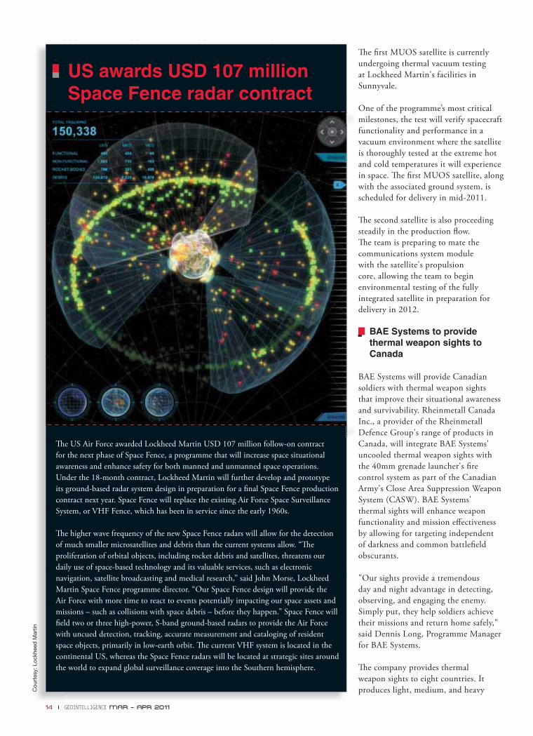
Th e US Air Force awarded Lockheed Martin USD 107 million follow-on contract for the next phase of Space Fence, a programme that will increase space situational awareness and enhance safety for both manned and unmanned space operations. Under the 18-month contract, Lockheed Martin will further develop and prototype its ground-based radar system design in preparation for a fi nal Space Fence production contract next year. Space Fence will replace the existing Air Force Space Surveillance System, or VHF Fence, which has been in service since the early 1960s.
Th e higher wave frequency of the new Space Fence radars will allow for the detection of much smaller microsatellites and debris than the current systems allow. “Th e proliferation of orbital objects, including rocket debris and satellites, threatens our daily use of space-based technology and its valuable services, such as electronic navigation, satellite broadcasting and medical research,” said John Morse, Lockheed Martin Space Fence programme director. “Our Space Fence design will provide the Air Force with more time to react to events potentially impacting our space assets and missions – such as collisions with space debris – before they happen.” Space Fence will fi eld two or three high-power, S-band ground-based radars to provide the Air Force with uncued detection, tracking, accurate measurement and cataloging of resident space objects, primarily in low-earth orbit. Th e current VHF system is located in the continental US, whereas the Space Fence radars will be located at strategic sites around the world to expand global surveillance coverage into the Southern hemisphere.
US awards USD 107 million Space Fence radar contract
Cou
rtes
y: L
ockh
eed
Mar
tin
Th e fi rst MUOS satellite is currently undergoing thermal vacuum testing at Lockheed Martin's facilities in Sunnyvale.
One of the programme’s most critical milestones, the test will verify spacecraft functionality and performance in a vacuum environment where the satellite is thoroughly tested at the extreme hot and cold temperatures it will experience in space. Th e fi rst MUOS satellite, along with the associated ground system, is scheduled for delivery in mid-2011.
Th e second satellite is also proceeding steadily in the production fl ow. Th e team is preparing to mate the communications system module with the satellite's propulsion core, allowing the team to begin environmental testing of the fully integrated satellite in preparation for delivery in 2012.
BAE Systems to provide thermal weapon sights to Canada
BAE Systems will provide Canadian soldiers with thermal weapon sights that improve their situational awareness and survivability. Rheinmetall Canada Inc., a provider of the Rheinmetall Defence Group's range of products in Canada, will integrate BAE Systems' uncooled thermal weapon sights with the 40mm grenade launcher's fi re control system as part of the Canadian Army's Close Area Suppression Weapon System (CASW). BAE Systems' thermal sights will enhance weapon functionality and mission eff ectiveness by allowing for targeting independent of darkness and common battlefi eld obscurants.
"Our sights provide a tremendous day and night advantage in detecting, observing, and engaging the enemy. Simply put, they help soldiers achieve their missions and return home safely," said Dennis Long, Programme Manager for BAE Systems.
Th e company provides thermal weapon sights to eight countries. It produces light, medium, and heavy
14 I GEOINTELLIGENCE MAR – APR 2011
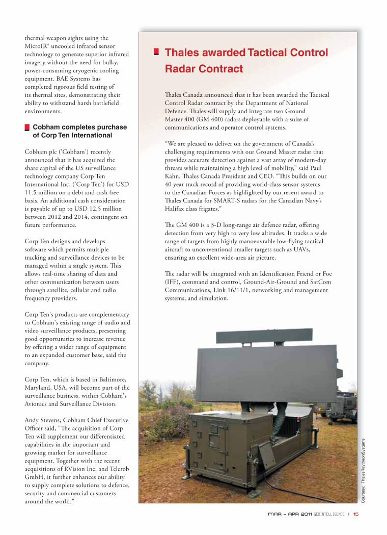
Thales awarded Tactical Control
Radar Contract
Th ales Canada announced that it has been awarded the Tactical Control Radar contract by the Department of National Defence. Th ales will supply and integrate two Ground Master 400 (GM 400) radars deployable with a suite of communications and operator control systems.
“We are pleased to deliver on the government of Canada’s challenging requirements with our Ground Master radar that provides accurate detection against a vast array of modern-day threats while maintaining a high level of mobility,” said Paul Kahn, Th ales Canada President and CEO. “Th is builds on our 40 year track record of providing world-class sensor systems to the Canadian Forces as highlighted by our recent award to Th ales Canada for SMART-S radars for the Canadian Navy’s Halifax class frigates.”
Th e GM 400 is a 3-D long-range air defence radar, off ering detection from very high to very low altitudes. It tracks a wide range of targets from highly manoeuvrable low-fl ying tactical aircraft to unconventional smaller targets such as UAVs, ensuring an excellent wide-area air picture.
Th e radar will be integrated with an Identifi cation Friend or Foe (IFF), command and control, Ground-Air-Ground and SatCom Communications, Link 16/11/1, networking and management systems, and simulation.
Cou
rtes
y: T
hale
sRay
theo
nSys
tem
s
thermal weapon sights using the MicroIR® uncooled infrared sensor technology to generate superior infrared imagery without the need for bulky, power-consuming cryogenic cooling equipment. BAE Systems has completed rigorous fi eld testing of its thermal sites, demonstrating their ability to withstand harsh battlefi eld environments.
Cobham completes purchase of Corp Ten International
Cobham plc ('Cobham') recently announced that it has acquired the share capital of the US surveillance technology company Corp Ten International Inc. ('Corp Ten') for USD 11.5 million on a debt and cash free basis. An additional cash consideration is payable of up to USD 12.5 million between 2012 and 2014, contingent on future performance.
Corp Ten designs and develops software which permits multiple tracking and surveillance devices to be managed within a single system. Th is allows real-time sharing of data and other communication between users through satellite, cellular and radio frequency providers.
Corp Ten's products are complementary to Cobham's existing range of audio and video surveillance products, presenting good opportunities to increase revenue by off ering a wider range of equipment to an expanded customer base, said the company.
Corp Ten, which is based in Baltimore, Maryland, USA, will become part of the surveillance business, within Cobham's Avionics and Surveillance Division.
Andy Stevens, Cobham Chief Executive Offi cer said, "Th e acquisition of Corp Ten will supplement our diff erentiated capabilities in the important and growing market for surveillance equipment. Together with the recent acquisitions of RVision Inc. and Telerob GmbH, it further enhances our ability to supply complete solutions to defence, security and commercial customers around the world."
MAR – APR 2011 GEOINTELLIGENCE I 15
Dr Joseph F. Fontanella – new Director of US Army Geospatial Center
Dr Joseph F. Fontanella was recently appointed as the Director of the US Army Geospatial Center (AGC). In his new
position, he will be responsible for supporting the operations, intelligence, acquisition, research and development as well as modelling and simulation communities with geospatial information. He is also chartered as
retiring from the Army as Colonel after 26 years. He served as deputy director of the AGC from 2006-2010. Fontanella holds a doctorate degree in educational leadership, master’s degrees in both national resource strategy and geography, and bachelor’s degrees in environmental science and landscape architecture, while his military education includes attendance at the Industrial college of the armed forces as well as the US army command and General staff college.
He is a Level III certifi ed acquisition professional as well as a licensed landscape architect in the States of Maryland and Texas, as well as the Commonwealth of Virginia.
the Army’s Geospatial Information Offi cer (GIO), with responsibility for collecting and validating geospatial requirements, formulating geospatial policy, setting priorities and securing resources supporting the army geospatial enterprise, as well as synchronising geospatial solutions at both headquarters, department of the army and secretariat levels of army governance.
Dr Joseph F. Fontanella succeeds Bob Burkhardt who retired on 28 January 2011. Dr Fontanella began his federal career as assistant director for plans and programme management with the US army engineer research and development center in Alexandria, Virginia, after
PEOPLE IN NEWS
Harris provides public safety communication system
Harris Corporation and Washington County, Wisconsin recently completed the installation and acceptance testing of their USD 11.5 million P25 public safety communication system. Harris deployed the eight-site trunked simulcast VHF P25IP (Project 25 to the Power of Internet Protocol) digital system to provide improved mission-critical communications
for the county's public safety personnel, which serve more than 131,000 residents across the county's 436 square miles.
"Washington County needed a new public safety radio system that could provide improved on-street and in-building coverage," said Dale Schmidt, Sheriff of Washington County, Wisconsin. "Th e Harris P25IP product provided that coverage and was a cost-eff ective solution. Th e Harris system
gives us enhanced capabilities and our users are already experiencing improved communications throughout the county."
Th e system operates on 10 VHF radio channels with enough capacity to accommodate fi ve additional radio channels. Harris also implemented a county-wide law enforcement, fi re and EMS conventional simulcast alert paging system.
Th e Washington County P25IP system is based on the Harris IP-based VIDA® (Voice, Interoperable, Data, Access) network platform and includes geographically-split high-availability network switching servers for increased reliability. Th e VIDA network is a cost-eff ective, interoperable radio communications technology that supports P25 and other IP-based systems. It addresses voice and data communications needs of transportation, utility and public safety radio users around the world. It provides a full IP management platform, including interoperability without intervention of console operators; IP consoles; networking technology for both the P25 Phase 1 and Phase 2 technology standards; and other benefi ts inherent in open IP architecture systems.
16 I GEOINTELLIGENCE MAR – APR 2011
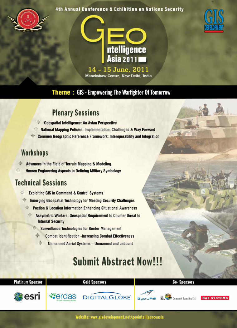
GEOINTELLIGENCE ASIA 2011
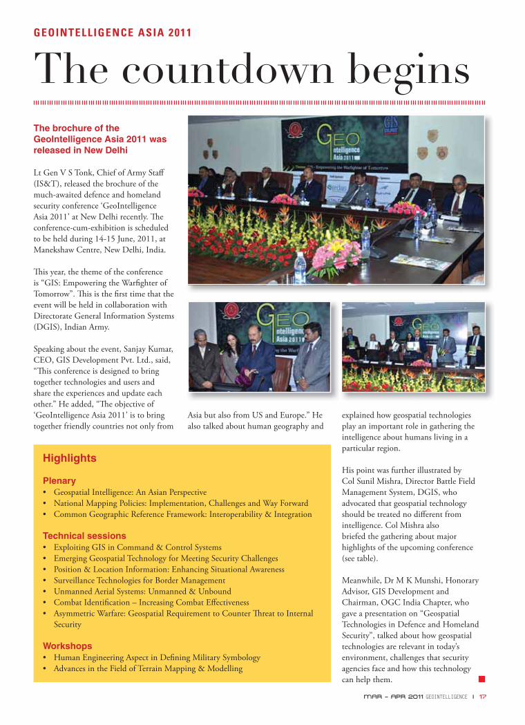
The countdown beginsThe brochure of the GeoIntelligence Asia 2011 was released in New Delhi
Lt Gen V S Tonk, Chief of Army Staff (IS&T), released the brochure of the much-awaited defence and homeland security conference ‘GeoIntelligence Asia 2011’ at New Delhi recently. Th e conference-cum-exhibition is scheduled to be held during 14-15 June, 2011, at Manekshaw Centre, New Delhi, India.
Th is year, the theme of the conference is “GIS: Empowering the Warfi ghter of Tomorrow”. Th is is the fi rst time that the event will be held in collaboration with Directorate General Information Systems (DGIS), Indian Army.
Speaking about the event, Sanjay Kumar, CEO, GIS Development Pvt. Ltd., said, “Th is conference is designed to bring together technologies and users and share the experiences and update each other.” He added, “Th e objective of ‘GeoIntelligence Asia 2011’ is to bring together friendly countries not only from
Asia but also from US and Europe.” He also talked about human geography and
explained how geospatial technologies play an important role in gathering the intelligence about humans living in a particular region.
His point was further illustrated by Col Sunil Mishra, Director Battle Field Management System, DGIS, who advocated that geospatial technology should be treated no diff erent from intelligence. Col Mishra also briefed the gathering about major highlights of the upcoming conference (see table).
Meanwhile, Dr M K Munshi, Honorary Advisor, GIS Development and Chairman, OGC India Chapter, who gave a presentation on “Geospatial Technologies in Defence and Homeland Security”, talked about how geospatial technologies are relevant in today’s environment, challenges that security agencies face and how this technology can help them.
Highlights
Plenary• Geospatial Intelligence: An Asian Perspective• National Mapping Policies: Implementation, Challenges and Way Forward• Common Geographic Reference Framework: Interoperability & Integration
Technical sessions• Exploiting GIS in Command & Control Systems• Emerging Geospatial Technology for Meeting Security Challenges• Position & Location Information: Enhancing Situational Awareness• Surveillance Technologies for Border Management• Unmanned Aerial Systems: Unmanned & Unbound• Combat Identifi cation – Increasing Combat Eff ectiveness• Asymmetric Warfare: Geospatial Requirement to Counter Th reat to Internal
Security
Workshops• Human Engineering Aspect in Defi ning Military Symbology• Advances in the Field of Terrain Mapping & Modelling
MAR – APR 2011 GEOINTELLIGENCE I 17
18 I GEOINTELLIGENCE MAR – APR 2011
It’s all about MDA
Few security commentators would dispute the geospatial issue which dominates contemporary concern over maritime security – the generation of a credible Maritime Domain Awareness (MDA) picture which is both comprehensive and persistent. In today’s “globalised, connected world;” we believe location is ubiquitous and that everything is tracked. Unfortunately from a maritime perspective, that is far from the truth and vessels once they go over the horizon can essentially “disappear”. Th is absence of reliable domain awareness hamstrings many if not all aspects of maritime commerce and security. Whether the concern is Port Security and administering the ISPS Code or enforcing national sovereignty over an Exclusive Economic Zone; MDA is the fundamental basis for maritime intelligence. Th is issue was recently explored in depth by the Nautical Institute’s Seaways magazine which spoke of:
“Despite the fact that today’s sea lanes account for over 80 per cent of world trade by value and generate 100’s of billions of dollars in service provisions there is still a creeping sea-blindness.” (Nautical Institute – Seaways July 2010 p23).
Maritime traffi c once out of range of land-based surveillance systems is largely invisible to shore-side authorities and ships can eff ectively disappear until they reappear shortly before the next ‘scheduled’ port call. Until Satellite based Automatic
S-AIS
With the advent of Satellite based Automatic Identifi cation System (S-AIS),
monitoring maritime traffi c once it’s out of range of land-based surveillance
systems is no longer a challenge for authorities. Today, this technology
forms the crux of effective Maritime Domain Awareness (MDA).
John W Allan
VP Global Sales & Marketing
exactEarth Ltd
MAR – APR 2011 GEOINTELLIGENCE I 19
vessels of 300 GRT or more that are capable of undertaking international voyages and all registered passenger ships - a requirement which now sees over 70,000 vessels equipped today. Th ese are the so-called Class A AIS systems. Th is number will grow enormously over the next few years as governments mandate that more vessels must carry AIS. In addition, Class B AIS systems are carried on much smaller vessels and are generally aimed at the consumer and leisure market.
Th e fundamental and potentially crucial limitation of AIS is the inherently short range of VHF which provides a ship-to-ship range of about 20 nm at sea and up to 50 nm for ship-to-shore communications. It was initially assumed that these signals would be too weak to be received in space, but
Identifi cation System (S-AIS) became available, the lack of eff ective global maritime surveillance was exploited by sea-based criminals and terrorists, who could thrive in these oceanic “black holes”. Many terrorist groups have demonstrated their ability to launch attacks in the maritime domain, with recent events in Mumbai, India showing the relative ease with which terrorists can deliver their particular brand of violence from the sea. It is little wonder such events have created an uneasy international consensus that something needs to be done to address this deteriorating situation. Satellite based AIS is the technology that can change all this.
Threats
Today’s threats of organised crime and terrorism have catapulted maritime security into the public arena; a situation which illustrates the diffi culties associated with delivering timely and eff ective MDA. Th e solution demands a multi-agency response borne of coordinated government and the sensible use of reliable, cost eff ective space-based surveillance systems: systems which can provide an integrated continuum of situational awareness and predictive intelligence. S-AIS is the only true means of providing a comprehensive and persistent monitoring of vessels on a global basis. exactEarth Ltd’s exactAIS data service provides users with a quantum leap forward in maritime surveillance capability.
Background
AIS is a mandatory navigation safety communications system under the provisions of Safety of Life at Sea (SOLAS) Conventions and is fast becoming a powerful tool in the delivery of MDA. Th e International Maritime Organisation (IMO) requires a functioning AIS must be onboard all
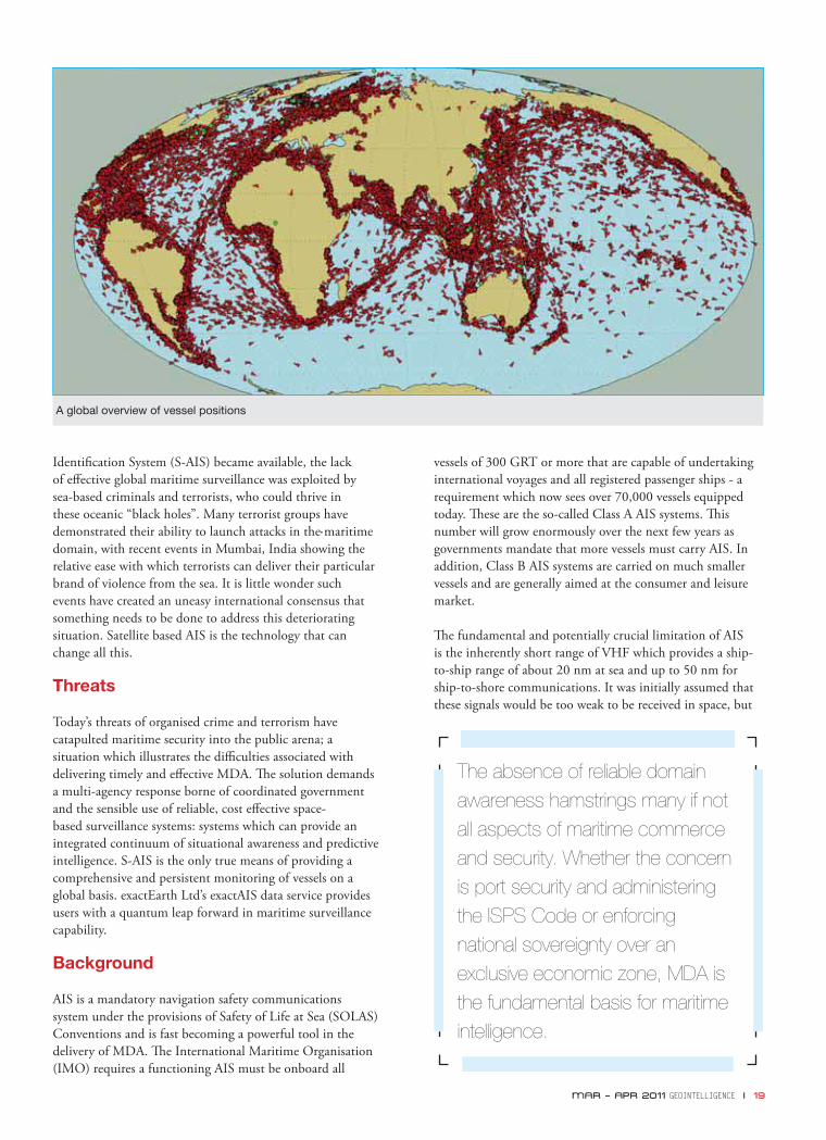
A global overview of vessel positions
The absence of reliable domain awareness hamstrings many if not all aspects of maritime commerce and security. Whether the concern is port security and administering the ISPS Code or enforcing national sovereignty over an exclusive economic zone, MDA is the fundamental basis for maritime intelligence.
20 I GEOINTELLIGENCE MAR – APR 2011
exactEarth’s test satellite, NTS-1, launched in 2008, proved that it was not impossible and started the technology that is now proving to be the game changer in MDA.
An AIS transponder will normally operate in a continuous and autonomous mode, transmitting information which includes a vessel’s unique ID number, position, course and speed, together with other voyage related information. Th e system is based on a self organising “cell” structure, where vessels in the same cell avoid broadcasting simultaneously. A standard ship based system is capable of handling over 4,500 reports per minute and transmitting as frequently as every two seconds. As a system, AIS delivers a continuous fl ow of intelligent data which constitutes a dynamic maritime picture. AIS equipped ships can therefore be more easily tracked; thus contributing to a safer, more secure maritime environment.
The new horizon
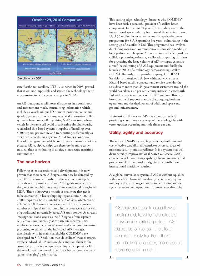
Following extensive research and development, it is now proven that these same AIS signals can now be detected by a satellite in a low earth orbit. If this satellite is in a polar orbit then it is possible to detect AIS signals anywhere on the globe and establish near-real time continental or regional MDA. Th ere is however one serious challenge that needs to be overcome. In heavy shipping regions some 5,000 to 7,000 ships may be in a satellite’s fi eld of view, which can be as large as 3,000 nautical miles across. Th is is a far greater number of ships than that found in the coverage area (or cell) of a traditional terrestrially based AIS transponder. As a result ‘message collisions’ occur as the AIS signals from separate cells arrive simultaneously at the satellite receiver. Th is results in an extremely ‘noisy’ signal and so requires intensive processing to extract all the individual AIS messages. exactEarth, with its main shareholder COMDEV have developed an S-AIS solution that ‘de-collides’ these messages, extracts individual AIS message data and tags them to the correct ship. Th is is a unique capability which provides 10x the vessel detection rate of other space borne systems – truly ‘game- changing’ performance.
Th is cutting edge technology illustrates why COMDEV have been such a successful provider of satellite-based components for the last 30 years. Th eir leading role in the international space industry has allowed them to invest over USD 30 million in an extensive multi-step development programme for S-AIS spanning fi ve years, culminating in the setting up of exactEarth Ltd. Th is programme has involved developing maritime communications simulation models, a high performance bespoke AIS transceiver, reliable signal de-collision processing software, a tailored computing platform for processing the large volume of AIS messages, extensive aircraft-based testing of S-AIS equipment and fi nally the launch in 2008 of a technology demonstrating satellite - NTS-1. Recently, the Spanish company, HISDESAT Servicios Estratégicos S.A. (www.hisdesat.es), a major Madrid-based satellite operator and service provider that sells data to more than 25 government customers around the world has taken a 27 per cent equity interest in exactEarth Ltd with a cash investment of Cdn$15 million. Th is cash investment will support exactEarth’s on-going business operations and the deployment of additional space and ground infrastructure.
In August 2010, the exactAIS service was launched, providing a continuous coverage of the whole globe with vessel updates occurring multiple times per day.
Utility, agility and accuracy
Th e utility of S-AIS is clear; it provides a signifi cant and cost eff ective capability diff erentiator across all areas of maritime security and surveillance. It is a system that will demonstrably improve national Search & Rescue (SAR), enhance vessel monitoring capability, focus environmental protection eff orts and make a signifi cant contribution to international maritime security.
As a global surveillance system, S-AIS is without equal; its widespread employment has already been proven by both military and civilian organisations in demanding multi-agency exercises and operations. It proved eff ective in its
AIS delivers a continuous fl ow of intelligent data which constitutes a dynamic maritime picture. AIS equipped ships can therefore be more easily tracked; thus contributing to a safer, more secure maritime environment.
Decollision vs OBP
Cou
rtes
y: C
LS
performance at recent major events such as at the Vancouver Winter Olympics, where it provided an outstanding contribution to the Canadian Navy’s Recognised Maritime Picture. It also provided maritime surveillance at the FIFA World Cup in South Africa. Speaking about its role during the world cup, Captain Karl Otto, Executive Head, Centre for Sea Watch and Response, SAMSA, said, “During the world cup, exactEarth’s space-based system was detecting over 1,000 ships in our area of interest. Th is enhanced visibility enabled our authorities to plan days in advance rather than hours.”
Its enhanced detection and identifi cation capability meant that security offi cials had a versatile tool at their disposal which allowed them access to a rapidly refreshing global maritime picture. Th ey could, for the fi rst time, match location and vessel identifi cation using both AIS and radar fi ngerprints, a move which ultimately fl agged any track anomalies and generated an intelligence baseline of normal maritime behaviour. Because it provides authorities with an accurate and timely wide area surveillance tool, it has allowed them to optimise platform tasking and focus valuable resources upon those contacts which are of interest. Likewise monitoring EEZ’s or remote coastlines from space can dramatically reduce the need for expensive legacy manned infrastructure. S-AIS performance also exceeded the
MAR – APR 2011 GEOINTELLIGENCE I 21
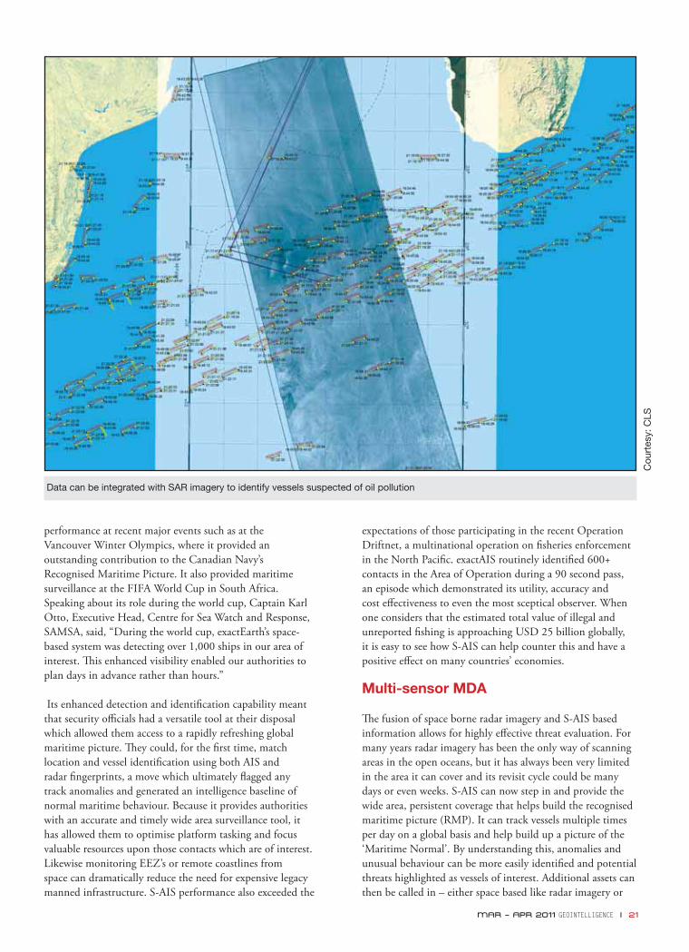
Data can be integrated with SAR imagery to identify vessels suspected of oil pollution
expectations of those participating in the recent Operation Driftnet, a multinational operation on fi sheries enforcement in the North Pacifi c. exactAIS routinely identifi ed 600+ contacts in the Area of Operation during a 90 second pass, an episode which demonstrated its utility, accuracy and cost eff ectiveness to even the most sceptical observer. When one considers that the estimated total value of illegal and unreported fi shing is approaching USD 25 billion globally, it is easy to see how S-AIS can help counter this and have a positive eff ect on many countries’ economies.
Multi-sensor MDA
Th e fusion of space borne radar imagery and S-AIS based information allows for highly eff ective threat evaluation. For many years radar imagery has been the only way of scanning areas in the open oceans, but it has always been very limited in the area it can cover and its revisit cycle could be many days or even weeks. S-AIS can now step in and provide the wide area, persistent coverage that helps build the recognised maritime picture (RMP). It can track vessels multiple times per day on a global basis and help build up a picture of the ‘Maritime Normal’. By understanding this, anomalies and unusual behaviour can be more easily identifi ed and potential threats highlighted as vessels of interest. Additional assets can then be called in – either space based like radar imagery or
22 I GEOINTELLIGENCE MAR – APR 2011
surface assets for interdiction – and the threat quantifi ed. For the fi rst time, S-AIS can provide a near real time monitoring capability of the open oceans. Th e continuous nature of the S-AIS monitoring also helps identify vessels who turn their AIS transponders off – an immediate anomaly detection as they need to have the AIS operational when in port or in shipping lanes. Turning it off actually draws attention to them – the very opposite of their intentions!
exactAIS can also provide a means for identifying ‘spoofed’ locations, where vessels either purposefully or unintentionally provide incorrect positional information in their AIS signal – for example, to hide the fact they are fi shing inside an EEZ.
Whilst radar imagery will identify vessels in the form of ‘returns’ on the radar image, there is no intelligence associated with the ‘return’ – in some instances, it could just as easily be a container fl oating in the water that happens to give a high refl ection. S-AIS on the other hand has a wide array of information associated with it – name, location, heading, speed and other voyage related information which allows it to be immediately used for geospatial intelligence applications. It forms the fundamental basis of the surveillance requirements of MDA.
Th e system allows ships and platforms to be fi nger-printed, so their behaviour and activities can be monitored like never before. It denies criminals the opportunity to ‘disappear’ and aff ords law-abiding vessels greater protection as they cross the world’s oceans. Tracking these fi nger-prints from space has removed once and for all the lottery associated with deep sea SAR; now with a high degree of certainty hard-pressed
rescue assets can be dispatched to the scene of an incident and render immediate assistance. In recent trials, exactAIS’ outstanding performance proved to be capable of tracking individual man overboard SAR Transponders from its polar orbit high above the earth.
Data collected from space and provided to various government and commercial organisations has become an essential part of the modern day maritime surveillance process. Here suspicious or emergency related activity is quickly discernible from the normal and allows those concerned to respond with greater certainty, in a timely and eff ective manner. Recoverable vessel histories are an essential part of accident or incident investigation and as such S-AIS is fast becoming a valuable tool in the multi-sensor aggregation of data which is required to monitor the world’s oceans or areas of national strategic importance.
Conclusion
S-AIS provides a comprehensive, persistent, high resolution, technology based contribution to global maritime domain awareness. Th e fact that it is also cost eff ective and immediately available makes it a true market leader in today’s globalised world. Th is is a surveillance system which demonstrates a broad utility across many maritime applications and will undoubtedly stay the test of time based upon its world-beating performance and huge potential developing market. exactEarth’s investment in applying their proven space technology looks more prudent by the day as they establish an enviable record for operational excellence in this most demanding environment.
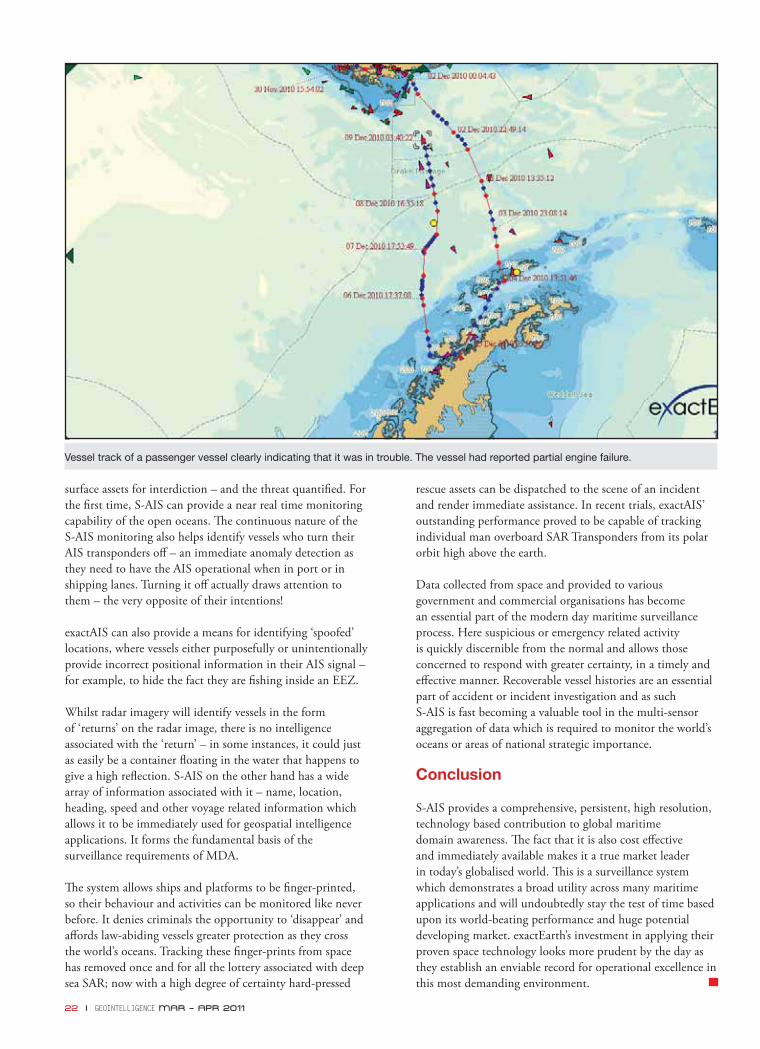
Vessel track of a passenger vessel clearly indicating that it was in trouble. The vessel had reported partial engine failure.

US Geospatial Intelligence Foundation (USGIF) recently held its annual symposium, GEOINT Symposium 2010, centered on the theme, “GEOINT 3.0”. More than 200 exhibitors, an increase from 174 in 2009, and over 4,000 total attendees, which were also up from about 3200 in 2009, participated in this four-day event. Th e occasion also witnessed enthusiastic participation from academic exhibitors with about 10 higher educational institutions setting up their stalls. Little wonder, USGIF described it as “the largest, and by all accounts, the best GEOINT Symposium to date”.
Th e fi rst day revolved around technology and academics. Th e academic session featured the likes of Dr Max Baber, Director of Academic Programmes, United States Geospatial Intelligence Foundation; Chuck Benton, Technology Education Specialist and Chair, Practical Arts Department, Dover Area High School, Pennsylvania; and Stewart Bruce, GIS Programme Coordinator, Center for Environment and Society, Washington College, who talked about the education challenges and opportunities in this sector. Th e technology session had representatives from the National Geospatial-Intelligence Agency (NGA), Defense Intelligence Agency and various organisations who talked about the path-breaking technology projects within the intelligence community, and the process by which research is planned, funded and evaluated.
“We’re shifting from how we use multiple sources to how we use multiple disciplines to come up with new methods and new ways to make sense out of all kinds of data,” said session moderator Edward T. Cope, who manages NSG RDT&E for NGA.
Stressing upon the need to bring in fl exibility in the process of R&D, Dr H. Gregory Smith, NGA’s Chief Scientist and Deputy Director of its InnoVision Directorate, said, “Th ere is a need for a type of approach to evaluation that can better express the value that they add to the enterprise. Part of the key in freeing up a programme to be more risk tolerant is to be able to communicate the value that an innovation programme can bring to the enterprise – not just technology, but also processes.”
Day two was full of activities and featured discussions on varied topics like ‘Maritime domain awareness’, ‘Open source in the 21st century’ and ‘GEOINT insight and infl uence through functional management’. Th e day’s opening keynote was delivered by James Clapper Jr., Director of National Intelligence. His talk focused on his future plans for the Offi ce of the Director of National Intelligence (ODNI). Explaining his vision of a revamped intelligence structure, Clapper said, “We’re putting together collection and analysis, which previously were managed as separate endeavors. We’re integrating those and putting them under one management hat,” adding that he had selected former NGA and DIA offi cial Robert Cardillo to lead the eff ort.
He was followed by Gen. Bruce Carlson, US Air Force (retd),
jan – feb 2011 GEOINTELLIGENCE I 23
I would like to subscribe for (tick as applicable)
1 year (6 bimonthly issues for Rs.500 / US$30)
2 years (12 bimonthly issues for Rs.950 / US$55)
First name ............................................ Last name ........................................
Designation .......................................... Organization ....................................
Address .............................................................................................................
City ........................................................ State .................................................
Postal code .......................................... Country .............................................
Phone .................................................... Fax ....................................................
Email ..................................................................................................................
I enclose cheque no ............................. drawn on ..........................................dated ......................... towards subscription for GEO Intelligencemagazine in favour of GIS Development Pvt. Ltd.
Sign ......................................................Date ............................
Mail this form with payment to:GIS Development Pvt. Ltd.A-145, Sector - 63, Noida, IndiaTel + 91 120 4612500 Fax + 91 120 461255 - 666
NEWS • VIEWS • REVIEWS • INTERVIEWS • NEWS • VIEWS • REVIEWS • INTERVIEWS • NEWS • VIEWS • REVIEWS • INTERVIEWS • NEWS • V
24 I GEOINTELLIGENCE MAR – APR 2011
Congratulations on your new role as President and CEO of Intergraph Government Solutions (IGS). You have described it as your dream job. What is your role in IGS and how is it different from your previous position? What challenges do you foresee in IGS?
As the President and CEO of IGS, a stand-alone entity owned by Intergraph US and Hexagon AB. My role is to run this independent business eff ectively and effi ciently with no outside infl uence from either Intergraph or Hexagon. I report to a proxy board of former US senior government executives appointed to oversee the operations of IGS and ensure that the operation is conducted in accordance with rules and regulations established by the Defense Security
Brig. Gen. Jack Pellicci (retd.)
President and CEO
Intergraph Government Solutions (IGS)
INTERVIEW

MAR – APR 2011 GEOINTELLIGENCE I 25
Service (DSS). In my previous role I was a senior vice president and general manager of the Federal Security and Intelligence (FSI) business unit and reported to the President of SG&I (Security, Government & Infrastructure). FSI was totally integrated with SG&I and we leveraged Intergraph/ SGI shared services as well as integrated business plans/ strategies. IGS now has established a separate business space and independent services in HR, Legal, Finance, and IT with business processes that are not connected to those of SGI, Intergraph or Hexagon. Th e major challenge we in IGS face is to ensure that we approach running the company as a start up to control operating costs while still providing our long time customer base with the same outstanding support we have always provided and at the same time grow the business and technical skillset. We are looking forward to the
integration of the ERDAS federal and intelligence accounts into IGS in 2011, and plan to off er other leading technology from Hexagon to our expanding customer base in the US federal sector.
IGS was created to ensure compliance with US laws and to support the current and future requirements of its US federal and classifi ed customers. How is it going to be different from other subsidiaries of Hexagon?
All other subsidiaries of Hexagon to include Intergraph’s SG&I and PPM (Process, Power and Marine) are now considered foreign owned and the IGS communications and
DSS to run entities like IGS whose parent is a foreign company is a long tested one which provides the necessary guidelines and checks to ensure that no classifi ed or other sensitive information associated with US government projects that IGS is involved in ever gets in the hands of Hexagon, its subsidiaries or any other foreign entity. Our initial feedback from the US government is that IGS has done a very good job of establishing the processes and systems to control and document communications between IGS and the rest of Intergraph and Hexagon. IGS has spent considerable eff ort and funds in establishing the requisite controls and training in the areas of security, export control and compliance with DSS requirements.
You have been a very important part of Intergraph’s Security, Government & Infrastructure (SG&I) division. Are you still going to be working with SG&I? Moreover, with Hexagon now at the helm of affairs, what is the future of Intergraph SG&I?
Th e IGS involvement with SG&I will be very limited and only approved by the proxy board for purposes that will not involve any sensitive information or insights to IGS’s operations with US government projects or customers. Intergraph SG&I will remain a strong global provider of products and services from Intergraph and Hexagon,
contact with these subsidiaries must be carefully controlled and monitored. Th is is where the proxy board plays a critical role in performing the duties prescribed by DSS. IGS will essentially be Hexagon’s and Intergraph’s distributor to the US federal, DOD, intelligence and civil agencies.
What role will Hexagon play with IGS, in terms of day-to-day functioning, technology transfer and decision-making?
Hexagon’s role will be limited to dealing with the proxy board. In cases where IGS personnel may be required to interface with Hexagon or any of its subsidiaries, prior approval must be obtained from the proxy board. While Hexagon’s view into IGS will be limited, IGS will have the benefi t of access to Hexagon’s expanding suite of technology platforms and products. IGS is uniquely positioned to off er Hexagon’s industry leading technology to US defense, intelligence and civilian agencies in ways that complement Intergraph’s proven solutions.
With Intergraph now a part of Hexagon, how would you allay the fears that US government’s projects will not fall in the hands of a non-US entity?
Th e US government process established by DOD and the
26 I GEOINTELLIGENCE MAR – APR 2011
MAR – APR 2011 GEOINTELLIGENCE I 27
focusing on all other sectors of the worldwide geospatial market.
Do you see the role of IGS restricted to US market only or do you intend to project it as a separate entity which will gradually expand to other countries?
Th e IGS role is to focus on just the US government market. In selected cases where US government agencies sponsor foreign military sales (FMS) funded projects, IGS may bid and implement them with the approval of the proxy board.
You have been associated with this domain for a long time, both as a soldier and as a solution provider. What according to you are the challenges facing military and intelligence organisations today?
Th e major challenges facing military and intelligence organisations centre around providing real-time actionable intelligence to commanders and their organisations in the fi eld as well as to decision makers in major joint and military service elements supporting these commanders. Th e intelligence information must be in a format that facilitates ease of handling in the fi eld, especially those with disadvantaged bandwidth. Th is must be a MULTI-INT experience where GEOINT, HUMINT, SIGINT, VIDINT etc. are treated in an integrated manner that provides quick and eff ective processing and dissemination. Specifi c areas of key interest include full motion video exploitation solutions which will provide live stream video from UAVs and other airborne platforms to units engaged in combat operations. Th is video must be integrated with HUMINT and SIGINT to improve the analyst’s ability to understand the actions occurring in the video, thereby improving the overall eff ectiveness of the analysis and the mission itself.
How do you think the perception towards geointelligence has changed over these years?
Geospatial intelligence (GEOINT) is moving into the next era and commanders at all levels appreciate its values much
Hexagon’s role will be limited to
dealing with the proxy board. While
its view into IGS will be limited,
IGS will have the benefi t of access
to Hexagon’s expanding suite of
technology platforms & products
more than in past years. Putting the power of GEOINT in the hands of commanders and troops in combat is making a real positive diff erence. GEOINT has earned a place at the combat commander’s table and it will always be considered an essential element of both preparing the battlefi eld and winning the fi ght since it provides a rich and relevant environment for integrated decision making and mission support. Additionally, GEOINT will not only be key to the warfi ghter but also to those managing humanitarian crises and those responding to natural disasters.
What kind of technology trend do you foresee in near future with regard to serving ever growing requirements of geointelligence information?
We see an increase in the demand for online/ on-demand access to GEOINT knowledge through self-service tools so commanders and their troops in the fi eld can access GEOINT when and where they need it and customise it to suit their specifi c needs at that moment. Static products will be replaced by more dynamic and seamless ones that support multiple form factors including mobile devices. All this will be provided real-time and at a reduced cost and as Ola Rollen, CEO of Hexagon, stated in his interview to Geospatial World, “Th e Real Value of a Map is in being Real-Time”.
What can we expect from IGS in future?
IGS was specifi cally created to preserve the sanctity of our US government work and classifi ed contracts and that transition process is moving ahead nicely. Our short term goal is to provide seamless support to our complete set of customers through the transition period and for the longer term, it is to make even more contributions to supporting the warfi ghter community. Finally, IGS is excited about the Hexagon acquisition and the possibilities for growth. Th at will result from IGS being a part of the Hexagon family, even though it will be an indirect relationship.
The US government process to run
entities like IGS whose parent is a
foreign company is a long tested
one which provides the necessary
guidelines and checks to ensure
that no classifi ed or other sensitive
information associated with US
government projects ever gets in
the hands of foreign entity
28 I GEOINTELLIGENCE MAR – APR 2011
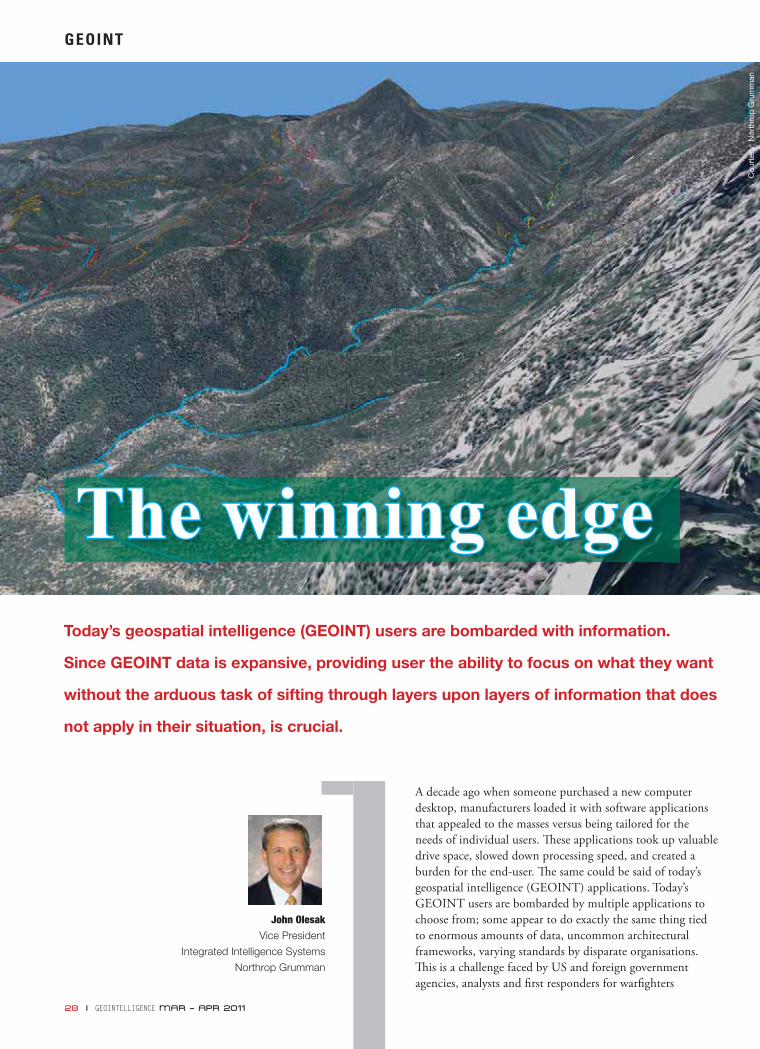
A decade ago when someone purchased a new computer desktop, manufacturers loaded it with software applications that appealed to the masses versus being tailored for the needs of individual users. Th ese applications took up valuable drive space, slowed down processing speed, and created a burden for the end-user. Th e same could be said of today’s geospatial intelligence (GEOINT) applications. Today’s GEOINT users are bombarded by multiple applications to choose from; some appear to do exactly the same thing tied to enormous amounts of data, uncommon architectural frameworks, varying standards by disparate organisations. Th is is a challenge faced by US and foreign government agencies, analysts and fi rst responders for warfi ghters
John Olesak
Vice President
Integrated Intelligence Systems
Northrop Grumman
GEOINT
Today’s geospatial intelligence (GEOINT) users are bombarded with information.
Since GEOINT data is expansive, providing user the ability to focus on what they want
without the arduous task of sifting through layers upon layers of information that does
not apply in their situation, is crucial.
The winning edgeThe winning edge
Cou
rtes
y: N
orth
rop
Gru
mm
an

MAR – APR 2011 GEOINTELLIGENCE I 29
can lose precious moments deciphering all the data. Th e ‘information overload’ experience is common for today’s GEOINT analysts. Layer upon layer of information or data which, when used in synchronisation with our lives can be benefi cial. However, when supplied in overwhelming abundance, it loses its power to help us. Our challenge in the world of GEOINT acquisition, analysis and processing is to peel away the layers of unnecessary data and disseminate the right information to the right analyst who needs it, in the format they require and in the necessary timeframe.
What if there was an online GEOINT storefront analysts could go to and select the applications and data they needed, in an on-demand fashion, in any format? Northrop Grumman, in collaboration with US and international agencies, is working towards this option—using advanced tools with common standards that allow for enhanced collaboration and information-sharing across agencies and boundaries to address common threats. Many challenges still remain – such as interoperability, developing common standards, accuracy and rapid transmission of information with limited bandwidth.
Common standards and interoperability
Common standards and implementation methods are critical to ensure that the multitudes of systems available to the user are capable of performing the intended mission without interruption or error. Developing systems from the ground up using a standards based approach ensures that the various tools needed by the user are interoperable and collaborate seamlessly behind the scenes without any direct user intervention. Th is saves time, increases capability and provides for a much richer user experience.
Organisations like the Open Geospatial Consortium (OGC), the National Spatial Data Infrastructure (NSDI), and the Global Spatial Data Infrastructure Association (GSDI) work to develop standards that enable interoperability and seamless integration of spatial information, processing software, and spatial services. Th ese organisations partner with government, private sector, and academic organisations to defi ne, develop, test, document, validate, and approve interface and encoding standards.
When employing a standards-based development approach, data and applicati ons from multiple sources and providers can be tightly integrated to achieve a more robust set of tools and require signifi cantly less pre-work on the part of the user in order to accomplish their tasks. Northrop Grumman’s development philosophy for GEOINT systems emphasises reuse and standards-based development for all aspects of product development.
To assist with this model, commercial off -the-shelf (COTS) software is integrated wherever possible. Using this type of approach promotes system interoperability, better scalability
and a reduction in the user training required to ‘spin up’ on multiple systems. Th is also helps create an effi cient and cost-eff ective method for deploying sophisticated geographic analysis, visualisation and dissemination capabilities at the enterprise level.
Applications and data together
Th e best applications are useless without the right data. Similarly, the most accurate data holds no value without the right tools to exploit it. For example, motorists using the global positioning system (GPS) in their car to fi nd directions across town have the right tool, and with the correct data loaded on it, they will get to their destination. Now, imagine they were provided with a high level map of the state they are in and general compass directions on which way to drive. It is not incumbent upon the driver to know the diff erence between regional imagery and street level vector maps — that is the job of the GPS. Good applications with appropriate data leads to mission accomplishment.
Th e same is true of users who require geospatial information system (GIS) information to accomplish their missions. If a user is examining an area to determine adequate helicopter landing zones, he requires accurate and detailed terrain information versus being bogged down by global information maps or regional imagery data that is 10 years old. Providing him the right tools combined with the right data in the format he requires will lead to mission success and reduced error rates.
GEOINT data is expansive so providing user the ability to focus on what they want without the arduous task of sifting through layers upon layers of information that does not apply in their situation is crucial. In the fi eld, the warfi ghter can access what they want and not get bogged down with unnecessary data.
Achieving the goal of tightly coupling applications, and data
Our challenge in the world of GEOINT acquisition, analysis
and processing is to peel away the layers of unnecessary data and disseminate the
right information to the right analyst who needs it, in the
format they require and in the necessary timeframe
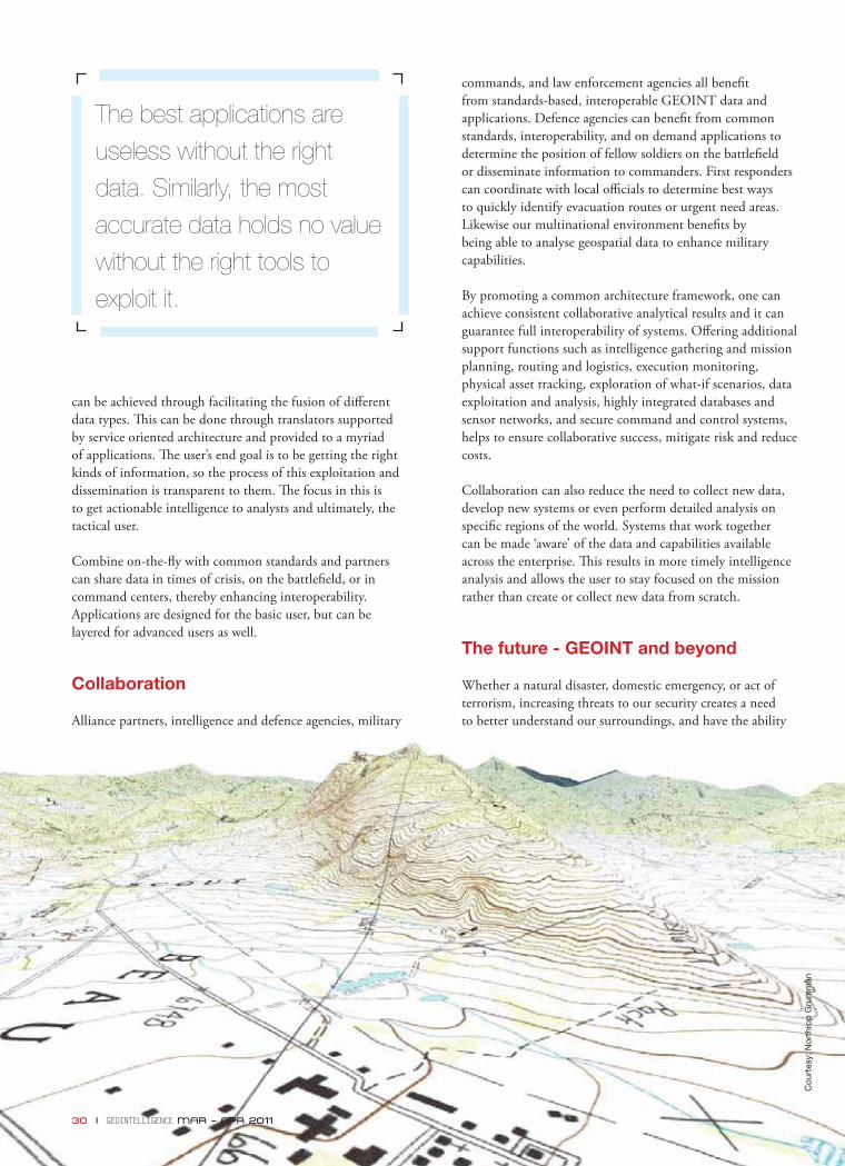
can be achieved through facilitating the fusion of diff erent data types. Th is can be done through translators supported by service oriented architecture and provided to a myriad of applications. Th e user’s end goal is to be getting the right kinds of information, so the process of this exploitation and dissemination is transparent to them. Th e focus in this is to get actionable intelligence to analysts and ultimately, the tactical user.
Combine on-the-fl y with common standards and partners can share data in times of crisis, on the battlefi eld, or in command centers, thereby enhancing interoperability. Applications are designed for the basic user, but can be layered for advanced users as well.
Collaboration
Alliance partners, intelligence and defence agencies, military
commands, and law enforcement agencies all benefi t from standards-based, interoperable GEOINT data and applications. Defence agencies can benefi t from common standards, interoperability, and on demand applications to determine the position of fellow soldiers on the battlefi eld or disseminate information to commanders. First responders can coordinate with local offi cials to determine best ways to quickly identify evacuation routes or urgent need areas. Likewise our multinational environment benefi ts by being able to analyse geospatial data to enhance military capabilities.
By promoting a common architecture framework, one can achieve consistent collaborative analytical results and it can guarantee full interoperability of systems. Off ering additional support functions such as intelligence gathering and mission planning, routing and logistics, execution monitoring, physical asset tracking, exploration of what-if scenarios, data exploitation and analysis, highly integrated databases and sensor networks, and secure command and control systems, helps to ensure collaborative success, mitigate risk and reduce costs.
Collaboration can also reduce the need to collect new data, develop new systems or even perform detailed analysis on specifi c regions of the world. Systems that work together can be made ‘aware’ of the data and capabilities available across the enterprise. Th is results in more timely intelligence analysis and allows the user to stay focused on the mission rather than create or collect new data from scratch.
The future - GEOINT and beyond
Whether a natural disaster, domestic emergency, or act of terrorism, increasing threats to our security creates a need to better understand our surroundings, and have the ability
The best applications are
useless without the right
data. Similarly, the most
accurate data holds no value
without the right tools to
exploit it.
30 I GEOINTELLIGENCE MAR – APR 2011
Cou
rtes
y: N
orth
rop
Gru
mm
an
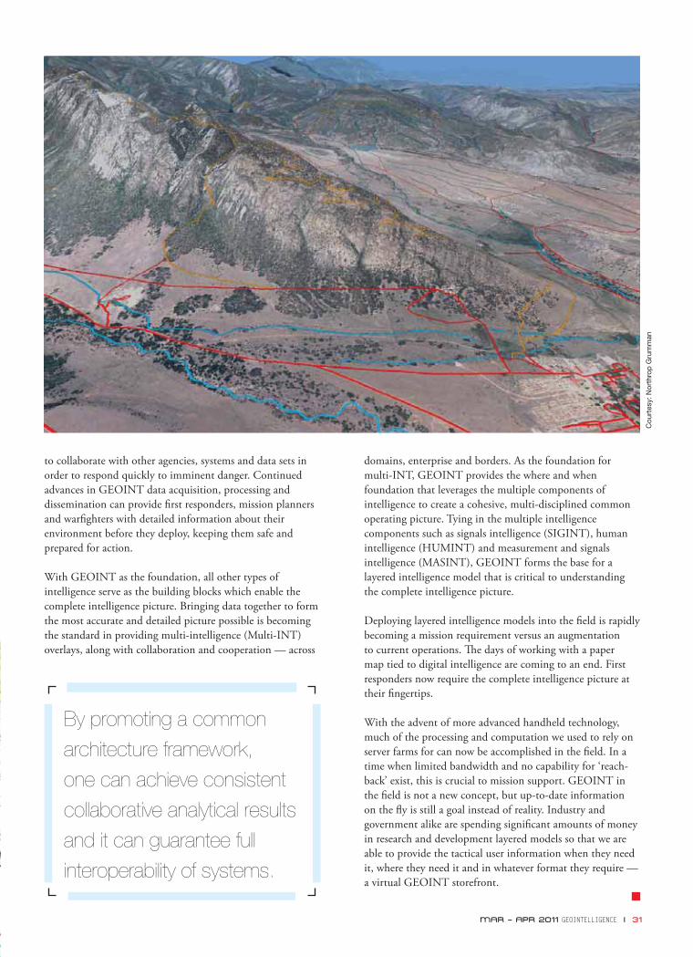
to collaborate with other agencies, systems and data sets in order to respond quickly to imminent danger. Continued advances in GEOINT data acquisition, processing and dissemination can provide fi rst responders, mission planners and warfi ghters with detailed information about their environment before they deploy, keeping them safe and prepared for action.
With GEOINT as the foundation, all other types of intelligence serve as the building blocks which enable the complete intelligence picture. Bringing data together to form the most accurate and detailed picture possible is becoming the standard in providing multi-intelligence (Multi-INT) overlays, along with collaboration and cooperation — across
domains, enterprise and borders. As the foundation for multi-INT, GEOINT provides the where and when foundation that leverages the multiple components of intelligence to create a cohesive, multi-disciplined common operating picture. Tying in the multiple intelligence components such as signals intelligence (SIGINT), human intelligence (HUMINT) and measurement and signals intelligence (MASINT), GEOINT forms the base for a layered intelligence model that is critical to understanding the complete intelligence picture.
Deploying layered intelligence models into the fi eld is rapidly becoming a mission requirement versus an augmentation to current operations. Th e days of working with a paper map tied to digital intelligence are coming to an end. First responders now require the complete intelligence picture at their fi ngertips.
With the advent of more advanced handheld technology, much of the processing and computation we used to rely on server farms for can now be accomplished in the fi eld. In a time when limited bandwidth and no capability for ‘reach-back’ exist, this is crucial to mission support. GEOINT in the fi eld is not a new concept, but up-to-date information on the fl y is still a goal instead of reality. Industry and government alike are spending signifi cant amounts of money in research and development layered models so that we are able to provide the tactical user information when they need it, where they need it and in whatever format they require — a virtual GEOINT storefront.
By promoting a common
architecture framework,
one can achieve consistent
collaborative analytical results
and it can guarantee full
interoperability of systems.
MAR – APR 2011 GEOINTELLIGENCE I 31
Cou
rtes
y: N
orth
rop
Gru
mm
an

32 I GEOINTELLIGENCE MAR – APR 2011
Electronic Warfare (EW) shall play an important role in deciding the outcome of any future war. All the confl icts in the last two decades have amply demonstrated this fact. Th erefore, it is no wonder that the armed forces around the globe are investing heavily in training their soldiers in this aspect of warfare, for it makes sense to sweat more in peace than bleed in war.
Training soldiers in the actual electromagnetic environment
Brig. S C Sharma
President – Mil Aero
Axis Aerospace & Technologies Pvt. Ltd.
EW SIMULATOR
Training soldiers in the actual electromagnetic environment is a challenge for armed forces. But with GIS based electronic warfare simulator, which brings the realistic warlike scenario to the classroom, soldiers can create different air situational scenarios and train.
Cou
rtes
y: U
nite
d S
tate
s D
epar
tmen
t of
Def
ense
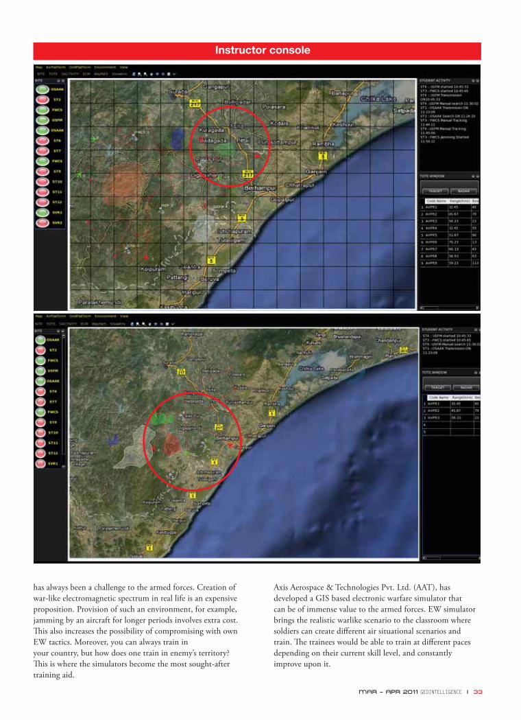
MAR – APR 2011 GEOINTELLIGENCE I 33
has always been a challenge to the armed forces. Creation of war-like electromagnetic spectrum in real life is an expensive proposition. Provision of such an environment, for example, jamming by an aircraft for longer periods involves extra cost. Th is also increases the possibility of compromising with own EW tactics. Moreover, you can always train in your country, but how does one train in enemy’s territory? Th is is where the simulators become the most sought-after training aid.
Axis Aerospace & Technologies Pvt. Ltd. (AAT), has developed a GIS based electronic warfare simulator that can be of immense value to the armed forces. EW simulator brings the realistic warlike scenario to the classroom where soldiers can create diff erent air situational scenarios and train. Th e trainees would be able to train at diff erent paces depending on their current skill level, and constantly improve upon it.
Instructor console
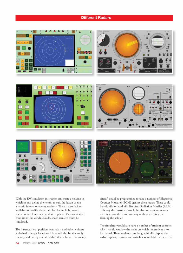
34 I GEOINTELLIGENCE MAR – APR 2011
With the EW simulator, instructor can create a volume in which he can defi ne the terrain to suit the lesson or use a terrain in own or enemy territory. Th ere is also facility available to modify the terrain by placing hills, towns, water bodies, forests etc. at desired places. Various weather conditions like winds, clouds, snow, rain etc could be simulated.
Th e instructor can position own radars and other emitters at desired strategic locations. He would also be able to fl y friendly and enemy aircraft within that volume. Th e enemy
aircraft could be programmed to take a number of Electronic Counter Measures (ECM) against these radars. Th ese could be soft kills or hard kills like Anti Radiation Missiles (ARM). Th is way the instructor would be able to create numerous exercises, save them and run any of these exercises for training the soldier.
Th e simulator would also have a number of student consoles which would emulate the radar on which the student is to be trained. Th ese student consoles graphically display the radar displays, controls and switches as available in the actual
Different Radars

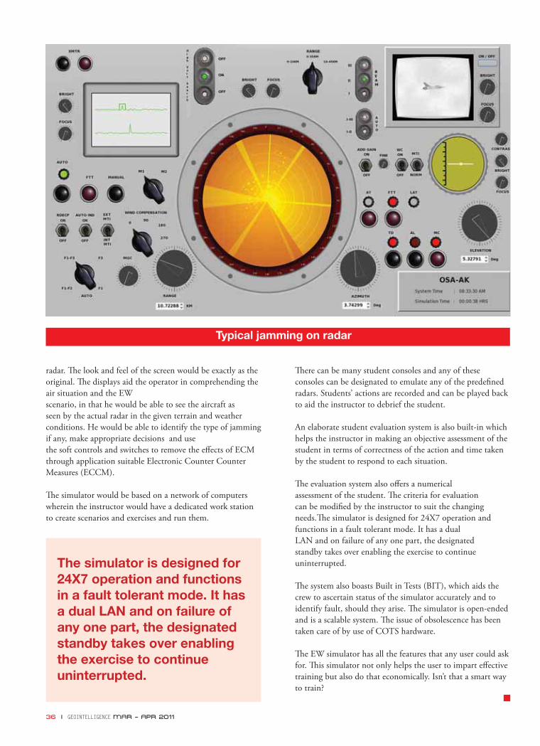
36 I GEOINTELLIGENCE MAR – APR 2011
radar. Th e look and feel of the screen would be exactly as the original. Th e displays aid the operator in comprehending the air situation and the EW scenario, in that he would be able to see the aircraft as seen by the actual radar in the given terrain and weather conditions. He would be able to identify the type of jamming if any, make appropriate decisions and use the soft controls and switches to remove the eff ects of ECM through application suitable Electronic Counter Counter Measures (ECCM).
Th e simulator would be based on a network of computers wherein the instructor would have a dedicated work station to create scenarios and exercises and run them.
Th ere can be many student consoles and any of these consoles can be designated to emulate any of the predefi ned radars. Students’ actions are recorded and can be played back to aid the instructor to debrief the student.
An elaborate student evaluation system is also built-in which helps the instructor in making an objective assessment of the student in terms of correctness of the action and time taken by the student to respond to each situation.
Th e evaluation system also off ers a numerical assessment of the student. Th e criteria for evaluation can be modifi ed by the instructor to suit the changing needs.Th e simulator is designed for 24X7 operation and functions in a fault tolerant mode. It has a dual LAN and on failure of any one part, the designated standby takes over enabling the exercise to continue uninterrupted.
Th e system also boasts Built in Tests (BIT), which aids the crew to ascertain status of the simulator accurately and to identify fault, should they arise. Th e simulator is open-ended and is a scalable system. Th e issue of obsolescence has been taken care of by use of COTS hardware.
Th e EW simulator has all the features that any user could ask for. Th is simulator not only helps the user to impart eff ective training but also do that economically. Isn’t that a smart way to train?
Typical jamming on radar
The simulator is designed for 24X7 operation and functions in a fault tolerant mode. It has a dual LAN and on failure of any one part, the designated standby takes over enabling the exercise to continue uninterrupted.

March
Unmanned Aircraft Systems1-3 March, 2011Sheraton San Diego Hotel & MarinaSan Diego, CA, USAwww.ttcus.com
Avalon Australian International Airshow1-6 March, 2011Avalon Airport, Geelong, VictoriaAustraliawww.airshow.net.au/avalon2011/index.html
Soldier Modernisation Asia14-17 March, 2011Amara Sanctuary Resort SentosaSingaporehttp://www.soldiermodasia.com/Event.aspx?id=345066
Cyber Security15-17 March, 2011Holiday Inn RosslynArlington, VA, USA.www.ttcus.com
New Concepts in Armour Engineering16 - 17 March, 2011Technion (Israel Institute of Technology)Haifa, Israelhttp://www.lightarmour.org/Haifa2011.html?defense-update
Air Surveillance and Reconnaissance 201121-23 March, 2011America Square Conference CentreLondon, United Kingdomwww.asarcevent.com
Future Artillery 201123-25 March, 2011TBC, London, UKwww.future-artillery.com
Network Centric Warfare 201129-30 March, 2011National Convention CentreCanberra, ACT, Australiawww.networkcentricwarfare.com
8th USENIX Symposium on Networked Systems Design and Implementation30 March - 1 April, 2011
Sheraton Boston HotelBoston, USAwww.usenix.org
Airborne Networks30 March - 1 April, 2011 Paris Las VegasLas Vegas, USAwww.ttcus.com
April
MilSpace 20114-5 April, 2011Radisson SAS HotelParis, Francehttp://www.smi-online.co.uk/events/overview.asp?is=1&ref=3512
SMES - Security Middle East Show7-9 April, 2011BIEL, BeirutLebanonwww.smesbeirut.com
9th Annual Maritime Homeland Security11-14 April, 2011Renaissance Baltimore Harborplace Hotel, Baltimore, Maryland, USAwww.maritimehssummit.com
MRO Military12-13 April, 2011Miami Beach Convention CenterMiami, USA.www.aviationweek.com
Latin America Aero & Defence - LAAD 201112-15 April, 2011Rio de Janeiro, Brazilwww.laadexpo.com
SPIE Defense, Security and Sensing25-29 April, 2011Orlando World center Marriott resort, FL, USAhttp://spie.org/defense-security-sensing.xml
May
USSTRATCOM Cyberspace Symposium (AFCEA)5-26 May, 2011Omaha, USAwww.afcea.org/events/
International Military Helicopter11-13 May 2011Olympia Conference CentreLondon, UKhttp://www.militaryhelicopterevent.com/Event.aspx?id=421444
Geospatial Intelligence Middle East 201115-18 May, 2011TBC, Abu DhabiUnited Arab Emirateswww.geospatialdefence.com
Cyber Defence16-17 May, 2011Istanbul Marriott HotelIstanbul, Turkey.www.smi-online.co.uk
MilSatCom Asia23-24 May 2011SingaporeSwissôtel Merchant Courthttp://www.smi-online.co.uk/events/overview.asp?is=1&ref=3640
June
2nd Annual Geospatial Summit1-3 June, 2011Hotel CorinthiaBudapest, Hungary http://www.fl emingeurope.com/aviation-and-defence-conferences/europe/2nd-annual-geospatial-intelligence-summit
UDT 20117-9 June, 2011ExCeL London, London, United Kingdomwww.udt-europe.com
Soldier Technology 20117-10 June, 2011Olympia Conference CentreLondon, United Kingdomwww.soldiertechnology.com
GeoIntelligence Asia 201114-15 June, 2011Manekshaw BhawanNew Delhi, Indiawww.gisdevelopment.net/geointelligence
EVENTS
MAR – APR 2011 GEOINTELLIGENCE I 37
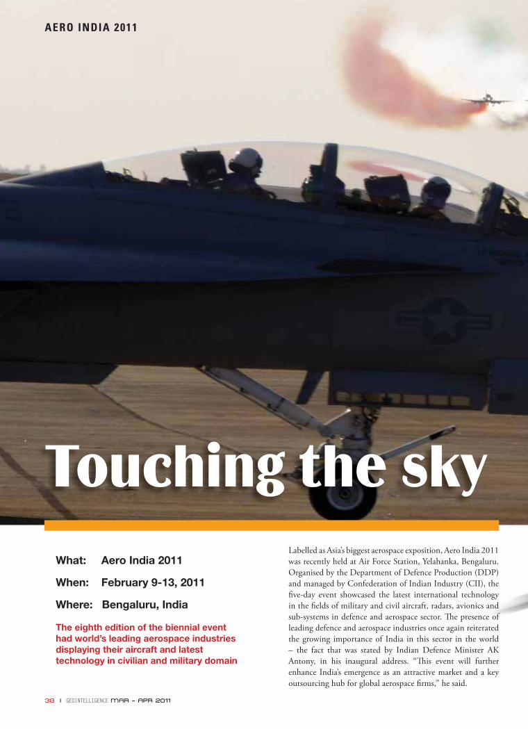
38 I GEOINTELLIGENCE MAR – APR 2011
AERO INDIA 2011
What: Aero India 2011
When: February 9-13, 2011
Where: Bengaluru, India
The eighth edition of the biennial event had world’s leading aerospace industries displaying their aircraft and latest technology in civilian and military domain
Touching the skyLabelled as Asia’s biggest aerospace exposition, Aero India 2011 was recently held at Air Force Station, Yelahanka, Bengaluru. Organised by the Department of Defence Production (DDP) and managed by Confederation of Indian Industry (CII), the fi ve-day event showcased the latest international technology in the fi elds of military and civil aircraft, radars, avionics and sub-systems in defence and aerospace sector. Th e presence of leading defence and aerospace industries once again reiterated the growing importance of India in this sector in the world – the fact that was stated by Indian Defence Minister AK Antony, in his inaugural address. “Th is event will further enhance India’s emergence as an attractive market and a key outsourcing hub for global aerospace fi rms,” he said.
38 I GEOINTELLIGENCE MAR – APR 2011
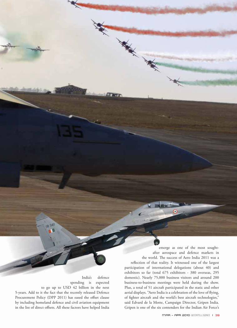
MAR – APR 2011 GEOINTELLIGENCE I 39
India’s defence spending is expected
to go up to USD 42 billion in the next 5-years. Add to it the fact that the recently released Defence Procurement Policy (DPP 2011) has eased the off set clause by including homeland defence and civil aviation equipment in the list of direct off sets. All these factors have helped India
emerge as one of the most sought-after aerospace and defence markets in
the world. Th e success of Aero India 2011 was a refl ection of that reality. It witnessed one of the largest
participation of international delegations (about 40) and exhibitors so far (total 675 exhibitors - 380 overseas, 295 domestic). Nearly 75,000 business visitors and around 200 business-to-business meetings were held during the show. Plus, a total of 51 aircraft participated in the static and other aerial displays. “Aero India is a celebration of the love of fl ying, of fi ghter aircraft and the world’s best aircraft technologies,” said Edvard de la Motte, Campaign Director, Gripen India. Gripen is one of the six contenders for the Indian Air Force’s
MAR – APR 2010 GEOINTELLIGENCE I 39
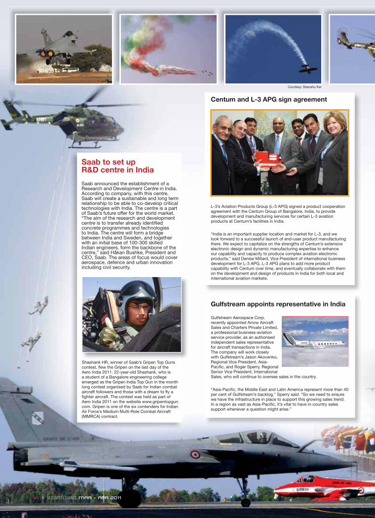
40 I GEOINTELLIGENCE MAR – APR 2011
Shashank HR, winner of Saab’s Gripen Top Guns contest, flew the Gripen on the last day of the Aero India 2011. 22-year-old Shashank, who is a student of a Bangalore engineering college emerged as the Gripen India Top Gun in the month long contest organised by Saab for Indian combat aircraft followers and those with a dream to fly a fighter aircraft. The contest was held as part of Aero India 2011 on the website www.gripentopgun.com. Gripen is one of the six contenders for Indian Air Force’s Medium Multi-Role Combat Aircraft (MMRCA) contract.
Saab to set up R&D centre in India
Saab announced the establishment of a Research and Development Centre in India. According to company, with this centre, Saab will create a sustainable and long term relationship to be able to co-develop critical technologies with India. The centre is a part of Saab’s future offer for the world market. “The aim of the research and development centre is to transfer already identified concrete programmes and technologies to India. The centre will form a bridge between India and Sweden, and together with an initial base of 100-300 skilled Indian engineers, form the backbone of the centre,” said Håkan Bushke, President and CEO, Saab. The areas of focus would cover aerospace, defence and urban innovation including civil security.
Centum and L-3 APG sign agreement
L-3’s Aviation Products Group (L-3 APG) signed a product cooperation agreement with the Centum Group of Bangalore, India, to provide development and manufacturing services for certain L-3 aviation products at Centum’s facilities in India.
“India is an important supplier location and market for L-3, and we look forward to a successful launch of end-user product manufacturing there. We expect to capitalize on the strengths of Centum’s extensive electronic design and dynamic manufacturing expertise to enhance our capability and capacity to produce complex aviation electronic products,” said Denise Millard, Vice President of international business development for L-3 APG. L-3 APG plans to add more product capability with Centum over time, and eventually collaborate with them on the development and design of products in India for both local and international aviation markets.
Gulfstream appoints representative in India
Gulfstream Aerospace Corp. recently appointed Arrow Aircraft Sales and Charters Private Limited, a professional business-aviation service provider, as an authorised independent sales representative for aircraft transactions in India. The company will work closely with Gulfstream’s Jason Akovenko, Regional Vice President, Asia-Pacific, and Roger Sperry, Regional Senior Vice President, International Sales, who will continue to oversee sales in the country.
“Asia-Pacific, the Middle East and Latin America represent more than 40 per cent of Gulfstream’s backlog,” Sperry said. “So we need to ensure we have the infrastructure in place to support this growing sales trend. In a region as vast as Asia-Pacific, it’s vital to have in-country sales support whenever a question might arise.”
40 I GEOINTELLIGENCE MAR – APR 2011
Courtesy: Sitanshu Kar
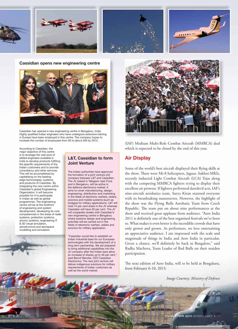
(IAF) Medium Multi-Role Combat Aircraft (MMRCA) deal which is expected to be closed by the end of this year.
Air Display
Some of the world’s best aircraft displayed their fl ying skills at the show. Th ere were Mi-8 helicopters, Jaguar, Sukhoi-MKIs, recently inducted Light Combat Aircraft (LCA) Tejas along with the competing MMRCA fi ghters trying to display their excellent air prowess. If fi ghters performed daredevil acts, IAF’s nine-aircraft aerobatics team, Surya Kiran stunned everyone with its breathtaking manoeuvres. However, the highlight of the show was the Flying Bulls Aerobatic Team from Czech Republic. Th e team put on about nine performances at the show and received great applause from audience. “Aero India 2011 is defi nitely one of the best organised festivals we’ve been to. What makes it even better is the incredible crowds that have only grown and grown. As performers, we love entertaining an appreciative audience. I am impressed with the scale and magnitude of things in India and Aero India in particular. Given a chance, we’ll defi nitely be back in Bangalore,” said Radka Machova, Team Leader of Red Bulls on their maiden participation.
Th e next edition of Aero India, will to be held at Bengaluru, from February 6-10, 2013.
Image Courtesy: Ministry of Defence
Cassidian opens new engineering centre
Cassidian has opened a new engineering centre in Bengaluru, India. Highly qualified Indian engineers who have undergone extensive training in Europe have been employed in this centre. The company hopes to increase the number of employees from 60 to about 200 by 2012.
According to Cassidian, the major objective of this centre is to leverage the vast pool of skilled engineers available in India to develop products fulfilling the specific requirements of the Indian customers and to provide consultancy and other services. This will be accomplished by capitalising on the leading-edge technologies, systems and products of Cassidian. By integrating the new centre within Cassidian’s global Engineering Organization, it will become possible for it to participate in Indian as well as global programmes. The engineering centre will be at the forefront of engineering and system development, developing its core competencies in the areas of radar systems, protection systems, avionic systems, engineering IT & 3D visual simulation, aerostructure and aerospace modelling and simulation.
L&T, Cassidian to form Joint Venture
The Indian authorities have approved the formation of a joint venture (JV) company between L&T and Cassidian. The JV, based in Talegaon near Pune and in Bengaluru, will be active in the defence electronics market. It aims to cover manufacturing, design, engineering, distribution and marketing in the fields of electronic warfare, radars, avionics and mobile systems (such as bridges) for military applications. L&T will hold 74 per cent share in the JV whereas Cassidian will have 26 per cent. The JV will cooperate closely with Cassidian’s new engineering centre in Bengaluru where systems design and engineering activities will be carried out in the fields of electronic warfare, radars and avionics for military application.
“Cassidian would like to establish an Indian industrial base for our European technologies with the development of a long term partnership. We are prepared to bring additional capabilities into the JV company after the Indian laws allow an increase of shares up to 49 per cent,” said Bernd Wenzler, CEO Cassidian Electronics. The new joint venture will deliver indigenous solutions for military requirements of Indian customers as well as the world market.
MAR – APR 2011 GEOINTELLIGENCE I 41
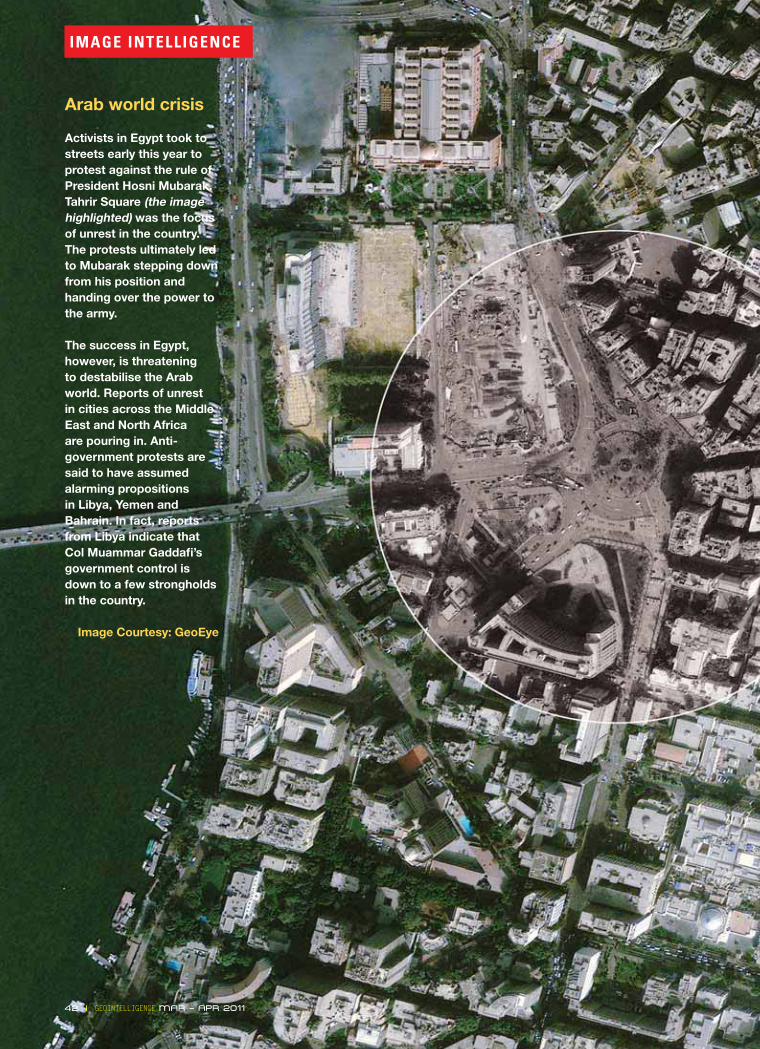
42 I GEOINTELLIGENCE MAR – APR 2011
IMAGE INTELLIGENCE
Arab world crisis
Activists in Egypt took to streets early this year to protest against the rule of President Hosni Mubarak. Tahrir Square (the image highlighted) was the focus of unrest in the country. The protests ultimately led to Mubarak stepping down from his position and handing over the power to the army.
The success in Egypt, however, is threatening to destabilise the Arab world. Reports of unrest in cities across the Middle East and North Africa are pouring in. Anti-government protests are said to have assumed alarming propositions in Libya, Yemen and Bahrain. In fact, reports from Libya indicate that Col Muammar Gaddafi ’s government control is down to a few strongholds in the country.
Image Courtesy: GeoEye

742 Square Miles, 720 Images, 10 Machines,
48 Hours, 3.8 Billion Terrain Points.
Automatically Generated Point Cloud in LPS eATE
Distribute your processing and maximize your resources.
Do you need to process massive imagery datasets quickly? ERDAS empowers you to quickly
and completely process your data, reducing your overhead costs:
Distributed Processingbatch tool in ERDAS IMAGINE 2011 and LPS 2011. We leverage an organization’s available
ERDAS Engine is a new offering, enabling ERDAS desktop products to run multiple
processes simultaneously for surges in production needs or situations requiring faster
throughput. Users can distribute demanding, resource-intensive processes among
multiple workstations or multiple cores on a single workstation.
With over 30 years of imagery expertise, ERDAS understands
the resources required to process and deliver information
or +1 877 GO ERDAS.