excavation and rehabilitation management plan · all quarries on commencement are required to...
TRANSCRIPT

Excavation and Rehabilitation Management Plan
Proposed Sand Quarry Lots 1479, 1480, 5890, and 5891 Warbrook
Road, Bullsbrook
City of Swan
WARBROOK ROAD PTY LTD
January 2016

Lindsay Stephens BSc (Geology), MSc (Plant Ecology) 25 Heather Road Roleystone WA 6111 Mem Aus Geomechanics Soc – MEIANZ – FIQA Tel 9397 5145, [email protected]

Proposed Extraction of Sand, Lots 1479. 1480, 5890 and 5891 Warbrook Road, Bullsbrook
Landform Research i
SUMMARY Approval for Planning Consent and Extractive Industries Licence to enable the extraction of sand from Lots 1479, 1480, 5890 and 5891, Warbrook Road, Bullsbrook is requested to maintain the supply of sand as a construction material to the local area. The proposal includes a rehabilitation plan that involves the restoration of the land surface to the same vegetation as currently occurs on site; parkland pasture and local native species. Landform restoration and rehabilitation is to progressively follow excavation. The site is listed in SPP 2.4 mapping as Resources 21/7 and portion of 21/34. Resource 21/7 is crossed out as being excavated, althouth this application seeks to complete the final excavation on that site. The Western Australian Geological Survey has produced 2012 mapping identifying Regionally Significant Basic Raw Materials across private land and State Forest. The Geological Survey mapping recognises the sand resource as significant and has mapped the ridge across all lots on the Perth – Wooroloo Sheet. The volume and rate of excavation is, of course, determined by the sales orders for the various contracts. It is expected that excavation will take up to 10 years to be completed. 100 000 to 200 000 tonnes per year are anticipated to be removed with the possibility of a larger contract in a particular year. Staging is shown on Figure 3. Buffers of 20 metres will be left to adjoining lots not held by a sand excavator. The lots adjoining to the north and south either have been excavated or will be excavated and will be mined through, to provide a consistent final end land surface. Environmental factors are considered and mitigated by best practice management.
• A flora and vegetation assessment is included in Attachment 1. Impact on flora and fauna are considered in Section 8.1 Biodiversity Management.
• An Environmental Risk Assessment is provided at the end of the
Summary at the front of this document. • Visual, Amenity, Transport impacts, Dust and Noise are considered in
a separate Offsite Impacts Management Plan in Attachment 2.
• Water management is considered in Attachment 3, Water Management Plan.

Proposed Extraction of Sand, Lots 1479. 1480, 5890 and 5891 Warbrook Road, Bullsbrook
Landform Research ii
• Closure and Rehabilitation is considered in Section 9.0 Mine Closure and Rehabilitation.
• Dieback and Weed Management Plans are included in Section 9 Mine
Closure and Rehabilitation.
APPROVAL SOUGHT
Approval is sought to remove the usable sand from Lots 1479, 1480, 5890 and 5891 over a period of 10 years to enable staged extraction and help satisfy long term community needs.
Suggested Condition for a larger contract. It is suggested that a Condition of Approval be used to enable a larger contract to be filled for a defined period of time. It is suggested that this could be activated by way of a notification to the Chief Executive Officer of the City of Swan through delegated authority of the Council, nominating the amount of material to be removed, complaints and communication procedures and the time frame. This would enable the City of Swan to provide input into the transport routes to be used, any dust or noise suppression required and any other management that may be appropriate. By allowing a potential or a larger contract to be undertaken for a defined time, the community is provided with certainty. This approach has been used for a number of sand operations such as Bush Beach Holding Pty Ltd on Lot 731 Old Coast Road Herron in the City of Mandurah and Rumenos Civil on Lots 11 and 12, Plantation Road Capel in the Shire of Capel.

Proposed Extraction of Sand, Lots 1479. 1480, 5890 and 5891 Warbrook Road, Bullsbrook
Landform Research iii
PROJECT SUMMARY ASPECT PROPOSAL CHARACTERISTIC EXCAVATION Total area of excavation 15.5 hectares Total disturbance area 9.0 ha cleared partially excavated
6.5 ha disturbed and partially vegetated in Completely Degraded to Degraded Condition with small areas approaching Good Condition.
Total area of mining footprint
Sand and sand extraction 100 000 to 200 000 tonnes per year with the possibility of a larger contract in a particular year.
Total estimated resource 800 000 tonnes Life of project 10 years – shorter if more sand is removed
annually. Area cleared per year Average 1 – 2 ha Area mined per year Average 1 – 2 ha Dewatering requirements None Maximum depth of excavations 1 - 10 metres Native vegetation to be cleared A Clearing Permit is required for 6.5 hectares. PROCESSING Sand Unlikely to be any processing Water requirements - source Approximately 5 000 kL per year.
Supplied and controlled by Licensed Bore if available, otherwise water will be brought to site from Scheme Water.
INFRASTRUCTURE Total area of plant and stock Located within pit. Approximately 0.5 ha needed. Area of settling ponds Not required Fuel storage Proposed to be mobile refuelling; no on site
storage. TRANSPORT Truck movements Variable but 0 – 5 laden truck movements per
hour. Access Internal road through Lot 5890 to Warbrook Road WORKFORCE Construction Existing operation. Operation 10 years Hours of operation Hours of operation will be, 6.30 am to 5.00 pm
Monday to Saturday inclusive, with transport and screening, if there is any processing, between 7.00 am to 5.00 pm excluding public holidays.

Proposed Extraction of Sand, Lots 1479. 1480, 5890 and 5891 Warbrook Road, Bullsbrook
Landform Research iv
MANAGEMENT OF THE OPERATIONS
The excavation, proessing and environmental management proposed has been designed to reflect best practice and utilises Commonwealth and State Guidelines. Safety Management All quarries operate under the provisions of the Mines Safety and Inspection Act 1994 and Regulations 1995. These are administered by the Department of Mines and Petroleum. The regulation is achieved through the DMP Safety Regulations and Reporting Systems (SRS). All quarries on commencement are required to register with the SRS system. As part of the registration a Project Management Plan is required to be produced and lodged online after all planning approvals are in place and prior to commencement. The Project Management Plan will use some material from this Management Plan and concentrate on the onsite operations as they relate to health and safety. Officers from the Safety Division of the DMP will regularly inspect the operations in relation to health and safety. Environmental Management Environmental Management is normally controlled through conditions imposed by Planning Approval under the Local Authority Town Planning Scheme, approval under a Local Authority Local Law, WAPC approval under a Regional Planning Scheme and any other conditions imposed by other approvals such as a Clearing Permit or Licensing through the Department of Environment Regulation or Water Licence through the Department of Water. Management is also achieved through the design and site procedures relating to the operations and commitments made by the proponent which are reflected in this Management Plan. The environmental management is designed to reflect best practise, outlined in particular in;
Department of Resources, Energy and Tourism (Commonwealth), 2011, A Guide to Leading Practice Sustainable Development in Mining, and guidelines produced by Environmental Protection Authority, Department of Environment Regulation, Department of Water, Department of Mines and Petroleum, Western Australia Planning Commission and the Local Authority.

Proposed Extraction of Sand, Lots 1479. 1480, 5890 and 5891 Warbrook Road, Bullsbrook
Landform Research v
An Environmental Risk Assessment has been developed based on the EPA Environmental Factors which have been identified by the EPA as the factors to be considered when reviewing environmental impact and outcomes in Western Australia. The EPA Factors have been used and added to in the following table which provides for the environmental risk if not mitigated or managed and the assessed environmental risk when the proposed design and management procedures are effectively implemented. All the EPA environmental factors, together with the other factors, are provided in the Environmental Risk Table to show that some are not relevant to this proposal. Leaving them out may lead to some uncertainty in a reviewer’s mind. The Environmental Risk Matrix was developed to the principles of AS/NZS ISO 140001:2004 (Environmental Management Systems) and AS/NZS ISO 19011:2014 (Guidelines for auditing Management Systems). The principles of AS/NZS 31000:2009 (Risk Management Guidelines) are also used when considering any risks. The Risk Table includes references to the various parts of the document to enable easy review and provides a summary of the project and its management. The risk assessment table also forms the basis of an auditable matrix.

Proposed Extraction of Sand, Lots 1479. 1480, 5890 and 5891 Warbrook Road, Bullsbrook
Landform Research vi
CONTENTS SUMMARY AND ENVIRONMENTAL RISK ASSESSMENT 1.0 BACKGROUND INFORMATION 1 1.1 Background 1 1.2 Location 1 1.3 Land Ownership and Agreements 1 1.4 Proponent 1 1.5 Project Objectives 2
1.6 Site Plans 4
2.0 PHYSICAL ENVIRONMENT 5 2.1 Geology and Geomorphology 5 2.2 Description of the Resource 5
2.3 Regolith and Soils 5 2.4 Climate 5 2.5 Hydrogeology 6 2.6 Acid Sulfate 7
3.0 BIOLOGICAL ENVIRONMENT 9 3.1 Vegetation and Flora 9 3.2 Fauna 10
3.3 Wetlands 11 3.4 Stygofauna and Troglofauna 11 3.5 Weeds and Plant Diseases 11
4.0 SOCIAL ENVIRONMENT 12 4.1 Planning Issues 12 4.1.1 State Planning Policies 12 4.1.2 Local Government Policies and Planning Scheme 17 4.1.3 End Use and Sequential Planning 18 4.1.4 Social Impacts 18 4.1.5 Surrounding Landuses and Buffers 19 4.2 Community Consultation 20 4.3 Heritage 20
4.4 Compliance and other Legislation 21 5.0 MINING OPERATIONS 23 5.1 Project Summary 23 5.2 Extraction and Processing of the Resource 24 5.2.1 Excavation 24 5.2.2 Pit Design and Staging 25 5.2.3 Final Contours 25 5.2.4 Processing of the Resource 26 5.2.5 Stockpiles 26 5.3 Hours of Operation 26
5.4 Machinery and Equipment 26 5.5 Access and Transport 27 5.6 Workforce 28 5.7 Water Use 29
6.0 GEOTECHNICAL FACTORS 30 7.0 SAFETY 31

Proposed Extraction of Sand, Lots 1479. 1480, 5890 and 5891 Warbrook Road, Bullsbrook
Landform Research vii
8.0 EVIRONMENTAL IMPACTS AND MANAGEMENT 33 8.1 Biodiversity Management 33 Flora Fauna Wetlands
8.2 Water Management 35 8.3 Atmospheric Pollution and Management 36 Visual Noise Dust
9.0 MINE CLOSURE PLAN 39 9.1 Land Use Policies 39 9.2 End Use 39 9.3 Mine Closure Considerations 40 9.4 Rehabilitation Objectives 40 Completion Criteria 42
9.5 Rehabilitation Procedures 42 Vegetation Clearing 42 Landform Reconstruction and Contouring 42 Topsoil and Overburden Removal 43
Vegetation Establishment 43 Fertiliser 45 Irrigation 46 Erosion Control 46
Monitoring 46 Plant Pathogen, Weed and Dieback Management 48
10.0 REFERENCES 53
FIGURES Figure 1 Location and SPP 2.4 Figure 2 Perth – Peel Green Growth Plan for 3.5 Million Figure 3 Surrounding Landuse – Transport Route
Figure 4 Aerial Photograph Figure 5 Site Photographs
Figure 6 Excavation Methods – Rehabilitation Areas Figure 7 Existing Contour Plan Figure 8 Concept Final Contour Plan
APPENDICES Appendix 1 Flora and Vegetation Assessment Appendix 2 Offsite Impacts Management Plan Appendix 3 Water Management Plan

Proposed Extraction of Sand, Lots 1479. 1480, 5890 and 5891 Warbrook Road, Bullsbrook
Landform Research 1
1.0 BACKGROUND INFORMATION 1.1 Background
Warbrook Road Pty Ltd seeks Planning Consent and an Extractive Industries Licence to enable the extraction of sand from Lots 1479, 1480, 5890 and 5891 Warbrook Road, to supply sand for construction materials. Sand has previously been extracted from Lot 5890 and the edges have been left as steep slopes at the angle of repose. The land adjoining Lot 5891 is currently being excavated for sand. This proposal seeks to extract sand from Lots 1479, 1480, 5890 and 5891 to tidy the land form and ensure it is consistent across lots and provide a source of sand for the local construction prior to the land is sterilised by nearby developments as nominated by State Government Planning Policies such as SPP 2.4. A dwelling currently lies on the central ridge on Lot 5891. This will be removed to enable excavation to occur.
1.2 Location
Lots 1479, 1480, 5890 and 5891 are located in Warbrook Road west of Halden Road, approximately 3 km north west from Ellenbrook 1.3 Land Ownership and Agreements
LOT OWNERS VOLUME FOLIO
1479 Rangedale Corporation Pty Ltd 1426 114 1480 Rangedale Corporation Pty Ltd 1426 114 5890 Rangedale Corporation Pty Ltd 1443 695 5891 Warbrook Roaqd Pty Ltd 1440 515
1.4 Proponent
The proponent is Warbrook Road Pty Ltd. Contact can be made through; Manager
Warbrook Road Pty Ltd 19 Watt Street Swanbourne WA 6010
Proposed Extraction of Sand, Lots 1479. 1480, 5890 and 5891 Warbrook Road, Bullsbrook
Landform Research 2
1.5 Project Objectives
• Progressively excavate sand. • Provide reserves of strategically located sand suited to a variety of end products
prior to sterilisation by local conservation or development. • Maximise the use of sand to the north of Perth from less sensitive areas, to
enable greenhouse gases, transport, and other environmental issues associated with alternative resources, to be minimised.
• Help to keep the prices of local sand at the lowest possible levels, by
maintaining small transport distances and competition. This benefits the whole community.
• Comply with State Planning Policies, which state that basic raw materials should
be taken prior to sterilisation of the area by development. • Extract sand from an area where other sand quarries currently exist. The proposal achieves the dual purposes of extracting a valuable resource in line with State Planning Policy No 2.4 Basic Raw Materials. Uses of the Sand Basic raw materials are essential for the construction and maintenance of all developments; such as roads, subdivisions, buildings, bridges, ports and rail lines. The sand is a vital resource;
• Almost every house on the Swan Coastal Plain is constructed using significant amounts of construction materials including sand for concrete and fill.
• All subdivisions use sand fill to prepare the sites to AS 2870 Site Class A.
• Sand from the Bassendean Land System enables several product types to
be produced: yellow fill sand, earthy yellow sand for maximisation of phosphate retention and white sand.
Significance of the Sand Perth and Peel @ 3.5million, developed by the Western Australian Planning Commission has determined that the Metropolitan Area will grow significantly between 2012 and 2050 by around 650 000 dwellings The construction of dwellings needs sand for roads, in particular locally the Perth – Darwin Highway, in addition to concrete and other products that include some sand. The Chamber of Commerce and Industry estimated in 2008 that each dwelling required 155 tonnes of sand, which includes roads. Dwellings in low lying acres requiring fill can require significantly more sand.

Proposed Extraction of Sand, Lots 1479. 1480, 5890 and 5891 Warbrook Road, Bullsbrook
Landform Research 3
The resource is identified as a Regionally Significant Basic Raw Material (sand) by the WA Geological Survey 2012, on the Perth-Wooroloo Sheet. The sand is recognised in State Planning Policy 2.4 Basic Raw Materials 2000, and has been recognised in previous documents such as availability of Basic Raw Materials Perth Metropolitan Region, Metropolitan Region Planning Authority 1983. Figure 1. The resource area is also recognised in the Perth and Peel Green Growth Plan for 3.5 million with the northern lots listed because they have some native vegetation on them but the southern lot is not listed because it is pasture. Figure 2. The need for basic raw materials such as sand has been discussed in many documents and in particular Chamber of Commerce and Industry, 1995 and 1996, Managing the Basic Raw Materials of Perth and the Outer Metropolitan Region, Parts 1 and 2 and Chamber of Commerce and Industry, 2008, Basic Raw Materials Access and Availability. Additional Sources of Information Further information on the need for sand is shown in the following documents. The Chamber of Commerce and Industry are currently updating their assessments. See; • Abeysinghe P B, 1998, Sand and Limesand Resources of Western Australia,
Geological Survey of Western Australia, Mineral Resources Bulletin 18. • Gozzard J R, 1987, Limesand and Sand Resources between Lancelin and
Bunbury, Geol Surv WA, Record 1987/5 • Western Australia, Western Australian Planning Commission, State Planning
Policy 2.4, Basic Raw Materials. • Chamber of Commerce and Industry, 1995 and 1996, Managing the Basic Raw
Materials of Perth and the Outer Metropolitan Region, Parts 1 and 2. • Chamber of Commerce and Industry, 2008, Basic Raw Materials Access and
Availability. Sand is only extracted for the community benefit, and utilised as a manufactured building product. If there was no community demand for sand as a building product it would be unlikely that this natural resource would ever be utilised for any other purpose and would have no economic significance. Alternative Resources The resource is strategically located and has the potential to provide raw materials for the manufacturing and construction industry for 10 plus years. The need for the resource is well known but is sometimes not given due weight in the assessment processes by all levels of Government. Sand is extracted from Gnangara pine plantation, but this sand has equal value and is closer to some potential markets, and that may assist in reducing the transport costs to developers and the community.

Proposed Extraction of Sand, Lots 1479. 1480, 5890 and 5891 Warbrook Road, Bullsbrook
Landform Research 4
Proposals such as this are often considered in isolation without reviewing the wider environmental impacts. If the resource is not taken from this site it will have to be taken from another site where similar or more land clearing is required. Requested Approval A ten year approval is sought.
1.6 Site Plans
Site plans are shown in the attached Figures.

Proposed Extraction of Sand, Lots 1479. 1480, 5890 and 5891 Warbrook Road, Bullsbrook
Landform Research 5
2.0 PHYSICAL ENVIRONMENT 2.1 Geology and Geomorphology
The site drops from 68 metres AHD in central parts of the site on Lot 5891, down to lower elevations in the north and south at around 50 metres AHD. The site consists of portion of a large sand ridge that has partially been excavated on Lot 5890 and is currently being excavated on the same ridge immediately to the east. The sand ridge is formed from Bassendaean Sand which, although widespread is restricted in its availability in strategic locations by existing land uses. The sand is of aeolian origin (formed from wind blown calcareous sands) derived from beach sands, and, over the years, has been subjected to solution of any calcium carbonate to leave behind a silica sand. The sand is likely to also have been reworked to produce the current ridge form. See Perth Environmental Geology 1 : 50 000 Series, Yanchep and Perth maps, (Geological Survey, 1982 and 1986). The upper portion of the resource is white silica grading to lighter yellow and yellow silica coloured by staining of the grains by minor amounts of goethite.
2.2 Description of the Resource The sand is almost pure silica sand with some minor goethite staining at depth as shown in the previously excavated faces on Lot 5890. The land surface ranges from 60 metres AHD on the centre of the resource down to 2 metres above the highest known water table at around 55 metres in the south and north. The total volume of sand is estimated at around 500 000 cubic metres, dependent on the depth of excavation and the batter slopes to be formed back to the natural land surface.
2.3 Regolith and Soils All soils are siliceous yellow sands with a leached white sand overlying horizon and a leached sand at the water table at around 47.5 metres in the east grading to 50 metres AHD in the west. The topsoil is a relatively thin grey band stained by organic matter. There may be occasional minor iron indurated sand and coffee rock in the profile at the historic wetting – drying front.
2.4 Climate The climate of the area is classified as Mediterranean, with dry hot summers and cool wet winters.

Proposed Extraction of Sand, Lots 1479. 1480, 5890 and 5891 Warbrook Road, Bullsbrook
Landform Research 6
Climate data is recorded at Bullsbrook, (Pearce RAAF), Precipitation is 688 mm per annum, of which 89% falls in the months April to October inclusive. At Swan Research Station evaporation exceeds rainfall in all but the four wettest months, and the situation at Bullsbrook can be expected to be similar. Average maximum temperatures at Bullsbrook reach 33.3 degrees Celsius for the hottest months, January and February, but fall to 17.6 degrees Celsius in July. Average minima for the coldest month August, is 8.2 degrees Celsius. The climate data for Bullsbrook shows that the predominant summer winds are from the east at 9.00 am and from the south west at 3.00 pm. In summer wind blows from the east 70% of the time at 9.00 am and from the west/south west for 60% of the time at 15.00 pm. Summer wind speeds tend to be 6 to 10 km/hour at 9.00 am and between 11 and 20 km/hour at 15.00 pm. The winter wind directions are more even, but there is a slight predominance from the east at 9.00 am and south west at 15.00 pm. The average speeds are between 1 to 10 km/hour. The wind roses for Pearce show that there is a pronounced easterly wind at 9.00 am on summer mornings, but this has to be balanced by the afternoon winds which blow from the south west at 3.00 pm. The data collected at Pearce has to be viewed with caution and can only be used as a general indication for this site and must be subject to interpretation. Pearce lies at the base of the Darling-Gingin Scarp and is subject to strong katabatic winds on summer mornings. The Scarp is immediately east of Pearce and produces the easterly spike at 9.00 am. This causes the windshear at Pearce and Perth Airport. The issue of katabatic effects is well explained in Mitchell, K, 1979, The Effect of the Darling Scarp on Easterly Air Flow, Geowest No 15 University of Western Australia. Katabatic effects result from the variations in air temperature, topographic effects and the air flow from the Darling Plateau down to the base of the Darling Scarp. The winds are significantly affected and directed by landform. The 100 metres change in elevation is sufficient to significantly produce and deflect katabatic winds.
2.5 Hydrogeology
Additional information is provided in the attached Water Management Plan. There is no surface drainage on the sand resource due to the porosity and permeability of the sand, with precipitation draining to the water table. However there is drainage at the water table in two areas to the north and south of the sand ridge and resource. In the north this extends around the ridge on Lots 1479 and 1480 and is defined in a drainage lot, Lot 377, enclosed by Lot 5890. Drainage also occurs in the wet area on Lot 5891 south of the resource. Surface water flow is to the east – south east along tributaries of Saw Pit Gully to eventually reach Ellen Brook.

Proposed Extraction of Sand, Lots 1479. 1480, 5890 and 5891 Warbrook Road, Bullsbrook
Landform Research 7
Groundwater flow is also to the east, dropping from an elevation of 50 metres AHD in the north west to 47.5 metres AHD under the east of the resource area. The sand is porous and there is no surface water runoff, with all surface water being retained within the pit.
2.6 Acid Sulfate
There has been an increased interest in acid sulfate soils since the release of WAPC Planning Bulletin 64. However the interest has been over-reactive, with assessments sought and risk applied in many areas where there is no geological risk or evidence of acid sulfate potential or actual conditions. The most definitive survey procedure was produced by the Acid Sulfate Soil Management Advisory Committee NSW, 1998, in their Acid Sulfate Manual. This Manual forms the basis for much of the assessment procedures in Australia, including those adopted by the Western Australian Planning Commission and the Department of Environment Regulation. The Acid Sulfate Manual adopts the procedure of reviewing the published data followed up by field assessment, which has been completed for this site. If a geological risk is determined, then a Preliminary Acid Sulfate Assessment is conducted. Acid sulfate only becomes a potential risk when a number of circumstances are present.
• There is rock, soil or regolith present that is carrying sulfides.
• Sulfide carrying materials from below the water table are to be exposed to the atmosphere.
• Excavation below the water table is to be carried out exposing the sulfide
carrying materials to oxygen in the atmosphere.
• Dewatering of the sulfide carrying materials is proposed, exposing them to oxygen.
• Regolith conditions are already highly acidic, below pH4, under which
oxidation can occur through electron exchange without the need for the presence of oxygen.
The site is shown as yellow coloured, Moderate to Low Risk of acid sulfate conditions at depths of generally > 3 metres, in WAPC Planning Bulletin 64. There are minor red spots which are rated as carrying a high risk of acid sulphate, but none of these appear to occur on the sand resoruce, but are centred on the wet area on Lots 1479 and 1480 to the north west of the proposed exavation. No drains or excavation are proposed to be cut below the water table.

Proposed Extraction of Sand, Lots 1479. 1480, 5890 and 5891 Warbrook Road, Bullsbrook
Landform Research 8
In some other low lying parts of the Swan Coastal the iron induration zones can contain organic material which by their reducing nature may hold sulfide sulfur and be acid sulfate generating on exposure to the atmosphere. The iron indurated materials on site are located above the water table which has been artificially raised following land clearing and is not organic enriched and contains no acid sulfate risk from site observations and the testing completed. No soil or water acidity can be attributed to acid sulfate conditions. Excavation will not occur below the water table so reduced materials will not be exposed to the atmosphere during excavation. The site has been visited by Lindsay Stephens of Landform Research and the sand observed. On this site the sandy soils and deeper sands are highly oxidised with sand exposed on the surface. The sand is neutral to acidic, hence the presence of the yellow brown goethite coatings. The base of the pit is at an elevation 2 metres above the groundwater, and demonstrates the oxidised conditions present. No peat or organic matter has been intersected in the pit, immediatley to the north on Lot 5890 where a good cross section of the resource is available.
Proposed Extraction of Sand, Lots 1479. 1480, 5890 and 5891 Warbrook Road, Bullsbrook
Landform Research 9
3.0 BIOLOGICAL ENVIRONMENT 3.1 Vegetation and Flora
The site comprises 15.5 hectares. Of this 9.0 hectares is cleared and only 6.5 ha is native vegetation that is disturbed and partially vegetated in Completely Degraded to Degraded Condition with small areas approaching Good Condition. The site has been assessed in Spring 2014 and 2015, by Lindsay Stephens of Landform Research. The flora and vegetation was assessed and the results provided in a separate report attached as Appendix 1.
In all areas there is <20% of the original species remaining. Even in the areas of better vegetation the vegetation cover is increased but the species composition remains poor. The vegetation varies from completely cleared as Completely Degraded with smaller areas of better vegetation rising to Degraded, and minor patches rated as being in Good Condition on the Bush Forever 2000 scale. Based on the total number of species, under Kaesehagen 1995, the vegetation best fits into the category of Very Poor as there is <20% of the original vegetation species remaining in almost all areas. The best vegetation lies towards the north of Lot 1480. The reduced species richness is typical of vegetation that has been subjected to some past and continued disturbance. What normally occurs is that the richness within a smaller area, such as sample plot size, is reduced, however the species richness of a much larger area, such as the whole site, is much greater because some species are removed from one area but not others. The areas of remnant vegetation contain elements of Banksia Eucalypt Woodland with Banksia attenuata, Banksia menziesii with scattered Eucalyptus todtiana, over a shrub layer that contains Jacksonia floribunda, Gompholobium tomentosum, Hibbertia hypericoides, Eremaea paucifloria, Patersonia occidentalis, Petrophile linearis, Acacia pulchella and Adenanthos cygnorum. The understorey contains significant exotic species and pasture grasses at densities of mainly very dense grasses typified and dominated by Veldt Grass Ehrharta spp Briza minor and Briza major. Figures 4 and 5. No plant communities or taxa are listed as a Threatened Ecological Community or taxa under the Commonwealth Environment Protection and Biodiversity Conservation Act 1999. The species present are common species. The vegetation on site would most likely have originally been FCT Community Type 23a, Central Banksia attenuata – B menziesii woodlands which is not specifically listed as a Threatened or Priority Community. However all Banksia dominated Woodlands on the Swan Coastal Plain IBRA region are now listed generally as a Priority 3 (iii) Community, meaning that all Banksia Woodlands dominated by Banksia attenuata – Banksia menziesii are generally under threat from processes such as inappropriate fire regimes, clearing, weed intrusion, dieback etc.

Proposed Extraction of Sand, Lots 1479. 1480, 5890 and 5891 Warbrook Road, Bullsbrook
Landform Research 10
On this site the vegetation is degraded and the Priority listing would apply only to remnant vegetation in higher quality condition. EPA Guidance 10 Level of assessment for proposals affecting natural areas within the System 6 region and Swan Coastal Plain portion of the System 1 Region lists Bassendean Complex North as having 72.0% of the pre-European area still occurring in 2003 and 27.5% in secure tenure. That figure will be less now with intervening clearing. Considering the degraded extent of the vegetation on site the vegetation meets the Government targets even if this land is cleared for sand excavation. A Clearing Permit will be required for part of the site. See Biodiversity Management Plan attached as Appendix 1 Environmental Impacts and Management.
3.2 Fauna A database search was made of the Department of Parks and Wildlife website. A search of the EPBC database was also conducted. These are attached to Appendix 1. Possibly the most significant fauna are Black Cockatoos which have been recorded in the general area. The listed taxa are Calyptorhynchus latirostris, with Caloptorhynchus sp being recorded in 2005 at Pinjar. Calyptorhynchus baudinii has not been locally recorded on DPAW databases. Both are listed on State (under the Wildlife Conservation Act 1950) and EPBC conservation databases. On the State database the taxa are listed in Schedule 1 as “Fauna that is rare or is likely to become extinct”. Fauna will be considered under the Clearing Permit process when an application is made for clearing. The main vegetation species being searched were for the potential for Carnaby’s Cockatoo Calyptorhynchus latirostris to provide some minor feeding habitat from the scattered Banksia attenuata and Banksia menziesii. There is no potential nesting hollows as there are no suitable trees within the clearing area. Some Marri Corymbia calophylla occur outside the proposed sand excavation in the north but will not be impacted. They and the pines on site will provide a small food resource for Black Cockatoos. In line with Government Policy the Marri will be retained and the pines are to be removed because they do not represent natural food sources for the cockatoos. An assessment of the potential for Black Cockatoo habitat has been undertaken. The clearing of the vegetation on site will not trigger the EPBC requirements for referral to the Commonwealth because the amount of food source is equivalent to less than 1 hectare and there are no nesting trees. The only large trees are the introduced pines and Eucalypts.

Proposed Extraction of Sand, Lots 1479. 1480, 5890 and 5891 Warbrook Road, Bullsbrook
Landform Research 11
3.3 Wetlands
There are no wetlands impacted by the proposal. The lower lying areas along the north of the site near Warbrook Road are a wetland and have been defined by Lot 377. The drainage is a tributary of Saw Pit Gully. This area lies outside the proposed excavation and will be provided with a 50 metre setback to excavation. Extraction of sand does not require the use of nutrients and is one land use that is “inert” with respect to nutrients. Quarries are permitted within drinking water catchments such as at Gnangara with the main risk being from the use of fuels.
3.4 Stygofauna and Troglofauna There is no limestone and therefore no potential for stygofauna. Normal sand based troglofauna are anticipated but there are no isolated communities and no taxa of conservation significance are anticipated.
3.5 Weeds and Plant Diseases
Weed and plant disease management plans are included in the Biodiversity Management Plan included in Section 9.0 Mine Closure and Rehabilitation.

Proposed Extraction of Sand, Lots 1479. 1480, 5890 and 5891 Warbrook Road, Bullsbrook
Landform Research 12
4.0 SOCIAL ENVIRONMENT
4.1 Planning Issues
4.1.1 State Planning Policies The State Planning Policy Framework provides for the implementation of a planning framework through the recognition and implementation of Regional Planning Policies above Local Planning Schemes and Policies. Within each layer of planning, there are a number of key policies and strategies to provide guidance to planning and development to enable sustainable communities to develop, expand and prosper without compromising the environment and future generations. Planning is governed under the Planning and Development Act 2005. This Act enables Government to introduce State and Regional Planning Schemes, Policies and Strategies to provide direction for future planning. The State and Regional Schemes sit above Town Planning Schemes and Strategies introduced by Local Government. Strategies and Policies provide guidance on how planning is to be undertaken and how proposed developments are to be considered. These Strategies and Policies are at the State, Regional and Local levels. Schemes are gazetted documents that provide for consideration and approval of proposed developments. These are normally at the Regional and Local Level. In addition to the documents produced under the Planning and Development Act 2005, the Local Government Act 1995 provides Local Governments with a mechanism to prepare Local Laws to manage issues of local significance. As noted above the policies have little relevance over mining tenements on Crown Land in State Forest, but they do have relevance to the local roads, and the recognition of the need for sand for dwellings, roads and construction. Even though they are implemented under the Planning and Development Act 2005, over which the Mining Act 1978 prevails, the policies have some relevance in providing guidance on the provision of basic raw materials for the community. They also have relevance in that the Department of Mines and Petroleum seeks advice from the Local Authority when assessing mining proposals. Some policies do have relevance such as the State Industrial Buffer Policy and Basic Raw Materials Policy. With respect to the supply of sand, the overarching document is the;
o State Planning Policy 1.0 State Planning Framework. Complementing this are a number of Relevant State Policies;
o State Planning Policy 2.0, Environment and Natural Resources Policy o State Planning Policy 2.4, Basic Raw Materials o State Planning Policy 4.1, State Industrial Buffer Policy

Proposed Extraction of Sand, Lots 1479. 1480, 5890 and 5891 Warbrook Road, Bullsbrook
Landform Research 13
o State Planning Policy 2.8, Bushland Policy for the Perth Metropolitan Region.
• State Planning Policy 2.0, Environment and Natural Resources Policy This policy provides for the protection of all natural resources under a number of sections;
5.1 General Measures 5.2 Water Quality including stormwater and wetlands 5.3 Air Quality 5.4 Soil and Land Quality 5.5 Biodiversity 5.6 Agricultural Land and Rangelands 5.7 Minerals Petroleum and Basic Raw Materials 5.8 Marine Resources and Aquaculture 5.9 Landscape 5.10 Greenhouse Gas Emissions and Energy Efficiency.
In addition to recognising the importance of protecting air quality, soil and land quality, water and wetlands and landscapes, the importance of Basic Raw Materials to the community is identified with reference to SPP 2.4 Basic Raw Materials, State Gravel Strategy 1998 and State Lime Strategy 2001. See Section 2.1 of this management plan. Section 5.7 of SPP 2.0, deals with Minerals, Petroleum and Basic Raw Materials. Part of Section 5.7 states;
Basic raw materials include sand, clay, hard rock, sand and gravel together with other construction and road building requirements. A ready supply of basic raw materials close to development areas is required in order to keep down the cost of land development and the price of housing. Planning strategies, schemes and decision making should:
ii. Identify and protect important basic raw materials and provide for their extraction and use in accordance with State Planning Policy No 10 (2.4); Basic Raw Materials.
iii. Support sequencing of uses where appropriate to maximise options
and resultant benefits to community and the environment. The other factors of the natural environment are provided with the best protection possible, by this management plan, by selection of the site, operational staging and footprint and rehabilitation, bearing in mind the constraints of excavating and processing the resource. SPP 2 Environmental and Natural Resources Policy Section 5.7 deals with Minerals, Petroleum and Basic Raw Materials. Part of Section 5.7 states;

Proposed Extraction of Sand, Lots 1479. 1480, 5890 and 5891 Warbrook Road, Bullsbrook
Landform Research 14
Basic raw materials include sand, clay, hard rock, sand and gravel together with other construction and road building requirements. A ready supply of basic raw materials close to development areas is required in order to keep down the cost of land development and the price of housing. Planning strategies, schemes and decision making should: ii. Identify and protect important basic raw materials and provide for
their extraction and use in accordance with State Planning Policy No 10 (2.5); Basic Raw Materials.
iii. Support sequencing of uses where appropriate to maximise options and resultant benefits to community and the environment.
State Planning Policies are also required to be considered under the Local Authority Town Planning Scheme. • State Planning Policy 2.4, Basic Raw Materials, 2000 State Planning Policy 2.4 recognises the site as a Priority Sand Resource. This is also recognised in the Metropolitan Rural Plan and The North West Structure Plan. Furthermore SPP 2.4 requires that resources be staged and taken prior to sterilisation by other land uses. Figure 1. The need for sand is also recognised by the Chamber of Commerce and Industry in their comprehensive summary of Basic Raw Materials, (Managing the Basic Raw materials of the Perth and Outer Metropolitan Region, April 1996). The Western Australian Planning Commission State Planning Policy 2.4, was released in July 2000. This site would fall under the provisions of IX 6.1.1. Section IX 6.3 provides some planning protection for the existing sand excavation by directing planning decisions to protect the resource. The site is a very valuable community asset, as sand can continue to be extracted with minimal community inconvenience in the local region. SPP 2.4 supports the principle that basic raw materials should be taken before they become sterilised by development. It provides guidelines to local government to recognise the importance of not permitting conflicting land uses to impinge on the operation and enable the resource to be taken in a staged manner. This policy makes many statements on the intent and actions which local authorities should use to protect and manage basic raw materials. Section 3.4 is very specific in explaining that basic raw materials need identification and protection because of increased urban expansion and conservation measures, (3.4.1), (3.4.2) and (3.4.4). Sections 3.4.5 and 3.4.6 recognise that environmental and amenity matters need to be considered. There are specific provisions in Section 6.2 Local Planning Scheme Provisions, such as;
No support for the prohibition of extractive industries in zones that permit broad rural land uses.
Proposed Extraction of Sand, Lots 1479. 1480, 5890 and 5891 Warbrook Road, Bullsbrook
Landform Research 15
Providing an appropriate P, D or A use. Not precluding the extraction of basic raw materials on land which is not identified as a Priority Resource Location, Key Extraction Area or Extraction Area (6.4.2).
The site is listed in SPP 2.4 mapping as Resources 21/7 and portion of 21/34. Resource 21/7 is crossed out as being excavated, althouth this application seeks to complete the final excavation on that site. The Western Australian Geological Survey has produced 2012 mapping identifying Regionally Significant Basic Raw Materials across private land and State Forest. The Geological Survey mapping recognises the sand resource as significant and has mapped the ridge across all lots on the Perth – Wooroloo Sheet. • SPP 2.5 – Agricultural and Rural Land Use Planning State Planning Policy No 2.5, Agricultural and Rural Land Use Planning, makes provision for the extraction of basic raw materials but in the draft update this policy applies to areas outside the Perth Peel Regions. SPP 2.5 in Point 9 states that "The location of rural residential and rural small holdings should avoid unacceptable impacts on, or sterilisation, of natural primary resources including prospective areas for mineralisation and basic raw materials ......". State Planning Policies are required to be considered under the Local Authority Town Planning Schemes as is the “identification and protection” for staged use, of basic raw materials. • State Planning Policy No 4.1, State Industrial Buffer Policy SPP 4.1 discusses the need to consider adjoining land uses when locating buffers but does not prescribe set buffers for operations such as this. The development and processing of the resource has been designed to maintain maximum buffer distances. In situations where the buffers are less, actions such as the provision of perimeter bunding to provide visual and noise management, tree planting and operational procedures, are used to mitigate and reduce impacts. This is discussed further in Section 5.1 Surrounding Landuses Buffers of this document. • State Planning Strategy, 1997 The Western Australian Planning Commission (WAPC) released the State Planning Strategy in 1997. It comprises a range of strategies, actions, policies and plans to guide the planning and development of regional and local areas in Western Australia and assists in achieving a coordinated response to the planning challenges and issues of the future by State and Local Governments.
Proposed Extraction of Sand, Lots 1479. 1480, 5890 and 5891 Warbrook Road, Bullsbrook
Landform Research 16
The State Planning Strategy contains the following five key principles. These are:
o Environment & resources: to protect and enhance the key natural and cultural assets of the State and to deliver to all Western Australians a high quality of life which is based on sound environmentally sustainable principles.
o Community: to respond to social changes and facilitate the creation of
vibrant, accessible, safe and self-reliant communities.
o Economy: to actively assist in the creation of regional wealth, support the development of new industries and encourage economic activity in accordance with sustainable development principles.
o Infrastructure: to facilitate strategic development of regional Western
Australia by taking account of the special assets and accommodating the individual requirements of each region.
o Regional Development: to assist the development of regional Western
Australia by taking account of the special assets and accommodating the individual requirements of each region.
• Directions 2031 and Beyond (WAPC 2010) Directions 2031 and Beyond provides data on the land uses and growth of the Perth Metropolitan and Peel areas over the 20 years to 2031. • Perth and Peel @ 3.5 million Perth and Peel @ 3.5million, developed by the Western Australian Planning Commission has determined that the Metropolitan Area will grow significantly between 2012 and 2050 by around 650 000 dwellings. The particular numbers of predicted dwellings (updated in 2015) are; North West Corridor 114 923 Central 215 000 North East Coridor 76 547 The Outlook also forecasts that there will be many new dwellings south of the Swan River. The construction of dwellings needs sand for roads, in particular locally the Perth – Darwin Highway, in addition to concrete and other products that include some sand. • Perth and Peel @ 3.5 million EPA advice to the Minister for the
Environment Perth and Peel @ 3.5 million EPA advice to the Minister for the Environment 2015 provides strong support for the need for basic raw materials for the growth of Perth.

Proposed Extraction of Sand, Lots 1479. 1480, 5890 and 5891 Warbrook Road, Bullsbrook
Landform Research 17
• Perth and Peel Green Growth Plan for 3.5 million advice to the Minister for the Environment
Perth and Peel Green Growth Plan 2015, prepared by the Office of Premier Plan D Basic Raw Materials identifies the areas proposed for excavation. Lot 5891 is not listed reflecting the cleared nature of the site. Figure 2. Lots 1479, 1480 and 5890 are shown as an area requiring further information. Lots have degraded vegetation and the attached analysis of the vegetation constitutes the additional information to be dealt with through the Clearing Permit Process. • Metropolitan Region Scheme The Metropolitan Region Scheme lies under the umbrella of the Planning and Development Act 2005. It provides overall direction to planning through the Metropolitan Region Scheme. Approvals are required under the Scheme but are normally delegated to the Local Authority. However in the case of Extractive Industries the delegated authority was revoked and all extractive industries are assessed by the Western Australian Planning Commission and issued with a separate and additional approval under the Metropolitan Region Scheme. The Western Australian Planning Commission will issue a separate Planning Consent for this application. 4.1.2 Local Government Policies and Planning Schemes • City of Swan District Planning Scheme 17 The location is zoned General Rural in the City of Swan Town Planning Scheme 17. The objectives of the Scheme are;
4.2.23 General Rural Zone
The objectives of the General Rural Zone are to –
(a) facilitate the use and development of land for a range of productive rural activities, which will contribute towards the economic base of the region;
(b) provide for a limited range of compatible support services to meet the needs of the rural community, but which will not prejudice the development of land elsewhere which is specifically zoned for such development;
(c) ensure the use and development of land does not prejudice rural amenities, and to promote the enhancement of rural character;
(d) ensure that development and land management are sustainable with reference to the capability of land and the natural resource values.
Even though the objectives of the General Rural Zone are for agriculture, Extractive Industries are a Discretionary Use through Planning Approval.
Proposed Extraction of Sand, Lots 1479. 1480, 5890 and 5891 Warbrook Road, Bullsbrook
Landform Research 18
Until recent times the City has made a recommendation to the Planning Commission when dealing with an application for an Extractive Industry but now also issues an approval under the Town Planning Scheme. Sand excavation has occurred in the past on the adjoining lant to the north, that forms part of this application, and currently on a number of nearby properties including the adjoining land to the east. • City of Swan By-Law – Extractive Industries The City of Swan Basic Raw Materials Policy provides direction to Council on Basic Raw Materials and their control. Extractive Industries are normally issued with Planning Consent and an Extractive Industries Licence. • City of Swan Local Law – Sand Drift The City of Swan has a Local Law to minimise and prevent sand drift that could be relevant to sand excavation. 4.1.3 End Use – Sequential Planning The extraction of sand is seen as an interim use prior to a return of the area to local native species and pasture, in areas of native vegetation with parkland pasture, in previously cleared areas, enabling a final end use of rural living or alternative compatible use. At this stage the most appropriate end use is to restore the surface to be visually compatible with the surrounding rural land surface. No sequential land planning can be made because the future use is not known. Therefore the most appropriate end use is to restore the existing cleared and parkland pasture land with native vegetation around the perimeter and in strategic locations. Thiis would enable semi-rural land uses and rural uses. Any other use will require rezoning of the land. Even so the proposed revegetation would be suitable for rural living if rezoning was to occur at some point in the future. 4.1.4 Social Impacts There have been no significant changes to the scale and nature of the local land uses over the past few years. Sand excavation has been approved to the south and the adjoining lot to the east.

Proposed Extraction of Sand, Lots 1479. 1480, 5890 and 5891 Warbrook Road, Bullsbrook
Landform Research 19
4.1.5 Surrounding Landuses and Buffers • Separation to Dwellings State Planning Policy No 2.5, Agricultural and Rural Land Use Planning, makes provision for the extraction of basic raw materials as does State Planning Policy 2.4 Basic Raw Materials. Both policies have similar aims. SPP 2.5 in Point 9 states that "The location of rural residential and rural small holdings should avoid unacceptable impacts on, or sterilisation of natural primary resources including prospective areas for mineralisation and basic raw materials ......". The issue of appropriate buffers is a matter of the distance and protection measures to prevent impact on adjoining land users. This applies mainly to noise, dust and visual impact, all of which are treated separately. A number of Government Policies relate to buffer distances and the protection of basic raw materials. State Planning Policy No 4.1, State Industrial Buffer Policy, (1997 and draft new policy) discusses the need to consider adjoining land uses when locating buffers but does not prescribe set buffers for operations such as this. Generic buffer requirements were developed by the Victorian Government and used by the Environmental Protection Authority as the basis for a Draft guideline on recommended buffer distances. These formed the basis of EPA Guidance Statement Number 3, Separation Distance between Industrial and Sensitive Land Uses, June 2005 and are currently under review, although the separation distances between sensitive premises and sand excavations are not dissimilar between the update and the older version. A Department of Environment Regulation Buffer Policy is also in draft form but will apply only to the assessment of Extractive Industries that use screening of the sand in excess of criteria of a Prescribed Premises under Part V of the Environmental Protection Act 1986. EPA guidance "Separation Distances between Industrial and Sensitive Land Uses", June 2005 lists the generic buffers for sand pits as 300 - 500 metres depending on the extent of processing. A generic buffer relates to the distance at which there are unlikely to be any problems without some further investigations and does not mean that smaller buffers are not acceptable. EPA Guidance for the Assessment of Environmental Factors No 3 June 2005 provides for a case by case separation, based on the potential impacts. The issue of appropriate buffers is a matter of the distance and protection measures to prevent impact on adjoining land users. This applies mainly to noise, dust and visual impact, all of which are treated separately. The walls of the pit, perimeter bunding and nature of the ridge landform will be used to reduce noise transmission. Excavation will be worked from inside out on the floor of the pit working below natural ground level. The main issues are the potential generation of dust and noise.

Proposed Extraction of Sand, Lots 1479. 1480, 5890 and 5891 Warbrook Road, Bullsbrook
Landform Research 20
Buffer distances to the closest dwellings, which are single on rural lots, are 400 metres south west and west, 350 and 500 metres east, with an approved sand excavation between and 1000 metres north east. Figure 4. The excavation of sand from the site therefore complies with the generic buffer policies considering the proposed sand excavation is for fill, which will not be screened. The buffer distances are similar to those that applied when sand from Lot 5890 was excavated and are larger than those that apply to the approved sand pit adjoining to the east. There is no reason why excavation of the resources on site cannot be completed in a similar manner based on proven excavation and buffering practices. The walls of the pit and perimeter bunding will be used to reduce noise transmission. The 20 metre buffer zones will be retained along perimeter boundaries.
4.2 Community Consultation The proposed excavation program and quarry will be circulated to Government Departments and Authorities by the City of Swan. Complaints Procedures A complaints register is in place as part of the proposed operational procedure. Any complaints will be recorded, investigated and, if substantiated, action will be taken as required. The details of all complaints will be contained in a record keeping facility at administration office.
4.3 Heritage The database of the Sites Department of the Department of Aboriginal Affairs has no record of any aboriginal sites on the subject land. The site has been grazed, and partially farmed and used for sand extraction for many years. Therefore disturbance of the soils has been a regular occurrence over much of the land. Should any evidence of early aboriginal occupation be uncovered, development will be stopped pending an assessment by a recognised consultant.
If the site is confirmed as a site under the provisions of Section 15 of the Aboriginal Heritage Act 1972-1980 and Amendments operations will cease pending relevant negotiations.

Proposed Extraction of Sand, Lots 1479. 1480, 5890 and 5891 Warbrook Road, Bullsbrook
Landform Research 21
4.4 Compliance and other Legislation A number of local and state government authorities are responsible for overseeing the safety and environmental management of quarries in the area. These include; City of Swan • Provides input to the Planning Consent process conducted by the Western
Australian Planning Commission. • Provides Planning approval under Town Planning Scheme 17. • Issues Extractive Industries Licence for the quarry.
• Regulates land zonings and planning in conjunction with the Western Australian
Planning Commission
• Controls the measures used to prevent bush fires.
• Issues approvals for transport vehicle owners to apply to MRWA (Main Roads) for permits to utilise oversize vehicles on specific roads.
Department of Mines and Petroleum • Controls the safety and methods of excavation and covers the health and safety
of the workers through the Mines Safety and Inspection Act 1994 and Regulations 1995.
• Currently undertaking a survey of the sand resources in the Perth metropolitan
Area. • A Project Management Plan is in place and the operations are approved under
the Department of Mines and Petroleum SRS System. Department of Environment Regulation Issues Licences for crushing and processing if required.
• Oversees the Environmental Protection (Noise) Regulations 1997.
• Issues Clearing Permits. Department of Parks and Wildlife • Overseas flora and fauna issues.
Department of Water • Has input into the use and maintenance of groundwater through guidelines.

Proposed Extraction of Sand, Lots 1479. 1480, 5890 and 5891 Warbrook Road, Bullsbrook
Landform Research 22
• Issues Water Licences. Currently the property has rural use and does not require a Licence. A Licence will be required for water use by a quarry. The superficial groundwater is over allocated locally and a Licence for that water is unlikely.
Main Roads • Has input into the use of highways and issues extra mass permits for road
transport vehicles. Department of Aboriginal Affairs • Maintains records of aboriginal sites and administers the WA Aboriginal Heritage
Act 1972. Western Australian Planning Commission • Responsible for the Metropolitan Region Scheme.
• Responsible for long term regional planning
• Determines Planning Consent for Extractive Industries under the Metropolitan
Region Scheme.
• Responsible for State Planning Policy 2.4, Basic Raw Materials Strategy. Department of Planning • Responsible in conjunction with the Western Australian Planning Commission
for Planning Policies such as Perth and Peel @ 3.5 million and Draft Industrial Land Strategy Perth and Peel (2009).
Office of Premier and Cabinet • Perth and Peel Green Growth Plan 2015, prepared by the Office of Premier Plan
D Basic Raw Materials identifies the areas proposed for excavation. And the access requirements. This land is listed as further investigation required through Clearing Permits.

Proposed Extraction of Sand, Lots 1479. 1480, 5890 and 5891 Warbrook Road, Bullsbrook
Landform Research 23
5.0 MINING OPERATIONS Environmental issues including dust, noise and traffic can be managed in such a way to minimise or eliminate any potential impact on the local area and residents. Dust and noise can be contained by the methods of extraction to be used and the control measures which will be put into place.
5.1 Project Summary ASPECT PROPOSAL CHARACTERISTIC EXCAVATION Total area of excavation 15.5 hectares Total disturbance area 9.0 ha cleared partially excavated
6.5 ha disturbed and partially vegetated in Completely Degraded to Degraded Condition with small areas approaching Good Condition.
Total area of mining footprint
Sand and sand extraction 100 000 to 200 000 tonnes per year with the possibility of a larger contract in a particular year.
Total estimated resource 800 000 tonnes Life of project 10 years – shorter if more sand is removed
annually. Area cleared per year Average 1 – 2 ha Area mined per year Average 1 – 2 ha Dewatering requirements None Maximum depth of excavations 1 - 10 metres Native vegetation to be cleared A Clearing Permit is required for 6.5 hectares. PROCESSING Sand Unlikely to be any processing Water requirements - source Approximately 5 000 kL per year.
Supplied and controlled by Licensed Bore if available, otherwise water will be brought to site from Scheme Water.
INFRASTRUCTURE Total area of plant and stock Located within pit. Approximately 0.5 ha needed. Area of settling ponds Not required Fuel storage Proposed to be mobile refuelling; no on site
storage. TRANSPORT Truck movements Variable but 0 – 5 laden truck movements per
hour. Access Internal road through Lot 5890 to Warbrook Road WORKFORCE Construction Existing operation. Operation 10 years Hours of operation Hours of operation will be, 6.30 am to 5.00 pm
Monday to Saturday inclusive, with transport and screening, if there is any processing, between 7.00 am to 5.00 pm excluding public holidays.

Proposed Extraction of Sand, Lots 1479. 1480, 5890 and 5891 Warbrook Road, Bullsbrook
Landform Research 24
5.2 Extraction and Processing of the Resource 5.2.1 Excavation Exposure of the resource A Clearing Permit will be required for 6.5 hectares of the 15.5 hectare resource. 1. A loader will be used to remove any vegetation, pasture and topsoil cover by
pushing it into windrows, for use on the batters to minimise soil erosion and spreading on the final land surface as part of the final rehabilitation.
2. Overburden – interburden, or subgrade sand and ferricreted material, will be
removed by pushing to the perimeter of the proposed pit to form perimeter bunding to the pit. Subgrade ferriceted material will be used to place in the drainage line and wetland to be formed to increase the phosphate retention capability.
3. This bunding will be pushed to the permimeter of the footprint along the western
edge and northern and southern edges to assist with visual protection. Extraction Sand has been excavated from Lot 5890 previously. There are no proposed changes to the scale and intensity of those operations that have taken place in the past without complaint. Environmental issues including dust, noise and traffic are not anticipated to change in their risk or impact and can continue to be managed in such a way to minimise or eliminate any potential impact on the local community. Excavation will be carried out as a sequence. Figure 5 shows typical plant and methods of extraction to be used. 1. Sand will be excavated by loader, loading directly to road trucks. See Figure 5. 2. Road trucks will enter from Warbrook Road through Lot 5890 on the same
access road used for the previous sand excavation.
3. Sand is to be excavated to 53.5 m AHD. 2.0 metres above the highest known water table as measured in water monitoring bores and piezometres during excavation. See the attached Water Management Plan. Figure 8.
4. The depth of excavation will be 1 to 7 metres. The floor will be flat to gently
sloping at 1 : 5 to 1 : 10 vertical to horizontal to enable a productive agricultural end land use with local native vegetation on buffers.
5. Water is unlikely to be used for dust suppression apart from the watering of
internal access roads to enable road trucks to access the resource to be loaded. Water will also be used to dampen dust on Warbrook Road. See the attached Offsite Risks Management Plan for dust management.
Details of the Rehabilitation are listed under 9.0 Mine Closure.

Proposed Extraction of Sand, Lots 1479. 1480, 5890 and 5891 Warbrook Road, Bullsbrook
Landform Research 25
5.2.2 Pit Design and Staging The volume and rate of excavation is, of course, determined by the sales orders for the various contracts. It is expected that excavation will take up to 10 years to be completed. 20 metre setbacks will be provided to the adjoining lots to the south of Lots 1479 and 1480 and to the west of Lot 5891 unless that land is also excavated at some point in the future. Figures 7 and 8. The land to the east, Lot 2382, is approved for sand excavation and therefore no buffer will be left to the east, but rather the excavation will be cut to the eastern boundary to enable a final consistent land surface. 100 000 to 200 000 tonnes per year are anticipated to be removed with the possibility of a larger contract in a particular year. ` It is suggested that a Condition of Approval be used to enable a larger contract to be filled for a defined period of time. It is suggested that this could be activated by way ofa notification to the Chief Executive Officer of the City of Swan through delegated authority of the Council, nominating the amount of material to be removed, complaints and communication procedures and the time frame. This would enable the City of Swan to provide input into the transport routes to be used, any dust or noise suppression required and any other management that may be appropriate. By allowing a potential or a larger contract to be undertaken for a defined time, the community is provided with certainty. This approach has been used for a number of sand operations such as Bush Beach Holding Pty on Lot 731 Old Coast Road Herron in the City of Mandurah and Rumenos Civil on Lots 11 and 12, Plantation Road Capel in the Shire of Capel. Staging is shown on Figure 3. Buffers of 20 metres will be left to adjoining lots not held by a sand excavator. The lots adjoining to the north and south either have been excavated or will be excavated and will be mined through, to provide a consistent final end land surface.
5.2.3 Final Contours
The end land surface will be in accordance with the safety considerations of the Mines Safety and Inspection Act 1995 and the requirements and guidelines of the Department of Mines and Petroleum; for example Guidelines on Safety Bund Walls Around Abandoned Open Pits 1991. The depth of excavation will be 1 to 7 metres to an elevation of 53.5 metres AHD. The floor will be flat to gently sloping at 1 : 10 vertical to horizontal to enable a productive agricultural end land use. Figure 8.

Proposed Extraction of Sand, Lots 1479. 1480, 5890 and 5891 Warbrook Road, Bullsbrook
Landform Research 26
The floor of the pit will be lowered to 2.0 metres above the highest water table to enable better soil moisture in summer and better pasture growth for continued agricultural production. The slopiing batter slopes will be rehabilitated to native vegetation. The separation distances are in line with Department of Water South Guideline for Extractive Industries. Measurements of the water table will be completed using the on site water monitoring bores and additional piezometres installed in the floor during excavation. Concept final batter slopes and a contour plan are attached.
5.2.4 Processing of the Resource No processing of the sand is proposed. If screening was proposed the screens would be located at least 500 metres from a dwelling, behind the face of the pit. If screening is used a Licence from the Department of Environment Regulation under Part V of the Environmental Protection Act 1986 will be applied for.
5.2.5 Stockpiles Stockpiles of products will be retained on the floor of the pit to reduce visual impact. As sand can be extracted as required, relatively small stockpiles of 10 – 30 000 tonnes are proposed.
5.3 Hours of Operation Hours of operation will continue to be 6.30 am to 5.00 pm Monday to Saturday inclusive, excluding public holidays, for excavation and be 7.00 am to 5.00 pm Monday to Saturday inclusive, excluding public holidays for transport (and screening) if used. Transporting material on Saturday is normal today because of the short distance of the quarry from major arterial roads, and the change of Saturday to a day of normal commercial trading in recent years. See the attached Offsite Impact Management Plan which discusses local amenity and transport. A truck management plan is proposed.
5.4 Machinery and Equipment The operation will use modern equipment that is regularly serviced. The following equipment is likely to be used.

Proposed Extraction of Sand, Lots 1479. 1480, 5890 and 5891 Warbrook Road, Bullsbrook
Landform Research 27
Site office/lunchroom • A portable site office/lunchroom may be maintained
on site for the management and security of small items.
• This facility if required, will be located on the hard stand in the north on or near Lot 5890.
Toilet system • An approved septic toilet system or serviced portable toilet system will be provided.
Storage sheds • At this stage a storage shed is not proposed. Fenced compound • A fenced security compound may be combined with
the proposed site office. Bulldozer • Not required for sand excavation but may be
required to clear vegetation and the larger pine trees.
Water tanker • A 10 000 L water truck or similar may be required for dust suppression on the access road Warbrook Road as required.
Excavator • An excavator may to be used from time to time to mainly excavate sand from deeper holes.
Loader • A loader (Cat 980 or similar) is to be used for the movement and excavation of sand, loading road trucks and (if required) feeding a screening plant.
• At times there may be two loaders on site to fill large contracts.
Weighbridge • A weighbridge is not proposed. Mobile screening plant • This is not proposed but remains a possibility to
produce speciality sands. • Mobile screening plant may be used for screening
sand, (licensed by DER Category 70 for 5 000 – 50 000 tonnes per year or Category 12 for > 50 000 tonnes per year as applicable).
• A sreening plant is likely to be electric and combined with a Genset generator.
• Located on the floor of the pit 500 metres from dwellings.
Fuel Storage • Vehicles will be refuelled from mobile tankers. All static and operational equipment will work on the quarry floor to provide maximum sound and visual screening where possible.
5.5 Access and Transport The quarry will continue to be accessed from Warbrook Road, through Lot 5890. This access has been used in the past and will again be used. There are no dwellings along the small section of Warbrook Road, west of Halden Road that is not sealed. Figure 3. Illegal access is to be restricted by perimeter fences and locked gates. Fences will be maintained and upgraded as required. Warning signs are to be erected and maintained as required by the Department of Mines and Petroleum and the City of Swan. 100 000 to 200 000 tonnes per year are anticipated to be removed with the possibility of a larger contract in a particular year.

Proposed Extraction of Sand, Lots 1479. 1480, 5890 and 5891 Warbrook Road, Bullsbrook
Landform Research 28
The number of trucks will be variable, with some days having more transport and other days less. To move 200 000 tonnes of sand an average of around 3 laden truck movements will be required per hour. In reality there are likely to be more trucks leaving site in the morning than in the afternoon so the number of laden trucks leaving per hour may be higher in the morning than in the afternoon. Instructions for drivers have been prepared that regulate the speed of the trucks, the use of engine/exhaust braking, contact with horses, covering of loads and other aspects of truck transport. This will be provided to all drivers. See the attached Offsite Impacts Management Plan. If a larger contract is let, it could be handled through notification to the City (CEO). It is suggested that a Condition of Approval be used to enable a larger contract to be filled for a defined period of time. This could be activated by way of a notification to the Chief Executive Officer of the City of Swan through delegated authority of the Council, nominating the amount of material to be removed, complaints and communication procedures and the time frame. This would enable the City of Swan to provide input into the transport routes to be used, any dust or noise suppression required and any other management that may be appropriate. By allowing a potential or a larger contract to be undertaken for a defined time, the community is provided with certainty. This approach has been used for a number of sand operations such as Bush Beach Holding Pty on Lot 731 Old Coast Road Herron in the City of Mandurah and Rumenos Civil on Lots 11 and 12, Plantation Road Capel in the Shire of Capel. Hours of transport will be restricted to 7.00 am to 5.00 pm Monday to Saturday inclusive, excluding public holidays. Transporting material on Saturday is normal today because of the short distance of the quarry from major arterial roads, and the change of Saturday to a day of normal commercial trading in recent years. See the attached Offsite Impact Management Plan which discusses local amenity and transport. A truck management plan is proposed.
5.6 Workforce
The workforce will vary, depending on the level of operation and market demands, but usually 3 plus persons can be expected to be working on site at any one time. During mobile training courses there can be expected to be an additional 10 persons generally restricted to the western half of the pit. The training is associated with normal quarry operations and activities and assists in those activities.

Proposed Extraction of Sand, Lots 1479. 1480, 5890 and 5891 Warbrook Road, Bullsbrook
Landform Research 29
5.7 Water Use Water is to be mainly used for dust suppression. Up to 5 000 kL of water per year may be required. This will be supplied and controlled by Licensed Bore if available, otherwise brought to site from Scheme Water. The site lies within Groundwater Area GWA/38 Swan. The superficial groundwater resource is over-allocated and the only available water from that aquifer is through purchase or lease of an allocation from an existing landholder. The underlying Mirrabooka aquifer is nearly allocated, but is deep at some tens of metres and does not occur in all locations. To drill a bore to extract water from the Mirrabooka aquifer will require a Licence from the Department of Water, if an allocation is available, and may cost in excess of $50 000 with no guarantee of intersecting useable water, and may not be an option, hence the fall back of using scheme water. Potable water is brought to the site as needed. Dust suppression is normally only required for active areas such as internal roads and hardstand, and the small section of Warbrook Road. Some dust suppression may also be required for traffic on the floor of the pit during active times.

Proposed Extraction of Sand, Lots 1479. 1480, 5890 and 5891 Warbrook Road, Bullsbrook
Landform Research 30
6.0 GEOTECHNICAL FACTORS
Geotechnical Design Implications The sand is at shallow depth with minimal overburden. Extraction will commence on the floor of the existing pit and from natural ground level. The working procedures comply with normal operational procedures for small Open Pit Mines as required and described by the Department of Mines and Petroleum Guidelines, Mines Safety and Inspection Act 1994 and Regulations 1995 and Read and Stacey 2009. Inspectors from DMP are responsible for overseeing the Health and Safety of the operations. They normally inspect quarries such as this from time to time. The operator on site is nominated as the Local Site Manager. Even though vertical faces will be produced during excavation, as far as quarries go, the structural integrity and small bench elevation to be used will minimise any risk of slope failure, unless an area was undercut which is not how the sand is extracted. The only design implications are to approach the face and excavate in a manner (perpendicular, in – out) that does not compromise the stability of the sand. The sand will slump at the angle of natural repose and can be excavated in a safe manner, as used in all sand quarries. Final Surface The end use will, however, remain a relatively flat floor with rehabilitated sloping sides in compliance with the safety considerations of the Mines Safety and Inspection Act 1995 and the requirements and guidelines of the Department of Mines and Petroleum; for example Guidelines on Safety Bund Walls Around Abandoned Open Pits 1991. The excavated floor will be 1 : 10 vertical to horizontal to enable a productive agricultural end land use with the batter slopes at 1 : 5.

Proposed Extraction of Sand, Lots 1479. 1480, 5890 and 5891 Warbrook Road, Bullsbrook
Landform Research 31
7.0 SAFETY All quarries operate under the provisions of the Mines Safety and Inspection Act 1994 and Regulations 1995. These are administered by the Department of Mines and Petroleum. The regulation is achieved through the DMP Safety Regulations and Reporting Systems (SRS). All quarries on commencement are required to register with the SRS system. As part of the registration a Project Management Plan is required to be produced and lodged online after all planning approvals are in place and prior to commencement. The Project Management Plan will use some material from this Management Plan and concentrate on the onsite operations as they relate to health and safety. Officers from the Safety Division of the DMP will regularly inspect the operations in relation to health and safety. The site will operate to the Mines Safety and Inspection Act 1994 and Regulations 1995, which are administered by the Department of Mines and Petroleum. Inspectors visit the site regularly. The proponent is committed to maintaining a safe working environment. The site is fenced with farm style fencing and installed with locked gates. Warning signs are to be installed and will be upgraded as necessary to the Department of Mines and Petroleum specification, as approved by the district inspectors and the City of Swan. Project Management Plans are required by the DMP to cover operational procedures which include workforce induction and training to ensure that all employees involved in sand extraction are made aware of the environmental and safety implications associated with all stages of the mining activities. This Excavation Management Plsan will form the basis of the health and safety Project Management Plans Where applicable Safe Operating Procedure Sheets are in place and made available for hazards. Workers and staff will be trained in the use of the procedures and all employees provided with site induction and training as necessary prior to commencing work on the site. The site is within mobile phone range. Fire Management The excavation area will form a natural firebreak; the access road will also assist. Water available on site can be used for fire fighting. The safety of workers is managed through a Safety Management Plan developed through the Mines Safety and Inspection Act 1994 and Regulations 1995.

Proposed Extraction of Sand, Lots 1479. 1480, 5890 and 5891 Warbrook Road, Bullsbrook
Landform Research 32
There are a number of management actions that can be taken in quarries to minimise fire risk and these will be used wherever possible. The general management actions are summarised below together with the potential issues that relate to this site. The actions will be used where applicable and as the opportunity presents to minimise fire risk.
• Restrict vehicles to operational area, particularly on high fire risk days • Use diesel rather than petrol powered vehicles • Maintain perimeter fire breaks as required • Ensure fire risk is addressed and maintained through the site Safety
Management Procedures • Establish on site water supplies for potential use in extinguishing fire • Secure the site from unauthorised access • Public access will not be permitted. • Stop work and prevent the movement of vehicles on days deemed to be high
– extreme fire risk days, in line with normal farm practice. • Maintain perimeter fire breaks as required • Provide an emergency muster area, communications and worker induction
and training • Provide emergency and evacuation contingencies • If on site, the loader can be used to assist with emergency fire breaks.

Proposed Extraction of Sand, Lots 1479. 1480, 5890 and 5891 Warbrook Road, Bullsbrook
Landform Research 33
8.0 ENVIRONMENTAL IMPACTS AND MANAGEMENT Environmental factors are considered and mitigated by best practice management.
• A flora and vegetation assessment is included in Attachment 1. Impact on flora and fauna are considered in Section 8.1 Biodiversity Management.
• An Environmental Risk Assessment is provided at the end of the Summary
at the front of this document. • Visual, Amenity, Transport impacts, Dust and Noise are considered in a
separate Offsite Impacts Management Plan in Attachment 2.
• Water management is considered in Attachment 3, Water Management Plan.
• Closure and Rehabilitation is considered in Section 9.0 Mine Closure and Rehabilitation.
• Dieback and Weed Management Plans are included in Section 9 Mine
Closure and Rehabilitation. A summary, of each environmental management is considered here.
8.1 Biodiversity Management
Flora The site comprises 15.5 hectares. Of this 9.0 hectares is cleared and only 6.5 ha is native vegetation that is disturbed and partially vegetated in Completely Degraded to Degraded Condition with small areas approaching Good Condition. The areas of remnant vegetation contain elements of Banksia Eucalypt Woodland with Banksia attenuata, Banksia menziesii with scattered Eucalyptus todtiana, over a shrub layer that contains Jacksonia floribunda, Gompholobium tomentosum, Hibbertia hypericoides, Eremaea paucifloria, Patersonia occidentalis, Petrophile linearis, Acacia pulchella and Adenanthos cygnorum. The understorey contains significant exotic species and pasture grasses at densities of mainly very dense grasses typified and dominated by Veldt Grass Ehrharta spp Briza minor and Briza major. A total of 45 native taxa, in addition to a number of exotic taxa mainly pasture and other species, were recorded. The vegetation on the site was originally Bassendean Complex North as identified by Heddle et al, 1980, Vegetation Complexes of the Darling System, Western Australia in Atlas of Natural Resources, Darling System, Western Australia, Department of Conservation and Environment. No Declared Rare, Priority species or Significant flora or Threatened Communities/Complexes were recorded.

Proposed Extraction of Sand, Lots 1479. 1480, 5890 and 5891 Warbrook Road, Bullsbrook
Landform Research 34
The vegetation was probably originally FCT Community Type 23a, Central Banksia attenuata – B menziesii woodland which is not specifically listed as a Threatened or Priority Community. However Banksia dominated Woodlands on the Swan Coastal Plain IBRA region are now listed generally as a Priority 3 (iii) Community, meaning all Banksia Woodland dominated by Banksia attenuata – Banksia menziesii. EPA Guidance 10 Level of assessment for proposals affecting natural areas within the System 6 region and Swan Coastal Plain portion of the System 1 Region lists Bassendean Complex North as having 72.0% of the pre-European area still occurring in 2003 and 27.5% in secure tenure. That figure will be less now with intervening clearing. Considering the degraded extent of the vegetation on site the vegetation meets the Government targets even if this land is cleared for sand excavation. Rehabilitation will be to pasture and local native vegetation. Figure 6.
Land Clearing Clearing is controlled under the Environmental Protection (Clearing of Native Vegetation) Regulations 2004. These regulations provide for a number of principles against which clearing is assessed.
CLEARING PRINCIPLE (Schedule 5 Environmental Protection Amendment Act, 1986
1a High Level of diversity 1b Significant fauna habitat 1c Necessary to existence of Rare flora 1d Threatened Ecological Community 1e Significant area of vegetation in an area that has been
extensively cleared 1f Wetland or watercourse 1g Land degradation 1h Impact on adjacent or nearby conservation areas 1i Deterioration of underground water 1j Increase flooding
These principles are considered in Attachment 1 and show that the 6.5 hectares of remnant vegetation on site has comparatively low biodiversity value. A Clearing Permit will be applied for prior to diisturbing the vegetation. 9.0 hectares does not require a Clearing Permit. Fauna Fauna will be considered under the Clearing Permit process when an application is made for clearing.

Proposed Extraction of Sand, Lots 1479. 1480, 5890 and 5891 Warbrook Road, Bullsbrook
Landform Research 35
The main vegetation species being searched were for the potential for Carnaby’s Cockatoo Calyptorhynchus latirostris to provide some minor feeding habitat from the scattered Banksia attenuata and Banksia menziesii. There are no potential nesting hollows as there are no suitable trees within the clearing area. Some Marri Corymbia calophylla occur outside the proposed sand excavation in the north but will not be impacted. They and the pines on site will provide a small food resource for Black Cockatoos. In line with Government Policy the Marri will be retained and the pines are to be removed because they do not represent natural food sources for the cockatoos. The clearing of the vegetation on site will not trigger the EPBC requirements for referral to the Commonwealth because the amount of food source is equivalent to less than 1 hectare and there are no nesting trees. The only large trees are the introduced pines and Eucalypts. Wet areas associated with Sawpit Gully in the north, which will be retained, may be providing suitable habitat for Quenda Isoodon obesulus fusciventer. The significance of the vegetation is therefore reduced and, on the basis of the assessment, the vegetation does not trigger the significance tests for native vegetation of high quality, and is assessed as being able to be cleared with minimal flora and fauna impacts. Wetlands There are no wetlands impacted by the proposal. The lower lying areas along the north of the site near Warbrook Road are a wetland and have been defined by Lot 377. The drainage is a tributary of Saw Pit Gully. This area lies outside the proposed excavation and will be provided with a 50 metre setback to excavation. Extraction of sand does not require the use of nutrients and is one land use that is “inert” with respect to nutrients. Quarries are permitted within drinking water catchments such as at Gnangara with the main risk being from the use of fuels.
8.2 Water Management
This proposal seeks to extract sand from Lots 1479, 1480, 5890 and 5891 to tidy the land form and ensure it is consistent across lots, and provide a source of sand for the local construction industry prior to the land being sterilised by nearby developments, as nominated by State Government Planning Policies such as SPP 2.4.
• The pit floor will maintain a 2 metre separation to the water table in compliance with The Department of Water WQPN 15, Water Quality Protection Note ”Extractive Industries near sensitive water resources 2009, which provides guidelines for quarries within catchments. The separation will be determined by Piezometers installed on the floor of the pit. Figure 4.
• The wetland vegetation associated with the tributary of Saw Pit Gully in the
north will be protected and provided with a 50 metre lateral buffer.

Proposed Extraction of Sand, Lots 1479. 1480, 5890 and 5891 Warbrook Road, Bullsbrook
Landform Research 36
• A comprehensive water management plan is provided to minimise the risk
of pollution impacts to the water table. See Attachemnt 3.
• The superficial groundwater locally is over allocated. The deeper aquifer, the Mirrabooka Formation, is also nearly allocated. Up to 5000 kL water is required annually and is likely to be sourced from Scheme Supply or purchased from a local landholder who has excess water on their Licence.
Warbrook Road Pty Ltd is committed to minimising water impacts and will implement the measures outlined in Water Management Plan. The proposed operations comply with all Government Policies and DOW – DMP Water Quality Protection Guidelines for Mining and Mineral Processing and Department of Water South West Region Guideline for Extractive Industries.
8.3 Offsite Impacts Management Plan Visual, Amenity, Transport impacts, Dust and Noise are considered in a separate Offsite Impacts Management Plan in Attachment 2. Visual Management Even though the site is set back from Warbrook Road, the north facing face will be partially exposed to Warbrook Road which is why the staging is proposed to come from the south. Buffer distances to the closest dwellings, which are single on rural lots, are 400 metres west, 355 and 540 metres east, with an approved sand excavation between and 1000 metres north east. A dwelling currently lies on the central ridge on Lot 5891. This will be removed to enable excavation to occur. The excavation of sand from the site therefore complies with the generic buffer policies considering the proposed sand excavation is for fill, which will not be screened. The buffer distances are similar to those that applied when sand from Lot 5890 was excavated and are larger than those that apply to the approved sand pit adjoining to the east. There is no reason why excavation of the resources on site cannot be completed in a similar manner based on proven excavation and buffering practices. The risks and management are described in the Offsite Impacts Management Plan attached as Attachment 2. Warbrook Road Pty Ltd is committed to minimising visual impact and will implement the measures outlined in the Offsite Impacts Management Plan.

Proposed Extraction of Sand, Lots 1479. 1480, 5890 and 5891 Warbrook Road, Bullsbrook
Landform Research 37
Amenity Impacts on the local amenity might take the form of additional trucks on the roads and noise from transport activities, and the various potential follow on impacts. Excavation will operate from the floor of the pit behind the existing faces, working towards the dwellings, which will assist visual screening. Excavation will push towards the perimeters behind the existing faces, with the floor being progressively lowered. The operational hours will be adhered to, with transport restricted to between 7.00 am to 5.00 pm excluding public holidays. Note that prior to 7.00 am maintenance and preparation for loading may be conducted, and trucks will be permitted to park on site. Trucks will not be loaded prior to 7.00 am. A Transport Management Plan is provided, regulating speed limits, driver behavior, braking, use of exhaust or air brakes and horns, contact with horses being ridden, covering of loads among other things. See Attahcment 2. Noise Offsite noise is governed by the Environmental Protection (Noise) Regulations 1997. Warbrook Road Pty Ltd will comply with the Environmental Protection (Noise) Regulations 1997 and the Mines Safety and Inspection Act 1994 and Regulations 1995. A Noise Management Plan is provided in Attachment 2 where the actions to minimise noise impacts are discussed. Sound travels mostly similar to lines of sight and is mitigated by solid barriers. The walls of the pit and bunds will form barriers that reduce noise transmission. All equipment will be fitted with noise shields and efficient silencers. Workers will be inducted and trained for operation on the site and provided with the correct noise protection equipment. Buffer distances to the closest dwellings, are 300 metres which complies with the EPA Buffer Generic Guidelines. The buffer distances are similar to those that applied when sand from Lot 5890 was excavated and are larger than those that apply to the approved sand pit adjoining to the east. There is no reason why excavation of the resources on site cannot be completed in a similar manner based on proven excavation and buffering practices. If a screening plant is used it will be located 500 metres from dwellings, located on the floor of the pit, behind appropriate perimeter bunding as necessary to minimise noise carry. Warbrook Road Pty Ltd is committed to minimising noise emissions and will implement the measures outlined in Offsite Impacts Management Plan.

Proposed Extraction of Sand, Lots 1479. 1480, 5890 and 5891 Warbrook Road, Bullsbrook
Landform Research 38
Dust The City of Swan has a Local Law to minimise and prevent sand drift that could be relevant to sand excavation. The dust management has been designed to comply with the bylaw and minimise erosion and sand drift. Warbrook Road Pty Ltd will take the necessary steps to manage and contain dust by implementing and maintaining the Dust Management Plan in the Offsite Impacts Management Plan at Attachment 2. The operations have been assessed to the DER 2011 Guideline for Managing the Impacts of Dust and Associated Contaminants from Land Development Sites, Contaminated Sites Remediation and other Related Activities and found to be Low Risk even without dust management. The operations will comply with the requirements of the following as applicable; • Guidance for the Assessment of Environmental Factors, EPA, March 2000. • Land development sites and impacts on air quality, DEP, 1996. • Department of Environmental Protection Guidelines, November 1996 and DEC
2008, A guideline for the development and implementation of a dust management plan.
• DEC 2011 Guideline for Managing the Impacts of Dust and Associated Contaminants from Land Development Sites, Contaminated Sites Remediation and other Related Activities.
Extensive dust management procedures are proposed as described in the Dust Management Plan in Attachment 2.
Proposed Extraction of Sand, Lots 1479. 1480, 5890 and 5891 Warbrook Road, Bullsbrook
Landform Research 39
9.0 MINE CLOSURE and REHABILITATION 9.1 Land Use Policies
The site is located on Lots 1479, 1480, 5890 and 5891 Warbrook Road, Bullsbrook. The land is zoned General Rural in the City of Swan Town Planning Scheme. The site is covered by SPP 2.4 Basic Raw Materials Policy as a Priority Sand Resource and a Regionally Significant Sand Resource by the Western Australian Geological Survey.
9.2 End Use The extraction areas will be returned to agriculture production as pasture and native vegetation. At the end of excavation, any overburden will be used to backfill the site in compliance with the safety considerations of the Mines Safety and Inspection Act 1994 and the requirements and guidelines of the Department of Mines and Petroleum; For example Guidelines on Safety Bund Walls Around Abandoned Open Pits 1991. The end land surface will be in accordance with the safety considerations of the Mines Safety and Inspection Act 1995 and the requirements and guidelines of the Department of Mines and Petroleum; for example Guidelines on Safety Bund Walls Around Abandoned Open Pits 1991. The excavated floor will be flat to gently sloping at 1 : 10 vertical to horizontal to enable a productive agricultural end land use. The floor of the pit will be lowered to 2.0 metres above the highest known water table to enable better soil moisture in summer and better pasture growth for continued agricultural production. This is in line with Department of Water Guideline for Extractive Industries. The sand resource and natural soils are leached white sand over yellow sand across most of the excavation footprint. With the removal of the leached upper layers of sand the remaining sand will have much higher phosphate retention which will assist with future rural land uses. In addition, by lowering the pasture land surface, capillary action will occur and the pasture will be able to gain soil moisture into summer. Capillary action allows for rises of soil moisture by 300 – 500 mm and, with root depth considered, land formed 0.5 to 1.0 metres above the groundwater will enable pasture to grow through summer, therefore providing significantly improved agricultural values. The implication of the large variations in the water table that has occured since the land was cleared and recharge has increased signficantly, are shown by the establishment of the plantation which has largely died because of recent changes to the groundwater elevations.

Proposed Extraction of Sand, Lots 1479. 1480, 5890 and 5891 Warbrook Road, Bullsbrook
Landform Research 40
Measurements of the water table will be completed using the on site water monitoring bores and additional piezometres installed in the floor during excavation. Concept final batter slopes and a contour plan are attached.
9.3 Mine Closure Considerations The extraction of sand is an interim use prior to a return of the area to local native species, in areas of native vegetation with parkland pasture in previously cleared areas, enabling a final end use of rural living or alternative compatible use. At this stage the most appropriate end use is to restore the surface to be visually compatible with the surrounding rural land surface. No sequential land planning can be made because the future use is not known. Therefore the most appropriate end use is to restore the existing cleared and parkland pasture land with native vegetation around the perimeter and in strategic locations. Thiis would enable semi-rural land uses and rural uses. Any other use will require rezoning of the land. Even so the proposed revegetation would be suitable for rural living if rezoning was to occur at some point in the future. The land to the east is currently being excavated for sand.
• Rehabilitation will be directed towards revegetation to parkland pasture and local native species.
• Rehabilitation will contain Dieback and Weed Management in addition to
monitoring and replanting failed areas.
• Appropriate topsoil management is seen to be an important element in achieving successful rehabilitation and plant re-establishment on the restored surface.
• Rehabilitation will progressively follow mining, with completed areas of the
excavation being revegetated as soon as practicable.
• Rehabilitation is to take place during the first winter months to minimise compaction effects.
• Appropriate topsoil management is seen to be an important element in
achieving successful rehabilitation and plant re-establishment on the restored surface.
• The site specific issues that relate to this site are also listed to explain how
this site compares to the general rehabilitation guidelines.
9.4 Rehabilitation Objectives
• Rehabilitation will be directed towards revegetation to parkland pasture and local native species. Figure 6.

Proposed Extraction of Sand, Lots 1479. 1480, 5890 and 5891 Warbrook Road, Bullsbrook
Landform Research 41
• The land surface will be returned to a form that matches the surrounding land.
• Rehabilitation will progressively follow mining, with completed areas of the
excavation being revegetated as soon as practicable. Completion criteria
• Stable post-mining landscape, and the minimisation of wind erosion.
• Provide for the protection of the local groundwater resource in terms of
both quality and quantity.
• Provide a self sustaining cover of pasture on the floor of the pit.
• Achieve weed species at levels not likely to threaten the native species on batter slopes.
• Completed pasture on the floor, at slopes of 1 : 10 vertical to horizontal.
• Pasture established at 2.0 metres above the highest known water table. • The wetland to the north is to be protected with a 50 metre buffer.
Parkland Pasture
• Provide a self sustaining cover of parkland pasture on existing cleared
areas, and local native groundcovers, shrubs and trees on areas of native vegetation to be cleared. See Figure 5.
• Achieve clumps and belts of trees and shrubs at 50 per hectare in the
parkland pasture areas.
Native Vegetation
• Achieve plant density of 1 native plant per 5 m2 in native vegetation rehabilitation at three years.
• Achieve a species richness of 10 native species per 100 m2 in native vegetation rehabilitation at three years.
• Provide a self sustaining cover of local native Banksia Woodland species
that replicates Banksia Woodland on pre-mined areas of original native vegetation.
Depending on the success of rehabilitation, evolving community standards, and new research, the completion criteria may be adjusted to reflect emerging trends and also adjusted in terms of cover and species richness, depending on the results achieved and emerging technologies or techniques.

Proposed Extraction of Sand, Lots 1479. 1480, 5890 and 5891 Warbrook Road, Bullsbrook
Landform Research 42
9.5 Rehabilitation Procedures Vegetation Clearing 1. The site is a mixture of native vegetation and previously cleared areas and
parkland pasture. 2. A Clearing Permit will be required and is to be applied for concurrently. Referral
to the Commonwealth under the EPBC Act 1999 will not be required because the clearing does not exceed the triggers set by the Commonwealth.
3. Pasture will be taken with the topsoil. 4. Seeds and other genetic material will be collected from native vegetation if
suitable areas are available for rehabilitation. This will assist in the preservation of genetic material, such as on batter slopes and in green belts.
5. Where practicable vegetation will be directly transferred to a batter slope or
other area being rehabilitated. Smaller indigenous shrub material will be used in the rehabilitation process when available and suitable, for example on the batter slopes of worked out areas. It will be laid on re-formed slopes to reduce wind and water erosion as well as provide a source of seeds for revegetation.
6. If direct transfer is not possible the vegetation will be stored in low dumps to 1
metre high or swapped with a nearby operator to try and ensure that the material is not wasted.
Topsoil and Overburden Removal Replacement 1. Where possible topsoil and overburden will be directly transferred from an area
being cleared to an area to be rehabilitated. This will retain the organic carbon fraction, improving soil properties such as resistance to water and wind erosion and moisture retention.
2. Topsoil will be spread directly from an area being cleared where possible,
otherwise reclaimed from a topsoil dump. 3. Overburden, when available, will be pushed to the perimeters to assist with
visual and noise screening. From there it can be used for the rehabilitation process.
4. Where possible topsoil clearing and excavation will be undertaken in wetter
months. Landform Reconstruction and Contouring 1. All buildings, fixtures and other structures, equipment and machinery associated
with sand excavation will be removed from site on completion.
2. The floor will be retained as gently sloping, installed with a sediment settlement sump.

Proposed Extraction of Sand, Lots 1479. 1480, 5890 and 5891 Warbrook Road, Bullsbrook
Landform Research 43
3. The floor will be deep ripped and be formed at slopes of 1 : 10 vertical to horizontal.
4. The land surface will be formed to the requirements of the Mines Safety and
Inspection Act 1994 and Regulations 1995 as a final land surface. 5. A minimum of 100 mm of topsoil will be spread over the surface where available
to provide a substrate for agriculture. 6. A minimum of 300 mm of overburden will be spread over the surface where
available to provide a substrate for agricultural soils, followed by topsoil. 7. Experience by Landform Research on sand rehabilitation on mining leases is
that good revegetation can be achieved by planting into soft overburden and deep ripped sand floor, if suitable local species are used.
Vegetation Establishment
• Pre-Planting/Seeding Weed Control Pre-seeding weed control is only likely to be required where topsoils are used that contain weed species such as in the existing parkland pasture areas. If required, this is normally only conducted after overburden and topsoil have been spread and any seeds have been allowed to germinate. Broadscale weed treatment can be detrimental to the germination and growth of native species but may be required if the weed load is to be reduced. In May, after the first autumn rains, check for grass germination. Where grass has the potential to inhibit rehabilitation, such as areas to be returned to native vegetation, use a licensed contractor to spray with Fusillade or other suitable herbicide. In areas of parkland pasture, grass cover is desirable. 1. Any weeds likely to significantly impact on the rehabilitation will be sprayed with
Roundup or similar herbicide or grubbed out, depending on the species involved. Weed affected topsoil and overburden will be buried. The Weed Management Plan will form the basis of weed treatment. Depending on the nature of the planting substrate, a broad spectrum spraying program may be used. In areas where grass only is a potential problem, grass specific sprays will be used. In some areas where topsoil from cleared native vegetation is available no spraying may be required.
2. See Weed and Dieback Management Procedures (following).
• Pasture and Parkland Areas 1. The preferred method of revegetation is to use the pasture seed from existing
topsoil on pasture areas. However this may be deficient and additional seed is likely to be required.
2. Topsoil will be spread to increase the total organic carbon fraction, improving
soil properties such as resistance to water and wind erosion and moisture retention.

Proposed Extraction of Sand, Lots 1479. 1480, 5890 and 5891 Warbrook Road, Bullsbrook
Landform Research 44
3. Topsoil provides a useful source of seed for rehabilitation when the correct
handling of the topsoil is used, stripped and replaced dry (autumn direct return).
4. However if sufficient seed is not available or does not germinate then
additional seed will be added. The establishment of pasture, including the selection of the pasture species is appended to this Management Plan. The documentation is produced by the Department of Agriculture and Food.
5. For pasture land in this situation it is essential that the species are matched to
the soil types and rainfall. The location falls into the “High Rainfall Coastal” planting regime with sandy to loamy gravel soils. Suitable perennial legumes include Birdsfoot trefoil, Lucerne, Strawberry Clover, and Sulla. Perennial pasture includes Perennial Ryegrass, Phalaris, Cocksfoot, and Summer Active Tall Fescue, Kikuyu and Rhodes Grass. Annual pasture species include Italian Ryegrass, Serradella, subterranean clover.
6. The actual species used will be determined by the individual season, nature of
the rainfall in the preceding months and stocking/hay production proposed by the landholder which may change from time to time.
7. Seeding rates are 2 – 5 kg/ha depending on the species used; for example
Ryegrass is seeded at 3 kg/ha whereas Rhodes Grass is seeded at 4 kg/ha.
8. Studies have shown that topsoil stripping and placement is best undertaken in summer for maximum germination, but this raises the potential for additional dust generation from the fine humus particles.
9. Any weeds likely to significantly impact on the rehabilitation are to be sprayed with Roundup or similar herbicide or grubbed out, depending on the species involved. Generally this has not been required in the past because the weed load is low. Pasture species may need to be sprayed with a grass specific spray such as Fusilade or a broad spectrum spray such as Glyphosate to reduce the competition with the revegetation.
10. If sufficient vegetation does not germinate from the respread top soil, the area will be seeded in early Autumn with a mixture of pasture species. The species will be selected on advice from a consultant or the Department of Agriculture and Food.
• Perimeter native vegetation areas
See Figure 7 for the concept location of the local native vegetaiton. 1. Warbrook Road Pty Ltd will spread any vegetation, plus leaf, root and organic
matter collected from the land clearing procedures. This will increase the total organic carbon fraction, improving soil properties such as resistance to water and wind erosion and moisture retention. The difference in properties between existing topsoil and subsoils is not considered a major impediment to rehabilitation of native species in the area.

Proposed Extraction of Sand, Lots 1479. 1480, 5890 and 5891 Warbrook Road, Bullsbrook
Landform Research 45
2. Topsoil will be re-distributed in rehabilitated areas to depths of 50 mm where available. Whilst burning is not always practicable the mixing of topsoil with ash and charcoal from burnt vegetation has shown a demonstrated improvement in the germination of local native species by triggering some species that do not normally germinate and by increasing germination rates.
3. Topsoil provides a useful source of seed for rehabilitation when the correct
handling of the topsoil is used, stripped and replaced dry (autumn direct return). Maximum depth of 50 mm can be used to optimise revegetation of species-rich plant communities preferably spread before the end of February.
4. Studies have shown that topsoil stripping and placement is best undertaken in
summer for maximum germination, but this raises the potential for additional dust generation from the fine humus particles.
5. Topsoil will be spread directly from an area being cleared where possible,
otherwise reclaimed from a topsoil dump. 6. Rehabilitation will take place during the first winter months following the
restoration earth works of each particular section of quarry. Leaving the completed earth works for one season will reduce the success of rehabilitation by at least 50%, due to compaction effects.
7. A combination of the three methods is always preferred by Landform Research
and has proven to be the most versatile and successful. The amount and species of additional seed and tube stock depends on the quality and seed store within the topsoil, and may vary from stage to stage.
8. Seeds of indigenous species will be scattered during late summer at the rate of
approximately 1 - 2 kg seeds per hectare if required. 9. Seeding conducted in summer will use scarified leguminous seeds that have
been “dry smoked”. Seeding conducted in July to August will have the leguminous seeds heat treated and all seeds will be smoke treated by soaking in “smoke water” for 24 hours prior to seeding.
10. Seed spreading will be achieved either using mechanical seed dispersal
equipment or using manual methods. Bulking with a spreading agent such as sawdust, vermiculite or sand is desirable.
11. Plant additional tube plants of local native species per hectare, at rates of 200 –
1 000 in June, in the areas of native vegetation, depending on the quality of the topsoil and its potential weed load.
12. Rehabilitation will progressively follow mining with completed areas of the
excavation being revegetated as soon as practicable. Fertiliser 1. Use a 10 g tree tablet or small handful of fertiliser beside each tube plant.

Proposed Extraction of Sand, Lots 1479. 1480, 5890 and 5891 Warbrook Road, Bullsbrook
Landform Research 46
2. Further investigation will be needed to determine suitable rates and the timing of fertilisation. It may be possible to integrate seed dispersal and fertilisation into a single pass. The fertiliser will need to supply macro-nutrients, phosphorus, nitrogen and potassium, and other micro-nutrients.
Irrigation 1. Experience by Landform Research has shown that, when completed well,
there is no need for irrigation of the rehabilitation. It is cheaper to use additional seed than to install irrigation.
Erosion Control 1. Soil erosion occurs when soil is exposed and disturbed by wind or
water. Erosion involves soil particles being detached from areas not adequately protected by vegetation, and moved down-slope or blown by the wind.
2. The soils are very permeable and runoff is normally minimal unless surface
materials become non-wetting. Even so experience shows that there is minimal non wetting and surface particle movement under such conditions.
3. Water erosion on the batter slopes can be avoided by the permeability of the
materials and by leaving the surface soft, rough and undulating, with the undulations running along contour on the batter slopes. The final machinery run should be along contour and not down slope. No evidence of current erosion is present in the excavated sand faces.
4. Wind erosion will be controlled by rehabilitating the disturbed ground as soon as
practicable and leaving the soils 2.0 metres above the maximum groundwater that results from the partial drainage.
5. If wind erosion and soil stability become an issue measures will be taken to
stabilise the soils. These could include but not be limited to fence wind breaks, spray mulching, cover crops, interim native vegetation or spreading mulch and vegetation.
6. For rehabilitation areas, revegetation will take place as soon as possible
following landform and soil reconstruction. 7. Cleared vegetation will be transferred from an area being cleared, to protect
against erosion, assist with habitat creation and provide a seed source. 8. Control of wind erosion potential will be assisted by spreading brush and
vegetation across the topsoil on the batter slopes and reconstructed soils where local native vegetation is to be established.
Monitoring 1. During late summer an assessment of the success of the rehabilitation will be
made to determine the rehabilitation requirements for the following winter.

Proposed Extraction of Sand, Lots 1479. 1480, 5890 and 5891 Warbrook Road, Bullsbrook
Landform Research 47
2. Monitoring includes visual assessments and, where necessary, counts to determine the success of the rehabilitation and restoration, as follows;
• plant density • species richness • plant growth • plant deaths • regeneration • weed infestation • soil stability and resistance to erosion
3. As necessary steps will be taken to correct any deficiencies in the vegetation. 4. Rehabilitation of each stage will be monitored for a period of three years to
ensure that the excavated site is stable and not subject to significant erosion. 5. Provide ongoing weed management to identify and treat significant
environmental weeds or weeds likely to impact on the rehabilitation. 6. In areas of rehabilitation that do not meet the completion criteria measures are
to be taken to increase the stem density to achieve the completion criteria. This could include but not be limited to;
• additional seeding, • Planting additional tube plants • Use of additional topsoil
Suggested Plant Species to be Used The species identified in the Flora and Vegetation Study will be used. However not all of these will be commercially available and some will be returned through the use of local topsoil.
All species are suitable for seeding
VEGETATION STRUCTURE
HEIGHT KEY SPECIES (to be overseeded or planted)
Tree Overstorey > 4 m Corymbia (Eucalyptus) calophylla Eucalyptus marginata (sandplain) Eucalyptus rudis # Eucalyptus todtiana
Tall Shrub layer 3 – 6 m Acacia saligna Allocasuarina fraseriana Ricinocarpus glaucus Banksia attenuata Banksia menziesii Banksia ilicifolia Banksia litoralis #

Proposed Extraction of Sand, Lots 1479. 1480, 5890 and 5891 Warbrook Road, Bullsbrook
Landform Research 48
Lower Shrub Layer 0.5 – 3 m Viminea juncea Jacksonia furcellata Jacksonia sternbergiana Jacksonia floribunda Viminea juncea Kunzea glabrescens Calothamnus quadrifidus Allocasuarina humilis Melaleuca thymoides Adenanthos cygnorum
Ground Cover Low Shrubs
<0.5 m Acacia pulchella and other small Acacia Hardenbergia comptoniana Kennedia prostrata Gompholobium tomentosum Bossiaea eriocarpa Melaleuca trichophylla Melaleca seriata Regelia inops Melaleuca systena Eremaea asterocarpa Eremaea pauciflora Hemiandra pungens Stirlingia latifolia Nemica reticulata Daviesia divaricate Hypocalymma angustifolium Hypocalymma robustum Petropile linearis Petrophile monostachya Pimelia spp Anigozanthos humilis Anigozanthos manglesii Patersonia occidentalis Other herbs, rushes and annuals
PLANT PATHOGEN, WEED and DIEBACK MANAGEMENT Dieback of vegetation is often attributed to Phytophthora cinamomi even though there are other Phytophthora species and other diseases such as Armillaria that can cause dieback like symptoms. Microscopic soil-borne fungi of the genus Phytophthora kill a wide range of native plants and can cause severe damage to many vegetation types, particularly those from the families Proteaceae, Epacridaceae, Xanthorrhoeaceae and Myrtaceae. In most cases dieback is caused by a pathogen which infests the plant and causes it to lose vigour, with leaves dying, and overtime may kill the plant. As such the management of Dieback is essentially related to plant hygiene when coming onto a site and within a site. There are several guides to the management of Dieback. • Department of Parks and Wildlife (CALM) Dieback Hygiene Manual 1992 is a
practical guide to Dieback management. • Department of Parks and Wildlife (CALM) Best Practice Guidelines for the
Management of Phytophthora cinamomi, draft 2004.

Proposed Extraction of Sand, Lots 1479. 1480, 5890 and 5891 Warbrook Road, Bullsbrook
Landform Research 49
• Dieback Working Group 2005, Management of Phytophthora Dieback in Extractive Industries.
• Dieback Working Group, 2000, Managing Phytophthora Dieback, Guidelines for Local Government.
Jarrah Dieback (Phytophthora cinnamomi) is widespread throughout this part of the State, but in many cases such as this site the vegetation is not interpretable because of the levels of disturbance. It is unclear whether dieback or other pathogens already occur on site. With the level of disturbance, previous activities and the degree of disturbance to vegetation it is likely that pathogens already exist on site. However as part of normal best practice, plant disease management actions will be used, therefore the following general principles are applied to Dieback management. The aim of dieback management during excavation is to minimise the risk of entry of any additional plant pathogens to the site. In many ways the management of the site for dieback is similar to that for the management of weeds, and the two management practices are considered together. There is very little risk of the operations spreading dieback onto vegetation on adjoining properties as there is no access to those properties and they are cleared. On the other hand good management practices are used as part of the ongoing normal quarry operations. Not all potential impacts apply to all parts of the proposed quarry operations. • DPAW and Dieback Working Group 2005, Guidelines will be followed. • Vehicles are to be prohibited from entering vegetation ahead of excavation,
apart from normal travel along made firebreaks and roads for normal security and maintenance activities.
• Dieback diseases are more likely to be transported under moist soil conditions. • All vehicles and equipment used during land clearing or land reinstatement, will
be clean and free from soil or plant material when arriving at site. • When removing topsoil and clearing, vehicles will run around the perimeter and
then push inwards where possible. • Remnant vegetation ahead of the stage to be excavated is proposed to be
quarantined where possible to minimise vehicles from entering. • No soil and vegetation is be brought to the site apart from that to be used in
rehabilitation and that which is dieback free. • Plants to be used in rehabilitation are to be certified as from dieback free
sources.

Proposed Extraction of Sand, Lots 1479. 1480, 5890 and 5891 Warbrook Road, Bullsbrook
Landform Research 50
• Unwanted access to vegetated areas is discouraged through reduced tracks, signage, site marking and or fencing as appropriate.
• Excavation vehicles will be restricted to the excavation area apart from clearing
land. • Rehabilitated surfaces will be free draining and not contain wet or waterlogged
conditions. • Illegally dumped rubbish is to be removed promptly. • When clearing land or firebreaks vehicles are to work from disturbed areas
towards the pit; or, in situations where dieback interpretation is not possible, from areas of higher quality vegetation to areas of lower quality vegetation.
• Roads are to be maintained as free draining and hard surfaced. • A split operation will be worked where practicable, where the road transport
vehicles only access one side of the stockpile or processing area and excavation vehicles operate on the other side of the stockpiles and processing, reducing the risk of contamination from road transport.
• DPAW has determined that material such as sand, taken from deeper in the
regolith profile where there is no organic and other plant matter, carries low risk of spreading dieback. (DEC 2004).
• The Weed Management Policy will be complied with. Quarry traffic is restricted to the designated access roads, pit and stockpile areas apart from clearing land and maintaining fire breaks. Normally transport trucks run along the bitumen roads to their destination and return. This run is considered low risk for dieback and trucks will not require cleaning during the transport phase. Weed Management Weed management is to be used to minimise impact on site remnant vegetation and on adjoining properties. Good management practices are to be used as part of the ongoing normal quarry operations. The management of weeds is essentially similar to that for plant diseases. The impact of weeds is really the impact within the local area and the more they are controlled the better. It is desirable that the site does not become a haven for environmental weeds and therefore a management and control program is warranted at all sites. Weeds can be declared under the Agriculture and Related Resources Protection Act 1976 which requires that Declared Weeds are eradicated. Other weeds are not Declared but may be classified as Environmental Weeds because they are well known for impacting on vegetation.

Proposed Extraction of Sand, Lots 1479. 1480, 5890 and 5891 Warbrook Road, Bullsbrook
Landform Research 51
Generally if the actions taken for Dieback are applied they will also control weeds. Not all potential impacts will apply to this quarry and the main impacts affecting this site are also listed. Weed management will be used to minimise impact on site and on adjoining properties. Good management practices will be used as part of the ongoing normal quarry operations. This plan utilises the most appropriate on ground measures to minimise the risk of spread of Declared and Environmental weeds. The information provided here summarises the key points of the on ground management. There is a significant amount of exotic vegetation on site including pasture and other species that can be classified as weeds to bushland. During the vegetation studies a number of exotic species were recorded. A number of these are weed species. Weeds are most likely to impact on;
• Disturbed areas such as overburden dumps, topsoil stockpiles.
• Edges of access roads.
• Edges of firebreaks adjacent to surrounding vegetation.
• Locations accessible to the public on which rubbish is dumped. The main sources of weeds are;
• Naturally occurring in topsoil. There is a very high exotic plant seed load with most of the vegetation being pasture and exotic species.
• Weeds from edge effects from access and local roads. • Gradual creep of weeds along access roads.
• Rubbish dumped by the public.
• Materials or waste brought to site by employees.
• Soil and seeds from vehicles arriving at site. This often applies to trucks that
have carried something else such as grain, or vehicles to be used in earthworks.
• Wind blown seed from surrounding land.
• Birds and other vectors. This is more common than is often given credit for.
eg Solanum species. Weed Management will consist of, but not be limited to, the following actions. • The Dieback Management Actions will be used to assist weed management.

Proposed Extraction of Sand, Lots 1479. 1480, 5890 and 5891 Warbrook Road, Bullsbrook
Landform Research 52
• Inspections are to be conducted to monitor the presence and introduction of Environmental and Declared Weeds on an annual or more frequent basis. On identification, Declared and significant environmental weeds will either be removed, buried, or sprayed with a herbicide.
• Large plants such as Castor Oil plants and Declared Weeds are to be
periodically grubbed out or spot sprayed with a herbicide. • Rehabilitation of the final land surface will be to interim revegetation for soil
stabilisation. This will not involve the elimination of exotic species, but rather provide an interim cover that stabilises the soil. Weeds that impact on that interim cover will be treated.
• Areas of grass can be sprayed with Fusilade or similar grass selective herbicide
if required. This can occur over the top of rehabilitated areas without significantly setting back the broad leafed species.
• All vehicles and equipment to be used during land clearing or land
reinstatement, are to be clean and free from soil or plant material when arriving at site.
• No soil and vegetation will be brought to the site apart from that to be used in
rehabilitation. • Plants to be used in rehabilitation are to be free from weeds. • Vegetated areas ahead of excavation will be quarantined to excavation vehicles
until required. • Unwanted access to vegetated areas is to be discouraged through signage,
marking, a lack of tracks, perimeter bunding and/or external fencing. • Weed affected top soils may need to be taken offsite, used in weed affected
areas, buried by 500 mm soil/overburden or taken offsite. • Illegally dumped rubbish is the major source of weeds and will be removed
promptly. • No weed contaminated or suspect soil or plant material is to be brought onto the
site. • When clearing land or firebreaks vehicles will work in conjunction with dieback
principles and push from areas of better vegetation towards areas of lower quality vegetation.
• Weeds are to be sprayed with broad spectrum spray prior to planting or seeding
in weed affected soils as required. • Weed management will work from the least affected areas to most affected. • Ongoing monitoring of weeds should be undertaken at least annually in autumn,
prior to winter rains.

Proposed Extraction of Sand, Lots 1479. 1480, 5890 and 5891 Warbrook Road, Bullsbrook
Landform Research 53
1 0.0 References - Reading
Abeysinghe P B, 1998, Limestone and Limesand Resources of Western Australia, Geological Survey of Western Australia, Mineral Resources Bulletin 18. Abeysinghe P B, 2003, Silica resources of Western Australia, Geological Survey of Western Australia, Mineral resources Bulletin No 21. Australian Geomechanics Society, 2003, Engineering Geology of Perth, Parts 1 and 2, Volume 38 No 3 and No 4. Balla S, 1994, Wetlands of the Swan Coastal Plain, Volume, 1 "Nature and Management Water Authority of Western Australia and DEP. Basic Raw Materials Resource Protection Working Plan, prepared for the Department of Planning and Urban Development (DPUD, 1996). Bastian L V, 1996, Residual soil mineralogy and dune subdivision, Swan Coastal Plain, Western Australia, Australian Journal of Earth Sciences 43, 31-44. Brearley A, 2005, Swanland, Estuaries and Coastal lagoons of South-western Australia, University of Western Australia press. Chamber of Commerce and Industry, 1995 and 1996, Managing the Basic Raw materials of Perth and the Outer Metropolitan Region, Parts 1 and 2. Chamber of Commerce and Industry, 2008, Basic Raw Materials Access and Availability. Christen E W and J W Hornbuckle, undated, Subsurface drainage design and management proctices in irrigated areas of Australia, CSIRO Land and Water, Griffith NSW. Department of Conservation and Environment, 1980, Atlas of Natural Resources Darling System, Western Australia. Department of Environment and Conservation 2004, Perth Groundwater Atlas. Department of Environment WA, 2004, Stormwater Management Manual for Western Australia. Department of Environmental Protection (1996). Land development sites and impacts on air quality: A guideline for the prevention of dust and smoke pollution from land development sites in Western Australia. Department of Environmental Protection (1997b). Environment Protection (Noise) Regulations 1997: Summary of the Regulations. Department of Environmental Protection, Perth. Department of Industry and Resources, 1999, Mining Environmental Management Guidelines, Safe Design and Operating Standards for Tailings Storage. Department of Minerals and Energy (1991). Environmental Management of Quarries: Development, Operation and Rehabilitation Guidelines. DOIR, Perth. Department of Water, 2011, Hydrological and nutrient modeling of the Peel Harvey Catchment, Water Science Technical Series, WST 33. Department of Water 2010 Murray Drainage and Water Management Plan Department of Water, 2006, Irrigation with Nutrient Rich Wastewater, WQPM22.

Proposed Extraction of Sand, Lots 1479. 1480, 5890 and 5891 Warbrook Road, Bullsbrook
Landform Research 54
Department of Water (1997). East Gnangara Environmental Water Provisions Plan – Public Environmental Review. Water and Rivers Commission - Policy and Planning Division, Perth. Department of Water (1998). Water Quality Protection Note: Washdown of Mechanical Equipment. Water and Rivers Commission, Perth. Department of Water (1999a). Water Resource Protection Series WRP16: Draft Policy and Guidelines on Construction and Silica Sand Mining in Public Drinking Water Source Areas. Water and Rivers Commission, Perth. Department of Water (1999b). Water Quality Protection Note: Above Ground Chemical Storage Tanks in Public Drinking Water Source Areas. Water and Rivers Commission, Perth. Department of Water (1999c). Water Quality Protection Note: Recharge Criteria for Public Drinking Water Source Areas. Water and Rivers Commission, Perth. Department of Water – South West Region, (undated), Water resource considerations for extractive industries. Engineers Australia 2003, Australian Runoff Quality, National Committee on Water Engineering. Environmental Protection Authority Victoria/ Melbourne Water, undated, Urban Stormwater, EPA Guidance Statement No 10, January 2003, Level of assessment for proposals affecting natural areas within the System 6 region and Swan Coastal Plain portion of the System 1 region. EPA, 2000, Phytophthora cinnamomi and the disease caused by it – a protocol for identifying protectable areas and their priority for Management. Firman J B, 2006, Ancient weathering zones, pedocretes and palaeosols on the Australian Precambrian shield and in adjoining sedimentary basins: a review, IN Journal of the Royal Society of Western Australia, Volume 89 part 2. Geological Survey of Western Australia, 1990, Geology and Mineral Resources of Western Australia, Memoir 3. Geological Survey of Western Australia, 1978, Perth Environmental Geology. Geoscience Australia, 2005, Natural hazard risk in Perth, Western Australia. Gibson, N, Keighery, B.J., Keighery, G.J., Burbidge, A.H. and Lyons, M.N. (1994), A Floristic Survey of the Swan Coastal Plain. Unpublished Report for the Australian Heritage Commission prepared by the Department of Conservation and Land Management and the Conservation Council of Western Australia. Government of Western Australia, 2000, Bush Forever. Guidelines for Groundwater Protection in Australia, ARMCANZ, ANZECC, September 1995. Hopkins, A.J.M. & Griffin, E.A. (1989). Fire in the Banksia Woodlands of the Swan Coastal Plain. Journal of the Royal Agricultural Society of Western Australia, No.71, pp.93-94. Planning Guidelines Separating Agricultural and Residential Land Uses, Department of Natural Resources Queensland 1997( Pages 65 – 111)

Proposed Extraction of Sand, Lots 1479. 1480, 5890 and 5891 Warbrook Road, Bullsbrook
Landform Research 55
Playford, P E, A E Cockbain and G H Low, 1976, Geology of the Perth Basin Western Australia, Geological Survey of Western Australia Bulletin 124. Read J and P Stacey ed, 2009, Guidelines for Open Pit Design, CSIRO Tiller K G, 1993, Micronutrients, IN Soils and Australian Viewpoint, CSIRO Safstrom R and N Short, 2012, Agriculture futures: Potential rural uses on the Palusplain, Department of Agriculture and Food Resources Management Technical Report 372. Thornwaite C W and J R Maher, 1957, Instructions and Tables for Computing Potential Evapotranspiration and the Water Balance, Drexel Institute of technology, Laboratory of Climatology, Vol X No 3, Centerton New Jersey. Townley L R et al,1993,", Volume 3 Interaction Between Lakes, Wetlands and Unconfined Aquifers", Water Authority of Western Australia and EPA, Water and Rivers Commission (1999c). Water Quality Protection Note: Recharge Criteria for Public Drinking Water Source Areas. Water and Rivers Commission, Perth. Water and Rivers Commission, 1998, Manual for Managing Urban Stormwater Quality in Western Australia. Western Australian Planning Commission, 1992, State Planning Policy 2.1 Peel – Harvey Coastal Plain Catchment Western Australian Planning Commission 2000- 2002, State Planning Policy 2.4, Basic Raw Materials. Western Australian Planning Commission, State Planning Policy 1.0 State Planning Framework. Western Australian Planning Commission, State Planning Policy 2.0, Environment and Natural Resources Policy. Western Australian Planning Commission, State Planning Policy No 2.5, Agricultural and Rural Land Use Planning. Western Australian Planning Commission, State Planning Policy No 4.1, State Industrial Buffer Policy. Western Australian Planning Commission, Statement of Planning Policy 2.4, Basic Raw Materials.
Western Australian Planning Commission, Statement of Planning Policy No 4.1, State Industrial Buffer Policy, (draft July 2004).
Western Australian Planning Commission, Statement of Planning Policy 2.5, Agricultural and Rural Land Use Planning.
Western Australian Planning Commission, Statement of Planning Policy No 4.1, State Industrial Buffer Policy, (draft July 2004). Western Australian Water Quality Guidelines for Fresh and Marine Waters, EPA Bulletin 711, 1993. Willett, I R, 1993, Oxidation-reduction reactions IN Soils and Australian Viewpoint.

STATE PLANNING POLICY 2.4BASIC RAW MATERIALS
PROPOSED SAND PITLOTS 1479, 1480, 5890 and 5891 WARBROOK
ROAD, BULLSBROOK
Location – SPP 2.4
Landform Research Scale See PlanBasemap City of Swan December 2015
Figure 1
PROPOSED SAND EXCAVATION

Proposed sand pit
Bushbeach Sand Pit
PERTH - PEEL GREEN GROWTH PLAN FOR 3.5 MILLION (Draft)
PROPOSED SAND PITLOTS 1479, 1480, 5890 and 5891 WARBROOK
ROAD, BULLSBROOK
Location – Perth – Peel Green Growth Plan for3.5 million
Landform Research Scale See PlanBasemap City of Swan December 2015
Figure 2

Bushbeach HoldingsSand Pit
Gnangara Sand Pits
Urban Resources Sand Pit
Warbrook Road
Transport to, and thennorth alongGreat Northern Highway
Transport north along Railway Parade
Transport south alongRailway Parade
Hald
en R
oad
PROPOSED SAND PITLOTS 1479, 1480, 5890 and 5891 WARBROOK
ROAD, BULLSBROOK
Surrounding Landuse – Transport Route
Landform Research Scale See PlanBasemap City of Swan December 2015
Figure 3
Proposed Sand Pit
0 500m

PREVIOUSLYEXCAVATED
LOT 1479
LOT 1480
LOT 5890
LOT 5891
APPROVED SANDEXCAVATION
To be mined through
LOT2382
LOT2382
Proposedexcavation area
PROPOSED EXCAVATION AREA - LOTS 1479, 1480, 5890 and 5891 PROPOSED SAND PITLOTS 1479, 1480, 5890 and 5891 WARBROOK
ROAD, BULLSBROOK
Aerial Photograph
Landform Research Scale See PlanBasemap City of Swan December 2015
50 m
49 m
48 m
48 m
Figure 4
WA
TE
R T
AB
LE
CO
NT
OU
RS
Water Table Contours (DOW Perth Groundwater Atlas)
Closest dwelling
Distance to closest dwelling400 m
400 m
400 m
500
m
550 m
200 m
350 m
700 m

PROPOSED SAND PITLOTS 1479, 1480, 5890 and 5891 WARBROOK
ROAD, BULLSBROOK
Site Photographs
Landform Research ScaleBasemap City of Swan December 2015
Figure 5
Old sand pit- Lot 5890 View southCleared land on Lot 5890
Cleared land on Lot 5890
Buffer to the drainage line, view north on Lot 1479 Typical vegetation on Lot 1480
Degraded vegetation on Lot 1479Vegetation in the best condition on Lot 1479, regrowth after pasture Vegetation in the best condition on Lot 1479, regrowth after pasture

0 100 m
PROPOSED SAND PITLOTS 1479, 1480, 5890 and 5891 WARBROOK
ROAD, BULLSBROOK
Existing Contour Plan
Landform Research Scale See PlanBasemap City of Swan December 2015
Figure 7
Excavatedto be tidied
56
55
55
55
56
Floor undulating at 53.5 - 54.5 metres AHD
Floor undulating at 53.5 - 54.5 metres AHD Floor undulating at
54.5 metres AHD
STAGE 1
STAGE 2 EXCAVATED
PROPOSED SAND PITLOTS 1479, 1480, 5890 and 5891 WARBROOK
ROAD, BULLSBROOK
Concept Final Contour Plan
Landform Research Scale See PlanBasemap City of Swan December 2015
Figure 8
PROPOSED REHABILITATION
2 metre separation to water table
2 metre separation to water table
Overburden followed by topsoil is spread across surface.Rehabilitation is to pasturewith perimeter shrubs and trees remaining
LAND RESTORATION AND REHABILITATION
EXCAVATION
Landform Research
Figure 6
The pit floor is gently sloping and internally draining.
Product is loaded from stockpiles to road trucks. Road traffic is isolatedfrom excavation for safety and tominimise risk of dieback introduction. X
X
X X
X
OOO
Overburden pushed into dumpsfor later use in rehabilitation.The dumps and operatingbehind the active face assist with dust and noise mitigation.
Topsoil pushed into lowdumps for use in rehabilitation.
Existing trees and shrubs provide visual buffer
Existing trees and shrubs provide visual buffer
Excavation is proposed to be 2 to 5 metres deep
Direction of excavation
Excavating sand from a face similar to the proposed operation Loading to a road truck in a typical sand operation Rehabilitation of a typical sand pit
PROPOSED EXCAVATION LOTS 1479, 1480, 5890 and 5891
PROPOSED SAND PITLOTS 1479, 1480, 5890 and 5891 WARBROOK
ROAD, BULLSBROOK
Excavation Methods
Landform Research Scale See PlanBasemap City of Swan December 2015
TO
BE
MIN
ED
TH
RO
UG
H
Wetland vegetation associated with Saw Pit Gully retained
Local Native vegetation rehabilitation
Parkland pasture
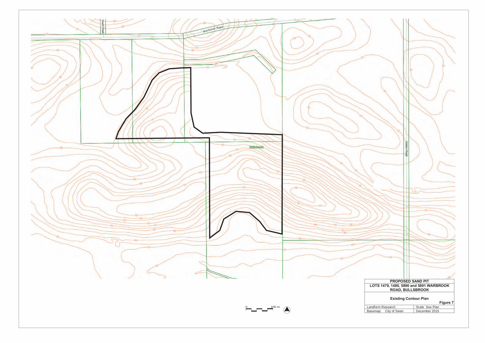
0 100 m
PROPOSED SAND PITLOTS 1479, 1480, 5890 and 5891 WARBROOK
ROAD, BULLSBROOK
Existing Contour Plan
Landform Research Scale See PlanBasemap City of Swan December 2015
Figure 7

0 100 m
PROPOSED SAND PITLOTS 1479, 1480, 5890 and 5891 WARBROOK
ROAD, BULLSBROOK
Existing Contour Plan
Landform Research Scale See PlanBasemap City of Swan December 2015
Figure 7
Excavatedto be tidied
56
55
55
55
56
Floor undulating at 53.5 - 54.5 metres AHD
Floor undulating at 53.5 - 54.5 metres AHD Floor undulating at
54.5 metres AHD
STAGE 1
STAGE 2 EXCAVATED
PROPOSED SAND PITLOTS 1479, 1480, 5890 and 5891 WARBROOK
ROAD, BULLSBROOK
Concept Final Contour Plan
Landform Research Scale See PlanBasemap City of Swan December 2015
Figure 8

Appendix 1

FLORA AND VEGETATION ASSESSMENT
In support for Clearing Permit
Proposed Sand Quarry
Lots 1479, 1480, 5890, and 5891 Warbrook Road,
Bullsbrook
City of Swan
October 2015
Lindsay Stephens BSc Geology), MSc (Plant Ecology) 25 Heather Road Roleystone WA 6111 Mem Aus Geomechanics Soc – MEIANZ – FIQA Tel 9397 5145, [email protected]


Appendix 2

Offsite Impacts Plan
Proposed Sand Excavation
Lots 1479, 1480, 5890, and 891 Warbrook Road,
Bullsbrook
City of Swan
WARBROOK ROAD PTY LTD
January 2016

Offsite Impacts Management Plan Proposed Extraction of Sand, Proposed Sand Pit, Lots 1479, 1480, 5890, and 5891, Warbrook Road, Bullsbrook
Landform Research 2
CONTENTS OF THE OFFSITE IMPACTS MANAGEMENT PLAN 1.0 VISUAL MANAGEMENT PLAN 3 2.0 LOCAL AMENITY 5 3.0 NOISE MANAGEMENT PLAN 6 4.0 DUST MANAGEMENT PLAN 9 5.0 COMPLAINTS PROCEDURE 18 6.0 TRUCK AND TRAFFIC MANAGEMENT PLAN 19
Offsite Impacts Management Plan Proposed Extraction of Sand, Proposed Sand Pit, Lots 1479, 1480, 5890, and 5891, Warbrook Road, Bullsbrook
Landform Research 3
1.0 VISUAL MANAGEMENT PLAN Visual Impact can occur in a number of circumstances, by the operation being set too high in the landscape, by being too close to neighbours and by insufficient visual protection. There are a number of management actions that can be taken in quarries to minimise visual impact and these will be used wherever possible. The general management actions are summarised below together with the visual impact issues that relate to this site. The actions will be used where applicable and as the opportunity presents to minimise visual impact. Even though the site is set back from Warbrook Road, the north facing face will be partially exposed to Warbrook Road which is why the staging is proposed to come from the south. Buffer distances to the closest dwellings which are single on rural lots, are 400 metres west, 355 and 540 metres east with an approved sand excavation between and 1000 metres north east. A dwelling currently lies on the central ridge on Lot 5891. This will be removed to enable excavation to occur. The excavation of sand from the site therefore complies with the generic buffer policies considering the proposed sand excavation is for fill, which will not be screened. The buffer distances are similar to those that applied when sand from Lot 5890 was excavated and are larger than those that apply to the approved sand pit adjoining to the east. There is no reason why excavation of the resources on site cannot be completed in a similar manner based on proven excavation and buffering practices. The walls of the pit and perimeter bunding will be used to reduce noise transmission. The 20 metre buffer zones will be retained along perimeter boundaries. Sand excavation, which does not include screening or processing, would be at the lower end of the generic buffer. If screening of sand was required the screen could be located at least 500 metres from dwellings. The excavation of sand from the site therefore complies with the EPA Buffer Generic Guidelines. Excavation will operate from the floor of the pit behind the existing faces, working towards the dwellings, which will assist visual screening. Excavation will push towards the perimeters behind the existing faces, with the floor being progressively lowered.
IDEAL OPERATIONAL PROCEDURES COMMITMENTS ON ACTIVITIES CONDUCTED
ON SITE • Locate exposed features behind
natural barriers and landform. • This is proposed.
• Operate from the floor of the pit below natural ground level.
• This will continue and is proposed.
• Avoid breaks in the skyline due to workings and haul roads.
• The excavation areas are below the high natural ground features.
• Push overburden and interburden into positions where they will not be seen or can form screening barriers.
• Perimeter bunds are proposed from a safety perspective and for visual management on this site.
• Stage workings and progressive rehabilitation to provide visual protection of later activities.
• The staging and direction of excavation towards the west and north will assist visual management.

Offsite Impacts Management Plan Proposed Extraction of Sand, Proposed Sand Pit, Lots 1479, 1480, 5890, and 5891, Warbrook Road, Bullsbrook
Landform Research 4
• Adopt good house keeping practices such as orderly storage and removal of disused equipment or waste.
• This is committed to.
• Provide progressive rehabilitation of all completed or disturbed areas.
• Rehabilitation to progressively stabilise the excavated ground with pasture is proposed.
• Other vegetation belts will be established progressively.
• Minimise the amount of ground used at any one time.
• This is proposed. Only ground required for excavation will be prepared for excavation with an additional area for support.
• Install fences and gates, which are compatible with the style of the area.
• The resources lie on previously partially agricultural land that is fenced with farm style fencing which in places needs to be upgraded.
• Minimise offsite impacts of night lighting.
• Night operations are not proposed.
• Paint and maintain visually exposed buildings, plant and equipment with low impact colours.
• Portable storage facilities if required will be located in the north of Lot 5891 and be lower impact from the dwelling and sheds currently on site.
• Locate roads and access to prevent direct views into the site
• No new roads are proposed. The existing access road through Lot 5890 will be used.
• Ensure transport vehicles do not spill material on public roads and ensure prompt cleanup if it occurs.
• Company practices and drive/operator training will address the need to minimise spill by ensuring the trucks are not overloaded.
• Collection of spills is to be carried out when reported.
• Drivers are to be instructed to be responsible for their loads.
Light Overspill It is not proposed that the facility will operate at night. The only lighting that might be required at night will be security lighting which is in place. Excavated areas will be progressively rehabilitated as they are completed. Summary Visual impact is regarded as low and is committed to for minimising visual impact.
Offsite Impacts Management Plan Proposed Extraction of Sand, Proposed Sand Pit, Lots 1479, 1480, 5890, and 5891, Warbrook Road, Bullsbrook
Landform Research 5
2.0 LOCAL AMENITY There are few local dwellings with the closest being single dwellings on rural lots, at distances to the closest dwellings of 400 metres west, 355 and 540 metres east with an approved sand excavation between and 1000 metres north east. There are also dwellings on the transport routes, particularly near the intersection of Warbrook Road and Railway Parade. Impacts on the local amenity might take the form of additional trucks on the roads and noise from transport activities, and the various potential follow on impacts. Excavation will operate from the floor of the pit behind the existing faces, working towards the dwellings, which will assist visual screening. Excavation will push towards the perimeters behind the existing faces, with the floor being progressively lowered. The operational hours will be adhered to; 6.30 am to 5.00 pm Monday to Saturday inclusive, with transport and screening if there is any processing, restricted to between 7.00 am to 5.00 pm excluding public holidays. Note that prior to 7.00 am maintenance and preparation for loading may be conducted, and trucks will be permitted to park on site. Trucks will not be loaded prior to 7.00 am. A Transport Management Plan is provided, regulating speed limits, driver behavior, braking, use of exhaust or air brakes and horns, contact with horses being ridden, covering of loads among other things.

Offsite Impacts Management Plan Proposed Extraction of Sand, Proposed Sand Pit, Lots 1479, 1480, 5890, and 5891, Warbrook Road, Bullsbrook
Landform Research 6
3.0 NOISE MANAGEMENT PLAN Offsite noise is governed by the Environmental Protection (Noise) Regulations 1997. The Environmental Protection (Noise) Regulations 1997, require that sensitive premises including dwellings in non industrial areas are not subjected to noise levels exceeding 45 dBA for more than 10% of the time, 55 dBA for more than 1% of the time and never exceeding 65 dBA during normal working hours. There are penalties for tonality of 5 dB, modulation 5 dB and 10 dB for impulsiveness, although impulsiveness is not likely to be relevant. Occupational noise associated with the quarrying processes falls under the Mines Safety and Inspection Act 1994 and Regulations 1995. The management of occupational noise is normally handled by providing all necessary hearing protection, as well as conducting worker inductions, and educational programs for all staff. Regular site audits of quarry and mining operations are normally conducted by the Department of Mines and Petroleum. Noise can originate from a number of operations and may impact on onsite workers, or travel offsite and impact on external sensitive premises. Both potential noise impacts are addressed by reducing the noise generated from the quarrying and processing operations. There are a number of management actions that can be taken in quarries to minimise noise generation or travel and these will be used wherever possible. The general management actions are summarised below together with the potential noise impact issues that relate to this site. The actions will be used where applicable and as the opportunity presents to minimise noise on this site. The Environmental Protection (Noise) Regulations 1997, require that sensitive premises including dwellings in non industrial and rural areas, are not subjected to general noise levels (excluding blasting), during the hours 7.00 am to 7.00 pm Monday to Saturday that exceed 45 dBA. Allowable noise to 55 dBA is permitted for up to 10% of the time and to 65 dBA for 1% of the time. Noise levels are not to exceed 65 dBA during normal working hours. Between 9.00 am and 7.00 pm on Sunday and Public Holidays and between 7.00 pm and 10.00 pm on all days the base level is 40 dBA. At night, between 10.00 pm and 7.00 am Mondays to Saturday and before 9.00 am on Sundays and Public Holidays, the permitted level drops to 35 dBA. The 10% and 1% “time above” allowances apply at night and on Sundays and Public Holidays as well. There are penalties for tonality of 5 dB, modulation 5 dB and 10 dB for impulsiveness, that are added to the permitted levels. That is, if the noise is tonal or modulated the permitted levels drop by 5 dB. Impulsiveness is not likely to be relevant for the quarry under normal circumstances. Influencing factors are external noise and nearby land uses such as busy roads, and industrial properties. Schedule 1 of the Environmental Protection (Noise) Regulations 1997 provides for the premises of excavations to be provided with an industrial influencing factor in the calculation of assigned noise levels, by way of the 100 and 450 metre influencing factor circles. Under Schedule 1 of the Noise Regulations the premises on which the extraction of basic raw materials, such as sand and limestone, is occurring is classified as Industrial Land for the purposes of calculating influencing factors. This was defined as the whole cadastral boundaries in State Administrative Tribunal decision {2013} WASAT 139, Bushbeach v City of Mandurah. At a distance greater than 15 metres from the sensitive premises (eg dwelling), and commercial premises a base level of 60 dBA applies at all times with the 10% time permitted to be up to 75 dBA and the 1% permitted to be up to 80 dBA. For Industrial premises the base level is 65 dBA at all times with the 10% time permitted to be up to 80 dBA and the 1% permitted to be up to 90 dBA.

Offsite Impacts Management Plan Proposed Extraction of Sand, Proposed Sand Pit, Lots 1479, 1480, 5890, and 5891, Warbrook Road, Bullsbrook
Landform Research 7
Sound travels mostly similar to lines of sight and is mitigated by solid barriers. The walls of the pit and bunds will form barriers that reduce noise transmission. The excavation operations will incorporate the procedures listed below wherever possible to minimise noise emanation from on site activities. All equipment will be fitted with noise shields and efficient silencers. Workers will be inducted and trained for operation on the site and provided with the correct noise protection equipment. Buffer distances to the closest dwellings, are 300 metres which complies with the EPA Buffer Generic Guidelines. Buffer distances to the closest dwellings which are single on rural lots, are 400 metres west, 355 and 540 metres east with an approved sand excavation between and 1000 metres north east. The excavation of sand from the site therefore complies with the generic buffer policies considering the proposed sand excavation is for fill, which will not be screened. The buffer distances are similar to those that applied when sand from Lot 5890 was excavated and are larger than those that apply to the approved sand pit adjoining to the east. There is no reason why excavation of the resources on site cannot be completed in a similar manner based on proven excavation and buffering practices. If a screening plant is used it will be located 500 metres from dwellings, located on the floor of the pit, behind appropriate perimeter bunding as necessary to minimise noise carry. Normal Quarry Management The following table summaries the methods that are normally used in quarries to minimise unacceptable noise generation.
IDEAL NORMAL OPERATIONAL PROCEDURES
COMMITMENTS ON ACTIVITIES CONDUCTED ON SITE
• Comply with the Environmental Protection (Noise) Regulations 1997.
• The Regulations will be complied with. Sand excavation previously took place on Lot 5890 and is currently occurring on the land adjoining to the east which has reduced buffers compared to that which is available on this project.
• Hours of operation will be, 6.30 am to 5.00 pm Monday to Saturday inclusive, with transport and screening if there is any processing, restricted to between 7.00 am to 5.00 pm excluding public holidays.
• Maintain adequate buffers to sensitive premises.
• The closest dwellings are located 355 metres from the edge of the pit, further away than the separation distances available for the approved sand excavation to the east.
• Any screening plant if required will be located 500 metres from dwellings. See Figure 3.
• The proposal complies with the EPA Generic Buffer Guidelines.
• Locate exposed features behind natural barriers and landform.
• The buffer, perimeter bunding and landform provide noise screening and will be used.
• Operate from the floor of the pit below natural ground level.
• This is proposed.

Offsite Impacts Management Plan Proposed Extraction of Sand, Proposed Sand Pit, Lots 1479, 1480, 5890, and 5891, Warbrook Road, Bullsbrook
Landform Research 8
• Push overburden and interburden dumps into positions where they can form screening barriers.
• Perimeter bunding is proposed where required to provide maximum noise screening, such as along the western side of the excavation.
• Design site operations to maximise the separation and protection from sensitive premises.
• The location of the excavation and the methods to be used have been selected to minimise noise generation and carry.
• Maintain all plant in good condition with efficient mufflers and noise shielding.
• The use of modern new equipment that is maintained in good condition is proposed.
• Maintain haul road and hardstand surfaces in good condition (free of potholes, rills and product spillages) and with suitable grades.
• This is committed to. • There are no near dwellings in Warbrook
near the pit where the surface remains unsealed.
• Implement a site code outlining
requirements for operators and drivers.
• Site induction and training for all personnel is proposed.
• Use equipment that will minimise noise generation.
• Quiet mobile plant will be used.
• Shut down equipment when not in use. • This is used and proposed to save fuel and maintenance costs in addition to noise minimisation.
• Scheduling activities to minimise the likelihood of noise nuisance.
• Hours of operation will be, 6.30 am to 5.00 pm Monday to Saturday inclusive, with transport and screening if there is any processing, between 7.00 am to 5.00 pm excluding public holidays.
• Fit warning lights, rather than audible sirens or beepers, on mobile equipment wherever possible.
• Lights or low frequency frog beepers are to be used rather than high pitched beepers to restrict noise intrusion.
• Use transport routes that minimise community disruption.
• There is no alternative transport route. • Truck drivers are instructed to be aware of
dwellings along the roads and the need to minimise noise and travel at safe speeds.
• Avoid the use of engine braking on product delivery trucks in built up areas.
• Truck drivers are to be instructed to minimise the use of engine braking.
• Minimise and conduct at the least disruptive times, non day to day activities such as vegetation, topsoil or overburden stripping on exposed ridgelines.
• Quarrying and processing operations are to be completed during normal working hours.
• Provide a complaints recording, investigation, action and reporting procedure.
• A complaints recording and investigation procedure is proposed.
• See 5.0 Complaints procedure. • Provide all workers with efficient noise
protection equipment. • All personal noise protection equipment
will be provided to staff. Summary The risk of noise impact on sensitive premises is low as there are no changes proposed to the current and past operations. The proponent is committed to minimising noise emissions and will implement the measures outlined.

Offsite Impacts Management Plan Proposed Extraction of Sand, Proposed Sand Pit, Lots 1479, 1480, 5890, and 5891, Warbrook Road, Bullsbrook
Landform Research 9
4.0 DUST MANAGEMENT PLAN Excessive dust has the potential to impact on both the workers and the adjoining land. The City of Swan has a Local Law to minimise and prevent sand drift that could be relevant to sand excavation. The dust management has been designed to comply with the bylaw and minimise erosion and sand drift. Dust can originate from a number of operations and may impact on onsite workers, or travel offsite. Potential dust impacts are addressed by reducing the dust generated from the quarrying, processing and transport operations. No changes are proposed to the existing and past operations.
There are a number of management actions that are used in quarries to minimise dust generation or travel and these will continue to be used wherever possible. 4.1 Environmental Dust
• Background Excessive dust has the potential to impact on both the workers and the adjoining land. However the potential generation of dust must be taken in context. There are a number of key aspects to dust impacts;
• What is the source of particles? • What is the potential for the particles to be disturbed? • What is the nature of the particles and how are they likely to behave? • What types of impacts are the particles likely to have if they move? • What management actions can be used to mitigate or reduce dust impacts?
Fine particles are a natural part of our environment and are present in soils, pollens, fragments of vegetation and many other sources. It is when the fine particles are excessively disturbed that there becomes concern for the potential impacts, whether they are nuisance or health risks. The most common form of disturbance is by human impacts. In this local area agricultural soils and limestone roads have the most potential to expose fine particles to disturbance by machinery and vehicles. In many situations the fine particles are stablised by vegetation, soil microbial materials and reactions and interactions between particles. Once disturbed however dust can be generated and may continue to be a problem until the fine particles are wetted down or return to a relatively stable condition. The risk of dust assumes no treatment. With effective treatment of dust by water, which is proposed, the risks of onsite, and consequently offsite, dust are minimised. Sand stays moist even into summer if capillary action of moisture is available or there is no vegetation to suck the moisture from the soil. The main dust risk is from vehicle movements on the pit and access road which contributes to occupational dust. When occupational dust is managed then environmental dust is also minimised. The main risk is the traffic which relate to occupational health and safety that is controlled under the Mines Safety and Inspection Act 1994.

Offsite Impacts Management Plan Proposed Extraction of Sand, Proposed Sand Pit, Lots 1479, 1480, 5890, and 5891, Warbrook Road, Bullsbrook
Landform Research 10
The main methods of dust control are awareness of the issues on a day to day and hour to hour basis as activities on site change. The most appropriate dust management procedures are then chosen to minimise occupational dust and environmental dust. Ongoing site awareness will be combined with a commitment to take whatever action is appropriate.
• Assessment of Dust Risk Dust Guidelines Dust management is an integral part of the extraction of sand. Facilities and procedures are updated as better technology becomes available. Occupational dust associated with the quarrying processes falls under the Mines Safety and Inspection Act 1994 and Regulations 1995 overseen by the Department of Mines and Petroleum. Dust emissions fall under the Guidance for the Assessment of Environmental Factors, EPA, March 2000. Assessments of the potential dust risk are normally made using the Land development sites and impacts on air quality, Department of Environmental Protection and Conservation Guidelines, November 1996. These are still in place but are incorporated into the DEC (DER) 2011 Guideline for Managing the Impacts of Dust and Associated Contaminants from Land Development Sites, Contaminated Sites Remediation and other Related Activities. The key Environmental Objectives for the operations are;
• Manage the potential for the generation of dust. • Visually monitor dust levels and take steps to reduce the potential impact of dust on
occupational and environmental aspects of the operation and local area.
Onsite Risks
Excessive dust has the potential to impact on both the workers and the adjoining land. From sand extraction the main particles are sand sized particles from the sand. These are normally in excess of 0.5 mm and have a capability of moving by saltation and do not travel far, being easily stopped by vegetation, pasture, small banks or other features. There is no evidence of sand movement or erosion on Lot 5890 which was previously excavated and remains with exposed sandy walls. Dust may be a potential problem during land clearing and reinstatement in the summer months. The access roads will be watered as necessary to reduce the generation of dust in the drier months. Dust from organic humic matter can also be generated during land clearing and restoration of topsoils in dry weather. The main risk from dust is not sand, but rather the fine particles that are generated during transport along access roads and traffic areas, and moving and reinstating topsoil during dry conditions. The sand grains are too large and will be trapped by vegetation and the perimeter bunding. Through the winter months of May to September inclusive, there is little dust risk because rainfall exceeds evaporation. The rainfall is sufficient to wet the whole soil profile to depth, with excess water reaching the water table. The type of sand is discussed in the attached table showing pictures of sand typically occurring on site.

Offsite Impacts Management Plan Proposed Extraction of Sand, Proposed Sand Pit, Lots 1479, 1480, 5890, and 5891, Warbrook Road, Bullsbrook
Landform Research 11
In summer, when evaporation exceeds rainfall, soils dry out and the road base on the access roads can be crushed by repeated vehicle movements. Without the traffic, areas of earthy sand stay in lumps that do not degrade or produce fine dust particles. However in elevated and dry stockpile areas or trafficked areas where the clay can dry out and be crushed there is potential for dust to be generated. Most of this dust is regarded as nuisance dust. The potential impacts are assessed for the sensitive premises to the west and south, under the worst possible scenario. The risk in winter will be substantially lower. Finer dust can be generated from situations where limestone is crushed and ground, such as along limestone access roads. The prevailing winds in summer are from the south west, particularly in the afternoon. In summer the easterly in the mornings and the sea breeze in the afternoon can be quite strong. Winds vary from easterly on summer mornings, to winds predominantly from the south west (south to west) in the afternoon. These winds can be strong and are normally all above 10 kph in summer, ranging up to > 30 kph or stronger. Winter winds are more variable and on average lighter, but have an easterly predominance. The most likely time for dust to become an issue is on summer mornings when winds are easterly. With operations below natural ground level, protected by landform, bunding and tree belts, it is unlikely that dust will impact on nearby residences. The dwellings are not in line with the afternoon winds but are partially in line with the morning easterlies. The main methods of dust control are awareness of the issues on a day to day and hour to hour basis as activities on site change. The most appropriate dust management procedures are then chosen to minimise occupational dust and environmental dust. Ongoing site awareness, combined with a commitment to take whatever action is appropriate, is more satisfactory than occasional sampling and monitoring by equipment. Dust management requirements change rapidly during excavation, and sampling at one time is unlikely to reflect the conditions at another time. On site sampling can also present difficulties in determining where the particles have come from. Overburden will be used to form screening bunds as appropriate and trees in the parkland pasture and remnant vegetation will assist in dust management, by trapping particles. A water tanker will be maintained on site during excavation when there is a risk of generating excessive dust. The water will be used to settle dust on the pit floor and to reduce the dust emanating from any crushing operation. Apart from the initial land clearing and surface reinstatement, all operations will be conducted below natural ground level. Bearing in mind the distances involved and the dust suppression methods in place, dust should not impact on any dwellings.
The category of dust risk is included in DER 2011 Guideline for Managing the Impacts of Dust and Associated Contaminants from Land Development Sites, Contaminated Sites Remediation and other Related Activities. This document is not really applicable to mining because it is to be used to assess the mitigation required based on no mitigation. It must be remembered that this guideline is not really appropriate for quarries. It was developed for subdivision earthworks at a time when dust management was a lower priority.

Offsite Impacts Management Plan Proposed Extraction of Sand, Proposed Sand Pit, Lots 1479, 1480, 5890, and 5891, Warbrook Road, Bullsbrook
Landform Research 12
All quarries have active and comprehensive dust management procedures in place and are required to do so to protect visual amenity and their staff. The Guidance has been used, but factored in is a reasonable amount of dust management. Using the normal dust management there is a negligible risk of dust impacting on sensitive premises west of the quarry. • Dust risk is generally more common in the dry summer months.
• Best practice dust management procedures apply to quarries and are used on site. These
are listed in the following table with a comment on how the potential dust issues are to be managed.
• The trigger for dust management is the generation of visual dust. • The site supervisor is normally the loader driver, who is in the best position to assess dust
generation and to direct remediation. • No visible dust will impact on dwellings. • On site operators are instructed to visually monitor dust, report and treat any visible dust.
• Dust Risk Assessment from DEC (DER) 2011
PART A Number
Item Score
1 Nuisance potential of the material Medium – 4 (moving topsoil) Low – 2 for normal sand excavation Reduced in winter
2 Topography and vegetation screening Moderately to Well screened – 1 - 6 3 Area of site activities Operational trafficked areas are 1 to 5
ha - 3 4 Type of work being undertaken Considering the natural moisture
content of the sand; partial earthworks – 9
Summer total without dust measures 15 Summer total with dust measures
22
PART B Number
Item Score
1 Distance to sensitive premises 100 – 500 metres - 12 2 Effect of prevailing wind Isolated use affected by one wind
direction - 6 Summer total without dust measures 18 Summer total with dust measures
18
Activity Calculated Score
Allocated Risk of Dust
Land Clearing and excavation without dust suppression.
396 Classification 2 Low Risk The recommended actions are included in the Dust Management Program.
With dust suppression 270 Classification 2 Low Risk Commitments are made to cease work if dust cannot be managed.

Offsite Impacts Management Plan Proposed Extraction of Sand, Proposed Sand Pit, Lots 1479, 1480, 5890, and 5891, Warbrook Road, Bullsbrook
Landform Research 13
4.2 Occupational Dust Occupational dust associated with the quarrying processes falls under the Mines Safety and Inspection Act 1994 and Regulations 1995 overseen by the Department of Mines and Petroleum. Site induction and protective equipment will be provided to all persons on site. The DMP require personal dust monitoring to ensure dust levels comply with health risk guidelines. The dust management procedures used on site comply with these guidelines. 4.3 Dust Management 4.3.1 Issues and Management Actions that can be used to prevent or mitigate dust are standard quarry best practice and have been used on this site on an ongoing basis. Some methods are taken from the DER 2011 Appendix 2 and others from quarry best practice. Methods that are available, and will be selected from, are listed below. The most effective by far is the use of water management from a water truck, sprinklers, water canon, water sprays and mists or other such mechanism.
DESIGN AND SITE
1. Minimising the amount of ground open. 2. Minimising the amount of ground being subject to traffic. 3. Locating access roads away from sensitive premises. 4. Design of the pit to reduce wind speed and potential dust lift off. 5. Maintaining effective setbacks. 6. Constructing perimeter bunds to reduce wind speed. 7. Maintaining natural vegetation buffers. 8. Providing wind break fencing generally and on top of bunds as required. 9. Maintaining a secure, fenced site, to prevent illegal access. 10. Rehabilitate and stabilise all completed areas as soon as practicable. 11. Clearing and replacing topsoil and overburden during wetter times; April to October.
OPERATIONS
12. Locate active areas away from windy locations. 13. Locate active areas away from sensitive premises. 14. Working on the floor of the pit. 15. Operate some parts of the pit only when conditions are suitable. 16. Locating mobile plant and stockpiles in sheltered areas. 17. Design staging to minimise dust risk. 18. Conduct higher dust risk operations such as topsoil clearing and placement during
more favourable conditions. 19. Shut down equipment that is not required.
ACCESS AND HARDSTAND
20. Constructing the access roads from hard materials that resist dust generation. 21. Maintaining a water truck on site for road and other wetting down. 22. Using a sealant such as a polymer, chemical or emulsified oil or bitumen on the
access road to reduce water use. 23. Using sprinklers and water canon on roads, traffic areas and stockpiles.

Offsite Impacts Management Plan Proposed Extraction of Sand, Proposed Sand Pit, Lots 1479, 1480, 5890, and 5891, Warbrook Road, Bullsbrook
Landform Research 14
PROCESSING
24. Applying water sprays and additives to crushing, cutting and screening cycles. 25. Providing screening, shielding or misting on mobile plant. 26. Use and maintain filters on all suitable plant. 27. Ensure regular appropriate emptying of filter collection devices. 28. Face hoppers away from prevailing winds. (unlikely to be required). 29. Use water mist sprays where appropriate at fall points and other locations where
dust may be generated.
STOCKPILES
30. Minimise the number of stockpiles. 31. Maintain stockpiles in sheltered areas. 32. Reduce the elevation of stockpiles. 33. Limit the drop height to stockpiles and loading. 34. Locate finer products inside or screened by stockpiles of coarse materials. 35. Locate stockpiles away from sensitive premises.
TRANSPORT
36. Cover all loads when fine materials are carried. 37. Ensure all trucks are dust free and not carrying pebbles and other materials outside
the tray. 38. Choose the best transport routes. 39. Wet down or sweep the cross over and access roads.
HEALTH AND COMMUNITY
40. Maintain air conditioned cabins on all vehicles. 41. Provide a readily auditable trigger of no visible dust to cross the property boundary
in line with the current DER Licence and best practice in WA. 42. Provide a comprehensive visual monitoring program. 43. Conduct effective site induction and awareness training for all staff. 44. Training should include observation and mitigation where possible of all dust
emissions. 45. Providing a complaints investigation, mitigation and recording procedure. 46. Liaising with the owners/operators of the nearby sensitive premises. 47. Ceasing operations when conditions are not favourable or when visible dust is
crossing the boundary. 48. Obtain the latest weather conditions to increase the awareness of dust risk. 49. Cease operations during adverse weather conditions. 50. Operate during wetter months or when the soils are moist.
Tree Belt - Buffers Dust particles are readily stopped by tree belts and distance, with which the site complies. Tree belts slow the wind and allow the dust to settle. See Planning Guidelines Separating Agricultural and Residential Land Uses, Department of Natural Resources Queensland 1997( Pages 65 – 111) and Department of Health WA, 2012, Guidelines for Separation of Agricultural and Residential Land Uses which uses the same criteria (Pages 112 – 118). The Queensland Guidelines predominantly relate to agricultural spray drift, but based on particle size also relate to dust. The Guidelines provide for a buffer of 300 metres for open agricultural land, dropping down to 40 metres where an effective tree belt is in place. The Western Australian Department of Health also uses the same guidelines. The Guidelines are based on field studies and demonstrate the effectiveness of tree belts and distance in providing screening against particulate travel.

Offsite Impacts Management Plan Proposed Extraction of Sand, Proposed Sand Pit, Lots 1479, 1480, 5890, and 5891, Warbrook Road, Bullsbrook
Landform Research 15
The 300 metre buffers across open ground are available. The actual buffers are better than the generic open ground buffer because the sensitive premises are located further away and there is intervening native vegetation rather than just pasture. There is no evidence of dust impacts from the adjoining sand pit to the east on the current dwelling on Lot 5891, indicating sand excavation can be conducted with minimal impact. Dust Management Actions
ACTIVITY POSSIBLE RISK SEVERITY and FREQUENCY
IDEAL OPERATIONAL PROCEDURES
COMMITMENTS ON ACTIVITIES CONDUCTED ON SITE
RISK AFTER MANAGEMENT
GENERAL Legislation ---- • Comply with the
provisions of the Mines Safety and Inspection Act 1994 and Regulations 1995.
• The proponent will comply with the Act and Regulations at all their pits.
----
Buffers ---- • Maintain adequate buffers to sensitive premises.
• The closest dwellings are located 300 metres from the edge of the pit.
• Any screening plant if required will be located 500 metres from dwellings.
• The proposal complies with the EPA Generic Buffer Guidelines.
----
Landform ---- • Locate activities behind natural barriers, landform and vegetation.
• The design of the pit and staging will be used to provide screening.
• Clearing and reinstating topsoil and overburden will be confined to the wetter months, April to October where possible.
----
Landform ---- • Work below natural ground level.
• This will be used. ----
• Push overburden and interburden dumps into positions where they can form screening barriers.
• This will be used where required. • A 2.5 metre bund will be
constructed from overburden along the side of the pit facing dwellings; that is along the western side of the pit and the southern side of Lots 1479 and 1480.
----
Staging ---- • Design operational procedures and staging, to maximise the separation to sensitive premises.
• The staging is designed to allow the loader to operate behind the active face and perimeter bunding.
----
MANAGEMENT Occupation ---- • Provide air conditioned
closed cabins on plant • These will be used on site for
operational mobile plant. ----
Monitoring ---- • Provide monitoring and supervision of the processing and other practices on site.
• A visual monitoring system is proposed. see below “Trigger Conditions”.
----
Trigger conditions
---- • Trigger conditions are used to determine when additional dust management is required.
• Most dust generated from excavation, land clearing, processing and transport has a very large visible component.
• The trigger for dust management is to be the generation of visual dust.
• When excessive dust is noted dust management measures will be implemented to treat the dust or
----

Offsite Impacts Management Plan Proposed Extraction of Sand, Proposed Sand Pit, Lots 1479, 1480, 5890, and 5891, Warbrook Road, Bullsbrook
Landform Research 16
manage the situation. • A water truck will be available when
required. Adverse weather
Moderate to high - Can occur on summer mornings
• When winds are sufficiently strong, or other weather conditions are unacceptable, to negate the effects of dust management, operations will cease until conditions improve and compliance can be achieved.
• These adverse conditions are more likely to occur on summer mornings. In winter stronger winds are normally associated with rain and therefore carry a reduced dust risk.
• This policy is used to minimise impact on adjoining land holders.
Low
Equipment failure
Low - Uncommon
• In the event of dust management not being able to be achieved through equipment failure operations will cease until full capability is restored.
• This is committed to. Low
Loading Low - Occasional; about once per hour
• Work on the floor of the pit. Loading is low impact with a loader and truck.
• Loading is low impact with a loader and truck.
Low
Transport Moderate - Occasional; about once per hour
• Cover all loads. • Transport is via road trucks. The sand loads are to be covered.
• The internal access roads will be watered or treated as required through the year to reduce dust generation.
• The small section of Warbrook Road west of the Halden Road intersection will be wetted down as required to minimise the generation of dust.
• A Transport Management Plan is proposed, to manage and restrict truck activities to minimise potential impacts on the local amenity. (See attachment).
• Transport routes are to be varied to reduce potential impacts on individual locations of the local amenity.
Low
Complaints ---- • Provide a complaints recording, investigation, action and reporting procedure.
• This is committed to. A complaints procedure is proposed.
----
EARTHWORKS Land Clearing Low
- Once per year.
• Schedule activities such as vegetation removal or topsoil stripping at times when the materials are less likely to blow or during suitable wind conditions.
• Normally the stripping of overburden and topsoil and their subsequent use in rehabilitation is undertaken in the drier months but when the soils are still moist enough to suppress dust but not wet.
• Completed sections of the quarry are to be progressively rehabilitated as soon as practicable.
Low
Land restoration
Low - Once per year.
• Schedule activities such as ripping, overburden and topsoil spreading on exposed ridgelines at times when the materials are less likely to blow or during suitable wind
• See Land Clearing above.
Low

Offsite Impacts Management Plan Proposed Extraction of Sand, Proposed Sand Pit, Lots 1479, 1480, 5890, and 5891, Warbrook Road, Bullsbrook
Landform Research 17
conditions. 4.3.2 Dust Monitoring The most effective dust monitoring is the generation of visible dust. The auditable condition is visible dust crossing the boundary of the premises; the lot boundary. This is the condition used on Department of Environment Regulation Licences and all other quarries such as sand, limestone and hard rock quarries in Western Australia and has worked well in the past. It is also the method used by the Department of Mines and Petroleum to rapidly assess occupational dust on site. As invisible dust can be generated with the visible dust, recognising and dealing with visible dust is a very effective instantaneous method of recognising excessive dust. There are a number of mechanical dust monitors but only two are approved under Australian Standards. The mechanical measurement of dust can be difficult to obtain accurate results and a number of systems provide retrospective measurements only.
Most dust generated from processing and vehicle movements has a very large visible component. Lesser risks emanate from excavation and land clearing. The quarry manager and leading hand are ultimately responsible for site supervision of dust. They will travel around the operations and pit frequently and are in two way radio contact with all mobile plant. All operators on site are instructed to be vigilant to dust generation and management and report any excessive dust or potential dust management issues. The effectiveness of the dust management is shown by no complaints regarding dust normally being received. No complaints are known relating to dust from excavation within the past five years. When trigger conditions are detected and/or alerted, relevant action is taken. This can include additional water suppression, modification of procedure, delay until more favourable conditions are present, use of alternative equipment etc. Human monitoring can detect potential dust risks prior, and take action prior, to the dust being generated. They also notice dust immediately such as from tyres, whereas machine monitoring has to rely on significant dust being generated, travelling to the boundaries of the premises and triggering an alarm. The operators would be negligent if they let the dust get to that level of impact prior to taking action. Visual monitoring is even more effective when complemented by a reporting and complaints process. 4.4 Greenhouse Gas The development of the Perth Metropolitan Area has generated the need for sand, and if this cannot be obtained from this quarry it will be obtained from another. Over the years trucks have become more efficient with respect to greenhouse gas emissions, particularly with the use of truck and trailer and road train configurations. The internal design of the operations attempts to minimise the haulage route to save energy use and potential impacts.

Offsite Impacts Management Plan Proposed Extraction of Sand, Proposed Sand Pit, Lots 1479, 1480, 5890, and 5891, Warbrook Road, Bullsbrook
Landform Research 18
5.0 COMPLAINTS PROCEDURE Visual monitoring is more effective when complemented by an extensive reporting and complaints process. That reporting mechanism is enhanced by liaison with the closest sensitive premises who are in a position to alert the operators as required. Liaison with the closest residents assist residents who feel they have an effective voice, when it is used well. People within the program will be provided with a copy of the Dust Management Plan and phone and email contacts that can be used in the event that visible dust is noticed crossing the site boundary. An effective complaints mechanism is an essential part of the dust identification and management and is proposed. A complaints procedure is proposed and a normal complaint, investigation, action and reporting system be used. A record will be kept of each complaint in a “Complaints Record”. The record will be kept in a form that provides permanent retention that is readily accessed. The Complaints Record will be available to officers of the City of Swan and generally include.
• The complaint, • Nature of the complaint, time and date, • Source of the complaint, • Investigations of the complaint, • Results of the investigation, • If the complaint is valid, any mitigation actions that result, • Any communication with the complainant. • Contacts will be provided on signage at the gate both during operations and when the
site is not manned to enable contact to be made.

Offsite Impacts Management Plan Proposed Extraction of Sand, Proposed Sand Pit, Lots 1479, 1480, 5890, and 5891, Warbrook Road, Bullsbrook
Landform Research 19
6.0 TRUCK AND TRAFFIC MANAGEMENT PLAN Hours of Operation Hours of loading and transport of sand will be 7.00 am to 6.00 pm Monday to Saturday excluding Public Holidays. Prior to 7.00 am a loader/s may prepare the site, maintenance can be undertaken and other general preparation duties carried out. General operations are covered elsewhere in the Excavation and Rehabilitation Management Plan. Safety All persons wishing to enter the site must contact the quarry manager and be “safety” inducted for this site. No unauthorised access can be permitted to site at any time, whether the site is operating or not under the provisions of the Mines Safety and Inspection Act 1994. Operations will be conducted to the Project Management Plan and approvals provided by the Department of Mines and Petroleum in relation to site safety. Safety is also addressed in various part of the Excavation and Rehabilitation Management Plan. TRUCK TRANSPORT General All companies and contractors transporting sand will be informed of the operating hours and procedures applying to their contract. All truck contractors are to be supplied with written guidelines on the operation of the pit. Drivers are to be inducted to the site through the Safety Management Procedures for the site. Signs are to be used on site to inform drivers of their responsibilities such as speed limits, loading procedures, site radio contact and access routes. Drivers found breaching site procedures are to be warned and their employer notified in writing or by email. Drivers breaching procedures on a second occasion are to be banned from the pit until retraining has been conducted. Repeated breaches are likely to result in a permanent ban. Trucks will be permitted to enter the site and be parked prior to the “commencement of the loading time (Normally 7.00 am) to reduce the impacts on Warbrook Road. Trucks will not be loaded prior to 7.00 am. Loading On entry, trucks will be required to park in the designated area and wait to be loaded. Trucks are to enter the site at low power and make their way to the loading area in an anticlockwise direction to wait for loading or instruction. Truck drivers are not permitted to leave the cab during loading unless they are located in a safe or designated place.

Offsite Impacts Management Plan Proposed Extraction of Sand, Proposed Sand Pit, Lots 1479, 1480, 5890, and 5891, Warbrook Road, Bullsbrook
Landform Research 20
Communication between trucks and the loader will be via radio and eye contact. On being loaded, drivers are to inspect trucks to ensure no sand remains on the outside of the tray or other locations from where it can be dislodged during transport. All loads are to be covered. Transport Trucks are to leave the pit under low power. The speed limit along the access road and within the pit is 25 kph. Trucks are not permitted to reverse except for safety or emergency. No excessive revving of engines on roads is permitted on site, near site or at the intersections of Halden – Warbrook Road and Warbrook Road – Railway Parade apart from safety considerations. Transport routes are to be variable depending on the destination to reduce the impacts on particular roads. No air or exhaust brakes are to be used within the pit or on nearby roads except for emergency. No horns are to be sounded within the pit or nearby areas except for emergency. Truck speed limits for travel along Warbrook Road west of Railway Parade and within 500 metres of the intersection of Warbrook Road and Railway Parade are 60 kph. At times when horses are being ridden on or adjacent to Warbrook Road, drivers are to be aware of the potential for a horse to react unexpectedly and are to exercise additional caution. Drivers are to report any adverse road conditions or excessive dust to the operator by way of radio or phone contact.

Appendix 3

Water Management Plan
Proposed Sand Excavation
Lots 1479, 1480, 5890, and 5891 Warbrook Road,
Bullsbrook
City of Swan
Warbrook Road Pty Ltd
January 2015
SUMMARY OF WATER MANAGEMENT 1.0 Background 1 2.0 Water Quality Guidance Statements 1 3.0 Geology and Geomorphology 2 4.0 Regolith and Soils 2 5.0 Climate 2 6.0 Water Source 2 7.0 Hydrogeology 3 7.1 Background 3 7.2 Surface Water 3 7.3 Ground Water 3 7.4 Wetlands 3 7.5 Final Contours 4 7.6 Dewatering 4 7.7 Recharge 4 7.8 Salinity 5 7.9 Acid sulfate risk 5 8.0 Protection of Catchments 6 9.0 Water Quality Management 7 9.1 Surface Water Protection 7 9.2 Groundwater Protection 7 9.3 Waste Rock and Tailings Management 7 9.4 Unauthorised Access and Illegal Dumping 7 9.5 Solid Domestic and Light Industrial Wastes 8 9.6 Wastewater Disposal 8 9.7 Refuelling 8 9.8 Dangerous Goods and Hazardous Substances 10 9.9 Servicing and Maintenance 10 10.0 Monitoring 11 Figures See the Figures of the main report

SUMMARY A proposal for Planning Consent and an Extractive Industries Licence to enable the extraction of sand from Lots 1479, 1480, 5890 and 5891 Warbrook Road, for construction materials. Sand has previously been extracted from Lot 5890 and the edges have been left as steep slopes at the angle of repose. The land adjoining Lot 5891 is currently being excavated for sand. This proposal seeks to extract sand from Lots 1479, 1480, 5890 and 5891 to tidy the land form and ensure it is consistent across lots, and provide a source of sand for the local construction industry prior to the land being sterilised by nearby developments, as nominated by State Government Planning Policies such as SPP 2.4.
• Sand can be extracted from the site, close to the north eastern corridor, the Perth Darwin Highway and Bullsbrook townsite, saving resources and transport and greenhouse gas penalties.
• The pit floor will maintain a 2 metre separation to the water table in
compliance with The Department of Water WQPN 15, Water Quality Protection Note ”Extractive Industries near sensitive water resources 2009, provides guidelines for quarries within catchments. The separation will be determined by Piezometers installed on the floor of the pit.
• The wetland vegetation associated with the tributary of Saw Pit Gully in the
north will be protected and provided with a 50 metre lateral buffer.
• A comprehensive water management plan is provided to minimise the risk of pollution impacts to the water table.
• The superficial groundwater locally is over allocated. The deeper aquifer,
the Mirrabooka Formation is also nearly allocated. Up to 5000 kL water is required annually and is likely to be sourced from Scheme Supply or purchased from a local landholder who has excess water on their Licence.

Water Management Plan, Proposed Sand Pit, Lots 1479, 1480, 5890, and 5891, Warbrook Road, Bullsbrook
Landform Research
1
HYDROGEOLOGY - WATER MANAGEMENT PLAN
1.0 Background Warbrook Road Pty Ltd seeks Planning Consent and an Extractive Industries Licence to enable the extraction of sand from Lots 1479, 1480, 5890 and 5891 Warbrook Road, for construction materials. Sand has previously been extracted from Lot 5890 and the edges have been left as steep slopes at the angle of repose. The land adjoining, Lot 2382, is currently being excavated for sand. 2.0 Water Quality Guidance Statements The Department of Water WQPN 15, Water Quality Protection Note ”Extractive Industries near sensitive water resources 2009, provides guidelines for quarries within catchments. This permits a separation to the water table of 2 metres in most areas and 3 metres in Priority 1 Groundwater Protection Areas. For quarries in the south west the Department of Water South West Region Guidelines Water Resource Considerations for Extractive Industries is the most appropriate guideline for sand pit such as this in a rural area that will be used for agricultural purposes on completion of quarrying. The guideline enables the sand to be cut lower to improve the pasture quality and agricultural capability. Within the Perth Metropolitan Area, with the likelihood of future developed land uses, a 2 metre separation is most appropriate for this sand excavation. All facilities and procedures on site are designed to comply with the DOW – DMP Water Quality Protection Guidelines for Mining and Mineral Processing and are all complied with
• Overview • Minesite water quality monitoring • Minesite stormwater • WQPN 28 Mechanical servicing and workshop (2006) • Mine dewatering • WQPN Landuse Compatibility in Public Drinking Water Source Areas (2004) • WQPN 15 Extractive Industries near sensitive water resources. (Not strictly relevant to the
site but the methodology is useful). Guidance on the quality of water can also be found in; • Western Australian Water Quality Guidelines for Fresh and Marine Waters, EPA Bulletin
711, 1993. • ANZECC, 1992, Australian Water Quality Guidelines for Fresh and Marine Waters. A number of documents provide guidance on the management and disposal of surface water that can lead to waterways, wetlands and underground water systems. These mainly apply to urban development but the methods are also applicable to the quarrying industry.
• Engineers Australia 2003, Australian Runoff Quality, National Committee on Water
Engineering. • Stormwater Management Manual for Western Australia, Department of Environment WA,
2004. • Guidelines for Groundwater Protection in Australia, ARMCANZ, ANZECC, September 1995.

Water Management Plan, Proposed Sand Pit, Lots 1479, 1480, 5890, and 5891, Warbrook Road, Bullsbrook
Landform Research
2
3.0 Geology and Geomorphology The site drops from 68 metres AHD on central parts of the site on Lot 5891, down to lower elevations in the north and south at around 50 metres AHD. The site consists of portion of a large sand ridge that has partially been excavated on Lot 5890 and is currently being excavated on the same ridge immediately to the east. On Lots 1479 and 1480 the land drops to low wetter areas at around 53 metres AHD that together with a separation buffer of 50 metres will be excluded from excavation. The sand ridge is formed from Bassendaean Sand which, although widespread, is restricted in its availability in strategic locations by existing land uses. See Perth Environmental Geology 1 : 50 000 Series, Yanchep and Perth maps, (Geological Survey, 1982 and 1986). 4.0 Regolith and Soils All soils are siliceous yellow sands with a leached white sand overlying horizon and a leached sand at the water table at around 53 metres AHD. The topsoil is a relatively thin grey band stained by organic matter. There may be occasional minor iron indurated sand and coffee rock in the profile at the historic wetting – drying front. 5.0 Climate Climate data is recorded at Bullsbrook, (Pearce RAAF). Precipitation is 688 mm per annum, of which 89% falls in the months April to October inclusive. At Swan Research Station evaporation exceeds rainfall in all but the four wettest months, and the situation at Bullsbrook can be expected to be similar. Average maximum temperatures at Bullsbrook reach 33.3 degrees Celsius for the hottest months, January and February, but fall to 17.6 degrees Celsius in July. Average minima for the coldest month August, is 8.2 degrees Celsius. 6.0 Water Source The site lies within Groundwater Area GWA/38 Swan. This groundwater area is potentially allocated. The superficial groundwater resource is over-allocated and the only available water from that aquifer is through purchase or lease of an allocation from an existing landholder. The underlying Mirrabooka aquifer is nearly allocated, but is deep at some tens of metres and does not occur in all locations. To drill a bore to extract water from the Mirrabooka aquifer will require a Licence from the Department of Water, if an allocation is available, and may cost in excess of $50 000 with no guarantee of intersecting useable water. The water needed will just be for the small portion of Warbrook road from the access road entrance at Lot 5890 to the intersection with Halden Road. A small amount of water may be required for wetting down internal roads. In all 5 000 kL per year may be required for dust suppression. If this cannot be obtained either through a lack of allocation or cost, water will be brought to site as required. Normally this would take the form of a contractor making a sweep of the areas potentially at risk from dust every so often.
Water Management Plan, Proposed Sand Pit, Lots 1479, 1480, 5890, and 5891, Warbrook Road, Bullsbrook
Landform Research
3
Potable water is to be brought to the site as needed.
7.0 Hydrogeology 7.1 Background There is no alteration to drainage lines, and neither surface water nor ground water will be affected. 7.2 Surface Water There is no surface drainage due to the porosity and permeability of the sand, with precipitation draining to the water table apart from winter pasture drainage and a small surface drain in the north, draining to Saw Pit Gully and ultimately Ellen Brook and the Swan River. There is no surface drainage on the sand resource due to the porosity and permeability of the sand, with precipitation draining to the water table. However there is drainage at the water table in two areas to the north and south of the sand ridge and resource. In the north this extends around the ridge on Lots 1479 and 1480 and is defined in a drainage lot, Lot 377, on Lot 5890. Drainage also occurs in the wet area on Lot 5891 south of the resource. Surface water flow is to the east – south east along tributaries of Saw Pit Gully to eventually reach Ellen Brook. The sand is porous and there is no surface water runoff, with all surface water being retained within the pit. 7.3 Groundwater Groundwater flow is also to the east, dropping from an elevation of 50 metres AHD in the north west to 47.5 metres AHD under the east of the resource area. The location lies within Groundwater Area GWA/38 Swan. Superficial groundwater flow is also to the east, dropping from an elevation of 50 metres AHD in the north west to 47.5 metres AHD under the east of the resource area. Perth Groundwater Atlas. The floor elevation of the excavated area on Lot 5890 is around 53.5 m AHD. The proposed excavation is proposed to be a similar elevation, with 50 metre setbacks to the water courses of the tributaries of Saw Pit Gully. 7.4 Wetlands There are no wetlands impacted by the proposal. The lower lying areas along the north of the site near Warbrook Road are a wetland and have been defined by Lot 377. The drainage is a tributary of Saw Pit Gully. This area lies outside the proposed excavation and will be provided with a 50 metre setback to excavation. Extraction of sand does not require the use of nutrients and is one land use that is “inert” with respect to nutrients. Quarries are permitted within drinking water catchments such as at Gnangara with the main risk being from the use of fuels.

Water Management Plan, Proposed Sand Pit, Lots 1479, 1480, 5890, and 5891, Warbrook Road, Bullsbrook
Landform Research
4
7.5 Final Contours The depth of excavation will be 1 to 5 metres AHD. The floor will be flat to gently sloping at 1 : 5 to 1 : 10 vertical to horizontal to enable a productive agricultural end land use. Excavating the sand to 2.0 metres above the highest known water table will not compromise a future developed land use because there will be sufficient sand retained to provide adequate separations for future land uses. This will be around 53.5 metres AHD in line with the excavated parts of Lot 5890. Measurements of the water table will be completed using the on site water monitoring bores and additional piezometers installed in the floor during excavation and these will form the determinant for the separation to groundwater elevations. Concept final batter slopes and a contour plan are attached. 7.6 Dewatering De-watering of the pit will not be necessary because the water table will not be intersected because of on going monitoring, by monitoring bores and piezometers in the floor of the pit. The excavated area does not require drainage and has no exposure of groundwater or the water table. 7.7 Recharge There will be no significant changes to the water balance. Recharge to groundwater will increase slightly and will compensate for evaporation from dust suppression actions. Runoff and interception are functions of rainfall intensity and the infiltration capacity of surface soils, which in turn are determined by soil type, compaction and vegetation cover. The groundwater issues were considered by the Environmental Protection Authority in Bulletins 512, 788, 821 and 818, and whilst these do not specifically refer to the extraction of basic raw materials and are for the Lake Clifton Catchment, they do consider the impact of clearing, planting trees and rural, residential developments. The figure the EPA used for recharge from native vegetation was 10 – 15% rainfall, whereas cleared land had a recharge of 30 – 40 %. Based on Environmental Protection Authority Bulletins 512, 788, 821 and 818, and an annual average rainfall of 900 mm, the main changes to the current recharge for parkland pasture is estimated to be 20% annual rainfall. Cleared land such as the pit floor will have an estimated recharge of 40% annual rainfall. Recharge from pasture is anticipated currently to be near 30% based on the vegetation and elevation above the water table. Recharge on excavated areas will also be in the order of 40% because of smaller separations to the water table. (Environmental Protection Authority Bulletins 512, 788, 821 and 818). This will result in little change to recharge with excavation. If any change occurred it would be a small increase in recharge, which will help offset a drying climate. All rainfall will be retained within the excavated area and on the site because of the highly porous ground, the same as currently occurs on the much steeper ridge on site. The water table is not anticipated to change and, with the proposed final landform, the flow directions are also not anticipated to be affected. From the base of the pit the water will add to the groundwater.
Water Management Plan, Proposed Sand Pit, Lots 1479, 1480, 5890, and 5891, Warbrook Road, Bullsbrook
Landform Research
5
Assessment of the proposal against EPA Bulletin 864 and EPA Guidance 28 shows that Extractive Industries are not listed as a landuse requiring management with respect to Lake Clifton. This includes the potential for impacts from quarries, which have been actively conducted in the catchment for many years, long before the documents were published, and would be similar for the local area with respect to nutrients and water bodies. The main issues being changes to recharge and the water table. It must be remembered that the available water is not that of pre-European conditions but rather a result of land clearing and planting to pasture. Recharge under native vegetation in shallow sandy aquifers such as this is commonly in the order of 10 – 15% rainfall. Under pasture that rises to 30 – 40%. EPA1995. That figure takes into account the evapotranspiration. In calculations of recharge on site a value of 300 mm is used. On the other hand discussions with Department of Water reveal that even with clearing there has been a continuing decline in the water table locally. As the current and end use are both pasture the current recharge is not anticipated to change significantly apart from small reductions caused by the planting of the tree and shrub belts. There will be no alteration to drainage lines or groundwater. On closure the surface will continue to be free draining to the water table. 7.8 Salinity Water quality is fresh. 7.9 Acid Sulfate Risk There has been an increased interest in acid sulfate soils since the release of WAPC Planning Bulletin 64. However the interest has been over-reactive, with assessments sought and risk applied in many areas where there is no geological risk or evidence of acid sulfate potential or actual conditions. The most definitive survey procedure was produced by the Acid Sulfate Soil Management Advisory Committee NSW, 1998, in their Acid Sulfate Manual. This Manual forms the basis for much of the assessment procedures in Australia, including those adopted by the Western Australian Planning Commission and the Department of Environment Regulation. The Acid Sulfate Manual adopts the procedure of reviewing the published data followed up by field assessment, which has been completed for this site. If a geological risk is determined, then a Preliminary Acid Sulfate Assessment is conducted. Acid sulfate only becomes a potential risk when a number of circumstances are present.
• There is rock, soil or regolith present that is carrying sulfides.
• Sulfide carrying materials from below the water table are to be exposed to the atmosphere.
• Excavation below the water table is to be carried out exposing the sulfide carrying
materials to oxygen in the atmosphere.
• Dewatering of the sulfide carrying materials is proposed, exposing them to oxygen.

Water Management Plan, Proposed Sand Pit, Lots 1479, 1480, 5890, and 5891, Warbrook Road, Bullsbrook
Landform Research
6
• Regolith conditions are already highly acidic, below pH4, under which oxidation can occur through electron exchange without the need for the presence of oxygen.
The site is shown as yellow coloured, Moderate to Low Risk of acid sulfate conditions at depths of generally > 3 metres, in WAPC Planning Bulletin 64. There are minor red spots which are rated as carrying a high risk of acid sulphate, but none of these appear to occur on the sand resource, but are centred on the wet area on Lots 1479 and 1480 to the north west of the proposed excavation. No drains or excavation are proposed to be cut below the water table. In some other low lying parts of the Swan Coastal Plain the iron induration zones can contain organic material which by their reducing nature may hold sulfide sulfur and be acid sulfate generating on exposure to the atmosphere. The iron indurated materials on site are located above the water table which has been artificially raised following land clearing and is not organic enriched and contains no acid sulfate risk from site observations and the testing completed. No soil or water acidity can be attributed to acid sulfate conditions. Excavation will not occur below the water table so reduced materials will not be exposed to the atmosphere during excavation. The sand is neutral to acidic, hence the presence of the yellow brown goethite coatings. The base of the pit is at an elevation 2 metres above the groundwater, and demonstrates the oxidised conditions present. No peat or organic matter has been intersected in the pit, immediately to the north on Lot 5890 where a good cross section of the resource is available. 8.0 Protection of Catchments Department of Water WQPN 15, Water Quality Protection Note ”Extractive Industries near sensitive water resources 2009, applies to gravel, clays, hard rock, sand and limestone. It generally permits extraction within 3 metres of the highest known water table in sands such as at Gnangara. For other areas not classified as Priority 1 catchments, the approved separation distance is 2 metres. The excavation of sand from the site will comply with the DOW guidelines and uses the management actions wherever there is environmental benefit. The protection of surface and ground water from contamination by hydrocarbons is viewed by the proponent as a critically important issue in managing its environmental responsibilities at this site. The company has examined this risk and adopted a range of policies and procedures to mitigate the impact of hydrocarbon spills on the environment. All precipitation water is to be contained within the pit from where it will soak vertically downwards to the water table.

Water Management Plan, Proposed Sand Pit, Lots 1479, 1480, 5890, and 5891, Warbrook Road, Bullsbrook
Landform Research
7
9.0 Water Quality Management 9.1 Surface Water Protection All precipitation water is to be contained within the pit from where it will soak vertically downwards to the water table. As noted above the pit is separated from the winter wet areas and tributaries of Saw Pit Gully that occur along the north of the site outside the proposed excavation area. Surface water is protected by the following procedures used for refueling, maintenance and other water protection measures. 9.2 Groundwater Protection No chemicals are used apart from normal lubricants. Sand excavation is one of the few industries that are permitted to operate in a Priority 1 Public Drinking Water Source Area, indicating the clean nature of the activity. See Department of Water Land Use Compatibility in Public Drinking Water. Groundwater is protected by the depth to the water table, and slow lateral flows through sand to nearby wet pasture. The most accurate measurement of the water table elevation is the on site measurements through the existing monitoring bores and piezometers to be installed in the base of the pit after the drainage is constructed. On site observations of the water table provide a basis for the pit design. An aim of the project is to improve the land capability. The reason that 2.0 metre final separation is used is that it will assist pasture growth because of capillary action in the soils and will therefore assist in increasing the productivity and capability of the constructed soils. The pit floor elevation will therefore be at around 53.5 metres AHD. Soils which are able to access water through capillary action in spring and into summer hold better pasture and provide for improved pasture growth. The 2.0 metre separation between the completed land surface and the base of the pit complies with DOW Guidelines. The actual 2.0 metre separation will be determined by piezometer measurements during excavation 9.3 Waste Rock and Tailings Management There will be no washing of products. Subgrade materials will be used for subsoil restoration or used for perimeter bunding and landform restoration. There will be no waste rock or tailings from the sand excavation but there may be some natural interburden that will be placed in completed sections of the pit. 9.4 Unauthorised Access and Illegal Dumping The potential for rubbish to be dumped relates to unauthorised access to the site. Access is restricted by perimeter fencing and locked gates. Fences will be maintained and upgraded as required.

Water Management Plan, Proposed Sand Pit, Lots 1479, 1480, 5890, and 5891, Warbrook Road, Bullsbrook
Landform Research
8
The access road is to be sealed and has a sealed crossover. The site is to be regularly patrolled and any illegal material promptly removed and taken to an approved landfill or other suitable site, depending on the nature of the material. Waste generated on site is to be recycled wherever possible and periodically disposed of at an approved landfill site. Some illegally dumped materials occur on Lot 5890 and this will be removed as part of the excavation program. 9.5 Solid Domestic and Light Industrial Waste All solid domestic and light industrial waste will be stored in commercial waste storage containers and/or removed to an approved landfill facility. There will be no waste disposal on site. Waste storage containers are sealed so that rainfall cannot enter and, as needed, impermeable, therefore preventing the formation of leachates or loss of fluids. 9.6 Wastewater Disposal A serviced portable toilet system is to be used during operational campaigns. This complies with WQPN 15 Extractive Industries near sensitive water resources. 9.7 Refuelling Extraction of sand is a clean operation in the nature of the risk to groundwater. No chemicals are used for sand extraction apart from normal lubricants. Sand excavation is one of the few industries that are permitted to operate in a Priority 1 Public Drinking Water Source Area, indicating the clean nature of the activity. See Department of Water Land Use Compatibility in Public Drinking Water Source Areas. Warbrook Road Pty Ltd will have in place safety and pollution management procedures for all their operations. These are summarised below. All spills are to be cleaned up in accordance with the summarised procedures following.
Documents specific to the fuel and maintenance are the DOW – DMP Water Quality Protection Guidelines for Mining and Mineral Processing • Mechanical servicing and workshop facilities • Above-ground fuel and chemical storage • WQPN 28 Mechanical servicing and workshop (2006) • WQPN 15 Extractive Industries near sensitive water resources.
A list of the management actions for maintenance is provided. The actions will be used where applicable and as the opportunity presents to maintain water quality on this site.

Water Management Plan, Proposed Sand Pit, Lots 1479, 1480, 5890, and 5891, Warbrook Road, Bullsbrook
Landform Research
9
Refuelling - Fuel Management Plan
• Refuelling will use dedicated mobile fuel tankers. There will be no onsite fuel storage. This
method is undertaken on most mine and construction sites as well as many farming properties.
• Over 90% of the hydrocarbons consumed on site are within earthmoving machinery and
there are minor quantities used in small stationary engines, which generate power or drive water pumps. The balance of approximately 10% is consumed by road transport vehicles which remove sand from the site.
• To minimise the risk of contamination, no bulk fuel will be stored on site. • All fuels and lubricants will be delivered to site on a purpose built service truck, which will
dispense fuel and oils to the earthmoving equipment on demand. • The main risk of contamination is the minor drips that occur during the removal of hoses
etc. Minor spills are quickly degraded by soil microbial matter. • The only other risk is from a tank rupture, but tanks are designed to manage this
eventuality. Soil contaminated by large spills will be removed from the site to an approved disposal area.
• Refuelling will be carried out in accordance with DOW – DMP Water Quality
Protection Guidelines for Mining and Mineral Processing, Mechanical servicing and workshop facilities and Above-ground fuel and chemical storage.
• Soils and hardstand such as those on this site are adsorptive. The main risk of
contamination is the minor drips that occur during the removal of hoses etc. Minor spills are quickly degraded by soil microbial matter.
• The operators of the mobile refuelling facilities (SWP) are trained in re-fuelling duties
including the management of any spills. • Refuelling and lubricating activities are to occur in the base of the pit, and
equipment for the containment and cleanup of spills is to be provided. The mobile facilities are equipped with adsorbent mats and products (attapulgite) to be used in the event of spills.
• Spillage will be contained in plant and working areas by shutting down plant or equipment
if the plant or equipment is the source of the spill (provided it is safe to do so). • Transport chemicals in accordance with the Australian Code for the Transport of
Dangerous Goods by Road and Rail (ADG Code). • All on site refuelling is to take place from vehicles compliant with, and in
accordance with, the Dangerous Goods Safety Act 2004 and the relevant Regulations.
• In the event of a spill or adverse incident, activities will be stopped in that area until the
incident is resolved.

Water Management Plan, Proposed Sand Pit, Lots 1479, 1480, 5890, and 5891, Warbrook Road, Bullsbrook
Landform Research
10
• Any spills will be contained by the excavation. Soil and resource will quickly be placed around the spill to contain it in as small an area as possible. When contained, the contaminated materials will be scooped up and removed to an approved landfill or other approved site.
Spill Management • Fuel and maintenance will be carried out in accordance with the DER – DMP Water Quality
Protection Guidelines for Mining and Mineral Processing, Mechanical servicing and workshop facilities and Above-ground fuel and chemical storage.
• Soils and hardstand such as those on this site are adsorptive. The main risk of
contamination is the minor drips that occur during the removal of hoses etc. Minor spills are quickly degraded by soil microbial matter.
• Refuelling and lubricating activities are to occur on natural land surface 3 metres above the
perched seasonal water table, and equipment for the containment and cleanup of spills is to be provided.
• Spillage will be contained in plant and working areas by shutting down plant or equipment if
the plant or equipment is the source of the spill (provided it is safe to do so). • All significant adverse incidents (such as a fuel spill of >5 litres in one dump), are to be
recorded, investigated and remediated. A record is to be kept of incidents, and DER, DOW and City of Swan and Department of Water notified within 24 hours of an incident.
• In the event of a spill or adverse incident, activities will be stopped in that area until the
incident is resolved. • Any spills will be contained by the excavation. Soil and resource will quickly be placed
around the spill to contain it in as small an area as possible. When contained, the contaminated sand will be scooped up and removed to an approved landfill or other approved site.
9.8 Dangerous Goods and Hazardous Substances There is no transport, storage or handling of hazardous materials involved in sand extraction apart from fuel. 9.9 Servicing and Maintenance The following actions will be used where applicable and as the opportunity presents to maintain water quality on this site. • All major servicing of vehicles will be conducted off site. Minor servicing will be conducted in
dedicated areas on the natural land surface. • Waste oil and other fluids derived from the routine maintenance of mobile machinery will
be transported off site and disposed of at an approved landfill site. Grease canisters, fuel filters, oil filters and top-up soils will be stored in appropriate containers in a shed or brought to the site as required.
• Vehicle wash down is not proposed.

Water Management Plan, Proposed Sand Pit, Lots 1479, 1480, 5890, and 5891, Warbrook Road, Bullsbrook
Landform Research
11
• Regular inspections and maintenance of fuel, oil and hydraulic fluids in storages and lines will be carried out for wear or faults.
• Servicing plant and equipment will be in accordance with a maintenance schedule. • Accidental spill containment and cleanup protocol will be implemented. This will normally
take the form of scooping up the contaminated material and removing offsite to an approved waste facility.
• Rubbish generated is to be recycled wherever possible and periodically disposed of at an
approved landfill site. • The site will be maintained in a tidy manner by removing all rubbish regularly offsite. • All surface water will be held on site in the dam in the base of the pit. • All significant adverse incidents (such as a fuel spill of >5 litres) in one dump, are to be
recorded, investigated and remediated. A record is to be kept of incidents and the Local Authority and Department of Water notified within 24 hours.
• The only other risk is from a tank rupture, but tanks are designed to manage this
eventuality. A commitment is made to notify Department of Water and Shire of Murray of any spill greater than 5 litres in one dump. This is much less than the DOW requirement trigger of 100 litres. Soil contaminated by large spills will be removed from the site to an approved disposal area.
10.0 Monitoring The two main aspects of monitoring are; Ongoing monitoring using the existing monitoring bores and installed piezometers on the floor of the excavation to determine the maximum winter water table across the pit and ensure that the excavation is maintained 2.0 metres above that level. Twice yearly monitoring of water quality and levels will be undertaken.

Water Management Plan, Proposed Sand Pit, Lots 1479, 1480, 5890, and 5891, Warbrook Road, Bullsbrook
Landform Research
12
REFERENCES - READING Balla S, 1994, Wetlands of the Swan Coastal Plain, Volume, 1 "Nature and Management Water Authority of Western Australia and DEP. Brearley A, 2005, Swanland, Estuaries and Coastal lagoons of South-western Australia, University of Western Australia press. Department of Conservation and Environment, 1980, Atlas of Natural Resources Darling System, Western Australia. Department of Environment and Conservation 2004, Perth Groundwater Atlas. Department of Environment WA, 2004, Stormwater Management Manual for Western Australia. Department of Industry and Resources, 1999, Mining Environmental Management Guidelines, Safe Design and Operating Standards for Tailings Storage. Department of Minerals and Energy (1991). Environmental Management of Quarries: Development, Operation and Rehabilitation Guidelines. DOIR, Perth. Department of Water, 2011, Hydrological and nutrient modeling of the Peel Harvey Catchment, Water Science Technical Series, WST 33. Department of Water 2010 Murray Drainage and Water Management Plan Department of Water, 2006, Irrigation with Nutrient Rich Wastewater, WQPM22. Department of Water, 2006, Nutrient and Irrigation Management Plans, WQPM33. Department of Water (1997). East Gnangara Environmental Water Provisions Plan – Public Environmental Review. Water and Rivers Commission - Policy and Planning Division, Perth. Department of Water (1998). Water Quality Protection Note: Washdown of Mechanical Equipment. Water and Rivers Commission, Perth. Department of Water (1999a). Water Resource Protection Series WRP16: Draft Policy and Guidelines on Construction and Silica Sand Mining in Public Drinking Water Source Areas. Water and Rivers Commission, Perth. Department of Water (1999b). Water Quality Protection Note: Above Ground Chemical Storage Tanks in Public Drinking Water Source Areas. Water and Rivers Commission, Perth. Department of Water (1999c). Water Quality Protection Note: Recharge Criteria for Public Drinking Water Source Areas. Water and Rivers Commission, Perth. Department of Water (1999d). Draft Statewide Policy: Pesticide use in Public Drinking Water Source Areas. Water and Rivers Commission Perth. Department of Water – South West Region, (undated), Water resource considerations for extractive industries. Engineers Australia 2003, Australian Runoff Quality, National Committee on Water Engineering. Environmental Protection Authority Victoria/ Melbourne Water, undated, Urban Stormwater, Best Practice Environmental Management Guidelines.

Water Management Plan, Proposed Sand Pit, Lots 1479, 1480, 5890, and 5891, Warbrook Road, Bullsbrook
Landform Research
13
EPA Guidance Statement No 10, January 2003, Level of assessment for proposals affecting natural areas within the System 6 region and Swan Coastal Plain portion of the System 1 region. Geological Survey of Western Australia, 1978, Pinjarra Urban Geology. Geoscience Australia, 2005, Natural hazard risk in Perth, Western Australia. Guidelines for Groundwater Protection in Australia, ARMCANZ, ANZECC, September 1995. Lantzke N, 1997, Phosphorus and nitrate Loss from horticulture on the Swan Coastal Plain, Department of Agriculture and Food, Miscellaneous Publication 16/97. Playford, P E, A E Cockbain and G H Low, 1976, Geology of the Perth Basin Western Australia, Geological Survey of Western Australia Bulletin 124. Read J and P Stacey ed, 2009, Guidelines for Open Pit Design, CSIRO Tiller K G, 1993, Micronutrients, IN Soils and Australian Viewpoint, CSIRO Safstrom R and N Short, 2012, Agriculture futures: Potential rural uses on the Palusplain, Department of Agriculture and Food Resources Management Technical Report 372. Thornwaite C W and J R Maher, 1957, Instructions and Tables for Computing Potential Evapotranspiration and the Water Balance, Drexel Institute of technology, Laboratory of Climatology, Vol X No 3, Centerton New Jersey. Townley L R et al,1993,", Volume 3 Interaction Between Lakes, Wetlands and Unconfined Aquifers", Water Authority of Western Australia and EPA, Western Australian Museum, (undated) Faunal Studies of the Northern Swan Coastal Plain. Western Australian Water Quality Guidelines for Fresh and Marine Waters, EPA Bulletin 711, 1993.