executive summary - agriculture and food | … · web viewthe report identifies a number of...
TRANSCRIPT

Weed threats to the Kimberley RegionPathways and the risk of incursion
Rod RandallInvasive Species ProgramDepartment of Agriculture and FoodJune 2014
Supporting your success
The Chief Executive Officer of the Department of Agriculture and Food and the state of Western Australia accept no liability whatsoever by reason of negligence or otherwise arising from the use or release of this information or any part of it.
Copyright © Western Australian Agriculture Authority, 2014
For copyright inquiries, please contact the Department of Agriculture and Food, Western Australia.
Apart from any fair dealing for the purposes of private study, research, criticism or review, as permitted under the provisions of the Copyright Act 1968, no part may be reproduced or reused for any commercial purposes whatsoever without prior written permission of the Western Australian Agriculture Authority.
Copies of this document are available in alternative formats upon request.
3 Baron-Hay CourtSouth Perth WA 6151Tel: (08) 9368 3333Email: [email protected]

www.agric.wa.gov.au
Table of Contents
Executive Summary..............................................................................................................1Recommendations....................................................................................................................... 1
Background...........................................................................................................................2Legislation.................................................................................................................................... 2
Regional economy........................................................................................................................ 2
The current situation..................................................................................................................... 3
Pathways...............................................................................................................................5Deliberate spread by humans.......................................................................................................6
Nurseries.............................................................................................................................. 7Coarse grains and fodder trade............................................................................................7
Accidental spread by humans......................................................................................................7Contamination....................................................................................................................... 7Escapes................................................................................................................................ 7Contamination in vehicles, apparel, equipment, construction materials and agricultural produce................................................................................................................................. 7Kununurra checkpoint summary of interceptions................................................................10Contamination of livestock..................................................................................................11Excretion Rates..................................................................................................................14Dung Production and Management....................................................................................14Incursion risk of contaminated livestock imports.................................................................15Escapes and disposal.........................................................................................................16
Natural spread............................................................................................................................ 16Spread by animals..............................................................................................................16Spread by wind................................................................................................................... 17Spread by water.................................................................................................................. 17
Analysis...............................................................................................................................19Pathway risk table...................................................................................................................... 20
Discussion...........................................................................................................................25
Recommendation................................................................................................................26
Case studies........................................................................................................................27Case study 1. Andropogon gayanus Kunth: gamba grass (Prohibited Organism s12)..............27
Case study 2. Prosopis spp. L.: mesquites (Declared Pest s22)................................................28Environmental impacts........................................................................................................28Primary production impacts................................................................................................28Tourism impacts.................................................................................................................29
Case study 3. Solanum viarum Dunal: tropical soda apple (Prohibited Organism s12)..............29
References..........................................................................................................................31
i

Executive SummaryThe report identifies a number of biosecurity risk pathways entering Western Australia through the Kununurra checkpoint.
Each pathway is discussed and assessed for its risk potential.
The most extreme risk is the interstate movement of livestock. The transport of agricultural produce is considered to be a high risk.
Five moderate risks include movement via clothing, machinery and vehicles, construction materials, waste disposal and weed escapees from adjacent locations.
Natural spread by animals, wind and water and spread via the nursery and the grain and fodder seed industries are considered a low risk.
RecommendationsIn consultation with identified stakeholders:
A response plan should be drafted that considers each pathway with clearly developed recommendations showing the best way to deal with the highest risk pathways.
The response plan should include a regular and targeted surveillance component at both the landscape and pathway level; and regulatory compliance and enforcement components.
The response plan would assist in the development of a biosecurity policy for each pathway.
1

BackgroundExternal plant threats to the Kimberley originate from many sources and only some can be managed. Without an understanding of these pathways, the species that can utilise them and the potential impacts and costs, the Department of Agriculture and Food, Western Australia (DAFWA) cannot effectively protect the region, the state, its many industries and partner organisations, or the environment.
This assessment reviews the various pathways, their relative risks and the wide range of pest plants, or weeds, that could enter and establish in the Kimberley region.
LegislationIn 2007 the Biosecurity and Agriculture Management Act 2007 (BAM Act) was passed by Parliament, followed in 2013 by the Biosecurity and Agriculture Management Regulations.
The BAM Act replaced sixteen Acts, in whole or in part, including the Plant Diseases Act 1914, Agriculture Protection Board Act 1950, Agriculture and Related Resources Protection Act 1976 and the Seeds Act 1985, which were the main Acts responsible for managing pests and weeds in this state.
The BAM Act became fully operational on the 1 May 2013 with all biosecurity and quarantine operations within Western Australia (WA) now the responsibility of this Act.
All trade within Australia and between neighbouring countries is covered by a series of national and international agreements which are intended to balance trade with biosecurity protection. The aim is to maximise both in the interests of all.
Therefore quarantine conditions are put in place with the aim of achieving an ‘acceptable level of protection’ whilst allowing trade to proceed. The BAM Act is the legislative tool used to achieve these desired outcomes.
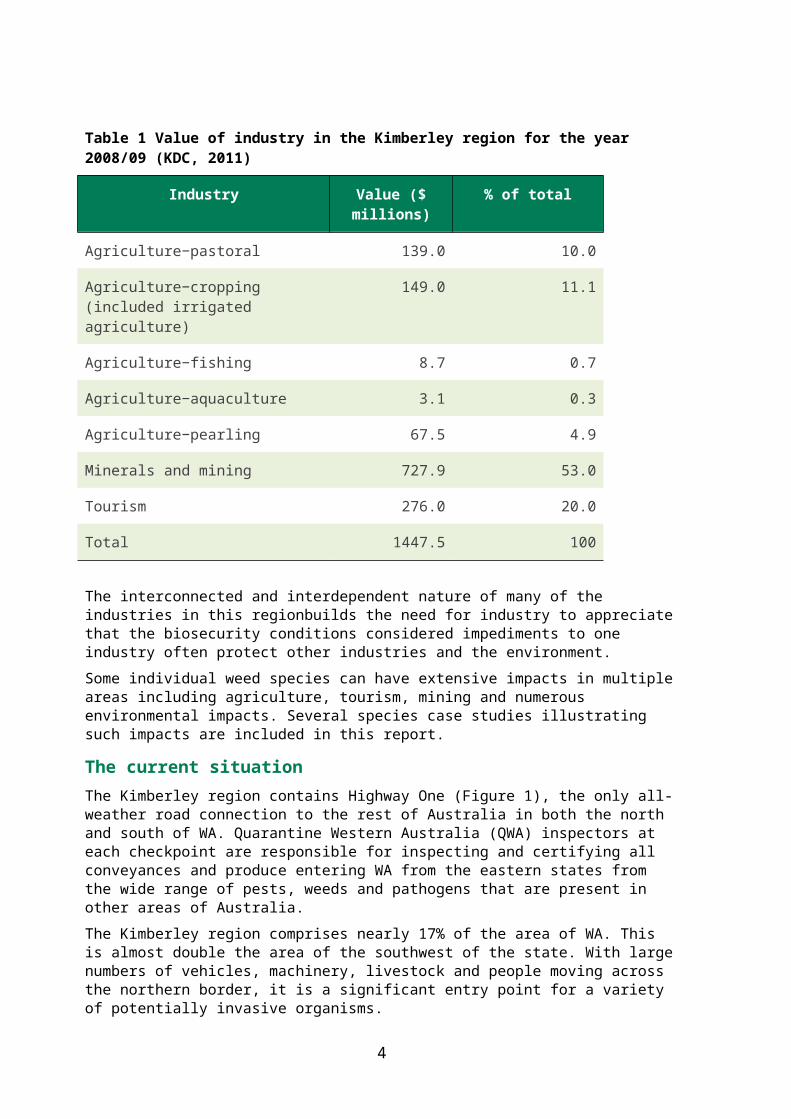
Regional economyThe economic value of the various industries in the Kimberley region annually exceeds $1.4 billion. Biosecurity operations statewide provide protection to all industries as not all the threats to the region enter the state via the road crossing at Kununurra. Table 1 provides the values of the major industries in the Kimberley for the 2008/09 financial year (KDC, 2011).
Mining and tourism account for almost three quarters of the income generated in the Kimberley while the pastoral industry, valued in 2008/09 at $139 million, accounts for 10% of the region’s income (KDC, 2011). Agriculture as a whole represents 27% of the annual economic value of the Kimberley.
The potential costs to any one industry are just part of the overall costs of weed impacts. By modifying the environment, increasing fire risks, changing water flow rates and creating erosion problems, weeds degrade the natural environment and have an impact on agricultural production. The pastoral and tourism industries in the Kimberley essentially share the productivity, beauty and diversity of Kimberley, and some stations run tourism businesses in tandem with their pastoral interests.
2
Table 1 Value of industry in the Kimberley region for the year 2008/09 (KDC, 2011)
Industry Value ($ millions)
% of total
Agriculture−pastoral 139.0 10.0
Agriculture−cropping(included irrigated agriculture)
149.0 11.1
Agriculture−fishing 8.7 0.7
Agriculture−aquaculture 3.1 0.3
Agriculture−pearling 67.5 4.9
Minerals and mining 727.9 53.0
Tourism 276.0 20.0
Total 1447.5 100
The interconnected and interdependent nature of many of the industries in this regionbuilds the need for industry to appreciate that the biosecurity conditions considered impediments to one industry often protect other industries and the environment.
Some individual weed species can have extensive impacts in multiple areas including agriculture, tourism, mining and numerous environmental impacts. Several species case studies illustrating such impacts are included in this report.
The current situationThe Kimberley region contains Highway One (Figure 1), the only all-weather road connection to the rest of Australia in both the north and south of WA. Quarantine Western Australia (QWA) inspectors at each checkpoint are responsible for inspecting and certifying all conveyances and produce entering WA from the eastern states from the wide range of pests, weeds and pathogens that are present in other areas of Australia.
The Kimberley region comprises nearly 17% of the area of WA. This is almost double the area of the southwest of the state. With large numbers of vehicles, machinery, livestock and people moving across the northern border, it is a significant entry point for a variety of potentially invasive organisms.
In addition to Highway One, other roads leading from the Northern Territory (NT) into the Kimberley region (Tanami, Buchanan, Duncan Roads) are used by livestock carriers and have no permanent quarantine checkpoint. Although anecdotal evidence suggests there are risks associated with these pathways, no data on truck or stock numbers are currently available.
3
Figure 1 The Kimberley region of Western Australia (Anon, 2013)
The actual incursion rate for biosecurity organisms across state boundaries cannot be determined. At best they could be estimated but that would require substantial organism interception data that has been identified to species level. This is not currently recorded.
Detections that are recorded comprise only a fraction of all incursions. Most detections are declared species that are reasonably well known to staff at the border and in the region.
Such detections have included:
prickly acacia (Acacia nilotica (L.) Willd. Ex Delile)
parthenium weed (Parthenium hysterophorus L.)
giant sensitive plant (Mimosa pigra L.)
rubbervine (Cryptostegia grandiflora R.Br.).
Detection of new plant species require confirmation by experienced botanists.
4
PathwaysPathways: any means that allows the entry or spread of a pest (FAO, 2007).
Plants are naturally well adapted to utilise a number of natural pathways to disperse their propagules as seeds, fruits or other viable plant parts including bulbs, bulbils, corms, spore, root or stem fragments. This range of propagules, each with their own physical and physiological characteristics and dispersal capabilities, leads to the expression ‘propagule pressure’.
As used by invasion biologists ‘propagule pressure’ describes the incursion potential posed by a species. For plants it is simply determined by the number of times incursions occur (the frequency) and the numbers of propagules in each incursion (volume) (Lockwood et al. 2005, Simberloff 2009). Species that occur frequently, and in high numbers, have a high propagule pressure whilst a species that is rarely involved in an incursion, or in very low numbers when it does, has a comparatively low ‘propagule pressure’. Seeds are a particularly efficient means for regular incursions and can be present in large numbers.
Depending on the pathway and the frequency of the potential carrier, some species can place huge propagule pressures on areas where they are being dispersed, with establishment just a matter of time. The nationwide movement of nursery stock is a good example of a high propagule pressure pathway because of the numbers of species involved, the potential quantities per incursion and the frequency of incursions.
Given that human activities have become such a significant vector in plant dispersal globally it is appropriate to consider these various pathways under the categories below, which can then be further subdivided:
1. Deliberate spread by humans ornamental plants
medicinal plants
food plants
revegetation and forestry plants
coarse grains and other agricultural seed for sowing.
2. Accidental spread by humansa) Contamination of:
machinery
equipment
vehicles
agricultural, nursery and home garden produce/products
construction and landscaping materials
livestock carriers.
b) Escapes: inappropriately disposed plants.
5
3. Natural spreadAnimals:
flying
walking or swimming.
Weather events:
wind
water.
Each pathway and its risks are considered.
Deliberate spread by humansThere are two main pathways relating to the deliberate spread of plants (see below). Both pathways are regulated under legislation with checks made to ensure that the identity of every individual plant or seed line imported is permitted entry into the state. Commercial consignments of seed are checked for contaminants. This requires a seed analysis certificate before being considered for entry into the state. Live plants are required to comply with a range of quarantine plant health requirements and need similar certification compliance with the required treatments.
The first check conducted on any live plants or seed proposed for introduction into WA is to correctly identify it. Any prohibited species is refused entry and the consignment either destroyed or sent back to its point of origin.
Seed in very small quantities, often sent by Australia Post or international mail, may sometimes escape scrutiny, however these identity conditions apply to all imported plants or seed. This risk also applies to the whole country and obviously the larger cities experience the highest incursion rates for this pathway.
The nursery industry does import live plants into the Kimberley from the NT and Queensland for domestic and commercial use. However the single road access and scrutiny of all species in each consignment mean there is minimal risk of any prohibited or declared pests entering via this pathway. There is no evidence that live plants are deliberately imported into WA on the alternate minor roads. Most eastern states nurseries sending consignments to WA are well aware of these requirements and many enter into voluntary quality assurance schemes to meet these obligations and streamline their shipping processes.
Post border inspections are common as many consignments may not be easily inspected at the border. This is commonly the case for live plants entering the state with relevant QWA post border inspections being carried out at licensed (bonded) warehouse facilities.
The deliberate distribution of plants and seed, while a diverse and widespread practise, is also a regulated, well understood and well managed series of pathways. While there is some potential for incorrectly labelled material to enter the state, this risk is considered to be minimal.
Interstate import conditions for seed and live plant imports are also routinely modified to reflect current quarantine concerns. The recent ban on plants from the Family Myrtaceae, due to the myrtle rust (Puccinia psidii G. Winter) incursion in Queensland is a good example. When these conditions change, the regulations are revised and updated to reflect
6

this changing risk based on advice from the relevant department specialists.
Nurseries
Nurseries produce potted plants, seedlings, cuttings, tissue culture slips, bulbs, corms and seeds for a vast range of uses.
Ornamental plants, used by gardeners, florists, landscapers etc.
Medicinal plants, as used by professional herbalists and many home growers.
Food plants, for the broadacre food industry down to backyards.
Revegetation and forestry plants across a vast range of landholdings around Australia.
Coarse grains and fodder trade
The coarse grains seed industry provides seed for pastures, feed products and seed for sowing a wide range of agricultural grain and fodder crops sourced from farms or specialist broad acre seed producers.
Accidental spread by humansAccidental spread pathways can also be broken down into two categories:
Contamination Human apparel and equipment: clothing, footwear and camping equipment.
Machinery, equipment and vehicles: mainly as seeds attached to, or inside, passenger vehicles, farm equipment, boats, earth moving machinery and other bulk equipment.
Agricultural produce: in feed or fodder products, seed for sowing etc.
Construction and landscaping materials: bulk materials such as gravel, soil, sand, mulch and turf.
Livestock movement: internal or external contamination of livestock.
Escapes Escapes from research agency trial sites were a significant source of new weed
species in the past. However it’s not as important a source these days since the screening of all intentional imports has been carried out for almost 20 years. Most escapes now are where plants spread from gardens or landscaped areas into the surrounding areas. This is still a contentious issue for some declared pests and for those species considered environmental weeds that are not declared pests.
Waste disposal: the intentional dumping of garden refuse and particularly aquarium plants into the environment is still a major issue. Public awareness and provision of free, or low cost, recycling or green waste dump sites can significantly reduce these risks.
Escapes are essentially a post border concern while contamination can be both a pre and post border issue. Contamination is clearly the major concern here, as it involves the potential for incursions of species new to the state, and is considered in detail.
Contamination in vehicles, apparel, equipment, construction materials and agricultural produce
Most contamination issues are well regulated, particularly for the pathways listed above.
7

Interstate import conditions, border inspections and wash down bays deal with most contaminants. Restrictions on the entry of soil and numerous conditions apply to most construction, agricultural and horticultural produce. Occasionally, a new product, such as sugarcane mulch, can cause problems where no existing import conditions can effectively deal with the threats posed by that pathway, so continual vigilance is essential to ensure such problems are dealt with quickly when they arise.
The number of species moved by humans on their clothing, personal equipment and on dirty vehicles, as shown in Table 2. Taylor et al. (2012), demonstrated that vehicles move seed attached to their exterior in mud or soil over hundreds of kilometres. Moerkerk’s (2006) study found that a vehicle’s cabin was consistently the most common place to find a wide range of weed seeds brought in by passengers on their shoes and clothing with seed becoming attached to floor mats and other soft surfaces inside the cabin.
Table 2 Dispersal of seed by people, animals and vehicles
Pathway Country Number of species
Reference
Shoes, socks, trousers Australia 50 Mount and Pickering, 2009
Shoes, socks, trousers Australia 24 Wace 1985
Shoes, socks Australia 32 Whinam et al. 2005
Shoes England 39 Clifford 1956
Vehicles Nigeria 39 Clifford 1959
Vehicles Australia 88 Lonsdale and Lane 1994
Vehicles Australia 53 Moerkerk 2006
Vehicles USA 61 Rew, 2011
Tourists clothing Global 228 Pickering and Mount 2010
Vehicles Global 505 Pickering and Mount 2010
Horse/donkey Global 234 (dung 216) Pickering and Mount 2010
Pickering and Mount’s (2010) comprehensive review of tourists as a vector for weed seeds showed the potential threat tourists, their vehicles, and the animals associated with tourists on ‘eco’ holidays can pose, transporting many hundreds of different plant species with 505 species on vehicles alone (Table 2).
Outdoor clothing such as boots, trousers and socks is an area that has been studied in Australia to determine which plant species are transported, and how far they can be carried by hikers (Mount and Pickering 2009, Pickering and Mount 2010, Pickering et al. 2011).
A range of studies have shown that up to 179 species can be dispersed by hikers on various items of clothing, although socks, shoes, laces and trouser legs are the most common (Mount and Pickering 2009). Australian field trials showed hikers collecting as many as 650 seeds per sock for up to 50 species, with contamination taking as little as five minutes (Mount and Pickering 2009). Distances dispersed were also significant. Seeds were being moved in the tread of shoes for up to 5km and over 2km on trousers (Mount and Pickering 2009, Pickering et al. 2011).
8
The range and number of species and the potential distances seed could be moved on clothing demonstrates the need for tourists who have been hiking or camping to ensure that their equipment is clean. Quarantine officers should check this equipment as a priority.
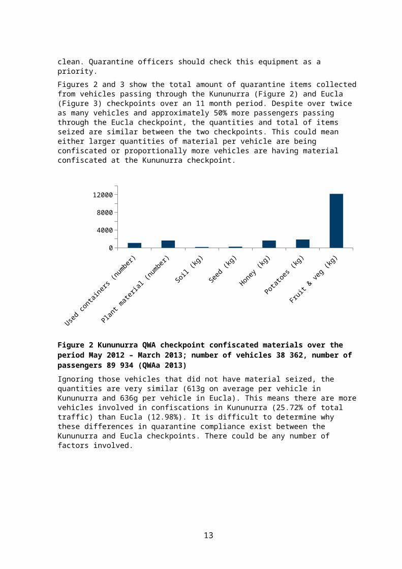
Figures 2 and 3 show the total amount of quarantine items collected from vehicles passing through the Kununurra (Figure 2) and Eucla (Figure 3) checkpoints over an 11 month period. Despite over twice as many vehicles and approximately 50% more passengers passing through the Eucla checkpoint, the quantities and total of items seized are similar between the two checkpoints. This could mean either larger quantities of material per vehicle are being confiscated or proportionally more vehicles are having material confiscated at the Kununurra checkpoint.
Used c
ontai
ners
(numbe
r)
Plant m
ateria
l (num
ber)
Soil (k
g)
Seed (
kg)
Honey
(kg)
Potatoe
s (kg
)
Fruit &
veg (
kg)
0
2000
4000
6000
8000
10000
12000
14000
Figure 2 Kununurra QWA checkpoint confiscated materials over the period May 2012 – March 2013; number of vehicles 38 362, number of passengers 89 934 (QWAa 2013)
Ignoring those vehicles that did not have material seized, the quantities are very similar (613g on average per vehicle in Kununurra and 636g per vehicle in Eucla). This means there are more vehicles involved in confiscations in Kununurra (25.72% of total traffic) than Eucla (12.98%). It is difficult to determine why these differences in quarantine compliance exist between the Kununurra and Eucla checkpoints. There could be any number of factors involved.
9

Used c
ontai
ners
(numbe
r)
Plant m
ateria
l (num
ber)
Soil (k
g)
Seed (
kg)
Honey
(kg)
Potatoe
s (kg
)
Fruit &
veg (
kg)
0
2000
4000
6000
8000
10000
12000
Figure 3 Eucla QWA checkpoint confiscated materials over the period May 2012 – March 2013; number of vehicles 82 284, number of passengers 137 666 (QWAa 2013)
The Kununurra checkpoint receives considerable quantities of quarantine contraband, including over 12 000kg of fruit and vegetables, 1 800kg of potatoes, 1 600kg of honey and 1 400 plants or plant material of quarantine risk being seized. If this pathway were not regulated, the risk to the whole state, not just the Kimberley, would be considerable.
Kununurra checkpoint summary of interceptions
Over an eleven month period (2012-13), 38 362 vehicles crossed into WA through the Kununurra quarantine checkpoint; an average of 109 vehicles a day, with 27% of these vehicles (10 464 vehicles, or 28 per day) having some quarantine material confiscated, carrying animals or ordered into quarantine (see Table 3).
None of the 190 stock trucks carrying stock entering the state were cleaned at the road checkpoint, however the majority were ordered into quarantine. Over the last few years, DAFWA’s policies have been modified. Cattle for export are now sent to Wyndham under a quarantine notice where the trucks are required to turn around and leave the state directly. No washout or inspection is otherwise conducted on these trucks if they leave the state after delivering their consignment. The is evidently inadequate control over these requirements..
By comparison, for the same period, the Eucla checkpoint had a total of 82 552 vehicle crossings, or an average of 226 a day. Of these 18% (15 028 vehicles, or 41 per day) also had some quarantine material confiscated or were ordered into quarantine by QWA inspectors.
Considerable effort appears to be spent by QWA inspectors checking and cleaning vehicles, or finding and confiscating various quarantine risk materials.
10
Table 3 Summary of material confiscated or vehicles placed into quarantine at the Kununurra checkpoint over the period May 2012 – March 2013 (QWAa 2013)
Materials confiscated or put into quarantine
Volume Number of vehicles affected (from a total of 38 362)
Live plants 1629 plants or plant material
159
Quarantine food products (fruit, vegetables, honey, potatoes etc.)
15 687kg 9 803
Seed (potential for contamination and pathogens)
237kg of seed 107
Machinery, equipment and vehicles (contamination issues)
163kg of soil 169 (44 cleaned)
Stock, including horses 16 485 190 (0 cleaned)
Orders into quarantine issued (involved 15 485 stock and horses)
354 vehicles, 145 carried stock and horses
Contamination of livestock
Livestock movement is controlled by quarantine policies and regulations, some relating to animal health and welfare issues. The interstate live animal export trade poses some risks to WA transport due to requests for variations in the import conditions – based on stock transiting through WA and therefore being a lower level of risk.
Visual inspections can easily determine if seed is present as an external contaminant, however significant quantities of viable seed can be held internally in any ruminant and without evacuating the stomach contents. This risk is not easy to identify.
Stock movement across the border into WA is concentrated in the north. Figure 4 shows the significant differences between the Eucla and Kununurra checkpoints regarding the numbers of stock and horses crossing into Western Australia over the same eleven month period. Clearly the numbers of stock entering the state via Kununurra is significantly greater than that entering via Eucla (16 016 versus 1 446) and this includes the recent reduction in overseas live exports. Note: Undetermined numbers of livestock also enter the Kimberley region along secondary roads.
11

Stock Horses0
2000
4000
6000
8000
10000
12000
14000
16000
18000
EuclaKununurra
Figure 4 Stock and horse numbers transported via Eucla and Kununurra (May 2012 – March 2013) (QWAa 2013)
The scientific literature was searched for data on the capacity of livestock to carry plant seeds internally and externally. Table 4 shows the quantities and diversity of plant seeds that are carried internally by livestock from a number of studies around the world. Appendix 1 provides a list of plants that can be dispersed internally or externally by cattle as well as by vehicles and people within Australia. The ‘nursery’ column in Appendix 1 only includes those declared pest plants available in the NT.
12
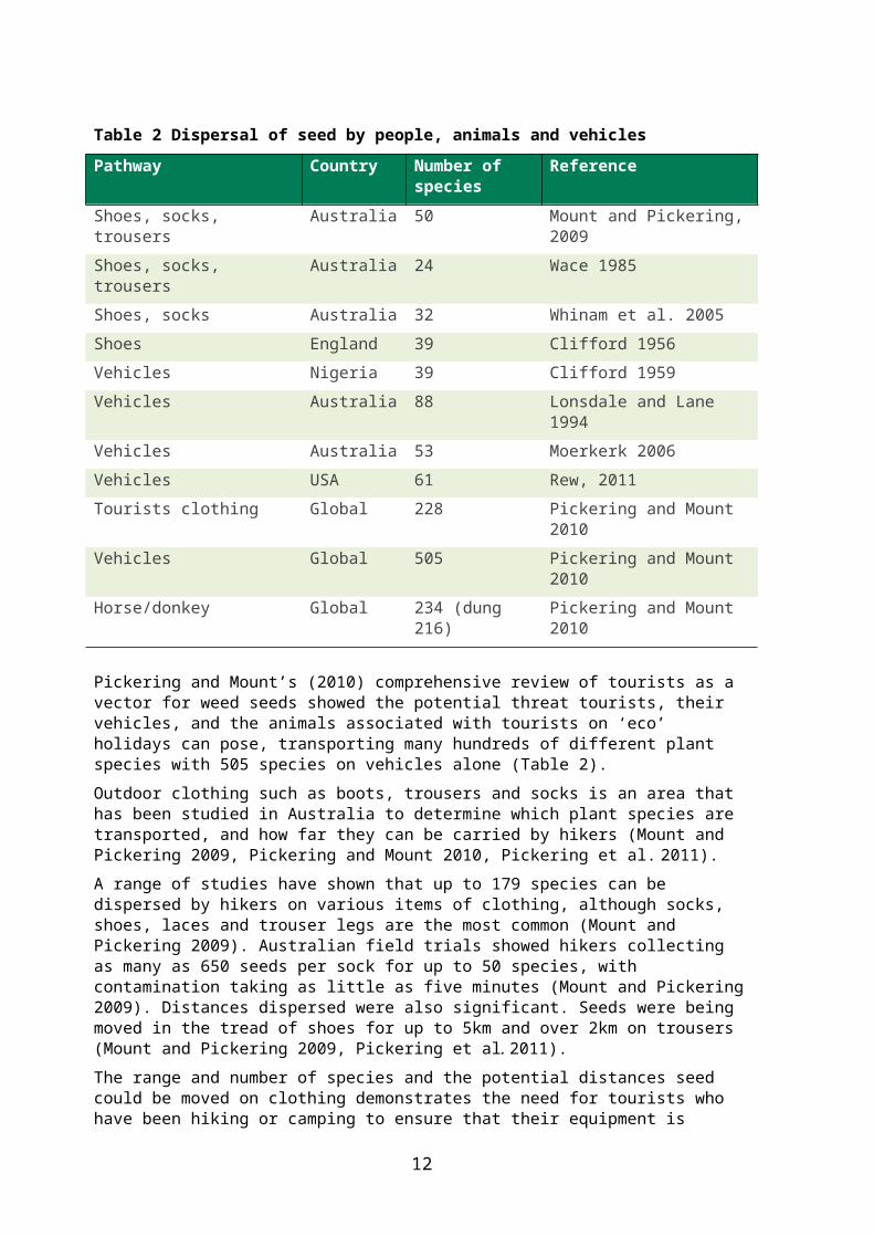
Table 4 Quantity and variety of seeds carried internally in livestock
Number of species detected
Number of seed/seedlings/kg
Density of seedlings/m2
Reference
41 355 (dw*) Vignolio and Fernández 2010
400 Materechera and Modiakgotla 2006
25 290 Bartuszevige and Endress 2008
234 Pickering and Mount 2010
29 Weaver and Adams 1996
595 Haarmeyer et al. 2010
75 Pleasant and Schlather 1994
100-2 000 (ds) 0.8 to 261 (ds) Rupende et al. 1998
1 500 (dw) Peinetti et al. 1993
117 7 237 Cosyns et al. 2005
2 900-11 500 (dw) Jones et al. 1991
300 (dw) Campos and Ojeda 1997
3 700 (dw) 561 Malo et al. 2000
1 575 (dw) Milton and Dean 2001
48 133 (ww) Pleasant and Schlather 1994
61 4 604 (dw) Mouissie et al. 2005
Review total 458
2 006 (dw)(average)
1 700 (average) Literature review for this paper Randall 2013
*dw = dry weight - ww = wet weight. - ds = numbers dependent on species.
13
Note: in developing the datasets for this report any species of plant that was documented using livestock animals as either an internal or external pathway for dispersal was recorded. Relevant information on zoochory (the movement of seed by animals), focussing on data relating to stock animals, shows that at least 458 species of plants use this dispersal pathway in many locations internationally. Of these, 398 species are currently present in Australia (Randall, 2013). This includes 26 Australian native species that are dispersed by this pathway.
Appendix 1 provides detail on 44 weed species present in Australia including their pathways and legal status in WA according to the BAM Act. The appendix contains 21 Declared Pests (s.22), 16 Prohibited Species (s.12) and 7 Unassessed plant species, all well documented weeds of rangelands that could have an impact on the Kimberley region.
Excretion Rates
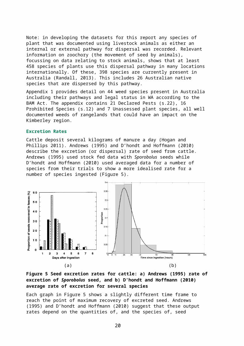
Cattle deposit several kilograms of manure a day (Hogan and Phillips 2011). Andrews (1995) and D’hondt and Hoffmann (2010) describe the excretion (or dispersal) rate of seed from cattle. Andrews (1995) used stock fed data with Sporobolus seeds while D’hondt and Hoffmann (2010) used averaged data for a number of species from their trials to show a more idealised rate for a number of species ingested (Figure 5).
(a) (b)
Figure 5 Seed excretion rates for cattle: a) Andrews (1995) rate of excretion of Sporobolus seed, and b) D’hondt and Hoffmann (2010) average rate of excretion for several species
Each graph in Figure 5 shows a slightly different time frame to reach the point of maximum recovery of excreted seed. Andrews (1995) and D’hondt and Hoffmann (2010) suggest that these output rates depend on the quantities of, and the species of, seed ingested. Some species of seed are recovered beyond the time frames shown above if a large quantity of seed has been consumed.
Dung Production and Management
The Hogan and Phillips 2011 review made the following comments about managing the issues of transporting cattle and the resultant dung contamination:
“With ingested weed seed the problem has to be addressed at both the point of origin and
14

the destination.
At the departure point, the seed burden can be reduced by changing the diet to one free of weed seed for several days before curfew and transport, as provided by an immature crop. However, feeding a mature crop of low digestibility for pre-transport feeding has been advocated to maintain rumen contents and reduce colonisation by pathogenic bacteria. Such a crop is more likely to be contaminated with weed seeds than an immature crop, and the crop itself may be a weed at the destination, which can be spread if the crop contains mature inflorescences.
At the destination (dispersed) seed should be localised by provision of a suitable quarantine area where the animals can be held, not only to detect health problems but also to permit the disposal of faeces. In view of the amount of seed possibly discharged in the transport vehicle a suitable area for the removal and disposal of excreta is also essential.”
For quarantine management of livestock to be effective, numerous factors need to be considered and integrated into protocols that minimise the risk of weed seed dispersal while allowing livestock to move from seller to buyer.
Incursion risk of contaminated livestock imports
How much seed could potentially enter WA inside stock each day?
For the 2012–13 period the seed contamination risk imposed by cattle imported from the NT and Queensland through the Kununurra checkpoint can be summarised as:
Stock numbers: 16 000
This figure will fluctuate year to year but for this exercise it will be assumed that 16,000 cattle a year are entering through the Kununurra checkpoint.
Dung deposited daily: 2.5kg dry weight per day
The amount of cattle dung produced per animal every day (Hogan and Phillips 2011). This is a conservative estimate and only applies to the first 24 hours.
Seed contained: 2006 seed per kg
This is an average of seven studies looking at the amount of seed contained in stock faeces (Table 2). Seed output can increase for up to three days and continue for seven or more days (Hogan and Phillips 2011).
Dung introduced annually: 40 000kg
From ‘stock numbers’ multiplied by ‘dung deposited daily’. Left behind somewhere in northern WA, within the first 24 hours of entry each year.
Seed introduced annually: 80 240 000 seeds
(or 220 000 seeds every day). From ‘dung introduced’ times ‘seed contained’ from a range of around 400 plant species.
With such potentially high numbers of seed entering each day it is likely that other factors are working to reduce this risk. Time is critical when looking at seed numbers excreted by stock. Longer travel time to the border and longer holding treatments applied to stock before loading all work in favour of reducing the risks of this pathway.
15

Escapes and disposal
Escapes of plants, that is the dispersal of propagules beyond intentional plantings, and the inappropriate disposal of viable plant material is essentially a post border management issue within WA.
The state border is sufficiently remote from the main population centres so that issues such as plants escaping from gardens or dump sites are rarely considered a border problem. One example isthe incursion of Salvinia molesta D.S.Mitchell (salvinia) in a tributary of Lake Argyle several years ago. Swift action by DAFWA staff prevented the possibility of this highly invasive species from colonising the entire lake surface, which would have had significant impacts on local irrigators, wildlife and the health of the lake. The original source of this infestation has never been determined. One option is casual dumping of excess plants from a fish tank or garden pond. Targeted media campaigns have been shown to be effective in eliciting information from the public on significant aquatic weeds like salvinia (Salvinia molesta D.S.Mitch.) and water hyacinth (Eichhornia crassipes (Mart.) Solms) particularly in remote infestations.
However as this report is considering pathways that move into the state, these species will not be considered further.
Natural spreadNatural spread, in relation to the Kimberley, are those aspects of the physical environment outside of the control of human activities. Natural spread considers two basic pathways, spread by animals and spread by extreme or regular weather events:
Animals birds and flying bats
other animals, including native, feral and domestic livestock (walking and swimming).
Weather events, potentially introducing seed from overseas and interstate wind: cyclones or other major storm events
water: regional inland flooding or ocean currents and storm surges.
The Northern Australia Quarantine Strategy (NAQS) surveys the northern Australian coastline and adjacent areas looking for incursions of animals, plants and pathogens from overseas sources, but the region is large and currently staffed by two botanists. Economically important pathogen incursions using a range of ‘sentinel’ animals in the isolated communities along the northern coastline are the major priority for NAQS. The sentinel animals used in these surveys are chickens, pigs and other livestock that have blood tested for the presence of exotic pathogens.
Spread by animals
A wide range of native and introduced wildlife consume and excrete a wide range of native and exotic seeds or fruits right across northern Australia. Externally attached seed and fruits can also be introduced and spread from across the border in the NT and from much further afield by birds and bats.
Randall, Mitchell and Waterhouse (1999) reported that 574 species of weed species not known in northern Australia were to be found in the near northern regions such as Timor, West Papua, Papua, Papua New Guinea and various smaller Indonesian islands. Most of
16

these species would require some human assistance to enter Australia.
Plant incursions via animals from overseas could be detected by regular botanical surveys. While NAQS does survey into WA their staff have different priorities and could overlook infestations of species of significance to WA such as Andropogon gayanus Kunth (gamba grass) or Acacia nilotica (L.) Willd. ex Delile (prickly acacia) both of which can be dispersed by animals and water.
Natural spread by native herbivores and livestock moving across the border are significantly different to moving stock by road in trucks but the differences are significant. Natural cross border movements are over relatively short ranges that can be considered as ecologically contiguous. However, livestock trucked in from another region and moved across the border would likely come from an area with a very different spectrum of browsed plant species, compared to the area they are dropped off in. Any animal, that through human intervention travels across larger distances and ecological regions, constitutes a greater weed risk.
Spread by wind
Distribution of wind-blown seeds is a major source of new weeds. Evidence indicates that most wind dispersed seeds fall within a few metres of the parent plant (Cain et al. 2000, Horn et al. 2001, Howe and Smallwood 1982, Nathan and Muller-Landau 2000, Tackenberg, Poschlod and Bonn 2003 and Tackenberg, Poschlod and Kahmen 2003).
Tackenberg, Poschlod, and Bonn (2003) showed that 99% of all wind dispersed seed lands within 200m of the parent plant. Only the very lightest of seeds, under exceptional weather conditions, can be distributed over larger distances. This could occur in the Kimberley during cyclones for those species with very light seeds, such as orchids or ferns which have tiny spores for seed. Many WA native species that occur on either side of the Timor Sea have already taken advantage of wind or water to disperse throughout the region.
Spread by water
Water movement is a significant pathway for seed dispersal within any region and is particularly relevant for the Kimberley with its large rainfall events tied to the seasonal cyclones with resultant widespread flooding across vast floodplains. Water movement can disperse seed far greater distances than wind but does require flood conditions to do so. These are restricted in their area of impact to established, and mapped, catchments. The catchment that includes Lake Argyle and the Ord River Irrigation Area (ORIA) comprises a significant asset that can best be protected by regular surveillance to detect incursions that may have entered via this uncontrollable but predictable pathway. The risk of spread by water requires planning and surveillance after floods or significant rainfall events.
Figure 6 shows the cross border catchments shared by WA and the NT. The two catchments (809 Ord River and 810 Keep River, in yellow), have the greatest potential for movement of weed seeds across the border following even ordinary wet seasons because they straddle the border where people live, work, commute and move through on a daily basis.
17

Figure 6 Map of the shared catchments across northern WA and the NT. Catchments 026, 809 and 810 are those at most risk of border crossing dispersal by animals, wind and water (from Anon, 2005)
All three natural pathways are difficult to regulate, and in the case of the Kimberley, are not easily monitored due to the large area and low population numbers. Consequently, limited staff numbers, and difficulties in accessing many remote areas after severe weather events will lead to incursions that can remain undetected for many years. The subsequent spread from such incursions can be significant.
The region defined by ORIA and the Lake Argyle catchment comprises a significant regional and state asset that should be protected by regular surveillance for incursions that may have entered via these uncontrollable pathways as well as the more frequent and predictable pathways.
18

AnalysisTo determine the level of risk each pathway poses two aspects of risk need to be ranked:
1. The probability of each event occurring (relates directly to propagule pressure).
2. The severity of that potential outcome (the potential level of impacts).
These rankings (Table 5) are multiplied to provide a pathway risk score ranging from a score of one to a maximum of 25. When applying probability and severity scores to each pathway the relative frequency of use, of each pathway, and the impacts of the species concerned needed to be considered.
The literature review and interception data supplied by QWA formed the basis of the decisions reached in allocating these scores to each pathway. The pathway risk score is then converted to a risk rating (Table 6a) and the results ranked by the score. Table 6b is a standard risk table derived from all the potential scores with those scores coloured to illustrate their rating outcomes.
Table 5 Pathway probability and severity outcomes with scores
Pathway probability
Probability score
Severity outcome
Severity score
Rare 1 Insignificant 1
Unlikely 2 Minor 2
Moderate 3 Moderate 3
Likely 4 Major 4
Almost certain 5 Catastrophic 5
Table 6a A standard risk tableProbability score
Severity score 1
Severity score 2
Severity score 3
Severity score 4
Severity score 5
1 1 2 3 4 52 2 4 6 8 103 3 6 9 12 154 4 8 12 16 205 5 10 15 20 25
Table 6b Pathway scores converted into risk ratingsRating Pathway Score
Low 1-5Moderate 6-9High 10-14Extreme 15-24Unacceptable 25
19

20
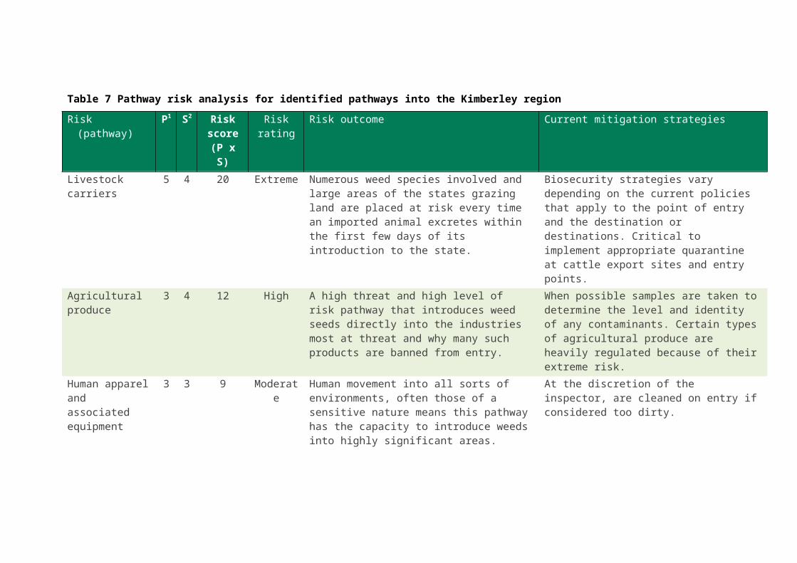
Pathway risk tableA pathway risk analysis table (Table 7) was compiled for the Kimberley region, looking at each identified pathway as a separate risk. The natural spread pathways of animals and wind were however combined into a single risk pathway. Water dispersal of weeds is also difficult to regulate but is more predictable in its actions and therefore more easily monitored after floods or rainfall events. Animals and wind are more random in both space and time and the distances involved were potentially smaller than the spread by water.
The risk outcome descriptions and mitigation strategies are summaries of current biosecurity management practices. Table 7 summarises and ranks these risks, indicating the most significant pathways in terms of the risk rating outcome.
The most significant pathways are the transport of livestock, followed by agricultural produce. The next five pathways are considered ‘Moderate’ risk, followed by three pathways on ‘Low’ risk.
The two most significant ‘risky’ pathways are those that place the highest threat of incursion on the Kimberley region. This can be viewed in terms of the frequency of that pathways use, combined with the numbers of propagules per incursion (that is, probability of an event occurring) and the types of undesirable species that can use that pathway (that is, their potential impacts).
The ‘agricultural produce’ pathway could have scored as highly as the ‘livestock movement’ pathway if not for the fact that it is a regulated pathway with interstate import conditions applied to a range of material or products, hence it has a lower probability of such events occurring.
21

Table 7 Pathway risk analysis for identified pathways into the Kimberley regionRisk (pathway) P1 S
2Risk
score(P x S)
Risk rating
Risk outcome Current mitigation strategies
Livestock carriers 5 4 20 Extreme Numerous weed species involved and large areas of the states grazing land are placed at risk every time an imported animal excretes within the first few days of its introduction to the state.
Biosecurity strategies vary depending on the current policies that apply to the point of entry and the destination or destinations. Critical to implement appropriate quarantine at cattle export sites and entry points.
Agricultural produce
3 4 12 High A high threat and high level of risk pathway that introduces weed seeds directly into the industries most at threat and why many such products are banned from entry.
When possible samples are taken to determine the level and identity of any contaminants. Certain types of agricultural produce are heavily regulated because of their extreme risk.
Human apparel and associated equipment
3 3 9 Moderate Human movement into all sorts of environments, often those of a sensitive nature means this pathway has the capacity to introduce weeds into highly significant areas.
At the discretion of the inspector, are cleaned on entry if considered too dirty.
Machinery, vehicles and other equipment
3 3 9 Moderate Equipment, particularly earthmoving machinery, is a well known pathway for introducing weed seeds.
Machinery hygiene is heavily promoted in this area both in imported machinery and with machinery moving into WA.
Construction materials
2 3 6 Moderate Similar threat as some types of agricultural produce.
Soil is a prohibited import. Other building materials would be subject to inspection and sampling on entry and most contamination issues can be offset with basic hygiene protocols in the collection and storage of such materials.
P1 - Probability of event occurring and S2 – Severity of potential outcome (1 'Low' to 5 'Extreme')

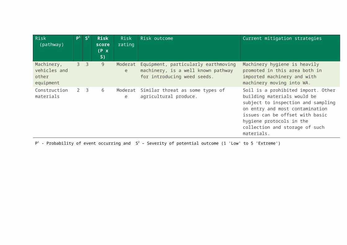
Table 7 Pathways risk analysis for identified pathways into the Kimberley region (continued)
Risk (pathway) P1
S2
Risk score(P x S)
Risk rating
Risk outcome Current mitigation strategies
Escapes 3 2 6 Moderate Areas impacted are generally small and adjacent to the locations where the problematic species is being grown.
A post border issue for the most part.
Waste disposal 3 2 6 Moderate Areas impacted are generally small and adjacent to the locations where problematic species are dumped.
A post border issue for the most part.
Natural spread by animals, wind
2 2 4 Low Depending on the specific pathway, spread will be either cross border or from the coast moving inland. Most species that are commonly spread by this pathway in the Kimberley would already have made numerous incursions over the years.
Management of natural seed dispersal from overseas or across the border is not possible, but good surveillance of the most obviously effected zones can keep this risk low.
Water 2 2 4 Low Significant water dispersal would normally take place after cyclones or other large rainfall events as floods which would include cross border dispersal.
Surveillance of flood plains is a somewhat simpler exercise in that the areas to be checked can be planned in advance prior to floods, with the extent of the flooding determining the areas to be searched.
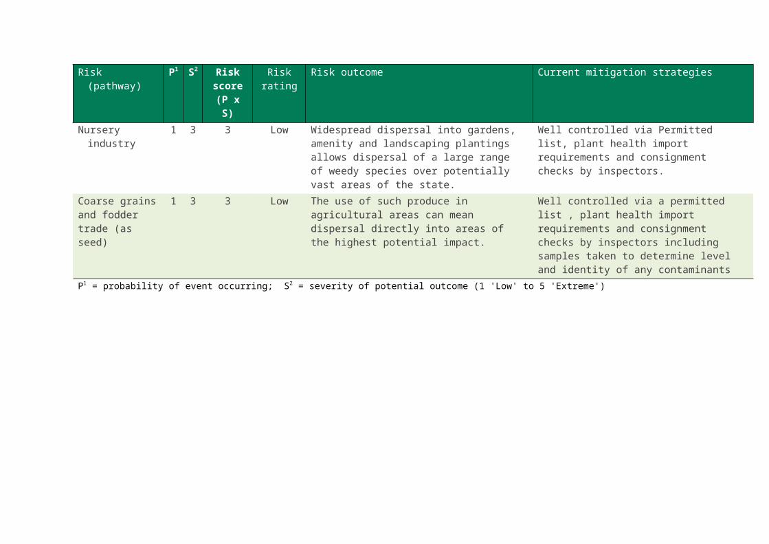
Nursery industry 1 3 3 Low Widespread dispersal into gardens, amenity and landscaping plantings allows dispersal of a large range of weedy species over potentially vast areas of the state.
Well controlled via Permitted list, plant health import requirements and consignment checks by inspectors.
Coarse grains and fodder trade (as seed)
1 3 3 Low The use of such produce in agricultural areas can mean dispersal directly into areas of the highest potential impact.
Well controlled via a permitted list , plant health import requirements and consignment checks by inspectors including samples taken to determine level and identity of any contaminants
P1 = probability of event occurring; S2 = severity of potential outcome (1 'Low' to 5 'Extreme')
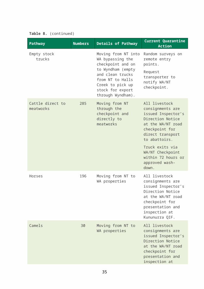
A further breakdown of the livestock carrier pathway (Table 8) was considered important as livestock crossing the border is a complex series of pathways with each being treated differently depending on the intended destination. In all cases they essentially present the same level of risk when presenting at the border, with all animals containing seed internally. However, when mitigating the potential risks, the destination within the region also needs to be considered.
Table 8 Various livestock pathways through the Kununurra checkpoint 2012–13 (QWAb 2013)
Pathway Number Details of pathway Current quarantine action
Cattle inspected at Quarantine Inspection Facility (QIF)
2 530 Moving from NT into WA with an inspection at the Kununurra QIF
All livestock consignments are issued Inspector’s Direction Notice at the WA/NT road checkpoint for presentation and inspection at Kununurra QIF.
Cattle inspected at destination property
5 588 Moving from NT into WA with an inspection at destination property
All livestock consignments are issued Inspector’s Direction Notice at the WA/NT road checkpoint for presentation and inspection at property of destination.
Cattle ‘moved within’ adjacent property
3,309 Moving from NT to WA side of the border to properties with the same owner
All livestock consignments are issued Inspector’s Direction Notice at the WA/NT road checkpoint, no inspection undertaken.
Live export cattle 3817 – Wyndham
1682 – Broome
Moving from NT to WA through the checkpoint and directly to an export facility
All livestock consignments are issued Inspector’s Direction Notice at the WA/NT road checkpoint for direct transport to an export facility.
Truck exits via WA/NT checkpoint within 72 hours or approved wash-down.
24
Table 8. (continued)
Pathway Numbers Details of Pathway Current Quarantine Action
Empty stock trucks Moving from NT into WA bypassing the checkpoint and on to Wyndham (empty and clean trucks from NT to Halls Creek to pick up stock for export through Wyndham).
Random surveys on remote entry points.
Request transporter to notify WA/NT checkpoint.
Cattle direct to meatworks
285 Moving from NT through the checkpoint and directly to meatworks
All livestock consignments are issued Inspector’s Direction Notice at the WA/NT road checkpoint for direct transport to abattoirs.
Truck exits via WA/NT Checkpoint within 72 hours or approved wash-down.
Horses 196 Moving from NT to WA properties
All livestock consignments are issued Inspector’s Direction Notice at the WA/NT road checkpoint for presentation and inspection at Kununurra QIF.
Camels 30 Moving from NT to WA properties
All livestock consignments are issued Inspector’s Direction Notice at the WA/NT road checkpoint for presentation and inspection at Kununurra QIF.
Livestock ? Moving from NT to WA properties on secondary roads
No quarantine effort expended on this pathway
25

DiscussionIf there are so many significant pathways into the state, why are incursions not detected more regularly? For the Kimberley, there are relatively few DAFWA staff responsible for a very large area. Combined with the time and the distances involved in moving livestock across northern Australia, it should not be surprising that few incursions are found.
Biosecurity surveillance in WA benefits from information from landholders, local government staff, other regional workers and tourists.
The combination of the relatively small numbers of people in the north of this state and its large area means that more systematic surveillance is required to find incursions before they become too large to eradicate or manage. This is a significant issue in a region as large and remote as the Kimberley.
Systematic surveillance operations will require the appropriate skills and experience to recognize exotic plant species.
Current biosecurity measures to protect WA’s agricultural industries and the environment has been considered an acceptable risk approach., however this requires review for weeds.
For any individual biosecurity threat the appropriate response is that which maintains our biosecurity integrity at an acceptable level of protection whilst still allowing effective border movement and trade.
Proposed changes to the current biosecurity arrangements for stock entering or passing through WA need to consider movement conditions including:
the potential outcomes
indicate the species that could use that pathway
where those species may originate
outline the areas affected by any incursions that might occur as a result of such changes and
how they would be dealt with.
The Kimberley, particularly the area defined by ORIA and the Lake Argyle catchment, should have regular surveillance for incursions that may have entered via uncontrolled but predictable pathways (such as wind and water) as well as the more frequent and predictable pathways (such as road transport).
The regular movement of people and machinery into the state through the Kununurra checkpoint also places a significant incursion pressure on the region. Attempts to improve the response to the importation of livestock should not come at the expense of the Department’s ability to cope with these important, and effectively managed, pathways.
Managing this state’s biosecurity continuum is a delicate balancing act requiring information for all potential pathways, impacts and outcomes.
26

RecommendationIn consultation with identified stakeholders a response plan should be drafted that considers each pathway and offers clear recommendations on how to deal with the risks identified. It should include a regular and targeted surveillance component that includes each pathway. The response planwill guide the development of further biosecurity policies and import entry conditions including policies and conditions for the safe transport of cattle into and through WA.
With effective engagement by industry and community, new weed mitigation strategies, policies and import conditions will improve biosecurity in the region.
27

Case studiesThree short case studies are presented as examples of the potential impacts these weeds could have if allowed to establish in the Kimberley region.
Case study 1. Andropogon gayanus Kunth: gamba grass (Prohibited Organism s12)Ecologists have called gamba grass a transformer species as it is a plant that can completely change the function of an ecosystem. In the northern Australian subtropical woodlands gamba grass increases the fire regime so dramatically that it creates a grassland monoculture, by killing off all trees. Ferdinands et al. (2006) recorded a 53% reduction in tree canopy over a 12 year period in the NT that could be attributed to the high fuel loads and continual fires triggered by gamba grass.
Gamba grass was proclaimed a declared plant in WA in 2007, listed as a key threatening species under the Environment Protection and Biodiversity Conservation Act 1999 in 2009 and listed as a Weed of National Significance in 2012. It is clearly considered one of the most significant weeds in Australia.
Drucker and Setterfield’s (2008) gamba grass benefit cost analysis considered a three scenario situation with gamba grass at three different levels of productivity (Table 9). Even at the highest level of gamba grass pasture productivity the fire management, biodiversity and socio-cultural costs were all significant.
Table 9 Gamba grass area net production benefits and costs relative to native pasture (Drucker and Setterfield, 2008)
NetLow
gamba grass productivity
scenario
Medium gamba grass productivity
scenario
High gamba grass productivity
scenarioBenefits on 27K ha $2.6 million $6.7 million $13.7 million
Management costs $6.05 million $6.05 million $6.05 million
Biodiversity costs Significant Significant Significant
Socio-cultural costs Significant Significant Significant
Among some invasive weeds, the effects of weed invasion are not that obvious to tourists, for example, para grass (Urochloa mutica (Forssk.) T.Q.Nguyen), invasion at Ubirr in Kakadu National Park. However this is not the case with gamba grass, where the impacts of invasion (vegetation changes and altered fire regime) are clearly visible to non-experts in the form of either grassland taller than four metres, with reduced or no tree canopy, or a regularly severely burnt landscape.
Furthermore, the nature of the impact, more frequent, higher intensity fires posed a direct
28

risk to people using these gamba grass invaded areas for tourism, recreation and infrastructure (for example, signs, buildings) (Ferdinands 2008, Ferdinands and Dodd 2010).
In recognising the risks and increased costs associated with fire management in urban and rural areas invaded by gamba grass the NT government will/has committed an additional $6.1 million (approximate) to Bushfires NT between 2007–12, with $1.25 million provided as recurrent funding. The basis for the Bushfires NT request for additional recurrent funding was that in areas that have been invaded by gamba grass fire management costs and associated risks increase significantly due to higher fuel loads (Ferdinands and Dodd 2010).
Gamba grass is a good example of an organism that provides income for one group while another pays the price of its impacts. Without ongoing intense management, gamba grass pastures become dense monocultures. Stock find movement through these areas to more palatable fodder is difficult.
Gamba grass has been a declared pest in all northern states and territories of Australia for some years, in recognition of the extreme risk it poses to native ecosystems and human infrastructure. It is expected that this widespread management approach will result in significant environmental, social and economic benefits right across northern Australia (Ferdinands and Dodd 2010).
The existing populations of gamba grass in WA are currently targeted for eradication.
Case study 2. Prosopis spp. L.: mesquites (Declared Pest s22)All mesquites, a group of large spiny shrubs and trees, are prohibited entry into WA. Some species and hybrids are already present here and are proving difficult and costly to manage. There are several other species present in Australia, the NT and Queensland, which could easily establish in WA.
The following comments on the impacts of mesquites are taken from the Weeds of National Significance Mesquite Strategic Plan (ARMCANZ et al. 2000).
Environmental impactsc) Formation of thickets that out-compete ground vegetation through competition for
light, water and nutrients and impact on fauna.
d) Open grasslands and native thornless woody shrub lands are vulnerable to being changed to thorny shrub lands, with potentially large effects on native fauna and flora.
e) All river systems and tidal estuaries in the northern rangelands of Australia are vulnerable to infestation by mesquites.
Primary production impactsf) Increased difficulty and expense in mustering stock.
g) Impeded movement and access to water.
h) Thorn damage to vehicle tyres and to livestock from deep puncture wounds.
i) Increased water loss from, and maintenance cost of, watering points.
29
j) Reduced pasture production and hence reduction in carrying capacity leading to lower cattle and wool production. Infestations can reduce grass production by up to 90%.
k) Exacerbates and accelerates soil erosion. Evidence from South Africa suggests that mesquites have a dramatic effect on the water table and surface runoff.
l) Production losses estimated at $25 000/year [per property] in NW Queensland.
m) Potential costs are much higher; in the United States costs amount to $200-500 million annually estimated (1985).
Tourism impactsn) The open grassland and woodland areas of northern Australia are one of the most
attractive characteristics of the outback. The value of the outback tourism industry is increasing; however mesquite infestations reduce such natural attractions in a similar fashion to prickly acacia.
o) Thorn damage to vehicle tyres.
p) Impeded movement and access.
The pathways most likely for mesquite to enter and spread within W A are on dirty vehicles and machinery and livestock (internally and externally) from infested properties. The seed pods of mesquite are highly palatable and are eagerly sort out by cattle. The large seed easily survive passage through the gut in quite reasonable numbers and with enhanced germination after removal of the protective pods (Campos and Ojeda 1997).
Mesquite populations in WA are being managed to prevent further spread with small outlier populations targeted for removal where possible. Further outbreaks of other mesquite species would be eradicated if possible.
Case study 3. Solanum viarum Dunal: tropical soda apple(Prohibited Organism s12)Tropical soda apple (TSA) is a recent introduction to Australia, having been first found on a property near Kempsey in northern New South Wales (NSW) in August 2010.
Subsequent investigations found the species was also present on numerous other properties in northern NSW and in January 2011 two properties in Queensland were also reported, extending its range across the state border. The major pathway for this spread was livestock movement, indicating a failure to react rapidly enough to the arrival of the weed in Australia.
The fruits of most Solanum species taste extremely bitter hence their major impact is reducing the grazing value of infested properties as livestock avoid going near the plants.
TSA is different, the fruits are highly palatable to cattle and they are one of the major vectors of the seed that easily survive passage through the gut. However the rest of the TSA plant is decidedly unpalatable and cattle do not browse any further than selectively removing the fruits.
30
In Florida, USA, TSA is a major weed of cattle properties spreading from a single infestation in 1989 to cover more than 243,000 hectares by 1995. The impacts on bahai grass pastures in Florida ranges from US$70 to $230 per acre per year in lost revenue, accounting for between US$11 and $15 million in lost animal production in the affected US states (Mullahey 2011).
(a) (b)
Figure 7 TSA germinating in a) cattle dung (Mullahey 2011) and b) a bag of cow manure (Westbrooks 2011)
The seed remains viable in the cattle gut for up to six days (Figure 7) and while other animals such as wild birds, goats, sheep and native herbivores also spread the seed in a similar manner it was the efficient long distance movement of cattle that was the major reason for the rapid spread of TSA in the USA. While some distance from the Kimberley region, TSA is just one of many weed species that could be transported into WA inside livestock. Its establishment on a property has the potential to render a business non-viable.
TSA is not yet present in WA but would be a target for eradication if found. The Kimberley region is an ideal climate for this species with TSA expected to be capable of establishing itself across the Kimberley and potentially down the coast into the Pilbara.
31
ReferencesAgriculture and Resource Management Council of Australia & New Zealand, Australian &
New Zealand Environment & Conservation Council and Forestry Ministers (2000). Weeds of National Significance Mesquite (Prosopis species) Strategic Plan. National Weeds Strategy Executive Committee, Launceston.
Andrews, T.S. (1995). Dispersal of seeds of giant Sporobolus spp. after ingestion by grazing cattle. Australian Journal of Experimental Agriculture 35(3) pp: 353 - 356.
Anon (2013). Australia’s NorthWest. Map of the North West Region URL: http://www.australiasnorthwest.com/Travel_information/Maps_of_the_North_West
Anon (2005). Surface Water Management Areas, as Defined by Australian Water Resources. Map ID: WA_L1_SWMA_28 Date: 11 September 2006 URL: http://www.water.gov.au/MapPdfs/SWMA_WA28_1f.pdf
Anon. (2011). Gamba grass, Andropogon gayanus. Fact sheet DECLARED CLASS 2 PEST PLANT. The State of Queensland, Department of Employment, Economic Development and Innovation. CS1097.
Bartuszevige, A.M. and Endress, B.A. (2008). Do ungulates facilitate native and exotic plant spread? Seed dispersal by cattle, elk and deer in north eastern Oregon. Journal of Arid Environments, 72 pp:904–913.
Cain, M.L., Milligan, B.G. and Strand, A.E. (2000). Invited Special Paper: Long-Distance Seed Dispersal in Plant Populations. American Journal of Botany, 87 (9) pp: 1217–1227.
Campos, C.M. and Ojeda, R.A. (1997). Dispersal and germination of Prosopis flexuosa (Fabaceae) seeds by desert mammals in Argentina. Journal of Arid Environments, 35 pp: 707–714.
Claudia M. Campos & Ricardo A. Ojeda (1997). Dispersal and germination of Prosopis flexuosa (Fabaceae) seeds by desert mammals in Argentina. Journal of Arid Environments, 35 pp: 707–714.
Clifford, H.T. (1956a). Seed dispersal on footwear. Proceedings of the Botanical Society of the British Isles 2, pp:129–131.
Clifford, H.T. (1959). Seed Dispersal by Motor Vehicles. Journal of Ecology. 47, pp: 311–315.
Cosyns, E., Claerbout, S., Lamoot, I. and Hoffmann, M. (2005). Endozoochorous seed dispersal by cattle and horse in a spatially heterogeneous landscape. Plant Ecology, 178 pp:149–162. DOI 10.1007/s11258-004-2846-3.
Couvreur, M., Christiaen, Bart., Verheyen, K. & Hermy, M. (2004). Large herbivores as mobile links between isolated nature reserves through adhesive seed dispersal. Applied Vegetation Science 7 pp: 229–242.
Couvreur, M., Cosyns, E., Hermy, M. and Hoffmann, M. (2005). Complementarity of epi- and endozoochory of plant seeds by free ranging donkeys. Ecography 28 pp: 37 –48.
Csurhes, S. (2006). An assessment of the potential impact of Andropogon gayanus (gamba grass) on the economy, environment and people of Queensland. Final draft for public comment. Queensland Department of Natural Resources and Mines (26 pp.).
32
Csurhes, S. and Hannan-Jones, M. (2008). Gamba grass, Andropogon gayanus. Pest Plant Assessment. The State of Queensland, Department of Primary Industries and Fisheries. (28 pp.)
D’hondt, B. and Hoffmann, M. (2010) A reassessment of the role of simple seed traits in survival following herbivore ingestion. Plant biology. doi:10.1111/j.1438 8677.2010.00335.x
Drucker, A.G. and Setterfield, S.A. (2008) Gamba grass benefit-cost analysis. Charles Darwin University, Darwin. (21 pp.)
FAO. (2007). Glossary of Phytosanitary Terms. ISPM No. 5. International Standards for Phytosanitary Measures. Produced by the Secretariat of the International Plant Protection Convention, FAO. (23 pp.)
Ferdinands, K. (2008). NT Weed Risk Assessment Report: Andropogon gayanus (Gamba Grass). Northern Territory Natural Resources Division, Department of Natural Resources, Environment, The Arts and Sport. (28 pp.)
Ferdinands, K. and Dodd, J. (2010). Application for WoNS candidacy, Gamba grass (Andropogon gayanus). NT Department of Natural Resources, Environment, the Arts and Sport and WA Department of Agriculture and Food. (43 pp.)
Ferdinands, K., Douglas, M.M., Setterfield, S.A. and Barratt, J.L. (2006). Africanising the tropical woodlands: Canopy loss and tree death following gamba grass Andropogon gayanus invasion. 15th Australian Weeds Conference: Managing Weeds in a Changing Climate pp: 296–296.
Grice, A. (1996). Seed production, dispersal and germination in Cryptostegia grandiflora and Ziziphus mauritiana, two invasive shrubs in tropical woodlands of northern Australia. Australian Journal of Ecology, Vol. 21, Issue 3, pages 324–331.
Haarmeyer, D.H., Bösing, B.M., Schmiedel, U. and Dengler, J. (2010). The role of domestic herbivores in endozoochorous plant dispersal in the arid Knersvlakte, South Africa. South African Journal of Botany 76 pp: 359–364.
Hogan, J.P. and Phillips, C.J.C. (2011). Transmission of weed seed by livestock: a review. Animal Production Science, 2011, 51 pp:391–398.
Horn, H.S., Nathan, R. and Kaplan, S.R. (2001). Long-distance dispersal of tree seeds by wind. Ecological Research, 16 pp: 877–885Howe, H.F. and Smallwood, J. (1982). Ecology of seed dispersal. Annual Review of Ecology and Systematics, 13 pp: 201–228.
Jones, R.M., Noguchi, M. and Bunch, G.A. (1991). Levels of Germinable Seed in Topsoil and Cattle Faeces in Legume-grass and Nitrogen-fertilized Pastures in South-East Queensland. Aust. J. Agric. Res., 42 pp:953–968.
Julien, M., McFadyen, R. and Cullen, J. (2012) Biological Control of Weeds in Australia. CSIRO Publishing (648 pp.) ISBN: 9780643099937
KDC (2011). The Kimberley: A region in profile 2011. Kimberley Development Commission (23 pp.)
Lockwood, J.L., Cassey, P. and Blackburn, T. (2005). The role of propagule pressure in explaining species invasions. TRENDS in Ecology and Evolution, Vol.20, No.5, pp: 223-228.
Lonsdale, W.M. and Lane, A.M. (1994). Tourist vehicles as vectors of weed seeds in Kakadu National Park, Northern Australia. Biological Conservation, 69 pp:277–283.
33

Malo, J.E., Jiménez, B. and Suarez, F. (2000). Herbivore dunging and endozoochorous seed deposition in a Mediterranean dehesa. J. Range Manage. 53 pp: 322–328.
Materechera, S.A. and Modiakgotla, L.N. (2006). Cattle manure increases soil weed population and species diversity in a semi-arid environment. South African Journal of Plant and Soil, 23 (1) pp: 21–28.
Miceli-Méndez, C.L., Ferguson, B.G. and Ramírez-Marcial, N. (2008). Seed Dispersal by Cattle: Natural History and Applications to Neotropical Forest Restoration and Agroforestry. Chapter 7 in Myster, R.W. (ed.) Post-Agricultural Succession in the Neotropics. Springer Science+Business Media, LLC.
Milton, S.J. and Dean, W.R.J. (2001). Seeds dispersed in dung of insectivores and herbivores in semi-arid southern Africa. Journal of Arid Environments, 47 pp: 465–483.
Moerkerk, M. (2006). Risk of weed movement through vehicles, plant and equipment: results from a Victorian study. Proceedings of the Fifteenth Australian Weeds Conference. Editors: Preston, C., Watts, J.H. and Crossman, N.D. pp: 458–461.
Mouissie, A.M., Vos, P., Verhagen, H.M.C. and Bakker, J.P. (2005). Endozoochory by free-ranging, large herbivores: Ecological correlates and perspectives for restoration. Basic and Applied Ecology 6 pp: 547–558.
Mount, A. and Pickering, C.M. (2009). Testing the capacity of clothing to act as a vector for non-native seed in protected areas. Journal of Environmental Management, 91 pp: 168–179.
Mullahey, J.J. (2011). Biology, Ecology, and Control of Tropical Soda Apple (Solanum viarum). University of Florida, WFREC Milton, Florida. (powerpoint presentation)Nathan, R. (2006). Long-Distance Dispersal of Plants. (Perspective), Science Vol. 313, pp: 786–788.
Nathan, R. and Muller-Landau, H.C. (2000). Spatial patterns of seed dispersal, their determinants and consequences for recruitment. TREE Vol. 15, no. 7 pp: 278–285.
Panetta, F.D. Groves, R.H. and Shepherd, R.C.H. (1998). The Biology of Australian Weeds Vol 2. R.G. and F.J. Richardson, Melbourne.
Parsons, W.T. and Cuthbertson, E.G. (1992). Noxious Weeds of Australia. Inkata Press, Melbourne and Sydney.
Peinetti, R., Pereyra, M., Kin, A. and Sosa, A. (1993). Effects of cattle ingestion on viability and germination rate of calden (Prosopis caldenia) seeds. Journal of Range Management. 46 pp:463–466.
Pickering, C.M. (2008). Literature Review of Horse Riding Impacts on Protected Areas and a Guide to the Development of an Assessment Program. Queensland Environmental Protection Agency: Brisbane. (54 pp.).
Pickering, C.M. and Mount, A. (2010) 'Do tourists disperse weed seed?’ A global review of unintentional human-mediated terrestrial seed dispersal on clothing, vehicles and horses. Journal of Sustainable Tourism, 18: 2, pp:239–256.
Pickering, C.M., Mount, A., Wichmann, M.C. and Bullock, J.M. (2011). Estimating human-mediated dispersal of seeds within an Australian protected area. Biological Invasions, 13 pp:1869–1880.
Pleasant, J.M. and Schlather, K.J. (1994). Incidence of Weed Seed in cow (Bos sp.) manure and its importance as a weed source for Cropland. Weed Technology, Vol. 8 pp: 304–310.
34

QWAa (2013). Quarantine Movement Statistics for the Kununurra and Eucla Checkpoints for the period March to May 2012–13.
QWAb (2013) Pers. Comm. Quarantine Western Australia.
Radford, I.J., Nicholas, D.M., Brown, J.R. and Kriticos, D.J. (2001). Paddock-scale patterns of seed production and dispersal in the invasive shrub Acacia nilotica (Mimosaceae) in northern Australian rangelands. Austral Ecology 26, pp: 338–348.
Randall, J. (1999). Import Risk Analysis. Importation of Weed Species by Live Animals and Unprocessed Fibre of Sheep and Goats. Regulatory Authority, Ministry of Agriculture and Forestry, Wellington NEW ZEALAND.
Randall, R.P. (2007). Introduced Flora of Australia and its Weed Status. CRC for Australian Weed Management and the Western Australian Department of Agriculture and Food. (pp. 524).
Randall, R.P. (2013) Plants Database. Department of Agriculture and Food, part-published data.
Randall, R.P., Mitchell, A.A. and Waterhouse, B.M. (1999). Tropical Weeds. Report to the Manager of Plant Industry Protection. Western Australia.
Rew, L.J. (2011). Developing Functional Parametres for a Science-Based Vehicle Cleaning Program to Reduce Transport of Non-Indigenous Invasive Plant Species. DOD, EPA, DOE - SERDP Project RC-1545. (64 pp.)
Ridley, H.N. (1930). The Dispersal of Plants throughout the World. Ashford, UK: L. Reeve and Co.
Rupende, E., Chivinge, O.A. and Mariga, I.K. (1998). Effect of Storage Time on Weed Seedling Emergence and Nutrient Release in Cattle Manure. Expl Agric, Vol. 34, pp: 277–285.
Seman, R. (2007). Dung Seed Bank of Livestock in Weberi Addis Ababa, Ethiopia. Thesis submitted to the Department of Environmental Science, for Master of Science in Environmental Science. Addis Ababa University, School of Graduate Studies.
Simao Neto, M., Jones, R.M. and Ratcliff, D. (1987). Recovery of pasture seed ingested by ruminants. 1. Seed of six tropical pasture species fed to cattle, sheep and goats. Aust. J. Exp. Agric., 27 pp: 239–46.
Simberloff, D. (2009). The Role of Propagule Pressure in Biological Invasions. Annual Review of Ecology, Evolution and Systematics, 40 pp:81–102.
Sindel, B. and van deer Meulen, A. (2008). Pathway risk analysis for weed spread within Australia (UNE61). Final Report to Land & Water Australia. School of Environmental and Rural Science, University of New England, Armidale.
Smith, N.M. (2002). Weeds of the Wet/Dry Tropics of Australia. (A Field Guide). The Environment Centre NT, Inc.
Tackenberg, O., Poschlod, P and Bonn, S. (2003). Assessment of Wind Dispersal Potential in Plant Species. Ecological Monographs, 73(2), pp:191–205.
Tackenberg, O., Poschlod, P. and Kahmen, S. (2003). Dandelion Seed Dispersal: Horizontal wind speed does not matter for long distance dispersal - it is updraft. Plant Biology, 5 pp: 451–454.
Taylor, K., Brummer, T., Taper, M.L., Wing, A. and Rew, L.J. (2012). Human-mediated long-distance dispersal: an empirical evaluation of seed dispersal by vehicles. Diversity and Distributions, pp: 1–10. DOI: 10.1111/j.1472-4642.2012.00926.x
35
Tews, J., Schurr, F. & Jeltsch, F. (2004). Seed dispersal by cattle may cause shrub encroachment of Grewia flava on southern Kalahari rangelands. Applied Vegetation Science 7 pp: 89–102.
Thure P. Hauser (19945). Germination, Predation and Dispersal of Acacia albida Seeds. Oikos, Vol. 70, Fasc. 3, pp. 421–426.
Traveset, A. (1998). Effect of seed passage through vertebrate frugivores’ guts on germination: a review. Perspectives in Plant Ecology, Evolution and Systematics, Vol. 1/2, pp. 151–190.
Vignolio, O.R. and Fernández, O.N. (2010). Cattle dung as vector of spreading seeds of exotic species in the Flooding Pampa grasslands (Buenos Aires, Argentina). Ann. Bot. Fennici, 47 pp: 14–22.
Wace, N. (1985). Australia – the isolated continent. In: Gibbs, A.J., Meischke, H.R.C. (Eds.), Pests and Parasites as Migrants: an Australian Perspective. Australian Academy of Sciences, Canberra, pp. 3–22.
Walden, D., van Dam, R., Finlayson, M., Storrs, M., Lowry, J. & Kriticos, D. (2004). A risk assessment of the tropical wetland weed Mimosa pigra in northern Australia. Supervising Scientist Report 177, Supervising Scientist, Darwin NT.
WAOL (2013). Western Australian Organism List. Biosecurity and Agriculture Management Act. Department of Agriculture and Food Western Australia URL: http://www.biosecurity.wa.gov.au/organisms
Weaver, V. and Adams, R. (1996). Horses as Vectors in the Dispersal of Weeds into Native Vegetation. Shepherd, R.C.H. (Ed.) Proceedings of the Eleventh Australian Weeds Conference, Weed Science Society of Victoria, Australia. Vol. 30, pp: 383–397.
Wells, F.H. and Lauenroth, W.K. (2007). The Potential for Horses to Disperse Alien Plants Along Recreational Trails. Rangeland Ecology and Management 60 (6) pp:574–577.
Westbrooks, R. (2011). Invasive Species Prevention Specialist, Invasive Plant Control, Inc. USA. Pers. Comm.
Whinam, J., Chilcott, N. and Bergstrom, D.M. (2005). Subantarctic hitchhikers: expeditioners as vectors for the introduction of alien organisms. Biological Conservation 121, pp: 207–219.
Walters, M, Figueiredo, E, Crouch, NR, Winter, PJD, Smith, GF, Zimmermann, HG and Mashope, BK (2011) Naturalised and invasive succulents of southern Africa. Abc Taxa Vol. 11, 360 pp.
36
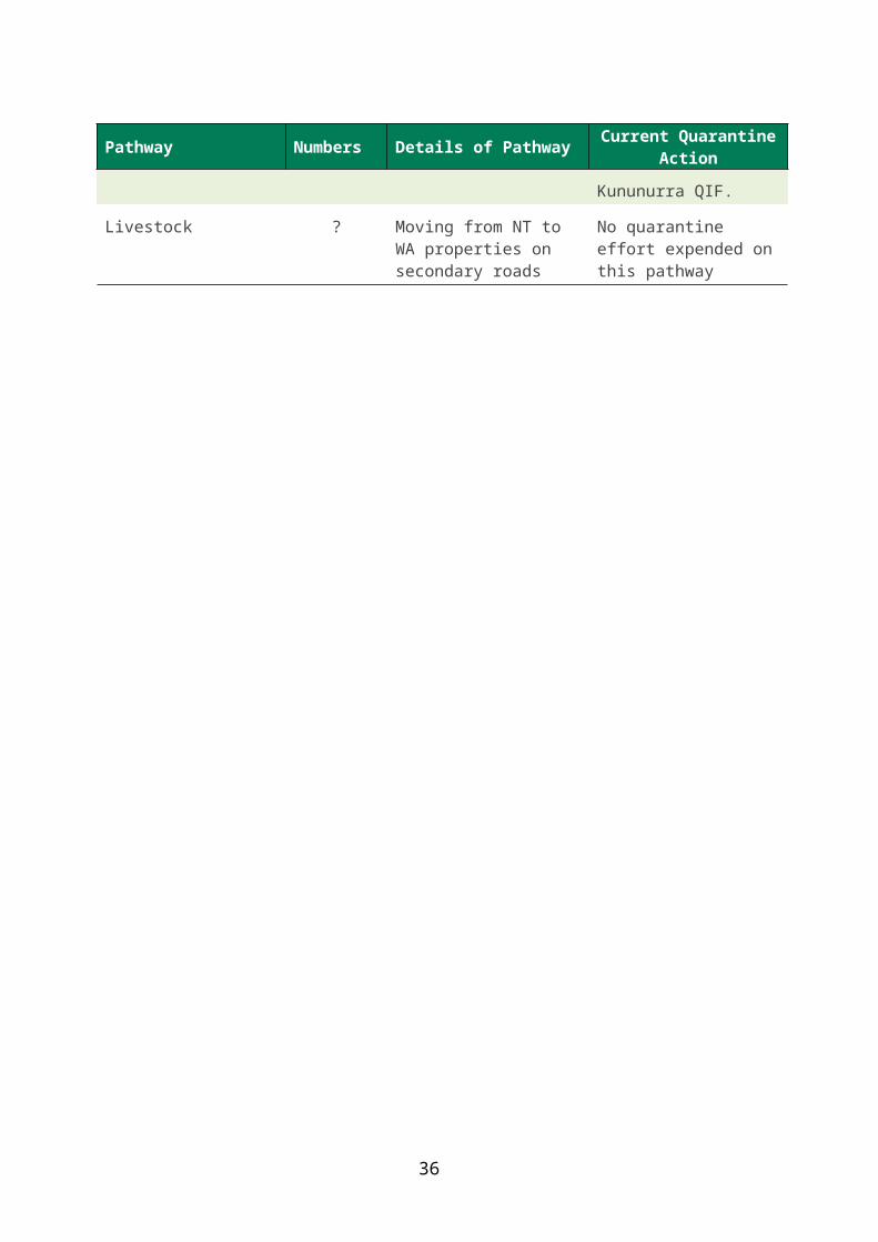
37
Appendix 1 Known weeds and unassessed plants in the stock, vehicle or tourist pathway in AustraliaAll documented as using at least one of the identified pathways. Unassessed organisms would need to be assessed for weed potential before its entry, if detected.
Botanical name and author BAM status Preferredhabitat
Rangeland weed
Stock pathway
Vehicle pathway
Human pathway
Nursery pathway
Acacia erioloba E.Mey. Prohibited s.12 Tropics/Subtropics Yes
Acacia nilotica (L.) Willd. Ex Delile Prohibited s.12 Tropics/Subtropics Yes
Acacia tortilis (Forsskal) Hayne Prohibited s.12 Tropics/Subtropics Yes
Alhagi maurorum Medik. Declared pest s.22 Tropics/Subtropics Yes
Ambrosia confertiflora DC. Prohibited s.12 Tropics/Subtropics Yes
Andropogon gayanus Kunth Prohibited s.12 Tropics/Subtropics Yes
Calotropis procera (Aiton) W.T.Aiton Declared pest s.22 Tropics/Subtropics Yes
Carthamus lanatus L. Declared pest s.22 Tropics/Subtropics Yes
Cenchrus polystachios (L.) Morrone Prohibited s.12 Tropics/Subtropics Yes
Chloris pilosa Schumach. Unassessed Tropics Yes Cryptostegia madagascariensis Bojer ex Decne. Declared pest s.22 Tropics/Subtropics Yes
Cyperus aromaticus (Ridl.) Mattf. & Kük. Unassessed Tropics/Subtropics Yes
Datura ferox L. Declared pest s.22 Tropics/Subtropics Yes
Datura inoxia Mill. Declared pest s.22 Tropics/Subtropics Yes
Datura metel L. Declared pest s.22 Tropics/Subtropics Yes
Datura stramonium L. Declared pest s.22 Tropics/Subtropics Yes
Datura wrightii Regel Declared pest s.22 Tropics/Subtropics Yes
Eragrostis ciliaris (L.) R.Br. Unassessed Tropics Yes
Jatropha curcas L. Prohibited s.12 Tropics/Subtropics Yes
Jatropha gossypiifolia L. Declared pest s.22 Tropics/Subtropics Yes
Lantana camara L. Declared pest s.22 Tropics/Subtropics Yes
Marrubium vulgare L. Declared pest s.22 Tropics/Subtropics Yes

38

39
Appendix 1: (continued)
Botanical name and author BAM status Preferredhabitat
Rangeland weed
Stock pathway
Vehicle pathway
Human pathway
Nursery pathway
Martynia annua L. Prohibited s.12 Tropics/Subtropics Yes
Mimosa pigra L. Prohibited s.12 Tropics/Subtropics Yes
Mimosa pudica L. Prohibited s.12 Tropics/Subtropics Yes
Opuntia stricta (Haw.) Haw. Declared pest s.22 Tropics/Subtropics Yes
Parkinsonia aculeata L. Declared pest s.22 Tropics/Subtropics Yes
Pithecellobium dulce (Roxb.) Benth. Unassessed Tropics/Subtropics Yes
Proboscidea louisianica (Mill.) Thell. Prohibited s.12 Tropics/Subtropics Yes
Prosopis glandulosa Torr. Prohibited s.12 Tropics/Subtropics Yes
Prosopis juliflora (Sw.) DC. Prohibited s.12 Tropics/Subtropics Yes Prosopis pallida (Humb. & Bonpl. ex Willd.) Kunth Prohibited s.12 Tropics/Subtropics Yes
Prosopis velutina Wooton Prohibited s.12 Tropics/Subtropics Yes
Schkuhria pinnata (Lam.) Kuntze ex Thell. Unassessed Tropics/Subtropics Yes
Senna alata (L.) Roxb. Declared pest s.22 Tropics/Subtropics Yes
Senna obtusifolia (L.) H.S.Irwin & Barneby Declared pest s.22 Tropics/Subtropics Yes
Sida acuta Burm. f. Declared pest s.22 Tropics/Subtropics Yes
Sida rhombifolia L. Unassessed Tropics/Subtropics Yes
Tamarix aphylla (L.) H.Karst. Declared pest s.22 Tropics/Subtropics Yes Verbesina encelioides (Cav.) Benth. & Hook. f. ex A.Gray Unassessed Tropics/Subtropics Yes
Xanthium ambrosioides Hook. & Arn. Prohibited s.12 Tropics/Subtropics Yes
Xanthium spinosum L. Declared pest s.22 Tropics/Subtropics Yes
Xanthium strumarium L. Declared pest s.22 Tropics/Subtropics Yes
Ziziphus mauritiana Lam. Declared pest s.22 Tropics/Subtropics Yes