executive summary of environmental impact …nature; its commercial viability needs special...
TRANSCRIPT

EXECUTIVE SUMMARY of ENVIRONMENTAL
IMPACT ASSESSMENT REPORT FOR THE
“BLACK GRANITE MINING PROJECT”
S.F. No: 917 / Part, 921 / Part Extent 166.92 Ha.
AT MAHIMANDALAM
VILLAGE, KATPADI TALUK,
VELLORE DISTRICT,
STATE OF TAMIL NADU
(Under Sector 1(a) Category A – “Mining of Minerals – Open Cast Only” as per EIA notification Sep 2006 and its Amendments)
Proposed by
M/S. TAMILNADU MINERALS LIMITED
Report prepared by
ENVIRONMENTAL CONSULTANT HUBERT ENVIRO CARE SYSTEMS (P) LTD
CHENNAI
September 2016

PROJECT PROFILE Sl.No
Project Profile for Black Granite Quarry – Mahimandalam (Katpadi) – 166.92 Ha
1 Name of the Project Black Granite Mining Project – Mahimandalam 2 Proponent Name M/s. Tamilnadu Minerals Limited 3 Contact Address TAMILNADU MINE and MINERALS
LIMITED (An Undertaking of Government of Tamil Nadu) No. 31, Kamarajar salai Chepauk, P.B No. 2961, Chennai - 600 005 , TAMILNADU STATE. Phone Number : 044-28410382, 28511972 Email : [email protected] Contact Person : Mr. E. Ganesan
4 Implementing Organization TAMIN 5 Location Map Enclosed 6 Project Consultants HECS 7 Project Location Mahimandalam, Katpadi, Vellore, Tamilnadu
8 Survey Numbers S.F. No. 917/Part and 921/ Part
9 Area /Extent 166.92 Ha.
10 Village MAHIMANDALAM
11 Taluk Katpadi
12 District Vellore
13 State Tamilnadu
14 Production Capacity – Per Annum
1003 Cubic Meter
15 Production Capacity - 5 years 5006.48 Cubic meter
16 Over burden waste 161878 Cubic Meter
16 EIA Category “A “Above 50.00 Ha. (>50 Ha.)
17 Sl. No. In the Schedule 1 (a)
18 General Conditions Not Applicable
19 Specific Conditions. Not Applicable
20 Water Requirement 2.3 KLD
21 Power Requirement 1000 Lts of Diesel / Month
2

22 Man Power Requirement 41
23 Project Cost in Rs. 100 Lakhs
24 Topography – SOI Survey of India Topo Sheet No. 570/4 & 8
25 Latitude - Northern 13°05’17.40”
26 Longitude – Eastern 79°13´9.50"
27 Terrain Undulating Terrain
28 Nearest Highway NH -4 – 6.0 km
29 Nearest Railway Junction Katpadi Railway Junction – 16.0 Km
30 Nearest Airport Chennai : 103.67 Km (E)
31 Nearest Water Bodies /River/Sea
Ponnayar–6 Km (SE)
32 Archeological Important Areas Vallimalai at the 10th km (S)
33 National Parks/Wildlife Sanctuaries
Mahimandalam R.F – 4.0 Km (SW)
34 Reserved Protected Forests Panapallumalai R.F – 1.5 km (N E)
35 Seismic zone Zone III
36 Defense Installations None.
3

Location Map : Village: Mahimandalam, Taluk : Katpadi, District : Vellore, State : Tamilnadu
4

Executive Summary for TAMIN Quarry at Mahimandalam for Black Granite
1.0: Introduction:
TAMIN was established in the year 1978 to carryout systematic mining and development
of different minerals all over the state. TAMIN mines different types of granites black
granite (Dolerite), Kashmir white (Leptynite), Paradiso (Mignatite gneiss), Green
Onyx (Syenite – Porphyry) , Red wave (Pink Feldspathic Leptinite) and a number of other
colored granite varieties apart from other industrial minerals viz. Quartz and feldspar,
graphite, limestone , silica sand , vermiculite etc.,
The mine at Mahimandalam Village, Katpadi Taluk, Vellore District , Tamil Nadu State
has mineral reserves of Black Granite (Dolerite) mine over an Extent of 166.92 Ha , S.F
No. 917 (Par) and 921 (Part) of Mahimandalam village, Katpadi Taluk, Vellore District,
Tami Nadu State.
TAMIN has also set up industrial units for processing the granite gneiss stones one each
at Manali (Chennai), Madhepalli at Krishnagiri District and Melur at Madurai District
respectively. A Benefaction plant for the graphite ore has been established close to
Sivaganga Graphite mine. An exfoliation plant for the processing of vermiculite mineral
at Ambattur (Chennai) has also been established.
TAMIN is the only organization recognized by Bureau of Indian Standard for
manufacture and supply of I.S. Sand all over the country.
1.1. EIA Category as per MoEF Guidelines 2006 and its amendments for Mining :
This proposed project requires clearance from MoEF & CC for this project under A
category of sector1 (a), since the mining lease is more than 50 Ha.
1.2. EIA consultant:
M/s. Hubert Enviro Care Systems – HECS, a NABET certified organization for Sector
1(a) is awarded the EIA compilation by Tender Rc. No. HECS/CONS/TEND/15-16/91,
dated 31-8-2015.
5

6
1.3 Environmental Clearance Application at MoEF
M/s. Hubert Enviro-Care Systems Pvt., Ltd is entrusted to carry out an EIA study and
prepare the layout as per contract number at MoEF for EC: IA/TN/MIN/27398/2015 dated
13 April 2015. The online EC application for Black Granite is over an extent of 166.92 in Ha S.F. No. 917 (Part) and 921 (Part) was appraised at MoEF by Expert Appraisal
committee formed in their 33rd meeting post submission of EC application of Form 1, PFR
and RQP mine plan dated May 15th, 2015. The Project would be categorized as A and industry sector of 1 a. The terms of Reference for EIA was issued by MoEF letter No. J-
11013/41/2006-IA.II (1). An EIA is submitted as per TOR compliance. 1.4: Public Litigation
There are no litigations pending against the proposed project proponent or orders passed by
any court of law/any statutory authority against the project. 2.0 Project Description
TAMIN was established in the year 1978 to carryout systematic mining and development
of different minerals all over the state. The Mining Plan for Black Granite in Mahimandalam
(S.F. No. 917 (Part) and 921 (Part), Katpadi Taluk, Vellore District, Tamilnadu was
approved by the Directorate of Geology and Mining, Chennai vide dated 16.11.2001.
Land Use Category for S.F. No. 917 and 921 pertaining to 166.92 Ha. - Government
Poramboke Land
Location description of Project
District Taluk Village S.F. No. Area in Ha Occupancy
/ownership
Vellore,
Tamilnadu
Katpadi Mahimandalam 917 (Part)
and 921
(part)
166.92 Government
Poramboke
land

2.1 Background of Lease Granted and Extent of Mining: S.F. No. 917 and S.F. No. 921
at Mahimandalam Village, Walajah Taluk, Vellore District.
The Mahimandalam TAMIN Mines was issued a quarry license as per Government Order
No. 300, Industries Department 26-06-1991 for S.F. No. 917 and 921 over an extent of
373.36 Hectares. This location belongs to Mahimandalam Village, Walajah Taluk, Vellore
District for a period of 10 years.
A part of land pertaining to S.F. NO. 921 over an extent of 126.36 Ha. was surrendered G.O.
3 D No. 17, Industries Department on 3-03-1998. Government has accepted the surrender.
Mine plan approval for quarrying in remaining 247.0 Ha. through the D.C. Vellore for 20
years was applied, since the existing lease would expire on 22-11-2001. A working
extension license was issued from 23-11-2001 to 22-11-2002.
The lease area was further reduced by surrender of 80 Ha. (34.91 Ha in Sf. No. 917 and
45.16 Ha. in S.F. No. 921). The surrendered 80 Ha. land was considered as non-mineral
bearing land. The Commissioner of Geology and mining considered only 166.92 Hectares
as the subject area. The commissioner recommended only 166.92 Ha. in subject area for
according renewal of lease for a period of 20 years. The proponent’s lease area with all
mining safety applicable as per Mines act has been enclosed as Annexure 2A for grant
of License for 20 years.
7

8
Figure 1 : TAMIN-S.F No. 921 and S.F . No. 917, Mahimandalam , Katpadi. The Mahimandalam mine is located at about 2 Kms North of Mahimandalam and is easil y
accessible through Ramapuram Periabodinathan road. The lease area generally manifests
undulating topography. 2.2 Geological Reserves
The area comprises of feldspathic granitic gneiss. The black granite found here is called
Dolerite A dark-coloured, medium-grained igneous rock which contains plagioclase
feldspar of labradorite composition and pyroxene of augite or titanaugite composition as
essential minerals, and magnetite, titano-magnetite, or ilmenite as accessory minerals.
Where olivine also occurs as an additional mineral, the rock is termed an "olivine
dolerite". Where quartz occurs as an additional mineral in the groundmass, the rock is
termed a "quartz dolerite". Dolerites are the medium-grained equivalents of basalts and,
like the basalts, can be divided into alkali and tholeiitic types. Dolerites are commonly
found in shallow level intrusions such as dykes, sills, or plugs.

9
The material is in good demand because of its quality, shine and polishing effect. The
material found in this location is found along N 25⁰E to N25⁰ W dipping 70⁰ to 75⁰ North
westerly. Occurrences of garnetiferrous gneiss and pockets of Tremolite mica schist and
pink granite veins are seen. The majority of the dykes are trending in ENE-WSW
direction; some dykes are seen trending NE-SW and also N-W
Geological reserves , the total quantity of reserves have been computed on the geological
cross sections up to the economically average depth of 30m from the top surface of the
granite body works out to 86,14,200 cbm and the total mineable reserve have been
computed after deleting of reserves due to mineral lock up in benches as 84,13,125 cbm.
The commercially viable or saleable reserve is computed at 3 to 5% recovery, the
saleable reserve was about 2, 46,003 cbm. 2.3 Details of Exploration
The value of the mineral deposit, dyke deposit nature individual mining of dykes is
commercially viable. Conventional methods are not applicable since the production
nature; its commercial viability needs special blasting, boring, drilling, cutting and
dressing techniques for extraction of dimensional granite stones. The mining and
recovery of the granite stone is in the form of dimensional stones of definite volume and
rectangular stones and not crushed ore.
Blasting: The technique and quantity of explosives are different in industrial
mining and Granite Mining.
Only mild explosives are used such as gun-powder, detonating cord, ordinary
detonators will be used for production of granite blocks.
Conventional 32 mm dia blast holes are drilled perfectly parallel to each other at
20 to 25 cm intervals along the plane of splitting
Explosives required for this mine are obtained from the authorised licensed dealer
for which necessary permission will be obtained from the authority concerned.
Blasting will be done under direct supervision of statutory persons of TAMIN.
Open Cast Mining: In accordance with the Regulation 106 (2) of the Metalliferous
mines regulations 1961, in all open cast workings where the ore body forms hard rock,
the working faces and sides should be adequately benched and sloped. A bench height
not exceeding 6 m and a bench width not less than the height has to be maintained. The

8
slope angle of such benches and sides should not exceed 60⁰ from the horizontal.
However it is practically difficult to maintain slope where dimensional granite of 3mx
2m x 2m. A relaxation to the provisions of Regulation 106 (2) up to a bench parameter
vertical of 10m height and 3 m width with vertical faces. Since the sheet is stable no
backfilling is proposed.
Open cast, semi-mechanized mining with stages of splitting of rock mass, and separation
of two vertical ends along the width slide by diamond wire cutting. Separation of the
horizontal and vertical planes by serial blasting simultaneously along the above two plans
by using 32 mm dia blast holes charged with mild explosives like gunpowder or
detonating cord. The above process is called Primary Cutting. The secondary splitting to
size required size involves long hole drilling up to the bottom of the separated block and
mild blasting along the required planes. Secondary splitting is done by using the
compressed air available at the quarry, initially widening and splitting up to 15 to 18 cm.
The blocks are toppled and removed from the pit to the dressing yard by using hydraulic
excavators. Dressing is a manual process and is supervised by a mining geologist.
2.4 Mineral Reserve, Life of Mine
The reserve of the current mine is sustainable for 20 years. There is a 5 year mineable
reserve calculated for exploration. The aim is sustainable development of black granite,
dimensional stone in this mine during the next five years. a) Removals of overburden
b) Side burdens removal to expose sheet rock.
Table 2.1: 5 years Production plan by RQP
Sl.
No
Year ROM in M3 Saleable
Quantity in M3
Granite rejects-overburden
and side burden in M3
1 1st 33435.000 1003 32431.95
2 2nd 33300.750 999.00 32301.73
3 3rd 33419.250 1002.58 32416.67
4 4th 33321.315 999.64 32321.62
5 5th 33408.75 1002.26 32406.49
Total 166885.06 5006.48 161878
10

11
2.5 Proposed rate of Production:
The production schedule for five years is given above. Pits are 1000 mt long, 20 x 70 m
wide and 10 to 20 m deep. The above reserve is sustainable for 20 years. The overseas
market for this variety of raw granite material is moderate and hence the domestic market
has been well developed for the finished tiles, slabs and monuments of this material.
The annual production of around 1003 Cbm with an average monthly production of 83
Cbm. 2.6 Extent of Mechanization:
1 Hydraulic Excavator 1 No
2 Compressor 2 Nos
3 Crane 10-Ton Escort 1 No
4 Tipper 1 No
5 Jack Hammer 4 Nos
6 Diamond Wire Saw machine with accessories 1 No 2.7 Waste Generated during the process of Mining: Overburden and granite rejects
The granite rejects per year amount to 32,431.95 Cubic Meter. The waste is managed by
dumping along the mine boundaries. The dumping is done along the Northern flanks of
the hillock. The waste can be dumped for an height of 10 m with slope of 60 degree from
horizontal. The waste generated during the exploitation of minerals in the mine in the
past working was about 58980 cbm. The lease hold area purchased for dumping is
sufficient for the mining target set for production. The RQP working plans and surface
layout maps indicate the waste dump areas in EIA.
Sl.
No
Year Granite rejects-overburden and side burden in M3
1 1st 32431.95
2 2nd 32301.73
3 3rd 32416.67
4 4th 32321.62
5 5th 32406.49

8
2.8 Water Consumption
Table 2.4: Water Consumption :
Sl.
No Description Quantity KLD
1 Dust Suppression 0.9
2 Drinking water 1.4
Total 2.3
150 KL/ Month for Diamond wire cutting
2.9 Fuel Requirement:
Diesel will be utilized for operating compressors and other machineries. Diesel usage
will be 1000 litres/month.
2.10 Mine Drainage:
Mine area is an elevated ground and natural slope runs water to the slope of the dykes.
And it has a natural gradient exists for rain water. As a precaution catch drains are
constructed all around the working pit to ensure workers safety. 2.11 Transport of Material:
Loading of Granite Blocks of 3m x 2m x 2m is done via trucks and private transporters.
TAMIN has excavators and tippers for internal transport of block granite. Block lifting is
carried out with the same excavators.
12

13
3.0 Description of Environment 3.1: The mine area comprises of rocky undulating terrain with very few vegetation in the core
area. Grass growth is seen all along the mine areas post monsoon. Mahimandalam
village areas and the link roads are agricultural. Paddy, peanut, lentils are the predominant
vegetation seen around the mining area in the village limits. Agriculture is dependent on
ground water through bores and open wells. The river (Ponnaiyar) seen at the 6 km
supports vegetation along its boundaries. The other mountains near the mine site are
Vallimalai (10 Km), which is another range of mountains. This is a historical and
religious place for the Hindus.
The lease area is hilly terrain. The area received moderate rainfall and the ground water
occurs at a depth of 15m to 30m.
TAMIN has been established for exploration and processing of granite dimensional.
The Mahimandalam quarry has identified black granite quarry located in Survey
Numbers 917(Part) and 921 (Part) of Mahimandalam village, Katpadi Taluk, Vellore
District. The Mineral resource is valuable material of the state and is commercially
exploited for domestic and international sales for its aesthetic appearance and ornamental
value.
The land use classification for the said land is Poramboke Land as per Government
Records.
3.2: The Environmental factors like Land, Air, Water and Soil were studied for Impact
Analysis.
Land Environment: Mahimandalam is a part of Vellore District and description of
Vellore would be an upcoming Urban city with a growth in industrial activity EIA studies
the impact of the mining quarry on Soil, air, water and noise parameters. For this study
sampling location were:
Sl. No EIA Monitoring Locations of Samples Description in table below
1 Mahimandalam Mine Location Core
2 500m downwind of mine 500m
3 5 Km – Serkadu Koot Road 5th km
4 7 km – Vallimalai 7 th km

8
3.3 Soil quality at the tested locations : The soil sampled ranged in color from brown to
reddish brown The sand content in % ranges from 60-70%, silt ranges from 10 to 27% ,
clay ranges from 5 to 20%. Moisture content ranges from 0.22 to 5.44 % . Water
holding capacity ranges from 31.36 to 55.09 %. Nitrogen ranges from 0.02 to 0.11%.
Phosphorus ranges from 0.02 to 0.08%. Iron ranges from /kg 6600 to 48400 mg and
Zinc ranges from 24.37 to 58.28 mg/kg. 3.4 Micrometeorology and Air Environment: The predominant wind direction is towards
North North East (NNE) during the North East monsoon season and towards South South
West (SSW) during the South west monsoon. The temperature ranges from 20.4 ⁰ C in
winter to 38 ⁰ C in Summer. Relative humidity ranges from 40-80%. Rainfall ranges from
900 – 1000 mm in a year during the South West Monsoon and North East
Monsoon.
Air Environment at mining location: The air quality at the mining location is well within
the pollution control standards for mining industry. The methodology of mining by
TAMIN follows GCDR (Granite Conservation and Development Rules, 1999) for Black
Granite mining. The approved mine plan has a copy of the Certificate for this mine.
The annual targets are conservative and blasting is mild because of the quality of rock
required. An indicator to air pollution is the particulate matter results for mines.
At TAMIN, Katpadi site the PM10 ranges from 51.2 to 53.5 µ g/Cu.m. The particulate
matter 2.5 indicates the fugitive dust and emissions which are less than 2.5 microgram.
These particles when inhaled can injure the upper respiratory tract and eyes on contact.
PM 2.5 is important for OHS specialists and doctors to suggest mitigate short and long
term hazards. The PM 2.5 results are well within permissible limits at this site.
Mahimandalam. 3.5 Water Environment: The study area was sampled at 4 different locations. Water is
collected from bore well at most locations. They are within permissible limits for
potable water at campsite where labour use the water for process. The other samples are
from borewells at 500m, 5 km and 10 km.
Water Source for Mining Site: Bore well. Water levels range from 50 -100 ft within a 5
km range from site.
14

15
The quality of water was tested for standard parameters. The water pH ranges from 8.4
to 8.64 which indicate that the water could be mildly alkaline. Total Dissolved Solids
range from 496 - 1200 mg/l, Alkalinity as CaCO3 ranges from 210 to 520 mg/l,
Hardness ranges from 110 – 550 mg/l as CaCO3, Calcium ranges from 25.6 to 164 mg/l,
Mg ranges from 33.6 to 67.2 mg/l, Chloride ranges from 7.8 to 192.4 mg/l, Bicarbonate
ranges from 256 to 414.8 mg/l and Fluoride from 0.6to 0.9 mg/l. 3.6 Noise Environment:
Mining as an activity increases base level noise and background noise levels. Vibration
from this industry also affects workers, labour, staff, flora and fauna. The noise levels
close to drilling equipment, compressors could increase during operation only. Baseline
values would vary in the city from 40 – 70 db depending on the area of monitoring.
The project area of the mine in process is 166.92 hectares. The zone does not have any
imminent danger to the habitation since the core mining zone is located at a safe distance
of 2 km from habitation. 3.7 Study of Flora and Fauna:
The study area is predominantly mountains and flat plains which have a mix of dry
deciduous vegetation. Arid to semi arid climate with low water tables.
The river source is Palar and Ponnayar which is dependent on monsoon. After 40 years
in 2015 the river had a good monsoon and water was seen in their rivers post Dec 2015
Chennai floods. Vallimalai, a heritage temple and mountain has several endemic,
medicinal plants of ayurvedic value. The core area has only grasses which have a
profuse growth post monsoon, the flat plains have agricultural, commercial crops around
the study area.
Commercial Crops: Paddy, Lentil, Peanut, Jowar are the common crops.
Table 3.12 : Commercial crop
Sl . No Commercial Crops/common name Scientific Name 1 Paddy - Rice Oryza sativa 2 Lentil - Thuvaram Parpu - Black
gram Pharsalus mungo
4 Groundnut Arachis hypogeal 5 Ragi Eleusine coracane

8
6 Jowar Sorghum vulgare 7 Turmeric Curcuma longa 8 Ginger Zingiber officinate 9 Maize Zea Maize
3.8 Human Settlement: A few villages are located within a vicinity of 5 km from the mine
site. The villages are Ammavaripalli at 3.0 km SW, Mahimandalam 2 Km (SE),
Perumalkuppam 2 Km (NE) and Vallimalai 7 km (NE).
Socio economic Profile
District Profile: The district is bound on the Northeast by Tiruvallur District, on the
southeast by Kanchipuram District, on the South by Tiruvannamalai District, on the
southwest by Krishnagiri District, and on the northwest and north by Andhra
Pradesh state. The area of the district is 6,075 sq,km. Vellore district consists of 3
Revenue Divisions, 9 Taluks, 20 Community Development Blocks, One Municipal
Corporation, 13 Municipalities, 22 Town Panchayats and 36 Census Towns. The total
number of Revenue Villages in the district is 858. 3.9 Public Building, Important Monuments and place of worship; There is no public building.
Mahimandalam a fort is seen on a hillock at the 4 km. 3.10 Water Source Bore Well, Applicable Cess water Act 1974.
3.11 Reserve Forests: Mahimandalam R.F 4.0 km (S.W)
Panapallumalai: R.F 1.5 km (NE)
3.12 Green Belt Provisions: Green belt provisions can be implemented in backfilled areas and
also for slope stabilization. Green belt would improve the drainage patterns and provide
some respite from the hot summer.
Year
No of trees proposed to
be planted
Survival rate
expected
No of trees expected to
be grown
1st 100 80% 80
2nd 100 80% 80
3rd 100 80% 80
16

17
4th 100 80% 80
5th 100 80% 80
4.0 Anticipated impacts (Positive and negative) of mining of minor mineral
and mitigation measures The chapter discusses the important environmental impacts of mining, impacts of the
Mahimandalam Katpadi mine and Mitigation Measures.
Sl. No
Activity Impacts Defined as Negative and Positive
Mitigation Measures in place for this mining site
1 Mining Mining only of approved Quantity on licensed land
Change of Land use
Disturbance to existing hydro- geology reserve
The Mining Quantity is verified, audited and royalty paid as per bill of quantity.
Restoration of Land with overburden and compaction. Reforestation of slopes for stabilization
Increasing the water catchment and storage at end of mine life with stabilized slopes
Redevelopment plan will include green belts. EMP for preventing long term impacts to
Nature. Environmental audits to control EHS /OHS
implementation 2 Developme
nt of mineral reserve by State and TAMIN. (Marketin) g
Positive impact on commercial use of Dolerite in Infrastructure, commercial sale.
Legal mining as per Mine Rules. Mining as per Government Conservation and
Development Rules Implementing Safety Rules for sustainable
development
3 Blasting Negative impact only on mining area. .
Signboards for blasting time. Controlled access of site with security. Display of approved blasters license at site. Diamond wire cutting to prevent loss of
Granite. 4 Effect on
Air Quality
Increase in Particulate Matter during granite cutting, sizing and dressing.
Sprinklers on site. Control of dust with Personal Protective
equipment. Environmental Monitoring as per EMP
provisions in EIA Baseline , compare and mitigate air pollution
with less polluting technology for mining 5 Water for Minor mineral Bore well source extraction is notified.

8
Process extraction uses 2.3 KLD water and Diamond wire cutting requires 150 KL per month water. Source is bore well
Quality of water is safe for use. Construction of Water Recharge Pits
recommended in EMP of EIA Construction of septic tank for workers and
staff Recycle water used for dust control post
sedimentation in green belt. 6 Effect on
soil
Unhygenic practices leading to soil pollution.
Construction of drains from wash areas Construction of toilets with septic tank
7 Noise and
Vibration
Process of mining and proximity to machinery determines the impact
Personnel protective equipment Acoustic enclosures. EHS audits Monitoring
8 Safety Accidents Emergencies
Ensuring display of hazard sign Display of explosive use timing and blasting
only by licensee. Review of site safety with EHS officer. Audit report.
9 Re-
forestation.
Increase green cover Green belt increases green cover Reduction of Noise and vibration Slope stabilization Reduces dust and CO2. EMP schedule.
10 Forest
Areas
Scrub vegetation predominates the area. Arid climate supports xerophytic vegetation Vallimalai has a unique vegetation.
No impacts on the forest area Sound and vibration could be controlled with
phased blasting and cutting. Only licensed area and sustainable production
targets as per Mining GO,
5.0: Environmental Monitoring:
The good practice of employing conservative methods of mining ensures that there is
least impact on the surroundings and also ensures that the reserves are not exhausted and
can be available for a longer period of time for developmental activities.
Monitoring of air, water, noise and soil is done to ensure quality of the project site does
not deteriorate and even if it does mitigation measures are implemented by TAMIN.
18

19
Environmental monitoring during operation is relevant to mining sites. Most staff and
labour are the first exponents. It is important to record air quality to educate and train the
labour and staff for the following:
Using masks
Personnel protective equipment purchase and issue.
Suggesting better technology.
EHS/OHS environmental audits
Increasing green belt in buffer and safe zones for plantation
Suggesting clean development mechanisms
In built machines and filters to reduce dust.
S. No
Area of Monitoring
Number of Sampling Stations
Frequently of Sampling
Parameters to be Analyzed
1. Ambient Air Quality
4 locations at site
Monthly PM 10, PM 2.5, SO2 and NOx , CO2 , O3
2.
Water Quality
4 ground water samples at site
Monthly
pH, Temp, Conductivity, TSS, TDS, BOD, O&G Heavy metals
3.
Soil
4 locations at site
Monthly
Physicochemical properties, Nutrients, Heavy metals
4.
Noise 4 Locations at site
Monthly
Day & night 6.0 Benefits to Society from TAMIN Mahimandalam.
There have been no litigations against the proponent.
A corporate environmental policy and corporate social policy provides
indirect job opportunities and economic stability.
Solar lighting will be provided in nearby villages.
Employee contributions towards improvement of facilities. 7.0 Risks and Hazard Analysis.
Factors of risk in Mining:
Access of mining site by unauthorized people
8
Access of mining site by cattle and livestock.
Blasting
Noise Pollution.
Air Pollution because of unethical practices.
TAMIN Mines: Risk Analysis and Hazard Analysis
TAMIN Mines are access controlled with security by day and night
Operated by approved Quarry licenses only
Legally authorized professionals for blasting
Require environmental monitoring and audit post environmental clearance.
Environmental monitoring of the site is enclosed in EIA.
8.0 Project Benefits
The black granite generated here attracts international buyers for quality of stone manufactured. It has commercial value. The stones are marketed in China, US, UK and Japan
There is a research oriented conservatory exploitation of natural resources. Socially there is an indirect employment potential. TAMIN has improved clean development mechanisms and investment in better mining
technology for reducing impacts on environment. The Project costs 1 crore, the investment on machinery is 50 Lakhs, and the investment
on manpower is 25 Lakhs. 9.0 Environmental Management Plan.
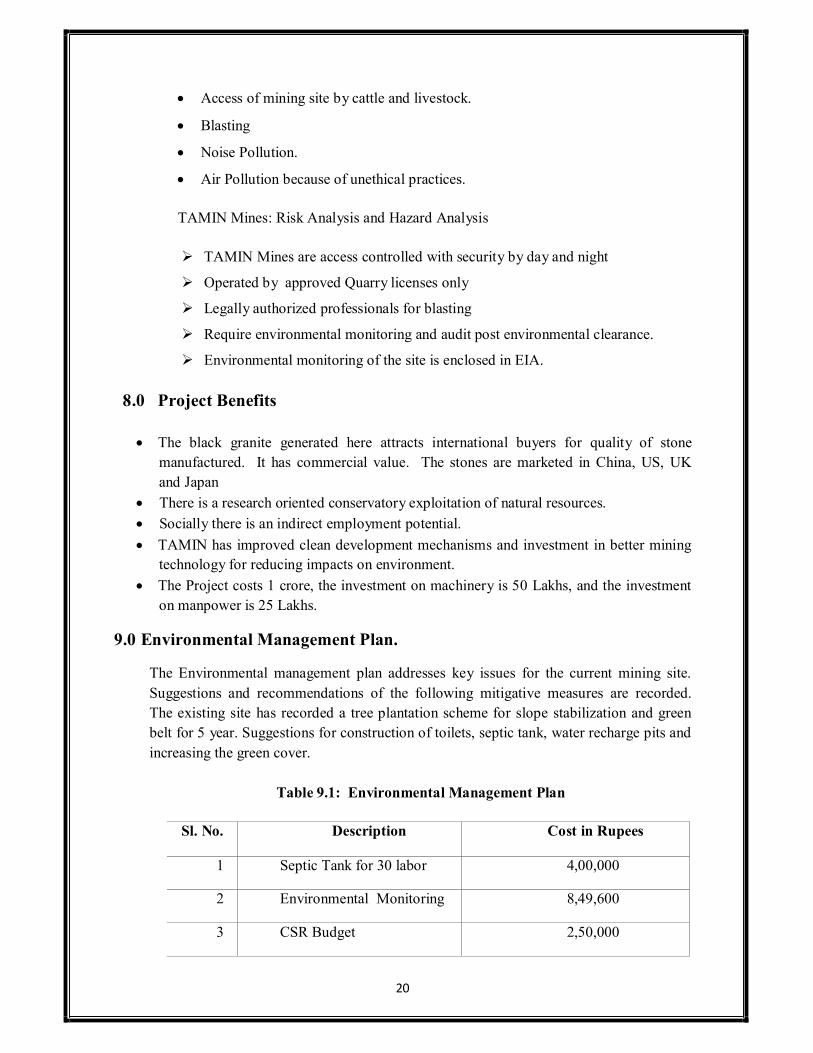
The Environmental management plan addresses key issues for the current mining site. Suggestions and recommendations of the following mitigative measures are recorded. The existing site has recorded a tree plantation scheme for slope stabilization and green belt for 5 year. Suggestions for construction of toilets, septic tank, water recharge pits and increasing the green cover.
Table 9.1: Environmental Management Plan
Sl. No. Description Cost in Rupees
1 Septic Tank for 30 labor 4,00,000
2 Environmental Monitoring 8,49,600
3 CSR Budget 2,50,000
20

21
4 EHS/OHS Medical Tests (6
Month)
30,000
Total 15,29,600
10.0 Summary and Conclusion:
TAMIN’s Mining site at Katpadi, Mahimandalam with an area of 166.92 Ha at Survey number S.F. NO. 917 parts and 921 part is a sustainable mining operation. The TAMIN production targets are conservative and follow the government mining rules.
Black granite, Dolerite is mined at this location and marketed to international and domestic markets. The production target is 1003 cbm per annum. The reserves are available for 20 years.
Environmental Monitoring for operational phase and Environmental Management Plan are recorded in Environmental Impact Analysis plans for implementation. A baseline of environmental monitoring is essential to understand the impact of industrialization on a study area over a period of time. Expert interventions and mitigation measures should be implemented after a 6-month audit of the mining site for EHS, OHS and site specific recommendations. PCB, Consultant a project proponent reviews a copy of compliance for preventing pollution.
11. Consultant Disclosure:
Mining EIA Coordinator – Sector Approval
HECS NABET/ SR No. 76 VALIDITY 2014-2017 Sector 1 (a) - Mining Category A EIA Coordinator Vivek P Navare (RQP approved for 1 (a) ) HECS 1 (a) approved sector
NABL Certificate
HECS NABL Accreditation Standard ISO/IEC 17025: 2005 Field Chemical & Biological Technical Director Dr. Rajkumar Environmental Monitoring Air, Water, Noise, Soil