exhibit list - home page - uk … list reference no: hol/00263 petitioner: paul ramsay kelleher and...
TRANSCRIPT

EXHIBIT LISTReference No: HOL/00263Petitioner: Paul Ramsay Kelleher and Sonia Ingrid KelleherPublished to Collaboration Area: Friday 11-Nov-2016
Page 1 of 12
No Exhibit Name Page
1 P5012_Kelleher_01_Local.pdf (P5012) 2
2 P5013_Kelleher_02_Construction.pdf (P5013) 3
3 P5014_Kelleher_03_Operation.pdf (P5014) 4
4 P5015_Kelleher_04_NoiseMap.pdf (P5015) 5
5 P5016_Kelleher_05_DetailedNoiseTable.pdf (P5016) 6
6 P5017_Kelleher_06_NoiseSummaryTable.pdf (P5017) 7
7 P5018_Kelleher_07_PropertyZones.pdf (P5018) 8
8 P5019_Kelleher_08_20151215 Accept lette.pdf (P5019) 9 - 12
HOL/00263/0001

CHALFONT LANE
CHALFONT LANE
SUNN
YHILL
ROA
D
OLDUXBRIDGE ROAD
A412
DENHAMWAY (NORTH ORBITAL ROAD)
0 25 50 75 100Metres
I
Date: 04/05/16
Scale at A3: 1:2,500
³A ³B ³C ³D ³E ³F ³G ³H ³I ³J
³A ³B ³C ³D ³E ³F ³G ³H ³I ³J
³10
³9
³8
³7
³6
³5
³4
³3
³2
³1
³10
³9
³8
³7
³6
³5
³4
³3
³2
³1
HS2 Ltd accept no responsibility for any circumstances, whicharise from the reproduction of this map after alteration,amendment or abbreviation or if it is issued in part or issuedincomplete in any way.
High Speed TwoPetitioner Location Plan
Reference Drawing
!
!
LONDON
BIRMINGHAM
Petition number
Petitioner
Registered in England. Registration number 06791686. Registered office: One Canada Square, London E14 5AB.
This material was last updated on [date] and may not be copied,distributed, sold or published without the formal permissionof Land Registry and Ordnance Survey. Only an official copy of atitle plan or register obtained from the Land Registry may be used forlegal or other official purposes. © Crown Copyright Ordnance Survey.This is not a copy of a title plan issued by LR.
© Crown copyright and database rights 2016.Ordnance Survey Licence Number 100049190.Paul Kelleher and Sonia Ingrid Kelleher
SC-04-263
HS2-HS2-HY-PET-HOL-000263 Doc Number: PH1-HS2-HY-MAP-000-004578
Indicative extent of petitioner(s) propertyPetitioner(s) land affected by Hybrid BillHybrid Bill Limits
!
Petitioner(s) property
LegendPhase One SES3 and AP4 ES alignment October 2015
Bored TunnelCuttingEmbankmentTunnel Portal
0 1
Kilometres
P5012 HOL/00263/0002

Drawn Checked Approved
Drawing No.
Date Scale Size
Rev.
DrawnRev Description
Project/Contract
Discipline/Function
ZoneLegends/Notes:
Drawing Title
Design Stage
Ordnance Survey Licence number 100049190
© Crown Copyright and database right 2015. All rights reserved.
Registry under delegated authority from the Controller of HMSO.
© Crown Copyright material is reproduced with the permission of Land
may be used for legal or other official purposes.
Only an official copy of a title plan or register obtained from the Land Registry
sold or published without the formal permission of Land Registry.
This material was last updated on 2015 and may not be copied, distributed,
Scale with caution as distortion can occur.
Creator/Originator
Checked Con App HS2 App
or if it is issued in part or issued incompletely in any way.
the reproduction of this document after alteration, amendment or abbreviation
HS2 accepts no responsibility for any circumstances which arise from
London, E14 5AB
One Canada Square,
Registered office:
Registration No. 06791686
Registered in England
Buckinghamshire
South Bucks District
A314/06/2016
TD
Country South
Environmental
Construction Phase
P00.1
AS SHOWN
DESIGN-FOR-PETITION
Atkins
Country South Design
FIRST DRAWN
P00.1
Tunnel portal
Tunnels external extent
Rail alignment
Rail alignment formation
Landscape earthworks
Engineering earthworks
Stopped-up PRoW
Location of Petitoners' property
Existing public right of way (PRoW)
New, diverted or realigned PRoW
Satellite construction compound
Main construction compound
during construction
Land potentially required
Construction traffic route
Temporary PRoW
route / haul route
Temporary site access
Temporary material stockpile
TILEHOUSE LANE
M25
Colne Valley Viaduct
North Launch
satellite compound
Colne Valley Viaduct
North Emabankment
satellite compound
Colne Valley Viaduct
Laydown
satellite compound
Colne Valley Viaduct
main compound
Chiltern
Tunnel
Colne Valley
Viaduct
Temporary M25
slip roads
Maple Cross
M25
---
A412 DENHAM WAY/NORTH ORBITAL ROAD
Chiltern Tunnel
South Portal
satellite
compound
Chiltern Tunnel
main compound
Herfordshire
Three Rivers District
C222-ATK-EV-DPL-020-050704-PETHOL000263
property
Petitioners'
Petition HOL 0263
Paul Ramsey Kelleher and Sonia Ingrid Kelleher
CONSTRUCTION
0 500200100 1000
@ 1:10000METRES
P5013 HOL/00263/0003

Drawn Checked Approved
Drawing No.
Date Scale Size
Rev.
DrawnRev Description
Project/Contract
Discipline/Function
ZoneLegends/Notes:
Drawing Title
Design Stage
Ordnance Survey Licence number 100049190
© Crown Copyright and database right 2015. All rights reserved.
Registry under delegated authority from the Controller of HMSO.
© Crown Copyright material is reproduced with the permission of Land
may be used for legal or other official purposes.
Only an official copy of a title plan or register obtained from the Land Registry
sold or published without the formal permission of Land Registry.
This material was last updated on 2015 and may not be copied, distributed,
Scale with caution as distortion can occur.
Creator/Originator
Checked Con App HS2 App
or if it is issued in part or issued incompletely in any way.
the reproduction of this document after alteration, amendment or abbreviation
HS2 accepts no responsibility for any circumstances which arise from
London, E14 5AB
One Canada Square,
Registered office:
Registration No. 06791686
Registered in England
Tunnel portal
Ditches - new
Tunnels external extent
HS2 Access road
Balancing pondNoise fence barrier
(scrub / woodland)
Landscape mitigation planting
Rail alignment
Rail alignment formation
Landscape earthworks
Engineering earthworks Stopped-up PRoW
Hedgerow habitat creation
Grassed areas
or portal building
Depot, station, headhouse
Location of Petitoners' property
Existing public right of way (PRoW)
New, diverted or realigned PRoW
Land drainage area
Replacement floodplain storage
Grassland habitat creation
A314/06/2016
TD
Country South
Environmental
Proposed Scheme
P00.1
AS SHOWN
DESIGN-FOR-PETITION
Atkins
Country South Design
FIRST DRAWN
P00.1
Main utility works
TILEHOUSE LANE
M25Buckinghamshire
South Bucks District
Chiltern
Tunnel
Colne Valley
Viaduct
Maple Cross
M25
M25 Tilehouse Lane
Overbridge
Chiltern Tunnel
South Portal
Scottish & Southern
Energy Substation
---
A412 DENHAM WAY/NORTH ORBITAL ROAD
Hertfordshire
Three Rivers District
Petition HOL 0263
C222-ATK-EV-DPL-020-060704-PETHOL000263
property
Petitioners'
Paul Ramsey Kelleher and Sonia Ingrid Kelleher
OPERATION
0 500200100 1000
@ 1:10000METRES
P5014 HOL/00263/0004

"
"
"
"
"
3m 1.4m
5-14m7-15m
3m 3m 1.4m3m3m1.4m
394612
709521
622057622056
622055621452621451
621443621440
621438621435
621434621433
621439621436 394900
711000
701098701097
701096
701095
701094
701093
701092711050
711049711048
385470
385188
385086
384986384928
384843
384701
384678
384540
384424384374
384372
383893
391453
391428
391389
391326
391211
391149
391014
390840
389429
389414
389294
389222
389194
388957
388708
388449388230
387787
387745387494
385939
385531
700375
700374
700372
700371
700370
700368
700367700366
700365
397534
397354
397281397097
396991
396945
396888
396203 403127
396118
402948
395447
402669
395380
395266
402270
394598
402028
392953
392473
399824
392100
399680
391607
399250
XW
$+$+$+$+
$+$+$+$+$+
$+$+
$+$+
$+
#*
!
! !
!
!
!
!
!
!
!
!
!
!
!
!
!
!
!
!
!
!
!
!
!
!
!!
!
!
!
!
!
!
!
!
!!
!
!!
!
!
!
!
!
!
!
!
!
!
!
!
!
!
!
!
!
!
!
!
!
!
!
!
!
!
!
!
!
!!
!
!
!
!
!
!
!
!
!
(
For C
ontin
uatio
n Refe
r to M
ap N
umbe
r SV-0
2-010
For C
ontin
uatio
n Refe
r to M
ap N
umbe
r SV-0
2-012
Chiltern TunnelSouth Portal
Colne ValleyViaduct
SOUTH BUCKSDISTRICT
CHILTERNDISTRICT
THREERIVERS
DISTRICT
LONDONBOROUGH OFHILLINGDON
OSV07-C02OSV07-N01OSV07-C03
CFA7/14
Doc Number: -AP05-P01
© Crown copyright and database rights 2016.Ordnance Survey Licence Number 100049190.
Date: 18/08/16
Scale at A3: 1:10,000
Map Name
Community Forum Area CFA7:Colne Valley
Map Number
Registered in England. Registration number 06791686. Registered office: One Canada Square, London, E14 5AB.
HS2 Ltd accept no responsibility for any circumstances, whicharise from the reproduction of this map after alteration,amendment or abbreviation or if it is issued in part or issuedincomplete in any way.
SV-02-011Operational Airborne Noise & Vibration Impacts &
Likely Significant Effects (with AssessmentLocations)
Post-AP Petitions+ Residential buildings only* Labelled with total barrier height above rail level** ES/SES HS2 train only LAmax + 2.5dB façade correction
0 100 200 300 400
Metres
I
Legend - General featuresRoute in bored tunnelRoute in green tunnelRoute on surfaceDepot, station, headhouse orportal buildingCommunity forum boundaryDistrict/Borough boundaryCounty boundary
Engineering earthworks:Embankment
Cutting
Non engineering earthworks:Embankment
Cutting
Ground-borne sound & vibration study area(residential and non-residential)Ground-borne sound & vibration study area (highlysensitive non-residential)
! Airborne sound assessment location#* Airborne sound and vibration assessment location$+
Ground-borne sound and/or vibration assessmentlocation
XWAirborne sound, ground-borne sound and vibrationassessment locationMinor ground-borne noise or vibration impact+
5
10
9
8
7
6
4
3
2
1
A B C D E F G H I J
10
9
8
7
6
5
4
3
2
1
A B C D E F G H I J
Effect dependent on receptor and baseline.For further details see Volume 5, AppendixSV004. Likely significant effect indicated byOSV#-N#2
< 40 dB < 50 dB Generally no adverse effect expected1
1 For further information see Volume 5 Appendix SV-001-0002 For details see relevant Volume 5 Appendix SV-004
Effect dependent on sound level change(see Panel B) and significance criteria. Likelysignificant effects on groups of dwellings andassociated facilities indicated by OSV#-C#2
Night-time LpAeq,T(T=23:00 to 07:00)
Daytime LpAeq,T(T=07:00 to 23:00) Residential Non-residential
& quiet areas
Pane
l A Likely significant effect on dwellings indicatedby , or avoided by noise insulation( l D
HS2 (rail only) sound level LpAeq,T Potential noise effect1, 2
> 65 dB> 55 dB
50 to 65 dB40 to 55 dB
Change in sound level (LpAeq,T day / night)Operational airborne sound impacts at buildings+
Pane
l B
Major adverse (>10dB)Moderate adverse (5dB to 10dB)Minor adverse (3dB to 5dB)Negligible (-3dB to 3dB)Beneficial (<-3dB)
( Potential additional noise insulation (triggered bymaximum sound levels at night)1
l Potential additional noise insulation (triggered by WHONight Noise Guidelines Interim Target)1
D Potential noise insulation (triggered by NoiseInsulation Regulations 1996)1
³I ³J
³2
³1
³I ³J
³2
³1
See text for full description and extent of significanteffects. (*) Where SES/AP is reason for significant effect.
Significant effect descriptor
SES/APchange ref.
Receptor/significant effectremoved/added (as a resultof amendment*: APX-XXX-YYY).
Reduced effect Increased effect
Legend - Sound related featuresCommitted developments (label as CFA#/#) - SV Only
Envisaged mitigation to avoid / reduce significant noise effects:Landscaping and/or fence barriers*Engineering e.g. cuttings (green tunnels separately marked)
Envisaged measures further reducing noise effects:Other environmental e.g. landscapingEngineering e.g. cuttingsAirborne sound study areaIndicative extent of Petitioner(s) propertyP5015 HOL/00263/0005

Table 1. Existing baseline sound levels
Assessment
location ID
Area Represented
Measurement
location
Existing baseline sound level (dB)
Data
source
coding
For operational sound assessment
For construction sound
assessment
Daytime
LpAeq, 16hr
Night-
time
L
Arithmetic
average of
night-time
LpAFmax, 5min
Highest night-
time
L
Daytime
LpAeq
Evening/
weekend
L
Night-
time
L
700365 Chalfont Lane, West Hyde CS0017 54.8 47.1 56.7 67.6 55.3 54.3 47.2 1,A,iii,b
Table 2. Assessment of construction noise at residential receptors
Assessment location Impact criteria Significance criteria
Sig
nif
ica
nt
eff
ect
ID Area
represented
Typical/highest monthly
outdoor LpAeq [dB] at the
façade
Construction activity resulting in highest
forecast noise levels
Ty
pe
of
eff
ect
Nu
mb
er
of
imp
act
s
rep
rese
nte
d
Ty
pe
of
rece
pto
r
Re
cep
tor
de
sig
n
Ex
isti
ng
en
viro
nm
en
t
Un
iqu
e f
ea
ture
Co
mb
ine
d
imp
act
Imp
act
du
rati
on
[mo
nth
s]
Mit
iga
tio
n e
ffe
ct
Day
0700-
1900
Evening
1900-
2300
Night
2300-
0700 700365 Chalfont
Lane, West
Hyde
45/54
[A]
<40/<40
[B]
<35/36
[C]
Day: Chiltern tunnel - south approach cutting – excavation; and
Night: Chiltern tunnel - south tunnel portal – finishes
NA 1 R T - - - - -
Table 3. Operational airborne sound level, noise impacts and effects
Assessment Location Impact criteria Significance criteria
ID
Area represented
Proposed Scheme only (Year 15 traffic)
Do nothing (Opening year baseline)
Do something (Opening year baseline + Year 15 traffic) ****
Change
Typ
e o
f ef
fect
Nu
mb
er o
f im
pac
ts
rep
rese
nte
d
Typ
e o
f re
cep
tor
Rec
epto
r d
esi
gn
Exi
stin
g e
nvi
ron
men
t
Un
iqu
e fe
atu
re
Co
mb
ined
imp
act
Mit
igat
ion
of
effe
ct
Sig
nif
ican
t ef
fect
Day
*
Night
**
Max
***
Day
*
Night
**
Max
***
Day
*
Night
**
Day
*
Night
**
700365 Chalfont Lane, West Hyde 55 47 56/58 55 47 57 55 47 0 0 A 1 R T - - - -
P5016 HOL/00263/0006

Noise levels – Chalfont Lane, West Hyde(ID: 700365)
Existing
baseline sound
levels (dB)
Construction noise
levels (dB)
Operational noise
levels (dB) Change (dB)
For construction
assessment
Daytime55.3 45/54
Evening/
weekend54.3 <40/<40
Night-time 47.2 <35/36
For operational
assessment
Daytime54.8 55 0
Night-time 47.1 47 0
P5017 HOL/00263/0007
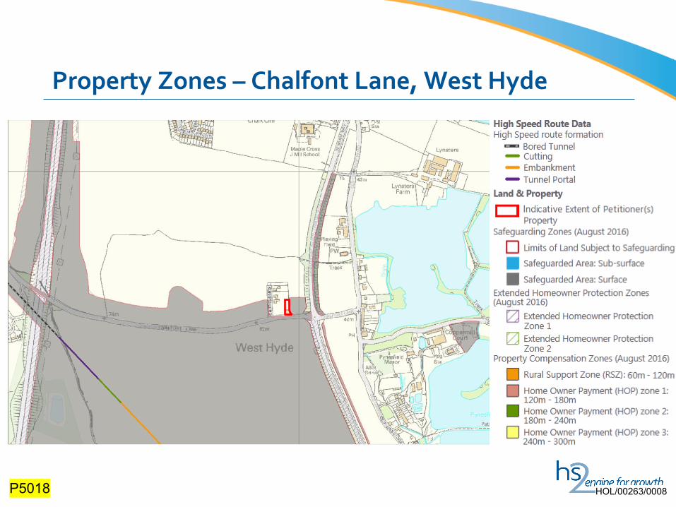
Property Zones – Chalfont Lane, West Hyde
P5018 HOL/00263/0008

P5019 (1) HOL/00263/0009

P5019 (2) HOL/00263/0010

P5019 (3) HOL/00263/0011

P5019 (4) HOL/00263/0012