expanding rice production project (erpp) …documents.worldbank.org/curated/en/...i united republic...
TRANSCRIPT

i
UNITED REPUBLIC OF TANZANIA
MINISTRY OF AGRICULTURE FOOD SECURITY AND COOPERATIVES
EXPANDING RICE PRODUCTION PROJECT (ERPP)
ENVIRONMENTAL AND SOCIAL MANAGEMENT FRAMEWORK (ESMF)
JUNE 2014
E4635 P
ublic
Dis
clos
ure
Aut
horiz
edP
ublic
Dis
clos
ure
Aut
horiz
edP
ublic
Dis
clos
ure
Aut
horiz
edP
ublic
Dis
clos
ure
Aut
horiz
edP
ublic
Dis
clos
ure
Aut
horiz
edP
ublic
Dis
clos
ure
Aut
horiz
edP
ublic
Dis
clos
ure
Aut
horiz
edP
ublic
Dis
clos
ure
Aut
horiz
ed

ii
EXECUTIVE SUMMARY
In 2012, the Government of Tanzania (GoT) submitted a proposal to the Global Agriculture
and Food Security Program (GAFSP) to expand rice production in the country under a project
named Expanding Rice Production Project (ERPP) or ‘the Project’. The GAFSP Steering
Committee accepted the proposal, and offered a prospective allocation of US$ 22.9 million for
the Project.
The Project Development Objective (PDO) of ERPP is: to increase rice produced and
marketed in the Morogoro Region in the Tanzania Mainland and in Zanzibar, leading to
improved rural incomes and food security. The direct project beneficiaries are 30,600
smallholder farmers and their families in the selected irrigation schemes of Tanzania
Mainland (25,000 households) and Zanzibar (5,600 households). Approximately, 50 percent
of these farmers are women. Indirect beneficiaries include smallholder farmers not directly
supported by the project, input suppliers, rice traders and processors and consumers.
The project has four main components: (i) Sustainable seed systems; (ii) Improving crop
productivity through better irrigation and crop management; (iii) Innovative marketing
strategies; and (iv) Project management, monitoring and evaluation.
Component 1: Sustainable Seed Systems: US$ 3.38 Million (2.27 Million for Tanzania
Mainland and 1.11 Million for Zanzibar). The objective of this component is to enhance the
adoption and sustained use of improved rice varieties that have been released by the research
system. This will support on-farm demonstrations to introduce the new varieties to farmers,
the multiplication and distribution of preferred varieties, and improvements in quality
assurance for rice seed.
Component 2: Improving crop productivity through better irrigation and crop
management: US$ 14.04 Million (10.34 Million for Tanzania Mainland and 3.7 Million
for Zanzibar). This component aims to improve smallholder rice production and productivity
through improved crop and water management. The project will support expansion and/or
rehabilitation of selected irrigation schemes, and promote adoption of improved agronomic
practices.
Component 3: Innovative marketing strategies US$ 2.37 Million for Tanzania Mainland.
The main objective of this component is to increase the quantity of rice marketed by
strengthening access to markets and improving price incentives at the farm gate. Activities
under this component are targeted at only the mainland, because of the current absence of
marketable surpluses, and hence limited marketing challenges, in Zanzibar. The project will
improve market efficiency through two major activities: (i) provision of marketing
infrastructure and (ii) strengthening of market linkages.
Component 4: Project Management and Coordination: US$ 3.1 Million (US$ 1.52
million for Tanzania Mainland and 1.6 million for Zanzibar. The objective of this
component is to facilitate efficient implementation of project activities and tracking of results.
Project implementation will use existing structures in Ministry of Agriculture Food Security
and Cooperatives (MAFC) for mainland Tanzania and the Ministry of Agriculture and Natural
Resources (MANR) in Zanzibar. Each of these Ministries will assign a dedicated task team of

iii
key staff to ensure that there is adequate capacity to coordinate, implement and monitor the
project effectively. Under this component, support will be provided for operational costs,
project monitoring and evaluation and impact assessments. Due to capacity weaknesses in
Zanzibar, the project will also fund supplementary technical assistance in procurement,
financial management, and monitoring and evaluation.
The Project will be implemented in three districts (Kilombero, Kilosa, and Mvomero) of
Morogoro Region in Tanzania Mainland and Pemba and Unguja Islands in Zanzibar. Both
Morogoro Region and Zanzibar are home to a number of protected areas and critical
ecosystems. Morogoro in particular is home to the Mikumi and Udzungwa National Parks, the
RAMSAR site at Kilombero, and several essential Wildlife Management Areas (WMAs).
The two main sets of risks relate to the competitive demands for irrigation water, and to the
possible environmental impacts of expanding use of agro-chemicals used in the irrigated
farming systems. There is growing competition for limited water resources in the Morogoro
region of mainland Tanzania. This Region encompasses or borders some of the uniquely
diverse agro-ecologies in the world, including national parks, wildlife management areas and
a Ramsar site. The expansion of irrigation investments potentially threatens the availability of
water for wildlife and as well as for household use and hydroelectricity. The drying of rivers
and wetlands reduces biodiversity. Multiple studies are evaluating water availability in the
larger Rufiji River Basin, and the growing competition for water use. The River Basin
Authority is being strengthened to better measure and manage this competition. On Zanzibar,
the limited information available suggests the need to better manage what water resources are
available. In either case, strong environmental assessments are required to assure the Project
investments do not threaten degradation and to assure continuing protection of critical
biodiversity.
The objective of the ESMF is to provide a framework for effective management of
environmental and social issues in the proposed ERPP. It seeks to both enhance
environmental and social development benefits of the Project in line with GoT and World
Bank policies and guidelines on management of environmental and social development
projects. Moreover, since the precise locations and potential impacts of future subprojects to
be financed under ERPP are not yet known, and will not be identified prior to appraisal, the
ESMF provides the basis for the preparation and approval of necessary environmental and
social work, as needed for the subproject investments supported through the Project.
iv
TABLE OF CONTENTS
1. INTRODUCTION ................................................................................................................................ 1
2. DESCRIPTION OF THE PROPOSED PROJECT .............................................................................. 3
2.1 Project Background .......................................................................................................................... 3
2.2 Proposed Project Components ......................................................................................................... 4
2.3 Project Implementation Arrangements ............................................................................................ 8
3. BASELINE DATA ............................................................................................................................... 9
3.1 Morogoro Region in Mainland Tanzania ......................................................................................... 9
3.1.1 Geographical Location ................................................................................................................. 9
3.1.2 Land Area and Administrative Units ........................................................................................... 9
3.1.3 Ethnicity ..................................................................................................................................... 10
3.1.4 Climate and Soils ....................................................................................................................... 10
3.1.5 Topography ................................................................................................................................ 11
3.1.6 Agro-Ecological Zones and Water Bodies ................................................................................. 11
3.1.7 Regional Economy ..................................................................................................................... 13
3.1.8 The Sociopolitical Environment of Morogoro Region .............................................................. 20
3.2 Zanzibar Islands ............................................................................................................................. 21
3.2.1 Geographical Location ............................................................................................................... 21
3.2.2 Administrative Units .................................................................................................................. 22
3.2.3 Climate ....................................................................................................................................... 23
3.2.4 Land-use and Agro-ecological Zones ........................................................................................ 23
3.2.5 Topography and Soils ................................................................................................................ 24
3.2.6 Ethnicity ..................................................................................................................................... 24
3.2.7 Overview of Agriculture Sector in Zanzibar .............................................................................. 24
3.2.8 Irrigation Potential ..................................................................................................................... 24
3.2.9 Livestock Production and Population ........................................................................................ 25
3.2.10 Natural Resources .................................................................................................................... 26
3.2.11 Environmental issues ............................................................................................................... 29
3.2.12 Poverty and inequality levels ................................................................................................... 30
3.2.13 Agriculture production ............................................................................................................. 30
3.2.14 Rice Marketing in Zanzibar ..................................................................................................... 31
4. POLICY AND INSTITUTIONAL FRAMEWORK .......................................................................... 32
4.1 Mainland Tanzania ........................................................................................................................ 32
4.1.1 Policy and Legal Framework for Environmental Management ................................................. 32
4.1.2 Legislative Framework for the Management of the Environment ............................................. 34
4.2 Zanzibar.......................................................................................................................................... 36
4.3 International Conventions .............................................................................................................. 39
4.4 World Bank Safeguards Policies ................................................................................................... 40
5. IMPACT EVALUATION OF THE PROJECT .................................................................................. 45
5.1 Potential Environmental and Social Impacts ................................................................................. 45
5.2 Potential Environmental Concerns for the ERPP .......................................................................... 47
5.3 Potential Social Concerns for the ERPP ........................................................................................ 49
6. ENVIRONMENTAL AND SOCIAL MANAGEMENT ................................................................... 51
6.1 Project Management Setup ............................................................................................................ 51
6.2 Roles and responsibilities in the ERPP .......................................................................................... 53
6.2.1 Tanzania Mainland ..................................................................................................................... 53
6.2.2 Zanzibar ..................................................................................................................................... 55
6.3 Capacity Building .......................................................................................................................... 57
6.4 Environmental and Social Assessment Process ............................................................................. 57
6.5 Monitoring Roles and Responsibilities .......................................................................................... 61
6.6 ESMF Work Plans and Budgets .................................................................................................... 62

v
ANNEXES
Annex A: Bibliography
Annex B: Consultations
Annex C: Verification of Safeguards Policies triggered by ERPP Sub-Projects
Annex D: Environmental and Social Screening Form (ESSF)
Annex E: Content of an Environmental and Social Management Plan (ESMP)
Annex F: Generic Environmental and Social Mitigation Measures Checklist
Annex G: Outline for a Preliminary Environmental and Social Impact Assessment Report
LIST OF TABLES
Table 2.1: Sub-project to be funded under ERPP .................................................................................... 6
Table 3.1: Land and water surface area in the region by District/Councils, 2006. .................................. 9
Table 3.2: Distribution of Administrative Units by District in the Region, 2006 .................................. 10
Table 3.3: Economic activities within Morogoro region. ...................................................................... 12
Table 3.4: Potential Areas for Irrigation in Morogoro Region, 2006 .................................................... 14
Table 3.5: Estimated Livestock population in Morogoro Region by District, 2006 .............................. 14
Table 3.6: Forest Reserves by District in Morogoro Region, 2006 ....................................................... 16
Table 3.7: Number of traditional and modern beehives by district in the region 2006. ........................ 16
Table 3.8: Estimated Production Levels of Bee-Products by District in the Region 2005/06 ............... 17
Table 3.9: Status of Industries in Morogoro Region as per 2006 .......................................................... 19
Table 3.10: Road Distribution in Morogoro Region by 2006. ............................................................... 20
Table 3.11: Population Distribution by Districts and number of Sheia, Zanzibar ................................. 23
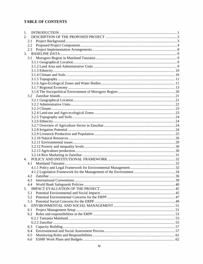
Table 3.12: Existing area for Irrigation in different districts in Zanzibar .............................................. 25
Table 3.13 Forest Protected Areas of Zanzibar (2009) .......................................................................... 28
Table 3.14: Annual productions of selected food crops in tons between 2008 and 2012 ...................... 31
Table 4.1: Key policies and laws relating to environmental management for Mainland Tanzania ....... 34
Table 4.2: Key policies and laws relating to environmental management for Zanzibar ........................ 37
Table 4.2: World Bank Safeguards Policies and their Applicability ..................................................... 40
Table 4.3: Summary of Requirements of World Bank Safeguards Policies Triggered by the ERPP ..... 44
Table 5.1: ERPP Potential Environmental and Social Impacts and Risk Categorization ...................... 46
Table 6.1: Tanzania Mainland Work Plan ............................................................................................. 63
Table 6.2: Zanzibar Work Plan .............................................................................................................. 64
Table 6.3: ERPP ESMF Implementation Budget (Zanzibar) ................................................................. 65
LIST OF FIGURES
Figure 3.1: Tanzania Administrative Map (Left) – Districts of Morogoro Region (Right) ..................... 9
Figure 3.2: Map of Zanzibar .................................................................................................................. 22

vi
ABBREVIATIONS
ASDS Agricultural Sector Development Strategy
ASA Agricultural Seed Agency
ASP Agricultural Strategic Plan
ATI Agricultural Transformation Initiative
BRN Big Result Now
CAADP Comprehensive Africa Agriculture Development Program
CITES Convention on International Trade in Endangered Species of Wild Fauna and
Flora
CoFMA Community Forest Management Agreement
DADO District Agricultural Development Officer
DAICO District Agriculture Irrigation and Cooperative Officer
DEC District Environmental Coordinator
DED District Executive Director
DEMO District Environmental Management Officer
DCCFF Department of Commercial Crops, Fruits and Forestry
DoE Department of Environment
DoI Department of Irrigation
DITS Department of Irrigation and Technical Services
DPPR Director of Planning, Policy and Research
EA Environmental Assessment
EIA Environmental Impact Assessment
EMA Environmental Management Act
EMU Environment Management Unit
ESIA Environmental and Social Impact Assessment
ERPP Expanding Rice Production Project
ESAF Environmental and Social Appraisal Form
ESMF Environmental and Social Management Framework
ESSF Environmental and Social Screening Form
GAFSP Global Agriculture and Food Security Program
GoT Government of Tanzania
HIV/AIDS Human Immunodeficiency Virus / Acquired Immunodeficiency Syndrome
IO Irrigator Organizations
IPMP Integrated Pest Management Plan
JSC Joint Steering Committee
KATRIN Kilombero Agricultural Research and Training Institute
LGA Local Government Authority
LGCDG Local Government Capital Development Grant
MAFC Ministry of Agriculture and Food Cooperatives
MANR Ministry of Agriculture and Natural Resources
MoL Ministry of Land
MTEF Medium-Term Expenditure Framework
NAIVS National Agricultural Input Voucher System
NEMC National Environment Management Council
NEP National Environmental Policy
NSGRP National Strategy for Growth and Reduction of Poverty
PESIA Preliminary Environmental and Social Impact Assessment
PDO Project Development Objective

vii
PMO-RALG Prime Minister’s Office - Regional Administration and Local Government
RGZ Revolutionary Government of Zanzibar
RPF Resettlement Policy Framework
SAGCOT Southern Agricultural Growth Corridor of Tanzania
SC Steering Committee
SESA Strategic Environmental and Social Assessment
SMS Subject Matter Specialist
SRI System of Rice Intensification
SWAp Sector Wide Approach
TAFSIP Tanzania Agriculture and Food Security Investment Plan
TASAF Tanzania Social Action Fund
TOSCI Tanzania Official Seed Certification Institute
TRC Technical Review Committee
TSC Technical Steering Committee
URT United Republic of Tanzania
UNFCCC UN Framework Convention for Climate Change
VPO Vice-President’s Office
WMA Wildlife Management Areas
ZARI Zanzibar Agricultural Research Institute
ZITSU Zonal Irrigation and Technical Support Units
ZSGRP Zanzibar Strategy for Growth and Reduction of Poverty

1
1. INTRODUCTION
In 2012, the Government of Tanzania (GoT) submitted a proposal to the Global Agriculture
and Food Security Program (GAFSP) to expand rice production in the country under a project
named Expanding Rice Production Project (ERPP) or ‘the Project’. The GAFSP Steering
Committee accepted the proposal, and offered a prospective allocation of US$ 22.9 million for
the Project. The Project will be implemented in three districts (Kilombero, Kilosa, and
Mvomero) of Morogoro Region in Tanzania Mainland and Pemba and Unguja Islands in
Zanzibar. Both Morogoro Region and Zanzibar are home to a number of protected areas and
critical ecosystems. Morogoro in particular is home to the Mikumi and Udzungwa National
Parks, the RAMSAR site at Kilombero, and several essential Wildlife Management Areas
(WMAs). Given the ecological sensitivity of the project area, care must be taken to avoid
negative impacts to the environment, surrounding communities and wildlife by minimizing
over-clearing of natural vegetation, reduce impediments to wildlife movements, and balance
water extraction with maintaining hydrological flow.
As part of project preparation, the World Bank Operational Policy 4.01 requires the
Government of Tanzania (GoT) to prepare an Environmental and Social Management
Framework (ESMF). This document sets out the mandatory principles, rules, guidelines and
procedures to assess and manage the potential environmental and social impacts of the
project. It also includes mitigation, monitoring and institutional measures to be taken during
project implementation in order to eliminate, offset, or reduce adverse environmental and
social impacts of project activities.
The objective of the ESMF is to provide a framework for effective management of
environmental and social issues in the proposed ERPP. It seeks to both enhance
environmental and social development benefits of the Project in line with GoT and World
Bank policies and guidelines on management of environmental and social development
projects. Moreover, since the precise locations and potential impacts of future subprojects to
be financed under ERPP are not yet known, and will not be identified prior to appraisal, the
ESMF provides the basis for the preparation and approval of necessary environmental and
social work, as needed for the subproject investments supported through the Project.
An Integrated Pest Management Plan (IPMP) and a Resettlement Policy Framework (RPF)
complement this ESMF. The IPMP include details on the integrated pest management
strategies to be employed under the Project and addresses the need to monitor and mitigate
negative environmental impacts of project activities by promoting biological and ecosystem
based pest management. The RPF address the needs of those people who might be
affected when Project investment causes the involuntary taking of land and other assets
resulting in: (a) relocation or loss of shelter, (b) loss of assets or access to assets, (c) loss of
income sources or means of livelihoods, whether or not the affected person must move to
another location.
The GoT is further required to disclose this ESMF (as well as the IPMP and the RPF) so that
they are accessible to the general public, local communities, potential project-affected groups,
local NGO’s and all other stakeholders in the country. This disclosure will also be made at the

2
World Bank Infoshop. The date for disclosure must precede the date for appraisal of the
Project.

3
2. DESCRIPTION OF THE PROPOSED PROJECT
2.1 Project Background
The agricultural sector in Tanzania is a key driver of social and economic development in the
country and will remain so in many years to come. The sector generates 26.8 per cent of the
GDP, 24 percent of exports, employs over 75 per cent of the rural population where the
majority of the poor reside. There is a strong interrelationship between its performance and
the growth and employment generation of the industrial sector, and other key sectors.
However, the sector is dominated by small scale subsistence farmers characterized by low
productivity. The GoT is committed to bring about the transformation of agriculture from
subsistence farming towards commercialization and modernization.
The national agricultural policy frameworks aims to create an enabling environment for
improved productivity and profitability as the basis for poverty reduction through: (i)
strengthening the institutional framework; (ii) creating a favorable climate for commercial
activities; (iii) clarifying public and private sector roles in improving support services; (iv)
developing input and output markets; and (v) mainstreaming planning for agricultural
development in other sectors. In 2001, Tanzania formulated the Agricultural Sector
Development Strategy (ASDS) for Tanzania Mainland and in 2004 the Agricultural Strategic
Plan (ASP) for Zanzibar putting in place a sector wide approach (SWAp).
The two strategies aim to develop the agricultural sector by increasing the rate of annual
agricultural sector growth to 6% in line with the Comprehensive Africa Agriculture
Development Program (CAADP). Implementation of these strategies will contribute to the
achievement of the National Strategy for Growth and Reduction of Poverty (NSGRP) and
Zanzibar Strategy for Growth and Reduction of Poverty (ZSGRP) targets. In an effort to give
more emphasis to a private sector-led development of agriculture, the two Governments,
together with private sector players formulated the Kilimo Kwanza and the Agricultural
Transformation Initiative (ATI), for Tanzania Mainland and Zanzibar respectively, as special
campaigns to harness public support for the agricultural transformation agenda. On 11
November 2011, Tanzania launched the Tanzania Agriculture and Food Security Investment
Plan (TAFSIP), which is a CAADP inspired framework aimed at mobilizing resources for the
implementation of strategic agricultural interventions for both Tanzania Mainland and
Zanzibar.
In order to address food and nutrition security in both Tanzania Mainland and Zanzibar efforts
have been focused on increasing production and productivity of major food crops including
maize, rice, cassava and sugar. This ERPP correspondingly seeks to expand rice production in
Tanzania.
The Project Development Objective (PDO) of ERPP is: to increase rice produced and
marketed in the Morogoro Region in the Tanzania Mainland and in Zanzibar, leading to
improved rural incomes and food security. The direct project beneficiaries are 30,600
smallholder farmers and their families in the selected irrigation schemes of Tanzania
Mainland (25,000 households) and Zanzibar (5,600 households). Approximately, 50 percent
of these farmers are women. Indirect beneficiaries include smallholder farmers not directly
supported by the project, input suppliers, rice traders and processors and consumers.

4
2.2 Proposed Project Components
The project has four main components: (i) Sustainable seed systems; (ii) Improving crop
productivity through better irrigation and crop management; (iii) Innovative marketing
strategies; and (iv) Project management, monitoring and evaluation.
Component 1: Sustainable Seed Systems: US$ 3.38 Million (2.27 Million for Tanzania
Mainland and 1.11 Million for Zanzibar). The objective of this component is to enhance the
adoption and sustained use of improved rice varieties that have been released by the research
system. This will support on-farm demonstrations to introduce the new varieties to farmers,
the multiplication and distribution of preferred varieties, and improvements in quality
assurance for rice seed.
Subcomponent 1.1: Introducing new varieties to smallholder farmers. Tanzania has thirteen
improved rice varieties released for multiplication and subsequent use by smallholder farmers.
These are grown, however, on less than 15 percent of the total area cropped to rice. Most rice
growers still plant low yielding varieties, and have yet to be introduced to the improved
varieties. The project will support two years of on-farm demonstrations in the targeted
regions of the Tanzania Mainland and Zanzibar in order to confirm the preferences of farmers
for the new varieties. The demonstrations will be organized and monitored with support from
national rice breeders to assure the information collected is integrated back into national
breeding programs. The project will also fund field days, exchange visits and the broader
dissemination of information about the new varieties to rice farmers in other regions. The
project will fund goods and equipment, consultancy services, and operational costs.
Subcomponent 1.2: Promoting the sustainable production and delivery of preferred varieties.
Seed multiplication and distribution systems will be strengthened for those improved rice
varieties preferred by smallholder farmers. The project will: (i) strengthen the capacity of the
Kilombero Agricultural Research and Training Institute (KATRIN) and the Zanzibar
Agricultural Research Institute (ZARI) to produce the requisite quality and quantity of pre-
basic seed; (ii) support the Agricultural Seed Agency (ASA) and the Seed Unit at Ministry of
Agriculture and Natural Resources (MANR) in Zanzibar to produce adequate quantities of
basic seed (from the pre-basic seed); (iii) support ASA and the MANR seed unit, for a limited
period, to produce certified seed1; and (iv) provide incentives for the private seed companies
to engage in production of certified seed2. The support to ASA and MANR for certified seed
production will include the construction of irrigation infrastructure to support the expansion of
rice seed production. Commercial seed companies will be encouraged to expand investment in
wholesale and retail trade of rice seed as well as contract seed production. The project will
fund goods and equipment, consultancy services, and operational costs.
Subcomponent 1.3: Strengthening seed quality control. The objective of this subcomponent is
to ensure that rice seed available to farmers is of the right quality. The project will strengthen
1 The objective is to support ASA and MANR (public agencies) to initially expand their production of certified
seed of preferred varieties, but phase public production out as rice seed production by the private sector expands. 2 Since rice is largely a self-pollinated crop, farmers can readily save seed from their previous year’s harvest
without short-term reductions in yield performance. This undermines commercial incentives to produce rice
seed. Seed companies are seeking support to test the commercial viability of this market.

5
seed quality control systems to assure genetic purity, germination capacity, physical purity
and freedom from diseases. Support will be provided for the rehabilitation and operation of
seed laboratory infrastructure at ASA on the Tanzania Mainland and Kizimbani in Zanzibar,
and for the purification of contaminated varieties (where contamination occurs). Support will
also be provided to Tanzania Official Seed Certification Institute (TOSCI) to strengthen the
inspection and testing of pre-basic and basic seed, and the certification of rice seed that is
multiplied by ASA, MANR and private seed companies. The project will fund goods,
consulting services and operational costs.
Component 2: Improving crop productivity through better irrigation and crop
management: US$ 14.04 Million (10.34 Million for Tanzania Mainland and 3.7 Million
for Zanzibar). This component aims to improve smallholder rice production and productivity
through improved crop and water management. The project will support expansion and/or
rehabilitation of selected irrigation schemes, and promote adoption of improved agronomic
practices.
Subcomponent 2.1: Expansion and rehabilitation of irrigation infrastructure. This sub-
component will improve water availability for dry season irrigation and water use efficiency
of irrigation during both the wet and dry seasons. The project will expand and/or rehabilitate
irrigation infrastructure at five irrigation schemes on the mainland, and eight irrigation
schemes in Zanzibar. On the mainland, 325 ha of irrigated area will be rehabilitated and 315
ha will be expanded. In Zanzibar, 58 ha will be rehabilitated and 72.5 hectares will be
expanded. The project will support the design of the irrigation infrastructure, the construction
of the infrastructure, and the strengthening the Irrigator Organizations to assure sustainable
operation and maintenance of the irrigation works. In complement, professional managers will
be employed on the five mainland schemes to facilitate the implementation of the BRN
strategy of rice scheme management. The project will finance goods, works, consulting
services, operational costs, training, and professional management staff.
Sub-component 2.2: Promoting Adoption of Improved Agronomic Practices. The project will
speed the adoption of improved technologies needed to raise rice productivity and production
by smallholder farmers distributed across 40 irrigation schemes on the mainland (including
the five to be rehabilitated or expanded) and 24 irrigation schemes in Zanzibar (including the
8 to be rehabilitated or expanded). The project will support: (i) farmer-led, on-farm
demonstrations of two methods of the System of Rice Intensification (SRI) - one with manual
weeding, and one with chemical weed control, (ii) training of extension staff, irrigation
technicians and lead farmers, and (iii) a temporary, market-friendly subsidy scheme
promoting the uptake of technologies on offer. The subsidy scheme includes an explicit
graduation strategy modeled on the lessons obtained under the National Agricultural Input
Voucher Scheme (NAIVS). The project will fund operational costs, goods and equipment and
subsidy costs.
Component 3: Innovative marketing strategies US$ 2.37 Million for Tanzania Mainland.
The main objective of this component is to increase the quantity of rice marketed by
strengthening access to markets and improving price incentives at the farmgate. Activities
under this component are targeted at only the mainland, because of the current absence of
marketable surpluses, and hence limited marketing challenges, in Zanzibar. The project will

6
improve market efficiency through two major activities: (i) provision of marketing
infrastructure and (ii) strengthening of market linkages.
Sub-Component 3.1: Provision of Marketing Infrastructure. The project will construct
warehouses for each of five smallholder schemes where irrigation infrastructure will be
rehabilitated, and rehabilitate feeder roads in two of these schemes to facilitate improved
access to output markets3. The proposed warehouses, together with their respective capacities
include: Njage (1,700Mt); Mvumi (1,300Mt); Msolwa (3,400Mt); Mbogo (1,000Mt) and
Kigugu (1,000Mt). Feeder roads will be rehabilitated in two irrigation schemes: Njage (7km)
and Mvumi (8km). The project will finance consultancy services, goods, works and related
operational expenses for supervision.
Sub-Component 3.2: Strengthening Market Linkages and Market Information. This
subcomponent aims to improve farmgate prices by testing alternative marketing strategies
linked with the warehouse operations. These are expected to help farmers take advantage of
the scale economies obtainable through bulk marketing, and the seasonality of rice prices. The
project will fund studies to help farmers better understand rice markets. It will support the
testing of multiple marketing strategies such as contract delivery with nearby processors, the
auctioning of grain to groups of traders, warehouse receipts, and the strengthening of market
information systems. The project will fund consultancy services, operational costs and
technical assistance.
Component 4: Project Management and Coordination: US$ 3.1 Million (US$ 1.52
million for Tanzania Mainland and 1.6 million for Zanzibar. The objective of this
component is to facilitate efficient implementation of project activities and tracking of results.
Project implementation will use existing structures in Ministry of Agriculture Food Security
and Cooperatives (MAFC) for mainland Tanzania and the Ministry of Agriculture and Natural
Resources (MANR) in Zanzibar. Each of these Ministries will assign a dedicated task team of
key staff to ensure that there is adequate capacity to coordinate, implement and monitor the
project effectively. Under this component, support will be provided for operational costs,
project monitoring and evaluation and impact assessments. Due to capacity weaknesses in
Zanzibar, the project will also fund supplementary technical assistance in procurement,
financial management, and monitoring and evaluation.
The list of sub-projects expected to be funded under the ERPP is provided in the below table.
Table 2.1: Sub-project to be funded under ERPP Serial
Number
Sub-Project Type Location Description Comments
Morogoro Region
MI1 Rehabilitation and
extension of irrigation
scheme
Njage, Kilombero
District
Repair 1050 m canals
Establish 5740 m canals
with hydraulic
structures
Converts 250 ha of
informal irrigation to
formal irrigation;
need to gauge drainage
to assure minimum flow
MI2 Rehabilitation and
extension of irrigation
scheme
Msolwa Ujamaa,
Kilombero
District
Establish 7650 m canals
with hydraulic
structures
Converts 625 ha informal
irrigation to formal
irrigation
3 This will also improve the accessibility of farm inputs.

7
MI3 Rehabilitation and
extension of irrigation
scheme
Kigugu,
Mvomero District
Establish 4400 m of
canals with hydraulic
structures
Converts 180 ha of
informal irrigation to
formal irrigation
MI4 Rehabilitation and
extension of irrigation
scheme
Mbogo,
Mvomero District
To be defined in
preliminary design
study
Converts 120 ha informal
irrigation to formal
irrigation and add 80 ha
of new irrigation area
MI6 Rehabilitation of
irrigation scheme
Kilangali, Kilosa
District
Repair 3335 m of canals Reclaims 400 ha of
irrigation area for public
seed farm
MR1 Rehabilitation of road Njage, Kilombero
District
Repair 5540 m of road Repairs road from village
to scheme
MR2 Rehabilitation of road Mvumi, Kilosa
District
Repair 7000 m of road Repairs road from village
to scheme
MR3 Rehabilitation of road Kigugu,
Mvomero District
Repair 3200 m of road Repairs road from village
to scheme
MW1 Build warehouse Njage, Kilombero
District
1700 mt Warehouse being
established on village
land
MW2 Build warehouse Msolwa Ujamaa,
Kilombero
District
3400 mt Warehouse being
established on village
land
MW3 Build warehouse Kigugu,
Mvomero District
1000 mt Warehouse being
established on village
land
MW4 Build warehouse Mbogo,
Mvomero District
1000 mt Warehouse being
established on village
land
MW5 Build warehouse Mvumi, Kilosa
District
1300 mt Warehouse being
established on village
land
Zanzibar
ZI1 Rehabilitation and
extension of irrigation
scheme
Mtwango,
Unguja
Repair of 775 m of
canals
78 ha more reliable
irrigation; additional 60
ha has water for second
crop
ZI2 Rehabilitation and
extension of irrigation
scheme
Koani Establish 1600 m of
canals
Allows 25 ha of
irrigation in dry season
ZI3 Rehabilitation and
extension of irrigation
scheme
Banda Maji Establish 1200 m canals Allows 15 ha of
irrigation in dry season
ZI4 Rehabilitation and
extension of irrigation
scheme
Mchangani Establish 2250 canals Converts 20 ha from
informal to formal
irrigation
ZI5 Rehabilitation and
extension of irrigation
scheme
Machigini,
Pemba
Establish 2,500 m
canals
Converts 12 ha of
informal to formal
irrigation
ZI6 Rehabilitation and
extension of irrigation
scheme
Dobi 1 Establish 100 m canals Reduces leakage for 3 ha
formal irrigation
ZI7 Rehabilitation and
extension of irrigation
scheme
Dobi2 To be determined Converts 25 ha from
informal to formal
irrigation
ZI8 Rehabilitation and
extension of irrigation
scheme
Kwale Mpona Establish 2000 m canals Converts 15 ha informal
to formal irrigation

8
ZI9 Rehabilitation and
extension of irrigation
scheme
Kibondo Mzungo To be determined Converts 25 ha from
informal to formal
irrigation
ZI10 Rehabilitation and
extension of irrigation
scheme
Ole To be determined Converts 15 ha from
informal to formal
irrigation on public seed
farm
2.3 Project Implementation Arrangements
The project will be implemented through the Ministry of Agriculture and Food Cooperatives
(MAFC) in the Tanzania Mainland, and the MANR in Zanzibar. In the Mainland, project
implementation will be led by a coordination team seconded from within government
although day to day responsibility for implementing the various components of the project
will remain with the relevant departments of the Ministry. At the local level, project
implementation will be guided by Local Government Authorities (LGA) working through the
District Agricultural Offices. Implementation in Zanzibar will be similarly let by a designated
coordinator, backed by an identified team of experts all seconded to the project by the
Ministry. Ministry procurement, financial management and monitoring and evaluation
systems will be used, with support from supplementary technical assistance as required. The
project will be overseen by two technical steering committees, one for Mainland Tanzania and
one for Zanzibar. These will be linked with a Joint Steering Committee encompassing the
Permanent Secretaries of MAFC and PMO-RALG in Mainland, and MANR and President’s
Office (Regional Administration) for Zanzibar.
Overall policy guidance and coordination of ERPP will be vested in the Ministry of
Agriculture, Food Security and Cooperatives in the Mainland. The office of the Director of
Policy and Planning will coordinate day to day project activities.
Technical Steering Committees (TSC): Two technical project steering committees will be
established to provide managerial oversight over the two implementation efforts. In order to
avoid duplication of effort promote collaboration across related projects, the Technical
Steering Committee for the Mainland project will report progress to the Steering Committee
for the Agricultural Sector Development Programme (ASDP). For Zanzibar the Technical
Steering Committee will be led by the Principal Secretary of MANR. Membership will
include the Permanent Secretaries responsible for Cooperatives, Union Matters, Environment
and Local Government. The main task of the two Steering Committees will be to review the
progress of project implementation as laid out in the quarterly and annual progress reports,
and approve the respective regional work plans and budgets. The task team leaders from the
MAFC and the MANR will serve as the secretariat to their respective Steering Committees.
Joint Steering Committee (JSC): A subset of the members of each Steering Committee will
meet together at least once a year as a Joint Steering Committee. This committee will
compare the implementation progress in the two regions, review implementation lessons, and
sign off on any significant reallocations of the project budget. These meetings will alternate
in being hosted by the MAFC on the Mainland, and the MANR on Zanzibar. The Permanent
Secretary of the host entity will chair each meeting.

9
3. BASELINE DATA
3.1 Morogoro Region in Mainland Tanzania
3.1.1 Geographical Location
Morogoro Region is one of the high potential agricultural regions in Tanzania Mainland that
is located on the eastern side of the country. The Region lies between latitudes 5o58’ and
10o00’ South of the Equator and between longitudes 35
o25’ and 38
o30’ East of Greenwich. It
is bordered by seven regions. In the north are Tanga and Manyara while in the eastern side are
the Coast Region and Lindi regions. On the western there are Dodoma and Iringa Regions
while Ruvuma is located in the southern side of the Region.
Figure 3.1: Tanzania Administrative Map (Left) – Districts of Morogoro Region (Right)
3.1.2 Land Area and Administrative Units
Morogoro Region has a total area of 73,039 km² out of which 2,240 km² is covered by water.
This area makes it the second largest region in Tanzania (the largest is Tabora). The Region
covers about 7.7 percent of the total area of Tanzania.
Table 3.1: Land and water surface area in the region by District/Councils, 2006.
District name Land area KM2 Water area KM
2 Total area
Kilosa 14,245.00 Insignificant 14,245.00
Kilombero 13,577.00 1,341.00 14,918.00
Ulanga 23,681.00 879.00 24,560.00
Morogoro Rural 11,711.00 20.00 11,731.00
Mvomero 7,325.00 Insignificant 11,711.00
Morogoro Urban 260.00 Insignificant 260.00
Total 70,799.00 2,240.00 77,425.00

10
Source: Morogoro Regional Commissioner’s Office, 2006.
Table 3.1 indicates that most of the land of Morogoro Region is covered by land (96.9
percent) and water bodies cover only a small part of the Region (3.1 percent). Out of six
district councils of the Region, only three districts of Kilombero, Ulanga and Morogoro Rural
have significant water bodies.
Administratively, Morogoro Region is divided into six (6) districts, namely Kilosa,
Kilombero, Ulanga, Mvomero, Morogoro Rural, and Morogoro Urban. The Districts are
subdivided into divisions, wards villages and streets (for urban wards)/vitongoji (for rural
wards). As indicated in Table 3.2, the Region has a total of 30 divisions, 141 wards, 540
villages, 275 streets and 3,204 vitongoji/hamlets.
Table 3.2: Distribution of Administrative Units by District in the Region, 2006
District
Name
Divisions Wards Villages Streets Vitongoji/Harmlets
Kilosa 9 37 161 - 1,030
Kilombero 5 19 81 - 355
Ulanga 5 24 65 - 605
Mvomero 4 17 101 - 577
Morogoro
(Urban)
1 19 Mitaa 275 -
Morogoro 6 25 132 - 657
Total 30 141 540 275 3,204 Source: Morogoro Regional Commissioners Office, 2006
3.1.3 Local communities
Most of the groups in the region are farmers. There are also pastoralists and agro-pastoralists.
These groups have moved in and settled in the districts in search of grazing lands for their
cattle. These new settlers have occasionally clashed with existing ethnic groups. The conflicts
are always based over the land use and occupancy rights.
3.1.4 Climate and Soils
Morogoro Region experiences climate of moderate temperature and rainfall. The average
annual temperatures vary between 180C to 30
0C in the lowlands. The Region experiences
moderate temperature of around 250C almost throughout the year. The warm season normally
runs from July to September.
Generally, the region experiences two major rainfall seasons: with long rains between
November and May, and short rains between January and February. The average annual
rainfall varies between 600mm and 1800mm. However, the average annual rainfall varies
from year to year and between ecological zones. Moreover, the mountainous topographical
nature of the Region affects the patterns of the rainfall. The eastern parts of Uluguru
Mountains receive very high rainfall of up to 2,850mm annually while the leeward sides of
these mountains are generally dry receiving rains of less than 600mm per annum. The areas
experiencing the lowest rains include Gairo and Mamboya divisions in the North of Kilosa
District, and Ngerengere division in Morogoro Rural District. Also, the Region’s climate
especially that of Ulanga and Kilombero Districts in the southern parts is greatly influenced

11
by the Mahenge and Udzungwa mountain ranges which have high altitude and harbour dense
forest reserves.
Soils in the Region vary according to topographical and ecological zones. In the mountainous
and hilly areas the common type of soils found are mainly oxisols which are generally low in
nitrogen and phosphorus. Valley and low lands are generally characterized by alluvial soils
which are fertile in nature. Sandy and clay soils are common in woodlands and grasslands
3.1.5 Topography
The topography of Morogoro Region is characterized by two remarkable natural features.
First are the mountainous and hilly areas which include the Ukaguru Mountains, and the
Uluguru and Nguru mountain ranges. Others include Mahenge and Udzungwa mountain
ranges which extend to the Njombe Highlands in Iringa Region. These mountains form the
eastern and southern part of the “Eastern Arc Mountains” which extend from southern Kenya
to southern Tanzania. These mountains are part of an ancient crystalline block- faulted
mountain range in the eastern part of Africa stretching from the Taita hills in Kenya to the
Drankensberg in South Africa. The second feature that characterizes the Region’s topography
is the lowlands especially the Kilombero valley and the northern parts of the Region.
The Region’s drainage is formed by many rivers that flow from highlands to lowlands in the
valleys. The major rivers include the Kilombero, Ruaha, Wami, Luwegu, Ruvu, Ngerengere,
Mkata, Mkondoa and Mkindo
3.1.6 Agro-Ecological Zones and Water Bodies
Morogoro Region can broadly be divided into four Agro-Ecological Zones, which include the
mountain zone, the intermediate zone, and the Kilombero river valleys and basins.
i) The Mountain Zone
The mountainous agricultural zone receive the highest amount of rains with average annual
precipitation ranging from 800mm-2500mm in the windward side of mountains and lowest
rains in the leeward side at an annual average rains of less than 600mm. The zone has an
altitude ranging from 600m to over 1250m above sea level. The zone experiences the coolest
temperature in the Region with an annual average of 180C. The zone is densely populated in
the eastern side due to its windward nature which brings high rainfall. On the other hand the
western side is sparsely populated as it experiences dry climate due to its leeward location.
A variety of crops are grown in this zone. Food crops are mainly maize, Irish potatoes,
banana, peas, yams, beans, groundnuts, wheat, cassava and horticultural crops. Major cash
crops include coffee, oil seeds, vegetables and fruits such as pineapple and oranges. Due to its
mountainous nature, the zone is limited to small stock such as goats, sheep and pigs.
The zone experiences a number of problems including deforestation which has culminated in
serious soil erosion. Deforestation is caused by residents who excessively cut forests while
clearing for farming. Roads and transport infrastructure are poor especially in the
mountainous areas of the Region.

12
ii) The Intermediate Zone
This zone covers most of the southern parts of Morogoro District, and greater part of Kilosa
District in Mikumi, Ulanga, Magubike, Magole and Chakwale wards. The altitude of this area
ranges from 300m to 600m above sea level, with an average rainfall between 700mm and
1200mm per annum. The temperatures in this zone average 180C annually.
Crops grown for food in this zone include maize, millet, cassava, sorghum, paddy and
legumes. Major cash crops raised include cotton, sisal and oilseeds. The zone is densely
populated due to its suitability to agriculture and livestock keeping.
iii) The River Valleys and Basins
This zone is constituted by the Mgeta, Kafa, Ruvu, Wami, Msongozi, Mbulumi and
Ngerengere river valleys in Morogoro and Mvomero District; the Wami-Mkata plains and
Mkondoa valley in Kilosa District, and the Luhombero Plains in Ulanga District. The
topography of these areas is predominantly plain with rainfall ranging between 900mm and
1400mm annually. Temperatures in this zone are high with an average of 300c due to its
lowland nature. The zone is densely populated in the upper parts of the valleys, and sparsely
populated in the inner parts of the valleys.
Major food crops grown in this zone include maize, paddy, sorghum, beans, cassava, fruits
and vegetables. Cash crops are cotton, sisal, oil seeds, sugar cane and coconuts.
Livestock raised in this zone include cattle, sheep and goats in the areas with no tsetse fly
problem. Roads, transport and communication infrastructure in this area face problems due to
frequent flooding during the rainy season.
iv) Kilombero River Valley
The Kilombero River Valley encompasses 39,990 km2, about 23% of the total area, and
contributes about 65% of the flow to the Rufiji River. An important feature of the Kilombero
basin is the great fertile Kilombero valley below the eastern scarp of the Udzungwa
Mountains. Numerous rivers flow on the scarp from the Udzungwa plateau. Some of the
important rivers are the Ruhudji, Kihansi, Luhombero, Kigogo-Ruaha and Mpanga. The
Ruhudji and the Luhombero form the Kilombero River. After Shughuri rapids on the old
basement step, the Kilombero joins the Luwegu flowing from south east to form the Rufiji.
The Rufiji basin is large, with differing rainfall and catchment characteristics. The area north
of Poroto and Udzungwa Mountain is under semi-arid conditions with mean annual rainfall of
500 mm. Rainfall increases southward and larger falls of 1800 mm per year are observed on
the slopes at the Udzungwa and Kipengere range. The rainfall pattern is such that there is one
rainy season (mid-November to May) and one dry season. This pattern is the same all over the
basin with the exception of coastal areas where there is slight tendency to bimodal rain
pattern. There is a tendency for the dry season to set earlier in the Great Ruaha basin than the
Kilombero basin. The Kilombero floods occur at the end of April or the beginning of May.
Runoff pattern is closely related to the rainfall pattern. Rivers start rising in December with a
peak in March-April. The unique ecological endowment, crop and livestock systems in each
zone are summarized in the table below.
Table 3.3: Economic activities within Morogoro region.

13
Zone Area covered Crops Livestock
raised
Higlands
600
Nguru, Mahenge, Rubeho,
Udzungwa and the Ubena
mountains
Maize, Vegetables, Fruits,
Coffee, Cocoa, Citrus
Poultry, Pigs, Goats,
Sheep
Plateau 300-
600m
Major part of Kilosa District
and part of the middle of
Morogoro South
Maize, sorghum, sweet
potatoes, cotton, sunflower,
simsim, citrus, paddy,
cassava and banana
Cattle, sheep, chicken
Lowland
and River
valleys
Kilombero Wami, Mkindo,
Ngerengere, Mgeta, Luwegu
and Luhomberovalleys
Paddy, maize, sugarcane,
bananas, cocoyams, cassava
and sweet potatoes.
Mainly poultry
Source: Morogoro Regional Office, 2006.
3.1.7 Regional Economy
3.1.7.1 Introduction.
Morogoro Region is one of the Regions in Tanzania with great potential of economic
development and prosperity. The Region has a very good climate and land favorable for
agriculture and other economic investments. The Region contains Morogoro Urban centre
which is its headquarters. The urban centre is strategically located at the junction point of
major roads from Dodoma and Iringa to Dar es Salaam and Arusha. The economy of the
Region is dominated by agriculture and the allied activities. The major activities include:
(i) Small Scale farming (food and cash crops production)
(ii) Cattle keeping (mainly indigenous livestock)
(iii) Plantations and estates (sisal, sugar).
(iv) Small capital intensive urban sector whose main activities include:
Manufacturing and
Provision of services - offices, hotels, petty trading etc.
(v) Traditional fishing is practiced along the Kilombero and Wami rivers as well as Mindu
dam.
(vi) Some mining is carried out at Lukande village in Ulanga District and at Matombo in
Morogoro rural district. The region is rich in three types of minerals, gemstones;
construction minerals (such as sand, gravel and stones) and industrial minerals
(including reticule lime stone, mica and graphite).
Agriculture is the major economic activity in the Region. It engages about 80 to 90 percent of
the region's labor force.
Agriculture involves both small and large-scale farmers. Large-scale farms include the
Kilombero and Mtibwa sugar estates, sisal estates, and paddy farms in Dakawa in Morogoro
Rural District, Mngeta in Kilombero District and Kilangali in Kilosa District.
Maize and paddy are the major staple food crops. Other food crops in the region include
sorghum, sweet potatoes, beans, cassava, millet, groundnuts, tomatoes, fruits and vegetables.
The main cash crops in the Region are cotton, coffee, sisal, onions, oil seeds (such as sesame,
sunflower and some cocoa along the mountain slopes.

14
3.1.7.2 Irrigation potential
Table 3.4 shows the potential irrigation areas in Morogoro Region. There is a potential for
irrigation of 434,390 hectares. Only 274,243 hectares was under irrigation by the year
2008/2009. Roughly 60 percent of the potential area for irrigation is yet to be utilized.
Table 3.4: Potential Areas for Irrigation in Morogoro Region, 2006
RIVER BASIN POTENTIAL AREA (HA) FOR
IRRIGATION
I Kilombero river basin
1. Luri, Mchilipa and Lwasesa plains 17,960
2. Lufupa and Sofi plains 36,740
3. Ruhuji, Mnyera and Mpanga plain 134,700
4. Kihansi, Mugeta, Ruipa and Lumemo plain 146,940
Sub total 336,340
II Luwengu river basin
1. Luhombero and Luwengu plain 16,500
2. Ruaha and Chilombola plain 10,450
Sub total 26,950
III Wami river basin
1. Wami – Dakawa plain 10,500
2. Mkindo and Mgongola plain 15,600
Sub total 26,100
IV Great Ruaha river basin
1. Kibegere plain 15,000
2. Kidatu and Msolwa plain 30,000
Sub total 45,000
GRAND TOTAL 434,390
Source: Morogoro Regional Commissioners Office, 2006
Kilombero with irrigation schemes covering 17,606 hectares is the district with the largest
irrigated area in the Region. Morogoro District having three irrigation schemes has a total of
2,140 hectares which are developed and used. The crops which are mainly serviced by these
irrigation schemes are sugar cane, paddy, maize, vegetables and pulses.
3.1.7.3 Livestock Production and population
Data collected in 2006 across Morogoro Region shows that chicken occupy the largest
proportion (55.5 %) of all livestock kept, followed by cattle (22.6 %), goats (18.6 %), sheep
(2.9 %), pigs (0.9 %) and donkeys (0.1 %) (See Table 3.5 below).
Table 3.5: Estimated Livestock population in Morogoro Region by District, 2006
District
Name
Cattle Goats Sheep Donkey Pigs Chicken Total/
district
%
Kilosa 215,040 93,737 25,098 2,930 5,097 500,612 842,514 32.1
Kilombero 68,106 10,090 5,806 157 6,902 365,670 455,446 17.4
Ulanga 97,263 16,714 18,084 262 495 346,219 479,037 18.3

15
Movemoro 172,827 51,161 20,121 385 6,243 192,325 383,584 16.9
Morogoro
Urban 4,170 4,300 180 3 3,130 25,640 37,423 1.4
Morogoro 35,935 295,404 5,467 55 2,543 25,804 364,908 13.9
Region Total 593,341 441,406 74,756 3,792 24,410 1,456,270 2,562,912
% livestock
type
22.6 18.0 2.9 0.1 0.9 55.5 100
Source: Morogoro Regional Commissioners Office, 2006
Kilosa District has been found to contains the largest share of livestock kept (32.1 %),
followed by Ulanga (18.3 %), Kilombero (17.4 %), Mvomero (16.9 %), Morogoro (13.9 %)
and Morogoro Urban (1.4 %). Most cattle are indigenous beef followed by dairy cattle, and
lastly improved beef cattle. There is an average of 2 dairy cattle kept by each dairy cattle
keeper.
Although dairy cattle are fewer than indigenous cattle in Morogoro, there has been a
considerable increase in dairy cross cattle in the region since 1990. One of the factors
limiting livestock keeping is the limited grazing land due to villagers allocating land for other
uses and un-demarcated land for crop and livestock production in the region.
3.1.7.4 Natural Resources
The natural resources sector in Morogoro Region is comprised of various sub-sectors
including forestry, fisheries, bee-keeping and wildlife. The sector is vital for the social and
economic development of the Region and the nation in general. According to the 2012
Population and Housing Census, the sector employs a total of 29,753 people which is about
3.4 percent of the Region’s labor force. Over the period of 2005-2010, the sector contributed
around 7 percent to the country’s Gross Domestic Product (GDP) on average.
The sector also plays an important role in the maintenance of climate stability, protection of
water sources, and soil fertility; controlling land erosion; and providing a source of wood fuel,
industrial raw materials and hydro-electric power. The Region is very rich in natural resources
which include perennial streams, springs and rivers such as the great Ruaha; wildlife areas
such as Selous Game Reserve, the Mikumi National Park, Kilombero Nature Reserve, the
Ramsar site and Udzungwa Mountains National Park.
3.1.7.5 Forestry
The 1974 survey on the extent of forest cover in the Region of Morogoro indicated that forests
covered about 88 percent of the Region’s total area. The area covered by forests was
estimated at 64,000km2. However, since that period tremendous changes have taken place in
terms of population and economic activities that have significantly contributed to the
depletion of this valuable resource. In particular, the Region’s forest cover has been under
serious pressure from agricultural and livestock activities as well as excessive tree cutting for
fuel wood and other domestic uses. The government and community responses to these
destructive forces include tree planting and forest conservation initiatives, and the
demarcations of more land as forest reserve.

16
Most of the forest reserves in the Region are found in four districts, namely Kilombero,
Kilosa, Ulanga and Morogoro Rural. Most of the reserves cover mountainous areas under a
high rainfall and so are the important catchments. The main mountain ranges include the
Uluguru and Nguru in Morogoro and Mvomero Districts, Udzungwa in Kilombero District,
Mahenge in Ulanga District and Ukaguru and Rubeho in Kilosa District. Table 3.6 shows the
number, and size of forest reserves in the districts of the Morogoro Region.
Table 3.6: Forest Reserves by District in Morogoro Region, 2006
District Name No. Reserved Forests Total Area (Ha) Encroached Area
(Ha)
Kilombero 13 127,364 2,547
Ulanga 8 7,692 1,430
Mvomero 20 80,662 3,496
Morogoro 17 112,444 Not available
Morogoro (Urban) 3 14,255 -
Total 61 342,417 7,473
Source: Morogoro Regional Commissioners Office, 2006
3.1.7.6 Environmental Conservation
Morogoro Region is one of the Regions in Tanzania, which has succeeded in environmental
conservation. The Region has undertaken remarkable efforts in addressing environmental
degradation through afforestation. In these efforts the Region has been involving various
stakeholders in planting trees in order to offset deforestation which has occurred in the past.
Stakeholders involved include the Government Forest Division, villages, primary schools,
NGOs, individuals and other institutions such as prisons and army camps. Normally seedlings
are raised and distributed to schools, villages, institutions and individuals for transplanting.
Up to the year 2005 there were over 20 NGOs involved in environmental conservation
activities. The activities include tree seedlings production, water catchments conservation
schemes, bee keeping, and wildlife conservation.
3.1.7.7 Bee-Keeping
Bee-keeping is a well suited economic activity in the Region due to its extensive forest cover
and well-watered lands. However, this important activity is handicapped by low technical
know-how in modern bee-keeping techniques. As such the potentials in this sub-sector have
not been adequately exploited.
Table 3.7 shows the number of traditional and modern beehives in the Region. It shows that
Kilosa District is leading in terms of traditional and modern beehives in the Region. The
District is followed by Kilombero, Ulanga, and Morogoro Districts in this aspect. All districts
have relatively fewer modern beehives as compared to traditional beehives. Morogoro Urban
District has no traditional beehives and has fewer modern beehives. Its low performance in
this sub-sector is attributed to lack of adequate forest resources because of its urban nature.
Table 3.7: Number of traditional and modern beehives by district in the region 2006.
District Name Traditional Beehives Modern Beehives Total
Kilosa 19,189 705 19,894
Kilombero 3,500 350 3,850

17
Ulanga 2,242 282 2,524
Mvomero 880 10 890
Morogoro 2,212 571 2,783
Morogoro (Urban) - 45 45
Total 28,023 1,963 29,986
Source: Morogoro Regional Commissioners Office, 2006
Table 3.8 shows the estimated production of bee products by district in the Region by the year
2005. As shown in the Table, Kilosa had been the major producer of bee products producing
82.6 % and 63.3 % of the Region’s bee wax and honey. Following Kilosa in bee products
production are Kilombero and Ulanga, respectively. However, in terms of beeswax production
Ulanga is not featuring well as it produced only 400 Kgs in 2006.
Table 3.8: Estimated Production Levels of Bee-Products by District in the Region 2005/06
District Name Bee-wax (Kgs) District % to
total
Honey (Kgs) District % to
total %
Kilombero 29,919.0 82.6 199,460.0 63.3
Ulanga 2,775.0 7.6 41,625.0 13.3
Mvomero 400.0 1.1 18,026.0 5.8
Morogoro(Rural) 387.0 1.1 1,204.0 0.1
Morogoro (Urban) 2,746.0 7.5 54,910.0 17.4
Total 13.0 0.1 460.0 0.1
36,240.0 100.0 315,685.0 100.0
Source: Morogoro Regional Commissioners Office, 2006
3.1.7.8 Fisheries
Fishing activities in the Region are mainly carried out in rivers as it has no large water bodies
such as lakes or ocean. The rivers on which fishing activities are carried out originate from
within and outside the Region. Mountain ranges that are found in the Region are the sources
of these rivers. The rivers include Kilombero, Ruaha, Kihanzi Luwegu, Ruvu, Wami,
Ngerengere, Mkondoa and Mkindo. Fishing in the Region is also carried out on man-made
dams which are mainly found in Kilosa, Kilombero and Morogoro Rural District. In
Morogoro Urban District there is one man-made dam, the Mindu, which gets its water from
Ngerengere River. The size of the dam is 320 hectares.
Fishing is particularly important in the Ulanga District. The district enjoys the presence of
abundant natural fisheries resources. These include rivers such as Kilombero, Ruaha, Mwatisi,
Mnyera, Ruhoji, Luhombero, Furua, Fuli, Lukanda, Luwegu, Mafinji, Pitu, Isaka, Mselesi,
Mtipa, Mbalu and many other tributaries. The resources also include 40 natural dams and
man-made small dams which have been locally made by the community purposely for fishing
activity.
Caritas-Mahenge is the NGO currently operating in Ulanga District. Together with other
activities in the District, it has a fishing project which provides training on effective fish
farming. The project also provides improved fish fingerlings free of charge to the participating
members of the villages in which it is operating. The villages in which the NGO is operating
include Makanga, Mdindo, Msogezi, Ruaha and Isongo.

18
Fishing is also an established economic activity in Morogoro and Mvomero Districts. The
rivers used for this purpose in these districts include Wami, Mgeta and Divue. The districts
have a total of 249 man-made and natural dams.
3.1.7.9 Wildlife and Tourism
Wildlife conservation, protected area management and game hunting have long been well
established in Tanzania, dating back to German hunting laws in 1901-1920. The “Protected
Area Network” now covers about 28 percent of the country (19 percent is high protection
where farming and residence are not allowed). In Tanzania the responsibility for managing
wildlife and protected areas is split between National and Local/District Governments, and
then between Government Ministries and Parastatals, such as Tanzania National Parks
Authority (TANAPA).
Morogoro has two famous National Parks in the country, namely Mikumi and Udzungwa.
Also, part of famous the Selous Game Reserve (the largest game reserve in Africa) is in this
region. Due to its unique ecological importance, this Game reserve was designated by
UNESCO as a United Nations World Heritage Site in 1981. It covers a wide variety of
wildlife habitats, and a variety of animals including elephants, buffalos, wild-dogs and hippos.
Other animals of tourist status include the lion, bush buck, impala, giraffe, baboon and zebra.
Mikumi National Park is located in the North of the Selous Game Reserve and shares borders
with the Uluguru Mountains in the north and Rubeho Mountains in the south-east. The park
which was gazetted in 1964, shares the eco-system with Selous Game Reserve and Kilombero
Game Controlled Area. With 3,230 km2 coverage, the park is famous for its large population
of elephants, giraffes, buffalos, zebra, elands, greater kudu, and wildebeest, roan and sable
antelope. Predators include the tree climbing lion, leopard, wild hunting dogs and black-
backed jackals. The park has more than 400 species of birds which include Shelley’s double
colored sun bird, pale billed hornbill and violet-crested Turaco as well as violet-backed
starling. The surrounding mountains and hills bring compelling natural beauty making them
highly attractive to wildlife tourists.
The region includes ppen grasslands, acacia and miombo woodlands and riverine forests. The
Udzungwa Mountains National Park, which covers about 2000 km², was the first terrestrial
national park declared in Tanzania. The mountains which are covered with dense forest, rise
abruptly from the Kilombero plain area in Morogoro Region and then extend towards Iringa
Region. It is famous for its biologically diverse forest with about 20 to 30 plant species that
are not found elsewhere in the world. Among the factors that contribute to the richness of this
park is high altitude which ranges between 200 to 2600 metres above sea level. This helps the
condensation of moist winds from the Indian Ocean, which then forms rains. The
characteristic climate has made it to be the source of water catchment for the tributaries of
river Kilombero, which joins Ruaha to form Rufiji River in the Coast Region.
A variety of animal species can be found in the Udzungwa Mountains National Park. These
include water buffalo, elephants, leopards and a number of reptiles, such as chameleons and
snakes. Other animals include rare primates such as red colobus, Sanje crested mangabey,
monkeys, black and yellow baboon, which live in the slopes of the mountains all sharing the
same habitat. The Park is also one of the top ten forests for bird conservation in Africa.
Recent discoveries of animal species in the Park include a single skins Lowe’s servaline

19
genet, the highland Mangabey which is a long tailed medium-sized primate with tree-dwelling
life style. Another famous discovery is the three toed frog which gives live-births instead of
eggs. This type of frog-species is not found elsewhere in the world.
3.1.7.10 Industrial Development
At present there are very few meaningful industrial activities in Morogoro Region. The
industrial development in the Region still needs more effort since the region is endowed with
a wide range of natural resources that could lead to the establishment of resource based
industries. Such resources offering potential for industrial development include various types
of cash and food crops, minerals, and forest and bee products. The Region also produces a
variety of fruits suitable for industrial processing including pineapples and oranges. Table 3.9
shows the existing industries in the Region. Most of the industries which were once owned
and run by Government have been privatized.
Table 3.9: Status of Industries in Morogoro Region as per 2006
Name of Industry District Name after privatization
Kilombero Sugar Company Kilosa K2-ILLOVO
Kimamba Fibres Kilosa
New Msowero Farm Kilosa
Kilosa Coop. Union Kilosa
Mikumi Poa Rice Mill Kilosa
SUMAGRO Sisal Industry Kilosa
Mangula Furniture Kilombero
Kidatu HP Kilombero
Kihansi HP Kilombero
Kilombero Sugar Company Kilombero K1-ILLOVO
Morogoro Canvas Mills Morogoro (Urban) Morogoro Canvas Mills
Tanzania Tobacco Factory Morogoro (Urban) Tanzania Tobacco Processors
Co. Ltd.
Moproco Ltd Morogoro (Urban) Abood Seed Oil Industry Ltd.
Morogoro Packaging Industry Morogoro (Urban) Tanzania Packaging
Manufacturers (1998) Ltd
Abood Soap Industry Morogoro (Urban) -
Karakana ya Reli (TRC) Morogoro (Urban) TRL Workshop
Mrogoro Tanneries Ltd Tanzania Leather Industries Ltd.
Morogoro Polyster Textile Mills Morogoro (Urban) 21st Century Textile Mills Ltd.
Morogoro Ceramic and Wares
Ltd. Morogoro (Urban) Purebod UK
Mtibwa Sugar Estates Morogoro (Urban) Mtibwa Sugar Estates Ltd.
Source: Morogoro Regional Commissioners Office, 2006
3.1.7.11 Road Network Development
Because of the location of Morogoro Region there is an elaborate connection of road
networks. This position makes the Region a centre for the national roads network - to Dar es
Salaam and the ocean coast in the East, Dodoma in the West and Iringa in the South. All the
roads connecting all these regions are tarmac roads. The region is also served by inter-district
links by regional roads, district roads and feeder roads. The roads are important as they link
different parts of the region, and facilitate transportation of produce to the market.

20
Table 3.10 shows the distribution of road networks by type in various districts of the Region.
Table 3.10: Road Distribution in Morogoro Region by 2006.
District Name Type (Km)
Truck Regional District Feeder Total
Kilosa 290.00 129.00 446.00 470.00 1,335.00
Kilombero 75.00 210.00 88.70 141.40 515.10
Ulanga 70.00 152.00 453.10 113.50 788.60
Mvomero 112.00 232.89 80.90 214.90 640.69
Morogoro 31.50 144.00 348.00 262.00 785.50
Morogoro (Urban) 376.00
Total 578.50 867.89 1,146.70 12,201.80 4,440.89
Source: Morogoro Regional Commissioners Office, 2006
3.1.8 The Sociopolitical Environment of Morogoro Region
3.1.8.1 The Demographics
Tanzania’s population of 44.9 million in the 2012 census is made up of more than 120
different tribes, most of them belonging to the Bantu family. Population density has increased
from the national average of 39 people in 2002 to 51 people per sq. km. in 2012. Also at
regional level, population density varies between regions, from 13 people per square
kilometer for Lindi region to 3,133 people per sq. km. for Dar es Salaam region on the part of
Tanzania Mainland. In Tanzania Zanzibar, regional population density ranges from 135
people per sq. km. in Unguja South to 2,581 people per sq. km. in Urban West.
According to the 2012 Population and Housing census, Morogoro Region had a total
population of 2,218,492 people, 1,093,302 being male and 1,125,190 females with an average
household size of 4.4. The average population growth rate is 2.6 percent per annum.
According to United Republic of Tanzania-URT, 2012), the Regional intercensal population
growth rates between 1967-1978, 1978 -1988, 1988-2002 and 2002-2012 were 2.9%, 2.6%,
2.6% and 2.4% respectively. Across the districts of Morogoro Region, the population growth
rate over the period ranged from 1.1 to 4.7 percent.
The health status in Tanzania is poor. Life expectancy at birth is 44years (a decline due to
HIV and AIDS) compared to 50 years average in Sub Sahara Africa (SSA), and infant
mortality of 99 per 1000 live births compared to 92 for SSA. The incidence of HIV/AIDS
is high, with 10.9% of the urban population and 5.3% of the rural population aged between
15 and 49, zero-positive. In the 1990’s the HIV infection rate increased significantly among
this group and was higher among women. Infection rates are four times higher among
young girls compared to boys. Water and sanitation services are deficient. Only 49 percent
of the population has access to improved water sources. Communicable diseases
(HIV/AIDS, persistent malaria and diarrhea), malnutrition and poor quality health care have
been major factors in poor survival indicators.
The illiteracy rate (% of population age 15+) is 25%. The Gross primary enrollment (% of
school-age population) is 67% for men and 66% for women.

21
3.1.8.2 Characteristics of Poverty
Based on the results of the in-country consultations with local communities, local and central
governments and civil society members, during the preparation of this ESMF, the following
characteristics of poverty were derived:
Who are the Poor?
• Rural households.
• Female headed households, other households with less than two adult-
members, elderly and handicapped persons.
• Large households.
The groups are not mutually exclusive.
Why are they poor? • Rural Households
- low agricultural productivity, declining soil fertility and environmental degradation.
- lack of access to land, land fragmentation, insecurity of land tenure.
- lack of access to markets, absence of rural commercial activity and
alternative income earning opportunities.
- poor quality education, lack of access to education, high cost of education.
- poor health services and health standards and rise in HIV/AIDS
incidence, impacting negatively on productivity.
- Poor nutritional intake
- lack of access to low cost capital or micro-credit or micro-grants.
- lack of access to affordable and sustainable household energy sources.
- Vulnerability
• Female-headed households
- shortage of household labor.
- declining soil fertility
- many women have to take care of unemployed/unemployable
husbands, dependent parents, dependent orphans,
- low education attainment, poor access to land, paid employment and credit
- poor social services, e.g. water, health, education etc.
3.2 Zanzibar Islands
3.2.1 Geographical Location
Zanzibar consists of two main islands, Unguja and Pemba, and several other smaller islands
some of which are uninhabited. Zanzibar is located in the Western Indian Ocean, about 30
kilometres off the East Coast of Africa between latitudes 5 and 7 degrees south of the
Equator. The Isles has a total area of 2,654 square kilometres; out of this, Unguja, which is the
largest, has an area of 1,666 square kilometres while Pemba has an area of 988 square
kilometres. with a population density of 370 persons per sq km, making it the most densely
populated area in East Africa. The 1988 and 2002 inter-census annual population growth is at
3.1 percent.

22
Figure 3.2: Map of Zanzibar
3.2.2 Administrative Units
Zanzibar is part of the United Republic of Tanzania and consists of the two main islands,
Unguja and Pemba and a number of small islets. Administratively, Zanzibar is divided into
five regions, three of which are in Unguja (North, South and Urban West). The remaining two
regions are Pemba, namely North and South Regions. In each region there are two districts.
Overall, there are 331 Shehias in Zanzibar. Based on the 2012 National Census, is estimated
to have a population of 1.3 million with a population density of 370 people per km2. Zanzibar
has five regions and ten districts. Unguja Island, has three regions (Urban West, North and
South) with six districts. Pemba Island has two regions (North and South) with four districts
as indicated in demographic below.

23
Table 3.11: Population Distribution by Districts and number of Sheia, Zanzibar
Districts Population Number of Shehia
North “A” 105,780 36
North “B” 81,127 29
Central 76,346 40
South 39,242 21
West 370,645 39
Urban 223,033 45
Total Unguja 896,173 210
Wete 107,916 32
Micheweni 103,816 27
Chake Chale 97,249 29
Mkoani 97,867 33
Total Pemba 406,848 121
Total Zanzibar 1,303,021 331 Source: National Census (2012)
3.2.3 Climate
Zanzibar experiences a lowland tropical humid type of climate with a bimodal pattern of
rainfall influenced by the prevailing monsoon trade winds. There are two main rain seasons
i.e. Masika which occur between March and June; and Vuli rain which starting from October
to December. Rainfall through Zanzibar varies within the range of 1000 to 2500 mm/yr.
Mean annual rainfall for Unguja is 1700 mm, whilst that for Pemba is 1800 mm. The mean
maximum temperature is 320C and 27
0C.
3.2.4 Land-use and Agro-ecological Zones
Zanzibar comprises of two major agro-ecological zones namely the plantation zone and the
coral rag zone. These zones have different characteristics in terms of soils, resources and
social economic patterns. The pattern of land-use in Zanzibar generally follows the
distribution of the different soil classes; the permanent, settled agricultural activities are
concentrated on the deep and fertile soils areas with good moisture content, while the coral
rag area is characterized by shallow and stony soils with moisture stresses. It is popular for
root and other drought tolerant or seasonal crops, and activities such as production of charcoal
and firewood, shifting cultivation and grazing.
The Woody Biomass Survey of 2013 indicates that 36 percent of land in Unguja Island is used
for agricultural production whilst the corresponding area for Pemba is 58 percent. This is
slightly lower than the one reported by the National Coconut Development Program in 1982.
The Woody Biomass Survey of 2013 indicates that, native forest in Zanzibar covers 86,182ha;
mangrove forest occupies 16,488ha; while forest plantations cover 3,788ha. The Zanzibar
Cash Crops Farming System Project (ZCCFSP, 1995) has divided the land area into ten
farming system zones. Five of these zones are in Unguja and the other fives are in Pemba.
These zones were identified taking into consideration agro-ecological characteristics, soils
and socio-economic characteristics of the islands.

24
3.2.5 Topography and Soils
Topographically, Zanzibar is relatively flat with some hilly areas particularly in the western
part of Pemba. The soils in Zanzibar can be categorized as deep and coral rag soils. The deep
and fertile soils occur in the western part of Islands where most of permanent agriculture is
practiced. These soils occupy about 45% (74,000 ha) of Unguja, whereas on Pemba they
occupy 85% (94,633 ha) of the total land area. The coral rag soils occupy the eastern side of
the Islands and are characterized by a thin layer of soil pockets in coral outcrops. Coral rag
accounts for 55% (90,458 ha) and occupy 15% (14,195 ha) of the total land area of Unguja
and Pemba, respectively. Due to the scarcity of land, most of the forestry activities are carried
out in the coral rag areas while most of the agricultural activities are being carried out in deep
soils. However, there has been new developments where agriculture and settlements expand to
coral rag areas as reported by the Zanzibar Wood Biomass Survey of 2013.
3.2.6 Ethnicity
Zanzibar is composed of cosmopolitan society with rich mixture of African, Arabs and
Hindus. Islam is the dominant religion practiced by over 90%. The Zanzibar has not
experience any clashes associated with land use and occupancy rights.
3.2.7 Overview of Agriculture Sector in Zanzibar
Agriculture is the second most important sectors in the economy and was identified as one of
the main drivers of growth. Agricultural contributes to 30.2% to the GDP (in 2012) with annual
growth of about 1.3%. The service sector is the biggest contributors to the GDP. Currently this
sector account to about 45.3% to the GDP with annual growth rate of 8.7 %. The sector also
accounts for an average of 82% of foreign exchange earnings and approximately 70 percent of
the population derives their livelihoods directly or indirectly from the sector.
The main export crops grown in Zanzibar include: cloves and spice (such as chilies, black
pepper, and cinnamon, cardamom, ginger, nutmeg and lemon grass. However the main export
cash crop is cloves, which is mainly grown in Pemba amounting to 60 percent of cultivated land
on the island), and seaweed. Whereas, rice, banana, cassava, sweet potato, yams, are the main
food crops grown in Zanzibar. Cereals such as maize, millet and sorghum are also grown
although not widely. The agricultural sector has two major zones; the plantations and the coral
rag zones. Total cultivated land is estimated at 370,645 acres with very small landholdings
ranging from 1 and 1.5 hectares.
The Zanzibar agriculture sector is dominated by small scale subsistence farming characterized
with low use of production enhancing technologies and heavily dependence on rain fed
agriculture. There is also lack of relevant marketing system. Most of farmers practice
intercropping of different annual and permanent crops in complex association.
3.2.8 Irrigation Potential
Zanzibar agriculture relies highly on the incidence of seasonal rainfall and this makes
production vulnerable to adverse rainfall events. While aggregate levels of rainfall are high,
this may be poorly timed relative to crop requirements. Opportunities are high for expanding
irrigation. According to Zanzibar Irrigation Master Plan the potential land for irrigation farming
in Zanzibar is 8,521ha. Currently less than 700ha are under irrigation. Irrigation development is
constrained low efficiency of schemes due to improper canal construction and poor water
25
management. According to the agricultural census 2002/03 only 7 percent of the agricultural
households in Zanzibar practice irrigation (of which the majority live in Unguja).
Paddy is the major irrigated crop. However, there are few farmers who grow vegetables and
fruits under irrigation system. Improving rain water harvesting systems could be an ideal way
of enhancing irrigation farming. There is also a high potential for surface irrigation using
existing rivers, streams and water catchments particularly for vegetable and rice production.
Given the seasonality in crop production and persistence climate change investment in
expansion of land under irrigated agriculture and water harvesting techniques would be the most
reasonable option for stable and higher agricultural productivity. The existing area for irrigation
paddy farming in different districts is as shown in the table below:
Table 3.12: Existing area for Irrigation in different districts in Zanzibar
NB. **The schemes selected for ERPP project Zanzibar.
3.2.9 Livestock Production and Population
The Zanzibar livestock subsector is mostly small scale extensive production system using
local breeds with low genetic potential. Over 50 percent of Zanzibar households own
livestock and 23 percent own low producing indigenous cattle. Livestock contribute 3.8 % of
the Zanzibar GDP. Cattle provide high protein diets, draught power, serve as a live bank and
are important in many religious and social functions. At present average annual consumption
per capita of red meat and milk is estimated at 3 to 4 kg and 11 litres respectively. Cattle and
goats slaughtered for urban markets have, in recent years, averaged 5000 and 4000 head
annually. Climatic and ecological limitations constrain horizontal expansion of this sub-
sector.
District S/N Scheme Existing
Area(ha)
Households Beneficiaries Paddy Yield
t/ha)
West 1 Mtwango** 108 300 1500 4
2 Bumbwisudi 150 1500 7500 3.8
3 Mwera 12 100 500 3.6
4 Kianga 15 150 750 4.5
Central 5 Koani** 25 250 1250 1.2
6 Cheju 64 640 3200 3.3
7 Mchangani** 20 200 1000 2
8 Uzini 19 190 950 3
North A 9 Bandamaji** 15 150 765 1.2
10 Kibokwa 52 520 2652 3
South 11 Muyuni 10 100 500 2.2
Wete 12 Kwalempona** 15 150 780 2
13 Mangwena 10 87 452 3.5
14 Weni 16 93 484 3.5
16 Tungamaa 5.6 32 166 3.5
Micheweni 17 Saninga 16 321 1670 3
18 Kinyakuzi 7.2 72 374 3.3
Chakechake 19 Dobi1** 3 30 156 3
20 Dodi 2** 25 250 1300 2.2
21 Tibirinzi 6 60 312 3
Mkoani 22 Machigini** 22.3 223 1160 2
23 Kimbuni 4 40 208 2.5
24 Makombeni 14 169 879 1.5
Total 634.1 5627 28508

26
The livestock population in 2008 was projected at 194,104 heads of cattle, 61,240 goats, 319
sheep, 1,274,467 chickens, 63,934 ducks and number of other small stocks and animals
(National Sample Census of Agriculture, 2003). Out of the total cattle population, about 95
percent is made up of local zebu cattle which are kept under extensive systems and the
remaining comprise of crossbreds raised under semi-intensive or intensive systems. Chickens
are the most important poultry in Zanzibar with 89 percent of them being indigenous breeds
raised under free range or semi-free range systems. An estimated 91 percent of livestock
keepers raise cattle, 26 percent goats, 70 percent poultry, 0.2 percent sheep and only 0.1
percent pigs. The average herd size kept per households is 5 cattle, 6 goats and 16 chickens.
3.2.10 Natural Resources
The importance of forestry in reducing poverty is highlighted in MKUZA with the aim of
increasing access to affordable and sustainable energy by 2010. The forestry sub sector and
natural resources has been tasked with managing and developing forest resources in a
sustainable manner. To achieve the goals set out in MKUZA the forestry sub sector and
natural resources is set to promote research on sustainable use of natural resources,
integrating principles of sustainable development into policies and programmes and projects,
promoting integrated bio-diversity conservation, enhancing the capacity of actors and
stakeholders of natural resources management and enhancing wood-fuel production and
management. Currently the subsector is comprised of six sections; Mangroves Conservation,
Coral Rag Forest Conservation, Forest Protected Areas, Farm Forest and Wild Animals.
Mangroves Conservation
Mangroves are one of the most important forest resources that provide high quality
construction materials and wood fuel. They provide protection for seashores against waves
and help the sedimentary stability of the coast, provide important breeding sites for fish and
other marine animals. They provide a valuable ecosystem function that extends to coral reef.
According to Zanzibar Wood Biomass Survey of 2013, there are 16, 488 ha in Zanzibar of
which 5274ha can be found in Unguja whilst the corresponding number for Pemba
is11214,ha. However despite their ecological importance, mangroves are under great
utilisation pressures that threaten their existence. Overcutting of mangroves for salt making
negatively affected the mangroves ecosystem.
Beekeeping
Beekeeping has gained extra focus from 2010. The importance of this subsector was
highlighted in ZATI, which emphasized promoting investment from both the public and
private sector in order to transform beekeeping into a profitable commercial sector. ZATI also
stressed the importance of promoting research, training and extension services in this sector.
In 2011, Zanzibar had 1237 bee hives operated by different individuals and groups. Between
2006 and 2008 the Kiwengwa-Pongwe Project helped the local community by distributing 46
beehives.
Coral rag Conservation
The coral rag forest is a typical coastal forest eco-system comprising of ever green thicker
with dense woody vegetation mostly found along the eastern belt of Zanzibar and south of
Unguja Island. There are about 86,842ha of coral rag forest in Zanzibar, it is the most
important source of forest products such as fruits/food, building materials, medicinal and
handcrafting materials. Coral rag forest form

27
Forest
Based on the 1997 Zanzibar Wood Biomass Survey, Forest vegetation in Zanzibar covers
about 63,908 ha equivalent to 23.7% of the total land area. This involve bush and tall trees in
coral rag areas (6,964ha), mangroves (19,748ha), high forest and forest plantations (9,505ha),
coconut plantation (6,958ha) and mixed wood vegetation (19,733ha) (Ali and Leskinen,
1997). Zanzibar Forest Protected Areas (FPAs) under government administration are totaling
approximately 12,476 ha (Department of Commercial Crops, Fruits and Forestry, 2009). If
added to the proposed Jambiani – Muyuni Forest reserve (4,000ha) it reaches about 16,000ha
as presented below.
Zanzibar’s forests, which form part of the East Africa Coastal Forests Eco-Region, are one of
the world’s 200 biodiversity hotspots. They are an important part of Zanzibar natural heritage
which represents remnants of high forest that once covered Zanzibar. They play important
roles in water catchments, soil stabilization, environmental protection and act as a refuge to
many animal species some of which are endemic to the area. In terms of employment, out of
the 70,000 people employed by the private sector, 10,000 are estimated to engaging in
forestry activities. Of the rural population, 80% are thought to derive at least part of their daily
livelihoods from market or non-market (i.e., subsistence) forest activities.
Plantation Forest
There are a number of state owned forest plantations in Zanzibar; these include Kibele,
Chaani, Dunga, Jendele and Unguja Ukuu in Unguja and Kiuyu Maziwa Ngombe in Pemba
which cover a total area of 2,788 ha. However, limited financial resources have resulted in
poor management of state plantations.
Clove plantations are the most significant vegetation in Zanzibar; particularly in Pemba where
the clove tree cover 15,326ha islands vegetative cover was dominated by cloves to about 80%.
Apart from their economic role, cloves trees play an equally significant role in provision of
quality wood fuel, building poles and soil stabilization. However in recent years there has
been an increase in the cutting of cloves trees because of increased demand of wood-fuel in
Unguja and Pemba.
Coconut is another important cash crop grown in Zanzibar. The dominant species is the East
African Tall and is widely distributed in deep soil areas and along the coastal fringes. Coconut
trees are versatile in use; they are used for wood energy and timber, roofing materials for
tourist hotels, medicine and food. The coconut production has declined significantly over the
years due to a number of reasons including ageing of many coconut trees, massive cutting of
trees for various uses such as construction and carpentry and increased use of non matured
fruit (madafu) particularly due to the expanding tourism sector and improved income of
certain segment of people and poor planting exercises of new trees.
Wild Life
Zanzibar has rich and diverse spectrum of wild animals including birds, small mammals,
reptiles, amphibians and insects some of which are endemic and under severe threats due to
indiscriminating hunting and habitat destruction. These animals are in particular danger
during the national hunting day which is done in the pretext of vermin control. This results in
the decline of the population of wild animals such as Zanzibar leopards and wild pigs. Other
important species of wild animals include red colobus monkey, Ader’s duicker, Pemba flying

28
fox and various species of birds. There has been a considerable pressure for resources uses
which have affected negatively most of these species of wild animals. A lot need to be done to
estimate to what extent these impacts have affected each of these important species and
measures to restore their populations.
Protected Areas
There are a number of protected areas in Zanzibar. These include patches of high forests at
Jozani-Chwaka Bay National Park, Ngezi-Vumawimbi Nature Forest Reserve, Masingini
catchment area, Msitu Mkuu Forest, Ras Kiuyu Forest and Kiwegwa-Pongwe Forest Reserve
(table xxx below). These protected areas are endowed with quality ecosystems of high and
unique bio-diversity values. These include endemic species and subspecies such as red
colobus monkeys, Ader’s duicker, Cassina Jozani and many others. There are also a number
of small patches of high forest in some community managed areas. These high forest areas
play an important role in water catchments, soil stabilization and act as a refuge to many
animal species. To protect these areas a number of agreements have been issued to
communities residing near forest areas to participate fully in conservation initiatives.
Table 3.13 Forest Protected Areas of Zanzibar (2009)
No Name of the Forest Protected Area Area(ha)
1 Jozani-Chwaka Bay National Park 5,000
2 Kiwengwa-Pongwe Forest Reserve 3,481
3 Ngezi-Vumawimbi Nature Forest Reserve 2,900
4 Ras Kiuyu Forest Reserve 270
5 Masingini Forest Reserve 285
6 Msitu Mkuu Forest Reserve 180
7 Jambiani-Muyuni Forest Reserve (Newly proposed) 4,000
Total 16,476 Source: Department of Cash Crop Fruits and Forestry (2009)
Zanzibar has rich and diverse spectrum of wild animals including birds, small mammals,
reptiles, amphibians and insects some of which are endemic and under severe threats due to
indiscriminating hunting and habitat destruction. These animals are in particular danger
during the national hunting day which is done in the pretext of vermin control. This results in
the decline of the population of wild animals such as Zanzibar leopards and wild pigs. Other
important species of wild animals include red colobus monkey, Ader’s duicker, Pemba flying
fox and various species of birds. There has been a considerable pressure for resources uses
which have affected negatively most of these species of wild animals. A lot need to be done to
estimate to what extent these impacts have affected each of these important species and
measures to restore their populations.
Fisheries
Fishing is the second most important economic activity (next to crop production) in the rural
areas. The activity is mostly done by man while women are concentrated with seaweed
farming and fetching of seashells. Fisheries contribute to about 7.1% of GDP. Fish is main
source of animal protein in Zanzibar. Over the last five years (between 2009 and 2013), the
average annual fish catch in Zanzibar is about 22,112.46 tons per year (MFL). About 99
percent of the catches are consumed locally. Annual per capita fish consumption is estimated
at 12 kg. Fish contribute 100 percent of the animal protein supplies for lower income families
and about 22 percent of average family expenditure on food. In view of this important role,
29
further exploitation of small-scale coastal fisheries and offshore fishing is considered an
important untapped potential area for sectoral investment.
Seaweed Farming
Seaweed farming in Zanzibar is predominantly women activity. It has been the most
important economic opportunity that provides self-employment to thousands of rural coastal
women and enables them to earn independent income apart from that of their husbands. This
farming activity increases purchasing power of women and brings about their social and
economic empowerment. Seaweed farmers in Zanzibar sell their raw produces to seaweed
companies existing in Zanzibar. These companies provide materials to farmers free of charge
and farmers sell the product to that companies that have provided them the materials for farm
establishment. Over the last six years the average annual seaweed production has been 12,118
metric tons of dry seaweed per year. Currently, local seaweed companies buy from farmers
and export 7,500 metric tons of dry annually. This is only 62% of the total annual local
production.
3.2.11 Environmental issues
Environmental impacts have been observed to be caused by a number of factors such as
increased population, global trends on climatic changes, increased traffic in land and sea
causing increased emissions into the surroundings. Human activities land and sea based such
as irresponsible fisheries, poor agricultural practices, deforestations and encroachment of
water catchments areas and poor drainage system are among the important activities on
environmental destruction in Zanzibar. There are have been some efforts at national and
sector levels that were taken to minimise the environmental impacts including policy and
regulatory frameworks which have witnessed a tremendous institutional changes to address
adequately environmental issues as a cross sectoral issue which have shown certain success
on the area. The promotion of organic agriculture reduces the use of chemicals that could
contaminate water and soil. Maintaining biodiversity which could influences a huge range of
ecosystem processes that contribute to the sustainability of life on earth. Soil organisms
maintain critical processes such as carbon storage, nutrient cycling and plant species diversity.
Soil biodiversity plays a role in soil fertility, nutrient uptake by plants, formation of soil
organic matter, nitrogen fixation, the biodegradation of dead plant and animal materials.
Water Resources
Ground water is the main source of water for both Agriculture and domestic consumption in
Zanzibar. There are only few natural rivers and ponds. Most of them get dried during summer's
season. With exception of Mtwango, Kianga, Mwera, Makombeni, Saninga, Tibirinzi and
Machigini, all remaining irrigation schemes in Zanzibar use underground water from boreholes.
Water resources are compelled with varying demands by different sectors of the economy.
Water is needed in food production, domestic and industrial uses. While there have been
different sources of water such as boreholes, springs, caves, local wells and small rivers the
ground water source remain to be an important source of water in Zanzibar.
There have been significant developments in water resources sector at policy and institutional
level aiming at improving the quality of services and instituting costs sharing element to
domestic and industrial water users. In agriculture sector food production depends on
appropriate and efficient water use and conservation practices. Achieving food security is a high
priority and agriculture must not only provide food for rising populations but also conserve water
for other uses. The challenge is to develop and apply water saving technologies and management

30
methods to enable communities to participate in food production. Some efforts were observed in
this area such as using drip irrigation technologies and other practices in agriculture that promote
moisture retention in the soils including promotion of water harvesting technology. Despite
some studies done to establish the ground water reservoir more need to be done to update the
situation. Collaborations between the sector on irrigation and water harvesting and the water
sector are important in ensuring that the agriculture sector goals are met.
3.2.12 Poverty and inequality levels
Broadly, food security in Zanzibar is premised on the flow of incomes to the household for
the purchase of food. Monetary income is low in most areas of Zanzibar and the general level
of poverty is high. According to Household Budget Survey (2009/10)4 the incidence of basic
need poverty has declined from 49% in 2005 to 44% in 2010. This is about 1 percentage point
decline annually. Apparently, the percentage point decline in basic need poverty is evenly
shared between urban and rural areas.
The incidence of food poverty has only declined marginally from 13.18% in 2005 to 13.04%
in 2010 (HBS, 2009/10). The insignificant decline in food poverty is partly due to increases in
costs of food items globally, a phenomenon observed towards the end of the 2000s. Zanzibar,
being a net food importer, such phenomenal increased in food price could have substantial
lose in welfare. The lack of a decline in food poverty is reflected in the modest increase in
food share in the total expenditure. The share of food expenditure in total expenditure
increased from 55 percent in 2004/06 to 57 percent in 2009/10. In general the incidence of
poverty is higher in rural areas compared to urban areas. Similarly, on average Pemba districts
had higher incidences of both basic needs and food poverty then Unguja districts (HBS,
2009/10).
3.2.13 Agriculture production
Agriculture production in Zanzibar is dominated by small-scale subsistence farmers
characterized with low use of modern production inputs. The most important crops grown in
Zanzibar includes: rice, cassava, sweet potatoes, bananas, plantains, and yams. Cereals such
as sorghum, maize and millet are also grown although not widely (in the 2002/3 agricultural
season sorghum, maize and millet together formed only 13 percent of the total cereal
production in Zanzibar, with rice constituting 87 percent of total cereal production). In
Zanzibar rice is considered as a major staple food. The government maintains the objective of
increasing self-sufficiency level in rice from 20% (currently) to 60% by 2015. Currently, a
large proportion (80%) of rice consumed in Zanzibar is imported. In general, paddy yields are
low with production levels far below potential yields. According to 2013 statistics average
yields of rainfed rice is only 1.4 tons/ha, against a potential of 2.4 tons/ha, while productivity
of paddy (irrigated rice) was 4.0 tons/ha, as compared to a potential of over 8 tons/ha.
Domestic grain supplies are also undermined by high levels of post-harvest losses due to poor
handling, inadequate processing and poor storage technology. It is estimated that the average
wastage of rice is 13% per year (ATI, 2010).
The production of different crops from the period of five years (2008 to 2012) is depicted in
the table 3.14 below.
4 Zanzibar Household Budget Survey (2009/10).Final Report

31
Table 3.14: Annual productions of selected food crops in tons between 2008 and 2012 Crops 2008 2009 2010 2011 2012*
Maize 1,933 2,063 3,112 3,281 857
Sorghum 615 457 572 512 484
Paddy 20,889 26,980 21,014 23,702 6,372
Cassava 153,136 195674 229,284 273,342 192,073
Banana 103,145 100,873 102258 110,250 97,935
Sweet potatoes 55,305 53,596 58,953 92,715 31,768
Yams 3,516 11,373 7,487 4,212 3,564
Tania 8,459 5,883 6443 4,940 4,092
Groundnuts 465 320 432 401 407
Pigeon peas 1,682 2,292 510 1,026 641
Cowpeas/ Green gram 1,719 1,394 1,103 1,177 317
Source: Socio – Economic Survey 2013; Statistical Report- Preliminary Results Office of the Chief
Government Statistician Zanzibar (NB. * Data in this year are projections)
3.2.14 Rice Marketing in Zanzibar
Incentive to expand rice production for market in Zanzibar is constrained by shortage of land
resource suitable for production of this crop. Most of rice produced in Zanzibar is consumed
locally by producers or their neighbours. However, in the recent years there has been a
tendency of some rice growers (particularly irrigated rice) to sell part of their harvest mostly
to consumers. Similarly some farmers of upland rice occasionally sell part of their harvest to
shopkeepers to cater for their urgent need of cash for different household requirements.
Incentives to expand production for the market are limited. The marketing system in Zanzibar
tends to be tightly controlled by a network of intermediaries, resulting in a situation that does
not give farmers an equitable benefit for their products, whilst allocating high margins to the
middleman. There also tends to be a large margin between farm gate and consumer prices
because of high grain assembly and transport costs. Farmers have limited access to market
information and have difficulty determining what is a fair producer price. Low farmgate
prices, and market uncertainty discourages the adoption of improved seed and fertilizer
technologies.

32
4. POLICY AND INSTITUTIONAL FRAMEWORK
This ESMF has been designed to guide all investments funded under the ERPP will comply
with all applicable environmental laws of the United Republic of Tanzania (URT) and the
Environmental and Social Safeguard Policies of the World Bank. In this chapter, the policy,
legal and institutional framework for environmental management in URT and the World
Bank’s safeguards policies and their applicability will be presented and discussed.
4.1 Mainland Tanzania
4.1.1 Policy and Legal Framework for Environmental Management
With regards to the management of the bio-physical environment throughout Tanzania, the
overall responsibility lies with the Office of the Vice President. There is also a cross-sectoral
technical committee for EIA review that may compose members from various sectors. The
members of the Technical Review Committee (TRC) are:
• The Ministry responsible for Environment (Vice-President’s Office)
• Ministry responsible for forestry, fisheries, wildlife and tourism
• Ministry responsible for Urban and Rural Planning
• Ministry responsible for Agriculture
• Ministry responsible for Water
• Ministry responsible for Works and Communication
• Ministry responsible for Industry and Trade
• Institute of Resource Assessment – University of Dar es Salaam
• National Environment Management Council (NEMC) - secretariat to the TRC.
The Office of the Vice-President
The vision of the Vice-President’s Office (Division of Environment) for Mainland will be
charged for sustainable environment for the ERPP.
The primary mission of the Vice-President’s Office (VPO) is “to assist the President in all
governmental matters, facilitate and support the Vice President of the United Republic of
Tanzania to effectively play the role of first assistant to the President of the Republic in
leading the nation to greater prosperity. In particular, the Office has the mission of
coordinating all Union matters, Environment management efforts and linkage between the
Government of United Republic of Tanzania and Government of Zanzibar on non-union
matters.
The National Environment Management Council (NEMC)
The National Environment Management Council (NEMC) is corporate body with perpetual
succession and common seal, established in the Office of the Vice President.
The NEMC was established so as to undertake Enforcement, Compliance, Review and
monitoring of Environmental Impact Assessment and in that regards, facilitate public
participation in environmental decision making, exercise general supervision and
coordination over all matters relation to the environment assigned to the Council under EMA

33
number 20 of 2004 or other written law
Environmental Management Act (EMA), 2004
The EMA CAP 191 No. 20 of 2004 provides the legal and institutional framework for the
management of the environment and implementation of the nation’s environmental policy.
The legislation is the framework that facilitates coherent administration of the environment
in the country.
Section 81 of the Environmental Management Act (EMA) cites the obligation to undertake
an EIA prior to the commencement or financing of a project which is still required even if the
Proponent has a permit or license under any other written law. Section 81 also cites that not
undertaking an EIA when required is an offence.
The EMA, as described in Part VI EIA and Other Assessments, also empowers the National
Environmental Management Council (NEMC) to screen, review and determine the types of
development projects subject to EIA study. The Act outlines projects that require a full EIA
or those that may be subjected to full EIA, after NEMC determination. Under this Act, the
NEMC is mandated to undertake enforcement, compliance, review and monitoring of
environmental impact assessment and has a role of facilitating public participation in
environmental decision making, exercise general supervision and coordinating over all
matters relating to the environment. The process for undertaking an EIA and related
assessments in Tanzania is presented in the Environmental Management Act, 2004 part VI
sections 81 to 103 and it’s subsequent in the Environmental Impact Assessment and Audit
Regulations, 2005 – G.N. No.349 of 2005, regulations 12 to 43.
Public participation is required during the scoping stages and while fulfilling the terms of
reference for the impact assessment in the EIA process. The operator is responsible for
identifying interested and affected parties and ensuring that all parties concerned are given
adequate opportunity to participate in the process. A public information program is initiated,
and public notices are issued during the scoping and EIA stages. Whenever a strong public
concern over the proposed project is indicated and impacts are extensive and far-reaching,
the NEMC is required to organize a public hearing. The results of the public hearing should
be taken into account when a decision is taken whether or not a permit is to be issued.
National Environmental Policy (NEP), 1997
Tanzania published its National Environmental Policy (NEP) in December 1997 and the
National Conservation Strategy for Sustainable Development, the National Environmental
Action Plan (NEAP) and specific sectoral policies such as those on land, mining, energy,
water, agriculture, forestry, wildlife, population and fisheries. The NEP recognizes the EIA
process as a means of ensuring that natural resources are soundly managed, and of avoiding
exploitation in ways that would cause irreparable damage and social costs.
The NEP seeks to provide the framework for making the fundamental changes that are
needed in order to incorporate environmental considerations into the mainstream of decision
making. The NEP seeks to provide guidance and planning strategies in determining how
actions should be prioritized, and provides for the monitoring and regular review of policies,
plans and programs. It further provides for sectoral and cross-sectoral policy analysis, so that
compatibility among sectors and interest groups can be achieved and the synergies between
them exploited. The overall objectives of the NEP are, therefore, the following:

34
To ensure the sustainability, security and equitable use of resources in meeting
the basic needs of present and future generations without degrading the
environment or risking health and safety.
To prevent and control the degradation of land, water, vegetation, and air,
which constitute our life support systems.
To conserve and enhance our natural and man-made heritage, including the
biological diversity of Tanzania’s unique ecosystems.
To improve the condition and productivity of degraded areas, as well as rural
and urban settlements, in order that all Tanzanians may live in safe, healthy,
productive and aesthetically pleasing surroundings.
To raise public awareness and understanding of the essential links
between the environment and development, and to promote individual and
community participation in environmental action, and
To promote international cooperation on the environment agenda, and
expand participation and contribution to relevant bilateral, sub regional,
regional, and global organizations and programs, including the
implementation of treaties.
4.1.2 Legislative Framework for the Management of the Environment
Under Article 27 of the Constitution, the public is called upon to ensure that the natural
resources of the country are managed properly:
(1) Every person is obliged to safeguard and protect the natural resources of the United
Republic, State property and all property jointly owned by the people
(2) All persons shall by law be required to safeguard State and communal property, to
combat all forms of misappropriation and wastage and to run the economy of the nation
assiduously, with the attitude of people who are masters of the fate of their nation.
The table below lists the various policies relevant to environmental management in URT.
Table 4.1: Key policies and laws relating to environmental management for Mainland Tanzania
Act Key Elements Implementing
Authority
The Environmental
Management Act
2004
The Act provides a legal and institutional
framework for sustainable management of
environment, outlines principles for different
environmental functions, provides a basis for
implementation of international instruments on
environment, provides for implementation of the
National Environmental Policy, and repeals the
Nation Environment Management Act 1983.
National
Environmental
Management Council
National
Environmental
Management
The Act provides for the establishment of the
NEMC, as well as all functions and other matters
National
Environmental

35
Council (NEMC)
Act, No. 19 of 1983
related and incidental to its establishment. Management Council
Wildlife
Conservation Act,
No. 12 of 1974, as
amended
The Act protects wildlife and vegetation by
restricting the utilization of wildlife to license-
holders. The use of sensitive wildlife habitats is
restricted during certain times of the year or for
specified periods.
Ministry of Tourism
and Natural Resources
Fisheries Act, No.
6 of 1970
The Act limits annual catches. Specific regulations
were introduced in 1973 and 1982, putting
limitations on methods of fish harvesting, including
outlawing of dynamiting and poisoning.
Division of Fisheries,
Ministry of Tourism
and Natural Resources
Water Utilization
and Control
Act, No. 42 of 1974
The Act establishes temporary standards for public
use, as well as effluent discharge standards.
Ministry of Water and
Livestock
Development
Urban Water
Supply
Act, No. 7 of 1981
The Act gives the National Urban Water Authority
powers to monitor and control surface water and
groundwater pollution and specifies punitive
measures for violators of this act.
National Urban Water
Authority,
Ministry of Water and
Livestock
Development
Forestry Policy of
1993
The revised Policy continues to recognize the
important role of forests in the maintenance of the
environment, the provision of forestry products and
the protection of watersheds and biodiversity.
Division of Forestry,
Ministry of Tourism
and Natural Resources
Land Act, No. 4 of
1999
Private Group Property is given either through
Granted Rights in General and Reserved Land
(Land Act, Section 19) or through Customary
Rights in Village Lands (Village Land Act, Section
22). Provision is also made for
holding land by joint occupancy or occupancy in
common
(Land Act, Part XIII).
Ministry of Lands and
Human
Settlement
Village Land Act,
No. 5 of 1999
The Act requires each village to identify and
register all communal land, and obtain the approval
of all members of the village for identification and
registration (Village Assembly, Section 13). A
Register of Communal Land (Section 13(6)) is to be
maintained by each Village Land Council, and land
cannot be allocated to individuals, families, or
groups for private ownership (Section 12(1)(a)).
Ministry of Lands and
Human
Settlement
Local (District and
Urban)
Local Authorities are empowered to make by-laws
regarding the protection of soil, agriculture, water
supplies and other natural resources. The Act
Local Authorities
36
4.2 Zanzibar
The Office of the First Vice President (Department of Environment (DoE) - Zanzibar)
The role of the institution responsible for environment in the administration of environmental
matters is usually connected with the other institutional arrangements concerned with
Agriculture, Health, Water, Fisheries, Forestry, Lands, Energy, Tourism, ZIPA, and the Local
Government Authority. At present, the Department of Environment (DoE) is placed under the
newly instituted First Vice President Office, Zanzibar. The current position of DoE under the
newly formed office has re-established the importance of environment management and
enforcement sector in Zanzibar. Since Zanzibar has not established Environmental
Management Authority (ZEMA) with autonomous administrative powers as enforcing body
that support implementation of the legislative requirements, the DoE remains responsible
institution for enforcing all matters related to environmental management, policy
guidance, setting standards and ensuring that all development projects in Zanzibar comply
with all relevant environmental laws, rules and regulations. The DoE is responsible for:
Issuing EIA registration forms to operators,
Review and recommend for approval/clear PEIA’s,
Provide relevant information on policies and other administrative requirements,
Assist the general PEIA process administration,
Train participating farmers on environmental and social safeguard issues and
mitigation measures
Review, Clearance and Approval of the ESIA’s/process for Category A and B sub
projects/activities of the GASFP,
Training of District Staff (DADO, District Environmental Officer, District Forest
Officer, Cooperative Officer, Lands Officer and Extension Officers) to carry out
monitoring
Periodic/oversight monitoring
Since the Department of Environment (DoE) under the First Vice President Office is
considered to provide environmental management for Zanzibar, the MANR in collaboration
with DoE will (i) conduct environmental audit of the project interventions; and (ii) provide on
Authorities Act,
No. 7 of 1982
contains provisions to protect human health and
regulate pollution problems.
Town and Country
Planning
Ordinance, of 1966,
Chapter 378
The Ordinance was intended to establish a land-use
planning scheme for designated areas. The National
Land Use Planning Commission was established to
advise Government on land conservation and
development.
National Land Use
Planning
Commission
Public Health,
Sewerage and
Drainage
Ordinance,
Chapter 336
The Ordinance prohibits the discharge of certain
substances into sewers. Violation of the Ordinance
is an offence, and penalties may be imposed on
offenders.
Ministry of Health and
Social Welfare
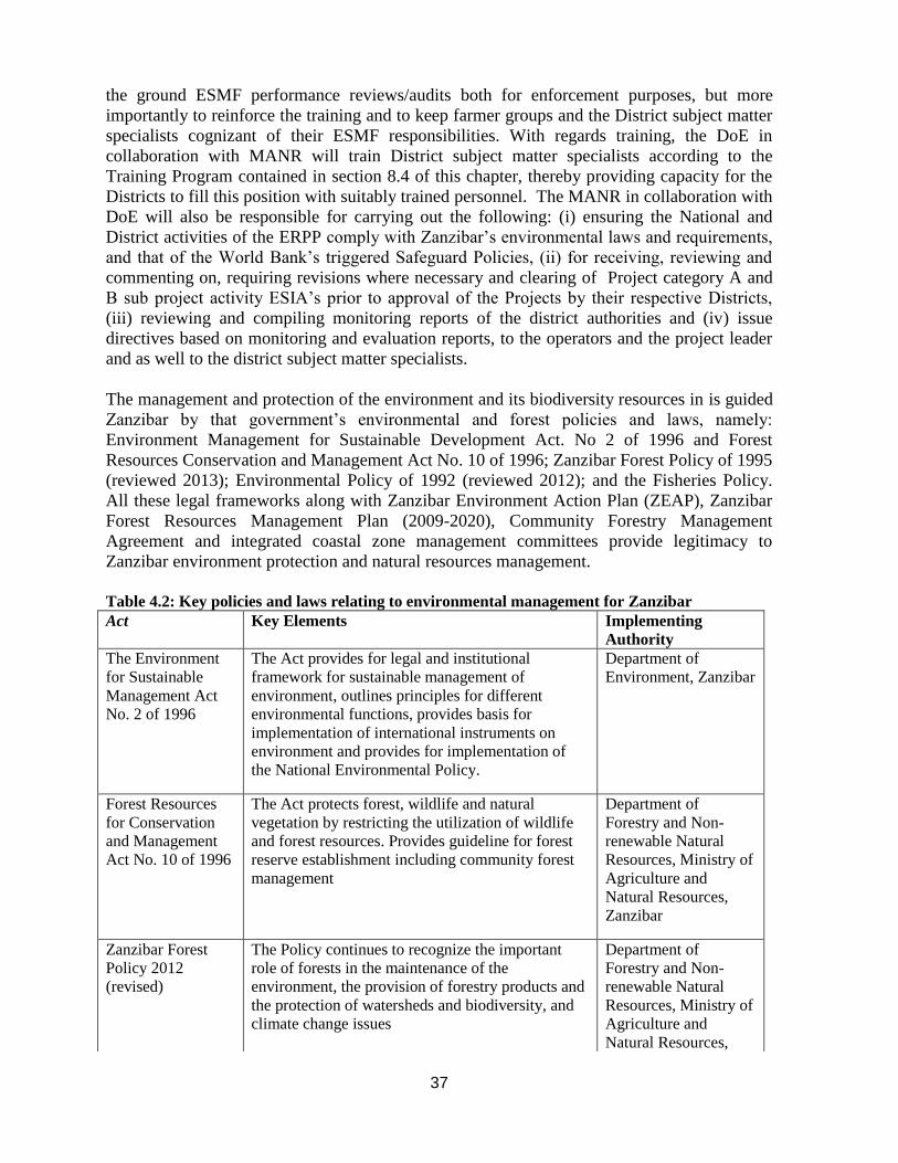
37
the ground ESMF performance reviews/audits both for enforcement purposes, but more
importantly to reinforce the training and to keep farmer groups and the District subject matter
specialists cognizant of their ESMF responsibilities. With regards training, the DoE in
collaboration with MANR will train District subject matter specialists according to the
Training Program contained in section 8.4 of this chapter, thereby providing capacity for the
Districts to fill this position with suitably trained personnel. The MANR in collaboration with
DoE will also be responsible for carrying out the following: (i) ensuring the National and
District activities of the ERPP comply with Zanzibar’s environmental laws and requirements,
and that of the World Bank’s triggered Safeguard Policies, (ii) for receiving, reviewing and
commenting on, requiring revisions where necessary and clearing of Project category A and
B sub project activity ESIA’s prior to approval of the Projects by their respective Districts,
(iii) reviewing and compiling monitoring reports of the district authorities and (iv) issue
directives based on monitoring and evaluation reports, to the operators and the project leader
and as well to the district subject matter specialists.
The management and protection of the environment and its biodiversity resources in is guided
Zanzibar by that government’s environmental and forest policies and laws, namely:
Environment Management for Sustainable Development Act. No 2 of 1996 and Forest
Resources Conservation and Management Act No. 10 of 1996; Zanzibar Forest Policy of 1995
(reviewed 2013); Environmental Policy of 1992 (reviewed 2012); and the Fisheries Policy.
All these legal frameworks along with Zanzibar Environment Action Plan (ZEAP), Zanzibar
Forest Resources Management Plan (2009-2020), Community Forestry Management
Agreement and integrated coastal zone management committees provide legitimacy to
Zanzibar environment protection and natural resources management.
Table 4.2: Key policies and laws relating to environmental management for Zanzibar
Act Key Elements Implementing
Authority
The Environment
for Sustainable
Management Act
No. 2 of 1996
The Act provides for legal and institutional
framework for sustainable management of
environment, outlines principles for different
environmental functions, provides basis for
implementation of international instruments on
environment and provides for implementation of
the National Environmental Policy.
Department of
Environment, Zanzibar
Forest Resources
for Conservation
and Management
Act No. 10 of 1996
The Act protects forest, wildlife and natural
vegetation by restricting the utilization of wildlife
and forest resources. Provides guideline for forest
reserve establishment including community forest
management
Department of
Forestry and Non-
renewable Natural
Resources, Ministry of
Agriculture and
Natural Resources,
Zanzibar
Zanzibar Forest
Policy 2012
(revised)
The Policy continues to recognize the important
role of forests in the maintenance of the
environment, the provision of forestry products and
the protection of watersheds and biodiversity, and
climate change issues
Department of
Forestry and Non-
renewable Natural
Resources, Ministry of
Agriculture and
Natural Resources,

38
Zanzibar
Fisheries Policy The Policy is responsible for marine environmental
management. It has acknowledge issues related to
environment as sustainable fishing practices;
control of destructive fishing gear; sustainable
utilization of offshore resources; and increasing
environmental conservation awareness among
fishermen
Department of
Fisheries and Marine
Product, Ministry of
Fisheries and
Livestock, Zanzibar
Zanzibar
Agricultural Policy
The policy recognizes that environmental
degradation is an issue of major concern in
agricultural development; is mainly attributed to
lack of public awareness on the preservation and
conservation of environment. Other attributed
factors include the rate of population growth and
density; and use of dangerous agro-chemicals and
pesticides in agricultural activities. The policy
recognizes that environmental protection is a
prerequisite management tool for maximum
achievement of sustainable agricultural production.
The policy recommends the establishment of a
special unit to co-ordinate proper mainstreaming of
environmental norms into agricultural development
activities.
Department of
Agriculture, Ministry
of Agriculture and
Natural Resources,
Zanzibar
The District and
Town Councils Act
no.4 of 1995,
Zanzibar
Local Authorities are empowered to take all
necessary measures for the prevention of soil
erosion and the protection of crops; to monitor or
regulate the use of any agricultural land as defined
and allocated under the land use plan; prescribe
steps to be taken by the occupier of any agricultural
land for the purposes of maintaining and improving
its productivity and preserving the fertility of the
soil; and require adult resident of the area, who
occupy agricultural land in accordance with
customary law to cultivate that land and other
residents to take measures to require and cultivate
land subject to the laws of the Council
District Councils,
Zanzibar
Local Government
Policy, Zanzibar
The policy recognizes essential linkages between
the local communities and environmental protection
and ensures sustainable use of the country’s limited
carrying capacity in the exploitation of natural
resources. The policy outlines the roles and
mandate of local authority and community relating
to the protection and conservation of environment
and natural resources; it supports the establishment
of community groups that will be engaged in
environmental management programmes such as
waste management and environmental education.
Local Authorities,
Zanzibar
Plant Protection The Act prohibits importation of any plant material, Plant Protection
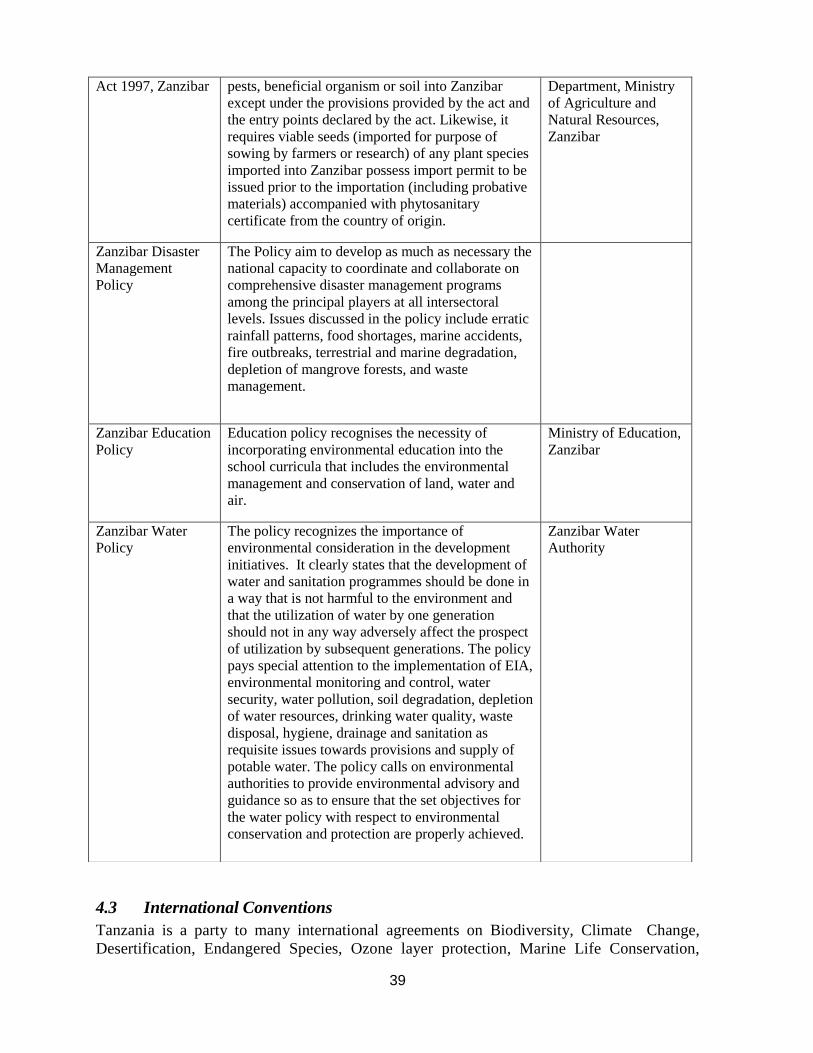
39
4.3 International Conventions
Tanzania is a party to many international agreements on Biodiversity, Climate Change,
Desertification, Endangered Species, Ozone layer protection, Marine Life Conservation,
Act 1997, Zanzibar pests, beneficial organism or soil into Zanzibar
except under the provisions provided by the act and
the entry points declared by the act. Likewise, it
requires viable seeds (imported for purpose of
sowing by farmers or research) of any plant species
imported into Zanzibar possess import permit to be
issued prior to the importation (including probative
materials) accompanied with phytosanitary
certificate from the country of origin.
Department, Ministry
of Agriculture and
Natural Resources,
Zanzibar
Zanzibar Disaster
Management
Policy
The Policy aim to develop as much as necessary the
national capacity to coordinate and collaborate on
comprehensive disaster management programs
among the principal players at all intersectoral
levels. Issues discussed in the policy include erratic
rainfall patterns, food shortages, marine accidents,
fire outbreaks, terrestrial and marine degradation,
depletion of mangrove forests, and waste
management.
Zanzibar Education
Policy
Education policy recognises the necessity of
incorporating environmental education into the
school curricula that includes the environmental
management and conservation of land, water and
air.
Ministry of Education,
Zanzibar
Zanzibar Water
Policy
The policy recognizes the importance of
environmental consideration in the development
initiatives. It clearly states that the development of
water and sanitation programmes should be done in
a way that is not harmful to the environment and
that the utilization of water by one generation
should not in any way adversely affect the prospect
of utilization by subsequent generations. The policy
pays special attention to the implementation of EIA,
environmental monitoring and control, water
security, water pollution, soil degradation, depletion
of water resources, drinking water quality, waste
disposal, hygiene, drainage and sanitation as
requisite issues towards provisions and supply of
potable water. The policy calls on environmental
authorities to provide environmental advisory and
guidance so as to ensure that the set objectives for
the water policy with respect to environmental
conservation and protection are properly achieved.
Zanzibar Water
Authority

40
wetlands etc. Examples are:
• Basel Convention on the Control of Transboundary Movements of Hazardous
Wastes and their Disposal (1989)
• Convention Concerning the Protection of the World Cultural and Natural
Heritage, Paris (1972)
• Development, Production and Stockpiling of Bacteriological ( Biological) and
Toxin Weapons, and their Destruction, London (1972)
• Convention on Biological Diversity
• Convention on International Trade in Endangered Species of Wild Fauna and
Flora (CITES) (1973)
• Convention on the Ban of the Import into Africa and the
Control of Transboundary Movement and Management of Hazardous
Wastes Within Africa, Bamako, Mali (1991)
• UN Convention to Combat Desertification in Countries Experiencing Serious
Drought and/or Desertification particularly in Africa (1994)
• Lusaka Agreement on Co-operative Enforcement Operations Directed at illegal
Trade in Wild Fauna and Flora (1994)
• Montreal Protocol on Substances that Deplete the Ozone Layer (1987)
• Phyto-sanitary Convention for Africa, Kinshasa (1967)
• UN Convention on the Law of the Sea (1982)
• UN Framework Convention on Climate Change (UNFCCC) adopted in May,
1992; signed by Tanzania on 12 June, 1992, ratified by Tanzania on 1 march
1996
• Vienna Convention for the Protection of the Ozone Layer, adopted on 16
September 1987. Acceded to by Tanzania on 16 April 1993
• Ramsar convention on Wetlands (1971)
• United Nations Framework Convention on Climate Change (1994)
4.4 World Bank Safeguards Policies
The Project has been assigned an EA category B due to the overall low to moderate risk
stemming from the small-scale nature of most project investments including the limited
expansion of irrigated area. All World Bank Safeguards Policies and their applicability for
this project are listed in the table below.
Table 4.2: World Bank Safeguards Policies and their Applicability
Safeguard Policies Applicable
Environmental Assessment OP/BP 4.01 Yes
Natural Habitats OP/BP 4.04 Yes
Forests OP/BP 4.36 No
Pest Management OP/BP 4.09 Yes
Physical Cultural Resources OP/BP 4.11 No
Indigenous Peoples OP/BP 4.10 No

41
Involuntary Resettlement OP/BP 4.12 Yes
Safety of Dams OP/BP 4.37 No
Projects on International Waterways OP/BP 7.50 No
Projects in Disputed Areas OP/BP 7.60 No
A complete description of the bank safeguards and their triggers for applicability can be
found on the World Bank’s official web site: http//www.worldbank.org/.
Environmental Assessment (OP/BP 4.01)
This policy requires an Environmental Assessment (EA) of projects/programs proposed for
Bank financing to help ensure that they are environmentally sound and sustainable, and thus
improve decision making. The EA is a process whose breadth, depth, and type of analysis
depend on the nature, scale, and potential environmental impact of the proposed investments.
The EA process takes into account the natural environment (air, water, and land); human
health and safety; social aspects; and transboundary and global environmental aspects.
The environmental and social impacts of the ERPP are envisaged to come from the project
activities and investments contained in the irrigation schemes and construction of marketing
infrastructure / warehouses which will receive financing under the Project. Therefore, the EA
process calls for the GoT to prepare an Environmental and Social Management Framework
(ESMF) report, which will establish a mechanism to determine and assess future potential
environmental and social impacts during implementation of the Project activities and
investments contained in the approved ERPP. The ESMF will also set fourth mitigation,
monitoring and institutional measures to be taken during implementation of these activities, to
eliminate adverse environmental and social impacts, offset them, or reduce them to acceptable
levels.
The policy further calls for the ERPP as a whole to be environmentally screened to determine
the extent and type of the EA process. The ERPP has thus been screened and assigned an EA
Category B. This category of projects/programs is defined as follows:
Category B projects are likely to have potential adverse environmental impacts on human
populations or environmentally important areas – including wetlands, forests, grasslands, and
other natural habitats – and are less adverse than those of category A projects. These impacts
are site specific, few if any of them are irreversible, and in most cases mitigation measures
can be designed more readily than for category A projects. The EA process for category B
projects examines the potential negative and positive environmental impacts and recommends
any measures needed to prevent, minimize, mitigate, or compensate for adverse impacts and
improve environmental performance. Therefore, this ESMF sets out the environmental and
social review and mitigation strategies to be implemented under the ERPP. This process
requires the implementer of the activities in the ERPP, namely the District Environmental
Management Officer (DEMO), to complete the environmental and social screening form
(Annex D) to all proposed sub-projects in order to clarify if the sub-project can be approved
for financing under the ERPP as well as to determine the scope of environmental assessment.
Chapter 6 sets out the relevant process requirements for environmental and social
management.
42
Natural Habitats (OP/BP 4.04)
The envisaged expansion of irrigation investments in the Kilombero Valley potentially
threatens the availability of water for the ecosystem. Abstraction of water may reduce
environmental flow in rivers and wetlands and negatively affect biodiversity. Multiple
studies are evaluating water availability including Environmental Flow Assessment in the
larger Rufiji River Basin, and the growing competition for water use. The River Basin
Authority is being strengthened to better measure and manage this competition.
In the long run, application of large quantities of agro-chemicals in smallholder farming
systems with limited environmental literacy may potently lead to development of pesticide
resistant pest species, upsurge of traditionally minor pests, and potential elimination of useful
fauna and flora species. Exposure to these substances can also affect human health through
entry of chemical residues into the food chains creating food and environmental safety
issues. Natural Habitats issues will be addressed as part of the environmental assessment.
Pest Management (OP/BP 4.09)
The Bank encourages the use of various means to assess pest management in the country and
support Integrated Pest Management (IPM) and the safe use of agricultural pesticides:
economic and sector work, sectoral or project-specific environmental assessments,
participatory IPM assessments, and adjustment or investment projects and components
aimed specifically at supporting the adoption and use of IPM. In World Bank-financed
agriculture operations, pest populations are normally controlled through IPM approaches,
such as biological control, cultural practices, and the development and use of crop varieties
that are resistant or tolerant to the pest.
An IPMP is a comprehensive plan, developed when there are significant pest management
issues such as: (a) new land-use development or changed cultivation practices in an area; (b)
significant expansion into new areas; (c) diversification into new crops in agriculture; (d)
intensification of existing low-technology systems; (e) proposed procurement of relatively
hazardous pest control products or methods; or (f) specific environmental or health concerns
(e.g. proximity of protected areas or important aquatic resources; worker safety). An IPMP is
also developed when proposed financing of pest control products represents a large
component of the project. A pest management plan reflects the policies set out in OP 4.09,
Pest Management. The plan is designed to minimize potential adverse impacts on human
health and the environment and to advance ecologically based IPM.
The ERPP will partially finance the purchase of agricultural inputs including seed (some
treated with pesticide), chemical fertilizer and herbicide. Therefore, the provisions of OP
4.09 are being triggered so that best practice methodologies in this field become part of the
implementation activities of the ERPP. Correspondingly, the GoT has prepared an Integrated
Pest Management Plan (IPMP), which will be approved and disclosed along with this ESMF
and the RPF prior to project appraisal.
The IPMP has the following objectives:
o To enhance capacity of the program beneficiaries (individual farmers) to use
pesticides in an economic and safe way (ensuring that banned pesticides or

43
agrochemicals in WHO classes IA, IB and II will not be acquired by farmers), and
introduce them to Integrated Pest Management (IPM) approach or concept for which
technical capacity will be established in the program.
o Identify key strategic and institutional issues at the national and local government levels,
in order to promote movement towards the development and implementation of a pest
management policy.
The first component of the plan is the presentation of an initial reconnaissance to identify the
main pest problems and their contexts (ecological, agricultural, public health, economic, and
institutional) and to define a baseline. The second component specifies procedures for
screening pest control products and then develops specific operational plans to address the
pest problems identified. The IPMP also encompasses pest control product screening
procedures.
Involuntary Resettlement (OP/BP 4.12)
This policy would be triggered when a program activity, for instance in this case a farmer
groups irrigation sub-project, causes the involuntary taking of land and other assets resulting
in: (a) relocation or loss of shelter, (b) loss of assets or access to assets, (c) loss of income
sources or means of livelihood, whether or not the affected persons must move to another
location.
The district, division, ward, village / shehia individual farmers and farmer groups as
implementers of the ERPP will make every possible effort to avoid impacts on people, land,
property, including people’s access to natural and other economic resources, as far as
possible. Most of the improvements in irrigated systems under the project involve
rehabilitation of schemes and limited expansion of formal irrigated systems where inform
irrigation had been previously practiced. The amount of resettlement executed is expected to
be small and mostly limited to a few schemes with more significant expansion. Nonetheless,
the implementation teams will need to carefully assess any loss or reallocation of property
rights associated with the ERPP investments. OP 4.12 will be triggered in those cases.
OP 4.12, in most cases, is not triggered because people are being affected by physical
displacement. It is triggered because the program activity causes land acquisition, whereby a
physical piece of land is needed and people may be affected because they are cultivating on
that land, they may have buildings on the land, they may be using the land for water and
grazing of animals or they may otherwise access the land economically, spiritually or any
other way which may not be possible during and after the sub project is implemented.
Therefore, people are in most cases compensated for their loss (of land, property, livelihood or
access) either in kind or in cash.
A Resettlement Policy Framework (RPF) originally prepared for ASDP has been updated in
line with ERPP by the government and will be submitted to the Bank for approval in
compliance with OP/BP 4.12. The RPF will set out guidelines for the preparation of
Resettlement Action Plans (RAPs) if the need for any resettlement is found. The RAPs will be
prepared by an external consultant and will have to be submitted to the District, Regional and
Zonal offices for approval. The World Bank reserves the right to also approve any RAP as a
condition for that particular project investment to be financed under the ERPP in both

44
Mainland and the islands of Zanzibar. Where there is a conflict between the Laws of Tanzania
and the Bank OP4.12, the latter must take precedence if the Bank is to fund the ERPP.
A summary of the required actions for each of the safeguards policies triggered by the Project
is provided in the table below (see Annex C for more details).
Table 4.3: Summary of Requirements of World Bank Safeguards Policies Triggered by the
ERPP
Bank Safeguards
Policy Triggered
Action Required by
Triggered Policy
By Whom Date action required by
OP 4.01
Environmental
Assessment
Preparation of ESMF
GoT and RGZ Approved by MAFC and
MANR of the URT and
the World Bank and
disclosed in Tanzania and
World Bank InfoShop
prior to project appraisal.
OP 4.04
Natural Habitat
No specific document is
required. Natural Habitats
issues will be addressed as
part of the sub-project
PESIA/ESMP.
Sub-project
implementing entity
Prior to sub-project
approval.
OP 4.09 Pest Management
1. Preparation of IPMP
2.
GoT and RGZ
Approved by MAFC and
MANR of the URT and
the World Bank and
disclosed in Tanzania and
World Bank InfoShop
prior to project appraisal.
OP 4.12 Involuntary
Resettlement
Preparation of RPF
3.
GoT and RGZ
Approved by Ministry of
Lands and Human
Settlement and by the
World Bank and disclosed
in Tanzanian Mainland
and Zanzibar and the
World Bank InfoShop
before project appraisal.

45
5. IMPACT EVALUATION OF THE PROJECT
The overall objective of the ERPP is to increase rice produced and marketed in the Morogoro
Region of Tanzania Mainland and Zanzibar, leading to improved rural incomes and food
security. However, the Project might also lead to some negative environmental and social
impacts. This chapter describes such potential impacts and propose mitigation measures in
order to eliminate or offset these impacts or to reduce them to acceptable levels.
5.1 Potential Environmental and Social Impacts
The two main sets of risks relate to the competitive demands for irrigation water, and to the
possible environmental impacts of expanding use of agro-chemicals used in the irrigated
farming systems. There is growing competition for limited water resources in the Morogoro
region of mainland Tanzania. This Region encompasses or borders some of the uniquely
diverse agro-ecologies in the world, including national parks, wildlife management areas and
a Ramsar site. The expansion of irrigation investments potentially threatens the availability of
water for wildlife and as well as for household use and hydroelectricity. The drying of rivers
and wetlands reduces biodiversity. Multiple studies are evaluating water availability in the
larger Rufiji River Basin, and the growing competition for water use. The River Basin
Authority is being strengthened to better measure and manage this competition. On Zanzibar,
the limited information available suggests the need to better manage what water resources are
available. In either case, strong environmental assessments are required to assure the Project
investments do not threaten degradation and to assure continuing protection of critical
biodiversity.
The expanding use of agro-chemicals fostered by this project aims to improve the productivity
of local rice production, but creates substantial risks to the wider environment. These include
risks to neighboring wetlands resulting from agro-chemical run-off, risks of building
resistances to pesticides, and risks to human health resulting from the mis-use of these
pesticides, or improper storage and disposal.
The National Environment Policy (NEP) identifies the following as the critical environmental
problems facing Tanzania today:
i) Land Degradation
ii) Lack of accessible, good quality water for both urban and rural inhabitants
iii) Environmental Pollution, e.g. Water Contamination, sewerage disposal, industrial
spilage
iv) Loss of Biodiversity, Habitat and Wetlands
v) Deterioration of Aquatic Systems
vi) Deforestation
vii) Bush fire
Table 5.1 below lists the potential environmental and social impacts arising from the various
types of ERPP sub-projects.

46
Table 5.1: ERPP Potential Environmental and Social Impacts and Risk Categorization
ERPP Type of
Sub-Project
Potential Environmental and
Social Impacts
Mitigation Measures Likely Risk
Category
Responsible
Agency
Rehabilitation
and
expansion of
irrigation
schemes
Water extraction in relation
to permits and rights of
downstream users;
Water pollution and water
quality;
Involuntary resettlement or
loss of /access to land/assets;
Waste management during
construction;
Water borne diseases due to
poor management of
irrigation water
Agro-chemical usage in the
scheme (see below)
Confirm permits; monitor
drainage in sensitive ecologies
Monitor inflow and outflow
Resettlement Action Plan (RAP)
if necessary. Key provisions
include: land-for-land
compensation; compensation for
structures and assets; and, a
disturbance allowance
TOR for construction requires
Waste Management Plan. Key
provisions include: Control and
daily cleaning at construction
sites; provision of adequate waste
disposal services. Proper disposal
of chemicals and other hazardous
materials; dust control by water,
appropriate design and siting,
restrict construction to certain
times; and, appropriate and
suitable storage of building
materials on site.
Farmer training on management
of irrigation water
B – if
expansion
C- if only
rehabilitation
MAFC/MANR-
DPPR
MAFC/DoI
MAFC/MANR/
MOL
MAFC/MANR
DITS, EMU
and LGAs/DoI
Construction of
warehouses Involuntary resettlement or
loss of /access to land/assets;
Waste management during
construction;
Resettlement Action Plan (RAP)
if necessary (see above)
TOR for construction requires
Waste Management Plan (see
above)
B – if
resettlement
C- without
resettlement
MAFC/MANR/
MOL
MAFC/MANR
Rehabilitation
of rural road Involuntary resettlement or
loss of /access to land/assets;
Waste management during
construction;
Resettlement Action Plan (RAP)
if necessary (see above)
TOR for construction requires
Waste Management Plan (see
above)
B – if
resettlement
C- without
resettlement
MAFC/MANR/
MOL
MAFC/MANR
Agro-chemical usage

47
Use of inorganic
fertilizers and
pesticides
(herbicides,
insecticides,
fungicides,
rodenticides)
Water contamination with
agro-chemical residues
(fertilizer, residues)
Human health impacts if
unsafe application/usage and
handling (transportation,
storage, disposal)
Training of farmers in the safe
use, handling and disposal of
inorganic fertilizer and pesticides
(esp. insecticide and herbicide)
and Integrated Pest Management
Assist farmers to develop and/or
implement Environmental and
Social Management Plans
(ESMP) for the schemes
Conduct refresher training for
village level extension agents on
IPM and safe use of agro
chemicals
Monitor quality of water runoff
from irrigation schemes
Establish monitoring and
warning system for pest outbreak
(for armyworm and edible
grasshopper in Zanzibar)
C DITS, EMU and
LGAs/DADO
SMS-Env. &
DADO/ EMU,
DITS, LGAs
DITS, EMU and
LGAs/DADA
DITS, EMU and
LGAs/DoI
DITS, EMU and
LGAs
5.2 Potential Environmental Concerns for the ERPP
Land Degradation – Rain fed agriculture and livestock grazing are the most widespread land
uses in Tanzania and these activities are potentially associated with serious and accelerating
environmental degradation. Degradation in this sense means a diminution of the biological
productivity expected of a given tract of land being used in a particular way. On a farm it may
be reflected in lower crop yields, on a savannah in fewer livestock units and in a nature
reserve in fewer plant and animal species. The soil on degraded lands is typically
impoverished or eroded, there is less water available due to increased surface runoff or
contamination, plant and animal productivity is lower, and wildlife less diverse.
Soil erosion impacts may include a dramatic increase in the frequency and intensity of floods
and droughts, habitat damage related to sedimentation impacts downstream and disruption of
natural ground water recharging. Degradation on arid, semi-arid and sub humid lands leads to
desertification, as desert like conditions appear when none existed before.
There are relatively few hard data measuring the extent of degraded land in Tanzania, but the
anecdotal evidence supporting accelerated deterioration in land productivity is compelling.
The most significant causes are deforestation, cultivation of unsuitable marginal lands,
inappropriate or excessive use of agricultural technologies and chemicals, over-grazing and
poor management of cultivated land, often exacerbated by drought.
Soil erosion harms productivity by depositing silt in irrigation systems and river transport
channels, and by damaging fisheries resulting in increased deficits in food production,
declining food security, and an increase in poverty.

48
General Water Stress – In some areas, drought, a shortage of potable water, increased
water demand for agricultural, energy and industrial purposes is leading to a critical water
stress situation. Management of water rights issues among and between formal and informal
users will continue to be particularly challenging if irrigation is significantly scaled up. Better
management is required to reduce conflict between users, ensure water and riparian rights are
respected and preserve ecosystems sustainability. Excessive water use for agriculture can
result in loss of biodiversity or conversion from wetlands to agricultural land.
Point and Non-point Pollution of Water Sources can affect water quality which in turn
affects aquatic life (leading to fish loss); affects human health due to water borne diseases;
and loss of livelihood for those communities who depend on these basins. The main threats to
basin wide water quality are insufficiently treated domestic, urban and industrial wastes and
irrigation drainage water, and non-point source pollution from pesticide and fertilizer residues.
To achieve a wider and deeper understanding of these and with the ultimate goal of ensuring a
more informed policy and planning decision-making process, the GoT through MAFC
supported by the NEMC has undertaken a Strategic Environmental and Social Assessment
(SESA) of the National Irrigation Master Plan in 2011.
Wetland Degradation – Agriculture (especially rice farming) is rapidly expanding in the
most wetland areas of Tanzania. Dependence on soil moisture in the wetland soils for crop
growing becomes an important element for food security and household income in the
regions. But also, green pastures and water for livestock can only be obtained in wetlands
during dry season. The quantity and diversity of various resources located in wetlands,
including water resources, soil fertility and land itself, fish and forest products have been
declining with time as a result of changing environment and over-use of resources due to
increased human demand.
The Kilombero Valley Floodplain Ramsar Site in Morogoro where the ERPP Sub Projects are
also going to be implemented is of global, national, regional and local importance in terms of
its ecology and biodiversity. The valley supports high concentrations of large mammals,
especially Puku antelope Kobus vardoni (with nearly 75% of the world population) and is a
key feature in the Selous-Kilombero seasonal wildlife migrations.
Sustainable Wetland Management and maintenance of ecological balance in this wetland is
essential and its utilization must be properly managed. Interventions are necessary to protect
the Ramsar Site against degradation and pollution.
Climate change – The agricultural sector is highly vulnerable to climate change impacts in
Tanzania. Higher temperatures can reduce yields of desirable crops. Rising temperatures can
promote weed and pest proliferation. Greater variation in precipitation patterns increase the
likelihood of short-run crop failures and long-run production declines. Although there will be
gains in some crops in some regions of the country, the overall impacts of climate change on
agriculture are expected to be negative, threatening food security.
Existing strategies including the National Climate Change Strategy aim most directly at
climate adaptation, and focus largely on increasing adaptation to drought. Drought-resistant
crops are perceived in policies as a principal means of addressing problems related to climate

49
variability and drought in particular. Promotion of such species should be integrated into
national and district development policies, multi-sectoral policies, and sectoral policies in
Tanzania.
5.3 Potential Social Concerns for the ERPP
Involuntary resettlement or loss of /access to land/assets: As a consequence of the
project’s support to undertake expansion of irrigation schemes, construction of warehouses,
and rehabilitation of rural roads some local communities may be involuntary resettled or
experience loss of access to land and/or natural resources. This can potential have
significant adverse impacts on the livelihoods and economic situation of such local
communities. This impact will be addressed through the RPF and the preparation of sub-
project specific RAPs that includes the specific mitigation measures and compensation
schemes to be implemented for sub-projects that triggers the World Bank’s OP 4.12
Involuntary Resettlement.
Gender Issues: Women are often poorer than men, own less land and livestock, have fewer
years of schooling and have the responsibility of sourcing and providing the household
energy and growing the main subsistence crops (hence responsible for households food
security).Therefore, women need an equal seat at the empowerment table. Gender imbalances
are rooted and sustained by traditional and cultural values. A gender committee has been
created to ensure that sectoral investments respond to the priority needs of both men and
women. The new land legislation has represented an encouraging step towards securing the
right of women to own, dispose of and inherit land.
Additionally, all stakeholders within the ERPP need to participate and take deliberate
sensitization actions to encourage women participation in agriculture related education,
training, programs and projects, planning, decision-making and, not least, policy
implementation. Thus during the implementation of the ERPP, the following should be
supported:
i. To promote gender equality within the participatory planning, implementation and
operations of the project
ii. To facilitate education and training for women in all ERPP components and
activities.
iii. To promote awareness on gender issues concerning men and women’s social roles
in the agriculture sector, including training on appropriate technologies.
iv. To promote awareness and advocacy on gender issues in the agriculture sector.
Inclusiveness: Exclusion of vulnerable groups from participating in and benefiting from
program activities, i.e., from barriers to access due to stigmatization, harmful cultural
practices, acute poverty among vulnerable groups, discrimination, lack of participation in the
planning process etc.
Lack of access to social services and credit: Very limited and often too distant access to
health care, schools, potable water, feeder roads, etc. Most smallholder farmers in the project
area lack access to credit to expand their businesses.

50
The environmental and social screening form and checklist contained in the attached Annex
C and F are specifically designed to ensure that adverse social impacts from ERPP
activities are identified and captured in the planning stages and there-in effectively
mitigated. Both environmental and social mitigation measures would be verifiable monitored
during the project implementation.
51
6. ENVIRONMENTAL AND SOCIAL MANAGEMENT
This chapter discusses the institutional roles and responsibilities of environmental and social
safeguards management during the project implementation and describes the steps involved
in the environmental assessment process and procedure leading to the review and approval
of sub-projects under ERPP.
6.1 Project Management Setup
The project will be implemented under the authority of the MAFC of the Tanzania Mainland
and the MANR of Zanzibar, with full use of government systems for activity management,
procurement, financial management, monitoring and evaluation. The details of these
arrangements are provided in the Project Implementation Manual.
Tanzania Mainland
The day to day implementation of the project will be overseen by a designated task team
composed of the following staff members:
i) a team leader with overall managerial responsibility for those components of
the project implemented;
ii) a seed specialist with oversight responsibility for the work plans, budgets and
implementation progress of subcomponent 1;
iii) an irrigation specialist with oversight responsibility for the work plans,
budgets and implementation progress of sub-component 2.1;
iv) a crop management specialist with oversight responsibility for the work plans,
budgets and implementation progress of sub-component 2.2; a marketing
specialist with oversight responsibility for the work plans, budgets and
implementation progress of component 3;
v) a monitoring and evaluation specialist responsible for quarterly and annual
technical progress reports;
vi) a procurement specialist responsible for the efficiency and timeliness of
project procurement;
vii) a financial management specialist responsible for tracking the project
accounts and associated reporting; and
viii) a safeguards specialist responsible for ensuring that overall safeguards
management monitoring and documentation is in line with the procedures
described in this ESMF as well as the EMA.
The responsible departments will work closely with counterparts at regional and district level
for the delivery of results. At the local level implementation will be under the District
Agriculture Irrigation and Cooperative Officer (DAICO), who falls under the supervision of
the District Executive Director (DED). This officer will be backed by the Zonal Irrigation
and Technical Support Units (ZITUS) in scheme design, supervising rehabilitation works,

52
and training of Irrigator Organizations (IO). At the village/scheme level, implementation of
the day to day activities of will be the responsibility of Irrigator Organizations (IO) and local
extension staff, backed by professional managers hired in conjunction with the BRN
initiative.
Zanzibar
Implementation of the project on Zanzibar will be similarly overseen by a designated task
team composed of the following staff members:
i) a team leader with overall managerial responsibility for those components of
the project implemented on the islands;
ii) a seed specialist with oversight responsibility for the work plans, budgets and
implementation progress of subcomponent 1;
iii) an irrigation specialist with oversight responsibility for the work plans,
budgets and implementation progress of sub-component 2.1;
iv) a crop management specialist with oversight responsibility for the work plans,
budgets and implementation progress of sub-component 2.2;
v) a monitoring and evaluation specialist responsible for quarterly and annual
technical progress reports;
vi) a procurement specialist responsible for the efficiency and timeliness of
project procurement;
vii) a financial management specialist responsible for tracking the project
accounts and associated reporting; and
viii) a safeguards specialist responsible for ensuring that overall safeguards
management, monitoring and documentation is in line with the procedures
described in this ESMF as well as the EMA and the SMA/environmental
management for sustainable development Act No. 2 0f 1996.
During the first three years of implementation, this team will be backed by a temporary set of
technical consultants hired to provide early guidance in project management, and build
government staff capabilities. These include a financial management specialist, a
procurement specialist, a monitoring and evaluation specialist, and safeguards specialist.
At the local level, project implementation will be guided by Local Government Authorities
(LGA) working through the District Agricultural Offices. Each district will be responsible for
procurement, contract administration, supervision of project activities, and reporting on
progress for sites under its jurisdiction.
The Project is aligned to the Sector Wide Approach (SWAp) in the agriculture sector created
under the auspices of the initial phase of the ASDP. Correspondingly, the Project will use the
ASDP Steering Committee (SC) for management and budgetary oversight.
Implementation in Zanzibar will be similarly let by a designated coordinator, backed by an
identified team of seed, irrigation and crop management specialists all seconded to the
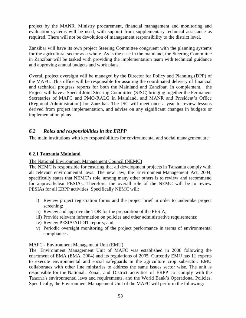
53
project by the MANR. Ministry procurement, financial management and monitoring and
evaluation systems will be used, with support from supplementary technical assistance as
required. There will not be devolution of management responsibility to the district level.
Zanzibar will have its own project Steering Committee congruent with the planning systems
for the agricultural sector as a whole. As is the case in the mainland, the Steering Committee
in Zanzibar will be tasked with providing the implementation team with technical guidance
and approving annual budgets and work plans.
Overall project oversight will be managed by the Director for Policy and Planning (DPP) of
the MAFC. This office will be responsible for assuring the coordinated delivery of financial
and technical progress reports for both the Mainland and Zanzibar. In complement, the
Project will have a Special Joint Steering Committee (SJSC) bringing together the Permanent
Secretaries of MAFC and PMO-RALG in Mainland, and MANR and President’s Office
(Regional Administration) for Zanzibar. The JSC will meet once a year to review lessons
derived from project implementation, and advise on any significant changes in budgets or
implementation plans.
6.2 Roles and responsibilities in the ERPP
The main institutions with key responsibilities for environmental and social management are:
6.2.1 Tanzania Mainland
The National Environment Management Council (NEMC)
The NEMC is responsible for ensuring that all development projects in Tanzania comply with
all relevant environmental laws. The new law, the Environment Management Act, 2004,
specifically states that NEMC’s role, among many other others is to review and recommend
for approval/clear PESIAs. Therefore, the overall role of the NEMC will be to review
PESIAs for all ERPP activities. Specifically NEMC will:
i) Review project registration forms and the project brief in order to undertake project
screening;
ii) Review and approve the TOR for the preparation of the PESIA;
iii) Provide relevant information on policies and other administrative requirements;
iv) Review PESIA/AUDIT reports; and
v) Periodic oversight monitoring of the project performance in terms of environmental
compliances.
MAFC - Environment Management Unit (EMU)
The Environment Management Unit of MAFC was established in 2008 following the
enactment of EMA (EMA, 2004) and its regulations of 2005. Currently EMU has 11 experts
to execute environmental and social safeguards in the agriculture crop subsector. EMU
collaborates with other line ministries to address the same issues sector wise. The unit is
responsible for the National, Zonal, and District activities of ERPP t o comply with the
Tanzania’s environmental laws and requirements, and the World Bank’s Operational Policies.
Specifically, the Environment Management Unit of the MAFC will perform the following:

54
i) Ensure that the project complies with the requirements of this ESMF;
ii) Supervise preparation of project brief and PESIA registration forms;
iii) Supervise and coordinate preparation of the scoping report and preparation of the
Terms of Reference for PESIA/AUDIT by environmental/audit experts;
iv) Monitoring and follow up on the implementation of the project environmental and
social mitigation measures;
v) Collaborate with LGAs to train participating farmers on proper use of fertilizer and
agro chemicals; and
vi) Collaborate with LGAs to train farmers on proper disposal of used pesticide cans and
bags.
District Environmental Coordinator (DEC)
The districts will play a leading role in the environmental management process of sub-
projects. Specifically the DEC will carry out the following tasks:
i) Oversee the preparation of TOR for PESIA and PMP if applicable;
ii) Supervise the public consultation process for PESIAs;
iii) Review and approve sub-projects environmental and social management plan
(ESMP);
iv) Ensuring that mitigation measures in the sub-projects ESMP contained in the cleared
project design package is being sufficiently implemented.
District Environmental Management Officer (DEMO)/Department of Irrigation and
Technical Services (DITS)
The DEMO/DITS will be responsible for complying with all national laws regarding the
environment and with all social/poverty guidelines, parameters and targets set by the GoT,
and of all triggered World Bank Safeguards policies. Specifically the LGAs will perform the
following:
i) Complete and submit the Environmental and Social Screening Form;
ii) Implement sub- project activities according to and consistent with the
provisions of this ESMF and the mitigation measures included in the ESMP;
iii) Ensure that these mitigation measures are complied with during construction and
post construction (i.e. operations ) stages of their activities, by self monitoring
of their activities and by periodically reporting to MAFC and ERPP Task Team
Leader;
iv) Maintain an adequate budget to implement the appropriate mitigation measures
identified in the PESIA and/or ESMP;
v) In collaboration with NEMC coordinate PEIA process at district level;
vi) Be the focal entity for integrating environmental safeguards in the project activities;
vii) Ensure that safeguards in the project activities are adequately integrated in progress
reports of the project implementation;
viii) Collaborate with MAFC/Environment Management Unit to;
Train participating farmers on environmental and social management
challenges; and
Train participating farmers on irrigation water management so as to minimize
incidence water borne diseases
ix) Facilitate resolving any conflict in the community that may arise in the course of
implementation of the ESMP.

55
Farmers/Irrigators Organization
i) Oversee water management within the irrigated area;
ii) Collaborate with other water users associations in the protection of water catchment
areas;
iii) Ensure irrigation committee perform its work effectively;
iv) Adhere to the comprehensive guidelines on irrigation operation and maintenance;
v) Adhere to proper use of fertilizers and other agro chemical; and
vi) Implement the irrigation scheme Environmental Management Plan.
6.2.2 Zanzibar
Ministry of Agriculture and Natural Resources (MANR)
The Ministry of Agriculture and Natural Resources is responsible to ensure social and
environment management are adhered to during the implementation of ERPPactivities. In this
context, its institutions (i) Zanzibar Agricultural Institute Research (ZARI) will collaborate
with District Authorities and Extension staff to train participating farmers on proper use of
fertilizer and agro chemicals so that in the course of use do not harm farmers and
environment; (ii) Department of Irrigation is responsible in training farmers on water borne
diseases associated with irrigation water use and (iii) Plant Protection Division (PPD) will
collaborate with Distinct Authorities and Extension staff to train farmers on proper disposal of
used pesticide cans and bags, and train participating farmers on environmental and social
safeguard issues and mitigation measures.
Local Government Authorities (i.e. District)
The LGA policy recognizes essential linkages between the local communities and
environmental protection to ensure sustainable use in the exploitation of natural resources. It
recognises the roles and mandate of local authority and communities on protection and
conservation of environment and natural resources; and recognition of the establishment of
community groups that will be engaged in environmental management programmes such as
waste management and environmental education.
The Environment Management for Sustainable Development Act No. 2 of 1996 section 106
(2), gives District Environmental Officers an authority to enforce legislation related to the
environment. Likewise, Agricultural Development Officers (DADO) with their counterparts
(i.e. subject matter specialists – forestry, Fisheries and cooperative) have the role to enforce
implementation of environmental legislation while supporting and or implementing strategic
plans from their sectors including related project implemented in their districts. The DADOs
and their counterparts in the course of implementing ERPP sub projects will:
(i) Complying with all national laws regarding the environment and with all social/poverty
guidelines, parameters and targets set by the GoZ and of all triggered World Bank
Safeguards policies,
(ii) to implement their sectoral sub project activities according to and consistent with the
provisions of this ESMF,
(iii) implementing, inter-alia, all appropriate mitigation measures identified in their

56
completed ESIA and/or environmental and social management plan (ESMF),
(iv) to ensure that these mitigation measures are complied with during construction and post
construction (i.e. operations) stages of their activities, by self-monitoring of their activities
and by periodically reporting to their respective Regional Agriculture Development Officer or
respective project leader,
(v) to ensure relevant mitigation measures identified in the ESIA and/or environmental and
social management plan (ESMP) are implemented and sustained in their operation, and
(vi) to comply with any directives that may be issued from time to time from the DoE, ERPP
, MANR, PSC and Regional authorities.
District Level Authorities
Based on ERPP implementation framework, District Agricultural Development Officers
(DADOs) have greater role to play to ensure ERPP activities are well coordinated and
implemented accordingly at district level. This office acts as a link between National, District
and Shehia level authorities. They will implement the project activities under the leadership of
ERPP facilitation team. The DADOs with their supporting team Subject Matter Specialists
(SMS) – environment, forestry, cooperative and lands will be responsible for:
i) Complete and submit the Environmental and Social Screening Form;
ii) Collaborate in PESIA process at district and field levels;
iii) Provide necessary information of the agricultural related district profile needed for the
PESIA process;
iv) Supervise implementation of ESMPs and PMPs including regular site visits;
v) Train participating farmers on environmental and social management challenges;
vi) Train participating farmers on irrigation water management so as to minimize
incidence water borne diseases; and
vii) Facilitate resolving any conflict in the community that may arise in the course of
project implementation.
Shehia Level Governments
The project will be implemented at the ongoing and planned irrigation schemes which are
located at the rural areas where some Shehias have formulated community forestry
management agreement (CoFMA) with the Central Government. For those Shehias with
CoFMA Shehia governments through their Councils are responsible in enforcing environment
management by-laws using Shehia Conservation Committees in order to enhance sustainable
management of natural resources and rural environment. For those Shehias with no
environmental management plans, the Shehia governments are responsible to ensure the
Shehia and or scheme has environmental management plan. At the Shehia level, there will be
also farmers and or water user’s organizations. The farmers and water user organizations
under the leadership of Shehia government and DADOs would have the following
responsibilities:
i) Protect water catchment areas,
ii) Ensure irrigation committee perform its work effectively,
iii) Adhere to the guidelines of environmental and social safeguard issues,
iv) Adhere to proper use of fertilizers and other agro chemical,
v) Follow mitigation measures advises

57
6.3 Capacity Building
In order to ensure successful safeguards management of ERPP sub-projects and
implementation of the ESMF training will be provided to key project stakeholders. In the
initial stage of project implementation two safeguards management start-up workshops (one
in Mainland Tanzania and one in Zanzibar) for all implementing agencies will be held to
discuss and confirm ERPP safeguards procedures, environmental and social management
and monitoring arrangements as well as the ESMF work plan. Moreover, training will be
given to farmers in targeted project areas on environmental and social management
challenges as well as on irrigation water management so as to minimize incidence water
borne diseases (schistosomiasis, malaria, dysentery, etc.). The training program is to be
implemented by the MAFC and MANR in collaboration with National Environment
Management Council and Department of Environment in Zanzibar. Additional training
activities related to pest management are included separately in the IPMP work plan.
It is proposed that the training program will be implemented four times a year, at least once
in each quarter in each participating Region over the first two years of the project cycle. The
budget for this activity will be as per safeguards budget in the PAD with supplementary
budget (token) from the MAFC-Medium Term Expenditure Framework.
EMU will link its synergies with other ongoing and planned programs/projects such as
Southern Agricultural Growth Corridor of Tanzania (SAGCOT), the Third Tanzania Social
Action Fund (TASAF) and Feed the Future (FtF) at the District level and will harmonize
with the similar training programs at district and village levels to support implementation of
ERPP.
6.4 Environmental and Social Assessment Process
The following section sets out the environmental and social assessment and approval
process to be applied on all sub-projects financed under the ERPP. The process complies
with both the World Bank’s Safeguard Policies and Tanzanian EIA regulations and related
guidelines.
This process involves the following four steps:
1. Completion of Environmental and Social Screening Form
2. Preparation of Environmental and Social Requirements
3. Sub-Project Appraisal and Approval
4. Monitoring and Evaluation
Step 1 – Completion of Environmental and Social Screening Form
The aim of the screening process is to: i) assess whether sub-projects are likely to have
potential negative environmental and social impacts; ii) determine the proposed sub-
project’s environmental and social risk level (category); and iii) determine appropriate
extent and type of environmental and social assessment required by the national legislation
and World Bank Safeguards Policies (including preparation of a Resettlement Action Plan
and Pest Management Plan, if applicable).

58
Environmental and social screening for potential sub-project to be financed under the ERPP
will be done by completing the Environmental and Social Screening Form (ESSF) (Annex
D). Based on a visit to the proposed project site and consultation with relevant stakeholders
the DEMO/SMS Environment will complete the ESSF and submit it to the MAFC –
Environmental Management Unit (EMU)/MANR/DoE for review, comments and approval.
The safeguard focal point for the ERPP in the MAFC-EMU/MANR must keep a copy of the
approved ESSF for each sub-project.
The completed ESSF would provide information, which is the basis for classification of
projects under categories B or C depending on the nature, type, scale, location, sensitivity
and magnitude of the potential environmental impact of the sub project. No category A sub-
projects will be financed under the ERPP. Table 5.1 lists the types of sub-projects to be
financed under ERPP including risk categorization. The environmental and social work
required for category B and C sub-project is as follows:
Category B - Moderate environmental and social risk
Project is likely to have some adverse environmental and social impacts but less than
those of category A. Those impacts are site specific and few if any are irreversible and
can be mitigated and managed through the implementation of a set of mitigation
measures as set included in the ESMP. Under this category the preparation of a
Preliminary Environmental and Social Impact Assessment is required (PESIA) (Annex
G)
Category C – Low environmental and social risk
Projects is likely to have minimal or no significant adverse environmental and social
impacts. Under this category the preparation of an Environmental and Social
Management Plan (ESMP) is required (Annex E)
Step 2 – Preparation of Environmental and Social Requirements
Once the ESSF has been approved the DEMO/MANR should initiate the required
environmental and social work (PESIA, ESMP) and RAP, PMP if applicable. The
preparation of the PESIA should be done by an individual consultant and ToR must be
reviewed and approved by NEMC/DoE. The preparation of ESMPs for Category C sub-
projects should be done by the DEMO and the final ESMP should be approved by the
DEC/DoE. The DEMO/DPPR will also oversee the preparation of the PESIA (and RAP,
PMP if applicable).
Public Consultation: According to the Tanzanian Law and World Bank OP4.01, public
consultation is required as part of PESIA and/or ESMP preparation process. Public
consultations should be held with the local communities and all other interested and affected
parties during the screening process. These consultations should identify key issues and
determine how concerns will be addressed. To facilitate meaningful consultations, the
Village/Shehia Council will provide all relevant materials and information concerning the
sub-projects in a timely manner prior to the consultation, in a form and language that are
understandable and accessible to the groups being consulted.
Environmental and Social Management Plan (ESMP): The sub-project ESMP must

59
include a set of mitigation, monitoring and institutional measures to be undertaken during
implementation to eliminate adverse environmental and social impacts, offset them, or
reduce them to acceptable levels. The ESMP is a sub-project specific plan, which must
include the actions needed to implement these measures, including the following features:
Mitigation: Based on the environmental and social impacts identified through the screening
process and PESIA for category B sub-projects, the ESMP should describe the technical
details of each mitigation measure, together with designs, equipment descriptions and
operating procedures as appropriate.
Monitoring: The ESMP should include a monitoring section that will be linked to the
mitigation measures. Specifically, that monitoring section of the ESMP should provide a
specific description and technical details of the monitoring method, including the
indicators to be measured, how they will be measured and by whom, the sampling locations,
the frequency of measurements, detection limits (where appropriate), and the definition of
thresholds that will signal the need for corrective actions, e.g. the need for on-site construction
supervision, or the need to test and have a water quality monitoring plan.
The ESMP should also provide a specific description of institutional arrangements for the sub
project, (i.e. who is responsible for implementing the mitigation measures and carrying out
the monitoring regime for operations, supervision, enforcement, monitoring of
implementation, remedial action, financing, reporting and staff training.)
Additionally, the ESMP should include an estimate of the costs of the measures and activities
recommended so that the district or the farmer group can budget the necessary funds. Similar
to the process for planning of sub-projects, the mitigation and monitoring measures
recommended in the ESMP should be developed in consultation with all the affected groups
to include their concerns and views in the design of the ESMP. The final and approved
ESMP should be included as part of the cleared project design package (see Annex C for
content of an ESMP).
Costs associated with the preparation of PESIA and implementation of the ESMP will be
covered under the ERPP sub-project budget. The expenses associated with review and
approval of sub-projects environmental and social required work would be made up of the
cost of service providers/technical assistance/allowances of staff etc. to support the efforts of
the district and/or the farmer group. An allowance for these costs is included and budgeted, in
the overall ERPP budget.
Step 3 – Sub-Project Appraisal and Approval
After completion of the required environmental and social work the final reports and/or
ESMPs should be submitted for final approval.
• Category B sub-projects: The final PESIA must be submitted to NEMC/World Bank
for approval
• Category C sub-projects: The final ESMP must be submitted to the DEC/DoE for
approval
Pest Management: If the sub-project intends to introduce or expand the use of pesticides or

60
other agrochemicals, the preparation of a Pest Management Plan is required (as determined
by the screening process). The PMP will include instructions for the handling, use, disposal
of chemicals, and provisions to supply necessary safety equipment and training for their use,
which will be reviewed and approved by the MAFC-EMU/MANR. The separate IPMP
document prepared along with this ESMF includes more details on this.
Involuntary Resettlement: If the sub-project causes the involuntary taking of land and other
assets resulting in: (a) relocation or loss of shelter, (b) loss of assets or access to assets, or (c)
loss of income sources or means of livelihood, whether or not the affected persons must move
to another location the preparation of an Resettlement Action Plan (RAP) is required. The
final RAP required the World Bank’s ‘No Objection’. The separate Resettlement Policy
Framework document prepared along with this ESMF includes more details on this.
Step 4 – Monitoring and Evaluation
The monitoring and evaluation plan described here is for the entire ERPP at the national level.
The objective for monitoring and evaluation plan is twofold:
i) to provide continuous and timely information to project staff at national and district
level about the success or challenges arising with the implementation of the
Environmental and Social Management process outlined in this ESMF;
ii) to evaluate the performance of the ESMF by determining whether the mitigation
measures designed into the ERPP sub-project activities have been successful in such a
way that the pre-project environmental and social conditions have been restored
or improved and environmental risks have been mitigated.
Monitoring and Evaluation Indicators
The following are some pertinent parameters and verifiable indicators to be used to measure
the ESMF process, mitigation plans and performance;
a) ESMF Procedures
• Proportion of irrigation, road and warehouse sub-projects requiring with completed
ESSFs
• Proportion of irrigation, road and warehouse sub-projects with acceptable PESIA
approved
• Proportion of irrigation, road and warehouse sub-projects with acceptable ESMP
approved
• Proportion of irrigation, road and warehouse sub-projects requiring a RAP that have
this completed
• Proportion of irrigation, road and warehouse sub-projects requiring a PMP that have
this completed.
b) Project Component Implementation
• Number of farmers who have received training on the safe use of agro-chemicals
• Proportion of drinking water access points downstream of the ERPP supported

61
irrigation schemes with unacceptable levels of agro-chemical contamination;
• Proportion of farmers with good knowledge of the safe use, handling and disposal
of agro-chemicals one year after receiving training.
6.5 Monitoring Roles and Responsibilities
LGA – (DEMO/SMS-Environment/DADO)
It is planned that the environmental and social impacts and their designed mitigation
measures are to be monitored throughout the implementation of ERPP sub-projects . The
DEMO in Mainland Tanzania and the SMS-Environment/District Agricultural Development
Officer (DADO) in Zanzibar will be responsible for the day-to-day supervision and
monitoring of sub-project safeguards management and implementation of mitigation
measures as included in the approved ESMP. The LGA will monitor and evaluate sub-
project environmental and social impacts and the mitigation measures regularly (including
monitoring of water quality in sub-project areas) and will maintain suitable records to be
made available to their respective LGA/MANR through the submission of biannual
safeguards monitoring reports.
The LGA will make regular visits to project sites (with highest priority given to category B
sub-projects) in order to inspect and verify for themselves the nature and extent of the
impacts and the level of implementation of the ESMP. The LGAs will prepare consolidated
biannual safeguards monitoring reports for submission to the MAFC-EMU/MANR. The
LGAs will need equipment and transportation to carry out their task effectively and this will
be provided by the ERPP and is included in the work plans and budgets in section 6.6
below.
The LGA will monitor the impacts and mitigation measures during project execution, i.e.
from planning stage to construction, operations and maintenance stages. The LGA will also
be responsible for monitoring the environmental and social impacts and mitigation
measures resulting from the action of their contractors, sub-contractors, transporters,
suppliers and all other third parties in the course of their duties. Further, the LGA will
also be responsible for monitoring the environmental and social impacts and mitigation
measures of the sub-project activities at other locations beyond the sub project sites, at end
user locations such as in rights of way, servitudes etc. and on nearby wetlands, game parks
etc. Therefore, wherever environmental and social impacts are or can be attributed to the
sub-project activities the appropriate mitigation measures must be included in the approved
ESMP for the sub-project and the LGA would be responsible for monitoring and evaluating
the implementation of this ESMP.
MAFC-Environmental Management Unit (EMU)/MANR
MAFC-EMU/MANR in collaboration with the Department of Irrigation and Technical
Services (DITS) and the Director of Planning, Policy and Research (DPPR) must ensure
that sub-projects comply with the requirements of this ESMF as well as to monitor and follow
up on the implementation of the mitigation measures as included in the sub-project ESMP.
The MAFC-EMU/MANR will conduct regular supervision and monitoring site visits to sub-
project with the highest environmental and social risks in order to assess the implementation
of the ESMF procedures and national legislations. By compiling biannual safeguards

62
monitoring reports from the districts the MAFC-EMU/MANR will prepare the required
safeguard section of the annual technical progress report for ERPP. The consolidated
safeguard report must include progress made on the parameters and indicators specified above
as well as to highlight specific environmental and social safeguards issues arising from sub-
project implementations, which must be reported to the ERPP NSC and LGCDG SC. The
safeguard focal points in MAFC and MAFR should ensure that an assessment of the
safeguards performance indicators mentioned above is included in the baseline, mid-term
and end of project impact surveys. Moreover, MAFC-EMU/MANR should confirm water
permits for irrigation schemes.
The Department of Irrigation in Zanzibar will also be responsible for monitoring of drainage
in sensitive ecologies as well as assessing quality of water runoff from irrigation schemes.
The National Environment Management Council (NEMC)/Department of
Environment (DoE)
NEMC/DoE, in collaboration with MAFC/MAFR will be responsible for reviewing the
PESIA report for Category B sub-projects and the ESMP for Category C sub-projects and
will also visit category B sub-project sites during construction to ensure construction
activities are going on as per ESMP. Moreover, the NEM/DOE will be responsible for
conducting ESMF environmental and social audits for selected ERPP sub-projects. The
audit is a systematic and objective assessment of the environmental and social impacts of
the sub-project and based upon the principles of the ESMF and the RPF, the audit identifies
areas of concern, and proposes appropriate measures for their mitigation, estimates the cost
of the measures, and recommends responsibilities and a schedule for implementing them.
The ERPP National Steering Committee and Local Government Capital Development
Grant Steering Committee (ERPP NSC and LGCDG SC): The NCS and SC will
monitor environmental and social management performance by reviewing the consolidated
bi-annual safeguards monitoring reports and mid-term review report’s safeguard
performance indicators.
6.6 ESMF Work Plans and Budgets

63
Table 6.1: Tanzania Mainland Work Plan OUTPUT/ACTIVITY TIMEFRAME RESPONSIBLE COST
ESTIMATES
(USD) YR
1
YR
2
YR
3
YR
4
YR
5
Output 1. ERPP Safeguards Management Start-up Workshop
Activity 1.1: Conduct one workshop in
Morogoro with all implementing
agencies in Mainland to discuss and
confirm ERPP safeguards procedures,
environmental/social management and
monitoring arrangements as well as
ESMF work plan
EMU, DITS,
LGAs
7,000
Sub- Total for Output 1 7,000
Output 2: Implementation of environmental safeguards in ERPP sub projects
Activity 2.1: Environmental and social
screening of ERPP sub-projects
EMU, DITS,
LGAs
6,000
Activity 2.2: Draft TOR for PESIA,
RAP, PMP as needed for ERPP sub-
projects
DITS, EMU and
LGAs
2,000
Activity 2.3: Preparation of PESIA,
ESMP, RAP, PMP as needed for ERPP
subprojects
DITS, EMU and
LGAs
30,000
Activity 2.4: Public consultations for
PESIAs
DITS, EMU and
LGAs
5,000
Activity 2.5: Review of PESIA,
ESMP, RAP and PMP
NEMC, DITS,
EMU, LGAs
8,000
Sub- Total for Output 2 51,000
Output 3: Backstop implementation of PESIA, ESMP, RAP work plans (NB. PMP work plans treated
separately in IPMP work plan and budget)
Activity 3.1: Training of farmers in
targeted project areas on environmental
and social management challenges and
ESMP expectations.
PHS, EMU,
DITS and LGAs
10,000
Activity 3.2: Training to farmers on
irrigation water management so as to
minimize incidence water borne
diseases (schistosomiasis, malaria,
dysentry, etc.)
DITS, EMU and
LGAs
20,000
Sub- Total for Output 3 30,000
Output 4: Monitoring and Evaluation of ESMF implementation at National, District and Local level
Activity 4.1: Conduct regular
monitoring and evaluation visits on
implementation of ESMF in the ERPP
sub-projects
MAFC, LGAs 10,000
Activity 4.2: Monitoring of water
quality in ERPP sub-projects areas
LGAs 5,000
Activity 4.3: Conduct environmental
and social auditing of selected ERPP
sub-projects
MAFC, NEMC 10,000
Activity 4.4: Incorporation of
safeguards review in project impact
surveys
MAFC In impact
survey
budgets
Sub- Total for Output 4 25,000
GRAND TOTAL 113,000
64
Table 6.2: Zanzibar Work Plan
Activity Responsible Year 1 Year 2 Year 3 Year 4 Year 5 Q1 Q2 Q3 Q4 Q1 Q2 Q3 Q4 Q1 Q2 Q3 Q4 Q1 Q2 Q3 Q4 Q1 Q2 Q3 Q4
ERPP Safeguards Management Start-up Workshop
Conduct one workshops in Zanzibar with all
implementing agencies to discuss and confirm
ERPP safeguards procedures, environmental /
social management and monitoring arrangements
as well as ESMF work plan
MANR
Environmental and Social Management Process
Step 1: Completion of Environmental and Social Screening Form
Complete and submit ESSFs including visit to
proposed project site
SMS-Env.
Review and approve ESSFs MANR
reviews /DoE
approves
Step 2: Preparation of Environmental and Social Requirements
Prepare PESIA TOR MANR
Prepare RAP TOR MANR
Prepare PMP TOR MANR
Review and approve PESIA TOR DoE
Oversee the preparation of the PESIA/RAP/PMP DPPR
Public consultation for PESIA/RAP/PMP DEC
Step 3: Sub-project Appraisal and Approval
Review and approve ESMPs/PESIAs DoE
Review and approve PMPs MANR–Plant
Protection
Review and approve the RAP MoL
Step 4: Monitoring and Evaluation
Supervise implementation of ESMPs and PMPs
including regular site visits
SMS-Env. &
DADO
Conduct regular site visits to monitor
implementation of ESMP/PMP
SMS-Env. &
DADO
Supervise implementation of RAPs MoL
Prepare and submit biannual safeguards
monitoring reports
MANR-DPPR
Prepare safeguard section in the annual technical
progress report
MANR-DPPR
Participate in GOT/World Bank Implementation
Support Missions
MANR-DPPR
Conduct environmental and social auditing of
selected ERPP sub-projects
MANR/DoE
Additional Mitigation Measures – in addition to those outlined in the IPMP and RPF
Provide input to TOR and monitor environmental
impacts of construction of irrigation schemes
DoE
Confirm water permits for irrigation schemes MANR-DPPR
Monitor drainage in sensitive ecologies and
inflow/outflow
DoI
Monitor quality of water runoff from irrigation
schemes
DoI
Training of farmers in targeted project areas on
environmental and social management challenges
and ESMP expectations.
MANR/DoE
Training to farmers on irrigation water
management so as to minimize incidence water
borne diseases (schistosomiasis,malaria,dysentry)
MANR/DoE

65
Table 6.3: ERPP ESMF Implementation Budget (Zanzibar)
Activity Amount (US$)
ERPP Safeguards Management Start-up Workshops 7,000
Environmental and Social Management Process 40,000
Mitigation Measures 50,000
Grand Total 97,000

66
Annex A: Bibliography
Morogoro Regional Office (2006)
National Census (2012)
URT, (2004), Environmental Management Act No. 20: Government Printers; Dar es
Salaam Tanzania
Household Budget Survey (2009/10)
OCGS,2012. National Sample Census of Agriculture 2007/2008. Volume VII: Crop
Sector -Zanzibar Report
The Zanzibar Cash Crops Farming System Project (1995). Farming System Research
report
Socio – Economic Survey 2013; Statistical Report- Preliminary Results Office of the
Chief Government Statistician Zanzibar
Wood Biomass Survey
Zanzibar Agricultural Transformation Initiatives for sustainable Agriculture (2010)

67
Annex B: Consultations
1. Names of experts preparing the ESMF
S/n Name Title Organization
1 Mary Majule Principal Agriculture Officer Ministry of Agriculture Food Security and
Cooperatives,
Environment Management Unit
2 John Banga Agriculture Officer Ministry of Agriculture Food Security and
Cooperatives,
Environment Management Unit
2. Names of people consulted during the preparation of the ERPP ESMF S/n Name Title Organization
1 Margaret Ndaba Team Leader Ministry of Agriculture Food Security and
cooperatives,
Department of Policy and Planning
2 Shakwaanande Natai Head - Environment
Management Unit
Ministry of Agriculture Food Security and
cooperatives,
3 Victoria Kisamfu Principal Agriculture Officer Ministry of Agriculture Food Security and
Cooperatives,
Environment Management Unit
4 Lait Simkanga Ministry of Agriculture Food Security and
cooperatives,
Department of Irrigation and Technical
Services
5 Ronald Komanga Ministry of Agriculture Food Security and
cooperatives,
Department of Irrigation and Technical
Services
6 Nassor Mkarafuu MANR – Zanzibar
7 Tamrin Said MANR – Zanzibar
8 Mary Majule Principal Agriculture Officer Ministry of Agriculture Food Security and
Cooperatives,
Environment Management Unit
9 John Banga Agriculture Officer Ministry of Agriculture Food Security and
Cooperatives,
Environment Management Unit

68
3. Consultations at district and village level Date Location Persons Issues Arising
23-25 April
2013
Zanzibar,
Unguja and
Pemba
Affan Mallim, Permanent
Secretary, Baliam Assad,
Deputy Permanent Secretary,
Mbenik Rashid, Director of
Agriculture, Othman Maulid,
Chief Extension Officer;
Rashid Said, Chief Irrigation
Officer; Sheha Hamdan,
Director of Forestry;
Manyam Abdulla, Director
of Policy and Planning,
Mansura Kassim, Director of
Food Security; Mchenga
Machena, Chief irrigation
Officer and visits to meet
with village officials in a
cross-section of irrigation
schemes including
Mtwangio, Loani, Banda
Majo, Machigini, Dobi 1,
Dobi 2 Kibondo Mzungo and
Ole
Discussion of the GAFSP proposal and planned
project including review of the origins of the
proposed irrigation schemes, current challenges in
water management and rice production. It was
noted that most of the schemes are very small and
are seeking interlinked rehabilitation with
advisory assistance on crop management.
Potential environmental and social impacts
include groundwater contamination; rising value
of farmland and the need for transparent
management systems especially for payments for
water and irrigation scheme maintenance. Agro-
chemical use is very limited with almost no use of
herbicides or insecticides. Many use fertilizer if
this is obtained through the input subsidy
programme. There is limited baseline data on
existing adoption rates and management
practices. Farmers were generally enthusiastic to
receive the project and seemed well organized in
each of the schemes. Extension support is
evident, though limited in breadth.
There is need to continue to strengthen the
irrigator associations to encourage productivity
growth and experimentation with new technology
and not simply the maintenance of irrigation
infrastructure. Training will be needed in the safe
use of agro-chemicals. Possible agro-chemical
contamination of ground water should be
monitored.
A key institutional challenge is the limited
number and training of national agricultural
extension staff. These monitor environmental
issues and probably need additional training to do
so.
28 April to
1 May 2013
Morogoro
District
L.G. Noah, Acting Regional
Administrative Secretary;
Firmin Mizambwa, Chief
Executive Officer,
Agricultural Seed Agency;
Henry Mahoo, Associate
Professor, Sokoine
University of Agriculture;
Imani Nzobo, Irrigation
Engineer and visits to a
corsssection of irrigation
Discussions of the GAFSP proposal and the plan
for the Expanding Rice production project
including a review of the irrigation schemes
targeted for assistance, current challenges in crop
management, water management, rice production
and rice marketing. The schemes vary
considerably in size and sophistication. Water
rights are evolving from a single right per year to
separate rights for the rainy and dry season,
though these are not consistently enforced. Many
farmers seem to apply chemical fertilizer, but few
69
schemes including Mvumi,
Kalangali, Msolwa Ujamaa
and
apply herbicide or insecticides. Additional
training is needed in safe application, storage and
disposal of agro-chemicals. This needs to be
linked with monitoring of groundwater for
possible contamination. There are no detailed
adoption data on the use of improved farming
technologies. There is need in many schemes for
more transparent and clearly agreed arrangements
for scheme maintenance. There is evidence of
conflict between arable farmers and pastoralists in
the broader Morogoro Region, though no
evidence of direct conflict in the irrigation
schemes under consideration. Resettlement has
not been an issue in the past as village or irrigator
associations seem to be transparent and work on
consensus, but this will need to be confirmed in
further discussions. There is little knowledge of
the proposed Big Results Now interventions.
The key challenges appear to be inadequate
irrigation scheme management to assure
sustaining these investments in good condition
and the lack of training in the safe use of agro-
chemicals. There is interest in integrated pest
management and some evidence of successful
application of the technologies underlying System
of Rice Intensification on a small-scale. These
will need to be monitored closely to confirm what
is most acceptable to farmers. Women and men
seem to have equitable access to irrigation plots.
Though again, this issue is worth further
monitoring.
There are district environmental officers, though
complaints that they lack adequate resources to
cover their mandates.
14-16
November
2013
Kilombero
District
District Executive Director;
District agriculture and
irrigation officials, village
officials in Njage and
Msolwa Ujamaa
Discussion of project plans for irrigation
rehabilitation and expansion, agronomic
interventions, possible resettlement issues; notes
shift from sugar to paddy production; highlights
needs for clear grievance procedures and
transparency if land reallocated.
16-18
November
2013
Kilosa
District
Discussions with district
agriculture officers, village
officials and farmers in
Mvumi and Kilangali
Discussion of project plans for irrigation
rehabilitation and expansion, agronomic
interventions, marketing; notes historical
controversy on settlement of Kilangali farm, but
not in area where expansion of irrigation under
this project is planned. Mvumi concerns with

70
improved drainage systems.
19-20
November
2013
Mvomero
Districts
Discussions with district
agriculture officers, village
officials and farmers in
Kugugu, Mbogo Kigugu
Discussion of project plans for irrigation
rehabilitation and expansion, agronomic
interventions; No major issues raised but call for
working within existing farmer organizations and
need for continued consultation
28
November
2013
Zanzibar Discussions with Shehia
officials, irrigation scheme
officials and farmers in
Kibonde Maji, Mtwango and
Kaoni
Discussion of project plans for irrigation
rehabilitation and expansion, agronomic
interventions. Contract on Kibonde need to be
handled transparently; no land compensation
issues; no major environmental concerns. Limited
use of ago-chemical inputs.
29
November
2013
Zanzibar Discussions with Shehia
officials, irrigation scheme
officials and farmers in
Banda maji, Mchangani
Discussion of project plans for irrigation
rehabilitation and expansion, agronomic
interventions, possible resettlement issues;
Farmers understand this is a continuation of
TASAF efforts in the past and see no significant
problems; little agro-chemical use.
30
November
3013
Pemba Discussions with Shehia
officials, irrigation scheme
officials and farmers in Dobi
1, Dobi 2
Discussion of project plans for irrigation
rehabilitation and expansion, agronomic
interventions, possible resettlement issues. Noted
that past irrigation infrastructure had led to
grievances about land reallocation that were
handled poorly; seeks greater transparency of
grievance procedures.
1 December
2013
Pemba Discussions with Shehia
officials, irrigation scheme
officials and farmers in
Kwale Mpona, Machihini
and Ole
Discussion of project plans for irrigation
rehabilitation and expansion, agronomic
interventions, possible resettlement issues; call to
work through existing farmer associations for on-
going communication and any possible dispute
resolution. No major environmental problems
foreseen.
22 April
2014
Morogoro
Region
Zonal Irrigation and
Technical Service Unit,
Ephraim Minde, Imani
Nzobonaliba, Boniface Mkita
Discussion of importance of water use efficiency;
Maintaining adequate drainage for water limited
regions; monitoring water rights and monitoring
water quality. There seems to be a need to track
water use efficiency and water sharing; whereas
the traditional role of irrigation engineers is
simply to expand infrastructure.
23 April
2014
Zanzibar Tamirini Said, Conservation
Officer; Mchenga Mchenga,
Irrigation Engineer, MANR,
Saleh Juma, Coordinator
Planning, MANR
Discussion of water use efficiency, fair
distribution of water rights, monitoring of water
quality and the early drafts of the ESMF and
IPMP. There is a general concern that
environmental regulations are not as well
developed as on the Mainland and further work is

71
needed to adapt the Mainland regulations to meet
Zanzibar’s needs. This includes the need to train
government staff and farmers about
environmental regulations. These need to be
reflected in the associated workplans.

72
Annex C: Verification of Safeguards Policies triggered by ERPP Sub-Projects
I. Environmental Assessment (OP 4.01)
Summary: The Bank requires environmental and social impact assessment (ESIA) of sub-
projects proposed for Bank financing to help ensure that they are environmentally sound and
sustainable. The environmental assessment is a process that is conducted to identify the
negative impacts that a project may have on aspects of the biophysical and social
environment. It analysis the impacts of project alternatives, provides mitigation measures to
be undertaken to eliminate or minimize the impacts identified.
Objective: To identify potential impacts that a project may have on the environment and to
provide mitigation measures to eliminate or minimize these impacts.
The sub-project automatically complies with this policy by complying with the measures and
procedures described in this ESMF. Preparation of a preliminary ESIA’s including ESMP’s is
required for Category B sub-projects, and only an ESMP is required for Category C sub-projects.
II. Natural Habitat (OP 4.04)
Summary: The conservation of natural habitats, like other measures that protect and enhance
the environment, is essential for long-term sustainable development. The Bank therefore
supports the protection, maintenance, and rehabilitation of natural habitats and their functions
in its economic and sector work, project financing, and policy dialogue. The Bank supports,
and expects borrowers to apply, a precautionary approach to natural resource management to
ensure opportunities for environmentally sustainable development. Natural habitats1 are land
and water areas where (i) the ecosystems' bio-logical communities are formed largely by
native plant and animal species, and (ii) human activity has not essentially modified the area's
primary ecological functions. All natural habitats have important biological, social, economic,
and existence value. Important natural habitats may occur in tropical humid, dry, and cloud
forests; temperate and boreal forests; mediterranean-type shrub lands; natural arid and semi-
arid lands; mangrove swamps, coastal marshes, and other wetlands; estuaries; sea grass beds;
coral reefs; freshwater lakes and rivers; alpine and sub alpine environments, including herb
fields, grasslands, and paramos; and tropical and temperate grasslands. If, as part of the
environmental assessment process, environmental screening indicates the potential for
significant conversion or degradation of critical or other natural habitats, the project is
classified as Category A; projects otherwise involving natural habitats are classified as
Category A or B, depending on the degree of their ecological impacts.
Objective: To identify potential impacts that a project may have on natural habitats and to
provide mitigation measures to eliminate or minimize these impacts.
The sub-project automatically complies with this policy by complying with the measures and
procedures described in this ESMF. Preparation of a preliminary ESIA’s including ESMP’s is
required for Category B sub-projects, and only an ESMP is required for Category C sub-projects.

73
III. Involuntary Resettlement (OP 4.12)
Summary: Bank experience indicates that involuntary resettlement under development projects,
if left unmitigated, often gives rise to severe economic, social and environmental risks:
production systems are dismantled; people face impoverishment when their production assets or
income sources are lost; people are relocated to environments where their productive skills may
by less applicable and the competition for resources greater; community institutions and social
networks are weakened; kin groups are dispersed; and cultural identity, traditional authority, and
the potential for mutual help are diminished or lost. Where people are forced into resettling as a
result of a Bank project or a component of the project that may be under other financial
arrangements, the Bank requires that those who are affected are treated in such a way so as way
as to minimize their disruption and to compensate for their losses. The borrower will be
responsible for preparing, implementing, and monitoring a resettlement plan, a resettlement
policy framework, or a process framework, as appropriate, that conforms to the policy. The GoT
has prepared and disclosed the Resettlement Policy Framework (RPF) which the operator is
supposed to comply with should his sub project trigger this policy.
Objective: Involuntary resettlement will be avoided where feasible, or minimized. Where
resettlement is required, resettlement activities will be conceived and executed as sustainable
development programs, providing sufficient investment resources to enable the persons displaced
by the project to share in project benefits. Displaced persons should be assisted in their efforts to
improve their livelihoods and standards of living or at least to restore them to levels prevailing
prior to the beginning of project implementation.
Questions: Actions:
i) Is there any land acquisition
resettling in loss of access,
restriction or denial of access
to that acquired land?
If the answer to one or more of the questions is yes, then a
resettlement action plan (RAP) consistent with the disclosed
RPF is to be prepared by the operator. Depending upon the
significance of the impacts (e.g. minor or less than 200
resettled) an abbreviated resettlement plan would be required
only). The plans will ensure that: i) people are informed of
the their options and rights pertaining to resettlement; ii) they
are consulted and given feasible resettlement alternatives; iii)
they are provided prompt and full compensation for losses
incurred. If physical relocation is required the plan will: i)
provide assistance during relocation; ii) be provided with
housing, housing sites, or agricultural sites; iii) offered
support after resettlement; iv) provided with development
assistance, monitored and granted access to grievance redress
mechanisms.
Resettlement planning includes early screening, scoping of key
issues, the choice of resettlement instrument, and the
information required to prepare the resettlement component. To
prepare the plan the borrower will draw upon appropriate social,
technical, and legal expertise and on relevant community based
organizations and NGOs.
ii) Will the taking of land
result in relocation or loss of
shelter? iii) Will the taking of land
result in a loss of assets or
access to assets?
iv) Will the taking of land
result in the loss of income
sources or means of
livelihood?
Other comments:

74
i) At the GoT’s request the Bank may provide technical, legal and financial support for
resettlement planning and for institutional capacity strengthening as this relates to resettlement
planning and implementation. ii) The full cost of resettlement activities to achieve the objectives of the project is included in the
total costs of the sub project to be paid for by the operator.
iii) The borrower is responsible for adequate monitoring and evaluation of the activities set forth
in the resettlement instrument (i.e RAP).
III. Pest Management (4.09)
Summary: The Bank uses various means to assess pest management in the country and support
integrated pest management (IPM) and the safe use of agricultural pesticides: economic and
sector work, sectoral or project-specific environmental assessments, participatory IPM
assessments, and investment projects and components aimed specifically at supporting the
adoption and use of IPM.
In Bank-financed agriculture operations, pest populations are normally controlled through IPM
approaches, such as biological control, cultural practices, and the development and use of crop
varieties that are resistant or tolerant to the pest. The Bank may finance the purchase of
pesticides when their use is justified under an IPM approach.
Objective: In assisting borrowers to manage pests that affect either agriculture or public
health, the Bank supports a strategy that promotes the use of biological or environmental
control methods and reduces reliance on synthetic chemical pesticides. In Bank-financed
projects, the borrower addresses pest management issues in the context of the project's
environmental assessment
Other comments:
The following criteria apply to the selection and use of pesticides in Bank-financed projects:
a) They must have negligible adverse human health effects
b) They must be shown to be effective against the target species.
c) They must have minimal effect on non-target species and the natural environment. The
methods, timing, and frequency of pesticide application are aimed to minimize damage to
natural enemies. Pesticides used in public health programs must be demonstrated to be safe
for inhabitants and domestic animals in the treated areas, as well as for personnel applying
them.
d) Their use must take into account the need to prevent the development of resistance in pests.

75
Annex D: Environmental and Social Screening Form (ESSF)
The Environmental and Social Screening Form (ESSF) has been designed to assist in the evaluation
of sub-projects financed under the ERPP. The aim of the ESSF is to: i) assess whether sub-projects
are likely to have potential negative environmental and social impacts; ii) determine the proposed
sub-project’s environmental and social risk level (category); and iii) determine appropriate extent
and type of environmental and social assessment required by the national legislation and World
Bank Safeguards Policies (including preparation of a Resettlement Action Plan (RAP) and Pest
Management Plan (PMP), if applicable).
The DEMO submits the completed ESSF to the MAFC – Environmental Management Unit
(EMU)/MANR for review, comments and approval. The safeguard focal point for the ERPP in the
MAFC-EMU/MANR must keep a copy of the approved ESSF for each sub-project.
1. General Information
Name of the Sub-Project:
Type of Sub-Project:
Implementing Agency:
Component of ERPP: Sustainable seed systems
Improving crop productivity through better irrigation and crop management
Innovative marketing strategies
Location: - Region:
- District:
- City/Village:
Evaluator’s name:
Evaluator’s email:
Evaluator’s telephone No.:
Date of completing ESSF:
2. Sub-Project Description
Description and general purpose of the sub-project:
Specific works and activities to be undertaken:

76
3. Potential Impacts and Measures
Impacts Measures
Positive Direct:
Indirect:
Negative Direct:
Indirect:
Cumulative:
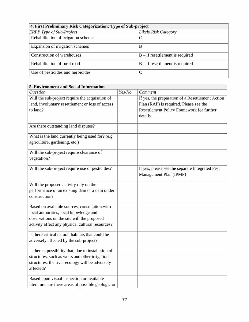
77
4. First Preliminary Risk Categorization: Type of Sub-project
ERPP Type of Sub-Project Likely Risk Category
Rehabilitation of irrigation schemes C
Expansion of irrigation schemes B
Construction of warehouses B – if resettlement is required
C- without resettlement rehabilitation
Rehabilitation of rural road B – if resettlement is required
C- without resettlement Use of pesticides and herbicides C
5. Environment and Social Information
Question Yes/No Comment
Will the sub-project require the acquisition of
land, involuntary resettlement or loss of access
to land?
If yes, the preparation of a Resettlement Action
Plan (RAP) is required. Please see the
Resettlement Policy Framework for further
details.
Are there outstanding land disputes?
What is the land currently being used for? (e.g.
agriculture, gardening, etc.)
Will the sub-project require clearance of
vegetation?
Will the sub-project require use of pesticides? If yes, please see the separate Integrated Pest
Management Plan (IPMP)
Will the proposed activity rely on the
performance of an existing dam or a dam under
construction?
Based on available sources, consultation with
local authorities, local knowledge and
observations on the site will the proposed
activity affect any physical cultural resources?
Is there critical natural habitats that could be
adversely affected by the sub-project?
Is there a possibility that, due to installation of
structures, such as weirs and other irrigation
structures, the river ecology will be adversely
affected?
Based upon visual inspection or available
literature, are there areas of possible geologic or

78
soil instability (erosion prone, landslide prone)?
Will the operating noise level exceed the
allowable decibel level for that zone?
Will the sub-project generate solid or liquid
waste?
6. Second Preliminary Classification: Site Sensitivity
HIGH MODERATE LOW
Protected Areas (National
Parks, Forest Reserve, etc.)
High danger of environmental
degradation (deforestation,
hunt, etc.)
Sensitive or critical ecosystem
(wetlands, mangrove swamps,
forests, and others)
Mountainous topography
(>35% of slope)
Vulnerable areas to natural
disasters (floods, earthquake,
and others)
Impact on household or
productive lands (more than
200 families affected)
Presence of physical cultural
resources
Protected Areas or in Buffer
Zones
Moderate danger of
environmental degradation
(deforestation, others)
Sensitive or critical
ecosystems (wetlands,
mangrove swamps, forests,
and others)
Wavy topography (15–35% of
slope)
Moderate risk to natural
disasters (floods, earthquake,
and others)
Impact on houses or
productive lands (more than
10 families but less than 200
families)
Presence of physical cultural
resources
Intervened areas out of protected
areas (national parks, others)
Low danger of environmental
degradation (deforestation, etc.)
No sensitive or critical
ecosystems areas in the influence
area (wetlands, mangrove
swamps, forests, others)
Flat topography (<15% of slope)
Low risk to natural disasters
(floods, earthquake, others)
Absence of physical cultural
resources
No people affected by the project
Site Sensitivity: __________________
7. Environmental and Social Studies Required
Based on the preliminary risk categorization in table 4 (type of project) and the secondary preliminary risk

79
categorization in table 6 (site sensitivity) please determine the risk category of the proposed sub-project.
Matrix 1: Environmental and Social Risk Category
Preliminary
classification
Site sensitivity
High Moderate Low
b A B B
c B B C
Risk Category Safeguards Documents Required
Category B Preliminary Environmental and Social Impact Assessment
Category C Environmental and Social Management Plan

80
Annex E: Content of an Environmental and Social Management Plan (ESMP)
The ESMP is an integral part of the overall implementation of the sub-project. The sub-project
ESMP must include a set of mitigation, monitoring and institutional measures to be undertaken
during implementation to eliminate adverse environmental and social impacts, offset them, or
reduce them to acceptable levels. The ESMP is a sub-project specific action plan presented in
table format, which must include the actions needed to implement these measures, including the
following features:
1. Description of adverse impacts: The anticipated impacts are identified and listed.
2. Description of mitigation measure and implementation schedule: Based on the
environmental and social impacts identified through the screening process and PESIA for
category B sub-projects each measure should be described as well as the schedule for their
implementation (timing, frequency, and duration).
3. Description of monitoring and reporting arrangements: A specific description and
technical details of the monitoring method, including the indicators to be measured, how
they will be measured and by whom, the sampling locations, the frequency of measurements,
detection limits (where appropriate), and the definition of thresholds that will signal the need
for corrective actions, e.g. the need for on-site construction supervision, or the need to test
and have a water quality monitoring plan.
4. Description of responsibilities: The ESMP should include specific responsibilities for
implementing the mitigation measures (i.e. who is responsible for implementing the
mitigation measures and carrying out the monitoring regime for operations, supervision,
enforcement, monitoring of implementation, remedial action, financing, reporting and staff
training.)
5. Cost estimates for mitigation and monitoring measures: Include an estimate of the costs
of the implementation of the mitigation measures and monitoring activities as well as the
source of funds.

81
Annex F: Generic Environmental and Social Mitigation Measures Checklist
Land Degradation
Water
Bio-diversity, Natural
Habitats and Wetlands
People
Planning Soil Erosion: (i) Training of Subsistence and Cash
Crop Farmers and Pastoralists on soil
conservation methods.
(ii) Rehabilitate anti-erosion
infrastructure such as, micro-basins,
micro dams, hill side terracing, soil bunds etc.
(iii) Construct new anti-erosion
infrastructure as listed in(ii) above. (iv) Introduce crop rotation
management,
use of fertilizers, tree planting and soil drainage.
(v) Control bush burning and fires.
vi) Protection of roadsides by planting
of vegetation. vii) Protection of outlet of drainage
canals
and culverts to avoid gully forming
downstream of the canal or culvert. viii) Prepare an effective and
sustainable
maintenance plan.
i) Promote potable water and sanitation sub projects.
ii) Promote environmental
health measures and public health education.
iii) Improve management of
household and solid waste, including infrastructure for
collection and treatment of liquid
waste and waste water. iv) Review, update and enforce
pollution control legislation. v)
Strengthen enforcement capacity.
vi) Develop and implement rural
water supply and sanitation policy.
vii) Locate sub projects at
far/safe distances from water
points and sources. viii) Increase public awareness.
i) Consideration of alternative locations/siting of sub projects.
ii) Reduce biomass use through
provision of alternative energy sources and construction
materials (cooking stoves,
photovoltaics).
iii) Strengthen natural resource
management capacities
iv) Develop alternatives to slash and burning clearing, decrease
overgrazing.
v) Promote agroforestry.
vi) Wetlands management and
small irrigation development. vii) Protect sensitive ecosystems
such as forests and wetlands,
prevent further encroachment in protected areas.
viii) Enforce existing laws.
ix) Locate sub projects
appropriately. x) Training of communities of
sustainable uses of resources.
xi) Identify certain species of trees and animals that must be
protected.
xii) Exclude ecosystems that
provided and important habitat
for protected species. xiii) Establish buffer zones
around protected areas and
wetlands
i) Involuntary settlement due to land acquisition, denial or
restriction of access to economic
resources such as trees, buildings etc., used by members of
communities should be avoided
or, if not, properly compensated.
ii) Provide social services in areas of
:
•Primary education
•Primary health care
•Water supply
•Micro-finance
•Feeder roads
•Soil conservation and natural
resources management.
Basic and required training at
district and community levels.
Ensure that these services are
equitably distributed throughout
the districts and that as access is open to all ethnic groups
irrespective of status.
iii) Ensure that vulnerable groups in sub project areas are included in
project activities and benefit from them levels of decision
making and implementation.
iv) Provide employment opportunities during contracting of
civil work etc.
Construction i) Construction in dry season. Protection of soil surfaces during construction. ii) Adequate protection from livestock entry by fencing the site perimeters.
iii) Employ all unskilled labor from local districts and semi-skilled labor first from local districts when available there in.
iv) Source goods and services from local districts first, when available. v) Control and daily cleaning at construction sites.
vi) Provision of adequate waste disposal services. Proper disposal of chemicals and other hazardous materials.
vii) Dust control by water, appropriate design and siting, restrict construction to certain times. viii) Appropriate and suitable storage of building materials on site.
ix) Siting of Latrines at safe distances from wells and other water points and using closed systems for sewage drainage.
x) Restrict construction to certain hours xi) Minimize loss of natural vegetation during construction; alternative sites; various special measures for sensitive species
xii) Restoration of vegetation; cleanup of construction sites.
xiii) Safety designs (signage) xiv) Ensure availability of clean potable water for use in latrines, canteens and for drinking.
xv) Use of appropriate building materials. No asbestos etc.
Day to Day
Operations
i) Use facilities/infrastructure as designed and as intended.
ii) Employ trained staff to man and secure facilities. iii) Log and report any damages done and repairs needed.
xvi) Perform periodic monitoring of al aspects as contained in the sub project Environmental and Social Monitoring Plan.
Maintenance i) Prepare and adopt suitable maintenance plan. ii) Maintain appropriate budget necessary to implement maintenance plan.
iii) Implement maintenance plan in two stages : for activities requiring day-to-to maintenance such as repairs to damages done, regular
inspections etc and longer/periodic term maintenance. iv) Have suitably trained staff to carry out maintenance and access to materials/goods/equipment.
82
Annex G: Outline for a Preliminary Environmental and Social Impact Assessment
The following is a recommended outline for a PESIA report that would be required for Category
B ERPP sub-projects. The DEMO of the sub-project for which use of ERPP funds is being
sought, will be required to submit such a report to NEMC for approval if the proposed activity
has been identified as a category B in the ESSF.
1. Executive Summary
Briefly describe the main findings of the PESIA.
2. Introduction
Briefly explains the purpose, structure, and audience of the PESIA.
3. Project Description
Describes the project in detail, including goals, objectives, beneficiaries, outcomes, value,
schedule, and implementing bodies.
4. Biophysical and Social Environment
Briefly describes both the physical and social environment in which the proposed sub-project
will take place, including soils, fauna, flora, protected areas, other special areas, biodiversity,
population, ethnicity, relevant cultural patterns and traits, employment, health and relationship of
the people to the resources, land use, and development patterns.
5. Potential Environmental and Social Impacts
Identifies the important potential impacts (biophysical and social), the most effective mitigation
to conduct, the residual impacts to be expected, and the cumulative effect to be expected. Impacts
may or may not be rated on a scale of, for instance, very significant, significant, moderately
significant, low significance, or no significance.
6. Legal and Administrative Framework
Briefly describes the main legal instrumentation for environmental control and management,
particularly specific instrumentation regarding the type of project and indicates government
bodies responsible for each of the relevant instruments. Also, it describes the institutional
framework for administration of the relevant environmental legislation and implementation of
policy, and analyzes the capacity and effectiveness of institutions.
7. Environmental and Social Management Plan (ESMP)
The ESMP should include the following:
Description of adverse impacts: The anticipated impacts are identified and listed.
Description of mitigation measure and implementation schedule: Based on the
environmental and social impacts identified through the screening process and PESIA for
category B sub-projects each measure should be described as well as the schedule for
their implementation (timing, frequency, and duration).
Description of monitoring and reporting arrangements: A specific description and
technical details of the monitoring method, including the indicators to be measured, how
83
they will be measured and by whom, the sampling locations, the frequency of
measurements, detection limits (where appropriate), and the definition of thresholds that
will signal the need for corrective actions, e.g. the need for on-site construction
supervision, or the need to test and have a water quality monitoring plan.
Description of responsibilities: The ESMP should include specific responsibilities for
implementing the mitigation measures (i.e. who is responsible for implementing the
mitigation measures and carrying out the monitoring regime for operations, supervision,
enforcement, monitoring of implementation, remedial action, financing, reporting and
staff training.)
Cost estimates for mitigation and monitoring measures: Include an estimate of the
costs of the implementation of the mitigation measures and monitoring activities as well
as the source of funds.
8. Literature Cited
A complete reference to all literature cited in the assessment and preparation of the ESIA report