exploration drilling within block er236, off the east ... · pdf fileexploration drilling...
TRANSCRIPT

Exploration Drilling within Block ER236, off the East Coast of South Africa Draft Scoping Report: Executive Summary October 2017 www.erm.com
The business of sustainability
Exploration Drilling within Block ER236, off the East Coast of South Africa
Eni Draft Scoping Report: Executive Summary
October 2017
Compiled by: Claire Alborough and Lindsey Bungartz
For and on behalf of Environmental Resources Management Approved by: Ingeborg McNicoll Signed: Position: Senior Partner Date: 24 October 2017
This report has been prepared by Environmental Resources Management the trading name of Environmental Resources Management Southern Africa (Pty) Limited, with all reasonable skill, care and diligence within the terms of the Contract with the client, incorporating our General Terms and Conditions of Business and taking account of the resources devoted to it by agreement with the client. We disclaim any responsibility to the client and others in respect of any matters outside the scope of the above. This report is confidential to the client and we accept no responsibility of whatsoever nature to third parties to whom this report, or any part thereof, is made known. Any such party relies on the report at their own risk.
EXECUTIVE SUMMARY
INTRODUCTION
Eni South Africa BV (Eni), and Sasol Africa Limited (Sasol) hold an Exploration Right off the East Coast of South Africa. Eni and Sasol are considering the possibility of conducting an exploration drilling programme in Block ER236 (12/3/236) to assess the commercial viability of the hydrocarbon reservoir for future development. Eni is considering drilling up to four deep water wells within Block ER236, within a 1,840 km2 area of interest, in water depths ranging between 1,500 m and 2,100 m (Figure 1). The drilling of the first exploration well is planned for late 2018 to early 2019. The expected drilling depth would be approximately 3,800 m and 4,100 m from the sea surface to target depth and the drilling of one well is expected to take in the order of two months to complete. Depending on the success of the first well, up to three additional wells comprising an additional exploration well at a second location and the possibility of one appraisal close to each exploration well location, may be drilled to establish the quantity and potential flow rate of any hydrocarbon present. The time sequence of these possible additional wells will be dependent on the results of the first exploration well, and will not occur immediately after the drilling of the initial well. Well testing may be conducted on the appraisal wells if they present potential commercial quantities of hydrocarbon. Location
Eni proposes to drill exploration wells inside Block ER236, within a 1,840 km2 area of interest, which is located, at its closest point, approximately 62 km from shore. The area of interest is located offshore of Richards Bay.
ENVIRONMENTAL RESOURCES MANAGEMENT ENI OFFSHORE DRILLING SCOPING REPORT
I

Figure 1 Locality Map
Eni, in its role as operator of ER236, has appointed Environmental Resources Management (ERM) as the independent Environmental Assessment Practitioner (EAP) for the EIA. The EIA will set out the anticipated impacts arising from the Project and propose measures on how these might be managed. The EIA report will inform an Environmental Authorisation (EA) decision to be taken by the Department of Mineral Resources (DMR). ADMINISTRATIVE FRAMEWORK
The primary legislation governing the South African upstream mining and petroleum sector is the Minerals and Petroleum Resources Development Act (MPRDA). In terms of the MPRDA, an Exploration Right must be approved prior to the commencement of exploration activities. Eni and Sasol hold an existing Exploration Right for ER236, which is currently in its first two year renewal period, as of 11 07 2017. The National Environmental Management Act (No.107 of 1998) (NEMA) is the South African framework legislation with respect to environmental protection and management. This provides a framework for the integration of environmental issues into the planning, design, decision-making and implementation of plans and development proposals that are likely to have a detrimental effect on the environment.
ENVIRONMENTAL RESOURCES MANAGEMENT ENI OFFSHORE DRILLING SCOPING REPORT
II
Whilst Section 23 sets out the basic objectives and principles of the IEM procedure, Section 24 sets out how these objectives and principles are to be accomplished. Regulations governing the environmental authorisation process have been promulgated in terms of NEMA include the EIA Regulations (GNR R982/2014) and Listing Notices 1 – 3 (GNR 983, 984, 985/2014). It should be noted that these regulations were amended in April 2017 by Government Notices 324, 325, 326 and 327. Numerous trigger activities have been identified for this project in terms of Listing Notice 1 and 2. In instances where more than one listing notice is triggered (as in this project), GNR 984 requirements will take precedent and the project will be subject to a full S&EIR process prior to commencement of any of the associated activities. Based on the EIA Regulations 2014 (as amended), it is understood that the competent authority for this project will be the Department of Mineral Resources (DMR). As such, Eni will be required to obtain a positive Environmental Authorisation from the DMR prior to commencement of the proposed activities. The Petroleum Agency of South Africa (PASA) accept and process offshore petroleum EA applications on behalf of the DMR, however the DMR is required to sign off on the final decision. PROJECT MOTIVATION
The South African White Paper on the Energy Policy (1998) is the overarching policy document which has guided and continues to guide future policy and planning in the energy sector. As outlined in the Ministerial foreword to the White Paper, fossil fuels play a central role in the socio-economic development of the country, while at the same time providing the necessary infrastructural economic base for the country to become an attractive host for foreign investments in the energy sector. The white paper states that ‘Government will ensure the optimal and environmentally sustainable exploration and development of the country’s natural oil and gas resources to the benefit of all’ and undertakes to ‘ensure private sector investment and expertise in the exploitation and development of the country’s oil and gas resources’. The successful exploitation of these natural resources would contribute to the growth of the economy and relieve pressure on the balance of payments. As indicated by the Integrated Energy Plan (IEP, 2016) diversity of supply sources and primary sources of energy is a key objective of the South African government. South Africa's current crude oil demand is over 600 000 barrels / day. South Africa currently imports approximately 70 percent of its liquid fuel, which comprises crude oil and finished products. The other approximately 30 percent is sourced from the local production of synfuels from coal and gas.
ENVIRONMENTAL RESOURCES MANAGEMENT ENI OFFSHORE DRILLING SCOPING REPORT
III
Crude oil prices combined with the Rand/Dollar exchange rate therefore have a major impact on fuel prices in South Africa. (1) In light of the above, exploration success would result in long-term benefits for South Africa consisting of access to new energy sources, improved security of supply, in-country investments in a development project (including job creation), increased government revenues, contribution to economic growth and reduced dependence on the importation of hydrocarbons. PROJECT DESCRIPTION
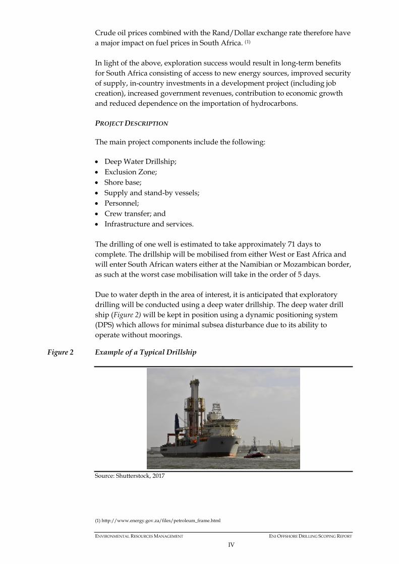
The main project components include the following: • Deep Water Drillship; • Exclusion Zone; • Shore base; • Supply and stand-by vessels; • Personnel; • Crew transfer; and • Infrastructure and services. The drilling of one well is estimated to take approximately 71 days to complete. The drillship will be mobilised from either West or East Africa and will enter South African waters either at the Namibian or Mozambican border, as such at the worst case mobilisation will take in the order of 5 days. Due to water depth in the area of interest, it is anticipated that exploratory drilling will be conducted using a deep water drillship. The deep water drill ship (Figure 2) will be kept in position using a dynamic positioning system (DPS) which allows for minimal subsea disturbance due to its ability to operate without moorings.
Figure 2 Example of a Typical Drillship
Source: Shutterstock, 2017
(1) http://www.energy.gov.za/files/petroleum_frame.html
ENVIRONMENTAL RESOURCES MANAGEMENT ENI OFFSHORE DRILLING SCOPING REPORT
IV
An onshore logistics base would be located in either Richards Bay or Durban, on an existing brownfield site (previously developed land) within the Port or the Industrial Development Zone (IDZ). Eni’s preferred option is Richards Bay as it is closer to the proposed drilling area, but a final decision has not yet been taken as a logistics survey is still to be undertaken in the identified areas. For the duration of the drilling operation, the drillship will be supported by platform supply vessels (PSVs), which are general purpose vessels designed to carry a variety of equipment and cargo. Project activities associated with drilling include following phases: • Mobilisation of the supply vessels to Richards Bay or Durban, operation of
the shore-based facilities for handling support services needed by the drillship;
• Drilling of well; • Well execution (side track, logging, completion) options; • Optional well testing; • Well abandonment; and • Demobilisation of the drillship, vessel and local logistics base. All activities will be conducted in conformity with recognised industry international best practice. Eni follows the following golden rules for waste management; in the order of priority: reduce, reuse, recycle, recover, treat, dispose. All vessels would have equipment, systems and protocols in place for prevention of pollution by oil, sewage and garbage in accordance with MARPOL 73/78. A project specific Waste Management Plan (covering all wastes generated offshore and onshore) would be developed in accordance with MARPOL requirements, South African regulations and Eni’s waste management guidelines. Waste disposal sites and waste management facilities would be identified, verified and approved prior to commencement of drilling. ENVIRONMENTAL AND SOCIO-ECONOMIC BASELINE
Table 1 presents a summary of the key baseline sensitivities in the Project Area.
Table 1 Summary of Key Sensitivities
Feature Description Agulhas Current • The Agulhas Current forms between 25° and 30° S, its main source
coming from recirculation in a South-West Indian Ocean subgyre. • It flows southwards at a rapid rate following the shelf edge along the
East Coast, before retroflecting between 16° and 20° E. It is a well-
ENVIRONMENTAL RESOURCES MANAGEMENT ENI OFFSHORE DRILLING SCOPING REPORT
V
Feature Description defined and intense jet some 100 km wide and 2,300 m deep.
• Current speeds of 2.5 m/s or more have been recorded. Seabed features and benthic habitat
• The AOI for well drilling lies east of the Natal Bight in >1,500 m water depth.
• The southern point of the area of interest overlaps with a portion of the Goodlad Canyon.
• The Goodlad Canyon differs significantly in morphology from those in northern KZN, where coelacanths have been reported and therefore it is unlikely that coelacanths will be found here.
• There is evidence from the seismic data collected in the area of interest of deep water canyons being present in the center of the area.
• Benthic habitats in the area of interest comprise Southwest Indian Upper and Lower Bathyal, both of which have been assigned an ecosystem threat status of ‘least threatened’ in the SANBI 2011 National Biodiversity Assessment.
• The benthic communities within these habitats are generally ubiquitous throughout the southern African East Coast region, being particular only to substratum type and/or depth zone.
Deep Water Corals • The occurrence of deep water corals in Block ER 236 and the area of interest are unknown.
Whales and Dolphins
• There are 36 species of cetaceans that are likely to be found within Block ER236. Of the 36 species, the Antarctic Blue whale is ‘critically endangered’, the Indo-Pacific humpback dolphin, fin whale and sei whale are considered ‘endangered’ and the Ifafi-Kosi Bay sub-population of the Indo-Pacific bottlenose dolphin, Sperm whale and Bryde’s whale (inshore population) are considered ‘vulnerable’ in the IUCN South African Red Data book List Assessment.
• The most common species within the area of interest (in terms of likely encounter rate not total population sizes) are likely to be the common bottlenose dolphin, Indo-pacific bottlenose dolphin, short-finned pilot whale and humpback whale.
• ER236 lies within the migratory route of Humpback (Least Concern) and Southern Right (Least Concern) whales. o Southern right whales will pass through Block ER236 in July and
August and again on their southward migration in October/November.
o Humpbacks have a bimodal distribution off the East coast, most reaching southern African waters around April, continuing through to September/October when the southern migration begins and continues through to December and as late as February. The calving season for Humpbacks extends from July to October, peaking in early August.
Marine Turtles • Five species of turtle are known to occur along the East Coast: leatherback, which is most frequently sighted, and the loggerhead, green, olive ridley and hawksbill turtles. In the IUCN Red listing, the hawksbill turtle is described as ‘Critically Endangered’, green turtle is ‘Endangered’ and leatherback, loggerhead and olive ridley are ‘Vulnerable’ on a global scale.
• Both the leatherback and the loggerhead turtle nest on the beaches of the northern KZN coastline (St Lucia, iSimangaliso) between mid-October and mid-January. Hatchlings are born from mid-January through to mid-March when the Agulhas Current is warmest. Once hatchlings enter the sea, they move southward following the Agulhas Current and are thought to remain in the southern Indian Ocean gyre for the first five years of their lives.
• The inshore regions of the northern portion of Block ER236, coincide with the inter-nesting migrations for leatherbacks, but the area of interest lies offshore of the inter-nesting range.
ENVIRONMENTAL RESOURCES MANAGEMENT ENI OFFSHORE DRILLING SCOPING REPORT
VI
Feature Description • Leatherback and loggerheads are likely to be encountered in Block
ER236 during their foraging migrations. Marine Protected Areas
• No existing marine protected areas overlap with Block ER236. • Block ER236 does not overlap with the iSimangaliso Wetland Park. • Although Block ER236 overlaps with the proposed Tugela Banks, Protea
Banks, Aliwal Shoal and iSimangaliso Wetland Park marine protected areas, there is no overlap of the area of interest with proposed protection areas.
Fish spawning, nursery and recruitment areas
• The area of interest is offshore of the major fish spawning and migration routes and ichthyoplankton abundance is likely to be low.
• The sardine run along the Eastern Cape coast and up to southern KZN is inshore of the area of interest.
• Pilchard eggs are inshore of the area of interest. Long Line Fishing • The area of interest overlaps with the long line fishing area which
targets primarily tuna but also swordfish. • Block ER236 overlaps with the crustacean trawl fishery.
Marine Traffic • The Project Area may overlap with the routes taken by tankers and bulk carriers. The supply vessels may interact with the inshore vessel traffic due to the collection of supplies from the Port of Durban.
• Important East Coast commercial harbors include Port Elizabeth, East London, Durban and Richards Bay.
Recreational users • The recreational use of marine resources along the East Coast typically occurs within inshore waters in the vicinity of coastal towns and holiday resorts.
EIA PROCESS
An EIA process is initiated by the Scoping Phase, as shown in Figure 3. During the Scoping Phase, the Terms of Reference for the full EIA is formulated and requirements from the authorities clarified, and potential issues and concerns identified via consultation. After completion of the Scoping Phase, detailed specialist studies will be undertaken in order to address issues identified during the Scoping Phase. Specialists are expected not only to provide baseline information in their particular field of expertise for the Project Area, but also to identify which project actions will result in significant impacts. Specialists will recommend ways in which adverse impacts could be mitigated to reduce their severity, and positive impacts enhanced. Draft reports are submitted for public review, during which time ERM present the key findings to all I&APs. All comments made by I&APs are captured in a Comments and Response Report (CRR), and in this report responses to all issues and concerns raised during the public review period are provided. All recommendations cited in the EIA report must be detailed in an Environmental Management Programme report (EMPr), which defines the mitigation/ enhancement actions to be implemented. EMPrs are recognised as important tools for the sound environmental management of projects.
ENVIRONMENTAL RESOURCES MANAGEMENT ENI OFFSHORE DRILLING SCOPING REPORT
VII
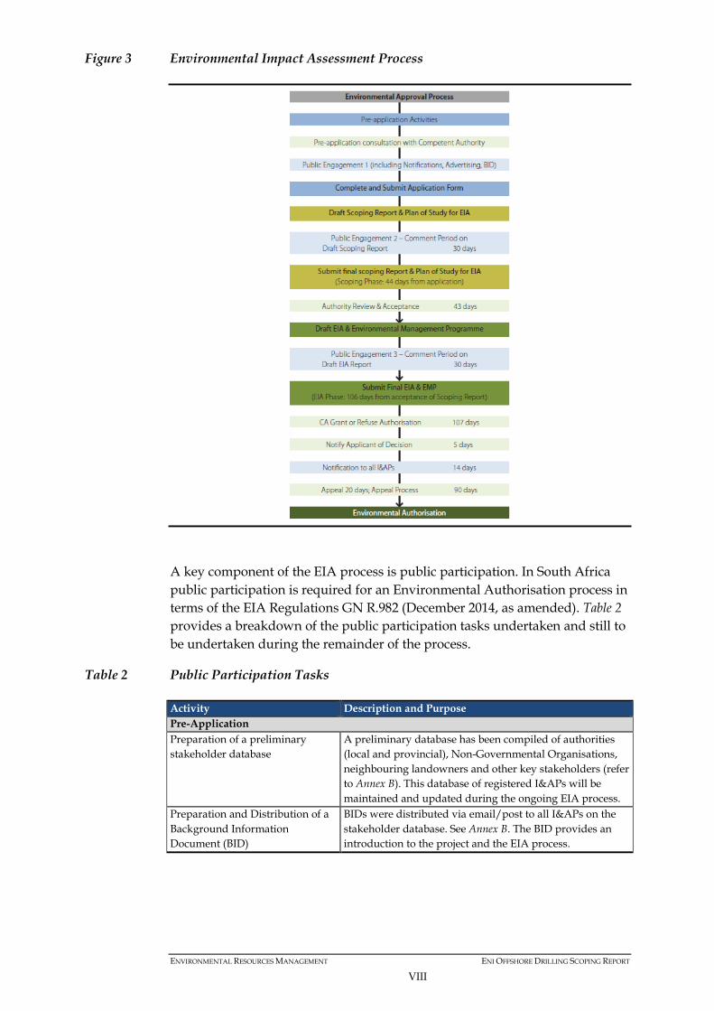
Figure 3 Environmental Impact Assessment Process
A key component of the EIA process is public participation. In South Africa public participation is required for an Environmental Authorisation process in terms of the EIA Regulations GN R.982 (December 2014, as amended). Table 2 provides a breakdown of the public participation tasks undertaken and still to be undertaken during the remainder of the process.
Table 2 Public Participation Tasks
Activity Description and Purpose Pre-Application Preparation of a preliminary stakeholder database
A preliminary database has been compiled of authorities (local and provincial), Non-Governmental Organisations, neighbouring landowners and other key stakeholders (refer to Annex B). This database of registered I&APs will be maintained and updated during the ongoing EIA process.
Preparation and Distribution of a Background Information Document (BID)
BIDs were distributed via email/post to all I&APs on the stakeholder database. See Annex B. The BID provides an introduction to the project and the EIA process.
ENVIRONMENTAL RESOURCES MANAGEMENT ENI OFFSHORE DRILLING SCOPING REPORT
VIII

Activity Description and Purpose Advertisement of the Project The project was advertised in four newspapers; The
Mercury and Isolezwe (in Zulu) with distribution around Durban, and The Zululand Observer and Ilanga Newspaper (in Zulu), with distribution around Richards Bay. The dates of distribution were as follows: • The Mercury – 18 September 2017 • The Zululand Observer – 18 September 2017 • Ilanga (advert in isiZulu) – 21 September 2017 • Isolezwe (advert in isiZulu) – 21 September 2017 See proof of advertisement in Annex B.
Erection of Site Notices Site notices have been placed at the following locations: eThekwini Municipality libraries: • Durban North; • Durban Central Lending; • Amanzimtoti; • Warner Beach; • Isipingo Beach; • Umkomaas; and • Tongaat Beach.
uMhlathuze Local Municipality: • Richards Bay Municipality; and • Richards Bay Library. Entrance to the Port of Richards Bay.
Development of an Initial Comments and Response Report
All comments received during the initial consultation period were recorded into a Comments and Response Report. See included in Annex C.
Scoping Phase Release of draft Scoping Report for Public Comment
The draft Scoping Report will be released for public comment. Notifications will be sent to all stakeholders on the database and the report will be made available online and in the following libraries: • Durban Public Library • Richards Bay Public Library. All comments received will be included in the final Scoping Report.
Public Engagement Meeting A public engagement meeting is planned to be held in Richards Bay and Durban to present the proposed Project and solicit input from stakeholders into the scoping process. Presentation, attendance registers and meeting notes will be included in the Final Scoping Report.
EIA Phase Release of draft EIR and EMP for Public Comment
The draft EIR and EMPr document will be made available for a 30-day comment period to stakeholders and the relevant authorities. A notification will be sent to all registered I&APs on the project database. This letter will invite I&APs to comment on the draft EIR. Newspaper adverts will be placed in local newspapers notifying stakeholders of the availability of the draft EIR report for review and inviting them to public meetings. All comments received, along with responses will be included in the final EIR.
ENVIRONMENTAL RESOURCES MANAGEMENT ENI OFFSHORE DRILLING SCOPING REPORT
IX
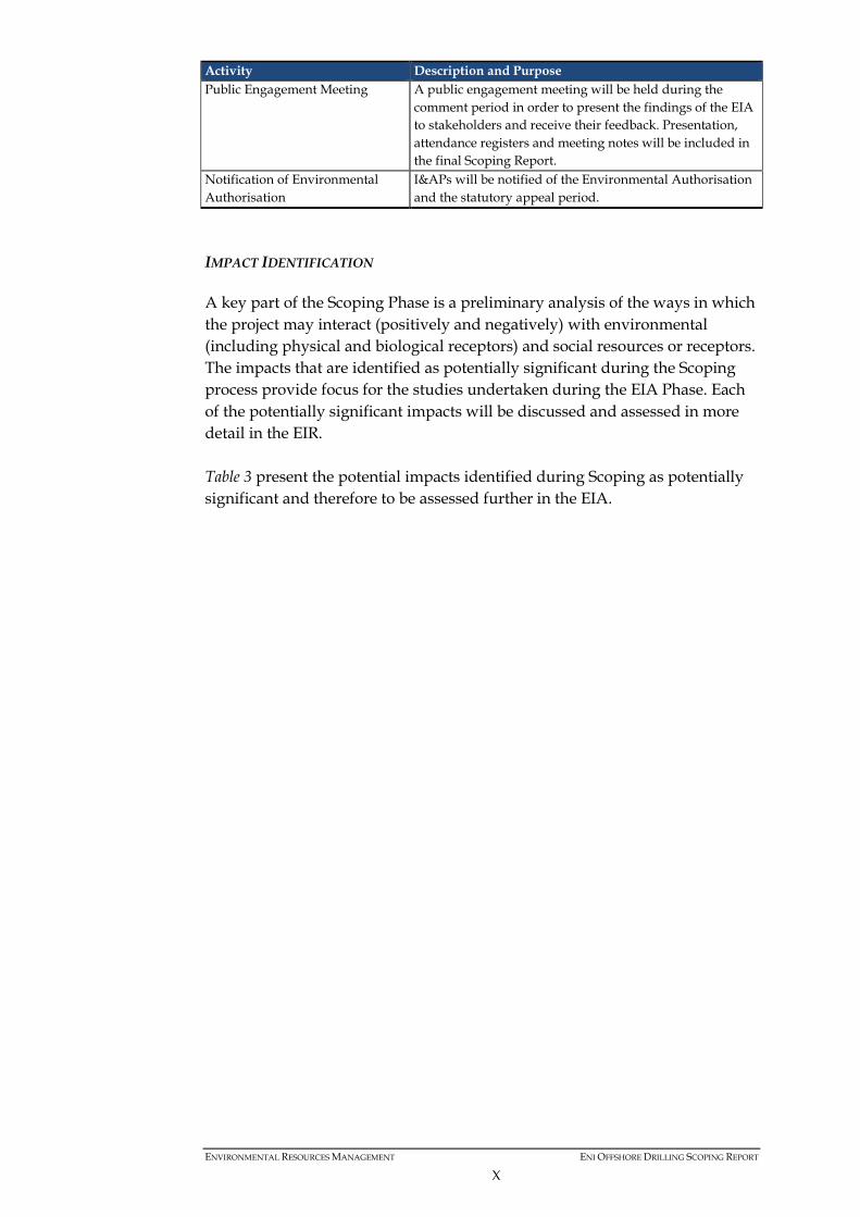
Activity Description and Purpose Public Engagement Meeting A public engagement meeting will be held during the
comment period in order to present the findings of the EIA to stakeholders and receive their feedback. Presentation, attendance registers and meeting notes will be included in the final Scoping Report.
Notification of Environmental Authorisation
I&APs will be notified of the Environmental Authorisation and the statutory appeal period.
IMPACT IDENTIFICATION
A key part of the Scoping Phase is a preliminary analysis of the ways in which the project may interact (positively and negatively) with environmental (including physical and biological receptors) and social resources or receptors. The impacts that are identified as potentially significant during the Scoping process provide focus for the studies undertaken during the EIA Phase. Each of the potentially significant impacts will be discussed and assessed in more detail in the EIR. Table 3 present the potential impacts identified during Scoping as potentially significant and therefore to be assessed further in the EIA.
ENVIRONMENTAL RESOURCES MANAGEMENT ENI OFFSHORE DRILLING SCOPING REPORT
X

Table 3 Potential Impacts from Planned Activities and Unplanned / Accidental Events
No. Issue Activities Scoping Results 1 Planned Activities 1.1 Seawater and
sediment quality degradation /contamination and impacts on marine fauna
Wastewater discharges from the drillship, supply and support vessels
Operational discharges from the drillship and all the other project vessels could have an impact on the water quality of the area and therefore potentially impact fish, marine mammals and turtles present in the Project Area. This impact will be assessed further in the EIR including a discussion around the mitigation of this impact by ensuring all vessel discharges are compliant with MARPOL 73/78 Annex I, Annex V and Annex IV.
Disposal of cuttings to the seafloor and overboard during drilling
Cuttings discharged both at the seabed (prior to the installation of the riser) and overboard (after the installation of the riser) will generate a plume of sediment which would disturb the marine habitats, benthic communities and marine fauna present in the area. This issue will be assessed further in the EIR, which will include a discussion around the treatment and base fluid content of these muds and cuttings prior to disposal.
1.2 Disturbance of marine organisms
• Noise generated by drillship dynamic positioning
• Noise and vibration generated by drilling
• Light generated by the drillship
Scoping determined that the underwater noise generated during the drilling works and the presence of vessels could lead to disturbances to marine habitats and fauna, especially to marine mammals and fish. The impact of underwater noise and vibrations on marine fauna will be assessed further in the EIR.
1.3 Disturbance to fishing (commercial and subsistence)
• Drillship, supply, survey and support vessels transit to and from the Richards Bay/Durban Port
• Presence of drillship at drilling location (including 500 m exclusion zone)
Both the Port of Richards Bay and the Port of Durban are large, commercial, high traffic ports and as such the additional vessel traffic for this project will be insignificant and will not be a major change from the current status quo in terms of impact to fishing activities. Long-line commercial and traditional line fishing activities occur within the area of interest and may therefore be impacted by the presence of the drillship at the drilling location and the enforcement of the 500 m exclusion zone. The extent to which fishing activities could be interrupted or placed at risk as a result of the drilling and vessel activities of this project will be assessed further in the EIR.
1.4 Climate change Burning of fossil fuels There are climate change implications from the burning of fossil fuels by the project vessels. The significance of this impact will be assessed further in the EIR.
ENVIRONMENTAL RESOURCES MANAGEMENT ENI OFFSHORE DRILLING SCOPING REPORT
XI
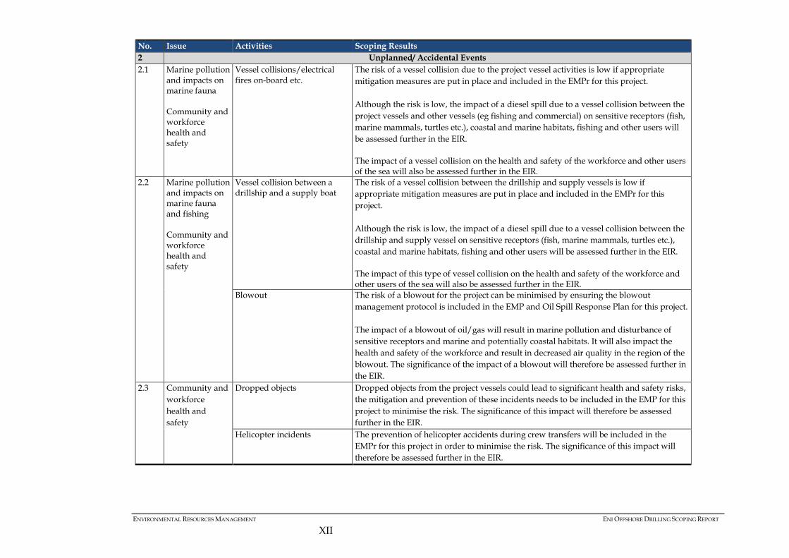
No. Issue Activities Scoping Results 2 Unplanned/ Accidental Events 2.1 Marine pollution
and impacts on marine fauna
Community and workforce health and safety
Vessel collisions/electrical fires on-board etc.
The risk of a vessel collision due to the project vessel activities is low if appropriate mitigation measures are put in place and included in the EMPr for this project. Although the risk is low, the impact of a diesel spill due to a vessel collision between the project vessels and other vessels (eg fishing and commercial) on sensitive receptors (fish, marine mammals, turtles etc.), coastal and marine habitats, fishing and other users will be assessed further in the EIR. The impact of a vessel collision on the health and safety of the workforce and other users of the sea will also be assessed further in the EIR.
2.2 Marine pollution and impacts on marine fauna and fishing Community and workforce health and safety
Vessel collision between a drillship and a supply boat
The risk of a vessel collision between the drillship and supply vessels is low if appropriate mitigation measures are put in place and included in the EMPr for this project. Although the risk is low, the impact of a diesel spill due to a vessel collision between the drillship and supply vessel on sensitive receptors (fish, marine mammals, turtles etc.), coastal and marine habitats, fishing and other users will be assessed further in the EIR. The impact of this type of vessel collision on the health and safety of the workforce and other users of the sea will also be assessed further in the EIR.
Blowout The risk of a blowout for the project can be minimised by ensuring the blowout management protocol is included in the EMP and Oil Spill Response Plan for this project. The impact of a blowout of oil/gas will result in marine pollution and disturbance of sensitive receptors and marine and potentially coastal habitats. It will also impact the health and safety of the workforce and result in decreased air quality in the region of the blowout. The significance of the impact of a blowout will therefore be assessed further in the EIR.
2.3 Community and workforce health and safety
Dropped objects Dropped objects from the project vessels could lead to significant health and safety risks, the mitigation and prevention of these incidents needs to be included in the EMP for this project to minimise the risk. The significance of this impact will therefore be assessed further in the EIR.
Helicopter incidents The prevention of helicopter accidents during crew transfers will be included in the EMPr for this project in order to minimise the risk. The significance of this impact will therefore be assessed further in the EIR.
ENVIRONMENTAL RESOURCES MANAGEMENT ENI OFFSHORE DRILLING SCOPING REPORT
XII
PLAN OF STUDY FOR EIA
Following the Scoping Phase of the project, the EIA team will: • update and finalise the technical project description as further project
details become available; • conduct additional consultation and further refine the scope of the EIA as
necessary; • collect additional baseline data through desktop research to complete a
comprehensive description of the environmental and social conditions; • undertake an impact assessment of the project activities interactions with
the key environmental and social resources and receptors; • develop mitigation and enhancement measures and outline an
Environmental Management Programme (EMPr) including an approach for monitoring; and
• report the findings in a comprehensive EIR. A number of issues have been identified during this Scoping Study which require specialist studies to understand the potential impact in more detail. The following specialist studies have been identified to address the key issues and data gaps: • Marine fauna; • Fisheries; • Oil Spill modelling; and • Drill cuttings modelling. A provisional schedule for the EIA is provided in Table 4 below.
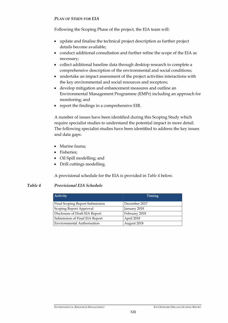
Table 4 Provisional EIA Schedule
Activity Timing
Final Scoping Report Submission December 2017 Scoping Report Approval January 2018 Disclosure of Draft EIA Report February 2018 Submission of Final EIA Report April 2018 Environmental Authorisation August 2018
ENVIRONMENTAL RESOURCES MANAGEMENT ENI OFFSHORE DRILLING SCOPING REPORT
XIII

The business of sustainability
ERM has over 160 offices across the following countries and territories worldwide. Argentina Australia Belgium Brazil Canada China Chile Colombia France Germany Hong Kong India Indonesia Ireland Italy Japan Kazakhstan Kenya Malaysia Mexico Mozambique Myanmar New Zealand Cape Town Office 2nd Floor, Great Westerford 240 Main Road, Rondebosch 7700, Cape Town, South Africa T: +27 21 681 5400 F: +27 21 686 0736 E: [email protected] Durban Office Suite S005, 17 The Boulevard Westway Office Park, Westville 3635, Durban, South Africa T: +27 31 265 0033 F: +27 31 265 0150 Johannesburg Office Building 32, The Woodlands Office Park, Woodlands Drive, Woodmead, 2148 Johannesburg, South Africa T: +27 11 798 4300 F: +27 11 804 2289 www.erm.com
Maputo Office 6th Floor, No. 141, Building Torres Rani, Av. da Marginal Maputo, Mozambique T: +258 84 093 9502 T: +258 84 311 9516 (Direct) Nairobi Office 4th Floor, Landmark Office Suites Laiboni Centre, Lenana Road, Kilimani, Nairobi, Kenya T: +254 20 493 8113/4 M: +254 71 265 0516 (KE) M: +27 72 610 6281 (SA) E: [email protected] Dar es Salaam Office 2nd Floor, Bains Avenue Off Chole Road, Masaki P. O. Box 38568 Dar es Salaam, Tanzania T: +255 22 221 2162 M: +255 767 150 894 E: [email protected]
Norway Panama Peru Poland Portugal Puerto Rico Romania Russia Senegal Singapore South Africa South Korea Spain Sweden Switzerland Taiwan Tanzania Thailand The Netherlands United Arab Emirates United Kingdom United States of America Vietnam