exploration in 2007 - nwt & nunavut chamber of … nwt mineral exploration overview, nov. 2007 i...
TRANSCRIPT
2007 Northwest Territories Mineral Exploration Overview
November 2007
K.E. MacFarlane, S.P. Goff, and D. Irwin, Northwest Territories Geoscience Office, Yellowknife, NT
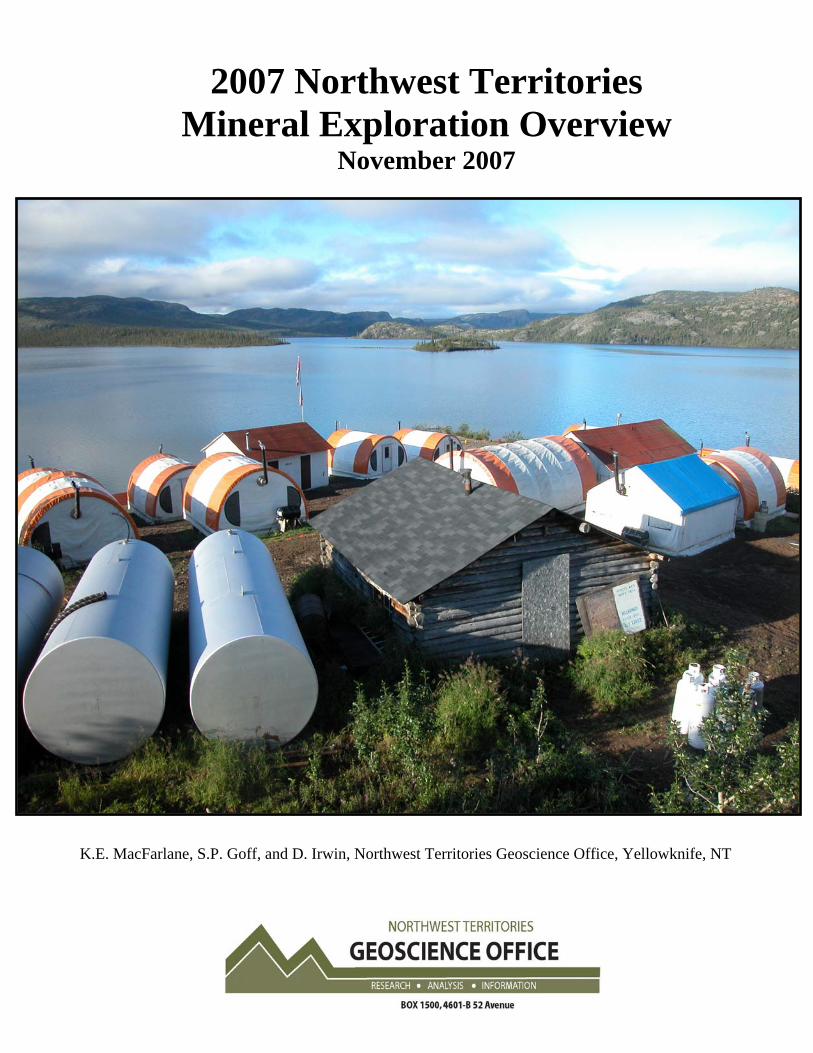
This publication may be obtained from the Northwest Territories Geoscience Office: Northwest Territories Geoscience Office 4601-B 52 Avenue P.O. Box 1500 Yellowknife, NT, X1A 2R3 Canada 867-669-2636 www.nwtgeoscience.ca In referring to this publication please use the following citation: MacFarlane, K.E., Goff, S.P., and Irwin, D., 2007. 2007 Northwest Territories Mineral Exploration Overview; Northwest Territories Geoscience Office, 16 p. Cover Illustration: Alberta Star’s camp on Echo Bay, Great Bear Lake, NT
© Copyright 2007 All Rights Reserved

2007 NWT Mineral Exploration Overview, Nov. 2007 i
TABLE OF CONTENTS Northwest Territories Mining Highlights for 2007......................................................................... 1 Northwest Territories Mineral Exploration Highlights for 2007.................................................... 2
Diamond Exploration - Slave Province ...................................................................................... 2 Diamond Exploration - Off the Slave Craton ............................................................................. 6 Metal Exploration ....................................................................................................................... 8
Further Information....................................................................................................................... 16
FIGURES
Figure 1: Diamond exploration projects in the Slave Province of the NWT (2007) ..................... 4 Figure 2: Diamond exploration projects off the Slave Craton in the NWT (2007) ....................... 7 Figure 3: Precious, base and energy metals exploration in the NWT (2007) ................................ 9
TABLES
Table 1: Diamond recovery from DD17 kimberlite, Monument Property .................................... 3 Table 2: Summary of Slave Province NWT diamond exploration (2007) .................................... 5 Table 3: Summary of diamond exploration off the Slave Craton in the NWT (2007) .................. 6 Table 4: Significant mineralized intervals, Eldorado and Contact Lake project ........................... 8 Table 5: Summary of precious, base and energy metals exploration (2007)............................... 10 Table 6: Resource summary for Prairie Creek............................................................................. 12 Table 7: Courageous Lake Gold Resources................................................................................. 14

2007 NWT Mineral Exploration Overview, Nov. 2007 1
2007 Northwest Territories Mineral Exploration Overview
Exploration for diamonds, uranium, precious and base metals in the NWT was fostered by higher than average commodity prices. Construction continued at the NWT’s third diamond mine; bulk sampling took place on various diamond projects and polymetallic projects; and there was increased exploration activity for nickel and platinum group elements.
NORTHWEST TERRITORIES MINING HIGHLIGHTS FOR 2007
Diavik Diamond Mine Inc., a joint venture between Diavik Diamond Mine (60%) and Aber Diamond Ltd. (40%) produced 3.1 million carats of diamonds in the third quarter bringing their year to date production to nine million carats. Production was predominantly from the A154 South pipe, with less production from the A154 North pipe. The new A418 open pit was subject to removal of overburden and waste rock stripping. An underground feasibility study was completed on the A418 and A154 pipes and has been submitted for internal funding. Economics for the underground project are still considered favourable. A decision has been made to defer the development of the A21 pipe pending further engineering studies and economic evaluations that could significantly improve the economics of the project. At the beginning of 2007 ore reserves for the A154 South, North and A418 pipes were reported at 24.5 million tonnes grading 3.3 carats per tonne for 81.7 million carats contained.
Production at BHP Billiton (80%), Stu Blusson (10%) and Chuck Fipke’s (10%) Ekati Diamond Mine totaled 3.528 million carats in the first three quarters of this year. The mine is in transition to a predominantly underground operation and is processing a blend of ore from open pit and underground sources. Mining continues in the Fox and Beartooth open pits; the Panda underground mine is running at full capacity; underground tunneling and ventilation were completed at the Koala pipe. The first underground production blast on the Koala kimberlite took place in October.
North American Tungsten Ltd. produced 21.3 x 10⁴ kilograms of tungsten concentrate in September bringing their total 2007 production at Cantung to 225.4 x 10⁴ kilograms. Production recovery is at 76% WO3. After an initial review of historical feasibility studies a full feasibility study was initiated on the Mactung property in November 2007. Mactung is one of the largest known undeveloped high grade tungsten-skarn deposits in the world with an indicated resource of 33.0 million tons grading 0.88% WO3 and an inferred mineral resource estimate of 11.3 million tons grading 0.78% WO3.
De Beers Canada continued with mine infrastructure construction and underground development on the Snap Lake diamond mine site. The deposit has an indicated resource of 1.4 million tonnes and an inferred resource of 25 million tonnes, with a recoverable grade of 1.2 carats per tonne. Production is set to begin in 2008.
2007 NWT Mineral Exploration Overview, Nov. 2007 2
NORTHWEST TERRITORIES MINERAL EXPLORATION HIGHLIGHTS FOR 2007
Diamond Exploration - Slave Province
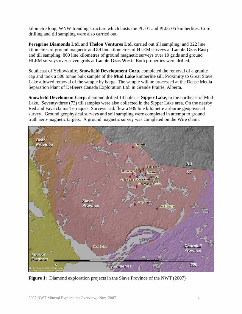
Diamond exploration programs taking place in the Slave Province are shown in Figure 1. Publically reported work is summarized in Table 2.
Anglo Swiss Resources Inc. and New Shoshoni Ventures Ltd. completed 18.0 line kilometres of total field ground magnetics and 6 line kilometres of horizontal loop electromagentics on the Fry Inlet diamond property in the Lac de Gras region. A drill program targeted a cluster of seven high-priority targets including the LI 201 kimberlite.
Arctic Star Diamond Corp. completed extensive detailed ground magnetics, seismic and gravity geophysical surveys on its Credit Lake Diamond Property, 40 kilometres southwest of Ekati. Nine drill holes targeted geochemical and geophysical anomalies associated with the South Coppermine mineral dispersion train and two drill holes targeted gravity anomalies in a mineral dispersal train north of the Coppermine River. Kimberlite was not intersected in drilling. Till sampling, prospecting and auger sampling were done in the summer.
Within the Ekati Core Zone property, operator BHP Billiton (80%) and partners C. Fipke (10%) and S. Blusson (10%), completed delineation diamond drilling and advanced reverse circulation drilling on the Pigeon pipe. Six geophysical targets were tested using helicopter-supported diamond drilling. Two new kimberlite pipes were discovered (Kia and Redwing).
In the Ekati Buffer Zone property, operator BHP Billiton (58.8%) and partners Archon Minerals (31.2%) and C. Fipke (10%), completed delineation drilling (11 holes) on the Jay pipe and follow-up reverse circulation drilling on the Cardinal pipe. A total of 156 kimberlites have been confirmed to date across the Ekati property (Core Zone and Buffer Zone).
DeBeers Canada (51%) and Mountain Province Diamonds Inc. (49%) completed a land-based large diameter drilling program on the Gahcho Kué project 300 kilometres northeast of Yellowknife. This program involved drilling five holes and was designed to recover approximately 60 tonnes of material for recovery of approximately 100 carats of diamonds. The bulk sample will be used to confirm the micro to macro diamond relationship on the north lobe of 5034. Holes drilled on the 5034 East Lobe will undergo geochemical analysis and thin section work in order to confirm the continuity between the North and East lobes at depth. Confirmation of the kimberlite continuity allows for increased confidence in resource calculations. In addition, over 8576 metres of delineation drilling (26 holes), on a 35 metre grid pattern, was completed on the Tuzo pipe in spring. Four of these holes terminated in kimberlite at 400 metres depth.
Diavik Diamond Mines Inc. tested several new targets by drilling over 900 metres. An additional new kimberlite was discovered bringing the total number of kimberlite bodies on the property to 68. Ground magnetic and horizontal loop electromagnetic surveys totalling 425 line-kilometres were completed and 300 till samples were collected.
GGL Diamond Corp. collected 146 till samples and 145 soil samples from its CH project area west of Lac de Gras.
2007 NWT Mineral Exploration Overview, Nov. 2007 3
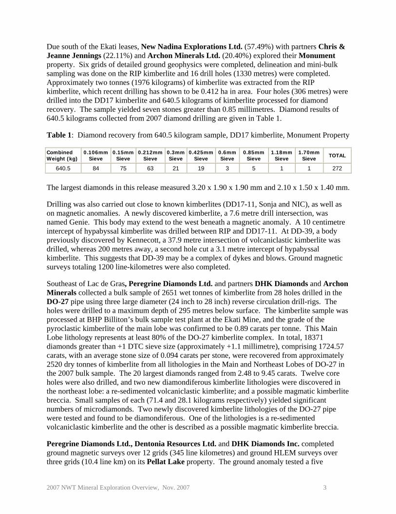
Due south of the Ekati leases, New Nadina Explorations Ltd. (57.49%) with partners Chris & Jeanne Jennings (22.11%) and Archon Minerals Ltd. (20.40%) explored their Monument property. Six grids of detailed ground geophysics were completed, delineation and mini-bulk sampling was done on the RIP kimberlite and 16 drill holes (1330 metres) were completed. Approximately two tonnes (1976 kilograms) of kimberlite was extracted from the RIP kimberlite, which recent drilling has shown to be 0.412 ha in area. Four holes (306 metres) were drilled into the DD17 kimberlite and 640.5 kilograms of kimberlite processed for diamond recovery. The sample yielded seven stones greater than 0.85 millimetres. Diamond results of 640.5 kilograms collected from 2007 diamond drilling are given in Table 1.
Table 1: Diamond recovery from 640.5 kilogram sample, DD17 kimberlite, Monument Property
Combined Weight (kg)
0.106mm Sieve
0.15mm Sieve
0.212mmSieve
0.3mmSieve
0.425mmSieve
0.6mmSieve
0.85mmSieve
1.18mm Sieve
1.70mm Sieve TOTAL
640.5 84 75 63 21 19 3 5 1 1 272
The largest diamonds in this release measured 3.20 x 1.90 x 1.90 mm and 2.10 x 1.50 x 1.40 mm.
Drilling was also carried out close to known kimberlites (DD17-11, Sonja and NIC), as well as on magnetic anomalies. A newly discovered kimberlite, a 7.6 metre drill intersection, was named Genie. This body may extend to the west beneath a magnetic anomaly. A 10 centimetre intercept of hypabyssal kimberlite was drilled between RIP and DD17-11. At DD-39, a body previously discovered by Kennecott, a 37.9 metre intersection of volcaniclastic kimberlite was drilled, whereas 200 metres away, a second hole cut a 3.1 metre intercept of hypabyssal kimberlite. This suggests that DD-39 may be a complex of dykes and blows. Ground magnetic surveys totaling 1200 line-kilometres were also completed.
Southeast of Lac de Gras, Peregrine Diamonds Ltd. and partners DHK Diamonds and Archon Minerals collected a bulk sample of 2651 wet tonnes of kimberlite from 28 holes drilled in the DO-27 pipe using three large diameter (24 inch to 28 inch) reverse circulation drill-rigs. The holes were drilled to a maximum depth of 295 metres below surface. The kimberlite sample was processed at BHP Billiton’s bulk sample test plant at the Ekati Mine, and the grade of the pyroclastic kimberlite of the main lobe was confirmed to be 0.89 carats per tonne. This Main Lobe lithology represents at least 80% of the DO-27 kimberlite complex. In total, 18371 diamonds greater than +1 DTC sieve size (approximately +1.1 millimetre), comprising 1724.57 carats, with an average stone size of 0.094 carats per stone, were recovered from approximately 2520 dry tonnes of kimberlite from all lithologies in the Main and Northeast Lobes of DO-27 in the 2007 bulk sample. The 20 largest diamonds ranged from 2.48 to 9.45 carats. Twelve core holes were also drilled, and two new diamondiferous kimberlite lithologies were discovered in the northeast lobe: a re-sedimented volcaniclastic kimberlite; and a possible magmatic kimberlite breccia. Small samples of each (71.4 and 28.1 kilograms respectively) yielded significant numbers of microdiamonds. Two newly discovered kimberlite lithologies of the DO-27 pipe were tested and found to be diamondiferous. One of the lithologies is a re-sedimented volcaniclastic kimberlite and the other is described as a possible magmatic kimberlite breccia.
Peregrine Diamonds Ltd., Dentonia Resources Ltd. and DHK Diamonds Inc. completed ground magnetic surveys over 12 grids (345 line kilometres) and ground HLEM surveys over three grids (10.4 line km) on its Pellat Lake property. The ground anomaly tested a five
2007 NWT Mineral Exploration Overview, Nov. 2007 4
kilometre long, WNW-trending structure which hosts the PL-01 and PL06-05 kimberlites. Core drilling and till sampling were also carried out.
Peregrine Diamonds Ltd. and Thelon Ventures Ltd. carried out till sampling, and 322 line kilometres of ground magnetic and 89 line kilometres of HLEM surveys at Lac de Gras East; and till sampling, 800 line kilometres of ground magnetic surveys over 19 grids and ground HLEM surveys over seven grids at Lac de Gras West. Both properties were drilled.
Southeast of Yellowknife, Snowfield Development Corp. completed the removal of a granite cap and took a 500 tonne bulk sample of the Mud Lake kimberlite sill. Proximity to Great Slave Lake allowed removal of the sample by barge. The sample will be processed at the Dense Media Separation Plant of DeBeers Canada Exploration Ltd. in Grande Prairie, Alberta.
Snowfield Develoment Corp. diamond drilled 14 holes at Sipper Lake, to the northeast of Mud Lake. Seventy-three (73) till samples were also collected in the Sipper Lake area. On the nearby Red and Faya claims Terraquest Surveys Ltd. flew a 939 line kilometre airborne geophysical survey. Ground geophysical surveys and soil sampling were completed in attempt to ground truth aero-magnetic targets. A ground magnetic survey was completed on the Wire claim. Figure 1: Diamond exploration projects in the Slave Province of the NWT (2007)
Digital Elevation Model (DEM) image Courtesy of NWT Centre for Geomatics

Table 2: Summary of Slave Province NWT diamond exploration (2007)
RC – reverse circulation, Mag – magnetic, EM electromagnetic, HLEM – horizontal loop electromagnetic, HM-Heavy Mineral
Operator / Partners Property Drilling Airborne Geophysics Ground Geophysics Sampling and Other
Work Anglo Swiss / New Shoshoni Fry Inlet 5 holes 18.0 line-km mag and 6.0
line-km HLEM Till HM sampling
Arctic Star Diamond Corp. Credit Lake 11 holes Mag, seismic, gravity Till samples, auger samples,
prospecting
BHP Billiton Diamonds / C. Fipke / Archon Minerals
Ekati Buffer Zone and Core
Leases
Delineation drilling Jay and Pigeon pipes. RC drilling Pigeon and Cardinal pipes.
Drilled 6 geophysical targets
2 new kimberlites discovered – Kia and Redwing
De Beers Canada / Mountain Province / Camphor Ventures
Gahcho Kué 1500 m large diameter core.
8400 m (26 holes) of delineation drilling
Resource calculation,
microdiamond analysis, macro diamond re-valuation
Diavik Diamond Mines 900 m 425 line-km of mag and HLEM 2 new kimberlites discovered
GGL Diamond CH Property 146 till and 145 soil samples
New Nadina / Chris and Jeanne Jennings / Archon Mineral
Monument
4 holes totaling 306 m Drilling near known
kimberlites and of mag anomalies
1200 line-km mag
640.5 kg of kimberlite processed, 7 stones > 0.85
mm Discovered new kimberlite
Genie Peregrine Diamonds / Archon Minerals / DHK Diamonds
DO-27 28 RC holes to collect 2651
wet tonne bulk sample 12 diamond drill holes
Grade estimate calculated, diamond recovery
Peregrine Diamonds / Thelon Ventures
Lac de Gras East and West
2 targets drilled at Lac de Gras West, no kimberlite intersected
1122 line km of mag, 89 line km of EM on Lac de Gras East, 7 HLEM surveys
on Lac de Gras West
Till HM sampling
Peregrine Diamonds / Dentonia Resources / DHK Diamonds Inc.
Pellat Lake Yes 345 line km of mag, 10.4 line km of HLEM HM sampling
Snowfield Development Corp. / Consolidated Gold-Win Ventures Inc.
Mud Lake 500 tonne bulk sample
Snowfield Development Corp. Sipper Lake 14 diamond drill holes 939 line km Mag, gradiometer Soil samples

2007 NWT Mineral Exploration Overview, Nov. 2007 6
Diamond Exploration - Off the Slave Craton
The location of diamond exploration programs taking place off the Slave Craton are shown in Figure 2. Publically reported work is summarized in Table 3.
Diamonds North Resources Ltd. performed detailed ground geophysical surveys over 116 of 204 targets on the Hepburn property in the Proterozoic Hornby Basin. They drilled 21 geophysical targets, kimberlite was not intersected.
On permits just east of the Minto Inlier on Victoria Island, Great Northern Mining and Exploration collected till samples.
North of Great Bear Lake, in the Interior Platform, Sanatana Diamonds Inc. and Kennecott Canada Exploration Inc. flew 3425 line kilometres of an airborne magnetic and EM survey across six main areas with kimberlite indicator mineral trains (Greenhorn, Yeltea, Simpson, Colville, Estabrook and Horton) in their Mackenzie project area. Approximately 1100 till samples were collected, and ground magnetic and HLEM surveys were completed in the Greenhorn and Simpson areas. In the Greenhorn area, on the Dease Arm of Great Bear Lake, drilling of the G14 magnetic anomaly, located at the termination of a major indicator mineral train, intersected a new ultramafic breccia with olivine macrocrysts. This new kimberlite (subject to petrologic verification) has been named “Dharma”. Over 750 kilograms of the body will be extracted for microdiamond analysis.
Stornoway Diamonds Corp. conducted ground geophysical surveys and auger drilling during the month of June on their Blackstone Project.
Table 3: Summary of diamond exploration off the Slave Craton in the NWT (2007)
Operator / Partners
Property Drilling Airborne Geophysics
Ground Geophysics
Sampling and Other Work
Diamonds North Resources Ltd
Hepburn Drilled 21 targets
Detailed surveys over 116 of 204 targets
Great Northern Mining and Exploration
Minto Inlier Permits
Till sampling
Sanatana Diamonds / Kennecott Canada Exploration Inc.
Mackenzie yes 3425 line km mag and EM
HLEM, mag 1100 till samples
Stornoway Diamonds Blackstone Auger drilling yes
RC – reverse circulation, Mag – magnetic, EM - electromagnetic, HLEM – horizontal loop electromagnetic, HM - Heavy Mineral

2007 NWT Mineral Exploration Overview, Nov. 2007 7
Figure 2: Diamond exploration projects off the Slave Craton in the NWT (2007)
2007 NWT Mineral Exploration Overview, Nov. 2007 8
Metal Exploration
The location of metal exploration programs are shown in Figure 3. Metal exploration activities are summarized in Table 5.
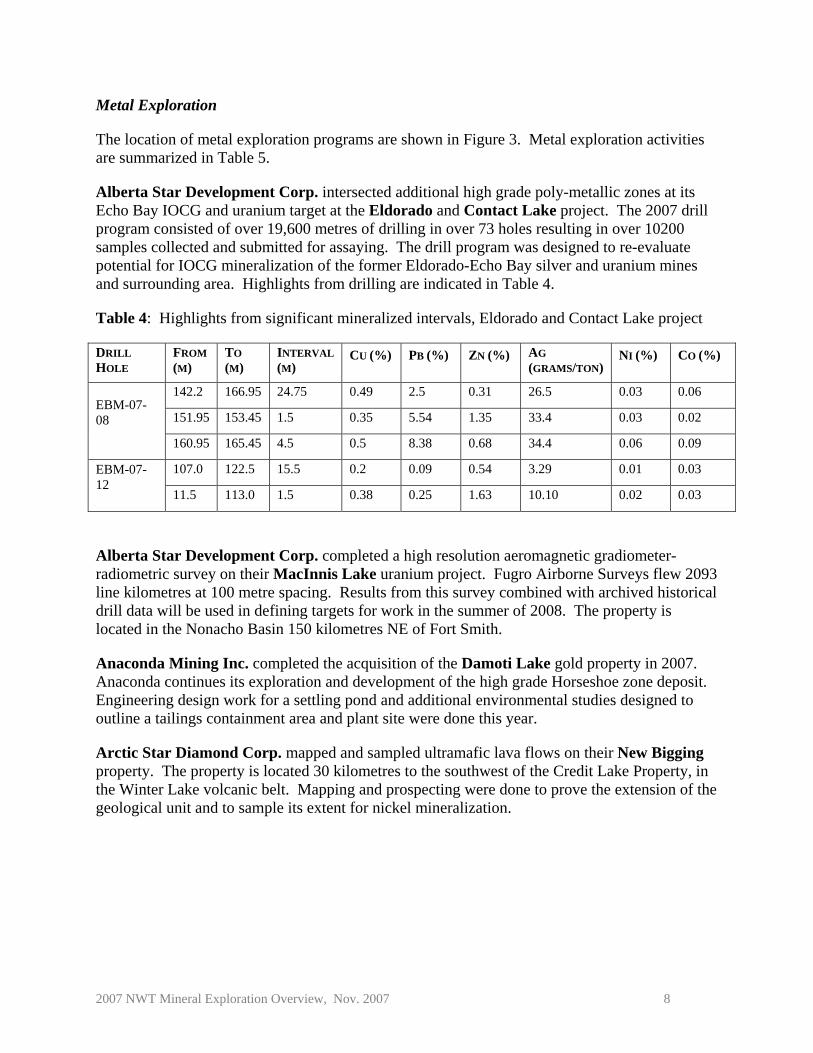
Alberta Star Development Corp. intersected additional high grade poly-metallic zones at its Echo Bay IOCG and uranium target at the Eldorado and Contact Lake project. The 2007 drill program consisted of over 19,600 metres of drilling in over 73 holes resulting in over 10200 samples collected and submitted for assaying. The drill program was designed to re-evaluate potential for IOCG mineralization of the former Eldorado-Echo Bay silver and uranium mines and surrounding area. Highlights from drilling are indicated in Table 4.
Table 4: Highlights from significant mineralized intervals, Eldorado and Contact Lake project
DRILL HOLE
FROM (M)
TO (M)
INTERVAL (M)
CU (%) PB (%) ZN (%) AG (GRAMS/TON)
NI (%) CO (%)
142.2 166.95 24.75 0.49 2.5 0.31 26.5 0.03 0.06
151.95 153.45 1.5 0.35 5.54 1.35 33.4 0.03 0.02 EBM-07-08
160.95 165.45 4.5 0.5 8.38 0.68 34.4 0.06 0.09
107.0 122.5 15.5 0.2 0.09 0.54 3.29 0.01 0.03 EBM-07-12
11.5 113.0 1.5 0.38 0.25 1.63 10.10 0.02 0.03
Alberta Star Development Corp. completed a high resolution aeromagnetic gradiometer-radiometric survey on their MacInnis Lake uranium project. Fugro Airborne Surveys flew 2093 line kilometres at 100 metre spacing. Results from this survey combined with archived historical drill data will be used in defining targets for work in the summer of 2008. The property is located in the Nonacho Basin 150 kilometres NE of Fort Smith.
Anaconda Mining Inc. completed the acquisition of the Damoti Lake gold property in 2007. Anaconda continues its exploration and development of the high grade Horseshoe zone deposit. Engineering design work for a settling pond and additional environmental studies designed to outline a tailings containment area and plant site were done this year.
Arctic Star Diamond Corp. mapped and sampled ultramafic lava flows on their New Bigging property. The property is located 30 kilometres to the southwest of the Credit Lake Property, in the Winter Lake volcanic belt. Mapping and prospecting were done to prove the extension of the geological unit and to sample its extent for nickel mineralization.

2007 NWT Mineral Exploration Overview, Nov. 2007 9
Figure 3: Precious, base and energy metals exploration in the NWT (2007)

Table 5: Summary of Northwest Territories precious, base and energy metals exploration (2007)
Operator / Partners
Property Commodity Drilling Airborne Geophysics Ground Geophysics
Sampling and Other Work
Alberta Star Development Corp.
Contact Lake / Eldorado
IOCG -U Over 19,600 m in over 73 holes
IP and Resistivity Over 10200 core samples
Alberta Star Development Corp.
MacInnis Lake U Gradiometer-radiometric survey, 2093 line km at 100 m spacing
Anaconda Gold Damoti Lake Au Feasibility assessment Arctic Star Diamond Corp. New Bigging Ni Mapping, prospecting,
sampling Avalon Ventures Ltd Thor Lake REE 2551 m in 16
holes 1160 core samples,
preliminary petrographic work
Bayswater Uranium / Uranium North Resources / Strongbow
Thelon Permits U 9500 line km VTEM Ground checking potential targets
Cameco Corp. Leith Peninsula U-Au prospecting
Canadian Zinc Prairie Creek Pb-Zn-Ag 8200 m (41 holes)
underground definition
Cooper Minerals Inc. Terra IOCG IOCG Yes 4241 line km
Mag/radiometric Sampling of historic
trenches
Eagle Plains Resources Bronco Ag-Cu-Pb-Zn 750 m in 5 holes Re-analysis of archived
samples, mapping, 98 rock samples, 3450 soil samples, 93 stream sediment samples
Fortune Minerals NICO Au-Co-Bi 325 m ramp extension, 300 m lateral development, alimak raise, 3600 tonnes ore mined
Freeport-McMoRan Copper and Gold Inc. / Kaska Minerals
Keele River Cu 2386 m reconnaissance drilling
GGL Diamond Corp. Winter Lake Ni 547 rock samples, 973 soil samples, 127 lake sediment samples
Mag – magnetic, EM - electromagnetic, IP – induced polarization, VTEM – versatile time-domain electromagnetic survey, HLEM – Horizontal loop electromagnetic survey, TEM - time-domain electromagnetic survey, PGE - platinum group elements
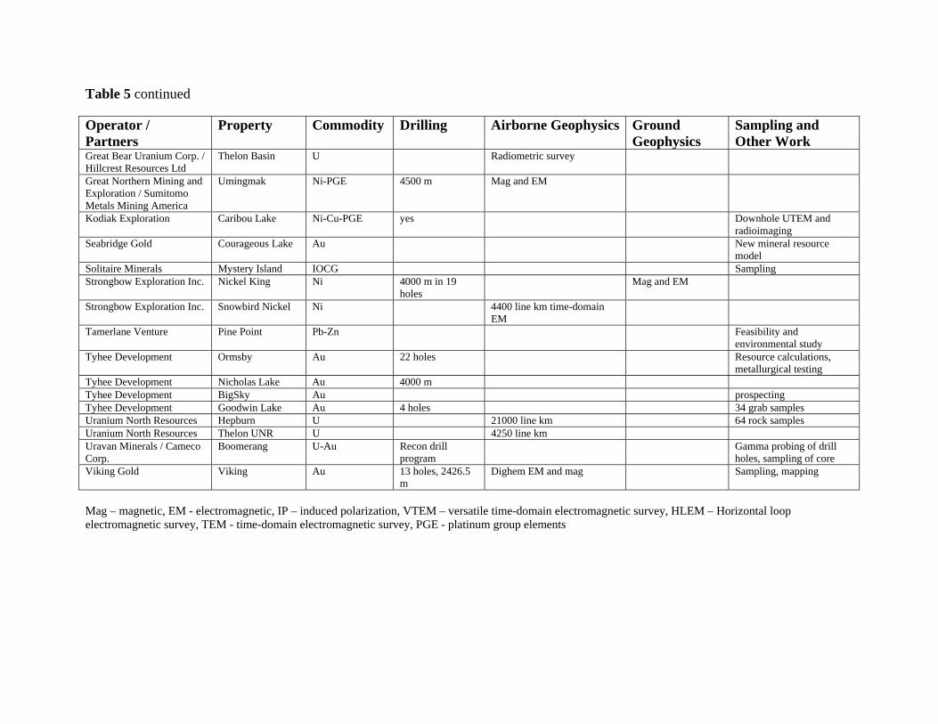
Table 5 continued
Operator / Partners
Property Commodity Drilling Airborne Geophysics Ground Geophysics
Sampling and Other Work
Great Bear Uranium Corp. / Hillcrest Resources Ltd
Thelon Basin U Radiometric survey
Great Northern Mining and Exploration / Sumitomo Metals Mining America
Umingmak Ni-PGE 4500 m Mag and EM
Kodiak Exploration Caribou Lake Ni-Cu-PGE yes Downhole UTEM and radioimaging
Seabridge Gold Courageous Lake Au New mineral resource model
Solitaire Minerals Mystery Island IOCG Sampling Strongbow Exploration Inc. Nickel King Ni 4000 m in 19
holes Mag and EM
Strongbow Exploration Inc. Snowbird Nickel Ni 4400 line km time-domain EM
Tamerlane Venture Pine Point Pb-Zn Feasibility and environmental study
Tyhee Development Ormsby Au 22 holes Resource calculations, metallurgical testing
Tyhee Development Nicholas Lake Au 4000 m Tyhee Development BigSky Au prospecting Tyhee Development Goodwin Lake Au 4 holes 34 grab samples Uranium North Resources Hepburn U 21000 line km 64 rock samples Uranium North Resources Thelon UNR U 4250 line km Uravan Minerals / Cameco Corp.
Boomerang U-Au Recon drill program
Gamma probing of drill holes, sampling of core
Viking Gold Viking Au 13 holes, 2426.5 m
Dighem EM and mag Sampling, mapping
Mag – magnetic, EM - electromagnetic, IP – induced polarization, VTEM – versatile time-domain electromagnetic survey, HLEM – Horizontal loop electromagnetic survey, TEM - time-domain electromagnetic survey, PGE - platinum group elements

2007 NWT Mineral Exploration Overview, Nov. 2007 12
Near the north shore of the East Arm of Great Slave Lake Avalon Ventures Ltd. drilled 16 holes totaling 2551 metres at their Thor Lake rare metal project. Two mineralized alteration zones were confirmed. The zones vary in thickness from 10 metres to 35 metres and have been traced laterally over 1100 metres. Eleven hundred and sixty samples were sent for assay. Preliminary petrographic work on a suite of 14 small split core samples was carried out. The mineralized zones contain a complex suite of REE-bearing minerals including bastnaesite, allanite, synchisite, parasite, monazite and fergusonite along with zircon and magnetite. Current work is being undertaken to define indicated resources in the higher grade sub-zones within the large inferred resource. A second phase program is scheduled to commence after freeze-up in 2008.
In the southern Thelon Basin area, exploring for uranium, Bayswater Uranium Corp. flew a 9500 line-kilometre VTEM geophysical survey over its properties on the west and southeast ends of the basin, plus over nearby properties involving partnerships with Strongbow and Uranium North Resources. Bayswater also completed ground geophysics and prospecting on its CL claims, and ground checking of potential targets was carried out on the properties in partnership with Uranium North.
Cameco prospected on uranium and gold showings on the Leith Peninsula of Great Bear Lake.
In the southern Mackenzie Mountains, Canadian Zinc Corp. advanced their Prairie Creek zinc-lead-silver project by completing approximately 8200 metres (41 holes) of underground definition drilling, drilled on 50 metre centres along a new 400 metre internal decline adjacent to the Main Zone. A new mineral resource estimate, based on mineralization type, was independently prepared for the Main Zone, see Table 6. Estimates include results from the recently completed underground drill program.
Table 6: Resource summary for Prairie Creek (CIMM, 2000), MineFill September 2007
Cooper Mineral Inc. identified significant gold values at the Terra IOCG Project on the east shore of Great Bear Lake. Samples collected from historic trenches returned gold values up to 36.0 g/ton. A 4241 line kilometre magnetic/spectrometer survey was flown over the property. A diamond drill program began in October.
MINERALIZATION TYPE
CATEGORY TONNES PB (%) ZN (%) AG (GRAMS/TONNE)
CU (%)
Measured 1,550,041 9.68 12.22 155.0 0.282 Indicated 3,608,123 11.36 10.97 184.7 0.385 Vein plus
Stratabound M + I 5,158,164 10.85 11.35 175.8 0.354 Stockwork Indicated 682,165 2.68 5.85 50.15 0.112
Measured 1,550,041 9.68 12.22 154.95 0.282 Indicated 4,290,288 9.98 10.16 163.34 0.342 M + I 5,840,329 9.90 10.71 161.12 0.326 Totals
Inferred 5,541,576 11.43 13.53 214.80 0.514

2007 NWT Mineral Exploration Overview, Nov. 2007 13
Eagle Plains Resources Ltd. drilled 5 holes (750 m) on their Bronco Property, a sedimentary-hosted silver, copper, lead and zinc occurrence in the Mackenzie Mountains near the NWT/Yukon border. Geological mapping, prospecting (98 rock samples collected), and ground surveys including geophysics, soil geochemistry (3,450) and stream sediment geochemistry (93 samples) were completed.
Fortune Minerals Ltd. completed further underground test mining on its NICO cobalt-gold-bismuth deposit located in the southern Bear Province. The 2007 program included dewatering of previous workings followed by deepening and extending the ramp by 325 metres to a depth of 200 metres below surface. Three hundred metres of lateral development was done to intersect the lower ore zone. An Alimak raise was driven to surface to provide ventilation and emergency access for underground workings. Ore mined during 2007 amounted to approximately 3600 tonnes and used to prepare a 275 tonne composite bulk sample for large-scale pilot plant testing. Waste rock obtained from the mining process will be used for construction and road aggregate.
West of Norman Wells, Freeport-McMoRan Copper and Gold Inc. and Kaska Minerals explored for sedimentary-hosted copper deposits on their Keele River property completing 2386 m of reconnaissance drilling west of the June deposit. Two new mineralized occurrences were discovered.
GGL Diamond Corp. conducted exploration work on their Winter Lake property. Reconnaissance mapping indicates that komatiites within the greenstone belt are more extensive than previously noted. Results from sampling of these komatiites show anomalous total nickel values between 800 and 4600 ppm. The property hosts a 15 kilometre long 500 metre wide strong geophysical conductor. The company collected 547 rock samples, 973 soil samples and 127 lake sediment samples.
Great Bear Uranium Corp. (40%) and Hillcrest Resources Ltd (60%) have undertaken a joint venture in the Thelon Basin. Hillcrest Resources had Aeroquest International Ltd. fly a radiometric geophysical survey over their claims in the Thelon. The program was aimed at identifying drill targets for unconformity type uranium deposits. Great Bear Uranium was previously known as Great Bear Resources.
In the Minto Inlier of Victoria Island, Great Northern Mining and Exploration and Sumitomo Metals Mining America drilled 4500 metres on airborne magnetic and EM targets on their Umingmak project claims, in a search for nickel-platinum group elements (PGE), and diamonds.
Hunter Bay Minerals (formerly Great Bear Resources) explored for uranium and polymetallic deposits on its Hunter property on the east shore of Great bear Lake with a small drilling program.
Kodiak Exploration Ltd. drilled their Caribou Lake Ni-Cu-Co-PGE property located near the north shore of the East Arm of Great Slave Lake. Drilling undertaken in 2007 confirmed the presence of abundant sulphide mineralization. The sulphides occur in coarse to very-coarse grained gabbro and pyroxenite. A 1.1 metre intersection in drill hole CL-07-05 grades 0.21% nickel and 0.31% copper. Downhole UTEM and radioimaging (RIM) surveys followed the drilling.

2007 NWT Mineral Exploration Overview, Nov. 2007 14
Seabridge Gold Inc. released a new independent mineral resource model for their Courageous Lake project, see Table 7.
Table 7: Courageous Lake Gold Resources at 0.83 gram per tonne cutoff
Measured Indicated Inferred Tonnes (000’s)
Grade (grams/Tonne)
Tonnes (000’s)
Grade (grams/Tonne)
Tonnes (000’s)
Grade (grams/Tonnne)
6,293 2.92 53,020 2.14 93,720 1.98 Solitaire Minerals Corp. received results for seven samples submitted for copper analysis. The samples were collected from their Mystery Island IOCG property in the Great Bear Lake area. Results ranged from 0.774 - 2.665% copper. Final results from a helicopter-borne VTEM geophysical survey flown in 2006 indicate a 12 kilometre long magnetic low which is coincident with a large regional fault. Drill targets have been identified on the property and the permitting process was started.
At Thye Lake, Strongbow Exploration Inc. drilled seven holes (1825 metres) on the Main Zone and three holes (425 metres) on the Joe Island anomaly of the Nickel King property during their winter program. As a result of this drilling, mineralization of the Main Zone was found to extend a further 800 metres to the southwest bringing the total identified strike length of this zone to 1600 metres. Nickel mineralization within the central and eastern portions of the Main Zone is hosted in gabbro sills. Drilling of the Main Zone confirmed previously reported sulphide nickel mineralization returning 29.4 metres grading 0.47% nickel, 53.75 metres grading 0.53% nickel and 17.05 metres grading 0.53% nickel within the lower gabbro sill. Borehole pulse EM surveys were done to aid in the interpretation of drill results. Ground magnetic and pulse EM surveys were conducted during the winter program. Summer drilling was temporarily halted due to a fire that destroyed camp. Drilling resumed in August and nine holes (1750 metres) were completed by early October. Results from drilling include a 31.5 metre intersection grading 1.04% nickel, including 4.35 metres grading 1.72% nickel and 10.25 metres grading 1.43% nickel. Good nickel grades are associated with gabbroic rocks with a sulphide content described as relatively modest. Ground geophysical surveys were also carried out during the summer program.
Strongbow Exploration Inc. flew a 4400 line kilometre airborne time-domain EM survey over their Snowbird Nickel project area which straddles the NWT/Saskatchewan border. The project area is located along a 240 kilometre strike length of the Snowbird Tectonic Zone. This program was designed to test the nickel potential of the Snowbird Tectonic Zone outside of the Nickel King property.
Tamerlane Venture Inc. announced results of a feasibility and scoping study on its Pine Point lead-zinc project, east of Hay River. The R-190 deposit will be the initial focus for development utilizing a freeze perimeter and other proven technologies for underground mining. A 43-101 report completed for the Pine Point property indicated that with a 5% zinc grade cut-off the R-190 deposit had a resource of 1.0 million tonnes with a grade of 11.16% zinc and 5.49% lead.
2007 NWT Mineral Exploration Overview, Nov. 2007 15
Tyhee Development Corp. drilled 22 diamond drill holes to define the limits of the Ormsby Zone 80 kilometres north of Yellowknife. The strike length of the zone is over 1,400 metres. Seven of the 11 holes used to test the northern limits intersected significant gold values including 2.0 metres grading 5.632 grams/tonne from hole NDM397. Approximately 3,400 tonnes of stockpiled mineralized rock from underground sampling at Ormsby was crushed and 10 tonnes were shipped for metallurgical testing. A revised resource estimate for the Ormsby Zone was released in June 2007 and reported a Measured plus Indicated resource of 8.237 million tonnes grading 3.53 grams/tonne gold using a 1.25 grams/tonne cut-off. Initial mapping and sampling was completed on the Clan Lake property.
Tyhee Development Corp. drilled 4000 metres at the Nicholas Lake Main Zone to expand the established resource and confirm the continuity of mineralization. Work also included re-sampling of previously drilled holes was completed in order to assess potential for a bulk-mineable resource.
On the Goodwin Lake Project VAD showing Tyhee Development Corp. drilled four holes. All holes intersected the variably altered and quartz veined targeted mafic intrusion. Thirty-four (34) grab samples collected from the VAD averaged over 5 grams/tonne gold. Of 15 channel samples taken, nine yielded elevated gold values.
Mapping on Tyhee Development Corp.’s Teapot Zone confirmed the nature of the zone and samples of the highly altered granodiorite contain tungsten mineralization. Five drill holes tested the Teapot Zone.
The BigSky property, recently acquired by Tyhee Development Corp., is located within the Yellowknife greenstone belt, immediately north of Yellowknife, is a 500 metre wide zone with anastomosing shears. Grab samples collected from these shears yielded up to 51.06 grams/tonne gold.
Uranium North Resources Corp. flew a 21000 line kilometres airborne geophysical survey over their Hepburn property in the Hornby Bay Basin. Sixty-four rock samples were collected and land use permitting for drilling was obtained. A 4250 line kilometre airborne geophysical survey was flown over their Thelon UNR project. Detailed ground surveys were completed over several targets. Both properties are being targeted for uranium.
Uravan Mineral Inc. (40%) and Comeco Corp. (60%) continued exploring for uranium and gold on their Boomerang property. The property is located along the southwestern margin of the Thelon Basin. A reconnaissance drill program was carried out and targets were selected by employing a TDEM large fixed-loop ground geophysical survey technique over peaks identified in the 2005 MEGATEM airborne survey. Drilling was also done on the F- and G- conductive trends identified from a 2005 and 2006 MEGATEM geophysical survey. Drilling confirmed significant faulting of the Thelon sandstone-basement unconformity contact. The identification of illite-enriched clay alteration hosted in the basal Thelon sandstone-conglomerate section at the unconformity provides evidence of post-Thelon hydrothermal fluid movement along reactivated structures. All drill holes were gamma probed and samples were submitted for major oxide and trace element analysis.
2007 NWT Mineral Exploration Overview, Nov. 2007 16
Viking Gold Exploration drilled 13 holes (2426.5 metres) on their Morris Lake property during the winter. The program was planned to test conductive anomalies identified by an airborne survey flown in 2006. A mapping and sampling program was undertaken in the summer of 2007 in preparation for continued diamond drilling. Results from the winter program and a review of previous assays led to the recognition of a broad alteration zone hosting known gold mineralization. Drilling results and data from previous work have widened the alteration zone from 30 metres at the shaft area to over 200 metres in the area of the drill holes.
FURTHER INFORMATION
Further information on mining and mineral exploration can be obtained from the following persons:
Stephen Goff, District Geologist, Indian & Northern Affairs Canada, Northwest Territories Geoscience Office, P.O. Box 1500, 4601-B 52nd Avenue, Yellowknife NT, X1A 2R3 867-669-2638 [email protected] Karen MacFarlane, District Geologist, Indian & Northern Affairs Canada, Northwest Territories Geoscience Office, P.O. Box 1500, 4601-B 52nd Avenue, Yellowknife NT, X1A 2R3 867-669-2645 [email protected] Hamish Sandeman, Diamond Geologist, Northwest Territories Geoscience Office, P.O. Box 1500, 4601-B 52nd Avenue, Yellowknife NT, X1A 2R3 867-669-2475 [email protected] Rose Greening, NWT Mining Recorder, Indian & Northern Affairs Canada, P.O. Box 1500, 4914 - 50th Street, Yellowknife, NT, X1A 2R3 [email protected]