exploratory querying of sparql endpoints in space and · pdf fileexploratory querying of...
TRANSCRIPT
Semantic Web 0 (0) 1 1IOS Press
Exploratory querying of SPARQL endpointsin space and timeEditor(s): Aba-Sah Dadzie, The Open University, UK; Emmanuel Pietriga, INRIA France & INRIA ChileSolicited review(s): Heiko Paulheim, University of Mannheim, Germany; Mariano Rico, Universidad Politecnica de Madrid, Spain; oneanonymous reviewer
Simon Scheider a,b,∗, Auriol Degbelo a, Rob Lemmens c, Corné van Elzakker c, Peter Zimmerhof a,Nemanja Kostic a, Jim Jones a,d, Gautam Banhatti aa University of Münster, Institute for Geoinformatics, Münster, DEE-mail: {degbelo, peterzimmerhof, kostic_nemanja, jim.jones, g_banh02}@uni-muenster.deb ETH Zürich, Inst. f. Kartografie u. Geoinformation, Zürich, CHE-mail: [email protected] University of Twente, Faculty of Geo-Information Science and Earth Observation (ITC), Enschede, NLE-mail: {r.l.g.lemmens, c.vanelzakker}@utwente.nld Münster University Library (ULB), Münster, DEE-mail: [email protected]
Abstract. The linked data Web provides a simple and flexible way of accessing information resources in a self-descriptiveformat. This offers a realistic chance of perforating existing data silos. However, in order to do so, space, time and other semanticconcepts need to function as dimensions for effectively exploring, querying and filtering contents. While triple stores, SPARQLendpoints, and RDF were designed for machine access, large burdens are still placed on a user to simultaneously explore andquery the contents of a given endpoint according to these dimensions. First, one has to know the semantic concepts and the typeof knowledge contained in an endpoint a-priori in order to query content effectively. Second, one has to be able to write andunderstand SPARQL and RDF. And third, one has to understand complex data type literals for space and time. In this article,we propose a way to deal with these challenges by interactive visual query construction, i.e., by letting query results feedbackinto both (space-time) exploration and filtering, and thus enabling exploratory querying. We propose design principles for SPEX(Spatio-temporal content explorer), a tool which helps people unfamiliar with the content of SPARQL endpoints or their syntaxto explore the latter in space and time. In a preliminary user study on a repository of historical maps, we found that our feedbackprinciples were effective, however, that successful question answering still requires improvements regarding space-time filtering,vocabulary explanation and the linking of space-time windows with other displays.
Keywords: SPARQL endpoints, visual query formulation, spatial and temporal linked data, exploratory querying, historical maps
1. Motivation
Data repositories often remain black boxes, for laypersons and database experts alike and regardless ofwhether the repository in question is a traditionalrelational database, a Web-based fast indexing and
*Corresponding author. E-mail:[email protected].
search system such as Elasticsearch1, or an RDF2 triplestore3. This is surprising, since all this technology israther mature and was designed for exactly that: help-
1http://www.elasticsearch.org2Resource Description Framework,
http://www.w3.org/RDF/3http://semanticweb.com/
introduction-to-triplestores_b34996
1570-0844/0-1900/$27.50 c© 0 – IOS Press and the authors. All rights reserved

2 S. Scheider et al. / SPEX
ing people retrieve particular information. What arethe main burdens for users to access such repositories?
Space and time are primary dimensions for structur-ing and searching information [25], and thus can helpopen up data silos. Map-like query interfaces can playa key role in retrieval tasks [37] and are easily adoptedby users [23]. In addition, a very large proportion ofdata (some say 80% [14]), not only from traditionalsources but also from the Semantic Web4, has a space/-time component, or can easily be linked to such (e.g.,based on OpenStreetMap [49]). The WGS84 Geo Po-sitioning vocabulary5 is currently, according to statis-tics from http://stats.lod2.eu, the third mostused linked data vocabulary after RDF-schema andRDF6. The OWL time vocabulary7 is, according tothese statistics, the 29th most used vocabulary.
Handling space and time references, however, stillposes a burden to users. While information on the Webis largely referenced to space-time in rather simplis-tic ways8, certain types of information require inter-action of users with more complex references. Exam-ples range from historical and cultural information9,such as historical maps [44] and museal artefacts [24]whose spatial references are extended and may evenundergo complex changes in time [31], to informationabout the human environment, such as Earthquakes orthe Cadastre system (cf. Sect. 6.5). How space andtime can be used in these cases together with other con-tent dimensions in order to open up the black box ofa repository to unfamiliar users remains an importantquestion of research [27,41].
Linked open data, even though it changes the condi-tions for and approaches to retrieval of spatio-temporaland other information in positive ways [50,34], placesfurther burdens on a user. Think about an historian orlibrarian who wants to find maps which contain infor-mation about Napoleon’s invasion to Russia [44] (Fig-ure 1). Suppose he or she is given a list of URIs of
4Compare the representative sample of linked geospatial datacrawled from the Web and described in http://stko.geog.ucsb.edu/location_linked_data.
5http://www.w3.org/2003/01/geo/wgs84_pos6Also, as of December 9, 2015, about 20% of all triples from
the Linked Data Cloud cover the geographic domain (see http://lod-cloud.net/state/).
7http://www.w3.org/TR/owl-time/8Based on coordinate points as footprints, similar to Wikipedia.9Compare e.g. the Europeana Open Culture
App http://blog.europeana.eu/2013/07/europeana-open-culture-apps-maps-and-plans/.
SPARQL10 endpoints11 containing RDF descriptionsof large collections of historical maps [33]. How toproceed from there? Even if the SPARQL syntax isknown, even if text search and linked data browsersare available, and even if the historian knows where tosearch on a map and when to search in time, how couldthe historian possibly know how to pose a query to theendpoint in order to get what he or she wants?
In this article, we suggest that a major challenge inimproving this situation is a dilemma which has to dowith the lacking integration of exploration and query-ing along all dimensions of space, time and theme, andcorrespondingly, with the lacking possibility of simul-taneously learning about the information needed whilespecifying it.
Think again about our example in Figure 1. Piece-wise data exploration does not allow users to per-form complex searches and does not scale across largerdatasets which cannot be explored manually. There aretwo traditional kinds of counter measures: either, oneignores data concepts and exploits text search, or onemakes use of data concepts and formulates queries.From a user’s viewpoint, text search is simple but alsoimprecise. For example, searching for “Napoleon” or“Russia” will not lead to any success, because the in-tended map (cf. Figure 1) happens to have the dig-itized title “Carte Figurative des pertes successivesen hommes de l’armé française dans la campagne deRussie 1812-1813”. A database or linked data querymay identify the right map because it works indepen-dently from keyword labels. However, it remains un-clear, first of all, how to formulate the right query,and secondly, which kinds of relations and conceptsare required and available in order to formulate theright query [44]. Furthermore, in our case, the histo-rian might want to filter results by a certain spatialarea in Russia and a certain time interval (1812-1813)and thus needs to handle georeferenced historical mapregions with complex polygon shapes [44]). This re-quires specific interaction strategies to facilitate mapoverview, zooming, as well as geometric comparisonand filtering.
All this unfortunately presupposes a lot of expertise,and systems which make strong assumptions abouttechnical skills and a-priori knowledge strongly limit
10http://www.w3.org/TR/RDF-sparql-query/11RESTful RDF repository interfaces for sending SPARQL
queries on the Web. http://labs.mondeca.com/sparqlEndpointsStatus.html is a list of available end-points.

S. Scheider et al. / SPEX 3
Fig. 1. Charles Minard’s map from 1861 about Napoleon’s 1812 march on Moscow. How could users unfamiliar with spatio-temporal (linked)data query for its complex content in a way which goes beyond keywords [44]?
the set of potential users. On the other hand, a querysystem that allows users inexperienced with repositorycontents and linked data to acquire such knowledgeneeds to support them in interacting with concepts anddata in novel ways. That is, at the end of the day,successful queries require exploration and scalable ex-ploration requires queries. While similar insights haverecently motivated exploratory query [29] and, moregenerally, exploratory search [40,52] as fields in infor-mation retrieval, it remains an open question how Se-mantic Web technologies and how space and time canbe used in order to realize it.
In this article, we focus on the following researchquestions:
1. How to integrate exploration and querying oflinked spatio-temporal data in a tightly closedloop, such that people inexperienced with con-tent of a repository, its syntax or data types arestill put in a position to answer complex ques-tions about it?
2. What is the role of spatio-temporal interfaces insuch exploratory query systems?
We experience a lack of systematic and empiricallytested design principles for linked data tools that com-bine query with exploration on the three dimensions ofspace, time and theme12. Furthermore, there is a cor-
12What we have in mind here are studies like [35].
responding lack of tools for users unfamiliar with thesyntax of linked data repositories, as we will argue be-low. Note, however, that the target audience for suchtools are not lay users, but rather motivated subject-matter experts that are willing to and capable of learn-ing new query and exploration principles.
In seeking for answers, we first discuss correspond-ing challenges and related work (Sect. 2), and then sug-gest a set of design principles (Sect. 3) for a SPARQLquery and exploration tool called SPEX (Sect. 4).Other tools are compared against these principles. Ahistorical maps scenario (Sect. 5) serves to test thetool in a preliminary user study (Sect. 6). The sce-nario builds on earlier work in the map library area[44,43] illustrating the requirements of handling com-plex space-time queries. The approach and designprinciples suggested in this paper, however, are noveland not restricted to the domain of historical maps.While an empirical validation is still future work, thestudy provides first insights on how users unfamiliarwith linked data make use of these principles to answercomplex questions about a repository, on the role ofspatio-temporal interfaces, and on the main open prob-lems.
4 S. Scheider et al. / SPEX
2. Joining linked spatio-temporal data explorationand retrieval
Joining exploration with querying parallels the olddilemma of joining the learning of concepts with theirspecification: How to specify something if that some-thing is basically unknown? This dilemma may havestimulated the relational schema in classical databaseresearch. A relational schema [11] allows users tospecify a piece of data without knowing all the details(e.g. its particular value). However, for this purpose,users need to explore the schema. Exploration, in oursense, is something that people do when looking at andmanipulating a display in order to learn about some-thing, e.g., when looking up a table schema in a rela-tional database or a digital map. Specification is some-thing that people do when they construct retrieval re-quests, e.g., by specifying a “select” query. Retrieval issomething that only machines do. However, it often re-quires specification as input and may have explorationapplied to its output.
Since linked data is inherently self-descriptive, itcan be used to do both specification and learning aboutconcepts at the same time. Technically, linked meta-data are simply linked data, and as such are not hid-den in the data structure [34], in contrast to a relationaldatabase schema13.
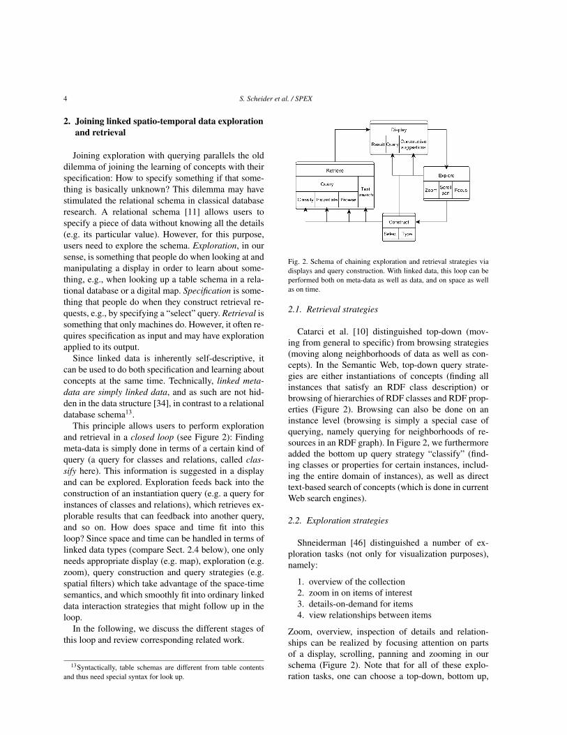
This principle allows users to perform explorationand retrieval in a closed loop (see Figure 2): Findingmeta-data is simply done in terms of a certain kind ofquery (a query for classes and relations, called clas-sify here). This information is suggested in a displayand can be explored. Exploration feeds back into theconstruction of an instantiation query (e.g. a query forinstances of classes and relations), which retrieves ex-plorable results that can feedback into another query,and so on. How does space and time fit into thisloop? Since space and time can be handled in terms oflinked data types (compare Sect. 2.4 below), one onlyneeds appropriate display (e.g. map), exploration (e.g.zoom), query construction and query strategies (e.g.spatial filters) which take advantage of the space-timesemantics, and which smoothly fit into ordinary linkeddata interaction strategies that might follow up in theloop.
In the following, we discuss the different stages ofthis loop and review corresponding related work.
13Syntactically, table schemas are different from table contentsand thus need special syntax for look up.
Fig. 2. Schema of chaining exploration and retrieval strategies viadisplays and query construction. With linked data, this loop can beperformed both on meta-data as well as data, and on space as wellas on time.
2.1. Retrieval strategies
Catarci et al. [10] distinguished top-down (mov-ing from general to specific) from browsing strategies(moving along neighborhoods of data as well as con-cepts). In the Semantic Web, top-down query strate-gies are either instantiations of concepts (finding allinstances that satisfy an RDF class description) orbrowsing of hierarchies of RDF classes and RDF prop-erties (Figure 2). Browsing can also be done on aninstance level (browsing is simply a special case ofquerying, namely querying for neighborhoods of re-sources in an RDF graph). In Figure 2, we furthermoreadded the bottom up query strategy “classify” (find-ing classes or properties for certain instances, includ-ing the entire domain of instances), as well as directtext-based search of concepts (which is done in currentWeb search engines).
2.2. Exploration strategies
Shneiderman [46] distinguished a number of ex-ploration tasks (not only for visualization purposes),namely:
1. overview of the collection2. zoom in on items of interest3. details-on-demand for items4. view relationships between items
Zoom, overview, inspection of details and relation-ships can be realized by focusing attention on partsof a display, scrolling, panning and zooming in ourschema (Figure 2). Note that for all of these explo-ration tasks, one can choose a top-down, bottom up,

S. Scheider et al. / SPEX 5
browsing or a text retrieval strategy, and for a certainretrieval strategy, one can choose any of the explo-ration strategies mentioned above. For example, onecan search for overview concepts based on their textlabel or browse through them or query for them. Andone can get an overview or visually “zoom into” a con-cept hierarchy which was itself retrieved by text searchor a browser. Retrieval strategies are therefore orthog-onal to Shneiderman’s exploration tasks.
Many linked open data (LOD) exploration and vi-sualization tools provide an overview of an endpointas well as details on demand [12]. Since the linkeddata structure is a graph, graph based visualizationtechniques seem obvious to address exploration. How-ever, as Schraefel and Karger argue [45], great biggraphs have severe drawbacks for visualizing linkeddata sets because what they exactly not provide areoverview, zoom and details-on-demand. Instead, a mixof graphical options which fit these tasks and corre-sponding data types are more adequate. Currently dis-cussed techniques in the Semantic Web range frommenus, treemaps and sitemaps or simple lists, carto-graphic overviews, to facets and pivoting (concatenat-ing facets) [8]. One major challenge is to combinethose elements on-the-fly to fit a certain purpose ordata set [45].
2.3. Query construction strategies
A visual query system needs to support query for-mulation [10] by letting users select visual data repre-sentation elements and manipulating them. Each pos-sible manipulation needs to translate into a syntacticaloperation in the formal query language. Even thoughthe choice of a visual query interface depends on thequery language (i.e., SPARQL), the development in theSemantic Web illustrates a wide variety of query con-struction approaches.
While faceted search is useful to learn about con-cepts and data, it is restricted in expressive power re-garding SPARQL, at least in its pure form: One ba-sically queries by a set of class restrictions, takinginto account the immediate property neighborhood ofa single class in focus and selecting values for theirproperty ranges. The idea of nesting and branchingof facets, as well as pivoting (re-focusing of the classin focus) allows people to use a wider fragment ofSPARQL [2].
We find a lot of faceted browsers which supportsignificant subsets of SPARQL, such as LESS [4],
RelFinder [19,38], gFacet [20], RDF Gravity14, Tab-ulator15, and Rhizomer [8]16 (compare [12]). Fromthese, RelFinder and gFacet directly work on SPARQLendpoints and can be used without a-priori knowledgeabout content, based on autosuggestion and feedback.RelFinder is restricted to instance based queries with-out variables. gFacet can already be considered a vi-sual query tool, as it follows a visual graph-patternstrategy very similar to the design principles proposedin this paper (compare Sect. 4.2).
Visual or text-based query languages afford the for-mulation of expressive queries either by typing textor by selecting visual objects (Figure 2). In gen-eral, one can [10] (1) construct schematic paths (andgraphs), (2) compose concepts and subqueries (3)query by examples, or (4) select quality ranges (e.g.by maps and time sliders). Semantic Web developershave suggested graphical SPARQL query languages(such as RDF-GL [22] or [53]) which help usersgenerate SPARQL code more conveniently, coveringlarge parts of graph pattern construction, composi-tion and filtering. However, these languages requirealso some a-priori understanding of SPARQL. Manyvisual SPARQL clients have been built in the lastyears. LodLive [9], NITELIGHT [48], IsaViz (SPAR-QLViz)17, ViziQuer [53], OpenLink iSPARQL18, Sgvi-zler [47], QueryVOWL [16], Visualbox [15] and Spar-qlFilterFlow [17] can be directly used as clients onSPARQL endpoints. From these, iSPARQL, SPAR-QLViz, Visualbox and Sgvizler require substantial a-priori knowledge about SPARQL or contained vocab-ularies for building a meaningful query. LodLive, Viz-iQuer, NITELIGHT, QueryVOWL and SparqlFilter-Flow, in contrast, have a form of overview and sug-gestion tool for available vocabularies and datasets inan endpoint as well as substantial feedback and sup-port in building queries. ViziQuer and NITELIGHT,however, seem to be made primarily for tech-users andfocus less on data exploration. An interesting interac-tive query tool suitable for inexperienced users whichgives feedback on data satisfying a query in terms ofa “flow” chart is SparqlFilterFlow [17]. However, all
14http://semweb.salzburgresearch.at/apps/RDF-gravity/
15http://www.w3.org/2005/ajar/tab16http://rhizomik.net/html/rhizomer/17http://www.w3.org/2001/11/IsaViz/ (last ac-
cessed: September 01, 2015).18https://github.com/openlink/iSPARQL(last
accessed: September 01, 2015).

6 S. Scheider et al. / SPEX
of these SPARQL tools do not handle complex spacetime literals in queries.
2.4. Handling of space and time in exploratoryquerying
The insight of [45] was that every kind of linkeddata needs a mix of visualization tools appropriate forthe task. One way to handle this is to exploit the dif-ferent kinds of semantics that linked data offers. Agood example for this strategy is spatio-temporal data:one can treat the semantics of spatio-temporal datatypes (RDF typed literals) with special visualizationand query panes, while treating ordinary RDF seman-tics in a different way. In RDF, linked spatio-temporaldata can be encoded as GeoSPARQL [5] and OWLTime19. For example, the time and space extent of ahistorical map can be represented as follows [44]:@prefix time:<http://www.w3.org/2006/time#> .@prefix sf:<http://www.opengis.net/ont/sf#> .@prefix geo:<http://www.opengis.net/ont/geosparql#> .@prefix maps:<http://www.geographicknowledge.de/vocab/maps#> .
:map maps:mapsTime "1840"^^xsd:gYear;maps:mapsArea _:g.
_:g geo:asWKT "<http://www.opengis.net/def/crs/EPSG/0/4326>POLYGON((9.874690102339652 52.25156096729222,9.874324681594004 52.126487663211606,10.07547489355107 52.1268449901813,10.073392224324136 52.252405987705664,9.874690102339652 52.25156096729222))"^^sf:wktLiteral.
In how far is exploratory querying of such data sup-ported by linked data technology? In recent years, wehave seen a considerable progress in adopting spa-tial functionality for linked data. Despite the presenceof space and time in the description of datasets ofthe Linked Data Cloud20, there remains a technicalgap between GIS, which is based on layer and geom-etry oriented data models (and corresponding queryand visualization tools), and linked data [34,28,18,26].While many triple stores now support spatial queriesof varying complexity21, we know of only two datatype standards (GeoSPARQL and stRDF) and corre-sponding triple stores which explicitly adopt the exist-ing geospatial geometry standard22 [5,36]. A few ex-
19http://www.w3.org/2006/time20Compare the statistics from http://stats.lod2.eu.21Ranging from GraphDB’s geo-spatial extension
(http://owlim.ontotext.com/display/GraphDB6/GraphDB-SE+Geo-spatial+Extensions) supporting (W3Geo RDF) point geometries, to Virtuoso’s (7.1+) support for com-plex WKT geometries (http://docs.openlinksw.com/virtuoso/sqlrefgeospatial.html).
22i.e. the simple features standard of the Open Geospatial Consor-tium (OGC) http://en.wikipedia.org/wiki/Simple_Features.
ploration tools for linked geospatial data have beenproposed so far [1,6,32,30]. Some linked data visual-ization tools and browsers support the interaction withgeographic information (such as gFacet [20], LGDBrowser [49], LDVizWiz [3] and the Linked DataQuery wizard [21]).
However, we do not know of any tools that specif-ically exploit the use of maps and time sliders in sup-porting SPARQL query formulation, and of any userstudy which covers this aspect. A particular challengelies in clarifying to users the conceptual link as wellas the difference between the kinds of semantics in-volved, namely between spatial geometries, time in-tervals (as literals) and ordinary linked data concepts.Correspondingly, it remains unclear how space-timeexploration and filtering can be intuitively integratedinto query pattern construction, especially for non-techusers.
3. Design principles
Users unfamiliar with a linked data repositoryshould be supported in finding complex patterns of in-formation of interest about some subject which is hid-den in the repository. Mandel [39, chapter 5] suggestedthree general interface design principles which can betranslated to this task as follows:
1. The interface should place users into control, i.e.,it should ..
– Offer users query manipulation overview, al-lowing them to navigate through a query andto undo each step.
– Immediately feed-back results into all dis-plays. In this way, users can explore and learnthe function of all manipulations based onfeedback (see principles 3.3 and 3.2 below).
– Avoid any menus which could change a dis-play modus (modeless design) and instead usecontext menus and (mouse) foci for explo-ration.
– Automatically parse datatypes into appropri-ate displays.
2. It should reduce their memory load, i.e., it should..
– Always suggest (only) the local space ofmeaningful query construction possibilities(see explanation in Sect. 3.2).
– Progressively disclose options.
S. Scheider et al. / SPEX 7
– Use visual cues for possible actions.
3. And it should be consistent, i.e., it should ..
– Be predictable and exploratory.– Use a consistent symbology.
Based on these general objectives, we suggest the fol-lowing design principles for an exploratory spatio-temporal query interface for linked data.
3.1. The syntax is in the visual construction of aquery pattern
Syntactical rules for SPARQL need to be enforcedby visual construction. This means that bad syntax isavoided upfront by offering only those constructionpossibilities that correspond to a valid SPARQL query.Furthermore, every construction possibility needs tobe visually indicated and needs to be explained. Usersshould be able to redo every step and reload a querypattern (a state of construction). Visual cues (e.g. col-ors) should identify every kind of syntactical elementof the SPARQL graph pattern in a consistent manner(variable nodes, constant nodes, property edges, sub-patterns...). Furthermore, users should be able to nav-igate and focus on parts of a query in order to mod-ify it. Selection of suggestions should be possible viacontext menus locally on selected foci.
3.2. Feedback 1: Constructive suggestions aregrounded in non-empty results
In formulating a query, search or exploration tech-niques serve as a starting point to learn about con-tents. However, during query construction, both tech-niques can also be used to constantly map out thespace of meaningful query construction steps. For ex-ample, the space of meaningful predicates to choosefrom reduces dramatically if a subject or object re-source is fixed. The current query restricts the possibleways how to proceed, which can feedback into sugges-tion tools (Figure 2) that map out the space of possi-ble actions. Therefore, constructive suggestions shouldalways entail a meaningful (non-empty) query result.Otherwise, they should not be displayed. For this pur-pose one needs a vocabulary suggester which takesinto account the current part of a query in focus andoffers exploration/selection of only those vocabularyor data terms which will produce non-empty query re-sults. In this way, it becomes possible to avoid frus-trating query attempts and unnecessary browsing. Atthe same time, users can immediately experience thecoverage of data which is available in a repository.
3.3. Feedback 2: Results feedback into theconstruction
Results should be reused in the construction. Thatis, people should be able to use results directly to filteror restrict a query. This reduces the memory load forusers and furthermore allows them to quickly generatesmaller result sets which can be visually explored moreefficiently.
3.4. Typed literals (space and time) are hidden andautomatically handled by “display-filters”
Typed literals should be hidden from users andshould be handled by special display-filter diagrams.That is, displaying and filtering results should be al-lowed in the same diagram. This has the advantage thatresults can be used for exploration as well as for set-ting of filters. Spatial geometries should be discoveredautomatically and visualized in maps, and temporal el-ements in calendars and time sliders. Simple filteringcan be performed based on the current extent of therespective windows in time and space. In order to sat-isfy principle 3.2, filtering should only be possible ifvariables are “spatio-temporally-enabled”, i.e., if cor-responding literals are present.
3.5. Resources are explorable, i.e. automaticallylabeled and visually linked across displays
URIs should never be shown to users and only beused as HTML hyperlinks of result items. Instead, allRDF resources should be displayed by their label, and,if not available, by a prefix abbreviation or a labelgenerated from an URI sub-string. Furthermore, resultitems should be visually linked across different dis-plays, e.g., by highlighting of mouse events, in orderto allow users identifying them across displays.
4. Spatio-temporal Content Explorer (SPEX)
The design principles discussed above were imple-mented in SPEX, a Web client written in Javascript.We used object-oriented-programming techniques inJavascript in order to divide the code into meaning-ful parts. Furthermore, we used evolutionary prototyp-ing in order to quickly build a running system withthe principles implemented in a preliminary way. Werefined this prototype and added further functionali-ties after the first heuristic evaluation. The SPEX code

8 S. Scheider et al. / SPEX
Fig. 3. The SPEX layout consists of three visual panes (query, results, and display-filters). The query pane (upper left) is used to construct querypatterns, and space-time filter panes (upper right) are used to set spatio-temporal constraints on nodes. In this example, we queried for historicalmaps that show periods in the 18th century, their map scale and the villages they represent. Clicking on a result (lower left, e.g. “Gefecht beiReichenberg in Böhmen”) zooms the space and time windows accordingly.
is available for exploration and re-use at https://github.com/lodum/SPEX. For a working ver-sion of the application, see http://giv-lodum.uni-muenster.de/spex/. Note the current ver-sion is not suitable for Chrome browsers and was de-veloped for Firefox.
4.1. Functional analysis
The layout of the user interface is shown in Figure3 and is divided into three window parts, namely thequery pane (upper left), two display-filters for spaceand time (upper right) and the results pane (lower left).
The construction of queries is possible in the querypane, through the use of context menus on nodes(see Figure 4). There are two kinds of nodes (Figure5): variable nodes (nodes which represent sets of in-stances) and instant nodes (nodes which represent par-ticular instances). The former are identified by a ques-tion mark inside the node, the latter are empty. Vari-able nodes can be restricted to an RDF class and arelabeled by the name of that class. Otherwise they arelabeled by a variable name. Instance nodes are labeledby the particular resource they denote. Spatial or tem-
Fig. 4. Context menu on a selected node. It offers node restrictionsto things of a kind (i.e. classes) or particular things (i.e. instances),and can be used to specify relationships to/from other things and tocarry out space/time filtering on a node.
poral enabling of nodes is depicted by green vs. bluecolors.
Fig. 5. SPEX visual query constructor elements.
The different kinds of user interaction with SPEX,which are explained in the following, are depicted
S. Scheider et al. / SPEX 9
in the flowchart model of Figure 6, labeled with ab-breviations. The query pane is initialized with a sin-gle unlabeled variable node, a question mark whichstands for an unspecified question. A user can addconstraints (triple patterns and filters) by selectinga node (SN, Fig. 6) and an option from the node’scontext menu: (1) either he or she can text search(TN, Fig. 6) or scroll through available classes or in-stants (SNL, Fig. 6) connected to this node and sub-mit an instantiation query by pressing return. Classrestrictions translate into ?var RDF:type Classstatements, and instance restrictions into filter state-ments of the form: FILTER (?var = <URI>).Or, (2) he or she can specify in- or out-going relation-ships (AL-TL-SLL, Fig. 6) (i.e., triple patterns of theform ?var property ?var1) to the node by textsearching and scrolling through a list of available prop-erties connected to the node. This adds an arrow point-ing to a new variable node to the query pane (Fig. 3).
Or, (3) he or she can set a spatial or temporal con-straint on the node (SC, Fig. 6), adding special fil-ters to the query23. A spatial or temporal constraintcan only be set if a node is spatially/temporally en-abled, i.e., it is linked to corresponding literals (basedon implicit background queries). The constructive pro-cess assures that only valid SPARQL can be generated.Suggester queries running in the background makesure suggested queries are always non-empty. Theyfilter out domain vocabulary RDF terms (includingclasses, properties and instance names) that are con-tained in the endpoint and linked to a node, excludingsyntactical RDF terms.
Result RDF resources are clickable (dereferencingthe corresponding URI) (BW, Fig. 6) and selectable(highlighting and zooming) (IO, Fig. 6) and automat-ically labeled and displayed in terms of a scrollabletable (ER, Fig. 6). The number of results is shownabove the table, and so empty result sets can be ex-plicitly discovered. Furthermore, results are automati-cally projected to time line events and map window ob-jects that are visually linked to table items (via mouseover highlighting and zooming), provided that corre-
23Map window and time slider window can be zoomed and usedto filter out results based on whether linked literal values (e.g.,WKT geometries in GeoSPARQL [5] or time instances/intervals inOWL-Time (http://www.w3.org/TR/owl-time)) are con-tained in a window or not. The spatial filtering is currently done in-side the SPEX client in order to remain independent from endpointtechnology. In the future, we intend to add server side spatial filter-ing for performance improvement.
sponding literals are present. Map and time windowsare both zoomable and panable24 (ZM/ZT, Fig. 6). Thisallows multidimensional exploration of results (Prin-ciples 3.5 and 3.3) and at the same time serves as aninterface for window-based filtering.
To illustrate the functionality, consider a query formaps of the 18th century that show some importanthistorical event, such as the French Revolution (com-pare Figure 7). After constraining the empty node tothe class “maps:Map” (7a), one can zoom the time lineto the 18th century and filter results by the time win-dow (7b). Then one can add a property link to the phe-nomena represented by maps (7c) and constrain thenew node by the class “dpb-ont:Event” (7d).
The current development covers only a subset ofSPARQL. It allows the construction of connectedconjunctive triple patterns and focuses on SELECTqueries with ‘*’, since CONSTRUCT, ASK queriesand the distinction of bound and unbound variablesare not needed for exploration purposes25. It does notyet allow users to deal with graph patterns, and thusdoes not support the formulation of disjunctive (viaUNION) and OPTIONAL patterns. This was not re-quired in our scenario (see Sect. 5) but could be addedin the future by allowing the manipulation of corre-sponding sub-query-panes (compare [53]). FILTERexpressions are supported in two ways: (i) In terms ofdisplay-filters for selected typed literals (space, time),according to our design principle 3.4; or (ii) As queryconstraints on variables denoting individual resources,which enables turning a variable node into an individ-ual node. Note that our focus was not on expressivepower, but on integrating content, space and time ex-ploration with querying.
While SPEX implements all our design principlesto some extent, it is only a prototype so far. Thereis much room for improvement (see the discussion inSect. 6). Further exploration and query strategies couldbe added, however, our study revealed that it alreadyrequires a considerable time for users to get acquaintedwith the current functionality (see Sect. 6).
24Based on Leaflet (http://leafletjs.com/) with OSMbackground layer.
25In an exploratory query system, information on the satisfiabil-ity of queries (ASK) comes for free (through data feedback mech-anisms, see principle 3.3 and 3.2). Furthermore, CONSTRUCTqueries and unbound variables do not support data exploration.

10 S. Scheider et al. / SPEX
Fig. 6. Flow chart of visual query construction and exploration possibilities in SPEX. Each process step is represented by a box and a 2-lettershort name and is further subdivided into display - explore - construct and retrieval actions (compare Figure 2). Dark grey boxes denote actionswith spatio-temporal displays.
(a) Constraining a node to the class “maps:Map”. (b) Zooming the timeline to the 18th century and filtering.
(c) Adding a link from maps to the phenomena they represent. (d) Constraining link by the class “dbp-ont:Event”.
Fig. 7. Querying for maps of the 18th century that show some important historical event (such as the French revolution).

S. Scheider et al. / SPEX 11
4.2. Functional tool comparison
In Table 1, we compared a number of SPARQL toolsin the Semantic Web with respect to the SPEX de-sign principles and the main requirements in this paper,namely target group and query expressivity requiredfor our scenario (to be introduced in Sect. 5).
In summary, the tools do not fully correspond tothese principles and requirements, mainly becausethey lack query expressivity (in particular space-time querying), are designed rather for linked data-experienced users, or do not support feedback or ex-ploration. However, Rhizomer, ViziQuer and espe-cially gFacet (compare Sect. 2) seem to have a signifi-cant overlap.
ViziQuer [53] has a class and property suggesterwhich is grounded in results, very similar to the onewe implemented in SPEX, and thus can prevent usersfrom building non-meaningful queries. However, it hasa complex expert-oriented user interface which still al-lows forming non-meaningful queries, and results arenot feed-backed into construction and exploration.
Rhizomer [8] is more than a faceted browser in thatit supports expressive queries with variables, proper-ties and classes, supplies only grounded suggestionsand is made for persons inexperienced with SPARQL.In Rhizomer, arbitrary class restrictions require filter-ing of values of the facet “RDF:type”, so that a userneeds to understand the RDF syntax to some extent.Rhizomer’s browser and pivoting-based visualisationstrategy also makes it difficult to get a visual overviewof a query: One needs to move along a link (pivot) orread a natural language-like description of the currentquery. In addition, the pivoting option is visually sepa-rated from the facets, which makes it difficult to learnhow the current query can be extended.
gFacet [20] is another faceted browser which linkshierarchical facets (facets that can be logically com-bined) with graph-pattern visualization. Facets ingFacet correspond to class nodes in SPEX, which canbe expanded via properties linking to new facets. Thisprovides a visual overview of the query. Since expan-sion is restricted to locally available properties, queryconstruction is also grounded. Information can be fil-tered by selecting elements in a facet, which broadcastsinto other facets of the graph. This provides feedbackof results into a query. Query results are expressedas the set of “valid” elements in each facet, which isthe set of elements satisfying all selections and prop-erty edges. Nodes cannot only be facets, but also ge-ographic maps or other displays, and the latter can
be used both for displaying and selecting geometricpoints. Thus, compared to SPEX, gFacet seems to bea tool with comparable functional scope regarding ourprinciples (Table 1). What seems missing, however,is a support for spatio-temporal queries and geome-tries/temporal entities beyond points. Tools like gFacetmight be candidates for a comparative evaluation inthe future. However, this was out of scope in this pre-liminary user study, as explained below.
5. Scenario: Exploring a repository of historicalmaps
We tested our approach in terms of a query andexploration scenario where users inexperienced withlinked data should answer a number of questions abouta linked data repository which contains descriptions ofvarious historical maps. The repository has been builtin the course of previous work on linked data map geo-referencing and encoding [44,43] and contains 2814triples. Even though the scenario is domain specific,it illustrates how complex space-time footprints andcorresponding queries can be essential for non-expertlinked data users, such as historians, and thus servesto make the case for similar kinds of linked spatio-temporal data.
The task was to explore a SPARQL endpoint26 abouthistorical maps from the University library in Mün-ster27. We asked subjects, all of them inexperienced re-garding SPARQL and RDF, to answer the followinglist of questions about this map repository (correct an-swers given in brackets):
1. Maps with lakes
(a) How many maps represent lakes? (22)(b) List those represented lakes that have a name
(Lamak lake, Lac du Castillon, Lac du Cham-bon, Lac de Serre-Poncon)
2. Maps with cities
(a) How many historical maps represent citieswhich are in Poland? (1)
(b) Show these cities in the browser (“Stettin”)
3. Maps with military conflicts
26http://giv-lodumdata.uni-muenster.de/historicmaps/sparql
27http://sammlungen.ulb.uni-muenster.de/nav/classification/116654

12 S. Scheider et al. / SPEX
Table 1Qualitative comparison of SPARQL tools against our principles
Criterion NITELIGHT SPARQLViz ViziQuer iSPARQL Rhizomer RelFinder gFacet
Validity of visualconstruction (3.1)
yes yes yes yes yes yes yes
Vocabulary Sug-gestion (3.2)
yes no yes no yes yes yes
Suggestiongrounded inresults (3.2)
no no yes no yes yes yes
Results feedbackinto construction(3.3)
no no no no yes no yes
Handling ofspace and time inqueries (3.4)
no no no no no no partially
Exploration sup-port (3.5)
(yes) no no no yes yes yes
Target groups experienced experienced experienced experienced inexperienced inexperienced inexperiencedQuery expressiv-ity suitable forscenario
no no no no no no no
(a) How many historical maps represent militaryconflicts? (2)
(b) Which years do these maps represent? (1801,1812)
4. Maps about Africa
(a) How many maps depict Africa? (5)(b) How many of them were created by ”Karl
Ferdinand Weiland”? (1)(c) Which years do these maps represent (1841)?
5. Maps about Europe in the 18th century
(a) How many maps show historical periods inthe 18th century (6)
(b) Which one of these has the largest mapscale (largest scale ratio or smallest divisor)?(“Gefecht bey Reichenberg in Böhmen”)
(c) Name a village which is represented in thismap (“Reichenberg”)
These questions [44] correspond to knowledge thatis (at least in principle) of interest to historians andhistorical cartographers, but cannot be posed in cur-rent library search systems [43]. Questions increase incomplexity, and even though they are partially repet-itive and build on each other in order to ease learn-ing, it requires all of the functionality of SPEX to an-swer them. The different sub-questions (a, b, c...) coverdifferent aspects, i.e., different kinds of triple pattern,spatio-temporal query strategies and also different sets
of processes in Figure 6. Questions where chosen suchthat it is nearly impossible to answer them by sim-ple text search and that it is difficult to answer themby piecewise exploration (for example by counting ina large result list), but instead require a combinationof query and exploration, where queries involve rela-tionship and class instantiation as well as classifica-tion. Approximately half of the questions require han-dling of space and time to some extent. For these rea-sons, they represent a scenario which is both realisticand challenging for people unfamiliar with SPARQL,space-time data or the repository.
In SPEX, the tasks can be most efficiently solved bythe following procedures (compare process steps in theflowchart model of Figure 6, and Fig. 8):
Q 1a ‘‘How many maps represent lakes?’’: SN[node1]->TN[Map]->SNL[maps:Map]->SN[node1]->AL->TL->SLL[maps:mapsPhenomenon]->SN[node 2]->TN[Lake]->SNL[phen:Lake]->ER->[‘‘22’’]
Q 1b ‘‘List those represented lakes that havea name’’: ->ER->[‘‘Lamak lake, Lac duCastillon, Lac du Chambon, Lac de Serre-Poncon’’]
Q 2a ‘‘How many maps represent cities whichare in Poland?’’: ->R->SN[node1]->TN[Map]->SNL[maps:Map]->SN[node 1]->AL->TL->SLL[maps:mapsPhenomenon]->SN[node 2]->TN[City]->SNL[phen:City]->SN[node 2]->AL->TL->SLL[dbp:country]->SN[node2]->SW[
S. Scheider et al. / SPEX 13
instance labels]->TN[Poland]->SNL[dbp:Poland]->ER->[‘‘1’’]
Q 2b ‘‘Show these cities in a browser’’: ->BW[dbp:Stettin]
Q 3a ‘‘How many historical maps representmilitary conflicts?’’: ->R->SN[node1]->TN[Map]->SNL[maps:Map]->SN[node 1]->AL->TL->SLL[maps:mapsPhenomenon]->SN[node 2]->TN[Conflict]->SNL[phen:MilitaryConflict]->ER[‘‘2’’]
Q 3b ‘‘Which years do these maps represent?’’:->IO->[‘‘1801, 1812’’]
Q 4a ‘‘How many maps depict Africa?’’: ->R->SN[node1]->TN[Map]->SNL[maps:Map]->SN[node 1]->AL->TL->SLL[maps:mapsPhenomenon]->SN[node 2]->SW[instance labels]->TN[Africa]->SNL[Africa]->ER[‘‘5’’]
[alternative: using ZM to Africa]Q 4b ‘‘How many of them were created by Karl
Ferdinand Weiland?’’: ->SN[node 1]->AL->TL->SLL[dct:creator]->SN[node 3]->SW[instance labels]->TN[Weiland]->SNL[KarlFerdinand Weiland]->ER[‘‘1’’]
Q 4c ‘‘Which years do these maps represent?’’: ->ZT->[‘‘1841’’]
Q 5a ‘‘How many maps show historical periodsin the 18th century?’’: ->R->SN[node1]->TN[Map]->SNL[maps:Map]->ZT[1700-1800]->SN[node 1]->SC->ER->[‘‘6’’]
Q 5b ‘‘Which one of these has the largestmaps scale?’’: ->SN[node 1]->AL->TL[Scale]->SLL[maps:hasScale]->ER->[‘‘Gefecht beyReichenberg in Boehmen’’]
Q 5c ‘‘Name a village which is represented inthis map’’: ->SN[node 1]->AL->TL->SLL[maps:mapsPhenomenon]->SN[node 2]->TN[Village]->SNL[phen:Village]->ER->[‘‘Reichenberg’’]
Listing 1: Flowchart based procedures for expectedsolutions.
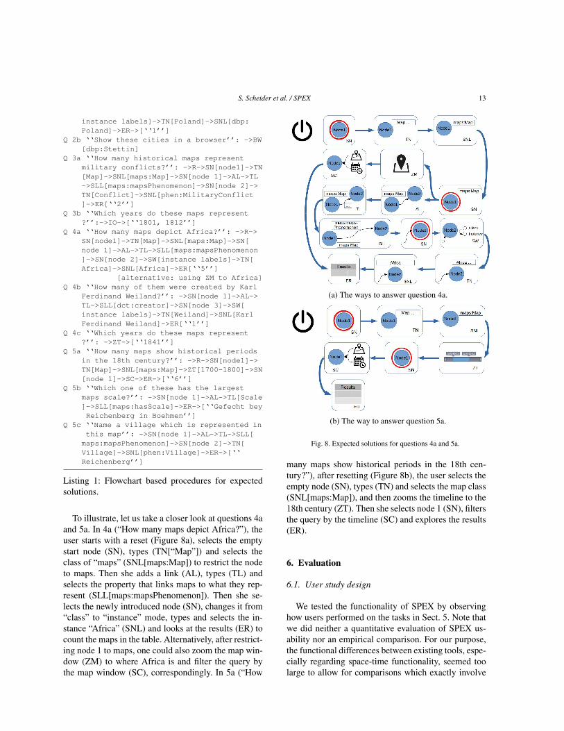
To illustrate, let us take a closer look at questions 4aand 5a. In 4a (“How many maps depict Africa?”), theuser starts with a reset (Figure 8a), selects the emptystart node (SN), types (TN[“Map”]) and selects theclass of “maps” (SNL[maps:Map]) to restrict the nodeto maps. Then she adds a link (AL), types (TL) andselects the property that links maps to what they rep-resent (SLL[maps:mapsPhenomenon]). Then she se-lects the newly introduced node (SN), changes it from“class” to “instance” mode, types and selects the in-stance “Africa” (SNL) and looks at the results (ER) tocount the maps in the table. Alternatively, after restrict-ing node 1 to maps, one could also zoom the map win-dow (ZM) to where Africa is and filter the query bythe map window (SC), correspondingly. In 5a (“How
(a) The ways to answer question 4a.
(b) The way to answer question 5a.
Fig. 8. Expected solutions for questions 4a and 5a.
many maps show historical periods in the 18th cen-tury?”), after resetting (Figure 8b), the user selects theempty node (SN), types (TN) and selects the map class(SNL[maps:Map]), and then zooms the timeline to the18th century (ZT). Then she selects node 1 (SN), filtersthe query by the timeline (SC) and explores the results(ER).
6. Evaluation
6.1. User study design
We tested the functionality of SPEX by observinghow users performed on the tasks in Sect. 5. Note thatwe did neither a quantitative evaluation of SPEX us-ability nor an empirical comparison. For our purpose,the functional differences between existing tools, espe-cially regarding space-time functionality, seemed toolarge to allow for comparisons which exactly involve

14 S. Scheider et al. / SPEX
these functions (compare results in Table 1). Further-more, our study aimed at discovering in how far thedesign principles are in effective use, as well as theremaining problems with the tool in order to reach amaturity sufficient for usability tests. While this doesnot yet allow drawing representative conclusions, it al-ready gives fundamental insights regarding the generalworkings of the tool and regarding our research ques-tions, which is a necessary basis for further prototypeimprovement and larger tests.
The SPEX tool was tested with potential users intwo stages: in the first stage a heuristic evaluation wasdone with an expert. The outcomes of this evaluationwere used to adjust and improve the information inthe “Help file28”, the formulation of the tasks (see sec-tion 5) and some aspects of the interface. Thereafter,the tool was tested with seven subjects (one of themonly in a pre-test) who are familiar with the problemof searching for geographic information on the basisof particular criteria. Two subjects are employed as li-brarian / information specialist in two different univer-sities, two other test persons are currently doing PhDresearch in the geo domain and the last two test per-sons are scientists / lecturers at the Faculty ITC of theUniversity of Twente.
The test persons were first asked to familiarizethemselves with the SPEX tool through the “Help file”(which was printed on paper) and SPEX displayed onthe screen. They were allowed, and even encouraged,to interact with the interface to try to better understandits functioning and design. Thereafter, the test personswere asked to execute the tasks as described in Sect. 5.One test person took 94 minutes to go through the Helpfile and familiarize himself with the tool. The othersubjects took less time, but still 45 minutes or more.For the execution of the tasks, usually 30 to 45 min-utes were needed, although not all test persons couldcomplete all the tasks.
The use and user issues of the SPEX prototypewere discovered through qualitative user research inwhich a mix of methods was applied. Such a mixedapproach is quite common in current user research,as different methods lead to different and comple-mentary information about the interaction of a subjectwith the tool or interface [7,13,51]. We observed thetest persons while they were going through the “Helpfile” and while they were executing their tasks with
28http://giv-lodum.uni-muenster.de/spex/help.html
SPEX. We did that by asking them to constantly thinkaloud (audio recorded), by screen and event logging(mouse clicks, etc.), by eye movement registration andby video recording their facial expressions. All theserecordings were synchronously made, stored and ana-lyzed in a Tobii X60 hardware and Tobii Studio 3.2.1software envionment, installed in the cartographic us-ability laboratory of the Faculty ITC of the Universityof Twente.
Fig. 9. The configuration of screen, eye tracking and video recordingwith one test person at ITC.
The 8 - 10 hours recordings (in total) were ana-lyzed in a qualitative way by matching the hypotheti-cal SPEX interaction model (Figure 6) with the think-ing aloud and activity protocols, and by studying theusage of the space time interfaces in greater detail withgaze maps based on eye-tracking.
The execution of the user tests went fine althoughsome test persons had difficulties with thinking aloud(they had to be reminded to do so every now and thenby the research leader who was in the same room allthe time) and the eye movement registration of somesubjects sometimes also suffered from the fact thatat the end of the long sessions the test persons sub-stantially moved their chairs and bodies. The researchleader did not interfere with this in order not to disturbthe think aloud process. All in all, the recordings re-sulted in a substantial and valuable amount of researchdata. At the end of each test session, the research leaderbriefly interviewed each subject and asked them abouttheir general satisfaction with SPEX.
6.2. Discussion of general results
For each user, we recorded the path they were fol-lowing in terms of our flowchart from Figure 6 to seewhich exploration-query steps they were performing,and which of them led to a success regarding our tasks,which did not, and why.

S. Scheider et al. / SPEX 15
Table 2Successes and failures of test persons in finding answers to questions from Sect. 5
User Q 1a Q 1b Q 2a Q 2b Q 3a Q 3b Q 4a Q 4b Q 4c Q 5a Q 5b Q 5c sol. rat.
1 success success partial skipped success success partial success(quasi)
success(quasi)
partial skipped skipped 6/8(0.75)
2 partial success success success success skipped partial skipped skipped failed skipped skipped 4/7(0.57)
3 partial success(a)
success success partial skipped success success(a)
skipped partial failed skipped 5/9(0.55)
4 partial success(quasi)
success(a)
success success(a)
partial failed skipped skipped failed skipped skipped 4/8(0.5)
5 partial partial success(a)
success partial skipped failed success(quasi)
failed skipped skipped skipped 3/8(0.38)
6 partial success(quasi)
partial skipped skipped skipped skipped skipped skipped skipped skipped skipped 1/3(0.33)
sol.rat.
1/6(0.16)
5/6(0.83)
4/6(0.66)
4/4(1.00)
3/5(0.6)
1/2(0.5)
1/4(0.25)
3/3(1.00)
1/2(0.5)
0/4(0)
0/1(0)
A synopsis of successes and failures is given in Ta-ble 2: “success” means that the question was answeredcorrectly and as expected; “failed” means that the an-swer and the way to the solution were incorrect; “suc-cess (quasi)” means the way of solution was entirelycorrect but the answer was not, and this only becauseof the influence of previous failures (dependencies be-tween answers); “partial” means that the question wasnot answered correctly, but a significant part of the wayto the solution was correct; “skipped” means that thequestion was skipped for some reason (e.g., because itdepends on predecessors which were not answered, orbecause participants were exhausted or simply forgotto give an answer). The addition of “(a)” for “alterna-tive” means that the test person used an alternative (un-foreseen) but in principle valid way to the solution. Wealso added the solution ratio, which is the proportionof successfully answered questions (either success orquasi success) divided by the number of answers given(without skipped questions).
What can be seen from this table can be summarizedas follows:
1. SPEX in principle allows non-expert users oflinked data to answer almost all these questionsabout an unknown repository (compare test per-son 1 with a success ratio of 6/8). There is asmall learning phase during the first question, af-ter which most people’s performance stabilizesquickly. The most difficult questions, however,required a lot of reasoning and iterative trials byall test persons. Question 5 (the most difficultone) was obviously too difficult for beginners.
2. Complete failures seldom occur (in 14% of alltrials). That is, persons chose at least partiallyvalid ways to an answer. Some of them even fig-ured out creative ways to a solution that we didnot anticipate (see discussion below for exam-ples).
3. Furthermore, taking into account that the diffi-culty and level of complexity of our questionswas considerably high right from the start and in-creased a lot towards the end, we notice that thelevel of successes is still quite high (52%). How-ever, a considerable exhaustion of users can beobserved towards the end in terms of a significantincrease of skipped trials as well as a decrease ofsuccesses.
Listing 2 shows an excerpt of our flowchart basedrecordings for test person 1 in Table 2. Explanation textin square brackets was added by us, and quotes wereuttered by the test person.
Q 3a ‘‘How many historical maps representmilitary conflicts?’’: R->SN->SNL[Map]->SN->AL->SLL[mapsPhenomenon, ‘‘Militaryconflict is a phenomenon, probably’’]->[‘‘Strange that those arrows arealways pointing into a differentdirection’’ (visual arrows direction vs.text direction)] ->SN[selects phenomenonnode]->SNL[‘‘Military Conflict’’]-> [correct answer: 2]
Q 3b ‘‘Which years do these maps represent?’’: ->ER->IO[inspects time events]->[correct answer: 1801, 1812]
Q 5a ‘‘How many maps show historical periodsin the 18th century?’’: R[restart withnew window]-> SN->SNL[Maps]->[‘‘And now

16 S. Scheider et al. / SPEX
the 18th century. Oh I should query that..’’]->SN-AL-SLL[does not find property,‘‘What does time mean?’’, select date]->ER[‘‘Is date the one?’’ ‘‘I don’t knowhow to do this. I can do it with thetimeline. But what does the timeline tellme? Is it the creation date?’’]-> U[undoes; would like to have a deletefunction in the node]->SN->ZT[scrollstimeline to 18th century; clicks onevents and wonders what happens] -> SW[confused; ‘‘I am doing too many things inone window here’’]->AL->SLL[‘‘has aperiod. That’s what I am looking for’’,but only finds date, select data again]->ER[‘‘I only get one. There is nothingthat is called a ‘period’.’’]
Listing 2: Flowchart based recording of test person 1.
Comparing Listing 1 with Listing 2 illustrates how us-ability problems can be spotted immediately. For ex-ample, the user in Listing 2 does not succeed in query-ing with the timeline for Q 5a because he is confusedabout how the temporal values in the time line relateto query results (creation date?) and whether or not heshould rather try a temporal query with a graph querypattern (using the “date” property).
In the following, we will discuss the general insightsfrom our analysis. We start with our observations re-garding the functioning of our design principles:
– People made effective use of all visual querygraph construction possibilities. Choosing nodelabels and adding visual edges seems in general totranslate well into the questions of the task (pro-vided, however, that people understand the mean-ing of vocabulary terms). All people used visuallink construction as well as node labeling to con-ceptualize the question and to solve their querytask. Test person 1 explicitly formulated ques-tions in terms of node-link query patterns, eventhough linked data principles were unknown tothis person.
– People used result exploration, Web browsing aswell as map and timeline exploration in orderto answer their questions in ways that were notforeseen by us (“alternative solution”). They usedmany trials to figure out different ways to reach anequivalent goal (and indeed, “many ways lead toRome”), e.g.: Using map geometry sizes to figureout map scales; using Web link information (DB-pedia) to find information about associated times;Using two filters on space and time and the prop-
erty “hasScale” to answer questions 5a and 5b,which in principle is a correct (but unexpected)answer.
– People ran through many query-exploration cy-cles iteratively (which is not time consumingbecause SPEX is modeless, i.e., works withoutmenu hierarchies, and has an undo/reset button).This allowed them to quickly learn somethingnew which they could use in the next iteration,i.e., they could make iterative learning progress.For example, test person 1 figured out that press-ing return is necessary after input in his first cy-cle, and then used this in all subsequent cycles.Another test person figured out (after several un-successful trials with browsing map descriptionson the Web) that map scales can also be comparedvia geometry sizes in the map window, which leadto an alternative solution.
– People explored term meanings using term sug-gestions and result feedback. For example, testperson 1 explored the meaning of the term “To-pographic Map” by checking whether results area subset of “Map”.
The following list contains main difficulties users wereconfronted with when using the current version of thetool on the given tasks. We classified them according tothe causes of their confusion or task failure and addedpossible cures:
– Difficulties with understanding linked data vo-cabularies and example (historical map) datamodels
∗ People had difficulties in guessing (without anyexplanation) the conceptual data model under-lying our scenario which treats maps as wellas their contents as linked nodes. For exam-ple, one test person largely failed to understandthat in the repository, maps are entities differ-ent from lakes and countries to be selected bya separate node and in need of linking to thelatter. This issue has probably to do with theparticularly unusual way of modeling map con-tents by linked data.
∗ People had difficulties with abstract and un-clear categories such as “hasPhenomenon” inthe property list. For example, test person 1subsumed “lake” under “phenomenon” but not“country” in the case of Poland and thereforefailed to answer question 2. Testers also hadtrouble understanding the difference between

S. Scheider et al. / SPEX 17
dc:date and the word “period” as used in ques-tion 5a), compare Listing 2. This is a conse-quence of the particular vocabulary terms usedand a lack of their explanation in the currentversion of SPEX. Understanding vocabulariescan be improved by adding vocabulary explo-ration or explanation tools. For example, a sim-ple measure would be to load RDF term com-ments from the Web and show them to a userwhenever a term needs to be selected.
∗ Prefixes occurring in front of terms were dis-turbing (test person 1: “dct: I have no idea whatthat is”). As a consequence, URIs should be ex-plained or, if possible, replaced by labels.
– Difficulties with the context menu options
∗ The query terminology used in context menuswas difficult to understand. For example, thedistinction between things of a kind and partic-ular things (test person 1: “Why do I have tomake the decision?”) could be removed.
∗ People were easily confused about the neces-sity of pressing return to go to the next step (ex-tra cognitive effort).
∗ Node context menu options were not offeredin sequential steps but all together at all times.For example, label selection was offered alsoafter a label was selected. This made it hard tothink about what step was next (test person 1:“I would not expect to see maps here in textform if I have selected the label map already.”“There should be a difference between whatyou have left behind and what your next task isgoing to be”.)
6.3. The role of space-time in exploratory querying
We did an additional analysis including eye-trackingresults in order to learn in how far and how success-fully the space-time functionality was used to solve ex-ploratory querying tasks.
Table 3 shows a synopsis of the usage of the mapand time windows regarding SPEX functionality as inFigure 6: inspection of query result objects in map ortime windows (IO), zooming of map (ZM) and timeline (ZT) and the use of space-time filtering (SC).What can be seen from this table is that the space-time interface was used for roughly half of the ques-tions (especially Questions 3b, 4a/c, and 5a). Com-pared to what we would consider meaningful givenour expected solutions (last row in Table 3), it appears
that participants 1-3 (the three most successful ones)roughly matched our expectations. That is, these peo-ple used map or time windows in a way which canbe considered appropriate for the corresponding task,even if they failed to answer the question, and providedthey did not skip the task for some reason. The otherparticipants (4,5,6) made considerably less successfuluse of the map and time windows. User 6 used the mapwindow for Q 2a, which can be considered appropriate(as Poland can be searched in the map), even thoughnot leading to success. According to our recordings,user 4 thought that the map was only illustrative andthus did not consider it as a tool, while user 5 for somereason only focused on query pattern construction. Us-age in general was mostly explorative. Regarding suc-cesses, if we compare table 3 with 2, we see that thequestions requiring space-time interfaces (Q 3b, 4c and5a) were a bit less successfully answered than over-all (2 successes (25%), 3 partial (37,5%) and 3 fail-ures (37,5%) out of 8 trials). However, these questionswere also among the more difficult ones in terms ofgeneral complexity. Quite a few people skipped thesetasks. Concerning Q 3b, our recordings reveal that peo-ple skipped sometimes because they thought the solu-tion was obvious after they tried out the time slider.
If we take a look at the gaze plots (Figures 10)and the corresponding fixation times (Table 4), we seedifferent strategies in the way users approached theirtasks, which can be put in relation to their respectivesuccess: For Q 4a (which can be solved both by usingthe map window or by a query pattern), user 1 (Fig.10a) used 60% of his time (Table 4) for the map win-dow and 16% for the time window, almost neglect-ing the query pattern construction, while user 4 (Fig.10b), in contrast, almost neglected map or time win-dows. User 1 partially solved the task, while user 4completely failed. User 3 (Figure 10c) made moderateuse of map (15%) and time (1%) windows (Table 4)as well as the query pattern construction and success-fully solved the task. Figure 10d illustrates how user 5tried to answer Q 3b with hardly any time exploration(0.15%, Table 4), which is not possible. Thus, the gazedifferences between people show not only a differentawareness of the possibilities that these windows of-fer, they also illustrate different strategies and partiallyreveal the causes for success or failure. However, ourresults do not allow concluding that usage of time andspace windows necessarily leads to more successes.
In analyzing the user test, we furthermore discov-ered a number of problems with the current space-timeinterface, and addressing these could greatly improve

18 S. Scheider et al. / SPEX
Table 3Usage of space-time functionality in exploratory querying compared to our expectation exp. Function labels as in Figure 6.
User Q 1a Q 1b Q 2a Q 2b Q 3a Q 3b Q 4a Q 4b Q 4c Q 5a Q 5b Q 5c
1 no no no no no IO ZM no IO/ZT ZT skipped skipped2 no no no no no ZT no skipped skipped no skipped skipped3 no no no no no skipped ZM no ZT IO/SC/ZTno skipped4 no no no no no no no skipped skipped no skipped skipped5 no no no no no skipped no no no skipped skipped skipped6 no no ZM/ZT skipped skipped skipped skipped no skipped skipped skipped skipped
exp no no ZM no no IO/ZT ZM/SC no IO/ZT ZT/SC IO/ZM IO/ZM
(a) A gaze plot of user 1 for Q 4a. (b) A gaze plot of user 4 for Q 4a.
(c) A gaze plot of user 3 for Q 4a. (d) A gaze plot of user 5 for Q 3b.
Fig. 10. Gaze plots of different users for questions Q 3b and Q 4a.
Table 4Eye-tracking fixation duration per test person for questions Q 4a and Q 3b, determined within the map window, time window and the entireapplication window.
Fixation time In seconds In percentfor ... Map W. Time W. Entire W. Map W. Time W. Entire W.
User 1 (Q 4a) 29.25 7.84 47.25 61.90 16.59 100User 3 (Q 4a) 11.74 0.75 82.04 14.31 0.91 100User 4 (Q 4a) 0.33 0.78 82.61 0.4 0.94 100User 5 (Q 3b) 0.68 0.35 228.25 0.3 0.15 100

S. Scheider et al. / SPEX 19
our result. In particular, the space-time filter function-ality (SC), which was very relevant in Q 4a and 5a(compare Table 3), was not used very often and notvery successfully compared to space-time exploration.In general, people said that the map window should bemore prominent and should be better explained. Peoplefound it difficult to decide whether they should treattime and space constraints via filters or via patterns inthe query window. They tried out both and were usu-ally exhausted when one option failed and did not trythe other option any more. Furthermore, the meaningof the link between map and time objects and resultsremained unclear. Do the events on the time line repre-sent what is shown in a map or when the map was cre-ated (compare Listing 2)? Links to space time literalsare currently not shown to the user. Finally, clutteredmap and time objects makes map and time windowsless useful.
6.4. Summary
In summary, the preliminary study shows that ourdesign, i.e., the query, exploration and feedback strate-gies on which it is based, were effectively used in alarge number of cases. It also highlights the frequentand purposeful use of map and time windows, as wellas the different roles they play in solution strategies.Space-time exploration was rather naturally adoptedfor answering questions with linked data in almost allrelevant cases, while space-time filtering obviously re-quires more explanation and usability improvement.One way would be to filter nodes automatically whenzooming, without requiring a user to set a filter con-straint. Successful users seemed to adopt a “balanced”strategy, combining space-time interaction with queryconstruction whenever appropriate. An open questionis how such a balanced strategy can be supported.The reasons for usability problems were in generalmostly located either outside of the scope of the in-tended functionality of SPEX (e.g., supporting the un-derstanding of vocabularies and domain models wasnot a goal of our design), or they were related to im-plementation choices that are not based on our designprinciples (compare Sect. 3). The discovered problemsmay exist precisely because the principles were notyet implemented with enough consequence: For exam-ple, the syntactical choice between class and instancebased queries was driven by our understanding of RDFbut contradicts principle 3.1, because it is neither ex-plained nor even necessary. The missing semantic linkbetween results and map/time objects and missing ex-
ploration of result name spaces contradict principle3.5. And showing a menu option also after it was se-lected contradicts the principle of progressive disclo-sure of options (Compare Sect. 3).
Overall, users said in the interviews that the tooloffers an interesting way of searching. Especiallythe time window was considered a useful part. Thisfits with our observations that users frequently wentthrough query and exploration cycles to approach avalid solution, even if they failed in the end. Thesecycles were exactly enabled by our design principles.For these reasons, we conclude that the study supportsthe general functioning of our design principles andthe way they integrate space and time, even though ithighlights also clear opportunities for improvement ofthe tool.
6.5. Application to other sources of spatio-temporallinked data
In order to evaluate SPEX beyond the dataset ofour study and to demonstrate its versatility, it hasbeen applied to two other use cases. In the first casethe data is generated by the crowdsourcing platformUshahidi29 delivering human observations in an earth-quake aftermath. The analysis of the original datais reported in [42]30. As depicted in Fig. 11, SPEXcan be used to find Ushahidi reports that are about(dc:subject) operating hospitals distributed in a cer-tain region. In the future, we want to link also tempo-ral information from these reports to our data. In thisway, emergency dispatchers as well as urban plannersare provided with meaningful user-generated content,allowing them to display as well as query availableemergency services, operating hospitals, infrastructuredamages, road blockages, and so on.
The second use case is about querying large scaletopography, including geographical objects and areasof the landscape such as roads, waterways, buildings,parcels and green spaces. We currently apply SPEXon an RDF version of the openly accessible datasetBGT31 (digital base map for the Netherlands) in orderto let landuse planners and other geoinformation pro-fessionals explore topographic objects by type, space
29http://www.ushahidi.com/30In order to generate RDF, we extracted objects and linked them
to OSM data as part of preprocessing the unstructured reports.31Basisregistratie Grootschalige Topografie, https:
//www.pdok.nl/nl/producten/pdok-downloads/download-basisregistratie-grootschalige-topografie

20 S. Scheider et al. / SPEX
Fig. 11. Finding operational hospitals inside an area with SPEX us-ing data about Chile from the crowdsourcing platform Ushahidi .
and links to other data. With linked data and SPEX, webelieve that cadastral data can be combined more effi-ciently with datasets from local government in a webenvironment to improve information provision to thegeneral public.
7. Conclusion
In current linked data retrieval systems, query andexploration are often not tightly integrated and do nothandle space and time in both query and exploration.This prevents users unfamiliar with a given repositoryfrom taking advantage of the self-explanatory powerof linked data and the intuitive retrieval possibilitiesof maps and time sliders in order to find out aboutinteresting repository content. In this paper, we haveproposed design principles for exploratory querying ofSPARQL endpoints in space and time, used them tocompare existing tools, implemented them in terms ofthe SPEX tool, and tested them in a preliminary userstudy. The latter was based on a number of questionsabout a historical maps repository which require com-plex query construction and interaction with space-time interfaces.
Even though our study is too limited to draw strongconclusions, results are encouraging and show that thetightly closed query and exploration loops of our de-sign enable novices on linked data to pose and cor-rectly answer complex queries about a repository theywould not be able to answer otherwise. Modeless de-sign and immediate feedback of query on explorationand vice versa enable users to iteratively explore queryfunctionality, data content and vocabulary meaning, aswell as to find alternative solution paths for a given
question. Our analysis revealed diverse solution strate-gies, where successful answers were found both byquery patterns and space-time windows. Space andtime windows were mostly used for exploratory pur-poses, seldom for query purposes.
However, we also found that successful question an-swering requires a simplification of the space-time fil-tering interface, a better understanding of vocabulariesand data models, improved usability of context menus,and a better conceptual linking of maps/time sliderswith other displays. In the future, we plan to addressthese issues by corresponding developments as indi-cated in this paper and to test them in a larger userstudy. Furthermore, a particular technical challengelies in making SPEX scale up to larger datasets. Sinceexploratory querying requires a high degree of inter-activity, SPEX currently fires many queries silently inthe background. Making this interactive behavior scal-able requires server side support for spatio-temporalqueries as well as strategies for fast query answering.
Acknowledgments
This work has been funded by the German Re-search Foundation (DFG) through the Linked Data foreScience Services (LIFE) project (KU 1368/11-1). Wethank our project partners, the Münster University Li-brary (ULB), for their constant support of this work.Furthermore, we thank all participants of our user testfor letting us peek over their shoulders.
References
[1] Alonen, M., Kauppinen, T., Suominen, O., Hyvönen, E.: Ex-ploring the linked university data with visualization tools.In: Cimiano, P., Fernández, M., Lopez, V., Schlobach, S.,Völker, J. (eds.) The Semantic Web: ESWC 2013 SatelliteEvents. pp. 204–208. Springer, Montpellier, France (2013),doi:10.1007/978-3-642-41242-4_25
[2] Arenas, M., Grau, B.C., Kharlamov, E., Marciuska, S.,Zheleznyakov, D.: Faceted search over ontology-enhancedRDF data. In: Proceedings of the 23rd ACM Interna-tional Conference on Information and Knowledge Manage-ment, CIKM 2014. pp. 939–948. Shanghai, China (2014),doi:10.1145/2661829.2662027
[3] Atemezing, G.A., Troncy, R.: Towards a linked-data based vi-sualization wizard. In: Hartig, O., Hogan, A., Sequeda, J. (eds.)Proceedings of the 5th International Workshop on ConsumingLinked Data (COLD 2014). CEUR-WS.org, Riva del Garda,Italy (2014)

S. Scheider et al. / SPEX 21
[4] Auer, S., Doehring, R., Dietzold, S.: LESS - Template-basedsyndication and presentation of linked data. In: Aroyo, L., An-toniou, G., Hyvönen, E., ten Teije, A., Stuckenschmidt, H.,Cabral, L., Tudorache, T. (eds.) Proceedings of the 7th Inter-national Conference on The Semantic Web: Research and Ap-plications - Volume Part II. pp. 211–224. ESWC’10, Springer-Verlag Berlin Heidelberg, Heraklion, Crete, Greece (2010),doi:10.1007/978-3-642-13489-0_15
[5] Battle, R., Kolas, D.: Enabling the geospatial Semantic Webwith Parliament and GeoSPARQL. Semantic Web 3(4), 355–370 (2012), doi:10.3233/SW-2012-0065
[6] Becker, C., Bizer, C.: Exploring the geospatial semantic webwith dbpedia mobile. J. Web Sem. 7(4), 278–286 (2009),doi:10.1016/j.websem.2009.09.004
[7] Bleisch, S.B.: Evaluating the appropriateness of visually com-bining quantitative data representations with 3D desktop vir-tual environments using mixed methods. Ph.D. thesis, CityUniversity, London (2011)
[8] Brunetti, J.M., García, R., Auer, S.: From overview to facetsand pivoting for interactive exploration of semantic webdata. Int. J. Semantic Web Inf. Syst. 9(1), 1–20 (2013),doi:10.4018/jswis.2013010101
[9] Camarda, D., Mazzini, S., Antonuccio, A.: LodLive, explor-ing the web of data. In: Presutti, V., Pinto, H.S. (eds.) Pro-ceedings of the 8th International Conference on Semantic Sys-tems (I-SEMANTICS 2012). pp. 197–200. ACM, Graz, Aus-tria (2012), doi:10.1145/2362499.2362532
[10] Catarci, T., Costabile, M.F., Levialdi, S., Batini, C.: Visualquery systems for databases: a survey. J. Vis. Lang. Comput.8(2), 215–260 (1997), doi:10.1006/jvlc.1997.0037
[11] Codd, E.F.: A relational model of data for large shareddata banks. Commun. ACM 13(6), 377–387 (Jun 1970),doi:10.1145/362384.362685
[12] Dadzie, A.S., Rowe, M.: Approaches to visualising linked data:a survey. Semantic Web 2(2), 89–124 (2011), doi:10.3233/SW-2011-0037
[13] Fazal-e-Amin, Alghamdi, A.S.: A mixed method study on us-ability evaluation of smartphone web browsers. Journal of In-ternet Technology 15(5), 783–792 (2014)
[14] Franklin, C., Hane, P.: An introduction to geographic informa-tion systems: linking maps to databases. Database 3(4), 333–354 (2012)
[15] Graves, A.: Creation of visualizations based on linkeddata. In: Proceedings of the 3rd International Conferenceon Web Intelligence, Mining and Semantics. pp. 41:1–41:12. WIMS’13, ACM, New York, NY, USA (2013),doi:10.1145/2479787.2479828
[16] Haag, F., Lohmann, S., Siek, S., Ertl, T.: Visual queryingof linked data with QueryVOWL. In: Joint Proceedings ofSumPre 2015 and HSWI 2014-15. CEUR-WS.org, Portoroz,Slovenia (2015)
[17] Haag, F., Lohmann, S., Bold, S., Ertl, T.: Visual SPARQLquerying based on extended filter/flow graphs. In: Paolini, P.,Garzotto, F. (eds.) Proceedings of the 2014 International Work-ing Conference on Advanced Visual Interfaces. pp. 305–312.ACM, Como, Italy (2014), doi:10.1145/2598153.2598185
[18] Hart, G., Dolbear, C.: Linked data: a geographic perspective.CRC Press, Boca Raton (2013)
[19] Heim, P., Hellmann, S., Lehmann, J., Lohmann, S., Stege-mann, T.: RelFinder: revealing relationships in RDF knowl-edge bases. In: Chua, T., Kompatsiaris, M., Mérialdo, B., Haas,
W., Thallinger, G., Bailer, W. (eds.) Semantic Multimedia -4th International Conference on Semantic and Digital Me-dia Technologies (SAMT 2009). pp. 182–187. Springer-VerlagBerlin Heidelberg, Graz, Austria (2009), doi:10.1007/978-3-642-10543-2_21
[20] Heim, P., Ziegler, J., Lohmann, S.: gFacet: a browser for theweb of data. In: Auer, S., Dietzold, S., Lohmann, S., Ziegler,J. (eds.) Proceedings of the International Workshop on Inter-acting with Multimedia Content in the Social Semantic Web(IMC-SSW’08). vol. 417, pp. 49–58. CEUR-WS.org, Koblenz,Germany (2008)
[21] Hoefler, P., Granitzer, M., Veas, E., Seifert, C.: Linked DataQuery Wizard: a novel interface for accessing SPARQL end-points. In: Bizer, C., Heath, T., Auer, S., Berners-Lee, T. (eds.)Proceedings of the Workshop on Linked Data on the Web(LDOW 2014). CEUR-WS.org, Seoul, Korea (2014)
[22] Hogenboom, F., Milea, V., Frasincar, F., Kaymak, U.: RDF-GL: a SPARQL-Based graphical query language for RDF.In: Chbeir, R., Badr, Y., Abraham, A., Hassanien, A.E. (eds.)Emergent Web Intelligence: Advanced Information Retrieval,pp. 87–116. Springer-Verlag London (2010), doi:10.1007/978-1-84996-074-8_4
[23] Hornbæk, K., Frøkjær, E.: Do thematic maps improve informa-tion retrieval? In: Human-Computer Interaction (INTERACT99). pp. 179–186. Edinburgh, Scotland (1999)
[24] Hyvönen, E., Ruotsalo, T., Häggström, T., Salminen, M., Jun-nila, M., Virkkilä, M., Haaramo, M., Mäkelä, E., Kauppinen,T., Viljanen, K.: Culturesampo - finnish culture on the semanticweb: the vision and first results. In: Developments in ArtificialIntelligence and the Semantic Web - Proceedings of the 12thFinnish AI Conference STeP. pp. 26–27 (2006)
[25] Janowicz, K.: The role of space and time for knowledge orga-nization on the Semantic Web. Semantic Web 1(1-2), 25–32(2010), doi:10.3233/SW-2010-0001
[26] Janowicz, K., Scheider, S., Pehle, T., Hart, G.: Geospatial se-mantics and linked spatiotemporal data - Past, Present, and Fu-ture. Semantic Web 3(4), 321–332 (2012), doi:10.3233/SW-2012-0077
[27] Jones, C.B., Purves, R.S.: Geographical information re-trieval. Int. J. Geogr. Inf. Sci. 22(3), 219–228 (2008),doi:10.1080/13658810701626343
[28] Jones, J., Kuhn, W., Keßler, C., Scheider, S.: Making the web ofdata available via web feature services. In: Huerta, J., Schade,S., Granell, C. (eds.) Connecting a Digital Europe ThroughLocation and Place, pp. 341–361. Lecture Notes in Geoin-formation and Cartography, Springer International Publishing(2014), doi:10.1007/978-3-319-03611-3_20
[29] Kadlag, A., Wanjari, A., Freire, J., Haritsa, J.: Supporting ex-ploratory queries in databases. In: Lee, Y., Li, J., Whang,K.Y., Lee, D. (eds.) Database Systems for Advanced Appli-cations, Lecture Notes in Computer Science, vol. 2973, pp.594–605. Springer Berlin Heidelberg (2004), doi:10.1007/978-3-540-24571-1_54
[30] Kauppinen, T., de Espindola, G., Jones, J., Sanchez, A., Gräler,B., Bartoschek, T.: Linked Brazilian Amazon rainforest data.Semantic Web Journal 5(2) (2014), doi:10.3233/SW-130113
[31] Kauppinen, T., Hyvönen, E.: Modeling and reasoning aboutchanges in ontology time series. In: Ontologies, pp. 319–338.Springer (2007), doi:10.1007/978-0-387-37022-4_11
[32] Keßler, C., Janowicz, K., Kauppinen, T.: spa-tial@linkedscience - Exploring the research field of GIScience
22 S. Scheider et al. / SPEX
with linked data. In: Xiao, N., Kwan, M.P., Goodchild, M.,Shekhar, S. (eds.) Geographic Information Science, LectureNotes in Computer Science, vol. 7478, pp. 102–115. SpringerBerlin Heidelberg (2012), doi:10.1007/978-3-642-33024-7_8
[33] Kovarsky, J.: Searching for early maps: use of online librarycatalogs. ACMLA Bulletin 138 (2011)
[34] Kuhn, W., Kauppinen, T., Janowicz, K.: Linked data - aparadigm shift for geographic information science. In: Duck-ham, M., Pebesma, E., Stewart, K., Frank, A.U. (eds.) Ge-ographic Information Science - Eighth International Confer-ence. pp. 173–186. Springer International Publishing, Vienna,Austria (2014), doi:10.1007/978-3-319-11593-1_12
[35] Kveladze, I., Kraak, M.J., van Elzakker, C.P.: A methodolog-ical framework for researching the usability of the space-time cube. The Cartographic Journal 50(3), 201–210 (2013),doi:10.1179/1743277413Y.0000000061
[36] Kyzirakos, K., Karpathiotakis, M., Koubarakis, M.: Stra-bon: a semantic geospatial DBMS. In: Cudré-Mauroux, P.,Heflin, J., Sirin, E., Tudorache, T., Euzenat, J., Hauswirth,M., Parreira, J., Hendler, J., Schreiber, G., Bernstein, A.,Blomqvist, E. (eds.) The Semantic Web–ISWC 2012, pp. 295–311. Springer Berlin Heidelberg, Boston, Massachusetts, USA(2012), doi:10.1007/978-3-642-35176-1_19
[37] Larson, R.: Geographic information retrieval and digital li-braries. In: Agosti, M., Borbinha, J., Kapidakis, S., Pap-atheodorou, C., Tsakonas, G. (eds.) Research and AdvancedTechnology for Digital Libraries, Lecture Notes in ComputerScience, vol. 5714, pp. 461–464. Springer Berlin Heidelberg,Corfu, Greece (2009), doi:10.1007/978-3-642-04346-8_59
[38] Lohmann, S., Heim, P., Stegemann, T., Ziegler, J.: TheRelFinder user interface: interactive exploration of rela-tionships between objects of interest. In: Rich, C., Yang,Q., Cavazza, M., Zhou, M.X. (eds.) Proceedings of the15th International Conference on Intelligent User Inter-faces. pp. 421–422. ACM, Hong Kong, China (2010),doi:10.1145/1719970.1720052
[39] Mandel, T.: The elements of user interface design. John Wiley& Sons, Inc., New York, NY, USA (1997)
[40] Marchionini, G.: Exploratory search: from finding to un-derstanding. Commun. ACM 49(4), 41–46 (Apr 2006),doi:10.1145/1121949.1121979
[41] Purves, R.S., Clough, P., Jones, C.B., Arampatzis, A.,Bucher, B., Finch, D., Fu, G.: The design and imple-mentation of SPIRIT: a spatially aware search engine forinformation retrieval on the internet. International J. ofGeographical Information Science 21(7), 717–745 (2007),doi:10.1080/13658810601169840
[42] Rhonzin, S.: Semantic enrichment of volunteered geographicinformation using linked data: a use case scenario for disastermanagement. Master’s thesis, University of Twente, Enschede(2015)
[43] Scheider, S., Degbelo, A., Kuhn, W., Przibytzin, H.: Contentand context description - How linked spatio-temporal data en-ables novel information services for libraries. gis.Science 4,138–149 (2014)
[44] Scheider, S., Jones, J., Sánchez, A., Keßler, C.: Encodingand querying historic map content. In: Huerta, J., Schade,S., Granell, C. (eds.) Connecting a Digital Europe ThroughLocation and Place, pp. 251–273. Lecture Notes in Geoin-formation and Cartography, Springer International Publishing(2014), doi:10.1007/978-3-319-03611-3_15
[45] Schraefel, M., Karger, D.: The pathetic fallacy of RDF. In: In-ternational workshop on the semantic web and user interaction(SWUI). Athens, Georgia, USA (2006)
[46] Shneiderman, B.: The eyes have it: a task by datatype taxonomy for information visualizations. In: Pro-ceedings of the 1996 IEEE Symposium on Visual Lan-guages. pp. 336–343. Boulder, Colorado, USA (1996),doi:10.1109/VL.1996.545307
[47] Skjæveland, M.: Sgvizler: a JavaScript wrapper for easy vi-sualization of SPARQL result sets. In: Simperl, E., Norton,B., Mladenic, D., Della Valle, E., Fundulaki, I., Passant, A.,Troncy, R. (eds.) The Semantic Web: ESWC 2012 Satel-lite Events. Lecture Notes in Computer Science, vol. 6089,pp. 361–365. Springer Berlin Heidelberg, Heraklion, Crete,Greece (2012), doi:10.1007/978-3-662-46641-4_27
[48] Smart, P.R., Russell, A., Braines, D., Kalfoglou, Y., Bao, J.,Shadbolt, N.R.: A visual approach to semantic query designusing a web-based graphical query designer. In: Gangemi, A.,Euzenat, J. (eds.) Knowledge Engineering: Practice and Pat-terns (EKAW 2008). Lecture Notes in Computer Science, vol.5268, pp. 275–291. Springer-Verlag Berlin Heidelberg, Ac-itrezza, Italy (2008), doi:10.1007/978-3-540-87696-0_25
[49] Stadler, C., Lehmann, J., Höffner, K., Auer, S.: LinkedGeo-Data: a core for a web of spatial open data. Semant. web 3(4),333–354 (2012), doi:10.3233/SW-2011-0052
[50] Usbeck, R.: Combining linked data and statistical informationretrieval. In: Presutti, V., d’Amato, C., Gandon, F., d’Aquin,M., Staab, S., Tordai, A. (eds.) The Semantic Web: Trendsand Challenges - 11th International Conference, ESWC 2014,Lecture Notes in Computer Science, vol. 8465, pp. 845–854.Springer International Publishing, Anissaras, Crete, Greece(2014), doi:10.1007/978-3-319-07443-6_58
[51] Venkatesh, V., Brown, S.A., Bala, H.: Bridging the qualitative-quantitative divide: guidelines for conducting mixed methodsresearch in information systems. MIS quarterly 37(1), 21–54(2013)
[52] White, R.W., Roth, R.A.: Exploratory search: beyond thequery-response paradigm. Synthesis Lectures on InformationConcepts, Retrieval, and Services, Morgan & Claypool Pub-lishers (2009), doi:10.2200/S00174ED1V01Y200901ICR003
[53] Zviedris, M., Barzdins, G.: Viziquer: a tool to explore andquery sparql endpoints. In: Antoniou, G., Grobelnik, M., Sim-perl, E., Parsia, B., Plexousakis, D., De Leenheer, P., Pan, J.(eds.) The Semanic Web: Research and Applications - 8th Ex-tended Semantic Web Conference, ESWC 2011, Proceedings,Part II. Lecture Notes in Computer Science, vol. 6644, pp. 441–445. Heraklion, Crete, Greece (2011), doi:10.1007/978-3-642-
21064-8_31