exploring geology chapter 1 questions - testbanku.eu · web viewin word so they renumber...
TRANSCRIPT

Chapter 1 – The Nature of Earth ScienceTest Bank for Exploring Earth Science 1st Edition by Reynolds
Complete downloadable file at: https://testbanku.eu/Test-Bank-for-Exploring-Earth-Science-1st-Edition-by-
Reynolds Section: The number of the relevant two-page spread in Exploring Earth Science.
Section 1.0 – The Nature of Earth Science
1. Which of the following was mentioned in the opening two-page spread of Chapter 1 (The Nature of Earth Science)?a) mountainsb) volcanoesc) stormsd) oceanse) all of these were mentioned
Answer: eSection: 1.0
2. One of the main topics discussed in the opening two-page spread of Chapter 1 (The Nature of Earth Science) was:a) that the two sides of North America are very differentb) that volcanoes have dramatically changed the atmosphere over timec) a huge meteorite impact caused the dinosaurs to become extinctd) all of these were mentioned
Answer: aSection: 1.0
Section 1.1 – How Do Earth’s Features and Processes Influence Where and How We Live?
3. Which potential geologic hazard is NOT represented by a feature on this figure?a) an earthquakeb) a volcanoc) contaminated groundwaterd) a landslidee) flood-prone areas
Answer: c

Full file at https://testbanku.eu/
Section: 1.1
4. Choose an appropriate way(s) volcanoes might impact people living nearby:a) increasing job opportunitiesb) improving the local economyc) increasing likelihood of volcanic eruptionsd) increasing likelihood of an oil spill
Answer: cSection: 1.1
5. Choose an appropriate way(s) steep cliffs might impact people living nearby:a) easy to build houses on steep cliffsb) favorable location for livestock grazingc) increases area available to grow cropsd) increases landslide hazard
Answer: dSection: 1.1
6. Choose anappropriate way(s) volcanoes might impact people living nearby:a) Releases steam and noxious gases into the atmosphere.b) Volcanic ash provides fertile sediment for growing crops.c) Ash ejected into the atmosphere blocks sunlight.d) Projectiles thrown into the air can hit your house.e) All of these impact people living nearby.
Answer: eSection: 1.1
7. Rainfall in mountain ranges might impact people living nearby by:a) increasing erosion in mountainsb) increasing flooding hazardsc) increasing mudslide hazardsd) water flowing into streams and rivers, increasing water supplye) all of these
Answer: eSection: 1.1
Section 1.2 – How Does Earth Science Explain Our World?
8. Earth science can help us learn about Earth's past by studying:
Full file at https://testbanku.eu/
a) why continents and oceans are differentb) why a landscape looks the way it doesc) how life in the past was different than todayd) how global climate has changed since the ice agese) all of these
Answer: eSection: 1.2
9. Which of the following is NOT a way earth science informs us about Earth's past?a) how the first second of the universe differed from a second todayb) why continents and oceans are differentc) why a landscape looks the way it does todayd) how life in the past was different than todaye) how past global climate was different than today
Answer: aSection: 1.2
10. Continents differ in appearance from ocean basins because:a) each has its own geologic historyb) each contains different fossilsc) each has its own climate
Answer: aSection: 1.2
11. Continental ice sheets were more common 28,000 years ago than they are today because:a) the Earth had more water then than nowb) the Earth was cooler then than nowc) the Earth was farther away from the Sun then
than now
Answer: bSection: 1.2
Section 1.3 – What Forces and Processes Affect Our Planet?
12. Which of the following is true about gravity?a) Gravity of the Sun and Moon exert a pull on Earth.b) The mass of the Earth causes a downward pull on objects on Earth.c) Gravity causes ice, water, and rocks to move downhill.d) All of these.

Full file at https://testbanku.eu/
Answer: dSection: 1.3
13. Which of the following is true about forces and energy imposed on Earth from space?a) Internal processes within the Moon produce light during the night.b) Sun's electromagnetic energy is all blocked by Earth's protective atmosphere. c) Our massive Sun is the only object that exerts a gravitational pull on Earth.d) All of these.e) None of these.
Answer: eSection: 1.3
14. What happens to material that is hotter than its surrounding material deep within the Earth?a) The hot material slowly moves up toward the surface.b) The hot material moves slowly down toward the core. c) Nothing. The hot material doesn't move at all.
Answer: aSection: 1.3
15. Radioactive decay in the Earth, especially in the Earth's crust, creates a tremendous amount of:a) pressureb) heat
Answer: bSection: 1.3
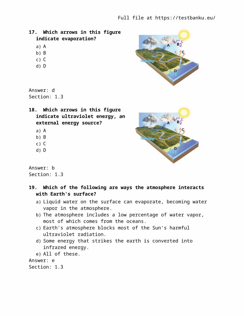
16. Which arrows in this figure indicate infrared energy, which has been converted from ultraviolet energy?a) Ab) Bc) Cd) D
Answer: cSection: 1.3
17. Which arrows in this figure indicate evaporation?

Full file at https://testbanku.eu/
a) Ab) Bc) Cd) D
Answer: dSection: 1.3
18. Which arrows in this figure indicate ultraviolet energy, an external energy source?a) Ab) Bc) Cd) D
Answer: bSection: 1.3
19. Which of the following are ways the atmosphere interacts with Earth's surface?a) Liquid water on the surface can evaporate, becoming water vapor in the atmosphere.b) The atmosphere includes a low percentage of water vapor, most of which comes from
the oceans.c) Earth's atmosphere blocks most of the Sun's harmful ultraviolet radiation.d) Some energy that strikes the earth is converted into infrared energy. e) All of these.
Answer: eSection: 1.3
Section 1.4 – How Do Natural Systems Operate?
20. The "sphere" that intersects with all of the other spheres is the
Full file at https://testbanku.eu/
a) atmosphere.b) biosphere.c) hydrosphere.d) lithosphere.
Answer: bSection: 1.4
21. The lithosphere refers to thea) plasticky interior of the Earth that moves in response to heating from the interior.b) molten lava that is ejected from volcanoes.c) land part of the Earth only.d) solid upper part of the Earth, including the crust and uppermost mantle.
Answer: dSection: 1.4
22. The difference between open and closed systems is thata) open systems are not predictable but closed systems are.b) open systems can acquire matter and energy, but closed systems cannot.c) open systems are much simpler in terms of the number of interactions between objects
in the system.d) open systems occur on land and closed systems occur in the ocean.
Answer: bSection: 1.4
23. When you shake fish food into in an aquarium, you are contributing to a(n)a) open system.b) negative feedback system.c) positive feedback system.d) closed system.
Answer: aSection: 1.4
24. A snowball that rolls down a hill, gradually gaining more and more mass and rolling faster and faster as it continues, would be an example of a(n)a) positive feedback system.b) negative feedback system.c) open system.d) closed system.
Answer: aSection: 1.4
Section 1.5 – What Are Some Important Earth Cycles?

Full file at https://testbanku.eu/
25. Which of the following statements is true about the transfer of energy, matter, or momentum in the atmosphere?a) Momentum is usually transferred from the surface upward.b) Energy transfer occurs when water changes state between solid, liquid, or gas.c) Matter is transferred so effectively that the spatial distribution of matter in the
atmosphere is uniform.d) No transfer of energy, matter, or momentum can occur in the polar part of the
atmosphere.Answer: bSection: 1.5
26. The hydrologic cycle includes all of the following processes excepta) evaporation.b) precipitation.c) runoff.d) uplift.
Answer: dSection: 1.5
27. The most likely and direct consequence of a reduced rate of “burial” of sediment in the rock cycle would bea) the delayed rate of formation of rock.b) slower rates of uplift of rocks back to the surface.c) more rapid deposition of more sediment.d) increased rates of rock deformation.
Answer: aSection: 1.5
28. In the rock cycle, sediment is stripped away and transported by the process of after the process of has taken place.a) erosion; weathering.b) weathering; erosion.c) uplift; solidification.d) solidification; uplift.
Answer: aSection: 1.5
29. The cycling of chemical substances throughout the biosphere is accomplished througha) vertical transfer of momentum.b) the first law of thermodynamics.c) the rock cycle.d) the work of living things and physical and chemical processes.
Answer: dSection: 1.5

Full file at https://testbanku.eu/
30. One of the main roles of plants in biogeochemical cycles is toa) reduce the rate of weathering.b) decrease the amount of time that water remains in contact with rocks and soils.c) extract carbon dioxide from the atmosphere.d) harden the soils.
Answer: cSection: 1.5
Section 1.6 – How Do Earth’s Four Spheres Interact?
31. A dynamic system refers to a system in whicha) motion causes the matter within the system to contain less energy than it would have
contained when sitting still.b) water molecules are constantly increasing in speed over time.c) the first law of thermodynamics does not apply.d) matter, energy, or both, are constantly changing their position, amounts, or form.
Answer: dSection: 1.6
32. The most direct example of an atmosphere-lithosphere exchange isa) a forest being planted.b) an active coral reef colony.c) a volcanic eruption.d) a wave breaking on a shoreline.
Answer: cSection: 1.6
33. When the lithosphere and biosphere interact,a) plants remove nutrients from the soil but return few if any nutrients to the soil.b) plants return nutrients to the soil but remove few if any nutrients from the soil.c) plants remove nutrients from the soil and return nutrients to the soil.d) plants acquire their nutrients directly from the air so that they do not disturb the nutrient
structure in the soil.Answer: cSection: 1.6
34. All of the following are likely effects of deforestation excepta) increased runoff into rivers and streams.b) increased rate of soil erosion.c) increased rate at which carbon dioxide is extracted out of the atmosphere.d) increased rate of destruction of plant and animal habitats.
Answer: cSection: 1.6

Full file at https://testbanku.eu/
35. All of the following are typical effects of dam construction excepta) interruption of the normal seasonal variation in flows of water.b) increased amount of sediment carried downstream of the dam.c) disruption of natural ecosystems.d) protecting towns from flooding.
Answer: bSection: 1.6
Section 1.7 – How Do We Depict Earth’s Surface?
36. Which type of map or diagram would best indicate elevation of the land surface?a) shaded-relief mapb) satellite imagec) topographic mapd) stratigraphic section
Answer: cSection: 1.7
37. What type of map is shown here?a) shaded-relief mapb) topographic map with contoursc) satellite imaged) geologic map
Answer: aSection: 1.7
38. What type of map is shown here?
Full file at https://testbanku.eu/
a) shaded-relief mapb) topographic map with contoursc) satellite imaged) geologic map
Answer: bSection: 1.7
39. Which of the following map or diagram would best show you the shape of the land surface?a) shaded-relief mapb) satellite imagec) geologic mapd) stratigraphic section
Answer: aSection: 1.7
40. What type of map is used primarily to show the shape of the land by simulating light and dark shading on the hills and valleys?a) shaded relief mapb) satellite imagec) geologic mapd) topographic map
Answer: aSection: 1.7
41. What specific type of map represents the distribution of rock units and geologic features exposed on the surface?a) geologic mapb) topographic mapc) contour mapd) shaded relief map
Answer: aSection: 1.7
42. What specific type of image uses measurements of different wavelengths of light reflecting from a land surface to create a computer-processed image to show the distribution of different types of plants, rocks, and other features?

Full file at https://testbanku.eu/
a) satellite imagesb) geologic mapc) topographic mapd) shaded relief map
Answer: aSection: 1.7
43. What type of map depicts the shape of the land surface by showing the elevation of the land surface with a series of lines called contours?a) topographic mapb) satellite imagec) shaded relief mapd) geologic map
Answer: aSection: 1.7
44. Topographic maps often have some contour lines that are darker than other contour lines. These darker lines are called:a) index contoursb) contour intervals
Answer: aSection: 1.7
Section 1.8 – How Do We Depict Earth’s Heights, Slopes, and Subsurface Aspects?
45. Which of the following may be interpreted from the sketch?a) A fault has cut through the rock layers.b) The fault is younger than all the rock layers
present.c) The oldest environment represented may
have been a river channel, based upon the shape of the clasts.
d) All of these.Answer: dSection: 1.8
46. What may be interpreted from this sketch?

Full file at https://testbanku.eu/
a) The basalt is younger than the fault.b) The tan silt layer is likely the oldest layer
present.c) None of these.
Answer: cSection: 1.8
47. Which letter on the accompanying figure indicates the elevation?a) Ab) Bc) Cd) D
Answer: bSection: 1.8
48. Which letter on the accompanying figure indicates the amount of topographic relief?a) Ab) Bc) Cd) D
Answer: cSection: 1.8
49. Which letter on the accompanying figure indicates depth?a) Ab) Bc) Cd) D
Answer: aSection: 1.8
50. Slopes that drop or rise sharply in elevation are:a) steepb) plainsc) contours
Answer: aSection: 1.8
51. Slopes in flatter areas are:

Full file at https://testbanku.eu/
a) gentleb) elevatedc) cliffsd) indexes
Answer: aSection: 1.8
52. Which of the following could be associated with a steep slope?a) a mountain sideb) a cliffc) closely spaced contour linesd) all of these
Answer: dSection: 1.8
53. Elevation variations in the land's surface might best be represented by a(n):a) topographic profileb) geologic mapc) outcrop
Answer: aSection: 1.8
54. This image would be best used in what situation?a) A petroleum company wants to know if any
geologic structures in the area could contain oil pools.
b) The thickness of the surface layer of rock needs to be determined for a construction site.
c) The average gradient for a particular area needs to be known to study surface runoff.
Answer: cSection: 1.8
55. Which of the following is (are) true for an evolutionary diagram?a) Uses a sequence of geologic diagrams to depict the geologic history of an area. b) May use block diagrams, cross sections, or maps.c) Shows the progression of changes an area undergoes through time. d) All of these.
Answer: dSection: 1.8
56. What type of figure would you use to portray the relative thicknesses of rock units stacked on top of one another?

Full file at https://testbanku.eu/
a) shaded relief mapb) topographic mapc) satellite imaged) stratigraphic sectione) evolutionary diagram
Answer: dSection: 1.8
57. What does the type of evolutionary diagrams discussed in the textbook show?a) how one creature evolved into another creatureb) changing of fossils up through a stratigraphic sectionc) evolution of the ways topographic maps have been drawn during historyd) the sequence of events that deposited the rocks and formed the landscape
Answer: dSection: 1.8
58. If you wanted to determine how deep a rock layer was below a particular point on the surface, what type of figure would be most useful?a) shaded relief map b) topographic map c) satellite imaged) evolutionary diagrame) geologic cross section
Answer: eSection: 1.8
Section 1.9 – How Do We Describe Locations on Earth?
59. If two places have the same latitude but different longitudes,a) the two places are directly east or west of each other.b) the two places are directly north or south of each other.c) the places will be directly east or west of each other on some map projections but not
others.d) the places will be directly north or south of each other on some map projections but not
others.Answer: aSection: 1.9
60. 0° of latitude is found at the _____ and 90° of latitude is found at the ______:a) South Pole; North Poleb) South Pole; Equatorc) Equator; North Poled) North Pole; Prime Meridian
Answer: c

Full file at https://testbanku.eu/
Section: 1.9
61. The Prime Meridian separatesa) the Northern Hemisphere from the Southern Hemisphere.b) the Eastern Hemisphere from the Western Hemisphere.c) places experiencing one day on the calendar from places experiencing another day on
the calendar.d) runs east-west, like the equator.
Answer: bSection: 1.9
62. Global positioning systems (GPS) can “know” their location bya) measuring the time required for radio signals from four or more satellites to reach the
receiver.b) relating changes in detected radiation to changes in the position of the Sun.c) continually measuring changes in angle to a stationary reference point, such as a
streetlight, in the area of the receiver.d) relating slight changes in magnetism and gravity to changes in the distance and direction
of movement from the point at which the location of the receiver was last calibrated.Answer: aSection: 1.9
Section 1.10 – How Do We Describe Time and Rates?
63. Greenwich mean time (GMT) is a system ofa) coordinating the rules for what time should appear on a clock, around the world.b) determining what years should be considered leap years and which should not.c) identifying the phase of the lunar cycle.d) determining when daylight savings time should go into effect.
Answer: aSection: 1.10
64. If it is 9:00 a.m. in your time zone, two time zones west of you the clock will saya) 7:00 a.m.b) 11:00 a.m.
Answer: aSection: 1.10
65. Rates in the Earth systema) span the range from very rapid to very slow.b) are nearly always very slow.c) are nearly always very fast.d) can never be calculated accurately.
Answer: a

Full file at https://testbanku.eu/
Section: 1.10
Section 1.11 – What Is Earth’s Place in the Solar System?
66. Compared to the outer planets in our solar system, the inner planets:a) are largerb) contain more gasc) are rocky and so are called terrestrial planetsd) have better developed planetary ringse) none of these
Answer: cSection: 1.11
67. The largest object in the solar system is:a) Earthb) the Earth's Moonc) Saturnd) Jupitere) the Sun
Answer: eSection: 1.11
68. Which of the following is considered one of the outer planets?a) Marsb) Jupiterc) Venusd) the Earth’s moone) none of these
Answer: bSection: 1.11
69. The closest object to the Earth is:a) the Earth’s Moonb) the Sunc) Venusd) Mars
Answer: aSection: 1.11
70. The Moon and Sun cause the tides in Earth's oceans because of:a) gravityb) heatc) magnetic pull

Full file at https://testbanku.eu/
Answer: aSection: 1.11
71. What is the most common type of atoms joined together in a process called nuclear fusion?a) oxygenb) nitrogenc) carbond) hydrogen
Answer: dSection: 1.11
72. Rocky fragments left over from the formation of the solar system are called:a) asteroidsb) plutoidsc) galaxies
Answer: aSection: 1.11
73. The Earth's orbit around the Sun is almost circular. Therefore, Earth receives about the same amount of year-round:a) heat and lightb) heat and precipitationc) light and precipitation
Answer: aSection: 1.11
Section 1.12 – How Do We Approach Earth Science Problems?
74. Which of the following is an example of quantitative data?a) Augustine volcano represents a dangerous situationb) the rocks were dark gray and angularc) the steam coming from the mountain was dark gray in colord) the rocks were too hot to touche) none of these
Answer: eSection: 1.12
75. Which of the following is an example of quantitative data?

Full file at https://testbanku.eu/
a) North America is moving across Earth's surface several centimeters per yearb) the river has flooded a low-lying areac) the volcano is releasing much steamd) volcanoes are dangerouse) when held, one rock feels heavier than another rock
Answer: aSection: 1.12
76. Qualitative data may involve which of the following?a) labelsb) sketchesc) descriptive wordsd) imagese) all of these
Answer: eSection: 1.12
77. If a description of sediment states that it contains large, angular fragments that are mostly red in color, what type of data would this represent?a) qualitativeb) quantitativec) numericald) measuremente) none of these
Answer: aSection: 1.12
78. Quantitative data may include:a) specific temperature datab) size measurements of sedimentsc) chemistry of water in a streamd) age of a rocke) all of these
Answer: eSection: 1.12
79. A geoscientist performs analyses on a rock to gather data recording its specific chemical composition. This type of data is:a) quantitativeb) qualitativec) a survey
Answer: aSection: 1.12
80. Which of the following is true about density and weight?

Full file at https://testbanku.eu/
a) density is higher if you have a larger volume of the same materialb) density is lower if you have a larger volume of the same materialc) a substance is more dense at night than during the dayd) weight depends on the mass of the object and the pull of gravitye) none of these
Answer: dSection: 1.12
81. This figure shows three blocks in water. Which of these materials is the densest?a) block 1b) block 2c) block 3d) the water 4
Answer: cSection: 1.12
82. This figure shows three blocks in water. Which of these materials is the least dense?a) block 1b) block 2c) block 3d) the water 4
Answer: aSection: 1.12
83. This figure shows three blocks in water. Which two materials have the same density?a) blocks 1 and 2b) blocks 2 and 3c) blocks 1 and 3d) block 2 and the water 4e) block 3 and the water 4
Answer: dSection: 1.12
84. Which of the following are ways in which a geologist may determine the density of earth materials?a) through direct measurement in the laboratoryb) by measuring the different velocities of seismic wavesc) using instruments to measure the pull of gravityd) all of these
Answer: dSection: 1.12

Full file at https://testbanku.eu/
85. Which of the following are ways in which a geoscientist may determine the density of earth materials?a) determining the weight of the object, but not its volumeb) calculating the volume of the object, but not its massc) none of these
Answer: cSection: 1.12
86. The formula to determine density is:a) mass/volumeb) mass/weightc) volume/massd) gravity/masse) weight/gravity
Answer: aSection: 1.12
Section 1.13 – How Do We Develop Scientific Explanations?
87. How does an observation become valid?a) A series of specific measurements is made, repeated, and recorded.b) A guess is made to approximate a measurement and the guess is recorded.c) An uncalibrated instrument is used to make a measurement and the measurement is
recorded.Answer: aSection: 1.13
88. A key step in developing a new explanation is:a) making observations about a place or processb) asking questions about the observationsc) proposing an interpretation that can be testedd) collecting new observations to test predictionse) all of these
Answer: eSection: 1.13
89. Which of the following is data rather than an interpretation?a) Recent volcanism at Yellowstone is related to the process that caused the low
topography.b) There is an area of low topography southwest of Yellowstone National Park.c) Volcanism in Yellowstone overlies an area of hotter-than-average mantle.d) The low topography southwest of Yellowstone formed when North America moved
over a hot spot.

Full file at https://testbanku.eu/
Answer: bSection: 1.13
90. Which of the following is data rather than an interpretation?a) Some trees along Yellowstone Lake were flooded when the land north of the lake rose
because of magma at depth.b) Rising and sinking of the land around Yellowstone is related to underlying magma.c) The ages of volcanic centers near Yellowstone indicate that North America is moving
southwest over the mantle.d) All of these are data rather than interpretations.e) All of these are interpretations rather than data.
Answer: eSection: 1.13
Section 1.14 – How Do Scientific Ideas Get Established?
91. What steps are involved in having a hypothesis become an established theory?a) A United Nations scientific panel votes on whether the hypothesis is accepted.b) A U.S. government agency votes on whether the hypothesis is accepted.c) The hypothesis is consistent with new data and investigations used to test its predictions.d) The hypothesis makes sense when explained by politicians.
Answer: cSection: 1.14
92. Which of the following shows the correct order for a scientific explanation?a) observation - question - hypotheses - predictions - results of investigation - conclusionsb) hypotheses - question - observation - predictions - results of investigation - conclusionsc) predictions - hypotheses - results of investigation - question - observation - conclusions
Answer: aSection: 1.14
93. Which are true of a hypothesis?a) It may be tentatively assumed.b) It can be tested for validity.c) It may be scrapped or amended after testing.d) All of these.
Answer: dSection: 1.14
94. Which are true of a hypothesis?a) It is the same thing as a theory.b) It is assumed to be true and requires no further examination.c) None of these.

Full file at https://testbanku.eu/
Answer: cSection: 1.14
Section 1.15 – How Are Earth-System Processes Expressed in the Black Hills and in Rapid City?
95. Which of the following is a way earth science influences Rapid City and areas of the Black Hills, either presently or in the past?a) flooding along creeks that drain the Black Hillsb) tilted rock layers that control the steepness of slopesc) tourism from presidents' faces chiseled into granited) large gold depositse) all of these
Answer: eSection: 1.15
96. Mt. Rushmore is composed of which type of rock?a) graniteb) sandstonec) magmad) basalt
Answer: aSection: 1.15
97. Devils Tower was formed by:a) solidification of a magma chamberb) sedimentation from river depositsc) accumulations of windblown sand
Answer: aSection: 1.15
98. The main cause of the Rapid City flood of 1972 was:a) rapid melting of glaciers in the Black Hills because of global warmingb) failure of a dam because of a large landslide into the reservoirc) poor design and poor construction of a large concrete damd) intense rainfall from a thunderstorm that resulted in a flash floode) all of these
Answer: dSection: 1.15

Full file at https://testbanku.eu/
Section 1.16 – How Are Earth Processes Affecting this Place?
99. Which of the following locationsis probably least at risk for geologic hazards?a) next to a river in low areasb) near an active faultc) on soils that gently expand when wetd) on gentle slopes away from mountainse) close to, but upwind of, an active volcano
Answer: dSection: 1.16
100. Which of the following geologic resources was discussed for the area around St. George, Utah?a) oil fieldb) floodplains with fertile soilsc) a large cement plantd) all of thesee) a and b only
Answer: eSection: 1.16
101. Which of the following geologic resources was discussed for the area around St. George, Utah?a) oil fieldb) floodplains with fertile soilsc) a large cement plantd) all of thesee) a and b only
Answer: eSection: 1.16
102. Which of the following geologic hazards was NOT discussed for the area around St. George, Utah?a) volcanic eruptionsb) earthquakes from a fault along the Hurricane cliffsc) flooding from the main riverd) flash flooding from the mountainse) all of these were discussed
Answer: eSection: 1.16
103. Which of the features labeled on the accompanying figure was discussed as a possible source of earthquakes?

Full file at https://testbanku.eu/
a) the cliff at Ab) the volcano at Bc) pumping of the oil field at Cd) shaking during large floods at De) landslides off the mountains at E
Answer: aSection: 1.16
104. Which of the following natural resources was discussed for the area around St. George, Utah?a) oil fieldsb) floodplains with fertile soilsc) a large cement plantd) all of thesee) both oil fields and floodplains with fertile soil
Answer: eSection: 1.16
105. A dry climate might impact how people live by increasing:a) the risk of drought and other water shortagesb) irrigation needsc) the likelihood of volcanic activityd) the likelihood of earthquakese) both the risk of drought and other water shortages and irrigation needs
Answer: eSection: 1.16
106. Which of the following geologic resources was discussed for the area around St. George, Utah?a) the risk of drought and other water shortagesb) irrigation needsc) the likelihood of volcanic activityd) the likelihood of earthquakese) both a and b
Answer: eSection: 1.16
107. Choose an appropriate way(s) hot springs might impact people living nearby:a) provides geothermal powerb) enables easy transportation of goodsc) increases likelihood of earthquakes

Full file at https://testbanku.eu/
Answer: aSection: 1.16
108. Choose an appropriate way(s) hot springs might impact people living nearby:a) provides geothermal powerb) enables easy transportation of goodsc) increases likelihood of earthquakes
Answer: aSection: 1.16
109. Which of the following is NOT a way(s) an oil field might impact people living nearby:a) increasing job opportunitiesb) improving the local economyc) increasing likelihood of volcanic eruptionsd) increasing likelihood of an oil spill
Answer: cSection: 1.16
Section xx.xx – Question Templates
110. Sample Questiona) Sample Answer 1b) Sample Answer 2
Answer: Section: 1.
111. Sample Question a) Sample Answer 1b) Sample Answer 2
Answer: Section: 1.
Instructions on Using this Document
Copy and PastingThis test-bank file is set up as a series of tables so a question and its associated figure will stay together when copied and pasted into the instructor’s test document. Most questions with a figure are a two-column table, with the question in the left cell and the figure in the right cell. To copy and paste these into your document, hover the mouse anywhere over the table until the table selection square appears over the upper left corner of the table. Clicking on the square selects the

Full file at https://testbanku.eu/
entire table. Copy it and paste it into your document. Or left click anywhere in the table and hold-drag the mouse until you are outside of the table and the entire table becomes highlighted. Multiple questions can be selected at the same type by the normal ways of selecting multiple lines of text.
When pasting the table into an existing document, make sure there is are normal lines of text on either side, because Word will merge the pasted table with any table to which it is directly adjacent.
Numbering and Ordering of Test ItemsQuestions are arranged in order of the number of the two-page spread (Section number) where the information in the textbook is located. For questions that involve aspects from more than one spread, the question is placed in the most appropriate section.
The questions are outlined numbered in Word so they renumber themselves when the order of questions is changed. The choice items under each question also renumber themselves when an instructor changes their order, as in making different versions for student study guides versus the actual test. The numbering will remain consistent if a question or choice is deleted or inserted.
Appearance of Test ItemsThe questions, choices, and section heading are each a separate style in Word. The question is a style named Test Question, the choices are a style named Choices, and the section heading is a style named Spread Number. These allow the instructor to change the font, font size, indents, or style of numbering for all questions and choices just by modifying the corresponding styles.
Adding and Deleting Test QuestionsThe end of the document contains blank two-column tables, into which an instructor can type or paste their own test questions. When inserting new questions into a blank table, type or paste the question into the left cell. If there is a figure, paste it into the right cell. If there is no associated figure, merge the cells so the question stretches across the entire width of the page. There must be a blank non-table line between each question or else Word merges the two tables, which can be separated but it involves several steps.
If the figure is large, part of it will extend to the right off the page. Simply click and drag one of the visible handles on the left side of the image and drag it to the right; the figure will resize to a smaller size and remain left justified when you release the mouse. Continue doing this as necessary. If the figure is required to be very large on the page, add a row to the bottom of the table and insert the figure into that page-width cell.
Since the questions are in a table, simple highlighting and hitting the delete key will deleted the contents of the table but not the table itself. To do this, highlight the entire table and the line before or after it and then hit the delete key or highlight the table and choose Edit, Cut.
To add a new choice to an existing question, it is easiest to add it in the middle of the list of choices or to make sure some text is present in the last choice. If the last choice is empty and you hit a return, Word removes the lettering for both lines.