exploring transformations in caribbean indigenous … transformations in caribbean indigenous social...
TRANSCRIPT
Exploring Transformations in Caribbean IndigenousSocial Networks through Visibility Studies: the Caseof Late Pre-Colonial Landscapes in East-Guadeloupe(French West Indies)
Tom Brughmans1 & Maaike S. de Waal2 &
Corinne L. Hofman2& Ulrik Brandes1
# The Author(s) 2017. This article is an open access publication
Abstract This paper presents a study of the visual properties of natural and Amerindiancultural landscapes in late pre-colonial East-Guadeloupe and of how these visual propertiesaffected social interactions. Through a review of descriptive and formal visibility studies inCaribbean archaeology, it reveals that the ability of visual properties to affect past humanbehaviour is frequently evoked but the more complex of these hypotheses are rarely studiedformally. To explore such complex hypotheses, the current study applies a range oftechniques: total viewsheds, cumulative viewsheds, visual neighbourhood configurationsand visibility networks. Experiments were performed to explore the control of seascapes, thefunctioning of hypothetical smoke signalling networks, the correlation of these visualproperties with stylistic similarities of material culture found at sites and the change ofvisual properties over time. The results of these experiments suggest that only few sites inEastern Guadeloupe are located in areas that are particularly suitable to visually controlpossible sea routes for short- and long-distance exchange; that visual control over sea areaswas not a factor of importance for the existence of micro-style areas; that during the earlyphase of the Late Ceramic Age networks per landmass are connected and dense and thatthey incorporate all sites, a structure that would allow hypothetical smoke signallingnetworks; and that the visual properties of locations of the late sites Morne Souffleur andMorne Cybèle-1 were not ideal for defensive purposes. These results led us to propose amulti-scalar hypothesis for how lines of sight between settlements in the Lesser Antillescould have structured past human behaviour: short-distance visibility networks represent thestructuring of navigation and communication within landmasses, whereas the landmasses
J Archaeol Method TheoryDOI 10.1007/s10816-017-9344-0
* Tom [email protected]
1 Department of Computer and Information Science, University of Konstanz, Konstanz, Germany2 Faculty of Archaeology, Leiden University, Leiden, The Netherlands
themselves served as focal points for regional navigation and interaction. We conclude byemphasising that since our archaeological theories about visual properties usually take amulti-scalar landscape perspective, there is a need for this perspective to be reflected in ourformal visibility methods as is made possible by the methods used in this paper.
Keywords Caribbean archaeology . Visibility . Network science . Guadeloupe . GIS
Introduction
This paper aims to explore transformations of indigenous social networks in late pre-colonial East-Guadeloupe from the perspective of visibility: a study of the visual propertiesof natural and Amerindian cultural landscapes, and of how these visual properties affectedsocial interactions. The distribution of raw materials, goods and ideas reveal that the pre-colonial Caribbean was highly interconnected and dynamic (Hofman et al. 2007; Hofmanand Bright 2010; Hofman and Hoogland 2011; Rodríguez Ramos 2010). The intervisibil-ity of most Caribbean islands is believed to have played a structuring role in establishingsocial relationships (Hofman et al. 2007). Moreover, archaeologists have argued that linesof sight between Amerindian communities could have acted as media for the flow ofinformation, which would have encouraged interactions, mobility and cultural exchange,also influencing settlement location selection (e.g. Bright 2011; Callaghan 2008; Hofmanet al. 2007; Reid et al. 2014; Reid and Torres 2014; Torres and Rodríguez Ramos 2008).The study of visibility patterns is therefore considered an approach to understand oneaspect of the social networks that connected indigenous communities in the past. But howexactly did visual properties of the natural and cultural landscapes of East-Guadeloupeaffect human behaviour in pre-colonial times? How did these structures enable or hinderinteractions between communities? And how did visual properties and their roles inAmerindian cultural landscapes change over time?
Our ability to answer these questions is affected by our fragmented knowledge ofchanging settlement, mobility and land use patterns as revealed by archaeological andhistorical sources, and by changes in the natural environment that may have taken place inthe past. Moreover, the review of descriptive and formal visibility studies in Caribbeanarchaeology presented in the next section reveals that (although well-established inlandscape archaeology in general) until now a very limited range of visibility analysismethods has been applied to answer a restricted range of research questions of limitedcomplexity, such as the use of binary and cumulative viewsheds to determine the sea areavisible from individual settlement locations. These methods are unsuitable for answeringmore complex questions such as the possible existence of smoke signalling networks or theability of settlements to be hidden from view whilst being located nearby good vantagepoints. Brughmans and Brandes (2017) and Brughmans, van Garderen, Brandes, &Gillings (Introducing visual neighbourhood configurations for studying visual propertiesof landscapes. Journal of Archaeological Science, in preparation) have therefore devel-oped an innovative GIS and network science approach to enhance our ability to explorecomplex visibility hypotheses, specifically designed for archaeological research contextswith fragmented knowledge of past landscape use. This paper presents the use of thisapproach to test and evaluate the complex visibility hypotheses that archaeologists haveused until now to explain cultural landscapes in East-Guadeloupe.
Brughmans et al.
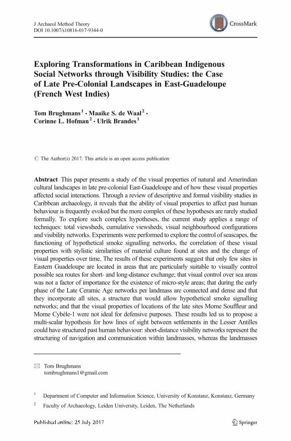
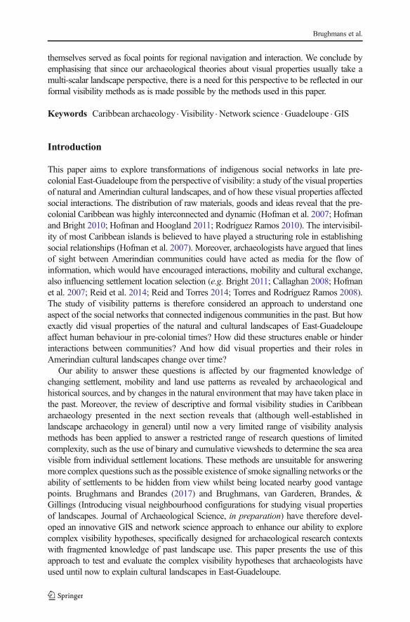
The present study focuses on East-Guadeloupe as for this region accurate pre-colonial site inventories are available due to systematic and intensive surveys andexcavations (De Waal 1999, 2003, 2006; Hofman et al. 2001, 2014; Hofman andHoogland 2011). The East-Guadeloupe region includes the Pointe des Châteauxpeninsula of Guadeloupe and the islands of La Désirade and Petite Terre (Fig. 1).The period of interest concentrates on the early and late phases of the Late Ceramic Age(AD 600/850–1200/1300 and AD 1200/1300–1493, respectively), as important changeswere observed between these phases with regards to settlement pattern, settlement struc-ture, population density, site location choice and mobility and interaction (De Waal 2006;Hofman 1995; Hofman et al. 2004).We aim to explore in what way visual properties of thenatural and cultural environment have influenced these changes (Table 1).
Previous studies have emphasised the importance of intervisibility of differentlandmasses from site locations in East-Guadeloupe and the position of sites on oppos-ing sides of islands, to understand the frequency of contacts or of cultural exchangebetween Amerindian communities on different islands (Bright 2011; De Waal 2006;Hofman et al. 2004, 2007). The ability to visually control sea areas crossed for short-and long-distance exchange and the ability to identify settlement locations from thevisibility of smoke columns have equally been discussed in explanations of artefactdistributions and settlement patterns elsewhere in the Caribbean (e.g. De Ruiter 2012;Ulloa Hung and De Ruiter 2011). Finally, the desire to remain largely invisible
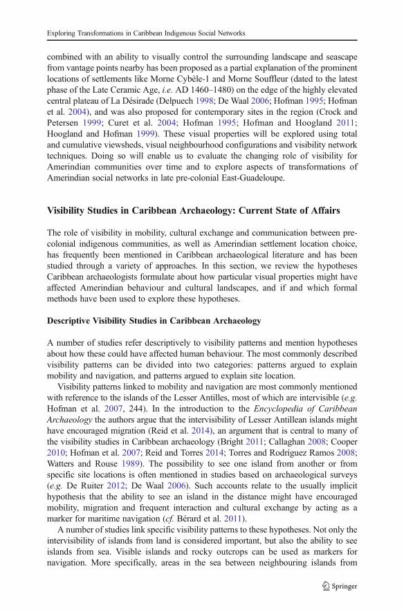
Fig. 1 East-Guadeloupe study area with site locations used here (published in De Waal 2006; habitation sitesrepresented as triangles and other sites as circles), listed in Table 1. White area represents 3 km buffer zonesaround landmasses in the research area, indicating maximum viewing distance from land used in this study.Elevation model Litto3D® Guadeloupe topographic LIDAR by © SHOM-IGN (2013). Inset ©OpenStreetMap contributors
Exploring Transformations in Caribbean Indigenous Social Networks
Table 1 Late Ceramic Age sites in the East-Guadeloupe study area (published in DeWaal 2006, 90–92). Sitesbelieved to have a habitation function represented in grey
Site location variables record (sixth column onwards) presence of freshwater (1), flat terrain (2), accessiblebays with canoe landing spots (3), reefs (4), soils suitable for small-scale horticulture (5), lithic raw materials(6), sites recorded as offering good viewpoints (7), strategic elevated spots (8), salinas (9) and mangrove (10)
Brughmans et al.
combined with an ability to visually control the surrounding landscape and seascapefrom vantage points nearby has been proposed as a partial explanation of the prominentlocations of settlements like Morne Cybèle-1 and Morne Souffleur (dated to the latestphase of the Late Ceramic Age, i.e. AD 1460–1480) on the edge of the highly elevatedcentral plateau of La Désirade (Delpuech 1998; De Waal 2006; Hofman 1995; Hofmanet al. 2004), and was also proposed for contemporary sites in the region (Crock andPetersen 1999; Curet et al. 2004; Hofman 1995; Hofman and Hoogland 2011;Hoogland and Hofman 1999). These visual properties will be explored using totaland cumulative viewsheds, visual neighbourhood configurations and visibility networktechniques. Doing so will enable us to evaluate the changing role of visibility forAmerindian communities over time and to explore aspects of transformations ofAmerindian social networks in late pre-colonial East-Guadeloupe.
Visibility Studies in Caribbean Archaeology: Current State of Affairs
The role of visibility in mobility, cultural exchange and communication between pre-colonial indigenous communities, as well as Amerindian settlement location choice,has frequently been mentioned in Caribbean archaeological literature and has beenstudied through a variety of approaches. In this section, we review the hypothesesCaribbean archaeologists formulate about how particular visual properties might haveaffected Amerindian behaviour and cultural landscapes, and if and which formalmethods have been used to explore these hypotheses.
Descriptive Visibility Studies in Caribbean Archaeology
A number of studies refer descriptively to visibility patterns and mention hypothesesabout how these could have affected human behaviour. The most commonly describedvisibility patterns can be divided into two categories: patterns argued to explainmobility and navigation, and patterns argued to explain site location.
Visibility patterns linked to mobility and navigation are most commonly mentionedwith reference to the islands of the Lesser Antilles, most of which are intervisible (e.g.Hofman et al. 2007, 244). In the introduction to the Encyclopedia of CaribbeanArchaeology the authors argue that the intervisibility of Lesser Antillean islands mighthave encouraged migration (Reid et al. 2014), an argument that is central to many ofthe visibility studies in Caribbean archaeology (Bright 2011; Callaghan 2008; Cooper2010; Hofman et al. 2007; Reid and Torres 2014; Torres and Rodríguez Ramos 2008;Watters and Rouse 1989). The possibility to see one island from another or fromspecific site locations is often mentioned in studies based on archaeological surveys(e.g. De Ruiter 2012; De Waal 2006). Such accounts relate to the usually implicithypothesis that the ability to see an island in the distance might have encouragedmobility, migration and frequent interaction and cultural exchange by acting as amarker for maritime navigation (cf. Bérard et al. 2011).
A number of studies link specific visibility patterns to these hypotheses. Not only theintervisibility of islands from land is considered important, but also the ability to seeislands from sea. Visible islands and rocky outcrops can be used as markers fornavigation. More specifically, areas in the sea between neighbouring islands from
Exploring Transformations in Caribbean Indigenous Social Networks
where islands are visible are considered to affect navigation and encourage migration.These spaces of intersecting visibility are argued to be particularly crucial in caseswhere islands are not intervisible from the landmasses themselves but only from the sea(Bright 2011; Callaghan 2008; Torres and Rodríguez Ramos 2008). Another example isoffered by communities facing each other across a sea channel (so-called passage areas)who were not only closer to one another than to communities at opposite ends of thesame island, but the sides of islands facing each other would also be intervisible. Thispattern is hypothesised to encourage frequency of interaction and cultural exchangebetween communities (Bright 2011; Rouse 1951, 1982; Torres and Rodríguez Ramos2008; Watters and Rouse 1989).
The second category of visibility patterns are those linked to explanations of sitelocations. In his introduction to the archaeology of the Caribbean, Wilson (2007, 81)mentions (but does not explain) that locations with good visibility on the windwardsides of higher islands were preferred for early Ceramic Age settlement (400/200 BC–AD 400/600), whilst the islands preferred by the first Archaic Age people (5000 BC–AD 100) were avoided. A number of studies suggest specific hypotheses of howvisibility patterns might explain settlement location: settlement location might havebeen influenced by (1) the ability to see large areas of the surrounding landscape orseascape (Bright 2011; De Ruiter 2012; De Waal 2006; Hofman et al. 2004), (2) theability to see marine or terrestrial resource sites (Bright 2011; Cooper 2010; Delpuech1998; De Ruiter 2012; De Waal 2006; Hofman and Hoogland 2011; Hofman et al.2004), (3) the ability to enable communication through visible signals like light orsmoke (De Ruiter 2012), (4) the ability to see approaching enemies with an eye ondefence (Bradford 2001; Bright 2011; Delpuech 1998; De Waal 2006; Hofman 1995;Hofman et al. 2004; Hofman et al. 2007), (5) the ability to project one’s power or toemphasise the importance of a site location (De Waal 2006: 98) and (6) the ability toobserve celestial bodies (Bradford 2001). Examples of several of these hypotheses areoffered by the presentation of the Late Ceramic settlement patterns in East-Guadeloupe(see below). The passage areas hypothesis mentioned above also fits in this category,where settlements could have been located not only with an eye on monitoring andenabling mobility and navigation but also to enable frequent interaction, communica-tion and exchange with (visible) communities on islands opposite.
Finally, a number of authors have argued that post-depositional processes and sea levelchange could have significantly altered the visibility of and from sites, and that this shouldbe taken into account in both descriptive and formal studies (Cooper and Boothroyd 2011;Hofman et al. 2004). Cooper and Boothroyd (2011) performed a formal study of howCaribbean landmasses have shrunk through 5 m of sea level rise in the last 6000 years.Such changes in the area above sea level, coastlines and coastal topography caused bycoastal erosion, sea level change, hurricanes, vegetation change and other post-depositional processes must significantly alter visibility patterns and our ability to accu-rately identify past visibility patterns. Such formal evaluations of these effects need to beincorporated in formal visibility studies like those introduced in the next section.
Formal Visibility Studies in Caribbean Archaeology
The use of formal visibility methods is well established in archaeology in general (Lakeand Woodman 2003), landscape-wide studies for addressing complex hypotheses like
Brughmans et al.
those presented in this paper have recently become more common (Eve and Crema2014; Gillings 2015; Llobera 2003; Paliou et al. 2011), and theoretical issues surround-ing the formal treatment of visibility are widely discussed (Gillings andWheatley 2001;Wheatley and Gillings 2000). In this section, we will discuss formal visibility studies inCaribbean archaeology in more detail.
First, Torres and Rodríguez Ramos (2008) argue that a study of interisland visibilitypatterns through formal visibility analysis in GIS might allow one to better understandinterisland interactions and past conceptualisations of landscapes. The authors reason thatsuch a perspective focusing on connectivity allows Caribbean archaeologists to steeraway from notions of insularity and isolationism so common in the study of islandarchipelagos. Instead, a relational perspective is needed to incorporate the human navi-gation factor. In this perspective the water should be seen as a relational space that is acontinuum of the terrestrial social landscapes, rather than a separating space. The authorshypothesise that interisland visibility was an important variable in people’s decisions tomigrate from one island to another and that overlaps in lines of sight from land to seahelped canoeists to navigate. Moreover, the intervisibility of islands is attributed thepotential to enhance cultural interaction, a hypothesis that is indebted to Rouse’s (1992)concept of passage areas: stronger cultural relationships exist between communities onopposing islands than between communities on different ends of the same island (see alsoBérard 2013; Bright 2011; Cooper 2008). However, we believe the analysis of what isvisible from land suggests navigational decision making happened on land, and it wouldtherefore be highly interesting to complement Torres and Rodríguez Ramos’ results withanalyses of what is visible from sea: their interesting concept of the water as a relationalspace could be most appropriately represented through total viewsheds from land as wellas from sea (as we illustrate for the case of Guadeloupe below).
A similar study is that by Callaghan (2008), who aimed to explore why no ArchaicAge sites were found on Jamaica whilst they are attested on Cuba, Hispaniola andPuerto Rico. Callaghan considers a number of environmental factors that could havediscouraged settlement in Jamaica: navigational difficulties, hurricane activity, sea levelchanges and visibility. Callaghan calculates maximum theoretical sighting distancesbetween Jamaica, Cuba and Hispaniola, concluding that the islands are not mutuallyvisible but that there are large areas in the sea where Jamaica and Hispaniola or Jamaicaand Cuba are visible. This observation is elaborated by stating that travellers would notneed to be out of sight of land for long and that the shortest travel route between Cubaand Jamaica in particular moves through the area of mutual visibility. Importantly, thesedistances calculated by Callaghan are maximum theoretical sighting distances that canbe significantly reduced due to atmospheric conditions.
Jago Cooper (2010) provides another formal approach to study interisland connec-tivity incorporating visibility in his study of models of mobility and exchange in pre-colonial Cuba. Visibility is hypothesised to be one indication for frequency of interac-tions between island communities and the possibility for communities to controlresources. The location of sites on higher elevations in particular is argued to haveenabled the intervisibility of sites and the control of resources. To illustrate this, Coopercreates a cumulative viewshed of six sites in the study area (the sum of visible areasfrom each of the six sites, see below) and concludes that these sites are all intervisible,that from all sites similar upland areas can be seen, and that Bthe agroalfarero sites fromthe study area and the wider region are linked by visual connections that link the
Exploring Transformations in Caribbean Indigenous Social Networks

offshore islands, the coast and the Cuban interior^ (Cooper 2010: 129). Moreover, noneof the interior sites have views of the sea, which is taken to suggest that inlandsettlements did not have direct access to marine resources but were dependent on acoastal distribution centre to obtain these. Cooper further performs a cluster analysis ofthe site locations and a cost surface analysis simulating travel routes and times betweenpairs of sites, allowing for both terrestrial and maritime travel. He argues that the resultsof these formal analyses indicate that Binter-island and marine environment interactionin the case study area was direct and regular^ (Cooper 2010: 133). Cooper’s studypresents results that reflect particularly interesting visual properties of a number of sitelocations, but it could be enhanced in one important way. The cumulative viewshedapproach used does not allow one to evaluate whether these sites’ visual properties areparticularly exceptional for the study area: do other locations in the study area wheresites could have been share these visual properties, and do the known site locationshave exceptional intervisibility and control of resources in comparison? This can beevaluated by performing total viewshed and visual neighbourhood configuration ex-periments, as presented in this paper.
Finally, in their study of settlement patterns in the north-western DominicanRepublic, de Ruiter (2012) and Ulloa Hung and Ruiter (2011) aim to evaluate whatrole visibility could have played in the selection of site locations. They calculated thepercentage of the study area that is visible from sites and the percentage of sites visiblefrom other sites (which allowed them to create a network of intervisible sites). DeRuiter (2012: 98) noticed that BChicoid sites tend to be located more in the vicinity ofother Chicoid sites than Meillacoid sites^. In addition, she noticed that even thoughLate Ceramic Age (Chicoid) sites are generally located at higher altitudes than con-temporary (Meillacoid) sites, they nevertheless have more restricted views, for examplebecause they are surrounded by higher hills. However, the Chicoid hilltop sites oftenoffer views on the most important marine resource extraction sites. BThe differencesbetween Meillacoid and Chicoid sites in visibility ranges and the amount of sites visibleare an indication that visibility did play a role in site location, and that it was not a ‘sideeffect’ of ecological factors^ (De Ruiter 2012, 99). De Ruiter mentions that goodvisibility could have been purposeful to enable communication and views of the coastor resources. De Ruiter explores the possibility of enabling communication betweensites through a visual signalling network by representing the intervisibility of sites as anetwork. However, De Ruiter does not provide an in-depth analysis of this network.Her study could be enhanced by evaluating the ability of this network to function as anefficient signalling network and the role of individual sites in this network throughvisibility network methods (as applied to the case of East-Guadeloupe in this paper).
Hypotheses and Methodological Challenges
This literature review revealed that Caribbean archaeologists have formulated a largenumber of hypotheses of how visibility patterns could have affected pre-colonialhuman behaviour:
& Mobility and navigation: Intervisibility of islands encouraged mobility; areas ofintersecting visibility in the sea encouraged mobility and acted as markers fornavigation; visible features in the sea acted as markers for maritime navigation.
Brughmans et al.

& Interaction and communication: Intervisibility encouraged interaction; communitiesfacing each other on different islands encouraged interaction, communication andcultural exchange; communication between settlements through visible signalling.
& Control and surveillance: Defensibility, visibility of approaches to site; visualcontrol of land and sea areas; visual control of land and marine resources.
Although formal GIS methods for the study of many of these complex hypothesesare well established in landscape archaeology in general, their use is less common inCaribbean archaeology. We argue that this would be a worthwhile pursuit for at leasttwo reasons. First, this may allow us to build arguments for the importance of visibilityin indigenous social networks, mobility and settlement location on reproducible andformally comparable results. Second, our fragmented knowledge of interactions be-tween indigenous communities and of Amerindian natural and cultural landscapesrequires evaluations of how well-known site locations fit the hypotheses as comparedto all other locations in a study area. In other words: are the visual properties at knownsite locations exceptional when compared to the rest of the landscape where villagescould have been located but where no sites have been found? Such an approachrequires methods for formal comparison. In the remainder of this paper we willillustrate how formal visibility analysis addressing complex visibility hypotheses canlead to a better understanding of transformations of indigenous social networks.
Transformations of Indigenous Social Networks in Late Pre-ColonialEast-Guadeloupe
This study focuses on the changing visual properties of Amerindian cultural landscapesin East-Guadeloupe (Fig. 1) to better understand the changing social networksconnecting Amerindian communities. The archaeology of this part of Guadeloupe isparticularly well studied thanks to the intensive excavations at the site of Anse à laGourde (Delpuech et al. 1999; Hofman et al. 1999, 2001, 2014; Hofman and Hoogland2011) and an exhaustive regional survey (De Waal 2006). Previous studies of thediachronic settlement patterns and artefact distributions reveal Late Ceramic Agetransformations of interaction networks between communities within the study area,as well as of long-distance interaction networks in the Lesser Antilles (De Waal 2006;Hofman et al. 2004, 2007; Hofman and Hoogland 2011). The presence of non-localmaterials at sites and the occurrence of stylistic similarities in ceramics reveal that thesea separating the landmasses of East-Guadeloupe encouraged interaction and ex-change between Amerindian communities on different islands, linking island commu-nities in social networks that transformed throughout the Late Ceramic Age (Hofmanet al. 2004, 2007; Hofman and Hoogland 2011; Knippenberg 2007).
A notable settlement pattern change occurred in East-Guadeloupe between the early(AD 600/800–1200/1300) and late (AD 1200/1300–1493) phases of the Late CeramicAge (De Waal 2006, 2014; occupation dates were mainly derived through relativedating of ceramics). The coastal areas of the study area were particularly denselyoccupied during the early phase, which also saw a more intensive use of the surround-ing landscapes as compared to previous periods, the settling of the Petite Terre islandsand the possible development of a settlement hierarchy centred on a few larger
Exploring Transformations in Caribbean Indigenous Social Networks
settlements like Anse à la Gourde (De Waal 2006; Hofman and Hoogland 2011). Ourknowledge of the settlement pattern of the later phase of the Late Ceramic Age justbefore European contact is entirely different: most previously settled coastal locations,including all on Petite Terre, were abandoned, resulting in very sparse occupation of thearea (De Waal 2006; Hofman 1995).
Early Phase (AD 600/850–1200/1300)
The material culture from Late Ceramic Age villages in East-Guadeloupe suggests thatthey were part of both local and regional contact networks that transformed throughout theperiod (Hofman et al. 2004). A number of villages have particularly early dates, ca. AD700/800–1000 and could have theoretically (based on possible overlaps in period of use)been in contact (De Waal 2006, 121–122): Degrat and Grande Saline on Pointe desChâteaux, and Grand Abaque 1 and Pointe Colibri on La Désirade. Moreover, closestylistic similarity of the pottery from Grand Abaque 1 and Pointe Colibri suggests thattheir inhabitants maintained regular contacts. The pottery from Anse Petite Rivière on LaDésirade and Anse à la Gourde and other sites on Grande-Terre (Pointe Helleux, PointeCanot and Pointe de la Couronne Conchou) make up a second stylistic group of sitessettled from AD 1000 onwards, argued to reflect regular contacts between Amerindiancommunities in La Désirade and Grande-Terre (De Waal 2006, 124; Hofman et al. 2004,167). Moreover, Anse Petite Rivière and Anse à la Gourde have demonstrably contem-porary components covering the entire Late Ceramic Age and their inhabitants probablyinteracted through a short-distance contact network (De Waal 2006; Hofman et al. 2007).
The non-local lithics recovered fromAnse Petite Rivière and Anse à la Gourde reflectthe existence of long-distance exchange networks and their participation in thesenetworks. Lithic raw materials suitable for the manufacture of stone tools were availableon La Désirade and were attested at sites on La Désirade itself like Anse Petite Rivière,as well as at sites on Pointe des Châteaux like Anse à la Gourde. Communities on PetiteTerre and Pointe des Châteaux also used flint fromAntigua and other non-local rocks, inaddition to lithics from La Désirade (De Waal 2006; Knippenberg 2007). The site ofAnse à la Gourde seems to have been particularly pivotal in long-distance contactnetworks, as evidenced through the presence of green chert from St. Martin, igneousrock from Basse-Terre and Montserrat, metamorphic rock from the Greater Antilles orthe South American mainland, and sandstone from Barbados and the Grenadines(Knippenberg 2007; Hofman and Hoogland 2011). We need to keep in mind, however,that the exceptionally intensive research activities at this site can bias our interpretationof its significance during this early phase of the Late Ceramic Age.
During this period, the islands of Petite Terre become settled for the first time andbegin to serve as an important marine resource extraction area. Besides permanenthabitation sites, temporary habitation sites have been identified on Petite Terre. Theywere probably Bused by inhabitants of villages on Pointe des Chateaux and LaDésirade, who were attracted by rich marine resources^ (De Waal 2006, 117).
Late Phase (AD 1200/1300–1493)
The density of population and number of villages significantly decreased towards theend of the Late Ceramic Age, when only three settlements were occupied in East-
Brughmans et al.

Guadeloupe: Anse à la Gourde at Pointe des Châteaux, and Morne Cybèle-1 and MorneSouffleur at La Désirade. Anse à la Gourde continued a long occupation history and isnot located in a particularly defensive position. Morne Cybèle-1 and Morne Souffleur(Bodu 1985; Delpuech 1998; De Waal 2006, 2014; Hofman 1995; Hofman andHoogland 1994) are argued to have been located in defendable places selected for theirability to observe humans approaching, or possible spiritual or symbolic appeal giventhe visibility of the La Désirade plateau with its table mountain shape from Petite Terreand Pointe des Chateaux (De Waal 2003, 2006: 128; Hofman 1995; Hofman et al.2004). Even though these settlements were located at a large distance from each other(2.5 km as the crow flies) and were not in competition for resources or settlementlocations, their founders selected locations with no direct access to freshwater or marineresources, which required trips of at least half an hour down the steep plateau side toobtain water and marine resources. Although both sites are very close to the plateauedge which offers great vantage points, the locations themselves are not very visiblefrom the surrounding plateau landscape (De Waal 2006). A preference for elevateddefendable locations might have continued into the period after European contact, assuggested by ethnographic accounts. Dreyfus’ (1976) summary of the sources on theseventeenth century Amerindian settlements confirms this, stating that settlementswould have preferentially been in elevated locations where approaches to the settlementcould have been observed. This defensive nature of settlement location and theimportance of being able to observe possible enemies are also mentioned in theethnographic accounts of Breton (1978 [1647]), and suggest that possible socialchanges in Amerindian communities before European contact caused them to abandonthe exposed beaches and to occupy more discrete and defendable elevated locationsinstead (Delpuech 1998, 316). Although this is not the case for Anse à la Gourde, thispicture is confirmed by recent investigations of early colonial Cayo sites on the islandsof Dominica, St. Vincent and Grenada (Hofman 2016; Hofman and Hoogland 2012).
The pottery assemblages of Morne Cybèle-1 and Morne Souffleur share great stylisticsimilarity as does a small component of the Anse à la Gourde assemblage (DeWaal 2006;Hofman et al. 2001, 2004). The ceramics are similar to the local Lesser Antillean Suazoidand Cayo pottery and show affiliations to the South American mainland and the GreaterAntilles (Hofman et al. 2004; Hofman and Hoogland 2012). However, the presence atAnse à la Gourde of pebbles, magmatic rock and red chert from La Désirade suggests thecontinued existence of a contact network in the micro-region or of direct raw materialprocurement trips by Anse à la Gourde inhabitants. Moreover, the presence of Antiguaflint and St. Martin green chert at Anse à la Gourde andMorne Souffleur suggests that theinhabitants of these villages were still part of long-distance contact networks. Due to thelower population densities, individual settlements had to sustain such networks over largerareas when compared to earlier periods (De Waal 2006).
Research Questions
The main research questions we will explore relate to what extent these transformationsin settlement patterns, and interaction networks can be understood through a study ofvisual properties of sites and the East-Guadeloupe landscape as a whole. Thesequestions focus on four key topics:
Exploring Transformations in Caribbean Indigenous Social Networks
1. Control of seascapes: The identification of land areas particularly suitable tovisually control possible sea routes for short- and long-distance exchange mayanswer the following questions: are villages located in such areas and are they partof micro-style areas, or are other uninhabited areas more suitable to visually controlseascapes? In which land areas are smoke columns rising up from villages visiblefrom the sea, and from which sea areas are such smoke columns visible? Arevillages located in such land areas and are they part of micro-style areas, or areother uninhabited areas more visible from the sea? Although it is known that thepositions of the sun, moon and stars also may have played a role in navigation,only smoke signals were used in the present analysis. To simplify our communi-cation of theories and results and to clearly distinguish this set of research questionsfrom the others addressed in this paper, we will consistently use the word ‘control’to refer to the diversity of archaeological theories stating that the possibility ofsurveillance might have been important to past communities, and to describe theresults of our experiments to study these theories.
2. Signalling networks: The study of the intervisibility of eventual smoke columns inLate Ceramic Age sites as a visual communication or signalling network betweencommunities may answer questions such as the following: in which ways canlines-of-sight structure interactions between communities in East-Guadeloupe? Didpossibilities for interaction through visual signalling transform over time (i.e. arethere differences between sites belonging to the particular micro-style areas)?
3. Micro-style areas: The comparison of visual properties of the sites belonging to thetwo micro-style areas that had been identified by De Waal (2006: 121–124) for theearly phase of the Late CeramicAge (one including Pointe Colibri andGrandAbaque1, the other consisting of Anse Petite Rivière and Anse à la Gourde) and of the laterstylistically linked sites (Morne Cybèle-1 and Morne Souffleur) may answer ques-tions such as the following: do micro-style areas correlate with visibility patterns? Dosites of the same micro-area share visibility of similar natural features, or are theirvisual properties complementary? Are they visible to people navigating the coast incanoes? Do their locations allow visual control of sea areas? Are smoke columnsrising up from stylistically linked villages intervisible, and what positions do theyoccupy in a hypothetical visual smoke signalling network?
4. Late phase network transformations and defensive locations: The exploration of long-and short-distance contact networks of the late phase of the Late Ceramic Age, byanalysing visual properties of the three remaining villages (Anse à la Gourde, MorneCybèle-1 andMorne Souffleur) may shed light on the following questions: how doestheir ability to visually control seascapes differ in comparison to the earlier sites? AreMorne Cybèle-1 andMorne Souffleur located in areas that serve a possible defensivefunction? Are they close to areas fromwhich approaches to the sites, the coast and thesea can be better visually controlled when compared to other uninhabited areas?
Data and Methods
A complete description of the data and methods used is available in the Appendix. In thecurrent section, we provide a summary and a discussion of the methodological challengesthat motivated the selection of the methods used and experiments performed.
Brughmans et al.
To explore and test our research questions as hypotheses is challenging. First, thesettlement pattern at the end of the Late Ceramic Age consists of only three sites, fortwo of which the preservation has been heavily affected by post-depositional processes.Second, we can also not exclude the existence of other contemporary sites destroyed bysuch processes or unidentified in previous archaeological activities. Third, the assump-tion that visual properties were vital for choosing these specific observed settlementlocations implies that other suitable but apparently unoccupied settlement locations donot share these properties in the same manner. Fourth, the hypothesis that visualproperties of settlement locations may help explain the observed changes in settlementpatterns, implies that these properties were dissimilar during the different phases of theLate Ceramic period. The survey data provided in De Waal (2006, 90–92) as well as avisibility survey Brughmans conducted in the study area in 2015 include a qualitativeassessment of site locations with good view points, which will be compared to thecomputationally derived results as a qualitative reference. But such qualitative obser-vations do not allow us to distinguish between particular visual properties and howexceptional the visual properties at site locations are as compared to those of the entirelandscape.
This study will address these challenges by performing total viewshed experiments(Llobera 2003) designed to represent and explore hypotheses of different visualproperties for all locations in the study area (rather than only for the site locations).Cumulative viewsheds (Wheatley 1995) will be used to explore visual properties ofsites belonging to micro-style areas and the later phase Late Ceramic Age sites. Totalviewsheds will in turn be explored using a number of visual neighbourhood configu-rations (Brughmans et al., in preparation) to study how sites are embedded within localareas of particularly high or low visibility, and within areas of low visibility with goodvantage points. Network science techniques will be used to represent and explore theintervisibility of sites (Brughmans and Brandes 2017). To address the issue of uncertainsettlement sizes, we will explore all visual properties within the assumed maximum sitearea (as estimated in De Waal 2006, 90–91, Table 5.1) rather than referring exclusivelyto the results of point locations of sites.
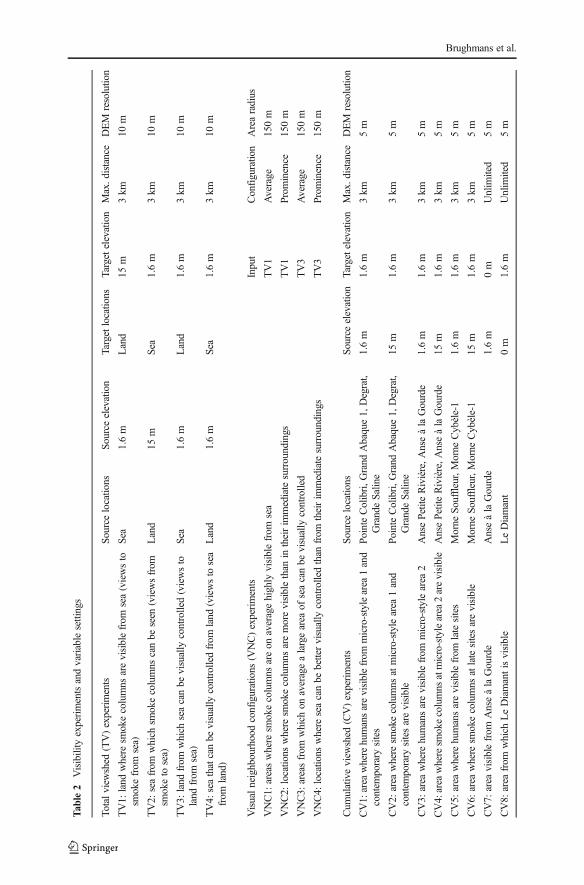
All experiments performed and reported in the next section are listed in Table 2, andsome are illustrated in Fig. 2. The motivation for experiment design, all variablesettings, resolution of input data and software used is provided in full detail in theAppendix.
Results
For all total viewshed and visual neighbourhood configuration results, locationswith results higher than one standard deviation added to the mean will be treated aslocations from which ‘a larger area’ can be seen or that have ‘higher visibility’(white in figures; bold in tables). Locations with results lower than one standarddeviation subtracted from the mean will be treated as locations from which ‘asmaller area’ can be seen or that have ‘lower visibility’ (dark grey in figures;underlined in tables). Where sites are mentioned in this results section, their sitenumbers will be included in square brackets (see Table 1 for a full list of site namesand numbers).
Exploring Transformations in Caribbean Indigenous Social Networks
Tab
le2
Visibility
experimentsandvariablesettings
Totalview
shed
(TV)experiments
Source
locations
Source
elevation
Targetlocatio
nsTargetelevation
Max.d
istance
DEM
resolutio
n
TV1:
land
where
smokecolumns
arevisiblefrom
sea(viewsto
smokefrom
sea)
Sea
1.6m
Land
15m
3km
10m
TV2:
seafrom
which
smokecolumns
canbe
seen
(viewsfrom
smoketo
sea)
Land
15m
Sea
1.6m
3km
10m
TV3:
land
from
which
seacanbe
visually
controlled(viewsto
land
from
sea)
Sea
1.6m
Land
1.6m
3km
10m
TV4:
seathatcanbe
visually
controlledfrom
land
(viewsto
sea
from
land)
Land
1.6m
Sea
1.6m
3km
10m
Visualneighbourhoodconfigurations
(VNC)experiments
Input
Configuratio
nArearadius
VNC1:
areaswhere
smokecolumns
areon
averagehighly
visiblefrom
sea
TV1
Average
150m
VNC2:
locatio
nswhere
smokecolumns
aremorevisiblethan
intheirim
mediatesurroundings
TV1
Prom
inence
150m
VNC3:
areasfrom
which
onaveragealargearea
ofseacanbe
visually
controlled
TV3
Average
150m
VNC4:
locatio
nswhere
seacanbe
bettervisually
controlledthan
from
theirim
mediatesurroundings
TV3
Prom
inence
150m
Cum
ulativeview
shed
(CV)experiments
Source
locations
Source
elevation
Targetelevation
Max.d
istance
DEM
resolutio
n
CV1:
area
wherehumansarevisiblefrom
micro-stylearea
1and
contem
porary
sites
PointeColibri,G
rand
Abaque1,
Degrat,
GrandeSaline
1.6m
1.6m
3km
5m
CV2:
area
where
smokecolumns
atmicro-stylearea
1and
contem
porary
sitesarevisible
PointeColibri,G
rand
Abaque1,
Degrat,
GrandeSaline
15m
1.6m
3km
5m
CV3:
area
where
humansarevisiblefrom
micro-stylearea
2AnsePetiteRivière,A
nseàlaGourde
1.6m
1.6m
3km
5m
CV4:area
wheresm
okecolumns
atmicro-stylearea
2arevisible
AnsePetiteRivière,A
nseàlaGourde
15m
1.6m
3km
5m
CV5:
area
where
humansarevisiblefrom
latesites
Morne
Souffleur,Morne
Cybèle-1
1.6m
1.6m
3km
5m
CV6:
area
where
smokecolumns
atlatesitesarevisible
Morne
Souffleur,Morne
Cybèle-1
15m
1.6m
3km
5m
CV7:
area
visiblefrom
AnseàlaGourde
AnseàlaGourde
1.6m
0m
Unlim
ited
5m
CV8:
area
from
which
LeDiamantisvisible
LeDiamant
0m
1.6m
Unlim
ited
5m
Brughmans et al.

Tab
le2
(contin
ued)
CV9:
area
visiblefrom
AnsePetiteRivière
AnsePetiteRivière
1.6m
0m
Unlim
ited
5m
CV10:area
visiblefrom
Morne
Souffleur
Morne
Souffleur
1.6m
0m
Unlim
ited
5m
CV11:area
visiblefrom
Morne
Cybèle-1
Morne
Cybèle-1
1.6m
0m
Unlim
ited
5m
Visibility
network(N
)experiment
Source
locations
Source
elevation
Targetlocatio
nsTargetelevation
Max.d
istance
DEM
resolutio
n
N1:
intervisibility
ofsm
okecolumns
atsiteareas
Siteareas
1.6m
Siteareas
15m
3km
1m
Intotalview
shed
experiments,v
aluesattargetlocatio
nsarerecorded
asresults.Incumulativeview
shed
experiments,the
entireresearch
area
isthetargetlocatio
n
Exploring Transformations in Caribbean Indigenous Social Networks

Total Viewshed Experiments (TV)
Tables 3, 4 and 5 present per site the average result of experiments TV1 and TV3within the site area; results of experiments TV1–4 are further shown in Fig. 3a–d.
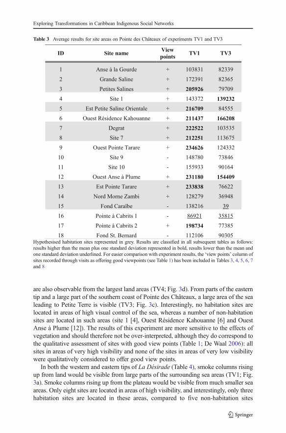
In the eastern part of Pointe des Châteaux (Table 3), including the area surroundingthe salinas, smoke columns rising up from land would have been visible from largeparts of the surrounding sea areas. These smoke columns could have been visible fromsea areas both to the north and south of Pointe des Châteaux (TV1; Fig. 3a). Half of allsites are located in these areas of high visibility, whilst Pointe à Cabrits 1 [16] is theonly site located in an area of low visibility from the sea. Habitation sites are located inareas of high visibility from the sea about as often as non-habitation sites. From seaareas along the southwestern and northwestern coasts of Pointe des Châteaux, smokecolumns rising up from the largest land areas can be observed. This is important as amuch larger land area lies within a 3-km radius of these western sea areas as comparedto the sea areas in the east of Pointe des Châteaux (TV2; Fig. 3b). These same sea areas
Fig. 2 Abstract graphical representation of total viewshed (TV) and visibility network (N) experiments. Intotal viewshed experiments, values at target locations are recorded as results
Brughmans et al.
are also observable from the largest land areas (TV4; Fig. 3d). From parts of the easterntip and a large part of the southern coast of Pointe des Châteaux, a large area of the sealeading to Petite Terre is visible (TV3; Fig. 3c). Interestingly, no habitation sites arelocated in areas of high visual control of the sea, whereas a number of non-habitationsites are located in such areas (site 1 [4], Ouest Résidence Kahouanne [6] and OuestAnse à Plume [12]). The results of this experiment are more sensitive to the effects ofvegetation and should therefore not be over-interpreted, although they do correspond tothe qualitative assessment of sites with good view points (Table 1; De Waal 2006): allsites in areas of very high visibility and none of the sites in areas of very low visibilitywere qualitatively considered to offer good view points.
In both the western and eastern tips of La Désirade (Table 4), smoke columns risingup from land would be visible from large parts of the surrounding sea areas (TV1; Fig.3a). Smoke columns rising up from the plateau would be visible from much smaller seaareas. Only eight sites are located in areas of high visibility, and interestingly, only threehabitation sites are located in these areas, compared to five non-habitation sites
Table 3 Average results for site areas on Pointe des Châteaux of experiments TV1 and TV3
Hypothesised habitation sites represented in grey. Results are classified in all subsequent tables as follows:results higher than the mean plus one standard deviation represented in bold, results lower than the mean andone standard deviation underlined. For easier comparison with experiment results, the ‘view points’ column ofsites recorded through visits as offering good viewpoints (see Table 1) has been included in Tables 3, 4, 5, 6, 7and 8
Exploring Transformations in Caribbean Indigenous Social Networks
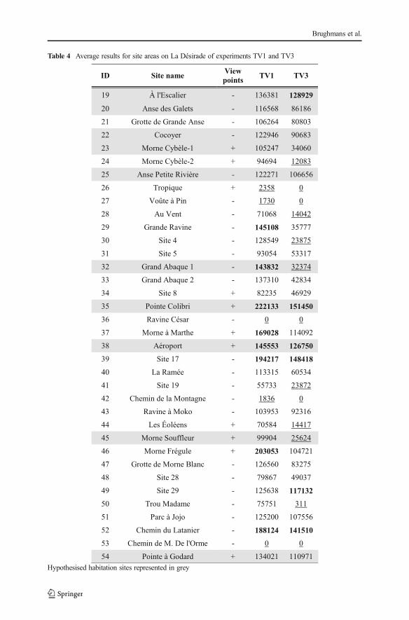
Table 4 Average results for site areas on La Désirade of experiments TV1 and TV3
Hypothesised habitation sites represented in grey
Brughmans et al.
(although all sites in areas of very low visibility from sea are non-habitation sites). It isimportant to note that the habitation sites in areas of high visibility include both sitesbelonging to the early micro-style area (Grand Abaque 1 [32] and Pointe Colibri [35]).From sea areas along the entire southern coast of La Désirade, smoke columns rising upfrom the largest land areas can be observed, whereas from many areas along the rockyand steep northern coast, very small land areas can be observed (TV2; Fig. 3b). Thesesame sea areas are also observable from the largest land areas (TV4; Fig. 3d). From the
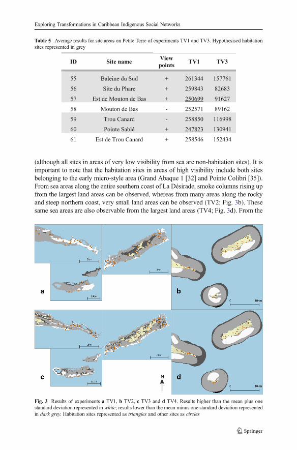
Table 5 Average results for site areas on Petite Terre of experiments TV1 and TV3. Hypothesised habitationsites represented in grey
Fig. 3 Results of experiments a TV1, b TV2, c TV3 and d TV4. Results higher than the mean plus onestandard deviation represented in white; results lower than the mean minus one standard deviation representedin dark grey. Habitation sites represented as triangles and other sites as circles
Exploring Transformations in Caribbean Indigenous Social Networks

western tip and the entire southern coastal area of La Désirade, a large area of the sealeading to Petite Terre is visible (TV3; Fig. 3c). Only three out of ten habitation sites arelocated in these areas of high visual control over the sea, including Pointe Colibri [35],one of the two sites of one of the early phase micro-style areas. Interestingly, the othersite, Grand Abaque 1 [32], is located in an area of very low visual control over the sea.Three non-habitation sites are located in areas of high visual control of the sea. Theresults of this experiment are more sensitive to the effects of vegetation and shouldtherefore not be over-interpreted, and they do not correspond well to the qualitativeassessment of sites with good view points (Table 1; DeWaal 2006): not all sites in areasof very high visibility and some sites in areas of very low visibility were qualitativelyconsidered to offer good view points.
As for Petite Terre (Table 5), in the eastern part of Terre de Bas, smokecolumns rising up from land would be visible from large parts of the surround-ing sea areas (TV1; Fig. 3a). Smoke columns rising up from the northerncoastal area of both islands of Petite Terre, facing La Désirade and Pointedes Châteaux would be visible from much smaller sea areas. No sites arelocated in areas that are highly visible from sea, whilst two habitation sitesare located in areas of very low visibility (Est de Mouton de Bas [57] andPointe Sablé [60]). From sea areas to the north-north-east facing Pointe desChâteaux, as well as sea areas to the south-south-west, smoke columns risingup from the largest land areas can be observed (TV2; Fig. 3b). However, thesea areas to the north-north-east facing Pointe des Châteaux are visible fromparticularly large land areas (TV4; Fig. 3d). The north coasts of Terre de Basand Terre de Haut are not particularly good locations for observing a large seaarea towards La Désirade and Pointe des Châteaux (TV3; Fig. 3c).
Visual Neighbourhood Configurations Experiments (VNC)
Tables 6, 7 and 8 present per site the average result of experiments VNC1–4 within thesite area (Fig. 4a–d). Both sites belonging to the early micro-style area [32, 35] arelocated in areas where smoke signals on average are highly visible from sea (VNC1;Fig. 4a), and Pointe Colibri [35] is also located in an area of high visual control of thesea on average (VNC3; Fig. 4c). However, sites belonging to the other early phasemicro-style area do not share any particular visual properties: Anse à la Gourde [1] doesnot have particularly high or low values for any of the VNC experiments, whereas AnsePetite Rivière [25] is located in an area of high visual control of the sea on average(VNC3; Fig. 4c). Morne Souffleur [45] and Morne Cybèle-1 [23], the two sites on theedge of the La Désirade plateau dated to the latest phase of the Late Ceramic Age, arelocated in areas where smoke columns are particularly visually prominent from sea, butvery close to areas where they are not (VNC2; Fig. 4b; Table 7). These two sites arealso located in areas from which much smaller sea areas can be visually controlled thanfrom their immediate surroundings, but right on the edge of an area of very high visualcontrol of the sea (VNC4; Fig. 4d; Table 7). This result supports the hypothesis thatthese two sites on the plateau edge are located in areas with high local variability invisual properties: large parts of the sites are located in areas with particularly limitedvisual control over the sea whereas small parts are located in areas offering greatvantage points, whilst smoke columns at these sites would be visible from much larger
Brughmans et al.
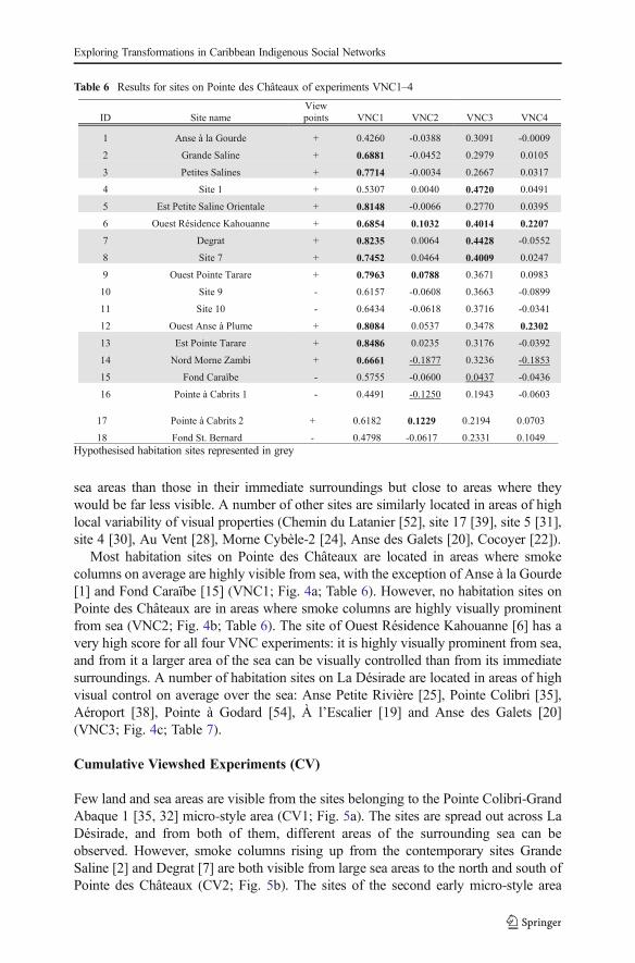
sea areas than those in their immediate surroundings but close to areas where theywould be far less visible. A number of other sites are similarly located in areas of highlocal variability of visual properties (Chemin du Latanier [52], site 17 [39], site 5 [31],site 4 [30], Au Vent [28], Morne Cybèle-2 [24], Anse des Galets [20], Cocoyer [22]).
Most habitation sites on Pointe des Châteaux are located in areas where smokecolumns on average are highly visible from sea, with the exception of Anse à la Gourde[1] and Fond Caraïbe [15] (VNC1; Fig. 4a; Table 6). However, no habitation sites onPointe des Châteaux are in areas where smoke columns are highly visually prominentfrom sea (VNC2; Fig. 4b; Table 6). The site of Ouest Résidence Kahouanne [6] has avery high score for all four VNC experiments: it is highly visually prominent from sea,and from it a larger area of the sea can be visually controlled than from its immediatesurroundings. A number of habitation sites on La Désirade are located in areas of highvisual control on average over the sea: Anse Petite Rivière [25], Pointe Colibri [35],Aéroport [38], Pointe à Godard [54], À l’Escalier [19] and Anse des Galets [20](VNC3; Fig. 4c; Table 7).
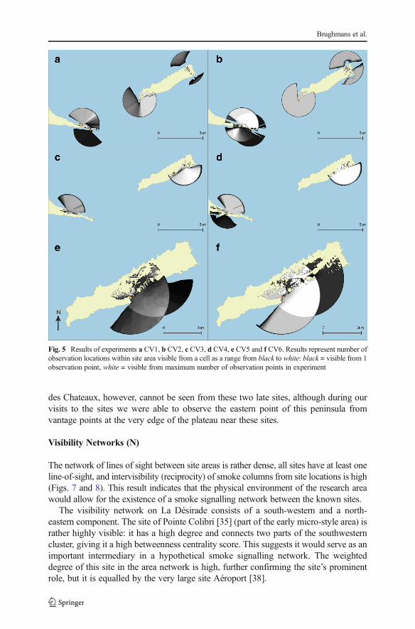
Cumulative Viewshed Experiments (CV)
Few land and sea areas are visible from the sites belonging to the Pointe Colibri-GrandAbaque 1 [35, 32] micro-style area (CV1; Fig. 5a). The sites are spread out across LaDésirade, and from both of them, different areas of the surrounding sea can beobserved. However, smoke columns rising up from the contemporary sites GrandeSaline [2] and Degrat [7] are both visible from large sea areas to the north and south ofPointe des Châteaux (CV2; Fig. 5b). The sites of the second early micro-style area
Table 6 Results for sites on Pointe des Châteaux of experiments VNC1–4
Hypothesised habitation sites represented in grey
Exploring Transformations in Caribbean Indigenous Social Networks

(Anse à la Gourde [1] and Anse Petite Rivière [25]) are located far away from eachother, are not intervisible and shared visibility of land or sea is impossible (CV3; Fig.
Table 7 Results for sites on La Désirade of experiments VNC1–4
Hypothesised habitation sites represented in grey
Brughmans et al.
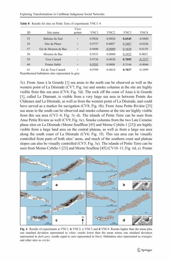
5c). From Anse à la Gourde [1] sea areas to the north can be observed as well as thewestern point of La Désirade (CV7; Fig. 6a) and smoke columns at the site are highlyvisible from this sea area (CV4; Fig. 5d). The rock off the coast of Anse à la Gourde[1], called Le Diamant, is visible from a very large sea area in between Pointe desChâteaux and La Désirade, as well as from the western point of La Désirade, and couldhave served as a marker for navigation (CV8; Fig. 6b). From Anse Petite Rivière [25]sea areas to the south can be observed and smoke columns at the site are highly visiblefrom this sea area (CV3–4; Fig. 5c–d). The islands of Petite Terre can be seen fromAnse Petite Riviere as well (CV9; Fig. 6c). Smoke columns from the two Late Ceramicphase sites on La Désirade (Morne Souffleur [45] and Morne Cybèle-1 [23]) are highlyvisible from a large land area on the central plateau, as well as from a large sea areaalong the south coast of La Désirade (CV6; Fig. 5f). This sea area can be visuallycontrolled from parts of both sites’ areas, and much of the southern coast and plateauslopes can also be visually controlled (CV5; Fig. 5e). The islands of Petite Terre can beseen fromMorne Cybèle-1 [23] and Morne Soufleur [45] (CV10–11; Fig. 6d, e). Pointe
Table 8 Results for sites on Petite Terre of experiments VNC1–4
Hypothesised habitation sites represented in grey
Fig. 4 Results of experiments a VNC1, b VNC2, c VNC3 and d VNC4. Results higher than the mean plusone standard deviation represented in white; results lower than the mean minus one standard deviationrepresented in dark grey; results equal to zero represented in black. Habitation sites represented as trianglesand other sites as circles
Exploring Transformations in Caribbean Indigenous Social Networks
des Chateaux, however, cannot be seen from these two late sites, although during ourvisits to the sites we were able to observe the eastern point of this peninsula fromvantage points at the very edge of the plateau near these sites.
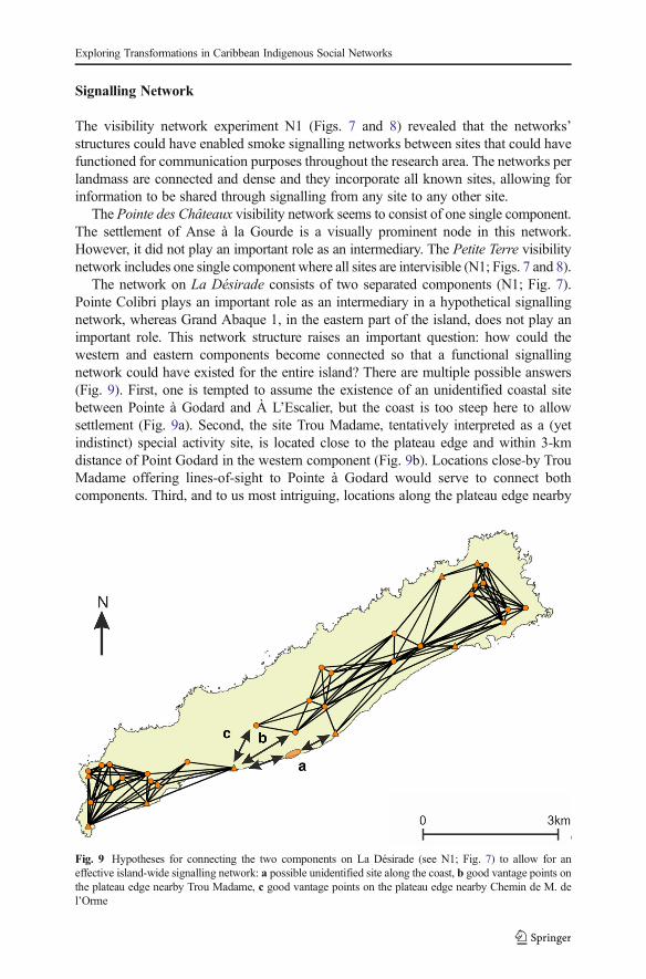
Visibility Networks (N)
The network of lines of sight between site areas is rather dense, all sites have at least oneline-of-sight, and intervisibility (reciprocity) of smoke columns from site locations is high(Figs. 7 and 8). This result indicates that the physical environment of the research areawould allow for the existence of a smoke signalling network between the known sites.
The visibility network on La Désirade consists of a south-western and a north-eastern component. The site of Pointe Colibri [35] (part of the early micro-style area) israther highly visible: it has a high degree and connects two parts of the southwesterncluster, giving it a high betweenness centrality score. This suggests it would serve as animportant intermediary in a hypothetical smoke signalling network. The weighteddegree of this site in the area network is high, further confirming the site’s prominentrole, but it is equalled by the very large site Aéroport [38].
Fig. 5 Results of experiments a CV1, b CV2, c CV3, d CV4, e CV5 and f CV6. Results represent number ofobservation locations within site area visible from a cell as a range from black to white: black = visible from 1observation point, white = visible from maximum number of observation points in experiment
Brughmans et al.

Ravine à Moko [43], and to some extent Morne Cybèle-2 [24], play an importantrole as intermediaries between the eastern and the plateau sites in the north-easterncomponent. Grand Abaque 1 [32] has a very low betweenness score and is intervisiblewith a low number of other sites, whereas the weighted degree of Anse Petite Rivière[25] is very high due to a higher number of incoming and outgoing lines of sight fromits large site area (these two sites are part of the two different early phase micro-styleareas). From one site on La Désirade smoke columns at no other sites can be seen(Chemin de M. De L’Orme [53] on the central plateau).
Three sites at the centre of the Pointe des Châteaux research area are important asgo-betweens (Ouest Pointe Tarare [9], Est Pointe Tarare [13], site 7 [8]). Anse à laGourde [1] (part of an early phase micro-style area) has a high weighted degree but a
Fig. 6 Results of experiments a CV7, b CV8, c CV9, d CV10 and e CV11. Black area is visible from at leastone observation point in site areas
Exploring Transformations in Caribbean Indigenous Social Networks
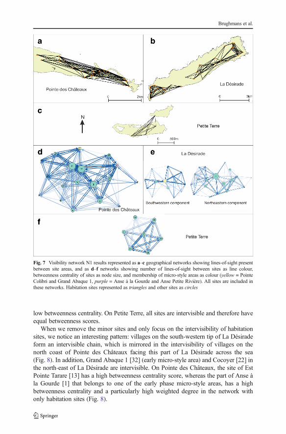
low betweenness centrality. On Petite Terre, all sites are intervisible and therefore haveequal betweenness scores.
When we remove the minor sites and only focus on the intervisibility of habitationsites, we notice an interesting pattern: villages on the south-western tip of La Désiradeform an intervisible chain, which is mirrored in the intervisibility of villages on thenorth coast of Pointe des Châteaux facing this part of La Désirade across the sea(Fig. 8). In addition, Grand Abaque 1 [32] (early micro-style area) and Cocoyer [22] inthe north-east of La Désirade are intervisible. On Pointe des Châteaux, the site of EstPointe Tarare [13] has a high betweenness centrality score, whereas the part of Anse àla Gourde [1] that belongs to one of the early phase micro-style areas, has a highbetweenness centrality and a particularly high weighted degree in the network withonly habitation sites (Fig. 8).
Fig. 7 Visibility network N1 results represented as a–c geographical networks showing lines-of-sight presentbetween site areas, and as d–f networks showing number of lines-of-sight between sites as line colour,betweenness centrality of sites as node size, and membership of micro-style areas as colour (yellow = PointeColibri and Grand Abaque 1, purple = Anse à la Gourde and Anse Petite Rivière). All sites are included inthese networks. Habitation sites represented as triangles and other sites as circles
Brughmans et al.
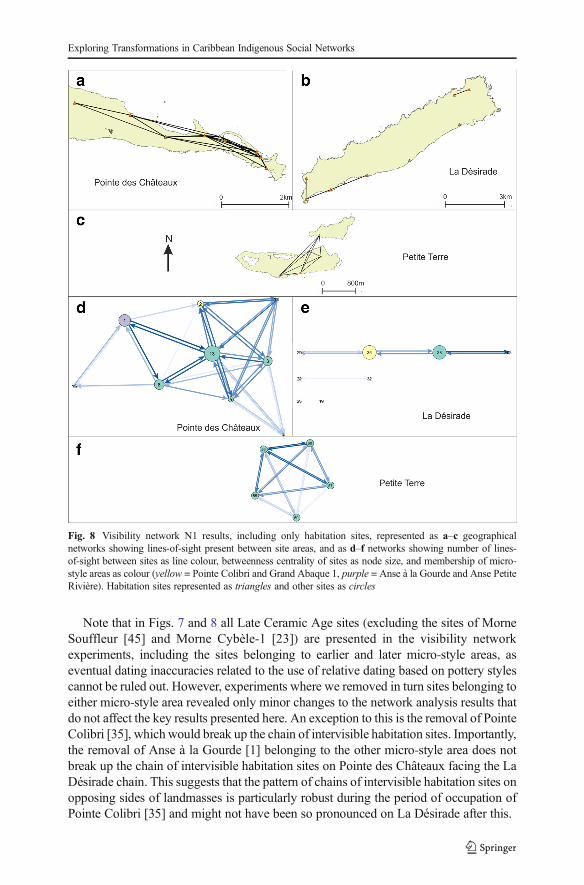
Note that in Figs. 7 and 8 all Late Ceramic Age sites (excluding the sites of MorneSouffleur [45] and Morne Cybèle-1 [23]) are presented in the visibility networkexperiments, including the sites belonging to earlier and later micro-style areas, aseventual dating inaccuracies related to the use of relative dating based on pottery stylescannot be ruled out. However, experiments where we removed in turn sites belonging toeither micro-style area revealed only minor changes to the network analysis results thatdo not affect the key results presented here. An exception to this is the removal of PointeColibri [35], whichwould break up the chain of intervisible habitation sites. Importantly,the removal of Anse à la Gourde [1] belonging to the other micro-style area does notbreak up the chain of intervisible habitation sites on Pointe des Châteaux facing the LaDésirade chain. This suggests that the pattern of chains of intervisible habitation sites onopposing sides of landmasses is particularly robust during the period of occupation ofPointe Colibri [35] and might not have been so pronounced on La Désirade after this.
Fig. 8 Visibility network N1 results, including only habitation sites, represented as a–c geographicalnetworks showing lines-of-sight present between site areas, and as d–f networks showing number of lines-of-sight between sites as line colour, betweenness centrality of sites as node size, and membership of micro-style areas as colour (yellow = Pointe Colibri and Grand Abaque 1, purple = Anse à la Gourde and Anse PetiteRivière). Habitation sites represented as triangles and other sites as circles
Exploring Transformations in Caribbean Indigenous Social Networks

Discussion
Control of Seascapes
In this paper, we consistently use the word ‘control’ to refer to the collection of theoriesstating that the possibility of surveillance might have been important to past commu-nities. We emphasise that results should be interpreted in light of this diversity oftheories rather than exclusively the desire for exercising active control: the need toobserve resources (like food or lithic extraction places) to avoid their use by certainpeople/communities; the ability to observe canoes navigating along the coast andindividuals walking through the landscape to be aware of human movements, exchangeroutes or the possibility of attack. The outcomes of the experiments indicate thelocations of land areas particularly suitable to visually control possible sea routes forshort- and long-distance exchange. These include the southern coast and parts of theeastern tip of Pointe des Châteaux (TV3; Fig. 3c). These parts may have beenparticularly important in observing or controlling excursions between La Désiradeand Basse-Terre. Only few sites are located in these areas. It is possible that visualcontrol over both sides of Pointe des Châteaux could be exerted from other GrandeTerre villages, located outside the study area (cf. De Waal 2006: Figs. 6.1, 6.3 and 6.8).In addition, as the Pointe des Châteaux peninsula only has a width of approximately1 km, it is expected that communication between people in sites on the south coast withpeople in settlements in other parts of Pointe des Châteaux was quick and easy. Vantagepoints around major settlements like Anse à la Gourde could have enabled successfulvisual control over sea lanes to the north, east and south. The south coast is particularlywell suited for visual control over the southern sea leading towards Petite Terre andenabling navigation further east to La Désirade (TV3; Fig. 3c). This is significant giventhe importance of Petite Terre as a marine resource extraction area (De Waal 2006: 65;De Waal 2009: 8–9) and of the hypothesised contacts between communities on Pointedes Châteaux and La Désirade. As sea currents to the north and north-east of Pointe desChâteaux are particularly strong (De Waal personal observations 1994–2002), weexpect navigation from Guadeloupe to La Désirade to have followed the relativelysheltered southern coast before making the crossing to La Désirade. We therefore arguethat sites on the southern coast should be considered lookout points as a complementarypart of the major agglomeration of Anse à la Gourde on the north coast.
Interestingly, the temporary habitation sites of site 1 and Ouest RésidenceKahouanne, and the strategic outpost at Ouest Anse à Plume, are located in these areascontrolling sea routes but permanent habitation sites are found in other locations(Table 3). This suggests that the location of Anse à la Gourde, one of the mostprominent settlements in the study area thought to have played an important role inshort- and long-distance exchange networks, was not selected for its visual control ofsea routes. The Anse à la Gourde area has many other favourable conditions for asettlement (De Waal 2006: Table 5.1), but apparently, visual control of sea routes wasnot a requirement for a settlement to fulfil this role in exchange networks. Severaluninhabited areas on the south coast were more suitable to visually control seascapes. Itmay also be suggested that other sites, such as site 1 and Ouest Résidence Kahouanne,fulfilled this role for Anse à la Gourde, even though they are at some distance (0.8 and1.5 km) from this settlement. If this happened, this only occurred during the early phase
Brughmans et al.
of the Late Ceramic Age (AD 600/850–1200/1300). During earlier and later phases,Anse à la Gourde is surrounded by less sites, the landscape is more empty and theinhabitants of the settlement had fewer opportunities to control sea routes in their nearsurroundings.
Land areas particularly suitable to visually control possible sea routes for short- andlong-distance exchange at La Désirade include the western tip and the entire southerncoastal area of the island (TV3; Fig. 3c). It is noteworthy that the southern edge of thecentral plateau is not included. In the experiments, the plateau edge has normalvisibility, but it has a lower theoretical maximum of visible sea area, being locatedslightly inland and given our theoretical maximum viewing distance of 3 km. Whenstanding on the edge of the plateau at Morne Cybèle-1 and Morne Souffleur one canoversee the sea to Petite Terre (and identify the Petite Terre lighthouse) and to Pointedes Châteaux. From the plateau, it is also possible to see boats arriving at the island aslanding areas for canoes can be observed. Morne Cybèle-2 overlooks Anse PetiteRivière and Morne Souffleur overlooks one of the other few bays where one can easilyland a canoe at the south coast.
At LaDésirade only six sites are located in areas with high visual control over sea routes(Table 4). Only three of these represent permanent habitation sites: Pointe Colibri, ÀL’Escalier and Aéroport. Grand Abaque 1, linked in a micro-style area with Pointe Colibriis in an area of low visibility. The natural setting of the sites of Pointe Colibri and GrandAbaque 1 is very different (De Waal 2006: Table 5.1). The regular contacts, suggested onthe basis of similarities in ceramics, were apparently not linked to shared preferences forlocations overlooking sea routes. They rather seem to complement each other, one siteoverlooking the west, the other site overlooking the east. Interestingly, habitation sitesfacing Petite Terre are located in areas of high visual control over the southern sea (PointeColibri, Aéroport, À l’Escalier TV3, Fig. 3c). Similarly to Anse à la Gourde, Anse PetiteRivière is located very close to (but not in) such areas (VNC3, Fig. 4c) (Table 4).Uninhabited areas close-by have slightly better visual control over seascapes. But no sitesare close-by Anse Petite Rivière that may have taken over this function.
At Petite Terre, possible sea routes for short- and long-distance exchange can becontrolled from large coastal areas except for the low-lying northern coast (TV3; Fig.3c). No sites are located in areas with good visual control over seascapes (Table 5) anduninhabited areas allow visual control over seascapes. However, from Est de Moutonde Bas at the northeastern coast of Terre de Bas, and Pointe Sablé at the southern coastof Terre de Haut, one can control access to the restricted channel separating the islandsof Petite Terre, which is reported to be one of the richest marine resource extractionareas for the islands (De Waal 2006: 65; De Waal 2009: 8–9). These sites may haveplayed a role in mobility related to resource extraction at Petite Terre, for example byexpeditions from La Désirade or Pointe des Château.
The results further indicate that in the eastern part of Pointe des Châteaux, includingthe area with the Salinas, smoke columns rising up from villages would be particularlyvisible from sea (TV1; Fig. 3a). Half of the sites are located in these areas, includinghalf of the habitation sites, including Petites Salines, Est Petite Saline Orientale, Degratand site 7 (Table 3). The sites are evenly distributed over these areas, which eliminatesthe question if uninhabited areas were more visible from the sea. Sites belonging tomicro-style areas do not share the same characteristics related to the visibility of smokecolumns. It is noteworthy that Anse à la Gourde is not in such a location. Regarding its
Exploring Transformations in Caribbean Indigenous Social Networks
role in regional and micro-regional networks one would expect that the visibility ofsmoke columns could help to direct interacting groups to the site. However, Anse à laGourde does have an eye-catching feature that helps people navigating to the site: asmall rocky island called ‘Le Diamant’, just north of Anse à la Gourde bay (CV8; Fig.6b). In addition, even though visibility is low for the settlements of Anse à la Gourdeand Grande Saline, high visibilities have been identified for the close-by indistinct siteof Pointe a Cabrits 2, west of Anse à la Gourde, and of the strategic outpost at OuestAnse à Plume, west of Grande Saline. These sites may have complemented thisvisibility role of both settlements. Smoke columns are best seen from sea stretches atthe north-west and south-west of Pointe des Châteaux.
In the western and eastern parts of La Désirade smoke columns rising up from villageswould be particularly visible from sea (TV1; Fig. 3a), especially from sea stretches directlysouth of the island. Only 8 out of 36 sites are located in these areas. Five of these arepermanent settlements, including Pointe Colibri and Grand Abaque 1, which together formone of the early micro-style areas (Table 4). The latter site, which seems to be hidden in theeastern hills, must have been well visible when it comes to detecting smoke columns fromthe sea. However, it may be questioned how important the notion is that both early micro-style area sites have a similar visibility of smoke columns from the sea. Contacts betweenboth sites may well have taken place over land, as they are only separated by approxi-mately 10.5 km as the crow flies and as canoes cannot be landed at the northern and easternsides of the island close to GrandAbaque 1. Interesting to note are the unremarkable resultsfor the settlements of Morne Cybèle-1 and Morne Souffleur, neither particularly high orlow. People establishing sites with presumably defensive locations probably tend to avoidattention to be drawn from a distance, but the results of TV1 (Table 4) do not providestrong support for this. Anse Petite Rivière also has a low visibility of smoke columns fromthe sea. Interesting to note as well is the high visibility of the south-eastern part of theisland, where the (undated) lithic workshops are located. These workshops have played arole in micro-regional interactions as inhabitants from Pointe des Châteaux and from otherparts of Guadeloupe collected raw materials for the manufacture of lithic artefacts at theselocations (De Waal 2006: 106, 115, 130). The high visibility of the indistinct (specialactivity) site of Grande Ravine, at some elevation north of the lithic workshops, seems tocomplement the visibility of the latter.
In the south-eastern part of Terre de Bas in Petite Terre smoke columns rising up fromvillages would be particularly visible from sea (TV1; Fig. 3a). This seems important asthis part of Terre de Bas is furthest removed from presumably important transportationroutes between Marie-Galante (or further south) and the north, which may be expectedto have passed the islands of Petite Terre in the west. No sites are located in these highvisibility areas, whilst two habitation sites are located in areas of very low visibility(Table 5). Sea stretches surrounding the islands, except for the eastern part, would allowgood views on smoke columns present on the islands of Petite Terre (TV2; Fig. 3b).
As a concluding remark, we cannot argue that the sites in general are located inplaces of exceptionally good or exceptionally bad visibility from and to the sea.Considering the presumed importance of the visibility of smoke columns with regardsto intersite and interisland movements, more sites were expected to be located in highvisibility areas than indicated in the experiments. The experiments do not indicatevisibility to have been a factor of importance for the existence and functioning ofmicro-style areas either.
Brughmans et al.
Signalling Network
The visibility network experiment N1 (Figs. 7 and 8) revealed that the networks’structures could have enabled smoke signalling networks between sites that could havefunctioned for communication purposes throughout the research area. The networks perlandmass are connected and dense and they incorporate all known sites, allowing forinformation to be shared through signalling from any site to any other site.
The Pointe des Châteaux visibility network seems to consist of one single component.The settlement of Anse à la Gourde is a visually prominent node in this network.However, it did not play an important role as an intermediary. The Petite Terre visibilitynetwork includes one single component where all sites are intervisible (N1; Figs. 7 and 8).
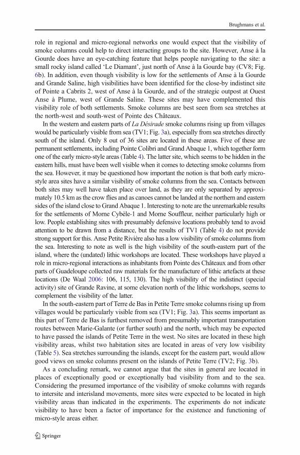
The network on La Désirade consists of two separated components (N1; Fig. 7).Pointe Colibri plays an important role as an intermediary in a hypothetical signallingnetwork, whereas Grand Abaque 1, in the eastern part of the island, does not play animportant role. This network structure raises an important question: how could thewestern and eastern components become connected so that a functional signallingnetwork could have existed for the entire island? There are multiple possible answers(Fig. 9). First, one is tempted to assume the existence of an unidentified coastal sitebetween Pointe à Godard and À L’Escalier, but the coast is too steep here to allowsettlement (Fig. 9a). Second, the site Trou Madame, tentatively interpreted as a (yetindistinct) special activity site, is located close to the plateau edge and within 3-kmdistance of Point Godard in the western component (Fig. 9b). Locations close-by TrouMadame offering lines-of-sight to Pointe à Godard would serve to connect bothcomponents. Third, and to us most intriguing, locations along the plateau edge nearby
Fig. 9 Hypotheses for connecting the two components on La Désirade (see N1; Fig. 7) to allow for aneffective island-wide signalling network: a possible unidentified site along the coast, b good vantage points onthe plateau edge nearby Trou Madame, c good vantage points on the plateau edge nearby Chemin de M. del’Orme
Exploring Transformations in Caribbean Indigenous Social Networks
the site of Chemin de M. de l’Orme situated on the central plateau could also connectboth components. Chemin de M. de l’Orme has been interpreted as a ceremonial, thusexceptional, site in an ‘empty’ area on the plateau (Fig. 9c). The site itself has lowvisibility (N1; Fig. 7) but nearby locations offer lines-of-sight to Pointe à Godard in thewestern component. It consists of a deliberate deposition of a small pelican vessel,which functioned as a container for a small non-used stone axe and adze of St. Martinchert (De Waal 2003, 2006: 99, 304). The site was considered a deposition in anunattractive area with no strategic importance, on a hilly terrain that is difficult to reachand far from the villages and the coast. In the light of the visibility analyses, it can nowbe suggested to have been close to locations that served as a lookout, connecting twonetwork components on the island and it is tempting to further speculate if the depotwas created as reference to this important role as a lookout or anchor point within theislands’ visibility network.
Interestingly, when we only include habitation sites, smoke signalling networks stillmay have functioned (Fig. 8). On the northern part of Pointe des Châteaux and thesouthern part of La Désirade, more or less ‘opposing sides’, the visibility networks ofhabitation sites form chains or paths through which information may have been sharedfrom one side of a landmass to the other. This spatial distribution is thought not to be aresult of the similarity in shape of the landmasses, as the pattern did not emerge in othersimilarly shaped parts of the study area. Due to the maximum viewing distance,artificially set at 3 km for our experiments, interaction between communities by smokesignalling was limited to intra-island contacts.
It is difficult to ascertain whether such hypothesised signalling networks transformedover time, since only a few sites could be assigned in an absolute way to differentmicro-style areas and phases of the Late Ceramic Age, making networks of securelydated contemporary sites impossible. However, one major change is obvious: a well-functioning smoke signalling network could have existed in the early phase of the LateCeramic Age as it has a large number of sites all over the landscape, which allowsintensive visual signalling networks, but not in the later phase. The decrease to only threelater phase sites marks the end of a smoke signalling network if one did exist. MorneSouffleur andMorne Cybèle-1 are intervisible, but a non-trivial signalling network requiresa chain of at least three sites where messages can be passed on between mutuallyintervisible sites A and C via a mutually visible site B. In addition, Morne Souffleur andMorne Cybèle-1 share similar visibility characteristics and do not complement each other’sobservations. Interestingly, this later phase is precisely the period in which East-Guadeloupe inhabitants might have wished for relatively dense or tight signalling andcommunication networks in their close environs, as there would have been only fewneighbours to rely on in times of need. Apparently, they depended on different ways tokeep contact and they covered larger distances out of necessity (cf. De Waal 2006: 132).
The fact that most of the sites have not been absolutely dated reduces our certainty ofthese visibility networks’ structures. However, taking one node away from the network (forexample because it is not contemporaneous with the other sites) does not cause the networkto break up into multiple components, thanks to its density, and thus stop being able tofunction as a possible signalling network. When only habitation sites are included in thenetwork the removal of a site has a larger impact, simply because less sites can take over itsrole. It is also interesting to note that when we look at the early phase of the Late CeramicAge and in turn remove the sites belonging to each of the two micro-style areas, almost
Brughmans et al.
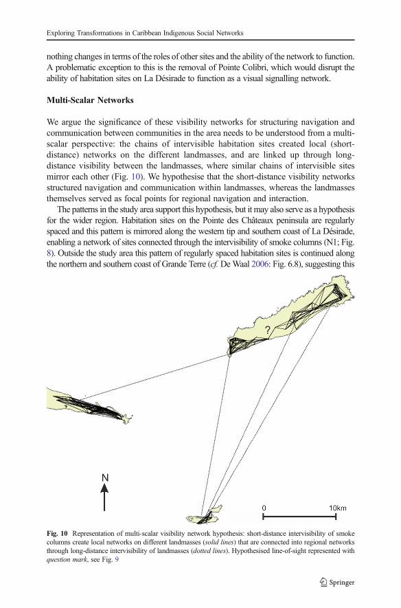
nothing changes in terms of the roles of other sites and the ability of the network to function.A problematic exception to this is the removal of Pointe Colibri, which would disrupt theability of habitation sites on La Désirade to function as a visual signalling network.
Multi-Scalar Networks
We argue the significance of these visibility networks for structuring navigation andcommunication between communities in the area needs to be understood from a multi-scalar perspective: the chains of intervisible habitation sites created local (short-distance) networks on the different landmasses, and are linked up through long-distance visibility between the landmasses, where similar chains of intervisible sitesmirror each other (Fig. 10). We hypothesise that the short-distance visibility networksstructured navigation and communication within landmasses, whereas the landmassesthemselves served as focal points for regional navigation and interaction.
The patterns in the study area support this hypothesis, but it may also serve as a hypothesisfor the wider region. Habitation sites on the Pointe des Châteaux peninsula are regularlyspaced and this pattern is mirrored along the western tip and southern coast of La Désirade,enabling a network of sites connected through the intervisibility of smoke columns (N1; Fig.8). Outside the study area this pattern of regularly spaced habitation sites is continued alongthe northern and southern coast of Grande Terre (cf.DeWaal 2006: Fig. 6.8), suggesting this
Fig. 10 Representation of multi-scalar visibility network hypothesis: short-distance intervisibility of smokecolumns create local networks on different landmasses (solid lines) that are connected into regional networksthrough long-distance intervisibility of landmasses (dotted lines). Hypothesised line-of-sight represented withquestion mark, see Fig. 9
Exploring Transformations in Caribbean Indigenous Social Networks
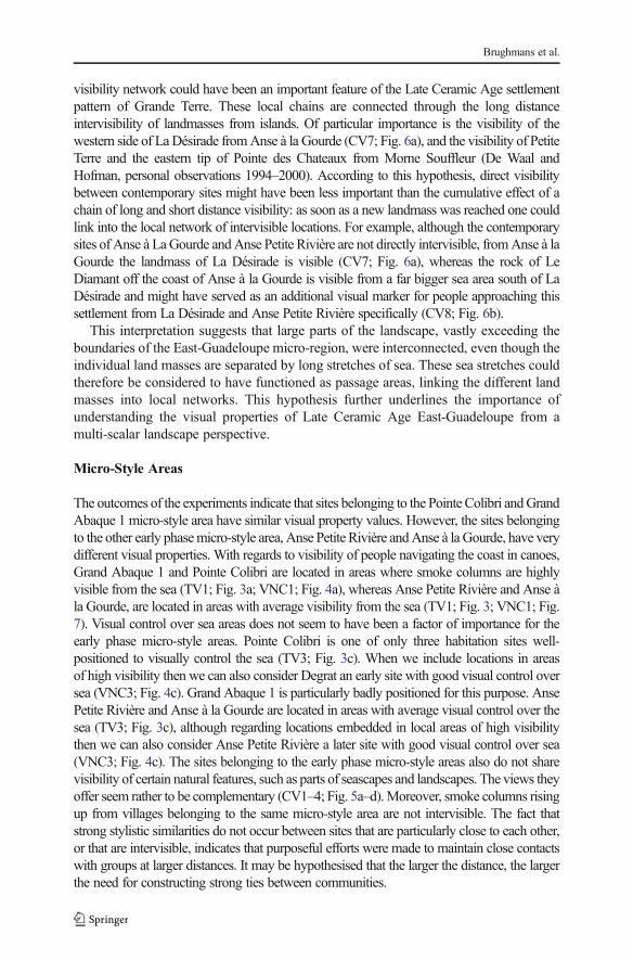
visibility network could have been an important feature of the Late Ceramic Age settlementpattern of Grande Terre. These local chains are connected through the long distanceintervisibility of landmasses from islands. Of particular importance is the visibility of thewestern side of LaDésirade fromAnse à la Gourde (CV7; Fig. 6a), and the visibility of PetiteTerre and the eastern tip of Pointe des Chateaux from Morne Souffleur (De Waal andHofman, personal observations 1994–2000). According to this hypothesis, direct visibilitybetween contemporary sites might have been less important than the cumulative effect of achain of long and short distance visibility: as soon as a new landmass was reached one couldlink into the local network of intervisible locations. For example, although the contemporarysites of Anse à LaGourde andAnse Petite Rivière are not directly intervisible, fromAnse à laGourde the landmass of La Désirade is visible (CV7; Fig. 6a), whereas the rock of LeDiamant off the coast of Anse à la Gourde is visible from a far bigger sea area south of LaDésirade and might have served as an additional visual marker for people approaching thissettlement from La Désirade and Anse Petite Rivière specifically (CV8; Fig. 6b).
This interpretation suggests that large parts of the landscape, vastly exceeding theboundaries of the East-Guadeloupe micro-region, were interconnected, even though theindividual land masses are separated by long stretches of sea. These sea stretches couldtherefore be considered to have functioned as passage areas, linking the different landmasses into local networks. This hypothesis further underlines the importance ofunderstanding the visual properties of Late Ceramic Age East-Guadeloupe from amulti-scalar landscape perspective.
Micro-Style Areas
The outcomes of the experiments indicate that sites belonging to the Pointe Colibri andGrandAbaque 1 micro-style area have similar visual property values. However, the sites belongingto the other early phasemicro-style area, Anse Petite Rivière andAnse à laGourde, have verydifferent visual properties. With regards to visibility of people navigating the coast in canoes,Grand Abaque 1 and Pointe Colibri are located in areas where smoke columns are highlyvisible from the sea (TV1; Fig. 3a; VNC1; Fig. 4a), whereas Anse Petite Rivière and Anse àla Gourde, are located in areas with average visibility from the sea (TV1; Fig. 3; VNC1; Fig.7). Visual control over sea areas does not seem to have been a factor of importance for theearly phase micro-style areas. Pointe Colibri is one of only three habitation sites well-positioned to visually control the sea (TV3; Fig. 3c). When we include locations in areasof high visibility then we can also consider Degrat an early site with good visual control oversea (VNC3; Fig. 4c). Grand Abaque 1 is particularly badly positioned for this purpose. AnsePetite Rivière and Anse à la Gourde are located in areas with average visual control over thesea (TV3; Fig. 3c), although regarding locations embedded in local areas of high visibilitythen we can also consider Anse Petite Rivière a later site with good visual control over sea(VNC3; Fig. 4c). The sites belonging to the early phase micro-style areas also do not sharevisibility of certain natural features, such as parts of seascapes and landscapes. The views theyoffer seem rather to be complementary (CV1–4; Fig. 5a–d).Moreover, smoke columns risingup from villages belonging to the same micro-style area are not intervisible. The fact thatstrong stylistic similarities do not occur between sites that are particularly close to each other,or that are intervisible, indicates that purposeful efforts were made to maintain close contactswith groups at larger distances. It may be hypothesised that the larger the distance, the largerthe need for constructing strong ties between communities.
Brughmans et al.
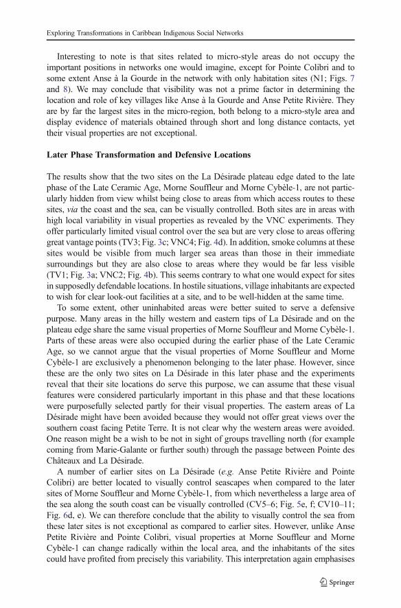
Interesting to note is that sites related to micro-style areas do not occupy theimportant positions in networks one would imagine, except for Pointe Colibri and tosome extent Anse à la Gourde in the network with only habitation sites (N1; Figs. 7and 8). We may conclude that visibility was not a prime factor in determining thelocation and role of key villages like Anse à la Gourde and Anse Petite Rivière. Theyare by far the largest sites in the micro-region, both belong to a micro-style area anddisplay evidence of materials obtained through short and long distance contacts, yettheir visual properties are not exceptional.
Later Phase Transformation and Defensive Locations
The results show that the two sites on the La Désirade plateau edge dated to the latephase of the Late Ceramic Age, Morne Souffleur and Morne Cybèle-1, are not partic-ularly hidden from view whilst being close to areas from which access routes to thesesites, via the coast and the sea, can be visually controlled. Both sites are in areas withhigh local variability in visual properties as revealed by the VNC experiments. Theyoffer particularly limited visual control over the sea but are very close to areas offeringgreat vantage points (TV3; Fig. 3c; VNC4; Fig. 4d). In addition, smoke columns at thesesites would be visible from much larger sea areas than those in their immediatesurroundings but they are also close to areas where they would be far less visible(TV1; Fig. 3a; VNC2; Fig. 4b). This seems contrary to what one would expect for sitesin supposedly defendable locations. In hostile situations, village inhabitants are expectedto wish for clear look-out facilities at a site, and to be well-hidden at the same time.
To some extent, other uninhabited areas were better suited to serve a defensivepurpose. Many areas in the hilly western and eastern tips of La Désirade and on theplateau edge share the same visual properties of Morne Souffleur and Morne Cybèle-1.Parts of these areas were also occupied during the earlier phase of the Late CeramicAge, so we cannot argue that the visual properties of Morne Souffleur and MorneCybèle-1 are exclusively a phenomenon belonging to the later phase. However, sincethese are the only two sites on La Désirade in this later phase and the experimentsreveal that their site locations do serve this purpose, we can assume that these visualfeatures were considered particularly important in this phase and that these locationswere purposefully selected partly for their visual properties. The eastern areas of LaDésirade might have been avoided because they would not offer great views over thesouthern coast facing Petite Terre. It is not clear why the western areas were avoided.One reason might be a wish to be not in sight of groups travelling north (for examplecoming from Marie-Galante or further south) through the passage between Pointe desChâteaux and La Désirade.
A number of earlier sites on La Désirade (e.g. Anse Petite Rivière and PointeColibri) are better located to visually control seascapes when compared to the latersites of Morne Souffleur and Morne Cybèle-1, from which nevertheless a large area ofthe sea along the south coast can be visually controlled (CV5–6; Fig. 5e, f; CV10–11;Fig. 6d, e). We can therefore conclude that the ability to visually control the sea fromthese later sites is not exceptional as compared to earlier sites. However, unlike AnsePetite Rivière and Pointe Colibri, visual properties at Morne Souffleur and MorneCybèle-1 can change radically within the local area, and the inhabitants of the sitescould have profited from precisely this variability. This interpretation again emphasises
Exploring Transformations in Caribbean Indigenous Social Networks
the importance to understanding visual properties of sites from a landscape perspectiveand not just from the perspective of the individual sites, as is usually done.
To conclude, it remains questionable whether the locations for Morne Cybèle-1 andMorne Souffleur were selected primarily for their defensive aspects. Villages shouldpreferably be invisible from the sea as smoke columns can easily give away hiddenvillage locations to enemies, whereas good look-outs over the surrounding landscapesand seascapes should be available close-by the village. This is precisely the opposite ofwhat our total viewshed results show (TV1, 3; Fig. 3a, c; Table 4). On the other hand,the visual neighbourhood configuration experiments did reveal that such locations witha defensive nature exist close-by due to the high variability of visual properties in thelocal area (VNC2, 4; Fig. 4b, d; Table 7), and the cumulative viewshed experiments andthe authors’ personal observations during survey work highlight the visibility of thelandmasses of Petite Terre and Pointe des Châteaux (CV10–11; Fig. 6d, e). Theseresults reflect a situation that may well have served a defensive purpose, althoughmaybe not exclusively so. If the site locations were not selected for defensive purposesalone, and if they were meant to be seen from a distance, this might also relate to thesuggested special, possibly ceremonial, function of the sites, based on the presence ofthe shell faces or guaizas at both sites (De Waal 2003, 2006; Hofman 1995; Hofmanet al. 2004). In addition, we could argue that sites participating in regional networks,which both sites were, are not expected to be hidden.
Conclusions
We started this paper by questioning how visual properties of natural and culturallandscapes in East-Guadeloupe affected human behaviour in pre-colonial times, par-ticularly with regards to interactions between communities, and whether these visualproperties and roles changed over time.
We conclude that only few sites (and very few villages) in Eastern Guadeloupe arelocated in areas that are particularly suitable to visually control possible sea routes forshort- and long-distance exchange. Even the prominent village of Anse à la Gourde isnot in a location that favours visual control of the sea. Other locations in an agglom-eration may have provided complementary visual properties and other settlementfeatures allowing villages such as Anse à la Gourde and Anse Petite Rivière to fulfiltheir roles in exchange networks, for example by functioning as observation outposts.
Contrary to what we had expected on the basis of the presumed importance of thevisibility of smoke columns with regards to intersite and interisland contacts, relatively fewhabitation sites were actually located in high visibility areas. It has been suggested that otherelements in the landscape may have helped canoeing people navigate to specific sites orlandforms and that neighbouring sites in high visibility areas played a complementary role.
The experiments further suggested that visual control over sea areas and visibility ofsmoke columns were not factors of importance for the existence of the micro-styleareas. The stylistic similarities are not related to the visual properties of site locations.
The visibility network experiments have indicated that during the early phase of theLate Ceramic Age networks per landmass are connected and dense and that theyincorporate all sites. This structure would allow hypothetical smoke signalling networksbetween sites to allow communication throughout the research area. This probably was
Brughmans et al.
a multi-scalar phenomenon: local networks of intervisibility between regularly spacedhabitation sites on landmasses connected with more regional long-distance intervisibil-ity of landmasses (Fig. 10).
With regards to changes that occurred during the later phase of the Late CeramicAge and the supposed preference for defensive locations, it can be concluded that thevisual properties of the Morne Souffleur and Morne Cybèle-1 site locations were notideal for defensive purposes, although the inhabitants may nevertheless have profitedfrom the high local variability in visual properties.
In addition to this detailed description and interpretation of the visual properties ofthe East-Guadeloupe study area, this paper has made two key contributions toCaribbean archaeology and landscape archaeology.
First, we used a variety of formal methods to explore how visual properties couldhave structured past human behaviour. These greatly extend the range of commonlyused formal visibility methods in Caribbean archaeology in particular and, when usedin combination, enable specific and complex hypotheses to be explored in Caribbeanarchaeology and landscape archaeology as a whole. We by no means exhausted therange of visibility theories and methods that can be usefully formally explored andargue future research should further extend this range (for example, by exploring thevisibility of fire during night-time or navigation using the positions of sun, moon andvisible stars). We strongly believe that the more common use of formal approachesalready well established in landscape archaeology in general will enable archaeologiststo build arguments for the importance of visibility on reproducible and formallycomparable results. Importantly, a formal approach will always need to be guided byarchaeological theories, contextual knowledge and conducted alongside personal ob-servations. For example, we were highly interested and surprised by results dispellingthe importance we as archaeologists attributed to visual properties in a number of cases:the micro-style areas do not seem to be related to visual properties; the major sites ofAnse à la Gourde and Anse Petite Rivière do not have the exceptional visual propertiesone would expect to see for communities that are clearly pivotal in local and regionalexchange networks; the visual properties of the late sites of Morne Souffleur and MorneCybèle-1 cannot be unambiguously interpreted as serving a defensive purpose. In thesecases, the formal approach challenged our personal observations and led us to rethinkthe role of visibility alongside other factors in our archaeological theories. Such studieswith negative but useful results, comparing diverse hypotheses and dispelling some ofour thoughts about the importance of visibility, are becoming increasingly common inarchaeology, a trend we hope will persist (e.g. Eve and Crema 2014; Gillings 2015).
Second, the approach presented here recognises that our archaeological theoriesfrequently concern visual properties of landscapes rather than sites. The total viewshed,visual neighbourhood configurations and visibility network methods enable us toformally express such theories, and explore these for site locations as well as thelandscape as a whole (to account for our incomplete knowledge of the past settlementpattern). As already concluded earlier (De Waal 2011: 80–81), information onneighbouring sites, archaeological site patterns and elements from the landscape settingclearly enhances the understanding of Blandscape use over time and [on] villageorganisation and interaction among the pre-Columbian Amerindians who onceinhabited Pointe des Châteaux, La Désirade and Petite Terre^. We recommend futurearchaeological visibility studies to avoid a restrictive focus on point site locations and
Exploring Transformations in Caribbean Indigenous Social Networks
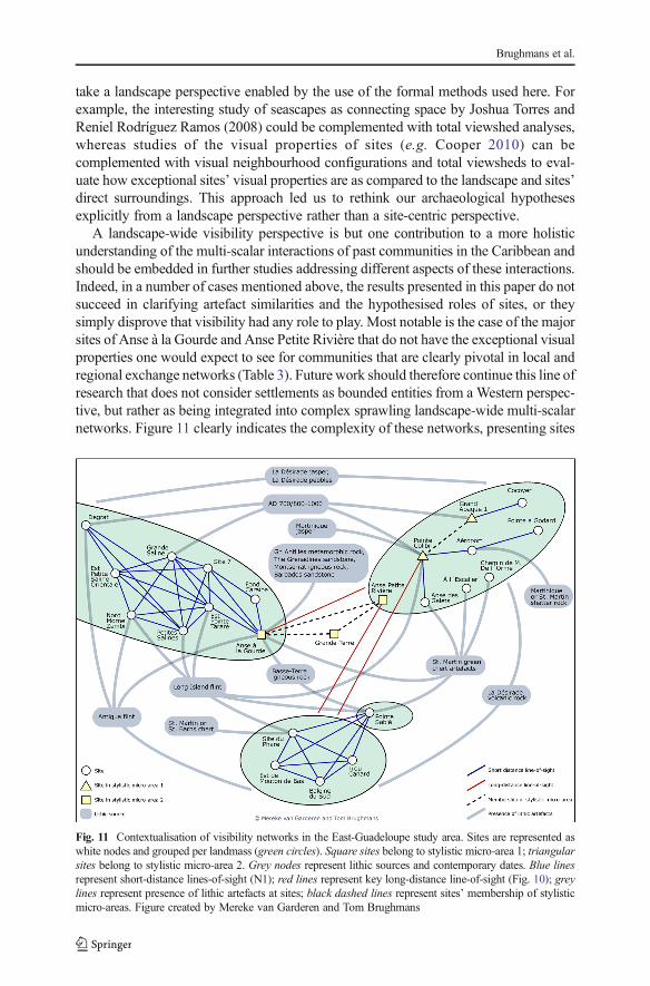
take a landscape perspective enabled by the use of the formal methods used here. Forexample, the interesting study of seascapes as connecting space by Joshua Torres andReniel Rodríguez Ramos (2008) could be complemented with total viewshed analyses,whereas studies of the visual properties of sites (e.g. Cooper 2010) can becomplemented with visual neighbourhood configurations and total viewsheds to eval-uate how exceptional sites’ visual properties are as compared to the landscape and sites’direct surroundings. This approach led us to rethink our archaeological hypothesesexplicitly from a landscape perspective rather than a site-centric perspective.
A landscape-wide visibility perspective is but one contribution to a more holisticunderstanding of the multi-scalar interactions of past communities in the Caribbean andshould be embedded in further studies addressing different aspects of these interactions.Indeed, in a number of cases mentioned above, the results presented in this paper do notsucceed in clarifying artefact similarities and the hypothesised roles of sites, or theysimply disprove that visibility had any role to play. Most notable is the case of the majorsites of Anse à la Gourde and Anse Petite Rivière that do not have the exceptional visualproperties one would expect to see for communities that are clearly pivotal in local andregional exchange networks (Table 3). Future work should therefore continue this line ofresearch that does not consider settlements as bounded entities from a Western perspec-tive, but rather as being integrated into complex sprawling landscape-wide multi-scalarnetworks. Figure 11 clearly indicates the complexity of these networks, presenting sites
Fig. 11 Contextualisation of visibility networks in the East-Guadeloupe study area. Sites are represented aswhite nodes and grouped per landmass (green circles). Square sites belong to stylistic micro-area 1; triangularsites belong to stylistic micro-area 2. Grey nodes represent lithic sources and contemporary dates. Blue linesrepresent short-distance lines-of-sight (N1); red lines represent key long-distance line-of-sight (Fig. 10); greylines represent presence of lithic artefacts at sites; black dashed lines represent sites’ membership of stylisticmicro-areas. Figure created by Mereke van Garderen and Tom Brughmans
Brughmans et al.

within their natural and cultural context and with neighbouring sites in their agglomer-ations, complementing settlement features. It also depicts sites embedded in local andregional visibility and interaction networks, as evidenced by the presence of non-localmaterials and close similarities in styles in material culture. The effects of seasonalityand palaeo-vegetation, memory and long-term development of local knowledge, and therole of celestial bodies in local and micro-regional visibility studies and navigationbetween pre-colonial communities remain to be investigated in order to complement thenatural landscapes of such networks.
Acknowledgements We thank Zoran Čučković for the development of his Viewshed Analysis QGIS pluginand his technical support; Mereke van Garderen for the development of her R script to analyse visualneighbourhood configurations, for technical support and for the production of Fig. 11; André Delpuech forhis collaboration in archaeological projects with Leiden University in Eastern Guadeloupe; and KatarinaJacobson for advice supporting our Guadeloupe visibility survey. The work presented here was performed aspart of the Caribbean Connections: Cultural Encounters in a NewWorld Setting project, financially supportedby the HERA Joint Research Programme, and the European Union’s Seventh Framework Programme forresearch, technological development and demonstration under grant agreement no. 1133; this research is alsopart of the ERC synergy project NEXUS1492, which has received funding from the European ResearchCouncil under the European Union’s Seventh Framework Programme (FP7/2007-2013) / ERC grant agree-ment no. 319209.
Appendix. Description of data and methods
Site data and digital elevation model
The site data include the sites surveyed and studied by Hofman and Hoogland (Hofman1995) and De Waal (2006) as presented in Table 1 and Fig. 1. This site inventory,including data collected until 2000, presents the most comprehensive documentation ofthe Late Ceramic Age settlement pattern in East-Guadeloupe. It was created through asystematic survey applying a standardised set of criteria and methods of documentationand analysis for each site, and site information is therefore comparable. An exception isthe site of Anse à la Gourde where extensive excavations took place over a period of7 years as a collaboration between the Service Régional de l’Archéologie de laGuadeloupe and the Faculty of Archaeology at Leiden University resulting in an exca-vated surface area of more than 2000 m2 (Hofman et al. 1999, 2001, 2014). Alongsidedescriptions of site locations, research history and finds, it records the presence of sitelocation variables that are compared to the visual properties of sites: fresh water, flatterrain, accessible bays with canoe landing spots, reefs, soils suitable for small-scalehorticulture, lithic raw materials, viewpoints, strategic elevated spots, salinas and man-grove (Table 1). Site areas with an unknown probable extent were represented as circleswith areas estimated by De Waal (2006, 90–91, Table 5.1) and modified to avoid seaareas. Cave sites were given a site area with a 1-m radius (Parc à Jojo, Grotte de GrandeAnse, Grotte de Morne Blanc and Morne Frégule at La Désirade). Trou Canard has anunknown site area. For this analysis, it was assumed to have had a minimum area of70 m2, equal to the assumed area of the smallest non-cave site in the dataset.
The raster digital elevation model (DEM) used in this paper is the Litto3D®Guadeloupe topographic LIDAR by © SHOM-IGN (2013), distributed under anOpen data licence. The DEM has a horizontal resolution of 1 m and was originally
Exploring Transformations in Caribbean Indigenous Social Networks
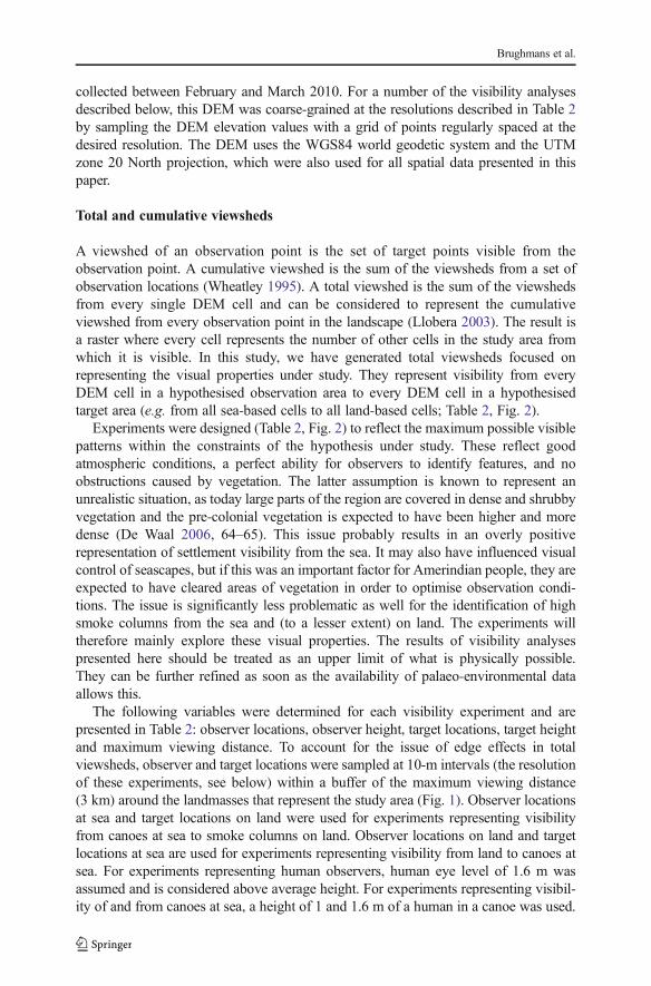
collected between February and March 2010. For a number of the visibility analysesdescribed below, this DEM was coarse-grained at the resolutions described in Table 2by sampling the DEM elevation values with a grid of points regularly spaced at thedesired resolution. The DEM uses the WGS84 world geodetic system and the UTMzone 20 North projection, which were also used for all spatial data presented in thispaper.
Total and cumulative viewsheds
A viewshed of an observation point is the set of target points visible from theobservation point. A cumulative viewshed is the sum of the viewsheds from a set ofobservation locations (Wheatley 1995). A total viewshed is the sum of the viewshedsfrom every single DEM cell and can be considered to represent the cumulativeviewshed from every observation point in the landscape (Llobera 2003). The result isa raster where every cell represents the number of other cells in the study area fromwhich it is visible. In this study, we have generated total viewsheds focused onrepresenting the visual properties under study. They represent visibility from everyDEM cell in a hypothesised observation area to every DEM cell in a hypothesisedtarget area (e.g. from all sea-based cells to all land-based cells; Table 2, Fig. 2).
Experiments were designed (Table 2, Fig. 2) to reflect the maximum possible visiblepatterns within the constraints of the hypothesis under study. These reflect goodatmospheric conditions, a perfect ability for observers to identify features, and noobstructions caused by vegetation. The latter assumption is known to represent anunrealistic situation, as today large parts of the region are covered in dense and shrubbyvegetation and the pre-colonial vegetation is expected to have been higher and moredense (De Waal 2006, 64–65). This issue probably results in an overly positiverepresentation of settlement visibility from the sea. It may also have influenced visualcontrol of seascapes, but if this was an important factor for Amerindian people, they areexpected to have cleared areas of vegetation in order to optimise observation condi-tions. The issue is significantly less problematic as well for the identification of highsmoke columns from the sea and (to a lesser extent) on land. The experiments willtherefore mainly explore these visual properties. The results of visibility analysespresented here should be treated as an upper limit of what is physically possible.They can be further refined as soon as the availability of palaeo-environmental dataallows this.
The following variables were determined for each visibility experiment and arepresented in Table 2: observer locations, observer height, target locations, target heightand maximum viewing distance. To account for the issue of edge effects in totalviewsheds, observer and target locations were sampled at 10-m intervals (the resolutionof these experiments, see below) within a buffer of the maximum viewing distance(3 km) around the landmasses that represent the study area (Fig. 1). Observer locationsat sea and target locations on land were used for experiments representing visibilityfrom canoes at sea to smoke columns on land. Observer locations on land and targetlocations at sea are used for experiments representing visibility from land to canoes atsea. For experiments representing human observers, human eye level of 1.6 m wasassumed and is considered above average height. For experiments representing visibil-ity of and from canoes at sea, a height of 1 and 1.6 m of a human in a canoe was used.
Brughmans et al.

However, results for all experiments revealed only minor differences between theseheights, and we therefore present here only results with a height of 1.6 m. Thisadditionally has the advantage of assuming intervisibility or reciprocity of lines-of-sight from human observers with an assumed eye level of 1.6 m. Observations duringour visibility surveys in Guadeloupe and Grenada (Brughmans in Hofman 2016)suggest an individual on land and a canoe at sea would be visible up to a maximumdistance of 3 km, which is the maximum viewing distance used here.
A review of the visual detection of smoke columns from forest fires suggests amaximum detection radius of 13.4 km under poor atmospheric and observer detectionconditions and 20.6 km under good conditions (Rego and Catry 2006). However, smokecolumns rising up from kitchen or garden fires in small villages would be far less dense,high and voluminous. Our observations during visibility surveys in Guadeloupe andGrenada suggest such columns are visible up to between 1 and 3 km. Under windyconditions the smoke columns were estimated to be 5 m high, and under less windyconditions straight smoke columns were estimated at 15 m high. Smoke columns weremost clearly visible when observed from the sea and when contrasted against the darkgreen colours of a forested background. In the analyses presented here we assumeddomestic smoke columns up to 15 m high that are clearly visible up to 3 km, hencereflecting maximum possible visibility. Since the three landmasses in the study area arelocated more than 3 km from each other, experiment results were analysed indepen-dently for Pointe des Châteaux, La Désirade and Petite Terre.
The results of TV experiments reported for each site are the average values for theentire site area. Results for point locations at the centre of site areas were also obtainedand are very similar, but these are not reported here.
To calculate viewsheds, we used the open source Viewshed Analysis plugin v0.5.1 inQGIS by Zoran Čučković (2016a, 2016b). It is as fast as comparable algorithms inGRASS and ArcGIS, it provides comparable results to these alternatives, and enablesthe calculation of visibility networks using the same algorithm. It is therefore preferablefor comparing the total viewshed and visibility network results presented here. Earthcurvature was taken into account (atmospheric refraction set to 0.13). Since thecomputation of a total viewshed at 1-m DEM resolutions was prohibitively timeconsuming for larger landscapes, the DEM was coarse-grained to a 10-m horizontalresolution for all total viewsheds presented here (e.g. this reduced the computation timeof total viewshed experiment TV1 to ca. 36 h for La Désirade only). For all cumulativeviewshed experiments, a coarse-grained DEM with a 5-m resolution was used.
In addition, visibility can either be perfect or extremely limited depending onthe season and atmospheric conditions. We also know that the current vegetationis not representative for the Late Ceramic Age (cf. De Waal 2006, 64–65).Although we acknowledge that formal evaluations of these effects need to beincorporated in formal visibility studies, present-day optimal visibility situationshave been taken as a starting point. When more quantitative and qualitative dataon changes in the natural setting that may have taken place in the past will becomeavailable, the effect on visibility studies can be investigated. Finally, the results ofour experiments have been interpreted in contexts of navigation and long- andshort-distance contacts between communities. In future work, the experimentsshould therefore be coupled with seafaring models for the study area, in order toobtain a better understanding of travel over seascapes.
Exploring Transformations in Caribbean Indigenous Social Networks
Visual neighbourhood configurations
Some of the visual properties under study here are not merely visual properties ofindividual locations but rather concern the way visual properties of individual locationsrelate to those of other locations in their immediate vicinity: whether sites are located inareas of high or low visibility, and whether sites are located in areas of low visibilitywith good vantage points in their immediate vicinity. These visual properties can beformally explored by comparing the results of locations in total viewshed experimentsTV1 and TV3 with results of surrounding locations, using the visual neighbourhoodconfigurations method developed by Brughmans et al. in preparation.
Four visual neighbourhood configuration (VNC) experiments were designed usingTV1 and TV3 as input (Table 2). VNC1 and 3 represent the average visual propertyvalue in an area around each cell and were used to study whether sites are embedded inlocal areas of high or low visibility. VNC2 and 4 represent the visual prominence ofeach cell within its local area. This is the difference of the cell’s visual property valuewith the average value in the area; coined as visual prominence by Llobera (2003). Thevisual prominence was used to study whether site locations are embedded in local areaswith visually prominent vantage points nearby. All VNC experiments used circularareas with a radius of 150 m around a focal cell. This radius is just larger than that of thelargest site area (Anse à la Gourde) and is therefore considered to represent the areasurrounding sites, in which inhabitants were aware of the views offered.
Visibility networks
The intervisibility of smoke columns at sites was studied as visibility networks(Brughmans and Brandes, 2017), in which nodes represent sites and arcs (directedrelationships) represent lines-of-sight of maximum 3-km distance from an observer atone site to a smoke column at another site (Table 2; Fig. 2). Since the observer height(1.6 m) and the maximum height of the observed smoke column (15 m) are not thesame, we cannot assume intervisibility or reciprocity (Conolly and Lake 2006, 229–230) and the resulting visibility networks were treated as directed networks. Visibilitynetworks were created with the Viewshed Analysis plugin v0.5.1 in QGIS (Čučković2016a, 2016b) using a 1-m resolution DEM. The visibility network (N1) was created toreflect the site areas, with a set of observation points per site spaced equally at 10-mintervals within the hypothesised site area. The number of lines-of-sight betweenobservation points at a pair of sites is represented as an arc multiplicity attribute.
These visibility networks are represented and analysed in Visone v.2.16 (Visoneproject team 2016) using a number of network science measures that will be brieflydefined here within the context of visibility networks. A connected component is asubset of sites that do not have lines-of-sight with sites in other components. Thedegree of a site is the number of lines-of-sight it has, and since these visibility networksare directed, the indegree of a site reflects the number of other sites from which smokecolumns at this site can be seen, and the outdegree of a site reflects the number ofsmoke columns at other sites that can be observed from this site. The weighted degreerepresents a site’s degree weighted by the number of lines-of-sight connecting locationswithin site areas of pairs of sites (i.e. the degree weighted by the multiplicity attribute ofeach arc). Finally, the betweenness centrality measure was used to explore the
Brughmans et al.
hypothesis that this visibility network could have functioned as a smoke signallingnetwork, where communication between sites is made possible through visible smokesignals. A site’s betweenness centrality score reflects how important this site is as anintermediary for passing on information in this signalling network.
Open Access This article is distributed under the terms of the Creative Commons Attribution 4.0 InternationalLicense (http://creativecommons.org/licenses/by/4.0/), which permits unrestricted use, distribution, and repro-duction in any medium, provided you give appropriate credit to the original author(s) and the source, provide alink to the Creative Commons license, and indicate if changes were made.
References
Bérard, B. (2013). Penser les territoires de l’histoire amérindienne des Antilles. In J. Dumont, B. Bérard, & J.P. Sainton (Eds.), Les territoires de l’histoire antillaise, Outre-Mers, n°378–379 (pp. 151–164). Paris:Société Française d’Histoire d’Outre-Mer.
Bérard, B., Billard, J. –Y., & Ramstein, B. (2011). Ioumoúlicou: BKoumoúlicou Nhányem AmonchéentiumOúbao,^ the Caribs from the Other Islands Are People from Our Nation. In R. Murphy & S. A. Rebovich(Eds.), Proceedings of the 23rd Congress of the International Association for Caribbean Archaeology(pp. 577–589). English Harbour, Antigua: Dockyard Museum.
Bodu, P. (1985). Rapport de Fouille de Sauvetage, Morne Cybèle, Le Souffleur, La Désirade. Unpublishedtypescript. Le Moule, Guadeloupe.
Bradford, M. (2001). Caribbean perspectives on settlement patterns: the Windward Island Study. In R. Murphy& S. A. Rebovich (Eds.), Proceedings of the XIXth International Congress for Caribbean Archaeology.Volume 2. Publication of the Museo Arqueologico Aruba, Volume 9 (pp. 109–120). English Harbour,Antigua: Dockyard Museum.
Breton, R. (1978). [1647] Relations de l’ile de la Guadeloupe. Basse-Terre: Société d’histoire de laGuadeloupe.
Bright, A. J. (2011). Blood is thicker than water. Amerindian intra- and inter-insular relationships and socialorganization in the pre-colonial Windward Islands. Leiden: Sidestone Press.
Brughmans,T.,&Brandes,U. (2017).Visibility network patterns andmethods for studying visual relational phenomenain archaeology. Frontiers in Digital Humanities: Digital Archaeology, 4(17). doi:10.3389/fdigh.2017.00017.
Callaghan, R. T. (2008). On the question of the absence of archaic age sites on Jamaica. The Journal of Islandand Coastal Archaeology, 3(1), 54–71. doi:10.1080/15564890801928615.
Conolly, J., & Lake, M. (2006). Geographical information systems in archaeology. In Cambridge. New York:Cambridge University Press Retrieved from http://www.loc.gov/catdir/enhancements/fy0665/2006296605-d.html.
Cooper, J. (2008). Creating connections between Caribbean Islands: An archaeological perspective fromnorthern Cuba. In J. Conolly & M. Campbell (Eds.), Comparative island archaeologies. BAR interna-tional series 1829 (pp. 179–189). Oxford: Archaeopress.
Cooper, J. (2010). Modelling mobility and exchange in Pre-Columbian Cuba: GIS led approaches toidentifying pathways and reconstructing journeys from the archaeological record. Journal of CaribbeanArchaeology, 3, 122–137.
Cooper, J., & Boothroyd, R. (2011). Living islands of the Caribbean. A view of relative sea level change fromthe water’s edge. In C. L. Hofman & A. Van Duijvenbode (Eds.), Communities in contact. Essays inarchaeology, ethnohistory & ethnography of the Amerindian circum-Caribbean (pp. 393–405). Leiden:Sidestone Press.
Crock, J. G., & Petersen, J. B. (1999). A long and rich cultural heritage: the Anguilla archaeology project,1992–1998. Report for the Anguilla Archaeological and Historical Society. Anguilla: The Valley.
Čučković, Z. (2016a). Advanced viewshed analysis: a Quantum GIS plug-in for the analysis of visuallandscapes. The Journal of Open Source Software, 1(4). doi:10.21105/joss.00032.
Čučković, Z. (2016b). Viewshed analysis v0.5.1 QGIS plugin. Retrieved from https://github.com/zoran-cuckovic/QGIS-visibility-analysis
Curet, L. A., Torres, J., & López, M. R. (2004). Political and social history of eastern Puerto Rico: the ceramicage. In A. Delpuech & C. L. Hofman (Eds.), Late Ceramic Age societies in the Eastern Caribbean. Paris
Exploring Transformations in Caribbean Indigenous Social Networks

monographs in American archaeology 14. BAR international series 1273 (pp. 59–85). Oxford:Archaeopress.
De Ruiter, S. (2012). Mapping history: an analysis of site locations in the northwestern Dominican Republic.Unpublished RMA thesis. Leiden: Leiden University.
De Waal, M. S. (1999). The Pointe des Châteaux survey (1998). A preliminary report. In Proceedings of theXVIIIth International Congress for Caribbean Archaeology no. 18 (pp. 268–276).
De Waal, M. S. (2003). Pre-Columbian site patterns in the Eastern Guadeloupe area. An archaeological surveyof La Désirade, Petite Terre and Pointe des Châteaux (1998–2000). In Proceedings of the XXthInternational Congress for Caribbean Archaeology no. 20 (pp. 75–84).
De Waal, M. S. (2006). Pre-Columbian social organisation and interaction interpreted through the study ofsettlement patterns. Houten: Leiden University. Digital Printing Partners Utrecht B.V.
DeWaal, M. S. (2009). Small islands, large settlements: archaeology at Les Îles de la Petite Terre, Guadeloupe,F.W.I. Caribbean Quarterly, Caribbean Archaeology and Material Culture, 55(2), 5–22.
De Waal, M. S. (2014). Guadeloupe (eastern). In B. A. Reid & R. G. I. Gilmore (Eds.), Encyclopedia ofCaribbean archaeology (pp. 173–174). Gainsville: University Press of Florida.
Delpuech, A. (1998). Habitats Amérindiens dans l’Archipel Guadeloupéen. In L’Homme préhistorique et lamer, 120e congrès National des Sociétés Historiques et Scientifiques (Aix-en-Provence, 1995) (pp. 307–318). Comité des travaux historiques et scientifiques-CTHS.
Delpuech, A., Hofman, C. L., & Hoogland, M. L. P. (1999). Excavations at the site of Anse à la Gourde,Guadeloupe. Organisation, history and environmental setting. In Proceedings of the XVIIIth InternationalCongress for Caribbean Archaeology. Tome 2 (pp. 156–161). l’Association Internationale d’Archéologiede la Caraïbe, Région Guadeloupe.
Dreyfus, S. (1976). Remarques sur l’organisation socio-politique des Caraïbes insulaires au XVIIème siècle. InR. P. Bullen (Ed.), Proceedings of the 6th International Congress for the study of pre-Columbian culturesof the Lesser Antilles (pp. 87–97). Gainesville: Florida State Museum, University of Florida.
Eve, S. J., & Crema, E. R. (2014). A house with a view? Multi-model inference, visibility fields, and pointprocess analysis of a Bronze Age settlement on Leskernick Hill (Cornwall, UK). Journal ofArchaeological Science, 43(1), 267–277. doi:10.1016/j.jas.2013.12.019.
Gillings, M. (2015). Mapping invisibility: GIS approaches to the analysis of hiding and seclusion. Journal ofArchaeological Science, 62, 1–14. doi:10.1016/j.jas.2015.06.015.
Gillings, M., & Wheatley, D. (2001). Seeing is not believing: unresolved issues in archaeological visibilityanalysis. In B. Slapšak (Ed.), On the good use of geographical information systems in archaeologicallandscape studies. Proceedings of the COST G2 Working Group 2 round table (pp. 25–36). Luxembourg:Office for Official Publications of the European Communities http://eprints.soton.ac.uk/28803/. Accessed11 December 2012.
Hofman, C. L., Delpuech, A., & Hoogland, M. L. P. (1999). Excavations at the site of Anse à la Gourde,Guadeloupe. Stratigraphy, ceramic chronology and structures. In Proceedings of the XVIIIth InternationalCongress for Caribbean Archaeology. Tome 2 (pp. 162–172). l’Association Internationale d’Archéologiede la Caraïbe, Région Guadeloupe.
Hofman, C. L. (1995). Terre-de-Bas: Grande Anse. In Bilan Scientifique 1994. Service Régional del’Archéologie. Basse-Terre: Direction Régionale des Affaires Culturelles de Guadeloupe (p. 34).
Hofman, C. L. (2016). Fieldwork report from the work carried out at La Poterie, Grenada in January 2016 bythe Faculty of Archaeology, Leiden University, under the direction of Professor dr. C. L. Hofman. Leiden:Leiden University.
Hofman, C. L., & Bright, A. J. (2010). Towards a pan-Caribbean perspective of pre-colonial mobility andexchange: preface to a special volume of the journal of Caribbean archaeology. In C. L. Hofman & A. J.Bright (Eds.), Mobility and exchange from a pan-Caribbean perspective. Journal of Caribbean archae-ology, Special Publication number 3 (pp. 1–3).
Hofman, C. L., & Hoogland, M. L. P. (1994). Rapport de Sondages 1994, Site de Morne Cybèle (Commune deLa Désirade), No.97110012. Leiden: Unpublished typescript.
Hofman, C. L., & Hoogland, M. L. P. (2011). Unravelling the multi-scale networks of mobility and exchangein the pre-colonial circum-Caribbean. In C. L. Hofman & A. Van Duijvenbode (Eds.), Communities incontact. Essays in archaeology, ethnohistory & ethnography of the Amerindian circum-Caribbean (pp.15–43). Leiden: Sidestone Press.
Hofman, C. L., & Hoogland, M. L. P. (2012). Caribbean encounters: rescue excavations at the early colonialisland Carib site of argyle, St. Vincent. In C. Bakels & H. Kamermans (Eds.), Analecta PraehistoricaLeidensia 43/44 (pp. 63–76). Leiden: Leiden University.
Hofman, C. L., Hoogland, M. L. P., & Delpuech, A. (2001). Le site de l’Anse à la Gourde, St. François,Guadeloupe. Fouille programmée pluriannuelle 1995–2000. Rapport de synthèse. UL/DRAC.
Brughmans et al.
Hofman, C. L., Delpuech, A., Hoogland, M. L. P., & de Waal, M. S. (2004). Late ceramic age survey of thenortheastern islands of the Guadeloupean archipelago. In A. Delpuech & C. L. Hofman (Eds.), Lateceramic age societies in the eastern Caribbean. Paris monographs in American archaeology 14. BARinternational series 1273 (pp. 159–181). Oxford: Archaeopress.
Hofman, C. L., Bright, A. J., Boomert, A., & Knippenberg, S. (2007). Island rhythms: The web of socialrelationships and interaction networks in the lesser Antillean archipelago between 400 B.C. and a.D.1492. Latin American Antiquity, 18(3), 243–268.
Hofman, C. L., Delpuech, A., & Hoogland, M. L. P. (2014). Espaces Amérindiens: archéologie en Grande-Terre de Guadeloupe. Exposition au Musée Edgar Clerc, Le Moule, Guadeloupe. Leiden: LeidenUniversity.
Hoogland, M. L. P., & Hofman, C. L. (1999). Expansion of the Taino Cacicazgos towards the lesser Antilles.Journal de la Société des Américanistes, 85, 93–113.
Knippenberg, S. (2007). Stone artefact production and exchange among the northern lesser Antilles.Archaeological studies Leiden University 13. Leiden: Leiden University Press.
Lake, M. W., & Woodman, P. E. (2003). Visibility studies in archaeology: a review and case study.Environment and Planning B: Planning and Design, 30(5), 689–707. doi:10.1068/b29122.
Llobera, M. (2003). Extending GIS-based visual analysis: The concept of visualscapes. International Journalof Geographical Information Science, 17(1), 25–48. doi:10.1080/13658810210157732.
Paliou, E., Wheatley, D., & Earl, G. (2011). Three-dimensional visibility analysis of architectural spaces:iconography and visibility of the wall paintings of Xeste 3 (Late Bronze Age Akrotiri). Journal ofArchaeological Science, 38(2), 375–386. doi:10.1016/j.jas.2010.09.016.
Rego, F. C., & Catry, F. X. (2006). Modelling the effects of distance on the probability of fire detection fromlookouts. International Journal of Wildland Fire, 15(2), 197. doi:10.1071/WF04016.
Reid, B. A., & Torres, J. M. (2014). Geoinformatics. In B. A. Reid & R. G. I. Gilmore (Eds.), Encyclopedia ofCaribbean archaeology (pp. 160–165). Gainsville: University Press of Florida.
Reid, B. A., Hofman, C. L., Gilmore, R. G. I., & Armstrong, D. V. (2014). Introduction. Caribbean prehistoricand historical archaeology. In B. A. Reid & R. G. I. Gilmore (Eds.), Encyclopedia of Caribbeanarchaeology (pp. 1–30). Gainsville: University Press of Florida.
Rodríguez Ramos, R. (2010). Rethinking Puerto Rican precolonial history. Tuscaloosa: Alabama UniversityPress.
Rouse, I. B. (1951). Areas and periods of culture in the Greater Antilles. Southwest Journal of Archaeology,7(3), 248–265.
Rouse, I. B. (1982). Ceramic and religious development in the Greater Antilles. Journal of New WorldArchaeology, 5(2), 45–56.
Rouse, I. B. (1992). The Tainos. Rise and decline of the people who greeted Columbus. New Haven: YaleUniversity Press.
SHOM-IGN. (2013). Litto3D® Guadeloupe. Retrieved from http://www.shom.fr/Torres, J. M., & Rodríguez Ramos, R. (2008). The Caribbean. A continent divided by water. In B. A. Reid
(Ed.), (pp. 13–29). Tuscaloosa: University of Alabama Press.Ulloa Hung, J., & Ruiter, S. D. (2011). Arqueología en la línea noroeste de la República Dominicana. Un
esbozo del paisaje arqueológico y las interacciones. El Caribe Arqueologico, 12, 60–57.Visone, P. T. (2016). Visone v.2.16.Watters, D. R., & Rouse, I. B. (1989). Environmental diversity and maritime adaptations in the Caribbean area.
In P. E. Siegel (Ed.), Early ceramic population lifeways and adaptive strategies in the Caribbean. BARinternational series 506 (pp. 129–144). Oxford: Archaeopress.
Wheatley, D. W. (1995). Cumulative viewshed analysis: a GIS-based method for investigating intervisibility,and its archaeological application. In G. Lock & Z. Stančič (Eds.), Archaeology and geographicalinformation systems: a European perspective (pp. 171–186). London: Taylor & Francis.
Wheatley, D., & Gillings, M. (2000). Vision, perception and GIS: developing enriched approaches to the studyof archaeological visibility. In G. R. Lock (Ed.), Beyond the map: Archaeology and spatial technologies(pp. 1–27). Amsterdam: IOS Press.
Wilson, S. M. (2007). The archaeology of the Caribbean. Cambridge: Cambridge University Press.
Exploring Transformations in Caribbean Indigenous Social Networks