extreme waves at the great lakes: performance of ncep’s operational wave models
DESCRIPTION
Extreme Waves at the Great Lakes: Performance of NCEP’s Operational Wave Models. Jose-Henrique Alves Research Scientist SRG@NOAA/NCEP/EMC. Outline. General Views Past numerical wave models Present Op models Description of op systems at NCEP Performance in typical condtions - PowerPoint PPT PresentationTRANSCRIPT

1
Extreme Waves at the Great Lakes: Performance of NCEP’s Operational Wave Models
Jose-Henrique AlvesResearch Scientist
SRG@NOAA/NCEP/EMC
2
Outline
• General Views– Past numerical wave models– Present Op models
• Description of op systems at NCEP• Performance in typical condtions• Performance in severe storms• Improving model performance during storms• What future lies ahead?

3
General Views: Numerical Ancestry
• 1974: First Automated NWS wave forecasts for Great Lakes – Pore (1979) based on Bretschneider (1970) fetch relations– Predictions at set of 64 point in five major lakes– Fetches radiating from points in 24 directions
• Late 70’s: Two-dimensional grid using 2G wave model– Mark Donelan’s wave model from an unpublished 1977 report– Tweaked for Great Lakes by GLERL (Liu, Schwab et al) using obs– Made more accurate via wind analysis developed at GLERL
• GLERL wave model is the main source of wave now/forecasts in the region today.

4
General Views: Modern Era
• Early 2004: Pilot-test using WAVEWATCH III at Marquette WFO– Good results : proof of concept , 3G model could be beneficial– Motivation to WFOs request toward using WW3 in the region
• Late 2004: Development o a WW3-based system starts• 2005: Testing and interaction with local WFOs
– Defining best wave spectral resolutions– Assessing quality of available winds (ETA, then NAM model)– Gathering bathymetric data (NGDC and GLERL) => spatial grids

5
NCEP Op Implementations
• 08/2006: Great Lakes Wave system (GLW) is made operational– 4 X daily forecasts at 00Z, 06Z, 12Z and 18Z– Initialization using 0h nowcast from previous run, with
6h hindcast forced with NDAS, then 84h forecasts– Output products made available via
ftp://ftpprd.noaa.gov and non-operational NCEP website http://polar.ncep.noaa.gov

6
NCEP Op Implementations
• 2008: Experimental GLW/NDFD (GLWN) wave system– Request from WFOs for a wave model forced with NDFD
winds• 2009: Op implementation of the GLWN
– Identical settings to GLW/NAM: shared spectral resolutions, spatial grids, ice coverage, air-sea temperature differences etc
– Staggered operational schedule: 03Z, 09Z, 15Z and 21Z– Extended forecast horizon (up to 144h)– No hindcast: initialization with 6h forecasts of previous
cycle

7
NCEP Op Implementations
• GLW/GLWN system configuration:– WAVEWATCH III model– Wave evolution physics parameterizations following Tolman &
Chalikov (1996), default WW3 package– Single, regular spatial grid covering all lakes
• 0.05o x 0.035o resolution in longitude by latitude ~ 4km
– Discrete wave spectrum resolved between 0.05Hz and 0.72Hz• Corresponds to the observed wave scales as per buoy data
– Stability estimated internally using air-sea temperature differences
– Products output every 3h, made available via NOAA’s operational ftp server and non-operational web site

8
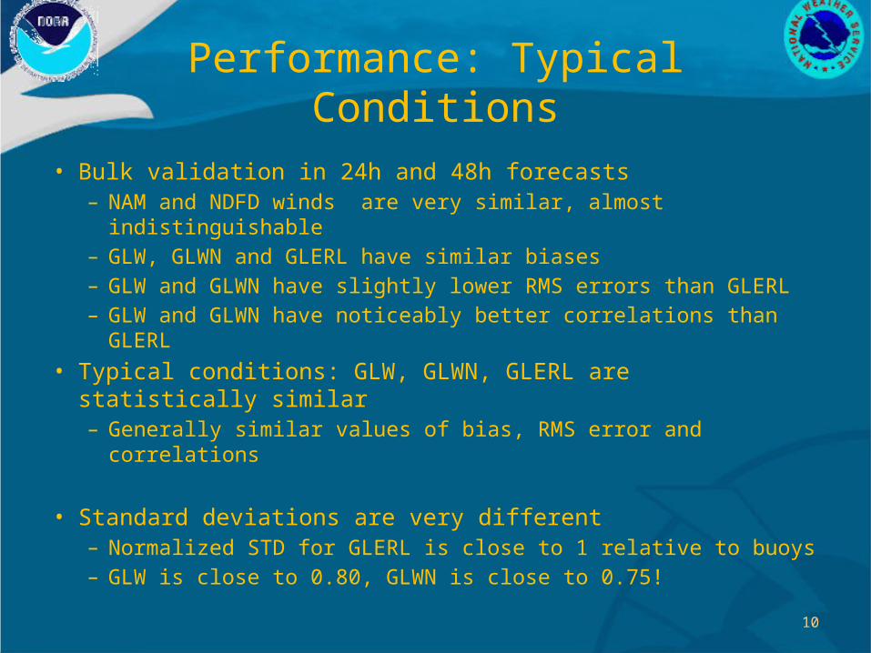
Performance: Typical Conditions
• Bulk validation: emphasizes performance in typical conditions– Wave model vs buoys: bias, RMS errors and correlation
• Performance assessment made for years 2008 and 2009• Only NDBC buoys used for bulk performance study
– Lake Superior: 45001, 45004, 45006– Lake Michigan: 45002, 45007– Lake Huron: 45003, 45008– Lake Erie: 45005– Lake Ontario: 45012
• Assessment made relative to reference wave model for the region: GLERL wave model, Great Lakes Op Forecast System (GLOFS)– Forecast phase has same forcing winds as in the GLWN model

9
Performance: Typical Conditions
24h 48h
Winds
Waves
2009
10
Performance: Typical Conditions
• Bulk validation in 24h and 48h forecasts– NAM and NDFD winds are very similar, almost indistinguishable– GLW, GLWN and GLERL have similar biases– GLW and GLWN have slightly lower RMS errors than GLERL– GLW and GLWN have noticeably better correlations than GLERL
• Typical conditions: GLW, GLWN, GLERL are statistically similar – Generally similar values of bias, RMS error and correlations
• Standard deviations are very different– Normalized STD for GLERL is close to 1 relative to buoys– GLW is close to 0.80, GLWN is close to 0.75!

11
Performance: Severe Sea States• 99% wind speeds and wave heights (normalized by obs)
– Emphasize more severe sea states, storms
24h 48h
Winds
Waves
2009

12
Performance: Storm Wave Forecasts
• Assessment included 95% (not shown) and 99% percentiles• Results reveal that:
– NAM and NDFD provide a reasonable representation of stronger winds associated with storms• NAM slightly outperforms NDFD at upper wind-speed percentile
– GLW, GLWN systematically underestimate upper Hs percentiles• GLW clearly outperforms GLWN
– GLERL wave model provides a reasonably accurate representation of observed upper Hs percentiles
• Both GLERL and GLWN use the same NDFD forecast winds– Default WAVEWATCH III physics are not doing a good job in
reproducing wave growth in intense storms in areas with short/irregular fetches… nothing new.
13
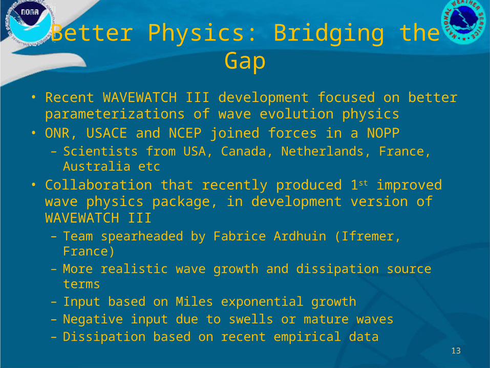
Better Physics: Bridging the Gap
• Recent WAVEWATCH III development focused on better parameterizations of wave evolution physics
• ONR, USACE and NCEP joined forces in a NOPP– Scientists from USA, Canada, Netherlands, France, Australia etc
• Collaboration that recently produced 1st improved wave physics package, in development version of WAVEWATCH III– Team spearheaded by Fabrice Ardhuin (Ifremer, France)– More realistic wave growth and dissipation source terms– Input based on Miles exponential growth– Negative input due to swells or mature waves– Dissipation based on recent empirical data

14
Better Physics: Bridging the Gap
• Performance of WW3 + Ardhuin et al. (2010) physics [A+10]– Comparative assessment using GLERL wave model as a
reference – To emphasize model skill, analysis winds were used– Wave hindcasts were generated with models forced by GLERL
surface wind analyses for 2008 and 2009– GLW system was run with the default WW3 physics (Tolman and
Chalikov, 1996) and with the new A+10 package– GLERL wave model data and GLERL wind analyses were provided
by Dave Schwab and Greg Lang from … GLERL!

15
Better Physics: Bridging the Gap• WW3 with A+10 Physics
– Breakthrough-level improvement to GLW in term of Hs
– Improved GLW’s already good bulk statistics (bias, RMS error, correlation)
– Matched GLERL STD– Higher precision in tracking
observations– Much improved wave
periods relative to GLERL
2009

16
Better Physics: Bridging the Gap
• 99% normalized by obs
• GLERL wind analyses have a superb quality: great accuracy in upper wind speeds at 99%
• WW3 with A+10 Physics– Breakthrough-level
improvement in predicting 99%wave heights
2009

17
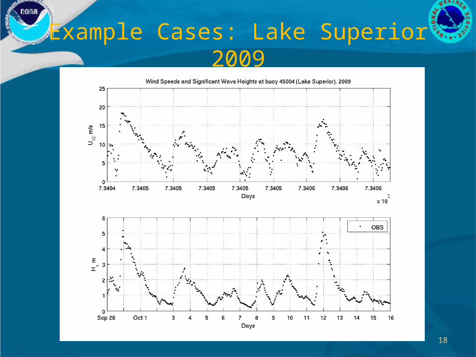
Example Cases: Severe Sea States
• Buoy 45004, Northeast of Marquette, MI (Lake Superior)– Double whammy…
• September 28 2009– Maximum recorded wind speed: 18.25 m/s– Maximum recorded Hs: 5.15 mhttp://www.youtube.com/watch?v=2pKgF_QMT14
• October 10 2009– Maximum recorded wind speed: 16.60 m/s– Maximum recorded Hs: 5.05 mhttp://www.youtube.com/watch?v=MRczx6Mr0gc
18
Example Cases: Lake Superior 2009

19
Future Work
• Extend cases to include more severe wave events• Expand assessment relative to Environment Canada Buoys
– Towards development of a Great Lakes wave test bed• Including also “swell” cases• Wave evolution in sudden wind drop cases• Nearshore wave evolution (further down the track)• Collaboration with NWS WFOs, POC Greg Mann

20
Future GLW/GLWN Systems
• Great reaults, aren’t they??• Implement A+10 physics in GLW/GLWN within 1 year• Include in the new system several other upgrades:
– Hindcast phase in GLWN using new RTMA overlake analyses • RTMA will have internal adjustment over lakes using GLERL
wind analysis algorithm– More accurate bathymetries (current not updated since 2004)– Possibly higher overall grid resolution (probably double) ~ 2km– Deployment of nearshore grids, two-way nested to coarser grid,
possibly at ½ km resolution
• New GLW development to be made in tight collaboration with NWS Great Lakes WFOs.
