fabien napolitano · seismology has been waiting long for a broadband sensor that measures the...
TRANSCRIPT


From fast developing autonomous technologies to new subsea positioning, imaging and seismic instrumentation, the offshore and geosciences industries have recently undergone a major technological revolution that has brought about significant innovations and changes. Everyone of us working in those industries have felt this change and had to adapt to new ways of conducting their operations. We are now able to explore new fringes of the oceans and inland waters, build structures at greater depths, and measure and monitor wider regions of the world.
We are at the dawn of this exciting time, and many challenges still lie ahead of us. In order to reach our potential and go beyond what is currently possible, collaboration and innovation are key. This is why we think that it is of the utmost importance for all key players of the maritime market to share their experience on the latest technologies and learn from it.
At iXblue, we are able to capitalize on the key technologies that we master around photonics, navigation, autonomy, subsea imagery, as well as acoustic positioning. A diversity which lies at the very heart of all aspects of our company, and that is reflected in the sheer variety of all the exciting and extraordinary projects in which we take part with our customers.
We hope this Users Conference, through the presentations of all the incredible stories our customers live everyday using our products, will bring you valuable insights on current and upcoming market trends, and will inspire you and cultivate your taste for challenges. As it is precisely this curiosity and innovative spirit that will keep shaping our industry and make it reach its full potential.
Fabien NapolitanoCEO, iXblue
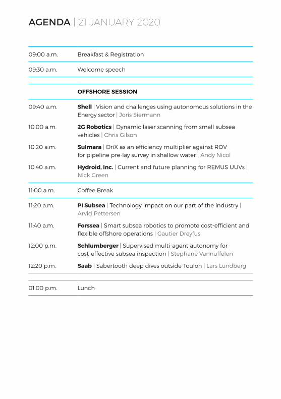
AGENDA | 21 JANUARY 2020
09:00 a.m. Breakfast & Registration
09:30 a.m. Welcome speech
OFFSHORE SESSION
09:40 a.m.
10:00 a.m.
10:20 a.m.
10:40 a.m.
Shell | Vision and challenges using autonomous solutions in the Energy sector | Joris Siermann
2G Robotics | Dynamic laser scanning from small subsea vehicles | Chris Gilson
Sulmara | DriX as an efficiency multiplier against ROV for pipeline pre-lay survey in shallow water | Andy Nicol
Hydroid, Inc. | Current and future planning for REMUS UUVs | Nick Green
11:00 a.m. Coffee Break
11:20 a.m.
11:40 a.m.
12:00 p.m.
12:20 p.m.
PI Subsea | Technology impact on our part of the industry | Arvid Pettersen
Forssea | Smart subsea robotics to promote cost-efficient and flexible offshore operations | Gautier Dreyfus
Schlumberger | Supervised multi-agent autonomy for cost-effective subsea inspection | Stephane Vannuffelen
Saab | Sabertooth deep dives outside Toulon | Lars Lundberg
01:00 p.m. Lunch

GEOSCIENCES SESSION
02:40 p.m.
03:00 p.m.
03:20 p.m.
03:40 p.m.
Ludwig-Maximilians-Universität Munich | The blueSeis-3A sensor: First results from field tests recording rotational ground motions on volcanoes, active faults, and tall buildings | Prof. Dr. Heiner Igel
iXblue | Deploying DriX from a Survey Vessel’s davit - NOAA’s sea trials | Guillaume Eudeline
iSTerre Grenoble | Towards 4-D imaging of volcano subaqueous degassing | Corentin Caudron
Ifremer | How can recent improvements of underwater navigation impact on AUV autonomy? | Jan Opderbecke
04:00 p.m. Coffee Break
04:20 p.m.
04:40 p.m.
05:00 p.m.
GEOMAR | Black Sea – Lots of methane but where is the gas hydrate? | Dr. Joerg Bialas
KOBO | Fish stock monitoring in Turkey with SeapiX 3D scanning sonar | Ümit Küçükoğlu
PIONEERS | Innovative ground motion sensors for planets and asteroids: PIONEERS H2020-SPACE European project | Frédéric Guatarri, iXblue
05:20 p.m. Closing remarks
06:00 p.m. Networking event

PRESENTATIONS | OFFSHORE SESSION
Vision and challenges using autonomous solutions in the Energy sectorSurveying with Maritime Autonomous Surface Ships (MASS) is recognised within Shell as a key differentiating technology. The Geomatics teams across Shell have been actively driving the deployment of MASS on a variety of projects ranging from the interrogation of seabed nodes during seismic operations offshore Nigeria, LNG terminal bathymetry verification in Gibraltar, to large scale hydrographic surveys off the coast of West Africa. This paper will cover the highlights and best-practices learned in the recent years. We will also cover the key challenges faced in the deployment of this fast developing and promising technology.
Dynamic laser scanning from small subsea vehiclesThe new collaborative Micro Inspection Skid delivers high accuracy laser inspection on inspection class ROVs and man-portable AUVs. As the offshore industry shifts to use small easily deployable vehicles to reduce project costs, we find that the capability of these vehicles is limited by the range of sensor payloads they can deploy. By combining new miniaturized sensors, the 2G Robotics Micro laser scanner, iXblue Rovins Nano, and Nortek DVL 1000, 3D laser modelling is now possible on vehicles with limited power, weight, and size requirements. This capability has been demonstrated with the modelling of a Canadian Shipwreck.
DriX as an efficiency multiplier against ROV for pipeline pre-lay survey in shallow waterExamination of DriX as an alternative to ROV based pre-lay survey in shallow waters. How does the real world deployment of DriX compare with theoretical savings and efficiencies including challenges of endurance, economics and logistics against proven ROV methodology? What new improvements will allow DriX to be a disruptive solution in the energy sector?
Current and future planning for REMUS UUVs Nick will be presenting on the current fleet of Underwater Autonomous Vehicles currently manufactured by Hydroid, Inc in the United States and will also be looking forward to where this technology is leading and how, with the now standard integration of the iXblue Inertial Navigation Systems, this is giving Hydroid a better advantage in the markets they offer the vehicles to and the future concept designs that smaller INS systems now allow.
ShellJoris Siermann
09:40 a.m.
2G RoboticsChris Gilson
10:00 a.m.
Sulmara Andy Nicol
10:20 a.m.
Hydroid, Inc.Nick Green
10:40 a.m.
Technology impact on our part of the industryThose of us who have been in this business for some years have experienced a dramatic change in technology which in turn has had a major impact on how we work and what we can achieve. The changes are continuing with an increased speed and we are now facing a new technology revolution by remotely controlled and unmanned operations utilizing artificial intelligence and machine learning. During this
PI SubseaArvid Pettersen
11:20 a.m.

Smart subsea robotics to promote cost-efficient and flexible offshore operationsForssea recently developed a smart ROV and a new visual positioning system and partnered with iXblue to facilitate the interfacing of INS systems onto their innovative robotics platforms. In this presentation, Forssea will introduce 2 milestones of this collaboration:• Agile LBL: a revolutionary method to deploy and recover
LBL frames using the Atoll ROV system. Recent tests were organized off the Mediterranean coast using iXblue Canopus LBL and sparse-LBL transponder and Gaps LBL positioning system.
• V-LOC: visual localization technology that uses image treatment and inertial fusion to output absolute positions of subsea vehicles. Forssea will present a subsea pipeline use-case.
Supervised multi-agent autonomy for cost-effective subsea inspection Inspection, Maintenance, and Repair (IMR) service providers utilize remotely operated vehicles (ROV) tethered to a surface vessel and piloted in real-time to evaluate and manipulate the subsea infrastructure. This talk will present a novel deployment technique that uses an untethered semi-autonomous underwater vehicle equipped with Schlumberger high-bandwidth acoustic telemetry capable of video transmission to the surface. This system augmented with real-time inspection analytics delivers a novel human-in-the-loop ROV-like command & control, but with significantly reduced support operational expenditure. We present the results of an open-water collaborative mission comprising the OneSubsea UROV working in tandem with iXblue’s Unmanned Surface Vehicle, DriX, to successfully demonstrate wireless video uplink and USBL positioning over 1,000 m of water depth.
Sabertooth deep dives outside ToulonDuring March of 2019 SAAB was involved in trials with Sabertooth system doing +2000msw surveys using iXblue Phins, Workhorse RDI Doppler and Avtrak 6 as primary navigation package. Exercise to prove Sabertooths capability to vertical dive to great working depth and execute survey mission with high end navigation performance. Lesson learned from Toulon exercise: what worked well, improvements to be made. SAABs view on navigation platforms for future application in more demanding environments, +6 months resident capability, ultra-deep dives etc.
ForsseaGautier Dreyfus
11:40 a.m.
SchlumbergerStephane Vannuffelen
12:00 p.m.
SaabLars Lundberg
12:20 p.m.
presentation I will focus on where we are coming from and obstacles faced in introduction of new technology and unmanned operations. Are we moving too fast?

PRESENTATIONS | GEOSCIENCES SESSION
The blueSeis-3A sensor: First results from field tests recording rotational ground motions on volcanoes, active faults, and tall buildingsSeismology has been waiting long for a broadband sensor that measures the rotational ground motions in addition to the classical three components of displacement. There is a wide range of applications ranging from correcting classical seismometers for (possibly strong) tilt contamination, extracting additional features from seismic wavefields, and better resolution for seismic tomography and earthquake source problems. We will report on first field studies indicating the potential of this new seismic instrumentation concept.
Towards 4-D imaging of volcano subaqueous degassing Volcanic gases are the leading forces of volcanic eruptions but also inject Greenhouse Gases into the atmosphere. Even though ~75% of Earth’s volcanism occurs below the sea surface, volcanic gas quantification in aqueous environment remains challenging, thereby limiting the understanding of volcano degassing behaviour as well as its contribution to the atmosphere. Hydroacoustic measurements make the monitoring of many volcanoes a quantitative and economically feasible approach to better constrain volatile output from subaerial volcanoes. Mutualizing the knowledge and technology between universities and industrial sectors in hydroacoustic appears as an appealing way to accelerate research and R&D of new technologies.
Ludwig-Maximilians-Universität MunichProf. Dr. Heiner Igel
02:40 p.m.
iSTerre GrenobleCorentin Caudron
03:20 p.m.
How can recent improvements of underwater navigation impact on AUV autonomy?The accurate localization of scientific data is a key factor in the ability of AUVs to run missions that are increasingly powerful in terms of endurance, environment perception, payload and data acquisition, and decision-making capabilities. In this regard, navigation drift is a limitation to long duration dives, even when using latest sensor technology. The use of long
IfremerJan Opderbecke
03:40 p.m.
Deploying DriX from a Survey Vessel’s davit - NOAA’s sea trialsU.S. NOAA recently integrated DriX USV and its Deployment System (DDS) into its daily hydrographic survey operations to demonstrate hydrographic survey force-multiplier capability in offshore waters. Those trials, conducted from NOAA’s hydrographic survey vessel, SS Thomas Jefferson, aimed at seeing if DriX could overcome the drawbacks of many ship-deployable USVs such as their speed, sortie endurance, ability to collect multibeam data in moderate sea states, as well as the difficulty in deploying and recovering them from a pitching and rolling ship in a seaway. This presentation will show what has been done and how easy and reversible it is to accommodate a DriX and its DDS on an existing davit.
iXblueGuillaume Eudeline
03:00 p.m.

Black Sea – Lots of methane but where is the gas hydrate?Gas hydrates (GH) are cage like structures of water molecules that bound a large volume of gas inside. GH are found at almost all continental margins worldwide. Natural gas hydrates are primarily formed from methane gas (CH4), which experiences an increasing demand in the course of replacement of coal as energy resource. Within European waters the Black Sea is known to be the largest marine reservoir of dissolved CH4. Hence it has become a target for Germany’s GH investigations. Interdisciplinary investigations revealed the distribution of gas hydrates but leave open questions on the available volume. Seismic surveys rely on Ocean Bottom Seismometers (OBS) to support remote sensing of physical properties. Cable controlled deployment of OBS systems at very short offsets is undertaken using iXblue Posidonia USBL.
baseline arrays or ship-born USBL resolves these limitations but generates mission constraints and hinders the operational autonomy. We will present results from experimentation accomplished of sparse LBL navigation on an AUV, in cooperation between Ifremer and iXblue. Use cases are long range straight line missions in geo-physical applications for Ifremer’s future 6000m AUV. As a perspective, the alternative use of range measurements from a local transponder at the surface for enhancement of the AUV navigation will equally be investigated.
GEOMARDr. Joerg Bialas
04:20 p.m.
Fish stock monitoring in Turkey with SeapiX 3D scanning sonarThe project aims to establish monitoring platforms for “Sea Water Ecosystem changes and pelagic fish migratory routes” in 6 locations in Turkey. Main deliveries are Sea Monitoring Buoy Systems for the establishment of an “Internet Based Fish Stocks, Ecosystem and Fishery Activities Data Monitoring Center in Ankara”. These platforms will be positioned at known hot-spots where the seasonal migrations take place. Relevant data (optical dissolved oxygen, salinity, turbidity, ph, temperature, chlorophyll, depth, water current speed & direction, wind speed & direction etc.) will be secured at the platforms and the SeapiX 3D scanning sonar will be collecting instantaneous marine life data, which will be transferred at required intervals to the center.
Innovative ground motion sensors for planets and asteroids: PIONEERS H2020-SPACE European projectThe H2020 PIONEERS study has been selected by the EU to build the future of the geophysical exploration of telluric planets: building on the heritage of the SEIS/InSight seismometer, it aims at helping Europe keep its technological advance in planetary seismology with the development of an innovative 6 Degree of Freedom ground motion instrument concept, based on optical interferometry. With the SEIS instrument on board InSight mission, Europe has demonstrated its leadership in developing such instrumentation.
KOBOÜmit Küçükoğlu
04:40 p.m.
PIONEERSFrédéric Guatarri,iXblue
05:00 p.m.

COMPANIES | SPEAKERS
2G Robotics provides industry-leading laser scanning and imaging solutions that enable our clients to confidently complete subsea inspections, surveys, and mapping to ensure the preservation and security of the world’s critical infrastructures and marine environments. 2G’s systems capture millimetric resolution 3D models and high resolution images that provide a detailed baseline for monitoring and predicting changes in subsea assets and environments.
Chris Gilson is the product development manager at 2G Robotics, overseeing the management of the product portfolio and industry partnerships. His background is mechanical engineering with many years of experience designing subsea sensor solutions.
2G Robotics
Chris GilsonProduct Development Manager
Forssea is a subsea robotics and underwater vision young innovative company, created in 2016. Through its specialized research and development team currently comprising 14 professionals, FORSSEA focuses on embedded hardware with high computing capacity and innovative control algorithms. Its first products recently entered qualification with major IOC and EPC.
Gautier Dreyfus is a petroleum engineer with 5 years experience in the Oil & Gas industry. Prior to founding Forssea, he worked 2 years as a field engineer onshore and offshore in Africa. He also worked for Schlumberger Business Consulting as an analyst for North Sea projects. He graduated from Ecole Polytechnique (France), IFP School (France) and Texas A&M University (USA).
Forssea
Gautier DreyfusCo-founder & CEO

GEOMAR Helmholtz Centre for Ocean Research Kiel is a world-wide leading institute of marine research. We investigate chemical, physical, biological and geological processes of the seafloor, oceans and ocean margins and their interactions with the atmosphere. GEOMAR is a foundation under public law with a staff of approximately 1,000 (2018) individuals and an annual budget of ~80 Million Euros.
Joerg Bialas joined GEOMAR in 1991 and worked for the department of Marine Geodynamics since then. His interests covered deep crustal structures and developed into 3D high resolution multichannel seismic studies of shallow fluid flow and gas hydrates in recent years. Instrument development has always been a strong part of JBs investigations.
GEOMAR
Dr. Joerg BialasSenior Scientist
Hydroid is a field-proven technology leader in advanced marine robotics, specifically autonomous underwater vehicles (AUVs). We design and manufacture solutions for use in a number of applications including marine research, commercial and defence. Located in the U.S. (a subsidiary of Kongsberg Maritime), Hydroid is the world’s most trusted manufacturer of AUVs.
Nick Green is the regional Sales Manager for the EMEA region for Hydroid Inc. He has been working in the marine industry for over 23 years with everything from yachts to sensors and software (formerly iXblue) to now underwater robots, within the different market sectors of Oil and Gas and Defence.
Hydroid, Inc.
Nick GreenRegional Sales Manager, EMEA

COMPANIES | SPEAKERS
The Institute of Earth Sciences focuses on the physical and chemical study of the Earth. By coupling observations of natural objects, experiments and modeling of complex phenomena, the institute studies the major systems related to the internal Earth.
After a PhD and postdoc experiences in Singapore, UK and Belgium, Corentin Caudron recently became an IRD researcher at ISTerre (Grenoble, France). He has been focusing on seismoacoustics approaches to investigate volcanoes and has been working on various volcanic systems (from the 6 continents) and more specifically volcanic lakes.
iSTerre Grenoble
Corentin Caudron IRD researcher
A leader in ocean science, IFREMER is managing the French Oceanographic Fleet and its dedicated scientists create ground-breaking technology to push the boundaries of ocean exploration and knowledge, from the abyss to the atmosphere-ocean interface.
Jan Opderbecke is an electrical engineer and accomplished his PhD in signal processing at Ecole Normale Supérieure de Cachan (France) in 1994. After joining the French Institute for Ocean Research IFREMER, he specialized in underwater robotics focusing on innovative techniques for navigation, mapping and optical inspection of the deep ocean sea-floors. Since 2014 he is head of the Unit for Underwater Systems, which develops and operates underwater vehicles within the French Oceanographic Fleet. The Unit for Underwater Systems carries out numerous R&D projects in cooperation with academic research labs and. The unit is actually running two major projects for the development of a 6000m AUV and a 6000m ROV system.
IFREMER
Jan Opderbecke Head of Unit for Underwater Systems

Ludwig-Maximilian-Universität is a public research university located in Munich, Germany.
Heiner Igel studied geophysics in Karlsruhe and Edinburgh. He obtained his doctoral degree in 1993 from the Institut de Physique du Globe in Paris developing parallel forward and inverse modelling tools for wave propagation problems. He then moved to the Institute of Theoretical Geophysics in Cambridge, UK, where he worked on wave simulation techniques for regional and global seismic wave propagation. In 1999 he became Professor of Seismology at the Ludwig-Maximilians-University Munich. His current interests include full-waveform inversion, high-performance computing, and rotational ground motions. He is a member of the German National Academy of Sciences.
LMU Munich
Prof. Dr. Heiner IgelProfessor of Geophysics/ Seismology
KOBO Electronics, Consulting (KOBO) is an Istanbul based company; experienced in development and management of marine and maritime projects, aids to navigation networks, maritime information systems (including Vessel Traffic Management) and associated maritime assets.
Umit Kucukoglu is an electronics engineer, experienced in the marketing and sales of maritime, IT, defence and telecommunications solutions. He has worked in multinational companies in Turkey, Africa and the Middle East.
KOBO
Ümit KüçükoğluManaging Director

COMPANIES | SPEAKERS
Saab serves the global market with world-leading products, services and solutions from military defence to civil security. With operations on every continent, Saab continuously develops, adapts and improves new technology to meet customers’ changing needs. Saab Dynamics offers a market- leading product portfolio comprising ground combat weapons, missile systems, torpedoes, unmanned underwater vehicles, training systems and signature management systems for armed forces. The product portfolio also consists of niche products for the civil and defence markets such as underwater vehicles for the offshore industry.
Lars Lundberg holds a Master of Scientist (mechanical engineering) from the Royal Institute of Technology in Stockholm Sweden. He started at SAAB in February 2000 as a mechanical engineer, working with different defense and commercial ROV and AUV systems. He also worked as a project manager with a number of projects including SAROV demo system and SubRov. Development of SAROV demo system was an upgrade package to get autonomous capability to existing mine hunting defense Double Eagle vehicles. Development of SubRov system, an ROV system operated from a Submarine´s torpedo tube (21»). Since 2011 Lars has been Product manager of SAABs Sabertooth systems.
Saab
Lars LundbergProduct Manager Sabertooth
PI Subsea is a new company established with key personnel from Swire Seabed. Their focus is on continued development of larger remotely controlled offshore USV Combi systems including USV, AUV, ROV and data processing systems. This is building on close cooperation with key industry players within their field of expertise.
Arvid Pettersen joined the industry as a hydrographic surveyor with the Norwegian Hydrographic Service from 1985 to 1992. He then joined Geoconsult as Party Chief and Survey manager until 2006 and established and managed Dof Subsea Brazil from 2006 to 2009. Arvid then became MD of NUI – a hyperbaric test and research facility from 2010 to 2013, and was appointed CEO of Swire Seabed in 2013. In 2019, he then became CTO to develop remotely controlled systems.
PI Subsea
Arvid PettersenCEO and part-owner of PI Subsea AS

Shell’s Projects & Technology (P&T) organisation manages the delivery of major projects and drives the innovation that leads to new technology. It also manages global contracts with suppliers and provides technical services that keep our Integrated Gas, Upstream and Downstream assets operating not only safely but also efficiently in both economic and environmental terms.
Joris Siermann joined Shell in 2006 and held various roles in the Geomatics Discipline ranging from Geospatial Consultancy, Team Lead for a Geomatics team base in Qatar. He is now Senior Operations Surveyor in the Survey operations Team in Rijswijk, Netherlands.
Shell
Joris SiermannSenior Operations Surveyor
Schlumberger is the world’s leading provider of technology for reservoir characterization, drilling, production, and processing to the oil and gas industry. With product sales and services in more than 120 countries and employing approximately 100,000 people who represent over 140 nationalities, Schlumberger supplies the industry’s most comprehensive range of products and services, from exploration through production, and integrated pore-to-pipeline solutions that optimize hydrocarbon recovery to deliver reservoir performance.
Stephane Vannuffelen is Program Manager of Marine Robotics and Telemetry at Schlumberger-Doll Research Robotics Department in Boston. He is leading a team of scientists developing the next-generation Autonomous Underwater Vehicle (AUV) for Subsea Inspection Maintenance and Repair (IMR) that comprises cutting-edge technology in planning, navigation, perception and high-speed acoustic telemetry.
Schlumberger
Stephane Vannuffelen Program Manager

COMPANIES | SPEAKERS
Sulmara Subsea is an international survey services contractor established in 2018 to provide quality personnel, responsiveness, and an innovative approach to services across the offshore services sector within a strong and committed QHSE culture. Collaboration is our mantra at Sulmara, we are convinced, from many years’ experience, that working as partners with our clients and our technology partners, by listening, by being responsive and reactive, by working together towards a solution builds lasting, successful relationships that endure and ultimately deliver. With offices in Houston and Aberdeen, as well as strategic alliances worldwide Sulmara is well positioned to support our clients globally.
Andy Nicol has over 10 years’ experience working on a variety of projects in the oil and gas/renewables industry. After graduating from Glasgow university in 2009 with an MSc in Geospatial and Mapping Science, Andy joined Subsea7 and went through their graduate programme. Since then he has also worked for UTEC Survey, GEOxyz and currently Sulmara Subsea. In his current capacity as offshore manager, he is responsible for managing trenching operations for Drebbel de Mexico and has also been involved in offshore trails with DriX in Mexico last year.
Sulmara
Andy NicolOffshore Manager
iXblue is a global high-tech company specializing in the design and manufacturing of advanced marine, photonics and autonomy technologies. The group in-house expertise includes innovative systems and solutions devoted to inertial navigation, subsea positioning, underwater imaging, as well as shipbuilding and test & simulation. iXblue technologies support Civil and Defense customers in carrying out their sea, land and space operations with maximum safety, efficiency and reliability. Employing a workforce of 650 people worldwide, iXblue conducts its business in over 60 countries.
Guillaume Eudeline spend the first 17 years of his professional career as an officer in the French Navy, most of them at sea and across the world. He served on various vessels ranging from hydrographic ship to nuclear aircraft carrier. He chose a civilian carrier path in 2015, and was in charge of military sales for Latin America and Europe for two years, before joining iXblue as a Global Business Developer for ships and drones three years ago. Guillaume is based at the head office in Paris.
Frederic Guattari is a senior expert in Fiber-Optic Gyroscope technology having deposited more than 12 patents. Starting at iXblue in the R&D team 11 years ago, he is now leading the product line dedicated to ground motion measurement named ‘blueSeis’, in addition to be a key member of the PIONEERS team.
Guillaume EudelineGlobal Business DevelopmentShips & Drones
Frédéric Guatarri Head of Seismic Rotation SensorsBusiness Line

SPONSORS | PROFILE
Formed in 1989, the privately owned Oceanscan Group has become a leading international equipment rental and personnel supply company. Oceanscan specialises in providing the very latest and most advanced subsea and inspection technology to the oil and gas, petrochemical, renewables, defence and nuclear industries.
Our continued investment in new and advanced equipment allows you access to the latest technologies at a fraction of the purchase cost; renting or hiring your subsea and inspection solutions and personnel directly from us dramatically reduces your financial outlay…let us make the investment for you.
www.oceanscan.co.uk
www.rts.as
www.teledynemarine.com
Teledyne Marine is an organization comprised of 23 leading-edge undersea technology brands that have been assembled by Teledyne Technologies Inc. Through acquisitions and collaboration, Teledyne Marine has evolved into an industry powerhouse, providing the widest breadth of marine technology in the industry, now available through a single supplier. Each Teledyne Marine brand is a leader in its respective field, with a shared commitment to providing premium products backed by unparalleled service and support.
The Teledyne Marine companies now include: Teledyne AG Geophysical, Benthos, BlueView, Bolt, Bowtech, CDL, DGO, Gavia, Geophysical Instruments, Impulse, ODI, Odom Hydrographic, RD Instruments, Real Time Systems, RESON, SeaBotix, Storm Cable, TSS, VariSystems, and Webb Research
RTS is an international provider of electronic engineering solutions for the subsea industry. We supply equipment and technical solutions to companies involved in the world’s major offshore inspection, seabed mapping- and subsea construction projects. RTS was established in 2002, and has since then designed and manufactured industry-leading solutions, recognised as best-in-class by the ROV and subsea survey communities around the world.

An event sponsored by