fact sheet - new nambucca river bridge · precast concrete u-girders, ... unformed or hand...
TRANSCRIPT
Construction activity on the Nambucca River 2015-2016The Australian and NSW governments are jointly funding the 20km Warrell Creek to
Nambucca Heads Pacific Highway upgrade. The project includes building a major
bridge over the Nambucca River and northern floodplain. This fact sheet explains the
timing of this work and how it will affect river users.
Fact SheetNew Nambucca River bridge
JULY 2015 WARRELL CREEK TO NAMBUCCA HEADS PACIFIC HIGHWAY UPGRADE
Nor
th C
oast
Ra
il wa
y
MACKSVILLE
NORTH MACKSVILLE
Nambucca River
Warrell Creek
Paci
fic H
ighw
ay
Mattick Road
Nursery Road
Gumma Road
Bald Hill Road
Ker
r D
rive
Sco
tts H
ead R
oa
d
Old
Coast Road
Pacific Highway
New bridge over Nambucca River
Upgraded Pacific Highway
Existing Macksville Bridge
Location of Macksville ramps are subject to an Environmental Asessment
Exi
stin
g P
acifi
c H
ighw
ay
Old C
oa
st Road
Letitia
Close
0 0.5 1.0
Km
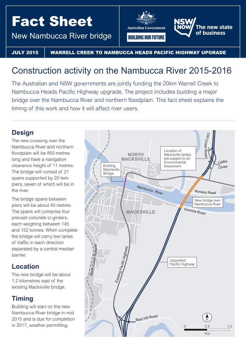
DesignThe new crossing over the Nambucca River and northern floodplain will be 850 metres long and have a navigation clearance height of 11 metres. The bridge will consist of 21 spans supported by 20 twin piers, seven of which will be in the river.
The bridge spans between piers will be about 40 metres. The spans will comprise four precast concrete U-girders, each weighing between 145 and 152 tonnes. When complete the bridge will carry two lanes of traffic in each direction separated by a central median barrier.
Location The new bridge will be about 1.2 kilometres east of the existing Macksville bridge.
TimingBuilding will start on the new Nambucca River bridge in mid 2015 and is due for completion in 2017, weather permitting.
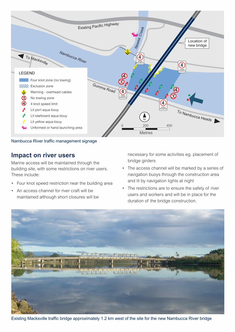
Impact on river users Marine access will be maintained through the building site, with some restrictions on river users. These include:
• Four knot speed restriction near the building area
• An access channel for river craft will be
maintained although short closures will be
necessary for some activities eg. placement of
bridge girders
• The access channel will be marked by a series of
navigation buoys through the construction area
and lit by navigation lights at night
• The restrictions are to ensure the safety of river
users and workers and will be in place for the
duration of the bridge construction.
0 200 400
Metres
LEGEND
Four knot zone (no towing)
Exclusion zone
Warning - overhead cables
No towing zone
4 knot speed limit
Lit port aqua bouy
Lit starboard aqua bouy
Lit yellow aqua bouy
Unformed or hand launching area
4TOWING
PROHIBITED
4TOWING
PROHIBITED
4TOWING
PROHIBITED
4TOWING
PROHIBITED
Nambucca River
New
ee C
reek
Location of new bridge
Existing Pacific Highway
To Nambucca Heads
To Macksville
Gumma Road
Nambucca River traffic management signage
Existing Macksville traffic bridge approximately 1.2 km west of the site for the new Nambucca River bridge

Frequently Asked QuestionsCan we still use the river during construction of the bridge?Yes. A navigable channel will be maintained through the construction area although short closures will be necessary. A reduced speed limit of four knots and ‘no towing’ restrictions will be in place near the building area which may impact on some activities.
How are potential environmental impacts on the river from the building work managed?Controls that will be implemented to minimise the environmental impact from the work include:
• Placing of floating barriers around all work areas
to contain and control the dispersion of silt in
the river
• Installation of a physical barrier to contain any
potential spills
• A strict regime of testing and monitoring to
ensure that the controls are adequate and
effective
• Establishment of a 24 hours emergency contact
number (1800 074 588).
Will work be stopped during summer?Work will stop during the Christmas/New Year holiday period. While no building work will take place during this time, the navigation and speed restrictions will remain in place due to the changed conditions on the river.
Can we still fish around the exisiting Macksville bridge?Yes. The building work will not interfere with fishing around the existing Macksville bridge. For safety reasons, fishing will be prohibited in the vicinity of the new bridge.
What will be the permanent speed limit on the river after the new bridge is built?This has not been determined. Issues around safety will be considered and consultation will take place with river users before a permanent post-construction speed limit is decided.
Artists impression of the new Nambucca River bridge
Typical barge and crane set up for piling
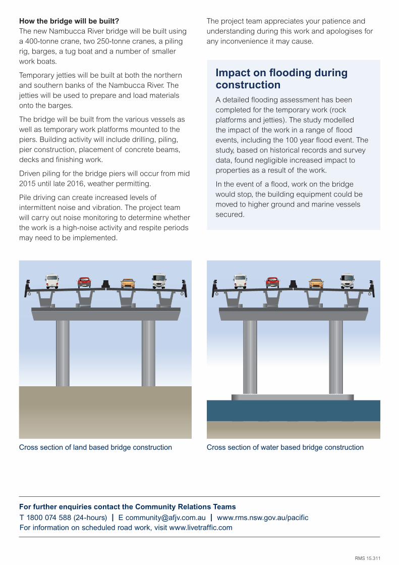
How the bridge will be built?The new Nambucca River bridge will be built using a 400-tonne crane, two 250-tonne cranes, a piling rig, barges, a tug boat and a number of smaller work boats.
Temporary jetties will be built at both the northern and southern banks of the Nambucca River. The jetties will be used to prepare and load materials onto the barges.
The bridge will be built from the various vessels as well as temporary work platforms mounted to the piers. Building activity will include drilling, piling, pier construction, placement of concrete beams, decks and finishing work.
Driven piling for the bridge piers will occur from mid 2015 until late 2016, weather permitting.
Pile driving can create increased levels of intermittent noise and vibration. The project team will carry out noise monitoring to determine whether the work is a high-noise activity and respite periods may need to be implemented.
Impact on flooding during constructionA detailed flooding assessment has been completed for the temporary work (rock platforms and jetties). The study modelled the impact of the work in a range of flood events, including the 100 year flood event. The study, based on historical records and survey data, found negligible increased impact to properties as a result of the work.
In the event of a flood, work on the bridge would stop, the building equipment could be moved to higher ground and marine vessels secured.
The project team appreciates your patience and understanding during this work and apologises for any inconvenience it may cause.
Cross section of land based bridge construction Cross section of water based bridge construction
For further enquiries contact the Community Relations Teams
RMS 15.311
T 1800 074 588 (24-hours) | E [email protected] | www.rms.nsw.gov.au/pacificFor information on scheduled road work, visit www.livetraffic.com