fao/global environment facility - thegef.org · fao/global environment facilityproject title ......
TRANSCRIPT

FAO/GLOBAL ENVIRONMENT FACILITY
PROJECT DOCUMENT
PROJECT TITLE: Resilient Islands, Resilient Communities
PROJECT CODE: GCP/KIR/009/GFF
COUNTRY: Kiribati
FINANCING PARTNER: GEF Trust Fund
FAO Project ID: 623415 GEF Project ID: 5551
EXECUTING PARTNERS: Ministry of Environment, Land and Agriculture Development,
Ministry of Fisheries and Marine Resources Development, Island Councils
Expected EOD (Starting Date): November 2017
Expected NTE (End Date): September 2022
CONTRIBUTION TO
FAO’s STRATEGIC
FRAMEWORK:
a. Strategic Objective/Organizational Result: Strategic Objective 2 (SO2),
Organizational Outcomes 1 and 2
b. Regional Result/Priority Areas Priority Area 1: Evidence-based Policy and
Strategic Planning, Priority Area 2: Food and Nutrition Security Resilient to the
Impacts of Disasters and Climate Change and Priority Area 4: Environmental
Management and Resilience
c. Country Programming Framework Outcome: a) Strengthened national
capacity for evidence-based policies and strategies to enhance food and nutrition
security b) Increased availability, access and utilization of local food and c)
Strengthened capacity for environmental management and resilience
GEF/LDCF/SCCF focal areas and strategic objectives: BD-1, LD-3, IW-3, SFM-1
Environmental and Social Risk Classification (insert √): Low Risk Moderate Risk √ High
Risk
Gender Marker (insert √): G0 G1 √ G2a G2b
Financing Plan: GEF/LDCF/SCCF allocation: Cofinancing
MELAD
MFMRD
FAO
SPC
University of Wollongong
Sub-total cofinancing:
Total Budget:
USD 4 720 030
6 000 000
6 000 000
800 000
162 000
378 000
13 340 000
18 060 030
FAO/GLOBAL ENVIRONMENT FACILITY
PROJECT DOCUMENT

2
Executive Summary
Kiribati is home to some of the world’s most significant coastal and marine biodiversity. The country
has more than 1500 documented species and 22 Key Biodiversity Areas (KBAs). Though Kiribati’s
terrestrial biodiversity is limited and the country has very limited land and agriculture resources with
soils shallow, alkaline and very low in organic matter, many of indigenous crop species form the basis
of sustenance on the islands. These include coconuts (‘Te nii’ – Cocos nucifera); pandanus, (‘Te
kaina’ – Pandanus tectorius); breadfruit (‘Te mai’ – Artocarpus altilis); and giant swamp taro (‘Te
bwabwai’- Cyrtosperma chamissonis). Kiribati’s near shore fisheries in the country’s lagoons and
coastal areas provide food, livelihood, nutrition, income and employment benefits. Fisheries play a
critical role in local food security in Kiribati where the per capita consumption seafood is one of the
highest in the world.
Within the above context, taking in to consideration the fact that Kiribati is a low-income food-deficit
country (LIFDC) with a significant trade deficit amid limited export options and rising import costs,
major environmental and developmental problems faced by Kiribati are i) continuing degradation of
the island ecosystems and ii) the impacts of the climate change. There have been several
initiatives/programmes implemented in the country to mitigate above mentioned challenges. In spite
of these efforts, key barriers remain that prevent addressing environmental degradation issues
effectively. These barriers are; i) inadequate institutional framework and governance weaknesses, ii)
limited technical capacities and skills at all levels and iii) limited alternative livelihoods and economic
opportunities.
This project will address these barriers through implementation of project the components noted
below, with the objective to improve biodiversity conservation and landscape level management to
enhance socio-ecological resilience to climate variability and change:
1. Enabling environment for R2R conservation and sustainable use
2. Implementation of R2R conservation and sustainable use strategies
3. Lessons learning and sharing
Expected project outcomes include the following:
• Enabling environment improved for ecosystem-based sustainable use and conservation of
island resources (LD3 (tracking tool) Framework strengthening INRM score moved from 2
to 3; LD3 (tracking tool) Capacity strengthening to enhance cross-sector enabling
environment score moved from 2 to 3)
• National management system for ecosystem-based sustainable use and conservation of island
resources established to deliver SFM, LD, and BD benefits (23496 hectares covered by
integrated natural resource management-land and marine- practices in wider landscape)
The project will be implemented in Butaritari, North Tarawa and Tabituea. About 10,090 community
members are expected to benefit from the project.

3
TABLE OF CONTENTS
Acronyms 4
SECTION 1 – PROJECT RATIONALE 6
1.1 PROJECT CONTEXT ........................................................................................................................... 6
1.2 THE CURRENT SITUATION ............................................................................................................ 13
1.3 THE GEF ALTERNATIVE ................................................................................................................. 19
1.4 LESSONS LEARNED ......................................................................................................................... 30
1.5 STRATEGIC ALIGNMENT ............................................................................................................... 31
SECTION 2 – FEASIBILITY 36
2.1 ENVIRONMENTAL AND SOCIAL ASSESSMENT ........................................................................ 36
2.2 RISK MANAGEMENT ....................................................................................................................... 36
SECTION 3 – IMPLEMENTATION AND MANAGEMENT ARRANGEMENTS 37
3.1 INSTITUTIONAL ARRANGEMENTS .............................................................................................. 37
3.2 IMPLEMENTATION ARRANGEMENTS ........................................................................................ 37
3.3 PLANNING AND FINANCIAL MANAGEMENT ............................................................................ 43
3.4 PROCUREMENT ................................................................................................................................ 46
3.5 MONITORING AND REPORTING ................................................................................................... 47
3.6 EVALUATION PROVISIONS............................................................................................................ 52
3.7 COMUNICATION AND VISIBILITY ............................................................................................... 53
SECTION 4 – SUSTAINABILITY OF RESULTS 53
4.1 SOCIAL SUSTAINABILITY .............................................................................................................. 53
4.2 ENVIRONMENTAL SUSTAINABILITY .......................................................................................... 54
4.3 FINANCIAL AND ECONOMIC SUSTAINABILITY ....................................................................... 54
4.4 SUSTAINABILITY OF CAPACITY DEVELOPMENT .................................................................... 54
4.5 APPROPRIATENESS OF TECHNOLOGIES INTRODUCED and COST/EFFICIENCY ............... 55
4.6 REPLICATION, SCALE-UP and INNOVATIVENESS .................................................................... 55
APPENDICES ............................................................................................................................................ 57
APPENDIX 1: RESULTS FRAMEWORK ............................................................................................... 58
APPENDIX 2: WORK PLAN.................................................................................................................... 60
APPENDIX 3: PROJECT BUDGET ......................................................................................................... 67
APPENDIX 4: RISK MATRIX ................................................................................................................. 68
APPENDIX 5: ENVIRONMENTAL AND SOCIAL SCREENING
CHECKLIST……………………………………………………………………………………………… 70
APPENDIX 6: TERMS OF REFERENCE ……………………………………………………………….72
APPENDIX 7: MAPS……………………………………………………………………………………..777
APPENDIX 8: QUANTIFYING CARBON BENEFITS……………………………………………….... 79

4
Acronyms and Abbreviations
ACIAR Australian Centre for International Agricultural Research
ALD Agriculture and Livestock Division
AUSAID Australian Agency for International Development
AWP/Bs Annual work plans and budgets
BH Budget Holder
CBFM Community-based Fisheries Management
CEDAW Convention on the Elimination of all forms of Discrimination Against Women
CPF Country Programme Framework
CTA Chief Technical Advisor
CSO Civil Society Organization
ECD Environment and Conservation Division
EEZs Exclusive Economic Zones
FAO The Food and Agriculture Organization of the United Nations
FE Final evaluation
FLO Funding Liaison Officer
FPMIS Field Programme Management Information System
GCP Government Cooperation Project
KBA Key Biodiversity Area
KDP Kiribati Development Plan
KIEP Kiribati Integrated Environmental Policy
KJIP Kiribati Joint Implementation Plan for Climate Change and Disaster Risk
Management
KNEG Kiribati National Expert Group on Climate Change and Disaster Risk
Management
K-NBSAP Kiribati National Biodiversity Strategy and Action Plan
KSVA Kiribati Seafood Verification Agency
KPA Key Policy Areas
LIDFC Low-Income Food-Deficit Country
LMD Land Management Division
LoAs Letters of Agreements
LTO Lead Technical Officer
MELAD Ministry of Environment Lands and Agricultural Development
MFMRD Ministry of Fisheries and Marine Resources Development
MIA Ministry of Internal Affairs
MLPID Ministry of the Line and Phoenix Islands Development
M&E Monitoring and Evaluation
NAP National Action Plan
NAPA National Adaptation Programme of Action
NGO Non-governmental organization
NPC National Project Coordinator
NZAID New Zealand Agency for International Development
OFO Operations and Finance Officer
PIPA Phoenix Islands Protected Area
PIR Project Implementation Review
PMU Project Management Unit
PoWPA The Convention on Biological Diversity’s Programme of Work on Protected
Areas
PPR Project Progress Reports
PSC Project Steering Committee
PTF Project Task Force
5
PY Project year
R2R Ridge-to-Reef
SAP FAO Subregional Office for the Pacific Islands
SPC The Pacific Community
SRC Subregional Coordinator
TCP Technical Cooperation Project
TT Tracking Tools
UNDP/GEF
LDCF
United Nations Development Programme / Global Environment Facility / Least
Developed Countries Fund
UNFCCC United Nations Framework Convention on Climate Change
UNCLOS UN Convention on the Law of the Sea
WOI Whole of Island Approach

6
SECTION 1 – PROJECT RATIONALE
1.1 PROJECT CONTEXT
1.1.1 Geographical and Socioeconomic setting
Kiribati is an atoll nation, comprising of three main island groups scattered over 3 million
square kilometres (sq km). The atolls are clustered into three groups; the Gilbert Group in the
West, the Phoenix Group (in the centre), and the Line Group in the East. The total land area of
all these atolls is about 800 sq km. The groups are so far apart that they have their own distinct
Exclusive Economic Zones (EEZs) with a total sea area of about 3.5 million sq km, with
international high seas separating them (Kiribati BPoA Report, 2010).
The Gilbert Island group consists of 17 islands with a total land area of 285.7 sq km. Many of
these islands still maintain some forms of traditional land tenure and marine resource regulation
systems. Tarawa Atoll, in the Gilbert group and the location of the capital, consists of more
than 20 named islets, the southern six of which are linked by causeways. The distance between
Tarawa and outer islands in the Gilbert group ranges between 51 km and 600 km (Thaman et.
Al, 1995).
The Phoenix Island group consists of 8 mostly uninhabited islands with a total land area of just
28.6 sq km located about 1,750 km east of Tarawa. This island group now includes the Phoenix
Islands Protected Area (PIPA). All islands within this group belong to the Government of
Kiribati. The only inhabited island of the Phoenix group is Kanton (Canton) Island with the
land area of 9 sq km. The island houses government officials who are stationed there for
administration purposes.
The Line Island group consists of 8 islands with a total land area of 496.5 sq km, extending
over a north-south distance of 2,100 km, located at a distance of between 3,280 and 4,210 km
east of Tarawa, and some 800 km south of Hawaii. This group includes the largest island in
Kiribati and also the biggest atoll in the world, Kiritimati, with a total area of 388.4 sq km.
Almost half of the country’s population live in two urban centres; South Tarawa contains 44%
of the total population and Kiritimati contains about 6% (MFMRD 2011). With a recorded
population density of 2,558 people per square km in 2005, South Tarawa, and Betio in
particular, are considered to be seriously overpopulated (MFMRD 2011). This is in stark
contrast to the approximately 127 people per square km in the remainder of the country. This
presents a set of unique environmental and socioeconomic challenges for the country, as it
suffers from the effects of overpopulation, while lacking a sufficient population base to readily
support a high-skills industry and institutional development initiatives.
1.1.2 Biodiversity in Kiribati
Kiribati is home to some of the world’s most significant coastal and marine biodiversity, and is
part of the Polynesia-Micronesia Biodiversity Hotspot. The country has more than 1,500
documented species and 22 Key Biodiversity Areas (KBAs). Marine fauna includes about 300
to 400 finfish species. There are 20 marine mammal species, species of note include Green
(Chelonia mydas), Hawksbill (Eretmochelys imbricata), Loggerhead (Caretta caretta), Olive
Ridley (Lepidochelys olivacea) and Leatherback (Dermochelys coriacea) turtles. Kiribati has
also at least 350 species of coral.
7
The country has approximately 50 species of birds. The nation’s remote atolls provide critical
refuge for a host of migratory bird species. Kiribati supports globally important populations of
many seabird species. This includes some of the largest breeding populations of two threatened
species: the Phoenix petrel (Pterodroma alba); and the Whitethroated stormpetrel (Nesofregetta
fuliginosa). Additional avian species of note include the Sooty tern (Sterna fuscata), White
tailed tropic bird (Phaethon rubricauda), Masked booby (Sula dactylatra), and Scarlet-breasted
lorikeet (Vini kuhlii).
There are several species found in the country that are endangered. These include four species
of Giant Clams (Tridacna gigas, Tridacna Squasoma Tridacna maxima, Cypraea spp.), three
turtle species (Chelonia mydas, Eretmochelys imbricate, Dermochelys coriacea), two species
of whales (Megaptera Novaeangliae, Balaenoptera musculus) and 38 species of birds.
Kiribati’s terrestrial biodiversity is limited. The terrestrial vegetation associations are generally
coastal strand vegetation, mangrove areas, coastal marsh vegetation, and remnant stands of
inland atoll forest. Notable species include Fish poison tree (Barringtonia asiatica) and Silver
pipturus (Pipturus argenteus). Many of indigenous crop species form the basis of sustenance
on the islands. Traditional crops include coconuts (‘Te nii’ – Cocos nucifera); pandanus, (‘Te
kaina’ – Pandanus tectorius); breadfruit (‘Te mai’ – Artocarpus altilis); giant swamp taro (‘Te
bwabwai’- Cyrtosperma chamissonis); pisonia or the great lettuce tree (‘Te buka’- Pisonia
gradis); beach mulberry (‘te non’ - Morinda citrifolia), and the broadleaved purslane (‘Te boi-
Portulaca lutea).
1.1.3 Coastal fisheries
Kiribati’s nearshore shallow water fisheries in the country’s lagoons and coastal areas provide
food, livelihood, nutrition, income and employment benefits. Fisheries play a critical role in
local food security in Kiribati where the per capita consumption seafood is one of the highest
in the world, ranging from 72 to 207 kg/person/year (Gillett, 2009). Kiribati is a low-income,
food-deficit country (LIFDC) with a significant trade deficit amid limited export options and
rising import costs. The most recent national household income and expenditure survey (HIES)
in 2006 estimated that nearly half of the annual average household income of AUD$ 8,700 is
spent on food (KNSO, 2006). While commercial oceanic tuna resources constitute a large
amount of Kiribati’s GDP, its coastal fisheries largely supply the local demand for fish and
provide a valuable and healthy source of animal protein for its communities.
Coastal fisheries also provide substantial employment and income benefits. In the most recent
national population census, over half of all surveyed households and around 60% of rural
households were engaged in some kind of fishing activity (Kiribati Census, 2010). These cash-
based fisheries related livelihood activities are included where possible in formal economy GDP
estimates (SPC, 2013a). However, the accuracy, completeness, timeliness and reliability of
coastal fisheries catch and value statistics is generally poor, despite efforts made by the Ministry
of Fisheries and Marine Resources Development (MFMRD)’s Coastal Fisheries Branch to
conduct artisanal fishing surveys (thereby making it difficult to quantify the true importance of
coastal fisheries). However, artisanal and small-scale commercial production was estimated to
be approximately 7,600 mt in the 2014 and subsistence catch was estimated to be 11.4 million
(Gillett 2016). Unlike commercial oceanic fisheries, coastal and lagoon-based catches are
landed in Kiribati and are either consumed or sold locally or domestically. Domestic small-
scale and artisanal catches have been steadily increasing over time but further small-scale fleet
expansion has been constrained by a lack of safe low impact fuel efficient capture technologies
8
and efficient transportation options for moving fish from outer islands to the large markets in
South Tarawa (MFMRD, 2011).
Small-scale tuna trolling has increased in recent years for both export to Tarawa and
consumption in outer islands which contributes to income and livelihoods particularly on
islands with no lagoon. However, in the majority of the outer islands the small-scale fleet
constitutes the most important contribution to food security. They operate in the shallow water
inshore lagoons using rudimentary bottom and mid-water hand-lines, pole and line, spears,
traps, gillnets, and diving. The total number of fishers actively engaged in full- or part-time
small-scale commercial and artisanal fisheries is unclear but it is likely that this number is
considerable relative to the total size of the population.
1.1.4 Land-based resources and mangroves
Kiribati has very limited land and agriculture resources. Soils are shallow, alkaline and are very
low in organic matter. Freshwater resources are limited to fragile shallow underground water
lens that can turn saline easily through salt water incursion. Livestock production is primarily
for subsistence (pigs and free range chicken). Forests, in the context of Kiribati, can be
classified into three categories; 1) Coconut forestry (Land occupied by coconut)1, 2) Land with
trees/natural woodland (Pandanus tectorius, Artocapus altilis, Ficus carica and Calophyllum
inophyllum- planted forests, and other natural shrubs/bushes like Morinda citrifolia a,
Tormefortia argentea, Guerttarda speciosa, Pandanus tectorius (wild) and Scavola taccada-
naturally regenerated) and 3) Mangroves (Rhizophora stylosa locally known as ‘te tongo’;
Bruguiera gymnorhiza locally known as ‘te tongo buangi’; i Lumnitzera littorea locally known
as ‘te aitoa’; and Sonneratia alba otherwise known as ‘te aitoa’). For statistical purposes, land
with trees/natural woodland is clubbed with mangroves due to data limitations. Land occupied
by coconut is estimated to be 64,800 hectares (about 80% of the total land area). Land occupied
by trees/natural woodland and mangroves together is estimated at 12,150 hectares (15% of the
total land area). The most recent reliable assessment estimates mangrove area at 258 hectares
(Metz, 1996).
These resources, though limited, play important roles in providing; housing materials for
construction, shelter for both human and species, food, protection of water reserves and coastal
areas that are most affected by the climate change and sea level rise. For example, coconut is
considered a significant source with potential to produce multiple valuable products both for
income generation and food security. But a significant part of the coconut population remain
senile (at least 40 per cent). Pandanus trees act as a food source through their fruits and leaves.
Mangroves stabilize tidal-zone soils and reduce the impact of storm surge and ocean salt spray.
Besides providing habitat and sources of food to a variety of oceanic organisms, mangroves
also control and regulate marine pollution (e.g. filtration of nutrient runoff from land).
In terms agricultural production, much of it provides food and work for the families producing
it. The main products are taro, bread-fruit, bananas, sweet potatoes and vegetables.
1.1.5 Climate change, population and food security
Climate change is forecast to have substantial impacts on Kiribati coastal and oceanic fisheries,
their habitats, and the little land area available. Over the rest of the twenty-first century and as
early as 2030, changes to the state of global oceans are forecast to include alterations to: ocean
1 Please note that for LD tracking tool purposes, coconut coverage has been calculated under agriculture area (as a tree crop).

9
temperatures, salinity, acidity, currents and sea levels. Changes to climate will include greater
variability in the: year-to-year frequency and intensity of rainfall and drought events; coastal
erosion; seawater contamination of Kiribati’s few freshwater aquifer resources; and land area
losses due to sea level rise. Kiribati is only a few meters above sea level. Sea-level rise in
Kiribati has been measured at 1 to 4 mm per year since 1993; this equates to a current minimum
sea level rise of 20 mm or a maximum of 80 mm, compared to 20 years ago.
The projected growth in atmospheric CO2 concentration as a result of climate change is
anticipated to perpetuate ocean acidification. This acidification, combined with an overall
increase in ocean temperatures, has already led to increased hard coral die-off in Kiribati. These
effects are forecast to become worse, particularly around the easternmost islands of Kiribati,
where saturation levels of aragonite are forecast to be among the lowest in the region in the
future. Organisms that use aragonite, one of the two common forms of calcium carbonate in the
ocean, to build coral skeletons and shells will be susceptible to decreased calcification due to
ocean acidification. Coral reef die-offs will affect the quality and availability of fish habitat and
the abundance of reef-associated fish. Reef fisheries play a pivotal role in local food security.
The potential for coastal reef fisheries catch declines has significant ramifications for domestic
food security in the face of human population increases in Kiribati.
Sea level rise also affects agricultural production, specifically in two ways; saltwater intrusion
and loss of coastal land to inundation. Variance in rainfall also has the potential to seriously
impact copra production. Faced with increased stress from ocean acidification, the requirement
to implement coral stress reducing / coping mitigations measures will increase.
The combination of climate change impacts, growing population pressure and limited
livelihood alternatives has presented the significant challenge of ensuring food security without
compromising the sustainability of natural resources.
1.1.6 Existing policy framework
Institutional and Legal Context
Kiribati gained independence in 1979 from the United Kingdom. The President serves as Head
of State and Government. Presidential candidates are nominated by Parliament and
subsequently elected nationally. The House of Parliament has 42 members each elected to four-
year terms. Approximately 35 of these members represent various outer islands with the
remaining 7 representing South Tarawa.
There are currently 15 national ministries. The most project relevant Ministries include:
• Ministry of Environment Lands and Agricultural Development (MELAD) oversees
environment, land management, and basic conservation issues.
• Ministry of Fisheries and Marine Resources Development (MFMRD) oversees marine,
fisheries and mining issues.
• Ministry of Internal Affairs (MIA) assists the efforts of Island Councils.
• Ministry of the Line and Phoenix Islands Development (MLPID) is responsible for
administering the Line and Phoenix Island Group.
• Ministry of Finance and Economic Development is responsible for national planning and
budgeting.
• Minister for Commerce, Industry and Cooperatives is responsible for private sector and
industry development, international and domestic trade, copra and cooperatives.
• Ministry of Communication, Transport and Tourism Development supports tourism and
tourism-based fishery projects.

10
Island Councils are responsible for setting and implementing island policies. Most immediate
natural resource management decisions occur at the island level. Twenty islands in Kiribati
have Island Councils. The Councils are generally composed of representatives from villages
located on the island. Individual members then work at the behest of the village’s chief and/or
group of elders.
Island Marine Resources: On the Gilbert Islands, each Island Council has general regulatory
authority over fisheries and other marine resources within 5.5 nautical miles of the coastline.
At the Line Islands, the Ministry of the Line and Phoenix Islands has general authority over
these resources in cooperation with MFMRD. In practice, coastal zone resources are almost
unilaterally “open access”. There are limited exceptions. For instance, Kiritimati (Christmas)
Island has passed a well-supported by-law strictly outlawing the capture of bonefish. Canton
Island regulates the total number of reef fish that may be exported off island. Live fish for the
international aquarium market are also regulated via permit.
Land and marine tenure varies greatly across Kiribati. Lands within both the Phoenix and Line
Island chains are a mix of government and private tenure. On these islands, government
generally controls all development and leases property to individuals and businesses. In
contrast, most land within the Gilbert Islands is privately owned. In the Gilberts, land ownership
is generally hereditary and highly complex. Lands may be registered under the most senior
family member, but there are generally multiple owners sharing lineal rights. Customary fishing
rules and marine tenure have played an important role in resource in pre-colonial times, but
have largely since only been informally recognized. However, the most recent fisheries act
(described below) does include recognition of customary fishing rights.
The Environment Act 1999 (as amended in 2007) is the primary law governing general
environmental concerns. The objective of environmental legislation is the protection,
improvement and conservation of the environment of Kiribati and introduces the legal regime
for the creation and management of protected areas. Environmental legislation provides, among
other things, for the making of regulations governing pollution, protected areas, species
conservation and associated licensing and enforcement. The Environment and Conservation
Division (ECD) within MELAD is responsible for implementing the Environmental Act.
The Fisheries Act of 2010 provides for the conservation, management and development of
fisheries in Kiribati including the promotion of the sustainable management of fishery resources
and protection of fish stocks and marine environment. MFMRD has the specific mandate to
implement the Fisheries Act and the National Fisheries Policy. The Act applies to "Kiribati
waters" meaning all of the area comprising the internal waters, archipelagic waters, territorial
seas and exclusive economic zone of Kiribati (as defined in Part II of the Marine Zones
(Declaration) Act 1983.
The Fisheries Acts provides for the formulation of management plans for fisheries and marine
resources. The Act empowers the Minister responsible for Fisheries and Marine Resources to
designate ‘fishery’ areas to be managed in the national interest, including conservation. The
legislation provides for setting conditions and fees for local licences and foreign licenses for
fishing, processing, and aquaculture. The Act empowers Island Councils to impose penalties to
those that do not comply with fishing by-laws, including harvest of fish and marine products.
A person that is a member of a kainga or utu with customary rights over a particular area is not
required to hold a licence but must comply with the bylaws of a local government council
11
relating to fishing in the area where the person takes the fish, and is subject to any penalties
imposed by the council for not complying with the bylaws.
The Local Government Act (1984, amended 1995) governs the operations and authority of
Island Councils. This applies primarily to the Gilbert Islands. According to the Local
Government Act, the Island Council has direct jurisdiction over natural resource use. This
includes land use, agriculture, and all fisheries located within 5.5 kilometres of the island.
Under this Act, all Island Councils have the authority to pass regulatory frameworks for the
management of coastal zone resources. In relation to natural resources, the functions of Island
Councils includes, but is not limited to, providing for the improvement and control of fishing
and related industries and prohibiting, restricting or regulating the hunting, capture, killing or
sale of animals, reptiles, birds or fish or any specified kind of animal, reptile, bird or fish. These
by-laws vary from island to island. It is important to ensure that the regulatory framework
introduced by Island Councils is consistent with those provided for in the Fisheries Act 2010
and the Environment Act as amended. The by-laws and associated regulatory systems will be
critical to project implementation success
Policy Context
This project will directly support objectives outlined in national policies. The specific policies
that this project will support include;
• The National Fisheries Policy (2013 – 2025). The project will particularly support the
achievement of goals 2 – 5 as set out in this policy: Protect and secure food security
and sustainable livelihoods for I-Kiribati; Ensure long-term conservation of fisheries
and marine ecosystems; Strengthen good governance with a particular focus on
building the capacity of MFMRD to implement and support fisheries management,
development, and monitoring, control and surveillance; and build climate change
resilience for fisheries and marine resources in Kiribati.
• Kiribati’s National Adaptation Programme of Action 2007 (NAPA) and the Kiribati
Joint Implementation Plan for Climate Change and Disaster Risk Management 2014-
2023 (KJIP). This project will directly support priorities identified by the NAPA,
including: Coral Reef Restoration, Monitoring and Stock; Agricultural Food Crops
Development; and Coastal Zone Management and Resilience Enhancement for
Adaptation. The project is in specific alignment with a number of key strategies outlined
in the KJIP such as strengthening good governance, policies, strategies and legislation
(1), increasing water and food security with integrated and sector-specific approaches
and promoting healthy and resilient ecosystems (4), and delivering appropriate
education, training and awareness programmes (7). The KJIP identifies the “Whole
Island Approach” as a national priority; e.g., “develop and implement a program for
community-based integrated vulnerability assessment, climate change adaptation and
disaster risk management such as the Whole of Island Approach (WOI).”
• Kiribati Integrated Environmental Policy 2012-2022 (KIEP). The project will link to
priorities in this policy including integration of conservation in public education
curriculum, customary rights and tenure integrated into protected area management
plans, and increase the number of protected areas and protected species under effective
management.
12
• The project will build on, and be in line with, the 2007 National Action Plan (NAP) to
address Land Degradation and Droughts. Further, land degradation is identified in the
KIEP as a priority issue, especially in urban areas, where population pressure is putting
unsustainable pressure on limited land resources, and foreshore areas.
• The Kiritimati Integrated Master Plan for Oceanic and Coastal Fisheries and
Aquaculture 2014-2017 sets out development priorities specific to the island. This plan
is a strategic action of the above mentioned Fisheries Policy and aims to improve both
the management and the sustainable development of the fisheries and marine resources
on Kiritimati Island
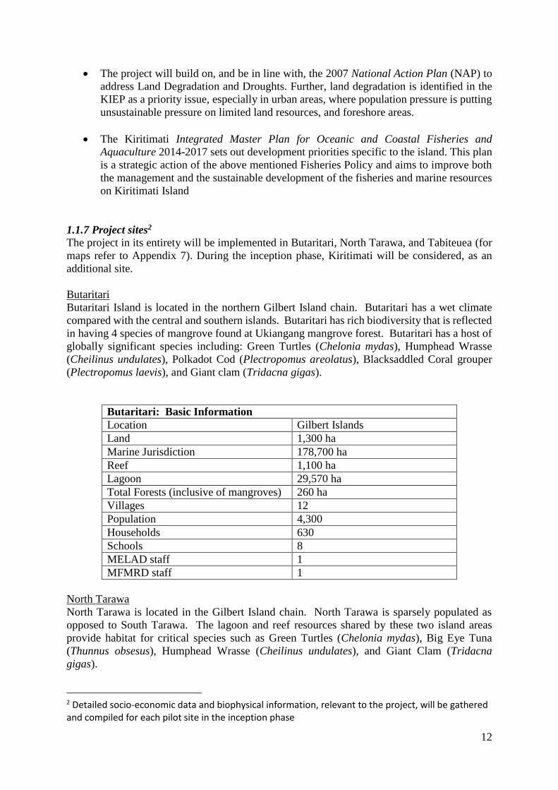
1.1.7 Project sites2
The project in its entirety will be implemented in Butaritari, North Tarawa, and Tabiteuea (for
maps refer to Appendix 7). During the inception phase, Kiritimati will be considered, as an
additional site.
Butaritari
Butaritari Island is located in the northern Gilbert Island chain. Butaritari has a wet climate
compared with the central and southern islands. Butaritari has rich biodiversity that is reflected
in having 4 species of mangrove found at Ukiangang mangrove forest. Butaritari has a host of
globally significant species including: Green Turtles (Chelonia mydas), Humphead Wrasse
(Cheilinus undulates), Polkadot Cod (Plectropomus areolatus), Blacksaddled Coral grouper
(Plectropomus laevis), and Giant clam (Tridacna gigas).
Butaritari: Basic Information
Location Gilbert Islands
Land 1,300 ha
Marine Jurisdiction 178,700 ha
Reef 1,100 ha
Lagoon 29,570 ha
Total Forests (inclusive of mangroves) 260 ha
Villages 12
Population 4,300
Households 630
Schools 8
MELAD staff 1
MFMRD staff 1
North Tarawa
North Tarawa is located in the Gilbert Island chain. North Tarawa is sparsely populated as
opposed to South Tarawa. The lagoon and reef resources shared by these two island areas
provide habitat for critical species such as Green Turtles (Chelonia mydas), Big Eye Tuna
(Thunnus obsesus), Humphead Wrasse (Cheilinus undulates), and Giant Clam (Tridacna
gigas).
2 Detailed socio-economic data and biophysical information, relevant to the project, will be gathered and compiled for each pilot site in the inception phase

13
North Tarawa: Basic Information
** All data estimates
Location Gilbert Islands
Land 1,500 ha
Marine Jurisdiction 98,500 ha
Reef 37,500 ha
Lagoon 53,300 ha
Forests (inclusive of mangroves) 500 ha
Villages 14
Population 6,100
Households 1,000
Schools 12
MELAD staff 1
MFMRD staff -
Tabiteuea
Tabiteuea is located in the southern Gilbert Island chain. The island is administratively
divided between “Tab-North” and “Tab-South”. These administrative units share the same
resources, including the extensive lagoon and reef fisheries. Tabiteuea offers critical habitat
for species such as Giant grouper (Epinephelu lanceolata) and Humphead Wrasse
(Cheilinus undulates).
Tabiteuea: Basic Information
** All data estimates
Location Gilbert Islands
Land 2,500 ha
Marine Jurisdiction 346,0000 ha
Reef 4,900 ha
Lagoon 53,200 ha
Forests (inclusive of mangroves) 400 ha
Villages 18
Population 4,890
Households 931
Schools 15
MELAD staff 1
MFMRD staff 0
1.2 THE CURRENT SITUATION
1.2.1 Global Environmental Problem and Drivers
Two of the major environmental and developmental problems faced by Kiribati are the
continuing degradation of the island ecosystems and the impacts of the climate change. Factors
contributing to these problems include: pollution of the lagoons, build-up of solid waste,
depletion of water, pollution of water from salinity and waste products, depletion of inshore
fisheries and coastal erosion. Marine life is also under threat from pollution and plastic wastes.
The spread of invasive species and agricultural pests and diseases, could potentially have a
significant impact on the economy of Kiribati. Waste oil and other chemicals contribute to

14
pollution. Poor solid waste management practices is becoming an increasing problem.
Hazardous e-waste and bulky waste (of old vehicles) both need managed collection and
shipment out of Kiribati. Population pressures have resulted in overcrowding that is putting
stress on housing, land management, crucial public infrastructure and the natural environment
including underground water reserves. Deteriorating water quality will also impact on people’s
health. The high rate of population growth in South Tarawa is causing stress on water and
sanitation services. The migration of more people to Kiritimati Island also puts pressure on the
Government with regards to an increasing number of squatters and other land use issues.
Disconcertingly, behavioural attitudes towards the environment and limited enforcement of the
Environment Act and other environmental-related legislation are also a major concern and
compounded by a general lack of understanding among the population of the consequences of
actions such as sand mining and inappropriate and poor fishing practices. However, in many
cases, individuals have few alternatives and therefore fail to comply with existing legislation.
This is an especially difficult situation given that unemployment rates are very high, especially
of youth (54%) and school leavers, there is widespread poverty and hardship with over 21.8 per
cent of the population under the basic needs poverty line.
Overexploitation of natural resources and habitat degradation
Given the extremely limited land availability, poor soil and intense periods of drought, domestic
food production in Kiribati is limited. Accordingly, the population depends heavily on marine
resources for their food, nutrition (and micronutrients) and livelihoods. At the same time, a
significant part of the I-Kiribati also comes from imports, which is constitutes an unreliable and
often nutritionally poor source of food. Recent urban development and migration has also
increased resource exploitation for commercial purposes (e.g. supplying dried fish to urban
areas) in urban centres such as South Tarawa that has impacted even the distant rural
communities. For example, many outer islands supply fish to Tarawa either through regular
markets or grey/familial markets. Within this overall context, near shore shallow water habitats
have degraded significantly including through drivers such as overexploitation of coastal
resources in many of the islands. Though there are no clear statistics, anecdotal evidence
indicates that coastal fisheries, a vital source of protein and nutrition, are severely impacted in
many areas including the pilot sites.
In Kiribati, land and marine ecosystems are intrinsically linked. The poor state of coastal
resources is also often connected with ongoing land degradation, pollution, and other related
factors (ease of access, inappropriate use of technology, limited opportunities for alternative /
innovative harvesting techniques). Removal of mangroves has resulted in a deterioration of
coastal habitats (for example: mangroves are an integral part of nutrient recycling, act as nursery
/ grow out grounds for fish and shellfish populations) compromising ecosystem resilience. Fires
and land clearing for planting of coconuts, encroachment of invasive species (such as Pluchea
spp.) have severely degraded land in the country and specifically in the pilot sites. Given the
limited land productivity, the accelerated degradation has further dented the opportunities to
increase benefits from local food production through agroforestry initiatives. A key behavioural
factor in resource depletion and habitat degradation is the lack of community ownership /
engagement in management decision making processes and as a result limited empathy with
consequences associated with poor farming and fishing practices. This, coupled with limited
opportunities for livelihood diversification fuels the continued decline readily accessible natural
resource areas.
Climate change
15
As an atoll nation and a least developed country, Kiribati is extremely vulnerable to climate
change. The pattern of global climate change is expected to impact Kiribati in several ways. In
the near and long term, the projections include high variability in rainfall patterns, sea surface
temperature increase, sea level rise, and ocean acidification. These trends will affect the
integrity of all the island ecosystems and also exacerbate the effects of natural disasters.
Freshwater resources are already scarce making an increase in variability of rainfall from
climate change a further difficulty for agriculture and agroforestry contributing to problems in
terms of resilience. It is essential for the country to build resilience (of both ecosystems and
local populations) to climate change impacts including climate variability. Furthermore, climate
change is expected to directly affect fisheries through changes in abundance and availability of
oceanic species such as tuna and associated species in the exclusive economic zone of Kiribati
while coastal fisheries are expected to decline due to higher sea surface temperature, coral
bleaching and other effects such as changes to habitats and natural mortality.
The Government of Kiribati is fully aware of their nation’s tenuous situation and some progress
is being made. However, significant conservation and sustainable resource utilization
challenges remain. If the nation hopes to build social and ecological resilience in the face of
climate change, tangible benefits could be derived through establishing and implementing an
informed regulatory and decision making co-management framework to conserve coastal zone
resources while at the same time allowing sustainable harvests of natural resources. The
approach must be centred within communities through an ecosystem approach and reflect I-
Kiribati’s reliance upon limited island resources for survival. The strategic and informed
management system would benefit from implementing a “whole island approach”. To enhance
resilience, the current unsustainable lagoon and near shore overexploitation practices require
transitioning to more effectively regulated and informed access regimes. Similarly, critically
important habitats and species of highest ecological value need added protection and the
country would benefit from taking steps to re-enforce their system of national, island-based
protected areas.
1.2.2 Baseline projects and investments for the next 3-5 years addressing the global
environment problem and causes (main co-financing sources of the project)
GEF incremental investment will be firmly rooted in baseline investments in communities, their
capacity development and participation in management and decision making processes through
involvement in government programmes and activities aimed at improving sustainable use,
conservation and management of marine and land resources, and increasing community
resilience to climate change. Key Ministries associated with these processes include;
a. Ministry of Environment Lands and Agriculture (MELAD)
b. Ministry of Fisheries and Marine Resources Development (MFMRD)
c. Ministry of Internal Affairs (MIA)
Ministry of Environment Lands and Agriculture (MELAD)
The MELAD is divided into three divisions; Land Management (LMD), Environment and
Conservation (ECD), and Agriculture and Livestock (ALD). LMD works primarily to resolve
land conflicts and enforce existing (often outdated) land use ordinances. ECD’s work focuses
on raising awareness on key environmental problems and issues including water and pollution,
and supporting regulatory coherence under the KIEP. ECD’s work on increasing knowledge
and experience base for creating a national network of PAs, for improved conservation of
biological resources of the country, would be leveraged for GEF incremental investment.

16
ALD, following up on the Agriculture and Livestock Department Development Strategy (2012-
2015), carries out extension and support services through its agricultural assistants (extension
officers). It covers a) pig and poultry breeding, multiplication and distribution support service
b) development and conservation of locally adapted breeds of livestock c) agroforestry
production systems trials (e.g. combining local chickens with trees/crops like coconuts,
pandanus tree, etc., temporary pig pens under trees and ducks raised under tree crops).
Previously, ALD has also carried out agroforestry activities based on combining coconuts,
breadfruit, bananas and native figs with livestock. In terms of managing forest resources, ALD
undertakes activities to preserve and manage native tree species, specifically Pandanus tree, and
mangroves. The forest management and agroforestry activities carried out by ALD will be
leveraged for the GEF incremental investment.
In addition to the above, PIPA is supported by MELAD and has a separate management unit
established under a specific regulation mandated for the Phoenix Island Protected Area. PIPA
establishment and management is governed by this regulation. The processes, guidelines,
methodologies and capacity generated by the PIPA serve as a basis from which a national
network of protected areas can be developed. Management is to be carried out according to a
four-year management plan (currently under preparation). There is a management committee
that consists mostly of representatives of government agencies and a trust fund that will provide
ongoing support to PIPA. Research is supported by a number of international organizations
that serve on the PIPA Scientific Advisory Committee coordinated by the New England
Aquarium. PIPA has benefited from surveys conducted by research partners including data
gathering on fisheries, currents, coral, carbon pathways, etc.
Ministry of Fisheries and Marine Resources Development (MFMRD)
The MFMRD with its mandate for fisheries and marine resources governance and management
in Kiribati, carries out extensive work on development and management of fisheries resources
from 3 nm miles out to the exclusive economic zone limit with Island Councils being
responsible for the waters inside the 3 nm zone. MFMRD has five divisions: the Fisheries
Division, the Resource Economics and Policy Division, the Mineral Resources Division, the
Information Technology Division and the Accounts, Administration and Human Resources
Division. In addition, the Kiribati Seafood Verification Agency (KSVA) sits within the
Ministry and regulates and controls fish processing standards. With support from The Pacific
Community (SPC) and AUSAID, all maritime boundaries in accordance with the provisions of
the UN Convention on the Law of the Sea (UNCLOS) have been declared and deposited with
the UN including territorial seas baselines, outer limits and EEZs. This information can be used
to assist with mapping and defining community based fishery management and conservation
areas.
The Ministry is guided by the National Fisheries Policy (2013 – 2025). The responsibilities of
the Fisheries Division including both the Oceanic and Coastal Fisheries Branches range from
licensing services, training and extension services for fishers (through fisheries assistants),
enforcement of fisheries regulations, carrying out of surveys and stock assessments which feed
into the information services provided by the Ministry, and local fisheries development services
as well as support for boat building and mechanical units. MFMRD is increasingly promoting
community-based management and co-management of marine resources through externally
funded programs. This will be an important base of experience for the expansion of co-
management of resources in the marine environment. All these activities will be leveraged for
GEF incremental investment.
17
Ministry of Internal Affairs (MIA)
The MIA provides support to Island Councils in establishing governance arrangements in outer
islands. This includes training on basic planning and management, support for the development
of outer islands laws and regulations, and associated enforcement activities. MIA receives,
appraises approved Island Council priority projects for Government or Donor funding and
provides annual support grants to support their budget. MIA has a specialised Local
Government Division that provides training support to Council Staff, Mayors and Councillors.
These activities would be leveraged for GEF incremental investment, specifically on local level
governance related activities (though we do not have an official Cofinancing letter).
Other key co-financing investments and contributions are as follows.
FAO Technical Cooperation Programme- Strengthening capacity in integrated home gardening
and food processing for enhanced food and nutrition security in Kiribati
The project will run from March 2017 to February 2019. The project aims to increase local
agriculture production of farm households and schools in Marakei, Maiana, Onotoa and Makini
through the following four key outputs;
a) Agriculture & Livestock Department (ALD) support services strengthened. Major focus
will include upgrading of centralised Government nurseries supply of high quality
planting materials; training for extension officers on improved sustainable integrated
production and management technologies, and preparation of technical extension
materials.
b) Capacity for families’ home gardens and small livestock production enhanced. Major
focus will include conduct of farmer field school and pilot demonstrations with selected
households on key aspects of home gardening and improve crops and fruit trees
management; compost making and soil improvement practices; small scale poultry
management and husbandry, and other climate smart farming practices.
c) Increased youth awareness on agriculture in schools. Key activities will include
revised school curriculum to include agriculture training, develop materials and strategy
for delivery the trainings. Establishment of school garden pilot demonstration sites in 4
schools for training of students.
d) Improve nutrition awareness, food processing and preservation techniques developed:
This output will strengthen capacities for women on improve nutrition for households
from home gardens, and enhance skills and knowledge on small scale food processing,
preservation, and safe food handling, and cooking demonstrations.
The GEF project will leverage on all the above outputs and these outputs would form the key
baseline for all agroforestry activities of the project (including awareness raising and capacity
building for agroforestry, engagement of youth and women in livelihood improvement
activities, establishment of gene bank of local species, improving extension services and
establishment of agroforestry sites and value addition of products). The GEF project will build
on these outputs and extend them to the project’s pilot sites to ensure breaking down the barriers
described below.
FAO Technical Cooperation Programme- Fish and food security in the outer islands of Kiribati
– innovative techniques and co-management
The project is expected to run from 2020 to 2021. The project will focus on introducing
innovative fishing techniques and co-management measures in the outer islands of Kiribati. The
18
specifics of the project will be developed keeping in mind the complementarity with this GEF
project.
University of Wollongong
The University of Wollongong through the Australian National Centre for Ocean Resources
and Security (ANCORS) has led implementation of an Australian Centre for International
Agricultural Research (ACIAR) funded project ‘Improving Community-based Fisheries
Management in Pacific island countries’ since 2012. The current phase ends in July 2017, and
the project’s second phase is about to be approved by ACIAR. This second phase will run for
four years, building on lessons learned in community engagement in Kiribati. The Kiribati work
forms a node in an ambitious three country project implemented in collaboration with the
Pacific Community, WorldFish and national agencies. The project’s overall objective is to
develop and nurture the structures, processes and capacity to implement and sustain national
programmes of Community-based Fisheries Management (CBFM). The project’s key outputs
in Kiribati include;
a) Situation analysis and CBFM rollout plan
b) Scaling out a national CBFM model
c) Implementation of inshore resource management plans in selected islands
d) Building capacity in national institutions to better manage coastal fisheries
These outputs are directly linked to and would be leveraged for the community-based marine
management measures to be planned and implemented as a part of the integrated land and
marine management plans.
The Pacific Community (SPC)
SPC is beginning the implementation of a New Zealand Agency for International Development
(NZAID) funded project titled ‘Improving fisheries food security and sustainable livelihoods
for Pacific Island communities’. The project’s objective is ‘Food security and livelihoods in
Pacific Island countries are improved through skilled staff and communities managing and
enforcing robust policies and legislation for sustainable coastal fisheries and aquaculture’. The
project’s outputs include;
a) New or revised national legislation for coastal fisheries and aquaculture is drafted /
progressed
b) New or revised sub-national legislation for coastal fisheries and aquaculture is drafted /
progressed
c) Capacity development, training, and mentoring to national and subnational levels in
policies and management plans
d) Awareness raising materials on fisheries rules, regulations and penalties are developed
and disseminated
The GEF project’s policy level work on mainstreaming Ridge-to-Reef (R2R) approach is
directly linked to the major outputs of the above project. The ground work carried out by the
above project would be leveraged for carrying out the review and revision of other relevant
policies under Component 1.
1.2.3 Barriers to be addressed by the project

19
Despite the above investments and actions, certain critical barriers remain that obstruct
improved conservation and sustainable management of coastal and land resources, and
increased climate resilience in Kiribati. Current activities and investments in the country point
towards the right direction, but fall short of addressing all the existing barriers. The key barriers
to be addressed through GEF incremental investment are described below.
Barrier#1: Inadequate institutional framework and governance weaknesses
At present, in Kiribati, sectoral policies and plans are geared towards sustainable management
of natural resources and improving climate resilience, but they adopt sectoral approaches and
do not adequately incorporate the Whole-of-Island approach or R2R strategies, which is
essential in terms of addressing the environmental challenges described above in an effective
and holistic manner. This is also related to the fact that different ministries and line departments
in the country often work in ‘’silos’’ with very little sectoral coordination and integration. There
is no cross sectoral coordination mechanism operating in the country. Lack of cross-sectoral
coordination and mainstreaming of R2R approaches into sectoral policies and planning are
significant institutional barriers.
Extensive research on vulnerability to climate change shows that it is the marginalized who
suffer the impacts of changing environmental conditions. Managing natural resource systems
with the added stresses associated with climate change poses a challenge for socio-ecological
systems. And although not a panacea, community engagement is a means of reducing
vulnerability to the natural hazards associated with climate change. Generally, natural resource
utilization and conservation policies are prepared at the national level and implemented in a
top-down fashion. Though the Island Councils are given certain responsibilities and they
provide an avenue for outer island representation in national level processes, they are relatively
new institutions and in the past engagement of local communities in planning processes have
often been minimal and this has resulted in lack of true community ownership over resource
conservation and management initiatives. This, coupled with the fact that the traditional
governance systems and mechanisms have been breaking down, is a significant barrier to
instituting long term environmental management. There have been funded initiatives (e.g. the
ACIAR PacFish project described in section 1.2.2) to promote and implement community-
based approaches in natural resource management, but more substantial efforts are essential to
breakdown this governance barrier.
Barrier#2: Limited technical capacities and skills at all levels
MELAD’s total staff is approximately: ECD (40 staff), Land (60 staff), and Agriculture (100+).
Approximately thirty MELAD staff are located at Kiritimati (Christmas) Island. These total
also includes MELAD’s agricultural assistants (extension officers) located at approximately
fifteen outer islands. While more than 80% have some level of professional training in
environmental management, only seven staff currently hold masters degrees on environmental
management. Two staff are currently pursuing doctorate level degrees. MFMRD has
approximately 147 staff in total which includes MFMRD’s fisheries assistants (extension
officers) located at approximately fifteen outer islands. While 60% have some level of
professional training in environment/fisheries-related management, only 6 staff currently hold
masters degrees on environmental management and only one MFMRD staff possesses a
doctorate level degree. While the overall numbers of trained government personnel is high, the
limited number of suitably qualified technical staff with extensive field experience, their limited
access to remote islands and communities, and limited availability to technology and equipment
for monitoring and surveillance of resources is a key factor that constrains successful mitigation
approaches.

20
At the same time, farming and fishing communities have a wealth of traditional knowledge
gleaned over decades and based on a clear association and understanding of changes occurring
on land and sea. However, top down management approaches seldom allow for communities
and natural resource providers to interact with resource managers and participate in decision
making processes. This inability to connect community knowledge and experience with
government resource managers and policy makers constrains the development of pragmatic
management plans where ownership of decisions is shared and where there is a mutual respect
for achieving successful outcomes from policy development and implementation.
Collectively, the considerable technical knowledge and capacity in areas related to marine and
land resource conservation and management across government agencies and within
communities has potential to be used in implementing effective management approaches.
However, there are gaps in skills and opportunity to engage local stakeholders and promote
community-driven approaches. Extension staff of both ministries, located in outer islands, lack
technical capacities in key areas relevant to improving local level resource management and
livelihood improvement. Extension staff of MELAD have knowledge gaps in tree crop re-
planting, agroforestry combinations, and measures for assisted natural regeneration of forests.
MFMRD’s extension staff have knowledge gaps in value addition, co-management skills and
post-harvest preservation techniques. With the capacity gaps at the local extension staff level,
technical assistance provided to the local communities have been inadequate, this has resulted
in gaps in technical skills of local communities to undertake agroforestry, forest management
and marine management measures.
Barrier#3: Limited alternative livelihoods and economic opportunities
The need to create alternative livelihoods and new economic opportunities is a key priority for
the government of Kiribati. It is driven by extremely high numbers of persons currently
unemployed. The 2010 Population Census showed that overall, unemployment was 31 per cent
while youth unemployment was 54 per cent (62% young women and 48 % young men).
However, local communities in Kiribati, especially in outer islands, have few opportunities to
diversify or improve their existing livelihoods especially in the outer islands given their
remoteness and poorly linked to markets and support services. This aspect in combination with
the above barriers result in increasing pressures being placed on natural resources in the near
shore and resulting in over or unsustainable resource exploitation and habitat degradation, and
increased vulnerability to climate change. While resources exist further offshore in deep water
and could contribute towards effort reduction and recovery of near shore areas, limited access
to technology, finance and training remain barriers. Under such conditions, the capacity of I-
Kiribati to adapt, reorganize, and evolve into more resilient communities that are able to derive
sustainable livelihoods from natural resource exploitation and being better prepared for future
climate change impacts is in jeopardy.
1.3 THE GEF ALTERNATIVE
1.3.1 Project strategy
The GEF incremental investment will build on and complement baseline and co-financing
projects/initiatives to mainstream and implement R2R approach to achieve the twin impacts of
global environmental benefits and increased local resilience to climate change.

21
Policy assessment and revision work is being carried out with regards to coastal fisheries and
aquaculture, the GEF grant will extend this to policies relevant to management of land based
resources, and ensure these policies integrate R2R approach. This project will also establish a
national level coordination mechanism for cross-sectoral coordination. Advocacy, awareness
raising and capacity building activities for conservation and sustainable use of natural resources
are ongoing, GEF grant will build on this at both national and island levels, among all relevant
stakeholders, to promote and implement R2R approach.
There are ongoing efforts to promote community-based fisheries management and agroforestry
in the country, this includes technical training, creation of relevant facilities/infrastructure and
pilot demonstrations. GEF grant will build on this to develop integrated marine and land
management plans, and implement them, to ensure that the island ecosystems are managed as
a whole (from Ridge to Reef).
This project is part of the Pacific Islands Ridge-to-Reef National Priorities “Integrated Water,
Land, Forest and Coastal Management to Preserve Biodiversity, Ecosystem Services, Store
Carbon, Improve Climate Resilience and Sustain Livelihoods” (R2R Programme) and will
collaborate closely with the other projects in the programme, and particularly the regional
project “Testing the Integration of Water, Land, Forest & Coastal Management to Preserve
Ecosystem Services, Store Carbon, Improve Climate Resilience and Sustain Livelihoods in
Pacific Island Countries.” Experiences and lessons learned will be shared with the other
countries/projects participating in the programme through the UNDP R2R umbrella project.
This will include linkages to regional knowledge portals and meetings. The project will also
endeavour to capture and transfer the lessons learnt through the parent R2R programme.
1.3.2 Project objectives, outcomes and outputs
The project aims to improve biodiversity conservation and landscape level management to
enhance socio-ecological resilience to climate variability and change. To achieve this goal, the
project is structured in three components, as described below.
Component 1: Enabling environment for R2R conservation and sustainable use
To remove barriers 1 and 2, the project, through this component targets the strengthening of an
enabling environment by; revision of policies and sectoral plans to mainstream R2R, improved
cross-sectoral coordination, streamlining of resilience and socio-ecological planning for R2R
strategies and improved capacities, educational programming and awareness at all levels for
R2R implementation.
GEF incremental financing of USD 723 500 will be invested in: i) technical assistance for
reviewing and revising policies and sectoral plans to mainstream an R2R approach; ii) technical
assistance for establish a cross-sectoral decision making mechanism; iii) technical assistance
for streamlining resilience and socio-ecological planning; and iv) community outreach
programmes, training programmes, school curriculum development and R2R Masters
programme.
Cofinancing for Component 1 comprises of awareness raising and knowledge development
activities carried out for agroforestry and marine management related training initiatives and
materials, conservation of biological resources and the updating and revision of policies and
legislation related to coastal resources and aquaculture. MELAD will contribute USD 500 000.
MFMRD will contribute USD 1 000 000. SPC will contribute USD 152 000. Univ. of

22
Wollongong will contribute USD 140 000. FAO through its TCPs will contribute USD 150
000.
Outcome 1.1. Enabling environment improved for ecosystem-based sustainable use and
conservation of island resources
Indicator: Under LD3 (tracking tool) Capacity strengthening to enhance cross-sector enabling
environment score moved from 2 to 3. Under LD3 (tracking tool) Framework strengthening
INRM score moved from 1 to 3.
Output 1.1.1 R2R concept mainstreamed into sectoral development priorities and policies
with an emphasis on protecting and developing livelihoods
During PY1, existing sectoral planning documents, legal frameworks, priorities and policies
will be reviewed to identify entry points for mainstreaming an R2R approach for mainstreaming
in at least in three policies, priorities or frameworks. This process will be supported by expert
consultants as well as listening sessions to facilitate a participatory approach to review of
policies to ensure that such revisions lead to practical policies and priority setting that meets
needs of outer islands and local communities. In addition, a potential sub-strategy on PAs
network will be reviewed developed as a supplement to the related policies.
In PY2, the identified policies and sectoral documents will be formally revised integrating an
R2R approach.
Output 1.1.2 National level coordination mechanism developed for cross-sectoral decision-
making (including on PAs)
Under this output, a cross-sectoral coordination and decision making mechanism will be
established. This mechanism will ensure that the sectoral partners do not work in silos and come
together to make key decisions and plans in the context of R2R implementation.
During PY1, the PMU with support from the expert consultants recruited under Output 1.1.1
will analyze existing cross-sectoral coordination avenues, review the functions of all relevant
Ministries and conduct stakeholder consultations at both national and island levels in the
context of developing a new cross sectoral coordination mechanism. Based on the consultations,
during PY2, detailed terms of reference will be developed for the mechanism (clearly outlining
the linkages to the island councils) and the mechanism will be formally operationalized for the
purpose of future sustainability.
Output 1.1.3 Resilience and socio-ecological planning for national to island-level coordination
mechanism on whole-of-Island based R2R conservation and sustainable-use strategies
streamlined across national and islands levels
This output will provide the socio-ecological basis/ground work to the cross-sectoral
coordination mechanism established under Output 1.1.2 to make decisions on R2R strategies
(development and implementation).
During PY1, extensive consultations will be conducted with Island Councils, communities and
key government stakeholders to streamline, and if applicable, develop indicators to measure
resilience at the island level using vulnerability assessment methodologies as well as
established resilience indicators from project partners. These indicators will be subsequently
used to measure the impact of this project in improving the resilience of the targeted local
communities, in addition to being a standard set of resilience indicators to be utilized later. A
community participation model will also be developed, specifically focusing on effectively

23
engaging youth and women, this model will form the basis for creating community groups for
developing and implementing the integrated land and marine management plans under
Component 2. In conjunction with the development of this model, impacts of R2R strategies
on resource access and socio-cultural aspects will be thoroughly analyzed and mitigation
options will be identified for adverse impacts, if any.
During PY2, through consultations with island councils, whole-of-island R2R strategies will be
developed and adopted. These strategies will guide the design of integrated land and marine
management plans both in this project and beyond this project, in the respective islands.
Output 1.1.4 National and island level environmental education, community outreach and
extension program developed
R2R Masters program: During PY1, two students will be identified to be enrolled onto the R2R
Masters program. This will involve development of a list of criteria for the selection process
and recruitment including the application of skills gained back into project activities or sites.
School curricula: During PY1, existing school curricula and related projects will be assessed
and an integrated model for curricula on R2R related resource conservation and management
issues will be designed. Consultations will be conducted with relevant govt. institutions and
schools for developing new curricula and subsequent training and materials will be provided.
In PY2, based on the consultations conducted and assessments done, new curricula will be
developed and introduced in nine schools. Utilization of the curricula will be monitored during
PY3 and PY4. At least nine schools will be targeted
Community outreach programme: During PY1, outreach and awareness raising materials on
R2R approach including community-based management approaches will be developed. These
materials will include videos, radio programs, posters and. A workshop on awareness building
approaches and strategies and associated required knowledge products will be conducted with
project partners to identify needs. In PY2, the outreach programme will be implemented
through the island councils and local community based organizations and institutions (e.g. local
church). The outreach programme will be sustained until PY4. At least 30 communities will be
targeted for community outreach programme
Training programme: The training programme under this component will target extension and
other technical support staff of MELAD and MFMRD. The training will take place at national
level and will also include staff not directly working on the project sites. At least 25 staff will
be trained. The trainings will be extensive, building on capacity building activities conducted
by co-financing partners, to facilitate implementation of communities identified actions.
Trainings topics will be dependent on priorities in the whole-of-island strategy and will cover,
inter alia, community-based fisheries management processes; developing and enforcing marine
management measures; alternative fishing methods and gear use; fisheries survey techniques;
protected area management and planning; mangrove restoration; assisted natural regeneration
techniques (e.g. unblocking natural waterborne seed flow), seedling management and planting
(e.g. taking into account substrate height, water flow and appropriate species for the location),
etc. and agroforestry; tree/crop choice and planting arrangements, soil and water
conservation/management techniques, value addition techniques, etc. In addition, a recognition
program and certificate for CBFM will be developed for communities. In PY1, the training
programme will be designed and the trainings will be carried out in PY2 and PY3.
COMPONENT 2: Implementation of R2R conservation and sustainable use strategies

24
This component will address Barriers 2 and 3. The GEF incremental financing for the
component will be USD 3 295 422. Through this component, the project will implement R2R
strategies through preparation and implementation of three integrated land and marine
management plans.
Cofinancing for Component 2 comprises of community mobilization, on the ground mangrove
restoration and agroforestry activities, community-based fisheries management measures and
agroforestry/fisheries related infrastructure. MELAD will contribute USD 5 000 000. MFMRD
will contribute USD 4 600 000. Univ. of Wollongong will contribute USD 200 000. FAO TCPs
will contribute USD 300 000.
Outcome 2.1 National management system for ecosystem-based sustainable use and
conservation of island resources established to deliver SFM, LD, and BD benefits
Indicator: 23 496 hectares (including three new PAs) covered by integrated natural resource
management (land and marine) practices in wider landscape.
Output 2.1.1 R2R conservation and sustainable use strategies initiated in at least three islands
aquatic and terrestrial ecosystems
During PY2, integrated land and sea planning and island level priority setting workshops will
be conducted to develop detailed plans and assessments based on the whole-of-island approach.
These workshops will primarily establish direction in terms of land and marine area use,
including potential sites for new PAs. Once the resource utilization and management techniques
are identified, discussions will be conducted and consensus will be developed within target
communities (under Output 2.1.2 and 2.1.3) on implementing priorities as a part of management
plan or action plans (to be prepared subsequently). This will include identification of specific
low-impact coastal fishing, agroforestry and mangrove restoration techniques. Identification of
these techniques will take into account the analyses conducted under Output 1.1.3 with regards
to resource access and socio-ecological perspective and under Output 2.1.2 (refer below) for
improved livelihood opportunities. It should be noted that the PAs will also fall under the
integrated land and marine management plans, but would have individual PA management
plans (refer below).
In the latter part of PY2, at least three integrated land and marine management plans will be
developed, covering i) establishment of three new PAs; ii) implementation of marine
management measures (coastal); iii) implementation of mangrove restoration and agroforestry;
and iv) livelihood improvement activities as integral part of resource management practices.
The plans will also be thoroughly assessed for any complementary links to existing activities
on the ground to maximize synergy.
In PY3, a local level monitoring programme will be established to monitor the progress of the
implementation plans and associated actions, the programme would be devised in a manner to
utilize community involvement and ownership, and rely on local level information sources. The
monitoring programme will be linked to the national level cross-sectoral coordination
mechanism (Output 1.1.2), providing ground level feedback for future decision making on R2R
related issues, and importantly, the resilience indicators developed/compiled under Output
1.1.3.
Output 2.1.2 Expanded and complementary livelihoods developed as a part of the plans
developed under Output 2.1.1
Though this output is primarily integrated into the management plans prepared under Output
2.1.2, it is essential to design activities directly supporting households to utilize opportunities

25
to improve their livelihoods. As early as PY1, analysis will be conducted to identify the
potential for local households to adopt livelihood strategies that can be a part of the integrated
management plans prepared. Once the management plans are prepared, in PY2, they will be
reviewed to ensure they do not have any adverse impacts on local level food security (this is in
addition to overall analysis of R2R strategies for socio-ecological and resource access impacts).
After the analysis, specific livelihood activities will be identified (that are part of resource
management practices) and 350 households will be assisted to adopt the activities. The support
will be mainly extended in the context of changing harvester/producer practices, new
harvester/producer strategies and products, value addition and marketing of products (e.g. post-
harvest processing).
Output 2.1.3 R2R conservation and use strategies across land and sea implemented at three
target islands (through the integrated plans)
This output will primarily implement the resource management techniques identified and
agreed under Output 2.1.1. In PY2, community groups will be formed, where they already exist
further support will be provided to them (engagement with the groups will be following the
community participation model developed under Output 1.1.3).
Agroforestry production: In PY3, ethnobotanic surveys (the last survey was conducted more
than a decade ago) will be conducted to establish gene banks and corresponding local level
nursery stations (at least 3) for native species. 414 ha of agroforestry sites will be established.
This will include rehabilitation of coconut, combining this with vegetable gardening and
livestock (chicken) production. Sites will also use alley cropping patterns combining pandanus,
fruit trees (e.g. banana), vegetable gardening and livestock. Selection of sites and practices will
take into account the hydrological state and flows, soil conditions and species compatibility as
well as interventions through other projects and partners that facilitate improved water access
and quality. In PY4, another 414 ha of agroforestry sites will be established.
Mangrove restoration and forest rehabilitation: In PY3, 100 ha of natural woodland and shrubs
will be managed through assisted natural regeneration and protection, this includes
management and clearance of invasive species. In addition, in PY3 82 ha of mangroves will be
restored through planting and assisted natural regeneration. In PY4, further 50 ha of natural
woodland will be added under natural generation and protection.
Marine management and development measures: In PY1, sites for expanded or new
development of a community-based management of fisheries approach will be identified based
on the management plans as well as partner project interventions and existing village requests.
Communities will be supported to, as identified in the management plans, implement spatial
management measures in lagoons and reefs (linked to 2.1.4), undertake changes in fishing
practices and gears, and develop new conservation and management measures. Site specific
information and data on fishing practices, grounds and fleets will be gathered during PY1 and
PY2 based on the identified priorities.
Output 2.1.4 At least three PAs established
Under this output, three new PAs will be established over 22 417 ha. The PAs will be
established as identified under Output 2.1.1. In PY3, cooperative management agreements will
be drafted and signed. The PAs will be formally recognized, management plans prepared and
implemented from PY3. The PAs will cover reef, lagoon and possibly land areas of the target
islands.
26
COMPONENT 3: Lessons learning and sharing
GEF incremental resources of USD 476 345 will be utilized under the component to ensure
that; i) the project implementation is effective and efficient, and is based on result-based
management principles; and ii) project findings and lessons learnt are captured and
disseminated for future initiatives.
Cofinancing for Component 3 comprises activities related to gathering information for the
evaluation of the results achieved by the project and dissemination of information and lessons
learnt through the project. MELAD will contribute USD 500 000. MFMRD will contribute
USD 400 000. SPC will contribute USD 10 000. Univ. of Wollongong will contribute USD 38
000. FAO TCPs will contribute USD 100 000.
Outcome 3.1: Project implementation based on results based management and
application and sharing of project findings and lessons learned
Indicator: Project M&E system designed, established and applied throughout the project and
across all components, provinces and project sites; Successful sharing of lessons learnt across
the region
Output 3.1.1: Monitoring, evaluation and reporting plan and system for the project established
and operational
During PY 1, the project will hire a Monitoring and Evaluation (M&E) System Expert to advise
the Project Management Unit (PMU) in the design and establishment of an M&E system to
obtain information on progress in meeting targets, evaluating results and facilitating the
systematization of experiences. In the first three months of the project, the M&E program will
be complimented by the collection of information and establishment of the project
socioeconomic and biophysical baseline. Throughout the duration of the project, monitoring
reports will be prepared according to the M&E system. During PY3, mid-term
evaluation/review, and at the end of PY5, end of project evaluation will be conducted. Both
evaluations will be conducted by experts selected by FAO with the approval of the PSC. In
addition, a critical part of project M&E would be the listening sessions conducted as part of
yearly PSC meeting. These listening sessions will provide the forum for island /community
level stakeholders to communicate their concerns on the project directly to the PSC.
Output 3.1.2 Project related ‘knowledge’ captured and shared
This output will ensure that the project experiences are captured and shared through knowledge
products and communications. In PY1, a communication strategy will be developed and to raise
visibility of the project awareness materials will be identified and developed (e.g. posters, radio
slots, etc.). From end of PY1, an annual project newsletter will be produced every year. The
PMU will facilitate information collection by coordinating with all the executing and other
partners. At the end of the project (PY5), as a part of the terminal workshop, the key lessons
learnt and the experiences gathered through the project will be shared, and a project publication
will be produced to facilitate wider dissemination. In addition, to ensure lessons learnt and
experiences are transferred to the parent R2R programme, participation will be ensured in R2R
cross-country knowledge sharing events.
The project will also invest in information sharing at a regional level, within the framework of
the multi-focal peer-to-peer scientific and technical network for knowledge sharing and training
(PacIW: LEARN) to be established through the regional R2R programme, and in accordance
with Objective 3 of the GEF International Waters focal area on support to foundational capacity
building, portfolio learning, and targeted research needs. This will build on the baseline
27
PacIWRM project's successful delivery of distance learning and twinning for IWRM capacity
development.
1.3.3 Project Stakeholders
Based on consultations during the project preparation and feedback received in the inception
and terminal workshops, below table has been compiled providing an overview of different
project stakeholders and their roles.
Roles and responsibilities of stakeholders
Stakeholder Role/Relevance
Government
Ministry of Environment, Lands and
Agricultural Development (MELAD)
Main executing partner.
MELAD is responsible for National Environment, Lands and
Agriculture and through the Environment and Conservation
Division (ECD) is the political Focal Point of the GEF through
the Secretary and the Director of ECD is the Operational Focal
Point. This agency is responsible for environment, lands and
agricultural policy development, implementation and
monitoring/evaluation. The Environment Act 1999 as amended in
2007 provides the legislative basis for the exercise of MELAD’s
environmental functions.
Ministry of Fisheries and Marine
Resources Development (MFMRD)
Main executing partner.
MFMRD is responsible for National Marine and Fisheries
policies development, implementation and monitoring and
evaluation. Through the Fisheries Act 2010, MFMRD is tasked to
promote sustainable management of fisheries and the
development and use of fisheries resources for the benefit of
Kiribati including the recovery of fees that reflect the value of
resource and, to protect the fish stocks and marine environment
of Kiribati. Based on this Act, the Kiribati National Fisheries
Policy 2013-2025 has been developed with aims that portray short
to medium and long-term strategic objectives that will enhance
responsible fisheries with emphasis on the need to support,
improve and sustain the peoples’ livelihood, food security and
sustainable economic growth.
Ministry of Internal Affairs (MIA) Key partner in implementation.
The MIA is responsible for Local Government and outer island
development and manages the Local Government Act that
governs the Island Councils functions and operations. MIA
provides link between Government and other organizations with
the Island Councils through its Local Government Division and
its staff including the Island Council Clerk, Island Project Officer
and the Treasurer serving the Island Councils. MIA will act as a
key link between the project and the Island Councils.
Ministry of Finance and Economic
Development
Key government stakeholder in implementation.
The Ministry of Finance and Economic Development is
responsible for national planning and budgeting. Funds for the
project will be disbursed to PMU through the Kiribati Fiduciary
Steering Unit established within the Ministry to handle large
project funds and following Government Financial Regulations
and Procedures.
28
Stakeholder Role/Relevance
Ministry for Education
Key government partner in implementation.
The Ministry for Education has an important national role for
education and to promote and relevant curricula work to assist. It
is responsible for preschool, primary, secondary, tertiary and also
runs a teachers’ training institution where teachers are trained to
become teachers at both primary and secondary school levels.
Island Councils Key partner in implementation
Island Councils are responsible for the development,
administration and management of their island affairs assisted by
Government through the MIA. Their involvement is important to
ensure facilitation role for any undertaking or project. The Local
Government Act governs functions and operations. Island
Councils have individual by-laws that largely guide their business
and operation. They oversee, lay out rules and procedures for how
domestic affairs, business operators and licensing, development
are managed. Island councils have discretionary power through
issuing licenses for business development and setting prices and
charges such as bus fares (KILGA 2013), fish sales prices in the
local market.
Ministry of Communication, Transport
and Tourism Development
Key government partner in implementation.
The Tourism Division of the Ministry of Communication,
Transport and Tourism Development monitors tourism-based
fishery projects. The Ministry is responsible for international
and local shipping policies and laws as well as aviation. Under
the Kiribati Development Plan (2012 - 2015), Government aims
to improve communication infrastructure on the outer islands to
encourage eco-tourism.
Kiribati National Expert Group on
Climate Change and Disaster Risk
Management (KNEG)
Key government partner in implementation.
The development of the KJIP led to the establishment of a Kiribati
National Expert Group on Climate Change and Disaster Risk
Management (KNEG), encompassing experts from core and line
ministries, NGOs, the Kiribati Chamber of Commerce and
Industries and other non-state actors. Acts as a coordination
mechanism for climate change and disaster risk management
initiatives.
It plays an overall steering function for the design,
implementation and monitoring of climate change and disaster
risk management initiatives and also form sub-steering groups for
sector-specific measures or integrated approaches targeting outer
islands and community level (such as the Whole of Island
Approach - WOI). It is the entry point for new initiatives.
International Development Organizations
The Pacific Community (SPC) Co-financing partner as explained above
Secretariat of the Pacific Regional
Environment Programme (SPREP)
Executing partner.
United Nations Development
Programme (UNDP)
UNDP is the implementing agency for a LDCF project in Kiribati.
Strong coordination with the project will ensure maximum
synergy.
Civil Society (NGO’s, etc.)
Kiribati Climate Action Network KIRICAN is an NGO doing community activities to promote
awareness on Climate Change and has worked with the ‘350’
Climate Action Network. Youth largely comprise membership of

29
Stakeholder Role/Relevance
the Kiribati Climate Action Network. KIRICAN will be a key
partner in outreach and awareness raising activities.
Kiribati National Council of Churches Kiribati is a deeply religious country and the Churches of
different denominations and church groups under them at
community level are active in community planning and
implementation. They will also be involved in relevant awareness
raising and implementation actions.
Church-based Women Organizations Church-based Women Groups are very active organizations in the
communities and through which important messages can be
effectively transmitted. They provide marketing assistance to
their Women Members in Outer Islands. They will play a key role
in engagement of women in the project.
Aia mwaea ainen Kiribati (AMAK) AMAK is the umbrella Women Organization for Kiribati and
provides training support to its members, serves as a link between
Government and its Women Organization members, coordination
role for relevant programs. It exists to promote the interest of
women enabling and empowering them. Key partner at national
level providing inputs and insights into gender issues relevant to
the project.
Live & Learn Live & Learn is heavily involved with community mainly on
agriculture for food security issues carrying out enabling and
practical training programs. They have on-going activities on
Outer Islands (Abaiang) and in Tarawa. The organization has
lately expanded to include health related initiatives such as
composting toilets.
Academic and Scientific Organizations
University of Wollongong Cofinancing partner
University of the South Pacific (USP)
Centre
USP Centre is an academic institution operating university
extension services for academic students. It also has vocational
training programs for non-academic students. Key partner in
education and curriculum related project activities.
Local and Indigenous Communities
Village Elders and Leaders
At community level for each Island, there is a communal
leadership system that strongly recognizes the powerful authority
of ‘unimane’ (village male elders) who are the supreme authority
for village level matters for the wellbeing of the members of the
village. Most villages located on islands are led either by a group
of village elders from amongst whom a Chairman is selected. The
elders committee is a respected body on the Island whose decision
is often respected. Their involvement through consultation
throughout implementation is important to reinforce the support
that village Councillor reps and the Mayor for the project.
Local communities Main beneficiaries of the project and primary partners on the
ground for the successful implementation of the project.
Private Sector
Kiribati Coconut Products The business provides Training on Virgin Coconut Oil (VCO)
processing, and marketing services for VCO from outer islands
in Tarawa. The business has established contact producers of the
VCO on a number of the Outer Islands that supply the domestic
market in Tarawa. VCO is a experiencing a growing interest and
market in Tarawa - all that is produced are consumed locally. It
has great potential for niche international markets.
Kiribati Fish Limited (KFL) KFL is a joint venture of Foreign Company and Government of
Kiribati that fish and buys fish from local fishermen in Tarawa
to process and export tuna loins mainly. The Company currently
also serves the domestic market and has potential for an outlet
for Outer Island fresh fish and other marine products. Whist it
currently selects the type of fish it buys, there is potential to
market other types of fish through the Company.

30
1.3.4 Expected global environmental and adaptation benefits
The project through the integrated land and marine management plans, implemented across 23
477 ha, will generate the following Global Environment Benefits (GEBs):
I. Improved biodiversity conservation, sustainable use and management in lagoons and
nearshore areas through establishment and management of three PAs area (22 417 ha).
The PAs would fall under IUCN category 6 ‘Protected area with sustainable use of
natural resources’, and would be co-managed with local communities to ensure
protection of key biodiversity, and sustainable and continued utilization of resources
from the targeted ecosystems. Of the three PA sites Butaritari is the only island with all
the four mangrove species. Tabituea and North Tarawa have recognized KBAs. These
protected areas will cover coral reef areas including areas with corals listed in the IUCN
Red List (72 across Kiribati). These PAs will also provide habitat for globally threatened
corals and charismatic species such as endangered Green Turtles (Chelonia mydas), and
Vulnerable species such as the Polkadot Cod (Plectropomus areolatus), Blacksaddled
Coral grouper (Plectropomus laevis), and Giant clam (Tridacna gigas) (see section
1.1.7).
II. Improved Sustainable Land Management at landscape covering the following;
a. Improved agricultural management (through agroforestry) - 828 ha. This will
involve restoration of coconuts and native species that play a significant role in
local food security (e.g. Pandanus). This will be facilitated through creation of
gene banks for local species;
b. Improved forest management (mangroves and natural woodland)- 232 ha,
including effective management of mangrove forests (166,630 tCO2eq over 20
years-including 5 years of project implementation)
1.4 LESSONS LEARNED
Key lessons learned from prior initiatives and projects in the Pacific region that are reflected in
project design include the following:
• A truly participatory approach is required that reaches from national level government
officials to island level councils to communities.
• The social sustainability of initiatives affecting natural resource management and
community organization is dependent on involving traditional authorities (national and
island-specific councils) at all stages in the process, from formulation to
implementation. Without their buy-in, resource management decisions at
landscape/seascape level have limited validity, and policy influencing initiatives have
limited credibility.
• At the same time, traditional authorities may not in all cases adequately take into
account the interests of all community members, and it may therefore be necessary to
establish complementary community-specific and gender-sensitive mechanisms to
ensure adequate participation and representation of individual communities and
marginalized stakeholders.
• While there is a high level of interest among stakeholders over much of the country in
the establishment of protected areas, the effective implementation of controls on
extractive activities can easily be undermined by the emergence of new food insecurities
or marketing opportunities; it is therefore not sufficient to rely solely on expressions of

31
goodwill and commitment, but also to ensure that stakeholders have access to economic
alternatives.
• The current tendency toward siloed sectoral work
Specifically within Kiribati, FAO has gained experience in working across sectors through an
emergency recovery project covering agriculture and fisheries (“Emergency support to re-
establish food security in Kiribati outer islands”/TCP/KIR/3503). Previous projects on
establishment of agroforestry initiatives and community agriculture have also held lessons
learned through consideration of sustainability in terms of community engagement and water
scarcity.
FAO has extensive forestry experience in the region and is actively learning from work on
ongoing projects such as the current GEF-FAO project on forestry and protected areas
management in Fiji, Samoa, Vanuatu and Niue. As well as other R2R projects including in
Tonga, Vanuatu and the Solomon Islands.
Within the area of fisheries, FAO has been working extensively on coastal and community-
based fisheries in the region compiling lessons learned through reviews of ongoing community-
based management initiatives. Key outcomes related to the importance of not just engaging
communities from the outset but through continued feedback and adaptive management based
on monitoring programs.
1.5 STRATEGIC ALIGNMENT
1.5.1 Consistency with national development goals and policies
The project is consistent with a range of national policies, goals and plans. Those goals and
policies that are the most relevant are listed below.
The Kiribati Development Plan (KDP) 2012–2015 is the overarching national development
plan detailing national priorities (GoK 2012c). The KDP is linked to the Millennium
Development Goals, the Pacific Plan and the Mauritius Strategy for Small Island Developing
States (BPoA+10). The KDP has six broad key policy areas (KPAs). The project is aligned with
KPA 2 on economic growth and poverty reduction and KPA 4 on environment which also
incorporates climate change.
The project adheres to the guidance of the Kiribati Joint Implementation Plan for Climate
Change and Disaster Risk Management 2014-2023 (KJIP). As party to the United Nations
Framework Convention on Climate Change (UNFCCC; ratified in 1992). The Government sees
the KJIP as its National Action Plan on climate change. The project is in specific alignment
with a number of key strategies such as strengthening good governance, policies, strategies and
legislation(1), increasing water and food security with integrated and sector-specific
approaches and promoting healthy and resilient ecosystems (4), and delivering appropriate
education, training and awareness programmes (7). The KJIP identifies the “Whole Island
Approach” as a national priority; e.g., Develop and implement a program for community-based
integrated vulnerability assessment, climate change adaptation and disaster risk management
such as the Whole of Island Approach (WOI).

32
Kiribati’s National Adaptation Programme of Action (January 2007) highlights Kiribati’s
vulnerability to climate change. It has noted the vulnerability of settlements, land and coastal
areas to impacts of climate change due to the low lying nature of the atolls; and also the
vulnerabilities of the fisheries sector; agriculture sector, water resources, physical assets,
biodiversity and human health. This project will directly support priorities identified by the
NAPA, including: Coral Reef Restoration, Monitoring and Stock; Agricultural Food Crops
Development; and Coastal Zone Management and Resilience Enhancement for Adaptation. The
NAPA notes that both marine and terrestrial sources of food security are important. The people
of Kiribati depend very significantly upon marine resources for their household level food
security while agriculture helps provide important food diversity.
The project is closely aligned with several platforms set forth in the National Fisheries Policy
(2013 – 2025). The project will particularly support the achievement of goals 2 – 5 as set out in
this policy: 2. Protect and secure food security and sustainable livelihoods for I-Kiribati; 3.
Ensure long-term conservation of fisheries and marine ecosystems; 4. Strengthen good
governance with a particular focus on building the capacity of MFMRD to implement and
support fisheries management, development, and monitoring, control and surveillance; and 5.
Build climate change resilience for fisheries and marine resources in Kiribati. The policy also
notes that lagoon and coastal fisheries currently provide sufficient protein for most I-Kiribati.
The policy states that fisheries are under strain from population pressures compounded with
climate change. The policy notes that the response to increasing lagoon fisheries pressure
should be the management of overfishing in order to maintain sustainable levels.
The project is also in line with the 2005 Kiribati National Biodiversity Strategy and Action
Plan (K-NBSAP) and its associated Action Plan for Implementing the Convention on
Biological Diversity’s Programme of Work on Protected Areas (PoWPA). The Key
Biodiversity Area (KBA) report, completed as part of the PoWPA phase II Project and awaiting
Cabinet approval, identifies 22 KBAs, 14 of which are currently afforded little or no protection
at all. The project will establish at least three Protected Areas based on the priorities set out in
the KBA report, after extensive consultations with communities in and around the proposed
sites. The project will also strive to mitigate risks to key threatened / endangered species in
Kiribati and their locations as well as linking to the implementation of the NBSAP objectives.
The project also directly addresses a number of key targets laid out in the draft Kiribati
Integrated Environmental Policy 2012-2022 (KIEP), including integration of conservation
in public education curriculum, customary rights and tenure integrated into protected area
management plans, and increase the number of protected areas and protected species under
effective management.
The project will build on, and be in line with, the 2007 National Action Plan (NAP) to address
Land Degradation and Droughts. Further, land degradation is identified in the KIEP as a priority
issue, especially in urban areas, where population pressure is putting unsustainable pressure on
limited land resources, and foreshore areas.
SFM in Kiribati is focused on improving coverage and management of mangrove forests,
through a range of tools and approaches including integrated coastal management, protected
areas, and locally-managed areas. This is consistent with, and directly responds to the
Environment Act 1999 (as amended 2007) and the natural resources management policy areas
of the KIEP, and builds on work under Kiribati Action Program in phase II and III. Kiribati
does not currently have a national forestry policy or strategy, but a policy specific to mangroves
33
is reflected and integrated under the KIEP. Further, Kiribati has recently become a Party to the
Ramsar Convention on Wetlands, and the project will assist the Government of Kiribati in
meeting its requirements under that convention.
In addition, the proposal also highlights the links between the project and the following Aichi
targets.
Relevant Aichi Target
Project Contribution
Strategic Goal B: Reduce the direct pressures on biodiversity and promote sustainable use
Target 6
By 2020 all fish and invertebrate stocks and aquatic
plants are managed and harvested sustainably,
legally and applying ecosystem based approaches,
so that overfishing is avoided, recovery plans and
measures are in place for all depleted species,
fisheries have no significant adverse impacts on
threatened species and vulnerable ecosystems and
the impacts of fisheries on stocks, species and
ecosystems are within safe ecological limits.
This project specifically targets improved
management of marine resources and will
contribute to the sustainability of harvested
resources in marine areas through facilitating
the reduction of stressors and diversification of
effort.
Target 7
By 2020 areas under agriculture, aquaculture and
forestry are managed sustainably, ensuring
conservation of biodiversity.
This project specifically targets improved
management of agricultural and forestry
resources including restoration through
agroforestry initiatives.
Target 10
By 2015, the multiple anthropogenic pressures on
coral reefs, and other vulnerable ecosystems
impacted by climate change or ocean acidification
are minimized, so as to maintain their integrity
and functioning.
The project will support the conservation of
reefs and sustainable use of coastal systems for
at least three Pacific islands. The project’s
amplification effect will reduce human
pressures on coastal systems in the pilot sites.
Strategic Goal C: To improve the status of biodiversity by safeguarding ecosystems, species and
genetic diversity
Target 13
By 2020, the genetic diversity of cultivated plants
and farmed and domesticated animals and of wild
relatives, including other socio-economically as
well as culturally valuable species, is maintained,
and strategies have been developed and
implemented for minimizing genetic erosion and
safeguarding their genetic diversity.
The project will support nurseries for
cultivation of important indigenous plant
species for forestry to support reforestation,
preservation of culturally important species and
sustainable agroforestry initiatives.
Strategic Goal D: Enhance the benefits to all from biodiversity and ecosystem services
Target 14 The project will support the maintenance of
ecosystem services on land and at sea that are

34
Relevant Aichi Target
Project Contribution
By 2020, ecosystems that provide essential
services, including services related to water, and
contribute to health, livelihoods and well-being,
are restored and safeguarded, taking into account
the needs of women, indigenous and local
communities, and the poor and vulnerable.
highly valuable to all I-Kiribati, including
women and women headed households.
1.5.2 Consistency with GEF focal area and GEF projects
This project is part of the programme “R2R Pacific Islands Ridge-to-Reef National Priorities –
Integrated Water, Land, Forest and Coastal Management to Preserve Biodiversity, Ecosystem
Services, Store Carbon, Improve Climate Resilience and Sustain Livelihoods” (R2R
Programme).
The project’s alignment with the corresponding focal areas is explained below:
Focal Area Objective Alignment
BD Objective 1 The project would establish three new PAs covering key
ecosystems in three islands, creating a national PA network.
Community-level consensus, ownership and capacities will be
generated to ensure effective management of the created PAs.
Policy and institutional environment relevant to PAs management
will be strengthened as well.
IW Objective 3 The project will implement on-the-ground integrated actions in
fisheries and coastal habitats, and will be directly linked to the
Regional R2R programme.
The project will contribute to achieving the GEF International
Waters focal area objective 3 Support Foundational Capacity
Building, Portfolio Learning, and Targeted Research Needs for
Ecosystem-based, Joint Management of Transboundary Water
Systems. Integrated coastal planning and management activities
will assist to rebuild coastal fish stocks and protecting and
rejuvenate mangrove forests by reducing pressure on these
resources. Project activities will serve to demonstrate the value of
an integrated approach to coastal management in atoll island
systems. The project will also assist in enhancing local and
national capacities both via this project and regionally through the
umbrella Ridge-to-Reef regional initiative, and will link to the
regional “Testing the integration of Water, Land Forest and
Coastal Management to Preserve Ecosystem Services, Store
Carbon, Improve Climate Resilience and Sustain Livelihood's in
Pacific Island Countries” project.
LD Objective 3 The project will build the groundwork and take actions to prepare
and implement three integrated land and marine management
plans. The plans will cover coastal lagoon and reef area,
agricultural and forest area in the targeted islands. The integrated

35
approach will systematically reduce pressure on competing land
uses in the island ecosystems.
SFM Objective 1 The project will work on mangrove and natural woodland
restoration and improved management. This will include assisted
natural regeneration, forest protection and planting.
UNDP/GEF project 5414: “Enhancing national food security in the context of global climate
change.”
This project will work in full cooperation and coordination with the UNDP/GEF project:
“Enhancing national food security in the context of global climate change.” The five-year
LDCF project is fully approved and has commenced implementation. The total project budget
is approximately US$ 4.5 million with an additional US$ 7 million in co-financing. The
objective is to build the adaptive capacity of vulnerable Kiribati communities to ensure food
security under conditions of climate change. Under Component One, the project will assist
Kiribati to address urgent institutional capacity building needs primarily on the national level.
This will include helping to set in place an improved regulatory environment, strengthened
institutional planning and policy frameworks, and generation of data required to support
informed decision-making. Under Component Two, the project will assist Kiribati to address
climate change vulnerabilities by implementing and demonstrating community-based
adaptation measures.
By aligning these projects, the Government of Kiribati hopes to build conservation momentum
and synergy across at least seven pilot sites. The UNDP/LDCF project will target the following
pilot islands: South Tarawa, Abemama, Nonouti, and Maiana. The UNDP/LDCF and this
project are designed to generate synergies, stay within the project absorptive capacity of
Kiribati, and to spread benefits/impacts across a wider selection of outer islands. This
coordinated approach has been fully vetted and supported by the Government Kiribati, UNDP,
and FAO.
1.5.3 Consistency with FAO’s Strategic Framework and Objectives
This project aligns well with the Strategic Objective 2 (SO2), ‘Increase and improve provision
of goods and services from agriculture, forestry and fisheries in a sustainable manner’. Mainly,
two Organizational Outcomes of SO2 below will be supported by the present project:
• Producers and natural resource managers adopt practices that increase and improve the
provision of goods and services in agriculture, forestry and fisheries in a sustainable
manner;
• Stakeholders in member countries strengthen governance –laws, policies and
institutions needed to support in transitioning to sustainable agricultural systems.
The project is also aligned with the FAO Country Programme Framework (CPF), specifically
the following outcomes:
• Strengthened national capacity for evidence-based policies and strategies to enhance
food and nutrition security
• Increased availability, access and utilization of local food
• Strengthened capacity for environmental management and resilience

36
SECTION 2 – FEASIBILITY
2.1 ENVIRONMENTAL AND SOCIAL ASSESSMENT
This project conforms to FAO’s pre-approved list of projects excluded from a detailed
environmental and social assessment. The Environmental and Social Screening Checklist is
attached in Appendix 5.
2.2 RISK MANAGEMENT
Project risks have been identified and analyzed during the preparation phase and mitigation
measures have been incorporated into the design of the project (see the Risk Matrix in Appendix
4). With FAO support and supervision, the Project Steering Committee will be responsible for
the management of such risks as well as the effective implementation of mitigation measures.
A Monitoring and Evaluation (M&E) System will serve to monitor performance indicators and
outputs, project risks and mitigation measures. The Project Steering Committee will also be
responsible for monitoring the effectiveness of mitigation measures and adjusting mitigation
strategies as needed, and to identify and manage any new risks that were not identified during
the project’s preparation, in collaboration with project partners.
The semi-annual Project Progress Reports (PPR) (see sub-section 3.5.3) are the main instrument
for monitoring and risk management. PPRs include a section covering the systematic
monitoring of risks and mitigation actions that were identified in previous PPRs. PPRs also
include a section to identify new risks or risks that have yet to be addressed, their classification
and mitigation actions, as well as those responsible for the monitoring of such risks and their
estimated deadlines. FAO will monitor the project’s risk management closely and will follow
up as needed, lending support for the adjustment and implementation of mitigation strategies.
Reports on the monitoring of risks and their classification will also be part of the Annual Project
Implementation Review (PIR) prepared by FAO and submitted to the GEF secretariat (see sub-
section 3.5.3).
2.2.1 Risks and mitigation measures
The table in Appendix 4 summarizes the risks that were identified and analyzed during the
project’s preparation phase, the probability of their occurrence and proposed mitigation
measures. Due the rating of medium risk a mitigation plan will be developed during the project
inception phase.
2.2.2 Analysis of fiduciary risks and mitigation measures (only for OPIM projects)
N/A

37
SECTION 3 – IMPLEMENTATION AND MANAGEMENT
ARRANGEMENTS
3.1 INSTITUTIONAL ARRANGEMENTS
In addition to FAO as a GEF agency, the main government institutions involved in the project
are MELAD and MFMRD. The Ministries will play the lead roles in the execution of the
project. FAO will sign a Government Cooperation Project (GCP) Agreement with MELAD.
The GCP Agreement will outline the roles and responsibilities of the FAO and MELAD
including legal aspects of collaboration such as responsibilities for facilitating inputs,
copyrights among others. MELAD will be responsible for the day-to-day monitoring and
ensuring the overall coordination of the project’s implementation, as well as coordination and
collaboration with partner institutions, local community organizations and other entities
participating in the project. At the island level, Island Councils will play the role in coordinating
field level activities and training in conjunction with the Chief Technical Advisor (CTA) and
the National Project Coordinator (NPC).
The Project will also achieve a number of key outputs through letters of agreements (LoAs) that
will be elaborated and signed between the FAO and collaborating partners (service providers).
The LoAs will be administratively managed by the Budget Holder (FAO Sub-regional
Coordinator). Funds received by the service providers under a LoA will be used to execute the
project activities in conformity with FAO’s rules and procedures. The respective LoAs are listed
under the “Contracts” budget line of the project budget.
FAO and the executing partners will collaborate with the implementing agencies of other
programs and projects in order to identify opportunities and mechanisms to facilitate synergies
with other relevant GEF, as well as projects supported by other donors. This collaboration will
include: (i) collaborative meetings to coordinate related activities and programs, (ii) informal
communications between GEF agencies and other partners in implementing programs and
projects; and (iii) exchange of information and outreach materials between projects.
3.2 IMPLEMENTATION ARRANGEMENTS
The Food and Agriculture Organization (FAO) is the GEF agency responsible for monitoring
and providing technical backstopping during project implementation. Technical backstopping
will be provided in coordination MELAD and MFMRD. FAO’s role and responsibilities is
described in sub-section 3.2.2 below.
Specifically, project implementation will take place through the Project Steering Committee
(PSC), which will have the role of overseeing and coordinating the project’s planning and
implementation. Sub-section 3.2.3 outlines the functions of the Project Steering Committee.
A Project Management Unit (PMU) will be created within MELAD, and comprised of a
Project Team (PT) funded by the GEF. MELAD will be responsible for finding an appropriate
space to house the PMU. The main function of the PT, following the guidelines of the Project
Steering Committees (see 3.2.3 below), is to ensure the coordination and execution of the
project through the effective implementation of the annual work plans and budgets (AWP/Bs).
It will be composed of a Chief Technical Advisor, National Project Coordinator (full time),
Operations Officer and Finance Officer (part time), and by specialist/expert consultants that
will be hired for shorter periods.
Some key functions of the PMU are:
• Technically identify, plan, design and support all activities;
38
• Liaise with government agencies and regularly advocate on behalf of the project;
• Prepare the AWP/B and monitoring plan;
• Be responsible for day-to-day implementation of the project in line with the AWP;
• Ensure a results-based approach to project implementation, including maintaining a
focus on project results and impacts as defined by the results framework indicators;
• Coordinate project interventions with other ongoing activities;
• Monitor project progress;
• Be responsible for the elaboration of FAO PPR and the annual PIR; and
• Facilitate and support the mid-term evaluation/review and final evaluation of the
project.
The Chief Technical Advisor (CTA) will be in charge of daily project management and
technical supervision including: (i) coordinating and closely monitoring the implementation of
project activities; (ii) day-to-day management; (iii) coordination with related initiatives; (iv)
ensuring a high level of collaboration among participating institutions and organizations at the
national and local levels; (v) tracking the project’s progress and ensuring timely delivery of
inputs and outputs; (vi) implementing and managing the project’s monitoring and
communications plans; (vii) organizing annual project workshops and meetings to monitor
progress and preparing the Annual Budget and Work Plan (AWP/B); vii) submitting the PPR
with the AWP/B to the Project Steering Committee and FAO; (viii) acting as Secretary of the
Project Steering Committee; and ix) preparing the PIR, and supporting the organization of the
mid-term evaluation/review and final evaluation.
Likewise, under FAO rules and procedures and in conformity with this project document and
the AWP/B, the CTA will identify expenses and disbursements that should be requested to FAO
for the timely execution of the project. The CTA will monitor, provide technical support and
assess the reports and outputs of the project’s national consultants (financed by GEF funds).
Draft Terms of Reference (TOR) for the CTA are listed in Appendix 6.
National Project Coordinator (NPC) will assist the CTA in all the above tasks, and eventually
taking over the entire project management and technical supervision after the first three years
of the project.
The Operations and Finance Officer (OFO) will assist the CTA and the NPC in ensuring
smooth and timely implementation of project activities through FAO’s operational and
administrative procedures.
Implementation arrangements are presented in Figure 4.

39
Figure 4: Project implementation arrangements
3.2.2 Decision-making mechanisms of the project
A multi-stakeholder Project Steering Committee (PSC) will be established to guide and
oversee implementation of the project. The PSC will meet at least twice a year and its specific
responsibilities will be:
a) Provide guidance to the PMU to ensure project implementation is in accordance with the
project document;
b) Review and approve any proposed revisions to the project results framework and
implementation arrangements;
c) Review, amend (if appropriate) and endorse all Annual Work Plans and Budgets;
d) Review project progress and achievement of planned results as presented in six-monthly
Project Progress Reports, Project Implementation Reviews (PIRs) and Financial Reports;
e) Ensure that co-financing support will be available on time;
f) Advise on issues and problems arising during project implementation;
g) Facilitate cooperation between all project partners and facilitate collaboration between the
Project and other relevant programmes, projects and initiatives in the country;
h) Review progress towards cross sectoral collaboration between ministries and communities
and provide guidance on ways to strengthen cooperation and collaboration, and
i) Approve ToR for midterm and final evaluations
Reports
Coordination
Cash flow
Letters of Agreement
(LoAs)
PROJECT
STEERING
COMMITTEE
PROJECT
MANAGEMENT
UNIT
GEF
Facilitation and implementation of activities at the field level
MELAD (Govt.
executing partner)
Island
Councils
FAO Sub-regional
Office
FAO HQ
MFMRD (Govt.
executing partner)
Other executing partners
40
The PSC will be chaired by MELAD, a nominee from MELAD, will serve as the Project
Director and will be responsible for ensuring the PSC responsibilities are fulfilled. The
Committee’s composition will include representation from the MELAD, MFMRD, MIA, FAO
Lead Technical Officer or designate, UNDP/GEF LDCF project staff3, the GEF focal point,
relevant Island Councils, partner organizations/projects, NGOs/CSOs, Ministry of Education,
etc. The PSC may co-opt ad hoc representatives from the other partners from related projects,
other relevant government departments, private sector etc. as may be necessary. The PSC will
have the mandate and flexibility to establish site-specific management committees and appoint
site coordinators.
FAO will provide support to MELAD in setting up the PMU and recruiting the needed staff for
the PMU. The PMU will be located within MELAD and will have an important coordinating/
logistics role. Much of this project will be executed via Letters of Agreement (LoA) with
national executing partners in government and civil society. This can be seen in Figure 4 above.
LoA are a means to enable national partners to execute significant key elements (whole outputs
or outcomes) of the project on a day-to-day basis. AS a result, day- to-day implementation will
be done largely thorugh partners. In this case, Kiribati’s Ministry of Environment, Lands, and
Agriculture Development (MELAD) and Ministry of Fisheries and Marine Resources
Development (MFMRD) are partners with whom FAO will elaborate LoA and transfer funds.
It is possible that other partners will be considered by the project steering committee (PSC)
such as the Ministry of Education, the Ministry of Internal Affairs and the University of South
Pacific.
3.2.3 FAO’s roles and responsibilities
FAO’s role in the project governance structure
FAO is the GEF Agency for the project. At the request of the Government of Kiribati and on
an exceptional basis, FAO will serve as financial and operational executing agency, and will
provide procurement services and financial management for GEF resources.
As the GEF Agency, FAO will supervise and provide technical guidance for the overall
implementation of the project. The administration of GEF grants will be in accordance with
FAO rules and procedures and in accordance with the agreement between FAO and the GEF
Trustee. As the GEF agency for the project, FAO will:
• Administrate funds from GEF in accordance with the rules and procedures of FAO;
• Oversee project implementation in accordance with the project document, work plans,
budgets, agreements with co-financiers and the rules and procedures of FAO;
• Provide technical guidance to ensure that appropriate technical quality is applied to all
activities concerned;
• Conduct at least one supervision mission per year; and
• Report to the GEF Secretariat and Evaluation Office, through the annual Project
Implementation Review, on project progress and provide financial reports to the GEF
Trustee.
3 A reciprocal relationship with the LDCF will be requested to ensure effective collaboration and cooperation across the GEF projects

41
At the request of the Government of Kiribati and on an exceptional basis FAO will also be
executing agency of GEF resources, including financial management, procurement of goods
and contracting of services, according to FAO rules and procedures. As financial executor, FAO
will provide to the Project Steering Committee semi-annual reports including a financial
statement of project expenditures.
In accordance with the present Project Document and the AWP/B(s) approved by the PSC, FAO
will prepare budget revisions to maintain the budget updated in the financial management
system of FAO and will provide this information to the PSC to facilitate the planning and
implementation of project activities. In collaboration with the PMU and the PSC, FAO will
participate in the planning of contracting and procurement processes. FAO will process due
payments for delivery of goods, services and products upon request of the PMU and based on
the AWP/B and Procurement Plans that will be annually approved by the PSC.
FAO’s roles in internal organization
The roles and responsibilities of FAO staff are regulated by the FAO Guide to the Project Cycle,
Quality for Results, 2015, Annex 4: Roles and Responsibilities of the Project Task Force
Members, and its updates.
The Subregional Coordinator (SRC) in the FAO Subregional Office for the Pacific Islands
will be the Budget Holder (BH) and will be responsible for the management of GEF resources.
As a first step in the implementation of the project, the FAO Subregional Office in Samoa will
establish an interdisciplinary Project Task Force (PTF) within FAO, to guide the
implementation of the project. The PTF is a management and consultative body that integrate
the necessary technical qualifications from the FAO relevant units to support the project. The
PTM is composed of a Budget Holder, a Lead Technical Officer (LTO), the Funding Liaison
Officer (FLO) and one or more technical officers based in FAO Headquarters (HQ Technical
Officer).
In consultation with the LTO, the FAO Subregional Coordinator will be responsible for timely
operational, administrative and financial management of the GEF project resources, including
in particular: (1) the acquisition of goods and contracting of services for the activities of the
project, according to FAO’s rules and procedures, in accordance with the approved AWP/B;
(2) process the payments corresponding to delivery of goods, services and technical products
in consultation with the PSC; (3) provide six-monthly financial reports including a statement
of project expenditures to the PSC; and (4) at least once a year, or more frequently if required,
prepare budget revisions for submission to the FAO-GEF Coordination Unit through the Field
Programme Management Information System (FPMIS) of FAO.
The FAO Subregional Office for the Pacific, in accordance with the PTF, will give its non-
objection to the AWP/Bs submitted by the PMU as well as the PPRs. PPRs may be commented
by the PTF and should be approved by the LTO before being uploaded by the BH in FPMIS.
The role of Lead Technical Officer (LTO) for the project is central to FAO’s comparative
advantage for projects. The LTO will oversee and carry out technical backstopping to the
project implementation. The LTO will support the BH in the implementation and monitoring
of the AWP/Bs, including work plan and budget revisions. The LTO is responsible and
accountable for providing or obtaining technical clearance of technical inputs and services
procured by the Organization.

42
In addition, the LTO will provide technical backstopping to the PT to ensure the delivery of
quality technical outputs. The LTO will coordinate the provision of appropriate technical
support from PTF to respond to requests from the PSC. The LTO will be responsible for:
• Review and give no-objection to TORs for consultancies and contracts to be performed
under the project, and to CVs and technical proposals short-listed by the PMU for key
project positions, goods, minor works, and services to be financed by GEF resources;
• Supported by the FAO Subregional Office for the Pacific, review and clear final
technical products delivered by consultants and contract holders financed by GEF
resources before the final payment can be processed;
• Assist with review and provision of technical comments to draft technical
products/reports during project execution;
• Review and approve project progress reports submitted by the CTA, in cooperation with
the BH;
• Support the FAO Subregional Coordinator in examining, reviewing and giving no-
objection to AWP/B submitted by the CTA, for their approval by the Project Steering
Committee;
• Ensure the technical quality of the six-monthly Project Progress Reports (PPRs). The
PPRs will be prepared by the CTA with assistance from the NPC, with inputs from the
PT. The BH will submit the PPR to the FAO/GEF Coordination Unit for comments, and
the LTO for technical clearance. The PPRs will be submitted to the PSC for approval
twice a year. The BH will upload the approved PPR to FPMIS.
• Supervise the preparation and ensure the technical quality of the annual PIR. The PIR
will be drafted by the CTA with assistance from the NPC, with inputs from the PT. The
PIR will be submitted to the BH and the FAO-GEF Coordination Unit for approval and
finalization. The FAO/GEF Coordination Unit will submit the PIRs to the GEF
Secretariat and the GEF Evaluation Office, as part of the Annual Monitoring Review
report of the FAO-GEF portfolio. The LTO must ensure that the CTA and the PT have
provided information on the co-financing provided during the year for inclusion in the
PIR;
• Conduct annual (or as needed) supervision missions;
• Review the TORs for the mid-term evaluation/review, participate in the mid-term
workshop with all key project stakeholders, development of an eventual agreed
adjustment plan in project execution approach, and supervise its implementation; and
• Provide inputs for the TORs of the final evaluation as requested by FAO Office of
Evaluation;
The HQ Officer is a member of the PTF, as a mandatory requirement of the FAO Guide to the
Project Cycle. The HQ Officer has most relevant technical expertise - within FAO technical
departments - related to the thematic of the project. The HQ Technical Officer will provide
effective functional advice to the LTO to ensure adherence to FAO corporate technical
standards during project implementation, in particular:
• Supports the LTO in monitoring and reporting on implementation of environmental and
social commitment plans for moderate projects. In this project, the HQ officer will
support the LTO in monitoring and reporting the identified risks and mitigation
measures (Appendix 4) in close coordination with the project partners.
• Provides technical backstopping for the project work plan.
• Clears technical reports, contributes to and oversees the quality of Project Progress
Report(s) (PPRs – see Section 3.5).

43
• May be requested to support the LTO and PTF for implementation and monitoring.
• Supports the LTO and BH in providing inputs to the TOR of the Final Evaluation as
requested by OED.
The FAO-GEF Coordination Unit will act as Funding Liaison Officer (FLO). The FAO/GEF
Coordination Unit will review the PPRs and financial reports, and will review and approve
budget revisions based on the approved Project Budget and AWP/Bs. This FAO/GEF
Coordination Unit will review and provide a rating in the annual PIR(s) and will undertake
supervision missions as necessary. The PIRs will be included in the FAO GEF Annual
Monitoring Review submitted to GEF by the FAO GEF Coordination Unit. The FAO GEF
Coordination Unit may also participate in the mid-term evaluation/review and final evaluation,
and in the development of corrective actions in the project implementation strategy if needed
to mitigate eventual risks affecting the timely and effective implementation of the project. The
FAO GEF Coordination Unit will in collaboration with the FAO Finance Division request
transfer of project funds from the GEF Trustee based on six-monthly projections of funds
needed.
The FAO Financial Division will provide annual Financial Reports to the GEF Trustee and, in
collaboration with the FAO-GEF Coordination Unit, request project funds on a six-monthly
basis to the GEF Trustee.
3.3 PLANNING AND FINANCIAL MANAGEMENT
The total cost of the project will be USD 18,060,030, of which USD 4 720 030 will be financed
with a grant from the GEF.
3.3.1 Financial plan (by components, outcome and co-financiers)
Table 5 presents the cost per component, outputs and source of funding and Table 6 shows the
sources and types of confirmed cofinancing. FAO, as a GEF agency, will be responsible only
for the execution of GEF resources and FAO co-financing.
Table 5: Financial plan (by components, outcome and co-financier).
Financial Plan
Confirmed sources of co-financing
Sources of co-
financing
Co-financier (source) Type of co-
financing
Amount of co-
financing ($)
Government MELAD In-kind 5 650 000
Government MELAD Cash 350 000
Government MFMRD In-kind 6 000 000
International
Organization
University of Wollongong Cash 378 000
International
Organization
SPC In-kind 152 000

44
International
Organization
SPC Cash 10 000
International
Organization
FAO In-kind 250 000
International
Organization
FAO TCP (Agriculture) Cash 300 000
International
Organization
FAO TCP (Fisheries) Cash 250 000
Total Co-
financing
13 340 000
3.3.2 GEF Contribution
GEF contributions will be distributed into all three components, focusing on: i) hiring full time
and part-time consultants that will form part of the PMU; ii) transfers of resources that will be
made through Letters of Agreements (LoAs); iii) communications; iii) training; iv) travel and
v) activities related to project monitoring and evaluation.
3.3.3 Government Contribution
Contribution of MELAD
MELAD will provide in-kind contribution spread across the three project components and
project management costs through provision of facilities and staff time, this will amount to USD
5 650 000. MELAD’s agroforestry activities will provide cash cofinancing of USD 350 000 for
Component 2.
Contribution of MFMRD
MFMRD will provide in-kind contribution spread across the three project components and
project management costs through provision of facilities and staff time, this will amount to USD
6 000 000.
3.3.4 FAO Contribution
FAO will provide in-kind contributions for project management costs of the project. This will
amount to USD 250 000.
FAO- TCPs
FAO contribution through its two TCPs implemented in Kiribati will amount to USD 550 000
spread across three components of the project.
3.3.5 Inputs from other co-financiers
University of Wollongong
University of Wollongong will contribute cash cofinancing of USD 378 000 spread across three
project components.
SPC
SPC in-kind cofinancing of USD 152,000 and cash cofinancing of USD 10 000 will be split
between Component 1 and 3.
3.3.6 Financial management and reporting on GEF resources

45
Financial management and reporting in relation to the GEF resources will be carried out in
accordance with FAO’s rules and procedures, and in accordance with the agreement between
FAO and the GEF Trustee. On the basis of the activities foreseen in the budget and the project,
FAO will undertake all operations for disbursements, procurement and contracting for the total
amount of GEF resources.
Financial records. FAO shall maintain a separate account in United States dollars for the
Project’s GEF resources showing all income and expenditures. Expenditures incurred in a
currency other than United States dollars shall be converted into United States dollars at the
United Nations operational rate of exchange on the date of the transaction. FAO shall administer
the Project in accordance with its regulations, rules and directives.
Financial reports. The BH shall prepare six-monthly project expenditure accounts and final
accounts for the project, showing amount budgeted for the year, amount expended since the
beginning of the year, and separately, the un-liquidated obligations as follows:
1. Details of project expenditures on outcome-by-outcome basis, reported in line with Project
Budget (Appendix 3 of this Project document), as at 30 June and 31 December each year.
2. Final accounts on completion of the Project on a component-by-component and outcome-by-
outcome basis, reported in line with the Project Budget (Appendix 3 of this Project document).
3. A final statement of account in line with FAO Oracle Project budget codes, reflecting actual
final expenditures under the Project, when all obligations have been liquidated.
Financial statements: Within 30 working days of the end of each semester, the FAO
Representation in Gambia shall submit six-monthly statements of expenditure of GEF
resources, to present to the Project Steering Committee. The purpose of the financial statement
is to list the expenditures incurred on the project on a six monthly basis compared to the budget,
so as to monitor project progress and to reconcile outstanding advances during the six-month
period. The financial statement shall contain information that will serve as the basis for a
periodic revision of the budget.
The BH will submit the above financial reports for review and monitoring by the LTO and the
FAO GEF Coordination Unit. Financial reports for submission to the donor (GEF) will be
prepared in accordance with the provisions in the GEF Financial Procedures Agreement and
submitted by the FAO Finance Division.
Budget Revisions. Semi-annual budget revisions will be prepared by the BH in accordance
with FAO standard guidelines and procedures.
Responsibility for cost overruns:
The BH is authorized to enter into commitments or incur expenditures up to a maximum of 20
percent over and above the annual amount foreseen in the project budget under any budget sub-
line provided the total cost of the annual budget is not exceeded.
Any cost overrun (expenditure in excess of the budgeted amount) on a specific budget sub-line
over and above the 20 percent flexibility should be discussed with the GEF Coordination Unit
with a view to ascertaining whether it will involve a major change in project scope or design.
If it is deemed to be a minor change, the BH shall prepare a budget revision in accordance with
FAO standard procedures. If it involves a major change in the project’s objectives or scope, a

46
budget revision and justification should be prepared by the BH for discussion with the GEF
Secretariat.
Savings in one budget sub-line may not be applied to overruns of more than 20 percent in other
sub-lines even if the total cost remains unchanged, unless this is specifically authorized by the
GEF Coordination Unit upon presentation of the request. In such a case, a revision to the project
document amending the budget will be prepared by the BH.
Under no circumstances can expenditures exceed the approved total project budget or be
approved beyond the NTE date of the project. Any over-expenditure is the responsibility of
the BH.
Audit
The Project shall be subject to the internal and external auditing procedures provided for in
FAO financial regulations, rules and directives and in keeping with the Financial Procedures
Agreement between the GEF Trustee and FAO.
The audit regime at FAO consists of an external audit provided by the Auditor-General (or
persons exercising an equivalent function) of a member nation appointed by the Governing
Bodies of the Organization and reporting directly to them, and an internal audit function headed
by the FAO Inspector-General who reports directly to the Director-General. This function
operates as an integral part of the Organization under policies established by senior
management, and furthermore has a reporting line to the governing bodies. Both functions are
required under the Basic Texts of FAO which establish a framework for the terms of reference
of each. Internal audits of accounts, records, bank reconciliation and asset verification take
place at FAO field and liaison offices on a cyclical basis.
3.4 PROCUREMENT
FAO will procure the equipment and services foreseen in the budget (Appendix 3) and the
AWP/Bs, in accordance with FAO rules and procedures.
Careful procurement planning is necessary for securing goods, services and works in a timely
manner, on a “Best Value for Money” basis, and in accordance with the Rules and Regulations
of FAO. It requires analysis of needs and constraints, including forecast of the reasonable
timeframe required to execute the procurement process. Procurement and delivery of inputs in
technical cooperation projects follow FAO’s rules and regulations for the procurement of
supplies, equipment and services (i.e. Manual Sections 502 and 507). Manual Section 502:
“Procurement of Goods, Works and Services” establishes the principles and procedures that
apply to procurement of all goods, works and services on behalf of the Organization, in all
offices and in all locations, with the exception of the procurement actions described in
Appendix A – Procurement Not Governed by Manual Section 502. Manual Section 507
establishes the principles and rules that govern the use of Letters of Agreement (LoA) by FAO
for the timely acquisition of services from eligible entities in a transparent and impartial
manner, taking into consideration economy and efficiency to achieve an optimum combination
of expected whole life costs and benefits (“Best Value for Money”).
As per the guidance in FAO’s Project Cycle Guide, the BH will draw up an annual procurement
plan for major items, which will be the basis of requests for procurement actions during
implementation. The first procurement plan will be prepared at the time of project start-up, if
not sooner, in close consultation with the NPC and LTU. The plan will include a description of

47
the goods, works, or services to be procured, estimated budget and source of funding, schedule
of procurement activities and proposed method of procurement. In situations where exact
information is not yet available, the procurement plan should at least contain reasonable
projections that will be corrected as information becomes available.
The procurement plan shall be updated every 12 months and submitted to FAO BH and LTO
for clearance, together with the AWP/B and annual financial statement of expenditures report
for the next instalment of funds.
The BH, in close collaboration with the CTA, the NPC, the LTO and the Finance Officer will
procure the equipment and services provided for in the detailed budget in Appendix 3, in line
with the AWP and Budget and in accordance with FAO’s rules and regulations.
3.5 MONITORING AND REPORTING
The monitoring and evaluation of progress in achieving the results and objectives of the project
will be based on targets and indicators in the Project Results Framework (Appendix 1 and
descriptions in sub-section 1.3.2). Monitoring and evaluation activities will follow FAO and
GEF policies and guidelines for monitoring and evaluation. The monitoring and evaluation
system will also facilitate learning and replication of the project’s results and lessons in relation
to the integrated management of natural resources.
3.5.1 Oversight and monitoring responsibilities
The monitoring and evaluation roles and responsibilities specifically described in the
Monitoring and Evaluation table (see Table 3.4 below) will be undertaken through: (i) day-to-
day monitoring and project progress supervision missions (PMU); (ii) technical monitoring of
indicators (PMU, CTA and NPC in coordination with partners); (iii) mid-term
evaluation/review and final evaluation (independent consultants and FAO Evaluation Office);
and (v) monitoring and supervision missions (FAO).
At the beginning of the implementation of the GEF project, the PMU will establish a system to
monitor the project’s progress. Participatory mechanisms and methodologies to support the
monitoring and evaluation of performance indicators and outputs will be developed. During the
project inception workshop (see Section 3.5.3 below), the tasks of monitoring and evaluation
will include: (i) presentation and explanation (if needed) of the project’s Results Framework
with all project stakeholders; (ii) review of monitoring and evaluation indicators and their
baselines; (iii) preparation of draft clauses that will be required for inclusion in consultant
contracts, to ensure compliance with the monitoring and evaluation reporting functions (if
applicable); and (iv) clarification of the division of monitoring and evaluation tasks among the
different stakeholders in the project. An M&E Expert will prepare a draft monitoring and
evaluation matrix that will be discussed and agreed upon by all stakeholders during the
inception workshop. The M&E matrix will be a management tool for the CTA, NPC, and the
Project Partners to: i) bi-annually monitor the achievement of output indicators; ii) annually
monitor the achievement of outcome indicators; iii) clearly define responsibilities and
verification means; iv) select a method to process the indicators and data.
The M&E Plan will be prepared by the M&E Expert in the three first months of the PY1 and
validated with the PSC. The M&E Plan will be based on the M&E Table 7 and the M&E Matrix
and will include: i) the updated results framework, with clear indicators per year; ii) updated
baseline, if needed, and selected tools for data collection (including sample definition); iii)
narrative of the monitoring strategy, including roles and responsibilities for data collection and
processing, reporting flows, monitoring matrix, and brief analysis of who, when and how will

48
each indicator be measured. Responsibility of project activities may or may not coincide with
data collection responsibility; iv) updated implementation arrangements, if needed; v) inclusion
of the tracking tool indicators, data collection and monitoring strategy to be included in the
mid-term review and final evaluation; vi) calendar of evaluation workshops, including self-
evaluation techniques.
The day-to-day monitoring of the project’s implementation will be the responsibility of the
CTA and NPC and will be driven by the preparation and implementation of an AWP/B followed
up through six-monthly PPRs. The preparation of the AWP/B and six-monthly PPRs will
represent the product of a unified planning process between main project stakeholders. As tools
for results-based-management (RBM), the AWP/B will identify the actions proposed for the
coming project year and provide the necessary details on output and outcome targets to be
achieved, and the PPRs will report on the monitoring of the implementation of actions and the
achievement of output and outcome targets. Specific inputs to the AWP/B and the PPRs will
be prepared based on participatory planning and progress review with all stakeholders and
coordinated and facilitated through project planning and progress review workshops. These
contributions will be consolidated by the NPC in the draft AWP/B and the PPRs, and checked
by the CTA.
An annual project progress review and planning meeting should be held with the participation
of the project partners to finalize the AWP/B and the PPRs. Once finalized, the AWP/B and the
PPRs will be submitted to the FAO LTO for technical clearance, and to the Project Steering
Committee for revision and approval. The AWP/B will be developed in a manner consistent
with the Project Results Framework to ensure adequate fulfilment and monitoring of project
outputs and outcomes.
Following the approval of the Project, the PY1 AWP/B will be adjusted (either reduced or
expanded in time) to synchronize it with the annual reporting calendar. In subsequent years, the
AWP/Bs will follow an annual preparation and reporting cycle as specified in Section 3.5.3
below.
3.5.2 Indicators and sources of information
In order to monitor the outputs and outcomes of the project, including contributions to global
environmental benefits, a set of indicators is set out in the Project Results Framework
(Appendix 1). The Project Results Framework indicators and means of verification will be
applied to monitor both project performance and impact. Following FAO monitoring
procedures and progress reporting formats, data collected will be sufficiently detailed that can
track specific outputs and outcomes, and flag project risks early on. Output target indicators
will be monitored on a six-monthly basis, and outcome target indicators will be monitored on
an annual basis, if possible, or as part of the mid-term and final evaluations.
Project output and outcome indicators have been designed to monitor both biophysical and
socioeconomic impacts. The main sources of information to support the M&E plan include: i)
participatory project monitoring systems; ii) participatory workshops to review progress with
stakeholders and beneficiaries; iii) in-situ monitoring of the implementation; iv) progress
reports prepared by the NPC and CTA with input from the in-country partners, project
specialists and other stakeholders; v) consultancy reports; vi) training reports; vii) mid-term
evaluation/review and final evaluation; viii) financial reports and budget reviews; ix) PIRs
prepared by the FAO LTO; and x) FAO-supervised mission reports.
3.5.3 Reporting schedule
49
Specific reports that will be prepared under the monitoring and evaluation program are: (i)
Project inception report; (ii) Annual Work Plan and Budget (AWP/B); (iii) Project Progress
Reports (PPRs); (iv) Annual Project Implementation Review (PIR); (v) Technical reports; (vi)
Co-financing reports; and (vii) Terminal Report. In addition, the GEF tracking tools for land
degradation, biodiversity and SFM will be completed and will be used to compare progress
with the baseline established during the preparation of the project.
Project Inception Report. After FAO internal approval of the project, a baseline study will
be organized to establish the socioeconomic and biophysical baseline following which an
inception workshop will be held. Immediately after the workshop, the NPC will prepare a
project inception report in consultation with the CTA and other project partners. The report will
include a narrative on the institutional roles and responsibilities and coordinating action of
project partners, progress to date on project establishment and start-up activities and an update
of any changed external conditions that may affect project implementation. It will also include
a detailed first year AWP/B and the M&E Matrix. The draft inception report will be circulated
to FAO and the PSC for review and comments before its finalization, no later than three months
after project start-up. The report will be cleared by the FAO BH, LTO and the FAO/GEF
Coordination Unit. The BH will upload it in FPMIS.
Annual Work Plan and Budget(s) (AWP/Bs). The CTA and NPC will present a draft AWP/B
to the PSC no later than 10 December of each year. The AWP/B should include detailed
activities to be implemented by project outcomes and outputs and divided into monthly
timeframes and targets and milestone dates for output and outcome indicators to be achieved
during the year. A detailed project budget for the activities to be implemented during the year
should also be included together with all monitoring and supervision activities required during
the year. The FAO Sub-regional Office in Samoa will circulate the draft AWP/B to the FAO
Project Task Force and will consolidate and submit FAO comments. The AWP/B will be
reviewed by the PSC and the PMU will incorporate any comments. The final AWP/B will be
sent to the PSC for approval and to FAO for final no-objection. The BH will upload the AWP/Bs
in FPMIS.
Project Progress Reports (PPR). PPRs will be prepared by the PMU based on the systematic
monitoring of output and outcome indicators identified in the project’s Results Framework
(Annex 1).The PPRs are used to identify constraints, problems or bottlenecks that impede
timely implementation and take appropriate remedial action. PPRs will be prepared based on
the systematic monitoring of output and outcome indicators identified in the Project Results
Framework (Appendix 1), AWP/B and M&E Plan. The Budget Holder has the responsibility to
coordinate the preparation and finalization of the PPR. Each semester the CTA with support
from NPC will prepare a draft PPR, and will collect and consolidate any comments from the
FAO PTF. The NPC will submit the final PPRs to the BH office every six months, prior to 10
June (covering the period between January and June) and before 10 December (covering the
period between July and December). The July-December report should be accompanied by the
updated AWP/B for the following Project Year (PY) for review and no-objection by the FAO
PTF. After LTO, BH and FLO clearance, the FLO will ensure that project progress reports are
uploaded in FPMIS in a timely manner.
Annual Project Implementation Review (PIR).
The BH (in collaboration with the PMU and the LTO) will prepare an annual PIR covering the
period July (the previous year) through June (current year) to be submitted to the FLO for
review and approval no later than early July each year. The FAO GEF Coordination Unit
will submit the PIR to the GEF Secretariat and GEF Evaluation Office as part of the Annual

50
Monitoring Review report of the FAO-GEF portfolio. PIRs will be uploaded on the FPMIS by
the FAO GEF Coordination Unit.
Key milestones for the PIR process:
- Early July: the LTOs submit the draft PIRs (after consultations with BHs, project teams)
to the FAO GEF Coordination Unit ([email protected] , copying respective GEF Unit
officer) for initial review;
- Mid July: FAO GEF Coordination Unit responsible officers review main elements of
PIR and discuss with LTO as required;
- Early/mid-August: FAO GEF Coordination Unit prepares and finalizes the FAO
Summary Tables and sends to the GEF Secretariat by (date is communicated each year by
the GEF Secretariat through the FAO GEF Unit;
- September/October: PIRs are finalized. PIRs carefully and thoroughly reviewed by the
FAO GEF Coordination Unit and discussed with the LTOs for final review and clearance;
- Mid November: (date to be confirmed by the GEF): the FAO GEF Coordination Unit
submits the final PIR reports -cleared by the LTU and approved by the FAO GEF
Coordination Unit- to the GEF Secretariat and the GEF Independent Evaluation Office.
Technical reports. Technical reports will be prepared by national, international consultants
(partner organizations under LOAs) as part of project outputs and to document and share project
outcomes and lessons learned. The drafts of any technical reports must be submitted by the
PMU to the BH who will share it with the LTO. The LTO will be responsible for ensuring
appropriate technical review and clearance of said report. The BH will upload the final cleared
reports onto the FPMIS. Copies of the technical reports will be distributed to project partners
and the Project Steering Committee as appropriate.
Co-financing reports. The BH, with support from the PMU, will be responsible for collecting
the required information and reporting on co-financing as indicated in the Project
Document/CEO Request. The PMU will compile the information received from the executing
partners and transmit it in a timely manner to the LTO and BH. The report, which covers the
period 1 July through 30 June, is to be submitted on or before 31 July and will be incorporated
into the annual PIR. The format and tables to report on co-financing can be found in the PIR.
GEF Tracking Tools. In compliance with GEF policies and procedures, tracking tools should
be sent to the GEF Secretariat in three stages: (i) with the project approval document by the
GEF Executive Director; (ii) with the mid-term evaluation/review of the project; and (iii) with
the final evaluation of the project. The TT will be uploaded in FPMIS by the FAO GEF
Coordination Unit. The TT are developed by the Project Design Specialist, in close
collaboration with the FAO Project Task Force. They are filled in by the PMU and made
available for the mid-term review an again for the final evaluation.
Terminal Report.
Within two months before the end date of the project, and one month before the Final
Evaluation, the PMU will submit to the BH and LTO a draft Terminal Report. The main purpose
of the Terminal Report is to give guidance at ministerial or senior government level on the policy
decisions required for the follow-up of the project, and to provide the donor with information on
how the funds were utilized. The Terminal Report is accordingly a concise account of the main
products, results, conclusions and recommendations of the project, without unnecessary
background, narrative or technical details. The target readership consists of persons who are not

51
necessarily technical specialists but who need to understand the policy implications of technical
findings and needs for insuring sustainability of project results.
3.5.4 Monitoring and Evaluation summary
Table 7 summarizes the main monitoring and evaluation reports, parties responsible for their
publication and time frames.
Summary of main monitoring and evaluation activities
M&E Activity Responsible parties Time frame/
Periodicity
Budget
Inception workshop NPC; CTA; FAO SAP
(with support from the
LTO, and FAO-GEF
Coordination Unit)
Within two
months of project
start up
USD 12 500
Project Inception
report
NPC, CTA, Expert M&E
and FAO SAP with
clearance by the LTO, BH
and FAO-GEF
Coordination Unit
Immediately after
the workshop -
Field-based impact
monitoring
NPC; CTA; project
partners, local organizations
Continuous USD 94 500 (9% of
the Project
Coordinator’s and
CTA’s time)
Supervision visits and
rating of progress in
PPRs and PIRs
NPC/CTA; FAO (FAO
SAP, LTO). FAO-GEF
Coordination Unit may
participate in the visits if
needed.
Annual, or as
needed
FAO visits will be
borne by GEF agency
fees
Project Coordination
visits shall be borne
by the project’s travel
budget
Project Progress
Reports (PPRs)
BH with support from
NPC/CTA, with
stakeholder contributions
and other participating
institutions
Six-monthly USD 36 750 (3.5% of
the Project
Coordinator’s and
CTA’s time)
Project
Implementation
Review (PIR)
BH (in collaboration with
the PCU and the LTO) Approved and submitted to
GEF by the FAO-GEF
Coordination Unit
Annual FAO staff time
financed though GEF
agency fees.
PCU time covered by
the project budget.
Co-financing reports BH with support from PCU
and input from other co-
financiers
Annual USD 10 500 (1% the
Project Coordinator’s
and CTA’s time
52
M&E Activity Responsible parties Time frame/
Periodicity
Budget
Technical reports NPC/CTA, FAO (LTO,
FAO SAP)
As needed -
Mid-term review
(MTR)
MTR: FAO SAP, External
consultant, in consultation
with the project team,
including the FAO-GEF
Coordination Unit and
others
Midway through
the project
implementation
period
USD 45 000 (through
an external
consultancy)
Final evaluation External consultant, FAO
Independent Evaluation
Unit in consultation with
the project team, including
the FAO-GEF Coordination
Unit and others
At the end of the
project
USD 60 000 (through
an external
consultancy)
FAO staff time and
travel costs will be
financed by GEF
agency fees
Terminal Report NPC; FAO (FAO SAP,
LTO, FAO-GEF
Coordination Unit, TCS
Reporting Unit)
Two months prior
to the end of the
project.
USD 12 500
Total budget USD 271 750
3.6 REVIEW AND EVALUATION PROVISIONS A Mid-Term Review will be undertaken at project mid-term to review progress and
effectiveness of implementation in terms of achieving the project objectives, outcomes and
outputs. Findings and recommendations of this review will be instrumental for bringing
improvement in the overall project design and execution strategy for the remaining period of
the project’s term. FAO will arrange for the mid-term review in consultation with the project
partners. The evaluation will, inter alia:
(i) review the effectiveness, efficiency and timeliness of project implementation;
(ii) analyze effectiveness of partnership arrangements;
(iii) identify issues requiring decisions and remedial actions;
(iv) propose any mid-course corrections and/or adjustments to the implementation
strategy as necessary; and
(v) highlight technical achievements and lessons learned derived from project design,
implementation and management.
It is recommended that an independent Final Evaluation (FE) be carried out three months prior
to the terminal review meeting of the project partners. The FE will aim to identify the project
impacts and sustainability of project results and the degree of achievement of long-term results.
This evaluation will also have the purpose of indicating future actions needed to sustain project
results and disseminate products and best-practices within the country and to neighbouring
countries.

53
3.7 COMMUNICATION AND VISIBILITY
In Component 1, the activities related to national and island level capacity and awareness
building will have high visibility as it will involve all the key sectors and respective technical
departments, partner agencies/projects, and the civil society. The national level coordination
mechanism developed under the component will be through extensive consultations with all
relevant national and island level stakeholders, this will inherently raise the visibility of the
project.
Under Component 2, given the present discourse on whole-of-island approach in the country,
activities related to mainstreaming R2R approach and implementing R2R strategies will be
provided high visibility through local media (radio talk shows, press releases, etc.).
In Component 3, communication and increased visibility of the project will be through the
yearly project newsletters, awareness materials and participation in the R2R cross country
knowledge sharing methods. The newsletter and participation in R2R events will not only
contribute to the visibility of the project (beyond national level), but also communicate the
progress and the key lessons learnt (periodically in the case of newsletters). This component
includes a collaboration mechanism among associated projects operating in Kiribati which will
include discussion of coordinated awareness building and communication methods. In addition
to this, at the end of the project, in conjunction with the terminal workshop a daylong meeting
will be held to disseminate the project results, key lessons learnt and best practices captured
through the project. This will also be documented through the end of project publication.
The project will also be part of the information sharing network at a regional level – the peer-
to-peer scientific and technical network for knowledge sharing and training (PacIW:LEARN).
This network will be established through the regional R2R programme and in accordance with
Objective 3 of the GEF International Waters focal area on support to foundational capacity
building, portfolio learning, and targeted research needs. This will build on the baseline
PacIWRM project's successful delivery of distance learning and twinning for IWRM capacity
development.
SECTION 4 – SUSTAINABILITY OF RESULTS The project has been designed to remove identified barriers and create an enabling environment
for the implementation of R2R conservation and sustainable use approach.
It is expected that as of PY 5 of the project, institutions, communities, and other stakeholders
will be able to give continuity to the activities undertaken by the project.
Factors that encourage sustainability in its social, environmental, economic, and capacity-
building dimensions are listed below:
4.1 SOCIAL SUSTAINABILITY
The implementation of the project will include defining factors that ensure social sustainability:
• Capacity development (see subsection 4.4)
• Safe, complementary livelihoods opportunities will be developed to at the island level.
The Socio-economic impacts of alternative or complementary livelihood options will
be assessed to ensure that proposed livelihood strategies do not have negative food

54
security impacts. Additionally, safety at sea measures will be considered for any change
in fisheries activities.
• Gender equality and gender mainstreaming at the institutional and community
levels. The project will promote the participation of women and empower them to
strengthen their role in planning and decision-making, and improve their productivity,
incomes, and living conditions. At the institutional level, adequate consideration of
gender issues will be promoted through adherence of international instruments that
Kiribati is party to such as the tenants of Convention on the Elimination of all forms of
Discrimination Against Women (CEDAW) within national activities related to
collaboration mechanisms, policy and legislation and education. At the community
level, participation of women will be particularly promoted in the community groups
supported/established by the project, by ensuring that women make up at least 30% of
the members. The project will also facilitate women’s access to training and technical
assistance. Training programmes delivered through the project will ensure that at least
30% of the participants are women. Data will be disaggregated by gender to monitor for
the differential impacts of the project and female beneficiaries will be involved and
represented in all project activities. Women will make up at least 30% of the
beneficiaries of the project.
• Food security has very strong linkages to the ecosystem goods and services provided
by the island ecosystems. Healthy ecosystems provide food security benefits to
communities through goods and services. The sustainable management of the coastal
and land resources targeted by the project will ensure the flow of food sources that act
as key safety net for local communities. Diversifying and improving livelihoods,
especially agroforestry practices will contribute to household level food security.
• Ownership by local institutions and communities of the overall processes of the project
is vital for the social sustainability of the project. Commitment and display of ownership
by local communities and strong facilitation of local institutions are the basic tenets of
this project; the project’s strategy is to implement R2R conservation and sustainable use
strategies through community groups, while supporting the development of an enabling
environment at the national level ensuring continued ownership.
4.2 ENVIRONMENTAL SUSTAINABILITY
The project will be implemented in areas under threat of degradation which also constitute an
important component of improving food security through providing vital island ecosystem
services. This project will intensify efforts to manage these areas sustainably ensuring the
continued flow of ecosystem services. Sustainable use practices, restoration and development
of good management practices will all lead to environmental gains during the project cycle and
beyond. The monitoring systems established and embedded into the existing institutional and
decision-making frameworks will ensure that environmental sustainability is achieved.
4.3 FINANCIAL AND ECONOMIC SUSTAINABILITY
The financial and economic sustainability of the project will be achieved to the extent that these
activities are financially and economically viable for the parties involved, including the
community groups and their members.
The activities promoted by the project will help increase the financial and economic
sustainability of rural beneficiaries and improve their livelihoods. The project’s dissemination
of R2R best practices will tend to improve financial sustainability in the medium term through
training, initial investment, and technical support during the project period. The project will
support the mainstreaming of R2R approach into national policies and planning, helping to
55
channel resources and investments from the national budget for the sustained efforts to carry
forward the R2R approach.
4.4 SUSTAINABILITY OF CAPACITY DEVELOPMENT
Capacity development is one of the essential pillars necessary to ensure the project’s
sustainability at the local and institutional levels.
The project will address two dimensions of capacity development according to the approach
developed by FAO on sustainability. 1) Technical capabilities; directed at producers/harvesters
(in this case the communities involved in coastal fishing and agroforestry) and entities directly
providing technical support to the producers/harvesters. 2) Functional capabilities; aimed at
support organizations (both government and non-government), to plan, direct, manage, and
sustain change initiatives that ensure that specialized technical expertise will be incorporated
into local systems and processed in a sustainable manner.
Sustainability at the community level will be ensured through local level skill transfers as well
as the fostering of ownership. The improvement in functional capabilities will ensure
institutionalization of technical expertise, and this will sustain capacities at the institutional
level.
4.5 APPROPRIATENESS OF TECHNOLOGIES INTRODUCED and
COST/EFFECTIVENESS
Technologies
The Project will promote tested and cost-effective resource management, utilization and
production practices. These practices include assisted natural regeneration, forest protection,
forest rehabilitation, agroforestry (with native species), a trialled community based
management approach for fisheries, new effective fishing practices, and improved processing
of products.
The Project will use training methodologies, community participation models and technical
assistance approaches currently used by FAO and project partners that are known and accepted
by technical experts and producers/harvesters. Incorporation of local and traditional knowledge
of communities is of utmost importance in this approach and existing experience from FAO
and project partners on respectful and effective incorporation of local and traditional knowledge
will be utilized.
Project technical feasibility is based on the presence of entities with sufficient fundamental
technical capacity to support and further transfer local technologies at the ground level.
MELAD, MFMRD and cofinancing partners of this project have a track record of providing
extension services, promoting and supporting sustainable use of natural resources.
Cost/effectiveness
The project design is cost-effective because it is based upon baseline initiatives, national and
local skills and infrastructure, and national and local policies. During full project preparation,
a number of strategies and methodologies have been identified that are complementary and
synergic among them and are cost/effective ways of removing the barriers and addressing the
threats to GEBs detailed in sub-sections 1.2.1 and 1.2.3 above. These strategies and
methodologies are detailed below:

56
i) The project development is based on coordination between key sectoral partners in the
country, this is reflected in the co-financing partnerships, this will enhance synergies,
avoid duplication of efforts, and reduce the implementation costs;
ii) The participation of key stakeholders (including national level government entities in
PSC) will ensure that decision-making and project implementation will be aligned to
local development priorities and public financing mechanisms;
iii) Training and awareness-raising among local communities participating through the
community groups, and their hands on experience in techniques implemented through
the project will ensure that these members are promoters of these practices at the local
level, ensuring their cost effective dissemination
iv) The institutional capacities developed at the national and regional levels will contribute
to the scale-up of the project activities, helping the effective management of natural
resources at the regional levels;
v) The systematization of experiences and lessons learned made available to project
partners and key stakeholders will also contribute to a cost/effective replication of
project results throughout the country.
4.6 INNOVATIVENESS, REPLICATION and SCALE-UP
Innovativeness
The project promotes a multi-sectoral approach and sectoral coordination, to ensure
mainstreaming of R2R approach. The project strategy is also based on strengthening local
institutions and establishing local level support systems. The established national support and
monitoring systems will not be just a means for providing assistance in terms of resource
conservation and management, but they would be a channel to provide inputs to national
sectoral processes and planning, and escalate bottlenecks and issues to find effective and quick
solutions. At the ground level, the project will be innovative, as it as it will not just involve
communities but enable them through both legal and technical avenues, to be drivers in the
conservation and management of their natural resources
Replication and up-scaling
This project is a pilot designed to replicate R2R conservation and sustainable use practices
across the islands of Kiribati. The agroforestry, marine management and other practices
implemented by the project are designed to be replicable in other islands of the country. The
systematization of experiences and lessons learned will also serve to promote the replication of
project results at the regional level.
The up-scaling potential of the project activities and results is high, given its complementarity
with national policies, plans, and programs (see sub-section 1.2.2). The main project partners,
MELAD and MFMRD, building on the improved enabling framework (including strengthened
policy, multi-sectoral coordination mechanism, local level support systems, and capacity
development) and techniques/practices implemented through the project, will lead the scaling
up throughout the country, as per their mandate.

57
APPENDICES
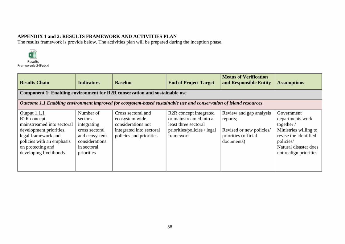
58
APPENDIX 1 and 2: RESULTS FRAMEWORK AND ACTIVITIES PLAN
The results framework is provide below. The activities plan will be prepared during the inception phase.
Results
Framework-24Feb.xlsx
Results Chain Indicators Baseline End of Project Target
Means of Verification
and Responsible Entity Assumptions
Component 1: Enabling environment for R2R conservation and sustainable use
Outcome 1.1 Enabling environment improved for ecosystem-based sustainable use and conservation of island resources
Output 1.1.1
R2R concept
mainstreamed into sectoral
development priorities,
legal framework and
policies with an emphasis
on protecting and
developing livelihoods
Number of
sectors
integrating
cross sectoral
and ecosystem
considerations
in sectoral
priorities
Cross sectoral and
ecosystem wide
considerations not
integrated into sectoral
policies and priorities
R2R concept integrated
or mainstreamed into at
least three sectoral
priorities/policies / legal
framework
Review and gap analysis
reports;
Revised or new policies/
priorities (official
documents)
Government
departments work
together /
Ministries willing to
revise the identified
policies/
Natural disaster does
not realign priorities

59
Results Chain Indicators Baseline End of Project Target
Means of Verification
and Responsible Entity Assumptions
Output 1.1.2
National level
coordination mechanism
developed for cross-
sectoral decision-making
(including on PAs)
Number of
national cross
sectoral
coordination
and decision
making
mechanism
present
No effective mechanism
exists for cross sectoral
decision making
At least one cross
sectoral coordination
mechanism established
and functional
Analysis, review,
consultation reports
ToR of the coordination
mechanism
Cross sectoral decision
making functioning (e.g.
effective facilitation of
decisions on R2R and
cross-sectoral strategies)
PA strategy
Willingness and
cooperation of
relevant Ministries
and Island Councils
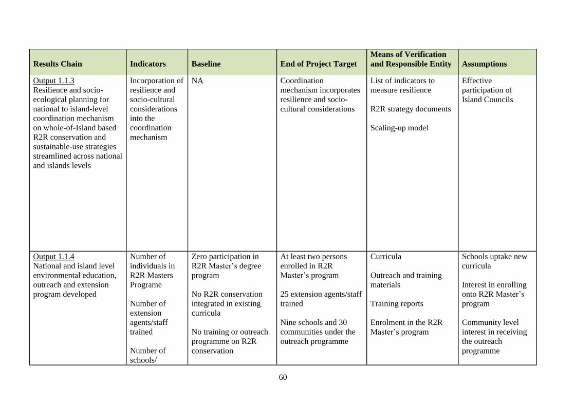
60
Results Chain Indicators Baseline End of Project Target
Means of Verification
and Responsible Entity Assumptions
Output 1.1.3
Resilience and socio-
ecological planning for
national to island-level
coordination mechanism
on whole-of-Island based
R2R conservation and
sustainable-use strategies
streamlined across national
and islands levels
Incorporation of
resilience and
socio-cultural
considerations
into the
coordination
mechanism
NA Coordination
mechanism incorporates
resilience and socio-
cultural considerations
List of indicators to
measure resilience
R2R strategy documents
Scaling-up model
Effective
participation of
Island Councils
Output 1.1.4
National and island level
environmental education,
outreach and extension
program developed
Number of
individuals in
R2R Masters
Programe
Number of
extension
agents/staff
trained
Number of
schools/
Zero participation in
R2R Master’s degree
program
No R2R conservation
integrated in existing
curricula
No training or outreach
programme on R2R
conservation
At least two persons
enrolled in R2R
Master’s program
25 extension agents/staff
trained
Nine schools and 30
communities under the
outreach programme
Curricula
Outreach and training
materials
Training reports
Enrolment in the R2R
Master’s program
Schools uptake new
curricula
Interest in enrolling
onto R2R Master’s
program
Community level
interest in receiving
the outreach
programme

61
Results Chain Indicators Baseline End of Project Target
Means of Verification
and Responsible Entity Assumptions
communities
under the
outreach
programme
Component 2: Implementation of R2R conservation and sustainable use strategies
Outcome 2.1 National management system for ecosystem-based sustainable use and conservation of island resources established to deliver SFM,
LD, and BD benefits
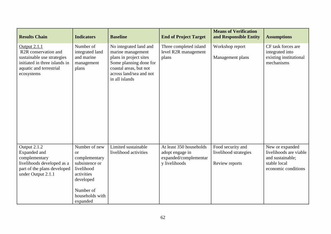
62
Results Chain Indicators Baseline End of Project Target
Means of Verification
and Responsible Entity Assumptions
Output 2.1.1
R2R conservation and
sustainable use strategies
initiated in three islands in
aquatic and terrestrial
ecosystems
Number of
integrated land
and marine
management
plans
No integrated land and
marine management
plans in project sites
Some planning done for
coastal areas, but not
across land/sea and not
in all islands
Three completed island
level R2R management
plans
Workshop report
Management plans
CF task forces are
integrated into
existing institutional
mechanisms
Output 2.1.2
Expanded and
complementary
livelihoods developed as a
part of the plans developed
under Output 2.1.1
Number of new
or
complementary
subsistence or
livelihood
activities
developed
Number of
households with
expanded
Limited sustainable
livelihood activities
At least 350 households
adopt engage in
expanded/complementar
y livelihoods
Food security and
livelihood strategies
Review reports
New or expanded
livelihoods are viable
and sustainable;
stable local
economic conditions

63
Results Chain Indicators Baseline End of Project Target
Means of Verification
and Responsible Entity Assumptions
livelihood
opportunities
Output 2.1.3
R2R conservation and use
strategies across land and
sea implemented at three
target islands (through the
integrated plans)
Number of
hectares of
agroforestry
sites established
Number of
hectares of
forests restored
Number of
hectares of
marine area
under co-
management as
new PAs
350 ha
0
0
828 ha under
agroforestry
232 hectares under SFM
22 417 hectares of
marine area under co-
management as three
new PAs
Nursery records
Planting records
Site assessment reports
Community reports
Targeted
communities sustain
their interest to
participate
community-based
management support
by local and national
government
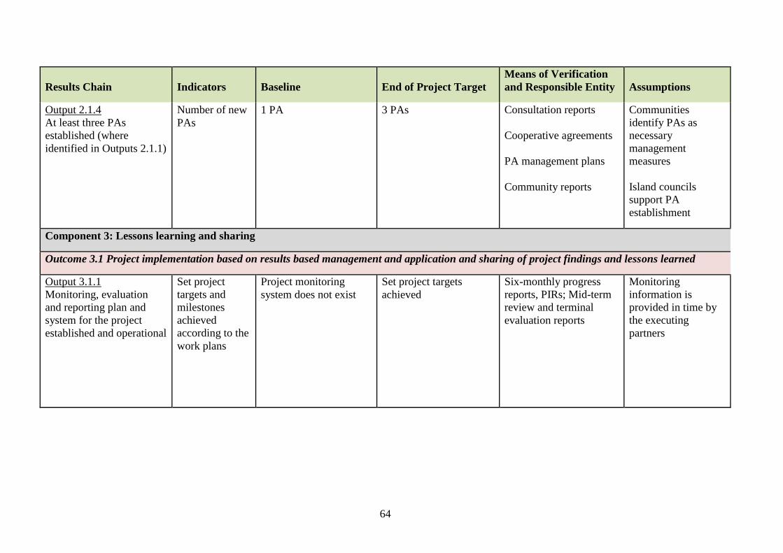
64
Results Chain Indicators Baseline End of Project Target
Means of Verification
and Responsible Entity Assumptions
Output 2.1.4
At least three PAs
established (where
identified in Outputs 2.1.1)
Number of new
PAs
1 PA 3 PAs Consultation reports
Cooperative agreements
PA management plans
Community reports
Communities
identify PAs as
necessary
management
measures
Island councils
support PA
establishment
Component 3: Lessons learning and sharing
Outcome 3.1 Project implementation based on results based management and application and sharing of project findings and lessons learned
Output 3.1.1
Monitoring, evaluation
and reporting plan and
system for the project
established and operational
Set project
targets and
milestones
achieved
according to the
work plans
Project monitoring
system does not exist
Set project targets
achieved
Six-monthly progress
reports, PIRs; Mid-term
review and terminal
evaluation reports
Monitoring
information is
provided in time by
the executing
partners

65
Results Chain Indicators Baseline End of Project Target
Means of Verification
and Responsible Entity Assumptions
Output 3.1.2
Project related
‘knowledge’ captured and
shared
Knowledge and
communication
products
NA A project publication (in
a format relevant to local
stakeholders) with the
results and lessons
documented
At least 5
Workshop report; Project
newsletters; Publication;
PacIW:LEARN Website
Communication strategy
Project
implementation is
successful

66
67
APPENDIX 3: PROJECT BUDGET
Budget.xlsx
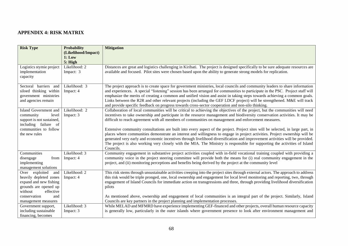
68
APPENDIX 4: RISK MATRIX
Risk Type Probability
(Likelihood/Impact)
1: Low
5: High
Mitigation
Logistics stymie project
implementation
capacity
Likelihood: 2
Impact: 3
Distances are great and logistics challenging in Kiribati. The project is designed specifically to be sure adequate resources are
available and focused. Pilot sites were chosen based upon the ability to generate strong models for replication.
Sectoral barriers and
siloed thinking within
government ministries
and agencies remain
Likelihood: 3
Impact: 4
The project approach is to create space for government ministries, local councils and community leaders to share information
and experiences. A special “listening” session has been arranged for communities to participate in the PSC. Project staff will
emphasize the merits of creating a common and unified vision and assist in taking steps towards achieving a common goals.
Links between the R2R and other relevant projects (including the GEF LDCF project) will be strengthened. M&E will track
and provide specific feedback on progress towards cross-sector cooperation and non-silo thinking.
Island Government and
community level
support is not sustained,
including failure of
communities to follow
the new rules
Likelihood: 2
Impact: 3
Collaboration of local communities will be critical to achieving the objectives of the project, but the communities will need
incentives to take ownership and participate in the resource management and biodiversity conservation activities. It may be
difficult to reach agreement with all members of communities on management and enforcement measures.
Extensive community consultations are built into every aspect of the project. Project sites will be selected, in large part, in
places where communities demonstrate an interest and willingness to engage in project activities. Project ownership will be
generated very early and economic incentives through livelihood diversification and improvement activities will be provided.
The project is also working very closely with the MIA. The Ministry is responsible for supporting the activities of Island
Councils.
Communities
disengage from
implementing
management solutions
Likelihood: 3
Impact: 4
Community engagement in substantive project activities coupled with in-field vocational training coupled with providing a
community voice in the project steering committee will provide both the means for (i) real community engagement in the
project, and (ii) monitoring perceptions and benefits being derived by the project at the community level
Over exploited and
heavily depleted zones
expand and new fishing
grounds are opened up
without effective
conservation and
management measures
Likelihood: 2
Impact: 4
This risk stems through unsustainable activities creeping into the project sites through external actors. The approach to address
this risk would be triple pronged, one, local ownership and engagement for local level monitoring and reporting, two, through
engagement of Island Councils for immediate action on transgressions and three, through providing livelihood diversification
pilots
As mentioned above, ownership and engagement of local communities is an integral part of the project. Similarly, Island
Councils are key partners in the project planning and implementation processes.
Government support,
including sustainable
financing, becomes
Likelihood: 3
Impact: 3
While MELAD and MFMRD have experience implementing GEF-financed and other projects, overall human resource capacity
is generally low, particularly in the outer islands where government presence to look after environment management and

69
Risk Type Probability
(Likelihood/Impact)
1: Low
5: High
Mitigation
inconsistent with long
term project objectives
protection, is nearly non-existent. Government budgets are fairly low, which could present problems if already low budgets are
reduced due to changes in national budget allocations.
Significant capacity-building activities, for government and stakeholders alike, are included in the project to address capacity
gaps. Project management will closely monitor government budget allocations in order to flag and potential shortfalls as soon
as possible, so that corrective measures can be taken as needed to ensure continued implementation of project activities
Climate change
negatively impacts
project outcomes
Likelihood: 2
Impact: 3
Sea level rise, storm surge, and variable rainfall patterns may cause communities to migrate to other areas, potentially disrupting
community-led activities. The project is designed specifically to improve resilience to climate change. The likelihood of
short-term impacts is low.

70
APPENDIX 5: ENVIRONMENTAL AND SOCIAL SCREENING CHECKLIST
Would the project, if implemented? Not
Applicable No Yes Unknown
I. FAO VISION/STRATEGIC OBJECTIVES
Be in line with FAO’s vision? Y
Be supportive of FAO’s strategic objectives? Y
II. FAO KEY PRINCIPLES FOR SUSTAINABILITY IN FOOD AND AGRICULTURE
Improve efficiency in the use of resources? Y
Conserve, protect and enhance natural resources? Y
Protect and improve rural livelihoods and social well-being? Y
Enhance resilience of people, communities and ecosystems? Y
Include responsible and effective governance mechanisms? Y
ESS 1 NATURAL RESOURCES MANAGEMENT
❖ Management of water resources and small dams
Include an irrigation scheme that is more than 20 hectares or withdraws more than 1000 m3/day of water? NA
Include an irrigation scheme that is more than 100 hectares or withdraws more than 5000 m3/day of water? NA
Include an existing irrigation scheme? NA
Include an area known or expected to have water quality problems? NA
Include usage of non-conventional sources of water (i.e. wastewater)? NA
Include a dam that is more than 5 m. in height? NA
Include a dam that is more than 15 m. in height? NA
Include measures that build resilience to climate change? NA
❖ Tenure
Negatively affect the legitimate tenure rights of individuals, communities or others4? N
ESS 2 BIODIVERSITY, ECOSYSTEMS AND NATURAL HABITATS
Make reasonable and feasible effort to avoid practices that could have a negative impact on biodiversity, including
agricultural biodiversity and genetic resources?
Y
Have biosafety provisions in place? NA
Respect access and benefit-sharing measures in force? Y
Safeguard the relationships between biological and cultural diversity? Y
❖ Protected areas, buffer zones and natural habitats
Be located such that it poses no risk or impact to protected areas, critical habitats and ecosystem functions? Y
4 In accordance with Voluntary Guidelines on the Responsible Governance of Tenure of Land, Fisheries and Forests in the Context of National Food Security (VGGT )
http://www.fao.org/docrep/016/i2801e/i2801e.pdf

71
Would the project, if implemented? Not
Applicable No Yes Unknown
ESS 3 PLANT GENETIC RESOURCES FOR FOOD AND AGRICULTURE
❖ Planted forests
Have a credible forest certification scheme, national forest programmes or equivalent or use the Voluntary Guidelines on
Planted Forests (or an equivalent for indigenous forests)?
NA
ESS 4 ANIMAL - LIVESTOCK AND AQUATIC- GENETIC RESOURCES FOR FOOD AND AGRICULTURE
Involve the procurement or provision of pesticides? NA
❖ Aquatic genetic resources
Adhere (Aligned) to the FAO Code of Conduct for Responsible Fisheries (CCRF) and its related negotiated instruments? Y
Be aligned, where applicable, with FAO’s strategic policies established in the FAO Technical Guidelines for Responsible
Fisheries (including aquaculture)?
NA
❖ Livestock genetic resources
Be aligned with the Livestock Sector Strategy including the animal disease, public health and land degradation
provisions? NA
ESS 5 PEST AND PESTICIDES MANAGEMENT
Involve the procurement or provision of pesticides? N
Result in increased use of pesticides through expansion or intensification of production systems? N
Require the disposal of pesticides or pesticide contaminated materials? N
ESS 6 INVOLUNTARY RESETTLEMENT AND DISPLACEMENT
Avoid the physical and economic displacement of people? Y
ESS 7 DECENT WORK
Adhere to FAO’s guidance on decent rural employment, promoting more and better employment opportunities and
working conditions in rural areas and avoiding practices that could increase workers’ vulnerability?
Y
Respect the fundamental principles and rights at work and support the effective implementation of other international
labour standards, in particular those that are relevant to the agri-food sector?
Y
ESS 8 GENDER EQUALITY
Have the needs, priorities and constraints of both women and men been taken into consideration? Y
Promote women’s and men’s equitable access to and control over productive resources and services? Y
Foster their equal participation in institutions and decision-making processes? Y
ESS 9 INDIGENOUS PEOPLES AND CULTURAL HERITAGE
Are there any indigenous communities in the project area? Y
Are project activities likely to have adverse effects on indigenous peoples’ rights, lands, natural resources, territories,
livelihoods, knowledge, social fabric, traditions, governance systems, and culture or heritage (tangible and intangible)?
N
Are indigenous communities outside the project area likely to be affected by the project? N
Designed to be sensitive to cultural heritage issues? NA

72
APPENDIX 6. TERMS OF REFERENCE
Draft5
Chief Technical Advisor
Under the overall supervision of the FAO Subregional Coordinator, and the direct supervision
of the Lead Technical Officer (LTO), the Chief Technical Advisor (CTA) will act as the leader
of the Project’s Coordination Unit (PMU) and will be responsible for leading, supervising and
coordinating all activities aimed at the successful implementation of the three project
components, budget execution, team management, and maintenance of institutional
relationships with project partners. The CTA will be responsible for overall and annual
planning, the preparation of contracts and agreements with organizations and consultants,
technical supervision of the PMU members and advisers, and the daily management of the
project.
Main responsibilities
• Direct the execution of the project’s technical and administrative activities, with support
from the National Project Coordinator (NPC), with LTO technical supervision at the
Subregional Office and FAO Headquarters in Rome.
• Coordinate and participate in the start-up workshop, and the planning workshops with local
stakeholders and project partners for the preparation of the Annual Work Plan(s) and
Budget(s) (AWP/B).
• Provide technical assistance and guide project partners in the implementation of activities
related to the project.
• Periodically conduct supervisory visits in the field and advise the technical personnel of the
project partners.
• Permanent coordination and communication with project partners’ personnel in charge of
project activities.
• Monitor risks according to the risk matrix (see APPENDIX 4) and ensure the
implementation of mitigation measures.
• Prepare the Project Progress Reports (PPRs) and the Terminal Report (TR) in coordination
with the project team and submit it for the consideration and review of the LTO and the
Project Steering Committee (PSC).
• Provide input to the Annual Project Implementation Review(s) (PIR) to be finalized by the
BH.
• Advise project partners in the preparation of reports on in-kind and in-cash cofinancing
provided by co-financiers and other partners that were not foreseen in the Project Document.
• In consultation with the PSC, the FAO Evaluation Office, the LTO and the FAO-GEF
Coordination Unit, assist in organizing the mid-term evaluation/review and final evaluation.
• Coordinate the review and approval of the terms of reference and technical specifications,
in order to proceed to the corresponding contracts.
• Coordinate work plans with the consultants hired to implement the project.
• Organize and serve as Secretary for the PSC and Liaison Committee meetings.
• Make the necessary arrangements to facilitate—through agreements and interagency
partnerships with local or national government bodies, as well as the private sector—the
development of the project and the achievement of its outcomes.
• Ensure technical compliance with project objective, outcomes and outputs, and follow the
monitoring and evaluation plan prepared by the M&E Expert.
5 NPC and Consultants’ Terms of Reference will be developed and validated during the project’s inception.

73
• Coordinate the implementation of the project’s communication strategy and the institutional
strengthening activities.
Required professional profile
• Advanced degree in a field related to the project (natural resource management, forestry,
fisheries etc.).
• Minimum of five years’ experience in the management of projects in natural resource
management sector
• Minimum of three years’ experience in coordinating development projects or components
financed by international organizations.
• Experience in the coordination of multidisciplinary teams.
• Knowledge and experience in results-based management, development and
implementation of budgets, preparation of technical and financial reports, and monitoring
and evaluation.
• Ability to prepare concise reports according to United Nations standards.
• Knowledge and use of participatory planning tools.
• Knowledge of the socioeconomic reality of Kiribati and the problems of gender equality.
• Proven ability to lead a team and capacity for teamwork.
• Excellent oral and written skills.
• Experience managing GEF projects desired.
• Experience in implementation and evaluation of FAO projects desired.
• Previous project management experience in Small Island Developing States would be an
asset
• Availability to travel frequently to the project sites.
Duration: 36 months
Location: Tarawa and with frequent travel to the areas covered by the project.
Languages: English

74
Operations and Administration Officer
Under the direct supervision of the FAO BH and in consultation with the PC, the Operations
and Administrative Officer (note: might be two separate positions) will have the following
responsibilities and functions:
- Ensure smooth and timely implementation of project activities in support of the results-
based work plan, through operational and administrative procedures according to FAO
rules and standards;
- Coordinate the project operational arrangements through contractual agreements with
key project partners;
- Arrange the operations needed for signing and executing Letters of Agreement (LoA)
with relevant project partners;
- Maintain inter-departmental linkages with FAO units for donor liaison, Finance, Human
Resources, and other units as required;
- Day-to-day manage the project budget, including the monitoring of cash availability,
budget preparation and budget revisions to be reviewed by the PC;
- Ensure the accurate recording of all data relevant for operational, financial and results-
based monitoring;
- Ensure that relevant reports on expenditures, forecasts, progress against work plans,
project closure, are prepared and submitted in accordance with FAO and GEF defined
procedures and reporting formats, schedules and communications channels, as required;
- Execute accurate and timely actions on all operational requirements for personnel-
related matters, equipment and material procurement, and field disbursements;
- Participate and represent the project in collaborative meetings with project partners and
the Project Steering Committee, as required;
- Undertake missions to monitor the outputs-based budget, and to resolve outstanding
operational problems, as appropriate;
- Be responsible for results achieved within her/his area of work and ensure issues
affecting project delivery and success are brought to the attention of higher level
authorities through the BH in a timely manner;
- In consultation with FAO Evaluation Office, the LTU, and FAO-GEF Coordination
Unit, support the organization of the mid-term evaluation/review and final evaluation,
and provide inputs regarding project budgetary matters;
- Provide inputs and maintain the FPMIS systems up-to-date; and
- Undertake any other duties as required.
Qualifications
- University Degree in Economics, Business Administration, or related fields;
- Five years of experience in project operation and management related to natural
resources management, including field experience in developing countries;
- Proven capacity to work and establish working relationships with government and non-
government representatives;

75
- Excellent English language skills; and
- Knowledge of FAO’s project management systems (desirable).
Socioeconomic Consultant (the funds for recruiting this consultant will come from the PPG
funds)
Under the overall supervision of the FAO Sub-regional Coordinator and direct supervision of the Lead
Technical Officer (LTO), the consultant will lead and conduct a baseline survey, with the following
responsibilities;
Responsibilities
• Through surveys and interviews, site assessments and reviews of national socioeconomic
statistics (social surveys, population censuses, etc.), collect baseline socioeconomic

76
information at project sites and elaborate proposals for gender mainstreaming and
participation in project activities.
• Identify and enumerate project beneficiaries at target sites (including enumeration by gender)
and collect information on resource based subsistence/livelihood activities
• Discuss with local community members what they perceive as the potential impacts of the
project and identify ways in which the project might contribute to local development needs
• On the basis of the above consultations and analysis, develop recommendations for gender
mainstreaming, active engagement of youth and ensuring the project adheres to the 4 pillars of
Decent Work
Expected outputs
• Socio-economic assessment report for the project sites (with clear socio-economic data)
• Project Strategy to mainstream gender and engage youth (including specifc indicators on gender
and youth)
• A brief plan to ensure that the project activities adhere to the 4 pillars of Decent Work Agenda
Required professional profile
• Master’s degree in social sciences or a related area
• At least 10 years of work experience related to socio-economic analysis
• Thorough familiarity and proven experience in socio-economic data collection
• Familiarity with forestry/fisheries/natural resource managements issues in SIDS context
• Fluency in English language and good writing skills
* Specific ToRs for other short term consultants will be developed by the CTA, based upon
the guidance of this document.

77
APPENDIX 7. MAPS
North Tarawa
Tabiteuea

78
Butaritari
Enhancing national food security in the context of global climate change

79
APPENDIX 8. Quantifying Carbon Benefits
Three forest and agroforestry management regimes are considered to generate carbon benefits
through the project. The narrative of these regimes and intervention scenarios are as follows:
1) Mangrove restoration: Project activities will be carried out for 82 ha of degraded
mangrove forests in three target islands. Based on the most recent reliable data (Metz,
1996), the mangrove area consists of 258 ha. The project will, thus, cover 32% (or 82
ha) of the total mangrove forests in Kiribati. The mangroves are one of three
categories of forests found in Kiribati, along with coconut and woodland, and have
been playing important roles such as stabilising tidal-zone soils, reducing the impact
of storm surge, providing habitat and sources of food, and regulating marine
pollution. The project will restore 82 ha of mangrove forests through planting and
assisting natural regeneration from project year 3. The areas for indirect Greenhouse
Gas (GHG) emission mitigation potential are assumed as 50 ha of mangrove forest.
2) Natural forest conservation and rehabilitation: The project will conserve and
rehabilitate 150 ha of natural woodland and shrubs through forest area conservation
and assisted natural regeneration. Conservation of forest will be promoted by e.g.
mainstreaming of Ridge-to-Reef (R2R) legal framework and policies (Output 1.1.1),
R2R conservation and sustainable use strategies (Output 2.1.1), and establishment of
protected areas (Output 2.1.4).. The woodland and shrubs provide food and housing
materials for the local communities. The 100 ha of forest rehabilitation activities will
be launched in project year 3 and further 50 ha of natural woodland will be included
in project year 4. The areas for indirect GHG emission mitigation potential are
assumed as 150 ha of natural woodland.
3) Agroforestry production: The main project interventions related to carbon benefit
are to rehabilitate coconut production system by establishing 414 ha of agroforestry
sites in project year 3 and additional 414 ha of agroforestry in project year 4 Coconut
is considered as a significant source for income generation and food security,
however, ca. 40% of coconut population remain senile. These sites will also use alley
cropping patterns combining pandanus and fruit trees (banana). The introduced
Agroforestry system will also be combined with vegetable gardening and poultry
production.
The carbon benefits from the project are estimated in terms of lifetime direct as well as
indirect GHG emission avoided over the default time horizon of 20 years under the IPCC
guideline and the guidance of the GEF Tracking Tools. For this project, the durations of
implementation phase and the capitalization phase are defined as 5 years and 15 years,
respectively. The carbon benefits are calculated using EX-Ante Carbon Balance Tool (EX-
ACT).
Direct lifetime GHG emission avoided
In the GEF Tracking Tool for Climate Change Mitigation projects, direct lifetime GHG
emissions avoided are the emissions reductions attributable to the investments made during
the project's supervised implementation period, totalled over the respective lifetime of the
investments. The following variables and assumptions are used for the calculation. The EX-
ACT results file is available:
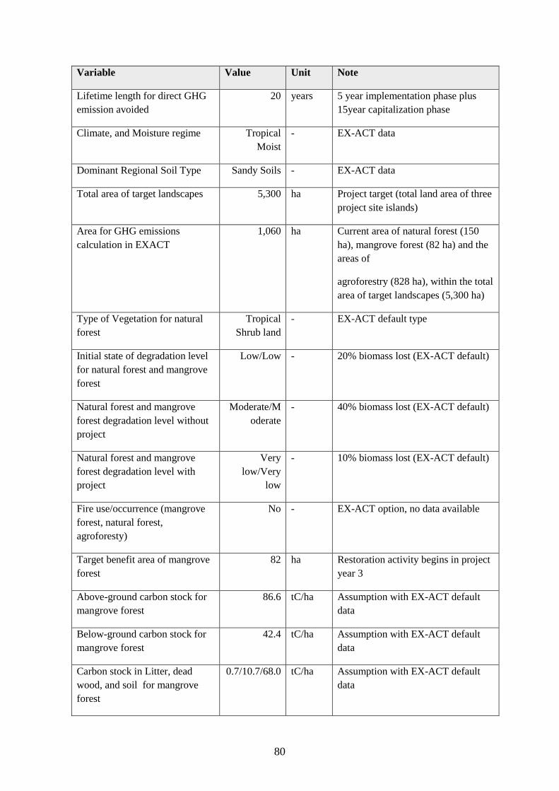
80
Variable Value Unit Note
Lifetime length for direct GHG
emission avoided
20 years 5 year implementation phase plus
15year capitalization phase
Climate, and Moisture regime Tropical
Moist
- EX-ACT data
Dominant Regional Soil Type Sandy Soils - EX-ACT data
Total area of target landscapes 5,300 ha Project target (total land area of three
project site islands)
Area for GHG emissions
calculation in EXACT
1,060 ha Current area of natural forest (150
ha), mangrove forest (82 ha) and the
areas of
agroforestry (828 ha), within the total
area of target landscapes (5,300 ha)
Type of Vegetation for natural
forest
Tropical
Shrub land
- EX-ACT default type
Initial state of degradation level
for natural forest and mangrove
forest
Low/Low - 20% biomass lost (EX-ACT default)
Natural forest and mangrove
forest degradation level without
project
Moderate/M
oderate
- 40% biomass lost (EX-ACT default)
Natural forest and mangrove
forest degradation level with
project
Very
low/Very
low
- 10% biomass lost (EX-ACT default)
Fire use/occurrence (mangrove
forest, natural forest,
agroforesty)
No - EX-ACT option, no data available
Target benefit area of mangrove
forest
82 ha Restoration activity begins in project
year 3
Above-ground carbon stock for
mangrove forest
86.6 tC/ha Assumption with EX-ACT default
data
Below-ground carbon stock for
mangrove forest
42.4 tC/ha Assumption with EX-ACT default
data
Carbon stock in Litter, dead
wood, and soil for mangrove
forest
0.7/10.7/68.0 tC/ha Assumption with EX-ACT default
data

81
Target benefit area of natural
forest
150 ha Conservation and rehabilitation with
assisted natural regeneration
activities implemented from project
year 3
Above-ground carbon stock for
natural forest
32.9 tC/ha Assumption with EX-ACT default
data
Below-ground carbon stock for
natural forest
13.2 tC/ha Assumption with EX-ACT default
data
Carbon stock in Litter, dead
wood and soil for natural forest
3.65/0/39.0 tC/ha Assumption with EX-ACT default
data
Target benefit area of
agroforestry system
828 ha Rehabilitation of coconut, combined
with gardening and poultry
production begin from project year 3
Above-ground growth rate of
coconut agroforestry
2.1 tC/ha/yr Tier 2 value from FAO agroforestry
database: Schiettecatte, per. com.
Below-ground growth rate of
coconut agroforestry
0.5 tC/ha/yr Tier 2 value from FAO agroforestry
database: Schiettecatte, per. com.
The estimated values of direct lifetime GHG emission avoided during 20 years (5 years of
implementation phase and 15 years of capitalization phase) are as follows:
Management regime Area (ha) Direct lifetime GHG
emission avoided (tCO2eq)
Mangrove restoration 82 15,350
Natural forest conservation and
rehabilitation 150 11,017
Agroforestry production 828 140,263
TOTAL 1,060 166,630
The direct lifetime GHG emission mitigation potential from the project is estimated as
166,630 tCO2eq, which is equivalent to 7.9 tCO2eq per hectare per year in the considered
biome and time frame.
Table below provides the details of the direct lifetime GHG fluxes as calculated with the EX-
ACT during 20 years of project lifetime:

82
Project Name Kiribati Climate Tropical (Moist) Duration of the Project (Years) 20
Continent Oceania Dominant Regional Soil Type Sandy Soils Total area (ha) 1060
Gross fluxes Share per GHG of the Balance Result per year
Without With Balance All GHG in tCO2eq Without With Balance
All GHG in tCO2eq CO2 N2O CH4
Positive = source / negative = sink Biomass Soil Other
Land use changes CO2-BiomassCO2-Soil CO2-OtherN2O CH4
Deforestation 0 0 0 0 0 0 0 0 0 0
Afforestation 0 0 0 0 0 0 0 0 0 0
Other LUC 0 0 0 0 0 0 0 0 0 0
Agriculture
Annual 0 0 0 0 0 0 0 0 0 0
Perennial -11,592 -151,855 -140,263 -140,263 0 0 0 -580 -7,593 -7,013
Rice 0 0 0 0 0 0 0 0 0 0
Grassland & Livestocks
Grassland 0 0 0 0 0 0 0 0 0 0
Livestocks 0 0 0 0 0 0 0 0
Degradation & Management 17,578 -8,789 -26,367 -20,868 -5,499 0 0 879 -439 -1,318
Coastal wetlands 0 0 0 0 0 0 0 0 0 0
Inputs & Investments 0 0 0 0 0 0 0 0 0
Fishery & Aquaculture 0 0 0 0 0 0 0 0 0
Total 5,986 -160,644 -166,630 -161,131 -5,499 0 0 0 299 -8,032 -8,332
Per hectare 6 -152 -157 -152.0 -5.2 0.0 0.0 0.0
Per hectare per year 0.3 -7.6 -7.9 -7.6 -0.3 0.0 0.0 0.0 0.3 -7.6 -7.9
Fluxes per component Balance per component
Total without and with project and balance Share of the balance per GHG (plus origin for CO2)
Evolutions of land use / category (hectares - ha) Uncertainty level
Initial State Without project With project % of uncertainty
Forest/Plantation 232 232 232
Annual 0 0 0 Without 5,986 33.1
Agriculture Perennial 828 828 828 With -160,644 21.7
Rice 0 0 0
Grassland 0 0 0 Net balance -166,630 24.6
Other lands Degraded 0 0 0
Other 0 0 0
Wetlands 0 0 0
Total area (ha) 1,060 1,060 1,060
Components of the project
Gross fluxes
Detailed matrices of
changes
-160,000
-140,000
-120,000
-100,000
-80,000
-60,000
-40,000
-20,000
0
20,000Without
With
-160,000
-140,000
-120,000
-100,000
-80,000
-60,000
-40,000
-20,000
0
Balance
-180,000
-160,000
-140,000
-120,000
-100,000
-80,000
-60,000
-40,000
-20,000
0
CO2-Biomass CO2-Soil CO2-Other N2O CH4
-180,000
-160,000
-140,000
-120,000
-100,000
-80,000
-60,000
-40,000
-20,000
0
20,000
Without With Balance

83
Indirect lifetime GHG emission avoided
To date there is very little reliable baseline information, both qualitative and quantitative,
available in Kiribati to calculate the indirect lifetime GHG emission avoided. During the early
implementation period, the project will conduct necessary baseline surveys, including the
assessment of potential target areas for the scaling-up purposes. Currently additional 150 ha of
natural forest areas and 50 ha of mangrove forest have been expected to be intervened after
the project and considered under indirect lifetime GHG emission avoided scenario. Indirect
target benefit area of agroforestry system remains the same as the direct project intervention
area (828 ha). The total area considered for the indirect lifetime GHG emissions calculation is
1260 ha. For the estimation of indirect lifetime GHG emission avoided during 20 years (5
years of implementation phase and 15 years of capitalization phase), the following variables
and assumptions are used for the calculation:
Variable Value Unit Note
Lifetime length for direct GHG
emission avoided
20 years 5 year implementation phase plus
15year capitalization phase
Climate, and Moisture regime Tropical
Moist
- EX-ACT data
Dominant Regional Soil Type Sandy Soils - EX-ACT data
Total area of target landscapes 5,300 ha Project target (total land area of three
project site islands)
Indirect potential natural forest
area via forest conservation and
assisted regeneration in addition
to the direct project intervention
area
150 ha Natural forest
Indirect potential mangrove
forest area via forest
conservation and assisted
regeneration in addition to the
direct project intervention area
50 ha Mangrove forest
Area for GHG emissions
calculation in EXACT
1,260 ha Current area of natural forest (300
ha), mangrove forest (132 ha) and the
areas of agroforestry (828 ha), within
the total area of target landscapes
(5,300 ha)
Type of Vegetation for natural
forest
Tropical
Shrub land
- EX-ACT default type
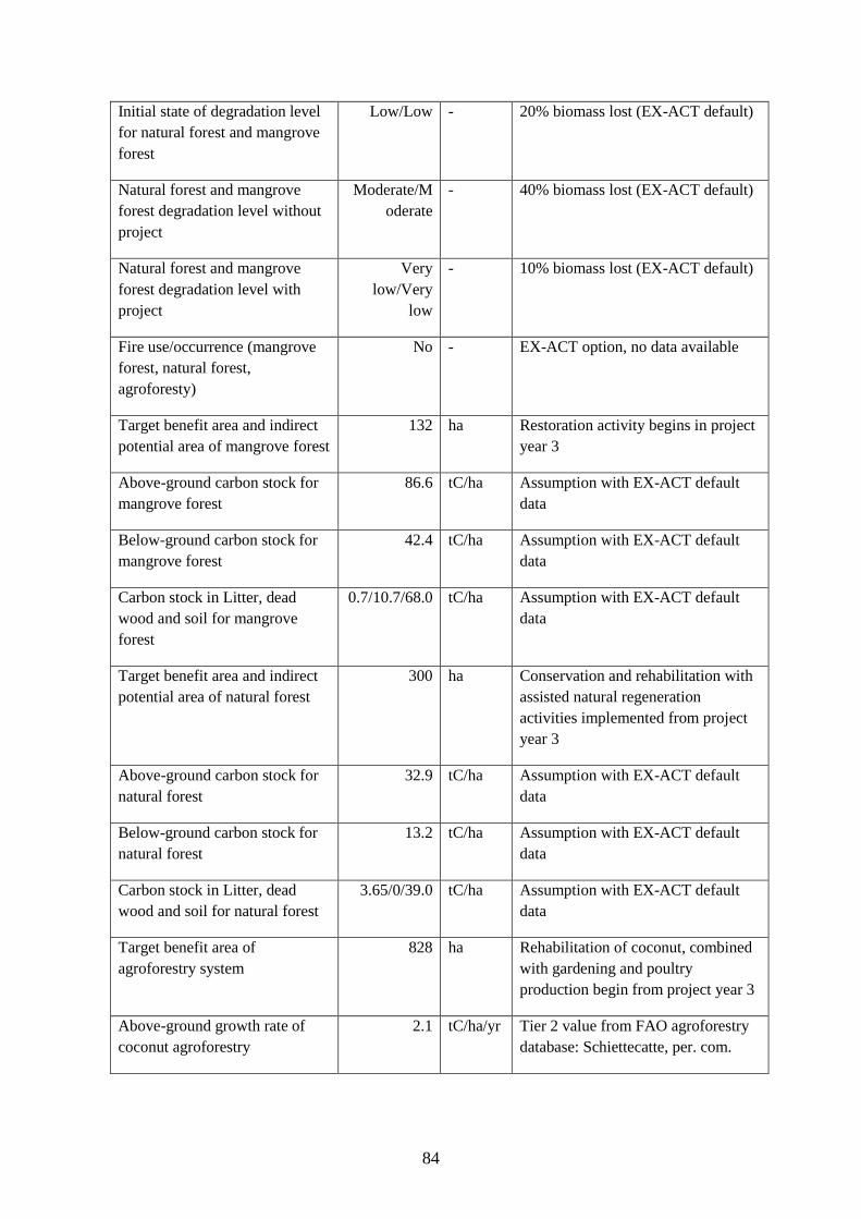
84
Initial state of degradation level
for natural forest and mangrove
forest
Low/Low - 20% biomass lost (EX-ACT default)
Natural forest and mangrove
forest degradation level without
project
Moderate/M
oderate
- 40% biomass lost (EX-ACT default)
Natural forest and mangrove
forest degradation level with
project
Very
low/Very
low
- 10% biomass lost (EX-ACT default)
Fire use/occurrence (mangrove
forest, natural forest,
agroforesty)
No - EX-ACT option, no data available
Target benefit area and indirect
potential area of mangrove forest
132 ha Restoration activity begins in project
year 3
Above-ground carbon stock for
mangrove forest
86.6 tC/ha Assumption with EX-ACT default
data
Below-ground carbon stock for
mangrove forest
42.4 tC/ha Assumption with EX-ACT default
data
Carbon stock in Litter, dead
wood and soil for mangrove
forest
0.7/10.7/68.0 tC/ha Assumption with EX-ACT default
data
Target benefit area and indirect
potential area of natural forest
300 ha Conservation and rehabilitation with
assisted natural regeneration
activities implemented from project
year 3
Above-ground carbon stock for
natural forest
32.9 tC/ha Assumption with EX-ACT default
data
Below-ground carbon stock for
natural forest
13.2 tC/ha Assumption with EX-ACT default
data
Carbon stock in Litter, dead
wood and soil for natural forest
3.65/0/39.0 tC/ha Assumption with EX-ACT default
data
Target benefit area of
agroforestry system
828 ha Rehabilitation of coconut, combined
with gardening and poultry
production begin from project year 3
Above-ground growth rate of
coconut agroforestry
2.1 tC/ha/yr Tier 2 value from FAO agroforestry
database: Schiettecatte, per. com.

85
Below-ground growth rate of
coconut agroforestry
0.5 tC/ha/yr Tier 2 value from FAO agroforestry
database: Schiettecatte, per. com.
The estimated values of indirect lifetime GHG emission avoided during 20 years (5 years of
implementation phase and 15 years of capitalization phase) are as follows:
Management regime Area (ha) Direct lifetime GHG
emission avoided (tCO2eq)
Mangrove restoration 132 24,709
Natural forest conservation and
rehabilitation 300 22,035
Agroforestry production 828 140,263
TOTAL 1,260 187,007
The indirect lifetime GHG emission mitigation potential from the project is estimated as
187,007 tCO2eq, which is equivalent to 7.4 tCO2eq per hectare per year in the considered
biome and time frame.
Table below provides the details of the indirect GHG fluxes as calculated with the EX-ACT
during 20 years of project lifetime:

86
Project Name Kiribati Climate Tropical (Moist) Duration of the Project (Years) 20
Continent Oceania Dominant Regional Soil Type Sandy Soils Total area (ha) 1260
Gross fluxes Share per GHG of the Balance Result per year
Without With Balance All GHG in tCO2eq Without With Balance
All GHG in tCO2eq CO2 N2O CH4
Positive = source / negative = sink Biomass Soil Other
Land use changes CO2-BiomassCO2-Soil CO2-OtherN2O CH4
Deforestation 0 0 0 0 0 0 0 0 0 0
Afforestation 0 0 0 0 0 0 0 0 0 0
Other LUC 0 0 0 0 0 0 0 0 0 0
Agriculture
Annual 0 0 0 0 0 0 0 0 0 0
Perennial -11,592 -151,855 -140,263 -140,263 0 0 0 -580 -7,593 -7,013
Rice 0 0 0 0 0 0 0 0 0 0
Grassland & Livestocks
Grassland 0 0 0 0 0 0 0 0 0 0
Livestocks 0 0 0 0 0 0 0 0
Degradation & Management 31,163 -15,581 -46,744 -36,794 -9,950 0 0 1,558 -779 -2,337
Coastal wetlands 0 0 0 0 0 0 0 0 0 0
Inputs & Investments 0 0 0 0 0 0 0 0 0
Fishery & Aquaculture 0 0 0 0 0 0 0 0 0
Total 19,571 -167,437 -187,007 -177,057 -9,950 0 0 0 979 -8,372 -9,350
Per hectare 16 -133 -148 -140.5 -7.9 0.0 0.0 0.0
Per hectare per year 0.8 -6.6 -7.4 -7.0 -0.4 0.0 0.0 0.0 0.8 -6.6 -7.4
Fluxes per component Balance per component
Total without and with project and balance Share of the balance per GHG (plus origin for CO2)
Evolutions of land use / category (hectares - ha) Uncertainty level
Initial State Without project With project % of uncertainty
Forest/Plantation 432 432 432
Annual 0 0 0 Without 19,571 34.9
Agriculture Perennial 828 828 828 With -167,437 22.8
Rice 0 0 0
Grassland 0 0 0 Net balance -187,007 26.8
Other lands Degraded 0 0 0
Other 0 0 0
Wetlands 0 0 0
Total area (ha) 1,260 1,260 1,260
Components of the project
Gross fluxes
Detailed matrices of
changes
-160,000-140,000-120,000-100,000
-80,000-60,000-40,000-20,000
020,00040,000
Without
With
-160,000
-140,000
-120,000
-100,000
-80,000
-60,000
-40,000
-20,000
0
Balance
-180,000
-160,000
-140,000
-120,000
-100,000
-80,000
-60,000
-40,000
-20,000
0
CO2-Biomass CO2-Soil CO2-Other N2O CH4
-200,000
-150,000
-100,000
-50,000
0
50,000
Without With Balance