fargo-moorhead dam safety and public waters work...
TRANSCRIPT

Dam Safety and Work in Public Waters Permit Application 2016-0386; Findings of Fact October 3, 2016 Page 1
STATE OF MINNESOTA DEPARTMENT OF NATURAL RESOURCES
DAM SAFETY AND PUBLIC WATERS WORK PERMIT APPLICATION 2016-0386 FINDINGS OF FACT
In the Matter of the Dam Safety and Public Waters Work Permit Application 2016-0386 for the Fargo-Moorhead Flood Risk Management Project, Clay and Wilkin Counties, Minnesota, and Cass and Richland Counties, North Dakota
) FINDINGS OF FACT ) CONCLUSIONS AND ORDER ) ) ) )
Based upon, and after having considered the entire record of the proceeding, including written reports, written and oral data, information, and statements, the Minnesota Department of Natural Resources (DNR) makes the following:
I. FINDINGS OF FACT
A. Permit Applicant and Application
1. On February 18, 2016, the Minnesota Department of Natural Resources (DNR) received an application for a Dam Safety and Public Waters Work permit, Permit Application 2016-0386 (Permit Application), for the Fargo-Moorhead Flood Risk Management Project (Project) through the MNDNR Permitting and Reporting System (MPARS).
2. The permit applicant is the Flood Diversion Board of Authority (Diversion
Authority), the City of Fargo, North Dakota (ND) and the City of Moorhead, Minnesota (MN) (collectively referred to as the Permit Applicant).
3. The Diversion Authority was created in 2011 when the Cities of Fargo and
Moorhead, along with Cass County (ND), Clay County (MN), the Cass County Joint Water Resources District (CCJWRD)(ND), and the Buffalo-Red River Watershed District (BRRWD)(MN) entered into a joint powers agreement (JPA). The purpose of the JPA is to establish a framework for the planning, design and management of the proposed Project. The Diversion Authority has partnered with the United States Army Corps of Engineers (USACE) to plan, secure funding for, and construct the Project. Ownership, operation, and maintenance of the Project would be the collective responsibility of the Diversion Authority, the City of Moorhead, the City of Fargo, and other potential non-Federal sponsors.
4. In June 2016, the Diversion Authority reconfigured the JPA and as reconfigured
the JPA no longer includes the Buffalo-Red River Watershed District.

Dam Safety and Work in Public Waters Permit Application 2016-0386; Findings of Fact October 3, 2016 Page 2
5. The Permit Application fee of $1,000 was received by the DNR on March 29,
2016.
6. The Permit Application proposes two principal activities that are part of the proposed Project: dam construction and construction of a gated control structure.
7. The Permit Application identifies the parties associated with the Permit Application and includes a description of the Dam Safety – Construction Site (Activity 1), a description of the Diversion Channel Site (Activity 2), a statement of the overall project purpose and need, a brief description of mitigation plans, a description of two alternatives to the proposed project, a rationale for choosing the proposed Project, a description of the impact of the proposed Project to waterbodies, and technical details about the dam and the area of fill features of the proposed Project. The alternatives section references the Federal Environmental Impact Statement (Federal EIS) completed in July 2011 and the State Final EIS (State FEIS) completed in May 2016. Section 3 of the Federal EIS and Section 2 of the State FEIS were attached as part of the Permit Application package. The Permit Application package also included an application cover letter, construction timeline, Red River Control Structure schematic showing where the Red River would be re-routed, a subsurface conditions report, plans for typical sections of the proposed dam embankment, and a preliminary design report.
8. On July 13, 2016, DNR staff met with the Diversion Authority, its consultants, and
the USACE. At that meeting soil boring information was submitted to the DNR Dam Safety Engineer.
9. On July 27, 2016, DNR’s Dam Safety Engineer sent a letter to the Permit Applicant, informing it the Permit Application was incomplete because it failed to include important information from the State FEIS, a land acquisition plan, a mitigation plan, and a risk analysis.
10. On or about September 9, 2016, the Permit Applicant submitted information in
response to the July 27, 2016 letter. 11. On September 15, 2016, DNR met with the Diversion Authority, its consultants,
and the USACE to discuss the September 9, 2016 submittal. 12. In accordance with the requirements of Minn. Stat. § 103G.301, subd. 6 and 7
(2014) and Minn. R. 6115.0250, subp. 2 (2015) the DNR distributed the Permit Application to and requested comments from local units of government in the Project Area. This request for comment was sent on July 27, 2016 through MPARS. The 30-day comment period extended from July 27, 2016 to August 26, 2016. The request for comments was sent to the following jurisdictions: the Cities of Moorhead, Fargo, West Fargo, Horace, Argusville, Comstock, Wolverton, and Oxbow; BRRWD; CCJWRD; Richland County Water Resource District; Clay Soil

Dam Safety and Work in Public Waters Permit Application 2016-0386; Findings of Fact October 3, 2016 Page 3
and Water Conservation District; Wilkin Soil and Water Conservation District; Cass Soil and Water Conservation District; Richland Soil and Water Conservation District Clay County; Cass County (ND); Wilkin County; Richland County; and the townships of Kurtz, Moorhead, Mapleton, Pleasant, Harwood and Warren.
13. A copy of the Permit Application and a request for comments were also sent to
state and federal authorities, including: the USACE; Minnesota DNR Fisheries, Wildlife, Non-Game Wildlife, and Environmental Assessment Units; Minnesota Pollution Control Agency; Minnesota Board of Soil and Water Resources; Minnesota Department of Transportation; North Dakota Department of Health; North Dakota Game and Fish; and North Dakota Department of Transportation. Issues raised during public comment are addressed below in Section I.G.
B. Project Purpose and Need
14. The Project purpose and need set forth in the Permit Application is “to reduce flood risk, flood damages, and flood protection costs related to flooding in the Fargo-Moorhead metropolitan area (F-M metropolitan area).”
15. The Project purpose and need identified in the Permit Application differs from
that in the State FEIS. The Project purpose and need statement in the State FEIS included the following additional specifics:
• Reduce flood risk potential associated with a long history of frequent flooding on local streams including the Red River, Sheyenne, Wild Rice, Maple, Rush and Lower Rush Rivers passing through or into the [F-M metropolitan area);
• Qualify substantial portions of the F-M metropolitan area for 100-year flood accreditation (i.e., meets the standard to be shown on a Flood Insurance Rate Maps (FIRMS) as providing protection) by the Federal Emergency Management Agency (FEMA) under the National Flood Insurance Program (NFIP); and
• Reduce flood risk for floods exceeding the 100-year flood or greater, given the importance of the F-M metropolitan area to the region and recent frequencies of potentially catastrophic flood events.
State FEIS § 1.4.
C. Geographical Setting and Flooding History of Project Location.
16. The F-M metropolitan area lies approximately 12 miles west to 6 miles east of the Red River and from 20 miles north to 20 miles south of Interstate Highway 94. The Red River flows north. Flooding of the Red River typically occurs in late March and early April as a result of spring snowmelt. The Red River has a significant history of flooding that can be attributed to both the local topography and ice conditions on the Red River. The Wild Rice River, Sheyenne River, Maple River, Lower Rush River, and Rush River also contribute to the flood risk within the F-M metropolitan area.

Dam Safety and Work in Public Waters Permit Application 2016-0386; Findings of Fact October 3, 2016 Page 4
17. Because of the size of and conditions in the Red River watershed, the National
Weather Service flood forecast hydrologists are able to provide substantial advance warning of potential flood events. This advance warning has been sufficient to permit effective deployment of necessary emergency measures. Flooding can potentially damage urban and rural infrastructure including transportation throughout portions of the F-M metropolitan area. The F-M metropolitan area is a regional center for healthcare, education, government, and commerce. The Red River has reached the National Weather Service flood warning stage of 18 feet in 48 of the past 114 years. At 18 feet, some street closings are needed in Fargo. At moderate flood stage of 25 feet, flooding begins in Fargo and Moorhead parks and recreation areas along the Red River. At major flood stage of 30 feet, emergency measures become necessary in the F-M metropolitan area. Major flood stage has occurred 16 times over the 114 year period of record. See http://water.weather.gov/ahps2/hydrograph.php?wfo=fgf&gage=FGON8 (Last visited at September 16, 2016).
18. Without the use of emergency measures (e.g., levees, sandbagging), the Project
area would experience approximately 215,000 acres of flooding at various depths for the 100-year flood event. By employing emergency measures for the same flood event, flooding is almost eliminated within the developed parts of the cities of Fargo and Moorhead. Attachment 1: Base No Action vs. No Action with Emergency Measures, 100-year.
19. The USACE estimates that average annual damages (AAD) from floods, assuming no emergency measures and without recent permanent flood damage reduction measures, described in ¶ 21, have the potential to exceed $194.8 million. The DNR was unable to independently verify that number. Using a different method but the same base conditions, DNR prepared an economic impact analysis and found the AAD to be $51 million. DNR cannot determine the reason for the large difference in AAD estimates.
20. The USACE’s AAD method doesn’t account for the use of emergency measures in
certain segments. Emergency measures are regularly undertaken and have been proven successful (e.g., flood of 2009) at preventing flood damage. Therefore, not including emergency measures inflates the AAD.
21. Since the 1997 flood, the Cities of Fargo and Moorhead and surrounding communities have implemented and continue to implement flood risk reduction measures, including: acquiring and removing structures, constructing levees and floodwalls, raising and stabilizing existing levees, installing permanent pump stations, and improving storm sewer lift stations and the sanitary sewer system. Fargo has a flood risk management incentive program that it uses to encourage individual homeowners to reduce their level of flood risk. Additionally, the two cities are constructing, or have constructed, levees and floodwalls with a top elevation of 44.0 feet (referenced to the gage height). This elevation provides protection that exceeds

Dam Safety and Work in Public Waters Permit Application 2016-0386; Findings of Fact October 3, 2016 Page 5
the 100-year flood level of 42.5 feet as determined by an Expert Opinion Elicitation Panel (EOEP).
22. Flood risk reduction projects have been designed for protection at the current
Federal Emergency Management Agency (FEMA) 100-year flood level. Some of the flood risk reduction projects are at elevations above the EOEP 100-year flood elevation, but do not have sufficient free board and/or tie-in elevations for FEMA accreditation under the EOEP hydrology. FEMA accreditation would eliminate the requirement to purchase flood insurance. This means there is actual flood protection up to the 100-year flood event for the vast majority of developed properties under the EOEP hydrology but property owners would still be required to acquire flood insurance. See State FEIS, Appendix N (discussing the differences between flood elevations when applying different hydrology methodologies). There are a number of gaps in permanent flood protection. However, in major flooding events, these gaps have historically been, and could continue to be effectively addressed using emergency measures. Attachment 1.
23. The City of Moorhead is at a higher elevation than Fargo. Moorhead has over
64,000 linear feet of completed or in-progress flood risk reduction projects. The total projected cost for implementing all of the flood risk reduction projects (completed, in-progress and funded) in Moorhead and immediate vicinity is approximately $137 million. Most of the levees have a top elevation of at least 44.0 feet. FEIS § 2.2.2.1.2. With the planned completion of these projects, the majority of developed properties within the City of Moorhead would be protected from a 100-year flood event.
24. The City of Fargo has over 83,000 linear feet of completed or in-progress flood risk reduction projects. A little over 21,000 additional feet of flood risk reduction projects are planned and funded for implementation in the near future. The total projected cost for these projects (completed, in-progress, and funded) is approximately $187 million. Most of the levees have a top elevation of at least 44.0 feet. FEIS § 2.2.2.1.2.
25. The City of Comstock, MN, is located between the Red River and Wolverton
Creek. Comstock is not in a designated floodplain. FEMA maps indicate that for both the 100-year and the 500-year floods, neither the Red River nor Wolverton Creek flood Comstock. Under Project conditions, Comstock would be located in the Project Staging Area1. When the Project is operational, Comstock would experience approximately two to four feet of flooding at the 100-year event. Under Project conditions, Comstock would require a community ring levee.
1 The project staging area is described in ¶¶ 33-36.

Dam Safety and Work in Public Waters Permit Application 2016-0386; Findings of Fact October 3, 2016 Page 6
D. Proposed Project Description
26. The proposed Project is a diversion channel system flood control project designed to divert flood waters around the cities of Fargo, Moorhead, and surrounding areas. The dam and associated staging area would not be used until flood levels are approximately at or above the 10-year flood. Project components include, but are not limited to: a system of excavated channels; a channel inlet control structure; tieback and overflow embankments; river control structures on the Red and Wild Rice Rivers; an upstream floodwater staging area (staging area); aqueducts and inlet structures on tributaries; levees and floodwalls in the F-M metropolitan area and the upstream staging area; community ring levees; non-structural features (such as buy-outs; relocations; or raising individual, existing structures); recreational features (such as multipurpose trails and pedestrian bridges); and environmental mitigation projects located inside and outside the Project area. FEIS § 2.1.
27. Portions of the proposed Project in Minnesota include six miles of dam
embankment; the Red River control structure; portions of the staging area; levees and floodwalls; the Comstock ring levee; raising U.S. Highway 75; raising the Burlington Northern Santa Fe Rail Lines Moorhead Subdivision grade; non-structural features; recreational features; and environmental mitigation projects.
28. The State FEIS clarifies the following Project components:
• Control Structure: A structure in the water management system that conveys water, controls the direction or rate of flow, maintains a desired water surface elevation, or measures water. The Project includes three control structures: Wild Rice River Control Structure, Red River Control Structure, and the Diversion Inlet Control Structure.
• Embankment: A mound or earthen material, typically created by placing and compacting soil, sand, clay and/or rock, to form a barrier to water seepage. Embankments can be used to form dams or created to form walls on the outside of man-made water channels. The Project would include the overflow embankment along Cass County Highway 17 and the tieback embankment to form the staging area.
• Dam: Any artificial barrier, together with required components, capable of impounding water, typically with a height greater than six feet and a storage capacity in excess of 15-acre feet. Minn. R. 6115.0320, subp. 5 (2015). For purposes of the Project, the dam is considered the three control structures and the two embankments.
29. The geographic reach of the proposed Project in Minnesota, including the
staging area, includes at least a portion of Georgetown, Glyndon, Holy Cross, Kragnes, Kurtz, Moorhead, Oakport and Wolverton Townships; the Cities of Moorhead and Comstock; Clay County and Wilkin County, and the BRRWD. To some extent, many of these local units of government exercise regulatory control within their jurisdictional boundaries. None of these

Dam Safety and Work in Public Waters Permit Application 2016-0386; Findings of Fact October 3, 2016 Page 7
local units of government have land use control over the entire geographic reach of the proposed Project, but each has jurisdictional authority over activities that occur within their jurisdictional boundaries.
30. An analysis of the dam safety and failure risk was included in the Federal EIS as
Appendix D. This analysis was performed prior to 2011. The analysis used development in the Project area present at that time. It should be noted, however, that the 2011 analysis assumed a different dam configuration than was ultimately advanced in the Federal EIS. Appendix D of the Federal EIS indicates that the expected loss of life would range from 0-594 lives in the event of a dam failure. The actual life loss would vary depending on the flood event, evacuation rate, and warning time among other factors.
31. The height of the dam at the Red River Control Structure would be 56.1 feet,
with the top of the dam at elevation 930.1 (vertical datum NAVD 1988). The majority of the earthen embankment would be approximately 20 feet high. See Minn. R. 6115.0320, subp. 7 (2015)(defining a dam’s height as the vertical distance from the natural stream bed measured at the downstream toe of the dam).
32. Existing flood risk reduction measures in combination with emergency measures
currently provide flood protection over the 100-year flood event in developed areas. Therefore, the additional benefits that would be provided by the proposed Project are to: (1) eliminate the need for flood insurance; (2) protect sparsely developed rural property for future development, and (3) provide greater protection over the 100-year flood event.
33. A key component of the Project is the staging area, which is an approximate 32,000 acre land management area immediately upstream of the dam. The staging area includes the area where the proposed Project would increase the 100-year flood water surface elevation by one foot or more over existing conditions. In many areas, flood depths would increase by six feet or more. The staging area does not constitute the total area affected by Project operation.
34. For the 100-year flood event, Project operation would increase the depth and
duration of existing flooded areas in portions of the project area. It is estimated that approximately 20,000 acres of land that does not currently receive flood waters would be newly inundated within and beyond the boundaries of the staging area. This area is referred to as the “inundation area”. See State FEIS at ES-61. Attachment 2: 100-year_Event_with_and_without_Project.
35. As designed, the proposed Project would protect to the 500-year flood event.
The areas that would experience new inundation in a 500-year flood event total approximately 15,786 acres. Attachment 3: 500-year Event with and without Project.
36. For the 100-year flood event, the proposed Project would benefit 62,694 acres in North Dakota. North Dakota receives about 86% of the Project benefits. The total newly
Dam Safety and Work in Public Waters Permit Application 2016-0386; Findings of Fact October 3, 2016 Page 8
inundated acres in North Dakota is 8,145; which results in a net reduction of 54,549 inundated acres. Also for the 100-year flood event, 14% of the total benefits of the proposed Project are within Minnesota. These benefits accrue to approximately 10,229 acres. The total newly inundated acres in Minnesota are 12,317; an increase of 2,088 acres of inundation over existing conditions. Minnesota would have more acreage impacted than benefited should the proposed Project be constructed.
37. The estimated Project cost is $2.2 billion. http://www.fmdiversion.com/who-else-is-paying-for-the-diversion-project/ (last visited Sept. 16, 2016).
38. Federal cost sharing for the Locally Preferred Plan (LPP)(i.e., the proposed Project) is based on the National Economic Development (NED) plan. The LPP is estimated to produce fewer total average annual benefits than the NED plan. The NED plan is a smaller Minnesota alternative that produced a comparable level of benefits to the LPP. Federal cost sharing would be based upon the NED. The USACE’s contribution to the proposed Project would be $450 million, or approximately 20% of the current estimated Project cost of $2.2 billion. http://www.fmdiversion.com/who-else-is-paying-for-the-diversion-project/ (last visited Sept. 17, 2016). Because the proposed Project would be operated and maintained by the Permit Applicant, there is no ongoing federal contribution for operation or maintenance.
39. The Permit Applicant would ultimately own, operate, and maintain the proposed
Project. Funding of mitigation, ongoing operation and maintenance would be raised by a sales tax, a maintenance district tax, or a combination thereof, levied by the members of the Diversion Authority within their individual jurisdictional boundaries. Monies raised would be managed by the Diversion Authority. The Diversion Authority has no independent taxing authority. The individual members of the Diversion Authority have yet to provide a mechanism to levy these taxes. Thus, there is currently no funding mechanism in place to assure mitigation, or ongoing operation and maintenance of the proposed Project, and its component parts, including the dam.
40. The proposed Project relies on timely and successful operation of the control
structure gates. The gates would regulate how much flow is diverted, how much flow goes down the natural river courses, and how much water gets impounded upstream of the dam. The gates would likely need to be operated under difficult (e.g., ice, debris) river conditions. Operators would rely on an Operation and Maintenance plan, which is currently in draft form and is scheduled to be modified. Improper gate operation could adversely impact lives and property both upstream and downstream of the dam.
41. The most recent version of the Operation and Maintenance plan proposes gate
operation commencing at a flood stage of 35.0 feet at the Red River gage in Fargo (Fargo gage). As operation begins, water would be stored upstream of the dam up to an elevation 922.2 feet for flows up to the 100-year event. Once inflow exceeds 34,700 cubic feet per second (cfs)(the 100-year event), flow would be increased through town up to stage 40.0 feet. Therefore, flows

Dam Safety and Work in Public Waters Permit Application 2016-0386; Findings of Fact October 3, 2016 Page 9
exceeding the 100-year event would rely on in-town levees to provide flood protection up to stage 40.0 feet. Once a stage of 40.0 feet is expected to be exceeded, the water level upstream of the dam would be raised above elevation 922.2 feet. The flood of record was 40.8 feet.
42. The proposed Project would be constructed over a period of approximately
eight years. The first phase of construction in Minnesota would be the Red River Control Structure. The final plans and specifications for the Red River Control Structure are currently anticipated to be completed in April of 2019. Final design is complete for the Diversion Inlet Control Structure in North Dakota. On May 23, 2016, the DNR received a design documentation report, plans, specifications, and right of way document for the Diversion Inlet Control Structure. On August 25, 2016, the Corps received responses to its request for qualifications to construct the Diversion Inlet Control Structure.
43. The proposed Project would increase flooding in the Unbenefited Area. State FEIS § 3.14.2. Increased flooding within the Unbenefited Area2 has the potential to restrict development and/or land use options in the Unbenefited Area.
44. The proposed Project would require permits and other governmental approvals,
and are discussed in the State FEIS §§ 1.5 and 3.14.3. Additionally, changes to regulatory floodways, Base Flood Elevations (BFEs) or extents of Special Flood Hazard Areas (SFHAs) caused by the construction and operation of the proposed Project would require updates to the existing Flood Insurance Study Map. The NFIP participating communities with FIRMs affected by the Project would require Flood Insurance Rate Map revisions pursuant to the FEMA Letter of Map Revision (LOMR) process and in accordance with the Final FEMA/USACE Coordination Plan. State FEIS §§ 1.5 and 3.2 and App. F.
E. DNR Evaluation of Project Impacts and Mitigation
45. The USACE developed an Adaptive Management Plan (AMP), dated July 2011, to
address the potential environmental impacts and propose monitoring of those impacts. The AMP identifies some potential mitigation options. As part of the State FEIS, the DNR developed an Adaptive Management and Monitoring Plan (AMMP) that, using the AMP as a starting point, identifies additional monitoring and mitigation measures for potential Project impacts. The Permit Applicant has advanced a mitigation proposal that does not implement all of the monitoring and mitigation measures outlined in the AMMP. The AMMP is found in Appendix B of the FEIS.
46. The DNR, in the State FEIS, identified those property interests that would be
required to construct and operate the dam pursuant to Federal and State Constitutional
2 The “Unbenefited Area” includes any newly inundated area or any area not removed from flooding.
Dam Safety and Work in Public Waters Permit Application 2016-0386; Findings of Fact October 3, 2016 Page 10
requirements and are not properly characterized as mitigation measures. These measures are outlined in Appendix O of the State FEIS.
47. The mitigation and monitoring proposed by the USACE and Diversion Authority
as part of the Permit Application were evaluated by the DNR against the AMMP to determine if the monitoring and mitigation measures proposed by the Permit Applicant would be sufficient to identify and mitigate known or potential impacts of the Project.
48. The State FEIS contains detailed discussions of the proposed Project’s known or
potential environmental and social impacts. See State FEIS, Ch. 3. These known or potential impacts and their proposed monitoring and mitigation measures are summarized below. It should be noted that the DNR has not yet received a sufficient monitoring plan that details the specific monitoring techniques, locations and frequencies, as well as triggers for additional monitoring or response actions. The DNR did receive a Mitigation Plan, dated September 9, 2016 (Mitigation Plan). A discussion of how the Mitigation Plan addresses proposed Project impacts and assessment of the adequacy of the elements of the Mitigation Plan is set forth below.
a. Stream Stability
i. State FEIS Impact Summary: The proposed Project, would alter the natural flow of water through the floodway. The proposed Project would also alter flood flow frequency and velocity; modify the existing floodway and floodplain; and result in channel abandonment and aqueduct channel/substrate alteration effects. State FEIS § 3.3.2. These changes in hydrology would alter the geomorphology, including stability, of the streams and rivers in this segment of the Red River Basin.
ii. Permit Applicant Proposal: The Permit Applicant has asserted that there would be no significant impacts to stream stability as a result of the proposed Project. Therefore, they have concluded no mitigation to address stream stability is necessary. The Permit Applicant has proposed ongoing monitoring to identify any newly identified concerns.
iii. DNR Evaluation: The approach detailed within the Mitigation Plan is insufficient as no monitoring plan has been received to date that details the specific monitoring techniques, locations and frequencies, as well as triggers for additional monitoring or response actions.
b. Wetlands
i. State FEIS Impact Summary: Construction and operation of the proposed Project would have direct and indirect impacts to forested wetlands (e.g., floodplain forests) and non-forested wetland communities. Estimates included in the State FEIS are direct impacts of sixty-two (62) acres of floodplain forest and 1,750 acres of non-forested wetland. Indirect impacts to floodplain forests and non-forested wetlands within the unprotected

Dam Safety and Work in Public Waters Permit Application 2016-0386; Findings of Fact October 3, 2016 Page 11
Project inundation area (i.e., the flooded areas) from sedimentation and subsequent function loss are also expected. Indirect impacts to specific wetlands have not been identified. The degree of impact from individual or cumulative flood events have not been quantified.
ii. Permit Applicant Proposal: A wetland mitigation plan has been prepared by the USACE as part of the Section 404 authorization packet (August 2016). This package includes wetland mitigation plans for the diversion channel, forested wetlands mitigation, and wetland mitigation for aquatic habitat impacts. The wetland mitigation plan was included as part of the Mitigation Plan submitted with the Permit Application. Monitoring would be completed to assess mitigation performance standards. Additional wetland projects have been developed to mitigate for impacts that have occurred prior to the diversion channel construction, including the OHB project, Diversion Inlet Control Structure, and County Road 16 and 17 re-alignment project.
iii. DNR Evaluation: The wetland mitigation approach has not considered the Minnesota Wetland Conservation Act (WCA) that would apply to wetland impacts resulting from construction in Clay or Wilkin County. WCA proceedings, including review and approval of proposed wetland mitigation in accordance with WCA standards, have not occurred. Suitability of mitigation would need to be determined by local government units with delegated WCA authority.
c. Cold Weather Impacts on Aqueduct Function and Biotics
i. State FEIS Impact Summary: The State FEIS identified potential cold weather impacts to fish passage and biological connectivity as well as habitat and water quality.
ii. Permit Applicant Proposal: The State FEIS describes the fish, macroinvertebrate, and physical habitat monitoring that would be required should the proposed Project be constructed. State FEIS § 3.8.3. Engineering plans for the proposed Project include heating components to reduce freezing or ice buildup detrimental to aquatic species. Discussions at the September 15, 2016 meeting indicated that the USACE would ensure that water would flow through the features without freezing. No ongoing monitoring is proposed.
iii. DNR Evaluation: Monitoring needs to be an added component to determine the ability of design elements to mitigate for cold weather impacts and ensure that biological connectivity is maintained. The Mitigation Plan is, therefore, insufficient.
d. Fish Passage and Biological Connectivity
i. State FEIS Impact Summary: The State FEIS identified a number of fish passage, biological connectivity, aquatic habitat and macroinvertebrate

Dam Safety and Work in Public Waters Permit Application 2016-0386; Findings of Fact October 3, 2016 Page 12
impacts associated with the proposed Project. State FEIS § 3.8.2. The proposed Project would result in the loss of fish connectivity on the Red River and Wild Rice River during operation of the Project control structure. These impacts would extend beyond these two river systems to other waterbodies within the Red River Basin. The proposed Project would impact aquatic biota and habitat in the project area associated with proposed Project features including the Maple and Sheyenne River aqueducts, and the Red River and Wild Rice River control structures. Project construction would result in channel abandonment of 2.7 miles of the Lower Rush River and 2.3 miles of the Rush River. Operation of the proposed Project could result in indirect impacts to biological connectivity, macroinvertebrates, and aquatic habitat. Aquatic habitat mitigation sites could also be impacted by Project operation. Operation of the proposed Project could strand fish in the diversion channel and the staging area.
ii. Permit Applicant Proposal: Proposed mitigation for fish connectivity includes modification of the Drayton Dam and removal of the Wild Rice Dam to facilitate fish movement. The Permit Applicant has not committed to monitoring for biological connectivity following Project construction. To mitigate for aquatic biota and habitat, a draft mitigation plan dated August 2016 has been prepared and submitted as part of the Section 404 authorization request to the USACE regulatory authority in the Omaha district. A channelized segment of the Bois de Sioux River is proposed as a habitat restoration site. No mitigation is proposed for channel abandonment of the Rush and Lower Rush Rivers. No monitoring is proposed for indirect impacts to biological connectivity, mactroinvertebrates, and aquatic habitat. A visual assessment to locate and evaluate stranded fish post-Project operation would be completed by the non-Federal sponsors.
iii. DNR Evaluation: Mitigation planning is in the early stages. Monitoring details, including specific monitoring techniques, locations and frequencies, as well as triggers for additional monitoring or response actions, have not yet been received. Given the lack of a monitoring plan to verify effectiveness of the proposed mitigation, the Mitigation Plan is insufficient. Absent this information, DNR Fisheries recommends denial of the permit. DNR Fisheries also found the proposed schedule for Drayton Dam modification insufficient stating that it should occur prior to or at a minimum concurrent with the Red River Control Structure construction. Additionally, no funding has been secured for the Drayton Dam project. DNR also finds the lack of mitigation for channel abandonment of the Rush and Lower Rush Rivers to be insufficient. The habitat restoration project has not received all necessary approvals and commitments as well as funding. The habitat restoration project feasibility is uncertain and therefore insufficient.

Dam Safety and Work in Public Waters Permit Application 2016-0386; Findings of Fact October 3, 2016 Page 13
e. Invasive Species i. State FEIS Impact Summary: The proposed Project could encourage the
establishment of invasive species populations at mitigation and construction sites as well as encourage spread and establishment of populations in the inundated areas following Project operation. Construction could involve work in zebra-mussel infested waters that could spread zebra-mussels within the watershed. State FEIS § 3.11.2.
ii. Permit Applicant Proposal: A formal invasive species management plan has not and will not be prepared for the proposed Project. Invasive species concerns would be addressed individually within mitigation areas for wetlands or floodplain forest to ensure mitigation success. Construction protocols would require that equipment is free of aquatic invasive species.
iii. DNR Evaluation: The Permit Applicant is required to obtain a DNR prohibited invasive species permit and a DNR infested waters permit for the proposed Project work in Minnesota.
f. Socioeconomics
i. State FEIS Impact Summary: The State FEIS contains extensive discussions of the proposed Project’s potential socioeconomic impacts that include: Project operation flood impacts to residential and nonresidential structures, including public infrastructure upstream of the dam; Project operation impacts to agricultural land, including organic farms; Project construction and/or operation impacts to businesses, including agricultural businesses upstream of the dam; Project construction and/or operation impacts to public services and utilities; Project operation impacts to uninsurable structures and grain/livestock food storage; and Project construction and/or operation impacts to cemeteries. See State FEIS §§ 3.16.2, 3.16.3, Table 6.19 and App. L.
ii. Permit Applicant Proposal: Proposed mitigation to some, but not all, of the above socioeconomic impacts is described in the Mitigation Plan. Major components of the proposal include:
• The Mitigation Plan includes a Property Acquisition Plan for Cass and Clay Counties following the Uniform Relocation Assistance (URA) and Real Property Acquisition Policies Act of 1970, the Code of Federal Regulations (49 CFR 24.104), along with any relevant State laws or regulations. Landowners would be able to counter offer their appraised values.
• The Mitigation Plan includes an Organic Farmland Acquisition Plan that would offer early acquisition of organic farmlands in the staging area so that farmers have the opportunity to establish organic certification on new lands outside the staging area.
• The FEMA/USACE Coordination Plan outlines mitigation for 100-year flood inundation to residential and non-residential insurable

Dam Safety and Work in Public Waters Permit Application 2016-0386; Findings of Fact October 3, 2016 Page 14
structures with more than two feet of flood inundation within the FEMA revision reach. Structures with up to two feet of flood inundation within the FEMA revision reach would be evaluated for non-structural mitigation measures, such as ring levees, relocation or elevating structures. Acquisition might be considered in areas where risk and safety analysis indicates that leaving structures in place would be inappropriate. The FEMA/USACE Coordination Plan does not address mitigation above the 100-year event. If the structure is located outside the FEMA revision reach, a takings analysis would be performed to determine mitigation.
• Included in the Mitigation Plan is a Flowage Easement Plan for the upstream retention area that proposes to obtain flowage easements on select properties. Alternatively, landowners whose properties are modeled to receive less than six inches of impact may elect to receive a payment for “actual and physical flood damages”.
• The Flowage Easement Plan would provide a one-time payment to a land owner for the right to inundate the property as part of Project operation and/or maintenance. The flowage easement is proposed to compensate the landowner for impacts associated with delayed planting, prevented planting, debris clean-up, loss of development rights, etc. The easement terms would provide for removal of all structures in the floodway and nonconforming structures in the floodplain. Flowage easements are proposed to be acquired by the year 2024 (before Project operation).
• A Cemetery Mitigation Plan proposes to acquire flowage easements for seven of the eleven cemeteries within the staging area. The Diversion Authority proposes to accommodate collection of debris that may accumulate on cemetery sites and provide reimbursement for repair costs, following the public lands repair and debris clean-up description below. The Diversion Authority would work with the National Register of Historic Places to ensure that mitigation for cemeteries eligible to be listed is in compliance with Section 106 and 36 C.F.R 900 prior to Project operation.
• As permitted by Section 106 of the National Historic Preservation Act, mitigation of Historic Properties would be addressed through the Programmatic Agreement entered into between the Diversion Authority, USACE and State Historical Preservation Offices.
• A Post-Operation Debris Clean-Up Plan for private lands would be adopted in addition to the one-time flowage easement payments for applicable properties. The intent of the flowage easement

Dam Safety and Work in Public Waters Permit Application 2016-0386; Findings of Fact October 3, 2016 Page 15
payment is to compensate property owners for the clean-up of debris to their property. The Debris Clean-Up Plan provides for disposal of Project-induced debris, collected by underlying fee owners.
• A Post-Operation Repair and Debris Clean-Up Plan for public lands (e.g., township and county roads, drainage ditches, cemeteries, and parks) provides for repair and clean-up from flooding associated with proposed Project impacts. The plan would allow local governments (townships, water boards, etc.) to contract for repair and debris clean-up and submit expenses for reimbursement. The Diversion Authority would review and reimburse accepted expenses.
• A Summer Operation Supplemental Farm Revenue Program would be committed to by the Diversion Authority to provide producers 90 percent coverage for crop losses associated with Project-induced flooding of growing crops during summer operation (e.g., a major rain event).
• The OHB Mitigation Project would mitigate for impacts to the City of Oxbow, Hickson and Bakke. The Project includes construction of a ring levee (OHB Levee) around the communities; internal drainage improvements; acquisition and relocation of 40 residences, the golf course clubhouse, several golf holes, and farmland; and construction of new residential lots for relocation of displaced residences inside and outside of the OHB Levee. Upon completion, the CCJWRD would own and maintain the OHB Levee, in coordination with the City of Oxbow and the Diversion Authority.
• The Comstock Mitigation Project, a ring dike constructed around Comstock, is proposed to mitigate for impacts to the City of Comstock. The details of the Project have yet to be finalized. Upon completion, it is proposed that City of Comstock would own and maintain its ring levee.
iii. DNR Evaluation: The measures contained in the various property acquisition plans are improperly characterized as project mitigation. Property acquisition is a constitutional requirement imposed on the Permit Applicant and is a prerequisite to both the permit and Project construction. Nonetheless, DNR has evaluated the various acquisition plans included in the Mitigation Plan and found the following deficiencies related to potential impacts:
• As stated in the July 27, 2016 letter request for additional information, the DNR requires property interests be secured up to the water surface elevation at the maximum capacity of the dam

Dam Safety and Work in Public Waters Permit Application 2016-0386; Findings of Fact October 3, 2016 Page 16
(the 500-year event). Attachment 4: Project 100-year vs. Project 500-year. The Project Applicant does not propose to acquire property interests for all properties up the maximum water surface elevation at the maximum capacity of the dam. Therefore, the following are insufficient: FEMA/USACE Coordination Plan, Structure Mitigation Plan, Land Mitigation Plan, Flowage Easement Plan, and the Cemetery Mitigation Plan.
• The entity (Moorhead-Clay County Joint Powers Agreement) identified as the acquiring authority for property interests in Minnesota does not exist.
• The Organic Farmland Acquisition Plan doesn’t address compensation for loss of “Going Concerns” sustained by Minnesota businesses to the extent that it is required by law (e.g., organic farmers and other unique businesses).
• Given the uncertainty of Project impacts on individual properties, it is not unclear that the proposed one-time payments set forth in the Flowage Easement Plan would adequately compensate landowners for damages to their remaining property over the life of the Project.
• The Post-Operation Debris Clean-Up Plan for private lands places the responsibility for debris clean-up on the property owner. Under existing law, the flowage easement holder is responsible to maintain the easement in such a way that the fee owner is free to use the underlying property for its highest and best use when the property is not subject to flooding. This means, by law, it is the Diversion Authority’s responsibility to clear all flood-induced debris and address flood-induced damages to the underlying property, notwithstanding the Permit Applicant’s proposed flowage easement language. This includes any resulting soil erosion, sedimentation, invasive species or contamination of soil (undesirable minerals and nutrients) arising out of Project operation. DNR finds the Debris Clean-up Plan for private lands insufficient.
• The Summer Operation Supplemental Farm Revenue Program does not address the changes in farming productivity over time due to flood inundation.
• The details of the Comstock Mitigation Project have yet to be finalized; therefore, it is not possible to determine if the proposal is sufficient to address the impacts. Additionally, without agreement between the City of Comstock and the Diversion Authority, the DNR does not find it sufficient that financial obligations related to operation and maintenance of the proposed
Dam Safety and Work in Public Waters Permit Application 2016-0386; Findings of Fact October 3, 2016 Page 17
Ring Levee would be the responsibility of the City. As outlined below in ¶ xxx, the City itself has major concerns with the Permit Applicant’s proposal.
• The O&M Funding Program would provide funding for monitoring and potential future environmental and socioeconomic mitigation, including, but not limited to, debris/physical damage clean-up and repair, and operation and maintenance costs. The funding source for this Program has yet to be determined and the Program has yet to be sufficiently detailed (e.g., not all costs for the above-mentioned mitigations have been estimated) to permit any reliance on the sufficiency of the Program to address any of the required mitigation. Therefore, the DNR finds that the Diversion Authority has not provided the necessary financial assurance to assure the DNR that mitigation for the proposed Project would be addressed.
• The Mitigation Plan is also insufficient because it fails to address or commit to compensation for loss of tax base to school districts and impacted cities; mitigation for uninsurable structures; private well issues as required by Minn. R. Ch. 4725 (2015); or floodproofing, abandonment or relocation of septic systems. It is insufficient not to mitigate for these impacts.
F. Federal and State Project Alternatives
49. The Federal EIS, Appendix O includes a detailed description of the USACE alternative analysis. Appendix O describes four phases in the planning process used during the feasibility study. The phase one analysis concluded that a $625 million levee system would have a benefit/cost ratio (BCR)3 of 1.0, a $909 million diversion concept would have a BCR of 0.65 and estimated AAD at more than $64 million. Based on these conclusions, the non-federal sponsors elected to continue the feasibility study. Phase two consisted of alternative screening. Conclusions of this phase retained diversion channels and the no action alternative as stand-alone alternatives for further evaluation. All other alternatives were removed from further consideration as stand-alone alternatives. The hydraulic model was recalibrated to the 2009 flood event and this resulted in an increase to the estimated AAD of the no action alternative to $104 million. Phase three identified the NED plan as the 40,000 cfs diversion in Minnesota. The USACE was given approval to tentatively recommend the LPP over the NED plan. The LPP was identified as a 35,000 cfs diversion channel in North Dakota because the plan provided, “protection for the greatest amount of land and for the greatest number of citizens.” Phase four evaluated modifications to the LPP to minimize downstream impacts. The conclusion of
3 Projects with a BCR greater than 1.0 have greater benefits than costs. Projects typically must have a BCR greater than 1.0 to be considered.

Dam Safety and Work in Public Waters Permit Application 2016-0386; Findings of Fact October 3, 2016 Page 18
phase four selected a modified LPP that incorporated upstream storage and staging to minimize downstream impacts. A September 2013 Supplemental Environmental Assessment (EA) evaluated modifications to the LPP. Among the modifications were removal of an internal storage area, increased heights on in-town levees, and revised operation of water control structures. The project described in the Supplemental EA was the proposed project advanced for analysis in the State EIS.
50. As part of State EIS scoping, DNR identified those portions of the Federal EIS
that could be used as part of the State Draft EIS. As part of this process, the alternative analysis conducted by the USACE was evaluated to determine if it met the requirement of Minn. R. 4410.2300, item G (2015), which sets forth the required process for alternatives analysis in a State EIS. After discussions with USACE, DNR determined that the main factor used for screening alternatives in the Federal EIS was the BCR. Environmental factors, although considered, were not the primary consideration. Based on this information, DNR determined that the federal alternative analysis was not adequate under Minnesota law and alternatives would need to be evaluated in the State EIS. To conduct this alternative analysis, DNR requested that the Diversion Authority provide its project purpose. The DNR evaluated the project purpose for compliance with applicable law. The project purpose used in the EIS included three components: 1) FEMA accreditation for the 100 year flood event; 2) protection from North Dakota tributaries; and 3) to the extent physically and fiscally feasible, to provide protection for flood events greater than the 100 year event. The Final Scoping Decision Document identified the alternative screening process the DNR used, as well as those alternatives that would be carried forward for further evaluation in the State EIS. Alternatives for further evaluation included the Base No Action Alternative, the No Action Alternative (with Emergency Measures), the Northern Alignment Alternative, and the Distributed Storage Alternative (DSA). During preparation of the Draft EIS, DNR determined that the DSA was not a reasonable alternative and it was removed from further analysis. The basis for this determination was included in the EIS and detailed in a Distributed Storage Alternative Screening Report. Among other factors, DNR determined it was unreasonable for the F-M metropolitan area to design and construct the many basin-wide storage facilities that would be needed to meet their identified project purpose. Public comments on the Draft EIS identified additional alternatives for consideration. Commenters also alleged that the project purpose was too narrow and, therefore, precluded a reasonable evaluation of alternatives. To address this comment, DNR reviewed alternatives previously screened out because they did not meet the project purpose and all new alternatives submitted in comments. The rescreen used a broader project purpose: FEMA accreditation for the 100-year flood event. The results of the rescreen did not identify any additional alternatives for further evaluation.
51. The Permit Application lists two alternatives: 1) the Base No Action Alternative
and 2) the No Action Alternative with Emergency Measures. The Base No Action Alternative includes the flood risk reduction impacts of already completed and currently funded projects, such as floodwalls, earthen levees, property buyouts, and other in-town measures to reduce flood damage. Floodwalls are designed to a river stage of 39.5 feet with 5.5 feet of freeboard.

Dam Safety and Work in Public Waters Permit Application 2016-0386; Findings of Fact October 3, 2016 Page 19
Earthen levees are designed to a river stage of 39.5 feet with 4 feet of freeboard. There are some gaps in the floodwall and earthen levee system through town that prevent 100-year flood protection. See State FEIS, Figure 11. Emergency measures deployed in the areas of these gaps provide substantial 100-year flood protection for the Cities of Fargo and Moorhead. See State FEIS, Figure 12. The No Action Alternative with Emergency Measures includes the flood risk reduction impacts of already completed and currently funded projects, and also assumes that emergency measures similar to those that have been historically implemented in the project area would continue to be implemented as necessary due to flooding.
G. Local Government Unit and Agency Comments
52. On July 29, 2016, the DNR received a response to its request for comment from
DNR Wildlife. These comments are summarized below: a. Comments: All the terrestrial habitat impacts on the Minnesota side appear to
be in floodplain forest/wetlands impacts associated with the dam and diversion structures. Mitigation and replacement measures identified in the State EIS seem adequate to address these impacts but there needs to be a commitment to implement the mitigation measures as described.
b. Response: Suitability of mitigation is a required component of a permit decision. Mitigation of impacts are addressed in ¶¶ 138 - 153.
53. On August 23, 2016, the DNR received a response to its request for comment
from the Richland County Water Resource District (the District). These comments are summarized below:
a. Comments:
• The District, a political subdivision organized under the laws of North Dakota, asserts that it has jurisdiction under North Dakota Law to plan, locate, relocate, construct, reconstruct, modify, maintain, repair, and control all dams and water conservation and management devices of every nature and water channels, and to control and regulate the same and all reservoirs, artificial lakes, and other water storage devices within the district. N.D.C.C. 61-16.1-39
• The Diversion Authority failed to give notice to the District of the Project permit application.
• The proposed project is not consistent with any Richland County land use plans or land use ordinances.
• The proposed project does not incorporate the sustainability principles contained in the “Water Resource Development Act” and the “1998 [Red River] Mediated Settlement Agreement.”

Dam Safety and Work in Public Waters Permit Application 2016-0386; Findings of Fact October 3, 2016 Page 20
• The District requested that the comment period be extended to allow comment when additional information is provided.
b. Response: In a meeting dated July 13, 2016 the DNR asked the Diversion Authority if it had applied for or intended to apply for any local government approvals. The Diversion Authority represented that it did not intend to seek approval from local governments for the proposed Project. Consistency with local government land and water plans is a required element for any Minnesota State water permit decision and is addressed in ¶¶ 161 - 197. Principles contained any specific provision of a “Water Resource Development Act” of the Red River Basin Flood Damage Reduction Work Group Agreement (December 9, 1998) (hereinafter 1998 Mediated Settlement Agreement) are not specific requirements that must be considered as part of DNR’s water permitting decisions. To the degree that these principles are codified in rule and law, they are addressed herein. The DNR reviewed the supplemental information provided by the Permit Applicant and determined that additional input from the District is not needed to inform the permit decision-making process.
54. On August 24, 2016, the DNR received a response to its request for comment
from Wilkin County. These comments are outlined below:
a. Comments: • The proposed Project application does not comply with Wilkin County's
Land Use Ordinance, Section 20.04. • The proposed Project is not consistent with Wilkin County's Comprehensive
Plan. Specifically, the proposed Project is not consistent with Goal 1, Objective (d) of the Comprehensive Plan.
• The proposed Project is not consistent with Wilkin County's Local Water Management Plan, Objective C.
• The submission observes that the Permit application is incomplete. Wilkin County's position is that the thirty (30) day comment period should not commence until a complete application is submitted.
b. Response: Consistency with local government land and water plans is a required consideration for any Minnesota water permit decision and is addressed in ¶¶ 161 - 197. The DNR reviewed the supplemental information provided by the Permit Applicant and determined that additional input from Wilkin County is not needed to inform the permit decision-making process.
55. On August 24, 2016, the DNR received a response to its request for comment
from Holy Cross Township. These comments are outlined below:

Dam Safety and Work in Public Waters Permit Application 2016-0386; Findings of Fact October 3, 2016 Page 21
a. Comments: Holy Cross Township requests that the DNR take no action on the Permit application until the following issues are addressed.
• Consistency with Holy Cross Township Ordinance #0001 establishing a moratorium on water impoundments within Holy Cross Township.
• Mitigation in the township. • Impact to roads, bridges, and ditches in the staging area during drawdown
of the staging area. • Potential environmental impact if ring dikes fail around the C-W Valley Co-
op Elevator and agronomy center. • The Project impacts the four cemeteries in the township.
b. Response: Suitability of mitigation is a required component of a permit decision. Mitigation of impacts are addressed in ¶¶ 138 - 153. Because Ordinance #0001 expired on January 6, 2016, DNR did not consider it during permit application review.
56. On August 25, 2016, the DNR received a response to its request for comment
from DNR Fisheries. The comments from DNR Fisheries focused mainly on the absence of a mitigation plan, which was subsequently received on September 9, 2016. Comments from DNR Fisheries received during the comment period are outlined below:
a. Comments:
• The proposed Project would result in loss of fish connectivity in the Red River. A detailed mitigation plan should be included with the application, but it appears that it has yet to be developed.
• The application does mention the modification of the Drayton Dam, but Drayton Dam is not planned to be modified until after the Project has been completed. This would mean that modification of the Drayton Dam would not occur until at least the year 2020. This timeframe increases the chances the Drayton Dam would not be modified if there is insufficient funding after Project completion. Therefore, if the Project moves forward, the modification of the Drayton Dam should be completed as a part of or prior to commencement of dam construction. This is necessary to assure mitigation for the loss of fish connectivity in the Red River.
• Over the last several decades, DNR Division of Fish and Wildlife has been removing/modifying dams in the Red River Basin to promote river connectivity, habitat available for fish species, and to improve public safety around dams.
• The DNR has partnered with American Indian tribes to reestablish lake sturgeon, a fish species that once was self-sustaining in the Red River Basin. The establishment of an additional dam and diversion of the Red River is

Dam Safety and Work in Public Waters Permit Application 2016-0386; Findings of Fact October 3, 2016 Page 22
contrary to the work that has been completed by the DNR in the Red River Basin. The Project also threatens essential fish habitat, and the safety of thousands of citizens living downstream of the proposed high hazard dam.
• DNR Fisheries recommended denial of the permit. b. Response: Suitability of mitigation is a required component of a permit decision. Mitigation of impacts are addressed in ¶¶ 138 - 153.
57. On August 26, 2016, the DNR received a response to its request for comment
from BRRWD. The comment noted that the BRRWD has permitting authority over all work done on the Minnesota side of the Red River including a possible ring dike/levee for the City of Comstock. BRRWD’s comments are outlined below:
a. Comments: • The proposed project is not consistent with the BRRWD’s Revised
Watershed Management Plan. The district identifies inconsistency with subsections 4.1.1.3, 4.1.1.6, 4.1.1.2, Section 6, Section 8 and Section 9.
• The proposed project is not consistent with BRRWD’s District Rules as identified in Section 4.2 of the BRRWD’s Revised Watershed Management Plan.
• The Permit applicant has not submitted a permit application for the proposed Project to the BRRWD.
• The proposed Project is not consistent with the goals and policies identified in the 1998 “Flood Damage Reduction Work Group Mediation Agreement.”
• The BRRWD stated they concur with all of DNR Dam Safety’s comments in a letter dated July 27, 2016 regarding the need for securing the necessary property interest and rights from all affected landowners before the issuance of any permits. The Permit Applicant also needs to develop a mitigation plan, address the details already identified in Items A-J of the July 27, letter ), and complete a risk analysis.
• The BRRWD reaffirmed concerns about impacts of water released from the staging area on both natural and constructed water conveyance systems administered and managed by the BRRWD.
• The BRRWD reaffirmed concerns about the impacts of floodwater storage on public infrastructure, roads and railroads. The BRRWD also expressed concerns about the impact of infrastructure modification on area hydrology.
• The BRRWD expressed concern about the impact water stored in the staging area would have on the area’s legally established drainage ditch systems and natural water courses.
• The BRRWD requested that DNR table any action on the Permit Application until the above-listed and additional concerns and issues are adequately addressed.

Dam Safety and Work in Public Waters Permit Application 2016-0386; Findings of Fact October 3, 2016 Page 23
b. Response: Consistency with local government land and water plans is a required consideration for any Minnesota water permit decision and is addressed in ¶¶ 161 - 197. In a meeting dated July 13, 2016 the DNR asked the Diversion Authority if it had applied for or intended to apply for any local government approvals. The Diversion Authority represented that it did not intend to seek approval from local governments for the Project. Principles contained in the 1998 Mediated Settlement Agreement are not specific requirements that must be considered as part of water permitting decisions. To the degree that these principles are codified in rule and law, they are addressed herein. A permit applicant must demonstrate that it has the necessary land rights before DNR can issue a water permit. This topic is addressed in ¶¶ 151 - 153. Similarly, suitability of mitigation is a threshold requirement of receiving a DNR water permit. Mitigation of impacts are addressed in ¶¶ 138 - 153.
58. On August 26, 2016, the DNR received a response to its request for comment
from Richland-Wilkin Joint Powers Authority (JPA). These comments are summarized below: a. Comments:
• The submission asserts that the proposed Project violates several Minnesota Public Water Statutes and Rules. Specifically:
o Minn. Stat. §103G.245 subd. 6, 7(a), 7(b), 9(a), and 9(b) o Minn R. 6115.0150 o Minn R. 6115.0220, subp. 1(A), 1(B), 1(C), 5(A), 5(B), 5(C), 5(D), and
5(E) o Minn R. 6115.0300 to 6115.0520 o Minn R. 6115.0410 subpart 8(A)
• The submission also asserted that the proposed Project does not incorporate the sustainability principles contained in the “Water Resource Development Act and the 1998 Mediated Settlement Agreement”.
• The submission asserts that the proposed project violates the principals of Executive Order 11988 (E.O. 11988), and that the principles of the E.O. 11988 are incorporated into Minnesota Water Policy.
• The submission also asserted that the State FEIS prepared by the DNR for the project is inadequate due to deficiencies related to alternatives analysis.
b. Response: The DNR has considered and addressed the relevant rules and laws in making its permit decision. Principles contained in the Water Resource Development Act, Executive Order 11988, and the 1998 Mediated Settlement Agreement are not specific requirements that must be considered as part of DNR’s water permitting decisions. To the degree that these principles are codified in rule and law, they are addressed within these Findings of Fact. The DNR, on June 29, 2016, issued an adequacy decision finding the State FEIS to be adequate and in compliance with all applicable State law. Nothing contained in the JPA comment or the Permit

Dam Safety and Work in Public Waters Permit Application 2016-0386; Findings of Fact October 3, 2016 Page 24
Application is sufficiently new as to cause the DNR to revisit its June 2016 adequacy decision.
59. On August 26, 2016, the DNR received a response to its request for comment
from the City of Comstock. The City’s comments are summarized below: a. Comments:
• The proposed Project, including the Comstock ring dike, would cause multiple hardships to city infrastructure:
o Potentially limit access to the town in emergency situations. o Compromise the city’s wastewater treatment system. o Limit future development.
• The proposed Project would impact Comstock’s main business, the local grain elevator, and the elevator company’s new facility that is outside of the proposed dike area.
• The proposed Project would impact the Comstock Lutheran Cemetery and other cemeteries in the area.
b. Response: Suitability of mitigation is a required component of a permit decision. Mitigation of impacts are addressed in ¶¶ 138 - 157.
60. On August 26, 2016, the DNR received a response to its request for comment
from Pleasant Township. These comments are summarized below: a. Comments
• The proposed Project violates the Pleasant Township Flood Plain Ordinance amended January 1999 and submitted with the Township’s comments. These ordinances were provided to the Permit Applicant.
• As of August 26, 2016, no permit application or variance request has been submitted to Pleasant Township for consideration.
• Pleasant Township requested that DNR consider the Pleasant Township ordinance during review of the project application.
b. Response: In a meeting dated July 13, 2016 the DNR asked the Diversion Authority if it had applied for or intended to apply for any local government approvals. The Diversion Authority represented that it did not intend to seek approval from local governments for the Project.
II. CONCLUSIONS OF LAW AND FACT
A. Public Water and Dam Safety Permitting Authority and Requirements
61. Minnesota Statute § 103A.205 (2014) provides:

Dam Safety and Work in Public Waters Permit Application 2016-0386; Findings of Fact October 3, 2016 Page 25
It is the policy of the state to promote the retention and conservation of all water precipitated from the atmosphere in the areas where it falls, as far as practicable. Except as otherwise expressly provided all . . . departments . . . of the state or political subdivisions having any authority or means for constructing, maintaining or operating dams or other works or engaging in other projects or operations affecting precipitated water shall use the authority, as far as practicable, to effectuate the policy in this section. 62. Minnesota Statute § 103G.245, subd. 1(1) (2014) prohibits any person, private or
public corporation or any governmental unit of the state from construction, reconstruction, transferring ownership of or making any change in reservoir, dam or waterway obstruction on public waters over which the State of Minnesota has jurisdiction without first obtaining a public waters work permit. See also Minn. R. 6115.0410, subp. 2 (2015)(requiring a dam permit for construction of a new dam).
63. Minnesota Statutes § 103G.245, subd. 1(2) (2014) prohibits any person, private
or public corporation or any governmental unit from “chang[ing] or diminish[ing] the course current or cross section of a public waters, entirely or partially within the state, by any means”, without first obtaining a public waters work permit.
64. The Red River is a public water within the meaning of Minn. Stat. § 103G.245,
subd. 1. See Minn. Stat. § 103G.005, subd. 15 (2014) (defining the term public water). 65. The Permit Applicant “City of Moorhead” is a governmental unit of the state
within the meaning of Minn. Stat. § 103G.245, subd. 1 (2014). 66. The term “person” includes “bodies politic and corporate, and . . . partnerships
and other unincorporated associations.” Minn. Stat. § 645.44, subd. 7 (2014). 67. The Permit Applicants, “City of Fargo” and Diversion Authority, as described in ¶
3, are persons within the meaning of Minn. Stat. § 645.44, subd. 7 (2014). 68. The Project described in ¶¶ 26 - 44 includes the construction of a dam across the
Red River and a temporary reservoir on the Red River to hold flood waters and requires a public waters/dam safety permit pursuant to Minn. Stat. § 103G.245 1(1)(2014).
69. The Project described in ¶¶ 26 - 44 requires the placement of fill and other
materials as well as excavation within the bed of the Red River and, therefore, requires a public waters work permit pursuant to Minn. Stat. § 103G.245 1(2)(2014).
70. Minnesota Statutes § 103G.315, subd. 2 (2014) requires that the commissioner
make findings of fact on issues necessary for determination of the applications considered.
Dam Safety and Work in Public Waters Permit Application 2016-0386; Findings of Fact October 3, 2016 Page 26
Orders made by the commissioner must be based upon findings of fact made on substantial evidence.
71. If the commissioner concludes that the plans of the applicant are reasonable, practical, and will adequately protect public safety and promote the public welfare, the commissioner shall grant the permit. Minn. Stat. § 103G.315, subp. 3 (2014). The permit “applicant has the burden of proving that the proposed project is reasonable, practical and will adequately protect public safety and promote the public welfare.” Minn. Stat. § 103G.315, subp. 6 (2014).
72. Regulation of the operation and maintenance of a dam is vested in the
commissioner. Minn. R. 6115.0380 (2015). 73. All applications for public waters permits, including a dam safety permit, are
required to be in writing on a form prescribed by the commissioner. Minn. Stat. § 103G.245, subd. 3 (2014) and Minn. R. 6115.0240 (2015).
74. As set forth in ¶¶ 1—2, the Permit Applicant submitted a permit application for a
dam safety permit and a work in public waters permit in the form prescribed by the commissioner.
75. The Permit Application includes the name and address of the prospective owner,
the dam purpose, the size location, type and height of the dam; and the storage capacity of the impoundment as required by Minn. R. 6115.0410, subp. 2 (2015).
76. The Permit Application must also include a preliminary report that includes a
general statement indicating the effect of the project on the environment; maps showing the specific location of the project; a report outlining the topographical and geologic surface conditions; a cross section of the dam showing elevations, proposed impoundment levels and top width; log borings; preliminary design assumptions; preliminary cost estimates; future plans on ultimate project size including the impoundment area; and a general description of all other activities and elements related to and part of the total dam project. Minn. R. 6115.0410, subp. 3 (2015).
77. The preliminary report submitted by the Permit Applicant included all of the
relevant documentations required by Minn. R. 6115.0410, subp. 3 (2015). 78. Minnesota Rule 6115.0410, subp. 6 (2015) requires that, upon acceptance of and
agreement with the preliminary report, the permit applicant shall submit the final design report together with plans and specifications for the dam so that all parts of the dam can be evaluated pursuant to the permit standards set forth in Minn. R. 6115.0410, subp. 8 (2015).

Dam Safety and Work in Public Waters Permit Application 2016-0386; Findings of Fact October 3, 2016 Page 27
79. In some instances; where a permittee has adequately addressed the core requirements related to public health, safety, and welfare, and presented a minimal impact solution; the DNR would consider conditional approval of portions of a project prior to submission of a final design report. However, as outlined below, this is not such a case.
80. The final design report for the Red River Control Structure and dam
embankments is not complete as required by Minn. R. 6115.0410, subp. 6 (2015). All parts of the dam need to be considered as one structure.
i. General Public Water Permit Requirements
81. The DNR commissioner may not issue a public water permit including a dam
safety permit if it is determined that the project plans are not reasonable, practical and will not adequately protect public safety and promote the general welfare. Minn. Stat. § 103G.315, subd. 3 (2014).
82. It is the goal of the State to limit the placement or excavation of materials into
public waters or the placement of structures in public waters to minimize encroachment, change, or damage to the environment; maintain consistency with floodplain and shoreland standards and ordinances; preserve the natural character of the public waters and their shorelands; and provide a balance between protection and use of the public waters. Minn. R. 6115.0190, subp. 1, 6115.0200, subp. 1, 6115.0210, subp. 1 (2015).
83. The purpose of Minn. R. 6115.0150 to 6115.0280 (2015) is to provide for the
orderly and consistent review of public water work permit applications in order to conserve and utilize the water resources of the state in the best interest of its people.
84. To aid the DNR analysis, the permit applicant is required to submit plans,
designs, permissions, and mitigation measures that are sufficiently complete to fully understand the project. Minn. R. 6115.0140, subp. 2 and Minn. R. 6115.0410 (2015). As outlined in ¶ 7, the information provided by the Permit Applicant was sufficient to determine that a permit was needed.
85. The commissioner must find that the proposed Project represents the “minimal
impact solution to a specific need with respect to all other reasonable alternatives.” Minn. R. 6115.0190, subp. 5E, 6115.0200, subp. 5C and 6115.0210, subp. 5A (2015).
ii. Dam Safety Permit Requirements for Class I Dams
Dam Safety and Work in Public Waters Permit Application 2016-0386; Findings of Fact October 3, 2016 Page 28
86. When evaluating a dam safety permit application the DNR is required to evaluate the potential hazards of the dam in light of the existing and “probable future development of the area downstream or upstream” of the dam. Minn. R. 6115.0410, subp. 8 (2015). The DNR’s analysis of the impact of the proposed Project is outlined in ¶¶ 91 – 94 and 123 – 129 below.
87. Development plans in the area upstream or downstream of the dam were not
included in the Permit Application. 88. It is the intent of the State to regulate the construction, operation, maintenance,
and transfer of ownership of any dam “in such a manner as to best provide for public health, safety, and welfare.” Minn. R. 6115.0300 (2015). The purpose of the State’s dam safety rules is to, among other factors, “set forth minimum standards and criteria for dam classification and identification of hazards to health, safety, and welfare for permits for dam projects.” Id. (emphasis added). The State’s dam safety rules are intended to be implemented in a manner consistent with the goals and objectives of “applicable federal and state environmental quality programs and policies”. Id. This includes, but is not limited to, both shoreland and floodplain requirements. Id.
89. Minnesota Rule 6115.0410, subp. 8 (2015), mandates that approval or denial of a
dam safety permit: “shall be based on the potential hazards to the health, safety, and welfare of the public and environment including probable future development of the area downstream or upstream. The applicant may be required to take measures to reduce risks, and the commissioner shall furnish information and recommendations to local governments for present and future land use controls to minimize risks to downstream areas.”
90. The owner of a dam is required to operate and maintain the dam in
conformance with standards adopted by the commissioner to ensure the public health, safety and welfare. Minn. R. 6115.0380, subp. 1 (2015).
91. All dams are required to be classified by the DNR Commissioner. Minn. R.
6115.0340 (2015). A Class I dam is a dam whose failure would result in “any loss of life or serious hazard, or damage to health, main highways, high-value industrial or commercial properties, major public utilities or serious direct or indirect, economic loss to the public.” Minn. R. 6115.0340 A (2015).
92. The USACE performed an abbreviated update of the loss of life assessment in
August 2016 which was provided to the DNR on September 8, 2016. Figure 2, USACE Risk Analysis White Paper (Sept. 8, 2016)(2016 Risk Analysis). The 2016 Risk Analysis hypothesized that a dam breach during a probable maximum flood4 would flood much of the F-M metropolitan area, stretching from County Road 17 in North Dakota to east of U.S. Highway 75
4 A “probable maximum flood” is the largest flood that could conceivably occur at a particular location.

Dam Safety and Work in Public Waters Permit Application 2016-0386; Findings of Fact October 3, 2016 Page 29
in Minnesota. Depths of flooding would generally be less than six feet, with levels over 15 feet in low lying areas. Id. Water velocity on land inundated downstream of the dam would generally be less than two feet per second. Id. at Figure 3.
93. The 2016 Risk Analysis found that downstream populations would be expected
to experience a “minor” increase in life loss estimate. This would be true even if the downstream population increased. This is primarily attributable to the fact that the anticipated flooding depth for most structures downstream of the dam would be less than 13 feet. At 0-13 feet of inundation, the 2016 Risk Analysis concludes “the safe zone” would experience a “low” fatality rate. The 2016 Risk Analysis relied on the Federal EIS, which assumed the floodplain downstream of the dam would develop regardless of whether the proposed Project is constructed.
94. The 2016 Risk Analysis concluded that the 2011 analysis is still valid for the
currently proposed Project. The fatality rate of the population at risk from the dam break was based on the LIFESim model5 that is part of the Hydrologic Engineering Center – Flood Impact Analysis (HEC-FIA) model used to simulate the potential for loss of life. The LIFESim model uses data from past disasters. The model used a fatality rate of 0% of the population at risk for 0 feet to 2 feet of inundation, 0.02% for 2 feet to 13 feet of inundation, 12% for 13 feet to 15 feet of inundation, and 91% for greater than 15 feet of inundation. In its analysis, the USACE assumed that the majority of the population at risk would have more than 60 minutes of warning time. The USACE analysis presumes that the flat topography of the Red River Basin is such that in the event of a breach, the spread of water would cover such an expansive territory at such a low depth that the loss of life potential is low.
95. As outlined in ¶¶ 92 – 94, the failure or improper operation of the Project dam
could result in death or injury and would damage main highways, commercial and industrial properties; adversely impact public utilities; and cause extensive damage to private properties. Because properties downstream of the dam would no longer be required to carry flood insurance, failure of the dam would likely cause catastrophic economic loss to inundated property owners. The dam component of the Project, therefore, meets the definition of a Class 1 (high hazard) dam as set forth in Minn. R. 6115.0340A (2015).
96. Minnesota Rule 6115.0410, subp. 8A (2015) requires that, prior to permitting a
Class I dam, the permit applicant must make a showing that there is a “lack of other suitable feasible site[s].” The permit applicant must also make a showing that failure to construct the
5 LIFESim is a model developed for the USACE to estimate potential loss of life from natural floods and/or dam and levee failure during flooding evens. LIFESim can be used to make dam safety risk assessments. The model is based on research conducted by the Utah State University using detailed characterizations of 60 flood case histories (with and without life loss) and includes the development of scale independent empirical fatality rate probability distributions for three flood (lethality) zones.

Dam Safety and Work in Public Waters Permit Application 2016-0386; Findings of Fact October 3, 2016 Page 30
project would have a major adverse effect on the population and the socioeconomic base of the area affected by the project. Id.
97. Minnesota Rule 6115.0410, subp. 8C (2015), requires the commissioner to
determine if the project is needed in light of the quantifiable benefits of the project. 98. Minnesota Rule 6115.0410, subp. 8D and E (2015), requires the commissioner to
determine the adequacy of the proposed dam’s stability and capacity of the dam under all conditions of construction and operation.
99. The final design of the Red River Control Structure and dam embankments is not
complete and the DNR is, therefore, unable to determine compliance with Minn. R. 6115.0410, subp. 8D and E (2015).
iii. Environmental Requirements of Public Waters and Dam Safety Permits
100. Rule 6115.0410, subp. 8F (2015), requires the commissioner to assess the permit
applicant’s “compliance with prudent, current environmental practice throughout its existence.”
101. Minnesota Statute § 116D.04, subd. 6 (2014) prohibits the State from taking any
action, including the issuance of a dam safety or a public waters work permit, that significantly affects the quality of the environment or from issuing a permit for natural resources management and development, where action undertaken pursuant to said permit “is likely to cause pollution, impairment, or destruction of the air, water, land or other natural resources located within the state” unless there is “no feasible and prudent alternative to issuance of the permit consistent with the reasonable requirements of the public health, safety, and welfare and the state's paramount concern for the protection of its air, water, land and other natural resources from pollution, impairment, or destruction. Economic considerations alone shall not justify such conduct.” See also, Minn. Stat. Ch. 116B (permitting a civil action to prohibit activities and the issuance of permits that are or are likely to cause pollution or impairment of the state’s natural resources and further providing that the only defense to said suit is to establish that there is no feasible and prudent alternative to the project notwithstanding economic considerations), Archabal v. County of Hennepin, 495 N.W. 2d 416, 422 (Minn. 1993) (applying Citizens to Preserve Overton Park v. Volpe, 401 U.S. 402 (1971) 4(f) standard to the cases brought under Minn. Stat. Ch. 116B).
102. Pollution, impairment or destruction of a natural resource is: any conduct which violates, or is likely to violate, any environmental quality standard, limitation, rule, order, license, stipulation agreement, or permit of the state or . . .
Dam Safety and Work in Public Waters Permit Application 2016-0386; Findings of Fact October 3, 2016 Page 31
political subdivision thereof which was issued prior to the date the alleged violation occurred or is likely to occur or any conduct which materially adversely affects or is likely to materially adversely affect the environment. . .
Minn. Stat. § 116B.02, subd. 5 (2014).
103. Minnesota Statute § 103G.245, subd. 7(a) (2014) permits the DNR to issue a work in public waters permit, including a dam safety permit, “only if the project will involve a minimum encroachment, change, or damage to the environment, particularly the ecology of the waterway.” If the permit is granted, then it must include provisions to compensate for the detrimental aspects of the change. Minn. Stat. § 103G.245, subd. 7(b) (2014).
104. Minnesota Rule 6115.0410, subp. 8F (2015), mandates that the commissioner
determine whether the proposed project would comply with prudent, current environmental practice throughout its existence.
105. The commissioner is precluded from issuing a public waters permit, including a
dam safety permit that causes pollution, impairment, or destruction of the air, water, land, or other natural resources so long as there is a feasible and prudent alternative consistent with the reasonable requirements of the public health, safety, and welfare. Minn. R. 6115.0250, subp. 1a (2015).
106. In order to issue a work in public waters permit, the DNR must find that, the
proposed Project “represents the ‘minimal impact’ solution to a specific need with respect to all other reasonable alternatives and does not exceed more than a minimum encroachment, change, or damage to the environment, particularly the ecology of the waters.” See e.g., Minn. R. 6115.0200, subp. 5C, 6115.0250, subp. 3(5) (2015).
107. Prior to issuing a public waters permit, the commissioner must determine that
the “adverse effects on the physical or biological character of the waters are subject to feasible and practical measures to mitigate the effects.” Minn. R. 6115.0190, subp. 5G, 6115.0200, subp. 5F-G, and 6115.0210, subp. 5D (2015).
108. The primary purpose of environmental review is to provide information about
the potential environmental and socioeconomic impacts a project may have in sufficient detail to allow their consideration by government decision makers. Robertson v. Methow Valley Citizens Council, 490 U.S. 332, 348 (1989) and In re North Dakota Pipeline Co. LLC, 8969 N.W.2d 693, 698 (Minn. 2015) citing with approval Robertson v. Methow Valley Citizens Council, 490 U.S. 332, 348 (1989). The State permitting process is separate and apart from the environmental review process and requires the state agency to apply permitting and other statutory criteria. The permitting standards go beyond the standards applied in environmental review. In applying the permitting criteria, the DNR is not, therefore, limited to the information contained in any applicable environmental review document. The standards applied during the

Dam Safety and Work in Public Waters Permit Application 2016-0386; Findings of Fact October 3, 2016 Page 32
permitting process require the permitting authority to look at alternatives through a different lens than applied in the environmental review process.
109. In the case of a Class I dam, the DNR must evaluate the proposed Project and
Project alternatives in light of their potential impacts on upstream and downstream populations; quantifiable benefits provided by the proposed Project; and impact of the proposed Project on the health, safety and welfare of its citizens. Minn. R. 6115.0410, subp. 8 (2015). Additionally, the DNR must consider whether the proposed Project represents the minimal impact solution to address flooding in the F-M metropolitan area. Minn. R. 6115.0200, subp.5C, 6115.0240, subp. 3(5), 6115.0250, subp. 1a and 6115.0410, subp.8 (2015). Finally, the DNR must consider whether there is a feasible and prudent alternative to the proposed Project without relying on economic considerations alone. Minn. Stat. Ch. 116B and Minn. Stat. § 116D.04, subd. 6 (2014). In undertaking this analysis the DNR compared the proposed Project to the No Action with Emergency Measures.
iv. Land Acquisition and Government Approval Requirements
110. Minnesota Rule 6115.0470 (2015) requires a permit applicant to acquire all
necessary interests or permissions. This includes both land interests and other governmental approvals.
111. The Fifth Amendment of the U.S. Constitution requires the payment of just
compensation for the taking of private property for a public purpose. The Fourteenth Amendment to the U.S. Constitution requires the individual states to comply with the requirements of the Fifth Amendment.
112. Article I § 13 of the Minnesota Constitution provides: “Private property shall not
be taken, destroyed or damaged for public use without just compensation therefor, first paid or secured.”
113. Minnesota Rule 6115.0240, subp. 2 (2015) requires that the permit applicant be
the riparian owner of the land on which the project is proposed or demonstrate ownership of a property interest in the impacted land. More specifically, if the permit applicant is not the riparian owner of the impacted land the applicant must, at the time of the permit application, produce a document evidencing a property interest granting the right to impact the property affected by the work performed pursuant to the proposed permit. The document must be signed by the owner of the impacted property. Minn. R. 6115.0240, subp. 2A (2015). If the permit applicant is a government entity or corporation authorized by law to conduct the project, the permit application must “fully describe” the property rights to be acquired.
114. The U.S. Supreme Court and the Minnesota Supreme Court recognize two
categories of compensable takings: regulatory takings and per se takings. Penn Central

Dam Safety and Work in Public Waters Permit Application 2016-0386; Findings of Fact October 3, 2016 Page 33
Transportation Co. v. City of New York, 438 U.S. 104, 123-127 (1978)(discussing regulatory takings and takings involving a physical invasion of property), Zeman v. City of Minneapolis, 552 N.W.2d 548, 554 (Minn. 1996)(discussing regulatory takings) and State of Minnesota v. Strom, 493 N.W.2d 554, 558 (Minn. 1992)(addressing damages associated with a physical invasion of property).
115. A per se taking involves the physical invasion, trespass, or invasion of private
property by a government entity for a public purpose. See generally, Antl v. State, 19 N.W. 2d 77 (Minn. 1945)(construction of highway on private property is a compensable taking). A per se taking may also involve the taking of a property right held by a property owner. Causby v United States, 328 U.S. 256, 260--263 (1946)(finding a taking for invasion of air space over a farmer’s property). Per se takings must be compensated. Penn Central Transportation Co. v. City of New York, 438 U.S. 104, 123-127 (1978).
116. A physical invasion of property occurs when a party alters the natural flow of
water in a watercourse causing it to flow outside of its natural course and damage the property of another. 78 Am. Jur. 2d Waters § 134 (1975), see also Rankin v. Town of Harrisonburg, 52 S.E. 555(Va. 1905)(holding Rankin, whose property was flooded by a city dam construction, was entitled to damages and that the city could only avoid ongoing damages to the Rankin property by taking the property).
117. A flowage easement in the context of a public dam project conveys to the
government the right to flood the property subject to the flowage easement. See generally, United States v. Virginia Electric and Power Co., 356 U.S. 624, 627-632 (1961).
118. When only a portion of a property is taken, the proper measure of damages is
the difference between the fair market value of the entire piece of property before the taking and the fair market value of the remaining property after the taking. State of Minnesota v. Strom, 493 N.W.2d 554, 558-59 (Minn. 1992). This after value includes both damages for the portion of property actually taken and any severance damage to the remainder. State v. Pahl, 95 N.W. 2d 85, 90 (Minn. 1959). When a flowage easement is taken, the damage due to the owner is the value of the entire parcel of land prior to the taking, “less the value of the remaining tract after [the taking], considering the erosion that has occurred and will occur, the cost of riprapping for protection, and whatever other elements there may be.” United States v. Virginia Electric and Power Co., 356 U.S. 624, 627-632 (1961) and M.L. Stockton and Mary Stockton v. United States, 214 Ct. Cl. 506, 519 (U.S. Ct. Cl 1977). As outlined in the 2016 Mitigation Plan, the Permit Application describes the process the Permit Applicant would use to acquire the real property necessary for physical construction of the Project. The 2016 Mitigation Plan does not, however, “fully describe” “the property rights” that would be acquired for construction of the dam. Therefore, the Permit Application does not comply with the requirements of Minn. R. 6115.0240, subp. 2 (2015).

Dam Safety and Work in Public Waters Permit Application 2016-0386; Findings of Fact October 3, 2016 Page 34
119. A public works permit, including a dam safety permit, may not be issued if the proposed project fails to conform to state, regional, and local water and related land use management plans. Minn. Stat. § 103G.245, subd. 6 (2014).
120. Rules governing the issuance of work in public water permits are not intended to
supersede or rescind the laws, rules, regulations, standards, and criteria of other federal, state, regional, or local governmental subdivisions with the authority to regulate work in the beds or on the shorelands of public waters. Minn. R. 6115.0250, subp. 2 (2015).
121. A public waters work permit may not be issued if the project does not conform
to state, regional, and local water and related land use resources management plans, including applicable floodplain and shoreland standards and ordinances. Minn. Stat. § 103G.245, subd. 6 (2015), Minn. R. 6115.0190, subp. 5H-I, 6115.0200, subp. 5 I-J, and 6115.0210, subp. 5E.
122. The proposed project must be consistent with the goals and objectives of
applicable federal, state, and local environmental quality programs and policies, including but not limited to shoreland and floodplain management zoning requirements. Minn. R. 6115.0150 (2015). B. Analysis of Permit Requirements
i. Public Health and Safety
123. The 2015 estimated population of the F-M metropolitan area is over 233,000
residents. http://factfinder.census.gov/faces/tableservices/jsf/pages/productview.xhtml?src=CF (last visited September 24, 2016). While the USACE provides that the vast majority of the population at risk would have at least 60 minutes advance warning in the event of a breach, the length of flooding, short time for evacuation, number of people that would need to be evacuated from the F-M metropolitan area, long evacuation routes (if even available) and potentially ice cold water present unique challenges in moving people in population centers to safety. Absent an evacuation action plan (i.e., a contingency plan or emergency action plan) demonstrating otherwise, the loss of life rate of 0.02% (2 fatalities for every 10,000 people at risk) for depths of flooding up to 13 feet appears to be low. The DNR concludes that it is not feasible to evacuate the F-M metropolitan area within a 60-minute timeframe. Therefore, the DNR concludes that the proposed Project is not protective of public health and safety.
124. As part of the permit analysis, the DNR reviewed a dam breach analysis. The
proposed Project dam would present a hazard to the health, safety, and welfare of the public. The Red River Valley topography is unusually flat and may not be well represented by the LIFESim model. Because of the flat topography and the suddenness of water flow associated with a dam breach, a breach of the Project dam could impact areas beyond the 100-year

Dam Safety and Work in Public Waters Permit Application 2016-0386; Findings of Fact October 3, 2016 Page 35
floodplain. In such an instance 60 minutes advanced warning of a breach may not be sufficient to vacate the potentially inundated area.
125. The loss of life assessment completed in 2011 for existing conditions (without
the Project) indicated an order of magnitude range of 10 to 100 lives lost due to a levee breach. The life loss range for a levee breach is similar to the estimated loss of lives from a Project dam breach. The 2016 Risk Analysis suggests that, in a 100-year or greater flood event, the temporary measures used during existing conditions would have a significantly higher probability of failure than the proposed Project, and thus that the risk of the proposed Project would be less. However, no formal risk assessment has been performed on the Project for any dam breach and the claims that the Project poses less risk is hypothetical.
126. The 2016 Risk Analysis is not a formal risk assessment of existing or proposed
conditions. It is not clear whether the proposed Project would decrease risk downstream of the dam during floods ranging from the 10-year event to the probable maximum flood. The existing flood control system, including emergency measures, in the F-M metropolitan area have successfully handled numerous floods at and above the 10-year event. The proposed Project would continue to rely on the levee system. The risk of the proposed Project during a 10-year event appears to be similar to or possibly even greater than existing conditions because an impoundment of water would be created upstream of the dam. Should the proposed Project become operational, there would be a risk of both a levee system breach and dam breach. Thus, the Project Applicant has failed to establish that the proposed Project is reasonable, practical, and will adequately protect public safety and welfare as required by Minn. Stat. § 103G.315, subp. 3 (2014) and Minn. R. 6115.0380, subp. 1 and 6115.0410, subp. 8 (2015).
127. The Federal Flood Control Act relieves the federal government of liability for
damages attributed to flood waters. 33 U.S.C. 702c. This includes liability for the breach of dams designed in whole or part by the USACE to restrain flood where the breach is associated with a flooding event. See e.g. Aetna Inc. Co. v. U.S. 628 F.2d 1201 (9th Cir. 1980) cert. denied 450 U.S. 1025 (holding U.S. government immune from liability for injuries from collapse of the Teton Dam because the project was, in part, a flood control project). Therefore, the dam owner would be solely liable should the dam fail. It is uncertain whether the Permit Applicant has sufficient capital to address the related financial implications of a failure. The Diversion Authority, the Permit Applicant responsible for operating the dam, is not a governmental unit within the meaning of the Minnesota Tort Claims Act and, therefore, does not have a statutory limit on liability. The financial implications of a dam failure are magnified by the fact that property owners in the shadow of the dam would no longer be required to carry flood insurance. The failure to provide adequate recompense in the event of Project failure does not protect the public welfare as required by Minn. Stat. § 103G.315, subp. 3 (2014) and Minn. R. 6115.0300 and 6115.0410, subp. 8 (2015).
128. The Permit Applicant submitted an unsigned operation and maintenance plan. A
proposed design modification to the dam near I-29 and a reduced maximum pool elevation

Dam Safety and Work in Public Waters Permit Application 2016-0386; Findings of Fact October 3, 2016 Page 36
would require a change to the operation plan. Operation of the control structure gates is proposed to begin once it is known that a flood stage of 35.0 feet would be exceeded at the Fargo gage. At a stage of 35.0 feet, the corresponding flow through Fargo would be approximately 17,000 cfs, which is approximately a 10-percent annual exceedance probability (i.e., 10-year flood) according to the EOEP. The recent 2009 flood was successfully fought with flows up to 29,500 cfs at a flood stage of 40.8 feet.
129. Should a breach occur, as set forth in ¶¶ 92 - 94 and ¶¶ 123 - 128 the proposed
Project as constructed is not protective of the public health and safety as required by Minn. Stat. § 103G.315, subd. 3 (2014) and Minn. R. 6115.0380, subp. 1 and 6115.0410, subp. 8 (2015).
ii. Public Welfare Analysis
130. The Federal EIS does not include a comprehensive analysis of the adverse
economic impacts to the upstream communities. Additional information was, therefore, included in the State FEIS. A review of both documents indicates that development would not be allowed in the upstream staging area. This would have an adverse economic impact on the region upstream of the dam. Land and property values would be adversely impacted in the staging area. Flooding in the staging area would also adversely impact land productivity and organic farming practices. The decline in land use and land value would adversely impact the property tax base of the region. Additionally, the proposed Project would require a number of area residents to relocate. In Comstock, residents who remain would have an increased flood risk and would need to rely on a ring levee for flood protection. Residents within the upstream communities would be expected to experience short- and long-term stress and anxiety associated with construction and operation of the proposed Project. The proposed Project would require road closures and alternate routes to services and might impact water supply and wastewater infrastructure. Social connectivity and identity would also be negatively impacted. Construction of the proposed Project would, therefore, be inconsistent with the public welfare of these communities.
131. The Federal EIS shows an overall National Economic Development (NED) BCR of
1.76 based on a project cost of over $1.7 billion, average annual benefits of over $174 million, and average annual costs of over $100 million. Federal EIS at ES-15. The State FEIS did not calculate a NED BCR. On August 1, 2016 the State’s consultant, Alexander Aaron, Inc., calculated a NED BCR of 0.58 using the Federal fiscal year 2016 discount rate and AAD reduction in benefits of $41 million derived from FEMA’s HAZUS model. The State analysis did not account for the increase in estimated project costs from $1.7 billion to $2.2 billion, which would decrease the BCR to less than 0.50. The project costs outweigh the benefits.
132. The Federal BCR for the proposed Project incorporates benefits that are
provided by the current flood control project plus emergency measures in the F-M metropolitan

Dam Safety and Work in Public Waters Permit Application 2016-0386; Findings of Fact October 3, 2016 Page 37
area. The Federal BCR does not break out the “added value” created by the proposed Project from the value provided by existing permanent flood control plus emergency measures. Thus the Federal BCR is misleading because a number of benefits that are claimed as Project benefits are currently provided by present flood control plus emergency measures and are not added benefits of the proposed Project.
133. The State EIS evaluated structural impacts for the Base No Action Alternative and
the Proposed Project. The Base No Action Alternative includes completed and currently funded projects, but does not include the use of emergency measure, which inflates the impacted structure counts. It should be recognized, however, emergency measures have proven successful to protect the majority of the developed areas of Fargo and Moorhead. Based on the Base No Action Alternative assumptions, the proposed Project at the 100-year flood, would protect 663 structures in Minnesota and 15,902 structures in North Dakota. At the 50-year flood, the proposed Project would protect 238 structures in Minnesota and 11,599 structures in North Dakota. At the 25-year flood, the proposed Project would protect 17 structures in Minnesota and 3,233 structures in North Dakota. At the 10-year flood, the proposed Project would protect one structure in Minnesota and 59 structures in North Dakota. See State EIS at § 3.16.2.3.3.
134. The State EIS evaluated a State-independent structural impact analysis, the
number of structures (residential and non-residential) damaged in the upstream inundation area for the Base No Action Alternative and the proposed Project. The assumptions for the Base No Action Alternative are outlined in ¶ 51. The proposed Project during operation would impact 177 structures in the upstream inundation area in Minnesota during the 100-year flood that would otherwise have been dry without the project operation. The proposed Project operation during the 25-year flood would impact 143 structures in the upstream inundation area in Minnesota, and 142 structures in North Dakota that would have been dry without the Project operation. See State FEIS, App. I.
135. The primary long term economic benefits provided by the proposed Project
would be those associated with the economic relief provided to property owners that are no longer required to purchase flood insurance, and the benefits that would accrue to developers and property owners that would now be permitted to develop within floodplain downstream of the Project without the constraints of floodplain zoning requirements. These benefits would be accrued to the detriment of newly-flooded property owners upstream of the proposed Project, who would be required to purchase flood insurance. The maximum economic benefit provided by the proposed Project would occur at the 500-year flood event.
136. The Regional Economic Development (RED) analysis prepared by the Diversion
Authority for the Project takes into account the regional economic activity that results from each alternative plan, using projections of income, employment, output, and population. The RED benefits for the Project were calculated using the IMPLAN@ model. The analysis finds an annual economic benefit of 14,715 jobs and $491 million in labor income attributable to construction

Dam Safety and Work in Public Waters Permit Application 2016-0386; Findings of Fact October 3, 2016 Page 38
and implementation of the Project. State FEIS, App. I at 50. The vast majority of these jobs and labor income would occur during the eight year Project construction duration and are not permanent. They would accrue to the F-M metropolitan area for any construction project of this magnitude and cannot be attributed to the long term operation and maintenance of the Project. The total economic impact associated with operation and maintenance of the proposed Project (i.e., those considered permanent jobs) are estimated at 37 jobs and $2 million in labor income. State FEIS, App. I at 50.
137. The review of the economic analysis and flood control benefits performed for
the proposed Project does not establish that the quantifiable benefits support the need for the Project as required by Minn. R. 6115.0410, subp. 8C (2014). Additionally, the permanent economic benefits attributed to the proposed Project do not contribute to the public welfare in a meaningful way. Minn. Stat. § 103G.315, subp. 3. Constructing a Class I (high hazard) dam is neither reasonable nor practical in light of the incremental increase of flood protection afforded to existing development in the F-M metropolitan area. Minn. Stat. § 103G.315, subd. 3 (2014).
iii. Environmental Impacts, Mitigation and Alternatives
138. Both a public waters work permit and the dam safety permit, if granted, would
authorize work within the Red River, a public water, which is a protectable natural resource within the meaning of Minn. Stat. § 116D.04, subd. 6 (2015) and Minn. Stat. § 116B.02, subd. 4 (2014).
139. The proposed Project would have a significant adverse impact on fish passage,
fish populations, biological connectivity, aquatic habitat, and macroinvertebrates in the Red River as well as on wetlands, soils and floodways. See State FEIS at Ch. 3
140. Construction of the dam would directly disturb approximately 1,400 acres of
upland, including wetland habitat. Direct impacts to wetlands and aquatic resources include the loss of 243.6 acres of non-forested wetlands, 36.1 acres of forested wetlands, and alteration of 25 acres of riverine aquatic habitat. Based on the estimated depth and duration of the 500-year flood, a total of 225,000 acre-feet (150,000 acre-feet additional) or 32,000 acres is required for staging water. In a 500-year flood, approximately 15,000 acres of upland outside of a floodplain that does not currently receive flood waters would be newly inundated within and beyond the boundaries of the staging area.
141. As outlined in ¶ 56 the DNR Fisheries Section evaluated the Permit Application
and concluded that, absent mitigation, the proposed Project would result in loss of fish connectivity, would destroy aquatic habitat and the disconnect aquatic habitat in the Red River. The Project would undermine efforts of the DNR to remove and modify dams within the Red River Basin to promote river connectivity to reconnect aquatic habitat for fish species. The Project would also undermine ongoing efforts by the DNR and American Indian Tribes to

Dam Safety and Work in Public Waters Permit Application 2016-0386; Findings of Fact October 3, 2016 Page 39
reestablish lake sturgeon within the Red River. Construction of the proposed Project would fragment and thereby threaten the habitat that sturgeon need to survive. The DNR Fisheries Section also evaluated the Permit Applicant’s Mitigation Plan and found it insufficient to mitigate for the loss of connectivity in the Red River. The DNR Fisheries Section recommended denial of the permit.
142. As outlined in ¶¶ 138 – 141, the proposed Project would cause pollution,
impairment or destruction of Minnesota’s natural resources as defined by Minn. Stat. § 116B.02, subd. 5 (2014).
143. If the DNR determines major changes to the environment, including the ecology
of the water are justified, the public waters work permit, including any dam safety permit must include provisions to compensate for the detrimental aspects of the change in the public water course. Minn. Stat. § 103G.245, subd. 7(b)(2014).
144. As outlined in ¶¶ 45 - 48, the mitigation measures proposed by the Project Applicant are not sufficient to mitigate for the adverse impacts of the proposed Project.
145. As outlined in ¶ 39, even for those mitigation measures that have been
proposed, there is no funding mechanism that assures full funding prior to or concurrent with Project construction.
146. For the reason set forth in ¶¶ 144 and 145 the DNR concludes that the adverse
effects of the proposed Project are not certain to be mitigated as required by Minn. R. 6115.0190, subp. 5G, 6115.0200, subp. 5F-G, and 6115.0210, subp. 5D (2015).
147. For purposes of its permitting decision and for the reasons set forth in ¶¶ 135 -
137, the DNR concludes that the primary benefits of the proposed Project over the No Action Alternative with Emergency Measures in the F-M metropolitan area are economic benefits. Economic considerations alone are not sufficient to meet the permitting criteria set forth in state law including Minn. Stat. § 116D.04, subd. 6, Minn. Stat. Ch. 116B (2014) and Minn. R. Minn. R. 6115.0200, subp. 5C 6115.0250, subp. 1a (2015).
148. When compared against the proposed Project, the No Action Alternative with
Emergency Measures is the minimum impact solution to address flooding in the F-M metropolitan area within the meaning of Minn. Stat. §103G.245, subd. 7a (2014). The No Action Alternative with Emergency Measures is a feasible and prudent alternative to the proposed Project within the meaning of Minn. Stat. Ch. 116B and Minn. Stat. § 116D.04, subd. 6 (2014).
149. For the reasons outlined in ¶¶ 17, 20 – 21, 32, and 52 the proposed Project does
not represent the minimal impact solution to afford flood control to the F-M metropolitan area when compared to the protection afforded by the No Action Alternative with Emergency
Dam Safety and Work in Public Waters Permit Application 2016-0386; Findings of Fact October 3, 2016 Page 40
Measures and, therefore, does not meet the requirements of Minn. R. Minn. R. 6115.0190, subp. 5E, 6115.0200, subp. 5C and 6115.0210, subp. 5A (2015).
150. The Permit Applicant has failed to establish that there is a “lack of other suitable
feasible site[s]” as required by Minn. R. 6115.0410, subp. 8A.(2015). As outlined in ¶¶ 17, 20 – 21, 32, and 52 the DNR concludes that the No Action Alternative with Emergency Measures is a suitable, feasible, and prudent alternative to the proposed Project within the meaning set forth in Archabal v. County of Hennepin, 495 N.W. 2d 416, 422 (Minn. 1993) .
iv. Analysis of Acquisition Plan
151. The Permit Applicant has not presented evidence that it has acquired all necessary
interests or permissions for the entire project or that the proposed Project is consistent with applicable state, local and regional plans. As discussed in greater detail in ¶ 48f, the required interests and permissions would include all property rights to impound water on the lands upstream of the dam and construct the Red River Control Structure and the dam embankment. Landowners have not given the Permit Applicant authorization to take soil borings along the embankment alignment in Minnesota. The Permit Applicant has attempted to acquire the interests and permissions for the first construction phase of the Project, the Diversion Inlet Control Structure, located in North Dakota.
152. As outlined in ¶ 48f, the Permit Applicant does not propose to acquire property
interests in all inundated properties up to the maximum water surface elevation at the maximum dam capacity. Therefore, the following are insufficient: FEMA/USACE Coordination Plan, Structure Mitigation Plan, Land Mitigation Plan, Flowage Easement Plan, and the Cemetery Mitigation Plan. Additionally, the Mitigation Plan appears to require property owners whose lands will be impacted less than 6” to choose between compensation for damages to property or the property interest actually taken. This is inconsistent with Constitutional requirements, which require compensation for the property interest taken and compensation for damages to the remaining property. These requirements are not mitigation; they are constitutionally-mandated requirements for the construction and operation of the proposed Project.
153. The Permit Applicant’s property acquisition proposal is insufficient and does not
meet the requirements of Minn. R. 6115.0240, subp. 2 (2015), the U.S. Constitution and the Minnesota State Constitution.
v. Consistency with Federal, State, and Local Land Use Requirements

Dam Safety and Work in Public Waters Permit Application 2016-0386; Findings of Fact October 3, 2016 Page 41
154. One of the challenges with a project of this magnitude is balancing the interests of the communities seeking protection with those communities that would be adversely impacted. The impacts from the proposed Project would be extensive. All communities in the Red River Basin have the goal of flood protection. Approximately 54% of the newly protected area is sparsely developed or undeveloped land in North Dakota. Attachment 5, 5a, 5b: 100-year Event Showing Parcels with and without Project. Under the proposed Project this land would be protected to the detriment of the upstream communities. A number of the comments received on the Permit Application and State FEIS question the equity of this flood risk transfer. For the 100-year flood, the Project removes approximately 72,923.50 acres from flooding in the Project area. This same flood event would add flooding to approximately 20,461.30 acres of land upstream of the proposed dam that currently do not flood. After assessing these impacts, DNR determined that the incremental benefits afforded by the proposed Project over the No Action Alternative with Emergency Measures do not warrant the adverse impacts imposed on the burdened communities6. Therefore, the proposed Project is not in the public welfare of the citizens of Minnesota as required by Minn. Stat. § 103G.315, subd. 3 (2014).
155. Federal Executive Order 11988 (E.O. 11988) provides in part “[i]f an agency has
determined to, or proposes to, conduct, support, or allow an action to be located in a floodplain, the agency shall consider alternatives to avoid adverse effects and incompatible development in floodplains.” E.O. 11988 also provides that “each agency of the federal government shall take floodplain management into account when formulating or evaluating any water and land use plans and shall require land and water resources use appropriate to the degree of hazard involved.”(Emphasis added.)
156. FEMA has characterized the fundamental purpose of E.O. 11988 as requiring
“federal agencies to avoid to the extent possible the long and short-term adverse impacts associated with the occupancy and modification of flood plains and to avoid direct and indirect support of floodplain development wherever there is a practicable alternative. The simplest way to satisfy this requirement is to avoid sites in the floodplain. E.O. 11988 requires that agencies minimize potential harm to people and property and to natural and beneficial flood plain values.” Guidelines for Implementing Executive Order 11988, Floodplain Management, and Executive Order 1360, Establishing a Federal Flood Risk Management Standard and a Process for Further Soliciting and Considering Stakeholder Input, at 12 (October 8, 2015)(hereinafter E.O. 11988 Guidelines)(emphasis added).
157. Executive Order E.O. 13690 (E.O. 13690) provides that federal agencies shall use
natural systems, ecosystem process, and natural –based approaches when developing alternatives for a proposed project. See also, E.O. 11988 Guidelines, at 24. These restrictions apply to “all Federal actions to which E.O. 11988”. Id.
6 The hydrology section (§3.1) and the socioeconomic section (§3.16) of the State FEIS describe how and to what extent this flood risk transfer would occur.

Dam Safety and Work in Public Waters Permit Application 2016-0386; Findings of Fact October 3, 2016 Page 42
158. The USACE is supporting the Permit Applicant’s project by serving as a general
contractor for the Permit Applicant for many of the component parts of the Project, including construction of the dam structure, which would be owned, operated, and maintained by the Diversion Authority.
159. The Federal Government and its agencies are supporting the proposed Project by
contributing 20% of the current estimated Project cost as set forth in ¶ 38. 160. The proposed Project appears to be inconsistent with the underlying intent of
E.O. 11988 and E.O. 13690. The proposed Project does not preserve or rely on natural floodplain storage. Rather the USACE, as a contractor for the Permit Applicant, would construct a project that would permit development in over 39,000 acres of sparsely developed natural floodplain on the outskirts of the F-M metropolitan area. This natural floodplain would no longer be available for flood storage. The proposed Project would alter the natural flow of the Red River to create approximately 20,000 acres of new floodplain in sparsely populated areas south of the proposed dam. Much of this acreage is currently outside of the natural floodplain.
161. It is the policy of the State to reduce flood damage first through floodplain
management and nonstructural measures such as floodplain zoning, flood proofing, and flood warnings. Minn. Stat. § 103A.207(a)(2014). Minnesota Statute § 103A.207(b) provides that it is also the policy of the State to:
(1) not prohibit, but guide development of the floodplains consistent with legislative findings; (2) provide state coordination and assistance to local government units in floodplain management; (3) encourage local governmental units to adopt, enforce, and administer sound floodplain management ordinances; and (4) provide the commissioner of natural resources with authority necessary to carry out a floodplain management program for the state and to coordinate federal, state, and local floodplain management activities in the state.
162. The legislature has found that “public interest necessitates sound land use
development . . . and the floodplains of this state are a land resource to be developed in a manner which will result in minimum loss of life and threat to health, and reduction of private and public economic loss caused by flooding.” Minn. Stat. § 103F.105(a)(2)(2014).
163. In furtherance of this policy the legislature has directed that “[f]loodplain
management ordinances are to be given primary consideration in the reduction of flood damage in the state and alternative methods for reducing flood damage may not be carried out before adoption of floodplain management ordinances by local governmental units. Structural

Dam Safety and Work in Public Waters Permit Application 2016-0386; Findings of Fact October 3, 2016 Page 43
projects which have the purpose of controlling floods are to be considered only as elements of a floodplain management program.” Minn. Stat. § 103F.115 (2014).
164. The legislature has further directed that it is the policy of the State that “local
units of government subject to recurrent flooding participate in the national flood insurance program.” Minn. Stat. § 103F.165, subd. 1 (2014).
165. The State’s Floodplain Management Rules require local units of government to
adopt floodplain management ordinances restricting development in floodplains in a manner consistent with Minn. R. 6120.5800 (2015).
166. To advance these fundamental State policies, Minn. Stat.§ 103F.121 (2014)
requires local units of government to adopt floodplain management ordinances in accordance with rules adopted by the DNR commissioner to regulate development within the floodplain in a manner consistent with the State’s floodplain management rules. Minn. R. 6120.5000 et. seq. (2015).
167. Each local unit of government is required to develop floodplain zoning districts
delineating both the flood plain and floodway of a water course. Minn. R. 6120.5600 – 6120.5700 (2015).
168. State law prohibits development within the designated floodway (i.e., most of
the inundated portions of the staging area on the Minnesota side) Minn. R. 6120.5800, subp. 3B (2015). Existing structures within the newly created and designated floodplain would require flood insurance if they have a federally-backed mortgage unless they were removed from the floodway or otherwise mitigated for the impacts of a 100-year flood event. State FEIS Table 6.17. Local zoning ordinances adopted pursuant to Minn. R. 6120.5800 et. seq. (2015) would govern future development within the floodplain.
169. The Mitigation Plan submitted with the Permit Application described how the
proposed Project intends to comply with the April 14, 2015 FEMA/USACE Coordination Plan for the North Dakota Diversion Channel with upstream staging. The CLOMR (Conditional Letter of Map Revision), which was anticipated to be submitted by September 30, 2016, is not required to be approved by FEMA. However, the State and FEMA require “certification that no insurable structures are impacted by increased BFEs or a description of the proposed mitigation measures for all impacted structures”. The CLOMR application should include the concurrence of the executive leaders of communities impacted by the proposed actions, or a description of the actions taken to obtain concurrence.
170. The placement of structures, fill, or other floodplain uses in violation of a
floodplain management ordinance adopted pursuant to Minn. Stat. §§ 103F.105 through 103F.151 is a public nuisance and subject to civil and criminal penalties. Minn. Stat. § 103F.145 (2014).

Dam Safety and Work in Public Waters Permit Application 2016-0386; Findings of Fact October 3, 2016 Page 44
171. The legislature has directed that a permit may only be granted if “the conduct
authorized by the public waters work permit is consistent with the floodplain management ordinance, if the commissioner has determined that enough information is available for the adoption of a floodplain management ordinance.” Minn. Stat. § 103G.245, subd. 9(a)(2)(2014).
172. Minnesota Statute § 103G.245, subd. 9(b) (2014) provides: A public waters work permit involving the control of floodwaters by structural means, such as dams, dikes, levees, and channel improvements, may be granted only after the commissioner has considered all other flood damage reduction alternatives.
(Emphasis added). 173. Responsible floodplain management maximizes the natural and beneficial uses
of the existing floodplain, especially undeveloped floodplain, and minimizes the expansion of the floodplain, especially where there is existing development. As set forth in ¶ xxx, the proposed Project would remove 17,000 structures and a large undeveloped land area from the existing regulatory floodplain. Conversely, the proposed Project would expand the floodplain upstream of the embankment requiring removal or mitigation of structures in this expanded floodplain area.
174. The proposed Project is inconsistent with and undermines State floodplain
management policy and goals by rewarding floodplain development to the detriment of those who live outside the floodplain.
175. Allowing development in the floodplain immediately downstream of the dam is
not consistent with either current Federal or State policy because dams can and do fail, and allowing development in vulnerable areas would increase the consequences of a dam failure or improper operation.
176. Minnesota Statute §§ 103F.211 – 103F.221 requires all local units of government
to adopt shoreland zoning ordinances regulating use and development of shoreland consistent with minimum standards adopted by the commissioner. These ordinances regulate the placement of structures in relation to shorelines, and preserve natural shorelands through the restriction of land uses. Minn. Stat. § 103F.211, subd. 1 (2014).
177. The minimum shoreland zoning ordinance adopted by the commissioner
requires shoreland development to be consistent with local floodplain management controls. Minn. R. 6120.3300, subp. 3 (2015).

Dam Safety and Work in Public Waters Permit Application 2016-0386; Findings of Fact October 3, 2016 Page 45
178. The Project construction area would be within the jurisdiction of Clay County, MN and subject to the requirements of the Clay County Development Code. The Project’s proposed construction site is within the County’s Shoreland and Agricultural Zone. See Clay County Zoning Map. The Clay County Shoreland Ordinance provides: “Alterations of topography must only be allowed if they are accessory to permitted or conditional uses and do not adversely affect adjacent or nearby properties.” See Clay County Development Code § 8-5B-12. The proposed Project is inconsistent with these requirements because the construction of the dam would change the topography and adversely affect numerous properties upstream of the dam.
179. Minnesota Rules 6115.0190 and 6115.0191 (2015) describe the standards and
criteria used to evaluate proposals to fill into public waters. In order for a permit to be issued, the filling must be consistent with applicable floodplain and shoreland standards and ordinances for the waters involved. The Clay County Development Code would govern the activities in the shoreland.
180. The Clay County Comprehensive Local Water Plan addresses flooding by focusing
on the flood damage reduction process, striving for county wide flood damage reduction. The proposed Project would flood lands in Clay County that were previously outside of the floodplain. Therefore, the proposed Project is inconsistent with the relevant portions of the Clay County Comprehensive Local Water Plan.
181. Between the years 2020 and 2040, Fargo’s projected growth is expected to
require just under 11 square miles. Over 60% of the City’s growth by the year 2040 is expected to be within existing city limits and just over 30% (approximately 4 square miles) is estimated to require the unincorporated extra-territorial boundaries. Fargo Growth Plan, 2007. Protecting sparsely populated lands currently within the floodplain for the future development of the F-M metropolitan area is, therefore, inconsistent with Fargo’s development plans.
182. The BRRWD’s Watershed Management plan and the Clay County and Wilkin
County Comprehensive Local Water Plans all focus on aquatic habitat improvement. Abandonment and filling of the natural channel of the Red River appears inconsistent with the natural resource enhancement goals identified in the plans.
183. Wilkin County’s floodplain zoning ordinance applies to all lands within a
floodplain, floodway, or flood fringe district on Wilkin County’s Zoning Map. Wilkin County Zoning Ordinance, § 22.02.1. The majority of the property proposed to be in the inundation area during a 100- year or more flood event are not currently within a zoned floodway district, flood fringe district or general floodplain district.
Dam Safety and Work in Public Waters Permit Application 2016-0386; Findings of Fact October 3, 2016 Page 46
184. Construction and operation of the proposed Project would increase the floodway, flood fringe and floodplain in Wilkin County creating a number of non-conforming properties.
185. The proposed Project is inconsistent with Wilkin County’s current Zoning
Ordinance and Land Use Plans. 186. Section 20.2.7 of Wilkin County’s zoning ordinance expressly provides that it
does not “allow, provide for, nor contemplate the use of Wilkin County lands for staging and storage behind a Red River Dam.” Section 20.04 of Wilkin County’s zoning ordinance expressly prohibits “large surface water impoundments in Wilkin County.” The proposed Project is inconsistent with this zoning ordinance.
187. Section 5 of the BRRWD Rules provides: “Surface water shall not be artificially
removed from the upper land to and across lower land without adequate provision being made on the lower land for its passage, nor shall the natural flow of surface water be obstructed so as to cause an overflow onto the property of others.” http://www.brrwd.org/pdf/BRRWD_Rules.pdf (last visited September 16, 2016).
188. Portions of the BRRWD that have not previously experienced flooding from the
Red River are within the proposed Project inundation area. Should the Project be constructed and operated, these lands would be flooded, which is inconsistent with Section 5 of the BRRWD Rules. Thus, the Project, if permitted, constructed and operated, would violate the BRRWD Rules.
189. Comstock, MN is not currently within the Red River Floodplain. Therefore, Comstock has never adopted ordinances to address flooding events from the Red River. Structures within Comstock, including its wastewater treatment plant, were not designed to sustain flooding events such as what would occur if the Project were built. Comstock contends that, even if a ring dike were constructed, its wastewater treatment plant would be compromised.
190. The Permit Applicant’s Mitigation Plan proposes construction of a ring dike
around Comstock, MN. As outlined in ¶ xxx, the ring dike construction and the newly created floodplain would limit future development within Comstock and is inconsistent with its development plan.
191. None of the entities comprising Permit Applicant is exempted by Minnesota law
from local zoning and planning requirements. Thus the Project Applicant must obtain any necessary conditional use permit or variance for the Project required by the local zoning ordinances or applicable rules for Pleasant and Holy Cross Township, the BRRWD, the City of Comstock, and Clay County. To assure that the any permit decision is in compliance with applicable local controls, the DNR requires that the Permit Applicant obtains said approvals as a
Dam Safety and Work in Public Waters Permit Application 2016-0386; Findings of Fact October 3, 2016 Page 47
condition of any state permit. To date, the Permit Applicant has failed to obtain the necessary local government approvals.
192. The Permit Applicant, at a meeting dated July 13, 2016, advised the DNR that it
did not intend to obtain local government approvals for the proposed Project. 193. In a letter dated September 21, 2016, the Diversion Authority opines that
Minnesota has no jurisdiction in North Dakota. The Diversion Authority has also expressed its opinion that the requirements of Minnesota’s local units of government are irrelevant to Minnesota’s decision. By implication, this suggests that Minnesota should focus solely on local government authorities in Minnesota. September 21, 2016 Diversion Authority letter at 2.
194. Throughout the course of the State’s environmental review and permit
considerations, the DNR has taken a systems- and regional-based approach to evaluating the proposed Project’s benefits and impacts. If DNR acquiesced to the Diversion Authority’s arguments described in ¶ 193, the DNR should not consider the benefits of the proposed Project to the State of North Dakota and should only concern itself with the benefits and impacts to the State of Minnesota. As described in ¶ 36, Minnesota experiences net negative effects from the proposed Project; and using the Diversion Authority’s logic, the permit should be denied.
195. Flood insurance is required for all structures within the FEMA identified 100-year
(1% annual flood risk) floodplain that have a federally-backed mortgage. Structures that are mapped in the floodplain on the current maps would require flood insurance for federally-backed mortgages until the project is completed and the LOMR is submitted, approved by FEMA, and finalized. The effective BFEs would be used for insurance determinations, until a LOMR or a restudy is finalized. If a structure is above the effective BFE, there is no mandatory insurance requirement. After construction of the proposed Project, there would be a number of structures upstream of the dam that were not previously required to purchase flood insurance that would now have this requirement.
196. The Permit Applicant’s justification for transferring the flood risk is that the Fargo-Moorhead urban area is a regional center with more structures and people. Therefore, it is more feasible to remove or mitigate for flood risk in a confined, less-developed area to the south. This justification is inconsistent with the actual impacts of the proposed Project because the developed portions of the F-M metropolitan area currently have flood protection. With the proposed Project, approximately 54% of the land removed from flooding is sparsely developed lands located outside of Fargo. The proposed Project, in part, simply shifts the burden of flooding from one sparsely developed rural area to another and, to this extent, is of minimal benefit to the public welfare.
197. For the reasons set forth in ¶¶ 154—196 the DNR concludes that the proposed
Project is inconsistent with applicable federal, state, and local requirements as required by

Dam Safety and Work in Public Waters Permit Application 2016-0386; Findings of Fact October 3, 2016 Page 48
Minn. Stat. § 103G.245, subd. 6 (2014) and Minn. R. 6115.0190, subp. 5H-I, 6115.0200, subp. 5 I-J, and 6115.0210, subp. 5E, Minn. R. 6115.250, subp. 2 (2015).
C. Conclusion
198. For the reasons set forth in Part II.B.i-ii, the DNR finds that the proposed Project does not adequately protect the public health, safety and welfare of its citizens, does not represent the minimal impact solution, and is neither reasonable nor practical. The DNR further finds that the proposed Project has significant environmental impacts that are not compliant with prudent environmental requirements. Economic benefits alone do not justify a project with the extensive socioeconomic and environmental impacts posed by this Project. The No Action Alternative with Emergency Measures represents a feasible, prudent, and minimal-impact alternative to provide flood protection to the F-M metropolitan area.
199. For the reasons set forth in Part II.B.iii-iv, the proposed Project does not
adequately mitigate for adverse impacts. 200. For the reasons set forth in Part II.B.v, the proposed Project is not consistent
with state floodplain requirements or local plans. 201. Findings that might properly be termed Conclusions and any Conclusions that
might properly be termed Findings are hereby adopted as such.
III. ORDER
Based upon the Findings of Fact and Conclusions contained herein and the entire record of the proceedings:
The Minnesota Department of Natural Resources hereby determines that the Dam Safety and Public Waters Work Permit Application 2016-0386 for the proposed Fargo-Moorhead Flood Risk Management Project, in Clay and Wilkin Counties, Minnesota, and Cass and Richland Counties, North Dakota, is hereby DENIED.
This Order is a final Order appealable pursuant to Minn. Stat. Ch. 14 (2014). If the Permit Applicant wishes to appeal this decision, they must file a written request for a contested case hearing pursuant to Minn. Stat. § 14.57 et. seq. (2014) within 30 days of receipt of the permit decision letter. The demand for hearing must be accompanied by a $500 surety bond or cashier’s check made out to Minnesota Department of Natural Resources. After 30 days, no further appeals may be made. The hearing request and bond or check should be sent to Jack Gleason, Hearings Coordinator, DNR Ecological and Water Resources Division, 500 Lafayette Road, St. Paul, MN 55155.
Approved and adopted this 3rd day of October 2016.
STATE OF MINNESOTA
DEPARTMENT OF NATURAL RESOURCES
Commissioner
Minnesota Department of Natural Resources
Dam Safety and Work in Public Waters Permit Application 2016-0386; Findings of Fact October 3, 2016 Page 49
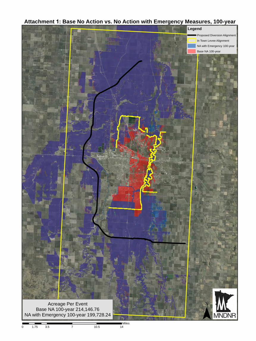
0 3.5 7 10.5 141.75Miles
LegendProposed Diversion Alignment
In Town Levee Alignment
NA with Emergency 100-year
Base NA 100-year
¯Acreage Per Event
Base NA 100-year 214,146.76NA with Emergency 100-year 199,728.24
Attachment 1: Base No Action vs. No Action with Emergency Measures, 100-year
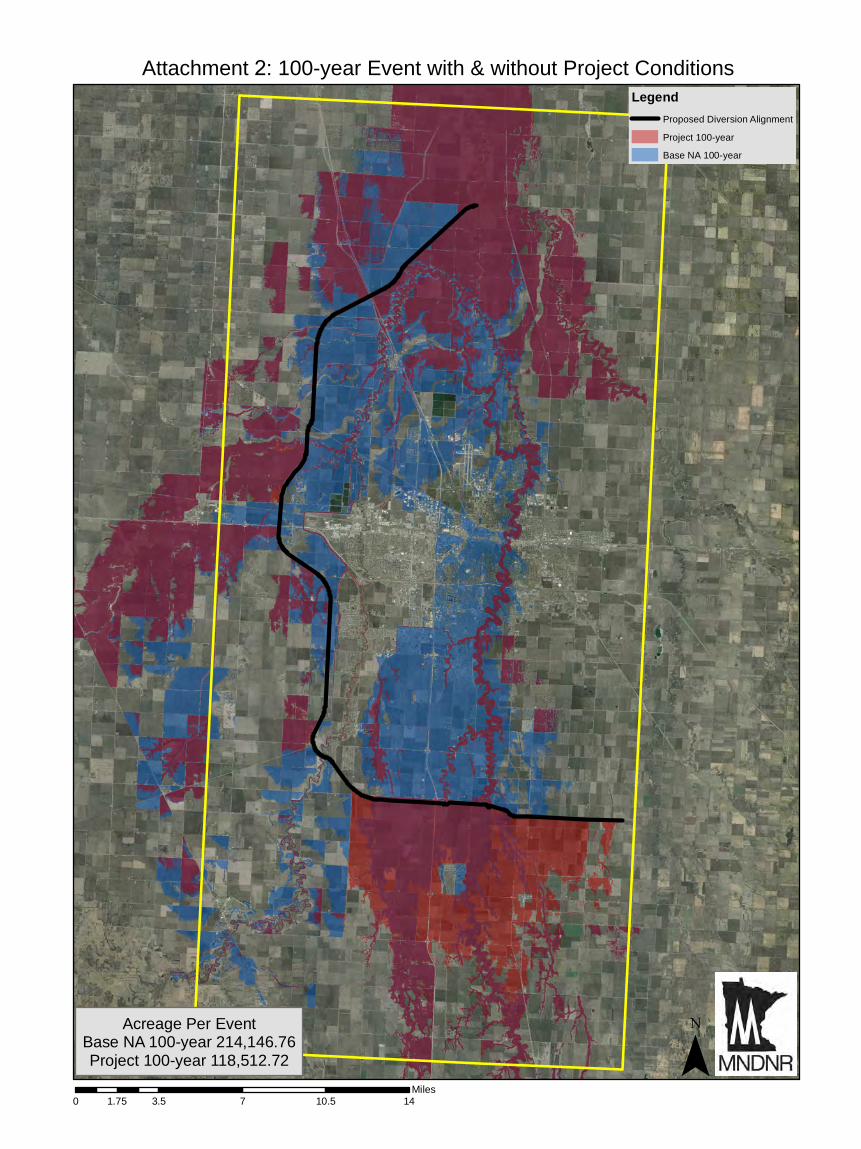
0 3.5 7 10.5 141.75Miles
LegendProposed Diversion Alignment
Project 100-year
Base NA 100-year
¯
Attachment 2: 100-year Event with & without Project Conditions
Acreage Per EventBase NA 100-year 214,146.76Project 100-year 118,512.72
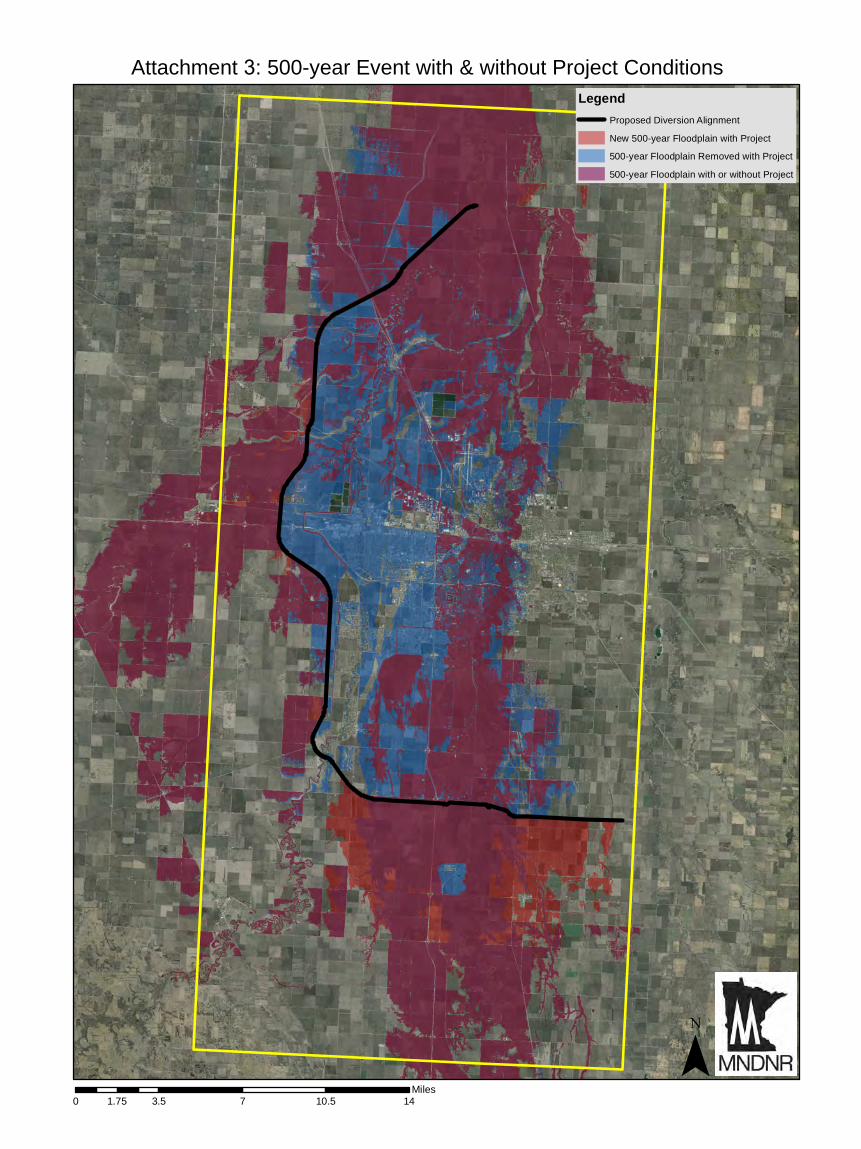
0 3.5 7 10.5 141.75Miles
LegendProposed Diversion Alignment
New 500-year Floodplain with Project
500-year Floodplain Removed with Project
500-year Floodplain with or without Project
¯
Attachment 3: 500-year Event with & without Project Conditions

0 3.5 7 10.5 141.75Miles
LegendProposed Diversion Alignment
100-yr Floodplain with or without Project
500-yr Floodplain with or without Project
¯
Attachment 4: Project 100-year vs. Project 500-year
Acreage Per EventProject 100-year 118,512.72Project 500-year 181,482.82
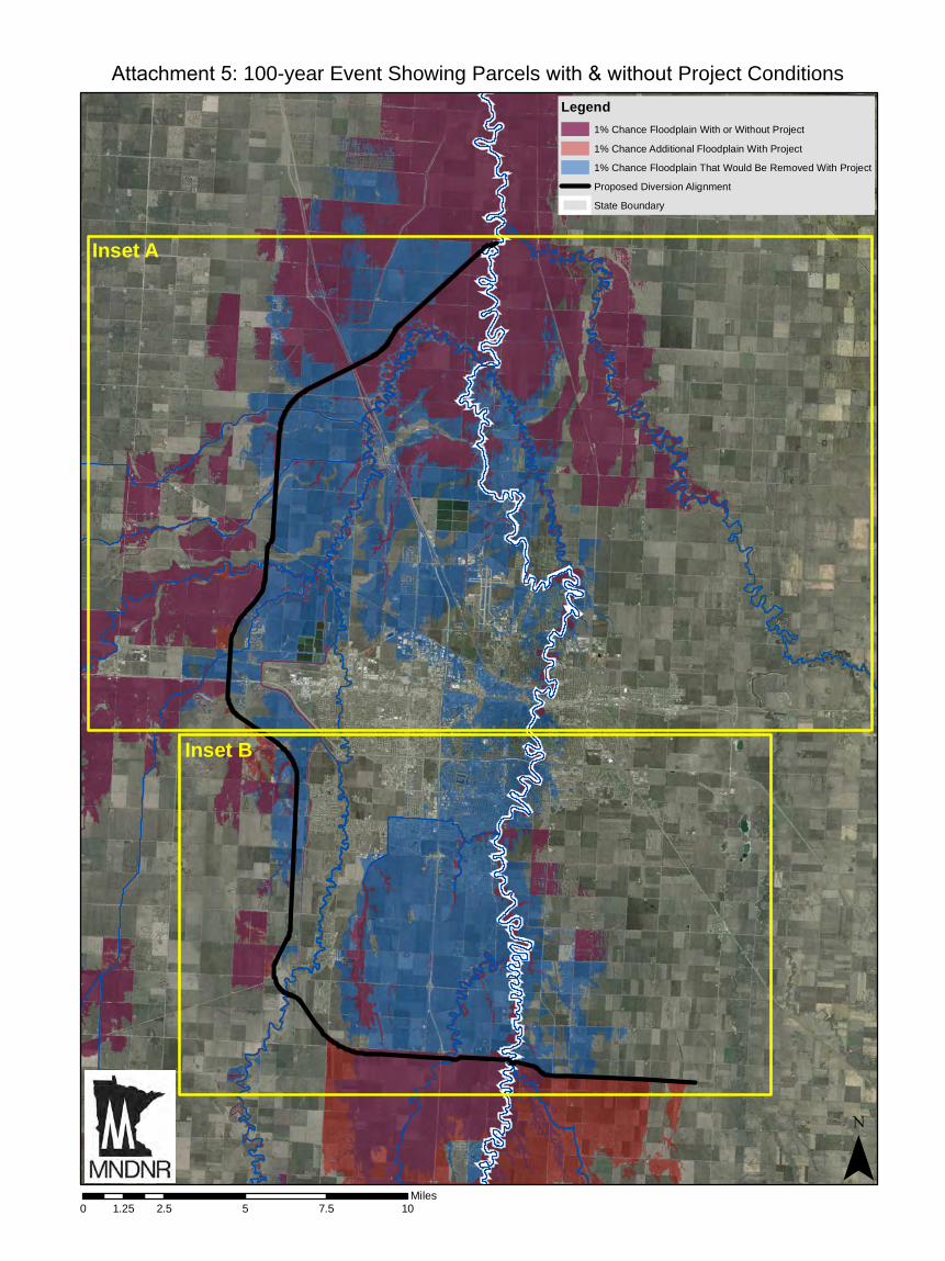
0 2.5 5 7.5 101.25Miles
Legend1% Chance Floodplain With or Without Project
1% Chance Additional Floodplain With Project
1% Chance Floodplain That Would Be Removed With Project
Proposed Diversion Alignment
State Boundary
¯
Attachment 5: 100-year Event Showing Parcels with & without Project Conditions
Inset A
Inset B

0 1.5 3 4.5 60.75Miles
Legend1% Chance Floodplain With or Without Project
1% Chance Additional Floodplain With Project
1% Chance Floodplain That Would Be Removed With Project
Clay Co MN Parcels
Cass Co ND Parcels
Proposed Diversion Alignment
State Boundary ¯
Attachment 5a: 100-year Event Showing Parcels with & without Project Conditions
§̈¦29

0 1 2 3 40.5Miles
Legend1% Chance Floodplain With or Without Project
1% Chance Additional Floodplain With Project
1% Chance Floodplain That Would Be Removed With Project
Clay Co MN Parcels
Cass Co ND Parcels
Proposed Diversion Alignment
State Boundary ¯
Attachment 5b: 100-year Event Showing Parcels with & without Project Conditions
§̈¦29
§̈¦94