farice iris subsea cable iceland to ireland
TRANSCRIPT

Farice – IRIS Subsea Cable
Iceland to Ireland
APPLICATION FOR FORESHORE LICENCE
FOR MARINE SURVEY & SITE INVESTIGATION WORKS AT BALLYLOUGHANE STRAND, RENMORE, CO. GALWAY
& GALWAY BAY

Foreshore Application Report October 2019 Farice – IRIS Galway SI 2 Job No. 1334
Contents 1.0 INTRODUCTION .............................................................................................. 3
2.0 PLANNED SURVEY ROUTE IN IRISH WATERS ........................................ 5
3.0 PROPOSED MARINE SURVEY & SITE INVESTIGATIONS ..................... 12
4.0 SURVEY EQUIPMENT PARAMETERS ....................................................... 20
5.0 MARINE LIAISON & CONSULTATIONS.................................................... 22
6.0 MARINE ARCHAEOLOGY .............................................................................. 24
7.0 AA SCREENING AND NATURA IMPACT STATEMENT ......................... 27
Appendix 1 – Drawings. .............................................................................................. 29
Appendix 2 – Marine Archaeology Assessment Report. ............................................. 30
Appendix 3– AA SCREENING AND NATURA IMPACT STATEMENT .............. 31

Foreshore Application Report October 2019 Farice – IRIS Galway SI 3 Job No. 1334
1.0 INTRODUCTION
1.1 It is planning to construct a new sub-sea telecoms cable system, IRIS, linking
Iceland to Ireland, from a landfall on the Reykjanes Peninsula to a landfall on the west
coast of Ireland as shown in Figure 1 below.
Figure 1: Proposed IRIS Subsea Cable System
1.2 The proposed survey route arises from discussions between Farice ehf (Ltd)
and DeepSea Fibre Neworks Ltd. Farice ehf (Ltd) was founded in November 2002 by
a number telecommunications companies in Iceland and the Faroe Islands as well as
the Icelandic State in order to build and operate the FARICE-1 submarine cable that
was put into service in January 2004. The second cable, DANICE, was put into service
in September 2009. The company is the now main provider of wholesale capacity in
and out of Iceland. The Icelandic state has 100% of the shares under its ownership.
1.3 This planning repot has been prepared by MDM Ltd and forms part of an
application for a Foreshore Licence for Marine Survey and Site Investigations for route
options traversing Galway Bay to the North or South of the Aran Islands. The planned
landfall is at Ballyloughane Strand, Renmore, Co. Galway. The works will be carried

Foreshore Application Report October 2019 Farice – IRIS Galway SI 4 Job No. 1334
out predominantly by seaborne electronic equipment (geophysical survey) with some
selective sampling of the seabed (geotechnical survey). Once the results of the survey
are obtained and analysed a preferred route corridor will be determined, design and
method statements will be developed and a final Route Position List (RPL) will be
defined as part of a further submission for a Foreshore Licence for installation works.

Foreshore Application Report October 2019 Farice – IRIS Galway SI 5 Job No. 1334
2.0 PLANNED SURVEY ROUTE IN IRISH WATERS
Offshore Section
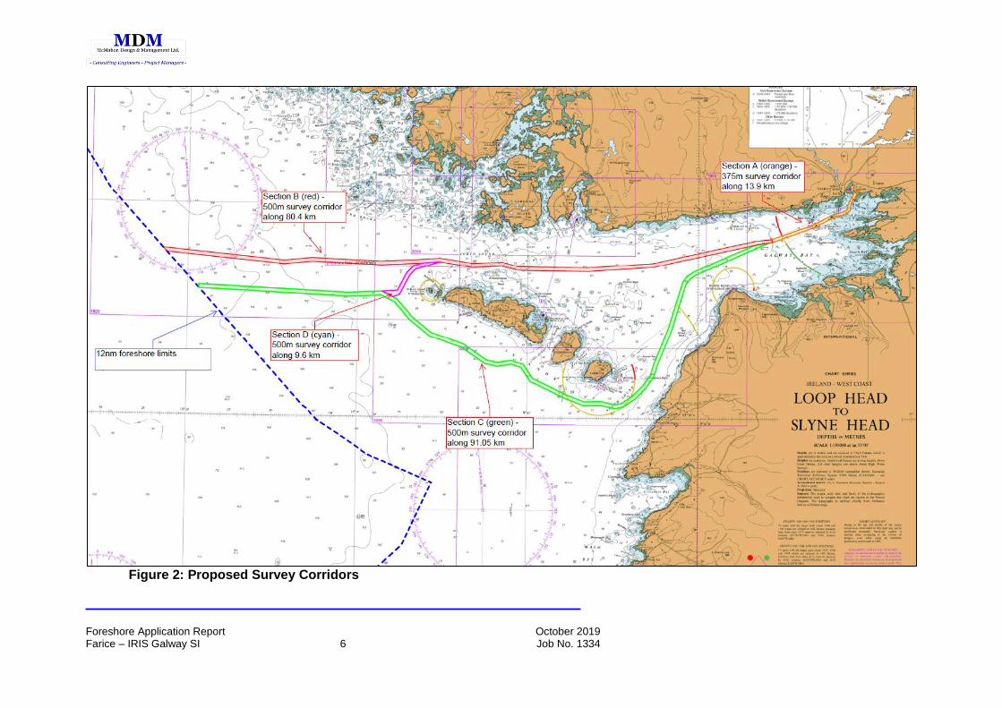
2.1 The proposed survey is divided into four sections in order to determine an
optimum route for the proposed cable system to traverse Galway Bay. The general
lines of the proposed offshore survey corridors are shown on an Admiralty Chart
base in Figure 2 overleaf.
2.2 The four survey sections are generally as follows;
• Section A – 375m wide survey corridor heading south-west from Ballyloughane
Strand, Renmore and then generally westwards until it ends at a point
approximately 13.9km from the landfall.
• Section B – 500m wide survey corridor from the end of Section A heading west
out of Galway Bay, through the North Sound and finishing at the 12 Mile Limit.
Section B is approximately 80.4km long.
• Section C - 500m wide survey corridor from the end of Section A heading south-
west out of Galway Bay, through the South Sound and then turning north-west
and running parallel to the Aran Islands before turning west and finishing at the
12 Mile Limit. Section C is approximately 91km long.
• Section D - 500m wide survey corridor from an intersection point with Section
B to the north west of Inishmore, heading south west to intersect with Section
C at a point to the west of Inishmore. Section D is approximately 9.6km long.
2.3 The proposed Route Position Lists for the four survey sections are presented
in Tables 1-4.
Foreshore Application Report October 2019 Farice – IRIS Galway SI 6 Job No. 1334
Figure 2: Proposed Survey Corridors

Foreshore Application Report October 2019 Farice – IRIS Galway SI 7 Job No. 1334
Table 1: Section A – 375m Wide Survey Corridor Centred on Route Below
Table 2: Section B – 500m Wide Survey Corridor Centred on Route Below

Foreshore Application Report October 2019 Farice – IRIS Galway SI 8 Job No. 1334
Table 3: Section C – 500m Wide Survey Corridor Centred on Route Below
Table 4: Section D – 500m Wide Survey Corridor Centred on Route Below
Foreshore Application Report October 2019 Farice – IRIS Galway SI 9 Job No. 1334
Inshore Section
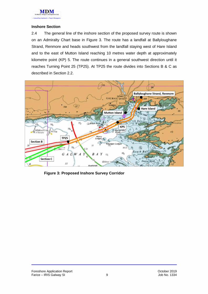
2.4 The general line of the inshore section of the proposed survey route is shown
on an Admiralty Chart base in Figure 3. The route has a landfall at Ballyloughane
Strand, Renmore and heads southwest from the landfall staying west of Hare Island
and to the east of Mutton Island reaching 10 metres water depth at approximately
kilometre point (KP) 5. The route continues in a general southwest direction until it
reaches Turning Point 25 (TP25). At TP25 the route divides into Sections B & C as
described in Section 2.2.
Figure 3: Proposed Inshore Survey Corridor

Foreshore Application Report October 2019 Farice – IRIS Galway SI 10 Job No. 1334
Landfall
2.5 The proposed landfall is at Ballyloughane Strand, Renmore, Co. Galway and
the general location is shown in Figure 4.
Figure 4: Landfall Location Source: Ordnance Survey Ireland (http://map.geohive.ie)
Nearshore Survey Corridor and Landfall Location
2.6 The location of the nearshore survey corridor and the landfall at Ballyloughane
Strand is shown on the 6” to 1 mile Ordnance Survey map and the 1/2,500 Ordnance
Survey map in Figures 5 & 6 respectively.
Figure 5 – Landfall Location on 6” Ordnance Survey Map

Foreshore Application Report October 2019 Farice – IRIS Galway SI 11 Job No. 1334
Figure 6 – Landfall Location on 1/1,000 Ordnance Survey Map
2.7 The Ordnance Survey Maps are reproduced in Drawings 1334-A-103, 1334-A-
104 and included in Appendix 1.

Foreshore Application Report October 2019 Farice – IRIS Galway SI 12 Job No. 1334
3.0 PROPOSED MARINE SURVEY & SITE INVESTIGATIONS
3.1 The principal objective of the Marine Survey & Site Investigations is to ascertain
a feasible and safe route for cable system design, deployment, survivability and
subsequent maintenance with due regard for environmental and ecological
considerations. The survey will also enable decisions to be made on cable armouring
and burial. The survey will identify all route features, obstacles and cable hazards and
provide detailed information to support cable route and installation engineering. The
site investigations will provide “ground-truthing” of the seabed along the route.
3.2 The survey operations will be broken down into separate but overlapping areas,
with boundaries defined by water depth as specified in the technical requirements
outlined below. These water depth boundaries may be adjusted due to suitability of the
survey vessel(s) and survey gear. The survey and survey line spacing will be designed
to ensure adequate coverage and overlap of geophysical measurements. For the route
survey, the sidescan ranges will be limited to those providing the greatest resolution
possible (able to resolve a 0.5m object or better), while following the requisite line
spacing and overlap. The maximum speeds outlined will be used as guidelines.
Bathymetry data collection will, at minimum, comply with the requirements in this
document and with International Hydrographic Office standards (S44).
3.3 For swathe bathymetry, “20% overlap” signifies that adjacent acquisition
swathes within the survey corridor overlap by 20%. For side scan sonar (SSS), 100%
overlap requires two passes of complete coverage over a given area of sea-floor, with
the two passes each ensonifying the sea-floor from opposite directions to ensure
targets are adequately imaged.
3.4 The basic survey equipment is to comply with the requirements of the
Underwater Archaeology Unit. The requirements are as follows;
General requirements for a geophysical survey for archaeological purposes:
Side Scan Sonar:
- For archaeological purposes, the Side Scan Sonar should have an
operational frequency of 410/500 khz.
Foreshore Application Report October 2019 Farice – IRIS Galway SI 13 Job No. 1334
- Side scan should be set at 50m survey line spacing
- This should not be slant-range corrected
- There should be 100% coverage of sites and therefore overlap of areas may
be required.
It is proposed that in shallow water (0-15 metre water depth) the line spacing may be
reduced to 25 metres. In deeper water (15 to 1500 metres) the line spacing may be
increased to 150 metres whilst maintaining the requisite seabed coverage.
Magnetometer:
- A magnetometer should always be used in tandem with side scan sonar
- Proton or caesium magnetometer should be used as well as, again, using
50m side spacing
- This should be used with DGPS
Sub-bottom profiler (optional):
Sub-bottom profile information shall be required for both the inshore and
shallow water sections of the route. Sub-bottom profile data shall be acquired
on all lines of the proposed line plan so that an accurate interpretation of the
geology can be obtained. Details of the preferred line plan can be found in
Section 3.14.
The Survey Contractor shall recommend sub-bottom profiling equipment that
typically resolves to twenty centimetres (0.2m) within the top three metres
(3m) of the seabed. The equipment shall be capable of penetrating to a
minimum of six metres (6m) in suitable seabed conditions. The Survey
Contractor shall state the resolution of the proposed system for survey.
Vessel mounted sensors shall be fully compensated for heave. In-water
sensors shall be dynamically positioned and steered along the predefined
survey lines using industry standard techniques. In water depth less than one
hundred metres (100m), equipment positioning may be determined using
fixed layback to counteract poor acoustic positioning.
The system shall be capable of providing data in both digital and analogue
form.
Foreshore Application Report October 2019 Farice – IRIS Galway SI 14 Job No. 1334
- If using a sub-bottom profiler then the Chirp system is the preferred one as
this gives the ultimate resolution
• This should be used in conjunction with DGPS
General:
Track plots should also be recorded. Track plots should be superimposed
onto a locational chart
All geophysical survey should be carried out by suitably qualified personnel.
Preferably they should also have underwater archaeological experience. If
this is not possible then the results must be viewed by a qualified
archaeologist with experience in underwater archaeology.
A copy of the original data/traces as well as the interpreted results of the
geophysics should be sent to the Underwater Archaeological Unit of DCHG.
Further archaeological mitigation may be required once the data has been
reviewed by DCHG.
Vessels should not travel faster than 4-5 knots when carrying out surveys.
3.5 In order to ensure data continuity, the following overlaps between survey
regions are to be established as a minimum;
▪ Landfall Site Survey to Small Boat Survey – 50m overlap
▪ Small Boat Survey to Offshore Survey – 500m overlap
Landfall Site Survey & Site Investigations
3.6 A non-intrusive topographic and geophysical survey of the beach at
Ballyloughane along the line of the proposed cable route is required from the carpark
to the low water mark.
3.7 Site Investigations at Ballyloughane Strand will consist of;
• 3 Trial Pits on the beach. (2.5 metres target depth, excavated and
immediately reinstated by JCB)
• Bar probes on the beach (effectively non-intrusive investigation)
• Bar probes from the Low Water Line to the 3m water depth contour.
(effectively non-intrusive investigation)

Foreshore Application Report October 2019 Farice – IRIS Galway SI 15 Job No. 1334
3.8 The sampling required on the beach at Ballyloughane Strand will involve 3
No. Trial Pits at 50m centres starting seaward of the High Water Mark. The 3 No.
Trial Pits will be excavated, logged, photographed and backfilled in a single intertidal
period. The trial pits will be backfilled with the original excavated materials in the
sequence in which they are excavated.
3.9 A summary Method Statement for excavation of the Trial Pits is as follows;
3 No. Trail Pits – JCB or equivalent small mechanical excavator.
– Maximum depth 2.5m.
– Excavate sand and place to one side.
– Excavate substrate and place separate from sand.
– Measure, log and photograph each Trial Pit.
- Backfill in sequence compacting with bucket of back-
hoe as the backfilling proceeds.
3.10 The bar probes on the beach are simply to prove the depth of sand, gravel or
soft material and are effectively non-intrusive.
Small Boat Survey
3.11 The area extending seaward from the low water mark and inshore of the safe
working draft limits of the primary survey vessel will be accurately surveyed with a
small craft using Multibeam Echosounder (MBES), sidescan sonar and sub-bottom
profile equipment. Sub-bottom profile equipment will be able to discern the nature and
density of the upper 3 metres of seabed and will be used on a non-interfering basis
with other sounding systems. Tie-lines will be performed to verify primary survey data
and will have a nominal spacing of 10 times the primary line spacing with a minimum
of two tie-lines. A minimum of seven survey lines, based upon the Survey RPL, is
required.
3.12 Features such as shallow reefs, surge channels, debris fields, archaeological
features or anything that could be a hazard to the cable or installation team will be
noted. General reconnaissance of the survey corridor beyond the planned survey
lines and tie-lines may be necessary to describe the seabed as accurately as

Foreshore Application Report October 2019 Farice – IRIS Galway SI 16 Job No. 1334
possible. A line plan showing number of survey lines as a function of depth will be
provided prior to start of survey operations.
Survey Area
Depth Range
Corridor Min. # of Lines
Min. Overlap Max. Speed
Small Boat 3m to 15m 350 -500m
7 SSS: 100%
MBES Bathy: 20%
4 knots
Table 6: Small Boat Survey Requirements
Offshore Survey 3.13 A continuous bathymetric swathe (Multibeam Echosounder), along with side
scan sonar imagery and sub-bottom profile will be obtained, centred on the
preliminary route and along all wing lines needed to complete the corridor coverage.
A minimum depth accuracy of 0.5% is required. Sub-bottom equipment will be able to
discern the nature and density of upper 3m of seabed, and is to be used on a non-
interfering basis with other sounding systems. Additional sounding lines may be
necessary to identify any obstacles or archaeological features that may be
encountered, and/or to meet the overlap and corridor requirements.
Survey Area
Depth Range
Corridor Min. # of Lines
Min. Overlap Max. Speed
Offshore > 15m 350 - 500m
3 SSS: 100%
MBES Bathy:20%
4 knots
Table 7: Offshore Survey Requirements
Seabed Sampling 3.14 Seabed sampling will be required at locations covered by the Small Boat and
Shallow Water Surveys.

Foreshore Application Report October 2019 Farice – IRIS Galway SI 17 Job No. 1334
3.15 A minimum of two attempts will be made at each sampling location to acquire
a suitable seabed sample. If an acceptable sample is achieved on the first attempt,
there is no need to perform a second attempt.
3.16 An acceptable sample is defined as;
• Grab Sample – recovery of approximately a full bucket of soils. Recovery of
rocks and/or large size granular material will be taken as indication of a hard
seabed and be deemed an acceptable sample.
• Gravity Core – recovery of no less than a 2m deep core of soil. If stiff or hard
soils are encountered below 1m of seabed and are clearly indicated in the
sample, a 1m+ soil sample will be deemed acceptable. Any sample site
yielding less than 1m of recovery must be investigated a second time unless
there is obvious damage to the coring equipment indicating a hard or rocky
substrate.
• CPT – Penetration to the 2m target, but a maximum of 3m below seabed. Any
push resulting in less than 2m penetration will warrant a second attempt.
Survey Area
Depth Type Avg. Spacing No. of
Samples
Small Boat 3 – 15 m Grab Sampler 1 per 500 m 8
Offshore > 15m Gravity Corer (GC)
or
Cone Penetrometer
(CPT)
Grab Sampler (After GC/CPT
Failure)
1 per 10km
45
Table 8: Seabed Sampling Requirements

Foreshore Application Report October 2019 Farice – IRIS Galway SI 18 Job No. 1334
3.17 The site investigations in the area from the Low Water Line to the 15m
contour will be undertaken from a small vessel having the appropriate draft.
3.18 The site investigations seaward of the 15m contour will be undertaken from a
larger sea-going vessel.
3.19 The marine survey and site investigations will be undertaken in compliance
with best practice and having regard for the protection of marine mammals.
3.20 The marine survey and site investigations will be undertaken along the route
line shown on the Foreshore Licence Map Drawings. However, a 500m wide route
corridor is shown to allow for local diversions in the event of obstructions or other
routing considerations.
3.21 The schedule of Site Investigations is set out in Table 9.
Survey Area Depth Type Avg. Spacing
Landfall HWM - LWM Trial Pit 50 m
Landfall HWM - LWM Bar Probing 1 per 25 m
Table 9: Site Investigations Schedule
3.22 The overall scope of the Site Investigations is as follows
• Trial Pits 3 No. on the beach
• Bar Probes 24 No. on the beach
• Bar Probes 20 No. from Low Water to the 3.0m
contour
• Grab Samples 6 No. from the 3m to the 15m contour
• Gravity Cores or 45 No. from the 15m contour to the
Cone Penetration Tests 12-Mile Limit
3.23 The Survey Control Measures prescribed in the Appropriate Assessment
Screening Report (attached as Appendix 3) will be adhered to.
Foreshore Application Report October 2019 Farice – IRIS Galway SI 19 Job No. 1334
Underwater Video Survey
3.24 As outlined in the Nature Impact Statement sensitive subtidal communities
were found within the vicinity of the proposed route within Galway Bay SAC in 2018.
Virgularia mirabilis was known to be present in Inner Galway Bay and previous subtidal
surveys were unable to locate the bed of Virgularia mirabilis. As discussed with Dr
David Lyons of NPWS it is necessary to map the distribution and density of Virgularia
mirabilis along the proposed survey corridor in order to select a route of least impact
to Virgularia mirabilis within this narrow corridor area that is located between the
Galway Port Company dredged channel to the North and intertidal/subtidal reef areas
to the south.
3.25 The proposed survey will involve a series of drop-down videos to map the
extent of the habitat. A series of transects will be carried out to confirm
presence/absence and to map the boundary extent of the Virgularia mirabilis within
this area of the SAC. These will be mapped in GIS and the proposed route alterations
will be carried out in consultation with the design team and the marine biologist that
will carry out the survey.
3.26 In addition, the proposed survey corridor is within the marine element of
Inishmore Island SAC and the initially proposed optimal cable route is between several
reef outcrops. Reef is a feature of interest of this SAC. In order to adequately assess
the potential impact of the proposed main lay and assist in the selection of potential
routes between the reef outcrops, an additional series of georeferenced video drops
are proposed within Inishmore Island SAC reef areas. The results from both video
surveys will be discussed with NPWS prior to the final layout of the main lay route.”

Foreshore Application Report October 2019 Farice – IRIS Galway SI 20 Job No. 1334
4.0 SURVEY EQUIPMENT PARAMETERS
Equipment and Procedures
4.1 The marine survey will be carried out in compliance with the “Code of Practice
for the Protection of Marine Mammals during Acoustic Seafloor Surveys in Irish
Waters,” and with the “General Requirements for a Geophysical Survey for
Archaeological Purposes,” and in accordance with the Survey Control Measures
prescribed in the Appropriate Assessment Screening Report (attached as Appendix
3).
4.2 The survey equipment acoustic properties have the following characteristics;
Equipment Type Frequency
(Energy level in dB re 1 µPa)
Dual Frequency Single Beam Echosounder – Reson Navisound 420
33 and 210kHz (168 – 174)
Dual Frequency Side Scan Sonar - Edgetech 4200 Sidescan Towfish
100 and 400kHz (226 effective)
100/400 kHz and 300/600 kHz
Sub-bottom Profiler - Geoacoustics 4 x 4 Hull-mounted SBP Pinger
System
3 – 7.5kHz (-225)
4.3 In the case of the Small Boat Survey the survey line spacing will be set at 50m
for the Side Scan Sonar. In deeper water the spacing will increase.
4.4 Specific soft-start procedures (to comply with the “Code of Practice for the
Protection of Marine Mammals during Acoustic Seafloor Surveys in Irish Waters”) will
be developed and incorporated in the project execution plan before mobilisation.
4.5 The duration of noise-generating surveys will be reduced to the minimum
necessary to collect results of sufficient quality.
4.6 The survey will be undertaken by a specialist survey vessel having experience
of marine survey and having approved appropriate survey equipment.
Foreshore Application Report October 2019 Farice – IRIS Galway SI 21 Job No. 1334
4.7 Details of the survey vessel and of the survey equipment to be used will be
made available prior to commencement of the survey. The data to be provided will
include;
• Name of vessel
• Name of Captain
• Name of Client’s Representative
• Contact details for the vessel
• Details of Multi-Beam Equipment including;
• The sound intensity, the frequency of pitch and the tone or bandwidth for the
Echo Sounder, the Side Scan Sonar and the Sub-Bottom Profiler.

Foreshore Application Report October 2019 Farice – IRIS Galway SI 22 Job No. 1334
5.0 MARINE LIAISON & CONSULTATIONS Sea Fisheries Protection Agency 5.1 It is proposed to contact the Sea Fisheries Protection Agency (SFPA) to seek
advice regarding the timing of survey works to avoid clashing with spawning periods
of fish in the area. This will reduce any potential for noise damage to larval and
juvenile life stages of fish when they are more susceptible to noise damage than
adults. Consideration of any possible impact on migratory fish patterns and timing will
also be discussed.
5.2 It is proposed to appoint a Fisheries Liaison Officer for the inshore and
offshore sections of the survey. The appointment of a Fisheries Liaison Officer would
have the purpose of keeping commercial fishermen informed of the survey works
including time lines, dates of sampling and locations of sampling vessels. The
Fisheries Liaison Officer will also inform the survey team of commercial activity and
locations of fishing nets or pots that may be impacted by the survey activities.
5.3 The Sea-Fisheries Protection Authority (SFPA) will be requested to advise on
consultation with the relevant fishermen’s organisations on details of the project.
National Parks & Wildlife Service 5.4 It is proposed to appoint a Marine Mammal Observer to be on board the
survey vessel.
Irish Coast Guard 5.5 It is proposed to liaise with the Irish Coast Guard to arrange appropriate radio
/ nav-text broadcast warnings to advise shipping approaching the survey area.
Harbour Master at Galway Port 5.6 The Galway Port Harbour Master will be informed of the Plan of Work and of
the planned start and estimated completion dates for the proposed survey works.

Foreshore Application Report October 2019 Farice – IRIS Galway SI 23 Job No. 1334
Marine Notice 5.7 It is proposed to publish a Marine Notice through the Marine Safety
Directorate giving a general description of operations and approximate dates of
commencement and completion.

Foreshore Application Report October 2019 Farice – IRIS Galway SI 24 Job No. 1334
6.0 MARINE ARCHAEOLOGY
6.1 A formal Marine Archaeological Assessment has been undertaken by
Geomara Ltd and the report is presented in full in Appendix 2. The Non-Technical
Summary of the Marine Archaeology Report is as follows;
The assessment comprises an introduction to the study area; and the
identification of cultural heritage sites, features and deposits located along and
close to the proposed survey route corridor. In order to provide a
comprehensive assessment, an extensive desk-based study of the survey corridor
was undertaken. The potential impact of the proposed scheme on the receiving
environment is addressed and mitigation measures to ameliorate these impacts
are presented.
The assessment has identified two wreck sites (W15898 & W17455) within the
proposed survey and site investigation corridor. In the surrounding area 15
other known shipwrecks have been recorded in the Shipwreck Inventory
(Appendix 1). The precise locations of these shipwrecks are sometimes difficult
to identify even when location details are present in the inventory. The sheer
numbers of known and unknown wrecks recorded from the area means any
proposed site investigations have the potential to impact on a wreck site or
other related cultural heritage assets.
Any site investigations on the seabed, foreshore or beach have the potential to
impact unrecorded features, finds and deposits.
Consequently, given the results of the impact assessment the mitigation
strategies outlined here detail the measures to be adopted in order to ameliorate
any direct, indirect and secondary impacts that the proposed survey and site
investigations may have on features of maritime cultural heritage interest. If
these measures are employed it is envisaged that the survey and site
investigations will have no impact on features of maritime cultural heritage
interest.

Foreshore Application Report October 2019 Farice – IRIS Galway SI 25 Job No. 1334
The following mitigation recommendations are presented in connection with the
proposed survey and site investigations:
1. It is recommended that all sites of cultural heritage interest included in this
report are avoided by the site investigations.
2. As the survey proceeds, processing and charting should be carried out in a
200m zone around all of the proposed site investigation sampling locations.
The data and charts should be reviewed and analyzed by a licensed
archaeologist for the presence of unrecorded seabed and subseabed
archaeological features finds or deposits. Only where no such features are
identified within the 200m zone surrounding the proposed sampling
location will the sampling be allowed to proceed.
3. Archaeological analysis of the full data set from the geophysical and
bathymetric pre installation surveys should be undertaken to both confirm
the locations of any identified wreck sites, especially known sites within the
survey corridor, such as W15898 & W17455 and also to identify any
potential unrecorded seabed and sub seabed maritime archaeological
features or cultural heritage assets.
4. Due to the approximate location details for many shipwrecks in the
inventory it is not recommended that the survey corridor be re-routed to
avoid the two known wrecks.
5. Where the location of a wreck site is found during the survey and site
investigations any proposed further development corridors should be re-
routed to avoid them.
6. Archaeological monitoring of the grab sampling, gravity core, CPT, trial pits
and bar probing should be undertaken in order to identify any previously
unrecorded cultural heritage features.
7. The location of all of the proposed trial pits and probing on the beach and
on the foreshore should avoid the seven sites and find spots noted during
the storm damage mitigation report and detailed in this report.
8. All of the proposed trial pit excavations and probing on the beach and on
the foreshore should be subject to full archaeological monitoring.

Foreshore Application Report October 2019 Farice – IRIS Galway SI 26 Job No. 1334
9. It is recommended that procedures should be put in place to ensure that
any previously unrecorded cultural heritage assets encountered during the
survey and site investigations should be assessed by a suitably qualified
archaeologist and avoided by any future works
10. Should the proposed survey route be subject to further revision, details of
these revisions should be forwarded to the project archaeologist for
assessment.
11. On completion of the survey and site investigations a report will be
produced summarising all archaeological aspects of the project and
submitted to DCHG and the National Museum of Ireland.

Foreshore Application Report October 2019 Farice – IRIS Galway SI 27 Job No. 1334
7.0 AA SCREENING AND NATURA IMPACT STATEMENT
7.1 An Appropriate Assessment Screening and Natura Impact Statement has
been prepared by Altemar Ltd. and the report is presented in full in Appendix 3.
7.2 The conclusions of the Appropriate Assessment Screening are as follows;
An initial screening of the proposed works, using the precautionary principle
(without the use of any mitigation measures) and Natura 2000 sites with the
potential to result in significant effects on the conservation objectives and
features of interest of the Natura 2000 sites was carried out in Table 10. Based
on best scientific knowledge and objective information and assessment, the
possibility of significant effects caused by the proposed project was excluded
for the following Natura 2000 sites.
Special Protection Areas
Inishmore SPA (2.7 km from cable route corridor)
Lough Corrib SPA (5.1 km from cable route corridor)
Cregganna Marsh (6.3 km from cable route corridor)
Cliffs of Moher SPA (4.0 km from cable route corridor)
Connemara Bog Complex SPA (7.9 km from cable route corridor)
Slyne Head To Ardmore Point SPA (8.4 km from cable route corridor)
Special Areas of Conservation
Inishmore Island SAC (within the proposed survey route)
Black Head-Poulsallagh Complex SAC (1.9 km from cable route corridor)
Lough Corrib SAC (2.5 km from cable route corridor)
Inisheer Island SAC (3.1km from cable route corridor)
Inishmaan Island SAC (3.9 km from cable route corridor)
Connemara Bog Complex SAC (7.0 km from cable route corridor)
Moneen Mountain SAC (9.5 km from cable route corridor)
East Burren Complex SAC (10.1 km from cable route corridor)
Inagh River Estuary SAC (10.6km from cable route corridor)
Ballyvaughan Turlough SAC (10.7 km from cable route corridor)
Lough Fingall Complex SAC (10.9 km from cable route corridor)

Foreshore Application Report October 2019 Farice – IRIS Galway SI 28 Job No. 1334
Ballyteige (Clare) SAC (11.1 km from cable route corridor)
Lough Nageeron SAC (14.1 km from cable route corridor)
Kiltiernan Turlough SAC (14.1 km from cable route corridor)
The project is limited in scale and extent and the potential zone of influence is
restricted to the immediate vicinity of the survey route, with the exception of
underwater noise that may extend beyond the survey corridor. The proposed
intertidal survey is within Inner Galway Bay SPA and Galway Bay Complex
SAC. Subtidal elements of the project are within Galway Bay Complex SAC,
Inner Galway Bay SPA and Inishmore Island SAC. However, the survey will not
impact on the features of interest Inishmore Island SAC. In addition, although
Kilkieran Bay and Islands SAC is 1.8 km from cable survey corridor, standard
marine mammal mitigation measures are required (in compliance with NPWS
guidance) and harbour seals from this SAC may be present within the survey
corridor.
Acting on a strictly precautionary basis, NIS is required in respect of the effects
of the project on the Inner Galway Bay SPA (potential disturbance to species
and habitat impacts), Galway Bay Complex SAC (potential habitat and harbour
seal impacts) and Kilkieran Bay and Islands SAC (potential harbour seal
impacts) because it cannot be excluded on the basis of best objective scientific
information following screening, in the absence of control or mitigation
measures that the plan or project, individually and/or in combination with other
plans or projects, will have a significant effect on the named European Site/s.
An NIS or Stage 2 Appropriate Assessment is not required for the effects of the
project on all other listed Natura sites above because it can be excluded on the
basis of the best objective scientific information following screening that the
plan or project, individually and/or in combination with other plans or projects,
will have a significant effect on the European Site/s.

Foreshore Application Report October 2019 Farice – IRIS Galway SI 29 Job No. 1334
Appendix 1 – Drawings.
FORESHORE LICENCE MAPS:
• 1334-A-103 Site Location Map
• 1334-A-104 Site Location Map 2
• 1334-A-101 Foreshore Licence Map 1
• 1334-A-102 Foreshore Licence Map 2

Foreshore Application Report October 2019 Farice – IRIS Galway SI 30 Job No. 1334
Appendix 2 – Marine Archaeology Assessment Report.

Foreshore Application Report October 2019 Farice – IRIS Galway SI 31 Job No. 1334
Appendix 3– AA SCREENING AND NATURA IMPACT STATEMENT