fb rdeirs ch 2 alternatives clean 2012-06-08 · bakersfield alternatives warranted preparation and...
TRANSCRIPT

CALIFORNIA HIGH-SPEED TRAIN PROJECT REVISED DEIR/SUPPLEMENTAL DEIS FRESNO TO BAKERSFIELD SECTION 2.0 ALTERNATIVES
Page 2-1
Alternatives 2.0
This chapter describes the background and development of the HST system and its individual components. This chapter also describes the background, development, and provides a detailed description of the alternatives considered for the Fresno to Bakersfield Section of the HST system. Six of the alternatives discussed in this chapter are based on the alternatives selected by the Authority and FRA at the conclusion of the Tier 1 EIR/EIS processes for the HST system (see Section 1.5, Tiering of Program EIR/EIS Documents). Three additional alternatives were developed based on substantive comments received during public and agency review of the Draft EIR/EIS. The design drawings that support the alternatives’ descriptions are included as Volume III (Alignments and Other Plans) of the EIR/EIS. This Revised Draft EIR/Supplemental Draft EIS analyzes the environmental impacts for the Fresno to Bakersfield Section of the HST system, including alternatives, direct and indirect impacts, cumulative impacts, secondary effects, and mitigation measures. Visit the California High-Speed Rail Authority website (www.cahighspeedrail.ca.gov) to view and download the EIR/EIS, request a CD-ROM EIR/EIS, and locate a library to review a hard copy of the environmental document. Printed copies of the EIR/EIS have been placed in public libraries in the following cities and communities: Sacramento, Fresno, Clovis, Laton, Hanford, Lemoore, Corcoran, Wasco, Shafter, Bakersfield, Visalia, Tulare, and Delano. At the Authority’s website, the following documents are also available: alternative analyses preceding preparation of the Project EIR/EIS, materials prepared for coordination with the U.S. Army Corps of Engineers (USACE) and U.S. Environmental Protection Agency (EPA) in compliance with the Clean Water Act Section 404(b)(1) requirements, and technical reports developed for the environmental analyses presented in Chapter 3.
2.1 Background
2.1.1 California HST Project Background
The planning, design, construction, and operation of the California HST System are the responsibility of the Authority, a state governing board formed in 1996. The Authority’s statutory mandate is to develop a high-speed rail system that is coordinated with the state’s existing transportation network, which includes intercity rail and bus lines, regional commuter rail lines, urban rail and bus transit lines, highways, and airports. The Authority’s plans call for high-speed intercity train service on more than 800 miles of tracks throughout California, connecting the major population centers of Sacramento, the San Francisco Bay Area, the Central Valley, Los Angeles, the Inland Empire, Orange County, and San Diego (Figure 2-1).1
The California HST System is planned to be implemented in two phases. Phase 1 would connect San Francisco to Los Angeles and Anaheim via the Pacheco Pass and the Central Valley.
2 Phase 2
would connect from the Central Valley (Merced Station) to the state’s capital, Sacramento, and another extension is planned from Los Angeles to San Diego (Figure 2-1). The HST system would meet the requirements of Proposition 1A, including the requirement for a maximum nonstop service travel time between San Francisco and Los Angeles of 2 hours and 40 minutes.
1 The alignments on Figure 2-1 are based on Authority/FRA decisions made in the 2005, 2008, and
2012 Programmatic EIR/EIS documents. 2 Phase 1 may be constructed in smaller operational segments, depending on available funds.
Definition of High-Speed Train (HST) System A system that includes HST tracks, structures, stations, traction power substations, maintenance facilities, and trains able to travel 220 mph.

CALIFORNIA HIGH-SPEED TRAIN PROJECT REVISED DEIR/SUPPLEMENTAL DEIS FRESNO TO BAKERSFIELD SECTION 2.0 ALTERNATIVES
Page 2-2
Figure 2-1 California HST System Initial Study Corridors
CALIFORNIA HIGH-SPEED TRAIN PROJECT REVISED DEIR/SUPPLEMENTAL DEIS FRESNO TO BAKERSFIELD SECTION 2.0 ALTERNATIVES
Page 2-3
2.1.2 Fresno to Bakersfield Section EIR/EIS Background
The Fresno to Bakersfield HST Section would be a critical link in the Phase 1 HST system connecting San Francisco and the Bay Area to Los Angeles and Anaheim. The Authority and the FRA’s prior program EIR/EIS documents (see Section 1.5, Tiering of Program EIR/EIS Documents) selected the BNSF Railway route as the preferred alternative for the Central Valley HST between Fresno and Bakersfield in the 2005 Statewide Program EIR/EIS decision document. Therefore, the Project EIR/EIS for the Fresno to Bakersfield Section focuses on alternative alignments along the general BNSF Railway corridor.
The Authority and FRA circulated the Draft EIR/EIS for the Fresno to Bakersfield Section to affected local jurisdictions, state and federal agencies, tribes, community organizations, other interest groups, and interested individuals for 60 days from August 15 to October 13, 2011. Based on substantive comments received during the public and agency review of the Draft EIR/EIS, the Authority decided to reintroduce alignment alternatives west of Hanford and an additional alternative through the Bakersfield area.
The Authority determined that the proposed addition of the Hanford West Bypass Alternatives, the Bakersfield Hybrid Alternative, and refinements being considered for existing Fresno to Bakersfield alternatives warranted preparation and circulation of a revised Draft EIR analyzing the potential environmental impacts that might result from the new alternatives and refinements to existing alternatives, pursuant to Section 15088.5 of the CEQA Guidelines. FRA also determined that these changes to the project alternatives made it necessary to prepare a supplement to the Draft EIS in compliance with the Council on Environmental Quality’s (CEQ’s) regulations (40 CFR 1502.9) and FRA’s Procedures for Considering Environmental Impacts.
2.2 HST System Infrastructure
The following section provides general information about the components and function of the proposed HST system. Detailed information on each alternative in the Fresno to Bakersfield Section is provided in Section 2.3. The HST system is envisioned as a state-of-the-art, electrically powered, high-speed, steel-wheel-on-steel-rail technology, which would employ the latest technology, safety, signaling, and automated train control systems. The trains would be capable of operating at speeds of up to 220 mph over fully grade-separated, dedicated track.
The infrastructure and systems of the HST alternatives are composed of trains (rolling stock), tracks, stations, train control, power systems, and maintenance facilities. The design of each HST alternative includes a double-track rail system to accommodate planned project operational needs for uninterrupted rail movement. Additionally, the HST safety criteria recommend avoidance of at-grade intersections on dedicated HSR alignments and, therefore, the system must be grade-separated from any other transportation system. This means that planning the HST system would also require grade-separated overcrossings or undercrossings for roadways or roadway closures and modifications to existing systems that do not span planned right-of-way. In some situations, it would be more efficient for the HST project to be elevated over existing facilities.
2.2.1 System Design Performance, Safety, and Security
The proposed California HST System has been designed for optimal performance and to conform to industry standards and federal and state safety regulations (Table 2-1). The HST system would be a fully grade-separated and access-controlled guideway with intrusion detection and monitoring systems where required. This means that the HST infrastructure (e.g., mainline tracks and maintenance and storage facilities) would be designed to prevent access by unauthorized vehicles, persons, animals, and objects. The capital cost estimates, presented in Chapter 5 of this

CALIFORNIA HIGH-SPEED TRAIN PROJECT REVISED DEIR/SUPPLEMENTAL DEIS FRESNO TO BAKERSFIELD SECTION 2.0 ALTERNATIVES
Page 2-4
Revised Draft EIR/Supplemental Draft EIS, include allowances for appropriate barriers (fences and walls), state-of-the-art communication, access-control, and monitoring and detection systems. Not only would the guideway be designed to keep persons, animals, and obstructions off the tracks, the ends of the HST trainsets would include a collision response management (CRM) system to minimize the effects of a collision. All aspects of the HST system would conform to the latest federal requirements regarding transportation security. The HST trainsets (train cars) would be pressure-sealed to maintain passenger comfort regardless of aerodynamic change, much like an airplane body does. Additional information regarding system safety and security is provided in Section 3.11 of this EIR/EIS.
Table 2-1 HST Performance Criteria
Category Criteria
System Design Criteria Electric propulsion system Fully grade-separated guideway Fully access-controlled guideway with intrusion monitoring systems where required Track geometry to maintain passenger comfort criteria (smoothness of ride, lateral acceleration less than 0.1 g [i.e., acceleration due to gravity])
System Capabilities Capable of traveling from San Francisco to Los Angeles in approximately 2 hours and 40 minutes All-weather/all-season operation Capable of sustained vertical gradient of 2.5% without considerable degradation in performance Capable of operating parcel and special freight service as a secondary use Capable of safe, comfortable, and efficient operation at speeds over 200 mph Capable of maintaining operations at 3-minute headways Equipped with high-capacity and redundant communications systems capable of supporting fully automatic train control
System Capacity Fully dual track mainline with off-line station stopping tracks Capable of accommodating a wide range of passenger demand (up to 20,000 passengers per hour per direction) Capable of accommodating normal maintenance activities without disruption to daily operations
Level of Service Capable of accommodating a wide range of service types (express, semi-express/limited stop, and local)
HST operation would follow safety and security plans developed by the Authority in cooperation with FRA to include the following:
• A System Safety Program Plan, including a Safety and Security Certification Program, which would be developed during the final design and construction phases to address safety, security, and emergency response as it relates to the day-to-day operation of the system.
• A Threat and Vulnerability Assessment for security and a Preliminary Hazard Analysis and Vehicle Hazard Analysis for safety during the preliminary engineering phase to produce comprehensive design criteria for safety and security requirements mandated by local, state, or federal regulations and industry best practices.

CALIFORNIA HIGH-SPEED TRAIN PROJECT REVISED DEIR/SUPPLEMENTAL DEIS FRESNO TO BAKERSFIELD SECTION 2.0 ALTERNATIVES
Page 2-5
• A Fire Life Safety Program and a System Security Plan. Under federal and state guidelines and criteria, the Fire Life Safety Plan would address the safety of passengers and employees as it relates to emergency response. The System Security Plan would address design features of the project intended to maintain security at the stations, within the trackwork right-of-way, and onboard trains. Compliance with these measures would maximize the safety and security of passengers and employees of the HST project so that adverse safety and security impacts would be less than significant.
Design criteria would address FRA safety standards and requirements as well as the Petition for Rule of Particular Applicability (RPA) that addresses specifications for key design elements for the system. The FRA is currently developing safety requirements for HSTs for use in the United States. The FRA will require that the HST safety regulations be met prior to revenue service operations. The following section describes those system components pertinent to the Fresno to Bakersfield Section.
2.2.2 Vehicles
Although the exact vehicle-type has not yet been selected, the environmental analyses considered the impacts associated with any of the HST vehicles produced in the world that meet the Authority’s criteria. All of the world’s HST systems in operation today use electric propulsion with power supplied by an overhead system. These include, among many others, the Train à Grande Vitesse (TGV) in France, the Shinkansen in Japan and Taiwan, and the InterCity Express (ICE) in Germany. See Figure 2-2 for examples of typical HSTs.
The Authority is considering an electric multiple unit (EMU) concept that would equip several train cars (including both end cars) with traction motors compared to a locomotive-hauled train (i.e., one engine in the front and one in the rear). Each train car would have an active suspension and each powered car would have an independent regenerative braking system (which returns power to the power system). The body would be made of lightweight but strong materials and would have an aerodynamic shape to minimize air resistance, much like a curved airplane body.
A typical train would be 9 to 11 feet wide, consisting of two trainsets, each approximately 660 feet long and consisting of eight cars. A train of two trainsets would seat up to 1,000 passengers, and be approximately 1,320 feet long with 16 cars. The power would be distributed to each train car via the overhead contact system (which are a series of wires strung above the tracks) and through a pair of pantographs that reach like antennae above the train (see Figure 2-3). Each trainset would have a train control system that could be independently monitored with override control while also communicating with the systemwide Operations Control Center. Phase 1 HST service is expected to need up to 94 sets of trains in 2035, depending on the HST fares charged.
Figure 2-2 Examples of Japanese Shinkansen high-speed trains

CALIFORNIA HIGH-SPEED TRAIN PROJECT REVISED DEIR/SUPPLEMENTAL DEIS FRESNO TO BAKERSFIELD SECTION 2.0 ALTERNATIVES
Page 2-6
A computer-based automatic train control (ATC) system would control the trains. The ATC system would provide for the FRA-mandated positive train control safety requirements, including safe separation of trains, over-speed prevention, and work zone protection. This would use a radio-based communications network that would include a fiber optic backbone and communications towers approximately every 2 to 3 miles, depending on the terrain and selected radio frequency. Ideally, the towers would be located near the HST corridor in a fenced area of approximately 20 feet by 15 feet, including a 10-foot by 8-foot communications shelter and a 6- to 8-foot-diameter, 100-foot-tall communications pole. These communications facilities could be co-located with the traction power substations.
2.2.3 Stations
The design of the station areas would provide intermodal connectivity, drop-off facilities, an entry plaza, a station house area for ticketing and support services, an indoor station room where passengers wait and access the HST, and parking facilities. Station design has not progressed beyond the conceptual stage. Figure 2-4 shows examples of station components from existing systems overseas; Figure 2-5 shows a potential “functional” station and a plan view of various station components. The functional station is a basic design that could be more elaborate with cooperation from the local jurisdiction; the station has the potential to be an iconic building that would help define the downtown transit core. Preliminary station planning and design are based on dimensional data from Station Platform Geometric Design guidance (Authority 2008) and volumetric data from Station Program Design Guidelines (Authority 2009a). All stations would be designed in accordance with Americans with Disabilities Act (ADA) accessibility guidelines. The Fresno to Bakersfield Section would include a station in Fresno and a station in Bakersfield. The Authority is also considering a potential station location in the Hanford area, the Kings/Tulare Regional Station.
Station Platforms and Trackway (Station Box) 2.2.3.1
The station would provide a sheltered area and platforms for passenger waiting and circulation elements (stairs, elevators, escalators). Of the four tracks passing through the station, the two express tracks (for trains that do not stop at the station) would be separated from those that stop at the station and platforms. To allow enough distance for safe deceleration of trains, a platform track would diverge from each mainline track, beginning 3,000 feet from the center of the 1,410-foot station platform. In order to provide enough distance for acceleration back to the main line, less distance is needed before rejoining the main line but an additional stub end refuge track would be provided to temporarily store HST trains in case of mechanical difficulty, for special scheduling purposes, and for daytime storage of maintenance-of-way work trains during periods when structure and track maintenance is being performed along the line around the station. The wider footprint for the four-track section thus extends for a total distance of 6,000 feet.
Figure 2-3 Example of an at-grade profile
showing contact wire system and vertical arms of the
pantograph power pickups

CALIFORNIA HIGH-SPEED TRAIN PROJECT REVISED DEIR/SUPPLEMENTAL DEIS FRESNO TO BAKERSFIELD SECTION 2.0 ALTERNATIVES
Page 2-7
Figure 2-4 Examples of existing stations
Figure 2-5 Simulated and plan views of a functional station and its various components

CALIFORNIA HIGH-SPEED TRAIN PROJECT REVISED DEIR/SUPPLEMENTAL DEIS FRESNO TO BAKERSFIELD SECTION 2.0 ALTERNATIVES
Page 2-8
Station Arrival/Departure Facility (Station 2.2.3.2House)
The station house would be adjacent to the primary entrance and plazas. The station house would be open to both patrons and visitors. Services within the station house may include initial ticketing and check-in, traveler’s aid and local information services, and concessions. Circulation linkages between the station house and the station platforms may include hallways, an access bridge to cross over railroad tracks, stairs, escalators, elevators, and/or moving sidewalks.
2.2.4 Infrastructure Components
The dedicated, fully grade-separated right-of-way needed to operate high-speed trains has more-stringent alignment requirements than those needed for lower-speed trains. In the Fresno to Bakersfield Section, the HST alternatives would use four different track profiles. These track types have varying profiles: low, near-the-ground tracks are at-grade; higher tracks are elevated or on retained fill (earth); and below-grade tracks are in a retained cut. Types of bridges that might be built include full channel spans, large box culverts, or, for some wider river crossings, limited piers within the ordinary high-water channel. The various track profiles are described below.
At-Grade Profile 2.2.4.1
At-grade track profiles (Figure 2-6) are best suited in areas where the ground is relatively flat, as in the Central Valley, and in rural areas where interference with local roadways is less. The at-grade track would be built on compacted soil and ballast material (a thick bed of angular rock) to prevent subsidence or changes in the track surface from soil movement. To avoid potential disruption of service from floodwater, the rail would be constructed above the 100-year floodplain. The height of the at-grade profile may vary to accommodate slight changes in topography, provide clearance for stormwater culverts and structures in order to allow water flow, and sometimes wildlife movement.
Station Parking Facilities Parking demand expectations are based on HST system ridership forecasts where parking availability is assumed to be unconstrained – meaning 100% of parking demand is assumed to be met. These projections provide a “high” starting point to inform discussions with cities where stations are proposed. While this Revised Draft EIR/ Supplemental Draft EIS identifies locations for parking facilities needed to satisfy the maximum forecast demand, parking is anticipated to be developed over time in phases, while also prioritizing access to the HST system through other modes such as transit, which could lead to less parking being necessary. See HST System Ridership and Station Area Parking in Section 2.5 for additional information.
Figure 2-6 At-grade typical cross section

CALIFORNIA HIGH-SPEED TRAIN PROJECT REVISED DEIR/SUPPLEMENTAL DEIS FRESNO TO BAKERSFIELD SECTION 2.0 ALTERNATIVES
Page 2-9
Retained-Fill Profile 2.2.4.2
Retained-fill profiles (Figure 2-7) are used when it is necessary to narrow the right-of-way within a constrained corridor to minimize property acquisition or to transition between an at-grade and elevated profile. The guideway would be raised off the existing ground on a retained fill platform made of reinforced walls, much like a freeway ramp. Short retaining walls would have a similar effect and would protect the adjacent properties from a slope extending beyond the rail guideway.
Retained-Cut Profile 2.2.4.3
Retained-cut profiles (Figure 2-8) are used when the rail alignment crosses under existing rail tracks, roads, or highways that are at-grade. This profile type is used only for short distances in highly urbanized and constrained situations. In some cases, it is less disruptive to the existing traffic network to depress the rail profile under these crossing roadways. Retaining walls would typically be needed to protect the adjacent properties from a cut slope extending beyond the rail guideway. Retained cut profiles are also used for roads or highways when it is more desirable to depress the roadway underneath an at-grade HST alignment.
Elevated Profile 2.2.4.4
Elevated profiles (Figure 2-9) can be used in urban areas where extensive road networks must be maintained. An elevated profile must have a minimum clearance of approximately 16.5 feet over roadways and approximately 24 feet over railroads. Pier supports are typically approximately 10 feet in diameter at the ground. Such structures could also be used to cross water bodies; even though the trackway might be at-
Figure 2-8 Retained-cut typical cross section
Figure 2-9 Elevated structure typical cross sections
Figure 2-7 Retained-fill typical cross section

CALIFORNIA HIGH-SPEED TRAIN PROJECT REVISED DEIR/SUPPLEMENTAL DEIS FRESNO TO BAKERSFIELD SECTION 2.0 ALTERNATIVES
Page 2-10
grade on either side, the width of the water channel could require a bridge at the same level, which would be built in the same way as the elevated profile.
Straddle Bents
When the HST elevated profile crosses over a roadway or railway on a very sharp skew (degree of difference from the perpendicular), a straddle bent ensures that the piers are outside of the functional/operational limit of the roadway or railway.
As shown in Figure 2-10, a straddle bent is a pier structure that spans (or “straddles”) the functional/operational limit of a roadway, highway, or railway. Typical roadway and highway crossings that have a smaller skew angle (i.e., the crossing is nearly perpendicular) generally use intermediate piers in medians and span the functional right-of-way. However, for larger-skew-angle crossing conditions, median piers would result in excessively long spans that are not feasible. Straddle bents that clear the functional right-of-way can be spaced as needed (typically 110 feet apart) to provide feasible span lengths for bridge crossings at larger skew angles.
2.2.5 Grade Separations
A safely operating HST system consists of a fully grade-separated and access-controlled guideway. Unlike existing passenger and freight trains in the project area, there would be no at-grade road crossings, nor would the HST system share its rails with freight trains. The following list describes possible scenarios for HST grade separations:
• Roadway overcrossings. There are many roadway and state route facilities that currently cross at-grade with or over the BNSF railroad tracks. Figure 2-11 illustrates how a roadway would be grade-separated over both the HST and the railroad in these situations. Similar conditions occur when an at-grade HST alignment crosses rural roads adjacent to farmland. Figure 2-12 is an example of a typical roadway overcrossing of the HST tracks; these overcrossings would generally occur approximately every 2 miles to provide continued mobility for local residents and farm operations. Overcrossings would have two lanes, each with a width of 12 feet. The shoulders would be 4 to 8 feet wide, depending on average daily traffic (ADT) volumes. The paved surface for vehicles would therefore range from 32 to 40 feet wide. Minimum clearance would be 27 feet over the HST. Specifications are based on county road standards.
• Elevated HST road crossings. In urban areas, it may be more feasible to raise the HST as shown previously in Figures 2-9 and 2-10. This is especially relevant in downtown urban areas where use of an elevated HST guideway would minimize impacts on the existing roadway system.
Figure 2-10 Straddle bent typical cross section

CALIFORNIA HIGH-SPEED TRAIN PROJECT REVISED DEIR/SUPPLEMENTAL DEIS FRESNO TO BAKERSFIELD SECTION 2.0 ALTERNATIVES
Page 2-11
• Roadway undercrossings. HST alternatives may require undercrossings for the HST to travel over roadways. Figure 2-13 illustrates how a roadway would be grade-separated below the HST guideway.
Figure 2-13 Typical cross section of roadway grade-separated beneath HST guideway
Figure 2-12 Adding local roadway overcrossings above HST guideway
Figure 2-11 Replacing local at-grade crossings with new overcrossings above
HST guideway and existing railroad trackway

CALIFORNIA HIGH-SPEED TRAIN PROJECT REVISED DEIR/SUPPLEMENTAL DEIS FRESNO TO BAKERSFIELD SECTION 2.0 ALTERNATIVES
Page 2-12
2.2.6 Traction Power Distribution
California’s electricity grid would power the proposed HST system. The HST system is expected to require less than 1% of the state’s future electricity consumption. In 2008, a study performed by Navigant Consulting, Inc. found that while the HST would be supplied with energy from the California grid, and it is not feasible to physically control the flow of electricity from particular sources (Navigant Consulting, Inc. 2008), it would be feasible for the Authority to obtain the quantity of power required for the HST from 100% clean, renewable energy sources through a variety of mechanisms, such as paying a clean-energy premium for the electricity consumed.
The project would not include the construction of a separate power source, although it would include the extension of power lines to a series of power substations positioned along the HST corridor. These power substations are needed to even out the power feed to the train system.
Trains would draw electric power from an overhead contact system with the running rails acting as the other conductor. The contact system would consist of a series of mast poles approximately 23.5 feet higher than the top of the rail, with contact wires suspended from the mast poles between 17 to 19 feet from the top of the rail. The train would have an arm, called a pantograph, to maintain contact with this wire to provide power to the train. The mast poles would be spaced approximately every 200 feet along straight portions of the track down to every 70 feet in tight-turn track areas. The contact system would be connected to the substations, required at approximately 30-mile intervals. Statewide, the power supply would consist of a 2-by-25-kilovolt (kV) overhead contact system for all electrified portions of the statewide system. See Figure 2-3, which shows a typical overhead contact system.
Traction Power SuBStations 2.2.6.1
Based on the HST system’s estimated power needs, traction power substations (TPSSs) would each need to be approximately 32,000 square feet (200 feet by 160 feet) and be located at approximately 30-mile intervals. Figure 2-14 shows a typical TPSS.
TPSSs would have to accommodate the power substations and would require a substantial buffer area around them for safety purposes. For the Fresno to Bakersfield Section, electrical substations would be constructed at locations where high-voltage power lines cross the HST alignment. The TPSS could be screened from view with a wall or fence. Each TPSS site would have a 20-foot-wide access road (or easement) from the street access point to the protective fence perimeter at each parcel location. Each site would require a parcel of up to 2 acres. Each substation would include an approximately 450-square-foot control room (each alternative design includes these facilities, as appropriate).
Power would be supplied by Pacific Gas and Electric Company (PG&E) transmission lines. PG&E has indicated that existing lines may need to be reconstructed in order to serve the project. This could consist of reconductoring transmission lines, or new power poles may need to be installed. When electrification of the system is required, PG&E would design and implement changes to their transmission lines, including completion of environmental review and clearance of the reconstruction of transmission lines.
Switching and Paralleling Stations 2.2.6.2
Switching and paralleling stations work together to balance the electrical load between tracks, and to switch power off or on to either track in the event of an emergency. Switching stations (Figure 2-15) would be required at approximately 15-mile intervals, midway between the TPSSs. These stations would need to be approximately 9,600 square feet (120 feet by 80 feet). Paralleling stations (Figure 2-16) would be required at approximately 5-mile intervals between the switching stations and the TPSSs. The paralleling stations would need to be approximately

CALIFORNIA HIGH-SPEED TRAIN PROJECT REVISED DEIR/SUPPLEMENTAL DEIS FRESNO TO BAKERSFIELD SECTION 2.0 ALTERNATIVES
Page 2-13
Figure 2-16 Paralleling station
8,000 square feet (100 feet by 80 feet). Each station would include an approximately 450-square-foot (18 feet by 25 feet) control room. TPSS, traction power switching, and paralleling stations are included in each alternative design as appropriate.
Backup and emergency Power 2.2.6.3Supply Sources for Stations and Facilities
During normal system operations, power would be provided by the local utility service and/or from the TPSS. Should the flow of power be interrupted, the system will automatically switch to a backup power source, through use of an emergency standby generator, an uninterruptable power supply, and/or a DC battery system.
For the Fresno to Bakersfield Section, permanent emergency standby generators are anticipated to be located at passenger stations and at the heavy maintenance facility (HMF) and terminal layup/storage and maintenance facilities. These standby generators are required to be tested (typically once a month for a short duration) in accordance with National Fire Protection Association (NFPA) 110/111 to ensure their readiness for backup and emergency use. If needed, portable generators could also be transported to other trackside facilities to reduce the impact to system operations.
Signaling and Train-Control Elements 2.2.6.4
Signaling and train control elements include signal huts/bungalows within the right-of-way that house signal relay components and microprocessor components, cabling to the field hardware and track, signals, and switch machines on the track. These would be located in the vicinity of track switches, and would be grouped with other power, maintenance, station, and similar HST facilities where possible.
Figure 2-14 Traction power substation
Figure 2-15 Switching station

CALIFORNIA HIGH-SPEED TRAIN PROJECT REVISED DEIR/SUPPLEMENTAL DEIS FRESNO TO BAKERSFIELD SECTION 2.0 ALTERNATIVES
Page 2-14
2.2.7 Track Structure
The track structure would consist of either a direct fixation system (with track, rail fasteners, and slab), or ballasted track, depending on local conditions and decisions to be made in later design. Ballasted track requires more frequent maintenance than slab track, as described below, but is less expensive to install.
For purposes of environmental review, slab track is assumed for long HST structures and ballasted track is assumed for at-grade sections and short HST structures. A subsequent environmental review will be performed if there is a significant change in the type of track structure following additional design and technical review.
2.2.8 Maintenance Facilities
The California HST System includes three types of maintenance facilities. Each section would have maintenance-of-way facilities and a number of overnight layover and servicing facilities would be distributed throughout the system. In addition, the HST system would have a single HMF. Descriptions of each follow.
Maintenance-of-Way Facilities 2.2.8.1
Maintenance-of-way facilities provide for equipment, materials, and replacement parts storage, and support quarters and staging areas for the HST system subdivision maintenance personnel. Each subdivision would cover about 150 miles; the maintenance-of-way facility would be centrally located in the subdivision.
The facility would sit on a linear site adjacent to the HST tracks with a maximum width of two tracks, and would be approximately 0.75 mile long for a total size of 26 acres. One maintenance-of-way facility would be necessary in the Fresno to Bakersfield Section. This facility would be co-located with the HMF, if an HMF is provided in this project section. If an HMF is not provided in this project section, the maintenance-of-way facility would be located at one of the potential HMF sites identified in this EIR/EIS (see Section 2.4.6, Proposed Heavy-Maintenance Facility Locations). Additionally, for lengths of mainline track that are relatively distant from stations with refuge tracks and/or maintenance-of-way facilities, a refuge track would be sited to provide temporary storage of work trains as they perform maintenance in the vicinity of the track. The track would be approximately 1,600 feet long and would be connected to the main line. Access by road for work crews would be required, along with enough space to park work crew vans while working from the site and to drive the length of the track. The track and access area would be within the fenced and secure area of the HST line. The Fresno to Bakersfield Section would require a refuge track in the vicinity of Corcoran.
HST Heavy Maintenance Facility 2.2.8.2
An HST rail heavy vehicle maintenance and layover facility would be sited in either the Merced to Fresno Section or Fresno to Bakersfield Section. This facility would require approximately 154 acres with space for all activities associated with train fleet assembly, disassembly, and complete rehabilitation; all onboard components of the trainsets; and overnight layover accommodations and servicing facilities. The site would include a maintenance shop, yard, Operations Control Center building, one TPSS, other support facilities, and a train interior cleaning platform. Figure 2-17 shows a conceptual HMF layout. The property boundaries for each HMF site would be larger than the acreage needed for the actual facility because of the unique site characteristics and constraints of each location.
Maintenance-of-Way A train industry term that refers to repair and maintenance activity concerning the right-of-way and track, including track and roadway, buildings, signals, and communication and power facilities.

CALIFORNIA HIGH-SPEED TRAIN PROJECT REVISED DEIR/SUPPLEMENTAL DEIS FRESNO TO BAKERSFIELD SECTION 2.0 ALTERNATIVES
Page 2-15
The HMF would have two functions. First, it would support train arrival, assembly, testing, and commissioning to operations. Later, the HMF would become the HST’s systemwide heavy maintenance workshop. The HMF is likely to support the following functions:
• Assembly, Testing, and Commissioning: During the pre-revenue service period, the HMF would be used for the assembly, testing, acceptance, and commissioning of the HST system’s new trains. Implementation of the testing, acceptance, and commissioning activities would require a mainline test track between 80 and 105 miles in length, connected directly to the HMF. This would also accommodate the equipment decommissioning or retirement of equipment from the system to make way for the future generations of trains.
• Train Storage: Some trains would be stored at the HMF prior to start of revenue service.
• Service Monitoring: Service monitoring would include daily train testing and diagnostics of certain safety sensitive apparatus on the train in addition to automatic on-board and on-ground monitoring devices.
• Examinations in Service: Examinations would include inspections, tests, verifications, and “quick” replacement of certain train components on the train. Examples include inspection and maintenance tasks associated with the train’s running gear, bogies, underbody elements, and pantographs.
• Inspection: Periodic inspections would be part of the planned preventive maintenance program requiring specialized equipment and facilities. Examples include examination of interior fittings and all train parts, passenger environment, in-depth inspection of axles and underbody components critical to train safety, and/or wheel condition diagnostics and re-profiling (wheel trueing).
Figure 2-17 Conceptual HMF layout

CALIFORNIA HIGH-SPEED TRAIN PROJECT REVISED DEIR/SUPPLEMENTAL DEIS FRESNO TO BAKERSFIELD SECTION 2.0 ALTERNATIVES
Page 2-16
• Rolling Stock Modifications and Accident Repair: Rolling stock modifications and accident repair would include major design modifications for improving safety, reliability, and passenger comfort.
• Overhaul: Part of planned life cycle maintenance program, overhauls require a specialized heavy maintenance shop with specific heavy-duty equipment. Activities would include the complete overhaul of train components. Overhauls may be completed on each trainset every 7 to 10 years (30-day duration per trainset).
The HMF would require approximately 154 acres, including buildings, outdoor service areas, storage, roadways, and parking. The proposed HMF sites are centrally located along the HST system to accommodate direct connection with 80 to 105 miles of high-speed mainline test track for HST fleet testing, acceptance, and commissioning. A single, gated entry would control access to the HMF. A two-way, 24-foot-wide circulation road would follow the facility’s interior perimeter and a 50-foot-wide asphalt apron would surround the main shop building to provide emergency vehicles access to the structure.
About 1,200 to 1,500 employees could be accommodated during peak shifts, including overlapping personnel departures and arrivals. The HMF would require parking for approximately 1,200 vehicles based on an estimate of 80% automobile share; and assuming 20% of employees would use public transportation or ride-share. In addition, up to 150 parking spaces near the facility would be available for management and administrative personnel, visitors, deliveries, and parking. Some crew, rolling stock preparation personnel, and train yard employees would park their automobiles near the yard tracks. Thus, the plan would include spaces for approximately 50 crew, 50 rolling stock preparation personnel, and 150 yard support employees at full build-out.
3 A
pedestrian bridge over the train yard tracks would connect the employee parking lot to the main shop building. In the Fresno to Bakersfield Section, five potential HMF sites are under consideration.
Operations Control Center 2.2.8.3
The HMF could house the Operations Control Center on the second floor, and would provide space for employee parking, pedestrian access/egress, and appropriate bathroom and lunchroom facilities. Housing the Operations Control Center in the HMF would minimize costs and impacts because it would not increase the HMF’s footprint or require a separate building. If not housed on the HMF site, the Operations Control Center would be housed in an office building where adequate and reliable electronic data are permitted for up to 200 employees.
2.3 Potential Alternatives Considered during Alternatives Screening Process
Following the decisions of the Program EIR/EIS documents (see Section 1.5, Tiering of Program EIS/EIS Documents), the Authority, in cooperation with the FRA, began the environmental review process for the Fresno to Bakersfield Section of the California HST Project; the environmental review process includes a Notice of Intent and Notice of Preparation (published in 2009) and an agency and public scoping process. Public and agency comments received during the Fresno to
3 The HMF would be built to meet the necessary requirements for rolling stock and a variety of
maintenance activities needed. The entire site would be acquired, but the internal functions may be constructed over time.
Alternatives Analysis Reports Available for Public Review The Alternatives Analysis, including the preliminary and supplemental reports, are available on-line at: www.cahighspeedrail.ca.gov/lib_Fresno_Bakersfield.aspx

CALIFORNIA HIGH-SPEED TRAIN PROJECT REVISED DEIR/SUPPLEMENTAL DEIS FRESNO TO BAKERSFIELD SECTION 2.0 ALTERNATIVES
Page 2-17
Bakersfield HST Project EIR/EIS scoping period and through interagency coordination meetings also informed the development of initial alternatives for the screening evaluation. After analysts identified the initial group of potential alternatives, they developed alignment plans, preliminary profile concepts, and cross sections. The Fresno to Bakersfield Section design criteria dictate 220-mph designs throughout, with few exceptions. The Fresno to Bakersfield Section is also one of two HST sections with sites under consideration for the HMF where the HSTs would be assembled and tested. The trains need to be tested for up to 2 years prior to operation. The following summarizes the Fresno to Bakersfield Section alternatives development and analysis process and results.
2.3.1 HST Project-Level Alternatives Development Process
An EIR/EIS is required to analyze the potential impacts of the full range of reasonable alternatives (14 CCR 15126.6; 40 CFR 1502.14[a]). Under CEQA, the alternatives are to include a No Project Alternative and a range of potentially feasible alternatives that would (1) meet most of the project’s basic objectives and (2) avoid or substantially lessen one or more of the project’s significant adverse effects (14 CCR 15126.6[c]). In determining the alternatives to be examined in the EIR, the lead agency must describe its reasons for excluding other potential alternatives. Under the “rule of reason,” an EIR is required to study a sufficient range of alternatives in order to permit a reasoned choice (14 CCR 15126.6[f]). It is not required that all possible alternatives be studied.
Under NEPA, the alternatives analysis is “the heart of the environmental impact statement” (40 CFR 1502.14). Accordingly, the EIR/EIS examines the range of reasonable alternatives to the proposed action, including the no-action alternative. Pursuant to Section 14(l) of the FRA’s Procedures for Considering Environmental Impacts, these include “all reasonable alternative courses of action that could satisfy the [project’s] purpose and need” (64 FR 28546, May 26, 1999). The Authority and FRA considered the input of the public and interested resource agencies when developing the reasonable range of alternatives. Pursuant to CEQA and NEPA, scoping meetings were held to invite public participation in defining the scope of the analysis, including the range of reasonable alternatives.
The development of project-level alternatives followed the process described in Alternatives Analysis Methods for Project-Level EIR/EIS, Version 2 (Authority 2009b). The assessment of potential alternatives involved both qualitative and quantitative measures that address applicable policy and technical considerations. These included field inspections of corridors; project team input and review considering local issues that could affect alignments; qualitative assessment of constructability, accessibility, operations, maintenance, right-of-way, public infrastructure impacts, railway infrastructure impacts, and environmental impacts; engineering assessment of project length, travel time, and configuration of key features of the alignment, such as the presence of existing infrastructure; and GIS analysis of impacts on farmland, water resources, wetlands, threatened and endangered species, cultural resources, current urban development, and infrastructure. Specific decision criteria under Section 404(b)(1) of the Clean Water Act include Consistency with Project Purpose; Logistics and Technology; Impacts on Aquatic Resources; Environmental Effects (including national wildlife refuges, parklands, cultural resources, agricultural resources, and displacements of residences and commercial and industrial facilities); Agency, Stakeholder, and Public Positions; and Benefits of Alternative.
The potential alternatives were evaluated against the HST system performance criteria: travel time, route length, intermodal connections, capital costs, operating costs, and maintenance costs. Screening also included environmental criteria to measure the potential effects of the proposed alternatives on the natural and human environment. The land use criteria measured the extent to which a station alternative supports transit use; is consistent with existing adopted local, regional, and state plans; and is supported by existing and future growth areas. Constructability

CALIFORNIA HIGH-SPEED TRAIN PROJECT REVISED DEIR/SUPPLEMENTAL DEIS FRESNO TO BAKERSFIELD SECTION 2.0 ALTERNATIVES
Page 2-18
measured the feasibility of construction and the extent to which right-of-way is constrained. Community impacts measured the extent of disruption to neighborhoods and communities, such as potential to minimize (1) right-of-way acquisitions, (2) dividing an established community, and (3) conflicts with community resources. Environmental resources and quality measured the extent to which an alternative minimizes impacts on natural resources.
2.3.2 Range of Potential Alternatives Considered and Findings
This section discusses the range of potential route alternatives and corresponding locations of stations and HMFs that were considered during the alternatives development process. The Fresno to Bakersfield Section includes the urbanized areas of Fresno and Bakersfield and the more rural area between the two cities, a distance of approximately 114 miles. Because urban and rural areas often have varying and different concerns, the alternatives analysis divides the corridor into three subsections:
• Fresno – Beginning at Clinton Avenue north of Downtown Fresno and terminating in the vicinity of East Manning Avenue south of Downtown Fresno.
• Rural – Beginning at East Manning Avenue in Fresno and continuing south to Hageman Road in Rosedale on the northwestern outskirts of Bakersfield.
• Bakersfield – Beginning at Hageman Road, continuing southeast through Downtown Bakersfield and terminating at Oswell Street, southeast of Downtown Bakersfield.
Linking alternatives from each subsection together forms complete Fresno to Bakersfield Section alternatives.
The project termini for the Fresno to Bakersfield Section of the HST system are the northern end of the Fresno station tracks, located along the UPRR rail line adjacent to Amador Street, and the southern end of the Bakersfield station tracks, located in the vicinity of Baker Street.
The alternatives analysis presented in the Fresno to Bakersfield Preliminary Alternatives Analysis Report (Authority and FRA 2010b) and summarized here begins at Clinton Avenue, approximately 2.5 miles northwest of the northern terminus of the Fresno to Bakersfield Section, and ends at Oswell Street, approximately 3 miles southeast of the southern terminus of the Fresno to Bakersfield Section. These limits were selected for the alternatives analysis because Clinton Avenue marks the location where the range of alternatives considered for the Merced to Fresno and Fresno to Bakersfield sections merge, forming a logical point for the identification of alternatives that would cross Downtown Fresno. Similarly, Oswell Street marks the location where the City of Bakersfield project alternatives evaluated in the Preliminary Alternatives Analysis rejoin on a common alignment. The alternatives analysis provides the reader with an understanding of how alternatives were developed, taking into account alignment and station development considerations for all of metropolitan Fresno and Bakersfield.
Because the Fresno to Bakersfield Section alignment alternatives extend south of the project’s southern terminus at Baker Street, the impact analysis presented in this Revised Draft EIR/Supplemental Draft EIS extends through Bakersfield to Oswell Street in order to provide analysis and comparison of impacts for the full length of alignment alternatives carried forward.
While the alternatives analysis process considered multiple criteria, the project objective to maximize the use of existing transportation corridors and available rights-of-way, to the extent feasible, was emphasized. The alternatives included in the Preliminary Alternatives Analysis follow the existing freight corridors of the BNSF Railway and the UPRR.
CALIFORNIA HIGH-SPEED TRAIN PROJECT REVISED DEIR/SUPPLEMENTAL DEIS FRESNO TO BAKERSFIELD SECTION 2.0 ALTERNATIVES
Page 2-19
Scoping comments brought up the I-5 corridor alignment that was considered in the 2005 Statewide Program EIR/EIS. The potential for an I-5 alignment was considered and rejected for further study in decisions by the Authority and the FRA in the 2005 Final Statewide Program EIR/EIS. While the I-5 corridor could possibly provide better end-to-end travel times compared to alignments that generally follow rail corridors or the SR 99 corridor, it would not meet project objectives and would not satisfy the project’s purpose and need as well as the BNSF/UPRR/SR 99 corridors would. Because it is not where the bulk of the Central Valley population resides, the I-5 corridor would result in lower ridership and would not meet the current and future intercity travel demand generated by the Central Valley communities. The I-5 corridor would not provide transit connections in this area, and thus would not meet the purpose and need or the basic objectives of maximizing intermodal transportation opportunities and improving intercity travel in the Central Valley. Use of the I-5 corridor would also encourage sprawl development, which is the opposite of what the HST system is intended to achieve, and which was opposed by numerous agencies, including the U.S. Environmental Protection Agency (USEPA).
In contrast to the lower population along the I-5 corridor, almost 5 million residents are projected to live between Merced and Bakersfield along the BNSF/UPRR/SR 99 corridors by 2035. Residents along the BNSF/UPRR/SR 99 corridors lack a competitive transportation alternative to the automobile, and ridership analysis showed that they would be ideal candidates to use an HST system (Authority 2010c). In addition, the I-5 corridor would not be compatible with current land use planning in the Central Valley, which focuses and accommodates growth in the communities along the BNSF/UPRR/SR 99 corridors. The concept of linking the I-5 corridor to Fresno and Bakersfield with spur lines was considered at the program level, but dismissed because it would add considerably to the I-5 corridor capital costs, and would still have the same lower ridership figures when compared to the SR 99 corridor.
The alternatives analysis process evaluated design options within individual alternatives in order to isolate concerns, screen, and refine the overall alternative to avoid key environmental issues or improve performance. The alternatives that were not carried forward had greater direct and indirect environmental impacts, were impracticable, or failed to meet the project purpose. Alternatives included in the Preliminary Alternatives Analysis are discussed in more detail below. Additional information on alternatives preliminarily considered but not carried forward for full evaluation in this Revised Draft EIR/Supplemental Draft EIS, can be found in the Preliminary Alternatives Analysis Report, Fresno to Bakersfield Section High-Speed Train Project EIR/EIS (Authority and FRA 2010b); the September 2010 Supplemental Alternatives Analysis Report, Fresno to Bakersfield Section High-Speed Train Project EIR/EIS (Authority and FRA 2010c); the Checkpoint B Summary Report (Authority and FRA 2011a); the May 2011 Supplemental Alternatives Analysis Report, Fresno to Bakersfield Section High-Speed Train Project EIR/EIS (Authority and FRA 2011b); and the December 2011 Supplemental Alternatives Analysis Report, Fresno to Bakersfield Section High-Speed Train Project EIR/EIS (Authority and FRA 2011c).
Fresno Subsection 2.3.2.1
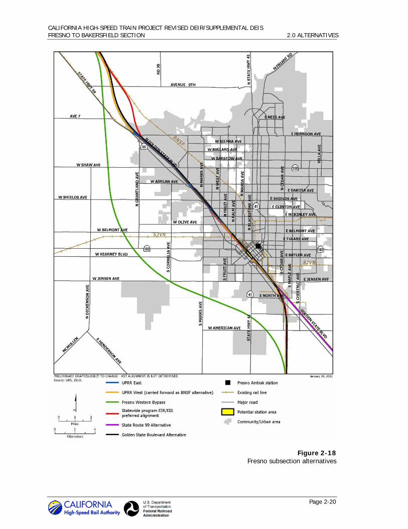
The five initial alternative alignments were based largely on the Statewide Program EIR/EIS preferred alignment and included input from the Fresno Technical Working Group (TWG) and other local stakeholders (Figure 2-18). These alternatives include the UPRR East, UPRR West, Golden State Boulevard, SR 99, and Fresno West Bypass alternatives.
Four of the five alternative alignments were not carried forward for full evaluation in this EIR/EIS. These include the UPRR East, Golden State Boulevard, SR 99, and the Fresno West Bypass alternatives. The UPRR East Alternative was not carried forward for further study as it would result in the demolition or relocation of the Southern Pacific Railroad Depot. The railroad depot is on the National Register of Historic Places and is protected under Section 4(f) of the U.S. Department of Transportation Act. Section 4(f) does not allow the U.S. Department of
CALIFORNIA HIGH-SPEED TRAIN PROJECT REVISED DEIR/SUPPLEMENTAL DEIS FRESNO TO BAKERSFIELD SECTION 2.0 ALTERNATIVES
Page 2-20
Figure 2-18 Fresno subsection alternatives

CALIFORNIA HIGH-SPEED TRAIN PROJECT REVISED DEIR/SUPPLEMENTAL DEIS FRESNO TO BAKERSFIELD SECTION 2.0 ALTERNATIVES
Page 2-21
Transportation to use protected properties unless there is no feasible and prudent alternative. The UPRR West Alternative is a feasible and prudent alternative, and therefore the UPRR East Alternative was not carried forward for further consideration.
The Golden State Boulevard Alternative was not carried forward for further study as it would be inconsistent with the City of Fresno’s redevelopment vision and would have greater community and environmental impacts with few, if any, environmental benefits relative to the UPRR East and UPRR West alternatives. The SR 99 Alternative was dismissed due to greater impacts on Roeding Park relative to the UPRR West and Golden State Boulevard alternatives, as well as its lack of connectivity to Fresno’s central business district.
The Fresno West Bypass Alternative would not be consistent with the project purpose and need or with the objective of using existing transportation corridors to the maximum extent possible. The alternative would also require acquisition of substantially more right-of-way than an alternative that goes through Fresno, and would therefore have substantially more impacts on environmental resources, including agricultural lands. The Fresno West Bypass Alternative was also opposed by both the City and County of Fresno. For these reasons, this alternative was not carried forward for further consideration.
An elevated “cross-over” alternative was carried forward in Fresno. This alternative travels on the eastern side of the UPRR tracks from Clinton Avenue south to Belmont Avenue where it crosses over to the western side of the UPRR tracks at a shallow angle and continues through Fresno on the western side of the UPRR. An at-grade cross-over alternative was determined not to be practicable as it would require two long, skewed crossings beneath the UPRR tracks in a tunnel or covered trench; one 4,000 feet long and the other 3,400 feet long. This would make the total trenching for the at-grade alternative 15,000 feet long as compared to the 7,800 feet required for the elevated cross-over alternative being carried forward. Although included in the alternatives analysis for the Fresno to Bakersfield Section, the cross-over alternative occurs north of the project terminus for this EIR/EIS (Amador Street), and is therefore carried forward in the Merced to Fresno Project EIR/EIS.
While several vertical alignment options were evaluated, building the HST primarily at-grade was determined to be the only practicable construction method for the Fresno subsection. The Authority and FRA judged that placement of the HST entirely below-grade would be impracticable. The alignment alternatives pass through a densely developed area of Fresno with many underground utilities, all of which would have to be relocated if the HST were placed in a trench or a cut-and-cover tunnel. Construction of a trench or cut-and-cover tunnel would also result in a lengthy disruption of traffic patterns because each road crossed by the HST would need to be closed and then rebuilt after the HST infrastructure was completed. Construction of an entirely below-grade HST would be much more expensive than the other vertical alignment options. For these reasons, an entirely below-grade alignment in Fresno was not carried forward for further consideration.
Although a stacked set of HST tracks would reduce the amount of property that would need to be acquired over the 6,000-foot length of the station tracks, this configuration would involve costly and complex design and construction, and would not reduce the other impacts associated with at-grade or elevated sets of tracks. Therefore, a stacked configuration was also not carried forward for further consideration.
An elevated structure was initially planned for this subsection; however, the high cost associated with the elevated structure in addition to City of Fresno concerns regarding its impacts through downtown Fresno led to the development of an at-grade alignment. The Authority conducted a value engineering study in January 2011 that found that at-grade construction would provide large project cost reductions. Design solutions were developed to remedy the infrastructure
CALIFORNIA HIGH-SPEED TRAIN PROJECT REVISED DEIR/SUPPLEMENTAL DEIS FRESNO TO BAKERSFIELD SECTION 2.0 ALTERNATIVES
Page 2-22
conflicts and design constraints described in previous alternatives analyses and it was determined that the HST would be built at-grade through Fresno.
Initial investigations and discussions with representatives of the City of Fresno indicated a preference for a station oriented toward the downtown. The city staff’s preference is for a station located at Mariposa Street on the east side of the UPRR right-of-way, oriented toward Fresno’s “front door.”
All the alternative alignments considered for the Fresno subsection feature a downtown station in the area generally bounded by Stanislaus Street on the north, Ventura Street on the south, H Street on the east, and SR 99 on the west. Because all of the alternative alignments provided the opportunity for a long stretch of straight track through this area, they afforded considerable flexibility for the location of the station platforms. Alternative stations were evaluated on the UPRR East and UPRR West alternative alignments between Stanislaus, H, Inyo, and G streets. Alternative stations on the Golden State Boulevard Alternative Alignment were evaluated between Stanislaus, G, Tulare, and F streets. For the SR 99 Alternative Alignment, stations were evaluated between Stanislaus, E, and Tulare streets, and SR 99.
Two Downtown Fresno station alternatives were carried forward in the Draft EIR/EIS, one at Mariposa Street and the other at Kern Street. On May 3, 2012, the Authority Board certified the Merced to Fresno Section Final EIR/EIS and selected the Mariposa Alternative as the Fresno station location.
4 The environmental evaluation of the Fresno station alternatives carried forward
in the Draft EIR/EIS demonstrated that environmental impacts were similar. Both the Mariposa and Kern station alternatives would affect a historic structure eligible or already on the National Register of Historic Places. Other effects include noise that would be mitigated, as well as temporary impacts on businesses and transportation circulation during construction. However, due to the City of Fresno’s planning and the orientation of the Downtown Fresno City Center, the Mariposa Station alternative offers substantially more opportunities for transit-oriented development.
Rural Subsection 2.3.2.2
The initial alternatives for the rural subsection originated from a variety of sources. First, the preferred alignment identified in the Statewide Program EIR/EIS was included as part of the analysis. Second, responding to the commitment made in the Statewide Program EIR/EIS to investigate alternatives that serve a potential station in the Visalia-Tulare-Hanford area, the Visalia-Tulare-Hanford Station Feasibility Study (Authority 2007) identified several alternative alignments. Third, initial alternatives were developed in response to input from local, state, and federal agency officials and stakeholders during the scoping process.
The initial alternatives reflect combinations of the following four factors:
• Primary Route. All of the initial alternatives followed the existing BNSF Railway or UPRR routes, in accordance with the project objective to use existing transportation corridors to the maximum extent possible.
• Traversing Communities. Many of the communities in the south San Joaquin Valley have grown up around the BNSF Railway and UPRR rights-of-way. Initial alternatives were identified that either passed through these communities adjacent to the existing railroad rights-of-way or bypassed the communities.
4 Issuance of the Record of Decision by the FRA is anticipated in summer 2012.
CALIFORNIA HIGH-SPEED TRAIN PROJECT REVISED DEIR/SUPPLEMENTAL DEIS FRESNO TO BAKERSFIELD SECTION 2.0 ALTERNATIVES
Page 2-23
• Visalia-Tulare-Hanford Area Station. A number of initial alternatives were driven by the possible locations for a potential Kings/Tulare Regional Station to serve the Visalia-Tulare-Hanford area.
• Transition from UPRR to BNSF Railway Corridor. Because Visalia and Tulare are located along the UPRR corridor, some of the initial alternatives for a Kings/Tulare Regional Station were in the UPRR corridor. However, all of the alternatives needed to return to the BNSF Railway Corridor before entering Bakersfield. The preferred alternative identified in the Statewide Program EIR/EIS calls for a station located in Downtown Bakersfield near the existing Amtrak station on the BNSF Railway line, and both Kern County and the City of Bakersfield passed resolutions supporting this station. By entering Bakersfield from the west along the BNSF Railway Corridor instead of the UPRR Corridor, the HST would result in far fewer relocation impacts and be more consistent with current and planned land uses.
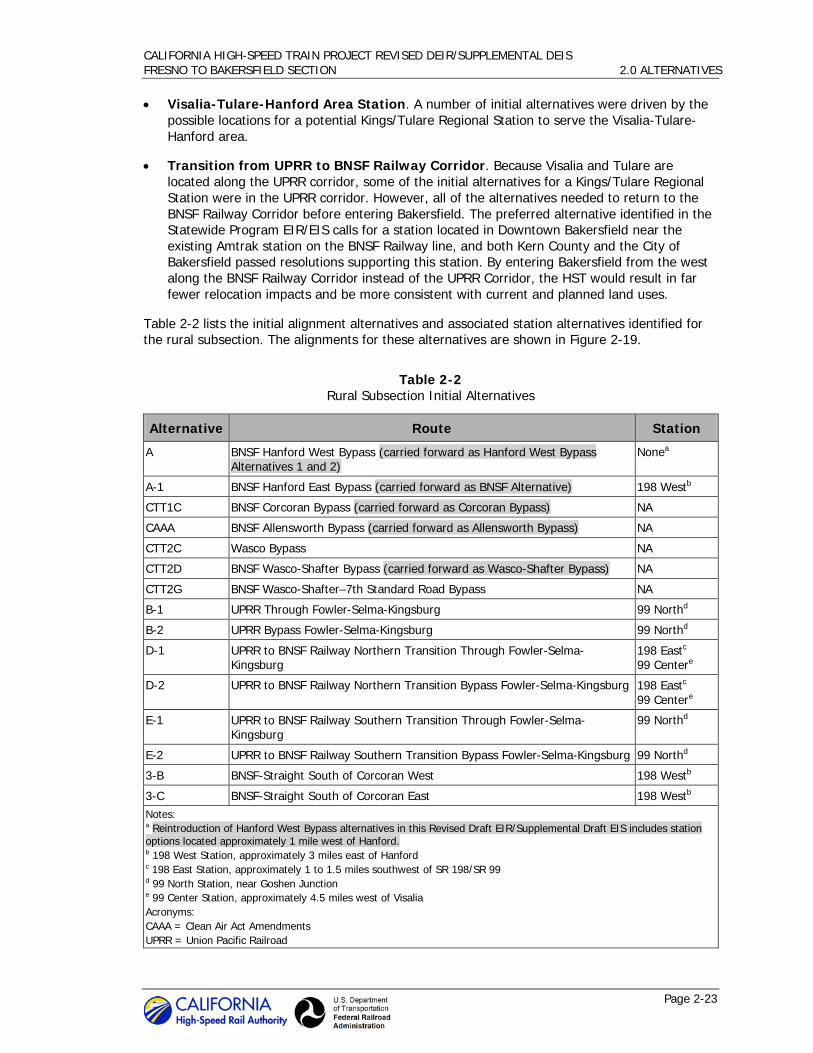
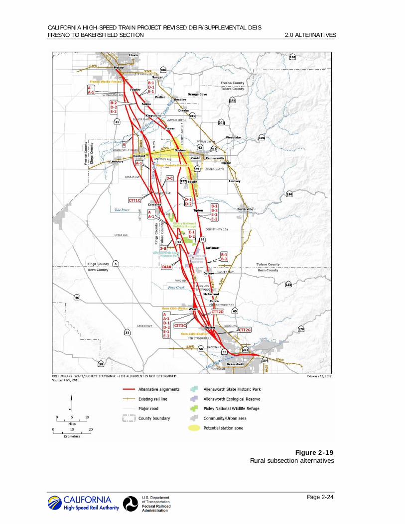
Table 2-2 lists the initial alignment alternatives and associated station alternatives identified for the rural subsection. The alignments for these alternatives are shown in Figure 2-19.
Table 2-2 Rural Subsection Initial Alternatives
Alternative Route Station
A BNSF Hanford West Bypass (carried forward as Hanford West Bypass Alternatives 1 and 2)
Nonea
A-1 BNSF Hanford East Bypass (carried forward as BNSF Alternative) 198 Westb
CTT1C BNSF Corcoran Bypass (carried forward as Corcoran Bypass) NA
CAAA BNSF Allensworth Bypass (carried forward as Allensworth Bypass) NA
CTT2C Wasco Bypass NA
CTT2D BNSF Wasco-Shafter Bypass (carried forward as Wasco-Shafter Bypass) NA
CTT2G BNSF Wasco-Shafter–7th Standard Road Bypass NA
B-1 UPRR Through Fowler-Selma-Kingsburg 99 Northd
B-2 UPRR Bypass Fowler-Selma-Kingsburg 99 Northd
D-1 UPRR to BNSF Railway Northern Transition Through Fowler-Selma-Kingsburg
198 Eastc 99 Centere
D-2 UPRR to BNSF Railway Northern Transition Bypass Fowler-Selma-Kingsburg 198 Eastc 99 Centere
E-1 UPRR to BNSF Railway Southern Transition Through Fowler-Selma-Kingsburg
99 Northd
E-2 UPRR to BNSF Railway Southern Transition Bypass Fowler-Selma-Kingsburg 99 Northd
3-B BNSF-Straight South of Corcoran West 198 Westb
3-C BNSF-Straight South of Corcoran East 198 Westb Notes: a Reintroduction of Hanford West Bypass alternatives in this Revised Draft EIR/Supplemental Draft EIS includes station options located approximately 1 mile west of Hanford. b 198 West Station, approximately 3 miles east of Hanford c 198 East Station, approximately 1 to 1.5 miles southwest of SR 198/SR 99 d 99 North Station, near Goshen Junction e 99 Center Station, approximately 4.5 miles west of Visalia Acronyms: CAAA = Clean Air Act Amendments UPRR = Union Pacific Railroad
CALIFORNIA HIGH-SPEED TRAIN PROJECT REVISED DEIR/SUPPLEMENTAL DEIS FRESNO TO BAKERSFIELD SECTION 2.0 ALTERNATIVES
Page 2-24
Figure 2-19 Rural subsection alternatives
CALIFORNIA HIGH-SPEED TRAIN PROJECT REVISED DEIR/SUPPLEMENTAL DEIS FRESNO TO BAKERSFIELD SECTION 2.0 ALTERNATIVES
Page 2-25
At the conclusion of the alternatives analysis, the Hanford West Bypass Alternative, which was the preferred alternative identified in the Program EIR/EIS, was not carried forward for further consideration in the Draft EIR/EIS because it would have greater impacts on aquatic resources, special-status species habitat, and agricultural land than the Hanford East Bypass. Although residential relocation and land use impacts would be similar between the two alignments, the Hanford West Bypass would be located between the cities of Hanford and Lemoore, an infill area where local plans seek to guide future development. HST construction of the Hanford West Bypass could discourage this development. In addition, the Hanford West Bypass would not provide as satisfactory a location for a potential Kings/Tulare Regional Station because it would not serve Visalia and Tulare as well as it would serve Hanford.
The Authority and FRA decided to reintroduce an alignment alternative west of Hanford to address substantive comments received during public and agency review, including requests from the USACE and USEPA to include a Hanford West Bypass Alternative in the environmental analysis of the Draft EIR/EIS in an attempt to reduce or avoid significant environmental effects. The USACE and USEPA found that preliminary data used to evaluate the Hanford East and West Bypass alternatives did not demonstrate a large enough difference between associated impacts to warrant exclusion of the Hanford West Bypass Alternative. The Authority conducted a supplemental alternatives analysis to further evaluate potential alignment alternatives west of Hanford and on the basis of this analysis, identified two Hanford West Bypass alternatives to carry through the environmental analysis in this Revised Draft EIR/Supplemental Draft EIS (Authority and FRA 2011). Both of these alternatives include a potential station site.
Previous analyses found that at-grade alignments through Corcoran, Wasco, and Shafter would result in substantial community disruption during project construction. The Authority identified large project cost reductions in the January 2011 value engineering study, described previously, from at-grade construction through Corcoran. While both at-grade and elevated alignment options are carried forward through Corcoran, the major impacts on the road networks and BNSF Railway operations and facilities in Wasco and Shafter made an at-grade alignment through these cities impracticable.
A bypass around Wasco and Shafter was considered to minimize impacts on both communities. The Wasco-Shafter-Seventh Standard Road bypass alternative was dismissed from further study, as it would require the acquisition of approximately 20 more acres of prime farmland than the Wasco-Shafter Bypass, would physically divide a planned 2,600-acre housing development, and is not supported by the City of Bakersfield.
The Statewide Program EIR/EIS evaluated potential HST alternatives in both the BNSF Railway and UPRR corridors. The BNSF Alignment was identified as the preferred alignment for the Fresno to Bakersfield Section.
The Statewide Program EIR/EIS also committed the Authority and FRA to conduct additional study of potential station locations in an existing or planned urbanized area near Visalia prior to the commencement of the project-level environmental review for the Fresno to Bakersfield Section. As Visalia and Tulare are located on the UPRR, evaluation of station sites required that alternatives along the UPRR corridor be considered. The Authority conducted the Visalia-Tulare-Hanford Station Feasibility Study (Authority 2007) to evaluate potential station sites in a zone extending along SR 99 from north of Visalia to south of Tulare and along SR 198 and the San Joaquin Valley Railroad (SJVR) corridor, from Visalia to the western side of Hanford (Figure 2-17). Four potential sites were identified:
• 99 North. This station site is located in Goshen adjacent to SR 99 in the vicinity of the UPRR and CVR junction.
• 198 East. This station site is located on SR 198 to the west of Visalia.
CALIFORNIA HIGH-SPEED TRAIN PROJECT REVISED DEIR/SUPPLEMENTAL DEIS FRESNO TO BAKERSFIELD SECTION 2.0 ALTERNATIVES
Page 2-26
• 99 Center. This station site is adjacent to SR 99 and the Visalia Municipal Airport. • 198 West. This station site is east of Hanford near the interchange of SR 198 and SR 43.
The 198 West potential station site would be served by the Hanford East Bypass in the BNSF Railway corridor. The remaining sites would be served by alignments in the UPRR corridor. The Visalia-Tulare-Hanford Station Feasibility Study indicated that any of these station sites would provide good service to the region due to their connectivity to the local transportation network and proximity to population centers.
As described in Section 2.3.2.3 of the referenced Feasibility Study, six alternatives were evaluated within the UPRR corridor to serve the potential station sites in the Visalia area (UPRR alternative alignments B-1, B-2, D-1, D-2, E-1, and E-2). These six alternatives can be described as three basic alignments with alternative routing in the vicinity of Fowler, Selma, and Kingsburg. The UPRR right-of-way passes through Fowler, Selma, and Kingsburg, and all three of these cities, as well as Fresno County, are strongly opposed to an HST passing through them. Therefore, alignment alternatives that would bypass the three cities to the west (B-2, D-2, and E-2) as well as alignments adjacent to the UPRR right-of-way (B-1, D-1, and E-1) were considered. The bypass alternatives would encroach on approximately the same number of residential parcels as the alignments adjacent to the UPRR right-of-way; however, all three bypass alternatives (B-2, D-2, and E-2) would have greater impacts on special-status species habitat (approximately 24 more acres) and farmland (approximately 135 more acres).
South of Visalia, the three pairs of UPRR alternative alignments follow different routes to reconnect with the BNSF Railway north of Bakersfield. To minimize out-of-direction travel and maintain the travel-time goal, UPRR alternative alignments D-1 and D-2 travel almost due south from Visalia and reconnect with the BNSF Railway corridor in the Allensworth area. UPRR alternative alignments E-1 and E-2 continue along the UPRR corridor south from Visalia to Pixley where they then diverge to the southwest, rejoining the BNSF Railway route at the Tulare/Kern county border. UPRR alternative alignments B-1 and B-2 continue on the UPRR corridor south from Visalia all the way to SR 46 south of McFarland, where they then travel due south to rejoin the BNSF Railway south of Shafter at approximately Seventh Standard Road (Figure 2-19).
South of the Tule River, alternative alignments D-1/D-2 and E-1/E-2 cross through extensive wetland habitat. Alternative alignments D-1/D-2 cross the Pixley National Wildlife Refuge and alternatives E-1/E-2 cross the Allensworth Ecological Reserve. Alternatives D-1/D-2 and E-1/E-2 would affect 43 and 93 acres of wetlands, respectively, most of which occurs in the area south of the Tule River. This is substantially more wetland impacts than those resulting from alternatives in the BNSF corridor or from UPRR alternatives B-1/B-2.
Additionally, alternatives D-1 and D-2 would have approximately 30 and 45 miles, respectively, of alignment outside of an existing transportation corridor, which is inconsistent with project objectives. Alternatives E-1 and E-2 also cross a wildlife refuge protected under Section 4(f) of the U.S. Department of Transportation Act. For these reasons, UPRR alternatives D-1/D-2 and E-1/E-2 were not carried forward for further consideration.
Existing environmental information indicates that UPRR alternatives B-1 and B-2 and alternatives on the BNSF Railway corridor would have approximately the same level of impact on biological resources. UPRR Alternative B-2 would affect fewer acres of special aquatic resources5 than the BNSF Alternative carried forward in the EIR/EIS (about 22 versus 30 acres). However, Alternative B-2 would impact 1.56 acres of vernal pool habitat with high functions and services values while the BNSF Alternative would have no impact to vernal pool habitat. The BNSF Alternative would
5 Special aquatic resources along alternative alignments consist of canals and ditches,
retention/detention basins, riparian habitat, riverine habitat, seasonal wetlands, and vernal pools.

CALIFORNIA HIGH-SPEED TRAIN PROJECT REVISED DEIR/SUPPLEMENTAL DEIS FRESNO TO BAKERSFIELD SECTION 2.0 ALTERNATIVES
Page 2-27
impact more habitat for special-status species than Alternative B-2 (about 1,132 versus 1,128 acres). Alternative B-2 would impact 25 acres of critical habitat for special-status species while the BNSF Alternative would impact no critical habitat.
As part of the effort to determine which alternatives to carry forward, the Authority and FRA developed information in 2011 regarding the practicability of a UPRR alignment alternative in the rural subsection. The 2011 practicability information focused on the evaluation criteria established by the Section 404(b)(1) Guidelines: existing technology, logistics, and cost. The UPRR B-2 Alternative was selected for further analysis as it would include a bypass of Fowler, Selma, and Kingsburg, a feature strongly requested by those municipalities and by Fresno County. Key findings indicate that HST construction along the UPRR Corridor would:
• Present substantial technical challenges.
• Present numerous logistical conflicts with existing infrastructure, in particular, UPRR railroad tracks, SR 99, SR 198, the Visalia Municipal Airport, local roads, and more than a dozen large industrial facilities.
• Potentially require the resolution of complex legal issues raised by UPRR, which could delay the onset of project construction by several years.
The major logistical impediment to the construction of an HST project along the UPRR corridor is UPRR’s position that it is not in its best interest for the HST project to be placed on its right-of-way. UPRR has stated its position in correspondence with the Authority on many occasions. These letters identify concerns and emphasize that the HST project being constructed on or immediately adjacent to its right-of-way could have adverse business/economic consequences to UPRR itself, its customers, and local, regional, and state economies. According to UPRR, placement of the HST alignment immediately adjacent to its Fresno Subdivision line would interrupt service to many existing shippers, resulting in severe economic losses.
In addition, UPRR notes its common carrier obligation to provide service to customers along its railroad lines. UPRR cannot be forced to abandon or discontinue freight service over its main or branch lines without authority from the Surface Transportation Board. UPRR also noted the environmental consequences of having HST limit or constrain its freight operations: industries that cannot in the future be served by freight rail due to proximity to the HST project would have to rely on truck service on local roads to move their goods.
The UPRR is more adverse to the HST being located adjacent to its right-of-way in this section of the proposed California HST System than in other sections. At approximately 114 miles in length, the Fresno to Bakersfield Section crosses the entire southern San Joaquin Valley, the most productive agricultural region in California, and among the most productive agricultural regions in the world. SR 99 already blocks UPRR from serving potential customers on one side of its Fresno Subdivision line in the southern San Joaquin Valley. Locating the HST adjacent to the UPRR right-of-way would block the other side of its line in many areas. In letters to the Authority, UPRR has characterized the location of the HST adjacent to its Fresno Subdivision line as creating a “railroad desert” through a region where railroad service is important to the efficient movement of agricultural products. There are locations where there are no suitable alternatives to locating the HST alignment adjacent to the UPRR in other sections of the proposed HST system, however, in the southern San Joaquin Valley, the BNSF Corridor does provide a viable alternative to the UPRR Corridor (Authority and FRA 2011).
The 2011 information regarding UPRR practicability substantiated earlier findings that a UPRR alignment alternative would present numerous technical challenges and involve extensive logistical (physical and legal) conflicts with the UPRR mainline and spurs, and with state

CALIFORNIA HIGH-SPEED TRAIN PROJECT REVISED DEIR/SUPPLEMENTAL DEIS FRESNO TO BAKERSFIELD SECTION 2.0 ALTERNATIVES
Page 2-28
highways, local roads, and industrial facilities. For these reasons, UPRR alignment alternatives were judged to be impracticable and were not carried forward for further consideration.
Bakersfield Subsection 2.3.2.3
The Bakersfield subsection begins at Hageman Road in Rosedale, northwest of Bakersfield, where it meets the rural subsection. It continues through Downtown Bakersfield and terminates at Oswell Street, southeast of downtown.
The ten preliminary alternatives for the Bakersfield subsection were variations of the Statewide Program EIR/EIS preferred alternative alignment, and were developed in coordination with city staff, local stakeholders, and the Bakersfield Technical Assessment Group. Five of the ten preliminary alternatives were grouped under Alternative Family 1. An additional three alternatives were grouped under Alternative Family 2. Alternatives 3 and 4 each include only one alternative. The initial alternatives were based on the factors described below.
• Truxtun Station – The Statewide Program EIR/EIS process identified a preferred station near Truxtun Avenue in the vicinity of the existing Amtrak station. This location ties into the local transit system and is most compatible with Bakersfield land use plans. A Truxtun station was endorsed by the City of Bakersfield, the County of Kern, and the Kern Council of Governments in 2003.
6
• Operating Speed – The geometry of all the alternative alignments needed to be straight enough to maintain operating speeds of 220 mph through Bakersfield in order to meet travel time goals for the system.
• Minimize Impacts on Cultural and Civic Resources – To reach a station site in the vicinity of Truxtun Avenue, the alignment must pass through a densely developed downtown. Initial alternatives were developed to minimize impacts on county and city civic buildings, schools, hospitals, and other important resources.
• Refinery – The BNSF Railway passes through the “Flying-J” refinery (purchased by Alon USA Energy, Inc. in 2010) in northwestern Bakersfield. Initial alternatives were developed to avoid this facility.
The five initial alternatives that belong to Alternative Family 1 would circumvent the Flying-J Refinery and parallel the Westside Parkway right-of-way. Two of these alternatives (Alternatives 1B and 1C) were not carried forward for further consideration as reasonable operating speeds could not be maintained on these alignments, and a third (Alternative 1E) was removed from consideration due to business displacements and constructability issues. The two alternatives carried forward from this family were renamed Alternative D1 and Alternative D2. Alternative D1 includes two local options, one with an elevated alignment north of UPRR (D1-N) and one with an elevated alignment south of UPRR (D1-S). Alternative D2 also includes two local options, one with an elevated alignment north of the BNSF Railway right-of-way in Central Bakersfield (D2-N), and one with an elevated alignment over the BNSF Railway right-of-way in Central Bakersfield (D2-S).
6 The City of Bakersfield and Kern Council of Governments reviewed issues concerning the siting of the
Metropolitan Bakersfield High-Speed Rail Terminal for over 6 years, participated in a regional steering committee created by the Kern Council of Governments, and retained a consultant team to analyze three potential sites in the Bakersfield metropolitan area. After careful consideration, the Council of the City of Bakersfield issued Resolution No. 118-03 on July 9, 2003, endorsing the downtown Truxtun Avenue site for the High-Speed Rail Terminal. The City of Bakersfield has since reversed its position, and issued Resolution No. 119-11 on December 14, 2011, opposing the High-Speed Rail Project.

CALIFORNIA HIGH-SPEED TRAIN PROJECT REVISED DEIR/SUPPLEMENTAL DEIS FRESNO TO BAKERSFIELD SECTION 2.0 ALTERNATIVES
Page 2-29
Alternative D1-N was not carried forward for further consideration in this EIR/EIS because it would require a large number of residential displacements in an environmental justice community, displacement of a power transmission substation, and impracticable construction requirements necessary to maintain design speed. Alternative D2-S was also removed from consideration, as the required construction of a 3-mile elevated structure above the existing BNSF Railway yard and mainline tracks was determined to be impracticable.
The second family of alternatives (Alternative Family 2) included three alternatives (Alternatives 2A, 2B, and 2C) that would most closely follow the path of the Statewide Program EIR/EIS preferred alignment. None of the three alternatives were carried forward for further consideration, as all three would travel through the Flying-J Refinery along the BNSF Railway right-of-way. The freight rail right-of-way is narrow in this area and would not allow HST tracks to share the constrained right-of-way. In addition, gas pipelines parallel and pass under the right-of-way, posing obstacles for construction and the possibility of encountering fuel leaks and contaminated soil. A risk assessment was done of HST operation through an active refinery, and it concluded that the proximity of the trains to refinery facilities could result in catastrophic events that could not be adequately mitigated to minimize risk to the passing trains and their riders. The risk assessment also cautioned that sparking from the trains’ overhead power lines could ignite a gas release from the refinery, causing an explosion. For these reasons, these alternatives were not carried forward for further consideration.
Alternative 3 would follow the proposed roadway alignments of the Centennial Corridor east of the Kern River. This alternative was removed from further consideration because required speeds could not be maintained along this corridor without cutting through established residential communities.
Alternative 4 deviated substantially from the BNSF right-of-way and avoided Downtown Bakersfield. This initial alternative was not carried forward for further consideration as it would not meet the project’s purpose and need of providing a downtown station.
The alternatives analysis included consideration of station locations in the vicinity of Golden State Highway and the Bakersfield Airport; however, these station locations were eliminated when their associated HST alignments were removed from consideration during the evaluation of alternatives process. Alternatives D1-S and D2-N were carried forward into this EIR/EIS analysis and both feature a station location consistent with the preferred Bakersfield station location in Downtown Bakersfield near Truxtun Avenue in the vicinity of the existing Amtrak station. The station platform for Alternative D1-S (carried forward as BNSF Alternative) would be elevated over the BNSF Railway mainline. For Alternative D2-N (carried forward as Bakersfield South), the elevated station platform would be in the Mill Creek Redevelopment Area just south of the BNSF Railway right-of-way.
A hybrid alternative that would follow Alternative D2-N with a D1-S station location was also considered. This alternative was not carried forward in the Draft EIR/EIS because it would not maintain the necessary speeds through Bakersfield required by mandated travel times between San Francisco and Los Angeles. Straightening the curves of this alignment in order to meet design speeds would result in substantial impacts on important community facilities. As this hybrid alternative would either not meet project design objectives or result in substantial disruption to the community, this alternative was not carried forward for further consideration.
The Authority, in cooperation with the affected stakeholders, developed a similar hybrid alternative alignment for the Bakersfield subsection to address substantive comments received during public and agency review of the Draft EIR/EIS. The Authority and FRA identified the Bakersfield Hybrid Alternative to carry through the environmental analysis in this Revised Draft EIR/Supplemental Draft EIS. This hybrid alternative is a variation of the two Bakersfield

CALIFORNIA HIGH-SPEED TRAIN PROJECT REVISED DEIR/SUPPLEMENTAL DEIS FRESNO TO BAKERSFIELD SECTION 2.0 ALTERNATIVES
Page 2-30
subsection alternatives already carried forward into this EIR/EIS, and all three alternatives share corresponding termini. While the Bakersfield Hybrid Alternative would require reduced speeds and would impact the overall travel times mandated by the California State Legislature, it provides the advantage of avoiding the Bakersfield High School campus, and reduces the number of religious facilities and homes impacted in east Bakersfield. The Bakersfield Hybrid Alternative also includes a potential station site.
Figure 2-20 illustrates the Alternatives D1-S (carried forward as BNSF Alternative), D2-N (carried forward as Bakersfield South), the Bakersfield Hybrid Alternative, and the Programmatic EIR/EIS preferred alignment.
Heavy Maintenance Facility 2.3.2.4
The Supplemental Alternatives Analysis incorporated the screening of the proposed sites for an HMF within the Fresno to Bakersfield Section in August 2010. The fundamental requirements for the HMF are defined by two Authority Technical Memoranda: TM 5.1, Terminal and HMF Guidelines (Authority 2009c), and TM 5.3, Maintenance Facilities Requirements Summary (Authority 2009d). In November 2009, based on the specific site and facility requirements, the Authority solicited Expressions of Interest (EOI) from parties between Merced and Bakersfield who could provide proposals where the HMF could be located.
The Fresno to Bakersfield Section of the HST system received eight proposals. Four of the eight sites were carried forward for further analysis in the EIR/EIS, and an additional site, Kern Council of Governments-Shafter West has been added for further consideration:
• Fresno Works–Fresno. • Kings County–Hanford. • Kern Council of Governments–Wasco. • Kern Council of Governments–Shafter East. • Kern Council of Governments–Shafter West.
Four sites were dismissed from further consideration, and are not carried forward into the EIR/EIS. The Angiola proposal was removed due to size limitations and land use conflicts, while the Allensworth and McFarland proposals were eliminated as a result of accessibility issues. The Bakersfield proposal was removed from consideration due to inconsistencies with existing plans and policies and the site’s 6-mile distance from the nearest HST alternative.

CALIFORNIA HIGH-SPEED TRAIN PROJECT REVISED DEIR/SUPPLEMENTAL DEIS 2.0 ALTERNATIVES FRESNO TO BAKERSFIELD SECTION
Page 2-31
Figure 2-20 Bakersfield subsection alternatives

CALIFORNIA HIGH-SPEED TRAIN PROJECT REVISED DEIR/SUPPLEMENTAL DEIS 2.0 ALTERNATIVES FRESNO TO BAKERSFIELD SECTION
Page 2-32
2.3.3 Summary of Design Features for Alternatives Being Carried Forward
Figure 2-21 illustrates the HST alternatives and the HMF sites being carried forward for further study. As discussed in Section 2.3.2, the impact analysis presented in this Fresno to Bakersfield Revised Draft EIR/Supplemental Draft EIS extends from Amador Street in the north to Oswell Street in the south. The Fresno to Bakersfield Section alternatives presented in this Revised Draft EIR/Supplemental Draft EIS reflect refinements made to the project design to avoid and minimize impacts on known environmental and community resources. The alternatives evaluated herein represent a 15% design level and are summarized in Table 2-3.
A key performance measure of each of the alternatives is the travel time between key destinations. The state-legislated HST system requirement is to provide for a nonstop service travel time between San Francisco and Los Angeles of 2 hours and 40 minutes, as well as a 2-hour and 20-minute trip between Los Angeles Union Station and Sacramento. Because the Fresno to Bakersfield HST alignment alternatives are located along the same corridor, travel times by alternative are similar. Selection of the Bakersfield Hybrid Alternative would increase travel time by approximately 1 minute.

CALIFORNIA HIGH-SPEED TRAIN PROJECT REVISED DEIR/SUPPLEMENTAL DEIS 2.0 ALTERNATIVES FRESNO TO BAKERSFIELD SECTION
Page 2-33
Table 2-3 Design Features of Alternatives Carried Forwarda
Design Option BNSF
Hanford West Bypass 1
Hanford West Bypass 2
Corcoran Elevated
Corcoran Bypass
Allensworth Bypass
Wasco-Shafter Bypass
Bakersfield South
Bakersfield Hybrid
At-Grade
Below-Grade
At-Grade
Below-Grade
Total Lengthb (linear miles) 117 28(30) 28(30) 28(30) 28(30) 10(10) 10(10) 21(21) 21(22) 12(12) 12(12)
At-grade Profileb (linear miles) 87 24(24) 21(24) 22(24) 19(24) 3(5) 6(5) 18(19) 18(15) 3(3) 3(3)
Elevated Profileb (linear miles) (including Retained Fill)
30 4(6) 4(6) 6(6) 6(6) 7(5) 4(5) 3(2) 3(7) 9(9) 9(9)
Below-grade Profileb (linear miles) 0.1 0(0) 3(0) 0(0) 3(0) 0(0) 0(0) 0(0) 0(0) 0(0) 0(0)
Number of Straddle Bents 62 0(0) 0(0) 0(0) 0(0) 0(0) 0(0) 0(0) 0(0) 71(62) 34(62)
Number of Railroad Crossings 9 1(1) 1(1) 1(1) 1(1) 8(1) 1(1) 1(1) 1(1) 3(2) 3(2)
Number of Major Water Crossings 7 3(4) 3(4) 3(4) 3(4) 0(0) 2(2) 0(0) 1(1) 1(1) 1(1)
Number of Road Crossings 188 29(34) 29(34) 29(34) 29(34) 11(10) 12(10) 9(9) 30(22) 48(56) 54(56)
Approximate Number of Roadway Closuresc 45 5(6) 5(6) 5(6) 5(6) 2(2) 7(2) 3(3) 18(4) 3(5) 10(5)
Number of Roadway Overcrossings and Undercrossings 53 20(20) 20(20) 18(20) 18(20) 2(2) 4(2) 4(5) 8(8) 1(1) 1(1)
Notes: a For comparison, equivalent numbers for the corresponding segment of the BNSF Alternative are presented in parenthesis. b Lengths shown are based on equivalent dual-track alignments. For example, the length of single-track elevated structure will be divided by a factor of 2 to convert to dual-track equivalents. c Includes public and private road closures.

CALIFORNIA HIGH-SPEED TRAIN PROJECT REVISED DEIR/SUPPLEMENTAL DEIS 2.0 ALTERNATIVES FRESNO TO BAKERSFIELD SECTION
Page 2-34
Figure 2-21 HST alternatives and HMF sites carried forward for further study

CALIFORNIA HIGH-SPEED TRAIN PROJECT REVISED DEIR/SUPPLEMENTAL DEIS FRESNO TO BAKERSFIELD SECTION 2.0 ALTERNATIVES
Page 2-35
2.4 Alignment, Station, and Heavy Maintenance Facility Alternatives Evaluated in this Project EIR/EIS
This section describes the project alternatives carried forward for further analysis in this Revised Draft EIR/Supplemental Draft EIS, beginning with the No Project Alternative and then carrying on to the HST alternatives. Discussion of the HST alternatives begins with a single continuous alignment, hereinafter termed the “BNSF Alternative.” This alternative extends from the northern end of the Fresno station tracks near Amador Street to Oswell Street in Bakersfield. This alternative most closely follows the preferred alignment selected in the Record of Decision (ROD) for the Statewide Program EIR/EIS. Descriptions of the additional eight alternative alignments that deviate from the BNSF Alternative for portions of the route then follow. In addition to the alternative alignments, two station alternatives in Fresno, two potential station locations in the Hanford area, three station alternatives in Bakersfield, and five potential heavy-maintenance facility alternatives are described.
The Fresno to Bakersfield Section study area discussion is organized from north to south. The project termini are the northern end of the Downtown Fresno Station tracks near Amador Street and the southern end of the Bakersfield station tracks in the vicinity of Baker Street. The study area extends to Oswell Street in eastern Bakersfield.
Appendix 2-A provides a detailed list of associated roadway modifications required to accommodate the HST system. All modifications (closures, overcrossings, or undercrossings) are shown in maps in the following descriptions. Appendix 2-B provides detailed lists of associated railroad crossings. The potential HMF alternatives are described separately from the alignment alternatives and stations. Appendix 3.1-A is a map book of the project footprint for all alternatives, including stations, potential HMF sites, and easements needed for power supply.
2.4.1 No Project Alternative – Existing and Planned Improvements
The No Project Alternative considers the effects of growth planned for the region as well as existing and planned improvements to the highway, aviation, conventional passenger rail, and freight rail systems in the Fresno to Bakersfield project area through the 2035 time horizon for the environmental analysis.
Planned growth 2.4.1.1
The San Joaquin Valley is projected to grow at a higher rate than any other region in California. The four counties of Fresno, Kings, Tulare, and Kern are projected to continue to grow at an average of 2.9% per year. Table 2-4 shows the projected population growth according to the California Department of Finance (DOF) for the four counties, as well as employment growth projections through 2035. Despite the current economic downturn, which may temporarily slow growth, by 2035 projections show over 1.7 million new inhabitants and 359,886 new jobs in this area.
General plan updates in each of the counties and incorporated cities in the region have occurred since 2002 in preparation for this projected growth. Previously, the seven councils of government (COGs) in the San Joaquin Valley engaged in the San Joaquin Valley Blueprint Planning Process for the purpose of examining alternative growth scenarios for the valley and selecting a preferred scenario to reflect regional partialities for future development patterns. In this process, Fresno, Kings, Tulare, and Kern county representative COGs reflected on the planning scenarios for their future development strategies. Computer programs modeled results of different land use densities so that the councils could make informed decisions for the future.
Growth Projections in Fresno, Kings, Tulare, and Kern Counties 2035 population projections show a need for approximately 550,000 new dwelling units and 173,000 acres of land to accommodate nearly 1.7 million new inhabitants in the area.
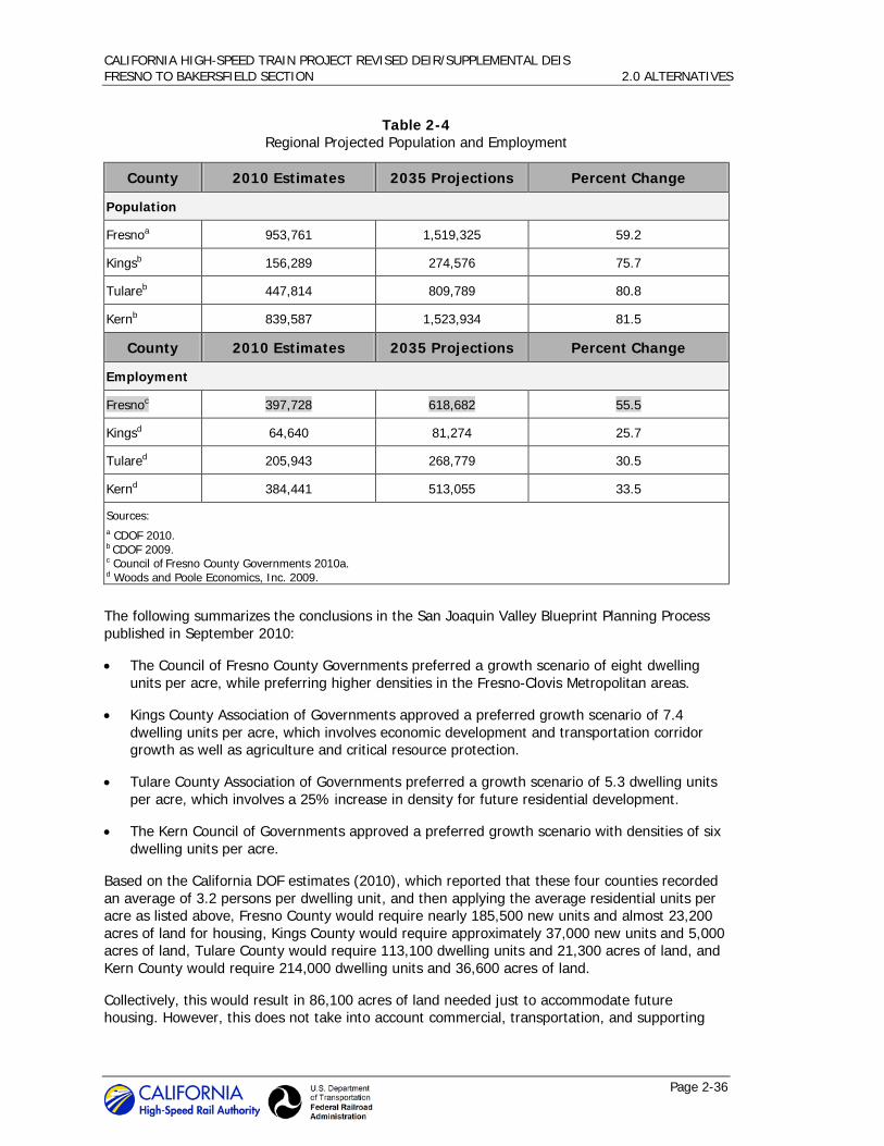
CALIFORNIA HIGH-SPEED TRAIN PROJECT REVISED DEIR/SUPPLEMENTAL DEIS FRESNO TO BAKERSFIELD SECTION 2.0 ALTERNATIVES
Page 2-36
Table 2-4 Regional Projected Population and Employment
County 2010 Estimates 2035 Projections Percent Change
Population
Fresnoa 953,761 1,519,325 59.2
Kingsb 156,289 274,576 75.7
Tulareb 447,814 809,789 80.8
Kernb 839,587 1,523,934 81.5
County 2010 Estimates 2035 Projections Percent Change
Employment
Fresnoc 397,728 618,682 55.5
Kingsd 64,640 81,274 25.7
Tulared 205,943 268,779 30.5
Kernd 384,441 513,055 33.5
Sources: a CDOF 2010. b CDOF 2009. c Council of Fresno County Governments 2010a. d Woods and Poole Economics, Inc. 2009.
The following summarizes the conclusions in the San Joaquin Valley Blueprint Planning Process published in September 2010:
• The Council of Fresno County Governments preferred a growth scenario of eight dwelling units per acre, while preferring higher densities in the Fresno-Clovis Metropolitan areas.
• Kings County Association of Governments approved a preferred growth scenario of 7.4 dwelling units per acre, which involves economic development and transportation corridor growth as well as agriculture and critical resource protection.
• Tulare County Association of Governments preferred a growth scenario of 5.3 dwelling units per acre, which involves a 25% increase in density for future residential development.
• The Kern Council of Governments approved a preferred growth scenario with densities of six dwelling units per acre.
Based on the California DOF estimates (2010), which reported that these four counties recorded an average of 3.2 persons per dwelling unit, and then applying the average residential units per acre as listed above, Fresno County would require nearly 185,500 new units and almost 23,200 acres of land for housing, Kings County would require approximately 37,000 new units and 5,000 acres of land, Tulare County would require 113,100 dwelling units and 21,300 acres of land, and Kern County would require 214,000 dwelling units and 36,600 acres of land.
Collectively, this would result in 86,100 acres of land needed just to accommodate future housing. However, this does not take into account commercial, transportation, and supporting

CALIFORNIA HIGH-SPEED TRAIN PROJECT REVISED DEIR/SUPPLEMENTAL DEIS FRESNO TO BAKERSFIELD SECTION 2.0 ALTERNATIVES
Page 2-37
infrastructure such as parks, water treatment, and medical facilities. With necessary supporting infrastructure, including commercial, office, transportation, parks, and schools, a typical density for an area similar to the San Joaquin Valley would result in 8 to 10 people per acre of land development
7 (Colorado Department of Transportation 2006). Under this scenario, the total four-
county growth projections would result in approximately 173,000 acres of needed development. This becomes the basis for comparing the HST project alternatives.
The No Project Alternative includes more detail on several planned transportation, housing, commercial, and other development projects by the year 2035. Section 3.19, Cumulative Impacts, provides a list of foreseeable future development projects, which include shopping centers, large residential developments, and planned transportation projects defined in the various RTPs for each of the four counties. Some of the notable, larger planned residential projects in the region are listed in Table 2-5. For more detail, see Section 3.19, Cumulative Impacts.
7 In Denver, the Colorado Department of Transportation studied land use density as part of the
preparation for the US 36 Project Alternative Analysis/EIS (2006). The study conducted a GIS analysis of 50 years of land use trends based on historical aerial photos digitized and then measured actual census data to determine that the gross use of an acre of land supported an average of 10 persons.
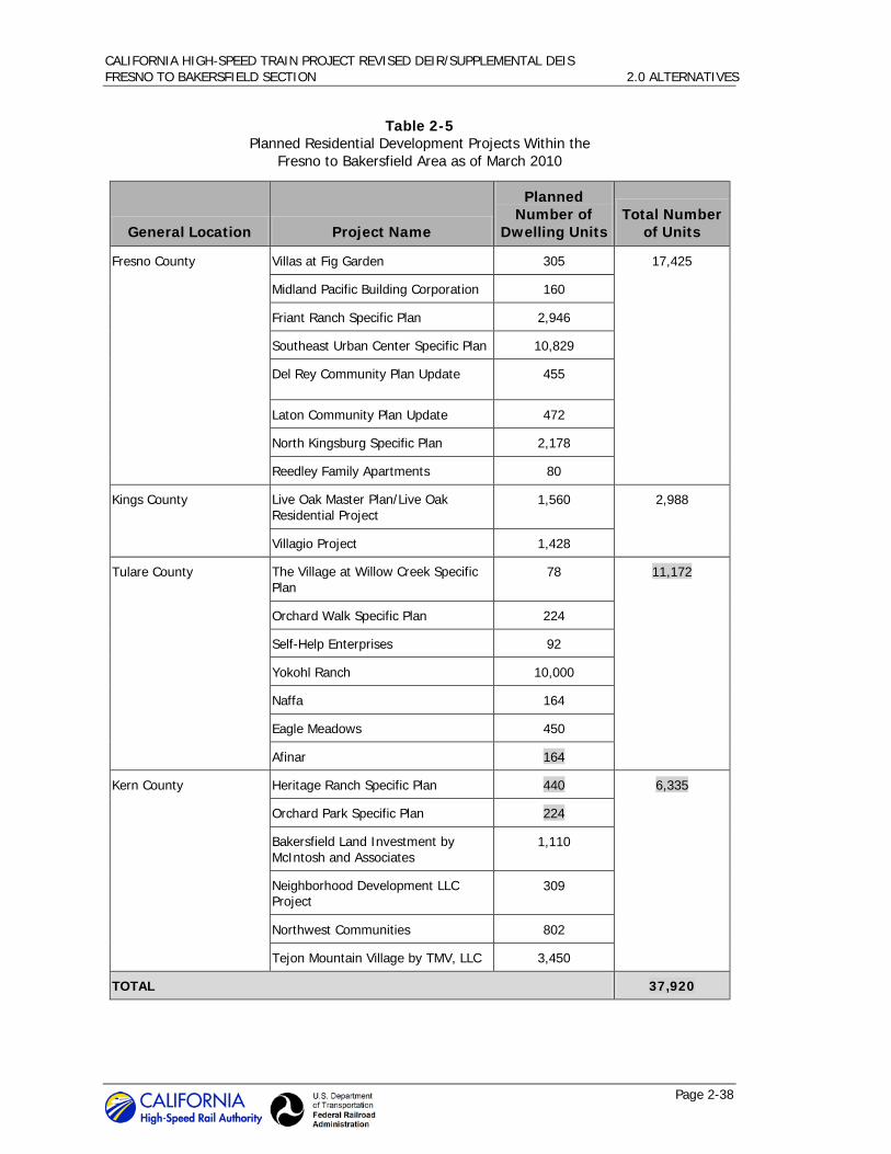
CALIFORNIA HIGH-SPEED TRAIN PROJECT REVISED DEIR/SUPPLEMENTAL DEIS FRESNO TO BAKERSFIELD SECTION 2.0 ALTERNATIVES
Page 2-38
Table 2-5 Planned Residential Development Projects Within the
Fresno to Bakersfield Area as of March 2010
General Location Project Name
Planned Number of
Dwelling Units Total Number
of Units
Fresno County Villas at Fig Garden 305 17,425
Midland Pacific Building Corporation 160
Friant Ranch Specific Plan 2,946
Southeast Urban Center Specific Plan 10,829
Del Rey Community Plan Update 455
Laton Community Plan Update 472
North Kingsburg Specific Plan 2,178
Reedley Family Apartments 80
Kings County Live Oak Master Plan/Live Oak Residential Project
1,560 2,988
Villagio Project 1,428
Tulare County The Village at Willow Creek Specific Plan
78 11,172
Orchard Walk Specific Plan 224
Self-Help Enterprises 92
Yokohl Ranch 10,000
Naffa 164
Eagle Meadows 450
Afinar 164
Kern County Heritage Ranch Specific Plan 440 6,335
Orchard Park Specific Plan 224
Bakersfield Land Investment by McIntosh and Associates
1,110
Neighborhood Development LLC Project
309
Northwest Communities 802
Tejon Mountain Village by TMV, LLC 3,450
TOTAL 37,920

CALIFORNIA HIGH-SPEED TRAIN PROJECT REVISED DEIR/SUPPLEMENTAL DEIS FRESNO TO BAKERSFIELD SECTION 2.0 ALTERNATIVES
Page 2-39
As of March 2010, there are residential plans at various stages of approval in the cities and counties in the study area. Within Fresno County, there are approximately 17,425 planned residential units. The City of Fresno’s ongoing general plan update is expected to include the city’s 9,000-acre Southeast Growth Area (SEGA), with the potential to accommodate more than 17,000 additional dwelling units. Because the general plan update has not been adopted, the potential capacity of the SEGA is not reflected in Table 2-5. In Kings County, there are approximately 2,988 planned residential units, primarily in the Hanford area. In Tulare County, there are approximately 11,172 planned residential units. In Kern County, there are approximately 6,335 planned residential units. Overall, approximately 37,920 residential units are in the planning approvals process in the four-county region. Due to the economy, the pace of construction has slowed for much of the development has slowed, but the plans are there to accommodate growth as it occurs.
Planned growth also includes campus expansions and school projects such as Southeast Fresno Community College expansion, West Hills College Coalinga expansion, Clovis Community Medical Center Healthcare Campus expansion, and Northwest School new school complex. Commercial and industrial projects are planned throughout the four-county study area; major projects include South I Street Industrial Park Specific Plan, the Tulare Motorsports Complex, and the Tulare Industrial Complex.
Although the above-described pending development projects illustrate that growth and change are anticipated, they do not represent the entire scope of potential development in the study area through the 2035 horizon.
Regardless of development patterns, population and employment growth would result in increased demand for travel between destinations. The regional measure for growth in travel patterns is the amount of vehicle miles traveled (VMT) in one year. Between 2009 and 2035, VMT is projected to increase 67% in the four-county region. According to a statewide transportation projection conducted by Cambridge Systematics, vehicle miles traveled per year in the region is projected to increase from approximately 48 million to almost 80 million in 2035 (Cambridge Systematics, Inc. 2012).

CALIFORNIA HIGH-SPEED TRAIN PROJECT REVISED DEIR/SUPPLEMENTAL DEIS FRESNO TO BAKERSFIELD SECTION 2.0 ALTERNATIVES
Page 2-40
Highway Element 2.4.1.3
The highway element of the No Project Alternative includes the planned efforts of Caltrans and the four study area counties to address anticipated growth in VMT and resulting congestion on the roadway system. Table 2-6 shows the projected VMT for the four counties and region in 2009 and 2035.
Table 2-6 Increase in Total Daily Vehicle Miles Traveled
County 2009 Daily
VMT (estimate) 2035 Daily
VMT (estimate) Estimated Increase in VMT (% of 2009 VMT)
Fresno 17,311,000 27,368,000 58
Kings 2,151,000 3,137,000 46
Tulare 6,046,000 10,112,000 67
Kern 22,379,000 39,240,000 75
Total 47,887,000 79,857,000 67
Source:
Cambridge Systematics, Inc. 2012.
Acronyms:
VMT = vehicle miles traveled
The No Project Alternative includes the funded and programmed improvements on the intercity highway network based on financially constrained RTPs developed by regional transportation planning agencies (shown in Figure 2-22). Tables 2-7 through 2-10 identify the improvements in Fresno, Kings, Tulare, and Kern counties; these tables include map identification numbers that coincide with the numbered improvement projects shown on Figures 2-23 through 2-26.

CALIFORNIA HIGH-SPEED TRAIN PROJECT REVISED DEIR/SUPPLEMENTAL DEIS FRESNO TO BAKERSFIELD SECTION 2.0 ALTERNATIVES
Page 2-41
Figure 2-22 Existing intercity transportation network

CALIFORNIA HIGH-SPEED TRAIN PROJECT REVISED DEIR/SUPPLEMENTAL DEIS FRESNO TO BAKERSFIELD SECTION 2.0 ALTERNATIVES
Page 2-42
Table 2-7 No Project Alternative – Planned Improvements in Fresno County
Location/ Map No. Routes Planned Improvements
Project Timeline
1 SR 99 Widen to six lanes, Ashlan Avenue to Fresno/Madera County line
2014–2017a
2 SR 41 Southbound auxiliary lane, El Paso Avenue to Friant Road 2014a
3 SR 99 Interchange construction, Grantland Avenue 2020a
4 SR 41 Northbound auxiliary lane, Bullard Avenue to Herndon Avenue
2010a
5 SR 99 Interchange improvements, Shaw Avenue 2030a
6 SR 41 Northbound auxiliary lane, Ashlan Avenue to Shaw Avenue 2030a
7 SR 41 Auxiliary lanes, O Street to Shaw Avenue 2030a
8 SR 41 Widen ramps to interchanges, McKinley Avenue to Shields Avenue
2010a
9 SR 180 Braided ramp construction, SR 41 to SR 168 2017a
10 SR 99 Interchange improvements, SR 99 at Merced Street unavailable
11 SR 99 Update closed bridge structure, Fresno 2014a
12 SR 180 Widen to four lanes, Temperance to Cove 2014–2030a
13 SR 99 Upgrade interchange, SR 99 to Cedar/North Avenue 2020a
14 SR 99 Upgrade interchange, Central Avenue and Chestnut Avenue 2030a
15 SR 99 Interchange improvements, American Avenue 2030a
16 SR 99 Replace bridge structures, SR 43/Floral Road 2030a
17 SR 99 Widen to six lanes, Tulare County line to SR 201 2014a
18 SR 41 Widen to four lanes, Kings County line to Elkhorn Avenue 2014a
19 SR 99 Six-lane freeway project, Kingsburg to Goshen 2013b
20 SR 198 Widen bridge to four lanes, Interchange at I-5 2020a
21 BNSF Railway Conejo Double Tracking (Drill Track) 2015–2035c
Note: See Figure 2-23 to cross reference the planned improvement.
Sources:
a Council of Fresno County Governments 2007. b Council of Fresno County Governments 2010b. c BNSF Railway 2010.
Acronyms:
I- = interstate SR = State Route

CALIFORNIA HIGH-SPEED TRAIN PROJECT REVISED DEIR/SUPPLEMENTAL DEIS FRESNO TO BAKERSFIELD SECTION 2.0 ALTERNATIVES
Page 2-43
Table 2-8 No Project Alternative – Planned Improvements in Kings County
Location/ Map No. Routes Planned Improvements Project Timeline
22 SR 198 Widen to four lanes, SR 43 to SR 99 2012a
23 BNSF Railway Corcoran to Allensworth Double Tracking (Brokaw Avenue to north of Deer Creek)
2015–2035b
24 BNSF Railway Corcoran to Allensworth Double Tracking (Brokaw Avenue to Palmer Avenue)
2015–2035b
Note: See Figure 2-24 to cross reference the planned improvement.
Sources: a Kings County Association of Governments 2008. b BNSF Railway 2010.
Acronyms:
N/O = north of SR = State Route
Table 2-9 No Project Alternative – Planned Improvements in Tulare County
Location/ Map No. Routes Planned Improvements Project Timeline
25 BNSF Railway Corcoran to Allensworth Double Tracking (Avenue 144 to N/O Deer Creek)
2015-2035a
26 BNSF Railway Corcoran to Allensworth Double Tracking (Avenue 144 to N/O Deer Creek)
2015-2035a
27 SR 198 Interchange improvements, Road 148 2025b
28 Tulare Expressway
SR 198 and County Road 204, Tulare County 2021c
29 SR 65 Widen to four lanes, Spruce 2021b
30 SR 99 Improvements, Avenue 200 to Tipton 2026b
31 SR 190 Passing lanes, SR 99 through SR 65 2020b
32 SR 65 Widen to four lanes, Portersville 2013–2015b
Note: See Figure 2-25 to cross reference the planned improvement.
Sources: a BNSF Railway 2010. b TCAG 2007a. c TCAG 2007b.
Acronyms:
N/O = north of SR = State Route
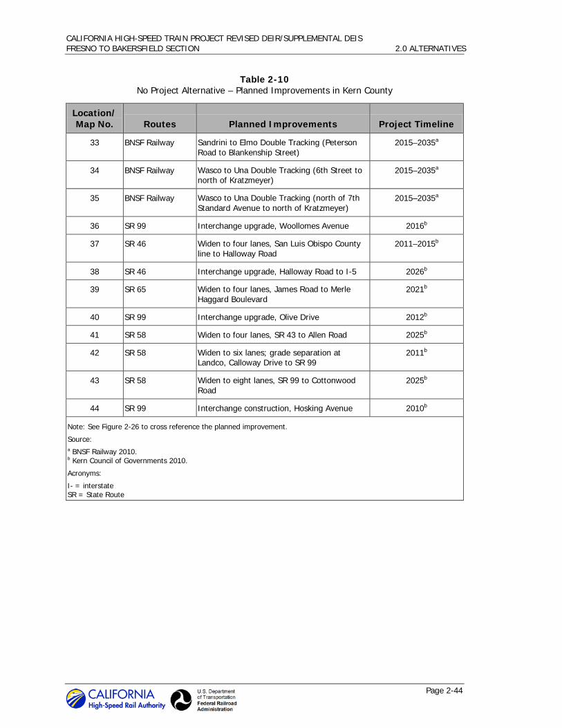
CALIFORNIA HIGH-SPEED TRAIN PROJECT REVISED DEIR/SUPPLEMENTAL DEIS FRESNO TO BAKERSFIELD SECTION 2.0 ALTERNATIVES
Page 2-44
Table 2-10 No Project Alternative – Planned Improvements in Kern County
Location/ Map No. Routes Planned Improvements Project Timeline
33 BNSF Railway Sandrini to Elmo Double Tracking (Peterson Road to Blankenship Street)
2015–2035a
34 BNSF Railway Wasco to Una Double Tracking (6th Street to north of Kratzmeyer)
2015–2035a
35 BNSF Railway Wasco to Una Double Tracking (north of 7th Standard Avenue to north of Kratzmeyer)
2015–2035a
36 SR 99 Interchange upgrade, Woollomes Avenue 2016b
37 SR 46 Widen to four lanes, San Luis Obispo County line to Halloway Road
2011–2015b
38 SR 46 Interchange upgrade, Halloway Road to I-5 2026b
39 SR 65 Widen to four lanes, James Road to Merle Haggard Boulevard
2021b
40 SR 99 Interchange upgrade, Olive Drive 2012b
41 SR 58 Widen to four lanes, SR 43 to Allen Road 2025b
42 SR 58 Widen to six lanes; grade separation at Landco, Calloway Drive to SR 99
2011b
43 SR 58 Widen to eight lanes, SR 99 to Cottonwood Road
2025b
44 SR 99 Interchange construction, Hosking Avenue 2010b
Note: See Figure 2-26 to cross reference the planned improvement.
Source: a BNSF Railway 2010. b Kern Council of Governments 2010.
Acronyms:
I- = interstate SR = State Route

CALIFORNIA HIGH-SPEED TRAIN PROJECT REVISED DEIR/SUPPLEMENTAL DEIS FRESNO TO BAKERSFIELD SECTION 2.0 ALTERNATIVES
Page 2-45
Figure 2-23 No Project Alternative planned improvements in Fresno County

CALIFORNIA HIGH-SPEED TRAIN PROJECT REVISED DEIR/SUPPLEMENTAL DEIS FRESNO TO BAKERSFIELD SECTION 2.0 ALTERNATIVES
Page 2-46
Figure 2-24 No Project Alternative planned improvements in Kings County

CALIFORNIA HIGH-SPEED TRAIN PROJECT REVISED DEIR/SUPPLEMENTAL DEIS FRESNO TO BAKERSFIELD SECTION 2.0 ALTERNATIVES
Page 2-47
Figure 2-25 No Project Alternative planned improvements in Tulare County

CALIFORNIA HIGH-SPEED TRAIN PROJECT REVISED DEIR/SUPPLEMENTAL DEIS FRESNO TO BAKERSFIELD SECTION 2.0 ALTERNATIVES
Page 2-48
Figure 2-26 No Project Alternative planned improvements in Kern County

CALIFORNIA HIGH-SPEED TRAIN PROJECT REVISED DEIR/SUPPLEMENTAL DEIS FRESNO TO BAKERSFIELD SECTION 2.0 ALTERNATIVES
Page 2-49
Aviation Element 2.4.1.4
Although three airports currently provide commercial service in the Fresno to Bakersfield area, they do not necessarily serve the same intercity markets as would the proposed HST alternatives. These airports are Fresno Yosemite International Airport (FAT), Visalia Municipal Airport (VIS), and Bakersfield Meadows Field Airport (BFL). Table 2-11 provides a summary of the usage of the commercial airports in the last 10 years in terms of enplanements.
8
As Table 2-11 shows, there has been overall growth in passenger usage of the airport in Fresno over the past 10 years, but a decline in passenger usage at both the Visalia and Bakersfield airports during the same period. Following Table 2-11 is a summary description of these airports, including a discussion of planned improvements and factors affecting future growth.
Table 2-11 Passenger Boardings for Fresno, Visalia, and Bakersfield Airports
Airport 2000 2005 2006 2007 2008 2009 2010
Change 2000-2010
Change 2005-2010
Fresno 501,204 574,012 623,997 636,032 600,489 580,203 569,879 68,675 -4,133
Visalia 12,816 4,008 5,141 4,637 1,696 2,455 1,831 -10,985 -2,177
Bakersfield 148,200 146,607 171,913 164,400 141,847 103,067 111,699 -36,501 -34,908
Total 662,220 724,627 801,051 805,069 744,032 685,725 683,409 21,189 -41,218
Source: FAA 2011.
Fresno-Yosemite International Airport – Northeast of Fresno and east of SR 41, this municipally owned airport is the San Joaquin Valley’s major airport, serving a six-county region. Eight certified carriers provide nonstop service to nine domestic locations and also offer international direct service to Guadalajara, Mexico. The domestic service includes major hub airports in the west, including Denver, Phoenix, Seattle, and Las Vegas. Within California, direct service is provided to Los Angeles and San Francisco.
The airport terminal includes a recently remodeled lobby and a two-story concourse with six gates. The facility has two runways—a primary 9,227-foot commercial runway and a secondary shorter runway for smaller aircraft. Fresno Yosemite International Airport (FAT) served 569,879 passenger enplanements in 2010, similar to passenger usage over the past 5 years. Of these, 199,680 are estimated to be trips within the state of California that connect to San Francisco and Los Angeles International Airports. The in-state weekly capacity is currently about 750 seats.
Future improvement plans for FAT are documented in the 2006 Fresno Airport Master Plan (AMP) (City of Fresno 2006). The AMP projects growth in airport usage, estimating 852,000 enplanements in 2025 (a 40% increase). Total aircraft operations are estimated to increase 20%. To meet this demand, the AMP identifies needed facility improvements. These include short-term (by 2014) projects such as lengthening and widening the secondary runway, rehabilitating and extending taxiways, and other site improvements. The AMP also includes longer-term (2015-
8 An enplanement is a passenger getting on an airplane for departure. A visitor flying in and flying out
equals one enplanement.

CALIFORNIA HIGH-SPEED TRAIN PROJECT REVISED DEIR/SUPPLEMENTAL DEIS FRESNO TO BAKERSFIELD SECTION 2.0 ALTERNATIVES
Page 2-50
2025) planned improvements such as additional taxiway rehabilitation and installation of an Instrument Landing System for the secondary runway.
As population within the six county service area increases, operations at FAT will increase. However, studies have shown that demand at FAT is suppressed by market forces including air fares, the availability of automobile travel, and alternative airports in the Bay Area, Sacramento, and Los Angeles (Council of Fresno Governments 2010a). A significant number of potential passengers (possibly as high as 300,000 a year) who might use intrastate air service, if available and competitively priced, instead are making auto trips to their destination or to other state airports. These market forces will influence the growth in future operations at the airport.
Visalia Municipal Airport – South of Highway 198 and east of SR 99, Visalia Municipal Airport is located on the eastern side of the city of Visalia. The airport is owned and operated by the city of Visalia and offers daily service to Los Angeles, Ontario, Merced, and Las Vegas.
The airport has a single 6,559-foot runway and served 2,455 passengers in 2009. There were over 10,000 passenger enplanements in the year 2000; however, enplanements have decreased considerably in the years since then. The only out-of-state travel that is offered is a single daily flight from Visalia to Las Vegas. All remaining flights travel within California for an in-state weekly capacity of approximately 266 seats.
Bakersfield Meadows Field Airport – East of SR 99 and north of the city of Bakersfield, Meadows Field Airport is the second busiest passenger airport in the San Joaquin Valley. The airport is owned and operated by Kern County and has three carriers providing 24 daily flights (12 departures and 12 arrivals) with service to Denver, Houston, Las Vegas, Los Angeles, Phoenix, and San Francisco. Five of the daily departures travel within California.
The airport’s domestic terminal includes a recently remodeled two-story concourse with three gates currently in use. The international terminal is currently under construction. The facility has two runways—a primary 10,855-foot runway, and a secondary 7,703-foot runway. In 2009, the airport had 141,847 passenger enplanements with approximately half of those passengers traveling within the state of California. Airport use has both risen and fallen within the past decade, with the number of enplanements in 2009 being only slightly less than that of 2000. The in-state weekly capacity is approximately 1,136 seats.
With the recent remodeling of the domestic terminal, rapid expansion of the concourse in response to increased demand is possible. Two gates can be added to the current concourse without construction, while concourse expansion could accommodate a total of 12 gates. If warranted, construction of an additional 12-gate terminal would provide for a total of 24 gates at the facility. Meadows Airport has made preparations to expand their facilities in the event of an increase in usage demand (Kern County Board of Supervisors 2006).
Intercity Transit Element 2.4.1.5
Conventional Passenger Rail
Amtrak provides intercity passenger rail service in California on four principal corridors covering more than 1,300 linear route miles and spanning almost the entire state. The No Project Alternative passenger rail element includes one of these corridors, the San Joaquin route, which shares tracks with the BNSF freight line through the Fresno to Bakersfield Section. Stations are located in Fresno, Hanford, Corcoran, Wasco, and Bakersfield.
The San Joaquin route currently provides four trips daily in each direction from Oakland to Bakersfield (with a bus connection to the Los Angeles Basin) and two trips daily in each direction from Sacramento to Bakersfield, for a total of six daily roundtrips serving Fresno and Bakersfield.

CALIFORNIA HIGH-SPEED TRAIN PROJECT REVISED DEIR/SUPPLEMENTAL DEIS FRESNO TO BAKERSFIELD SECTION 2.0 ALTERNATIVES
Page 2-51
This route carried over 949,611 riders in fiscal year 2008 (Amtrak 2008) with an on-time performance of 85.7% (Amtrak 2009). The objective for the San Joaquin route is to increase ridership from 853,000 in 2007-08 to 1,417,000 in 2017-18 (Caltrans 2008a). The current scheduled running time between Bakersfield and Oakland is 6 hours 9 minutes, at an average speed of 51.2 mph, but the plan is to reduce this to less than 6 hours. The maximum speed on the route is 79 mph (Caltrans 2008b).
Intercity passenger rail system improvements identified in the Caltrans’ California State Rail Plan for implementation before 2020 are included in the No Project Alternative. Table 2-12 identifies these improvements, which consist of additional track capacity, construction of double track, and design and construction of a layover facility in Fresno.
Table 2-12 Programmed Improvements in 2008 California State Rail Plan
Project Title Project Description Project Timeline
Hanford to Shirley Increases capacity and OTP By 2017/18
Guernsey to Hanford Construction of double track By 2017/18
Gregg Double Track–Fresno County
Increases OTP and efficiency By 2017/18
Shafter to Jastro Increases OTP and efficiency By 2017/18
Kings Park Increases OTP and efficiency By 2017/18
San Joaquin Route Capitalized Maintenance
Routine infrastructure maintenance By 2017/18
Equipment Purchase two trainsets (6 cars/1 locomotive)
By 2017/18
Fresno Layover Facility Design and construction layover facility By 2017/18
Source:
Caltrans 2008a.
Acronym:
OTP = on-time performance
In addition to these programmed improvements, the State Rail Plan also identified additional capital improvements that are needed to support the planned service improvements. These currently unfunded capital improvements that include track and signal projects to increase capacity between Fresno and Bakersfield were not included in this evaluation because of the funding uncertainty. The plan also identifies the intent to develop options for originating some trains in Fresno and extending rail service from Bakersfield to Los Angeles.
In 2008, Caltrans, in partnership with the counties along the San Joaquin route, completed the San Joaquin Corridor Strategic Plan, assuming no HST system. This study formalized the short-, medium- and long-term visions for the corridor and developed a preferred alternative and recommended improvement projects. The preferred plan provides a phased approach for service and capacity improvements. Many of the short- and mid-term improvements are included in the State Rail Plan. Longer-term improvements (25 years) include completing the double tracking of the corridor. The San Joaquin Corridor Strategic Plan and current State Rail Plan do not

CALIFORNIA HIGH-SPEED TRAIN PROJECT REVISED DEIR/SUPPLEMENTAL DEIS FRESNO TO BAKERSFIELD SECTION 2.0 ALTERNATIVES
Page 2-52
incorporate HST service, but it is anticipated that revised plans will be developed that address the changing role for the San Joaquin route as a feeder service to the HST system.
Intercity Passenger Bus Service
Regional bus service in the study area is provided by Greyhound, which provides scheduled bus service though the San Joaquin Valley, with bus terminals located in the cities of Fresno, Hanford and Bakersfield. Greyhound provides daily service from the Fresno, Hanford, and Bakersfield stations to destinations such as San Jose, San Francisco, Sacramento, Los Angeles, San Diego, and Las Vegas. Greyhound operates 5 daily trips to San Francisco, 4 daily trips to Sacramento, and 10 daily trips to Los Angeles. Service to Las Vegas is provided via transfers at Bakersfield or Los Angeles.
In the Fresno area, additional regional bus service is provided by Transportes InterCalifornias. This service provides daily roundtrip service between Fresno and Los Angeles with connecting service to Santa Ana, San Ysidro, Tijuana, and Mexicali, as well as daily roundtrips to Stockton and San Jose. Service also is provided to numerous intermediate points within the area. Bus services within the city of Fresno are provided by the Fresno Area Express.
The Kings Area Rural Transit Agency provides transit services within the city of Hanford and has intercity connector routes with Lemoore, Avenal, Corcoran, Visalia, Fresno and Laton. The Tulare County Area Transit has routes that connect all the major cities within Tulare County.
In Kern County, Kern Regional Transit (KRT) provides service throughout the county, with connections between Wasco, Shafter, and Bakersfield. KRT provides several other connections as well, including service from Inyokern to the Eastern Sierra Transit Agency, which serves Inyo and Mono counties. The Golden Empire Transit (GET) District provides services throughout the city of Bakersfield and the connecting communities. The Long-Range Transit Plan for GET is currently underway. The plan is anticipated to include intercity bus service expansion and be adopted in early 2012 (Kern COG 2011). Continued service is an element of the No Project Alternative, but serves only a small portion of the intercity travel market.
Freight Rail Element 2.4.1.6
Operating along the corridor’s length, two Class I freight railroads (BNSF and UPRR) serve the Fresno to Bakersfield Corridor. The San Joaquin Valley lines for both the BNSF Railway and UPRR are important segments of their national rail systems. Freight rail traffic nationally has been growing, with a 31.4% increase in ton-miles of freight activity between 1997 and 2007 (Bureau of Transportation Statistics 2010).
Freight rail movements in the San Joaquin Valley are primarily interstate rail movements because the railroads generally focus on shipments of 700 miles or more. However, while trucking is the dominant mode for moving freight (with rail serving only 11% of the total tonnage), local markets are also served by the San Joaquin Valley Railroad (SJVR), a short-line railroad that interchanges with the BNSF at Fresno and Bakersfield, and with the UPRR at Fresno, Goshen Junction, and Bakersfield. The growth in roadway congestion is expected to increase reliance on rail traffic, as noted in the Fresno County RTP.
The BNSF Railway alignment is generally located west of the SR 99 corridor. BNSF is also the primary owner of the railroad right-of-way used by the Amtrak San Joaquin route. The average number of daily one-way train operations within the corridor is 20 to 24 daily train trips, of which 12 are Amtrak trains. The railroad owns a 276-mile section of the San Joaquin corridor from Bakersfield to Port Chicago, 6.5 miles east-northeast of Martinez in Contra Costa County. An increase in operations may constrain plans to increase Amtrak service, unless more of the corridor becomes double-tracked.

CALIFORNIA HIGH-SPEED TRAIN PROJECT REVISED DEIR/SUPPLEMENTAL DEIS FRESNO TO BAKERSFIELD SECTION 2.0 ALTERNATIVES
Page 2-53
UPRR parallels SR 99 for most of the corridor. UPRR along this corridor is primarily single track and has an average number of 20 to 24 daily one-way train trips within the corridor (FRA Office of Safety 2010).
Both the BNSF Railway and UPRR are currently operating near capacity and (according to the 2008 Goods Movement Study) will be above capacity by 2035. No formal capacity expansion plans are available for the freight corridors between Fresno and Bakersfield. However, future BNSF candidate double-tracking projects are included in this analysis as planned improvement projects. The BNSF will also gain capacity from planned improvements for the expansion of Amtrak San Joaquin service, as defined in the State Rail Plan. Historically, both railroads have added capacity when needed to meet market demand. Future improvements are expected to continue to provide sufficient capacity for interstate needs.
2.4.2 BNSF Alternative
This section provides a detailed description of the BNSF Alternative. The 15% design drawings showing the track alignments, profiles, structures, typical sections, construction use areas, and other preliminary design information are included as Volume III (Alignments and Other Plans) of the EIR/EIS and available on the Authority’s website (www.cahighspeedrail.ca.gov) or on CD by request. Figure 2-21 shows the BNSF Alternative Alignment from Fresno to Bakersfield.
Alignment Requirements 2.4.2.1
The alignment for the BNSF Alternative traverses urban downtown areas in the cities of Fresno and Bakersfield. It is generally adjacent to the BNSF Railway (Figures 2-27 through 2-30). Some of the main requirements are described below.
• Operational Facilities: HST operational requirements require TPSSs, switching stations, paralleling stations, and underground or overhead power transmission lines. Working in coordination with power supply companies and per design requirements, the Authority and FRA have identified frequency and right-of-way requirements for these facilities.
• Frontage Road and Local Roadway Crossings: As the alignment travels through rural regions, it can affect existing local frontage roads used by small communities and farm operations. Where these frontage roads are impacted by the HST alignment, they would be shifted and reconstructed to maintain their function. Where roads are perpendicular to the proposed HST, overcrossings or undercrossings are planned at minimum of every 2 miles. In between, some roads may be closed. These modifications are identified on project maps and detailed lists are provided in Appendix 2-A.
• Irrigation and Drainage Facilities: The HST alignment would affect some existing drainage and irrigation facilities. Depending on the extent of the impact, existing facilities would be modified, improved, or replaced, as needed to maintain existing drainage and irrigation functions and support HST drainage requirements.
• Wildlife Crossing Structures: Wildlife crossing opportunities would be available through a variety of engineered structures. In addition to dedicated wildlife crossing structures, wildlife crossing opportunities would also be available at elevated portions of the alignment, bridges over riparian corridors, road overcrossings and undercrossings, and drainage facilities (i.e., large diameter [60 – 120 inches] culverts and paired 30-inch culverts).
Dedicated wildlife crossing structures would be provided from approximately Cross Creek (Kings County) south to Poso Creek (Kern County) in at-grade portions of the railroad embankment at approximately 0.3-mile intervals. Where bridges, aerial structures, and road

CALIFORNIA HIGH-SPEED TRAIN PROJECT REVISED DEIR/SUPPLEMENTAL DEIS FRESNO TO BAKERSFIELD SECTION 2.0 ALTERNATIVES
Page 2-54
Figure 2-27 Fresno County HST alternatives

CALIFORNIA HIGH-SPEED TRAIN PROJECT REVISED DEIR/SUPPLEMENTAL DEIS FRESNO TO BAKERSFIELD SECTION 2.0 ALTERNATIVES
Page 2-55
Figure 2-28 Kings County HST alternatives
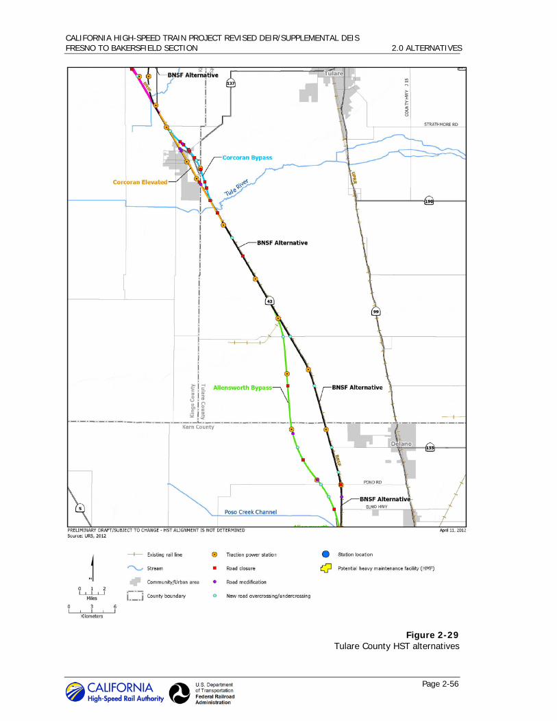
CALIFORNIA HIGH-SPEED TRAIN PROJECT REVISED DEIR/SUPPLEMENTAL DEIS FRESNO TO BAKERSFIELD SECTION 2.0 ALTERNATIVES
Page 2-56
Figure 2-29 Tulare County HST alternatives

CALIFORNIA HIGH-SPEED TRAIN PROJECT REVISED DEIR/SUPPLEMENTAL DEIS FRESNO TO BAKERSFIELD SECTION 2.0 ALTERNATIVES
Page 2-57
Figure 2-30 Kern County HST alternatives

CALIFORNIA HIGH-SPEED TRAIN PROJECT REVISED DEIR/SUPPLEMENTAL DEIS FRESNO TO BAKERSFIELD SECTION 2.0 ALTERNATIVES
Page 2-58
crossings coincide with proposed dedicated wildlife crossing structures, such features would serve the function of, and supersede the need for, dedicated wildlife crossing structures.
The preliminary wildlife crossing structure design consists of modified culverts in the embankment that would support the HST tracks. The typical culvert from end-to-end would be 73 feet long (crossing-structure distance), would span a width of approximately 10 feet (crossing-structure width), and provide 3 feet of vertical clearance (crossing-structure height), resulting in a calculated openness factor (Bremner-Harrison et al. 2007) of 0.41.
9 To
accommodate variations in the topography, the height of the at-grade profile may require depressing wildlife crossing structures no more than 1.5 feet (half of the vertical clearance) below-grade.
At locations where stormwater swales parallel the embankment, the approach to wildlife crossing structures would be designed in such a way as to prevent water from ponding within the structure. This would be accomplished by terminating the swales on either side of the wildlife crossing structure and engineering a high point distal to the entrance of the structure to create a micro-watershed, limiting the rainwater catchment area to a small, isolated, and discrete depression between the high point and the entrance to the structure. To allow wildlife free passage through the crossing structures, HST right-of-way fencing would be diverted toward the toe of the slope, up the embankment, and around the entrance of the structure. At locations where an intrusion protection barrier parallels a proposed wildlife crossing structure, the crossing structure would be extended and designed to pass through the barrier to allow wildlife free passage. Figure 2-31 shows the wildlife crossing elevation and cross section, as well as the drainage detail.
Additional wildlife crossing structure designs could include circular or elliptical pipe culverts, and larger (longer) culverts with crossing-structure distances of up to 100 feet. However, any changes to wildlife crossing structure design must be constrained by a minimum of 3 feet of vertical clearance (crossing-structure height), depressed no more than 1.5 feet below-grade (half of the vertical clearance), and must meet or exceed the minimum 0.41 openness factor.
Additionally, dedicated wildlife crossing structures would be placed to the north and south of each of the following river/creek crossings: Kings River, St. Johns Cut (Dutch Slough), Cole Slough, Cross Creek, Tule Creek, Poso Creek, Deer Creek, and Kern River. These wildlife crossing structures would be located between 100 and 500 feet from the banks of each riparian corridor.
9 (Height x Width)/Distance = Openness Factor; (4 ft x 8 ft)/72 ft = 0.44

CALIFORNIA HIGH-SPEED TRAIN PROJECT REVISED DEIR/SUPPLEMENTAL DEIS FRESNO TO BAKERSFIELD SECTION 2.0 ALTERNATIVES
Page 2-59
Figure 2-31 Wildlife crossing structure

CALIFORNIA HIGH-SPEED TRAIN PROJECT REVISED DEIR/SUPPLEMENTAL DEIS FRESNO TO BAKERSFIELD SECTION 2.0 ALTERNATIVES
Page 2-60
BNSF Adjacency 2.4.2.2
An important objective of the project is to align HST tracks adjacent to existing transportation corridors. The BNSF Alternative is designed to follow the existing BNSF Railway corridor adjacent to the BNSF mainline right-of-way as closely as practicable. Minor deviations from the BNSF Railway route are necessary to accommodate design requirements; namely, wider curves are necessary to accommodate the speed of the HST compared to the existing lower-speed freight line track alignment. The BNSF Alternative would not follow the BNSF Railway right-of-way between approximately Elk Avenue in Fresno County and Nevada Avenue in Kings County. Instead, the alignment would curve to the east on the north side of the Kings River and away from the city of Hanford, and would rejoin the BNSF Railway near the city of Corcoran.
The BNSF Alternative’s cross sections include provisions for a 102-foot separation of the HST track centerline from the BNSF Railway track centerline, as well as separations that include swale or berm protection, or an intrusion protection barrier (wall) where the HST tracks are closer. Figure 2-32 shows cross sections of these various configurations where there would not be a shared right-of-way with BNSF. Figure 2-33 shows the same cross sections illustrating a shared right-of-way with BNSF; the design guidelines recognize BNSF as a potential shared corridor partner, which in some locations could reduce the horizontal separation of the HST from the BNSF Railway facility by as much as 25 feet, assuming the appropriate intrusion protection barrier is provided.
For purposes of the Revised Draft EIR/Supplemental Draft EIS, it is assumed no encroachment on the BNSF right-of-way would occur. A 102-foot separation between the centerlines of BNSF Railway and HST tracks is provided wherever feasible and appropriate. In urban areas where a 102-foot separation could result in substantial displacement of businesses, homes, and infrastructure, the separation between the BNSF Railway and the HST was reduced. The areas with reduced separation require protection to prevent encroachment on the HST right-of-way, in the event of a freight rail derailment. Protection would consist of a swale, berm, or wall, depending on the separation.
North-south alignment 2.4.2.3
This section describes the BNSF Alternative as it traverses from north to south from Fresno to Bakersfield. Appendix 2-A of this Revised Draft EIR/Supplemental Draft EIS provides additional detailed information of HST roadway crossings within these vicinities.
Fresno County
The BNSF Alternative would begin at the north end of the Fresno Station tracks adjacent to the western side of the UPRR right-of-way in the vicinity of Amador Street. The alignment would be below-grade for approximately 140 yards as it crosses the Fresno Bee railroad spur, rendering it unusable. The alignment would return to grade and continue southeast through Fresno on the western side of the UPRR until reaching East Jensen Avenue. An intrusion protection barrier approximately 1 mile in length would be required from approximately Stanislaus Street to Ventura Avenue because of the proximity of the UPRR and HST rights-of-way. The alignment would again be below-grade in a shallow trench as it travels underneath East Jensen Avenue and would then curve to the south and be elevated over Golden State Boulevard and SR 99. The elevated structure would span just over 1 mile and would reach a maximum height of approximately 55 feet to the top of the rail. The alignment would return to grade and join the BNSF Railway corridor on its western side at East Malaga Avenue south of Fresno.
The BNSF Alternative would continue through Fresno County along the BNSF Railway right-of-way in an area consisting mostly of agricultural land. Approximately 24 miles of track would be in Fresno County. Nearly all of the alignment, roughly 22 of the 24 miles, would be at-grade.

CALIFORNIA HIGH-SPEED TRAIN PROJECT REVISED DEIR/SUPPLEMENTAL DEIS FRESNO TO BAKERSFIELD SECTION 2.0 ALTERNATIVES
Page 2-61
Figure 2-32 BNSF Alternative without shared right-of-way

CALIFORNIA HIGH-SPEED TRAIN PROJECT REVISED DEIR/SUPPLEMENTAL DEIS FRESNO TO BAKERSFIELD SECTION 2.0 ALTERNATIVES
Page 2-62
Figure 2-33 BNSF Alternative showing opportunity for shared right-of-way

CALIFORNIA HIGH-SPEED TRAIN PROJECT REVISED DEIR/SUPPLEMENTAL DEIS FRESNO TO BAKERSFIELD SECTION 2.0 ALTERNATIVES
Page 2-63
Approximately 5.5 miles of BNSF Railway tracks would be realigned from approximately East Sumner Avenue to East Huntsman Avenue and from approximately East Rose Avenue to East Kamm Avenue, to accommodate the HST alignment. The alignment would be elevated where it crosses from the western side to the eastern side of the BNSF Railway tracks near East Conejo Avenue. The elevated structure would span approximately 1 mile and would reach a maximum height of approximately 42 feet to the top of the rail as it crosses over the BNSF Railway tracks. Another 0.5 mile of BNSF Railway tracks would be realigned in the vicinity of South Peach Avenue. The alignment would be at-grade with bridges where it crosses Cole Slough and the Kings River into Kings County. These bridges would clear the Cole Slough and Kings River levees by approximately 3 feet. Dedicated wildlife crossing structures would be placed between 100 and 500 feet to the north and south of Cole Slough.
Kings County
Approximately 28 miles of the BNSF Alternative would be in Kings County. The alternative would pass east of the city of Hanford, parallel to and approximately 0.5 mile east of SR 43 (Avenue 8). South of Hanford in the vicinity of Idaho Avenue, the BNSF Alternative would curve to the west and then south toward the BNSF Railway right-of way. The alignment was refined in this area to avoid special aquatic features north of Corcoran and east of the BNSF Railway. The alignment would rejoin the BNSF Railway right-of-way on its western side just north of Corcoran and travel through the eastern edge of the city of Corcoran. The majority of this part of the alignment would pass through agricultural land except where it travels through Corcoran. The alignment in Corcoran encompasses a number of land uses, including residential, commercial, and industrial. Approximately 8 miles of track within Kings County would be elevated. The first elevated portion would be located just east of Hanford, and would span a length of 2.5 miles, beginning just south of Fargo Avenue and ending just north of Hanford-Armona Road. This portion of the alignment would pass over the San Joaquin Valley Railroad and SR 198. The structure would reach a height of approximately 50 feet to the top of the rail. The potential Kings/Tulare Regional Station–East Alternative would be located along this structure near the SR 43 and SR 198 interchange.
The alignment would continue at-grade south of Hanford-Armona Road for approximately 10 miles, where it would again ascend onto an elevated structure over Cross Creek and the BNSF Railway right-of-way. The structure would span a length of approximately 2.5 miles, beginning just before Cross Creek and returning to grade just before Nevada Avenue. The elevated structure would reach a maximum height of 40 feet to the top of the rail. The alignment would then continue at-grade and require an intrusion protection barrier from approximately Nevada Avenue to approximately North Avenue. The barrier would be approximately 2 miles in length. At Patterson Avenue, the alignment would again ascend onto an elevated structure over Brokaw Avenue, Whitley Avenue, a BNSF Railway spur, and agricultural facilities located at the southern end of the city of Corcoran. The structure would span approximately 1.7 miles. The alignment would be constructed on a retained embankment as it crosses into Tulare County, from north of Fourth Avenue to Avenue 136. Approximately 0.3 mile of BNSF Railway tracks would be realigned at Oregon Avenue, south of Corcoran.
Dedicated wildlife crossing structures would be provided from approximately Cross Creek south to the Tulare County line in at-grade portions of the railroad embankment at intervals of approximately 0.3 mile. Additionally, the BNSF Alternative would include dedicated wildlife crossing structures placed between 100 and 500 feet to the north and south of each of the following river/creek crossings: St. Johns Cut (Dutch Slough), Kings River, and Cross Creek.
Tulare County
The BNSF Alternative crosses approximately 22 miles of Tulare County. The alignment travels through the county adjacent to the western side of the BNSF Railway right-of-way. The majority

CALIFORNIA HIGH-SPEED TRAIN PROJECT REVISED DEIR/SUPPLEMENTAL DEIS FRESNO TO BAKERSFIELD SECTION 2.0 ALTERNATIVES
Page 2-64
of the alignment would be at-grade, with only a combined total of 4 miles elevated where the alignment crosses the Tule River and then both Deer Creek and the Stoil railroad spur from the BNSF Railway. The elevated structure would reach a height of approximately 50 feet to the top of the rail. This alignment would cross over Lakeland Canal.
Dedicated wildlife crossing structures would be provided throughout at-grade portions of the railroad embankment at intervals of approximately 0.3 mile. Additionally, the BNSF Alternative would include dedicated wildlife crossing structures placed between 100 and 500 feet to the north and south of each of the following river/creek crossings: Tule River and Deer Creek.
Kern County
The Kern County segment of the BNSF Alternative is approximately 44 miles long and would pass through the cities of Wasco and Shafter on its way to Bakersfield. It would closely follow the western side of the BNSF Railway corridor until just south of Wasco, where it would cross over to the eastern side of the BNSF Railway tracks. Approximately 4 miles of BNSF Railway tracks would be realigned in the vicinity of Fourth Street, from Eighth Street to Poso Avenue, and from Jackson Avenue to Merced Avenue to accommodate the HST alignment. The alignment would continue on the eastern side of the BNSF Railway right-of-way through Shafter and then cross over once more to the western side of the BNSF Railway right-of-way. Approximately 8 miles of Santa Fe Way would be shifted to the west of the proposed HST alignment to accommodate the HST right-of-way, from north of Riverside Street to south of Renfro Road. Approximately 1.5 miles of the BNSF’s Lone Star rail spur would be realigned from Riverside Street to south of Burbank Street. The alignment would generally follow the BNSF Railway corridor through Bakersfield to the project terminus in the vicinity of Baker Street. Approximately 2.5 miles of BNSF Railway tracks would be realigned in Bakersfield from Jomani Drive to Glenn Street and from Oak Street to C Street to accommodate the HST alignment. Within this portion of the alignment, approximately 27 miles would be at-grade, while the remainder of the alignment would be elevated. There would be three elevated sections along this segment of the BNSF Alternative in the cities of Wasco, Shafter, and Bakersfield. The alignment would be at-grade with a bridge where it crosses Poso Creek.
The first elevated structure would begin at First Street, pass through Wasco for a distance of about 3 miles and return to grade north of Kimberlina Road. It would reach a height of approximately 45 feet to the top of the rail. From approximately Kimberlina Road, the alignment would continue at-grade for approximately 5 miles to just north of Shafter Avenue where it would again ascend onto an elevated structure.
The alignment would be on an elevated structure through Shafter for a distance of about 3.5 miles between Shafter Avenue and Cherry Avenue. This structure would pass over a BNSF Railway yard within the city, and reach a maximum height of approximately 45 feet to the top of the rail. After returning to grade just south of Cherry Avenue, the alignment would travel approximately 10 miles to Country Breeze Place where it would ascend onto another elevated structure through Bakersfield.
From Country Breeze Place through the Bakersfield Station to Oswell Street, the BNSF Alternative would be on an elevated structure. The elevated structure through Bakersfield would pass over the transportation corridor improvement projects, SR 99, and a BNSF Railway yard. It would range in height from 50 to 90 feet to the top of the rail. The highest elevations in the city of Bakersfield would be reached between Rosedale Highway and SR 99. From SR 99 to the terminus of the BNSF Alternative, the structure would range in height from 50 to 70 feet to the top of the rail. In Bakersfield, the alignment would displace six religious facilities, the Bakersfield High School Industrial Arts building, the Mercado Latino Tianguis, and 119 homes in the eastern

CALIFORNIA HIGH-SPEED TRAIN PROJECT REVISED DEIR/SUPPLEMENTAL DEIS FRESNO TO BAKERSFIELD SECTION 2.0 ALTERNATIVES
Page 2-65
portion of the city. For more detail, see Section 3.12, Socioeconomics, Communities, and Environmental Justice.
Dedicated wildlife crossing structures would be provided in at-grade portions of the railroad embankment at intervals of approximately 0.3 mile. The BNSF Alternative would also include dedicated wildlife crossing structures placed between 100 and 500 feet to the north and south of the Poso Creek crossing. Dedicated wildlife crossing structures would not be required to the north and south of the Kern River as the BNSF Alternative would be elevated.
2.4.3 Alignment Alternatives
In addition to the BNSF Alternative, the Authority and FRA are considering eight other alternatives for portions of the Fresno to Bakersfield Section. The Authority developed these alternatives to avoid environmental, land use, or community impacts identified for portions of the BNSF Alternative. These eight alternatives are discussed below and depicted in Figures 2-27 through 2-30.
Hanford West Bypass 1 Alternative 2.4.3.1
The Hanford West Bypass 1 Alternative would parallel the BNSF Alternative from East Kamm Avenue to approximately East Elkhorn Avenue in Fresno County. At East Conejo Avenue where the BNSF Alternative crosses to the eastern side of the BNSF Railway tracks to pass the city of Hanford to the east, the Hanford West Bypass 1 Alternative continues south on the western side of the BNSF Railway tracks. The Hanford West Bypass 1 would diverge from the BNSF Railway corridor just south of East Elkhorn Avenue and ascend onto an elevated structure just south of East Harlan Avenue, crossing over the Kings River complex and Murphy Slough, and passing the community of Laton to the west. The elevated structure would be approximately 0.8 mile in length and reach a maximum height of approximately 40 feet to the top of the rail. The Hanford West Bypass 1 Alternative would return to grade just north of Dover Avenue. The alignment would continue at-grade and would travel between the community of Armona to the west and the city of Hanford to the east on a southeasterly route toward the BNSF Railway corridor. In order to avoid a large dairy located at the intersection of Kent and 11th avenues, the Hanford West Bypass 1 Alternative must travel to its west and deviate from the BNSF Railway corridor in the area of Kansas Avenue. The alignment would pass to the west of a large complex of BNSF Railway serviced grain silos and loading bays before it rejoins the BNSF Railway corridor adjacent to its western side at about Lansing Avenue. The alignment would continue on the western side of the BNSF Railway corridor and ascend onto another elevated structure, traveling over Cross Creek and special aquatic features that exist north of Corcoran. The elevated structure would span approximately 3 miles and reach a maximum height of approximately 20 feet to the top of the rail. This alignment would return to grade just north of Nevada Avenue and would connect to the BNSF Alternative traveling through Corcoran at-grade, maintaining an alignment on the western side of the BNSF Railway corridor. The total length of the Hanford West Bypass 1 Alternative would be approximately 28 miles.
The Hanford West Bypass 1 Alternative includes a design option where the alignment would be below-grade between Grangeville Boulevard and Houston Avenue. The alignment would travel below-grade in an open cut with side slopes as it transitions to a retained-cut profile, approximately 40 feet below ground level. As the alignment transitions back to grade just north of Houston Avenue, the open-cut profile would be used once more. The alignment would cross SR 198 and several local roads. South Peach Avenue, East Clarkson Avenue, East Barrett Avenue, Elder Avenue, and South Tenth Avenue would be closed at the HST right-of-way, while the other roads would be realigned and/or grade-separated from the HST with overcrossings/undercrossings. Grade separations at Grangeville Boulevard, 13th Avenue, and

CALIFORNIA HIGH-SPEED TRAIN PROJECT REVISED DEIR/SUPPLEMENTAL DEIS FRESNO TO BAKERSFIELD SECTION 2.0 ALTERNATIVES
Page 2-66
West Lacey Boulevard would be determined based on the alignment design option selected (at-grade or below-grade) (Appendix 2-A).
The potential Kings/Tulare Regional Station–West Alternative would be located along this alignment east of 13th Avenue, between Lacey Boulevard and the SJVR railroad spur. This potential station includes at-grade and below-grade design option as well.
Hanford West Bypass 2 Alternative 2.4.3.2
The Hanford West Bypass 2 Alternative would be the same as the Hanford West Bypass 1 Alternative from East Kamm Avenue to just north of Jackson Avenue. The Hanford West Bypass 2 Alternative would then curve away from the Hanford West Bypass 1 Alternative to travel to the east of the dairy located at the intersection of Kent and 11th avenues toward the BNSF Railway corridor, approximately 0.3 mile east of the Hanford West Bypass 1 route. The Hanford West Bypass 2 Alternative would ascend over Kent Avenue and then cross over the BNSF Railway right-of-way to the northeast of the large complex of grain silos and loading bays located north of Kansas Avenue. The alignment would remain elevated for approximately 1.5 miles and parallel the BNSF Railway to the east, then cross over Kansas Avenue. The structure would reach a maximum height of 55 feet to the top of the rail before returning to grade north of Lansing Avenue and continuing along the BNSF Railway corridor on its eastern side. Similar to the Hanford West Bypass 1 Alternative, the Hanford West Bypass 2 Alternative would travel over Cross Creek and the special aquatic features located north of Corcoran and return to grade north of Nevada Avenue; however, the Hanford West Bypass 2 would be located on the eastern side of the BNSF Railway tracks in order to connect to either of the two Corcoran alternatives that would travel on the eastern side of the BNSF Railway corridor, the Corcoran Elevated Alternative or the Corcoran Bypass Alternative, described below. Like the Hanford West Bypass 1 Alternative, the total length of the Hanford West Bypass 2 Alternative would be approximately 28 miles.
The Hanford West Bypass 2 Alternative includes the same below-grade design option between Grangeville Boulevard and Houston Avenue as the Hanford West Bypass 1 Alternative, as well as either at-grade or below-grade options at the potential Kings/Tulare Regional Station–West Alternative. Similar to the Hanford West Bypass 1 Alternative, Hanford West Bypass 2 would cross SR 198 and several local roads. Road closures would be the same as those for the Hanford West Bypass 1, and roadway modifications at Grangeville Boulevard, 13th Avenue, and West Lacey Boulevard would depend on the alignment design option selected (Appendix 2-A).
Corcoran Elevated Alternative 2.4.3.3
The Corcoran Elevated Alternative would be the same as the corresponding section of the BNSF Alternative from approximately Nevada Avenue to Avenue 136, except that it would pass through Corcoran on the eastern side of the BNSF Railway right-of-way on an aerial structure. The aerial structure begins at Niles Avenue and returns to grade south of Fourth Avenue. It would reach a maximum height of approximately 51 feet to the top of the rail. The total length of the Corcoran Elevated Alternative would be approximately 10 miles. An intrusion protection barrier would be required in the at-grade portion of the alignment, north of Nevada Avenue to just north of Niles Avenue because of the proximity of BNSF and HST rights-of way. This barrier would be approximately 2 miles in length. Approximately 0.2 mile of BNSF Railway tracks would be realigned at Patterson Avenue. Dedicated wildlife crossing structures would be provided from approximately Cross Creek south to Avenue 136 in at-grade portions of the railroad embankment at intervals of approximately 0.3 mile. Dedicated wildlife crossing structures would also be placed between 100 and 500 feet to the north and south of each of the Cross Creek and Tule River crossings.

CALIFORNIA HIGH-SPEED TRAIN PROJECT REVISED DEIR/SUPPLEMENTAL DEIS FRESNO TO BAKERSFIELD SECTION 2.0 ALTERNATIVES
Page 2-67
This alternative alignment would pass over several local roads on an aerial structure. Santa Fe Avenue and Avenue 136 would be closed at the HST right-of-way (Appendix 2-A).
Corcoran Bypass Alternative 2.4.3.4
The Corcoran Bypass Alternative would diverge from the BNSF Alternative at Nevada Avenue and swing east of Corcoran, rejoining the BNSF Railway route at Avenue 136 (Figures 2-26 and 2-27). The total length of the Corcoran Bypass would be approximately 10 miles. An intrusion protection barrier would be required in the vicinity of Nevada Avenue because of the proximity of BNSF and HST rights-of-way. Similar to the corresponding section of the BNSF Alternative, the majority of the Corcoran Bypass Alternative would be at-grade. However, one elevated structure would carry the HST over SR 43, the BNSF Railway, and the Tule River. The structure would reach a maximum height of approximately 45 feet to the top of the rail. Dedicated wildlife crossing structures would be provided from approximately Cross Creek south to Avenue 136 in at-grade portions of the railroad embankment at intervals of approximately 0.3 mile. Dedicated wildlife crossing structures would also be placed between 100 and 500 feet to the north and south of each of the Cross Creek and Tule River crossings.
This alternative alignment would cross SR 43, Whitley Avenue/SR 137, and several local roads. SR 43, Waukena Avenue, and Whitley Avenue would be grade-separated from the HST with an overcrossing/undercrossing; other roads including Niles Avenue, Orange Avenue, and Avenue 136 would be closed at the HST right-of-way (Appendix 2-A).
Allensworth Bypass Alternative 2.4.3.5
The Allensworth Bypass Alternative passes west of the BNSF Alternative, avoiding Allensworth Ecological Reserve and the Allensworth State Historic Park. As part of the Draft EIR/EIS process, this alignment was refined over the course of environmental studies including aerial photography reconnaissance and field surveys to reduce impacts on wetlands and orchards. The total length of the Allensworth Bypass Alternative would be approximately 21 miles, beginning at Avenue 84 and rejoining the BNSF Alternative at Elmo Highway. The Allensworth Bypass Alternative would be constructed on an elevated structure only where the alignment crosses Deer Creek and the Stoil railroad spur. The structure would reach a maximum height of approximately 47 feet to the top of the rail. The majority of the alignment would pass through Tulare County at-grade. Dedicated wildlife crossing structures would be provided from approximately Avenue 84 to Poso Creek at intervals of approximately 0.3 mile. Dedicated wildlife crossing structures would also be placed between 100 and 500 feet to the north and south of both the Deer Creek and Poso Creek crossings.
The Allensworth Bypass would cross several roads including County Road J22, Avenue 24, Garces Highway, Woollomes Avenue, Magnolia Avenue, Pond Road, and Elmo Highway. Avenue 24, Woollomes Avenue, and Elmo Highway would be closed at the HST right-of-way, while the other roads would be realigned and/or grade-separated from the HST with overcrossings (Appendix 2-A).
Wasco-Shafter Bypass Alternative 2.4.3.6
The Wasco-Shafter Bypass Alternative would diverge from the BNSF Alternative between Taussig Avenue and Zachary Avenue, crossing over to the eastern side of the BNSF Railway tracks and bypassing Wasco and Shafter to the east. The Wasco-Shafter Bypass Alternative would be at-grade except where it travels over Seventh Standard Road and the BNSF Railway to rejoin the BNSF Alternative. This aerial structure would reach a maximum height of 75 feet to the top of the rail. Approximately 4 miles of Santa Fe Way would be shifted to the west of the proposed alignment to accommodate the HST right-of-way, from approximately Galpin Street to south of Renfro Road. The total length of the Wasco-Shafter Bypass Alternative would be 21 miles.

CALIFORNIA HIGH-SPEED TRAIN PROJECT REVISED DEIR/SUPPLEMENTAL DEIS FRESNO TO BAKERSFIELD SECTION 2.0 ALTERNATIVES
Page 2-68
The Wasco-Shafter Bypass was refined to avoid the Occidental Petroleum tank farm as well as a historic property potentially eligible for listing on the National Register of Historic Places. The Wasco-Shafter Bypass would cross SR 43, SR 46, East Lerdo Highway, and several local roads. Roads including SR 46, Kimberlina Road, Shafter Avenue, Beech Avenue, Cherry Avenue, and Kratzmeyer Road would be grade-separated from the HST with overcrossings/undercrossings; other roads would be closed at the HST right-of-way (Appendix 2-A).
Bakersfield South Alternative 2.4.3.7
From the Rosedale Highway (SR 58) in Bakersfield, the Bakersfield South Alternative parallels the BNSF Alternative at varying distances to the north. At Chester Avenue, the Bakersfield South Alternative curves south, and parallels California Avenue. As with the BNSF Alternative, the Bakersfield South Alternative would begin at-grade and become elevated starting at Country Breeze Place through Bakersfield to its terminus at Oswell Street. The elevated section would range in height from 50 to 90 feet to the top of the rail. The realignment of BNSF Railway tracks from Jomani Drive to Glenn Street in Bakersfield would be required, as it is for the BNSF Alternative. Dedicated wildlife crossing structures would not be required as this alternative would be elevated to the north and south of the Kern River.
In contrast to the corresponding segment of the BNSF Alternative, the Bakersfield South Alternative would not affect the Bakersfield High School campus or the Mercado Latino Tianguis. However, the alignment would displace five religious facilities, the Bethel Christian School, and 146 homes in east Bakersfield. For more detail, see Section 3.12, Socioeconomics, Communities, and Environmental Justice.
The Bakersfield South Alternative would be approximately 12 miles long and would cross many of the same roads as the BNSF Alternative (Appendix 2-A). This alternative includes the Bakersfield Station–South Alternative.
Bakersfield Hybrid Alternative 2.4.3.8
From Rosedale Highway (SR 58) in Bakersfield, the Bakersfield Hybrid Alternative follows the Bakersfield South Alternative as it parallels the BNSF Alternative at varying distances to the north. At approximately A Street, the Bakersfield Hybrid Alternative diverges from the Bakersfield South Alternative, crosses over Chester Avenue and the BNSF right-of-way in a southeasterly direction, then curves back to the northeast to parallel the BNSF Railway tracks towards Kern Junction. After crossing Truxtun Avenue, the alignment curves to the southeast to parallel the UPRR tracks and Edison Highway to its terminus at Oswell Street. As with the BNSF and Bakersfield South alternatives, the Bakersfield Hybrid Alternative would begin at-grade and become elevated starting at Country Breeze Place through Bakersfield to Oswell Street. The elevated section would range in height from 30 to 90 feet to the top of the rail. The realignment of BNSF Railway tracks from Jomani Drive to Glenn Street in Bakersfield would be required, as it is for both the BNSF and Bakersfield South alternatives. Dedicated wildlife crossing structures would not be required because this alternative would be elevated to the north and south of the Kern River.
The Bakersfield Hybrid Alternative would not affect the Bakersfield High School campus or the Bethel Christian School; however, the alignment would displace one religious facility, the Mercado Latino Tianguis, the Bakersfield Homeless Shelter, and 57 homes in east Bakersfield. For more detail, see Section 3.12, Socioeconomics, Communities, and Environmental Justice.
The Bakersfield Hybrid Alternative would be approximately 12 miles long and would cross many of the same roads as the BNSF and Bakersfield South alternatives (Appendix 2-A). This alternative includes the Bakersfield Station–Hybrid Alternative.

CALIFORNIA HIGH-SPEED TRAIN PROJECT REVISED DEIR/SUPPLEMENTAL DEIS FRESNO TO BAKERSFIELD SECTION 2.0 ALTERNATIVES
Page 2-69
2.4.4 Station Alternatives
The Fresno to Bakersfield Section would include a station in Fresno and a station in Bakersfield. The Authority is also considering a potential station location in the Hanford area, the Kings/Tulare Regional Station. The Fresno, potential Kings/Tulare Regional, and Bakersfield HST station areas would each occupy several blocks. The station areas would include the station plazas, drop-offs, multimodal transit center, and parking structures. The stations would include the station platforms, a station building and associated access structure, as well as lengths of bypass tracks to accommodate local and express service at the stations. Table 2-13 summarizes the planning and design assumptions for the stations throughout the implementation of the HST system in phases, and reflects forecast ridership under the “high” scenario (ticket price at 50% of air fare), which would continue to increase from 2025 to 2035.
Table 2-13 Planning and Design Assumptions
Fresno Station Kings/Tulare Regional
Station Bakersfield Station
2020 2026 2027 2035 2020 2026 2027 2035 2020 2026 2027 2035
Average Daily Boardings
2,700 7,500 7,600 8,400 1,100 3,000 3,000 3,300 2,900 8,000 8,100 9,200
Unconstrained Parking Demand
2,400 6,600 6,700 7,400 900 2,500 2,600 2,800 2,600 7,100 7,200 8,100
Type of Station Dual side platform with 4-track trackway
Platform Length (station box) 1,410 feet
Combined Width of Platform and Trackway (width of station box)
125 feet (150-foot minimum right-of-way)
Storage Tracks Located in at-grade sections to be determined at later stages of design
Note:
All data for the Full System scenario.
Source:
Authority 2010b.
Fresno Station Alternatives 2.4.4.1
Two alternative sites are under consideration in Fresno. Figure 2-34 depicts the conceptual station plans for the “functional” and “iconic” architectural design options for the Fresno station structure. The ultimate appearance of the station would be determined in collaboration with key community representatives and include stakeholder input.
Fresno Station–Mariposa Alternative (Preferred Alternative)
The Fresno Station–Mariposa Alternative is located in Downtown Fresno, less than 0.5 mile east of SR 99 on the BNSF Alternative. The station would be centered on Mariposa Street and

CALIFORNIA HIGH-SPEED TRAIN PROJECT REVISED DEIR/SUPPLEMENTAL DEIS FRESNO TO BAKERSFIELD SECTION 2.0 ALTERNATIVES
Page 2-70
bordered by Fresno Street on the north, Tulare Street on the south, H Street on the east, and G Street on the west. The area around the station contains a mixture of land uses, with industrial uses located along the UPRR corridor closest to the station and commercial, civic, and residential uses farther away from the rail corridor. Landmarks in the vicinity of the station include the Fulton Mall and Chukchansi Park to the east and Historic Chinatown to the west. A conceptual site plan of the Fresno Station–Mariposa Alternative is provided in Figure 2-35.
The station building would be approximately 75,000 square feet, with a maximum height of approximately 64 feet. The two-level station would be at grade; with passenger access provided both east and west of the HST guideway and the UPRR tracks, which would run parallel with one another adjacent to the station. The first level would contain the public concourse, passenger service areas, and station and operation offices. The second level would include the mezzanine, a pedestrian overcrossing above the HST guideway and the UPRR tracks, and an additional public concourse area. Entrances would be located at both G and H streets. The eastern entrance would be at the intersection of H Street and Mariposa Street, with platform access provided via the pedestrian overcrossing. This entrance would provide a “front door” connection with Downtown Fresno on an axis that also includes the County Courthouse and City Hall to the east. The main western entrance would be located at G Street and Mariposa Street. Proposed roadway modifications at Tulare Street and Ventura Street in the vicinity of the proposed station include both over- and underpass options. The underpass designs are preferred for both crossings by the City of Fresno (Appendix 2-A).
The majority of station facilities would be east of the UPRR tracks. The station and associated facilities would occupy approximately 20.5 acres, including 13 acres dedicated to the station, short term parking, and “kiss-and-ride” passenger drop-off areas. A new intermodal facility, not a part of this proposed undertaking, would be located on the parcel bordered by Fresno Street to the north, Mariposa Street to the south, Broadway Street to the east, and H Street to the west (designated “Intermodal Transit Center” in Figure 2-35). Among other uses, the intermodal facility would accommodate the Greyhound facilities and services that would be relocated from their current location at the northwest corner of Tulare and H streets. The site proposal includes the potential for up to three parking structures occupying a total of 5.5 acres. Two of the three potential parking structures would each sit on 2 acres, and each would have a capacity of approximately 1,500 cars. The third parking structure would be slightly smaller in footprint (1.5 acres), with five levels and a capacity of approximately 1,100 cars. An additional 2-acre surface parking lot would provide approximately 300 parking spaces. Currently, Downtown Fresno has a large amount of excess public parking within a mile of the proposed HST station. Based on discussions with the City of Fresno, the balance of spaces needed to satisfy the estimated 2035 parking demand (7,400 total spaces) would be accommodated by existing public spaces, without the need for additional parking lots or structures. The Authority would work with the City of Fresno and other interested parties to phase parking supply to support HST ridership demand and the demand for emerging uses in the area surrounding the station.
Under this alternative, the historic Southern Pacific Railroad depot and associated Pullman Sheds would remain intact. While these structures could be used for station-related purposes, they are not assumed to be functionally required for the HST project and are thus not proposed to be physically altered as part of the project. The Mariposa station building footprint has been configured to preserve views of the historic railroad depot and associated sheds. Figure 2-36 illustrates the relationship between the depot property and the proposed Fresno Station–Mariposa Alternative.
The Authority Board selected the Mariposa Alternative as the station location on May 3, 2012 following certification of the Merced to Fresno Section Final EIR/EIS; the FRA has not yet issued a ROD and selected a station site in Fresno.
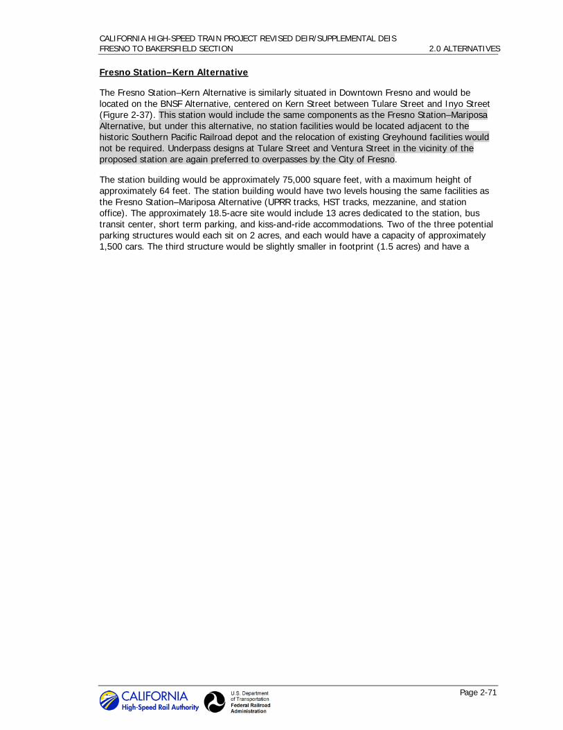
CALIFORNIA HIGH-SPEED TRAIN PROJECT REVISED DEIR/SUPPLEMENTAL DEIS FRESNO TO BAKERSFIELD SECTION 2.0 ALTERNATIVES
Page 2-71
Fresno Station–Kern Alternative
The Fresno Station–Kern Alternative is similarly situated in Downtown Fresno and would be located on the BNSF Alternative, centered on Kern Street between Tulare Street and Inyo Street (Figure 2-37). This station would include the same components as the Fresno Station–Mariposa Alternative, but under this alternative, no station facilities would be located adjacent to the historic Southern Pacific Railroad depot and the relocation of existing Greyhound facilities would not be required. Underpass designs at Tulare Street and Ventura Street in the vicinity of the proposed station are again preferred to overpasses by the City of Fresno.
The station building would be approximately 75,000 square feet, with a maximum height of approximately 64 feet. The station building would have two levels housing the same facilities as the Fresno Station–Mariposa Alternative (UPRR tracks, HST tracks, mezzanine, and station office). The approximately 18.5-acre site would include 13 acres dedicated to the station, bus transit center, short term parking, and kiss-and-ride accommodations. Two of the three potential parking structures would each sit on 2 acres, and each would have a capacity of approximately 1,500 cars. The third structure would be slightly smaller in footprint (1.5 acres) and have a
CALIFORNIA HIGH-SPEED TRAIN PROJECT REVISED DEIR/SUPPLEMENTAL DEIS FRESNO TO BAKERSFIELD SECTION 2.0 ALTERNATIVES
Page 2-72
Figure 2-34 Fresno Station conceptual designs

CALIFORNIA HIGH-SPEED TRAIN PROJECT REVISED DEIR/SUPPLEMENTAL DEIS FRESNO TO BAKERSFIELD SECTION 2.0 ALTERNATIVES
Page 2-73
Figure 2-35 Fresno Station–Mariposa Alternative
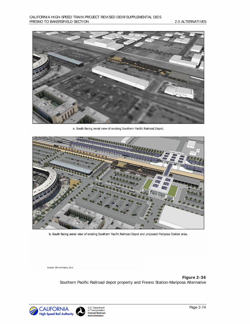
CALIFORNIA HIGH-SPEED TRAIN PROJECT REVISED DEIR/SUPPLEMENTAL DEIS FRESNO TO BAKERSFIELD SECTION 2.0 ALTERNATIVES
Page 2-74
Figure 2-36 Southern Pacific Railroad depot property and Fresno Station-Mariposa Alternative

CALIFORNIA HIGH-SPEED TRAIN PROJECT REVISED DEIR/SUPPLEMENTAL DEIS FRESNO TO BAKERSFIELD SECTION 2.0 ALTERNATIVES
Page 2-75
Figure 2-37 Fresno Station–Kern Alternative

CALIFORNIA HIGH-SPEED TRAIN PROJECT REVISED DEIR/SUPPLEMENTAL DEIS FRESNO TO BAKERSFIELD SECTION 2.0 ALTERNATIVES
Page 2-76
capacity of approximately 1,100 cars. Like the Fresno Station–Mariposa Alternative, the balance of the spaces needed to satisfy the estimated 2035 parking demand (7,400 total spaces) would be accommodated by existing public spaces, and the majority of station facilities would be sited east of the HST tracks.
Kings/Tulare Regional Station Alternatives 2.4.4.2
Two alternative sites are under consideration for the potential Kings/Tulare Regional Station.
Kings/Tulare Regional Station–East Alternative
The potential Kings/Tulare Regional Station–East Alternative would be located east of SR 43 (Avenue 8) and north of the San Joaquin Valley Railroad on the BNSF Alternative (Figure 2-38). The station building would be approximately 40,000 square feet with a maximum height of approximately 75 feet. The entire site would be approximately 25 acres, including 8 acres designated for the station, bus bays, short-term parking, and kiss-and-ride areas. An additional approximately 17.25 acres would support a surface parking lot with approximately 2,280 spaces. The balance of parking spaces necessary to meet the 2035 parking demand (2,800 total spaces) would be accommodated in downtown Hanford, Visalia, and/or Tulare, with local transit or shuttle services connecting with the station. Reducing the number of parking spaces provided at the station would allow for more open space areas, discourage growth at the station, encourage revitalization of the downtowns of Hanford, Visalia, and/or Tulare, and contain the development footprint of the station. Location of station parking in downtown areas would be identified in consultation with local communities to avoid traffic congestion and may require additional environmental review.
Kings/Tulare Regional Station–West Alternative
The potential Kings/Tulare Regional Station–West Alternative would be located east of 13th Avenue and north of the San Joaquin Valley Railroad on the Hanford West Bypass 1 and 2 alternatives. The station would be located either at-grade or below-grade depending on which Hanford West Bypass alignment design option is chosen.
The at-grade Kings/Tulare Regional Station–West Alternative would include a station building of approximately 100,000 square feet with a maximum height of approximately 36 feet. The entire site would be approximately 48 acres, including 6 acres designated for the station, bus bays, short-term parking, and kiss-and-ride areas. Approximately 5 acres would support a surface parking lot with approximately 700 spaces. An additional 3.5 acres would support two parking structures with a combined parking capacity of 2,100 spaces (Figure 2-39).
The below-grade Kings/Tulare Regional Station–West Alternative would include a station building of approximately the same size and height as the above-grade option. The below-grade station site would include the same components as the at-grade station option on the same number of acres; however, the station platform would be located below-grade instead of at ground level. Approximately 4 acres would support a surface parking lot with approximately 600 spaces and an additional 4 acres would support two parking structures with a combined parking capacity of 2,200 spaces (Figure 2-40).
Bakersfield Station Alternatives 2.4.4.3
Three alternative sites are under consideration for the Bakersfield Station. Figure 2-41 depicts the conceptual station plans for the “functional” and “iconic” architectural design options for the Bakersfield station structure. As in Fresno, the ultimate appearance of the station would be determined in collaboration with key community representatives and include stakeholder input.

CALIFORNIA HIGH-SPEED TRAIN PROJECT REVISED DEIR/SUPPLEMENTAL DEIS FRESNO TO BAKERSFIELD SECTION 2.0 ALTERNATIVES
Page 2-77
Bakersfield Station–North Alternative
The Bakersfield Station–North Alternative would be located at the corner of Truxtun and Union Avenue/SR 204 on the BNSF Alternative. Surrounding land uses in the area consist of offices, commercial, retail, industrial, and government offices. The Amtrak station is west of the proposed station site. A conceptual site plan for this station alternative is provided in Figure 2-42.
Access to the site would be from Truxtun Avenue, Union Avenue, and S Street. Two new boulevards would be built from Union Avenue and S Street to access the station and the supporting facilities. The main entrance would be located on the northern end of the site. The three-level station building would be 52,000 square feet, with a maximum height of approximately 95 feet. The first level would house station operation offices and would also accommodate other trains running along the BNSF Railway line. The second level would include the mezzanine; the platforms and guideway would pass through the third level.
The entire site would consist of 19 acres, with 11.5 acres designated for the station, bus transit center, short-term parking, and kiss-and-ride areas. An additional 7.5 acres would house two parking structures, one with a planned capacity of approximately 1,500 cars, and the other with a capacity of approximately 3,000 cars. In addition, another 175 spaces would be provided in surface lots. The balance of the supply necessary to accommodate the full 2035 parking demand (8,100 total spaces) would be provided through use of underutilized facilities around the station and in Downtown Bakersfield. Identification of these additional spaces would be coordinated with the City of Bakersfield as a part of a comprehensive parking strategy. Additional environmental review may be necessary as parking needs are identified for full system operations. Under this alternative, the station building would be located at the western end of the parcel footprint. The bus transit center and the smaller of the two parking structures (2.5 acres) would be north of the HST tracks. The BNSF Railway track runs through the station site. The HST tracks would be above the BNSF Railway tracks.
Bakersfield Station–South Alternative
The Bakersfield Station–South Alternative would be in the same area as the North Station Alternative, but would be situated along Union and California avenues on the Bakersfield South Alternative, just south of the BNSF Railway right-of-way (Figure 2-43). The two-level station building would be approximately 51,000 square feet, with a maximum height of approximately 95 feet. The first floor would house the concourse, and the platforms and guideway would be on the second floor.
The entire site would be 20 acres, with 15 acres designated for the station, bus transit center, short-term parking, and kiss-and-ride areas. Five of the 20 acres would support one six-level parking structure with a capacity of approximately 4,500 cars. In addition, another 500 spaces would be provided in surface lots. As with the Bakersfield Station–North Alternative, the balance of the supply necessary to accommodate the full 2035 parking demand (8,100 total spaces) would be identified as a part of a comprehensive parking strategy in coordination with the City of Bakersfield, and may require additional environmental review. Access to the station site would be from two new boulevards: one branching off from California Avenue, and the other from Union Avenue.
Bakersfield Station–Hybrid Alternative
The Bakersfield Station–Hybrid Alternative would be in the same area as the North and South Station alternatives, and would be located at the corner of Truxtun and Union Avenue/SR 204 on the Bakersfield Hybrid Alternative (Figure 2-44). The station design includes an approximately 57,000-square-foot main station building and an approximately 5,500-square-foot entry concourse located north of the BNSF Railway right-of-way. The station building would have two

CALIFORNIA HIGH-SPEED TRAIN PROJECT REVISED DEIR/SUPPLEMENTAL DEIS FRESNO TO BAKERSFIELD SECTION 2.0 ALTERNATIVES
Page 2-78
levels with a maximum height of approximately 95 feet. The first floor would house the concourse, and the platforms and guideway would be on the second floor. Additionally, a pedestrian overcrossing would connect the main station building to the north entry concourse across the BNSF right-of-way.
The entire site would be approximately 24 acres, with 15 acres designated for the station, bus transit center, short-term parking, and kiss-and-ride areas. Approximately 4.5 of the 24 acres would support 3 parking structures with a total capacity of approximately 4,500 cars. Each parking structure would be 7 levels; one with a planned capacity of 1,750 cars, another with a capacity of 1,315 cars, and the third with a planned capacity of 1,435 cars. An additional 460 parking spaces would be provided in surface lots covering a total of approximately 4.5 acres of the station site. As with the Bakersfield Station–North and Bakersfield Station–South alternatives, the balance of the supply needed to accommodate the full 2035 parking demand (8,100 total spaces) would be identified as a part of a comprehensive parking strategy developed in coordination with the City of Bakersfield. Access to the station site would be from Truxtun Avenue and Union Avenue as well as Hayden Court. Under this alternative, the BNSF Railway track would run through the station site, and the main station building and majority of the station facilities would be sited south of the BNSF Railway right-of-way.

CALIFORNIA HIGH-SPEED TRAIN PROJECT REVISED DEIR/SUPPLEMENTAL DEIS FRESNO TO BAKERSFIELD SECTION 2.0 ALTERNATIVES
Page 2-79
Figure 2-38 Kings/Tulare Regional Station–East Alternative

CALIFORNIA HIGH-SPEED TRAIN PROJECT REVISED DEIR/SUPPLEMENTAL DEIS FRESNO TO BAKERSFIELD SECTION 2.0 ALTERNATIVES
Page 2-80
Figure 2-39 Kings/Tulare Regional Station–West Alternative (at-grade option)

CALIFORNIA HIGH-SPEED TRAIN PROJECT REVISED DEIR/SUPPLEMENTAL DEIS FRESNO TO BAKERSFIELD SECTION 2.0 ALTERNATIVES
Page 2-81
Figure 2-40 Kings/Tulare Regional Station–West Alternative (below-grade option)

CALIFORNIA HIGH-SPEED TRAIN PROJECT REVISED DEIR/SUPPLEMENTAL DEIS FRESNO TO BAKERSFIELD SECTION 2.0 ALTERNATIVES
Page 2-82
Figure 2-41 Bakersfield Station conceptual designs

CALIFORNIA HIGH-SPEED TRAIN PROJECT REVISED DEIR/SUPPLEMENTAL DEIS FRESNO TO BAKERSFIELD SECTION 2.0 ALTERNATIVES
Page 2-83
Figure 2-42 Bakersfield Station–North Alternative

CALIFORNIA HIGH-SPEED TRAIN PROJECT REVISED DEIR/SUPPLEMENTAL DEIS FRESNO TO BAKERSFIELD SECTION 2.0 ALTERNATIVES
Page 2-84
Figure 2-43 Bakersfield Station–South Alternative

CALIFORNIA HIGH-SPEED TRAIN PROJECT REVISED DEIR/SUPPLEMENTAL DEIS FRESNO TO BAKERSFIELD SECTION 2.0 ALTERNATIVES
Page 2-85
Figure 2-44 Bakersfield Station–Hybrid Alternative
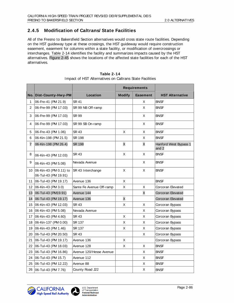
CALIFORNIA HIGH-SPEED TRAIN PROJECT REVSIED DEIR/SUPPLEMENTAL DEIS FRESNO TO BAKERSFIELD SECTION 2.0 ALTERNATIVES
Page 2-86
2.4.5 Modification of Caltrans/State Facilities
All of the Fresno to Bakersfield Section alternatives would cross state route facilities. Depending on the HST guideway type at these crossings, the HST guideway would require construction easement, easement for columns within a state facility, or modification of overcrossings or interchanges. Table 2-14 identifies the facility and summarizes impacts caused by the HST alternatives. Figure 2-45 shows the locations of the affected state facilities for each of the HST alternatives.
Table 2-14 Impact of HST Alternatives on Caltrans State Facilities
No. Dist-County-Hwy-PM Location
Requirements
HST Alternative Modify Easement
1 06-Fre-41 (PM 21.9) SR 41 X BNSF
2 06-Fre-99 (PM 17.03) SR 99 NB Off-ramp X BNSF
3 06-Fre-99 (PM 17.03) SR 99 X BNSF
4 06-Fre-99 (PM 17.03) SR 99 SB On-ramp X BNSF
5 06-Fre-43 (PM 1.06) SR 43 X X BNSF
6 06-Kin-198 (PM 21.5) SR 198 X BNSF
7 06-Kin-198 (PM 26.4) SR 198 X X Hanford West Bypass 1 and 2
8 06-Kin-43 (PM 12.03) SR 43 X X BNSF
9 06-Kin-43 (PM 5.08) Nevada Avenue X BNSF
10 06-Kin-43 (PM 0.11) to 06-Tul-43 (PM 19.91)
SR 43 Interchange X X BNSF
11 06-Tul-43 (PM 19.17) Avenue 136 X BNSF
12 06-Kin-43 (PM 3.0) Sante Fe Avenue Off-ramp X X Corcoran Elevated
13 06-Tul-43 (PM19.91) Avenue 144 X Corcoran Elevated
14 06-Tul-43 (PM 19.17) Avenue 136 X Corcoran Elevated
15 06-Kin-43 (PM 12.03) SR 43 X X Corcoran Bypass
16 06-Kin-43 (PM 5.08) Nevada Avenue X Corcoran Bypass
17 06-Kin-43 (PM 4.60) SR 43 X X Corcoran Bypass
18 06-Kin-137 (PM 0.00) SR 137 X X Corcoran Bypass
19 06-Kin-43 (PM 1.46) SR 137 X X Corcoran Bypass
20 06-Tul-43 (PM 20.50) SR 43 X Corcoran Bypass
21 06-Tul-43 (PM 19.17) Avenue 136 X Corcoran Bypass
22 06-Tul-43 (PM 18.03) Avenue 128 X X BNSF
23 06-Tul-43 (PM 16.86) Avenue 120/Hesse Avenue X BNSF
24 06-Tul-43 (PM 15.7) Avenue 112 X BNSF
25 06-Tul-43 (PM 12.22) Avenue 88 X BNSF
26 06-Tul-43 (PM 7.76) County Road J22 X BNSF

CALIFORNIA HIGH-SPEED TRAIN PROJECT REVISED DEIR/SUPPLEMENTAL DEIS FRESNO TO BAKERSFIELD SECTION 2.0 ALTERNATIVES
Page 2-87
Table 2-14 Impact of HST Alternatives on Caltrans State Facilities
No. Dist-County-Hwy-PM Location
Requirements
HST Alternative Modify Easement
27 06-Tul-43 (PM 3.11) Avenue 24 X X BNSF
28 06-Ker-43 (PM 36.19) Garces Highway X BNSF
29 06-Ker-43 (PM 34.19) Schuster Road X BNSF
30 06-Ker-43 (PM 33.19) Pond Road X BNSF
31 06-Ker-43 (PM 32.19) Peterson Road X BNSF
32 06-Ker-43 (PM 29.78) Blankenship Avenue X BNSF
33 06-Ker-43 (PM 28.78) Taussig Avenue X BNSF
34 06-Ker-43 (PM 26.47) McCombs Avenue X X BNSF
35 06-Ker-46 (PM 51.0) SR 46 near F St in Wasco X BNSF
36 06-Ker-43 (PM 19.38) Merced Avenue X BNSF
37 06-Ker-43 (PM 18.61) Poplar Avenue X BNSF
38 06-Ker-43 (PM 17.95) Fresno Avenue X BNSF
39 06-Ker-43 (PM22.16) Kimberlina Avenue X X BNSF
40 06-Ker-43 (PM 27.7) SR 43 X Wasco-Shafter Bypass
41 06-Ker-46 (PM 51.64) SR 46 X X Wasco-Shafter Bypass
42 06-Ker-58 (PM 47.1) SR 58 X X BNSF
43 06-Ker-99 (PM 24.8) SR 99 X BNSF
44 06-Ker-204 (PM 3.3) SR 204 X BNSF
45 06-Ker-58 (PM 47.1) SR 58 X X Bakersfield South
46 06-Ker-99 (PM 24.8) SR 99 X Bakersfield South
47 06-Ker-204 (PM 3.3) SR 204 X Bakersfield South
48 06-Ker-58 (PM 47.1) SR 58 X X Bakersfield Hybrid
49 06-Ker-99 (PM 24.8) SR 99 X Bakersfield Hybrid
50 06-Ker-204 (PM 3.3) SR 204 X Bakersfield Hybrid
Note: Where Modify and Easement boxes are both checked, the project requires an easement over/under the State Highway and changes to the existing roadway.
Acronyms:
NB = northbound PM = post mile SR = state route

CALIFORNIA HIGH-SPEED TRAIN PROJECT REVISED DEIR/SUPPLEMENTAL DEIS FRESNO TO BAKERSFIELD SECTION 2.0 ALTERNATIVES
Page 2-88
Figure 2-45 Location of state facilities affected by HST alternatives

CALIFORNIA HIGH-SPEED TRAIN PROJECT REVISED DEIR/SUPPLEMENTAL DEIS FRESNO TO BAKERSFIELD SECTION 2.0 ALTERNATIVES
Page 2-89
Locating an HST guideway adjacent to the BNSF Corridor would require modification to state highway and local roadway systems to maintain their function. Although much of the HST interaction with state facilities along the Fresno to Bakersfield Section would be limited to encroachment of the Caltrans right-of-way, there are two specific instances where reconfiguration would occur. The following sections discuss the affected facilities. The two proposed state route reconfigurations are discussed first, and descriptions of general modifications that would occur to state facilities due to proximity of the HST alternatives then follow.
State Route Reconfigurations 2.4.5.1
State Route 46
To the east of Wasco, the Wasco-Shafter Bypass Alternative would be at- grade and intersect with SR 46. In order to separate the HST and the state facility, SR 46 would remain on its current horizontal alignment but would be reconfigured vertically to cross over the HST (Figure 2-46). The proposed reconstruction of SR 46 includes two 12-foot lanes, two 8-foot shoulders, and two 5-foot sidewalks. The traffic from SR 46 would be detoured onto local roads during construction.
State Route 137
To the east of Corcoran, the Corcoran Bypass Alternative would be at-grade and intersect SR 137. Separation of the HST and SR 137 would be required. SR 137 would remain on its current horizontal alignment but the vertical profile would be lowered and an underpass of the at-grade HST constructed (Figure 2-47). The existing junction of SR 43 and SR 137 would remain. It was not possible to use the typical overhead crossing design because of the close proximity of SR 43 and the HST alignment and because of the location of a private airport on the southeastern corner of the existing SR 43 and SR 137 junction. SR 137 would be constructed with two 12-foot lanes and two 8-foot shoulders. The traffic from SR 137 would be detoured to local roads and SR 43 during construction.
Figure 2-46 State Route 46 reconfiguration
Figure 2-47 State Route 137 reconfiguration
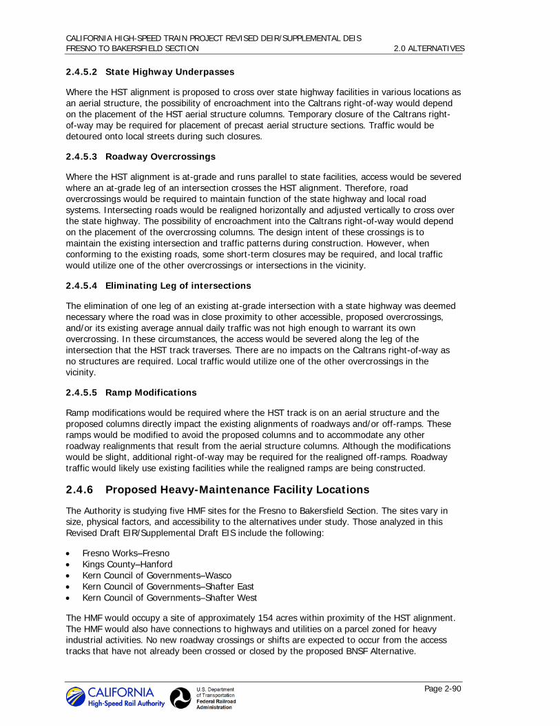
CALIFORNIA HIGH-SPEED TRAIN PROJECT REVISED DEIR/SUPPLEMENTAL DEIS FRESNO TO BAKERSFIELD SECTION 2.0 ALTERNATIVES
Page 2-90
State Highway Underpasses 2.4.5.2
Where the HST alignment is proposed to cross over state highway facilities in various locations as an aerial structure, the possibility of encroachment into the Caltrans right-of-way would depend on the placement of the HST aerial structure columns. Temporary closure of the Caltrans right-of-way may be required for placement of precast aerial structure sections. Traffic would be detoured onto local streets during such closures.
Roadway Overcrossings 2.4.5.3
Where the HST alignment is at-grade and runs parallel to state facilities, access would be severed where an at-grade leg of an intersection crosses the HST alignment. Therefore, road overcrossings would be required to maintain function of the state highway and local road systems. Intersecting roads would be realigned horizontally and adjusted vertically to cross over the state highway. The possibility of encroachment into the Caltrans right-of-way would depend on the placement of the overcrossing columns. The design intent of these crossings is to maintain the existing intersection and traffic patterns during construction. However, when conforming to the existing roads, some short-term closures may be required, and local traffic would utilize one of the other overcrossings or intersections in the vicinity.
Eliminating Leg of intersections 2.4.5.4
The elimination of one leg of an existing at-grade intersection with a state highway was deemed necessary where the road was in close proximity to other accessible, proposed overcrossings, and/or its existing average annual daily traffic was not high enough to warrant its own overcrossing. In these circumstances, the access would be severed along the leg of the intersection that the HST track traverses. There are no impacts on the Caltrans right-of-way as no structures are required. Local traffic would utilize one of the other overcrossings in the vicinity.
Ramp Modifications 2.4.5.5
Ramp modifications would be required where the HST track is on an aerial structure and the proposed columns directly impact the existing alignments of roadways and/or off-ramps. These ramps would be modified to avoid the proposed columns and to accommodate any other roadway realignments that result from the aerial structure columns. Although the modifications would be slight, additional right-of-way may be required for the realigned off-ramps. Roadway traffic would likely use existing facilities while the realigned ramps are being constructed.
2.4.6 Proposed Heavy-Maintenance Facility Locations
The Authority is studying five HMF sites for the Fresno to Bakersfield Section. The sites vary in size, physical factors, and accessibility to the alternatives under study. Those analyzed in this Revised Draft EIR/Supplemental Draft EIS include the following:
• Fresno Works–Fresno • Kings County–Hanford • Kern Council of Governments–Wasco • Kern Council of Governments–Shafter East • Kern Council of Governments–Shafter West
The HMF would occupy a site of approximately 154 acres within proximity of the HST alignment. The HMF would also have connections to highways and utilities on a parcel zoned for heavy industrial activities. No new roadway crossings or shifts are expected to occur from the access tracks that have not already been crossed or closed by the proposed BNSF Alternative.

CALIFORNIA HIGH-SPEED TRAIN PROJECT REVISED DEIR/SUPPLEMENTAL DEIS FRESNO TO BAKERSFIELD SECTION 2.0 ALTERNATIVES
Page 2-91
Tracks would be built through the facility building(s), and trains would normally enter and leave under their own electric power. It is assumed that several movements into and out of the main shop building would occur on every shift, and that there would be movements between the train yard and the shop on every shift. The shop would have a high roof (to accommodate transverse cranes that can lift whole train cars). Maintenance buildings would likely be prefabricated steel buildings.
Figure 2-48 shows the locations proposed for the HMF; Table 2-15 describes each proposed HMF, its location, and property characteristics. The following sections describe how the access track would enter and exit the proposed HMF site and any proposed changes to the roadways to facilitate the access track.
Fresno Works–Fresno HMF Site 2.4.6.1
If the Fresno Works–Fresno site is selected for the HMF, the configuration of HST access tracks would be based on facility layout. The site is located within the southern limits of the city of Fresno next to the BNSF Railway right-of-way between SR 99 and Adams Avenue. HST access tracks would extend from both the northern and southern ends of the site and, depending on site configuration, overcrossings may be required to clear the BNSF Railway. Proposed roadway modifications include overcrossings and closures. Access tracks are not expected to add to the number of roadway crossings or shifts proposed by the project.
Kings County–Hanford HMF Site 2.4.6.2
The Kings County–Hanford HMF Site, which would be accessed by the BNSF Alternative, is located southeast of the city of Hanford, adjacent to and east of SR 43, between Houston and Idaho avenues. HST access tracks would extend from both the northern and southern ends of the site; however, this site would require an overcrossing of the eastern HST tracks to access the western, or “far-side,” HST tracks. There are no constraints on the construction of overcrossings at the site. Access tracks are not expected to add to the number of roadway crossings or shifts proposed by the project.
Kern Council of Governments–Wasco HMF Site 2.4.6.3
This proposed site would lie east of Wasco between SR 46 and Filburn Street. Connections to the northern and southern ends of the facility from the BNSF Alternative would require an easement, an overcrossing of the BNSF Railway, and an undercrossing of SR 46. Access from the Wasco-Shafter Bypass Alternative would be limited to the northern end of the facility, resulting in a stub-ended facility. Access tracks are not expected to add to the number of roadway crossings or shifts proposed by the project.
Kern Council of Governments-Shafter East HMF Site 2.4.6.4
This proposed site, which would be accessed by the Wasco-Shafter Bypass Alternative, would be located on the eastern side of the BNSF Railway right-of-way in the city of Shafter between Burbank Street and Seventh Standard Road. Access to the HST tracks at both ends of the site is possible from the Wasco-Shafter Bypass Alternative; however, depending on site configuration, access from this alternative alignment may require an overcrossing of the BNSF Railway. Access tracks are not expected to add to the number of roadway crossings or shifts proposed by the project.

CALIFORNIA HIGH-SPEED TRAIN PROJECT REVISED DEIR/SUPPLEMENTAL DEIS FRESNO TO BAKERSFIELD SECTION 2.0 ALTERNATIVES
Page 2-92
Figure 2-48 Locations of potential heavy maintenance facility sites

CALIFORNIA HIGH-SPEED TRAIN PROJECT REVISED DEIR/SUPPLEMENTAL DEIS FRESNO TO BAKERSFIELD SECTION 2.0 ALTERNATIVES
Page 2-93
Kern Council of Governments–Shafter West HMF Site 2.4.6.5
This proposed site, which would be accessed by the BNSF Alternative, would be located on the western side of the BNSF Railway right-of-way in the city of Shafter between Burbank Street and Seventh Standard Road. Access to the northern and southern ends of the facility from the BNSF Alternative would not require an overcrossing of the BNSF Railway. Access tracks are not expected to add to the number of roadway crossings or shifts proposed by the project.
Table 2-15 Fresno to Bakersfield Section HMF Site Descriptions
Name Location/Description Property Characteristics
Fresno Works–Fresno
590 available acres
Located within the southern limits of the city of Fresno and county of Fresno next to the BNSF Railway right-of-way between SR 99 and Adams Avenue (Figure 2-49).
Site would serve all of the alternatives under consideration.
Economic incentives include $25 million to be used by the Authority for site acquisition, infrastructure, utilities, and/or construction
Immediately accessible from HST tracks
Existing roadway access
3 acres located in floodplain
Close proximity to utilities
9 waterways onsite
Kings County–Hanford
510 available acres
Located southeast of the city of Hanford, adjacent to and east of SR 43, between Houston and Idaho avenues (Figure 2-50).
Site would serve all of the alternatives under consideration except the Hanford West 1 & 2 alternatives.
Economic incentives include proximity to Kings County Enterprise Zone
Immediately accessible from HST tracks
Convenient highway access
Outside of floodplain
Utilities readily available
One waterway on site
Kern Council of Governments–Wasco
420 available acres
East of Wasco between SR 46 and Filburn Street (Figure 2-51).
Site would serve all of the alternatives under consideration.
One site for HMF, Maintenance-of-Way Facility and Operations Control Center
Immediately accessible from HST tracks at both ends of the facility with additional design features (BNSF) or northern end only (Wasco-Shafter Bypass)
Convenient highway access
Outside of floodplain
Close proximity to utilities
Fewest acres of agricultural lands affected
Kern Council of Governments–Shafter East
490 available acres
Located in the city of Shafter on the eastern side of the BNSF Railway right-of-way between Burbank Street and 7th Standard Road (Figure 2-52).
Site would serve the Wasco-Shafter Bypass Alternative.
Capability of collecting daily operations data with California State University, Bakersfield GIS lab
Access is complicated by the location of existing BNSF Railway facilities
Site is not suitable for yard track turnouts from the Wasco-Shafter Bypass Alternative
Existing roadway access
Utilities readily available
150 acres located in floodplain

CALIFORNIA HIGH-SPEED TRAIN PROJECT REVISED DEIR/SUPPLEMENTAL DEIS FRESNO TO BAKERSFIELD SECTION 2.0 ALTERNATIVES
Page 2-94
Table 2-15 Fresno to Bakersfield Section HMF Site Descriptions
Name Location/Description Property Characteristics
Kern Council of Governments–Shafter West
480 available acres
Located in the city of Shafter on the western side of the BNSF Railway right-of-way between Burbank Street and 7th Standard Road (Figure 2-52).
Site would serve all of the alternatives under consideration except the Wasco-Shafter Bypass Alternative.
Capability of collecting daily operations data with California State University, Bakersfield GIS lab
Immediately accessible from HST tracks at both ends of the facility
Existing roadway access
Utilities readily available
175 acres located in floodplain
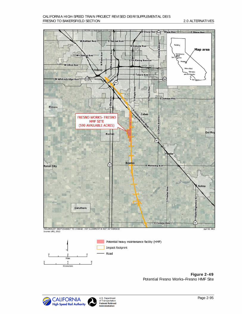
CALIFORNIA HIGH-SPEED TRAIN PROJECT REVISED DEIR/SUPPLEMENTAL DEIS FRESNO TO BAKERSFIELD SECTION 2.0 ALTERNATIVES
Page 2-95
Figure 2-49 Potential Fresno Works–Fresno HMF Site

CALIFORNIA HIGH-SPEED TRAIN PROJECT REVISED DEIR/SUPPLEMENTAL DEIS FRESNO TO BAKERSFIELD SECTION 2.0 ALTERNATIVES
Page 2-96
Figure 2-50 Potential Kings County–Hanford HMF Site

CALIFORNIA HIGH-SPEED TRAIN PROJECT REVISED DEIR/SUPPLEMENTAL DEIS FRESNO TO BAKERSFIELD SECTION 2.0 ALTERNATIVES
Page 2-97
Figure 2-51 Potential Kern Council of Governments–Wasco HMF Site

CALIFORNIA HIGH-SPEED TRAIN PROJECT REVISED DEIR/SUPPLEMENTAL DEIS FRESNO TO BAKERSFIELD SECTION 2.0 ALTERNATIVES
Page 2-98
Figure 2-52 Potential Kern Council of Governments–Shafter East and West HMF sites

CALIFORNIA HIGH-SPEED TRAIN PROJECT REVISED DEIR/SUPPLEMENTAL DEIS FRESNO TO BAKERSFIELD SECTION 2.0 ALTERNATIVES
Page 2-99
2.5 Travel Demand and Ridership Forecasts
New ridership forecasts were prepared to support ongoing planning for the HST system and the analysis in this Revised Draft EIR/Supplemental Draft EIS. Ridership forecasts were developed for the year 2030 by Cambridge Systematics, Inc. These 2030 forecasts were prepared using a 4,667-zone ridership and revenue model developed by Cambridge Systematics in 2005-2007 for the Metropolitan Transportation Commission (MTC) in partnership with the Authority. Using HST operating plan assumptions (see Appendix 2-C, Operations and Service Plan Summary) including run times and station stops for a variety of express, semi-express, and local trains, Cambridge Systematics tested numerous combinations of system phasing, parking cost, and HST fares. Two primary forecasting scenarios were created: one assuming Full System operation between Sacramento, San Diego, San Francisco, and Anaheim, and one assuming Phase 1 HST operations between San Francisco, Merced, and Anaheim.
Cambridge Systematics also developed 2035 statewide regional growth estimates and applied these to the 2030 forecasts to develop 2035 forecasts. These forecasts were then used to estimate the ridership levels shown in Table 2-16. These figures, in turn, were extrapolated to produce 2020 estimates based on predicted growth rates for 2030, assuming that only 40% of the forecast ridership would materialize in the first year, 60% in the second, 80% in the third, and finally reaching the system’s forecast levels for the year in 2023. More details on the modeling and forecasts are set out in the California High-Speed Rail Ridership and Revenue Model: Development, Application, and Project-Level Forecasts (Authority 2010c).
With higher passenger fares (i.e., 83% of airfare levels), Phase 1 would carry 13.2 million riders in the first year 2020, growing to 36.1 million by 2026, the last full year before the assumed implementation of the full system. In its first assumed year of operation, 2027, the Full System would carry 47.6 million passengers, growing to over 69 million in 2035. The forecast of 69.3 million passengers annually for the 2035 Full System represents the low forecast for this EIR/EIS.
With lower passenger fares (i.e., 50% of airfare levels), Phase 1 would carry 18.7 million passengers in 2020, growing to 51.3 million in 2026. The Full System in its first year, 2027, would carry 67.5 million passengers, growing to over 98 million in 2035. The forecast of 98.2 million passengers annually for the 2035 Full System represents the high forecast for this EIR/EIS.
Table 2-16 HST System Ridership Forecasts (in millions per year)
Fare Scenario
2020 2027 2035
Phase I Full System Phase I* Full System
HST ticket price 83% of airfare levels 13.2 47.6 40.2 69.3
HST ticket price 50% of airfare levels 18.7 67.5 57.0 98.2
*Note: Although the Full System is expected to be implemented by 2027, these forecasts provide “worst case” scenarios for the Phase 1 terminus station, and a lower-volume mid-line station in the full system.
This range of ridership forecasts allowed for the development of certain aspects of the HST system design and certain portions of the environmental analysis as described in more detail below. Eventual HST system ridership will depend on many uncertain factors, such as the price of

CALIFORNIA HIGH-SPEED TRAIN PROJECT REVISED DEIR/SUPPLEMENTAL DEIS FRESNO TO BAKERSFIELD SECTION 2.0 ALTERNATIVES
Page 2-100
gasoline or eventual cost of an HST ticket. Accordingly, the HST system analyzed in this document is designed to accommodate the broad range of future ridership over the coming decades.
2.5.1 Ridership and HST System Design
The HST system is a long-term transportation investment for the state of California. Many components of the HST system infrastructure have a design life of 30, 50, and even 100 years. The HST system analyzed in this EIR/EIS is designed to provide adequate infrastructure and facilities for a state-of-the-art, high-speed passenger train system over many decades (Parsons Brinckerhoff 2010). While much infrastructure must be designed and built for full utility, certain components of the HST system are more flexible and can change and adapt depending on how HST ridership grows over time.
Total forecasted annual ridership on the HST system is not the primary driver of HST system design. While the Authority and FRA have weighed ridership and revenue potential in evaluating alignment and station alternatives in the Tier 1 Program EIR/EIS documents and Tier 2 alternatives screening, the design of most HST system components is dictated by the agencies’ performance objectives and safety requirements, rather than by total annual ridership. The HST system will be a two-track system throughout, with four tracks at intermediate stations, regardless of total annual ridership. Track geometry and profile, power distribution systems, train control/signal systems, and the type of rolling stock will be the same whether the HST system has 50 million riders annually or 100 million. Most station elements also will be the same regardless of total annual ridership, such as platform design and other necessary station components. The location of the HMF and the light maintenance facilities are dictated by technical operating requirements for the HST system, not by ridership.
Ridership does influence HST system design in some respects. The size of the HMF and the light-maintenance facilities is based on the 2035 Full System high-ridership forecast to ensure adequate sizing of these facilities to accommodate maximum future needs. This approach is consistent with general planning and design practice for a large infrastructure project, acquiring enough land for future needs up front rather than trying to purchase property at a later date when it may no longer be available or impractical to acquire. This would allow early phases of maintenance facility construction and later expansion as fleet size and maintenance requirements grow.
For stations, forecasted annual ridership and peak-period ridership play a role in determining the size of some station components, such as those required for public access and egress to the HST system. The 2035 Full System high-ridership forecast formed the basis for the conceptual service plan, which in turn influenced the station designs by ensuring the station facilities would be sufficient to accommodate the anticipated future use of the HST system, which is expected to build over time.
For station-area parking facilities, the 2035 Full System high-ridership scenario was used to capture the maximum potential parking demand and to allow for an analysis of where and how parking demand might be accommodated near the HST station. Parking facilities are expected to be phased in over time as demand grows. The EIR/EIS reliance on the high forecasts for parking provides flexibility over time to change or even reduce the amount of station parking as improved transit-oriented development (TOD) occurs around station areas.
2.5.2 Ridership and Environmental Impact Analysis
The level of annual HST ridership plays a role in the analysis of environmental impacts and benefits for traffic, air quality, noise, and energy. For these areas, this EIR/EIS uses the high

CALIFORNIA HIGH-SPEED TRAIN PROJECT REVISED DEIR/SUPPLEMENTAL DEIS FRESNO TO BAKERSFIELD SECTION 2.0 ALTERNATIVES
Page 2-101
ridership forecast for analyzing the potential for adverse environmental impacts of building and operating the HST system. This “worst-case” approach ensures disclosure of the higher level of adverse environmental effects that may occur with higher ridership (e.g., pass-by train noise, station-area traffic). If eventual ridership is lower, adverse environmental impacts would also be lower. For environmental benefits from the HST system (e.g., transportation, air quality, energy), a lower level of ridership would reduce the level of benefits provided by the HST system. This is discussed in more detail in Chapter 3.
2.5.3 Ridership and Station Area Parking
HST system ridership, parking demand, parking supply, and development around HST stations are intertwined, and anticipated to evolve from commencement of revenue service in 2020 to full system operations in 2035. The Authority's goals are to ensure access to the HST system by providing automobile parking and also to promote—in partnership with cities—TOD around HST stations and expansion of local transit to bring riders to HST stations. This is a delicate balance that will evolve over time and vary by station, as some cities and regions will develop their station areas and local transit systems more than others by 2020 and 2035.
Research suggests that the percentage of transit passengers arriving/departing transit stations by car and needing to park decreases as land use development and population around the stations increases. The Authority’s adopted station area development policies recognize this inverse relationship between parking demand and HST station area development. HST will be most successful if stations are placed where there is or will be a high density of population, jobs, commercial activities, entertainment, and other activities that generate trips. The Authority’s policies, therefore, encourage dense development around HST stations, which supports system ridership while reducing parking demand.
Land use development around HST stations will not occur immediately, however. While HST will be a catalyst for such development, actual construction will be dictated by local land use decisions and market conditions. The Authority will encourage station area development in partnership with local government, as exemplified by the station area planning grants it has provided to the city of Fresno and offered to the city of Bakersfield, but the Authority’s power in this regard is limited. The actual demand for parking facilities, moreover, will depend on how HST ridership grows over time.
In light of the uncertainty over the need for station area parking, this EIR/EIS conservatively identifies parking facilities to meet the maximum forecast parking demand in the immediate vicinity of the stations. This scenario is an upper bound on actual needs and discloses the maximum potential environmental impact. The Authority and FRA will therefore have the flexibility to make decisions about what parking facilities will be constructed initially, and how additional parking might be phased or adjusted depending on how HST system ridership increases over time. For example, it is possible that some parking facilities might get constructed at the 2020 project opening, only to be replaced in whole or in part, or augmented later with development of other parking facilities.
2.6 Operations and Service Plan
2.6.1 HST Service
The conceptual HST service plan for Phase 1, starting in 2020, begins with service between Anaheim/Los Angeles running through the Central Valley from Bakersfield to Merced, and traveling northwest into the Bay Area. Subsequent stages of the HST system include a southern extension from Los Angeles to San Diego via the Inland Empire and an extension from Merced

CALIFORNIA HIGH-SPEED TRAIN PROJECT REVISED DEIR/SUPPLEMENTAL DEIS FRESNO TO BAKERSFIELD SECTION 2.0 ALTERNATIVES
Page 2-102
north to Sacramento, which are anticipated to be implemented in 2027 for purposes of this environmental analysis.
Train service would run in diverse patterns between various terminals. Three basic service types are envisioned:
• Express trains, which would serve major stations only, providing fast travel times; for example, between Los Angeles and San Francisco during the morning and afternoon peak with a run time of 2 hours and 40 minutes.
• Limited-stop trains, which would skip selected stops along a route to provide faster service between stations.
• All-stop trains, which would focus on regional service.
The vast majority of trains would provide limited-stop services and offer a relatively fast run time along with connectivity among various intermediate stations. Numerous limited-stop patterns would be provided, to achieve a balanced level of service at the intermediate stations. The service plan envisions at least four limited trains per hour in each direction, all day long, on the main route between San Francisco and Los Angeles. Each intermediate station in the Bay Area, Central Valley between Fresno and Bakersfield, Palmdale in the High Desert, and Sylmar and Burbank in the San Fernando Valley would be served by at least two limited trains every hour—offering at least two reasonably fast trains an hour to San Francisco and Los Angeles. Selected limited-stop trains would be extended south of Los Angeles as appropriate to serve projected demand.
Including the limited-stop trains on the routes between Sacramento and Los Angeles, and Los Angeles and San Diego, and the frequent-stop local trains between San Francisco and Los Angeles/Anaheim, and Sacramento and San Diego, every station on the HST network would be served by at least two trains per hour per direction throughout the day, and at least three trains per hour during the morning and afternoon peak periods. Stations with higher ridership demand would generally be served by more trains than those with lower estimated ridership demand.
The service plan provides direct-train service between most station pairs at least once per hour. Certain routes may not always be served directly, and some passengers would need to transfer from one train to another at an intermediate station, such as Los Angeles Union Station, to reach their final destination. Generally, the Phase 1 and Full-Build conceptual operations and service plans offer a wide spectrum of direct-service options and minimize the need for passengers to transfer.
Figure 2-53 shows how projected ridership and the numbers of trains would grow over time for the high scenario of ridership. In 2020, the assumed first year of Phase 1 operation, 120 trains would operate daily. This would grow to 260 daily trains in 2026, and jump to 288 when the full statewide HST system is anticipated to become operational, including the Merced to Sacramento and Los Angeles to San Diego sections. By 2035, 212 trainsets will be needed to operate 339 daily trains throughout the HST system.
CALIFORNIA HIGH-SPEED TRAIN PROJECT REVISED DEIR/SUPPLEMENTAL DEIS FRESNO TO BAKERSFIELD SECTION 2.0 ALTERNATIVES
Page 2-103
Specifically for the Fresno to Bakersfield Section, estimated trip time would be approximately 40 minutes between Fresno and Bakersfield. The maximum operating speed would reach 220 mph in this section. Train service in the corridor is anticipated to run from around 6:00 a.m. to midnight. Non-service activities required to maintain the system are anticipated to occur during non-revenue service hours. The dwell time of trains at the stations for passenger unloading and loading is expected to be approximately 1.5 minutes.
The Fresno, Kings/Tulare Regional, and Bakersfield stations would see a mix of stopping trains and through trains peaking for the full system. In 2035 for the high-ridership scenario, the full system would see four trains an hour stop at Fresno in each direction at the peak, and six trains run through. At the off-peak the same number of stops would be made, but the through trains would drop to three per hour. At the Kings/Tulare Regional Station, four trains would stop each hour per direction at the peak, with six running through. At the off-peak, four trains would stop at the station. At the Bakersfield Station, four trains would stop each hour per direction at the peak, with six running through. At the off-peak, four trains would stop in Bakersfield. For more detail, see Appendix 2-C, Operations and Service Plan Summary.
2.6.2 Maintenance Activities
The Authority would regularly perform maintenance along the track and railroad right-of-way as well as the power systems, train control, signalizing, communications, and other vital systems required for the safe operation of the HST system. Maintenance methods are expected to be
Figure 2-53 Revenue service and ridership build-up

CALIFORNIA HIGH-SPEED TRAIN PROJECT REVISED DEIR/SUPPLEMENTAL DEIS FRESNO TO BAKERSFIELD SECTION 2.0 ALTERNATIVES
Page 2-104
similar to those of existing European and Asian HST systems, adapted to the specifics of the California HST. However, the FRA will specify standards of maintenance, inspection, and other items in a set of regulations (Rule of Particular Applicability or RPA) to be issued in the next several years, and the overseas practices may be amended in ways not currently foreseen. The brief descriptions of maintenance activities described below are thus based on best judgment about future practices in California.
• Track and Right-of-Way – The track at any point would be inspected several times a week using measurement and recording equipment aboard special measuring trains. These trains are of similar design to the regular trains but would operate at a lower speed. They would run between midnight and 5 a.m. and would usually pass over any given section of track once in the night.
Most adjustments to the track and routine maintenance would be accomplished in a single night at any specific location with crews and material brought by work trains along the line. When rail resurfacing is needed, perhaps several times a year, specialized equipment would pass over the track sections at 5-10 mph.
Approximately every four to five years, ballasted track would require sections of more intensive maintenance of the track and structure using a train with a succession of specialized cars to raise, straighten, and tamp the track, and using vibrating “arms” to move and position the ballast under the ties. The train would typically cover a mile-long section of track in the course of one night’s maintenance. Slab track, which is expected to comprise track at elevated sections, would not require this activity. No major track components are expected to require replacement through 2035.
Other maintenance of the right-of-way, aerial structures, and bridge sections of the alignment would include drain cleaning, vegetation control, litter removal, and other inspection that would typically occur monthly to several times a year.
• Power – The overhead contact system (OCS) along the right-of-way would be inspected nightly, with repairs being made when needed, which would typically be accomplished in one night’s maintenance window. Other inspections would occur monthly. Many of the functions and status of substations and smaller facilities outside of the trackway would be remotely monitored; however, visits would be made to repair or replace minor items, and would also be scheduled several times a month to check the general site. It is expected that no major component replacement would be required for the OCS or the substations through 2035.
• Structures – Visual inspections of the structures along the right-of-way and testing of fire and life-safety systems and equipment in or on structures would occur monthly, while inspections of all structures for structural integrity would occur at least annually. Steel structures would also require painting every several years. For tunnels and buildings, repair and replacement of lighting and communication components would be performed on a routine basis. It is expected that no major component replacement or reconstruction of any structures would be needed through 2035.
• Signaling, Train Control, and Communications – Inspection and maintenance of signaling and train control components would be guided by FRA regulations and standards to be adopted by the Authority. Typically, physical in-field inspection and testing of the system would occur four times a year using hand-operated tools and equipment. Communication components would be routinely inspected and maintained, usually at night, although daytime work may occur if the work area is clear of the trackway. No major component replacement of these systems is expected through 2035.

CALIFORNIA HIGH-SPEED TRAIN PROJECT REVISED DEIR/SUPPLEMENTAL DEIS FRESNO TO BAKERSFIELD SECTION 2.0 ALTERNATIVES
Page 2-105
• Stations – Each station would be inspected and cleaned daily. Inspections of the structures, including the platforms, would occur annually. Inspections of other major systems, such as escalators, the heating and ventilation system, ticket-vending machines, and closed-circuit television would be according to manufacturer recommendations. Major station components are not expected to require replacement through 2035.
• Perimeter Fencing and Intrusion Protection – Fencing and intrusion protection systems will be remotely monitored, as well as periodically inspected. Maintenance would occur as needed, but it is not expected that the fencing or systems are not expected to require replacement before 2035.
2.7 Additional High-Speed Train Development Considerations
2.7.1 High-Speed Train, Land Use Patterns, and Development around High-Speed Train Stations
In 2008, California voters approved Proposition 1A – essentially approving the California HST System. Regarding urban development and land use patterns, voters specifically mandated that HST stations “be located in areas with good access to local mass transit or other modes of transportation. The HST system also shall be planned and constructed in a manner that minimizes urban sprawl and impacts on the natural environment” including “wildlife corridors.”
In submitting Proposition 1A to the voters, the Legislature went further:
“The continuing growth in California’s population and the resulting increase in traffic congestion, air pollution, greenhouse gas emissions, and the continuation of urban sprawl make it imperative that the state proceed quickly to construct a state-of-the-art high-speed passenger train system to serve major metropolitan areas.”
The Authority has embraced this voter and legislative direction. As the Authority’s program EIR/EIS documents show and this EIR/EIS supports, operation of the HST system by itself will reduce traffic congestion, air pollution, and greenhouse gas (GHG) emissions. The Authority believes, however, that this is not enough. The HST will be most successful, and will best fulfill the intent of the voters and Legislature, if it is coordinated with sprawl-reducing and environment-improving land use development patterns. Accordingly, the Authority has adopted HST Station Area Development Policies based on the following premise:
“For the high-speed train to be more useful and yield the most benefit, it is important that the stations be placed where there will be a high density of population, jobs, commercial activities, entertainment, and other activities that generate personal trips. The success of HST is highly dependent on land use patterns that also reduce urban sprawl, reduce conversion of farm land to development, reduce vehicle miles traveled (VMT) by automobiles, and encourage high-density development in and around the HST station.”
The Authority and its Station Area Development Policies specifically advocate:
• Higher density development in relation to the existing pattern of development in the surrounding area, along with minimum requirements for density.
• A mix of land uses (e.g., retail, office, hotels, entertainment, residential) and a mix of housing types to meet the needs of the local community.

CALIFORNIA HIGH-SPEED TRAIN PROJECT REVISED DEIR/SUPPLEMENTAL DEIS FRESNO TO BAKERSFIELD SECTION 2.0 ALTERNATIVES
Page 2-106
• Compact pedestrian-oriented design that promotes walking, bicycle, and transit access with streetscapes that include landscaping, small parks, and pedestrian spaces.
• Limits on the amount of parking for new development and a preference that parking be placed in structures. Transit-oriented development areas typically have reduced parking requirements for retail, office, and residential uses due to their transit and bicycle access, walkability, and potential for shared parking. Sufficient train passenger parking would be essential to the system viability, but this would be offered at market rates (not free) to encourage the use of access by transit and other modes.
• Infill development—namely, development around HST stations on land that is already disturbed by existing development, parking lots, pavement, etc., rather than development on previously undisturbed land or on farmland. The Authority, therefore, prefers to locate its stations in existing developed areas, particularly city centers.
The Authority recognizes that land use development around HST stations is controlled by local government and the market, and is influenced by public-interest groups. The Authority also recognizes that local transit is controlled by regional and local transit agencies. The Authority is committed, therefore, to working cooperatively with local government, transit agencies, public-interest groups, and the development community to realize a shared vision for land use and transit development around HST stations consistent with the Authority’s Development Policies, to the maximum extent possible.
Good land use planning helps ensure good land use development. Planning for infill development, however, is particularly complicated. Infill areas (e.g., established downtowns) typically involve numerous small parcels with different property owners. Therefore, no single property owner exists to pay for the planning. Government typically has to fund it. The economic downturn and the State’s elimination of redevelopment agencies, however, have left local government resources particularly limited. Accordingly, the Authority has committed to utilize its resources, both financial and otherwise, to encourage good local government land use planning around HST stations consistent with the above principles.
The Authority believes that implementation of its Station Area Development Policies, and cooperative work with local government (including funding for planning), will result in the types of environmental benefits voters and the Legislature contemplated in 2008. This EIR/EIS forecasts that the HST will reduce VMT and related GHG emissions, reduce energy use, reduce traffic congestion, and improve air quality. To be conservative and consistent with CEQA and NEPA requirements, these forecasts generally do not account for the additional benefit to these areas expected from more compact development patterns—patterns which the Authority’s Station Area Development Policies support. The Authority began the “Vision California” study effort to help account for these additional sustainability benefits that would exceed benefits reported in this EIR/EIS.
Vision California is a first-of-its-kind effort to explore the role of land use and transportation investments in meeting the environmental, fiscal, and public-health challenges facing California over the coming decades. The project is producing new scenario development and analysis tools to examine the impacts of varying policy decisions and development patterns associated with accommodating the expected dramatic increase in California’s population by 2050. Essentially, Vision California’s tools will quantitatively illustrate the connections between land use patterns, water and energy use, housing affordability, public health, air quality, GHG emissions, farmland preservation, infrastructure investment, and economic development. The tool will allow state agencies, regions, local governments and the nonprofit community to measure the impacts of land use and transportation investment scenarios. More information about Vision California is at

CALIFORNIA HIGH-SPEED TRAIN PROJECT REVISED DEIR/SUPPLEMENTAL DEIS FRESNO TO BAKERSFIELD SECTION 2.0 ALTERNATIVES
Page 2-107
http://visioncalifornia.org/index.php. Calthorpe Associates is developing the model with funds provided by the California Strategic Growth Council and the Authority.
Vision California involves two different modeling tools. An open source geo-spatial model called UrbanFootprint is map-based, and analyzes detailed base and scenario data at the 5.5-acre level across most parts of the state. It is scalable so as to permit analysis of local and regional land use and infrastructure decisions. This is a monumental endeavor—the UrbanFootprint model is in pilot testing now and will be fully operational by mid-2012. Another tool is complete now, however. Called “Rapid Fire,” it has been deployed statewide and in regions across California. Two Vision California statewide growth scenarios—Business as Usual and Growing Smarter—were developed and analyzed in the Vision California process using RapidFire. Business as Usual assumes continuation of the past trend of less compact development patterns. Growing Smarter assumes an increasing proportion of urban infill and compact growth.
The Growing Smarter scenario is closely linked to the implementation of the HST system and supportive feeder services. This is particularly true in regions of the state, such as the San Joaquin Valley, that currently lack high-quality transit facilities, as it is not likely that the level of urban and compact growth envisioned in the Growing Smarter scenario would be realized without the significant investment and mobility enhancements represented by the California HST System.
Rapid Fire predicts that the more-compact growth of the Growing Smarter scenario would result in the following by 2050:
• Saves over $7,300 per household annually on automobile costs and utility bills.
• Saves $1.1 billion per year from lower infrastructure costs for new homes.
• Saves 18 million acre-feet of water by 2050—enough water to fill Hetch Hetchy reservoir 50 times.
• Cuts residential and commercial building energy use by 15%—enough to power all homes in California for 8 years.
• Saves over 3,700 square miles of land by 2050—more than Rhode Island and Delaware combined.
• Reduces fuel consumption through 2050 equivalent to 2 years of the USA’s oil imports. Amounts to a household savings of $2,600 per year per household.
• Reduces GHG emissions equivalent to the emissions offset by a forest a quarter the size of California.
• Reduces pollution-related respiratory disease, saving more than $1.6 billion annually.
• Reduces passenger vehicle travel by more than 4 trillion miles, the equivalent of taking all cars off of California’s roads for 15 years.
In conclusion, construction of the California HST System, coupled with successful implementation of the Authority’s Station Area Development Policies, would serve to reinforce cities as hubs of our economy and future growth and would save land and water, reduce energy use, improve air quality, and save money. The initial findings of the Vision California study suggest that these benefits could be tremendous and would help California meet its sustainability goals.

CALIFORNIA HIGH-SPEED TRAIN PROJECT REVISED DEIR/SUPPLEMENTAL DEIS FRESNO TO BAKERSFIELD SECTION 2.0 ALTERNATIVES
Page 2-108
2.8 Construction Plan
This section summarizes the general approach to building the HST system, including activities associated with pre-construction and construction of major system components. To maintain its eligibility for federal American Recovery and Reinvestment Act (ARRA) funding, the Authority intends to begin final design and project construction in early 2013. The Initial Operating Section (IOS) first construction is to be completed by December 2018. Service on the IOS is expected to start in 2022.
The Fresno to Bakersfield Section would be built using a “design-build” (D/B) approach. This method of project delivery involves a single contract with the project owner to provide design and construction services. This differs from the “design-bid-build” approach, where design and construction services are managed under separate contracts and the design is completed before the project is put out for construction bids. The D/B approach offers more flexibility to adapt the project to changing conditions. The contract with the D/B contractor will require compliance with standard engineering design and environmental practices and regulations as well as implementation of any project design features and applicable mitigation measures included in this EIR/EIS.
The Authority has prioritized a portion of the Merced to Fresno and the Fresno to Bakersfield Project sections as the first section of the California HST System to be built to meet the ARRA funding requirements, which includes both a funding deadline of September 30, 2017 and the requirement that the Federal investment demonstrate “independent utility” as that term is defined in the High Speed Intercity Passenger Rail Notice of Funding Availability and Interim Program Guidance (74 FR 29900, 29905, June 23, 2009). The IOS first construction will be available for immediate use for improved and faster service on the San Joaquin intercity line prior to the initiation of HST service on the IOS in 2022, thus providing for independent utility consistent with ARRA. The Central Valley was determined to be the best location for the initial construction, with service extending south to Palmdale and the San Fernando Valley and north to San Jose to link with blended service to Metrolink in the south and Caltrain in the north. The Authority has met the “independent utility” requirement of the federal stimulus financing because the IOS first construction track would have dedicated passenger track capable of higher speeds, thereby improving existing San Joaquin operations. It would also include a basic station design (platform) for non-electrified passenger service in Fresno (located at the planned Fresno Station).
The interim use of the IOS first construction track for upgraded San Joaquin service could have environmental impacts that differ from those analyzed in this EIR/EIS; for example, increased noise and air quality impacts with increased frequency of diesel trains during the temporary period when San Joaquin service would use the IOS first construction track (between 2018 and 2022). Service upgrades for the San Joaquin service and the potential for environmental impact would be assessed by the operating agency prior to service initiation.
2.8.1 General Approach
Upon receiving the required environmental approvals and securing needed funding, the Authority would begin implementing its construction plan. Given the size and complexity of the HST project, the design and construction work could be divided into a number of procurement packages. In general, the procurement would address the following:
• Civil/structural infrastructure, including design and construction of passenger stations, maintenance facilities, and right-of-way facilities.
• Trackwork, including design and construction of direct fixation track and sub-ballast, ballast, ties and rail installation, switches, and special trackwork.
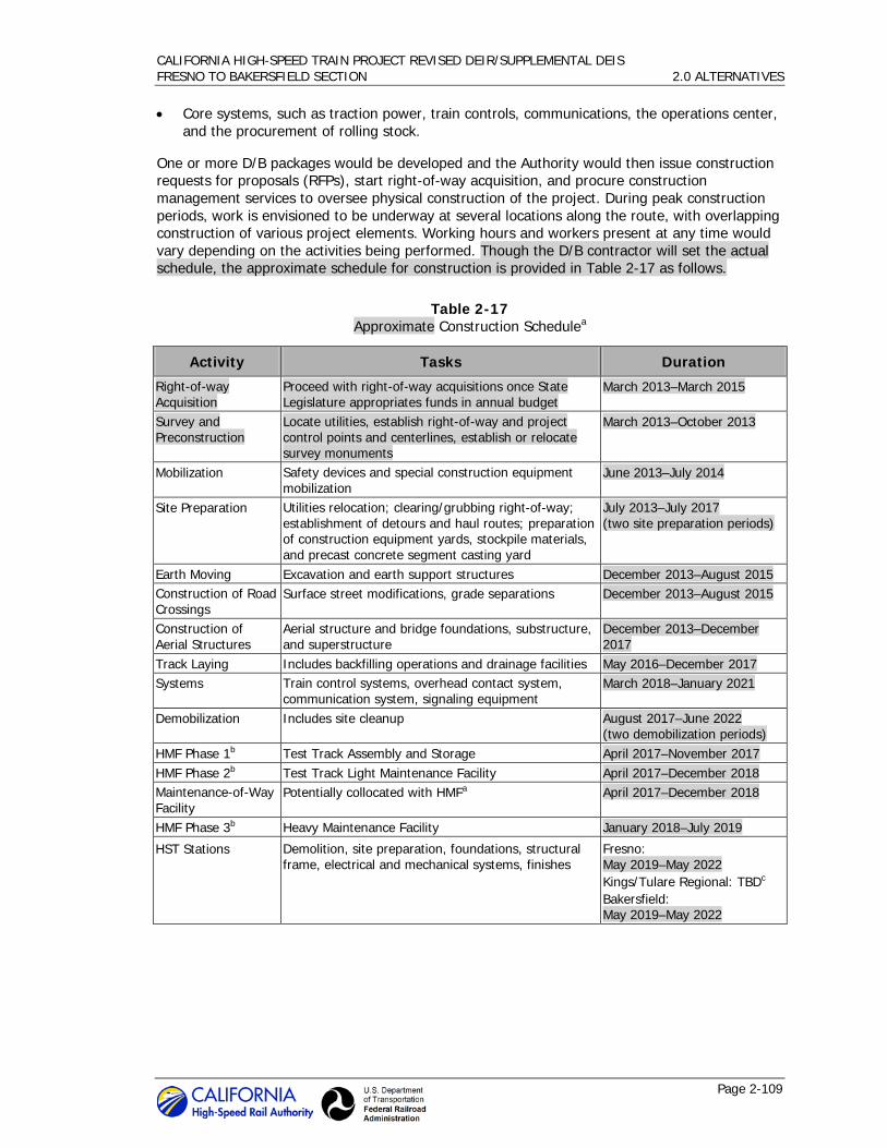
CALIFORNIA HIGH-SPEED TRAIN PROJECT REVISED DEIR/SUPPLEMENTAL DEIS FRESNO TO BAKERSFIELD SECTION 2.0 ALTERNATIVES
Page 2-109
• Core systems, such as traction power, train controls, communications, the operations center, and the procurement of rolling stock.
One or more D/B packages would be developed and the Authority would then issue construction requests for proposals (RFPs), start right-of-way acquisition, and procure construction management services to oversee physical construction of the project. During peak construction periods, work is envisioned to be underway at several locations along the route, with overlapping construction of various project elements. Working hours and workers present at any time would vary depending on the activities being performed. Though the D/B contractor will set the actual schedule, the approximate schedule for construction is provided in Table 2-17 as follows.
Table 2-17 Approximate Construction Schedulea
Activity Tasks Duration
Right-of-way Acquisition
Proceed with right-of-way acquisitions once State Legislature appropriates funds in annual budget
March 2013–March 2015
Survey and Preconstruction
Locate utilities, establish right-of-way and project control points and centerlines, establish or relocate survey monuments
March 2013–October 2013
Mobilization Safety devices and special construction equipment mobilization
June 2013–July 2014
Site Preparation Utilities relocation; clearing/grubbing right-of-way; establishment of detours and haul routes; preparation of construction equipment yards, stockpile materials, and precast concrete segment casting yard
July 2013–July 2017 (two site preparation periods)
Earth Moving Excavation and earth support structures December 2013–August 2015 Construction of Road Crossings
Surface street modifications, grade separations December 2013–August 2015
Construction of Aerial Structures
Aerial structure and bridge foundations, substructure, and superstructure
December 2013–December 2017
Track Laying Includes backfilling operations and drainage facilities May 2016–December 2017 Systems Train control systems, overhead contact system,
communication system, signaling equipment March 2018–January 2021
Demobilization Includes site cleanup August 2017–June 2022 (two demobilization periods)
HMF Phase 1b Test Track Assembly and Storage April 2017–November 2017 HMF Phase 2b Test Track Light Maintenance Facility April 2017–December 2018 Maintenance-of-Way Facility
Potentially collocated with HMFa April 2017–December 2018
HMF Phase 3b Heavy Maintenance Facility January 2018–July 2019
HST Stations Demolition, site preparation, foundations, structural frame, electrical and mechanical systems, finishes
Fresno: May 2019–May 2022 Kings/Tulare Regional: TBDc Bakersfield: May 2019–May 2022
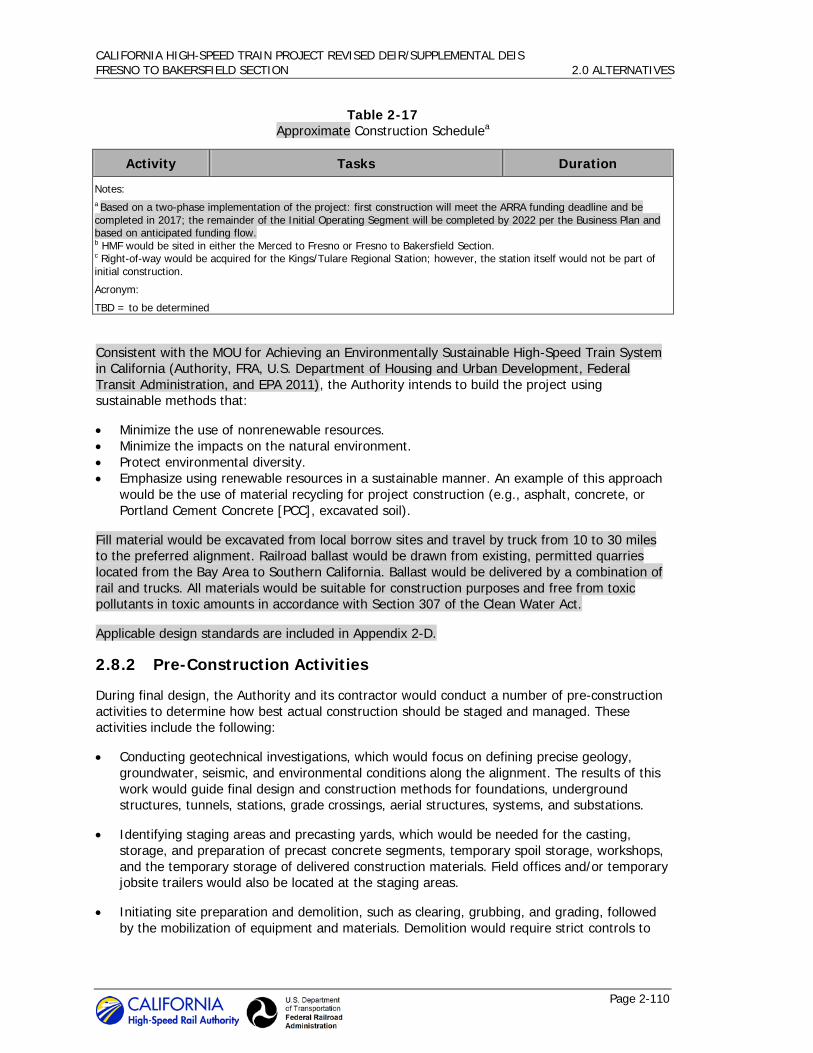
CALIFORNIA HIGH-SPEED TRAIN PROJECT REVISED DEIR/SUPPLEMENTAL DEIS FRESNO TO BAKERSFIELD SECTION 2.0 ALTERNATIVES
Page 2-110
Table 2-17 Approximate Construction Schedulea
Activity Tasks Duration
Notes: a Based on a two-phase implementation of the project: first construction will meet the ARRA funding deadline and be completed in 2017; the remainder of the Initial Operating Segment will be completed by 2022 per the Business Plan and based on anticipated funding flow. b HMF would be sited in either the Merced to Fresno or Fresno to Bakersfield Section. c Right-of-way would be acquired for the Kings/Tulare Regional Station; however, the station itself would not be part of initial construction.
Acronym:
TBD = to be determined
Consistent with the MOU for Achieving an Environmentally Sustainable High-Speed Train System in California (Authority, FRA, U.S. Department of Housing and Urban Development, Federal Transit Administration, and EPA 2011), the Authority intends to build the project using sustainable methods that:
• Minimize the use of nonrenewable resources. • Minimize the impacts on the natural environment. • Protect environmental diversity. • Emphasize using renewable resources in a sustainable manner. An example of this approach
would be the use of material recycling for project construction (e.g., asphalt, concrete, or Portland Cement Concrete [PCC], excavated soil).
Fill material would be excavated from local borrow sites and travel by truck from 10 to 30 miles to the preferred alignment. Railroad ballast would be drawn from existing, permitted quarries located from the Bay Area to Southern California. Ballast would be delivered by a combination of rail and trucks. All materials would be suitable for construction purposes and free from toxic pollutants in toxic amounts in accordance with Section 307 of the Clean Water Act.
Applicable design standards are included in Appendix 2-D.
2.8.2 Pre-Construction Activities
During final design, the Authority and its contractor would conduct a number of pre-construction activities to determine how best actual construction should be staged and managed. These activities include the following:
• Conducting geotechnical investigations, which would focus on defining precise geology, groundwater, seismic, and environmental conditions along the alignment. The results of this work would guide final design and construction methods for foundations, underground structures, tunnels, stations, grade crossings, aerial structures, systems, and substations.
• Identifying staging areas and precasting yards, which would be needed for the casting, storage, and preparation of precast concrete segments, temporary spoil storage, workshops, and the temporary storage of delivered construction materials. Field offices and/or temporary jobsite trailers would also be located at the staging areas.
• Initiating site preparation and demolition, such as clearing, grubbing, and grading, followed by the mobilization of equipment and materials. Demolition would require strict controls to

CALIFORNIA HIGH-SPEED TRAIN PROJECT REVISED DEIR/SUPPLEMENTAL DEIS FRESNO TO BAKERSFIELD SECTION 2.0 ALTERNATIVES
Page 2-111
ensure that adjacent buildings or infrastructure are not damaged or otherwise affected by the demolition efforts.
• Relocating utilities, where the contractor would work with the utility companies to relocate or protect in place high-risk utilities as overhead tension wires, pressurized transmission mains, oil lines, fiber optics, and communications prior to construction.
• Implementing temporary, long-term, and permanent road closures to re-route or detour traffic away from construction activities. Handrails, fences, and walkways would be provided for the safety of pedestrians and bicyclists.
• Locating temporary batch plants, which would be required to produce PCC or asphaltic concrete (AC) needed for roads, bridges, aerial structures, retaining walls, and other large structures. The facilities generally consist of silos containing fly ash, lime, and cement; heated tanks of liquid asphalt; sand and gravel material storage areas; mixing equipment; aboveground storage tanks; and designated areas for sand and gravel truck unloading, concrete truck loading, and concrete truck washout. The contractor would be responsible for implementing procedures for reducing air emissions, mitigating noise impacts, and reducing the discharge of potential pollutants into storage drains or watercourses from the use of equipment, materials, and waste products.
• Conducting other studies and investigations, as needed, such as local business surveys to identify business usage, delivery, shipping patterns, and critical times of the day or year for business activities. This information would help develop construction requirements and worksite traffic control plans, and will identify potential alternative routes, cultural resource investigations, and historic property surveys.
2.8.3 Major Construction Activities
Four major types of construction activities are briefly described below. Because there is no tunnel construction proposed for the Fresno to Bakersfield HST Section, this construction element is not discussed.
Earthwork 2.8.3.1
Earth support is an important factor in constructing deep excavations that will be encountered on several alignment sections. It is anticipated that the following excavation support systems may be used along the route. There are three general excavation support categories, which are described below.
• Open Cut Slope. Open cut slope is used in areas where sufficient room is available to open-cut the area and slope the sides back to meet the adjacent existing ground. The slopes are designed similar to any cut slope, taking into account the natural repose angle of adjacent ground material and global stability.
• Temporary. Temporary excavation support structures are designed and installed to support vertical or near vertical faces of the excavation in areas where room to open-cut does not exist. This structure does not contribute to the final load carrying capacity of the tunnel or trench structure and is either abandoned in place or dismantled as the excavation is being backfilled. Generally, it consists of soldier piles and lagging, sheet pile walls, slurry walls, secant piles, or tangent piles.
• Permanent. Permanent structures are designed and installed to support vertical or near vertical faces of the excavation in areas where room to open-cut does not exist. This

CALIFORNIA HIGH-SPEED TRAIN PROJECT REVISED DEIR/SUPPLEMENTAL DEIS FRESNO TO BAKERSFIELD SECTION 2.0 ALTERNATIVES
Page 2-112
structure forms part of the permanent final structure. Generally it consists of slurry walls, secant piles, or tangent pile walls.
Bridge, Aerial Structure, And Road Crossing Construction 2.8.3.2
Similar to existing high-speed rail systems around the world, it is anticipated that the elevated guideways will be designed and built as single box segmental girder construction. Where needed, other structural types will be considered and used, including steel girders, steel truss, and cable-supported structures.
• Foundations. A typical aerial structure foundation pile cap is supported by an average of 4 large diameter bored piles with diameters ranging from 5 to 9 feet. Depth of piles depends on geotechnical site conditions. Pile construction can be achieved by using rotary drilling rigs, and either bentonite slurry or temporary casings may be used to stabilize pile shaft excavation. The estimated pile production rate is 4 days per pile installation. Additional pile installation methods available to the contractor include bored piles, rotary drilling cast-in-place piles, driven piles, and a combination of pile jetting and driving.
Upon completing the piles, pile caps can be constructed using conventional methods. For pile caps constructed near existing structures such as railways, bridges, and underground drainage culverts, temporary sheet piling (i.e., temporary walls) can be used to minimize disturbances to adjacent structures. It is anticipated that sheet piling installation and extraction is achieved using hydraulic sheet piling machines.
• Substructure. Aerial structures with pier heights ranging from 20 to 90 feet may be constructed using conventional jump form and scaffolding methods. A self-climbing formwork system may be used to construct piers and portal beams over 90 feet high. The self-climbing formwork system is equipped with a winched lifting device, which is raised up along the column by hydraulic means with a structural frame mounted on top of the previous pour. In general, a 3-day cycle for each 12 feet pour height can be achieved. The final size and spacing of the piers depends on the type of superstructure and spans they are supporting.
• Superstructure. It will be necessary to consider the loadings, stresses, and deflections encountered during the various intermediate construction stages, including changes in static scheme, sequence of tendon installation, maturity of concrete at loading, and load effects from erection equipment. As a result, the final design will depend on the contractor’s means and methods of construction and can include several different methods, such as a span-by-span, incrementally launched, progressive cantilever, and balanced cantilever.
Road crossings of existing railroads, roads, and the HST would be constructed on the line of the existing road or offline at some locations. When constructed online, the existing road would be closed or temporarily diverted. When constructed offline, the existing road would be maintained in use until the new crossing is completed. Where new roadway undercrossings of existing railroads are required, a temporary shoofly track would be constructed to maintain railroad operations during undercrossing construction.
Construction of foundations and substructure would be similar to that for the aerial structures, but reduced in size. The superstructure would likely be constructed using precast, prestressed, concrete girders and cast-in-place deck. Approaches to the bridges would be earthwork embankments, mechanically stabilized earth wall, or other retaining structures.
Railroad Systems Construction 2.8.3.3
The railroad systems are to include trackwork, traction electrification, signaling, and communications. After completion of earthwork and structures, trackwork is the first rail system

CALIFORNIA HIGH-SPEED TRAIN PROJECT REVISED DEIR/SUPPLEMENTAL DEIS FRESNO TO BAKERSFIELD SECTION 2.0 ALTERNATIVES
Page 2-113
to be constructed, and it must be in place at least locally to start traction electrification and railroad signalizing installation. Trackwork construction generally requires the welding of transportable lengths of steel running onto longer lengths (approximately 1/4 mile), which are placed in position on crossties or track slabs and field-welded into continuous lengths from special trackwork to special trackwork.
Both tie and ballast as well as slab track construction would be used. Tie and ballast construction, which would be used for at-grade and minor structures, typically uses cross ties and ballast that are distributed along the trackbed by truck or tractor. In sensitive areas, such as where the HST is parallel to or near streams, rivers, or wetlands, and in areas of limited accessibility, this operation may be accomplished by using the established right-of-way with material delivery via the constructed rail line. For major civil structures, slab track construction would be used. Slab track construction is a non-ballasted track form employing precast track supports.
Traction electrification equipment to be installed includes traction power substations and the overhead contact system. Traction power substations are typically fabricated and tested in a factory, then delivered by tractor-trailer to a prepared site adjacent to the alignment. It is assumed that substations are to be located every 30 miles along the alignment. The overhead contact system is assembled in place over each track and includes poles, brackets, insulators, conductors, and other hardware.
Signaling equipment to be installed includes wayside cabinets and bungalows, wayside signals (at interlocking), switch machines, insulated joints, impedance bounds, and connecting cables. The equipment will support automatic train protection, automatic train control, and positive train control to control train separation, routing at interlocking, and speed.
Station Construction 2.8.3.4
As HST stations for the Fresno to Bakersfield Section would be newly constructed, existing train operations, including station capacity and passenger levels of service, would be maintained during construction. HST stations require significant coordination and planning to accommodate safe and convenient access to existing businesses and residences and to accommodate traffic control during construction periods. Additional information about the station areas is provided in Section 2.4.4. The typical construction sequence would be:
• Demolition and Site Preparation. The contractor would be required to construct detour roadways, new station entrances, construction fences and barriers, and other elements required as a result of taking existing facilities on the worksite out of service. The contractor would be required to perform street improvement work, site clearing and earthwork, drainage work, and utility relocations. Additionally, substations and maintenance facilities are assumed to be newly constructed structures. For platform improvements or additional platform construction, the contractor may be required to realign existing track.
• Structural Shell and Mechanical/Electrical Rough-Ins. For these activities, the contractor would construct foundations and erect the structural frame for the new station, enclose the new building, and/or construct new platforms and connect the structure to site utilities. Additionally, the contractor would rough-in electrical and mechanical systems and install specialty items such as elevators, escalators, and ticketing equipment.
• Finishes and Tenant Improvements. The contractor would install electrical and mechanical equipment, communications and security equipment, finishes, and signage. Additionally, the contractor may install other tenant improvements if requested.

CALIFORNIA HIGH-SPEED TRAIN PROJECT REVISED DEIR/SUPPLEMENTAL DEIS FRESNO TO BAKERSFIELD SECTION 2.0 ALTERNATIVES
Page 2-114
2.9 Permits
The Authority and FRA are in the process of preparing agreements with environmental resource agencies to facilitate the environmental permitting required during final design and construction. These agreements—a Memorandum of Understanding and a Memorandum of Agreement or Programmatic Agreement—will clearly identify the Authority’s responsibilities in meeting the permitting requirements of the federal, state, and regional environmental resource agencies. A Memorandum of Agreement was established in 2010 between the Authority, the FRA, the USACE, and the USEPA (Authority et al. 2010) regarding integration of NEPA, Clean Water Act Section 404, and Rivers and Harbors Act Section 14 processes. Coordination with the United States Coast Guard was conducted and the Coast Guard indicated that this project is not within their jurisdiction (Sulouff 2011). Table 2-18 lists the major environmental permits required for the HST Project. As a state agency, the Authority is exempt from local permit requirements; however, in order to coordinate construction activities with local jurisdictions, the Authority will seek local permits as part of construction processes consistent with local ordinances. The agencies identified in Table 2-18 are anticipated to rely on the EIR/EIS to support their permitting and approval processes.
Table 2-18 Potential Major Environmental Permits and Approvals
Agency Permit
Federal
USACE Section 404 Permit for Discharge of Dredge or Fill Materials into Waters of the U.S., including wetlands Section 10 Permit for Construction of any Structure in or over any Navigable Water of the United States
U.S. Department of Interior/Federal Railroad Administration
Section 4(f) of the U.S. Transportation Act of 1966
U.S. Department of Interior/National Park Service
Section 6(f) of the Land and Water Conservation Fund Act of 1965
U.S. Advisory Council on Historic Preservation via the California State Historic Preservation Office
Section 106 Consultation (National Historic Preservation Act of 1966)
USEPA Review of Environmental Justice conclusions General Conformity Determination
U.S. Fish and Wildlife Service Section 7 Consultation and Biological Opinion
National Marine Fisheries Service Section 7 Consultation and Biological Opinion
State
California Department of Fish and Game
California Endangered Species Act permits California Department of Fish and Game Section 1602 Lake and Streambed Alteration Agreement Use of Title 14 lands – Allensworth Ecological Reserve
California Department of Transportation (Caltrans)
Caltrans Encroachment Permits
California Public Utilities Commission Approval for construction and operation of railroad crossing of public road and for construction of new transmission lines and

CALIFORNIA HIGH-SPEED TRAIN PROJECT REVISED DEIR/SUPPLEMENTAL DEIS FRESNO TO BAKERSFIELD SECTION 2.0 ALTERNATIVES
Page 2-115
Table 2-18 Potential Major Environmental Permits and Approvals
Agency Permit substations
California State Lands Commission Lease for crossing state sovereign lands
Regional
San Joaquin Valley Air Pollution Control District
Rule 201 General Permit Requirements, Rule 403 Fugitive Dust, Rule 442 Architectural Coatings, and Rule 902 Asbestos
Regional Water Quality Control Board Clean Water Act Section 401 Water Quality Certification Section 402 National Pollutant Discharge Elimination System (NPDES) Water Discharge Permit Dewatering permit (Order No. 98-67) Spill Prevention, Control, and Countermeasure (SPCC) Plan (part of Section 402 process) Stormwater Construction and Operation Permit
Central Valley Flood Protection Board Title 23 California Code of Regulations, Section 2, and Title 33 Code of Federal Regulations, Section 208.10 (flood protection facilities)

CALIFORNIA HIGH-SPEED TRAIN PROJECT REVISED DEIR/SUPPLEMENTAL DEIS FRESNO TO BAKERSFIELD SECTION 2.0 ALTERNATIVES
Page 2-116
This page intentionally left blank