field-truthing and monitoring of the proposed penneast ... eis... · field-truthing and monitoring...
TRANSCRIPT

Field-Truthing and Monitoring of the Proposed PennEast Pipeline,
FERC Draft EIS, Docket No. CP15-558
September, 2016
Prepared by: Delaware Riverkeeper Network

2
Thank you to Dr. Ann Rhoads, Sarah Chamberlain, Steve Kunz, Stephen Sousa,
Betsy Leppo, Stephen Metts, Darren Klein, Mike Spille, Fairfax Hutter, Bob Dahl,
and the volunteer monitors and community who provided technical reviews,
species ID, photo documentation, expertise or their time to help document
habitats along the Penn East Pipeline route.

3
Introduction
Delaware Riverkeeper Network (DRN) conducted visual assessments and stream monitoring
along sections of the proposed Penn East pipeline route as part of ground-truthing information
supplied for the Federal Energy and Regulatory (FERC) Draft Environmental Impact Statement
(DEIS) for the proposed Penn East Pipeline project. DRN walked accessible portions of the
pipeline route, focusing on areas where forested habitats, steep slope impacts, and stream and
wetland impacts would occur with a goal to spot check information provided about these
impacts in the FERC DEIS and to determine how well these resources were mapped out in the
field. Spot areas monitored targeted sections of the pipeline route proposed to be located in
Pennsylvania State Gameland (SGL) 168, Appalachian Trail across Blue Mountain, Ted Stiles
Preserve at Baldpate Mountain in New Jersey, and proposed stream crossings of Alexauken
Creek, Wickecheoke Creek and Harihokake Creek, three C1 streams in New Jersey.
Methods
DRN used a combination of Penn East wetland delineation maps and reports (dated Sept 2015
and 3/3/2016), the FERC DEIS (August, 2016), PE alignment sheets Revision D (dated
9/23/2015), and digitized GIS based field mapping tools (Sept., 2015 route and Feb, 2015 route)
to conduct assessments. Photo documentation and habitat assessments were conducted along
areas of the proposed pipeline route. For C1 stream assessments, each stream station was
assessed and selected based on its proximity to an existing Right of Way (ROW) or proposed PE
route, accessibility and property permissions. Calibrated automatic temperature probes
(HOBO) were temporarily installed into the stream water column to document hourly summer
water temperatures from Mid-August to early September. DRN used approved PA DEP
methodologies for probe placement and referenced New Jersey’s Integrated 303 (d) listings and
water quality classifications to select stream locations.i
Mapping Errors, Inadequate and Incomplete Information in DEIS
Flaws in Wetlands Analyses – Avoidance & Minimization Measures not Fully
Considered

4
According to the FERC DEIS, construction of the PE pipeline would temporarily impact 56 acres
of wetlands (26 acres in Pennsylvania and 30 acres in New Jersey) and permanently impact
about 35 acres of wetlands (17 acres in Pennsylvania and 18 acres in New Jersey). According to
the DEIS, in New Jersey, 17.57 acres of forested or scrub shrub wetlands will be permanently
converted to herbaceous wetland and in Pennsylvania 17.27 acres of forested or scrub shrub
wetlands will be permanently converted to herbaceous wetland. Wetland crossing widths in
Pennsylvania and New Jersey are estimated in the DEIS to be 22,541 ft. and 16,443 ft.,
respectively. Wetland crossings proposed, are mostly proposed to be open cuts and at least
173 wetlands are proposed for open cut methods which are documented to leave long term
and cascading impacts to these sensitive habitats often including but not limited to changes in
hydrology, temperature changes, potential invasive plant colonization, and nutrient changes.ii
The FERC DEIS states that “emergent vegetation regenerates quickly (in wetlands), typically
within one to three years and in scrub shrub and forested wetlands, PE would maintain a 10 foot
wide corridor centered over the pipeline in an herbaceous state and would selectively cut trees
within a 30-foot-wide corridor centered over the pipeline. The remainder of forested and scrub-
shrub vegetation would be allowed to return to preconstruction conditions and would not be
affected during operation. No permanent fill or loss of wetland area would result from
construction and operation of the Project.” DRN has documented continued and irreversible
impacts to wetlands from pipeline crossings that are sustained beyond this short term view,
especially in forested wetlands where tree regrowth can take decades to recover.iii In light of
deer browse and other impacts to changed soils, trees may never establish as they had prior to
the ROW impact in these forested wetlands. Invasive plant species often move into these
wetlands and impact the wetland ecology long term. iv
These impacts are not fully outlined in the DEIS and the wetland habitats themselves to be
impacted are not all accurately included or represented in the DEIS and have missing
information regarding their features and habitats. While the DEIS states that FERC
acknowledges that not all wetland surveys, especially related to vernal pools, are completed it
recommends that PE, prior to construction, will provide a revised table of impacts on vernal
pools within or near proposed workspaces based on completed surveys.
5
Upon limited field reviews and alignment sheet reviews by DRN and field reviews provided by
Schmid & Companyv, the characterization of wetland impacts by FERC is erroneous, inadequate
and incomplete. FERC’s rationale and request of updated wetland information being provided
before construction does not allow for thorough and adequate public and technical review.
Given the wealth of inaccuracies and misinformation the Delaware Riverkeeper Network and
experts have documented regarding the wetlands and vernal pools, and/or lack thereof, in
areas where PennEast has fully surveyed and intends to engage in construction, operation and
maintenance activities, demonstrates that third party public vetting of any claimed future data
is necessary. FERC’s rationale that jurisdiction by other agencies will lead to proper mitigation
and restoration is also not based on science and restoration ecological principles and what is
actually observed on the ground.
The DEIS states that there is only one wetland along the PE route with “extremely saturated
soils” and requests PE identify special construction techniques for wetlands as well as
justification of any resulting required additional workspace for crossings of these saturated
wetland soils. It is unclear what FERC means by highlighting this one wetland. By nature, most
wetlands have saturated soils and most wetland crossings identified in the PE alignment sheets
indicate significant temporary work space (TWS) and additional temporary work space (ATWS)
that are often located just adjacent to the waterbody and wetland and that often involve the
cutting of mature trees and compaction of soils adjacent to those wetlands. In some instances
ATWS is proposed to be located in actual wetlands. Avoidance and minimization of these
wetlands are not being fully considered. The DEIS lists 211 wetland and waterbodies that are
proposed to have ATWS impacts within 50 feet of these wetlands and waterbodies (Table G-10)
which is the majority of waterbodies to be cut. PE states and FERC agrees that citing ATWS
within 50 ft of wetlands is justified and allowed for when the following conditions occur: HDD
under roads and interstates, to store excavated material, to cross steep slope and wetlands,
and to cross railroad corridors. Minor and major road crossings alone appear to jeopardize
sensitive wetland habitats in atleast 59 wetlands (Table G-10).
PE is proposing Open Cut trenching for 130 of the wetlands proposed to be crossed. Other
wetlands not cut by open cut are noted in the DEIS as N/A for crossing type – it is unclear what

6
is meant by N/A – there is no description of that condition in the notes of the table (Table G-
11). Still a few other wetlands are noted as Bore/Open Cut or Open Cut/HDD. Despite open
cuts making up the majority of the waterbody crossings and despite the exceptions of allowing
ATWS within 50 feet of sensitive wetlands at least in 211 instances, FERC concludes that there is
adequate justification for ATWSs and that there will be minimal harm. FERC’s conclusion is a
false conclusion and avoidance of these sensitive areas was not fully and adequately
investigated.
HDD long borings should be considered and analyzed for feasibility for each and every
waterbody crossing along the route to reduce impacts to sensitive habitats.vi However, in
some instances, HDD entrance and exit points which often require large land clearings and
impacts to soils are proposed by PE to be located in sensitive wetland and forested habitats.
This practice is another indication that avoidance and minimization is not fully being considered
for wetlands and waterbodies and the most technological advanced measures and proper citing
of HDD are not being considered. For example, in Mercer Co. New Jersey, a horizontal
directional drill (HDD) is proposed under Pleasant Valley Rd. and an adjacent stream and
wetland complex (between MP 105.5 and 106.0) (see figure 1). However, in this instance, the
HDD entry point is proposed to be located at MP 105.4 and within a large PEM wetland
complex (1002-PEM and 1001-PEM). According to alignment sheets, that HDD entry point in
the wetland would require temporary work space on either side of the permanent ROW in
addition to a 400’ by 90’ and 400’ by 60’ ATWS on either side of the permanent ROW within the
wetland. It would be less impactful to extend the HDD entry point westward away from the
waterbody or forest to reduce impacts and to encourage longer HDD borings to better avoid
impacts from open cuts.

7
Figure 1. Penn East Alignment Drawing 000-03-01-212 Revision D. Illustrating an HDD entry work space within a wetland
The exit point for this same proposed HDD section is proposed just adjacent another wetland
complex and just north of and paralleling a stream (see figure 2). The faded aerial overlays
that are provided by Penn East in alignment sheets are unclear but it appears mature trees may
be cut for this HDD exit point. Again, it would be less impactful to extend the HDD to a location
where already impacted land would not be harmed since technology is feasible to drill for
longer segments, thereby reducing impacts. An HDD should be required in this MP area to
minimize harm to the point pleasant wetland and stream complex but the citing for the exit and
entrance points is inappropriate yet it has been deemed acceptable impact by FERC.

8
Figure 2. Penn East Alignment Drawing 000-03-01-213 Revision D. Illustrating an HDD exit work space adjacent a wetland and parallel a stream. Mature trees also appear to possibly located in this reach though faded alignments are provided by PE which make land use determination difficult.
FERC Analysis Flaws, Missing Vernal Pool Habitat Documentation & Incomplete
Cumulative Review of Impacts to Amphibians
FERC’s recommendation in the DEIS that PE provide missing information on vernal pools and
revise its impact tables on vernal pools within or near the proposed workspace before
construction is not protective of these important wetlands types nor adequate for public review
or proper avoidance or minimization of these impacts.
The FERC DEIS states that approximately 0.13 acre of vernal pool habitats would be impacted
by construction of the Project, with 0.11 acre permanently impacted during operation. Based
on the sensitive areas along the 115 mile proposed route, this acreage sounds low. Spot field
checks in short sections of already surveyed areas of the route, make clear that vernal pools
and wetlands have been missed and not accurately depicted by field surveys or the DEIS.
For example, DRN field-truthed and surveyed SGL 168 along MP 52.4 to MP 52.9 on August 28,
2016 after reviewing PE wetland delineation maps (maps not part of the DEIS) and alignment

9
sheets (Revision D) that showed there were only three vernal pool habitats present in this area
of the route. (072415_JC_1001_VP, 072415_JC_1003_VP, 72415_JC_1002_VP on Figure 3
Sheets 129 and 130, PE wetland delineation map). When DRN assessed and walked this section
of pipeline, it was clear vernal pool habitats were missed even in areas that PE has noted as
being surveyed. DRN documented 12 vernal pools or potential vernal pool complexes and
groundwater seeps and depressions that may serve as habitat along this same area of the
pipeline route (see Figure 3). Table G-11 of the DEIS notes only two vernal pools in this area at
MP 52.4 and MP 52.6 and both are forested yet an open cut (25 feet and 67 feet) is the crossing
type PE is proposing. One stream, an UNT to Indian Creek at 52.4 is documented by PE on Table
G-7. No groundwater seeps or springs have been documented by PE in this area. This is not
protective of the vernal forested pool habitats that obligate and facultative vernal pool species
require and it also does not include or map all vernal pools and groundwater seeps that were
present in this reach of the proposed route. Table G-11 in the FERC EIS and the wetland
delineation maps provided by PE are also not consistent.

10
Figure 3: Vernal pools and groundwater seeps along base of Blue Mountain. Note red line depicts pipeline route with 400 ft. survey area. Herpetologists recommend 1,000 ft buffer of upland to protect vernal pool species.
This section of the pipeline route is in a stretch of high quality PA State Gameland 168 forest
that has sensitive vernal pool species present since surrounding upland intact mature forest is
present – a much needed component for vernal pool species during times of the year when the
vernal pools are dry. Protecting vernal pools and the surrounding 1,000 feet of upland habitat
is critical for protection of water quality, amphibian breeding, and terrestrial habitat for adult
and juvenile amphibians.vii Residents along Cottonwood Drive that are about 500 feet from the
proposed route and that back up to the SGL property forest, have noted amphibian calls during
the breeding season.

11
Furthermore, this area that DRN field truthed was in an area that PE stated they had surveyed.
However during assessment of this route, there were only a few pink flags marked by the PE
surveyors for a short section of the route and no wetland flagging at all was present at vernal
pools located along the proposed route. The pipeline route either intersects or runs adjacent to
these vernal pool areas which would inflict harm to species that rely on these vernal pool
wetlands to breed yet no documentation of these actual surrounding habitats is provided by PE
in the information provided in the DEIS.
Though these photos were taken during the dry season on August 29, 2016, it is evident that
they likely serve as wetland vernal pool areas during the vernal pool season.
Figure 4. Note depression, stained leaves, cardinal flower in bloom and ground indicative of forested vernal pools

12
Figure 5. This depression - another likely seasonal vernal pool habitat not identified in the DEIS or maps.

13
Figure 6: note buttressed tree roots, sedges, depression, stained leaves and ground indicative of forested vernal pools – a third vernal pool that was not positively ID’d in the DEIS or maps.
These omissions and lack of FERC considering upland habitat impacts 1000 feet surrounding
these habitats in the DEIS exemplifies the incomplete assessments that were provided for
wetland and vernal pool features even when they are located in areas as sensitive and
accessible as PA State Gamelands. Given that this area was already surveyed by PennEast, and
is public land that is easily accessible, there is no reason that PennEast, FERC and the DEIS do
not provide thorough and complete surveys and assessments.
Finally, in the early spring of 2016, DRN volunteer monitors documented vernal pools that are
missing from the DEIS. In PA, one DRN volunteer monitor documented a vernal pool near MP
43.5 – 44 by observing wood frog egg masses (a vernal pool obligate species). In NJ, volunteer
monitors documented vernal pools near MP 95 – 95.5 and MP 107 – 109 by observing wood
frog egg masses, wood frog tadpoles, and springtime fairy shrimp (vernal pool obligate species).

14
Figure 7: Photo of wood frog egg mass (obligate vernal pool species) documented by DRN volunteer on 3/15/16
between MP 43.5 and 44.
Figure 8: Photo of wood frog egg mass (obligate vernal pool species) documented by DRN volunteer on 3/19/16
between MP 95 and 95.5.
15
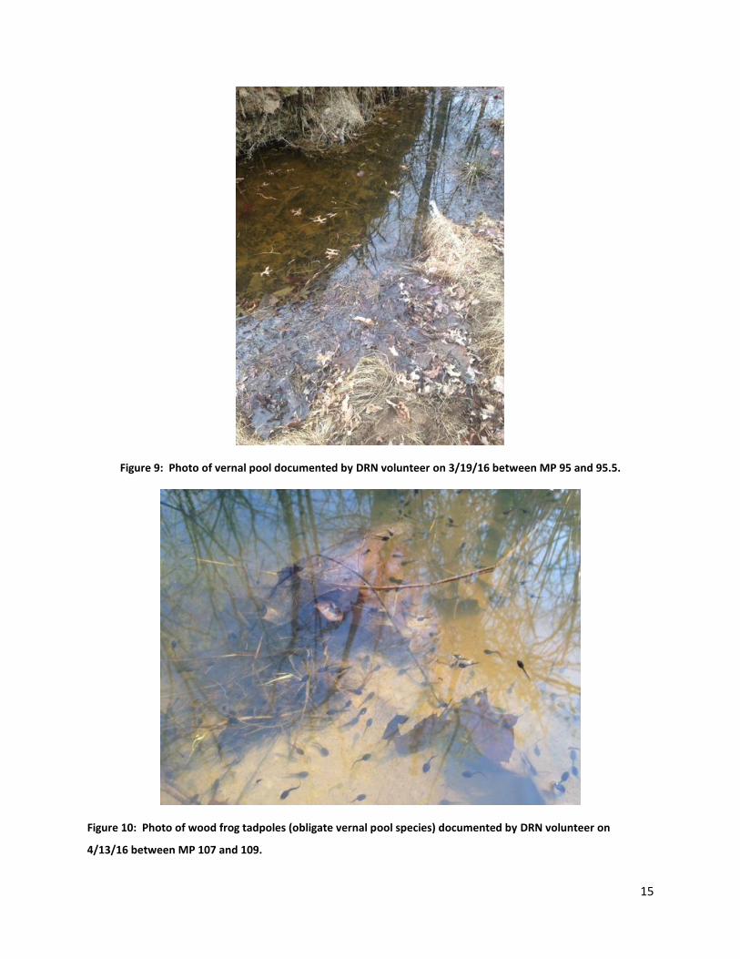
Figure 9: Photo of vernal pool documented by DRN volunteer on 3/19/16 between MP 95 and 95.5.
Figure 10: Photo of wood frog tadpoles (obligate vernal pool species) documented by DRN volunteer on
4/13/16 between MP 107 and 109.
16
FERC’s DEIS conclusion that with the time of year restriction during key breeding periods
(March to June) for obligate and facultative amphibian species and restoration construction
practices, that impacts on wetland resources, including vernal pools, would not be effectively
minimized or mitigated. This is a grossly false conclusion. The DEIS does not consider the full
forest impacts and forest upland habitats at least 1,000 feet from the vernal pools that these
amphibians rely on for other times of the year that will be cut down and lost; this analysis does
not include the thermal and likely hydrological impacts that will change these vernal pools
compromising water temperature and flow for breeding amphibians; this does not include the
temperature changes and dry compacted soil conditions and changes to vegetation of a ROW
that will make it near impossible for migrating amphibians to return to their breeding pool post
pipeline construction; this does not include the repetitive pipeline maintenance impacts like
herbicide applications to the ROW and routine cutting and unauthorized ATV use that would
impact amphibians long term creating a new cut along the base of the mountain where there is
currently no existing co-location; this FERC analysis does not even include or require a
thorough mapping of all vernal pools and wetlands and FERC recognizes information is
complete yet gives the green light without full information being provided or mapped; finally
this does not include the climate change impacts that impact vernal pool and wetland species.
Climate Change Impacts Not Included in DEIS for Amphibian Species
The timing of amphibian breeding is largely driven by environmental cues such as temperature
and moisture, and because of this, their breeding phenology may be directly affected by global
warming. Amphibians in regions such as the northeastern United States (where the proposed
PennEast pipeline would be) may be even more susceptible to increases in temperature.
Amphibian species in the northeast spend a large portion of the year inactive, escaping either
cold winters or hot summers. Subtle increases in temperature or moisture trigger them to
emerge from their hibernacula in the spring. Immediately upon emergence, they migrate to
ponds or streams to breed. As average air temperatures increase from climate change,
amphibians will start to emerge and breed earlier in the year. If amphibians breed too early in
the season, they may be more vulnerable to early snowmelt induced floods and early season

17
freezes that are usually less common later in the season. Amphibians tricked by the warm
temperatures from climate change may emerge too early and then die when a cold front comes
in.
Amphibians are also affected by extreme weather events associated with climate change,
particularly drought. In addition to requiring water for breeding, amphibians need to keep their
skin moist to avoid drying up in the sun. Rain water, shade from trees, and moist soil are very
important to amphibians. In drought conditions caused by climate change, long periods with no
rain can be detrimental to amphibian populations. These effects are worsened by deforestation
because it eliminates the shade that the trees provide. Shade keeps the soil on the forest floor
moist by blocking the sun’s rays. Many amphibians, particularly salamanders, burrow in this
moist soil in between periods of rain. Without the shade from the canopy and with no rain, this
soil is exposed to full sun exposure and quickly dries up and amphibians become desiccated.
Natural gas pipeline construction involves the clearing of many acres of forest, so this is a prime
example of natural gas infrastructure working hand-in-hand with climate change and
compounding impacts.viii
In addition, local changes in the environment can decrease immune function and lead to
pathogen outbreaks and elevated mortality in amphibians. Conditions can change to become
more favorable for the growth of a pathogen. For example, the chytrid fungus
(Batrachochytrium dendrobatidis) grows best in culture between 6-28 degrees C and dies at 32
degrees C. The chytrid fungus causes an infectious disease in amphibians called
chytridiomycosis which has killed millions of amphibians worldwide and has affected about 30%
of all amphibian species in the world. Climate change may make environmental conditions
more conducive for this disease to spread as well as cause weakened immune systems, making
it more difficult for amphibians to fight off the disease. This disease has been documented in
Pennsylvania and New Jersey which are both home to multiple state listed amphibian species.
Clearly, these amphibian species are at great risk and they would be put at an even greater risk
by the combined impacts of climate change and the construction of the PennEast pipeline.
Lack of Field Surveys and Protection of Sensitive Waterbodies and Wetlands

18
According to the DEIS, construction of the Project would require 210 wetland crossings, 106 in
Pennsylvania and 104 in New Jersey. Based on the information provided by PennEast the
Project would impact a total of 56 acres of wetlands during construction, of which about 26
acres would be in Pennsylvania and 30 in New Jersey (see table 4.4.2-1 in section 4.4.2). But
this analysis is based on incomplete information and incomplete field surveys and little data.
The FERC DEIS inadequately relies on remote sensed data even in the case of sensitive wetlands
habitat. Again, this means that the information provided is not complete yet the public is made
to comment on incomplete information and FERC has conducted its cumulative impact
conclusions based on incomplete data. The DEIS states that in New Jersey 73 wetland locations
were based on estimated acreages from the NJDEP GeoWeb database. PennEast classified
wetlands in Pennsylvania (see appendix G-11) using information from the NWI mapping
database (FWS 2009) for about 19 miles (23 percent) of the pipeline. FERC’s recommendation
that PE file prior to construction with FERC a complete wetland delineation report for the entire
project that includes all wetlands delineated in accordance with the USACE and the applicable
state agency requirements is not protective enough nor does it give the public adequate time
to field verify information.
Independent wetland delineation experts indicated during field truthing of wetlands that
occurred by them along the PE route in Pennsylvania the following: “The boundaries of
wetlands were reported to have been fieldmarked with surveyor's tape, and the flagged
boundaries recorded with a handheld GPS unit. In our experience, such flagging typically persists
in the field for several years at least, although pieces of some flags may become torn or lost and
some markings may become illegible over time as a result of wind, rain, and general exposure to
the elements. Upon field inspection during May 2016, the location of the proposed pipeline
centerline, the pipeline corridor, and wetlands and streams within the pipeline corridor in
general were found to be very poorly marked. We did not encounter a single wetland with
delineation flags completely outlining it. At most we saw isolated, unnumbered pink flags pre-
printed with "Wetland Delineation", or isolated numbered (or unnumbered) flags that did not
connect in sequence with other numbered (or unnumbered) flags. Thus it was not possible to

19
confirm with any precision in the field the accuracy of the wetlands depicted on the applicant's
drawings”.ix DRN observed this same spotty and often completely missing flagging or non-
existent flagging along the pipeline routes that were assessed – even in areas where PE stated
the route had been surveyed. When we did observe flagging, it looked relatively new, like here
in the case on SGL 168 yet there were very little flags present along the route and flagging was
only in proximity to an easy access point.
Figure 11: Two of approx. 8 pink survey flags noting the pipeline center route along an area marked as “surveyed by PE” on SGL 168. Note flagging looks new so it is unusual that not more flagging is present throughout the SGL proposed route. None of the wetlands or vernal pool areas were flagged. On the top of Blue Mountain only 4 new pink flags were noted while no flagging was present along the steep slope away from the Appalachian Trail. Photo taken August 29, 2016.
Exceptional Value Wetlands in Pennsylvania Not Adequately Documented in DEIS
Schmid expert reports highlight discrepancies and errors related to EV wetland protection for
PE resource reports and subsequent EIS. Exceptional Value Wetlands in Pennsylvania exhibit
one or more of the following characteristics:

20
(i) Wetlands which serve as habitat for fauna or flora listed as “threatened” or
“endangered under the Endangered Species Act of 1973
(ii) Wetlands that are hydrologically connected to or located within 1/2- mile of
wetlands identified that maintain the habitat of the threatened or endangered species
(iii) Wetlands that are located in or along the floodplain of the reach of a wild trout
stream or waters listed as exceptional value under Chapter 93 (relating to water
quality standards) and the floodplain of streams tributary thereto, or wetlands
within the corridor of a watercourse or body of water that has been designated as
a National wild or scenic river in accordance with the Wild and Scenic Rivers Act
of 1968 (16 U.S.C.A. §§ 1271-1287) or designated as wild or scenic under the
Pennsylvania Scenic Rivers Act (32 P.S. §§ 820.21-820.29).
(iv) Wetlands located along an existing public or private drinking water supply,
including both surface water and groundwater sources, that maintain the quality or
quantity of the drinking water supply.
(v) Wetlands located in areas designated by the Department as “natural” or “wild”
areas within State forest or park lands, wetlands located in areas designated as
Federal wilderness areas under the Wilderness Act (16 U.S.C.A. §§ 1131-1136)
or the Federal Eastern Wilderness Act of 1975 (16 U.S.C.A. § 1132) or wetlands
located in areas designated as National natural landmarks by the Secretary of the
Interior under the Historic Sites Act of 1935 (16 U.S.C.A. §§ 461-467).
The DEIS indicates an abundance of Wild Trout Waters in Pennsylvania to be crossed by the
pipeline. The Penn East lists at least 131 Wild Trout Waters in Pennsylvania to be cut across by
the pipeline (Table G-5). Pennsylvania Fish and Boat Commission has been conducting
frequent and regular additions to its Class A and Wild Trout Waters designations in recent years
and every few months; its important those newer classifications are reflected in the DEIS and
updated.xxi It is unclear from the table if all of these newer designations are included by
PennEast and it would be a good recommendation that FERC require this review by PennEast
and included updates as a requirement. Wetlands that are hydrologically connected to

21
Exceptional Value Waters and/or Wild Trout Waters and their tributaries are considered
Exceptional Value (EV) Wetlands. Private drinking water supplies are also to be protected as EV
wetlands as are wetlands that are home to threatened and endangered species. The DEIS does
not make it possible nor does it appear to include wetland designations for each of the
wetlands to be crossed (Table G-11). The DEIS also recognizes that private water supplies are
not yet mapped, which means that wetlands associated with these water supplies are not yet
fully analyzed under Pennsylvania requirements for EV wetlands. The DEIS mentions EV
protections but provides no break out wetland by wetland of the characteristics and
designations for each to adequately provide the detail needed to assess the impact to each of
the many wetlands and waterbodies to be crossed. The DEIS also does not have tables or cross
referenced documentation to depict each of the wetlands that are hydrologically connected or
located within ½ mile of wetlands that maintain habitat of threatened or endangered species
within the wetland. These are large omissions and failures of the DEIS.
Inadequate Documentation and Incomplete Current Mapping and Monitoring of Sensitive Waterbodies
On July 30, 2016, DRN field-truthed a short section of the proposed PE pipeline corridor along
Ted Stiles Preserve at Baldpate Mountain in Hopewell Township, New Jersey (MP 107.2 to MP
106.8). DRN walked west from the Baldpate parking area about a half mile just south of the
existing electrical ROW.

22
Figure 12: DRN walked west from the Access Pleasant valley road parking area on July 30, 2016 and documented within 0.5 miles one obvious intermittent stream missing from PE wetland and alignment sheet maps. Shagbark hickories and other important mature trees that provide refuge for bat species were documented. Invasive plants were documented along existing JCP&L ROW that would be exacerbated and spread with a new ROW.
This Mercer County Public Park has over 12 miles of marked trails for hiking, horseback riding,
mountain biking, and trail running. According to the DEIS and PE alignment sheets, this area had
been surveyed by PE. No flagging was observed during ground-truthing for the pipeline center
line, or any of the wetlands or streams along the proposed pipeline route we encountered as
late as July 30, 2016. An intermittent stream was not delineated on the PE alignment sheets
nor was there flagging present to note this water feature despite the fact that the stream is
delineated on state freshwater mapping layers available to the public. Table G-6 in the DEIS
also does not list this stream as a waterbody to be cut.

23
Figure 13. Approx. location of the intermittent stream within proposed ROW corridor on Ted Stiles Preserve at Baldpate Mountain not mapped by Penn East

24
Figure 14. Intermittent stream and wetland documented along pipeline corridor, Baldpate Mountain that is not mapped on PE alignment sheets or Table G-6 in the DEIS despite this being public land. MP 106.8 (photo taken facing away from existing ROW)
Figure 15. Intermittent stream undocumented in the DEIS mapping and Table G-6 that DRN documented along the pipeline corridor. Note abundance of invasive Japanese stiltgrass encroaching and advancing into the mature forest spreading inland into the forest from the existing ROW. Photo taken facing the existing ROW.

25
The DEIS Table 4.31-5 notes only 4 groundwater seeps in Pennsylvania and only one
groundwater seep in New Jersey. This number of seeps along the entire Penn East pipeline
route is not complete in light of DRN documenting missing water features along all areas that
we assessed. The DEIS states surveys are not yet complete meaning again, the public is
reviewing incomplete information and FERCs analysis of no significant environmental harm is
based on incomplete habitat information. On September 7, 2016 DRN conducted field visits and
documented two groundwater seeps, critical sources for aquatic life during the critical hot and
dry summer months when the associated intermittent streams can run dry (which was the case
this year). Often these groundwater seeps and interfaces within the streams are critical
remaining habitat for fish, amphibians, and macroinvertebrates working to survive these dry
conditions by congregating in these wet and colder areas that remain in what otherwise would
be largely a dry stream bed. The two groundwater seeps that DRN documented were located
in areas where PE proposes to build its pipeline. An open cut could change the hydrology of
these sensitive and important features. Furthermore, these seeps and interfaces with
groundwater assist in cooling stream temperature throughout the year. An expert
groundwater hydrologist has recommended that the DEIS should include a complete inventory
of springs and seeps within a quarter mile of the pipeline to adequately consider the changes
which could occur due to pipeline construction rather than limiting it to just 150 ft. within the
construction workspace that is currently proposed by FERC.xii Vernal pools and wetlands are
often interfaced with groundwater and hydrologically connected and we illustrated missing
vernal pool habitats in the DEIS above. Streams also have these groundwater interfaces which
are important refuge habitat and a source of scarce water during droughts conditions which are
becoming more exacerbated due to climate change and poor stormwater management
practices. These groundwater interfaces and springs are especially important to some of our
headwater and intermittent streams that are usually proposed for open cuts by PE.

26
Figure 16: Stream temperatures for UNT to Wickecheoke Creek (Plum Creek) (MP 95.1)
The temperatures observed in Plum Creek, an UNT to Wickecheoke Creek, a C1 stream (FW2-
NTC1) in New Jersey (located at MP 95.1) indicates conditions that groundwater seepage is
assisting to help sustain and cool this important C1 tributary. This area of the stream is in the
very headwaters and upstream of a large pond that eventually continues downstream to feed
the Wickecheoke Creek. The temperatures range from 61.6°F to 74.0°F, with a mean of 68.7°F.
The conductivity of Plum Creek on 9/7/2016 was 270 uS/cm and on In addition this stream, is
currently private and preserved farmland and native plant meadows with a healthy forested
riparian buffer along the stream. The PE is proposing to cut down mature trees and cut across
this stream using a dry crossing and the construction period is estimated to be July 16 –
September 30. However, if the proposed pipeline ROW crosses the stream at this location, it
would impact and likely alter groundwater flows. Furthermore, Table G-6 in the DEIS lists 10
pipeline cuts across the Wickecheoke watershed proposed just for the Penn East pipeline alone.
Most cuts are proposed to be dry crossings conducted 7/1 to 9/30 or 6/16 to 9/30 with the
exception of one bore at MP 96.8. Table G-8 at MP 95.3 lists a waterbody as UNK. Despite
multiple cuts across these watersheds, FERC fails to require any other measures to ensure
cumulative impacts for these cuts is adequately monitored or considered on a sub-watershed
or a larger watershed context.
50
55
60
65
70
75
80
85
90
8/23/16 8/25/16 8/27/16 8/29/16 8/31/16 9/2/16 9/4/16 9/6/16 9/8/16
Tem
per
atu
re (
°F)
Date
Summer Streams Temperatures of Plum Creek, (UNT) to Wickecheoke Creek

27
Figure 17. Photo of one of the few remaining pools and groundwater sources sustaining Plum Creek, an UNT to
Wickecheoke Creek that was largely dry in early September, 2016. Photo taken Sept 7, 2016.
DRN monitored stream temperature and conducted site visits to an UNT to Harihokake Creek
that is proposed to be cut near MP 85.4 in Milford, NJ. This habitat is comprised of a sensitive
stream and wetland complex that is now located along a deviation of the PE route so no
updated alignment sheets were provided by PE in the DEIS in this case at this time. Harihokake
Creek is a FW2-TMC1 (trout maintenance) stream in New Jersey. This UNT and wetland
complex appears to be intermittent in flow especially in late summer so the pools and wetland
pockets of groundwater fed areas that remain during these drought conditions, are critical
areas and refuges for aquatic life and animals. This diverse wetland and stream complex is of
high quality wetland habitat with abundant native plant species and wetland types. The DEIS
lists this wetland complex as PFO, PSS, and PEM and there is no existing gas ROW cutting across
this wetland at this time.

28
The crossing lengths identified by PE appear inaccurate and photos below indicate more
disturbance of PFO depending on the alignment. The DEIS lists for this wetland complex the
PFO is only 1 ft., the PSS 227 ft., and the PEM 79 ft. With some mature trees being present in
the wetland, a 1 foot PFO estimate does not adequately account for the large trees likely to be
cut. But no alignment sheets are updated for this deviation of the pipeline route in the DEIS
plus alignment sheets included do not have MPs delineated like earlier versions which makes it
difficult to cross reference waterbody crossings with MPs in the field esp. since so much of the
areas have not been flagged by PE in the field. Without updated alignments sheets which FERC
states only need be provided before construction, field visits and independent reviews cannot
easily be provided by the public for a thorough review of ATWS or TWS which may be included
at this crossing. Landowners on deviations also do not appear to have access to the alignment
sheets at this time either. This inadequacy of mapping in the draft EIS is a gross omission by
FERC. The map below is from the wetland delineation report for this wetland and stream (MP
85.3 to MP 85.4) which does not provide detailed construction plans as the alignments do
(these maps were obtained from the DRBC website not the DEIS). Note the unsurveyed field
parcels here by PE (red hatch). These delineation maps were not part of the DEIS volumes
provided by FERC which indicates another missing piece and data source that is not readily
accessible nor made available at all to the public and community reviewing the DEIS.

29
Figure 18: Wetland delineation maps not part of DEIS package
Some of the native plant species in the wetland or shading the wetland observed (not all
identified here) include cattail, sensitive fern, wool grass, bull rush, golden rod, jewelweed,
deer tongue, and ironweed. Mature trees and shrubs within the wetland or shading the
wetland and along the streambank that would be cut include: red maple, willow, oak, dog
wood, and witch hazel. Invasives present include Japanese stiltgrass and phragmites. The
landowner has conducted several invasive species removals over the years in this wetland area
– mostly targeting multiflora rose removals to ensure native plants reside in this important
wetland. In the spring the wetland teams with amphibians and frog choruses are abundant
according to the landowner.

30
Figure 19. Wetland and stream complex that could be cut by PennEast pipeline around MP 85.3-84.4. The crossing widths (1 ft.) PE provides per wetland type especially related to PFO do not appear comprehensive from observations in the field. Photo taken August 12, 2016.

31
Figure 20. Wetland and stream complex that could be cut by PennEast pipeline around MP 85.3-84.4. The crossing widths (1 ft.) PE provides per wetland type especially related to PFO do not appear comprehensive from observations in the field. Shade from mature trees just outside the wetland would also likely be cut. Photo taken August 12, 2016.

32
.
Figure 21: Temperature Data from UNT to Harihokake Creek that flows through wetland complex
The summer stream temperatures collected from this station on the UNT and wetland are
indicative of good water quality, ranging from 59.5°F to 79.0°F, with a mean of 69.4°F. The
conductivity of the stream on 8/12/16 was 371 uS/cm. From Aug 27 to Sept 7, 2016 the stream
was dry and the HOBO probe was taking air temps as a result (air temps. removed from graph
above). These dry conditions indicate the very sensitive nature of these headwater streams
and wetland complexes PE proposes to cross. The proposed ROW would cut across this
wetland and stream complex bringing with it cascading and long term impacts that would
impact stream and wetland temperatures and reduce shading and habitat that is currently
present in this wetland complex. The proposed ROW would cross the Harihokake and its
tributaries at 7 different locations (MP 85.4, 85.6, 85.8, 85.9, 86, 86.3, 86.7), which poses a
threat to this watershed individually and cumulatively. Again, FERC has not assessed the
cumulative impact of all of these cuts across watersheds, FERC has not required in situ
information or stream water quality conditions to be collected by PE, FERC has not required
updated alignment sheets and maps – all gross errors and omissions in the DEIS.
C-1 streams like this one in New Jersey also appear to receive limited protection from FERC
even though C-1 is a special stream designation in New Jersey. FERC states that before the end
of the DEIS period PennEast must file and identify any special construction procedures that
50
55
60
65
70
75
80
85
90
8/12/16 8/14/16 8/16/16 8/18/16 8/20/16 8/22/16 8/24/16 8/26/16
Tem
per
atu
re (
°F)
Date
UNT to Harihokake Creek & Wetland Complex

33
would be implemented to minimize impacts on C-1 streams. It is unclear if this filing has been
done. FERC also states that there should be consultation with appropriate federal and state
agencies regarding C-1 streams, including identification of any agency recommendations and
PennEast’s responses. However examining other ROW cuts in C1 watersheds, it appears this is
a flawed conclusion since C1 streams have suffered sustained and prolonged impacts that are
not temporary in nature (see section on Alexauken Creek below).
Alexauken Stream Temps and Example of Cumulative Impacts Not Monitored or
Considered in DEIS
DRN deployed HOBO automatic temperature probes in several C1 watersheds in New Jersey in
August, 2016. Locations were selected based on the proximity to the Penn East pipeline route
and where we could get access on private lands. The data clearly show long term cascading
impacts to streams where existing ROWs cut across these streams. FERC’s point that with
agency review the CEQ regulations under NEPA will be fulfilled is a false statement. Even with
all mitigation measures in place or deemed complete by the agencies on other ROW projects,
the data show stream impacts persist. The locations of the HOBO probes can be seen in purple,
in Figure 1 below. In addition, a 400-foot buffer zone (200 feet on either side of the proposed
ROW) of the proposed pipeline can also be seen on the figure in red.

34
Figure22: HOBO Probe Locations along C-1 streams in New Jersey
35
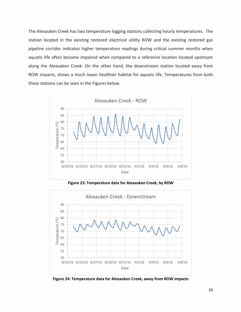
The Alexauken Creek has two temperature logging stations collecting hourly temperatures. The
station located in the existing restored electrical utility ROW and the existing restored gas
pipeline corridor indicates higher temperature readings during critical summer months when
aquatic life often become impaired when compared to a reference location located upstream
along the Alexuaken Creek. On the other hand, the downstream station located away from
ROW impacts, shows a much lower healthier habitat for aquatic life. Temperatures from both
these stations can be seen in the Figures below.
Figure 23: Temperature data for Alexauken Creek, by ROW
Figure 24: Temperature data for Alexauken Creek, away from ROW impacts
50
55
60
65
70
75
80
85
90
8/23/16 8/25/16 8/27/16 8/29/16 8/31/16 9/2/16 9/4/16 9/6/16 9/8/16
Tem
per
atu
re (
°F)
Date
Alexauken Creek - ROW
50
55
60
65
70
75
80
85
90
8/23/16 8/25/16 8/27/16 8/29/16 8/31/16 9/2/16 9/4/16 9/6/16 9/8/16
Tem
per
atu
re (
°F)
Date
Alexauken Creek - Downstream

36
The data from the ROW logging station on the Alexauken show daily fluctuation. The
temperatures range from 63.7 °F to 85.9 °F, with a mean of 73.7 °F. Whereas, the data collected
from the other non-ROW station show much less fluctuations in temperature. For this station,
the temperatures ranged from 66.4 °F to 78.5 °F, with a mean of 72.7 °F. Aquatic species
generally have a preferred temperature range, and thrive in more stable temperature
conditions. A ROW close to a waterbody means that air temperature would affect water
temperature more rapidly. These rapidly fluctuating temperatures can wreak havoc on aquatic
life. In comparison, a water body away from ROW and surrounded by forested land, would not
be affected by air temperature as much, since the forest would act as a buffer to regulate water
temperature. These trends can be clearly seen in the data collected for Alexauken Creek. The
station by the ROW not only had a higher mean temperature, a much higher maximum
temperature than the other station.
Warmer water holds a lesser amount of Dissolved Oxygen (DO). DO is essential for the
sustenance of aquatic life. It should also be noted that algae growth is very abundant in the
ROW corridor. Algae blooms are indicative of higher temperatures, and make living conditions
tough for other aquatic life. As algae die out and decay, they rob DO in water, available to other
aquatic life species (see photo below).

37
Figure 25: Abundant algae growth in Alexuaken Creek, a C1 stream in New Jersey growing in an existing gas ROW
Alexauken Creek is classified as a trout maintenance stream (FW2-TMC1). According to N.J.A.C.
7:9B-1.14(d), the temperature for this stream shall not exceed 25°C (77°C). The temperatures
from Alexauken Creek certainly exceeded this standard, which shows that the stream is already
impacted (it is an impaired waterbody). With the proposed pipeline ROW, right along these
stations (as seen in Figure 1), the degree of impact will be greater, which can prove fatal to the
local ecosystem. The proposed PE pipeline would cross the Alexauken and its tributaries 7
times, which poses a threat to the already impacted stream. In a December 2010 report, by
Princeton Hydro (in collaboration with the Delaware Riverkeeper Network), Alexauken Creek
38
was found to be impacted for temperature and nutrients. This report presents a protection plan
for the Alexauken Creek watershed, in order to maintain its classification. Even with this
protection plan in place and a TMDL plan, the temperature data shows that the watershed is
still struggling. An additional 7 ROW crossings in the creek and its tributaries will present a
major threat to the already struggling watershed.
A third temperature logging station was located along an unnamed tributary of Alexauken
Creek. This station was located southeast of the downstream Alexauken Creek station. The
probe was installed on August 23, 2016. However, on August 28 the unnamed tributary ran
dry. During the 5 days the probe was in the water, the temperatures ranged from 63.9°F to
73.0°F, with a mean of 67.0°F. This small tributary is just one of many intermittent streams that
are along the proposed PE pipeline ROW. This UNT tributary alone is proposed to be crossed 3
times by the pipeline, which would cause serious harm to an already stressed system and
watershed. A picture of the dry streambed observed on Sept 7 below is provided and again
these streams that have groundwater seeps within the ROW will be disrupted if another cut is
allowed.

39
Figure 26: UNT to Alexuaken Creek be cut by PE pipeline. Low flows and drought conditions already cause harm to these sensitive streams. A groundwater seep remains in this tributary just upstream where aquatic life and fish are congregating and it is located directly in the path of the proposed ROW which could alter groundwater flow – a key survival need during low flow times and summer months for this tributary.
According to the National Weather Service, precipitation in the Alexauken Creek Watershed
area was 5.6 inches below average. This is the probable cause for the dry unnamed tributary to
Alexauken Creek. The lower than average rainfall is a result of extensive development in the
area. It goes without saying that a dry stream is not good for aquatic life. An added right of way

40
would decrease transpiration from local vegetation, leading to an even lesser amount of rainfall
in the area. The impacts of existing rights of way (such as utilities, roads, etc.) are already visible
in the form of dry streams, and would worsen with an addition pipeline ROW. Thus, it would
not only affect aquatic life directly (in the form of higher temperatures), but would also have
longer term impacts such as dry streams.
Figure 27: Remaining groundwater seep in the dry UNT to Alexauken Creek. Note dead fish. Over 100 small fish were located in this pool which is directly in the route of the proposed PE pipeline.
Additional Forest Fragmentation Not Fully Considered in the DEIS
This map below based on April alignment sheets helps illustrate the additional forest
fragmentation impacts that are being proposed for a public preserve that has some of the last
remaining forest in the region and that already has an existing ROW. The DEIS states that

41
colocation is less impactful but this is not what the maps document since in the gas line would
run adjacent to the existing ROW cutting through new habitat in the Ted Stiles Preserve on
Baldpate mountain instead of being built within the current ROW footprint which means more
habitat disturbed, trees cut, and an extension of forest fragmentation further into the woods
(in the instance above).
Figure 28: April 2016 Map showing increased fragmentation proposed by PE ROW
DEIS has Inappropriate Practices Proposed for Steep Slopes, Sensitive Soils, Important and
Unique Reptile Habitat and National Significant Trail Systems
DRN surveyed sections of the pipeline route that would cut through State Gameland (SGL) 168
on August 28 and 29, 2016. Homeowners along N. Cottonwood Drive provided access from the
base of the mountain and the pipeline was accessed to the north from the Appalachian Trail
(AT) and Blue Mountain Trail Road. DRN walked the AT and the pipeline path from about MP
51.1 MP to 51.6. This stretch of the Blue Mountain was dominated by steep slopes, glacial thin
soils and abundant outcroppings and boulder fields indicative of ideal timber rattlesnake
habitat. Due to the geology, blasting would likely be required (see section on blasting). And

42
there would be very high likelihood of erosion and increased stormwater runoff from tree
removal.xiii
Figure 29: Outcropping and optimum rattlesnake and copperhead habitat along the AT and approx. 25 feet from the proposed ROW. Steep slopes and glacial soils with thin top soils and mature forest dominate this area.

43
Figure 30. Outcropping and outlook along Appalachian Trail, about 25 feet from the proposed pipeline route. Photo taken facing towards the top of the ridge, white pines in right side of the frame are within the proposed ROW and would be cut.
This area of SGL 168 and the AT is pristine for the region and includes sensitive glacial soils and
features, steep slopes, and areas with shallow bedrock. These areas, the DEIS states will likely
require blasting due to shallow bedrock conditions. Along the steep slope down the Blue
Mountain where the pipeline would cut, boulder areas dominate the slope.
Currently the area surveyed on SGL is dominated by native vegetation, mature forest and
optimal rattlesnake habitat with sensitive vernal pools and groundwater interfaces present at
the base of the mountain. Some of the plant species noted and identified within the proposed
ROW include: Mature canopy trees and seedlings: eastern hemlock (indicative of thin glacial
soils), white pine, green ash, chestnut oak, red oak, white oak, American beech, red maple,
catalpa, shagbark hickory (ideal bat habitat), and birch species.

44
Midstory layer: sassafras, witch hazel, spicebush, maple leaf viburnum, striped maple, and low
bush blueberry Groundcover: indian pipe, greenbriar, wood aster, shining clubmoss (Huperzia
lucidula), raspberry, cut-leaved grape fern (Botrychium dissectum), Virginia creeper,
wintergreen, hay-scented fern, unknown fern sp., Christmas fern, and cardinal flower. All of
these diverse layers in the forest help filter rainwater and slow stormwater on steep slopes and
all of these layers of this mature forest are proposed to be cut by the pipeline which will lead to
significant stormwater runoff without these plant communities present. The Meliora report
provides more detail on stormwater impacts anticipated. Invasive plants are minimal and
absent in a majority of this area of SGL 168 but currently most noted along old logging roads
entering SGL’s from Cottonwood Rd area. Japanese stiltgrass has colonized many of the old
linear logging roads between MP 52.4 to 52.5. Japanese barberry is colonized in sections of the
steep slope areas but currently at a low infestation rate. This is a clear example of how road
ROWs , and a future pipeline will spread these invasive plants that are beginning to take hold
on these state lands along edges. The DEIS does not currently include an Invasive Species
Management Plan by PennEast and FERC requests that one be developed but again, without
having this information as part of a complete DEIS, the public is made to comment on an
incomplete analysis of the harm.
Vernal pools located at the foot of mountains, like the ones observed and described earlier in
this report, likely fill with groundwater so there are also groundwater seeps in this reach of the
pipeline route that are not mapped in the DEIS section related to groundwater seeps. A pool
located on a slope may actually receive groundwater on the upslope side and discharge it to the
water table on the downslope side.xiv DRN has documented severe changes to a similar lateral
hillside cut along a base of a smaller mountain but steep slope on another pipeline in Pike
County, PA so likely similar changes would occur here since most standards and E&S control
measures would be similar.xv
Disregard for Siting Pipeline in Existing ROW or Impacted Developed Areas

45
Blue Mt Ski area is highly impacted with massive cuts for ski slopes yet the pipeline proposed
near the ski center would add an additional cut rather than utilize one of the current clear cut
paths. There is an existing Buckeye oil pipeline present about <0.5 miles from the proposed
new greenfield PE route that would be closer to the Blue Mountain Ski area and that already
cuts across the steep slope and the Appalachian Trail (AT). It is unclear why co-location is not
being considered here within the existing oil pipeline route or on an existing ski slope since the
resort plans to use the gas especially with such sensitive habitat, steep slopes, and cultural
impacts in jeopardy. This harm would be significant and the DEIS conclusion that it would not is
incorrect. The information in the DEIS related to reviewing alternate routes and co-location
also does not provide all information for reviewers to understand the full analysis done or not
done for alternate routes. PE notes that 44 miles of the pipeline route (37%) would be located
adjacent to existing ROWs but full analysis of this is not provided.
Temperature Impacts and Forest Fragmentation Calculations Not Fully
Examined
DRN conducted a snapshot temperature study along the existing Buckeye oil gas transmission
ROW that is west of the proposed Penn East ROW. DRN used a Lamotte calibrated
thermometer to record air temperatures at four locations on or adjacent the existing pipeline
route. It is logical to assume that much of the long term impacts on the Buckeye Route in this
reach on Blue Mountain would be similar impacts for the proposed PE route.
Sensitive glacial soils, extreme compaction, continued and repeated ATV traffic and pipeline
maintenance, lack of diverse growth, bare soils, and thermal heat and fragmentation impacts to
the ROW and within the mature forest paralleling the Buckeye ROW were observed.

46
Figure 31. Locations of temperature readings taken on existing Buckeye ROW and from distances away from ROW to illustrate forest fragmentation and thermal impacts. Note Blue Mountain Ski area also to the right frame of the photo.
Figure 32: Air Temperatures Documented on August 28, 2016 by Delaware Riverkeeper
Network in Proximity to an Existing Gas Pipeline
Location
Air Temp (°F) Distance from ROW (ft.)
Elevation (ft) Lat. and Long.
Buckeye existing Pipeline ROW
107 0 1,134 40.80763, -75.53507
On AT 89.4 115 ft. 1,139 40.80766, -75.53548
On AT 85.4 410 ft. 1,170 40.80751, -75.53653
On AT 83.4 615 ft. 1,264 40.80742, -75.53725
DRN recorded extreme temperatures on the existing ROW and temperature impacts that
continued into the forest and away from the ROW for over 615 feet. These forest impacts are
also cited in the literature and expert reports submitted authored by Kevin Heatley. The
distance an edge effect extends into a forest/woodland is variable, but most studies point to at
least 300 feet (Rodewald 2001; Ontario Ministry of Natural Resources 2000; Robbins 1988;

47
Rosenberg et al. 1999). It would appear from this snapshot of air temperatures above that
localized impacts from a ROW on this mountain may have more interior impacts.
The DEIS does not consider these cumulative impacts and severe forest fragmentation impacts.
The DEIS does not include data like this nor require it to determine actual impacts on the
ground.
Blasting Impacts Inappropriate and Unacceptable in DEIS And Steep Slopes To be Cut Near
Waterbodies Will Cause Significant Harm
The DEIS states 69% of Hunterdon Co, 35% of Northampton Co., 23% of Mercer Co., 25% of
Luzerne Co., and 28% of Carbon County will require likely blasting to blast through shallow
bedrock (page 4-13). In these steep slopes with sensitive glacial soils and thin top soils of the
Blue Mountain, pipeline cuts and blasting would drastically change the character and
environmental functions of this region. Blasting on steep slopes can also increase the risk of
sediment pollution events and blowouts into nearby streams. The Myers and Meliora report
submitted with DRN comment lay out more science on these impacts. At least 43 waterbody
crossings have steep slopes that would be cut by the pipeline. These 43 crossings are proposed
to have additional temporary work spaces (ATWS) within 50 ft. of sensitive water features,
adding to the potential erosion threats to these steep banks, cuts to mature forest, and the
nearby sensitive streams where sediment pollution can cause long term harm.
FERC does recommend that PE not use forested areas to place pipe yards (which is still being
proposed in the DEIS) but this recommendation needs to be expanded greatly to minimize any
areas where mature forest or trees would be cut for temporary placement or workspaces.
Cutting mature trees for ATWS and TWS is not temporary in nature.

48
Threatened and Vulnerable Species Impacts Not Fully Documented
Figure 33. Shagbark hickory and bat habitat along Baldpate Mountain PE proposed route. Shagbark also evident in SGL 168
Missing sections to protect the timber rattlesnake and copperheads
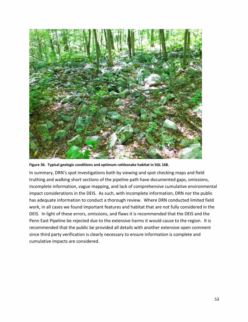
ON August 29, 2016, DRN assessed the pipeline path from the base of SGL 168 from MP 52.9
walking westward to MP 52.5. The DEIS states that timber rattlesnake (Crotalus horridus)
thrives in deciduous forest habitat with at least 70 percent canopy cover, rocky hillsides, and
outcrops for use as hibernacula and exposed rocks for basking (PFBC 2011b) and it lists Luzerne,
Carbon and Northampton PA as habitat for these snakes. The DEIS states Phase 1 surveys were
completed between MP 10.5 to 10.7, 11.1 to 11.6, 12.9 to 13.1, 14.1 to 16.9, 22.5 to 23.1, 23.7
to 24.1, 29.3 to 29.5, 30.1 to 30.7, 32.9 to 33.3, 37.9 to 40.6, and 51.1 to 51.6. Phase 2 surveys
are ongoing. The timber rattlesnake is listed as a candidate species by Pennsylvania and as an
endangered species by New Jersey. The DEIS states that PennEast conducted presence/absence

49
and/or habitat surveys for this species in the summer of 2015. These surveys were conducted by
a qualified herpetologist in potential habitat areas designated by the PFBC. Suitable habitat for
this species was identified within the Project area and one timber rattlesnake was observed
within the Project area in Pennsylvania during wetland field surveys in 2015. For areas that were
identified as potential habitat, PennEast has committed to following the PFBC recommendations
to minimize impacts on this species: which include spring presence surveys, avoiding the habitat
during construction, and the restoration of gestation habitat following PFBC guidelines (PFBC
2010). PennEast has also committed to avoiding denning habitat identified near MP 39.2 and
adhering to a 300 foot no disturbance buffer around these dens, as well as the use of
rattlesnake monitor on-site during construction in suitable habitats between April 15 and
October 15. We recommend that PennEast continue to consult with the PFBC as needed to
finalize plans necessary to avoid or minimize impacts on the timber rattlesnake (see section
4.6.2.25).
The habitats that are listed in the DEIS as being surveyed are not complete and not protective
of timber rattlesnakes and copperheads. DRN documented optimum timber rattlesnake
habitat during assessments conducted in SGL 168 from at least MP 52.9 to 51.0 along Blue
Mountain near Danielsville, PA. The DEIS states that 51.1 to 51.6 was surveyed for timber
rattlesnake but this only includes one section of this habitat and does not include all of the
optimal habitat areas in that area of SGLs; therefore the DEIS is not complete nor protective of
these important species. Below some images of the habitat observed during field
reconnaissance.

50
Figure 34: Example of optimum rattlesnake habitat in SGL 168 that was not currently assessed in the herp
studies.

51
Figure 35: Evidence of rodents among the boulder habitat – another primary requirement of rattlesnakes
Rattlesnakes use different areas of a mountain at different times of the year and it would be
more protective to ensure all areas are surveyed by a certified herpetologist at various times in
these ideal habitats.The seasonal movements of timber rattlesnakes vary greatly. Snakes
emerge from hibernacula (dens) in the spring and come down along the base of the mountain
to summer foraging and breeding grounds. As ectotherms, their movements are triggered by
temperature and sun patterns and orientation. The habitat requirements for hibernating,
foraging, and breeding are different so all suitable areas must be taken into account. Spatial
ecology also varies between males and females. Gravid females generally stay within a half mile
of the den, while nongravid females may travel over a mile away from the den. Males move
significantly farther, particularly when searching for females, and may travel up to 4 miles away
from the den. This large home range size means that there is a significant area of land that
needs to be surveyed before presence or absence can be determined.

52
Rocky outcroppings, boulder habitat, and rodent populations and hiding places were all
observed between MP 52.5 and MP 52.9. This SGL dominated area is natural and includes
intact native plant habitat, boulder conditions, and mature forest on steep slopes and along the
base of the mountain ideal for rattlesnakes and likely copperheads also. This area is not
included in the MP Phase 1 surveys listed above and this is a large omission, especially in light
of the DEIS stating that PE would adhere to the recommendations of the state agencies,
including completing all necessary surveys for state species. Landowners along Cottonwood
Road whose properties about the SGL 168 have heard and observed timber rattlesnakes over
the past few years. Milk snakes and black racers have also been observed as well as black
bears. Local residents also said that snakes are found on the top of the ridge along the AT very
regularly. With these observations, it would be prudent to expand the Phase 1 studies to
include ALL areas, especially in these intact habitats and public lands and to see a Phase 2
survey conducted in this area through this entire stretch. From the DEIS, this area largely in SGL
168, is not fully included. It also seems unusual that the DEIS lists only one den site for timber
rattlesnakes considering the extensive length of the pipeline route in Pennsylvania counties
containing known timber rattlesnake habitat.
53
Figure 36. Typical geologic conditions and optimum rattlesnake habitat in SGL 168.
In summary, DRN’s spot investigations both by viewing and spot checking maps and field
truthing and walking short sections of the pipeline path have documented gaps, omissions,
incomplete information, vague mapping, and lack of comprehensive cumulative environmental
impact considerations in the DEIS. As such, with incomplete information, DRN nor the public
has adequate information to conduct a thorough review. Where DRN conducted limited field
work, in all cases we found important features and habitat that are not fully considered in the
DEIS. In light of these errors, omissions, and flaws it is recommended that the DEIS and the
Penn East Pipeline be rejected due to the extensive harms it would cause to the region. It is
recommended that the public be provided all details with another extensive open comment
since third party verification is clearly necessary to ensure information is complete and
cumulative impacts are considered.

54
References
i PA DEP Continuous Probe Monitoring Protocol. 2015 ii Schmid & Company, The Effects of the Proposed PennEast Pipeline on Exceptional Value Wetlands in
Pennsylvania, July 2016. iii Delaware Riverkeeper Network Field Monitoring Report, Pipeline Construction & Maintenance Irreparably Harms
Rivers, Wetlands and Streams. Addendum to Comment for the PennEast Pipeline. iv Schmid & Company, The Effects of the Proposed PennEast Pipeline on Exceptional Value Wetlands in
Pennsylvania, July 2016. v Ibid.
viTom Myers, Ph.D. Technical Memorandum Review of Draft Environmental Impact Statement, Proposed PennEast
Pipeline, Docket No. CP15-558-000, FERC\EIS: 0271D, August 31, 2016 vii
Brown, L.J. and R.E. Jung. 2005. “An introduction to Mid-Atlantic Seasonal Pool,” EPA 903-B-05-001. U.S. Environmental Protection Agency, Mid Atlantic Integrated Assessment, Ft. Meade, Maryland. viii Vredenberg, V., McDonald, M., & Sayre, T. (2008). Climate Change. AmphibiaWeb: Information on amphibian
biology and conservation, 2016, Berkeley, California. Retrieved from http://amphibiaweb.org/declines/ClimateChange.html ix Schmid & Company, The Effects of the Proposed PennEast Pipeline on Exceptional Value Wetlands in
Pennsylvania, July 2016. xi An example of a recent Wild Trout Waters Change, PA Fish and Boat Commission
http://www.pabulletin.com/secure/data/vol46/46-30/1268.html. July 23, 2016. Accessed Sept 12, 2016. xii
Tom Myers, Ph.D. Technical Memorandum Review of Draft Environmental Impact Statement, Proposed PennEast Pipeline, Docket No. CP15-558-000, FERC\EIS: 0271D, August 31, 2016 xiii
Adams, Michelle and Henderson, Marc, Water Resources Engineers, Meliora Design, LLC, Professional Review & Comment of the Draft Environmental Impact Statement and Supporting Documents Related to Surface Water Impacts of the Proposed PennEast Pipeline Project, September 2016. xiv
The Nature Conservancy, Pennsylvania Vernal Pool Identification Guide. 2005. xv
Delaware Riverkeeper Network Field Monitoring Report, Pipeline Construction & Maintenance Irreparably Harms Rivers, Wetlands and Streams. Addendum to Comment for the PennEast Pipeline.