final - department of environmental affairs · final semp (november 2014) ... in collaboration with...
TRANSCRIPT

ENVIRONMENTAL MANAGEMENT FRAMEWORK
Final
November 2014
Mapungubwe Cultural Landscape World Heritage Site

Mapungubwe CLWHS ENVIRONMENTAL MANAGEMENT FRAMEWORK
Final SEMP (November 2014)
Page i

Mapungubwe CLWHS ENVIRONMENTAL MANAGEMENT FRAMEWORK
Final SEMP (November 2014)
Page i
EXECUTIVE SUMMARY
The Department of Environmental Affairs (DEA), in collaboration with the Limpopo
Department of Economic Development, Environment and Tourism (LEDET) and South
African National Parks (SANParks), embarked on a process to develop an Environmental
Management Framework (EMF) for the Mapungubwe Cultural Landscape World Heritage
Site (MCLWHS). Nemai Consulting was appointed to prepare the MCLMWHS EMF.
An EMF is a study of the biophysical and socio-cultural systems of a geographically
defined area to reveal where specific activities may best be undertaken and to offer
performance standards for achieving and maintaining the desired state of that area. The
EMF development approach, which is outlined in the figure to follow, is consistent with
the requirements stipulated in the National Environmental Management Act (NEMA) (Act
No. 107 of 1998) and the EMF Regulations (GN No. R547 of 18 June 2010).

Mapungubwe CLWHS ENVIRONMENTAL MANAGEMENT FRAMEWORK
Final SEMP (November 2014)
Page ii
This report represents the Strategic Environmental Management Plan (SEMP) of the
EMF process and serves to plot the way forward for attaining the desired state. The
SEMP bridges the divide between the current state of the environment in MCLWHS and
the desired state. It aims to achieve this by managing the sustainable utilisation of land
through Management Guidelines and by controlling the activities that may impact on
environmental attributes in specific geographical areas.
The Desired State phase of the EMF was concluded with the delineation of
Environmental Management Zones (EMZs). Each of these zones represents a specific
demarcated area that requires active control to ensure that its potential is realised. The
EMZs depict the assimilated sensitivity maps that were integrated with the development
pressures and trends, opportunities, constraints and public aspirations.
To facilitate the attainment of the desired state for these EMZs, guidelines are required
that stipulate compatible activities that support the vision for these zones and specific
management requirements and objectives that need to be adhered to when development
is proposed in a zone. The SEMP also attempts to manage activities in the EMZs linked
to the listing notices (GN no. R544, R545 and R546) of the Environmental Impact
Assessment (EIA) Regulations of 2010, in accordance with Section 24 of NEMA
The SEMP culminates in a strategy for the implementation of the EMF, which consists of
the following:
A pragmatic approach to the implementation of the MCLWHS EMF based on the
commonly adopted management system of a Plan-Do-Check-Act cycle;
Linkages with other Planning and Policy Instruments;
Striving towards the Desired State;
Giving Effect to the EMF –
o EMF Enabling Institutional Arrangements;
o EMF Implementation Duties;
o EMF Functionality;
o EMF Review;
Management Framework for Strategic Issues & Priorities; and
Monitoring, Evaluation & Review

Mapungubwe CLWHS ENVIRONMENTAL MANAGEMENT FRAMEWORK
Final SEMP (November 2014)
Page iii
TITLE AND APPROVAL PAGE
Title: Mapungubwe Cultural Landscape World Heritage Site
Environmental Management Framework: Strategic Environmental
Management Plan
Authors: Donavan Henning, Jean Beater
Status of Report: FINAL
Consultants: Approved for Consultants:
……………………………………… N. Naidoo Nemai Consulting - Study Leader
Client: Approved for the Department of Environmental Affairs (DEA):
………………………………………………… B. Nethononda DEA - Study Leader

Mapungubwe CLWHS ENVIRONMENTAL MANAGEMENT FRAMEWORK
Final SEMP (November 2014)
Page iv
AMENDMENTS PAGE
Date Nature of Amendment Amendment No. Signature
Sept 2014 Draft for Public Review 0
Nov 2014 Final for Client Submission 1

Mapungubwe CLWHS ENVIRONMENTAL MANAGEMENT FRAMEWORK
Final SEMP (November 2014)
Page v
TABLE OF CONTENTS
EXECUTIVE SUMMARY ................................................................................................................ i
TITLE AND APPROVAL PAGE ................................................................................................... iii
AMENDMENTS PAGE ................................................................................................................. iv
TABLE OF CONTENTS ................................................................................................................ v
LIST OF ACRONYMS & ABBREVIATIONS ................................................................................ vii
DEFINITIONS / GLOSSARY OF TERMS ................................................................................... viii
1 INTRODUCTION ................................................................................................................ 2
1.1 Background ................................................................................................................... 2
1.2 EMF Study Area ............................................................................................................ 3
1.3 MCLWHS Boundaries ................................................................................................... 4
1.3.1 Core Area .............................................................................................................. 4
1.3.2 2009 Proclaimed Buffer Zone ................................................................................ 5
1.3.3 Proposed New Buffer Zone .................................................................................... 5
1.3.4 Extended area ....................................................................................................... 6
1.4 EMF Objectives ............................................................................................................. 7
1.5 EMF Development Approach ......................................................................................... 8
1.6 EMF Methodology ......................................................................................................... 9
1.7 Culmination of the EMF Development Process .............................................................10
2 MANAGEMENT GUIDELINES ......................................................................................... 12
3 EIA LISTINGS .................................................................................................................. 29
4 IMPLEMENTATION STRATEGY ..................................................................................... 33
4.1 Cyclical Implementation Approach ................................................................................33
4.2 Linkages with other Planning and Policy Instruments ...................................................34
4.3 Striving towards the Desired State ................................................................................34
4.4 Giving Effect to the EMF ...............................................................................................36
4.4.1 EMF Enabling Institutional Arrangements .............................................................36
4.4.2 EMF Implementation Duties ..................................................................................38
4.4.3 EMF Functionality .................................................................................................38
4.4.4 EMF Review .........................................................................................................39
4.4.5 Managing Conflicts between Environmental Features ...........................................40
4.5 Management Framework for Strategic Issues & Priorities .............................................42
4.6 Monitoring, Evaluation & Review ..................................................................................47
5 REFERENCES ................................................................................................................. 50

Mapungubwe CLWHS ENVIRONMENTAL MANAGEMENT FRAMEWORK
Final SEMP (November 2014)
Page vi
LIST OF TABLES
TABLE 1: MANAGEMENT GUIDELINES FRAMEWORK 12
TABLE 2: MCLWHS EMF IMPLEMENTATION CYCLE 33
TABLE 3: ORGANISATIONAL ARRANGEMENTS FOR MCLWHS EMF IMPLEMENTATION & IEM 37
TABLE 4: EMF IMPLEMENTATION DUTIES 38
TABLE 5: ADDRESSING PRIORITISED ENVIRONMENTAL ISSUES 44
TABLE 6: KPIS FOR PRIORITISED ENVIRONMENTAL ISSUES 48
LIST OF FIGURES
FIGURE 1: EMF COMPONENTS 2
FIGURE 2: MCLWHS EMF BUILDING BLOCKS 3
FIGURE 3: MCLWHS & BUFFER NATIONAL AND PROVINCIAL GEOGRAPHICAL CONTEXT 3
FIGURE 4: LOCALTY MAP – EMF STUDY AREA 4
FIGURE 5: CORE AREA AND BUFFER ZONE OF MCLWHS 5
FIGURE 6: PROPOSED NEW BUFFER ZONE OF MCLWHS 6
FIGURE 7: MCLWHS EMF EXTENSION AREA 7
FIGURE 8: BROAD OVERVIEW OF EMF DEVELOPMENT PROCESS 9
FIGURE 9: OBJECTIVES HIERARCHY (ADAPTED FROM DWAF, 2006), WITH EXAMPLE 35
LIST OF APPENDICES
APPENDIX A : COMPATIBILITY OF EIA ACTIVITIES WITH GEOGRAPHIC AREAS 55
APPENDIX B : ENVIRONMENTAL PERFORMANCE INDICATORS 76

Mapungubwe CLWHS ENVIRONMENTAL MANAGEMENT FRAMEWORK
Final SEMP (November 2014)
Page vii
LIST OF ACRONYMS & ABBREVIATIONS
CDF Conservation Development Framework
CLWHS Cultural Landscape World Heritage Site
DEA Department of Environmental Affairs
DEAT Department of Environmental Affairs and Tourism
DWS Department of Water and Sanitation
ECZ Environmental Constraint Zone
EIA Environmental Impact Assessment
EMF Environmental Management Framework
EMZ Environmental Management Zone
FEPA Freshwater Ecosystem Priority Area
GIS Geographical Information System
GMTFCA Greater Mapungubwe Transfrontier Conservation Area
GN Government Notice
LEDET Limpopo Department of Economic Development, Environment and Tourism
MCLWHS Mapungubwe Cultural Landscape World Heritage Site
MNP Mapungubwe National Park
NEMA National Environmental Management Act (Act No. 107 of 1998)
NEMPA National Environmental Management: Protected Areas Act (Act 57 of 2003)
RDM Resource Directed Measures
SANParks South African National Parks
SDCs Source Directed Controls
SEMP Strategic Environmental Management Plan
WWTW Waste Water Treatment Works

Mapungubwe CLWHS ENVIRONMENTAL MANAGEMENT FRAMEWORK
Final SEMP (November 2014)
Page viii
DEFINITIONS / GLOSSARY OF TERMS
Attributes
The quality ascribed to an element in the environment that distinguishes it in character, form or
nature from other elements in the environment.
Management Guidelines
Specific provisions applied in the management of each individual attribute or activity associated
with the respective Management Zones.
Environment
The surroundings in which humans exist and which comprise:
The land, water and atmosphere of the earth;
Micro-organisms, plant and animal life;
Any part or combination of a) and b) and the interrelationships among and between them; and
The physical, chemical, aesthetic and cultural properties and conditions of the foregoing that
can influence human health and well-being.
Environmental Feature
Elements and attributes of the biophysical, economic and social environment that comprise a data
category.
Environmental Management Framework (EMF)
The study of the biophysical and socio-cultural systems of a geographically defined area to reveal
where specific activities may best be practiced and to offer performance standards for maintaining
appropriate use of such land.
Geographical Areas
A logical spatially demarcated area defined by an EMF as being sensitive, requiring specific
management intervention to ensure its future environmental integrity.
Management Zones
Specific demarcated geographical area, represented spatially on a map illustrating a specific
sensitive feature which needs to be managed in a pro-active and dedicated way.

Mapungubwe CLWHS ENVIRONMENTAL MANAGEMENT FRAMEWORK
Final SEMP (November 2014) Page 1
INTRODUCTION
SECTION

Mapungubwe CLWHS ENVIRONMENTAL MANAGEMENT FRAMEWORK
Final SEMP (November 2014) Page 2
1 INTRODUCTION
1.1 Background
The Department of Environmental Affairs (DEA), in collaboration with the Limpopo
Department of Economic Development, Environment and Tourism (LEDET) and South
African National Parks (SANParks), embarked on a process to develop an Environmental
Management Framework (EMF) for the Mapungubwe Cultural Landscape World Heritage
Site (MCLWHS). Nemai Consulting was appointed to prepare the MCLMWHS EMF.
According to the EMF Regulations (Government Notice No. R547 of 18 June 2010), an
EMF is a study of the biophysical and socio-cultural systems of a geographically defined
area to reveal where specific land uses may best be practiced and to offer performance
standards for maintaining appropriate use of such land. An EMF includes a framework of
spatially represented information connected to significant enviornmental (i.e. ecological,
social and economic) parameters, such as ecology, hydrology, infrastructure and services.
A key function of an EMF is to proactively identify areas of potential conflict between
development proposals and critical/sensitive environments (DEAT, 1998).
As shown in Figure 1, the two major components of the MCLWHS EMF will entail Public
Participation and Technical Development. Once the EMF is finalised, it will undergo
promulgation and gazetting in order to render it as a formal decision-making tool in the
environmental and planning arenas.
Figure 1: EMF Components

Mapungubwe CLWHS ENVIRONMENTAL MANAGEMENT FRAMEWORK
Final SEMP (November 2014) Page 3
Figure 2: MCLWHS EMF Building Blocks
As part of the MCLWHS EMF development process, the following deliverables will be
produced: Status Quo Report,
Desired State Report and Strategic
Environmental Management Plan
(SEMP) (see insert).
This report represents the SEMP
(Volume 3) of the EMF process and
serves to plot the way forward for
attaining the desired state.
1.2 EMF Study Area
The EMF Study area includes the core of the MCLWHS as well as the 2009 proclaimed
buffer zone (Figure 4).
Mapungubwe (meaning 'hill of the jackal') is situated in the northernmost district in
Limpopo (see Figure 3). It lies on the international borders of South Africa, Zimbabwe and
Botswana. Mapungubwe falls predominantly within the Vhembe District Municipality and
the Musina Local Municipality. A small part of the buffer zone in the south-western corner
is situated in the Capricorn District Municipality and the Blouberg Local Municipality.
Figure 3: MCLWHS & Buffer National and Provincial Geographical Context

Mapungubwe CLWHS ENVIRONMENTAL MANAGEMENT FRAMEWORK
Final SEMP (November 2014) Page 4
Figure 4: Localty Map – EMF Study Area
The coordinates of the MCLWHS are as follows:
NW corner 22°12’56”S 29°08’22”E;
NE corner 22°10’10”S 29°29’04”E;
SE corner 22°14’15”S 29°31’35”E; and
SW corner 22°17’40”S 29°12’00”E.
1.3 MCLWHS Boundaries
1.3.1 Core Area
The core of the WHS is 28 168.66 ha in extent and is made up of 22 original farms (DEA,
2013). According to the WHS nomination dossier (DEAT, 2002), the boundaries of the
MCLWHS correspond to the Vhembe-Dongola National Park which was later re-named to
the Mapungubwe National Park (MNP). These boundaries are as follows (Figure 4):

Mapungubwe CLWHS ENVIRONMENTAL MANAGEMENT FRAMEWORK
Final SEMP (November 2014) Page 5
North - Limpopo River;
West - Alldays-Pont Drift road;
South - Messina-Pont Drift road and the boundary of the farm Riedel; and
East - the boundary of the farm Riedel and the western side of the irrigated lands on
the farm Weipe.
1.3.2 2009 Proclaimed Buffer Zone
The 2009 proclaimed buffer zone is significant in size as it covers approximately 237 100
ha of land on the western, southern and eastern part of the core (DEA, 2013). The buffer
zone comprises the following (Figure 5):
Venetia-Limpopo Nature Reserve;
Vhembe Nature Reserve;
Limpopo Valley Game Reserve; and
Privately owned land in the north-western and south-western part of the buffer zone.
Figure 5: Core Area and Buffer Zone of MCLWHS
1.3.3 Proposed New Buffer Zone
A study was commissioned to review the size of the 2009 proclaimed buffer and align land
uses to the promotion of conservation and biodiversity in and around the core of the
MCLWHS. According to the audit of land use activities (DEA, 2013), there is a strong view
that the 2009 Proclaimed buffer zone is too large and therefore not practical for a coherent
environmental management plan as well as for a balanced approach considerate of the
Mapungubwe CLWHS ENVIRONMENTAL MANAGEMENT FRAMEWORK
Final SEMP (November 2014) Page 6
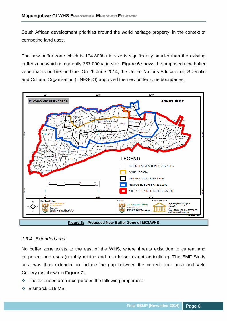
South African development priorities around the world heritage property, in the context of
competing land uses.
The new buffer zone which is 104 800ha in size is significantly smaller than the existing
buffer zone which is currently 237 000ha in size. Figure 6 shows the proposed new buffer
zone that is outlined in blue. On 26 June 2014, the United Nations Educational, Scientific
and Cultural Organisation (UNESCO) approved the new buffer zone boundaries.
Figure 6: Proposed New Buffer Zone of MCLWHS
1.3.4 Extended area
No buffer zone exists to the east of the WHS, where threats exist due to current and
proposed land uses (notably mining and to a lesser extent agriculture). The EMF Study
area was thus extended to include the gap between the current core area and Vele
Colliery (as shown in Figure 7).
The extended area incorporates the following properties:
Bismarck 116 MS;

Mapungubwe CLWHS ENVIRONMENTAL MANAGEMENT FRAMEWORK
Final SEMP (November 2014) Page 7
Portion 1 of Newmark 121 MS;
Katina 805 MS;
Skutwater 115 MS; and
A portion of the Remainder of Weipe 47 MS, as well as Portions 2, 3, 4, 5 and 6 of
Weipe 47 MS.
It should be noted that the extended area forms part of the new buffer zone.
Figure 7: MCLWHS EMF Extension Area
1.4 EMF Objectives
As the norm, an EMF aims to achieve the following:
Promoting sustainability;
Securing environmental protection; and
Promoting cooperative environmental
governance.

Mapungubwe CLWHS ENVIRONMENTAL MANAGEMENT FRAMEWORK
Final SEMP (November 2014) Page 8
Within this context, the primary objectives of the MCLWHS EMF include the following:
1. To facilitate decision-making to ensure sustainable management of significant
environmental features in the WHS and its buffer zone;
2. To provide strategic guidance on environmental, economic and social issues in the
WHS and its buffer;
3. To identify environmentally sensitive areas;
4. To identify the environmental and development opportunities and constraints;
5. To assess the economic and environmental potential of the area;
6. To provide a decision support system in respect of environmental issues and priorities
in the EMF area; and
7. To include existing policies as frameworks for establishing values, guidelines and
standards for future developments.
In its formal context, the EMF that is adopted by the Minister or MEC will be taken into
consideration when reviewing applications for environmental authorisation in or affecting
the areas to which the EMF applies.
1.5 EMF Development Approach
The EMF development approach is consistent with the requirements stipulated in the
following primary legislation that governs the process:
The National Environmental Management Act (Act 107 of 1998) (NEMA), in particular
Sections 2, 23 and 24; and
The EMF Regulations (GN No. R547 of 18 June 2010), which make
provision for the development, content and adoption of EMFs
as a proactive environmental management decision
support tool.
In addition, the MCLWHS EMF also conforms to the
Guideline on Environmental Management Frameworks in
terms of the EMF Regulations of 2010, Integrated
Environmental Management Guideline Series 6 (DEA, 2010).
Mapungubwe CLWHS ENVIRONMENTAL MANAGEMENT FRAMEWORK
Final SEMP (November 2014) Page 9
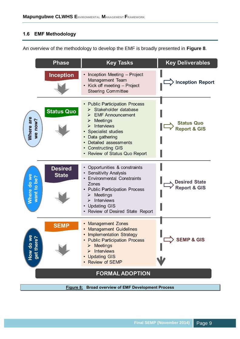
1.6 EMF Methodology
An overview of the methodology to develop the EMF is broadly presented in Figure 8.
Figure 8: Broad overview of EMF Development Process

Mapungubwe CLWHS ENVIRONMENTAL MANAGEMENT FRAMEWORK
Final SEMP (November 2014) Page 10
1.7 Culmination of the EMF Development Process
The SEMP bridges the divide between the current state of the
environment and the desired state. It aims to achieve this by
managing the sustainable utilisation of land through Management
Guidelines and by controlling the activities that may impact on
environmental attributes in specific geographical areas.
The Desired State phase of the EMF (refer to MCLWHS EMF Volume 2: Desired State
Report) was concluded with the delineation of Environmental Management Zones (EMZs).
Each of these zones represents a specific demarcated area that requires active control to
ensure that its potential is realised. The EMZs depict the assimilated sensitivity maps that
were integrated with the development pressures and trends, opportunities, constraints and
public aspirations.
To facilitate the attainment of the desired state for these EMZs, guidelines are required
that stipulate compatible activities that support the vision for these zones and specific
management requirements and objectives that need to be adhered to when development
is proposed in a zone. The SEMP also attempts to manage activities in the EMZs linked to
the listing notices (GN no. R544, R545 and R546) of the Environmental Impact
Assessment (EIA) Regulations of 2010, in accordance with Section 24 of NEMA.

Mapungubwe CLWHS ENVIRONMENTAL MANAGEMENT FRAMEWORK
Final SEMP (November 2014) Page 11
MANAGEMENT GUIDELINES
SECTION

Mapungubwe CLWHS ENVIRONMENTAL MANAGEMENT FRAMEWORK
Final SEMP (November 2014) Page 12
2 MANAGEMENT GUIDELINES
Management Guidelines are measures and objectives that promote the realisation of the
desired state, as well as requirements that need to be taken into consideration when
contemplating development within the EMZs. The Management Guidelines are primarily
based on the following:
Environmental management priorities in the EMF study area;
Existing statutory and regulatory provisions;
Existing policies, strategies, plans and programmes of various government
departments;
Findings of specialist studies;
Outcomes of public participation; and
Best practices.
As stated in the EMF Guidelines (DEA, 2010), the Management Guidelines are not
prescriptive regarding land use and do not indicate which land uses must occur in which
areas. Rather, the guidelines indicate specific minimum environmental requirements and
performance criteria, which need to be abided by and satisfied before approval of a
development application should be considered.
The Management Guidelines for each EMZ are displays in the sub-sections to follow
according to the format displayed in Table 1.
Table 1: Management Guidelines Framework
ENVIRONMENTAL MANAGEMENT ZONE: ___________________
Mapped Management Zone Authorities Desired State
Relevant to the management of environmental attribute(s)
Authorities with jurisdiction over environmental attributes in EMZ.
Statement(s) pertaining to the future desirable state of the EMZ or its associated environmental attributes. Depicted in EMZ.
Management Priorities Based on the environmental status, issues, constraints and opportunities.
Management Guidelines Specific management measures, objectives and requirements related to environmental attributes and the overall EMZ.
Compatible Developments Incompatible Developments Performance Management
Targets Indicators
Activities/developments that promote and are supportive of the desired state and management objectives of the EMZ, and that need to be encouraged.
Activities/developments that are in conflict with the desired state and management objectives of the EMZ, and that need to be discouraged.
Quantitative /qualitative description of what is to be achieved
Means of measuring achievement of targets

Mapungubwe CLWHS ENVIRONMENTAL MANAGEMENT FRAMEWORK
Final SEMP (November 2014) Page 13
ENVIRONMENTAL MANAGEMENT ZONE: Mapungubwe National Park & World Heritage Site
Mapped Management Zone Lead
Authorities Desired State
DEA
SANParks
The Mapungubwe National Park (MNP) and WHS is to be managed in accordance with the Management Plan developed for the period 2013 – 2018. This Plan was authorised in terms of Sections 39 and 41 of the National Environmental Management: Protected Areas Act (NEMPA) (Act 57 of 2003) and chapter 4 of the World Heritage Convention Act (Act 49 of 1999).
The programmes contained within the Management Plan (SANParks, 2013) are designed to achieve the desired state for the park and focus primarily on the conservation of the unique cultural-historical and biodiversity characteristics of the area, including the status of the park as a World Heritage Site and a Transfrontier Conservation Area
Vision – “Mapungubwe Cultural Landscape will be managed and developed to conserve its cultural heritage and biodiversity for all.”
Policies Strategies Plans & Programmes Implementation Mechanisms
SANParks buffer zone policy.
MNP & WHS Management Plan (SANParks, 2013)
Zonation Plan
Management Plan programmes
Environmental Management System
Authorisation of related listed activities in terms of the EIA Regulations (2010).
Development permits issued in terms of NEMPA.
SANParks may impose conditions in addition to (but consistent with) conditions set by other authorities and legislation.
MNP Rules
Management Priorities
Support and facilitate land planning and practices that safeguard and enhance the following: o WHS Outstanding Universal Values; o Cultural heritage; o Biodiversity values; o Objectives of the Greater Mapungubwe Transfrontier Conservation Area (GMTFCA).
DEA to develop a policy for the MCLWHS buffer zone.
Consolidate park and produce conservation development framework (CDF).
Areas suitable for proclamation as wilderness under NEMPA need to be identified, and their formal proclamation pursued where possible.
Maintain working relationships between the various spheres of government to ensure a collaborative effort to conserve MNP and WHS and its buffer zone.
Facilitate private public partnerships within MNP.
Facilitate environmental / cultural education and contribute to environmental awareness
Resolution of land claims. Amongst others, adhere to National Cabinet decision in 2002 regarding the settlement of restitution claims in protected areas, World Heritage sites and State forests. This framework integrates both NEMA and Restitution of Land Rights Acts. After the settling of a claim SANParks and the land claimants must consider entering into an agreement which provides a framework for their future relationship.
Integration with Institutional Arrangements of the GMTFCA.
Develop a Climate Change Strategy for the MNP.
Management Guidelines
Activities to adhere to the MNP and WHS Management Plan (SANParks, 2013).
Activities to comply with the Zoning Plan, which is based on the park’s biophysical, heritage and scenic

Mapungubwe CLWHS ENVIRONMENTAL MANAGEMENT FRAMEWORK
Final SEMP (November 2014) Page 14
resources, as well as current and planned infrastructure and tourist routes / products.
Activities to support programmes listed in the Strategic Plan of the park’s Management Plan (SANParks, 2013), which are grouped into the following categories: o Bioregional; o Biodiversity; o Tourism; o People and conservation; and o Effective park management.
Developments and significant activities to be screened against enviro-legal requirements and to be presented to Park Forum and advisory committee.
In terms of Government Notice No. R546 of 18 June 2010, DEA or LEDET (depending on lead authority status) to review and comment on listed development applications that are within 10km of the WHS within RSA borders.
Where an EIA is not legally required for activities within the Park, consideration should be given to developing an Environmental Management Programme to address the possible impacts associated with an activity.
Specialist disciplines required (where relevant) – Terrestrial Ecology (and associated sub-disciplines), Aquatic Ecology, Visual, Socio-economic, Social, Heritage, Geotechnical, Geohydrology, etc. (as required)
Compatible Developments Incompatible Developments Performance Management
Targets Indicators
Dictated by Zoning Plan.
No un-authorised developent in MNP and WHS.
Development in buffer zones discussed under separate Management Zone.
To be aligned with target and indicators contained in Management Plan for the park.

Mapungubwe CLWHS ENVIRONMENTAL MANAGEMENT FRAMEWORK
Final SEMP (November 2014) Page 15
ENVIRONMENTAL MANAGEMENT ZONE: Buffer Zone
Mapped Management Zone Lead Authorities Desired State
DEA
LEDET
SANParks
Maintain buffer zone for the MCLWHS to manage conflicts between external and internal management objectives, and to protect the core area and its Outstanding Universal Values that is afforded formal protection.
Assist adjacent communities to secure appropriate and sustainable benefits from the Park and buffer zone.
Policies Strategies Plans & Programmes Implementation Mechanisms
SANParks buffer zone policy.
Authorisation of related listed activities in terms of the EIA Regulations (2010).
SANParks may impose conditions in addition to (but consistent with) conditions set by other authorities and legislation.
Management Priorities
DEA to develop a formal policy and operational guidelines for the MCLWHS buffer zone.
Implications of buffer zone to be clearly documented and presented to affected landowners and tenants.
Promote broad based and sustainable economic activities that support tourism and conservation.
Support and facilitate land planning and practices that enhance the overall objectives of the Greater Mapungubwe Transfrontier Conservation Area (GMTFCA).
Maintain working relationships between the various spheres of government to ensure a collaborative effort to manage the buffer zone.
Buffer zone EMZ to be integrated into municipal planning and decision-making.
Promote marketing of the WHS and buffer zone.
Dedicated catchment management for important water yield areas.
Control of alien vegetation.
Control of soil erosion.
Viewshed protection.
Appropriate land care (e.g. appropriate stocking rates).
Integration with Institutional Arrangements of the GMTFCA.
Establish infrastructure corridors for alignment of linear-type developments (e.g. pipelines and power lines).
Management Guidelines
Protect areas where the landscape character is identical and similar to those of the MCLWHS.
Safeguard areas and features of high conservation value (e.g. watercourses; areas underlain by sensitive groundwater resources; unmodified landscapes; areas of outstanding scenic beauty and visual quality, Critical Biodiversity Areas, etc.).
Prevent disparate activities in visual impact zones.
Developments and significant activities to be screened against enviro-legal requirements and to be presented to Park Forum and advisory committee.
Environmental Impact Assessments for listed activities proposed within the buffer zone need to evaluate the impact of the proposal on the MCLWHS and its Outstanding Universal Values.
Following the requisite assessments and due consideration of the buffer zone EMZ Management Guidelines, mining should be restricted to underground with no open pits. Appropriate offsets to be identified and negotiated with relevant authorities.
In terms of Government Notice No. R546 of 18 June 2010, DEA or LEDET (depending on lead authority status) to review and comment on listed development applications that are within 10km of the WHS

Mapungubwe CLWHS ENVIRONMENTAL MANAGEMENT FRAMEWORK
Final SEMP (November 2014) Page 16
within RSA borders.
Application of Section 28 of NEMA which affords protection against significant pollution or degradation of the environment by imposing a duty of care and requiring remediation of environmental damage.
The relevant specialist studies will need to be conducted to allow for informed and balanced decision-making. Specialist disciplines required (where relevant) – Terrestrial Ecology (and associated sub-disciplines), Aquatic Ecology, Visual, Socio-economic, Social, Heritage, Geotechnical, Geohydrology, etc. (as required)
Compatible Developments Incompatible Developments Performance Management
Targets Indicators
Low impact activities that support the objectives of the WHS.
Conservation. Tourism (regulated; low impact). Ecological Corridors. Open space (regulated; low impact;
excluding any permanent structures).
Where the edge effects of activities will significantly adversely impact on the environment within the WHS.
Development beyond existing transformation footprints.
Activities that could adversely impact on the following –
o Resource quality of watercourses (water quality, flow regime, habitat, aquatic biota);
o Groundwater resources; o Ecological corridors; o Aesthetic qualities of the park.
Activities that could cause noise or air quality pollution that exceed standards or impact of the park’s activities.
Urban expansion. Intensification of land use (e.g. golf
estate).
No threats that may jeopardise the WHS Outstanding Universal Values
Edge effects associated with disparate activities / developments

Mapungubwe CLWHS ENVIRONMENTAL MANAGEMENT FRAMEWORK
Final SEMP (November 2014) Page 17
ENVIRONMENTAL MANAGEMENT ZONE: Terrestrial Biodiversity
Mapped Management Zone Authorities Desired State
DEA
LEDET
SANParks
DAFF
The EMF study area contains a wealth of natural resources, which need to be appropriately protected to ensure that the associated environmental goods and services are not jeopardised.
Policies Strategies Plans &
Programmes Implementation Mechanisms
White Paper on the Conservation and Sustainable Use of South Africa’s Biological Diversity (1997)
National Biodiversity Strategy and Action Plan
National Biodiversity Framework
National Protected Area Expansion Strategy
National Spatial Biodiversity Assessment
National Biodiversity Strategy and Action Plan
National Strategy for Sustainable Development and Action Plan
TFCA Treaty and Integrated Development Plan
MNP Management Plan (SANParks, 2013)
LEDET C-plan
Species-based conservation (listed species).
Area-based conservation (protected areas, protected eco-systems).
Purpose-based conservation.
Management Plan programmes.
State of Environment Reporting.
Permitting of activities (threatened species, alien species, listed invasive species).
Terrestrial protected areas.
Control measures for alien and invasive plant species.
Authorisation of related listed activities in terms of the EIA Regulations (2010), and in particular GN No. R546 of 18 June 2010.
Management Priorities
Support and facilitate land planning and practices that enhance the following: o Overall biodiversity values and the role the region can plan in conserving the Soutpansberg
Centre of Endemism. o Objectives of the GMTFCA. o Economic objectives based on wildlife industries that are compatible with the regions overall
biodiversity values including ecotourism developments.
Conserve and maintain the fence that protects the gallery forest (which is listed as Critically Endangered) from elephants.
Restore and conserve biodiversity and ecosystem patterns and processes.
Promote the restoration of the Limpopo/Shashe River system and its tributaries to deliver basic ecosystem functions to surrounding environments.
Rehabilitation of old lands, with particular emphasis on re-establishment of riparian woodland.
Conserve long-term viable and representatives of sensitive and threatened vegetation types and control development pressure in the key sensitive areas.
Rehabilitate Kalopi/Maloutswa wetland and pans.
Remove and control invasive alien vegetation.
Implement effective veld fire management strategies.
Ensure that the habitat required for the Southern Ground-Hornbill remains intact.
The use of signage and roadside fencing to direct wildlife to cross roads through existing culverts to reduce incidents of roadkill.
National and local government structures must facilitate sustainable trade in medicinal plants and continue to monitor and regulate the use of medicinal plant species.
Mapungubwe CLWHS ENVIRONMENTAL MANAGEMENT FRAMEWORK
Final SEMP (November 2014) Page 18
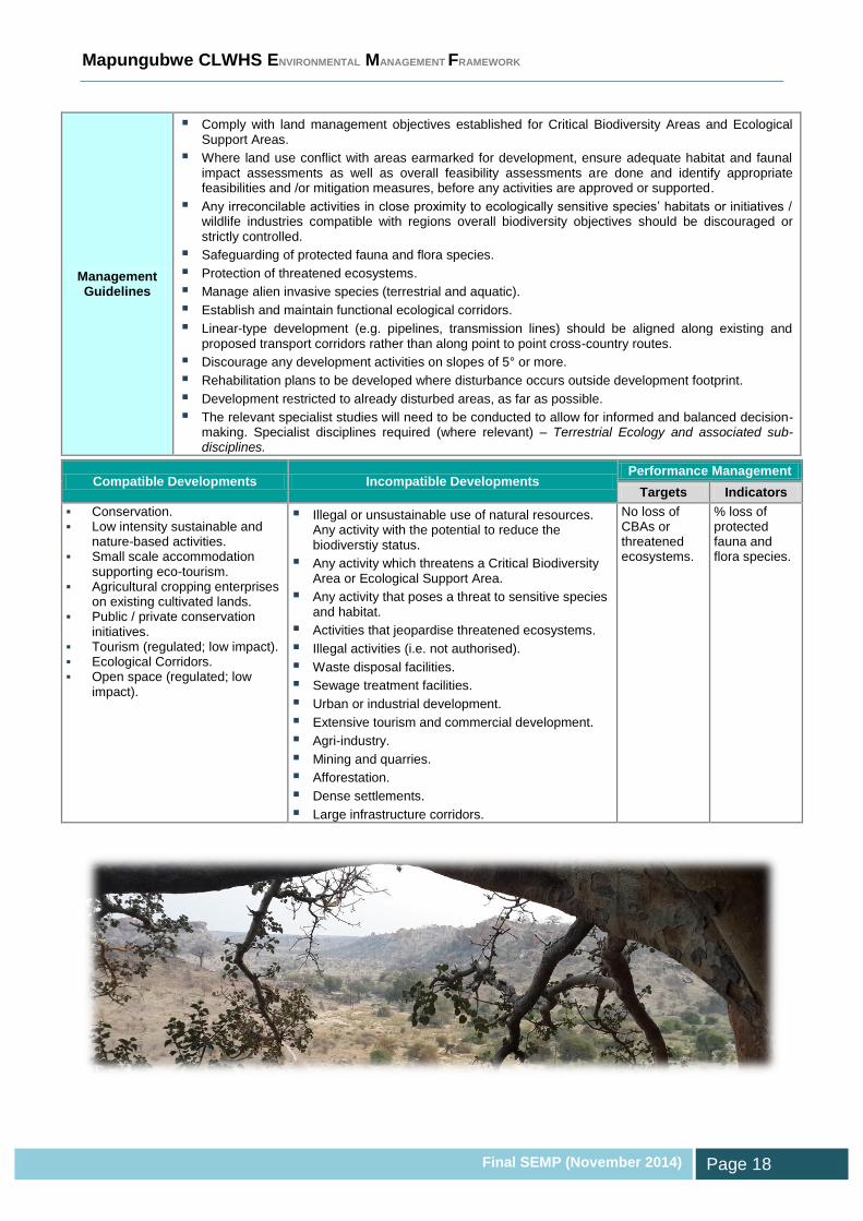
Management Guidelines
Comply with land management objectives established for Critical Biodiversity Areas and Ecological Support Areas.
Where land use conflict with areas earmarked for development, ensure adequate habitat and faunal impact assessments as well as overall feasibility assessments are done and identify appropriate feasibilities and /or mitigation measures, before any activities are approved or supported.
Any irreconcilable activities in close proximity to ecologically sensitive species’ habitats or initiatives / wildlife industries compatible with regions overall biodiversity objectives should be discouraged or strictly controlled.
Safeguarding of protected fauna and flora species.
Protection of threatened ecosystems.
Manage alien invasive species (terrestrial and aquatic).
Establish and maintain functional ecological corridors.
Linear-type development (e.g. pipelines, transmission lines) should be aligned along existing and proposed transport corridors rather than along point to point cross-country routes.
Discourage any development activities on slopes of 5° or more.
Rehabilitation plans to be developed where disturbance occurs outside development footprint.
Development restricted to already disturbed areas, as far as possible.
The relevant specialist studies will need to be conducted to allow for informed and balanced decision-making. Specialist disciplines required (where relevant) – Terrestrial Ecology and associated sub-disciplines.
Compatible Developments Incompatible Developments Performance Management
Targets Indicators
Conservation. Low intensity sustainable and
nature-based activities. Small scale accommodation
supporting eco-tourism. Agricultural cropping enterprises
on existing cultivated lands. Public / private conservation
initiatives. Tourism (regulated; low impact). Ecological Corridors. Open space (regulated; low
impact).
Illegal or unsustainable use of natural resources. Any activity with the potential to reduce the biodiverstiy status.
Any activity which threatens a Critical Biodiversity Area or Ecological Support Area.
Any activity that poses a threat to sensitive species and habitat.
Activities that jeopardise threatened ecosystems.
Illegal activities (i.e. not authorised).
Waste disposal facilities.
Sewage treatment facilities.
Urban or industrial development.
Extensive tourism and commercial development.
Agri-industry.
Mining and quarries.
Afforestation.
Dense settlements.
Large infrastructure corridors.
No loss of CBAs or threatened ecosystems.
% loss of protected fauna and flora species.

Mapungubwe CLWHS ENVIRONMENTAL MANAGEMENT FRAMEWORK
Final SEMP (November 2014) Page 19
ENVIRONMENTAL MANAGEMENT ZONE: Surface Water
Mapped Management Zone Authorities Desired State
Department of Water & Sanitation (DWS)
DEA
LEDET
Water resources to be managed to allow for sustainable and equitable use.
Future visions established by Catchment Management Agency to be adopted.
Policies Strategies Plans &
Programmes Implementation Mechanisms
National Water Resource Strategy
Internal Strategic Perspective
Catchment Management Strategy
Catchment Management Plan
River Health Programme
Waste Discharge Charge System
Working for Water Programme
Resource Directed Measures (RDM) - clear objectives for the desired level of protection of the resource – Reserve, Classification System, and Resource Quality Objectives.
Source Directed Controls (SDCs) – measures to control water use, e.g. water quality standards for waste water, waste water discharges, pollution prevention, and waste minimisation technologies.
National monitoring and information systems – address the monitoring, recording, assessing and dissemination of information on water resources.
Catchment Management Forum.
Authorisation of related listed activities in terms of the EIA Regulations (2010).
Management Priorities
Support and facilitate land planning and practices that are aligned with the following: o The Reserve and Resource Quality Objectives; o Attaining the Management Class for affected water resources; o Objectives of the GMTFCA.
Promote the restoration of river flow and, water quality of the Limpopo / Shashe Rivers’ system, its tributaries and groundwater dependant ecosystems, to deliver basic ecosystem functions to surrounding environments.
Encourage MCLWHS participation in relevant water use fora.
Develop an adaptive management programme for wetlands.
Developing the Golope/Maloutswa wetland as a key biodiversity feature in MCLWHS.
Rehabilitation of riparian areas affected by anthropogenic activities.
Control abstraction from Schroda Dam, especially during low-flow and dry periods.
Results from water quality and quantity monitoring programme for Schroda Dam to be shared with SANParks
Management Guidelines
Provision of adequate sanitation and waste management services.
Comply with Freshwater Ecosystem Priority Areas (FEPA) Management Guidelines.
For any proposed water use or development in proximity to a watercourse, a delineation of the wetland / riparian habitat needs to be undertaken in accordance with the DWS Guidelines.
Development to be located outside 1:100 year flood line and not to interfere with stormwater drainage. No mining or agricultural development within regulated area of the watercourse (i.e. 1:100 year floodline or delineated riparian / wetland habitat, whichever is greatest).

Mapungubwe CLWHS ENVIRONMENTAL MANAGEMENT FRAMEWORK
Final SEMP (November 2014) Page 20
Adopt 32 metres buffer area from boundary of regulated area of a watercourse. Strict regulation of encroachment and incompatible activities.
Regulated area of watercourse and associated buffer zone should be determined on a strategic priority basis, based on the nature of the activity.
All watercourses (including delineated boundary and additional 32m buffer zone) should be regarded as sensitive until proven otherwise by a suitably qualified specialist.
Water use Licence required for development within 500m radius of a wetland.
Source directed controls (including compliance with licence conditions) for mining and other sources of impacts to resource quality (i.e. flow, water quality, habitat and aquatic biota).
Mining and prospecting within the alluvial flood plains (outside of the regulated area) should not be permitted without the relevant approvals and detailed after-use plans and rehabilitation plans.
Develop invasive alien species control plan for riparian areas / wetlands.
Dedicated catchment management for watercourses that feed into the WHS.
Implement a water quality monitoring programme and consider relevant water quality variables that pose a threat to the functionality of wetlands.
Strict regulation of development with structural elements.
Strict protection of sensitive alluvial vegetation with significant ecosystem status.
Watercourse crossings need to undergo an authorisation process and need to adopt best practices (e.g. perpendicular crossings, avoid sensitive habitat, accommodate floods).
The relevant specialist studies will need to be conducted to allow for informed and balanced decision-making. Specialist fields required (where relevant) – Aquatic Ecology, Hydrology, Geomorphology.
Compatible Developments Incompatible Developments Performance Management
Targets Indicators
Conservation. Tourism (regulated; low impact). Ecological Corridors. Open space (regulated; low impact;
excluding any permanent structures.
Activities that adversely affect resource quality (i.e. flow regime, water quality, aquatic biota, habitat and morphology).
Waste disposal facilities.
Sewage facilities (WWTW and sewage pump stations).
Illegal activities (i.e. not authorised).
Any activity with the potential to reduce the Present Eclogical State or influence the future Management Class.
Maintaining the Ecological Reserve and Management Class
Resource Quality Objectives

Mapungubwe CLWHS ENVIRONMENTAL MANAGEMENT FRAMEWORK
Final SEMP (November 2014) Page 21
ENVIRONMENTAL MANAGEMENT ZONE: Groundwater
Mapped Management Zone Authorities Desired State
Department of Water & Sanitation (DWS)
DEA
LEDET
Water resources to be managed to allow for sustainable and equitable use.
Future visions established by Catchment Management Agency to be adopted.
Policies Strategies Plans &
Programmes Implementation Mechanisms
National Water Resource Strategy
Internal Strategic Perspective
Catchment Management Strategy
Catchment Management Plan
Waste Discharge Charge System
Working for Water Programme
Groundwater Resource Directed Measures (GRDM) - clear objectives for the desired level of protection of the resource – Reserve, Classification System, and Resource Quality Objectives.
Source Directed Controls (SDCs) – measures to control water use, e.g. water quality standards for waste water, waste water discharges, pollution prevention, and waste minimisation technologies.
National monitoring and information systems – address the monitoring, recording, assessing and dissemination of information on water resources.
Catchment Management Forum.
Authorisation of related listed activities in terms of the EIA Regulations (2010).
Management Priorities
Support and facilitate land planning and practices that are aligned with the following: o The Reserve and Resource Quality Objectives; o Attaining the Management Class for affected water resources; o Objectives of the GMTFCA.
Promote the restoration of groundwater attributes of the Limpopo / Shashe Rivers’ system, its tributaries and groundwater dependant ecosystems, to deliver basic ecosystem functions to surrounding environments.
Encourage MCLWHS participation in relevant water use fora and to ensure that communication channels are established between the park and other stakeholders sharing groundwater resources.
Integrate MNP into regional water user community.
Regular feedback from De Beers and DWS regarding groundwater abstraction within the park.
Initiate a hydro-census (collect, review and archive baseline information on the existing groundwater resources and threats in the park).
Set up a groundwater monitoring programme.
Establish an understanding of the groundwater resources’ vulnerability to pollution.
Institute adequate source-directed controls to manage potential impacts to groundwater resources, which could include: o Authorisations, licences and permits; o Standards to regulate quality of waste discharges; o Requirements for on-site management practices (e.g. to minimise waste at source and to control
diffuse pollution);

Mapungubwe CLWHS ENVIRONMENTAL MANAGEMENT FRAMEWORK
Final SEMP (November 2014) Page 22
o Requirements for clean-up and remediation of water resources that have already been polluted.
Ongoing engagement between De Beers and SANParks in terms of groundwater monitoring.
Venetia Mine's wells to form part of the groundwater monitoring programme
Management Guidelines
Regulate and prohibit land-based activities which may affect the quantity and quality of groundwater once site specific studies have been conducted and the results known.
Prevent intrusion of polluted surface water.
Provision of adequate sanitation and waste management services.
Implement a groundwater monitoring programme.
The relevant specialist studies will need to be conducted to allow for informed and balanced decision-making. Specialist fields required (where relevant) – Geohydrology.
Compatible Developments Incompatible Developments Performance Management
Targets Indicators
Compatibility of activities dependent on the nature of the possible impacts to the groundwater resources, and based on the findings of the relevnat specialist studies.
Maintaining the Groundwater Reserve and Management Class
Groundwater Resource Quality Objectives

Mapungubwe CLWHS ENVIRONMENTAL MANAGEMENT FRAMEWORK
Final SEMP (November 2014) Page 23
ENVIRONMENTAL MANAGEMENT ZONE: Agriculture
Mapped Management Zone Authorities Desired State
Department of Agriculture, Forestry and Fisheries
Department of Agriculture
LEDET
High potential, unique agricultural land and land under irrigation with approved water rights should be protected.
Policies Strategies Plans &
Programmes Implementation Mechanisms
Strategic Plan for South African Agriculture
National Land Care Programme (1997)
Authorisation of related listed activities in terms of the EIA Regulations (2010).
Soil conservation measures.
Land capability and suitability assessment.
Pollution prevention and remediation measures.
Management Priorities
Agricultural activities take place within the core of the WHS. If these activities are to remain they need to complement the conservation status of MNP via the Conservation of Agriculture Resources Act (Act No. 43 of 1983) and other pieces of relevant environmental legislation.
Existing agricultural activities should be maintained, but where possible a transition to less intensive land uses or ecological restoration should be favoured.
Areas affected by historical farming activities and that are no longer under cultivation along the Limpopo River need to be rehabilitated.
Maintain veterinary fence along Limpopo River.
Enforcement of livestock carrying capacity for the area.
Settling of land claims as expeditiously as possible.
Providing the necessary support to emeging farmers.
Support development of game farms but ensure that game is not allowed to enter areas which will place the cultural and environmental resources at risk. Conservation should take priority over game farming as the comparative advantage of the area lies in the cultural resources of the area.
Manage impacts from polluted (e.g. saline) return flows from agricultural activities.
The relevant specialist studies will need to be conducted to allow for informed and balanced decision-making. Specialist fields required (where relevant) – Agriculture and associated sub-disciplines.
Management Guidelines
Comply with legal requirements for an application for a change of land use from agriculture to any other land use. Adhere to this department’s specifications for a Natural Resources Survey report.
Manage impacts from polluted (e.g. saline) return flows from agricultural activities.
Invest in better agricultural education and land care programmes. Build capacity surrounding sustainable and environmentally-friendly farming methods, irrigation and grazing practises.
Eradication of alien invasive species should be controlled under the Conservation of Agricultural Resources Act (Act 48 of 1983).
Best practices to be employed, including contour farming, organic farming, use of fertilizer and pesticides, management of return flows, water conservation, soil preservation, stocking densities.
The relevant specialist studies will need to be conducted to allow for informed and balanced decision-making. Specialist fields required (where relevant) – Agriculture and associated sub-disciplines.

Mapungubwe CLWHS ENVIRONMENTAL MANAGEMENT FRAMEWORK
Final SEMP (November 2014) Page 24
Compatible Developments Incompatible Developments Performance Management
Targets Indicators
Activities that support primary agricultural production (including associated infrastructure).
Tourism (regulated and agriculture-focused).
Any activity which poses a threat to land with high agricultural potential.
Poor farming practices, especially related to water conservation, soil degradation and water pollution.
Mining. Dense settlements.
Zero loss of high potential, unique agricultural land.
% loss high potential, unique agricultural land.

Mapungubwe CLWHS ENVIRONMENTAL MANAGEMENT FRAMEWORK
Final SEMP (November 2014) Page 25
ENVIRONMENTAL MANAGEMENT ZONE: Heritage & Cultural Resources
Mapped Management Zone Authorities Desired State
SAHRA
Limpopo Provincial Heritage Resources Authority (LIHRA)
Protection of heritage and cultural resources.
Policies Strategies Plans &
Programmes Implementation Mechanisms
Management Plans (generic and site-specific)
Conservation, protection and administration of both the physical and the living or tangible heritage resources.
Issuing of permits for protection of heritage resources, graves, archaeological and paleontological sites.
Issuing of permits in terms of national heritage site status before any changes or development is contemplated
Conduct Heritage Impact Assessments in terms of Section 38 of the National Heritage Resources Act (Act No. 25 of 1999).
Management Priorities
Execution and approval of Heritage Impact Assessments for activities listed in section 38 of the National Heritage Resources Act (Act No. 25 of 1999).
All the relevant protocols need to be abided by and permits will need to be obtained with regard to heritage and cultural resources (where necessary).
Optimise tourism potential offered by heritage and cultural resources.
Incorporate heritage considerations into development proposals.
Sense of place to be maintained.
Strict regulation of inappropriate development within footprint / 50m from the buffer zone of National, Provincial and Local Heritage Sites.
Strict regulation of any alterations, additions or new structures that are contradictory to protected buildings or the general character of area.
Develop and maintain a Geographical Information System (GIS) database of all cultural heritage features within the core and buffer of the WHS.
Optimise opportunities associated with tourism and job creation linked to the conservation of cultural and heritage resources.
Investigate areas that have not yet been surveyed.
Develop a cultural heritage resources programme, based on indigenous knowledge.
Specialist fields required (where relevant) – Heritage and associated sub-disciplines.
Alignment with the district’s approved Tourism Strategy and Plan.
Management Guidelines
Execution and approval of Heritage Impact Assessments (HIAs) for activities listed in section 38 of the National Heritage Resources Act (Act No. 25 of 1999). Assessments to conform to Guidance on HIAs for cultural world heritage properties (International Council of Monuments and Sites 2011).
Optimise tourism potential offered by heritage and cultural resources.
Incorporate heritage considerations into development proposals.

Mapungubwe CLWHS ENVIRONMENTAL MANAGEMENT FRAMEWORK
Final SEMP (November 2014) Page 26
Sense of place to be maintained.
Strict regulation of inappropriate development within footprint / 50m from the buffer zone of National, Provincial and Local Heritage Sites.
Strict regulation of any alterations, additions or new structures that are contradictory to protected buildings or the general character of area.
Optimise opportunities associated with tourism and job creation linked to the conservation of cultural and heritage resources.
The relevant specialist studies will need to be conducted to allow for informed and balanced decision-making. Specialist fields required (where relevant) – Heritage and associated sub-disciplines.
Alignment with the district’s approved Tourism Strategy and Plan.
Compatible Developments Incompatible Developments Performance Management
Targets Indicators
Conservation. Tourism (regulated; low impact). Ecological Corridors. Open space (regulated; low impact;
excluding any permanent structures).
Any activity that poses a threat to cultural and heritage resources.
Illegal activities (i.e. not authorised).
No loss of heritage resources.
Inventory of heritage resource.
Number of heritage resource sites damaged or vandalised.
Mapungubwe CLWHS ENVIRONMENTAL MANAGEMENT FRAMEWORK
Final SEMP (November 2014) Page 27
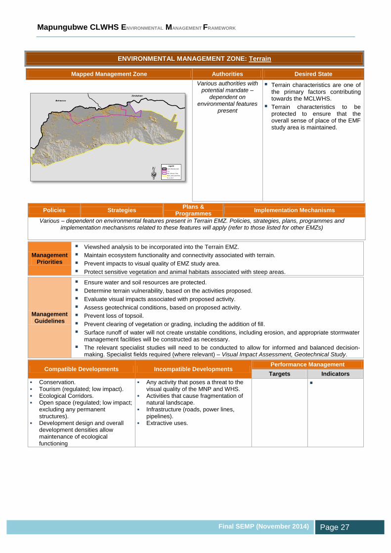
ENVIRONMENTAL MANAGEMENT ZONE: Terrain
Mapped Management Zone Authorities Desired State
Various authorities with potential mandate –
dependent on environmental features
present
Terrain characteristics are one of the primary factors contributing towards the MCLWHS.
Terrain characteristics to be protected to ensure that the overall sense of place of the EMF study area is maintained.
Policies Strategies Plans &
Programmes Implementation Mechanisms
Various – dependent on environmental features present in Terrain EMZ. Policies, strategies, plans, programmes and implementation mechanisms related to these features will apply (refer to those listed for other EMZs)
Management Priorities
Viewshed analysis to be incorporated into the Terrain EMZ.
Maintain ecosystem functionality and connectivity associated with terrain.
Prevent impacts to visual quality of EMZ study area.
Protect sensitive vegetation and animal habitats associated with steep areas.
Management Guidelines
Ensure water and soil resources are protected.
Determine terrain vulnerability, based on the activities proposed.
Evaluate visual impacts associated with proposed activity.
Assess geotechnical conditions, based on proposed activity.
Prevent loss of topsoil.
Prevent clearing of vegetation or grading, including the addition of fill.
Surface runoff of water will not create unstable conditions, including erosion, and appropriate stormwater management facilities will be constructed as necessary.
The relevant specialist studies will need to be conducted to allow for informed and balanced decision-making. Specialist fields required (where relevant) – Visual Impact Assessment, Geotechnical Study.
Compatible Developments Incompatible Developments Performance Management
Targets Indicators
Conservation. Tourism (regulated; low impact). Ecological Corridors. Open space (regulated; low impact;
excluding any permanent structures).
Development design and overall development densities allow maintenance of ecological functioning
Any activity that poses a threat to the visual quality of the MNP and WHS.
Activities that cause fragmentation of natural landscape.
Infrastructure (roads, power lines, pipelines).
Extractive uses.

Mapungubwe CLWHS ENVIRONMENTAL MANAGEMENT FRAMEWORK
Final SEMP (November 2014) Page 28
EIA LISTINGS
SECTION

Mapungubwe CLWHS ENVIRONMENTAL MANAGEMENT FRAMEWORK
Final SEMP (November 2014) Page 29
3 EIA LISTINGS
Section 24 of NEMA gives the Minister and the provincial counter-part, the MEC, the
power to regulate which activities need permission to proceed and to accept spatial plans
to assist in the authorisation of new activities. The relevant paragraph states: “…prepare
compilations of information and maps that specify the attributes of the environment in
particular geographical areas, including the sensitivity, extent, interrelationship and
significance of such attributes which must be taken into account by every organ of state
charged by law with authorising, permitting or otherwise allowing the implementation of a
new activity, or with considering, assessing and evaluating an existing activity”.
One of the primary purposes of the EMF is thus to function as a support mechanism in the
EIA process in the evaluation and review of development applications. This is achieved in
the following manner:
Supporting the undertaking of an EIA in an area by indicating the scope of potential
impacts and information requirements for executing the assessment (refer to
Management Guidelines);
Delineating geographical areas within which additional specified activities are to be
identified in terms of NEMA;
Delineating geographical areas within which activities listed in terms of NEMA may be
excluded by identifying areas that are not sensitive to the potential impacts of such
activities; and
Delineating geographical areas within which activities listed in terms of the EIA
Regulations are either escalated from Listing Notice 1 to 2 or vice versa (see Box 1).
The EMF informs EIAs through the environmental sensitivity depicted through the EMZs,
linked to their Management Guidelines that need to be considered for undertaking
developments within these zones. In this way, the Desired State is promoted by allowing
compatible developments to proceed without undergoing protracted decision-making
processes whilst subjecting potentially disparate development to an environmental
assessment.

Mapungubwe CLWHS ENVIRONMENTAL MANAGEMENT FRAMEWORK
Final SEMP (November 2014) Page 30
The relationship bewteen the EMZs and the EIA Listing Notices were explored based on
the following:
Activities - significant impact –
Activities where the related impact(s) may have a high significance rating in terms of
the environmental attributes in an EMZ. Only permissible through strict regulation, and
impacts need to be adequately mitigated.
Activities – no significant impact –
Activities that are more amenable to environmental attributes in an EMZ, and where a
low significance rating applies. Although permissible, regulation is still a requirement.
The compatibility of the activities contained in the EIA Listing Notices (GN No. R544, R545
and R546) with regards to the EMZs are presented in Appendix A. The following
conditions apply to the interpretation and application of the EMF’s influence to the EIA
activities:
1. As the GIS was compiled based largely of desktop spatial information, a certain level of
ground-truthing that is appropriate to the type of activity and status of the receiving
environment, will be required. Depending on the outcome, the requirements can be
challenged.
What is the difference between a Basic Assessment
& Scoping and EIA Process?
A Basic Assessment is the environmental assessment applied to activities listed in Listing 1 and
3 (GN No. R544 and R546, respectively). These are smaller scale activities, the impacts of
which are generally known and can be easily managed. Typically, these activities are of lower
risk and are considered less likely to have significant impacts to the receiving environment.
Scoping and EIA requires a thorough and rigorous environmental assessment for activities
contained in Listing 2 (GN No. R545). Due to their nature and/or extent, these activities are of
higher risk and are likely to have significant impacts that cannot be easily predicted.
BOX 1

Mapungubwe CLWHS ENVIRONMENTAL MANAGEMENT FRAMEWORK
Final SEMP (November 2014) Page 31
2. While preferred activities within the EMZs are proposed, it does not preclude a
developer/ planner from having to consider the underlying sensitive features or having
to comply with relevant environmental legislation.
3. Exclusion must be considered following consultation with the competent environmental
authority in terms of NEMA.
4. Where an exclusion is permitted, it is advocated that an Environmental Management
Programme (EMPr) needs to be prepared in accordance with section 24N of NEMA
and the associated regulation 33 of GN No. R. 543 (18 June 2010). The EMPr needs to
be approved by the NEMA competent authority.
5. From the EMF’s perspective, the following needs to be considered during the
application stage of the EIA:
a. The competent authority must make the EMF available to the applicant /
Environmental Assessment Practitioner (EAP);
b. The EAP must, in accordance with regulation 20 of GN No. R546, determine
whether a Basic Assessment or Scoping should be applied to the application,
taking into account the EMF’s requirements;
c. If the EAP managing the application, following the review of the EMF, is for any
reason of the view that the environmental assessment process recommended by
the EMF is inappropriate (based on a sufficient understanding of the project and
receiving environment), the applicant / EAP may provide sufficient motivation to
the competent authority to deviate from the EMF.
6. Exclusions do not apply to other environmental legislation, where the relevant
approvals will still need to be sought for various legal triggers. Examples of such key
pieces of legislation include (list is not exhaustive):
World Heritage Convention Act (Act 49 of 1999);
National Water Act (Act No. 36 of 1998);
National Environmental Management Air Quality Act (Act No. 39 of 2004);
National Environmental Management: Biodiversity Act, 2004 (Act No. 10 of 2004);
National Environmental Management: Protected Areas Act (Act No. 57 of 2003);
National Environmental Management: Waste Act (Act No. 59 of 2008);
National Forests Act (No. 84 of 1998);
Minerals and Petroleum Resources Development Act (Act No. 28 of 2002); and
National Heritage Resources Act (Act No. 25 of 1999).

Mapungubwe CLWHS ENVIRONMENTAL MANAGEMENT FRAMEWORK
Final SEMP (November 2014) Page 32
SECTION
IMPLEMENTATION STRATEGY

Mapungubwe CLWHS ENVIRONMENTAL MANAGEMENT FRAMEWORK
Final SEMP (November 2014) Page 33
4 IMPLEMENTATION STRATEGY
4.1 Cyclical Implementation Approach
A pragmatic approach to the implementation of the MCLWHS EMF is recommended,
which is based on the commonly adopted management system of a
Plan-Do-Check-Act cycle. This method acknowledges that it requires
dedicated commitment to continual improvement to eventually achieve
the desired management outcomes. The main steps in the cycle are
presented in the table to follow.
Table 2: MCLWHS EMF Implementation Cycle
1. Plan
Identify the EMF triggers.
Define the scope of the EMF.
Determine information requirements and key environmental features and
attributes to be investigated.
Develop and implement a public participation strategy.
Determine context for environmental management, based on status quo,
opportunities, constraints, issues, and desired state.
Delineate management zones and assign management objectives and
requirements.
Develop implementation strategy.
Seek formal adoption.
Establish institutional arragements.
2. Do
EMF training of stakeholders. Depending on the audience, training mechanisms
can include manuals, tutored sessions, brochures, etc.
Recruitment of EMF in appraisal of proposals / applications for activities or
developments.
Implementation of EMF manangement measures, including provisions and
arragements for accomplishing management objectives and desired state.
3. Check
Monitoring of EMF performance and overall implementation.
Monitoring to be based on Management Framework for Strategic Issues &
Priorities (see Section 4.5), and to focus on associated indicators.
4. Act
Taking stock of the lessons learnt during the implementation of the EMF and the
outcome of the review stage, management actions need to be taken to ensure that
the EMF is revised as needed. New information must also be incorporated into the
EMF, and the GIS must also be updated.

Mapungubwe CLWHS ENVIRONMENTAL MANAGEMENT FRAMEWORK
Final SEMP (November 2014) Page 34
4.2 Linkages with other Planning and Policy Instruments
The EMF attempts to be aligned with existing planning tools, in particular the MNP and
WHS Management Plan (SANParks, 2013), GMTFCA Integrated Development Plan
(GMTFCA TTC, 2010), as well as the municipal Spatial Development Frmework (SDF) and
Integrated Development Plan (IDP). Likewise, the EMF will feed environmental information
into these planning tools. The environmental priorities emphasised in the EMF should
serve as a thrust in formulating new plans and guide the decisions on existing planning
arrangements.
On a spatial scale, the EMZs should form the environmental layer of the SDF for the
Vhembe District Municipality and Musina Local Municipality. Any conflicts that exist
between the EMF and SDF would need to be identified and ironed-out in a balanced
manner with due consideration of the sustainability criteria contained in the EMF Desired
State Report (Volume 2).
4.3 Striving towards the Desired State
Environmental Management Priorities (as discussed in the EMF Desired State Report)
emanate from the issues, opportunities and constraints identified during the EMF status
quo assessment, and through feedback received during Public Participation.
In terms of the EMF development process, Management Priorities were not necessarily all
taken forward in the mapping component of the EMF, where some of the objectives could
not be presented spatially. However, the Management Priorities promote attaining the
desired state of the EMF study area by playing an important role in setting Management
Guidelines for the respective EMZs.
Outside of the functions of the EMF, the Management Priorities need to be captured in
future environmental management strategies for the area, which need to be championed
by the responsible government bodies. Some of these priorities are addressed on a high
level in the Management Framework for Strategic Issues & Priorities (see Section 4.5).

Mapungubwe CLWHS ENVIRONMENTAL MANAGEMENT FRAMEWORK
Final SEMP (November 2014) Page 35
Mapping the path from the environmental vision to the realisation of the desired state relies
on the disaggregtion of the vision into management objectives. These objectives are best
presented in a hierarchy, which begins at its coarsest level with the vision and ends in a
series of management objectives of increasing focus, rigour and practical achievability
(see example presented in Figure 9).
Figure 9: Objectives Hierarchy (adapted from DWAF, 2006), with example
The higher level vision and accompanying objectives (EMF Management Priorities) relate
primarily to upper management and societal values with statements of strategic intent,
while the lower level objectives provide more specified and operational-type objectives that
can be linked to specific targets. The lower level objectives, which represent the most
detailed and most technical level of objectives, are not necessarily contained in the EMF
and need to be developed as part of the roll-out of the tool through appropriate strategies,
plans and programmes by the relevant stakeholders.
The role of the EMF in endeavouring towars the desired state includes the following:
Provide context and guidance to policies, strategies and plans, where the
environmental management requirements need to be taken into consideration;
Planning initiatives need to support the EMZs’ management objectives;

Mapungubwe CLWHS ENVIRONMENTAL MANAGEMENT FRAMEWORK
Final SEMP (November 2014) Page 36
Developers and professionals need to screen proposals against the the EMF and the
appropriate EMZs to identify potential incompatability. Should the activity not conform
to the desired state establsihed for the EMZ, the proponent may revise the proposal or
undertake detailed investigations to verify the EMF findings; and
National (i.e. DEA), provincial (LEDET) and local (Vhembe District Municipality and
Musina Local Municipality) authorities should use the EMF to facilitate environmental
decision-making.
4.4 Giving Effect to the EMF
Institutional arrangements are regarded as the overall framework for sustainable
development planning and decision-making, including political, legal, regulatory, policy and
organisational frameworks and processes.
The sub-sections to follow discuss some of the high-level provisions that need to be in
place to successfully implement the MCLWHS EMF.
4.4.1 EMF Enabling Institutional Arrangements
As deduced in the EMF Status Quo Report (Volume 1), from an appraisal of the IDP and
SDF it appears as if the Vhembe District Municipality and Musina Local Municipality have
limited resources to ensure effective Integrated Environmental Management (IEM). In
addition, limited environmental planning and management tools that are associated with
various pieces of environmental legislation are in place.
The district municipality needs to ensure that the requisite enabling environment is created
to facilitate the successful application of the EMF. Table 3 lists the organisational
arrangements required to give effect to MCLWHS EMF and IEM. The associated
timeframes range from short-term (immediately to 1 year), medium-term (1 – 3 years) and
long-term (3 – 5 years).

Mapungubwe CLWHS ENVIRONMENTAL MANAGEMENT FRAMEWORK
Final SEMP (November 2014) Page 37
Table 3: Organisational arrangements for MCLWHS EMF implementation & IEM
Organisational Requirement Timeframe
Short term
Medium term
Long Term
1. Conduct a training needs assessment and provide environmental training to municipal officials.
2. Dedicated Environmental Managers for Vhembe District Municipality and Musina Local Municipality need to be appointed to oversee the following –
a. Planning, coordinating, implementing and monitoring all aspects related to IEM;
b. Coordinating environmental compliance (where the municipality acts as the developer or project proponent, fulfils functions or conducts activities) and governance (where the municipality acts as the commenting or regulatory authority);
c. Creating environmental awareness within the municipality and ensuring task-specific environmental training is provided to municipal officials;
d. Designing and managing pollution prevention, abatement, and control programmes;
e. Applying legal and regulatory tools to achieve environmental sustainability;
f. Mainstreaming environmental sustainability within the municipal structure and functions.
3. Develop an internal system to screen all projects, functions and activities against environmental legislation and to initiate the relevant authorisations protocols.
4. Conduct environmental compliance monitoring of municipal projects.
5. Integrate EMF into the IDP, SDF and Land Use Management Schemes (LUMS) of the District and Local Municipality.
6. Establish a co-operative environmental governance forum to engage with key environmental authorities from the various spheres of government.
7. Dedicated environmental officers in the District and Local Municipality to support the Environmental Managers by undertaking executing the following functions: a. Environmental compliance monitoring; b. Responding to environmental complaints; c. Roll-out of environmental education; d. Review of Environmental Impact Assessments, Environmental
Management Programmes, planning applications, etc.; e. Implementing environmental projects; f. Assist in compiling environmental management tools.
8. Roll-out of projects to address environmental priorities identified through the EMF.
9. Establish community environmental forums.
On a larger scale, the management of the EMF area needs to be undertaken in a
collaborative and coordinated fashion within the joint formalised structure of the GMTFCA.

Mapungubwe CLWHS ENVIRONMENTAL MANAGEMENT FRAMEWORK
Final SEMP (November 2014) Page 38
4.4.2 EMF Implementation Duties
In accordance with the EMF Regulations (GN No. R547 of 18 June 2010), various role-
players are involved with the conclusion of the EMF development process, its formal
adoption and the ensuing implementation of the framework. The following key duties need
to be performed for the implementation of the EMF:
Table 4: EMF Implementation Duties
EMF Implementation Duty Roles & Responsibilities
Finalise EMF DEA
Endorse EMF Project Steering Committee (PSC)
Seek EMF approval DEA
Approve EMF DEA
Minister / MEC
Broadcast the EMF DEA, LEDET, SANParks
Consideration of EMF during the review of activities
/ project proposals in terms of NEMA section
24(4)(b)(vi)
DEA
LEDET
Department of Mineral Resources (DMR)
DWS
Municipalities
Set operational objectives and implementation
plans for desired state
DEA
LEDET
SANParks
Monitor the implementation of the EMF PSC
Review the EMF DEA
PSC
Update the EMF DEA
4.4.3 EMF Functionality
According to the EMF Regulations (GN No. R547 of 18 June 2010), once an EMF is
adopted by the Minister or MEC it must be taken into account in the consideration of
applications for environmental authorisation in or affecting the geographical area to which
the framework applies. The primary purpose of an EMF is thus to function as a support
mechanism in the EIA process in the evaluation and review of development applications,
as well as making strategic informed decisions regarding land use planning applications.
The District Municipality and Local Municipality as well as key government departments
(e.g. DEA, LEDET, SANParks, DWS, DMR, SAHRA, LIHRA, etc.) will use the EMF as a

Mapungubwe CLWHS ENVIRONMENTAL MANAGEMENT FRAMEWORK
Final SEMP (November 2014) Page 39
tool for planning, environmental screening, regulatory functions and overall decision-
making.
The MCLWHS EMF provides a compilation of information and maps illustrating attributes
of the environment in the WHS and its 2009 proclaimed buffer zone. This provides
valuable guidance in terms of planning processes in the region.
The EMF will provide applicants with an early indication of the areas in which it would be
potentially appropriate to undertake an activity. If an area has been earmarked for a
certain type of development where it will be incompatible with the desired state of the
associated EMZ, the applicant will need to undergo a rigorous environmental assessment
to determine the state of the receiving environment and the potential impacts to the
features that contribute towards the sensitivity of the zone in question. As the GIS was
compiled based largely of desktop spatial information, a certain level of ground-truthing
that is suitable for the type of activity and status of the receiving environment, will be
required. Refer to the Desired State Report for further elaboration on how to screen
projects against the Environmental Constraint Zones (ECZs) and EMZs.
It is important to note that, while the SEMP outlines preferred activities within the EMZs, it
does not preclude a developer/ planner from having to consider the underlying sensitive
features or having to comply with relevant environmental legislation.
4.4.4 EMF Review
An EMF must be implemented and monitored on a regular basis to ensure that it achieves
its purpose and goal. The MCLWHS EMF’s intended use should be checked against the
following performance indicators:
Officials trained on the interpretation and application of the EMF;
Appointment of dedicated Environmental Managers in the District Municipality and
Local Municipality to oversee the implementation of the EMF;
Outcomes of projects screened against EMF GIS;
Manner in which projects were influenced by the EMZ requirements;
Adherence to Management Guidelines; and
Application of EMF guidance to EIA Listing Notices.

Mapungubwe CLWHS ENVIRONMENTAL MANAGEMENT FRAMEWORK
Final SEMP (November 2014) Page 40
According to the EMF Regulations (GN No. R547 of 18 June 2010), an EMF may from
time to time, on the initiative of the Minister or an MEC in concurrence with the Minister, or
as specified in the revision schedule of the EMF, be revised, on condition that such
revision is subject to a public participation process similar to that envisaged in the
regulations. It is proposed that the review and revision cycle of the EMF be coupled to that
of the other planning tools (i.e. SDF and IDP). Accordingly, an overall update cycle of 5
years is recommended.
With the review of the EMF it is recommended that the following elements be investigated
in greater details for the next generation EMF for the MCLWHS:
1. Geohydrology –
Identification of vulnerable groundwater resources;
Specific management requirements;
2. Climate Change –
Investigation of climate change risks in the area;
Developing a climate change strategy for the area;
3. A dedicated EMZ needs to be considered for tourism, especially considering the
tourism-related opportunities in the study area and the role that this industry plays in
the local economy.
4. Further consideration needs to be given regarding inclusion of terrain and geotechnical
conditions as an EMZ in the EMF.
5. Consideration of inclusions or exclusions in terms of the listed waste management
activities under the National Environmental Management: Waste Act (NEM:WA) (Act
No. 59 of 2008).
6. Investigate community conservation strategies for areas that are located alongside the
MNP and WHS. Consider initiatives that will support the desired state of the protected
areas and not jeopardise their ecosystem goods and services, while promoting socio-
economic benefits to the local communities.
4.4.5 Managing Conflicts between Environmental Features
Where sensitive environmental attributes overlap and there is a possibility of conflict over
the desired state (e.g. incompatible environmental potential such as intensive agriculture
Mapungubwe CLWHS ENVIRONMENTAL MANAGEMENT FRAMEWORK
Final SEMP (November 2014) Page 41
versus protection of terrestrial biodiversity), preference may be afforded to a particular
zone based on the following considerations (with prudent discretion):
A feature with a ‘Very High’ rating trumps a feature with a ‘High’ rating;
The ultimate vulnerability of a feature;
The risks posed by one feature to another;
Specialists’ guidance;
Contribution towards sustainable development principles;
Where uncertainty existed, adopt a risk-averse and conservative approach; and
As a general rule, the order of significance / prioritisation is as follows for the EMZ
layers: MNP & WHS Formally Protected Areas Surface Water
Groundwater Terrestrial Biodiversity Agriculture Terrain Buffer Zone.
The Heritage & Cultural Resources EMZ consists of sites as opposed to the other
features that consist of polygons, and it is thus ranked highest within the context of
other zones.
Although the abovementioned ranking of EMZs is suggested, it needs to be applied with
due caution. A preferred approach for the application of the Management Guidelines of the
EMZs is to consider the requirements under each zone when development is considered
for a specific site. This implies that an area that falls within more than one zone can be
assigned different desired states (except for the MNP & WHS EMZ), which leaves some
flexibility in terms of future management options. It also prevents the exclusion or
disregard of sensitive features that occur in a lower ranked EMZ at the expense of only
those features that constitute the prioritised zone. This approach is favoured as it is more
comprehensive in terms of regarding overall sensitivity and it is less rigid when considering
the often dynamic nature of development planning. Note that detailed justification needs to
be provided for the prioritisation of one EMZ above another.
To evaluate the environmental requirements for a particular area, one would need to firstly
identify which EMZs are affected. Then it needs to be established whether the
development is incompatible with the desired state of any of the affected EMZs. If, for
example, the development entails cultivation, then it supports the Agriculture EMZ but may
lead to the loss of sensitive ecological features. Detailed site investigations, specialist(s)

Mapungubwe CLWHS ENVIRONMENTAL MANAGEMENT FRAMEWORK
Final SEMP (November 2014) Page 42
input and thorough motivation would be required to justify pursuing the development if it is
contrary to the desired state of an EMZ. At a site appraisal level, the Management
Guidelines associated with each affected EMZ need to be taken into consideration (e.g.
specialist studies to be conducted).
If preference is afforded to a certain EMZ for conflict areas, certain of the overlain features
are not exclusive in their management requirements where the desired states of these
features are supportive of one another. For example, where an area is important from a
biodiversity perspective (e.g. ecological connectivity) and it is also rated as significant
under watercourses (e.g. riparian zone buffer), both features will benefit from future
management efforts that promote the preservation of the area in question.
4.5 Management Framework for Strategic Issues & Priorities
Table 5 contains the environmental objectives, strategies and interventions to address
certain of the Environmental Management Priorities in the EMF study area. Note that
detailed strategies are not included in the EMF, and will need to be developed in
consultation with the relevant stakeholders. Only certain Environmental Management
Priorities have been selected from the list contained in the EMF Desired State Report
(Volume 2). This is to prevent an unrealistic and over-ambitious attempt at dealing with all
the management priorities and issues.
In addition, the following has not been considered further in Table 5 as adequate provision
has been made as part of other management structures:
Management priorities that are addressed by the programmes of the MNP and WHS
Management Plan (SANParks, 2013); and
The Key Performance Areas that form part of the GMTFCA Integrated Development
Plan (GMTFCA TTC, 2010).
The interventions set the high-level scope for conceptualising the projects deemed
necessary to achieve the objectives. However, they do not define the details required for
the implementation of actual projects. Once the interventions have been endorsed by the

Mapungubwe CLWHS ENVIRONMENTAL MANAGEMENT FRAMEWORK
Final SEMP (November 2014) Page 43
relevant stakeholders, project plans will need to be developed to include information
pertaining to the following:
1. Project description;
2. Budget and sources of finance;
3. Implementation time frames;
4. Activities and outputs; and
5. Performance indicators (aligned with sustainability criteria).
It is accepted that the interventions will go through a degree of refinement in the
formulation of project plans or that alternatives may be identified, with contributions from
the environmental authorities, multi-stakeholder workshops and through more in-depth
public participation. Such modifications are supported, as long as the original motivations
for the interventions are borne in mind and the alterations are orchestrated by the ultimate
goals of attending to the environmental issues. The sustainability criteria (refer to the EMF
Desired State Report, Volume 2) must also always guide the evolution of the projects
towards realising the area’s environmental vision.
The purpose of the objectives is to address the prioritised environmental issues and to
manage the natural resources and environmental assets, whilst ensuring alignment with
the vision. The objectives aim to be pragmatic in their scope to prevent unrealistic
aspirations.
The strategies strive to attain the objectives set for addressing the environmental issues.
They are intrinsically linked to the study area’s environmental context and the realisation of
the desired state. The interventions, which emanate from the strategies, present the
measures and ventures at the coalface to practically bridge the gap between the current
and desired state. Note that the timeframes are as follows: short- (immediately to 1 year),
medium- (1 – 3 years) and long-term (3 – 5 years).

Mapungubwe CLWHS ENVIRONMENTAL MANAGEMENT FRAMEWORK
Final SEMP (November 2014) Page 44
Table 5: Addressing Prioritised Environmental Issues (S = short term; M = medium term; L = long term)
Issues / Rationale Objectives Strategies Interventions Time-
frames Locations
Roles & Responsibilities
CLIMATE
Risks posed by climate change
Ensure the EMF area’s preparedness for climate change risks.
Develop Climate Change Strategy. Climate Change Strategy to include Implementation Plan.
M Municipal-wide DEA LEDET DWS Department of
Energy Relevant
municipal units
BUFFER ZONE
Lack of guidance for development and activities in the MCLWHS buffer zone.
Protect WHS Outstanding Universal Values.
Manage edge-effects to WHS core.
Formalise management requirements for MCLWH buffer zone.
Develop a policy for the MCLWHS buffer zone.
S MCLWHS proclaimed buffer zone
DEA LEDET SANParks Relevant
municipal units Facilitate collaboration with authorities, stakeholders and private landowners within buffer zone
Education programme on buffer zone policy for affected landowners.
Establish MCLWHS Buffer Zone Committee.
Employ best practices to safeguard the environment
Develop a generic Environmental Management Programme to protect the environment during the execution of activities that do not require authorisation
S
Inadequate marketing of MCLWHS and its buffer zone
Realisation of the tourism potential of MCLWHS and its buffer zone
Combined marketing of MCLWHS and buffer zone
Tourism Strategy and Plan for MCLWHS and buffer zone
Improve accessibility by improving signage and information boards throughout the destination
S - M MCLWHS & buffer zone
BIODIVERSITY
Require an understanding of all wetland systems
Protection of wetland systems.
Identify and protect all wetlands in the EMF area.
Develop wetland inventory for EMF area Delineate priority wetlands and conduct
functionality assessments
S Major watercourses & Catchments feeding the WHS
DWS LEDET
Alien plant invasion
Eradication of alien vegetation
Remove and control invasive alien vegetation
Invasive alien vegetation eradication programme outside of MNP (existing provisions in park)
S - M EMF area DWS LEDET DAFF
Increase in incidents of roadkill
Reduce the incidents of roadkill in EMF area
Develop Roadkill Strategy Employ best practices to reduce roadkill, such as the use of signage and roadside fencing to direct wildlife to cross roads
S - M EMF area and surrounding road network
DEA LEDET SANParks

Mapungubwe CLWHS ENVIRONMENTAL MANAGEMENT FRAMEWORK
Final SEMP (November 2014) Page 45
Issues / Rationale Objectives Strategies Interventions Time-
frames Locations
Roles & Responsibilities
through existing culverts and clearing of road verges to improve visibility of animals and vehicles
SURFACE WATER
Lack of protection of watercourses and encroachment of development along rivers.
Protection of regulated areas for watercourses (i.e. 1:100 year floodline or delineated riparian habitat/ 500m radius of wetland habitat, whichever is greatest).
Control development alongside watercourses.
Adopt 32 metres buffer area from boundary of regulated area of major watercourses for strict regulation of development. Implementation through adequate provisions in the municipal LUMS.
S Major watercourses
LEDET DWS Relevant
municipal units
The Limpopo River is severely stressed and overused. No in-stream flow requirements or Reserve determinations have been conducted.
Adequate protection of the ecological requirements of the major rivers in the EMF area.
Establish the Ecological Reserve of the major rivers in the EMF area and the catchments feeding the WHS.
Conduct a Reserve Determination at the appropriate level for the Limpopo River and other major watercourses in the EMF area and the catchments feeding the WHS.
M Major watercourses & Catchments feeding the WHS
DWS
Implement a water quality monitoring programme
S - M DWS
Riparian areas affected by anthropogenic activities
Enhanced structure and function of degraded riparian areas
Rehabilitation of degraded riparian areas
Rehabilitation Plan for degraded riparian
areas outside of MNP (existing provisions in park)
M Major watercourses & Catchments feeding the WHS
DWS LEDET
GROUNDWATER
Contamination and unsustainable use of groundwater
Protection of vulnerable groundwater resources
Establish an understanding of the groundwater resources’ vulnerability to pollution.
Conduct geo-hydrological study – o Identify vulnerable groundwater
resources o Verify groundwater conditions and
water quality o Specific management requirements
M EMF area and major aquifers
DWS Relevant
municipal units
Implement a groundwater monitoring programme
S - M
AGRICULTURE
Impacts from commercial farming
Minimise environmental
Promote sustainable and environmentally-friendly farming
Agricultural education and land care programme. Build capacity surrounding
S - M EMF area & Catchments
DAFF

Mapungubwe CLWHS ENVIRONMENTAL MANAGEMENT FRAMEWORK
Final SEMP (November 2014) Page 46
Issues / Rationale Objectives Strategies Interventions Time-
frames Locations
Roles & Responsibilities
impacts associated with agriculture
methods sustainable and environmentally-friendly farming methods, irrigation and grazing practises
feeding the WHS
HERITAGE AND CULTURAL RESOURCES
Unidentified or unprotected heritage and cultural resources located outside of WHS
All heritage and cultural resources to be adequately safeguarded
Identify heritage and cultural resources located outside of WHS
Investigate areas that have not yet been surveyed and record all heritage
and cultural resources Develop and maintain a GIS-based
database of all cultural heritage features within the core and buffer of the WHS.
S - M EMF area SAHRA DEA LEDET
INSTITUTIONAL ENVIRONMENT
Institutional problems associated with environmental management within the municipality
Alignment of municipal functions with requirements for Integrated Environmental Management (IEM).
Provide enabling environment to municipal officials to adopt and implement IEM.
Develop IEM Implementation Plan, with provisions for institutional arrangements and implementation of environmental management tools.
Conduct environmental training and create environmental awareness amongst municipal officials.
EMF to be incorporated in the review of the municipal IDP and SDF.
Evaluate municipal project and programmes against the EMF, environmental vision and sustainability criteria.
Establish a co-operative environmental governance forum to engage with key environmental authorities.
Establish communication channels with civil society for environmental matters.
S - M Municipal-wide Relevant municipal units
LEDET

Mapungubwe CLWHS ENVIRONMENTAL MANAGEMENT FRAMEWORK
Final SEMP (November 2014)
Page 47
4.6 Monitoring, Evaluation & Review
The MCLWHS EMF needs to be monitored and reviewed in order to:
Measure the performance of the EMF’s success against sustainability principles;
Measure the performance of the EMF in attaining the desired state for each EMZ and
addressing Management Priorities;
Evaluate adherence to Management Guidelines;
Provide an evaluation process to review and improve the EMF;
Build on the lessons of good practice;
Address identified shortcomings; and
Create an opportunity to continuously improve the quality and accuracy of the EMF.
Some tools that can be used to monitor, evaluate and review the EMF include:
1. Key Performance Indicators (KPIs);
2. Sustainability Indicators;
3. Environmental audits;
4. Environmental monitoring;
5. Community-based monitoring;
6. Interviews and workshops with stakeholder reference groups; and
7. State of Environment Reporting (SoER).
Key Performance Indicators (KPIs) were established for the prioritised environmental
issues identified in the EMF study area, and they are contained in Table 6. These KPIs
serve to gauge the EMF’s performance in addressing the environmental issues and in
satisfying the related objectives and strategies listed in Table 5.
Over and above these issue- and project-specific KPIs, the following indicators need to be
incorporated into the EMF reporting structure:
Indicators contained in the MNP and WHS Strategic Plan (SANParks, 2013);
Indicators contained in the GMTFCA Integrated Development Plan (GMTFCA TTC,
2010); and
DEA’s core set of environmental performance indicators for local level reporting (DEAT,
2004) contained in Appendix B, with specific reference to the EMF study area.

Mapungubwe CLWHS ENVIRONMENTAL MANAGEMENT FRAMEWORK
Final SEMP (November 2014)
Page 48
Table 6: KPIs for Prioritised Environmental Issues
Objectives Strategies KPIs
CLIMATE
Ensure the EMF area’s preparedness for climate change risks.
Develop Climate Change Strategy. % implementation of Climate Change Strategy
BUFFER ZONE
Protect WHS Outstanding Universal Values.
Manage edge-effects to WHS core.
Formalise management requirements for MCLWH buffer zone.
Approved policy for the MCLWHS buffer zone
% implementation of education programme on buffer zone policy for affected landowners.
Facilitate collaboration with authorities, stakeholders and private landowners within buffer zone
Minutes of meetings of MCLWHS Buffer Zone Committee.
Employ best practices to safeguard the environment
Adopted Environmental Management Programme
Realisation of the tourism potential of MCLWHS and its buffer zone
Combined marketing of MCLWHS and buffer zone
Approved Tourism Strategy and Plan for MCLWHS and buffer zone and % implementation
Displayed signage for MCLWHS and buffer zone
BIODIVERSITY
Protection of wetland systems.
Identify and protect all wetlands in the EMF area.
Wetland inventory developed
% priority wetlands delineated and assessed
Eradication of alien vegetation
Remove and control invasive alien vegetation
Invasive alien vegetation eradication programme and %
implementation
Total of area where eradication has taken place
Reduce the incidents of roadkill in EMF area
Develop Roadkill Strategy Approved Roadkill Strategy and % implementation
SURFACE WATER
Protection of regulated areas for watercourses (i.e. 1:100 year floodline or delineated riparian habitat/ 500m radius of wetland habitat, whichever is greatest).
Control development alongside watercourses.
Number of encroachments
Specific provision in LUMS
Adequate protection of the ecological requirements of the major rivers in the EMF area.
Establish the Ecological Reserve of the major rivers in the EMF area and the catchments feeding the WHS.
% completion of Reserve study
Surface water quality monitoring conducted in accordance with a programme
Enhanced structure and function of degraded riparian areas
Rehabilitation of degraded riparian areas Approved Rehabilitation Plan for degraded riparian areas and % implementation
GROUNDWATER
Protection of vulnerable groundwater resources
Establish an understanding of the groundwater resources’ vulnerability to pollution.
Completed geo-hydrological study
Groundwater monitoring conducted in accordance with a programme
AGRICULTURE
Minimise environmental impacts associated with agriculture
Promote sustainable and environmentally-friendly farming methods
Approved agricultural education and land care programme and % implementation

Mapungubwe CLWHS ENVIRONMENTAL MANAGEMENT FRAMEWORK
Final SEMP (November 2014)
Page 49
Objectives Strategies KPIs
HERITAGE AND CULTURAL RESOURCES
All heritage and cultural resources to be adequately safeguarded
Identify heritage and cultural resources located outside of WHS
% of area surveyed and recoded
Functional GIS database
INSTITUTIONAL ENVIRONMENT
Alignment of municipal functions with requirements for IEM
Provide enabling environment to municipal officials to adopt and implement IEM.
IEM Implementation Plan developed
Training needs assessment conducted
Number of municipal officials that have undergone environmental training
Environmental Awareness Programme developed
% implementation of Environmental Awareness Training
EMF incorporated into IDP and SDF
Number of municipal projects that have been screened against the sustainability criteria
Co-operative environmental governance forum established
Public communication channels established

Mapungubwe CLWHS ENVIRONMENTAL MANAGEMENT FRAMEWORK
Final SEMP (November 2014)
Page 50
5 REFERENCES
DEAT. 2002. MAPUNGUBWE CULTURAL LANDSCAPE. World Heritage Nomination Dossier.
Submitted to the WORLD HERITAGE COMMITTEE By the Department of Environmental Affairs
and Tourism. REPUBLIC OF SOUTH AFRICA. January 2002
DEAT, 2004. Development of a Core Set of Environmental Performance Indicators. Prepared by
Palmer Development Group for DEAT. Department of Environmental Affairs and Tourism (DEAT),
Pretoria.
DEA 2010, Environmental Management Frameworks in terms of the EMF Regulations of 2010,
Integrated Environmental Management Guideline Series 6, Department of Environmental Affairs
(DEA), Pretoria.
DEA. 2013. Audit of Land Use Activities Report. The Audit of Land Use Activities in and around
Mapungubwe Cultural Landscape World Heritage Site and to facilitate negotiations for the Review
of the Mapungubwe Buffer Zone. Department of Environmental Affairs and Tourism, Pretoria.
GMTFCA TTC. 2010. Greater Mapungubwe Transfrontier Conservation Area Integrated
Development Plan, First Edition. October 2010.
SANParks, 2013. Mapungubwe National Park and World Heritage Site Management Plan. For the
period 2013-2018. South African National Parks.

Mapungubwe CLWHS ENVIRONMENTAL MANAGEMENT FRAMEWORK
Final SEMP (November 2014)
Page 51
APPENDIX A
COMPATIBILITY OF EIA ACTIVITIES WITH GEOGRAPHIC AREAS

Mapungubwe CLWHS ENVIRONMENTAL MANAGEMENT FRAMEWORK
Final SEMP (November 2014) Page 52
MCLWHS EMF
COMPATIBILITY OF EIA ACTIVITIES WITH GEOGRAPHIC AREAS
Notes:
Appropriate discretion needs to be applied when interpreting the tables to follow, within the context of the EMF. The conditions associated with the use of these
tables, as contained in the EMF’s SEMP, need to be taken into consideration at the onset of the legal screening process.
The Minister of Water and Environmental Affairs is the competent authority in respect of the activities listed in Listing Notices 1, 2 and 3, published in
Government Gazette numbers R544, R545, and R546 respectively, in terms of NEMA if the activity -
(a) Has implications for international environmental commitments or relations;
(b) Will take place within an area protected by means of an international environmental instrument, other than-
(i) Any area falling within the sea-shore or within 150 meters seawards from the high-water mark, whichever is the greater;
(ii) A conservancy;
(iii) A protected natural environment;
(iv) A proclaimed private nature reserve;
(v) A natural heritage site; and
(vi) The buffer zone or transitional area of a world heritage site;
(c) Has a development footprint that falls within the boundaries of more than one province or traverses international boundaries;
(d) Is undertaken, or is to be undertaken by-
(i) A national department;
(ii) A provincial department responsible for environmental affairs or any other organ of state performing a regulatory function and reporting to the MEC; or
(iii) A statutory body, excluding any municipality, performing an exclusive competence of the national sphere of government; or
(e) Will take place within a national proclaimed protected area or other conservation area under control of a national authority.
Legend:
High risk activity in the context of the EMZ - based on associated impacts, sensitivity of receiving environment and desired state. Activity potentially not supported.
BA Activity can only be undertaken if authorised following the undertaking of at least a Basic Assessment and the requisite specialist studies that are relevant to the EMZ. Compliance with EMZs’ Management Guidelines.
S&EIA Activity can only be undertaken if authorised following the undertaking of a Scoping and EIA process as well as the requisite specialist studies that are relevant to the EMZ. Compliance with EMZs’ Management Guidelines.
Consider for exclusion from authorisation, with suitable motivation and site-specific appraisal of receiving environment. Subject to a separate legal process.
Acronyms: MNP – Mapungubwe National Park
WHS – World Heritage Site
BZ – Buffer Zone
TB – Terrestrial Biodiversity
SF – Surface Water
GW – Groundwater
A – Agriculture
HC – Heritage and Culture
Mapungubwe CLWHS ENVIRONMENTAL MANAGEMENT FRAMEWORK
Final SEMP (November 2014) Page 53
LISTING NOTICE 1 (GN NO. R544)
Activity no.
Activity description Environmental Management Zones
MNP & WHS BZ TB SW A HC GW
1. The construction of facilities or infrastructure for the generation of electricity where:
i. the electricity output is more than 10 megawatts but less than 20 megawatts; or ii. the output is 10 megawatts or less but the total extent of the facility covers an area in excess of 1 hectare.
BA BA BA
2. The construction of facilities or infrastructure for the storage of ore or coal that requires an atmospheric emissions license in terms of the National Environmental Management: Air Quality Act (Act No. 39 of 2004). S&EIA S&EIA BA S&EIA
3. The construction of facilities or infrastructure for the slaughter of animals with a product throughput of: (i) poultry exceeding 50 poultry per day; or (ii) game and red meat exceeding 6 units per day.
BA BA BA BA
4.
The construction of facilities or infrastructure for the concentration of animals for the purpose of commercial production in densities that exceed— (i) 20 square metres per large stock unit and more than 500 units, per facility; (ii) 8 square meters per small stock unit and;
a. more than 1 000 units per facility excluding pigs where (b) will apply; b. more than 250 pigs per facility excluding piglets that are not yet weaned;
(iii) 30 square metres per crocodile at any level of production, excluding crocodiles younger than 6 months; (iv) 3 square metre per rabbit and more than 500 rabbits per facility; or (v) 250 square metres per ostrich or emu and more than 50 ostriches or emus per facility; or 2500 square metres per breeding pair.
S&EIA S&EIA BA BA
5. The construction of facilities or infrastructure for the concentration of: (i) more than 1 000 poultry per facility situated within an urban area, excluding chicks younger than 20 days (ii) more than 5 000 poultry per facility situated outside an urban area, excluding chicks younger than 20 days,
S&EIA BA BA
6.
The construction of facilities, infrastructure or structures for aquaculture of: (i) finfish, crustaceans, reptiles or amphibians where such facility, infrastructure or structures will have a
production output exceeding 20 000 kg but less than 200 000 kg per annum (wet weight); (ii) molluscs where such facility, infrastructure or structures will have a production output exceeding 30 000 kg
but not exceeding 150 000 kg per annum (wet weight); (iii) aquatic plants where such facility, infrastructure or structures will have a production output exceeding 60 000
kg but not exceeding 200 000 kg per annum (wet weight); excluding where the construction of facilities, infrastructure or structures is for purposes of offshore cage culture in which case activity 7 in this Notice will apply.
S&EIA BA BA BA
7. The construction of facilities, infrastructure or structures for aquaculture of offshore cage culture of finfish, crustaceans, reptiles, amphibians, molluscs and aquatic plants where the facility, infrastructure or structures will have a production output exceeding 50 000 kg but not exceeding 100 000 kg per annum (wet weight).
N/A
8. The construction of a hatchery or agri-industrial infrastructure outside industrial complexes where the development footprint covers an area of 2 000 square metres or more. BA BA BA
9.
The construction of facilities or infrastructure exceeding 1000 metres in length for the bulk transportation of water, sewage or storm water - (i) with an internal diameter of 0,36 metres or more; or (ii) with a peak throughput of 120 litres per second or more, excluding where:
a. such facilities or infrastructure are for bulk transportation of water, sewage or storm water or storm water drainage inside a road reserve; or
b. where such construction will occur within urban areas but further than 32 metres from a watercourse,
S&EIA S&EIA BA BA BA BA BA

Mapungubwe CLWHS ENVIRONMENTAL MANAGEMENT FRAMEWORK
Final SEMP (November 2014) Page 54
Activity no.
Activity description Environmental Management Zones
MNP & WHS BZ TB SW A HC GW
measured from the edge of the watercourse.
10. The construction of facilities or infrastructure for the transmission and distribution of electricity - (i) outside urban areas or industrial complexes with a capacity of more than 33 but less than 275 kilovolts; or (ii) inside urban areas or industrial complexes with a capacity of 275 kilovolts or more.
S&EIA S&EIA BA BA BA BA BA
11.
The construction of: (i) canals; (ii) channels; (iii) bridges; (iv) dams; (v) weirs; (vi) bulk storm water outlet structures; (vii) marinas; (viii) jetties exceeding 50 square metres in size; (ix) slipways exceeding 50 square metres in size; (x) buildings exceeding 50 square metres in size; or (xi) infrastructure or structures covering 50 square metres or more where such construction occurs within a watercourse or within 32 metres of a watercourse, measured from the edge of a watercourse, excluding where such construction will occur behind the development setback line.
S&EIA BA BA BA BA BA BA
12. The construction of facilities or infrastructure for the off-stream storage of water, including dams and reservoirs, with a combined capacity of 50000 cubic metres or more, unless such storage falls within the ambit of activity 19 of Notice 545 of 2010.
S&EIA BA S&EIA BA BA BA
13. The construction of facilities or infrastructure for the storage, or for the storage and handling, of a dangerous good, where such storage occurs in containers with a combined capacity of 80 but not exceeding 500 cubic metres;
S&EIA S&EIA BA BA S&EIA
14.
The construction of structures in the coastal public property where the development footprint is bigger than 50 square metres, excluding (i) the construction of structures within existing ports or harbours that will not increase the development
footprint or throughput capacity of the port or harbour; (ii) the construction of a port or harbour, in which case activity 24 of Notice 545 of 2010 applies; (iii) the construction of temporary structures within the beach zone where such structures will be demolished or
disassembled after a period not exceeding 6 weeks.
N/A
15. The construction of facilities for the desalination of sea water with a design capacity to produce more than 100 cubic metres of treated water per day.
N/A
16.
Construction or earth moving activities in the sea, an estuary, or within the littoral active zone or a distance of 100 metres inland of the high-water mark of the sea or an estuary, whichever is the greater, in respect of – (i) fixed or floating jetties and slipways; (ii) tidal pools; (iii) embankments; (iv) rock revetments or stabilising structures including stabilising walls; (v) buildings of 50 square metres or more; or (vi) infrastructure covering 50 square metres or more – but excluding (a) if such construction or earth moving activities will occur behind a development setback line; or (b) where such construction or earth moving activities will occur within existing ports or harbours and the
construction or earth moving activities will not increase the development footprint or throughput capacity of the port or harbour;
N/A

Mapungubwe CLWHS ENVIRONMENTAL MANAGEMENT FRAMEWORK
Final SEMP (November 2014) Page 55
Activity no.
Activity description Environmental Management Zones
MNP & WHS BZ TB SW A HC GW
(c) where such construction or earth moving activities is undertaken for purposes of maintenance of the facilities mentioned in (i)-(vi) above; or
(d) where such construction or earth moving activities is related to the construction of a port or harbour, in which case activity 24 of Notice 545 of 2010 applies.
17.
The planting of vegetation or placing of any material on dunes and exposed sand surfaces, within the littoral active zone for the purpose of preventing the free movement of sand, erosion or accretion, excluding where the planting of vegetation or placement of material relates to restoration and maintenance of indigenous coastal vegetation or where such planting of vegetation or placing of material will occur behind a development setback line.
N/A
18.
The infilling or depositing of any material of more than 5 cubic metres into, or the dredging, excavation, removal or moving of soil, sand, shells, shell grit, pebbles or rock from (i) a watercourse; (ii) the sea; (iii) the seashore; (iv) the littoral active zone, an estuary or a distance of 100 metres inland of the high-water mark of the sea or
an estuary, whichever distance is the greater- but excluding where such infilling, depositing, dredging, excavation, removal or moving (i) is for maintenance purposes undertaken in accordance with a management plan agreed to by the relevant
environmental authority; or (ii) occurs behind the development setback line.
S&EIA BA BA S&EIA BA BA BA
19. Any activity which requires a prospecting right or renewal thereof in terms of section 16 and 18 respectively of the Mineral and Petroleum Resources Development Act, 2002 (Act No. 28 of 2002).
Activity not in effect yet
20. Any activity requiring a mining permit in terms of section 27 of the Mineral and Petroleum Resources Development Act, 2002 (Act No. 28 of 2002) or renewal thereof.
Activity not in effect yet
21. The establishment of cemeteries of 2500 square metres or more in size. S&EIA BA
22.
The construction of a road, outside urban areas, (i) with a reserve wider than 13,5 meters or, (ii) where no reserve exists where the road is wider than 8 metres, or (iii) for which an environmental authorisation was obtained for the route determination in terms of activity 5 in
Government Notice 387 of 2006 or activity 18 in Notice 545 of 2010.
S&EIA BA BA BA BA BA BA
23.
The transformation of undeveloped, vacant or derelict land to – (i) residential, retail, commercial, recreational, industrial or institutional use, inside an urban area, and where the
total area to be transformed is 5 hectares or more, but less than 20 hectares, or (ii) residential, retail, commercial, recreational, industrial or institutional use, outside an urban area and where the
total area to be transformed is bigger than 1 hectare but less than 20 hectares; - except where such transformation takes place - (i) for linear activities; or (ii) for purposes of agriculture or afforestation, in which case Activity 16 of Notice No.R. 545 applies.
S&EIA [comply with MNP Zoning
Plan]
S&EIA BA BA BA BA
24. The transformation of land bigger than 1000 square metres in size, to residential, retail, commercial, industrial or institutional use, where, at the time of the coming into effect of this Schedule or thereafter such land was zoned open space, conservation or had an equivalent zoning.
S&EIA [comply with MNP Zoning
Plan]
S&EIA BA BA BA BA
25. The release of genetically modified organisms into the environment, where assessment for such release is required by the Genetically Modified Organisms Act, 1997 (Act No. 15 of 1997) or the National Environmental Management: Biodiversity Act, 2004 (Act No. 10 of 2004).
Activity not in effect yet

Mapungubwe CLWHS ENVIRONMENTAL MANAGEMENT FRAMEWORK
Final SEMP (November 2014) Page 56
Activity no.
Activity description Environmental Management Zones
MNP & WHS BZ TB SW A HC GW
26. Any process or activity identified in terms of section 53(1) of the National Environmental Management: Biodiversity Act, 2004 (Act No. 10 of 2004).
S&EIA BA BA BA BA BA BA
27.
The decommissioning of existing facilities or infrastructure, for - (i) electricity generation with a threshold of more than 10MW; (ii) electricity transmission and distribution with a threshold of more than 132kV; (iii) nuclear reactors and storage of nuclear fuel; (iv) activities, where the facility or the land on which it is located is contaminated ; (v) storage, or storage and handling, of dangerous goods of more than 80 cubic metres; but excluding any facilities or infrastructure that commenced under an environmental authorisation issued in terms of the Environmental Impact Assessment Regulations, 2006 made under section 24(5) of the Act and published in Government Notice No. R. 385 of 2006, or Notice No. 543 of 2010.
S&EIA BA BA BA BA BA BA
28.
The expansion of or changes to existing facilities for any process or activity where such expansion or changes to will result in the need for a permit or license in terms of national or provincial legislation governing the release of emissions or pollution, excluding where the facility, process or activity is included in the list of waste management activities published in terms of section 19 of the National Environmental Management: Waste Act, 2008 (Act No. 59 of 2008) in which case that Act will apply.
S&EIA S&EIA BA BA BA BA
29.
The expansion of facilities for the generation of electricity where: (i) the electricity output will be increased by 10 megawatts or more, excluding where such expansion takes place
on the original development footprint; or (ii) regardless the increased output of the facility, the development footprint will be expanded by 1 hectare or
more;
S&EIA BA BA BA BA BA
30.
The expansion of facilities for the slaughter of animals where the daily product throughput will be increased by more than: (i) 50 poultry or (ii) 6 units of red meat and game.
BA BA BA BA BA BA
31.
The expansion of facilities for the concentration of animals for the purpose of commercial production in densities that will exceed— (i) 20 square metres per large stock unit, where the expansion will constitute more than 500 additional units; (ii) 8 square meters per small stock unit, where the expansion will constitute more than:
a. 1 000 additional units per facility or more excluding pigs where (b) will apply; b. 250 additional pigs, excluding piglets that are not yet weaned;
(iii) 30 square metres per crocodile at any level of production where the expansion will constitute an increase in the level of production, excluding crocodiles younger than 6 months;
(iv) 3 square metre per rabbit where the expansion will constitute more than 500 additional rabbits; or (v) 250 square metres per ostrich or emu where the expansion will constitute more than 50 additional ostriches
or emus; and (vi) 2500 square metres per breeding pair, where the facility will be increased by 2500 square metres or more.
S&EIA BA BA BA BA
32.
The expansion of facilities for the concentration of poultry, excluding chicks younger than 20 days, where the capacity of the facility will be increased by: (i) more than 1 000 poultry where the facility is situated within an urban area; or (ii) more than 5 000 poultry per facility situated outside an urban area.
S&EIA BA BA BA BA
33.
The expansion of facilities, infrastructure or structures for aquaculture of- (i) finfish, crustaceans, reptiles or amphibians, where the production output of such facility, infrastructure or
structures will be increased by 20 000 kg (wet weight) or more; (ii) molluscs where the production output of such facility, infrastructure or structures will be increased by 30 000
(wet weight) or more;
BA BA BA BA BA BA

Mapungubwe CLWHS ENVIRONMENTAL MANAGEMENT FRAMEWORK
Final SEMP (November 2014) Page 57
Activity no.
Activity description Environmental Management Zones
MNP & WHS BZ TB SW A HC GW
(iii) aquatic plants where the production output of such facility, infrastructure or structures will be increased by 60 000 kg (wet weight) or more.
34. The expansion of facilities, infrastructure or structures for aquaculture of offshore cage culture of finfish, crustaceans, reptiles, amphibians, molluscs and aquatic plants where the production output of such facility, infrastructure or structures will be increased by 50 000 kg (wet weight) or more.
BA BA BA BA BA BA
35. The expansion of facilities for agri-industrial purposes outside industrial complexes, where the development footprint of the facility will be increased by a 1 000 square metres or more, with the exception of hatcheries, where activity 36 in this Notice applies.
S&EIA BA BA BA BA
36. The expansion of hatcheries, outside industrial complexes, where the development footprint of the hatchery will be increased by 2 000 square metres or more. S&EIA BA BA BA BA
37.
The expansion of facilities or infrastructure for the bulk transportation of water, sewage or storm water where: (a) the facility or infrastructure is expanded by more than 1000 metres in length; or (b) where the throughput capacity of the facility or infrastructure will be increased by 10% or more– excluding where such expansion: (i) relates to transportation of water, sewage or storm water within a road reserve; or (ii) where such expansion will occur within urban areas but further than 32 metres from a watercourse,
measured from the edge of the watercourse.
S&EIA BA BA BA BA BA BA
38. The expansion of facilities for the transmission and distribution of electricity where the expanded capacity will exceed 275 kilovolts and the development footprint will increase.
S&EIA S&EIA BA BA BA BA BA
39.
The expansion of (i) canals; (ii) channels; (iii) bridges; (iv) weirs; (v) bulk storm water outlet structures; (vi) marinas; within a watercourse or within 32 metres of a watercourse, measured from the edge of a watercourse, where such expansion will result in an increased development footprint but excluding where such expansion will occur behind the development setback line.
BA BA BA BA BA BA BA
40.
The expansion of (i) jetties by more than 50 square metres; (ii) slipways by more than 50 square metres; (iii) buildings by more than 50 square metres; or (iv) infrastructure by more than 50 square metres within a watercourse or within 32 metres of a watercourse, measured from the edge of a watercourse, but excluding where such expansion will occur behind the development setback line.
BA BA BA BA BA BA BA
41. The expansion of facilities or infrastructure for the off-stream storage of water, including dams and reservoirs, where the combined capacity will be increased by 50000 cubic metres or more. S&EIA BA S&EIA BA BA BA
42. The expansion of facilities for the storage, or storage and handling, of a dangerous good, where the capacity of such storage facility will be expanded by 80 cubic metres or more.
S&EIA S&EIA BA BA BA S&EIA

Mapungubwe CLWHS ENVIRONMENTAL MANAGEMENT FRAMEWORK
Final SEMP (November 2014) Page 58
Activity no.
Activity description Environmental Management Zones
MNP & WHS BZ TB SW A HC GW
43. The expansion of structures in the coastal public property where the development footprint will be increased by more than 50 square metres, excluding such expansions within existing ports or harbours where there would be no increase in the development footprint or throughput capacity of the port or harbour.
N/A
44. The expansion of facilities for the desalination of sea water where the design capacity will be expanded to produce an additional 100 cubic metres or more of treated water per day.
N/A
45.
The expansion of facilities in the sea, an estuary, or within the littoral active zone or a distance of 100 metres inland of the high-water mark of the sea or an estuary, whichever is the greater, for – (i) fixed or floating jetties and slipways; (ii) tidal pools; (iii) embankments; (iv) rock revetments or stabilising structures including stabilising walls; (v) buildings by more than 50 square metres; (vi) infrastructure by more than 50 square metres; (vii) facilities associated with the arrival and departure of vessels and the handling of cargo; (viii) piers; (ix) inter- and sub-tidal structures for entrapment of sand; (x) breakwater structures; (xi) coastal marinas; (xii) coastal harbours or ports; (xiii) structures for draining parts of the sea or estuary; (xiv) tunnels; or (xv) underwater channels – where such expansion will result in an increase in the development footprint of such facilities but excluding where such expansion occurs: (a) behind a development setback line; or (b) within existing ports or harbours where there will be no increase in the development footprint or
throughput capacity of the port or harbour.
N/A
46. The expansion of cemeteries by an additional 2500 square metres or more. BA BA BA
47.
The widening of a road by more than 6 metres, or the lengthening of a road by more than 1 kilometre - (i) where the existing reserve is wider than 13,5 meters; or (ii) where no reserve exists, where the existing road is wider than 8 metres – excluding widening or lengthening occurring inside urban areas.
S&EIA BA BA BA BA BA BA
48. The expansion of facilities for the refining, extraction or processing of gas, oil or petroleum products where the installed capacity of the facility will be increased by 50 cubic metres or more per day, excluding facilities for the refining, extraction or processing of gas from landfill sites.
BA S&EIA BA BA
49.
The expansion of facilities or infrastructure for the bulk transportation of dangerous goods: (i) in gas form, outside an industrial complex, by an increased throughput capacity of 700 tons or more per day; (ii) in liquid form, outside an industrial complex or zone, by an increased throughput capacity of 50 cubic metres
or more per day; or (iii) in solid form, outside an industrial complex or zone, by an increased throughput capacity of 50 tons or more
per day.
BA BA BA BA BA
50. The expansion of airports where the development footprint will be increased. S&EIA S&EIA BA BA BA BA

Mapungubwe CLWHS ENVIRONMENTAL MANAGEMENT FRAMEWORK
Final SEMP (November 2014) Page 59
Activity no.
Activity description Environmental Management Zones
MNP & WHS BZ TB SW A HC GW
51. The expansion of facilities or infrastructure for marine telecommunication where there will be an increased development footprint.
N/A
52.
The expansion of facilities or infrastructure for the transfer of water from and to or between any combination of the following: (i) water catchments; (ii) water treatment works; or (iii) impoundments; where the capacity will be increased by 50 000 cubic metres or more per day, but excluding water treatment works where water is treated for drinking purposes.
BA S&EIA BA BA BA
53.
The expansion of railway lines, stations or shunting yards where there will be an increased development footprint – excluding: (i) railway lines, shunting yards and railway stations in industrial complexes or zones; (ii) underground railway lines in mines; and (iii) additional railway lines within the reserve of an existing railway line.
S&EIA S&EIA BA BA BA BA BA
54. The expansion of an island, anchored platform or any other permanent structure on or along the sea bed, where the expansion will constitute an increased development footprint.
55.
The expansion of a dam where: (i) the highest part of the dam wall, as measured from the outside toe of the wall to the highest part of the wall,
was originally 5 metres or higher and where the height of the wall is increased by 2,5 metres or more; or (ii) where the high-water mark of the dam will be increased with 10 hectares or more.
BA S&EIA BA BA BA
56.
Phased activities for all activities listed in this Schedule, which commenced on or after the effective date of this Schedule, where any one phase of the activity may be below a threshold but where a combination of the phases, including expansions or extensions, will exceed a specified threshold; - excluding the following activities listed in this Schedule: 2; 11(i)-(vii); 16(i)-(iv); 17; 19; 20; 22(i) & 22(iii); 25; 26; 27(iii) & (iv); 28; 39; 45(i)-(iv) & (vii)-(xv); 50; 51; 53; and 54.
BA BA BA BA BA BA BA

Mapungubwe CLWHS ENVIRONMENTAL MANAGEMENT FRAMEWORK
Final SEMP (November 2014) Page 60
LISTING NOTICE 2 (GN NO. R545)
Activity no.
Activity description
Environmental Management Zones
MNP & WHS BZ TB SW A HC GW
1. The construction of facilities or infrastructure for the generation of electricity where the electricity output is 20 megawatts or more. S&EIA S&EIA S&EIA
2. The construction of facilities or infrastructure for nuclear reaction including energy generation, the production, enrichment, processing, reprocessing, storage or disposal of nuclear fuels, radioactive products and nuclear and radioactive waste. S&EIA S&EIA
3. The construction of facilities or infrastructure for the storage, or storage and handling of a dangerous good, where such storage occurs in containers with a combined capacity of more than 500 cubic metres. S&EIA S&EIA
4. The construction of facilities or infrastructure for the refining, extraction or processing of gas, oil or petroleum products with an installed capacity of 50 cubic metres or more per day, excluding facilities for the refining, extraction or processing of gas from landfill sites.
S&EIA S&EIA S&EIA S&EIA
5.
The construction of facilities or infrastructure for any process or activity which requires a permit or license in terms of national or provincial legislation governing the generation or release of emissions, pollution or effluent and which is not identified in Notice No. 544 of 2010 or included in the list of waste management activities published in terms of section 19 of the National Environmental Management: Waste Act, 2008 (Act No. 59 of 2008) in which case that Act will apply.
S&EIA S&EIA S&EIA S&EIA
6.
The construction of facilities or infrastructure for the bulk transportation of dangerous goods - (i) in gas form, outside an industrial complex, using pipelines, exceeding 1000 metres in length, with a throughput
capacity of more than 700 tons per day; (ii) in liquid form, outside an industrial complex, using pipelines, exceeding 1000 metres in length, with a throughput
capacity more than 50 cubic metres per day; or (iii) in solid form, outside an industrial complex, using funiculars or conveyors with a throughput capacity of more than 50
tons day.
S&EIA S&EIA S&EIA S&EIA S&EIA
7. The construction of (i) airports, or (ii) runways or aircraft landing strips longer than 1,4 kilometres.
S&EIA S&EIA S&EIA S&EIA
8. The construction of facilities or infrastructure for the transmission and distribution of electricity with a capacity of 275 kilovolts or more, outside an urban area or industrial complex. S&EIA S&EIA S&EIA S&EIA
9. The construction of facilities or infrastructure for marine telecommunication. N/A
10.
The construction of facilities or infrastructure for the transfer of 50 000 cubic metres or more water per day, from and to or between any combination of the following: (i) water catchments, (ii) water treatment works; or (iii) impoundments, excluding treatment works where water is to be treated for drinking purposes.
[Activity not supported if it entails transferring water from the EMF area]
11.
The construction of railway lines, stations or shunting yards, excluding - (i) railway lines, shunting yards and railway stations in industrial complexes or zones; (ii) underground railway lines in a mining area; and (iii) additional railway lines within the reserve of an existing railway line;
S&EIA S&EIA S&EIA S&EIA S&EIA
12.
The construction of facilities, infrastructure or structures for aquaculture of - (i) finfish, crustaceans, reptiles or amphibians where the facility, infrastructure or structures will have a production
output of 200 000 or more kg per annum (live round weight); (ii) molluscs where the facility, infrastructure or structures will have a production output of 150000 or more kg per
annum (live round weight); (iii) aquatic plants where the facility, infrastructure or structures will have a production output of 200 000 or more kg per
S&EIA S&EIA S&EIA S&EIA

Mapungubwe CLWHS ENVIRONMENTAL MANAGEMENT FRAMEWORK
Final SEMP (November 2014) Page 61
Activity no.
Activity description
Environmental Management Zones
MNP & WHS BZ TB SW A HC GW
annum (live round weight); excluding where the construction of facilities, infrastructure or structures is for purposes of offshore cage culture in which case activity 13 in this Notice will apply.
13. The construction of facilities, infrastructure or structures for aquaculture of offshore cage culture of finfish, crustaceans, reptiles, amphibians, molluscs and aquatic plants where the facility, infrastructure or structures will have a production output of 100 000 or more kg per annum (live round weight).
N/A
14. The construction of an island, anchored platform or any other permanent structure on or along the sea bed excluding construction of facilities, infrastructure or structures for aquaculture purposes.
N/A
15.
Physical alteration of undeveloped, vacant or derelict land for residential, retail, commercial, recreational, industrial or institutional use where the total area to be transformed is 20 hectares or more; except where such physical alteration takes place for: (i) linear development activities; or (ii) agriculture or afforestation where activity 16 in this Schedule will apply.
S&EIA S&EIA S&EIA S&EIA
16. The physical alteration of virgin soil to agriculture, or afforestation for the purposes of commercial tree, timber or wood production of 100 hectares or more. S&EIA S&EIA S&EIA S&EIA
17. The extraction or removal of peat or peat soils, including the disturbance of vegetation or soils in anticipation of the extraction or removal of peat or peat soils. S&EIA S&EIA S&EIA S&EIA
18.
The route determination of roads and design of associated physical infrastructure, including roads that have not yet been built for which routes have been determined before 03 July 2006 and which have not been authorised by a competent authority in terms of the Environmental Impact Assessment Regulations, 2006 or 2009, made under section 24(5) of the Act and published in Government Notice No. R. 385 of 2006,— (i) it is a national road as defined in section 40 of the South African National Roads Agency Limited and National Roads
Act, 1998 (Act No. 7 of 1998); (ii) it is a road administered by a provincial authority; (iii) the road reserve is wider than 30 metres; or (iv) the road will cater for more than one lane of traffic in both directions.
S&EIA S&EIA S&EIA S&EIA S&EIA
19. The construction of a dam, where the highest part of the dam wall, as measured from the outside toe of the wall to the highest part of the wall, is 5 metres or higher or where the high-water mark of the dam covers an area of 10 hectares or more.
S&EIA S&EIA S&EIA S&EIA
20. Any activity which requires a mining right or renewal thereof as contemplated in sections 22 and 24 respectively of the Mineral and Petroleum Resources Development Act, 2002 (Act No. 28 of 2002).
Activity not in effect yet
21. Any activity which requires an exploration right or renewal thereof as contemplated in sections 79 and 81 respectively of the Mineral and Petroleum Resources Development Act, 2002 (Act No. 28 of 2002).
22. Any activity which requires a production right or renewal thereof as contemplated in sections 83 and 85 respectively of the Mineral and Petroleum Resources Development Act, 2002 (Act No. 28 of 2002).
23. Any activity which requires a reconnaissance permit as contemplated in section 74 of the Mineral and Petroleum Resources Development Act, 2002 (Act No. 28 of 2002), excluding where such reconnaissance is conducted by means of a fly over.
24.
Construction or earth moving activities in the sea, an estuary, or within the littoral active zone or a distance of 100 metres inland of the high-water mark of the sea or an estuary, whichever distance is the greater, in respect of: (i) facilities associated with the arrival and departure of vessels and the handling of cargo; (ii) piers; (iii) inter- and sub-tidal structures for entrapment of sand; (iv) breakwater structures; (v) coastal marinas;
N/A

Mapungubwe CLWHS ENVIRONMENTAL MANAGEMENT FRAMEWORK
Final SEMP (November 2014) Page 62
Activity no.
Activity description
Environmental Management Zones
MNP & WHS BZ TB SW A HC GW
(vi) coastal harbours or ports; (vii) structures for reclaiming parts of the sea; (viii) tunnels; or (ix) underwater channels; but excluding — (a) activities listed in activity 16 in Notice 544 of 2010, (b) construction or earth moving activities if such construction or earth moving activities will occur behind a development
setback line; (c) where such construction or earth moving activities will occur in existing ports or harbours where there will be no
increase of the development footprint or throughput capacity of the port or harbour; or (d) where such construction or earth moving activities takes place for maintenance purposes.
25. The expansion of facilities for nuclear reaction including energy generation, the production, enrichment, processing, reprocessing, storage or disposal of nuclear fuels, radioactive products and nuclear and radioactive waste. S&EIA S&EIA S&EIA
26. Commencing of an activity, which requires an atmospheric emission license in terms of section 21 of the National Environmental Management: Air Quality Act, 2004 (Act No. 39 of 2004), except where such commencement requires a basic assessment in terms of Notice of No. R544 of 2010
S&EIA S&EIA S&EIA S&EIA

Mapungubwe CLWHS ENVIRONMENTAL MANAGEMENT FRAMEWORK
Final SEMP (November 2014) Page 63
LISTING NOTICE 3 (GN NO. R546)
Activity no.
Activity description Geographical areas based on environmental attributes MCLWHS EMF Requirements
1.
The construction of billboards exceeding 18 square metres in size outside urban or mining areas or outside industrial complexes.
i. A protected area identified in terms of NEMPAA, excluding conservancies; ii. National Protected Area Expansion Strategy Focus areas; iii. World Heritage Sites; iv. Sensitive areas as identified in an environmental management framework as contemplated in chapter 5 of the Act and as
adopted by the competent authority; v. Sites or areas identified in terms of an International Convention; vi. Critical biodiversity areas as identified in systematic biodiversity plans adopted by the competent authority or in bioregional
plans; vii. Core areas in biosphere reserves; viii. Areas within 10 kilometres from national parks or world heritage sites or 5 kilometres from any other protected area identified
in terms of NEMPAA or from the core area of a biosphere reserve; ix. Areas seawards of the development setback line or within 1 kilometre from the high-water mark of the sea if no such
development setback line is determined; x. In an estuary.
BA – also for: Surface Water EMZ
2.
The construction of reservoirs for bulk water supply with a capacity of more than 250 cubic metres.
i. In an estuary; ii. In a protected area identified in terms of NEMPAA, excluding conservancies; iii. Outside urban areas, in:
(aa) National Protected Area Expansion Strategy Focus areas; (bb) Sensitive areas as identified in an environmental management framework as contemplated in chapter 5 of the Act
and as adopted by the competent authority; (cc) Sites or areas identified in terms of an International Convention; (dd) Critical biodiversity areas as identified in systematic biodiversity plans adopted by the competent authority or in
bioregional plans; (ee) Core areas in biosphere reserves; (ff) Areas within 10 kilometres from national parks or world heritage sites or 5 kilometres from any other protected area
identified in terms of NEMPAA or from the core area of a biosphere reserve; (gg) Areas seawards of the development setback line or within 1 kilometre from the high-water mark of the sea if no such
development setback line is determined. iv. In urban areas:
(aa) Areas zoned for use as public open space; (bb) Areas designated for conservation use in Spatial Development Frameworks adopted by the competent authority, or
zoned for a conservation purpose; (cc) Areas seawards of the development setback line or within urban protected areas.
BA – also for: Surface Water EMZ Agriculture EMZ (if
earmarked area is not transformed)
3.
The construction of masts or towers of any material or type used for telecommunication broadcasting or radio transmission purposes where the mast: (a) is to be placed on a site not previously
used for this purpose, and (b) will exceed 15 metres in height, but excluding attachments to existing buildings and masts on rooftops.
i. In an estuary; ii. Outside urban areas,
(aa) A protected area identified in terms of NEMPAA, excluding conservancies; (bb) National Protected Area Expansion Strategy Focus areas; (cc) Sensitive areas as identified in an environmental management framework as contemplated in chapter 5 of the Act
and as adopted by the competent authority; (dd) Sites or areas identified in terms of an International Convention; (ee) Critical biodiversity areas as identified in systematic biodiversity plans adopted by the competent authority or in
bioregional plans; (ff) Core areas in biosphere reserves; (gg) Areas within 10 kilometres from national parks or world heritage sites or 5 kilometres from any other protected area
identified in terms of NEMPAA or from the core areas of a biosphere reserve;
BA – also for: Surface Water EMZ
Mapungubwe CLWHS ENVIRONMENTAL MANAGEMENT FRAMEWORK
Final SEMP (November 2014) Page 64
Activity no.
Activity description Geographical areas based on environmental attributes MCLWHS EMF Requirements
(hh) Areas seawards of the development setback line or within 1 kilometre from the high-water mark of the sea if no such development setback line is determined.
iii. Inside urban areas; in: (aa) Areas zoned for use as public open space; (bb) Areas designated for conservation use in Spatial Development Frameworks adopted by the competent authority or
zoned for a conservation purpose.
4.
The construction of a road wider than 4 metres with a reserve less than 13,5 metres.
i. In an estuary; ii. Outside urban areas, in:
(aa) A protected area identified in terms of NEMPAA, excluding conservancies; (bb) National Protected Area Expansion Strategy Focus areas; (cc) Sensitive areas as identified in an environmental management framework as contemplated in chapter 5 of the Act
and as adopted by the competent authority; (dd) Sites or areas identified in terms of an International Convention; (ee) Critical biodiversity areas as identified in systematic biodiversity plans adopted by the competent authority or in
bioregional plans; (ff) Core areas in biosphere reserves; (gg) Areas within 10 kilometres from national parks or world heritage sites or 5 kilometres from any other protected area
identified in terms of NEMPAA or from the core areas of a biosphere reserve; (hh) Areas seawards of the development setback line or within 1 kilometre from the high-water mark of the sea if no such
development setback line is determined. iii. In urban areas:
(aa) Areas zoned for use as public open space; (bb) Areas designated for conservation use in Spatial Development Frameworks adopted by the competent authority or
zoned for a conservation purpose; (cc) seawards of the development setback line or within urban protected areas.
BA – also for: Agriculture EMZ (if
earmarked area is not transformed)
5.
The construction of resorts, lodges or other tourism accommodation facilities that sleep less than 15 people.
(a) A protected area identified in terms of the NEMPAA. Unchanged
(b) In an estuary. Unchanged
(c) Outside urban areas within 10 kilometres from national parks or world heritage sites or 5 kilometres from any other protected area identified in terms of NEMPAA or from the core area of a biosphere reserve.
Unchanged
i. Outside urban areas, in: (aa) Critical biodiversity areas as identified in systematic biodiversity plans adopted by the competent authority or in
bioregional plans; (bb) Areas seawards of the development setback line or within 1 kilometre from the high-water mark of the sea if no such
development setback line is determined; (cc) Areas within 100 metres of a watercourse or wetland.
ii. In urban areas: (aa) Areas zoned for use as public open space; (bb) Areas designated for conservation use in Spatial Development Frameworks adopted by the competent authority or
zoned for a conservation purpose.
6.
The construction of resorts, lodges or other tourism accommodation facilities that sleep 15 people or more.
i. In an estuary; ii. Outside urban areas, in:
(aa) A protected area identified in terms of NEMPAA, excluding conservancies; (bb) National Protected Area Expansion Strategy Focus areas; (cc) Sensitive areas as identified in an environmental management framework as contemplated in chapter 5 of the Act
and as adopted by the competent authority; (dd) Sites or areas identified in terms of an International Convention;
Unchanged

Mapungubwe CLWHS ENVIRONMENTAL MANAGEMENT FRAMEWORK
Final SEMP (November 2014) Page 65
Activity no.
Activity description Geographical areas based on environmental attributes MCLWHS EMF Requirements
(ee) Critical biodiversity areas as identified in systematic biodiversity plans adopted by the competent authority or in bioregional plans;
(ff) Core areas in biosphere reserves; (gg) Areas within 10 kilometres from national parks or world heritage sites or 5 kilometres from any other protected area
identified in terms of NEMPAA or from the core area of a biosphere reserve; (hh) Areas seawards of the development setback line or within 1 kilometre from the high-water mark of the sea if no such
development setback line is determined; (ii) Areas on the watercourse side of the development setback line or within 100 metres from the edge of a watercourse
where no such setback line has been determined. iii. In urban areas, the following:
(aa) Areas zoned for use as public open space; (bb) Areas designated for conservation use in Spatial Development Frameworks adopted by the competent authority or
zoned for a conservation purpose.
7.
The conversion of existing structures to resorts, lodges or tourism accommodation facilities that sleep 15 people or more.
i. In an estuary; ii. Outside urban areas, in:
(aa) A protected area identified in terms of NEMPAA, excluding conservancies; (bb) National Protected Area Expansion Strategy Focus areas; (cc) World Heritage Sites; (dd) Sensitive areas as identified in an environmental management framework as contemplated in chapter 5 of the Act
and as adopted by the competent authority; (ee) Sites or areas identified in terms of an International Convention; (ff) Critical biodiversity areas as identified in systematic biodiversity plans adopted by the competent authority or in
bioregional plans; (gg) Core areas in biosphere reserves; (hh) Areas within 10 kilometres from national parks or world heritage sites or 5 kilometres from any other protected area
identified in terms of NEMPAA or from the core areas of a biosphere reserve; (ii) Areas seawards of the development setback line or within 1 kilometre from the high-water mark of the sea if no such
development setback line is determined; iii. In urban areas:
(aa) Areas zoned for use as public open space; (bb) Areas designated for conservation use in Spatial Development Frameworks adopted by the competent authority or
zoned for a conservation purpose.
Unchanged
8.
The construction of aircraft landing strips and runways 1.4 kilometres and shorter.
i. In an estuary; ii. Outside urban areas, in:
(aa) A protected area identified in terms of NEMPAA, excluding conservancies; (bb) National Protected Area Expansion Strategy Focus areas; (cc) World Heritage Sites; (dd) Sensitive areas as identified in an environmental management framework as contemplated in chapter 5 of the Act
and as adopted by the competent authority; (ee) Sites or areas identified in terms of an International Convention; (ff) Critical biodiversity areas as identified in systematic biodiversity plans adopted by the competent authority or in
bioregional plans; (gg) Core areas in biosphere reserves; (hh) Areas within 10 kilometres from national parks or world heritage sites or 5 kilometres from any other protected area
identified in terms of NEMPAA or from the core of a biosphere reserve; (ii) Areas seawards of the development setback line or within 1 kilometre from the high-water mark of the sea if no such
development setback line is determined; (jj) Areas on the watercourse side of the development setback line or within 100 metres from the edge of a watercourse
BA – also for: Surface Water EMZ Agriculture EMZ (if
earmarked area is not transformed)
Mapungubwe CLWHS ENVIRONMENTAL MANAGEMENT FRAMEWORK
Final SEMP (November 2014) Page 66
Activity no.
Activity description Geographical areas based on environmental attributes MCLWHS EMF Requirements
where no such setback line has been determined. iii. In urban areas:
(aa) Areas zoned for use as public open space; (bb) Areas designated for conservation use in Spatial Development Frameworks adopted by the competent authority or
zoned for a conservation purpose.
9.
The construction of above ground cableways and funiculars.
i. In an estuary; ii. Areas outside urban areas; iii. In urban areas:
(aa) Areas zoned for use as public open space; (bb) Areas designated for conservation use in Spatial Development Frameworks adopted by the competent authority or
zoned for a conservation purpose; (cc) Areas on the watercourse side of the development setback line or within 100 metres from the edge of a watercourse
where no such setback line has been determined. (dd) Areas seawards of the development setback line or within 1 kilometre from the high-water mark of the sea if no such
development setback line is determined
Unchanged
10.
The construction of facilities or infrastructure for the storage, or storage and handling of a dangerous good, where such storage occurs in containers with a combined capacity of 30 but not exceeding 80 cubic metres.
i. In an estuary; ii. Outside urban areas, in:
(aa) A protected area identified in terms of NEMPAA, excluding conservancies; (bb) National Protected Area Expansion Strategy Focus areas; (cc) Sensitive areas as identified in an environmental management framework as contemplated in chapter 5 of the Act
and as adopted by the competent authority; (dd) Sites or areas identified in terms of an International Convention; (ee) Critical biodiversity areas as identified in systematic biodiversity plans adopted by the competent authority or in
bioregional plans; (ff) Core areas in biosphere reserves; (gg) Areas within 10 kilometres from national parks or world heritage sites or 5 kilometres from any other protected area
identified in terms of NEMPAA or from the core areas of a biosphere reserve; (hh) Areas seawards of the development setback line or within 1 kilometre from the high-water mark of the sea if no such
development setback line is determined; (ii) Areas on the watercourse side of the development setback line or within 100 metres from the edge of a watercourse
where no such setback line has been determined; (jj) Within 500 metres of an estuary.
iii. In urban areas: (aa) Areas zoned for use as public open space; (bb) Areas designated for conservation use in Spatial Development Frameworks adopted by the competent authority or
zoned for a conservation purpose; (cc) Within 500 metres of an estuary.
BA – also for: Surface Water EMZ Agriculture EMZ (if
earmarked area is not transformed)
11.
The construction of tracks or routes for the testing, recreational use or outdoor racing of motor powered vehicles excluding conversion of existing tracks or routes for the testing, recreational use or outdoor racing of motor powered vehicles.
i. In an estuary; ii. In areas seawards of the development setback line or within 1 kilometre from the high-water mark of the sea if no such
development setback line is determined; iii. Within areas of indigenous vegetation outside urban areas.
BA – also for: Surface Water EMZ Agriculture EMZ (if
earmarked area is not transformed)

Mapungubwe CLWHS ENVIRONMENTAL MANAGEMENT FRAMEWORK
Final SEMP (November 2014) Page 67
Activity no.
Activity description Geographical areas based on environmental attributes MCLWHS EMF Requirements
12.
The clearance of an area of 300 square metres or more of vegetation where 75% or more of the vegetative cover constitutes indigenous vegetation.
(a) Within any critically endangered or endangered ecosystem listed in terms of section 52 of the NEMBA or prior to the publication of such a list, within an area that has been identified as critically endangered in the National Spatial Biodiversity Assessment 2004;
(b) Within critical biodiversity areas identified in bioregional plans; (c) Within the littoral active zone or 100 metres inland from high water mark of the sea or an estuary, whichever distance is the
greater, excluding where such removal will occur behind the development setback line on erven in urban areas.
BA – also for: Surface Water EMZ Agriculture EMZ (if
earmarked area is not transformed)
13.
The clearance of an area of 1 hectare or more of vegetation where 75% or more of the vegetative cover constitutes indigenous vegetation, except where such removal of vegetation is required for: (1) the undertaking of a process or activity
included in the list of waste management activities published in terms of section 19 of the National Environmental Management: Waste Act, 2008 (Act No. 59 of 2008), in which case the activity is regarded to be excluded from this list.
(2) the undertaking of a linear activity falling below the thresholds entioned in Listing Notice 1
(a) Critical biodiversity areas and ecological support areas as identified in systematic biodiversity plans adopted by the competent authority.
(b) National Protected Area Expansion Strategy Focus areas.
BA – also for: Surface Water EMZ Agriculture EMZ (if
earmarked area is not transformed)
i. In an estuary; ii. Outside urban areas, the following:
(aa) A protected area identified in terms of NEMPAA, excluding conservancies; (bb) National Protected Area Expansion Strategy Focus areas; (cc) Sensitive areas as identified in an environmental management framework as contemplated in chapter 5 of the Act
and as adopted by the competent authority; (dd) Sites or areas identified in terms of an International Convention; (ee) Core areas in biosphere reserves; (ff) Areas within10 kilometres from national parks or world heritage sites or 5 kilometres from any other protected area
identified in terms of NEMPAA or from the core area of a biosphere reserve; (gg) Areas seawards of the development setback line or within 1 kilometre from the high-water mark of the sea if no such
development setback line is determined. iii. In urban areas, the following:
(aa) Areas zoned for use as public open space; (bb) Areas designated for conservation use in Spatial Development Frameworks adopted by the competent authority or
zoned for a conservation purpose; (cc) Areas seawards of the development setback line; (dd) Areas on the watercourse side of the development setback line or within 100 metres from the edge of a watercourse
where no such setback line has been determined.
14.
The clearance of an area of 5 hectares or more of vegetation where 75% or more of the vegetative cover constitutes indigenous vegetation, except where such removal of vegetation is required for: (1) purposes of agriculture or afforestation
inside areas identified in spatial instruments adopted by the competent authority for agriculture or afforestation purposes;
(2) the undertaking of a process or activity
i. All areas outside urban areas. BA – also for: Surface Water EMZ Agriculture EMZ (if
earmarked area is not transformed)

Mapungubwe CLWHS ENVIRONMENTAL MANAGEMENT FRAMEWORK
Final SEMP (November 2014) Page 68
Activity no.
Activity description Geographical areas based on environmental attributes MCLWHS EMF Requirements
included in the list of waste management activities published in terms of section 19 of the National Environmental Management: Waste Act, 2008 (Act No. 59 of 2008) in which case the activity is regarded to be excluded from this list;
(3) the undertaking of a linear activity falling below the thresholds in Listing Notice 1.
S&EIA – for: World Heritage Site
EMZ Formally Protected
Areas EMZ
15.
The construction of facilities, infrastructure or structures of any size for any form of aquaculture.
(a) In an estuary; (b) In a Protected Area identified in the NEMPAA; (c) Areas on the watercourse side of the development setback line or within 100 metres from the edge of a watercourse where
no such setback line has been determined.
BA – also for: Surface Water EMZ Agriculture EMZ (if
earmarked area is not transformed)
16.
The construction of: (i) jetties exceeding 10 square metres in
size; (ii) slipways exceeding 10 square metres
in size; (iii) buildings with a footprint exceeding 10
square metres in size; or (iv) infrastructure covering 10 square
metres or more where such construction occurs within a watercourse or within 32 metres of a watercourse, measured from the edge of a watercourse, excluding where such construction will occur behind the development setback line.
i. In an estuary; ii. Outside urban areas, in:
(aa) A protected area identified in terms of NEMPAA, excluding conservancies; (bb) National Protected Area Expansion Strategy Focus areas; (cc) World Heritage Sites; (dd) Sensitive areas as identified in an environmental management framework as contemplated in chapter 5 of the Act
and as adopted by the competent authority; (ee) Sites or areas identified in terms of an International Convention; (ff) Critical biodiversity areas or ecosystem service areas as identified in systematic biodiversity plans adopted by the
competent authority or in bioregional plans; (gg) Core areas in biosphere reserves; (hh) Areas within 10 kilometres from national parks or world heritage sites or 5 kilometres from any other protected area
identified in terms of NEMPAA or from the core area of a biosphere reserve; (ii) Areas seawards of the development setback line or within 1 kilometre from the high-water mark of the sea if no such
development setback line is determined. iii. In urban areas:
(aa) Areas zoned for use as public open space; (bb) Areas designated for conservation use in Spatial Development Frameworks adopted by the competent authority,
zoned for a conservation purpose; or (cc) Areas seawards of the development setback line.
Unchanged
17.
The expansion of reservoirs for bulk water supply where the capacity will be increased by more than 250 cubic metres.
i. Outside urban areas, in: (aa) A protected area identified in terms of NEMPAA, excluding conservancies; (bb) National Protected Area Expansion Strategy Focus areas; (cc) World Heritage Sites; (dd) Sensitive areas as identified in an environmental management framework as contemplated in chapter 5 of the Act
and as adopted by the competent authority; (ee) Sites or areas identified in terms of an International Convention; (ff) Critical biodiversity areas as identified in systematic biodiversity plans adopted by the competent authority or in
bioregional plans; (gg) Core areas in biosphere reserves; (hh) Areas within 10 kilometres from national parks or world heritage sites or 5 kilometres from any other protected area
BA – also for: Surface Water EMZ Agriculture EMZ (if
earmarked area is not transformed)

Mapungubwe CLWHS ENVIRONMENTAL MANAGEMENT FRAMEWORK
Final SEMP (November 2014) Page 69
Activity no.
Activity description Geographical areas based on environmental attributes MCLWHS EMF Requirements
identified in terms of NEMPAA or from the core area of a biosphere reserve; (ii) Areas seawards of the development setback line or within 1 kilometre from the high-water mark of the sea if no such
development setback line is determined. ii. Inside urban areas: (aa) Areas zoned for use as public open space; (bb) Areas designated for conservation use in Spatial Development Frameworks adopted by the competent authority, or
zoned for a conservation purpose; (cc) Areas seawards of development setback line or within 100 metres of the high water mark of the sea where the
development setback line has not been determined.
18.
The expansion of a resort, lodge, hotel and tourism or hospitality facilities where the development footprint will be expanded.
i. In an estuary; ii. Outside urban areas, in:
(aa) A protected area identified in terms of NEMPAA, excluding conservancies; (bb) National Protected Area Expansion Strategy Focus areas; (cc) Sensitive areas as identified in an environmental management framework as contemplated in chapter 5 of the Act
and as adopted by the competent authority; (dd) Sites or areas identified in terms of an International Convention; (ee) Critical biodiversity areas as identified in systematic biodiversity plans adopted by the competent authority or in
bioregional plans; (ff) Core areas in biosphere reserves; (gg) Areas within 10 kilometres from national parks or world heritage sites or 5 kilometres from any other protected area
identified in terms of NEMPAA or from the core area of a biosphere reserve; (hh) Areas seawards of the development setback line or within 1 kilometre from the high-water mark of the sea if no such
development setback line is determined. iii. Inside urban areas:
(aa) Areas zoned for use as public open space; (bb) Areas designated for conservation use in Spatial Development Frameworks adopted by the competent authority or
zoned for a conservation; (cc) Areas seawards of the development set back line or within 100 metres from the high-water mark of the sea if no such
development setback line is determined.
Unchanged
19.
The widening of a road by more than 4 metres, or the lengthening of a road by more than 1 kilometre.
i. In an estuary; ii. Outside urban areas, in:
(aa) A protected area identified in terms of NEMPAA, excluding conservancies; (bb) National Protected Area Expansion Strategy Focus areas; (cc) Sensitive areas as identified in an environmental management framework as contemplated in chapter 5 of the Act
and as adopted by the competent authority; (dd) Sites or areas identified in terms of an International Convention; (ee) Critical biodiversity areas as identified in systematic biodiversity plans adopted by the competent authority or in
bioregional plans; (ff) Core areas in biosphere reserves; (gg) Areas within 10 kilometres from national parks or world heritage sites or 5 kilometres from any other protected area
identified in terms of NEMPAA or from the core area of a biosphere reserve; (hh) Areas seawards of the development setback line or within 1 kilometre from the high-water mark of the sea if no such
development setback line is determined; (ii) Areas on the watercourse side of the development setback line or within 100 metres from the edge of a watercourse
where no such setback line has been determined. iii. Inside urban areas:
(aa) Areas zoned for use as public open space; (bb) Areas designated for conservation use in Spatial Development Frameworks adopted by the competent authority or
BA – also for: Agriculture EMZ (if
earmarked area is not transformed)

Mapungubwe CLWHS ENVIRONMENTAL MANAGEMENT FRAMEWORK
Final SEMP (November 2014) Page 70
Activity no.
Activity description Geographical areas based on environmental attributes MCLWHS EMF Requirements
zoned for a conservation purpose.
20.
The expansion of runways or aircraft landing strips where the expanded runways or aircraft landing strips will be longer than 1,4 kilometres in length.
i. In an estuary; ii. Outside urban areas, in:
(aa) A protected area identified in terms of NEMPAA, excluding conservancies; (bb) National Protected Area Expansion Strategy Focus areas; (cc) Sensitive areas as identified in an environmental management framework as contemplated in chapter 5 of the Act
and as adopted by the competent authority; (dd) Sites or areas identified in terms of an International Convention; (ee) Critical biodiversity areas as identified in systematic biodiversity plans adopted by the competent authority or in
bioregional plans; (ff) Core areas in biosphere reserves; (gg) Areas within 10 kilometres from national parks and world heritage sites and 5 kilometres from any other protected
area identified in terms of NEMPAA or from the core area of a biosphere reserve; (hh) Areas seawards of the development setback line or within 1 kilometre from the high-water mark of the sea if no such
development setback line is determined; (ii) Areas on the watercourse side of the development setback line or within 100 metres from the edge of a watercourse
where no such setback line has been determined. iii. Inside urban areas:
(aa) Areas zoned for use as public open space; (bb) Areas designated for conservation use in Spatial Development Frameworks adopted by the competent authority or
zoned for a conservation purpose.
Unchanged
21.
The expansion of above ground cableways and funiculars where the development footprint will be increased.
i. In an estuary; ii. All areas outside urban areas; iii. In urban areas:
(aa) Areas zoned for use as public open space; (bb) Areas designated for conservation use in Spatial Development Frameworks adopted by the competent authority or
zoned for a conservation purpose; (cc) Areas seawards of the development setback line or within 1 kilometre from the high-water mark of the sea if no such
development setback line is determined. (dd) Areas on the watercourse side of the development setback line or within 100 metres from the edge of a watercourse
where no such setback line has been determined
Unchanged
22.
The expansion of tracks or routes for the testing, recreational use or outdoor racing of motor powered vehicles excluding conversion of existing tracks or routes for the testing, recreational use or outdoor racing of motor powered vehicles, where the development footprint will be expanded.
i. In an estuary; ii. Within areas seaward of the development setback line or within 1 kilometre of the high-water mark if no setback line is
determined; iii. Within areas of indigenous vegetation outside and inside urban areas.
Unchanged
23.
The expansion of facilities or infrastructure for the storage, or storage and handling of a dangerous good, where such storage facilities will be expanded by 30 cubic metres or more but less than 80 cubic metres.
i. In an estuary; ii. Outside urban areas, in:
(aa) A protected area identified in terms of NEMPAA, excluding conservancies; (bb) National Protected Area Expansion Strategy Focus areas; (cc) Sensitive areas as identified in an environmental management framework as contemplated in chapter 5 of the Act
and as adopted by the competent authority; (dd) Sites or areas identified in terms of an International Convention; (ee) Critical biodiversity areas as identified in systematic biodiversity plans adopted by the competent authority or in
Unchanged

Mapungubwe CLWHS ENVIRONMENTAL MANAGEMENT FRAMEWORK
Final SEMP (November 2014) Page 71
Activity no.
Activity description Geographical areas based on environmental attributes MCLWHS EMF Requirements
bioregional plans; (ff) Core areas in biosphere reserves; (gg) Areas within 10 kilometres from national parks or world heritage sites or 5 kilometres from any other protected area
identified in terms of NEMPAA or from the core area of a biosphere reserve; (hh) Areas seawards of the development setback line or within 1 kilometre from the high-water mark of the sea if no such
development setback line is determined; (ii) Areas on the watercourse side of the development setback line or within 100 metres from the edge of a watercourse
where no such setback line has been determined; (jj) Within 500 metres of an estuary.
iii. In urban areas: (aa) Areas zoned for use as public open space; (bb) Areas designated for conservation use in Spatial Development Frameworks adopted by the competent authority or
zoned for a conservation purpose; (cc) Areas on the watercourse side of the development setback line or within 100 metres from the edge of a watercourse
where no such setback line has been determined; (dd) Within 500 metres of an estuary.
24.
The expansion of (a) jetties where the jetty will be expanded
by 10 square metres in size or more; (b) slipways where the slipway will be
expanded by 10 square metres or more;
(c) buildings where the buildings will be expanded by 10 square metres or more in size; or
(d) infrastructure where the infrastructure will be expanded by 10 square metres or more
where such construction occurs within a watercourse or within 32 metres of a watercourse, measured from the edge of a watercourse, excluding where such construction will occur behind the development setback line.
i. In an estuary; ii. Outside urban areas, in:
(aa) A protected area identified in terms of NEMPAA, excluding conservancies; (bb) National Protected Area Expansion Strategy Focus areas; (cc) Sensitive areas as identified in an environmental management framework as contemplated in chapter 5 of the Act
and as adopted by the competent authority; (dd) Sites or areas identified in terms of an International Convention; (ee) Critical biodiversity areas as identified in systematic biodiversity plans adopted by the competent authority or in
bioregional plans; (ff) Core areas in biosphere reserves; (gg) Areas within 10 kilometres from national parks or world heritage sites or 5 kilometres from any other protected area
identified in terms of NEMPAA or from the core area of a biosphere reserve; (hh) Areas seawards of the development setback line or within 1 kilometre from the high-water mark of the sea if no such
development setback line is determined. iii. Inside urban areas:
(aa) Areas zoned for use as public open space; (bb) Areas designated for conservation use in Spatial Development Frameworks adopted by the competent authority or
zoned for a conservation purpose.
Unchanged
25.
The expansion of facilities, infrastructure or structures of any size for any form of aquaculture.
(a) In an estuary; (b) In a Protected Area identified in the NEMPAA; (c) Areas on the watercourse side of the development setback line or within 100 metres from the edge of a watercourse where no
such setback line has been determined.
Unchanged
26.
Phased activities for all activities listed in this Schedule and as it applies to a specific geographical area, which commenced on or after the effective date of this Schedule, where any phase of the activity may be below a threshold but where a combination of the phases, including expansions or extensions, will exceed a specified threshold.
All the areas as identified for the specific activities listed in this schedule. Unchanged

Mapungubwe CLWHS ENVIRONMENTAL MANAGEMENT FRAMEWORK
Final SEMP (November 2014)
Page 72
APPENDIX B
ENVIRONMENTAL PERFORMANCE INDICATORS

Final SEMP (November 2014)
Page 73
MCLWHS EMF
ENVIRONMENTAL PERFORMANCE INDICATORS
Extracted from Development of a Core Set of Environmental Performance Indicators (DEAT, 2004)
Note that these indicators may be adopted for reporting by the municipality in the EMF area.
CATEGORIES
Types of Indicators
Core indicators = indicators which are relevant to all municipalities and are also of interest at
the national level (in other words, they can be aggregated up to provincial and then national
level and will help DEA achieve a country-wide picture of performance).
Peripheral indicators – or non-core set = indicators which are not relevant to every
municipality – but may be more suitable for use by municipalities with particular
characteristics. It also contains those indicators which were not felt to be of relevance at the
national level (i.e. will tell local government about its performance against local bylaws,
responsibilities and so on, but which have little impact at a national level). Where possible and
obvious, the ‘peripheral‘ set also notes those indicators that apply only to certain tiers of local
government, but not to all of them.
Practicality
Pragmatic indicators = those for which information can be collated by all municipalities at the
present time.
Ideal indicators = those for which information cannot be collated at the present time as
additional resources and/or capacity are required to enable this to happen.
SUMMARY LIST OF INDICATORS
Note: These are all ‘pragmatic’ indicators – unless otherwise marked (shaded box = ideal
indicators) and are all relevant to local authorities unless otherwise marked with a P*
(provincial responsibility) or DWS* (DWS regional responsibility)
CORE INDICATORS
Air/Climate
Is there an adopted Air Quality Management Plan?
% of licensed industries with did not comply with license conditions
% of these for which there was an enforcement response by the authority
% of key pollutants monitored according to the specifications in the National Air Quality Framework
Ambient Concentrations of Key Pollutants
Degree of exceedence of national standards for ambient concentrations of key pollutants
Number of air quality related complaints received by the local authority (no. /year)
% of these for which there was an enforcement action
Number of staff (FTEs) responsible for monitoring air quality in the municipality
Waste Management
General waste produced per capita per year
Hazardous waste produced per sector per year
Number of incidents of illegal dumping
% of these incidents for which enforcement action was taken
Amount (tonnes) of illegal dumping cleared by the local authority
% of general waste recycled on an annual basis

Final SEMP (November 2014)
Page 74
% municipal landfill sites licensed
Available landfill lifespan
% of licensed landfill sites that are being monitored for compliance (according to specification in license)
Water, Sanitation & water quality
% exceedence of DWS guidelines for selected groundwater quality variables (DWS)
% exceedence of DWS guidelines for selected surface water quality variables (DWS)
Protected Areas
% of local protected areas with a current/adopted management plan and authorised budget
Invasive Alien Species
Area (hectares) of municipal land currently invaded by alien species
% of municipal land currently invaded by alien species
Area of IAS cleared from municipal land (this reporting year)
% of municipal land currently invaded by alien species which has been cleared (this reporting year)
Is there an adopted Invasive Species Monitoring, Control and Eradication Plan that is integrated and aligned to the IDP?
Species and Ecosystem Management and Change
Threatened and extinct species per taxonomic group P*
Endemic Species per taxonomic group P*
Population trends of selected species P*
Area (hectares) of sensitive, vulnerable, highly dynamic and stressed ecosystems in the municipal area (by ecosystem type) P*
% of each of the above which is degraded or transformed on an annual basis P*
Environmental Governance
Has the municipality audited its plans, policies and programmes for adherence to the NEMA principles?
Has a strategic environmental assessment of the impact of the Spatial Development Framework for the municipality been carried out?
For each of the following, is there a current, adopted plan that is integrated and aligned to the IDP?: Air Quality Plan, Integrated Waste Management Plan; Oil Spill Contingency Plan; Water Services Development Plan; Plan to provide access to basic water services; Invasive Species monitoring, control and eradication plan
Is the IDP aligned to the National Biodiversity Strategy and the Bioregional Plan?
Has the municipality officially adopted the Agenda 21 process?
Is there an approved implementation plan for Agenda 21?
PERIPHERAL INDICATORS
Noise Pollution
Number of noise pollution related complaints received by the local authority
% of these complaints for which there was enforcement action
Storm Water Management
% of storm water drains that are maintained annually
No. dwellings within the 50 year flood line
Protected Areas
Level of user satisfaction with access to and quality of local protected areas
* Note that no KPIs related to Climate Change/Greenhouse Gases were included in DEA’s list of environmental performance indicators