final design report / environmental assesment · environmental assesment may 2011 updated june 2018...
TRANSCRIPT

FINAL DESIGN REPORT /ENVIRONMENTAL ASSESMENT
May 2011Updated June 2018
Highway & Bridge ProjectP.I.N. 6754.12
Route 13 Connector RoadChemung County


Granted per 8/13/18 FHWA memo

us. Department of Trrnsportation
Federal Highway Administration
Michael J. Griffin, P.E. Project Coordinator
New York Division
August 13, 2018
New York State Department of Transportation, Region 6 107 Broadway Hornell, NY 14843
Leo W. O'Brien Federal Building 11A Clinton Avenue, Suite 719
Albany, NY 12207 518-431-4127
Fax: 518-431-4121 New [email protected]
In Reply Refer To: HED-NY
Subject: PIN 6754.12 - FONS! (Finding of No Significant Impact), Design Approval , PoDI Determination Route 13 Connector Road Town of Horseheads, Chemung County
Dear Mr. Griffin:
We have reviewed the June 2018 Final Design Report/Environmental Assessment (FDR/EA) submitted on July 31 with your request for our review and approval. This document has been developed in cooperation with the Federal Highway Administration (FHWA) and a 30-day opportunity for public comment and review was provided. Several comments were received and addressed, and revisions to the document were made in response. The revisions were not substantive and do not warrant further analysis .
All Agency and public concerns have been properly considered in the development of this project and all comments have been resolved. Based on our review of the project documents, we conclude at this time that the subject project will have "no significant impacts". Per 23 CFR 771.121 , a Finding of No Significant Impact (FONS!) has been made by the FHWA for the preferred alternative (Alternative 2 with Subalternative B2 and Levee Alternative 1). An approved copy of the FONS! is enclosed. A Notice of Availability may now be published.
Your July 31 letter also requested Design Approval. It is our understanding that there are no nonstandard features retained in the design, and that the levee alternative will be progressed with a non-federal share. FHWA hereby grants Design Approval for the work proposed in the FDR/EA.
As previously discussed, this project will be classified as a Project of Division Interest (PoDI) Category I in accordance with the FHW A/NYSDOT 2015 Stewardship and Oversight Agreement. Based on this classification, FHW A will review and approve the PS&E packages, concur in award, conduct routine construction inspections, approve change orders, and issue Final Acceptance.

If you have any questions, please feel free to contact me at (518) 431-8859.
Enclosure
cc: Sharon Grabosky, NYSDOT Region 6
Sincerely,
Lorin Willett Area Engineer
Elissa Manwaring, Chemung County Public Works
2
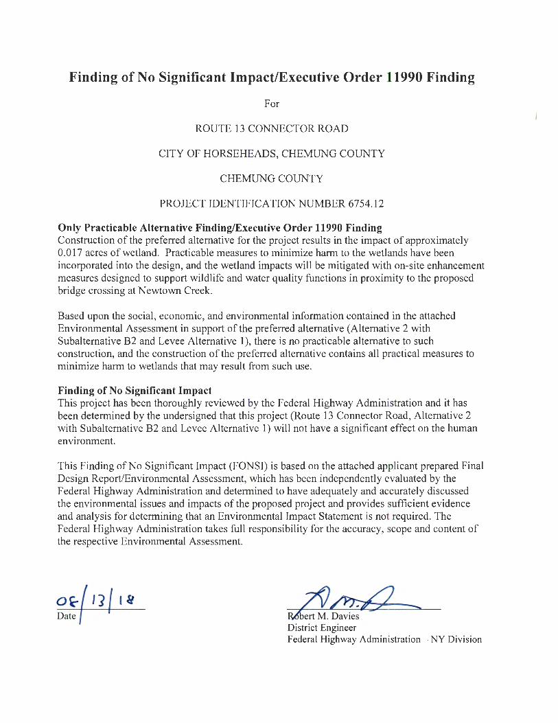
Finding of No Significant Impact/Executive Order 11990 Finding
For
ROUTE 13 CONNECTOR ROAD
CITY OF HORSEHEADS, CHEMUNG COUNTY
CHEMUNG COUNTY
PROJECT IDENTIFICATION NUMBER 6754.12
Only Practicable Alternative Finding/Executive Order 11990 Finding Construction of the preferred alternative for the project results in the impact of approximately 0.017 acres of wetland. Practicable measures to minimize harm to the wetlands have been incorporated into the design, and the wetland impacts will be mitigated with on-site enhancement measures designed to support wildlife and water quality functions in proximity to the proposed bridge crossing at Newtown Creek.
Based upon the social, economic, and environmental information contained in the attached Environmental Assessment in support of the preferred alternative (Alternative 2 with Subalternative B2 and Levee Alternative 1), there is no practicable alternative to such construction, and the construction of the preferred alternative contains all practical measures to minimize harm to wetlands that may result from such use.
Finding of No Significant Impact This project has been thoroughly reviewed by the Federal Highway Administration and it has been determined by the undersigned that this project (Route 13 Connector Road, Alternative 2 with Subalternative B2 and Levee Alternative 1) will not have a significant effect on the human environment.
This Finding of No Significant Impact (FONS I) is based on the attached applicant prepared Final Design Report/Environmental Assessmen_t, which has been independently evaluated by the Federal Highway Administration and determined to have adequately and accurately discussed the environmental issues and impacts of the proposed project and provides sufficient evidence and analysis for determining that an Environmental Impact Statement is not required. The Federal Highway Administration takes full responsibility for the accuracy, scope and content of the respective Environmental Assessment.
o~ I] '" Date &dbert M . Davies
District Engineer Federal Highway Administration - NY Division

iii
LIST OF PREPARERSGroup Director Responsible for Production of the Design Approval Document:
Paul J. Presutti, PE, Principal Associate, Erdman Anthony
Description of Work Performed: Directed the preparation of the Design ApprovalDocument in accordance with established standards, policies, regulations andprocedures, except as otherwise explained in this document.
Note: It is a violation of law for any person, unless they are acting under the direction of a licensed professionalengineer, architect, landscape architect, or land surveyor, to alter an item in any way. If an item bearing the stamp ofa licensed professional is altered, the altering engineer, architect, landscape architect, or land surveyor shall stampthe document and include the notation "altered by" followed by their signature, the date of such alteration, and aspecific description of the alteration.

iv
COVER .................................................................................................................................................... iPROJECT APPROVAL SHEET ............................................................................................................... iiLIST OF PREPARERS ............................................................................................................................ iiiTABLE OF CONTENTS ...........................................................................................................................iv
CHAPTER 1 - EXECUTIVE SUMMARY ............................................................................................... 1-11.1. Introduction .................................................................................................................................... 1-11.2. Purpose and Need ......................................................................................................................... 1-1
1.2.1. Where is the Project Located? .............................................................................................. 1-11.2.2. Why is the Project Needed? .................................................................................................. 1-31.2.3. What are the Objectives/Purposes of the Project? ................................................................. 1-4
1.3. What Alternative(s) Are Being Considered? ................................................................................... 1-41.4 How will the Alternative(s) Affect the Environment? ....................................................................... 1-101.5. What Are The Costs & Schedules? .............................................................................................. 1-111.6. Which Alternative is Preferred? .................................................................................................... 1-121.7. What are the Opportunities for Public Involvement? ..................................................................... 1-12
CHAPTER 2 - PROJECT CONTEXT: HISTORY, TRANSPORTATION PLANS, CONDITIONS ANDNEEDS................................................................................................................................................. 2-12.1. Project History ............................................................................................................................... 2-12.2. Transportation Plans and Land Use ............................................................................................... 2-2
2.2.1. Local Plans for the Project Area ............................................................................................ 2-22.2.2. Transportation Corridor ......................................................................................................... 2-2
2.3. Transportation Conditions, Deficiencies and Engineering Considerations ....................................... 2-52.3.1. Operations (Traffic and Safety) & Maintenance ..................................................................... 2-52.3.2. Multimodal .......................................................................................................................... 2-122.3.3. Infrastructure ...................................................................................................................... 2-132.3.4. Potential Enhancement Opportunities ................................................................................. 2-172.3.5. Miscellaneous ..................................................................................................................... 2-18
CHAPTER 3 – ALTERNATIVES .......................................................................................................... 3-13.1. Alternatives Considered and Eliminated from Further Study ........................................................... 3-13.2. Reasonable Build Alternatives ....................................................................................................... 3-3
3.2.1. Description of Reasonable Alternatives ................................................................................. 3-33.2.2 Preferred Alternative .............................................................................................................. 3-63.2.3. Design Criteria for Reasonable Alternative(s) ........................................................................ 3-6
3.3. Engineering Considerations ......................................................................................................... 3-143.3.1. Operations (Traffic and Safety) & Maintenance ................................................................... 3-143.3.2. Multimodal .......................................................................................................................... 3-213.3.3. Infrastructure ...................................................................................................................... 3-223.3.4. Landscape and Environmental Enhancements .................................................................... 3-283.3.5. Miscellaneous ..................................................................................................................... 3-28
CHAPTER 4 - SOCIAL, ECONOMIC AND ENVIRONMENTAL CONDITIONS ANDCONSEQUENCES ............................................................................................................................... 4-14.1 Introduction ..................................................................................................................................... 4-1
4.1.1 Environmental Classification ................................................................................................. 4-14.1.2 Coordination with Agencies.................................................................................................... 4-1
4.2 Social ............................................................................................................................................. 4-24.2.1 Land Use ............................................................................................................................... 4-24.2.2 Neighborhoods and Community Cohesion ............................................................................. 4-34.2.3 Social Groups Benefited or Harmed ....................................................................................... 4-4
TABLE OF CONTENTS

v
4.2.4 School Districts, Recreational Areas, and Places of Worship.................................................. 4-44.3 Economic........................................................................................................................................ 4-4
4.3.1 Regional and Local Economies .............................................................................................. 4-44.3.2 Business Districts .................................................................................................................. 4-54.3.3 Specific Business Impacts ..................................................................................................... 4-5
4.4 Environmental................................................................................................................................. 4-54.4.1 Wetlands ............................................................................................................................... 4-54.4.2 Surface Waterbodies and Watercourses ................................................................................ 4-64.4.3 Wild, Scenic, and Recreational Rivers.................................................................................... 4-74.4.4 Navigable Waters .................................................................................................................. 4-84.4.5 Floodplains ............................................................................................................................ 4-84.4.6 Coastal Resources ................................................................................................................ 4-94.4.7 Groundwater Resources, Aquifers, and Reservoirs .............................................................. 4-104.4.8 Stormwater Management ..................................................................................................... 4-114.4.9 General Ecology and Wildlife Resources ............................................................................. 4-114.4.10 Critical Environmental Areas .............................................................................................. 4-144.4.11 Historic and Cultural Resources ......................................................................................... 4-144.4.12 Parks and Recreational Resources .................................................................................... 4-164.4.13 Visual Resources ............................................................................................................... 4-174.4.14 Farmlands ......................................................................................................................... 4-174.4.15 Air Quality .......................................................................................................................... 4-174.4.16 Energy ............................................................................................................................... 4-194.4.17 Noise ................................................................................................................................. 4-244.4.18 Asbestos ........................................................................................................................... 4-264.4.19 Hazardous Waste and Contaminated Materials .................................................................. 4-26
4.5 Construction Effects ...................................................................................................................... 4-284.5.1 Construction Impacts ........................................................................................................... 4-284.5.2 Mitigation Measures............................................................................................................. 4-29
4.6 Indirect and Secondary Effects ..................................................................................................... 4-294.7 Cumulative Effects ........................................................................................................................ 4-304.8 Short-Term Uses of Man’s Environment and the Maintenance and Enhancement of Long-Term
Productivity .............................................................................................................................. 4-314.9 Irreversible and Irretrivable Commitments of Resources ................................................................ 4-314.10 Adverse Environmental Impacts that Cannot be Avoided or Adequately Mitigated ....................... 4-31

vi
AppendicesA1. Roadway Typical Sections, Plans & Profiles (Bound Separately)
A2. Levee Typical Sections & Plans (Bound Separately)
B1. Environmental Information
B2. Air Quality Analysis (Bound Separately)
B3. Hazardous Waste / Contaminated Materials Screening Report (Bound Separately)
C1. Traffic Analysis
C2. Traffic Analysis Backup (Bound Separately)
C3. Accident Analysis
C4. Complete Streets Checklist / Smart Growth Screening Tool
D. Pavement Information
E1. Geotechnical Evaluation (Bound Separately)
E2. Floodplain Evaluation Report (Bound Separately)
F. Public Involvement Plan
G. Right-of-Way Information


June 2018 Final Design Report / Environmental Assessment PIN 6754.12
1-1
CHAPTER 1 - EXECUTIVE SUMMARY
1.1. Introduction
This report was prepared in accordance with the NYSDOT Project Development Manual, 17 NYCRR(New York Codes, Rules and Regulations) Part 15, and 23 CFR (Code of Federal Regulations) 771.Transportation needs have been identified (section 1.2.2), objectives established (1.2.3) to address theneeds, and cost-effective alternatives developed (1.3). This project is federally funded.
This report was prepared in accordance with the NYSDOT Procedures for Locally Administered FederalAid Projects, the State Environmental Quality Review Act (SEQR, 6NYCRR Part 617) and NationalEnvironmental Policy Act (NEPA, 23 CFR 771). The SEQR Lead Agency is Chemung County.
1.1.1. Summary of Revisions
In general, this Final Design Report/Environmental Assessment is an update of the 2011 report withadditional improvements that include levee repairs and extension of the levee to the north, traffic calming,drainage improvements, intersection re-alignment and additional paving on Old Ithaca Road, and theaddition of a right turn lane on Wygant Road. Under the previous report’s preferred alternative, the Route13 / Connector Road intersection was signalized and the Old Ithaca Road / Connector Road intersectionincluded alternatives for both a signalized and roundabout intersection. Since then, a new roundabout hasbeen constructed at the intersection of Route 13 and Franklin Street and recent public outreach hassupported the installation of roundabouts at the Route 13 and Old Ithaca Road proposed intersectionswith the new connector road. As a result, the preferred alternative was modified to include proposedroundabouts at these locations. On May 15, 2018 a public hearing for the project was held at theAmerican Legion in Horseheads, NY. The comments received and resolution of those comments arelocated in Appendix F.
1.2. Purpose and Need
1.2.1. Where is the Project Located?
The project is located in the Town and Village of Horseheads, Chemung County, New York.

June 2018 Final Design Report / Environmental Assessment PIN 6754.12
1-2
Exhibit 1.2.1Project Location Map
Project StudyArea
ProjectImprovement
Area

June 2018 Final Design Report / Environmental Assessment PIN 6754.12
1-3
1.2.2. Why is the Project Needed?
The project is needed to address existing and emerging traffic, mobility, and access deficiencies withinthe Town and Village of Horseheads in the vicinity of the Horseheads Sand & Transloading (HOST)Terminal, formerly known as Center at Horseheads (CHH) industrial park. The need for the project hasbeen identified in various studies over the past decade, and has been included in the Elmira-ChemungTransportation Council Transportation Improvement Program (TIP) (2017-2021).
The HOST Terminal is a 500-acredecommissioned military facilitythat has been converted to private,civilian use. In 2011, the HOSTTerminal was purchased andrepositioned to capitalize on thefracking boom. Approximately 200acres of the facility are owned bythe HOST Terminal, while theremaining lands are home to manyindustrial facilities. Of those 200acres, approximately 60 acres areundeveloped and the remaining140 contain 2.1 million square feetof warehouse and industrial space.
Truck and automobile access tothe HOST Terminal from I-86 is primarily accomplished via NY Route 13 and to a lesser extent NY Route14. Route 13 is a two-lane road linking I-86 with the Finger Lakes Region. It is generally limited accessand has a higher class than Route 14, which is also a two-lane road linking I-86 with Watkins Glen.Neither route offers direct access to the HOST Terminal and requires truck and commuter traffic to passthrough residential areas, as well as the historic Hanover Square intersection of the Village ofHorseheads. The lack of direct, easily accessible routes for commuter and heavy truck traffic is commonlycited by potential developers as a significant barrier to locating at the HOST Terminal. As a result, thepark is largely unoccupied both in existing buildings and undeveloped lands.
In 2004 the Town of Horseheads Routes 13 and 14 Corridor Management Assessment examined thepotential impacts of growth along Route 13 and Route 14 within the communities and suggested ways toaccommodate and manage that growth. Among its recommendations was the construction of two newroadways connecting Old Ithaca Road with Route 13, north and south of the Hanson Aggregates gravelmining operation. These roadways would support the management of development throughout the areaand relieve the burden of industrial traffic on local roads.
In 2006 Southern Tier Economic Growth (STEG), in conjunction with the Elmira-Chemung TransportationCouncil (ECTC), commissioned a concept-level study for a corridor connecting the HOST Terminal withRoute 13. Various alternative roadway alignments through the Hanson Aggregates and surroundingproperties were examined to identify the preferred alignment, determine right-of-way requirements,estimate costs, and summarize potential issues associated with its construction and operation. Onepreferred alternative was identified based on comparison and analysis of these factors.
In 2015, the Elmira-Chemung Transportation Council developed Plan 2035 Elmira Urbanized AreaFreight Movement Study. The study identified the lack of a direct connection to the HOST to State Route13 as a potential freight connectivity issue. A connector road would provide quick and convenient accessto I-86.
Exhibit 1.2.2Aerial Image of the HOST Terminal

June 2018 Final Design Report / Environmental Assessment PIN 6754.12
1-4
1.2.3. What are the Objectives/Purposes of the Project?
The project will be developed with the following objectives:
§ Accommodate commuter and large truck travel to the HOST Terminal by eliminating encumbrancesfrom mobility and geometric deficiencies in residential areas within and surrounding the Village ofHorseheads, including historic Hanover Square.
§ Maintain access management on Route 13 and reduce requests for breaks in access related todevelopment of abutting properties.
§ Reduce the rate of pavement deterioration improve roadside drainage, and maintain rideability ofaffected local streets and roads as funds allow.
§ Obtain sustainable FEMA accreditation of the existing 5,000’± long levee located along the west sideof Newtown Creek that was originally constructed to protect the Elmira Holding and ReconsignmentPoint facility (now known as the HOST Terminal), which also provides flood risk reduction to thesurrounding Town and Village of Horseheads. If Newtown Creek and this levee are to be traversedby any build alternative, FEMA accreditation is needed in order for any Conditional Letter of MapRevision (CLOMR), necessary for the project’s construction, can be approved.
1.3. What Alternative(s) Are Being Considered?
The following alternatives are being considered:
§ Alternative 1: “Null” or No Action§ Alternative 2: New Connector Road incorporating
o Subalternative B2: Roundabout on Old Ithaca Road with Direct Connection to 5th Streeto Levee Alternative 1: Levee Improvement and Extension on New Alignment.
Alternative 1: “Null” or No ActionThis alternative provides for only continued maintenance of the existing roadway network. No operationalor safety improvements would be implemented; therefore, historic Hanover Square and the residentialneighborhoods within the project study area would continue to be burdened by increasing truck andcommuter traffic.
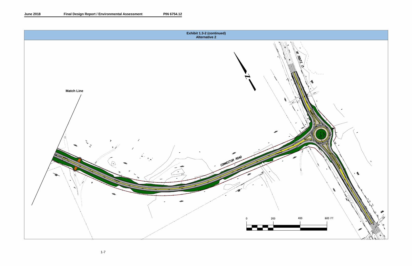
Alternative 2: New Connector RoadThis alternative provides for the construction of a new connector road from the HOST Terminal to Route13. One 12-foot travel lane would be provided in each direction on the new roadway, along with a 4-footshoulder in curbed areas and an 8-foot shoulder in open areas. A single-lane modern roundabout wouldbe constructed on Route 13. A new 238-foot, 2-span, curved multi-girder bridge would be constructedover Newtown Creek.
South of the proposed connector road, the existing levee adjacent to Old Ithaca Road would bereconstructed in-kind where necessary due to its deterioration. In addition, the portion of the levee northof the proposed connector road would be reconstructed to replace the old levee that has beencompromised by development and vegetation. The northern portion of the levee will be constructed asdescribed below. A right turn would be added on Wygant Road at NYS Route 14. Two railroad crossingswould be replaced on Wygant Road immediately east of NYS Route 14. Landscaping in the form ofconifer (evergreen) trees would be considered along the east side of Route 13 adjacent to the propertieson Camelot Drive to provide a gateway element for the project and to address a concern from theneighborhood. Refer to Exhibit 1.3-2 for a rendering of the proposed improvements. As funds allow, thefollowing would be included along Old Ithaca Road: New curb and drainage improvements would beinstalled and the pavement width would be reduced between the town line and the south approach to thenew connector road and from the north approach to the new connector road to NY Route 13. Ridge Roadwould be realigned perpendicular to Old Ithaca Road. The pavement on Old Ithaca Road would be milledand overlaid between Hanover Square and the south approach to the new connector road and from thenorth approach to the new connector road to NY Route 13.

June 2018 Final Design Report / Environmental Assessment PIN 6754.12
1-5
Subalternative B2: Roundabout on Old Ithaca Road with Direct Connection to 5th StreetThis subalternative provides for the construction of a single-lane modern roundabout at the intersection ofOld Ithaca Road and the new connector road. 5th Street would be realigned to intersect with the newconnector road and E Street would be shifted easterly to provide additional buffer space near trucksparked in the loading bays of Building 13-1. Traffic on E Street would be stop-controlled while 5th Streetwould remain uncontrolled. This would improve access to the south side of the HOST Terminal andreduce the potential for conflicts with the new roundabout at Old Ithaca Road. Refer to Exhibit 1.3-B2 fora rendering of the proposed improvements.
Levee Alternative 1: Levee Improvement and Extension on New Alignment.Under this levee improvement alternative, the levee would be extended further north to naturally tie intoexisting high ground. Beginning approximately 650 south of the existing levee’s northern terminus, thelevee alignment would shift northeasterly and then back northerly in order to pass east of existingdeveloped lands. This extension to the north on shifted alignment totals approximately 1,600 feet. Theremaining 4,350 levee would be improved where warranted such that the entire length of the levee wouldmeet current FEMA standards for accreditation as a flood control structure. Under this alternative, newpermanent easements for the levee’s construction and continued operations and maintenance would beneeded from up to four properties. The levee alternative is shown in the plan drawings in Appendix A.


June 2018 Final Design Report / Environmental Assessment PIN 6754.12
1-6
Exhibit 1.3-2Alternative 2 with Subalternative B2
Match Line
June 2018 Final Design Report / Environmental Assessment PIN 6754.12
1-7
Exhibit 1.3-2 (continued)Alternative 2
Match Line

June 2018 Design Report / Environmental Assessment PIN 6754.12
1-8
The following alternatives and subalternatives were considered and have been eliminated from furtherstudy:
§ Alternative 3: Improve Existing Roadway Network§ Subalternative AO: Minor Intersection Improvements on Old Ithaca Road§ Subalternative A1: Unsignalized Conventional Intersection with Auxiliary Lanes on Old Ithaca Road§ Subalternative A2: Signalized Intersection with Auxiliary Lanes on Old Ithaca Road and Direct
Connection to 5th Street§ Subalternative A3: Auxiliary Lanes on Old Ithaca Road with Direct Connection to E Street§ Subalternative B1: Roundabout on Old Ithaca Road§ Subalternative B3: Roundabout on Old Ithaca Road with Direct Connection to E Street§ Subalternative C1: Signalized intersection on Route 13§ Subalternative C2: Unsignalized Conventional Intersection on Route 13§ Levee Alternative 2: Levee Improvement and Reestablishment along Alex Drive
Alternative 3: Improve Existing Roadway NetworkThis alternative provides for continued maintenance of the existing roadway network with operational andsafety improvements on Route 14, Old Ithaca Road, as well as the Hanover Square intersection.Operational improvements at Hanover Square would require the addition of auxiliary lanes as well aswidened intersection turn radii to better accommodate large trucks. Doing so would likely involve removalor alteration of historically significant properties and would require significant right-of-way acquisition. Inaddition, historic Hanover Square and the residential neighborhoods within the project study area wouldcontinue to be burdened by increasing truck and commuter traffic. This alternative was considered andrejected as it does not address all of the project objectives.
Subalternative AO: No Intersection Improvements on Old Ithaca RoadThis subalternative provides for construction of minor intersection improvements at Old Ithaca Road inconcert with the new connector road. The existing lane configuration on Old Ithaca Road would remainone lane in each direction. The 5th Street approach would be realigned slightly to intersect perpendicularto Old Ithaca Road. This subalternative would provide acceptable levels of service until shortly aftercompletion of the project, but would likely result in operational conflicts with the E Street and 5th Streetintersection. This alternative was considered and rejected as it does not address all of the projectobjectives.
Subalternative A1: Unsignalized Conventional Intersection with Auxiliary Lanes on Old Ithaca RoadThis subalternative provides for the construction of an unsignalized 4-leg intersection at Old Ithaca Roadand the new connector road. 5th Street would be realigned slightly to intersect perpendicular to Old IthacaRoad. Dedicated northbound left and southbound left turn lanes would be added to Old Ithaca Road toimprove intersection level of service. Traffic would be stop controlled on the connector road and 5th streetlegs of the intersection. This subalternative meets all of the project objectives, but would likely result inoperational conflicts with the E Street and 5th Street intersection and has been rejected.
Subalternative A2: Signalized Intersection with Auxiliary Lanes on Old Ithaca Road and Direct Connectionto 5th StreetThis subalternative provides for the construction of a conventional signalized 4-leg intersection at OldIthaca Road and the new connector road, with dedicated northbound left and southbound left turn laneson Old Ithaca Road. 5th Street would be realigned to intersect with the new connector road and E Streetwould be shifted easterly to provide additional buffer space near trucks parked in the loading bays ofBuilding 13-1. Traffic on E Street would be stop-controlled while 5th Street would remain uncontrolled.This would improve access to the south side of the HOST Terminal and reduce the potential for conflictswith the new intersection at Old Ithaca Road. This subalternative meets all of the project objectives.However, its expected traffic and safety operational outcomes are less than that of Subalternative B2, theRoundabout; and it was significantly less favored based on comments received at the July 24, 2017Public Informational Meeting. Therefore, this subalternative has been dropped from further consideration.

June 2018 Design Report / Environmental Assessment PIN 6754.12
1-9
Subalternative A3: Auxiliary Lanes on Old Ithaca Road with Direct Connection to E StreetThis subalternative provides for the construction of a conventional signalized 4-leg intersection at OldIthaca Road and the new connector road with dedicated northbound left and southbound left turn laneson Old Ithaca Road. E Street would be relocated to intersect with the new connector road and provideadditional buffer space near trucks parked in the loading bays of Building 13-1. 5th Street would berealigned to intersect with E Street at a tee intersection. Traffic on 5th Street would be stop-controlledwhile E Street would remain uncontrolled. This subalternative meets all of the project objectives, butwould likely result in operational conflicts with queues of westbound left turning vehicles at the 5th Streetintersection and has been rejected.
Subalternative B1: Roundabout on Old Ithaca RoadThis subalternative provides for the construction of a single-lane modern roundabout at the intersection ofOld Ithaca Road and the new connector road. 5th Street would be realigned slightly to intersectperpendicular to Old Ithaca Road. This subalternative meets all of the project objectives, but would likelyresult in operational conflicts with the E Street and 5th Street intersection and has been rejected.
Subalternative B3: Roundabout on Old Ithaca Road with Direct Connection to E StreetThis subalternative provides for the construction of a single-lane modern roundabout at the intersection ofOld Ithaca Road and the new connector road. E Street would be relocated to intersect with the newconnector road and provide additional buffer space near trucks parked in the loading bays of Building 13-1. 5th Street would be realigned to intersect with E Street at a tee intersection. Traffic on 5th Street wouldbe stop-controlled while E Street would remain uncontrolled. This subalternative meets all of the projectobjectives, but would likely result in operational conflicts with queues of westbound left turning vehicles atthe 5th Street intersection and has been rejected.
Subalternative C1: Signalized intersection on Route 13This subalternative provides for the construction of a dedicated northbound left turn lane and a trafficsignal at the intersection of Route 13 and the new connector road. The lane configuration on Route 13would remain one lane in each direction. This subalternative would provide acceptable levels of service;however, would not provide continuity between intersections along Route 13. The existing adjacentintersections to the north and south of the proposed Connector Road were recently reconstructed tomodern roundabouts. This subalternative would likely result in operational conflicts with queues ofnorthbound vehicles at the Route 13 intersection and has been rejected.
Subalternative C2: Unsignalized Conventional Intersection on Route 13This subalternative provides for the construction of a conventional tee intersection at Route 13 with adedicated northbound left turn lane and eastbound right turn lane. Traffic on the Connector Road legwould be stop controlled and Route 13 would be uncontrolled. This subalternative would not meet theoperational goals of the project and has been rejected.
Levee Alternative 2: Levee Improvement and Reestablishment along Alex Drive.Under this alternative, the existing earth embankment levee would be improved and generally re-established on its existing alignment. In order to minimize impacts on existing developed land, theproposed levee reestablishment along Alex Drive would consist of a new flood wall located along thesouth side of the street, approximately 4 to 6 feet in height. This proposed wall would likely beconstructed of either a precast or cast-in-place Portland cement concrete. The improved andreestablished levee would be approximately 5,300 feet in length; and would be constructed and improvedto meet current FEMA standards for accreditation as a flood control structure. This alternative wouldsignificantly impact a residential property along Alex Drive and require substantial ground disturbance tobuild a new flood wall along Alex Drive. The cost and future maintenance of the proposed flood wallwould be undesirable by the stakeholders. Therefore, this alternative was eliminated from furtherconsideration.
Refer to section 3.2.3 of this report for in-depth discussion of the design criteria, and to section 3.3.3.2 fornon-standard features and non-conforming features.

June 2018 Design Report / Environmental Assessment PIN 6754.12
1-10
1.4 How will the Alternative(s) Affect the Environment?
Refer to Chapter 4 for mitigation measures that are proposed for the project, and to Section 3.2.1 fordetailed information for the preferred alternatives.
Anticipated Permits/Certifications/Coordination:
Coordination:§ Coordination with Federal Highway Administration§ Coordination with New York State Department of Transportation§ Coordination with New York State Office of Parks, Recreation, and Historic Preservation
(NYSOPRHP) State Historic Preservation Office§ Coordination with the US Fish and Wildlife Service§ Coordination with the New York Natural Heritage Program§ Coordination with local municipalities and elected officials§ Coordination with the project steering committee§ Coordination with the public
Certifications:§ FEMA Levee Certification
Exhibit 1.4-AEnvironmental Summary
NEPA Classification Class III BY FHWA Date Pending
SEQR Type: Non-Type II (EA) BY Chemung County Date Pending
Permits that would be required during Final Design:§ FEMA Conditional Letter of Map Revision (CLOMR) for Levee & Bridge§ NYSDEC State Pollutant Discharge Elimination System (SPDES) General Permit§ Town of Horseheads Floodplain Development Permit§ NYSDEC Section 401/Title 5 Water Quality Certification§ USACE Section 404 Nationwide Permit #14 - Linear Transportation Projects§ FEMA Letter of Map Revision (LOMR) upon completion of construction.
Exhibit 1.4-BComparison of Alternatives
CategoryAlternative/Subalternative
1 2 with B2Wetland impact None None100-year floodplain impact None 3.90 acresCultural resource impacts None NoneNoise Minor impact Minor impactSoil disturbance None 9.66 acres
Property impacts None
17.5 acres13 commercial4 residential2 municipal
Hanover Square operation at ETC+20 LOS D (AM)LOS E (PM)
LOS C (AM)LOS C (PM)
Old Ithaca Road / E Street operation atETC+20
LOS F (AM)LOS F (PM)
LOS D (AM)LOS C (PM)
Wygant Road / A Street LOS E (AM)LOS F (PM)
LOS D (AM)LOS E (PM)
Project cost (2018) None $23.0M

June 2018 Design Report / Environmental Assessment PIN 6754.12
1-11
The following permits would be required for the build alternative(s):
FEMA:§ Conditional Letter of Map Revision (CLOMR)§ Letter of Map Revision (upon completion of construction)
NYS Department of Environmental Conservation (NYSDEC):§ State Pollutant Discharge Elimination System (SPDES) General Permit§ Section 401/Title 5 Water Quality Certification in concert with Section 404 Nationwide Permit
NYS Department of Transportation (NYSDOT):§ Highway Work Permit
US Coast Guard (USCG):§ None
US Army Corps of Engineers (USACE):§ Section 404 Nationwide Permit #14 - Linear Transportation Projects
1.5. What Are The Costs & Schedule?
Design Approval is scheduled for June of 2018 with construction scheduled to last 36 months beginningin March of 2019. The project will be constructed in two phases. The first phase will repair and extend thelevee, and is a federally required pre-requisite for phase 2. The second phase will construct the Route 13Connector Road and bridge over Newtown Creek. NYSDOT will pay for the first phase levee constructionusing state funds, while the second phase will utilize federal funds.
The anticipated project schedule and project costs can be seen in the following Exhibits.
Exhibit 1.6-AProject Schedule
Activity Date Occurred/Tentative
Scoping Approval December 2016
Design Approval June 2018
ROW Acquisition August 2018
Construction Start March 2019
Construction Complete October 2021
Exhibit 1.6-BSummary of Alternative Costs (2018)
Activities Alt. 1 Alt. 2 with“Null”/No Action Subalt. B2
ConstructionCosts
Bridge $0 $3,300,000
Highway $0 $8,450,000
Levee Improvements $0 $2,200,000
SPDES Mitigation Costs $0 $250,000
Incidentals1 (10%) $0 $1,420,000
Subtotal $0 $15,620,000
Contingency2 (20%) $0 $3,124,000
Subtotal $0 $18,744,000
Potential Field Change Order3 $0 $713,000

June 2018 Design Report / Environmental Assessment PIN 6754.12
1-12
Subtotal $0 $19,457,000
Mobilization (4%) $0 $779,000
Subtotal $0 $20,236,000
Construction Inspection (10%) $0 $2,024,000
ROW Costs $0 $800,000
Total Project Costs $0 $23,060,000Notes:1. The potential cost increase due to unknown or un-tabulated items.2. NYSDOT recommended standard contingencies: 25% Scoping stage, 15% Design Approval
stage, 5% Advanced Detail Plans stage.3. According to HDM Chapter 21 Section 21.3.9.4, EB 03-029 & EB 06-057.
For more detail on costs for each alternative refer to Section 3.2.1.
1.6. Which Alternative is Preferred?Alternative 2 in conjunction with Sub-Alternative B2 (roundabout) and Levee Alternative 1 have beenidentified as the feasible and prudent build alternative / sub-alternative that best meets the projectobjectives.
1.7. What are the Opportunities for Public Involvement?Chemung County is the project sponsor, as well as the SEQR Lead Agency, and is responsible forselection of the preferred alternative/subalternative, including the preferred levee alternative. Thepreferred alternative/subalternative will be selected after extensive coordination with regulatory agencies,project stakeholders, and the public. A steering committee was formed to provide input andrecommendations for the project design process. Representative steering committee members included:
§ Chemung County Department of Public Works§ Elmira-Chemung Transportation Council (ECTC)§ Southern Tier Economic Growth (STEG)§ New York State Department of Transportation (NYSDOT)§ Village of Horseheads§ Town of Horseheads§ Property owners and businesses within the HOST Terminal and adjacent to the project§ Project engineering/environmental consultants
The public involvement schedule is included in Exhibit 1.8.
Exhibit 1.8Public Involvement Plan Schedule of Milestone Dates
Activity Date Occurred/Tentative
Internal Scoping Meeting December 2016
Public Informational Meeting July 2017
Public Hearing May 2018
Project Letting February 2019
A public meeting and public hearing was previously held when the original Design Report / EnvironmentalAssessment was completed in 2011. Recently, a public information meeting was held to obtain feedbackfrom the community. A public hearing was held in May 2018. Refer to Appendix F for input fromstakeholders including the public as well as a transcript from the 2011 and 2018 public hearings.
June 2018 Design Report / Environmental Assessment PIN 6754.12
1-13
For additional information regarding the project, contact:
Elissa ManwaringChemung County Department of Public Works
email: [email protected]: (607) 739-3896
Mailing Address:Chemung County Department of Public Works
803 Chemung StreetHorseheads, New York 14845
Please identify this project as Route 13 Connector Road and include the six digit Project IdentificationNumber (PIN) 6754.12 in all correspondence and when requesting additional information.
The remainder of this report is a detailed technical evaluation of the existing conditions, the proposedalternatives, the impacts of the alternatives, copies of technical reports and plans and other supportinginformation.

June 2018 Final Design Report / Environmental Assessment PIN 6754.12
2-1
CHAPTER 2 - PROJECT CONTEXT: HISTORY, TRANSPORTATIONPLANS, CONDITIONS AND NEEDS
This chapter addresses the history and existing context of the project site, including the existingconditions, deficiencies, and needs for the subject study area.
2.1. Project HistoryThe need for the project has been identified in various studies over the past decade, including the Townof Horseheads Routes 13 and 14 Corridor Management Study (2004), the Center at HorseheadsHighway Corridor Analysis (2006), Center at Horseheads Connector Road Draft Design Report /Environmental Assessment (2010), and Plan 2035 Elmira Urbanized Area Freight Movement Study(2015).
In 2004 the New York State Department of Transportation (NYSDOT) examined the potential impacts ofgrowth along Route 13 and Route 14 within the communities and suggested ways to accommodate andmanage that growth. Among its recommendations was the construction of two new roadways connectingOld Ithaca Road with Route 13, north and south of the Hanson Aggregates gravel mining operation.These roadways would support the management of development throughout the area and relieve theburden of industrial traffic on local roads.
In 2006, Southern Tier Economic Growth (STEG), in conjunction with the Elmira-Chemung TransportationCouncil (ECTC), commissioned a concept-level study for a corridor connecting the former Center atHorseheads (CHH) with Route 13. Two alternative roadway alignments north of, and three south of, theHanson Aggregates and surrounding properties were examined to identify the preferred alignment,determine right-of-way requirements, estimate costs, and summarize potential issues associated with itsconstruction and operation. One preferred alternative was identified based on comparison and analysis ofthese factors.
In 2010, Erdman Anthony, in conjunction with Chemung County completed a Draft Design Report /Environmental Assessment for what is now referred to in this report as the Route 13 Connector Road.The report discussed the need for a connector road between the HOST facility and Route 13. Due to alack of funding, the project was delayed. In 2016, New York State secured funding for the project and thereport was started again. This Draft Design Report/Environmental Assessment will supersede thepreviously published 2011 report.
In general, this Draft Design Report/Environmental Assessment is an update of the 2011 report withadditional improvements that include levee repairs and extension of the levee to the north, traffic calming,drainage improvements, intersection re-alignment and additional paving on Old Ithaca Road, and theaddition of a right turn lane on Wygant Road. Under the previous report’s preferred alternative, the Route13 / Connector Road intersection was signalized and the Old Ithaca Road / Connector Road intersectionincluded alternatives for both a signalized and roundabout intersection. Since then, a new roundabout hasbeen constructed at the intersection of Route 13 and Franklin Street and recent public outreach hassupported the installation of roundabouts at the Route 13 and Old Ithaca Road proposed intersectionswith the new connector road. As a result, the preferred alternative was modified to include proposedroundabouts at these locations.
In 2015, the Elmira-Chemung Transportation Council developed Plan 2035 Elmira Urbanized AreaFreight Movement Study. The study identified the lack of a direct connection to the HOST to State Route13 as a potential freight connectivity issue. A connector road would provide quick and convenient accessto I-86.
The 2006 study served as the initial scoping document for the subject project. The project wasprogrammed by NYSDOT’s Statewide Transportation Improvement Program (STIP) and included in theECTC Transportation Improvement Program (TIP) in 2016.

June 2018 Final Design Report / Environmental Assessment PIN 6754.12
2-2
2.2. Transportation Plans and Land Use
2.2.1. Local Plans for the Project Area
2.2.1.1. Local Comprehensive Plans (“Master Plan”) -
The Village of Horseheads Comprehensive Plan (2010) was reviewed to determine the community’s localplanning efforts for the project study area. The document identified issues with traffic, lack of truck and railaccess, and lack of capital investment as a hurdle to redevelopment of the HOST Terminal.Recommendations for improving vehicular and rail access to the site were identified as a means ofrealizing the economic development potential of the HOST Terminal. In addition, preservation of theRoute 14 / Westinghouse Road corridor to maintain the residential nature of the area, and visualenhancement of the gateways to the village were also identified as community goals.
The Town of Horseheads indicated that they do not currently have a comprehensive plan in place.
2.2.1.2. Local Private Development Plans –
The HOST Terminal and surrounding properties are the subject of redevelopment plans in various stagesof completion. Current plans, as discussed with the manager of the HOST facility include:
· FedEx anticipates expanding their operation to generate up to 250 additional trucks in the nexttwo years.
· Schlumberger Technology Corporation, an international company that provides support servicesto the natural gas industry, operates a gas field services facility on an 88-acre parcel in the HOSTTerminal. At one point, there were 300 employees at the facility, but currently there are only 4.The facility is set up to become fully operational with generation of around 600 new vehicle tripsper day at any point.
· Kayden Industries, a manufacturer of centrifuges for gas drilling operations, constructed a smallmaintenance shop on a 3.56-acre parcel (G) at the intersection of E Street and 2nd Street. Thisfacility currently does not have any employees, but is set up to become operational at any point.
· Thomas & Betts, a designer and manufacturer of connectors and components for electrical andcommunication markets, currently has 50-75 employees with the potential to expand theoperations.
· In 2014, when gas drilling via hydraulic fracturing (hydrofracking) was a significant operation inPennsylvania, there was a spike in rail and truck trips to and from the HOST facility. The facility ishopeful to regain this traffic within the next 2-3 years.
2.2.2. Transportation Corridor
2.2.2.1. Importance of the Project Route Segment –
Truck and automobile access to the HOST Terminal from I-86 is primarily accomplished via NY Route13 and to a lesser extent NY Route 14. Route 13 is a two-lane road linking I-86 with the Finger LakesRegion. It is generally limited access and has a higher class than Route 14, which is also a two-laneroad linking I-86 with Watkins Glen.
Old Ithaca Road is a minor arterial linking Hanover Square in the Village of Horseheads to Route 13.The frontage along Old Ithaca is largely developed in both residential and commercial uses, withcommercial uses to the south and residential clusters to the north. Old Ithaca Road serves a largecommuter function, connects residential areas in the town to services and businesses in the village,and is a designated truck access route to the HOST Terminal.

June 2018 Final Design Report / Environmental Assessment PIN 6754.12
2-3
2.2.2.2. Alternate Routes –
There are no suitable alternative routes on the existing roadway network with excess capacity to receivea diversion of existing traffic or new traffic generated by future development. Nearby arterial highways,such as Route 13 and I-86 are not easily accessible without major rerouting of travel patterns. Localroutes such as Wygant Road, Ridge Road, and North Main Street are not suitable for high traffic volumes,as they pass through residential and historically-significant areas.
2.2.2.3. Corridor Deficiencies and Needs -
Deficiencies in the existing roadway network were identified in the Town of Horseheads Routes 13 and 14Corridor Management Study (2004). The study concluded that the existing roadway network is extremelyinefficient in moving east-west traffic across the project study area. In the south, such movements areaccommodated through Hanover Square, where the five-legged intersection alignment, turn radii, andadjacent land uses are problematic. In the north, these movements are made via Wygant Road to OldIthaca Road and involve a series of turns and jogging movements through residential areas. Neither ofthese routes can accommodate truck traffic or high traffic volumes comfortably and safely.
Likewise, the movement of large truck traffic within the study area is also problematic. Access to theHOST Terminal for semi-trailer (48-foot trailer) and smaller trucks is legally accommodated by two of thethree roadway entrances. Currently, the southwest driveway entrance is closed to automobile and trucktraffic. Access for larger semi-trailers with 43-foot kingpins (53-foot trailers) is limited to designatedQualifying or Access Highways by §385(3)(e) of NYS Vehicle and Traffic Law. Unlike QualifyingHighways, where 53-foot semi-trailers are allowed to travel up to one mile off-system, Access Highwaysdo not allow for additional travel on non-designated routes – with an exception for driveway entrances.
There are no designated Qualifying Highways offering direct access to the HOST Terminal. There are twodesignated Access Highway routes to the HOST Terminal from I-86. One follows Route 14 and a portionof Wygant Road to the HOST Terminal entrance at A Street and the other follows Route 13 to Old IthacaRoad to the HOST Terminal entrance at E Street. The frontages along Route 14 and Old Ithaca Road arefully developed in residential, institutional, and some retail and commercial uses. At current trafficvolumes, truck traffic appears to cause few operational problems; however, as described in the 2004study, operational issues would be experienced as the HOST Terminal is redeveloped with truck intensiveuses or overall growth approaches levels postulated in the Route 17 economic analysis. The increasedtraffic and potentially an increased road width would impact properties along the road as well as bicycleand pedestrian users. See Exhibit 2.2.2.3 for locations of designated Access Highways and entrances tothe HOST Terminal.
The lack of direct, easily accessible routes for commuter and heavy truck traffic is commonly cited bypotential developers as a significant barrier to locating at the HOST Terminal. The need to accommodatelarge truck traffic, while minimizing impacts to Old Ithaca Road, Route 14 and residential areas, has beenidentified as a community goal.

June 2018 Final Design Report / Environmental Assessment PIN 6754.12
2-4
Exhibit 2.2.2.3Access Routes Map
ProjectImprovement
Area
Project StudyArea
HanoverSquare Access Highway
Qualifying HighwayHOST Access Point

June 2018 Final Design Report / Environmental Assessment PIN 6754.12
2-5
2.2.2.4. Transportation Plans -
This project is on the approved ECTC Transportation Improvement Program (TIP) as well as theNYSDOT Statewide Transportation Improvement Program (STIP) approved in 2017.
The ECTC Plan 2035 Long Range Transportation Plan (LRP) was reviewed for consistency with theproject needs and objectives. The plan was approved in 2014. Some of the goals listed in the LRPinclude:
· Ensuring the efficiency of freight movement throughout the region to maximize support of theeconomy.
· Integrating transportation and land-use planning to promote economic development,sustainability, and enhanced livability.
· Investing in the transportation system infrastructure to bring all facilities and modes into a state ofgood repair.
· Ensuring the safety and security of the transportation system for all users.· Actively operate the transportation system to maximize efficiency and reliability of travel.
The LRP discusses the HOST facility and how it has become a significant generator of truck traffic, asmaterials for natural gas drilling/hydrofracking, including sand and pipe, are shipped in by rail andtransloaded to truck for shipment to well development sites in northern Pennsylvania. It also mentions theproposed connector road and the significant benefits of a direct connection from NY Route 13 to theHOST facility.
2.2.2.5. Abutting Highway Segments and Future Plans for Abutting Highway Segments -
The abutting segments of Old Ithaca Road are similar in character to that of the project improvementarea. Travel lane and shoulder widths, posted speed limits, and clear zones are consistent with the areaof improvements. Chemung County has indicated that there are no plans to reconstruct or widen theabutting segments of Old Ithaca Road within the next 20 years. Routine capital projects, includingpavement maintenance and drainage improvements, will be performed as conditions warrant.
The NYSDOT recently completed a safety improvement project, PIN 6804.19, for the two existing Route13 intersections north and south of the proposed project (East Franklin Street to the south and Old IthacaRoad to the north. At both locations, the project converted the signalized intersections to roundabouts.Overall, travel lane and shoulder widths, posted speeds, geometry, and clear zones are expected toremain consistent throughout the Route 13 corridor for the foreseeable future.
Chemung County recently reconstructed and assumed ownership and maintenance responsibility for aportion of E Street within the HOST Terminal. The need for the project was identified by Chemung Countyand the Village of Horseheads, and was brought on by the need to provide adequate truck access toindustries within and adjacent to the HOST Terminal. The improvements consisted of one 12-foot travellane and 4-foot paved shoulder in each direction. No further improvements are anticipated in or aroundthe HOST facility.
The Town of Horseheads and Chemung County recently completed a project to improve stream stabilityand the existing flood control levee on the west side of Newtown Creek. This project is described infurther detail in section 4.4.5 of this report. No additional improvements to the levee are anticipated.
2.3. Transportation Conditions, Deficiencies and Engineering Considerations
2.3.1. Operations (Traffic and Safety) & Maintenance
2.3.1.1. Functional Classification and National Highway System (NHS) –
The NYSDOT functional classification of the respective roadway segments in the project improvementarea is presented in the following exhibit.

June 2018 Final Design Report / Environmental Assessment PIN 6754.12
2-6
Exhibit 2.3.1.1Classification Data
RoadwayOld
IthacaRoad
Route13 5th Street E Street Wygant
RoadRidgeRoad
Functional ClassificationUrbanMinor
Arterial
UrbanPrincipalArterial
UrbanLocal
UrbanLocal
UrbanMinor
Arterial
UrbanLocal
National Highway System(NHS) No Yes No No No No
Designated Truck AccessHighway1 Yes2 Yes No No Yes3 No
Qualifying Highway1 No No No No No NoWithin 1 mile of a Qualifying
Highway No Yes No No No No
Within the 16-ft verticalclearance network No No No No No No
Notes:1. Obtained from NYSDOTs Official Description of Designated Qualifying and Access Highways in New York
State, April 2016.2. Old Ithaca Road is designated Access Highway from E Street north to Route 13.3. Wygant Road is designated Access Highway from HOST Entrance to Route 14.
2.3.1.2. Control of Access -Access onto Old Ithaca Road is uncontrolled within the project study area. Residential and commercialdriveways are prevalent throughout the area near the 5th Street intersection with an average density of70 driveways per mile.
The right-of-way along Route 13 throughout the project study area is without access. There are nodriveways or developed properties in the area near the proposed site with the exception of a conveniencestore near the intersection of Old Ithaca Road. NYSDOT has indicated that requests for breaks in accessalong Route 13 have increased substantially in recent years, and that maintaining access control alongRoute 13 is a priority to maintain safety and capacity.
2.3.1.3. Traffic Control Devices –There is one existing signalized intersection on Wygant Road at the intersection with NYS Route 14 thathas semi-actuated, three color traffic signals suspended from span wire supported poles. Currently, thereis one westbound lane in the approach to the intersection. Motorists often use the wide right shoulder asa de-facto right turn lane.
There are no other existing traffic signals within the project improvement area. Traffic signal warrants arepresented in the Manual on Uniform Traffic Control Devices (MUTCD). A traffic signal warrant analysiswas performed at the intersection of E Street and Old Ithaca Road to determine if any warrants would bemet at the estimated time of completion (ETC) and ETC+5 assuming no improvements are made.Warrant 1 (Eight Hour Vehicular Volume) was satisfied. Refer to Appendix C for the warrant analysis andadditional information.
Signs and delineators installed throughout the project improvement area are generally in fair condition,although some show evidence of vehicular impact and loss of reflectivity. Most signs throughout theproject area appear to be in conformance with current standards, but will be investigated further as theproject progresses.
2.3.1.4. Intelligent Transportation Systems (ITS) –
There are no ITS systems in operation or planned for the project area.

June 2018 Final Design Report / Environmental Assessment PIN 6754.12
2-7
2.3.1.5. Speeds and Delay -
Posted speed limits were obtained from field observation as well as review of the Code of the Village ofHorseheads. Operating speeds for Old Ithaca Road were obtained using NYSDOT’s Speed Count HourlyReports. Speed data is presented in Exhibit 2.3.1.5-A.
Exhibit 2.3.1.5-ASpeed Data
Street NamePosted/
RegulatorySpeed
AverageSpeed
50th
PercentileSpeed
85th
PercentileSpeed
Route 13(0.4 mi. North of Franklin Street) 55 mph NB 58.6 mph
SB 59.1 mphNB 58.4 mphSB 58.9 mph
NB 63.5 mphSB 63.9 mph
Old Ithaca Road(North of Franklin Street) 45 mph NB 42.1 mph
SB 42.7 mph 43.4 mph 48 mph
5th Street/E Street(West of Old Ithaca Road) 30 mph N/A N/A 35 mph
North Main Street(Between Franklin St & North St) 30 mph NB 33.9 mph
SB 32.6 mphNB 34.2 mphSB 33.0 mph
NB 38.8 mphSB 37.6 mph
Wygant Road(0.5 mi East of Route 14) 45 mph N/A N/A N/A
Ridge Road(Between Old Ithaca Road and
Wygant Road)30 mph N/A N/A N/A
The operating speed is a single speed that reflects the majority of motorists. Rather than use an averagespeed, which may only accommodate half the highway motorists, transportation agencies use theinternationally accepted off-peak 85th percentile speed to represent the operating speed. The 85thpercentile speed is the operating speed that only 15% of the motorists exceed during off-peak hours.
2.3.1.6. Traffic Volumes - Manual turning movement counts at the six intersections within the studyarea were collected on Wednesday, January 25th, 2017 between 7:00 AM and 9:00 AM and between4:00 PM and 6:00 PM. Refer to Figure C3.1 in Appendix C2 for the existing peak hour traffic volumes atthe subject intersections. Annual average daily traffic (AADT) for each roadway was generated from aproportion of the daily traffic occurring in an hour and compared to the NYSDOT Traffic Data Viewer forconsistency. Traffic volume projections were forecasted for the No Build scenario at ETC (2020), ETC+10(2030) and ETC+20 (2040) with growth rate of 1.0% (annually compounded) based on historical data.The No Build traffic volumes represent the traffic impact on the study area if the preferred alternative (andsub-alternatives) in this report were not constructed. The results are summarized in Exhibit 2.3.1.6-1below. Hourly count reports and forecast calculations are contained in Appendix C2.
Exhibit 2.3.1.6-1Traffic Data Forecast (Existing and No Build)
Segment Existing(2017)
ETC(2020)
ETC+10(2030)
ETC+20(2040)
Route 13(North of East
Franklin Street)
AADT 8821 9088 10039 11089DHV 847 (796) 852 (820) 1288 (1050) 1040 (1001)HV% 13.5%
Old Ithaca Road(Between HanoverSquare & E Street)
AADT 7460 12323 13127 16629DHV 640 (673) 1082 (1086) 1151 (1159) 1459 (1468)HV% 9.0%

June 2018 Final Design Report / Environmental Assessment PIN 6754.12
2-8
Exhibit 2.3.1.6-1Traffic Data Forecast (Existing and No Build)
Segment Existing(2017)
ETC(2020)
ETC+10(2030)
ETC+20(2040)
North Main Street(Between HanoverSquare & 6th Street)
AADT 5656 5827 6437 7110DHV 438 (580) 451 (598) 498 (660) 551 (729)HV% 5.0%
Wygant Road(Between Watkins
Rd. & A Street)
AADT 6640 8905 9621 11562DHV 607 (628) 815 (841) 881 (909) 1055 (1095)HV% 4.0%
Note: AM (PM)
When estimating the proposed trip generation from units within the HOST facility, relatively aggressivegrowth forecasts were utilized. Based on history of the HOST facility, rapid spikes in traffic volumes havebeen experienced in the past, and it was important to capture the potential growth of the facility to ensurethe new connector road and surrounding roadways could handle the additional traffic.
Additional discussion of the traffic count methodology, major traffic generators, and peak hour and turningmovement volumes for intersections inside the affected study area is included in Appendix C.
2.3.1.7. Level of Service and Mobility -
2.3.1.7. (1) Existing level of service and capacity analysis –
Level of Service (LOS) and capacity analysis were performed on major connecting links and intersectionswithin the project study area. The LOS was calculated for AM and PM peak hours in order to determinedelay and congestion during commuter peak hours. Detailed LOS results, analysis, and methodologyalong with software outputs are contained in Appendix C.
Existing and No Build scenario levels of service results for roadway segments within the study area areprovided in Exhibit 2.3.1.7-1. These values are determined using forecasted traffic data from Exhibit2.3.1.6-1 above.
Exhibit 2.3.1.7-1Segment LOS Summary (Existing and No Build)
Segment Existing ETC ETC+10 ETC+20Route 13
(0.23 mi from Franklin St to Connector Rd) C (C) C (D) C (D) D (D)
Old Ithaca Road(0.6 mi from Hanover Square to E Street) B (B) C (D) C (C) C (E)
North Main Street(0.3 mi from Hanover Square to 6th Street) B (C) B (C) B (C) B (C)
Wygant Road(0.17 mi from NYS Route 14 to A Street) B (C) B (D) B (D) C (D)
The segment operations during the peak hours for the Existing and No Build scenarios are projected tooperate acceptably from LOS A to D through the design year of ETC+20 with the exception of Old IthacaRoad during the PM peak hour during design year ETC+20, which is projected to operate at a LOS E. It isanticipated that the shift in traffic volume under the Build scenarios will improve the LOS E to anacceptable level of service. Detailed level of service analysis results are contained in Appendix C2.
Existing and No Build scenario levels of service results for intersections within the study area areprovided in Exhibit 2.3.1.7-2. The study intersections are projected to operate with acceptable levels ofservice ranging from LOS A to D throughout the design year with the exception of Old Ithaca and EStreet, Hanover Square, and Wygant Road and A Street.
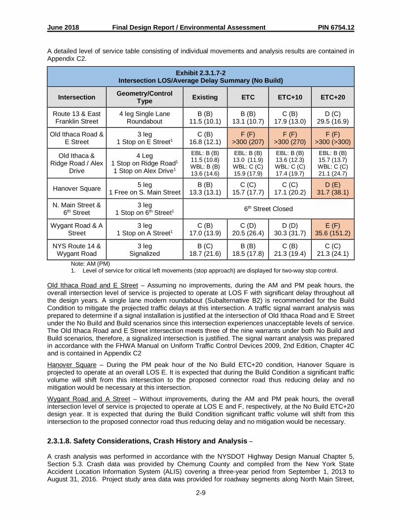
June 2018 Final Design Report / Environmental Assessment PIN 6754.12
2-9
A detailed level of service table consisting of individual movements and analysis results are contained inAppendix C2.
Exhibit 2.3.1.7-2Intersection LOS/Average Delay Summary (No Build)
Intersection Geometry/ControlType Existing ETC ETC+10 ETC+20
Route 13 & EastFranklin Street
4 leg Single LaneRoundabout
B (B)11.5 (10.1)
B (B)13.1 (10.7)
C (B)17.9 (13.0)
D (C)29.5 (16.9)
Old Ithaca Road &E Street
3 leg1 Stop on E Street1
C (B)16.8 (12.1)
F (F)>300 (207)
F (F)>300 (270)
F (F)>300 (>300)
Old Ithaca &Ridge Road / Alex
Drive
4 Leg1 Stop on Ridge Road1
1 Stop on Alex Drive1
EBL: B (B)11.5 (10.8)WBL: B (B)13.6 (14.6)
EBL: B (B)13.0 (11.9)WBL: C (C)15.9 (17.9)
EBL: B (B)13.6 (12.3)WBL: C (C)17.4 (19.7)
EBL: B (B)15.7 (13.7)WBL: C (C)21.1 (24.7)
Hanover Square 5 leg1 Free on S. Main Street
B (B)13.3 (13.1)
C (C)15.7 (17.7)
C (C)17.1 (20.2)
D (E)31.7 (38.1)
N. Main Street &6th Street
3 leg1 Stop on 6th Street1 6th Street Closed
Wygant Road & AStreet
3 leg1 Stop on A Street1
C (B)17.0 (13.9)
C (D)20.5 (26.4)
D (D)30.3 (31.7)
E (F)35.6 (151.2)
NYS Route 14 &Wygant Road
3 legSignalized
B (C)18.7 (21.6)
B (B)18.5 (17.8)
C (B)21.3 (19.4)
C (C)21.3 (24.1)
Note: AM (PM)1. Level of service for critical left movements (stop approach) are displayed for two-way stop control.
Old Ithaca Road and E Street – Assuming no improvements, during the AM and PM peak hours, theoverall intersection level of service is projected to operate at LOS F with significant delay throughout allthe design years. A single lane modern roundabout (Subalternative B2) is recommended for the BuildCondition to mitigate the projected traffic delays at this intersection. A traffic signal warrant analysis wasprepared to determine if a signal installation is justified at the intersection of Old Ithaca Road and E Streetunder the No Build and Build scenarios since this intersection experiences unacceptable levels of service.The Old Ithaca Road and E Street intersection meets three of the nine warrants under both No Build andBuild scenarios, therefore, a signalized intersection is justified. The signal warrant analysis was preparedin accordance with the FHWA Manual on Uniform Traffic Control Devices 2009, 2nd Edition, Chapter 4Cand is contained in Appendix C2
Hanover Square – During the PM peak hour of the No Build ETC+20 condition, Hanover Square isprojected to operate at an overall LOS E. It is expected that during the Build Condition a significant trafficvolume will shift from this intersection to the proposed connector road thus reducing delay and nomitigation would be necessary at this intersection.
Wygant Road and A Street – Without improvements, during the AM and PM peak hours, the overallintersection level of service is projected to operate at LOS E and F, respectively, at the No Build ETC+20design year. It is expected that during the Build Condition significant traffic volume will shift from thisintersection to the proposed connector road thus reducing delay and no mitigation would be necessary.
2.3.1.8. Safety Considerations, Crash History and Analysis –
A crash analysis was performed in accordance with the NYSDOT Highway Design Manual Chapter 5,Section 5.3. Crash data was provided by Chemung County and compiled from the New York StateAccident Location Information System (ALIS) covering a three-year period from September 1, 2013 toAugust 31, 2016. Project study area data was provided for roadway segments along North Main Street,

June 2018 Final Design Report / Environmental Assessment PIN 6754.12
2-10
Route 13, Old Ithaca Road and Wygant Road and the intersections of Route 13 at Franklin Street, Route14 at Wygant Road, Old Ithaca Road at Ridge Road.
The roadway segments and intersections within the project study area were investigated to identify highincident areas, possible accident clusters and potential causal factors. Crash rates were calculated for theintersections and roadway segment then compared to statewide average rates provided by the NYSDOT.Non-reportable crashes were not included in the accident rate calculations. These rates are illustrated inExhibit 2.3.1.8.
Exhibit 2.3.1.8Collision Summary
Location No. ofAcc.
AnalysisPeriod
(Months)Acc. Rate
(Acc/MVM)StatewideAverage
(Acc/MVM)Acc. Rate(Acc/MEV)
StatewideAverage
(Acc/MEV)Segments (Mid-block)
N. Main Street 4 36 1.70 3.52 - -NYS Route 13 3 36 0.71 2.29 -
Old Ithaca Road 7 36 0.81 3.52 - -Wygant Road 4 36 1.72 3.52 - -
IntersectionsNYS Route 13 / E.
Franklin Street 18 36 - - 1.26 0.50
Old Ithaca Road / RidgeRoad 3 36 - - 0.38 0.17
NYS Route 14 / WygantRoad 5 36 - - 0.32 0.14
A total of 44 collisions (18 non-intersection and 26 intersection-related) occurred over the three-yearperiod from September 2013 to August 2016. Injuries resulted from 12 of the 44 total crashes. Noneresulted in a fatality.
All of the midblock segments within the project study area had crash rates that were much lower than thestatewide averages for similar facilities. Each segment’s rate was less than half of the statewide accidentrate.
At the roundabout intersection of NYS Route 13 and East Franklin St, the calculated average annualaccident rate per million entering vehicles (ACC/MEV) is 1.26 ACC/MEV, which is 2.5 times higher thanthe statewide average of 0.50 ACC/MEV for a signalized intersection. Currently, the NYSDOT does notpublish average crash rates for roundabout intersections. Only 2 of the 18 accidents at the intersectionresulted in injuries, as the accidents mostly involved low speed collisions including rear ends and rightangles. It is important to note that this rate of 1.26 ACC/MEV is lower than the 1.74 ACC/MEV ratecalculated in the 2010 Center at Horseheads Connector Road Draft Design Report. In that previousreport, crashes from 2006 to 2008 were analyzed for the signalized intersection prior to the constructionof the roundabout.
At the intersection of Old Ithaca Road with Ridge Road and the signalized intersection of NYS Route 14with Wygant Road, the calculated accident rates were 0.38 ACC/MEV and 0.32 ACC/MEV respectively.Both accident rates were approximately two times the statewide average of 0.17 ACC/MEV (Old Ithaca atRidge) and 0.14 ACC/MEV (Route 14 at Wygant Road). There were no clusters or patterns to indicateany inherent safety deficiencies at the subject intersections.
Refer to Appendix C for the complete accident analysis, including collision diagrams, accident summarytables, and rate calculations.

June 2018 Final Design Report / Environmental Assessment PIN 6754.12
2-11
2.3.1.9. Existing Police, Fire Protection and Ambulance Access -
The Horseheads Fire and Rescue Company is located within the project study area on North Main Streetin Hanover Square and provides services to the area within the Village of Horseheads corporate limits.Emergency services in the Town of Horseheads are provided by the Town and Country Fire Department,which is located on Gardner Road outside of the project study area. Likewise, police services within thevillage corporate limits are provided by the Horseheads Police Department and outside the village limitsby the Chemung County Sheriff’s Office. Emergency vehicles frequently use Old Ithaca Road, EastFranklin Street, and Route 13 for access to service calls north and east of the project study area.
2.3.1.10. Parking Regulations and Parking Related Conditions –
Parking regulations within the project limits were obtained from field observation and a review of the Townand Village of Horseheads Code. Exhibit 2.3.1.10 presents the parking regulations of the roadways in theproject improvement area.
Exhibit 2.3.1.10Parking Regulations
Street Name ParkingJurisdiction Parking Regulations
Route 13 Town ofHorseheads Emergency Stopping Only
Old Ithaca Road(North of Franklin Street to Village Line)
Village ofHorseheads No Parking from 2:00 AM to 6:00 AM
Old Ithaca Road(Village Line to Ridge Road)
Town ofHorseheads No Parking Nov. 1st to April 30th
E Street Town ofHorseheads No Parking Nov. 1st to April 30th
Wygant Road Town ofHorseheads No Parking Nov. 1st to April 30th
Ridge Road Town ofHorseheads No Parking Nov. 1st to April 30th
2.3.1.11. Lighting –
Lighting exists at several of the intersections within the project limits, including Route 13 / Franklin Street,Route 13 / Old Ithaca Road, Hanover Square, Old Ithaca Road / E Street, Old Ithaca Road / Ridge Road,Route 14 / Wygant Road, and Wygant Road / A Street. In addition, a portion of Old Ithaca Road as itapproaches Hanover Square has roadside lighting. With the exception of Hanover Square which hasdecorative pedestrian scale lights, the lighting is achieved with lights mounted on bracket arms mountedto wood utility poles. The municipalities have not indicated any plans to install any additional lighting inthe foreseeable future.
Generally, the operation and maintenance costs of existing street lighting within the project area is paidby the local municipality in which the lighting is located, either the Town of Horseheads or the Village ofHorseheads. The exception to this is that lighting operations and maintenance within the two existingNYS Route 13 Roundabouts is paid by the State.

June 2018 Final Design Report / Environmental Assessment PIN 6754.12
2-12
2.3.1.12. Ownership and Maintenance Jurisdiction –
The ownership and maintenance responsibility of the roadway features within the project improvementarea are shown in the following exhibit:
Exhibit 2.3.1.12Existing Ownership and Maintenance Jurisdiction
Highway Limits Feature(s) Maintained Agency AuthorityRoadways
Old Ithaca Road /CR 68 Entirety Pavement, drainage,
landscaping, and snow removal County Section 10, Subdiv.25 Highway Law
NYS Route 13 Entirety Pavement, drainage,landscaping, and snow removal State Section 12
Highway Law
NYS Route 14 Entirety Pavement, drainage,landscaping, and snow removal State Section 12
Highway Law
E Street Entirety Pavement, drainage,landscaping, and snow removal County Section 10, Subdiv.
25 Highway LawWygant Road /
CR 21 Entirety Pavement, drainage,landscaping, and snow removal County Section 10, Subdiv.
25 Highway LawRidge Road /
CR 5 Entirety Pavement, drainage,landscaping, and snow removal County Section 10, Subdiv.
25 Highway Law
A Street Entirety Pavement, drainage,landscaping, and snow removal Private Section 54(a)
Highway Law
5th Street Entirety Pavement, drainage,landscaping, and snow removal Private Section 54(a)
Highway Law
Alex Drive Entirety Pavement, drainage,landscaping, and snow removal Private Section 54(a)
Highway LawStructures
NYS Route 13S.H. 59-07 Entirety Underpass Structure
(CIN C6200030) State Section 233Highway Law
Wygant Road /CR 21 Entirety Culvert Structure County Section 130
Highway LawTraffic Signals
Wygant Road /CR 21 Entirety Intersection of NYS Route 14 and
Wygant Road State Section 12Highway Law
RailroadsWygant Road /
CR 21WithinR.O.W.
Highway Grade CrossingDOT# 526682S
NorfolkSouthern
Section 24(c)Highway Law
Wygant Road /CR 21
WithinR.O.W. Highway Grade Crossing Industry
(HOST)Section 24(c)Highway Law
Flood Control StructuresNewtown Creek
Levee Entirety Levee-Within limits of existing andproposed easements Town
2.3.2. Multimodal
2.3.2.1. Pedestrians –
There are very limited separate provisions for pedestrians within the project improvement area. On thewest side of Old Ithaca Road, several discontinuous runs of sidewalk extend northerly from HanoverSquare, ending approximately 1,200 feet south of the 5th Street intersection. The occasional pedestrianmay legally use the paved shoulder on the remainder of Old Ithaca Road.
There are no approved plans for sidewalk extensions, trails, or other pedestrian routes within the projectimprovement area. The Town of Horseheads Routes 13 and 14 Corridor Management Study (2004)

June 2018 Final Design Report / Environmental Assessment PIN 6754.12
2-13
described the potential for construction of a multi-use trail on the east side of Newtown Creek (generallyfollowing the alignment of the existing flood control berm) but no plans to advance thoserecommendations have been identified. In addition, the 2015 ECTC Plan 2035 discussed the potential foran off-road trail from Wygant Road to Hanover Square in the vicinity of the wetlands between WatkinsRoad and the Horseheads Industrial Park. There are no known plans to move this concept forward. Acomplete streets checklist is included in Appendix C.
2.3.2.2. Bicyclists –
There are no designated bicycle routes or separate provisions for bicyclists in the project improvementarea. The occasional bicyclist may legally use the travelway or paved shoulder. There is a signed, on-road designated bicycle route, New York State Bicycle Route 14, which is located adjacent to the projectimprovement area along North Main Street and Route 14 between Franklin Street and Wygant Road.
As discussed in the previous section, the Town of Horseheads Routes 13 and 14 Corridor ManagementStudy (2004) described the potential for construction of a multi-use trail on the east side of NewtownCreek (generally following the alignment of the existing flood control berm) but no plans to advance thoserecommendations have been identified. In addition, the 2014 ECTC Plan 2035 discussed the potential foran off-road trail from Wygant Road to Hanover Square in the vicinity of the wetlands between WatkinsRoad and the Horseheads Industrial Park. A complete streets checklist is included in Appendix C.
2.3.2.3. Transit –
Public transportation services for Chemung County are provided by CTran, previously known as theChemung County Transportation System (CCTS). CTran transit routes are located on Route 14, NorthMain Street, Old Ithaca Road, and Route 13 within the project study area.
2.3.2.4. Airports, Railroad Stations, and Ports –
There are no airports, railroad stations or port entrances within the project study area.
2.3.2.5. Access to Recreation Areas (Parks, Trails, Waterways, State Lands) –
Access to the Holding Point Recreation Complex is provided from Wygant Road approximately 1000’west of Ridge Road. The Village of Horseheads Park is home to baseball, softball, soccer and lacrossefields, a pavilion, playground and BMX track.
2.3.3. Infrastructure
2.3.3.1. Existing Highway Section –
Old Ithaca Road and Route 13 are comprised of one 12-foot travel lane and 8-foot paved shoulder ineach direction. Wygant Road is comprised of one 12-foot lane and 4-foot shoulder in each direction. Theshoulder is fully paved in some locations and closer to NY Route 14, the shoulder is 2’ of paved surfaceand 2’ of stone. Travel lane widths on 5th Street and E Street are 11 feet. No defined shoulders arepresent, although the surrounding ground is generally level and at the same elevation as the pavementand perform the function of shoulders. There are no curbs or medians within the project improvementarea.
Residential and commercial driveways are prevalent throughout Old Ithaca Road with an average densityof 70 driveways per mile. Many of the commercial driveways extend the full frontage of properties andoffer little in the way of traffic control. Likewise, many of the driveway entrances on E Street also extendthe full width of the parking areas and have been identified as areas of concern. The truck parking area infront of Building 13-1 in the HOST Terminal is particularly problematic, since semi-trailers with 43-footkingpins (53-foot trailers) overhang into the shy line of E Street.

June 2018 Final Design Report / Environmental Assessment PIN 6754.12
2-14
Right-of-way widths on Old Ithaca Road and Route 13 are 60 feet and 100 feet, respectively. Widths weredetermined from record plans, acquisition maps, and tax maps for the Town and Village of Horseheads.As noted previously, the right-of-way on Route 13 was acquired without access.
2.3.3.2. Geometric Design Elements Not Meeting Minimum Standards –
This section compares the existing geometric elements with the minimum standards used to make capitalinfrastructure improvements. This section helps ensure the objectives and feasible alternatives considerkey deficiencies.
With respect to Old Ithaca Road, Wygant Road and Route 13, there are no existing non-standard featuresbased on the current NYSDOT 2R/3R Standards. The geometric features of the subject roadways wereevaluated in accordance with design standards set forth in the HDM. The lane and shoulder width,grades, horizontal and vertical alignments, superelevation, sight distance, cross slope, clearances, androllover on Old Ithaca Road and Route 13 appear to coincide with the safe operating and regulatoryspeeds of the facilities.
2.3.3.2.(1) Other Design Parameters -
The existing weak post corrugated guide rail at the Route 13 underpass does not conform to currentstandards. Refer to section 2.3.3.8. for additional discussion. No other existing nonconforming featureshave been identified based on the current NYSDOT 2R/3R Standards and a review of the crash history.
2.3.3.3. Pavement and Shoulder -
Route 13 was originally constructed in 1959 under contract FASH 59-7 and last received a single courseoverlay of asphalt concrete pavement in 2011. The pavement section consists of a 4-inch asphaltconcrete overlay, 8-inch plain cement concrete foundation, and 12 inches of granular subbase. Theshoulders consist of approximately 5 inches of asphalt concrete and granular subbase. Based on the2015 NYSDOT Pavement Data Report, the Route 13 Pavement Condition Rating is 7.
Old Ithaca Road was originally constructed in 1941 under contract FARC 40-42 and received a slurry sealtreatment in the summer of 2009. The pavement section consists of approximately 6 inches of asphaltconcrete overlay, 12 inches of reinforced cement concrete base, and 6 inches of gravel subbase. Theshoulders consist of approximately 3½ inches of asphalt concrete and 6 inches of gravel subbase. Ageotechnical report and pavement evaluation for Old Ithaca Road was completed in May 2017 andindicates the pavement is in fair condition and has suitable subgrade soils, subbase and pavementthickness to support pavement rehabilitation. The report is included in Appendix D.
The original construction date of the 5th Street approach to Old Ithaca Road is unknown. The recordplans for the Elmira Holding and Reconsignment Point show that E Street, as well as 5th Street west of EStreet were constructed in 1942; however, the connection to Old Ithaca Road was not included at thetime. It is likely that the connection was constructed shortly after the original project with materials similarto the abutting segments. Chemung County took over ownership of E Street in 2011. At that time, theroad was reconstructed and relocated slightly south of its original location.
The Pavement Evaluation and Treatment Selection Report (PETSR) can be found in Appendix D.
2.3.3.4. Drainage Systems -
Drainage of Route 13 is accommodated by the raised embankment section at the approach to theunderpass structure. A defined toe of slope ditch is present on the southwest quadrant of the underpassand it appears to adequately collect and convey runoff to the underpass.
The drainage system on Old Ithaca Road consist of a poorly-defined system of open swales and ditches.No driveway, cross culverts, or inlets were visible between Hanover Square and Ridge Road at the timeof field inspection. Existing cross-culverts located under the adjacent Newtown Creek levee indicate

June 2018 Final Design Report / Environmental Assessment PIN 6754.12
2-15
some drainage along Old Ithaca Road between Hanover Square and Ridge Road is conveyed under thelevee to Newtown Creek.
Between Ridge Road and NY Route 13, there are some driveway culverts. It appears that stormwaterrunoff generally collects in low-lying areas and slowly infiltrates into the surrounding ground.
The drainage system on 5th Street and E Street is similar to that on Old Ithaca Road, although anapparently underutilized closed drainage system is located nearby. The closed drainage system wasinstalled in 1942 as part of the Elmira Holding and Reconsignment Point construction and consists ofreinforced concrete pipe ranging from 18- to 30-inch diameter. The closed drainage system flows in awesterly direction and discharges to the drainage canal adjacent to Norfolk Southern Railway’sHorseheads Industrial Track.
Drainage of Wygant Road is accommodated by roadside ditches that carry stormwater from the road tothe drainage canal adjacent to Norfolk Southern Railway’s Horseheads Industrial Track. Some drivewayculverts exist on properties close to NY Route 14. In addition, a culvert exists beneath the NorfolkSouthern Railroad track.
2.3.3.5. Geotechnical –
A National Cooperative Soil Survey Custom Soil Resource Report was prepared for the area of the newconnector road and bridge. The report indicates that the soils in the project area are moderately welldrained silt loam, moderately well drained sandy loam, and poorly drained alluvial soil in the vicinity ofNewtown Creek. East of Newtown Creek the original soil horizon has been modified by gravel mining andfill operations, and the remaining soils were not described. A copy of the report is included in Appendix E.
A subsurface investigation program and geotechnical evaluation were completed to gather information onthe soils underlying the area of the new connector road and bridge. Twelve soil borings were made alongthe project improvement area. The borings were generally 10 to 15 feet deep except for three 3 borings inthe vicinity of Newtown Creek, which ranged from 112 to 142 feet deep.
Each of the borings at Newtown Creek revealed similar results. The borings showed that the sub soils arecomprised of alluvial deposits. The first 30 feet of soil encountered below the top soil was a brown gravel(soil types GW and GM) with some pockets of brown sand (soil type SM). The next 100 feet of soilencountered consisted of alternating layers of grey silt (soil type ML) and grey clay (soil type CL). Thelayers of silt were generally 20 to 30 feet thick and the clay layers were generally 5 to 15 feet thick. Thegravel layer is generally wet and loose in the upper 20 feet of the layer and firm below. The silt layers aregenerally moist or wet and are firm. The clay layers are generally moist and are either stiff or very stiff.
The shallower borings conducted in the remainder of the other project areas were generally terminated inthe upper gravel layer, but one of the borings revealed a fill soil over its entire 15-foot depth and twoothers revealed shallow silt or clay soils.
A subsurface investigation program and geotechnical evaluation was also completed along the existinglevee adjacent to Old Ithaca Road as well as on the pavement of Old Ithaca Road. The geotechnicalreport is included in Appendix E.
Additional discussion is provided in the Geotechnical Evaluation Report for Proposed Route 13 ConnectorRoad (2010) and the Geotechnical Evaluation Report for Proposed Bridge over Newtown Creek (2010),both located in Appendix E.
2.3.3.6. Structure –
A 15-foot-span by 14-foot-rise cast-in-place concrete underpass (CIN C620003) is located on Route 13approximately 1,500 feet north of East Franklin Street. The underpass was constructed in 1959 tomaintain truck access to the former gravel mining operation on the east side of Route 13, butrepresentatives of the current mining operation have indicated that the underpass is no longer used for

June 2018 Final Design Report / Environmental Assessment PIN 6754.12
2-16
access. The property on the east side of Route 13 was sold to a private individual with access rightsmaintained to Bowman Hill Terrace.
An in-depth condition inspection was not performed on the structure. The 2014 inspection GeneralRecommendation was 5. A cursory visual evaluation revealed that the structure is in good to faircondition. The walls and roof slab were generally in good condition, although areas exposed to road saltshowed light to moderate spalling. The invert slab exhibited larger and deeper spalled areas, although noexposed reinforcing was noted. The wingwalls were also in good condition, but showed the greatest signsof deterioration at the interface with the barrel walls. Vertical cracking was noted at the wingwall joint onall four quadrants, with the greatest amount of cracking and deterioration on the southeast wingwall. Thecracking was likely caused by differential settlement of the wingwalls relative to the barrel, although itappears that the movement has stabilized. Impact from mining equipment may be another cause of themovement and deterioration at the wingwall interface, as well as the floor spalling noted previously.
Although the structure is in adequate condition, NYSDOT has indicated that the need for the structure isno longer warranted as the properties linked by the underpass are now under separate ownership.NYSDOT may explore removal of the structure or replacement with a smaller opening in the future.
BIN 3331110 (Wygant Road over Chemung Canal AB) is located 750’ east of the NY Route 14 / WygantRoad Intersection. The bridge is identified as functionally obsolete by NYSDOT due to its narrower thanstandard bridge width. The Chemung County owned bridge was built in 1997 and carries Wygant Road,an urban minor arterial. According to inventory data, the prestressed concrete beam bridge spans 24 feetand carries widths of approximately 30.3 feet (rail-to-rail) and 32.3 feet (out-to-out). In addition, thestructure carries an ADT of 5766 (2013). As of March 2015, research indicates that the structure has asufficiency rating of 76.6 and all elements are scored in very good to excellent condition.
2.3.3.7. Hydraulics of Bridges and Culverts –
Newtown Creek enters the Town of Horseheads from the east and then flows in a southerly directionthrough the project study area until its confluence with the Chemung River near Elmira. The FloodInsurance Study for the Town of Horseheads, New York (1996), Town and Village of Horseheads HazardMitigation Action Plan (2004), and other documents were reviewed to determine the effects of NewtownCreek on existing and planned developments in the project improvement area.
A hydraulic analysis of Newtown Creek in the vicinity of the Center at Horseheads Connector Road wasperformed for this floodplain evaluation. Upon review of available historic flooding data and physicalcharacteristics of Newtown Creek and the associated floodplain, a preliminary hydraulic analysis wasperformed using the U.S. Army Corps of Engineers HEC-RAS Version 4.1 computer program. If anyincreases are caused by the proposed project, a FEMA Conditional Letter of Map Revision (CLOMR),which is likely, will be required. The Floodplain Evaluation Report is contained in Appendix E.
Newtown Creek is not a navigable waterway; therefore, a Coast Guard checklist was not prepared.
2.3.3.8. Guide Railing, Median Barriers and Impact Attenuators –
Guide railing within the project improvement area is located on Route 13 at the approach to theunderpass structure and along Wygant Road between the two railroad crossings. Route 13 rail consistsof weak post corrugated beam (W-beam) railing with turned down end terminals that are not inaccordance with current standards. Guide rail on Wygant Road consists of box beam railing that appearsto be in fair condition and conform to current standards. The railing, posts, and connections are in faircondition and show few signs of impact. Post spacing over the Route 13 underpass structure are twicethat of the approach railing and appears to be an attempt to compensate for decreased post embedmentdepth over the roof slab. Pertinent data is provided below:

June 2018 Final Design Report / Environmental Assessment PIN 6754.12
2-17
Exhibit 2.3.3.8Existing Guide Railing
Type Location/Side Length ConditionW-Beam Route 13, Lt. 365 ft Fair, some posts loose/impacted, end terminals
not in accordance with current standards
W-Beam Route 13, Rt. 325 ft Fair, some posts loose/impacted, end terminalsnot in accordance with current standards
Box Beam Wygant Rd. Lt & Rt 95 ft. Lt &95 ft Rt.
Fair condition, end terminals appear to be inaccordance with current standards.
2.3.3.9. Utilities –
Utility companies and municipal agencies were contacted to determine the location of any existingunderground and overhead facilities. The following utilities are present in the general vicinity of the projectimprovement area:
Overhead electric transmission and distribution lines owned by New York State Electric and Gas (private)· Overhead and underground telephone lines owned by Verizon (private)· Overhead cable television lines owned by Time Warner Cable (private)· Underground gas lines owned by New York State Electric and Gas (private)· Underground water transmission and distribution lines owned by the Village of Horseheads
(public)· Underground sanitary sewers owned by Chemung County Pure Water Agency (public) and the
Village of Horseheads (public)
2.3.3.10. Railroad Facilities –
Norfolk Southern Railway’s (NS) Horseheads Industrial Track is located in the western portion of theproject study area. The line diverges from the NS Southern Tier Line at MP SR 276.89 and extendsnortherly 3.60 miles through the Village and Town of Horseheads, ending north of Wygant Road. Speedson the line are limited to 10 MPH and train frequency is approximately two per week, or as required forservice to the HOST Terminal. Public grade crossings owned by NS within the project study area includeNorth Main Street (USDOT 526681K) and Wygant Road (USDOT 526682S). Both crossings have activewarning devices (flashers) and consist of low-type timber and asphalt surfaces.
NS has recently completed a major tie and surfacing project for the entire length of the HorseheadsIndustrial Track. The grade crossings at Wygant Road and North Main Street have been reconstructedwith asphalt concrete and rubber rail seal surfaces. The northerly limit of the Horseheads Industrial Trackhas also been extended approximately 1,000 feet to address operational issues at the entrance to theHOST Terminal.
The only current rail customers on the Horseheads Industrial Track are the various shippers within theHOST Terminal. The HOST Terminal maintains an extensive internal track network at the west end of theproperty, consisting of a small storage yard and team track adjacent to Wygant Road, as well as severalparallel sidings serving buildings A-D, and F-J. Approximately 17 private grade crossings are locatedthroughout the confines of the property, most of which have no passive warning devices. The northerlylead track serving the HOST Terminal crosses Wygant Road approximately 190 feet east of the NScrossing.
2.3.4. Potential Enhancement Opportunities
2.3.4.1. Landscape –
The landscape of the surrounding area is formed on a level terrain with limited land use density. Theproject site is located in an area with residential, commercial and industrial uses. The periphery containslimited agricultural uses.

June 2018 Final Design Report / Environmental Assessment PIN 6754.12
2-18
Along the Route 13 corridor the roadside landscape consists of high voltage transmission lines, utilitypoles, and the vegetation consists of mature trees and dense pioneer growth. The vegetation consists ofa wide variety of plants including but not limited to: Sumac (Rhus), Spruce (Picea), Willow (Salix), BoxElder (Acer), Poplar (Populus), Viburnum (Viburnum), Wild Grape (Ampelocissus), Goldenrod (Solidago),and grasses.
The Old Ithaca Road corridor landscape consists of commercial properties, commercial signage andlimited views to the north, south, and west. The eastern view is screened by dense vegetation to the rearof the properties that front Old Ithaca Road. North of the 5th Street intersection there is a higherconcentration of residential structures. These contain manicured lawn areas, shade trees andevergreens.
The vegetation consists of the wide variety of plants including but not limited to: Maple (Acer), Spruce(Picea), Privit (Ligustrum), and Hosta (Hosta).
The existing landscape within the project improvement area is limited in value. The vegetation is grass,weedy growth, or pioneer growth. No majestic trees or important landforms are present.
2.3.4.1. (1) Terrain -
According to properties described in the HDM, the terrain of the project improvement area is level.Highway sight distances, as governed by both horizontal and vertical restrictions, are generally long orcould be made to be so without construction difficulty or major expenses.
2.3.4.1. (2) Unusual Weather Conditions-
The climate is typical of the region and consists of warm to hot summers and cold winters with moderateto heavy snowfall. Average annual precipitation is 35 inches. The former gravel mining area and adjacentagricultural fields contain open, undulating landforms with sparse vegetation. These areas may contributeto snowdrifts and white out conditions and should be monitored as the project progresses.
2.3.4.1. (3) Visual Resources –
The visual environment does not contain any known visually sensitive receptors including significantscenic views, State/National Register of historic Places structures, buildings or objects and/or district, norunusual land forms. Refer to section 4.4.13 for additional discussion.
2.3.4.2. Opportunities for Environmental Enhancements –
No practical opportunities for environmental enhancements within the project area have been identified todate. Opportunities for improvements in accordance with NYSDOT’s Environmental Initiative should beexamined as the project progresses. These are actions to enhance the natural and manmadeenvironment above and beyond the required project mitigation measures. They may include features thatprovide the opportunity for enhancement by local governments or other agencies or organizations asbetterments. Examples include: fishing access, boat and canoe launch sites, development of pocketparks, habitat improvements, and enhanced wetlands.
2.3.5. Miscellaneous -
Within the project limits is an existing earth embankment levee, generally located along the west side ofNewtown Creek, which has been providing flood protection to a large area of land and a large number ofproperties in both the Town and Village of Horseheads. This levee was constructed in 1944 by the USArmy Corps of Engineers in order to protect the then newly constructed Elmira Holding andReconsignment Point facility (now known as the HOST Terminal) from flooding. The levee begins on thenorth side of East Franklin Street (in the Village of Horseheads) adjacent to the bridge over NewtownCreek; and extends northerly for approximately 1 mile to Alex Drive, a privately owned road (in the Town

June 2018 Final Design Report / Environmental Assessment PIN 6754.12
2-19
of Horseheads). The lone record plan of this levee indicates the upper end of the levee extendedwesterly approximately 375 feet from its current terminus to the intersection of Old Ithaca Road and RidgeRoad however, no remnants of this 375-ft reach over to Old Ithaca Road are evident.
Although the current FEMA flood hazard mapping includes the levee, FEMA rules and regulations nowonly allow levees to be used in hydraulic modeling and flood hazard mapping if the levee is accredited inaccordance with the National Flood Insurance Program (NFIP) requirements as described in Title 44,Chapter 1, Section 65.10 (CFR 44). This existing levee is not accredited, and existing records of itsoriginal construction are insufficient or lacking adequate information needed to attain accreditation.
FEMA policy further states that non-accredited levees can no longer be included in hydraulic analyses insupport of Conditional Letter of Map Revision (CLOMR) submissions and updated studies. If the levee isunaccounted for in the hydraulic model, structures would certainly be affected by increases to thefloodplain due to the project, causing a CLOMR to be rejected by FEMA. In order to receive CLOMRapproval, which is required to construct the project, the levee must be certified to meet FEMArequirements listed in Section 65.10 of the NFIP regulations. Levee certification documents can then besubmitted to FEMA in support of accreditation.
2.3.5.1. Levee Ownership –
At some point prior to 1975, the Federal government transferred ownership of the Elmira Holding andReconsignment Point facility, including the levee, to a private corporation. Records compiled by the Townof Horseheads suggest at least one change of ownership occurred after that date. On or about June 3,1975, the Town of Horseheads took possession of the former Elmira Holding and Reconsignment Pointfacility, including the levee.
The property on which the levee is situated consists of multiple permanent easement tracts beginning atwhat is now Alex Drive, and extending south to Franklin Street. Prior to the Town of Horseheads takingownership, Easement Tract 1, the most northern easement tract and the western portion of easementtract 16 were released back to the underlying fee (property) owners.
It is also noted that the Village of Horseheads has a backup public water supply well (Well No. 4) locatedwithin the levee embankment, at approximately levee Station 41+00.
2.3.5.2. Existing Levee Condition –
Recently, the Town of Horseheads, in cooperation with the Chemung County Soil and WaterConservation District (SWCD) has undertaken efforts to repair and address some of the more seriousdeficiencies that were caused by extensive vegetative overgrowth, including numerous trees greater than12” D.B.H. The southern 3,000± feet of levee (Sta. 10+25 to Sta. 41+00) generally abuts the west side ofNewtown Creek and is often directly subjected to potentially damaging flows. Jimmie Carl, Director of theChemung SWCD, believes some of the erosion and toe-of-slope de-stabilization occurred as far back as1972 following Hurricane Agnes. Therefore, the Chemung SWCD has focused their limited resources andefforts on this portion of the levee, which has included:
· Removal of most of the brush and trees, including roots and stumps.· Stream bank repairs and embankment stabilization along a portion of the levee’s creek
side toe of slope.
Along this same reach of levee (Sta. 10+25 to Sta. 41+00), there are still some limited areas of extensivevegetation and numerous “property improvements” that could be considered encroachments within thelevee easements. These property improvements generally consist of fences, bulk material storagebunkers, sheds, gardens, and driveway and materials storage surfacing consisting of gravel, asphalt andconcrete.
From Sta. 41+00 north to Sta. 46+00 (Easement Tract 3), the levee surface is degraded by an overgrowthof light brush and trees. From Sta. 41+00 to Sta. 53+00 (Easement Tact 2) the levee surface ismaintained as mowed lawn surface. However the western edge of the existing easement is encroached

June 2018 Final Design Report / Environmental Assessment PIN 6754.12
2-20
upon by an existing residential apartment building and underground utilities. The remainder of theexisting levee, Sta. 53+00 to Sta. 62+50 (former Easement Tract 1) is in poor condition. Gradingattributed to the adjacent land development reduced the overall levee width by approximately 50%, andwhat remains is further degraded by brush and small trees. No physical evidence remains of the leveealong Alex Drive, westerly to Old Ithaca Road.
2.3.5.3. Levee Pipe Crossings –
The table below documents existing pipes that are known to pass through the base or underlyingfoundation soils of the levee.
Location /Station
Size /Material
TypeUse /
Function Condition Comment
10+94 Unknown Gas Main Unknown Owned by NYSEG
11+2015” RCPw/FlapGate
Drainage Fair; 40-50% siltedin
May have drained long abandonedadjacent railroad. No longer functioning
15+45
Twin 24”RCP’sw/flapgates
DrainageFair: 75-90% silted
in.NOT functional
Visual observation of excavated outletsuggests it has not functioned indecades. Upstream inlet indeterminate.
20+76 15” RCP DrainageFair – Still
functioning as adrainage culvert
Appears to still be serviceable
25+29 12” IronPipe Gas Main
Fair-goodMay be
abandoned
Exposed in bed of Newtown Creek.Unable to ascertain contact informationfor last known owner / easement holder.
32+2824” RCPw/FlapGate
Drainage Fair Appears to accept drainage from OldIthaca Road
41+03 UnknownPublicWaterSupply
unknown Supply line from Village of Horseheads’Water Well No. 4 (Backup supply well)
2.3.5.4. Hydraulic Conditions –
FEMA published a revised Flood Insurance Study (FIS) for the Town of Horseheads, New York, onSeptember 29, 1996. Newtown Creek was studied using detailed methods; therefore, the original FEMAhydraulic model was obtained for this study. The Flood Insurance Rate Map (FIRM) for the Town ofHorseheads was also issued September 29, 1996. The floodplains shown on the FIRM map areassociated with the 100-year and 500-year recurrence interval floods. The FIRM also shows the expanseof the Regulated Floodway along Newtown Creek.
In recent years FEMA conducted new hydrologic and hydraulic studies and re-evaluated the currenthydraulic model as a precursor to publishing an updated FIS and FIRM. However, after a period of publicreview and comment, the updated FIS and FIRM were not adopted, primarily due to controversysurrounding the revised hydraulic modeling results, which would have resulted in significantly higher peakflows, and subsequently, more properties placed in a flood hazard area.
For purposes of the hydraulic modeling relative to the levee, both the currently published flows (“existingFEMA flows”) and the un-adopted flows (e.g. “future FEMA flows”) were evaluated in order to evaluate thelevee’s long term sustainability in addition to its existing flood control capabilities. Water surface profileswere computed for the base flood (100-year) event using the U.S. Army Corps of Engineers HEC-RASRiver Analysis System program (Version 4.1).

June 2018 Final Design Report / Environmental Assessment PIN 6754.12
2-21
Generally, the existing levee adequately provides the desired 100-year flood control for “existing FEMAflows” except for the most northern 200± feet, where the free board falls below the desired 3-feet, to 2.29feet. Under the “future FEMA flows”, the levee’s 100-year flood freeboard is compromised along itsnorthern 1,000± feet, where the free board is reduced to as little as 0.73-feet or less.
A review of a planimetric outputs showing the “horizontal” extents of the 100-year base flood elevationsnotes the following:
· Floodplain extents associated with the “existing FEMA flows” indicate the 100-year flood does notcome in contact with the northern 1,500± feet of levee. Furthermore, the lack of any existing leveeremaining along Alex Drive is not a concern since if it were present, it would have no apparent floodprotection function or benefit.
· Floodplain extents associated with the “future FEMA flows” shows extended contact with the leveeand some overtopping at its northern limits. Six properties south of Alex Drive, intended to beprotected by the levee are inundated. This is primarily due to the loss of the originally constructedlevee along the northern end and what is now Alex Drive.

June 2018 Final Design Report / Environmental Assessment PIN 6754.12
3-1
CHAPTER 3 – ALTERNATIVES
This chapter discusses the alternatives considered and examines the engineering aspects for allreasonable alternatives to address project objectives in Chapter 1 of this report.
3.1. Alternatives Considered and Eliminated from Further Study
Project alternatives and subalternatives were developed to meet the project objectives using the designcriteria in Section 3.2.3.2 of this report. The following alternatives and subalternatives were consideredand have been eliminated from further study:
§ Alternative 3: Improve Existing Roadway Network§ Subalternative AO: Minor Intersection Improvements on Old Ithaca Road§ Subalternative A1: Unsignalized Conventional Intersection with Auxiliary Lanes on Old Ithaca Road§ Subalternative A2: Signalized Intersection with Auxiliary Lanes on Old Ithaca Road and Direct
Connection to 5th Street§ Subalternative A3: Auxiliary Lanes on Old Ithaca Road with Direct Connection to E Street§ Subalternative B1: Roundabout on Old Ithaca Road§ Subalternative B3: Roundabout on Old Ithaca Road with Direct Connection to E Street§ Subalternative C1: Signalized intersection on Route 13§ Subalternative C2: Unsignalized Conventional Intersection on Route 13§ Levee Alternative 2: Levee Improvement and Reestablishment along Alex Drive.
Alternative 3: Improve Existing Roadway NetworkThis alternative provides for continued maintenance of the existing roadway network with operational andsafety improvements on Route 14, Old Ithaca Road, as well as the Hanover Square intersection. Route14 is operating at or near capacity and would likely have to be widened to a 3- or 4-lane section toaccommodate the additional traffic. Operational improvements at Hanover Square would require theaddition of auxiliary lanes as well as widened intersection turn radii to better accommodate large trucks.Doing so would likely involve removal or alteration of historically significant properties and would requiresignificant right-of-way acquisition. In addition, historic Hanover Square and the residential neighborhoodswithin the project study area would continue to be burdened by increasing truck and commuter traffic.This alternative was considered and rejected as it does not address all of the project objectives.
Subalternative AO: No Intersection Improvements on Old Ithaca RoadThis subalternative provides for construction of minor intersection improvements at Old Ithaca Road inconcert with the new connector road. The existing lane configuration on Old Ithaca Road would remainone lane in each direction. The E Street approach would be realigned slightly to intersect perpendicular toOld Ithaca Road. This subalternative would provide acceptable levels of service until shortly aftercompletion of the project, but would likely result in operational conflicts with the E Street and 5th Streetintersection. This alternative was considered and rejected as it does not address all of the projectobjectives.
Subalternative A1: Unsignalized Conventional Intersection with Auxiliary Lanes on Old Ithaca RoadThis subalternative provides for the construction of a 4-leg intersection at Old Ithaca Road and the newconnector road. E Street would be realigned slightly to intersect perpendicular to Old Ithaca Road.Dedicated northbound left and southbound left turn lanes would be added to Old Ithaca Road to improveintersection level of service. Traffic would be stop controlled on the connector road and E street legs ofthe intersection. This subalternative meets all of the project objectives, but would likely result inoperational conflicts with the E Street and 5th Street intersection and has been rejected.
Subalternative A2: Signalized Intersection with Auxiliary Lanes on Old Ithaca Road and Direct Connectionto 5th StreetThis subalternative provides for the construction of a conventional signalized 4-leg intersection at OldIthaca Road and the new connector road, with dedicated northbound left and southbound left turn lanes

June 2018 Final Design Report / Environmental Assessment PIN 6754.12
3-2
on Old Ithaca Road. 5th Street would be realigned to intersect with the new connector road and E Streetwould be shifted easterly to provide additional buffer space near trucks parked in the loading bays ofBuilding 13-1. Traffic on E Street would be stop-controlled while 5th Street would remain uncontrolled.This would improve access to the south side of the HOST Terminal and reduce the potential for conflictswith the new intersection at Old Ithaca Road. This subalternative meets all of the project objectives.However, its expected traffic and safety operational outcomes are less than that of Subalternative B1, theRoundabout; and it was significantly less favored based on comments received at the July 24, 2017Public Informational Meeting. Therefore, this subalternative has been dropped from further consideration.
Subalternative A3: Auxiliary Lanes on Old Ithaca Road with Direct Connection to E StreetThis subalternative provides for the construction of a conventional 4-leg intersection at Old Ithaca Roadand the new connector road with dedicated northbound left and southbound left turn lanes on Old IthacaRoad. E Street would be relocated to intersect with the new connector road and provide additional bufferspace near trucks parked in the loading bays of Building 13-1. 5th Street would be realigned to intersectwith E Street at a tee intersection. Traffic on 5th Street would be stop-controlled while E Street wouldremain uncontrolled. This subalternative meets all of the project objectives, but would likely result inoperational conflicts with queues of westbound left turning vehicles at the 5th Street intersection and hasbeen rejected.
Subalternative B1: Roundabout on Old Ithaca RoadThis subalternative provides for the construction of a single-lane modern roundabout at the intersection ofOld Ithaca Road and the new connector road. E Street would be realigned slightly to intersectperpendicular to Old Ithaca Road. This subalternative meets all of the project objectives, but would likelyresult in operational conflicts with the E Street and 5th Street intersection and has been rejected.
Subalternative B3: Roundabout on Old Ithaca Road with Direct Connection to E StreetThis subalternative provides for the construction of a single-lane modern roundabout at the intersection ofOld Ithaca Road and the new connector road. E Street would be relocated to intersect with the newconnector road and provide additional buffer space near trucks parked in the loading bays of Building 13-1. 5th Street would be realigned to intersect with E Street at a tee intersection. Traffic on 5th Street wouldbe stop-controlled while E Street would remain uncontrolled. This subalternative meets all of the projectobjectives, but would likely result in operational conflicts with queues of westbound left turning vehicles atthe 5th Street intersection and has been rejected.
Subalternative C1: Signalized intersection on Route 13This subalternative provides for the construction of a dedicated northbound left turn lane and a trafficsignal at the intersection of Route 13 and the new connector road. The lane configuration on Route 13would remain one lane in each direction. This subalternative would provide acceptable levels of service;however, would not provide continuity between intersections along Route 13. The existing adjacentintersections to the north and south of the proposed Connector Road were recently reconstructed tomodern roundabouts therefore a new signal installation would be undesirable. This subalternative wouldlikely result in operational conflicts with queues of northbound vehicles at the Route 13 intersection and.has been rejected.
Subalternative C2: Unsignalized Conventional Intersection on Route 13This subalternative provides for the construction of a conventional tee intersection at Route 13 with adedicated northbound left turn lane and eastbound right turn lane. Traffic on the Connector Road legwould be stop controlled and Route 13 would be uncontrolled. This subalternative would provideacceptable levels of service; however, the right-of-way, utility, and project impacts would be greater thanthe base alternative and the operational goals of the project would not be met. Although this alternative isconsidered feasible, it has been rejected.
Levee Alternative 2: Levee Improvement and Reestablishment along Alex Drive.Under this alternative, the existing earth embankment levee would be improved and generally re-established on its existing alignment. In order to minimize impacts on existing developed land, theproposed levee reestablishment along Alex Drive would consist of a new flood wall located along thesouth side of the street, approximately 4 to 6 feet in height. This proposed wall would likely be

June 2018 Final Design Report / Environmental Assessment PIN 6754.12
3-3
constructed of either a precast or cast-in-place Portland cement concrete. The improved andreestablished levee would be approximately 5,300 feet in length; and would be constructed and improvedto meet current FEMA standards for accreditation as a flood control structure. This alternative wouldsignificantly impact a residential property along Alex Drive and require substantial ground disturbance tobuild a new flood wall along Alex Drive. The cost and future maintenance of the proposed flood wallwould be undesirable by the stakeholders. Therefore, this alternative was eliminated from furtherconsideration.
Refer to section 3.2.3 of this report for in-depth discussion of the design criteria, and to section 3.3.3.2 fornon-standard features and non-conforming features.
3.2. Reasonable Build Alternatives
3.2.1. Description of Reasonable Alternatives
Project alternatives and subalternatives were developed to meet the project objectives using the designcriteria in Section 3.2.3.2 of this report. Alternative 1 is listed as a reasonable alternative, but does notmeet any of the project objectives outlined in Chapter 1. Alternative 2 is considered feasible as it meetsall of the project objectives:
§ Alternative 1: “Null” or No Action§ Alternative 2: New Connector Road incorporating
o Subalternative B2: Roundabout on Old Ithaca Road with Direct Connection to 5th Streeto Levee alternative 1
Alternative 1: “Null” or No ActionThis alternative provides for only continued maintenance of the existing roadway network. No operationalor safety improvements would be implemented; therefore, historic Hanover Square and the residentialneighborhoods within the project study area would continue to be burdened by increasing truck andcommuter traffic.
Alternative 2: New Connector RoadThis alternative, in concert with subalternative B2 and levee alternative 1, provides for the construction ofa new urban collector from the HOST Terminal to Route 13. One 12-foot travel lane would be provided ineach direction on the new roadway, along with a 4-foot shoulder in curbed areas and an 8-foot shoulderin open areas. A single-lane modern roundabout intersection would be constructed on Route 13. A new238-foot, 2-span, curved multi-girder bridge would be constructed over Newtown Creek and the existingunderpass structure on Route 13 would be altered as needed to accommodate the widened roadway.
South of the proposed connector road, the existing levee adjacent to Old Ithaca Road would bereconstructed in-kind where necessary due to its deterioration. In addition, the portion of the levee northof the proposed connector road would be reconstructed to replace the old levee that has beencompromised by development and vegetation. A westbound right turn would be added on Wygant Roadat its intersection with NYS Route 14. Two railroad crossings would be replaced on Wygant Roadbetween NYS Route 14 and the HOST terminal driveway. Landscaping in the form of conifer (evergreen)trees would be considered along the east side of Route 13 adjacent to the properties on Camelot Drive toprovide a gateway element for the project and to address a concern from the neighborhood. As fundsallow, the following would be included along Old Ithaca Road: Install new curb and drainageimprovements and reduce pavement width between the town line and the south approach to the newconnector road and from the north approach to the new connector road to Ridge Road. Ridge Roadwould be realigned perpendicular to Old Ithaca Road. The pavement on Old Ithaca Road would be milledand overlaid between Hanover Square and the south approach to the new connector road and from thenorth approach to the new connector road to NY Route 13.
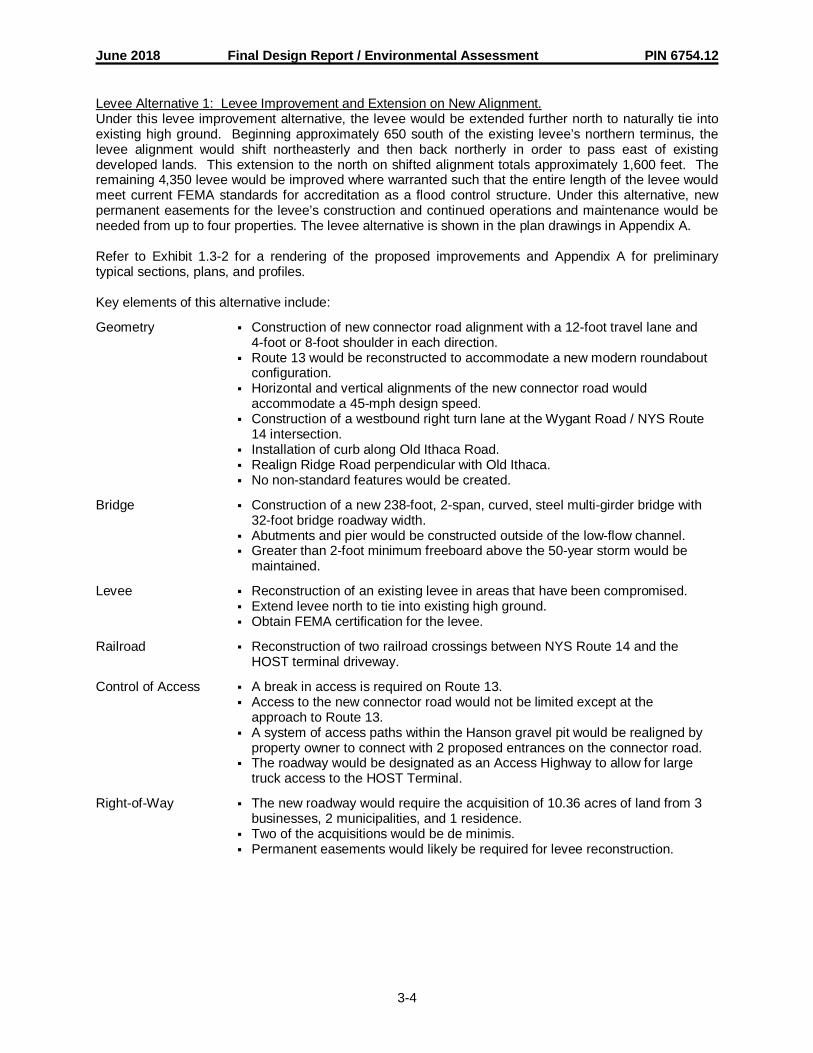
June 2018 Final Design Report / Environmental Assessment PIN 6754.12
3-4
Levee Alternative 1: Levee Improvement and Extension on New Alignment.Under this levee improvement alternative, the levee would be extended further north to naturally tie intoexisting high ground. Beginning approximately 650 south of the existing levee’s northern terminus, thelevee alignment would shift northeasterly and then back northerly in order to pass east of existingdeveloped lands. This extension to the north on shifted alignment totals approximately 1,600 feet. Theremaining 4,350 levee would be improved where warranted such that the entire length of the levee wouldmeet current FEMA standards for accreditation as a flood control structure. Under this alternative, newpermanent easements for the levee’s construction and continued operations and maintenance would beneeded from up to four properties. The levee alternative is shown in the plan drawings in Appendix A.
Refer to Exhibit 1.3-2 for a rendering of the proposed improvements and Appendix A for preliminarytypical sections, plans, and profiles.
Key elements of this alternative include:
Geometry § Construction of new connector road alignment with a 12-foot travel lane and4-foot or 8-foot shoulder in each direction.
§ Route 13 would be reconstructed to accommodate a new modern roundaboutconfiguration.
§ Horizontal and vertical alignments of the new connector road wouldaccommodate a 45-mph design speed.
§ Construction of a westbound right turn lane at the Wygant Road / NYS Route14 intersection.
§ Installation of curb along Old Ithaca Road.§ Realign Ridge Road perpendicular with Old Ithaca.§ No non-standard features would be created.
Bridge § Construction of a new 238-foot, 2-span, curved, steel multi-girder bridge with32-foot bridge roadway width.
§ Abutments and pier would be constructed outside of the low-flow channel.§ Greater than 2-foot minimum freeboard above the 50-year storm would be
maintained.
Levee § Reconstruction of an existing levee in areas that have been compromised.§ Extend levee north to tie into existing high ground.§ Obtain FEMA certification for the levee.
Railroad § Reconstruction of two railroad crossings between NYS Route 14 and theHOST terminal driveway.
Control of Access § A break in access is required on Route 13.§ Access to the new connector road would not be limited except at the
approach to Route 13.§ A system of access paths within the Hanson gravel pit would be realigned by
property owner to connect with 2 proposed entrances on the connector road.§ The roadway would be designated as an Access Highway to allow for large
truck access to the HOST Terminal.
Right-of-Way § The new roadway would require the acquisition of 10.36 acres of land from 3businesses, 2 municipalities, and 1 residence.
§ Two of the acquisitions would be de minimis.§ Permanent easements would likely be required for levee reconstruction.

June 2018 Final Design Report / Environmental Assessment PIN 6754.12
3-5
Environmental § There are no significant wetland impacts associated with Alternative 2.§ There are no significant noise or visual impacts associated with Alternative 2
as compared to the null alternative.§ The new bridge construction would result in permanent floodplain impacts.§ The drainage system would be designed to limit impacts to the Village of
Horseheads water supply.§ No long-term detours are anticipated for construction.
Cost § Total construction cost of this alternative is $22.0M not including the OldIthaca Road intersection.
Project Goals § This improvement meets the overall objectives of providing access betweenthe HOST Terminal and I-86/Route 17, maintaining access management onRoute 13, reducing through traffic on streets and roads in the Village ofHorseheads, obtaining levee certification, and advances ECTC’s Long RangeTransportation Plan.
Subalternative B2: Roundabout on Old Ithaca Road with Direct Connection to E StreetThis subalternative provides for the construction of a single-lane modern roundabout at the intersection ofOld Ithaca Road and the new connector road. 5th Street would be realigned slightly to intersect with thenew connector road and E Street would be shifted easterly to provide additional buffer space near trucksparked in the loading bays of Building 13-1. Traffic on E Street would be stop-controlled while 5th Streetwould remain uncontrolled. This would improve access to the south side of the HOST Terminal andreduce the potential for conflicts with the new roundabout at Old Ithaca Road. Refer to Exhibit 1.3-B2 fora rendering of the proposed improvements and Appendix A for preliminary typical sections and plans.
Key elements of this subalternative include:
Geometry § Construction of new single-lane modern roundabout with a 150-foot inscribedcircle diameter, a 20-foot circulatory roadway, and 15-foot concrete truckapron.
§ Meets all design criteria.
Operational § Provides acceptable level of service at Old Ithaca Road Intersection (D orbetter during AM and PM) at ETC+20.
§ Intersection configuration at E Street and 5th Street would not result in delayto westbound vehicles or conflict with intersection operation at Old IthacaRoad.
Right of Way § Requires acquisition of 2.16 acres from 5 businesses and 1 residence.§ Spot relocation of water main parallel to east curb line of Old Ithaca Road
may be required to accommodate closed drainage system.
Environmental § No wetland impacts are associated with this subalternative.§ No significant noise or visual impacts are associated with this subalternative.
Cost § Total estimated additional construction cost of this alternative is $1.0 M.

June 2018 Final Design Report / Environmental Assessment PIN 6754.12
3-6
Exhibit 3.2.1Summary of Alternative Costs (2018)
Activities Alt. 1 Alt. 2 with“Null”/No Action Subalt. B2
ConstructionCosts
Bridge $0 $3,300,000
Highway $0 $8,450,000
Levee Improvements $0 $2,200,000
SPDES Mitigation Costs $0 $250,000
Incidentals1 (10%) $0 $1,420,000
Subtotal $0 $15,620,000
Contingency2 (20%) $0 $3,124,000
Subtotal $0 $18,744,000
Potential Field Change Order3 $0 $713,000
Subtotal $0 $19,457,000
Mobilization (4%) $0 $779,000
Subtotal $0 $20,236,000
Construction Inspection (10%) $0 $20,024,000
ROW Costs $0 $800,000
Total Project Costs $0 $23,060,000Notes:1. The potential cost increase due to unknown or un-tabulated items.2. NYSDOT recommended standard contingencies: 25% Scoping stage, 15% Design Approval
stage, 5% Advanced Detail Plans stage.3. According to HDM Chapter 21 Section 21.3.9.4, EB 03-029 & EB 06-057.
3.2.2 Preferred Alternative
Alternative 2 has been identified as the preferred alternative under consideration in conjunction with thefeasible subalternative B2 and levee alternative 1. A final decision will be made after the comments onthe Draft Design Report / Environmental Assessment and comments from the public hearing have beenfully evaluated.
3.2.3. Design Criteria for Reasonable Alternative(s)
3.2.3.1. Design Standards - Chapter 2 of the NYSDOT Highway Design Manual (HDM) is the primaryguidance for design standards. In the vicinity of the proposed bridge, the NYSDOT Bridge Manual (BM)was used to develop the design standards. The primary work type for the Connector Road is newhighway construction. While work types on Old Ithaca Road, Route 13, E Street, 5th Street, and WygantRoad may be classified as 3R for various alternatives; the standards for reconstruction are presented forconsistency.
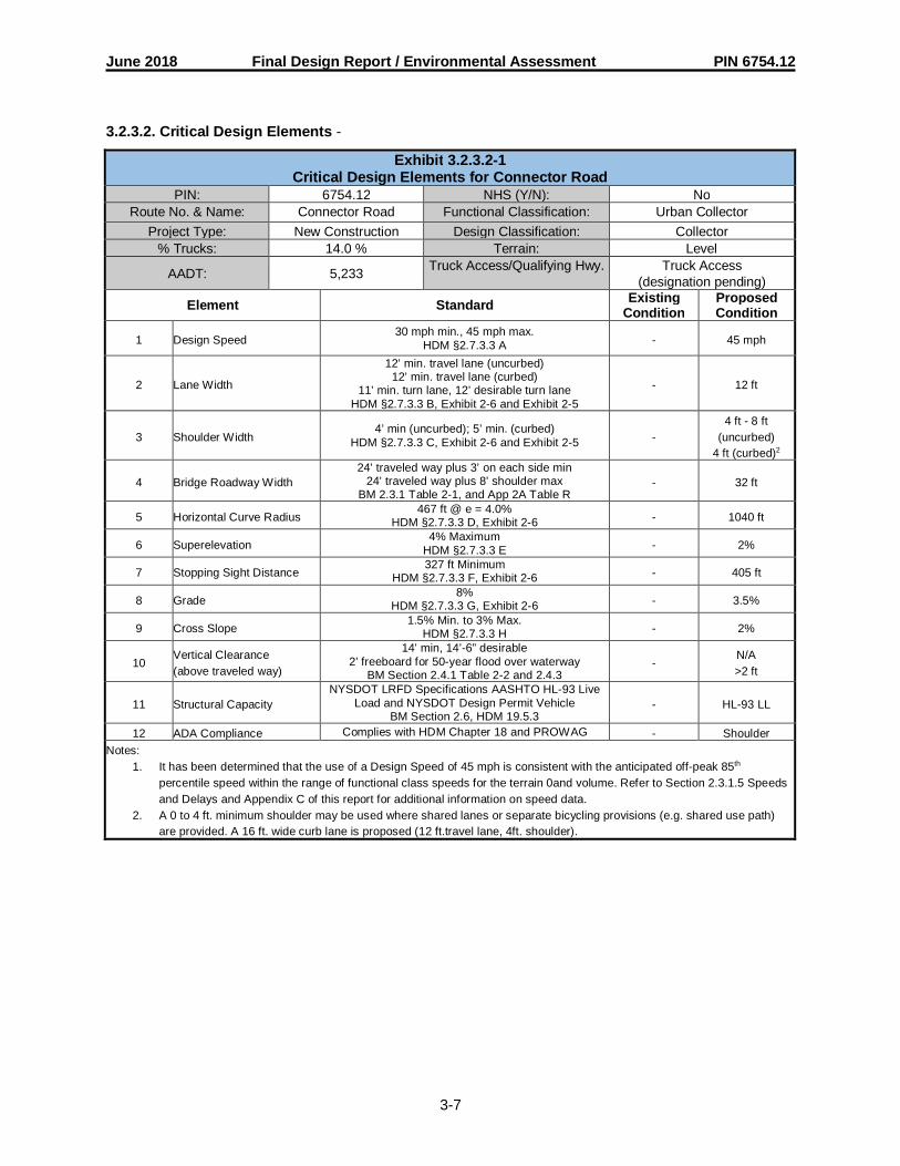
June 2018 Final Design Report / Environmental Assessment PIN 6754.12
3-7
3.2.3.2. Critical Design Elements -
Exhibit 3.2.3.2-1Critical Design Elements for Connector Road
PIN: 6754.12 NHS (Y/N): NoRoute No. & Name: Connector Road Functional Classification: Urban Collector
Project Type: New Construction Design Classification: Collector% Trucks: 14.0 % Terrain: Level
AADT: 5,233 Truck Access/Qualifying Hwy. Truck Access(designation pending)
Element Standard ExistingCondition
ProposedCondition
1 Design Speed30 mph min., 45 mph max.
HDM §2.7.3.3 A - 45 mph
2 Lane Width
12’ min. travel lane (uncurbed)12’ min. travel lane (curbed)
11’ min. turn lane, 12’ desirable turn laneHDM §2.7.3.3 B, Exhibit 2-6 and Exhibit 2-5
- 12 ft
3 Shoulder Width4’ min (uncurbed); 5’ min. (curbed)
HDM §2.7.3.3 C, Exhibit 2-6 and Exhibit 2-5 -4 ft - 8 ft
(uncurbed)4 ft (curbed)2
4 Bridge Roadway Width24’ traveled way plus 3’ on each side min
24’ traveled way plus 8’ shoulder maxBM 2.3.1 Table 2-1, and App 2A Table R
- 32 ft
5 Horizontal Curve Radius467 ft @ e = 4.0%
HDM §2.7.3.3 D, Exhibit 2-6 - 1040 ft
6 Superelevation4% Maximum
HDM §2.7.3.3 E - 2%
7 Stopping Sight Distance327 ft Minimum
HDM §2.7.3.3 F, Exhibit 2-6 - 405 ft
8 Grade8%
HDM §2.7.3.3 G, Exhibit 2-6 - 3.5%
9 Cross Slope1.5% Min. to 3% Max.
HDM §2.7.3.3 H - 2%
10Vertical Clearance(above traveled way)
14’ min, 14’-6” desirable2’ freeboard for 50-year flood over waterway
BM Section 2.4.1 Table 2-2 and 2.4.3-
N/A>2 ft
11 Structural CapacityNYSDOT LRFD Specifications AASHTO HL-93 Live
Load and NYSDOT Design Permit VehicleBM Section 2.6, HDM 19.5.3
- HL-93 LL
12 ADA Compliance Complies with HDM Chapter 18 and PROWAG - ShoulderNotes:
1. It has been determined that the use of a Design Speed of 45 mph is consistent with the anticipated off-peak 85th
percentile speed within the range of functional class speeds for the terrain 0and volume. Refer to Section 2.3.1.5 Speedsand Delays and Appendix C of this report for additional information on speed data.
2. A 0 to 4 ft. minimum shoulder may be used where shared lanes or separate bicycling provisions (e.g. shared use path)are provided. A 16 ft. wide curb lane is proposed (12 ft.travel lane, 4ft. shoulder).

June 2018 Final Design Report / Environmental Assessment PIN 6754.12
3-8
Exhibit 3.2.3.2-2Critical Design Elements for NYS Route 13
PIN: 6754.12 NHS (Y/N): YesRoute No. & Name: NYS Route 13 Functional Classification: Rural Principal Arterial
Project Type: Reconstruction Design Classification: Rural Arterial% Trucks: 12.5 % Terrain: Level
AADT: 12,120 Truck Access/QualifyingHwy. Truck Access
Element Standard ExistingCondition
ProposedCondition
1 Design Speed 40 mph min, 70 mph max1
HDM §2.7.2.2 A55 mph(posted) 60 mph
2 Lane Width12’ min
11’ min turn lane, 12’ desirableHDM §2.7.2.2 B, Exhibit 2-3a and 2-4
12 ft 12 ft
3 Shoulder Width 8’ minHDM §2.7.2.2 C, Exhibit 2-3a 8 ft 8 ft
4 Horizontal Curve Radius 1,200’ @ e = 8%HDM §2.7.2.2 D, Exhibit 2-3a 5,730 ft 5,730 ft
5 Superelevation 8% maxHDM §2.7.2.2 E 2.3% 2.3%
6 Stopping Sight Distance 570’ minHDM §2.7.2.2 F, Exhibit 2-3a > 570 ft > 570 ft
7 Grade 3% Max.HDM §2.7.2.2 G, Exhibit 2-3a 0.6% 0.6%
8 Cross Slope 1.5% min to 2.5% maxHDM §2.7.2.2 H 2% 2%
9 Vertical Clearance(above traveled way)
14’ min, 14’-6” desirable2’ freeboard for 50 year flood over waterway
BM §2.4.1 Table 2-2 and §2.4.3N/A N/A
10 Structural Capacity
NYSDOT LRFD SpecificationsAASHTO HL-93 Live Load and NYSDOT
Design Permit VehicleBM §2.6.1
N/A N/A
11 ADA Compliance Complies with HDM Chapter 18 andPROWAG Shoulder Shoulder
Notes:1. It has been determined that the use of a Design Speed of 60 mph is consistent with the anticipated off-peak 85th
percentile speed within the range of functional class speeds for the terrain and volume. Refer to Section 2.3.1.5 Speedsand Delays and Appendix C of this report for additional information on speed data.

June 2018 Final Design Report / Environmental Assessment PIN 6754.12
3-9
Exhibit 3.2.3.2-3Critical Design Elements for Old Ithaca Road
PIN: 6754.12 NHS (Y/N): NoRoute No. & Name: Old Ithaca Road Functional Classification: Urban Minor Arterial
Project Type: Reconstruction /Resurfacing Design Classification: Urban Arterial
% Trucks: 8.8 % Terrain: Level
AADT: 7,023 Truck Access/QualifyingHwy.
Truck Access (E Street north toRoute 13)
Element Standard ExistingCondition
ProposedCondition
1 Design Speed 35 mph min, 45 mph max1
HDM §2.7.2.3 A45 mph(posted)
45 mph(posted)
2 Lane Width11’ min, 12’ desirable travel lane11’ min, 12’ desirable turn lane
HDM §2.7.2.3 B, Exhibit 2-4
12 ftN/A
11 ft -12 ft14 ft
3 Shoulder Width4’ min (uncurbed)5’ min (curbed)
HDM §2.7.2.3 C, Exhibit 2-4 and Exhibit 2-38 ft (uncurbed) 8 ft (uncurbed)
0 ft – 4 ft (curbed)2
4 Horizontal CurveRadius
467’ (@ emax = 4.0%)HDM 2.7.2.3 D, Exhibit 2-4 N/A N/A
5 Superelevation 4% maxHDM §2.7.2.3 E NC NC
6 Stopping SightDistance
327’ minHDM §2.7.2.3 F, Exhibit 2-4 > 327 ft > 327 ft
7 Grade 6%HDM §2.7.2.3 G, Exhibit 2-4 0.5% 0.5%
8 Cross Slope 1.5% min to 3% maxHDM §2.7.2.3 H 2% 2%
9 Vertical Clearance(above traveled way)
14’ min, 14’-6” desirable2’ freeboard for 50 year flood over waterway
BM §2.4.1 Table 2-2 and §2.4.3N/A N/A
10 Structural Capacity
NYSDOT LRFD SpecificationsAASHTO HL-93 Live Load and NYSDOT
Design Permit VehicleBM §2.6.1
N/A N/A
11 ADA Compliance Complies with HDM Chapter 18 andPROWAG Shoulder Shoulder
Notes:1. It has been determined that the use of a Design Speed of 45 mph is consistent with the anticipated off-peak 85th
percentile speed within the range of functional class speeds for the terrain and volume. Refer to Section 2.3.1.5 Speedsand Delays and Appendix C of this report for additional information on speed data.
2. A 0 to 4 ft. minimum shoulder may be used where shared lanes or separate bicycling provisions (e.g. shared use path)are provided.
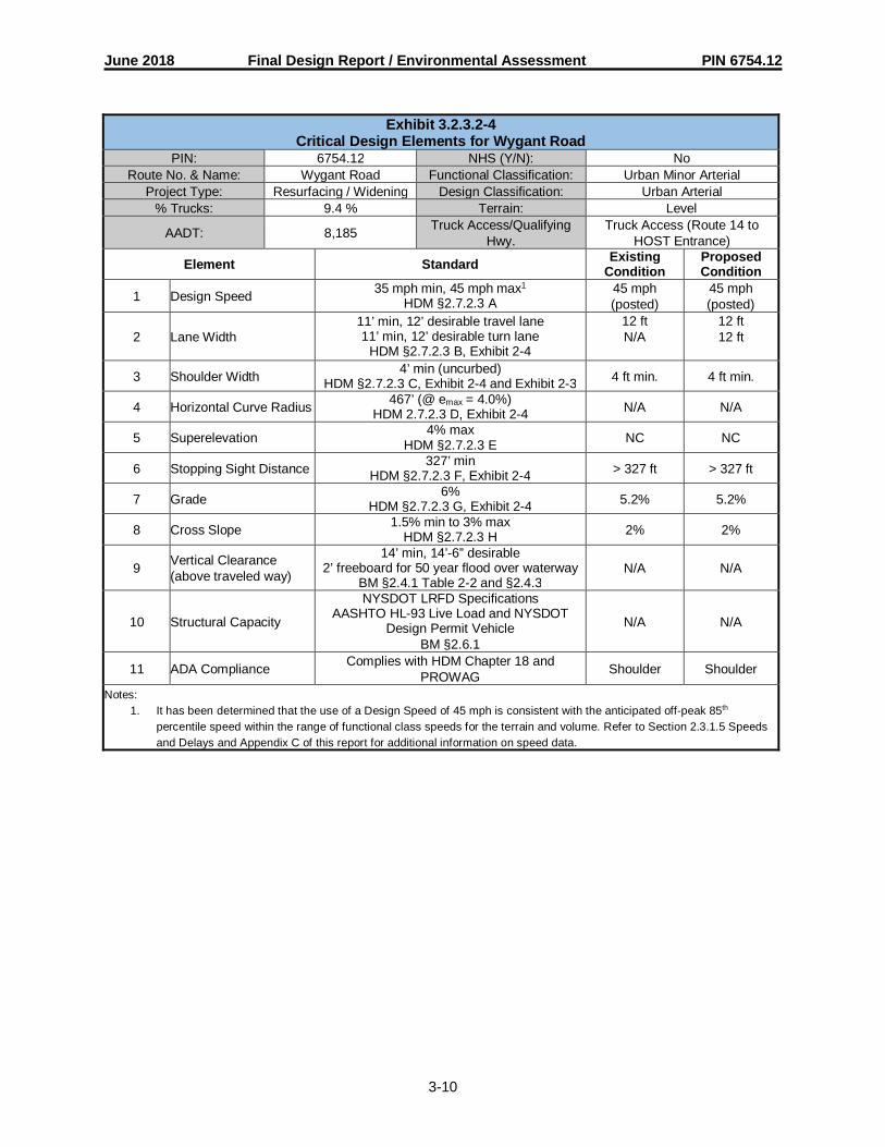
June 2018 Final Design Report / Environmental Assessment PIN 6754.12
3-10
Exhibit 3.2.3.2-4Critical Design Elements for Wygant Road
PIN: 6754.12 NHS (Y/N): NoRoute No. & Name: Wygant Road Functional Classification: Urban Minor Arterial
Project Type: Resurfacing / Widening Design Classification: Urban Arterial% Trucks: 9.4 % Terrain: Level
AADT: 8,185 Truck Access/QualifyingHwy.
Truck Access (Route 14 toHOST Entrance)
Element Standard ExistingCondition
ProposedCondition
1 Design Speed 35 mph min, 45 mph max1
HDM §2.7.2.3 A45 mph(posted)
45 mph(posted)
2 Lane Width11’ min, 12’ desirable travel lane11’ min, 12’ desirable turn lane
HDM §2.7.2.3 B, Exhibit 2-4
12 ftN/A
12 ft12 ft
3 Shoulder Width 4’ min (uncurbed)HDM §2.7.2.3 C, Exhibit 2-4 and Exhibit 2-3 4 ft min. 4 ft min.
4 Horizontal Curve Radius 467’ (@ emax = 4.0%)HDM 2.7.2.3 D, Exhibit 2-4 N/A N/A
5 Superelevation 4% maxHDM §2.7.2.3 E NC NC
6 Stopping Sight Distance 327’ minHDM §2.7.2.3 F, Exhibit 2-4 > 327 ft > 327 ft
7 Grade 6%HDM §2.7.2.3 G, Exhibit 2-4 5.2% 5.2%
8 Cross Slope 1.5% min to 3% maxHDM §2.7.2.3 H 2% 2%
9 Vertical Clearance(above traveled way)
14’ min, 14’-6” desirable2’ freeboard for 50 year flood over waterway
BM §2.4.1 Table 2-2 and §2.4.3N/A N/A
10 Structural Capacity
NYSDOT LRFD SpecificationsAASHTO HL-93 Live Load and NYSDOT
Design Permit VehicleBM §2.6.1
N/A N/A
11 ADA Compliance Complies with HDM Chapter 18 andPROWAG Shoulder Shoulder
Notes:1. It has been determined that the use of a Design Speed of 45 mph is consistent with the anticipated off-peak 85th
percentile speed within the range of functional class speeds for the terrain and volume. Refer to Section 2.3.1.5 Speedsand Delays and Appendix C of this report for additional information on speed data.
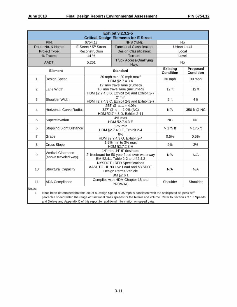
June 2018 Final Design Report / Environmental Assessment PIN 6754.12
3-11
Exhibit 3.2.3.2-5Critical Design Elements for E Street
PIN: 6754.12 NHS (Y/N): NoRoute No. & Name: E Street / 5th Street Functional Classification: Urban Local
Project Type: Reconstruction Design Classification: Local% Trucks: 14 % Terrain: Level
AADT: 5,251 Truck Access/QualifyingHwy. No
Element Standard ExistingCondition
ProposedCondition
1 Design Speed 20 mph min, 30 mph max1
HDM §2.7.4.3 A 30 mph 30 mph
2 Lane Width12’ min travel lane (curbed)
10’ min travel lane (uncurbed)HDM §2.7.4.3 B, Exhibit 2-8 and Exhibit 2-7
12 ft 12 ft
3 Shoulder Width 2’ minHDM §2.7.4.3 C, Exhibit 2-8 and Exhibit 2-7 2 ft 4 ft
4 Horizontal Curve Radius255’ @ emax = 4.0%
327’ @ e = -2.0% (NC)HDM §2.7.4.3 D, Exhibit 2-11
N/A 350 ft @ NC
5 Superelevation 4% maxHDM §2.7.4.3 E NC NC
6 Stopping Sight Distance 175’ minHDM §2.7.4.3 F, Exhibit 2-4 > 175 ft > 175 ft
7 Grade 8%HDM §2.7.4.3 G, Exhibit 2-4 0.5% 0.5%
8 Cross Slope 1.5% min to 3% maxHDM §2.7.2.3 H 2% 2%
9 Vertical Clearance(above traveled way)
14’ min, 14’-6” desirable2’ freeboard for 50 year flood over waterway
BM §2.4.1 Table 2-2 and §2.4.3N/A N/A
10 Structural Capacity
NYSDOT LRFD SpecificationsAASHTO HL-93 Live Load and NYSDOT
Design Permit VehicleBM §2.6.1
N/A N/A
11 ADA Compliance Complies with HDM Chapter 18 andPROWAG Shoulder Shoulder
Notes:1. It has been determined that the use of a Design Speed of 35 mph is consistent with the anticipated off-peak 85th
percentile speed within the range of functional class speeds for the terrain and volume. Refer to Section 2.3.1.5 Speedsand Delays and Appendix C of this report for additional information on speed data.

June 2018 Final Design Report / Environmental Assessment PIN 6754.12
3-12
3.2.3.3. Other Design Parameters –Recommended design standards for roundabouts are established by the NYSDOT EngineeringInstruction 00-21 Roundabouts: Interim Requirements and Guidance (EI 00-21) and the Federal HighwayAdministration Roundabouts: An Informational Guide. Refer to Exhibit 3.2.3.3-1 and Exhibit 3.2.3.3-2 for acomparison of standard and proposed roundabout parameters.
Exhibit 3.2.3.3-1Other Design Parameters: Roundabout at Connector Road/Route 13
Intersection Name: NYS Route 13 &Connector Rd.
Roundabout Type: Urban Single Lane
% Trucks: 13.5% Design Vehicle: WB-40 w/o truck apronWB-65 using truck apron
RoundaboutCapacity: 2,490 Veh/hr Demand Flow: 1,830 Veh/hr
Element Standard Criteria Proposed Condition by ApproachNorth South West
Design Speed 30 mph maxEI 00-21 §3.1.2.a 20 mph 20 mph 20 mph
Max EntrySuperelevation
5%EI 00-21 §3.1.2.b 2% 2% 2%
Effective FlareLength
40’ min, 330’ max, 100’ desirableEI 00-21 §3.1.2.c 71’ 79’ 77’
Entry Lane Width 10’ min, 35’ maxEI 00-21 §3.1.2.d-e 18’ 18’ 18’
Entry Radius 35’ min, 330’ max, 65’ desirableEI 00-21 §3.1.2.f 110’ 110’ 110’
Entry Angle 20° min, 60° max, 30°-40° desirableEI 00-21 §3.1.2.g 32° 31° 32°
Minimum Exit Radius 65’ min to 330’, 65’ desirable.EI 00-21 §3.1.2.p 650’ 800’ 500’
Stopping SightDistance
497’ for North and South approaches.363’ for West approach
FHWA §6.3.9>497 >497 >363
Intersection SightDistance
d1=169’ min for south, d1=143’ min forwest
d2=115’ minNCHRP 672 §6.7.3.2
d1=N/A
d2=115’
d1=169’
d2=115’
d1=143’
d2=115’
Inscribed CircleDiameter
50’ min, 330’ maxEI 00-21 §3.1.2.k 150’
Circulating RoadwayCross Slope
0.5% min, 2.5% maxEI 00-21 §3.1.2.l 2%
Circulating RoadwayWidth
20’ min, 24’ maxEI 00-21 §3.1.2.m 20’
Control and Accessof Parking
No parking or access within 80’ ofyield line. EI 00-21 §3.1.2.n
No parking or access within 80’ ofyield line
Minimum CirculatingSight Distance
78’FHWA §6.3.9 113’
PedestrianAccommodations
Complies with HDM Chapter 18 andPROWAG
EI 00-21 §3.1.2.q
Comply with HDM Ch. 18 &PROWAG
Max Travel LaneRollover
4%EI 00-21 §3.1.2.s 4%
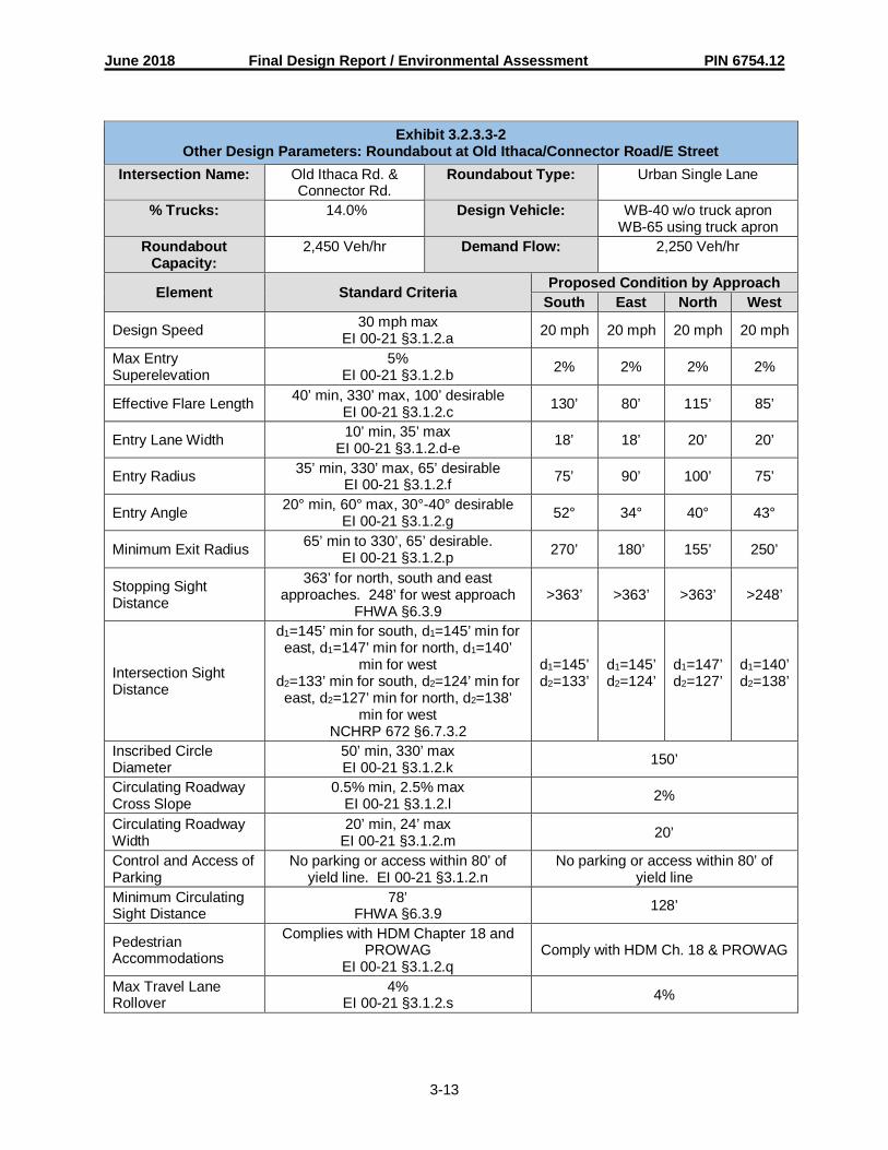
June 2018 Final Design Report / Environmental Assessment PIN 6754.12
3-13
Exhibit 3.2.3.3-2Other Design Parameters: Roundabout at Old Ithaca/Connector Road/E Street
Intersection Name: Old Ithaca Rd. &Connector Rd.
Roundabout Type: Urban Single Lane
% Trucks: 14.0% Design Vehicle: WB-40 w/o truck apronWB-65 using truck apron
RoundaboutCapacity:
2,450 Veh/hr Demand Flow: 2,250 Veh/hr
Element Standard Criteria Proposed Condition by ApproachSouth East North West
Design Speed 30 mph maxEI 00-21 §3.1.2.a 20 mph 20 mph 20 mph 20 mph
Max EntrySuperelevation
5%EI 00-21 §3.1.2.b 2% 2% 2% 2%
Effective Flare Length 40’ min, 330’ max, 100’ desirableEI 00-21 §3.1.2.c 130’ 80’ 115’ 85’
Entry Lane Width 10’ min, 35’ maxEI 00-21 §3.1.2.d-e 18’ 18’ 20’ 20’
Entry Radius 35’ min, 330’ max, 65’ desirableEI 00-21 §3.1.2.f 75’ 90’ 100’ 75’
Entry Angle 20° min, 60° max, 30°-40° desirableEI 00-21 §3.1.2.g 52° 34° 40° 43°
Minimum Exit Radius 65’ min to 330’, 65’ desirable.EI 00-21 §3.1.2.p 270’ 180’ 155’ 250’
Stopping SightDistance
363’ for north, south and eastapproaches. 248’ for west approach
FHWA §6.3.9>363’ >363’ >363’ >248’
Intersection SightDistance
d1=145’ min for south, d1=145’ min foreast, d1=147’ min for north, d1=140’
min for westd2=133’ min for south, d2=124’ min foreast, d2=127’ min for north, d2=138’
min for westNCHRP 672 §6.7.3.2
d1=145’d2=133’
d1=145’d2=124’
d1=147’d2=127’
d1=140’d2=138’
Inscribed CircleDiameter
50’ min, 330’ maxEI 00-21 §3.1.2.k 150’
Circulating RoadwayCross Slope
0.5% min, 2.5% maxEI 00-21 §3.1.2.l 2%
Circulating RoadwayWidth
20’ min, 24’ maxEI 00-21 §3.1.2.m 20’
Control and Access ofParking
No parking or access within 80’ ofyield line. EI 00-21 §3.1.2.n
No parking or access within 80’ ofyield line
Minimum CirculatingSight Distance
78’FHWA §6.3.9 128’
PedestrianAccommodations
Complies with HDM Chapter 18 andPROWAG
EI 00-21 §3.1.2.qComply with HDM Ch. 18 & PROWAG
Max Travel LaneRollover
4%EI 00-21 §3.1.2.s 4%

June 2018 Final Design Report / Environmental Assessment PIN 6754.12
3-14
Other important engineering standards and normally accepted practices upon which the alternatives arebased are included in the following exhibits:
Exhibit 3.2.3.3-3Other Design Parameters: Design Vehicle
Location Design Vehicle Vehicle AccommodatedAlternative 2
Connector Road and Route 13 SU, HDM §5.7.1.1 WB-65 (53’ Trailer) all legsSubalternative B2
Connector Road and Old Ithaca Road SU, HDM §5.7.1.1 WB-65 (53’ Trailer) all legs
5th Street and E Street SU, HDM §5.7.1.1 WB-50 (42.5’ Trailer) SBRWB-65 (53’ Trailer) all other legs
Exhibit 3.2.3.3-4Other Design Parameters: Miscellaneous
Element Criteria Proposed ConditionConnector Road
Level of Service (non-interstate) D min, C desirable; HDM §5.2.2.1 CDesign Storm: Culverts = Storm Drainage System = Ditches =
50 yrs: HDM §8.3.2.45 yrs: HDM §8.3.2.410 yrs: HDM §8.3.2.4
50510
Route 13Level of Service (non-interstate) D min, C desirable; HDM §5.2.2.1 DDesign Storm: Culverts = Storm Drainage System = Ditches =
50 yrs: HDM §8.3.2.410 yrs: HDM §8.3.2.425 yrs: HDM §8.3.2.4
50N/A25
Old Ithaca RoadLevel of Service (non-interstate) D min, C desirable; HDM §5.2.2.1 CDesign Storm: Culverts = Storm Drainage System = Ditches =
50 yrs: HDM §8.3.2.45 yrs: HDM §8.3.2.410 yrs: HDM §8.3.2.4
N/A510
E Street/5th StreetLevel of Service (non-interstate) D min, C desirable; HDM §5.2.2.1 BDesign Storm: Culverts = Storm Drainage System = Ditches =
50 yrs: HDM §8.3.2.45 yrs: HDM §8.3.2.410 yrs: HDM §8.3.2.4
N/A510
3.3. Engineering Considerations
3.3.1. Operations (Traffic and Safety) & Maintenance
3.3.1.1. Functional Classification and National Highway System –
The project will not affect the functional classification of any existing highways in the study area. TheRoute 13 Connector Road is functionally classified as an Urban Collector (FC17). The Connector Roadwould not be on the NHS.

June 2018 Final Design Report / Environmental Assessment PIN 6754.12
3-15
3.3.1.2. Control of Access -
Vehicular access onto the Route 13 Connector Road would not be prohibited, except at the approach toRoute 13, where access would be prohibited for approximately 300 feet at the request of NYSDOT. Abreak in access agreement with NYSDOT would be required for the proposed Connector Roadintersection with Route 13.
Access onto E Street in the vicinity of Building 13-1 in the HOST Terminal would be refined with the buildAlternative 2. Driveways leading to the loading bays would be narrowed and defined to accommodate aWB-50 (42.5-foot semi-trailer) design vehicle at the northerly 2 loading bays and WB-65 (53-foot semi-trailer) at all other loading bays.
In order for the project objectives to be fully met and implemented, the Connector Road must bedesignated as an Access Highway in accordance with §385(3)(e) of NYS Vehicle and Traffic Law.NYSDOT has indicated that the County should file a formal request for designation with NYSDOT oncethe project is under construction.
3.3.1.3. Traffic Control Devices -
There is one existing signalized intersection on Wygant Road at the intersection with NYS Route 14 thathas semi-actuated, three color traffic signals with northbound and westbound right turn arrows suspendedfrom span wire supported poles. The existing traffic signal would be retained and inductance loopsdisturbed by construction would be replaced in-kind.
All existing signs within the proposed work limits would be inspected for condition and evaluated forconformance with current standards during final design. All proposed signs and pavement markingswould conform to current standards outlined in the MUTCD.
3.3.1.4. Intelligent Transportation Systems (ITS) –
No ITS measures are proposed.
3.3.1.5. Speeds and Delay -
The posted speed limit on existing roadways within the project limits will not be affected by the project.The proposed speed limit on the Connector Road has not been determined by local resolution.
Travel time estimates have not been performed, since the feasible alternative is not expected toadversely affect the capacity of the existing roadway network.
3.3.1.6. Traffic Volumes –Traffic volume projections were forecasted for the Build scenario at ETC (2020), ETC+10 (2030) andETC+20 (2040) with growth rate of 1.0% (annually compounded) based on historical data. The Buildtraffic volumes represent the traffic impact on the study area if the preferred alternative (and sub-alternatives) in this report were constructed. Detailed trip generation, distribution, and diversionmethodology of the affected study area are contained in the Design Year Traffic Analysis of Appendix C.When estimating the proposed trip generation from units within the HOST facility, relatively aggressivegrowth forecasts were utilized. Based on history of the HOST facility, rapid spikes in traffic volumes havebeen experienced in the past, and it was important to capture the potential growth of the facility to ensurethe new connector road and surrounding roadways could handle the additional traffic. The results aresummarized in Exhibit 3.3.1.6-1 below.

June 2018 Final Design Report / Environmental Assessment PIN 6754.12
3-16
Exhibit 3.3.1.6-1Traffic Data Forecast (Build)
Segment ETC(2020)
ETC+10(2030)
ETC+20(2040)
Route 13(North of East
Franklin Street)
AADT 12120 13039 15749DHV 1189 (977) 1288 (1050) 1525 (1294)HV% 13.5%
Old Ithaca Road(Between HanoverSquare & E Street)
AADT 8032 8814 9973DHV 563 (776) 616 (852) 771 (1061)HV% 9.0%
North Main Street(Between HanoverSquare & 6th Street)
AADT 7038 7648 8982DHV 560 (707) 607 (769) 714 (903)HV% 5.0%
Wygant Road(Between Watkins
Rd. & A Street)
AADT 8185 8901 10433DHV 753 (769) 819 (837) 960 (980)HV% 4.0%
Connector Road
ETC(2020)
ETC+10(2030)
ETC+20(2040)
ETC+301
(2050)AADT 5233 5441 7503 7757DHV 446 (496) 463 (516) 632 (719) 653 (743)HV% 14.0%
Note: AM (PM)1. Build ETC+30 is shown for connector road bridge design year analysis only. Build ETC+30 volumes
include background traffic added to Build ETC+20.
3.3.1.7. Level of Service and Mobility –Build scenario levels of service results for roadway segments within the study area are provided in Exhibit3.3.1.7-1. Results are determined using forecasted traffic data from Exhibit 3.3.1.6-1 above. All roadwaysegments are anticipated to operate acceptable with level of service of D or better throughout the designyears.
Exhibit 3.3.1.7-1Segment LOS Summary (Build)
Segment ETC ETC+10 ETC+20 ETC+301
Connector Road(Between Route 13 & Old Ithaca Road) C (C) C (C) C (C) C (C)
Route 13(0.4 mi. North of Franklin Street) D (D) D (D) D (D) --------
Old Ithaca Road(North of East Franklin Street) B (D) B (D) B (D) --------
North Main Street(Between Old Ithaca Road & E Street) B (D) B (D) B (D) --------
Wygant Road(Between 5th Street & Schlumberger) B (D) B (D) C (D) --------
Note: AM (PM)1. Build ETC+30 is shown for connector road bridge design year analysis only.
Build scenario levels of service results for intersections within the study area are provided in Exhibit3.3.1.7-2 below. The study intersections and proposed intersections under Alternative 2 andSubalternative B2 is projected to operate with acceptable levels of service ranging from LOS A to Dthroughout the design year with the exception of Route 13 and Franklin Street and Wygant Road and AStreet. A detailed level of service table consisting of individual movements is provided in Appendix C2.

June 2018 Final Design Report / Environmental Assessment PIN 6754.12
3-17
Exhibit 3.3.1.7-2Intersection LOS/ Average Delay Summary (Build)
Intersection Geometry/Control Type ETC ETC+10 ETC+20Route 13 & E.
Franklin St.4 Leg Single Lane
RoundaboutC (C)
21.3 (18.8)D (D)
33.8 (27.0)F (F)
67.3 (59.0)
Route 13 &Connector Rd.
Alternative 23 Leg Single Lane
Roundabout
B (A)10.9 (9.6)
B (B)13.7 (10.7)
D2 (C)28.1 (15.2)
Old Ithaca &Connector Rd
Subalternative B24 Leg single lane
Roundabout
B (A)10.6 (9.0)
B (A)12.0 (9.8)
D3 (C)30.0 (17.0)
Old Ithaca & RidgeRoad / Alex Drive
4 Leg1 Stop on Ridge Road1
1 Stop on Alex Drive1
EBL: B (B)13.0 (12.0)WBL: C (C)16.0 (18.5)
EBL: B (B)13.7 (12.4)WBL: C (C)17.6 (20.7)
EBL: C (B)16.5 (13.9)WBL: C (C)22.8 (25.4)
Hanover Square 5 Leg1 Free on Main St. NB
B (B)14.7 (14.5)
C (C)16.4 (15.8)
C (C)19.5 (20.3)
N. Main St. & 6th St. 3 Leg1 Stop on 6th Street1
B (B)11.5 (13.7)
B (B)11.8 (14.3)
B (C)13.2 (18.6)
NYS Route 14 &Wygant Road
3 LegSignalized
B (B)19.0 (16.6)
C (B)20.2 (18.0)
C (C)21.8 (21.8)
Wygant Rd. & A St. 3 Leg1 Stop on A Street
C (C)19 (19.9)
C (C)21.1 (22.4)
D (E)4
31.2 (49.4)Route 13 & Old
Ithaca Rd.4 Leg Single Lane
Roundabout - - C (D)22.4 (27.3)
Note: AM (PM)1. Level of service for critical left movements (stop approach) are displayed for two-way stop
control.2. Southbound approach operates at LOS E with 48.1 seconds of delay.3. Southbound approach operates at LOS F with 58.3 seconds of delay.4. SimTraffic predicts 18 seconds of delay (LOS C) and a 95th percentile queue of 140 ft.
NYS Route 13 and Franklin Street – During the AM and PM peak hours of the Build ETC+20 condition,the overall intersection level of service is projected to operate at LOS F with delay of 67 seconds and 59seconds, respectively. Since this intersection is not within the construction limits of this project it isrecommended that this intersection be monitored throughout the ETC+20 design year. At some point, itmay be recommended to install pocket northbound and southbound right turn lanes in order to mitigatedelays.
NYS Route 13 and Connector Road – According to the detailed level of service table contained inAppendix C2, the southbound approach of the AM Build ETC+20 Roundabout condition is projected tooperate at LOS E with 48 seconds of delay. It is recommended that this intersection be monitoredthroughout the ETC+20 design year for both alternatives.
Old Ithaca Road and Connector Road – According to the detailed level of service table contained inAppendix C2, the southbound approach of the AM Build ETC+20 Roundabout condition is projected tooperate at LOS F with 58.3 seconds of delay. Possible mitigation could include the installation of a pocketsouthbound right turn lane for Subalternative B2 (Roundabout) to mitigate these delays at a future dateonce traffic warrants it.
NYS Route 14 and Wygant Road – As it exists today, the westbound approach includes a right turnoverlap and right turning vehicles were observed developing an improvised right turn lane by using theshoulder. For this traffic analysis, the westbound approach was modeled with an exclusive right turn laneto correctly demonstrate field conditions. Modeling the westbound approach without the exclusive rightturn lane results in levels of service that range from LOS E to LOS F with extensive vehicle delay for alldesign year scenarios. It is recommended that an exclusive right turn lane of approximately 150’ beinstalled on the westbound approach to appropriately accommodate motorists turning right onto NYS

June 2018 Final Design Report / Environmental Assessment PIN 6754.12
3-18
Route 14 north. This would improve right turning vehicles from waiting for queued left turning vehicles inthe westbound shared left-right lane.
Wygant Road and A Street – During the PM peak hour of the Build ETC+20 condition, the northbound leftis projected to operate at LOS E with 49 seconds of delay. In general, the Synchro model overestimatesstop sign delays for TWSC (two way stop control) intersections where the major road is a two lanehighway and there is no center two way left turn lane. The SimTraffic model simulates traffic flowindicates/predicts less delay and better LOS as shown in the footnote of the table. Field observationshave found that often times actual delays fall between that predicted by Synchro and by SimTraffic.
Refer to Section 3.3.1.8 for further discussion regarding safety considerations.
3.3.1.7.(2) Work Zone Safety & Mobility:Two-way traffic at the proposed single lane modern roundabout on Route 13 at the proposed ConnectorRoad would be maintained on existing and temporary roadway surfaces during construction. Two-waytraffic on Route 13 would be maintained by utilizing shoulder closures and periodic flagging control whileinstallation of temporary pavement is completed. Periodic flagging operations will be necessary forconstruction vehicles to access work area once the temporary pavement is installed. No detours or long-term lane closures are anticipated to be required to construct the new roundabout.
Traffic on Old Ithaca Road and Wygant Road would be maintained on existing or temporary roadwaysurfaces for the duration of construction. No detours or long-term lane closures are anticipated to berequired to construct the new roadway segments. Traffic at tie-in points and at the proposed intersectionsunder subalternative B2 would be controlled with short-term, daily lane closures and flagging operations.No detours or long-term lane closures are anticipated to be required to construct the new roundaboutunder subalternative B2, however, periodic flagging operations will be necessary for construction vehiclesto access work area once the temporary pavement is installed.
Traffic on E street and 5th Street would also be maintained with short-term, daily lane closures andflagging operations; although more driveway closures or restrictions to vehicle size may be required toconstruct the improvements at the approach to Old Ithaca Road. All work proposed under the varioussubalternatives is well suited to staging during construction.
All work zones would be set up in conformance with the MUTCD. A clearly marked travel way would bedelineated with temporary pavement markings, traffic signage, barricades, drums, cones, etc. asapplicable while traffic is maintained through the intersection. Flaggers would be utilized to direct trafficwhere required. Access to affected industrial, retail, and residential properties would be maintainedthroughout construction or alternate accommodations provided. Access for emergency vehicles and localdeliveries would also be maintained.
Details pertaining to work zone traffic control during construction – including recommended staging andsequencing of construction – would be developed during final design of the project. The proposed trafficcontrol scheme on Route 13 would require review and approval from NYSDOT as well as a HighwayWork Permit. Due to the close proximity to residential homes and the ability to maintain traffic withacceptable delays during the daylight hours, nighttime construction should not be utilized. The use of timerelated provisions should be evaluated during final design.
Any staging schemes or access restrictions should be coordinated with emergency service providers,transit agencies, and school districts during the final design phase as well as construction. At a minimum,coordination should take place with:
§ Town and Country Fire Department§ Horseheads Fire and Rescue Company§ Horseheads Police Department§ Chemung County Sheriff§ New York State Police§ Horseheads Central School District§ Chemung County Transit System

June 2018 Final Design Report / Environmental Assessment PIN 6754.12
3-19
The project does not include work on an Interstate located within a designated TransportationManagement Area (TMA); therefore, further coordination for Significant Projects as defined in 23 CFR630.1010 is not necessary.
3.3.1.8. Safety Considerations, Accident History and Analysis –Exhibit 3.3.1.8 presents a diagram of vehicle-vehicle conflict points for a traditional four-leg intersectionwith left turn lanes and a four-leg roundabout. As the figure shows, the number of vehicle-vehicle conflictpoints for roundabouts decreases from 33 for four-leg intersections to 8.
Exhibit 3.3.1.8Intersection Conflict Points
As Exhibit 3.3.1.8 shows, the roundabout provided by Alternative 2 and Subalternative B2 would reducevehicular crossing conflicts for the three- and four-leg intersections proposed by converting allmovements to right turns. Separate turn lanes and signalization could help to reduce, but not eliminate,the number of crossing conflicts at a traditional intersection by separating conflicts in space and time.However, the most severe crashes at signalized intersections occur when there is a violation of the trafficcontrol device designed to separate conflicts by time (e.g., a right-angle collision due to running a redlight, and vehicle-pedestrian collisions). Therefore, the ability of single-lane roundabouts to reduceconflicts through physical, geometric features has been demonstrated to be more effective than thereliance on driver obedience of traffic control devices.
The addition of a westbound right turn lane at the NYS Route 14 / Wygant Road intersection wouldimprove the safety of that intersection. This would in effect also create a left turn lane, as Wygant Roadcomes to a ‘T’ intersection with NYS Route 14. According to the NYSDOT Post ImplementationEvaluation System Accident Reduction Factors, channelization and the addition of a left turn lane canreduce all accidents by up to 48%.
Desirable clear zones widths should be provided where right-of-way and environmental constraints allow.Where minimum clear zones cannot be provided, any obstructions should be appropriately shielded. Thefinal determination of the design clear zone width should be made during the final design phase.
3.3.1.9. Impacts on Police, Fire Protection and Ambulance Access –The project is expected to provide long-term benefits to emergency services providers. The connectorroad would provide an additional means of access between Route 13 and Old Ithaca Road, with loadcapacity and intersection geometry able to accommodate the largest rescue vehicles in use. In addition,the project would indirectly provide offsite capacity improvements and reduce congestion at intersectionsduring peak travel periods – reducing potential conflicts with motorists and potentially increasing responsetime.

June 2018 Final Design Report / Environmental Assessment PIN 6754.12
3-20
Refer to Section 3.3.1.7(2) for a discussion of the anticipated impacts during construction.
3.3.1.10. Parking Regulations and Parking Related Issues –
No changes in parking restrictions are proposed by the project.
3.3.1.11. Lighting –
Continuous roadway lighting along the affected segments does not appear to be warranted. Alternative 2(with subalternative B2) will require lighting at both the NYS Route 13 / Connector Road intersection andthe Old Ithaca Road/Connector Road/5th Street intersection in conformance with FHWA’s Roundabouts:An Informational Guide, Second Edition (2010), NYSDOT’s Policy on Highway Lighting (1979) and theHDM. Consideration should be given to using the ecoluminance approach to lighting design as describedin the Lighting Research Center’s Lighting and Vegetation for Energy-Efficient and Safe Roadway Travel(2009). The ecoluminance approach, as it relates to roundabouts, involves the incorporation of vegetationand lighting to cue the driver’s attention to pedestrians and other potential hazards along the road, whileminimizing light pollution and operating costs.
Both the NYSDOT and Chemung County have advised that LED light fixtures will be desired at both ofthe Connector Road intersections (roundabouts) under their respective jurisdictions.
3.3.1.12. Ownership and Maintenance Jurisdiction –Ownership and maintenance responsibilities for the existing roadways, including any improvements,would remain as described in Section 2.3.1.12 of this report. Ownership and maintenance jurisdiction ofthe proposed connector road and a portion of 5th Street, would be assumed by Chemung County.Ownership and maintenance responsibility of the improved levee would remain with the Town ofHorseheads although a formal request has been sent to the NYSDEC for them to take over the ownershipand maintenance of the levee once the project is complete. Refer to the following Exhibit for moreinformation:
Exhibit 3.3.1.12Proposed Ownership and Maintenance Jurisdiction (Build)
Highway Limits Feature(s)Maintained Agency Authority
RoadwaysOld Ithaca Road /
CR 68 Entirety Pavement, drainage, landscaping,and snow removal
ChemungCounty
Section 129 & 135Highway Law
NYS Route 13S.H. 59-07 Entirety Pavement, drainage, landscaping,
and snow removal State Section 12Highway Law
Connector Road Entirety Pavement, drainage, landscaping,and snow removal
ChemungCounty
Section 129 & 135Highway Law
NYS Route 14 Entirety Pavement, drainage, landscaping,and snow removal State Section 12
Highway LawWygant Road /
CR 21 Entirety Pavement, drainage, landscaping,and snow removal
ChemungCounty
Section 129 & 135Highway Law
E Street Entirety Pavement, drainage, landscaping,and snow removal
ChemungCounty
Section 129 & 135Highway Law
Ridge RoadCR 5 Entirety Pavement, drainage, landscaping,
and snow removalChemung
CountySection 10, Sub.25 Highway Law
A Street Entirety Pavement, drainage, landscaping,and snow removal Private Section 54(a)
Highway Law
5th Street See Note 1 Pavement, drainage, landscaping,and snow removal Private1 Section 54(a)
Highway Law
Alex Drive Entirety Pavement, drainage, landscaping,and snow removal Private Section 54(a)
Highway Law

June 2018 Final Design Report / Environmental Assessment PIN 6754.12
3-21
Exhibit 3.3.1.12Proposed Ownership and Maintenance Jurisdiction (Build)
Highway Limits Feature(s)Maintained Agency Authority
StructuresNYS Route 13
S.H. 59-07 Entirety Underpass Structure(CIN C6200030) State Section 233
Highway Law
Connector Road EntiretyBridge over Newtown Creek
(including stream channel andbanks within the R.O.W.)
ChemungCounty
Section 130Highway Law
Wygant Road /CR 21 Entirety Culvert Structure Chemung
CountySection 130
Highway LawTraffic Signals
Wygant Road /CR 21 Entirety Intersection of NYS Route 14
and Wygant Road/CR21 State Section 12Highway Law
Roundabouts
NYS Route 13 &Connector Road
Circulatory Road& Approaches
Pavement, drainage, lighting,landscaping, Islands State
Section 12Highway lawCirculatory Road Snow Removal State
Approaches Snow Removal County
Old Ithaca Rd. / CR68 & Connector Rd. Entirety
Pavement, Islands, Drainage,Lighting, Landscaping,
& Snow RemovalChemung
CountySection 12
Highway Law
RailroadsWygant Road /
CR 21WithinR.O.W.
Highway Grade CrossingDOT# 526682S
NorfolkSouthern
Section 24(c)Highway Law
Wygant Road /CR 21
WithinR.O.W. Highway Grade Crossing Industry
(HOST)Section 24(c)Highway Law
Flood Control Structures
Newtown CreekLevee Entirety
Levee - Within Limits ofExisting and ProposedPermanent Easements
Town ofHorseheads2
Notes:1. The realigned portion of 5th Street (from Sta. 5+00 east to E Street intersection) would be owned and maintained
by Chemung County under Subalternative B2 (Roundabout).2. A formal request has been made to the NYS DEC to take-over Ownership and Maintenance of the Improved levee
once accreditation and recognition by FEMA is attained.
3.3.1.13. Constructability Review –
A constructability review has not been performed for the project. The project work elements are expectedto be routine, the work area should not be overly-confining or restrictive, and the schedule is not expectedto be compressed. A final constructability review should be performed by the proposed constructioninspection staff during the final design phase of the project.
3.3.2. Multimodal3.3.2.1. Pedestrians –No separate pedestrian accommodations would be provided on the new Connector Road due to the lackof pedestrian generator density and stakeholder interest. Pedestrians on Old Ithaca Road and WygantRoad would be accommodated on the paved shoulders. Refer to Appendix C4 for the Complete StreetsChecklist.
June 2018 Final Design Report / Environmental Assessment PIN 6754.12
3-22
3.3.2.2. Bicyclists –No separate provisions to accommodate bicyclists are proposed. Bicyclists would be accommodated onthe paved shoulders.
3.3.2.3. Transit –No changes to the CTran routes on Old Ithaca Road and Route 13, or the private carrier routes on Route13 are anticipated as part of the project. Refer to Section 3.3.1.7(2) for a discussion of the anticipatedimpacts during construction.
3.3.2.4. Airports, Railroad Stations, and Ports –There are no airports, railroad stations or port entrances within the project study area.
3.3.2.5. Access to Recreation Areas (Parks, Trails, Waterways, and State Lands) –The project would not affect access to any recreation areas.
3.3.3. Infrastructure
3.3.3.1. Proposed Highway Section –
Refer to Appendix A for preliminary typical sections of all alternatives under consideration.
3.3.3.1. (1) Right-of-Way:Right-of-way along the proposed connector road would be acquired with access, except at theroundabout of the connector road and Route 13. The initial 300-ft of proposed Connector Road right-of-way immediately west of the NYS Route 13 would be restricted or “without access” at NYSDOT’s request.All right-of-way necessary for the construction of improvements to Old Ithaca Road, E Street, 5th Street,Ridge Road, and Wygant Road would be acquired with access.
Permanent easements will likely be required to construct the levee improvements and for futuremaintenance. A draft ROW acquisition table is included in Appendix G.
The property incorporated into the project would be acquired in accordance with the Uniform RelocationAssistance and Real Property Acquisition Polices Act of 1970, as amended and related Federalregulations.
3.3.3.1. (2) Curb:Alternative 2 includes the installation of 6-inch vertical faced granite curb on both sides of the connectorroad from the intersection of Old Ithaca Road easterly across the bridge over Newtown Creek as fundsallow. Granite curb would also be installed along Old Ithaca Road between the town line to Ridge Road.The curb would help contain and direct any roadway runoff to a controlled discharge point, and would aidin the calming of traffic. A short run of 12-inch-wide traversable concrete curb in the vicinity of stationC32+50 would help direct roadside drainage and limit erosion in the adjacent cut section. On the Route13 roundabout, splitter islands would be constructed with 6-inch mountable granite curb to prevent theoccasional errant vehicle from destabilizing, as well as allow emergency vehicles to maneuver aroundany stopped vehicles if necessary. The truck apron and circulatory roadway would be separated bytraversable concrete curb, which would limit any discomfort to truck drivers and reduce the possibility ofloads shifting in truck trailers.
Subalternative B2 includes the installation of 6-inch vertical faced granite to the outside of the traveledway at all approaches to the roundabout at Old Ithaca Road. Splitter islands would be constructed with 6-inch mountable granite curb to prevent the occasional errant vehicle from destabilizing, as well as allowemergency vehicles to maneuver around any stopped vehicles if necessary. The truck apron andcirculatory roadway would be separated by traversable concrete curb, which would limit any discomfort totruck drivers and reduce the possibility of loads shifting in truck trailers.

June 2018 Final Design Report / Environmental Assessment PIN 6754.12
3-23
3.3.3.1. (3) Grades:The proposed maximum grade on the connector road would be 3.5%. Maximum grades on Route 13 andOld Ithaca Road would remain 0.6% and 0.5%, respectively. Minimum grades would be 0.5% in curbedareas to avoid creating flat spots.
3.3.3.1. (4) Intersection Geometry and Conditions:Alternative 2 includes construction of a new single-lane modern roundabout at Route 13 and theproposed Connector Road. The roundabout would physically eliminate left turns and crossing maneuvers.Refer to Section 3.3.1.8 above regarding a significant reduction in conflict points compared to a traditionalsignalized intersection. The geometric design of the roundabout provides the optimal balance betweenaccommodating the design vehicle and ensuring slow speeds to improve intersection safety. Vehicleturning paths of the design vehicle were analyzed to provide adequate space for large trucks to maneuverefficiently and reliably through the roundabout. Semi-trailers up to 53-feet would be accommodated bymounting the truck apron. The truck apron is a raised section of concrete around the central island thatprovides additional width for large vehicles and vehicles with trailers. The back wheels of a large vehiclecan mount the curb that lines the truck apron and traverse the raised portion of concrete so it may easilycomplete the turn while discouraging use by smaller vehicles. In no case would any vehicles be requiredto mount the splitter islands or any exterior portions of the roundabout.
Additionally, a westbound right turn lane at the NYS Route 14 / Wygant Road intersection would beinstalled. The right turn lane would provide a separate lane for left and right turning vehicles and stop thecurrent practice of driving over the edge line and onto the right shoulder when making a right turn.
If there are sufficient funds, Alternative 2 would realign Ridge Road perpendicular to Old Ithaca Road andeliminate the existing adverse skew. The intersection realignment would provide improved sight distanceand prevent long term roadside rehabilitation caused by vehicle oversteer deteriorating the edge ofshoulder.
Subalternative B2 provides for the construction of a single-lane modern roundabout on Old Ithaca Roadand the proposed Connector Road. Similar to the Route 13 roundabout, the geometry was configured toaccommodate the design vehicle while maintaining slow speeds through the intersection. Single unittrucks, busses, and other vehicles up to a WB-40 (33-foot semi-trailer) would be accommodated on thecirculatory roadway without mounting the truck apron. Semi-trailers up to 53 feet would beaccommodated by mounting the truck apron.
Subalternative B2 provides a slightly-skewed tee intersection on 5th Street with a stop condition on EStreet. Access to the south side of the HOST Terminal would be maintained and geometricaccommodations for large semi-trailers would be made.
3.3.3.1. (5) Roadside Elements:Snow storage would be accommodated on the embankment slopes, within the ditch sections, or behindcurbing. The majority of the new roadway east of Old Ithaca Road would pass through sparsely vegetatedand long stretches of open space, which may be subject to blowing and drifting snow conditions. Theproposed roadway cross section and profile would employ passive snow control features to reduce thepotential for drifting snow described in Section 5.7.13 of the HDM. Providing an aerodynamic roadwaycross section would allow the roadway to be swept clear by the wind, rather than employing mechanicalmeans to remove accumulated drifts. Additional measures to mitigate the potential for whiteouts andblowing snow should be investigated during the final design phase.
Any wide or otherwise undesirable driveways would be modified to comply with Chemung Countystandards or the current NYSDOT Policy and Standards for Design of Entrances to State Highways. Wideentrances would be narrowed and access would be controlled with curbing near the proposed right-of-way line.

June 2018 Final Design Report / Environmental Assessment PIN 6754.12
3-24
Desirable clear zones widths would be provided where right-of-way and environmental constraints allow.Where minimum clear zones cannot be provided, any obstructions would be appropriately shielded. Thefinal determination of the design clear zone width would be made during the final design phase.
3.3.3.2. Special Geometric Design Elements -3.3.3.2. (1) Non-Standard Features:There are no non-standard features that do not meet the critical design elements.
3.3.3.2. (2) Non-Conforming Features:Two features within the project limits would be created that do not conform to standard engineeringpractice or other design parameters described in Section 3.2.3.2.
Alternative 2Headlight Sight Distance: The proposed HSD on the vertical curve located on the connector road atstation 11+00 would have less than the required 360-foot HSD. In order for the vertical curve to meet the360-foot standard, it would need to be lengthened, which would extend into the roundabout and at leastone of the approach grades would need to be flattened. This feature is considered non-conforming ratherthan non-standard since roadway lighting would be provided at the adjacent intersection.
Headlight Sight Distance: The existing HSD on the vertical curve located on Wygant Road at station WY15+40 would have less than the required 360-foot HSD. In order for the vertical curve to meet the 360-foot standard, it would need to be lengthened and at least one of the approach grades would need to beflattened. This non-conforming feature would be retained since there is no full-depth reconstruction workproposed on Wygant Road.
3.3.3.3. Pavement and Shoulder –The proposed pavement reconstruction section on the connector road, Route 13, E Street / 5th Street andOld Ithaca Road would consist of multiple courses of HMA concrete on a crushed stone subbase course.Portland cement concrete (PCC) pavement would be used at the proposed roundabout intersections fordurability and reduction in routine maintenance. The reconstruction pavement sections would bedesigned for a 50-year service life using the ESAL-based method described in the NYSDOTComprehensive Pavement Design Manual (most recent updates in 2014). The pavement section andshoulder treatment would be finalized during the final design phase.
The existing overlaid PCC pavement on Old Ithaca Road, Route 13, and Wygant would be rehabilitated toprovide a 20-year design life. Widened pavement on Wygant Road would consist of full-depth HMAconcrete on a crushed stone subbase course and underdrains would be installed to drain the existingsubgrade.
Refer to the Pavement Evaluation and Treatment Selection Report in Appendix D for detailed information.
3.3.3.4. Drainage Systems –Overall drainage patterns within the project improvement area would not be altered significantly. An opendrainage system would be maintained on Route 13 as well as the portion of the HOST TerminalConnector Road east of Newtown Creek. In fill sections, roadway runoff would be directed away from thepavement by raised embankments. In cut sections, drainage ditches and cross culverts would beconstructed as needed to convey roadway runoff away from the pavement section. Upon concurrencefrom the NYSDOT, the existing (“perched”) 30-inch RCP culvert at station 95+35 on Route 13 could beformally abandoned in-place by plugging and filling the culvert with controlled density low strengthmaterial. The existing drainage swales would be retained.
The Connecter Road west of Newtown Creek and Old Ithaca Road drainage would be collected bycurbed sections along the proposed roadway and carried through a closed drainage system. Continuousunderdrain would be installed along both pavement edges and discharged into the closed drainagesystem. The closed drainage system would continue westerly on the Connector Road and southerly from

June 2018 Final Design Report / Environmental Assessment PIN 6754.12
3-25
Ridge Road and tie into the closed drainage system needed for the proposed Roundabout. From the newRoundabout, the drainage will be piped south for approximately 700’ and then easterly for 300’± via aproposed easement to an existing cross-culvert under the levee that discharges to Newtown Creek.South of this discharge point, the drainage along Old Ithaca would be piped south and outlet to a secondexisting cross-culvert under the levee that discharges to Newtown Creek. West of Old Ithaca Road, E-Street and 5th Street drainage will be directed to the existing closed drainage system described in Section2.3.3.4. All new closed drainage systems and improvements to existing closed drainage system would bedesigned to accommodate a 10-year storm recurrence interval with cross culverts designed for a 50-yearrecurrence.
The project would involve greater than one acre of soil disturbance; therefore, a State Pollution DischargeElimination System (SPDES) permit for construction activities would be required. The permit requirementsinclude preparation of a Stormwater Pollution Prevention Plan (SWPPP), installation of temporary andpermanent soil erosion and sediment control measures, water quality treatment, and water quantitycontrols.
3.3.3.5. Geotechnical –The proposed bridge abutments and center pier would be supported on 14-inch diameter cast-in-placeconcrete friction piles, approximately 100 feet long.
A settlement of 1.75 inches is expected to occur due to construction of the bridge approachembankments. The majority of the settlement (1.5 inches) is expected to occur in the silt, sand andgravel layers over a one-month duration. Since 0.5 inches of settlement is enough to mobilize downdragforces on the piles, the piles should be driven no sooner than one month after construction of theapproach embankments.
The use of a cofferdam would be necessary to construct the pier foundation, which would be constructedapproximately 8 feet below the streambed. Due to the permeable nature of the upper soil layer, specialconsideration should be given to the dewatering method used for the cofferdam.
Alternative 2 would require portions of the existing levee to be reconstructed due to impacts fromdeterioration, vegetation, and development in and around the levee. The levee would be reconstructed tomeet FEMA standard guidelines for levee construction.
3.3.3.6. Structures –
Various structure types, span arrangements, and abutment configurations were studied for the newcrossing of Newtown Creek in order to minimize impacts to the existing floodplain.
A continuous, two-span, curved, weathering steel multi-girder bridge would be constructed with acomposite concrete deck and an integral concrete wearing surface. The structure would have a 20° skewat both abutments and two 119-foot spans between centerlines of bearing. The bridge would have 12-foottravel lanes and 4-foot shoulders to match the proposed highway approach section. 6-inch vertical-facedgranite curb would be installed on both sides of the bridge to control drainage runoff into Newtown Creek.Refer to Appendix A for a preliminary typical section
The proposed bridge would be designed for AASHTO HL-93 live load. The abutments would beconventional stub abutments, supported on cast-in-place piles. The center pier would be a conventionalsolid wall pier, supported on cast-in-place concrete piles. The proposed pier and abutment locationsshould minimize impacts to Newtown Creek by eliminating the need for a causeway and allowing themajority of the substructures to be constructed outside of the stream banks.
Various options for removal or rehabilitation of the existing underpass structure on Route 13 (CINC620003) were evaluated at the request of NYSDOT. The results of the evaluation indicated that theexisting structure has remaining useful life and removal would be cost prohibitive versus the null

June 2018 Final Design Report / Environmental Assessment PIN 6754.12
3-26
alternative. The proposed treatment includes retention of the existing underpass without structuralrehabilitation and upgrading of the railing passing over the top slab to current standards.
There are currently no plans for any modifications to BIN 3331110 (Wygant Road over Chemung CanalAB). Despite the functionally obsolete classification of the existing bridge, it is in very good to excellentcondition and there are no apparent major issues with its ability to convey traffic. Additionally there are noimprovements planned along the Wygant Road corridor which would warrant improvements to the bridge.
3.3.3.7. Hydraulics of Bridges and Culverts –
A hydraulic analysis was performed for Newtown Creek in the vicinity of the new bridge crossing. Datafrom this analysis was utilized to assist in establishing suitable design criteria for the proposed roadwayand bridge structure. The results of the analysis are summarized below:
Exhibit 3.3.3.7Hydrologic and Hydraulic Characteristics at the Proposed Structure (NAVD88, Build)Drainage Area: 51.6 square miles Design Flood Base FloodRecurrence Interval, years 50 100Peak Discharge, cfs 4,550 5,400High Water Elevation, ft 900.5 900.8Freeboard Provided, ft 5.541 5.241
Channel Velocity @ Structure, ft/s 5.83 6.38Notes:1. This value is based on an assumed low chord elevation of 906.04 ft. The proposed freeboard will
be further refined as the preliminary design progresses.
The results of the analysis indicate that the proposed bridge would pass the design flood and base flood,causing increases in flood elevations from existing conditions. The increases vary up to 1.2 feet andwould require coordination with the Federal Emergency Management Agency (FEMA) and preparation ofa Conditional Letter of Map Revision (CLOMR). Although the vertical increase is significant, the floodplainis bounded on both sides by manmade berms resulting in a negligible increase to the overall floodplainarea. The increased water surface elevations tie back into existing water surface elevations within 2,470 ftupstream of the bridge and there are no structures within the affected area of the floodplain; therefore, theproposed new bridge crossing is not expected to negatively affect the surrounding community.
The project’s need for a CLOMR application would also require coordination with the Town ofHorseheads floodplain administrator in order to obtain a permit from the Town to construct this projectwithin the floodway and floodplain of Newtown Creek. Coordination with the Town of Horseheads,NYSDEC, FEMA, and various other agencies has already begun and should continue during thepreliminary and final design phases of the project.
The above discussed hydraulic analysis would only be valid for the proposed condition if the existinglevee along the west side of Newtown Creek is accredited in accordance with Section 65.10 (44 CFR65.10) of the National Flood Insurance Program (NFIP). Currently, this levee, owned by the Town ofHorseheads, is not accredited by FEMA. FEMA policy states that non-accredited levees can no longer beincluded in hydraulic analyses in support of CLOMR submissions and updated studies. If the levee isunaccounted for in the hydraulic model, structures would be affected by increases to the floodplain due tothe project, causing a CLOMR to be rejected by FEMA. In order to receive CLOMR approval andconstruct the project, the levee must be certified to meet FEMA requirements listed in Section 65.10 ofthe NFIP regulations. According to Section 65.10, FEMA will certify levee systems that adequately meetminimum design requirements as it relates to minimum freeboard, closure devices, embankmentprotection, embankment and foundation stability, settlement, interior drainage, or other unique designcriteria determined by FEMA.

June 2018 Final Design Report / Environmental Assessment PIN 6754.12
3-27
Based on the requirement that CLOMR approval and levee certification is necessary for the ConnectorRoad to be constructed, the following project sequencing was developed:
PROJECT SEQUENCINGProject 1 Levee rehabilitation and construction contract
FEMA accreditation of CLOMR at completion of Project 1Project 2 Connector Road roadway and structure contract
Project 2 cannot begin until accreditation of the CLOMR by FEMA.
It is also noted that required levee freeboard requirements of at least 3 feet above the base floodelevation (BFE) plus an additional foot at either side of structures such as bridges, as well as FEMAdefined operation, maintenance and physical standards must be met. Based on the hydraulic analysis,the increase to the BFE is still within the above noted levee freeboard requirements of 3 feet plus anadditional foot (total 4 feet) on either side of bridge structures, including the proposed bridge structure.
Levee certification documents will be submitted to FEMA in support of accreditation. Further discussionregarding the levee that is located along the west side of the floodplain area can be found in section3.3.5.2.
The results of this analysis were informally shared and discussed with FEMA representatives. TheseFEMA representatives have indicated that there does not appear to be any concerns that would preventapproval of a CLOMR application other than the need for the Town of Horseheads to attain leveeaccreditation.
3.3.3.8. Guide Railing, Median Barriers and Impact Attenuators –
Galvanized steel box beam guide railing would be provided in accordance with current standards at theapproach to the new bridge over Newtown Creek on the proposed connector road. Flared, gating typeend terminals would be used to terminate the guide rail runs due to the low approach speeds.
The existing corrugated beam guide railing on Route 13 would be replaced as needed to accommodatethe pavement reconstruction along both sides of the north leg proposed roundabout approach and theunderpass structure. Galvanized steel box beam railing would be provided in accordance with currentstandards. End terminals at this location would be of the parallel, redirective, non-gating type due to thehigh approach speeds. The limited cover over the roof slab of the underpass structure would requirespecial consideration during the final design phase. This treatment is expected to include construction ofa cast-in-place foundation slab for support of the guide rail post, as well as detailing of special posts withbase plates for proper anchoring to the foundation slab.
3.3.3.9. Utilities –
Various underground and overhead utilities may be impacted by the project. Impacts to private utilities,including gas, telephone, and cable television, should be coordinated with the respective owners forrelocation. Resolution of conflicts with public utilities, including water and sanitary sewers and services,would be included in the project. Potential utility conflicts include:
§ Water: The 12” CI water main on the east side of Old Ithaca Road is located in close proximity to theproposed curbline on the Roundabout’s south approach, and would conflict with the closed drainagesystem installation on that side of the road. In addition, a 10-ft. horizontal separation is requiredbetween watermains and sewers. Therefore, to minimize conflicts with the existing water main, theproposed closed drainage should be located along the west side of Old Ithaca Road. In addition,minor hydrant relocations and valve box adjustment would be required for the build alternative andsubalternative.
§ Gas: The existing 6” steel gas main on the east side of Old Ithaca Road is located directly under theproposed curb line on the approaches to the Roundabout. This gas main would conflict withunderdrain and closed drainage system installation in the area of the Roundabout and to the south
June 2018 Final Design Report / Environmental Assessment PIN 6754.12
3-28
where the proposed closed drainage turns to the east to drain under the levee and into NewtownCreek. The relocated portion of E Street would potentially conflict with the existing 6” PE gas main onthe east side of E Street.
§ Utility Poles: Several utility poles and overhead cables in the vicinity of the intersection at Old IthacaRoad, as well as on the relocated portion of E Street opposite Building 13-1, would be in conflict withthe proposed improvements. The transmission lines west of Route 13 are not expected to be inconflict with the connector road; however, the proposed changes in vertical clearance should becoordinated with the utility.
§ Sanitary Sewer: No conflicts with the existing sanitary sewer or laterals are anticipated.
All costs associated with public utility relocations would be reimbursed by the project. All costs for privateutility relocations would be the responsibility of the respective utility owner; with an exception for anyunderground electric services, which would be included in the project. A final utility inventory would becompleted during the final design phase of the project to determine impacts to the above-mentionedfacilities.
3.3.3.10. Railroad Facilities –The project would reconstruct the two railroad crossings on Wygant Road between NYS Route 14 andthe HOST Terminal driveway. One of the tracks is owned by Norfolk Southern Railway and the other isowned by the HOST facility. Additional descriptions of the rail facilities is described in Section 2.3.3.10 ofthis report. The improved truck access to the HOST Terminal would likely increase its attractiveness as atransloading and multimodal transportation center, in turn, increasing use of the underutilized rail facilitieswithin the industrial park.
3.3.4. Landscape and Environmental Enhancements –
Refer to Chapter 4 for complete discussion.
3.3.4.1. Landscape Development and Other Aesthetics Improvements –The extent of landscaping improvements, including plantings, screenings, and aesthetic improvementswould be determined as the design phase progresses. The need for any such treatments would bedetermined with input from the public including stakeholders. Evergreen trees will be considered alongthe east side of Route 13 south of Franklin Street to provide a gateway element for the project and toaddress increased traffic concerns from the residents of Camelot Drive.
3.3.4.2. Environmental Enhancements –No practical opportunities for environmental enhancements within the project area have been identified todate. Opportunities for improvements in accordance with NYSDOT’s Environmental Initiative should beexamined as the project progresses. These are actions to enhance the natural and manmadeenvironment above and beyond the required project mitigation measures. They may include features thatprovide the opportunity for enhancement by local governments or other agencies or organizations asbetterments. Examples include: fishing access, boat and canoe launch sites, development of pocketparks, habitat improvements, and enhanced wetlands.
3.3.5. Miscellaneous3.3.5.1 NYS Smart Growth Public Infrastructure Policy Act (SGPIPA)Pursuant to ECL Article 6, this project is compliant with the New York State Smart Growth PublicInfrastructure Policy Act (SGPIPA).
To the extent practicable this project has met the relevant criteria as described in ECL § 6-0107. TheSmart Growth Screening Tool was used to assess the project’s consistency and alignment with relevantSmart Growth criteria. A copy of the Smart Growth Screening Checklist is provided in Appendix C4.

June 2018 Final Design Report / Environmental Assessment PIN 6754.12
3-29
3.3.5.2 Levee3.3.5.2 (1) Levee Alternatives
Levee Alternative 1: Levee Improvement and Extension on New Alignment.Under the preferred levee Alternative 1, the levee would be extended further north as an earthenembankment and naturally tie into existing high ground. Beginning approximately 650 feet south of theexisting levee’s northern terminus, the levee alignment would shift northeasterly and then back northerlyin order to pass east of existing developed lands. This extension to the north on shifted alignment totalsapproximately 1,600 feet. The remaining 4,350-foot levee would be improved where warranted such thatthe entire length of the levee would meet current FEMA standards for accreditation as a flood controlstructure.
Levee Alternative 2: Levee Improvement and Reestablishment along Alex Drive.Under this alternative, the existing earth embankment levee would be improved and generally re-established on its existing alignment. In order to minimize impacts on existing developed land, theproposed levee reestablishment along Alex Drive would consist of a new flood wall located along thesouth side of the street, approximately 4 to 6 feet in height. This proposed wall would likely beconstructed of either a precast or cast-in-place Portland cement concrete. The improved andreestablished levee would be approximately 5,300 feet in length; and would be constructed and improvedto meet current FEMA standards for accreditation as a flood control structure. This alternative wouldsignificantly impact a residential property along Alex Drive and require substantial ground disturbance tobuild a new flood wall along Alex Drive. The cost and future maintenance of the proposed flood wallwould be undesirable by the stakeholders. Therefore, this alternative was eliminated from furtherconsideration.
3.3.5.2 (2) Levee Improvements
Under levee Alternative 1, improvements would include addressing slope, seepage and stabilitydeficiencies where identified, warranted and deemed necessary by the geotechnical investigation. Allsuch improvements and all new construction would be designed and constructed in accordance with:
· National Flood Insurance Program (NFIP) requirements as described in Title 44, Chapter 1,Section 65.10 (CFR 44)
· US Army Corps of Engineers Engineering and Design Manual; Publication EM 1110-2-1913;Design and Construction of Levees
South of levee station 41+00 the levee crest width of 8-ft and side slopes of 2H:1V or flatter will beretained. North of levee station 41+00, where more extensive vegetation removal and surfacerehabilitation is warranted, and where some raising of the crest elevation to provide a minimum 3-feet offreeboard (for the 100-year storm event) is needed, the levee crest width will be widened to 10-feet andside slopes will be 3H:1V or flatter. All disturbed and new earth embankment levee sections will besurfaced with topsoil and seeded.
Access to the south end of the levee from East Franklin Street will be improved by flattening the slopedirectly off the south end of the levee to a traversable maximum grade of 10%. Other access to the leveewill be maintained at levee Sta. 28+00±, Sta. 41+50± (existing Village of Horseheads access to theirwater supply well); and via Alex Drive at Sta. 60+50.
Disposition of Existing Pipe Crossings: The table below details the proposed disposition of existing pipesthat are known to pass through the base or underlying foundation soils of the existing levee:

June 2018 Final Design Report / Environmental Assessment PIN 6754.12
3-30
Disposition of Existing Pipes Under / Through LeveeLocation / Station Description /
Function Proposed Disposition10+94 NYSEG Gas Main If active, pipe will remain in-place. It is not expected to
be disturbed by proposed construction. If abandoned,pipe will be cut and plugged with cast-in-place concretewithin the limits of the levee.
11+20 15” RCP DrainagePipe w/ exposedConcrete Headwalland Flap Gate onCreek outfall
Pipe is considered abandoned and no longerfunctioning. Headwall and flap gate will be removed /demolished. On the land side of the levee, the pipe willbe excavated / uncovered. The portion remainingwithin the levee will be filled with controlled lowstrength material and plugged with cast-in-placeconcrete.
15+45 Twin 24” RCPDrainage pipes w/buried headwall andflap gates on creekside of levee.
Pipes are considered abandoned and have notfunctioned in decades.South Culvert: The reach passing under the levee willbe cleaned, televised and retained. A new flap gatewill be installed on the downstream end; and adrainage structure with a manually operated slide gatewill be installed on the upstream end between thelevee toe-of slope and the abutting Old Ithaca Road.This new drainage structure will facilitate roadsidedrainage and provide opportunity for any future stormsewer connection(s). The reach to the west (under OldIthaca Rd.) will be plugged and abandoned in-place.North Culvert: Remove existing flap gate andabandoned in-place by plugging each end (at thelevee’s toe of slope) with concrete. The reach to thewest (under Old Ithaca Rd.) will also be plugged withconcrete.
20+76 15” RCP DrainageCulvert withheadwalls and flapgate on creek side.
Although pipe is still serviceable, replacement with alarger 24” RCP culvert is proposed for easiermaintenance and serviceability. A new headwall withan automatically operated flap-gate on creek sideoutfall is required, AND a manually operated slide gatewithin a pre-cast concrete access structure adjacent tothe levee’s crest is required. A trash rack on theupstream inlet should be considered to prevent debrisfrom clogging the culvert.
25+29 12” iron gas main(owner unknown atthis time)
If active, pipe will remain in-place. It is not expected tobe disturbed by proposed construction. If abandoned,pipe will be cut and plugged with cast-in-place concretewithin the limits of the levee.
32+28 24” RCP DrainageCulvert withheadwalls and flapgate on creek side.
Existing culvert pipe to be retained. Pipe will becleaned, televised, and if warranted, lined for continuedlong term serviceability. A new automatically operatedflap-gate will be installed on the existing downstream(creek-side) outfall. On the land (dry) side of the levee,the existing headwall will be removed and the culvertextended 6’ ± to accommodate an appropriately sizedprecast concrete manhole structure at the juncture withthe existing drainage pipe conveying drainage from OldIthaca Road. A manually operated slide gate will alsobe installed in this structure as a back-up to theautomatically operated flap gate.

June 2018 Final Design Report / Environmental Assessment PIN 6754.12
3-31
Disposition of Existing Pipes Under / Through LeveeLocation / Station Description /
Function Proposed Disposition41+03 Water Main
(Vg. Horseheads)Pipe is active and will remain in-place. It is notexpected to be disturbed by proposed construction.
3.3.5.2 (3) Levee Ownership
Under levee Alternative 1, all existing permanent easements tracts will remain in-place. At the north endwhere levee Easement Tract 1 was terminated, new permanent easements will be established to coincidewith either levee alternative’s alignment. The levee alignment under either alternative would be set orotherwise adjusted to avoid impacts to existing developed land area; and to minimize the number ofproperties that would be affected by a permanent easement. Levee Ownership will remain with the Townof Horseheads and any new easements would reside with the Town of Horseheads. The table belowdocuments the proposed permanent easements that would be needed for the preferred levee alternative.
Reputed Owner Tax Map No. Parcel Address TotalParcel Area
ProposedEasement Area
Levee Alternative 1: Levee Improvement and Extension on New AlignmentVillage of Horseheads 49.03-2-26 198R Old Ithaca
Road 34.5 acres 2.7 acres
William Hetrick 49.03-2-20 9 Alex Drive 0.75 acres 0.04 acresFurstoss Building &Development, Inc. 49.02—6-1.11 270 Old Ithaca
Road 7.54 acres 0.46 acres
Spring CreekApartments, Inc. 049.03-2-30 150 Old Ithaca
Road Unknown 0.15 acres
3.3.5.2 (4) Hydraulic Conditions
For purposes of the hydraulic modeling relative to the levee, both the currently published flows (“existingFEMA flows”) and the un-adopted flows (e.g. “future FEMA flows”) were utilized in order to evaluate eachlevee alternatives flood control capabilities and sustainability should future published flood flows besignificantly higher than existing published flows. Water surface profiles were computed for the base flood(100-year) event using the U.S. Army Corps of Engineers HEC-RAS River Analysis System program(Version 4.1).
A review of the planimetric outputs showing the horizontal extents of the 100-year base flood elevationsfor the preferred levee alternative notes the following:
Levee Alternative 1: Levee Improvement and Extension on New Alignment· Floodplain extents associated with the “existing FEMA flows” shows the 100-year flood does come in
contact with over half the proposed re-aligned and extended levee segment. An additional fiveproperties north of Alex Drive, totaling approximately 7.9 acres, that were partially or completelyinundated by the 100-year flood (under existing conditions) are now completely protected by theextended levee. “Upstream” of the area protected by the extended levee, there appears to be only aminor increase in the extents of the 100-year flood event when compared to existing conditions.
· Floodplain extents associated with the “future FEMA flows” shows the 100-year flood does come incontact with a significant portion of the proposed re-aligned and extended levee segment. Similar to the“existing FEMA flows”, an additional five properties north of Alex Drive, totaling approximately 7.9 acres,that were partially or completely inundated by the 100-year flood (under existing conditions) are nowcompletely protected by the extended levee. In addition, the six properties south of Alex Drive, intendedto be protected by the original 1944 levee construction are also protected. Further north (Upstream)beyond the area protected by the extended levee, there appears to be some minor increase in the extentsof the 100-year flood when compared to existing conditions.


June 2018 Design Report / Environmental Assessment PIN 6754.12
4-1
CHAPTER 4 - SOCIAL, ECONOMIC and ENVIRONMENTALCONDITIONS and CONSEQUENCES
4.1 Introduction
4.1.1 Environmental Classification
4.1.1.1 NEPA Classification -
This project is being progressed as a NEPA Class III (Environmental Assessment) action. NEPA Class IIIactions are projects for which the significance of the environmental impact is not clearly established. ThisEnvironmental Assessment (EA) was prepared to assist in making the determination that a Finding of NoSignificant Impact (FONSI) was appropriate. The Federal Highway Administration (FHWA) is the NEPAlead agency.
4.1.1.2 SEQR Classification -
In accordance with 6NYCRR, Part 617, “State Environmental Quality Review”, it has been determinedthat the subject project is a SEQR Non-Type II project. Consequently, a Full Environmental AssessmentForm (FEAF) has been prepared and is included in Appendix B. The Chemung County Department ofPublic Works is the SEQR lead agency.
4.1.2 Coordination with Agencies
4.1.2.1 NEPA Cooperating and Participating Agencies -
The following agencies are Cooperating Agencies in accordance with 23 CFR 771.111(d):
Agency coordination was ongoing with involved and interested agencies throughout the original designphase of the project. Coordination was conducted in various forms, including letters, telephone requestsand project meetings. Additionally, a Steering Committee was created for this project, and consisted of acombination of members of the project team, municipal staff, and representatives of local businesses,including the Town of Horseheads, Chemung County Transportation Council, and Southern TierEconomic Growth. The Steering Committee meetings provided a forum for discussions, questions andrecommendations prior to public review.
NEPA Cooperating AgenciesThe following agencies have been identified as Cooperating Agencies in accordance with 23 CFR 771:
§ U.S. Army Corps of Engineers (USACE)§ U.S. Fish and Wildlife Service (USFWS)
SEQR Involved and Interested AgenciesThe following agencies have been identified as Involved and Interested Agencies under SEQR:
§ New York State Department of Transportation (NYSDOT)§ New York State Department of Environmental Conservation (NYSDEC)§ New York State Office of Parks, Recreation and Historic Preservation (NYSOPRHP) State Historic
Preservation Office (SHPO)§ Federal Emergency Management Agency (FEMA)§ Town of Horseheads§ Chemung County Transportation Council§ Southern Tier Economic Growth
June 2018 Design Report / Environmental Assessment PIN 6754.12
4-2
4.2 Social
The purpose of this section is to discuss the social environment in the vicinity of the project. This projectinvolves construction of a new connector road between State Route 13 and Old Ithaca Road inHorseheads, New York. The western terminus of this project is at the Horseheads Sand & Transloading(HOST) Terminal, formerly known as the Center at Horseheads (CHH) industrial park. The road itself isproposed to traverse fallow lands and a gravel mine. The project will also require the construction of anew bridge over Newtown Creek. Construction of a new right turn lane is also proposed on Wygant Roadat the intersection with State Route 14. Landscaping in the form of arborvitae trees are being consideredbetween State Route 13 and the residences on Camelot Drive. This landscaping will act as a visualbarrier between the homes and State Route 13. The scope of work for this project also includes in kindreconstruction of the portion of the existing levee between Old Ithaca Road and Newtown Creek toaddress deterioration. In addition, the northern end of the levee is proposed to be extended to the northand tie into existing higher ground. The levee improvements will have a positive benefit by reducing floodrisk to the surrounding area. The connector road will provide a more direct route between the interstateand the HOST terminal thereby reducing truck traffic through the residential areas as the build-out of theHOST terminal occurs.
There’s a potential that project funding may be sufficient to cover additional activities which meet theproject objectives. As such, additional scope of work is also being evaluated and the projects will bepursued as funding allows. These activities include, in order of priority: 1. Curbing and drainage along OldIthaca Road from the connector road roundabout north to Ridge Road; 2. Realignment of the intersectionof Old Ithaca Road and Ridge Road; and 3. Curbing and drainage from the connector road roundaboutsouth to the Horseheads Village line. These activities would have a positive effect on the area byimproving the drainage of Old Ithaca Road, and the safety of the intersection with Ridge Road.
4.2.1 Land Use
4.2.1.1 Demographics and Affected Population -
The project area is in the rural/suburban outskirts outside the Village of Horseheads. Immediatelysurrounding the connector road project area are an industrial park, gravel mine, and undeveloped lands.In the area of the levee, several residences and businesses are adjacent to the west while the east side isundeveloped forest. More broadly, the Village of Horseheads is to the southwest, suburban residencesare along Franklin Street to the south, industrial properties are to the west and northwest, suburbanresidences and industry are to the north beyond the gravel mine, and the east is generally undevelopedbeyond Route 13.
The 2010 US Census reports that the Town of Horseheads has a population of 19,485 persons. Themedian reported age was 43.6, with 18.9% of the population being reported at age 65 or older. 93.4% ofthe population was identified as white. 1.5% of the population was identified as Limited English Proficient(LEP), i.e., speaking English “less than very well.”
Based on data collected from the US Census’s 2015 American Community Survey, approximately 4.6%of the Town’s population identified as disabled, (although specific disabilities were not listed). Thispercentage is lower than the percentage for Chemung County, 13.5%, and New York State, 11.1 %.
The Town had 8.7% of its population reported to be below the poverty level, which is below that year’snational average of 15.5%. This project is not located in a potential NYSDEC Environmental Justice Area.
The US Census reported that in 2010, 77% of the Town’s working population commuted individually bycar or truck to work with an average travel time of 24.6 minutes. This is within the national average andconsidered by many to be reasonable for a work commute or shopping. The proximity of Interstate 86provides commuting opportunities for many residents to Corning or even the Binghamton/Triple Citiesarea.

June 2018 Design Report / Environmental Assessment PIN 6754.12
4-3
4.2.1.2 Comprehensive Plans and Zoning -
The Village of Horseheads Comprehensive Plan discusses this project directly. It acknowledges thepotential impacts of this project on cultural and historic resources, active farmlands, floodplains, noise, airquality, energy use, and visual resources. However, the Plan also recognizes the benefits includingincreased economic activity at the HOST Terminal and relief of traffic burden. In conclusion, the Planacknowledges that growth is a reality and this project supports local growth and aims to maximizebenefits of it.
4.2.2 Neighborhoods and Community Cohesion
4.2.2.1 Community Cohesion -
The project will not divide neighborhoods, isolate part of a neighborhood, or otherwise affect communitycohesion. The age and ethnic background of the surrounding population is of a similar composition asthe rest of the Town of Horseheads. No dwellings will need to be acquired and no people will need to berelocated for this proposed project. There are no residences or businesses along the proposed connectorroad corridor, except for at the intersection with Old Ithaca Road. Several small businesses andresidences are adjacent to the project activities along Camelot Drive, Old Ithaca Road, and Ridge Road.The HOST Terminal is at the western terminus of the project, to the west of Old Ithaca Road. Some right-of-way area will need to be acquired, but no businesses or residences will be isolated or otherwisedisconnected from the community. Reference Section 3.2.1 for a summary of ROW impacts.
No residences are in the vicinity of the Wygant Road project activities. A church is present on the northside of Wygant Road at the intersection with Route 14. A gasoline station is on the south side of WygantRoad at this intersection. The improvements proposed at Wygant Road will not affect the cohesion of thechurch or its parishioners with the rest of the community.
4.2.2.2 Home and Business Relocations -
Since this project involves the construction of a new road through mostly undeveloped land and does notrequire the acquisition of occupied dwellings/businesses, it will not cause adverse impacts uponneighborhood character and stability. The proposed alternative would require no displacement ofresidences or businesses and there would be no relocation impacts. Driveway access will be provided atone location on the connector road to maintain access to Hansen Aggregates.
The construction of the proposed roadway will result in the need to acquire right-of-way from businessand institutional properties. As identified in 3.2.1,10.95 acres of land would need to be acquired from 3businesses, 2 municipalities and 1 residence under Alternative 2. Subalternative B2 (Roundabout on OldIthaca Road with Direct Connection to 5th Street) would require right-of-way acquisition from 5 businessesand 1 residence totaling 2.7 acres. Although property impacts will occur as a result of the subject project,the new roadway will ultimately accommodate commuter and large truck travel to the HOST terminal byimproving mobility and geometric deficiencies, thereby eliminating the need for such traffic to travelthrough nearby residential areas within and around the Village of Horseheads, including the historicHanover Square.
Replacement of the levee north of the proposed connector road will require right of way acquisition. Seesection 3.3.5.2 for a summary of ROW impacts associated with the levee extension.
Additional fee acquisition is required on the north side of Wygant Road to provide for the right turn laneonto Route 14.
Additional acquisition for the potential curbing and drainage on Old Ithaca Road and realignment of theintersection of Ridge Road will be required if these activities are pursued. A discussion of the ROWimpacts can be found in Chapter 3, Section 3.3.5.2.

June 2018 Design Report / Environmental Assessment PIN 6754.12
4-4
4.2.3 Social Groups Benefited or Harmed
4.2.3.1 Elderly and/or Disabled Persons or Groups -
A review of US Census data in Section 4.2.1.1 indicates that there is no significant concentration ofelderly or disabled persons in the project area.
4.2.3.2 Transit Dependent –
Public transit providers operating within the project improvement area are identified in Section 2.3.2.3.Sidewalks and bike lanes are not proposed for the new connector roadway or Old Ithaca Road. Theoccasional pedestrian and bicyclist may legally use the existing and proposed shoulders on theConnector Road and Old Ithaca Road.
4.2.3.3 Low Income, Minority and Ethnic Groups (Environmental Justice) -
The project is not located in or near an environmental justice area.
4.2.4 School Districts, Recreational Areas, and Places of Worship
4.2.4.1 School Districts -
The proposed project is within the Horseheads Central School District. There are no schools or schoolproperties within or near the project corridor.
4.2.4.2 Recreational Areas -
The proposed project is not near any National, State, County, or Town parks or recreational areas. Thesurrounding area is generally industrial and undeveloped. No impacts are anticipated to local recreation.
4.2.4.3 Places of Worship –
One church is present on the north side of Wygant Road at the intersection with Route 14. Anotherchurch is present to the north of the levee corridor at the intersection of Level Acres Drive and Old IthacaRoad. No other churches, synagogues, mosques, temples, or other places of worship are within thevicinity of the project corridor. The church at Level Acres Drive is beyond the scope of the projectactivities and will not be adversely affected. The church at Wygant Road is not anticipated to be adverselyaffected except for potential traffic detours and delays during the work period.
4.3 Economic
Impacts to the local economy are anticipated to be positive. With the construction of the new connectorroad, large trucks will have easier access to the industrial park and smaller businesses along Old IthacaRoad, improving the efficiency of commerce. The connector road will also mean decreased large trucktraffic on the existing shipping routes, which is a benefit as these routes are currently experiencing excesstraffic congestion and route through residential neighborhoods and the historic Hanover Square. Trafficdelays and detours will be minimal and limited to the construction period.
4.3.1 Regional and Local Economies
This is a relatively small project and is not anticipated to affect the larger region. Although not planned atthis time, the presence of this road could support the development of the immediately adjacent land in thefuture.

June 2018 Design Report / Environmental Assessment PIN 6754.12
4-5
4.3.2 Business District Impacts
The business district as a whole, and specifically along Old Ithaca Road, will benefit from the presence ofan alternative access route to their locations and the anticipated build out of the HOST Terminal. Anyhindrances on these businesses through construction delays and detours will be minimal and limited tothe construction period.
4.3.3 Specific Business Impacts
This project involves the construction of a new road through mostly undeveloped land and does notrequire the acquisition of occupied businesses. The proposed alternative would require no displacementof businesses and there would be no relocation impacts. Driveway access will be provided at one locationon the connector road to maintain access to Hansen Aggregates.
The construction of the proposed roadway will result in the need to acquire right-of-way from business,and institutional and residential properties. As identified in 3.2.1, 12.5 acres of land would need to beacquired under the proposed alternative and subalternative. Two of the business acquisitions areconsidered de minimis and will only result in a small take of currently unused land. The majority of theright of way impact (7.78 acres) will be on the Hansen Aggregates property. This is a large property thatis mostly unused, and the roadway will not impact the economic viability of this business.
The roundabout on Old Ithaca Road would require right-of-way acquisition from adjacent businesses andone residence. Although property acquisitions will occur, there will be no impacts to structures. Thelargest acquisition to an active business site adjacent to the roundabout will require 1.02 acres of landfrom Tax Parcel 049.03-2-37, which is currently occupied by Case Monroe Tractor. The Connector roadwill cross this parcel and enter the roundabout on the east side of Old Ithaca Road, rendering anadditional 0.44 acres of the property economically unviable. Although 47% of this parcel’s land will beeither acquired for the right of way or rendered economically unviable the negative impacts on thebusiness should be low as the space involved in the project is currently unused. The right of way impactswill have minimal effects on the existing businesses, and the addition of the new road will increase trafficthrough the area providing the potential for increased sales at the businesses located near the proposedintersection of the Route 13 Connector Road and Old Ithaca Road.
The Wygant Road portion of the project will require the acquisition of 0.079 acres of land from Tax Parcel049.01-0-15.3 currently occupied by Bible Baptist Church. No structures will be affected by thisacquisition, and impacts to the business will be negligible as an area of mowed grass will be the only landacquired.
All right of way acquisitions will be pursuant to the state right of way acquisition process. Right-of-Wayacquisitions must be acquired in accordance with the Federal Uniform Act requirements. The propertyincorporated into the project will be acquired in accordance with the Uniform Relocation Assistance andReal Property Acquisition Policies Act of 1970, as amended and related Federal regulations.
4.4 Environmental
4.4.1 Wetlands
4.4.1.1 State Freshwater Wetlands –
There are no mapped NYSDEC regulated freshwater wetlands or regulated adjacent areas (100 ft) withinthe footprint of the proposed connector road, as per the NYSDEC Freshwater Wetlands Maps forChemung County, Horseheads quadrangle. A site visit was performed March 6, 2017 to verify this.NYDEC Freshwater Wetland HH-3 is mapped in the vicinity of the Wygant Road Bridge. The boundariesof this wetland were delineated March 6, 2017. Further coordination is required with the NYSDEC, and anEnvironmental Conservation Law, Article 24 Permit will be required for any work within the 100’ Adjacent

June 2018 Design Report / Environmental Assessment PIN 6754.12
4-6
Area. Review of current plans, suggests work within the 100’ AA is currently limited to re-paving a portionof Wygant Road; re-surfacing paved areas is not anticipated to require a NYSDEC permit. The railroadcrossing proposed work will be reviewed to determine whether a permit for activities within the 100’ AA ofWetland HH-3 will be required.
4.4.1.2 State Tidal Wetlands -A review of the NYSDEC GIS wetland data files indicates that there are no NYSDEC jurisdictional tidalwetlands or regulated adjacent areas within or near the project limits, and ECL Article 25 does not apply.
4.4.1.3 Federal Jurisdiction Wetlands -The project area was reviewed for wetlands in accordance with the criteria defined in the 1987 US ArmyCorps of Engineers Wetland Delineation Manual and the Northeast and Northcentral RegionalSupplement. Five wetlands were identified within the project corridor. Additional detail and figurespertaining to these wetlands are included in the Wetland Documentation Package in Appendix B. Onewetland, Wetland E, or Horseheads Marsh, is adjacent the Wygant Road bridge. The other four wetlandsfall within the connector road corridor and are isolated from other waterbodies and are therefore not underthe jurisdiction of the USACE. A Jurisdictional Determination (JD) was issued on December 13, 2017which confirms that the four wetlands along the connector road corridor are not under the jurisdiction ofthe USACE. A USACE permit will not be required for impacts to these four wetlands. A USACE permitwill be required for the proposed bridge over Newtown Creek. No wetlands were identified within theexisting levee corridor, the area of impact associated with Levee Alternative 1, or the proposed activitiesalong Old Ithaca Road.
A Blanket Section 401 Water Quality Certification (WQC) applies to this project, since the work required isanticipated to meet the requirements of Nationwide Permit # 14 and it will comply with the NYSDECGeneral WQC Conditions.
4.4.1.4 Executive Order 11990 -The project will result in 0.017 acres of fill to non-jurisdictional Wetland B, which is comprised of theinvasive common reed (Phragmites australis). This small wetland provides little functional value within thelandscape. The proposed roadway alignment avoided impacts to all other wetlands, which are larger andprovide more value within the landscape. Shifting the alignment would have resulted in a larger area ofwetland impact; therefore, there is no practicable alternative to the proposed project and the impact toWetland B could not be avoided. As such, mitigation options were evaluated consistent with the no netloss provision of Executive Order (EO) 11990. Additional supporting documentation is included inAppendix B and the proposed mitigation is discussed below. FHWA will issue an Individual EO 11990Finding.
4.4.1.5 Mitigation Summary -Mitigation is proposed to satisfy EO 11990. The intent is to plant willow stakes in a pattern in proximity tothe rock armoring on the east side of Newtown Creek at the proposed bridge crossing. This practice willshade the rock and lower the water temperature from solar heating thereby improving aquatic habitat.Due to the extremely minimal wetland impact it was determined that an on-site enhancement measurewould result in a greater benefit compared to wetland construction or in-lieu fee. The proposed practicesupports wildlife and water quality functions to off-set the small loss of habitat and stormwaterfunctionality exhibited by Wetland B (i.e. no net loss).
4.4.2 Surface Waterbodies and Watercourses4.4.2.1 Surface Waters -The proposed connector road would require a bridge spanning Newtown Creek. It is anticipated that thiswork can be authorized under the U.S. Army Corps of Engineers (USACE) Section 404 NationwidePermit #14 – Linear Transportation Projects (NWP #14). A Pre-Construction Notification is anticipated.Preliminary bridge design indicates that the abutments and pier will be constructed beyond the limits ofthe existing stream channel. Minimal work is expected to occur within Newtown Creek. A cofferdam willbe necessary to construct the pier. Permanent fill below OHW is expected to be limited to heavy stone inthe vicinity of the pier. Stream impacts will be provided in terms of linear stream impact, area of impact,and volume of impact below OHW once bridge design plans have been progressed such that the amount

June 2018 Design Report / Environmental Assessment PIN 6754.12
4-7
of stone fill can be quantified. The ordinary high water elevation of Newtown Creek was identified in thefield in 2017, in accordance with the USACE definition, and added to project mapping. Work will notcommence until the permit(s) are acquired and will adhere to any conditions set forth by the permitrequirements. A Blanket Section 401 Water Quality Certification is anticipated to authorize this projectsince the scope of work is expected to meet the requirements of NWP #14. This will be confirmed uponreview of final design plans.
4.4.2.2 Surface Water Classification and Standards -
Based upon a review of the NYSDEC Environmental Resource Mapper (ERM) there are two streamswithin the overall project area. One regulated stream, Newtown Creek, exists within the connector roadcorridor. The waterbody is rated Class C and Standard C by the NYSDEC and is not a 303(d) segment.Another NYSDEC mapped stream, an unnamed tributary to Catherine Creek, flows north under theWygant Road bridge. This waterbody is also rated Class C and Standard C.
The best usage for Class/Standard “C” waters is fishing. Water quality is suitable for fish propagation andsurvival. The water quality shall be suitable for primary and secondary contact recreation, although otherfactors may limit the use for these purposes.
The New York State Department of Conservation (NYSDEC) will be consulted to determine anyrestrictions to construction activities due to fish spawning seasons or other water quality concerns.
The project is not located within or adjacent to a TMDL Watershed.
4.4.2.3 Stream Bed and Bank Protection -
Based on the classifications of the unnamed tributary to Catherine Creek and Newtown Creek, aNYSDEC Protection of Waters permit would not be required for this project. However, Newtown Creek isprotected as a Navigable Water by the state and would require a Protection of Waters Permit. More onthis is in section 4.4.4.1.
4.4.2.4 Airport and Airway Improvement –
Not applicable.
4.4.2.5 Mitigation Summary -
The connector road will span Newtown Creek. Permanent impacts are expected to be minimal. Streammitigation is not anticipated to be required.
4.4.3 Wild, Scenic, and Recreational Rivers
4.4.3.1 State Wild, Scenic and Recreational Rivers -
There are no NYSDEC Designated, Study or Inventory State Wild, Scenic or Recreational Rivers within oradjacent to the proposed project site. No further review is required.
4.4.3.2 National Wild and Scenic Rivers -
The project does not involve a National Wild and Scenic River as shown by the Nationwide RiversInventory List of National Wild and Scenic Rivers. No further review is required.
4.4.3.3 Section 4(f) Involvement –
The proposed project does not involve work in or adjacent to a wildlife or waterfowl refuge. No furtherconsideration is required.

June 2018 Design Report / Environmental Assessment PIN 6754.12
4-8
4.4.3.4 Mitigation Summary –
Mitigation will not be required because no impacts are proposed to Wild, Scenic, or Recreational Rivers.
4.4.4 Navigable Waters
4.4.4.1 State Regulated Waters -
Newtown Creek is not considered navigable as defined by the United States Army Corps of Engineers(USACE) or the United States Coast Guard (USCG), therefore, neither a Section 10 nor a Section 9permit will be required.
Newtown Creek is protected by the NYSDEC as a state Navigable Water. A Navigable Water, as definedby the state, is any lake, river, or other waterway on which water vessels with a capacity of one or morepersons are operated or can be operated. It is unknown whether unpowered boats such as canoes andkayaks use Newtown Creek, but the potential is present. The project will require placement of fill belowthe high-water mark of Newtown Creek for the construction of the connector road bridge structure. Assmall vessels are the only potential users of this stream, navigability of the waters will not be affected. ANYSDEC Protection of Waters Permit for Excavation or Placement of Fill in Navigable Waters will berequired, pursuant to ECL Article 15, Title 5. The permit will be obtained during final design once thelocation and extent of the impacts are clearly defined.
4.4.4.2 Office of General Services Lands and Navigable Waters -
There are no OGS underwater holdings located within the project’s area of potential effect that will beimpacted by the work.
4.4.4.3 Rivers and Harbors Act – Section 9 -
Since the project does not involve the construction or modification of any bridge, dam, dike, or causewayover any navigable water of the United States, Section 9 is not applicable.
4.4.4.4 Rivers and Harbors Act – Section 10 -
Since the project does not involve the creation of any obstruction to the navigable capacity of any of thewaters of the United States, or in any manner alter or modify the course, location, condition, or capacity ofany navigable water of the United States, Section 10 is not applicable.
4.4.5 Floodplains
4.4.5.1 State Flood Insurance Compliance Program –
FEMA published a revised Flood Insurance Study (FIS) for the Town of Horseheads, New York, onSeptember 29, 1996. Newtown Creek was studied using detailed methods; therefore, the original FEMAhydraulic model was obtained for this study. The Flood Insurance Rate Map (FIRM) for the Town ofHorseheads was also issued September 29, 1996. The floodplains shown on the FIRM map areassociated with the 100-year and 500-year recurrence interval floods. The FIRM also shows the expanseof the Regulated Floodway along Newtown Creek.
In recent years FEMA conducted new hydrologic and hydraulic studies and re-evaluated the currenthydraulic model as a precursor to publishing an updated FIS and FIRM. However, after a period of publicreview and comment, the updated FIS and FIRM were not published (e.g. adopted) primarily due tocontroversy surrounding the revised hydraulic modeling results, which would have resulted in significantlyhigher peak flows, and subsequently, more land area (e.g. properties) placed in a flood hazard area.

June 2018 Design Report / Environmental Assessment PIN 6754.12
4-9
The results of the analysis indicate that the proposed bridge would pass the design flood and base flood,causing increases in flood elevations from existing conditions. The increases vary up to 1.99 feet andwould require coordination with the Federal Emergency Management Agency (FEMA) and preparation ofa Conditional Letter of Map Revision (CLOMR). Although the vertical increase is significant, the floodplainis bounded on both sides by manmade berms resulting in a negligible increase to the overall floodplainarea.
The above discussed hydraulic analysis would only be valid for the proposed condition if the existinglevee along the west side of Newtown Creek is accredited in accordance with Section 65.10 (44 CFR65.10) of the National Flood Insurance Program (NFIP). Currently, this levee, owned by the Town ofHorseheads, is not accredited by FEMA. FEMA policy states that non-accredited levees can no longer beincluded in hydraulic analyses in support of CLOMR submissions and updated studies. If the levee isunaccounted for in the hydraulic model, structures would be affected by increases to the floodplain due tothe project, causing a CLOMR to be rejected by FEMA. In order to receive CLOMR approval andconstruct the project, the levee must be certified to meet FEMA requirements listed in Section 65.10 ofthe NFIP regulations. Levee certification documents can then be submitted to FEMA in support ofaccreditation. Further discussion regarding the levee that is located along the west side of the floodplainarea can be found in section 3.3.5.2.
The proposed project will provide a significant benefit to the area, with 5 properties and 7.9 acres thatwould be protected by the extended levee that were partially or completely inundated by the 100-yearflood under existing conditions. The project also results in impacts to flood controlled land which may fallunder the jurisdiction of the state. The flood control project is currently under the jurisdiction of the Townof Horseheads; however, discussions regarding ongoing maintenance responsibility for the project areongoing with the NYSDEC. A permit may be required from the NYSDEC for Use of State Flood ControlLand if responsibility is assumed by that agency.
4.4.5.2 Executive Order 11988 -
Executive Order 11988 dictates that actions shall be taken to reduce the risk or to minimize the impacts offloods on human safety, health, and welfare and to restore and preserve natural and beneficial valuesserved by floodplains in carrying out projects. The order also states that the potential effects of anyactions taken on a floodplain need to be evaluated. As indicated above, the project would impact aregulated floodplain and result in an increase in flood elevations.
In accordance with the provisions of Executive Order 11988, Flood Plain Management, and 23 CFR650A, this action considered and evaluated the practicability of alternatives to any significantencroachments, or any support of incompatible floodplain development. As a result of this evaluation, it isconcluded that this encroachment is not considered significant because (1) there is no significantpotential for interruption or termination of a transportation facility which is needed for emergency vehicles,(2) there is no significant risk and (3) there are no significant impacts on natural and beneficial flood plainvalues.
The above statements regarding EO 11988 are only valid if the Town of Horseheads attains accreditationof the existing levee in accordance with Section 65.10 of the NFIP. Levee accreditation must be attained(see above sub-section paragraph titled National Flood Insurance Compliance Program) in order for theCLOMR to be approved by FEMA; and the CLOMR is necessary in order for the floodplain administratorto issue a permit for the project to be constructed in the Newtown Creek floodway and floodplain.Therefore, the attainment of levee accreditation is necessary to construct the project.
4.4.6 Coastal Resources
4.4.6.1 State Coastal Zone Management Program -
The proposed project is not located in a State Coastal Zone Management (CZM) area, according to theCoastal Zone Area Map from the NYS Department of State’s Coastal Zone Management Unit.

June 2018 Design Report / Environmental Assessment PIN 6754.12
4-10
4.4.6.2 State Coastal Erosion Hazard Area -
The proposed project is not located in or near a Coastal Erosion Hazard Area.
4.4.6.3 Waterfront Revitalization and Coastal Resources Program -
According to NYS DOS “List of Approved Coastal Local Waterfront Revitalization Programs (LWRPs),”dated March 2007, the proposed project is not located in a Local Waterfront Revitalization Area. Nofurther action is required.
4.4.6.4 Federal Coastal Barrier Resources Act (CBRA) and Coastal Barrier ImprovementAct (CBIA) -
The proposed project is not located in, or near a coastal area under the jurisdiction of the Coastal BarrierResources Act (CBRA) or the Coastal Barrier Improvement Act (CBIA).
4.4.7 Groundwater Resources, Aquifers, and Reservoirs
4.4.7.1 Aquifers -
NYSDEC aquifer GIS data files have been reviewed and it has been determined that the proposed projectis located in the Elmira-Horseheads-Big Flats primary aquifer. Measures will be incorporated into thedesign and construction of the project to avoid, minimize or mitigate any possible adverse impacts to theaquifer. These measures are intended to minimize contamination from highway runoff and constructionactivities. Project activities will comply with the applicable standards in 6 NYCRR Part 703.
A review of the EPA-designated Sole Source Aquifer Areas Federal Register Notices, Maps, and FactSheets indicates that the project is not located in a Sole Source Aquifer Project Review Area. No federalreview and/or approvals are required pursuant to Section 1424(e) of the Safe Drinking Water Act.
A Groundwater Assessment was conducted to confirm the proposed new impervious area, andassociated de-icing would not significantly affect the aquifer. As documented in the original GroundWater Assessment Report, and as updated May 2017, it has been determined that the project will have anegligible impact on chloride concentrations in the groundwater. This determination is based on analysisperformed using the Toler Analysis method, which is a standard approach used to estimate potentialworst-case chloride concentrations and their impact on an aquifer underlying the salt application area.Based on the assumptions employed, the application of deicing chemicals to the new lane milesproposed to be constructed within this project corridor would increase chloride concentrations in Well No.4 by an estimated 9.8 ppm. A more representative scenario used calculated volumes of deicingchemicals applied only to the new lane miles west of Newtown Creek (0.35 lane miles), which resulted inan increased chloride concentration in Well No. 4 of 2 ppm. The background chloride concentration in theaquifer is reported to be 74.8 ppm. The sum of the increased chloride from deicing chemicals added tothe new lanes and the background chloride concentrations would remain well below the MCL of 250 ppmwhen considering the new lane miles west of Newtown Creek or the new lane miles associated with theentire project.
Furthermore, inorganic pollutants from vehicles are not anticipated to negatively affect this primaryaquifer. Petroleum releases as a result of traffic accidents were identified as a potential hazard to theaquifer due to the close proximity of Well No. 4. It is recommended that stormwater managementpractices be designed and constructed along the connector road from the Newtown Creek Bridge to theOld Ithaca Road intersection to collect potentially impacted runoff and ensure that it would be dischargedsouth (downgradient) of Well No. 4 and the proposed connector road. Further evaluation of the effects ofdeicing materials on the Primary Aquifer does not appear to be warranted. A copy of the GroundwaterAssessment Report is included in Appendix B.

June 2018 Design Report / Environmental Assessment PIN 6754.12
4-11
4.4.7.2 Drinking Water Supply Wells (Public and Private Wells) and Reservoirs -
A water well, identified by NYSDEC as CM888, is located approximately 1,000-ft north of the intersectionof Old Ithaca Road and Ridge Road. This well is outside the limits of the project. It is unknown whom thiswell services. According to topographic map review, it appears that this well is up-gradient of the projectsite and approximately 2,500-ft from any proposed activities. This project is not anticipated to have anyeffect on the quality or productivity of this well.
As stated in the Draft Groundwater Assessment Report, the NYSDEC Elmira-Horseheads-Big Flatsprimary aquifer is utilized by the Village of Horseheads as a drinking water source with one (1) backupsupply well (Well No. 4) located within approximately 120 feet of the proposed roadway west of NewtownCreek. A first-order analysis (Toler Analysis) of the effect of deicing salts on groundwater quality wasused to provide a conservative indicator of aquifer impacts as a result of roadway-related chemicalsdeposited to the new roadway surfaces. As identified above, the project will have negligible effect onchloride concentrations and the project will include drainage design and stormwater managementpractices to avoid, minimize, or mitigate any possible adverse impacts to the aquifer.
4.4.8 Stormwater Management
A SPDES General Permit GP-0-15-002 will be required because the project will have more than one acreof soil disturbance. A Stormwater Pollution Prevention Plan (SWPPP) with the appropriate sediment anderosion control measures will be developed. Based on the current SPDES General Permit GP-0-15-002,and the current NYS DEC Stormwater Management Design Manual, permanent stormwater managementpractices to address stormwater run-off quality and quantity are likely warranted for those areas that drainto waters of the United States. To the extent practical, infiltration practices will be used to reduce thevolume of stormwater run-off.
Potential permanent stormwater management areas have been identified on the northwest, southwestand southeast quadrants of the proposed Connector Road / Old Ithaca Road intersection (roundabout) forthe areas west of Newtown Creek. East of Newtown Creek, the Connector Road crosses previousdisturbed gravel mining area, some of which have localized low areas that do not drain or discharge otherthan by infiltration. Along this segment of the connector road, sufficient right-of-way width is proposed toaccommodate linear stormwater treatment and infiltration practices at the toe of embankment slopeswhere run-of may reach waters of the United States.
The project corridor is not adjacent to or discharging runoff to a TMDL Watershed or a listed 303(d) waterbody.
The project will employ effective erosion and sediment control practices during construction, as set forthin NYSDOT’s statewide stormwater and erosion and sedimentation control specifications, standardconstruction details, and design and construction guidance procedures.
4.4.9 General Ecology and Wildlife Resources
Fish, Wildlife, and Waterfowl -
A review of the U.S. Fish & Wildlife Service’s (USFWS) Information for Planning and Conservation (IPaC)system and coordination with the NYSDEC Natural Heritage Program was conducted to assess thepotential for the presence of critical habitats, significant natural communities, and the presence of stateand federally-protected threatened or endangered species.
4.4.9.2 Habitat Areas, Wildlife Refuges, and Wildfowl Refuges -
The proposed project does not involve work in, or adjacent to, a wildlife or waterfowl refuge. No furtherconsideration is required.

June 2018 Design Report / Environmental Assessment PIN 6754.12
4-12
4.4.9.3 Endangered and Threatened Species -
According to the NYSDEC Environmental Review Mapper (ERM), rare plants and/or animals may bepresent in the project area. The NYSDEC Natural Heritage Program indicated in a letter dated February21, 2017 that three state-protected threatened species have been documented near the project site:northern harrier (Circus cyaneus), upland sandpiper (Batramia longicauda), and least bittern (Ixobrychusexilis). Further, the letter identified sightings of the species. Follow up coordination with the NYSDECsuggests the species records are historic and potentially date back to WW II era; no recent sightings havebeen reported. A copy of the response letter is included in Appendix B. It should be noted that thespecies data is sensitive in nature and should not be released to the general public.
According to the NYSDEC the northern harrier is a bird of prey that occupies grasslands, marshes,meadows, cultivated fields, and similar open areas. The USFWS further defines preferred habitat for thenorthern harrier as open lands a minimum of 8-14 hectares (20-35 acres) in size, and lacking shrubs orother surfaces more than 0.5 meters in height. The majority of the project area consists of shrubland,early successional forest, or existing roadways. Open, unpaved areas occupy only approximately eightacres of the project area, of which three are located west of the Newtown Creek levee and are heavilyfragmented. The fragmented areas west of the levee consist mostly of mowed roadsides, and are not partof larger contiguous tracts of land that would meet the minimum area preferred by the species. Theapproximately five acres of open grassland area within the project area is comprised of the former asphaltplant site. This area exhibits evidence of prior disturbance, and unfinished and/or broken concrete occupyabout one acre of this area. The open space within the project area is part of a larger, almost 50 acrearea comprised of open grassland and cultivated cropland, although tree and brush lines are presentseparating the project corridor from the larger undeveloped area. The portion of this larger open area tothe south/southwest of the project would likely be preferred over the open habitat within the projectcorridor due to its location farther from tree lines, shrubland, and successional forests that may harborpotential predators. A “May Affect, but Not Likely to Adversely Affect” designation is recommended for theeffect of this roadway project on the species due to the loss of a small amount of relatively low qualityhabitat. This issue will be coordinated further with the NYSDEC as part of the permit process. Review ofhistoric aerial imagery (dated 1944) shows a substantial tracts of field within (and no forested land),adjacent to and surrounding the project corridor, which suggests habitat consistent with historic recordsindicating the use of the area by the northern harrier and the upland sand piper as referenced below.
According to the NYSDEC Fact Sheet the upland sandpiper uses grassland habitats in the state of NewYork for breeding. More specifically, upland sandpipers generally prefer large grassland areas, generallyover 100 acres composed of a heterogeneous mix of grasses with varying height. Optimal breedinghabitat for the bird species contains a mix of shorter (10-20 cm) and longer grass areas, with the shortergrass areas being used for feeding and courtship, while the longer grass area are used for nesting andbrood cover. As discussed above relative to the northern harrier, only approximately five acres ofpotentially suitable grassland habitat is present within the project area. The larger portion of open land tothe south/southwest of the project would likely be preferred over the open habitat within the project areaas it is located farther away from tree lines, shrubland, and successional forests that are near the projectarea and may harbor potential predators. A “May Affect, but Not Likely to Adversely Affect” designation isrecommended for the effect of this roadway project on the upland sandpiper due to the loss of a smallamount of relatively low quality habitat. This issue will be coordinated further with the NYSDEC as part ofthe permit process.
According to the NYSDEC, the habitat for the least bittern consists of emergent marshes with tall densevegetation interspersed with woody shrubs and open water. Five wetlands and one stream were identifiedwithin the project area. Wetlands B, C, and D contain dense emergent vegetation, but are small and lackopen water, and therefore do not contain suitable habitat for the least bittern. Wetland A is an emergentand scrub-shrub wetland but lacks open water, and is therefore not suitable habitat for the least bittern.The identified stream, Newtown Creek, is a swift moving stream with cobble dominated substrate;therefore not suitable habitat for the species. Wetland E, also known as Horseheads Marsh, is a largeemergent wetland with large areas of open water, and sporadic shrubs. This wetland is consideredsuitable habitat for the least bittern; however the portion within the project area is immediately adjacent tothe fairly heavily travelled Wygant Road. Due to the traffic of the road and associated pollution and

June 2018 Design Report / Environmental Assessment PIN 6754.12
4-13
disturbance other portions of Wetland A outside of the project area likely offer more preferable habitat forthe least bittern. The current work activities proposed on Wygant Road will not impact this wetland, orsubsequently habitat for the least bittern; therefore, a “No Effect” determination is recommended for thisspecies.
The U.S. Fish & Wildlife Service’s IPaC species list identifies the federally-threatened northern long-earedbat (Myotis septentrionalis) as potentially present within the project area (Reference Appendix B).Summer roosting habitat is described by the USFWS as both live and dead trees greater than 3” diameterat breast height (dbh) with cracks, crevices, cavities, and loose or exfoliating bark. Approximately 2.3acres of successional hardwood forest area is proposed to be cleared along the connector roadalignment, plus a couple of individual trees within old field and shrubland areas. Along levee Alternative 1,approximately 0.7 acres of successional hardwood forest area is proposed to be cleared. Leveealternative 1 would include the removal of approximately 18 individual trees along the existing leveealignment. These forested areas are dominated by trees with dbh’s greater than 3’, and are consideredsuitable roosting habitat for the bat species. There are no known maternity roost trees within 150 feet ofthe project area, and no known hibernacula within 0.25 mile of the project site. Federal actions that causean incidental take that is not prohibited under the 4(d) rule (such as in this case) may still affect individualnorthern long-eared bats. Under section 7 of the Endangered Species Act, a federal agency must consultwith the Service if their action may affect a listed species, which includes effects to individuals. Thisrequirement does not change when a 4(d) rule is implemented. However, for the northern long-eared bat(NLEB) 4(d) rule, the Service has provided a framework to streamline Section 7 consultations whenfederal actions may affect the northern long-eared bat but not cause prohibited take. Consultation will becoordinated with the FHWA using the FHWA New York Division Environmental Procedures forEndangered Species Act, Section 7: Process for Compliance and Consultation. A review package thatincluded the NLEB Consultation Form (30-day form); SHAFT form, ESA transmittal sheet, USFWS OfficialIPAC response and a species conclusion table was prepared and submitted to FHWA requestingconcurrence with the May Affect, but Not Likely to Adversely Affect determination for the northern long-eared bat (Appendix B). The NYSDOT forwarded the 30-day form and supporting documentation to theUSFWS on December 5, 2017, requesting concurrence with the May Affect determination associated withthe 2.3 acres of tree cutting; FHWA agrees with this recommendation. This determination is contingent onclearing within the cutting window of October 1 through March 31.
4.4.9.4 Invasive Species -
This project is located within a disturbed, yet naturally regenerated corridor. Figures 2A and 2B, asincluded in Appendix B depict the general vegetative communities within the corridor as well as theinvasive species. Invasive species were present throughout the project area, specifically the shrub linesalong Route 13 contained tartarian honeysuckle (Lonicera tatarica) and autumn olive (Eleagnusumbellata), the successional fields within the proposed road corridor contained common reed(Phragmites australis), tartarian honeysuckle, autumn olive, multiflora rose (Rosa multiflora), Japaneseknotweed (Reynoutria japonica), and spotted knapweed (Centaurea stoebe), the successional forestswithin the proposed road corridor contained Japanese knotweed, autumn olive, common buckthorn(Rhamnus cathartica), and tartarian honeysuckle, the levee and adjacent areas contained Japaneseknotweed, tartarian honeysuckle, mugwort (Artemisia vulgaris), and garlic mustard (Alliaria petiolata), theforested and shrubland areas north of the levee contained Japanese knotweed, tartarian honeysuckle,mugwort, and garlic mustard, and the marsh and areas surrounding the Wygant Road Bridge containednarrowleaf cattails (Typha angustifolia), purple loosestrife (Lythrum salicaria), spotted knapweed, andtartarian honeysuckle. Invasive species along Old Ithaca Road include tartarian honeysuckle andJapanese knotweed.
Executive Order 13112 aims to; (1) prevent the introduction of invasive species; (2) provide for theircontrol; and (3) minimize the economic, ecological, and human health impacts that invasive speciescause. Under Executive Order 13112, federal agencies cannot authorize, fund or carry out actions that itbelieves are likely to cause or promote the introductions or spread of invasive species in the UnitedStates or elsewhere unless all reasonable measures to minimize risk of harm have been analyzed andconsidered. As such, preventative measures and management practices will be utilized on-site tominimize the potential introduction or spread of any invasive species due to disturbances caused by
June 2018 Design Report / Environmental Assessment PIN 6754.12
4-14
proposed project activities. These measures may include installing temporary erosion and sedimentcontrol practices to limit the spread of invasive species by acting as a barrier to reproductive methods andmulching and seeding disturbed areas with native species as soon as possible after initial construction tolimit the opportunity for any invasive species to become established or spread. Additionally, constructionequipment access and movement should be limited within the project area and all equipment used duringconstruction should be inspected and cleaned prior to entering and leaving the site as a control tospreading any invasive species. Furthermore, any invasive species spoil should be properly disposed ofand all mulch used on-site should be weed-free.
4.4.9.5 Roadside Vegetation Management -
Existing roadside vegetation consists primarily of mowed lawn, mowed lawn with trees, and successionalold field. Mowed lawn will be provided and maintained within the right-of-way of the proposed connectorroad corridor. Efforts will be made to replace wildlife-supporting vegetation that is removed in the courseof construction.
4.4.10 Critical Environmental Areas
4.4.10.1 State Critical Environmental Areas -
According to information obtained from NYSDEC, the proposed project does not involve work in or near aCritical Environmental Area.
4.4.10.2 State Forest Preserve Lands -
According to information obtained from NYSDEC, the proposed project does not involve work in or nearstate forest preserve lands.
4.4.11 Historic and Cultural Resources
4.4.11.1 National Heritage Areas Program -
The proposed project will not impact areas identified as National Heritage Areas.
4.4.11.2 National Historic Preservation Act – Section 106 / State Historic Preservation Act– Section 14.09 -
According to the National Register (NR) of Historic Places, there are no historic properties eligible, orlisted, within the project’s area of potential effect. The historic Hanover Square is located south of theproject corridor.
4.4.11.3 Architectural Resources -
No properties listed on the National Register of Historic Places are within the project’s area of potentialeffect. Previous coordination regarding the connector road confirmed there were no listed or potentiallyeligible properties within the connector road corridor. Additional review and coordination confirmed thereare no properties eligible for inclusion on the National Register of Historic Places within the area of impactassociated with the levee alternative, the Wygant Road right turn lane, Camelot Drive, or proposedstormwater management areas. A historic/cultural review package was prepared and forwarded to theNYSDOT Cultural Resource Coordinator and State Historic Preservation Office. Information regardingbuildings in proximity to the proposed project activities was included in the review package. Upon reviewof the package, a request was made for a Phase I Cultural Resource Survey and an Architectural Survey.A Phase I Cultural Resource Survey (CRS) was completed for the original connector road alignment(June 2009); the survey concluded that none of the buildings within or adjacent to the project limits wereeligible for listing in the National Register of Historic Places. As indicated above, additional review wasconducted with regard to the proposed activities along the levee, Wygant Road, and stormwater

June 2018 Design Report / Environmental Assessment PIN 6754.12
4-15
management areas. The Architectural Report prepared for the expanded project area, dated November28, 2017, identified 29 properties within or adjacent to the project area along Old Ithaca Road, 10properties on the west side of Camelot Drive and one on the northeast corner of Wygant Road and NY13. The study concluded that many of the properties in the project area are mid- to late-20th centurystructures that lack historic character or have been too heavily altered to be recommended as eligible forthe National Register. A copy of this report is located in the project file. These results were forwarded tothe NYSOPRHP, to which they concluded in a letter dated January 2, 2018 that the project will not affecthistoric properties (Appendix B).
4.4.11.4 Archaeological Resources -
The proposed project area does not include any property that is listed or eligible for inclusion on theNational Register of Historic Places. As per NYSOPRHP CRIS, the entire project area is consideredArchaeologically Sensitive.
A Phase I archeological survey was previously conducted to determine the presence of archeologicalresources within the connector road corridor. The survey concluded that the project area did not containany prehistoric or historic archaeological sites, and that no further work was recommended within thoseoriginal project limits. Since the scope of the project has expanded to include levee improvements andactivities at Wygant Road, work proposed within areas where there is no documented evidence of priordisturbance was evaluated via a supplemental Phase I Cultural Resource Survey. The Phase I CRSperformed for the expanded scope of work, dated November 17, 2017 concluded that no pre-historic orhistoric sites were present and the recommendation was that the proposed project will have no adverseeffect on archaeological sites. The Public Archaeology Facility recommended that no furtherarchaeological work is required with the boundaries of the project area. A copy of the report is located inthe project file. This report was forwarded to the NYSOPRHP, and they concluded in a letter datedJanuary 2, 2018 that the project would not affect historic properties (Appendix B). It is anticipated that theproposed drainage improvements along Old Ithaca Road will be limited to areas of previous disturbance.A project review package was provided to the NYSDOT Cultural Resource Coordinator (CRC) to confirmtheir office agrees with this finding. Per the response letter dated February 8, 2018, the NYSDOT concursthat the work along Old Ithaca Road will be limited to areas of previous disturbance and furthercoordination with NYSOPRHP will not be required for impacts associated with drainage work along OldIthaca Road or the potential intersection realignment (Appendix B). FHWA issued concurrence February22, 2018, indicating the project will have no effect on properties on or eligible for the National Register.
4.4.11.5 Historic Bridges -
There are no bridges over 50 years old or listed on NYSDOT’s Historic Bridge Inventory that are locatedwithin the project’s area of potential effect.
4.4.11.6 Historic Parkways -This project does not have the potential to impact any Historic Parkways.
4.4.11.7 Native American Involvement -
The proposed project is following the Section 106 process of the NHPA (36 CFR 800). The Section 106process ensures compliance with this Act. In addition, places or artifacts of religious importance to NativeAmericans were not found within the project impact area.
The proposed project does not lie within Federal, Tribal, or Indian-owned property. The ArchaeologicalResources Protection Act of 1979 does not apply. Furthermore, conformance with this Act is coveredunder the Section 106 process. In addition, since the proposed project does not lie within Federal orNative American-owned property, the American Antiquities Act does not apply.
A copy of the Cultural Resource Reconnaissance Survey was forwarded on June 14, 2010 to the SenecaNation Tribal Historic Preservation Officer, the Cayuga Nation and the Tonawanda Seneca Nationrequesting concerns or concurrence with the finding that no site of cultural or religious significance will be

June 2018 Design Report / Environmental Assessment PIN 6754.12
4-16
affected by this project. No responses were received. As indicated in the cover letters of the requests, thenon-responsiveness is taken to mean they concur.
On October 12, 2010, the NYSDOT Region 6 Cultural Resource Coordinator submitted a request to theFHWA for their concurrence that the requirements of 36 CFR 800 (which includes Section 106processing) had been satisfied for the project. Concurrence was received via an October 25, 2010 letterfrom the FHWA’s Area Engineer.
Coordination was initiated November 28, 2017 with tribal representatives following completion of asupplemental Phase I Cultural Resources Survey for the impacted portions of the corridor associated withthe proposed levee improvements, which were not reviewed as part of the original project (Appendix B).Again, the comment period lapsed, no response was received, and their non-responsiveness is taken asconcurrence.
FHWA issued concurrence, February 22, 2018, indicating the project would have No Effect on propertieson or eligible for inclusion on the National Register of Historic Places and requirements of36 CFR 800have been satisfied. Their response is included in Appendix B..
4.4.11.8 Section 4(f) Involvement -
A Phase I Cultural Resource Survey was previously performed for the connector road corridor andconcluded there were no buildings in the project corridor eligible for listing in the National Register ofHistoric Places. Further, the project was documented not to contain prehistoric or historic archaeologicalsites. A supplemental Cultural Resource Study was progressed for the portions of the corridor impactedby the proposed levee extension, which was not included as part of the original project and subsequentPhase I Cultural Resource Survey. This supplemental survey also concluded the project will have noadverse effect on archaeological sites. The potential project activities along Old Ithaca Road and RidgeRoad are limited to areas of previous disturbance; thus, coordination was initiated with the NYSDOT CRCto obtain concurrence that further coordination with the NYSOPRHP is not required. The project will haveno impact on historic or cultural resources; therefore, 4(f) properties will not be affected.
4.4.12 Parks and Recreational Resources
4.4.12.1 State Heritage Area Program -
The proposed project will not impact areas identified as State Heritage Areas.
4.4.12.2 National Heritage Areas Program -
The proposed project will not impact areas identified as National Heritage Areas.
4.4.12.3 National Registry of Natural Landmarks -
There are no listed nationally significant natural areas within, or adjacent to, the project area.
4.4.12.4 Section 4(f) Involvement -
There are no publicly owned parks or recreational facilities, protected under Section 4(f) of the USDOTAct, in or adjacent to the project area. No further action is required under this section.
4.4.12.5 Section 6(f) Involvement -
The project does not impact parklands or facilities that have been partially or fully federally fundedthrough the Land and Water Conservation Act. No further consideration under Section 6(f) is required.

June 2018 Design Report / Environmental Assessment PIN 6754.12
4-17
4.4.12.6 Section 1010 Involvement -
This project does not involve the use of land from a park to which Urban Park and Recreation RecoveryProgram funds have been applied.
4.4.13 Visual Resources
4.4.13.1 Introduction –
4.4.13.2 Effects Assessment -
This project will create new views for local motorists. Currently, no vehicles access the corridor sighted forthe proposed connector road. At this time motorists and residents have views of Route 13 and Old IthacaRoad corridors. The proposed intersections at these roads will be consistent with the existing local visualcharacteristics. The proposed crossing of Newtown Creek will likely be seen as an improvement bymotorists who didn’t previously have an opportunity to overlook the waterbody. Where the leveealternative follows the existing alignment, no visual change is anticipated. The preferred levee alternativeincludes an extension of the existing levee to the northeast, behind several businesses and residences.Much of this extension would be visually obstructed by a buffer of trees. Toward the northern end itappears that up to three residences could be within sight distance of this extension. The area is currentlywooded, cropland, and mowed lawn with trees. Should the curbing and drainage improvements along OldIthaca Road and realignment of Ridge Road be pursued, it is not anticipated that there would be anysignificant visual effect, as the visual characteristics of the area would remain the same.
4.4.14 Farmlands
4.4.14.1 State Farmland and Agricultural Districts -
Based on a review of the NYS Agricultural District Maps for Chemung County, the proposed project is notlocated in or immediately adjacent to any parcels within the Chemung County Agricultural District.
4.4.14.2 Federal Prime and Unique Farmland -
The project is located in an area that is mapped with soil units characterized as prime farmland. TheChemung County Soil Survey identifies Howard gravelly silt loam (HoA and HoB), Middlebury silt loam(Me), Tioga fine sandy loam (Tf), Unadilla silt loam (UnA), and Williamson silt loam (WlA) as primefarmland. However, the land west of Newtown Creek is designated as an urbanized area and is thereforenot protected by the Federal Farmland Protection Policy Act (FFPPA). The only active farmland within theproject corridor is at the northern end in the vicinity of the northernmost terminus of the levee extension.The remainder of the project corridor consists of paved roadway, mowed shoulder and lawns,successional meadows, shrublands, and forests, and quarry. As currently proposed, the eastern edge ofthe levee extension (Sta 67+00) would impact a sliver of the southwestern corner of the agricultural fieldidentified as TM #49.02-6-1.11. The proposed levee extension and the corresponding easement wouldresult in the conversion of a small amount of agricultural land to non-agricultural uses. Part VI of theFarmland Impact Rating Form was completed as part of the Draft Design Report submission to determinethe score. The total score in Part VI totaled 48, which is less than the 60 point threshold; therefore, nofurther coordination with the USDA-NRCS will be required relative to the Federal Farmland ProtectionPolicy Act and the Farmland Impact Rating Form will not have to be submitted.
4.4.15 Air Quality
An Air Quality Analysis was conducted in 2009 for the proposed Connector Road project. The analysiswas revisited in 2017 with consideration of the updated traffic data to confirm the study is still relevant.The methods for air analysis have not changed since the original analysis. Although the traffic data showsthere are some locations where traffic is increased, overall, there was not a significant change in theproposed traffic volumes. Further, the updated Average Daily Traffic (ADT) was used to calculate the

June 2018 Design Report / Environmental Assessment PIN 6754.12
4-18
Vehicle Miles Traveled (VMT), which is used in the various air analyses. As in the 2011 analysis, the VMTof the Build Alternative was found to be less than the VMT of the No-Build Alternative in all yearsanalyzed. The updated VMT projections showed a more significant decrease between the No-Build andthe Build Alternative compared to the decrease demonstrated by the original analysis. This decrease inVMT is responsible for the favorable analyses of air quality, and so, these analyses are logicallyanticipated to be even more favorable with the larger decrease. It was determined that the project did notwarrant an updated air analysis; a summary of the findings is provided below.
4.4.15.1 Regulatory Framework –
Clean Air Act –
An air quality analysis is required for projects that increase traffic volumes, reduce source-receptordistance, or change existing conditions to such a degree as to jeopardize attainment of the NationalAmbient Air Quality Standards (NAAQS).
4.4.15.2 Transportation Conformity –
The conformity rule required that transportation plans, programs, and projects conform to StateImplementation Plans (SIPs), and establishes the criteria and procedures for determining whether or notthey do. Conformity to a SIP ensures that transportation plans, programs, and projects do not producenew air quality violations, worsen existing violations, or delay timely attainment of NAAQS. According tothe Clean Air Act, federally supported activities must confirm to the implementation plan’s purpose ofattaining and maintaining these standards. The transportation conformity rule applies to non-attainmentand maintenance areas only. The proposed project is located in Chemung County, which is not listed as anon-attainment or maintenance area for any of the criteria pollutants. Therefore, the transportationconformity rules do not apply.
4.4.15.3 Carbon Monoxide (CO) Microscale Analysis -
Current traffic data was reviewed to verify the screening criteria relative to the CO Microscale Analysis isstill valid. Since the end conclusion was the same, the original air report was not updated. Intersectionsimpacted by a project, with a build ETC, ETC+10, and ETC+20 LOS of A, B and C are generally excludedfrom a microscale air quality analysis. Since intersections within the area of effect for this project haveLOS poorer than C, the project fails the LOS screening, and a Capture Criteria Screening needs to beperformed. The Build Alternative does not result in a 10% or more reduction in the source-receptordistance; however, it does result in a 10% or more increase in traffic volume on affected roadwaysbetween ETC+10 and ETC+20 for each analyzed segment. Since the project meets at least one of theapplicable Capture Screening Criteria, a Volume Threshold Screening is required. The peak hour trafficvolumes do not exceed the thresholds; therefore, it has been determined that an Air Quality Analysis forCO is not required. The project does not require a project-level conformity determination.
4.4.15.4 Mesoscale Analysis -
A Mesoscale Analysis was required for this project as the total lane-miles added will exceed one mile andthe project could have a regionally significant air quality impact. A thorough Mesoscale Analysis wasperformed in 2009 and emissions were predicted for VOC, CO, NOx, PM2.5, and PM10. These predictionsindicate that the emissions burden will decrease for all of the pollutants for all of the years studied.Although the development of the HOST Terminal and the proposed roadway are anticipated to result inan increased ADT, Vehicle Miles Traveled (VMT) is predicted to be reduced. This is because traffic will bere-routed from local roads to the connector road. As such, a decrease in regional emissions should occurif the proposed roadway is constructed. Further assessment of the project’s impact on regional air qualityis not warranted since increases in emissions are not predicted.
Since 2011, the Mesoscale Analysis techniques have not changed. The analysis was revisited withupdated ADT and VMT values. The same conclusion remains true. Although the ADT is anticipated toincrease, the VMT is predicted to be reduced. In fact, where the 2011 analysis predicted decreases in

June 2018 Design Report / Environmental Assessment PIN 6754.12
4-19
VMT of 1.22 - 2.52% from No-Build to Build Alternative, the current analysis predicts a decrease of 19.30- 21.17% from No-Build to Build Alternative. As the emissions rates are directly related to the VMT, theyare also anticipated to decrease from the No-Build to the Build Alternative, as was true in 2011.The re-routing of traffic from local roads to the connector road is still anticipated to result in a decrease inregional emissions.
4.4.15.5 Mobile Source Air Toxics (MSATs) Analysis -
A qualitative analysis for MSATs was performed for the original connector project. The study indicatesthat for the design year (which was 2011), MSAT emissions in the project area would be slightly lowerunder the Build Alternative relative to the No-Build Alternative due to decreased VMT. There could alsobe increased in MSAT levels in a few localized areas where VMT increases. However, EPA’s vehicle andfuel regulations will result in significantly lower MSAT levels for the area in the future compared to today.The MSAT analysis techniques have not changed since the original analysis. The analysis was revisitedwith updated ADT and VMT values. Because the updated VMT values show a significantly greaterdecrease from the No-Build to the Build Alternative, the conclusions of the original analysis remain true.
4.4.15.6 Particulate Matter (PM) Analysis -
A Microscale PM Emissions analysis was performed to support the original connector road project. Theanalysis was performed for the Old Ithaca Road and 5th Street/Connector Road intersection inconformance with Chapter 1.2 of the EPM. The analysis was conducted for the Build and No-BuildAlternatives for the estimated time of completion plus 20 years (ETC+20), which was (2040). Theintersection of Route 13 and the proposed connector road was not modeled since potential receptors arenot located in the area.
The original analysis concluded that emission increases were not predicted to exceed the impactthresholds for either PM2.5 or PM10 for any of the subalternatives studied. Therefore, further considerationand assessment of mitigation measures or air quality impacts related to PM2.5 and PM10 emissions is notnecessary or warranted. Updated projections of Average Daily Traffic were analyzed and the sameconclusions were reached. Emission increases are not predicted to exceed the impact thresholds forPM2.5 or PM10 for the proposed project.
The PM analysis techniques have not changed since the original analysis. Updated projections ofAverage Daily Traffic were analyzed and the same conclusions were reached. The updated VMT valuespredict a significantly greater decrease from the No-Build to the Build Alternative, when compared to the2011 projections. The same conclusions therefore remain true. Emission increases are not predicted toexceed the impact thresholds for PM2.5 or PM10 for the proposed project.4.4.15.7 Greenhouse Gas Analysis -
The analysis of greenhouse gas emissions is included in the energy analysis below.
4.4.16 Energy
An energy assessment is required for the proposed project since it is expected to:a. Increase or decrease VMT;b. Generate additional vehicle trips;c. Result in a shift in travel patterns; andd. Significantly increase or decrease vehicle operating speeds.
4.4.16.1 Introduction -
Federal Highway Administration 1987 guidelines for preparing environmental impact statements requirequantifying direct and indirect energy consumption due to a highway project. The State Energy Plan,adopted in 2002, calls for the State’s transportation sector to be more energy efficient and sets goals forreducing consumption. Accordingly, the potential energy effects of the construction and operation of the

June 2018 Design Report / Environmental Assessment PIN 6754.12
4-20
Connector Road to the HOST Terminal (Alternative 2-Build Condition) are compared to taking no action(the No-Build alternative).
Because the construction of the Connector Road to the HOST facility will increase operating speeds andchange travel patterns along the project corridor, the proposed project has the potential to affect energyconsumption. Both the potential direct and indirect energy impacts of the proposed project were analyzedfor the original project based on guidance and procedures developed by NYSDOT for estimating theenergy impacts from construction and operation of transportation projects. Since the alignment of theconnector road has not changed relative to the previously reviewed configuration, updated traffic datawas reviewed to confirm the findings of the original analysis. The information presented below reflects thelatest traffic data. The findings of the original analysis have been confirmed to remain valid.
4.4.16.2 Energy Analysis –
The Energy Analysis is based on NYSDOT’s Draft Energy Analysis Guidelines for Project-Level Analysis,dated November 2003. The energy analysis addresses two elements: direct and indirect energyconsumption. Direct energy refers to the fuel consumed by vehicles using the highway facility. Indirectenergy refers to energy associated with construction and operation of the facility.
Direct Energy
Direct energy impact is the energy consumed by vehicles using a facility based on vehicular volumes,weight and average travel speeds. The direct energy analysis uses the Urban Fuel ConsumptionMethod (UFCM) for light duty vehicles and medium and heavy trucks described in NYSDOT’s energyanalysis guidelines. The UFCM was modified for the new connector road corridor by includingspreadsheets (See Tables 1, 2, 3, and 4) that incorporate all assumptions on a link-by-link basis toproduce estimates of energy use for the two scenarios that are more precise than generalizedcorridor-long analytic approaches. The links used are the corridor segments where the majority of thetraffic diversions would occur with the construction of the new connector road. Since the corridor iswithin the Chemung Valley and the terrain is essentially flat the impact of grade changes wasconsidered negligible.
Input assumptions:· Vehicle volumes are derived for each facility segment, producing vehicle miles of travel (VMT) per
link.· Vehicle weights are based on vehicle classifications which are used to identify fuel consumption
rates.· The effect of slowdowns and stops associated with urban traffic on vehicle speeds is built into the
average travel speeds and fuel consumption rates of the UFCM.
For this analysis, average speeds and traffic volumes (and thus VMT) were estimated by link for theworst-case morning and evening peak hours, summed and factored to produce an average daily andannual fuel consumption for each alternative.
Average Speeds
Average travel speeds were determined by adding the impact of the average of the morning andafternoon peak intersection delays to the segment free flow speeds on all links along the impactednew connector road. Delays were calculated from the SYNCHRO traffic analysis model. A modifiedHCS 7 model application was used in the special 5-legged intersection Hanover Square scenario.
Vehicle Miles Traveled (VMT) and Vehicle Mix
Traffic volumes for each link were obtained from traffic counts for baseline conditions in the year2020. Future volumes were estimated by multiplying these volumes by 1.00%/year growth factorsprovided by NYSDOT and adding any additional trips generated by the forecasted industrialdevelopment. Annual Vehicle Miles Traveled (VMT) was then calculated from the summation of
June 2018 Design Report / Environmental Assessment PIN 6754.12
4-21
AADT x 365 days per segment length. The vehicle mix for Route 13 and the new connector road wasassumed as 45% medium (F4-buses and F5-2-axle 6 tire single unit trucks) and a 55% heavy (F6-F13, 3-axle or more unit truck) proportion mix for heavy duty vehicles. The assumption was made toreverse these proportions to 55% medium and 45% heavy for the more local road segments. Theseproportions were multiplied by the %HV from Exhibits 2.3.1.6-1 and 3.3.1.6-1.
Fuel Consumption Rate/Fuel Economy
Based on an average vehicle weight, and average speed for each link and time period, the fuelconsumption rates for light duty vehicles and medium and heavy trucks were determined using valuesprovided in NYSDOT’s Draft Energy Analysis Guidelines, which adjusts 1980 base year factors forNo-Build and Build conditions for ETC, ETC+10 and ETC+20.
Total Vehicular Fuel Use
To estimate the total corridor fuel use for No-Build and Build conditions for ETC and ETC+20 for themorning and evening weekday peak hours, VMT by link by time period was multiplied by itscorresponding fuel consumption rate and summed. The peak hour results were then factored using24-hour ATR counts to get daily fuel use, even though the higher off-peak travel speeds would reduceactual fuel usage slightly. The daily usage was multiplied by 350 to estimate annual fuel use. Thismultiplier, which accounts for the difference in traffic volume on weekends versus average weekday,was developed from ATR counts for the period 2000 through 2004 provided by NYSDOT.
Indirect Energy
The remaining energy impacts are the indirect energy associated with constructing, operating andmaintaining a facility. The indirect energy analysis was conducted using the Input-Output Approach inNYSDOT’s Draft Energy Analysis Guidelines for Project-Level Analysis. Maintenance Energy isbased on the lane-miles of pavement type for a facility. The indirect energy analysis is focused onthe differences in the energy consumed due to construction between the No-Build and the Buildalternatives. Construction energy covers production and transport of materials, powering on-siteequipment, worker transportation and other factors plus the materials used in construction itself.
Construction Energy
Construction energy is the energy consumed during construction based on an established energyfactor per dollar of construction costs, annualized by dividing total project costs by 20 years. The costof construction reported for all segments of the new connector road is $23.0M. The energy coefficientper unit cost of construction is derived from a highway construction price index provided in theguidance document, in which the published 1977 dollar values are adjusted for a future year ofconstruction of 2020 by a factor of 3.44. For this analysis, the construction factor (2.51x10⁴
BTU/1977$) is used for the Build Alternative. The No-Build is assumed not to have construction costsor related energy consumption.
Energy Required for Roadway Maintenance
The energy required to operate and maintain each alternative is based on the energy consumed forroadway maintenance (patching, crack sealing, lighting, landscape maintenance, etc.) based on thetotal lane-miles for each alternative. Annual energy consumption for maintenance per lane mile isprovided in the guidance document.
Greenhouse Gas Emissions Analysis
The majority of the greenhouse gas emissions associated with the project is in the form of carbondioxide (CO2), resulting from the combustion of carbon-based fossil fuels. Fossil fuels account forvirtually all energy use by motor vehicles (direct energy), and for virtually all energy embedded in theconstruction materials and used during construction and maintenance of the roadway (indirect

June 2018 Design Report / Environmental Assessment PIN 6754.12
4-22
energy). Thus, this analysis of potential emissions of greenhouse gases uses the results from thedirect and indirect energy analyses above and is reported as total carbon emissions.
CO2 Emissions Estimates from Direct Energy Consumption
It is assumed that CO2 emissions from Direct Energy Consumption of a roadway project are the resultof the combustion of motor vehicle fuel. Therefore, this analysis employed Carbon EmissionCoefficients for motor vehicle fuel to calculate the carbon equivalent of CO2 emissions resulting fromoperation of each of the project alternatives. These coefficients were provided in NYSDOT’s DraftEnergy Analysis Guidelines.
Probable Impacts of the Project Alternatives
Direct EnergyThe results of the analysis show that the potential direct annual energy consumption of the BuildAlternative would be less than the energy consumption of the No-Build alternative. This is because ofincrease in the traffic congestion/delays associated with the future traffic increases through the localsystem. The construction of the new connector road to the HOST facility would divert industrialdevelopment through the much more efficient Route 13 access corridor from Route I-86. Table 1compares the vehicle miles of travel along the connector road to the HOST corridor for 2020 and2040 for No Build and Build conditions. Table 2 reports the resulting direct (vehicular) energyconsumption. It shows that the Build Alternative will require less energy for vehicular travel in thefuture than is required for the less efficient No-Build (existing) roadway configuration.
Table 1: Annual Travel Along New Connector Road
AlternativeVehicle Miles of Travel
(millions)ETC (2020) ETC+20 (2040)
No Build 15.1 19.3Build 16.0 20.5
Difference Build vs. No-Build + 6.0% + 6.2%
Table 2: Annual Direct Energy Consumption
AlternativeDirect Energy Consumption
(billion Btu)ETC (2020) ETC+20 (2040)
No Build 526 864Build 487 647
Difference Build vs. No-Build -7.4% -25.1%
Indirect EnergyThe indirect energy calculations account for the energy expended due to the construction proposedunder each of the proposed alternatives. Between the No-Build and Build alternatives, the analysispredictably shows that the No Build alternative would result in the least amount of indirect energyexpended, and that construction of the Build alternative would produce higher indirect energydemands than for the No-Build alternative. A summary of the indirect energy results is presented inTable 3. The resulting indirect energy consumption has been annualized over 20 years (i.e., the totalIndirect Energy Consumption for roadway construction has been divided by 20). The sameconclusion is expected based on the current construction year for the Build Alternative (2020)
Table 3: 2020 Construction Year Indirect Energy Consumption

June 2018 Design Report / Environmental Assessment PIN 6754.12
4-23
Alternative 2020 Construction CostIndirect EnergyConsumption(billion BTU)(1)
No Build $0 1.46Build $23.2M 8.32 + 1.69 = 10.01
(1) Includes energy required annually for roadway maintenance and operation.
Table 4: Total Energy Use Estimated for the Connector Road Project
AlternativeTotal Energy Consumption
(billion Btu)ETC (2020) ETC+20 (2040)
No Build 527 865Build 497 657
Difference Build vs. No-Build -5.7% -24.0%
Greenhouse Gas Emissions Analysis
CO2 Emissions Estimates From Direct Energy Consumption
Since the No-Build alternative resulted in higher direct energy effects than the Build alternative, itfollows that the greenhouse gas emissions for the No-Build alternative were also predicted to beslightly higher than for the Build alternative. The results of this analysis are presented in Table 5.
Table 5: Annual Carbon (CO2) Emissions Estimated from Direct Energy Consumption
AlternativeCarbon Emissions
(Tons per Year)ETC (2020) ETC+20 (2040)
No Build 11,098 18,230Build 10,296 13,672
CO2 Emissions Estimates From Indirect Energy Consumption
Between the two project alternatives, the analysis shows that the No-Build Alternative would result ina lower level of greenhouse gas emissions. As stated above, the construction work required underthe Build alternative would contribute to higher indirect energy requirements, and therefore higherpredicted emissions of greenhouse gases than for the No-Build alternative analyzed. A summary ofthe CO2 emissions estimates from indirect energy consumption, reported as tons of carbon, arepresented in Table 6. It shows that the Build alternative produces 3.6 times the carbon emissionsannually than does the No-Build alternative due entirely to the energy required to construct andmaintain the connector road to the HOST facility.
Table 6: Total Carbon (CO2) Emissions Estimated from Indirect Energy Consumption
AlternativeCarbon Emissions
(Tons per Year)ETC (2020) ETC+20 (2040)
No Build 31.8 31.8Build 116.9 116.9
(1) Construction energy and therefore carbon emissions is analyzed over 20 years.
Annual CO2 Emissions Estimated For the Total Project
Total carbon emissions in 2020 and 2040 for the project are presented in Table 7 with the Buildalternative producing slightly lower emissions than the No-Build in both 2020 and 2040.
Table 7: Total Carbon (CO2) Emissions Estimated from the Connector Road Project
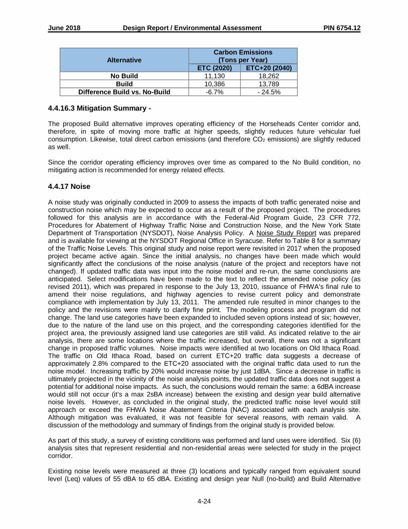
June 2018 Design Report / Environmental Assessment PIN 6754.12
4-24
AlternativeCarbon Emissions
(Tons per Year)ETC (2020) ETC+20 (2040)
No Build 11,130 18,262Build 10,386 13,789
Difference Build vs. No-Build -6.7% - 24.5%
4.4.16.3 Mitigation Summary -
The proposed Build alternative improves operating efficiency of the Horseheads Center corridor and,therefore, in spite of moving more traffic at higher speeds, slightly reduces future vehicular fuelconsumption. Likewise, total direct carbon emissions (and therefore CO2 emissions) are slightly reducedas well.
Since the corridor operating efficiency improves over time as compared to the No Build condition, nomitigating action is recommended for energy related effects.
4.4.17 Noise
A noise study was originally conducted in 2009 to assess the impacts of both traffic generated noise andconstruction noise which may be expected to occur as a result of the proposed project. The proceduresfollowed for this analysis are in accordance with the Federal-Aid Program Guide, 23 CFR 772,Procedures for Abatement of Highway Traffic Noise and Construction Noise, and the New York StateDepartment of Transportation (NYSDOT), Noise Analysis Policy. A Noise Study Report was preparedand is available for viewing at the NYSDOT Regional Office in Syracuse. Refer to Table 8 for a summaryof the Traffic Noise Levels. This original study and noise report were revisited in 2017 when the proposedproject became active again. Since the initial analysis, no changes have been made which wouldsignificantly affect the conclusions of the noise analysis (nature of the project and receptors have notchanged). If updated traffic data was input into the noise model and re-run, the same conclusions areanticipated. Select modifications have been made to the text to reflect the amended noise policy (asrevised 2011), which was prepared in response to the July 13, 2010, issuance of FHWA’s final rule toamend their noise regulations, and highway agencies to revise current policy and demonstratecompliance with implementation by July 13, 2011. The amended rule resulted in minor changes to thepolicy and the revisions were mainly to clarify fine print. The modeling process and program did notchange. The land use categories have been expanded to included seven options instead of six; however,due to the nature of the land use on this project, and the corresponding categories identified for theproject area, the previously assigned land use categories are still valid. As indicated relative to the airanalysis, there are some locations where the traffic increased, but overall, there was not a significantchange in proposed traffic volumes. Noise impacts were identified at two locations on Old Ithaca Road.The traffic on Old Ithaca Road, based on current ETC+20 traffic data suggests a decrease ofapproximately 2.8% compared to the ETC+20 associated with the original traffic data used to run thenoise model. Increasing traffic by 20% would increase noise by just 1dBA. Since a decrease in traffic isultimately projected in the vicinity of the noise analysis points, the updated traffic data does not suggest apotential for additional noise impacts. As such, the conclusions would remain the same: a 6dBA increasewould still not occur (it’s a max 2sBA increase) between the existing and design year build alternativenoise levels. However, as concluded in the original study, the predicted traffic noise level would stillapproach or exceed the FHWA Noise Abatement Criteria (NAC) associated with each analysis site.Although mitigation was evaluated, it was not feasible for several reasons, with remain valid. Adiscussion of the methodology and summary of findings from the original study is provided below.
As part of this study, a survey of existing conditions was performed and land uses were identified. Six (6)analysis sites that represent residential and non-residential areas were selected for study in the projectcorridor.
Existing noise levels were measured at three (3) locations and typically ranged from equivalent soundlevel (Leq) values of 55 dBA to 65 dBA. Existing and design year Null (no-build) and Build Alternative
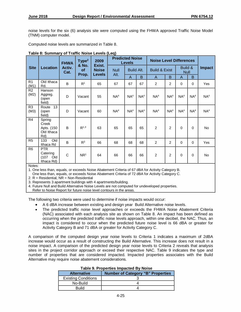
June 2018 Design Report / Environmental Assessment PIN 6754.12
4-25
noise levels for the six (6) analysis site were computed using the FHWA approved Traffic Noise Model(TNM) computer model.
Computed noise levels are summarized in Table 8.
Table 8: Summary of Traffic Noise Levels (Leq)
Site LocationFHWAActiv.Cat.
Type2
& No.of
Prop.
2009Exist.NoiseLevels
Predicted NoiseLevels Noise Level Differences
ImpactNullAlt.
Build Alt. Build & Exist Build &Null
A B A B A BR1(M1)
Old IthacaRd. B R1 65 67 67 67 2 2 0 0 Yes
R2(M2)
HansonAggreg.(openfield)
D Vacant 55 NA4 NA4 NA4 NA4 NA4 NA4 NA4 NA4
R3(M3)
Route 13(openfield)
D Vacant 60 NA4 NA4 NA4 NA4 NA4 NA4 NA4 NA4
R4 SpringCreekApts. (150Old IthacaRd)
B R1,3 63 65 65 65 2 2 0 0 No
R5 133 OldIthaca Rd B R3 66 68 68 68 2 2 0 0 Yes
R6 PTRCatering(107 OldIthaca Rd)
C NR1 64 66 66 66 2 2 0 0 No
Notes:1. One less than, equals, or exceeds Noise Abatement Criteria of 67 dBA for Activity Category B. One less than, equals, or exceeds Noise Abatement Criteria of 72 dBA for Activity Category C.2. R = Residential, NR = Non-Residential3. Represents 3 apartment buildings with 4 apartments/building.4. Future Null and Build Alternative Noise Levels are not computed for undeveloped properties.
Refer to Noise Report for future noise level contours in the areas.
The following two criteria were used to determine if noise impacts would occur:· A 6 dBA increase between existing and design year Build Alternative noise levels.· The predicted traffic noise level approaches or exceeds the FHWA Noise Abatement Criteria
(NAC) associated with each analysis site as shown on Table 8. An impact has been defined asoccurring when the predicted traffic noise levels approach, within one decibel, the NAC. Thus, animpact is considered to occur when the predicted future noise level is 66 dBA or greater forActivity Category B and 71 dBA or greater for Activity Category C.
A comparison of the computed design year noise levels to Criteria 1 indicates a maximum of 2dBAincrease would occur as a result of constructing the Build Alternative. This increase does not result in anoise impact. A comparison of the predicted design year noise levels to Criteria 2 reveals that analysissites in the project corridor approach or exceed their respective NAC. Table 9 indicates the type andnumber of properties that are considered impacted. Impacted properties associates with the BuildAlternative may require noise abatement considerations.
Table 9. Properties Impacted By NoiseAlternative Number of Category “B” Properties
Existing Conditions 3No-Build 4
Build 4

June 2018 Design Report / Environmental Assessment PIN 6754.12
4-26
To reduce the noise impact associated with this project, noise abatement techniques must be considered.Noise abatement measures must be considered reasonable and feasible to warrant implementation.Feasible is defined as the practical capability of the abatement being built as well as achieving asubstantial decibel reduction. For a measure to be deemed feasible, it must provide a minimum 5 dBAreduction to the majority of the receptors. A substantial reduction in noise level of 10 dBA is desirable,while a 7 dBA reduction is the goal. Reasonable encompasses the social, economic and environmentalfactors associated with the abatement and applies when the cost of the noise abatement measure is lessthan a specified cost index based on the total cost per dwelling unit benefited. Reasonableness shall bebased on viewpoints, cost and overall noise reduction. The following cost indices apply: for a noise bermor noise insulation, a cost index of $80,000 per benefited receptor shall be used; for barrier walls, amaximum of 2,000 linear feet of wall per benefited receptor shall be used.
Four (4) noise abatement techniques were reviewed for this project: traffic management techniques,alternative highway locations, noise barriers, and acquisition of real property to serve as a buffer zone.None of the techniques were found to be reasonable and feasible since they do not provide thesubstantial noise reduction required or would not be considered cost effective for implementation. Withthe exception of some potential vegetative screening proposed along Camelot Drive to addresscomments received during the 2011 public comment period, no other noise abatement measures areproposed. The Noise Study Report in the Environmental Appendix provides a complete evaluation ofmitigation measures.
4.4.18 Asbestos
4.4.18.1 Screening -
An asbestos screening has been performed for this project. As part of the screening, companies known tohave utilities within the project area were contacted to determine whether their utility infrastructurecontains Asbestos Containing Material (ACM).
4.4.18.2 Assessment and Quantification -
Sanitary sewer lines owned by the Chemung County Sewer District are reported to be clay tile pipe, asuspect ACM. Additionally, utility markers for gas mains owned by New York State Electric & Gas(NYSEG) were observed throughout the project area. Gas mains have historically been known to containACM. Water valves and hydrants were also observed throughout the study area.
Several utility companies responded that they did not own utilities in the project area or that their facilitiesare not constructed of ACM. Several companies were unavailable for comment regarding their facilities.SCE was not provided adequate information to contact these utilities by letter.
The underground gas and water transmission lines and any additional suspect ACM encountered duringconstruction should be handled as an ACM unless laboratory analysis confirms the material is non-ACM.
Removal, transport, and disposal of ACM shall be performed in accordance with federal, state, and localregulations including, but not limited to, those of the USEPA, OSHA, NYSDEC, and NYSDOL. Applicableregulations include National Emission Standards for Hazardous Air Pollutants (NESHAP) promulgated byUSEPA and NYSDOL Industrial Code Rule 56 (ICR 56).
4.4.18.3 Mitigation Summary -
No special site specific variances are anticipated for this project.
4.4.19 Hazardous Waste and Contaminated Materials
A Hazardous Waste/Contaminated Materials Screening has been conducted in accordance with theNYSDOT The Environmental Manual, Section 5.1, in order to document the likely presence or absence of
June 2018 Design Report / Environmental Assessment PIN 6754.12
4-27
hazardous/contaminated environmental conditions. A hazardous/contaminated environmental conditionis the presence or likely presence of any hazardous substances or petroleum products (includingproducts currently in compliance with applicable regulations) on a property under conditions that indicatean existing release, a past release, or a material threat of a release of any hazardous substances orpetroleum products into structures on the property or into the ground, ground water, or surface water ofthe property.
4.4.19.1 Screening -
The Hazardous Waste/Contaminated Materials Site Screening included a review of NYSDEC regulatorydata files, historic maps, interviews and site ‘walkovers’ on March 7, 2017 and January 11, 2018. A copyof the Hazardous Waste and Contaminated Materials Screening is included in Appendix B.
Based on review of historic maps, information obtained during interviews, database listings and a site visitthe locations below have been identified as potential sites of concern. Design plans shall be reviewed inmore detail relative to potential involvement with areas of potential soil and groundwater contamination.
Potential Sites of Concern (proximity to connector road, levee, and Old Ithaca Road)1. HOST Terminal (formerly Center at Horseheads) – This former defense department facility has
significant potential to impact soil and groundwater in the vicinity from organic and inorganiccompound migration via groundwater. Boring logs for borings advanced in proximity to this siteshould be reviewed to assess depth to groundwater, and roadway cross sections should bereviewed to determine if based on the limit of work there is a potential to encounter contaminatedsoil and/or groundwater at the western end of the connector at the HOST Terminal.
2. Former rail line-Historic maps indicate that a rail line was formerly located along the western bankon Newtown Creek. Railroad bed ballast can be contaminated with organic and inorganiccompounds.
3. 126 Old Ithaca Road (former Knispel Construction Company) – This upgradient site was identifiedfor groundwater contamination by gasoline. Although remediated and closed, the potentialremains for an impact to the project corridor via groundwater migration.
4. Hansen Aggregates/Former Asphalt Plant – The project corridor is planned to traverse the formerHansen former asphalt property. Soil and groundwater impact by organic compounds is commonfor such facilities. Therefore, this former use is considered to be a potential environmentalconcern.
5. Former gasoline station at Ridge Road/Old Ithaca Road – This site apparently once served as agasoline station and likely also operated as an auto repair facility. No record of removal of theunderground storage tanks was found in the EDR report. If the realignment of the Ridge Roadintersection is pursued, further investigation at this site would be warranted.
6. Parmenter Tire – This automotive shop has records of improper storage and dumping ofhazardous materials. If curbing and drainage along Old Ithaca Road south of the connector roadare pursued, further investigations into this property may be warranted.
If additional right-of-way acquisitions or excavations become necessary for the connector road additionalsites such as 110 Old Ithaca Road (Case Monroe Tractor) may have to be evaluated as potential sites ofconcern.
Potential Sites of Concern (Proximity to Wygant Road improvements)
1. 115 Wygant Road (CR Clark Truckment, Inc / Panther Equipment Rentals) – This facility containsan Underground Storage Tank (UST) and railroad beds. Based on the proximity to the projectcorridor and the proposed right turn lane from Wygant Road to Route 14, this facility isconsidered a potential environmental concern.
2. 104 Wygant Road (Aikman Property Superfund Site/Dandy Gasoline Station) - This activegasoline service station property had drums discarded and was a Superfund site. An open spillexists for a fuel release as well. Based on the proximity to the project corridor and the proposed
June 2018 Design Report / Environmental Assessment PIN 6754.12
4-28
right turn lane from Wygant Road to Route 14, this facility is considered a potential environmentalconcern.
If additional work involving excavations is proposed along Wygant Road there are additional potentialsites of concern (Sysco Corporation/Pepsi Beverage Company and the Norfolk Southern Railroad HOSTTerminal) that would need to be evaluated relative to the project’s scope of work.
4.4.19.2 Assessment and Quantification -
4.4.19.3 Screening and Site Assessment -
4.4.19.4 Mitigation Summary -
Several hazardous waste/contaminated materials sites with the potential to impact the project wereidentified in the Hazardous Waste/Contaminated Materials Site Screening. A HazardousWaste/Contaminated Materials Site Assessment may need to be performed to further assess potentialimpacts to the project.
4.5 Construction Effects
4.5.1 Construction Impacts
Construction impacts associated with this project will be temporary and cease with the completion ofconstruction activities. The project will be scheduled and phased to minimize disruption to neighboringcommunities and the environment; however, some inconvenience is unavoidable.
Regional and Local EconomyThere is a potential for a short term direct increase in employment associated with construction of thisproject, some of which may filter through the local economy generating a small amount of increasedspending. The magnitude of the economic benefit is dependent on the ability of the local suppliers andlaborers to fulfill the demand for construction goods and services.
Noise, Air and EnergyLocal laws and regulations contain general provisions for construction noise. Muffling and propermaintenance of equipment will help reduce noise impacts. Short-term air quality impacts will be limited tofugitive dust and mobile source emissions. The contractor shall make provisions for application measuresto limit the amount of construction dust that is generated. Construction-related energy impacts arepresented within the energy discussion included in Section 4.4.16.
Travel delaysSince much of the project involves construction in a corridor that is not currently used by the travellingpublic, delays are expected to generally be short-term and minimal at the intersections of the newconnector Road with Route 13 and Old Ithaca Road. Maintenance and protection of traffic measures willbe implemented to minimize the disruption to traffic and ensure adequate roadway capacity is availableduring peak travel periods
Ecology and WaterbodiesShort term impacts will occur to Newtown Creek during the construction of the proposed bridge requiredto carry the connector road across Newtown Creek. Bridge plans will be reviewed as the projectprogresses to further document the extent of impact. Impacts will require authorization under NYSDECand USACE permits; areas of temporary impact will be reestablished. Erosion and sediment controlmeasures will be utilized to minimize the potential for impacts to Newtown Creek. Construction will resultin minor encroachment on ecological communities used by local wildlife. The species are generallycommon to the area and co-exist with development; therefore, the impacts are expected to be temporary.
Groundwater

June 2018 Design Report / Environmental Assessment PIN 6754.12
4-29
Potential groundwater contamination could occur as a result of leaking construction equipment. Propermaintenance procedures will be enforced and fuel/chemical storage will not be allowed on site.
4.5.2 Mitigation Measures
4.6 Indirect and Secondary Effects
According to the Council on Environmental Quality (CEQ), indirect effects are “caused by the action andoccur later in time or farther removed in distance, but are still reasonably foreseeable.” According to theNational Cooperative Highway Research Program Report 466, “Desk Reference for Estimating theIndirect Effects of Proposed Transportation Projects,” indirect effects can be grouped into three (3) broadcategories: (a) Alteration of the behavior and functioning of the affected environment caused by theproject encroachment (physical, chemical, biological) on the environment, (b) Project-influenceddevelopment effects (e.g., the land use effect) and (c) Effect related to project-influenced developmenteffects (e.g., effects of the change in land use on the human and natural environment).
Indirect effects can occur within the full range of impact types, such as changes in land use, economicvitality, neighborhood character, traffic congestion, air quality, noise, vibration, and water and naturalresources. Examples of indirect effects can include growth-inducing effects and other effects related toinduced changes in land use patterns, population density, and growth rates, and related effects on air andwater and other natural systems.
The proposed project will result in the construction of a new roadway that connects Route 13 with OldIthaca Road. The project is needed to address existing and emerging traffic, mobility and accessdeficiencies within the Town and Village of Horseheads in the vicinity of the HOST Terminal. Existingroutes do not offer direct access to the HOST Terminal and lack of direct access to the HOST facility hasbeen cited by potential developers as a significant barrier to locating at the HOST Terminal. As such, it isanticipated that the new roadway will facilitate increased development within the HOST Terminal, nearbycommunities and potentially along the new roadway corridor. An increase in impervious area generatedfrom induced development can increase pollutant loadings into the Newtown Creek. It is expectedhowever, that the increased runoff would be treated in accordance with NYSDEC permit requirements tominimize the magnitude of this impact. As such, there is a potential for additional habitat fragmentationas well as an increase in the percentage of invasive species in the area. Invasive species typicallycompete with native species and generally provide less value to wildlife compared to native species.Measures should be taken during construction to prevent the introduction of invasive species, anddisturbed areas should be reseeded immediately following disturbance to minimize their establishment.
Additionally, induced development along the corridor would remove additional vegetation and potentialhabitat. According to the Town of Horseheads zoning information the vast majority of land along theconnector road corridor is Planned Unit Development (PUD). Planned Unit Development allows fororderly and effective growth. Each development must be a minimum of three acres, and at least 30% ofthe PUD acreage must be open space. Further, the planned development has to demonstrateconsistency with the comprehensive plan. A small parcel at the western end of the connector is zonedBusiness. This parcel is currently vacant residential, and according to the zoning ordinance can bedeveloped with hotels, motels, customary businesses, retails shops, and offices. The building cannothave lot coverage greater than 60 percent. The parcels south of the connector road corridor beyond theareas of PUD zoning are comprised of Residence B and Ag and Hill. Residential B zoning allows for highdensity residential uses, including multi-family units, two-family, single family and educational buildings.This parcel has frontage along E. Franklin Street and does not become prime development location as aresult of the proposed connector road. The development within the Ag and Hill district is extremely limited;land zoned with this classification exists to the south and north of the connector road. Intensivedevelopment is restricted; permitted uses include single dwellings, farming, gardening, livestock, quarryand mining. Based on the nature of the project, and the existing zoning classifications along theconnector road corridor, it appears there is the potential for some development to occur; however, thezoning ordinance will ensure consistency with the character of the area and the comprehensive plan forthe areas of proposed development. Stormwater management practices will be required consistent withthe NYSDEC SPDES regulations. Land just beyond the corridor to the north and south will remain

June 2018 Design Report / Environmental Assessment PIN 6754.12
4-30
generally undeveloped due to the Ag and Hill zoning. Development of this land to the south is furtherrestricted due to the boundaries of the FEMA 100-year flood plain. Significant adverse indirect impactsdue to potential future development are not anticipated.
4.7 Cumulative Effects
Cumulative effects are a summation of the impacts that can result from individually minor, but collectivelysignificant, actions taken or that are likely to take place over a period of time. The cumulative effects of anaction may be undetectable when viewed in the individual context of direct and even indirect impacts, butnevertheless when added to other actions can eventually lead to a measurable environmental change.Cumulative impacts are the net result of both the proposed project and the other improvements plannedin, near, and around the project.
This analysis assesses the possibility that the project, in concert with a variety of actions taken in the pastand future, could result in additional effects over a wider area or time frame different from that studied inthe direct analyses. Based on CEQ guidance, this discussion also considers the potential for cumulativeeffects from the proposed project in conjunction with other reasonably foreseeable future actions that arenot yet developed enough to be included in capital budgets or identified in the long-range plans oftransportation agencies.
Cumulative effects of this project would result primarily from future development at the HOST Terminaland the subsequent increase in commuter and heavy truck traffic. Cumulative effects would be generallyrelated to noise, energy and air quality concerns.
The projected traffic volumes for the project have taken future traffic volumes associated with expecteddevelopment at the HOST Terminal into consideration, in addition to general growth. The ETC andETC+10 assume that the warehouse will be approximately 20% utilized; the ETC+20 and ETC+30 includea projection that the existing warehousing facility will be utilized at 90% capacity.
Noise, energy and air analyses performed for this project have included a determination for ETC+20 andtherefore consider the impacts associated with increased commuter and heavy truck traffic resulting fromdevelopment at the HOST Terminal. The predicted noise levels for ETC+20 for both the build and Nobuild alternatives resulted in a 2 dBA increase, which was not itself considered an impact. However, anoise impact has been determined to occur because the predicted traffic noise level approaches orexceeds the FHWA Noise Abatement Criteria associated with the site activity category. It should be notedthat this impact was determined to occur regardless of whether the Connector Road project was built.The noise analysis for the project, involved a prediction of noise levels under the build and no buildalternatives for the ETC+20. Noise abatement techniques were considered but were not found to bereasonable or feasible. Energy analyses revealed that energy expenditures are expected to be less thanthe no build situation for the ETC+20. Lastly, it has been determined that project (inclusive of projecteddevelopment at the HOST Terminal) will not increase traffic volumes to such a degree as to jeopardizeattainment of National Ambient Air Quality Standards.
Impact on the ecology of the area could result as development occurs along the proposed new roadwaycorridor. It is anticipated that each of the proposed new developments will be subject to the SEQRAprocess, overall analysis of potential impacts and consideration of necessary mitigation measures.Based on consideration of anticipated development, existing resources within the corridor, state andfederal regulations and associated permit conditions, significant cumulative impacts are not expected. Insummary, because the future development is primarily associated with the redevelopment of an existingindustrial/business facility, cumulative impacts associated with direct affects to land, such as wetlands,ecology, waterbodies are not expected. Cumulative impacts are expected to be a direct result of theincrease in traffic associated with build out of the HOST Terminal and other induced development.Overall the project and the anticipated developments will have a positive impact on the local economy.
4.8 Short-Term Uses of Man’s Environment and the Maintenance and Enhancement ofLong-Term Productivity

June 2018 Design Report / Environmental Assessment PIN 6754.12
4-31
Short-term environmental impacts are those that would occur during construction of the project or as adirect result of an activity associated with the proposed project. Impacts that extend beyond the period ofconstruction are considered long-term impacts.
Due to the nature of the subject project, resources in the area would be impacted by short-term increasesin noise, dust and sediment. Traffic congestion during construction is anticipated to be extremely limitedin duration since the main impact will occur at the eastern and western termini of the project only, and atthe Wygant Road/Route 14 intersection.
The proposed project is compatible with the Comprehensive Plan. The build alternatives were proposedto address existing and future traffic congestion and provide a more direct access between the interstateand the HOST Terminal. Long term benefits therefore include economic development and improvedsafety. Additionally, the alternatives proposed to address deficiencies with the existing levee systemwould improve the viability of the area.
The local short-term impacts and use of resources by this project is generally consistent with the long-term maintenance and enhancement required for long-term productivity for the local area and surroundingregion.
4.9 Irreversible and Irretrievable Commitments of Resources
This section describes the major and irretrievable commitments of resources that can be identified as partof the Environmental Assessment analysis. A commitment of resources is considered irreversible whenprimary or secondary impacts limit the future options for a resource. An irretrievable commitment refersto the use or consumption of resources that are not renewable or recoverable for future use.
The Build Alternatives for the connector road and the levee improvements will require a commitment ofnatural, physical, human and fiscal resources:
Land – an irretrievable commitment of land is required for right-of-way.
Materials – the Build Alternatives will require construction materials, including gravel, concrete,and asphalt.
Energy – the Build Alternatives will expend energy resources for construction.
Habitat – right-of-way areas associated with the connector road, which offer some wildlife habitat,will be irreversible committed to transportation uses.
Funding – construction funds would be irreversibly committed to this project since funds wouldnot be available for investments on other projects.
4.10 Adverse Environmental Impacts that cannot be Avoided or Adequately Mitigated
A noise impact would occur as a result of the Build Alternatives. The cost for abatement was found not tobe reasonable.
