final draft frap habitat conservation and restoration ... · planning and management. the local...
TRANSCRIPT
FINAL DRAFT
FRAP Habitat Conservation and Restoration ProgramReview of Results
SUMMARY VERSION
December 15, 1997
Prepared for the Canadian Wildlife ServiceTrish Hayes, Rick McKelvey, and Michael Dunn
Prepared by Dovetail Consulting and Praxis Pacific

TABLE OF CONTENTS
:+<�','�:(�1(('�7+(�+$%,7$7�352*5$0" ��������������������������������������������������������������������������������������� �
:+$7�','�:(�6(7�287�72�$&+,(9(" ������������������������������������������������������������������������������������������������������ �
:+$7�:$6�$&&203/,6+('" ���������������������������������������������������������������������������������������������������������������������� �
6(&85(0(17 ���������������������������������������������������������������������������������������������������������������������������������������������������������� �
35,9$7(�/$1'�67(:$5'6+,3���������������������������������������������������������������������������������������������������������������������������������� �
&20081,7<�$:$5(1(66�$1'�,192/9(0(17���������������������������������������������������������������������������������������������������������� �
,1)/8(1&,1*�'(&,6,21�0$.(56 ������������������������������������������������������������������������������������������������������������������������������ �
86(�2)�5(*8/$7,216���������������������������������������������������������������������������������������������������������������������������������������������� �
$�9,6,21�)25�7+(�)5$6(5�%$6,1 �������������������������������������������������������������������������������������������������������������� �
85%$1�081,&,3$/�6(&725�5(68/76������������������������������������������������������������������������������������������������������� �
6(&85(0(17 ���������������������������������������������������������������������������������������������������������������������������������������������������������� �
:HWODQGV�RI�WKH�)UDVHU�/RZODQG������������������������������������������������������������������������������������������������������������������������� �
:HWODQGV�:RUNLQJ�*URXS����������������������������������������������������������������������������������������������������������������������������������� �
/DQG�6HFXUHPHQW ����������������������������������������������������������������������������������������������������������������������������������������������� �
&20081,7<�$:$5(1(66�$1'�$&7,21�������������������������������������������������������������������������������������������������������������������� �
&RPPXQLW\�*UHHQZD\V���/LQNLQJ�&RPPXQLWLHV�WR�&RXQWU\��DQG�3HRSOH�WR�1DWXUH���������������������������������������������� �
1DWXUHVFDSH���&DULQJ�IRU�:LOGOLIH�+DELWDW�DW�+RPH ������������������������������������������������������������������������������������������� �
:HWODQGNHHSHUV ������������������������������������������������������������������������������������������������������������������������������������������������� �
/LYLQJ�%\�:DWHU������������������������������������������������������������������������������������������������������������������������������������������������� �
,1)/8(1&,1*�'(&,6,21�0$.(56 ����������������������������������������������������������������������������������������������������������������������������� �
6WHZDUGVKLS�%\ODZV��$�*XLGH�IRU�/RFDO�*RYHUQPHQW ����������������������������������������������������������������������������������������� �
&ULWLFDO�:DWHUIRZO�+DELWDWV�LQ�%ULWLVK�&ROXPELD ����������������������������������������������������������������������������������������������� �
)UDVHU�/RZODQGV�/DQGVFDSH���D�PRVDLF�RI�ODQG�XVH�DQG�KDELWDW ������������������������������������������������������������������������� �
%RXQGDU\�%D\���6HPLDKPRR�%D\�,QWHUWLGDO�9HJHWDWLRQ�0DSSLQJ���������������������������������������������������������������������� ��
86(�2)�5(*8/$7,216�������������������������������������������������������������������������������������������������������������������������������������������� ��
'HYHORSPHQW�6SHFLILF�*XLGHOLQHV �������������������������������������������������������������������������������������������������������������������� ��
*UHHQLQJ�<RXU�%&�*ROI�&RXUVH ����������������������������������������������������������������������������������������������������������������������� ��
$*5,&8/785$/�585$/�6(&725�5(68/76�������������������������������������������������������������������������������������������� ��
*5((1),(/'6�352*5$0���������������������������������������������������������������������������������������������������������������������������������������� ��
,17(5,25�:(7/$1'6�352*5$0 ���������������������������������������������������������������������������������������������������������������������������� ��
%&�*5$66/$1'6�67(:$5'6+,3�*8,'(������������������������������������������������������������������������������������������������������������������ ��
)25(67�(&26<67(06�%,2',9(56,7<�6(&725�5(68/76������������������������������������������������������������������ ��
&20081,7<�,192/9(0(17�$1'�$:$5(1(66�������������������������������������������������������������������������������������������������������� ��
)ULQJH�%HQHILWV��$�/DQGRZQHU©V�*XLGH�WR�WKH�9DOXH�DQG�6WHZDUGVKLS�RI�5LSDULDQ�$UHDV���������������������������������� ��
&RPPXQLW\�0DS�$QDO\VLV�3URMHFW��&20$3����������������������������������������������������������������������������������������������������� ��
/503�7UDLQLQJ�0DQXDO�IRU�)LUVW�1DWLRQV �������������������������������������������������������������������������������������������������������� ��
2SHUDWLRQDO�3DPSKOHWV�RQ�)RUHVW�%LRGLYHUVLW\�,VVXHV �������������������������������������������������������������������������������������� ��
)257221�)RUHVW�0DQDJHPHQW�*DPH ������������������������������������������������������������������������������������������������������������ ��
,1)/8(1&,1*�'(&,6,21�0$.(56 ��������������������������������������������������������������������������������������������������������������������������� ��
&DQDGLDQ�:LOGOLIH�6HUYLFH��&:6��$UHDV�RI�,QWHUHVW�0DS���������������������������������������������������������������������������������� ��
3DUWLFLSDWLRQ�LQ�&25(�DQG�/503������������������������������������������������������������������������������������������������������������������� ��
&DULERR�&KLOFRWLQ�%DVHOLQH�7KHPDWLF�0DSSLQJ��%70� ������������������������������������������������������������������������������������ ��
5LSDULDQ�+DELWDWV��WKHLU�6FLHQFH�DQG�0DQDJHPHQW ������������������������������������������������������������������������������������������ ��
%LRGLYHUVLW\�LQ�%&�7UDLQLQJ�0RGXOH ���������������������������������������������������������������������������������������������������������������� ��
$SSOLHG�5HVHDUFK�RQ�%LUGV�DQG�WKHLU�+DELWDWV ������������������������������������������������������������������������������������������������� ��
6,0)25�'HFLVLRQ�6XSSRUW�7RRO ���������������������������������������������������������������������������������������������������������������������� ��
/,67�2)�$33(1',&(6
$33(1',;�$���67$7(�2)�7+(�%$6,1������������������������������������������������������������������������������������������������������������ �
67$786�2)�:,/'/,)(�+$%,7$7 �������������������������������������������������������������������������������������������������������������������������������� �
:HWODQGV�RI�WKH�)UDVHU�/RZODQG������������������������������������������������������������������������������������������������������������������������� �
:HWODQG�3URWHFWLRQ �������������������������������������������������������������������������������������������������������������������������������������������� �
67$786�2)�:,/'/,)(�3238/$7,216 ������������������������������������������������������������������������������������������������������������������������� �
,QWHULRU�:HWODQGV����������������������������������������������������������������������������������������������������������������������������������������������� �
)UDVHU�5LYHU�'HOWD��������������������������������������������������������������������������������������������������������������������������������������������� �
$33(1',;�%���/,67�2)�,17(59,(:6������������������������������������������������������������������������������������������������������������ �
$33(1',;�&���4827$%/(�4827(6 ������������������������������������������������������������������������������������������������������������� �
6(&85(0(17 ���������������������������������������������������������������������������������������������������������������������������������������������������������� �
,1)/8(1&,1*�'(&,6,21�0$.(56 ����������������������������������������������������������������������������������������������������������������������������� �
67(:$5'6+,3�2)�35,9$7(�/$1'6���������������������������������������������������������������������������������������������������������������������������� �
&20081,7<�,192/9(0(17�$1'�$:$5(1(66���������������������������������������������������������������������������������������������������������� �
Dovetail Consulting and Praxis PacificFRAP Habitat Program • Review of Results • Summary Version Final Draft • December 15, 1997
1
FRAP Habitat Conservation and Restoration ProgramReview of Results
SUMMARY VERSION
Why did we need the Habitat Program?The answer is clear: migratory bird habitat in the Fraser Basin is considered to beinternationally significant and this precious resource has been declining steadily underthe pressures of urban, agricultural and forest harvesting expansion. The areasrequiring focused conservation and restoration efforts were the Fraser lowlands andestuary, the interior wetlands of the Fraser Basin and forested ecosystems throughout theBasin.
The Fraser lowlands and estuary - spanning from Hope to the mouth of the Fraser - arerecognized as a vital area for overwintering and migrating waterfowl and shorebirds.Given the mountainous terrain of British Columbia, only 2.3% of the 27,000 kmcoastline provides suitable habitat for these migrating and wintering wetland birds.Most of this is concentrated in southwestern British Columbia, including the FraserRiver estuary where over 70% of the original wetlands have disappeared. Theremaining marsh, mudflats, adjacent uplands and agricultural land supports Canada’shighest densities of shorebirds, waterfowl, and raptors in winter. With its strategiclocation on the Pacific Flyway, an estimated 1.4 million birds migrate through theestuary each year.
This is also the Vancouver Metropolitan Area (spanning from the coast to Chilliwack),Canada’s fastest growing metropolis. Human population in this region is expected torise from current estimates of 2 million to almost 3 million by the year 2021. Populationgrowth is putting severe pressure on wildlife habitat and agricultural land. Even withinremaining agricultural land, trends toward intensified uses such as greenhouses andthe closure of processing plants for certain vegetable crops ]continue to reduce soil-based agriculture and therefore bird habitat.
The interior wetlands are home to British Columbia’s most productive habitats forbreeding waterfowl. These wetlands also play a major role in maintaining waterquality and quantity in the Fraser basin. A 1993 study carried out by the CanadianWildlife Service concluded that the Southern and Central Interior regions of the FraserBasin encompass some 34,600 ha of wetland and 45,000 ha of associated upland habitatsthat are critical to waterfowl populations. It was also estimated that these wetland andupland habitats were breeding grounds for 493,000 ducks and 14,100 Canada geese,representing over 29% of the provincial waterfowl breeding population.
As in the estuary, interior wetlands are under pressure; particularly from cattlegrazing, and partly due to expanding human populations in the Interior. Cattleconcentrate in wetlands and riparian areas, which are important for bird nesting and
Dovetail Consulting and Praxis PacificFRAP Habitat Program • Review of Results • Summary Version Final Draft • December 15, 1997
2escape cover. Trampling of vegetation can also reduce water quality, with negativeimpacts on fish and wildlife habitat, and on drinking water for humans and the cattlethemselves.
Forest ecosystems of the Fraser Basin are important for a variety of forest-dwellingbirds and other wildlife. Forests adjacent to streams or wetlands support a richdiversity of wildlife and are important, even essential, to many wildlife populations.Other parts of the forest - such as old, dead and dying trees, and logs on the ground -provide important habitat for many bird and other wildlife species. These habitats areunder pressure from traditional forest management practices.
What did we set out to achieve?The Habitat Program was designed to accomplish the following:
1.� Lowlands/Estuary: Protect and enhance migratory bird habitat and biodiversity inupland/estuary ecosystems vital to the staging and over-wintering of over 1million shorebirds and approximately 250,000 waterfowl annually,;
2.� Interior Wetlands: Rehabilitate wetlands to improve biodiversity, restorewaterfowl productivity, water table and water quality, and encourage sustainableagriculture; and
3.� Forest Ecosystems and Biodiversity: Develop in cooperation with governments,universities and forest managers, improved forest management practices benefitingbiodiversity, wildlife and threatened ecosystems.
What was accomplished?The program was designed to accomplish its goals in two general ways: first throughdirect securement and management of habitat for migratory birds; and second, throughinfluencing others to manage and steward land, water and forest resources under theircontrol in a sustainable way that conserves wildlife and their habitats. The HabitatProgram made great strides in both areas, through the acquisition of important wildlifehabitat, establishment of private land stewardship programs, production ofcommunications and stewardship materials and guides, and participation in planningefforts. One of the greatest accomplishments in all aspects of the Program was thesuccessful development of partnerships with a very broad spectrum of agencies, groupsand individuals. Some of the major accomplishments of the Habitat Program, and itsmany partners, are highlighted below.
SecurementFRAP has contributed to the direct purchase of 440 hectares of private land and to theprotection of over 12,000 hectares of provincial crown land.
Acquisitions provided funds to secure 441 ha of wetlands (Crescent, Gunn-Williamson, Douglas and Rose-Kirkland Islands and Trim Road) withpartners through The Lower Mainland Nature Legacy Program andthe Pacific Estuary Conservation Program

Dovetail Consulting and Praxis PacificFRAP Habitat Program • Review of Results • Summary Version Final Draft • December 15, 1997
3Provincial WildlifeManagement Areas
contributed to securement of 12,443 ha of provincial crown land(Boundary Bay, McIntyre Creek, and South Arm Marshes)
Private Land StewardshipTwo major private land projects resulted in the enhancement of wildlife habitatthrough stewardship of over 8,600 hectares of agricultural land.
The Greenfields Project, DeltaBC
maintenance of wildlife habitat and enhanced soil conservation onfarmland through the planting of over 1,000 hectares of winter covercrops each year
The Interior Wetland Program,Interior Fraser Basin
completion of over 20 demonstration projects on rangeland, protectingover 1,300 hectares of wetland habitat and 6,300 hectares of uplandhabitat for waterfowl, while providing a secure supply of clean waterfor cattle
Community Awareness and InvolvementCommunities are much more aware of wildlife habitat values and are getting involvedin wildlife habitat stewardship through a variety of programs.
Naturescape: Caring forWildlife at Home
provides valuable information and supports nearly 3,000 backyardhabitat stewards in the Lower Fraser Basin
Community Greenways encourages communities to develop linear green corridors thatconnect natural areas and provide wildlife habitat
Wetlandkeepers provides a comprehensive guide to wetland stewardship, and a newtraining program offered by Langara College
Living By Water provides waterfront residents with a guide to personal action they cantake to protect and restore habitat
Fringe Benefits: A LandownerGuide to the Value andStewardship of RiparianHabitat
provides landowners with practical advice on how to protect andenhance biodiversity on their property
LRMP Training Manual forFirst Nations
helps First Nations and participants in land use planning processesunderstand First Nations issues and concerns, and how to addressthem.
COMAP: A communitymapping project
helped 3 BC communities learn more about mapping and analysisusing Geographic Information Systems (GIS).
FORTOON: A forestmanagement game
helps high school students understand the habitat needs of forest-dependent wildlife, and to grapple with the complex interactionsbetween wildlife and forest management activities
Operational pamphlets onforest management issues
aids forest managers in protecting forest biodiversity (Bald Eagles andForestry Practices, Biodiversity and Forests of BC, Rotten Luck - theRole of Downed Wood in Ecosystems, and Broad-leaved Trees:Unsung Components of British Columbia's Forests)
Influencing decision makersDecision makers, particularly at the local level, are being influenced by habitatinformation, stewardship materials and guidelines, and also by the lobbying efforts of
Dovetail Consulting and Praxis PacificFRAP Habitat Program • Review of Results • Summary Version Final Draft • December 15, 1997
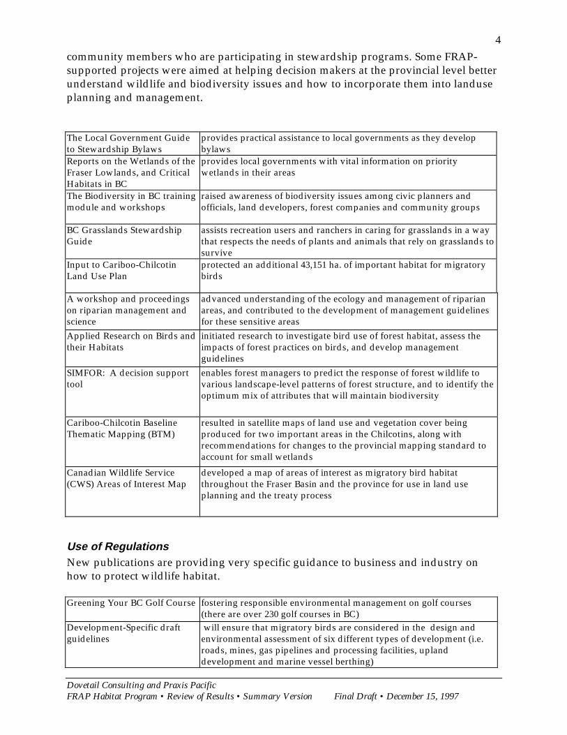
4community members who are participating in stewardship programs. Some FRAP-supported projects were aimed at helping decision makers at the provincial level betterunderstand wildlife and biodiversity issues and how to incorporate them into landuseplanning and management.
The Local Government Guideto Stewardship Bylaws
provides practical assistance to local governments as they developbylaws
Reports on the Wetlands of theFraser Lowlands, and CriticalHabitats in BC
provides local governments with vital information on prioritywetlands in their areas
The Biodiversity in BC trainingmodule and workshops
raised awareness of biodiversity issues among civic planners andofficials, land developers, forest companies and community groups
BC Grasslands StewardshipGuide
assists recreation users and ranchers in caring for grasslands in a waythat respects the needs of plants and animals that rely on grasslands tosurvive
Input to Cariboo-ChilcotinLand Use Plan
protected an additional 43,151 ha. of important habitat for migratorybirds
A workshop and proceedingson riparian management andscience
advanced understanding of the ecology and management of riparianareas, and contributed to the development of management guidelinesfor these sensitive areas
Applied Research on Birds andtheir Habitats
initiated research to investigate bird use of forest habitat, assess theimpacts of forest practices on birds, and develop managementguidelines
SIMFOR: A decision supporttool
enables forest managers to predict the response of forest wildlife tovarious landscape-level patterns of forest structure, and to identify theoptimum mix of attributes that will maintain biodiversity
Cariboo-Chilcotin BaselineThematic Mapping (BTM)
resulted in satellite maps of land use and vegetation cover beingproduced for two important areas in the Chilcotins, along withrecommendations for changes to the provincial mapping standard toaccount for small wetlands
Canadian Wildlife Service(CWS) Areas of Interest Map
developed a map of areas of interest as migratory bird habitatthroughout the Fraser Basin and the province for use in land useplanning and the treaty process
Use of RegulationsNew publications are providing very specific guidance to business and industry onhow to protect wildlife habitat.
Greening Your BC Golf Course fostering responsible environmental management on golf courses(there are over 230 golf courses in BC)
Development-Specific draftguidelines
will ensure that migratory birds are considered in the design andenvironmental assessment of six different types of development (i.e.roads, mines, gas pipelines and processing facilities, uplanddevelopment and marine vessel berthing)
Dovetail Consulting and Praxis PacificFRAP Habitat Program • Review of Results • Summary Version Final Draft • December 15, 1997
5
A Vision for the Fraser BasinThere is still a lot of work to be done to achieve sustainable use of the ecosystems andwildlife habitats of the Fraser Basin. The Fraser Basin is under tremendous pressurefrom continued population growth, urban expansion, rural development, agricultureand forestry. While there has been no specific attempt to develop a common vision forwildlife habitat conservation in the Fraser Basin, many individuals have a clear pictureof what they would like to see:x� increased protection for critical wetlands and other wildlife habitat in the Fraser
Basin through direct acquisitions and protected areas;x� management of wetlands and other wildlife habitats not as islands in a sea of
development, but integrated into management of the whole land base;x� a concerted effort by all levels of government to work cooperatively towards
common goals of habitat conservation and restoration; and,x� more direct involvement of ordinary British Columbians in community-driven
stewardship activities, and personal change to reduce our impacts on the Basin.
FRAP has contributed towards sustainable use of the Basin in a number of importantways. The most direct and obvious contribution has been the protection of criticalhabitats through direct acquisition and by influencing the designation of new protectedareas under provincial land use planning processes. No less significant, however, havebeen the FRAP efforts to integrate wetland and wildlife habitat conservation into landmanagement practices throughout the Basin, for example, with farmers in the FraserDelta and ranchers in the interior Fraser Basin.
We all have a vital role to play in sustaining the Basin. FRAP supported efforts ofindividuals, community groups, and all levels of government to increase ourknowledge and awareness of Fraser Basin ecosystems, and to improve our capability tobe good stewards of the land. The following sections report on each of the majorprojects in which FRAP was involved.
Urban/Municipal Sector ResultsThe strategy in the Urban and Municipal sector was a combination of securing keypieces of wildlife habitat; promoting community awareness and action programs; andinfluencing local decision makers through guidelines, habitat information andstewardship programs. Key projects are described below.
Securement
Wetlands of the Fraser LowlandTwo major studies set the foundation for a great deal of work in securing wetlands inthe Lower Fraser: 1) Wetlands of the Fraser Lowland, 1989: An Inventory and 2)Wetlands of the Fraser Lowland: Ownership, Management and Protection Status.
Dovetail Consulting and Praxis PacificFRAP Habitat Program • Review of Results • Summary Version Final Draft • December 15, 1997
6The inventory includes almost 400 remaining wetlands, outlines their size and currentstatus, and categorizes them into various classes. The inventory covers the 41,906hectares of wetlands left in the Fraser Lowland which represents 13.6% of the total area.The second report determines the ownership status of the wetlands identified in theinitial inventory, the current level of protection, and which agencies are responsible formanaging any public lands on which these are located. These reports are essentialresources for securing and managing habitat throughout the Fraser Lowlands. Thedocuments also serve as an invaluable resource to other agencies responsible forwetland management.
Wetlands Working GroupThe Wetlands Working Group was established to combine efforts and coordinateknowledge towards wetlands protection. This group included the Canadian WildlifeService, BC Environment, Ducks Unlimited, Land For Nature, The Nature Trust of BC,and Fisheries and Oceans Canada and others. The group oversaw completion of theownership report mentioned above, ranked the wetlands for action, and workedcooperatively towards securing high priority habitats. The Wetlands Working Groupprovided guidance on priority sites to a number of programs which resulted in thepurchase of wetlands and the protection of wetlands on crown land (see below).
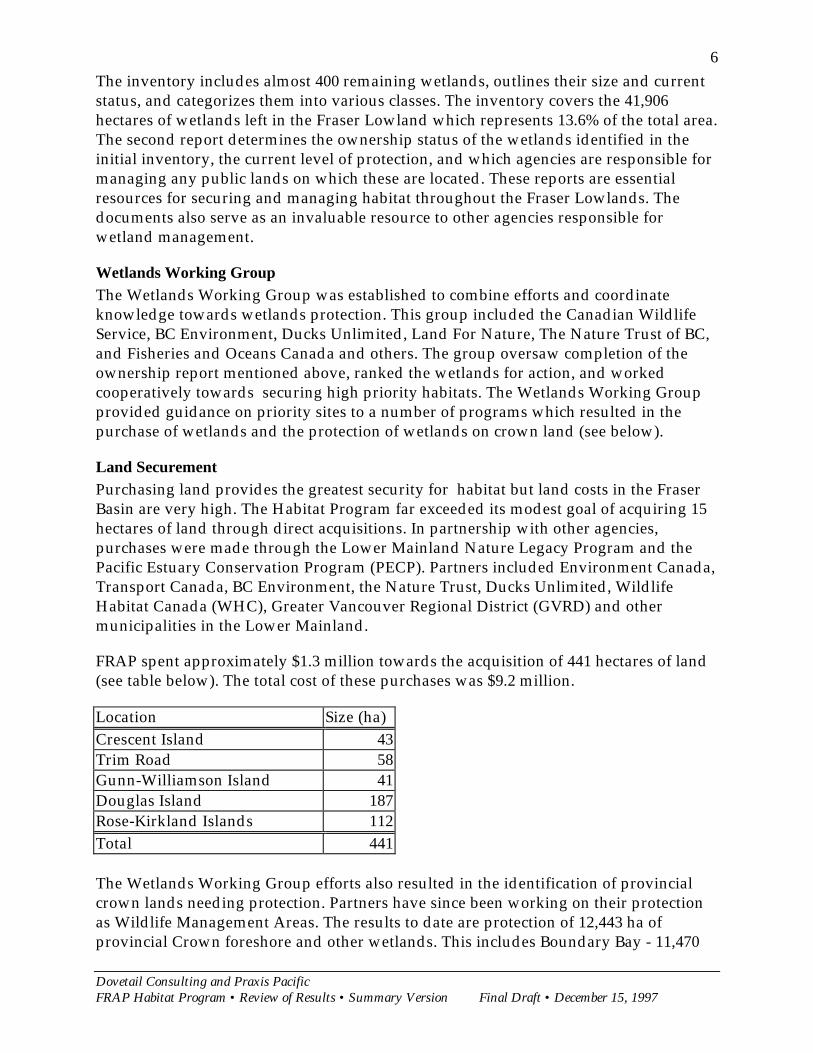
Land SecurementPurchasing land provides the greatest security for habitat but land costs in the FraserBasin are very high. The Habitat Program far exceeded its modest goal of acquiring 15hectares of land through direct acquisitions. In partnership with other agencies,purchases were made through the Lower Mainland Nature Legacy Program and thePacific Estuary Conservation Program (PECP). Partners included Environment Canada,Transport Canada, BC Environment, the Nature Trust, Ducks Unlimited, WildlifeHabitat Canada (WHC), Greater Vancouver Regional District (GVRD) and othermunicipalities in the Lower Mainland.
FRAP spent approximately $1.3 million towards the acquisition of 441 hectares of land(see table below). The total cost of these purchases was $9.2 million.
Location Size (ha)Crescent Island 43Trim Road 58Gunn-Williamson Island 41Douglas Island 187Rose-Kirkland Islands 112Total 441
The Wetlands Working Group efforts also resulted in the identification of provincialcrown lands needing protection. Partners have since been working on their protectionas Wildlife Management Areas. The results to date are protection of 12,443 ha ofprovincial Crown foreshore and other wetlands. This includes Boundary Bay - 11,470
Dovetail Consulting and Praxis PacificFRAP Habitat Program • Review of Results • Summary Version Final Draft • December 15, 1997
7ha; McIntyre Creek - 87 ha; and the South Arm Marshes - 886 ha. An additional 19crown land transfers to BC Environment are in progress that together cover 22,481 ha.
Community Awareness and ActionA number of programs were initiated to promote conservation of habitat on privateland at the community level. The Stewardship Series includes a wide range of guidesprepared by a number of partners, including CWS, BC Environment, Fisheries andOceans Canada, Ministry of Municipal Affairs and Housing, the Habitat ConservationTrust Fund and others. The publications most directly related to migratory bird habitatare profiled below.
Community Greenways: Linking Communities to Country, and People to NatureGreenways is an urban stewardship program designed to encourage and supportcommunity efforts to designate landscape corridors that connect natural areas andprovide wildlife habitat and recreational opportunities. There is a strong emphasis onintegrating ecosystem requirements into land use planning at the local level. TheCommunity Greenways publication defines the nature, purpose and benefits ofGreenways and then provides practical advice on how to plan a greenway throughvisioning, partnerships, public involvement, inventory and strategic planning. Theguide also provides a template for how to implement and manage Greenways andaddress the technicalities of land tenure and regulations.
While Greenways is still a very new program, it has met with great success so far. Itwas a timely response to built-up demand for practical advice on how to makeGreenways a reality. The benefits so far are many including: integration of Greenwaysconcepts into Official Community Plans (e.g. in Salmon Arm OCP and in the GVRDLivable Region Strategy), use of Greenways concepts in environmental protectionprograms (e.g. City of North Vancouver), development of new trail and bridgenetworks (e.g. Williams Lake); development of Greenways plans (e.g. in Prince Georgeand through a GVRD partnership with Maple Ridge and Pitt Meadows); raisedexpectations among the public and local government to achieve Greenways; bridge-building between recreation, fish, wildlife and “greenspace” interests; heightenedawareness of the value of Greenways and integrated local planning; and much greaterpractical knowledge about how to establish Greenways. It also fosters a stewardshipethic among local governments and urban residents. The program has also had verypositive results in areas outside of the Fraser Basin. The program has been highlysuccessful at reaching community groups and in turn, their lobbying efforts and welldeveloped plans are influencing some local governments.
Naturescape: Caring for Wildlife Habitat at HomeNaturescape is a stewardship program that promotes caring for wildlife habitat athome. It is aimed at people who want to connect more closely with nature in their dailylives and in their own backyards. A series of region-specific publications will cover theprovince, explaining the broader ecological environment in which people live,describing the types of wildlife habitats that may be suitable in specific locations,providing lists and the natural history of appropriate native plants, and setting out

Dovetail Consulting and Praxis PacificFRAP Habitat Program • Review of Results • Summary Version Final Draft • December 15, 1997
8examples of how wildlife use these native plants. The first set of resource booksproduced covers the Georgia Basin region. A provincial guide has also been preparedand circulated to over 3,000 BC residents.
In the Georgia Basin alone, there are almost 3,000 participants, each paying $20 toregister with the Naturescape program and receive the Native Plant and Animalbooklet and the resource booklet for the Georgia Basin. Demand from the public for thebooklets has been overwhelming. The long term benefits of this program will beincreased wildlife habitat, well informed stewards of backyard habitats and a broadlybased stewardship ethic. There are examples of where the program has influenced localpoliticians and developers. The City of Port Moody has adopted the Naturescapeprinciples in response to the lobbying efforts of community members who areNaturescape participants. The program has been highly successful in providinginformation to residents who are interested in wildlife, gardening and natural areas.
WetlandkeepersWetlandkeepers is a program for individuals and community groups interested instewarding a wetland. Its primary purpose is to raise public awareness of wetlandvalues and foster a land ethic among the public at large. Modeled on the successfulStreamkeepers Handbook developed by Fisheries and Oceans, the project involved thedevelopment of the Wetlandkeepers Handbook: A practical guide to wetland care, and anintensive two-day and one evening training course offered through Langara College.The Wetlandkeepers Handbook provides background information on wetland ecology andlaws related to wetlands protection, as well as step-by-step instruction on wetlandstewardship activities.
The Wetlandkeepers Handbook and training course have been available since theSpring of 1997. So far, about 100 people have taken the course and about 300handbooks have been purchased . The handbook and course have allowed concernedcitizens and groups to become better informed about wetland ecology andmanagement, and to establish contacts with resource professionals and others in theircommunity who share their concern about wetlands. There has been a very favorableresponse to the course and many requests for the handbook from individuals,landowners, community group and students from around the province.
One group that has particularly benefited from Wetlandkeepers is unemployed fishersenrolled in a stewardship program offered by the Community Fisheries DevelopmentCentre (CFDC), in Surrey, BC. So far, about 65 fishers have completed CFDC's 6 monthstewardship course, which includes the Wetlandkeepers training. The course hasallowed for a successful transition to paid work in resource stewardship for somegraduates. This was an unexpected benefit of the program.
Living By WaterFRAP has provided seed funding to a new project called Living By Water. The projectis targeted to individual waterfront residents across the country who live beside rivers,streams, wetlands and marine shorelands. The project will inspire individual land

Dovetail Consulting and Praxis PacificFRAP Habitat Program • Review of Results • Summary Version Final Draft • December 15, 1997
9owners and residents to take personal action to protect and restore wildlife habitat intheir own backyard. The project will consist of a Living By Water Guidebook that willprovide practical tips on local stewardship activities and how to access additionalresources. A Living By Water Workshop will be developed to provide a beginner coursein environmental stewardship for use by local hosting organizations (stewardshipgroups, naturalist groups, conservation organizations, and colleges). A potential benefitof this project is that it will reach an audience that is important in terms of its impact onriparian and wetland habitats, but may not have been reached by other forms ofstewardship education and extension activities.
Influencing Decision Makers
Stewardship Bylaws: A Guide for Local GovernmentThe Stewardship Bylaws publication provides a practical guide for the design of fair,effective and enforceable local bylaws with a stewardship component. When combinedwith planning, public awareness, voluntary actions and public and private investment,the bylaws will help to foster a stewardship ethic at the community level. The guidebegins with a description of the various tools that can be used to promote stewardshipand provides step-by-step instructions on how to develop policies for stewardshipbylaws. The balance of the guide contains a wide variety of sample stewardshipbylaws.
The bylaws guide is particularly helpful because it focuses on practical matters, it isreadily usable and it saves time for planners by providing model language for bylaws.While the publication is very recent, early indications are that it has increased localgovernments’ ability and willingness to incorporate stewardship concepts into localbylaws, planning and decision making.
Critical Waterfowl Habitats in British ColumbiaThis report was prepared by the Canadian Wildlife Service, BC Environment andDucks Unlimited Canada. The report includes a series of detailed maps whichdelineate, describe and characterize the general status of protection for 38 wetlandcomplexes and associated uplands. The report focuses only on those wetlands knownto be critical for breeding, migrating and wintering waterfowl. The maps andinformation are being used extensively to determine important bird areas and thenconvey these interests in planning and decision making processes such as native landclaims, the Commission on Resources and Environment, Local Resource andManagement Planning, Habitat Landscape Models and environmental assessment.
Fraser Lowlands Landscape - a mosaic of land use and habitatThe Fraser Lowland Landscape Mosaic Map is a cooperative project between federal,provincial and local governments to map the significant habitats and land use featuresof the Fraser Lowland, using satellite images. Features include wetlands, protectedareas, agricultural uses, town centres, industrial areas, forested areas, the AgriculturalLand Reserve, fish absence/presence, streams and roads. In addition to the map
Dovetail Consulting and Praxis PacificFRAP Habitat Program • Review of Results • Summary Version Final Draft • December 15, 1997
10features, text boxes provide facts on the national or regional significance of some of thearea's features.
Once data gaps have been filled, about 1,000 copies of the Map will be distributed touniversities, colleges, municipal government planning departments and federal andprovincial land management agencies. The Mosaic Map will be an important planningtool for federal, provincial, and local government planners. Community conservationand stewardship groups will benefit from being able to locate local stewardshipprojects within the regional perspective. The Mosaic Map will also be an important toolfor educating and building awareness among educators, students and the generalpublic.
Boundary Bay - Semiahmoo Bay Intertidal Vegetation MappingThis project mapped the vegetation communities of Boundary Bay/Semiahmoo Bayand Roberts Bank inter-tidal areas. These areas are important habitat for migratorybirds. A database and digital map have been produced to model the distribution ofplant species and their ground cover. The products provide a useful benchmark forecosystem studies being done in the area. Vancouver Port Corporation has used thedata in their planning work in the area between the Roberts Bank and BC Ferrycauseways, and numerous private sector remote sensing companies have used the datato calibrate their image analysis products. The mapping project will benefit wildlife byproviding an essential baseline of information to monitor changes in habitat andmanage the area in a way that protects this valuable habitat.
Use of Regulations
Development-Specific GuidelinesA set of six development-specific guidelines has been prepared in draft form. Theguidelines were developed in response to concerns about the poor quality ofenvironmental assessments conducted by proponents. Historically, environmentalassessments have given inadequate and incomplete attention to migratory birds.
There are guidelines for six different types of development: roads, mines, shorelineprotective works, upland development, gas pipelines and processing plants, andmarine vessel berthing. Each of the guidelines contains a comprehensive list of thekinds of impacts to consider, discussion about appropriate principles for EA andguidance on what kind of information Environment Canada requires in an assessment.
The development-specific guidelines will provide proponents with clear guidance onwhat environmental assessment information is required of them, and it will provideEnvironment Canada reviewers with a standard against which to evaluate themigratory bird section of completed environmental assessments submitted bydevelopment proponents. In the long term, this will facilitate a more comprehensiveconsideration of migratory birds and their habitat in decision making.
Dovetail Consulting and Praxis PacificFRAP Habitat Program • Review of Results • Summary Version Final Draft • December 15, 1997
11
Greening Your BC Golf CourseGreening your BC Golf course is a practical guide to assist in the design and managementof golf courses that benefit course owners, operators and golfers while benefiting fishand wildlife. When the report was released (spring of 1996) there were 230 golf coursesin BC, drawing an estimated 450,000 golfers each year. With this many courses, plustwo or three new golf courses each year, there is an urgent need for responsibleenvironmental management. The guide provides tips on what to look for in stream,riparian and upland habitats; advice on how to design and build and “eco-friendly golfcourse”; and recommendations for management of stormwater, irrigation, pests, andmaintenance areas.
Demand for the Greening Your BC Golf Course has been very high - particularly atevents such as the annual UBCM (Union of BC Municipalities) conference. It has beensuccessful at reaching local decision makers, and golf course owners, managers anddevelopers. It provides a useful tool for local government officials as they evaluatepermit applications and it helps them incorporate environmental considerations intotheir decision making. Their job is also simplified because the developers are betterinformed and are more likely to have followed the guide in formulating their designs.
Agricultural/Rural Sector ResultsThe main thrust of the Habitat Program in the agricultural and rural sector was onprivate land stewardship. Two major projects were initiated during FRAP: TheGreenfields program in the Fraser estuary and the Interior Wetland Program in theinterior region of the Fraser basin. These programs relied heavily on the cooperationand efforts of farmers and ranchers.
Greenfields ProgramThe Greenfields Program was established in Delta to promote widespread use ofwinter cover crops. The goal was to lessen the impact of waterfowl grazing and benefitfarmers through soil conservation, while still providing winter habitat for birds.The initial target was to plant 1,200 ha of cover crop each winter. The cost-sharedprogram began through a partnership with local farmers and Ducks Unlimited. It isnow delivered by a local community group, the Delta Farmland and Wildlife Trust.Approximately 30 farmers have consistently applied cover crops each year, with theacreage varying over time (see table below).
Farmland in winter cover cropyear hectares acres
91-91 972 2,40092-93 1,134 2,80093-94 1,215 3,00094-95 972 2,40095-96 1,053 2,60096-97 1,215 3,00097-98 1,134 2,800
Dovetail Consulting and Praxis PacificFRAP Habitat Program • Review of Results • Summary Version Final Draft • December 15, 1997
12
The cover crops benefit wildlife by providing important winter habitat for waterfowlwhile farmers benefit from enhanced soil productivity, reduced soil erosion andreduced damage to cash crops from waterfowl grazing. Society as whole benefitsthrough the maintenance of soil-based agriculture and a sustainable farm community.Other benefits of the program are greater acceptance of wildlife among the farmingcommunity, a better understanding of the impacts birds have on farmland and howthese impacts can be reduced, and greater public awareness of the value of farmlandfor local food production and bird habitat. In addition, a new partnership hasdeveloped between the farming and wildlife communities, allowing them to addresscommon concerns and achieve common goals together.
Communications and extension activities have been an important component of theprogram. Tools include a quarterly newsletter now sent to over 780 people, a colouringbook with over 10,000 copies in circulation, brochures, a video and displays at localevents.
The Delta Farmland and Wildlife Trust has brought on two new funding partners, theDelta Agriculture Society and the BC Waterfowl Society, and is actively searching forpermanent funding. Local farmers think the program is extremely important andsuccessful.
Interior Wetlands ProgramThe Interior Wetlands Program (IWP) was initiated in 1992 and developed inassociation with the Ministry of Environment, Lands and Parks (Wildlife Branch), BCForest Service (Rangeland Branch), the BC Ministry of Agriculture and Food (GrazingBranch) and Ducks Unlimited (DU). DU were primarily responsible for delivery of theprogram. Focusing on the lower and mid-elevation grasslands and open forestrangelands of the Interior Fraser Basin, the three goals of the program were to promoteland use practices that result in robust wetland and upland vegetation for waterfowland other wildlife; to maintain and/or improve water quality and quantity; and, toencourage sustainable agriculture. Specific objectives of the program were to completeat least 6 major wetland improvement projects; secure critical habitat (including 100 ha.at a project at Salmon Arm); minimize grazing impact on wetlands; and improveunderstanding by ranchers of the values of wetlands.
The IWP Program was successful in meeting the three program objectives. Twentywetland improvement projects, ranging in size from 2.7 hectares (Fallis Pond) to almost1,000 hectares (Chilcotin Marshes), have been completed and 3 additional projects willbe completed by early 1998. In total, approximately 1375 hectares of wetland habitatand 6344 hectares of upland habitat will have been brought under improvedmanagement as a result of the IWP demonstration projects, including 100 hectares ofwetland habitat at Salmon Arm. Many of the projects consisted of installation ofimproved cattle watering facilities and fencing to keep the cattle out of sensitivewetlands while providing them with a secure supply of clean water. Demonstrationprojects are secured through 30-year land owner agreements. The demonstration

Dovetail Consulting and Praxis PacificFRAP Habitat Program • Review of Results • Summary Version Final Draft • December 15, 1997
13projects are clearly resulting in recovery of grassland and open forest riparian habitattowards more natural vegetation conditions. Waterfowl and other wildlife arebenefiting from the habitat improvements. DU estimates that an additional 2500waterfowl per year will result from the IWP demonstration projects, or about 76,00birds over the lifetime of the projects (estimated at 30 years in most cases).
The IWP also provided extension and education activities to raise awareness aboutwetland conservation and sustainable agriculture. An Interior Wetlands Programbrochure, stewardship fact sheets, posters, a video, a web site(www.bc.ducks.ca/ducks), a newsletter, and project profiles for the demonstrationprojects were produced. These publications were distributed widely among theranching community, government agencies, and to the general public. Two wetlandmanagement workshop were also held that brought together over 100 individuals fromthe ranching communities, conservation groups, the government and the interestedpublic to share knowledge and concerns about wetland management and agriculture.The IWP program also contributed to the publication of various guides, including TreadLightly on Our Grasslands, The Rangelands of British, BC Grasslands Stewardship Guide, andWatershed Stewardship: A Guide for Agriculture. A Wetland Handbook for Land Managers iscurrently being developed, as well as a series of stewardship publications on BC'sinterior wetlands.
Overall, the IWP has been very effective at raising awareness of need for wetlandstewardship on rangeland and, perhaps more significantly, helped build a foundationof cooperation and partnerships among ranchers, range managers, governmentagencies and conservation groups. The ranching community has been supportive of theProgram, and while it is difficult to demonstrate a direct economic benefit to theranchers from the improvements, many ranchers are pleased to be able to conservewetland habitat while also providing their cattle with access to secure, clean water. Thebroader ranching community and range managers have benefited from an improvedunderstanding of sustainable agriculture techniques and increased public awareness oftheir efforts to be good stewards of the land. The public has benefited from significantchanges in land use practices on key parcels of wetland habitat within the Fraser Basin,enhancing wildlife values and improving quality of life in the region.
BC Grasslands Stewardship GuideThe Grasslands Stewardship Guide designed to assist recreation users and ranchers incaring for grasslands in a way that respects the needs of the plants and animals thatrely on grasslands to survive. The guide points to specific problems with agriculture,recreation, and the management of pests, weeds, fire and roads; provides practicalsolutions to these problems and highlights the benefits of well-managed grasslands.
Forest Ecosystems/Biodiversity Sector ResultsForest ecosystems of the Fraser Basin are important for a variety of forest-dwellingbirds and other wildlife. The Forest Ecosystem/Biodiversity component of the FRAPHabitat Program undertook a wide range of projects to identify and contribute to theprotection of important migratory bird habitats in the Fraser Basin; to increase public
Dovetail Consulting and Praxis PacificFRAP Habitat Program • Review of Results • Summary Version Final Draft • December 15, 1997
14awareness and knowledge of forest ecosystems and biodiversity of the Fraser Basin;and contribute to the development of sustainable forest management practices. The twomain strategies were promoting community involvement and awareness andinfluencing decision makers.
Community Involvement and Awareness
Fringe Benefits: A Landowner’s Guide to the Value and Stewardship of Riparian AreasThis booklet describes the plants and animals that use the riparian fringe ofwatercourses and provides steps to protect this important habitat. Geared to the privatelandowner in the Fraser Basin, the booklet is a practical guide and learning tool forschools, management agencies and the public. The booklet has been very popular.About 5,000 copies were printed, and most have been distributed. A phone survey ofmunicipal planners was done in 1993, and Fringe Benefits was developed to providethe information respondents thought was needed.
Community Map Analysis Project (COMAP)The purpose of the Community Map Analysis Project (COMAP) was to develop adecision support system which would enable people to visualize, query and analyzegeographic information. Three study areas were chosen, and a geographic informationsystem (GIS) was established in the communities of Yalakom, Nehaliston and ReadIsland. Community members were trained in the use of the GIS. Forest cover, land useand other geographic data were obtained. Each community collected additionalinformation of interest and produced a map and database for their area.
A lasting legacy of the COMAP project is that individuals within each of thecommunities continue to benefit from access to GIS technology, enhancing their abilityto contribute to local land use planning and resource management. There is thepotential for government resource agencies to benefit from community-based mappingand analysis as well.
LRMP Training Manual for First NationsFRAP contributed to the development of an LRMP training module for First Nations.The module is a means for LRMP participants to learn about First Nations issues and toprovide a process to develop mutually acceptable First Nations participation in LRMPprocesses. LRMP participants benefit from the module as it provides a structured wayto learn about provincial First Nations issues, such as land claims, and become moreaware of specific local First Nations land use concerns through their maps and otherland use information. First Nations benefit by having a way for government and LRMPparticipants to learn about their land use concerns and aspirations.
Operational Pamphlets on Forest Biodiversity IssuesFRAP supported the design and production of 4 pamphlets on forest biodiversity issuesthat were developed by the UBC Centre for Applied Conservation Biology and theMinistry of Forests. The pamphlets are Bald Eagle and Forestry Practices, MaintainingBiological Diversity in British Columbia's Forests, Rotten Luck - The Role of Downed Wood in

Dovetail Consulting and Praxis PacificFRAP Habitat Program • Review of Results • Summary Version Final Draft • December 15, 1997
15Ecosystems, and Broad-leaved Trees: Unsung Component of British Columbia's Forests. Thepamphlets were compiled from an extensive review of the scientific literature andpresented in a concise, factual format. They were designed to be useful to operationalforest managers, other land managers, private property owners and the informedpublic. Five thousand copies of each of the first three pamphlets were initiallyproduced and a second printing of 10,000 copies of Maintaining Biological Diversityand Rotten Luck was undertaken. The pamphlets were distributed widely throughoutthe Basin to government agency staff and have been used extensively in schools to raiseawareness of forest biodiversity issues. Recognizing the usefulness of these pamphletsas a quick reference tool for managers, the Ministry of Forests supported the projectwith editing services and production costs.
FORTOON Forest Management GameThe FORTOON forest management game is an educational tool for British Columbiahigh school students. FORTOON is a computer game that puts students in the role ofthe Chief Forester, charged with making decisions about where and what type oflogging will take place in forest stands. Students learn about clearcutting, partialcutting, and other aspects of forest management. The objective of the game is tomaintain jobs, profits and wildlife habitat. Students can go to various "classrooms" tofind out more about each forest management practice and wildlife needs. FRAPsupported the development of the "wildlife classroom" which describes the habitatneeds of 50 species. The project is nearing completion and the game is being distributedto schools through the National Film Board. Students and educators will benefit fromthe opportunity to learn more about the complexity of forest and wildlife managementin British Columbia.
Influencing Decision Makers
Canadian Wildlife Service (CWS) Areas of Interest MapStaff of Environment Canada's Canadian Wildlife Service undertook a project to mapareas of interest as migratory bird habitat throughout the Fraser Basin and theprovince. The maps were compiled based on the experience of CWS staff, andidentified important habitat, areas where further study was needed, and "hotspots"where habitat was imminently threatened. The maps were produced at a scale of1:250,000 for the whole province and are being used in protected areas planning andthe land claims process.
Participation in CORE and LRMPDuring FRAP, Environment Canada provided advice and inputs to the development ofa provincial land use strategy (through the Commission on Resources and theEnvironment, or CORE), which included providing input into the provincial Land UseCharter and Land Use Goals approved by the BC Cabinet. This has led to greaterrecognition of the significance of sensitive habitats and ecosystem types in provincialland use planning, including wetlands, riparian areas, estuaries, endangered specieshabitats and wildlife. The importance of protecting migratory bird habitat has beenentrenched in the guiding policy document, A Statement of Principles and Process for
Dovetail Consulting and Praxis PacificFRAP Habitat Program • Review of Results • Summary Version Final Draft • December 15, 1997
16Land and Resource Management Planning (LRMP). FRAP also co-funded the firstworkshop of LRMP practitioners in Prince George which brought together over 100representatives from all sectors, and contributed to the development of the modelLRMP manual for stakeholders.
FRAP's involvement in CORE and LRMP policy development increased awareness ofthe need to protect migratory bird habitat and sensitive ecosystems within the FraserBasin and contributed to protection of these important habitats. For example, the CORECariboo-Chilcotin Land Use Plan protected an additional 43,151 ha. of importanthabitat for migratory birds. Eight key areas protected were Stum Lake, Niagara Creek,Cameron/Penfold Creeks and Mitchell River, Upper Cariboo River complex, UpperMatthew River, Upper Nazko River complex, and the Blackwater River and PelicanLake area.
Cariboo-Chilcotin Baseline Thematic Mapping (BTM)Maps of wetlands and other critical habitat are lacking for much of British Columbia.This is largely due to the high cost of undertaking this work using traditional meanssuch as air photo interpretation. Undertaken in conjunction with the Department ofFisheries and Oceans, and the Mapping Branch of the Ministry of Environment, Landsand Parks, this project was designed to assess the cost effectiveness of using satelliteimagery to develop digital and paper maps of land use and vegetation cover for twoareas of the Fraser Basin. Current land use and ground cover information was obtainedfrom satellite imagery for the Quesnel Lake and Bonaparte Lake areas of the FraserBasin. Digital files and paper maps were produced and were used to help analyze anddetermine fish and wildlife habitat values in these areas.
Subsequent to the project completion, the provincial government decided to completeBaseline Thematic Mapping for the whole province for use in provincial land useplanning processes. This information will benefit resource planners by providing themwith the "big picture" of land use and habitat status over large areas. As a result ofFRAP's involvement in the early stages of BTM development, provincial BTM mapswill identify wetlands as small as 15 hectares in size, and provide finer resolution ofurban and rural land uses, helping resource managers better plan for wildlife habitatconservation throughout the Fraser Basin.
Riparian Habitats, their Science and ManagementFRAP co-sponsored a workshop on riparian habitat management held in Kamloops inMay, 1993. The purpose of the workshop was to review the current state of knowledgeof the biology and management of riparian habitats in British Columbia, especiallywithin the Fraser Basin, and to develop recommendations for managing riparian areas.The workshop drew 140 participants, mainly federal and provincial biologists involvedin riparian area management and research. The proceedings of the workshop, RiparianHabitat Management and Research, were published by FRAP, along with a summarydocument. The workshop proceedings and summary document have been animportant reference tool for resource managers involved in riparian area management.The summary of the workshop discussions was provided to the technical committee
Dovetail Consulting and Praxis PacificFRAP Habitat Program • Review of Results • Summary Version Final Draft • December 15, 1997
17working on the Riparian Area Management Guidebook under the Forest PracticesCode. The proceedings were used as a key reference document for a definitiveworkshop on riparian area management hosted by the Ministry of Forests. Theworkshop and proceedings have benefited forest ecologists, researchers, resourcemanagers and policy makers, as well as private property owners, the general publicand naturalists groups concerned about riparian area management.
Biodiversity in BC Training ModuleFRAP funds supported the development of workshop toolkits and workshoppresentations on biodiversity. The audience for the workshops was municipal councilsand regional boards, municipal and regional government staff, school trustees, localenvironmental non-governmental organizations, land developers and others with aninterest in biodiversity. The workshop materials defined biodiversity, described therange and state of biodiversity in British Columbia, and highlighted mechanisms toconserve biodiversity, especially in urban settings.
Two pilot workshops involving 110 participants were presented and the materials wererevised based on participant feedback. Four additional workshops were provided inVictoria, Prince George, Invermere and Castlegar. The workshops were well receivedand almost all respondents to a follow-up survey said the workshops were valuableand provided useful information. As a result of participation in a biodiversityworkshop, BC Building Corporation has adopted a biodiversity pre-screening processto evaluate biodiversity issues in every land purchase, sale or development. Some ofthe civic planners and other officials involved in the workshops said they had takenaction as a result of the workshop, including: establishing guidelines in thedevelopment permit process to protect waterways, wildlife habitat and water quality;changing the concept of a park in municipal planning from manicured greenery tonatural landscapes; protecting riparian areas in new subdivisions; revising regionalparks plans to include biodiversity conservation with recreation value.
Applied Research on Birds and their HabitatsFRAP funds supported several projects which have allowed researchers to develop abetter understanding of migratory birds, and how to sustain bird wildlife in managedforests. In most cases, the FRAP funding was vital to support multi-year studies, and toallow time for the project results to be published in scientific journals and technicalreports, and to be disseminated to resource managers through workshops, conferences,and other venues. FRAP has supported the work of at least 15 graduate, post-graduateand post-doctoral students working on sustainable forest management research in theFraser Basin. The results of these studies have been provided to forest researchers, landmanagers, universities, the forest industry, and the consulting community and arehelping to influence the design of forest management guidelines and practices:
6WXDUW�7DNOD�5LYHUV�5LSDULDQ�$UHD�$YLDQ�'HQVLW\
The purpose of this study is to develop a good baseline understanding of whatmigratory birds use riparian areas, how they use them, and to determine the influenceof forestry practices on birds in riparian areas of the interior northern forests of British

Dovetail Consulting and Praxis PacificFRAP Habitat Program • Review of Results • Summary Version Final Draft • December 15, 1997
18Columbia. The study focused on four adjacent watersheds near Fort St. James. Birdcounts were undertaken in the four undeveloped watersheds, and compared with birdcounts in nearby logged watersheds. As logging takes place in the four watersheds,bird counts will be undertaken to determine the influence of logging on birdabundance and distribution. Other studies will document whether bird behavior isinfluenced by the logging activity. Information from these studies will increaseknowledge and understanding about the bird communities in the boreal forest and willassist in developing conservation and management plans for riparian areas.
6KXVZDS�9HJHWDWLRQ�0DQDJHPHQW�DQG�$YLDQ�'LYHUVLW\�6WXG\
Herbicides and manual cutting are often used to control the growth of trees and shrubsthat compete with conifer seedlings in managed forests. The purpose of this study wasto examine how these practices affect birds living in treated areas in forests of theInterior Fraser Basin. The study will help forest managers design forest managementplans that sustain wildlife while controlling deciduous vegetation.
0DQDJHPHQW�RI�3ULPDU\�&DYLW\�1HVWLQJ�%LUGV�LQ�WKH�.DPORRSV�)RUHVW�5HJLRQ
Since 1992, researchers have been investigating the nest site selection and foraginghabitat of primary cavity nesting birds in two study areas in the Kamloops ForestRegion. The primary goal of this study is to examine the impacts of forest harvesting onwoodpecker nesting and foraging behavior. Six harvest treatments were applied atOpax Mountain, and four at the Sicamous site, representing different types ofharvesting, and different amounts of tree removal. The study determined which cavitynesting species were present at each site, and what types of trees were used forforaging under different forest management conditions.
FRAP supported the publication of a guide, called Ecology and Management ofWoodpeckers and Wildlife Trees in British Columbia. The publication summarizes thecurrent state of knowledge on the ecological associations between woodpeckers andtheir habitat in British Columbia. Information is provided on the general ecology of the12 species of woodpeckers found in BC, their role within forest ecosystems, and theirusefulness in controlling forest insects. The guide provides recommendations forretaining woodpecker habitat in managed forests and serves as a useful resource formanagers involved in wildlife tree management. About 2,000 copies of the guide werepublished and widely distributed to provincial and federal wildlife staff and toindividuals within the forest industry. The guide and the research projects haveincreased knowledge of woodpecker ecology, raised awareness of the importance ofwildlife trees for woodpecker habitat, and provided specific management suggestionsfor retaining wildlife trees in managed forests.
6WUXFWXUH�RI�&DYLW\�1HVWLQJ�&RPPXQLWLHV��5LVNH�&UHHN��&KLOFRWLQV
This study examined the interactions between primary cavity nesters (those thatexcavate a hole for a nest), and secondary cavity nesters (those that use existing cavitiesthat have been abandoned) in a forest near Riske Creek, in the Chilcotins. The purposeof this study is to better understand the interactions between bird species based on nest
Dovetail Consulting and Praxis PacificFRAP Habitat Program • Review of Results • Summary Version Final Draft • December 15, 1997
19site availability and other factors. The results of this study will help forest managers tosustain cavity nesting birds in managed forests.
3RSXODWLRQ�(FRORJ\�RI�*UDVVODQG�%LUGV��5LVNH�&UHHN��&KLOFRWLQV
This study examines the role that cattle grazing and fire play in the population ecologyof birds breeding in the central interior grasslands of British Columbia, focusing on twospecies - Vesper sparrow and Horned lark. Nests were located and monitored in arange of sites, from highly disturbed to relatively undisturbed. By comparing the lossof birds due to predation and other causes among nest sites and habitat types, the roleof habitat degradation in influencing grassland bird populations could be examined.
SIMFOR Decision Support ToolForestry activity introduces roads, harvesting and other changes to forest landscapes.An important question for managers is: How does this alter the availability and qualityof habitat for forest-dwelling animals? The SIMFOR project attempts to answer thisquestion. The project involves identifying groups of wildlife that respond in similarways to changes in habitat structure and landscape patterns. A geographic informationsystem (GIS) is used to show the pattern of forest attributes over large areas. Acomputer model predicts the responses of wildlife to various landscape patterns andidentifies the optimum mix of attributes which will maintain biological diversity.SIMFOR is under development. The model is currently being tested and evaluated bythe Ministry of Forests and by several forest companies to assess their forest practicesand the implications of the Forest Practices Code. FRAP funds have helped to acceleratethe work towards completion and field testing of the outputs.
Beneficiaries of the SIMFOR work include forest resource managers, the forest industry,forest ecologists, and individuals involved in land use planning. The SIMFOR modelwill helps managers assess the cumulative impacts of land use decisions on wildlifepopulations well into the future. When validated, the model will be a significantcontribution towards sustaining wildlife populations in managed forests.
Dovetail Consulting and Praxis PacificFRAP Habitat Program • Review of Results • Summary Version Draft Two * December 12, 1997
1
Appendix A: State of the Basin
This section provides a snap shot of where we are in the Fraser Basin in terms ofwildlife habitat and wildlife populations.
Status of Wildlife Habitat
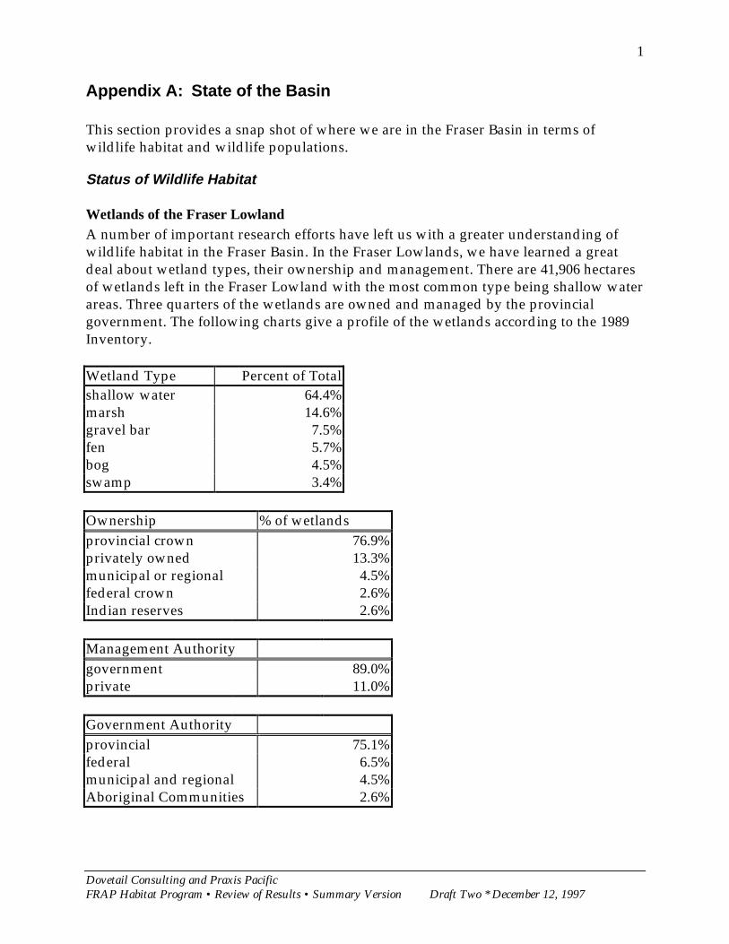
Wetlands of the Fraser LowlandA number of important research efforts have left us with a greater understanding ofwildlife habitat in the Fraser Basin. In the Fraser Lowlands, we have learned a greatdeal about wetland types, their ownership and management. There are 41,906 hectaresof wetlands left in the Fraser Lowland with the most common type being shallow waterareas. Three quarters of the wetlands are owned and managed by the provincialgovernment. The following charts give a profile of the wetlands according to the 1989Inventory.
Wetland Type Percent of Totalshallow water 64.4%marsh 14.6%gravel bar 7.5%fen 5.7%bog 4.5%swamp 3.4%
Ownership % of wetlandsprovincial crown 76.9%privately owned 13.3%municipal or regional 4.5%federal crown 2.6%Indian reserves 2.6%
Management Authoritygovernment 89.0%private 11.0%
Government Authorityprovincial 75.1%federal 6.5%municipal and regional 4.5%Aboriginal Communities 2.6%
Dovetail Consulting and Praxis PacificFRAP Habitat Program • Review of Results • Summary Version Draft Two * December 12, 1997
2
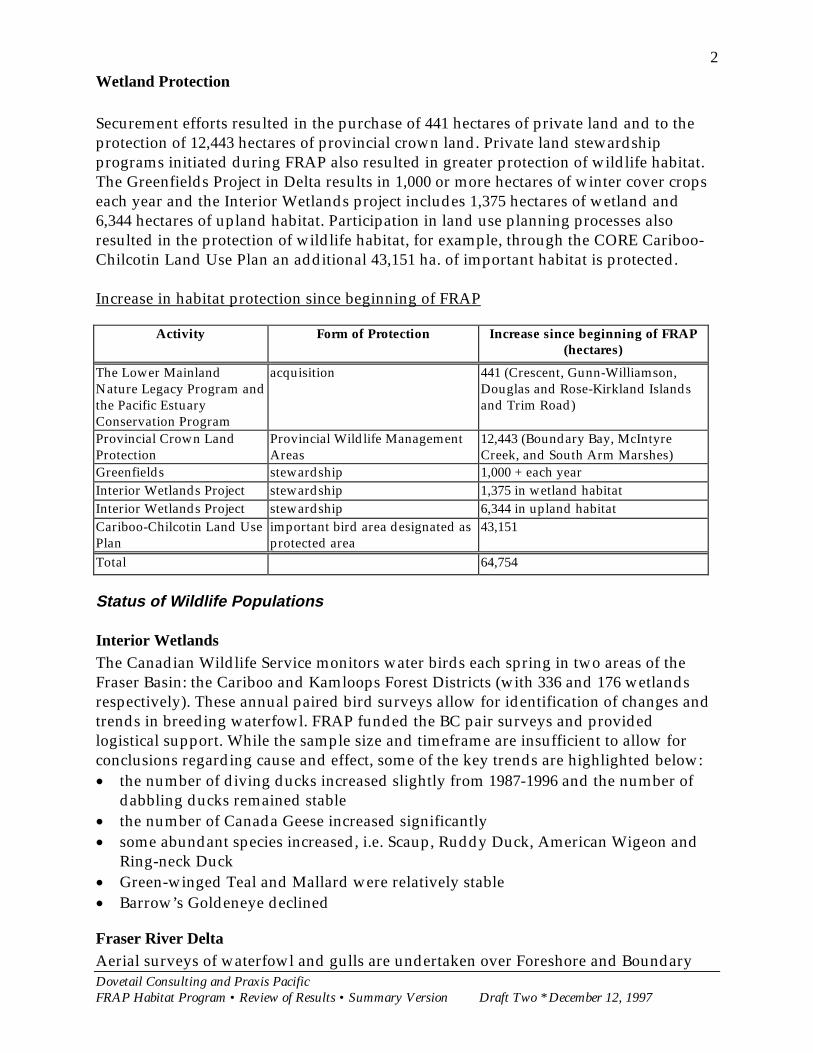
Wetland Protection
Securement efforts resulted in the purchase of 441 hectares of private land and to theprotection of 12,443 hectares of provincial crown land. Private land stewardshipprograms initiated during FRAP also resulted in greater protection of wildlife habitat.The Greenfields Project in Delta results in 1,000 or more hectares of winter cover cropseach year and the Interior Wetlands project includes 1,375 hectares of wetland and6,344 hectares of upland habitat. Participation in land use planning processes alsoresulted in the protection of wildlife habitat, for example, through the CORE Cariboo-Chilcotin Land Use Plan an additional 43,151 ha. of important habitat is protected.
Increase in habitat protection since beginning of FRAP
Activity Form of Protection Increase since beginning of FRAP(hectares)
The Lower MainlandNature Legacy Program andthe Pacific EstuaryConservation Program
acquisition 441 (Crescent, Gunn-Williamson,Douglas and Rose-Kirkland Islandsand Trim Road)
Provincial Crown LandProtection
Provincial Wildlife ManagementAreas
12,443 (Boundary Bay, McIntyreCreek, and South Arm Marshes)
Greenfields stewardship 1,000 + each yearInterior Wetlands Project stewardship 1,375 in wetland habitatInterior Wetlands Project stewardship 6,344 in upland habitatCariboo-Chilcotin Land UsePlan
important bird area designated asprotected area
43,151
Total 64,754
Status of Wildlife Populations
Interior WetlandsThe Canadian Wildlife Service monitors water birds each spring in two areas of theFraser Basin: the Cariboo and Kamloops Forest Districts (with 336 and 176 wetlandsrespectively). These annual paired bird surveys allow for identification of changes andtrends in breeding waterfowl. FRAP funded the BC pair surveys and providedlogistical support. While the sample size and timeframe are insufficient to allow forconclusions regarding cause and effect, some of the key trends are highlighted below:x� the number of diving ducks increased slightly from 1987-1996 and the number of
dabbling ducks remained stablex� the number of Canada Geese increased significantlyx� some abundant species increased, i.e. Scaup, Ruddy Duck, American Wigeon and
Ring-neck Duckx� Green-winged Teal and Mallard were relatively stablex� Barrow’s Goldeneye declined
Fraser River DeltaAerial surveys of waterfowl and gulls are undertaken over Foreshore and Boundary
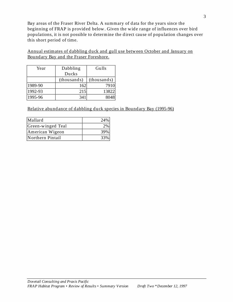
Dovetail Consulting and Praxis PacificFRAP Habitat Program • Review of Results • Summary Version Draft Two * December 12, 1997
3Bay areas of the Fraser River Delta. A summary of data for the years since thebeginning of FRAP is provided below. Given the wide range of influences over birdpopulations, it is not possible to determine the direct cause of population changes overthis short period of time.
Annual estimates of dabbling duck and gull use between October and January onBoundary Bay and the Fraser Foreshore.
Year DabblingDucks
Gulls
(thousands) (thousands)1989-90 162 79101992-93 215 138221995-96 341 8048
Relative abundance of dabbling duck species in Boundary Bay (1995-96)
Mallard 24%Green-winged Teal 2%American Wigeon 39%Northern Pintail 33%

Dovetail Consulting and Praxis PacificFRAP Habitat Program • Review of Results • Summary Version Draft Two * December 12, 1997
4
Appendix B: List of Interviews
URBAN/MUNICIPALName Organization InvolvementRick McKelvey CWS Overall programTrish Hayes CWS Overall programKen Brock CWS guidelinesLes Bogdan DU securements (also agriculture questions)Rod Silver HCTF Naturescape and stewardship pledgeMelody Farrell DFO Guidelines and stewardship series publicationsTom Burgess BCE (retired) surveys, wetlands working group, securementAbby Schwarz Langara College WetlandkeepersKaren Lucke Community Fisheries
Development CentreWetlandkeepers
Erik Karlsen MMAH Stewardship seriesDavid Reed Lanarc Consulting GreenwaysRon Erickson TNT acquisitions, Options AccountJim LeMaistre Corp of Delta Urban and agricultural questionsTheresa Southam Co-ordinator Wetland keepersFOREST/BIODIVERSITYMichael Dunn CWS Forestry program delivery (also Naturescape)Debra Gibson BCCF overall administration of Forest Program Funds
Kathy Martin BC/CWS overall assessment of and riparian/vegetationmanagement research
Fred Bunnell UBC overall assessment of SIMFOR modelLaurie Kremsater UBC pamphlets and FORTOONJerry Maedel UBC/FIRMS COMAP projectKathleen Moore CWS BTM Cariboo Region, Fraser Mosaic MapWalt Klenner MOF primary cavity nesters, Kamloops Forest region
Ken Morgan CWS Riparian science and management, Fringe Benefits
Clive Calloway Cal-Eco Consultants Living By WaterJulian Dunster Consultant Natural Resource DictionaryStewart Guy MELP Habitat protection/BC forest practices training
Frances Smart FRAP Communications distribution of reports
AGRICULTURESusan Smith DF&WT GreenfieldsTheresa Duynstee now with GVRD GreenfieldsDave Melnychuck MAFF GreenfieldsJack Bates Delta Farmers Institute Greenfields
Dovetail Consulting and Praxis PacificFRAP Habitat Program • Review of Results • Summary Version Draft Two * December 12, 1997
5
Appendix C: Quotable Quotes
Securementx� One precious legacy is acquisitions
Influencing Decision Makersx� FRAP really enabled a lot of research to get going because it was undertaken
cooperatively with a lot of people; many projects would not have been undertakenotherwise.
x� Now we have the tools to marshall data, to be more organized in decision making, andmore readily available to help others make good decisions.
x� FRAP generated significant new knowledge that serves for contemporarymanagement needs and as a baseline for future studies and management.
Stewardship of Private Landsx� The Interior Wetlands and Greenfields projects have created a lasting legacy of
demonstration projects that showcase sustainable agriculture. Extension activitiescan continue to capitalize on these investments.
Community Involvement and Awarenessx� There is now quite a bit public involvement in maintaining habitats in my area; there
is a ground-swell of enthusiasm for stewardship. We need to continue to capitalize onthat support.
x� Wetlandkeepers and Greenways have increased sensitivity to these special areas[wetlands]; its “upped” the attention of the public. The time has been right to do thiskind of work.
x� A larger body of committed public; that will be the legacy of the program. FRAP gavecommunities something to organize towards, now you don’t have to be an expert tohave access to the knowledge and tools of stewardship.
x� FRAP has influenced the overall picture; there is a climate of change among ordinarypeople, so much has been done that there is heightened awareness.
x� The public has to be the pressure that directs conservation of habitat. Some progresshas been made, for example, with Streamkeepers and Wetlandkeepers. They providesomething more than anecdotal information on the value and importance of wetlandsthat the public can use to influence their elected representatives to protect habitat. .
x� I would like to see a land ethic develop, so that people understand their choices andthe impacts, so that responsibility is brought closer to people and their individualactions.