final ea csfs fuels mitigation project - fema.gov...12420 milestone center drive, suite 150...
TRANSCRIPT

Final Environmental Assessment
Colorado State Forest Fuels Mitigation Project Jackson County, Colorado January 2012
Federal Emergency Management Agency Department of Homeland Security 500 C Street, SW Washington, DC 20472

This document was prepared by
URS Group, Inc. 12120 Shamrock Plaza, Suite 300 Omaha, NE 68154
and
12420 Milestone Center Drive, Suite 150 Germantown, MD 20876
Prepared for
FEMA Region VIII Denver Federal Center Building 710, Box 25267 Denver, CO 80255-0267
Contract No. HSFEHQ-09-D-1130 Task Order No. HSFEHQ-10-J-0011
15702511.31BUP
Table of Contents
Final, January 2012 i
ACRONYMS AND ABBREVIATIONS ......................................................................................................... III
SECTION ONE INTRODUCTION ....................................................................................................... 1-1
1.1 Background .................................................................................................................. 1-1 1.2 Purpose and Need ........................................................................................................ 1-2
SECTION TWO ALTERNATIVES ....................................................................................................... 2-1
2.1 Alternatives Not Retained ........................................................................................... 2-1 2.1.1 Prescribed Burning ............................................................................................ 2-1 2.1.2 Clear Cutting ..................................................................................................... 2-1
2.2 Alternatives Considered .............................................................................................. 2-1 2.2.1 Alternative 1 – No Action ................................................................................. 2-1 2.2.2 Alternative 2 – Vegetation Management (Proposed Action) ............................ 2-2
SECTION THREE AFFECTED ENVIRONMENT AND ENVIRONMENTAL CONSEQUENCES ............ 3-1
3.1 Physical Resources ....................................................................................................... 3-1 3.1.1 Affected Environment ....................................................................................... 3-1 3.1.2 Environmental Consequences ........................................................................... 3-2
3.2 Water Resources .......................................................................................................... 3-4 3.2.1 Affected Environment ....................................................................................... 3-4 3.2.2 Environmental Consequences ........................................................................... 3-5
3.3 Biological Resources .................................................................................................... 3-7 3.3.1 Affected Environment ....................................................................................... 3-7 3.3.2 Environmental Consequences ......................................................................... 3-11
3.4 Cultural Resources .................................................................................................... 3-15 3.4.1 Affected Environment ..................................................................................... 3-16 3.4.2 Environmental Consequences ......................................................................... 3-18
3.5 Socioeconomic Resources and Environmental Justice ........................................... 3-19 3.5.1 Affected Environment ..................................................................................... 3-19 3.5.2 Environmental Consequences ......................................................................... 3-20
3.6 Community Resources .............................................................................................. 3-21 3.6.1 Affected Environment ..................................................................................... 3-21 3.6.2 Environmental Consequences ......................................................................... 3-22
3.7 Hazardous Substances / Wastes ............................................................................... 3-24 3.7.1 Affected Environment ..................................................................................... 3-24 3.7.2 Environmental Consequences ......................................................................... 3-25
3.8 Cumulative Impacts .................................................................................................. 3-25 3.9 Coordination and Permits ........................................................................................ 3-26

Table of Contents
Final, January 2012 ii
SECTION FOUR SUMMARY OF IMPACTS ......................................................................................... 4-1
SECTION FIVE PUBLIC INVOLVEMENT ........................................................................................... 5-1
5.1 Initial Public Notice ..................................................................................................... 5-1 5.2 Final Public Notice ...................................................................................................... 5-2 5.3 Public Comments ......................................................................................................... 5-3
SECTION SIX AGENCIES CONSULTED ......................................................................................... 6-1
6.1 Agencies Consulted During the Preparation of this Environmental Assessment .................................................................................................................... 6-1
SECTION SEVEN REFERENCES .......................................................................................................... 7-1
SECTION EIGHT LIST OF PREPARERS .............................................................................................. 8-1
Tables
Table 3-1: Threatened and Endangered Species with the Potential to be Affected by Projects in Jackson County ....................................................................................... 3-9
Table 3-2: Determinations of the Effects from the Proposed Action on Federally and State-Listed Species ................................................................................................ 3-15
Table 3-3: Summary of Previous Projects Near the APE .......................................................... 3-16
Table 4-1: Environmental Effects of Alternatives ....................................................................... 4-2
Appendix A: Exhibits
Exhibit 1 Project Location
Exhibit 2 Proposed Treatment Areas
Exhibit 3 Equipment Used to Complete Treatments
Exhibit 4 Typical Viewshed after Treatment
Exhibit 5 Wetlands within the Project Area
Exhibit 6 Vegetation within the Project Area
Exhibit 7 Area of Potential Effects
Exhibit 8 Roads in Project Area
Appendix B: Site Visit Photographs
Appendix C: Agency Correspondence

Acronyms and Abbreviations
Final, January 2012 iii
Acronyms and Abbreviations
APE Area of Potential Effects BMP Best Management Practice CCC Civilian Conservation Corps CDPHE Colorado Department of Public Health and Environment CDOW Colorado Division of Wildlife CEQ Council on Environmental Quality CFR Code of Federal Regulations County Jackson County CSFS Colorado State Forest Service CSP Colorado State Parks CSU Colorado State University EA Environmental Assessment EDR Environmental Data Resources, Inc. EO Executive Order EPA U.S. Environmental Protection Agency FEMA Federal Emergency Management Agency FONSI Finding of No Significant Impacts FRFTP Front Range Fuels Treatment Partnership MBTA Migratory Bird Treaty Act NEPA National Environmental Policy Act NHPA National Historic Preservation Act of 1996 NPDES National Pollutant Discharge Elimination System NRHP National Register of Historic Places Park Colorado State Forest State Park PDM Pre-Disaster Mitigation Program PM10 Particulate matter up to 10 microns in diameter PM2.5 Particulate matter up to 2.5 microns in diameter SHPO State Historic Preservation Officer SMZ Streamside Management Zone TSS total suspended solids USACE U.S. Army Corps of Engineers U.S.C. U.S. Code USCB U.S. Census Bureau USFS U.S. Forest Service USFWS U.S. Fish and Wildlife Service USGS U.S. Geological Survey

Introduction
Final, January 2012 1-1
SECTION ONE INTRODUCTION
1.1 BACKGROUND Fire management in the West since the Europeans arrived in the 19th century has increased the quantity of vegetative ground and ladder fuels, resulting in surface fires that today move easily into the tree canopy and fuel destructive crown fires. High density, continuous fuels in many forests allow fires to spread to large areas in a relatively short period, making wildfires difficult and dangerous to control (USFS 2005).
The risk of catastrophic wildfires in Colorado’s forests is extremely high because of the fuel load and the recent decline in forest health, which is the result of dry conditions and mountain beetle infestations (CSFS 2008). The communities of Walden and Gould in Jackson County, Colorado, and the region as a whole are working on implementing projects to manage the insect infestations.
The Colorado State Forest Service (CSFS) has proposed a vegetation management fuels mitigation project (Proposed Action) to reduce the fuel load on approximately 1,200 acres of the Colorado State Forest State Park (Park). The 71,000-acre Park (latitude 40.502; longitude –105.966) is near the communities of Walden and Gould and is owned by the Colorado State Land Board. Recreational uses in the Park are administered by Colorado State Parks (CSP), and vegetation and timber are managed by the CSFS. All treatment areas would be located in the Park, which is considered to be the project area. See Appendix A, Exhibit 1, for the location of the Park.
All wildfires directly damage the vegetation within areas that are burned. However, large wildfires generate extreme heat which can also damage the existing soils; this damage, coupled with the loss of vegetation, can result in rapid runoff (flash floods) and damaging debris flows. In the past, flash floods in Colorado have contributed significant amounts of sediment and debris to receiving waters. Frequently, the receiving waters are used as a potable water source by municipalities. The increased sediment and debris load associated with past wildfires has significantly increased water treatment costs of water (potable) used by Colorado citizens (Denver Water Board 2011). The North Michigan Reservoir, which is located in the Park (Appendix A, Exhibit 2), provides potable water to the town of Walden, Gould, and surrounding rural communities and is critical to the viability of those communities (CSFS 2011).
The CSFS, through the Colorado Division of Emergency Management, has requested funding through Federal Emergency Management Agency’s (FEMA’s) Pre-Disaster Mitigation (PDM) Program to implement the proposed project. FEMA’s involvement in hazardous fire risk reduction projects triggers the requirements of the National Environmental Policy Act of 1969 (NEPA) (42 U.S. Code [U.S.C]. §§ 4321–4327), which include an evaluation by Federal agencies of the potential environmental impacts of proposed actions and consideration of the impacts during the decision-making process. FEMA is preparing this Environmental Assessment (EA) in accordance with the Council on Environmental Quality’s (CEQ’s) NEPA implementing regulations (Title 40 Code of Federal Regulations [CFR] Parts 1500–1508) and FEMA’s NEPA procedures (44 CFR Part 10).

Introduction
Final, January 2012 1-2
1.2 PURPOSE AND NEED The CSFS, through the Colorado Division of Emergency Management, has requested FEMA PDM Program funding to implement mitigation measures to reduce the wildfire hazard in the Park. The purpose of FEMA’s PDM Program is to provide funds to States, territories, Native American tribes, communities, colleges, and universities for pre-disaster mitigation planning and the implementation of cost-effective mitigation projects prior to a disaster event. Funding these plans and projects reduces the overall risk to populations and structures, while also reducing reliance on funding from future disaster declarations.
The purpose of the Proposed Action is to reduce the wildfire hazard in the Park. Fuel reduction in areas prone to wildfire reduces the severity of potential wildfires, increases the ability to control wildfires, and minimizes potential damage to property, public safety, and the natural environment.
Based on the continuing potential risk of catastrophic wildfires in the Park, the CSFS has determined that there is a need to reduce fuels in the project area to protect people, structures, and watersheds in the Park.
Alternatives
Final, January 2012 2-1
SECTION TWO ALTERNATIVES
2.1 ALTERNATIVES NOT RETAINED The alternatives that were considered but determined to be nonviable include prescribed burning and clear cutting vegetation.
2.1.1 Prescribed Burning Prescribed burning involves setting a controlled fire in a predetermined area and is the most natural way to reduce the risk of a wildfire and promote the growth of native vegetation. However, prescribed burning was determined to be a nonviable alternative because of concerns regarding the ability to control the fire considering the number of dead trees within the Park. Therefore, this alternative was not retained for consideration.
2.1.2 Clear Cutting Clear cutting involves cutting and removing all or most trees in a stand at the same time and promotes the establishment and growth of species that are intolerant to shade. However, it also changes the appearance of the treated area significantly by changing a mature forest with large trees to an area with no trees or very young trees; this aesthetic impact would likely not be acceptable to Park visitors. Clear cutting may have an adverse impact on wildlife because it removes food and cover and often increases soil erosion, which reduces the water quality of streams and other water bodies downstream of the treatment area. For these reasons, clear cutting was determined to be a nonviable alternative and was not retained for consideration.
2.2 ALTERNATIVES CONSIDERED As required by NEPA, the No Action Alternative was considered as a baseline to which the potential impacts of the action alternative were compared.
Alternative 2, the Proposed Action, would consist of creating defensible spaces around Park structures, constructing fuelbreaks along roads, and thinning vegetation beyond the defensible spaces.
2.2.1 Alternative 1 – No Action The No Action Alternative provides a means to compare baseline conditions (taking no action) with the potential effects of the Proposed Action. Under the No Action Alternative, CSFS would not implement any vegetation management treatments in the. Current management activities in the Park, including maintenance of existing facilities, would continue, and the current methods of suppressing wildfires would continue. Existing fuel accumulations and the risk of catastrophic wildfires would not be reduced. Therefore, the risk to life and property from a wildfire would not change.

Alternatives
Final, January 2012 2-2
2.2.2 Alternative 2 – Vegetation Management (Proposed Action) Land managers can implement practices (treatments) that will reduce the potential of the ignition of a wildfire and/or reduce the spread of a wildfire when they occur. However, wildfires are not completely preventable.
The CSFS has identified approximately 1,200 acres in the Park where vegetation management activities are necessary to protect the structures, residents, visitors, and watersheds in the Park. The Proposed Action consists of managing vegetation (fuel loading) in the project area by removing trees, shrubs, and dead trees and vegetation. All proposed vegetation management activities (treatments) would occur in the Park and proposed treatment areas are shown in Exhibit 2, Appendix A.
The proposed treatments are:
• Creating defensible spaces
• Constructing fuelbreaks
• Thinning The Proposed Action would include creating a defensible space around 14 structures. Fuelbreaks would be constructed on 315 to 330 acres along existing roads in the Park. Thinning would occur on approximately 600 acres within 2 miles of the North Michigan Reservoir and on an additional 250 acres within 2 miles of other critical infrastructure in the Park.
The fuel reduction activities associated with the treatments would include timber harvesting, slash piling, and mulching (chipping). None of these treatments would involve burning. All treatments would be implemented using Colorado’s Best Management Practices (BMPs) (CSFS 2010) to ensure minimum risk of adverse impacts on physical, natural, socioeconomic, cultural, and historic resources. The BMPs do not allow any treatment activities within 50 feet of a wetland or stream.
Implementation of the Proposed Action would also adhere to the CSFS forest/fuels management guidelines as discussed in plans by Dennis (2006) and the CSFS (2010). These plans include extensive information on designing a project to protect soil, water, and other resources. All treatment areas would be accessed using existing roads; the less accessible reaches of these areas would be accessed by walking. All streams would be crossed at existing stream crossings as no new stream crossings would be created. No project activities would occur in Streamside Management Zones (SMZs)/Exclusion Zones, which are buffers around streams and wetlands. The minimum SMZ is 50 linear feet from a water body or wetland. The size of the SMZ in each treatment area would be determined in the field.
The treatments are discussed further in the following subsections.
2.2.2.1 Defensible Space A defensible space is created by removing the woody vegetation around a structure. The purpose of a defensible space is to provide a buffer that limits the spread of a wildfire and an area in which firefighters can safely protect the structures through fire suppression activities.

Alternatives
Final, January 2012 2-3
In the Proposed Action, a defensible space would be created around 14 structures. The defensible spaces would total approximately 35 acres. The structures include the Moose Visitor Center, CSFS Headquarters, Gould Community Center, homes, high value recreational facilities, cabins, pit vault toilets, emergency response facilities, and businesses.
The width of the defensible spaces would vary depending on slope and tree density as discussed in Dennis (2006). Based on those guidelines, the widths would generally be between 15 and 125 feet; in areas with extreme slopes the width could be more than 200 feet.
2.2.2.2 Fuelbreaks Fuelbreaks are created by selectively removing vegetation from an area. Fuelbreaks normally provide quick access for fire suppression and serve as a line of defense from which personnel and equipment can be deployed. Fuelbreaks also aid firefighters by slowing the spread of a wildfire under normal conditions and by allowing fire suppression activities to be carried out under safer conditions.
Under the Proposed Action, fuelbreaks would be created by thinning tree stands along existing roads to maximize the protection that roads provide—reducing the spread of a wildfire and providing evacuation routes. The fuelbreaks would be created on both sides of the road and would generally be 300 to 340 feet wide (excluding the road width) with an uphill distance of 100 to 150 feet and a downhill distance of 150 to 240 feet (Dennis 2006).
2.2.2.3 Thinning The objective of thinning is to reduce stem density, basal area, canopy continuity, and ladder fuels by removing trees and shrubs (live and dead) from the forest stand, thereby helping to reduce the spread of a wildfire both horizontally and vertically. Thinning can also increase the health of remaining trees, which creates a more fire-resistant forest. Healthy trees are more resistant to insect attacks and diseases, which can kill trees.
Thinning would be conducted in key locations in the project area to reduce the potential for the fire to reach the tops of trees and spread rapidly. Exact locations would be determined by modeling and adaptive management, which would allow the effects of the thinning on fire behavior to be analyzed separately. After each area is thinned, new locations would be determined based on the modeling and ground refinement. Thinning is critical for the protection of the North Michigan Reservoir, which provides potable water to the towns of Walden, Gould, and the surrounding rural communities (CSFS 2011).
Thinning would occur on approximately 600 acres within 2 miles of the North Michigan Reservoir and on an additional 250 acres within 2 miles of other critical infrastructure in the Park.
2.2.2.4 Project Schedule and Equipment All project activities would be conducted during the winter months when the ground is frozen and there is 6 to 12 inches of snow cover. Logging systems used to implement the Proposed Action would be limited to ground-based systems and mastication/chipping systems. Ground-based systems (chain saws, tractors) would be used to sever and remove trees from the treatment

Alternatives
Final, January 2012 2-4
areas and mastication/chipping would be used to eliminate slash (branches, treetops) onsite. Equipment required for activities (tractors, chippers) would be fitted with high flotation/low ground pressure tires or tracks to reduce or eliminate ground disturbance. Appendix A, Exhibit 3 shows the types of equipment that would be used to complete the fuel reduction activities. Appendix A, Exhibit 4 shows what a typical viewshed would look like after treatment. Appendix B contains photographs of the Park showing Park structures and existing vegetation.

Affected Environment and Environmental Consequences
Final, January 2012 3-1
SECTION THREE AFFECTED ENVIRONMENT AND ENVIRONMENTAL CONSEQUENCES
This section contains the results of the evaluation of the potential effects of the No Action Alternative and the Proposed Action on the human and natural environment.
3.1 PHYSICAL RESOURCES The physical resources that were considered in this EA are geology and soils, air quality and climate control, and visual resources.
3.1.1 Affected Environment
3.1.1.1 Geology and Soils Jackson County is located in the central Rocky Mountains. The Rocky Mountains extend from New Mexico to Canada and comprise a complex of igneous and metamorphic rock with younger sedimentary rock occurring along the margins of the southern mountains (USGS 2004). The Park is located on the western side of the Medicine Bow Range of the Rocky Mountains and has rugged topography.
Soils in the central Rocky Mountains are very complex and developed from glacial deposits, crystalline granite rocks, conglomerates, and sandstone. In the Rocky Mountains, soil orders occur in zones corresponding to vegetation zones. Granite weathers to gruss, which is coarse gravel and fine sand composed of potassium feldspar, quartz, weathered biotite, muscovite, and hornblende. As a parent material, granite provides weakly developed soils that are highly sensitive to both wind and water erosion (USFS 2005). Most of the soils, especially at higher elevations, are quite fragile and subject to excessive erosion rates (from water) if the vegetative cover is removed. Soils are generally finer textured than those on crystalline or metamorphic substrates of Crystalline Subalpine Forests and are also more alkaline if derived from carbonate-rich substrates (CSFS 2010).
3.1.1.2 Air Quality and Climate Change The National Ambient Air Quality Standards established by the U.S. Environmental Protection Agency (EPA) define the allowable concentrations of air pollutants that may be reached, but not exceeded, in a given period to protect human health (primary standards) and welfare (secondary standards) with a reasonable margin of safety. These standards include maximum concentrations for ozone, carbon monoxide, nitrogen dioxide, sulfur dioxide, lead, and particulate matter with a diameter of up to 2.5 microns (PM2.5) or 10 microns (PM10).
Wildfires can generate substantial amounts of fine particulate matter, which can affect the health of people breathing the smoke laden air. Fine particulates (PM2.5) are of special concern because of their potential to adversely affect human respiratory systems, especially in young children, the elderly, and people with lung disease or asthma. Wildfires can also generate substantial amounts of carbon monoxide near the fire, which can be of concern for frontline firefighters.

Affected Environment and Environmental Consequences
Final, January 2012 3-2
The Colorado Department of Public Health and Environment (CDPHE), Air Pollution Control Division, is the primary authority for protecting air quality in the State under the Colorado Air Pollution Prevention and Control Act. Jackson County is an attainment for all air quality standards including PM2.5 and PM10 (EPA 2011a). An attainment area is an area where existing concentrations of air pollutants are below the established standard(s), and limited increases in emissions are allowable.
CEQ has recently released guidance on how Federal agencies should consider climate change in their decisions. Guidance for NEPA documents suggest that quantitative analysis should be done if an action would release more than 25,000 metric tons of greenhouse gases per year (CEQ 2010).
3.1.1.3 Visual Resources The project area is a State park that includes forested land, jagged peaks, and alpine lakes. Development in the Park is limited to cabins and recreational facilities. The viewshed is scenic and considered to be high quality.
3.1.2 Environmental Consequences Neither alternative would affect geology – the No Action because no ground disturbance would occur, and the Proposed Action because activities would not extend deep enough to disturb geologic resources.
3.1.2.1 Alternative 1 – No Action
Soils The No Action Alternative would not change the baseline conditions of soils in the project area. The potential for a catastrophic wildfire would not change and such a wildfire could adversely affect soils by removing existing vegetation and exposing soils to potential erosion from future heavy precipitation events.
Air Quality and Climate Change The No Action Alternative would not include any vegetation management activities. Therefore, baseline air quality conditions would not be affected.
Without vegetation management activities, fuel loads in the project area would continue to accumulate and the potential for wildfires, including catastrophic wildfires, would increase. Catastrophic wildfires would result in high emission rates of air pollutants from smoke, especially high concentrations of particulate matter. If a wildfire occurred during unfavorable meteorological conditions (e.g., gusting winds from a thunderstorm), as is the often the case, the meteorological conditions would compound the adverse effects on air quality.
If no wildfire occurred in the project area, the No Action Alternative would have no effect on the emission of greenhouses gases. If a wildfire occurred over a large area, under the No Action Alternative large quantities of greenhouses gases could be released and adversely affect air

Affected Environment and Environmental Consequences
Final, January 2012 3-3
quality in the area. It is unlikely that wildfires, even encompassing several thousand acres would affect global climate change.
Visual Resources Baseline visual resources in the project area would not be affected by the No Action Alternative. Without vegetation management activities, the existing forest conditions in the project area would likely deteriorate over time. As the health of the trees in the project area deteriorate, the risk of additional disease outbreaks, insect infestations, and catastrophic wildfires would increase. Visual quality would be adversely affected as vegetation quality deteriorates and would be substantially impaired if a catastrophic wildfire occurred.
3.1.2.2 Alternative 2 – Vegetation Management (Proposed Action)
Soils The Proposed Action would involve the use of some heavy equipment, but the equipment would have large tires or tracks and would be used only when the ground is frozen and there is 6 to 12 inches of snow cover. Therefore, soil disturbance would be minimal.
Post-project impacts on soils are difficult to predict because the actual impacts would depend on whether the project area experiences a wildfire. If the project area does not experience a wildfire, the Proposed Action would have no impact on soils. If a wildfire occurs and the advancement of the wildfire is slowed or stalled by the vegetation management activities to the extent that firefighters are able to contain the fire, the Proposed Action would have a significant beneficial effect on the soils in the areas that would have burned if the vegetation management had not been implemented. The beneficial effects would extend to adjacent areas that otherwise would have burned. Although the exact area of benefit cannot be quantified, the size of recent wildfires in Colorado suggests that several thousand acres could benefit. The unburned areas would retain existing vegetation and during future heavy precipitation events would not experience increased runoff and associated soil erosion, which would adversely affect soils.
Air Quality and Climate Change During the removal of vegetation under the Proposed Action, machinery would generate low levels of particulate matter emissions and low levels of vehicle exhaust emissions. These emissions represent a temporary minor impact on air quality in the treatment areas.
The Proposed Action has the potential for a long-term beneficial effect on air quality in the project area by reducing the risk of a wildfire and the associated emission of greenhouse gases. The Proposed Action is not anticipated to affect global climate change.
Visual Resources The magnitude and type of visual impact would depend on the viewshed of Park visitors. A viewshed with an accumulation of dead, diseased, or downed trees is generally viewed as negative, and vegetation management would have both short- and long-term beneficial effects. In a viewshed that includes healthier forested areas, vegetation management could create a high contrast between treated and non-treated areas.

Affected Environment and Environmental Consequences
Final, January 2012 3-4
Removing trees and understory would have a direct short-term (temporary) adverse effect on visual resources associated with the accumulation of downed trees and slash until the usable wood was removed and the slash chipped. Once the downed trees and slash were disposed of, the treated areas would be more open and park-like and would appear natural to most observers. If the vegetation management activities reduce the risk of a catastrophic wildfire, the Proposed Action would have a significant long-term beneficial effect on visual resources by reducing the risk of the loss of vegetation from a wildfire.
3.2 WATER RESOURCES
3.2.1 Affected Environment The water resources considered in this EA are surface water, groundwater, floodplains, and wetlands.
3.2.1.1 Surface Water Surface water in the vicinity of the project area includes the Michigan River, Grass Creek, North Fork Michigan River, South Fork Michigan River, Gould Ditch, North Michigan Reservoir, and Ranger Lakes. The North Michigan Reservoir and Ranger Lakes are surrounded by campgrounds. The North Michigan Reservoir is the source of potable water for the towns of Walden and Gould and the surrounding rural areas.
Water quality in the streams and reservoirs in the project area and associated North Platte watershed is influenced by natural characteristics of the watershed and by past and present activities in the watershed. The water quality parameters that can affect the beneficial uses of the water include sediment, temperature, and heavy metals. Sediment levels are normally measured in terms of total suspended solids (TSS). High levels of TSS can adversely affect conveyance, diversion, and the treatment that is required prior to the water’s use as a potable supply. Increased erosion is frequently the source of high TSS levels in a stream, which are normally associated with soil disturbances upstream in the watershed. Soils disturbances can be caused by natural occurrences (floods, landslides, and wildfires) and man-induced occurrences (road construction, mining, timber harvest, and urban development). According to the EPA, the quality of the water in the Michigan River is good and can be used for all assessed water uses (EPA 2011b).
3.2.1.2 Groundwater The project area is located in a portion of Colorado known as North Park, which is a distinct basin in the intermontane region of north-central Colorado. The geologic formations in this area are complex, with extensive folds and faults; therefore, most of the groundwater in Jackson County occurs in alluvial and terrace deposits along stream and river valleys. Existing water quality in North Park aquifers has been characterized as suitable for domestic and stock use (CDPHE 2001).

Affected Environment and Environmental Consequences
Final, January 2012 3-5
3.2.1.3 Floodplains Executive Order (EO) 11988, Floodplain Management, requires Federal agencies to take actions to minimize occupancy of and modifications to floodplains. FEMA regulation 44 CFR Part 9, Floodplain Management and Protection of Wetlands, sets forth the policy, procedures, and responsibilities to implement and enforce EO 11988 and prohibits FEMA from funding construction in the 100-year floodplain (or 500-year floodplain for a critical facility) unless no practicable alternatives are available. To satisfy the requirements of EO 11988 and 44 CFR Part 9, FEMA uses an Eight-Step Decision-Making Process to evaluate projects that have potential to affect a floodplain.
No designated floodplains are present in the project area because this area of Colorado has not been mapped by FEMA.
3.2.1.4 Wetlands (Executive Order 11990) EO 11990, Protection of Wetlands, requires Federal agencies to take action to minimize the loss of wetlands. Activities disturbing jurisdictional wetlands require a permit from the U.S. Army Corps of Engineers (USACE) under Section 404 of the Clean Water Act of 1977 (33 U.S.C. § 1344).
The U.S. Fish and Wildlife Service (USFWS) Wetlands Mapper (USFWS 2011a) for the project area indicates that the project area contains several wetlands. The wetlands are associated primarily with riparian habitat along streams and lakes (Exhibit 5, Appendix A). Vegetation management BMPs require a minimum 50-foot buffer around wetlands and streams; therefore, no project activities would occur within this buffer.
FEMA regulation 44 CFR Part 9, Floodplain Management and Protection of Wetlands, sets forth the policy, procedures, and responsibilities to implement and enforce EO 11990 and prohibits Federal agencies from funding construction in a wetland unless no practicable alternatives are available. To satisfy the intent of EO 11990 and 44 CFR Part 9, FEMA uses an Eight-Step Decision-Making Process to evaluate projects that have potential to affect a wetland.
3.2.2 Environmental Consequences
3.2.2.1 Alternative 1 – No Action
Surface Water Baseline surface water quality of stream and lakes in and downstream from the project area would not be altered under the No Action Alternative.
Fuel loads in the project area would continue to increase, along with the risk of a catastrophic wildfire. If such a wildfire occurred in the project area, the fire would destroy most of the existing vegetation in the burned area and without the existing vegetation, the burned area would be more susceptible to soil erosion during future heavy precipitation events. Flash flooding after a catastrophic wildfire contributes heavy loads of sediment and debris to reservoirs, streams, and wetlands in the affected watershed. Historically, increased loading of sediment and debris has increased water treatment costs for water suppliers in the affected watersheds (Denver Water

Affected Environment and Environmental Consequences
Final, January 2012 3-6
Board 2011). Accelerated erosion of soils in a watershed can also damage other facilities and structures along affected streams, including bridges, roads, campgrounds, and residences.
With the No Action Alternative, existing (baseline) water quality in local streams and lakes would not be altered. The risk of a large wildfire in the project area would remain and if a large wildfire occurred, the resulting increase in sediment and debris loading of streams downgradient of the burned area could contribute to a significant degradation of water quality in the affected surface waters and could adversely affect facilities and structures along the stream. Depending on the amount of sediment carried into the affected streams and other water bodies, it could take several years for the water bodies to return to the conditions that existed prior to the wildfire.
Groundwater The No Action Alternative does not have the potential to affect local groundwater resources.
Floodplains The No Action Alternative does not have the potential to adversely affect floodplains.
Wetlands The No Action Alternative does not have the potential to adversely affect wetlands.
3.2.2.2 Alternative 2 – Vegetation Management (Proposed Action)
Surface Water Vegetation management activities implemented under the Proposed Action would not include the storage of or other alterations to stream flows that would affect the quantity of water in streams downstream of the project area. Additionally, the 50-foot buffer around wetlands and streams would prevent any impacts on these waters.
EPA’s National Pollutant Discharge Elimination System (NPDES) Program requires all construction activities that disturb more than 1 acre to have a permit. The Water Quality Control Division of the CDPHE administers the NPDES Program in Colorado. The vegetation management activities that would occur with the project area are considered nonpoint source and are exempt from the NPDES permitting process (CDPHE 2011). Therefore, the project would not require a NPDES permit.
Post-project impacts on water resources under with the Proposed Action are difficult to precisely predict. Most of the potential effects depend on whether the Proposed Action prevents the ignition or controls the spread of a wildfire. If a wildfire is not prevented or the spread of a wildfire controlled, the Proposed Action would have no effect on water quality. However, if the Proposed Action helps prevent or control a wildfire, especially a catastrophic wildfire, significant degradation in the water quality of the receiving streams would be prevented. Retention of the existing vegetation would also prevent an increase in runoff rates and erosion. Therefore, with the Proposed Action, the risk of damage to facilities and structures along the receiving streams would not increase, and water treatment costs to water supplies would not change.

Affected Environment and Environmental Consequences
Final, January 2012 3-7
Groundwater The Proposed Action does not have the potential to affect local groundwater resources.
Floodplains No designated floodplains are present in the project area, and no designated floodplains would be otherwise affected by the Proposed Action. Therefore, the Eight-Step Decision-Making Process for Floodplains is not required for the Proposed Action.
Wetlands Vegetation management BMPs require a 50-buffer around wetlands. Therefore, no project activities would occur within wetlands and no wetlands would be affected by the Proposed Action. Therefore, the Eight-Step Decision-Making Process is not required for the Proposed Action.
3.3 BIOLOGICAL RESOURCES
3.3.1 Affected Environment The project area is located in the Southern Rockies Sedimentary Mid-Elevation and Subalpine Forest Ecoregions (CSFS 2011). The Southern Rockies are composed of high-elevation, steep, rugged mountains, and vegetation follows a pattern of elevational banding. The elevation in this ecoregion is from 7,000 to 9,000 feet. The typical geomorphology includes partially glaciated mountain ridges, slopes, and outwash fans and moderate to high gradient perennial streams with boulder, cobble, and bedrock substrates. Elevations in the Park range from 8,600 feet to mountains that exceed 12,000 feet.
3.3.1.1 Vegetation Forested areas cover almost 75 percent of the 71,000 acres of the Park. Lodgepole pine and spruce-fir are the primary coniferous forest types in the Park. Tree species in the coniferous forest include alpine fir, Colorado blue spruce, Douglas fir, Englemann spruce, limber pine, lodgepole pine, and ponderosa pine. Typical understory plants in the coniferous forest are vaccinium, kinnikinnik, common juniper, rose, and Oregon grape (CSP 2011a). The lodgepole pine is the most abundant tree species in the Park, comprising about 60 percent of the tree cover. Mountain beetle infestations have resulted in heavy (almost total) mortality of many lodgepole pine stands. Spruce-fir stands, which accounts for about 23 percent of the Park’s forest, have not been affected to that. Deciduous aspen forest accounts for the remaining 17 percent of forest in the Park. Aspen is the dominant tree species, with an understory of daisy, common juniper, smooth brome, mountain muhley, squaw current, fescue, golden banner, and yarrow (CSP 2011a). Riparian zone vegetation occurs adjacent to streams in the Park. Willows are the predominant species, and other common species are chokecherry, horsetail, sedges, and squaw current (CSP 2011a). Appendix A, Exhibit 6 shows the existing vegetation within the project area.

Affected Environment and Environmental Consequences
Final, January 2012 3-8
3.3.1.2 Terrestrial Wildlife The Park provides high quality wildlife habitat for many species and is home to more than 600 moose and other large mammals including bighorn sheep, black bear, elk, and mule deer. Smaller mammals in the Park include coyote, fox, marmot, snowshoe hare, bobcat, beaver, and porcupines (CSP 2011b). Common birds in the Park are blue grouse, ptarmigan, eagles (bald and golden), Stellers jay, gray jay, black capped chickadee, mourning dove, northern flicker, raven, crow, and several finch and sparrow species (CSP 2011b; CSP 2011c).
The Migratory Bird Treaty Act of 1918 (MBTA) (16 U.S.C. §§ 703–711) prohibits the taking of any migratory birds, their parts, nests, or eggs except as permitted by regulations. The USFWS consults on issues related to migratory birds.
3.3.1.3 Aquatic Wildlife Water bodies in the Park and surrounding area include the North Michigan Reservoir and several streams including North Fork of Michigan River, Michigan River, Canadian River (North and South Forks), and Grass Creek. These water bodies support salmonid fish populations. Based on the elevation and the size of the streams in the Park, brook trout are expected to be the predominant species in the streams with occasional brown trout and rainbow trout. North Michigan Reservoir sport fishery resources include stocked rainbow trout, brown trout, and brook trout (Fish Explorer 2011).
3.3.1.4 Threatened and Endangered Species and Critical Habitat Section 7 of the Endangered Species Act of 1973 (16 U.S.C. § 1536) requires Federal agencies to ensure that actions authorized, funded, or carried out by them are not likely to jeopardize the continued existence of threatened, endangered, or candidate species or cause destruction or adverse modification of their critical habitats.
The USFWS lists 11 threatened or endangered species with the potential to occur in Jackson County or that have the potential to be affected by projects in Jackson County (USFWS 2011b).
Colorado has 16 State-listed threatened and endangered species that are not also federally listed (CDOW 2011a). Of these 16 species, only the boreal toad (Bufo boreas), burrowing owl (Athene cuniculaia), river otter (Lutra canadensis), and wolverine (Gulo gulo) have the potential to occur in Jackson County (CDOW 2011b). Colorado has no State-level recognition or protection for plant species (CSU 2009).
Table 3-1 contains the federally listed and State-listed threatened and endangered species with the potential to be affected by projects in Jackson County, their habitat requirements, and whether habitat for that species is present in the project area.

Affected Environment and Environmental Consequences
Final, January 2012 3-9
Table 3-1: Threatened and Endangered Species with the Potential to be Affected by Projects in Jackson County
Common Name Scientific Name Federal Status
State Status Habitat Requirements/Notes
Habitat Present in the Project Area?
Canada lynx Lynx canadensis T E Dense subalpine forest, willow corridors along mountain streams, avalanche chutes. Occurs at elevations between 8,000 and 14,000 feet. CDOW indicates species may occur in Park County but is extremely rare.
Yes
Whooping crane Grus americana E E Mid-river sandbars and wet meadows along the Platte River in Nebraska. No
Least tern Sterna antillarum E E Bare sand and gravel bars along rivers and waste sand piles along several rivers in Nebraska.
No
Piping plover Charadrius melodus T T Bare sand and gravel bars along rivers and waste sand piles along several rivers in Nebraska.
No
Pallid sturgeon Scaphirhynchus albus
E NA Large, turbid rivers including the lower Platte River in Nebraska. No
Western prairie fringed orchid
Platanthera praeclara
T NA Wet meadows associated with native prairies and wet riparian areas along the Platte River in Nebraska.
No
Bonytail chub Gila elegans E E Large, fast-flowing waterways of the Colorado River system. No
Colorado pikeminnow
Ptychocheilus lucius E T Swift flowing muddy rivers with quiet, warm backwaters. No
Humpback chub Gila cypha E T Deep, fast-moving, turbid waters often associated with large boulders and steep cliffs. No
Razorback sucker Xyrauchen texanus E E Deep, clear to turbid waters of large rivers and some reservoirs over mud, sand, or gravel.
No
North Park phacelia
Phacelia formosula E NA Restricted to sandstone bluffs of the Coalmont Formation. Only known occurrences are in Jackson County.
No
Boreal toad Bufo boreas NA E Between 8,500 and 11,500 feet. Damp areas in the vicinity of marshes, wet meadows, streams, beaver ponds, glacial kettle ponds, and lakes interspersed in subalpine forest.
Yes
Burrowing owl Athene cuniculaia NA T Grasslands in or near prairie dog towns. No
River otter Lontra canadensis NA T Riparian habitats that traverse a variety of other ecosystems ranging from semi-desert shrublands to montane and subalpine forests.
No

Affected Environment and Environmental Consequences
Final, January 2012 3-10
Table 3-1: Threatened and Endangered Species with the Potential to be Affected by Projects in Jackson County
Common Name Scientific Name Federal Status
State Status Habitat Requirements/Notes
Habitat Present in the Project Area?
Wolverine Gulo gulo NA E Boreal forests and tundra. Marshy areas. Avoids areas inhabited by people.
Yes
CDOW = Colorado Division of Wildlife E = Endangered NA = Not Applicable T = Threatened

Affected Environment and Environmental Consequences
Final, January 2012 3-11
3.3.2 Environmental Consequences
3.3.2.1 Alternative 1 – No Action
Vegetation Existing baseline vegetation conditions would not be altered under the No Action Alternative.
Fuel loads would continue to increase and the risk of a catastrophic wildfire within the project area would increase accordingly. If a wildfire occurred in the project area, vegetation in the burned area would change significantly. Most of the existing trees and shrubs could be lost. Initially, the burned areas would revegetate with early succession species (native and exotic). Although the CSFS would likely replant some trees, without a major revegetation effort, a return to the pre-fire vegetation conditions in the burned areas (sapling/pole stands of trees) could take more than 35 years. A substantially longer period would be required for the trees to reach maturity.
Terrestrial Wildlife Existing wildlife habitat conditions would not be altered under this alternative because no vegetation management would occur.
The potential for a catastrophic wildfire would not change and such a wildfire would have the potential to adversely affect wildlife or wildlife habitat in the project area. Not only could individual animals be lost, but significant wildlife habitat could also be lost. Most of the existing trees and shrubs within the burn area could be lost. Without a major revegetation effort, a return to the pre-fire vegetation conditions in the burned areas (sapling/pole stands of trees) could take more than 35 years and a substantially longer period would be required for the trees to mature.
Aquatic Wildlife Under the No Action Alternative, no vegetation management activities would occur and the existing conditions for aquatic wildlife would not be altered.
The potential for a catastrophic wildfire would not change and such a wildfire would have a potential adverse impact on aquatic wildlife or its habitat in the project area. Subsequent precipitation events could result in large quantities of sediment and debris being transported and deposited into the downstream habitats, resulting in the loss of individuals and desirable aquatic habitat. Debris can create barriers that impede the movement of aquatic resources in a stream. Without major revegetation efforts, it could take several years aquatic habitat to return to existing conditions in the affected streams.
Threatened and Endangered Species and Critical Habitat The project area contains habitat for three federally or state-listed threatened or endangered species – the federally listed Canada lynx and the state-listed boreal toad and wolverine. Under the No Action Alternative, no vegetation management activities would occur and vegetation conditions would not be altered. Therefore, the alternative would not adversely affect any federally or State-listed threatened or endangered species or their habitat including the Canada

Affected Environment and Environmental Consequences
Final, January 2012 3-12
lynx, boreal toad, and wolverine. In the event of a wildfire in the project area, vegetation in the burned area would change significantly and potential habitat for these species could be lost.
3.3.2.2 Alternative 2 – Vegetation Management (Proposed Action)
Vegetation Under the Proposed Action, vegetation management activities would include creating defensible spaces and fuelbreaks and thinning tree density. The defensible spaces would total approximately 35 acres and could extend to 200 feet from a structure. Thinning would occur on approximately 600 acres within 2 miles of the North Michigan Reservoir and on an additional 250 acres within 2 miles of other critical infrastructure in the Park.
The proposed thinning activities would open the canopy of the existing stands of trees, which would hinder the advancement of a wildfire and would also have a beneficial effect on the spread of aspens and understory vegetation. Fuelbreaks would be created along existing roads to slow the spread of a fire and provide access for firefighters. By reducing the risk and spread of a wildfire, the Proposed Action would have a long-term beneficial impact on vegetation in the project area.
Terrestrial Wildlife Although the vegetation management activities would focus on reducing fuels, the activities would result in changes in vegetation patterns and composition that would benefit many terrestrial wildlife species. Opening the stands (reducing tree density) generally results in more useable space for mule deer and elk and increases the diversification and productivity of the forest’s understory, including increasing the health of grasses, forbs, and shrubs in the treated areas providing habitat for smaller mammals and birds. Where aspen stands presently exist, thinning treatments would provide favorable conditions for expansion of the stands. Young aspens are favored forage of elk. By reducing the risk and spread of wildfire, the Proposed Action would protect existing wildlife habitat in the Park. The treatment of 1,200 acres in the project area would result in long-term beneficial impacts on local wildlife populations. Project activities involving tree removal would need to be completed outside the nesting season for all migratory birds in compliance with the MBTA.
Aquatic Wildlife Vegetation management activities would have no direct impact on streams and the North Michigan Reservoir located in the project area because no activities would occur within 50 feet of a stream or the Reservoir.
The effect of the Proposed Action on aquatic wildlife in and downstream of the project area is difficult to quantify because most of the potential effects would be depend on whether the Proposed Action prevented the ignition or the spread of a wildfire. If a wildfire did not occur, the Proposed Action would have little, if any, effect on downstream aquatic resources. However, if the Proposed Action prevented a wildfire or contributed to the containment of a wildfire, degradation of the soil stability in the affected watershed would not occur or would be

Affected Environment and Environmental Consequences
Final, January 2012 3-13
minimized. Preventing increased sediment and debris in the affected streams represents a beneficial effect of the Proposed Action on aquatic resources.
The Proposed Action is not expected to have an adverse impact on aquatic resources during the implementation of the vegetation management treatments. Once the treatments have been implemented, the Proposed Action is expected to have a neutral or beneficial effect on aquatic resources.
Threatened and Endangered Species and Critical Habitat
Federally Listed Species Table 3-2 summarizes FEMA’s determination of effects for federally listed species with the potential to occur in the project area or be affected by project activities within Jackson County.
The whooping crane, least tern, piping plover, pallid sturgeon, and western prairie fringed orchid do not occur in Jackson County but could be affected by flow depletions in the Platte River basin, which includes the North Platte watershed. Since the Proposed Action would have no effect on flows on any stream or river in the Platte River basin, FEMA has determined that the Proposed Action would have no effect on these five species.
The bonytail chub, Colorado pikeminnow, humpback chub, and razorback sucker are found in the Colorado River drainage. The project area is located in the North Platte River drainage; therefore, the Proposed Action would have no effect on these four species.
The North Park phacelia and the Canada lynx have the potential to occur in Jackson County. North Park phacelia habitat is restricted to the Coalmont Formation in the North Park area of Jackson County. This habitat does not occur in the project area. Based on a lack of habitat in the project area, FEMA has determined that the Proposed Action may affect, but is not likely to adversely affect, the North Park phacelia. The USFWS, in a letter dated January 27, 2012, concurred with this determination.
The Canada lynx is found in dense subalpine forest and willow-choked corridors along mountain streams and avalanche chutes, the home of its favored prey species, the snowshoe hare (USFWS 2011a). Canada lynx generally avoid human contact. The CDOW (2011b) indicates the Canada lynx appears to be restricted to extremely isolated areas of the mountains in the central portion of the State and generally occur at elevations between 8,000 and 14,000 feet. The project area is a State park located at an elevation between 8,600 and 12,600 feet that is used for recreational activities. Additionally, a portion of the Park is often snow-covered well into the summer. Therefore, Canada lynx may occur in the Park, although an occurrence would likely only as transient individuals. FEMA has made a determination that the Proposed Action may affect, but is not likely to adversely affect the Canada lynx. The USFWS in a letter dated January 27, 2012 concurred with this dtermination (Appendix B).
State-Listed Threatened and Endangered Species State-listed species that are not also federally listed for Jackson County include the boreal toad, burrowing owl, river otter, and wolverine. The determinations regarding State-listed species that have the potential to occur in Jackson County are listed in Table 3-2.

Affected Environment and Environmental Consequences
Final, January 2012 3-14
The project area does not contain habitat used by the burrowing owl. Therefore, FEMA has determined that the Proposed Action would have no effect on the burrowing owl.
Since the vegetation management activities would occur during the winter when the soil is frozen and snow-covered and would not include any areas within 50 feet of a water body or wetland, the boreal toad should not be physically affected by the Proposed Action. FEMA has made a determination of may affect, but not likely to adversely affect the boreal toad.
The CDOW indicated that the river otters occur in the Colorado, Gunnison, Piedra, and Dolores rivers in Colorado (CDOW 2011b). It was also reported that tracks and other signs of the otter have been observed in the Poudre and Laramie drainages in Larimer County (CDOW 2011b). The project area does not include any of the streams or drainages where the river otter are known to occur. Based on this information FEMA has determined that the Proposed Action would have no effect on the river otter.
Wolverines select areas that are cold and receive enough winter snow to maintain deep snow late into the warm season. In Colorado, this type of habitat is restricted to areas at high elevations. According to the CDOW, in the spring of 2009, researchers with the Greater Yellowstone Wolverine Program tracked a wolverine from the Grand Teton National Park south into north central Colorado (CDOW 2011b). This was the first confirmed wolverine in the state of Colorado in 90 years. Based on the low potential for occurrence of this species in the project area, FEMA has made a determination that the Proposed Action may affect, but is not likely to adversely affect the wolverine.
If the CDOW provide project specific stipulations for any of these species, they will be incorporated as project conditions.
In the long term, the Proposed Action is expected to have a beneficial effect on federally and State-listed species in the project area by reducing the risk of wildfires, which destroys habitat.

Affected Environment and Environmental Consequences
Final, January 2012 3-15
Table 3-2: Determinations of the Effects from the Proposed Action on Federally and State-Listed Species
Federally Listed/ State-Listed Common Name Determination
Federal Canada lynx May affect, not likely to adversely affect.
Whooping crane No effect.
Least tern No effect.
Piping plover No effect.
Pallid sturgeon No effect.
Western prairie fringed orchid No effect.
Bonytail chub No effect.
Colorado pikeminnow No effect.
Humpback chub No effect.
Razorback sucker No effect.
North Park phacelia May affect, not likely to adversely affect.
State Burrowing owl No effect.
Boreal toad May affect, not likely to adversely affect.
River Otter No effect.
Wolverine May affect, not likely to adversely affect.
3.4 CULTURAL RESOURCES The National Historic Preservation Act of 1966 (NHPA) (16 U.S.C. § 470 et seq.) constitutes the primary Federal policy protecting historic properties and promoting historic preservation, in cooperation with States, tribal governments, local governments, and other consulting parties. The NHPA established the National Register of Historic Places (NRHP) and designated the State Historic Preservation Officer (SHPO) as the entity responsible for administering State-level programs. The NHPA also created the Advisory Council on Historic Preservation, the Federal agency responsible for overseeing the process described in Section 106 of the NHPA (16 U.S.C. § 470f) and for providing commentary on Federal activities, programs, and policies that affect historic properties.
Section 106 of the NHPA and its implementing regulations (36 CFR Part 800) contain the procedures for Federal agencies to follow to take into account the effect of their actions on historic properties. The Section 106 process applies to any Federal undertaking that has the potential to affect historic properties, defined at 36 CFR § 800.16(l)(1) as “any prehistoric or historic district, site, building, structure, or object included in, or eligible for inclusion in, the National Register of Historic Places.” Although buildings and archaeological sites are most readily recognizable as historic properties, the NRHP contains a diverse range of resources that

Affected Environment and Environmental Consequences
Final, January 2012 3-16
includes roads, landscapes, and vehicles. Under Section 106, Federal agencies are responsible for identifying historic properties in the Area of Potential Effects (APE) for an undertaking; assessing the effects of the undertaking on those historic properties, if present; and considering ways to avoid, minimize, or mitigate any adverse effects. Because Section 106 is a process by which the Federal Government assesses the effects of its undertakings on historic properties, it is the primary regulatory framework that is used in the NEPA process to determine impacts on cultural resources.
3.4.1 Affected Environment Gordon C. Tucker, Jr., a URS archaeologist, qualified under the Secretary of the Interior’s Professional Qualification Standards for archaeology (36 CFR Part 61), conducted an assessment of the Proposed Action’s potential to affect historic properties in the APE. A search of COMPASS, Colorado’s On-line Cultural Resource Database, revealed that seven cultural resources surveys have been conducted in this area between 1976 and 2010. Nearly all of these were Forest Service projects.
Table 3-3: Summary of Previous Projects Near the APE
PROJECT NO. YEAR TITLE AUTHOR(S)
MC.FS.R 1976 Routt National Forest Final Report Cultural Resources L. Ward-Williams M.S. Foster
MC.FS.R233 1976 Final Report of Cultural Resources Inventories, Routt National Forest, Steamboat Springs, Colorado Fiscal Years 1975 and 1976
L. Ward-Williams M.S. Foster
JA.FS.R66 1985 Owl Mountain North and Owl Mountain Aspen Timber Sales Cultural Resource Inventories, North Park District, Jackson County
R.H. Nykamp
JA.LM.R42 1996 PTI Communication’s Walden Exchange Class III Cultural Resource Inventory, Jackson County, Colorado C. Spath
JA.FS.R51 2001
An Intensive Cultural Resource Survey of the Gould Fuels Reduction and Michigan Snowmobile Trailhead, Parks Ranger District, Medicine Bow-Routt National Forest, Jackson County, Colorado
S. Wadsworth
JA.FS.R80 2008 Class II and Class III Survey for the Owl Mountain North Timber Sale
S.E. Crump
JA.FS.R92 2010 A Class III Cultural Resource Inventory of Owl Mountain Road Hazardous Tree Removal Project, Parks Ranger District, Routt National Forest, Jackson County, Colorado
P.B. Heiner
FEMA has determined the APE for the Proposed Action encompasses the areas of treatment with 30-foot buffers, for a total of 1,200 acres that will be impacted by these activities, as shown in Appendix A, Exhibit 7. The project area is a heavily forested, mountainous area, which is principally drained by the Michigan River and associated tributaries. Elevations range from

Affected Environment and Environmental Consequences
Final, January 2012 3-17
approximately 9,000 feet to over 12,000 feet. State Highway 14 crosses the southern end of the project area. The defensible space treatments would help protect 14 properties, including individual houses, the Colorado State Forest Headquarters, high-value recreation facilities (e.g., the Moose Visitor Center and Gould Community Center), cabins, pit vault toilets, emergency response facilities, businesses, and roads, as well as North Michigan Reservoir, which is the Town of Walden's water supply.
Historically, North Park was traditional hunting grounds for the Ute, who maintained a demographic presence in Jackson County into the 1920s. To a lesser degree, the Arapaho also used the county for seasonal hunting, primarily for bison. Historical references indicate these groups fiercely protected the area; as a result, it was slow to be settled and today remains one of the least populated counties of the State. Several prehistoric site types may be located within the APE, including seasonal camps, temporary habitations, tipi rings, rock or boulder shelters, quarries, roasting pits, milling stations, bison kill sites, lithic scatters, midden soils, and fire-altered rock.
Trappers are known to have been active in western Colorado by the 1820s and the project area was sporadically occupied during a small gold and silver rush beginning in the 1860s. The county was not permanently settled by non-native people until the late nineteenth century. The town of Gould and various sawmill and logging encampments in the project area were settled during the late nineteenth century to exploit the timber resources. One such encampment, the Bockman Lumber Camp, was located 3.8 miles northeast of Gould, just inside the extreme eastern edge of the APE. According to the CSFS (2011c), the Bockman Lumber Camp, which operated from approximately 1940 to 1970, was the largest logging camp in Colorado history, housing more than 100 workers and their families. During the early 1930s, a Civilian Conservation Corps (CCC) Camp was built just south of Gould. The camp was later converted and used as a Prisoner of War Camp during World War II for people of German descent as well as for American conscientious objectors. Today, it is used as the Cameron Pass 4-H Club Camp. The location of other temporary encampments for mining and timber are highly possible within the still relatively undeveloped APE.
3.4.1.1 Aboveground Resources No NRHP-listed properties are found in the project area. The general potential for previously unidentified above-ground historic properties to be located within the APE is moderate. Two NRHP-listed properties are found in Jackson County: the Lake Agnes Cabin (5JA1716), approximately 2 miles east of the APE, and the Hog Park Guard Station (5JA561), located on the Colorado-Wyoming border, approximately 48 miles northwest of the APE.
According to COMPASS, one previously recorded above-ground resource is located in the APE (Appendix A, Exhibit7). The CCC Camp F-52 (5JA527), also known as the Cameron Pass 4-H Club Camp, is a building complex located on State Highway 14, approximately 1.5 miles southeast of Gould, Colorado. It was built in 1930 to 1939 and officially determined not eligible for listing in the NRHP in 1986. Its NRHP eligibility may need to be reassessed, however, particularly in light of recent renewed interest in New Deal-era built resources in Colorado. Additionally, one previously recorded above-ground resource, the Michigan River Guard Station (5JA942), is located just outside the APE, approximately 1 mile southwest of Gould, Colorado.

Affected Environment and Environmental Consequences
Final, January 2012 3-18
The building was constructed in 1914 and officially determined eligible for listing in the NRHP in 1997. Other buildings in the APE, such as the Gould Community Center, Gould Fire Station, and Drifter’s Cookhouse along State Highway 14, may be historically significant but they appear to have been greatly modified and, therefore, may lack sufficient integrity to be considered eligible for listing in the NRHP. Six cabins that may be historically significant are located around the end of North Michigan Reservoir. The presence of these properties indicates that previously unidentified above-ground historic properties may be located within the project APE.
3.4.1.2 Archaeological Resources The general potential for previously unidentified archaeological historic properties to be located within the APE is high. No NRHP-listed or NRHP-eligible archaeological sites have been identified within close proximity to the APE. A search of COMPASS revealed that no archaeological sites have been identified or recorded in proximity to the APE. As noted above, seven cultural resources surveys were conducted near the project area between 1976 and 2010. These surveys identified 25 cultural resources, including prehistoric open lithic scatters, historic artifact scatters, and isolated finds, as well as historic roads/trails and ditches. Desktop resources indicate that over 800 cultural resources have been documented in the county, with an approximate site density of 0.2 to 0.4 sites per square mile.
3.4.2 Environmental Consequences
3.4.2.1 Alternative 1 – No Action The No Action Alternative would have no impact on cultural resources. Therefore, FEMA has determined that no historic properties would be affected by the No Action Alternative.
3.4.2.2 Alternative 2 – Vegetation Management In consideration of the aforementioned details, FEMA has concluded the following with regard to the effect of the undertaking on historic properties within the APE:
• Project activities will result in very little surface disturbance o defensible spaces around structures will be created, and tree stands thinned, using
only hand clearing methods with minimal impacts o only hand clearing will occur within 500 feet of the CCC Camp. o staging and landing areas will be located in previously disturbed areas o existing roads will be used and no new roads will be created
• Extant historic buildings will not be directly affected
• Thinning would increase the tree canopy spacing, but these impacts would be modest and widely spaced and would not significantly alter the historic landscape, should it be present
• Project activities would be restricted to the winter months when the ground is frozen and the snow cover deep enough (6 to 12 inches) to protect vegetation, soil, and surface artifact scatters (prehistoric or historic)

Affected Environment and Environmental Consequences
Final, January 2012 3-19
Accordingly, FEMA determined that given the limited disturbance anticipated by the Proposed Action, no intensive pedestrian survey of the APE was necessary.
In a letter to the State Historic Preservation Officer (SHPO) dated December 21, 2011 (Appendix C), FEMA determined that although a moderate potential exists for previously unidentified historic properties to be located within the APE, the proposed undertaking would have no adverse effect on historic properties.j The SHPO responded in a letter dated January 20, 2012 (Appendix C) seeking clarification on three items and a recommendation regarding the protection of the CCC Camp, located whithin the Park. FEMA, in a letter dated January 31, 2012 (Appendix C), provided clarification on the three items and confirmed that the protection of the CCC Camp would be a project condition.
On December 21, 2011, FEMA sent letters to the following tribes seeking their comments on potential impacts to archaeological sites, burials, and traditional cultural properties in or near the project area:
• Cheyenne and Arapaho Tribes, Oklahoma
• Shoshone Tribe of the Wind River Reservation, Wyoming
• Shoshone-Bannock Tribes, Idaho
• Northern Cheyenne Tribe, Montana
• Ute Mountain Ute Tribe, Colorado The letters are included in Appendix C.
If unexpected discoveries are made during the course of project execution, FEMA will proceed in compliance with State and Federal laws protecting cultural resources, including Section 106 of the NHPA, and all work will cease in the immediate vicinity of the find until appropriate parties are consulted and a treatment plan is established.
3.5 SOCIOECONOMIC RESOURCES AND ENVIRONMENTAL JUSTICE
3.5.1 Affected Environment
3.5.1.1 Socioeconomics The Park is in a remote area of Jackson County with a population density of less than one person per square mile (USCB 2011). Jackson County is one of the major centers for tourism and recreation in the region. Much of the local economy depends on the value that the forests in the Park provide, such as camping, hiking, mountain biking, and horseback riding, which attract users to the Park. The Park attracts more than 250,000 visitors annually (CSFS 2011.). The communities of Walden and Gould are near the Park, but no census data are available for these communities.
According to the U.S. Census Bureau (USCB), the 2010 population of Jackson County was 1,394. The average household size was approximately 2.1 people. Approximately 47 percent of the population is female and 53 percent is male (USCB 2011).

Affected Environment and Environmental Consequences
Final, January 2012 3-20
Approximately 91 percent of the people over 25 years of age in the County are high school graduates, and approximately 22 percent are college graduates. In 2010, the per capita income for Jackson County residents was $22,594, and the median household income was $41,337 (USCB 2011).
3.5.1.2 Environmental Justice (Executive Order 12898) EO 12898, Federal Actions to Address Environmental Justice in Minority Populations and Low-Income Populations, directs Federal agencies to “make environmental justice part of their mission by identifying and addressing, as appropriate, disproportionately high and adverse human health or environmental effects of its programs, policies, and activities on minority populations and low-income populations.”
Based on the 2010 population census (USCB 2011), Jackson County has a population of 1,394 of which approximately 92.5 percent are white. Hispanics or Latinos (of any race) represent 10.8 percent of the population. Other minority populations comprise approximately 1 percent each of the County’s population. Approximately 15 percent have incomes below the poverty level, which exceeds the State rate of 12.6 percent (USCB 2011).
3.5.2 Environmental Consequences
3.5.2.1 Alternative 1 – No Action
Socioeconomics The No Action Alternative would have no direct impact on the economies of the Park or Jackson County because the risk of a wildfire would not change. However, if a large catastrophic fire occurred, there would be a negative economic impact on the State of Colorado, Jackson County, the Park, and any residents living in or near the burned area. Communities that receive water from the North Michigan Reservoir or other waterbodies downstream of the burned area could also be adversely affected. These potential negative economic impacts would most severely affect those who live and work in the burned area, but indirect effects could extend to everyone in the State.
Environmental Justice Under the No Action Alternative, all populations in the project area and Jackson County would continue to be at risk of a catastrophic wildfire. The project area is a State park and therefore does not contain any minority or low-income populations. The No Action Alternative would not have a disproportionately high and adverse human health or environmental effect on minority or low-income populations and therefore meets the requirements of EO 12898.
3.5.2.2 Alternative 2 – Vegetation Management (Proposed Action)
Socioeconomics The Proposed Action would have little direct effect on the economies of the Park or Jackson County. Creating defensible spaces and fuelbreaks and thinning trees in selected areas of the Park would help to prevent the ignition and control the spread of a wildfire. If a wildfire

Affected Environment and Environmental Consequences
Final, January 2012 3-21
occurred, the vegetation management treatments would likely limit the extent and magnitude of the wildfire. Thus, the Proposed Action Alternative could have a beneficial impact on the Park, as well as the county and the State, because funds needed to fight and recover from wildfires would likely decrease.
Environmental Justice The project area is a State park and therefore does not contain minority or low-income populations. The Proposed Action would have a beneficial effect on people who live and work in the vicinity of the Park, including low-income and minority persons. No disproportionately high and adverse impacts to low-income or minority populations would result from the Proposed Action. Therefore, the Proposed Action would comply with EO 12898.
3.6 COMMUNITY RESOURCES
3.6.1 Affected Environment The community resources considered in this EA are public health and safety, traffic and circulation, public services and utilities, and noise.
3.6.1.1 Public Health and Safety The risk of catastrophic wildfires in Colorado’s forests is extremely high due to the heavy fuel loading (closely spaced trees and shrubs and dead material on the forest floor). Flash flooding following large wildfires can contribute sediment and debris to area waterways, which can damage structures, roads, and utilities critical to the safety and well-being of citizens in and downgradient of the project area. During recent wildfires and associated flooding in Colorado, thousands of people have required evacuation because of safety concerns. Some fatalities have occurred. The Park is visited by more than 250,000 people a year. Therefore, there are concerns regarding the safety of residents and people visiting the Park if a catastrophic wildfire occurs.
3.6.1.2 Traffic and Circulation State Highway 14 is a two-lane paved road that provides access to the Park. This road, also known as the Cache la Poudre-North Park Scenic Byway, is the main ingress and egress route for the Park. The Moose Visitor Center, Gould Community Center, and State Forest Headquarters are located along State Highway 14. County Roads 41 and 41A provide access from State Highway 14 to the KOA Campground and cabins along the North Michigan Reservoir. These roads are two-lane and gravel/rock. The other roads in the project area are Park roads, which are rock or dirt and may not be accessible by the public. Appendix A, Exhibit 8 shows the roads in the vicinity of the Park.
3.6.1.3 Public Services and Utilities Currently, no utilities are provided to the cabins in the Park. Electricity is provided via overhead lines to the Moose Visitor Center, Gould Community Center, KOA Campground, and State Forest Headquarters. Water and sewer services are also available at these facilities.

Affected Environment and Environmental Consequences
Final, January 2012 3-22
Emergency responders include the Jackson County Sheriff in Walden, the Colorado State Patrol based in Craig, the Jackson County Ambulance Service in Walden, and fire stations in Gould and Walden. Colorado One Call (1-800-922-1987) provides a utility location service throughout the State of Colorado.
3.6.1.4 Noise Sounds that disrupt normal activities or otherwise diminish the quality of the environment are designated as noise. Noise events that occur during the night (9 p.m. to 7 a.m.) are generally considered more annoying than those that occur during normal waking hours (7 a.m. to 9 p.m.). Noise events in the project vicinity are associated with climatic conditions (e.g., wind, thunder), transportation noise (e.g., traffic on roads, airplanes), and “life sounds” (e.g., people talking, children playing). The project area is a State park; therefore, noise, especially noise related to human activities, would be less in the more remote areas of the Park.
3.6.2 Environmental Consequences
3.6.2.1 Alternative 1 – No Action
Public Health and Safety Public health and safety in the project area and areas in the vicinity of the project area would not be altered by the No Action Alternative.
The potential for a catastrophic wildfire would not be changed and such a wildfire would have a potential adverse impact on park visitors and workers. The danger of catastrophic wildfires in Colorado’s forests is extremely high due to heavy fuel loading consisting of (closely spaced trees and shrubs and dead material on the forest floor) that has accumulated over time. Flash flooding following these large wildfires contributes sediment and debris to area waterways that can damage structures, roads, and utilities critical to the safety and well-being of citizens in and downgradient of the project area.
Wildfires can generate substantial amounts of fine particulate matter, which can affect the health of people breathing smoke-laden air. Therefore, the health of people downwind of a wildfire, especially young children and people with lung disease or asthma, could be adversely affected if a wildfire occurred in the project area. Wildfires can also generate substantial amounts of carbon monoxide, which can pose a health concern for frontline firefighters.
Traffic and Circulation Traffic and the circulation of traffic in and adjacent to the Park would not be altered by the No Action Alternative. Existing levels of local traffic would not change and there would be no direct impact on traffic in the project area.
The potential for a catastrophic wildfire would not be changed and all roads in the vicinity of the Park have the potential to be closed if a wildfire approaches or encompasses the road. The risk would remain that a wildfire in or near the project area could close State Highway 14, the

Affected Environment and Environmental Consequences
Final, January 2012 3-23
primary evacuation route for Park visitors, workers, and communities in the vicinity of the Park, which could contribute to short-term traffic congestion during the period of closure.
Public Services and Utilities Public services and utilities would not be altered from existing conditions by the No Action Alternative.
The potential for wildfires would continue to be high in the project area, and electricity provided via overhead lines would have the potential to be adversely affected by a wildfire. Response time of emergency responders would not change under the No Action Alternative. A wildfire in the vicinity of the project area would involve local law enforcement and fire protection personnel for the duration of the wildfire. During the period of involvement, these personnel would not be available to respond to emergency situations that occurred at other locations in their service area.
Noise Under the No Action Alternative, no vegetation management activities would occur, and there would be no change to noise levels in the project area.
3.6.2.2 Alternative 2 – Vegetation Management (Proposed Action)
Public Health and Safety The primary focus of the vegetation management activities under the Proposed Action is to create defensible spaces around 14 Park structures and fuelbreaks along Park roads and to thin existing vegetation in key locations in the project area to reduce the potential for a fire to spread rapidly through the tree tops. These activities are designed to reduce the wildfire hazard in the Park and include reducing the potential for ignition and controlling the spreading rate and intensity of a wildfire. The activities would create a safer environment in which firefighters could fight a wildfire, and a lower spreading rate would make controlling a wildfire easier. Wildfires cannot be prevented, but if they can be more readily controlled and contained, the chance that a small wildfire will grow into a catastrophic fire is greatly reduced. Reducing the intensity and frequency of wildfires lowers the risk for people visiting, living, and working in the Park and for the people who live in the vicinity of the Park. Therefore, the Proposed Action would have a beneficial effect on public health and safety in the vicinity of the Park.
Traffic and Circulation Vehicle traffic would be generated by transporting equipment (masticators, tractors, and chippers) to the project area and by the work crews traveling to and from work sites. Work would occur during the winter when there are fewer visitors to the Park. Therefore, the amount of traffic generated would be minimal and would not interfere with local residents or other people traveling in the vicinity of the project area.
The vegetation management activities would reduce the risk of a wildfire encompassing a road in or near the project area. Thus, the potential for roads to be blocked by a wildfire would be reduced.

Affected Environment and Environmental Consequences
Final, January 2012 3-24
Public Services and Utilities No public services or the response time of emergency responders would be directly affected during the implementation of the vegetation management treatments in the project area. However, if the vegetation management activities reduced the risk of a wildfire or contributed to the containment of a catastrophic wildfire, the Proposed Action would prevent potential damage to utilities and allow emergency responders to remain available to respond to other emergencies. In addition, when wildfires are controlled quickly, a smaller area is burned, which results in less sediment and debris being transported downstream during future heavy precipitation events. The Proposed Action would also help protect and maintain municipal water supplies for communities that obtain water from the treated watershed.
Noise Operation of chainsaws, masticators, and chippers during the vegetation management activities would increase noise levels in the vicinity of the treatment areas. No sensitive noise receptors are known to be within or in the vicinity of the project area. Project activities would occur during the winter when there are fewer visitors to the Park. Noise associated with the operation of the equipment would be limited to daylight hours. Therefore, noise impacts would be minor, temporary, and limited to the duration of the vegetation management activities.
3.7 HAZARDOUS SUBSTANCES / WASTES
3.7.1 Affected Environment A substance is classified as hazardous if it has the potential to damage the environment and/or be harmful to humans and other living organisms. The presence of a hazardous substance or waste in the vicinity or upgradient of a project area is important in determining the development constraints and viability of an action.
To determine whether any facilities in the vicinity or upgradient of the project area have known and documented environmental issues or concerns, Environmental Data Resources, Inc. (EDR) searched 74 Federal and State environmental databases. The EDR reports include environmental database records for the project area, immediately adjacent properties, and the standard EDR search radius (EDR 2011a; EDR 2011b).
The EDR reports were reviewed for the following environmental issues:
• Presence of a hazardous substance/waste in or in the immediate vicinity of the proposed project area
• Presence of any upgradient leaking underground storage tank that is not considered closed or does not have a “no further action” status
• Presence of an upgradient solid waste landfill The databases did not identify any sites that would potentially affect the project area.

Affected Environment and Environmental Consequences
Final, January 2012 3-25
3.7.2 Environmental Consequences
3.7.2.1 Alternative 1 – No Action No sites were identified in any of the databases that would potentially affect the project area. Therefore, the presence of hazardous substances/waste does not represent a concern for the No Action Alternative.
3.7.2.2 Alternative 2 – Vegetation Management (Proposed Action) No sites were identified in any of the databases that would potentially affect the project area or be affected by the Proposed Action. Therefore, the presence of hazardous substances/waste does not represent a concern for the Proposed Action.
3.8 CUMULATIVE IMPACTS Section 1508.7 of the CEQ regulations 40 CFR § 1508.7) defines cumulative impacts as “the impact on the environment which results from the incremental impact of the action when added to other past, present, and reasonably foreseeable actions.” Cumulative effects are not wholly different effects from direct or indirect effects of an action. Cumulative effects are merely a way of placing seemingly isolated or insignificant direct and indirect effects in context with respect to overall impacts, both over time and in an area larger than that evaluated for direct and indirect effects. Cumulative effects are discussed in terms of being additive, synergistic, or reductive.
Vegetation management activities in Colorado have been and will continue to be important in the management of forestlands located on both public and private lands. All of these vegetation management activities have a cumulative effect on the location and connectivity of fuelbreaks and fuel reduction areas across lands managed by different agencies and individuals. In addition, the construction of fuelbreaks, creation of defensible space, and thinning to reduce fuel loads by the different agencies have a cumulative effect on how a wildfire would advance, how fast the wildfire would advance, and the areas from which firefighters could marshal resources to fight and control a wildfire.
In the vicinity of the project area, vegetation management activities have occurred on the Arapaho and Roosevelt National Forests and Rocky Mountain National Park. In these areas, vegetation management activities have included the creation of defensible space, construction of fuelbreaks, and reduction of fuel loads (thinning) in forested areas. A total of approximately 15,900 acres have been treated mechanically. Approximately 1,800 acres have been treated with prescribed burns. These projects were designed to take advantage of existing features such as rock outcrops and existing stands of aspen, as well as human-created features such as existing roads and areas that had previously received vegetation management (FRFTP 2010).
Cumulative effects from the Proposed Action and other actions are anticipated to be beneficial to the project area, County, and State because the risk of a catastrophic wildfire would be reduced.

Affected Environment and Environmental Consequences
Final, January 2012 3-26
3.9 COORDINATION AND PERMITS • U.S. Fish and Wildlife Service. No additional coordination or permits would be required
regarding federally listed threatened and endangered species. Work would be scheduled during the winter; therefore, any impacts to migratory birds would be avoided, and no further coordination with USFWS regarding the MBTA would be required.
• U.S. Army Corps of Engineers. No water bodies or wetlands would be affected; therefore, no additional coordination or permits would be required.
• Natural Resource Conservation Service. No farmland occurs in the project area. Therefore, no additional coordination would be required.
• Colorado State Historic Preservation Office. Letter was sent to SHPO on December 21, 2011 in which FEMA determination was no historic properties would be adversely affected. Additional coordination may be required with SHPO upon receiving the SHPO’s response letter.
• Colorado Division of Wildlife. No additional coordination would be required regarding State-listed threatened and endangered species.
• Colorado Department of Public Health and Environment. Vegetation management activities are exempt from the NPDES permitting process; therefore, a NPDES construction permit would not be required for the Proposed Action. No additional coordination would be required.
• Jackson County Floodplain Administrator. The project area does not contain a designated floodplain; therefore, a Floodplain Development Permit would not be required.
• Tribal Coordination. Letters were sent to the Cheyenne and Arapaho Tribes of Oklahoma, the Northern Cheyenne Tribe, the Shoshone Tribe of the Wind River Tribe, the Shoshone-Bannock Tribes, and the Ute Mountain Ute Tribe on December 22, 2011.

Summary of Impacts
Final, January 2012 4-1
SECTION FOUR SUMMARY OF IMPACTS
A summary of the potential environmental impacts of Alternative 1 – No Action and Alternative 2 – Vegetation Management (Proposed Action) are presented in Table 4-1.
Under the No Action Alternative, CSFS would not implement any vegetation management treatments in the. Current management activities in the Park, including maintenance of existing facilities, would continue, and the current methods of suppressing wildfires would continue.
The Proposed Action consists of managing vegetation (fuel loading) within approximately 1,200 acres of the project area by removing trees, shrubs, and dead trees and vegetation. The proposed vegetation management activities (treatments) include creating defensible spaces around 14 structures, constructing fuelbreaks, and thinning.

Summary of Impacts
Final, January 2012 4-2
Table 4-1: Environmental Effects of Alternatives
Environmental Resource
Resource Subcategory
Alternative 1: No Action
Alternative 2: Vegetation Management
Physical Geology and soils No impact on geology. Baseline soil conditions would not be affected. The potential for a catastrophic wildfire would not be changed and such a wildfire would adversely affect soils.
No direct impact on soil. Indirect beneficial impact on soils if a wildfire is prevented or the alternative contributes to the containment of a wildfire.
Air quality and climate change
Existing air quality would not be affected. No impact on emission of greenhouse gases or climate change. The potential for a catastrophic wildfire would not be changed. A wildfire would adversely affect air quality.
Minor, short-term reductions in air quality caused by equipment exhaust during the implementation of the vegetation management procedures. Potential to have a long-term beneficial effect on air quality due to reduced risk of a wildfire. No impact on climate change.
Visual resources The existing viewshed would not be altered. The potential remains that the existing viewshed would be adversely affected with the occurrence of a wildfire.
Short-term negative impact on viewshed during implementation of vegetation management treatments. Long-term beneficial effect by reducing the risk of wildfire and associated loss of vegetation.
Water Surface water Surface water baseline conditions would not be altered. The potential for a catastrophic wildfire would not be changed. A wildfire could increase sediment and debris loading of streams downstream of the burned area, contributing to a significant degradation of water quality in the affected streams.
No direct impact. SMZs would be established around streams and waterbodies. Potential for long-term beneficial effect by preventing increased soil erosion that would be expected after a major wildfire.
Ground water No impact. No impact.
Floodplains No impact. No impact.
Wetlands No impact. No 404 Permit would be required.
No impact. Buffer zones established around any wetland area. No 404 Permit would be required.
Biological Vegetation No direct impact on vegetation. The potential for a catastrophic wildfire would not be changed. A wildfire would have the potential to adversely impact vegetation in the project area.
Long-term beneficial effect on vegetation by reducing the potential for a catastrophic wildfire to occur and by enhancing the health of the forest.

Summary of Impacts
Final, January 2012 4-3
Table 4-1: Environmental Effects of Alternatives
Environmental Resource
Resource Subcategory
Alternative 1: No Action
Alternative 2: Vegetation Management
Biological (cont.) Terrestrial wildlife No direct impact on wildlife or wildlife habitat. Baseline conditions for wildlife would not be altered. The potential for a wildfire would not be altered. If a wildfire occurred food and cover for wildlife could be adversely affected.
Long-term beneficial impacts on terrestrial wildlife habitat by opening the stands, resulting in more useable space for mule deer and elk and increasing the diversification and productivity of the forest’s understory, including increasing the health of grasses, forbs, and shrubs in the treated areas. If the ignition of a wildfire was prevented or the spread of a wildfire was controlled, adverse impacts to wildlife habitat within the burn area would be reduced or prevented.
Aquatic wildlife No direct impact. The potential for a catastrophic wildfire would not be changed. A wildfire would have the potential to have major adverse impact on aquatic wildlife and habitat in and downgradient of the burned area.
No direct impact on aquatic resources. Beneficial effect if the ignition of a wildfire was prevented or contributed to the control of a wildfire by preventing a significant degradation of soil stability in the affected watershed and an increase in sediment and debris flows into downgradient stream. Neutral to beneficial effect on aquatic resources.
Threatened and Endangered Species
No direct impact to threatened and endangered species or their habitat. The potential for a catastrophic wildfire would not be changed. A wildfire could adversely impact potential Canada lynx habitat.
May affect, but likely to adversely affect the Canada lynx, North Park phacelia, and wolverine (USFWS concurs with these determinations). May affect, but not likely to adversely affect the state-listed boreal toad. No effect on the whooping crane, least tern, piping plover, pallid sturgeon, western prairie fringed orchid, bonytail chub, Colorado pikeminnow, humpback chub, razorback sucker, burrowing owl, and river otter.
Cultural Aboveground No impact on above ground cultural resources. No historic properties adversely affected.
Archaeological No impact on archaeological resources. No historic properties adversely affected.
Socioeconomic and Environmental Justice
Socioeconomics No direct impact on the economics of the Park or Jackson County. The potential for a catastrophic wildfire would not be changed. A wildfire would have the potential adverse impact on the economics of the Park and everyone living or working in or in the vicinity of the burned area, Jackson County, and the State.
Slight beneficial effect on the economics of Jackson County due to the purchase of goods and services to implement the proposed activities. Long-term beneficial effect if the risk of a wildfire is reduced by avoiding the cost of fighting and recovering from a wildfire.

Summary of Impacts
Final, January 2012 4-4
Table 4-1: Environmental Effects of Alternatives
Environmental Resource
Resource Subcategory
Alternative 1: No Action
Alternative 2: Vegetation Management
Socioeconomic and Environmental Justice (cont.)
Environmental justice
No disproportionately high and adverse effects on any minority or low-income population.
Beneficial effect on people who live and work in the vicinity of the Park, including low-income and minority persons. No disproportionately high and adverse effects on any minority or low-income population.
Community Public health and safety
Baseline conditions would not be altered by the alternative. The potential for a catastrophic wildfire would not be changed. A wildfire would have the potential to adversely impact community resources due to increased sediment and debris flows. Potential would remain that inhalation of smoke-laden air by local residents and firefighters.
Beneficial effect on firefighters by making the environment safer in which to fight the fire. Beneficial effect by reducing the intensity and frequency of wildfires. The risk of increased sediment and debris flows in waters used as potable water source would be reduced.
Traffic and circulation
No direct impact on traffic. Potential adverse effect if a wildfire occurred from road closures due to the fire and short-term traffic congestion due to evacuation.
Potential beneficial effect by reducing the risk of wildfires, which would reduce the risk of road closures.
Public services and utilities
No direct effect on utilities or emergency responders. The potential for a catastrophic wildfire would not be changed and such a wildfire would have the potential adverse affecting the response time of emergency responders and reducing their availability to respond to other emergencies.
No direct effect on utilities or emergency responders. Potential beneficial effect by reducing the risk of a wildfire. Emergency responders available for other emergencies in their service area. The risk of increased sediment and debris flows in waters used as potable water source would be reduced.
Noise No impact. Minor, temporary impacts due to equipment during project implementation.
Hazardous Substances/Wastes
NA No impact. No impact.
NA = Not Applicable SMZ = Streamside Management Zone

Public Involvement
Final, January 2012 5-1
SECTION FIVE PUBLIC INVOLVEMENT
5.1 INITIAL PUBLIC NOTICE The following initial public notice was published in the Jackson County Star on December 1 and 8, 2011.
Public notification is hereby given by the Department of Homeland Security’s Federal Emergency Management Agency (FEMA) of the intent to prepare an Environmental Assessment (EA) for a proposed project submitted by the Colorado State Forest Service to reduce future wildfire hazards in the Colorado State Forest State Park, which is located in Jackson County, east of Walden, Colorado. A portion of the funding would be provided by FEMA’s Pre-Disaster Mitigation Program. This program assists State and local governments with implementing cost-effective hazard mitigation planning and project activities that complement a comprehensive mitigation program.
Colorado State Forest State Park (Latitude - 40.502; Longitude - 105.966) is a state owned property located near the town of Walden, Colorado. Land in the Park is owned by the Colorado State Land Board with the recreational uses administered by the Colorado State Parks and the vegetation/timber managed by the Colorado State Forest Service. The Colorado State Forest Service has determined the Colorado State Forest State Park has a high potential for ignition of a wildfire and rapid spread of a wildfire in the Park and to areas beyond its boundaries.
The President’s Council on Environmental Quality (CEQ) has developed regulations to implement the National Environmental Policy Act (NEPA). These regulations require an investigation of the potential environmental impacts of a proposed federal action, and an evaluation of alternatives as part of the environmental assessment process. FEMA also has regulations that establish the agency-specific process for implementing NEPA. An EA will be prepared in accordance with both FEMA and CEQ NEPA regulations. Two alternatives will be considered in the EA:
The NO ACTION ALTERNATIVE, which considers the consequences of taking no action to implement vegetation management procedures to reduce the fuel load in the project area and/or create defensible space adjacent to 14 structures located in the Park.
The PROPOSED ACTION ALTERNATIVE would include the implementation of established vegetation management procedures that would reduce the potential of ignition and/or spread of a wildfire in the Colorado State Forest State Park. Activities associated with this alternative are directed at the management of vegetation (fuel loading) in the Park through the removal of trees, shrubs, and dead material that have accumulated over time. All proposed vegetation management activities will occur in the Park and the CSFS has identified approximately 1,200 acres where vegetation management activities are necessary for the protection of structures and watersheds present in the Park. Treatments that would be implemented include the creation of defensible space, construction of fuelbreaks, and thinning.
Other alternatives considered, but dismissed due to cost considerations, safety, and environmental impacts, include the prescribed burning and clear cutting of undesired fuels.

Public Involvement
Final, January 2012 5-2
The President of the United States has issued Executive Orders that require Federal Agencies to focus attention on the environment and on human health and safety when considering the funding of an action. Executive Order 11988 – Protection of Floodplains requires federal agencies to avoid to the extent possible the long and short-term adverse impacts associated with the occupancy and modification of flood plains and to avoid direct and indirect support of floodplain development wherever there is a practicable alternative. Executive Order 11990 – Protection of Wetlands requires Federal agencies to take action to minimize the loss of wetlands. Neither of the alternatives has the potential to adversely affect floodplains or wetland areas due to the implementation of Beat Management Practices, such as a 50-foot buffer around streams and wetlands.. With this public notice, FEMA is informing the public that the EA for the identified project is in the process of being prepared.
During the NEPA review process FEMA will also evaluate potential impacts to other environmental resources and compliance with other laws and regulations, such as, the Endangered Species Act, the National Historic Preservation Act, and EO 12898 – Environmental Justice.
A public comment period related to the alternatives as outlined above or other possible alternatives will end on December 23, 2011. In addition to this initial comment period, a final comment period will be opened for public review of the Draft EA.
Interested parties may obtain more detailed information about the alternatives by calling Mr. Greg Sundstrom at (970) 491-6303 or by email [email protected]. Additionally, comments or question regarding the NEPA compliance process can be directed to Richard Myers, FEMA Region VIII Deputy Regional Environmental Officer by calling 303.235.4926 or by email at [email protected].
5.2 FINAL PUBLIC NOTICE Notification is hereby given to the public that it is the intent of the Department of Homeland Security’s Federal Emergency Management Agency (FEMA) to provide funds to the Colorado State Forest Service to reduce future wildfire hazards within the Colorado State Forest State Park, which is located in Jackson County east of Walden, Colorado (latitude: 40.502, longitude: -105.966). Land within the Park is owned by the Colorado State Land Board with the recreation uses administered by the Colorado State Parks and the vegetation/timber managed by the Colorado State Forest Service.
FEMA is required under the National Environmental Policy Act (NEPA) to consider all reasonable alternatives for achieving the intended purpose of the proposed project. The purpose of the proposed project is to reduce wildfire hazards within the Colorado State Forest State Park. In the Draft Environmental Assessment (EA), the following two alternatives were considered: (1) a No Action Alternative, which considered the consequences of taking no action and (2) the Proposed Action Alternative which includes the implementation of established vegetation management procedures that would reduce the potential of ignition and/or spread of a wildfire in the Park.

Public Involvement
Final, January 2012 5-3
The President of the United States has issued Executive Orders that require Federal agencies, when considering an action for funding, to focus attention on the environment and human health with respect to Floodplain Management, Executive Order 11988; Protection of Wetlands, Executive Order 11990; and Environmental Justice, Executive Order 12898. Compliance with Executive Orders, other environmental laws, and NEPA has been documented in the Draft EA. FEMA or the grant Applicant has coordinated with the following agencies: Federal Emergency Management Agency, U.S. Fish and Wildlife Service, Colorado Division of Wildlife, Colorado Historical Society, and Colorado Division of Emergency Management.
Based on agency comments and the EA process, there does not appear to be any significant adverse environmental impact on the human or natural environment associated with either alternative. Therefore, an Environmental Impact Statement will not be prepared, and if no comments are received, a Finding of No Significant Impact (FONSI) will be signed following the public comment period and the project will proceed.
The Draft EA will be available for review starting January 6, 2012 and the public comment period will remain open until January 20, 2012. Interested parties may submit comments, request additional information, or request a copy of the FONSI by contacting FEMA’s Region VIII Office at the Denver Federal Center, P.O. Box 25267, Denver, Colorado, 80225, or by calling 303.235.4798 between 8:00 a.m. and 4:30 p.m. Mountain Time, Monday through Friday. Comments or requests should be submitted in writing to Mr. Richard Myers, FEMA Region VIII Deputy Environmental Officer, by calling 303.235.4926, or by e-mail at [email protected]
The Draft EA will be posted in the official notice posting area at the Colorado State Forest Service Office located at 59228 Highway 14, Walden, Colorado, starting January 6, 2012. The Office can be contacted at (970) 723-4505. The Draft EA can also be viewed and downloaded from FEMA’s website at http://www.fema.gov/plan/ehp/envdocuments/ea-region8.shtm .
5.3 PUBLIC COMMENTS No comments were received during the initial public comment period.

Agencies Consulted
Final, January 2012 6-1
SECTION SIX AGENCIES CONSULTED
6.1 AGENCIES CONSULTED DURING THE PREPARATION OF THIS ENVIRONMENTAL ASSESSMENT
Federal Emergency Management Agency, Denver, CO Steven Hardegen, Regional Environmental Officer (303) 235-4798 Richard Myers, Deputy Regional Environmental Officer (303) 235-4798
U.S. Fish and Wildlife Services, Lakewood, CO Susan C. Linner, Field Supervisor (303) 236-4774 Leslie Ellwood, Endangered Species Specialist (303) 236-4747
U.S. Army Corps of Engineers, Littleton, CO Margret Langworthy, Project Manager (303) 979-4120
Colorado Department of Emergency Management, Centennial, CO Iain Hyde, Mitigation Specialist (720) 852-6698 Ken Brink, Mitigation Team Supervisor (720) 852-6695 Deanna Butterbraugh, Mitigation Specialist (720) 852 6697 Victoria Smith, Mitigation Specialist (720) 852-6699
Colorado Division of Wildlife, Denver, CO Steve Yamashita, Northeast Regional Manager (303) 291-7227
Colorado State Forest Service, Fort Collins, CO Greg Sundstrom, Assistant Staff Forester (970) 491-5342
Colorado State Forest Service, Broomfield, CO Scott Woods, Staff Forester (970) 491-5342
Colorado State Historic Preservation Office, Denver, CO Dan Corson, Intergovernmental Services Director (303) 866-4694 Mark Tobias, Section 106 Compliance Manager (303) 866-2673
Cheyenne and Arapaho Tribes – Oklahoma, Concho, OK Janice Prairie Chief Boswell, Governor Not available
Northern Cheyenne Tribe, Lame Deer, MT Leroy Spang, President Not available

Agencies Consulted
Final, January 2012 6-2
Shoshone Tribe of the Wind River, Fort Washakie, WY Mike Lajeunesse, Chairman Not available
Shoshone-Bannock Tribes, Fort Hall, ID Nathan Small, Chairman Not available
Ute Mountain Ute Tribe, Towaoc, CO Ernest House Sr, Chairman Not available

References
Final, January 2012 7-1
SECTION SEVEN REFERENCES
Colorado Department of Public Health and Environment (CDPHE). 2001. 2000 Annual Report. Available at http://ids-nile.engr.colostate.edu/webkit/groundwater/2000%20monitoring.pdf. Accessed December 14, 2011.
Colorado Department of Public Health and Environment (CDPHE). 2011. Colorado Discharge Permit System Regulations. Available at http://www.cdphe.state.co.us/regulations/ wqccregs/61_2011(09).pdf. Accessed November 21, 2011.
Colorado Division of Wildlife (CDOW). 2011a. Natural Diversity Information Source. (Last update not listed). Available at http://ndis.nrel.colostate.edu/index.html. Accessed November 11, 2011.
Colorado Division of Wildlife (CDOW). 2011b. Species Profiles. Available at http://wildlife.state.co.us/WildlifeSpecies/Profiles/Pages/WildlifeProfiles.aspx. Accessed November 11, 2011.
Colorado State Forest Service (CSFS). 2008. The Health of Colorado’s Forests – Special Issue: High Elevation Forests. Available at http://csfs.colostate.edu/pdfs/894651_ 08FrstHlth_www.pdf. Accessed December 14, 2011.
Colorado State Forest Service (CSFS). 2010. Forestry Best Management Practices to Protect Water Quality in Colorado 2010. Fort Collins, CO: Colorado State Forest Service. Available at http://csfs.colostate.edu/pages/pub-csfs2.html. Accessed December 15, 2011.
Colorado State Forest Service (CSFS). 2011a. State Forest Fuels Mitigation Project 2011, Colorado State University Pre-Disaster Mitigation Subapplication. Application Number PDMC-PJ-08-CO-2011-006.
Colorado State Forest Service (CSFS).2011b. “Colorado’s Forest Types.” Colorado State University. Available at http://csfs.colostate.edu/pages/forest-types.html. Accessed November 22, 2011.
Colorado State Forest Service (CSFS). 2011c. History of the Colorado State Forest. Electronic document, http://csfs.colostate.edu/pages/csfs-history.html Accessed on December 20, 2011.
Colorado State Parks (CSP). 2011a. Plants at State Forest State Park. Available at http://parks.state.co.us/Parks/StateForest/Nature/Plants/Pages/StateForestPlants.aspx. Accessed November 29, 2011.
Colorado State Parks (CSP). 2011b. Wildlife at State Forest. Available at http://parks.state.co.us/Parks/StateForest/Nature/Wildlife/Pages/StateForestWildlife.aspx. Accessed November 29, 2011.
References
Final, January 2012 7-2
Colorado State Parks (CSP). 2011c. State Forest State Park Bird sightings. Available at http://parks.state.co.us/SiteCollectionImages/parks/Parks/State Forest/StateForestBird%20List.pdf. Accessed November 29, 2011.
Colorado State University (CSU). 2009. “Plant Conservation Initiative Focuses on Rare Plants.” Available at http://today.colostate.edu/story.aspx?id=1921. Accessed December 2, 2011.
Council on Environmental Quality (CEQ). 2010. Draft NEPA Guidance on Consideration of the Effects of Climate Change and Greenhouse Gas Emissions.
Crump, S.E. 2008. Class II and Class III Survey for the Owl Mountain North Timber Sale. JA.FS.R80
Dennis, F.C. 2006. Creating Wildfire-Defensible Zones. Fort Collins, CO: Colorado State University, Cooperative Extension, in cooperation with Colorado State Forest Service.
Denver Water Board. 2011. Waterton Canyon Closure. Available at http://denverwater.org/Recreation/WatertonCanyon/FAQs Accesses December 1, 2011.
Environmental Data Resources, Inc. (EDR). 2011a. EDR Radius Map with Geocheck. Colorado State Forest, Highway 14, Walden, CO 80480. Inquiry Number: 3204598.7s.
Environmental Data Resources, Inc. (EDR). 2011b. EDR Radius Map with Geocheck. Gould, Highway 14/County Road 21, Walden, CO 80480. Inquiry Number: 3204598.6s.
Fish Explorer. 2011. North Michigan Reservoir, Walden, Colorado Fishing Report. Last update August 2011. Available at http://fishexplorer.com/co/lakedet.asp?lid=2222. Accessed November 29, 2011.
Front Range Fuels Treatment Partnership (FRFTP). 2010. The Front Range Fuels Treatment Partnership 2009 Annual Report. Available at http://csfs.colostate.edu/pages/reports.html. Accessed November 28, 2011.
Heiner, P.B. 2010. A Class III Cultural Resource Inventory of Owl Mountain Road Hazardous Tree Removal Projects, Parks Ranger District, Route National Forest, Jackson County, Colorado. JA.FS.R92
Nykamp, R.H. 1985. Owl Mountain North and Owl Mountain Aspen Timber Sales Cultural Resource Inventories, North Park district, Jackson County. JA.FS.R66
Spath, C. 1996. PTI Communication’s Walden Exchange Class III Cultural Resource Inventory, Jackson County, Colorado. JA.LM.R42
U.S. Census Bureau (USCB). 2011. Jackson County QuickFacts from the U.S. Census Bureau – 2010 Census. Last updated October 27, 2011. Available at http://quickfacts.census.gov/qfd/states/08/08057.html. Accessed November 21, 2011.

References
Final, January 2012 7-3
U.S. Environmental Protection Agency (EPA). 2011a. “Currently Designated Nonattainment Areas for All Criteria Pollutants (Green Book).” Available at http://www.epa.gov/oar/oaqps/greenbk/ancl.html. Accessed November 15, 2011.
U.S. Environmental Protection Agency (EPA). 2011b. Watershed Assessment, Tracking, and Environmental Results. Colorado Water Quality Assessment Report. Available at http://iaspub.epa.gov/waters10/attains_state.control?p_state=CO. Accessed November 15, 2011.
U.S. Fish and Wildlife Service (USFWS). 2011a. Wetlands. National Wetlands Inventory Online Mapper. Colorado Forest State Park. Available at http://107.20.228.18/Wetlands/WetlandsMapper.html#. Accessed November 15, 2011.
U.S. Fish and Wildlife Service (USFWS). 2011b. Natural Resources of Concern. IPaC – Information, Planning, and Conservation Online System. Available at http://ecos.fws.gov/ipac/. Accessed November 11, 2011.
U.S. Forest Service (USFS). 2005. Harris Park Fuel Management Project Environmental Assessment. U.S. Forest Service, Denver, CO.
U.S. Geological Survey (USGS). 2004. Geology and Hydrology, Rocky Mountains. Available at http://geomaps.wr.usgs.gov/parks/province/rockymtn.html. Accessed November 11, 2011.
Wadsworth, S. 2001. An Intensive Cultural Resource Survey of the Gould Fuels reduction and Michigan Snowmobile Trailhead, Parks Ranger District, Medicine Bow-Routt National Forest, Jackson County, Colorado. JA.FS.R51
Ward-Williams, L., and M.S. Foster. 1976. Routt National Forest Final Report Cultural Resources. MC.FS.R
Ward-Williams, L., and M.S. Foster. 1976. Final report of Cultural Resources Inventories, Routt National Forest, Steamboat Springs, Colorado Fiscal Years 1976, 1976. MC.FS.R233

List of Preparers
Final, January 2012 8-1
SECTION EIGHT LIST OF PREPARERS
This EA was prepared by URS Group, Inc., for FEMA Region VIII, Denver, CO.
URS staff:
• Quentin Bliss, Senior Environmental Planner
• Susan Volkmer, Senior Environmental Planner
• Amy Cherko, Environmental Planner
• Gordon Tucker, Senior Archaeologist
• Brian Osborn, Senior Environmental Planner
• Dana Burke, Senior Technical Editor
• Angela Chaisson, Senior NEPA Reviewer

APPENDIX A EXHIBITS

Z:\
fem
a\R
eg
ion
8_
EA
s\W
ald
en
_C
SF
\site
_lo
c.m
xd
Carbon UV230
UV125
Wyoming
Colorado
Jackson
UV125
UV125 Larimer
Albany
Woods Landing-Jelm
Albany
UV14
UV230
UV230
UV230
Walden
Project Location
Red Feather Lakes
The Buttes Locator Map
Legend
Colorado State Forest State Park
National Park - Forest
Town
Highways
Local Roads
Routt
Steamboat Springs
Gould #*
0 5 102.5 ¹Data Source: ESRI Street Map North America 2004
UV131 £¤40
Grand
£¤34UV125
Boulder
Estes Park
Miles
Colorado State Forest Fuels Mitigation Project
Jackson County, Colorado
Project Location
15702511 Projec t No:
NAD 1983 UTM Z one 13N Projec tion:
Subapplicat ion Number: PDMC -PJ-05-CO-2011-006
1 Exhibit

#*
North Michigan Reservoir
KOA Campground
CSF Headquarters
Moose Visitor Center
Gould Community Center UV14
Z:\
fem
a\R
egio
n8_E
As\
Wa
lden
_CS
F\E
x2_
Wa
lden
.mxd
1
2/2
7/20
11
Gould
! !
!
!
Jackson Larimer
Grand
Rand
Walden
Rocky Mountain National Park
Legend
!(
#*
Main Park Structures
Park Boundary
Proposed Treatment Areas
Local Road
Stream 0 0.5 1 Mile±Town
Data Source: ESRI Street Map North America 2004 Aerial Source: USGS 2009
Colorado State Forest Fuels Mitigation Project
Jackson County, Colorado
Proposed Treatment Areas Subapplication Number:
PDMC-PJ-05-CO-2011-006
Projection: NAD 1983 UTM Zone 13N Exhibit
2Project No: 15702511

Z
:\fe
ma
\Re
gio
n8
_EA
s\W
ald
en_C
SF
\Ex3
_C
SF.
mxd
12
/19/
2011
Colorado State Forest State Park November 3, 2011
Colorado State Forest Service 2011
Colorado State Forest Service 2011
Colorado State Forest Fuels Mitigation Project
Jackson County, Colorado
Equipment Used to Complete Treatments
Subapplication Number: PDMC-PJ-08-CO-2011-006
Projection: NAD 1983 UTM Zone 13N Exhibit
3Project No: 15702511

Z
:\fe
ma
\Re
gio
n8
_EA
s\W
ald
en_C
SF
\Ex4
_C
SF.
mxd
12
/19/
2011
Colorado State Forest Service 2011
Colorado State Forest Fuels Mitigation Project
Jackson County, Colorado
Typical Viewshed after Treatment
Subapplication Number: PDMC-PJ-08-CO-2011-006
Projection: NAD 1983 UTM Zone 13N Exhibit
4Project No: 15702511

!(
!(
!(
!(
North Michigan Reservoir
#*
Michigan River
Sawmill Creek
Michigan River
KOA Campground
CSF Headquarters
Moose Visitor Center
Gould Community Center
UV14
Z:\
fem
a\R
eg
ion
8_E
As\
Wa
lden
_C
SF
\Ex5
_W
alde
n.m
xd
12/2
7/20
11
Gould
!
!
Jackson Larimer
Grand
Rand
Walden
Rocky Mountain National Park
Legend Colorado State Forest State Park Boundary
Proposed Treatment Area
! Main Park Structures (
# Town *
Highway
Road
Stream
WETLAND Freshwater Emergent Wetland
Freshwater Forested/Shrub Wetland
Freshwater Pond
Lake
Riverine
Data Source: ESRI Street Map North America 2004 Aerial Source: USGS 2009 ± 0 0.5 1
Mile
Colorado State Forest Fuels Mitigation Project
Jackson County, Colorado
Wetlands within Project Area
Subapplication Number: PDMC-PJ-05-CO-2011-006
Projection: NAD 1983 UTM Zone 13N Exhibit
5Project No: 15702511

Z
:\fe
ma
\Re
gio
n8
_EA
s\W
ald
en_C
SF
\Ex6
_C
SF.
mxd
12
/13/
2011
Colorado State Forest State Park November 3, 2011
Colorado State Forest State Park November 3, 2011
Colorado State Forest Fuels Mitigation Project
Jackson County, Colorado
Vegetation within the Project Area
Subapplication Number: PDMC-PJ-08-CO-2011-006
Projection: NAD 1983 UTM Zone 13N Exhibit
6Project No: 15702511

North Michigan Reservoir
KOA Campground
CSF Headquarters
Moose Visitor Center
Gould Community Center UV14
! !
!
!
Jackson Larimer
Grand
Rand
Walden
Rocky Mountain National Park
Z:\
fem
a\R
egio
n8_E
As\
Wa
lden
_CS
F\S
HP
O\E
x7_W
ald
en.m
xd
12
/27
/201
1
0 10.5 Mile±
Legend !( Main Park Structures
Park Boundary
Proposed Treatement Areas
Streams
Area of Potential Effects
") Historic Site
Highway
Local Roads
#* Town
Data Source: ESRI Street Map North America 2004 Aerial Source: USGS 2009
#*Gould
Michigan River Guard Station (5JA942)
CCC Camp (5JA527)
Exhibit Projection:
Project No:
Colorado State Forest Fuels Mitigation Project
Jackson County, Colorado
Area of Potential Effects
NAD 1983 UTM Zone 13N
15702511 7
Subapplication Number: PDMC-PJ-05-CO-2011-006

Z:\
fem
a\R
eg
ion
8_
EA
s\W
ald
en
_C
SF
\Ex
8.m
xd
County Road 41
County Road 41A
Project Area
Locator Map
¹
Legend
Colorado State Forest State Park Boundary
National Park - Forest
Roads in Project Area
Highway
Local Roads and Trails
Streams
#* Town
Data Source: ESRI Street Map North America 2004
Gould #*
State Highway 14
RRocky Mocky Moountuntaiain Nn Natatiionaona ll ParParkk
0 1 20.5
Miles
Colorado State Forest Fuels Mitigation Project
Jackson County, Colorado
Roads in Project Area
15702511Projec t No:
NAD 1983 UTM Z one 13NProjec tion:
Subapplicat ion Number: PDMC -PJ-05-CO-2011-006
8 Exhibit

APPENDIX B SITE VISIT PHOTOGRAPHS

Photo No. 2
Date: 11/3/11
Description: Cabins along North Michigan Reservoir.
APPENDIX B- SITE VISIT PHOTOGRAPHS Client Name: FEMA
Project: State Forest Fuels Mitigation Project
Project No. 15702511
Photo No. 1
Date: 11/3/11
Description: North Michigan Reservoir.

APPENDIX B- SITE VISIT PHOTOGRAPHS Client Name: FEMA
Project: State Forest Fuels Mitigation Project
Project No.
15702511
Photo No. 3
Date: 11/3/11
Description: Trees along State Highway 14 killed by mountain pine beetles.

Photo No. 5
Date: 11/3/11
Description: Trees next to the Graves residence.
APPENDIX B- SITE VISIT PHOTOGRAPHS Client Name: FEMA
Project: State Forest Fuels Mitigation Project
Project No.
15702511
Photo No. 4
Date: 11/3/11
Description: Graves residence near the entrance to the Colorado State Forest State Park.

Photo No. 7
Date: 11/3/11
Description: KOA main building.
APPENDIX B- SITE VISIT PHOTOGRAPHS Client Name: FEMA
Project: State Forest Fuels Mitigation Project
Project No. 15702511
Photo No. 6
Date: 11/3/11
Description: Colorado State Forest State Park maintenance facility, which is adjacent to the Graves residence. The shed behind the maintenance facility contains an aboveground diesel tank.

Photo No. 9
Date: 11/3/11
Description: Gould Fire Department.
APPENDIX B- SITE VISIT PHOTOGRAPHS Client Name: FEMA
Project: State Forest Fuels Mitigation Project
Project No. 15702511
Photo No. 8
Date: 11/3/11
Description: Entrance road to KOA, Colorado State Forest State Park maintenance facility, and Graves residence.

Photo No. 11
Date: 11/3/11
Description: Trees across State Highway 14 from the Colorado State Forest Service Headquarters.
APPENDIX B- SITE VISIT PHOTOGRAPHS Client Name: FEMA
Project: State Forest Fuels Mitigation Project
Project No. 15702511
Photo No. 10
Date: 11/3/11
Description: Colorado State Forest Service Headquarters near Gould, CO.

APPENDIX C AGENCY CORRESPONDENCE

U.S. Department of Homeland Security Region VIII Denver Federal Center, Building 710 P.O. Box 25267 Denver, CO 80225-0267
www.fema.gov
R8-EHP 28 November 2011 Ms. Susan Linner U.S. Fish and Wildlife Service Colorado Ecological Services Office 134 Union Blvd, Suite 670 P.O. Box 25486 DFC Denver, CO 80225 Re: Threatened and Endangered Species, Colorado State Forest Service (CSFS) - State Forest Fuels Mitigation Project, near Walden, CO (40.50218, -105.96588). Dear Ms. Linner:
On November 7, 2011, Quentin Bliss of URS Corporation spoke with Ms. Leslie Ellwood of your office regarding a Federal Emergency Management Agency (FEMA) wildfire mitigation projects in Colorado. URS Corporation, on behalf of the Federal Emergency Management Agency (FEMA), is preparing an Environmental Assessment for the CSFS - State Forest Fuels Mitigation Project near Walden and Gould, Colorado. Exhibit 1 shows the general project location. The proposed project will occur within the State Forest State Park and the CSFS has identified 1,200 acres where vegetation management activities are necessary for the protection of structures and watersheds present within the Park.
Treatments that would be implemented include: Creation of defensible space,
Construction of fuelbreaks, and
Thinning. Treatment areas will include thinning of approximately 600 acres within 2 miles of North Michigan Reservoir and the thinning of an additional 250 acres within 2 miles of other critical infrastructures located within the Park. Creation of defensible space for the 14 identified structures (including the Moose Visitor Center, State Forest Headquarters, and Gould Community Center) would involve 20 to 35 acres. Fuel breaks along existing roads within the Park would be constructed on the remaining 315 to 330 acres. Logging systems that would be employed to implement the project would be limited to ground-based systems and mastication/chipping systems. Ground-based systems (chainsaws, tractors) would be used to sever and removed tree from the project sites. Mastication/chipping would be used eliminate slash (branches, tops) on site. Equipment required to carry out this activities (chainsaws, tractors, chippers) would fitted with high flotation/low ground pressure tires or tracks to eliminate ground disturbance. Photographs showing the existing vegetation and some of the structures to be protected area attached to this letter.

U.S. Department of Homeland Security Region VIII Denver Federal Center, Building 710 P.O. Box 25267 Denver, CO 80225-0267
www.fema.gov
Ms. Susan Linner November 28, 2011 Page 2 The IPaC system was accessed on November 7 to obtain an official list of federally listed threatened and endangered species that have the potential to occur in Jackson County, Colorado. IPaC indicated the following species could be affected by flow depletions in the Platte River basin.
Whooping crane (Grus americana) - endangered Least tern (Sternula antillarum) - endangered Piping plover (Charadrius melodus) - threatened Pallid sturgeon (Scaphirhynchus albus) - endangered Western prairie fringed orchid (Platanthera praeclara) – threatened
Water depletions within the South Platte, North Platte, and Laramie River basins may affect each of these species and/or their critical habitat associated with the Platte River in Nebraska. Since the project area only involves the thinning of existing vegetation, it does not have the potential to contribute to flow depletions within the Platte River in Nebraska. Therefore, FEMA has determined the proposed project would have No Effect on these five species. IPaC indicated the following federally listed species could be affected by flow depletions in the Colorado River basin:
Colorado pikeminnow (Ptychocheilus lucius) – endangered; Humpback chub (Gila cypha) – endangered; Razorback sucker (Xyrauchen texanus) – endangered; and
However, the CSFS - State Forest Fuels Mitigation Project is within the Platte River drainage. Therefore, FEMA has determined the proposed project would have No Effect on these three species.
IPaC indicates the following federally listed species have the potential to occur in Jackson County, CO:
Canada lynx (Lynx canadensis) – threatened; North America wolverine (Gulo gulo luscus) – candidate; Greater sage-grouse (Centrocercus urophasianus) – candidate; and North Park phacelia (Phacelia formosula) – endangered.
Habitat requirements and designated critical habitat for each of the threatened, endangered, or candidate species are discussed briefly in the following paragraphs.

U.S. Department of Homeland Security Region VIII Denver Federal Center, Building 710 P.O. Box 25267 Denver, CO 80225-0267
www.fema.gov
Ms. Susan Linner November 28, 2011 Page 3 Canada lynx. The lynx is found in dense sub-alpine forest and willow-choked corridors along mountain streams and avalanche chutes, the home of its favored prey species, the snowshoe hare. The CDOW indicates that the Canada lynx appears to be restricted to extremely isolated areas of the mountains in the central portion of the state and that they generally occur at elevations between 9,000 and 14,000 feet. The project area is between 8,500 to 10,000 feet and the CDOW report that the lynx is known to occur in Jackson County. Therefore, there is a potential for Canada lynx to occur within habitat located in the project area. Based on low potential of occurrence in the project area, FEMA has determined the proposed project activities may affect but not likely to adversely affect the Canada lynx. North America wolverine. Wolverines appear to select remote areas that are cold and retain snow throughout most of the year. Within Colorado, this type of habitat is restricted to high elevation forest areas. Wolverines are quite rare in Colorado, and the CDOW indicates the status of the wolverine in Colorado is uncertain. The USFWS indicates the primary threat to the North America wolverine is from habitat and range loss due to climate warming. The project area contains the high elevation forested areas and persistent snow cover desired by the wolverine. Therefore, FEMA has determined the proposed project activities may affect but not likely to adversely affect the North America wolverine. Greater sage-grouse. Greater sage-grouse are a large, ground-dwelling bird, up to 30 inches long and 2 feet tall, weighing from 2 to 7 pounds. The birds are found at elevations ranging from 4,000, to over 9,000 feet and are dependent on sagebrush for cover and food. The greater sage-grouse is nearly completely reliant on sagebrush. Throughout much of the year, adult sage-grouse rely on sagebrush to provide roosting cover and food. Sagebrush is not present within the project area; therefore, FEMA has determined the proposed project activities will have No Effect on the greater sage-grouse. North Park phacelia. The North Park phacelia is found only in the erosive sandstone outcrops of the Coalmont Formation in North Park of Jackson County, Colorado. There are less than ten populations of North Park phacelia with the majority of plants located in only two sites. The North Park phacelia is a biennial or short-lived perennial. This species grows on sandy soils in sparsely vegetated areas of the Coalmont Formation. It can also be found growing on the side of steep ravines or sandy hills. All vegetation management activities in the proposed project would be

U.S. Department of Homeland Security Region VIII Denver Federal Center, Building 710 P.O. Box 25267 Denver, CO 80225-0267
www.fema.gov
Ms. Susan Linner November 28, 2011 Page 4 performed on frozen ground with deep snow cover present. Therefore, FEMA has determined the proposed project activities may affect but not likely to adversely affect the North Park phacelia. The CDOW is also being contacted regarding state-listed threatened and endangered species in Jackson County. Based on the information provided and discussed above, FEMA has made a determination the proposed State Forest Fuels Mitigation Project near Walden and Gould, Colorado would have “No Effect” on two of the five listed terrestrial species with the potential to occur in Jackson County. For the remaining species (Canada lynx, boreal toad, North American wolverine), FEMA has made a determination of “may affect not likely to adversely affect”.
Based on the information provided and discussed above, FEMA has made a determination that the proposed Boulder County Wildfire Mitigation Project would have “No Effect” on 9 of the 12 listed species that have the potential to occur in Jackson County or could be affected by flow depletions in the Platte or Colorado River Basins. For the remaining three species (Canada lynx, North American wolverine, and North Park phacelia), FEMA has made a determination of “may affect not likely to adversely affect”. Your response to this determination is requested. If you need additional information or have questions, please call me at (303) 235-4926. Sincerely, Richard Myers Deputy Environmental Officer FEMA – Region VIII cc: Amy Cherko, URS Omaha Sue Volkmer, URS Omaha Enclosures: Project Location Map Project Area Map
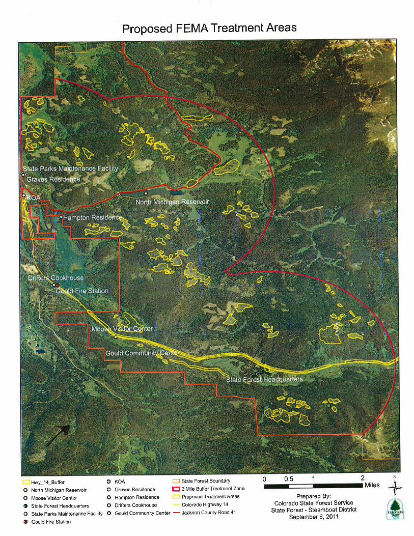

Description: 1. Typical vegetative conditions within Colorado State Forest State Park. 2. Typical vegetative conditions within Colorado State Forest State Park.
Colorado State Forest Service Wildfire Mitigation Project
Near Walden, CO
15702511 SV
11/28/11 AC
0 2
1.
2.

Description: 3. North Michigan Reservoir, located within the Colorado State Forest State Park. 4. Looking upstream at box culvert, American Discovery Trail on left.
Colorado State Forest Service Wildfire Mitigation Project
Near Walden, CO
15702511 SV
11/28/11 AC
0 2
3.
4.

Description: 5. Cabins located near North Michigan Reservoir. 6.Colorado State Forest Service Headquarters building near Gould, CO.
Colorado State Forest Service Wildfire Mitigation Project
Near Walden, CO
15702511 SV
11/28/11 AC
0 2
5.
6.


U.S. Department of Homeland Security Region VIII Denver Federal Center, Building 710 P.O. Box 25267 Denver, CO 80225-0267
www.fema.gov
R8-Div 28 November 2011 Mr. Steve Yamashita Colorado Department of Wildlife Northeast Regional Office 6060 Broadway Denver, Colorado 80216 Re: State Threatened and Endangered Wildlife, Colorado State Forest Service (CSFS) - State Forest Fuels Mitigation Project, near Walden, CO (40.50218, -105.96588). Mr. Yamashita:
URS Corporation, on behalf of the Federal Emergency Management Agency (FEMA), is preparing an Environmental Assessment for the CSFS - State Forest Fuels Mitigation Project near Walden and Gould, Colorado. Exhibit 1 shows the general project location and photographs of the project area are also enclosed. The proposed project will occur within the State Forest State Park and the CSFS has identified 1,200 acres where vegetation management activities are necessary for the protection of structures and watersheds present within the Park.
Treatments that would be implemented include: Creation of defensible space,
Construction of fuelbreaks, and
Thinning. Treatment areas will include thinning of approximately 600 acres within 2 miles of North Michigan Reservoir and the thinning of an additional 250 acres within 2 miles of other critical infrastructures located within the Park. Creation of defensible space for the 14 identified structures (including the Moose Visitor Center, State Forest Headquarters, and Gould Community Center) would involve 20 to 35 acres. Fuel breaks along existing roads within the Park would be constructed on the remaining 315 to 330 acres. Logging systems that would be employed to implement the project would be limited to ground-based systems and mastication/chipping systems. Ground-based systems (chainsaws, tractors) would be used to sever and removed tree from the project sites. Mastication/chipping would be used eliminate slash (branches, tops) on site. Equipment required to carry out this activities (chainsaws, tractors, chippers) would be fitted with high flotation/low ground pressure tires or tracks to eliminate ground disturbance. Photographs showing the existing vegetation and some of the structures to be protected are attached to this letter.

U.S. Department of Homeland Security Region VIII Denver Federal Center, Building 710 P.O. Box 25267 Denver, CO 80225-0267
www.fema.gov
Mr. Steve Yamashita November 28, 2011 Page 2 The Colorado Division of Wildlife (CDOW) and Natural Diversity Information Source (NDIS) websites were accessed on November 10 to obtain an official list of state listed threatened and endangered species that have potential to occur in Jackson County, Colorado. Several streams and the North Michigan Reservoir are located within the project area; however, the proposed project would have no direct physical effect on any aquatic resources. The indirect effect the proposed project would have on the aquatic resources near the project area is difficult to quantify, as most of the potential effects would be depend on whether or not the actions prevent a catastrophic fire. If a wildfire did not occur, the proposed project would have little if any effect on downstream aquatic resources. However, if the treatment prevents a catastrophic fire, the proposed project would have prevented a significant degradation of the soil stability within the affected watershed. The prevention of an increase in sediment and debris within the affected streams represents a favorable attribute of the proposed project on aquatic resources. In summary, since the proposed project would not be expected to have an adverse impact on aquatic resources during the implementation of the vegetation management treatments, FEMA has determined the proposed project would have No Effect on any State threatened or endangered aquatic species. The NDIS website indicates the following State threatened and endangered terrestrial species have potential to occur in Jackson County, CO:
Canada lynx (Lynx canadensis) – State endangered; North America wolverine (Gulo gulo) – State endangered; River otter (Lontra canadensis) – State threatened; Burrowing owl (Athene cunicularia) – State threatened; Boreal toad (Bufo boreas boreas) – State endangered
Habitat requirements and designated critical habitat for each of the threatened, endangered, or candidate species are discussed briefly in the following paragraphs. Canada lynx. The lynx is found in dense sub-alpine forest and willow-choked corridors along mountain streams and avalanche chutes, the home of its favored prey species, the snowshoe hare. The CDOW indicates that the Canada lynx appears to be restricted to extremely isolated areas of the mountains in the central portion of the state and that they generally occur at elevations between 9,000 and 14,000 feet. The project area is between 8,500 to 10,000 feet and the CDOW report that the lynx is known to occur in Jackson County. Therefore, there is a potential for Canada lynx to

U.S. Department of Homeland Security Region VIII Denver Federal Center, Building 710 P.O. Box 25267 Denver, CO 80225-0267
www.fema.gov
Mr. Steve Yamashita November 28, 2011 Page 3 occur within habitat located in the project area. Based on low potential of occurrence in the project area, FEMA has determined that proposed project activities May Affect But Not Likely To Adversely Effect the Canada lynx. North America Wolverine. Wolverines appear to select remote areas that are cold and retain snow throughout most of the year. Within Colorado, this type of habitat is restricted to high elevation forest areas. Wolverines are quite rare in Colorado, and the CDOW indicates the status of the wolverine in Colorado is uncertain. The USFWS indicates the primary threat to the North America wolverine is from habitat and range loss due to climate warming. The project area contains the high elevation forested areas and persistent snow cover desired by the wolverine. Therefore, FEMA has determined that the proposed project activities May Affect But Not Likely To Adversely Effect the North America wolverine. River Otter. The river otter inhabits riparian habitats that traverse a variety of other ecosystems ranging from semi-desert shrublands to montane and subalpine forests. River otters require permanent water of relatively high quality and with an abundant food base of fish or crustaceans. They occur in the Colorado, Gunnison, Piedra, and Dolores rivers. Tracks and other sign of otters have also been found in the Poudre and Laramie drainages in Larimer County. None of the project areas are located in these areas. Since the project area does not contain habitat utilized by the species, FEMA has determined the proposed project would have No Effect on the river otter. Boreal toad. The boreal toad generally is located in areas between 8,500 and 11,500 feet in elevation in areas that are damp and in the vicinity of a water source. The project area contains the high elevation damp areas desired by the boreal toad. However, the work in Colorado State Forest State Park will take place during the winter months while snow is on the ground and the toad is in hibernation. Therefore, FEMA has determined that the proposed project activities would have May Affect But Not Likely To Adversely Effect on the boreal toad. Burrowing Owl. The burrowing owl occurs in grasslands in or near prairie dog towns. The project area does not contain grasslands or prairie dog towns. Therefore, FEMA has determined that the proposed project activities would have No Effect on the burrowing owl. The USFWS is also being contacted regarding federally-listed threatened and endangered species in Jackson County.

U.S. Department of Homeland Security Region VIII Denver Federal Center, Building 710 P.O. Box 25267 Denver, CO 80225-0267
www.fema.gov
Mr. Steve Yamashita November 28, 2011 Page 4 Based on the information provided and discussed above, FEMA has made a determination the proposed State Forest Fuels Mitigation Project near Walden and Gould, Colorado would have “No Effect” on two of the five listed terrestrial species with the potential to occur in Jackson County. For the remaining species (Canada lynx, boreal toad, North American wolverine), FEMA has made a determination of “May Affect Not Likely To Adversely Effect”. If you need additional information or have questions, please call me at (303) 235-4926. Sincerely, Richard Myers Deputy Environmental Officer FEMA – Region VIII cc: Amy Cherko, URS Omaha Sue Volkmer, URS Omaha Enclosures: Project Location Map Project Area Photographs


Description: 1. Typical vegetative conditions within Colorado State Forest State Park. 2. Typical vegetative conditions within Colorado State Forest State Park.
Colorado State Forest Service Wildfire Mitigation Project
Near Walden, CO
15702511 SV
11/28/11 AC
0 2
1.
2.

Description: 3. North Michigan Reservoir, located within the Colorado State Forest State Park. 4. Looking upstream at box culvert, American Discovery Trail on left.
Colorado State Forest Service Wildfire Mitigation Project
Near Walden, CO
15702511 SV
11/28/11 AC
0 2
3.
4.

Description: 5. Cabins located near North Michigan Reservoir. 6.Colorado State Forest Service Headquarters building near Gould, CO.
Colorado State Forest Service Wildfire Mitigation Project
Near Walden, CO
15702511 SV
11/28/11 AC
0 2
5.
6.


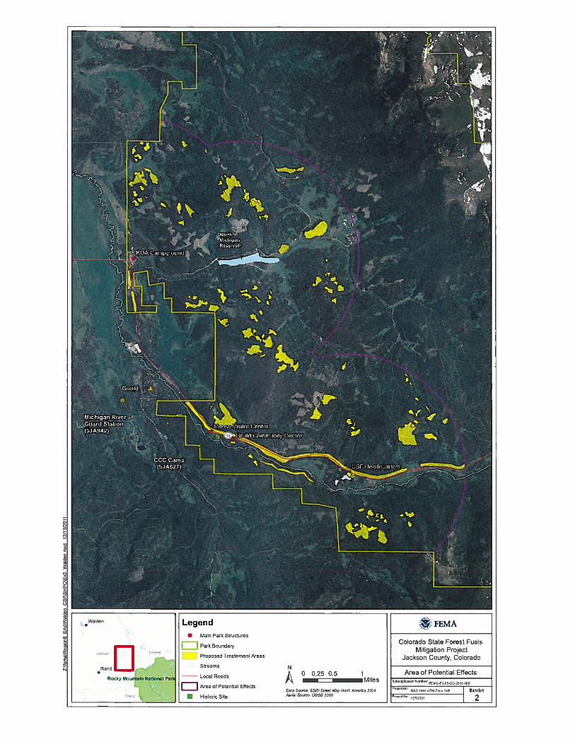


U.S. Department of Homeland Security Region VIII Denver Federal Center, Building 710 P.O. Box 25267 Denver, CO 80225-0267
www.fema.gov
R8-Div December 22, 2011 Ms. Janice Prairie Chief Boswell, Governor Cheyenne and Arapaho Tribes, Oklahoma Office of the Tribal Council P.O. Box 38 Concho, OK 73022 RE: Section 106 Consultation – COLORADO STATE FOREST FUELS MITIGATION,
Walden, Jackson County, Colorado (PDMC-PJ-08-CO-2011-006) Dear Governor Boswell: The Colorado State Forest Service has applied for Federal Emergency Management Agency (FEMA) funding to create defensible space, construct fuelbreaks, and reduce hazardous fuels within approximately 1,200 acres spread out over a roughly 25-square-mile project area within the Colorado State Forest State Park, east of Walden, Jackson County, Colorado (latitude: 40.50218; longitude: -105.96588; Exhibit 1). In accordance with FEMA’s responsibilities under Section 106 of the National Historic Preservation Act (NHPA) of 1966, as amended, we are submitting this determination of no adverse effect on historic properties for the proposed undertaking.
Proposed Undertaking Colorado State Forest State Park encompasses approximately 71,000 acres in Jackson and Larimer counties east of Walden, Colorado, in the high mountain basin known as North Park, along the west side of the Medicine Bow Mountains and northern end of the Never Summer Range. The proposed activities will impact an area of approximately 1,200 acres.
This undertaking includes hand clearing with chain saws and chipping to create defensible space and reduce the fuel load in the project area. Defensible space would be created by hand clearing all woody vegetation to slow the spread of wildfire and provide room for firefighters to work. Fuelbreaks would be created along road systems by thinning tree stands in order to improve the protection that roads provide in reducing the spread of fire. The trees removed during the construction of the fuelbreaks and reduction of hazardous fuels would be harvested for timbers, mulched, or placed in slash piles. Computer modeling and adaptive management criteria would be used to identify locations where thinning treatments would be most effective. The treatments would thin the existing conifer understory and canopy to break up the continuity of fuels. The treatments will occur during winter months when soils are snow covered and frozen, so as to lessen soil disturbance and erosion. Staging and landing areas, where cleared vegetation will be stockpiled

Ms. Janice Prairie Chief Boswell December 21, 2011 Page 2
before further treatment and removal, will be located on sites that have been used for previous vegetation management activities, thereby minimizing new disturbance. The project will use existing roads; no new roads will be created.
Area of Potential Effects The project area is a heavily forested, mountainous area, which is principally drained by the Michigan River and associated tributaries. Elevations range from approximately 9,000 feet to over 12,000 feet above mean sea level. State Highway (SH) 14 crosses the southern end of the project area. The area of potential effects (APE) for this project encompasses the areas of treatment, as shown on the attached map (Exhibit 2). The defensible space treatments would help protect 14 properties, including individual houses, the Colorado State Forest Headquarters, high-value recreation facilities (e.g., the Moose Visitor Center and Gould Community Center), cabins, pit vault toilets, emergency response facilities, businesses, and roads, as well as North Michigan Reservoir, which is the Town of Walden's water supply.
Identification of Historic Properties The regional ethnohistory suggests that several precontact site types may be located within the APE, including seasonal camps, temporary habitations, tipi rings, rock or boulder shelters, quarries, roasting pits, milling stations, bison kill sites, lithic scatters, midden soils, and fire-altered rock.
Trappers are known to have been active in western Colorado by the 1820s and the project area was sporadically occupied during a small gold and silver rush beginning in the 1860s. The county was not permanently settled by non-native people until the late nineteenth century. The town of Gould and various sawmill and logging encampments in the project area were settled during the late nineteenth century to exploit the timber resources. One such encampment, the Bockman Lumber Camp, was located 3.8 miles northeast of Gould, just inside the extreme eastern edge of the APE. According to the Colorado State Forest website (http://csfs.colostate.edu/pages/csfs-history.html), the Bockman Lumber Camp, which operated from approximately 1940 to 1970, was the largest logging camp in Colorado history, housing more than 100 workers and their families. During the early 1930s, a Civilian Conservation Corps (CCC) Camp was built just south of Gould. The camp was later converted and used as a Prisoner of War Camp during World War II for people of German descent as well as for American conscientious objectors. Today, it is used as the Cameron Pass 4-H Club Camp. The location of other temporary encampments for mining and timber are highly possible within the still relatively undeveloped APE.
Archaeological Resources The general potential for previously unidentified archaeological historic properties to be located within the APE is high. To date, no National Register of Historic Places (NRHP)-listed or NRHP-eligible archaeological sites have been documented in Jackson County. A search of COMPASS, Colorado’s On-line Cultural Resource Database, for the 6th Prime Meridian, Township 7 North, Range 77 West, Sections 9-16 and 21-28; and Township 6 North, Range 77 West, Sections 1-4 and 9-12, revealed that seven cultural resources surveys have been conducted in this area

Ms. Janice Prairie Chief Boswell December 21, 2011 Page 3
between 1976 and 2010. These surveys identified 25 cultural resources, including precontact open lithic scatters, historic artifact scatters, and isolated finds, as well as historic roads/trails and ditches. Data provided by the Colorado SHPO to the National Archaeological Database (http://cast.uark.edu/other/nps/maplib/USsitdens.1993.html) between 1991 and 1993 indicate that 576 sites had been documented within the county, with an approximate density of 0.201 to 0.4 sites per square mile. According to the Colorado Historical Society, the number of documented sites in Jackson County had increased to 878 by November 2006 (http://www.historycolorado.org/sites/default/files/files/OAHP/crforms_edumat/pdfs/1553.pdf).
Above-ground Resources The general potential for previously unidentified above-ground historic properties to be located within the APE is moderate. A search of the NRHP Database (http://www.nps.gov/nr/research/) revealed that no NRHP-listed properties are found in the APE. Only two NRHP-listed properties are in Jackson County - the Lake Agnes Cabin (5JA1716), approximately two miles east of the APE, and the Hog Park Guard Station (5JA561), located on the Colorado-Wyoming border, approximately 48 miles northwest of the APE.
According to COMPASS, one previously recorded above-ground resource is located in the APE (Exhibit 2). The Civilian Conservation Corps (CCC) Camp F-52 (5JA527), also known as the Cameron Pass 4-H Club Camp, is a building complex located on SH 14, approximately 1.5 miles southeast of Gould, Colorado. It was built in 1930-1939 and officially determined not eligible for listing in the NRHP in 1986. Its NRHP eligibility may need to be reassessed, however, particularly in light of recent renewed interest in New Deal-era built resources in Colorado. Additionally, one previously recorded above-ground resource, the Michigan River Guard Station (5JA942), is located just outside the APE, approximately 1 mile southwest of Gould, Colorado. The building was constructed in 1914 and officially determined eligible for listing in the NRHP in 1997. Other buildings in the APE, such as the Gould Community Center, Gould Fire Station, and Drifter’s Cookhouse along SH 14, may be historic but they appear to have been greatly modified and, therefore, may lack sufficient integrity to be considered eligible for listing in the NRHP. Six cabins that may be historic are located around the end of North Michigan Reservoir. The presence of these properties indicates that previously unidentified above-ground historic properties may be located within the project APE.
Determination of No Adverse Effect In consideration of the above information, FEMA has concluded the following with regard to the effect of the undertaking on historic properties within the APE:
• Project activities will result in very little surface disturbance o defensible spaces around structures will be created, and tree stands thinned, using
only hand clearing methods with minimal impacts o staging and landing areas will be located in previously disturbed areas o existing roads will be used and no new roads will be created

Ms. Janice Prairie Chief Boswell December 21, 2011 Page 4
• Extant historic buildings will not be directly affected • Thinning would increase the tree canopy spacing, but these impacts would be modest and
widely spaced and would not significantly alter the historic landscape, should it be present
• Project activities would be restricted to the winter months when the ground is frozen and the snow cover deep enough (6 to 12 inches) to protect vegetation, soil, and surface artifact scatters (prehistoric or historic)
Accordingly, FEMA has determined that although a moderate to high potential exists for previously unidentified historic properties to be located within the APE, the undertaking itself has minimal impacts and will have no adverse effect on historic properties. If previously unknown resources are discovered, work will be stopped and FEMA, SHPO, and you will be notified as soon as possible. We respectfully seek your concurrence with these findings and determination. FEMA respectfully seeks your comments on potential impacts to archaeological sites, burials, and traditional cultural properties in or near the project area that are of importance to you or your tribe. If you have any questions or comments concerning this project, please contact me by telephone at 303-235-4926 or by email at [email protected]. If no comments are received within 30 days, we will assume you have no interest in the proposed project.
Sincerely, Richard Myers Deputy Regional Environmental Officer FEMA Region VIII
cc: Quentin Bliss, URS Omaha
Carrie Albee, URS Germantown Gordon Tucker, URS Denver
Enclosures: Exhibit 1, Project Location Map
Exhibit 2, APE Map

Ms. Janice Prairie Chief Boswell December 21, 2011 Page 5

Ms. Janice Prairie Chief Boswell December 21, 2011 Page 6


U.S. Department of Homeland Security Region VIII Denver Federal Center, Building 710 P.O. Box 25267 Denver, CO 80225-0267
www.fema.gov
R8-Div December 22, 2011 Mr. Leroy Spang, President Northern Cheyenne Tribe P.O. Box 128 Lame Deer, MT 59043 RE: Section 106 Consultation – COLORADO STATE FOREST FUELS MITIGATION,
Walden, Jackson County, Colorado (PDMC-PJ-08-CO-2011-006) Dear Governor Boswell: The Colorado State Forest Service has applied for Federal Emergency Management Agency (FEMA) funding to create defensible space, construct fuelbreaks, and reduce hazardous fuels within approximately 1,200 acres spread out over a roughly 25-square-mile project area within the Colorado State Forest State Park, east of Walden, Jackson County, Colorado (latitude: 40.50218; longitude: -105.96588; Exhibit 1). In accordance with FEMA’s responsibilities under Section 106 of the National Historic Preservation Act (NHPA) of 1966, as amended, we are submitting this determination of no adverse effect on historic properties for the proposed undertaking.
Proposed Undertaking Colorado State Forest State Park encompasses approximately 71,000 acres in Jackson and Larimer counties east of Walden, Colorado, in the high mountain basin known as North Park, along the west side of the Medicine Bow Mountains and northern end of the Never Summer Range. The proposed activities will impact an area of approximately 1,200 acres.
This undertaking includes hand clearing with chain saws and chipping to create defensible space and reduce the fuel load in the project area. Defensible space would be created by hand clearing all woody vegetation to slow the spread of wildfire and provide room for firefighters to work. Fuelbreaks would be created along road systems by thinning tree stands in order to improve the protection that roads provide in reducing the spread of fire. The trees removed during the construction of the fuelbreaks and reduction of hazardous fuels would be harvested for timbers, mulched, or placed in slash piles. Computer modeling and adaptive management criteria would be used to identify locations where thinning treatments would be most effective. The treatments would thin the existing conifer understory and canopy to break up the continuity of fuels. The treatments will occur during winter months when soils are snow covered and frozen, so as to lessen soil disturbance and erosion. Staging and landing areas, where cleared vegetation will be stockpiled

Mr. Leroy Spang December 21, 2011 Page 2
before further treatment and removal, will be located on sites that have been used for previous vegetation management activities, thereby minimizing new disturbance. The project will use existing roads; no new roads will be created.
Area of Potential Effects The project area is a heavily forested, mountainous area, which is principally drained by the Michigan River and associated tributaries. Elevations range from approximately 9,000 feet to over 12,000 feet above mean sea level. State Highway (SH) 14 crosses the southern end of the project area. The area of potential effects (APE) for this project encompasses the areas of treatment, as shown on the attached map (Exhibit 2). The defensible space treatments would help protect 14 properties, including individual houses, the Colorado State Forest Headquarters, high-value recreation facilities (e.g., the Moose Visitor Center and Gould Community Center), cabins, pit vault toilets, emergency response facilities, businesses, and roads, as well as North Michigan Reservoir, which is the Town of Walden's water supply.
Identification of Historic Properties The regional ethnohistory suggests that several precontact site types may be located within the APE, including seasonal camps, temporary habitations, tipi rings, rock or boulder shelters, quarries, roasting pits, milling stations, bison kill sites, lithic scatters, midden soils, and fire-altered rock.
Trappers are known to have been active in western Colorado by the 1820s and the project area was sporadically occupied during a small gold and silver rush beginning in the 1860s. The county was not permanently settled by non-native people until the late nineteenth century. The town of Gould and various sawmill and logging encampments in the project area were settled during the late nineteenth century to exploit the timber resources. One such encampment, the Bockman Lumber Camp, was located 3.8 miles northeast of Gould, just inside the extreme eastern edge of the APE. According to the Colorado State Forest website (http://csfs.colostate.edu/pages/csfs-history.html), the Bockman Lumber Camp, which operated from approximately 1940 to 1970, was the largest logging camp in Colorado history, housing more than 100 workers and their families. During the early 1930s, a Civilian Conservation Corps (CCC) Camp was built just south of Gould. The camp was later converted and used as a Prisoner of War Camp during World War II for people of German descent as well as for American conscientious objectors. Today, it is used as the Cameron Pass 4-H Club Camp. The location of other temporary encampments for mining and timber are highly possible within the still relatively undeveloped APE.
Archaeological Resources The general potential for previously unidentified archaeological historic properties to be located within the APE is high. To date, no National Register of Historic Places (NRHP)-listed or NRHP-eligible archaeological sites have been documented in Jackson County. A search of COMPASS, Colorado’s On-line Cultural Resource Database, for the 6th Prime Meridian, Township 7 North, Range 77 West, Sections 9-16 and 21-28; and Township 6 North, Range 77 West, Sections 1-4 and 9-12, revealed that seven cultural resources surveys have been conducted in this area

Mr. Leroy Spang December 21, 2011 Page 3
between 1976 and 2010. These surveys identified 25 cultural resources, including precontact open lithic scatters, historic artifact scatters, and isolated finds, as well as historic roads/trails and ditches. Data provided by the Colorado SHPO to the National Archaeological Database (http://cast.uark.edu/other/nps/maplib/USsitdens.1993.html) between 1991 and 1993 indicate that 576 sites had been documented within the county, with an approximate density of 0.201 to 0.4 sites per square mile. According to the Colorado Historical Society, the number of documented sites in Jackson County had increased to 878 by November 2006 (http://www.historycolorado.org/sites/default/files/files/OAHP/crforms_edumat/pdfs/1553.pdf).
Above-ground Resources The general potential for previously unidentified above-ground historic properties to be located within the APE is moderate. A search of the NRHP Database (http://www.nps.gov/nr/research/) revealed that no NRHP-listed properties are found in the APE. Only two NRHP-listed properties are in Jackson County - the Lake Agnes Cabin (5JA1716), approximately two miles east of the APE, and the Hog Park Guard Station (5JA561), located on the Colorado-Wyoming border, approximately 48 miles northwest of the APE.
According to COMPASS, one previously recorded above-ground resource is located in the APE (Exhibit 2). The Civilian Conservation Corps (CCC) Camp F-52 (5JA527), also known as the Cameron Pass 4-H Club Camp, is a building complex located on SH 14, approximately 1.5 miles southeast of Gould, Colorado. It was built in 1930-1939 and officially determined not eligible for listing in the NRHP in 1986. Its NRHP eligibility may need to be reassessed, however, particularly in light of recent renewed interest in New Deal-era built resources in Colorado. Additionally, one previously recorded above-ground resource, the Michigan River Guard Station (5JA942), is located just outside the APE, approximately 1 mile southwest of Gould, Colorado. The building was constructed in 1914 and officially determined eligible for listing in the NRHP in 1997. Other buildings in the APE, such as the Gould Community Center, Gould Fire Station, and Drifter’s Cookhouse along SH 14, may be historic but they appear to have been greatly modified and, therefore, may lack sufficient integrity to be considered eligible for listing in the NRHP. Six cabins that may be historic are located around the end of North Michigan Reservoir. The presence of these properties indicates that previously unidentified above-ground historic properties may be located within the project APE.
Determination of No Adverse Effect In consideration of the above information, FEMA has concluded the following with regard to the effect of the undertaking on historic properties within the APE:
• Project activities will result in very little surface disturbance o defensible spaces around structures will be created, and tree stands thinned, using
only hand clearing methods with minimal impacts o staging and landing areas will be located in previously disturbed areas o existing roads will be used and no new roads will be created

Mr. Leroy Spang December 21, 2011 Page 4
• Extant historic buildings will not be directly affected • Thinning would increase the tree canopy spacing, but these impacts would be modest and
widely spaced and would not significantly alter the historic landscape, should it be present
• Project activities would be restricted to the winter months when the ground is frozen and the snow cover deep enough (6 to 12 inches) to protect vegetation, soil, and surface artifact scatters (prehistoric or historic)
Accordingly, FEMA has determined that although a moderate to high potential exists for previously unidentified historic properties to be located within the APE, the undertaking itself has minimal impacts and will have no adverse effect on historic properties. If previously unknown resources are discovered, work will be stopped and FEMA, SHPO, and you will be notified as soon as possible. We respectfully seek your concurrence with these findings and determination. FEMA respectfully seeks your comments on potential impacts to archaeological sites, burials, and traditional cultural properties in or near the project area that are of importance to you or your tribe. If you have any questions or comments concerning this project, please contact me by telephone at 303-235-4926 or by email at [email protected]. If no comments are received within 30 days, we will assume you have no interest in the proposed project.
Sincerely, Richard Myers Deputy Regional Environmental Officer FEMA Region VIII
cc: Quentin Bliss, URS Omaha
Carrie Albee, URS Germantown Gordon Tucker, URS Denver
Enclosures: Exhibit 1, Project Location Map
Exhibit 2, APE Map

Mr. Leroy Spang December 21, 2011 Page 5

Mr. Leroy Spang December 21, 2011 Page 6

U.S. Department of Homeland Security Region VIII Denver Federal Center, Building 710 P.O. Box 25267 Denver, CO 80225-0267
www.fema.gov
R8-Div December 22, 2011 Mr. Mike Lajeunesse, Chairman Shoshone Tribe of the Wind River Reservation P.O. Box 538 Fort Washakie, WY 82514 RE: Section 106 Consultation – COLORADO STATE FOREST FUELS MITIGATION,
Walden, Jackson County, Colorado (PDMC-PJ-08-CO-2011-006) Dear Governor Boswell: The Colorado State Forest Service has applied for Federal Emergency Management Agency (FEMA) funding to create defensible space, construct fuelbreaks, and reduce hazardous fuels within approximately 1,200 acres spread out over a roughly 25-square-mile project area within the Colorado State Forest State Park, east of Walden, Jackson County, Colorado (latitude: 40.50218; longitude: -105.96588; Exhibit 1). In accordance with FEMA’s responsibilities under Section 106 of the National Historic Preservation Act (NHPA) of 1966, as amended, we are submitting this determination of no adverse effect on historic properties for the proposed undertaking.
Proposed Undertaking Colorado State Forest State Park encompasses approximately 71,000 acres in Jackson and Larimer counties east of Walden, Colorado, in the high mountain basin known as North Park, along the west side of the Medicine Bow Mountains and northern end of the Never Summer Range. The proposed activities will impact an area of approximately 1,200 acres.
This undertaking includes hand clearing with chain saws and chipping to create defensible space and reduce the fuel load in the project area. Defensible space would be created by hand clearing all woody vegetation to slow the spread of wildfire and provide room for firefighters to work. Fuelbreaks would be created along road systems by thinning tree stands in order to improve the protection that roads provide in reducing the spread of fire. The trees removed during the construction of the fuelbreaks and reduction of hazardous fuels would be harvested for timbers, mulched, or placed in slash piles. Computer modeling and adaptive management criteria would be used to identify locations where thinning treatments would be most effective. The treatments would thin the existing conifer understory and canopy to break up the continuity of fuels. The treatments will occur during winter months when soils are snow covered and frozen, so as to lessen soil disturbance and erosion. Staging and landing areas, where cleared vegetation will be stockpiled

Mr. Mike Lajeunesse December 21, 2011 Page 2
before further treatment and removal, will be located on sites that have been used for previous vegetation management activities, thereby minimizing new disturbance. The project will use existing roads; no new roads will be created.
Area of Potential Effects The project area is a heavily forested, mountainous area, which is principally drained by the Michigan River and associated tributaries. Elevations range from approximately 9,000 feet to over 12,000 feet above mean sea level. State Highway (SH) 14 crosses the southern end of the project area. The area of potential effects (APE) for this project encompasses the areas of treatment, as shown on the attached map (Exhibit 2). The defensible space treatments would help protect 14 properties, including individual houses, the Colorado State Forest Headquarters, high-value recreation facilities (e.g., the Moose Visitor Center and Gould Community Center), cabins, pit vault toilets, emergency response facilities, businesses, and roads, as well as North Michigan Reservoir, which is the Town of Walden's water supply.
Identification of Historic Properties The regional ethnohistory suggests that several precontact site types may be located within the APE, including seasonal camps, temporary habitations, tipi rings, rock or boulder shelters, quarries, roasting pits, milling stations, bison kill sites, lithic scatters, midden soils, and fire-altered rock.
Trappers are known to have been active in western Colorado by the 1820s and the project area was sporadically occupied during a small gold and silver rush beginning in the 1860s. The county was not permanently settled by non-native people until the late nineteenth century. The town of Gould and various sawmill and logging encampments in the project area were settled during the late nineteenth century to exploit the timber resources. One such encampment, the Bockman Lumber Camp, was located 3.8 miles northeast of Gould, just inside the extreme eastern edge of the APE. According to the Colorado State Forest website (http://csfs.colostate.edu/pages/csfs-history.html), the Bockman Lumber Camp, which operated from approximately 1940 to 1970, was the largest logging camp in Colorado history, housing more than 100 workers and their families. During the early 1930s, a Civilian Conservation Corps (CCC) Camp was built just south of Gould. The camp was later converted and used as a Prisoner of War Camp during World War II for people of German descent as well as for American conscientious objectors. Today, it is used as the Cameron Pass 4-H Club Camp. The location of other temporary encampments for mining and timber are highly possible within the still relatively undeveloped APE.
Archaeological Resources The general potential for previously unidentified archaeological historic properties to be located within the APE is high. To date, no National Register of Historic Places (NRHP)-listed or NRHP-eligible archaeological sites have been documented in Jackson County. A search of COMPASS, Colorado’s On-line Cultural Resource Database, for the 6th Prime Meridian, Township 7 North, Range 77 West, Sections 9-16 and 21-28; and Township 6 North, Range 77 West, Sections 1-4 and 9-12, revealed that seven cultural resources surveys have been conducted in this area between 1976 and 2010. These surveys identified 25 cultural resources, including precontact open

Mr. Mike Lajeunesse December 21, 2011 Page 3
lithic scatters, historic artifact scatters, and isolated finds, as well as historic roads/trails and ditches. Data provided by the Colorado SHPO to the National Archaeological Database (http://cast.uark.edu/other/nps/maplib/USsitdens.1993.html) between 1991 and 1993 indicate that 576 sites had been documented within the county, with an approximate density of 0.201 to 0.4 sites per square mile. According to the Colorado Historical Society, the number of documented sites in Jackson County had increased to 878 by November 2006 (http://www.historycolorado.org/sites/default/files/files/OAHP/crforms_edumat/pdfs/1553.pdf).
Above-ground Resources The general potential for previously unidentified above-ground historic properties to be located within the APE is moderate. A search of the NRHP Database (http://www.nps.gov/nr/research/) revealed that no NRHP-listed properties are found in the APE. Only two NRHP-listed properties are in Jackson County - the Lake Agnes Cabin (5JA1716), approximately two miles east of the APE, and the Hog Park Guard Station (5JA561), located on the Colorado-Wyoming border, approximately 48 miles northwest of the APE.
According to COMPASS, one previously recorded above-ground resource is located in the APE (Exhibit 2). The Civilian Conservation Corps (CCC) Camp F-52 (5JA527), also known as the Cameron Pass 4-H Club Camp, is a building complex located on SH 14, approximately 1.5 miles southeast of Gould, Colorado. It was built in 1930-1939 and officially determined not eligible for listing in the NRHP in 1986. Its NRHP eligibility may need to be reassessed, however, particularly in light of recent renewed interest in New Deal-era built resources in Colorado. Additionally, one previously recorded above-ground resource, the Michigan River Guard Station (5JA942), is located just outside the APE, approximately 1 mile southwest of Gould, Colorado. The building was constructed in 1914 and officially determined eligible for listing in the NRHP in 1997. Other buildings in the APE, such as the Gould Community Center, Gould Fire Station, and Drifter’s Cookhouse along SH 14, may be historic but they appear to have been greatly modified and, therefore, may lack sufficient integrity to be considered eligible for listing in the NRHP. Six cabins that may be historic are located around the end of North Michigan Reservoir. The presence of these properties indicates that previously unidentified above-ground historic properties may be located within the project APE.
Determination of No Adverse Effect In consideration of the above information, FEMA has concluded the following with regard to the effect of the undertaking on historic properties within the APE:
• Project activities will result in very little surface disturbance o defensible spaces around structures will be created, and tree stands thinned, using
only hand clearing methods with minimal impacts o staging and landing areas will be located in previously disturbed areas o existing roads will be used and no new roads will be created
• Extant historic buildings will not be directly affected

Mr. Mike Lajeunesse December 21, 2011 Page 4
• Thinning would increase the tree canopy spacing, but these impacts would be modest and widely spaced and would not significantly alter the historic landscape, should it be present
• Project activities would be restricted to the winter months when the ground is frozen and the snow cover deep enough (6 to 12 inches) to protect vegetation, soil, and surface artifact scatters (prehistoric or historic)
Accordingly, FEMA has determined that although a moderate to high potential exists for previously unidentified historic properties to be located within the APE, the undertaking itself has minimal impacts and will have no adverse effect on historic properties. If previously unknown resources are discovered, work will be stopped and FEMA, SHPO, and you will be notified as soon as possible. We respectfully seek your concurrence with these findings and determination. FEMA respectfully seeks your comments on potential impacts to archaeological sites, burials, and traditional cultural properties in or near the project area that are of importance to you or your tribe. If you have any questions or comments concerning this project, please contact me by telephone at 303-235-4926 or by email at [email protected]. If no comments are received within 30 days, we will assume you have no interest in the proposed project.
Sincerely, Richard Myers Deputy Regional Environmental Officer FEMA Region VIII
cc: Quentin Bliss, URS Omaha
Carrie Albee, URS Germantown Gordon Tucker, URS Denver
Enclosures: Exhibit 1, Project Location Map
Exhibit 2, APE Map

Mr. Mike Lajeunesse December 21, 2011 Page 5

Mr. Mike Lajeunesse December 21, 2011 Page 6

U.S. Department of Homeland Security Region VIII Denver Federal Center, Building 710 P.O. Box 25267 Denver, CO 80225-0267
www.fema.gov
R8-Div December 22, 2011 Mr. Nathan Small, Chairman Shoshone-Bannock Tribes P.O. Box 306 Fort Hall, ID 83203 RE: Section 106 Consultation – COLORADO STATE FOREST FUELS MITIGATION,
Walden, Jackson County, Colorado (PDMC-PJ-08-CO-2011-006) Dear Governor Boswell: The Colorado State Forest Service has applied for Federal Emergency Management Agency (FEMA) funding to create defensible space, construct fuelbreaks, and reduce hazardous fuels within approximately 1,200 acres spread out over a roughly 25-square-mile project area within the Colorado State Forest State Park, east of Walden, Jackson County, Colorado (latitude: 40.50218; longitude: -105.96588; Exhibit 1). In accordance with FEMA’s responsibilities under Section 106 of the National Historic Preservation Act (NHPA) of 1966, as amended, we are submitting this determination of no adverse effect on historic properties for the proposed undertaking.
Proposed Undertaking Colorado State Forest State Park encompasses approximately 71,000 acres in Jackson and Larimer counties east of Walden, Colorado, in the high mountain basin known as North Park, along the west side of the Medicine Bow Mountains and northern end of the Never Summer Range. The proposed activities will impact an area of approximately 1,200 acres.
This undertaking includes hand clearing with chain saws and chipping to create defensible space and reduce the fuel load in the project area. Defensible space would be created by hand clearing all woody vegetation to slow the spread of wildfire and provide room for firefighters to work. Fuelbreaks would be created along road systems by thinning tree stands in order to improve the protection that roads provide in reducing the spread of fire. The trees removed during the construction of the fuelbreaks and reduction of hazardous fuels would be harvested for timbers, mulched, or placed in slash piles. Computer modeling and adaptive management criteria would be used to identify locations where thinning treatments would be most effective. The treatments would thin the existing conifer understory and canopy to break up the continuity of fuels. The treatments will occur during winter months when soils are snow covered and frozen, so as to lessen soil disturbance and erosion. Staging and landing areas, where cleared vegetation will be stockpiled

Mr. Nathan Small December 21, 2011 Page 2
before further treatment and removal, will be located on sites that have been used for previous vegetation management activities, thereby minimizing new disturbance. The project will use existing roads; no new roads will be created.
Area of Potential Effects The project area is a heavily forested, mountainous area, which is principally drained by the Michigan River and associated tributaries. Elevations range from approximately 9,000 feet to over 12,000 feet above mean sea level. State Highway (SH) 14 crosses the southern end of the project area. The area of potential effects (APE) for this project encompasses the areas of treatment, as shown on the attached map (Exhibit 2). The defensible space treatments would help protect 14 properties, including individual houses, the Colorado State Forest Headquarters, high-value recreation facilities (e.g., the Moose Visitor Center and Gould Community Center), cabins, pit vault toilets, emergency response facilities, businesses, and roads, as well as North Michigan Reservoir, which is the Town of Walden's water supply.
Identification of Historic Properties The regional ethnohistory suggests that several precontact site types may be located within the APE, including seasonal camps, temporary habitations, tipi rings, rock or boulder shelters, quarries, roasting pits, milling stations, bison kill sites, lithic scatters, midden soils, and fire-altered rock.
Trappers are known to have been active in western Colorado by the 1820s and the project area was sporadically occupied during a small gold and silver rush beginning in the 1860s. The county was not permanently settled by non-native people until the late nineteenth century. The town of Gould and various sawmill and logging encampments in the project area were settled during the late nineteenth century to exploit the timber resources. One such encampment, the Bockman Lumber Camp, was located 3.8 miles northeast of Gould, just inside the extreme eastern edge of the APE. According to the Colorado State Forest website (http://csfs.colostate.edu/pages/csfs-history.html), the Bockman Lumber Camp, which operated from approximately 1940 to 1970, was the largest logging camp in Colorado history, housing more than 100 workers and their families. During the early 1930s, a Civilian Conservation Corps (CCC) Camp was built just south of Gould. The camp was later converted and used as a Prisoner of War Camp during World War II for people of German descent as well as for American conscientious objectors. Today, it is used as the Cameron Pass 4-H Club Camp. The location of other temporary encampments for mining and timber are highly possible within the still relatively undeveloped APE.
Archaeological Resources The general potential for previously unidentified archaeological historic properties to be located within the APE is high. To date, no National Register of Historic Places (NRHP)-listed or NRHP-eligible archaeological sites have been documented in Jackson County. A search of COMPASS, Colorado’s On-line Cultural Resource Database, for the 6th Prime Meridian, Township 7 North, Range 77 West, Sections 9-16 and 21-28; and Township 6 North, Range 77 West, Sections 1-4 and 9-12, revealed that seven cultural resources surveys have been conducted in this area between 1976 and 2010. These surveys identified 25 cultural resources, including precontact open lithic scatters, historic artifact scatters, and isolated finds, as well as historic roads/trails and ditches.

Mr. Nathan Small December 21, 2011 Page 3
Data provided by the Colorado SHPO to the National Archaeological Database (http://cast.uark.edu/other/nps/maplib/USsitdens.1993.html) between 1991 and 1993 indicate that 576 sites had been documented within the county, with an approximate density of 0.201 to 0.4 sites per square mile. According to the Colorado Historical Society, the number of documented sites in Jackson County had increased to 878 by November 2006 (http://www.historycolorado.org/sites/default/files/files/OAHP/crforms_edumat/pdfs/1553.pdf).
Above-ground Resources The general potential for previously unidentified above-ground historic properties to be located within the APE is moderate. A search of the NRHP Database (http://www.nps.gov/nr/research/) revealed that no NRHP-listed properties are found in the APE. Only two NRHP-listed properties are in Jackson County - the Lake Agnes Cabin (5JA1716), approximately two miles east of the APE, and the Hog Park Guard Station (5JA561), located on the Colorado-Wyoming border, approximately 48 miles northwest of the APE.
According to COMPASS, one previously recorded above-ground resource is located in the APE (Exhibit 2). The Civilian Conservation Corps (CCC) Camp F-52 (5JA527), also known as the Cameron Pass 4-H Club Camp, is a building complex located on SH 14, approximately 1.5 miles southeast of Gould, Colorado. It was built in 1930-1939 and officially determined not eligible for listing in the NRHP in 1986. Its NRHP eligibility may need to be reassessed, however, particularly in light of recent renewed interest in New Deal-era built resources in Colorado. Additionally, one previously recorded above-ground resource, the Michigan River Guard Station (5JA942), is located just outside the APE, approximately 1 mile southwest of Gould, Colorado. The building was constructed in 1914 and officially determined eligible for listing in the NRHP in 1997. Other buildings in the APE, such as the Gould Community Center, Gould Fire Station, and Drifter’s Cookhouse along SH 14, may be historic but they appear to have been greatly modified and, therefore, may lack sufficient integrity to be considered eligible for listing in the NRHP. Six cabins that may be historic are located around the end of North Michigan Reservoir. The presence of these properties indicates that previously unidentified above-ground historic properties may be located within the project APE.
Determination of No Adverse Effect In consideration of the above information, FEMA has concluded the following with regard to the effect of the undertaking on historic properties within the APE:
• Project activities will result in very little surface disturbance o defensible spaces around structures will be created, and tree stands thinned, using
only hand clearing methods with minimal impacts o staging and landing areas will be located in previously disturbed areas o existing roads will be used and no new roads will be created
• Extant historic buildings will not be directly affected • Thinning would increase the tree canopy spacing, but these impacts would be modest and
widely spaced and would not significantly alter the historic landscape, should it be present

Mr. Nathan Small December 21, 2011 Page 4
• Project activities would be restricted to the winter months when the ground is frozen and the snow cover deep enough (6 to 12 inches) to protect vegetation, soil, and surface artifact scatters (prehistoric or historic)
Accordingly, FEMA has determined that although a moderate to high potential exists for previously unidentified historic properties to be located within the APE, the undertaking itself has minimal impacts and will have no adverse effect on historic properties. If previously unknown resources are discovered, work will be stopped and FEMA, SHPO, and you will be notified as soon as possible. We respectfully seek your concurrence with these findings and determination. FEMA respectfully seeks your comments on potential impacts to archaeological sites, burials, and traditional cultural properties in or near the project area that are of importance to you or your tribe. If you have any questions or comments concerning this project, please contact me by telephone at 303-235-4926 or by email at [email protected]. If no comments are received within 30 days, we will assume you have no interest in the proposed project.
Sincerely, Richard Myers Deputy Regional Environmental Officer FEMA Region VIII
cc: Quentin Bliss, URS Omaha
Carrie Albee, URS Germantown Gordon Tucker, URS Denver
Enclosures: Exhibit 1, Project Location Map
Exhibit 2, APE Map

Mr. Nathan Small December 21, 2011 Page 5

Mr. Nathan Small December 21, 2011 Page 6

U.S. Department of Homeland Security Region VIII Denver Federal Center, Building 710 P.O. Box 25267 Denver, CO 80225-0267
www.fema.gov
R8-Div December 22, 2011 Mr. Ernest House Sr., Chairman Ute Mountain Ute Tribe P.O. Box 189 Towaoc, CO 81334 RE: Section 106 Consultation – COLORADO STATE FOREST FUELS MITIGATION,
Walden, Jackson County, Colorado (PDMC-PJ-08-CO-2011-006) Dear Governor Boswell: The Colorado State Forest Service has applied for Federal Emergency Management Agency (FEMA) funding to create defensible space, construct fuelbreaks, and reduce hazardous fuels within approximately 1,200 acres spread out over a roughly 25-square-mile project area within the Colorado State Forest State Park, east of Walden, Jackson County, Colorado (latitude: 40.50218; longitude: -105.96588; Exhibit 1). In accordance with FEMA’s responsibilities under Section 106 of the National Historic Preservation Act (NHPA) of 1966, as amended, we are submitting this determination of no adverse effect on historic properties for the proposed undertaking.
Proposed Undertaking Colorado State Forest State Park encompasses approximately 71,000 acres in Jackson and Larimer counties east of Walden, Colorado, in the high mountain basin known as North Park, along the west side of the Medicine Bow Mountains and northern end of the Never Summer Range. The proposed activities will impact an area of approximately 1,200 acres.
This undertaking includes hand clearing with chain saws and chipping to create defensible space and reduce the fuel load in the project area. Defensible space would be created by hand clearing all woody vegetation to slow the spread of wildfire and provide room for firefighters to work. Fuelbreaks would be created along road systems by thinning tree stands in order to improve the protection that roads provide in reducing the spread of fire. The trees removed during the construction of the fuelbreaks and reduction of hazardous fuels would be harvested for timbers, mulched, or placed in slash piles. Computer modeling and adaptive management criteria would be used to identify locations where thinning treatments would be most effective. The treatments would thin the existing conifer understory and canopy to break up the continuity of fuels. The treatments will occur during winter months when soils are snow covered and frozen, so as to lessen soil disturbance and erosion. Staging and landing areas, where cleared vegetation will be stockpiled

Mr. Ernest House Sr. December 21, 2011 Page 2
before further treatment and removal, will be located on sites that have been used for previous vegetation management activities, thereby minimizing new disturbance. The project will use existing roads; no new roads will be created.
Area of Potential Effects The project area is a heavily forested, mountainous area, which is principally drained by the Michigan River and associated tributaries. Elevations range from approximately 9,000 feet to over 12,000 feet above mean sea level. State Highway (SH) 14 crosses the southern end of the project area. The area of potential effects (APE) for this project encompasses the areas of treatment, as shown on the attached map (Exhibit 2). The defensible space treatments would help protect 14 properties, including individual houses, the Colorado State Forest Headquarters, high-value recreation facilities (e.g., the Moose Visitor Center and Gould Community Center), cabins, pit vault toilets, emergency response facilities, businesses, and roads, as well as North Michigan Reservoir, which is the Town of Walden's water supply.
Identification of Historic Properties The regional ethnohistory suggests that several precontact site types may be located within the APE, including seasonal camps, temporary habitations, tipi rings, rock or boulder shelters, quarries, roasting pits, milling stations, bison kill sites, lithic scatters, midden soils, and fire-altered rock.
Trappers are known to have been active in western Colorado by the 1820s and the project area was sporadically occupied during a small gold and silver rush beginning in the 1860s. The county was not permanently settled by non-native people until the late nineteenth century. The town of Gould and various sawmill and logging encampments in the project area were settled during the late nineteenth century to exploit the timber resources. One such encampment, the Bockman Lumber Camp, was located 3.8 miles northeast of Gould, just inside the extreme eastern edge of the APE. According to the Colorado State Forest website (http://csfs.colostate.edu/pages/csfs-history.html), the Bockman Lumber Camp, which operated from approximately 1940 to 1970, was the largest logging camp in Colorado history, housing more than 100 workers and their families. During the early 1930s, a Civilian Conservation Corps (CCC) Camp was built just south of Gould. The camp was later converted and used as a Prisoner of War Camp during World War II for people of German descent as well as for American conscientious objectors. Today, it is used as the Cameron Pass 4-H Club Camp. The location of other temporary encampments for mining and timber are highly possible within the still relatively undeveloped APE.
Archaeological Resources The general potential for previously unidentified archaeological historic properties to be located within the APE is high. To date, no National Register of Historic Places (NRHP)-listed or NRHP-eligible archaeological sites have been documented in Jackson County. A search of COMPASS, Colorado’s On-line Cultural Resource Database, for the 6th Prime Meridian, Township 7 North, Range 77 West, Sections 9-16 and 21-28; and Township 6 North, Range 77 West, Sections 1-4 and 9-12, revealed that seven cultural resources surveys have been conducted in this area between 1976 and 2010. These surveys identified 25 cultural resources, including precontact open

Mr. Ernest House Sr. December 21, 2011 Page 3
lithic scatters, historic artifact scatters, and isolated finds, as well as historic roads/trails and ditches. Data provided by the Colorado SHPO to the National Archaeological Database (http://cast.uark.edu/other/nps/maplib/USsitdens.1993.html) between 1991 and 1993 indicate that 576 sites had been documented within the county, with an approximate density of 0.201 to 0.4 sites per square mile. According to the Colorado Historical Society, the number of documented sites in Jackson County had increased to 878 by November 2006 (http://www.historycolorado.org/sites/default/files/files/OAHP/crforms_edumat/pdfs/1553.pdf).
Above-ground Resources The general potential for previously unidentified above-ground historic properties to be located within the APE is moderate. A search of the NRHP Database (http://www.nps.gov/nr/research/) revealed that no NRHP-listed properties are found in the APE. Only two NRHP-listed properties are in Jackson County - the Lake Agnes Cabin (5JA1716), approximately two miles east of the APE, and the Hog Park Guard Station (5JA561), located on the Colorado-Wyoming border, approximately 48 miles northwest of the APE.
According to COMPASS, one previously recorded above-ground resource is located in the APE (Exhibit 2). The Civilian Conservation Corps (CCC) Camp F-52 (5JA527), also known as the Cameron Pass 4-H Club Camp, is a building complex located on SH 14, approximately 1.5 miles southeast of Gould, Colorado. It was built in 1930-1939 and officially determined not eligible for listing in the NRHP in 1986. Its NRHP eligibility may need to be reassessed, however, particularly in light of recent renewed interest in New Deal-era built resources in Colorado. Additionally, one previously recorded above-ground resource, the Michigan River Guard Station (5JA942), is located just outside the APE, approximately 1 mile southwest of Gould, Colorado. The building was constructed in 1914 and officially determined eligible for listing in the NRHP in 1997. Other buildings in the APE, such as the Gould Community Center, Gould Fire Station, and Drifter’s Cookhouse along SH 14, may be historic but they appear to have been greatly modified and, therefore, may lack sufficient integrity to be considered eligible for listing in the NRHP. Six cabins that may be historic are located around the end of North Michigan Reservoir. The presence of these properties indicates that previously unidentified above-ground historic properties may be located within the project APE.
Determination of No Adverse Effect In consideration of the above information, FEMA has concluded the following with regard to the effect of the undertaking on historic properties within the APE:
• Project activities will result in very little surface disturbance o defensible spaces around structures will be created, and tree stands thinned, using
only hand clearing methods with minimal impacts o staging and landing areas will be located in previously disturbed areas o existing roads will be used and no new roads will be created
• Extant historic buildings will not be directly affected

Mr. Ernest House Sr. December 21, 2011 Page 4
• Thinning would increase the tree canopy spacing, but these impacts would be modest and widely spaced and would not significantly alter the historic landscape, should it be present
• Project activities would be restricted to the winter months when the ground is frozen and the snow cover deep enough (6 to 12 inches) to protect vegetation, soil, and surface artifact scatters (prehistoric or historic)
Accordingly, FEMA has determined that although a moderate to high potential exists for previously unidentified historic properties to be located within the APE, the undertaking itself has minimal impacts and will have no adverse effect on historic properties. If previously unknown resources are discovered, work will be stopped and FEMA, SHPO, and you will be notified as soon as possible. We respectfully seek your concurrence with these findings and determination. FEMA respectfully seeks your comments on potential impacts to archaeological sites, burials, and traditional cultural properties in or near the project area that are of importance to you or your tribe. If you have any questions or comments concerning this project, please contact me by telephone at 303-235-4926 or by email at [email protected]. If no comments are received within 30 days, we will assume you have no interest in the proposed project.
Sincerely, Richard Myers Deputy Regional Environmental Officer FEMA Region VIII
cc: Quentin Bliss, URS Omaha
Carrie Albee, URS Germantown Gordon Tucker, URS Denver
Enclosures: Exhibit 1, Project Location Map
Exhibit 2, APE Map

Mr. Ernest House Sr. December 21, 2011 Page 5

Mr. Ernest House Sr. December 21, 2011 Page 6


APPENDIX D
PUBLIC COMMENTS
