final environmental assessment morrow point cimarron ... · final environmental assessment morrow...
TRANSCRIPT

FINAL ENVIRONMENTAL ASSESSMENT
Morrow PointCimarron Dredging
Project
Prepared by Bureau of Reclamation
Western Colorado Area OfficeGrand Junction, Colorado
September 2001

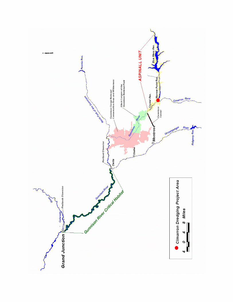


TABLE OF CONTENTS
CHAPTER I - Introduction . . . . . . . . . . . . . . . . . . . . . . . . . . . . . . . . . . . . . . . . . . . . . . . . . . . . . . 1Proposed Action . . . . . . . . . . . . . . . . . . . . . . . . . . . . . . . . . . . . . . . . . . . . . . . . . . . . . . . . . 1Purpose and Need . . . . . . . . . . . . . . . . . . . . . . . . . . . . . . . . . . . . . . . . . . . . . . . . . . . . . . . 1Background Information . . . . . . . . . . . . . . . . . . . . . . . . . . . . . . . . . . . . . . . . . . . . . . . . . . 2Public Scoping . . . . . . . . . . . . . . . . . . . . . . . . . . . . . . . . . . . . . . . . . . . . . . . . . . . . . . . . . . 4
CHAPTER II - ALTERNATIVES AND THE PREFERRED ALTERNATIVE . . . . . . . . . . . . . 6No Action Alternative . . . . . . . . . . . . . . . . . . . . . . . . . . . . . . . . . . . . . . . . . . . . . . . . . . . . 6Proposed Action . . . . . . . . . . . . . . . . . . . . . . . . . . . . . . . . . . . . . . . . . . . . . . . . . . . . . . . . . 6Environmental Commitments . . . . . . . . . . . . . . . . . . . . . . . . . . . . . . . . . . . . . . . . . . . . . . 6
CHAPTER III - AFFECTED ENVIRONMENT/ENVIRONMENTAL CONSEQUENCES . . . 8General . . . . . . . . . . . . . . . . . . . . . . . . . . . . . . . . . . . . . . . . . . . . . . . . . . . . . . . . . . . . . . . . 8Aspinall Unit and Morrow Point Reservoir . . . . . . . . . . . . . . . . . . . . . . . . . . . . . . . . . . . . 8Recreation Resources . . . . . . . . . . . . . . . . . . . . . . . . . . . . . . . . . . . . . . . . . . . . . . . . . . . . 10Land Use and Vegetation . . . . . . . . . . . . . . . . . . . . . . . . . . . . . . . . . . . . . . . . . . . . . . . . . 11Fish and Wildlife Resources . . . . . . . . . . . . . . . . . . . . . . . . . . . . . . . . . . . . . . . . . . . . . . 11Threatened and Endangered Species . . . . . . . . . . . . . . . . . . . . . . . . . . . . . . . . . . . . . . . . 14Water Quality . . . . . . . . . . . . . . . . . . . . . . . . . . . . . . . . . . . . . . . . . . . . . . . . . . . . . . . . . . 14Water Rights . . . . . . . . . . . . . . . . . . . . . . . . . . . . . . . . . . . . . . . . . . . . . . . . . . . . . . . . . . 16Historical and Cultural Resource Properties . . . . . . . . . . . . . . . . . . . . . . . . . . . . . . . . . . 16Indian Trust Assets . . . . . . . . . . . . . . . . . . . . . . . . . . . . . . . . . . . . . . . . . . . . . . . . . . . . . 16Environmental Justice . . . . . . . . . . . . . . . . . . . . . . . . . . . . . . . . . . . . . . . . . . . . . . . . . . . 17Socioeconomic . . . . . . . . . . . . . . . . . . . . . . . . . . . . . . . . . . . . . . . . . . . . . . . . . . . . . . . . . 17
Hydropower Production . . . . . . . . . . . . . . . . . . . . . . . . . . . . . . . . . . . . . . . . . . . . 17Commercial Guiding Services . . . . . . . . . . . . . . . . . . . . . . . . . . . . . . . . . . . . . . . 18
Cumulative Impacts . . . . . . . . . . . . . . . . . . . . . . . . . . . . . . . . . . . . . . . . . . . . . . . . . . . . . 19Summary and Environmental Commitments . . . . . . . . . . . . . . . . . . . . . . . . . . . . . . . . . . 19
CHAPTER IV - CONSULTATION AND COORDINATION . . . . . . . . . . . . . . . . . . . . . . . . . . 21General . . . . . . . . . . . . . . . . . . . . . . . . . . . . . . . . . . . . . . . . . . . . . . . . . . . . . . . . . . . . . . . 21Comment on Draft EA . . . . . . . . . . . . . . . . . . . . . . . . . . . . . . . . . . . . . . . . . . . . . . . . . . . 21Consultation with Other Agencies . . . . . . . . . . . . . . . . . . . . . . . . . . . . . . . . . . . . . . . . . . 31Distribution List . . . . . . . . . . . . . . . . . . . . . . . . . . . . . . . . . . . . . . . . . . . . . . . . . . . . . . . . 31
REFERENCES CITED . . . . . . . . . . . . . . . . . . . . . . . . . . . . . . . . . . . . . . . . . . . . . . . . . . . . . . . . 33

TABLE OF CONTENTS (Cont.)
FIGURES
Vicinity Map . . . . . . . . . . . . . . . . . . . . . . . . . . . . . . . . . . . . . . . . . . . . . Frontispiece MapFigure 1 - Confluence of the Gunnison and Cimarron Rivers . . . . . . . . . . . . . . . . . . . . . . 2Figure 2 - Reservoirs of the Aspinall Unit . . . . . . . . . . . . . . . . . . . . . . . . . . . . . . . . . . . . . 9Figure 3 - Aspinall Unit Water Quality Monitoring Sites . . . . . . . . . . . . . . . . . . . . . . . . 15Figure 4 - 2000 Visitation Statistics for Curecanti National Recreation Area and
Black Canyon of the Gunnison National Park . . . . . . . . . . . . . . . . . . . . . . . . 18
TABLES
Table 1 - Rainbow & Brown Trout Critical Time Periods . . . . . . . . . . . . . . . . . . . . . . . 12
APPENDIX A - Morrow Point Dam and Power Plant River Channel Improvement Drawing
APPENDIX B - Distribution Mailing List
APPENDIX C - Comment Letters
APPENDIX D - Water Quality Data

CHAPTER 1 - INTRODUCTION
Proposed Action
This Final Environmental Assessment (EA) reviews the proposed action of removingapproximately 11,000 cubic yards of deposited material from the upper end of Crystal Reservoir below Morrow Point Dam’s tailrace in Montrose County, Colorado. The Bureau of Reclamation(Reclamation) prepared this EA in cooperation with other federal and state agencies to complywith the National Environmental Policy Act (NEPA), Endangered Species Act, and related U.S.Department of the Interior policies and regulations. If, based on this analysis, Reclamationconcludes the proposed action would have no significant impact on the human environment,preparation of an Environmental Impact Statement would not be required before the action couldbe implemented.
Morrow Point Dam was completed in 1968 as part of the Wayne N. Aspinall Unit (AspinallUnit) of the Colorado River Storage Project (CRSP). Blue Mesa, Morrow Point and CrystalReservoirs on the Gunnison River are operated as a system to comprise the Aspinall Unit. Otherfeatures of the CRSP include Flaming Gorge Dam on the Green River, Navajo Dam on the SanJuan River, and Glen Canyon Dam on the Colorado River.
The Aspinall Unit is located in Gunnison and Montrose Counties, Colorado, along a 40-milereach of the Gunnison River as shown on the Frontispiece Map. The Unit is operated byReclamation, while lands surrounding the reservoirs are managed by the National Park Serviceas the Curecanti National Recreation Area. Reclamation operates the reservoirs and powerplants to meet the following authorized purposes:
< regulate the flow of the Colorado River< store water for beneficial consumptive uses< allow the Upper Basin states to use the apportionment made to and among them through
the Colorado River Basin Compact and Upper Colorado River Compact< provide for the reclamation of arid and semiarid land< provide for flood control< provide for fish and wildlife enhancement and public recreation < generate hydropower
Purpose and Need
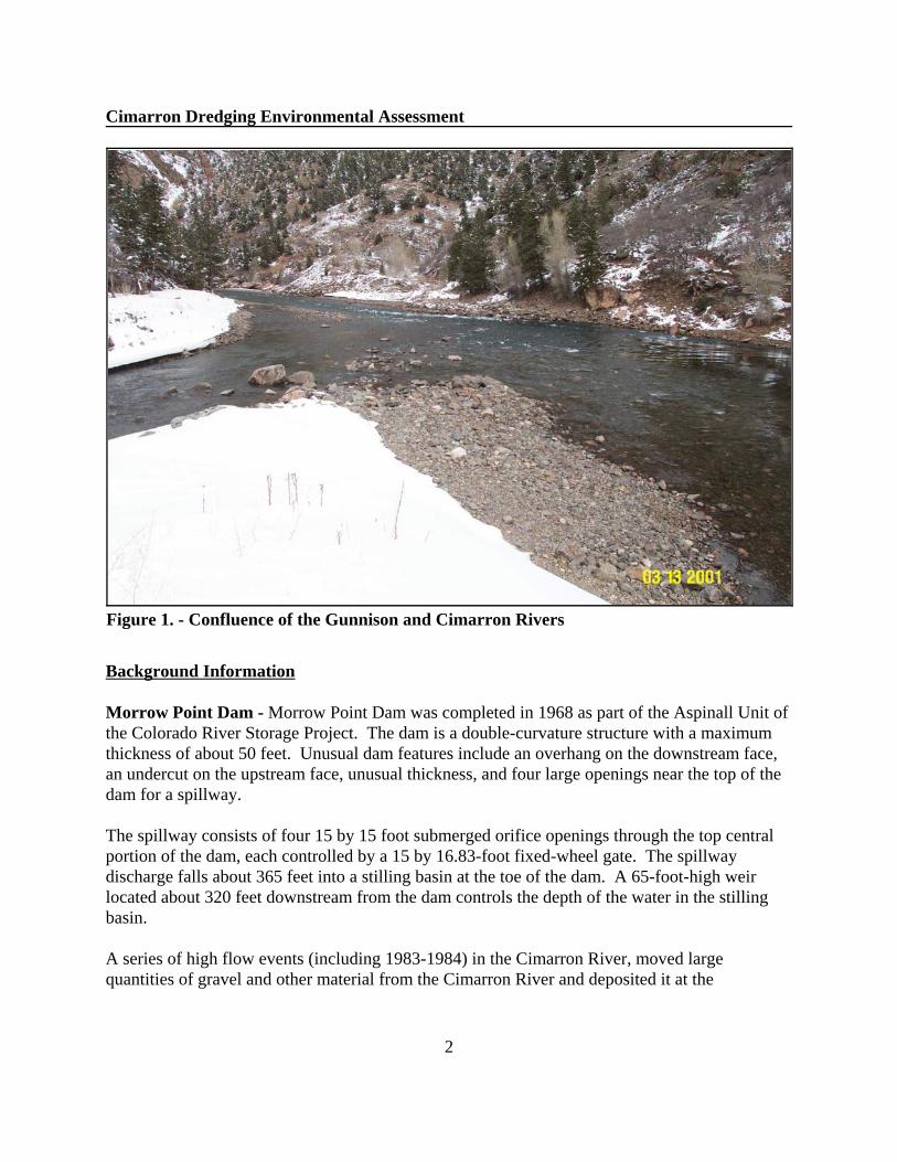
Reclamation has identified a need to restore the tailrace below Morrow Point Reservoir to itsoriginal post dam construction elevation. Reclamation proposes to remove approximately11,000 cubic yards of gravel deposited in the upper end of Crystal Reservoir at the confluence ofthe Gunnison and Cimarron Rivers (See Figure 1). The purpose of the project is to lower thewater elevation in the power plant tailrace to improve hydropower generating efficiency.
Cimarron Dredging Environmental Assessment
2
Figure 1. - Confluence of the Gunnison and Cimarron Rivers
Background Information
Morrow Point Dam - Morrow Point Dam was completed in 1968 as part of the Aspinall Unit ofthe Colorado River Storage Project. The dam is a double-curvature structure with a maximumthickness of about 50 feet. Unusual dam features include an overhang on the downstream face,an undercut on the upstream face, unusual thickness, and four large openings near the top of thedam for a spillway.
The spillway consists of four 15 by 15 foot submerged orifice openings through the top centralportion of the dam, each controlled by a 15 by 16.83-foot fixed-wheel gate. The spillwaydischarge falls about 365 feet into a stilling basin at the toe of the dam. A 65-foot-high weirlocated about 320 feet downstream from the dam controls the depth of the water in the stillingbasin.
A series of high flow events (including 1983-1984) in the Cimarron River, moved largequantities of gravel and other material from the Cimarron River and deposited it at the
Cimarron Dredging Environmental Assessment
3
confluence with the Gunnison River (upper end of Crystal Reservoir) (See Figure 1). Thedeposited material created a backwater pool in the dam’s tailrace. This has resulted in losses inpower production efficiencies at Morrow Point Dam and ability to dewater the spillway stillingbasin. Curecanti National Recreation Area - The Curecanti National Recreation Area includes theareas surrounding Blue Mesa, Morrow Point and Crystal Reservoirs, and provides recreation forover 1 million visitors annually. Administered by the National Park Service, activities includeboating, fishing, sightseeing, and hiking.
Black Canyon of the Gunnison National Park - The Black Canyon of the Gunnison NationalPark (formerly National Monument until 1999) was originally established by PresidentialProclamation No. 2033 (47 Stat 2558) to preserve the spectacular gorge and other objects ofscenic, scientific, and educational interests. In October 1999, the Monument was designated aNational Park by an act of Congress through enactment of P.L. 106-76. The National Parkincludes 14 miles of the Gunnison River downstream from the Aspinall Unit.
Gunnison Gorge National Conservation Area and Wilderness - The Bureau of LandManagement (BLM) manages the Gunnison Gorge National Conservation Area (NCA) andWilderness located immediately downstream of the Black Canyon of the Gunnison NationalPark. The NCA includes an additional 24 miles of the Gunnison River from the Park’s westernboundary down to the Town of Austin.
Gold Medal Trout Fisheries - The State of Colorado has classified the Gunnison River from theupper end of the Black Canyon of the Gunnison National Park to the confluence of the NorthFork of the Gunnison River as a Gold Medal trout fishery for brown trout.
Endangered Fishes - Colorado pikeminnow and razorback sucker are listed as endangered inthe Gunnison River. Critical habitat for the Gunnison River was designated by the U.S. Fish andWildlife Service below the project area from about Delta, Colorado to the Gunnison River’sconfluence with the Colorado River in Grand Junction, Colorado. A fish ladder was constructedin 1996 by the Upper Colorado River Endangered Fish Recovery Program to provide passageupstream of the Redlands Diversion on the Gunnison River near Grand Junction.
Downstream Diversions - Diversion downstream of the project area include the GunnisonTunnel which supplies irrigation water to the Uncompahgre Project near Montrose, Colorado;Hartland Diversion which provides irrigation water near Delta, Colorado; and the RedlandsDiversion which provides water for power and some irrigation to the Redlands near GrandJunction, Colorado.
Cimarron Dredging Environmental Assessment
4
Public Scoping
Reclamation identified issues and concerns with participation from individuals, agencies, andorganizations who may be affected by the project. The Cimarron Dredging Project was firstpresented to the general public at the January 2001 Aspinall operations meeting. On January 25,2001, a public scoping letter was mailed to interested parties and was published in the GrandJunction Daily Sentinel. Comments were requested to be received by March 2, 2001.
Each issue and concern described below is discussed in Chapter 3. More information on scopingactivities is included in Chapter 4.
Water Resources
The proposed action has the potential to negatively affect water quality downstream of CrystalReservoir. Concerns focused around total suspended solids (TSS), total dissolved solids (TDS),and dissolved oxygen (DO) levels below Crystal Reservoir.
The Gunnison Tunnel, operated by the Uncompahgre Valley Water Users Association(UVWUA) below Crystal Reservoir, diverts water for irrigation and municipal use in theMontrose and Delta areas.
Trout Fisheries
The proposed action has the potential to negatively affect the Gunnison River Gold Medal Troutfisheries from Crystal Reservoir downstream to the confluence with the North Fork of theGunnison River. Concerns focused primarily around water quality issues as they affect troutspawning and recruitment. Fall brown trout and spring rainbow trout spawning success could begreatly reduced if suspended sediments travel downstream into trout spawning areas and smothernests (redds). Reducing flows after spawning also has the potential to affect spawning success.
Recreation Resources
The Gunnison River is a valuable recreation resource. Rafting, floatfishing, walk-wade fishing,hiking, and sightseeing are all common uses on the Gunnison River in the Curecanti NationalRecreation Area, the Black Canyon of the Gunnison National Park, and the Gunnison Gorge. Ifthe Gunnison River below Crystal Reservoir becomes cloudy because of increased sediments;fishing, rafting, and the overall aesthetics of the Gunnison River could be negatively affected.
Land and Facility Resources
The access road to Morrow Point is a narrow two-lane paved road. The road is used byReclamation to operate Morrow Point Dam and is also used by recreationists to access the upperend of Crystal Reservoir. The road may need to be temporarily closed to the public during
Cimarron Dredging Environmental Assessment
5
dredging activities for public safety. In addition, the road may be damaged by the volume ofheavy trucks that would be used to transport the dredged material off-site.
Socioeconomic Resources
The Bureau of Reclamation generates electricity from the Aspinall Unit which is marketed bythe Western Area Power Administration. Reduced flows during dredging activity have thepotential to affect power generation and consequently CRSP repayment schedules. Recreationalguide services have developed in conjunction with the recreational opportunities in the GunnisonRiver. Rafting and fishing trips during the dredging activity could be negatively affected bycloudy waters from increased sediments, thus affecting guiding revenues.
Cimarron Dredging Environmental Assessment
6
CHAPTER 2 - ALTERNATIVES
This chapter describes the No Action and Proposed Action alternatives for removing materialdeposited from the tailrace below Morrow Point Dam at its confluence with the Cimarron River. No other alternatives were identified that met the purpose and need.
No Action
Under the No Action Alternative, Reclamation would not remove about 11,000 cubic yards ofgravel from the upper end of Crystal Reservoir below the Morrow Point Dam tailrace. Thedeposited material would continue to create a pool of water from the Cimarron River to MorrowPoints Dam’s stilling basin. Morrow Point’s generator power efficiencies would continue to bereduced. Power efficiency losses are estimated at 1.14%, which represents about 5,608megawatt hours (mwh) per year in power generation at a value of about $98,539 per year.
Proposed Action
The Proposed Action would dredge about 11,000 cubic yards of gravel and other materials fromthe end of Crystal Reservoir below Morrow Point Dam at its confluence with the CimarronRiver. The Gunnison River would be returned to its original construction elevation (6,744.3feet). Dredging activities would begin October 1, 2001 and be completed by November 30,2001. If weather or other circumstances prevent completion of the dredging project byNovember 30, 2001, additional dredging would occur in October and November, 2002.
Dredging would be limited to the river channel from about 200 feet upstream of the GunnisonRiver’s confluence with the Cimarron River to about 1,000 feet below the river’s confluence. Reclamation or a contractor would dredge the deposited material using an excavator and accessthe project area using an existing construction road. Dump Trucks would be used to transportthe dredged material from the Gunnison River to the paved parking area above and transportedoff-site to Colorado Department of Transportation stockyard. Dredged material would bedonated to the Colorado Department of Transportation who would use the material on existingroad projects.
The existing construction road from the parking area to the Gunnison River would require minorimprovements to accommodate the heavy equipment and dump trucks.
Environmental Commitments
The proposed action includes measures as needed to:
Cimarron Dredging Environmental Assessment
7
! monitor and protect water quality in the Gunnison River! protect downstream water rights including diversions at the Gunnison Tunnel! minimize negative effects to trout resources below Crystal Reservoir! minimize negative effects to on-site and downstream recreational uses! minimize effects to guiding revenues! minimize effects to power generation! maintain delivery of a minimum 300 cfs of water over the Redlands Diversion Dam
between July 1 and October 31, in compliance with Contract No. 95-07-40-R1760 for thebenefit of endangered fishes.
The degree to which the proposed measures would alleviate concerns for potentially affectedresources and interests is discussed with the applicable sections of the next chapter.
To comply with the Endangered Species Act, Reclamation consulted with the U.S. Fish andWildlife Service. Per consultation with the Army Corp of Engineers (ACOE 2001), permitsunder the Clean Water Act are not required as long as dredged material is not deposited withinthe high water line. However, a Nation-wide 33 permit was issued to allow Reclamation tomove and reshape deposited material in the river to allow for easier access.

Cimarron Dredging Environmental Assessment
8
CHAPTER 3 - AFFECTED ENVIRONMENT ANDENVIRONMENTAL CONSEQUENCES
General
This chapter discusses resources that may be affected by actions taken to restore the upper end ofCrystal Reservoir below Morrow Point Dam to its original post-dam construction elevation. During preparation of this Draft EA, information on issues and concerns was received fromaffected water users, resource agencies, private interests, recreational interest groups andcitizens, and other parties (see Chapter 4, Consultation and Coordination, for further details).
For each resource, the potentially affected area, and/or interests are identified, existingconditions are described, and impacts expected under the No Action Alternative and ProposedAction Alternative are discussed. This chapter concludes with a summary comparison of thealternatives and a list of mitigation measures.
The project is located in Montrose County, Colorado along the Gunnison River withinReclamation withdrawn lands of the Aspinall Unit. Montrose County has a population of about31,500 (U.S. Census 2001). Montrose is the largest city in the area with a population of about12,000. The county is primarily rural in nature with an agricultural base. The UncompahgreProject, constructed in the early 1900's, provides irrigation water for about 86,000 acres bydiverting water from the Gunnison River primarily through the Gunnison Tunnel, and theUncompahgre River. Tourism and recreation are also a significant source of economic activityfor the area with the Gunnison River, Black Canyon of the Gunnison National Park, CurecantiNational Recreation Area, and the San Juan range of the Rocky Mountains nearby.
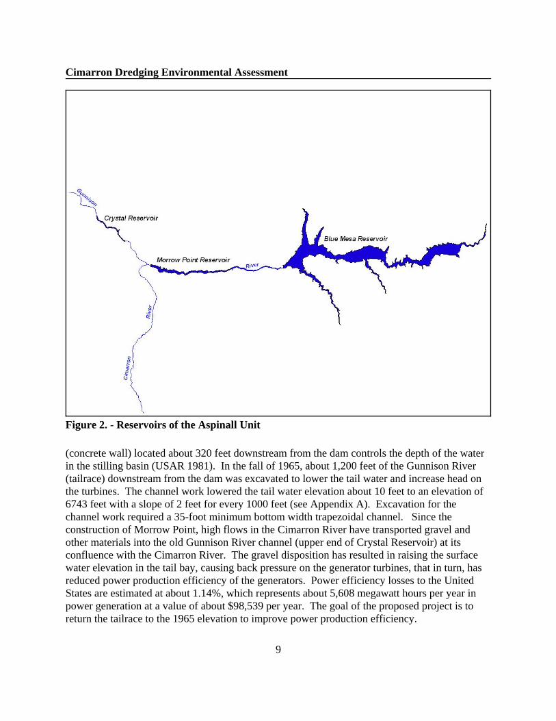
Aspinall Unit and Morrow Point Reservoir
The Aspinall Unit of the Colorado River Storage Project consists of three reservoirs (Blue Mesa,Morrow Point, and Crystal) along a 40 mile stretch of the Gunnison River (see Figure 2).
Morrow Point Dam was completed in 1968 as part of the Aspinall Unit of the Colorado RiverStorage Project. The dam is a double-curvature structure constructed with 18 blocks separatedby vertical transverse contraction joints spaced at 40-foot centers except for the center block,which is 30-feet wide.
The spillway consists of four 15 by 15 foot submerged orifice openings through the top centralportion of the dam, each controlled by a 15 by 16.83 foot fixed-wheel gate. The spillwaydischarge falls about 365 feet into a stilling basin at the toe of the dam. A 65-foot-high weir
Cimarron Dredging Environmental Assessment
9
Figure 2. - Reservoirs of the Aspinall Unit
(concrete wall) located about 320 feet downstream from the dam controls the depth of the waterin the stilling basin (USAR 1981). In the fall of 1965, about 1,200 feet of the Gunnison River(tailrace) downstream from the dam was excavated to lower the tail water and increase head onthe turbines. The channel work lowered the tail water elevation about 10 feet to an elevation of6743 feet with a slope of 2 feet for every 1000 feet (see Appendix A). Excavation for thechannel work required a 35-foot minimum bottom width trapezoidal channel. Since theconstruction of Morrow Point, high flows in the Cimarron River have transported gravel andother materials into the old Gunnison River channel (upper end of Crystal Reservoir) at itsconfluence with the Cimarron River. The gravel disposition has resulted in raising the surfacewater elevation in the tail bay, causing back pressure on the generator turbines, that in turn, hasreduced power production efficiency of the generators. Power efficiency losses to the UnitedStates are estimated at about 1.14%, which represents about 5,608 megawatt hours per year inpower generation at a value of about $98,539 per year. The goal of the proposed project is toreturn the tailrace to the 1965 elevation to improve power production efficiency.
Cimarron Dredging Environmental Assessment
10
Blue Mesa and Morrow Point Dams are operated to provide peaking power, while Crystal Damis operated to re-regulate water releases in the Gunnison River. Under the proposed action, theAspinall dams would continue under normal operations, except for Morrow Point Dam whichwould not release water for a 6 hour period each day. Adjustments in releases from other damson the system, consistent with existing operating criteria, would be made to absorb the 6 hourdredging window. Water surface elevations at Crystal Reservoir would be maintained at orbelow the 6743 foot “bottom of channel” elevation during the dredging activities to allow easyaccess to and removal of the deposited material.
Recreation Resources
The Gunnison River provides various recreational opportunities including fishing, rafting,hiking, and sightseeing. Recreation on the Gunnison River below Morrow Point Dam ismanaged by the National Park Service, the Bureau of Land Management, and Colorado Divisionof Wildlife.
The National Park Service manages recreation within the Curecanti National Recreation Area,which includes recreation sites along Blue Mesa, Morrow Point and Crystal Reservoirs. TheCurecanti National Recreation Area was developed in conjunction with the construction of theAspinall Unit. Because of limited public access created by high canyon walls, Morrow Pointand Crystal Reservoirs receive very little recreation use. Access is primarily limited to the upperends of Morrow Point and Crystal Reservoirs, and the East Portal of the Gunnison River belowCrystal Reservoir. Recreational use at the upper end of Crystal Reservoir is primarily limited tothe spring through fall.
The Black Canyon of the Gunnison National Park (Park) is located downstream of the EastPortal of the Gunnison Tunnel and is managed by the National Park Service. The Park wasestablished to preserve the spectacular gorge and other scenic, scientific, and educationalinterests. The Park includes 14 miles of the Gunnison River.
An additional 26 miles of the Gunnison River downstream of the National Park is managed bythe BLM. The river flows through the BLM’s 57,700 acre Gunnison Gorge NationalConservation Area and Wilderness. BLM manages the NCA and Wilderness to permanentlyprotect and conserve its outstanding scenic, geologic, wildlife, and wilderness resources and toprovide a diverse range of recreational opportunities including wilderness whitewater boatingand camping, floatfishing, and walk-wade fishing, hiking, and sightseeing.
The Colorado Division of Wildlife manages recreational fishing on the Gunnison River. Recreational fishing is discussed in greater detail in the Wildlife Section of this Chapter.
The No Action Alternative would not affect recreational resources. The Proposed Action couldnegatively affect recreational uses if the Gunnison River becomes cloudy (turbid). If the waters
Cimarron Dredging Environmental Assessment
11
are turbid, fishing success may be reduced and the river may become difficult to navigate byboat, thus reducing the quality of the recreational experience. In addition, access to the upperend of Crystal Reservoir would be restricted during the dredging period (approximately 6weeks). Restricting dredging activities to October and November would reduce the likelihood ofconflicts with recreational uses. Minor impacts to recreation are projected because recreationuses drop sharply in October and November, primarily because of cooler weather associated withthe higher mountain elevations.
Water quality is discussed in greater detail in the Water Resources section of this chapter.
Land Use and Vegetation
The project area is located on lands of the United States withdrawn for the construction andoperation of the Aspinall Unit. The property is co-managed by Reclamation and the NationalPark Service for hydropower generation, water storage and recreation.
The canyon was created by the Gunnison River cutting through Precambrian rock. Vegetationresources within the project area are limited because of the nature of the rock canyon walls. Chokecherry (Prunus virginiana) , box-elder (Acer negundo), narrow-leaf cottonwood (Populusangustifolia), and poison ivy (Rhus radicans) are common in the canyon along the river banks(NPS 2001). The No Action and Proposed Action are expected to have no effect on land use orvegetation resources.
The proposed action was also evaluated to determine if the dredging activity could start aheadcut that would move up the Cimarron River. Material deposited at the confluence of theCimarron River and upper end of Crystal Reservoir has likely changed the lower portion of theCimarron River's elevation. It is anticipated that once the deposited material is removed, theCimarron River will adjust to the change in the downstream elevation to reach a new streamequilibrium. It is predicted that the Cimarron's elevation will more closely resemble its postchannel improvement elevation somewhere between the 1965 elevation (Channel ImprovementDate) and the post-deposition elevation (after the 1983 high flow event which deposited thematerial). This change is expected to be minor.
Fish and Wildlife Resources
The Gunnison River and its canyon walls support wildlife including beaver (Castor canadensis),mule deer (Odocoileus hemionus), stone fly, ringtail cat (Bassariscus astutus), great horned owl(Bubo virginianus), western fence lizard (Sceloporus occidentalis), yellow warbler (Dendroicapetechia), rainbow trout (Oncorhynchus mykiss) and brown trout (Salmo trutta) (NPS 2001).
The fishery resource of the Gunnison River below Crystal Reservoir is managed by the ColoradoDivision of Wildlife (CDOW). This stretch of river has an excellent rainbow and brown trout
Cimarron Dredging Environmental Assessment
12
fishery. These populations are self-sustaining; however, whirling disease has greatly reducedrecruitment for rainbow trout. The CDOW conducts an annual fall (September) survey on theGunnison River below the Black Canyon of the Gunnison National Park. CDOW does notdirectly stock Crystal Reservoir; however, Crystal Reservoir does receive fish that survive theentrainment from Morrow Point Reservoir and the Cimarron River. Morrow Point Reservoir hasbeen stocked with kokanee and Colorado River cutthroat trout. Entrainment from Blue MesaReservoir also provides a significant number of fish in Morrow Point Reservoir (Hebein 2001).
Fish species lists for both Crystal and Morrow Point Reservoirs are identical even though thesources of species varies. These include: Kokanee (Oncorhynchus nerkus), rainbow trout, browntrout, brook trout (Salvelinus fontinalis), Colorado River cutthroat trout (Oncorhynchus clarkipleuriticus), possibly Snake River cutthroat trout (Oncorhynchus clarki sp.), Mackinaw or laketrout (Salvelinus namaycush), longnose sucker (Catostomus catostomus), white sucker(Catostomus commersoni), bluehead sucker (Catostomus discobolus), longnose dace(Rhinichthys cataractae), mottled sculpin (Cottus bairdi). Hybridized remnants of flannelmouthsucker (Catostomus latipinnis) may also be present (McCada 2000, Hebein 2001).
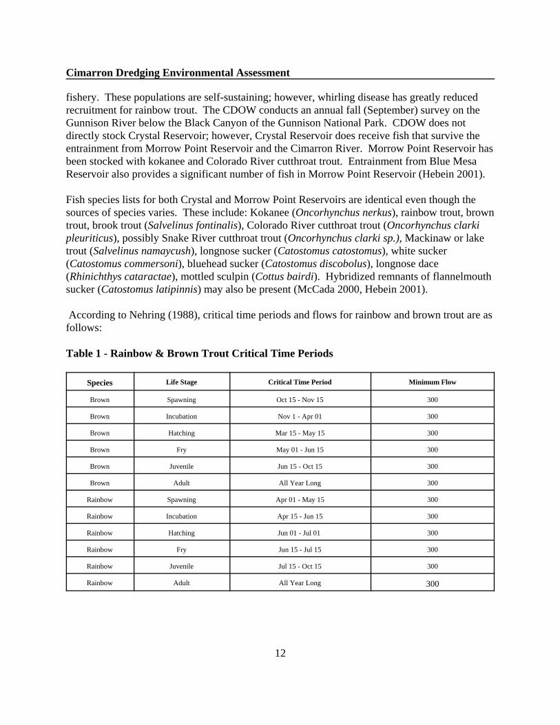
According to Nehring (1988), critical time periods and flows for rainbow and brown trout are asfollows:
Table 1 - Rainbow & Brown Trout Critical Time Periods
Species Life Stage Critical Time Period Minimum Flow
Brown Spawning Oct 15 - Nov 15 300
Brown Incubation Nov 1 - Apr 01 300
Brown Hatching Mar 15 - May 15 300
Brown Fry May 01 - Jun 15 300
Brown Juvenile Jun 15 - Oct 15 300
Brown Adult All Year Long 300
Rainbow Spawning Apr 01 - May 15 300
Rainbow Incubation Apr 15 - Jun 15 300
Rainbow Hatching Jun 01 - Jul 01 300
Rainbow Fry Jun 15 - Jul 15 300
Rainbow Juvenile Jul 15 - Oct 15 300
Rainbow Adult All Year Long 300

Cimarron Dredging Environmental Assessment
13
The gravel bar deposited by the Cimarron River is not considered spawning habitat, primarilybecause of large fluctuation in releases from Morrow Point Dam (between 0-5,000 cfs) and thewater is too cold for spawning.
Brown and rainbow trout may be affected by the proposed action if significant sediments aretransported and deposited in key spawning areas downstream of Crystal Reservoir duringcritical time periods. This could result in eggs laid in redds (nests) being covered with fine siltsand depriving the eggs of oxygen. Large amounts of transported sediment could greatly reducerainbow and brown trout recruitment.
In addition, brown trout and rainbow trout are affected if flows in the Gunnison River arelowered below 300 cfs. Crystal Reservoir will continue to operate as the regulating reservoir,with releases being made based on projected hydrology. Therefore, flows in the Gunnison Riverbelow Crystal will be unaffected by the proposed action. Releases from Morrow Point Dam willcontinue to operate to produce peaking power; however, dredging activities will be limited toperiods when water is not being released from Morrow Point Dam. This should aid in limitingthe amount of sediments being transported in the Gunnison River. It is also anticipated that mostincreases in suspended sediments as a result of the dredging activity would settle out in CrystalReservoir and not affect the Gunnison River downstream. Water quality samples would be takendaily during the dredging activity as described in the Water Quality section of this chapter tomonitor changes in water quality.
Dredging activities would be conducted after October 1 and completed no later than November30 to avoid conflicts with CDOW’s annual monitoring program. The CDOW would continuethe annual fall sampling of the Gunnison River and would be able to measure effects on brownand rainbow trout recruitment.
To assist in dewatering the dredging site, Crystal Reservoir’s water surface elevation would bemaintained at or below 6,743 feet. Except while releases are being made from Morrow PointDam during the project, the first 1,200 feet of the tailrace would be drained. CDOW does notconsider the tailrace suitable fish habitat because of the high flows released from Morrow PointDam (Hebein 2001).
Once the dredging is completed, the backwater pool created by the deposited material will nolonger exist. Water in the channel from the dam to the upper end of Crystal Reservoir would bedependant on releases from Morrow Point Reservoir and the water surface elevation of CrystalReservoir.
Local wildlife may avoid the area during dredging activities; however effects are projected to beshort-term and the project would not alter existing wildlife habitat.
Cimarron Dredging Environmental Assessment
14
Threatened and Endangered Species
Informal consultation with the U.S. Fish and Wildlife Service (2001) identified no threatenedand endangered species that could be directly affected by the proposed action. However, ifflows in the Gunnison River were reduced and Reclamation was unable to maintain delivery of aminimum 300 cfs of water over the Redlands Diversion Dam between July 1 and October 31, incompliance with Contract No. 95-07-40-R1760 for the benefit of endangered fishes, adverseimpacts could result and consultation would need to be reinitiated. Additionally, if flushingflows were needed to remove large volumes of deposited sediments from the Gunnison River,flushing flows could affect the U.S. Fish and Wildlife Service’s razorback sucker stockingprogram. The proposed action would not affect Reclamation’s contract to deliver a minimum300 cfs over the Redlands Diversion Dam and flushing flows are not being considered at thistime, therefore, the proposed action is projected to have no effect on threatened or endangeredspecies.
Water Quality
Water quality is good in the Gunnison River. The Aspinall Unit acts as a sink for suspendedsolids and provides constant cold water releases. The clarity (total suspended solids and totaldissolved solids) and temperature of the Gunnison River creates an excellent trout fishery andprovides recreational opportunities for fishing, rafting, and other forms of recreation.
The Gunnison River and the three reservoirs are classified by the Colorado Water QualityControl Commission as Aquatic Life Cold 1, Recreation 1, Water Supply and Agriculture, anddesignated as Antidegradation Reviewable waters (previously a High Water Quality 2designation). The Aquatic Life Cold 1 classification denotes waters which support a widevariety of cold water biota. Recreation 1 waters are suitable for primary human contactincluding swimming, kayaking, rafting, and water-skiing. The Water Supply and Agricultureclassifications denote that the waters are suitable for such purposes. The antidegradationreviewable designation recognizes waters which are not outstanding state or national resources,but exhibit high quality. These waters yield to the antidegradation review process, a processwhich allows degradation of water quality if economic or social benefits override water qualitybenefits (Long etal. 1995).
Significant changes in water quality could negatively affect downstream trout fisheries and riverrafting. A cloudy (high levels of suspended solids) Gunnison River would reduce anglingsuccess, make river running more difficult (cannot see rocks and other obstructions), andgenerally detract from the scenic views in the Black Canyon of the Gunnison National Park andthe Gunnison Gorge.
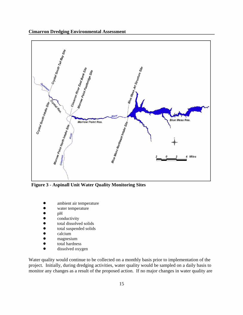
Associated with the proposed action, in April 2001, Reclamation began monitoring water qualityparameters listed below on a monthly basis at 7 sites within the Aspinall Unit (See Figure 3):
Cimarron Dredging Environmental Assessment
15
Figure 3 - Aspinall Unit Water Quality Monitoring Sites
! ambient air temperature! water temperature! pH! conductivity! total dissolved solids! total suspended solids! calcium! magnesium! total hardness! dissolved oxygen
Water quality would continue to be collected on a monthly basis prior to implementation of theproject. Initially, during dredging activities, water quality would be sampled on a daily basis tomonitor any changes as a result of the proposed action. If no major changes in water quality are
Cimarron Dredging Environmental Assessment
16
observed, Reclamation may decrease the frequency of water quality sampling from daily toweekly. In addition, Reclamation would visually monitor the water quality in Crystal Reservoir. If the lower end of Crystal Reservoir becomes significantly turbid (cloudy), dredging activitieswould be stopped to reduce the amount of suspended sediments being transported below CrystalDam. Once the reservoir began to clear, dredging activities could resume.
Water Rights
Water rights in the Upper Gunnison Basin include both direct flow and storage rights. One ofthe project authorizations for the Aspinall Unit was to store Upper Basin States water. TheAspinall Unit would continue under normal operations, providing water to meet downstreamobligations (water rights, delivery contracts, etc.). The proposed action is projected to have noeffect on water rights or Aspinall water deliveries.
Historical and Cultural Resource Properties
The proposed project is located near the Curecanti Archeological District (District). The Districtconsists of a complex of over 200 recorded archeological sites and encompasses 6,750.25 acres. The District was listed on the National Register of Historic Places on August 15, 1984. Prehistoric sites dating back to 8,000 B.C. represent a significant change in the understanding ofhow these early people used Colorado’s high mountain valleys. A large collection of artifactsfrom the area are in storage at the Midwest Archeological Center in Lincoln, Nebraska. Inaddition, thirty-nine sites generally associated with the Ute Tribe and classified as temporarycamps have been identified in the Black Canyon of the Gunnison National Park (NPS 1997).
Historic resources within the Curecanti National Recreation Area illustrate three great humanachievements—building narrow gauge railroads, dam building/engineering, andhomesteading/saw milling (NPS 1997). The proposed project is in the Cimarron area and is afocal point for illustrating the role of the narrow gauge railroad in the development of westernColorado. A display at Cimarron depicts the rise and fall of the narrow gauge railroad as amountain transportation system.
No impacts to cultural or historic resources are projected because 1) the project would becompletely within a previously disturbed area, 2) dredging activities would be conducted withinthe high water line of the Gunnison River, and 3) vehicles and equipment would use existingroads to transport the dredged material off-site.
Indian Trust Assets
Indian trust assets are legal interests in property held by the United States for Indian Tribes orindividuals. Reclamation and other Federal agencies share the responsibility to protect theseassets. There have been no trust assets identified in the project area, and therefore no impact on
Cimarron Dredging Environmental Assessment
17
these assets is predicted.
Environmental Justice
Executive Order 12898 on Environmental Justice provides that Federal agencies analyzeprograms to assure that they do not disproportionately adversely affect minority or low incomepopulations or Indian Tribes. There are no potentially affected populations in the project areaand no adverse effects related to environmental justice are predicted.
Socioeconomic
Socioeconomic resources related to the proposed action can be broken into two generalcategories: 1) Hydropower Production from the Aspinall Unit and 2) Commercial GuidingServices for fishing and float guides.
Hydropower Production
The Aspinall Unit is operated to meet daily peak power demands, and power production andmarketing is managed by the Western Area Power Administration. Peaking power means thathigher releases are made at those times during the day when energy demands are highest. Typically, peak power periods are from 7:00 a.m. to 10:00 p.m. Blue Mesa and Morrow PointDam releases are made during this time period to meet power demands. This results in largechanges in flows between Blue Mesa Reservoir and Morrow Point Reservoir, and betweenMorrow Point Reservoir and Crystal Reservoir.
Crystal Reservoir is operated differently than the other two reservoirs. Crystal Reservoirprovides storage space for smoothing peaking power releases from Morrow Point Reservoir torelatively uniform flows required to provide the existing Uncompahgre Project diversionsthrough the downstream Gunnison Tunnel in the summer months. Within a 24 hour period,releases for power production from Blue Mesa Dam can fluctuate between 0 and 3,400 cfs,Morrow Point Dam between 0 and 5,000 cfs, while Crystals releases typically fluctuate in the 50cfs range. When the Aspinall Unit is at maximum power production, daily fluctuations inreleases from Crystal Dam may increase to the 200 cfs range.
Under the proposed action, dredging activities would be restricted to a 6 hour window whenreleases from Morrow Point Reservoir were at zero. The Western Area Power Administrationdoes not foresee that there will be any financial impacts to CRSP during the planned dredging. There would be no overall loss in CRSP generation during the dredging period; generationpatterns within the CRSP system would be altered during that period, consistent with existingoperating parameters. The improved power efficiency, after completion of the dredging project,is expected to result in an estimated 5,608 MWh per year increase in power generation. Attoday’s rates, this amount of generation equates to about $98,539 per year.
Cimarron Dredging Environmental Assessment
18
0
50000
100000
150000
200000
250000
Jan Feb Mar Apr May Jun Jul Aug Sep Oct Nov Dec
Curecanti National Recreation AreaBlack Canyon of the Gunnison National Park
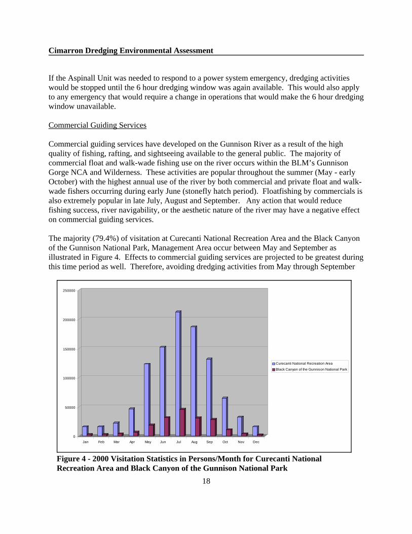
Figure 4 - 2000 Visitation Statistics in Persons/Month for Curecanti NationalRecreation Area and Black Canyon of the Gunnison National Park
If the Aspinall Unit was needed to respond to a power system emergency, dredging activitieswould be stopped until the 6 hour dredging window was again available. This would also applyto any emergency that would require a change in operations that would make the 6 hour dredgingwindow unavailable.
Commercial Guiding Services
Commercial guiding services have developed on the Gunnison River as a result of the highquality of fishing, rafting, and sightseeing available to the general public. The majority ofcommercial float and walk-wade fishing use on the river occurs within the BLM’s GunnisonGorge NCA and Wilderness. These activities are popular throughout the summer (May - earlyOctober) with the highest annual use of the river by both commercial and private float and walk-wade fishers occurring during early June (stonefly hatch period). Floatfishing by commercials isalso extremely popular in late July, August and September. Any action that would reducefishing success, river navigability, or the aesthetic nature of the river may have a negative effecton commercial guiding services.
The majority (79.4%) of visitation at Curecanti National Recreation Area and the Black Canyonof the Gunnison National Park, Management Area occur between May and September asillustrated in Figure 4. Effects to commercial guiding services are projected to be greatest duringthis time period as well. Therefore, avoiding dredging activities from May through September
Cimarron Dredging Environmental Assessment
19
would reduce the economic impact felt by commercial guides if water quality was affected as aresult of the proposed action.
Cumulative Impacts
Cumulative impacts are the impacts on the environment which result from the incrementalimpact of the action, when added to other past, present, and reasonably foreseeable futureactions, regardless of what agency (Federal or non-Federal) or person undertakes such otheractions. Cumulative impacts can result from individually minor but collectively significantactions taking place over a period of time.
Past and present activities that have affected river-related resources in the area include landirrigation, urban development and recreational activities associated with construction andoperation of the Aspinall Unit and the Uncompahgre Project, and activities associated with theRecovery Implementation Program for Endangered Fish Species in the Upper Colorado RiverBasin. Planned activities include the Morrow Point Reservoir trash rack cleaning project, theMorrow Point Reservoir drawdown criteria project, and additional Recovery Program activities.
Implementation of all or any of these projects has the potential to affect the human environmentincluding but not limited to water quality, water rights, socioeconomics and wildlife resources. Cumulative impacts associated with the implementation of the Cimarron Dredging Project areanticipated to be short-term and too small to measure.
Summary and Environmental Commitments
In summary, the primary effect of the proposed action would be to restore the channel of theGunnison River to its 1965 elevation thus improving power generation efficiencies. The projectis designed and would be implemented to avoid or reduce impacts or harm to recreation, fish andwildlife resources, water quality, and power production. There will be no effect on water rights,water uses, or water supplies.
The following environmental and social/economic commitments are included in the project plan.
<All construction contracts would have “Stop Work” clauses that would require the contractor tostop dredging activities if threatened or endangered species were encountered. If this wouldoccur, construction would be halted until additional consultation with the Service wascompleted.
<All construction contracts would have “Stop Work” clauses that would require the contractor tostop construction activities if cultural resources were encountered or affected. If this wouldoccur, construction would be halted until consultation with the State Historical PreservationOfficer was completed.<All construction contracts would have “Stop Work” clauses that would stop dredging activities

20
if Reclamation, through its water quality monitoring program, determines that continueddredging activities would degrade water quality to a level to significantly affect fisheriesincluding brown trout spawning success. <Dredging activities would be restricted to a time period between October 1 and November 30 toreduce conflicts with recreationists, fisheries resources, and water users.
<Flows in the Gunnison River below Crystal Dam would remain within the general operations ofthe Aspinall Unit and would not be modified for the Cimarron Dredging Project. Releaseswould be based using existing operation criteria for the Aspinall Unit.
<Water quality measurements will be recorded monthly prior to the implementation of theproposed action. Initially, during the dredging activity, water quality measurements will berecorded daily to document any changes in water quality. If significant changes in water qualityare not observed, Reclamation may reduce the water quality sampling to weekly. In addition,daily visual observations of Crystal Reservoir would be made. If lower end of Crystal Reservoirbecomes turbid (cloudy), dredging activities would be stopped. Once the reservoir began toclear, dredging activities would resume.
<In-river activities (dredging, etc.) will be limited to periods when no releases are made fromMorrow Point Reservoir to protect water quality in the Gunnison River below Crystal.
<The water surface elevation of Crystal Reservoir will be maintained at or below 6,743 feetduring the proposed action to assist in dewatering the dredging site and protecting water quality. Full pool elevation at Crystal Reservoir is 6,755 feet.
<The condition of the paved two-lane access road to Morrow Point Dam would be monitoredthroughout the project period. Road damage that may occur as a result of heavy equipmenttraffic, would be repaired by Reclamation or its contractor as appropriate.
<Road closures and/or traffic control (flagging) will be implemented during dredging activitiesand when transporting the dredged material off-site.
<The parking lot where the dredged material would be temporarily stored, would be cleaned andrepaired as appropriate. The parking lot would be broomed and picked up, washing the fines andsilt over the embankment would not be allowed.
<The contractor, prior to beginning work, would submit to Reclamation for approval a “spillcontainment plan” to protect the river from oil and/or fuel contamination from excavating, haulvehicles, and storage facilities.
<Reclamation would notify and inform agencies, individuals and the public prior to and duringdredging activities using press releases, mailing lists, and existing Aspinall facsimile numbers.

21
CHAPTER IV - CONSULTATION AND COORDINATION
General
The Cimarron Dredging Project was first presented to the general public at the January 2001Aspinall Operations meeting. The Aspinall Operations meetings are held three times a yearbetween Reclamation, local, state and federal agencies, water users, environmentalorganizations, recreationists, and other interested parties. On January 25, 2001, a public scopingletter was mailed to interested parties and was published in the Grand Junction Daily Sentinel. Comments were requested to be received by March 2, 2001.
Comments on the Draft EA were addressed and incorporated as follows:
Colorado Water Conservation Board (CWCB)
Comment 1: The CWCB has some minor concerns with the potential to start a headcut thatwould move up the Cimarron River. The CWCB has a 16 cfs instream flow on the CimarronRiver that runs from the Gunnison confluence upstream 3.7 miles to the confluence with theLittle Cimarron River. The CWCB would therefore like to see the potential for headcutting upthe Cimarron addressed in the Draft EA.
Response: The potential for a headcut to start in the Cimarron River was evaluated. Discussionon the headcut issue was added to the Land Use and Vegetation Section of the EA.
Comment 2: It would be helpful if the Frontispiece map showed some of the water diversions inthe Delta area and the Redlands Diversion down near Grand Junction. Also, critical habitat forendangered fish should be identified.
Response: The Frontispiece map was modified to show the Hartland Diversion near Delta andthe Redlands Diversion. Endangered fish critical habitat for the Gunnsion River was alsoidentified.
Comment 3: Page 1, Proposed Action - We suggest that the bulleted authorization purposes bebroken out into “primary and incidental or secondary” purposes consistent with the ColoradoRiver Storage Project Act. Also, the 3rd bullet needs to include reference to the Upper ColoradoRiver Compact.
Response: The authorized purposes are not listed in any particular order. Reclamation has theresponsibility to meet all authorized purposes, therefore primary and incidental or secondarypurposes are not presented. Upper Colorado River Compact was added to the third bullet.
Comment 4: Page 3, Background Information - We suggest brief mention of critical habitat forthe four endangered Colorado River fishes and the Redlands fish ladder and the smaller waterdiversions in the Delta area.

22
Response: A brief discussion of critical habitat for Colorado pikeminnow and razorback sucker,and the Redlands fish ladder was added to the Background Information section. Critical habitatfor bonytail and humpback chub was not designated for the Gunnison River.
Comment 5: Page 4, Socioeconomic Resources - We suggest modifying the 2nd sentence asfollows, “ Reduced flows during dredging has the potential to adversely affect their powerrevenues and consequently CRSP repayment schedules.
Response: “Consequently CRSP repayment schedules” was added to the 2nd paragraph. Discussion with WAPA and CREDA determined that the 6 hour daily window needed during thedredging period would not adversely affect power revenues. Additional releases from otherdams on the system would be made to adjust for the 6 hour window release shutdown fromMorrow Point Dam.
Comment 6: Page 5, No Action, last sentence - add “year” following “per”.
Response: Year was inserted into the sentence.
Comment 7: Page 9, 1st paragraph - We suggest additional discussion concerning the 6-hour shutdown period for dredging. How will this impact peaking operations of the unit and ability tobalance the power grid? Also, what will happen during emergency situations in southernCalifornia, are there are any concerns or other considerations under these circumstances.
Response: Additional discussion of the 6-hour shut down period was added. If emergencysituations require changes in operations of the Aspinall Unit, the dredging project will stop untilthe emergency is addressed.
Comment 8: Page 15, Water Rights - We suggest that the language here be strengthened. Language to the effect that adequate water will be released from the Aspinall Units todownstream users in a manner that will have no adverse effect on water rights.
Response: No changes in Aspinall’s downstream water users are projected as part of thedredging project, therefore no affect was predicted. Releases made from Crystal will be madeunder normal operating criteria. “Water rights” was changed to “obligations (water rights,delivery contracts, etc.)”.
Comment 9: Page 18, Summary of Environmental Commitments - Suggest modifying 1st bulletas follows, “All construction contracts would have “Stop Work” clauses that would require thecontractor to stop dredging activities if threatened or endangered species are encountered oradversely affected. If this occurs, construction would be halted until further consultation withthe Service can be completed. The Service will agree to give this additional consultation somepriority given the limited window during which dredging is expected to occur.”

Cimarron Dredging Environmental Assessment
23
Response: “Construction” was changed to “Dredging” and “or affected” was added. “Adverselyaffected” was not added because Reclamation would be required to consult with the Service forany affect under the Endangered Species Act. Reclamation feels that it is not appropriate tomake the statement “the Service will........” ,. If necessary, Reclamation will consult with theService as outlined in Section 7 of the Endangered Species Act. If formal consultation isnecessary, the project would likely be delayed until the following year or until the consultationwas completed.
Comment 10: Page 18, Summary of Environmental Commitments - 3rd bullet should probably beexpanded to include all fisheries with perhaps special emphasis on Brown Trout spawning.
Response: Sentence was restructured to include all fisheries.
Bureau of Land Management (BLM)
Comment 1: After reviewing the document we feel that most of our concerns are covered but in avery general manner. We would like to re-emphasis our earlier request that BR make a sincereeffort to provide timely and detailed notification to concerned agencies, interested parties, andpublics, prior to and during the proposed dredging activity. This and other concerns are detailedin our previous correspondence to you regarding this project, which we would like to request bemade part of our comments on the draft EA.
Response: BLM’s previous correspondence is attached in the Appendix. As part of the NEPAprocess, concerned agencies, interested parties, and publics will be notified prior to and duringthe dredging activity. Concerned parties have received the draft EA, and will receive a copy ofthe Final EA and “Finding of No Significant Impact”. Press release, mailing lists and facsimilelists will be used to inform and update agencies and the public about the dredging activity. Thiswas added to the list of environmental commitments.
Comment 2. Page 3 - Replace “Gunnison Gorge Special Recreation Area” with “GunnisonGorge National Conservation Area and Wilderness.” Add “the BLM manages the GunnisonGorge National Conservation Area (NCA) and Wilderness located immediately downstream ofthe Black Canyon of the Gunnison National Park. The NCA includes an additional 24 miles ofthe Gunnison River from the Park’s western boundary to the Town of Austin”.
Response: Changed.
Comment 3: Page 4,Recreation Resources - Add “float fishing, walk-wade fishing” between“rafting” and “hiking”
Response: Added to the sentence.
Cimarron Dredging Environmental Assessment
24
Comment 4: Page 9, Recreation Resources - .....An additional 26 miles of the Gunnison River................. downstream of the National Park is managed by the BLM. The river flows throughthe BLM’s 57,700 acre Gunnison Gorge National Conservation Area and Wilderness. BLMmanages the NCA and Wilderness to permanently protect and conserve its outstanding scenic,geologic, wildlife, and wilderness resources and to provide a diverse range of recreationalopportunities including wilderness, whitewater boating, and camping, floatfishing, and walk-wade fishing, hiking, and sightseeing.
Response: Changed.
Comment 5: Page 17, Commercial Guiding Services - Add “The majority of commercial floatand walk-wade fishing use on the river occurs within the BLM’s Gunnison Gorge NCA andWilderness. These activities are popular throughout the summer (May - early October) with thehighest annual use of the river by both commercial and private float and walk-wade fishersoccurring during early June (stonefly hatch period). Floatfishing by commercials is alsoextremely popular in late July, August and September.
Response: Added.
National Park Service (NPS)
Comment 1: Page 3, Paragraph 3: states “The Black Canyon of the Gunnison National Park(formerly National Monument until 1999) was created by Presidential Proclamation No. 2033(47 Stat 2558)....” To be more accurate, the National Monument was established by PresidentialProclamation, the National Park was designated by an act of Congress through enactment of P.L. 106-79 in October of 1999.
Response: The sentence was restructured to address the Congressional action.
Comment 2: Page 3, Paragraph 4: The area administered by the Bureau of Land Managementbelow Black Canyon of the Gunnison National Park was designated as the “Gunnison GorgeNational Conservation Area” through the same act that designated Black Canyon as a NationalPark.
Response: This was already addressed in the BLM comments.
Comment 3: Page 3, Paragraph 8: states the concerns focused around the water quality issues“below” Crystal Reservoir. Were there no concerns about water quality “within CrystalReservoir? If not, why?
Response: Based on initial water quality data, no concerns were identified within CrystalReservoir. Crystal Reservoir serves as a sediment trap for the Cimarron River. In discussions
Cimarron Dredging Environmental Assessment
25
with the CDOW, increased turbidity in Crystal that may occur as a result as a function of thedredging project is not predicted to adversely affect the fisheries in Crystal. CDOW’s concernsfocused around limiting the amount of suspended sediments being deposited in the GunnisonRiver below Crystal; therefore, water quality issues were focused below Crystal. Preliminarywater quality data has been added to the Appendices.
Comment 3: Page 4, paragraph 4, Land and Facilities Resources: Will the road be closed to thepublic during the entire two-month dredging process, or just during the 6 hour per day thatdredging activities are taking place?
Response: Traffic control measures (signing, flagging, and road closures) will be used to addresspublic safety issues associated with the narrow road and haul trucks. When equipment andloaded trucks are using the road, the road will be closed to the public. When hauling is notoccuring, the road will be open to the public.
Comment 4: Page 5, Paragraph 2, last sentence: should “read...which represents about $98,539per year in power revenues.”
Response: “year” was added.
Comment 5: Paragraph 4: Where is the “off-site” storage area? Do the impacts associated withthe off-site storage area need to be evaluated?
Response: The Colorado Department of Transportation will provide the off-site storage area andimpacts associated with the off-site storage area need to be evaluated. It is anticipated that thegravel will be stored at an existing CDOT storage site, however, if a new storage site isdeveloped, appropriated NEPA compliance would be needed.
Comment 6: Page 6, Statement 3: Should you be minimizing negative effects to trout resourses“within” as well as below Crystal Reservoir.
Response: Concerns identified associated with trout resources focused around sediments beingdeposited in the Gunnison River affecting trout spawning success. Trout do not spawn in CrystalReservoir. Temporary changes in water quality in Crystal as a result of the dredging is notpredicted to adversely affect trout resources in Crystal.
Comment 7: Page 9, Paragraph 9, Sentence 1: should read “in conjunction with the constructionof the Aspinall Unit.
Response: “the” was added.
Comment 8: Page 9, Paragraph 5, Sentence 1: should read “... below the Black Canyon of the

Cimarron Dredging Environmental Assessment
26
Gunnison National Park....”
Response: This sentence was changed based on BLM comments.
Comment 9: Page 9, Paragraph 7: Has the effect on private boater access to Crystal Reservoirpost-dredging been evaluated? If not, what are the preceived impacts/benefits?
Response: The public has limited access below Morrow Point to launch boats. The road leadingdown to the tailrace is gated and locked. In addition, high fluctuation in flows below MorrowPoint make this site unsafe. Boats have to be carried down to the upper end of Crystal Reseroir. The proposed dredging activity would not change this requirement. When the dredging projectis complete, boats may need to be carried further down past the Cimarron River confluence tolaunch boats because the tailrace would be drained when Morrow Point is not releasing water.
Comment 10: Page 10, Paragraph 6: The Colorado Division of Wildlife does not manage theGunnison River below Crystal Reservoir. The National Park Service manages the river as partof Curecanti National Recreation Area and Black Canyon of the Gunnison National Park. TheColorado Division of Wildlife does have fisheries management responsibility on the river.
Response: “fishery resource of the” was added to this sentence to clarify managementresponsibility.
Comment 11: Page 10, Paragraph 6, Sentence 4: should read “...below the Black Canyon of theGunnison National Park.”
Response: “Monument” changed to “Park”.
Comment 12: Page 12, Paragraph 6: While the Colorado River cutthroat trout, bluehead sucker,and flannelmouth sucker are not federally listed species, they are State Special Concern Species. As such, the National Park Service must manage them in a manner similar to its treatment offederally listed species. Therefore, potential impacts to these species must be evaluated.
Response: The proposed dredging project is predicted to have no effect on these State SpecialConcern Species.
Comment 13: Paragraph 1: states “...flushing flows are not being considered at this time...” Is itconceivable that flushing flows will be necessary? If so, what is the contingency in case they areneeded?
Response: Flushing flows are not being considered in the mitigation plan. The project isdesigned to address sediment deposition issues associated with dredging. Dredging activitieswould be stopped immediately if sediment issues arise and therefore, flushing flows would not

Cimarron Dredging Environmental Assessment
27
be needed. It is hoped that there will be adequate water in the system for a high spring flow in2002. Flash floods in August 2001 have put significant amounts of sediments in the system anda high flow in 2002 would be very beneficial.
Comment 14: Page 13: The water quality monitoring design on Crystal Reservoir before andduring the dredging is not specific to any depth. At what depth is the sampling taking place? Surface sampling will almost always yield adequate dissolved oxygen values. Water qualityprofiles within the reservoir may show different values.
Response: Water quality measurements are being taken at a depth of 3 feet with exception to theCimarron River, which varies between 1-2 feet depth depending on flow. Water quality data hasbeen added to the Appendices.
Comment 15: Page 14, Paragraph 2: What is considered to be “significant” turbidity? This needsto be quantified and based on turbidity levels where impacts to aquatic life occur.
Response: In discussion with CDOW, Reclamation was unable to identify at what level turbidityimpacts aquatic life. For the purposes of this document, significant turbidity is defined as thelevel where sediments begin to be deposited in the Gunnison River below Crystal Reservoir andwhere significant effects may occur. Reclamation will work closely with CDOW on thisdetermination.
Comment 16: Page 15, Paragraph 2: The proposed project is not within the CurecantiArcheological District. The primary focus of the Archeological District is in the vicinity of BlueMesa Reservoir.
Response: “within” was changed to “near”.
Comment 17: Page 16, Paragraph 1: Affect should read affected.
Response: Changed.
Comment 18: Page 18, Paragraph 3: Isn’t the primary effect of the proposed action moreaccurately to restore the channel of the Gunnison River to its 1965 elevation?
Response: “the channel of” was added to clarify the sentence.
Comment 19: Page 19, Paragraph 1: To reiterate an earlier point, the level of unacceptableturbidity needs to be quantified.
Response: This comment was addressed in response to Comment 15.

Cimarron Dredging Environmental Assessment
28
Colorado River Energy Distributors Association
Comment 1: Page 4, Paragraph 4, Sentence 2: We are concerned that the Draft EA does notaccurately characterize the socioeconomic affects of the Proposed Action with regards tohydropower generation. If generation is reduced from the Aspinall Unit, replacement generationwould most likely have to be purchased on the open market, at market prices, by Western at therequest of its customers, or by the customers themselves. The EA refers only to “the potential toaffect their (Western’s) power revenues.”
Response: “revenues” was changed to “generation.. It is projected that any reduced generationfrom the Aspinall Unit would be offset by additional generation at either Glen Canyon orFlaming Gorge Dams if needed.
Comment 2: Page 5, Paragraph 2: The No Action Alternative is described as causing losses,“estimated at 1.14%, which represents about $98,539 per year in power revenues.” The impactshould be characterized in terms of lost GENERATION, not lost REVENUES. Western’sratesetting methodology requires that it establish rates sufficient to recover its revenuerequirement. In essence, if they have reduced generation to market, they have the ability toadjust their rates to recover their fixed revenue requirements. On the other hand, reducedgeneration has a direct effect on the power customers.
Response: Paragraph was reworded to address concerns.
Comment 3: Page 17, Second Paragraph: Refers to “loss of power revenues” and quantitiesincreased generator efficiency in terms of “power revenues”. These references should be revisedto refer to “lost generating capability” and “_______” amount of energy”, respectively.
Response: Paragraph was reworded to address concerns.
Grand Valley Anglers (Trout Unlimited)
Comment 1: When water quality is lowered it has a direct negative impact on the river, and therafting and fishing industries are affected due to poor fishing conditions and, of course, theoverall aesthetics are impacted.
Response: The impact of high turbidity is recognized, and the time period of October 1 toNovember 30 was selected to avoid peak recreational use on the Gunnison River. It is notanticipated that water quality will be significantly affected downstream of Crystal Reservoirwhere the majority of recreational use occurs, however there are uncertainties and monitoringwill be conducted..
Comment 2: Another concern is that fine silty material is habitat for the whirling disease host,
Cimarron Dredging Environmental Assessment
29
tubifex worm. Whirling disease has devastated the rainbow trout population in the Gorge and byincreasing sediment the problem may be increased.
Response: The proposed project is designed to eliminate or minimize the amount of sedimenttransported as a result of the dredging project. The river will be monitored while dredgingactivities are occuring, and stopped if suspended sediments start to deposit in the Gunnison Riverbelow Crystal Reservoir. The great majority of sediment in the Gunnison Gorge is caused byflash floods downstream from Crystal Reservoir and by tributaries upstream from Crystal.
Comment 3: The Report notes that Reclamation will visually monitor the water quality in CrystalReservoir and if the lower end becomes significantly turbid, dredging activities would bestopped. Often, including the past few weeks when the Cimarron River was running high due toheavy rains in the Cimarron drainage, the reservoir was clear but releases out of Crystal wereextremely turbid. The monitoring must be done in the river below Crystal Dam at the EastPortal. The report does not identify the agency that would make that decision. The ColoradoDivision of Wildlife should be consulted for their evaluation.
Response: The Colorado Division of Wildlife was consulted and will continue to be consultedduring the dredging project to address concerns to fisheries resources. Monitoring will beconducted at the East Portal below Crystal and is indicated as Crystal South Tailbay Site. Waterquality measurements will be taken at the 7 sites identified in the EA before and during thedredging activity. The CDOW will be consulted and the visual monitoring of Crystal will be inaddition to the 7 sample sites. It is true that Crystal Reservoir does discharge cloudy water evenwhen reservoir surface water appears clear.
US Geological Survey
Comment 1: It would be helpful to include in the EA a description of how releases are madefrom Crystal. For example, the elevation of the release relative to the bottom of the reservoir. This would be useful in determining how sediment may move through the reservoir.
Response: A description of how releases are made from Crystal Reservoir is included withdiscussion of the Aspinall Unit under the Socioeconomic section.
Comment 2: There is no mention of the threshold at which dredging would cease. Whichparameters will be used to determine whether cessation of dredging would occur? As wediscussed, there are ways to determine if turbidity is associated with sediments or nutrients andthe associated plant growth. Using secci disc and measurement of chlorophyl-a and nutrients(low level method) a determination could be made about what is effecting the trophic status ofthe reservoir. Once that is established, you could use secci-disc measurements to monitor thereservoir and determine the trophic status (once you establish the trophic status of the reservoir isnot sediment or nutrient limited then you could make the assumption that amy changes in
Cimarron Dredging Environmental Assessment
30
turbidity are associated with sediments from dredging operations). The measurements could beused to determine when dredging should cease. A table of trophic conditions could beconstructed that would allow for a determination of when turbidity became limiting. We couldalso look at ways to determine how to manage the dredging process. We could also look at datafrom other reservoirs to determine appropriate secci-disc depths.
Response: This comment was discussed in greater detail with USGS staff on September 6, 2001. USGS does not expect turbidity to be a major concern as a result of the dredging project. Inconsultation with CDOW, Reclamation was unable to identify at what level turbidity impactsbelow Crystal Dam. Reclamation will continue to work with CDOW to monitor water qualityeffects as a result of the dredging project.
Reclamation will consider collecting turbidity measurements in Crystal Reservoir and theGunnison River below Crystal as part of its water quality monitoring program. Logistically,using the secci disks is problematic because of limited access.
Comment 3: Sample Sites: Is the site at Crystal South tail bay downstream from the reservoir? Why are you collecting data at the sites upstream from the Morrow Point footbridge? There isno explanation for the rational behind the sampling network. The site and the Morrow Pointfootbridge and downstream make sense.
Response: The Crystal South tail bay sampling site is located on the Gunnison River belowCrystal Reservoir. The sampling network was developed to monitor water quality changes forthis project and to collect baseline data for the proposed Morrow Point drawdown and trash rackcleaning project that will occur in late 2002 or 2003. In discussions with the CDOW, samplesites were selected so that Reclamation could monitor water quality changes throughout theAspinall system and see how suspended sediments and other water quality parameters movethrough the system. The Cimarron River was also included in the sampling network because it isthe largest contributor of sediment below Morrow Point and above Crystal. Water Quality datato date is attached for reference in the Appendices.
Comment 4: If there is an impact of the turbidity of the reservoir and downstream, considerdredging every other day to minimize the persistence of any effect.
Response: Dredging every other day is possible if turbidity becomes a problem. The frequencycould be even longer if appropriate.
Comment 5: If you are concerned with monitoring effects of the dredging downstream fromCrystal, a turbidimeter could be rented and installed at the Gunnison River below the GunnisonTunnel (or immediately downstream from the Crystal Reservoir) to provide real-time data foruse in decision making. Different secci-depth reading could be compared to turbidity data todetermine if dredging should continue.

Cimarron Dredging Environmental Assessment
31
Response: The use of the turbidimeter may be appropriate for use in monitoring effects of theproposed Morrow Point drawdown and trash rack cleaning project.
Comment 6: Some size analysis (percent silts and clays) of suspended sediments would helpdetermine how readily transported the sediments that escape the reservoir may be. This mayhave little utility for this round of dredging, but would provide useful information for futurework.
Response: Reclamation will consider the potential of conducting limited size analysis as part ofthis project and future projects.
Consultation with other Agencies
Reclamation staff continues to informally coordinate and consult with the Fish and WildlifeService to comply with the Fish and Wildlife Coordination Act and Endangered Species Act; theArmy Corps of Engineers and Colorado Water Quality Control Commission to comply with theClean Water Act; as well as the Western Area Power Administration, National Park Service,Bureau of Land Management, and the Colorado Division of Wildlife. A complete list ofAgencies is included in the Distribution List.
Distribution List
Appendix A contains the mailing list for this Final EA. The list includes all individuals,agencies, and organizations to whom Reclamation sent the scoping document in January 2001. In addition, others who have specifically requested a copy of the Draft EA are included on thelist.

33
References
Hebein, S. 2001. Personal communication with Sherman Hebein (Email), Colorado Division ofWildlife on June 11, 2001.
Long, B.A., L.S. Cudlip, and R.A. Smith 1995. Water Quality Data Analysis and Interpretation,Curecanti National Recreation Area. National Park Service, Water Resources Division.Technical Report NPS/NRWRD/NRTR-95/98.
McCada, C.W. 2000. Flow Recommendations to Benefit Endangered Fishes in the Colorado andGunnison Rivers. Recovery Program Project Number 54, Draft Final Report, U.S. Fish andWildlife Service, Grand Junction, Colorado.
National Park Service 1997. General Management Plan, Black Canyon of the GunnisonNational Monument and Curecanti National Recreation Area. NPS D-63 & NPS D-63a
National Park Service 2001. Website URL. Http://www/nps.blca/webvc/lifezone.htm
Nehring, R.B. 1988. Stream fisheries investigations. Colorado Division of Wildlife Job FinalReport. Federal Aid Project F-51-R. 49 pp.
U.S. Bureau of Reclamation 1981. Project Data. United States Department of Interior, Waterand Power Resources Service, Denver, Colorado. 1463 pp.
U.S. Census 2001. Website URL. Http://www.census.gov/population/estimates/county/crh.htm
U.S. Fish and Wildlife Service 2001. Memorandum from Assistant Field Supervisor, GrandJunction Ecological Services Field Office, Grand Junction, Colorado to Bureau of ReclamationTechnical Services Manager, Grand Junction, Colorado dated May 4, 2001.


APPENDIX AMORROW POINT DAM AND POWER PLANT
RIVER CHANNEL IMPROVEMENT DRAWING


APPENDIX BDISTRIBUTION MAILING LIST

Cimarron Dredging Project Distribution Mailing List
Mr. Larry Abbott Mr. Jeffery AckermanColorado Department of Transportation Western Area Power AdministrationGrand Junction, CO Montrose, CO
Mr. Ray Alvarado Mr. Brian AveryColorado Water Conservation Board National Weather ServiceDenver, CO Grand Junction, CO
Mr. Cliff Barrett Mr. Allan BeltCREDA Bureau of Land ManagementStansbury Park, UT Montrose, CO
Mr. Bob Boulger Mr. Daniel BrauchU.S. Geological Survey Colorado Division of WildlifeGrand Junction, CO Gunnison, CO
Mr. Dave Buchanan Mr. Gary BurtonDaily Sentinel Western Area Power AdministrationGrand Junction, CO Lakewood, CO
Mr. Marc Catlin Mr. Myron ChaseUncompahgre Valley Water Users Association U.S. National Park ServiceMontrose, CO Montrose, CO
Mr. Ralph Clark III Ms. Shane CollinsGunnison, CO Western Area Power Administration
Salt Lake City, UT
Ms. Kathy Crane Ms. Kathleen CurryWestern Area Power Administration Upper Gunnison River Water Conservancy DistrictMontrose, CO Gunnison, CO
Mr. Pat Daniel Mr. Bill DayGunnison Country Times Hotchkiss, COGunnison, CO
Ms. Wilma Ervin Peter FahmyCity of Delta Regional Solicitor’s OfficeDelta, CO U.S. Department of the Interior
Lakewood, CO
Mr. Duane Freeman Mr. Jonathan FriedmanDelta County Emergency Management U.S. Geological SurveyDelta, CO Fort Collins, CO
Mr. Dave Gehlert Mr. Steven GlazerU.S. Department of Justice High Country Citizen’s Alliance/Sierra ClubDenver, CO Crested Butte, CO
Mr. John Hayse Mr. Sherman Hebein
Argonne National Laboratory Colorado Division of WildlifeArgonne, IL Montrose, CO
Mr. Duane Helton Mr. Shane HenryHelton & Williamsen PC Senator Wayne AllardEnglewood, CO Grand Junction, CO
Mr. Bill Andriss Mr. Hank HoltzeCongressman Scott McInnis Gunnison River ExpeditionsGrand Junction, CO Montrose, CO
Mr. Jim Hokit Mr. Terry IrelandUncompahgre Valley Water Users Association U.S. Fish and Wildlife ServiceMontrose, CO Grand Junction, CO
Mr. Brett Johnson Mr. Dave KanzerColorado State University Colorado River Water Conservation DistrictFort Collins, CO Glenwood Springs, CO
Ms. Melinda Kassen Ms. Dianna LeinbergerTrout Unlimited Club 20Boulder, CO Grand Junction, CO
Mr. Henry Maddux Mr. Pat MartinezU.S. Fish and Wildlife Service Colorado Division of WildlifeSalt Lake City, UT Grand Junction, CO
Ms. Margaret Matter Mr. Chuck McCadaWestern Area Power Administration U.S. Fish and Wildlife ServiceGolden, CO Grand Junction, CO
Mr. Grady McNure Mr. Craig MeisU.S. Army Corps of Engineers KNFS Environmental ServicesGrand Junction, CO Grand Junction, CO
Mr. Bart Miller Mr. Jim MillerLand and Water Fund of the Rockies Colorado Department of AgricultureBoulder, CO Denver, CO
Gordon Mueller Dennis MurphyBureau of Reclamation Bureau of Land ManagementDenver, CO Montrose, CO
Mr. Rober Muth Mr. Mike MyersU.S. Fish and Wildlife Service U.S. National Weather ServiceDenver, CO Grand Junction, CO
Mr. Pat Oglesby Mr. Matt OwensTrout Unlimited Matt Owen’s Fly CompanyGrand Junction, CO Cedaredge, CO
Mr. Chuck Pettee Mr. Frank PfeiferNational Park Service U.S. Fish and Wildlife ServiceFort Collins, CO Grand Junction, COMr. Al Pfister Ms. Andrea RayU.S. Fish and Wildlife Service U.S. National Oceanic & Atmospheric Administration
Grand Junction, CO Boulder, CO
Mr. Ramon Reed Ms. George RossmanGunnison Basin Power Senator Ben Nighthorse CampbellGunnison, CO Grand Junction, CO
Mr. Richard Sales Mr. Wayne SchieldtCity of Delta Colorado Division of Water ResourcesDelta, CO Montrose, CO
Mr. Mark Schumacher Mr. Randy SeaholmUpper Gunnison River Water Conservancy District Colorado Water Conservation BoardGunnison, CO Denver, CO
Mr. John Shields Mr. George SmithWyoming State Engineers Office U.S. Fish and Wildlife ServiceCheyenne, WY Denver, CO
Mr. Roy Smith Mr. Ken StahlneckerBureau of Land Management U.S. National Park ServiceLakewood, CO Gunnison, CO
Mr. Jack Stanford Mr. Dennis SteckelFlathead Biological Station Upper Gunnison River Water Conservancy DistrictPolson, MT Gunnison, CO
Mr. Sheridan Steele Mr. Richard StodtU.S. National Park Service Bureau of ReclamationGunnison, CO Denver, CO
Mr. Gregg Strong Mr. Everett SunderlandRedlands Water and Power Company Upper Colorado River CommissionGrand Junction, CO Salt Lake City, UT
Mr. Matt Sura Mr. Ray TenneyWestern Colorado Congress Colorado River Water Conservation DistrictGrand Junction, CO Glenwood Springs, CO
Mr. Greg Trainor Mr. John TrammelCity of Grand Junction Trout UnlimitedGrand Junction, CO Grand Junction, CO
Mr. Jim Ventrello Mr. Paul Von GuerardDelta County Commissioners U.S. Geological SurveyDelta, CO Grand Junction, CO
Mr. Klaus Weickmann Mr. Mark WondzellU.S. National Oceanic & Atmospheric Admin. U.S. National Park ServiceBoulder, CO Fort Collins, CO
Ms. Marlene Zanetell EditorGunnison, CO Delta County Independent
Delta, COManager Members Ballantyne Loper and WetlauferEnvironmental Defense Western Colorado CongressBoulder, CO Montrose, CO
Delta County Commissioners Mr. William E. DaviesDelta, CO EcoPlan Associates, Inc.
Mesa, AZ
Ms. Leslie JamesColorado River Energy Distributors AssociationTempe, Arizona
APPENDIX CCOMMENT LETTERS


1

2
N1621
August 29, 2001
Carol DeAngelisU.S. Bureau of Reclamation2764 Compass DriveGrand Junction, Colorado 81506
Dear Carol:
Following are comments from the National Park Service regarding the Draft EnvironmentalAssessment for the Cimarron dredging project.
We offer the following:
GENERAL COMMENTS:
Page 3, paragraph 3: states “The Black Canyon of the Gunnison National Park (formerlyNational Monument until 1999) was created by Presidential Proclamation No. 2033 (47 Stat2558) …”. To be more accurate, the National Monument was established by PresidentialProclamation, the National Park was designated by an act of Congress through enactment of P.L.106-76 in October of 1999.
Page 3, paragraph 4: The area administered by the Bureau of Land Management below BlackCanyon of the Gunnison National Park was designated as the “Gunnison Gorge NationalConservation Area” through the same act that designated Black Canyon as a National Park.
Page 3, paragraph 8: states that concerns focused around the water quality issues “below”Crystal Reservoir. Were there no concerns about water quality “within Crystal Reservoir? Ifnot, why?
Page 4, paragraph 4, Land and Facility Resources: Will the road be closed to the public duringthe entire two-month dredging process, or just during the 6 hours per day that dredging activitiesare taking place?
Page 5, paragraph 2, last sentence: should read “…which represents about $98,539.00 per year inpower revenues.”
3
Page 5, paragraph 4: Where is the “off-site” storage area? Do the impacts associated with theoff-site storage area need to be evaluated.
Page 6, statement 3: Should you be minimizing negative effects to trout resources “within” aswell as below Crystal Reservoir.
Page 9, paragraph 3, sentence 2: should read “…in conjunction with the construction of theAspinall Unit.”
Page 9, paragraph 5, sentence 1: should read “…below the Black Canyon of the GunnisonNational Park…”
Page 9, paragraph 7: Has the effect on private boater access to Crystal Reservoir post-dredgingbeen evaluated? If not, what are the perceived impacts/benefits?
Page 10, paragraph 6: The Colorado Division of Wildlife does not manage The Gunnison Riverbelow Crystal Reservoir. The National Park Service manages the river as part of CurecantiNational Recreation Area and Black Canyon of the Gunnison National Park. The ColoradoDivision of Wildlife does have fisheries management responsibility on the river.
Page 10, paragraph 6, sentence 4: should read “…below the Black Canyon of the GunnisonNational Park.”
Page 12, paragraph 6: While the Colorado River cutthroat trout, bluehead sucker, andflannelmouth sucker are not federally listed species, they are State Special Concern Species. Assuch, the National Park Service must manage them in a manner similar to its treatment offederally listed species. Therefore, potential impacts to these species must be evaluated.
Page 13, paragraph 1: states “…flushing flows are not being considered at this time…”. Is itconceivable that flushing flows will be necessary? If so, what is the contingency in case they areneeded?
Page 13: The water quality monitoring design on Crystal Reservoir before and during thedredging is not specific to any depth. At what depth is the sampling taking place? Surfacesampling will almost always yield adequate dissolved oxygen values. Water quality profileswithin the reservoir may show much different values.
Page 14, paragraph 2: What is considered to be “significantly” turbid? This needs to bequantified and based on turbidity levels where impacts to aquatic life may occur.
Page 15, paragraph 2: The proposed project is not within the Curecanti Archeological District. The primary focus of the Archeological District is in the vicinity of Blue Mesa Reservoir.
4
Page 16, paragraph 1: Affect should read affected.
Page 18, Paragraph 3: Isn’t the primary effect of the proposed action more accurately to restorethe channel of the Gunnison River to its 1965 elevation?
Page 19, paragraph 1: To reiterate an earlier point, the level of unacceptable turbidity needs to bequantified.
We appreciate the opportunity to comment on the environmental assessment. If you haveadditional questions concerning this issue, please contact me at (970) 641-2337 ext. 220.
Sincerely,
Sheridan SteeleSuperintendent

1
From: "Paul Vonguerard" <[email protected]>To: <[email protected]>Date: 8/31/01 3:24PMSubject: Draft EA
Terry:
listed below are my comments on the Draft EA for the Morrow Point CimarronDredging Project.
1. It would be useful to include in the EA a description of how releasesare made from Crystal. For example the elevation of the release relative tothe bottom of the reservoir. This would be useful in determining howsediment may move through the reservoir.
2. There is no mention of the threshold at which dredging would cease.Which parameters will be used to determine whether cessation of dredgingwould occur? As we discussed, there are ways to determine if turbidity isassociated with sediments or nutrients and the associated plant growth.Using a secci disc and measurements of chlorophyll-a and nutrients (lowlevel method) a determination could be made about what is effecting thetrophic status of the reservoir. Once that is established, you could usesecci-disc measurements to monitor the reservoir and determine the trophicstatus (once you establish that the trophic status of the reservoir is notsediment or nutrient limited then you could make the assumption that anychanges in turbidity are associated with sediments from the dredgingoperation.) The measurements could be used to determine when dredgingshould cease. A table of trophic conditions could be constructed that wouldallow for a determination of when turbidity became limiting. That may be away to determine how to manage the dredging process. We could also look atdata from other reservoirs to determine appropriate secci-disc depths.
3. Sampling sites: Is the site at Crystal South tail bay downstream from the reservoir?Why are you collecting data at the sites upstream from the Morrow pointfoot bridge? There is no explanation for the rational behind the samplingnetwork. the site and the Morrow point foot bridge and downstream makesense.
4. If there is an impact of the turbidity of the reservoir and downstreamconsider dredging every other day to minimize the persistence of anyeffect.
5. If you are concerned with monitoring effects of the dredging downstream

2
from Crystal a turbidimeter could be rented and installed at the GunnisonRiver below the Gunnison Tunnel (or immediately downstream from the CrystalReservoir) to provide real-time data for use in decision making. Differentsecci-disc depths could be compared to turbidity to provide a frame ofreference to use the turbidity data to determine if dredging shouldcontinue.
6. Some size analysis (percent silts and clays) of suspended sedimentswould help to determine how readily transported the sediments that escapethe reservoir may be. This may have little utility for this round ofdredging, but would provide useful information for future work.
Paul von GuerardWestern Slope Subdistrict ChiefPh 970-245-5257 ext 14FAX 970-245-1026email [email protected]
CC: "Robert W Boulger" <[email protected]>

1
Grand Valley AnglersP. O. Box 3109Grand Junction, CO 81504
August 30, 2001
Mr. Terry StrohBureau of ReclamationWestern Colorado Area Office2764 Compass DriveGrand Junction, CO 81506
Dear Mr. Stroh
This letter is in response to the Draft Environmental Assessment of the MorrowPoint/Cimarron Dredging Project.
Grand Valley Anglers, Chapter of Trout Unlimited, is concerned about possible impacts tothe Gunnison River below Crystal Reservoir with respect to your proposed project.
October is a sensitive time for spawning brown trout. Water quality is important for troutspawning and recruitment. Suspended sediments could be moved down the river affectingspawning areas.
In 1999 the trash racks in Crystal Reservoir required cleaning. When the level of thereservoir was lowered, large silt deltas were exposed on the upper end of the reservoir. During releases from Morrow Point Reservoir, the flows cut through the deltas taking thematerial on through the reservoir depositing the materials in the river throughout theGorge. This lasted for several weeks. Since we haven’t had a high spring flow for the pasttwo years, there is still evidence of the fine material.
When water quality is lowered it has a direct negative impact on the river, and the raftingand fishing industries are affected due to poor fishing conditions and , of course, the overallaesthetics are impacted.
Another concern is that fine silty material is habitat for the whirling disease host, thetubifex worm. Whirling disease has devastated the rainbow trout population in the Gorgeand by increasing sediment the problem may be increased.
The report notes that Reclamation will visually monitor the water quality in CrystalReservoir and if the lower end becomes significantly turbid, dredging activities would be

2
stopped. Often, including the past few weeks when the Cimarron River was running highdue to heavy rains in the Cimarron drainage, the reservoir was clear but the releases out ofCrystal were extremely turbid. The monitoring must be done in the river below CrystalDam at the East Portal. The report doesn’t identify the agency that would make thatdecision. The Colorado Division of Wildlife should be consulted for their evaluation.
We ask that you give consideration to these concerns.
Sincerely,
Pat OglesbyPresident, Grand Valley Anglers
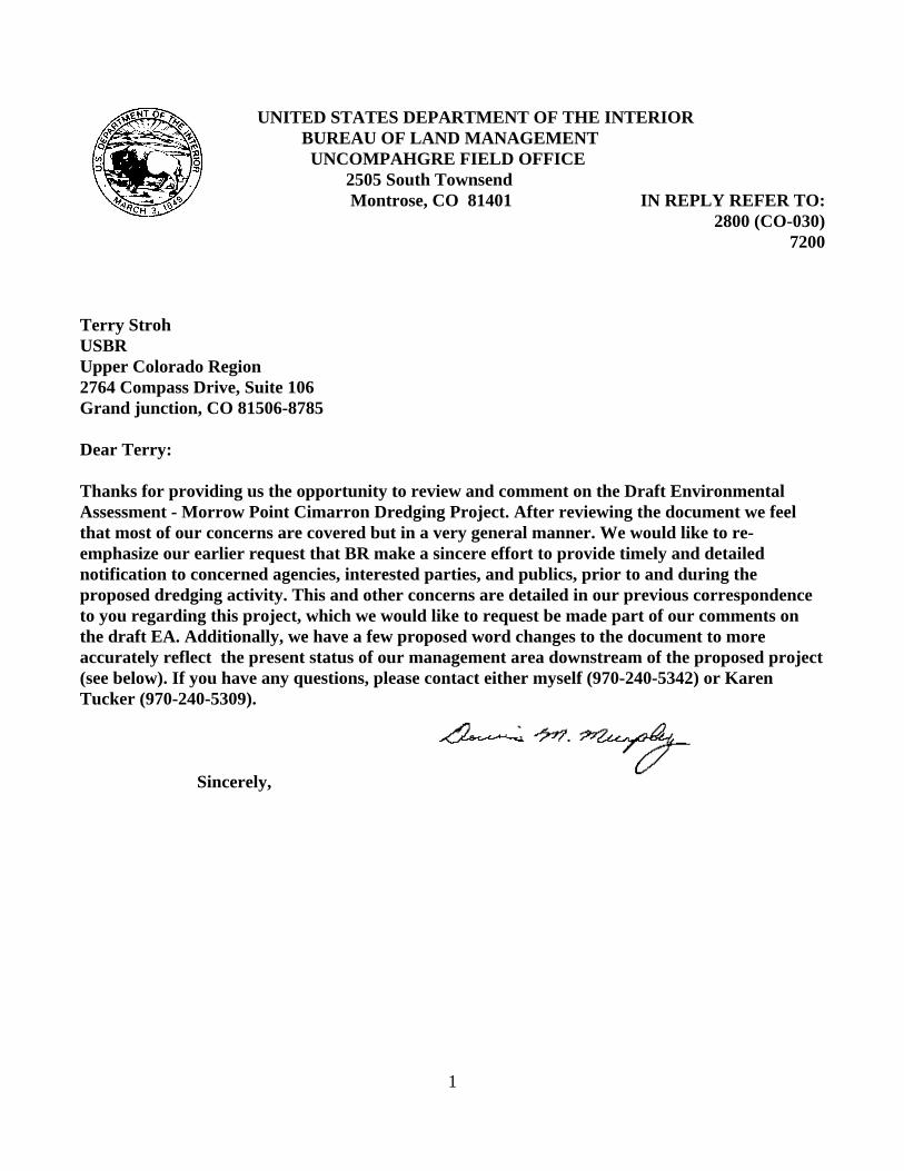
1
UNITED STATES DEPARTMENT OF THE INTERIOR BUREAU OF LAND MANAGEMENT UNCOMPAHGRE FIELD OFFICE 2505 South Townsend Montrose, CO 81401 IN REPLY REFER TO:
2800 (CO-030)7200
Terry StrohUSBRUpper Colorado Region2764 Compass Drive, Suite 106Grand junction, CO 81506-8785
Dear Terry:
Thanks for providing us the opportunity to review and comment on the Draft EnvironmentalAssessment - Morrow Point Cimarron Dredging Project. After reviewing the document we feelthat most of our concerns are covered but in a very general manner. We would like to re-emphasize our earlier request that BR make a sincere effort to provide timely and detailednotification to concerned agencies, interested parties, and publics, prior to and during theproposed dredging activity. This and other concerns are detailed in our previous correspondenceto you regarding this project, which we would like to request be made part of our comments onthe draft EA. Additionally, we have a few proposed word changes to the document to moreaccurately reflect the present status of our management area downstream of the proposed project(see below). If you have any questions, please contact either myself (970-240-5342) or KarenTucker (970-240-5309).
Sincerely,

2
BLM-HydrologistSpecific Comments:
Page 3 Gunnison Gorge Special Recreation Area Gunnison Gorge National Conservation Area and Wilderness
The BLM manages the Gunnison Gorge National Conservation Area (NCA) and Wildernesslocated immediately downstream of the Black Canyon of the Gunnison National Park. The NCAarea includes an additional 24 miles of the Gunnison River from the Park’s western boundarydown to the Town of Austin.
Page 4 Recreation Resources
Rafting, floatfishing, walk-wade fishing, hiking, sightseeing......
Page 9
Recreation Resources
...... An additional 26 miles of the Gunnison River .........................downstream of the NationalPark is managed by the BLM. The river flows through the BLM”s 57,700 acre Gunnison GorgeNational Conservation Area and Wilderness. BLM manages the NCA and Wilderness topermanently protect and conserve its outstanding scenic, geologic, wildlife, and wildernessresources and to provide a diverse range of recreational opportunities including wildernesswhitewater boating and camping, floatfishing, and walk-wade fishing, hiking, and sightseeing.
Page 17
Commercial Guiding Services
ADD - The majority of commercial float and walk-wade fishing use on the river occurs within theBLM’s Gunnison Gorge NCA and Wilderness. These activities are popular throughout thesummer (May - early October) with the highest annual use of the river by both commercial and

3
private float and walk-wade fishers occurring during early June (stonefly hatch period). Floatfishing by commercials is also extremely popular in late July, August and September.

1


APPENDIX DWATER QUALITY DATA

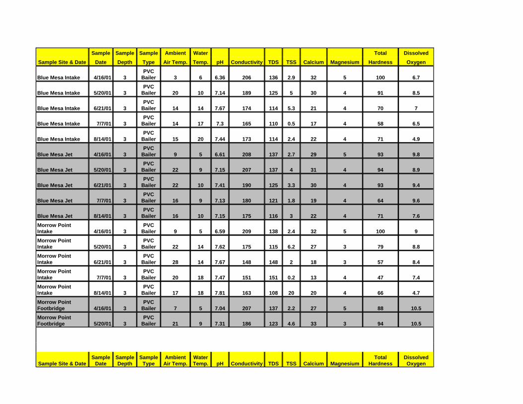
Sample Sample Sample Ambient Water Total DissolvedSample Site & Date Date Depth Type Air Temp. Temp. pH Conductivity TDS TSS Calcium Magnesium Hardness Oxygen
Blue Mesa Intake 4/16/01 3PVC
Bailer 3 6 6.36 206 136 2.9 32 5 100 6.7
Blue Mesa Intake 5/20/01 3PVC
Bailer 20 10 7.14 189 125 5 30 4 91 8.5
Blue Mesa Intake 6/21/01 3PVC
Bailer 14 14 7.67 174 114 5.3 21 4 70 7
Blue Mesa Intake 7/7/01 3PVC
Bailer 14 17 7.3 165 110 0.5 17 4 58 6.5
Blue Mesa Intake 8/14/01 3PVC
Bailer 15 20 7.44 173 114 2.4 22 4 71 4.9
Blue Mesa Jet 4/16/01 3PVC
Bailer 9 5 6.61 208 137 2.7 29 5 93 9.8
Blue Mesa Jet 5/20/01 3PVC
Bailer 22 9 7.15 207 137 4 31 4 94 8.9
Blue Mesa Jet 6/21/01 3PVC
Bailer 22 10 7.41 190 125 3.3 30 4 93 9.4
Blue Mesa Jet 7/7/01 3PVC
Bailer 16 9 7.13 180 121 1.8 19 4 64 9.6
Blue Mesa Jet 8/14/01 3PVC
Bailer 16 10 7.15 175 116 3 22 4 71 7.6Morrow PointIntake 4/16/01 3
PVCBailer 9 5 6.59 209 138 2.4 32 5 100 9
Morrow PointIntake 5/20/01 3
PVCBailer 22 14 7.62 175 115 6.2 27 3 79 8.8
Morrow PointIntake 6/21/01 3
PVCBailer 28 14 7.67 148 148 2 18 3 57 8.4
Morrow PointIntake 7/7/01 3
PVCBailer 20 18 7.47 151 151 0.2 13 4 47 7.4
Morrow PointIntake 8/14/01 3
PVCBailer 17 18 7.81 163 108 20 20 4 66 4.7
Morrow PointFootbridge 4/16/01 3
PVCBailer 7 5 7.04 207 137 2.2 27 5 88 10.5
Morrow PointFootbridge 5/20/01 3
PVCBailer 21 9 7.31 186 123 4.6 33 3 94 10.5
Sample Site & DateSample
DateSampleDepth
SampleType
AmbientAir Temp.
WaterTemp. pH Conductivity TDS TSS Calcium Magnesium
TotalHardness
DissolvedOxygen

Morrow PointFootbridge 6/21/01 3
PVCBailer 29 10 7.44 169 112 3 23 4 75 9.8
Morrow PointFootbridge 7/7/01 3
PVCBailer 22 11 7.22 177 118 0.2 18 4 61 8
Morrow PointFootbridge 8/14/01 3
PVCBailer 17 17 7.42 174 115 7.4 23 4 73 7.4
Cimmaron River 4/16/01 1PVC
Bailer 7 5 7.56 624 418 16.6 44 23 203 9.8
Cimmaron River 5/20/01 1PVC
Bailer 21 13 7.69 230 152 63.3 24 5 81 8.6
Cimmaron River 6/21/01 2PVC
Bailer 29 15 8.38 360 241 16 29 12 121 8.4
Cimmaron River 7/7/01 2PVC
Bailer 22 15 8.07 358 358 4.8 33 7 111 12.2
Cimmaron River 8/14/01 2PVC
Bailer 17 17 8.06 638 444 234 43 43 226 9.2
Crystal Intake 4/16/01 3PVC
Bailer 10 8 7.09 228 150 5.7 29 6 976 6.8
Crystal Intake 5/20/01 3PVC
Bailer 18 12 7.8 196 129 8.3 35 4 103 8.8
Crystal Intake 6/21/01 3PVC
Bailer 29 13 7.64 171 113 2 22 4 73 9.4
Crystal Intake 7/7/01 3PVC
Bailer 27 18 7.68 184 123 0.4 15 4 51 6.5
Crystal Intake 8/14/01 3PVC
Bailer 18 17 8.04 198 131 4.2 24 5 80 6.5
Crystal Tailbay 4/16/01 3PVC
Bailer 13 8 7.18 228 150 5.2 28 6 94 7.4
Crystal Tailbay 5/20/01 3PVC
Bailer 19 9 7.46 190 190 6.3 30 4 91 11.5
Crystal Tailbay 6/21/01 3PVC
Bailer 29 10 7.47 182 120 6.6 21 4 71 9.6
Crystal Tailbay 7/7/01 3PVC
Bailer 27 12 7.34 197 132 1.2 18 4 61 9.2
Crystal Tailbay 8/14/01 3PVC
Bailer 20 11 7.66 191 126 10.6 25 5 83 7.7
