final environmental impact assessment … · assessment practitioner (eap), has been appointed by...
TRANSCRIPT

_____________________________________________________________________________________________
COPYRIGHT WARNING Copyright in all text and other matter, including the manner of presentation, is the exclusive property of the author. It is a criminal offence to reproduce and/or use, without written consent, any matter, technical procedure and/or technique contained in this document. Criminal and civil proceedings will be taken as a matter of strict routine against any person and/or institution infringing the copyright of the author and/or proprietors.
FINAL ENVIRONMENTAL IMPACT ASSESSMENT REPORT
PROPOSED INTEGRATED HOUSING DEVELOPMENT IN KAGISO, GAUTENG
Prepared for: Mogale City Local Municipality P O Box 94, Krugersdorp 1740
Tel: 011 951 2028 Fax: 0119532547
ABSA Property Development (PTY)LTD P O Box 1132 Johannesburg 2000 Tel: 011 671 7652 Fax: 011 674 1217
Submitted to:
DEPARTMENT OF AGRICULTURE, CONSERVATION, AND ENVIRONMENT
P O Box 8769 Johannesburg
2000 Prepared by:
JANUARY 2008
Strategic Environmental Focus (Pty) Ltd P.O. Box 74785
LYNWOOD RIDGE 0040
Tel. No.: (012) 349-1307 Fax. No.: (012) 349-1229 e-mail: [email protected]

Kagiso-Azaadville integrated development project Final Environmental Impact Assessment Report
Final EIA Report i SEF Project Code: 500846
ENVIRONMENTAL ASSESSMENT PRACTITIONER As per the requirements of the National Environmental Management Act: NEMA, 1998 (Act No. 107 of 1998), (NEMA) as amended and the Environmental Impact Assessment Regulations, April 21 2006, the following information is pertinent with regards to the Environmental Assessment Practitioner (EAP) that has been appointed for the Scoping process for the proposed mixed use development:
Environmental Consultant:
Strategic Environmental Focus (Pty) Ltd
Contact Person: Mr. Stephanie Webber Postal address: P.O. Box 74785, Lynnwood Ridge, Pretoria Postal code: 0040 Cell: Telephone: (012) 349 1307 Fax: (012) 349 1229 E-mail: [email protected] Expertise of the EAP to carry out the Scoping Process
Ms. Webber. BSc Animal Science (Hons). BSc Wildlife Management (Hons). Project Manager.
The following specialists conducted the specialist investigations for this EIA report:
Specialists conducting specialist assessments in the EIA
Name Organization Specialist assessment Mrs Ilse Blignaut and Ms Renee Beck
Strategic Environmental Focus (Pty) Ltd
Public Participation
Ms Antoinette Van Wyk Strategic Environmental Focus (Pty) Ltd
Wetland Specialist
Ms Lael Buckman Strategic Environmental Focus (Pty) Ltd
Ecological Practitioner
Mr Johnny Van Schalkwyk
National Cultural History Museum
Principal Investigator; Cultural and Historian professional
CONTACT DETAILS OF ENVIRONMENTAL ASSESSMENT PRACTITIONER
Strategic Environmental Focus (Pty) Ltd
Ms Stephanie Webber PO Box 74785 CSIR CAMPUS Lynnwood Ridge, PRETORIA BRUMMERIA 0040 PRETORIA Tel +27 12 349 1307 BUILDING NUMBER 4 Fax +27 12 349 1229
Kagiso-Azaadville integrated development project Final Environmental Impact Assessment Report
Final EIA Report ii SEF Project Code: 500846
EXECUTIVE SUMMARY
1 INTRODUCTION
Strategic Environmental Focus (Pty) Ltd (SEF), as an independent Environmental Assessment Practitioner (EAP), has been appointed by BIGEN AFRICA (PTY) LTD on behalf of Mogale city Local Municipality and ABSA Devco (PTY) LTD, to facilitate the EIA process for the proposed establishment of a formal residential township in the Kagiso – Azaadville region. The land earmarked for the development is co-owned by ABSA property development (Portion 43 of the Farm Rietvallei 241 IQ) and Mogale City Municipality (Remainder of the Farm Kagiso 402 IQ). The housing project will deliver some 9,400 housing opportunities in the subsidized, institutional/rental and bonded housing segments.
The proposed housing project caters for a variety of social levels, whereby subsidy stands, rental market and bonded housing through institutional housing, community commercial, educational facilities, religious and other community facilities will be provided. The Environmental Impact Assessment (EIA) process followed is in compliance with the National Environmental Management Act: NEMA, 1998 (Act No. 107 of 1998), as amended and the Environmental Impact Assessment Regulations of 2006 (Government Notice No’s R385, 386 and 387 of 2006). The proposed development involves ‘listed activities’, as defined by the NEMA, 1998. Listed activities are activities, which may potentially have detrimental impacts on the environment and therefore require environmental authorisation from the relevant authorising body. The proposed development occurs inside Gauteng and thus GDACE are the responsible decision making authority. The proposed development involves the following listed activities as stipulated in the EIA Regulations of 2006: As per Government Notice No. R. 386 of 2006, the following listed activities are included for the above application:
• 1(m) Any purpose in the one in ten year flood line of a river or stream, or within 32 metres from the bank of a river or stream where the flood line is unknown, excluding purposes associated with existing residential use, but including -
• canals; • channels; • bridges; • dams; and • Weirs.

Kagiso-Azaadville integrated development project Final Environmental Impact Assessment Report
Final EIA Report iii SEF Project Code: 500846
• 1 (p) The temporary storage of hazardous waste; • 12 The transformation or removal of indigenous vegetation of 3 hectares
or more or of any size where the transformation or removal would occur within a critically endangered or an endangered ecosystem listed in terms of section 52 of the National Environmental Management: Biodiversity Act, 2004 (Act No. 10 of 2004);
• 15 The construction of a road that is wider than 4 metres or that has a reserve wider than 6 metres, excluding roads that fall within the ambit of another listed activity or which are access; and
• 17 Phased activities where any one phase of the activity may be below a threshold specified in this Schedule but where a combination of the phases, including expansions or extensions, will exceed a specified threshold.
The above activities are all Basic Assessment activities. However, we confirm that the application will remain a Scoping and EIA application, due to the following listed activity as per Government Notice No. 387 of 2006:
• 1 (a) The construction of facilities or infrastructure including associated structures or infrastructure for the generation of electricity where the output is 20 megawatts or more; or the elements of the facility cover a combined area in excess of 1 hectare;
• 1 (l) The construction of facilities or infrastructure including associated structures or infrastructure for the transmission and distribution of above ground electricity with a capacity of 120 kilovolts or more;
• 1 (p) The treatment of effluent, wastewater or sewage with an annual throughput capacity of 15 000 cubic metres or more; and
• 2 Any development activity, including associated structures and infrastructure, where the total area of the developed area is, or is intended to be, 20 hectares or more.
SEF were appointed to act as independent environmental assessment practitioners responsible for: § The public participation process for both the Scoping and EIA phases; § The required specialist studies; and § The compilation of this Scoping Report / EIR (and site specific EMP) and its
submission to the relevant environmental authority.
Kagiso-Azaadville integrated development project Final Environmental Impact Assessment Report
Final EIA Report iv SEF Project Code: 500846
2 GENERAL PROJECT DESCRIPTION
The site is located adjacent to the greater Kagiso area, within the jurisdiction of the Mogale City Local Municipality in the West Rand. The responsible municipality is the West Rand District Municipality, while the Mogale City is the Local Municipality. The size of the site is approximately 328 hectares (ha). The following farm portions are applicable:
• Portion 43 of Rietvallei No. 241-IQ • The Remainder of Kagiso No. 402 IQ
Currently both sites are vacant. Small scale subsistence agricultural practices occur on the remainder of the Farm Kagiso No. 402 IQ.
The general development concept of the Kagiso-Azaadville integrated housing development is to: • Contribute in addressing the existing housing backlog in the area; • Establish a sustainable integrated housing development which will accommodate
both bonded and subsidised housing; • To provide the potential beneficiary with a range of different housing typologies; • To provide complimentary facilities, which will not only serve the local community,
but also the sub-region; • To be sensitive to adjacent land uses and to focus on effective integration; • To be sensitive to environmental considerations/elements; and • To incorporate the inputs of all stakeholders. This development is planned to be unique; in as far as it will integrate beneficiaries with different income levels linked to different housing typologies. Furthermore it is envisaged as a development where a joint venture will take place between the Department of National Housing, Department of Provincial Housing, the Mogale City and ABSA to provide a combination of bonded and subsidised housing.
There are a number of provincial routes in the vicinity of the proposed development. Access from these routes will assist with the distribution of traffic to and from the proposed developments. Access to the Remainder of the farm Kagiso No. 402 IQ can be obtained via the Taj Mahal Street intersection with the K13; the existing access to Azaadville. Additional access to Randfontein Road will be provided to the east, situated at least 600m from Kagiso Drive. Access to Portion 43 of the farm Rietvallei No. 241-IQ can be obtained via the existing 1st Avenue / Badshani Drive intersection. A number of external roads will need to be upgraded, to improve the accessibility of the development. The extent of the proposed upgrading will be determined during a full traffic impact study that is currently being conducted. This study is still underway.

Kagiso-Azaadville integrated development project Final Environmental Impact Assessment Report
Final EIA Report v SEF Project Code: 500846
3 ENVIRONMENTAL IMPACT ASSESSMENT AND PUBLIC PARTICIPATION PROCESS
The principles of NEMA govern many aspects of EIA’’s, including consultation with interested and affected parties (I&APs). These principles include the provision of sufficient and transparent information to I&APs on an ongoing basis, to allow them to comment, and ensuring the participation of historically disadvantaged individuals, including women, the disabled and the youth.
Interested and affected parties (I&APs) representing the following sectors of society have been identified. The project was announced as follows: • Publication of a media advertisement in the local and regional newspaper, the
Randfontein Herald on the 19 July 2007. • On-site notices advertising the EIA have been placed at the following public
locations on 20 July 2007: - Corner of Kagiso Road and Randfontein Road R41 - T-Junction of Taj Mahal Drive (Azaadville) and the K13 - Corner of Badshani drive and Randfontein Road R41 - Corner of 1st Avenue and Randfontein Road R41
• Distribution of Background Information Documents and Registration and Comment sheets by hand delivery to I&APs on 27th July 2007
• Hand-delivering flyers to directly affected I&APs and/or landowners on 27th July 2007 who could not be otherwise reached; and
• Making available the draft Scoping Report at Azaadville Public Library in Azaadville from 20/8/2007 to 20/9/2007.
• Making available the draft EIA Report at Azaadville Public Library in Azaadville from 10/1/2008 – 29/1/2008.
Furthermore, a focus group meeting was arranged with registered I&AP’s and ward councillors. The purpose of this meeting was to: • announce the proposed project and EIA • obtain their initial issues of concern, and • encourage their ongoing participation. All the issues raised to date were captured in the Draft Scoping and EIA Reports which were made available in English. The EIA Regulations specify that I&APs must have an opportunity to verify that their issues have been captured. A period of 30 days was made available for public comment on the Draft Scoping Report. The availability of the Draft Scoping Report was announced via personal letters to all the registered I&APs on the distribution list.
Kagiso-Azaadville integrated development project Final Environmental Impact Assessment Report
Final EIA Report vi SEF Project Code: 500846
In addition, the Draft Scoping Report was distributed for comment as follows: • Placed in the Azaadville Public Library • Hand-delivered to the relevant authorities, ie. DWAF • Mailed to I&APs who requested copies Public review of the Draft Scoping Report has been made available by the following methods: • Written notification to registered I&AP’s and Ward Councillors • Advertising A Focus Group Meeting was conducted with registered I&AP’s and relevant ward councillors for the area, on the 11 September 2007, at the ANC Caucus Room at the Mogale City Local Municipality, Municipal Offices, Cnr Market and Commissioner Streets, Krugersdorp. The outcome of this meeting was positive. No objections were raised. All parties are in favour of the development. All the issues raised to date were captured in the Draft and final Scoping Reports. These reports were made available in English. The EIA Regulations specify that I&APs must have an opportunity to verify that their issues have been captured. A period of 30 days was made available for public comment on the Draft Scoping Report. The availability of the Draft Scoping Report was announced via personal letters to all the registered I&APs on the distribution list. The availability of the Draft Environmental Impact Assessment Report has been announced via personal letters to all the registered I&APs on the distribution list. The first letter was sent to the registered I&APs on the 7/12/2007. A reminder notice of the availability of the draft EIA report was sent to all I&APs on the 7/1/2008. In addition, the Draft Environmental Impact Assessment Report has been distributed for comment as follows: • Placed in the Azaadville Public Library from 10/1/2007 – 29/1/2007. • Hand-delivered to the relevant authorities, ie. DWAF • Mailed to I&APs who requested copies Public review of the Draft Environmental Impact Assessment Report has been made available by the following methods: • Written notification to registered I&AP’s and Ward Councillors No comments on the draft EIA report were received by I&AP’s or approving bodies such as DWAF, Department of Health, SAHRA or Mogale City Local Municipality Environmental Division.
Kagiso-Azaadville integrated development project Final Environmental Impact Assessment Report
Final EIA Report vii SEF Project Code: 500846
4 KEY IMPACTS
The key issues listed in the following section have been determined through the following avenues: § Views of interested and affected parties;
§ Legislation; and
§ Professional understanding of environmental assessment practitioners and specialist consultants
The potential impacts and key issues identified for the Kagiso-Azaadville Intergated/mixed use development include:
• Geological formations; • Soil erosion and pollution; • Stormwater management; • Catchment processes and Hydrological systems (including wetlands,
rivers, and associated aquatic systems);; • Soil and water (surface and groundwater) contamination; • Ecological functioning; • Air quality • Heritage and culture; • Safety and security; • Infrastructure and services provision; • Traffic; • Socio economic; and • Landscape character / visual character;
This EIA report has assessed the key issues identified for the Kagiso-Azaadville Integrated/mixed use development. These key issues have been determined through the Views of interested and affected parties; Legislation; and Professional understanding of environmental assessment practitioners and specialist consultants. Necessary mitigation measures for the potential impacts have been provided. It is the finding of this EIA report that the environmental impacts of the key issues can be sufficiently mitigated, such that the impact to the environment is acceptable, and can be managed.
Kagiso-Azaadville integrated development project Final Environmental Impact Assessment Report
Final EIA Report viii SEF Project Code: 500846
5 ALTERNATIVES
The identification of alternatives is an important component of the EIA process. Where possible, alternatives have been identified and investigated. The various alternatives have been assessed in terms of both environmental acceptability as well as economical feasibility. The alternatives that have been assessed as part of the EIA for the Kagiso Integrated Housing Development include: § Overall layout; § Roads design; and § Lighting
Overall layout
At the onset of the project, alternatives for the overall layout of the development were considered by the Project team. An exercise of “shifting housing typologies” was undertaken. Input from the property developers as well as the Local Municipality dictated the placement / positioning of the bonded housing versus the subsidised housing. The location for each type of housing was influenced by market and surrounding land use types. The final urban design locates the bonded housing closer to the surrounding bonded areas of Rietvallei and Kagiso. The final layout furthermore, promotes security and privacy for the entire development. Roads design
This subsidy from the Department of Housing included the provision of a metered water connection to each stand, an individual water borne sewer connection and gravel roads. Subsequent to this line of thinking however, the project team has made allowance for all roads within the development to be tarred.
Lighting
In order to lighten the load on the services of the area, it is proposed that Compact Fluorescent Lights (CFL) is used throughout the development for lighting. The advantages and disadvantages of using CFLs are outlined in this report.
NO-GO DEVELOPMENT ALTERNATIVE
DEAT stresses that the no-development option should be considered in cases where the proposed development will have a significant detrimental impact that cannot be effectively or satisfactorily mitigated. The no-go option is explored in terms of the relative costs and benefits of not proceeding with the proposed development. If no development were to occur on site, the ecological systems within the study area would not be disturbed. Ecological processes across the both farm portions would remain undisturbed, and natural habitats for fauna and flora would not be impacted on.

Kagiso-Azaadville integrated development project Final Environmental Impact Assessment Report
Final EIA Report ix SEF Project Code: 500846
From a Socio-economic aspect, if the development does not proceed, the local communities in the area would not benefit from:
o Development; o Employment opportunities; o Improved Standard of living; o Social facility provision and improvement; o Skills transfer; and o Tourism opportunities.
6 CONCLUSIONS AND RECOMMENDATIONS
This draft Environmental Impact Assessment report has been compiled on the strength of the information made available to the consultants. Professional environmental assessment practitioners have reviewed the development proposal, and have identified those key issues which will have an impact on the environment. All provincial guidelines and Acts applicable to the project proposal have been considered during the development of the project. These policies and acts have guided the development of the project proposal. The proposed integrated development is in line with the surrounding land uses. In terms of the current development policies such as the Integrated Development Plan (IDP), Spatial Development Framework and Land Development Objectives, the development proposal falls within the ambit of the authority’s objectives for the area. The land use requirements for the project are based on the requirements of Mogale city Local Municipality; who aim to address the housing backlog in their municipal area; and ABSA Property Development; who aim to deliver quality and affordable housing products A number of specialist studies have been conducted for this application; namely:
• Ecological fauna and flora • Wetland delineation and Riparian functional assessment • Heritage Impact Assessment • Geotechnical
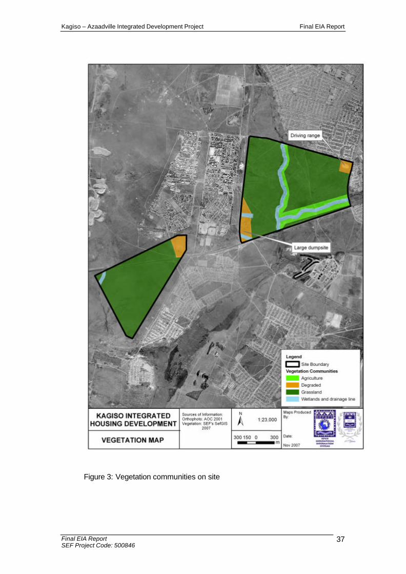
The receiving environment has been investigated, and the outcome and recommendations of the specialist studies have influenced the overall layout of the development. Specialist ecological investigations revealed that the majority of both sites are classified as unimproved grassland. Areas of high floral sensitivity are the moist grasslands and rocky outcrops within the dry grassland matrix. These areas are located within the 32m buffer zone adjacent to the river courses on the application sites. The specialist Ecological Assessment revealed that Wetland systems on site and rocky outcrops, offer suitable habitat to important faunal species. Baboon spiders might occur within rocky outcrops and in light of these, rocky outcrops should be protected. This assessment will reveal the presence, or non-presence of these species. Doctor Johnny Van Schalkwyk from the National Cultural
Kagiso-Azaadville integrated development project Final Environmental Impact Assessment Report
Final EIA Report x SEF Project Code: 500846
History Museum conducted the Heritage Impact Assessment for the project. No evidence of historically significant elements was noted. This EIA report has assessed the key issues identified for the Kagiso-Azaadville Integrated/mixed use development. These key issues have been determined through the Views of interested and affected parties; Legislation; and Professional understanding of environmental assessment practitioners and specialist consultants. Necessary mitigation measures for the potential impacts have been provided. It is the finding of this EIA report that the environmental impacts can be sufficiently mitigated. The impacts to the environment are rated as acceptable, and can be managed. With regards to public and key stake holder involvement, the public have been engaged, and intensive public participation processes has persisted throughout the public participation process. The project was first advertised in the Randfontein Herald. Input from Mogale City Local Municipality, guided SEF to re-advertise in the Krugersdorp News as well. This advertisement served to reach parties not previously addressed by the first advertisement, and made the public aware that the environmental scoping report was available for public review. A focus group meeting was conducted with registered I&AP’s and relevant ward councillors for the area, on the 11 September 2007, at the ANC Caucus Room at the Mogale City Local Municipality, Municipal Offices, Cnr Market and Commissioner Streets, Krugersdorp. The outcome of this meeting was positive. No objections were raised. All parties are in favour of the development. During the compilation of the EIA report, no further comments / objections for this application were received. Following the 20 day review period of the draft EIA report, no further comments have been received on the application, process or development proposal. Importantly, the proposed development has the potential to decrease the unemployment status of the Kagiso, Azaadville and Rietvallei areas. A number of community, retail, commercial and social developments (schools, medical clinics, churches) are to be built as part of the development initiative. These project components will assist in increasing the economy of the area, and potentially the quality of life for the people residing there.

Kagiso-Azaadville Integrated Mixed Use Development Final EIA Report
Final EIA Report xi SEF Project Code: 500846
TABLE OF CONTENTS
EXECUTIVE SUMMARY........................................................................................... ii 1 INTRODUCTION ........................................................................................... ii 2 GENERAL PROJECT DESCRIPTION.......................................................... iv 3 ENVIRONMENTAL IMPACT ASSESSMENT AND PUBLIC
PARTICIPATION PROCESS ........................................................................... v 4 KEY IMPACTS...............................................................................................vii 5 ALTERNATIVES ...........................................................................................viii NO-GO DEVELOPMENT ALTERNATIVE....................................................viii 6 CONCLUSIONS AND RECOMMENDATIONS........................................... ix
TABLE OF CONTENTS.................................................................. xi LIST OF ABBREVIATIONS ..........................................................xiv GLOSSARY OF TERMS................................................................xv SECTION A INTRODUCTION.....................................................16
A-2 LEGAL REQUIREMENTS APPLICABLE TO THIS APPLICATION .........19 A-2.1 NEMA and Environmental Impact Assessment Regulations ................19 A-2.2 Acts applicable to the project application ..............................................20 A-2.3.1 Conservation Plan....................................................................................22 A-2.3.2 Red Data Plan species Policy .................................................................22 A-2.3.3 Information layers and buffer zones for Industries in Gauteng ...............23
A-3 DETAILS OF THE APPLICANT ..................................................................23 A-4 MOTIVATION FOR THE PROJECT ...........................................................23 A-5 DESCRIPTION OF THE PROPOSED PROJECT.......................................25
A-5.1 Location...................................................................................................25 A-5.2 Housing Products ...................................................................................25 A-5.3 Community Services and Social Amenities ...........................................26 A-5.4 Work Opportunities.................................................................................28
A-5.5 Surrounding land uses ...........................................................................29 A-5.6 Existing operations.................................................................................30 A-5.7 Engineering services .............................................................................30
A-6 LEGAL DEVELOPMENT RIGHTS...............................................................32 A-6.1 Zoning ....................................................................................................32 A-6.2 The proposal in terms of relevant planning schemes ...........................33
SECTION B THE RECEIVING ENVIRONMENT .......................34 B-1 BIOPHYSICAL ENVIRONMENT.................................................................34
B-1.1 Geology and Geotechnical Suitability....................................................34 B-1.2 Soils and agricultural potential...............................................................34 B-1.3 Topography and hydrology....................................................................34 B-1.4 Climate ...................................................................................................35
B-1.4.1 Temperature and precipitation .......................................................35 B-1.4.2 Wind................................................................................................36
B-1.5 Flora .......................................................................................................36 B-1.6 Fauna and Avi-fauna..............................................................................40 B-1.8 C - Plan ..................................................................................................43 B-1.9 Noise......................................................................................................43 B-1.10 Air quality ...............................................................................................43 B-1.11 Gauteng Industries and buffers .............................................................43
B-2 SOCIAL ENVIRONMENT............................................................................49 B-2.1 Visual......................................................................................................49 B-2.2 Heritage Resources ...............................................................................50
Kagiso-Azaadville Integrated Mixed Use Development Final EIA Report
Final EIA Report xii SEF Project Code: 500846
SECTION C ENVIRONMENTAL IMPACT ASSESSMENT (EIA) PROCESS 51
C-1 APPROACH TO THE EIA.............................................................................51 C-2 GUIDING PRINCIPLES FOR AN EIA...........................................................51 C-3 EIA TECHNICAL PROCESS........................................................................52
C-3.1 Consultation with the Gauteng Department of Agriculture Conservation and Environment...................................................................................................52 C-3.2 Application for authorization ..................................................................52 C-3.3 Information gathering .............................................................................52 C-3.4 Specialist studies ...................................................................................52
C-4 PUBLIC PARTICIPATION PROCESS..........................................................53 C-4.1 Identification of interested and affected parties.....................................53 C-4.2 Public announcement of the project......................................................53 C-4.3 Meetings with I&APs ..............................................................................54 C-4.4 Raising issues for investigation by EIA specialists ...............................54 C-4.5 Draft Scoping Report .............................................................................54 C-4.6 Final Scoping Report .............................................................................55 C-4.7 Draft Environmental Impact Assessment Report ..................................55 C-4.8 Public participation during the Impact Assessment Phase...................55
SECTION D ASSESSMENT OF IMPACTS...............................56 D-1 IDENTIFICATION OF IMPORTANT ENVIRONMENTAL ISSUES..............56 D-2 ASSESSMENT METHODOLOGY................................................................57 D-3 SUMMARY OF ANTICIPATED IMPACTS ...................................................60 D-4 IMPACT ASSESSMENT ...............................................................................64
4.0 DETAILED IMPACT ASSESSMENT.............................................................64 4.1 Soil .............................................................................................................64 4.2 Terrestrial Ecology.....................................................................................70 4.7 Aquatic Ecosystems ..................................................................................82 4.9 Air Quality ..................................................................................................91 4.10 Heritage Resources...................................................................................94 4.12 Traffic .........................................................................................................98
SECTION E BRIDGE CONSTRUCTION METHODOLOGY AND MITIGATION MEASURES FOR THE CONSTRUCTION PHASE... ................................................................................100 SECTION F STORMWATER MANAGEMENT.........................106 SECTION G ALTERNATIVES...................................................106
G-1 IDENTIFICATION OF ALTERNATIVES.....................................................106 G-2.0 NO-GO DEVELOPMENT ALTERNATIVE..................................................108
SECTION H CONCLUSION AND RECOMMENDATIONS......109
Kagiso-Azaadville Integrated Mixed Use Development Final EIA Report
Final EIA Report xiii SEF Project Code: 500846
LIST OF FIGURES Figure 1: Regional Locality Map Figure 2: Urban Concept Layout Figure 3: Vegetation Communities on site Figure 4: Site sensitivities Figure 5: Riparian zones with 32m buffer Figure 6: Ecological Index Rating Figure 7: Irreplaceable sites Figure 8: Control Zones Figure 9: Environmental Management Framework, Vegetation categories Figure 10: Parks and Open Space Figure 11: Four phases of the EIA Figure 12: Luminaire fixtures Figure 13: Directing outdoor Luminaires LIST OF TABLES Table 1: Surrounding land use table for The Remainder of the farm Kagiso No.
402 IQ Table 2: Surrounding land use table for Portion 43 of the farm Rietvallei No.
241 IQ Table 3: Impacts example table Table 4: Alternatives comparison table Table 5: Stockpiling of topsoil Table 6: Soil pollution Table 7: Increased pollution Table 8: Impacts on natural habitat: Construction Phase Table 9: Impacts on natural habitat: Operational phase Table 10: Impact on Natural Habitat Table 11: Vegetation Clearance Table 12: Loss of plant species richness Table 13: Disturbance of Fauna: Construction phase Table 14: Disturbance of Fauna: Operational phase Table 15: Catchment hardening Table 16: Modification to water bodies Table 17: Sedimentation of water resources Table 18: Surface water pollution Table 19: Impacts of dust pollution Table 20: Impacts of increased emissions resulting from increased traffic Table 21: Damage to heritage resources Table 22: Expected increase in traffic for development Table 23: Impacts of the proposed bridges and mitigation measures Table 24: Possible stormwater impacts arising during construction phase

Kagiso-Azaadville Integrated Mixed Use Development Final EIA Report
Final EIA Report xiv SEF Project Code: 500846
LIST OF ABBREVIATIONS
CBOs - Community Based Organisations
DWAF - Department of Water Affairs and Forestry
EIA - Environmental Impact Assessment
EIR - Environmental Impact Report
EAP - Environmental Assessment Practitioner
ECO - Environmental Control Officer
EMP - Environmental Management Plan
GDACE Gauteng Department of Agriculture, Conservation and
Environment
HIA - Heritage Impact Assessment
I&APs - Interested and Affected Parties
ICS - International Conservation Services
IEM - Integrated Environmental Management
IDP - Integrated Development Plan
NEMA - National Environmental Management Act, 1998 (Act No. 107 of
1998)
NGOs - Non-Governmental Organisations
NSBA - National Spatial Biodiversity Assessment
PP - Public Participation
PoS - Plan of Study
RoD - Record of Decision
SAHRA - South African Heritage Resources Agency
SEF - Strategic Environmental Focus (Pty) Ltd
WWTW - Waste Water Treatment Works

Kagiso-Azaadville Integrated Mixed Use Development Final EIA Report
Final Scoping Report xv SEF Project Code: 500587
GLOSSARY OF TERMS
Alien species: A plant or animal species introduced from elsewhere: neither endemic nor indigenous.
Applicant: Any person who applies for an authorisation to undertake an activity or to cause such activity to be undertaken as contemplated in the National Environmental Management Act (Act No. 107 of 1998), as amended and the Environmental Impact Assessment Regulations, 2006.
Arable potential: Land with soil, slope and climate components where the production of cultivated crops is economical and practical.
Critically endangered: A taxon is Critically Endangered when it is facing an extremely high risk of extinction in the wild, in the immediate future.
Ecology: The study of the inter relationships between organisms and their environments.
Environment: All physical, chemical and biological factors and conditions that influence an object and/or organism.
Environmental Impact Assessment: Assessment of the effects of a development on the environment.
Environmental Management Plan: A legally binding working document, which stipulates environmental and socio-economic mitigation measures that must be implemented by several responsible parties throughout the duration of the proposed project.
Soil compaction: Mechanically increasing the density of the soil, vehicle passage or any other type of loading. Wet soils compact easier than moist or dry soils.
Study area: Refers to the entire study area encompassing the total area of the land parcels as indicated on the study area map.
Vulnerable: A taxon is ‘Vulnerable’ when it is not ‘Critically Endangered’ or ‘Endangered’ but is facing a high risk of extinction in the wild in the medium-term future.
Kagiso – Azaadville Integrated Development Project Final EIA Report
Final EIA Report SEF Project Code: 500846
16
SECTION A INTRODUCTION Strategic Environmental Focus (Pty) Ltd (SEF), as an independent Environmental Assessment Practitioner (EAP), has been appointed by BIGEN AFRICA (PTY) LTD on behalf of Mogale city Local Municipality and ABSA Devco (PTY) LTD, to facilitate the EIA process for the proposed establishment of a formal residential township in the Kagiso – Azaadville region. The land earmarked for the development is co-owned by ABSA property development (Portions 42 and 43 of the Farm Rietvallei 241 IQ) and Mogale City Municipality (Remainder of the Farm Kagiso 402 IQ). The housing project will deliver some 9,400 housing opportunities in the subsidized, institutional/rental and bonded housing segments.
The land use requirements for the project are based on the requirements of Mogale City Local Municipality and ABSA Devco (PTY) LTD. Mogale city Local Municipality aim to address the housing backlog in their municipal area; and ABSA Property Development aim to deliver quality and affordable housing products in areas where this need exists. The proposed housing project caters for a variety of social levels, whereby subsidy stands, rental market and bonded housing through institutional housing, community commercial, educational facilities, religious and other community facilities will be provided. The proposed development sites are located adjacent to the greater Kagiso area, within the municipal jurisdiction of the Mogale City Municipality and the West Rand District Municipality. The proposed development site comprises of two (2) land parcels yielding a total development area of 328 hectares.

Kagiso – Azaadville Integrated Development Project Final EIA Report
Final EIA Report SEF Project Code: 500846
17
Figure 1 : Regional Locality Map

Kagiso – Azaadville Integrated Development Project Final EIA Report
Final EIA Report SEF Project Code: 500846
18
Figure 2: Urban Concept Layout

Kagiso – Azaadville Integrated Development Project Final EIA Report
Final EIA Report SEF Project Code: 500846
19
A-2 LEGAL REQUIREMENTS APPLICABLE TO THIS APPLICATION
A-2.1 NEMA and Environmental Impact Assessment Regulations
The Environmental Impact Assessment (EIA) process followed is in compliance with the National Environmental Management Act: NEMA, 1998 (Act No. 107 of 1998), as amended and the Environmental Impact Assessment Regulations of 2006 (Government Notice No’s R385, 386 and 387 of 2006). The proposed development involves ‘listed activities’, as defined by the NEMA, 1998. Listed activities are activities, which may potentially have detrimental impacts on the environment and therefore require environmental authorisation from the relevant authorising body. The proposed development occurs inside Gauteng and thus GDACE are the responsible decision making authority. The proposed development involves the following listed activities as stipulated in the EIA Regulations of 2006: As per Government Notice No. R. 386 of 2006, the following listed activities are included for the above application:
• 1(m) Any purpose in the one in ten year flood line of a river or stream, or within 32 metres from the bank of a river or stream where the flood line is unknown, excluding purposes associated with existing residential use, but including -
• canals; • channels; • bridges; • dams; and • Weirs.
• 1 (p) The temporary storage of hazardous waste; • 12 The transformation or removal of indigenous vegetation of 3 hectares
or more or of any size where the transformation or removal would occur within a critically endangered or an endangered ecosystem listed in terms of section 52 of the National Environmental Management: Biodiversity Act, 2004 (Act No. 10 of 2004);
• 15 The construction of a road that is wider than 4 metres or that has a reserve wider than 6 metres, excluding roads that fall within the ambit of another listed activity or which are access; and
• 17 Phased activities where any one phase of the activity may be below a threshold specified in this Schedule but where a combination of the phases, including expansions or extensions, will exceed a specified threshold.
The above activities are all Basic Assessment activities. However, we confirm that the application will remain a Scoping and EIA application, due to the following listed activity as per Government Notice No. 387 of 2006:
Kagiso – Azaadville Integrated Development Project Final EIA Report
Final EIA Report SEF Project Code: 500846
20
• 1 (a) The construction of facilities or infrastructure including associated
structures or infrastructure for the generation of electricity where the output is 20 megawatts or more; or the elements of the facility cover a combined area in excess of 1 hectare;
• 1 (l) The construction of facilities or infrastructure including associated structures or infrastructure for the transmission and distribution of above ground electricity with a capacity of 120 kilovolts or more;
• 1 (p) The treatment of effluent, wastewater or sewage with an annual throughput capacity of 15 000 cubic metres or more; and
• 2 Any development activity, including associated structures and infrastructure, where the total area of the developed area is, or is intended to be, 20 hectares or more.
A-2.2 Acts applicable to the project application
National Environmental Management: Biodiversity Act, 2004 (Act No. 10 of 2004) The purpose of the Biodiversity Act is to provide for the management and conservation of South Africa’s biodiversity within the framework of the NEMA and the protection of species and ecosystems that warrant national protection. As part of its implementation strategy, the National Spatial Biodiversity Assessment was developed. The diversity of ecological processes for the application sites has been determined by the specialist studies. The outcome/recommendations of the specialist studies has guided the management of the biodiversity on site, and indicated how the ecological elements on site need to form part of a greater environmental management framework for the region. National Spatial Biodiversity Assessment The National Spatial Biodiversity Assessment (NSBA) classifies areas as worthy of protection based on its biophysical characteristics, which are ranked according to priority levels. The diversity of ecological processes for the application sites has been determined by the specialist studies. The outcome/recommendations of the specialist studies has guided the management of the biodiversity on site, and indicated how the ecological elements on site need to form part of a greater environmental management framework for the region.

Kagiso – Azaadville Integrated Development Project Final EIA Report
Final EIA Report SEF Project Code: 500846
21
Protected species – Provincial Ordinances Provincial ordinances were developed to protect particular plant species within specific provinces. The protection of these species is enforced through permitting requirements associated with provincial lists of protected species. Permits are administered by the Provincial Departments of Environmental Affairs. The ecological and wetland specialist studies conducted for the application sites have determined the presence and non-presence of protected or vulnerable species on site. The protected and/or vulnerable floral species located on site will be managed as part of the riparian habitat and associated 32m buffer zone. The preservation of these species will ensure the viable genetic distribution and migration of the protected species from the application sites to connecting open spaces and riparian systems. National Water Act, 1998 (Act No. 36 of 1998) The National Water Act guides the management of water in South Africa as a common resource. The Act aims to regulate the use of water and activities, which may impact on water resources through the categorisation of ‘listed water uses’ encompassing water extraction, flow attenuation within catchments as well as the potential contamination of water resources, where the Department of Water Affairs and Forestry (DWAF) is the administering body in this regard. National Heritage Resources Act, 1999 (Act No. 25 of 1999) The National Heritage Resources Act legislates the necessity for cultural and heritage impact assessment in areas earmarked for development, which exceed 0.5 ha. The Act makes provision for the potential destruction to existing sites, pending the archaeologist’s recommendations through permitting procedures. Permits are administered by the South African Heritage Resources Agency (SAHRA). The size of the application sites warrants that a specialist Heritage Assessment be conducted. Doctor Johnny Van Schalkwyk from the National Cultural History Museum, has completed the Heritage Impact Assessment for the project. No objects or structures of cultural significance were present on site. National Environmental Management: Protected Areas Act, 2003 (Act No. 57 of 2003) The purpose of this Act is to provide for the protection, conservation and management of ecologically viable areas representative of South Africa’s biological diversity and its natural landscapes. The diversity of ecological processes for the application sites has been determined by the specialist studies. The outcome/recommendations of the specialist studies has guided the management of the biodiversity on site, and indicated how the ecological elements on site need to form part of a greater environmental management framework for the region.

Kagiso – Azaadville Integrated Development Project Final EIA Report
Final EIA Report SEF Project Code: 500846
22
Atmospheric Pollution Prevention Act (Act no. 45 of 1965) The purpose of this Act is to provide for the prevention of the pollution of the atmosphere, for the establishment of a National Air Pollution Advisory Committee, and for matters incidental thereto. The Flip Human Sewer Treatment Works (located south of the R41 Main Reef Road) is characterised by a 500m air quality buffer zone. A- 2.3 Provincial policies/ guidelines
A-2.3.1 Conservation Plan
The Gauteng Department of Agriculture Conservation and Environment, 2005: Gauteng Biodiversity Gap Analysis Project: Gauteng conswrvation Plan Version 2, Johannesburg, GDACE, aims to identify and map the distribution of areas that are of importance to biodiversity in Gauteng. This exercise is accomplished through a conservation planning exercise that is based on explicit representation goals and the principles of complementarity (avoidance of duplication of important attributes), efficiency (most protection for the least cost/area), defensibility and flexibility (many combinations of potential solutions in the face of competing land uses), irreplaceability, retention (consideration of threatening factors), persistence (capturing of ecological processes and exclusion of threats), and accountability (in allowing decisions to be critically reviewed), and ultimately to provide recommendations for the conservation and management of these areas. The C-Plan has been utilised during the Scoping and EIA process to provide the project team with an indication of the expected biodiversity on site. Please see Figures 6 - 10.
A-2.3.2 Red Data Plan species Policy
The Directorate of Nature Conservation of the Gauteng Department of Agriculture Conservation and Environment, was requested to compile a draft policy to assist with the evaluation of development applications that affected Red Data plant species. A ranking scheme that prioritizes Red Data plant species in Gauteng from the most important to the least important, had already been developed for other purposes within the Directorate of Nature Conservation. This ranking scheme was revised as a basis to develop the required Red Data policy. This policy has been utilised during the Scoping and EIA process to provide the project team with an indication of the anticipated biodiversity on site.
Kagiso – Azaadville Integrated Development Project Final EIA Report
Final EIA Report SEF Project Code: 500846
23
A-2.3.3 Information layers and buffer zones for Industries in Gauteng
The initial project to map activities in the Gauteng Province for the “Information Layers and Buffer Zones” was completed in March 2002. This exercise determined those activities that could have potentially negative impacts on proposed residential development, and to determine buffers around these activities for these proposed developments. The Information Layers and Buffer Zones project looked not only at industrial activities in Gauteng, but also at sewage treatment plants, landfill sites and mine dumps. The buffer zones that were determined for industrial areas were meant as an early warning decision-support tool, to indicate possible conflicts between sensitive activities (including residential development, hospitals, etc.) and pollution caused by industrial activities, sewage treatment plants, landfill sites and mine dumps. The buffer zones database is not a regulatory instrument in itself, but is to be used to facilitate better decision–making in the environmental impact assessment process. Buffer zones do not imply that no development is possible within certain areas, and the purpose is not to completely sterilise certain areas for residential development. The buffers are meant to act as “Red Flags” to warn the applicants that conflicts are possible between industries and sensitive development activities (including residential, hospitals and schools), and that certain studies may be necessary to determine the scope of these conflicts and mitigation measures for them. The Flip Human Sewer Treatment Works (located south of the R41 Main Reef Road) is characterised by a 500m air quality buffer zone.
A-3 DETAILS OF THE APPLICANT
The details of the project applicant are indicated below.
Name of Applicant Postal Address Relevant Numbers ABSA DevCo (PTY) Ltd Mr Luthando Vutula
PO Box 1132 Johannesburg 2000
Tel: (011) 671 7652 Fax: (011) 674 1217
A-4 MOTIVATION FOR THE PROJECT
The Kagiso area falls within the Spatial Development Framework of the Mogale City Municipality. The Johannesburg and Randfontein SPF also address the proposed development site. The area is identified as a first order centre, which reinforces the concept that Kagiso must be earmarked as a priority development area. The Kagiso – Azaadville mixed use development is an important initiative by the Mogale City Local Municipality and ABSA Devco (PTY) Ltd. The proposed housing project caters for a variety of social levels, whereby subsidy stands, rental market

Kagiso – Azaadville Integrated Development Project Final EIA Report
Final EIA Report SEF Project Code: 500846
24
and bonded housing through institutional housing, community commercial, educational facilities, religious and other community facilities will be provided. The proposed development has the potential to decrease the unemployment status of the Kagiso, Azaadville and Rietvallei areas. A number of community, retail, commercial and social developments (schools) are to be built as part of the development initiative. These project components will assist in increasing the economy of the area, and potentially the quality of life for the people residing there. Furthermore, the Urban Design rationale for the project is based on the “Breaking New Ground policies” of National Government. This policy entails a fully integrated township that includes different housing typologies and promotes social integration. The design is premised on the development of an efficient and high quality network composed of access points, circulation networks, a system of blocks and subdivision of erven, the dedicated open space network and the infrastructure network. It is defined and enhanced by the form and use of the surrounding buildings. The layout furthermore promotes security and privacy. The incorporation of the landscape, the planting of indigenous trees and the integration of the open space network, endeavour to promote ecological development and protection of the outdoor environment.
The Kagiso Integrated Housing Project will be developed to have land uses such as:
§ A lifestyle development of ± 9400 residential stands of various typologies
§ Educational land uses; § Clinics; § Churches and crèches; § Sport Complex and Community Centre; § Police Services; § Convenience retail within the development; § Community Gardens Specialist ecological and wetland studies have revealed on-site sensitivities. The site sensitivities have been accommodated into the final development layout/urban design.

Kagiso – Azaadville Integrated Development Project Final EIA Report
Final EIA Report SEF Project Code: 500846
25
A-5 DESCRIPTION OF THE PROPOSED PROJECT
A-5.1 Location
The site is located adjacent to the greater Kagiso area, within the jurisdiction of the Mogale City Local Municipality in the West Rand. The size of the site is approximately 328 hectares (ha). The following farm portions are applicable:
• Portion 43 of Rietvallei No. 241-IQ • The Remainder of Kagiso No. 402 IQ
Currently both sites are vacant. Uncontroled anthropogenic activities occur on the sites. Small scale subsistence agricultural practices occurs on the remainder of the Farm Kagiso No. 402 IQ. The responsible municipality is the West Rand District Municipality, whilst the Mogale City is the Local Municipality.
A-5.2 Housing Products
The housing products planned for the Kagiso-Azzadville Mixed Use Development are as follows: Residential 1: The “Residential 1” zoning is characterised by “one dwelling per stand”. Provision has been made for the “Residential 1” zoning in both the bonded and subsidised income categories. Within the “Residential 1” bonded component a range of erf sizes is planned from a minimum of 250m2 to a maximum of 350m2. The “Residential 1” subsidised component is structured around 2 typologies, namely: erven at an average of 200m2 which will accommodate one dwelling per stand, and erven at an average of 160m2 which will accommodate semi-detached units. Residential 2: Within the development area, there are a number of “Residential 2” stands, which will be provided for higher density development within the bonded and subsidised income groups. Within the bonded income group, stands are provided at a density of ±60 units / ha. These stands are provided at the intersections of higher order collector roads and in close proximity to higher order commercial / social facilities. Within the subsidised housing component, units at a density of 70-90 units / ha are provided. The typology will be row-housing (not more than 3-4 units in a row) at a height of 2 storeys. The locality of this typology will be towards the east and west of the development area, in close proximity to the business nodes and social activities.

Kagiso – Azaadville Integrated Development Project Final EIA Report
Final EIA Report SEF Project Code: 500846
26
Residential 3: The “Residential 3” housing type will be in the form of a 2/3 storey walk-up units or rental apartments at a density of 80-100 units / ha. The locality of this housing type will be in close proximity to commercial/social faculties, and serviced by a well-defined network of higher order access roads.
A-5.3 Community Services and Social Amenities
The following community services and social amenities are planned to be provided as follows: Schools A total of five school sites have been planned in the Kagiso-Azaadville development area. The school sites are in close proximity to the primary access roads and to the higher density residential component. The school sites have been located adjacent to the public open space, with the purpose to link some recreational activities, and to tie into or be an extension of the public or natural open space network. No residential stands have been provided directly adjacent to the school sites, with the primary purpose to increase security and to make the schools more visible. The average stand size of each school is ±2.5-3.5 ha. Crèches A number of crèche or community stands at an average of ±1200m2 have been provided in the development area. The stands are primarily located at the secondary nodes within the residential cells coupled with other social amenities and within walking distance for neighbouring residents. Community Centre, Clinic, Library, Police Services Provision is made for the establishment of a Community Centre in the Kagiso-Mogale City site with sufficient space for a clinic, library and police services. The site is located within the secondary commercial / social hub of the development area adjacent to the existing Kagiso business centre at the intersection of Kagiso Avenue and Randfontein Road. One smaller community centre and clinic site is also provided within the primary commercial hub of the ABSA development area adjacent to Randfontein R41. The community centre will also integrate the public square, shopping centre and a small taxi rank where a defined public space is planned to link formal-and-informal activities. It is anticipated that the community centres will fulfil a multi-purpose function and could accommodate a number of community-orientated activities and provision for police services.

Kagiso – Azaadville Integrated Development Project Final EIA Report
Final EIA Report SEF Project Code: 500846
27
The size of the each site is ±4000m2 ±2000m2 respectively. Churches A number of church sites have been provided within the development area. The locality thereof is equally distributed throughout the development, at nodal points and at intersections to enhance the visual definition of the area. The average size of the church sites is ±1600m2 in extent. Shopping Centres A shopping centre of ±5000 m2 GLA is planned in the Kagiso-Mogale City site located at the most visible and accessible entrance to the development area on the intersection of the western entrance and K13 Roads. The shopping centre would accommodate higher order activities such as shops, offices and service industries, places of amusement, restaurant, confectionary, financial societies, medical suites and sales showrooms. In this development it is anticipated that a “retail anchor” be established which will incorporate a number of ancillary line shop activities. A second smaller shopping node is proposed on the ABSA land portion again at the most visible and accessible entrance to the development on the intersection of the Randfontein R41 Road and access to Reitvallei. Public Open Space The public open space activities within the development area make provision for a number of different types. Sports Complex Provision for a sports complex is provided for formalised and structured sporting codes within both the Kagiso-Mogale City and ABSA development areas. The sports complex is situated to act as an extension of the natural open space network and provide an effective complimentary land use to neighbouring commercial, social and recreational activities. It is planned that 2 full size soccer fields and several multi-purpose outdoor courts could be provided, complimented with a club-house. Passive Open Space The GDACE conservation area which bisects the Kagiso-Mogale City development area is characterised by the natural open space river system. This stretch of public open space is a major form-giving element of the area and is planned to be implemented as such.

Kagiso – Azaadville Integrated Development Project Final EIA Report
Final EIA Report SEF Project Code: 500846
28
Active Open Space A number of active open spaces to promote intensive and active recreation are provided for play and relaxation. The localities of these stands are based on the following principles: • Located within the residential cells to provide an accessible and defined facility to
all residents. It also promotes the principle of neighbourhood identity and place-making;
• Located at secondary nodes and coupled with other social amenities to provide for an integrated planning approach;
• Where possible, these stands are adjacent to lower order business stands with the primary intention to encourage activity and access to public transport stops.
• The average size of the active open spaces or squares is ± 800m2. Focus Areas / Linkages Some of the passive and active open spaces are planned to provide a focal importance for functionally and definition to the development area i.e. place making. The open spaces, semi-circular points of confluence are designed to fulfil a focal purpose, where a number of 16m and 20m boulevards will converge. The function of Public Open Spaces will not only be restricted to allocated sites, but the road network is planned to provide an open space system by which people will move, integrate and link. The main 25m road, together with some of the 20m and 16m roads are designed to be landscaped as boulevards.
A-5.4 Work Opportunities
Within the development area, two types of business stands are envisaged, which are: Business 2 A secondary business node is proposed at the intersection of Randfontein Road and Kagiso Avenue diagonally opposite the existing shopping centre. Business stands are structured around the Community Centre facility. A number of smaller business stands are provided along the primary 25m collector roads adjoining the K13 to Kagiso Avenue, and at the secondary nodes within the residential component. These sites are smaller in extent (±1000m2) and will provide a lower order retail function to the adjacent residential areas and through traffic. It is envisaged that these retail outlets will provide local development opportunities for convenience ‘spaza’ shops, offices, medical services and cafés/restaurants. Light Industrial / Commercial In view of a demand for local service-orientated faculties, stands have been provided to accommodate light industrial use activities and showrooms located along the western and southern boundaries of the Kagiso-Mogale City development area. The

Kagiso – Azaadville Integrated Development Project Final EIA Report
Final EIA Report SEF Project Code: 500846
29
sites are accessed and visible from the Randfontein R41 Road, the K13 Road and effectively integrate and buffer the neighbouring residential estate. The underlying urban design concept for the Kagiso-Azaadville Mixed use development is based on the creation of an integrated living environment catering for different housing needs of the community i.e. from institutional and rented housing, subsidised housing to bonded housing in a formal, orderly and regulated manner.
At the same time, the layout provides for the non-residential land uses needed by an integrated community and to create an interesting living environment instead of the stereotype of rows of houses that is the general in low cost housing development presently.
A-5.5 Surrounding land uses
The land uses in the surrounding areas are mostly of a residential nature with local community commercial activities and public land uses.
TABLE 1. SURROUNDING LAND USE TABLE FOR THE REMAINDER OF THE FARM KAGISO NO. 402 IQ
Direction Land Use Description Retail Large retail centre North
Industrial and automotive service companies
Chamdor Industrial Area
Mining & slimes dams
Randfontein Estate Gold Mine
East Formal settlement Kagiso
Sewerage works Flip Human Sewer Treatment works
Provincial Road Randfontein Road R41
South
Vacant land Open grassland
Provincial road K13
Azaadville suburbia
Formal residential area
West
Commercial Existing Business Centre
Mining & slimes dams
Lindum Reefs Gold Mine

Kagiso – Azaadville Integrated Development Project Final EIA Report
Final EIA Report SEF Project Code: 500846
30
TABLE 2. SURROUNDING LAND USE TABLE FOR PORTION 43 OF THE FARM RIETVALLEI NO 241 IQ
Direction Land Use Description
Azaadville suburbia
Formal residential area North
Provincial road Randfontein Road R41
North West
Mining & slimes dams
Lindum Reefs Gold Mine
East Commercial Existing Business Centre
Informal Residential
Rietvallei x 2 Informal settlement
South Informal Residential
Extension of Rietvallei x 2 Informal settlement
Vacant Open grassland and small tributary West
Commercial Existing Business Centre
A-5.6 Existing operations
Bigen Africa in association with ABSA Devco (PTY) Ltd and Mogale City Local Municipality, propose to establish a mixed use residential development on Portion 43 of the farm Rietvallei No. 241-IQ and the Remainder of the farm Kagiso No. 402 IQ. The proposed development will occupy an area of approximately 328 hectares. The proposed housing project caters for a variety of social levels, whereby subsidy stands, rental market and bonded housing through institutional housing, community commercial, educational facilities, religious and other community facilities will be provided. The proposed Kagiso - Azaadville integrated development model will incorporate several thousand subsidy stands as well as institutional housing (i.e. cater for the rental market) and bonded housing.
A-5.7.1 Engineering services
A-5.7.1.1 WATER The proposed development falls within the Mogale City water supply area. Mogale City have confirmed that both the Lusaka and Azaadville Reservoirs have sufficient capacity to supply the proposed development with its water requirements. A-5.7.1.2 SANITATION The sewer effluent from the proposed development will be treated at the Flip Human Waste Water Treatment Works (WWTW). Sufficient capacity has been confirmed at this WWTW, to accommodate the additional load from the Kagiso-Azaadville

Kagiso – Azaadville Integrated Development Project Final EIA Report
Final EIA Report SEF Project Code: 500846
31
Integrated Housing Project. Two existing outfall sewers terminate at the Flip Human WWTW and also have the capacity to accommodate the sewer effluent from the application sites. A-5.7.1.3 ELECTRICITY The proposed sites for development are located within the supply area of Mogale City Municipality. Mogale City does not have sufficient infrastructure in the area to supply the development. Nor does the ESKOM infrastructure in the area. Mogale City Municipality require that a new sub-station be constructed to provide the additional capacity required for the development. A-5.7.1.4 SOLID WASTE General solid waste will be disposed oat the Krugersdorp Landfill Site. This landfill waste site has the additional airspace / capacity to accommodate the waste generated from the proposed development. A formal municipal collection service is in operation for the Kagiso and Azaadville areas. A-5.7.1.5 ROADS
There are a number of provincial routes in the vicinity of the proposed development. Access from these routes will assist with the distribution of traffic to and from the proposed developments. There are no PWV or GAUTRANS plans affecting the properties.
The K13 links Johannesburg in the east with Randfontein in the west. Existing accesses constructed on the K13 can be utilised. Access to the Remainder of the farm Kagiso No. 402 IQ can be obtained via the Taj Mahal Street intersection with the K13; the existing access to Azaadville. Additional access to Randfontein Road will be provided to the east, situated at least 600m from Kagiso Drive.
Access to Portion 43 of the farm Rietvallei No. 241-IQ can be obtained via the existing 1st Avenue / Badshani Drive intersection.
A number of external roads will need to be upgraded, to improve the accessibility of the development. The extent of the proposed upgrading will be determined during a full traffic impact study that is currently being conducted. A-5.7.2 Internal services Internal Infrastructure (water supply, sanitation, and street and stormwater drainage, electricity etc.) will be laid down and connected to already available bulk and link infrastructure. The bulk infrastructure has sufficient capacity to accommodate the proposed development.

Kagiso – Azaadville Integrated Development Project Final EIA Report
Final EIA Report SEF Project Code: 500846
32
The internal road network will make provision for public transport, and access to individual erven will be provided as part of the site development initiative.
As part of the internal road network on the Remainder of Kagiso No. 402 IQ, two bridge crossings are proposed over the Wonderfonteinspruit tributaries on site. The detail of these bridges will be explored in the EIA report.
A-5.8 Servitudes Portion 43 of the farm Rietvallei No. 241-IQ is affected by the following servitudes:
• An electrical power transmission cable servitude (22m Wide); • A right of way servitude (30m Wide); • An electrical overhead transmission cable servitude (47m wide); and • An overhead electrical power transmission cable servitude (31m Wide).
Remainder of Kagiso 402-IQ
• A service servitude (6m Wide).
A-5.9 Physical constraints
• The floodlines on site affect not only the developable area, but also the road
access across the streams on site. Bridges are proposed to cross the Wonderfonteinspruit tributaries on the Remainder of the Farm Kagiso No. 402 IQ.
• Chemical contamination from mining activities to the north of the sites may be
present in the drainage lines on site. This constraint is however not deemed as fatal.
• The Flip Human Sewer treatment works is located to the south of the
Remainder of Kagiso 402-IQ, and to the east of Portion 43 of the farm Rietvallei No. 241-IQ. A buffer of 500m surrounding the works already exists. If this buffer however, is not acceptable to the authorities, further input in this regard might limit the construction of certain components of the project.
A-6 LEGAL DEVELOPMENT RIGHTS
A-6.1 Zoning
The properties are currently zoned as Agricultural land. A formal township establishment process is currently underway, in order to secure the required development rights.
Kagiso – Azaadville Integrated Development Project Final EIA Report
Final EIA Report SEF Project Code: 500846
33
A-6.2 The proposal in terms of relevant planning schemes
In terms of the current development policies such as the Integrated Development Plan (IDP), Spatial Development Framework and Land Development Objectives, the development proposal appears to fall within the ambit of the authority’s objectives for the area.

Kagiso – Azaadville Integrated Development Project Final EIA Report
Final EIA Report SEF Project Code: 500846
34
SECTION B THE RECEIVING ENVIRONMENT This section briefly outlines the existing environment in the project area. Please refer to Figure 1 indicating the major towns, infrastructure, rivers and streams and existing operations in the study areas. Figure 1 also shows an aerial view of the sites, where small scale subsistence agriculture, rural communities, formal settlements and suburbia, mining and industry and commercial and retail centres occupy the surrounding land.
B-1 BIOPHYSICAL ENVIRONMENT
B-1.1 Geology and Geotechnical Suitability
According to the geotechnical report compiled by GEOGROUP (please see Appendix 4), near-surface bedrock formations on the land parcels are comprised of quartzites, conglomerates and shales of the Government subgroup, west group and Witwatersrand supergroup. These bedrocks are overlain by shales and quartzites of the Jeppestownsubgroup. Alluvial deposits of quaternary age occur in adjacent to the major and minor natural drainage channels on site. Various thicknesses of quaternary age hillwash and pedogenic materials also occur on the application sites. The geotechnical report (Appendix 4) identified that potentially collapsible soils are likely to be problematic on certain areas of the land parcels. Possible foundation solutions for housing structures will need to undergo “site class” designations for the individual erven during the construction phase.
B-1.2 Soils and agricultural potential
According to the Gauteng Department of Agriculture Conservation and Environment 2002 Gauteng Agricultural Potential Atlas, the agricultural potential of the soil is classified as low. No further studies to determine the agricultural potential of the site, will be conducted as part of the EIA phase of the project.
B-1.3 Topography and hydrology
The site is comprised of rolling hills with an average gradient ratio of 1:20 and 1:50. These gradients are considered suitable for development. Portion 43 of the farm Rietvallei No. 241-IQ slopes in a south westerly direction. A small tributary is located at the north western corner of this site. The direction of slope for the remainder of the Farm Kagiso No. 402 IQ is in south easterly direction towards the Wonderfonteinspruit.

Kagiso – Azaadville Integrated Development Project Final EIA Report
Final EIA Report SEF Project Code: 500846
35
Several drainage lines (perennial and non-perennal rivers) which can be classified as 1:100 flood lines in terms of the National Water Act, intersect the sites. According to the Department of Water Affairs & Forestry, the sites fall in the C23D Quartenary catchment of South Africa.
B-1.4 Climate
The climate is typical of Highveld conditions, with relatively warm to hot summers, with fairly high rainfall and moderate to cool winters with little or no rain. Valleys and wetlands are much cooler at night and more prone to frost than higher lying areas. The area experiences thunderstorms, which usually occur in the late afternoons during the summer months.
B-1.4.1 Temperature and precipitation
Temperature
The highest maximum and lowest minimum temperatures recorded at the Kroningspark weather station in Krugersdorp were 30,8°C and 6,8°C respectively, with an average maximum temperature of 26.93°C, and an average minimum temperature of 13.52°C. Graph 1 illustrates the maximum and minimum temperature regimes in the west rand area.
Min and Max Temp Range
0
51015
202530
35
Janua
ry
Febru
aryMarc
hApri
lMay
June Ju
ly
Augu
st
Septe
mber
Octobe
r
Novem
ber
Decem
ber
Months
Tem
per
atu
re
Maximum
Minimum
Graph 1: Maximum and Minimum Temperatures of Kroningspark weather station

Kagiso – Azaadville Integrated Development Project Final EIA Report
Final EIA Report SEF Project Code: 500846
36
Precipitation
Rainfall is seasonal, with an average monthly rainfall of 138 mm in January (during the rainy season) and 4 mm in July (during the dry season). Most rain occurs as heavy, isolated thundershowers in the summer months between October and March. The average rainfall per annum is 736 mm. Graph 2 below illustrates the rainfall regime in the west rand area. Maximum and minimum humidity is recorded at 97% and 10% respectively.
Graph 2: Precipitation Regime in Randfontein.
B-1.4.2 Wind
Wind direction in the area is predominantly north westerly throughout the year. The average wind speed is 4,2 m/s, with the windiest months being those from August to December. The average wind speed during these months is 4,7 m/s.
B-1.5 Flora
The majority of both sites are classified as unimproved grassland. The main vegetation type on both sites is classified as Soweto Highveld Grassland. The southern section of the Farm Kagiso No. 402 IQ is classified as Eastern Temperate Freshwater Wetlands. Low and Rebelo describe the vegetation on both sites as Rocky Highveld Grassland, while Acocks describes it as Bankenveld. No ridge categories occur on the application sites. According to the Gauteng Department of Agriculture Conservation and Environment 2005: Gauteng Biodiversity Gap Analysis Project: Gauteng Conservation Plan Version 2, the following areas are classified as Irreplaceable with primary vegetation, possible Red Data Bird habitat and historical Red Data Invertebrate habitat: • The southern section of The Remainder of the Farm Kagiso No. 402 IQ; • The western section of Portion 43 of the farm Rietvallei No. 241-IQ.
0
100
200
300
400
500
J F M A M J J A S O N D
Months
Rai
nfal
l (m
m)
Average
Max
Min
Kagiso – Azaadville Integrated Development Project Final EIA Report
Final EIA Report SEF Project Code: 500846
37
Figure 3: Vegetation communities on site
Kagiso – Azaadville Integrated Development Project Final EIA Report
Final EIA Report SEF Project Code: 500846
38
Strategic Environmental Focus (SEF) was commissioned to undertake the environmental process as well as specialist studies, in order to assess the ecological sensitivity on site. Please see Appendix 5 for the specialist ecological report.
From the data collected, a sensitivity map was compiled as a precursor to this report. Sections of the site were rated as low, medium or high sensitivity based on their level of disturbance, ecological condition and species composition.
Two vegetation units were broadly described on site according to the Mucina and Rutherford’s (2006) vegetation classification system. These comprised the Soweto Highveld Grassland and the Eastern Temperate Freshwater wetlands.
Degraded areas are reflected in the vegetation communities map (Figure 3). These areas have been degraded by anthropogenic disturbances and no longer perform ecosystem functions. Instead they harbour a high amount of litter and alien invasive plants. They hold no species (flora or fauna) of high sensitivity or conservation importance. These areas are suitable for development.
The areas of medium sensitivity encompass the dry grassland on site. These communities were found to have high plant species richness and a high percentage grass cover. However anthropogenic disturbances and alien plants were recorded in this community. Agricultural practices have disturbed areas of grassland along the wetland edge and rubble dumping, cattle grazing, informal roads and footpaths were also observed. Though the dry grasslands contain no plants of Red Data status and no suitable habitat for these plants, animal burrows and high plant species richness were recorded within these communities. They therefore are of medium sensitivity and are marginally suitable areas for development.
Areas of high sensitivity are the moist grasslands and rocky outcrops within the dry grassland matrix. They are located in close proximity to the wetland system and they support a high number of forbs, herbs and shrubs, some of which are not found elsewhere on site. A protected plant was recorded in the rocky outcrops. As these communities lie in close proximity to the wetland, they are likely to be protected within the 32m buffer. These communities represent sensitive areas for vegetation, and such areas are protected by legislation. It is therefore advised that rocky outcrops are avoided where they occur out of the wetland buffer.

Kagiso – Azaadville Integrated Development Project Final EIA Report
Final EIA Report SEF Project Code: 500846
39
Figure 4: Site sensitivities

Kagiso – Azaadville Integrated Development Project Final EIA Report
Final EIA Report SEF Project Code: 500846
40
B-1.6 Fauna and Avi-fauna
Strategic Environmental Focus (SEF) were commissioned to undertake the environmental process, as well as specialist studies, in order to assess the ecological sensitivity on site. From the data collected, a sensitivity map was compiled as a precursor to this report. Please see Appendix 5 for the specialist ecological report.
Sections of the site were rated as low, medium, or high sensitivity based on their level of disturbance, ecological condition and species composition.
The specialist Ecological Assessment revealed that Wetland systems on site and rocky outcrops, offer suitable habitat to faunal species. Baboon spiders might occur within rocky outcrops and in light of these, rocky outcrops must be assessed for their presence prior to construction. Greater Flamingos were not observed during the wetland assessment or the three day ecological survey, and are not expected to occur on site. A high number of small mammals are expected to occur on site. Burrows were noticed in the landscape, particularly in the wetland system. Habitat surrounding the wetland is also suitable for small mammals.
B-1.7 Wetlands
Strategic Environmental Focus (Pty) Ltd were appointed to undertake the Environmental Impact Assessment for the proposed Kagiso and Environs Integrated housing and development project. A riparian delineation was conducted to inform the proposed development layout of hydrologically sensitive areas. Please see Appendix 6 for the Riparian Delineation specialist report. A Non-Perennial river traverses the Remainder of the Farm Kagiso No. 402 IQ. This site is affected by the 1:100yr floodline. Portion 43 of the farm Rietvallei No. 241-IQ is also affected by a floodline on the western edge of the site, with smaller tributaries joining from the east and west. The non-perennial river on the Remainder of the Farm Kagiso No. 402 IQ has steep embankments and will be accommodated by declaring the river banks and the associated flood plains/wetland systems as Public Open Space. These public open spaces will also serve as positive socio-economic open spaces. Socio economic space contributes to a better living environment for the residents. According to the Riparian Delineation specialist report, the north-south channel in the eastern site can be classified as a B Section channel. This type of channel is characteristic of areas where the water table fluctuates and only has baseflow in the channel, when the saturated zone is in contact with the channel bed. Because the channel bed is in contact with, or in close proximity to the water table, residual pools are often seen when the baseflow ceases.
Kagiso – Azaadville Integrated Development Project Final EIA Report
Final EIA Report SEF Project Code: 500846
41
The remaining portions of river on the eastern and western sites may be classified as A Section channels. These channels are situated above the water table and therefore do not carry baseflow. They do, however, carry stormwater runoff. The A section channel in the eastern site flows in an east-west direction. This channel is polluted by sewage from the settlement upstream.
B-1.7.1 Buffer Zones
DWAF (2005) defines a buffer zone as: a strip of land surrounding a wetland or riparian area in which activities are controlled or restricted, in order to reduce the impact of adjacent land uses on the wetland or riparian area. The purpose of a buffer is the continuation of hydrological, ecological and socio-economical beneficiary processes including flood attenuation, erosion control, and biodiversity maintenance. Standard buffer zones suggested for riparian areas in Gauteng are 32m (GDACE, 2006).
In the eastern site the riparian zone including the suggested 32 meter buffer comprises 33.5 Ha, and the western site the riparian zone including the suggested 32 meter buffer comprises 6.6 Ha. Please see figure 5 for the riparian buffer zones.
Buffer zones not only help maintain hydrological integrity, but also ensure a high level of connectivity and biodiversity by facilitating gene flow, dispersal, foraging, breeding and movement of wetland and non-wetland dependant species.
B-1.7.2 Riparian Habitat
Several bird species, invertebrate species, and small mammal burrows were found in the riparian habitat. Most of the study area is classified in the GDACE (2005) C-Plan version 2 as Irreplaceable Habitat. The invertebrate species are not indicators of pristine conditions (Gerber & Gabriel, 2002; Tarboton & Tarboton, 2002), and the presence of the adult individuals does not necessarily imply that the stream is utilised for breeding. However, their presence, together with that of several bird and mammal species does indicate that this is a highly functional habitat in terms of its contribution to biodiversity maintenance.
A number of relevant principles which will ensure the minimum impact on wetland and riparian zone integrity are detailed in the specialist riparian report. These are to be implemented during the construction phase of the development.

Kagiso – Azaadville Integrated Development Project Final EIA Report
Final EIA Report SEF Project Code: 500846
42
Figure 5: Riparian zones with a 32m buffer

Kagiso – Azaadville Integrated Development Project Final EIA Report
Final EIA Report SEF Project Code: 500846
43
B-1.8 C - Plan
According to the Gauteng Department of Agriculture Conservation and Environment 2005: Gauteng Biodiversity Gap Analysis Project: Gauteng Conservation Plan Version 2, the subject properties have been classified according to the following ecologically important criteria:
- Ecological Index Rating (ECO IR) (Please see figure 6) - Irreplaceable sites (Please see figure 7) - Control zones (Please see figure 8) - Environmental Management Framework, Vegetation categories
(Please see figure 9) - Parks and open spaces (Please see figure 10) Environmentally sensitive planning and the implementation of sound environmental practices on site during the planning, construction and operational phases of the development, will ensure that the above ecologically important criteria as determined by the approving authority, are accommodated in the proposed development.
B-1.9 Noise
The site is not located near a major source of noise. The most predominate noise source is from the provincial roads, Randfontein Road R41 and the Road P24-1. This source of noise is not significant.
B-1.10 Air quality
The Flip Human WWTW is located south of the R41 Main Reef road. A 500m health and odour buffer zone already exists around this sewer treatment works plant.
B-1.11 Gauteng Industries and buffers
According to the Gauteng Department of Agriculture Conservation and Environment 2003: Information layers and buffer Zones for Industries in Gauteng (Phase 1 & 2), a slimes dam maximum alert zone occurs 800m West of Portion 43 of the farm Rietvallei No. 241-IQ, only.
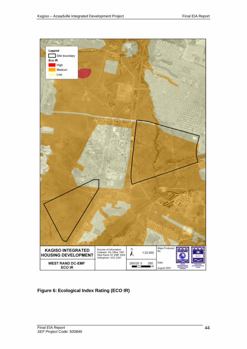
Kagiso – Azaadville Integrated Development Project Final EIA Report
Final EIA Report SEF Project Code: 500846
44
Figure 6: Ecological Index Rating (ECO IR)

Kagiso – Azaadville Integrated Development Project Final EIA Report
Final EIA Report SEF Project Code: 500846
45
Figure 7: Irreplaceable sites

Kagiso – Azaadville Integrated Development Project Final EIA Report
Final EIA Report SEF Project Code: 500846
46
Figure 8: Control zones
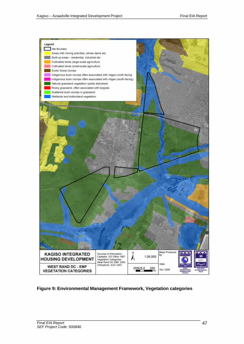
Kagiso – Azaadville Integrated Development Project Final EIA Report
Final EIA Report SEF Project Code: 500846
47
Figure 9: Environmental Management Framework, Vegetation categories
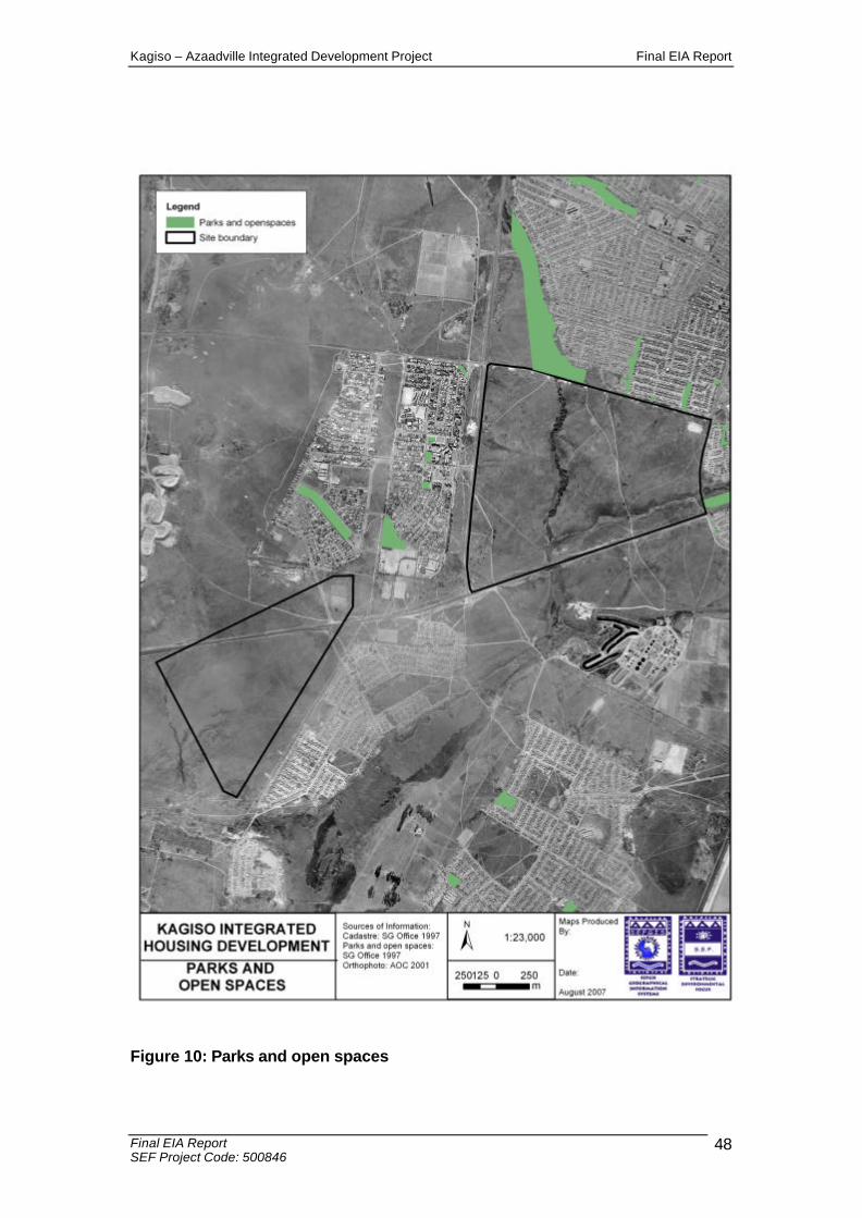
Kagiso – Azaadville Integrated Development Project Final EIA Report
Final EIA Report SEF Project Code: 500846
48
Figure 10: Parks and open spaces
Kagiso – Azaadville Integrated Development Project Final EIA Report
Final EIA Report SEF Project Code: 500846
49
B-2 SOCIAL ENVIRONMENT
B-2.1 Visual
The landscape of the study area is fairly flat with gently undulating hills and steep slopes. Due to the scale and nature of the proposed development, the visual impact of the development on surrounding communities will be quite significant. Large portions of both application properties can be seen from all cardinal directions. The Remainder of the Farm Kagiso 402 IQ is located directly adjacent to Azaadville and Kagiso. This property will impose the greatest visual impact on the current landscape. Screening elements such as trees and berms, can soften the visual impact this development will have on the major roads which border the subject properties. Internal landscaping and architectural design of the different components of the development, will positively contribute to the aesthetics of the area. The increased light source from the developments will significantly impact the study area at night. This aspect can however contribute to the deterrence of criminal activities. The establishment of a residential township of this nature, in the context of the surrounding land uses, is in line with the surrounding land uses. The establishment of a formal, well landscaped development will establish an improved aesthetic appeal to the area. The Kagiso-Azaadville development is planned to be unique; in as far as it will integrate beneficiaries with different income levels linked to different housing typologies. Furthermore it is envisaged as a development where a joint venture will take place between the Department of National Housing, Department of Provincial Housing, the Mogale City and ABSA to provide a combination of bonded and subsidised housing. The design of the Kagiso housing project was informed by a number of urban design principles, structured around the following aims: • Ensure a development, which is integrated with its surroundings and not an
exclusive enclave for a selected number of users; • Establish a clear understanding of what the public environment looks like and
how that can be translated into a sense of identity; • To create an environment that is both safe and secure; • To create an environment that promotes ease of movement and access for both
vehicular and pedestrian traffic; • Provide guidelines, which encourage developers, investors and owners can
expand their vision; • Identify lead projects and phasing methods to ensure a holistic approach through
the lifespan of the development; and
Kagiso – Azaadville Integrated Development Project Final EIA Report
Final EIA Report SEF Project Code: 500846
50
• Ensure a spatial model that is based on sustainable development scenarios that are feasible and socially acceptable.
B-2.2 Heritage Resources
As per the requirements of the National Heritage Resources Act, 1999 (Act 25 of 1999), it is necessary to identify elements of historical and cultural significance for possible conservation thereof. During the site visits undertaken by the environmental consultants, no evidence of historically significant elements were noted, ie. Graves, structures older than 60 years, stone age tools, etc. Doctor Johnny Van Schalkwyk from the National Cultural History Museum was appointed by SEF to conduct the Heritage Impact Assessment for the project. Please see Appendix 7 for the full specialist report. No evidence of historically significant elements was noted.
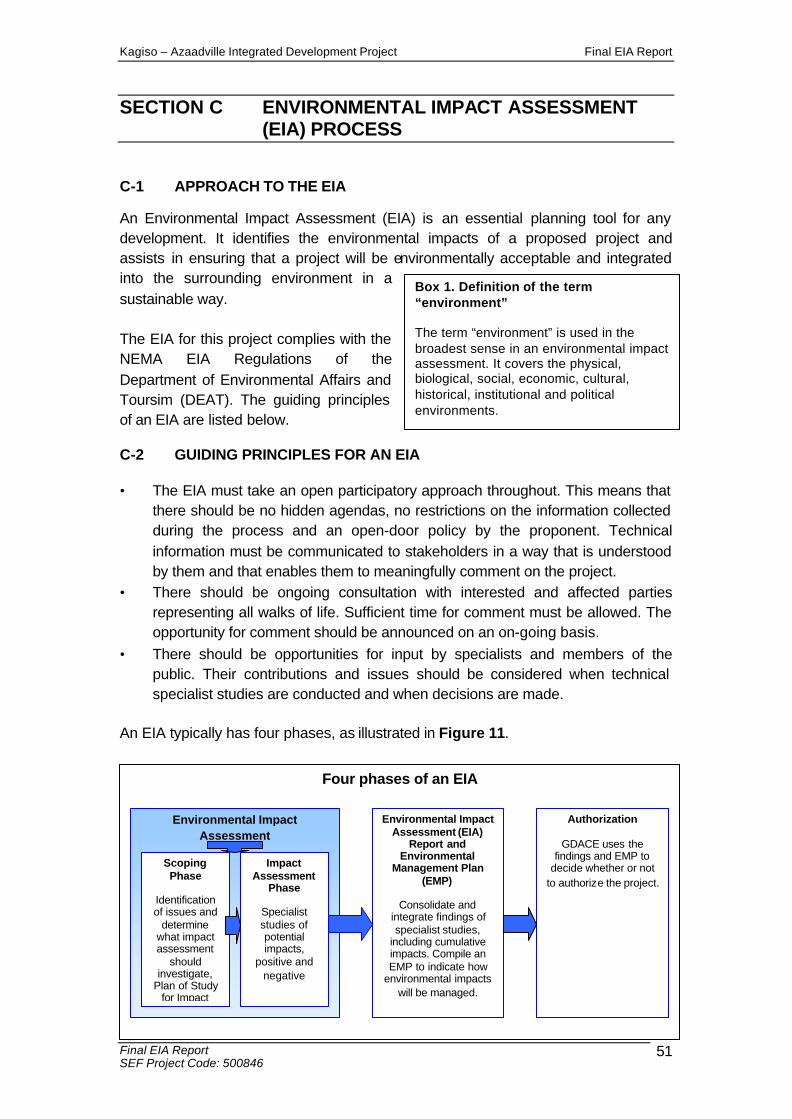
Kagiso – Azaadville Integrated Development Project Final EIA Report
Final EIA Report SEF Project Code: 500846
51
Box 1. Definition of the term “environment” The term “environment” is used in the broadest sense in an environmental impact assessment. It covers the physical, biological, social, economic, cultural, historical, institutional and political environments.
SECTION C ENVIRONMENTAL IMPACT ASSESSMENT (EIA) PROCESS
C-1 APPROACH TO THE EIA
An Environmental Impact Assessment (EIA) is an essential planning tool for any development. It identifies the environmental impacts of a proposed project and assists in ensuring that a project will be environmentally acceptable and integrated into the surrounding environment in a sustainable way. The EIA for this project complies with the NEMA EIA Regulations of the Department of Environmental Affairs and Toursim (DEAT). The guiding principles of an EIA are listed below.
C-2 GUIDING PRINCIPLES FOR AN EIA
• The EIA must take an open participatory approach throughout. This means that there should be no hidden agendas, no restrictions on the information collected during the process and an open-door policy by the proponent. Technical information must be communicated to stakeholders in a way that is understood by them and that enables them to meaningfully comment on the project.
• There should be ongoing consultation with interested and affected parties representing all walks of life. Sufficient time for comment must be allowed. The opportunity for comment should be announced on an on-going basis.
• There should be opportunities for input by specialists and members of the public. Their contributions and issues should be considered when technical specialist studies are conducted and when decisions are made.
An EIA typically has four phases, as illustrated in Figure 11.
Four phases of an EIA
Environmental Impact Assessment
Environmental Impact Assessment (EIA)
Report and Environmental
Management Plan (EMP)
Consolidate and
integrate findings of specialist studies,
including cumulative impacts. Compile an EMP to indicate how
environmental impacts will be managed.
Authorization
GDACE uses the findings and EMP to
decide whether or not to authorize the project.
Scoping Phase
Identification of issues and
determine what impact assessment
should investigate,
Plan of Study for Impact
Impact Assessment
Phase
Specialist studies of potential impacts,
positive and negative
Kagiso – Azaadville Integrated Development Project Final EIA Report
Final EIA Report SEF Project Code: 500846
52
C-3 EIA TECHNICAL PROCESS
The following section provides a summary of the technical process followed for this EIA.
C-3.1 Consultation with the Gauteng Department of Agriculture Conservation and Environment
Mogale City Local Municipality, BIGEN AFRICA engineers and SEF conducted an important application meeting with GDACE on the 16th August 2007. SEF and Mogale City Local Municipality informed GDACE about the proposed project. Specific requirements were established with the authorities prior to submission of the Scoping Report to the decision making authority.
The urgency of the application was impressed on the authority, and an understanding of co-operative assistance to achieve the best time frames for the project, was discussed. In order to ensure the best time frames were achieved on the application, SEF submitted an exemption application request to GDACE in October 2007. On behalf of the applicant, SEF requested that the review time frames for the public participation process, and the authority review time frames, were reduced. On the 21/11/2007, GDACE approved this exemption request. Please see Appendix 1 for the approval letter.
C-3.2 Application for authorization
An application for authorization, together with Strategic Environmental Focus’ declaration of independence, was submitted to the GDACE on the 6/7/2007.
C-3.3 Information gathering
Early in the EIA process, the technical specialists identified the information that would be required for the impact assessment and the relevant data started to be obtained. In addition, the specialists sourced available information about the receiving environment from GIS tools and systems, interested and affected parties, authority support tools, and pre-feasibility studies conducted for the development in 2005. The EIA team and specialists then visited the site to gain first-hand information and an understanding of the existing operations and the proposed project.
C-3.4 Specialist studies
The following specialist studies have been undertaken for the EIA:
• Ecological fauna and flora • Wetland delineation and Riparian functional assessment • Heritage Impact Assessment
Kagiso – Azaadville Integrated Development Project Final EIA Report
Final EIA Report SEF Project Code: 500846
53
C-4 PUBLIC PARTICIPATION PROCESS
The principles of NEMA govern many aspects of EIA’’s, including consultation with interested and affected parties (I&APs). These principles include the provision of sufficient and transparent information to I&APs on an ongoing basis, to allow them to comment, and ensuring the participation of historically disadvantaged individuals, including women, the disabled, and the youth.
C-4.1 Identification of interested and affected parties
Interested and affected parties (I&APs) representing the following sectors of society have been identified (see Appendix 2.7 for a complete I&AP distribution list): • National, provincial and local government • Agriculture, including local landowners • Community Based Organisations • Non-Governmental Organisations • Water bodies • Tourism • Industry and mining • Commerce • Historically disadvantaged groups, including women, youth and the disabled • Research • Other.
C-4.2 Public announcement of the project
The project was announced as follows: • Publication of a media advertisement in the local and regional newspaper, the
Randfontein Herald on the 19 July 2007. (Appendix 2.1 ). • On-site notices advertising the EIA have been placed at the following public
locations on 20 July 2007 (Appendix 2.3): - Corner of Kagiso Road and Randfontein Road R41 - T-Junction of Taj Mahal Drive (Azaadville) and the K13 - Corner of Badshani drive and Randfontein Road R41 - Corner of 1st Avenue and Randfontein Road R41
• Distribution of Background Information Documents and Registration and Comment sheets by hand delivery to I&APs on 27th July 2007 (Appendix 2.5)
• Hand-delivering flyers to directly affected I&APs and/or landowners on 27th July 2007 who could not be otherwise reached; and
• Making available the Draft Scoping Report at Azaadville Public Library in Azaadville and Kagiso Branch Library in Kagiso from 20/8/2007 to 20/9/2007.
Kagiso – Azaadville Integrated Development Project Final EIA Report
Final EIA Report SEF Project Code: 500846
54
• Making available the Draft Environmental Impact Assessment Report at Azaadville Public Library in Azaadville and Kagiso Branch Library in Kagiso from 10/1/2007 – 29/1/2007.
C-4.3 Meetings with I&APs
A focus group meeting was conducted with registered I&AP’s and ward councillors. Please see Annexure 2.10 for a list of the attendees at the meeting. This meeting was conducted at the ANC Caucus Room at the Mogale City Local Municipality, Municipal Offices, Cnr Market and Commissioner Streets, Krugersdorp. All registered parties, and the relevant Ward Councillors, were invited to the focus group meeting via fax (Annexure 2.9) and follow up telephone calls. The purpose of this meeting was to: • announce the proposed project and EIA • obtain their initial issues of concern, and • encourage their ongoing participation. Please see Annexure 2.11 for the minutes of this meeting. A public open house meeting will be arranged during the public review of the Draft EIA report. This public meeting will be dove-tailed with the Town planning open house meeting. Any comments / issues / concerns / objections raised, will be recorded and addressed in the final EIA report.
C-4.4 Raising issues for investigation by EIA specialists
I&APs have had the first opportunity to raise issues either in writing, by telephone or email. All the issues raised by I&APs during the scoping process have been captured in a Comment and Response Report (see Appendix 2.8) and I&APs received letters acknowledging their contributions.
C-4.5 Draft Scoping Report
All the issues raised to date were captured in the Draft Scoping Report which was made available in English. The EIA Regulations specify that I&APs must have an opportunity to verify that their issues have been captured. A period of 30 days was made available for public comment on the Draft Scoping Report. The availability of the Draft Scoping Report was announced via personal letters to all the registered I&APs on the distribution list. In addition, the Draft Scoping Report was distributed for comment as follows: • Placed in the Azaadville Public Library • Hand-delivered to the relevant authorities, ie. DWAF • Mailed to I&APs who requested copies
Kagiso – Azaadville Integrated Development Project Final EIA Report
Final EIA Report SEF Project Code: 500846
55
Public review of the Draft Scoping Report has been made available by the following methods: • Written notification to registered I&AP’s and Ward Councillors • Advertising
C-4.6 Final Scoping Report
The Final Scoping Report has been prepared, following the public review period of the draft Scoping Report. The review period of the draft Scoping Report commenced on the 20/8/2007 and ended on the 20/9/2007. The final Scoping Report has been updated with additional issues raised by I&APs and minutes from the Focus Group meeting.
C-4.7 Draft Environmental Impact Assessment Report
All the issues raised to date were captured in the Draft and final Scoping Reports. These reports were made available in English. The EIA Regulations specify that I&APs must have an opportunity to verify that their issues have been captured. A period of 30 days was made available for public comment on the Draft Scoping Report. The availability of the Draft Scoping Report was announced via personal letters to all the registered I&APs on the distribution list. The availability of the Draft Environmental Impact Assessment Report has been announced via personal letters to all the registered I&APs on the distribution list. The first letter was sent to the registered I&APs on the 7/12/2007. A reminder notice of the availability of the draft EIA report was sent to all I&APs on the 7/1/2008. In addition, the Draft Environmental Impact Assessment Report has been distributed for comment as follows: • Placed in the Azaadville Public Library from 10/1/2007 – 29/1/2007. • Hand-delivered to the relevant authorities, ie. DWAF • Mailed to I&APs who requested copies Public review of the Draft Environmental Impact Assessment Report has been made available by the following methods: • Written notification to registered I&AP’s and Ward Councillors
C-4.8 Public participation during the Impact Assessment Phase
Public participation during the Impact Assessment Phase of the EIA has revolved around a review of the findings of the EIA and inputs into the Environmental Management Plan (EMP). The findings have been presented in this Draft Environmental Impact Assessment Report and EMP and the volume of specialist studies.
Kagiso – Azaadville Integrated Development Project Final EIA Report
Final EIA Report SEF Project Code: 500846
56
SECTION D ASSESSMENT OF IMPACTS
D-1 IDENTIFICATION OF IMPORTANT ENVIRONMENTAL ISSUES
The key issues listed in the following section have been determined through the following avenues: § Views of interested and affected parties;
§ Legislation; and
§ Professional understanding of environmental assessment practitioners and specialist consultants
The potential impacts and key issues identified for the Kagiso-Azaadville Integrated/mixed use development include:
• Geological formations; • Soil erosion and pollution; • Stormwater management; • Catchment processes and Hydrological systems (including wetlands,
rivers, and associated aquatic systems);; • Soil and water (surface and groundwater) contamination; • Ecological biodiversity and functioning; • Air quality; • Heritage and culture; • Safety and security; • Infrastructure and services provision; • Traffic; • Socio economic; and • Landscape character / visual character;
This EIA report serves to assess the impacts of the key issues, as well as ascertain the cumulative impacts of the development in totality. This EIA report outlines the necessary mitigation measures, delineates sensitive areas containing species of conservation importance, and identifies habitats integral to the maintenance of ecosystem function.
Kagiso – Azaadville Integrated Development Project Final EIA Report
Final EIA Report SEF Project Code: 500846
57
D-2 ASSESSMENT METHODOLOGY
The identification and assessment of environmental impacts is a multi-faceted process, which combines quantitative and qualitative descriptions and evaluations. It involves the application of scientific measurements and professional judgement to determine the significance of environmental impacts associated with the proposed project. The process involves consideration of inter alia: the purpose and need for the project; views and concerns of interested and affected parties, general public interest; and environmental legislation and guidelines. The generic criteria and systematic approach used to identify, describe and assess impacts are outlined below. The assessment of the impacts will be conducted according to a synthesis of criteria required by the integrated environmental management procedure. a) Nature of impact
This is an appraisal of the type of effect the proposed activity would have on the affected environmental component. Its description should include receiving environment and how it is impacted. . Is the impact destructive, or benign?
b) Extent
The physical and spatial size of the impact, which is classified as:
i. Local: The impacted area extends only as far as the activity, e.g. a footprint of proposed activity.
ii. Site: The impact could affect the whole, or a measurable portion of the above mentioned property.
iii. Regional: The impact could affect the area including the neighbouring farms the transport routes and the adjoining towns.
c) Duration The lifetime of the impact; this is measured in the context of the life-time of the proposed base. i. Short term (0-5 years):
The impact will either disappear with mitigation or will be mitigated through natural process in a span shorter than any proposed phases.
ii. Medium term (5-15 years): The impact will last up to the end of the phases, where after it will be entirely negated.

Kagiso – Azaadville Integrated Development Project Final EIA Report
Final EIA Report SEF Project Code: 500846
58
iii. Long term (duration of operation): The impact will continue or last for the entire operational life of the development, but will be mitigated by direct human action or by natural processes thereafter.
iv. Permanent: The only class of impact, which is considered non transitory. Mitigation, either by man or natural process, will not occur in such a way or in such a time span that the impact can be considered transient.
d) Intensity This will be a relative evaluation within the context of all the activities and the other impacts within the framework of the project. Does it destroy the impacted environment, alter its functioning, or render it slightly altered? These are rated as: i. None:
No known impacts ii. Low:
The impact alters the affected environment in such a way that the natural processes or functions are not affected.
iii. Medium: The affected environment is altered, but function and process continue, albeit in a modified way.
iv. High: Function or process of the affected environment is disturbed to the extent that it temporarily or permanently ceases.
e) Probability This describes the likelihood of the impacts actually occurring. The impact may occur for any length of time during the life cycle of the activity, and not at any given time. The classes are rated as follows: i. Improbable
The possibility of the impact occurring is very low, due to the circumstances, design or experience.
ii. Probable There is a possibility that the impact will occur to the extent that provisions must be made to mitigate the impacts.
iii. Highly probable It is most likely that the impacts will occur at some or other stage of the development. Plans must be drawn up before the undertaking of the activity.
iv. Definite The impact will take place regardless of any prevention plans, and thus mitigatory actions or contingency plans must be relied on to contain the effect.
Kagiso – Azaadville Integrated Development Project Final EIA Report
Final EIA Report SEF Project Code: 500846
59
f) Determination of significance Significance is determined through a synthesis of impact characteristics. Significance is an indication of the importance of the impact in terms of both physical extent and time scale and therefore indicates the level of mitigation required. The classes are rated as follows: i. No significance
The impact is not substantial and does not require any mitigatory action. ii. Low
The impact is of minimal importance, but may require limited mitigation. iii. Medium
The impact is of importance and therefore considered to have a negative impact. Mitigation is required to reduce the negative impacts to acceptable levels.
iv. High The impact is of great importance. Failure to mitigate, with the objective reducing the impact to acceptable levels, could render the entire development option or entire project proposal unacceptable. Mitigation is therefore essential.

Kagiso – Azaadville Integrated Development Project Final EIA Report
Final EIA Report SEF Project Code: 500846
60
D-3 SUMMARY OF ANTICIPATED IMPACTS
Table 3: Summary of anticipated impacts as identified Environmental
Aspect Relevant
Area Environmental Objective Potential Impacts Additional Investigations Potential Mitigation
PHYSICAL
Geological Instability of Site Site
To insure the area is stabilised during construction, and operations.
Collapse of site during construction, and operation. Potential loss of development space due to undermining.
Geotechnical Assessment Buffer potentially collapsible areas. Increased support structures during construction.
Surface and ground water
Regional
To ensure that the drainage lines, associated river systems, and other surrounding water resources are not adversely affected to the detriment of the environment and the surrounding communities; To prevent the disruption of catchment processes and functioning; To minimise erosion; and to Prevent surface and water contamination.
Disruption of habitats through development; Disruption of natural drainage patterns; Altered flow regimes as a result of hardened surfaces; and Potential contamination of surface and groundwater through the use of chemicals associated with maintenance and slimes dams contamination.
Wetland Assessment
No development within the 1:100 year floodlines, 100 m from drainage channels and 50 m around wetlands; and Stormwater Management Plan must be developed and implemented.
Wetlands Regional
To ensure that the Wonderfonteinspruit and other surrounding water resources are not adversely affected to the detriment of the environment and the surrounding communities; To prevent the disruption of catchment processes and functioning; To minimise erosion; and to prevent further surface and water contamination from near by mining activities. To ensure that the proposed drainage line crossings (bridges) are consistent with
Disruption of habitats through development; Disruption of natural drainage patterns; Altered flow regimes as a result of hardened surfaces; and Potential contamination of surface and groundwater, as well as soils due to nearby mining activities.
Ecological Assessment; Wetland Delineation Study; Water Use License Application.
Appropriate no-development buffers around water courses, floodlines and wetlands. Use of biologically degradable herbicides and insecticides and/or biological control; and Stormwater Management Plan must be developed and implemented. Lay out consisting of public open spaces around un-developable land.
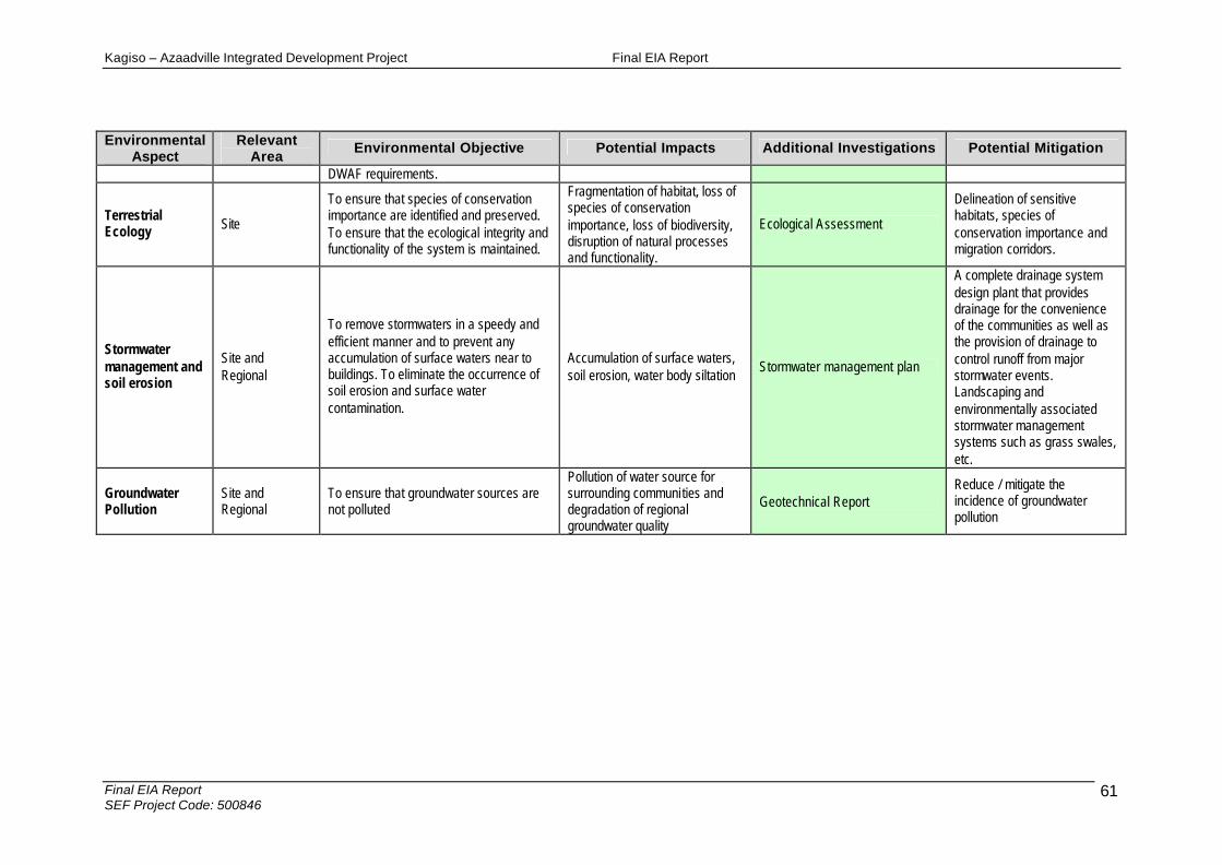
Kagiso – Azaadville Integrated Development Project Final EIA Report
Final EIA Report SEF Project Code: 500846
61
Environmental Aspect
Relevant Area
Environmental Objective Potential Impacts Additional Investigations Potential Mitigation
DWAF requirements.
Terrestrial Ecology Site
To ensure that species of conservation importance are identified and preserved. To ensure that the ecological integrity and functionality of the system is maintained.
Fragmentation of habitat, loss of species of conservation importance, loss of biodiversity, disruption of natural processes and functionality.
Ecological Assessment
Delineation of sensitive habitats, species of conservation importance and migration corridors.
Stormwater management and soil erosion
Site and Regional
To remove stormwaters in a speedy and efficient manner and to prevent any accumulation of surface waters near to buildings. To eliminate the occurrence of soil erosion and surface water contamination.
Accumulation of surface waters, soil erosion, water body siltation
Stormwater management plan
A complete drainage system design plant that provides drainage for the convenience of the communities as well as the provision of drainage to control runoff from major stormwater events. Landscaping and environmentally associated stormwater management systems such as grass swales, etc.
Groundwater Pollution
Site and Regional
To ensure that groundwater sources are not polluted
Pollution of water source for surrounding communities and degradation of regional groundwater quality
Geotechnical Report Reduce / mitigate the incidence of groundwater pollution
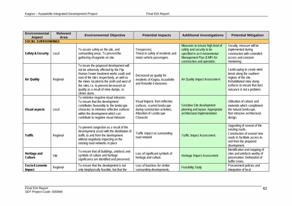
Kagiso – Azaadville Integrated Development Project Final EIA Report
Final EIA Report SEF Project Code: 500846
62
Environmental Aspect
Relevant Area
Environmental Objective Potential Impacts Additional Investigations Potential Mitigation
SOCIAL SURROUNDINGS
Safety & Security Local To assure safety on the site, and surrounding areas. To prevent the gathering of vagrants on site.
Trespassers; Threat to safety of residents and motor vehicle passengers.
Measures to ensure high level of safety and security to be specified in an Environmental Management Plan (EMP) for construction and operation.
Security measure will be implemented during construction with controlled access and constant monitoring.
Air Quality Regional
To insure the proposed development will not be adversely affected by the Flip Human Sewer treatment works south and east of the site s respectively, as well as the mines located to the north and west of the sites, i.e. to prevent decreased air quality as a result of mine dumps, or slimes dams.
Decreased air quality for residents of Kagiso, Azaadville and Retvallei Extensions.
Air Quality Impact Assessment
Landscaping to create wind break along the southern regions of the site. Rehabilitated mine dump surfaces to ensure that duct nuisance is not a problem.
Visual aspects Local
To minimise negative visual intrusion; To ensure that the development contributes favourably to the landscape character; to minimise reflective surfaces within the development which can contribute to negative visual intrusion
Visual Impacts from reflective surfaces, scarred landscape during construction activities; Alteration of Landscape Character
Sensitive Site development planning and layout. Appropriate architectural implementation
Utilisation of colours and materials which compliment the natural landscape. Non intrusive architectural design.
Traffic Regional
To prevent congestion as a result of the development, assist with the distribution of traffic to and from the development without negatively impacting on the existing road networks in place
Traffic impact on surrounding road network Traffic Impact Assessment
Upgrading of several of the existing roads. Construction of several new roads to facilitate access to and from the proposed development.
Heritage and Culture Site
To ensure that all buildings, artefacts and symbols of culture and heritage significance are identified and preserved.
Loss of significant symbols of heritage and culture. Heritage Impact Assessment
Identification and mapping of sites and artefacts worthy of preservation. Delineation of buffer zones.
Socio-Economic Impact
Regional To ensure that the development is not only biophysically feasible, but that the
Loss of business for similar surrounding developments.
Feasibility Study Procurement policies and integration of local

Kagiso – Azaadville Integrated Development Project Final EIA Report
Final EIA Report SEF Project Code: 500846
63
Environmental Aspect
Relevant Area
Environmental Objective Potential Impacts Additional Investigations Potential Mitigation
socio economic impacts of the development on the surrounding communities is not negative. To assure that the development is sustainable through community upliftment and involvement as well as the procurement of local people; To generate revenue for the local eco-tourism industry; Employment, transfer of skills and training.
Increased economic benefits for the surrounding areas. Employment, Social upliftment; Increased investments in the area.
communities.
Infrastructure & Service Provision Regional
To ensure the environment is least effected by the provision of municipal services, e.g. waste disposal, sewerage, water, electricity etc.
Poor implementation and management of internal services and the links up to current bulk supplies in the area. Soil, surface and ground water contamination due to leakages, burst pipes, over capacitated facilities, etc.
Civil Services Report
Capacity of the Municipal services to be determined, and where necessary construction of increased infrastructure to accommodate such services.
Kagiso – Azaadville Integrated Development Project Final EIA Report
Final EIA Report SEF Project Code: 500846
64
D-4 IMPACT ASSESSMENT
The following specialist studies were undertaken during the EIA phase of the process, in order to assist with the development of an understanding of the system processes and the potential impacts of the proposed development on both the social and biophysical environments:
1. Geological investigations; 2. Ecological Assessment; 3. Riparian delineation and Assessment; and 4. Heritage Assessment;
4.0 DETAILED IMPACT ASSESSMENT
4.1 Soil
4.1.1 Loss of a valuable natural resource – topsoil
Source of the impact: Stripping, stockpiling and handling of topsoil The risk sources can be considered as follows:
• Topsoil stockpiles with depths exceeding two (2) metres, results in the formation of anaerobic conditions and the subsequent reduction of aerobic microbial activity;
• Significant soil compaction could occur as a result of vehicular movement; • Restriction of water infiltration and resultant loss of growth potential within the
soil; • Breakdown of the soil structure occurs when the soil is worked while it is too
moist (i.e. with a moisture content of more than 12%), rendering the soil unsuitable for rehabilitation;
• Soil erosion; and • Soil contamination
Description of the impact: Stockpiles exceeding two (2) metre in height/depth The depth of the stockpile and the length of time it is stored affects the quality of the soil at replacement; and thereby presents the greatest risk to future rehabilitation. The natural process of soil development can take hundreds of years. Stockpiled topsoil becomes highly degraded the moment this structure is disturbed. Research indicates that the most damage occurs when topsoil is initially stripped from the ground. Table 4 explains the effects that can be expected from the stripping of soil, as well as the incorrect stockpiling of soil.

Kagiso – Azaadville Integrated Development Project Final EIA Report
Final EIA Report SEF Project Code: 500846
65
Soil compaction Soil compaction occurs when soil particles are pressed together, thereby reducing pore spaces between the soil particles. According to DeJongh-Hughes, Moncrief, Voorhees and Swan (2001) up to 80% of soil compaction occurs with the first pass of a vehicle. Furthermore, axle loads exceeding 10 tons per axle – as is the case for the majority of earthmoving equipment and batching plant – can result in soil compaction in excess of 50 cm depths (DeJongh-Hughes et al., 2001). As natural vegetation must be re-established in all areas other than the actual building footprint, it is imperative that compaction is minimised through the single handling of soil as well as limited vehicular movement. Mixing of the subsoil and the topsoil layers Earthworks will involve the removal and storage of the topsoil and in certain cases the subsoil layers. The combination of the top and subsoil layers despite its radically different physical and chemical properties will create difficulty with the rehabilitation of the vegetation. The subsoil layers lack the organic and microbial organisms necessary to sustain plants. Thus, all efforts must be made to separate the top and subsoils.
Table 4: Impacts on soil resulting from stripping / stockpiling
Action Impact Reference
Stripping soil
• Increased bulk density • Decreased water holding capacity • Chemical changes • Reduced nutrient cycling • Reduced microbial activity • Loss of viable plant remnants and seeds
Strohmayer (1999)
• Varying moisture levels within the stockpile, which limits soil microbial respiration, causing reduced microbial communities
Strohmayer (1999)
Topsoil stripping • Remediation of damage may require extended periods of time
• Damaged sites that return to relatively healthy status may not return to their pristine states
Sims (1990)
Stockpiles > 2 m deep
• Accumulation of ammonium • Formation of anaerobic conditions at
pile base, resulting in the following: o Increased microbial competition o Major drop in microbial
community o Decreased nutrient cycling
Harris and Birch (1989)

Kagiso – Azaadville Integrated Development Project Final EIA Report
Final EIA Report SEF Project Code: 500846
66
o Decrease in carbon • Decrease in viability of buried seeds • Absence of propagules • Moisture problems created by saturation
and desiccation • Limiting soil microbial respiration,
causing loss in microbial community
Strohmayer (1999)
• Immediate drop in carbon levels by as much as 30%
Visser et al. (1984)
• Cessation of nutrient input, resulting in a loss of organic material
Jordon (1998)
Stockpiling
• Marked drop in earthworm populations Johnson et al. (1991)
Compaction / waterlogging
• Establishment of anaerobic conditions, and
• Subsequent loss of aerobic microbial communities
Sims (1990)
Pollution Pollution may potentially result from the operation activity in the form of litter and fuel spills. During construction, earth-moving vehicles, generators, batching plant or other machinery are brought onto site. The machinery may leak fuel / oil and diesel, which infiltrates into the soils of the area impacting on the surrounding environment. Furthermore, people working on site, generate litter. Significance of impact: Stockpiling of topsoil, soil compaction and mixing of top and sub-soils The above-mentioned activities will occur within the confines of the development nodes only. The intensity of the impacts is rated as medium, as biological processes occurring within the soil will be temporarily impeded. The impact will occur over a short to medium term and the probability of the impact occurring is definite. Therefore, the weighting factor is rated as medium to high, which results in a significance rating of medium. The mitigation efficiency is rated as medium because the prescribed mitigation measures will be effective in reducing the impact significance. Therefore the significance of the impact, after implementation of mitigation measures, is rated as low to medium. Pollution Pollution of the soil will be restricted to the boundaries of the site only and the intensity thereof is calculated as medium, because the ecological processes on site will continue, even in a modified way. The duration of the impact is highly likely to occur over a short to medium period as it will last during the construction phase only. The weighting factor is rated at medium because of the likelihood of the impact
Kagiso – Azaadville Integrated Development Project Final EIA Report
Final EIA Report SEF Project Code: 500846
67
occurring as well as the medium intensity of the soil pollution. The significance of the impact is therefore calculated as low to medium. The mitigation efficiency is medium because the prescribed mitigation measures will be effective in reducing the impact significance. Therefore, the significance of the impact, after implementation of the mitigation measures, is rated as low. All Mitigation measures: 1. All possible efforts must be made by the contractors to strip topsoil to a maximum
depth of 150 mm. 2. Topsoil stockpiles must be kept as small as possible in order to prevent
compaction and the formation of anaerobic conditions. 3. Topsoil must be stockpiled for the shortest possible timeframes in order to ensure
that the quality of the topsoil is not impaired. 4. Topsoil must not be handled when the moisture content exceeds 12%. 5. Topsoil stockpiles must be kept separate from subsoils. 6. Excavated and stockpiled soil material must be stored and bermed on the higher
lying areas of the footprint area and not in any storm water run-off channels or any other areas where it is likely to cause erosion, or where water would naturally accumulate.
7. The topsoil should be replaced as soon as possible on to the backfilled areas, thereby allowing for the regrowth of the seed bank contained within the topsoil.
8. Stockpiles susceptible to wind erosion must be covered during windy periods. 9. Refuelling must take place in well demarcated areas and over suitable drip trays
to prevent soil pollution. 10. Spill kits to clean up accidental spills from earthmoving machinery must be well-
marked and readily available on site. 11. Workers must undergo induction to ensure that they are aware and prepared for
rapid clean-up procedures.
Table 5: Stockpiling of topsoil, soil compaction and mixing of top and subsoils
Activity Stockpiling of topsoil
Nature of the impact
Loss of topsoil capability through handling and incorrect stockpiling Vehicular compaction of soils
Status -
Receiving environment Edaphic environment
Extent (footprint; site; regional; national; international) SITE Intensity (low; med; high) MEDIUM Duration (short; short-med; medium; long; permanent) LONG Magnitude Probability (Improbable; possible; likely; highly likely; definite)
DEFINITE
Weighting factor (WF)
WF (low; low-med; medium; med-high; high) MEDIUM -HIGH
Mitigation Efficiency (ME)
ME (high; med-high; medium; low-med; low) MEDIUM
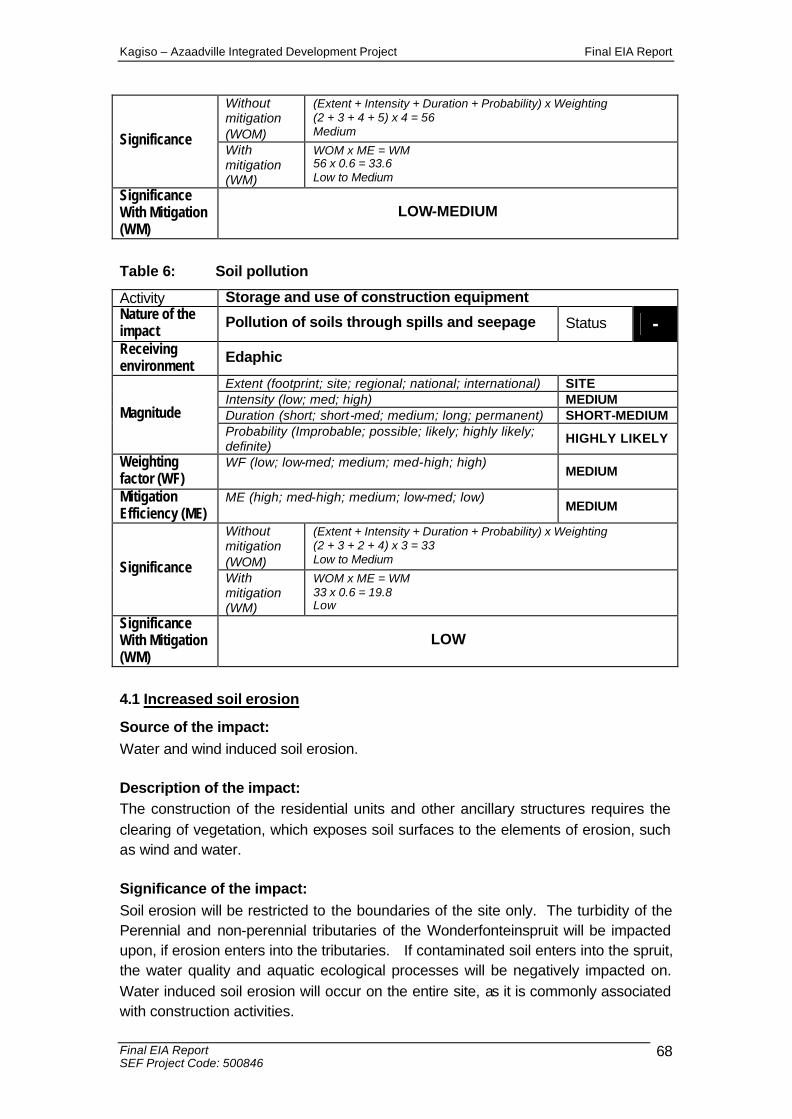
Kagiso – Azaadville Integrated Development Project Final EIA Report
Final EIA Report SEF Project Code: 500846
68
Without mitigation (WOM)
(Extent + Intensity + Duration + Probability) x Weighting (2 + 3 + 4 + 5) x 4 = 56 Medium Significance
With mitigation (WM)
WOM x ME = WM 56 x 0.6 = 33.6 Low to Medium
Significance With Mitigation (WM)
LOW-MEDIUM
Table 6: Soil pollution
Activity Storage and use of construction equipment Nature of the impact Pollution of soils through spills and seepage Status - Receiving environment Edaphic
Extent (footprint; site; regional; national; international) SITE Intensity (low; med; high) MEDIUM Duration (short; short-med; medium; long; permanent) SHORT-MEDIUM Magnitude Probability (Improbable; possible; likely; highly likely; definite)
HIGHLY LIKELY
Weighting factor (WF)
WF (low; low-med; medium; med-high; high) MEDIUM
Mitigation Efficiency (ME)
ME (high; med-high; medium; low-med; low) MEDIUM
Without mitigation (WOM)
(Extent + Intensity + Duration + Probability) x Weighting (2 + 3 + 2 + 4) x 3 = 33 Low to Medium Significance
With mitigation (WM)
WOM x ME = WM 33 x 0.6 = 19.8 Low
Significance With Mitigation (WM)
LOW
4.1 Increased soil erosion
Source of the impact: Water and wind induced soil erosion. Description of the impact: The construction of the residential units and other ancillary structures requires the clearing of vegetation, which exposes soil surfaces to the elements of erosion, such as wind and water. Significance of the impact: Soil erosion will be restricted to the boundaries of the site only. The turbidity of the Perennial and non-perennial tributaries of the Wonderfonteinspruit will be impacted upon, if erosion enters into the tributaries. If contaminated soil enters into the spruit, the water quality and aquatic ecological processes will be negatively impacted on. Water induced soil erosion will occur on the entire site, as it is commonly associated with construction activities.
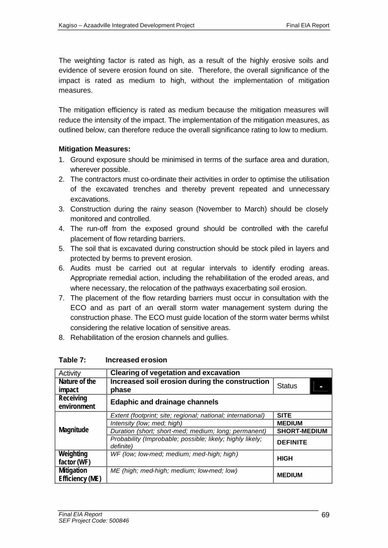
Kagiso – Azaadville Integrated Development Project Final EIA Report
Final EIA Report SEF Project Code: 500846
69
The weighting factor is rated as high, as a result of the highly erosive soils and evidence of severe erosion found on site. Therefore, the overall significance of the impact is rated as medium to high, without the implementation of mitigation measures. The mitigation efficiency is rated as medium because the mitigation measures will reduce the intensity of the impact. The implementation of the mitigation measures, as outlined below, can therefore reduce the overall significance rating to low to medium. Mitigation Measures: 1. Ground exposure should be minimised in terms of the surface area and duration,
wherever possible. 2. The contractors must co-ordinate their activities in order to optimise the utilisation
of the excavated trenches and thereby prevent repeated and unnecessary excavations.
3. Construction during the rainy season (November to March) should be closely monitored and controlled.
4. The run-off from the exposed ground should be controlled with the careful placement of flow retarding barriers.
5. The soil that is excavated during construction should be stock piled in layers and protected by berms to prevent erosion.
6. Audits must be carried out at regular intervals to identify eroding areas. Appropriate remedial action, including the rehabilitation of the eroded areas, and where necessary, the relocation of the pathways exacerbating soil erosion.
7. The placement of the flow retarding barriers must occur in consultation with the ECO and as part of an overall storm water management system during the construction phase. The ECO must guide location of the storm water berms whilst considering the relative location of sensitive areas.
8. Rehabilitation of the erosion channels and gullies.
Table 7: Increased erosion
Activity Clearing of vegetation and excavation Nature of the impact
Increased soil erosion during the construction phase Status -
Receiving environment Edaphic and drainage channels
Extent (footprint; site; regional; national; international) SITE Intensity (low; med; high) MEDIUM Duration (short; short-med; medium; long; permanent) SHORT-MEDIUM Magnitude Probability (Improbable; possible; likely; highly likely; definite)
DEFINITE
Weighting factor (WF)
WF (low; low-med; medium; med-high; high) HIGH
Mitigation Efficiency (ME)
ME (high; med-high; medium; low-med; low) MEDIUM

Kagiso – Azaadville Integrated Development Project Final EIA Report
Final EIA Report SEF Project Code: 500846
70
Without mitigation (WOM)
(Extent + Intensity + Duration + Probability) x WF (2 + 3 + 2 + 5) x 5 = 60 Medium to High Significance
With mitigation (WM)
WOM x ME = WM 60 x 0.6 = 36 Low to Medium
Significance With Mitigation (WM)
LOW-MEDIUM
4.2 Terrestrial Ecology
4.2.1 Impact on Natural Habitat: Construction Phase
Source of the impact: The following activities will contribute to a negative impact on habitat on the site: • The construction of roads, construction of all proposed infrastructure, installation
of bulk services; and • The clearing of vegetation / habitat for the spoil areas, materials storage and
topsoil stockpiles. Description of the impact: Construction activities on site will impact on the natural habitat within which ecological systems and processes operate. Individual herpetofauna might be injured or killed when the sites are cleared and/or transformed. The fauna located underground or in retreats might also be affected by the earthmoving equipment used during construction / clearing. Animals that have temporarily migrated, as a result of foraging induced behavioural patterns, will be affected, since they either move into areas that will be affected by construction activities, or will not be able to return to their original habitat. Significance: The permanence and definite occurrence of the impact on the habitat for individual species and ecological processes renders the impact significance high. The weighting factor is rated as high, as the impact on the habitat and the potential disruption of ecological processes is irreversible. The mitigation efficiency is rated as low to medium as the probability of the impact and the permanent duration of the impact, will not be minimised by the specified mitigation measures. The mitigation measures will serve to minimise the extent of the impact, and therefore the significance rating of the impact. The implementation of mitigation measures will reduce the impact from high to medium to high. Mitigation Measures: 1. Minimise the footprint of transformation; 2. Steep gradients coupled with pristine vegetation should not form part of the
proposed layout.

Kagiso – Azaadville Integrated Development Project Final EIA Report
Final EIA Report SEF Project Code: 500846
71
Table 8: Impact on Natural Habitat: Construction Phase
Activity Construction of activities related to the development Nature of the impact Impact on natural habitat Status - Receiving environment Faunal habitat
Extent (footprint; site; regional; national; international) SITE Intensity (low; med; high) HIGH Duration (short; short-med; medium; long; permanent) PERMANENT Magnitude Probability (Improbable; possible; likely; highly likely; definite)
DEFINITE
Weighting factor (WF)
WF (low; low-med; medium; med-high; high) HIGH
Mitigation Efficiency (ME)
ME (high; med-high; medium; low-med; low) LOW-MEDIUM
Without mitigation (WOM)
(Extent + Intensity + Duration + Probability) x Weighting (2 + 5 + 5 + 5) x 5 = 85 High Significance
With mitigation (WM)
WOM x ME = WM 85 x 0.8 = 68 Medium to High
Significance With Mitigation (WM)
MEDIUM-HIGH
4.2.2 Impact on Natural Habitat: Operational Phase
Source of the impact: The impact on the habitat will be exacerbated during the operation phase, in the event that the following aspects occur: • The introduction of exotic plant species; and • The installation of fences and walls (internal boundaries) Description of the impact: Exotic species create habitat types that are not conducive to the indigenous species presently occurring on site. Thus, the creation of an artificial habitat does not support the persistence of naturally occurring species and ecological processes. Walls and fences hinder faunal migration patterns, which negatively impact on life cycles, as migration is often driven by different requirements within the life cycles. Significance of the impact: The weighting factor of the impact is rated as high as a result of the high intensity of such an impact, the permanent duration of the impact as well as the definite occurrence of the impact. The impact on the habitat will be limited to the site boundaries within the development nodes. The impact will have permanent consequences. Once the habitat is impacted on, it is unlikely that it can be restored to its original character and function. In the event that the habitat is restored, the possibility of the fauna returning to the area is highly unlikely. The intensity of this

Kagiso – Azaadville Integrated Development Project Final EIA Report
Final EIA Report SEF Project Code: 500846
72
impact is therefore rated as high. As a result of construction activities, the reduction of habitat is inevitable and in the absence of mitigation measures, the significance of such an impact is rated as high. The mitigation efficiency is rated as medium as this will reduce the habitat in the areas of construction only, and not in peripheral areas on the site. Modifications to the design of the site will also facilitate movement of fauna (including herpetofauna). Thus, the significance of the impact after mitigation measures are implemented is rated as medium. Mitigation Measures: 1. Palisade fencing can be fauna friendly;
Table 9: Impact on Natural Habitat: Operational Phase
Activity The introduction of exotic plant species Installation of fences and walls / internal boundaries
Nature of the impact Impact on natural habitat Status - Receiving environment Natural Habitat
Extent (footprint; site; regional; national; international) SITE Intensity (low; med; high) HIGH Duration (short; short-med; medium; long; permanent) PERMANENT Magnitude Probability (Improbable; possible; likely; highly likely; definite)
DEFINITE
Weighting factor (WF)
WF (low; low-med; medium; med-high; high) HIGH
Mitigation Efficiency (ME)
ME (high; med-high; medium; low-med; low) MEDIUM
Without mitigation (WOM)
(Extent + Intensity + Duration + Probability) x Weighting (1 + 5 + 5 + 4) x 5 = 75 High Significance
With mitigation (WM)
WOM x ME = WM 75 x 0.6 = 45 Medium
Significance With Mitigation (WM)
MEDIUM

Kagiso – Azaadville Integrated Development Project Final EIA Report
Final EIA Report SEF Project Code: 500846
73
4.2.2.1 Impact on natural habitat
Source of the impact: The transformation of natural habitats to residential units or associated infrastructure will result in the loss of habitat, thereby affecting individual species as well as ecological processes. Description of the impacts: Appropriate mitigation measures such as the implementation of buffer zones around rocky outcrops and wetland areas will go a long way to ensuring that important ecological processes are kept intact and functional. It is inevitable that a predicted loss of faunal habitat and ecological function will occur. Significance of the impacts: The impact will have different levels of significance for avifauna, mammals and herpetofauna, but the overall significance is rated as high, as a result of the irreversibility of the impact. The weighting factor is rated as medium to high as a result of the permanent nature and degree of habitat transformation. Therefore, the overall significance of the impact is rated as medium to high, without the implementation of mitigation measures. The mitigation efficiency is rated as low because the mitigation measures can only marginally reduce the intensity of the impact. Mitigation Measures: 1. Development is not permissible within the 1;100 year floodline and it is
recommended that a buffer zone allocated from the edge of the riparian zone be enforced on site;.
2. Development in close proximity to the rocky outcrops.should be placed at least 10m from any prominent outcrop and preferably on level ground. The proposed development should not impede on any drainage line or any natural area bordering an impoundment. These areas should be protected by a natural buffer area.
3. All stormwater management features should be constructed in a manner that will ensure the continued functioning of the natural drainage lines on the study site. Stormwater management should not impede or divert surface water flow, as any changes in surface water flow quality or quantity have significant impacts on associated animal groups; If any subterranean or fossorial reptile species are found during the construction phase, this species must be relocated to the nearest conservation area or natural open space with suitable habitat for the particular species to continue its life history; and
4. All construction activities should be limited to daylight hours. 5. Careful consideration is required when planning the placement for stockpiling
construction material, topsoil and the creation of access routes in order to avoid

Kagiso – Azaadville Integrated Development Project Final EIA Report
Final EIA Report SEF Project Code: 500846
74
the destruction of pristine habitats and minimise the overall development footprint.
6. The appointment of a full time ECO must render guidance to the contractors with respect to suitable areas for all construction related disturbance.
Table 10: Impact on Natural Habitat
Activity Complete loss of habitat arising from construction activities Nature of the impact Loss of natural habitat Status -
Receiving environment
Fauna Flora Extent (footprint; site; regional; national; international) SITE Intensity (low; med; high) HIGH Duration (short; short-med; medium; long; permanent) PERMANENT Magnitude Probability (Improbable; possible; likely; highly likely; definite)
DEFINITE
Weighting factor (WF)
WF (low; low-med; medium; med-high; high) MEDIUM -HIGH
Mitigation Efficiency (ME)
ME (high; med-high; medium; low-med; low) LOW
Without mitigation (WOM)
(Extent + Intensity + Duration + Probability) x Weighting (2 + 5 + 5 + 5) x 4 = 68 Medium-high Significance
With mitigation (WM)
WOM x ME = WM 68 x 1 = 68 Medium-high
Significance With Mitigation (WM)
MEDIUM-HIGH

Kagiso – Azaadville Integrated Development Project Final EIA Report
Final EIA Report SEF Project Code: 500846
75
4.3 Vegetation clearance
Source of the impact: Removal of vegetation for construction purposes. Description of the impact: The construction of the residential units and other ancillary structures, require the clearance of vegetation. The moist grassland present on the site is located within the riparian buffer zones and is of significant importance for the site. Significance of the impact: The weighting factor is rated as medium to high as a result of the permanent nature of the impact. Therefore, the overall significance of the impact is rated as medium to high, without the implementation of mitigation measures for the moist grasslands. These units are important for ecological function and conservation value. The significance of the impacts on other plant assemblages is low, as a result of their anthropogenic nature, low conservation importance or low ecological function. The mitigation efficiency is rated as medium to high because the mitigation measures will reduce the intensity of the impact. The implementation of the mitigation measures, as outlined below, can therefore reduce the overall significance rating to low. Mitigation Measures: 1. Development should be guided by an adequate buffer zone, from any natural
watercourse; 2. Natural corridors must be retained where possible to promote movement of
fauna, especially during the construction phase when a high rate of natural disruption is expected.
Table 11: Vegetation Clearance
Activity Clearing of vegetation Nature of the impact
Loss of unique plant assemblages Status -
Receiving environment
Flora Fauna Extent (footprint; site; regional; national; international) SITE Intensity (low; med; high) HIGH Duration (short; short-med; medium; long; permanent) PERMANENT Magnitude Probability (Improbable; possible; likely; highly likely; definite)
DEFINITE
Weighting factor (WF)
WF (low; low-med; medium; med-high; high) MEDIUM -HIGH
Mitigation Efficiency (ME)
ME (high; med-high; medium; low-med; low) MEDIUM
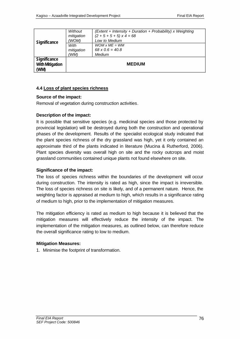
Kagiso – Azaadville Integrated Development Project Final EIA Report
Final EIA Report SEF Project Code: 500846
76
Without mitigation (WOM)
(Extent + Intensity + Duration + Probability) x Weighting (2 + 5 + 5 + 5) x 4 = 68 Low to Medium Significance
With mitigation (WM)
WOM x ME = WM 68 x 0.6 = 40.8 Medium
Significance With Mitigation (WM)
MEDIUM
4.4 Loss of plant species richness
Source of the impact: Removal of vegetation during construction activities. Description of the impact: It is possible that sensitive species (e.g. medicinal species and those protected by provincial legislation) will be destroyed during both the construction and operational phases of the development. Results of the specialist ecological study indicated that the plant species richness of the dry grassland was high, yet it only contained an approximate third of the plants indicated in literature (Mucina & Rutherford, 2006). Plant species diversity was overall high on site and the rocky outcrops and moist grassland communities contained unique plants not found elsewhere on site. Significance of the impact: The loss of species richness within the boundaries of the development will occur during construction. The intensity is rated as high, since the impact is irreversible. The loss of species richness on site is likely, and of a permanent nature. Hence, the weighting factor is appraised at medium to high, which results in a significance rating of medium to high, prior to the implementation of mitigation measures. The mitigation efficiency is rated as medium to high because it is believed that the mitigation measures will effectively reduce the intensity of the impact. The implementation of the mitigation measures, as outlined below, can therefore reduce the overall significance rating to low to medium. Mitigation Measures: 1. Minimise the footprint of transformation.
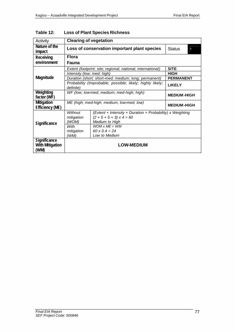
Kagiso – Azaadville Integrated Development Project Final EIA Report
Final EIA Report SEF Project Code: 500846
77
Table 12: Loss of Plant Species Richness
Activity Clearing of vegetation Nature of the impact
Loss of conservation important plant species Status -
Receiving environment
Flora Fauna Extent (footprint; site; regional; national; international) SITE Intensity (low; med; high) HIGH Duration (short; short-med; medium; long; permanent) PERMANENT Magnitude Probability (Improbable; possible; likely; highly likely; definite)
LIKELY
Weighting factor (WF)
WF (low; low-med; medium; med-high; high) MEDIUM -HIGH
Mitigation Efficiency (ME)
ME (high; med-high; medium; low-med; low) MEDIUM -HIGH
Without mitigation (WOM)
(Extent + Intensity + Duration + Probability) x Weighting (2 + 5 + 5 + 3) x 4 = 60 Medium to High Significance
With mitigation (WM)
WOM x ME = WM 60 x 0.4 = 24 Low to Medium
Significance With Mitigation (WM)
LOW-MEDIUM
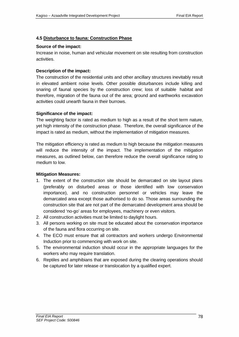
Kagiso – Azaadville Integrated Development Project Final EIA Report
Final EIA Report SEF Project Code: 500846
78
4.5 Disturbance to fauna: Construction Phase
Source of the impact: Increase in noise, human and vehicular movement on site resulting from construction activities. Description of the impact: The construction of the residential units and other ancillary structures inevitably result in elevated ambient noise levels. Other possible disturbances include killing and snaring of faunal species by the construction crew; loss of suitable habitat and therefore, migration of the fauna out of the area; ground and earthworks excavation activities could unearth fauna in their burrows. Significance of the impact: The weighting factor is rated as medium to high as a result of the short term nature, yet high intensity of the construction phase. Therefore, the overall significance of the impact is rated as medium, without the implementation of mitigation measures. The mitigation efficiency is rated as medium to high because the mitigation measures will reduce the intensity of the impact. The implementation of the mitigation measures, as outlined below, can therefore reduce the overall significance rating to medium to low. Mitigation Measures: 1. The extent of the construction site should be demarcated on site layout plans
(preferably on disturbed areas or those identified with low conservation importance), and no construction personnel or vehicles may leave the demarcated area except those authorised to do so. Those areas surrounding the construction site that are not part of the demarcated development area should be considered ‘no-go’ areas for employees, machinery or even visitors.
2. All construction activities must be limited to daylight hours. 3. All persons working on site must be educated about the conservation importance
of the fauna and flora occurring on site. 4. The ECO must ensure that all contractors and workers undergo Environmental
Induction prior to commencing with work on site. 5. The environmental induction should occur in the appropriate languages for the
workers who may require translation. 6. Reptiles and amphibians that are exposed during the clearing operations should
be captured for later release or translocation by a qualified expert.
Kagiso – Azaadville Integrated Development Project Final EIA Report
Final EIA Report SEF Project Code: 500846
79
Table 13: Disturbance of fauna: Construction Phase
Activity Construction activities; Presence of humans and machinery on site
Nature of the impact
Increased ambient noise Killing / snaring Earthworks Heavy machinery travel
Status -
Receiving environment Fauna
Extent (footprint; site; regional; national; international) SITE Intensity (low; med; high) HIGH Duration (short; short-med; medium; long; permanent) SHORT-MEDIUM Magnitude Probability (Improbable; possible; likely; highly likely; definite)
DEFINITE
Weighting factor (WF)
WF (low; low-med; medium; med-high; high) MEDIUM -HIGH
Mitigation Efficiency (ME)
ME (high; med-high; medium; low-med; low) MEDIUM -HIGH
Without mitigation (WOM)
(Extent + Intensity + Duration + Probability) x Weighting (2 + 5 + 2 + 5) x 4 = 56 Medium-High Significance
With mitigation (WM)
WOM x ME = WM 56 x 0.4 = 22.4 Medium-Low
Significance With Mitigation (WM)
MEDIUM-LOW
Kagiso – Azaadville Integrated Development Project Final EIA Report
Final EIA Report SEF Project Code: 500846
80
4.6.1 Disturbance of fauna: Operational Phase
Source of the impact: Disturbance of fauna during the operational phase of the development, including intentional killing. Description of the impact: The intentional killing of fauna is largely a result of ignorance and fear. Encounters between reptiles (especially snakes) and humans commonly result in death of the snake. Other possible disturbances include killing and snaring of mammal species by workers and residents, as well disturbances caused by pets (including inbreeding of domestic cats with the African Wild Cat Felis silvestris). Significance of the impact: The weighting factor is rated as medium to high, resulting from the long-term impact created as a result of the disturbance to the fauna and intentional killing of the fauna. The significance of the impact is therefore rated as medium. With sufficient mitigation measures, the impact’s significance is rated as low. Mitigation Measures: 1. The appointment of an ECO who is educated in the conservation practices and
conservation principles of fauna.

Kagiso – Azaadville Integrated Development Project Final EIA Report
Final EIA Report SEF Project Code: 500846
81
Table14: Disturbance of fauna: Operational Phase
Activity Recreational activities on estate Nature of the impact Disturbance of fauna Status -
Receiving environment Fauna
Extent (footprint; site; regional; national; international) SITE Intensity (low; med; high) MEDIUM Duration (short; short-med; medium; long; permanent) LONG TERM Magnitude Probability (Improbable; possible; likely; highly likely; definite)
LIKELY
Weighting factor (WF)
WF (low; low-med; medium; med-high; high) MEDIUM -HIGH
Mitigation Efficiency (ME)
ME (high; med-high; medium; low-med; low) MEDIUM -HIGH
Without mitigation (WOM)
(Extent + Intensity + Duration + Probability) x Weighting (2 + 3 + 4 + 3) x 4 = 48 Medium Significance
With mitigation (WM)
WOM x ME = WM 48 x 0.4 = 19.2 Low
Significance With Mitigation (WM)
LOW
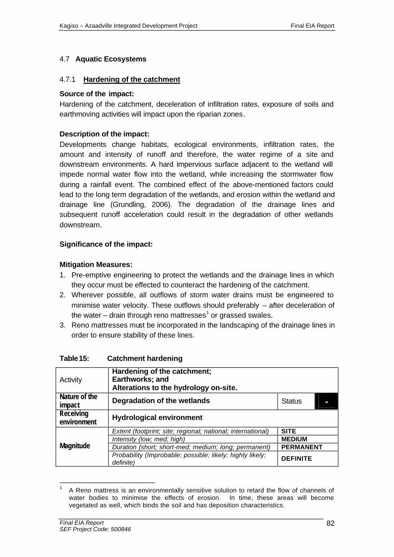
Kagiso – Azaadville Integrated Development Project Final EIA Report
Final EIA Report SEF Project Code: 500846
82
4.7 Aquatic Ecosystems
4.7.1 Hardening of the catchment
Source of the impact: Hardening of the catchment, deceleration of infiltration rates, exposure of soils and earthmoving activities will impact upon the riparian zones. Description of the impact: Developments change habitats, ecological environments, infiltration rates, the amount and intensity of runoff and therefore, the water regime of a site and downstream environments. A hard impervious surface adjacent to the wetland will impede normal water flow into the wetland, while increasing the stormwater flow during a rainfall event. The combined effect of the above-mentioned factors could lead to the long term degradation of the wetlands, and erosion within the wetland and drainage line (Grundling, 2006). The degradation of the drainage lines and subsequent runoff acceleration could result in the degradation of other wetlands downstream. Significance of the impact: Mitigation Measures: 1. Pre-emptive engineering to protect the wetlands and the drainage lines in which
they occur must be effected to counteract the hardening of the catchment. 2. Wherever possible, all outflows of storm water drains must be engineered to
minimise water velocity. These outflows should preferably – after deceleration of the water – drain through reno mattresses1 or grassed swales.
3. Reno mattresses must be incorporated in the landscaping of the drainage lines in order to ensure stability of these lines.
Table15: Catchment hardening
Activity Hardening of the catchment; Earthworks; and Alterations to the hydrology on-site.
Nature of the impact Degradation of the wetlands Status - Receiving environment Hydrological environment
Extent (footprint; site; regional; national; international) SITE Intensity (low; med; high) MEDIUM Duration (short; short-med; medium; long; permanent) PERMANENT Magnitude Probability (Improbable; possible; likely; highly likely; definite)
DEFINITE
1 A Reno mattress is an environmentally sensitive solution to retard the flow of channels of
water bodies to minimise the effects of erosion. In time, these areas will become vegetated as well, which binds the soil and has deposition characteristics.

Kagiso – Azaadville Integrated Development Project Final EIA Report
Final EIA Report SEF Project Code: 500846
83
Weighting factor (WF)
WF (low; low-med; medium; med-high; high) MEDIUM -HIGH
Mitigation Efficiency (ME)
ME (high; med-high; medium; low-med; low) MEDIUM
Without mitigation (WOM)
(Extent + Intensity + Duration + Probability) x Weighting (3 + 3 + 5 + 5) x 4 = 64 Medium-High
Significance With mitigation (WM)
WOM x ME = WM 64 x 0.8 = 51.2 Medium
Significance With Mitigation (WM)
MEDIUM
4.7.2 Impact on water bodies: Construction phase
Source of the impact: Storm water runoff and Sedimentation The construction of residential units and associated infrastructure (e.g. parking areas and roofs) will result in the conversion of natural permeable surfaces into impermeable hardened surfaces, which will lead to higher rates of storm water run-off. Anthropogenic Activities Human activities, which disturb the soil structure, induce erosion for example: • Vehicular use along specific tracks (construction phase); and • Compaction of soil by repeated use of footpaths (operational phase).
Description of the impact: Storm water runoff The clearance of vegetation will reduce the capacity of the land surface to retard the flow of surface water, thereby decreasing infiltration and increasing both the quantity and velocity of surface water runoff. Sedimentation Increased storm water could result in increased erosion if unchecked. Significance of the impact: The weighting factor is rated as high as a result of the cumulative factors discussed above. Therefore, the impact is rated as high. The mitigation measures specified below will not ameliorate the impact to a major degree as development of any scale on the site will result in the change of the flow characteristic of surface water bodies. Therefore, the mitigation efficiency is rated as low to medium. The significance of the impact following mitigation therefore remains high.
Kagiso – Azaadville Integrated Development Project Final EIA Report
Final EIA Report SEF Project Code: 500846
84
Mitigation Measures: 1. Measures must be introduced to stabilise the drainage lines. 2. The design of the storm water management plan must take cognisance of the
sensitive wetland environments 3. Provide permeable surfaces and address increased runoff volumes at source. 4. Appropriate flow diversion and erosion control structures i.e. earth embankments
must be placed where soil may be exposed to high levels of erosion on account of steep slopes and soil structure.
5. Should a freak storm displace the temporary earth embankments or other erosion control structures, a visual inspection of the site must be made and the damage must be recorded. Any damage and loss of soil resulting from a storm must be remedied immediately.
6. Storm water at the construction crew camps must be managed so as to reduce the silt loads in the stream channels.
7. Measures must be implemented to distribute storm water as evenly as possible to avoid point sources of erosion.
8. Construction on steep slopes and in soft or erosive material will require erosion control measures and correct grassing / revegetation methods.
9. All construction areas should be suitably rehabilitated and re-vegetated as soon as possible after construction.
10. Disturbed surfaces must be rehabilitated, ripped and hydro seeded where necessary.

Kagiso – Azaadville Integrated Development Project Final EIA Report
Final EIA Report SEF Project Code: 500846
85
Table 16: Modification to water bodies
Activity Increase in hard, impermeable surface areas Sedimentation of water bodies Anthropogenic activities
Nature of the impact
Modification to functional and ecologically sensitive wetlands and other surface water bodies on site
Status -
Receiving environment
• Aquatic • Fuanal • Residents • Downstream users Extent (footprint; site; regional; national; international) SITE Intensity (low; med; high) HIGH Duration (short; short-med; medium; long; permanent) PERMANENT Magnitude Probability (Improbable; possible; likely; highly likely; definite)
DEFINITE
Weighting factor (WF)
WF (low; low-med; medium; med-high; high) HIGH
Mitigation Efficiency (ME)
ME (high; med-high; medium; low-med; low) LOW-MEDIUM
Without mitigation (WOM)
(Extent + Intensity + Duration + Probability) x Weighting (5 + 5 + 5 + 5) x 5 = 100 High Significance
With mitigation (WM)
WOM x ME = WM 100 x 0.8 = 80 High
Significance With Mitigation (WM)
HIGH

Kagiso – Azaadville Integrated Development Project Final EIA Report
Final EIA Report SEF Project Code: 500846
86
4.7.3 Sedimentation of water resources
Source of the impact: Reduction of ground cover leading to increased soil runoff potential. Description of the impact: Clearance of existing vegetation will expose the upper layers of the soil horizon to erosion. The transport of eroded soil into surrounding surface water resources will increase the Total Suspended Solids (TSS) of the water courses, which may adversely affect the aquatic fauna (e.g. clogging of the gills of fish). Suspended solids may interfere with the feeding mechanisms of filter-feeding organisms such as certain macro invertebrates, gill functioning, foraging efficiency (due to visual disturbances) and growth of fish. Construction activities The movement of construction vehicles and personnel can also result in the onset of erosion and associated sedimentation of streams and rivers. The stockpiling of excavated earth and construction materials can result in contamination of runoff as a result of erosion of stockpiles. Significance of the impact: The aquatic processes will be altered, however, processes will continue in a modified way signifying a medium intensity impact of medium duration. The impact is highly likely to occur and therefore must be mitigated. The weighting factor is rated as medium to high as a result of the international extent, medium intensity, medium duration and high probability of the impact occurring. The mitigation efficiency is rated as medium as the intensity will be reduced, and if implemented correctly, the extent will also be reduced. Therefore, the significance following mitigation is rated as medium. Mitigation Measures: 1. To prevent erosion of material that is stockpiled for long periods, the material
must be retained in bermed areas. 2. All topsoil must be removed and stockpiled on the site. 3. The temporary storage of topsoil, inert spoil, fill, and associated storage of
construction activities should occur above the 20 year flood line or at least 20 m from the top of the bank of any drainage lines, whichever is the maximum or as agreed with the ECO.
4. Mulch, roughen or sterile grass seeding can be used on any batter or topsoil stockpile that will be maintained for a period of time exceeding 28 days.
5. Construct an earth bank around the upslope portion of any stockpiles in order to redirect runoff and prevent scouring of stockpiles.
6. Erect a silt fence around any stockpiles in order to trap sediment and prevent stockpile sediment loss.
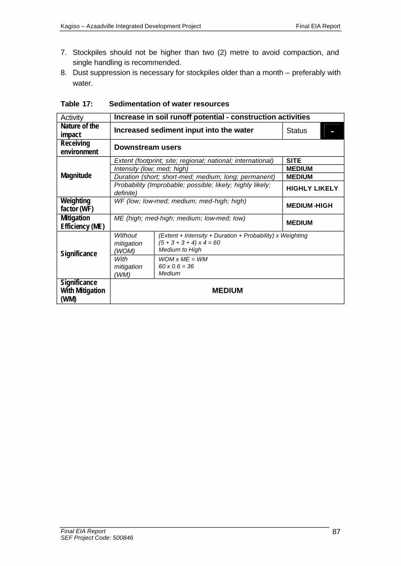
Kagiso – Azaadville Integrated Development Project Final EIA Report
Final EIA Report SEF Project Code: 500846
87
7. Stockpiles should not be higher than two (2) metre to avoid compaction, and single handling is recommended.
8. Dust suppression is necessary for stockpiles older than a month – preferably with water.
Table 17: Sedimentation of water resources
Activity Increase in soil runoff potential - construction activities Nature of the impact Increased sediment input into the water Status - Receiving environment Downstream users
Extent (footprint; site; regional; national; international) SITE Intensity (low; med; high) MEDIUM Duration (short; short-med; medium; long; permanent) MEDIUM Magnitude Probability (Improbable; possible; likely; highly likely; definite)
HIGHLY LIKELY
Weighting factor (WF)
WF (low; low-med; medium; med-high; high) MEDIUM -HIGH
Mitigation Efficiency (ME)
ME (high; med-high; medium; low-med; low) MEDIUM
Without mitigation (WOM)
(Extent + Intensity + Duration + Probability) x Weighting (5 + 3 + 3 + 4) x 4 = 60 Medium to High Significance
With mitigation (WM)
WOM x ME = WM 60 x 0.6 = 36 Medium
Significance With Mitigation (WM)
MEDIUM

Kagiso – Azaadville Integrated Development Project Final EIA Report
Final EIA Report SEF Project Code: 500846
88
4.8 Surface water pollution
Source of the impact: Activities of workforce, for example: • Spillage of hydrocarbon based fuels or lubricants; • Washing of clothes in the river; and • Inappropriate toilet facilities for construction workers. Description of the impact: Spillage Hydrocarbon based fuels or lubricants spilled from construction vehicles, construction materials that are not properly stored, and litter deposited by construction workers may be washed into surface water bodies. The water bodies could be contaminated and this poses a threat to the aquatic ecosystem (including wetlands). Personal hygiene use of water bodies The utilisation of the water courses for washing of clothes or disposal of water used for washing will decrease the abundance and diversity of aquatic macro invertebrates inhabiting along the affected portion of the river as well as further downstream. In the event that construction workers are not provided with adequate sanitation, there is the potential that the surface water resources and surrounds will be contaminated by raw sewage. The addition of raw sewage to the water resources will contribute to altering the habitat of the aquatic ecosystem. Significance of the impact: Even though the probability of the impact is a fairly low it is still ‘possible’, and the impact has a high significance. The weighting factor of surface water pollution is rated as high as a result of the severity of this impact on the receiving environment. The mitigation efficiency is rated as high because with the correct mitigation measures in place, the impact can be reduced. Thus, the significance of the impact, after the implementation of the mitigation measures, is rated as low.
Mitigation Measures: 1. Construction vehicles must be maintained in good working order, to reduce the
probability of leakage of fuels and lubricants. 2. If servicing and washing of the vehicles are to occur on site, there must be
specific areas constructed for this activity. These areas must have temporary plastic bunding as well as oil traps to contain any spillages.
3. A walled concrete platform, dedicated store with adequate flooring or bermed area should be used to accommodate chemicals such as fuel, oil, paint, herbicide and insecticides, as appropriate, in well ventilated areas.
4. Storage of potentially hazardous materials should be above any 100 year flood line, or as agreed with the ECO. These materials include fuel, oil, cement, paint, bitumen etc.
Kagiso – Azaadville Integrated Development Project Final EIA Report
Final EIA Report SEF Project Code: 500846
89
5. Sufficient care must be taken when handling these materials to prevent pollution. 6. Surface water draining off contaminated areas containing oil and petrol must be
channelled towards a sump, which will separate water and chemicals/oils. 7. Oil residue shall be treated with oil absorbent such as Drizit or similar and this
material removed to an approved waste site. Spill kits must be easily accessible and workers must undergo induction regarding the use thereof.
8. Concrete must be mixed on mixing trays or plastic liners. If mixing of concrete occurs on exposed soil, such activities must occur in demarcated areas with clean and dirty water separation systems, which will contained the contaminated water during heavy rainfall events.
9. Concrete and tar shall be mixed in specifically demarcated areas only. 10. All concrete and tar that is spilled outside demarcated areas shall be promptly
removed by the Contractor and disposed of at a registered landfill site. 11. After all the concrete/tar mixing is complete all waste concrete/tar shall be
removed from the batching area and disposed of at a registered landfill site. 12. Storm water shall not be allowed to flow through the above-mentioned areas.
Ensure that there are clean water separation systems preventing clean water from entering the affected areas and measures to contain any contaminated water occurring within the actual areas.
13. Cement and sediment shall be removed from time to time and disposed of in a manner as instructed by the Consulting Engineer.
14. All construction materials liable to spillage must be stored in appropriate structures with impermeable flooring, such as plastic liners for temporary storage areas.
15. Portable septic toilets must be provided and maintained for construction crews. Maintenance must include the removal without sewage spills.
16. Under no circumstances may ablutions occur outside of the provided facilities. 17. No uncontrolled discharges from the construction crew camps to any surface
water resources shall be permitted. Any discharge points need to be approved by the relevant authority.
18. In the case of pollution of any surface or groundwater, the Regional Representative of the DWAF must be informed immediately.
19. Where construction in close proximity to sewer lines is unavoidable then excavations must be done by hand while at all times ensuring that the soil beneath the sewer lines is not destabilised.
20. Store all litter carefully so it cannot be washed or blown into any of the water courses within the study area.
21. Provide bins for construction workers and staff at appropriate locations, particularly where food is consumed.
22. The construction site should be cleaned daily and litter removed. 23. Conduct ongoing staff awareness programs in order to reinforce the need to
avoid littering as this adds to the surface water pollution. 24. Backfill must be compacted to form a stabilised and durable blanket.
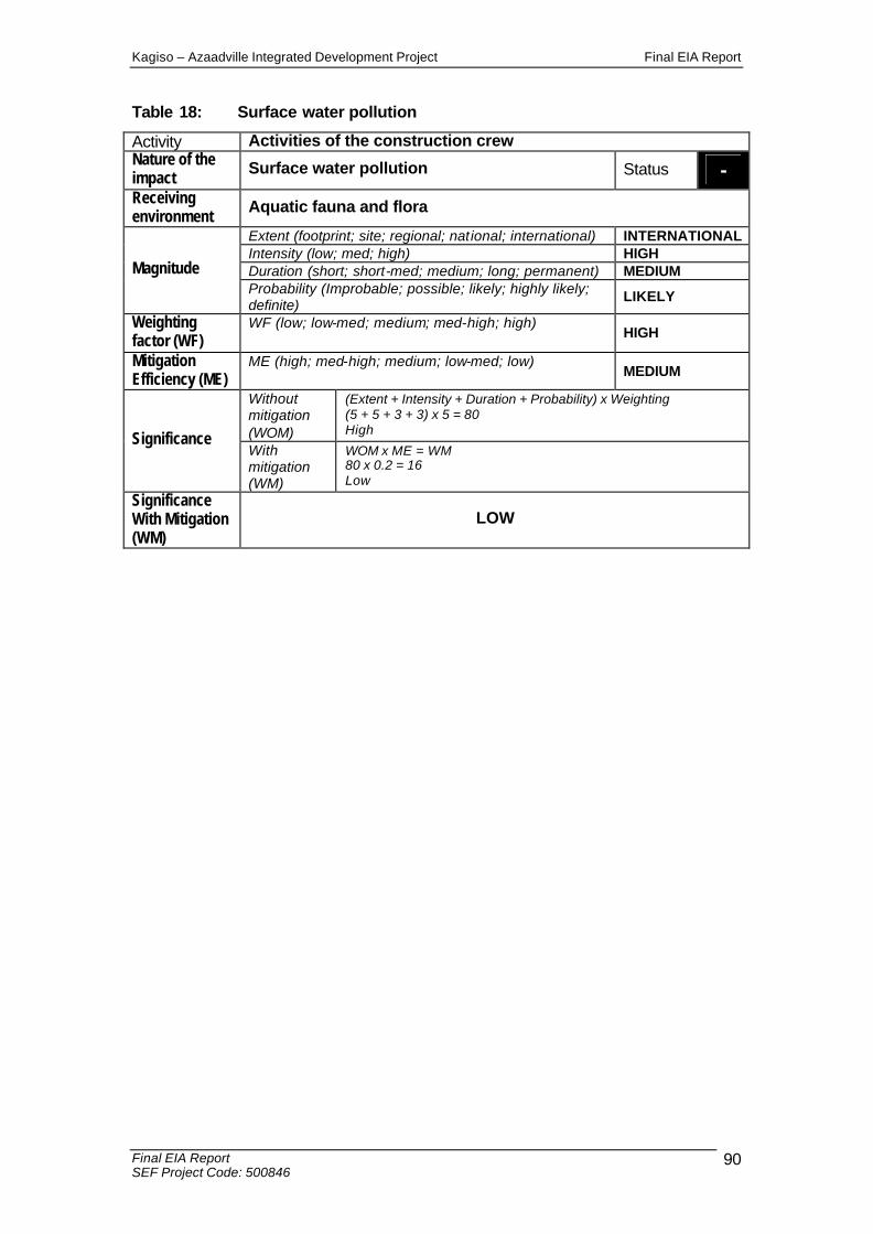
Kagiso – Azaadville Integrated Development Project Final EIA Report
Final EIA Report SEF Project Code: 500846
90
Table 18: Surface water pollution
Activity Activities of the construction crew Nature of the impact Surface water pollution Status - Receiving environment Aquatic fauna and flora
Extent (footprint; site; regional; national; international) INTERNATIONAL Intensity (low; med; high) HIGH Duration (short; short-med; medium; long; permanent) MEDIUM Magnitude Probability (Improbable; possible; likely; highly likely; definite)
LIKELY
Weighting factor (WF)
WF (low; low-med; medium; med-high; high) HIGH
Mitigation Efficiency (ME)
ME (high; med-high; medium; low-med; low) MEDIUM
Without mitigation (WOM)
(Extent + Intensity + Duration + Probability) x Weighting (5 + 5 + 3 + 3) x 5 = 80 High Significance
With mitigation (WM)
WOM x ME = WM 80 x 0.2 = 16 Low
Significance With Mitigation (WM)
LOW
Kagiso – Azaadville Integrated Development Project Final EIA Report
Final EIA Report SEF Project Code: 500846
91
4.9 Air Quality
4.9.1 The impacts of dust during the construction phase
Source of the impact: The construction of the development will result in the generation of dust particles into the atmosphere. Description of the impact: The construction activities entail the use of construction vehicles. A direct repercussion of the clearance of vegetation and creation of stockpiles is that the soil becomes susceptible to wind erosion. Dust from the barren soil is susceptible to affect the ambient air quality. Dust is relatively inert and is more likely to be a nuisance than a health hazard. As a nuisance, it could soil property and be aesthetically displeasing. The greatest impact on the air quality will be related to the earthworks on site and the transport of construction materials to the site by heavy vehicles. This impact could effectively be combated by frequently wetting the access roads. All temporary access roads should be wetted with a water cart periodically to suppress and prevent fugitive dust generation from temporary access dirt roads. Significance of the impact: Dust disperses in the atmosphere. The impact is classified as local. The ecological processes continue for the duration of the impact (during the construction phase it is rated as short to medium term) and is therefore rated as medium. The weighting factor is rated as medium. The significance of the generation of dust, during the construction phase, before any mitigation measures are introduced is rated as low to medium. Mitigation measures: 1. Frequent wetting of access roads. 2. Dust suppression for the material extraction and utilization activities, if required. 3. Maintenance of effective exhaust systems on vehicles. 4. Efficient operation of the air filters on equipment. 5. Maintenance of fire prevention practices and effective and timely access to or
collaboration with fire fighting teams. 6. Prohibition of any fires on site. 7. Trucks will drive with headlights on for safety reasons at all times to improve
visibility.

Kagiso – Azaadville Integrated Development Project Final EIA Report
Final EIA Report SEF Project Code: 500846
92
Table 19: Impacts of dust: Construction Phase
Activity The use of construction vehicles during the construction phase Nature of the impact
Dust being dispersed during the construction phase affecting the air quality Status -
Receiving environment Residents
Extent (footprint; site; regional; national; international) REGIONAL Intensity (low; med; high) MEDIUM Duration (short; short-med; medium; long; permanent) SHORT-MEDIUM Magnitude Probability (Improbable; possible; likely; highly likely; definite)
HIGHLY LIKELY
Weighting factor (WF)
WF (low; low-med; medium; med-high; high) MEDIUM
Mitigation Efficiency (ME)
ME (high; med-high; medium; low-med; low) MEDIUM
Without mitigation (WOM)
(Extent + Intensity + Duration + Probability) x Weighting (3 + 3 + 2 + 4) x 3 = 36 Low – Medium Significance
With mitigation (WM)
WOM x ME = WM 36 x 0.6 = 21.6 Low – Medium
Significance With Mitigation (WM)
LOW-MEDIUM
4.9.2 The impacts of increased vehicular emissions resulting from increased traffic
Source of the impact: The increase in the traffic as the development will serve as a tourism destination. Description of the impact: The establishment of the mixed use residential development will result in increased traffic and associated vehicular emissions into the atmosphere. Significance of the impact: Kagiso, Azaadville and the other towns that surround the proposed development will show an increase in the traffic, which has regional implications. The intensity of the increased emissions is rated as medium because the air quality will not drop to a degree that becomes harmful to the health and well being of the affected stakeholders (motorists, residents and the surrounding landowners and users). The traffic will be a permanent feature of the proposed Mixed use development, hence it is rated as permanent. The increase in the emissions as a result of an increase in the traffic will definitely occur. The weighting factor is rated as low to medium. The air quality in the region will not be impacted upon to a great degree. Therefore, the significance of the impact is calculated as low to medium prior to the implementation of mitigation measures.
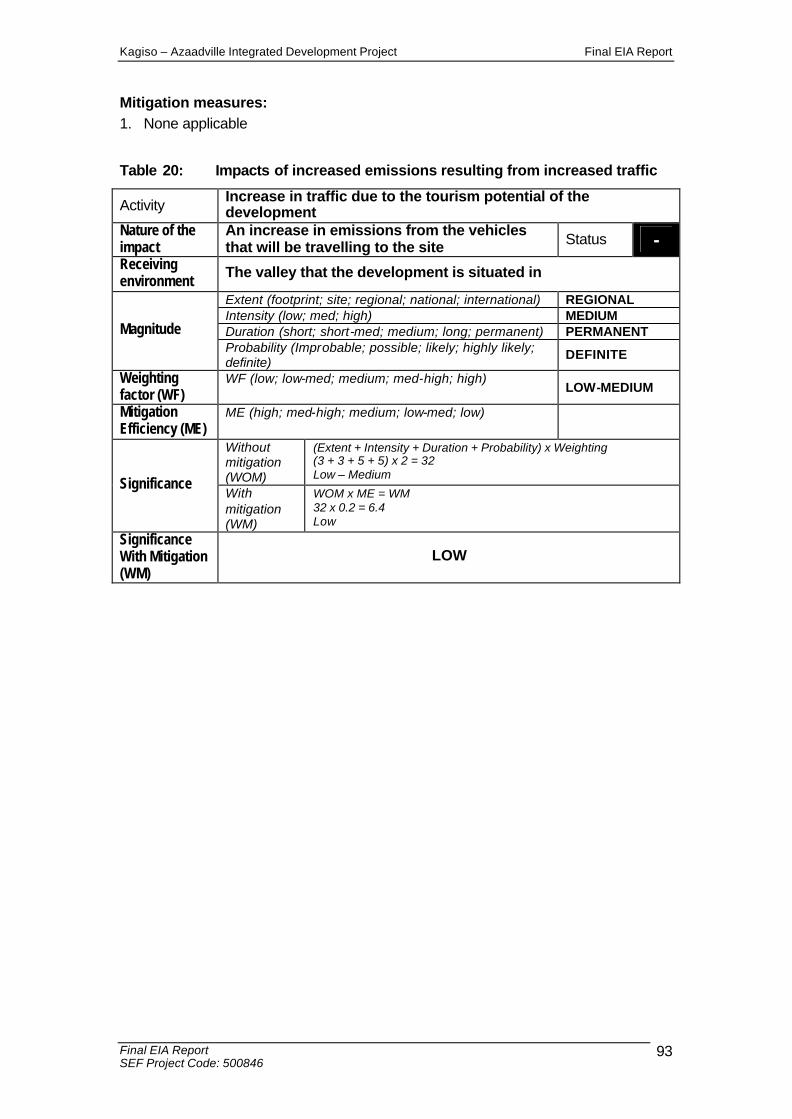
Kagiso – Azaadville Integrated Development Project Final EIA Report
Final EIA Report SEF Project Code: 500846
93
Mitigation measures: 1. None applicable
Table 20: Impacts of increased emissions resulting from increased traffic
Activity Increase in traffic due to the tourism potential of the development
Nature of the impact
An increase in emissions from the vehicles that will be travelling to the site Status -
Receiving environment The valley that the development is situated in
Extent (footprint; site; regional; national; international) REGIONAL Intensity (low; med; high) MEDIUM Duration (short; short-med; medium; long; permanent) PERMANENT Magnitude Probability (Improbable; possible; likely; highly likely; definite)
DEFINITE
Weighting factor (WF)
WF (low; low-med; medium; med-high; high) LOW-MEDIUM
Mitigation Efficiency (ME)
ME (high; med-high; medium; low-med; low)
Without mitigation (WOM)
(Extent + Intensity + Duration + Probability) x Weighting (3 + 3 + 5 + 5) x 2 = 32 Low – Medium
Significance With mitigation (WM)
WOM x ME = WM 32 x 0.2 = 6.4 Low
Significance With Mitigation (WM)
LOW
Kagiso – Azaadville Integrated Development Project Final EIA Report
Final EIA Report SEF Project Code: 500846
94
4.10 Heritage Resources
Destruction of heritage resources
Source of the impact: Damage to Heritage Resource The construction activities (earthworks, movement of equipment and personnel) on site have the potential to impact upon potential heritage resources. Looting of Heritage Resource Theft or vandalism and the subsequent loss of artefacts of cultural and/or heritage importance. Description of the impact: Damage to Heritage Resources Heritage sites are fixed features in the environment, occurring within specific spatial confines. Any impact upon these resources will be permanent and irreversible. Any movement of vehicles, equipment or personnel through areas containing these artefacts could result in the permanent destruction of the artefacts and loss of heritage resources. Looting to Heritage Resources Looting of artefacts for their cultural, spiritual or mere novelty value is a common occurrence. However, the uncontrolled removal of or defacing artefacts – essentially constituting theft or vandalism will result in the permanent loss of heritage resources. Significance of the impact: The specialist heritage assessment of the site concluded that no artefacts, buildings, structures or tools of archaeological or historical importance are present on site, hence, no significant impacts are envisaged. The mitigation measures should still be very effective and as such the impact is deemed as low significance with mitigation. The impact has a weighting of medium to high as the heritage resources, if lost, are impossible to recover while people place major emphasis on the importance of heritage and cultural resources. Mitigation measures:
• If construction takes place and archaeological sites are exposed, it should immediately be reported to a museum, preferably one at which an archaeologist is available, so that an investigation and evaluation of the finds can be made.
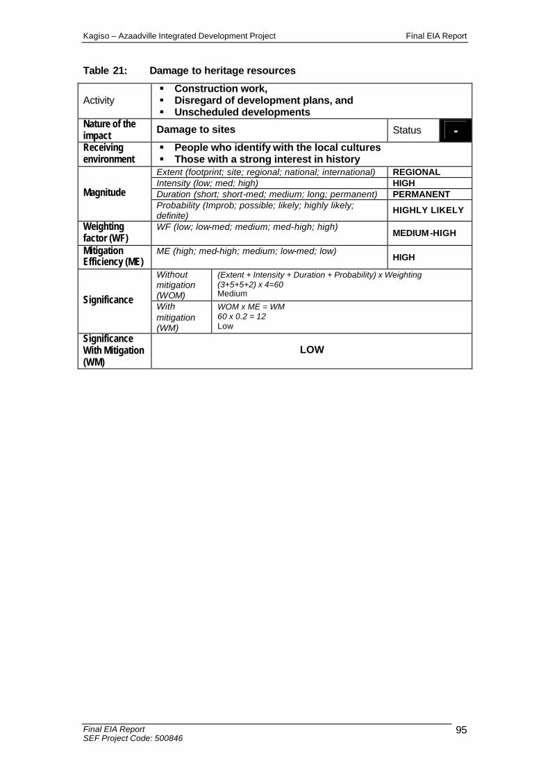
Kagiso – Azaadville Integrated Development Project Final EIA Report
Final EIA Report SEF Project Code: 500846
95
Table 21: Damage to heritage resources
Activity § Construction work, § Disregard of development plans, and § Unscheduled developments
Nature of the impact Damage to sites Status - Receiving environment
§ People who identify with the local cultures § Those with a strong interest in history
Extent (footprint; site; regional; national; international) REGIONAL Intensity (low; med; high) HIGH Duration (short; short-med; medium; long; permanent) PERMANENT Magnitude Probability (Improb; possible; likely; highly likely; definite)
HIGHLY LIKELY
Weighting factor (WF)
WF (low; low-med; medium; med-high; high) MEDIUM -HIGH
Mitigation Efficiency (ME)
ME (high; med-high; medium; low-med; low) HIGH
Without mitigation (WOM)
(Extent + Intensity + Duration + Probability) x Weighting (3+5+5+2) x 4=60 Medium
Significance With mitigation (WM)
WOM x ME = WM 60 x 0.2 = 12 Low
Significance With Mitigation (WM)
LOW
Kagiso – Azaadville Integrated Development Project Final EIA Report
Final EIA Report SEF Project Code: 500846
96
4.11 Visual mitigation measures
The aim of mitigation is to reduce or alleviate the intrusive contrast between the proposed development components and activities, and the receiving landscape, to a point where it is acceptable to visual and landscape receptors. Mitigation should be implemented as an iterative process, accompanying the design phase to mitigate predictable impacts before construction commences. This approach generates preventative measures that will influence design decisions instead of relying on cosmetic landscape remediation of a completed project. Design Stage: 1. The aesthetic design of the site perimeter fence should be subtle and not appear
as a hostile barrier. A permeable fence is suggested to abate the dominant presence of the fence. It can fade into its surrounds and is thus less visible.
2. Avoid bright coloured finishes to buildings that will increase colour contrast between the buildings and the earthly background created by the foliage. Building facades and roofs should preferably be painted or finished with natural earthy tones.
3. Minimise roads around the perimeter of the development. Concentrate road circulation in the centre between the buildings to reduce the possibility of vehicle lights disturbing adjacent residents at night.
4. Provide screen planting around buildings to reduce the visibility from external vantage points.
5. Avoid light trespass and glare originating from street and security lighting. Fit “full cut-off” luminaries to limit the amount of light trespass and to control light output and restrain glare (Shaflik, 1997).
6. When vertical structures or surfaces are lit, such as building facades or signs, direct the light downwards if possible. If the only alternative is to ‘up-light’ the element, the correct luminaire must be fitted to avoid light spillage.
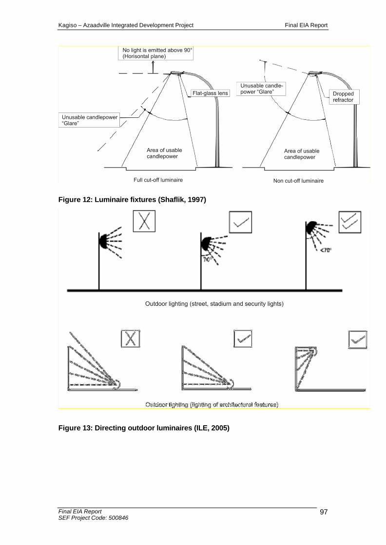
Kagiso – Azaadville Integrated Development Project Final EIA Report
Final EIA Report SEF Project Code: 500846
97
Figure 12: Luminaire fixtures (Shaflik, 1997)
Figure 13: Directing outdoor luminaires (ILE, 2005)
Kagiso – Azaadville Integrated Development Project Final EIA Report
Final EIA Report SEF Project Code: 500846
98
7. Establish construction equipment, material stockpiles and site offices in areas of relatively low visibility.
8. Maintain the construction sites and camps neat, clean and organised in order to portray a tidy appearance.
9. Remove rubble and other building rubbish off site as soon as possible or place it in a container in order to keep the construction site free from additional unsightly elements.
10. Locate the construction camps and the material stockpiles outside of the visual field of sensitive visual receptors.
11. Rehabilitate or vegetate disturbed areas as soon as practically possible after construction. This should be done to restrict long stages of exposed soil and possible erosion that will result in indirect landscape and visual impacts.
12. Dust suppression procedures should be implemented especially on windy days during earth works.
13. Maintain the landscape to a high aesthetic standard to retain a high visual quality for visitors and observers.
4.12 Traffic
4.12.1 Expected increase in traffic for the development
Source of the impact:
There are a number of provincial routes in the vicinity of the proposed development. Existing accesses constructed on the K13 can be utilised. Access to the Remainder of the farm Kagiso No. 402 IQ can be obtained via the Taj Mahal Street intersection with the K13; the existing access to Azaadville. Additional access to Randfontein Road will be provided to the east, situated at least 600m from Kagiso Drive.
Access to Portion 43 of the farm Rietvallei No. 241-IQ can be obtained via the existing 1st Avenue / Badshani Drive intersection.
A number of external roads will need to be upgraded, to improve the accessibility of the development. The extent of the proposed upgrading will be determined during a full traffic impact study that is currently being conducted. This study will be made available in the EIA report.
Description of the impact: The development will result in an increase in the traffic, caused by increased number of vehicles travelling to the site, resulting in added pressure within the existing road network. Significance of the impact: The significance of the increase in traffic is medium to high resulting from the high intensity of this impact. However, the impact can be mitigated to a medium impact in the event that mitigation measures are implemented.
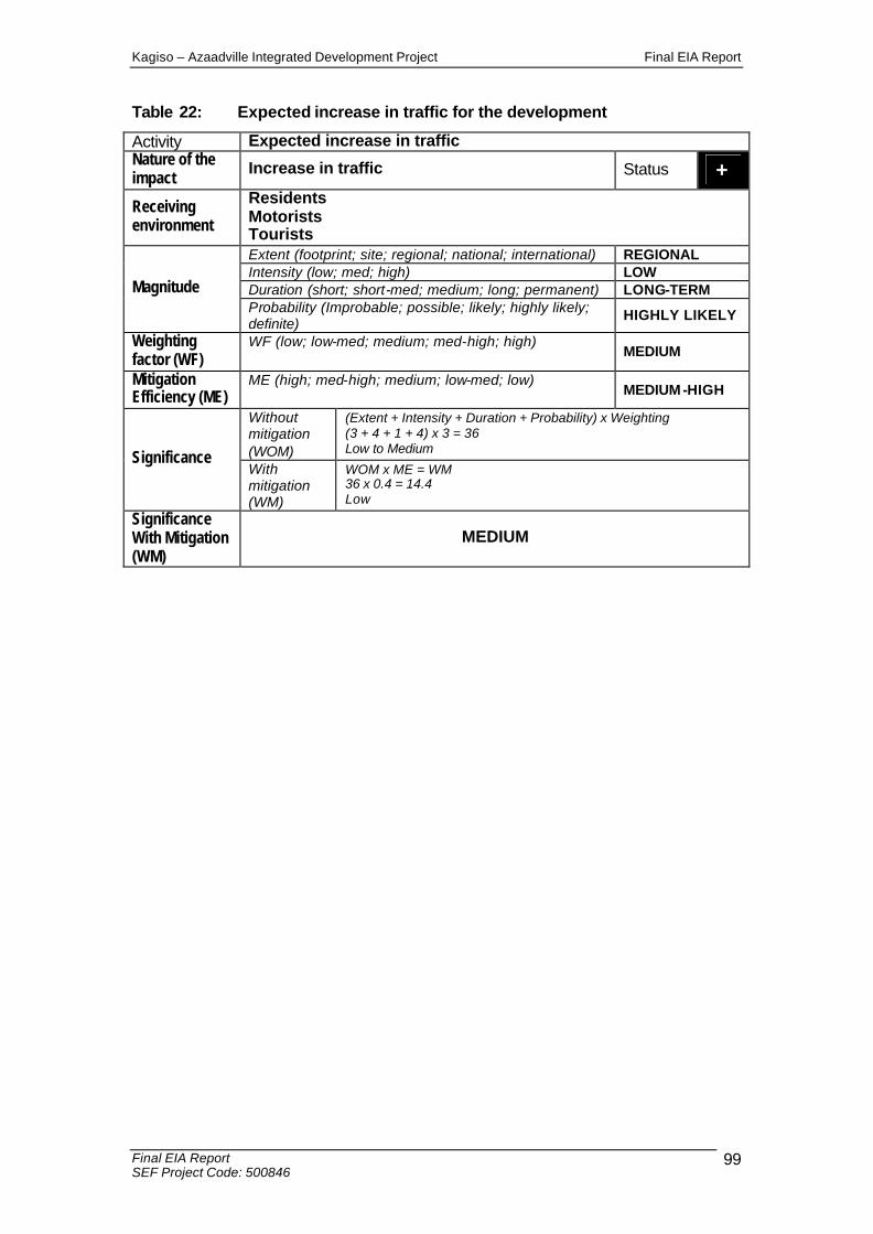
Kagiso – Azaadville Integrated Development Project Final EIA Report
Final EIA Report SEF Project Code: 500846
99
Table 22: Expected increase in traffic for the development
Activity Expected increase in traffic Nature of the impact Increase in traffic Status + Receiving environment
Residents Motorists Tourists Extent (footprint; site; regional; national; international) REGIONAL Intensity (low; med; high) LOW Duration (short; short-med; medium; long; permanent) LONG-TERM Magnitude Probability (Improbable; possible; likely; highly likely; definite)
HIGHLY LIKELY
Weighting factor (WF)
WF (low; low-med; medium; med-high; high) MEDIUM
Mitigation Efficiency (ME)
ME (high; med-high; medium; low-med; low) MEDIUM -HIGH
Without mitigation (WOM)
(Extent + Intensity + Duration + Probability) x Weighting (3 + 4 + 1 + 4) x 3 = 36 Low to Medium Significance
With mitigation (WM)
WOM x ME = WM 36 x 0.4 = 14.4 Low
Significance With Mitigation (WM)
MEDIUM
Kagiso – Azaadville Integrated Development Project Final EIA Report
Final EIA Report SEF Project Code: 500846
100
SECTION E BRIDGE CONSTRUCTION METHODOLOGY AND MITIGATION MEASURES FOR THE CONSTRUCTION PHASE
The proposed action is to build two (2) new bridges that will cross the Wonderfonteinspruit and its tributaries at two different locations across the site. Please see Appendix 9 for the illustration of where the bridges will cross the Wonderfonteinspruit. SEF have undertaken the exercise to identify the anticipated impacts associated with the construction of the bridges. The design and structure of each individual bridge will be engineered by Bigen Africa Engineers. It is anticipated that the bridges will be cement structures, with a roadway deck suitable for the passage of motor vehicles in both directions. Please see Appendix 9 for further description of the bridge structures anticipated for the development. Pillars will be constructed in the 1:50 and 1:100 year flood lines simply due to the expanse of the flood lines. This aspect is determined by the length of the bridge. The project planning phase identified that to ensure efficient free flowing traffic within the development, a number of bridge crossings would need to be constructed, to facilitate vehicular movement through the development.
E-1. BRIDGE CONSTRUCTION METHODOLOGY
The bridges to be constructed across the Wonderfonteinspruit will be constructed from concrete and steel. The bridge will comprise of foundations, piers, abutments, deck, hand rail, drainage systems. • Excavation for foundations for the piers and the abutments. Excavation to rock level.
Excavation will take place by means of TLBS and Excavators. • Pour concrete blinding layers, • Fix steel reinforcement and erect shutters for piers and abutments , • Install drainage reticulation behind abutments, • Erect shutters and fix steel reinforcements for bridge deck, • Install sleeves in bridge deck for services, • Pour concrete for bridge deck, • Construct road surface layers and • Install bridge hand rail.

Kagiso – Azaadville Integrated Development Project Final EIA Report
Final EIA Report SEF Project Code: 500846
101
The diversion of the Wonderfonteinspruit will not be required as the bridge foundations are situated outside the normal flow path of the river.
Table 23: IMPACTS OF THE PROPOSED BRIDGES AND MITIGATION MEASURES
Potential
impacts: Proposed mitigation:
Significance
rating of impacts after
mitigation:
Ground and
surface water
pollution
Construction phase
• The site and surrounding area should be designed to permit the drainage of surface water and to prevent ‘ponding’ along the road
embankment.
• Vegetation clearance must be kept to a minimum.
• Litter generated by the construction crew must be collected in rubbish bins and disposed of regularly.
• Adequate provision must be made for sanitation for the construction workers. Chemical toilets on site are to be emptied
weekly.
• Prevention measures should be established to prevent hydrocarbon fuel contamination of the soil by diesel and oil spillage
during the delivery of construction materials.
• Any excavation works must be properly backfilled and compacted according to specifications given in sub-clause 5.2.4. of SABS
1200DA.
• Natural recharge of water resources conditions must be maintained on site.
• Seepage zones and springs that can form during and after rainfall
events must be recognised. Suitable horizontal drainage systems also need to be designed and implemented. These should be
sufficient to accommodate the dam flood levels.
• A water use license should be applied for activities as required in the Water Act, 1998 (Act No. 36 of 1998).
• Chemical toilets should not be located in drainage line or near any
water bodies.
Low
Change in
drainage
patterns
Construction phase
• Design and construct contour banks to ensure soil
conservation works.
Low

Kagiso – Azaadville Integrated Development Project Final EIA Report
Final EIA Report SEF Project Code: 500846
102
• Where possible, ensure low gradients so that run-off water
flows at a controlled rate so as to minimise channelling and
soil erosion of existing watercourses during high rainfall
events.
• Ensure that water content of soils on the down-slope side of drainage culverts is not significantly increased by the
discharge water such that they become waterlogged and
unproductive
Changes in
channel
structure and
condition (also linked to
changes in the
riparian zone)
due to
construction
activities.
Construction phase
• Bridges must span the entire width of the channel and floodplain so as to avoid disturbance to the riparian zones of rivers.
• • Pillars, columns or bridge buttresses should not be placed in
in-stream or in riparian zones, if at all possible. The disturbance
of in-stream channels and riparian zones during bridge
construction must be minimised.
Changes in (in-
stream) habitat
(physical and
flow) quality and quantity
due to physical
structures /
obstructions in
the river
channel,
estuary or
wetland
• The number and width of pillars, vertical columns and buttresses
placed within the river channel and floodplain should be minimised. This is particularly important within the river channel.
Low
Increased sedimentation (linked mostly to construction activities) in the river channel.
• Pillars, vertical columns and buttresses should not be placed within river channels if at all possible. If this is necessary, all
precautions should be taken to avoid excessive disturbance
of the bank and increased sedimentation into the river
channel.
• All stockpiles must be protected from erosion, stored on flat
areas where run-off will be minimised, and if closer than 500
m on upland positions, they must be surrounded by bunds.
• Stockpiles must be located away from river channels if at all
possible and for as short a time as possible.
• Erosion control of all banks must take place so as to reduce erosion and sedimentation into river channels.
• Rehabilitation of banks must take place so as to avoid

Kagiso – Azaadville Integrated Development Project Final EIA Report
Final EIA Report SEF Project Code: 500846
103
excessive erosion.
• Silt traps, berms or other suitable structures must be placed
down slopes where vegetation stripping is taking place close
to rivers and wetlands, so as to catch any silt which may
move into the rivers.
• Silt traps and culverts should be regularly maintained and cleared so as to ensure effective drainage.
Soil disturbances
and instability
Construction Phase
• By maintaining the maximum amount of vegetation, the extent of
erosion and ecosystem loss can be reduced.
• Soil excavated during trenching should be stockpiled in layers not more than 2 metres and replaced in the same order when
backfilling.
• All access roads to the development site must be demarcated, and only existing roads are to be used as far as possible.
• The construction site is to be clearly demarcated.
• In order to successfully avoid the major impacts caused by erosion, construction during the rainy season (November to March)
should be avoided, if possible.
• Where necessary, a suitable mixture of indigenous grass seed shall be used to reseed damaged areas.
• Abutment material along the upstream side should be protected against erosion by the placing of Reno Mattresses along the floor
and wall up to a height of approximately 1.5m above the natural
ground level.
• Reinforced grass should be planted from the top of the Reno Mattresses to the top of the road, as well as along the road
embankment.
Low
Changes in
water quality (during
construction
and operational
phases) other
than
sedimentation
Construction Phase
• Emergency plans must be in place in case of spillages into
river systems.
Low
Change in ecosystem
structure and function
• Engineering design of bridges, culverts and storm water
drains must reduce impacts on aquatic systems, and in so doing, reduce the possibility of changes in ecosystem structure and function.
Low
Loss of
• Sensitive areas, where the possibility of impacts is high,

Kagiso – Azaadville Integrated Development Project Final EIA Report
Final EIA Report SEF Project Code: 500846
104
biodiversity of in-stream biota (including increased abundances of alien fish species and subsequent loss of indigenous fish species)
should be monitored before and after construction so as to
detect changes in the present state of aquatic biota .
Floral
Destruction and
faunal
displacement
Construction Phase
• Construction work should be restricted to one area at a time on the site. This will give the smaller birds, mammals and reptiles a
chance to move from the disturbance to an undisturbed zone close
to their natural territories.
• All alien plant species must be eradicated.
• The Contractor must ensure that no littering takes place on site or in the surrounding areas.
• A rehabilitation plan must be implemented to restore and ensure
that the ecological processes continue to function naturally (i.e. wetland zone, etc).
Low
Disturbance of
Heritage
Resources
Construction Phase
If any archaeological sites or graves become exposed during
construction work, it should immediately be reported to a museum,
preferably one at which an archaeologist is available, so that an
investigation and evaluation of the finds can be made.
Low
Socio-Economic
Environment
Construction Phase
• Ensure that no litter, refuse, wastes, rubbish, rubble, debris and builders wastes generated on the premises be placed, dumped or
deposited on adjacent/surrounding properties including road
verges, roads or public places and open spaces during or after the
construction period of the proposed developments, but disposed of
at a registered landfill site.
• Local labor should be used as the preferred work force where possible.
Low
Visual Construction Phase
• Dustbins must be provided at strategic places within the construction area.
Low
Kagiso – Azaadville Integrated Development Project Final EIA Report
Final EIA Report SEF Project Code: 500846
105
• The construction site must be kept in a clean and orderly state at all times.
• Maintain the bridge to ensure that they do not deteriorate and result in an aesthetically unpleasing development.
Traffic
Construction Phase
• During the construction phase access to the site must follow current and established routes, however no entry or exiting of the
site during peak hour should occur (07h30 - 08h30 and 16h00 -
17h30).
• Noise shall be limited at all times and consideration should be given to adjoining properties.
Low
Air quality
Impacts
associated with
dust
Construction Phase
• Remove only limited vegetation to accommodate construction
activities.
• Implement appropriate dust suppression techniques for unpaved roads, construction areas, stockpiles and spoil.
• Implement traffic control measures to limit vehicle entrained dust from unpaved roads (e.g. by limiting construction vehicle speeds
and by restricting traffic volumes).
• Rehabilitate the area as soon as possible after construction is completed.
Low
Crime, Safety
and Security
Construction Phase
• Ensure that the handling of equipment and materials is supervised and adequately instructed.
• Adequately barricade any exposed excavations or erect warning signs to notify the public of the inherent dangers. Access to the site
will have to be supervised to monitor entry and exit.
• Provide adequate facilities on site to treat emergencies to staff.
• The contractor will have to provide his own security arrangements while on site.
• Ensure that construction vehicles are under the control of competent personnel.
• Vehicular traffic during construction activities must be limited to a maximum speed of 30 km/hr.
Low
Kagiso – Azaadville Integrated Development Project Final EIA Report
Final EIA Report SEF Project Code: 500846
106
SECTION F STORMWATER MANAGEMENT
Please see Appendix 8 for the stormwater management plan provided by Bigen Africa Engineers.
SECTION G ALTERNATIVES
G-1 IDENTIFICATION OF ALTERNATIVES
The identification of alternatives is an important component of the EIA process. The various alternatives have been assessed in terms of both environmental acceptability as well as economical feasibility. The alternatives that have been assessed as part of the EIA for the Kagiso Integrated Housing Development include: § Overall layout; § Roads design; and § Lighting
G-1.1 Overall layout
The proposed Kagiso housing project caters for a variety of social levels, whereby subsidy stands, rental market and bonded housing through institutional housing, community commercial, educational facilities, religious and other community facilities will be provided. The Final Urban Design rationale for the project is based on the “Breaking New Ground policies” of National Government. This policy entails a fully integrated township that includes different housing typologies and promotes social integration. At the onset of the project, alternatives for the overall layout of the development were considered by the Project team. An exercise of “shifting housing typologies” was undertaken. Input from the property developers as well as the Local Municipality dictated the placement / positioning of the bonded housing versus the subsidised housing. The location for each type of housing was influenced by market and surrounding land use types. The final urban design locates the bonded housing closer to the surrounding bonded areas of Rietvallei and Kagiso. The final layout furthermore, promotes security and privacy for the entire development. G-1.2 Roads design
At the onset of the project, it was established that the wet services for the subsidised portion of the development will be financed from the Department of Housing subsidy scheme; and the level of service that can be provided is restricted by the amount available from the subsidy. This subsidy included the provision of a metered water connection to each stand, an individual water borne sewer connection and gravel roads. Subsequent to this line of

Kagiso – Azaadville Integrated Development Project Final EIA Report
Final EIA Report SEF Project Code: 500846
107
thinking however, the project team has made allowance for all roads within the development to be tarred.
G-1.3 Lighting
It is estimated that 18% of South Africa’s power is used for household applications (Cooper and Prinsloo, 2005). An anticipated 9400 units will be established for the Kagiso development. The proposed development will place strain upon the existing electrical network, hence, a new substation for the development is to be constructed. In the interests of sustainability and minimising all on- and off-site impacts of the development, it is proposed that the most energy-efficient lighting is used. In order to lighten the load on the services of the area, it is proposed that Compact Fluorescent Lights (CFL) is used throughout the development for lighting. The advantages and disadvantages of using CFLs are outlined below: Disadvantages • High initial cost • Extended time period to reach full brightness • Contain trace amounts of mercury. This is not an issue during the use of the bulb,
but can become problematic in landfill sites after disposal. However, the mercury released from powering an incandescent bulb for five years, exceeds the sum of the mercury released by powering a comparably luminous CFL for the same period as well as the mercury contained in the lamp.
Advantages On-site • Lower electrical costs • Range of shades available for different uses • More efficient light production resulting from lower heat transfer, lowering the
strain on air-conditioning systems • Longer lifespan of 8 000 hours, whereas incandescent bulbs typically last 500 to
2 000 hours, depending on exposure to voltage spikes and mechanical shock. Off-site • Lower electricity consumption, as CFLs use about a quarter of the power of
incandescent bulbs • Less strain placed on local service delivery • Less emissions from power stations as a result of lower demand for power The ultimate objective is to create a development that promotes energy saving opportunities, which contribute to the overall sustainability of the development.

Kagiso – Azaadville Integrated Development Project Final EIA Report
Final EIA Report SEF Project Code: 500846
108
G-2.0 NO-GO DEVELOPMENT ALTERNATIVE
DEAT stresses that the no-development option should be considered in cases where the proposed development will have a significant detrimental impact that cannot be effectively or satisfactorily mitigated. The no-go option is explored in terms of the relative costs and benefits of not proceeding with the proposed development. If no development were to occur on site, ecological processes across both farm portions would continue to be impacted upon by anthropogenic activities such as subsistence farming within the sensitive moist grasslands and illegal dumping. From a Socio-economic aspect, if the development does not proceed, the local communities in the area would not benefit from:
o Development; o Employment opportunities; o Improved Standard of living; o Social facility provision and improvement; o Skills transfer; and o Tourism opportunities.

Kagiso – Azaadville Integrated Development Project Final EIA Report
Final EIA Report SEF Project Code: 500846
109
SECTION H CONCLUSION AND RECOMMENDATIONS This draft Environmental Impact Assessment report has been compiled on the strength of the information made available to the consultants. Professional environmental assessment practitioners have reviewed the development proposal, and have identified those key issues which will have an impact on the environment. All provincial guidelines and Acts applicable to the project proposal have been considered during the development of the project. These policies and acts have guided the development of the project proposal. The proposed integrated development is in line with the surrounding land uses. In terms of the current development policies such as the Integrated Development Plan (IDP), Spatial Development Framework and Land Development Objectives, the development proposal falls within the ambit of the authority’s objectives for the area. The land use requirements for the project are based on the requirements of Mogale city Local Municipality; who aim to address the housing backlog in their municipal area; and ABSA Property Development; who aim to deliver quality and affordable housing products A number of specialist studies have been conducted for this application; namely:
• Ecological fauna and flora • Wetland delineation and Riparian functional assessment • Heritage Impact Assessment • Geotechnical
The receiving environment has been investigated, and the outcome and recommendations of the specialist studies have influenced the overall layout of the development. Specialist ecological investigations revealed that the majority of both sites are classified as unimproved grassland. Areas of high floral sensitivity are the moist grasslands and rocky outcrops within the dry grassland matrix. These areas are located within the 32m buffer zone adjacent to the river courses on the application sites. The specialist Ecological Assessment revealed that Wetland systems on site and rocky outcrops, offer suitable habitat to important faunal species. Baboon spiders might occur within rocky outcrops and in light of these, rocky outcrops must be assessed prior to construction activities on site. This assessment will reveal the presence, or non-presence of these species. Doctor Johnny Van Schalkwyk from the National Cultural History Museum conducted the Heritage Impact Assessment for the project. No evidence of historically significant elements was noted.

Kagiso – Azaadville Integrated Development Project Final EIA Report
Final EIA Report SEF Project Code: 500846
110
This EIA report has assessed the key issues identified for the Kagiso-Azaadville Integrated/mixed use development. These key issues have been determined through the Views of interested and affected parties; Legislation; and Professional understanding of environmental assessment practitioners and specialist consultants. Necessary mitigation measures for the potential impacts have been provided. It is the finding of this EIA report that the environmental impacts can be sufficiently mitigated. The impacts to the environment are rated as acceptable, and can be managed. With regards to public and key stake holder involvement, the public have been engaged, and intensive public participation processes has persisted. The project was first advertised in the Randfontein Herald. Input from Mogale City Local Municipality, guided SEF to re-advertise in the Krugersdorp News as well. This advertisement serves not only to reach parties not previously addressed by the first advertisement, but made the public aware that the environmental scoping report was available for public review. A focus group meeting was conducted with registered I&AP’s and relevant ward councillors for the area, on the 11 September 2007, at the ANC Caucus Room at the Mogale City Local Municipality, Municipal Offices, Cnr Market and Commissioner Streets, Krugersdorp. The outcome of this meeting was positive. No objections were raised. All parties are in favour of the development. During the compilation of the EIA report, no further comments / objections for this application were received. Following the 20 day review period of the draft EIA report, no further comments have been received on the application, process or development proposal. Copies of the draft EIA report were submitted to the relevant officials at DWAF, the Mogale Local Municipality Environmental Division, and the department of Health. No comments from these approving authorities have been received as yet. Importantly, the proposed development has the potential to decrease the unemployment status of the Kagiso, Azaadville and Rietvallei areas. A number of community, retail, commercial and social developments (schools, medical clinics, churches) are to be built as part of the development initiative. These project components will assist in increasing the economy of the area, and potentially the quality of life for the people residing there.
Kagiso – Azaadville Integrated Development Project Final EIA Report
Final EIA Report SEF Project Code: 500846
111
SECTION I REFERENCES § Acocks J.P.H. 1975. Veld types of South Africa. Memoirs of the botanical
survey of South Africa. No 40.
§ Mucina L. & Rutherford M.C. (Eds.). 2004. Vegetation Map of South Africa, Lesotho and Swaziland: Shape files of basic mapping units. Beta version 4.0, February 2004, National Botanical Institute, Cape Town.
§ Bigen Africa, September 2005. Feasibility Report
§ Van Rooyen, N. & Bredenkamp, G.J. 1996. Sour Lowveld Bushveld. In: Low, A.B. & Rebelo, A.G. Vegetation of South Africa, Lesotho and Swaziland. DEAT, Pretoria.
Kagiso – Azaadville Integrated Development Project Final EIA Report
Draft Scoping Report 112 SEF project code: 500846
SECTION J ANNEXURES Appendix1: Correspondence with relevant authority Appendix 2: Public Participation: 2.1 Newspaper advertisements; 2.2 Site notice text; 2.3 Site notice photo’s; 2.4 Site notice affidavit; 2.5 Letter and Background Information to identified I&APs; 2.6 Comments Received; 2.7 Identified and contacted I&APs; 2.8 Issues and Responses Report post Scoping Report Public Review 2.9 Focus Group Meeting invitation 2.10 Attendance register (Focus Group Meeting) 2.11 Minutes of focus Group Meeting 2.12 Notices sent to registered I&APs to inform of availability of draft EIA report Appendix 3: Outline Services Scheme Report Appendix 4: Geotechnical Report Appendix 5: Ecological Assessment Appendix 6: Riparian Delineation Appendix 7: Historical Impact Assessment Appendix 8: Stormwater Management Plan Appendix 9: Bridge Design Diagrams Appendix 10: Environmental Management Plan

Kagiso – Azaadville Integrated Development Project Final EIA Report
Draft Scoping Report 113 SEF project code: 500846
Appendix 1: Correspondence with GDACE 1.1 Application Documentation to GDACE
Kagiso – Azaadville Integrated Development Project Final EIA Report
Draft Scoping Report 114 SEF project code: 500846
1.2 Acknowledgement of Receipt from GDACE

Kagiso – Azaadville Integrated Development Project Final EIA Report
Draft Scoping Report 115 SEF project code: 500846
1.3 Approval of Scoping Report
Kagiso – Azaadville Integrated Development Project Final EIA Report
Draft Scoping Report 116 SEF project code: 500846
1.4 Approval of Exemption Application

Kagiso – Azaadville Integrated Development Project Final EIA Report
Draft Scoping Report 117 SEF project code: 500846
Appendix 2: Public Participation Process 2.1 Newspaper advertisements
Kagiso – Azaadville Integrated Development Project Final EIA Report
Draft Scoping Report 118 SEF project code: 500846
2.2 Site notice text

Kagiso – Azaadville Integrated Development Project Final EIA Report
Draft Scoping Report 119 SEF project code: 500846
2.3 Site notice photo’s
Kagiso – Azaadville Integrated Development Project Final EIA Report
Draft Scoping Report 120 SEF project code: 500846
2.4 Site notice affidavit

Kagiso – Azaadville Integrated Development Project Final EIA Report
Draft Scoping Report 121 SEF project code: 500846
2.5 Letter and Background Information to identified I&APs

Kagiso – Azaadville Integrated Development Project Final EIA Report
Draft Scoping Report 122 SEF project code: 500846
2.6 Comments Received
Kagiso – Azaadville Integrated Development Project Final EIA Report
Draft Scoping Report 123 SEF project code: 500846
2.7 Identified and contacted I&APs

Kagiso – Azaadville Integrated Development Project Final EIA Report
Draft Scoping Report 124 SEF project code: 500846
2.8 Issues and Responses Report post Scoping Report Public Review
Kagiso – Azaadville Integrated Development Project Final EIA Report
Draft Scoping Report 125 SEF project code: 500846
2.9 Invitation to Focus Group Meeting
Kagiso – Azaadville Integrated Development Project Final EIA Report
Draft Scoping Report 126 SEF project code: 500846
2.10 Attendance register (Focus Group Meeting)
Kagiso – Azaadville Integrated Development Project Final EIA Report
Draft Scoping Report 127 SEF project code: 500846
2.11 Minutes of focus Group Meeting
Kagiso – Azaadville Integrated Development Project Final EIA Report
Draft Scoping Report 128 SEF project code: 500846
2.12 Notices sent to I&AP’s to inform them of the availability of the draft EIA report
Kagiso – Azaadville Integrated Development Project Final EIA Report
Draft Scoping Report 129 SEF project code: 500846
Appendix 3: Outline Services Scheme Report

Kagiso – Azaadville Integrated Development Project Final EIA Report
Draft Scoping Report 130 SEF project code: 500846
Appendix 4: Geotechnical Report
Please note that a copy of the full geotechnical report, including appendices, is available on request.
Kagiso – Azaadville Integrated Development Project Final EIA Report
Draft Scoping Report 131 SEF project code: 500846
Appendix 5: Ecological Assessment
Kagiso – Azaadville Integrated Development Project Final EIA Report
Draft Scoping Report 132 SEF project code: 500846
Appendix 6: Riparian Delineation

Kagiso – Azaadville Integrated Development Project Final EIA Report
Draft Scoping Report 133 SEF project code: 500846
Appendix 7: Heritage Impact Assessment
Kagiso – Azaadville Integrated Development Project Final EIA Report
Draft Scoping Report 134 SEF project code: 500846
Appendix 8: Stormwater Management Plan

Kagiso – Azaadville Integrated Development Project Final EIA Report
Draft Scoping Report 135 SEF project code: 500846
Appendix 9: Bridge Design Diagrams

Kagiso – Azaadville Integrated Development Project Final EIA Report
Draft Scoping Report 136 SEF project code: 500846
Appendix 10: Environmental Management Plan