final field sampling and analysis plan … · the existing ground surface is relatively flat, but...
TRANSCRIPT
FIE
SPAR
TECH
ELD SAM
RROWS P
BA
EPHNICAL DI
DOCUM
U.S. EnviH
FMPLING
POINT –SOUTH
ALTIMO
A CONTRAIRECTION
MENT CONT
Pr
ironmental Hazardous S
1650Philade
P
Weston1400
West C
J
FINAL G AND A
– SEDIMHEAST ARE, MA
ACT NO.: N DOCUMETROL NO.
repared For:
Protection Site Cleanu0 Arch Streelphia, PA 1
Prepared By
n Solutions,0 Weston Whester, PA 1
June 2016
ANALYS
MENT ASAREA
ARYLAN
EP-S3-15-0ENT NO.: W: W0053.1A
:
Agency Regup Divisioneet 19103
, Inc. Way
19380
SIS PLA
SSESSME
D
02 W501-15-08-A.01715
gion III
AN
ENT
-003

TDD NO.: W501DCN: W0053.1ASPARROW POI
Approve
Aproved
Approve
1-15-08-003 A.01715 INT-SEDIMENT_ASS
d by:
by:
d by:
ESSMENT_FINAL_FS
FIELDSPARROW
WECh
WEMaRo
USGr
SP.Docx
F
D SAMPLINWS POINT
SOUTBALTIMO
ESTON – Prharles Rapon
ESTON – STanager obert McGlad
SEPA – On-Sreg Ham
Sp
FINAL
NG AND AN– SEDIME
THEAST ARORE, MAR
roject Task Lne
TART Progr
de
Scene Coord
parrows Point-SFin
NALYSIS PENT ASSESREA
RYLAND
Lead
ram
dinator
Sediment Assenal Field Samp
PLAN SSMENT
6/1 Dat
6/1
Dat
Dat
essment Southepling and Analy
5/2016 te
5/2016 te
te
east Area ysis Plan
Sparrows Point-Sediment Assessment Southeast Area Final Field Sampling and Analysis Plan
TDD NO.: W501-15-08-003 DCN: W0053.1A.01715 Page i SPARROW POINT-SEDIMENT_ASSESSMENT_FINAL_FSP.Docx
TABLE OF CONTENTS
Section Page
1.0 INTRODUCTION ............................................................................................................... 1 2.0 BACKGROUND ................................................................................................................. 1
2.1 Site Location .............................................................................................................. 2 2.2 Site Description .......................................................................................................... 2 2.3 Site History ................................................................................................................ 2 2.4 Previous Site Investigations ....................................................................................... 3 2.5 upcoming Groundwater Investigations ...................................................................... 5 2.6 Potential Source Identification summary ................................................................... 5
3.0 OBJECTIVE AND DATA USE .......................................................................................... 6 4.0 PROPOSED ACTIVITIES .................................................................................................. 7
4.1 Scope of Work ........................................................................................................... 7 4.2 Field activities ............................................................................................................ 7
4.2.1 Sediment Sampling ........................................................................................ 8 4.2.2 Stormwater Sampling..................................................................................... 9
4.3 Sample Identification ............................................................................................... 10 4.4 Sample Management ................................................................................................ 11 4.5 Decontamination and Investigation-Derived Waste ................................................ 12
5.0 ANALYTICAL PARAMETERS AND METHODS ........................................................ 12 6.0 QUALITY ASSURANCE AND QUALITY CONTROL PROCEDURES ...................... 13
6.1 Field Quality Control ............................................................................................... 13 6.2 Laboratory Quality Control ...................................................................................... 14 6.3 Data Validation ........................................................................................................ 14 6.4 Data Evaluation and Management ........................................................................... 15
6.4.1 Data Evaluation ............................................................................................ 15 6.4.2 Data Representativeness and Completeness ................................................ 15 6.4.3 Data Management ........................................................................................ 16
7.0 SCHEDULE AND DELIVERABLES .............................................................................. 16 8.0 REFERENCES .................................................................................................................. 17

Sparrows Point-Sediment Assessment Southeast Area Final Field Sampling and Analysis Plan
TDD NO.: W501-15-08-003 DCN: W0053.1A.01715 Page ii SPARROW POINT-SEDIMENT_ASSESSMENT_FINAL_FSP.Docx
LIST OF FIGURES
Title
Figure 1 Site Location Map
Figure 2 Site Layout Map
Figure 3 Sediment Sample Locations
Figure 4 Stormwater Sample Locations
LIST OF TABLES
Title
Table 1 Proposed Sampling
Table 2 Analytical Parameters
Sparrows Point-Sediment Assessment Southeast Area Final Field Sampling and Analysis Plan
TDD NO.: W501-15-08-003 DCN: W0053.1A.01715 Page 1 SPARROW POINT-SEDIMENT_ASSESSMENT_FINAL_FSP.Docx
1.0 INTRODUCTION
Under the Eastern Area Superfund Technical Assessment and Response Team (START) Contract No.
EP-S3-15-02, Technical Direction Document (TDD) No. W501-15-08-003, the U.S. Environmental
Protection Agency (EPA) Region III tasked Weston Solutions, Inc. (WESTON®) to conduct a Site
Assessment for the offshore investigation of the southeast shoreline at the Sparrows Point Facility site
(the Site) located along southern and eastern shores within the former Bethlehem Steel plant property
on the Sparrows Point peninsula in Baltimore County, Maryland. The objective of the assessment is
to characterize the offshore sediment and stormwater located along the southeast shoreline area to
determine whether contaminants are present in sediment at concentrations that present, or may
present a risk to human health or the environment. In order to meet the objective of the assessment,
WESTON will collect sediment and stormwater samples from various locations at the Site.
A second round of sampling will be conducted once the results of the first round of sampling have
been received and evaluated. The second round of sampling will include the collection of additional
sediment and stormwater samples, and may also include additional analyses (including physical
parameters). These samples will be more strategically located, based upon the results of the first
round of sampling, to attempt to determine a source of contamination. In addition, to fully
characterize the stormwater discharge, multiple samples may be collected throughout the course of a
rainfall event to determine fluctuations in contaminant concentrations. A revised Field Sampling and
Analysis Plan (FSP) will be submitted for the second round of sampling.
WESTON developed this FSP in accordance with the provisions of the EPA Region III START 5
Program-Wide Uniform Federal Policy-Quality Assurance Project Plan (UFP QAPP) (WESTON,
2015a).
2.0 BACKGROUND
This section describes the site location, presents a description of the Site, summarizes previous
investigations conducted at the Site, and summarizes proposed groundwater investigations to be
completed by EnviroAnalyticals Group (EAG).
Sparrows Point-Sediment Assessment Southeast Area Final Field Sampling and Analysis Plan
TDD NO.: W501-15-08-003 DCN: W0053.1A.01715 Page 2 SPARROW POINT-SEDIMENT_ASSESSMENT_FINAL_FSP.Docx
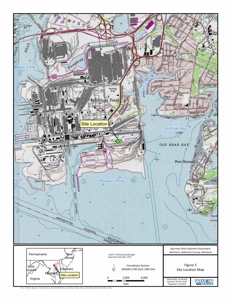
2.1 SITE LOCATION
The Sparrows Point Site comprises approximately 3,100 acres on the north side of the Patapsco River
in Baltimore County, Maryland, and is located approximately nine miles southeast of downtown
Baltimore, as depicted on Figure 1, Site Location Map. The approximate geographic coordinates of
the center of the Site are 39.21264º north latitude and 76.46974º west longitude. The Site includes the
shoreline areas of the peninsula located immediately surrounding the former Sparrows Point Facility
and is bounded to the west by Bear Creek; to the south by the Patapsco River; to the east by Old Road
Bay, Jones Creek, and residential areas of the City of Edgemere beyond. As shown in Figure 2, Site
Layout Map, the southeast shoreline portion surrounding the former Sparrows Point Facility at which
this assessment will be conducted, is located along the southern and eastern shores adjacent to the
former Bethlehem Steel plant on Sparrows Point, and is bordered by the Patapsco River to the south,
Old Road Bay to the east, and Jones Creek to the northeast.
2.2 SITE DESCRIPTION
Most buildings within the Site had been demolished with concrete slabs, if present, remaining on
grade (Rust, 1998). The existing ground surface is relatively flat, but contains manmade features
such as buildings, landfills, and material stockpiles. Land reclamation and fill placement activities
have been conducted at the Site since the early 1900s. Currently, most buildings within the Site have
been demolished with concrete slabs remaining on grade. Fill deposited at the Site consists primarily
of iron and steel-making slag and waste byproduct materials that have been placed for grade-leveling.
In general, fill placement occurred in three modes: (1) stream channels and estuaries that originally
extended into the Sparrows Point peninsula were filled; (2) the entire southern shoreline of the
peninsula was expanded southward into the Patapsco River; and (3) fill was placed throughout the
property to level grades (EAG, 2015a).
2.3 SITE HISTORY
From the late 1800s until 2012, the production and manufacturing of steel was conducted at Sparrows
Point. Pennsylvania Steel built the first furnace at Sparrows Point in 1887. Bethlehem Steel
Corporation (BSC) purchased the facility in 1916 and constructed mills to produce hot rolled sheet,
cold rolled sheet, galvanized sheet tin mill products, and steel plate. During peak steel production in
Sparrows Point-Sediment Assessment Southeast Area Final Field Sampling and Analysis Plan
TDD NO.: W501-15-08-003 DCN: W0053.1A.01715 Page 3 SPARROW POINT-SEDIMENT_ASSESSMENT_FINAL_FSP.Docx
1959, the facility operated 12 coke-oven batteries, 10 blast furnaces, and 4 open-hearth furnaces (EA,
2014). Iron and steel production operations and processes at Sparrows Point included raw material
handling, coke production, sinter production, iron production, steel production, and semi-finished and
finished product preparation. In 1970, Sparrows Point was the largest steel facility in the United
States, producing hot and cold rolled sheets, coated materials, pipes, plates, and rod and wire. The
steelmaking operations at the facility ceased in Fall 2012 (EAG, 2014).
According to the Description of Current Conditions (DCC) Report produced by Rust Environment
and Infrastructure (Rust), the Site was formerly occupied by businesses conducting iron and steel
production operations within areas generally referred to as Open Hearth Furnace Area, Primary
Rolling Mills Area, and Blast Furnace Area. Other former operations include a power generation
building and associated oil storage facilities, a vehicle maintenance area and areas occupied by a
former employee town.
On September 11, 2014, the Site was accepted into the Maryland Department of the Environment
(MDE) Voluntary Cleanup Program (VCP). The Site’s current and anticipated future use is Tier 3
(Industrial), and plans for the Site include demolition of existing structures and redevelopment over
the next several years.
2.4 PREVIOUS SITE INVESTIGATIONS
In August 1993, potential sources of releases of hazardous substances to the environment from the
Site were identified in a final Resource Conservation and Recovery Act (RCRA) Facility Assessment
Phase II Report (RFA Report) prepared for EPA by A.T. Kearney (Kearney, 1993). The RFA Report
provided an updated report for the Site from an initial draft RFA Report prepared by PRC
Environmental Management on April 12, 1988. The Final RFA identified 203 Solid Waste
Management Units (SWMUs) and 28 Areas of Concern (AOCs) where a release occurred or that had
the potential to release hazardous wastes or hazardous waste constituents to various media (EAG,
2014).
On October 10, 1997, EPA and MDE filed a multimedia Consent Decree through the U.S District
Court for the Court of Maryland seeking relief from alleged endangerment to public health, welfare,
or the environment from contamination at and around the Sparrows Point Facility. Pursuant to the

Sparrows Point-Sediment Assessment Southeast Area Final Field Sampling and Analysis Plan
TDD NO.: W501-15-08-003 DCN: W0053.1A.01715 Page 4 SPARROW POINT-SEDIMENT_ASSESSMENT_FINAL_FSP.Docx
requirements of the 1997 Consent Decree, a Site-Wide Investigation (SWI) and associated
environmental assessments have been performed at the Site. The SWI focused on characterizing the
nature and extent of releases from the facility. As part of the SWI, work has been completed to
implement an investigation and screening process to evaluate potential source areas of releases to the
environment and determine if further action (or no further action) is necessary.
Numerous investigations have been completed as part of the SWI program required by the Consent
Decree. Major submittals completed to date as part of the SWI include:
• Description of Current Conditions (Rust, 1998)
• Site-Wide Investigation Work Plan- Groundwater Study (CH2M Hill, 2000)
• Site-Wide Investigation Groundwater Study Report (SWI), July 2001 (CH2M Hill, 2001)
• Site-Wide Investigation Release Site Characterization Study (RCS), June 2002 (CH2M, Hill
2002)
• Site-Wide Investigation: Report of Nature & Extent of Releases to Groundwater from the
Special Study Areas (SSAs) (URS, 2007a).
• CA725 Facility Investigation and Human Health Risk Evaluation (HHRE) Findings, ISG
Sparrows Point, June 2005 (URS, 2005);
• Ecological Risk Assessment Strategy Document; ISG Sparrows Point Facility (URS, 2006);
• Final Ecological Risk Assessment Work Plan for On-Site Areas (URS, 2007b).
• Screening Level Ecological Risk Assessment For On-Site Areas Final (URS, 2009a)
• Supplemental Report County Lands Parcel 1B Ponds Final (URS, 2009b)
• Final Baseline Ecological Risk Assessment for On-Site Areas (BERA) Report (URS, 2011)
• Quality Assurance Project Plan-Sparrows Point Terminal Site. Prepared by ARM Group.
(EAG, 2015b).
In 2014, a Site Conceptual Cleanup Plan (SCCP) of the Site was prepared by EAG on behalf of the
current owner and seller; Sparrows Point LLC. The SCCP is intended to provide an agreed upon
course of action for further investigation, remediation, closure, and pathway exclusion of applicable
areas for the Site pursuant to the December 14, 2013 Purchase Sale Agreement (PSA) between HRP
Sparrows Point, LLC (HRP or Purchaser) and Sparrows Point, LLC. The SCCP outlines the
Sparrows Point-Sediment Assessment Southeast Area Final Field Sampling and Analysis Plan
TDD NO.: W501-15-08-003 DCN: W0053.1A.01715 Page 5 SPARROW POINT-SEDIMENT_ASSESSMENT_FINAL_FSP.Docx
objectives, approach, methods and schedule to complete investigation and remediation and achieve
‘closure’ of environmental obligations of the Site (EAG, 2014).
2.5 Upcoming Groundwater Investigations
In October 2015, EAG submitted a Work Plan to complete a comprehensive groundwater
investigation on a central portion of the Sparrows Point Facility. The investigation is currently
ongoing and validated groundwater data is expected in April 2016. The objectives of this
investigation are to:
• Determine the presence or absence of impacts to groundwater in the central portion of the
Sparrows Point Facility.
• Identify potential continuing sources of groundwater contamination.
• Characterize the quality of groundwater at the perimeter of the central portion of Sparrows
Point Facility that potentially is discharging to surface water.
The proposed groundwater monitoring system design incorporates collecting groundwater samples
from newly installed, and several existing groundwater monitoring wells (EAG, 2015a).
The southeast shoreline was not the primary focus of this investigation; however, the data that will be
collected during this investigation regarding groundwater conditions at the Site will be utilized for the
purposes of sample location and analysis selection for the sediment sampling discussed in this FSP.
Based upon the results of the groundwater investigation, sample locations or analyses may be
adjusted at the discretion of the EPA On-Scene Coordinator (OSC).
2.6 POTENTIAL SOURCE IDENTIFICATION SUMMARY
Based upon the results of previous investigations at the Site and document review, several areas in
and around the buildings and facilities located at the Site have been identified as potential historical
sources of groundwater contamination. The first potential sources to be identified were Recognized
Environmental Conditions (RECs), identified during the Phase I Environmental Site Assessment
(ESA) conducted in August, 2013 (Weaver Boos Consultants, 2014).

Sparrows Point-Sediment Assessment Southeast Area Final Field Sampling and Analysis Plan
TDD NO.: W501-15-08-003 DCN: W0053.1A.01715 Page 6 SPARROW POINT-SEDIMENT_ASSESSMENT_FINAL_FSP.Docx
Following the identification and evaluation of all RECs at the Site, SWMUs and AOCs were
identified during the DCC Stormwater runoff from these areas is diverted and collected by a network
of culverts, underground pipes, and drainage ditches, and discharged through stormwater outfalls.
According to the DCC thirty-five outfalls are covered under the current National Pollutant Discharge
Elimination System (NPDES) Permit. A detailed discussion of the existing NPDES discharge
locations is presented in a Site-Wide Investigation Release Site Characterization Study (RCS),
(CH2MHill, 2002).
Stormwater associated with the outfalls located on the east side of the southeast shoreline is directed
east and then discharged to Jones Creek and Old Road Bay through outfalls 001, 017, 016, 065, 059,
and 068. Stormwater from the southern portion of the Site is directed to the southwest, and
discharged to the Patapsco River through outfall 044. Stormwater from the northern portion of the
facility is directed north to the Tin Mill Canal and Humphreys Creek Wastewater Treatment Plant and
is discharged to Bear Creek through Outfall 014. The outfalls associated with the Site are shown on
Figure 2, Site Layout Map.
3.0 OBJECTIVE AND DATA USE
The objective of the sampling activities presented in this FSP is to conduct a removal assessment of
the southeast shoreline of the Site to determine if hazardous materials, pollutants and contaminants
associated with the former Sparrows Point Facility have contaminated offshore sediments, and to
provide stormwater chemistry data from nearby outfalls to identify potential sources of contamination
to the sediments. Analytical data will be used to evaluate whether the Site warrants additional action
under the Comprehensive Environmental Response, Compensation, and Liability Act of 1980
(CERCLA).
Components of this assessment include the following:
• Surface sediment sampling and analysis; and,
• Stormwater sampling and analysis to assess the potential effects of discharge from stormwater
outfalls from the southeast shoreline of Patapsco River, Old Road Bay and Jones Creek;

Sparrows Point-Sediment Assessment Southeast Area Final Field Sampling and Analysis Plan
TDD NO.: W501-15-08-003 DCN: W0053.1A.01715 Page 7 SPARROW POINT-SEDIMENT_ASSESSMENT_FINAL_FSP.Docx
4.0 PROPOSED ACTIVITIES
This section describes the scope of work, including proposed sampling activities and field
measurements; summarizes samples to be collected for the project; explains how samples will be
collected and handled; and describes equipment decontamination procedures and the disposal of
investigation-derived waste (IDW) generated during sampling.
4.1 SCOPE OF WORK
As part of the removal assessment for the Site, WESTON will perform the following tasks:
Collect up to 42 sediment samples.
Collect up to 7 stormwater samples.
Collect field duplicate samples for each sample matrix, five for sediment and one for
stormwater.
Document and record sample locations using Global Positioning System (GPS) technology
and enter sample location information into a Scribe database.
Photo document sampling activities and sampling locations.
Package and ship all samples collected to the assigned EPA Contract Laboratory Program
(CLP) laboratory or Tier IV laboratory (i.e., WESTON-subcontracted laboratory) for the
following analyses: volatile organic compounds (VOCs), semivolatile organic compounds
(SVOCs) including polynuclear aromatic hydrocarbons (PAHs), polychlorinated biphenyls
(PCBs), Target Analyte List (TAL) metals including mercury, and cyanide.
4.2 FIELD ACTIVITIES
This section describes the proposed sampling activities and proposed sample locations. Proposed
sediment and stormwater sampling locations are shown on Figure 3, Sediment Sampling Locations
and Figure 4, Stormwater Sample Locations, respectively. The proposed samples to be collected are
summarized in Table 1, Proposed Sample Summary. Actual sample locations may vary based upon
field conditions and observations at the time of sampling, at the discretion of the OSC and the results
of the groundwater investigation to be conducted by EAG. In addition, if sufficient sample volume is
not able to be collected at any one location, the location may be modified at the discretion of the
Sparrows Point-Sediment Assessment Southeast Area Final Field Sampling and Analysis Plan
TDD NO.: W501-15-08-003 DCN: W0053.1A.01715 Page 8 SPARROW POINT-SEDIMENT_ASSESSMENT_FINAL_FSP.Docx
OSC. Table 2 summarizes the matrices, analyses, analytical methods, containers, preservatives,
detection limits, and maximum holding times for all the samples proposed to be collected during the
sampling event.
Initially, sampling for the offshore investigation for the southeast shoreline area will consist of
collecting sediment and stormwater samples to evaluate potential migration paths for contaminants to
the offshore environment. Samples will be submitted to the assigned EPA CLP laboratory and/or Tier
IV laboratory for analysis. Following receipt of the analytical results from the initial sampling, the
EPA OSC will determine what additional surface or subsurface sediment sampling is necessary to
achieve the project objectives. Subsequent surface and subsurface sampling of the sediments, along
with additional stormwater samples, will be described in a revision to this FSP. The addendum will
describe additional sampling and analytical procedures for collection of additional sediment and/or
subsurface sediment using a boat-mounted Vibracore sample collection system to approximately 6 ft
below the sediment surface.
4.2.1 SEDIMENT SAMPLING
WESTON will collect up to forty-two surface sediment samples during the initial southeast shoreline
offshore investigation. Proposed sample locations are depicted on Figure 3, Sediment Sample
Locations. These locations were selected to provide spatial coverage of the area, and also to assess
the potential transport of contaminants to the offshore environment from stormwater drainage. The
locations of sediment samples were organized into 14 transects, consisting of three sampling
locations each, to assess the following locations as depicted on Figure 3:
The southeast shoreline within Patapsco River; assigned transect identifiers A through D from
the west to east.
The southeast shoreline within Old Road Bay; assigned transect identifiers E through I from
the south to north.
The east shoreline within Jones Creek; assigned transect identifiers J through M from the
south to north.
If determined by the EPA OSC to be necessary to achieve the assessment objectives, additional
surface and/or subsurface sediment samples may be collected during a second round of field sampling

Sparrows Point-Sediment Assessment Southeast Area Final Field Sampling and Analysis Plan
TDD NO.: W501-15-08-003 DCN: W0053.1A.01715 Page 9 SPARROW POINT-SEDIMENT_ASSESSMENT_FINAL_FSP.Docx
to provide further characterization of the nature and extent of contamination. Subsurface sediment
cores will be collected using a Vibracore sampler to approximately 6 ft below the sediment surface.
Locations for this sampling event will be selected based on the results of the initial sampling and
analysis.
Sediment samples will be collected as discrete grab samples from the southeast shoreline area of
Sparrows Point in accordance with WESTON SOP 303, Sediment Sampling (WESTON, 2015b).
Samples will be collected using a Petite Ponar dredge operated from a 16-ft Jon boat. Each sample
will consist of one successful Ponar grab in which the dredge is lowered through the water to the
sediment surface and is recovered with a full receptacle of sediment. Sediment samples will be
targeted from the sediment surface to a maximum depth of six inches. Ponar grabs that do not achieve
sufficient penetration depth will be discarded. Additional attempts will be made until the desired
penetration is achieved.
Sediment will then be placed from the Ponar into a stainless steel bowl or equivalent receptacle.
Sediment samples for VOC analysis will be collected first using 5 gram EnCore® sampling devices
or collected directly into 4 ounce glass jars with septum. The sediment will then be homogenized with
a stainless steel or disposable hand trowel, and all extraneous material (i.e., pebbles, plant material,
shells) will be removed to the greatest extent practicable. During this process, the sediment will be
screened using a photoionization detector (PID). Homogenized materials will then be placed directly
in the appropriate sample containers for analysis. A sediment sampling form that indicates the PID
measurements, texture, location, date/time of collection, and observations of the material recovered
will be compiled for each sampling location.
Sediment samples will be collected for VOCs, SVOCs (including PAHs by Selected Ion Monitoring
[SIM]), PCBs, and TAL metals (including mercury and cyanide analysis). Sample volume, container
types, and preservation requirements for the analytical methods proposed for this project are provided
in Table 2.
4.2.2 STORMWATER SAMPLING
Stormwater samples will be collected from seven stormwater outfalls exiting the facility to assess
potential sources of contaminants to the offshore sediments. If possible, stormwater samples will be
Sparrows Point-Sediment Assessment Southeast Area Final Field Sampling and Analysis Plan
TDD NO.: W501-15-08-003 DCN: W0053.1A.01715 Page 10 SPARROW POINT-SEDIMENT_ASSESSMENT_FINAL_FSP.Docx
collected during, or immediately after a rain event, from any of the active stormwater outfalls
(Outfalls 068, 017, 016, 001, 065, 059 and 044) located in the southeast shoreline area that are
observed to be flowing. For purposes of this sampling, a rain event is defined as any measurable
amount of rain that causes the storm water outfalls to flow. If a rain event does not occur during the
sampling event, then stormwater samples will collected from any outflows observed to be flowing.
Additional stormwater samples will be collected during the second round of sampling and additional
criteria for a rain event may be defined. The stormwater outfall locations are depicted on Figure 4,
Stormwater Sample Locations. Grab samples of stormwater will be collected from the outfalls during,
or immediately after the storm event, to capture the runoff. Samples will be collected directly from
the water flowing out of each outfall directly into sample containers for analysis. During sampling, at
each location water quality measurements including, pH, turbidity, specific conductance, dissolved
oxygen (DO), oxidation reduction potential (ORP), and temperature will be measured in accordance
with WESTON SOP No. 210, Field pH, Conductivity, and Temperature Measurement (WESTON,
2011a) using a multi-parameter YSI water quality meter or equivalent instrumentation.
Stormwater samples will be analyzed for VOCs, SVOCs (including PAHs by SIM), PCBs, TAL
metals (including mercury), and cyanide. The sample containers, preservatives, and holding time
requirements for stormwater are provided in Table 2.
4.3 SAMPLE IDENTIFICATION
The Sample Identifier will be listed on the chain-of-custody document for each sample and will
provide the date and sample location as follows:
SESL-MMDDYY-XX-###
The “SESL” prefix refers to the Site name – South East Shoreline at the Sparrows Point Facility. The
MMDDYY refers to the date of sample collection (i.e., 040116 for April 1, 2016). The XX portion of
the Sample Identifier refers to the sample type (“SS” for surface sediment, “ST” for stormwater, “FB”
for field blank, “RB” for rinsate blank, and “TB” for trip blank). The “##” portion of the suffix refers
to the unique sequential sample number assigned to a specific sampling location. For sediment
samples, each transect has been assigned a letter and will be assigned a number consecutively moving
Sparrows Point-Sediment Assessment Southeast Area Final Field Sampling and Analysis Plan
TDD NO.: W501-15-08-003 DCN: W0053.1A.01715 Page 11 SPARROW POINT-SEDIMENT_ASSESSMENT_FINAL_FSP.Docx
away from the shoreline. Stormwater samples will be labeled with “ST” followed by the outfall
number.
In addition to the Sample Identifier, samples to be shipped to CLP or Delivery of Analytical Services
(DAS) laboratories for analysis will be assigned unique CLP sample numbers. Organics samples will
be identified in the format C#### (where the # may represent a number or letter), and the
corresponding inorganics sample ID will be in the format MC####. The CLP sample number and the
Sample Identifier will be included on the chain-of-custody, the bottle labels, and the sample tags
attached to each bottle.
4.4 SAMPLE MANAGEMENT
WESTON will document field activities using logbooks, photographic records, and chain-of-custody
documentation. Documentation, record keeping, and data management activities will be conducted in
accordance with the WESTON UFP-QAPP (WESTON, 2015a) and in accordance with the Contract
Laboratory Program Guidance for Field Samplers (EPA, 2014a), unless otherwise specified. Each
sampling location will be noted in the field logbook in accordance with WESTON SOP No. 101,
Logbook Documentation (WESTON, 2015c). Scribe software will be used for sample documentation
and data management.
Sample handling, packaging, and shipment procedures will be in accordance with the Contract
Laboratory Program Guidance for Field Samplers (EPA, 2014a). Sample labels and tags will be
affixed to each sample container and labeled with appropriate identifying information (i.e., location,
date, time, condition, added preservatives). The dates and times of collection for each sample will be
noted on the sampling form and on the COC form. Sample containers will be placed within protective
packaging to prevent breakage and stored in a secure insulated cooler with ice (kept at ≤ 6 °C
without freezing) until being shipped off-site to an assigned EPA Contract Laboratory Program (CLP)
laboratory or Tier IV laboratory (i.e., WESTON-subcontracted laboratory). A temperature blank will
be placed in each sample cooler. Additional field QA/QC samples will be collected as specified in
Table 2.
Samples will be placed in plastic zipper bags. Bagged containers will be placed in coolers with ice
and packed with appropriate absorbent and packing material. All sample documents will be sealed in
Sparrows Point-Sediment Assessment Southeast Area Final Field Sampling and Analysis Plan
TDD NO.: W501-15-08-003 DCN: W0053.1A.01715 Page 12 SPARROW POINT-SEDIMENT_ASSESSMENT_FINAL_FSP.Docx
a plastic zipper bag and affixed to the underside of each cooler lid. The lid will be sealed with
shipping tape and custody seals will be affixed to the cooler. Coolers will be labeled with the origin
and destination locations.
Chain-of-custody documents will be completed using Scribe software, and will accompany field
samples to the laboratory in accordance with WESTON SOP No. 103, Chain-of-Custody
Documentation (WESTON, 2011b). Samples will be shipped to the designated CLP or Tier IV
laboratories via Federal Express. Regulations for packaging, marking, labeling, and shipping
hazardous materials and wastes are promulgated by the U.S. Department of Transportation. Air
carriers that transport hazardous materials require compliance with the current International Air
Transport Association (IATA) regulations, which apply to shipment and transport of hazardous
materials by air carrier. WESTON will follow all applicable IATA regulations.
4.5 DECONTAMINATION AND INVESTIGATION-DERIVED WASTE
Dedicated, disposable sampling equipment and personal protective equipment (PPE) will be used
wherever applicable. Disposable sampling equipment and PPE will be double-bagged and disposed of
as dry industrial waste. Non-dedicated sampling equipment, such as the petite Ponar will undergo a
gross decontamination between each sampling point with Alconox, followed by a double rinse with
distilled water, in accordance with WESTON SOP No. 301, Decontamination Procedures (WESTON,
2011c). IDW is defined as any byproduct of the field activities that is suspected or known to be
contaminated with hazardous substances. IDW will be handled in accordance with Office of Solid
Waste and Emergency Response (OSWER) 9345.3-02 (EPA, 1991) and WESTON SOP No. 019,
Investigative Derived Waste Compliance Plan (WESTON, 2012).
5.0 ANALYTICAL PARAMETERS AND METHODS
All sediment and stormwater samples will be analyzed for Target Compound List (TCL) VOCs,
SVOCs (including PAHs by SIM), PCBs, and TAL metals including mercury, and cyanide. Analysis
will be conducted in accordance with EPA CLP Methods SOM02.3 and ISM02.3 for organics and
inorganics, respectively (EPA, 2015a and EPA, 2015b). TAL Metals analysis will be conducted
through Inductively Coupled Plasma-Mass Spectroscopy (ICP-MS). Table 2, Analytical Parameters,
Sparrows Point-Sediment Assessment Southeast Area Final Field Sampling and Analysis Plan
TDD NO.: W501-15-08-003 DCN: W0053.1A.01715 Page 13 SPARROW POINT-SEDIMENT_ASSESSMENT_FINAL_FSP.Docx
summarizes the matrices, analyses, analytical methods, containers, preservatives, QA/QC samples,
and technical holding times for the samples proposed for collection during the sampling event.
6.0 QUALITY ASSURANCE AND QUALITY CONTROL PROCEDURES
This section describes the QA and QC procedures for personnel during the site sampling event,
including responsibilities, field QC, laboratory QC, data evaluation, and data management.
6.1 FIELD QUALITY CONTROL
Field QA/QC measures will consist of collecting field duplicates and field blanks (e.g., trip blank
samples, ambient field blank samples, and equipment rinsate blank samples).
Field duplicate samples will be collected at a rate of one per 20 samples per sample matrix and will
be used to test the reproducibility of sampling procedures and analytical results.
Trip blank samples will be collected and provided in each cooler containing samples for VOC
analysis. Trip blank samples will be used to assess whether samples may have become cross-
contaminated with VOCs during storage and shipment.
Ambient field blanks will be collected at a frequency of one per day or one per 20 field samples for
each parameter to be analyzed, whichever is greater. Ambient field blanks are generated in the field
by pouring laboratory grade deionized water into the sampling container and preserving the sample
according to method requirements. The ambient field blank results will be used to assess whether
contaminants were introduced during sample collection, storage, and shipment as well as sample
handling by the laboratory.
Equipment rinsate blanks will be collected from non-dedicated sampling equipment at a frequency of
one per day or one per 20 samples per matrix for each sampling equipment type for each parameter to
be analyzed, whichever is greater. Equipment rinsate blank results will be used to verify proper
decontamination of non-dedicated sampling equipment and field filters (for dissolved metals
analysis). These measures will be applied in accordance with the WESTON UFP QAPP (WESTON,
2015a). The number and types of QC samples to be collected are summarized in Table 2.
Sparrows Point-Sediment Assessment Southeast Area Final Field Sampling and Analysis Plan
TDD NO.: W501-15-08-003 DCN: W0053.1A.01715 Page 14 SPARROW POINT-SEDIMENT_ASSESSMENT_FINAL_FSP.Docx
Temperature blanks will be placed in each sample cooler and used to determine whether samples
have been adequately cooled during shipment and storage. The temperature blank will be prepared
using tap water placed in a volatile organic analysis (VOA) vial without preservative.
6.2 LABORATORY QUALITY CONTROL
Samples will be shipped to the EPA Region III CLP laboratory assigned through the EPA Region III
Office of Analytical Services and Quality Assurance Branch (OASQA) or the assigned Tier IV DAS
laboratory. Laboratory QC measures will consist of all QC elements identified in the analytical
method or CLP Statement of Work (SOW) as required by EPA Region III policy, and will
incorporate all reportable QC (including forms and deliverables) required by the SOW and this FSP.
Since samples will be shipped to EPA CLP or DAS laboratories, analysis of matrix spike and matrix
spike duplicate (MS/MSD) samples is required for PCBs and Spike/Duplicate (S/D) for inorganic
analyses. EPA Region III does not require analysis of MS/MSD samples for CLP VOCs or SVOCs.
MS/MSD and matrix spike/duplicate (S/D) sample results are used to assess analytical precision and
accuracy in a specific sample matrix. WESTON field personnel will collect a minimum of one
MS/MSD and one S/D sample per 20 samples of the same matrix. For water samples, the MS/MSD
sample will require collection of a triple volume of sample and the analysis for the S/D sample will
involve the collection of a double volume of sample. Additional sample volume is not required for the
sediment samples. See Table 2, Analytical Parameters, for a summary of QA/QC samples being
collected.
6.3 DATA VALIDATION
Validation of all analytical data will be performed by the Environmental Services Assistance Team
(ESAT) contractor under the direction of the OASQA Branch. Inorganic and organic data will be
validated at the Organic Level 2 and Inorganic Level 2, in accordance with USEPA Contract
Laboratory Program National Functional Guidelines for Superfund Organic Methods Data Review,
USEPA-540-R-014-002, August 2014 (EPA, 2014b) and USEPA Contract Laboratory Program
National Functional Guidelines for Inorganic Superfund Data Review, USEPA-540-R-013-001,
August 2014 (EPA, 2014c).
Sparrows Point-Sediment Assessment Southeast Area Final Field Sampling and Analysis Plan
TDD NO.: W501-15-08-003 DCN: W0053.1A.01715 Page 15 SPARROW POINT-SEDIMENT_ASSESSMENT_FINAL_FSP.Docx
6.4 DATA EVALUATION AND MANAGEMENT
This section describes how WESTON will evaluate data generated from the sampling event,
determine whether data are representative of the Site, and make certain that data are secure and
retrievable.
6.4.1 DATA EVALUATION
WESTON will review the data validation reports to determine whether any major or minor
deficiencies were encountered during sampling and analysis. These deficiencies may include major
deficiencies (such as unusable or rejected data) or minor deficiencies affecting data, including data
that were estimated or qualified due to failure to meet project-specific or National Functional
Guideline QC acceptance limits.
To assess the effectiveness of field sampling procedures and implement corrective actions as needed,
WESTON will evaluate field blank results. Trip blank contamination not attributed to laboratory
sources may be due to contamination in the field or during shipment. Rinsate blank contamination,
not otherwise attributed to laboratory sources, may be due to inadequate decontamination procedures
or contamination in source water used for the rinsate blank. Ambient field blank contamination, not
attributed to laboratory sources, suggests contaminants from either airborne sources that may have
been entrained in the analytical sample during collection or from the source water used to generate
the ambient field blank. Failure of the trip blank to meet the temperature acceptance criteria indicates
the need to better ice down the samples.
6.4.2 DATA REPRESENTATIVENESS AND COMPLETENESS
The intent of this FSP is to obtain a complete data set which is representative of site conditions. Data
will be reviewed for completeness. If not all samples were collected, resulting in less than 100%
completeness, the reason for the data gaps will be identified in the Trip Report. If any data are
rejected, the reason for the data rejection will be discussed in the Trip Report. If sampling activities or
procedures vary significantly from this FSP due to unexpected conditions in the field or other
unforeseeable factors, WESTON will discuss these deviations from the FSP and whether the changes
affect data representativeness in the Trip Report.
Sparrows Point-Sediment Assessment Southeast Area Final Field Sampling and Analysis Plan
TDD NO.: W501-15-08-003 DCN: W0053.1A.01715 Page 16 SPARROW POINT-SEDIMENT_ASSESSMENT_FINAL_FSP.Docx
6.4.3 DATA MANAGEMENT
EPA Region III will provide WESTON with a validation report for the analytical data in portable
document file (pdf) format along with an importable Excel electronic data deliverable (EDD).
WESTON will upload the EDD data to the Scribe database and compare the EDD results to the
sample results received in pdf format in conjunction with the data validation report to ensure their
consistency. All electronic data will be stored in a Scribe database for future retrieval and reference,
based on the OSC’s requirements.
7.0 SCHEDULE AND DELIVERABLES
WESTON anticipates that sample collection will take place the week of June 20, 2016. WESTON
will ship samples to the assigned laboratories for analysis immediately following collection.
WESTON expects to receive validated analytical data from EPA Region III approximately 35 days
after the laboratory receives the samples. WESTON will provide EPA with the Trip Report within 70
days after all site activities have been completed and validated data are available.
Information obtained during the sampling event will be compiled into a Trip Report. The Trip Report
will discuss data collection methods and document sampling locations and include data summary
tables, figures, maps, and site photographic documentation.
Sparrows Point-Sediment Assessment Southeast Area Final Field Sampling and Analysis Plan
TDD NO.: W501-15-08-003 DCN: W0053.1A.01715 Page 17 SPARROW POINT-SEDIMENT_ASSESSMENT_FINAL_FSP.Docx
8.0 REFERENCES
A.T. Kearney. 1993. Final RCRA Facility Assessment Phase II Report. August.
CH2M Hill. 2000. Site-Wide Investigation (SWI) Work Plan. June.
CH2M Hill. 2001. Site-Wide Investigation Groundwater Study Report. July.
CH2MHill. 2002. Site-Wide Investigation Release Site Characterization Study. June.
EPA (U.S. Environmental Protection Agency). 2014a. Contract Laboratory Program Guidance for Field Samplers. Office of Superfund Remediation and Technology Innovation. Office of Solid Waste and Emergency Response (OSWER) 9200.2-147 EPA 540-R-014-013. October.
EPA (U.S. Environmental Protection Agency). 2014b. USEPA Contract Laboratory Program National Functional Guidelines for Superfund Organic Methods Data Review. USEPA-540-R-14-001. August.
EPA (U.S. Environmental Protection Agency). 2014c. National Functional Guidelines for Inorganic Superfund Data Review. USEPA-540-R-013-001. August.
EPA (U.S. Environmental Protection Agency). 2015a. EPA Contract Laboratory Program Statement of Work for Organic Superfund Methods, Multi-Media, Multi-Concentration, SOM02.3. August.
EPA (U.S. Environmental Protection Agency). 2015b. EPA Contract Laboratory Program Statement of Work For Inorganic Superfund Methods, Multi-Media, Multi-Concentration, ISM02.3. August.
EPA (U.S. Environmental Protection Agency). 1991. Management of Investigative Derived Waste During Site Inspections. Office of Solid Waste and Emergency Response (OSWER) 9345.3-02. May. EA Engineering, Science and Technology, Inc. 2014. Work Plan for Offshore Investigation of the Phase I Area of the Sparrows Point Site. September
EAG (EnviroAnalytics Group). 2015a. Phase II Investigation Work Plan-Area B Groundwater Investigation. Prepared by ARM Group. October.
EAG (EnviroAnalytics Group). 2015b. Quality Assurance Project Plan-Sparrows Point Terminal Site. Prepared by ARM Group. October.
EAG (EnviroAnalytics Group). 2014. A Site Conceptual Cleanup Plan-Former RD Steel Facility. May.
Rust Environment and Infrastructure. 1998. Description of Current Conditions Report-Bethlehem Steel Corporation Report. January.

Sparrows Point-Sediment Assessment Southeast Area Final Field Sampling and Analysis Plan
TDD NO.: W501-15-08-003 DCN: W0053.1A.01715 Page 18 SPARROW POINT-SEDIMENT_ASSESSMENT_FINAL_FSP.Docx
URS (URS Corporation). 2011. Final Baseline Ecological Risk Assessment for On-Site Areas (BERA) Report. October 7, 2011.
URS (URS Corporation). 2009a. Screening Level Ecological Risk Assessment for Onsite Areas. ISG Sparrows Point Facility, Sparrows Point Maryland. Prepared for Severstal Sparrows Point, LLC. April.
URS (URS Corporation). 2009b. Supplemental Report: County Lands Parcel 1B Ponds, Final. ISG Sparrows Point Facility, Sparrows Point Maryland. Prepared for Severstal Sparrows Point, LLC. May.
URS (URS Corporation). 2007a. Site Wide Investigation, Report of Nature & Extent of Releases to Groundwater from the Special Study Areas. International Steel Group, ISG Sparrows Point, Inc. Facility, Sparrows Point, Maryland.
URS (URS Corporation). 2007b. Final Ecological Risk Assessment Work Plan for On-Site Areas. ISG Sparrows Point Facility, Sparrows Point, Maryland. Prepared for ISG Sparrows Point, January.
URS (URS Corporation). 2006. Ecological Risk Strategy Document: ISG Sparrows Point Facility, Sparrows Point, Maryland.
URS (URS Corporation). 2005. CA725 Facility Investigation and Human Health Risk Evaluation (HHRE) Findings, ISG Sparrows Point, June 9, 2005.
Weaver Boos Consultants, LLC. 2014. Phase I Environmental Site Assessment. May.
WESTON (Weston Solutions, Inc.). 2011a. Field pH, Conductivity, and Temperature Measurement. SOP No. 210. August.
WESTON (Weston Solutions, Inc.). 2011b. Chain-of-Custody Documentation. SOP No. 103. August.
WESTON (Weston Solutions, Inc.). 2011c. Decontamination Procedures. SOP No. 301. August.
WESTON (Weston Solutions, Inc.). 2012. Investigative Derived Waste Compliance Plan. SOP No. 019. May.
WESTON (Weston Solutions, Inc.). 2015a. EPA Region III Superfund Technical Assessment and Response Team 5 (START-5 Contract) Program-Wide Uniform Federal Policy Quality Assurance Project Plan (QAPP). Draft. July.
WESTON (Weston Solutions, Inc.). 2015b. Sediment Sampling. SOP 303.
WESTON (Weston Solutions, Inc.). 2015c. Logbook Documentation. SOP No. 101. July.
Sparrows Point-Sediment Assessment Southeast Area Final Field Sampling and Analysis Plan
TDD NO.: W501-15-08-003 DCN: W0053.1A.01715
SPARROW POINT-SEDIMENT_ASSESSMENT_DRAFT_FSP.Docx
FIGURES
kj
Bear Creek
Patapsco River
Old Road Bay
Jones
Creek
Edgemere
Figure 1Site Location Map
Site Location
File: Y:\EPA_Region_III\Sparrows_Point\MXD\Site_Location_Map.mxd, 3/1/2016 10:29:54 AM, ricksc
Pennsylvania NewJersey
Virginia
West Virginia
MarylandDelaware
Coordinate System:WGS84 UTM Zone 18N Feet´
Site Location
Sparrows Point Sediment AssessmentBaltimore, Baltimore County, Maryland
TDD# W501-15-08-003Contract: EP-S3-15-02
Prepared: 3/1/2016
USGS 7.5 Minute QuadrangleSparrows Point MD, 1975
0 2,000 4,000Feet
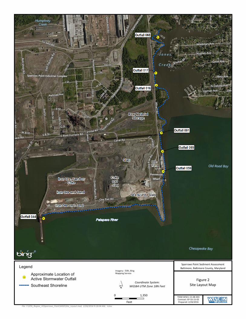
Figure 2Site Layout Map
Imagery: ESRI, BingMapping Service
0 1,350Feet
File: Y:\EPA_Region_III\Sparrows_Point\MXD\Site_Layout.mxd, 2/26/2016 9:18:04 AM, ricksc
´
Legend
!.Approximate Location ofActive Stormwater OutfallSoutheast Shoreline Coordinate System:
WGS84 UTM Zone 18N Feet
Sparrows Point Sediment AssessmentBaltimore, Baltimore County, Maryland
TDD# W501-15-08-003Contract: EP-S3-15-02Prepared: 2/26/2016

Figure 3Sediment Sample Locations
Imagery: ESRI, BingMapping Service
0 1,350Feet
File: Y:\EPA_Region_III\Sparrows_Point\MXD\Prop_Sed_locs.mxd, 4/19/2016 9:29:40 AM, ricksc
´
Legend
#*Proposed Sediment Sample Location
!.Approximate Location ofActive Stormwater Outfall
Coordinate System:WGS84 UTM Zone 18N Feet
Sparrows Point Sediment AssessmentBaltimore, Baltimore County, Maryland
TDD# W501-15-08-003Contract: EP-S3-15-02Prepared: 4/19/2016

Figure 4Stormwater Sample Locations
Imagery: ESRI, BingMapping Service
0 1,350Feet
File: Y:\EPA_Region_III\Sparrows_Point\MXD\SW_sample_locs.mxd, 2/26/2016 9:23:20 AM, ricksc
´
Legend
!.Approximate Location ofActive Stormwater Outfall
!? Storm Water Sample Locations Coordinate System:WGS84 UTM Zone 18N Feet
Sparrows Point Sediment AssessmentBaltimore, Baltimore County, Maryland
TDD# W501-15-08-003Contract: EP-S3-15-02Prepared: 2/26/2016

Sparrows Point-Sediment Assessment Southeast Area Final Field Sampling and Analysis Plan
TDD NO.: W501-15-08-003 DCN: W0053.1A.01715 SPARROW POINT-SEDIMENT_ASSESSMENT_FINAL_FSP.Docx
TABLES

Sparrows Point-Sediment Assessment Southeast Area Final Field Sampling and Analysis Plan
TDD NO.: W501-15-08-003 DCN: W0053.1A.01715 SPARROW POINT-SEDIMENT_ASSESSMENT_FINAL_FSP.Docx
Table 1 Proposed Sampling
Sample Identifier Sample Matrix Sampling Location Description Rationale
SESL-2016-SS-A01 through A03 Sediment
South East Shoreline; Transect A; Located within the vicinity of Outfall 044; Southern shoreline within Patapsco
River Assess surface water migration destination
SESL-2016-SS-B01 through B03 Sediment
South East Shoreline; Transect B; Spatial coverage of southern shoreline within Patapsco River Background
SESL-2016-SS-C01 through C03 Sediment
South East Shoreline; Transect C; Spatial coverage of southern shoreline within Patapsco River
Assess surface water migration destination
SESL-2016-SS-D01 through D03 Sediment
South East Shoreline; Transect D; Spatial coverage of the southern portion of eastern shoreline within Patapsco River
Assess surface water migration destination
SESL-2016-SS-E01 through E03 Sediment
South East Shoreline; Transect E; Spatial coverage of eastern shoreline within Old Road Bay
Assess surface water migration destination
SESL-2016-SS-F01 through F03 Sediment
South East Shoreline; Transect F; Located within the vicinity of Outfall 059 within Old Road Bay
Assess surface water migration destination
SESL-2016-SS-G01 through G03 Sediment
South East Shoreline; Transect G; Located within the vicinity of Outfall 065 within Old Road Bay
Assess surface water migration destination
SESL-2016-SS-H01 through H03 Sediment
South East Shoreline; Transect H; Located in the vicinity of Outfall 001 along the eastern shoreline within Old Road
Bay Assess surface water migration destination
SESL-2016-SS-I01 through I03 Sediment
South East Shoreline; Transect I; Located at the mouth of Jones Creek and Old Road bay
Assess surface water migration destination
SESL-2016-SS-J01 through J03 Sediment
South East Shoreline; Transect J; Located in the vicinity of Outfall 016 along the eastern shoreline within Jones Creek
Assess surface water migration destination
SESL-2016-SS-K01 through K03 Sediment
South East Shoreline; Transect K; Located in the vicinity of Outfall 017 along the eastern shoreline within Jones Creek
Assess surface water migration destination
SESL-2016-SS-L01 through L03 Sediment
South East Shoreline; Transect L; Located in between Outfall 068 and 17 within Jones Creek
Assess surface water migration destination
SESL-2016-SS-M01 through M03 Sediment
South East Shoreline; Transect M; Located in the vicinity of Outfall 068 within Jones Creek
Assess surface water migration destination
SESL-2016-ST-044 Stormwater Southeast Shoreline; Outfall 044
Assess surface water migration
SESL-2016-ST-059 Stormwater Southeast Shoreline; Outfall 059
Assess surface water migration
SESL-2016-ST-065 Stormwater Southeast Shoreline; Outfall 065
Assess surface water migration
SESL-2016-ST-001 Stormwater Southeast Shoreline; Outfall 001
Assess surface water migration
SESL-2016-ST-016 Stormwater Southeast Shoreline; Outfall 016
Assess surface water migration
SESL-2016-ST-017 Stormwater Southeast Shoreline; Outfall 017
Assess surface water migration

Sparrows Point-Sediment Assessment Southeast Area Final Field Sampling and Analysis Plan
TDD NO.: W501-15-08-003 DCN: W0053.1A.01715 SPARROW POINT-SEDIMENT_ASSESSMENT_FINAL_FSP.Docx
Sample Identifier Sample Matrix Sampling Location Description Rationale
SESL-2016-ST-068 Stormwater Southeast Shoreline; Outfall 068
Assess surface water migration
SESL-2016-ST-001-01 Stormwater Duplicate Sample of SEDL-2016-ST-001 QA/QC
SESL-2016-TB-01 Aqueous Trip blank QA/QC SESL-2016-TB-02 Aqueous Trip blank QA/QC SESL-2016-FB-01 Aqueous Field blank QA/QC SESL-2016-RB-01 Aqueous Rinsate blank QA/QC Notes: QA/QC = Quality assurance/quality control
SESL = Southeast Shoreline SS = Surface Sediment ST = Stormwater FB = Field Blank TB = Trip Blank

Sparrows Point-Sediment Assessment Southeast Area Final Field Sampling and Analysis Plan
TDD NO.: W501-15-08-003 DCN: W0053.1A.01715 SPARROW POINT-SEDIMENT_ASSESSMENT_FINAL_FSP.Docx
Table 2 Analytical Parameters
Matrix Parameter Analytical Method
Container Type Preservative Detection
Limit Technical Holding
Time
Number of Field Samples
Number of. Field
Duplicates
Number of Designated
Lab QC Samples1
Stormwater
TAL VOCs
CLP SOW SOM02.3
Three 40-mL VOA vials
Ice 4°C, HCl, pH<2 CRQL 14 days analysis 7 1 0
TAL SVOCs
CLP SOW SOM02.3
Four 1-L amber Ice CRQL 7 days (extraction)
40 days (analysis) 7 1 0
TAL PCBs CLP SOW SOM02.3
Two 1-L amber Ice CRQL 7 days (extraction
40 days (analysis) 7 1 1
TAL Metals &
Hg
CLP SOW ISM02.3
ICP-MS+Hg
1-L polyethylene
Ice 4°C, HNO3 to pH
<2 CRQL
180 days (metals) 28 days (Hg)
7 1 1
Cyanide CLP SOW ISM02.3
1-L polyethylene
Ice 4º C, NaOH to pH
>12 CRQL 14 days 7 1 1
Soil/Sediment
TAL VOCs
CLP SOW SOM02.3
Three EnCore®
samplers and one 2-oz jar or
one 4-oz jar with septum
Ice CRQL 2 days (unpreserved) 43 5 0
TAL SVOCs
CLP SOW SOM02.3
One 8-oz jar (amber glass) Ice CRQL 14 days (extraction)
40 days (analysis) 43 5 0
TAL PCBs CLP SOW SOM02.3
One 8-oz jar (amber glass) Ice CRQL 14 days (extraction)
40 days (analysis) 43 5 3
TAL Metals &Hg
Cyanide
CLP SOW ISM02.3
ICP-MS+Hg+CN One 4-oz jar Ice CRQL
180 days (metals) 28 days (Hg);
14 days (cyanide) 43 5 3
Rinsate Blank Sample
TAL VOC CLP SOW SOM02.3
Three 40 mL VOA vials
Ice 4°C, HCl, pH<2 CRQL 14 days analysis 5 NA NA
TAL CLP SOW Two 1-L Ice CRQL 7 days (extraction) 4 NA NA

Sparrows Point-Sediment Assessment Southeast Area Final Field Sampling and Analysis Plan
Table 2 Analytical Parameters (Continued)
TDD NO.: W501-15-08-003 DCN: W0053.1A.01715 SPARROW POINT-SEDIMENT_ASSESSMENT_FINAL_FSP.Docx
Matrix Parameter Analytical Method
Container Type Preservative Detection
Limit Technical Holding
Time
Number of Field Samples
Number of. Field
Duplicates
Number of Designated
Lab QC Samples1
SVOCs SOM02.3 amber 40 days (analysis)
TAL PCBs CLP SOW SOM02.3
Two 1-L amber Ice CRQL
7 days (extraction) 40 days (analysis)
4 NA NA
TAL Metals &Hg
CLP SOW ISM02.3
1-L polyethylene
Ice 4°C, HNO3 to pH
<2 CRQL
180 days (metals) 28 days (Hg)
4 NA NA
Cyanide CLP SOW ISM02.3
1-L polyethylene
Ice 4º C, NaOH to pH
>12 CRQL 14 days 4 NA NA
Aqueous Blanks (Trip
and Field)
TAL VOCs
CLP SOW SOM02.3
Three 40-mL VOA vials
Ice 4°C, HCl, pH<2 CRQL 14 days analysis
8 (4 for field blank and 4 for
trip blank)
NA NA
Notes:
1 Designate 1 sample per 20 samples for laboratory QC (i.e., MS/MSD for PCB analysis and S/D for inorganic analysis). A triple volume is required for the PCB sample designated for MS/MSD analysis. Additional sample volume is not required for the inorganic sample designated for S/D analysis. CLP = Contract Laboratory Program
L = Liter S/D = matrix spike/duplicate
CRQL = Contract-required quantitation limit mL = Milliliter SOM02.3 = CLP SOW Superfund Organic Method
HCL = Hydrochloric acid MS/MSD = matrix spike/matrix spike duplicate SOW = Statement of work Hg; CN = Mercury; cyanide NA = Not applicable SVOC = Semivolatile organic compound HNO3 = Nitric acid NaOH = Sodium hydroxide TAL = Target analyte list ICP-MS = Inductively coupled plasma-mass spectroscopy PCB = Polychlorinated biphenyl VOA = Volatile organic analysis ISM02.3 = CLP SOW Inorganic Superfund Method QC = Quality control VOC = Volatile organic compound