final independent external peer review report independent ...€¦ · final independent external...
TRANSCRIPT
Final Independent External Peer Review Report Independent External Peer Review (IEPR), Delta Islands and Levees Feasibility Study, California, Draft Integrated Feasibility Report & Environmental Impact Statement
Prepared by
Battelle Memorial Institute
Prepared for
Department of the Army
U.S. Army Corps of Engineers
Ecosystem Restoration Planning Center of Expertise
Rock Island District
Contract No. W912HQ-10-D-0002
Task Order: 0061
July 10, 2014

Delta Islands and Levees IEPR | Final IEPR Report
BATTELLE | July 10, 2014
This page is intentionally left blank

Delta Islands and Levees IEPR | Final IEPR Report
BATTELLE | July 10, 2014 i
CONTRACT NO. W912HQ-10-D-0002 Task Order: 0061
Final Independent External Peer Review Report
Independent External Peer Review (IEPR),
Delta Islands and Levees Feasibility Study,
California, Draft Integrated Feasibility Report &
Environmental Impact Statement
Prepared by
Battelle 505 King Avenue Columbus, Ohio 43201
for
Department of the Army U.S. Army Corps of Engineers Ecosystem Restoration Planning Center of Expertise Rock Island District
July 10, 2014

Delta Islands and Levees IEPR | Final IEPR Report
BATTELLE | July 10, 2014 ii
This page is intentionally left blank.

Delta Islands and Levees IEPR | Final IEPR Report
BATTELLE | July 10, 2014 iii
Final Independent External Peer Review Report Independent External Peer Review (IEPR), Delta Islands and Levees Feasibility Study, California, Draft Integrated Feasibility Report & Environmental Impact Statement
Executive Summary
PROJECT BACKGROUND AND PURPOSE
The Sacramento – San Joaquin Delta is a web of channels and reclaimed islands at the confluence of the
Sacramento, San Joaquin, Cosumnes, Mokelumne, and Calaveras Rivers in California. Forty percent of
the State’s land area is contained within the watersheds of these rivers. The Delta covers about
738,000 acres, interlaced with hundreds of miles of waterways.
The communities and ecosystem within the Delta rely on the existing levee network to contain flows in the
Sacramento and San Joaquin Rivers. The existing 1,100-mile levee network is a mix of Federal and non-
Federal levees that do not meet any levee construction standards and could fail at water levels well below
the top of the levee. The levee network serves more as a network of dams, as it holds water back from
flooding the islands/tracts throughout the daily tidal fluctuations. Native habitat and natural river function
in the study area have been degraded by construction of the levee network and conversion of the
floodplain to agricultural and rural development, as well as management of the system for municipal,
industrial, and agricultural water supplies. The purposes of a project for the Delta area are to reduce risk
to life and property and to restore the ecosystem.
Independent External Peer Review Process
Independent, objective peer review is regarded as a critical element in ensuring the reliability of scientific
analysis. The U.S. Corps of Engineers (USACE) is conducting an Independent External Peer Review
(IEPR) of the Delta Islands and Levees Feasibility Study, California, Draft Integrated Feasibility Report &
Environmental Impact Statement (hereinafter Delta Study IEPR). As a 501(c)(3) non-profit science and
technology organization, Battelle is independent, is free from conflicts of interest (COIs), and meets the
requirements for an Outside Eligible Organization (OEO) per guidance described in USACE (2012).
Battelle has experience in establishing and administering peer review panels for USACE and was
engaged to coordinate the IEPR of the Delta Study. The IEPR was external to the agency and conducted
following USACE and Office of Management and Budget (OMB) guidance described in USACE (2012)
and OMB (2004). This final report presents the Final Panel Comments of the IEPR Panel (the Panel).
Details regarding the IEPR (including the process for selecting panel members, the panel members’
biographical information and expertise, and the charge submitted to the Panel to guide its review)
arepresented in appendices.
Based on the technical content of the Delta Study review documents and the overall scope of the project,
Battelle identified candidates for the Panel in the following key technical areas: economics, plan
Delta Islands and Levees IEPR | Final IEPR Report
BATTELLE | July 10, 2014 iv
formulation, National Environmental Policy Act (NEPA) expert, hydraulic engineering, and geotechnical
engineering. Four panel members were selected for the IEPR. USACE was given the list of candidate
panel members, but Battelle made the final selection of the Panel.
The Panel received an electronic version of the 670-page Delta Study review documents, along with a
charge that solicited comments on specific sections of the documents to be reviewed. USACE prepared
the charge questions following guidance provided in USACE (2012) and OMB (2004), which were
included in the draft and final Work Plans.
USACE briefed the Panel and Battelle during a kick-off meeting held via teleconference prior to the start
of the review to provide the Panel an opportunity to ask questions of USACE and clarify uncertainties.
Other than Battelle-facilitated teleconferences, there was no direct communication between the Panel and
USACE during the peer review process. The Panel produced individual comments in response to the
charge questions.
IEPR panel members reviewed the Delta Study documents individually. The panel members then met via
teleconference with Battelle to review key technical comments and reach agreement on the Final Panel
Comments to be provided to USACE. Each Final Panel Comment was documented using a four-part
format consisting of: (1) a comment statement; (2) the basis for the comment; (3) the significance of the
comment (high, medium/high, medium, medium/low, or low); and (4) recommendations on how to resolve
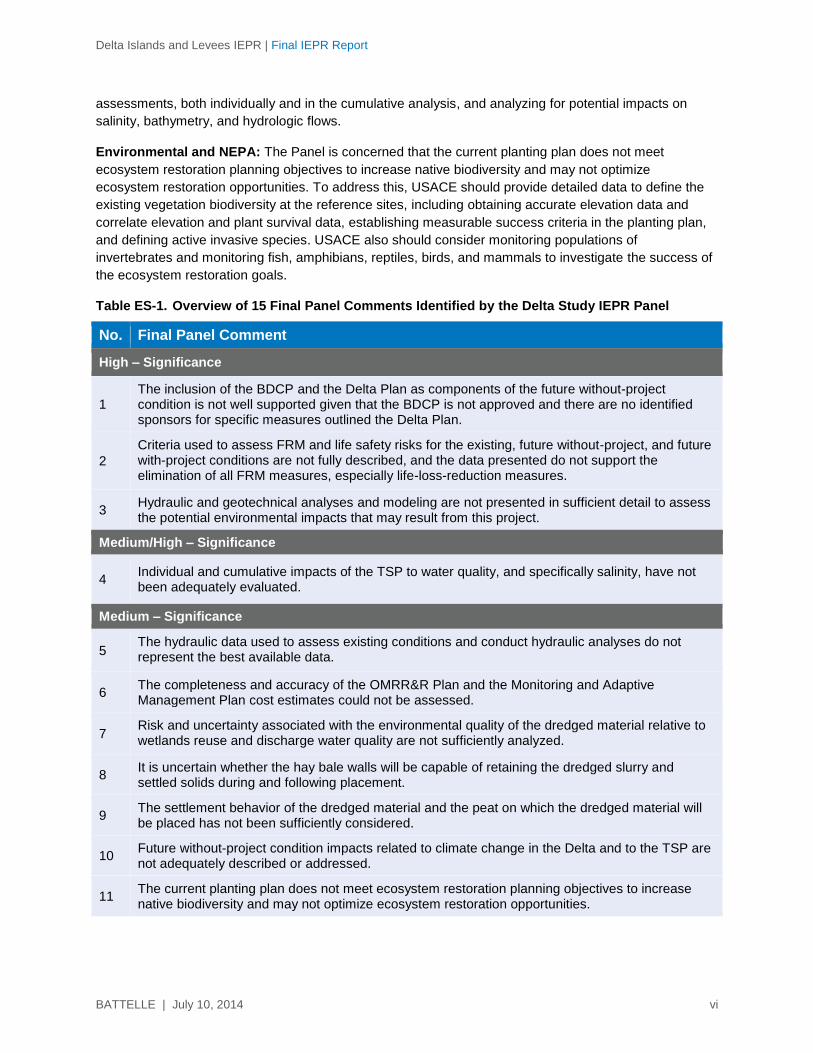
the comment. Overall, 15 Final Panel Comments were identified and documented. Of these, 3 were
identified as having high significance, 1 was identified as having medium/high significance, 7 had a
medium significance, 3 had medium/low significance, and 1 had low significance.
Battelle received public comments from USACE on the Delta Study IEPR (20 total pages of comments)
and provided them to the IEPR panel members. The panel members were charged with determining if
any information or concerns presented in the public comments raised any additional discipline-specific
technical concerns with regard to the Delta Study IEPR review documents. After completing its review,
the Panel confirmed that no new issues or concerns were identified other than those already covered in
its Final Panel Comments. The Panel also determined that adequate stakeholder involvement had
occurred.
Results of the Independent External Peer Review
The panel members agreed on their “assessment of the adequacy and acceptability of the economic,
engineering, and environmental methods, models, and analyses used” (USACE, 2012; p. D-4) in the
Delta Study IEPR review documents. Table ES-1 lists the Final Panel Comment statements by level of
significance. The full text of the Final Panel Comments is presented in Section 4.2 of this report. The
following summarizes the Panel’s findings.
Based on the Panel’s review, the report is well-written considering the complexity of the project, and the
material was presented in a logical and concise manner. While the report assessed the economic,
engineering, and environmental issues of the Delta Study project, the Panel identified several elements of
the project that require further analysis and sections of the FR/EIS that should be clarified or revised.
Of primary concern to the Panel is the inclusion of the Bay Delta Conservation Plan and Delta Plan
(BDCP and Delta Plan) as components of the future without-project condition. The inclusion of these
components is not well supported given that BDCP is not approved and there are no identified sponsors

Delta Islands and Levees IEPR | Final IEPR Report
BATTELLE | July 10, 2014 v
for specific measures outlined in the Delta Plan. This issue can be resolved by revising the future without-
project condition to exclude the Tentatively Selected Plan (TSP) from the BDCP and the Delta Plan and
by including an analysis of alternatives that assumes that components of the BDCP and the Delta Plan
will not be in place.
Civil/geotechnical engineering: Three important issues related to dredged materials and their proposed
applications were identified. First, the risk and uncertainty associated with the environmental quality of the
dredged materials relative to wetlands reuse and discharge water quality are not sufficiently analyzed.
USACE can address this by summarizing previous and current chemical/bioassay analyses of dredged
material proposed for reuse in the FR/EIS. Second, it is uncertain whether the hay bale walls will be
capable of retaining the dredged slurry and settled solids during and following placement. This matter
can be addressed by conducting a feasibility-level engineering analysis to evaluate hay bale walls for
dredged material retention and expanding the discussion in the FR/EIS to describe the Engineer
Research and Development Center (ERDC) technique for using hay bale walls in other locations across
the country. Third, the settlement behavior of the dredged material and peat on which the dredged
material will be placed has not been sufficiently considered. The Panel believes that this issue can be
addressed by evaluating the effects of peat and dredged material settlement and analyzing the impacts
on placement volumes, long-term marsh target elevations, and dredged material retention structures.
Plan Formulation and Economics: Of significance to the Panel is that criteria used to assess flood risk
management (FRM) and life safety risks for the existing, future without-project, and future with-project
conditions are not fully described, and the data presented do not support the elimination of all FRM
measures, especially life-loss-reduction measures. This matter can be addressed by providing a more
complete description of life safety issues for the existing condition and the future without-project condition
in the FR/EIS, including life safety and loss of life as criteria in the screening and evaluation of the final
array of alternatives. Another important issue was that the completeness and accuracy of the Operation,
Maintenance, Repair, Replacement and Rehabilitation (OMRR&R) Plan and the Monitoring and Adaptive
Management Plan cost estimates could not be assessed based on the information included in the
FR/EIS. Including a discussion of the OMRR&R cost estimate that describes the rationale for basing the
OMRR&R estimate on the recent experience with Donlon Island and Venice Cut and completing an
OMRR&R cost estimate in the FR/EIS will address this matter. In addition, the inclusion of a monitoring
and adaptive management plan in the FR/EIS is necessary to address this issue and ensure that project
goals will be met.
Hydraulic Engineering: The Panel found that hydraulic and geotechnical analyses and modeling are not
presented in sufficient detail to assess the potential environmental impacts that may result from this
project. This issue can be addressed by defining the level of analyses and modeling performed (and not
performed) with reference to USACE Engineer Regulation (ER) 1110-2-1150 and by providing better
supporting data for assumptions made in lieu of quantitative analyses or modeling. The Panel also found
that the hydraulic data used to assess existing conditions and conduct hydraulic analyses do not
represent the best available data. This matter can be addressed by reviewing the hydraulic data and
methods used for compliance with ER 1110-2-1150 and describing why the older datasets were assumed
to be acceptable; explaining any limitations associated with their use; and clarifying why newer available
data were not utilized. Finally, individual and cumulative impacts of the TSP to water quality, and
specifically salinity, have not been adequately evaluated. USACE can address this issue by clarifying for
all assumptions related to salinity and by conducting hydraulic modeling, or at least some analytical
Delta Islands and Levees IEPR | Final IEPR Report
BATTELLE | July 10, 2014 vi
assessments, both individually and in the cumulative analysis, and analyzing for potential impacts on
salinity, bathymetry, and hydrologic flows.
Environmental and NEPA: The Panel is concerned that the current planting plan does not meet
ecosystem restoration planning objectives to increase native biodiversity and may not optimize
ecosystem restoration opportunities. To address this, USACE should provide detailed data to define the
existing vegetation biodiversity at the reference sites, including obtaining accurate elevation data and
correlate elevation and plant survival data, establishing measurable success criteria in the planting plan,
and defining active invasive species. USACE also should consider monitoring populations of
invertebrates and monitoring fish, amphibians, reptiles, birds, and mammals to investigate the success of
the ecosystem restoration goals.
Table ES-1. Overview of 15 Final Panel Comments Identified by the Delta Study IEPR Panel
No. Final Panel Comment
High – Significance
1 The inclusion of the BDCP and the Delta Plan as components of the future without-project condition is not well supported given that the BDCP is not approved and there are no identified sponsors for specific measures outlined the Delta Plan.
2
Criteria used to assess FRM and life safety risks for the existing, future without-project, and future with-project conditions are not fully described, and the data presented do not support the elimination of all FRM measures, especially life-loss-reduction measures.
3 Hydraulic and geotechnical analyses and modeling are not presented in sufficient detail to assess the potential environmental impacts that may result from this project.
Medium/High – Significance
4 Individual and cumulative impacts of the TSP to water quality, and specifically salinity, have not been adequately evaluated.
Medium – Significance
5 The hydraulic data used to assess existing conditions and conduct hydraulic analyses do not represent the best available data.
6 The completeness and accuracy of the OMRR&R Plan and the Monitoring and Adaptive Management Plan cost estimates could not be assessed.
7 Risk and uncertainty associated with the environmental quality of the dredged material relative to wetlands reuse and discharge water quality are not sufficiently analyzed.
8 It is uncertain whether the hay bale walls will be capable of retaining the dredged slurry and settled solids during and following placement.
9 The settlement behavior of the dredged material and the peat on which the dredged material will be placed has not been sufficiently considered.
10 Future without-project condition impacts related to climate change in the Delta and to the TSP are not adequately described or addressed.
11 The current planting plan does not meet ecosystem restoration planning objectives to increase native biodiversity and may not optimize ecosystem restoration opportunities.
Delta Islands and Levees IEPR | Final IEPR Report
BATTELLE | July 10, 2014 vii
Table ES-1. Overview of 15 Final Panel Comments Identified by the Delta Study IEPR Panel (continued)
No. Final Panel Comment
Medium/Low – Significance
12 Although the Delta Study project is located in a deltaic system, measures or alternatives that incorporate a “natural” process of accommodating and/or designing for natural sediment accretion are not presented.
13 The cumulative analysis required under NEPA does not provide sufficient analysis results to support the recommendation.
14 If salinity levels are not monitored or controlled during dredging activities, water quality in the Delta region could be adversely affected.
Low – Significance
15 The Port of West Sacramento, an important resource in the study area, is not described in the transportation resources section of the FR/EIS.
Delta Islands and Levees IEPR | Final IEPR Report
BATTELLE | July 10, 2014 viii
Table of Contents
Page
Executive Summary ...................................................................................................................................... iii
1. INTRODUCTION .................................................................................................................................. 1
2. PURPOSE OF THE IEPR ..................................................................................................................... 1
3. METHODS FOR CONDUCTING THE IEPR ........................................................................................ 2
4. RESULTS OF THE IEPR ...................................................................................................................... 3
4.1 Summary of Final Panel Comments ............................................................................................. 3
4.2 Final Panel Comments ................................................................................................................. 3
5. REFERENCES ................................................................................................................................... 35
Appendix A. IEPR Process for the Delta Study Project
Appendix B. Identification and Selection of IEPR Panel Members for the Delta Study Project
Appendix C. Final Charge to the IEPR Panel as Submitted to USACE on April 18, 2014, for the Delta
Study Project
List of Tables
Page
Table ES-1. Overview of 15 Final Panel Comments Identified by the Delta Study IEPR Panel ............... vi
Table 1. Major Milestones and Deliverables of the Delta Study IEPR ................................................. 2
Delta Islands and Levees IEPR | Final IEPR Report
BATTELLE | July 10, 2014 ix
LIST OF ACRONYMS
ADH Adaptive Hydraulic (Model)
ASCE American Society of Civil Engineers
ATR Agency Technical Review
BCR Benefit-Cost Ratio
BDCP Bay Delta Conservation Plan
CE/ICA Cost Effectiveness / Incremental Cost Analysis
CEQA California Environmental Quality Act
COI Conflict of Interest
DILFS Delta Islands and Levees Feasibility Study
DrChecks Design Review and Checking System
DRMS Delta Risk Management Study
DWR Department of Water Resources
DWSC Deep Water Ship Channel
EC Engineer Circular
ECTM Economic Consequences Technical Memorandum
EFDC Environmental Fluid Dynamics Code
EM Engineer Manual
EPA U.S. Environmental Protection Agency
ER Engineer Regulation
ERDC Engineer Research and Development Center
FEMA Federal Emergency Management Agency
FPMS Floodplain Management Services
FR/EIS Feasibility Report/Environmental Impact Statement
FRM Flood Risk Management
GIS Geographic Information System
HEC-FDA Hydrologic Engineering Center-Flood Damage Reduction Analysis
HEP Habitat Evaluation Procedure
IEPR Independent External Peer Review
IWR Institute for Water Resources
LCA Louisiana Coastal Area
Delta Islands and Levees IEPR | Final IEPR Report
BATTELLE | July 10, 2014 x
LiDAR Light Detection and Ranging
MHHW Mean Higher High Water
mm/yr millimeters per year
MTL Mean Tide Level
NAVD88 North American Vertical Datum (1988)
NEPA National Environmental Policy Act
NER National Ecosystem Restoration
NOAA National Oceanic and Atmospheric Administration
OEO Outside Eligible Organization
OMB Office of Management and Budget
OMRR&R Operation, Maintenance, Repair, Replacement and Rehabilitation
PDT Project Delivery Team
POR Period of Record
SAR Safety Assurance Review
SFBRWQCB San Francisco Bay Regional Water Quality Control Board
TSP Tentatively Selected Plan
USACE United States Army Corps of Engineers
USFWS United States Fish and Wildlife Services
USGS United States Geological Service
Delta Islands and Levees IEPR | Final IEPR Report
BATTELLE | July 10, 2014 1
1. INTRODUCTION
The Sacramento – San Joaquin Delta is a web of channels and reclaimed islands at the confluence of the
Sacramento, San Joaquin, Cosumnes, Mokelumne, and Calaveras Rivers in California. Forty percent of
the State’s land area is contained within the watersheds of these rivers. The Delta covers about
738,000 acres, interlaced with hundreds of miles of waterways.
The communities and ecosystem within the Delta rely on the existing levee network to contain flows in the
Sacramento and San Joaquin Rivers. The existing 1,100-mile levee network is a mix of Federal and non-
Federal levees that do not meet any levee construction standards and could fail at water levels well below
the top of the levee. The levee network serves more as a network of dams, as it holds water back from
flooding the islands/tracts throughout the daily tidal fluctuations. Native habitat and natural river function
in the study area have been degraded by construction of the levee network and conversion of the
floodplain to agricultural and rural development, as well as management of the system for municipal,
industrial, and agricultural water supplies. The purposes of a project for the Delta area are to reduce risk
to life and property and to restore the ecosystem.
Independent, objective peer review is regarded as a critical element in ensuring the reliability of scientific
analysis. The objective of the work described here was to conduct an Independent External Peer Review
(IEPR) of the Delta Islands and Levees Feasibility Study, California, Draft Integrated Feasibility Report &
Environmental Impact Statement (hereinafter Delta Study IEPR) in accordance with procedures described
in the Department of the Army, U.S. Army Corps of Engineers (USACE), Engineer Circular (EC) Civil
Works Review (EC 1165-2-214) (USACE, 2012) and the Office of Management and Budget (OMB)
bulletin Final Information Quality Bulletin for Peer Review (OMB, 2004). Supplemental guidance on
evaluation for conflicts of interest (COIs) was obtained from the Policy on Committee Composition and
Balance and Conflicts of Interest for Committees Used in the Development of Reports (The National
Academies, 2003).
This final report presents the Final Panel Comments of the IEPR Panel (the Panel) on the existing
engineering, economic, environmental, and plan formulation analyses contained in the Delta Study IEPR
documents (Section 4). Appendix A describes in detail how the IEPR was planned and conducted.
Appendix B provides biographical information on the IEPR panel members and describes the method
Battelle followed to select them. Appendix C presents the final charge to the IEPR panel members for
their use during the review; the final charge was submitted to USACE on April 18, 2014.
2. PURPOSE OF THE IEPR
To ensure that USACE documents are supported by the best scientific and technical information, USACE
has implemented a peer review process that uses IEPR to complement the Agency Technical Review
(ATR), as described in USACE (2012).
In general, the purpose of peer review is to strengthen the quality and credibility of the USACE decision
documents in support of its Civil Works program. IEPR provides an independent assessment of the
engineering, economic, environmental, and plan formulation analyses of the project study. In particular,
the IEPR addresses the technical soundness of the project study’s assumptions, methods, analyses, and
calculations and identifies the need for additional data or analyses to make a good decision regarding
implementation of alternatives and recommendations.
Delta Islands and Levees IEPR | Final IEPR Report
BATTELLE | July 10, 2014 2
In this case, the IEPR of the Delta Study was conducted and managed using contract support from
Battelle, which is an Outside Eligible Organization (OEO) (as defined by EC 1165-2-214). Battelle, a
501(c)(3) organization under the U.S. Internal Revenue Code, has experience conducting IEPRs for
USACE.
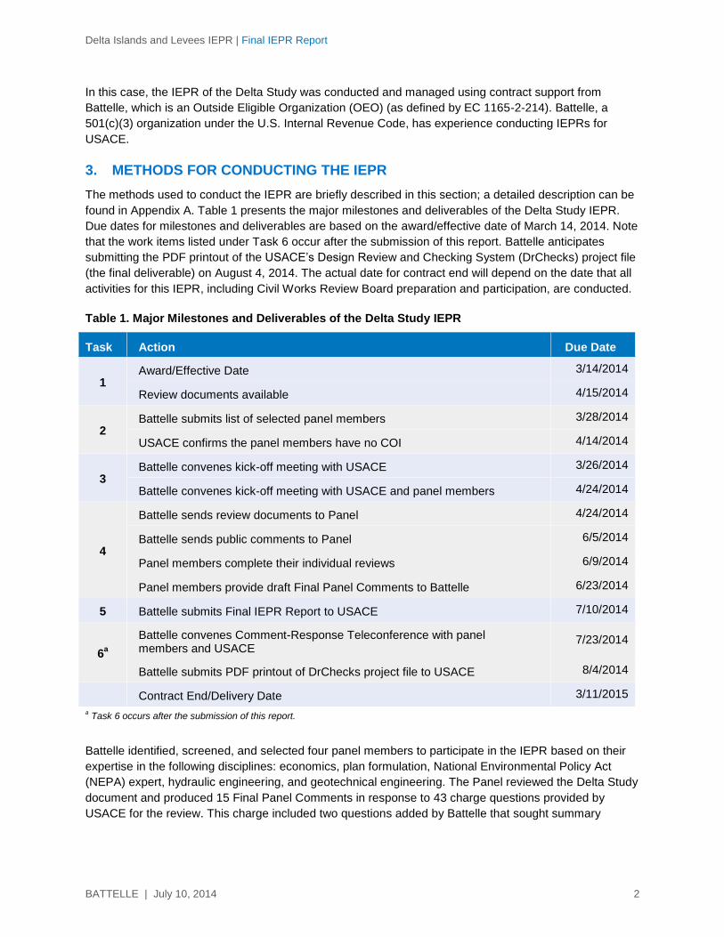
3. METHODS FOR CONDUCTING THE IEPR
The methods used to conduct the IEPR are briefly described in this section; a detailed description can be
found in Appendix A. Table 1 presents the major milestones and deliverables of the Delta Study IEPR.
Due dates for milestones and deliverables are based on the award/effective date of March 14, 2014. Note
that the work items listed under Task 6 occur after the submission of this report. Battelle anticipates
submitting the PDF printout of the USACE’s Design Review and Checking System (DrChecks) project file
(the final deliverable) on August 4, 2014. The actual date for contract end will depend on the date that all
activities for this IEPR, including Civil Works Review Board preparation and participation, are conducted.
Table 1. Major Milestones and Deliverables of the Delta Study IEPR
Task Action Due Date
1 Award/Effective Date 3/14/2014
Review documents available 4/15/2014
2 Battelle submits list of selected panel members
3/28/2014
USACE confirms the panel members have no COI 4/14/2014
3 Battelle convenes kick-off meeting with USACE 3/26/2014
Battelle convenes kick-off meeting with USACE and panel members 4/24/2014
4
Battelle sends review documents to Panel 4/24/2014
Battelle sends public comments to Panel 6/5/2014
Panel members complete their individual reviews 6/9/2014
Panel members provide draft Final Panel Comments to Battelle 6/23/2014
5 Battelle submits Final IEPR Report to USACE 7/10/2014
6a
Battelle convenes Comment-Response Teleconference with panel members and USACE
7/23/2014
Battelle submits PDF printout of DrChecks project file to USACE 8/4/2014
Contract End/Delivery Date 3/11/2015
a Task 6 occurs after the submission of this report.
Battelle identified, screened, and selected four panel members to participate in the IEPR based on their
expertise in the following disciplines: economics, plan formulation, National Environmental Policy Act
(NEPA) expert, hydraulic engineering, and geotechnical engineering. The Panel reviewed the Delta Study
document and produced 15 Final Panel Comments in response to 43 charge questions provided by
USACE for the review. This charge included two questions added by Battelle that sought summary
Delta Islands and Levees IEPR | Final IEPR Report
BATTELLE | July 10, 2014 3
information from the IEPR Panel and two questions associated with the public comments. Battelle
instructed the Panel to develop the Final Panel Comments using a standardized four-part structure:
1. Comment Statement (succinct summary statement of concern)
2. Basis for Comment (details regarding the concern)
3. Significance (high, medium/high, medium, medium/low, or low; in accordance with specific criteria
for determining level of significance)
4. Recommendation(s) for Resolution (at least one implementable action that could be taken to
address the Final Panel Comment).
Battelle reviewed all Final Panel Comments for accuracy, adherence to USACE guidance (EC 1165-2-
214, Appendix D), and completeness prior to determining that they were final and suitable for inclusion in
the Final IEPR Report. There was no direct communication between the Panel and USACE during the
preparation of the Final Panel Comments. The Panel’s findings are summarized in Section 4.1; the Final
Panel Comments are presented in full in Section 4.2.
4. RESULTS OF THE IEPR
This section presents the results of the IEPR. A summary of the Panel’s findings and the full text of the
Final Panel Comments are provided.
4.1 Summary of Final Panel Comments
The panel members agreed on their “assessment of the adequacy and acceptability of the economic,
engineering, and environmental methods, models, and analyses used” (USACE, 2012; p. D-4) in the
Delta Study IEPR review document. The following summarizes the Panel’s findings.
Based on the Panel’s review, the report is well-written considering the complexity of the project, and the
material was presented in a logical and concise manner. While the report assessed the economic,
engineering, and environmental issues of the Delta Study project, the Panel identified several elements of
the project that require further analysis and sections of the FR/EIS that should be clarified or revised.
Of primary concern to the Panel is the inclusion of the Bay Delta Conservation Plan and Delta Plan
(BDCP and Delta Plan) as components of the future without-project condition. The inclusion of these
components is not well supported given that BDCP is not approved and there are no identified sponsors
for specific measures outlined in the Delta Plan. This issue can be resolved by revising the future without-
project condition to exclude the Tentatively Selected Plan (TSP) from the BDCP and the Delta Plan and
by including an analysis of alternatives that assumes that components of the BDCP and the Delta Plan
will not be in place.
Civil/geotechnical engineering: Three important issues related to dredged materials and their proposed
applications were identified. First, the risk and uncertainty associated with the environmental quality of the
dredged materials relative to wetlands reuse and discharge water quality are not sufficiently analyzed.
USACE can address this by summarizing previous and current chemical/bioassay analyses of dredged
material proposed for reuse in the FR/EIS. Second, it is uncertain whether the hay bale walls will be
capable of retaining the dredged slurry and settled solids during and following placement. This matter
can be addressed by conducting a feasibility-level engineering analysis to evaluate hay bale walls for
dredged material retention and expanding the discussion in the FR/EIS to describe the Engineer
Delta Islands and Levees IEPR | Final IEPR Report
BATTELLE | July 10, 2014 4
Research and Development Center (ERDC) technique for using hay bale walls in other locations across
the country. Third, the settlement behavior of the dredged material and peat on which the dredged
material will be placed has not been sufficiently considered. The Panel believes that this issue can be
addressed by evaluating the effects of peat and dredged material settlement and analyzing the impacts
on placement volumes, long-term marsh target elevations, and dredged material retention structures.
Plan Formulation and Economics: Of significance to the Panel is that criteria used to assess flood risk
management (FRM) and life safety risks for the existing, future without-project, and future with-project
conditions are not fully described, and the data presented do not support the elimination of all FRM
measures, especially life-loss-reduction measures. This matter can be addressed by providing a more
complete description of life safety issues for the existing condition and the future without-project condition
in the FR/EIS, including life safety and loss of life as criteria in the screening and evaluation of the final
array of alternatives. Another important issue was that the completeness and accuracy of the Operation,
Maintenance, Repair, Replacement and Rehabilitation (OMRR&R) Plan and the Monitoring and Adaptive
Management Plan cost estimates could not be assessed based on the information included in the
FR/EIS. Including a discussion of the OMRR&R cost estimate that describes the rationale for basing the
OMRR&R estimate on the recent experience with Donlon Island and Venice Cut and completing an
OMRR&R cost estimate in the FR/EIS will address this matter. In addition, the inclusion of a monitoring
and adaptive management plan in the FR/EIS is necessary to address this issue and ensure that project
goals will be met.
Hydraulic Engineering: The Panel found that hydraulic and geotechnical analyses and modeling are not
presented in sufficient detail to assess the potential environmental impacts that may result from this
project. This issue can be addressed by defining the level of analyses and modeling performed (and not
performed) with reference to USACE Engineer Regulation (ER) 1110-2-1150 and by providing better
supporting data for assumptions made in lieu of quantitative analyses or modeling. The Panel also found
that the hydraulic data used to assess existing conditions and conduct hydraulic analyses do not
represent the best available data. This matter can be addressed by reviewing the hydraulic data and
methods used for compliance with ER 1110-2-1150 and describing why the older datasets were assumed
to be acceptable; explaining any limitations associated with their use; and clarifying why newer available
data were not utilized. Finally, individual and cumulative impacts of the TSP to water quality, and
specifically salinity, have not been adequately evaluated. USACE can address this issue by clarifying for
all assumptions related to salinity and by conducting hydraulic modeling, or at least some analytical
assessments, both individually and in the cumulative analysis, and analyzing for potential impacts on
salinity, bathymetry, and hydrologic flows.
Environmental and NEPA: The Panel is concerned that the current planting plan does not meet
ecosystem restoration planning objectives to increase native biodiversity and may not optimize
ecosystem restoration opportunities. To address this, USACE should provide detailed data to define the
existing vegetation biodiversity at the reference sites, including obtaining accurate elevation data and
correlate elevation and plant survival data, establishing measurable success criteria in the planting plan,
and defining active invasive species. USACE also should consider monitoring populations of
invertebrates and monitoring fish, amphibians, reptiles, birds, and mammals to investigate the success of
the ecosystem restoration goals.
4.2 Final Panel Comments.
This section presents the full text of the Final Panel Comments prepared by the IEPR panel members.
Delta Islands and Levees IEPR | Final IEPR Report
BATTELLE | July 10, 2014 5
Literature Cited: Delta Stewardship Council (2013). The Delta Plan. Available online at http://deltacouncil.ca.gov/delta-plan-0. September 2013.
Final Panel Comment 1
The inclusion of the BDCP and the Delta Plan as components of the future without-project
condition is not well supported given that the BDCP is not approved and there are no identified
sponsors for specific measures outlined the Delta Plan.
Basis for Comment
Because the BDCP is still under consideration and the Delta Plan, while adopted in 2013, generally
consists of goals, objectives, recommendations and policies that are largely to be implemented through
coordination with other agencies including the USACE (Delta Stewardship Council, 2013), it is speculative
whether the habitat restoration alternatives outlined in these plans will be implemented. It is reasonable to
assume that numerous high-priority habitat restoration sites may not be implemented through the BDCP
or the Delta Plan.
With regard to habitat restoration alternatives, if the BDCP or the specific measures outlined in the Delta
Plan are not approved or funded, the TSP for the Delta Islands and Levee Feasibility Study may not
represent the most cost-effective and efficient habitat restoration plan which meets regional priorities.
Consideration of high-priority habitat restoration sites identified in the BDCP and the Delta Plan may result
in more cost-effective habitat restoration. Other sites identified in these plans may experience less
settlement associated with the presence of thick peat deposits and/or have shallower existing mudline
conditions, both of which would reduce the volume of dredged material required for each acre of habitat
restoration. In addition, other project alternatives, which were not considered due to their inclusion in the
BDCP and Delta Plan, may produce higher habitat values. Other alternatives also may either have
existing or require fewer engineering controls to retain the dredged sediments and reduce water quality
risks during placement, as well as during future flood events. It is also important to consider that there is a
limited supply of dredged material available in the Delta region for subsidence reversal and habitat
restoration projects. Therefore, if dredged material is used for lower-priority projects, higher-value projects
may not be feasible in the future.
Significance – High
Consideration of other alternatives, including those identified for prioritization and implementation in the
BDCP and the Delta Plan, may influence the TSP.
Recommendations for Resolution
1. Consider revising the future without-project condition to exclude the TSP from the BDCP and the Delta Plan.
2. Include in the FR/EIS an analysis of alternatives that assumes that components of the BDCP and the Delta Plan will not be in place.
3. Consider all “Recommended Areas for Prioritization and Implementation for Habitat Restoration Projects” outlined in the Delta Plan as project alternatives.
Delta Islands and Levees IEPR | Final IEPR Report
BATTELLE | July 10, 2014 6
Due to planning constraints, FRM measures were all eliminated and it was determined that there is no
Federal interest in structural FRM in the Delta.
Alternatives Analysis for FRM Structural Measures:
The planning objectives of this project as stated in the draft FR/EIS, p. 19, include: ”Goal 2 - Improve flood
risk management in the Delta.” Goal 2 will not be met because FRM is not addressed under this project.
The Panel is concerned that the Federal interest in FRM has been eliminated based on (1) the assumption
that the BDCP and presumably other projects will be in place and are part of the without-project condition,
and (2) a benefit-cost ratio (BCR) below unity that does not consider benefits associated with life safety.
An extensive, detailed list of site-specific structural FRM measures was screened for economic feasibility,
existing risk to loss of life, statewide significance, and inclusion in other ongoing USACE studies. Four
islands with the greatest potential for economic feasibility were identified and then evaluated for economic
efficiency using USACE’s Hydrologic Engineering Center-Flood Damage Analysis (HEC-FDA) software.
Screening results indicated that the islands with the highest potential for structural FRM measures have
negative net benefits associated with life safety and BCRs significantly below unity (with the highest being
0.76). Considering these results, it was determined that there is no Federal interest in structural FRM in
the Delta.
Existing Life Safety Risks:
The Delta levees were constructed over the past 150 years largely by farmers and reclamation groups
who used light equipment and local, uncompacted sediments and organic matter, meaning the levees
have little or no foundation preparation. These levees, in general, were not constructed to current
standards for levees that protect people and property. The FR/EIS, p. 30, presents the main finding of the
Delta Risk Management Study (DRMS) with respect to future risk from flooding: that such risk will increase
many-fold (Appendix C, pp. 13-14). It is apparent by the frequency of historical flood events (over 168
instances in the past 100 years) that the current levee system does not provide adequate flood protection
for the 500,000 people living behind Delta levees. The FR/EIS states that “About two thirds of the Delta
levees were constructed without engineering specifications” (FR/EIS, p.14), and the Panel is concerned
that the TSP does not adequately address risk and uncertainty. The conclusions presented in Section 5.0
of Appendix C (p. 37) state the following: “While refinements to these risk estimates are possible, this
appendix and the Delta Risk Management Strategy analyses provide more than sufficient evidence that
flooding in the Sacramento –San Joaquin Delta presents significant risks to California and the nation.
Hundreds of lives and billions of dollar damages are at high probability of occurrence. Urgent action is
necessary to manage those risks”.
Furthermore, Section 5.0 (p. 37) concludes that: “While additional analyses are possible – quantification
of ecosystem risks and evaluation of human threats among them – the evidence for system-wide
catastrophic life loss and economic damages is more than sufficient to justify risk management through
targeted system improvements.”
Final Panel Comment 2
Criteria used to assess FRM and life safety risks for the existing, future without-project, and future
with-project conditions are not fully described, and the data presented do not support the
elimination of all FRM measures, especially life-loss-reduction measures.
Basis for Comment

Delta Islands and Levees IEPR | Final IEPR Report
BATTELLE | July 10, 2014 7
Life Risk Assumptions of Future Without-Project Conditions
Appendix C, Table 3-2 (Life Loss Risk Matrix with Number of Zones within Each Risk Category) (p. 18),
defines zones with the greatest Life Loss Risk Index. Loss of life was a screening criterion for FRM
measures, but the draft FR/EIS did not include additional analysis of life safety risks associated under the
future assumption of no FRM action. Life loss risk is based entirely on Delta island population data
obtained from the DRMS Economic Consequences Technical Memorandum (ECTM). Life safety issues
are qualitatively assessed for the array of alternatives (high, medium, low) but not specifically addressed
for the existing, future without-project, and future with-project conditions. The study acknowledges that
flood risk problems currently exist that will be resolved through the implementation of the BDCP/Delta Plan
but does not analyze the flood risk if the BDCP/Delta Plan is not implemented as currently envisioned or if
its implementation is delayed.
Life safety impacts were evaluated for life-loss probability, which showed that 10 zones had at least a 10%
probability of 100 deaths or more if a breach occurred in their protecting levees. Floods, earthquakes, and
high tides can cause local or widespread levee failures along these poorly constructed levees on weak
foundations, as evidenced by 166 levee failures in the past 100 years; the last levee failure occurred in
2004 at Jones Tract. The draft FR/EIS notes that “inadequate levee protection leaves 500,000 people at
risk in the Delta.” It is not clear where life safety risks may occur or what the true magnitude of the problem
is in terms of actual life loss potential. The fundamental conclusion of the DRMS future risks analysis was
that all significant risk factors will increase with time. As stated in Appendix C, p.7: “While uncertainties in
the absolute magnitude of the results make them most useful for comparisons, the actual values of the
probabilities and consequences are alarming.”
Since the constraints of the project (cost effectiveness) resulted in the elimination of all flood reduction
measures, goal 2 of the project will not be addressed. The Panel is also concerned that USACE’s
decision to eliminate FRM alternatives based solely on the economics of flood damages does not
adequately consider life-loss risks and non-economic benefits of FRM alternatives. Life loss is clearly
stated as part of the formulation process for the alternatives, and selection of islands for final screening
was based on large population sizes with significant risk of life loss. The Delta Stewardship Council (public
comment letter, p.5) shares this opinion, stating that it is “concerned about the USACE’s policy constraints
that have prevented the USACE from…finding a federal interest in flood management in the Delta.”
Non-Structural FRM Measures and Potential Inclusion in Other Programs:
As stated in the FR/EIS, p. 39: “The existing USACE Floodplain Management Services (FPMS) authority
could allow for Federal support in implementation of these recommendations. For these reasons, these
measures are provided as general recommendations and will not be included in a recommended plan for
action, as sufficient authority exists to further explore these recommendations.”
Therefore, non-structural FRM measures are provided as general recommendations and are not included
in either the TSP or any specific recommended plan for action. However, the non-structural measures,
and the decision to limit them to general recommendations as part of the future without-project condition,
may not be adequate, given the statement that “Advanced flood warning systems should also be
considered for the Delta, as very little warning time exists for much of the region due to the nature of the
isolated tidal levee systems and deep floodplains (FR/EIS, p. 39).” Because no entity has been charged
with responsibility, it is unclear if this recommendation will lead to any action. The conclusion of the
analysis, as stated on p.39 of the FR/EIS, is as follows: “The existing USACE Floodplain Management
Services (FPMS) authority could allow for Federal support in implementation of these recommendations.
For these reasons, these measures are provided as general recommendations and will not be included in
Delta Islands and Levees IEPR | Final IEPR Report
BATTELLE | July 10, 2014 8
a recommended plan for action, as sufficient authority exists to further explore these recommendations.”
As a result, all FRM measures were eliminated from this project. However, the Panel is unable to
determine what components of FRM will be covered by other projects.
In evaluating other potential programs, it appears that the BDCP addressed only habitat restoration and
water supply issues. The Department of Water Resources (DWR) Delta Levee Maintenance Subventions
Program and Delta Levees Special Flood Control Programs address FRM to a limited extent, but specific
plans that address FRM are not clearly presented. The draft FR/EIS also states that non-structural FRM
will continue through the Delta Protection Commission, including emergency preparedness and response
planning. Since the review documents do not present specific information regarding the scope, funding
status, or residual risk remaining if these measures are implemented, the Panel is unable to evaluate the
adequacy of FRM alternatives that would address the concerns of this study.
Given the evidence presented for system-wide catastrophic loss of life and substantial economic
damages, the elimination of FRM measures does not seem prudent. Without integrating flood risk
reduction, the entire project remains at risk. Assuming that the TSP is implemented successfully, the risk
remains that a levee near the study area may fail and, in addition to the potential damage defined in the
draft FR/EIS, the dredged material placed during construction of this project may be mobilized. This
would both destroy this project and have substantial adverse impacts on water quality and downstream
resources.
The FRM section of the draft FR/EIS (Section 3.4.1, “Life Loss Risk” subsection [p. 30]) consists of two
sentences that refer to the DRMS ECTM. This subsection does not reference Appendix C and the DRMS
LIFESim modeling and results. As these memorandums are not presented in this document, references
should be limited to material provided.
Significance – High
Due to the elimination of all FRM measures, the project’s primary planning objectives will not be achieved;
therefore, reanalyzing the alternatives to include loss-of-life reduction may change the results and affect
overall study recommendations, potentially including some FRM measures in the TSP.
Recommendations for Resolution
1. Include a more complete description of life safety issues for the existing condition and the future
without-project condition in the FR/EIS.
2. Include life safety and loss of life as criteria in the screening and evaluation of the final array of
alternatives.
3. Include non-structural FRM measures in the TSP or other recommended plan for action.
4. Revise the FRM section that refers to the DRMS ECTM (FR/EIS, Section 3.4.1, “Life Loss Risk”
subsection) to reference Appendix C and the DRMS LIFESim modeling and results.
5. Define the scope, funding status, and residual risk potentially remaining if specific measures are
implemented when considering FRM alternatives for this study.

Delta Islands and Levees IEPR | Final IEPR Report
BATTELLE | July 10, 2014 9
Final Panel Comment 3
Hydraulic and geotechnical analyses and modeling are not presented in sufficient detail to assess
the potential environmental impacts that may result from this project.
Basis for Comment
Although this project will likely result in environmental benefits, the risk to water quality and water supply
are substantial enough to warrant a level of hydraulic and geotechnical analyses called for in ER 1110-2-
1150 (USACE, 1999) prior to the Preconstruction Engineering and Design phase. Hydraulic and
geotechnical analyses and modeling during the feasibility phase would increase the understanding of how
these processes will influence the project design.
USACE guidance in ER 1110-2-1150 (USACE, 1999), Section 12.6, states: “Engineering studies and
analyses, including physical and numerical model investigations, shall be scoped to the level needed to
establish project features and elements that will form an adequate basis for the project construction
schedule and a baseline cost estimate.”
Furthermore, Section 13.6.1 of ER 1110-2-1150 states: “Physical and numerical modeling may be
required in the feasibility phase to demonstrate that the proposed alternative(s) can be designed to satisfy
project objectives and to determine project costs within the required level of accuracy”.
Appendix C of the draft FR/EIS acknowledges that a robust set of hydraulic and geotechnical models was
developed and used in an appropriate manner as part of the previous 2008 DRMS Phase 1 studies and
the ongoing USACE Delta Islands and Levees Feasibility Study (DILFS). For example, the DILFS models
include USACE’s “AD”aptive Hydraulic Model (ADH) and the Environmental Protection Agency’s (EPA)
Environmental Fluid Dynamics Code (EFDC) model. These models can simulate flood flow, sediment
transport, and water quality and can be linked to ecosystem models. The selection of the USACE ADH
model and EPA EFDC model is described in Appendix C, Section 1.2; however, it is not clear whether (or
how) these models were applied in this feasibility study. Section 1.2 of Appendix C states that: “Additional
refinements and analysis using our comprehensive modeling framework have been placed on hold until
federal interest has been identified and future work authorized”. It appears that assumptions have been
made in lieu of quantitative analyses or numerical modeling.
For example, assumptions are made in the draft FR/EIS concerning the effects of the TSP on hydraulics
and salinity conditions. As stated in Appendix D, Section 3.1.3: “Due to the geographic location of Big
Break and Frank’s Tract, it is assumed that any subsidence reversal measure would have little to no
hydraulic impacts to the flood control system and deep water shipping channels.”
In addition, Section 3.1.1 of Appendix D states: “For engineering purposes, it is assumed that a
subsidence reversal measure would eliminate this pathway [the flooded area of Frank’s Tract Island] for
saline water to travel further upstream the Delta. At a minimum, there would be no negative impacts to the
salinity levels”.
Given this last assumption, the Panel suggests that numerical modeling of this condition would validate or
refute the assumption. For example, it is not intuitively apparent that the filling of Frank’s Tract would not
affect salinity, in that the reduction in tidal prism volume and conveyance area could potentially increase
inland salinity levels as tidal waters are forced to flow through more constricted openings on the flood tide.
Additionally, slight changes in salinity concentrations may substantially affect plant composition and a
species’ ability to establish and survive in intertidal marshes.

Delta Islands and Levees IEPR | Final IEPR Report
BATTELLE | July 10, 2014 10
Similarly, the degree of geotechnical characterization and modeling in this feasibility phase is insufficient
for the evaluation of the proposed alternatives. Generally, the draft FR/EIS relied on the DRMS studies as
the basis of conceptual engineering and constructability. These extensive studies describe geotechnical
and civil engineering models that are sufficiently discriminatory to support conclusions drawn from them
(e.g., stability, seepage, levee configurations); however, the system-wide models are not sufficient relative
to site-specific features of the TSP for assessing:
the containment, solids-settling behavior, and water quality associated with in-water contained
dredged material disposal;
volume calculations for subsidence reversal, which do not account for restoration site foundation
settlement or bulking/self-weight consolidation of the slurried dredged material;
the suitability of the proposed hay bale walls for containment and erosion control;
the basis of dredged material placement elevations considering changes in dredged material void
ratio (volume) and placement site settlement (peat) foundation;
impacts of dredged material and foundation settlement on volume calculations;
dredged material containment elevations for primary settling and clarification to reduce suspended
solids impacts, and;
the periodic overtopping of containment during high tides and flood events on slurry retention and
settled solids erosion.
The successful implementation of similar projects (Donlon Island and Venice Cut) in the vicinity of Big
Break and Little Frank’s Tract indicate that geotechnical risks are low; however, because no geotechnical
study or modeling was conducted related to the TSP, the impacts of placing large volumes of dredged
material on subsided peat soils in these specific locations are uncertain.
Significance – High
The lack of quantitative analyses and numerical modeling of the geotechnical/civil engineering and
hydraulic/water quality aspects of dredged material placement affects the complete analysis of the
alternatives, the potential environmental impacts, and ultimately, the project design.
Recommendations for Resolution
1. Update the FR/EIS by defining the level of analyses and modeling performed (and not performed)
with reference to ER 1110-2-1150.
2. Provide better supporting data for assumptions made in lieu of quantitative analyses or modeling.
3. Expand the FR/EIS assessment of the TSP to consider the reduction in tidal prism volume and
conveyance area caused by the subsidence reversal action and the potential impacts to salinity
levels as tidal waters are forced to flow through more constricted openings on the flood tide.
4. Conduct feasibility-level geotechnical characterization and modeling as it relates to the TSP and
the risks associated with dredged material placement.
Delta Islands and Levees IEPR | Final IEPR Report
BATTELLE | July 10, 2014 11
Literature Cited: USACE (1999). Engineering and Design for Civil Works Projects. Department of the Army, U.S. Army Corps of Engineers, Washington, D.C. Engineer Regulation (ER) No. 1110-2-1150. August 31. Available online at http://www.publications.usace.army.mil/Portals/76/Publications/EngineerRegulations/ER_1110-2-1150.pdf
Delta Islands and Levees IEPR | Final IEPR Report
BATTELLE | July 10, 2014 12
Final Panel Comment 4
Individual and cumulative impacts of the TSP to water quality, and specifically salinity, have not
been adequately evaluated.
Basis for Comment
The discussion in the FR/EIS on how individual and cumulative impacts associated with the proposed
actions may affect hydraulic conditions is insufficient, specifically with respect to salinity, flow paths, water
quality, and water supply. This is due, in large part, to the lack of hydraulic modeling to analyze changes
imposed by the TSP from current baseline conditions.
The operation of pumping facilities is known to alter hydraulic flow patterns in the Delta. The altered
hydraulics and operation of the Federal, state, and local water projects has resulted in (1) altered natural
water flows through the Delta and to Suisun Marsh and San Francisco Bay; (2) changes to timing, volume,
and/or distribution of water throughout the Delta, which has adversely affected the ecosystem and the
habitat requirements of many native species; and, (3) reduction in seasonal variability in the migration and
concentrations of saline water. The Panel recognizes these issues will not be addressed in this project
and were only briefly discussed in the draft FR/EIS; however, the overall hydraulic and water quality
changes resulting from this project should be analyzed, especially with respect to salinity and the
implications to water supply.
The draft FR/EIS provides little quantitative information on how the TSP may impact salinity. For example,
Table 3-1 indicates that “Salinity Management” was screened out due to conflict with the BDCP, future
without-project condition, and planning constraint. It is understood that this is a focus of the BDCP;
however, the draft FR/EIS does not articulate how the TSP will affect the physical system and associated
salinity conditions, in part because no hydraulic modeling was performed as part of the feasibility study.
Also, Section 1.3.2 of Appendix D states: “[The Department of Water Resources] has conducted water
quality impact studies along various locations in the Delta, specifically looking at salinity, organic carbon,
and mercury levels. DWR’s report “Flooded Islands, Feasibility Study Baseline Report, 2005” documents
potential project alternatives and their relative impacts on the salinity levels on Frank’s Tract, Big Break
and Lower Sherman Lake. The water quality impacts were assumed to be the same for USACE’s ER
alternatives for TSP selection.”
The Panel cannot locate any supporting information to substantiate this statement.
An ecosystem restoration measure developed in detail is stated in Section 3.4.2 of the FR/EIS to: “Avoid
impacts to population centers and infrastructure (including islands in the western Delta that are considered
critical for salinity management – known as the “eight western islands”)”
Figure 3-3 shows these eight western islands with the legend caption “restoration unlikely”; however, the
TSP includes the restoration of Big Break, adjacent to Jersey Island (one of the eight western islands) and
Frank’s Tract (surrounded on all sides except the east by western islands). During the mid-review
teleconference on May 28, 2014, with USACE and the Panel (which was facilitated by Battelle), USACE
response to the Panel’s question on this subject indicated that removal of levees in the eight western
islands would impact the salinity balance of the system. However, it is not clear whether the TSP actions
for filling current open-water areas in this same vicinity of the Delta would also impact the salinity balance.
Furthermore, the likelihood of the TSP to achieve expected outputs is dependent on the observations at
Donlon Island and Venice Cut Island, and these locations may or may not be representative of the TSP
Delta Islands and Levees IEPR | Final IEPR Report
BATTELLE | July 10, 2014 13
locations in terms of hydrodynamics, sediment movement, and salinity.
Water quality issues were also examined in Appendix H (Section IV.B, Water Circulation, Fluctuation, and
Salinity Determinations) (pp. 11-12), and no significant effects were identified. Again, the study does not
assess the altered bathymetry resulting from this project on water quality and salinity to validate the
finding of no significant effects. No modeling was conducted to evaluate this potential impact, and the
documents conclude, without sufficient justification, that no significant impacts will occur to salinity and
water supply; e.g., “a Section 404(b)(1) analysis was conducted on the TSP and…concluded that the
project would not result in significant effects to water quality” (Section 6.1). However, Appendix H (Section
IV.A.(5).a)) also states “Alternative 6 would produce a large effect on turbidity since the alternative is 48
acres larger than Alternative 2. The effects from turbidity would be short term”. Further, the impact
analysis does not consider resulting changes in bathymetry and hydraulic flows in the project area,
especially as construction is scheduled for late summer and early fall when water levels are naturally low
and risks of salinity impacts are highest.
Significance – Medium/High
Because water quality, and specifically salinity, has not been evaluated to an appropriate level at this
feasibility phase, the impacts associated with the TSP cannot be confirmed.
Recommendations for Resolution
1. Clarify all assumptions related to salinity including:
a. How the TSP can be assumed to cause no negative impacts to salinity levels without the
benefit of hydraulic and water quality modeling, and explain why no quantitative analyses or
analytical estimates of salinity changes were performed.
b. How the TSP imposes no changes on salinity with respect to analyses and assumptions made
in the BDCP and other DWR studies.
c. Whether the TSP actions for filling current open water areas would also impact the salinity
balance.
2. Conduct hydraulic modeling, or at least some analytical assessments, both individually and in the
cumulative analysis and analyze for potential impacts on salinity, bathymetry, and hydrologic
flows. Include the results in the FR/EIS.
Delta Islands and Levees IEPR | Final IEPR Report
BATTELLE | July 10, 2014 14
Final Panel Comment 5
The hydraulic data used to assess existing conditions and conduct hydraulic analyses do not
represent the best available data.
Basis for Comment
The draft FR/EIS relies on hydraulic data prepared by others that are outdated and may not be
representative of current conditions. Other data used are selected from discrete time periods and may not
be representative of long-term mean, or average, conditions. Relevant examples include the following:
1) The hydraulic data used for stage, frequency, and uncertainty event analysis, and to support the
FR/EIS Appendix C FRM analysis, come from a 1992 Hydrology Office Report of the Sacramento-San
Joaquin Delta Special Study by the USACE Sacramento District, with data effective through 1988. The
use of 26-year-old hydraulic data in a feasibility-phase study is questionable. Furthermore, Section 13.5.1
of ER 1110-2-1150 (USACE, 1999) states that the primary engineering objective during the feasibility
phase is to “provide engineering data and analyses sufficient to develop the complete project schedule
and cost estimate.” The Panel questions the use of 26-year-old hydraulic data to achieve this objective.
2) Appendix C, Table 5-1, summarizes data and the period of record (POR) for three gages used in the
1992 study to provide stage data for the draft FR/EIS economic analysis conducted with HEC-FDA; the
POR of these gages ranges from 30 to 43 years. If these data are effective through 1988 and
25 subsequent years of data are not accounted for (assumed 1989 through 2013), the economic decisions
for this project are being made with datasets that are potentially missing 37% to 46% of a complete
dataset (i.e., data through 2013), where 25 missing years from a potential POR of 43 years plus 25 years
equals 37%, and 25 missing years from a potential POR of 30 years plus 25 years equals 46%.
3) The primary design criterion for the TSP and subsidence reversal is the establishment of restored
ground elevations to 2.8 to 5.3 feet North American Vertical Datum (1988) (NAVD88). These elevations
are centered on a mean water elevation of 4.8 feet NAVD88 estimated from one year of data (2013) for
the Rio Vista gage. The use of one year of data and the location of this particular gage are questionable
because these inputs may not represent best available data. For example, the Rio Vista gage is located
on the Sacramento River and includes a substantial component of river flow in any stage measurement,
as opposed to a dominant tidal condition. A comparison of the Rio Vista river gage data to tide gages was
not provided in the draft FR/EIS; such a comparison may support or refute the study’s reliance on this
single gage.
4) The use of one year of data to derive a long-term mean water elevation is also questionable. In a tidal
setting, tidal datums are typically used to describe long-term tidal conditions; tidal datums are not
mentioned in the draft FR/EIS. The Panel reviewed tidal datums published by the National Oceanic and
Atmospheric Administration (NOAA) for the Rio Vista gage (NOAA, 2013a) indicating a Mean Tide Level
(MTL) of 5.03 feet NAVD88, which is close to the average mean water elevation of 4.8 feet NAVD88
estimated in the draft FR/EIS; however, the tide gage at Port of Chicago and Suisun Bay has a MTL of
3.91 feet NAVD88 (NOAA, 2013b).
5) It is not clear why a mean tide elevation was used in the draft FR/EIS to establish marsh habitat. For
example, research in the Delta by Simenstad et al. (2000) indicates that average marsh plain elevations at
natural reference sites occur close to Mean Higher High Water (MHHW); this tidal datum is approximately
7.01 feet NAVD88 for the Rio Vista gage and 6.24 feet NAVD88 for the Port of Chicago gage. The use of
the MHHW tidal datum for design purposes would result in a need for substantially more dredged material
Delta Islands and Levees IEPR | Final IEPR Report
BATTELLE | July 10, 2014 15
Literature Cited: NOAA (2013a). Tidal Elevation, Elevation Information for Station ID 9415316, Rio Vista, Sacramento River, July 17. National Oceanic and Atmospheric Administration. Available online at http://www.ngs.noaa.gov/Tidal_Elevation/diagram.jsp?PID=JS1921&EPOCH=1983-2001 NOAA (2013b). Tidal Elevation, Elevation Information for Station ID 9415144, Port of Chicago, Suisun Bay, July 17. National Oceanic and Atmospheric Administration. Available online at http://www.ngs.noaa.gov/Tidal_Elevation/diagram.jsp?PID=AH7472&EPOCH=1983-2001 Simenstad, C., J. Toft, H. Higgins, J. Cordell, M. Orr, P. Williams, L. Grimaldo, Z. Hymanson, and D. Reed (2000). Sacramento/San Joaquin Delta Breached Levee Wetland Study (BREACH). University of Washington School of Fisheries, Preliminary Report, February. Available online at http://depts.washington.edu/calfed/breachin.pdf USACE (1999). Engineering and Design for Civil Works Projects. Department of the Army, U.S. Army Corps of Engineers, Washington, D.C. Engineer Regulation (ER) No. 1110-2-1150. August 31. Available online at http://www.publications.usace.army.mil/Portals/76/Publications/EngineerRegulations/ER_1110-2-1150.pdf
than currently estimated.
Significance –Medium
The characterization of hydraulic processes may not be accurate due to reliance on old datasets, a lack of
data that reflect current hydraulic conditions, and the selection of gage locations that are not
representative of hydraulic conditions at the location of the TSP activities.
Recommendations for Resolution
1. Assess the sensitivity of water elevations adapted from older datasets to water elevations that
could be estimated using a more current and complete dataset.
2. Review the hydraulic data and methods used for compliance with ER 1110-2-1150. Specifically,
describe why the older datasets were assumed to be acceptable, explain any limitations
associated with their use, and clarify why newer available data were not utilized.
3. Compare the Rio Vista river gage data to other tide gage data in the Delta and near the location of
the TSP.
4. Document the assumptions and validity of using a mean water elevation derived from one year of
data, as opposed to the use of published tidal datums.
5. Justify the use of a mean water level elevation derived from one year of data to establish a target
fill elevation, as opposed to the use of MHHW as a target marsh plain elevation.

Delta Islands and Levees IEPR | Final IEPR Report
BATTELLE | July 10, 2014 16
Final Panel Comment 6
The completeness and accuracy of the OMRR&R Plan and the Monitoring and Adaptive
Management Plan cost estimates could not be assessed.
Basis for Comment
The draft FR/EIS states (pp. 236, 239, and 240) that a Monitoring and Adaptive Management Plan will be
developed and included in the final report and that monitoring and adaptive management costs are
expected to be minimal. Appendix E, p. C-5, further states that a brief investigation of OMRR&R costs
was conducted by USACE and that OMRR&R was determined to be unnecessary. This determination was
based on cost estimates derived from nearby Donlon Island and Venice Cut, a beneficial use of dredged
material project considered successful by USACE. For that project, dredged materials were used to create
approximately 81 acres of new shallow water, wetland, and upland habitats within those two flooded
islands. It was not clear if the Donlon Island and Venice Cut project is similar enough to the TSP to serve
as a basis for the OMRR&R cost estimate; therefore, the Panel could not assess the completeness and
accuracy of the cost estimate for OMRR&R.
The Panel understands that USACE ER 1105-2-100 (USACE, 2000), Appendix D, p. D-8, states that
USACE is to base OMRR&R estimates on “actual current costs incurred for carrying out these activities
for similar projects and project measures” and that USACE is following that guidance to develop its
preliminary estimates. The Panel also understands that additional work to define OMRR&R and adaptive
management and monitoring costs has yet to be accomplished and that a complete and accurate cost
estimate is necessary for Federal and non-Federal sponsor planning and budgeting processes. The Panel
is concerned that there is a significant risk of adaptive measures being necessary to compensate for
dredged material settlement, as well as protection of dredged material during placement and during flood
events. These risks will exist until marsh vegetation is well established, and possibly well beyond that
point in time. It therefore appears that OMRR&R costs could be substantial and highly variable.
Significance – Medium
Information in the draft FR/EIS on the monitoring and adaptive management plan and OMRR&R cost
estimate is insufficient for the Panel to evaluate their respective costs.
Recommendations for Resolution
1. Include a discussion of the OMRR&R cost estimate in the draft FR/EIS that describes the
rationale for basing the OMRR&R estimate on the recent experience with Donlon Island and
Venice Cut.
2. Complete an OMRR&R cost estimate for inclusion in the FR/EIS, noting the need for adaptive
measures to compensate for the risk of dredged material settlement and placement and flood
events.
3. Complete a monitoring and adaptive management plan for inclusion in the FR/EIS.
4. Communicate any non-Federal OMRR&R responsibilities to the project sponsor and include them
in the FR/EIS.
Delta Islands and Levees IEPR | Final IEPR Report
BATTELLE | July 10, 2014 17
Literature Cited: USACE (2000). Planning Guidance Notebook. Department of the Army, U.S. Army Corps of Engineers, Washington, D.C. Engineer Regulation (ER) No. 1105-2-100. April 22. Available online at http://planning.usace.army.mil/toolbox/library/ERs/entire.pdf
Delta Islands and Levees IEPR | Final IEPR Report
BATTELLE | July 10, 2014 18
Final Panel Comment 7
Risk and uncertainty associated with the environmental quality of the dredged material relative to
wetlands reuse and discharge water quality are not sufficiently analyzed.
Basis for Comment
The environmental quality of the dredged material, specifically with regard to chemical constituents and
bioassay results, will impact sediment reuse for wetlands creation (cover and non-cover), as well as water
quality issues during hydraulic placement. The draft FR/EIS makes numerous references to the
environmental quality of proposed borrow materials; however, existing constituents’ concentrations and
acceptance criteria for wetlands reuse are unclear. Examples include the following:
Draft FR/EIS, p. 96: “Historic chemical and granular test results [of] previously dredged materials
at placement sites indicated that the dredge materials are chemically cleaner than the existing
baseline sampling from project area samples. Future materials from dredging operations would be
sampled prior to operations and maintenance dredging. Materials meeting baseline criteria would
be utilized for marsh habitat creation. Materials not meeting baseline criteria would be stored at
existing dryland storage sites.”
Draft FR/EIS, p. 172: (regarding the Stockton Deep Water Ship Channel [DWSC]), “Similar to
Alternative 2, past [operations and maintenance] dredging is covered under the San Francisco
Bay to Stockton (John F Baldwin and Stockton Ship Channel) Final Environmental Impact
Statement from September 1980. However, effects associated with the pumping of material from
the source material sites are analyzed below. The dredged materials from the DWSCs are
sampled prior to O&M activities and tested for [hazardous, toxic, and radioactive wastes]. Existing
stockpiled materials were previously tested and records show granular and chemical analyses.
The test results are compared against baseline sampling from the restoration sites. Dredged
materials not meeting the chemical baseline would not be used.”
Draft FR/EIS, p. 188: “Coordination with the [Central Valley Regional Water Quality Control Board]
would establish construction requirements to prevent violation of water quality standards set forth
in the Basin Plan and to ensure that water quality is not substantially degraded through project
activities. Standard dredging protocol for testing of material prior to dredging activities will be
followed. This protocol includes the testing of materials before dredging begins to determine if
they meet standards for placement in water and upland areas. If material being dredged meets
the criteria, it would be used to create the intertidal marsh habitat. If material does not meet the
water quality standards, it would be processed under the dredging standards and not used for this
project.”
Draft FR/EIS, Appendix D, p. 6: “The dredged material obtained from Operations and
Maintenance Dredging will be characterized prior to placement and habitat restoration. Similarly,
previously placed dredged material will be characterized for mercury prior to placement in the
restoration areas, and has already been characterized under the O&M dredging program for the
past 13 years.”
The statements above suggest that the environmental quality of the dredged material is uncertain and that
the acceptance criteria for dredged material reuse are not clearly understood at this time. The draft
FR/EIS references past and ongoing testing, but does not reference specific results or criteria from other
similar projects. Additional reference to dredged material reuse guidelines, such as the guidelines
Delta Islands and Levees IEPR | Final IEPR Report
BATTELLE | July 10, 2014 19
Literature Cited: SFBRWQCB (2000). Beneficial Reuse of Dredged Materials: Sediment Screening and Testing
Guidelines. San Francisco Bay Regional Water Quality Control Board, Draft Report, May 2000. Available
online at
http://www.waterboards.ca.gov/sanfranciscobay/water_issues/available_documents/benreuse.pdf
presented in the San Francisco Bay Regional Water Quality Control Board (SFBRWQCB) Draft Report
(2000), would be useful in communicating probable acceptance criteria for the project.
Significance – Medium
The environmental acceptability of dredged material could impact the feasibility of dredged material reuse
and the quantity of that material available for wetland cover and non-cover purposes.
Recommendations for Resolution
1. Summarize previous and current chemical/bioassay analyses of dredged material proposed for reuse in the FR/EIS.
2. Summarize current and probable sediment acceptance criteria for wetland reuse and wetlands cover for similar projects (such as those presented in the SFBRWQCB 2000 draft guidelines) in the FR/EIS.
3. Include a more detailed discussion of the potential impacts of mercury contamination on restoration feasibility in the FR/EIS.
Delta Islands and Levees IEPR | Final IEPR Report
BATTELLE | July 10, 2014 20
Final Panel Comment 8
It is uncertain whether the hay bale walls will be capable of retaining the dredged slurry and
settled solids during and following placement.
Basis for Comment
The draft FR/EIS includes several references to a method to contain the areas of dredged material
placement “by a perimeter of sacrificial hay bales and silt curtains to contain the suspended material and
minimize turbidity.” Figure 8-2 in the draft FR/EIS (p. 237) includes an illustration of a sacrificial hay bale
wall. The Panel questions the engineering viability of using hay bales in this particular application.
The draft FR/EIS does not describe how the proposed hay bale walls will be utilized to retain the dredged
material during placement as well as during future flood events. The pre-design engineering and design
appendix indicates that at the target elevation of 4.5 feet NAVD88, the hay bales walls would retain 7 to 10
feet of dredged material. In addition, peat marsh plain settlement could account for several more feet of
wall and fill subsidence during placement, resulting in significantly greater wall heights. Tidal flow, wind
waves, and water surface elevation variations will likely result in differential water heights between the
backfill and waterside wall faces. Increasing forces will likely be imposed on the hay bale walls with
increasing heights of sediment fill. These sediment and differential hydraulic loads may result in significant
wall pressures leading to wall overturning, sliding and bearing pressures, and wall settlement, as well as
internal compression, tension, and shear stresses.
Furthermore, the hay bale wall may be subject to deterioration and erosive forces during tidal and flood
flows, leading to a loss of dredged material confinement. Alternative engineering dredged material
confinement measures, such as sheet pile walls, sand berms or geotubes®, would increase costs, require
different construction means and methods than have been analyzed, and potentially have other
environmental impacts that have not been considered. It is not clear whether a “non-engineered” hay bale
wall can reasonably resist these forces without the risk of unconfined discharge of the dredged material
into the Delta waters. There is no discussion of these technical concerns in the main report or
appendices.
Significance – Medium
The assumed dredged material placement process and results may be significantly compromised if hay
bale walls are unsuccessful as containment, and other dredged material containment measures that have
not been analyzed to date would impact project costs and may introduce unanalyzed environmental
impacts.
Recommendations for Resolution
1. Conduct feasibility-level engineering analyses to evaluate hay bale walls for dredged material
retention.
2. Expand the discussion in the FR/EIS to describe the ERDC technique for using hay bale walls in
other locations across the country.
3. Provide examples of the successful use of hay bale walls for dredged material retention in similar
conditions (i.e., retaining 7 to 10 feet of dredged sediments in a submerged condition).
4. Provide feasibility-level designs for alternative dredged material retention methods and evaluate
impacts on projects costs.
Delta Islands and Levees IEPR | Final IEPR Report
BATTELLE | July 10, 2014 21
5. Discuss the vulnerability of the hay bale wall to overtopping and erosion due to tidal and flood
related flows and potential repair options.
6. Identify mitigation confinement measures as a contingency if containment fails.

Delta Islands and Levees IEPR | Final IEPR Report
BATTELLE | July 10, 2014 22
Literature Cited: USACE (1987). Confined Disposal of Dredged Materials. Department of the Army, U.S. Army Corps of Engineers, Washington, D.C. Engineer Manual (EM) No. 1110-2-5027. September 30.
Final Panel Comment 9
The settlement behavior of the dredged material and the peat on which the dredged material will be placed has not been sufficiently considered.
Basis for Comment
The proposed dredged material and retention structures (hay bale walls) will be placed on a deep deposits
of highly compressible fibrous peat. Peat is known to compress significantly under new fill and structure
loads. Peat will rapidly experience considerable settlement due to primary consolidation in response to
new loads and will continue to experience significant ongoing settlements due to secondary compression.
In many cases, the peat soils may settle or subside a large percentage of new fill thicknesses over many
years. Accordingly, the potential for settlement of up to several feet under new dredged material fill loads
is likely.
In addition to peat settlement, the hydraulically placed dredged materials that will increase substantially in
volume during transport as a slurry will ultimately reduce in volume in the dredged containment site due to
solids settling and self-weight consolidation. Depending on the rate of fill placement and the geometric
configuration of the site, significant additional fill height may be required to accommodate hydraulic fill
placement, primary settling, and self-weight consolidation of the dredged material. These processes are
described in Engineer Manual (EM) 1110-2-5027, Confined Disposal of Dredged Materials (USACE,
1987).
Peat and dredged material settlement will affect the volume of “cut bank” dredged material that will be
required to attain a long-term marsh target elevation. In general, the volume and dredged material
placement elevations estimates do not appear to include an allowance for settlement. As a result, dredged
material volumes may significantly be underestimated. If settlement is not accounted for, long-term marsh
elevations may settle below target elevations potentially affecting the ability to restore the sites to tidal
marsh habitat. In addition, site settlement and initial dredged material placement elevations necessary to
compensate for settlement will affect the design of containment structures. The need to construct
containment structures to higher elevations may require more robust retention structure types which could
significantly increase project costs.
Significance – Medium
Peat and dredged material settlement will affect dredged material volumes and placement/retention
design elevations, ultimately impacting alternative feasibility and project costs.
Recommendations for Resolution
1. Consider the effects of peat and dredge material settlement and evaluate the impacts on placement volumes, long-term marsh target elevations and dredged material retention structures.
Delta Islands and Levees IEPR | Final IEPR Report
BATTELLE | July 10, 2014 23
Final Panel Comment 10
Future without-project condition impacts related to climate change in the Delta and to the TSP are
not adequately described or addressed.
Basis for Comment
The draft FR/EIS focuses on the impacts of the project on climate change (e.g., greenhouse gas
emissions) with, conversely, relatively less discussion of the quantitative effects of climate change (e.g.,
sea-level rise) on the project. The draft FR/EIS acknowledges the potential for increased flood risk due to
climate change (Section 2.2.1), and several potential impacts of climate change are qualitatively described
in Section 3.3 of the draft FR/EIS under future without-project conditions (e.g., increased runoff, flood
stages, tide levels, wave heights, etc.). However, the magnitude of the impacts from these conditions in
the Delta and on the TSP are not specifically addressed, nor are any actions considered to mitigate for
these potential impacts in the evaluation of the TSP. Other potential effects of climate change are
increased severe storm events, also contributing to increased flood risk. Furthermore, the determination
that FRM is not within the Federal interest did not consider increased flood risk from climate change.
Further, the draft FR/EIS (pp. 139-140) states that: “With respect to California’s water resources, the most
important effects of climate change have been changes to the water cycle and sea level rise. Over the
past century, the precipitation mix between snow and rain has shifted in favor of more rainfall and less
snow…and snowpack in the Sierra Nevada is melting earlier in the spring…These changes have major
implications for water supply, flooding, aquatic ecosystems, energy generation, and recreation throughout
the state.” (p. 139) “If the amount of precipitation falling as rain rather than snow were to increase earlier
in the year, flooding potential could increase. Water that normally would be held in the Sierra Nevada
snowpack until spring would flow into the Central Valley concurrently with the rain from winter storm
events”. (p. 140)
This scenario would place more pressure on existing flood control systems. These issues are not
discussed at length in the draft FR/EIS, and the decision to eliminate any FRM measures does not
adequately address these increased risks from climate change.
USACE provided an engineering appendix from the USACE DILFS (USACE, 2014) (not included in the
draft FR/EIS) indicating that climate change was considered per USACE EC 1165-2-212 (USACE, 2011).
This guidance references potential eustatic (global) sea level rise (assumed reference to Figure B-13 in
the EC) and provides magnitude and confidence limits of trends for southern Pacific coast tide stations
(Figure B-8), including Port Chicago, California, near the project location. The Panel believes that the
global sea level rise data in Appendix D of engineering appendix (Section 4.2, Table 4.1) may
overestimate local sea level rise trends. For example, the low estimate (Curve I) indicates an approximate
3.4- to 5.8-millimeter per year (mm/yr) rise from 2015 to 2075, compared to a locally recorded 2.08-
mm/year for 2009 in Figure B-8 in the EC and an updated 1.23-mm/year for 2013 at the Port Chicago tide
gage (NOAA, 2013c).
The draft FR/EIS also does not specifically address the local vertical movement of the land mass to define
“relative” sea level rise. For example, the NOAA tidal bench mark sheet for the Rio Vista gage (Station ID
9415316) (NOAA, 2003)--the only gage used to establish target elevations for subsidence reversal
measures and island restoration for the project per Section 3.2.1 of USACE (2014)--has a footnote stating
“CAUTION: Tidal datums at Rio Vista may be subject to change over time due to land subsidence”.
Research by Mount and Twiss (2005) provides subsidence rates for Lower Jones Tract, Mildred Island,
Delta Islands and Levees IEPR | Final IEPR Report
BATTELLE | July 10, 2014 24
and Bacon Island and shows that land subsidence, while occurring at decreasing rates since the 1960s, is
still occurring at the rate of 38- to 46-mm/year (Figure 3).
The draft FR/EIS, p. 242, reports that: “…Delta water levels are projected to rise during the life of the
project; however, the life cycle of the intertidal marsh vegetation is expected to be more than sufficient to
accrue organic material and increase land elevation, naturally compensating for changes in sea level.”
However, there is insufficient discussion of plant composition and future monitoring efforts to evaluate this
assumption, which is based on research presented in the draft FR/EIS (p. 7): “[The Department of Water
Resources] and the U.S. Geological Survey (USGS) constructed approximately 15 acres of wetlands in
1997 to evaluate land surface elevation changes and carbon accretion due to the accumulation and decay
of plant materials. Ongoing research at this facility has shown that land surface elevation increases 1.3 to
2.2 inches per year, while surrounding areas used for agricultural purposes lost elevation due to
subsidence. Decaying organic matter can not only eliminate subsidence but also reverse subsidence…”
Because the USGS project on Twitchell Island is seen as a pilot study, site-specific monitoring data should
be obtained to validate this assumption.
USACE guidance for considering sea-level change in Civil Works projects (EC 1165-2-212, Section 6.c)
states: “Determine how sensitive alternative plans and designs are to these rates of future local mean
[sea-level change], how this sensitivity affects calculated risk, and what design or operations and
maintenance measures should be implemented to minimize adverse consequences while maximizing
beneficial effects.” (USACE, 2011)
The Panel believes that the draft FR/EIS is lacking a discussion of climate change in accordance with this
guidance.
Significance – Medium
Climate change impacts on future without-project conditions are only qualitatively described; however,
data are available to assess these impacts more quantitatively and at a local level with respect to the TSP.
Recommendations for Resolution
1. Augment the climate change section in the draft FR/EIS, where pertinent, to more
comprehensively follow guidance from EC 1165-2-212.
2. Expand the FRM section in the draft FR/EIS (Section 3.4.1), where pertinent, to include more
discussion on increased flood risk from climate change.
3. Leverage existing quantitative data on local climate change pertinent to the Delta and the TSP.
4. Expand the climate change discussion to include considerations for “relative” sea level rise for the
TSP locations (i.e., the combined effects of eustatic sea-level rise with local land subsidence or
uplift).
5. Conduct monitoring at the Twitchell Island restored site to assess land surface elevation changes
and carbon accretion due to the accumulation and decay of plant materials to determine if the
assumption that this project will self-mitigate for sea level rise is valid and if plant composition is
an important variable.
Delta Islands and Levees IEPR | Final IEPR Report
BATTELLE | July 10, 2014 25
Literature Cited: Mount, J., and R. Twiss (2005). Subsidence, Sea Level Rise, and Seismicity in the Sacramento-San Joaquin Delta. San Francisco Estuary and Watershed Science 3(1), March. Available online at http://escholarship.org/uc/item/4k44725p NOAA (2003). Datums Page, Station ID 9415316, Rio Vista, Sacramento River, California, September 9. National Oceanic and Atmospheric Administration. Available online at http://tidesandcurrents.noaa.gov/benchmarks/9415316.html NOAA (2013c). Updated Mean Sea Level Trends, 9415144 Port Chicago, California, October 15. National Oceanic and Atmospheric Administration. Available online at http://tidesandcurrents.noaa.gov/sltrends/sltrends_update.shtml?stnid=9415144 USACE (2011). Sea-Level Change Considerations for Civil Works Programs. Department of the Army, U.S. Army Corps of Engineers, Washington, D.C. Engineer Circular (EC) No. 1165-2-212. October 1. Available online at http://planning.usace.army.mil/toolbox/library/ECs/EC11652212Nov2011.pdf USACE (2014). Engineering Appendix for Existing Condition Analysis for Risk Informed Decision Making for Project Alternative Selection Delta Islands and Levees Feasibility Study, California. U.S. Army Corps of Engineers, Sacramento District, Hydrology & Hydraulics Branch, Hydraulic Analysis Section, February 19. Available online at http://www.spk.usace.army.mil/Portals/12/documents/civil_works/Delta/DILFS/Appendix%20D%20Enginering%20Report.pdf
Delta Islands and Levees IEPR | Final IEPR Report
BATTELLE | July 10, 2014 26
Final Panel Comment 11
The current planting plan does not meet ecosystem restoration planning objectives to increase
native biodiversity and may not optimize ecosystem restoration opportunities.
Basis for Comment
One of the planning goals of the Delta Study project is to restore ecosystem function in the Delta. The first
opportunity listed in the draft FR/EIS (Section 2.2.3, p.17) is to “Restore, enhance, preserve, create, and
maintain aquatic, riparian, and adjacent terrestrial habitats in the Delta for native plants and wildlife,
including Federal and State threatened, endangered, and special-status species…”
It is not clear if these opportunities will be realized with the existing planting plan. The planting plan
defined in the TSP is limited to planting 10% cover of one common species (bulrush).
The Panel has additional concerns related to the following aspects of the planting plan:
Reference Site and Active Planting–This Delta project (FR/EIS) is based on the successful
establishment of intertidal marsh vegetation at the reference sites at Donlon Island and Venice Cut,
where no active planting occurred. Appendix F, p. 1, reports “…that subsidence reversal to restore land
surface to intertidal elevations, along with minimal plantings, can result in successful restoration of
intertidal marsh with 80% vegetation coverage within 2 years.”
No detailed data are provided in the appendix to define the existing vegetation coverage and biodiversity
at the reference sites. Therefore, the Panel is unable to assess expected vegetation composition
outcomes resulting from this project.
Appendix F, p.1, also states that “Measures considered at Big Break, Frank’s Tract, and Little
Frank’sTract are based on the success of these reference sites.” It is not clear if the goal of the reference
sites was to evaluate the potential to beneficially use dredged material for tidal marsh restoration through
subsidence reversal, or if the planning objectives included ecosystem restoration with native plant
establishment as a project goal, as this Delta project does. While the limited planting plan identified in the
TSP may be justified for a beneficial use project, there is uncertainty whether a mix of native plants,
especially listed species, will successfully become established without active planting.
As stated in the FR/EIS p.111, special status plant species have been identified in the project site. Field
surveys conducted in 1988 and 2000 identified the presence of two special status plant species within
tidal marsh vegetation, the Suisun Marsh aster and Mason’s lilaeopsis. In addition the presence of rose-
mallow (Hibiscus lasiocarpus), Delta tule pea, and Delta mudwort were reported. No consideration was
given to planting these species as part of the Delta Study or TSP. These surveys were conducted more
than 14 years ago. A more recent survey may identify listed species that can be targeted in this project for
planting to assist recovery of these species, in addition to the bulrush planting. Appendix G, lists the
Special Status Plant Species, their habitat requirements, and likelihood of occurrence. Actively planting
listed species that have higher likelihood of occurrence may support establishment of a new population of
listed species in restored marshes and may expedite overall ecosystem restoration.
Without planting, the draft FR/EIS (p.100) states that: “Wave energy dissipation and levee maintenance
are typical erosion factors. The rate of plant succession on the sediments will vary depending on the
supply of plant propagules and the distance to plants that can colonize the sediment by extending their
root systems”.
It is not clear how successful native plant biodiversity establishment will occur without actively planting
Delta Islands and Levees IEPR | Final IEPR Report
BATTELLE | July 10, 2014 27
some individuals of target species.
Elevation–Intertidal marsh species are sensitive to small changes in elevation. Marsh restoration
typically involves identifying more than one elevation zone and grading to specific zones accordingly. By
grading more heterogeneous habitat within the site, particularly integrating transitional wetland/upland
habitat, the potential for a number of diverse plant communities is increased. The planting plan should be
designed to target these zones and thus increase the habitat quality. Creating multiple elevations
provides multiple habitats for opportunistic plant species as well as those restricted to specific elevations.
Subtle elevation differences can have substantial influence on the ability of different species
establishment and survival. Appendix G (p. 16) confirms that “Different elevations have created a mosaic
of emergent species in this perennial freshwater marsh with common three-square in shallowly inundated
areas, cattail and tule in deeper waters, and California bulrush in the deepest waters.”
The TSP planting plan is focused on only the species that favor the deepest waters. Variations in
microtopography will naturally occur due to placement of dredged material and settling rates. Surveying
microtopographic changes will be important in identifying dredged material settling rates and will enable
correlating plant establishment and survival with elevation. Planting multiple species along the elevation
gradient would provide valuable data that would facilitate this and future ecosystem restoration projects.
Establish Link to Habitat Evaluation Procedures (HEP) Model Results–Restoring intertidal marsh
habitat is a component of the ecosystem restoration alternatives. The selection of the HEP model was
based on U.S. Fish and Wildlife Service (USFWS) coordination targeting habitat requirements for the
marsh wren, as stated in the FR/EIS (p. 67), with “emergent herbaceous vegetation, typically cattails and
bulrushes for nesting and cover in water greater than 15 centimeters”. While the model is appropriate for
this analysis, this Delta project would be strengthened if habitat creation goals were directly applied to
specific habitat requirements of the native plant and animal species targeted.
Pilot Study Ecosystem Research–An opportunity exists to assess whether planting multiple species,
including actively planting listed species, expedites the ecosystem recovery process and results in a more
diverse, robust habitat. USACE has stated that the beneficial use of dredged material as a means to
reverse subsidence in flooded islands and restore tidal marsh habitat, if found successful, will be used
more extensively in the future. The Delta Study could serve as a pilot project to identify ways to
beneficially use dredged material for subsidence reversal and expedite the natural ecosystem recovery.
For example, plots could be established to assess survival rates of a range of species planted at a range
of elevations. Small changes in elevation can have significant impacts on establishment and survival
rates in the tidal marsh habitat. Therefore, experimenting with different elevations and different plant
species may indicate that small changes in elevation design result in substantial habitat quality
differences.
Monitoring protocols are not presented but should include looking at habitat recovery by assessing
differences in habitats by different elevations and different plants. Collaborating with academic
institutions could provide a cost-effective mechanism to conduct an ecosystem study and evaluate
species composition over time in this type of restored habitat. In this way, the planting plan can be
designed to meet the planning objectives, and important data can be collected regarding the survival
success of planting listed species and also correlating habitat to elevation.
Maintenance– Maintenance requirements, which are anticipated to be minimal, will be discussed in detail
in the OMRR&R manual. Based on the high rate of vegetative success at the nearby Donlon Island
reference site, the restoration plantings are expected to be self-sufficient, therefore requiring no
Delta Islands and Levees IEPR | Final IEPR Report
BATTELLE | July 10, 2014 28
maintenance. As there is minimal O&M expected and the actual OMRR&R plans and budget have not
been developed, there is an opportunity to include research and multiple species planting as part of the
TSP for this Delta project.
One goal of the planting plan is to restore native plant biodiversity. Habitat improvements also include the
eradication of non-native invasive species. Measures described in the planting plan should be clearly
presented to ensure that non-native species do not establish and/or come to dominate the vegetation in
the newly restored area. This should include alternative techniques for controlling aggressive non-native
invasive plant species that become established and may limit or be able to out-compete native species.
The draft FR/EIS (p. 74) states “In addition, degraded conditions have led to the introduction and
propagation of non-native invasive species such as egeria and water hyacinth that out-compete and
replace native species for limited resources.”
Active management may be required to ensure that these invasive species that are removed do not
return to dominate the area and that water quality impacts do not result from management activities.
To truly consider this project an ecosystem level restoration project, subsidence reversal is only the first
step. The planting plan should therefore exceed planting for erosion control and soil stabilization and
target restoration of native plant biodiversity. Funding from the available OMRR&R budget could be used
to plant small populations of additional species.
Significance –Medium
The defined planning goals may not be realized with the existing planting plan, and opportunities to
increase diversity and abundance of listed species for this project (and future projects) may be
overlooked.
Recommendations for Resolution
1. Provide detailed data to define the existing vegetation biodiversity at the reference sites.
2. Provide the design guidelines that resulted from the study at Donlon Island and Venice Cut.
3. Consider multiple species for the planting plan, including listed species that may occur, to
optimize the ecosystem restoration planning objectives of the project.
4. Establish test plots along elevation gradients to monitor plant establishment rates, diversity,
abundance, and survival of all species and correlate to specific elevations.
5. Partner with academic institutions to design, implement, and monitor an adequate planting plan
and specifically to evaluate the survival success of planting listed species, and correlate habitat to
populations in the study area. These data will be valuable to inform future USACE projects.
6. Establish measurable success criteria in the planting plan, based on specific target species to be
included, and monitor establishment and survival to determine the success of the ecosystem
restoration goal of this project.
7. Define active management to ensure that invasive species that are removed from the project
area do not re-establish in the restored habitats.
8. Define invasive plant management details to enable confirmation that water quality impacts will
not occur.
9. Consider monitoring populations of invertebrates, fish, amphibians, reptiles, birds, and mammals
in partnerships with academia to investigate ecosystem restoration goals.

Delta Islands and Levees IEPR | Final IEPR Report
BATTELLE | July 10, 2014 29
10. Consider monitoring hydrologic variables (i.e., salinity, pH, dissolved oxygen, flow rates) to
identify potential impacts from dredged material and define factors potentially influential in
increasing dispersal and survival of plant and wildlife species in conjunction with the ecosystem-
based approach that this project strives to achieve.

Delta Islands and Levees IEPR | Final IEPR Report
BATTELLE | July 10, 2014 30
Final Panel Comment 12
Although the Delta Study project is located in a deltaic system, measures or alternatives that
incorporate a “natural” process of accommodating and/or designing for natural sediment
accretion are not presented.
Basis for Comment
The array of alternatives for the Delta Study was formulated for the single purpose of ecosystem
restoration. The FS/EIS states that the ecosystem restoration measures used to formulate the
alternatives address the critical nature of the ecological health of the Delta, address the cause of habitat
degradation, and re-establish some of the critical ecosystem structure and functions. Most of the
ecosystem restoration measures were developed and screened in detail, and all alternatives generated
involved the direct placement or pumping of dredged material to achieve “subsidence reversal” and
restoration of intertidal marsh habitat. However, no measures or alternatives are presented in the draft
FR/EIS that leverage, in whole or in part, the natural sedimentation processes at work in the Delta.
The Panel understands that the planning objectives for the project are assumed to be attained within a
50-year timeframe and that USACE assumes that no appreciable sedimentation has occurred over the
past 60 years, so these assumptions would lessen the viability for relying solely on natural sedimentation
to revive ecosystem function by restoring key hydrologic and geomorphic processes.
However, this project is located in a deltaic system that was formed over millennia by the deposition of
sediment (Mount and Twiss, 2005). Schoellhamer et al. (2012) notes that, even with sediment supplies
decreasing over time, approximately two-thirds of the sediment that enters the Delta from the rivers
deposits within the Delta. The draft FR/EIS describes a USGS study on Twitchell Island that indicates that
decaying organic material can increase land surface elevations by 1.3 to 2.2 inches per year. In addition,
field research by Reed (2002) indicates that inorganic suspended sediments are currently a primary
contributor to Delta marsh surface soil and demonstrated that surface accretion in the Delta exceeds
10 mm/year; however, the absolute rate of elevation change is less, due to decomposition and
compaction processes and continued land subsidence. Reed (2002) also noted more than 30-mm of
sediment accretion at Donlon Island (a reference site mentioned in the draft FR/EIS) from 1998 to 2000;
however, there was no net elevation increase due to assumed continuing subsidence processes.
Given the emphasis of this project on ecosystem restoration, the draft FR/EIS should include a discussion
on sediment transport and deposition, a significant hydrologic and geomorphic process at work in the
Delta, and its relationship to the TSP.
Significance – Medium/Low
There is insufficient information in the draft FR/EIS for the Panel to evaluate natural sedimentation
measures as an alternative to or in combination with the TSP.
Recommendations for Resolution
1. Provide references and supporting data to substantiate how the physical modifications proposed
by the TSP will re-establish some of the critical ecosystem structure and functions, such as key
hydrologic and geomorphic processes.
2. Describe in more detail why natural sediment accretion was not considered, at any level, in the
Delta Islands and Levees IEPR | Final IEPR Report
BATTELLE | July 10, 2014 31
Literature Cited: Mount, J., and R. Twiss (2005). Subsidence, Sea Level Rise, and Seismicity in the Sacramento-San Joaquin Delta. San Francisco Estuary and Watershed Science 3(1), March. Available online at http://escholarship.org/uc/item/4k44725p Reed, D.J. (2002). Understanding Tidal Marsh Sedimentation in the Sacramento-San Joaquin Delta, California. Journal of Coastal Research, Special Issue 36, pp. 605-611. Available online at http://www.science.ulst.ac.uk/ics2002/reed.pdf Schoellhamer, D.H., S. A. Wright, and J. Drexler (2012). A Conceptual Model of Sedimentation in the Sacramento–San Joaquin Delta, San Francisco Estuary and Watershed Science, Volume 10, Issue 3, October. Available online at http://ca.water.usgs.gov/pubs/2012/2652z8sq.pdf
formulation of alternatives and selection of the TSP.
Delta Islands and Levees IEPR | Final IEPR Report
BATTELLE | July 10, 2014 32
Final Panel Comment 13
The cumulative analysis required under NEPA does not provide sufficient analysis results to support the recommendation.
Basis for Comment
The draft FR/EIS does not identify any significant contribution to cumulative impacts from any of the
alternatives in the final array. Numerous other tidal marsh restoration projects are planned within the
study area by a range of agencies. These projects have the potential to result in cumulative impacts, but
these impacts are not discussed in the cumulative impact section of the draft FR/EIS. Notably, the
cumulative impact analysis does not consider the stated future without-project condition that includes
implementation of the BDCP. The combined impact, though possibly beneficial for overall habitat, may
also alter hydraulic flows and adversely affect flows for water supply and potentially salinity
concentrations. These impacts should be discussed and evaluated using standard modeling efforts.
USACE has stated that it is considering deepening projects in both the Port of West Sacramento and the
Port of Stockton that may result in the availability of substantial amounts of dredged material that would
be used in further tidal marsh restoration projects. The deepening projects should also be included in the
cumulative analysis.
Further, the public comment letter from Cindy Messer of the Delta Stewardship Council states (p.4) that
Decker Island should be reconsidered as a source location for dredged material for this project, as this
parcel has been identified for restoration in the future and removing sediment from this location may
interfere with future restoration opportunities on this island. All of these projects should be discussed in
the cumulative impact analysis of the draft FR/EIS.
Potential impacts identified in future modeling efforts are required to be disclosed and analyzed for
project-specific and cumulative impacts on water quality.
Significance –Medium/Low
Defining a comprehensive list of all potential projects in the study area and analyzing for cumulative
analysis may uncover unidentified environmental impacts.
Recommendations for Resolution
1. Identify and analyze in the cumulative impact section of the FR/EIS (Section 5.11) all other tidal
marsh restoration projects planned for near the study area by other agencies, in addition to the
potential future USACE channel and port-deepening projects.
2. Re-evaluate the use of Decker Island as a source area for dredged material, based on the
possibility of future restoration actions at that site, and include the results of the evaluation in the
FR/EIS. Based on analysis, consider eliminating this site from the alternatives analysis if future
restoration is likely.

Delta Islands and Levees IEPR | Final IEPR Report
BATTELLE | July 10, 2014 33
Final Panel Comment 14
If salinity levels are not monitored or controlled during dredging activities, water quality in the Delta region could be adversely affected.
Basis for Comment
The draft FR/EIS discusses the importance of salinity management and the risks to the water supply from
salt water intrusion. Long-term impacts of the altered bathymetry on water quality and salinity are not
discussed, although the draft FR/EIS does mention salinity as a potential adverse impact: “During winter
and early spring, freshwater inflows to the Delta are usually above the minimum required to control
salinity. However, at least for a few months in summer and fall of most years when freshwater inflows to
the Delta have declined, Delta salinity conditions must be carefully monitored and controlled. Broad-scale
salinity control actions are taken in the Delta because its channels are at or below sea level and unless
repelled by continuous seaward flow of fresh water, seawater can advance into the western Delta and
adversely affect compliance with water quality objectives and beneficial uses provided by Delta water
resources.” (draft FR/EIS, p.128).
In addition, the draft FR/EIS (p.188 and Appendix D Engineering Assessment, p.6) both conclude, without
justification or modeling results, that there will be no impact to salinity in the project area resulting from
the TSP.
This project is scheduled to be implemented August to October each year. This is the most vulnerable
time for the water supply, when salinity must be carefully monitored during dredging activities to minimize
impacts on salinity concentrations. Because the construction phase of the work is scheduled for late
summer and early fall, when water levels are naturally low, the risk from salinity impacts remains a
substantial issue that may require mitigation. Further standard hydrologic modeling efforts not originally
conducted for both individual project impacts and cumulative impacts may identify other environmental
impacts that require mitigation.
Significance – Medium/Low
Without the monitoring of salinity during dredging activities, impacts to the Delta water may go
unrecognized and have an effect on the surrounding resources.
Recommendations for Resolution
1. Include salinity monitoring during dredging activities to protect water quality.
Delta Islands and Levees IEPR | Final IEPR Report
BATTELLE | July 10, 2014 34
Final Panel Comment 15
The Port of West Sacramento, an important resource in the study area, is not described in the
transportation resources section of the FR/EIS.
Basis for Comment
The Port of West Sacramento is an important transportation resource that is not described in Section
4.2.6, Transportation and Navigation, of the draft FR/EIS. Including additional details about the Port,
such as port location, facilities, capacity, and access, would reinforce the significance the Sacramento
DWSC has with respect to the overall project. For instance, the draft FR/EIS (p. 7) discusses improving
the Sacramento DWSC “for more efficient and safe commodity transport from San Francisco Bay to the
Port of West Sacramento”; p. 208 of the draft FR/EIS evaluates the “construction-related impacts of the
alternatives” to the Sacramento DWSC; and p. 218 discusses operation and maintenance practices for
the Sacramento DWSC. In addition, this port is relevant to the analysis of cumulative impacts related to
the potential (authorized) deepening of the Sacramento DWSC. Access to the Port of West Sacramento
is directly related to the level of operation and maintenance of the Sacramento DWSC.
Significance – Low
A description of the Port of West Sacramento in the draft FR/EIS would provide a better understanding of
the transportation resources in the study area and the relationship of the port to the Sacramento DWSC.
Recommendations for Resolution
1. Include a description of the Port of West Sacramento in Section 4.2.6 of the draft FR/EIS.
Delta Islands and Levees IEPR | Final IEPR Report
BATTELLE | July 10, 2014 35
5. REFERENCES
Delta Stewardship Council (2013). The Delta Plan. Available online at http://deltacouncil.ca.gov/delta-plan-0. September 2013.
Mount, J., and R. Twiss (2005). Subsidence, Sea Level Rise, and Seismicity in the Sacramento-San Joaquin Delta. San Francisco Estuary and Watershed Science 3(1), March. Available online at http://escholarship.org/uc/item/4k44725p
OMB (2004). Final Information Quality Bulletin for Peer Review. Executive Office of the President, Office of Management and Budget, Washington, D.C. Memorandum M-05-03. December 16.
The National Academies (2003). Policy on Committee Composition and Balance and Conflicts of Interest for Committees Used in the Development of Reports. The National Academies (National Academy of Science, National Academy of Engineering, Institute of Medicine, National Research Council). May 12.
NOAA (2003). Datums Page, Station ID 9415316, Rio Vista, Sacramento River, California, September 9. National Oceanic and Atmospheric Administration. Available online at http://tidesandcurrents.noaa.gov/benchmarks/9415316.html
NOAA (2013a). Tidal Elevation, Elevation Information for Station ID 9415316, Rio Vista, Sacramento River, July 17. National Oceanic and Atmospheric Administration. Available online at http://www.ngs.noaa.gov/Tidal_Elevation/diagram.jsp?PID=JS1921&EPOCH=1983-2001
NOAA (2013b). Tidal Elevation, Elevation Information for Station ID 9415144, Port of Chicago, Suisun Bay, July 17. National Oceanic and Atmospheric Administration. Available online at http://www.ngs.noaa.gov/Tidal_Elevation/diagram.jsp?PID=AH7472&EPOCH=1983-2001
NOAA (2013c). Updated Mean Sea Level Trends, 9415144 Port Chicago, California, October 15. National Oceanic and Atmospheric Administration. Available online at http://tidesandcurrents.noaa.gov/sltrends/sltrends_update.shtml?stnid=9415144
Reed, D.J. (2002). Understanding Tidal Marsh Sedimentation in the Sacramento-San Joaquin Delta, California. Journal of Coastal Research, Special Issue 36, pp. 605-611. Available online at http://www.science.ulst.ac.uk/ics2002/reed.pdf
Schoellhamer, D.H., S. A. Wright, and J. Drexler (2012). A Conceptual Model of Sedimentation in the Sacramento–San Joaquin Delta, San Francisco Estuary and Watershed Science, Volume 10, Issue 3, October. Available online at http://ca.water.usgs.gov/pubs/2012/2652z8sq.pdf
SFBRWQCB (2000). Beneficial Reuse of Dredged Materials: Sediment Screening and Testing Guidelines. San Francisco Bay Regional Water Quality Control Board, Draft Report, May 2000. Available online at http://www.waterboards.ca.gov/sanfranciscobay/water_issues/available_documents/benreuse.pdf
Simenstad, C., J. Toft, H. Higgins, J. Cordell, M. Orr, P. Williams, L. Grimaldo, Z. Hymanson, and D. Reed (2000). Sacramento/San Joaquin Delta Breached Levee Wetland Study (BREACH). University of Washington School of Fisheries, Preliminary Report, February. Available online at http://depts.washington.edu/calfed/breachin.pdf
USACE (1987). Confined Disposal of Dredged Materials. Department of the Army, U.S. Army Corps of Engineers, Washington, D.C. Engineer Manual (EM) No. 1110-2-5027. September 30.
Delta Islands and Levees IEPR | Final IEPR Report
BATTELLE | July 10, 2014 36
USACE (1999). Engineering and Design for Civil Works Projects. Department of the Army, U.S. Army Corps of Engineers, Washington, D.C. Engineer Regulation (ER) No. 1110-2-1150. August 31. Available online at http://www.publications.usace.army.mil/Portals/76/Publications/EngineerRegulations/ER_1110-2-1150.pdf
USACE (2000). Planning Guidance Notebook. Department of the Army, U.S. Army Corps of Engineers, Washington, D.C. Engineer Regulation (ER) No. 1105-2-100. April 22. Available online at http://planning.usace.army.mil/toolbox/library/ERs/entire.pdf
USACE (2011). Sea-Level Change Considerations for Civil Works Programs. Department of the Army, U.S. Army Corps of Engineers, Washington, D.C. Engineer Circular (EC) No. 1165-2-212. October 1. Available online at http://planning.usace.army.mil/toolbox/library/ECs/EC11652212Nov2011.pdf
USACE (2012). Water Resources Policies and Authorities: Civil Works Review. Department of the Army, U.S. Army Corps of Engineers, Washington, D.C. Engineer Circular (EC) 1165-2-214. December 15.
USACE (2014). Engineering Appendix for Existing Condition Analysis for Risk Informed Decision Making for Project Alternative Selection Delta Islands and Levees Feasibility Study, California. U.S. Army Corps of Engineers, Sacramento District, Hydrology & Hydraulics Branch, Hydraulic Analysis Section, February 19. Available online at http://www.spk.usace.army.mil/Portals/12/documents/civil_works/Delta/DILFS/Appendix%20D%20Enginering%20Report.pdf

Delta Islands and Levees IEPR | Final IEPR Report
BATTELLE | July 10, 2014 37
This page is intentionally left blank.
Delta Islands and Levees IEPR | Final IEPR Report
BATTELLE | July 10, 2014 A-1
APPENDIX A
IEPR Process for the Delta Study Project

Delta Islands and Levees IEPR | Final IEPR Report
BATTELLE | July 10, 2014 A-2
This page is intentionally left blank.

Delta Islands and Levees IEPR | Final IEPR Report
BATTELLE | July 10, 2014 A-3
A.1 Planning and Conduct of the Independent External Peer Review (IEPR)
Table A-1 presents the schedule followed in executing the Delta Islands and Levees Feasibility Study,
California, Draft Integrated Feasibility Report & Environmental Impact Statement Independent External
Peer Review (hereinafter: Delta Study IEPR). Due dates for milestones and deliverables are based on the
award/effective date of March 14, 2014. The review documents were provided by U.S. Army Corps of
Engineers (USACE) on April 14, 2014, and public comments were provided on June 5, 2014. Note that
the work items listed under Task 6 occur after the submission of this report. Battelle will enter the 15 Final
Panel Comments developed by the Panel into USACE’s Design Review and Checking System
(DrChecks), a Web-based software system for documenting and sharing comments on reports and
design documents, so that USACE can review and respond to them. USACE will provide responses
(Evaluator Responses) to the Final Panel Comments, and the Panel will respond (BackCheck
Responses) to the Evaluator Responses. All USACE and Panel responses will be documented by
Battelle. Battelle will provide USACE and the Panel a PDF printout of all DrChecks entries, through
comment closeout, as a final deliverable and record of the IEPR results.
Table A-1. Delta Study Complete IEPR Schedule
Task Action Due Date
1 Award/Effective Date 3/14/2014
Review documents available 4/15/2014
Battelle submits draft Work Plana 3/28/2014
USACE provides comments on draft Work Plan 4/14/2014
Battelle submits final Work Plana 4/18/2014
2 Battelle requests input from USACE on the conflict of interest (COI) questionnaire 3/18/2014
USACE provides comments on COI questionnaire 3/24/2014
Battelle submits list of selected panel membersa 3/28/2014
USACE confirms the panel members have no COI 4/14/2014
Battelle completes subcontracts for panel members 4/23/2014
3 Battelle convenes kick-off meeting with USACE 3/26/2014
Battelle convenes kick-off meeting with panel members 4/24/2014
Battelle convenes kick-off meeting with USACE and panel members 4/24/2014
Battelle convenes mid-review teleconference for panel members to ask clarifying
questions of USACE 5/28/2014
Agency Decision Milestone Meeting 8/18/2014
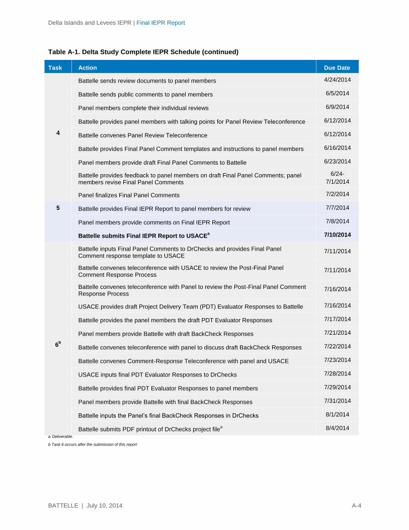
Delta Islands and Levees IEPR | Final IEPR Report
BATTELLE | July 10, 2014 A-4
Table A-1. Delta Study Complete IEPR Schedule (continued)
Task Action Due Date
4
Battelle sends review documents to panel members 4/24/2014
Battelle sends public comments to panel members 6/5/2014
Panel members complete their individual reviews 6/9/2014
Battelle provides panel members with talking points for Panel Review Teleconference 6/12/2014
Battelle convenes Panel Review Teleconference 6/12/2014
Battelle provides Final Panel Comment templates and instructions to panel members 6/16/2014
Panel members provide draft Final Panel Comments to Battelle 6/23/2014
Battelle provides feedback to panel members on draft Final Panel Comments; panel members revise Final Panel Comments
6/24-
7/1/2014
Panel finalizes Final Panel Comments 7/2/2014
5 Battelle provides Final IEPR Report to panel members for review 7/7/2014
Panel members provide comments on Final IEPR Report 7/8/2014
Battelle submits Final IEPR Report to USACEa 7/10/2014
6b
Battelle inputs Final Panel Comments to DrChecks and provides Final Panel Comment response template to USACE
7/11/2014
Battelle convenes teleconference with USACE to review the Post-Final Panel Comment Response Process
7/11/2014
Battelle convenes teleconference with Panel to review the Post-Final Panel Comment Response Process
7/16/2014
USACE provides draft Project Delivery Team (PDT) Evaluator Responses to Battelle 7/16/2014
Battelle provides the panel members the draft PDT Evaluator Responses 7/17/2014
Panel members provide Battelle with draft BackCheck Responses 7/21/2014
Battelle convenes teleconference with panel to discuss draft BackCheck Responses 7/22/2014
Battelle convenes Comment-Response Teleconference with panel and USACE 7/23/2014
USACE inputs final PDT Evaluator Responses to DrChecks 7/28/2014
Battelle provides final PDT Evaluator Responses to panel members 7/29/2014
Panel members provide Battelle with final BackCheck Responses 7/31/2014
Battelle inputs the Panel’s final BackCheck Responses in DrChecks 8/1/2014
Battelle submits PDF printout of DrChecks project filea 8/4/2014
a Deliverable.
b Task 6 occurs after the submission of this report
Delta Islands and Levees IEPR | Final IEPR Report
BATTELLE | July 10, 2014 A-5
At the beginning of the Period of Performance for the Delta Study IEPR, Battelle held a kick-off meeting
with USACE to review the preliminary/suggested schedule, discuss the IEPR process, and address any
questions regarding the scope (e.g., clarify expertise areas needed for panel members). Any revisions to
the schedule were submitted as part of the final Work Plan. In addition, 43 charge questions were
provided by USACE and included in the draft and final Work Plans. Battelle added two questions that
seek summary information from the IEPR Panel and two questions associated with the public comments.
The final charge also included general guidance for the Panel on the conduct of the peer review (provided
in Appendix C of this final report).
Prior to beginning their review and within nine days of their subcontracts being finalized, all members of
the Panel attended a kick-off meeting via teleconference planned and facilitated by Battelle in order to
review the IEPR process, the schedule, communication procedures, and other pertinent information for
the Panel. Battelle planned and facilitated a second kick-off meeting via teleconference during which
USACE presented project details to the Panel. Before the meetings, the IEPR Panel received an
electronic version of the final charge as well as the Delta Study review documents and reference
materials listed below. The documents and files in bold font were provided for review; the other
documents were provided for reference or supplemental information only.
Draft Integrated Feasibility Report & Environmental Impact Statement Documentation (269 pages)
Appendix A: Scoping Report (53 pages)
Appendix B: Economics (25 pages)
Appendix C: Engineering – Flood Risk Mgmt. (37 pages, plus reference data)
Appendix D: Engineering – Ecosystem Restoration (32 pages)
Appendix E: Engineering – Cost Engineering (15 pages)
Appendix F: Habitat Evaluation Procedure/Cost Effectiveness/Incremental Cost Analysis (17 pages)
Appendix G: Special Status Species Lists and Coordination (102 pages)
Appendix H: Draft Section 404(b)(1) Evaluation (22 pages)
Appendix I: Air Quality Modeling Results (4 pages)
Appendix J: Cultural Resources Correspondence (43 pages)
Appendix K: Draft Real Estate Plan (31 pages)
Public and Agency Comments (20 pages)
Risk Register
Draft Bay Delta Conservation Plan
Delta Risk Management Study
SMART Planning Guide
USACE guidance Civil Works Review, (EC 1165-2-214) dated 15 December 2012
Office of Management and Budget’s Final Information Quality Bulletin for Peer Review released
December 16, 2004.
About halfway through the review of the Delta Study IEPR documents, a teleconference was held with
USACE, the Panel, and Battelle so that USACE could answer any questions the Panel had concerning
Delta Islands and Levees IEPR | Final IEPR Report
BATTELLE | July 10, 2014 A-6
either the review documents or the project. Prior to this teleconference, Battelle submitted 32 panel
member questions to USACE. USACE was able to provide responses to all of the questions during the
teleconference or during the review period via email.
In addition, throughout the review period, USACE provided documents at the request of panel members.
These documents were provided to Battelle and then sent to the Panel as additional information only and
were not part of the official review. A list of these additional documents requested by the Panel is
provided below.
Delta CE-ICA TSP_Dependency_2-05-14
Delta CE-ICA TSP_Variables_2-05-14PG
Delta CE-ICA_2-05-14
Delta CE-ICA_2-05-14PG
Delta TSP CE-ICA_Solutions and Scales_2-05-14
Delta_Econ_complete_DQC
FDA_Bethel
FDA_Disco_Bay
FDA_Isleton
FDA_WalnutGr
FW_Delta Study-Restoration Concepts-Target Habitat Elevation PT1
Water Surface Elevation Graph
Completion Report for East Marsh Island Marsh Creation Project (TV-21), Iberia Parish, LA
A.2 Review of Individual Comments
The Panel was instructed to address the charge questions/discussion points within a charge question
response table provided by Battelle. At the end of the review period, the Panel produced individual
comments in response to the charge questions/discussion points. Battelle reviewed the comments to
identify overall recurring themes, areas of potential conflict, and other overall impressions. At the end of
the review, Battelle summarized the individual comments in a preliminary list of 22 overall comments and
discussion points. Each panel member’s individual comments were shared with the full Panel in a merged
individual comments table.
A.3 IEPR Panel Teleconference
Battelle facilitated a four-hour teleconference with the Panel so that the panel members could exchange
technical information. The main goal of the teleconference was to identify which issues should be carried
forward as Final Panel Comments in the Final IEPR Report and decide which panel member would serve
as the lead author for the development of each Final Panel Comment. This information exchange ensured
that the Final IEPR Report would accurately represent the Panel’s assessment of the project, including
any conflicting opinions. The Panel engaged in a thorough discussion of the overall positive and negative
comments, added any missing issues of significant importance to the findings, and merged any related
individual comments. At the conclusion of the teleconference, Battelle reviewed each Final Panel
Comment with the Panel, including the associated level of significance, and confirmed the lead author for
each comment.
Delta Islands and Levees IEPR | Final IEPR Report
BATTELLE | July 10, 2014 A-7
The Panel also discussed responses to one specific charge question where there appeared to be
disagreement among panel members. The conflicting comment was determined not to be conflicting and
was found consistent with other Final Panel Comments already developed.
At the end of these discussions, the Panel identified 15 comments and discussion points that should be
brought forward as Final Panel Comments.
A.4 Preparation of Final Panel Comments
Following the teleconference, Battelle prepared a summary memorandum for the Panel documenting
each Final Panel Comment (organized by level of significance). The memorandum provided the following
detailed guidance on the approach and format to be used to develop the Final Panel Comments for the
Delta Study IEPR:
Lead Responsibility: For each Final Panel Comment, one Panel member was identified as the
lead author responsible for coordinating the development of the Final Panel Comment and
submitting it to Battelle. Battelle modified lead assignments at the direction of the Panel. To assist
each lead in the development of the Final Panel Comments, Battelle distributed the merged
individual comments table, a summary detailing each draft final comment statement, an example
Final Panel Comment following the four-part structure described below, and templates for the
preparation of each Final Panel Comment.
Directive to the Lead: Each lead was encouraged to communicate directly with the other panel
member as needed and to contribute to a particular Final Panel Comment. If a significant
comment was identified that was not covered by one of the original Final Panel Comments, the
appropriate lead was instructed to draft a new Final Panel Comment.
Format for Final Panel Comments: Each Final Panel Comment was presented as part of a four-
part structure:
1. Comment Statement (succinct summary statement of concern)
2. Basis for Comment (details regarding the concern)
3. Significance (high, medium/high, medium, medium/low, and low; see description below)
4. Recommendation(s) for Resolution (see description below).
Criteria for Significance: The following were used as criteria for assigning a significance level to
each Final Panel Comment:
1. High: Describes a fundamental issue with the project that affects the current
recommendation or justification of the project, and which will affect its future success, if the
project moves forward without the issue being addressed. Comments rated as high indicate
that the Panel determined that the current methods, models, and/or analyses contain a
“showstopper” issue.
2. Medium/High: Describes a potential fundamental issue with the project, which has not been
evaluated at a level appropriate to this stage in the SMART Planning process. Comments
rated as medium/high indicate that the Panel analyzed or assessed the methods, models,
and/or analyses available at this stage in the SMART Planning process and has determined
that if the issue is not addressed, it could lead to a “showstopper” issue.
Delta Islands and Levees IEPR | Final IEPR Report
BATTELLE | July 10, 2014 A-8
3. Medium: Describes an issue with the project, which does not align with the currently
assessed level of risk assigned at this stage in the SMART Planning process. Comments
rated as medium indicate that, based on the information provided, the Panel identified an
issue that would raise the risk level if the issue is not appropriately addressed.
4. Medium/Low: Affects the completeness of the report at this time in describing the project,
but will not affect the recommendation or justification of the project. Comments rated as
medium/low indicate that the Panel does not currently have sufficient information to analyze
or assess the methods, models, or analyses.
5. Low: Affects the understanding or accuracy of the project as described in the report, but will
not affect the recommendation or justification of the project. Comments rated as low indicate
that the Panel identified information that was mislabeled or incorrect or that certain data or
report section(s) were not clearly described or presented.
Guidelines for Developing Recommendations: The recommendation section was to include
specific actions that USACE should consider to resolve the Final Panel Comment (e.g.,
suggestions on how and where to incorporate data into the analysis, how and where to address
insufficiencies, areas where additional documentation is needed).
Battelle reviewed and edited the Final Panel Comments for clarity, consistency with the comment
statement, and adherence to guidance on the Panel’s overall charge, which included ensuring that there
were no comments regarding either the appropriateness of the selected alternative or USACE policy. At
the end of this process, 15 Final Panel Comments were prepared and assembled. There was no direct
communication between the Panel and USACE during the preparation of the Final Panel Comments. The
Final Panel Comments are presented in the main report.
A.5 Conduct of the Public Comment Review
Battelle received a PDF file containing 20 pages of public comments on the Delta Study from USACE on
June 5, 2014. Battelle sent the public comments to the panel members that same day, along with an
additional two charge questions:
1. Does information or concerns raised in the public comments raise any additional
discipline-specific technical concerns with regard to the overall report?
2. Has adequate stakeholder involvement occurred to identify issues of interest and to
solicit feedback from interested parties?
The panel members were charged with responding to the two charge questions above.
The Panel produced individual comments in response to the two charge questions. Battelle reviewed the
comments to identify any new technical concerns that had not been previously identified during the initial
IEPR. Upon review, Battelle determined, and the Panel confirmed, that no new issues or concerns were
identified other than those already covered in its Final Panel Comments. The Panel also determined that
adequate stakeholder involvement had occurred.

Delta Islands and Levees IEPR | Final IEPR Report
BATTELLE | July 10, 2014 A-9
This page is intentionally left blank.

Delta Islands and Levees IEPR | Final IEPR Report
BATTELLE | July 10, 2014 B-1
APPENDIX B
Identification and Selection of IEPR Panel Members
for the Delta Study Project

Delta Islands and Levees IEPR | Final IEPR Report
BATTELLE | July 10, 2014 B-2
This page is intentionally left blank.
Delta Islands and Levees IEPR | Final IEPR Report
BATTELLE | July 10, 2014 B-3
B.1 Panel Identification
The candidates for the Independent External Peer Review (IEPR) for the Delta Islands and Levees
Feasibility Study, California, Draft Integrated Feasibility Report & Environmental Impact Statement
(hereinafter: Delta Study IEPR) Panel were evaluated based on their technical expertise in the following
key areas: economics, plan formulation, National Environmental Policy Act (NEPA) expert, hydraulic
engineering, and geotechnical engineering. These areas correspond to the technical content of the Delta
Study IEPR review documents and overall scope of the Delta Study project.
To identify candidate panel members, Battelle reviewed the credentials of the experts in Battelle’s Peer
Reviewer Database, sought recommendations from colleagues, contacted former panel members, and
conducted targeted Internet searches. Battelle evaluated these candidate panel members in terms of their
technical expertise and potential conflicts of interest (COIs). Of these candidates, Battelle chose the most
qualified individuals, confirmed their interest and availability, and ultimately selected four experts for the
final Panel.
The four selected reviewers constituted the final Panel. The remaining candidates were not proposed for
a variety of reasons, including lack of availability, disclosed COIs, or lack of the precise technical
expertise required.
The candidates were screened for the following potential exclusion criteria or COIs.1 These COI
questions serve as a means of disclosure and to better characterize a candidate’s employment history
and background. Providing a positive response to a COI screening question did not automatically
preclude a candidate from serving on the Panel. For example, participation in previous USACE technical
peer review committees and other technical review panel experience was included as a COI screening
question. A positive response to this question could be considered a benefit.
Previous and/or current involvement by you or your firm2 in the Delta Islands and Levees
Integrated Feasibility Report & Environmental Impact Statement
Previous and/or current involvement by you or your firm2 in flood control, ecosystem
restoration projects in the Sacramento – San Joaquin Delta, California, area.
Previous and/or current involvement by you or your firm2 in the Delta Islands and Levees
Integrated Feasibility Report & Environmental Impact Statement related projects.
Previous and/or current involvement by you or your firm2 in the conceptual or actual design,
construction, or operation and maintenance (O&M) of any projects in the Delta Islands and
Levees Integrated Feasibility Report & Environmental Impact Statement related projects.
1 Battelle evaluated whether scientists in universities and consulting firms that are receiving USACE-funding have sufficient
independence from USACE to be appropriate peer reviewers. See OMB (2004, p. 18), “….when a scientist is awarded a
government research grant through an investigator-initiated, peer-reviewed competition, there generally should be no question as to
that scientist's ability to offer independent scientific advice to the agency on other projects. This contrasts, for example, to a situation
in which a scientist has a consulting or contractual arrangement with the agency or office sponsoring a peer review. Likewise, when
the agency and a researcher work together (e.g., through a cooperative agreement) to design or implement a study, there is less
independence from the agency. Furthermore, if a scientist has repeatedly served as a reviewer for the same agency, some may
question whether that scientist is sufficiently independent from the agency to be employed as a peer reviewer on agency-sponsored
projects.”
2 Includes any joint ventures in which firm is involved and if firm serves as a prime or as a subcontractor to a prime.
Delta Islands and Levees IEPR | Final IEPR Report
BATTELLE | July 10, 2014 B-4
Current employment by the U.S. Army Corps of Engineers (USACE).
Previous and/or current involvement with paid or unpaid expert testimony related to Delta Islands
and Levees Integrated Feasibility Report & Environmental Impact Statement.
Previous and/or current involvement with paid or unpaid expert testimony related to Delta Islands
and Levees Integrated Feasibility Report & Environmental Impact Statement.
Previous and/or current employment or affiliation with members of the cooperating agencies or
local sponsors: California Department of Water Resources (DWR); Central Valley Flood
Protection Board (for pay or pro bono).
Past, current, or future interests or involvements (financial or otherwise) by you, your spouse or
children related to Sacramento – San Joaquin Delta, California, area.
Current personal involvement with other USACE projects, including whether involvement was to
author any manuals or guidance documents for USACE. If yes, provide titles of documents or
description of project, dates, and location (USACE district, division, Headquarters, Engineer
Research and Development Center [ERDC], etc.), and position/role. Please highlight and discuss
in greater detail any projects that are specifically with the Sacramento District.
Previous or current involvement with the development or testing of models that will be used for or
in support of the Delta Islands and Levees Integrated Feasibility Report & Environmental Impact
Statement project.
Current firm2 involvement with other USACE projects, specifically those projects/contracts that
are with the Sacramento District. If yes, provide title/description, dates, and location (USACE
district, division, Headquarters, ERDC, etc.), and position/role. Please also clearly delineate the
percentage of work you personally are currently conducting for the Sacramento District. Please
explain.
Any previous employment by USACE as a direct employee, notably if employment was with the
Sacramento District. If yes, provide title/description, dates employed, and place of employment
(district, division, Headquarters, ERDC, etc.), and position/role.
Any previous employment by USACE as a contractor (either as an individual or through your
firm2) within the last 10 years, notably if those projects/contracts are with the Sacramento District
If yes, provide title/description, dates employed, and place of employment (district, division,
Headquarters, ERDC, etc.), and position/role.
Previous experience conducting technical peer reviews. If yes, please highlight and discuss any
technical reviews concerning ecosystem review and/or flood management studies, and include
the client/agency and duration of review (approximate dates).
Pending, current, or future financial interests in Delta Islands and Levees Integrated Feasibility
Report & Environmental Impact Statement related contracts/awards from USACE.
A significant portion (i.e., greater than 50%) of personal or firm2 revenues within the last 3 years
came from USACE contracts.
A significant portion (i.e., greater than 50%) of personal or firm2 revenues within the last 3 years
from contracts with the non-federal sponsor (California DWR; Central Valley Flood Protection
Board).
Any publicly documented statement (including, for example, advocating for or discouraging
against) related to Delta Islands and Levees Integrated Feasibility Report & Environmental Impact
Statement
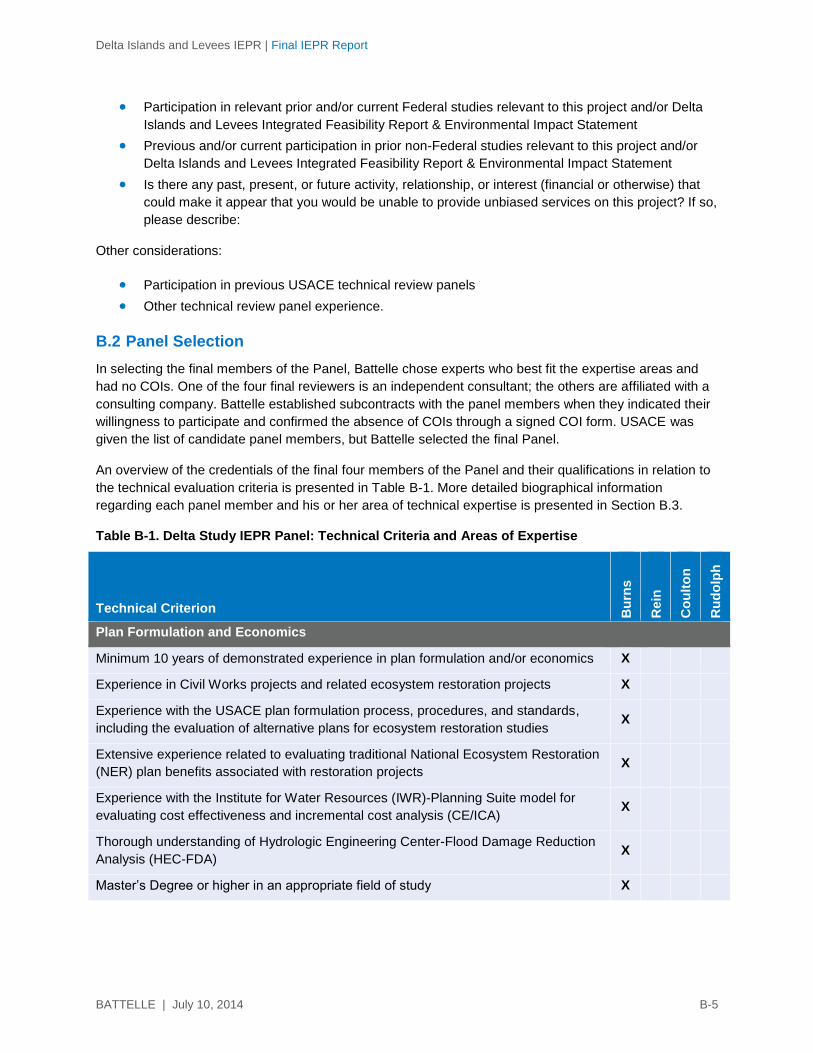
Delta Islands and Levees IEPR | Final IEPR Report
BATTELLE | July 10, 2014 B-5
Participation in relevant prior and/or current Federal studies relevant to this project and/or Delta
Islands and Levees Integrated Feasibility Report & Environmental Impact Statement
Previous and/or current participation in prior non-Federal studies relevant to this project and/or
Delta Islands and Levees Integrated Feasibility Report & Environmental Impact Statement
Is there any past, present, or future activity, relationship, or interest (financial or otherwise) that
could make it appear that you would be unable to provide unbiased services on this project? If so,
please describe:
Other considerations:
Participation in previous USACE technical review panels
Other technical review panel experience.
B.2 Panel Selection
In selecting the final members of the Panel, Battelle chose experts who best fit the expertise areas and
had no COIs. One of the four final reviewers is an independent consultant; the others are affiliated with a
consulting company. Battelle established subcontracts with the panel members when they indicated their
willingness to participate and confirmed the absence of COIs through a signed COI form. USACE was
given the list of candidate panel members, but Battelle selected the final Panel.
An overview of the credentials of the final four members of the Panel and their qualifications in relation to
the technical evaluation criteria is presented in Table B-1. More detailed biographical information
regarding each panel member and his or her area of technical expertise is presented in Section B.3.
Table B-1. Delta Study IEPR Panel: Technical Criteria and Areas of Expertise
Technical Criterion Bu
rns
Rein
Co
ult
on
Ru
do
lph
Plan Formulation and Economics
Minimum 10 years of demonstrated experience in plan formulation and/or economics X
Experience in Civil Works projects and related ecosystem restoration projects X
Experience with the USACE plan formulation process, procedures, and standards,
including the evaluation of alternative plans for ecosystem restoration studies X
Extensive experience related to evaluating traditional National Ecosystem Restoration
(NER) plan benefits associated with restoration projects X
Experience with the Institute for Water Resources (IWR)-Planning Suite model for
evaluating cost effectiveness and incremental cost analysis (CE/ICA) X
Thorough understanding of Hydrologic Engineering Center-Flood Damage Reduction
Analysis (HEC-FDA) X
Master’s Degree or higher in an appropriate field of study X

Delta Islands and Levees IEPR | Final IEPR Report
BATTELLE | July 10, 2014 B-6
Table B-1. Delta Study IEPR Panel: Technical Criteria and Areas of Expertise (continued)
Technical Criterion Bu
rns
Rein
Co
ult
on
Ru
do
lph
Environmental and National Environmental Policy Act
Minimum 10 years of demonstrated experience in environmental science and NEPA
compliance
X
Experienced in NEPA/California Environmental Quality Act (CEQA) process and
analysis
X
Familiar with the project area (i.e. San Joaquin Delta, California) and ecosystem
restoration projects
X
Extensive knowledge of the following:
intertidal and tidal ecology X
wetlands X
riparian habitats X
Master’s degree in environmental science or related field X
Hydraulic Engineering
Minimum 10 years of demonstrated experience in hydraulic engineering X
Possess a thorough understanding of river and delta flows including,
but not limited to:
flood conditions X
low flow/drought X
channel flows X
reservoir operations X
potential impacts of urban and farmland run-off X
Knowledge of flood walls and levee impacts X
Experience working with non-structural measures X
Experience in the application of risk and uncertainty analyses relating to flood risk
management (FRM) and residual flood risk.
X
Master’s degree in hydraulic engineering or related field X
Registered professional engineer X
Certified floodplain manager X
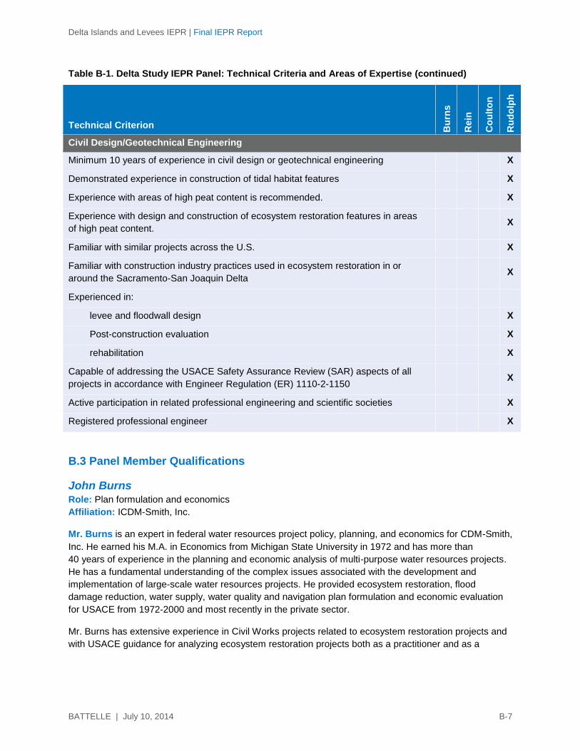
Delta Islands and Levees IEPR | Final IEPR Report
BATTELLE | July 10, 2014 B-7
Table B-1. Delta Study IEPR Panel: Technical Criteria and Areas of Expertise (continued)
Technical Criterion Bu
rns
Rein
Co
ult
on
Ru
do
lph
Civil Design/Geotechnical Engineering
Minimum 10 years of experience in civil design or geotechnical engineering X
Demonstrated experience in construction of tidal habitat features X
Experience with areas of high peat content is recommended. X
Experience with design and construction of ecosystem restoration features in areas
of high peat content.
X
Familiar with similar projects across the U.S. X
Familiar with construction industry practices used in ecosystem restoration in or
around the Sacramento-San Joaquin Delta
X
Experienced in:
levee and floodwall design X
Post-construction evaluation X
rehabilitation X
Capable of addressing the USACE Safety Assurance Review (SAR) aspects of all
projects in accordance with Engineer Regulation (ER) 1110-2-1150
X
Active participation in related professional engineering and scientific societies X
Registered professional engineer X
B.3 Panel Member Qualifications
John Burns Role: Plan formulation and economics
Affiliation: ICDM-Smith, Inc.
Mr. Burns is an expert in federal water resources project policy, planning, and economics for CDM-Smith,
Inc. He earned his M.A. in Economics from Michigan State University in 1972 and has more than
40 years of experience in the planning and economic analysis of multi-purpose water resources projects.
He has a fundamental understanding of the complex issues associated with the development and
implementation of large-scale water resources projects. He provided ecosystem restoration, flood
damage reduction, water supply, water quality and navigation plan formulation and economic evaluation
for USACE from 1972-2000 and most recently in the private sector.
Mr. Burns has extensive experience in Civil Works projects related to ecosystem restoration projects and
with USACE guidance for analyzing ecosystem restoration projects both as a practitioner and as a
Delta Islands and Levees IEPR | Final IEPR Report
BATTELLE | July 10, 2014 B-8
reviewer. Relevant studies include his participation as study manager and economist for the Small
Diversion at Convent/Blind River, Louisiana Coastal Area (LCA), Louisiana, through CDM and the
technical planning and economic assistance through Dawson & Associates for the Lower Passaic River
Restoration Project. Additionally, in his role as national manager for USACE’s Planning Program at the
Chief of the Planning Management Branch in the USACE Headquarters, he provided managerial
oversight for USACE feasibility studies, including the following ecosystem restoration projects:
Comprehensive Everglades Restoration Plan, Florida; Hamilton Army Airfield Wetland Restoration,
California; and the Rio Salado, Salt River, Phoenix and Tempe, Arizona, and Tres Rios, Arizona.
Mr. Burns’ role as the national manager for USACE’s planning program also included large-scale water
resources projects. He was responsible for the execution of USACE’s $140 million General Investigations
Program, and for identifying areas requiring new policy direction. He provided expert assistance and
policy direction to subordinate offices, helping them resolve complex issues and ensuring that
engineering, economic, and environmental analyses guiding navigation, flood damage reduction,
ecosystem restoration, and other multi-purpose water resources investments and project operational
changes were developed to meet the changing needs and priorities of the nation. Additionally, he
developed and led a workshop for USACE Northwestern Division on changes to USACE planning
guidance, the 2001 Energy and Water Development Appropriations Act, and the Water Resources
Development Act of 2000.
Mr. Burns has experience with the USACE plan formulation process, procedures, and standards,
including the evaluation of alternative plans for ecosystem restoration studies. He is also familiar with the
Hydrologic Engineering Center-Flood Damage Reduction Analysis (HEC-FDA) User's Manual and the
use of HEC-FDA with its sample data files. Most recently, he conducted the formulation and evaluation of
ecosystem restoration plans as the study manager and economist on the LCA Small Diversion at
Convent/Blind River, Louisiana, Project. He has demonstrable experience related to evaluating National
Ecosystem Restoration (NER) plan benefits associated with ecosystem restoration projects that include
the LCA Small Diversion at Convent/Blind River Project and the Jamaica Bay, Marine Park, and Plum
Beach, New York, environmental restoration study. He has extensive background with the USACE plan
formulation process and with the Institute for Water Resources (IWR)-Planning Suite model for evaluating
cost effectiveness and incremental cost analysis (CE/ICA) and has a strong understanding of the
economics of flood risk reduction and principles and guidelines requirements.
Felicia Orah Rein Role: Environmental and National Environmental Policy Act
Affiliation: Watershed Solutions, Inc.
Dr. Rein is a senior scientist and president at Watershed Solutions, Inc. in Boca Raton, Florida, and
affiliate professor at Florida Atlantic University. She earned her Ph.D. in ecosystem restoration from the
University of California at Santa Cruz in 2000 and has 25 years of experience managing and
implementing large-scale multidisciplinary research and evaluation projects that address critical
environmental issues. Experience on such projects includes the Moores Lake water rights project in
Carmel Valley, California, and the Jamaica Bay, New York, restoration design project. She has more than
20 years of experience with NEPA compliance and specializes in water and soil resources and restoration
ecology, as well as overall environmental management.
Dr. Rein is knowledgeable in NEPA/California Environmental Quality Act (CEQA) processes and
analyses. She gained direct experience through both her doctoral program work and private consultation
Delta Islands and Levees IEPR | Final IEPR Report
BATTELLE | July 10, 2014 B-9
where NEPA compliance and analysis is critical to the practice. She has read, written, and analyzed
environmental impact reports/environmental impact statements for more than 20 years. Since 2002, she
has written environmental NEPA and CEQA documents, including managing preparation of a CEQA
document for an expanded Initial Study in Carmel, California. Additionally, she has served on several
IEPR panels as the environmental and NEPA expert.
Dr. Rein is familiar with the project area, having worked in the region for 15 years. From 1989-1991, she
managed a groundwater cleanup superfund site in Sacramento. From 1996-1999, she managed an
ecosystem restoration project on the San Luis National Wildlife Refuge, for the U.S. Fish and Wildlife
Service (USFWS) in Los Banos. Additionally, her doctoral focus was ecosystem restoration, where she
conducted a six-year complex ecosystem restoration research study in Elkhorn Slough estuary, near
Monterey, California.
Dr. Rein has extensive knowledge in intertidal and tidal ecology. She has conducted field research on
seaweeds in the Monterey Bay area and specializes in coastal ecosystems, with some experience
working in tide pools. She has worked in wetlands conducting wetland delineation and wetland restoration
projects in many areas of central California, including in the Delta Island area and Mono County for the
Lahontan Regional Water Quality Control Board. Dr. Rein has extensive knowledge and experience in
riparian habitats, both with restoration and flood control in central California. In 1995, she prepared the
riparian and native plant restoration plans for the Pala Band of Indians in northern San Diego County.
Most recently, she monitored water quality impacts resulting from coffer dam construction for levee
improvements along the Hillsboro canal in Palm Beach County, Florida, demonstrating a sound
understanding of levee construction and restoration.
Kevin Coulton, P.E. Role: Hydraulic engineering
Affiliation: cbec, inc.
Mr. Coulton is a water resources engineer with cbec, inc. He has 29 years of experience in hydraulic
engineering with a focus in ecosystem restoration planning and design. He earned his M.S. in civil
engineering from Washington State University. He is a certified floodplain manager and is a registered
professional engineer in the states of California, Idaho, Montana, Oregon, and Washington. He
possesses a thorough understanding of river and delta flows through his academic and work experiences.
His career has been focused on the estimation, evaluation, and management of flood conditions. Early in
his career, he performed riverine and coastal flood insurance studies for the Federal Emergency
Management Agency (FEMA) and has written guidance for performing flood investigations. Additionally,
he was involved with the California Department of Water Resources (DWR) on a program to define 200-
year floodplain conditions in the Sacramento River Basin.
Mr. Coulton has experience in low-flow and drought conditions through several investigations that
examined low-flow conditions with respect to fish passage design, water balance studies, and habitat
restoration, using hydrologic models and/or analytical methods. Additionally, he was a task manager for a
water supply study that investigated the safe yield of water supply options with consideration given to
instream water rights, historic drought periods, and the sizing of physical facilities. Mr. Coulton is familiar
with channel flow through his work on projects throughout the Central Valley. He has performed
numerous projects focused on open-channel flow and several projects addressing levee breaching. For
example, for the California Central Valley Flood Protection Plan, he managed and led the technical efforts
to develop new spatial methods to assess channel floodplain morphology and flood potential, including
Delta Islands and Levees IEPR | Final IEPR Report
BATTELLE | July 10, 2014 B-10
height above river and flood inundation potential Geographic Information System (GIS) analyses.
Additionally, his graduate school work involved physical modeling of open-channel flow, field work related
to stream restoration and fish passage, and coursework on fluid dynamics and open-channel hydraulics.
Mr. Coulton has experience in reservoir operations, including an evaluation of the Barney Reservoir for
the USACE Portland District examining flow diversion impacts on the water balance of Tillamook Bay,
Oregon. Other reservoir operations experience includes evaluating bank storage at Hungry Horse
Reservoir in northwestern Montana. Mr. Coulton has experience in the potential impacts of urban and
farmland runoff as well. This experience comes from a hydraulic and hydrology study he managed of
flooding on Five Mile Creek near Boise, Idaho. The study simulated runoff potential to the creek and the
complex interaction of seasonal agricultural irrigation practices and increased flood potential in the
urbanized watershed. Mr. Coulton has knowledge of flood walls and levee impacts through this use of
hydraulic modeling of floodplain and levee systems on many stream systems (including Napa Creek and
the San Joaquin, Tuolumne, and Sacramento Rivers) and has performed levee setback planning on the
Sacramento River and its tributaries.
Non-structural flood management measures are a focus of Mr. Coulton’s career through both his
academic and consulting experiences. He has been involved in the planning, design, and application of
non-structural measures including, floodplain restoration, levee setbacks, flood insurance, and improved
building standards. From a policy standpoint involving non-structural measures, Mr. Coulton has attended
most of the Association of State Floodplain Managers Gilbert White Flood Policy Forums in Washington,
DC, and authored a chapter in a national report titled “Impact of the 1 percent standard on natural and
beneficial functions of the floodplain”, as part of the first comprehensive review of the National Flood
Insurance Program.
Mr. Coulton has experience in the application of risk and uncertainty analyses relating to FRM and
residual flood risk through his work on previous IEPRs, His current project work with FEMA Headquarters
National Flood Insurance Risk study assesses a broad range of options by which the private sector could
assist in managing the insurance risk of flooding within the United states. Additionally, from 2011 to 2013,
he led efforts to assess flood risk in the highly urbanized area of Monterrey, Mexico. He is a member of
the Association of State Floodplain Managers, Northwest Regional Floodplain Managers Association, and
American Society of Civil Engineers (ASCE).
William Rudolph, P.E., G.E Role: Civil design/geotechnical engineering
Affiliation: Independent Consultant
Mr. Rudolph is an independent consultant with 36 years of experience as a geotechnical engineer and
extensive experience with levee and ecosystem restoration projects. He earned his M.S. degree in
civil/geotechnical engineering from the University of California at Berkeley in 1978 and is both a licensed
professional civil engineer and a licensed geotechnical engineer. Mr. Rudolph has extensive geotechnical
experience with construction of tidal habitat features through his work on such studies as the Hamilton
Wetlands Restoration and the Middle Harbor Habitat Enhancement Projects. Additionally, he has
participated in site investigation, design, construction, and post-construction monitoring and other
ecosystem restoration projects which involved beneficial reuse of dredged materials.
Mr. Rudolph has experience with areas of high peat content, specifically through his geotechnical
explorations and site characterization for sites underlain by fibrous peat. These projects included levees,

Delta Islands and Levees IEPR | Final IEPR Report
BATTELLE | July 10, 2014 B-11
bridges, waterfront facilities, and other structures in the Sacramento-San Joaquin River Delta.
Additionally, he has experience with design and construction of ecosystem restoration features in high-
peat-content areas. Specifically, he has evaluated the effects of peat and soft/compressible estuarine
deposits on levee stability and settlement. He has also evaluated the effects of dredged fill on marsh plain
subsidence and has performed geotechnical design of weirs and outlet control structures in peat soils. Mr.
Rudolph is also experienced with peat ground loss due to oxidation.
Mr. Rudolph is familiar with similar projects across the United States through his involvement in
evaluation of flood control projects with levee construction/evaluation and habitat restoration components
in the West and Midwest. He is familiar with construction industry practices used in ecosystem restoration
in the Sacramento-San Joaquin Delta area through hands-on experience with levee construction and
repairs, as well as dredged material management for habitat restoration. He is well versed in soft ground
construction practices through his work on such projects as the Hamilton Wetland, Galbraith Dredge
rehandling facility, and Middle Harbor enhancement area.
Mr. Rudolph has experience with levee and floodwall design through investigations, analysis, and design
of levees, and flood control levels along the Sacramento, American, and Mississippi Rivers and lesser
creeks and streams. This work was conducted on such projects as Bay and Delta Island levees located
on poor soils, including soft clays, liquefiable sands, and peat. He has experience in post-construction
evaluation and has designed, supervised installation, and reviewed monitoring results of piezometers,
survey monuments, light detection and ranging (LiDAR) surveys, vibrating wire settlement gauges, slope
inclinometers, tilt meters, and acoustic depth sounders to monitor post-construction performance.
Additionally, he is experienced in rehabilitation through his work on levee assessment surveys for bay
front and riverine levees, where he identified deficiencies and recommended corrective action measures.
Through his involvement with USACE peer reviews (including peer reviews of the USACE Hurricane and
Storm Damage Risk Reduction System projects in greater New Orleans, the Leon Creek project, and
other dam safety reviews), Mr. Rudolph is able to address the USACE Safety Assurance Review (SAR)
aspects of all projects defined by USACE Engineer Circular (EC) 1165-2-214 (Appendix D, Para. 2. c (3)).
Mr. Rudolph is an active member of the ASCE, including the Coasts, Oceans, Ports and Rivers Institute.
Delta Islands and Levees IEPR | Final IEPR Report
BATTELLE | July 10, 2014 C-1
APPENDIX C
Final Charge to the IEPR Submitted
to USACE on April 18, 2014 for the
Delta Study Project

Delta Islands and Levees IEPR | Final IEPR Report
BATTELLE | July 10, 2014 C-2
This page is intentionally left blank.
Delta Islands and Levees IEPR | Final IEPR Report
BATTELLE | July 10, 2014 C-3
CHARGE QUESTIONS AND GUIDANCE TO THE PANEL MEMBERS FOR THE IEPR OF THE DELTA ISLANDS AND LEVEES FEASIBILITY STUDY, CALIFORNIA, DRAFT INTEGRATED FEASIBILITY REPORT & ENVIRONMENTAL IMPACT STATEMENT
BACKGROUND
The Sacramento – San Joaquin Delta is a web of channels and reclaimed islands at the confluence of the
Sacramento, San Joaquin, Cosumnes, Mokelumne, and Calaveras Rivers in California. Forty percent of
the State’s land area is contained within the watersheds of these rivers. The Delta covers about
738,000 acres, interlaced with hundreds of miles of waterways.
The communities and ecosystem within the Delta rely on the existing levee network to contain flows in the
Sacramento and San Joaquin Rivers. The existing 1,100-mile levee network is a mix of Federal and non-
Federal levees that do not meet any levee construction standards and could fail at water levels well below
the top of the levee. The levee network serves more as a network of dams, as it holds water back from
flooding the islands/tracts throughout the daily tidal fluctuations. Native habitat and natural river function
in the study area have been degraded by construction of the levee network and conversion of the
floodplain to agricultural and rural development, as well as management of the system for municipal,
industrial, and agricultural water supplies. The purposes of a project for the Delta area are to reduce risk
to life and property and to restore the ecosystem.
OBJECTIVES
The objective of this Performance Work Statement (PWS) is to conduct an Independent External Peer Review (IEPR) of the Delta Islands and Levees Integrated Feasibility Report & Environmental Impact Statement in accordance with procedures described in the Department of the Army, U.S. Army Corps of Engineers (USACE), Engineer Circular (EC) No. 1165-2-214, Civil Works Review Policy, dated 15 December 2012. Peer review is one of the important procedures used to ensure that the quality of published information meets the standards of the scientific and technical community. Peer review typically evaluates the clarity of hypotheses, validity of the research design, quality of data collection procedures, robustness of the methods employed, appropriateness of the methods for the hypotheses being tested, extent to which the conclusions follow from the analysis, and strengths and limitations of the overall product. The purpose of the IEPR is to assess the “adequacy and acceptability of the economic, engineering, and environmental methods, models, and analyses used” (EC 1165-2-214; p. D-4) for the Delta Study documents. The IEPR will be limited to technical review and will not involve policy review.
DOCUMENTS PROVIDED
The following is a list of documents, supporting information, and reference materials that will be provided
for the review.
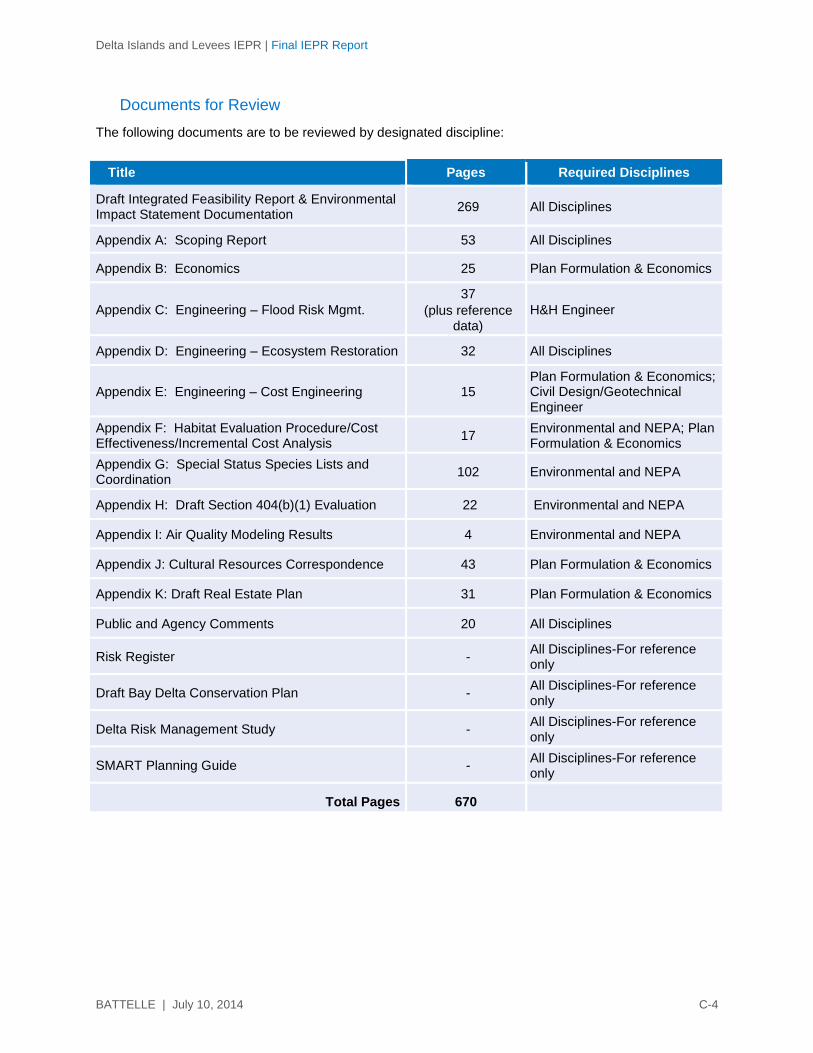
Delta Islands and Levees IEPR | Final IEPR Report
BATTELLE | July 10, 2014 C-4
Documents for Review
The following documents are to be reviewed by designated discipline:
Title Pages Required Disciplines
Draft Integrated Feasibility Report & Environmental Impact Statement Documentation
269 All Disciplines
Appendix A: Scoping Report 53 All Disciplines
Appendix B: Economics 25 Plan Formulation & Economics
Appendix C: Engineering – Flood Risk Mgmt.
37
(plus reference data)
H&H Engineer
Appendix D: Engineering – Ecosystem Restoration 32 All Disciplines
Appendix E: Engineering – Cost Engineering 15 Plan Formulation & Economics; Civil Design/Geotechnical Engineer
Appendix F: Habitat Evaluation Procedure/Cost Effectiveness/Incremental Cost Analysis
17 Environmental and NEPA; Plan Formulation & Economics
Appendix G: Special Status Species Lists and Coordination
102 Environmental and NEPA
Appendix H: Draft Section 404(b)(1) Evaluation 22 Environmental and NEPA
Appendix I: Air Quality Modeling Results 4 Environmental and NEPA
Appendix J: Cultural Resources Correspondence 43 Plan Formulation & Economics
Appendix K: Draft Real Estate Plan 31 Plan Formulation & Economics
Public and Agency Comments 20 All Disciplines
Risk Register - All Disciplines-For reference only
Draft Bay Delta Conservation Plan - All Disciplines-For reference only
Delta Risk Management Study - All Disciplines-For reference only
SMART Planning Guide - All Disciplines-For reference only
Total Pages 670
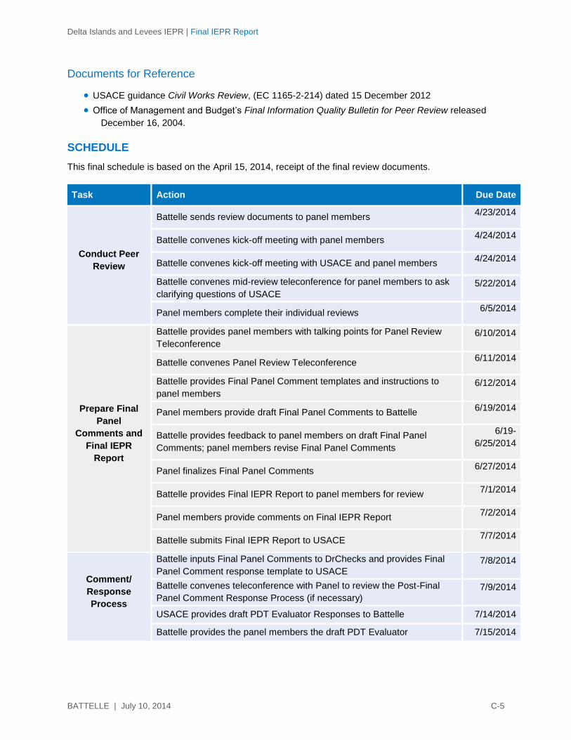
Delta Islands and Levees IEPR | Final IEPR Report
BATTELLE | July 10, 2014 C-5
Documents for Reference
USACE guidance Civil Works Review, (EC 1165-2-214) dated 15 December 2012
Office of Management and Budget’s Final Information Quality Bulletin for Peer Review released
December 16, 2004.
SCHEDULE
This final schedule is based on the April 15, 2014, receipt of the final review documents.
Task Action Due Date
Conduct Peer
Review
Battelle sends review documents to panel members 4/23/2014
Battelle convenes kick-off meeting with panel members 4/24/2014
Battelle convenes kick-off meeting with USACE and panel members 4/24/2014
Battelle convenes mid-review teleconference for panel members to ask
clarifying questions of USACE 5/22/2014
Panel members complete their individual reviews 6/5/2014
Prepare Final
Panel
Comments and
Final IEPR
Report
Battelle provides panel members with talking points for Panel Review
Teleconference 6/10/2014
Battelle convenes Panel Review Teleconference 6/11/2014
Battelle provides Final Panel Comment templates and instructions to
panel members 6/12/2014
Panel members provide draft Final Panel Comments to Battelle 6/19/2014
Battelle provides feedback to panel members on draft Final Panel
Comments; panel members revise Final Panel Comments
6/19-
6/25/2014
Panel finalizes Final Panel Comments 6/27/2014
Battelle provides Final IEPR Report to panel members for review 7/1/2014
Panel members provide comments on Final IEPR Report 7/2/2014
Battelle submits Final IEPR Report to USACE 7/7/2014
Comment/
Response
Process
Battelle inputs Final Panel Comments to DrChecks and provides Final
Panel Comment response template to USACE 7/8/2014
Battelle convenes teleconference with Panel to review the Post-Final
Panel Comment Response Process (if necessary) 7/9/2014
USACE provides draft PDT Evaluator Responses to Battelle 7/14/2014
Battelle provides the panel members the draft PDT Evaluator 7/15/2014

Delta Islands and Levees IEPR | Final IEPR Report
BATTELLE | July 10, 2014 C-6
Task Action Due Date
Responses
Panel members provide Battelle with draft BackCheck Responses 7/18/2014
Battelle convenes teleconference with panel members to discuss draft
BackCheck Responses 7/21/2014
Battelle convenes Comment-Response Teleconference with panel
members and USACE 7/22/2014
USACE inputs final PDT Evaluator Responses to DrChecks 7/25/2014
Battelle provides PDT Evaluator Responses to panel members 7/28/2014
Panel members provide Battelle with final BackCheck Responses 7/30/2014
Battelle inputs the panel members' final BackCheck Responses to
DrChecks 7/31/2014
Battelle submits PDF printout of DrChecks project file 8/1/2014
CHARGE FOR PEER REVIEW
Members of this IEPR Panel are asked to determine whether the technical approach and scientific
rationale presented in the Delta Study documents are credible and whether the conclusions are valid.
The Panel is asked to determine whether the technical work is adequate, competently performed, and
properly documented; satisfies established quality requirements; and yields scientifically credible
conclusions. The Panel is being asked to provide feedback on the economic, engineering, environmental
resources, and plan formulation. The panel members are not being asked whether they would have
conducted the work in a similar manner.
Specific questions for the Panel (by report section or appendix) are included in the general charge
guidance, which is provided below.
General Charge Guidance
Please answer the scientific and technical questions listed below and conduct a broad overview of the
Delta Study documents. Please focus your review on the review materials assigned to your
discipline/area of expertise and technical knowledge. Even though there are some sections with no
questions associated with them, that does not mean that you cannot comment on them. Please feel free
to make any relevant and appropriate comment on any of the sections and appendices you were asked to
review. In addition, please note the following guidance. Note that the Panel will be asked to provide an
overall statement related to 2 and 3 below per USACE guidance (EC 1165-2-214; Appendix D).
1. Your response to the charge questions should not be limited to a “yes” or “no.” Please provide complete answers to fully explain your response.
2. Assess the adequacy and acceptability of the economic and environmental assumptions and projections, project evaluation data, and any biological opinions of the project study.
3. Assess the adequacy and acceptability of the economic analyses, environmental analyses, engineering analyses, formulation of alternative plans, methods for integrating risk and

Delta Islands and Levees IEPR | Final IEPR Report
BATTELLE | July 10, 2014 C-7
uncertainty, and models used in evaluating economic or environmental impacts of the proposed project.
4. If appropriate, offer opinions as to whether there are sufficient analyses upon which to base a recommendation.
5. Identify, explain, and comment upon assumptions that underlie all the analyses, and evaluate the soundness of models, surveys, investigations, and methods.
6. Evaluate whether the interpretations of analysis and the conclusions based on analysis are reasonable.
7. Please focus the review on assumptions, data, methods, and models.
Please do not make recommendations on whether a particular alternative should be implemented, or
whether you would have conducted the work in a similar manner. Also, please do not comment on or
make recommendations on policy issues and decision-making. Comments should be provided based on
your professional judgment, not the legality of the document.
1. If desired, panel members can contact one another. However, panel members should not contact anyone who is or was involved in the project, prepared the subject documents, or was part of the USACE Agency Technical Review (ATR).
2. Please contact the Battelle Project Manager (Dick Uhler, [email protected]) or Program Manager (Karen Johnson-Young ([email protected]) for requests or additional information.
3. In case of media contact, notify the Battelle Program Manager, Karen Johnson-Young ([email protected]) immediately.
4. Your name will appear as one of the panel members in the peer review. Your comments will be included in the Final IEPR Report, but will remain anonymous.
Please submit your comments in electronic form to Project Manager, [email protected], no later
than June 5, 2014.
Delta Islands and Levees IEPR | Final IEPR Report
BATTELLE | July 10, 2014 C-8
IEPR of the Delta Islands and Levees Feasibility Study, California, Draft Integrated Feasibility Report & Environmental Impact Statement
CHARGE QUESTIONS AND RELEVANT SECTIONS AS SUPPLIED BY USACE
General Review Considerations
1. Were all models used in the analyses used in an appropriate manner?
2. Are the models used sufficiently discriminatory to support the conclusions drawn from them (i.e.,
identify meaningful differences between alternatives)?
3. Were risk and uncertainty sufficiently considered?
4. Are potential life safety issues accurately and adequately described under existing, future without-
project, and future with-project conditions?
5. In your opinion, are there sufficient analyses upon which to base the recommendation?
Problem, Needs, Constraints, and Opportunities
6. Are the problems, needs, constraints, and opportunities adequately and correctly defined?
7. Do the identified problems, needs, constraints, and opportunities reflect a systems, watershed, and/or
ecosystem approach, addressing a geographic area large enough to ensure that plans address the
cause-and-effect relationships among affected resources and activities that are pertinent to achieving
the study objectives (i.e., evaluate the resources and related demands as a system)?
8. Does the study address those resources identified during the scoping process as important in making
decisions relating to the study?
Existing and Future Without-Project Resources
9. Have the character and scope of the study area been adequately described, and is the identified
study area appropriate in terms of undertaking a systems/watershed/ecosystem-based investigation?
10. Do you agree with the general analyses of the existing social, financial, and natural resources within
the study area? For your particular area of expertise, provide an in-depth review of whether the
general analyses of the existing social, financial, and natural resources within the study area are
sufficient to support the estimation of impacts of the array of alternatives. Were the surveys
conducted to evaluate the existing social, financial, and natural resources adequate? If not, what
types of surveys should have been conducted?
11. Were socioeconomic conditions adequately addressed? Were specific socioeconomic issues not
addressed?
Delta Islands and Levees IEPR | Final IEPR Report
BATTELLE | July 10, 2014 C-9
12. Was the hydrology discussion sufficient to characterize current baseline conditions and to allow for
evaluation of how forecasted conditions (with and without proposed actions) are likely to affect
hydrologic conditions? Please comment on the completeness of the discussion on the relationship
between subsurface hydrology and the hydrodynamics of the project area.
13. Given your area of expertise, does this section appropriately address the existing conditions of all
resources pertinent to the study?
14. Was the discussion of natural resources sufficient to characterize current baseline conditions and to
allow for evaluation of forecasted conditions (with and without proposed actions)?
15. Were the assumptions used as the basis for developing the most probable future without-project
conditions reasonable? Were adequate scenarios effectively considered (applied during analyses
where relevant and/or reasonably investigated)? Were the potential effects of climate change
addressed?
16. Are the future conditions expected to exist in the absence of a Federal project logical and adequately
described and documented?
17. Please comment on the conclusion of the most probable future without-project condition. Do you
envision other potential probable outcomes?
Plan Formulation / Evaluation
18. Was a reasonably complete array of possible measures considered in the development of
alternatives?
19. Did the formulation process follow the requirement to avoid, minimize, and then mitigate adverse
impacts on resources?
20. Does each alternative meet the formulation criteria of being effective, efficient, complete, and
acceptable?
21. Were the assumptions made for use in developing the future with-project conditions for each
alternative reasonable? Were adequate scenarios considered? Were the assumptions reasonably
consistent across the range of alternatives and/or adequately justified where different?
22. Are the changes between the without- and with-project conditions adequately described for each
alternative?
23. Are the uncertainties inherent in our evaluation of benefits, costs, and impacts, and any risk
associated with those uncertainties, adequately addressed and described for each alternative?
24. Are future Operation, Maintenance, Repair, Replacement, and Rehabilitation (OMRR&R) efforts
adequately described, and are the estimated cost of those efforts reasonable for each alternative?
25. Please comment on the screening of the proposed measures and alternatives. Are the screening
criteria appropriate? In your professional opinion, are the results of the screening acceptable? Were
any measures or alternatives screened out too early?

Delta Islands and Levees IEPR | Final IEPR Report
BATTELLE | July 10, 2014 C-10
26. Were the engineering, economic, and environmental analyses used for this study consistent with
generally accepted methodologies? Why or why not?
27. Does any alternative include identified separable elements (a portion of a project that is physically
separable, and produces hydrologic effects or physical or economic benefits that are separately
identifiable from those produced by other portions of the project)? If so, is each identified separable
element independently justified, and are the benefits, costs, and effects of the separable elements
correctly divided?
Recommended Plan
28. Comment on whether you agree or disagree with how the selected alternative was formulated and
selected. Comment on the plan formulation. Does it meet the study objectives and avoid violating the
study constraints?
29. Are there any unmitigated environmental impacts not identified and, if so, could they impact plan
selection?
30. Please comment on the likelihood that the recommended plan will achieve the expected outputs.
31. Please comment on the completeness of the recommended plan; i.e., will any additional efforts,
measures, or projects be needed to realize the expected benefits?
32. Please comment on the appropriateness of location, sizing, and design of plan features.
Ecosystem Restoration – Specific Questions
33. Are the expected changes in the quality and abundance of desired ecological resources clearly and
precisely specified in justifying the ecosystem restoration and protection investment?
34. Is it clear that restoration of the desired ecological resource quality is a function of improvements in
habitat quality or quantity? Do planning models and procedures clearly link habitat improvement to
the needs of the targeted ecological resources?
35. Is it clear that the restored ecological resource quality will be sustainable over the long run?
36. Are the required long-term commitments (both Federal and non-Federal) to sustaining the restored
ecological resource quality adequately described and adequately demonstrated?
Flood Risk Management – Specific Questions
37. Do the assumptions, models, and assessments used to complete the FRM analysis support the
conclusions made in the report (determination that FRM is not within the Federal interest)?
38. Are the life safety risks associated with no FRM action clearly identified?
39. From a public safety perspective, is the proposed alternative reasonably appropriate, or are there
other alternatives that should be considered? Are residual risks associated with the recommended
plan adequately described?
Delta Islands and Levees IEPR | Final IEPR Report
BATTELLE | July 10, 2014 C-11
Summary Questions
40. Please identify the most critical concerns (up to five) you have with the project and/or review
documents. These concerns can be (but do not need to be) new ideas or issues that have not been
raised previously.
41. Please provide positive feedback on the project and/or review documents.
Public Comment Questions (provided to the Panel separately for its review of the public
comments)
42. Does information or do concerns raised by the public raise any additional discipline-specific technical
concerns with regard to the overall report?
43. Has adequate stakeholder involvement occurred to identify issues of interest and to solicit feedback
from interested parties?

Delta Islands and Levees IEPR | Final IEPR Report
BATTELLE | July 10, 2014 C-12
This page is intentionally left blank.