final report: investigation of fuel and bushfire risk
TRANSCRIPT
HEAD OFFICE: 420 Victoria Street, Brunswick VIC 3056 MELBOURNE: PO Box 298, Brunswick VIC 3056 GEELONG: PO Box 8048, Newtown VIC 3220
FINAL REPORT:
Investigation of Fuel and Bushfire Risk Management inVictoria’s High Country Using Strategic Cattle Grazing
Fauna and Flora Desktop Assessment
Matters of National Environmental Significance
ON BEHALF OF:
Department of Sustainability and EnvironmentJuly 2011
Ecology and Heritage Partners Pty Ltd

Investigation of fuel and bushfire risk management in Victoria’s high country using strategic cattle grazing 2
Table of Contents
1 Summary .......................................................................................................... 5
1 Introduction.................................................................................................... 10
1.1 Background ..................................................................................................... 10
1.2 Project Summary ............................................................................................. 10
1.3 Scope of Assessment...................................................................................... 11
1.4 Study Area....................................................................................................... 11
2 Methods.......................................................................................................... 12
2.1 Nomenclature .................................................................................................. 12
2.2 Literature Review and Other Information......................................................... 12
2.3 Database Searches ......................................................................................... 12
2.4 Nationally Threatened Communities ............................................................... 13
2.5 Buffers ............................................................................................................. 13
2.6 Likelihood of occurrence.................................................................................. 13
2.7 Limitations ....................................................................................................... 13
2.8 Site A ............................................................................................................... 15
2.8.1 Flora Assessment ..................................................................................................................15
2.8.2 Fauna Assessment ................................................................................................................16
2.9 Site B ............................................................................................................... 16
2.9.1 Flora Assessment ..................................................................................................................16
2.9.2 Fauna Assessment ................................................................................................................17
2.10 Site C............................................................................................................... 18
2.10.1 Flora Assessment..............................................................................................................18
2.10.2 Fauna Assessment ............................................................................................................19
2.11 Site D............................................................................................................... 20
2.11.1 Flora Assessment..............................................................................................................20
2.11.2 Fauna Assessment ............................................................................................................21
2.12 Site E ............................................................................................................... 22
2.12.1 Flora Assessment..............................................................................................................22
2.12.2 Fauna Assessment ............................................................................................................22
2.13 Site F ............................................................................................................... 23
2.13.1 Flora Assessment..............................................................................................................23
2.13.2 Fauna Assessment ............................................................................................................24
2.14 Site C1............................................................................................................. 25
2.14.1 Flora Assessment..............................................................................................................25
2.14.2 Fauna Assessment ............................................................................................................26

Investigation of fuel and bushfire risk management in Victoria’s high country using strategic cattle grazing3
2.15 Site C2............................................................................................................. 26
2.15.1 Flora Assessment..............................................................................................................26
2.15.2 Fauna Assessment ............................................................................................................27
2.16 Site C3............................................................................................................. 28
2.16.1 Flora Assessment..............................................................................................................28
2.16.2 Fauna Assessment ............................................................................................................29
2.17 Site C4............................................................................................................. 30
2.17.1 Flora Assessment..............................................................................................................30
2.17.2 Fauna Assessment ............................................................................................................30
3 Implications of the findings.......................................................................... 32
3.1 Environment Protection and Biodiversity Conservation Act 1999 ................... 32
3.1.1 Matters of NES........................................................................................................................32
4 Conclusion ..................................................................................................... 52
5 References ..................................................................................................... 53
6 Figures............................................................................................................ 65
7 Appendices .................................................................................................... 66
Tables
Table 1. Summary table of species identified during the current assessment within the 10
study areas and/or the 10 kilometre buffer zones. Numbers denote the number of
observations and the date of the most recent observation. Ex = Extinct, CE = Critically
Endangered, En = Endangered, Vu = Vulnerable. ........................................................... 7
Table 2. List of migratory species previously recorded within 10 kilometres of the study sites.
........................................................................................................................................ 50
Table A1.1. Rare or Threatened categories for listed Victorian taxa...................................... 67
Table A1.2. Defining Ecological Significance. ........................................................................ 68
Table A1.3. Defining Site Significance. .................................................................................. 70
Table A1.4. Defining Vegetation Condition. ........................................................................... 71
Table A1.5. Defining Habitat Quality. ..................................................................................... 72
Table A2.1. Nationally significant flora within 10 kilometres of the study area locations........ 73
Table A3.1. Nationally significant fauna within 10 kilometres of the study area locations..... 77

Investigation of fuel and bushfire risk management in Victoria’s high country using strategic cattle grazing4
AcknowledgementsWe thank the following people for their contribution in the project:
Seran Pty Ltd for project information.
Department of Sustainability and Environment for project and site information.
Department of Sustainability and Environment and Seran for participation in the
workshop and comments on the draft report.
The following Ecology and Heritage Partners Pty Ltd employees were
involved in the project and contributed to the report: Stuart Cooney, Jo
Day, James Garden, Bill Fish, Cristina Del Borrello, Amy Webster
Amanda Feetham and Aaron Organ.
Copyright © Ecology and Heritage Partners Pty Ltd.
This document is subject to copyright and may only be used for the
purposes for which it was commissioned. The use or copying of this
document in whole or part without the permission of Ecology and
Heritage Partners Pty Ltd is an infringement of copyright.
Disclaimer
Although Ecology and Heritage Partners Pty Ltd have taken all the
necessary steps to ensure that an accurate document has been
prepared, the company accepts no liability for any damages or loss
incurred as a result of reliance placed upon the report and its content.

Investigation of fuel and bushfire risk management in Victoria’s high country using strategic cattle grazing5
1 SUMMARY
Introduction
Ecology and Heritage Partners Pty Ltd (EHP), in collaboration with Seran, were
commissioned by the Department of Sustainability and Environment (DSE), to undertake a
desktop flora and fauna assessment of 10 sites for the proposed Research Trial being
conducted by DSE. The purpose of this desktop assessment is to inform the development of a
risk assessment and Environmental Management Plan (EMP) which will be established before
the research trial begins.
Ten sites have been identified for the conduct of the research trial. Only six will be used as
research sites at any one time, with four contingency sites identified for adaptive management
purposes. None of the four contingency sites will be used unless one or more of the six
research sites cannot be used due to significant unforeseen circumstances.
Methods
Biological databases maintained by the Department of Sustainability and Environment were
reviewed, principally the Victorian Biodiversity Atlas. The presence of Ecological Vegetation
Classes (EVCs) within the study area were reviewed using DSE’s biodiversity interactive
maps, while information referring to matters (listed taxa and ecological communities, Ramsar
wetlands) protected under the Commonwealth Environment Protection and Biodiversity
Conservation Act 1999 (EPBC Act) was also obtained from the Department of Sustainability,
Environment, Water, Population and Communities (SEWPaC) Protected Matters Search Tool.
Results
Flora
Four nationally significant flora species (Leafy Greenhood Pterostylis cucullata, Grey
Fireweed Senecio georgianus, Dwarf Sedge Carex paupera and Pale Golden Moths Diuris
ochroma) that are currently listed under the EPBC Act have previously been recorded within
the 10 proposed study sites, while an additional 16 species have previously been recorded
within a 10 kilometre radius of the 10 study sites (Table 1). A further five species have not
been recorded, but have the potential to occur or for their habitats to occur, based on SEWPaC
Protected Matters Search Tool.
Communities
Three ecological communities listed under the EPBC Act have the potential to occur in one or
more of the study sites. The critically endangered White Box-Yellow Box-Blakely's Red
Gum Grassy Woodland and Derived Native Grassland, and the endangered Alpine Sphagnum
Bogs and Associated Fens community is likely to occur within all of the study sites, but is
known to occur in Site F or its buffer zone. Finally, the buffer zone around Site F is also
likely to contain Natural Temperate Grassland of the Southern Tablelands of NSW and the

Investigation of fuel and bushfire risk management in Victoria’s high country using strategic cattle grazing6
Australian Capital Territory, which relates to vegetation over the border in New South Wales,
outside of the proposed research trial sites.
Despite this, without field assessments, this assessment is unable to definitively quantitative
the presence or absence of these communities in the study areas.
Fauna
Three nationally significant fauna species (Alpine Tree Frog Litoria verreauxii alpina,
Spotted Tree Frog Litoria spenceri and Swift Parrot Lathamus discolor), which are listed
under the EPBC Act, have been recorded from within the study sites, while a further 12
species have been recorded from the buffer zones around the study areas (Table 1). An
additional 9 fauna species are predicted to occur and/or have suitable habitat within a 10
kilometre radius of the study area, despite not previously been recorded, based on SEWPaC
Protected Matters Search Tool. Detailed surveys of the study areas are likely to reveal
additional threatened species (most likely to be those already identified at other study sites)
within some or all of the study areas.
Conclusion
The Research Trial has the potential to impact several matters of National Environmental
Significance (NES). Each of the six study sites, as well as the four contingency sites possess
ecological features that may be impacted by the cattle research regime. The information
provided here will be used in a risk assessment which will in turn inform an EMP will identify
the risks associated with the re-introduction of cattle to these sensitive areas so that
appropriate measures can be undertaken to prevent or minimise the potential for impacts to
matters of NES under the EPBC Act. The preparation and implementation of an EMP will
help to ensure that the research trial can be undertaken in a manner that is compatible with the
protection of the Alpine National Park while enabling a scientific research program to be
conducted.

Investigation of fuel and bushfire risk management in Victoria’s high country using strategic cattle grazing7
Table 1. Summary table of species identified during the current assessment within the 10 study areas and/or the 10 kilometre buffer zones. Numbers denote
the number of observations and the date of the most recent observation. Ex = Extinct, CE = Critically Endangered, En = Endangered, Vu = Vulnerable.
Study areas
EPBCAct
Status
Site A Site B Site C Site D Site E Site F
SpeciesStudyArea Buffer
StudyArea Buffer
StudyArea Buffer
StudyArea Buffer
StudyArea Buffer
StudyArea Buffer
Flora
Shining Cudweed Argyrotegium nitidulum Vu - - - - - - - 1 1984 - - - -
Maidenhair Spleenwort Asplenium hookerianum Vu - - - - - - - - - - - -
Crimson (Maroon)Spider-orchid
Caladenia concolor Vu - - - - - - - - - - - -
Dwarf Sedge Carex paupera Vu - - - - - - 4 1990 4 1991 - - - -
Narrow-leaf Bent-grass Deyeuxia pungens Vu - - - - - - - - - - -10
2002
Pale Golden Moths Diuris ochroma Vu - - - - - 3 1993 - - - - - -
Bog Willow-herbEpilobium brunnescenssubsp. beaugleholei
Vu - - - - - - - - - - - -
Bogong Eyebright Euphrasia eichleri Vu - - - - - - - 1 1883 - - - -
Clover Glycine Glycine latrobeana Vu - 3 1980 - - - - - - - - - -
Harsh NematolepisNematolepis squameasubsp. coriacea
Vu - - - 2 1770 - - - - - 2 1770 - -
Snow Pratia Lobelia gelida Vu - 2 2007 - - - - - - - - -
Maroon Leek-orchid Prasophyllum frenchii En - - - - - - - - - - -
Mignonette Leek-orchid
Prasophyllum morganii Vu - - - - - - - 7 2004 - - - -
Leafy Greenhood Pterostylis cucullata Vu 1 199319
1993- - - - - - - - -
Grey Fireweed Senecio georgianus Ex 1 1770 1 1770 - - - - - - - 1 1859 - -
Austral Toadflax Thesium australe Vu - - - - - - - - - - -32
2010
Fauna

Investigation of fuel and bushfire risk management in Victoria’s high country using strategic cattle grazing8
EPBCAct
Status
Site A Site B Site C Site D Site E Site F
SpeciesStudyArea Buffer
StudyArea Buffer
StudyArea Buffer
StudyArea Buffer
StudyArea Buffer
StudyArea Buffer
Spot-tailed Quoll Dasyurus maculatus En - - - - - - - 1 2007 - - -23
2004
Mountain Pygmy-possum
Burramys parvus En - - - 4 2004 - - - 1 1979 - - - -
Long-footed Potoroo Potorous longipes En - - - 8 1998 -80
1998- - - - - -
Brush-tailed Rock-wallaby
Petrogale penicillata Vu - - - - - - - - - - -16
1994
Smoky Mouse Pseudomys fumeus En - 2 1978 - 2 1995 - 8 1999 - 1 1978 - 6 1978 - -
Swift Parrot Lathamus discolor En - - - - - - - - - - - -
Regent Honeyeater Anthochaera phrygia En - - - - - - - - - - - -
Alpine Tree Frog Litoria verreauxii alpina Vu -16
1974-
112001
- -103
2004362
2008-
112008
- -
Spotted Tree Frog Litoria spenceri En - - 1 197729
2003- - - - -
312003
- -
Barred Galaxias Galaxias fuscus En - - -42
2008- - - - -
402008
- -
Australian Grayling Prototroctes maraena Vu - - - - - - - 2 1983 - - - 4 1980
Contingency Areas
EPBCAct
Status
Site C1 Site C2 Site C3 Site C4
SpeciesStudyArea Buffer
StudyArea Buffer
StudyArea Buffer
StudyArea Buffer
Flora
Shining Cudweed Argyrotegium nitidulum Vu - - - - - - - -
Maidenhair Spleenwort Asplenium hookerianum Vu - - - 3 1989 - - - -
Crimson (Maroon)Spider-orchid
Caladenia concolor Vu- 2 2006 - - - - - -
Dwarf Sedge Carex paupera Vu - - - - - - - -
Narrow-leaf Bent-grass Deyeuxia pungens Vu - - - - - - - -
Pale Golden Moths Diuris ochroma Vu - - 5 1993 1 1993 - - - -

Investigation of fuel and bushfire risk management in Victoria’s high country using strategic cattle grazing9
EPBCAct
Status
Site C1 Site C2 Site C3 Site C4
SpeciesStudyArea Buffer
StudyArea Buffer
StudyArea Buffer
StudyArea Buffer
Bog Willow-herbEpilobium brunnescenssubsp. beaugleholei
Vu- - - 5 1989 - - - -
Bogong Eyebright Euphrasia eichleri Vu - - - - - - - -
Clover Glycine Glycine latrobeana Vu - - - - - - - 1 2002
Snow Pratia Lobelia gelida Vu - - - - - - - -
Harsh NematolepisNematolepis squameasubsp. coriacea
Vu- 1 1861 - - - - - -
Maroon Leek-orchid Prasophyllum frenchii En - - - - - - - 1 1992
Mignonette Leek-orchid
Prasophyllum morganii Vu- - - - - - - -
Leafy Greenhood Pterostylis cucullata Vu - - - - - - - -
Grey Fireweed Senecio georgianus Ex - - - - - - - -
Austral Toadflax Thesium australe Vu - - - - - - - -
Fauna
Spot-tailed Quoll Dasyurus maculatus En - - - - - - - -
Mountain Pygmy-possum
Burramys parvus En- - - - - - - -
Long-footed Potoroo Potorous longipes En - - - 45 1998 - - - -
Brush-tailed Rock-wallaby
Petrogale penicillata Vu- - 10 1999 - - - - -
Smoky Mouse Pseudomys fumeus En - - - - - - 1 1979 -
Swift Parrot Lathamus discolor En - - - - - - - 1 1983
Regent Honeyeater Anthochaera phrygia En 1 1974 14 1978 - 3 1974 - 2 1975 - 4 1994
Alpine Tree Frog Litoria verreauxii alpina Vu - - - - - - - -
Spotted Tree Frog Litoria spenceri En - - - - - - - -
Barred Galaxias Galaxias fuscus En - - - 2 1981 - - - -
Australian Grayling Prototroctes maraena Vu - 15 1978 - - - - - -

Investigation of fuel and bushfire risk management in Victoria’s high country using strategic cattle grazing 10
1 INTRODUCTION
1.1 Background
Ecology and Heritage Partners Pty Ltd (EHP), in collaboration with Seran, were
commissioned by the Department of Sustainability and Environment (DSE), to undertake a
desktop flora, fauna and cultural heritage assessment of 10 sites for the proposed Research
Trial being conducted by DSE.
The main purpose of the assessment is to determine the key ecological values within these 10
sites, any potential impacts that may occur on these values, and the implications of these
impacts in relation to the Commonwealth Environment Protection and Biodiversity
Conservation Act 1999 (EPBC 1999).
1.2 Project Summary
The research trial is located in Victoria’s high country. The research trial is required to
investigate fuel and bushfire management using strategic cattle grazing. The focus of the
research trial is on grazing using cattle, how it affects fuel hazard and the resultant
implications for fire behaviour. It will assess the implications of different vegetation types,
slope, aspect and other relevant variables in foothill, montane and sub-alpine areas of the high
country, along with fire history.
Ten sites have been identified for the conduct of the research trial. Only six will be used as
research sites at any one time, with four contingency sites identified for adaptive management
purposes. The six research sites have a total area of 27,949 ha, which is equivalent to 1.23%
of Victoria’s high country. Four contingency sites covering an area of 11,789 ha, (or 0.52% of
Victoria’s high country) have also been identified. None of the four contingency sites will be
used unless one or more of the six research sites cannot be used due to significant unforeseen
circumstances.
The sites have been selected to avoid, and where this is not possible, reduce the likelihood of
impact of the activities associated with the research trial. This, coupled with the risk
management approach for each site to reduce impacts, will mean that significant impacts in
EPBC Act listed flora, fauna and ecological communities are unlikely to occur.
This desktop assessment applies to the following physical activities required to deliver the
research trial:
cattle transport to and from research sites each year for five years; and placement of cattle in research sites which will involve grazing of 400 adult equivalent
cattle for a maximum period of 1 December to 30 April each year for five years.
Investigation of fuel and bushfire risk management in Victoria’s high country using strategic cattle grazing 11
1.3 Scope of Assessment
The following tasks for the desktop flora and fauna assessment were undertaken:
A review of the relevant flora and fauna databases (e.g. Victorian Biodiversity Atlas,
Protected Matters Search Tool) and available literature;
A review of the results of existing consultant reports and other publically available
resources;
Discussions with staff from DSE, representatives from relevant Alpine Management
Boards and other relevant experts; and,
Determination of any potential impacts on Matters of National Environmental
Significance (MNES) associated with the research trial.
1.4 Study Area
This assessment covers 10 potential locations for the research trial (Figure 1). Six of these
sites are preferred locations (A–F), while a further four sites are contingency sites (C1–C4).
For the purposes of this report, no distinction is made between the two categories of sites.
All of the sites are located in publically held land that is within the Victoria’s High Country.
According to the DSE Biodiversity Interactive Map (DSE 2011) the study areas are within the
Victorian Alps and Highlands Northern Fall and Highlands Southern Fall bioregions.

Investigation of fuel and bushfire risk management in Victoria’s high country using strategic cattle grazing 12
2 METHODS
2.1 Nomenclature
Common and scientific names of vascular plants follow the Flora Information System (FIS)
2007 version, which is maintained by the DSE and the Census of Vascular Plants of Victoria
(Walsh and Stajsic 2007). Vegetation community names follow Ecological Vegetation
Classes (EVC) Benchmarks.
Terrestrial and aquatic vertebrate fauna (mammals, birds, reptiles, amphibians and fish) follow
the Atlas of Victorian Wildlife (AVW) and the Victorian Aquatic Fauna Database (VAFD) of
the DSE.
2.2 Literature Review and Other Information
A brief literature review of any relevant past reports in or within the vicinity of the study area,
including previous consultant reports and information held by DSE was undertaken. Aerial
photography was used to determine the extent of vegetation within the study area and the
surrounding land. A selection of literature and relevant documents includes:
Department of Conservation and Environment (1992). Management Plan. Alpine
National Park. Bogong Planning Unit. Unpublished report by Department of
Conservation and Environment, Victoria.
Department of Conservation and Environment (1992). Management Plan. Alpine
National Park. Wonnangatta-Moroka Planning Unit. Unpublished report by
Department of Conservation and Environment, Victoria.
Department of Conservation and Environment (1992). Management Plan. Alpine
National Park. Dartmouth Planning Unit. Unpublished report by Department of
Conservation and Environment, Victoria.
Department of Conservation and Environment (1992). Management Plan. Alpine
National Park. Cobberas-Tingaringy Planning Unit. Unpublished report by
Department of Conservation and Environment, Victoria.
Department of Sustainability and Environment (2011). Investigation of fuel and fire
management Victoria’s high country using strategic grazing: Assessment against
matters of national environmental significance. Unpublished report for Department of
Society, Environment, Water, Population and Communities, Canberra.
2.3 Database Searches
The Victorian Biodiversity Database [DSE 2010a; which supersedes the Flora Information
Service (2009); Atlas of Victorian Wildlife (2009) and Victorian Aquatic Fauna Database

Investigation of fuel and bushfire risk management in Victoria’s high country using strategic cattle grazing 13
(2007c)], biological databases maintained by DSE were reviewed. The presence of EVCs
within the study area was reviewed using DSE’s biodiversity interactive maps, including
extant and pre-1750 vegetation mapping (DSE, undated), while information referring to
matters of MNES (listed taxa and ecological communities and Ramsar wetlands) protected
under the EPBC Act were obtained from the Australian Government’s Department of
Sustainability, Environment, Water, Population and Communities (SEWPaC) Protected
Matters Search Tool (PMST).
2.4 Nationally Threatened Communities
Nationally threatened communities are identified in this report through interrogation of the
PMST (SEWPaC 2011a). These communities are not mapped in commercially available
databases, therefore the precise location of threatened communities, within a particular study
area cannot be determined without field work, which is beyond the scope of this research trial.
To draw some conclusions about the likelihood of these communities being found within the
study areas in this report, EVC mapping is used as a proxy for the communities, because the
nationally threatened communities correspond with some EVCs. Therefore we discuss EVCs
and their presence or absence to indicate the likelihood of a threatened community occurring
in a study area. This is clearly a coarse approach to take and ground-truthing is required to
confirm and map threatened communities within the study areas.
2.5 Buffers
Database searches were focused on the six study sites and four contingency sites, along with
an approximately 10 kilometre buffer around the research areas (not the control areas).
Buffers are used to ensure that rare and cryptic species are assessed, even if they have not
been specifically recorded within the study areas. This also accounts for mobile fauna
species. Most fauna move through a large territory and, obviously, will not recognise
artificial administrative boundaries.
2.6 Likelihood of occurrence
An assessment of the likelihood of occurrence was made based on historical records, the
ecology of the species involved and the range of habitats found within each of the study areas.
This was discussed in a workshop and through revisions to the draft reports. Given the size of
the study areas and the range of habitats that they include, this assessment is a conservative
estimate of the likely presence of a species and would require further targeted surveys to
improve the robustness of the assessment.
2.7 Limitations
This assessment was undertaken over a short period of time (2 weeks) in order to facilitate the
development of a scientific research plan that can be undertaken in the Summer of 2011/12.

Investigation of fuel and bushfire risk management in Victoria’s high country using strategic cattle grazing 14
This has resulted in a limited examination of historical records, in particular records held by
private individuals and companies, and other data that is not in the public domain. This
literature may contain flora and fauna records that are not included in this report. However, it
is considered that this document provides sufficient information on which to perform a risk
assessment and gauge the species and communities that have the highest likelihood of being
impacted by the proposed research trial.
Where data is available, it is limited and patchy. Records from the remote areas associated
with the study areas are often associated with settled areas, roads and trails, which has the
potential to bias the results in favour of obvious species, to the detriment of cryptic species.
Overall, however it is likely to have led to an underestimation of both the numbers and types
of significant species within the study areas. The use of 10 kilometre buffers is expected to
reduce the impact of this limitation. A more accurate representation of the significant flora
and fauna of the study areas can only be generated through targeted surveys of key species on
site.
Furthermore, it is the intention of this report that it be reviewed by experts from within DSE.

Investigation of fuel and bushfire risk management in Victoria’s high country using strategic cattle grazing 15
RESULTS
2.8 Site A
2.8.1 Flora Assessment
2.8.1.1 Nationally Significant Flora Species
Two nationally significant flora species were recorded in Site A (Figure 2a). Leafy
Greenhood Pterostylis cucullata has previously been recorded on the southern boundary of the
study area (most recent 1993), as well as within the buffer area below 600 meters elevation
(DSE 2010). There is also a single record of Grey Fireweed Senecio georgianus that dates
from 1770.
Two other EPBC Act-listed flora species (Clover Glycine Glycine latrobeana and Snow Pratia
Lobelia gelida) have previously been recorded within the 10 kilometre buffer (DSE 2010;
Appendix 2.1):
Clover Glycine (3 records, most recently 1980); and,
Snow Pratia (2 records, most recently in 2007).
Maroon Leak-orchid Prasophyllum frenchii, or habitat for this species, was identified as
potentially occurring within a 10 kilometre radius of Site A (EPBC Act PMST; SEWPaC
2011a) (Appendix 2.1).
2.8.1.2 Nationally Significant Ecological Communities
The critically endangered White Box-Yellow Box-Blakely's Red Gum Grassy Woodland and
Derived Native Grassland, and the endangered Alpine Sphagnum Bogs and Associated Fens
community is likely to occur within Site A (SEWPaC 2011). White Box-Yellow Box-
Blakely's Red Gum Grassy Woodland aligns with Valley Grassy Forest (EVCs 47), Plains
Grassy Woodland (EVC 55), and Grassy Woodland (EVC 175) (SEWPaC 2011a). Alpine
Sphagnum Bogs and Associated Fens align with Alpine Fen (EVCs 171), Sub-alpine Wet
Heathland (EVC 210), Sub-alpine Wet Heathland/Alpine Fen Mosaic (EVC 221), Alpine
Valley Peatland (Raised Bog) (EVC 288-61), Alpine Valley Peatland (Valley Bog) (288-62),
Sub-alpine Wet Sedgeland Victoria (EVC 917), and Alpine Peaty Heathland (EVC 1011)
(update reference throughout).
Based on the 2005 DSE EVC mapping (Figure 3a), only Sub-Alpine Heathland is located
within the study area, which may represent an area of the endangered Alpine Sphagnum Bogs
and Associated Fens community. Valley Grassy Forest is located along the southern
boundary of Site A, in the valley formed by the Wellington River and Grassy Woodland is
found further south. These areas may represent the critically endangered White Box-Yellow

Investigation of fuel and bushfire risk management in Victoria’s high country using strategic cattle grazing 16
Box-Blakely's Red Gum Grassy Woodland. Ground-truthing of these areas is required to
establish if either of these threatened communities are represented by this vegetation.
2.8.2 Fauna Assessment
2.8.2.1 Nationally Significant Fauna Species
Based on the desktop analysis, no nationally significant fauna species have previously been
recorded in Site A (DSE 2010; Figure 4a).
However, two nationally significant fauna species (Alpine Tree Frogs Litoria verreauxii
alpina and Smoky Mouse Pseudomys fumeus) have previously been recorded within a 10
kilometre buffer surrounding Site A (DSE 2010) (Appendix 3.1):
Alpine Tree Frog (16 records, most recently in 1974); and,
Smoky Mice (2 records, most recently in 1978).
Nine species (not previously documented on the VBA), or habitat for these species, are
identified as potentially occurring within a 10 kilometre radius of Site A (EPBC Act PMST;
SEWPaC 2011a) (Appendix 3.1):
Spot-tailed Quoll Dasyurus maculatus;
Grey-headed Flying-fox Pteropus poliocephalus;
Australian Painted Snipe Rostratula benghalensis australis;
Swift Parrot Lathamus discolor;
Regent Honeyeater Anthochaera phrygia;
Giant Burrowing Frog Heleioporus australiacus;
Growling Grass Frog Litoria raniformis;
Australian Grayling Prototroctes maraena; and,
Golden Sun Moth Synemon plana.
2.9 Site B
2.9.1 Flora Assessment
2.9.1.1 Nationally Significant Flora Species

Investigation of fuel and bushfire risk management in Victoria’s high country using strategic cattle grazing 17
Based on the desktop analysis, no nationally significant flora species have previously been
recorded in Site B (Figure 2b).
However, one nationally significant flora species (Harsh Nematolepis Nematolepis squamea
subs. Coriacea) has previously been recorded within a 10 kilometre radius of Site B (DSE
2010) (Appendix 2.1). While this species has been recorded to the south of Site B, all three
records of this species are more than 150 years old (i.e. historic records).
Clover Glycine, or habitat for this species, was also identified as potentially occurring within a
10 kilometre radius of Site B (EPBC Act PMST; SEWPaC 2011a) (Appendix 2.1).
2.9.1.2 Nationally Significant Communities
The EPBC Act PMST (SEWPaC 2011a) revealed that the critically endangered White Box-
Yellow Box-Blakely's Red Gum Grassy Woodland and Derived Native Grassland may occur
within the study area and the endangered Alpine Sphagnum Bogs and Associated Fens
community is likely to occur within Site B. White Box-Yellow Box-Blakely's Red Gum
Grassy Woodland aligns with Valley Grassy Forest, Plains Grassy Woodland, and Grassy
Woodland (SEWPaC 2011e). Alpine Sphagnum Bogs and Associated Fens align with Alpine
Fen, Sub-alpine Wet Heathland, Sub-alpine Wet Heathland/Alpine Fen Mosaic, Alpine Valley
Peatland (Raised Bog), Alpine Valley Peatland (Valley Bog), Sub-alpine Wet Sedgeland
Victoria, and Alpine Peaty Heathland (SEWPaC 2011d).
Based on the 2005 DSE EVC mapping (Figure 3b), only Sub-Alpine Heathland is located
within small areas within the southern parts of the buffer zone of Site B, which may represent
an area of the endangered Alpine Sphagnum Bogs and Associated Fens community. Ground-
truthing of these areas is required to establish if either of these threatened communities are
represented by this vegetation.
2.9.2 Fauna Assessment
2.9.2.1 Nationally Significant Fauna Species
One nationally significant fauna species (Spotted Tree Frog Litoria spenceri) was recorded in
Site B during the present assessment (Figure 4b). This species were recorded in 1977 along
the King River (DSE 2010), and is known to occur more widely within the buffer area,
particularly along the Howqua River, where it has most recently been recorded in 2003 (DSE
2010).
Seven additional fauna species listed under the EPBC Act have previously been recorded
within the 10 kilometre buffer (DSE 2010) (Appendix 3.1). These are:
Alpine Tree Frog (recorded on 11 occasions to the south of the study area, most
recently in 2001);

Investigation of fuel and bushfire risk management in Victoria’s high country using strategic cattle grazing 18
Smoky Mouse (recorded twice, most recently in 1995);
Mountain Pygmy-Possum Burramys parvus (recorded on four occasions, most recent
2004);
Long-footed Potoroo Potorous longipes (recorded eight times, most recently in 1998);
Barred Galaxias Galaxias fuscus (at several locations at the headwaters of the Howqua
River, most recently 2008) (DSE 2010);
Murray Cod Maccullochella peelii peelii (identified as present by Tim O’Brien, ARI,
In litt.); and,
Trout Cod Maccullochella macquariensis (identified as present by Tim O’Brien, ARI,
In litt.).
A further six species (not previously documented on the VBA), or habitat for these species,
are identified as potentially occurring within a 10 kilometre radius of Site B (EPBC Act
PMST; SEWPaC 2011a) (Appendix 3.1):
Spot-tailed Quoll;
Australian Painted Snipe;
Swift Parrot;
Regent Honeyeater;
Growling Grass Frog; and,
Macquarie Perch Macquaria australasica.
2.10Site C
2.10.1 Flora Assessment
2.10.1.1 Nationally Significant Flora Species
Based on the desktop analysis, no nationally significant flora species have previously been
recorded in Site C (Figure 2c).
One nationally significant flora species (Pale Golden Moths Diuris ochroma) has previously
been recorded within the 10 kilometre buffer (DSE 2010) (Appendix 2.1). This species has
been recorded on three occasions in the southern part of the buffer zone, most recently in 1993
(DSE 2010).

Investigation of fuel and bushfire risk management in Victoria’s high country using strategic cattle grazing 19
Clover Glycine and Don’s Spider Orchid Caladenia cremna, or habitat for these species, were
also identified as potentially occurring within a 10 kilometre radius of Site C (EPBC Act
PMST; SEWPaC 2011a; Appendix 2.1).
2.10.1.2 Nationally Significant Communities
The EPBC PMST (SEWPaC 2011a) revealed that the critically endangered White Box-
Yellow Box-Blakely's Red Gum Grassy Woodland and Derived Native Grassland may occur
within the study area and the endangered Alpine Sphagnum Bogs and Associated Fens
community is likely to occur within Site C. Based on the 2005 DSE EVC mapping (Figure
3c), Grassy Woodland is found in the southern part of the buffer zone. These patches of
vegetation may represent the critically endangered White Box-Yellow Box-Blakely's Red
Gum Grassy Woodland. Ground-truthing of these areas is required to establish if either of
these threatened communities are represented by this vegetation.
2.10.2 Fauna Assessment
2.10.2.1 Nationally Significant Fauna Species
Based on the desktop analysis, no nationally significant fauna species have previously been
recorded in Site C (Figure 4c).
Three other nationally significant fauna species have previously been recorded within the ten
kilometre buffer (DSE 2010; Appendix 3.1):
Smoky Mice have been recorded eight times, most recently in 1999 to the south of the
study area;
There are a large number of Long-footed Potoroo observations in a period from 1995
to 1998; and,
Macquarie Perch has been identified as present by Tim O’Brien (ARI, In litt.)
A further seven species (not previously documented on the VBA), or habitat for these species,
are identified as potentially occurring within a 10 kilometre radius of Site C (EPBC Act
PMST; SEWPaC 2011a; Appendix 3.1):
Spot-tailed Quoll;
Australian Painted Snipe;
Swift Parrot;
Regent Honeyeater;
Growling Grass Frog;

Investigation of fuel and bushfire risk management in Victoria’s high country using strategic cattle grazing 20
Spotted Tree Frog;
Murray Cod.
2.11Site D
2.11.1 Flora Assessment
2.11.1.1 Nationally Significant Flora Species
One nationally significant flora species was recorded in Site D during the present assessment
(Figure 2d). Dwarf Sedge Carex paupera has been recorded in eight locations, most recently
in 1991. The locations of this species are confined to the western section of Site D, although
there are more records of this species in the buffer zone, to the north of Site D, near the Great
Alpine Road (DSE 2010).
Another three nationally significant flora species have previously been recorded within the ten
kilometre buffer (DSE 2010; Appendix 2.1). Shining Cudweed Argyrotegium nitidulum has
also been recorded on one occasion to the east of the study area in 1984. Mignonette Leek-
orchid Prasophyllum morganii has been recorded in seven locations to the west of the study
area, near Omeo (most recently in 2004). There is also an 1883 record of Bogong Eyebright
Euphrasia eichleri to the east of Site D.
Clover Glycine and Austral Toadflax Thesium australe, or habitat for these species, were also
identified as potentially occurring within a 10 kilometre radius of Site D (EPBC Act PMST;
SEWPaC 2011a; Appendix 2.1).
2.11.1.2 Nationally Significant Communities
The EPBC PMST (SEWPaC 2011a) revealed that the critically endangered White Box-
Yellow Box-Blakely's Red Gum Grassy Woodland and Derived Native Grassland may occur
within the study area and the endangered Alpine Sphagnum Bogs and Associated Fens
community is likely to occur within Site D.
Based on the 2005 DSE EVC mapping (Figure 3d), only Sub-Alpine Heathland (EVC 210) is
located within the study area, which may represent an area of the endangered Alpine
Sphagnum Bogs and Associated Fens community. Valley Grassy Forest (EVC 47) is located
along the southern boundary of the buffer zone, below 600 metres elevation. These patches of
vegetation may represent the critically endangered White Box-Yellow Box-Blakely's Red
Gum Grassy Woodland. Ground-truthing of these areas is required to establish if either of
these threatened communities are represented by this vegetation.

Investigation of fuel and bushfire risk management in Victoria’s high country using strategic cattle grazing 21
2.11.2 Fauna Assessment
2.11.2.1 Nationally Significant Fauna Species
One nationally significant fauna species was recorded in Site D during the present assessment
(Figure 4d). Alpine Tree Frogs have been recorded regularly on the headwaters to the Dargo
River and its tributaries (DSE 2010). These observations are largely related to the western
extension to the Site D. This sub-species is also recorded more widely within the buffer, with
a large number of observations from north of the study area, along the Great Alpine Road.
Four other nationally significant fauna species have previously been recorded within the ten
kilometre buffer (DSE 2010; Appendix 3.1). These species are:
Spot-tailed Quoll (recorded in the north of the buffer area, north of the Great Alpine
Road in 2007);
Smoky Mouse (recorded in 1978);
Mountain Pygmy-Possum (recorded in 1979); and,
Australian Grayling (recorded in 1983, south of the study area in the Dargo River).
A further nine species (not previously documented on the VBA), or habitat for these species,
are identified as potentially occurring within a 10 kilometre radius of Site D (EPBC Act
PMST; SEWPaC 2011a; Appendix 3.1):
Long-nosed Potoroo Potorous tridactylus tridactylus;
Grey-headed Flying-fox;
Australian Painted Snipe;
Swift Parrot;
Regent Honeyeater;
Alpine She-oak Skink Cyclodomorphus praealtus;
Giant Burrowing Frog;
Murray Cod; and,
Macquarie Perch.

Investigation of fuel and bushfire risk management in Victoria’s high country using strategic cattle grazing 22
2.12Site E
2.12.1 Flora Assessment
2.12.1.1 Nationally Significant Flora Species
Based on the desktop analysis, no nationally significant flora species have previously been
recorded in Site E (Figure 2e).
Two nationally significant flora species have previously been recorded within the ten
kilometre buffer (DSE 2010; Appendix 2.1). Both Grey Fireweed and Harsh Nematolepis
have been recorded in the buffer area, although these records date back to 1859 and 1861,
respectively.
Clover Glycine and Don’s Spider Orchid, or habitat for these species, were also identified as
potentially occurring within a 10 kilometre radius of Site E (EPBC Act PMST, SEWPaC
2011a; Appendix 2.1).
2.12.1.2 Nationally Significant Communities
The EPBC PMST (SEWPaC 2011a) revealed that the critically endangered White Box-
Yellow Box-Blakely's Red Gum Grassy Woodland and Derived Native Grassland may occur
within the study area and the endangered Alpine Sphagnum Bogs and Associated Fens
community is likely to occur within Site E.
Based on the 2005 DSE EVC mapping (Figure 3e), only Sub-Alpine Heathland (EVC 210) is
located within Site E, which may represent an area of the endangered Alpine Sphagnum Bogs
and Associated Fens community. Ground-truthing of these areas is required to establish if
either of these threatened communities are represented by this vegetation.
2.12.2 Fauna Assessment
2.12.2.1 Nationally Significant Fauna Species
Based on the desktop analysis, no nationally significant fauna species have previously been
recorded in Site E (Figure 4e).
Four nationally significant fauna species have previously been recorded within the ten
kilometre buffer (DSE 2010; Appendix 3.1). These species area:
Alpine Tree Frogs (recorded on 11 occasions to the south of the study area, most
recently in 2008);
Spotted Tree Frogs (recorded on 31 occasions along the Howqua River, most recently
in 2003);
Investigation of fuel and bushfire risk management in Victoria’s high country using strategic cattle grazing 23
Smoky Mice (recorded on six occasions, most recently in 1978); and,
Barred Galaxias (recorded on 40 occasions, most recently in 2008).
A further nine species (not previously documented on the VBA), or habitat for these species,
are identified as potentially occurring within a 10 kilometre radius of Site E (EPBC Act
PMST; SEWPaC 2011a; Appendix 3.1):
Spot-tailed Quoll;
Long-footed Potoroo;
Mountain Pygmy-possum;
Australian Painted Snipe;
Swift Parrot;
Regent Honeyeater;
Growling Grass Frog;
Murray Cod; and,
Macquarie Perch.
2.13Site F
2.13.1 Flora Assessment
2.13.1.1 Nationally Significant Flora Species
Based on the desktop analysis, no nationally significant flora species have previously been
recorded in Site F (Figure 2f).
Two nationally significant flora species have previously been recorded within the ten
kilometre buffer (DSE 2010; Appendix 2.1). Narrow-leaf bent-grass Deyeuxia pungens and
Austral Toad-flax have been records to the south of Site F, most recently in 2002 and 2010
respectively.
No other species were identified as potentially occurring within a 10 kilometre radius of Site F
(EPBC Act PMST; SEWPaC 2011a; Appendix 2.1).

Investigation of fuel and bushfire risk management in Victoria’s high country using strategic cattle grazing 24
2.13.1.2 Nationally Significant Communities
The EPBC Act PMST (SEWPaC 2011a) revealed that the critically endangered White Box-
Yellow Box-Blakely's Red Gum Grassy Woodland and Derived Native Grassland may occur
within the study area and the endangered Alpine Sphagnum Bogs and Associated Fens
community is known to occur within Site F.
The results also reveal that the buffer zone surrounding this Site may contain Natural
Temperate Grassland of the Southern tablelands of NSW and the Australian Capital Territory
(SEWPaC 2011a), which relates to vegetation over the border in New South Wales.
Based on the 2005 DSE EVC mapping (Figure 3f), there is no vegetation within the study area
that may represent EPBC Act threatened communities. To the west of the study area patches
of Sub-Alpine Heathland (EVC 210) are located within the buffer zone, which may represent
an area of the endangered Alpine Sphagnum Bogs and Associated Fens community.
Extensive tracts of Grassy Woodland (EVC 175) is found in the south-eastern part of the
buffer zone, particularly below 600 metres in elevation. These patches of vegetation may
represent the critically endangered White Box-Yellow Box-Blakely's Red Gum Grassy
Woodland. Ground-truthing of these areas is required to establish if either of these threatened
communities are represented by this vegetation.
2.13.2 Fauna Assessment
2.13.2.1 Nationally Significant Fauna Species
Based on the desktop analysis, no nationally significant fauna species have previously been
recorded in Site F (Figure 4f).
Four nationally significant fauna species have previously been recorded within the ten
kilometre buffer (DSE 2010; Appendix 3.1). These species area:
Smoky Mice (recorded on six occasions, most recently in 1978);
Spot-tailed Quoll (recorded 23 times, to the south of the study area, most recently in
2004);
Brush-tailed Rock-wallaby (recorded 16 times between the dates of as early as 1760 to
1994); and,
Australian Grayling (recorded on the Buchan and Snowy Rivers most recently in 1980;
DSE 2010).
A further six species (not previously documented on the VBA), or habitat for these species,
are identified as potentially occurring within a 10 kilometre radius of Site F (EPBC Act
PMST; SEWPaC 2011a; Appendix 3.1).

Investigation of fuel and bushfire risk management in Victoria’s high country using strategic cattle grazing 25
Grey-headed Flying-fox;
Australian Painted Snipe;
Swift Parrot;
Regent Honeyeater;
Large Brown Tree Frog; and,
Golden Sun Moth.
2.14Site C1
2.14.1 Flora Assessment
2.14.1.1 Nationally Significant Flora Species
Based on the desktop analysis, no nationally significant flora species have previously been
recorded in Site C1 (Figure 2g).
Two nationally significant flora species have previously been recorded within the ten
kilometre buffer (DSE 2010; Appendix 2.1). Harsh Nematolepis was recorded in the buffer,
west of the study area in 1861 and Crimson Spider-orchid, immediately east of the Moroka
river, which bounds Site C1 in 2006 (DSE 2010).
Clover Glycine and Maroon Leek-orchid, or habitat for these species, were also identified as
potentially occurring within a 10 kilometre radius of Site C1 (EPBC Act PMST; SEWPaC
2011a; Appendix 2.1).
2.14.1.2 Nationally Significant Communities
The EPBC PMST (SEWPaC 2011a) revealed that the critically endangered White Box-
Yellow Box-Blakely's Red Gum Grassy Woodland and Derived Native Grassland may occur
within the study area and the endangered Alpine Sphagnum Bogs and Associated Fens
community is likely to occur within Site C1.
Based on the 2005 DSE EVC mapping (Figure 3g), there is no vegetation within the study
area that may represent EPBC Act threatened communities. To the west of Site C1 patches of
Sub-Alpine Heathland (EVC 210) are located within the buffer zone, which may represent an
area of the endangered Alpine Sphagnum Bogs and Associated Fens community. In the
valleys to the north of Site C1, near the limit of the buffer, there are small patches of Valley
Grassy Forest (EVC 47) and Grassy Woodland (EVC 175). These patches of vegetation may
represent the critically endangered White Box-Yellow Box-Blakely's Red Gum Grassy

Investigation of fuel and bushfire risk management in Victoria’s high country using strategic cattle grazing 26
Woodland. Ground-truthing of these areas is required to establish if either of these threatened
communities are represented by this vegetation.
2.14.2 Fauna Assessment
2.14.2.1 Nationally Significant Fauna Species
One nationally significant fauna sub-species was recorded in Site C1 during the present
assessment (Figure 4g). Alpine Tree Frogs were recorded once near the Moroka River in
1974 (DSE 2010). This species is also recorded more widely within the buffer.
One other nationally significant fauna species have previously been recorded within the ten
kilometre buffer (DSE 2010; Appendix 3.1). Brush-tailed Rock-wallabies have regularly been
recorded from a single site up until 1978 (DSE 2010).
A further 12 species (not previously documented on the VBA), or habitat for these species, are
identified as potentially occurring within a 10 kilometre radius of Site C1 (EPBC Act PMST;
SEWPaC 2011a; Appendix 3.1).
Spot-tailed Quoll;
Long-nosed Potoroo;
Smoky Mouse;
Grey-headed Flying-fox;
Australian Painted Snipe;
Swift Parrot;
Regent Honeyeater;
Alpine She-oak Skink;
Giant Burrowing Frog;
Growling Grass Frog;
Australian Grayling; and,
Golden Sun Moth.
2.15Site C2
2.15.1 Flora Assessment

Investigation of fuel and bushfire risk management in Victoria’s high country using strategic cattle grazing 27
2.15.1.1 Nationally Significant Flora Species
One nationally significant flora species was recorded in Site C2 during the present assessment
(Figure 2h). Pale Golden Moths has been recorded on six occasions throughout the study
area, mostly below 600 metres elevation. The most recent record is from 1993.
Two other nationally significant flora species have previously been recorded within the ten
kilometre buffer (DSE 2010; Appendix 2.1). Both Maidenhair Spleenwort Asplenium
hookerianum and Bog Willow-herb Epilobium brunnescens subs. beaugleholei have been
recorded in the buffer area. These records date from, most recently, 1989 and are located in
the south of the buffer area.
Clover Glycine and Don’s Spider Orchid, or habitat for these species, were also identified as
potentially occurring within a 10 kilometre radius of Site C2 (EPBC Act PMST; SEWPaC
2011a; Appendix 2.1).
2.15.1.2 Nationally Significant Communities
The EPBC PMST (SEWPaC 2011a) revealed that the critically endangered White Box-
Yellow Box-Blakely's Red Gum Grassy Woodland and Derived Native Grassland may occur
within the study area and the endangered Alpine Sphagnum Bogs and Associated Fens
community is likely to occur within Site C2. Based on the 2005 DSE EVC mapping (Figure
3h), there is no vegetation within the study area that may represent EPBC Act threatened
communities. South of the study area patches of Sub-Alpine Heathland (EVC 210) are
located within the buffer zone, which may represent an area of the endangered Alpine
Sphagnum Bogs and Associated Fens community. In the Wonnangatta River valley, south-
east of the study area Grassy Woodland (EVC 175) is mapped. These patches of vegetation
may represent the critically endangered White Box-Yellow Box-Blakely's Red Gum Grassy
Woodland. Ground-truthing of these areas is required to establish if either of these threatened
communities are represented by this vegetation.
2.15.2 Fauna Assessment
2.15.2.1 Nationally Significant Fauna Species
Based on the desktop analysis, no nationally significant fauna species have previously been
recorded in Site C2 (Figure 4h).
Four nationally significant fauna species have previously been recorded within the ten
kilometre buffer (DSE 2010; Appendix 3.1). These species are:
Alpine Tree Frogs (recorded on three occasions to the north of the study area, most
recently in 1974);

Investigation of fuel and bushfire risk management in Victoria’s high country using strategic cattle grazing 28
Smoky Mice (recorded ten times, most recently in 1999, mostly to the north and west
of the study area);
Long-footed Potoroos (recorded 45 times, most recently in 1998, to the north of the
study area near Hotham Heights); and,
Australian Grayling (recorded in 1981, south of the study area in the headwaters of the
Avon River).
A further nine species (not previously documented on the VBA), or habitat for these species,
are identified as potentially occurring within a 10 kilometre radius of Site C2 (EPBC Act
PMST; SEWPaC 2011a; Appendix 3.1):
Spot-tailed Quoll;
Australian Painted Snipe;
Swift Parrot;
Regent Honeyeater;
Growling Grass Frog;
Spotted Tree Frog;
Murray Cod;
Macquarie Perch; and,
Golden Sun Moth.
2.16Site C3
2.16.1 Flora Assessment
2.16.1.1 Nationally Significant Flora Species
Based on the desktop analysis, no nationally significant flora species have previously been
recorded in Site C3 (Figure 2i).
Austral Toad-flax, or habitat for this species, was identified as potentially occurring within a
10 kilometre radius of the study area (EPBC Act PMST; SEWPaC 2011; Appendix 2.1). An
assessment of the likely use of Site C3 by these nationally listed species is presented in
Appendix 2.1.
Investigation of fuel and bushfire risk management in Victoria’s high country using strategic cattle grazing 29
2.16.1.2 Nationally Significant Communities
The EPBC PMST (SEWPaC 2011a) revealed that the critically endangered White Box-
Yellow Box-Blakely's Red Gum Grassy Woodland and Derived Native Grassland may occur
within the study area and the endangered Alpine Sphagnum Bogs and Associated Fens
community is likely to occur within Site C3. No vegetation is mapped with any EVCs that
may represent EPBC Act- listed ecological communities either in Site C3 or the surrounding
buffer (Figure 3i).
2.16.2 Fauna Assessment
2.16.2.1 Nationally Significant Fauna Species
Based on the desktop analysis, no nationally significant fauna species have previously been
recorded in Site C3 (Figure 4i).
Only one nationally significant fauna species has previously been recorded within the ten
kilometre buffer (DSE 2010; Appendix 3.1). Alpine Tree Frogs have been recorded on two
occasions to the south of Site C3, most recently in 1975.
A further nine species (not previously documented on the VBA), or habitat for these species,
are identified as potentially occurring within a 10 kilometre radius of Site C3 (EPBC Act
PMST; SEWPaC 2011; Appendix 3.1):
Spot-tailed Quoll;
Smoky Mouse;
Australian Painted Snipe;
Swift Parrot;
Regent Honeyeater;
Growling Grass Frog;
Spotted Tree Frog;
Murray Cod; and
Macquarie Perch.

Investigation of fuel and bushfire risk management in Victoria’s high country using strategic cattle grazing 30
2.17Site C4
2.17.1 Flora Assessment
2.17.1.1 Nationally Significant Flora Species
Based on the desktop analysis, no nationally significant flora species have previously been
recorded in Site C4 (Figure 2j).
Two nationally significant flora species have previously been recorded within the ten
kilometre buffer (DSE 2010; Appendix 2.1). Clover Glycine and Maroon Leek-orchid have
both been recorded in north of the study area, in New South Wales.
Austral Toad-flax, or habitat for this species, was also identified as potentially occurring
within a 10 kilometre radius of Site C4 (EPBC Act PMST; SEWPaC 2011a; Appendix 2.1).
2.17.1.2 Nationally Significant Communities
The EPBC PMST (SEWPaC 2011a) revealed that the critically endangered White Box-
Yellow Box-Blakely's Red Gum Grassy Woodland and Derived Native Grassland is likely to
occur within the study area and the endangered Alpine Sphagnum Bogs and Associated Fens
community is likely to occur within Site C4.
Based on the 2005 DSE EVC mapping (Figure 3j), there is a small patch of Grassy Woodland
(EVC 175) in the north of the study area, which extends along the Murray River. North of the
study area, in the buffer zone, Valley Grassy Forest (EVC 47) is associated with Omeo Creek.
These patches of vegetation may represent the critically endangered White Box-Yellow Box-
Blakely's Red Gum Grassy Woodland. South of the study area, in the buffer zone, there are
small patches of Sub-alpine Wet Heathland (EVC 210), which may represent an area of the
endangered Alpine Sphagnum Bogs and Associated Fens community.
2.17.2 Fauna Assessment
2.17.2.1 Nationally Significant Fauna Species
One nationally significant fauna species was recorded in the study area during the present
assessment (Figure 4j). In 1979 there was a single observation of Swift Parrot Lathamus
discolor in Site C4.
Four other nationally significant fauna species have previously been recorded within the ten
kilometre buffer (DSE 2010; Appendix 3.1).
Alpine Tree Frogs have been recorded on four occasions to the east of the study area,
most recently in 1994;

Investigation of fuel and bushfire risk management in Victoria’s high country using strategic cattle grazing 31
There is also a single observation, in 1983, of Regent Honeyeater Anthochaera phrygia
to the north-east of the study area;
Murray Cod identified as present by Tim O’Brien (ARI, In litt.); and,
Trout Cod identified as present by Tim O’Brien (ARI, In litt.).
A further eight species (not previously documented on the VBA), or habitat for these species,
are identified as potentially occurring within a 10 kilometre radius of Site C4 (EPBC Act
PMST; SEWPaC 2011a; Appendix 3.1).
Spot-tailed Quoll;
Smoky Mouse;
Australian Painted Snipe;
Alpine She-oak Skink;
Growling Grass Frog;
Spotted Tree Frog;
Macquarie Perch; and,
Golden Sun Moth.

Investigation of fuel and bushfire risk management in Victoria’s high country using strategic cattle grazing32
3 IMPLICATIONS OF THE FINDINGS
3.1 Environment Protection and Biodiversity Conservation Act1999
The EPBC Act establishes a Commonwealth process for assessment of proposed actions that
are likely to have a significant impact on matters of NES, or on Commonwealth land. An
action (i.e. project, development, undertaking, activity, or series of activities), unless
otherwise exempt, requires approval from the Commonwealth Environment Minister if it is
likely to have an impact on any matters of NES. A referral under the EPBC Act is required if
a proposed action is likely to have a ‘significant impact’ on any of the following matters of
NES:
World Heritage properties
National heritage places
Ramsar wetlands of international significance
Threatened species and ecological communities
Migratory and marine species
Commonwealth marine area
Nuclear actions (including uranium mining)
Great Barrier Reef Marine Park
3.1.1 Matters of NES
3.1.1.1 World Heritage properties
No World Heritage properties were identified in any of the study sites, nor any of the
contingency areas, or within ten kilometres of these areas (SEWPaC 2011).
3.1.1.2 National heritage places
The Australian Alps National Parks and Reserves was identified as a matter of NES for all of
the study and contingency areas. Contingency Site 4 also is identified as within 10 kilometres
of the Snowy Mountains Scheme, NSW historic National Heritage place. The implications of
this result are discussed in the accompanying report detailing cultural heritage items of NES.
3.1.1.3 Ramsar wetlands of international significance
The EPBC Act PMST (SEWPaC 2011a) identified all the study areas as being upstream of a
range of Ramsar sites. These sites include the Coorong and Lakes Alexandrina and Albert;
Banrock Station Wetland Complex; Riverland; NSW Central Murray State Forests; Gunbower
Investigation of fuel and bushfire risk management in Victoria’s high country using strategic cattle grazing33
Forest; Barmah Forest; and Gippsland Lakes. However, given the large distance of the study
areas from these Ramsar sites, and the localised intensity of the proposed activity, it is
unlikely that these trials would significantly impact any Ramsar sites.
3.1.1.4 Listed flora and fauna species, and ecological communities
Flora
Sixteen EPBC Act-listed flora species have previously been recorded within a 10 kilometre
radius of the 10 study areas (Figure 2; Appendix 2.1). A further five species have not been
recorded, but have the potential to occur or for their habitats to occur, based on the PMST
(SEWPaC 2011). A description of EPBC Act-listed flora are provided below:
Maidenhair Spleenwort Asplenium hookerianum
EPBC Act listing: Vulnerable
Maidenhair Spleenwort occurs in Victoria, in the Australian Alps bioregion. The two
Victorian populations of A. hookerianum occur near Licola in central Gippsland, in the Alpine
National Park, at Bryces Gorge, containing about 50 plants (2008), and the East Caledonia
River, containing about 220 plants (2008).
In Victoria, A. hookerianum occurs on rock faces with sheltered east and south-east aspects,
and within the rock face habitat the species is confined to cracks in the rock surface under
small overhangs and in vertical and horizontal crevices. The populations are at an altitude of
1,200m and average rainfall is in excess of 1,400 mm/year. The substrate is Lower
Carboniferous quartzose and feldspathic sandstone and siltstone (Snowy Plains Formation).
Associated flora species consist of an overstorey containing Candlebark Eucalyptus rubida
and understorey trees of Mountain Tea-tree Leptospermum grandifolium. On the rockface
habitat where A. hookerianum occurs, the characteristic species are the rare Cliff Cudweed
Euchiton umbricola and Common Spleenwort A. trichomanes. Also common are Necklace
Fern A. flabellifolium, Slender Tussock-grass Poa tenera, Mother Shield-fern Polystichum
proliferum, Brittle Bladder-fern Cystopteris tasmanica and several moss taxa (Sutter 2010).
This species has previously been recorded in the buffer zones around Site C2 (DSE 2010). It
is considered likely to be present at all sites.
Don's Spider Orchid Caladenia cremna
EBPC Act listing: Critically endangered
Don's Spider Orchid is endemic to Victoria and is known only from one small population
consisting of approximately 18 plants in 2008. It occurs in the Black Range State Forest in
north-east Victoria, approximately 60 kilometre south of Wangaratta. In 2006, the extent of
occurrence and the area of occupancy of Don's Spider Orchid were estimated to be 400 m².

Investigation of fuel and bushfire risk management in Victoria’s high country using strategic cattle grazing34
Don's Spider Orchid occurs in Heathy Dry Forest, dominated by Red Stringybark Eucalyptus
macrorhyncha and Long-leaved Box Eucalyptus goniocalyx with an understorey dominated
by Red Anther Wallaby Grass Joycea pallida. It occurs on a northerly aspect at approximately
510 metres altitude (SEWPaC 2011a).
There are no previous records of this species in any of this study sites or buffer zones, but
habitat for this species may occur at Sites C, E and C2 (DSE 2010). It is considered likely to
be present at all sites.
Dwarf Sedge Carex paupera
EPBC Act listing: Vulnerable
Dwarf Sedge is endemic to the highlands of eastern Victoria, between Dargo and Mt Bogong,
at 1200–1760 metres above sea level, within the Australian Alps bioregion. Populations have
been recorded on the Bogong High Plains near Mt Jim, the Mt Hotham area, and the Dargo
High Plains.
Populations of Carex paupera occur in shallow depressions (‘snowpools’) and other areas
devoid of densely tussocking grasses such as track margins, on loamy soils over Tertiary
basalt. These areas are typically within alpine and subalpine grassland and low herbland,
between 1200–1800 metres above sea level. The snowpools are water filled for at least one
month after snowmelt, but are dry in late summer (Carter 2006).
This species has previously been recorded from within study Site D. It is considered likely to
be rare at all sites.
Bog Willow-herb Epilobium brunnescens subsp. beaugleholei
EPBC Act listing: Vulnerable
Bog Willow-herb is endemic to Victoria, where it is known from a single site in the Snowy
Range, north of Licola, Alpine National Park in the Australian Alps IBRA bioregion. Two
other subspecies of Epilobium brunnescens (subsp. brunnescens and subsp. minutiflora) are
native to and widespread in New Zealand. The Australian Bog Willow-herb represents a
distinct subspecies that has probably evolved in isolation since Gondwanan breakup (Carter
and Walsh 2006a).
The single population of Bog Willow herb occurs on moist, moss covered rocks receiving
splash from a perennial subalpine waterfall. It occurs with various bryophyte mats and
receives little direct sunlight. Plants permeate the mossy substrate with their long nodal roots,
and there is little to no soil on the wet rock where plants reside. The altitude is c. 1320 metres
above sea level (Carter and Walsh 2006a).
This species has previously been recorded from within the buffer zone around Site C2. It is
considered unlikely to be present at any of the sites.
Investigation of fuel and bushfire risk management in Victoria’s high country using strategic cattle grazing35
Austral Toadflax Thesium austral
EPBC Act listing: Vulnerable
Once widespread across Victoria, but all recent collections are from highland areas in the
vicinity of Wulgulmerang and it is believed to have become extinct across most of its
Australian range due to loss of habitat and grazing.
This species grows in grasslands, woodlands and herbfields, usually in damp situations.
Flowers mostly spring and summer (Walsh and Entwisle 1999).
This species has previously been recorded from within the buffer zone around Site F and
habitat for this species may occur at Sites D, C3 and C4. It is considered possible that this
species will be present at all sites.
Shining Cudweed Argyrotegium nitidulum
EPBC Act listing: Vulnerable
In Victoria, this species is extremely localised on the Bogong High Plains where it persists in
damp, open grassland communities between Mt Cope and Mt Nelse (Walsh and Entwisle
1999).
Shining Cudweed is found in wet areas near streams and near the margins of bogs, and sod
tussock grassland. Victorian populations have been recorded in grassland and open heathland
(NSW National Parks and Wildlife Service 2001).
This species has previously been recorded from within the buffer zone around Site D. It is
considered likely to be rare at all sites.
Crimson Spider-orchid, Maroon Spider-orchid Caladenia concolor
EPBC Act listing: Vulnerable
This species is found in the Victorian Northern Inland Slopes Bioregion (Beechworth,
Chiltern). Additional populations are thought to occur in the Central Victorian Uplands
(Broadford/Tyaak area).
This species occurs in Box-Ironbark open forests (usually Long-leafed Box E. goniocalyx,
Red Stringybark E. macrorhyncha, Red Box E. polyanthemos, Mugga Ironbark E.
sideroxylon) on well drained gravelly or stony sand and clay loam. The understorey typically
consists of scattered heathy shrubs and grasses such as Fringed Brachyloma Brachyloma
ciliatum, Handsome Flat Pea Platylobium formosum, Twisted Parrot-pea Dillwynia
phylicoides, Erect Guinea-flower Hibbertia riparia, and Red Anther Wallaby Grass Joycea
pallida. Critical habitat has not been determined (Coates et al. 2002).

Investigation of fuel and bushfire risk management in Victoria’s high country using strategic cattle grazing36
This species has previously been recorded from within the buffer zone around Site C1. It is
considered likely to be present at all sites.
Narrow-leaf Bent-grass Deyeuxia pungens
EPBC Act listing: Vulnerable
Narrow-leaf Bent-grass is endemic to Victoria, where it is known from only two locations
near Suggan Buggan in far eastern Victoria, in the Australian Alps IBRA bioregion. The
altitudinal range of the known populations is 800–870 metres above sea level. Both
populations currently occur within the Alpine National Park.
The Narrow-leaf Bent-grass population in the Ballantyne Hills occurs in rocky outcrop scrub.
The Ingeegoodbee Track population occurs in dry woodland. Both sites occur on skeletal soils
developed on Snowy River volcanic (Carter and Walsh 2006b). Plants tend to be most
abundant in crevices and on ledges of the steepest, most exposed cliff lines. In flatter areas
there are fewer plants (Carter and Walsh 2006b).
This species has previously been recorded from within the buffer zone around Site F. It is
considered likely to be present at all sites.
Pale Golden Moths Diuris ochroma
EPBC Act listing: Vulnerable
This species is restricted to a single site in the Wonnangatta Valley, east of Mt Howitt, within
the Highlands – Southern Fall bioregion.
Montane herbfield in silty clay to peaty soils. Grows either on flats just above the river flood
plain in grassland/herbfield or on lower slopes in woodland with a herbaceous understorey
(Coates et al. 2002).
This species has previously been recorded from within Site C2 and the buffer zone around
Site C. It is considered almost certain to be present at all sites.
Bogong Eyebright Euphrasia eichleri
EPBC Act listing: Vulnerable
The Bogong Eyebright is endemic to the alps of eastern Victoria, where it is restricted to
alpine and subalpine vegetation between the Bogong High Plains and Mt Bogong, and on the
Dargo High Plains from 1,600–1,860 metres altitude, in the Australian Alps IBRA bioregion.
Bogong Eyebright occurs in low open heath, grassland and Sphagnum bogs. Bogong
Eyebright has also been recorded from low open shrubland dominated by Alpine Orites Orites
lancifolia (Carter and Walsh 2006c).

Investigation of fuel and bushfire risk management in Victoria’s high country using strategic cattle grazing37
This species has previously been recorded from within the buffer zone around site D. It is
considered unlikely to be present at any of the sites.
Clover Glycine Glycine latrobeana
EPBC Act listing: Vulnerable
Clover Glycine is endemic to south-eastern Australia, where it is widely distributed from Port
Pirie in South Australia, through much of Victoria to near Hobart in Tasmania. In Victoria,
the species occurs in the Australian Alps, Naracoorte Coastal Plain, South Eastern Highlands,
South East Coastal Plain, Victorian Midlands and Victorian Volcanic Plains bioregions.
Clover Glycine occurs mainly in grassland and grassy woodland habitats, less often in dry
forests, and only rarely in heathland. Populations occur from sea level to c. 1,200 metres
altitude. In Victoria, plants grow in a range of soil types including alluvial soils, and those
derived from sandstones, mudstones, granite and basalt. Soils are usually clay, but may also
have high loam content (Carter and Sutter 2010). At Nunniong Plateau in eastern Victoria,
Clover Glycine has previously been recorded in sub-alpine woodlands (c. 1200 metres above
sea level) on red-brown clays with an overstorey of Snow Gum, with scattered Small-fruit
Hakea Hakea macrocarpa interspersed with grassy species such and various forbs (Carter and
Sutter 2010).
This species has previously been recorded from within the buffer zones around Sites C and
C4. Habitat for this species may occur at sites B, C, D, E, C1, and C2. It is considered
possible to be present at all sites.
Snow Pratia Lobelia gelida
EPBC Act listing: Vulnerable
Snow Pratia is endemic to the highlands of eastern Victoria, where it is has been found in only
two areas; Mt Buffalo and Mt Reynard in the South-eastern Highlands IBRA bioregion, at
1300–1700 metres altitude.
The species occurs in seasonally inundated depressions within grassland or heathland. At Mt
Reynard, this population occurs on fine blackish silt soils that crack in summer, at 1680
metres above sea level. The Mt Buffalo populations occur on silty alluvium peat soil, at
altitudes of 1310–1510 metres above sea level. Recovery actions include survey and mapping
of habitat that will lead to the identification of habitat critical to the survival of the species
(Carter and Walsh 2006d).
This species has previously been recorded from within the buffer zones around Site A. It is
considered likely to be present at all sites.

Investigation of fuel and bushfire risk management in Victoria’s high country using strategic cattle grazing38
Harsh Nematolepis Nematolepis squamea subsp. coriacea
EPBC Act listing: Vulnerable
Harsh Nematolepis is endemic to Victoria, where it is known from two widely-separated
locations in the eastern highlands, one in the upper Wonnangatta River catchment and the
second in the Snowy River valley near Wulgulmerang, from 870–1350 metres altitude, in the
Australian Alps and South East Corner IBRA bioregions.
The species occurs in rocky outcrop sparse shrubland. The St Helena Spur population grows
on skeletal Snowy River volcanics/Boundary Creek conglomerate soils. Topography falls
away steeply north to north-easterly and the plants are highly exposed, although protected
from most wildfires by flanking cliffs (Carter and Walsh 2006e).
The Neilson Crag population grows on skeletal soils derived from metamorphosed sandstone.
Topography varies from flat to steep north and westerly facing slopes. Topography at the
lower (St Helena Spur) site tends to fall steeply north-north-easterly and the plants are highly
exposed, but would be rarely burnt due to the protection offered by flanking cliffs (Carter and
Walsh 2006e).
This species has previously been recorded from within the buffer zones around Sites B, E, and
C1, although these records all date from the 19th century. It is considered unlikely to be
present at any of the sites.
Maroon Leek-orchid Prasophyllum frenchii
EPBC Act listing: Endangered
Maroon Leek-orchid is endemic to south-eastern Australia, where it occurs from south-eastern
South Australia to eastern Victoria, in the Naracoorte Coastal Plain, South East Coastal Plain,
and South East Corner bioregions. It is currently known only from seven populations
containing about 1,000 plants, with one population occurring in South Australia and the
remainder in Victoria. The most easterly and inland occurrence of species is a population of
approximately 150 individuals found at Greenhills Nature Conservation Reserve near
Gillingal in East Gippsland.
Maroon Leek-orchid occurs in grassland and grassy woodland habitats, on sandy to black clay
loams that are generally damp but well drained, although some sites are seasonally
waterlogged (Duncan 2010a). Sites include the seasonally damp transition zone on the
margins of shallow freshwater marshlands. Little is known of specific habitat requirements,
and some sites have been disturbed by periodic fire or stock grazing (Duncan 2010a).
This species has previously been recorded from within the buffer zone around Site C4.
Habitat for this species may occur in sites A, and C1. It is considered likely to be present at all
of the sites.

Investigation of fuel and bushfire risk management in Victoria’s high country using strategic cattle grazing39
Mignonette Leek-orchid Prasophyllum morganii
EPBC Act listing: Vulnerable
Mignonette Leek-orchid is endemic to Victorian Highlands, Northern Fall bioregion, but
known only from the type locality near Cobungra. No precise records exist to indicate its
former distribution, but likely to have been a short range endemic in the Omeo area.
Discovered near Mt Cobberas in Victoria in 1990 (Coates et al. 2002).
This species is found in Snow Gum open forest at about 1,000 metres above sea level. Sunny
side of a small ridge running down to Spring Creek. Soil is inclined to be clayey, with a little
quartz and sandstone among it. Critical habitat has not been determined (Coates et al. 2002).
This species has previously been recorded from within the buffer zone around Site D. It is
considered likely to be present at all of the sites.
Leafy Greenhood Pterostylis cucullata
EPBC Act listing: Vulnerable
Leafy Greenhood is endemic to south-eastern Australia, where it occurs in South Australia,
Victoria and Tasmania. In Victoria, Leafy Greenhood occurs in the coastal strip between
Nelson in the west and Bairnsdale in the east (with one population inland at Mt Eccles in the
south-west), in the Southeast Coastal Plain, Naracoorte Coastal Plain and Victorian Volcanic
Plain IBRA bioregions. The two subspecies of Leafy Greenhood occupy generally different
habitats. Victorian populations of subsp. sylvicola usually occur on montane river banks or
alluvial terraces under Apple Box E. bridgesiana, Yellow Gum E. melliodora, Red Box E.
macrorhyncha, Manna Gum E. viminalis or Blue Gum E. globulus, with scattered shrubs and
a grassy and herbaceous groundcover (Duncan 2010b).
This species has previously been recorded from within study Site A. It is considered likely to
be present at all sites.
Grey Fireweed Senecio georgianus
EPBC Act listing: Extinct
Grey Fireweed has been collected in NSW, South Australia, Victoria, Western Australia and
Tasmania, but is now considered extinct. This species was never considered common despite
being collected from such a large area. Collection locations in Victoria include Macalister
River, Mitta-Mitta Range and Lake Omeo. All collections are historical (prior to 1900) except
for Victorian collections which were made in 1972. Victorian populations, at the time, were
described as rare and localised.

Investigation of fuel and bushfire risk management in Victoria’s high country using strategic cattle grazing40
Grey Fireweed is recorded as occurring in savannah grassland, undulating grassy eucalypt
woodland, grassy sub-alpine ridges and collections frequently occurred in association with
major rivers and lakes (SEWPaC 2011b).
This species has previously been recorded from within study site A and E, although both
records are more than 150 years old and the species is now considered extinct in Victoria. It is
considered likely to be rare at all sites.
Communities
Three EPBC Act-listed ecological communities are known to, or have potential to occur
within one or more study sites. The critically endangered White Box-Yellow Box-Blakely's
Red Gum Grassy Woodland and Derived Native Grassland may occur within all of the study
sites or their buffer zones, but is likely to be rare and limited in extent. In addition, the
endangered Alpine Sphagnum Bogs and Associated Fens community is considered almost
certain to occur within all of the study sites, but it is known to occur in Site F and its buffer
zone. Finally, the buffer zone around Site F is also likely to contain Natural Temperate
Grassland of the Southern Tablelands of NSW and the Australian Capital Territory, which
relates to vegetation over the border in New South Wales, beyond the effects of the proposed
research trial.
Fauna
Three fauna species (Alpine Tree Frog, Spotted Tree Frog and Swift Parrot), listed under the
EPBC Act, have been recorded from within the study sites, while a further 10 species have
been recorded from the buffer zones around the study areas (DSE 2010). An additional 10 are
predicted to have suitable habitat within a 10 kilometre radius of the study area, despite not
having been recorded there (SWEPaC 2011a; Appendix 3.1). Descriptions of EPBC Act-listed
fauna are provided below:
Spot-tailed Quoll Dasyurus maculatus maculatus
EPBC Act listed: Endangered
The Spot-tailed Quoll was previously widely distributed from south-east Queensland, eastern
NSW, Victoria, south-east South Australia and Tasmania (Jones et al. 2001). In Victoria, the
species is now predominantly confined to national parks, state forests and reserves (DSE
2003b).
The Spot-tailed Quoll has a preference for mature wet forest habitat (Green & Scarborough
1990; Watt 1993; Belcher 2000) that has not been disturbed by timber harvesting (Catling et
al. 1998, 2000). However, this species has also been recorded in eucalypt woodlands, inland
riparian forests, sub-alpine woodlands and coastal heathlands (NPWS 1999). The species
requires suitable den sites such as hollow logs, tree hollows, rock outcrops or caves (NPWS
1999) and an abundance of food, such as birds and small mammals, and large areas of
relatively intact vegetation through which to forage (NSW NPWS 1999).

Investigation of fuel and bushfire risk management in Victoria’s high country using strategic cattle grazing41
This species has previously been recorded within the buffer zones around Site D and F (DSE
2010) and habitat for this species may occur at Sites A, B, C, E, C1, C2, C3 and C4 (SEWPaC
2011a). It is considered almost certain to be present at all sites.
Mountain Pygmy-possum Burramys parvus
EPBC Act listed: Endangered
The Mountain Pygmy-possum is confined to the Australian Alps bioregion (Broome 2001).
The species occurs in three disjunct locations across the alpine region in Victoria and NSW.
In Victoria the species is found across Mt Bogong, the Bogong High Plains and Mt
Higginbotham (Mansergh et al. 1989); a second, distinct population occurs at Mt Buller
(Heinze and Williams 1998).
The Mountain Pygmy-possum is dependent on winter snow and thus is confined to areas
above the winter snowline, approximately 1370 metres above sea-level, where there is a
continuous period of snow cover for up to six months (Strahan 2002). High quality habitat for
this species is characterised by deep, extensive boulderfields, high elevations, abundant
Bogong Moths Agrostis infusa, and a nearby seed source (Mansergh and Broome 1994;
Broome 2001).
This species has previously been recorded from within the buffer zone around Sites B and D,
and habitat for this species may occur at Site E (SEWPaC 2011a). It is considered likely to be
rare at all sites.
Long-footed Potoroo Potorous longipes
EPBC Act listed: Endangered
The Long-footed Potoroo occurs in Victoria and New South Wales. In Victoria there are two
prominent known populations: 1) in East Gippsland, north-east of Orbost, in the catchments of
the Brodribb River, Bemm River, Rodger River and Yalmy River (Claridge 2002; NSW
NPWS 2002b; VDSE 2003), and 2) in the Alpine National Park region of north-eastern
Victoria, between Mt Feathertop and Mt Buller, concentrated in the region bounded by Mt
Sarah, Mt Selwyn, the Cobbler Plateau, Mt Speculation, Mt Howitt and Mt Darling, in the
West Buffalo, East Riley and Tea Tree Range areas of the Barry Mountains (Jones and
Johnson 1997; Jones 1998).
The habitat of the Long-footed Potoroo includes temperate rainforest, riparian forest and wet
sclerophyll forest (Nunan et al. 2000). It occurs at a range of elevations from around 100
metres (East Gippsland) to greater than 1200 metres (the Victorian Alps).
Records of this species were not found in any of the study areas. It was located in the buffer
zone around Site B, C and C2. Habitat for this species may occur at Site E (SEWPaC 2011a).
It is considered almost certain to be present at all sites.

Investigation of fuel and bushfire risk management in Victoria’s high country using strategic cattle grazing42
Long-nosed Potoroo Potorous tridactylus tridactylus
EPBC Act listed: Vulnerable
The distribution of Long-nosed Potoroos (SE mainland) has been well documented through
trapping surveys and observations. In Victoria the Long-nosed Potoroo (SE Mainland) occurs
in six discrete regions (Seebeck 1981): the South-west, the Grampians, the Otways, Western
Port, Wilsons Promontory and east Gippsland (Seebeck 1981).
Throughout these regions, the Long-nosed Potoroo has been observed in open forests, lowland
forest, heath-woodland, heath and ecotones in between (Seebeck 1981).
Records of this species were not found in any of the study areas or in the buffer zones around
any of the sites, however habitat for this species may occur at Sites D and C1 (SEWPaC
2011a). It is considered likely to be rare at all sites.
Brush-tailed Rock-wallaby Petrogale penicillata
EPBC Act listed: Vulnerable
The Brush-tailed Rock-wallaby was formerly found along the Great Dividing Range from
Nanango in south-east Queensland through to east Gippsland in Victoria (Short and Milkovits
1990; Eldridge and Close 1992;Connolly 1995). There has been a significant reduction in the
species' range and numbers throughout south-east Australia, the greatest being in Victoria and
southern NSW (DEC 2005c).
The Brush-tailed Rock-Wallaby has been recorded in a range of vegetation types including
dense rainforest, wet sclerophyll forest, vine thickets, dry sclerophyll forest, and open forest
(Murray et al. 2008). The species prefers rocky habitats including loose boulder-piles, rocky
outcrops, steep rocky slopes, cliffs, gorges and isolated rock stacks (Short 1982; Murray et al.
2008).
This species has previously been recorded within the buffer zones around Site F and C1,
although there is not likely to be habitat for this species at any other Sites (SEWPaC 2011a). It
is considered likely to be rare at all sites.
Grey-headed Flying-fox Pteropus poliocephalus
EPBC Act listed: Vulnerable
The Grey-headed Flying-fox is Australia's only endemic flying-fox and occurs in a coastal
belt from south-eastern Queensland to Melbourne, Victoria (Tidemann 1998).
The Grey-headed Flying-fox requires foraging resources and roosting sites. It utilises
rainforests, open forests, closed and open woodlands, Melaleuca swamps and Banksia
woodlands and also feeds on introduced tree species in urban areas as well as commercial fruit

Investigation of fuel and bushfire risk management in Victoria’s high country using strategic cattle grazing43
crops. None of the vegetation communities used by the Grey-headed Flying-fox produces
continuous foraging resources throughout the year, and the species has adopted complex
migration traits in response to ephemeral and patchy food resources (Nelson 1965; Spencer et
al. 1991; Parry-Jones and Augee 1992; Eby 1996, 1998; Duncan et al. 1999).
Records of this species were not found in any of the study areas or in the buffer zones around
any of the sites, however habitat for this species may occur at Sites A, D, F, and C1 (SEWPaC
2011a). It is considered likely to be rare at all sites.
Smoky Mouse Pseudomys fumeus
EPBC Act listed: Endangered
The Smoky Mouse is endemic to mainland south-eastern Australia, where it occurs in
Victoria, New South Wales and the Australian Capital Territory. The species has a relatively
wide but disjunct distribution, populations are small and fragmented, and there appear to have
been local extinctions in several areas (Menkhorst and Broome 2006).
The Smoky Mouse occurs in a variety of vegetation communities, ranging from coastal heath
to dry ridgeline forest, sub-alpine heath and, occasionally, wetter gullies (Menkhorst and
Seebeck 1981; Menkhorst and Broome 2006).
This species has previously been recorded from within the buffer zones around Site A, B, C,
D, E, F and C2 and habitat for this species may occur at Sites C1, C3 and C4 (SEWPaC
2011a). It is considered almost certain to be present at all sites.
Australian Painted Snipe Rostratula australis
EPBC Act listing: Vulnerable
The Australian Painted Snipe occurs throughout most of Australia however is most commonly
recorded throughout Queensland, New South Wales and Victoria (Hall 1910; Blakers et al.
1984;Barrett et al. 2003).
The Australian Painted Snipe generally prefers shallow terrestrial freshwater (occasionally
brackish) wetlands, including temporary and permanent lakes, swamps and claypans. It also
uses inundated or waterlogged grassland or saltmarsh, dams, rice crops, sewage farms and
bore drains. Typical sites include those with rank emergent tussocks of grass, sedges, rushes
or reeds, or samphire; often with scattered clumps of lignum Muehlenbeckia or canegrass or
sometimes tea-tree (Melaleuca) (Marchant and Higgins 1993).
Records of this species were not found in any of the study areas or in the buffer zones around
any of the sites, however habitat for this species may occur at all ten Sites (SEWPaC 2011a).
It is considered possible to be present at all sites.

Investigation of fuel and bushfire risk management in Victoria’s high country using strategic cattle grazing44
Swift Parrot Lathamus discolor
EPBC Act listed: Endangered
The Swift Parrot is endemic to south-eastern Australia. It breeds only in Tasmania, and
migrates to mainland Australia in autumn (Higgins 1999; Swift Parrot Recovery Team 2001).
In Victoria, the Swift Parrot is found in predominantly box-ironbark forests and woodlands of
the Great Dividing Range’s inland slopes, mainly between Stawell in the central west and
Wodonga in the north-east. The species is mostly associated with Yellow Gum E. leucoxylon,
Red Ironbark, Grey Box E. microcarpa, Mugga Ironbark and White Box E. albens (Swift
Parrot Recovery Team 2001; Kennedy and Tzaros 2005).
This species has previously been recorded from within the buffer zone around Site C4.
Habitat for this species may occur at all the other sites (SEWPaC 2011a). . It is considered
possible to be present at all sites.
Regent Honeyeater Anthochaera phrygia
EPBC Act listed: Endangered
The Regent Honeyeater is endemic to south-eastern Australia, where it is widespread but very
sparsely scattered, mostly on the inland slopes of the Great Dividing Range (Higgins et al.
2001). In Victoria, the species is mainly recorded around Chiltern, in Killawarra State Forest,
near Bobinawarrah, near Wangaratta and near Benalla (Emison et al. 1987; Franklin et al.
1987; Webster and Menkhorst 1992; Menkhorst 1993; Traill et al. 1996; Higgins et al. 2001;
Geering 2005).
This species largely occurs in dry box-ironbark eucalypt woodland and dry sclerophyll forest
associations, wherein they prefer the most fertile sites available (e.g. along creek flats, or in
broad river valleys and foothills; Franklin et al. 1989; Ley and Williams 1992; Webster and
Menkhorst 1992; Geering and French 1998; Oliver et al. 1999).
This species has previously been recorded from within the buffer zone around Site C4.
Habitat for this species may occur at all the other sites (SEWPaC 2011a). It is considered
possible to be present at all sites.
Alpine She-oak Skink Cyclodomorphus praealtus
EPBC Act listing: Endangered
Endemic to Victoria and NSW, the Alpine She-oak Skink is restricted to sub-alpine and alpine
habitats above 1500 metres in the Australian Alps, from the Omeo Plain in the south to
Kiandra in the north (Swan et al. 2004).
In Victoria, the Alpine She-oak Skink is generally found in alpine tussock grasslands, alpine
heathlands and alpine grassy heathlands that occur above the tree line (TSSC 2009). The

Investigation of fuel and bushfire risk management in Victoria’s high country using strategic cattle grazing45
occurrence of these habitat types is inherently patchy throughout the alpine landscape
therefore this species has limited capacity to disperse (Koumoundouros et al. 2009).
Records of this species were not found in any of the study areas or in the buffer zones around
any of the sites, however habitat for this species may occur at Sites D, C1, and C4 (SEWPaC
2011a). It is considered almost certain to be present at all sites.
Guthega Skink Liopholus guthega
EPBC Act listing: Endangered
The Guthega Skink is endemic to New South Wales and Victoria. It is restricted to locations
above 1600 m in the Australian Alps, in the vicinity of Mt Kosciuszko, NSW, and the Bogong
High Plains, Victoria (Threatened Species Scientific Committee (TSSC) 2011a).
Preferred habitats for the Guthega Skink are usually rocky or have sub-surface boulders
hidden beneath soil or thick vegetation (TSSC 2011a). The species occurs between 1600
metres and 2170 metres, which is higher than much of the proposed study sites (TSSC 2011a).
Records of this species were not found in any of the study areas or in the buffer zones around
any of the sites. It is considered possible to be present at all sites.
Giant Burrowing Frog Heleioporus australiacus
EPBC Act listing: Vulnerable
The Giant Burrowing Frog is confined to the eastern escarpment and slopes of the Great
Dividing Range and coastal regions from Wollemi National Park, New South Wales (NSW
NPWS 2001b; Penman et al. 2005), to Walhalla in the central highlands of eastern Victoria
(Littlejohn and Martin 1967).
In Victoria, the Giant Burrowing Frog has been recorded in a wide range of forest
communities including montane sclerophyll woodland, montane riparian woodland and, wet
and dry sclerophyll forest (Littlejohn and Martin 1967; Gillespie 1990; Lemckert et al. 1998;
Penman et al. 2005). Most records occur in the drier habitats while the wetter habitats appear
to be used for short periods during the year for breeding (Penman et al. 2005).
Records of this species were not found in any of the study areas or in the buffer zones around
any of the sites, however habitat for this species may occur at Sites A, D and C1 (SEWPaC
2011a) . It is considered possible to be present at all sites.

Investigation of fuel and bushfire risk management in Victoria’s high country using strategic cattle grazing46
Large Brown (Littlejohn’s) Tree Frog Litoria littlejohni
EPBC Act listed: Vulnerable
The Large Brown Tree Frog is confined to eastern New South Wales and north-east Victoria.
It occurs in scattered locations between the Watagan Mountains, New South Wales, to Buchan
in Victoria (White et al. 1994).
The Large Brown Tree Frog is known to inhabit forest, coastal woodland and heath from 100
to 950 metres above sea level (White and Ehmann 1997), but the species is not associated
with any specific vegetation types (Lemckert 2004). Breeding habitat has been variously
reported as rocky streams and semi-permanent dams (Barker et al. 1995), still water in dams,
ditches, isolated pools and flooded hollows (Hero et al. 1991), dams, creeks and lagoons
(Griffiths 1997), semi-permanent or permanent dams, ponds and creeks (Anstis 2002) and
temporary pools when sufficient run-off water was available (White et al. 1994).
Records of this species were not found in any of the study areas or in the buffer zones around
any of the sites, however habitat for this species may occur at Site F (SEWPaC 2011a). It is
considered unlikely to be present at any of the sites.
Growling Grass Frog Litoria raniformis
EPBC Act listing: Vulnerable
The Growling Grass Frog was previously widespread across Victoria and was absent only
from the western desert regions and the eastern alpine regions (Littlejohn 1963, 1982; Hero et
al. 1991 in Mahony 1999). The species has disappeared from large parts of its former range
across Victoria (NSW DEC 2005a) but persists in isolated populations in the greater
Melbourne area, and in the south-west of Victoria. Isolated populations are known from a few
sites in central Victoria and Gippsland (Clemann and Gillespie 2004).
This species is found mostly amongst emergent vegetation, including Cumbungi Typha spp.,
Common Reed Phragmites australis. and Spike Rushes Eleocharis spp., in or at the edges of
still or slow-flowing water bodies such as lagoons, swamps, lakes, ponds and farm dams
(NSW DEC 2005a).
Records of this species were not found in any of the study areas or in the buffer zones around
any of the sites, however habitat for this species may occur at A, B, C, E, C1, C2, C3 and C4
Sites (SEWPaC 2011a). It is considered possible to be present at all sites.

Investigation of fuel and bushfire risk management in Victoria’s high country using strategic cattle grazing47
Spotted Tree Frog Litoria spenceri
EPBC Act listed: Endangered
The Spotted Tree Frog is restricted predominantly to the western slopes of the Great Dividing
Range, from near Lake Eildon in the Central Highlands of Victoria to Mount Kosciuszko,
New South Wales, at altitudes of 200 to 1100 metres (Gillespie and Hollis 1996).
Most Spotted Tree Frog populations occur in dissected, mountainous country, generally in
areas with limited access and disturbance (Gillespie and Hollis 1996). It is found almost
exclusively in association with rock habitats along streams (Gillespie and Hollis 1996) within
a range of vegetation communities from montane forest at high altitudes to wet and dry forest
at moderate to low altitudes respectively (Gillespie and Hollis 1996).
Records of this species were not found in any of the study areas. It was located in the buffer
zone around Site B. Habitat for this species may occur at Sites C, C2, C3 and C4 (SEWPaC
2011a). It is considered almost certain to be present at all sites.
Alpine Tree Frog Litoria verreauxii alpina
EPBC Act listing: Vulnerable
The Alpine Tree Frog was once widespread and abundant throughout much of the high
country of south-east Australia. Recent surveys suggest that the species is now limited to
small and discrete populations in New South Wales and Victorian subalpine and alpine
habitats between 1200 metres and 1600 metres (Osborne et al. 1999; Gillespie et al. 1995).
The Alpine Tree Frog occurs mainly in woodland, heath, grassland and herb field at montane,
subalpine and alpine altitudes. Breeding populations occur on plains or open valleys where
there are stream side pools, fens and bogs (Gillespie et al. 1995) but may also be associated
with artificial waterbodies such as small dams and reservoirs (Osborne et al. 1999).
This species has previously been recorded from within study Sites D, C1 and the buffer zone
around Sites A, B, D, E, C1, C2, C3, and C4. It is considered almost certain to be present at all
sites.
Barred Galaxias Galaxias fuscus
EPBC Act listed: Endangered
Barred Galaxias has a restricted distribution in eastern Victoria and is only known to occur in
13 streams in four general areas of the upper Goulburn R. catchment near Mt Buller/Mt
Stirling; Woods Pt; Marysville; and between Narbethong and Toolangi (Raadik 2000).
Barred Galaxias inhabits small, shallow, gravel-bottomed streams (Cadwallader and
Backhouse 1983) and pools (Wager and Jackson 1993), with clear flowing waters in
mountainous terrain above the winter snowline (Allen 1989).

Investigation of fuel and bushfire risk management in Victoria’s high country using strategic cattle grazing48
This species has previously been recorded from within the buffer zone around Site B, E.
Habitat for this species is not expected at any of the other sites (SEWPaC 2011a). It is
considered possible to be present at all sites.
Australian Grayling Prototroctes maraena
EPBC Act listing: Vulnerable
On mainland Australia, the Australian Grayling occurs in rivers that flow east and south of the
Great Dividing Range (McDowall 1976). In Victoria the species has most commonly been
recorded in the Tambo, Barwon, Mitchell and Tarwin R. systems (Jackson and Koehn 1988).
While the Australian Grayling is known to inhabit clear, gravel-bottomed streams with
alternating pools and riffles, it has also been recorded in muddy-bottomed, heavily silted
streams (Jackson 1980; Berra 1982). Whilst generally associated with high water quality,
Australian Grayling has been recorded in the turbid and saline Barwon River (Hall and
Harrington 1989).
This species was recorded in the buffer zones around Site D, F, and C2 and habitat for this
species may occur at Sites A and C1 (SEWPaC 2011a). It is considered likely to be present at
sites D and C2.
Macquarie Perch Macquaria australasica
EPBC Act listing: Endangered
Macquarie Perch was once widespread through the cooler upper reaches of the southern
tributaries of the Murray-Darling river system and is still known to exist in waterways of
Victoria, NSW and the ACT. The largest remaining populations of Macquarie Perch occur in
Lake Dartmouth on the Mitta Mitta River, Victoria, and several isolated populations in the
Goulburn River catchment, Victoria, including Hughes Creek and the upper reaches of the
Seven Creeks system (Cadwallader 1981).
The Macquarie Perch is a riverine, schooling species. It prefers clear water and deep, rocky
holes with lots of cover. As well as aquatic vegetation, additional cover may comprise of
large boulders, debris and overhanging banks (Cadwallader and Eden 1979).
This species has previously been found in the buffer zones around Sites B and C. Habitat for
this species may also occur at Sites D, E, C1, C3 and C4 (SEWPaC 2011a). It is considered
likely to be present at Site B and potentially present at Site C.

Investigation of fuel and bushfire risk management in Victoria’s high country using strategic cattle grazing49
Murray Cod Maccullochella peelii
EPBC Act listing: Vulnerable
The Murray Cod is found extensively throughout the Murray Darling Basin in the south-
eastern region of Australia. Its range throughout the Basin includes South Australia, Victoria,
NSW, ACT and Queensland.
The Murray Cod has the ability to live in a diverse range of habitats, including clear rocky
streams (such as those found in the upper western slopes of NSW), to slow flowing, turbid
rivers and billabongs. Within the large range of habitats, the Murray Cod is usually found
near complex structural cover such as large rocks, snags, overhanging vegetation and other
woody structures (National Murray Cod Recovery Team 2009).
This species has previously been found the buffer zones around site C4, however habitat for
this species may occur at B, C, D, E, C2 and C3 Sites (SEWPaC 2011a). It is considered
possible to be present at all sites.
Trout Cod Maccullochella maquariensis
EPBC Act listing: Endangered
The Trout Cod is endemic to the Murray-Darling River system in south-eastern Australia
(Trout Cod Recovery Team 2008). At present only two breeding populations of Trout Cod
are known, one in the Murray River downstream of the Yarrawonga Weir and a translocated
population in Seven Creeks below Polly McQuinns Weir (Trout Cod Recovery Team 2008).
The Trout Cod is a riverine species, inhabiting a variety of flowing waters in the mid to upper
reaches of rivers and streams with cover in the form of woody debris or boulders (Trout Cod
Recovery Team 2008). Trout Cod used river positions where large woody debris is present in
high quantity, close to deeper water and high surface velocity, further from the river bank
(Trout Cod Recovery Team 2008).
This species has previously been found in the buffer zones around Sites B and C4. It is not
likely to be found at any other sites.
Golden Sun Moth Synemon plana
EPBC Act listing: Critically Endangered
Prior to European settlement, the Golden Sun Moth was widespread and relatively common
throughout native temperate grasslands in NSW, the ACT, Victoria and South Australia (DSE
2004). With less than 1% of these temperate native grasslands remaining, Golden Sun Moth
populations are now highly reduced and fragmented (Clarke and O'Dwyer 2000).

Investigation of fuel and bushfire risk management in Victoria’s high country using strategic cattle grazing50
The Golden Sun Moth typically occurs in native grassland, grassy woodland, dominated by
greater than 40% cover of wallaby-grass, in particular wallaby grass Austrodanthonia spp.
(DSE 2004), but may also inhabit areas dominated by Kangaroo Grass Themeda triandra
(Endersby and Koehler 2006) and introduced grassland dominated by Chilean Needle-grass
Nassella neesiana and other introduced species.
Records of this species were not found in any of the study areas or in the buffer zones around
any of the sites, however habitat for this species may occur at Sites A, F, C1 and C4
(SEWPaC 2011c). It is considered unlikely to be present at any of the sites.
Alpine Stonefly Thaumatoperla alpina
EPBC Act listing: Endangered
Alpine Stonefly is a large stonefly that occupies the Bogong High Plains in north-east Victoria
(TSSC 2011b). The species is known to occur at 12 sites, which are separated by natural and
anthropogenic barriers, in the Kiewa River catchment (TSSC 2011b). Six of these sites occur
within the Alpine National Park, five within Falls Creek Alpine Resort and one occurs within
state forest (TSSC 2011b). The species occurs in cold water rivers above 760 metres (TSSC
2011a).
Alpine Stonefly is not listed in the VBA, however it may occur at all the study areas in
suitable habitat.
3.1.1.5 Listed migratory species
Eleven species have previously been recorded within the study areas that are classified as
migratory species under the EPBC Act (Table 2). Only one of these species is also listed as
threatened under the Act. A Regent Honeyeater has previously been recorded in 1983 in the
buffer zone of Site F (Figure 4j).
Table 2. List of migratory species previously recorded within 10 kilometres of the study sites.
Common Name Scientific name
Most recent
documented
record
Number of
documented
records
Likelihood of
Occurrence
Eastern Great Egret Ardea modesta 1980 4 Possible
Lewin's Rail Lewinia pectoralis pectoralis 1996 1 Possible
Latham's Snipe Gallinago hardwickii 2002 17 Possible
White-bellied Sea-Eagle Haliaeetus leucogaster 1980 2 Possible
White-throated Needletail Hirundapus caudacutus 2008 54 Almost certain
Fork-tailed Swift Apus pacificus 2001 1 Likely

Investigation of fuel and bushfire risk management in Victoria’s high country using strategic cattle grazing51
Common Name Scientific name
Most recent
documented
record
Number of
documented
records
Likelihood of
Occurrence
Rainbow Bee-eater Merops ornatus 2000 18 Likely
Regent Honeyeater Anthochaera phrygia 1983 1 Possible
Rufous Fantail Rhipidura rufifrons 2005 50 Almost certain
Satin Flycatcher Myiagra cyanoleuca 2008 97 Almost certain
Clamorous Reed Warbler Acrocephalus stentoreus 1994 3 Almost certain
3.1.1.6 Commonwealth marine areas
The study areas are not within a Commonwealth marine area.
3.1.1.7 Nuclear actions
The proposed research trial is not related to any nuclear actions.
3.1.1.8 Great Barrier Reef Marine Park
The proposed research trial will not have any impact on the Great Barrier Reef Marine Park.
Investigation of fuel and bushfire risk management in Victoria’s high country using strategic cattle grazing52
4 CONCLUSION
The Research Trial has the potential to impact several matters of NES. Each of the six study
sites, along with the four contingency sites possess ecological features that are likely to be
impacted by the introduction or re-introduction of a cattle grazing regime.
This review has identified a range of significant species and ecological communities that may
suffer further declines as a result of any interference to them. Each of these species relies on
the habitat in which they live and degradation to that habitat will have a negative effect on
their ability to persist in that habitat. The extent and nature of that impact is not clear because
the nature of the impact and the importance of the habitat for any given species is not clear.
This is due to an incomplete understanding of each species’ presence and/or abundance within
a particular study area and the absence of a trial protocol to guide the assessment.
Four nationally significant flora species have been found within the 10 proposed study sites
(Leafy Greenhood, Grey Fireweed, Dwarf Sedge and Pale Golden Moths). An additional 16
species have previously been recorded within a 10 kilometre radius of the 10 study sites.
Three fauna species (Spotted Tree Frog Alpine Tree Frog and Swift Parrot), listed as
threatened under the EPBC Act, have also been recorded from within the study sites, while a
further 12 species have been recorded from the buffer zones around the study areas (SEWPaC
2011a).
Three listed ecological communities have been identified during the course of this assessment.
The critically endangered White Box-Yellow Box-Blakely's Red Gum Grassy Woodland and
Derived Native Grassland may occur within all of the study sites or their buffer zones. The
endangered Alpine Sphagnum Bogs and Associated Fens community may also occur within
all of the study sites, including Site F where it is known to occur.
Clover Glycine and Maroon Leek-orchid were identified from historical records in New South
Wales. Whilst New South Wales is outside the jurisdiction of DSE, any impacts of the
proposed research trial on these species need to be assessed because of their national
significance.
Despite these results, the study sites are remote and poorly surveyed. Therefore it is likely
that the desktop analysis will have missed some species that are likely to occur within one or
more of the study sites. Consultation with experts will help to fill in some of these gaps,
however further surveys would be required to get a complete inventory of all the species
within the study areas. Including buffer zones in the assessment has also increased the
number of species that have been considered in the current assessment, so, while the numbers
of records are, at best, indicative, the range of species which may be impacted by the research
trial is likely to be comprehensive.

Investigation of fuel and bushfire risk management in Victoria’s high country using strategic cattle grazing53
5 REFERENCES

Investigation of fuel and bushfire risk management in Victoria’s high country using strategic cattle grazing54
References
Allen, G.R. 1989. Freshwater Fishes of Australia. Brookvale, NSW: T.F.H. Publications.
Anstis, M. 2002. Tadpoles of South-eastern Australia. A guide with keys. Sydney, NSW: Reed
New Holland.
Barker, J., G.C. Grigg. & M.J. Tyler 1995. A Field Guide to Australian Frogs. Chipping
Norton, NSW: Surrey Beatty & Sons.
Barrett, G., A. Silcocks, S. Barry, R. Cunningham & R. Poulter 2003. The New Atlas of
Australian Birds. Melbourne, Victoria: Birds Australia.
Belcher, C.A. 2000. The Ecology of the Tiger Quoll, Dasyurus maculatus, in south-eastern
Australia. Ph.D. Thesis. Melbourne, Victoria: Deakin University.
Berra, T.M. 1982. Life history of the Australian grayling Prototroctes maraena
(Salmoniformes: Prototroctidae) in the Tambo River, Victoria . Copeia. 1982:795–805.
Blakers, M., S.J.J.F. Davies & P.N. Reilly 1984. The Atlas of Australian Birds. Melbourne,
Victoria: Melbourne University Press.
Briggs, J.D. & Leigh, J.H. 1996. Rare or Threatened Australian Plants. CSIRO Australia &Australian Nature Conservation Agency.
Broome, L.S. 2001. Density, home range, seasonal movements and habitat use of the
mountain pygmy-possum Burramys parvus (Marsupalia: Burramyidae) at Mount Blue
Cow, Kosciuszko National Park. Austral Ecology. 26:275–292.
Cadwallader, P.L. 1981. Past and present distributions and translocations of Macquarie Perch
Macquaria australasica (Pisces: Percichthyidae), with particular reference to Victoria.
Proceedings of the Royal Society of Victoria. 93:23–30.
Cadwallader, P.L. & G.N. Backhouse 1983. A Guide to the Freshwater Fishes of Victoria.
Victorian Government Printing Office, Melbourne.
Cadwallader, P.L. & A.K. Eden 1979. Observations of the food of the Macquarie Perch
Macquaria australasica (Pisces: Percichthyidae), in Victoria. Australian Journal of Marine
and Freshwater Research. 30:401–9.
Catling, P.C., R.J. Burt & R.I. Forrester 1998. Models of the distribution and abundance of
ground-dwelling mammals in the eucalypt forests of south-eastern New South Wales.
Wildlife Research. 25:449–466.

Investigation of fuel and bushfire risk management in Victoria’s high country using strategic cattle grazing55
Catling, P.C., R.J. Burt & R.I. Forrester. 2000. Models of the distribution and abundance of
ground-dwelling mammals in the eucalypt forests of north-eastern New South Wales in
relation to habitat variables. Wildlife Research. 27:639–654.
Carter, O. & Walsh, N. 2006a. National Recovery Plan for the Bog Willow herb Epilobium
brunnescens subspecies beaugleholei. Department of Sustainability and Environment,
Melbourne.
Carter, O. & Walsh, N. 2006b. National Recovery Plan for the Narrowleaf Bent-grass
Deyeuxia pungens. Department of Sustainability and Environment, Melbourne.
Carter, O. & Walsh, N. 2006c. National Recovery Plan for the Bogong Eyebright Euphrasia
eichleri. Department of Sustainability and Environment, Melbourne.
Carter, O. & Walsh, N. 2006d. National Recovery Plan for the Snow Pratia Lobelia gelida.
Department of Sustainability and Environment, Melbourne.
Carter, O. & Walsh, N. 2006e. National Recovery Plan for the Harsh Nematolepis
Nematolepis squamea subspecies coriacea. Department of Sustainability and Environment,
Melbourne.
Cater, O. 2006f. National Recovery Plan for the Dwarf Sedge Carex paupera. Department of
Sustainability and Environment, Melbourne.
Carter, O & Sutter, G. 2010. National Recovery Plan for Clover Glycine Glycine latrobeana.
Department of Sustainability and Environment, Melbourne.
Clarke, G.M. & C. O'Dwyer 1999. Further survey in southeastern New South Wales for the
endangered golden sun moth, Synemon plana. Pg 77. CSIRO Entomology, Canberra.
Claridge, A.W. 2002. Use of bioclimatic analysis to direct survey effort for the long-footed
potoroo (Potorous longipes), a rare forest-dwelling rat-kangaroo. Wildlife Research.
29:193–202.
Clemann, N. & G.R. Gillespie. 2004. Draft Recovery Plan for Litoria raniformis 2004-2008.
Canberra, Department of the Environment and Heritage.
Coates, F., Jeanes, J. & Pritchard, A. 2002. Recovery Plan for Twenty-five Threatened
Orchids of Victoria, South Australia and New South Wales 2003 - 2007. Department of
Sustainability and Environment, Melbourne.
Cogger, H.G., Cameron, E.E., Sadlier, R.A. & Eggler, P. 1993. The Action Plan for AustralianReptiles. Australia Nature Conservation Agency.
Connolly, A. 1995. Past and future refuge for the Brush-tailed Rock-wallaby (Petrogale
penicillata) in the southern ACT. Preliminary research into the feasibility of a local re-

Investigation of fuel and bushfire risk management in Victoria’s high country using strategic cattle grazing56
introduction. Bsc (Hons) Thesis. Hons. Thesis. Department of Forestry, Australian National
University, Australia.
Department of Conservation and Environment 1992a. Management Plan. Alpine National
Park. Bogong Planning Unit. Unpublished report by Department of Conservation and
Environment, Victoria.
Department of Conservation and Environment 1992b. Management Plan. Alpine National
Park. Wonnangatta-Moroka Planning Unit. Unpublished report by Department of
Conservation and Environment, Victoria.
Department of Conservation and Environment 1992c. Management Plan. Alpine National
Park. Dartmouth Planning Unit. Unpublished report by Department of Conservation and
Environment, Victoria.
Department of Conservation and Environment 1992d. Management Plan. Alpine National
Park. Cobberas-Tingaringy Planning Unit. Unpublished report by Department of
Conservation and Environment, Victoria.
Department of Environment and Conservation (NSW) (DEC). 2005c. Draft Recovery Plan for
the Brush-tailed Rock-wallaby, Petrogale penicillata. Sydney, NSW: Department of
Environment and Conservation.
Department of Sustainability and Environment. 2011. Investigation of fuel and fire
management Victoria’s high country using strategic grazing: Assessment against matters of
national environmental significance. Unpublished report for Department of Society,
Environment, Water, Population and Communities, Canberra.
DSE 2003. Advisory List of Threatened Vertebrate Fauna in Victoria. Department ofSustainability and Environment, Victoria.
DSE 2004. Flora and Fauna Guarantee Act Action Statement: Five threatened Victoria Sun
Moths. Department of Sustainability and Environment, East Melbourne, Victoria.
DSE 2005. Advisory List of Rare or Threatened Plants in Victoria - 2005.Department ofSustainability and Environment, East Melbourne, Victoria.
DSE 2007. Advisory list of Threatened Vertebrate Fauna in Victoria – 2007. Department of
Sustainability and Environment, Victoria.
DSE 2009. Advisory list of Threatened Invertebrate Fauna in Victoria – 2009. Department of
Sustainability and Environment, Victoria.
DSE 2010. Victorian Biodiversity Atlas (VBA). Sourced from: ‘VBA_FAUNA25’ and‘VBA_FAUNA100’, August 2010. Department of Sustainability and Environment,Victoria.
Duncan, A., Baker, G.B. & Montgomery, N. 1999. The Action Plan for Australian Bats.Environment Australia, Canberra.
Investigation of fuel and bushfire risk management in Victoria’s high country using strategic cattle grazing57
Duncan, M. 2010a. National Recovery Plan for the Maroon Leek Orchid Prasophyllum
frenchii. Department of Sustainability and Environment, Melbourne.
Duncan, M. 2010b. National Recovery Plan for the Leafy Greenhood Pterostylis cucullata.
Department of Sustainability and Environment, Victoria.
Eby, P. 1996. Interactions between the Grey-headed Flying-fox Pteropus poliocephalus
(Chiroptera: Pteropodidae) and its diet plants-seasonal movements and seed dispersal.
Ph.D. Thesis. Armidale, NSW: University of New England.
Eby, P. 1998. An analysis of diet specialization in frugivore Pteropus poliocephalus in
Australian subtropical rainforest. Australian Journal of Ecology. 23:443-456.
Eldridge, M.D.B. & R.L. Close. 1992. 'Taxonomy of Rock Wallabies, Petrogale (Marsupialia:
Macropodidae). I. A Revision of the Eastern Petrogale with the Description of Three New
Species'. Australian Journal of Zoology. 40:605-625.
Emison,W.B., C.M. Beardsell, F.I. Norman, R.H. Loyn & S.C. Bennett. 1987. Atlas of
Victorian Birds. Melbourne: Department of Conservation (Forest & Lands) & Royal
Australian Ornithological Union.
Endersby, I & Koehler, S. 2006. Golden Sun Moth Synemon plana: discovery of new
populations around Melbourne. The Victorian Naturalist 123:362-365.
Franklin, D., P. Menkhorst & J. Robinson. 1987. Field surveys of the Regent Honeyeater
Xanthomyza phrygia in Victoria. Australian Bird Watcher. 12:91–95.
Franklin, D., P. Menkhorst & J. Robinson. 1989. Ecology of the Regent Honeyeater
Xanthomyza phrygia. Emu. 89:140–154.
Garnett, S. & Crowley, G. 2000. The Action Plan for Australian Birds. EnvironmentAustralia, Canberra.
Geering, D. 2005a. The Regent Honeyeater in Victoria. Where the Regents Roam. Newsletter
of the Regent Honeyeater Recovery Effort. 15:1–3.
Geering, D. & K. French. 1998. Breeding biology of the Regent Honeyeater Xanthomyza
phrygia in the Capertee Valley, New South Wales. Emu. 98:104–116.
Gillespie, G.R. & G.J. Hollis. 1996. Distribution and habitat of the spotted tree frog Litoria
spenceri Dubois (Anura: Hylidae), and an assessment of potential causes of population
declines. Wildlife Research. 23:49–75.
Gillespie, G.R., W.S. Osborne & N.A. McElhinney 1995. The Conservation Status of Frogs in
the Australian Alps: a Review. Report to Australian Alps Liaison Committee.

Investigation of fuel and bushfire risk management in Victoria’s high country using strategic cattle grazing58
Green, R.H. & T.J. Scarborough. 1990. The spotted-tailed quoll Dasyurus maculatus
(Dasyuridae, Marsupialia) in Tasmania. The Tasmanian Naturalist. 100:1–15.
Hall, R. 1910. The southern limit of Rostratula australis, Gould. Emu. 10:138.
Hall, D.N. & D.J. Harrington. 1989. Studies on the spawning and early life history of
Australian grayling Prototroctes maraena Gunther, in the Barwon River, Victoria. Arthur
Rylah Institute for Environmental Research Technical Report. 84:31.
Heinze, Dean & Williams, Lance. 1998. The discovery of the mountain pygmy-possum
Burramys parvus on Mount Buller, Victoria . Victorian Naturalist. 115:132–134.
Hero, J-M., M. Littlejohn & G. Marantelli. 1991. Frogwatch Field Guide to Victorian Frogs.
[Online]. Melbourne, Victoria: Department of Conservation and Environment. Available
from: http://frogs.org.au/frogs/index.html.
Higgins, P.J. (ed.). 1999. Handbook of Australian, New Zealand and Antarctic Birds. Volume
Four - Parrots to Dollarbird. Melbourne: Oxford University Press.
Higgins, P.J., J.M. Peter & W.K. Steele (Eds). 2001. Handbook of Australian, New Zealand
and Antarctic Birds. Volume Five - Tyrant-flycatchers to Chats. Melbourne: Oxford
University Press.
IUCN 2006.2006 IUCN Red List of Threatened Animals. International Union for theConservation of Nature & Natural Resources, Geneva.
Jackson, P.D. & J.D. Koehn. 1988. A review of biological information, distribution and status
of the Australian grayling Prototroctes maraena Gunther in Victoria. Arthur Rylah
Institute for Environmental Research Technical Report. 52:20. Fisheries Division, Victoria.
Jackson, P.D. 1980. Survey of fishes in the west branch of the Tarwin R. above Berrys Creek.
Victorian Naturalist. 97: 11–14.
Jones, N. 1998. Long-footed Potoroo habitat in the north-eastern Victorian Alps: 1998
distributional survay with major ecological vegetation classes. Flora and Fauna Technical
Report 150. Victoria: Department of Natural Resources and Environment
Jones, N. & Johnson, G.A. 1997. The Long-footed Potoroo in the north-eastern Victorian
Alps: 1995-96 survey report. Flora and Fauna Technical Report 147. Victoria: Department
of Natural Resources and Environment.
Jones, M.E., R.K. Rose & S. Burnett. 2001. Dasyurus maculatus. Mammalian Species. 676:1–
9. American Society of Mammalogists.

Investigation of fuel and bushfire risk management in Victoria’s high country using strategic cattle grazing59
Kennedy, S.J. & C.L. Tzaros. 2005. Foraging ecology of the Swift Parrot Lathamus discolor
in the box-ironbark forests and woodlands of Victoria. Pacific Conservation Biology.
11:158–173.
Koumoundouros T., J. Sumner, N. Clemann & D. Stuart-Fox. 2009. Current genetic isolation
and fragmentation contrasts with historical connectivity in an alpine lizard
(Cyclodomorphus praealtus) threatened by climate change. Biological Conservation.
142:992–1002
Lane, B.A. & D.I. Rogers. 2000. The Australian Painted Snipe, Rostratula (benghalensis)
australis: an Endangered species? Stilt. 36:26–34.
Lee, A. K. 1995. The action plan for Australian rodents. Australian Nature ConservationAgency, Canberra.
Lemckert, F. 2004. The biology and conservation status of the heath frog Litoria littlejohni.
Herpetofauna. 34(2).
Ley, A. & M.B. Williams. 1992. The conservation status of the Regent Honeyeater near
Armidale, New South Wales. Australian Bird Watcher. 14:277–281.
Littlejohn, M.J. 1982. Amphibians of Victoria. Victorian Yearbook. 85:1–11.
Littlejohn, M.J. 1963b. Frogs of the Melbourne area. Victorian Naturalist. 79:296–304.
Mahony, M. 1999. Review of the declines and disappearances within the bell frog species
group (Litoria aurea species group) in Australia. In: A. Campbell, ed. Declines and
disappearances of Australian frogs. Pp. 81–93. Canberra: Environment Australia.
Mansergh, Ian & Broome, Linda. 1994. The mountain pygmy-possum of the Australian Alps.
NSW Uni Press, Kensington, NSW.
Mansergh, I.M. & Scotts, D.J. 1989. Habitat continuity and social organization of the
mountain pygmy-possum restored by tunnel. Journal of Wildlife Management. 53:701–
707.
Menkhorst, P. 1993. Regent Honeyeater (Xanthomyza phrygia) Action Statement 41.
Department of Conservation and Natural Resources, Melbourne.
Menkhorst, P. and Broome, L. 2006. National Recovery Plan for the Smoky Mouse
Pseudomys fumeus. Department of Sustainability and Environment, Melbourne.
Menkhorst, P.W. & Seebeck, J.H. 1981. The status, habitat and distribution of Pseudomys
fumeus Brazenor (Rodentia: Muridae). Australian Wildlife Research 8:87–98.

Investigation of fuel and bushfire risk management in Victoria’s high country using strategic cattle grazing60
Marchant, S. & P.J. Higgins, eds. 1993. Handbook of Australian, New Zealand and Antarctic
Birds. Volume 2 - Raptors to Lapwings. Melbourne, Victoria: Oxford University Press.
Maxwell, S., Burbidge, A. & Morris, K. 1996. Action Plan for Australian Marsupials andMonotremes. IUCN Species Survival Commission.
Murray, J.V., S. Low Choy, C.A. McAlpine, H.P. Possingham, A.W. Goldizen. 2008. The
importance of ecological scale for wildlife conservation in naturally fragmented
environments : A case study of the brush-tailed rock-wallaby (Petrogale penicillata).
Biological Conservation. 141:7–22.
McDowall, R.M. 1976. Fishes of the family Prototroctidae (Salmoniformes). Australian
Journal of Marine and Freshwater Research. 27:641–659.
National Murray Cod Recovery Team. 2009. Draft National Recovery Plan for the Murray
Cod Maccullochella peelii peelii. Melbourne: Department of Sustainability and
Environment.
Nelson, J.E. 1965a. Movements of Australian flying foxes (Pteropodidae: Megachiroptera).
Australian Journal of Zoology. 13:53–73.
Nunan, D., S. Henry & P. Tennant. 2000. Long-footed Potoroo (Potorous longipes) Recovery
Plan. [Online]. Vic NRE, NSW NPWS, NSW State Forests, Parks Vic. Available from:
http://www.environment.gov.au/biodiversity/threatened/publications/recovery/long-footed-
potoroo/index.html.
NRE 2002. Victoria's Native Vegetation Management: A Framework for Action. Departmentof Natural Resources & Environment, Victoria.
NSW Department of Environment and Conservation (NSW DEC). 2005a. Southern Bell Frog
(Litoria raniformis) Draft Recovery Plan. [Online]. Sydney, NSW Department of
Environment and Conservation (DEC). Available from:
http://www.environment.nsw.gov.au/resources/nature/recoveryplanDraftSouthernBellFrog.
pdf.
NSW National Parks and Wildlife Service (NSW NPWS). 1999. Spotted-tailed Quoll,
Dasyurus maculatus (Kerr 1792). Hurstville, NSW: NPWS.
NSW National Parks and Wildlife Service. 2001. Approved Recovery Plan for the Threatened
Alpine Flora Anemone Buttercup (Ranunculus anemoneus), Feldmark Grass
(Erythranthera pumila), Raleigh Sedge (Carex raleighii) & Shining Cudweed (Euchiton
nitidulus). NSW NPWS, Hurstville NSW.
NSW National Parks and Wildlife Service (NSW NPWS). 2002b. Approved Recovery Plan
for the Long-Footed Potoroo (Potorous longipes). [Online]. Hurstville: NSW National

Investigation of fuel and bushfire risk management in Victoria’s high country using strategic cattle grazing61
Parks and Widlife Service. Available from:
http://www.environment.nsw.gov.au/resources/nature/tsprofileLongfootedPotoroo.pdf.
[Accessed: 13-Oct-2008].
Oliver, D., A. Ley, H. Ford & B. Williams. 1999. Habitat of the Regent Honeyeater
Xanthomyza phrygia and the value of the Bundarra-Barraba region for the conservation of
avifauna. Pacific Conservation Biology. 5:224–239.
Osborne, W., D. Hunter & G. Hollis. 1999. Population declines and range contraction in
Australian alpine frogs. In: A. Campbell, ed. Declines and Disappearances of Australian
Frogs. Page(s) 145-157. Environment Australia, Canberra.
Parry-Jones, K. & M. Augee. 1992. Movements of Grey-headed Flying-foxes (Pteropus
poliocephalus) to and from a Colony Site on the Central Coat of New South Wales.
Wildlife Research. 19:331–340.
Raadik, T.A. 2000. Barred Galaxias Recovery Project Final Report. Arthur Rylah Institute,
Heidelberg.
Rogers, D., I. Hance, S. Paton, C. Tzaros, P. Griffioen, M. Herring, R. Jaensch, L. Oring, A.
Silcocks & M. Weston. 2005. The breeding bottleneck: breeding habitat and population
decline in the Australian Painted Snipe. In: Straw, P., ed. Status and Conservation of
Seabirds in the East Asian-Australasian Flyway. Pp. 15–23.
Sands, D.P.A. and New, T.R. 2002. The Action Plan for Australian Butterflies, EnvironmentAustralia, Canberra.
Seebeck, J.H. 1981. Potorous tridactylus (Kerr) (Marsupialia: Macropodidae): its distribution,
status and habitat preferences in Victoria . Australian Wildlife Research. 8: 285–306.
SEWPaC. 2011a. Environment Protection and Biodiversity Act 1999 Protected Matters Search
Tool http://www.deh.gov.au/erin/ert/epbc/imap/map.html.
SEWPaC. 2011b. Senecio georgianus in Species Profile and Threats Database, Department of
Sustainability, Environment, Water, Population and Communities, Canberra. Available
from: http://www.environment.gov.au/sprat. Accessed Thu, 23 Jun 2011.
SEWPaC. 2011c. Caladenia cremna in Species Profile and Threats Database, Department of
Sustainability, Environment, Water, Population and Communities, Canberra. Available
from: http://www.environment.gov.au/sprat. Accessed Thu, 23 Jun 2011.
SEWPaC. 2011d Advice to the Minister for the Environment, Heritage and the Arts from the
Threatened Species Scientific Committee (the Committee) on Amendments to the List of
Ecological Communities under the Environment Protection and Biodiversity Conservation
Act 1999 (EPBC Act). Available from URL:

Investigation of fuel and bushfire risk management in Victoria’s high country using strategic cattle grazing62
http://www.environment.gov.au/biodiversity/threatened/communities/pubs/29-listing-
advice.pdf. Accessed Thu, 23 Jun 2011.
SEWPaC. 2011e Advice to the Minister for the Environment and Heritage from the
Threatened Species Scientific Committee (TSSC) on Amendments to the List of Ecological
Communities under the Environment Protection and Biodiversity Conservation Act 1999
(EPBC Act). Available from URL:
http://www.environment.gov.au/biodiversity/threatened/communities/pubs/box-gum.pdf.
Accessed Thu, 23 Jun 2011.
Short, J. 1982. Habitat requirements of the brush-tailed rock-wallaby, Petrogale penicillata, in
New South Wales. Australian Wildlife Research. 9:239–246.
Short, J. & G. Milkovits. 1990. Distribution and status of the brush-tailed rock-wallaby in
south-eastern Australia. Australian Wildlife Research. 17:169–179.
Spencer, H.J., C. Palmer & K. Parry-Jones. 1991. Movements of fruit-bats in eastern
Australia, determined by using radio-tracking. Wildlife Research. 18:463–468.
Strahan, R., ed. 2002. The Mammals of Australia, second edition. Sydney Australian
Museum/Reed New Holland.
Sutter, G. 2010. National Recovery Plan for the Maidenhair Spleenwort Asplenium
hookerianum. Department of Sustainability and Environment, Melbourne.
Swan, G., G. Shea & R. Sadlier. 2004. A Field Guide to the Reptiles of New South Wales.
Sydney, NSW: Reed New Holland.
Swift Parrot Recovery Team. 2000. Swift Parrot Recovery Plan 2001-2005. [Online].
Department of Primary Industries, Water and Environment. Hobart: Dept of Primary
Industries, Water & Enviro. Available from:
http://www.environment.gov.au/biodiversity/threatened/publications/recovery/swift-
parrot/index.html.
Threatened Species Scientific Committee (TSSC). 2009. Commonwealth Listing Advice on
Cyclodomorphus praealtus (Alpine She-oak Skink). [Online]. Department of the
Environment, Water, Heritage and the Arts. Canberra, ACT: Department of the
Environment, Water, Heritage and the Arts. Available from:
http://www.environment.gov.au/biodiversity/threatened/species/pubs/64721-listing-
advice.pdf.
Threatened Species Scientific Committee (TSSC). 2011a. Commonwealth Listing Advice on
Liopholus guthega (Guthega’s Skink). [Online]. Department of the Environment, Water,
Heritage and the Arts. Canberra, ACT: Department of the Environment, Water, Heritage
and the Arts. Available from:

Investigation of fuel and bushfire risk management in Victoria’s high country using strategic cattle grazing63
http://www.environment.gov.au/biodiversity/threatened/species/pubs/83079-listing-
advice.pdf
Threatened Species Scientific Committee (TSSC). 2011a. Commonwealth Listing Advice on
Liopholus guthega (Guthega’s Skink). [Online]. Department of the Environment, Water,
Heritage and the Arts. Canberra, ACT: Department of the Environment, Water, Heritage
and the Arts. Available from:
http://www.environment.gov.au/biodiversity/threatened/species/pubs/25289-listing-
advice.pdf
Traill, B.J., E. Collins, P. Peake & S. Jessup. 1996. Current and past status of the birds of
Chiltern- a Box-Ironbark forest in north-eastern Victoria. Australian Bird Watcher.
16:309–326.
Trout Cod Recovery Team 2008a. National Recovery Plan for the Trout Cod Maccullochellamacquariensis. Department of Sustainability and Environment, Melbourne.
Tyler, M.J. 1997. The Action Plan for Australian Frogs. Environment Australia, Canberra.
Victorian Department of Sustainability and Environment (VDSE). 2003. Flora and Fauna
Guarantee Action Statement no. 58: Long-footed Potoroo Potorous longipes. [Online].
Department of Sustainability and Environment: Melbourne. Available from:
http://www.dse.vic.gov.au/CA256F310024B628/0/D83A7A380318FA5FCA2570EC001E
61BE/$File/058+Long-footed+Potoroo+1994.pdf. [Accessed: 27 Jun 2011].
Victoria Department of Sustainability and Environment (Vic. DSE). 2003b. Spot-tailed Quoll,
Dasyurus maculatus, Flora and Fauna Guarantee Act 1988, Action Statement No. 15.
[Online]. Victoria: DSE. Available from:
http://www.dse.vic.gov.au/CA256F310024B628/0/EFD229883493FAF8CA257068000D2
A54/$File/015+spot+tailed+quoll+revised+2003.pdf
Wager, R. & P. Jackson. 1993. The Action Plan For Australian Freshwater Fishes. Canberra,
ACT: Australian Nature Conservation Agency.
Walsh, N.G. & Entwisle, T.J. 1999. Flora of Victoria, vol. 4. Inkata Press, Melbourne.
Walsh, N.G. & Stajsic V. 2007. A Census of the Vascular Plants of Victoria. 8th Edition,Royal Botanic Gardens, Victoria.
Watt, A. 1993. Conservation status and draft management plan for Dasyurus maculatus and
D. hallucatus in southern Queensland. Queensland: Department of Environment and
Heritage.
Webster, R. & P. Menkhorst. 1992. The Regent Honeyeater Xanthomyza phrygia: population
status and ecology in Victoria and New South Wales. Arthur Rylah Institute for

Investigation of fuel and bushfire risk management in Victoria’s high country using strategic cattle grazing64
Environmental Research Technical Report Series Number 126. Dept of Conservation &
Environment, Melbourne.
White, A.W., D. Whitford & M. Mahoney. 1994. A new species of Litoria (Anura: Hylidae)
from eastern Australia. Proceedings of the Linnaean Society of NSW. 114:3–10.
White, A.W. & H. Ehmann. 1997c. Heath Frog, Litoria littlejohni. In: H. Ehmann, ed.
Threatened Frogs of New South Wales: Habitats, Status and Conservation. Pp. 206-212.
Frog & Tadpole Study Group of NSW, Sydney.

Investigation of fuel and bushfire risk management in Victoria’s high country using strategic cattle grazing65
6 FIGURES
See attached

Investigation of fuel and bushfire risk management in Victoria’s high country using strategic cattle grazing66
7 APPENDICES
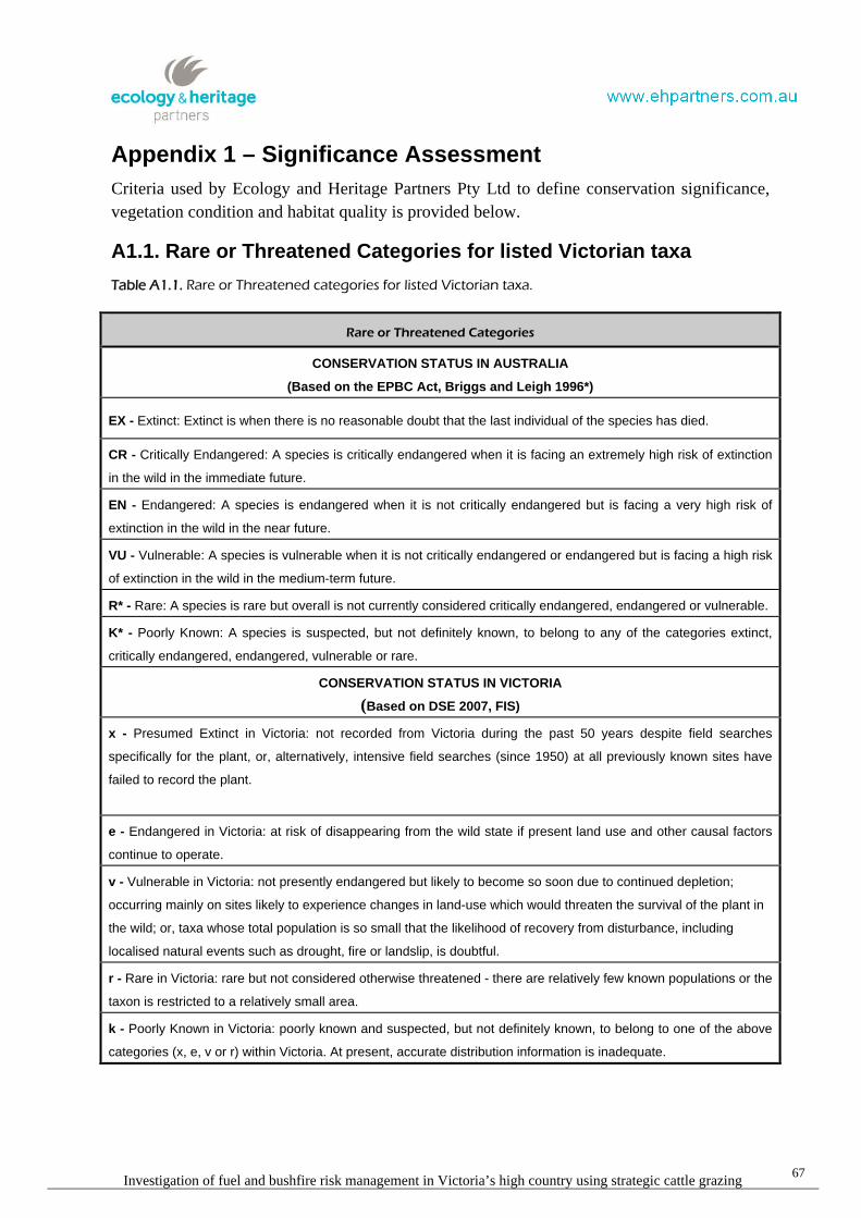
Investigation of fuel and bushfire risk management in Victoria’s high country using strategic cattle grazing67
Appendix 1 – Significance Assessment
Criteria used by Ecology and Heritage Partners Pty Ltd to define conservation significance,
vegetation condition and habitat quality is provided below.
A1.1. Rare or Threatened Categories for listed Victorian taxa
Table A1.1. Rare or Threatened categories for listed Victorian taxa.
Rare or Threatened Categories
CONSERVATION STATUS IN AUSTRALIA
(Based on the EPBC Act, Briggs and Leigh 1996*)
EX - Extinct: Extinct is when there is no reasonable doubt that the last individual of the species has died.
CR - Critically Endangered: A species is critically endangered when it is facing an extremely high risk of extinction
in the wild in the immediate future.
EN - Endangered: A species is endangered when it is not critically endangered but is facing a very high risk of
extinction in the wild in the near future.
VU - Vulnerable: A species is vulnerable when it is not critically endangered or endangered but is facing a high risk
of extinction in the wild in the medium-term future.
R* - Rare: A species is rare but overall is not currently considered critically endangered, endangered or vulnerable.
K* - Poorly Known: A species is suspected, but not definitely known, to belong to any of the categories extinct,
critically endangered, endangered, vulnerable or rare.
CONSERVATION STATUS IN VICTORIA
(Based on DSE 2007, FIS)
x - Presumed Extinct in Victoria: not recorded from Victoria during the past 50 years despite field searches
specifically for the plant, or, alternatively, intensive field searches (since 1950) at all previously known sites have
failed to record the plant.
e - Endangered in Victoria: at risk of disappearing from the wild state if present land use and other causal factors
continue to operate.
v - Vulnerable in Victoria: not presently endangered but likely to become so soon due to continued depletion;
occurring mainly on sites likely to experience changes in land-use which would threaten the survival of the plant in
the wild; or, taxa whose total population is so small that the likelihood of recovery from disturbance, including
localised natural events such as drought, fire or landslip, is doubtful.
r - Rare in Victoria: rare but not considered otherwise threatened - there are relatively few known populations or the
taxon is restricted to a relatively small area.
k - Poorly Known in Victoria: poorly known and suspected, but not definitely known, to belong to one of the above
categories (x, e, v or r) within Victoria. At present, accurate distribution information is inadequate.

Investigation of fuel and bushfire risk management in Victoria’s high country using strategic cattle grazing68
A1.2. Defining Ecological Significance
Table A1.2. Defining Ecological Significance.
Criteria for defining Ecological Significance
NATIONAL SIGNIFICANCE
Flo
ra
National conservation status is based on the EPBC Act list of taxa considered threatened in Australia (i.e.
extinct, critically endangered, endangered, vulnerable).
Flora listed as rare in Australian Rare or Threatened Australian Plants (Briggs and Leigh 1996).
Fa
un
a
National conservation status is based on the EPBC Act list of taxa considered threatened in Australia (i.e.
extinct, critically endangered, endangered, vulnerable).
Fauna listed as extinct, critically endangered, endangered, vulnerable, Rare or Lower Risk (near threatened,
conservation dependent or least concern) under National Action Plans for terrestrial taxon prepared for the
Department of Sustainability, Environment, Water, Population and Communities: threatened marsupials and
monotremes (Maxwell et al. 1996), bats (Duncan et al. 1999), birds (Garnett and Crowley 2000), reptiles
(Cogger et al. 1993), and amphibians (Tyler 1997).
Species that have not been included on the EBPC Act but listed as significance according to the IUCN 2009
Red List of Threatened Species (IUCN 2009).
Co
mm
un
itie
s Vegetation communities considered critically endangered, endangered or vulnerable under the EPBC Act
and considering vegetation condition.
STATE SIGNIFICANCE
Flo
ra
Threatened taxa listed under the provisions of the Flora and Fauna Guarantee Act 1988.
Flora listed as extinct, endangered, vulnerable or rare in Victoria in the DSE Flora Information System (most
recent Version).
Flora listed in the State Government’s Advisory List of Rare or Threatened Plants in Victoria, 2005 (DSE
2005).
Flora listed as poorly known in Australia in Rare or Threatened Australian Plants (Briggs and Leigh 1996).
Fa
un
a
Threatened taxon listed under Schedule 2 of the Flora and Fauna Guarantee Act 1988.
Fauna listed as extinct, critically endangered, endangered and vulnerable on the State Government’s
Advisory List of Threatened Vertebrate Fauna in Victoria - 2003 (DSE 2007).
Listed as Data Deficient, Insufficiently Known or Near-threatened under National Action Plans for terrestrial
species prepared for the Department of Environment and Heritage: threatened marsupials and monotremes
(Maxwell et al. 1996), bats (Duncan et al. 1999), birds (Garnett and Crowley 2000), reptiles (Coggeret. al.
1993), and amphibians (Tyler 1997).

Investigation of fuel and bushfire risk management in Victoria’s high country using strategic cattle grazing69
Criteria for defining Ecological Significance
Co
mm
un
itie
s
Ecological communities listed as threatened under the FFG Act.
Ecological Vegetation Class listed as threatened (i.e. endangered, vulnerable) or rare in a Native Vegetation
Plan for a particular bioregion (DSE Website) and considering vegetation condition.
REGIONAL SIGNIFICANCE
Flo
ra
Flora considered rare in any regional native vegetation plan for a particular bioregion.
Flora considered rare by the author for a particular bioregion.
Fa
un
a
Fauna with a disjunct distribution, or a small number of documented recorded or naturally rare in theVictorian Alps and Southern Fall Bioregion.
A particular taxon that is has an unusual ecological or biogeographical occurrence or listed as Lower Risk –
Near Threatened, Data Deficient or Insufficiently Known on the State Government’s Advisory List of
Threatened Vertebrate Fauna in Victoria - 2003 (DSE 2007).
Co
mm
un
itie
s Ecological Vegetation Class listed as depleted or least concern in a Native Vegetation Plan for a particular
bioregion (DSE Website) and considering vegetation condition.
Ecological Vegetation Class considered rare by the author for a particular bioregion.
LOCAL SIGNIFICANCE
Local significance is defined as flora, fauna and ecological communities indigenous to a particular area, which are
not considered rare or threatened on a national, state or regional level.

Investigation of fuel and bushfire risk management in Victoria’s high country using strategic cattle grazing70
A1.3 Defining Site Significance
The following geographical areas apply to the overall level of significance with respect to thecurrent survey.
National: Australia
State: Victoria
Regional: Victorian Alps and Highlands Northern Fall bioregions
Local: Within 10 kilometres surrounding the study area
Table A1.3. Defining Site Significance.
Criteria for defining Site Significance
NATIONAL SIGNIFICANCE
A site is of National significance if:
- it regularly supports, or has a high probability of regularly supporting individuals of a taxon listed as ‘CriticallyEndangered’ or ‘Endangered’ under the EPBC Act and/or under National Action Plans for terrestrial taxonprepared for the Department of Environment and Heritage.
- it regularly supports, or has a high probability of supporting, an ‘important population’ as defined under the EPBCAct of one or more nationally ‘vulnerable’ flora and fauna taxon.
- it is known to support, or has a high probability of supporting taxon listed as ‘Vulnerable’ under National ActionPlans.
- it is known to regularly support a large proportion (i.e. greater than 1%) of a population of a taxon listed as‘Conservation Dependent’ under the EPBC Act and/or listed as Rare or Lower Risk (near threatened,conservation dependent or least concern) under National Action Plans.
- it contains an area, or part thereof designated as ‘critical habitat’ under the EPBC Act, or if the site is listed underthe Register of National Estate compiled by the Australian Heritage Commission.
- it is a site which forms part of, or is connected to a larger areas of remnant native vegetation or habitat of nationalconservation significance such as most National Park, and/or a Ramsar Wetlands.
STATE SIGNIFICANCE
A site is of State significance if:
- it occasionally (i.e. every 1 to 5 years) supports, or has suitable habitat to support taxon listed as ‘CriticallyEndangered’ or ‘Endangered’ under the Environment Protection and Biodiversity Conservation Act 1999 and/orunder National Action Plans.
- it regularly supports, or has a high probability of regularly supporting (i.e. high habitat quality) taxon listed as‘Vulnerable’, ‘Near threatened‘, ‘Data Deficient’ or ‘Insufficiently Known’ in Victoria (DSE 2007), or species listedas ‘Data Deficient’ or ‘Insufficiently Known’ under National Action Plans.
- it contains an area, or part thereof designated as ‘critical habitat’ under the Flora and Fauna Guarantee Act 1988.
- it supports, or likely to support a high proportion of any Victorian flora and fauna taxa.
- it contains high quality, intact vegetation/habitat supporting a high species richness and diversity in a particularBioregion.
- it is a site which forms part of, or connected to a larger areas of remnant native vegetation or habitat of stateconservation significance such as most State Parks and/or Flora and Fauna Reserves.
REGIONAL SIGNIFICANCE

Investigation of fuel and bushfire risk management in Victoria’s high country using strategic cattle grazing71
Criteria for defining Site Significance
A site is of Regional significance if:
- it regularly supports, or has a high probability of regularly supporting regionally significant fauna as defined inTable 1.2.
- is contains a large population (i.e. greater than 1%) of flora considered rare in any regional native vegetation planfor a particular bioregion.
- it supports a fauna population with a disjunct distribution, or a particular taxon that has an unusual ecological orbiogeographical occurrence.
- it is a site which forms part of, or is connected to a larger areas of remnant native vegetation or habitat of regionalconservation significance such as most Regional Parks and/or Flora and Fauna Reserves.
LOCAL SIGNIFICANCE
Most sites are considered to be of at least local significant for conservation, and in general a site of local
significance can be defined as:
- an area which supports indigenous flora species and/or a remnant Ecological Vegetation Class, and habitats usedby locally significant fauna species.
- an area which currently acts, or has the potential to act as a wildlife corridor linking other areas of higherconservation significance and facilitating fauna movement throughout the landscape.
A1.4. Defining Vegetation Condition
Table A1.4. Defining Vegetation Condition.
Criteria for defining Vegetation Condition
Good condition - Vegetation dominated by a diversity of indigenous species, with defined structures (whereappropriate), such as canopy layer, shrub layer, and ground cover, with little or few introduced species present.
Moderate condition - Vegetation dominated by a diversity of indigenous species, but is lacking some structures,such as canopy layer, shrub layer or ground cover, and/or there is a greater level of introduced flora species present.
Poor condition - Vegetation dominated by introduced species, but supports low levels of indigenous speciespresent, in the canopy, shrub layer or ground cover.
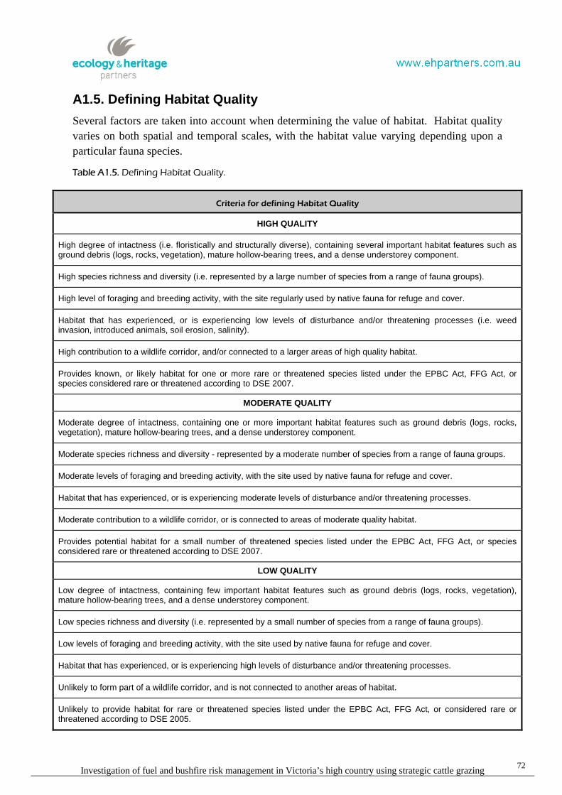
Investigation of fuel and bushfire risk management in Victoria’s high country using strategic cattle grazing72
A1.5. Defining Habitat Quality
Several factors are taken into account when determining the value of habitat. Habitat quality
varies on both spatial and temporal scales, with the habitat value varying depending upon a
particular fauna species.
Table A1.5. Defining Habitat Quality.
Criteria for defining Habitat Quality
HIGH QUALITY
High degree of intactness (i.e. floristically and structurally diverse), containing several important habitat features such asground debris (logs, rocks, vegetation), mature hollow-bearing trees, and a dense understorey component.
High species richness and diversity (i.e. represented by a large number of species from a range of fauna groups).
High level of foraging and breeding activity, with the site regularly used by native fauna for refuge and cover.
Habitat that has experienced, or is experiencing low levels of disturbance and/or threatening processes (i.e. weedinvasion, introduced animals, soil erosion, salinity).
High contribution to a wildlife corridor, and/or connected to a larger areas of high quality habitat.
Provides known, or likely habitat for one or more rare or threatened species listed under the EPBC Act, FFG Act, orspecies considered rare or threatened according to DSE 2007.
MODERATE QUALITY
Moderate degree of intactness, containing one or more important habitat features such as ground debris (logs, rocks,vegetation), mature hollow-bearing trees, and a dense understorey component.
Moderate species richness and diversity - represented by a moderate number of species from a range of fauna groups.
Moderate levels of foraging and breeding activity, with the site used by native fauna for refuge and cover.
Habitat that has experienced, or is experiencing moderate levels of disturbance and/or threatening processes.
Moderate contribution to a wildlife corridor, or is connected to areas of moderate quality habitat.
Provides potential habitat for a small number of threatened species listed under the EPBC Act, FFG Act, or speciesconsidered rare or threatened according to DSE 2007.
LOW QUALITY
Low degree of intactness, containing few important habitat features such as ground debris (logs, rocks, vegetation),mature hollow-bearing trees, and a dense understorey component.
Low species richness and diversity (i.e. represented by a small number of species from a range of fauna groups).
Low levels of foraging and breeding activity, with the site used by native fauna for refuge and cover.
Habitat that has experienced, or is experiencing high levels of disturbance and/or threatening processes.
Unlikely to form part of a wildlife corridor, and is not connected to another areas of habitat.
Unlikely to provide habitat for rare or threatened species listed under the EPBC Act, FFG Act, or considered rare orthreatened according to DSE 2005.

Investigation of fuel and bushfire risk management in Victoria’s high country using strategic cattle grazing 73
Appendix 2.1 – Significant Flora
Table A2.1. Nationally significant flora within 10 kilometres of the study area locations
Sources used to determine species status:
EPBC Environment Protection and Biodiversity Conservation Act 1999 (Commonwealth)DSE Advisory List of Threatened Flora in Victoria (DSE 2005)FFG Flora and Fauna Guarantee Act 1988 (Victoria)
National status of species is designatedby:# Listed on the PMSTCR Critically endangeredEN EndangeredVU VulnerableK Poorly Known
State status of species is designated by:e Endangeredv Vulnerabler Rarek Poorly KnownL Listed
Site A
Scientific name Common nameLast
documentedrecord
Total # ofdocumented
recordsEPBC FFG DSE
#Glycine latrobeana Clover Glycine 1980 3 VU L v
Lobelia gelida Snow Pratia 2007 2 VU L v
#Prasophyllum frenchii Maroon Leek-orchid - - EN L e
Pterostylis cucullata Leafy Greenhood 1993 20 VU L v
Senecio georgianus Grey Fireweed 1770 1 EX - x
Site B
Scientific name Common nameLast documented
record
Total # ofdocumented
recordsEPBC FFG DSE
#Glycine latrobeana Clover Glycine - - VU L v
Nematolepis squamea subsp. coriacea Harsh Nematolepis 1861 3 VU L v

Investigation of fuel and bushfire risk management in Victoria’s high country using strategic cattle grazing 74
Site C
Scientific name Common nameLast
documentedrecord
Total # ofdocumented
recordsEPBC FFG DSE
#Caladenia cremna Don's Spider Orchid - - VU - e
Diuris ochroma Pale Golden Moths 1993 3 VU L e
#Glycine latrobeana Clover Glycine - - VU L v
Site D
Scientific name Common nameLast
documentedrecord
Total # ofdocumented
recordsEPBC FFG DSE
Argyrotegium nitidulum Shining Cudweed 1984 1 VU - r
#Carex paupera Dwarf Sedge 1991 8 VU L v
Euphrasia eichleri Bogong Eyebright 1883 1 VU L v
#Glycine latrobeana Clover Glycine - - VU L v
Prasophyllum morganii Mignonette Leek-orchid 2004 7 VU L x
#Thesium australe Austral Toadflax - - VU L v
Site E
Scientific name Common nameLast documented
record
Total # ofdocumented
recordsEPBC FFG DSE
#Caladenia cremna Don's Spider Orchid - - VU - e
#Glycine latrobeana Clover Glycine - - VU L v
Nematolepis squamea subsp. coriacea Harsh Nematolepis 1861 3 VU L v
Senecio georgianus Grey Fireweed 1859 1 EX - x
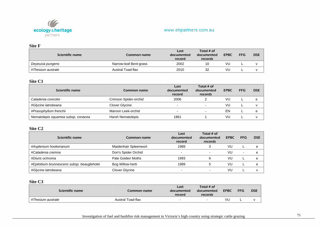
Investigation of fuel and bushfire risk management in Victoria’s high country using strategic cattle grazing 75
Site F
Scientific name Common nameLast
documentedrecord
Total # ofdocumented
recordsEPBC FFG DSE
Deyeuxia pungens Narrow-leaf Bent-grass 2002 10 VU L v
#Thesium australe Austral Toad-flax 2010 32 VU L v
Site C1
Scientific name Common nameLast
documentedrecord
Total # ofdocumented
recordsEPBC FFG DSE
Caladenia concolor Crimson Spider-orchid 2006 2 VU L e
#Glycine latrobeana Clover Glycine - - VU L v
#Prasophyllum frenchii Maroon Leek-orchid - - EN L e
Nematolepis squamea subsp. coriacea Harsh Nematolepis 1861 1 VU L v
Site C2
Scientific name Common nameLast
documentedrecord
Total # ofdocumented
recordsEPBC FFG DSE
#Asplenium hookerianum Maidenhair Spleenwort 1989 3 VU L e
#Caladenia cremna Don's Spider Orchid - - VU - e
#Diuris ochroma Pale Golden Moths 1993 6 VU L e
#Epilobium brunnescens subsp. beaugleholei Bog Willow-herb 1989 5 VU L e
#Glycine latrobeana Clover Glycine - - VU L v
Site C3
Scientific name Common nameLast
documentedrecord
Total # ofdocumented
recordsEPBC FFG DSE
#Thesium australe Austral Toad-flax - - VU L v

Investigation of fuel and bushfire risk management in Victoria’s high country using strategic cattle grazing 76
Site C4
Scientific name Common nameLast
documentedrecord
Total # ofdocumented
recordsEPBC FFG DSE
Glycine latrobeana Clover Glycine 2002 1 VU L v
Prasophyllum frenchii Maroon Leek-orchid 1992 1 EN L e
#Thesium australe Austral Toad-flax - - VU L v
Source: Flora Information System (DSE) and PMST (SWEPaC)

Investigation of fuel and bushfire risk management in Victoria’s high country using strategic cattle grazing 77
Appendix 3.1 – Significant fauna species
Table A3.1. Nationally significant fauna within 10 kilometres of the study area locations
EPBC Environment Protection and Biodiversity Conservation Act 1999 (EPBC Act)
FFG Flora and Fauna Guarantee Act 1988 (FFG Act)
DSE Advisory List of Threatened Vertebrate Fauna in Victoria (DSE 2007); Advisory List of Threatened Invertebrate Fauna in Victoria (DSE 2009)
NAP National Action Plan (Cogger et al 1993; Duncan et al. 1999; Garnet and Crowley 2000; Lee 1995; Maxwell et al. 1996; Sands and New 2002; Tyler 1997)
EX Extinct
RX Regionally extinct
CR Critically endangered
EN Endangered
VU Vulnerable
RA Rare
NT Near threatened
CD Conservation dependent
LC least concern
DD Data deficient (insufficiently or poorly known)
L Listed as threatened under FFG Act
I Invalid or ineligible for listing under the FFG Act
# Listed on the PMST
Mi Migratory
Ma Marine
Site A
Common name Scientific nameLast documented
recordTotal # of
documented records EPBC FFG DSE NAP
# Spot-tailed Quoll Dasyurus maculatus - - EN L EN VU
#Smoky Mouse Pseudomys fumeus 1978 2 EN L CR RA
# Grey-headed Flying-fox Pteropus poliocephalus - - VU L VU VU
# Australian Painted Snipe Rostratula benghalensis australis - - VU L CR VU
# Swift Parrot Lathamus discolor - - EN L EN EN
# Regent Honeyeater Anthochaera phrygia - - EN L CR EN
# Giant Burrowing Frog Heleioporus australiacus - - VU L VU DD

Investigation of fuel and bushfire risk management in Victoria’s high country using strategic cattle grazing 78
Common name Scientific nameLast documented
recordTotal # of
documented records EPBC FFG DSE NAP
# Growling Grass Frog Litoria raniformis - - VU L EN VU
Alpine Tree Frog Litoria verreauxii alpina 1974 16 VU L CR VU
# Australian Grayling Prototroctes maraena - - VU L VU VU
# Golden Sun Moth Synemon plana - - CR L EN -
Site B
Common name Scientific nameLast documented
recordTotal # of
documented records EPBC FFG DSE NAP
# Spot-tailed Quoll Dasyurus maculatus - - EN L EN VU
#Long-footed Potoroo Potorous longipes 1998 8 EN L EN EN
#Mountain Pygmy-possum Burramys parvus 2004 4 EN L CR EN
#Smoky Mouse Pseudomys fumeus 1995 2 EN L CR RA
# Australian Painted Snipe Rostratula australis - - VU L CR VU
# Swift Parrot Lathamus discolor - - EN L EN EN
# Regent Honeyeater Anthochaera phrygia - - EN L CR EN
# Growling Grass Frog Litoria raniformis - - VU L EN VU
#Spotted Tree Frog Litoria spenceri 2003 30 EN L CR EN
Alpine Tree Frog Litoria verreauxii alpina 2001 11 VU L CR VU
#Barred Galaxias Galaxias fuscus 2008 42 EN L CR EN
# Murray Cod Maccullochella peelii peelii - - VU L EN -
# Macquarie Perch Macquaria australasica - - EN L EN DD
Site C
Common name Scientific nameLast documented
recordTotal # of
documented records EPBC FFG DSE NAP
# Spot-tailed Quoll Dasyurus maculatus - - EN L EN VU
#Long-footed Potoroo Potorous longipes 1998 80 EN L EN EN
#Smoky Mouse Pseudomys fumeus 1999 8 EN L CR RA
# Australian Painted Snipe Rostratula australis - - VU L CR VU

Investigation of fuel and bushfire risk management in Victoria’s high country using strategic cattle grazing 79
Common name Scientific nameLast documented
recordTotal # of
documented records EPBC FFG DSE NAP
# Swift Parrot Lathamus discolor - - EN L EN EN
# Regent Honeyeater Anthochaera phrygia - - EN L CR EN
# Growling Grass Frog Litoria raniformis - - VU L EN VU
#Spotted Tree Frog Litoria spenceri - - EN L CR EN
# Murray Cod Maccullochella peelii peelii - - VU L EN -
# Macquarie Perch Macquaria australasica - - EN L EN DD
Site D
Common name Scientific nameLast documented
recordTotal # of
documented records EPBC FFG DSE NAP
# Spot-tailed Quoll Dasyurus maculatus 2007 1 EN L EN VU
#Long-nosed Potoroo Potorous tridactylus tridactylus - - VU L EN EN
#Mountain Pygmy-possum Burramys parvus 1979 1 EN L CR EN
#Smoky Mouse Pseudomys fumeus 1978 1 EN L CR RA
# Grey-headed Flying-fox Pteropus poliocephalus - - VU L VU VU
# Australian Painted Snipe Rostratula australis - - VU L CR VU
# Swift Parrot Lathamus discolor - - EN L EN EN
# Regent Honeyeater Anthochaera phrygia - - EN L CR EN
# Alpine She-oak Skink Cyclodomorphus praealtus - - En L EN -
# Giant Burrowing Frog Heleioporus australiacus - - VU L VU DD
Alpine Tree Frog Litoria verreauxii alpina 2008 383 VU L CR VU
# Australian Grayling Prototroctes maraena 1983 2 VU L VU VU
# Murray Cod Maccullochella peelii peelii - - VU L EN -
# Macquarie Perch Macquaria australasica - - EN L EN DD
Site E
Common name Scientific nameLast documented
recordTotal # of
documented records EPBC FFG DSE NAP
# Spot-tailed Quoll Dasyurus maculatus - - EN L EN VU

Investigation of fuel and bushfire risk management in Victoria’s high country using strategic cattle grazing 80
Common name Scientific nameLast documented
recordTotal # of
documented records EPBC FFG DSE NAP
#Long-footed Potoroo Potorous longipes - - EN L EN EN
#Mountain Pygmy-possum Burramys parvus - - EN L CR EN
#Smoky Mouse Pseudomys fumeus 1978 6 EN L CR RA
# Australian Painted Snipe Rostratula australis - - VU L CR VU
# Swift Parrot Lathamus discolor - - EN L EN EN
# Regent Honeyeater Anthochaera phrygia - - EN L CR EN
# Growling Grass Frog Litoria raniformis - - VU L EN VU
#Spotted Tree Frog Litoria spenceri 2003 31 EN L CR EN
Alpine Tree Frog Litoria verreauxii alpina 2008 11 VU L CR VU
#Barred Galaxias Galaxias fuscus 2008 40 EN L CR EN
# Murray Cod Maccullochella peelii peelii - - VU L EN -
# Macquarie Perch Macquaria australasica - - EN L EN DD
Site F
Common name Scientific nameLast documented
recordTotal # of
documented records EPBC FFG DSE NAP
# Spot-tailed Quoll Dasyurus maculatus 2004 23 EN L EN VU
#Brush-tailed Rock-wallaby Petrogale penicillata 1994 16 VU L CR VU
#Smoky Mouse Pseudomys fumeus 1978 6 EN L CR RA
# Grey-headed Flying-fox Pteropus poliocephalus - - VU L VU VU
# Australian Painted Snipe Rostratula australis - - VU L CR VU
# Swift Parrot Lathamus discolor - - EN L EN EN
# Regent Honeyeater Anthochaera phrygia - - EN L CR EN
#Large Brown Tree Frog Litoria littlejohni - - VU L NT -
# Australian Grayling Prototroctes maraena 1980 4 VU L VU VU
#Golden Sun Moth Synemon plana - - CR L CR -

Investigation of fuel and bushfire risk management in Victoria’s high country using strategic cattle grazing 81
Site C1
Common name Scientific nameLast documented
recordTotal # of
documented records EPBC FFG DSE NAP
# Spot-tailed Quoll Dasyurus maculatus - - EN L EN VU
#Long-nosed Potoroo Potorous tridactylus tridactylus - - VU L EN EN
#Brush-tailed Rock-wallaby Petrogale penicillata 1978 15 VU L CR VU
#Smoky Mouse Pseudomys fumeus - - EN L CR RA
# Grey-headed Flying-fox Pteropus poliocephalus - - VU L VU VU
# Australian Painted Snipe Rostratula australis - - VU L CR VU
# Swift Parrot Lathamus discolor - - EN L EN EN
# Regent Honeyeater Anthochaera phrygia - - EN L CR EN
# Alpine She-oak Skink Cyclodomorphus praealtus - - En L EN -
# Giant Burrowing Frog Heleioporus australiacus - - VU L VU DD
# Growling Grass Frog Litoria raniformis - - VU L EN VU
Alpine Tree Frog Litoria verreauxii alpina 1978 15 VU L CR VU
# Australian Grayling Prototroctes maraena - - VU L VU VU
#Golden Sun Moth Synemon plana - - CR L CR -
Site C2
Common name Scientific nameLast documented
recordTotal # of
documented records EPBC FFG DSE NAP
# Spot-tailed Quoll Dasyurus maculatus - - EN L EN VU
#Long-footed Potoroo Potorous longipes 1998 45 EN L EN EN
#Smoky Mouse Pseudomys fumeus 1999 10 EN L CR RA
# Australian Painted Snipe Rostratula australis - - VU L CR VU
# Swift Parrot Lathamus discolor - - EN L EN EN
# Regent Honeyeater Anthochaera phrygia - - EN L CR EN
# Growling Grass Frog Litoria raniformis - - VU L EN VU
#Spotted Tree Frog Litoria spenceri - - EN L CR EN
Alpine Tree Frog Litoria verreauxii alpina 1974 3 VU L CR VU
Australian Grayling Prototroctes maraena 1981 2 VU L VU VU
# Murray Cod Maccullochella peelii peelii - - VU L EN -

Investigation of fuel and bushfire risk management in Victoria’s high country using strategic cattle grazing 82
Common name Scientific nameLast documented
recordTotal # of
documented records EPBC FFG DSE NAP
# Macquarie Perch Macquaria australasica - - EN L EN DD
#Golden Sun Moth Synemon plana - - CR L CR -
Site C3
Common name Scientific nameLast documented
recordTotal # of
documented records EPBC FFG DSE NAP
# Spot-tailed Quoll Dasyurus maculatus - - EN L EN VU
#Smoky Mouse Pseudomys fumeus - - EN L CR RA
# Australian Painted Snipe Rostratula australis - - VU L CR VU
# Swift Parrot Lathamus discolor - - EN L EN EN
# Regent Honeyeater Anthochaera phrygia - - EN L CR EN
# Growling Grass Frog Litoria raniformis - - VU L EN VU
#Spotted Tree Frog Litoria spenceri - - EN L CR EN
Alpine Tree Frog Litoria verreauxii alpina 1975 2 VU L CR VU
# Murray Cod Maccullochella peelii peelii - - VU L EN -
# Macquarie Perch Macquaria australasica - - EN L EN DD
Site C4
Common name Scientific nameLast documented
recordTotal # of
documented records EPBC FFG DSE NAP
# Spot-tailed Quoll Dasyurus maculatus - - EN L EN VU
#Smoky Mouse Pseudomys fumeus - - EN L CR RA
# Australian Painted Snipe Rostratula australis - - VU L CR VU
# Swift Parrot Lathamus discolor 1979 1 EN L EN EN
# Regent Honeyeater Anthochaera phrygia 1983 1 EN L CR EN
# Alpine She-oak Skink Cyclodomorphus praealtus - - En L EN -
# Growling Grass Frog Litoria raniformis - - VU L EN VU
#Spotted Tree Frog Litoria spenceri - - EN L CR EN
Alpine Tree Frog Litoria verreauxii alpina 1994 4 VU L CR VU

Investigation of fuel and bushfire risk management in Victoria’s high country using strategic cattle grazing 83
Common name Scientific nameLast documented
recordTotal # of
documented records EPBC FFG DSE NAP
# Murray Cod Maccullochella peelii peelii - - VU L EN -
# Macquarie Perch Macquaria australasica - - EN L EN DD
#Golden Sun Moth Synemon plana - - CR L CR -
Data source: Victorian Biodiversity Atlas (DSE 2010); PMST(SEWPaC 2011c)