final survey and assessment, - denver
TRANSCRIPT

February 4, 2016
Prepared for:
Denver Mountain Parks City and County of Denver Natural Areas Program
201 W Colfax, Department 605 Denver, CO 80202
Prepared by: Studio CPG
with:
FINALNatural Resource Survey and Assessment, Denver Mountain Parks’ Properties in
Jefferson County, Colorado

Natural Resources Survey and Assessment, Denver Mountain Parks
This page left blank intentionally.
Natural Resources Survey and Assessment, Denver Mountain Parks
i
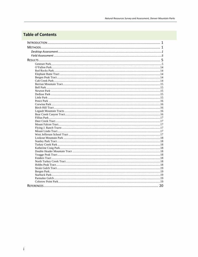
Table of Contents
INTRODUCTION .................................................................................................................... 1 METHODS ........................................................................................................................... 1
Desktop Assessment ...............................................................................................................................1 Field Assessment ....................................................................................................................................5
RESULTS ............................................................................................................................. 5 Genesee Park ...................................................................................................................................................... 5 O’Fallon Park ................................................................................................................................................... 14 Red Rocks Park ................................................................................................................................................ 14 Elephant Butte Tract ........................................................................................................................................ 14 Bergen Peak Tract ............................................................................................................................................ 14 Cub Creek Park ................................................................................................................................................ 14 Berrian Mountain Tract .................................................................................................................................... 15 Bell Park .......................................................................................................................................................... 15 Newton Park .................................................................................................................................................... 15 Dedisse Park .................................................................................................................................................... 15 Little Park ........................................................................................................................................................ 15 Pence Park ....................................................................................................................................................... 16 Corwina Park ................................................................................................................................................... 16 Birch Hill Tract ................................................................................................................................................ 16 Legault Mountain Tracts .................................................................................................................................. 16 Bear Creek Canyon Tract ................................................................................................................................. 16 Fillius Park ....................................................................................................................................................... 17 Deer Creek Tract .............................................................................................................................................. 17 Mount Falcon Tract .......................................................................................................................................... 17 Flying J. Ranch Tracts ..................................................................................................................................... 17 Mount Lindo Tract ........................................................................................................................................... 17 West Jefferson School Tract ............................................................................................................................ 17 Lookout Mountain Park ................................................................................................................................... 18 Stanley Park Tract ............................................................................................................................................ 18 Turkey Creek Park ........................................................................................................................................... 18 Katherine Craig Park ........................................................................................................................................ 18 Double Header Mountain Tract ....................................................................................................................... 18 Yeagge Peak Tract ........................................................................................................................................... 18 Fenders Tract ................................................................................................................................................... 18 North Turkey Creek Tract ................................................................................................................................ 18 Hobbs Peak Tract ............................................................................................................................................. 18 Strain Gulch Tract ............................................................................................................................................ 19 Bergen Park...................................................................................................................................................... 19 Starbuck Park ................................................................................................................................................... 19 Parmalee Gulch ................................................................................................................................................ 19 Colorow Point Park .......................................................................................................................................... 19
REFERENCES ...................................................................................................................... 20
Natural Resources Survey and Assessment, Denver Mountain Parks
ii
Tables
TABLE 1. EVALUATION CRITERIA AND CATEGORIES FOR PROPERTY RANKINGS, DENVER MOUNTAIN PARKS 4 TABLE 2. SUMMARY OF ASSESSMENT RANKINGS FOR DENVER MOUNTAIN PARKS PROPERTIES, LISTED BY SIZE.
....................................................................................................................................................... 7 TABLE 3. SUMMARY OF ASSESSMENT RANKINGS FOR DENVER MOUNTAIN PARKS PROPERTIES, LISTED BY RANK.
..................................................................................................................................................... 10
Figures
FIGURE 1. DENVER MOUNTAIN PARKS PROPERTIES IN JEFFERSON COUNTY, COLORADO ............................. 13
Attachment
ATTACHMENT A: SIGNIFICANT BIOLOGICAL RESOURCES LISTED FOR JEFFERSON COUNTY (FROM CNHP 2012)
AND POTENTIALLY OCCURRING ON DENVER MOUNTAIN PARKS PROPERTIES. ............................ 21
Natural Resources Survey and Assessment, Denver Mountain Parks
iii
Acronyms
BLM Bureau of Land Management
CLO Cornell Laboratory of Ornithology
CNHP Colorado Natural Heritage Program
CPW Colorado Parks and Wildlife
DMP Denver Mountain Parks
E & E Ecology and Environment
GPS Global Positioning System
NAIP National Agriculture Imagery Program
NDIS Natural Diversity Information System
SBR Significant Biological Resource
JCOS Jefferson County Open Space
PCA Potential Conservation Area
SWReGap Southwestern Regional Gap Analysis Project
USFS U.S. Forest Service
USFWS U.S. Fish and Wildlife Service
USGS U.S. Geological Survey
Walsh Walsh Environmental Scientists and Engineers, LLC

Natural Resources Survey and Assessment, Denver Mountain Parks
iv
This page left intentionally blank.

Natural Resources Survey and Assessment, Denver Mountain Parks
1
Introduction Walsh Environmental Scientists and Engineers, LLC (Walsh) conducted a natural resources survey and assessment of 36 Denver Mountain Parks (DMP) properties in Jefferson County for the City and County of Denver Natural Areas Program. The first phase in 2014 comprised a desktop assessment of numerous geospatial datasets pertaining to each property. Based on analysis routines of the assembled database, property evaluation criteria and rankings developed from this analysis are intend to be the foundation for management decisions, grant applications, and other ongoing property evaluation needs.
The second phase of this project involved a field assessment and ground‐truthing of the desktop assessment for 20 of the 36 properties, as prioritized by DMP. This work was conducted during the spring, summer, and fall of 2015. The results of field efforts are incorporated as additions and revisions to the project database and herein.
One of the goals of this survey and assessment was to conduct the analyses using methods that mirror those used by the Colorado Natural Heritage Program (CNHP) to conduct surveys of Jefferson County Open Space properties in 2010/2011. We describe the methods used in the assessment and rankings, and the results for each property. The results section of this report includes a summary for each property. The summary field of the database integrates these descriptions as well.
Methods
Desktop Assessment
The project database and the desktop assessment integrate the following data sources:
Base aerial imagery from the National Agriculture Imagery Program National Agriculture Imagery Program (NAIP) (U.S. Department of Agriculture 2011).
U.S. Geological Survey Topographic 7.5’ Quadrangle Maps.
Southwestern Regional Gap Analysis Project (SWReGap 2004), RS/GIS Laboratory, College of Natural Resources. 'PROVISIONAL' Digital Landcover Dataset for the Southwestern United States. Version 1.0 ‐ raster digital data, Utah State University.
U.S. U.S. Geological Survey, The National Map. 3DEP products and services: The National Map, 3D Elevation Program. (U.S. Geological Survey 2014a)
National Hydrography Dataset (U.S. Geological Survey in cooperation with U.S. Environmental Protection Agency, USDA Forest Service, and other Federal, State and local partners. USGS Reston, Virginia. Vector digital data (U.S. Geological Survey 2014b)
U.S Fish and Wildlife Service Species by County Reports. (USFWS 2015).
Colorado Parks and Wildlife (CPW) list of State Threatened and Endangered species, and Species of Special Concern. (CPW 2015).

Natural Resources Survey and Assessment, Denver Mountain Parks
2
Survey of Critical Biological Resources, Jefferson County, Colorado, 2010‐2011 (CNHP 2012).
Natural Diversity Information Source (NDIS) mapping of big game and other wildlife species’ distribution and migration corridors maintained by Colorado State University. (NDIS 2014)
Jefferson County Open Space Master Plan. (Geospatial Data: Jefferson County Open Space Lands, August 2014; Private Conservation Lands, October 2014).
Colorado Breeding Bird Atlas II (Colorado Bird Atlas Partnership and the Cornell Laboratory of Ornithology 2011).
Ebird real‐time online checklist program (Cornell Laboratory of Ornithology (CLO) and National Audubon Society 2014).
Property characteristics that most contribute to natural biological resource conservation value were assessed for each property. These values were summarized, by category, to support construction of an aggregate ranking system for each property. These defining characteristics and category summaries are discussed below and summarized in Table 1. Exceptions to this categorization include the Genesee and Dedisse properties, discussed below under Size and Hydrology, respectively.
Size–is the area of a property, in acres. In general, property sizes range from 0.28 acres to 815 acres. The exception to this is Genesee Park, a 2,400‐acre property. Each property is assigned to one of five size categories (1 to 5), based on increments of 203 acres (Table 1). Genesee Park alone is assigned category 5 for size.
PercentAdjacentOpenLands– represents the degree to which an individual property is embedded, or adjacent to, other non‐developed lands. These adjacent open lands include Jefferson County Open Space, other City and County of Denver properties, and National Forests. This characteristic is calculated as the percent of the property boundary adjacent to other open lands. This value is assigned one of four categories (1 to 4), based on percent of adjacency with open lands (Table 1).
Topography – is a measure of a property’s steepness, represented by the percent of 10–meter square quadrats within the property that are 15 percent or greater in topography (Table 1). It is notable that only nine (9) properties had less than 75 percent slope.
NDIS–from the NDIS, described above. Assessed as the number of overlaps on a property with any of the following mapped species’ habitat elements: elk production area, severe winter range, winter concentration area, and winter range; mule deer migration pattern, concentrations area, severe winter range, winter concentration area, and winter range; black bear fall concentration, human conflict area, and summer concentration; lynx potential habitat; and Preble’s meadow jumping mouse overall range. These are assigned to one of four categories (Table 1) based on the degree of overlap.
SBR–Significant Biological Resources (SBR) include individual species and plant communities that estimates determine that they may occur in a property, based on the overlap of their
Natural Resources Survey and Assessment, Denver Mountain Parks
3
known habitat affinities and SWReGap mapped habitats present. These are a subset of those listed in the Jefferson County assessment of critical biological resources (CHNP 2012) (Table 2). We included all species listed under the Endangered Species Act, U.S. Forest Service (USFS) Sensitive, Bureau of Land Management (BLM) Sensitive, Colorado state‐listed species, and those species and plant communities listed by CHNP as having a state rank of S1, S2, or S3 (Attachment 1).
To determine the potential SBR value for each property, we determined the habitat association for all potential SBR from a literature review and our professional knowledge of the species and plant communities. We created a map of the SWReGap landcover descriptions (SWReGap 2004) present on each property, and searched each property on the map for the presence of the required habitat for each species from the list. All potentially present species are listed as such in the database in the SWReGAP vegetation community type field.
PCA–Potential Conservation Areas (PCAs) are taken from the Jefferson County Open Space (JCOS) Master Plan (JCOS 2014). Potential Conservation Areas were delineated by CNHP to classify land areas that provide habitat and ecological functions upon which a particular species, group of species, or a natural area depends on for its ongoing existence. They are useful in conservation planning practices by land management agencies. Categories comprise values of 0 to 4, as follows: none (0); General Biodiversity Interest (1); Moderate Biodiversity Significance (2); High Biodiversity Significance (3); and Very High Biodiversity Significance (4). This value is applied when/if one of the PCAs overlaps onto the property.
Hydrology– is characterized by the miles of perennial streams on the property, plus 0.5 per mile of ephemeral or intermittent streams, plus one (1) for the presence of any number of water bodies. For example, Dedisse Park was assigned a 3 for the large number of water bodies present, in addition to the 1.9 miles of perennial stream and 0.6 miles (multiplied by 0.5) of ephemeral/intermittent stream on the property. The length of streams through standing water bodies was included in the calculation of perennial stream length. Any canal or irrigation channel present was included as an ephemeral or intermittent stream.

Natural Resources Survey and Assessment, Denver Mountain Parks
4
Table 1. Evaluation Criteria and Categories for Property Rankings, Denver Mountain Parks
Landscape Context All Other Categories
Characteristic Size Percent
Adjacent Open Lands
Topography NDIS SBR PCA Hydrology
Metric Acres
Percent of property
boundary that abuts Open
Lands
Percent of all 10‐m2 quadrats that are >15% topography
Number of NDIS
maps that overlap property
Number of SBR (species)
potentially present
Highest category value of any PCAs that overlap the
property
Miles of stream plus 1 for presence of water bodies
Range of Actual Values
0.28 – 815 [Genesee = 2,400]
0 – 98% 0 – 99 1 ‐12 10‐23 0 ‐ 4 0.22‐3.86 + 0.5 x (0.07‐8.53)
Ranking System and Categories
1: 1‐203 2: 204‐407 3: 408‐611 4: 612‐815 5: 816‐2,400
1: 0‐25 2: 26‐50 3: 51‐75 4: 76‐100
1: 0‐25 2: 26‐50 3: 51‐75 4: 76‐100
1: 1‐3 2: 4‐6 3: 7‐9
4: 10‐12
1: 10‐12 2: 13‐15 3: 16‐18 4: 19‐23
0=no overlap 1=General
Biodiversity (B5) 2=Moderate
Biodiversity (B4) 3=High Biodiversity
(B3) 4=Very High
Biodiversity (B2)
Miles of perennial + 0.5 x (miles of intermittent
and ephemeral) + 1 for presence of lake/pond; Dedisse gets miles + 3
End Product for Input into Ranking
Categories 1 – 5
Categories 1 – 4
Categories 1 – 4
Categories1 – 4
Categories 1 – 4
Categories 0 – 4
Categories 0 – 9
Natural Resources Survey and Assessment, Denver Mountain Parks
5
Field Assessment
Field assessments and ground truthing were conducted on 20 properties selected by DMP, from the 36 properties included in the first phase rankings. Two biologists visited each property for one hour up to a full day or more, depending on the property’s size and ease of access. They recorded the following characteristics:
Confirmation of the existing vegetation mapping from the desktop assessment;
Presence of weeds; and
Presence of SBRs, if encountered.
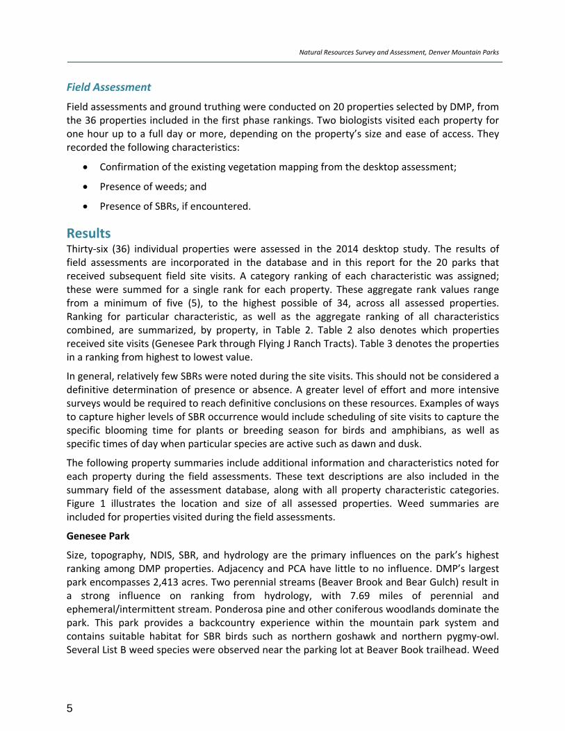
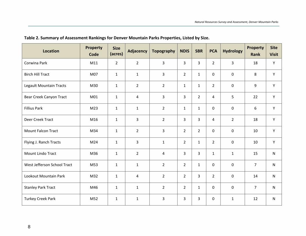
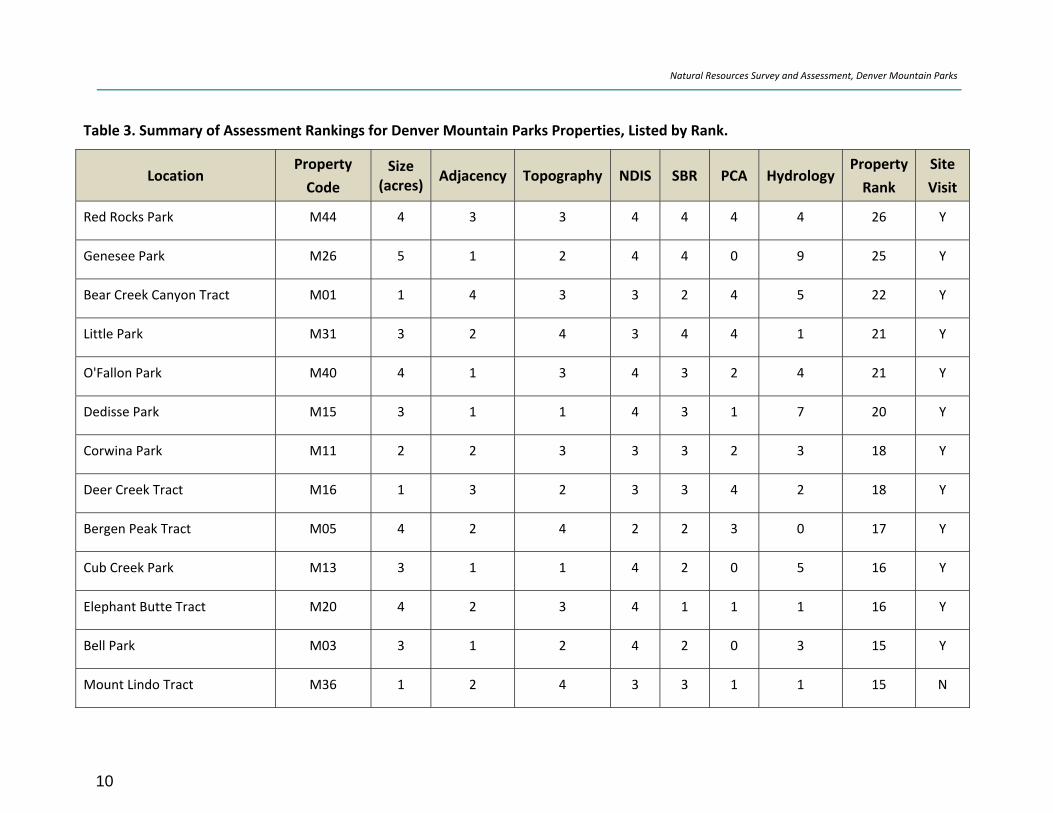
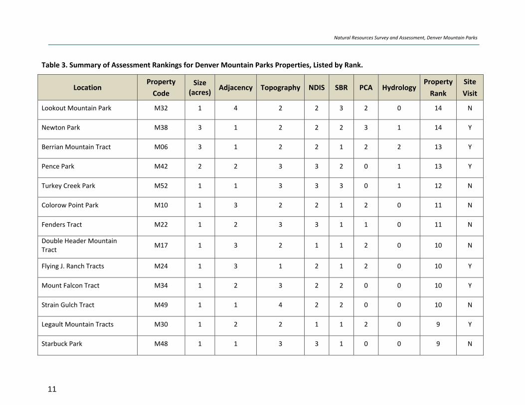
Results Thirty‐six (36) individual properties were assessed in the 2014 desktop study. The results of field assessments are incorporated in the database and in this report for the 20 parks that received subsequent field site visits. A category ranking of each characteristic was assigned; these were summed for a single rank for each property. These aggregate rank values range from a minimum of five (5), to the highest possible of 34, across all assessed properties. Ranking for particular characteristic, as well as the aggregate ranking of all characteristics combined, are summarized, by property, in Table 2. Table 2 also denotes which properties received site visits (Genesee Park through Flying J Ranch Tracts). Table 3 denotes the properties in a ranking from highest to lowest value.
In general, relatively few SBRs were noted during the site visits. This should not be considered a definitive determination of presence or absence. A greater level of effort and more intensive surveys would be required to reach definitive conclusions on these resources. Examples of ways to capture higher levels of SBR occurrence would include scheduling of site visits to capture the specific blooming time for plants or breeding season for birds and amphibians, as well as specific times of day when particular species are active such as dawn and dusk.
The following property summaries include additional information and characteristics noted for each property during the field assessments. These text descriptions are also included in the summary field of the assessment database, along with all property characteristic categories. Figure 1 illustrates the location and size of all assessed properties. Weed summaries are included for properties visited during the field assessments.
Genesee Park
Size, topography, NDIS, SBR, and hydrology are the primary influences on the park’s highest ranking among DMP properties. Adjacency and PCA have little to no influence. DMP’s largest park encompasses 2,413 acres. Two perennial streams (Beaver Brook and Bear Gulch) result in a strong influence on ranking from hydrology, with 7.69 miles of perennial and ephemeral/intermittent stream. Ponderosa pine and other coniferous woodlands dominate the park. This park provides a backcountry experience within the mountain park system and contains suitable habitat for SBR birds such as northern goshawk and northern pygmy‐owl. Several List B weed species were observed near the parking lot at Beaver Book trailhead. Weed

Natural Resources Survey and Assessment, Denver Mountain Parks
6
populations near trails appear minimal. Isolated patches of yellow toadflax, oxeye daisy, Canada thistle, and musk thistle occur in and around the trail system within the Park. The size of this park imparts an overwhelming influence on the park’s ranking, over twice as large as the next largest park – O’Fallon.

Natural Resources Survey and Assessment, Denver Mountain Parks
7
Table 2. Summary of Assessment Rankings for Denver Mountain Parks Properties, Listed by Size.
Location Property
Code
Size (acres)
Adjacency Topography NDIS SBR PCA HydrologyProperty
Rank
Site
Visit
Genesee Park M26 5 1 2 4 4 0 9 25 Y
O'Fallon Park M40 4 1 3 4 3 2 4 21 Y
Red Rocks Park M44 4 3 3 4 4 4 4 26 Y
Elephant Butte Tract M20 4 2 3 4 1 1 1 16 Y
Bergen Peak Tract M05 4 2 4 2 2 3 0 17 Y
Cub Creek Park M13 3 1 1 4 2 0 5 16 Y
Berrian Mountain Tract M06 3 1 2 2 1 2 2 13 Y
Bell Park M03 3 1 2 4 2 0 3 15 Y
Newton Park M38 3 1 2 2 2 3 1 14 Y
Dedisse Park M15 3 1 1 4 3 1 7 20 Y
Little Park M31 3 2 4 3 4 4 1 21 Y
Pence Park M42 2 2 3 3 2 0 1 13 Y
Natural Resources Survey and Assessment, Denver Mountain Parks
8
Table 2. Summary of Assessment Rankings for Denver Mountain Parks Properties, Listed by Size.
Location Property
Code
Size (acres)
Adjacency Topography NDIS SBR PCA HydrologyProperty
Rank
Site
Visit
Corwina Park M11 2 2 3 3 3 2 3 18 Y
Birch Hill Tract M07 1 1 3 2 1 0 0 8 Y
Legault Mountain Tracts M30 1 2 2 1 1 2 0 9 Y
Bear Creek Canyon Tract M01 1 4 3 3 2 4 5 22 Y
Fillius Park M23 1 1 2 1 1 0 0 6 Y
Deer Creek Tract M16 1 3 2 3 3 4 2 18 Y
Mount Falcon Tract M34 1 2 3 2 2 0 0 10 Y
Flying J. Ranch Tracts M24 1 3 1 2 1 2 0 10 Y
Mount Lindo Tract M36 1 2 4 3 3 1 1 15 N
West Jefferson School Tract M53 1 1 2 2 1 0 0 7 N
Lookout Mountain Park M32 1 4 2 2 3 2 0 14 N
Stanley Park Tract M46 1 1 2 2 1 0 0 7 N
Turkey Creek Park M52 1 1 3 3 3 0 1 12 N

Natural Resources Survey and Assessment, Denver Mountain Parks
9
Table 2. Summary of Assessment Rankings for Denver Mountain Parks Properties, Listed by Size.
Location Property
Code
Size (acres)
Adjacency Topography NDIS SBR PCA HydrologyProperty
Rank
Site
Visit
Katherine Craig Park M12 1 1 1 2 1 0 0 6 N
Double Header Mountain Tract
M17 1 3 2 1 1 2 0 10 N
Yeagge Peak Tract M55 1 1 4 1 1 0 0 8 N
Fenders Tract M22 1 2 3 3 1 1 0 11 N
North Turkey Creek Tract M39 1 1 2 2 1 0 0 7 N
Hobbs Peak Tract M29 1 1 2 1 1 0 0 6 N
Strain Gulch Tract M49 1 1 4 2 2 0 0 10 N
Bergen Park M04 1 1 1 2 1 0 0 6 N
Starbuck Park M48 1 1 3 3 1 0 0 9 N
Parmalee Gulch Tract M41 1 1 1 2 1 0 0 6 N
Colorow Point Park M10 1 3 2 2 1 2 0 11 N
Natural Resources Survey and Assessment, Denver Mountain Parks
10
Table 3. Summary of Assessment Rankings for Denver Mountain Parks Properties, Listed by Rank.
Location Property
Code
Size (acres)
Adjacency Topography NDIS SBR PCA HydrologyProperty
Rank
Site
Visit
Red Rocks Park M44 4 3 3 4 4 4 4 26 Y
Genesee Park M26 5 1 2 4 4 0 9 25 Y
Bear Creek Canyon Tract M01 1 4 3 3 2 4 5 22 Y
Little Park M31 3 2 4 3 4 4 1 21 Y
O'Fallon Park M40 4 1 3 4 3 2 4 21 Y
Dedisse Park M15 3 1 1 4 3 1 7 20 Y
Corwina Park M11 2 2 3 3 3 2 3 18 Y
Deer Creek Tract M16 1 3 2 3 3 4 2 18 Y
Bergen Peak Tract M05 4 2 4 2 2 3 0 17 Y
Cub Creek Park M13 3 1 1 4 2 0 5 16 Y
Elephant Butte Tract M20 4 2 3 4 1 1 1 16 Y
Bell Park M03 3 1 2 4 2 0 3 15 Y
Mount Lindo Tract M36 1 2 4 3 3 1 1 15 N
Natural Resources Survey and Assessment, Denver Mountain Parks
11
Table 3. Summary of Assessment Rankings for Denver Mountain Parks Properties, Listed by Rank.
Location Property
Code
Size (acres)
Adjacency Topography NDIS SBR PCA HydrologyProperty
Rank
Site
Visit
Lookout Mountain Park M32 1 4 2 2 3 2 0 14 N
Newton Park M38 3 1 2 2 2 3 1 14 Y
Berrian Mountain Tract M06 3 1 2 2 1 2 2 13 Y
Pence Park M42 2 2 3 3 2 0 1 13 Y
Turkey Creek Park M52 1 1 3 3 3 0 1 12 N
Colorow Point Park M10 1 3 2 2 1 2 0 11 N
Fenders Tract M22 1 2 3 3 1 1 0 11 N
Double Header Mountain Tract
M17 1 3 2 1 1 2 0 10 N
Flying J. Ranch Tracts M24 1 3 1 2 1 2 0 10 Y
Mount Falcon Tract M34 1 2 3 2 2 0 0 10 Y
Strain Gulch Tract M49 1 1 4 2 2 0 0 10 N
Legault Mountain Tracts M30 1 2 2 1 1 2 0 9 Y
Starbuck Park M48 1 1 3 3 1 0 0 9 N

Natural Resources Survey and Assessment, Denver Mountain Parks
12
Table 3. Summary of Assessment Rankings for Denver Mountain Parks Properties, Listed by Rank.
Location Property
Code
Size (acres)
Adjacency Topography NDIS SBR PCA HydrologyProperty
Rank
Site
Visit
Birch Hill Tract M07 1 1 3 2 1 0 0 8 Y
Yeagge Peak Tract M55 1 1 4 1 1 0 0 8 N
North Turkey Creek Tract M39 1 1 2 2 1 0 0 7 N
Stanley Park Tract M46 1 1 2 2 1 0 0 7 N
West Jefferson School Tract M53 1 1 2 2 1 0 0 7 N
Bergen Park M04 1 1 1 2 1 0 0 6 N
Fillius Park M23 1 1 2 1 1 0 0 6 Y
Hobbs Peak Tract M29 1 1 2 1 1 0 0 6 N
Katherine Craig Park M12 1 1 1 2 1 0 0 6 N
Parmalee Gulch Tract M41 1 1 1 2 1 0 0 6 N
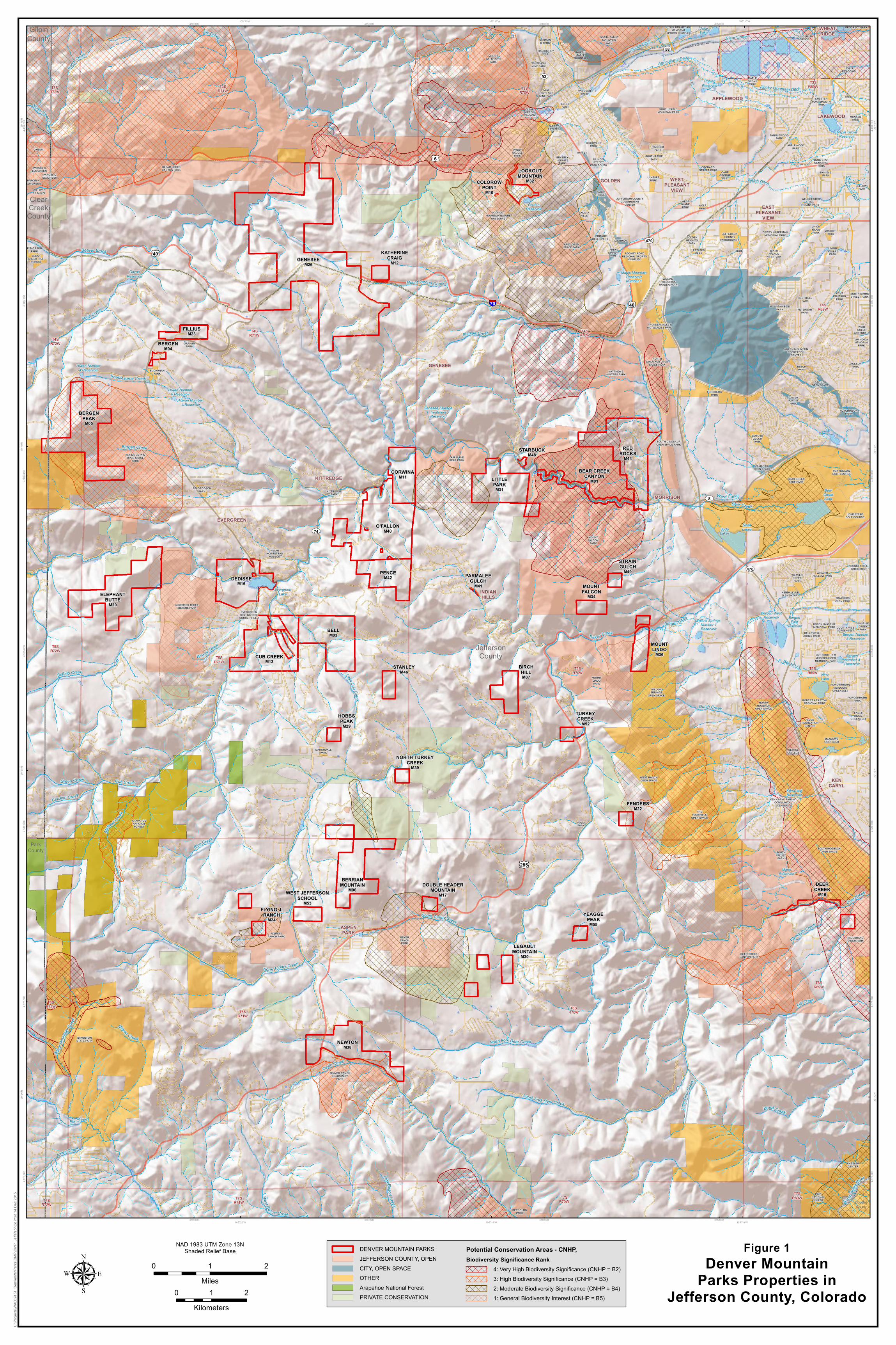
Figure 1Denver Mountain
Parks Properties inJefferson County, Colorado
BELLM03
CUB CREEKM13
DEDISSEM15
ELEPHANTBUTTE
M20
CORWINAM11
PENCEM42
LITTLEPARK
M31
BERRIANMOUNTAIN
M06
REDROCKS
M44
NEWTONM38
GENESEEM26
O'FALLONM40
FILLIUSM23
BERGENPEAK
M05
BERGENM04
FLYING J.RANCH
M24
LEGAULTMOUNTAIN
M30
DEERCREEK
M16
STRAINGULCH
M49
MOUNTFALCON
M34
BIRCHHILLM07
STANLEYM46
HOBBSPEAK
M29
PARMALEEGULCH
M41
TURKEYCREEK
M52
FENDERSM22
WEST JEFFERSONSCHOOL
M53
DOUBLE HEADERMOUNTAIN
M17
YEAGGEPEAK
M55
NORTH TURKEYCREEK
M39
MOUNTLINDO
M36
BEAR CREEKCANYON
M01
LOOKOUTMOUNTAIN
M32
STARBUCKM48
KATHERINECRAIG
M12
COLOROWPOINT
M10
APPLEWOOD
ASPENPARK
EASTPLEASANT
VIEW
EVERGREEN
GENESEE
GOLDEN
INDIANHILLS
KENCARYL
KITTREDGE
LAKEWOOD
MORRISON
WESTPLEASANT
VIEW
WHEATRIDGE
T3SR69WT3S
R70WT3S
R71WT3SR72W
T4SR69W
T4SR70W
T4SR71W
T4SR72W
T5SR69W
T5SR70W
T5SR71W
T5SR72W
T6SR69W
T6SR70WT6S
R71W
T6SR72W
T7SR69WT7S
R70WT7SR71WT7S
R72W
TRAPPERSGLEN PARK
KASSLERCENTER
OXBOW
GS LOT 2S1 T4 R72
CLEARCREEK HIGH
SCHOOL
ELMGREENPARK
PARCEL AELMGREEN
PARCEL BELMGREEN
PARCEL CELMGREEN
THEFOOTHILLS
OPEN SPACE
SOUTHVALLEYPARK
WOLFPARK
CAMPGEORGE
WEST
SOUTH HOGBACKOPEN SPACE
MARSHDALEPARK
SIXTHAVENUE
WEST PARK
WILLOWSPRINGS
OPEN SPACE
WEST RANCHOPEN SPACE
JCOS
JEFFERSONCOUNTY
FAIRGROUNDS
BUCHANANPARK
PROSPECT PARK
PARFETESTATES
KEN CARYL RANCHCOMMUNITY
CENTER
STAGECOACHPARK
GRAHAMPARK
ORCHARDSTREET PARK
APPLEWOODPARK
TANGLEWOODPARK
MAPLEGROVEPARK
LEWISMEADOWS
YOUNGFIELDSERVICE
KITTREDGEPARK
STAUNTONSTATE PARK
ARAPAHOENATIONALFOREST
EAGLERIDGE
GREENBELT
HUTCHINSONPARK
LOWERRAVINEPARK
SOUTH DINOSAUROPEN SPACE PARK
BEAR CREEKLAKE PARK
FOX HOLLOWGOLF COURSE
HOMESTEADGOLF COURSE
DISCOVERYPARK
THUNDER VALLEYMOTOCROSS PARK
NORTHDINOSAUR OPEN
SPACE PARK
WEAVERCREEKPARK
WEAVERHOLLOW PARK
PIKENATIONALFOREST
BEVERLYHEIGHTS
PARK
EVERGREENHIGH SCHOOLSOCCER FIELD
KENDALLVUEELEMENTARY
BETHELCOLLEGE
MOUNTLINDOPARK
DONKEY HILLGREENBELT
RIDGERECREATION
CENTER
ROBERT A EASTONREGIONAL PARK
WELCHESTERTREE
GRANT PARK
BELLOWSPARK
POWDERHORNPARK
TONY GRAMPSASMEMORIAL
SPORTS COMPLEX
POWDERHORNMEADOWS
GREENBELT
COUNTY WESTGREENBELT
TAMARISKOPEN SPACE
FORSBERGPARK
RAVINESOPEN SPACE
LAIR O THEBEAR PARK
MOUNTFALCON
PARK
FOOTHILLSPARK
SOUTH SIMMSSTREET PARK
KENTKNUTSON
PARK
WILLIAMFREDERICK
HAYDEN PARK
ESTATESPARK
UNIONSQUARE
PARK
HERITAGEDELLS PARK
ULYSSESPARK
BLUE STARMEMORIAL
PARK
MOUNTGALBRAITH
PARK
WINDYSADDLE
PARK
WEIRGULCH
GREENBELT
PETERSONPARK
ROONEY ROADREGIONAL SPORTS
COMPLEX
WESTBLADEPARK
LOOKOUTMOUNTAIN NATURE
PRESERVE
EAGLERIDGE
CLEARCREEK
CANYON
SOUTH TABLEMOUNTAIN PARK
NORTHTABLE
MOUNTAIN
NORTH TABLEMOUNTAIN
PARK
REYNOLDSPARK
BEAVER RANCHCOMMUNITY
PARK
DEER CREEKCANYON PARK
FLYING JRANCH PARK MEYER
RANCHPARK
HALMPARK
HILDEBRANDRANCH PARK
SGT TIMOTHY MMOSSBRUCKERMEMORIAL PARK
BELLEVIEWACRES PARK
BOBBY HYATT JRMEMORIAL PARK
SUNRISECREEKPARK
ALDERFER THREESISTERS PARK
ELK MOUNTAINOPEN SPACE
PARK
BEECHPARK
JACKSONPARK
JIM HOIDAMEMORIAL
PARK
GOLDENHEIGHTS
PARK
UNIONRIDGEPARK
APEX OPENSPACE PARK
DANIELSPARK
LIONSPARK
CHESTERPORTSMOUTH
PARK
VANOVERPARK TAFT
PARK
NEWLOVELANDMINE PARK
WHITE ASHMINE PARK
NORMAND PARK
CLEAR CREEKCANYON PARK
MEADOWSGOLF CLUB
GREEN MOUNTAINRECREATION
CENTER
JEFFERSON COUNTYGOVERNMENT
CENTER
APEXKINNEY
RUN
COYOTEGULCHPARK
DEWEY HABERMANMEMORIAL PARK
WRIGHTPARK
SOUTHRIDGEPARK
NORTHHOGBACK
OPEN SPACE
HIWANHOMESTEAD
MUSEUM
HACKBERRYHILL
PARFET
LAKOTAHILLS
MATTHEWSWINTERS PARK
BACHMAN
RIMROCKPARK
ILLINOISSTREET
PARK SOUTH
MCNABBPARK
MOUNTAINSIDEPARK
£¤40
£¤6
£¤285
£¤40
UV93
UV470
UV74
UV8
UV58
UV470
§̈¦70
MannReservoir
Hiwan Number6 Reservoir
Willow SpringsNumber 1Reservoir
Maple GroveReservoir
HineLake
BergenNumber 4Reservoir
SodaLakes
DukeLake
BergenEast
Reservoir
Ken CarylReservoir
Genesee SewageTreatmentReservoir
RollingReservoir
Bergen Number5 Reservoir
GoldenReservoir
Bergen WestReservoir
GaynoReservoir
Magic MountainReservoirNumber 1
Hiwan Number1 Reservoir
SodaLakes
Hiwan Number4 Reservoir
BearCreekLake
EvergreenLake
Last Resort Creek
North Clear Creek
Beaver Brook
Ward Canal
Cub Creek
Brush Creek
Shingle Creek
Blue Cree k
Rocky Mountain Ditch
Buffalo Creek
Agricultural Ditch
Bear Creek
Jones Creek
Elk Creek
Soda Creek
Dutch Creek
South TurkeyCreek
Maxwell Cree
k
North Turkey Creek
Casto Creek
Mount Vernon Creek
Deer Creek
North Fork Deer Creek
West Resort Creek
Green Creek
Black
Moun
tainCre
ek
SouthPla
tte
River
HorseCreek
Wilmot Creek
Mill Cree k
Little Cub Creek
South Fork Deer Creek
Elk CreekLit
t leDe
erCre
e k
BergenDitch
Turkey Creek
Plymouth Creek
Mason Creek
Chicken Creek
Welch Ditch
Troublesome Creek
Agricultural Ditc h
Clear Creek
Bergen Creek
Church Ditch
Bergen Ditch
ClearCreekCounty
DouglasCounty
ParkCounty
GilpinCounty
JeffersonCounty
470,000
470,000
475,000
475,000
480,000
480,000
485,000
485,000
4,370
,000
4,370
,000
4,375
,000
4,375
,000
4,380
,000
4,380
,000
4,385
,000
4,385
,000
4,390
,000
4,390
,000
4,395
,000
4,395
,000
4,400
,000
4,400
,000
105°10'W
105°10'W
105°15'W
105°15'W
105°20'W
105°20'W39
°45'N
39°4
5'N
39°4
0'N
39°4
0'N
39°3
5'N
39°3
5'N
39°3
0'N
39°3
0'N
0 1 2Milesµ
NAD 1983 UTM Zone 13NShaded Relief Base
U:\Pr
ojects
\WA0
0243
4_De
nverM
tnPark
s\DMP
\DMP
_Jeff
erson
Co.m
xd 14
Dec
2015
DENVER MOUNTAIN PARKSJEFFERSON COUNTY, OPENCITY, OPEN SPACEOTHERArapahoe National ForestPRIVATE CONSERVATION
Potential Conservation Areas - CNHP,Biodiversity Significance Rank
4: Very High Biodiversity Significance (CNHP = B2)3: High Biodiversity Significance (CNHP = B3)2: Moderate Biodiversity Significance (CNHP = B4)1: General Biodiversity Interest (CNHP = B5)0 1 2
Kilometers

Natural Resources Survey and Assessment, Denver Mountain Parks
14
O’Fallon Park
High scores for size, topography, and NDIS are primary influences on property ranking, whereas SBR has a moderate score, and PCA and hydrology have low scores. The park lies adjacent to two other parks, Corwina Park to the north, and Pence Park to the south. The park consists of extensive coniferous forests interspersed with shrublands and riparian areas. This park contains suitable habitat for SBR birds such as northern pygmy‐owl and Lewis’s woodpecker. An American three‐toed woodpecker was observed onsite. Weeds such as musk thistle, yellow toadflax, Dalmatian toadflax, houndstongue, leafy spurge, and Canada thistle occur in some areas; however, widespread populations were not observed.
Red Rocks Park
Size, NDIS, SBR and PCA are the primary influences on the park’s ranking with moderate influences from adjacency and hydrology. Over a third of the park lies within a PCA of very high biodiversity significance (CNHP B2), and over half of the park’s western boundary adjoins JCOS. Sandstone cliffs dominate the park, and there is a long extent of riparian habitat, both enhancing its potential for SBR habitat. Peregrine falcons (previously listed as threatened under the Endangered Species Act) were observed on the cliffs. The park may provide habitat for prairie falcon and Lewis’s woodpecker. Weeds such as Dalmatian toadflax, scotch thistle, and Canada thistle occur in some areas. Poison hemlock is widespread.
Elephant Butte Tract
This tract represents high value for size, topography, and NDIS, and low for adjacency, SBR, PCA, and hydrology. A PCA of general biodiversity interest (B5) overlaps the eastern side of the property. The property borders JCOS to the east and a private conservation easement to the north. A ridge of rocky outcrops runs from the southwest to the northeast side and provides extensive bat habitat. Extensive mixed conifer forests cover the site. Musk thistle occurs in five‐ to ten‐meter diameter patches; however, weed populations are not widespread. Myrtle spurge populations exist near the summit.
Bergen Peak Tract
This tract represents high value for size and topography, and moderate for PCA. Lower values are recorded for adjacency, NDIS, and SBR, and hydrology was zero. A PCA of high biodiversity significance (B3) overlaps the majority of the tract. The park is adjacent to JCOS to the east. The park consists of extensive mixed coniferous forests. A juvenile Williamson’s sapsucker was observed indicating nesting in the tract and habitat for dusky grouse exists within the boundary. Weeds such as Dalmatian toadflax, leafy spurge, musk thistle, and Canada thistle occur; however, weed populations do not appear to be widespread.
Cub Creek Park
Values are high for NDIS and moderate for size, topography, and hydrology. Lower values are found for adjacency and SBR, with no PCA value. Cub Creek runs from the southwest corner to the north side. Mountain subdivisions border the north, south, and west sides. This park is adjacent to Bell Park to the east. The park consists of extensive mixed coniferous forests.
Natural Resources Survey and Assessment, Denver Mountain Parks
15
Weeds such as orange hawkweed, diffuse knapweed, musk thistle, and Canada thistle occur in some areas; however, weed populations do not appear to be widespread.
Berrian Mountain Tract
Values are high for size and topography, and low for adjacency, NDIS, SBR, PCA, and hydrology. Subdivisions and development border the western and southern boundaries. Dense stands of lodgepole pine and mixed conifer woodlands cover the site. There is some evidence of a historic fire. An American three‐toed woodpecker was heard drumming during field surveys conducted in August. Weeds such as yellow toadflax, Canada thistle, and musk thistle occur in some areas; however, weed populations do not appear to be widespread. Rock outcroppings along the trails provide bat roosting habitat.
Bell Park
Values are high for topography and NDIS, and moderate for size. Low values are recorded for adjacency, SBR, PCA, and hydrology. Subdivisions occur on the north, east, and south sides and Bell Park is adjacent to Cub Creek Park to the west. The park is dominated by ponderosa pine woodland with smaller areas of mixed conifer. Weeds such as corn chamomile, yellow toadflax, and Canada thistle occur in some areas; however, weed populations do not appear to be widespread.
Newton Park
Values are high for size, topography, and PCA, and low for adjacency, NDIS, SBR, and hydrology. A PCA of high biodiversity significance (B3) overlaps portions of the eastern side. JCOS borders the southern boundary. Ponderosa pine woodlands dominate the park with smaller stands of mixed conifers. The park slopes down toward a riparian corridor along Casto Creek (offsite). Traffic along the creek corridor may affect wildlife use of the park. Weeds such as mayweed chamomile, yellow toadflax, and musk thistle occur; however, weed populations do not appear to be widespread.
Dedisse Park
High scores for NDIS and hydrology, and moderate scores for size, topography, and SBR are the primary influences on Dedisse Park. Adjacency and PCA have little influence. The park includes Evergreen Lake and is bisected by Bear Creek. These two aquatic features provide a strong positive influence on hydrology. Large coniferous forests dominate the western two‐thirds of the park. Bear Creek and Evergreen Lake within and adjacent to the park impart a major influence on the hydrological value of the property.
Little Park
Scores for topography, SBR, and PCA are high whereas size, adjacency, and NDIS have moderate values. Hydrology value is low. The western third of Little Park is included within a PCA of moderate biological significance (B4). The Little Park property is adjacent to JCOS on the east and northwest sides. The park has a mixture of coniferous woodlands and shrub‐covered hillsides. Weeds such as musk thistle, Dalmatian toadflax, and Canada thistle occur in some areas; however, weed populations do not appear to be widespread.
Natural Resources Survey and Assessment, Denver Mountain Parks
16
Comprising only a short reach of Bear Creek results in a relatively low hydrologic score for Little Park. However, it is important to note that this reach of perennial creek, as well as two contributing ephemeral tributaries, are located at the very top of the Bear Creek watershed, an important position for resource management and conservation. The riparian area supports approximately six (6) acres of high value Rocky Mountain lower montane riparian woodland within the upper boundary of the park. This is an uncommon habitat within DMP.
Pence Park
Values are high for topography and NDIS and low for size, adjacency, SBR, PCA, and hydrology. O’Fallon Park borders the northern side. Subdivisions border the west and east sides. Extensive dense mixed conifer forests cover the site with smaller stands of ponderosa pine. Traffic along the eastern boundary may influence wildlife use. Musk thistle persists in some areas; however, weed populations do not appear to be widespread.
Corwina Park
Values are high for topography, and moderate for size, adjacency, NDIS, SBR, and PCA. Hydrologic values are low. The park has adjacency with JCOS on the northeast and O’Fallon Park and Pence Park to the south; this forms a large extent of contiguous properties. A PCA of moderate biological significance (B4) borders and slightly overlaps the southeastern corner. Extensive and dense coniferous forests cover the property. Weeds such as leafy spurge, musk thistle, Dalmatian toadflax, and Canada thistle continue to persist in some areas; however, weed populations do not appear to be widespread.
Birch Hill Tract
This tract has a high value for topography, and low values for size, adjacency, NDIS, SBR, PCA, and hydrology. Subdivisions border the southern side. Extensive ponderosa pine and mixed conifer forests cover the site. Weeds such as spotted knapweed, musk thistle, and Canada thistle occur in some areas; however, weed populations do not appear to be widespread.
Legault Mountain Tracts
These three tracts have a high value for topography, and low values for size, adjacency, NDIS, SBR, PCA, and hydrology. The western two parcels are adjacent to private conservation easements. Montane mixed conifer forests dominate all three parcels. Weeds such as Canada thistle, bull thistle, and musk thistle occur in some areas; however, weed populations do not appear to be widespread. Overall, the area is quite wild and exhibits many native plants and favorable habitat for regional wildlife due to limited public access and use. Of note, habitat and evidence of American three‐toed woodpecker were observed.
Bear Creek Canyon Tract
Adjacency, topography, PCA, and hydrology are the primary influences on the park’s ranking, with NDIS having a moderate influence. Size and SBR are lower influences. The entirety of the tract is bordered to the north and south by JCOS. It lies within a PCA (B2). The entire length of the tract encompasses Bear Creek resulting in a strong influence on ranking from hydrology.
Natural Resources Survey and Assessment, Denver Mountain Parks
17
The long extent of riparian habitat along the creek enhances the value of this property. Diffuse knapweed was observed along shoulder of the road but does not appear to be widespread.
Fillius Park
This is a small park with high value for topography and low values for size, adjacency, NDIS, SBR, PCA, and hydrology. Ponderosa pines are the dominant vegetation. Weeds such as Russian knapweed, Dalmatian toadflax, musk thistle, and Canada thistle persist in some areas. Weed treatment is recommended as a priority for this park.
Deer Creek Tract
Values are high for PCA and moderate for adjacency, topography, NDIS, and SBR. Size and hydrology are low. A PCA of very high biological significance (B3) overlaps the eastern third of the property. JCOS is adjacent to the park to the north and east. A very small park, Deer Creek Tract lies at the transition between foothills and plains with a diversity of vegetation communities. Traffic along the tract likely influences wildlife use. Weeds such as diffuse knapweed, musk thistle, and Canada thistle persist along the shoulder or the road; however, weed populations do not appear to be widespread.
Mount Falcon Tract
This tract has a high value for topography, and low values for size, adjacency, NDIS, SBR, PCA, and hydrology. Adjacent to the north and west is JCOS. The site is a mosaic of ponderosa pine and mixed montane shrubland. Weeds such as Dalmatian toadflax and musk thistle occur in some areas; however, weed populations do not appear to be widespread. Of note, a common poorwill was observed during field surveys in August.
Flying J. Ranch Tracts
Values are high for adjacency and topography, and low for size, NDIS, SBR, PCA, and hydrology. These two small parcels are bordered by JCOS. A PCA of moderate biodiversity significance (B4) covers the majority of the southern tract. Dense montane mixed coniferous cover both sites. Sign of American three‐toed woodpecker was noted within the tract boundary.
Mount Lindo Tract
This tract comprises two parcels bisected by U.S. 285. Values are high for topography, NDIS, and SBR, and low for size, adjacency, PCA, and hydrology. JCOS and other open space areas border the southern half of the property. Ponderosa pine and mixed conifers dominate the site along with stands of Gamble oak and scattered riparian vegetation.
West Jefferson School Tract
This is a small park contained within a subdivision and adjacent to the Town of Aspen Park. The tract has a high value for topography, and low values for size, adjacency, NDIS, SBR, PCA, and hydrology. It is a small park contained within subdivisions. The majority of the park is dominated by mixed conifer woodland with some areas of ponderosa pine woodland.

Natural Resources Survey and Assessment, Denver Mountain Parks
18
Lookout Mountain Park
Values are high for adjacency, topography, and SBR with lower values for size, NDIS, PCA, and hydrology. JCOS surrounds the park. A PCA of moderate biodiversity significance (B4) overlaps the property. The park consists of ponderosa pine and mixed conifer forests.
Stanley Park Tract
This is a small park contained within subdivisions. It has a high value for topography, and low values for size, adjacency, NDIS, SBR, PCA, and hydrology. The majority of the park is covered in ponderosa pine woodlands with small areas of mixed conifer woodland.
Turkey Creek Park
Values are high for topography, NDIS, and SBR. Low values are noted for size, adjacency, PCA, and hydrology. Turkey Creek runs along the southern border. Highway 285 cuts through the center of the park, dividing the east and west sides. This small park is mostly ponderosa pine woodland and mixed conifer woodland, with patches of riparian habitat and wet meadow.
Katherine Craig Park
Low values are recorded for size, adjacency, topography, NDIS, SBR, PCA, and hydrology. The park is sparsely vegetated with ponderosa pine.
Double Header Mountain Tract
Values are high for adjacency and topography, and low for size, NDIS, SBR, PCA, and hydrology. JCOS borders the western and southern boundaries. This sparsely wooded site consists mostly of ponderosa pine and mixed conifer woodland.
Yeagge Peak Tract
This is a small park surrounded by sparsely developed areas. It has a high value for topography and low values for size, adjacency, NDIS, SBR, PCA, and hydrology. Mixed conifer woodlands cover the majority of the park.
Fenders Tract
Values are high for topography and NDIS and low for size, adjacency, SBR, PCA, and hydrology. Subdivisions border the east and south sides. Extensive stands of Gamble oak cover two‐thirds of this small park, with the other third consisting of dry coniferous woodland.
North Turkey Creek Tract
This tract has a high value for topography and low values for size, adjacency, NDIS, SBR, PCA, and hydrology. It is a small parcel with subdivisions on the west and a conservation easement on the east. Ponderosa pine and conifer woodlands cover the majority of the park.
Hobbs Peak Tract
This is a small park contained within subdivisions. This tract has a high value for topography, and low values for size, adjacency, NDIS, SBR, PCA, and hydrology. A cliff outcrop dominates the property, and extensive conifer forests cover the site.

Natural Resources Survey and Assessment, Denver Mountain Parks
19
Strain Gulch Tract
This is a very small park, with high value for topography, and low values for size, adjacency, NDIS, SBR, PCA, and hydrology. Coniferous woodlands and Gamble oak shrublands cover the site. The tract sits above a large quarry.
Bergen Park
This is a small park surrounded by residential and urban development. Low values are recorded for size, adjacency, topography, NDIS, SBR, PCA, and hydrology. Highly managed ponderosa pine woodland covers the park.
Starbuck Park
This is a very small south‐facing park overlooking Bear Creek. It has high values for topography and NDIS, and low values for size, adjacency, SBR, PCA, and hydrology. A mountain shrub vegetation community dominates the site.
Parmalee Gulch
This is a very small and relatively isolated park surrounded by mountain subdivisions. Low values are recorded for size, adjacency, topography, NDIS, SBR, PCA, and hydrology. Ponderosa pines sparsely grow on the site.
Colorow Point Park
Values are high for adjacency and topography, and low for size, NDIS, SBR, PCA, and hydrology. The park comprises a very small overlook along Colorow Road.

Natural Resources Survey and Assessment, Denver Mountain Parks
20
References
Colorado Bird Atlas Partnership and the Cornell Laboratory of Ornithology. 2011. Colorado Breeding Bird Atlas II. Available: http://bird.atlasing.org/Atlas/CO/Main. Accessed December 2014.
Colorado Natural Heritage Program (CNHP). 2012. Survey of Critical Biological Resources, Jefferson County, Colorado, 2010‐2011.
Colorado Parks and Wildlife (CPW). 2015. Species of Concern. Available: http://wildlife.state.co.us/WildlifeSpecies/SpeciesOfConcern/ThreatenedEndangeredList/Pages/ListOfThreatenedAndEndangeredSpecies.aspx. Accessed December 2015.
Cornell Laboratory of Ornithology (CLO) and National Audubon Society. 2014. Ebird real‐time online checklist program. Available: http://ebird.org/content/ebird/. Accessed December 2014.
Jefferson County Open Space (JCOS). 2014. 2014‐2019 Jefferson County Open Space Master Plan 2014‐2015. Available: http://jeffco.us/open‐space/plans/open‐space‐master‐plan/. Accessed December 2014.
Natural Diversity Information Source (NDIS). 2014. Available: http://ulpeis.anl.gov/documents/dpeis/references/pdfs/CPW_2011a.pdf. Accessed December 2014.
Southwestern Regional Gap (SWReGap). 2004. RS/GIS Laboratory, College of Natural Resources, Utah State University. 'PROVISIONAL' Digital Landcover Dataset for the Southwestern United States. Version 1.0 ‐ raster digital data. Available: http://earth.gis.usu.edu/swgap/. Accessed January 2015.
U.S Fish and Wildlife Service (USFWS). 2015. Species by County Reports. Available: http://www.fws.gov/mountain‐prairie/co.html. Accessed December 2015.
U.S. Department of Agriculture. 2011. National Agriculture Imagery Program National Agriculture Imagery Program (NAIP). Available: http://www.fsa.usda.gov/FSA/apfoapp?area=home&subject=prog&topic=nai. Accessed December 2014.
U.S. Geological Survey, The National Map. 2014a. 3DEP products and services: The National Map, 3D Elevation Program. Available: http://nationalmap.gov/3dep_prodserv.html. Accessed December 2014.
U.S. Geological Survey. 2014b. National Hydrography Dataset (U.S. Geological Survey in cooperation with U.S. Environmental Protection Agency, USDA Forest Service, and other Federal, State and local partners. USGS Reston, Virginia. Vector digital data. Available: \\igskbthifsfasd1\nvm_extracts\GDBExtractServer\Template\NHD_File_Template_High_931vjxx.gdb. Accessed December 2014.

Natural Resources Survey and Assessment, Denver Mountain Parks
21
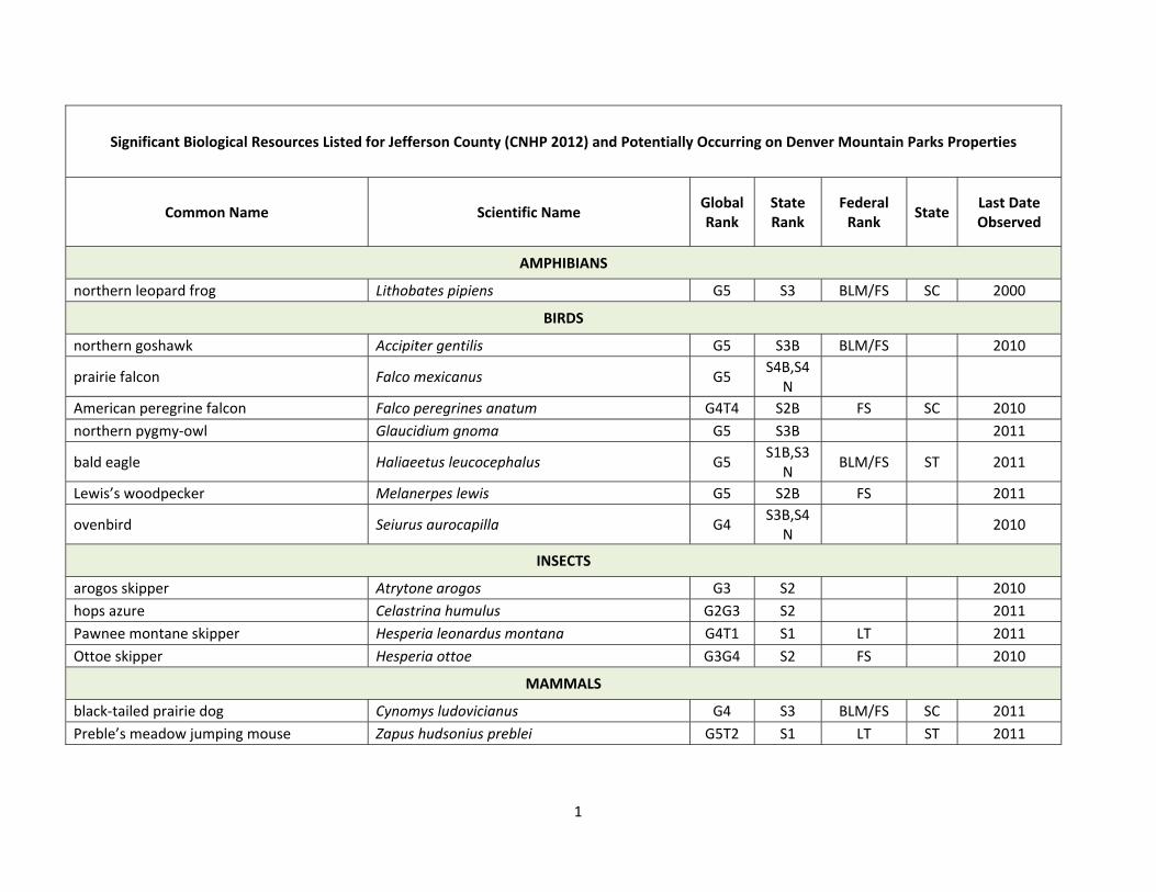
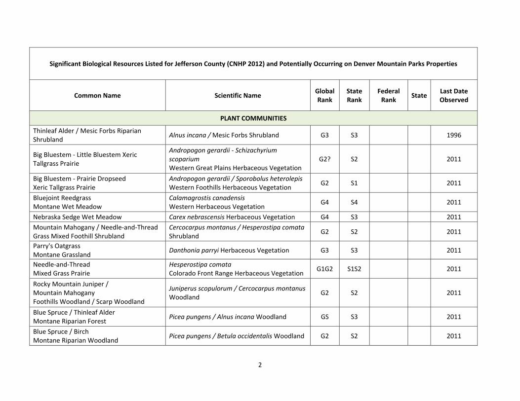
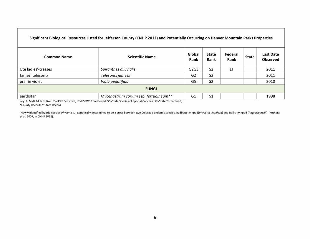
ATTACHMENT A: SIGNIFICANT BIOLOGICAL RESOURCES LISTED FOR JEFFERSON COUNTY (FROM CNHP 2012) AND POTENTIALLY OCCURRING ON DENVER MOUNTAIN PARKS PROPERTIES.
1
Significant Biological Resources Listed for Jefferson County (CNHP 2012) and Potentially Occurring on Denver Mountain Parks Properties
Common Name Scientific Name Global Rank
State Rank
Federal Rank
StateLast Date Observed
AMPHIBIANS
northern leopard frog Lithobates pipiens G5 S3 BLM/FS SC 2000
BIRDS
northern goshawk Accipiter gentilis G5 S3B BLM/FS 2010
prairie falcon Falco mexicanus G5 S4B,S4
N
American peregrine falcon Falco peregrines anatum G4T4 S2B FS SC 2010
northern pygmy‐owl Glaucidium gnoma G5 S3B 2011
bald eagle Haliaeetus leucocephalus G5 S1B,S3
N BLM/FS ST 2011
Lewis’s woodpecker Melanerpes lewis G5 S2B FS 2011
ovenbird Seiurus aurocapilla G4 S3B,S4
N 2010
INSECTS
arogos skipper Atrytone arogos G3 S2 2010
hops azure Celastrina humulus G2G3 S2 2011
Pawnee montane skipper Hesperia leonardus montana G4T1 S1 LT 2011
Ottoe skipper Hesperia ottoe G3G4 S2 FS 2010
MAMMALS
black‐tailed prairie dog Cynomys ludovicianus G4 S3 BLM/FS SC 2011
Preble’s meadow jumping mouse Zapus hudsonius preblei G5T2 S1 LT ST 2011
2
Significant Biological Resources Listed for Jefferson County (CNHP 2012) and Potentially Occurring on Denver Mountain Parks Properties
Common Name Scientific Name Global Rank
State Rank
Federal Rank
StateLast Date Observed
PLANT COMMUNITIES
Thinleaf Alder / Mesic Forbs Riparian Shrubland
Alnus incana / Mesic Forbs Shrubland G3 S3
1996
Big Bluestem ‐ Little Bluestem Xeric Tallgrass Prairie
Andropogon gerardii ‐ Schizachyrium scoparium Western Great Plains Herbaceous Vegetation
G2? S2
2011
Big Bluestem ‐ Prairie Dropseed Xeric Tallgrass Prairie
Andropogon gerardii / Sporobolus heterolepis Western Foothills Herbaceous Vegetation
G2 S1
2011
Bluejoint Reedgrass Montane Wet Meadow
Calamagrostis canadensis Western Herbaceous Vegetation
G4 S4
2011
Nebraska Sedge Wet Meadow Carex nebrascensis Herbaceous Vegetation G4 S3 2011
Mountain Mahogany / Needle‐and‐Thread Grass Mixed Foothill Shrubland
Cercocarpus montanus / Hesperostipa comata Shrubland
G2 S2
2011
Parry's Oatgrass Montane Grassland
Danthonia parryi Herbaceous Vegetation G3 S3
2011
Needle‐and‐Thread Mixed Grass Prairie
Hesperostipa comata Colorado Front Range Herbaceous Vegetation
G1G2 S1S2
2011
Rocky Mountain Juniper / Mountain Mahogany Foothills Woodland / Scarp Woodland
Juniperus scopulorum / Cercocarpus montanus Woodland
G2 S2
2011
Blue Spruce / Thinleaf Alder Montane Riparian Forest
Picea pungens / Alnus incana Woodland GS S3
2011
Blue Spruce / Birch Montane Riparian Woodland
Picea pungens / Betula occidentalis Woodland G2 S2
2011

3
Significant Biological Resources Listed for Jefferson County (CNHP 2012) and Potentially Occurring on Denver Mountain Parks Properties
Common Name Scientific Name Global Rank
State Rank
Federal Rank
StateLast Date Observed
Limber Pine / Kinnikinnik Lower Montane Woodland
Pinus flexilis / Arctostaphylos uva‐ursi Woodland**
G4 S3
1992
Ponderosa pine / Thinleaf Alder Woodland
Pinus ponderosa / Alnus incana Woodland
G2 S2
1996
Ponderosa Pine / Kinnikinnik Lower Montane Forest
Pinus ponderosa / Arctostaphylos uva‐ursi Woodland
G4 S3
1992
Foothills Ponderosa Pine Scrub Woodlands Pinus ponderosa / Cercocarpus montanus / Andropogon gerardii Wooded Herbaceous Vegetation
G2 S2?
1992
Foothills Ponderosa Pine Scrub Woodlands Pinus ponderosa / Cercocarpus montanus Woodland
G4 S4
1992
Foothills Ponderosa Pine Savannas Pinus ponderosa / Leucopoa kingii Woodland
G3 S3
1992
Foothills Ponderosa Pine Savannas Pinus ponderosa / Muhlenbergia montana Woodland
G4G5 S2S3
1992
Foothills Ponderosa Pine Scrub Woodlands Pinus ponderosa / Quercus gambelii Woodland
G5 S4
1992
Narrowleaf Cottonwood / Thinleaf Alder Montane Riparian Forest
Populus angustifolia / Alnus incana Woodland
G3 S3
2011
Narrowleaf Cottonwood / Douglas Fir Montane Riparian Forest
Populus angustifolia / Pseudotsuga menziesii Woodland*
G3 S2
2011
Narrowleaf Cottonwood / Drummond Willow/ Rocky Mountain Maple Woodland
Populus angustifolia / Salix drummondiana / Acer glabrum Woodland*
G2? S1
2011

4
Significant Biological Resources Listed for Jefferson County (CNHP 2012) and Potentially Occurring on Denver Mountain Parks Properties
Common Name Scientific Name Global Rank
State Rank
Federal Rank
StateLast Date Observed
Quaking Aspen / Beaked Hazelnut Montane Riparian Forest
Populus tremuloides / Corylus cornuta Forest*
G3 S1
2011
Douglas Fir / Water Birch Montane Riparian Forest
Pseudotsuga menziesii / Betula occidentalis Woodland
G3? S3
2011
Douglas Fir / Geyer’s Sedge Lower Montane Forest
Pseudotsuga menziesii / Carex geyeri Forest
G4? S3
2011
Douglas Fir / Waxflower Lower Montane Forest
Pseudotsuga menziesii / Jamesia americana Forest
G3G4 S3
1992
Rocky Mountain Willow / Bluejoint Reedgrass Montane Willow Carr
Salix monticola / Calamagrostis canadensis Shrubland
G3 S3
2011
Rocky Mountain Willow / Beaked Sedge Montane Riparian Willow Carr
Salix monticola / Carex utriculata Shrubland
G3 S3
2011
Rocky Mountain Willow Montane Riparian Willow Carr
Salix monticola / Mesic Forbs Shrubland
G4 S3
1996
PLANTS
lavender hyssop Agastache foeniculum G4G5 S1 1878
dwarf wild indigo Amorpha nana G5 S2S3 2011
golden columbine Aquilegia chrysantha var. rydbergii* G4T1Q S1 BLM/FS 2011
Rocky Mountain columbine Aquilegia saximontana G3 S3 2011
forked three‐awn grass Aristida basiramea G5 S1 2010
Front Range milkvetch Astragalus sparsiflorus G2 S2 2010
openfield sedge Carex conoidea** G5 S1 2011
Peck's sedge Carex peckii* G4G5 S1 2011
Rocky Mountain sedge Carex saximontana G5 S1 2011

5
Significant Biological Resources Listed for Jefferson County (CNHP 2012) and Potentially Occurring on Denver Mountain Parks Properties
Common Name Scientific Name Global Rank
State Rank
Federal Rank
StateLast Date Observed
long‐beaked sedge Carex sprengelii G5? S2S3 2011
Torrey's sedge Carex torreyi G4 S1 2011
redstem springbeauty Claytonia rubra G5 S1 2010
yellow hawthorn Crataegus chrysocarpa G5 S1 2011
American yellow lady's slipper Cypripedium calceolus ssp. parviflorum G5 S2 FS 2011
Bicknell's northern cranesbill Geranium bicknellii G5 S2 2010
Front Range alumroot Heuchera hallii G3 S3 2011
variegated horsetail Hippochaete variegata G5 S1 2011
Vasey's rush Juncus vaseyi* G5? S1 2011
wood lily Lilium philadelphicum G5T5 S3/S4 2011
white adder's mouth Malaxis monophyllos ssp. brachypoda G4Q S1 FS 2011
Weber's monkeyflower Mimulus gemmiparus G1 S1 2011
jeweled blazingstar Nuttallia speciosa G3 S3 2011
Colorado butterfly plant Oenothera coloradensis ssp. coloradensis G3T2 S1 LT 2011
Rocky Mountain phacelia Phacelia denticulata* G3 SU 2011
Rydberg twinpod Physaria vitulifera G3 S3 2011
Twinpod hybrid Physaria x 11** G1Q S1 2010
Rocky Mountain polypody Polypodium saximontanum G3? S3? 2011
southern Rocky Mountain cinquefoil Potentilla ambigens G3 S1S2 2010
American current Ribes americanum G5 S2 1910
Weatherby's spikemoss Selaginella weatherbiana G3G4 S3S4 2011
blue‐eyed grass Sisyrinchium demissum G5 S2 1994
carrion flower Smilax lasioneura G5 S3S4 2011
6
Significant Biological Resources Listed for Jefferson County (CNHP 2012) and Potentially Occurring on Denver Mountain Parks Properties
Common Name Scientific Name Global Rank
State Rank
Federal Rank
StateLast Date Observed
Ute ladies’‐tresses Spiranthes diluvialis G2G3 S2 LT 2011
James' telesonix Telesonix jamesii G2 S2 2011
prairie violet Viola pedatifida G5 S2 2010
FUNGI
earthstar Mycenastrum corium ssp. ferrugineum** G1 S1 1998 Key: BLM=BLM Sensitive; FS=USFS Sensitive; LT=USFWS Threatened; SC=State Species of Special Concern; ST=State Threatened; *County Record; **State Record 1Newly identified hybrid species Physaria x1, genetically determined to be a cross between two Colorado endemic species, Rydberg twinpod(Physaria vitulifera) and Bell's twinpod (Physaria bellii) (Kothera et al. 2007, in CNHP 2012).