first five year review report (signed) - skinner landfill
TRANSCRIPT

u s EPA RECORDS CENTER REGION 5
461684
FIVE-YEAR REVIEW REPORT FOR LENZ OIL SERVICES, INC. SUPERFUND SITE
DUPAGE COUNTY, ILLINOIS
, ^ N ^ ^ ^ « ^ ^ ^ ^ .
< LU
Prepared by
U.S. Environmental Protection Agency Region 5
Chicago, Illinois
March 2014
Approved bj** Date:
/• RicnardG/Karin^irector' jJ^LSuperfund Division, Region 5
'j^j/^/f

TABLE OF CONTENTS
List of Acronyms iv
Executive Summary v
Five-Year Review Summary Form vi
1.0 INTRODUCTION 1
2.0 SITE CHRONOLOGY .....2
3.0 BACKGROUND 2 3.1 Physical Characteristics : 2 3.2 Land and Resource Use 3 3.3 History of Contamination 3 3.4 Initial Response 4 3.5 Basis for Taking Action 4
4.0 REMEDIAL ACTIONS 9 4.1 Remedy Selection 9 4.2 Remedy Implementation 11 4.3 Institutional Controls 13 4.4 System Operations/Operation and Maintenance 14
5.0 PROGRESS SINCE LAST FIVE-YEAR REVIEW 15
6.0 FIVE-YEAR REVIEW PROCESS 15 6.1 Administrative Components 15 6.2 Community Notification and Involvement 15 6.3 Document Review 16 6.4 Data Review 16 6.5 Site Inspection 16
7.0 TECHNICAL ASSESSMENT 17 7.1 Question A: Is the remedy functioning as intended by the decision documents? Yes 17 7.2 Question B: Are the assumptions used at the time of remedy selection still valid? Yes
17 7.3 Question C: Has any other information come to light that could call into question the
protectiveness of the remedy? No 18 7.4 Technical Assessment Summary 18
8.0 ISSUES 18
9.0 RECOMMENDATIONS AND FOLLOW-UP ACTIONS 19

10.0 PROTECTIVENESS STATEMENT 19
11.0 NEXT REVIEW : 19
Tables
Table 1 - Chronology of Site Events 2 Table 2 - Institutional Controls Summary Table 13 Table 3 - Issues that Impact Protectiveness. 18 Table 4 - Recommendations and Follow-up Actions .A9
Appendix A - Figures
Figure 1 - Site Plan Figure 2 - VER System and Well Locations
Appendix B - Attachments
Attachment 1 - Groundwater and LNAPL Analytical Data Attachment 1 A: Groundwater Analytical Data from November 2007 Attachment IB: Groundwater Analytical Data from June 2013 Attachment IC: LNAPL Analytical Data from June 2013
Attachment 2 - VER System Influent and Effluent Analytical Data Attachment 2A: VER System Influent Analytical Data (2010-2014) Attachment 2B: VER System Effluent Analytical Data (2010-2014)
Attachment 3 - VER System LNAPL Recovery and Extraction Summary (2010-2013)
Attachment 4 - Site Inspection Checklist
Attachment 5 - Environmental Covenant for Property South of Jeans Road
111

LIST OF ACRONYMS
AOC Administrative Order on Consent BTEX benzene, toluene, ethylbenzene, and xylenes CD Consent Decree CERCLA Comprehensive Environmental Response, Compensation, and Liability Act C.F.R. Code of Federal Regulations EPA United States Enviromnental Protection Agency ESD Explanation of Significant Differences FS Feasibility Study FYR Five-Year Review HI Hazard Index ICs Institutional Controls lEPA Illinois Environmental Protection Agency LNAPL Light Non-Aqueous Phase Liquid LTTD Low Temperature Thermal Desorption MCLs Maximum Contaminant Levels NCP National Oil and Hazardous Substances Pollution Contingency Plan NPDES National Pollutant Discharge Elimination System NPL National Priorities List O&M Operation and Maintenance OU Operable Unit PAHs Polynuclear Aromatic Hydrocarbons PCBs Polychlorinated Biphenyls PCE Tetrachloroethene PDDC Pre-Design Data Collection ppb parts per billion PRPs Potentially Responsible Parties RA Remedial Action RAOs Remedial Action Objectives RCRA Resource Conservation and Recovery Act RD Remedial Design RD/RA Remedial Design/Remedial Action RI Remedial Investigation RI/FS Remedial Investigation/ Feasibility Study ROD Record of Decision SVOCs Semi-Volatile Organic Compounds TCE Trichloroethene ug/kg micrograms per kilogram ug/L micrograms per liter UU/UE Unlimited Use/Unrestricted Exposure VER Vacuum Enhanced Recovery VOCs Volatile Organic Compounds
IV

EXECUTIVE SUMMARY
The completion of the cuiTent five-year.review (FYR) for the Lenz Oil Services Superfund site confirms that the components of the remedies selected in the 1999 Record of Decision (ROD) and the 2007 Explanation of Significant Differences (ESD) have been implemented and remain effective under the 2001 Remedial Design/Remedial Action (RD/RA) Consent Decree (CD) and Remedial Action Plan. This is the first FYR for the site.
The remedy for the Lenz Oil site in Du Page County, Illinois, addresses shallow subsurface light non-aqueous phase liquid (LNAPL) at the edge of and emanating from the site property, and includes the following components: 1) a 1,300-foot containment wall surrounding the LNAPL area; 2) four trenches, each 220 feet to 250 feet long and 16 feet deep; 3) a dewatering system to lower the groundwater table to enhance LNAPL recovery and vapor extraction; 4) an 1,840-cubic-feet-per-minute vapor extraction system with air injection; 5) a treatment building housing the dewatering, vapor extraction, and air injection systems; and 6) a network of LNAPL and vapor monitoring points. The remedy was implemented as a single operable unit (OU). Prior to the site ROD remedy, the State of Illinois excavated and incinerated contaminated soils on the Lenz Oil property. The site achieved construction completion with the signing of the Preliminary Closeout Report on September 28, 2009. The trigger action for this FYR was the start of remedial action construction in March 2009.
The assessment of this FYR has found that the remedy at the Lenz Oil site currently protects human health and the environment since all known exposure pathways have been eliminated. However, in order for the remedy to be protective in the long term, legally effective use restrictions that protect the integrity of the remedy components, prohibit land uses that interfere with the remedy, and prohibit the use of contaminated groundwater will need to be implemented and maintained. Long-term protectiveness requires compliance with effective institutional controls (ICs), including land use restrictions that prohibit interference with the Vacuum Enhanced Recovery (VER) system.

Five-Year Review Summary Form
SITE IDENTIFICATION
Site Name: Lenz Oil Services, Inc. 1 EPA ID: ILD005451711 |
Region: 5 State: IL City/County: Lemont/DuPage County
NPL Status: Final
Multiple OUs? No
Has the Site achieved construction completion? Yes
Lead agency: EPA
Author name (Federal or State Project Manager): Scott Hansen
Author affiliation: Remedial Project Manager
Review period: 3/28/2013 - 3/28/2014
Date of site inspection: 3/17/2014
Type of review: Statutory
Review number: 1
Triggering action date: 3/30/2009
Due date (five years after triggering action date): 3/30/2014
VI

Five-Year Review Summary Form (continued)
Issues/Recommendations
OU(s) without Issues/Recommendations Identified in the Five-Year Review:
None
Issues and Recommendations Identified in the Five-Year Review:
OU(s): 1
Affect Current Protectiveness
No
Issue Category: Institutional Controls
Issue: The second of two environmental covenants needs to be implemented
Recommendation: Record the environment covenant for the Lenz Oil property
Affect Future Protectiveness
Yes
Implementing Party
PRP
Oversight Party
EPA
Milestone Date
06/30/2014
OU(s): 1
Affect Current Protectiveness
No
Issue Category: Institutional Controls
Issue: Need to ensure long-term stewardship
Recommendation: Modify the O&M plan to ensure that effective ICs are maintained and monitored
Affect Future Protectiveness
Yes
Implementing Party
PRP
Oversight Party
EPA
Milestone Date
09/30/2014
0U1 and Sitewide Proteiitiveness Statement(s)
Protectiveness Determination: Short-term Protective
Protectiveness Statement: The assessment of this FYR has found that the remedy at the Lenz Oil site currently protects human health and the environment since ail known exposure pathways have been eliminated. However, in • order for the remedy to be protective in the long term, legally effective use restrictions that protect the integrity of the remedy components, prohibit land uses that interfere with the remedy, and prohibit the use of contaminated groundwater will need to be implemented and maintained. Long-temi protectiveness requires compliance with effective ICs, including land use restrictions that prohibit interference with the VER system.
Vll

Five-Year Review Report
LO INTRODUCTION
The United States Environmental Protection Agency (EPA) has conducted a FYR of the remedial actions implemented at the Lenz Oil site in Lemont, Illinois. The review was conducted between March 2013 and March 2014. This report documents the results of the FYR. The purpose of a five-year review is to evaluate the implementation and performance of a remedy in order to determine whether the remedy at a site is protective of human health and the environment. The methods, findings, and conclusions of the review are documented in FYR reports. In addition, FYR reports identify issues found during the review, if any, and document recommendations to address them.
EPA prepares FYRs pursuant to the Comprehensive Environmental Response, Compensation, and Liability Act (CERCLA) and the National Oil and Hazardous Substances Pollution Contingency Plan (NCP). CERCLA 121(c), as amended, states:
If the President selects a remedial action that results in any hazardous substances, pollutants, or contaminants remaining at the site, the President shall review such remedial action no less often than each five years after the initiation of such remedial action to assure that human health and the environment are being protected by the remedial action being implemented. In addition, if upon such review it is the judgment of the President that action is appropriate at such site in accordance with section [104] or [106], the President shall take or require such action. The President shall report to the Congress a list of facilities for which such review is required, the results of all such reviews, and any actions taken as a result of such reviews.
EPA interpreted this requirement fiirther in the NCP. Title 40 of the Code of Federal Regulations (C.F.R.), section 300.430(f)(4)(ii), states:
If a remedial action is selected that results in hazardous substances, pollutants, or contaminants remaining at the site above levels that allow for unlimited use and unrestricted exposure, the lead agency shall review such action no less often than every five years after the initiation of the selected remedial action.
This is the first FYR for the Lenz Oil site. Due to the fact that hazardous substances, pollutants, or contaminants remain at the site above levels that allow for unlimited use and unrestricted exposure (UU/UE), FYRs are statutorily required. The trigger action for this FYR was the start of remedial action construction in March 2009.

2.0 SITE CHRONOLOGY
Table 1 - Chronology of Site Events
Date
1961-1985
1985-1988
10/1989
11/1989
10/1997
09/30/1999
04/03/2001
08/14/2002
2003-2004
2005-2006
04/10/2007
04/17/2008
01/07/2009
03/2009
09/24/2009
09/28/2009
02/2010
11/19/2010
Event
Operation of waste oil recycling, storage, and transfer facility
Illinois Environmental Protection Agency (lEPA) work activities
National Priorities List (NPL) listing
Administrative Order on Consent signed
Remedial Investigation/Feasibility Study (RI/FS) report completed
Final ROD signed
Consent Decree for RD/RA finalized
Consent Decree for RD/RA entered by court
Pre-Design Data Collection work conducted
Supplemental Pre-Design Data Collection work conducted
ESD issued
Remedial Design (RD) completion
Phase I Remedial Action Work Plan approved
Remedial Action (RA) construction begins
Pre-final inspection conducted
Preliminary Close-Out Report signed
Vacuum Enhanced Recover (VER) system operational
EPA approved Phase I RA Construction Completion Report
3.0 BACKGROUND
3.1 Physical Characteristics
The site is located in an unincorporated area of southeast DuPage County, Illinois, two miles northeast of the Village of Lemont, Illinois. The site consists of the Lenz Oil property and contiguous property to the south which has contamination originating from the Lenz Oil property. The Lenz Oil property is bounded by Jeans Road on the south, by Route 83 on the west, by open land on the east, and by the Atchison, Topeka, and Santa Fe Railroad on the north. Figure I shows the Lenz Oil property as well as the adjacent impacted property south of Jeans

Road. The Lenz Oil property is currently a flat, vacant, grassy area containing a radio tower, a number of monitoring wells and piezometers, a fire hydrant, two utility manways, and the building that contains the VER system. The portion of the site south of Jeans Road contains a residence adjacent to one comer along with several storage structures. The site is located within the 100-year floodplain of the Des Plaines River, just 500 feet from the river.
3.2 Land and Resource Use
The site operated as a waste-oil recycling and transfer facility during the period from 1961 to 1985.
The portion of the site consisting of the Lenz Oil property is zoned as light industrial, has no present use contrary to the zoned use, and therefore has an anticipated future use consistent with light industrial zoning. The remaining portion of the site consisting of the property to the south of Jeans Road is also zoned as light industrial; however, a residence and a landscaping business exist on the property cuiTcntly, and future owners of the property may continue using the area for a business and/or residence.
The shallow geology at the site consists of Silurian dolomite bedrock overlain by up to 26.5 feet of unconsolidated glacial and alluvial deposits and assorted fill material. Bedrock present beneath the site is part of the Racine dolomite formation, which is characterized by discrete fracture zones, most of which are horizontal and appear to be bedding planes. In general, bedrock is encountered between 10 and 26 feet below ground level in the area of the site. The unconsolidated deposits directly on top of the bedrock consist of silty gravel with some sand and clay. The water level of the aquifer beneath the site varies between approximately 4 and 12 feet below ground level depending on the amount of precipitation in the area. Groundwater flows to the southeast towards the Des Plaines River.
3.3 History of Contamination
As mentioned, above, the site operated as a recycling, storage, and transfer facility for waste oil and solvents from the early 1960s to mid-1980s. In July 1981, lEPA issued a "developmental" permit for Lenz Oil to operate as a waste management facility. In 1982, EPA cited the facility for operating as a Resource Conservation and Recovery Act (RCRA) hazardous waste facility without having an interim status permit. Although the facility owner then submitted an application for the required RCRA pennit, the facility owner withdrew the permit application in November 1984, saying that the facility no longer handled hazardous waste. After a site inspection early in 1985, lEPA and Lenz Oil entered into an agreed order on May 22, 1985, in which Lenz Oil agreed to prepare and implement a cleanup and closure plan for the site. Lenz Oil failed to carry out major portions of the court order and, in April 1986, filed for bankruptcy. Past operations at the Lenz Oil facility led to the release of contaminated oil and solvents to facility soils, which then resulted in the presence of dissolved and non-dissolved oil and solvent contamination in the shallow aquifer beneath the site.

3.4 Initial Response
On January 17, 1986, lEPA filed a State Record of Decision (State ROD) for immediate removal action at the site. lEPA investigations of the Lenz Oil property in November 1985 found the following items at the site:
• Three 30,000- to 80,000-gallon unlined concrete underground storage tanks; • Nine tank trucks with a total capacity of over 30,000 gallons; • Fourteen low- to moderate-capacity above-ground or partially buried steel tanks; • Six low-capacity underground steel tanks; • A drum storage area containing approximately 200 drums; and • Three surface impoundments constructed of porous cinder-type material.
In addition, oil and solvent waste contaminated the soil and the aquifer. lEPA initiated cleanup actions at the Lenz Oil property in 1986 and by mid-1988 had accomplished the following actions: incinerated all drum, tank, and tank truck contents; shi'edded and incinerated all on-property containers; emptied and decontaminated ail tank trucks on the property; and demolished and removed all buildings, above-ground structures, and below-ground structures from the property. lEPA excavated and incinerated about 21,000 tons of contaminated soil. In addition, the lEPA cleanup included filling the on-property surface impoundment areas and providing nearby residences with municipal water hook-ups.
On October 4, 1989, EPA finalized the site on the NPL, and in November 1989, certain Potentially Responsible Parties (PRPs) for the site signed an administrative order on consent (AOC) with EPA and lEPA. Under the AOC, the PRPs agreed to conduct an RI/FS, under the joint oversight of EPA and lEPA, to determine the nature and extent of the remaining site contamination.
3.5 Basis for Taking Action
Results of sampling and investigation during the RI and subsequent field activities revealed the presence of a number of potential contaminants of concern both on- and off-site. Contaminants found in the area of the site included heavy metals, volatile organic compounds (VOCs), semi-volatile organic compounds (SVOCs), polynuclear aromatic hydrocarbons (PAHs), and polychlorinated biphenyls (PCBs).
Groundwater Aquifer
The investigation results showed that a layer of non-dissolved LNAPL was floating on top of the aquifer at the site, and that dissolved LNAPL constituents were found in the groundwater beneath the layer of non-dissolved LNAPL.
• LNAPL: Samples of non-dissolved LNAPL floating in the surficial aquifer beneath the site contained the highest levels of contaminants found. Tliree LNAPL samples were collected during each of the sampling efforts in 1991, 1994, and 1997. The samples collected in 1997 were analyzed for VOCs only. The results from each sampling event

showed that some of the constituents detected in the LNAPL, and the range of concentrations at which they were detected, included:
o VOCs: acetone (4,200 to 500,000j' micrograms per kilogram [ug/kg]), total 1,2-dichloroethene (39,000 to 460,000J ug/kg), toluene (49,000 to 4,400,000 ug/kg), ethyl benzene (6,900 to 2,000,000 ug/kg), and total xylenes (4,700 to 8,500,000 ug/kg)
o SVOCs: bis(2-ethylhexyl)phthalate (110,000J ug/kg) and 2-methylnaphthalene (1,000,000 to 2,900,000 ug/kg)
o PCBs: Aroclor-1242 (65,000J to 210,000J ug/kg) and Aroclor-1260 (38,000J to 42,000J ug/kg)
o Inorganics: arsenic (1,900J to 5,800J ug/kg), banum (121,000 to 219,000J ug/kg), cadmium (11,200 ug/kg), chi-omium (4,600J to 5,700 ug/kg), lead (81,000 to 150,000 ug/kg), and zinc (3,300J to 7,1OOJ ug/kg).
• Dissolved LNAPL: Groundwater samples were collected in 1991 and 1997. During 1997, samples were analyzed for VOCs only, and only shallow wells or piezometers were sampled. Contaminants detected in groundwater samples from the vicinity of the site, along with the maximum level at which they were found and the general depth of the well in which they were found, included:
o VOCs: acetone (150J micrograms per liter [ug/L], shallow), toluene (360J ug/L, shallow; 4J ug/L, deep), ethyl benzene (440J ug/L, shallow), and total xylenes (2,400J ug/L, shallow)
o Chlorinated VOCs: total 1,2-dichloroethene (21 ug/L, shallow; 15 ug/L, intermediate), 1,1-dichloroethane (60 ug/L, shallow; 70 ug/L, intermediate), 1,1-dichloroethene (50 ug/L, shallow; 3J ug/L, intermediate), chloroethane (lOOJ ug/L, shallow; 53 ug/L, deep), vinyl chloride (1IJ ug/L, shallow; 15J ug/L, intermediate), 1,1,1-trichloroethane (120 ug/L, shallow; 83 ug/L, intermediate; 2J ug/L, deep), trichloroethene (6 ug/L, shallow; 3J ug/L, intermediate), tetrachloroethene (3J ug/L, shallow; 2J ug/L, intermediate)
o SVOCs: 2-methynaphthalene (4,000 ug/L, shallow)
o PCBs: Aroclor-1242 (160 ug/L, shallow) and Aroclor-1260 (97J ug/L, shallow)
o Inorganics: arsenic (total) (92J ug/L, shallow; 5.4J ug/L, deep), barium (total) (l,410J ug/L, shallow; 123 J ug/L, intemiediate; 117 ug/L, deep), lead (total) (564 ug/L, shallow), zinc (total) (386J ug/L, shallow; 48 ug/L, intermediate; 21.9J ug/L, deep), and cyanide (44.9J ug/L, shallow).
The two shallow groundwater monitoring wells closest to the Des Plaines River that were sampled again in 1997 did not contain detectable levels of VOCs.
' A "J" after a sampling result indicates tiiat the result siiouid be considered to be "estimated".

Other Areas of Site
In addition to the groundwater aquifer, three main areas of the site were investigated, as follows:
• Main excavation area: This is the area excavated during the lEPA removal action initiated in 1987. The area generally coincides with the area of the former Lenz Oil facility on which the various storage tanks, tanker trucks, and drums were located. The main excavation area is approximately 1.5 acres in size. Shallow and deep soil samples were collected near and in this area.
• Surface impoundment excavation area: This area, which is less than a quarter-acre in size, is located to the east of the main excavation area and was the location of a fornier surface impoundment on the Lenz Oil facility property. This area was excavated during the lEPA removal action. Shallow and deep soil samples were collected near and in this area.
• Drainage ditch: This refers to the ditch that runs along the northwestern border of the site. Soil, sediment, and surface water samples were collected from this area.
The investigation results for each of these three areas are discussed below.
Main excavation area: For the most part, soil samples collected from in and around this area did not contain significant levels of contaminants. Several isolated samples, typically from just outside the excavation area, did contain some contaminants. Generally, total VOC concentrations in soil samples ranged between 50 and 200 ug/kg. One shallow soil sample located near the west corner of the area (SB 19) contained nearly 600 ug/kg total VOCs. The other samples that contained levels of total VOCs ranging from 200 ug/kg (SB22) to 60,000 ug/kg (SB 12) were all located along the southern edge of the excavation area, at the "beginning" of the LNAPL plume. PAHs, typically at levels near 300 ug/kg, were also detected in soils collected from along the perimeter or outside of the excavation area. Two samples, SB 12 and SB 14, contained higher levels of PAHs, with total PAHs in these two samples ranging between 50,000 and 60,000 ug/kg. Six samples, five of which were collected from along the perimeter of the excavation area, contained PCBs at levels greater than 100 ug/kg and in one case at a concentration of 6,700 ug/kg. Elevated levels of inorganic compounds were found in the majority of soil samples.
Surface impoundment excavation area: Similar to the results for the samples collected from in and around the main excavation area, samples from the vicinity of the surface impoundment excavation area did not, for the most part, contain significant levels of contaminants. Two samples, SB202 and SB203, located generally to the north of the surface impoundment excavation area, contained levels of total PAHs in the 10,000 to 30,000 ug/kg range. SB202 and another sample in the same general area, SB201, contained PCBs at levels between 660 and 1,000 ug/kg. Elevated levels of inorganic compounds were found in the majority of soil samples.

Drainage ditch: Results from surface water, sediment and soil samples collected from or near the drainage ditch showed the presence of a few organic compounds at levels only slightly above detection limits. The concentrations and number of SVOCs and inorganics in drainage ditch sediment and soil samples, however, were of significance. Results for inorganic compounds from samples of drainage ditch surface water were also of note.
All six surface water samples contained elevated levels of several inorganic compounds, including barium, cadmium and zinc. Sediment samples from the ditch generally contained total PAHs in the 30,000 ug/kg range along with elevated levels of metals. Soil samples from both the northern and southern banks of the ditch contained elevated levels of PAHs and some metals. One soil sample from along the northern bank of the ditch contained two PCB congeners at concentrations of 2,500 and 2,800 ug/kg.
In addition to the three areas of the site described above, another area of the site that should be noted is the area around monitoring well G105, located in the main excavation area. On Figure 1 and Figure 2, G105 is idenfified with the label "POl"; it is located on the Lenz Oil property, northwest of the only building on that property. Monitoring well G105 was installed prior to the initiation of the removal action by lEPA and remained intact after the completion of the removal. To prevent the uncontaminated soil and ash used to backfill the excavation area from becoming recontaminated by the LNAPL and LNAPL-contaminated soil suiTOunding G105, a layer of visqueen was installed between the well and the excavation backfill to keep the contaminated soil separate from the clean backfill area.
Based on the high concentration of contaminants in the LNAPL which are either carcinogenic or cause non-cancerous negafive impacts to human health, or both, EPA's 1999 ROD identified the LNAPL as a principal threat at the site.
Contaminants of Concern
The media affected by the site's contamination include groundwater, surface water, sediments, and soil. Since a diverse number of chemicals were detected at the site, the following subset of chemicals which represented the highest risk potential to human health and the environment were used:
trichloroethene (TCE) tetrachloroethene (PCE) chloroform vinyl chloride benzene 1,1-dichloroethene 1,2-dichloroethene PCB isomers carcinogenic PAHs pesticides
Risk Characterization
EPA completed the baseline risk assessment for the site in August 1992. The risk assessment characterized the potential risks to human health and the environment caused by chemicals of potential concern at the site. Exposure was evaluated in relation to two land use scenarios: (1) current land use conditions, including trespassing, residential use, and recreation; and (2) fiiture land use, including residenfial use of the site and the area adjacent to the site, and short-temi risk to on-site workers. The primary exposure pathways evaluated were skin contact with soil, groundwater, surface water, or sediment; and ingestion of soil, groundwater, or surface water.
Risk assessment resuhs indicated that adjacent and future residents or on-site workers or trespassers may be exposed to potential chemicals of concern by touching or ingesting the LNAPL or LNAPL-contaminated soil or groundwater, or by breathing in particles or vapors from the LNAPL or LNAPL-contaminated soil or groundwater. In 2005, EPA requested an evaluation of potential vapor intrusion into the basement of the one residence located on the site. The purpose of the evaluation was to determine whether the indoor air poses a risk to human health due to subsurface vapor intrusion. In November and December 2005, a basement inspection, indoor air sampling, outdoor air sampling, and soil vapor sampling was conducted.
The analytical data were evaluated using the generic target criteria presented in EPA's Draft Guidance for Evaluating the Vapor Intrusion to Indoor Air Pathway from Groundwater and Soils (Subsurface Vapor Intrusion Guidance) (USEPA, 2002). The target criteria were used to screen compounds of potential concern that warranted further evaluation.
Chloroform was detected in one soil gas probe at a concentration of 4.2 parts per billion (ppb), which exceeded the generic target criteria. Chloroform was not detected in the indoor air sample. Therefore, chloroform is not associated with subsurface vapor intrusion. No other VOCs were detected above the generic target criteria in the soil gas samples or outdoor air sample.
For the air sample collected within the basement, two compounds exceeded the target criteria (TCE at 1.3 ppb and PCE at 1.7 ppb). In addition, TCE and PCE were not detected in groundwater samples from piezometers adjacent to the residence. LNAPL samples collected from the residence's well in 1997 (prior to abandomnent) did not contain TCE and PCE. Hence, the detections of TCE and PCE inside the residence are likely not associated with subsurface vapor migration. TCE and PCE are chlorinated solvents which are commonly detected in residential air samples due to homeowner-related activities (e.g., household solvents). The detected concentrations of TCE and PCE are within the range of residential background concentrations due to household-related sources. In addition, since 2005, nobody has been living at the residence.
Cancer risks for a fiiture resident using contaminated groundwater from the site ranged from 4x10' to 4x10" . A Hazard Index (HI) of 1.7 was also predicted for this pathway. Cancer risks for a future resident using contaminated groundwater from off-site ranged from 1x10" to lxlO"^withanHIofl.7.

The most significant cancer risk for a future on-site receptor due to ingestion or dermal contact with soil was lxlO"\ For ingestion and dermal contact exposures of a shorter duration, such as
Q
for trespassers and short-temi workers, the cancer risk was 1x10" .
Cancer risks for current and future residents on or adjacent to the site, due to inhalation of contaminants, ranged from 1x10" to 1x10" . However, because these numbers were calculated assuming that subsurface soils were actually surface soils, EPA views this risk calculation as overly conservative.
Ecological Risks
No ecological risk assessment was performed for the site since the dissolved and non-dissolved LNAPL contaminants are approximately four to twelve feet below ground surface in the aquifer, and are not accessible to environmental receptors. Risk associated with the potential for migration of chemicals into the Des Plaines River would primarily occur via transport of chemicals in groundwater or by migration along underground conduits. The potential risk due to site contaminants entering the river was not quantitatively evaluated because, according to the dilution model used, contaminant levels in samples of groundwater from the four monitoring wells closest to the river showed that groundwater entering the Des Plaines River should not be at levels above ambient water quality criteria. No organic compounds were detected in any of the four monitoring wells near the river. In addition, ten soil borings in the area between the site and an underground pipeline showed that neither the dissolved nor non-dissolved LNAPL contaminants were present. Additionally, no oil seeps were observed along the banks of the Des Plaines River. For these reasons, the site was considered not to pose a risk to the environment.
4.0 REMEDIAL ACTIONS
4.1 Remedy Selection
On September 30, 1999, EPA signed a ROD which identified the following Remedial Action Objectives (RAOs):
• Prevent exposure to LNAPL and LNAPL-contaminated groundwater, above acceptable risk levels.
• Prevent or minimize further migration of the LNAPL contaminant plume. • Extract or treat the LNAPL plume in the aquifer. • Prevent or minimize further migration of LNAPL contaminants to groundwater. • Achieve federal Maximum Contaminant Levels (MCLs), the Safe Drinking Water Act,
and the State standards pursuant to I AC Title 35, Chapter I, Part 620, throughout the plume in a reasonable aniount of time.
The ROD separated the site remedy into two phases: Phase I was the LNAPL remedy and Phase II was the groundwater remedy.

The major components of the primary remedy for Phase I included:
• Treatability studies to ensure that solidification/stabilization adequately immobilizes the contaminants
• Excavation of the LNAPL-contaminated material • Treatment of the LNAPL-contaminated material via solidification/stabilization • Disposal of solidified/stabilized material in a Corrective Action Management Unit
The ROD further stated that unless EPA, in consultation with lEPA, determined that a specific component listed below was not necessary, the Phase I remedy would also include the following:
• Periodic soil sampling, or some equally protective measure(s), in the vicinity of the pipelines to the west of the site to ensure that LNAPL does not migrate into the pipelines
• Removal and proper disposal of LNAPL and LNAPL-contaminated soil from the area of monitoring well G105, located in the main excavation area
• Institutional controls and deed restrictions, as necessary • Site fencing and long-term operation and maintenance
For the Phase II cleanup, the ROD recommended implementing a groundwater pump-and-treat system, if necessary, after Phase I was implemented.
In addition, the ROD required that two contingent remedies be studied during the Pre-Design Data Collection (PDDC) activities to detemiine whether either of the two contingent remedy alternatives (Vacuum Enhanced Recovery and in-situ Low Temperature Thermal Desorption [LTTD]) would be just as protective as the selected Phase I remedy. Vacuum enhanced recovery would involve:
• Pumping the LNAPL using dual-phase extraction wells • Application of a vacuum to increase the recovery rate of the LNAPL • Capture and treatment of volatilizing compounds • Potential use of air injection wells to further enhance the process
As part of the PDDC work plan, a technical review regarding the suitability of in-situ LTTD was conducted and it was determined that this technology was not suitable for application at this site. EPA accepted this determination.
A Consent Decree between a group of PRPs, EPA, and lEPA was negotiated in 2001. The CD required the members of the Lenz Oil RD/RA Group to implement the RD/RA at the site. The CD was entered by the Court on August 14, 2002.
In July 2003, the Lenz Oil RD/RA Group developed a PDDC work plan to obtain the data necessary to design and implement the selected Phase I remedy and investigate the effectiveness ofthe VER contingent remedy. EPA approved the PDDC work plan in August 2003. The PDDC work was conducted from September 2003 tlirough February 2004.

Based on the results ofthe PDDC effort, the Lenz Oil RD/RA Group recommended selecting VER as the final Phase I remedy instead ofthe Phase I remedy that had been selected in the ROD (i.e.. Excavation and Treatment via Solidification/Stabilization). EPA requested additional PDDC work to evaluate the recommendation. The Lenz Oil RD/RA Group developed a supplemental PDDC work plan to obtain the requested information, and EPA approved the work plan in June 2005. The supplemental PDDC work was conducted from August 2005 through February 2006.
Information obtained during the supplemental PDDC studies showed that site conditions were substantially different from how they were defined at the time the ROD was signed. The major differences included:
• The depth ofthe bedrock surface is shallower that shown by pre-ROD studies, indicatmg that the quantity of LNAPL-affected bedrock is greater than referenced in the pre-ROD studies.
• The amount of LNAPL may be significantly less than originally estimated in the ROD. • The LNAPL layer is located within the fractures/bedding planes of competent hard
bedrock, rather than in the weathered bedrock and overburden soil as indicated in the ROD.
The original RI studies indicated that the LNAPL was shallow and would be easy to excavate. However, the PDDC studies indicated that the LNAPL layer was deeper and located more in the competent bedrock, which would require a lot more hydraulic hammering or blasting to remove the LNAPL-contaminated material. This suggested that the selected Phase I remedy would be harder to implement, more disruptive to nearby residents and businesses, and more costly than originally anticipated. In addition, the amount of LNAPL could be significantly less than originally estimated in the ROD.
EPA, in consultation with lEPA, decided that the VER contingent Phase I remedy was preferable to the selected Phase I remedy only if the LNAPL plume was contained. EPA issued an ESD on April 10, 2007, to change the Phase I remedy from Excavation and Treatment via Solidification/ Stabilization to the Vacuum Enhanced Recovery contingent alternative.
EPA approved the Final Remedial Design in April 2008. On June 2, 2008, the Lenz Oil RD/RA Group submitted the Phase I RA Work Plan to EPA. EPA approved the RA Work Plan on January 7, 2009, and provided authorization to proceed with construction ofthe Phase I RA.
4.2 Remedy Implementation
On-site remedial action construction activities began in March 2009. The work completed during the Lenz Oil Phase I RA generally consisted of construction or installation of a containment wall around the LNAPL plume, a groundwater and LNAPL collection/recovery system, a groundwater treatment system, a vapor extraction and air injection system, a treatment building, and a network of groundwater/LNAPL and vapor monitoring points (see Figure 2).
11

The work activities completed at the site included the following:
• Mobilization of equipment, facilities and personnel • Provision and maintenance of temporary facilities and controls • Demolition and removal of dilapidated buildings within the work area • Construction of a 1,300-linear-foot containment wall surrounding the LNAPL area; the
wall was constructed as a combination of a slurry wall (875 feet) and a grout curtain (425 feet)
• Construction of four VER trenches, each 220 feet to 250 feet long and 16 feet deep • Constructionof a 70-gallon-per-minute dewatering system to lower the groundwater
table to enhance LNAPL recovery and vapor extraction; the water treatment equipment includes an oil-water separator, a flocculation/coagulation chemical addition unit with a diffused-air floatation unit, cartridge filters, and an air stripper; and treated water is discharged to a drainage ditch along the north boundary ofthe site
• Construction of an 1,840-cubic-feet-per-minute vapor extraction system with an accompanying air injection system
• Construction of a treatment building which houses the dewatering treatment system, vapor extraction system, and air injection system
• Installation of a network of LNAPL and vapor monitoring points • Installation, connection, and coordination of new water, electric, telephone, and natural
gas utilities to the treatment building, including existing utility crossings • Asphalt or vegetation surface restoration • Commissioning ofthe facility including preliminary operation of all equipment on clean
water • Demobilization and construction closeout
During the construction activities, several changes to the approved construction plans were required. EPA was notified prior to implementation ofthe changes, which included the following items:
The slurry wall and grout curtain lengths were modified The treatment building was relocated The treatment building foundation subgrade installation was augmented The treated water discharge outfall was relocated from the Des Plaines River to the drainage ditch along the north boundary ofthe site. Five air injection points along the south side of Jeans Road were not installed Three LNAPL monitoring points along the south side of Jeans Road were not installed The air injection blower equipment size was adjusted The water heater equipment was resized An electrical services disconnect was added
The Phase I remedy is currently operating to capture and remove LNAPL. Although the ROD stated that the need for a Phase II groundwater remedy would be evaluated after the completion of Phase I, EPA believes that the site will likely not need a Phase II cleanup since the LNAPL plume is completely contained and the LNAPL-contaminated groundwater is being treated on site tlirough the VER system.
12

In September 2009, with the signing ofthe Preliminary Close-Out Report, EPA determined that the site achieved construction completion status. EPA and the State determined that all RA construction activities were performed according to specifications. EPA approved the PRPs' Final Phase I RA Construction Completion Report in November 2010.
4.3 Institutional Controls
Institutional controls are non-engineered instruments, such as administrative and legal controls that help to minimize the potential for exposure to contamination and that protect the integrity of the remedy. ICs are required to assure long-term protectiveness for any areas which do not allow for UU/UE. ICs are also required to maintain the integrity ofthe remedy.
The 1999 ROD for the Lenz Oil site included the imposition of proprietary controls and other ICs in order to prevent use of contaminated groundwater, prevent future development ofthe site that would interfere with the remedy, and assure the integrity ofthe remedial acfion components. The ICs for the site are intended to prevent the development and use of land within the site boundary that would interfere with the site remedy, thereby assuring the integrity ofthe VER system and other components ofthe remedial action.
In addition to using ICs to minimize the potential for exposure to site contaminants, the site is fenced and the gate is locked. The gate and fence, which are forms of engineering controls, are checked as part of regular site inspections.
The following table summarizes the ICs that are or will be implemented at the site.
Table 2 - Institutional Controls Summary Table
IVledia, Engineered Controls & Areas that
Do Not Support UU/UE under Current Conditions ,
Site boundary/site area
RA components such as VER system
IC Objective
Prohibit use of groundwater underlying the site
Prohibit use of land underlying the site that would interfere with remedy components and remedy implementation
ICInstruiiientTinplemented or Planned
Environmental covenant for the property south of Jeans Road was recorded on 02/14/14 (see Attachment 5); environmental covenant for Lenz Oil property has been signed and needs to be recorded
Environmental covenant for the property south of Jeans Road was recorded on 02/14/14 (see Attachment 5); environmental covenant for Lenz Oil propeity has been signed and needs to be recorded

The site figures attached to this document outline the site land boundary. These maps depict the cuiTent conditions ofthe site and the areas which do not allow for UU/UE. The environmental covenant for the property south of Jeans Road (Attacliment 5) also describes the areas that are subject to the restrictions specified in that instrument.
Based on inspections and interviews, EPA finds that the existing land use at the site is consistent with the stated objectives ofthe ICs. Also, there is no evidence of groundwater uses at the site which are inconsistent with the IC objecfives.
4.4 System Operations/Operation and Maintenance
Operation and maintenance (O&M) ofthe VER system is performed by the PRPs in accordance with the Operation and Maintenance Plan (O&M Plan) contained in the Final Remedial Design document dated March 2008 (approved by EPA in April 2008).
Pursuant to the O&M Plan, the infiuent and effluent from the treatment system is monitored on a monthly basis, and samples are analyzed for benzene, toluene, ethylbenzene, and xylenes (BTEX), as well as oil and grease, to demonstrate compliance with the National Pollutant Discharge Elimination System (NPDES) substantive requirements established by lEPA.' Inspections ofthe physical plant are also carried out during those monitoring events. The O&M Plan also requires that groundwater and LNAPL levels be measured on a monthly basis at specified locations inside and outside ofthe containment wall, that soil vapor concentrations be roudnely measured from the VER trenches piping, and that soil vapor vacuum measurements be recorded on a monthly basis at all vapor monitoring points inside the containment wall.
According to the O&M Plan, groundwater monitoring during operation ofthe Phase I remedy is supposed to occur on an annual basis at specified locations, with samples analyzed for VOCs and metals. Additionally, the O&M Plan requires that LNAPL samples be collected from the floating LNAPL layer at designated locations, and analyzed for VOCs, SVOC, PCBs, metals, and cyanide, according to the following schedule: once before the remedial action, at least once during operation ofthe remedy, and once after remedy operations cease.
An LNAPL sampling event conducted in November 2007 is considered to represent the "before the remedial action" sampling event. LNAPL sampling was also conducted in June 2013 (during operation of the remedy).
During the preparation of this FYR, EPA discovered that the required annual groundwater monitoring has not been conducted due to a misunderstanding about the O&M Plan's requirements for groundwater monitoring. Instead of annually, groundwater monitoring has been conducted on the same schedule as the LNAPL sampling discussed above. As a result, post-ROD groundwater monitoring data is available only for sampling events conducted in November 2007 (baseline event) and June 2013. The PRPs' contractor has been notified of this problem, and groundwater monitoring will be conducted on an annual basis in the future, as required by the O&M Plan.
^ Tiiere is not an NPDES permit for this site, since tine work is being conducted pursuant to CERCLA. Tiie NPDES discharge requirements issued by I EPA represent the substantive requirements of what would be in such a permit.
14

Based on the operating flow data, as of December 2013 the VER system has pumped and treated approximately 74 million gallons of water since the system began operating in February 2010. During that time, approximately 1,300 gallons and 9,450 pounds of free phase LNAPL have been recovered. (See Attachment 3.)
Long-term protectiveness requires compliance with land use restrictions that prohibit interference with the remedy and use of contaminated groundwater. To ensure compliance with the use restrictions, the O&M Plan should be modified to ensure that effective ICs are maintained and monitored and to provide for an annual certification to EPA.
5.0 PROGRESS SINCE LAST FIVE-YEAR REVIEW
This is the first FYR for the site.
Activities conducted at the site since the completion of construction activities include the following:
• Perfonned inspections ofthe fences, gates, extraction and monitoring wells; • Operation ofthe VER system; • Performed routine cleaning and maintenance ofthe VER system; • Performed monthly influent and effluent sampling (2010-2014); • Perfonned a single groundwater monitoring event (2013); • Cut grass and trimmed trees, as necessary; and • Conducted work towards getting all required ICs implemented.
6.0 FIVE-YEAR REVIEW PROCESS
6.1 Administrative Components
The Lenz Oil FYR was prepared by Scott Hansen, EPA Remedial Project Manager for the site. Doyle Wilson, State Project Manager with the lEPA, assisted in the review. The FYR, which began on 3/28/2013, consisted ofthe following components:
• Document review • Data review • Site inspection • FYR report development and review
6.2 Community Notification and Involvement
Due to an administrative oversight, EPA did not place an ad in a local newspaper regarding the fact that a five-year review was being conducted for the Lenz Oil site. The completed FYR and background data will be available in the site information repository and on EPA's website for public viewing, and EPA will place an ad in a local newspaper to notify the community that a five-year review has been completed.

6.3 Document Review
The site documents reviewed in preparation of this FYR report include the following:
• RD/RA Consent Decree • ROD • ESD • Lenz Oil site file and status reports • Monitoring reports / monitoring data
6.4 Data Review
As noted in Section 4.4 of this FYR, groundwater monitoring has been conducted only once (in June 2013, when LNAPL samples were collected) since the VER system became operational in early 2010. (Groundwater monitoring will be conducted annually from now on, as required by the O&M Plan.) The groundwater samples were analyzed for VOCs and metals, and the LNAPL samples were analyzed for VOCs, SVOCs, PCBs, metals, and cyanide. Monitoring of treatment system influent and effluent has been conducted on a monthly basis since February 2010, with samples analyzed for BTEX and oil and grease.
As part of this FYR, EPA reviewed all comprehensive site reports, including the monitoring results from the sampling events described above. The groundwater and LNAPL analytical results were compared to the baseline sampling data from November 2007. Attachments 1 and 2 contain all the'relevant analytical data that were reviewed, including the 2007 groundwater data (Attachment 1 A), the 2003 groundwater data (Attachment 1B), the 2013 LNAPL data (Attachment IC), and the VER system influent and effluent data from 2010 through early 2014 (Attachments 2A and 2B, respectively).
Based on a review ofthe groundwater analytical results from 2007 and 2013, the parameter results are either staying consistent or decreasing. The monthly effluent sample results show that the treated groundwater meets the discharge requirements. The volume of water pumped and treated each month, and the amount of free-phase LNAPL recovered by the VER treatment process, is presented in Attachment 3.
6.5 Site Inspection
The site inspection for this FYR was conducted on March 17, 2014. In attendance were: Scott Hansen, EPA; Doyle Wilson, lEPA; Tim Ree, CRA (PRP contractor); and numerous members of the Lenz Oil PRP group. The purpose of the inspecfion was to assess current site conditions and the protectiveness ofthe remedy, including the presence of fencing to restrict access, the integrity ofthe trenches, and general condifions ofthe VER system.
A walk was taken around the property. Site access is available through a locked gate which encloses the site treatment building. The site appeared to be in good condition and well vegetated. The Site Inspection Checklist completed by EPA is included as Attacliment 4.
16

During the site inspection, CRA informed EPA that the air injection wells have only been turned on once during the system's operation. The air injection system can only be turned on if the water levels within the containment wall are below the injection points. CRA explained that the water levels have been below the injection points on only one occasion since the VER system began operating. As a result, the air injection system has generally not been utilized as part of the VER system to date.
7.0 TECHNICAL ASSESSMENT
7.1 Question A: Is the remedy functioning as intended by the decision documents? Yes.
Remedial Action Performance: The remedial action selected in the 1999 ROD as revised by the 2007 ESD has been implemented and remains fiinctional, operational, and effective. With continued maintenance and monitoring ofthe VER system inside the security perimeter fence, the source area remedy will ensure that the site remains protective.
Cost of System Operations/O&M: Current annual O&M costs are not available since the site O&M activities are being conducted by the PRPs and they are not required to provide that information.
Opportunities for Optimization: No opportunities for optimization have been identified to date.
Early Indicators of Potential Remedy Failure: No early indicators of potential remedy failure were noted during the review. Maintenance activities have been consistent with expectations, and groundwater monitoring results show that the parameter results remain consistent or are decreasing.
Implementation of Institutional Controls and Other Measures: The 1999 ROD required the imposition of proprietary controls and other ICs in order to prevent use of contaminated groundwater, prevent future development ofthe site that would interfere with the remedy, and assure the integrity ofthe remedial action components. Site access and use is restricted with a security perimeter fence. Environmental covenants for both properties that comprise the site, which provide notice ofthe need to restrict development on the property, restrict groundwater use, and protect the integrity of remedial components, have been signed by all parties and one of the environmental covenants has been recorded (see Attachment 5). The ICs, when fully implemented, will help ensure long-teiTn protectiveness ofthe remedy.
7.2 Question B: Are the exposure assumptions, toxicity data, cleanup levels, and remedial action objectives used at the time ofthe remedy selection still valid? Yes.
Changes in Standards and To-Be-Considereds: The standards outlined in the 1999 ROD are still valid at the site, and they were not changed by the 2007 ESD.
Changes in Exposure Pathways: No changes in the site conditions that affect exposure pathways were identified as part ofthe FYR. There are no cuiTcnt or known planned changes in the site land use, and there are no newly identified contaminants or contaminant sources.
17

Changes in Toxicity and Other Contaminant Characteristics: Since the time of remedy selection, the toxicity factors for two site contaminants of concern have changed. Specifically, the toxicity factors for TCE and PCE were changed in 2011 and 2012, respectively. The groundwater cleanup standards for TCE and PCE at the Lenz Oil site were established in the ROD and were based on the federal MCLs. EPA headquarters is reportedly evaluating whether the MCLs for these two contaminants need to be revised, but the MCLs are currently the same as at the time ofthe ROD. Even though the toxicity factors have changed, such changes do not impact the cun-ent protectiveness ofthe remedy because all ofthe LNAPL contamination at the site is contained within the subsurface containment wall and is still undergoing treatment by the selected remedy.
Changes in Risk Assessment Methodologies: Changes in risk assessment methodologies since the time of remedy selection are not significant and do not call into question the protectiveness of the remedy.
Expected Progress Towards Meeting Remedial Action Objectives: The RAOs for the selected remedy are listed in Section 4.1 of this FYR. The remedy has been in operation since February 2010 and continues to extract and remove LNAPL from the aquifer. The remedy has already met some of the RAOs and is making progress toward achieving the groundwater cleanup standards.
7.3 Question C: Has any other information come to light that could call into question the protectiveness of the remedy? No.
No other information has come to light that calls into question the protectiveness ofthe remedy.
7.4 Technical Assessment Summary
According to the data and documents reviewed and observations made during the site inspection, the remedy is functioning as intended by the 1999 ROD and 2007 ESD. There have been no significant changes in the physical conditions at the site, cleanup standards, contaminant toxicity, or exposure pathways that would affect the protectiveness ofthe remedy. No additional information has been identified that would call into question the protectiveness ofthe remedy.
8.0 ISSUES
The following issues were identified during the FYR process that could impact the protectiveness ofthe remedy:
Table 3 - Issues that Impact Protectiveness
Issue
The second of two environmental covenants needs to be implemented
Need to ensure long-tenn stewardship
Affects Current Protectiveness?
No
No
Affects Future Protectiveness?
Yes
Yes

9.0 RECOMMENDATIONS AND FOLLOW-UP ACTIONS
Table 4 - Recommendations and Follow-up Actions
Issue
The second of two environmental covenants needs to be implemented
Need to ensure long-term stewardship
Recommendations/ Follow-up Actions
Record the environmental covenant for the Lenz Oil property
Modify the O&M plan to ensure that effective ICs are maintained and monitored
Party Responsible
PRPs
PRPs
Oversight Agency
EPA
EPA
Milestone Date
06/30/2014
09/30/2014
Affects Protectiveness
Current No
No
Future Yes
Yes
10.0 PROTECTIVENESS STATEMENT
The assessment of this FYR has found that the remedy at the Lenz Oil site currently protects human health and the environment since all known exposure pathways have been eliminated. However, in order for the remedy to be protective in the long tenn, legally effective use restrictions that protect the integrity of the remedy components, prohibit land uses that interfere with the remedy, and prohibit the use of contaminated groundwater will need to be implemented and maintained. Long-term protectiveness requires compliance with effective ICs, including land use restrictions that prohibit interference with the VER system.
11.0 NEXT REVIEW
EPA performs statutory reviews on remedies that result in hazardous substances, pollutants or contaminants remaining on site above levels that allow for urdimited use and unrestricted exposure. Since hazardous substances, pollutants or contaminants are contained on the site and will potentially remain above EPA and lEPA regulatory standards in the future, the site will require ongoing FYRs. The next five-year review report for the Lenz Oil site is required five years from the completion date of this review.
19

APPENDIX A - FIGURES

0 c
LEGEND I MONITORING WELL LOCATION
PIEZOMETER LOCATION
VACUUM ENHANCED RECOVERY WELL LOCATION
VAPOR MONITORING PROBE LOCATION
VAULT VALVE
WATER VALVE
•D--O H
— W -
— G -
© ® (5)
MAILBOX FIRE HYDRANT LTTIUTY POLE W LIGHT UTIUTY POLE LIGHT POLE
TELEPHONE SPLICE BOX SIGN
TREE AND SIZE FLARED END SECTION WATER MAIN GAS LINE GUARD RAIL FENCE LINE
CORRUGATED METAL PIPE REINFORCED CONCRETE PIPE
AIR INJECTION POINT LOCATION
VER EXTRACTION TRENCH LOCATION WITH SUMP LOCATION
LNAPL MONnORING POINT LOCATION
SLURRY WALL
GROUT CURTAIN PRIMARY INJECTION POINT
GROUT CURTAIN SECONDARY INJECTION POINT
MONITORING WEU LOCATION
MONITORING WELL, PROBE. OR PIEZOMETER LOCATION
figure 1
SITE PLAN LENZ OIL SITE Lemont, Illinois
015169-23(HANS126)GN-SP001 APR 4/2012

LEGEND
» e A
0 9
m u -o--o-« •"' -^
e — w — — G —
X
CMP
RCP
VER EXTRACTION TRENCH LOCATION WITH SUMP LOCATION
MONITORING WELL, PIEZOMETER. OR LNAPL MONITORING POINT LOCATION AIR INJECTION POINT LOCATION
VAPOR MONITORING PROBE LOCATION
VAULT VALVE WATER VALVE
MAIL BOX FIRE HYDRANT UTILITY POLE W/ LIGHT UTIUTY POLE LIGHT POLE
TELEPHONE SPLICE BOX SIGN
TREE AND SIZE
FLARED END SECTION
WATER MAIN GAS LINE GUARD RAIL FENCE LINE CORRUGATED METAL PIPE
REINFORCED CONCRETE PIPE
SLURRY WALL
( 0 GROUT CURTAIN PRIMARY INJECTION POINT
( D GROUT CURTAIN SECONDARY INJECTION POINT
O ABANDONED WELL OR PIEZOMETER LOCATION
20 50ft
figure 2
VER SYSTEM AND WELL LOCATIONS LENZ OIL SITE Lemont, Illinois
015169-23(HANS126)GN-SP002 APR 4/2012

APPENDIX B - ATTACHMENTS

Attachment 1
Attachment lA

TABLE 3.4 Page 2 of 2
GROUNDWATER SAMPLE ANALYTICAL DATA - NOVEMBER 2007 LENZ OIL SITE
LEMONT, ILLINOIS
•a
Location
G-IOID
G-IOIM
G-106D
MW-2D
MW-2S
MW-3D
MW-3S
MW-5D
MW-6D
MW-7D
MW-7D
MW-7S
MW-8S
MW-16
MW-17
MW-17
NfW-18
MW-20
MW-21
RMW-6S
Units ' Class I Standards '
Date Duplicate ^
11/28/07
n / 2 8 / 0 7
11/27/07
11/28/07
11/28/07
11/29/07
11/29/07
11/27/07
11/28/07
11/27/07
11/27/07
11/27/07
11/28/07
11/26/07
11/29/07
11/29/07
11/29/07
11/29/07
11/27/07
11/28/07
X
X
200
< I
< 1
< 1
< 1
< 1
< 1
< 1
< 1
< 1
< 1
< 1
< 1
< 1
< 1
< 1
< 1
< 1
< 1
< 1
s "-
Mg'L NA
< 1
< 1
1.4
< 1
< 1
< 1
< 1
< 1
< 1
< 1
< 1
< 1
< 1
< 1
< 1
< 1
< 1
< 1
< 1
< 1
is 9
600
< 1
< 1
3.2
< 1
< 1
< 1
< 1
< 1
< 1
< 1
< 1
< 1
< 1
< 1
< 1
< 1
< 1
< 1
< . 1
< 1
U K • u N
Mg'i 5
< 1
< 1
11
< 1
< 1
< 1
< 1
< 1
< 1
< 1
< 1
< • 1
< 1
< 1
< 1
< 1
< 1
< 1
< 1
< 1
g O
5 MglL 100
< 1
< 1
< 1
< 1
< 1
< 1
< 1
< 1
< 1
< 1
< 1
< 1
< 1
< 1
< 1
< 1
< 1
< 1
< 1
<u
e
fg lL NA
< 1
< 1
2.7
< 1
< 1
< 1
< 1
<. 1
< 1
< 1
< 1
< 1
< 1
< 1
< 1
< 1
< 1
< 1
< 1
< 1
< <
a
f g l l 70
0.5
0.5
0.51 .
< 0.5
0.58
<
<
<
< < <
<
<
<
<
<
0.5
0.5
0.5
0.5
0.5
0.5
0.5
0.5
0.5
0.5
0.5
1.5
<
< <
0.5
0.5
0.5
•§
a-f g i i NA
< 1
< 1
1.6
< 1
< 1
< 1
< 1
< 1
< 1
< 1
< 1
< 1
< 1
< 1
< 1
< 1
< 1
< 1
< 1
< 1
•5
fg lL 2
< 1
< 1
< 1
< 1
< 1
< 1
< 1
< 1
< 1
< _ 1
< 1
< 1
< 1
< 1
< 1
< 1
4.3
< 1
< 1
< 1
Notes 1 Concentrations reported in micrograms per liter (ug/L)
2 Illinois Administrative Code (lAC) Class I Drinking Water Criteria 3 Not applicable (NA) 4 Duplicate sample collected 5 Less than symbol (<) indicates parameter was not detected above respective reporting limit
6 " j " indicates concentration is estimated Concentrations enclosed in bold outline exceed LAC Class I Criteria
CRA 015169 (21)

TABLE 3.4 Page 1 of 2
GROUNDWATER SAMPLE ANALYTICAL DATA - NOVEMBER 2007 LENZ OIL SITE
LEMONT, ILLINOIS
Units ' Class I Standards '
Mg/L N A '
c
ca
Mg/L
2000
u f g ' l ' NA
o Mg'L 100
o Mgft-650
fg lL 5000
T3
.3 figll'
7.5
IP §
MglL NA
c
1 Ag/ t 150
>:•:
g Mgll 100
d
£ fg /L NA
•5 wi
Mg/i-NA
Location
G-IOID
G-lOlM
G-106D
MW-2D
MW-2S
MW-3D
MW-3S
MW-5D
MW-6D
MW-7D
MW-7D
MW-7S
MW-8S
MW-16
MW-17
MW-17
MW-18
MW-20
MW-21
RMW-6S
Date
11/28/07
11/28/07
11/27/07
11/28/07
11/28/07
11/29/07
11/29/07
11/27/07
11/28/07
11/27/07
11/27/07
11/27/07
11/28/07
11/26/07
11/29/07
11/29/07
11/29/07
11/29/07
11/27/07
11/28/07
Duplicate *
X
X
<' < < < < < < < < < <
50
50
50
50
50
50
50
50
50
50
50
1040
< <
50
50
203
129
50.1
< <
50
50
145
< < < <
100
100
100
100
102
< < < < < <
100
100
100
100
100
100
130
< < < < < <
100
100
100
100
100
100
493
- 105
100000
111000
63900
166000
161000
178000
154000
106000
172000
134000 J '
68700 J
240000
122000
122000
122000
lOBOOO
116000
149000
360000
137000
< < < <
5
5
5
5
5.4
< < < <
5
5
5
5
5.1
< 5
13.3
37.1
< 5
6
< <
5
5
71.7
318
< 5
< < < < < < < < < < <
5
5
5
5
5
5
5
5
5
5
5
6.4
< < < <
5
5
5
5
6
< <
5
5
12.2
2140
< 100
356
2430
2620
2760
.2720
2950
2400
3110 J
1350 J
9010
1290
2230
2320 J
1700 J
4070
5210
10700
3310
< < < < < < < < < < < < < <
3
.3
3
3
3
3
3
3
3
3
3
3
3
3
5.2
< < < < <
3
3
3
3
3
43600
55100
28400
85500
64300
96500
79800
49800
86700
60300 J
39900 J
128000
70400
64300
76000
67000
68700
69400
223000
62300
39.2
< 20
32
52
1 7 1 -
37.8
118
86.9
54.5
60.6 J
325 J •
222 '
26.1
191 •-
300 -
263 -
138
114
1300 •
412
< < < < < < < < < < < <
25
25
25
25
25
25
25
25
25
25
25
25
29
< 25
29.9
< 25
318
216
209
< 25
3630
2260
71700
5020
10400
4930
5350
6190
4940
8000
3760
8380
5010
6490
7390
7340
28900
7120
8760
158000
37900
11700
142000
54500
271000
47100
63600
104000
103000
342000 J
87700 ;
533000
145000
194000
19600
20500
54000
196000
391000
52000
Notes
1 Concentrations reported in micrograms per liter (ug/L) 2 Illinois Administrative Code (lAC) Class I Drinking Water Criteria 3 Not applicable (NA) 4 Duplicate sample collected 5 Less than symbol (<) indicates parameter was not detected above respective reporting limit 6 "J" indicates concentration is estimated Concentratior\s enclosed in bold outline exceed LAC Class I Criteria
CRA 015169 (2!)

Attachment IB
Groundwater Analytical Data from June 2013

QROUNDWATER SAMPLE ANALYTICAL DATA - JUNE 2013
LENZ OIL SITE
LEMONT, ILLINOIS
Page 1 of 3
Uni ts '
Class 1 s t a n d a r d s '
i 1
u g / L
N A '
•B 1
ug /L
6
ug/L ug/L
E
CQ
ug/L
4
ug/L ug/L
NA
ug/L
100
ug/L s
u g / L
650
o
u g / L
5 0 0 0
a u g / L
75
S u g / L
NA
Locat ion
G - I O I D
G-101M
G-106D
M W - 2 D
rviw-2S
M W - 3 D
MW-3S
MW-5DR
M W - 6 D
MW-6S
M W - 7 D
MW-7S
MW-8S
MVi/-8S
M W - 1 6
M W - : 6
MVi/-17
MVi/-18
M W - 2 0
M W - 2 1
Date
6 /25 /13
6 /25 /13
6 /26 /13
6 /26 /13
6 /26 /13
6 /24 /13
6 /24 /13
6 /26 /13
6 /24 /13
6 /24 /13
6 /25 /13
6 /25 /13
6 /26 /13
6 /26 /13
6 /25 /13
6 /25 /13
6 /26 /13
6 /25 /13
6 /21 /13 6 /25 /13
Dup l i ca te ^
X
X
<:' < < < < <
200
200
200
200
200
200
330
< 200
220
< < < < < <
200
200
200
200
200
200
240
1300
130 J
120 J
< 200
< < < < < < < < < < < <
10
10 '
10
10
10
10
10
10 1
10
10
10
10
5 J
2 J
< < c
< < <
10
10
10
10
10
10
< < < < < <
10
10
10
10
10
I D
3.7 J
< <
10
10
• - 11 .
< < < <
10
10
10
10
13
12
< 10
7 J
4,2 J
< 10
31 j '
17 J
B6 J
29 J
49 J
3 1 J
44 J
47 J
36 J
26 J
54 J
140 J
89 J
87 J
74 J
77 J
25 J
38 J
60 J
290 .
< < < < < < < < < < < < < < < < < < < <
5
S
5
5
S
5
5
5
5
5
5
5
5
5
5
5
S
5
5
5
< < , < < < < < < < < < < < < < < < < < <
2
2
2
2
2
2
. .2
2
2
2
2
2
2
2
2
2
2
2
2
2
120000 J
110000 J
12C000 J
190000 J
130000 J
190000 J
100000 J
160000 J
150000 J
58000 J
92000 J
190000 J
110000 J
110000 J
100000 J
100000 J
46000 J
72000 J
95000 J
290000 J
4 J
< 5
< 5
< 5
3.2 J
2,7 J
17
< 5
< 5
< 5
30
< 5
26 24
12'J
4 1 J
4.3 J
2.5 J
120
310
< < < < < <
7
7
7
7
7
7
21
< < < < <
7
7
7
7
7
3.3 J
3.4 J
2.8 J
3.7 J
< 7 3.8 J
5.5 J
12
< < < < < < < < < < < < < < <
25
25
25
25
25
25
25
25
25
25
25
25
25 .
• 25
25
7.5 J
9.8 J
< 25
5.7 J
12 J
1100
< 100
1700
2200
440
2900
. 890
2400
2100
670
1100
2800
430
360
5900
6300
2100
1900
2300
5300
< < < < < < < < < < < < < < < < < < < <
3
3
3
3
3
3
3
3
3
3
3
3
3
3
3
3
3
3
3
3
58000 J
53000 J
47000 J
97000 J
50000 J
97000 J
46000 J
79000 J
75000 J
24000 J
63000 J
100000 J
65000 J
63000 J
51C00 J
52000 J
17000 J
33000 J
41000 J
150000 J

GROUNDWATER SAMPLE ANALYTICAL DATA - JUNE 2013
LENZ OIL SITE
LEMONT, ILLINOIS
Page 2 o f 3
Class I S tandards '
ug /L
1 ug/L
100
1
ug/L
NA
.a c
ug/L
SO
u g / L ug /L
z u g / L ug/L
5000
ug/L
zoo
1 ug/L
1400
•i rvi"
ug/L
70
S IN
ug/L
BOO
a rn
ug/L
NA
5 ug/L
75
1 ^ ug/L
4200
Location
G-IOID G-101M
G-105D
MW-2D MW-2S MW-3D
MW-3S
MW-5DR MW-6D
MW-6S MW-7D
MW-7S
MW-8S MW-8S MW-16
MW-15 MW-17
MW-18 MW-20 MW-21
Date
6/25/13 6/25/13
6/26/13
6/26/13 6/26/13 6/24/13
6/24/13
5/26/13 5/24/13
6/24/13 6/25/13
6/25/13
6/26/13 6/25/13 6/25/13 6/25/13
6/26/13 6/25/13 6/24/13 6/25/13
Duplicate
X
X
40 < 15
85 40
110 33
500
48 55
160
13 J
30
120 120 130 140
43 240 200 720
3.4 J < 40 < 40
< 40 6.5 J
< 40
17 J
< 40 < 40
7.6 J
20 J
< 40
19 J 18 J 15 J 50 J
3.4 J 79
200
860
3900 J 1600 J
11000
4500 J 3900 J 4000 J
3800 J
4000 J 4200 J
42000 J
9500 J 6600 J
6100 6000 8100 J 8400 J
5000 25000 J
3100 J 7300 J
< 5 < 5 < 5
< 5 < 5 < 5
< 5
< 5 < 5 < 5
< 5 < 5
< 5 < 5
< 5 < 5
< 5 < 5 < 5 < 5
23000 J 8500 J
160000
38000 140000
37000 J
29000 J
54000 77000 J
35C00 J
160000 J
620000 J
140000 130000 200000 J 2000D0 J
10000 32000 J 47000 J
490000 J
< 10 < 10
5.0 J
< 10 < 10 < 10
< 10
< 10 < 10
< 10 < 10
5.8 J
< 10 < 10 < 10 < ID
< .10 < 10 < ID
4.9 J
7 < 7
< 7
< 7 < 7 < 7
< 7
< 7 < 7
< 7
< 7 < 7
< 7 < 7
< 7 < 7
12
< • 7
< 7 < 7
< 50 < 50
< 50
< 50 < 50 < 50
< 50
< 50 < 50
< 50
50
< 50
< 50 < 50 < 50 < 50
< 50 < 50 < 50
< 50
< 1 < 1
< 1 < 1 < 1 < 1
< 1
<: 1 < 1
< 1 < 1
< 1
0.85 J 0.86 J
< 1 < 1 < 1
< 1 < 1
< 1
< 1 < 1 < 1 < 1
0.48 J < 1 < 1
< 1 < 1 c 1
< 1 < 1
< 1 < 1
0.15 J < 1
<. 1 < 1 < 1 < 1
< 1 < 1
< 1 < 1 < 1 < 1 < 1
< 1 < 1
< 1 < 1
< 1
< • 1
< 1 < 1
< 1
< 1 < 1 < 1 < 1
< 1 < 1
< 1
< 1 < 1 <• 1
< 1
< 1 < 1
< 1
< 1 < 1 < 1 <: 1
< 1 < 1
< 1
< 1 < 1
< 1
< 1 < 1
< 1 < 1 < 1 < 1
< 1 < 1 < 1
< 1
< 1 < 1 < 1 < 1
< 1 < 1 < 1
< 1 < 1
< 1
< 1 < 1 < 1
< 1 < 1 < 1
< 1
< 1 < 1
< 1
< 1
< 1 < 1 < 1 < 1
< 1
< 1 < 1 < 1 < 1
< 10 < 10
< 10
< 10 < 10 < 10
< 10
< 10 < 10
< 10 < 10
< 10
< 10 < 10
< 10 < 10
0.58 J
< 10 < 10 < 10

GROUNDWATER SAMPLE ANALYTICAL DATA -LENZ OIL SITE
LEMONT, ILLINOIS
Page 3 of 3
Units '
Class 1 Standards '
<t.
ug/L
6300
1 ug/L
5
5 ug/L
700
g ug/L
100
•3 ug/L
70
fi-ug/L
NA
M ug/L
700
s ug/L
700
HI
s ug/L
NA
1 ug/L
70
. 1 ug/L
50
g ug/L
1000
i ug/L
10000
Location
G-IOID G-101M G-106D MW-2D MW-2S MW-3D
MW-3S
MW-5DR MW-6D
MW-6S
MW-7D
MW-7S
MW-8S MW-8S MW-15
MW-16 MW-17 MW-18 MW-20 MW-21
Date
6/25/13 6/25/13 6/26/13
6/26/13 6/26/13 6/24/13 6/24/13
6/26/13 6/24/13
6/24/13 6/2S/13
6/25/13
6/26/13 6/26/13
6/25/13
6/25/13 6/2S/13 6/2S/13 6/24/13 6/25/13
Duplicate
X
X •
1.4 J
•: 10
^ 10
< 10
< 10
.; 10
< 1 0
< 1 0
<: 10
^ 1 0
< 10
< 10
< 10
< 10
< 10
< 1 0
7,3 J
< 1 0
< ID
< 10
< 1
< 1
< 1
< 1
< 1
<: 1
< 1
< 1
< 1
< 1 < 1
< 1
< 1
< 1
< 1
< 1
< 1
< 1
< 1
< 1
< 1
< 1
< 1
< 1
< 1
< 1
< 1
< 1
0 ,19 J
< 1
< 1
< 1
< 1
< 1
< 1
< 1
< 1 < 1
< 1
< 1
< 1
< 1
< 1
< 1
< 1
< 1
< 1
< 1
< 1
< 1
< 1
< 1
< 1
< 1
< 1
< 1
< 1
<: 1
< 1
< 1
< 1
< 1 •
< . 1
< 1
0 . 4 5 J
< 1
< 1
< 1
< 1
< 1
< 1
< 1
< 1
< 1
< 1
< 1
< 1
0 . 2 5 J
< 1
< 1
< 1
< 1
< 1
< 1
< 1
< 1
< 1
< 1
< 1
< 1
< 1
< 1
< 1
< 1
< 1
< 1
< 1
< 1
< 1
< 1
< 1
< 1
< 1
< 1
< 1
< 1
< 1
< 1
< 1
< 1
< 1
< 1
< 1
< 1
< 1
< 1
< 1
< 1
< 0-< 1
< 1 .
< 1
< 1
< 1
< 1 < 1
< 1
< 1
< 1
< 1
< 1
< 1
< 1
< 1
< 1
< 1
< 1
< 1
< 1
< 1
< 1
< 1
<: 1
< 1
< 1
< 1
< 1
< 1
< 1
< 1
< 1
< 1
< 1
< 1
< 1
< 1
< 1
< 1
< 1
< 1
< 1
< 1
< 1
1 < 1
<: 1
<; 1
< 1
< 1
< 1
< 1
0 . 3 4 J
< 1
< 1
<: 1
<: 1
< 1
< 1
< 1
< 1
< 1
< 1
< 1
< 1
< 1
^ 1
< 1
< 1
< 1
< 1
< 1
< 1
1 < 1
< 1
< 1
< 1
< 1
< 1
< 1
< 1
< 1
< 1
< 1
< 1
< 1
< 1
< 1
< 1
< 1
< 1
< 1
< 1
< 1
< 1
< 1
< 1
< 1
< 1
< 1
< 2
< 2
< 2
< 2
< 2
< 2
< 2
< 2
< 2
< 2
< 2
< 2
< 2
2
< 2
< 2
< 2
< 2
< 2
< 2
Notes
- Concentrations reported in micrograms per liter (ug/L) ^ - Illinois Administrative Code (lAC) Class I Drinking Water Criteria ^ -Not applicable (NA)
- Duplicate sample collected - Less than symbol (<) Indicates parameter was not detected above respective reporting limit
- "J" indicates concentration Is estimated , Concentrations enclosed in bold outline exceed lAC Class ) Criteria

Attachment IC
LNAPL Analytical Data from June 2013

LNAPL SAMPLE ANALYTICAL DATA-JUNE 2013
LENZ OIL SITE
LEMONT, ILLINOIS
Page 1 o f 4
p .c E 3 <i
i> o
^ 1 <?:
1 o CO
S ,3
1 > OJ
CQ
e
1 Q U • o
^ E S ^ o
(3 I T3 •
3 lo (U
c C l C3
<u c o en c o
5 3 to
B Q
Q,
E 3
5 OJ
lO
t 3
O l / l
Units ^ mg/kg mg/kg mg/kg mg/kg mg/kg mg/kg mg/kg mg/kg mg/kg mg/kg mg/kg mg/kg mg/kg mg/kg mg/kg mg/kg mg/kg mg/kg Location
LMP-13 LMP-13
MW-12R P-34R
Date
6/26/2013 6/26/2013
6/26/2013 6/26/2013
14 J 14 J 18 J 48
<^0.97 <0 .85 <1 .0
<0 .87
1.5 1.4 3.4 11
140 J 140 J 150 130
<0.49 <0.43 <0.5CJ 0.039 J
0.058 J 0.048 J 0.043 J 0.15 J
< 4 9 0 <430 160 J 230 J
5.1 5.3 5.3 7.7
<4.9 <4 .3
<5.0 0.32 J
1.7 J 1.8 J
<2 .5 5.1
84 84 57 •
480
72 74
100 150
< 4 9 0 <430
< 5 0 0 < 4 3 0
0.95 J 0.96 J 0.86 J 1.7 J
1.5 J 1.5J
1.3 J 3.4 J
< 4 9 0 < 4 3 0 < 5 0 0 < 4 3 0
\ 0.61 0.67
<0 .50 <0 .43
< 4 9 0 < 4 3 0 <500 <430

LNAPL SAMPLE ANALYTICAL DATA - JUNE 2013
LENZ OIL SITE
LEMONT, ILLINOIS
Page 2 of 4
E .3
"3 P;
E 3 O C .3 ::>
.C
1=5
„ ^
s • o
1 CJ
co <5-fM *H CQ O a. 00 «3-5i
1 •a:
o lO IM 1 ^
m o Q.
p U3
2 <a:
Units''
tu C
§• c ><
s I
mg/kg mg/kg mg/kg mg/kg ug/kg ug/kg ug/kg ug/kg
c -3:
Sis
III
,§.
.CL CQ
ug/kg ug/kg
I: UJ
3 (U
a JZ
-c a
1
lo -Q
ug/kg
1 1. 1 s
ug/kg
„_ ^
m Q
Si a o
•a "s. 3
c Q
ug/kg
lU
3 u.
ug/kg
01
g "5
Q. O S
ug/kg Location
LMP-13
LMP-13
MW-12R
P-34R
Date
6/25/2013
6/26/2013
6/26/2013
6/26/2013
<0.97
<0.85
<1.0
<0.87
2.6 J
2.7J
3.3J
3.0J
<2.0
<2.3
<3.2
15 J
<0.51
<0.51
<0.48
0.21 J
96000
84000
140000
98000
39000
34000
33000
26000
2300000
2600000
3000000
640000
220000 J
250000 J
210000 J
75000 J
110000 J
120000 J
66000 J
< 400000
96000 J
120000 J
110000 J
40000 J
< 400000
< 380000
< 390000
370000 J
< 400000
120000 J
97000 J
< 400000
<400000
< 380000
< 390000
30000 J
200000 J
220000 J
210000 J
72000 J
470000
500000
600000
200000 J
CriA 015169 ( )

LU
:33
en NJ
en NJ
o UJ
O l o o o o
A
H * O O O
A
O O O
A l-i h-* O O O
l-J O o o
Ln
o o
Ln o o O
A
en o o o
A
o o o
1^
o o o
A
l-i
o o o
o o o
A
l-i
o o o
Ln 00 O O O
fO LU O O O O
2
)-i
:3:
en M
en K)
o UJ
Ln
o o O o
A
NJ ID o o o
A
hJ
O o o
A M LD O O O
en
o o o
4 ^ o o o
o o o
A
M
O O O O
A
I-* ^-» O O O
o
Ln en o o o
A
ro LO o o o
A
ro ID o o o
A
ID o o o
A Ln
a o o
o o o o
r-
h-i
UJ
NJ
M O .
UJ
en -t^ o o o o
A
t->
O
o o
A l-> H" O O O
M Ol O O O
o o o
NJ DO O O
00 O O O
A
en o o o
A 4 ^ CTl O O O
A
M O O O
A
l-i h.* O O O
A H* l-> O O O
A
M
O
o o
A NJ LU O O O
UJ o o o o
r —
S LO
cn N)
cn NJ
o
Ln
o o o o
A
o o o
A
M .
o o o
A
1-'
o o o
oo o o o
A
(-> O o o
A
l->
o o o
A
4^ Ln O O O
A 4i Ln O O O
4i 4i O
o
A
M
O O O
A
l-> O O
o A
1-"
I-"
O
O
o
A
NJ
UJ
O
o o
1-" UJ o o o o
b "
• ^ Phenanthrene ua
c • ^ 1,1,1-Trichloroethane
c
5 ^
ua
c
«a
c
c
c sa
1,1-Dichloroethane
1,2,4-Trichlorobenzene
1,2-Dichlorobenzene
1,3-Dichlorob enzene
• ^ 1,4-Dichlorobenzene oa
z o in
c IP
ua
2-Butanone (iVlethyl ethyl ketone) (IVlEKj
Acetone
z >
> 2 > I— -c n
> r-> -) >
N) O
C
"is Benzene Z. "a
c ua
«a Carbon disulf ide
"5^ Chlorobenzene ua
c • ^ cis-l,2-Dichloroethene ua
c ua
Cyclohexane ro UJ o
• ^ Ethylbenzene «5

LNAPL SAMPLE ANALYTICAL DATA - JUNE 2013 LENZ OIL SITE
LEMONT, ILLINOIS
Page 4 of 4
Location Units ^ Date
c <u
>, Q-S §• ^
ug/kg
>v
»s « (U
s ug/kg
Uj CQ K ? ^ <u .c
3
tu • 4.1
Ss j ;
•t5
S ug/k
OJ C •u "S,
I (U
g
ug/kg ug/kg ug/kg
LMP-13
LMP-13
MW-12R
P-34R
6/26/2013
6/26/2013
6/26/2013
6/26/2013
46000
47000
76000
31000
210000
230000
380000
120000
< 45000
<46000
<110000
< 46000
3400 J
5500 J
14000 J
3800 J
25000
24000
400000
12000
580000
590000
2100000
640000
Notes;
Concentrations reported in milligrams per hcilogram (mg/kg) or micrograms per kilogram (ug/kg)
Less than symbol (<) indicates parameter was not detected above respective reporting limit
"J" indicates concentration is estimated

Attachment 2

Attachment 2A
VER System Influent Analytical Data (2010-2014)

VER SYSTEM INFLUENT WATER SAMPLE ANALYTICAL DATA LENZ OIL SITE
LEMONT, ILLINOIS
Page 1 of 6
Location
INF
INF
INF INF
INF
INF
INF INF INF
INF
INF INF
INF INF INF INF INF INF
Uni ts '
Date
2/22/10
3/31/10
4/15/10
5/20/10 6/15/10
7/15/10
8/19/10 9/16/10 10/21/10 11/18/10
12/22/10
1/13/11
2/7/11 3/8/11 4 /4 /11
5/3/11 6/3/11 7/6/11
"5
1
1 1 tu
c
£
mg/L
< '5 .0
<S.O
I . I J
1.8 J <5.0 <5.0
0.95 J <5.0 I . I J 31.4
0.77 J 1.6 J
2.2J 1.4 J 1.4 J 1.7 J
i 1 5 Ol
1 O
mg/L
2.8 J 1.5 J
Ol
S Ol
i •5
-ug/L
0.82 j '
<1 .0
0.27 J <1 .0
0.23 J
<1 .0
0.24 J
lU
s
1 I N
- r -
ug/L
<2.5
<1.0 <1.0
<1.0
<1.0
<1.0
<1.0
g tu g o
•6
• H " •
ug/L
<2.5
<1.0 <1.0
<1.0
<1.0
<1 .0
<1.0
1 o
•5 9 »-i
-ug/L
12
2.4 3.6
3.4
3.3
2.8
3.3
Hi
1
1 9 -f
ug/L
<2.5
<1.0 <1.0
<1.0
<1.0
<1.0
<1.0
s
1 IN"
ug/L
<2.5
<1.0
I J <1.0
0.20 J
0.21 J
<1.0
5 CQ
C
1 •5
1 Q
ug/L <5.0
<2.0
<2.0 <2.0
<2.0
<2 .0
<2.0
E
1 tit
1 iii.
S
1 1 9 rN w-
ug/L
<2.5
<1.0
<1.0
<1.0 <1.0
<1.0
<1.0
1 1 •5 9 I N
-ug/L
8.3
3.0
7.6
3.7 3.4
2.8
2.7
f 9 IN
-ug/L
<2.5
<1.0
<1.0
<1.0 <1.0
<1 .0
<1.0
t 9 IN
ug/L
0.80 J
<1.0 0.20 J
<1.0
<1.0
0.20 J
<1.0
c
s s o
•6 Q
-ug/L
<2.5
<1.0
0.23 J <1.0
<1.0
<1.0
<1.0
0) c tu
1 o
•5 9
ug/L
< 2 . 0
g o
•6 S
ug/L
<2.S
<1.0
0.93 J 0.48 J
0.47 J
0.40 J
<1.0
1 § 1 1
1 tu § c Q
ug/L
< 2 5
<10 <10
<10
<10
< 1 0
<10
o
1 IN
ug/L
<25
<10 <10
<10
<10
< 1 0
<10
5" ca
t 1 3
•§
1 tu
§ 1 c
1 ug/L
< 2 5
< 1 0
< 1 0 < 1 0
< 1 0
< 1 0
< 1 0
1 ug/L
3.0 J
< 1 0 <10
<10
< 1 0
< 1 0
< 1 0
CQ
ug/L
50
40
54
15
31 36
37 24 10 15
14
12
13 14 13
20
12 13
§
1 •6 o
1 ug/L
<2.5
<1.0 <1.0
<1.0
<1.0
<1 .0
<1.0
1 L.
CQ
ug/L
<2.S
<1.0 <1.0
<1.0
<1.0
<1 .0
<1.0
1 1 CU C
1 tu E o
ug/L
<2.5
<1.0
<1.0 <1.0
<1.0
<1,0
<1,0
1 .wi • 5
1 ug/L
<2,5
<1.0 3.7
<1.0
0.63 J • .
0.64 J
<1.0
• c
•5 S tu
c o •e iS
ug/L
<2.5
<1.0 <1.0
<1 .0
<1 .0
<1 .0
<1 .0

VER SYSTEM INFLUENT WATER SAMPLE ANALYTICAL DATA
LENZ OIL SITE
LEMONT, ILLINOIS
Page 2 of 6
Loca t ion
INF
INF
INF
INF
INF
INF
INF
INF
INF
INF
INF
INF
INF
INF
INF
INF
INF
INF
INF
INF
Un i t s ' -
D a t e
8 / 4 / 1 1
9 / 2 / 1 1
1 0 / 4 / 1 1
1 1 / 2 / 1 1
1 2 / 6 / 1 1
1 / 3 / 1 2
2 / 7 / 1 2
3 / 6 / 1 2
4 / 3 / 1 2
5 / 2 / 1 2
6 / 7 / 1 2
7 / 3 / 1 2
8 / 1 / 1 2
9 / 6 / 1 2 1 0 / 4 / 1 2
1 1 / 1 / 1 2
1 / 2 4 / 1 3
2 / 7 / 1 3
3 / 7 / 1 3
4 / 5 / 1 3
1 1 I
1 mg/L
i 1 1 1 §
m g / L
< 1 . 8
1.6 J
1.7 J
2 .2 J
< 4 . 7
< 4 . 8
2.2
< 4 , 8
6.0
1.2 J
0 .86 J 3 3
< 4 . 8
< 4 . S
ISO
< 4 . 8
1 1
1 .7J
< 4 . 7
< 4 . 7
i
i
- ( -
u g / L
< 1 . 0
< 1 . 0
< 1 . 0
< 2 . 0
< 9 . 1
< 1 . 0
< 1 . 0
1 1 1 rvi
>
u g / L
< 1 . 0
< 1 , 0
< 1 . 0
< 2 . 0
< 9 . 1
< 1 . 0
-< 1 . 0
tu
1 1 •5 E »-?
u g / L
< 1 . 0
< 1 . 0
< 1 . 0
< 2 . 0
O . l
< 1 . 0
< 1 . 0
OJ
c
i :5
u g / L
3.5
2 .3
2 .7
2 . 1
< 9 . 1
1.5
2 .1
QJ
g
i 9 ^-
u g / L
< 1 . 0
< 1 . 0
< 1 . G
< 2 . 0
< 9 . 1
< 1 . 0
< 1 . 0
S
1 o
•5
1 IN-
ug /L
< 1 . 0
< 1 . 0
< 1 . 0
< 2 . 0
O . l
< 1 . 0
< 1 . 0
5 a
1 '1
IN
u g / L
< 2 . 0
< 2 . 0
< 2 . 0
< 4 . 0
< 1 8
< 2 . 0
< 2 . 0
1 1 IXi
. % •
1 Q IN
u g / L
< 1 . 0
< 1 . D
< 1 . 0
< 2 . 0
< 9 . 1
<1.0
< 1 . 0
QJ
c:
•£1
e o
:5
S u g / L
2 .6
2 .2
2.2
6.6
15
2 .0
2 . 1
QJ
i •5 S tN
u g / L
< 1 . 0
< 1 . 0
< 1 . 0
< 2 . 0
< 9 . 1
< 1 . 0
< 1 , 0
tu
I 1 9
u g / L
< 1 . 0
< 1 . 0
< 1 . 0
< 2 , 0
o . l
< 1 . 0
< 1 . 0
Q j
i 1 s fn - f
u g / L
< 1 . 0
< 1 . D
< 1 . 0
< 2 . 0
o . l
< 1 . 0
< 1 . 0
Q t c tu
1 o
•6 'S
ug/L
< 2 . 0
< 2 . 0
< 2 . 0
< 4 . 0
< 1 8
< 2 , 0
< 2 . 0
ttj c QJ
1
"S
u g / L
0 . 3 7 J
0 .30
0 .33 J
0 . 9 1 J
O . l
0 .33 J
0 .33 J
1 1
O l
1 § 1 .§
u g / L
< 1 0
< 1 0
< 1 0
< 2 0
O l
<10
< 1 0
i s a: fNJ
u g / L
< 1 0
< 1 0
< 1 0
< 2 0
< 9 1
< 1 0
< 1 0
I OJ
t 1 o
1 IN "3;.
1 u g / L
< 1 0
< 1 0
< 1 0
< 2 0
O l
< 1 0
< 1 0
QJ
c
a Si
u g / L
< 1 0
< 1 0
4 . 8 J
< 2 0
O l
< 1 0
< 1 0
QJ
1 u g / L
1 3
9 .3
1 1
1 1
15
6 .3
1 1
1 0
8.6
9 .4
6 .3
6.7
6 .1
5 .8
S .2J
4 .5
3 .8
5 .8
5 .0
6 .5
1
1
u g / L
< 1 . 0
< 1 . 0
< 1 . 0
< 2 . 0
< 9 . 1
< 1 . 0
< 1 . 0
1 u g / L
< 1 . 0
< 1 . 0
< 1 . 0
< 2 . D
< 9 . 1
< 1 . 0
< 1 . 0
i E
• 5 .
• £
t
1 u g / L
< 1 . 0
< 1 . 0
< 1 . 0
< 2 . 0
< 9 . 1
< 1 . 0
< 1 . 0
1
1 u g / L
0 . 1 9 J
< 1 . 0
0 . 4 0 J
< 2 .0
O . l
0 . 5 3 J
0 .22 J
1 •s
1 1
u g / L
< 1 . 0
< 1 . 0
< 1.0
< 2 . 0
< 9 . 1
< 1 . 0
< 1 . 0

2
1
UJ
1-i
2
w
J-*
A
b
A
b
A
b
A
b A M
b
A
ro b A
b
A
b
A
b
A
M
b
A NJ
b A
b A
O
A
S A M O
A
O
b
A l-»
b
A
b A
b
o b
A
b
- n
ro
1-1 w
o
cn
ro bo
2 •r i
O
UJ
ro bo
ro NJ
z:
O
U i
1-1 (JO
CO
b
A
b
A t-1 b
A HI
b
A
b
o NJ cn
A NJ
b A
b
A
b A
b
A
b
A NJ
b A
b
A
O
A
O
A M O
A
o
o Ln UJ
A
b A
b A
b A
M
b
A
b
- n
- t o
M UJ
A
CO
ro CD
2 -n
OO
I-*
UJ
A
bo
UJ
2 -n
ro
M LU
UJ
A
b
A
b
A
M
b ro
A
b
A M
b A
ro b
A
b
NJ U l
A
b
A
b
A
l->
b
ro b
A
b A
o
A
o
A
'4^
A
b
A
t - l
b A
b
A l-»
b A
b
z -n
cn M ro ---1-1 UJ
1-1 H i
- n
U l
( - 1
M UJ
O bo cn
UJ
1 ^ Q n Q
5' 3
!°^ N-Hexane extractable mater ia l t~~
^ Oil and grease (HEM), polar
^ l , l , i -T r i ch lo roe thane
c ^ 1,1,2,2-retrachloroeti iane
!5, 1,1,2-Trichloroethane
S^ 1,1-Dichloroethane
^ 1,1-Dichloroethene
!?, 1,2,4-Trichlorobenzene
^ l ,2-Dibromo-3-chloropropane (DBCP)
c ^5, 1,2-Dibromoethane (Ethylene dibromide)
c i^, 1,2-Dichlorobenzene
!?, 1,2-Dichloroethane
^ 1,2-DichIoropropane
S , 1,3-Dichlorobenzene
c ! ^ 1,3-Dichloropropene
C
' ^ 1,4-Dichlorobenzene
c ! ^ 2-Butanone (Methy l ethyl ketone} (MEKj
^5, 2-Hexanone
S5, 4-Methyl-2-pentanone (Methy l isobutyl ketone) (MIBK)
! ^ Acetone
c S ^ B e n z e n e t ^
c 55, Bromodichloromethane
c ! ^ Bromoform
c 55, Bromometbane (Methy l bromide)
55, Carbon disulfide
55, Carbon tetrachlor ide
K 5 S S < o z S 2 N 5 ,-H O m — — 50
EI W Z H O "1
i q>

VER SYSTEM INFLUENT WATER SAMPLE ANALYTICAL DATA
LENZ OIL SITE
LEMONT, ILLINOIS
Page 4 of 6
Location
INF
INF
INF
INF
INF
INF
INF
INF
INF
INF
INF
INF
INF
INF
INF
INF
INF
INF
Uni t s ' Date
2/22/10
3/31/10 4/15/10
5/20/10 6/15/10 7/15/10 8/19/10 9/15/10 10/21/10 11/18/10 12/22/10 1/13/11 2/7/11 3/8/11 4 /4 /11 5/3/11 6/3/11 7/6/11
Qj
g
ug/L
2.4 J
1.2
1.4
1.4
1.2
0.92 J
1.1
1 1
ug/L
8.4
1.2
3.7
2.S
3.0
l . S
2,6
OJ
c Q .g QJ
i 1 i
ug/L
<2.5
<1.0 <1,0 <1.0 <1.0
<1.0
<1.0
! •6 1 1 g
1 1 1
ug/L <2.5
<1.0 <1.0 <1.0 <1.0
<1.Q
<1.0
1 •N
Ij
ug/L
16
2 .8
6.3
4.S
4 .6
5.7
S.2
Q rn
1 ug/L
<2.5
<1.0 <1.0 <1.0 •;1.0
<1.0
•=1,0
QJ
1 ug/L
2.3 J
0.70 J 3.5
6.7
1.9
2.3
4 .0
QJ
§
1 •6 o
1 ug/L
<2.5
<1.0 <1.0 <1.0 <1.0
<1.0
<1.0
IN"
tu C o
1 1
1 ug/L
<2.5
<1.0 <1.0 <1.0 <1.0
<1.0
<1.0
1 t
ug/L
4 7
5 7
1 1 0
8 .1
37
4 7
4 5
36
12
32
19
15
16
1 1
18
22
14
16
1 I
ug/L
1.9 J
0.74 J 2.4
1.4
0.97 J
0.94 J
1.1
a
s ug/L
< 2 5
< 1 0
< 1 0
< 1 0
< 1 0
< 1 0
< 1 Q
Ql
g
1 t
ug/L
<2.5
O.SOJ 1.8
2.0
0.65 J
O.SOJ
1.6
CJ
xt t : tu
1 s
ug/L
< 1 2
< 5.0 <5.0 <5.0 <5.0
<5.0
<:5.0
'g •s
CU
g t s ug/L
<2.5
<1.0 <1.0 <1.0 <1.0
<1.0
<1.0
QJ
ug/L
<2.5
< 1.0 <1.0 <1.0 <1.0
<1.0
<1.0
QJ
5
1 ug/L
<2.5
<1.0 <1.0 <1.0 <1.0
<1.0
<1.0
1 1
ug/L
52
3 7
4 9
1.3
15
2 3
2 2
6.7
1.4
1 1
2.5
3 .8
2.9
3.5
4.S
4 .2
1.3
2 .5
QJ
£ QJ g
s tN - -
ug/L
<2.5
<1 .0 <1.0 <1.0 <1 .0
<1 .0
<1 .0
QJ
c
I 1
•5
ug/L
<2 .5J
<1.0 <1.0 <1.0 <1.0
<1.0
<1.0
1 1 •s
ug/L
<2.5
<1.0 <1.0 <1.0 <1.0
<1.0
0.17 J
i
1
iS
ug/L
<2.5
<1.0 <1.0 <1.0 <1.0
<1.0
<1.0
cn
§
<u
g
1 e o
t ug/L
<2.5
<1.0 <1.0 <1.0 <1.D
< 1.0
<1.0
tu
1
1 ug/L
<2.5
0.49 J 1.3
1.4
1.3
< 1.0
<1.0
o
g
ug/L
8 9
9 1
1 6 0
4 .2
4 0
5 4
5 6
29
4 .3
8 4
9 .2
9.5
8.5
8.2
13
1 1
5.8
9 .1

VER SYSTEM INFLUENT WATER SAMPLE ANALYTICAL DATA
LENZ OIL SITE
LEMONT, ILLINOIS .
Page S of 5
Location INF INF
INF INF INF INF
INF INF INF INF INF INF INF INF INF INF INF INF INF INF
Uni ts ' Date
8/4/11 9/2/11 10/4/11
11/2/11 12/6/11
1/3/12 2/7/12 3/6/12 4/3/12 5/2/12 5/7/12 7/3/12 8/1/12 9/6/12 10/4/12 11/1/12 1/24/13 2/7/13 3/7/13 4/5/13
QJ
g
1 5
ug/L
1.1
0.80
0.70 J
1.0 J
1.4 J
0.56 J
0.67 J
OJ
c Qj
i 5
ug/L
3.5
1.1
1.5
0.64 J
< 9 . 1
1.0
1.5
1 f 1
i ug/L
<1.0
<1.0
<1.0
<2.0
< 9 . 1
<1 .0
<1.0
1 "3;
QJ
tu
a
i ug/L
<1.0
<1.0
<1.0
<2.0
<9 .1
<1.0
<1.0
QJ
g
O
1 -
Ui
a ug/L
5,1
2.9
4.9
4.4
3.5 J
2.4
4.8
QJ
g
9
1 ug/L
<1.0
<1.0
<1.0
<2.0
<9.1
<1.0
<1.0
Qi
i •g
ug/L
4.0
1.2
2.4
5.7
3.2J
1.9
2.6
QJ
o
-g
QJ
O
1 Q
ug/L
<1.0
<1.0
<1.0
<2.0
<9.1
<1.0
<1.0
1 Ol
1 1
ug/L
<1.0
<1.0
<1.0
<2.0
<9 .1
<1.0
<1.0
QJ
C
1 Ol
1 ug/L
11 8.4 8.9
8.9 12 4.3 11 12 7.7 8.4 5.1 48 4.3 4.3 78 2.9 3.0 4.0 2.9 5.7
£
1 ug/L
0.69 J
0.44
0.59 J
4.2
5.7 J
0.40 J
0.76 J
1 1 s
ug/L
<10
<10
<10
<2Q
< 9 1
< 1 0
<10
QJ
1
t <u
s ug/L
1.4
0,34
1.1
6.1
2.2 J
0.60 J
0.98 J
e QJ
QJ
B
t QJ
1-ug/L
<5.0
<5.0
<5.0
<10
< 4 5
<5.0
<1.0
QJ 1 3
'g OJ
E
t, ug/L
<1.0
<1.0
<1.0
<2.0
O . l
<1.0
<1.0
QJ
ug/L
<1.0
<1.0
<1.0
<2.0
<9 .1
<1.0
<1.0
QJ
g
1 •6 s iS!
ug/L
<1.0
<1 .0
<1.0
<2.0
<9 .1
<1 .0
<1.0
QJ
£
ug/L
0.58 J 0.39 J
1.8
1.1 5.5
0.79 2.0 2.3 1.2 1.7 0.60 J 61 2.1 1,3 79 0.62 J 1.2 3.1 1.0 3.2
QJ
O
Q
1 ug/L
<1.0
<1.0
<1.0
<2.0
< 9 . 1
<1.0
<1.0
CU
t 9 rn 1 1 -
S
ug/L
<1 .0
<1.0
<1 .0
<2.0
< 9 . 1
<1 .0
<1 .0
£
1 1
ug/L
<1.0
<1.0
<1.0
<2.0
< 9 . 1
<1 .0
<1 .0
tu
1 UJ
i 1 1 E
ug/L
<1.0
<1.0
<1.0
<2.0
O . l
<1 .0
<1.0
ST « 1
1 CU
c
1 o
£ i t
ug/L
<1.0
<1.0
<1.0
<2.0
< 9 . 1
<1 .0
<1.0
§
ug/L
1.5
0.50
<1.0
<2.0
O . l
<1 .0
I 1
ug/L
2.3 1.8 J
4.5 3.7 11 2.2 7.3 6.9 7.4 4.7 1.3 J 210 5.0 5.1 430 3.4 7.1 6.7 4.0
0.64 J 7.7

VER SYSTEM INFLUENT WATER SAMPLE ANALYTICAL DATA
LENZ OIL SITE
LEMONT, ILLINOIS
Page 6 of 6
Locat ion
INF
INF
INF
INF
INF
INF
INF
INF
INF
INF
U n i t s '
Da te
5 /1 /13
6 /12 /13
7 /2 /13
8 /1 /13
9 /3 /13
10 /3 /13
10 /31 /13
12 /2 /13
1/3/14
2 /4 /14
QJ
1 1 6
ug/L
0.61J
< 1 . 0
0.44 J
tu
g
1 u g / L
< 1 . 0
0.48 J
0.62 J
1 QJ
E o o
1 •6
ug /L
< 1 . 0
< 1 . 0
< 1 . 0
!
a
1 ug/L
<1 .0
<1 .0
<1 .0
1 1
1 O
pii
ug/L
2.9
1.5
1.3
1 1*1
•t ug/L
< 1 . 0
< 1 . 0
< 1 . 0
QJ
g g •§
d ug/L
1.4
0.31 J
1.3
QJ
E S
1 ug/L
< 1 . 0
< 1 . 0
<1 .0
O • C QJ
O
& •a
Q
ug /L
< 1 . 0
< 1 . 0
< 1 . 0
QJ
c
1 Uj
ug/L 2.7
3.9
2.5 1.9
2.3
< 1 . 0
2.3
0.87 J
0.93 J
0.82 J
Oj
1 Qj
I ug /L
0.21 J
< 1 . 0
0.70 J
QJ
s
1 QJ
S ug/L
< 1 0
< 1 0
< 1 0
i 1 t
ug /L
0.47 J
< 1 . 0
0.76 J
IS" E S. tu
1
•5 ,
1 ug /L
< 1 . 0
< 1 . 0
< 1 . 0
QJ 13
§ •6 QJ
£ 1 1
ug/L
< 1 . 0
< 1 . 0
< 1 . 0
QJ
1 ug /L
<1.0
< 1 . 0
< 1 . 0
QJ
g
1 s l i
ug /L
< 1 . 0
< 1 . 0
< 1 . 0
QJ c QJ 3
£ ug /L
0.49 J
0.30 J
< 1 . 0
0.28 J
< 1 . 7
< 1 . 0
1,5 O.SOJ
0.23 J
QJ C QJ
QJ
1 •5 9 IN
-1 ug /L
< 1 . 0
< 1 . 0
< 1 . 0
< 1 . 0
Qj
1 •5 9 rn
1 ug/L
< 1 . 0
< 1 . 0
< 1 . 0
QJ
1 Qj
1 1
u g / L
< 1 . 0
< 1 . 0
< 1 . 0
CU C O
•£ Qj 1 1 £
ug /L
< 1 . 0
< 1 . 0 '
< 1 . 0
1 1
s i s l i :
u g / L
< 1 . 0
< 1 . 0
< 1 . 0
S
"5, 1
ug /L
< 1 . 0
< 1 . 0
< 1 . 0
B o
(U
ug /L
1.9 J
I . I J
0.92 J
1.4 J
7.2
4.2
9.9
0.58 J
3.3
1.2 J
Concentrat ions repor ted In mil l igrams per l i ter (mg/L)
or micrograms per l i ter (ug/L)
Less than symbol (<) indicates parameter was not detec ted
above respect ive repor t ing l imi t
"J " indicates concent ra t ion is es t imated

Attachment 2B
VER System Effluent Analytical Data (2010-2014)

VER SYSTEM EFFLUENT WATER SAMPLE ANALYTICAL DATA
LENZ OIL SITE
LEMONT, ILLINOIS
Page 1 of 3
Location EFF
EFF
EFF
EFF
EFF
EFF
EFF
EFF
EFF EFF EFF EFF EFF EFF
EFF
EFF EFF
EFF EFF EFF EFF EFF
Units ^ Date
2/22/10
3/31/10
4/15/10
5/20/10
5/15/10
7/15/10
8/19/10
9/16/10
10/21/10
11/18/10
12/22/10
1/13/11
2/7/11
3/8/11
4/4/11
5/3/11
• 6/3/11
7/6/11
S/4/11
9/2/11
10/4/11
11/2/11
"5
Si o
f 5 <u
g 5
a:
mg/L <^5.0
<5.0
1.2 J
1.6 J
I.IJ
<5.0
1.6 J
<5.0
I.IJ
3.4 J
<5.0
1.5 J
I.IJ
<5.0
4.1 J
1.9 J
t 1 QJ
1 T3
c
mg/L
1.2J
1.9 J
<1.2
<4.8
1.51
2.2 J
QJ
c
i tu
ug/L
1.3
0.40 J
<1.0
<1.0
0.29 J
<1.0
<1.0
<1.0
<1.0
<1.0
<1.0
<1.0
<1.0
<1.0
<1.0
<1.0
<1.0
<1.0
< 1.0 <1.0 <1.0 <1.0
QJ
c
i LU
ug/L
1.0
0.47 J
0.17 J
<1.0
0.32 J
<1.0
<1.0
0.20 J
<1.0
<1.0
<1.0
<1.0
<1.0
<1.0
0.21J
0.24 J
< 1.0 < 1.0 < 1.0 <1.0 <1.0 < 1.0
CU c QJ 3
ug/L
1.5
0.49 J
0.16J
<1.0
0.19 J
<1.0
<1.0
<1.0
<1.0 <1.0 <1.0 <1.0
<1.0 < 1.0
<1.0
<1.0 <1.0
<1.0 <1.0 < 1.0 < 1.0 <1.0
"5 o
in QJ C Qj
ug/L
2.9
1.4 J
0.42 J
0,37 J
<2.0
<2.0
0.33 J
<2.0
<2,0
<2.0
<2.0
<2,0
<2.0
<2,0
<2.0
<2.0
<2.0
<2.0
<2.0
<2.0
<2.0
<2.0
CRA 015169

VER SYSTEM EFFLUENT WATER SAMPLE ANALYTICAL DATA
LENZ OIL SITE
LEMONT, ILLINOIS
Page 2 o f 3
Location
EFF
EFF
EFF'
EFF
EFF
EFF
EFF
EFF
EFF
EFF
EFF
EFF
EFF
EFF
EFF
EFF
EFF
EFF
EFF
EFF
EFF
Units
Date
12/6/11
1/3/12
2/7/12
3/6/12
4/3/12
5/2/12
6/7/12
7/3/12
8/1/12
9/6/12
10/4/12
11/1/12
1/24/13
2/7/13
3/7/13
•4/S/13
S/1/13
6/12/13
7/2/13
8/1/13
9/3/13
EFF , 10/3/13
3
P
N-H
exa
ne e
xtracta
ble
mate
rial
i O
il and g
rease
(H
EM
), p
ola
r
<4.8
1.7
3.1
<4.8
2.5 J
3.3 J
1.5 J
2.5 J
2.3 J
1.2 J
14
<4.8
2.9 J
1.0 J
<4.8
<4.8
5.5
3.6 J
3,0 J
<4.8
<4.8
QJ C QJ
5 CO
ug/L
0.23 J
<1.0
0.14
<1.0
<1.0
<1.0
<1.0
<1.0
0.19 J
<1.0
<1.0
<1.0
0.38 J
1.5
0.46 J
0.40 J
<1.0
0.58 J
<1.0
<1.0
<1.0
3.3 J (< 1.0
OJ
g N
g -Q
"5, ug/L
0.22 J
<1.0
<1.0
<1.0
0.23 J
<1.0
< 1.0
<1.0
<1.0
<1.0
1.3
<1.0
0,26 J
Q.S6 J
0.22 J
0.56 J
<1.0
0.23 J
< 1.0
< 1.0
<1.0
<1.0
QJ
g
ug/L
<1.0
<1.0
<1.0
<.1.0
<1.0
<1.0
<1.0
0.16 J
<1.0
<1.0
0.88 J
<1.0
0.14 J
0.7SJ
<1.0
0.23 J
< 1.0
<1.0
<1,0
<1.0
<1.0
<1.0 1
'3
QJ
5 :^
ug/L
<2.0
<2.0
<2.0
<2.0
0.41 J
<2.0
<2.0
0.83 J
<2.0
<2.0
8.4
<2.0
0.41 J
1.9 J
0.30 J
l.S J
<2.0
<2.D
<2.0
<2.0
<2.0 1 0.38 J 1

VER SYSTEM EFFLUENT WATER SAMPLE ANALYTICAL DATA
LENZ OIL SITE
LEMONT, ILLINOIS
Page 3 of 3
Locat ion
EFF
EFF
EFF
EFF
Uni ts ^
Da te
10 /31 /13
12 /2 /13
1/3/14
2 /4 /14
,o s C3
s 01
3 o tJ • •-
g c o
a:
m g / L
a - " i § u j a: QJ
QJ
D^
1 m g / L
2.1 J
< 4 . 8
< 4 . 8
2.9 J
Qj
QJ
CQ
u g / L
< 1 . 0
< 1 . 0
< 1 . 0
0.39 J
QJ
c QJ c QJ
LU
ug /L
< 1 . 0
< 1 . 0
< 1 . 0
< 1.0
c QJ
u g / L
< 1 . 0
< 1 . 0
< 1 . 0
< 1 . 0
r ^
2 O
'"— 01
g
u g / L
< 2 . 0
< 2 . 0
< 2 . 0
0.17 J
Note:
Concentrat ions repor ted in mi l l igrams per l i ter (mg/L)
or micrograms per l i ter (ug/L)
Less than symbol (<) indicates parameter was not detec ted
above respective repor t ing l imi t
"J " indicates concentrat ion Is es t imated

Attachment 3
VER System LNAPL Recovery and Extraction Summary (2010-2013)

VER SYSTEM PHASE-SPECIFIC LNAPL RECOVERY AND WATER EXTRACTION SUMMARY
LENZ OIL SITE
LEMONT, ILLINOIS
Date
Feb-2010 Mar-2010 Apr-2010 May-2010 Jun-2010 Jul-2010 Aijg-2010 Sep-2010 Oct-2010 Nciv-2010 Dec-2010 Jan-2011 Feb-2011 M3r-2011 Apr-2011 May-2011 Jun-2011 Jul-2011 Aug-2011 Sep-2011 Oct-2011 Nov-2011 Dec-2011 Jan-2012 Feb-2012 Mar-2012 Apr-2012 May-2012 Jun-2012 Jul-2012 Aug-2012 Sep-2012 Oct-2012 Nov-2012 Dec-2012 Jan-2013 Feb-2013 Mar-2013 Apr-2013 May-2013 Jun-2013 Jul-2013 Aug-2013 Sep-2013 Oct-2013 Nov-2013 Dec-2013
Run Time^ (days)
8.8 25.3 27.5 31.0 14.4 6.6 25.9 30.0 27.0 29.0 16.2 18.6 17.5 23.8 19.5 29.6 18.9 29.6 19.0 15.2 31.0 18.5 28.0 26.0 29.0 31.0 24.0 31.0 30.0 31.0 31.0 30.0 27.9 21.3 0.0 20.6 25.6 19.9 23.4 27.0 14.2 31.0 31.0 30.0 26.0 25.0 28.0
Cumulative Run Time
(days)
8.8 34.1 61.6 92.6 106.9 113.5 139.4 169.4 196.4 225.4 241.6 260.3 277.8 301.6 321.1 350.7 369.6 399.2 418.2 433.3 464.3 482.8 510.8 536.9 565.9 596.9 620.9 651.9 681.9 712.9 743.9 773.9 801.8 823.1 823.1 843.8 869.3 889.2 912.6 939.6 837.3 854.1 874.8 899.3 915.2 937.6 957.6
Dissolved Phase
Monthly
Total '
(pounds}
5.8 28.8 21.0 14.2 1.4 0.8 18.6 2.6 17.3 19.4 11.1 21.8 30.9 22.1 19.6 36.1 32.0 19.0 23.1 13.9 32.2 24.0 33.7 0.4 36.5 0.7 19.4 17.7 10.9 19.4 0.8 0.8 19-4 12.5 0.0 19.4 24.1 11.5 13.8 13.0 9.4 18.6 22.9 14.0
130.7 34.2 13.0
Cumulative Total
(pounds) (gallons)
5.8 34.7 55.7 69.9 71.3 72.1 90.7 93.3 110.6 130.0 141.1 162.9 193.8 215.9 235.5 271.6 303.7 322.7 345.8 359.7 391.9 416.0 449.6 450.0 486.5 487.2 506.7 524.4 535.3 554.8 555.5 556.3 575.7 588.2 588.2 607.6 631.7 643.2 657.0 670.0 597.6 606.8 630.5 645.7 773.9 691.2 683.0
0.8 4,8 7.7 9.6 9-8 9.9 12.5 12.8 15.2 17.9 19.4 22.4 26.7 29.7 32.4 37.4 41.8 44.4 47.6 49.5 54.0 57.3 61.9 61.9 67.0 67.1 69.7 72.2 73.7 76.4 76.5 76.6 79.3 81.0 81.0 83.6 87.0 88.5 90.4 92.2 82.3 83.5 86.8 88.9 106.5 95.1 94.0
Daily Recovery Rate
(pounds/day) (gallons/day)
0.7 1.1 0.8 0.5 0.1 0.1 0.7 0.1 0.6 0.7 0.7 1.2 1.8 0.9 1.0 1.2 1.7 0.6 1.2 0.9 1.0 1.3 1.2 0.0 1.3 0.0 0.8 0.6 0.4 0.6 0.0 0.0 0.7 0.6 0.0 0.9 0.9 0.6 0.6 0.5 0.7 0.6 0.7 0.5 5.0 1.4 0.5
0.1 0.2 0.1 0.1 0.0 0.0 0.1 0.0 0.1 0.1 0.1 0.2 0.2 0.1 0.1 0.2 0.2 0.1 0.2 0.1 0.1 0.2 0.2 0.0 0.2 0.0 0.1 0.1 0.1 0.1 0.0 0.0 0.1 0.1 0.0 0.1 0.1 0.1 0.1 0.1 0.1 0.1 0.1 0.1 0.7 0.2 0.1
Overall Average Recovery Rate '
(pounds/day) (gallons/day)
0.7 1.0 0.9 0.8 0.7 0.6 OJ 0.6 0.6 0.6 0.6 0.6 0.7 0.7 0.7 0.8 0.8 0.8 0.8 0.8 0.8 0.9 0.9 0.8 0.9 0.8 0.8 0.8 0.8 0.8 0.7 0.7 0.7 0.7 0.7 0.7 0.7 0.7 0.7 0.7 0.7 0.7 0.7 0.7 0.8 0.7 0.7
0.1 0.1 0.1 0.1 0.1 0.1 0.1 0.1 0.1 0.1 0.1 0.1 0.1 0.1 0.1 0.1 0.1 0.1 0.1 0.1 0.1 0.1 0.1 0.1 0.1 0.1 0.1 0.1 0.1 0.1 0.1 0.1 0.1 0.1 0.1 0.1 0.1 0.1 0.1 0.1 0.1 0.1 0.1 0.1 0.1 0.1 0.1
Vapor Phase
MontWy
Total (pounds)
0.0 0.0 0.0 0.0 0.0 0.0 0.0 0.0 3.4 3.4 3.4 0.0 0.0 0.0 4.1 4.1 4.1 0.6 0.6 0.6 0.7 0.7 0.7 0.0 0.0 0.0 0.0 0.0 0.0 0.8 0.8 0.8 2.3 2.3 2.3 0.0 0.0 0.0 0.1 0.1 0.1 0.0 0.0 0.0 3.0 3.0 3.0
Cumulative Total
(pounds) (gallons)
0.0 0.0 0.0 0.0 0.0 0.0 0.0 0.0 3.4 67 10.1 10.1 10.1 10.1 14.2 18.3 22.4 23.0 23.7 24.3 25.0 25.6 26.3 26.3 26.3 26.3 26.3 26.3 26.3 27.1 27.8 28.6 30.9 33.1 35.4 35.4 3S.4 35.4 35.5 35.7 33.3 35.4 35.4 35.4 38.4 38.5 38.7
0.0 0.0 0.0 0.0 0.0 0.0 0.0 0.0 0.5 0.9 1.4 1.4 1.4 1.4 2.0 2.5 3.1 3.2 3.3 3.3 3.4 3.5 3.6 3.6 3.6 3.6 3.6 3.6 3.6 3.7 3.8 3.9 4.2 4.6 4.9 4.9 4.9 4.9 4.9 4.9 4.6 4.9 4.9 4.9 5.3 5.3 5.3
Daily Recovery Rate
(pounds/day) (gallons/day)
0.000 0.000 0.000 0.000 0.000 0.000 0.000 0.000 0.125 0.116 0.207 0.000 0.000 0.000 0.210 0.139 0.217 0.021 0.033 0.042 0.022 0.036 0.024 0.000 0.000 0.000 O.OOO
0.000
O.OOO
0.025
0.025
0.026
0.081
0.106
0.000
0 .000
0 .000
0 .000
0.006
0.005
0.009
0 .000
0 ,000
0 .000
0.115
0 .120
0.107
0.0 0.000
0 .000
0 .000
0 .000
0 .000
0 .000
0 .000
0.017
0.016
0.029
0 .000
0 .000
0 .000
0.029 0.019 0.030 0.003 0.005 0.006 0.003 0.005 0.003 0.000 0.000 0.000 0.000 0.000 0.000 0.003 0.003 0.004 0.011 0.015 0.000 0.000 0.000 0.000 0.001 0.001 0.001 0.000 0.000 0.000 0.016 0.017 0.015
Overall Average Recovery Rate '
(pounds/day) (gallons/day)
0.000 0.000 0.000 0.000 0.000 0.000 0.000 0.000 0.017 0.030 0.042 0.039 0.036 0.033 0.044 0.052 0.061 0.058 0.057 0.056 0.054 0.053 0.051 0.049 0.046 0.044 0.042 0.040 0.039 0.038 0.037 0.037 0.038 0.040 0.043 0.042 0.041 0.040 0.039 0.038 0.040 0.041 0.040 0.039 0.042 0.041 0.040
0.000 0.000 0.000 0.000 0.000 0.000 0.000 0.000 0.0O2 0.004 0.006 0.005 0.005 0.005 0.006 0.007 0.008 0.008 0.008 0.008 0.007 0.007 0.007 0.007 0.006 0.006 0.006 0.006 0.005 0.005 0.005 0.005 0.005 0.006 0.006 0.OO6 0.O06 0.005 0.005 0.OO5 0.005 0.006 0.006 0.005 0.006 0.006 0.006
W a t e r Ejrtraction |
Monthly Total (gallons)
368,445 2,502,795 1,648,241 1,236,137 919,612 445,800
1,909,024 2,071,001 1,813,778 1,794,186 1,572,604 1,573,673 1,638,344 1,813,880 1,602,100 2,433,422 1,344,719 1,457,277 1,498,254 1,016,677 2,207,178 1,279,400 1,634,523 1,687,563 1,950,884 2,033,667 1,622,581 1,706,601 1,464,002 1,772,623 1,934,078 1,957,400 1,748,026 1,503,570
0 849,185
1,666,918 1,761,271 1,447,345 1,773,399 911,736
1,689,342 2,248,784 1,705,884 1,732,430 1,451,250 2,044,456
Cumulative Monthly Total
(gallons)
368,445 2,871,240 4,519,481 5,755,618 6,675,230 7,121,030 9,030,054 11,101,055 12,914,833 14,709,019 16,281,623 17,855,296 19,493,640 21,307,520 22,909,620 25,343,041 26,687,761 28,145,038 29,643,292 30,659,968 32,867,146 34,146,546 35,731,069 37,468,632 39,419,516 41,453,183 43,075,763 44,782,364 46,246,366 48,018,990 49,953,068 51,910,467 53,658,493 55,162,063 55,162,063 56,011,248 57,678,166 59,439,437 60,886,782 62,660,181 63,571,917 65,261,259 67,510,043 69,215,927 70,948,357 72,399,607 74,444,063
Dally Recovery
Rate ' (gallons per day)
41,679 99,121 59,934 39,875 64,057 67,989 73,674 69,033 67,246 61,808 96,925 84,540 93,620 76,173 82,226 82,218 71,029 49,214 78,884 67,067 71,199 69,219 58,369 64,816 67,272 65,602 67,656 55,052 48,800 57,181 62,390 65,247 62,547 70,448
0 41,200 65,204 88,704 61,871 65,639 64,229 54,495 72,541 56,863 66,632 58,050 73,016
Overall Average
Recovery Rate '
(gallons per day)
41,679 84,225 73,379 62,162 62,416 62,738 64,771 65,525 65,762 65,253 67,379 68,607 70,183 70,656 71,358 72,274 72,211 70,505 70,885 70,752 70,782 70,722 70,045 69,791 69,662 69,451 69,382 68,700 67,825 67,362 67,155 67,081 66,923 67,014 67,014 66,384 66,349 66,848 66,720 66,689 75,922 76,406 77,176 76,965 77,525 77,221 76,938
Free Phase |
Bailing Activities
Surge Tanic^
Dissolved Phase''
TOTAL
roto; Recovery
(galltjns)
33.0
786.0
482.2
1301.2
Total
Recovery
(pounds)
239.7
5709.9
3503.1
9452.7
Notes:
Daily recovery rate = total volume for month/f t days per month • -
Overall average recovery rate = cumulative total volume/cumulative total run time
^Operation of the groundwater treatment system began on February 15, 201C
"Monthly dissolved phase totals with an Oil & Grease concentration greater than 5 mg/L were assumed to be free phase LNAPL recovery. For those months, the totals have been replaced wi th an average of the remaining months of operation.
One t ime recovery of free phase LNAPL in surge tank on June 23, 201]

Attachment 4
Site Inspection Checklist

OSWEK No. 9355.7-03B-P
Please note that "O&M" is referred to throughout this checklist. At sites where Long-Term Response Actions are in progress, O&M activities may be referred to as "system operations" since these sites are not considered to be in the O&M phase while being remediated under the Superfund program.
Five-Year Review Site Inspection Checklist (Template)
(Working document for site inspection. Information may be completed by hand and attached to the Five-Year Review report as supporting documentation of site status. "N/A" refers to "not applicable.")
I. SITE INFORMATION
Site name: L e V ^ ^ O t j S ^ r V ^ / ' t ^ ^ f Date pf inspection: //V/v Location and Region: U m t d j ZTfL- ^ ^ T r S EPA ID: r / : / ^ x > < ^ ' ^ Q r t / r / 7 / / Agency, office, or company leading the five-year review: ^ ^ ^
Weather/temperature:
Xi ML i g i ^ S o ' / ^ Remedy Includes: (Check all that apply)
Landfill cover/containment #<^ccess controls C^stitutional controls jZroundwater pump and treatment
Surface water collection and treatment Other
Monitored natural attenuation i/jroundwater containment (Vertical barrier walls
Attachments: Inspection team roster attached Site map attached
II. INTERVIEWS (Check all that apply)
L O&M site manager / I ^ f ^ ' C ^ . ^ (1 r ^ > ^ Name , Title
Interviewed ,/m site at office by phone Phone no. b W ^ ^ " ^ ^ " ^ V ( % Problems, suggestions; Report attached
'Date ZiL
2. 0«&M staff Name Title
Interviewed at site at office by phone Phone no. Problems, suggestions; Report.attached
Date
D-7

OSWER No. 9355.7-03B-P
3. Local regulatory authorities and response agencies (i.e.. State and Tribal offices, emergency response office, police department, office of public health or environmental health, zoning office, recorder of deeds, or other city and county offices, etc.) Fill in all that apply.
Agency ^ ^ J ^ r ^ ^ • . ^ Contact-^75;^ )r //;;i)-/nA f'UAe hM fi^i/: r j h / ^ 2 ( i ' r \ % i
hijime Title ^ ~ Date Phone no. Problems; suggestions; Report attached
Agency Contact
V\do
Name Problems; suggestions; Report attached
Title
Agency Contact
Name Problems; suggestions; Report attached
Title
Agency • Contact
Name Problems; suggestions; Report attached
Title
Date Phone no.
Date Phone no.
Date Phone no.
Other interviews (optional) Report attached.
D-8
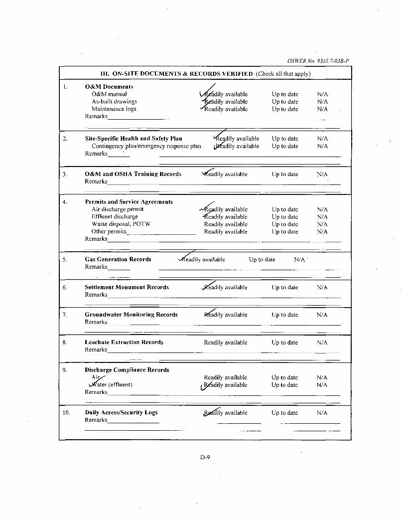
OSWER Nc . 9355.7-03B-P
III. ON-SITE DOCUMENTS & RECORDS VERIFIED (Check all that apply)
1.
2.
3.
4.
5.
6.
7.
8.
9.
10.
O&M Documents O&M manual As-built drawings Maintenance logs
Remarks
L/Re^dily available •^^Sdily available "T^eadily available
^ Site-Specific Health and Safety Plan 'lleadily available
Contingency plan/emergency response plan LPr^dily available Remarks
O&M and OSHA Training Records Remarks
Permits and Service Agreements Air discharge permit Effluent discharge Waste disposal, POTW Other permits
Remarks
N^adily available
-^•^Igadily available •l^eadily available Readily available Readily available
Up to date Up to date Up to date
Up to date Up to date
Up to date
Up to date Up to date Up to date Up to date
Gas Generation Records >.^adily available Up to date N/A Remarks
Settlement Monument Records Remarks
Groundwater Monitoring Records Remarks
Leachate Extraction Records Remarks
Discharge Compliance Records
vWater (effluent) Remarks
Daily Access/Security Logs Remarks
J?eadily available
Readily available
Readily available
Readily available fR^dily available
^^d^ly available
Up to date
Up to date
Up to date
Up to date Up to date
Up to date
N/A. N/A N/A
N/A N/A
N/A
N/A N/A N/A N/A
N/A
N/A
N/A
N/A N/A
N/A
D-9

OSIVER No. 9355.7-03B-P
IV. O&M COSTS
1. O&M Organization State in-house Contractor for State PRP in-house vP^tractor for PRP Federal Facility in-house Contractor for Federal Facility Other
O&M Cost Records Readily available Up to date Funding mechanism/agreement in place
Original O&M cost estimate Breakdown attached
Total annual cost by year for review period if available
From
From
From
From
From
Date
Date
Date
Date
Date
_ T o _
_ T o
_ T o _
_ T o _
_ T o
Date
Date
Date
Date
Date
Total cost
Total cost
Total cost
Total cost
Total cost
Breakdown attached
Breakdown attached
Breakdown attached
Breakdown attached
Breakdown attached
Unanticipated or Unusually High O&M Costs During Review Period Describe costs and reasons:
V. ACCESS AND INSTITUTIONAL CONTROLS tApplicable N/A cJf^Wci
A. Fencing
1. Fencing damaged ^ ^ Location shown on site map Gates secured N/A Remarks f-ey\AjC t TJ C J ^ Q ^ J I
B. Other Access Restrictions
I. Signs and other security measures Location shown on site map N/A
Remarks S'r<CU^,$ j ^ / ? / / - < / ^ •
D-IO

C.
1.
2.
D.
1.
2.
3.
Institutional Controls (ICs)
Implementation and enforcement Site conditions imply ICs not properly implemented Yes Site conditions imply ICs not being fiilly enforced Yes
Type of monitoring (e.^., self-reporting, drive by) Frequency Responsible party/agency Contact
Name Title Date
Reporting is up-to-date Yes Reports are verified by the lead agency Yes
Specific requirements in deed or decision documents have been met Yes Violations have been reported Yes Other problems or suggestions: Report attached
: ^
Adequacy JjCs are adecwate '\>C^are inadequate, Remarks lAI Ai l ^ y ^ ^ f A i ^ C\A.f ^ . C 4 ^
/ 1
ir tcorJ-iJ ' General
OSWER No. 9355.7-03B-P
No No
No No
No No
la^--
Vandalism/trespassing Location shown on site map ^^kWandalism evident Remarks
Land use changes on site j ^ / k Remarks
Land use changes off site ..W/A Remarks
N/A N/A
Phone no.
N/A N/A
N/A N/A
N/A
VI. G ^ f E R A L SITE CONDITIONS
A.
1.
Roads Applicable \J^ls .
Roads damaged Location shown on site map Roads adequate Remarks
^ k
D-11

OSWER No. -9355.7-03B-P
B.
A.
1.
2.
3.
4.
5.
6.
7.
Otli er Site Conditions
Rpmark-';
VII.
Landfill Surface
Settlement (Low spots) Areal extent
Remarks
Cracks Lengths
Remarks
Erosion Areal extent Remarks
Holes Areal extent Remarks
Vegetative Cover Trees/Shrubs (indicate
Remarks
Alternative Cover (arm Remarks
Bulges Areal extent Remarks
LANDFILL COVERS Applicable (^
Location shown on site map Depth
Location shown on site map Widths Depths
Location shown on site map Depth
Location shown on site map Depth
^ ^
^
Settlement not evident
Cracking not evident
Erosion not evident
Holes not evident
Grass Cover properly established No signs of stress size and locations on a diagram)
ored rock, concrete, etc.) N/A
Location shown on site map Height
Bulges not evident
D-12

OSWER No. 9355.7-03B-P
8.
9.
B.
1.
2.
3.
C.
1.
2.
J .
Wet AreasAVater Damage tAVet areas/water damage not evident Wet areas Location shown on site map Areal extent Ponding Location shown on site map Areal extent Seeps Location shown oil site map Areal extent Soft subgrade Location shown on site map Areal extent
Remarks
Slope Instability Slides Location shown on site map t_>kfevidence of slope instability Areal extent Remarks
^ „ - - ^
Benches Applicable W A (Horizontally constructed mounds of earth placed across a steep landfill side slope to interrupt the slope in order to slow down the velocity of surface runoff and intercept and convey the runoff to a lined channel.)
Flows Bypass Bench Location shown on site map N/A or okay Remarks
Bench Breached Location shown on site map N/A or okay Remarks
Bench Overtopped Location shown on site map N/A or okay Remarks ^
Letdown Channels Applicable L/'R/A (Channel lined with erosion control mats, riprap, grout bags, or gabions that descend down the steep side slope ofthe cover and will allow the runoff water collected by the benches to move off of the landfill cover without creating erosion gullies.)
Settlement Location shown on site map No evidence of settlement Areal extent Depth Remarks
Material Degradation Location shown on site map No evidence of degradation Material type Areal extent Remarks
Erosion Location shown on site map No evidence of erosion Areal extent Depth Remarks
D-13

OSWER No. 9355.7-03B-P
4.
5.
6.
D.
I.
2.
3.
4.
5.
Undercutting Location shov Areal extent Depth Remarks
Obstructions Type Location shown on site map
Size Remarks
Excessive Vegetative Growth No evidence of excessive growth Vegetation in channels does not obstruct Location shown on site map
Remarks
Cover Penetrations Applicable >J«fA
Gas Vents Active Properly secured/locked Functioning Evidence of leakage at penetration N/A
Remarks
Gas Monitoring Probes Properly secured/locked Functioning Evidence of leakage at penetration
Remarks
Monitoring Wells (within surface area of 1 Properly secured/locked Functioning Evidence of leakage at penetration
Remarks
Leachate Extraction Wells Properly secured/locked Functioning Evidence of leakage at penetration
Remarks
k'n on site map No evidence of undercutting
No obstructions Areal extent
Type
flow Areal extent
y
Passive Routinely sampled Good condition
Needs Maintenance
Routinely sampled Good condition Needs Maintenance N/A
indfill) Routinely sampled Good condition
Needs Maintenance N/A
Routinely sampled Good condition Needs Maintenance N/A
Settlement Monuments Located Routinely surveyed N/A Remarks
D-14

E.
I.
2.
3.
F.
I.
2.
G.
1.
2.
3.
4.
Gas Collection and Treatment Applicable V.
Gas Treatment Facilities Flaring Thermal destruction Good condition Needs Maintenance
Remarks
Gas Collection Wells, Manifolds and Piping Good condition Needs Maintenance
Remarks
- ^ I T A
_ / OSWER No. 9355.7-03B-P
Collection for reuse
Gas Monitoring Facilities (e.g., gas monitoring of adjacent homes or buildings) Good condition Needs Maintenance N/A
Remarks
Cover Drainage Layer Applicable
Outlet Pipes Inspected Functioning Remarks
Outlet Rock Inspected Functioning Remarks
Detention/Sedimentation Ponds Applicable
Siltation Areal extent Depth Siltation not evident
Remarks
Erosion Areal extent Depth Erosion not evident
Remarks
Outlet Works Functioning N/A Remarks
Dam Functioning N/A Remarks
y UiJf%
N/A
N/A
^
V < M
N/A
D-I5

OSWER No. 9355.7-03B-P
H.
1.
2.
I.
1.
2.
"1
J .
4.
1.
2.
Retaining Walls Applicable o * ^
Deformations Location shown on site map Horizontal displacement Vertical displac Rotational displacement Remarks
^
Degradation Location shown on site map Remarks
^
Deformation not evident .ement
^
^•©^gradation not evident
Perimeter Ditches/Off-Site Discharge W^pplicable ,N/A
Siltation Location shown on site map SiMation Areal extent Depth Remarks
Vegetative Growth Location shown on site map Vegetation does not impede flow
Areal extent Type Remarks
Erosion Location shown on site map Areal extent Depth Remarks
Discharge Structure U#tinctioning N/A Remarks
V i n . VERTICAL BARRIER WALLS
Settlement Location shown on site map Areal extent Depth Remarks
Performance MonitoringType of monitoring I j aS . ^ Performance not monitored .
Frequency / \ / ^ S ) f ^ m h j Evi( Head differential " ' Remarks
not evident
J / K
.^fosion not evident
_
•x'fpplicable N/A
Settlement not evident
ience of breaching
D-16

OSWER No. 935S-.7-03B-P ER No. 9 3 ^ .
1 J ^ IX. GROUNDWATER/SURFACE WATER REMEDIES \ ^ l i c a b l e
A. Groundwater Extraction Wells, Pumps, and Pipelines Applicable N/A
1. P u n j ^ , Wellhead Plumbing, and Electrical ^ o o d condition All required wells properly operating Needs Maintenance N/A
Remarks
E x t r a ^ o n System Pipelines, Valves, Valve Boxes, and Other Appurtenances ( J ^ o d condifion Needs Maintenance
Remarks
3. Sparp^ar ts and Equipment ^R^adily available Good condition Requires upgrade Needs to be provided
Remarks
j . fppTicab B. Surface Water Collection Structures, Pumps, and Pipelines j^^'fpplicable N/A
1. Collectkrti Structures, Pumps, and Electrical .^3ood condition Needs Maintenance
Remarks
Surface Water Collection System Pipelines, Valves, Valve Boxes, and Other Appurtenances (.G/rfod condition Needs Maintenance
Remarks
3. Sparp'I'arts and Equipment ^_^^adily available Good condition Requires upgrade Needs to be provided Remarks
D-17

OSWER No. 9355.7-03B-P
VAp^ici C. Treatment System icable N/A
1. Treatment Train (Check components that apply) Metals removal ^^^fl/water separation
(^^PffTstripping fJSi^on adsorbers J^ftters
Bioremediation
Additive {e.g., chelation agent, flocculent)_ Othe ?ood condition Needs Maintenance
Sampling ports properly marked and fiinctional Sampling/maintenance log displayed and up to date Equipment properly identified Quantity of groundwater treated annually Quantity of surface water treated annually_
Remarks
2. Electrical Enclosures apdlPanels (properly rated and functional) N/A \J8mod condition Needs Maintenance
Remarks
3. Tanks, Vaults, StorageVeSsels N/A , GtJod condition
Remarks Proper secondary containment Needs Maintenance
Discharge Structure and^A^urtenances N/A f^0(5d condition Needs Maintenance
Remarks
Treatment Building(sL N/A ..>0ood condition (esp. roof and doorways) Chemicals and equipment properly stored
Remarks
Needs repair
Monitoring Wells (pump and treatment remedy) Properly secured/locked Functioning cRtJijtinely sampled All required wells located Needs Maintenance
Remarks
Good condition N/A
D. Monitoring Data
1. Monitoring Da Is routinely submitted on time Is of acceptable quality
Monitorjpf data suggests: ^ ^ ^ ^ ^ ^Gutmndwater plume is effectively contained (_p>Hmninant concentrations are declining
D-18

OSWER No. 9355 7-03B-P
D. Monitored Natural Attenuation
Monitoring Wells (natural attenuati<5n remedy) (£j;0{5erly secured/locked Fjxictioning giatftinely sampled All required wells located Needs Maintenance
Remarks
3od condition N/A
X. OTHER REMEDIES
If there are remedies applied at the site which are not covered above, attach an inspection sheet describing the physical nature and condition of any facility associated with the remedy. An example would be soil vapor extraction.
XL OVERALL OBSERVATIONS
A. Implementation ofthe Remedy
Describe issues and observations relating to whether the remedy is effecfive and fijnctioning as designed. Begin with a brief statement of what the remedy is to accomplish (i.e., to contain contaminant plume, minimize infiltration and gas emission, etc.).
B. Adequacy of O&M
Describe issues and observations related to the implementation and scope of O&M procedures. In particular, discuss their relationship to the current and long-term protectiveness ofthe remedy.
D-I9

OSWER No. 9355.7-03B-P
Early Indicators of Potential Remedy Problems
Describe issues and observations such as unexpected changes in the cost or scope of O&M or a high frequency of unscheduled repairs, that suggest that the protectiveness ofthe remedy may be compromised in the fiiture.
D. Opportunities for Optimization
Describe possible opportunities for optimization in monitoring tasks or the operation ofthe remedy.
D-20

Attachment 5
Environmental Covenant for Property South of Jeans Road

• • i^ iP^ ' - \^ : . : - f^^J^ :
FRED BUCHOLZ DUPAGE COUNTY RECORDER
FEB.14,2014 RHSP 8:52 AM OTHER 10-11-402-010 032 PAGES R2014-013119
This instrument was prepared by:
Name: Shell J. Bleiweiss Address: I S . Dearborn St. Suite 2100
Chicago, EL 60603-2307
Please return this instrument to:
Name: / ^ Shell J. Bleiweiss Address: / I S . Dearborn St. Suite 2100
Chicago, IL 60603-2307
ENVIRONMENTAL COVENANT
1. This Environmental Covenant is made this mB day of j j j i ^ 2013, by and among Peter Tamehng Trust (Grantor) and the Holder/Grantee further identified in paragraph 3 below pursuant to the Uniform Environmental Covenants Act, 765 PLCS Ch. 122 (UECA) for the purpose of subjecting the Property to the activity and use limitations described herein.
2. Property and Grantor.
A. Property: The real property subject to this Environmental Covenant is located at Route 83 and Jeans Rd, Lemont, DuPage County, Illinois 60439 and is legally described in Appendix A, hereinafter referred to as the "Property". The Property is part of a larger parcel known as the Lenz Oil Superfund Site.
B. Grantor: Peter Tameling Trust is the "Grantor" of this Enviromnental Covenant. The mailing address ofthe Grantor is June Tameling, Administrator, 7475 Madison St., Unit 1, Willowbrook, IL 60527.
3. Holder (and Grantee for purposes of indexing). Illinois EPA and the Setthng Work Defendants (as defined herein, paragraph 5. B.) are the Holders (and Grantees for purposes of indexing) of this Environmental Covenant pursuant to its authority under Section 3(b) of UECA. The mailing address ofthe IlUnois EPA is 1021 N. Grand Avenue East, P.O. Box 19276, Springfield, IL 62794-9276. The mailing
1

address ofthe Settling Work Defendants is c/o Alan Bielawski, Sidley Austin, One S. Dearborn St, Chicago, IL 60603.
4. Agencies. The Ilhnois EPA and the U.S. EPA are "Agencies" within the meaning of Section 2(2) of UECA. The Agencies have approved the environmental response project described in paragraph 5 below and may enforce this Enviromnental Covenant pursuant to Section 11 of UECA.
5. Environmental Response Project and Administrative Record.
A. This Environmental Covenant arises under an environmental response project as defined in Section 2(5) of UECA.
B. The Property is part ofthe Lenz Oil Superfimd Site, which the U.S. EPA, pxirsuant to Section 105 ofthe Comprehensive Environmental Response, Compensation and Liability Act ("CERCLA"), 42 U.S.C. § 9605, placed on the National Priorities List, set forth at 40 C.F.R. Part 300, Appendix B. in a Record of Decision (ROD) signed by the U.S. EPA Region 5 Superfund Division Director on September 30, 1999, the U.S. EPA approved a plan for environmental remediation ofthe Site. In the Consent Decree signed on August 14, 2002, United States of America and the State of Illinois v. Alpha Construction, et a l , Case No. 02 C 3609 (N.D. 111.), Settling Work Defendants, as defined in the Consent Decree at p. 14 and listed in Appendix D.l to the Consent Decree agreed to implement the remedial action plan in the ROD including the excavation ofthe principal threat area, the treatment of the contaminated material via sohdification/stabilization (S/S), the disposal ofthe treated material within a corrective action management unit (CAMU), and the implementation of a pump-and-treat system for contaminants that remain in the aquifer after the other actions are completed. In April 2007, the U.S. EPA issued an Explanation of Significant Differences (ESD) that changed the Phase I remedy alternative fi:om excavation and treatment via solidification/stabilization to Vacuum Enhanced Recovery (VER). In April 2008, the U.S. EPA approved the Remedial Design. On November 19, 2010, the U.S. EPA approved the Phase I Remedial Action Construction Completion Report. The remedial action plan requires implementation and compliance with land and groundwater activity and use limitations at the Lenz Oil Site. The Consent Decree also provides that U.S. EPA may require additional response activity, including changing the remedy, under certain Umited circumstances.
C. Grantor wishes to cooperate fully with the Agencies by granting the required environmental covenants at the Site.
D. The Administrative Record for the environmental response project at the Lenz Oil Site (including the Property) is maintained at the U.S. EPA Superfund Record Center, 7th Floor, 77 West Jackson Blvd, Chicago, Illinois 60604. Persons may also contact the Freedom of Information Act ("FOIA") officer, Illinois EPA, 1021 N. Grand Avenue East, P.O. Box 19276, Springfield, IL 62794-9276 or Lemont Village Hall, 508

Lemont Street, Lemont, IL 60439 for the Administrative Record or other information concerning the Site.
6. Grant of Covenant. Covenant Runs With The Land. Grantor creates this Environmental Covenant pursuant to UECA so that the Activity and Use Limitations and associated terms and conditions set forth herein shall "run with the land" in accordance with Section 5(a) of UECA and shall be binding on Grantor, its heirs, successors and assigns, and on all present and subsequent owners, occupants, lessees or other person acquiring an interest in the Property.
7.--- -- -Activity and Use=:LimitatiottS7r— The-feHow4ngrA tivi;fy^and UseiimitatiaBS^ apply to the use ofthe Property:
A. The Property shall not be used in any manner that would interfere with or adversely affect the integrity or protectiveness ofthe remedial action which has been implemented or which will be implemented pursuant to the Consent Decree unless the written consent of U.S. EPA to such use is first obtained. The restrictions on the Property shall include, but are not limited to, not allowing any drilling, digging, building, or the
. installation, construction, removal or use of any buildings, wells, pipes, roads, ditches or any other structures on the Property unless the written consent of U.S. EPA to such use or activity is first obtained.
B. There shall be no excavating for landscaping, construction or other activities which removes soil from any portion ofthe Property unless the written consent of U.S. EPA to such use or activity is first obtained.
C. Construction of wells and activities that extract, consume, or otherwise use any groundwater are prohibited on the Property.
D. Notwithstanding the above, implementation ofthe Work as defmed in the Consent Decree shall be permitted and shall not require any further consent of U.S. EPA. Use and maintenance of buildings and equipment present as ofthe effective date of this Environmental Covenant also shall be permitted and shall not require any further consent of U.S. EPA.
8. Access to the Property. Grantor agrees that U.S. EPA, the Illinois EPA and the Settling Work Defendants, their successors and assigns, and their respective officers, employees, agents contractors, and other invitees (collectively, "Access Grantees") shall have and hereby grants to each of them an unrestricted right of access to the Property to undertake the Permitted Uses described in Paragraph 9 below and, in connection therewith, to use all roads, drives and paths, paved or unpaved, located on the Property. The right of access granted under this Paragraph 8 shall be irrevocable while this Covenant remains in full force and effect.

9. Permitted Uses. The right of access granted under Paragraph 8 of this Environmental Covenant shall provide Access Grantees with access at all reasonable times to the Property, for the purposes of conducting any activity related to the Consent Decree ofthe purchase ofthe Property, including but not limited to, the following activities:
A. Implementing, operating and maintaining the Work pursuant to the Consent Decree;
B. Monitoring the Work;
C. Conducting investigations relating to contamination at or near the Property, including, but not limited to, the surface or subsurface erection or placement of physical or mechanical objects necessary to those investigations;
D. Obtaining samples;
E. Assessing the need for, planning, or implementing additional response actions at or near the Property;
F. Verifying any data or information submitted to U.S. EPA or Illinois EPA;
G. Inspecting and copying records, operating logs, contracts, or other documents maintained or generated by Settling Work Defendants or their agents, consistent with Section XXVIII (Access to Information) ofthe Consent Decree;
H. Verifying, assessing, monitoring, implementing and enforcing the Activity and Use Restrictions set forth in Paragraph 7;
I. Assessing Settling Work Defendants' compliance with the Consent Decree; and
J. Verifying that no action is being taken on the Property in violation ofthe terms of this instrument, the Work pursuant to the Consent Decree or of any federal or state environmental laws or regulations.
Nothing in this document shall limit or otherwise affect U.S. EPA and Illinois EPA's rights of entiy and access or U.S. EPA's and Illinois EPA's authority to take response actions under CERCLA, the National Contingency Plan ("NCP"), RCRA or other federal and state law.
10. Reserved rights of Grantor: Grantor hereby reserves unto itself, its successors, and assigns, including heirs, lessees and occupants, all rights and privileges in and to the

use ofthe Property which are not incompatible with the activity and use limitations identified herein.
11. No Public Access and Use: No right of access or use by the general public to any portion of the Property is conveyed by this instrument.
12. Future Conveyances., Notice and Reservation:
A. Grantor agrees to include in any future instrument conveying any interest in any portion ofthe Property, including but not limited to deeds, leases and mortgages, a notice and renerv^ation which is in substantially the following form: —
THE INTEREST CONVEYED HEREBY IS SUBJECT TO AND GRANTOR SPECIFICALLY RESERVES THE ENVIRONMENTAL COVENANT EXECUTED UNDER THE UNIFORM ENVIRONMENTAL COVENANTS ACT (UECA) AT 765 ILCS CH. 122 RECORDED IN THE OFFICIAL PROPERTY RECORDS OF DUPAGE COUNTY, ILLINOIS ON AS DOCUMENT NO. , IN FAVOR OF AND ENFORCEABLE BY THE ILLINOIS EIWIRONMENTAL PROTECTION AGENCY AS A UECA HOLDER AND THE U.S. ENVIRONMENTAL PROTECTION AGENCY AS A UECA AGENCY.
B. Grantor agrees to provide written notice to IlUnois EPA and U.S. EPA within 30 days after any conveyance of fee title to the Property or any portion ofthe Property. The notice shall identify the name and contact information ofthe new Ov Tier, and the portion ofthe Property conveyed to that Owner.
13. Enforcement and Compliance.
A. Civil Action for Injunction or Equitable Relief. This Environmental Covenant may be enforced through a civil action for injunctive or other equitable relief for any violation of any term or condition of this Environmental Covenant, including violation ofthe Activity and Use Limitations under Paragraph 7 and denial of Right of Access under Paragraph 8. Such an action may be brought individually or jointly by:
i. Settling Work Defendants; ii. the Illinois Environmental Protection Agency; iii. U.S. Environmental Protection Agency; and iv. Peter Tameling Trust.
B. Other Authorities Not Affected. No Waiver of Enforcement. All remedies available hereunder shall be in addition to any and all other remedies at law or in equity, including CERCLA. Nothing in this Environmental Covenant affects U.S. EPA or Illinois EPA's authority to take or require performance of response actions to address releases or threatened releases of hazardous substances or pollutants or contaminants at or from the Property, or to enforce a consent order, consent decree or other settlement

agreement entered into by U.S. EPA or Illinois EPA. Enforcement ofthe terms of this instrument shall be at the discretion of the Holders, the Settling Work Defendants, the U.S. EPA and Illinois EPA and any forbearance, delay or omission to exercise its rights under this instilment in the event of a breach of any term of this instrument shall not be deemed to be a waiver by tiie Holders, the Setthng Work Defendants, U.S. EPA or Illinois EPA of such term or of any subsequent breach ofthe same or any other term, or of any ofthe rights of tiie Holders, the Seti;ling Work Defendants, U.S. EPA or Illinois EPA of such term or of any subsequent breach ofthe same or any other term, or of any of the rights ofthe Holders, the Settling Work Defendants, U.S. EPA or Illinois EPA.
Former Owners AndTn^rcst Holders Subject to Enforcement. An Owner, or other person that holds any right, title or interest in or to the Property remains subject to enforcement with respect to any violation of this Environmental Covenant by the Owner or other person which occurred during the time when the Owner or other person was boimd by this Environmental Covenant regardless of whether the Ovraer or other person has subsequently conveyed the fee title, or other right, title or interest, to another person.
14. Waiver of certain defenses: This Environmental Covenant may not be extinguished, limited, or impaired through issuance of a tax deed, foreclosure of a tax hen, or apphcation ofthe doctrine of adverse possession, prescription, abandonment, waiver, lack of enforcement, or acquiescence, or similar doctrine as set forth in Section 9 ofUECA.
15. Representations and Warranties: Grantor hereby represents and warrants to the Illinois EPA, U.S. EPA and any otiier signatories to this Environmental Covenant that, at the time of execution of this Environmental Covenant, that the Grantor has a good and lawful right and power to grant this Environmental Covenant, that the Property is firee and clear of encumbrances, except those noted on Appendix C attached hereto, and that the Grantor will forever warrant and defend the title thereto and the quiet possession thereof After recording this instrument, Settling Work Defendants will provide a copy of this Environmental Covenant to all holders of record ofthe encvunbrances including those entities noted on Appendix C.
16. Amendment or Termination. This Environmental Covenant may be amended or terminated by consent only if the amendment or termination is signed by the Illinois EPA, U.S. EPA and the current owner ofthe fee simple ofthe Property or the Receiver, unless waived by the Agencies.
17. Notices: Any notice, demand, request, consent, approval, or communication that either party desires or is required to give to the other shall be in writing and shall either be served personally or sent by first class mail, postage prepaid, addressed as follows:

To Grantor: _
Peter Tameling Trust c/o June Tameling, Administrator 7575 Madison St. Unit 1 Willowbrook, IL 60527
To Holder:
Settling Work Defendants, c/o Alan Bielawski -gidley Au^nr^ae^giJtcarbea^ - — Chicago, IL 60603
To Agencies:
U.S. Environmental Protection Agency Superfund Division Director 77 West Jackson Boulevard Chicago, IL 60604
IlUnois Environmental Protection Agency Chief, Bureau of Land 1021 N. Grand Avenue East P.O. Box 19276 Springfield, IL 62794-9276
18. Recording and Notice of Environmental Covenant. Amendments and Termination.
A. The Original Environmental Covenant. An Environmental Covenant must be recorded in the Office ofthe Recorder or Registrar of Titles ofthe county in which the property that is the subject ofthe Environmental Covenant is located. Within 30 days after the Illinois EPA and U.S. EPA (whichever is later) sign and deliver to Grantor this Environmental Covenant, the Grantor shall record this Environmental Covenant in the office ofthe Recorder of Deeds of DuPage County, State of IlUnois.
B. Termination, Amendment or Modification. Within 30 days after Ilhnois EPA and U.S. EPA (whichever is later) sign and deliver to Owner or Receiver/Grantor any termination, amendment or modification of this Environmental Covenant, the Owner or Receiver/Grantor shall record the amendment, modification, or notice of termination of this Environmental Covenant in the office ofthe County Recorder or Registi-ar of Titles in which the Property is located.
C. Providing Notice of Covenant, Termination, Amendment or Modification. Within 30 days after recording this Environmental Covenant, the Settling Work Defendants shall transmit a copy ofthe Environmental Covenant in recorded form to:
i. the Illinois EPA; ii. tiie U.S. EPA; iii. each person holding a recorded interest in the Property,
including those interests in Appendix C; iv. each person in possession of the Property; and
—V-. Gach-pQlitical::::sidjdivisionin-which-therErQp.ei!tyrisrlQe:atedT:
Within 30 days after recording a termination, amendment or modification of this Environmental Covenant, the Owner or Settling Work Defendants shall transmit a copy ofthe document in recorded form to the persons listed in items i to v above.
19. General Provisions:
A. Controlling law: This Environmental Covenant shall be construed according to and governed by the laws ofthe State of Illinois and the United States of America.
B. Liberal construction: Any general rule of construction to the contrary notwitiistanding, this instrument shall be liberally construed-in favor ofthe Grantor or Holders to affect the purpose of this instrument and the policy and purpose of the environmental response project and its authorizing legislation. If any provision of this insti-ument is found to be ambiguous, an interpretation consistent with the purpose of this instrument that would render the provision valid shall be favored over any interpretation that would render it invalid.
C. No Forfeiture: Nothing contained herein will result in a forfeiture or reversion of Grantor's title in any respect.
D. Joint Obligation: If there are two or more parties identified as Grantor herein, the obligations imposed by this instrument upon them shall be joint and several.
E. Captions: The captions in this instrument have been inserted solely for convenience of reference and are not a part of this instrument and shall have no effect upon construction or interpretation.
20. Effective Date. This Environmental Covenant is effective on the date of acknowledgement ofthe signature of tiie Ilhnois EPA and U.S. EPA, whichever is later.
21. List of Appendices:
Appendix A - Legal Description and Map of the Property
8

Appendix B - Location of Monitoring Wells Appendix C - List of Recorded Encumbrances
[Signature Pages to follow]

[THE UNDERSIGNED REPRESENTATIVE OF THE GRANTOR REPRESENTS AND CERTIFIES THAT HE/SHE IS AUTHORIZED TO EXECUTE THIS ENVIRONMENTAL COVENANT.]
IN WTTNESS WHEREOF, THIS INSTRUMENT HAS BEEN EXECUTED ON THE DATES INDICATED BELOW:
FOR THE GRANTOR:
Peter
^
Tameling Trus t s p
June Tameling_
-(signature) •
(print)
[Title] _Adniimstrator_ (print)
State of IlUnois
County o f ' { l i t e l )
) )SS.
On /A-yyC I ' j , 2013, this instrument was acknowledged before me by, , [use following when Grantor is an organization] [Title of Name of
Grantor, on behalf of Grantor]^
Notary Public My Commission Expires
(signature)
10
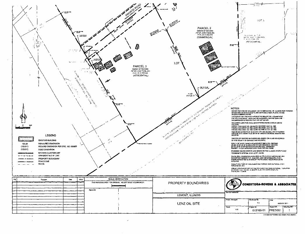
PARCEL 2 OWNER OF RECORD:
PETER JOHN TAMELrNG P.I.N. 10-1M02'010
(COMMERICIAL)
120.37 (123,3 V) (123.511
EXISTING eUlLDINS
MEASURED DIMENSION
RECORD DIMENSION PER DOC. NO. 606565
DEED DIMENSION
SECTION QUARTER LINE APPARENT R.O.W. LINE
PROPERTY aOUNORY FENCE LINE RIVER
PARCEL 3 OWMER OF RECORD:
PETER JOHN TAMELING PP.N. IO-tl-402-009
(RESIDENTIAL)
NOTES; SURVEY PREPARED BY tlOLLINOER, U^CH k A&BOCMTeS. iNC ILLINOIB PROPf ESSlOHU OESION FRM 19tO01» AUOUST B. 200^ HETH BOLUNOCR. IPLS NO. 33-Ufi2 WVLEE3 OTHEfWnSE NOTED. i m a SURVEY WAS PREPARED WfTWOUT THE aEWERT Of A COWUJTMffMT FORT1Tl.eiN3URUJCE.TKEREUAYB£EAffEMENTe.R£B'miCnoNSAND ' ENCUMBRANCEfl OF RECXIRO THAT ARE NQfT SHOWN.
DOCUMENTS USED FOR LEGAL OESCAf>TlON9 SHOViN HEREON ARE AS FOLLOWS: PARCEL 1 DOCUUENT NO. RAMOZiU. RECOROEO hUY 33, 1B» PARCei. 2 DOCUUENT HO. R0»-1SO»3. RECORDED JLfl.Y IS. 1090 PARCEL 1OOCUMENT RO. RSa-IGOlBO. RECORDEQ JULY IB, (BSS DMENStOHS SHOWN THUS' Sa.}S'ARE FEET AND OECtUAL PARTS THEREOF. AN0U1>R DATA SHOWN THUS: GO" M' 00' INDICATE DEOREES, MlNl/rE3 AND SECGNOa.
OWNERS OF RECORD AS SHOWN ARE aASED ON A LIMITED SEARCH OF THE COUNTY OF DUPAOE TAX RECORDS.
Sa.tS V K a r OCT OCT E MOICATES MEASURED OUitERSIOR / BEARINO. [G0.2&) f {H SO' OCT 00' E] INOIOATES RECORD OlMEHSIOH / BEARING. S0.IS1 J {N H* 07 00- E] MDICATES RECORD CAU DIMENSION / BEARING IN0EEDDOCUMENT3REI&-t»»3ANbRBS-iSa3M
BEARINQS SHOV/N HEREON ARE BASED ON THE ILLINOIS STATH PLANE
COORDINATE SYSTEM, EAST ZONE, NAD83
CHECK LEGAL OESCRPTION WFTN DEED OR TTTLE PDUCY AND REPORT ANY DISCREPANCY BMEDUTELY. BUILfllHO LINES AND ^ASEUENrS. IF ANY. EHO'AiN HEREON ARE AS SHOWN ON THE RECORDED SUBDMSION OR AS INDICATED.
ASBUILT LOCATION OF VER SVSrEU TREATMENT BUlLOlNQ ON PARCEL 1 SURVEYED BV BRYAN J LEE. IPLS NO 3S'3Bie RE ALLEN ANO ASeoClATE9 LTD. GRAVSIAXE. ILUNOIS.
SCALE VERIFICATION
THIS QAR MEASURES 1' ON ORIGINAL. ADJUST SCALE ACCOflOlNCLY. PROPERTY BOUNDARIES
LEMONT, ILLINOIS
LENZ OIL SITE
CONESTOQA-ROVeilS A A980CIATB8
Soiirca RalDrencc:
Projaci N»:
015169-01
AUGUST 2 0 n
RapofI N l .
PRES001 D r a w ^ N l :
1
G15I69-01(PRES001K^N-OE001 AUG 03/2011

FOR THE ILLINOIS ENVIRONMENTAL PROTECTION AGENCY
(signature) / A n y v i j f j ^ ^
/ - I S ^ S o n / l t g ' t t ' Director Illinois Environmental Protection Agency
OFFICIAL SEAL SHERRIE A. ELZINGA
State of Illinois 't \ JTARY pi IBI ir, STATP OF ILLINOIS
County olQS/N'MMii, m
This instrument was acknowledged before me on ' /fTt^yjVV^ I ^ , 2013, by j^lSfL QOAt^cff' , the Director ofthe Illinois Environjlnental Protection Agency, a state agency, on behalf of the State of Illinois.
jQ 'nWiU p i - ^ - -yys igna ture) ^Notary Public ^ ^ j2./ / My Commission Expires / ^ ^ / 2 .^*^
11

FOR THE UNITED STATES ENVIRONMENTAL PROTECTION AGENCY
On behalf of the Administrator of the United States Environmental Protection Agency
/ 2 ^ c IC^ By: Richard C. Karl, Director Superfund Division U.S. En\aronmenta1 Protection Agenc)r, Region 5
STATE OF ILLINOIS
COUNTY OF COOK
) )SS. )
.'.A M. lOUIE lAL SEAL S'lieotnilnoU •>• ' • E » D i r e s
._^ The foregoing instrument was acknowledged before me this I ' day of L b c e H g p ^ ^ , 2013, by Richard C. Karl, Director, Superfund Division, Region 5 of the United States Envirormiental Protection Agency.
(signature) Notary Public My Commission Expires Y&CCQ (S^^DlM- •ERTANNAM. lOUIE
OFFICIAL SEAL NQtory Fubiic. Slot* ot Milnoli
My Commltslon ENP4IIM MoichlS, a O U '
• * * •
12

APPENDIX A: Legal Description and Map of the Property
The legal description ofthe Tameling Property is shown as Parcel 2 and Parcel 3 on the following map.
^
{/ ^ a ^ / Y . - ^ : ]
^ ' ^ ^ /
13

NOTHS: SURVEY PREPARED BY BOaiNOER, LACH1 ASSOCIATES. INC. LLMOtS PROFFESSIONAL 0E8I0N FIRM 1S4-O01» AUGUST S. 2007 KIETH BOLUNGER, (PLS NO U - U U UNLESS OTHERWISE NOTED. THIS SURVEY WAS PREPARED WTTMOUT THE BENEFIT OF A COMMITMElTr FOR TITLE INSURANCE T>«RE MAY BE EABEMENT3. RESTRlCTlOMa AND ENCUMBRANCES OF RECORD T>HAT ARE NOT SHOWN.
OOCUWenS USED FOR LEOAL DESCHiPnONS SHOWN HEREON ARE AS FOaOWS: PARCEL 1 DOCUUENT NO. RIHKMZIsa. RECORDED MAYSl, INO PARCEL 2 DOCUMENT NO. R08~15O3O3. RECORDED JULY 20. ISIB PARCEL 3 DOCUMENT NO. R9B-iea3aa. RECORDED JULY ZB, IBSfl
OlMENSlDNa SHOWN TNU5: tOSBTARE FEET ANO DECIMAL PARTS TfCREOF. ANGULAR DATA SHOWN T>US: BD* CCT OCT INOICATB DEGREES. IMNUIES W D SECONDS.
OWNERS OF RECORD AS SHOWN ARE BASED ON A LIMITED SEARCH OF THE COUNTY OF DUPAGE TAX RECORDS.
50.26 7 N KT oa 00' E INDICATES MEASURED DIMENSION I BE>ftWG. (SO 26-) / (N 00* 00^00' E) INDICATES RECORD OIUENEION /BEARING. [50.251 / (N BO- 00 00* E] INDICATES RECORD CALL DIMENSION I BEARING IN DEED DOCUMENTS R0ft-ISO3»3 AND RSB-1Sa290
BEARINGS SHOWN HEREON ARE BASED ON THE ILLINOIS STATE PLANE
COORDINATE SYSTEM. EAST ZONE, NADM
CHECK LEGAL DESCRIPTION WfTH DEED OR TTTLE POLICY AND REPORT ANY DISCREPANCY IMMEDIATELV. BUILOtNO LINES AND EASEUENrS. (F ANY. SHOVtN HEREON ARE AS SHOWN ON THE RECORDED SUBDIVISION OR AS INDICATED.
ASaUiLT LOCATIONS OF TOOL SHEDS ANO STORAGE BINS ON PARCEL 2 NOT SURVEYED BVIPLS .
ASSUILT LOCATION OF VER SYSTEM TREATMENT BUILDING ON PARCEL 1 SURVEYED BV BRYAN J. LEE. IPLS NO. lS-3ai6 R£ ALLEN AND ASSOCMIE^ LTD GRAYSLAKE. ILUNOIS.
SCALE VERIFICATION
THIB BAR MEASURES 1* ON ORIGINAL ADJUST SCALE ACCORDINGLY. PROPERTY BOUNDARIES
LEMONT, ILLINOIS
LENZ OIL SITE
CONE8T0QA-ROVER8 ft ASSOCIATES
Sfxirca Rafaranca:
015169-01 RaponW:
PRES001 brawingNl:
1
Ot5169-Ol(PRESOOl1GN-DE001 AUG 03/2011

PARCEL 1 THAT PART OF THE SOUIWEAST QUARTER OF SECTION I I , TOWNSHIP 37 NORTH RANGE 11, EAST OF THE THRO PRINCIPAL MERIDIAN, DESCRIBED BV COMMENCING AT THE CENTER OF SMD SECTION 11 AND RUNNING THENCE NORTH B9 DEGREES 27 MINUTES EAST M.OH0 THE NORTH LINE OF SAID SOUTHEAST QUAHTeR. 79* J FEET TO THE SOUTHEASTERLY RtGKT-OP-WAY LINE OF THE ATCHISON. TOPFKA AND SANTA FE RAILROAD. AB VflOENED, FOR A PLACE OF BEGINNING: THENCE CDNTINUIMG NORTH S0 DEGREES 27 MINUTES EAfiT ALONG SAID NORTH LINE OF THE SOUTHEAST QUARTER ^0t.^ FEET TO THE WEST UKE OF LOT 61 OF THE ASSESSMENT DIVISION OF THE SOUTH HALF OF SECTION 1 AND 2 ANO AU OF SECTIONS 11 AND U. LYING NORTH OF THE NORTH LINE OF THE SANrAHY DISTRICT OF CHICAGO, faWOIft THENCE SOUTH ALONG SAD WEST LNE, 467.75 FEET TO THE CENTER LINE OF A PRIVATE ROAD; THENCE BDITTH G] OEOREES 10 MINUTES WEST ALONO 8*10 CENTER UHE, tUJS FEET TO THE EASTERLY LINE OF THE SIGHT^F-WAY OF BTATE HIGHWAY ROUTE B3 ( ^ORMERLY 04); THENCE NORTHWESTERLY ALONO SAID UNE, 313A9 FEET TO THE SOUTHEASTERLY fUGHT-OF-WAY UNE OF SAJD SANTA FB RAILROAO AS WIDENED; THENCE NORTH 45 DEGREES 2B MINUTES EAST ALONO BAID WIDENED RIOKT-OF-WAY LINE 1008.0 FEET TO THE PLACE OF BEQINNINQ, EXCEPT THAT PART LYING NORTHEASTERLY OF A LINE DRAWN NORTHWESTERLY AT RIGHT ANOLES TO THE SOUTHEASTERLY LINE OF THE ABOVE DESCRIIED PROPERTY FROM A POINT WHICH IS 2a2.0 FEET SOUTHWESTERLY (AS MEASURED ALONG SAM SOUTHEASTERLY LINE)OF THE SDLTTHEASr COHNEROF SAID ABOVE DESCRIBED PROPERTY. IN DUPAGE COUNTY, ILLINOIS.
PARCEL 2 THAT PART OF THE SOUTHEAST X OF SECTION 11. TOWNSHIP 37 NORTH RANGE 11. EAST OF THE THIRD PRINCIPAL MERIDIAN. DCSCRtBED AS FOLLOWS: COMMB4CtN0 ATTHE CENTER OF BfJD SECTION 11: THENCE NORTH Bl DEGREES 27 MINUTES EAST. ALONG THE NORTH LINE OF SAID BOUTHEAST14. A DISTANCE OF 871J FEET TO THE WEST UKE OF LOT Bl OF THE ASSESSMENT DIVISION OF THE SOUTH » OF SECTIONS 1 AND 2 AND ALL OF SECTIONS 11 AND 12 LYING NORTH OF THE NORTH UNE OF THE SANITARY DISTRICT OF CKtCACO: THENCE SOUTH 0 DEGREES 00 MINUTES 00 SECONDS EAST, ALONO SAID WEST LINE, 49XU FEET (DEED « SOUTH. 4S4.79 FEET^ TO THE CENTER LINE OF A PRIVATE ROAD AS SHOWN ON JACOB J. JEANS PLAT OF SURVEV RECORDED OCTOBER 7,1850 A3 DOCUMENT 50UU. AND THE POINT OF BEQINNINQ; THENCE COHTIHUlHa BOUTH 0 OEQREES 00 MINUTES 00 SECONDS EAST. ALOKQ SMD WEST LINE OFLOT 61. A DISTANCE OF S88.12 FEET [DEED "SOUTH 6B9.46FErn TO THE NORTHERLY UNE OF SAID PROPERTY OP THS SANITARY DISTRICT OF CHICAOO; THENCE SOUTH B7 DEGREES 01 MINUTES WEST, ALONG SMD NORTHERLY LINE, 2W.1S PEETi THENCE NORTH 34 DEGREES 66 MINUTES 33 SECONDS Y^ST 466.08 FEET TO BAIO CENTER LING OF A PRIVATE ROAD; TMENCG NORTH S3 DEGREES 21 MINUTES 13 SECONDS EAST (DEED > NORTH S3 DEGREES 2B MINUTES EAST), ALONO BAID CENTER LME. 466.30 FEET TO THE POINT OP BEGINNING. ALL IN DUPAOE COUNTY. ILLINOIS. X
PARCEL 3
THAT PART OF THE SOUTHEAST V. OF SECTION 11. TOWNSHIP 37 NORTH. RANGE 11, EAST OF THE THIRD PRINCIPAL MERIDIAN, DESCRIBED AS FOUOW9: COMMENaNO AT THE CENTER OF SAID SECTION 11; THENCE NORTH 19 DEGREES 27 MINUTES EAST. ALONG THE NORTH LINE OF SAJD SOUTHEAST K. A DISTANCE OF 871.3 FEET TO THE WESTLlNE OF LOT 6t OF THE ASSESSMENT DM310N OF THE SOUTH 'A OF SECTIONS 1 AND 2 ANO ALL OF SECTIONS 11 AND 12 LYING NORTH OF THE NORTH LINE OF THE BANfTARY DISTRICT OF CHICAGO: THENCE SOUTH 0 DEGREES 00 MINUTES 00 SECONDS EAffT. ALONG SAID WEST UNE, 1072 J6 FEET (DEED - SOUTH, 1074.20 FEET) TO THE NORTHERLY LINE OF SAID PHOPERTV OF THE SANITARY DISTRICT OF CHICAGO: THENCE SOUTH ST DEGREES 01 MINUTES WEST, ALONG SAID NORTHERLY LINE , 20e.1S FEET TO THE PQIHT OF BECWNIMQ; THENCE COHTtHUIMG SOUTH BT DEGREES 01 MINUTE WEST, ALONO iAJP NORTHEBLY LINE, 333.65 FEET TO T>C EASTERLY RIOHT-OF- WAY LINE OF STATE HIGHWAY ROUTE Bl (FORMERLY ROUTE M); THENCE NORTH n DECREES OS MINUTES 14 SECONDS WEST, ALONO SAID EASTERLY LINE.441.B4 FEET (DEED -441.00 FEET! TO THE CENTER LINE OF A PRIVATE ROAD AS SOWN ON JACO& J- JEAW3 PLAT OF SURVEY RECORDED OCTOBER 7. IHO AS DOCUMENT B0B5B5: THENCE NORTHUDEOREES 31 MINUTES 13&EC0NDS EAST (DEED-NORTH 63 DEGREES 2B MINUTES EAST), ALONG SAID CENTER LINE, 370.00 FEET; THENCE SOUTH 24 DEGREES SO MINUTES AND 33 SECONDS EAST 4BB.0B FEET TO THE POINT OF BEOINNINO, ALL IN DUPAOE COUNTY. lUINOIS.

APPENDIX B: Location of Monitoring Wells
Location of Monitoring Wells are shown on Parcels 2 and 3 ofthe following map.
14

'CIONITII 'MNHOD 30Vd/ia Nl TTV 'ONIWIOSS JO INIOd 3H1 O i 133d K t i t iSV3 SONOOaS CC ONV SIHINIH K SaaUOaO VS K U I O S JONSKL ' A 3 3 J 00'0/E *3Nn U3J.N33 OIVS ONOTV tlSVH S3lflNlW K 93311030 CS KLUON - 0330) J.eV3 SCNODas CI 83i/1NM IE S^HUOSG GS KLUON 33NaKl ^SSnoS .INiMnOOO SV
OKI U usaoiDO aaauoom AaAuns ijo jv id sjwar r soDvr NO MHOS ev ovoy siVAind v jo 3nn V3IN30 am. a i l isaj Dfvn • 0330)i33i yfl'itt'3NI1 J lu LEVH arve QNOTV'ISBMsoNooas n sauiNin so s33uo3a BE KIUON a9N3Hi'(n3inOUATU3miOd)C9 3i/XmAVMH01H31VXSJO SNnAVUdO-iHDIti ATU31SV3 3 H l O X U 3 d C 0 n t
"BNII AlUSRLtiON QIVB ONOTtf '163M iWNW tO 833^030 Z5 HLHOS ONIONLLNOD 30N3HL :DNlNNt03E JO INIOd 3KL Qj. i33d 9L'60E' 3NI1 A1U3HiUONGtVS QNOTV 'LB3M &3inNIV110S33U93Q iS HinOS30N3HL ^OOVDIHD dOlOIUiSIG AWVDNVS 3H1
JO AlH3dOVd a m J O 3 H t ATUSHiWN 3H10.L U33J OZHJDi 'HinOS - 0330) A33J OTUOl 'SNDIB3M OVB ONOIY '19V3 soNOoas 00 BEinNin DO B suDaa o KLHOS BONBHL ^OOVDIHD do iniuisia AUVUNVG BHI do BNIT HIUON BHJ. O
KUION ONIAT U ONV LL BN0U33S dO TTV ONV Z ONV L SNOliOBS M K KUIOG 3KL dO NOIGIAIG lN3WSe3ESV 3Hi iO IS iOT dO 3Nn IS3M 3Hi 01133d IVtS dO 30NVJL8ta V 'K ISVaunOS QlVfi dO 3NI1 HluON 3Hi ONO~V '1SV3 S3J/1Nin IZ S33UD3a'B9 HXUON 3DN3HL : L I NOIlDBe CIVS dO U3iN3D ^ H i IV ONIONaiWOO SM/CmOi SV aSBIUDSSQ 'NVIQIU3W
IVdlDMUd aWHl a w d O i S v a 'U 3^^fVa^mHO^^^£dlH3NMOl 'IIN011D3S JO y . l S V 3 H W a S a m dOIWdlVHL
BIONlTU 'JUNAOa
/lOVdna Nl TTV 'DNINNIQBfl dO INOd HKi OI 133J flZ'SSr 'SNTI uaiN30 OIVC ONOIV 1LSV3 BSXnNin K S33U93Q U KiaON - 0330) LEV3 SONOOBS Ct sainWH IC S33a03Q E9 HLMON 30N3HI ^OVOa BiVAlHd ¥ JO 3Nn HaiN3a atre o i 133J BO esr IS3M. sonosas ce &2 /v«n n S33U£>3Q K HWOM aotem ossj oi 'soz 'asn ATUHHIUON
OrVS fMOTV 'IS3AA Sl i r iN in lO S33US3a IS HUlOS aOHmi. OOVDIHO dO I O I U L S I D AUVilNVS 3HJ. i O AlUadOUd OIVB rfO 3Nn ATU3H1UON ^ H l O x l l i B d Sr US "HinOS > 0330) 13Bd t l t K JO 33NVi£lO V ' t 9 i 0 1 iO 3Nn lS3M
OIW ONOTV '1SV3 SGNOOBS 00 SBinNln 00 S33U03a 0 HinOB ONinNllNOO 30N3hU ^QNINNIOBfl dO INIOd 3m. ONV 'nsDOB iN3nn3oa sv osa t v uasoiDo a3ouoD3U ASAUHS do iv id SNvar r so^vr NO NMOHS SV OVOU aiVAiUd
¥ JO 3Nn UEUOO 3Hi Oi ll33J £iW> HiJWS • 0330) i33J *Vi» "aNniSHM 0IV8 ONOTV '1SV3 S0N003S DO SaUlNIW 00 e33N03a D HinOG 3aN3KI 'OSVDIhO dO lOIHLBID AWUNVS 3HI dO 3Nn KIUON BHl dO HIUON ONUTIiaNVllGNOIID3SdOTVCNVEaNVlSNOIiD38dOKRmOS3UIdOHOISlAIQlN3nB933BV 3HI dO IS
101 dO 3Nn 163W 3HJ.01 i33d r i l B dO BONVISIQ V'»t ISVSHLIIOS OIVS dO BNIT HiUON SHI ONOTV ' i£V3 EHi/INin IZ G33U03D88 KLUON 30N3Hi : u NOU03S OYS dO U3IN3D 3 K i I V 0NI3N31Wloa :SAAOnTOd SVa3fllU3830 'NVK1IU3M
-rfdlONMd OMIHi3HlJ0 iSV3U3SNVWHia0NJtdJHSNM0i" lJN01iO33JOMiSV3Hir t0S3HiJOiaVdiVHl
ZIBOUVd
SIONITII 'JUNnOO HOVdna NI 'AlUadOUd a3fltUDS3G aAOev OIVS dO )13Nti03 XSV3HinD3 3K1 dO (3NI') ATll3I6V3Hii10B QiVS 0N01V Q3UnBV3n SV) ATUaiSSUHI/lOS i33d O'EOZ SI H3IHAII INIOd V nOUd
AiUSdOUd oaaitfDSSa a u a v 3 H I dO 3Nn ATuaif^^KLnOS 3 H I O I SanSHV I H S U I V A1UaiS3AAHIUON NMVUQ 3Nn VdO ATU3XSV3HluaN SNIAT IHVd IVHL Ld3D)G '0NlNNlfi3e JO 30Vld 3HL OI. X33J 9'«Xll 3Nn AVM-JO-ii40IU QSNSOIM OIVS
ONOIV iQV3 SHIRNIVt SZ S33U03a Gf KiUON 3DN3HI '-GSNSaiM SV OVOlTIIVU Sd VXNVS OIVS dO 3Hn AVM-dOlHOlU A1U3ISV3Hi/10S 3Hi Ol l33d S m C 'SNH QIVG ONOTV A7U3XS3MHIUON 33N3HI '-1*9 ATUSMUOd) C8 aulOtl AVWHQIH
aiVIS dO AVIM-JO-XHDIN 3HI dO 3Nn A1iaiSV3 3HI 0 1 L33d VKf l '3Nn UaiMa^l aivS DN01V Lfi3M SdirtNlH u S33d03Q GS HinOS 3DN3HL '•<NOH BiVAIUd V dO 3 ^ 1 U3IN33 BHl 0 1 1 3 3 i QLl»* 'HM1IS3M QVE DN01V Hl/IOS
30N3HL ^OHITTI 'OQVOlHO dO idlUiSlO AUVUNVS 3H1 dO 3Nn HIUON 3KI dO HIUON 0NLA1 "ZI ONV 11 SN01I33S dO TTVaNVZaNVlNDllD3GdOdTVHKinOS3KLdONOlSIAiaiN3n8e3&9V 3 h U d O l 9 l 0 1 d 0 3Nn iG3M3HIO l I3ad
I'BOL bOiUVnO ieV3HXnOS 3Hi dO 3NIT KIUON CIVG ONOTV LSVE GaUINin tZ 833U03a Gd HIUON ONlllNUNOO 33N3HI :0NINNID3a dO 3DVld V UOd 'OSNSaUA 0V 'OVOtniVU 3d VXNVS ONV VM3dOI 'NOGIHOLV 3 K I dO aNII AVM-dO-IHDlU
ATU318V3HI/10S 3HI01133d fftU 'UftlUVnD levaKUlOS dVS dO SNIT HIUON 3H1 ONOTV 1SV3 SainNIH IZ S33U03a BB HLUON BDN3HI ONlNNHb ONV H NOllOBS QIVQ JO lt3LN30 BKI IV ONlDNSNWD Afl C3eium3a 'NVIOUtldn TVdlDNIUd
•NIHl 3H ld01BV3 ' t l 3SNW'KIUON i t dIHBHMOl' H NOUD^ff ^ t/3ItnY)0 ISV3H1/K}S 3Hi dO JNVd I k H I
' naouvd

OISI69-01(PRESD01)GM.DE004 AUG 03/2011

APPENDIX C: List of Recorded Encumbrances
15

COMMITMENT FOR TTTUE INSURANCE
® Chicago Title Insurance Company
CHICAGO TITLE I N S I T R A N C E COMPANY, a Nebraska coipoi atiou, hei eiu called the Company, for •'^iliiable cousideratiou, commits to issue itspolicj- or policies of title iasnrauce, as identified in Schedule A, in favor ofthe Proposed Insured named in Schedule A. as o\\uer or moitgasee ofthe estate or interest in the Laud described or refen ed to in Schedule A, upon payment ofthe premiums and chaises and comphance wth the Requii emeuts; all .•aibject to the provisions of Schedule A and B and to the Conditions of this Commitment. ,
ThLs Commitment shallbe eflfecti'.'e onhwhen the identity of the Proposed In.««red audthe amount ofthe pohcy or pohcies committed for have been inseited in Schedule A by the Company.
All habihty and obligation under this Commitment .shall cease and terminate 6 m onths after the Effective Date or when the policy or pohcies committed for shall i.s.siie. \\hichex'er fust occurs, provided that the faihire to i.ssiie the policy or policies is not the fault ofthe Company.
The Company will provide a sample ofthe policy foiin upon reque.st.
IN WITNESS WTIEREOF, Chicago Title In.?urance Comptmyhas caused its corporate name and seal to be affixed by its chih' authorized officers on the date shown in Schedule A.
Issued By:
CHICAGO TITLE INSURANCE COMPANY 10 S. LASALLE ST. 3100 CHICAGO, I L 6 0 6 0 3
R e f e r I n q u i r i e s To : ( 3 1 2 ) 2 2 3 - 3 0 0 5
CHICAGO TITUE INSURANCE COMPANY
By
fiiithorized Signatory
Commitment No.: 1401 880012672 D2
Copyright Amarican Land THIaAkfioeiation. A i l rights nwanrad. The usa of fliisFonnsresiikl^ inan^jsis g S i g S in gixxl standing as of the date of use. All other uses see prohibitBd. Reprinted under license RtNni tnAiTie i l^ . ) ^ ; ; ; J ^
CSDMCVP06 3; 11 ML JL7 05/09/13 08:40:07

CHICAGO TITLE INSURANCE COMPANY
COMMITMENT FOR TITLE INSURANCE
SCHEDULE A YOUR REFERENCE: I n f o r m a t i o n a l - S h e l l B l i w i s e ORDER N O . : 1401 8 8 0 0 1 2 6 7 2 D2
EFFECTINTIDATE: APRIL 2 2 , 2 0 1 3
1. POLICY' OR POLICIE S TO BE ISSUED ;
OWNER'S POLICY: ALTA OWNERS 2 0 0 6 AMOUNT: $ 1 0 , 0 0 0 . 0 0 PROPOSED INSURED: NONE.
1. THE ESTATE OR INTERE ST IN THE LAND DESCRIBED OR R E F E R R E D T O IN THIS COMMITMENT LS FEE SIMPLE, UNLESS OTHERWISE NOTED.
3. TITLE TO THE ESTATE OR INTEREST IN THE LAND IS AT THE E F F E C T R T : DATE VESTED IN: PETER JOHN TAMELING, AS TRUSTEE OF THE PETER JOHN TAMELING TRUST DATED FEBRUARY 2 3 , 1998
CopyrtgMAnerican Land Title Associafioh. All rights rasanrad. The use of tiisFonn is raetri^^ matntiais ^g""*; in good standing as of the dale of use. All olfier uses are prohibited. Reprinted underllcense tronilt» American Land T!Ue Association. - ^ ^ " ^
COMA406 3/11 ML ^^7 PAGE Al JS5 05/09/13 08:40:07

CHICAGO TITLE INSURANCE COMPANY
COMMITMENT FOR TITLE INSURANCE
SCHEDULE A (CONTINUED)
ORDER NO.: 1401 880012672 D2
4A. LOAN POLICY 1 MORTGAGE OR TRUST DEED TO BE INSURED:
NONE
4B. LOAN POLICY 2 MORTGAGE OR TRUST DEED TO BE INSURED:
WONE
Copyright Amarl«an Land Titia Asftotftation. All rights rwarvad. The use of Ms Fom l« reatftotadtoALTAIIoerreaaggndALTA mambare SSSfSr In good standing as of the data of use. Ail other uses are ptohlbltad. Ropnntad underllcense frorn the Amailcan Land Title Association. ^^atm,
COM2MTC6 3niML IL7 PAGE Al JS5 05/09/13 08:40:07

CHICAGO TITLE INSURANCE COMPANY
COMMITMENT FOR TITLE INSURANCE SCHEDULE A (CONTINUED)
ORDER N O . : 1401 8 8 0 0 1 2 6 7 2 D2
THE LAND R E F E R R E D T O IN THIS CORJMITMENT LS DESCRIBED AS FOLLOWS:
PARCEL 1 :
THAT PART OF THE SOUTHEAST 1/4 OF SECTION 11, TOtflilSHIP 37 NORTH, RANGE 11 EAST OF THE THIRD PRINCIPAL MERIDIAN, DESCRIBED AS FOLLOWS:
COMMENCING AT THE CENTER OF SAID SECTION 11; THENCE NORTH 89 DEGREES 27 MINUTES EAST, ALONG THE NORTH LINE OF SAID SOUTHEAST 1/4, A DISTANCE OF 871.2 FEET TO THE WEST LINE OF LOT 51 OF THE ASSESSMENT DIVISION OF THE SOUTH 1/2 OF SECTIONS 1 A1\ID 2 AND AL-L-eF-STE6TIONG 11 AND 12 LYING NORTH-QF-THE-NeRyH-LINE-•OP T-HE-SANl-TftR¥ DISTRICT OF CHICAGO; THENCE SOUTH 00 DEGREES 00 MINUTES 00 SECONDS EAST, ALONG SAID WEST LINE, 1072.26 FEET (DEED = SOUTH, 1074.20 FEET) TO THE NORTHERLY LINE OF SAID PROPERTY OF THE SANITARY DISTRICT OF CHICAGO; THENCE SOUTH 57 DEGREES 01 MINUTES WEST, ALONG SAID NORTHERLY LINE, 209.15 FEET TO THE POINT OF BEGINNING; THENCE CONTINUING SOUTH 57 DEGREES 01 MINUTES WEST, ALONG SAID NORTHERLY LINE, 333.65 FEET TO THE EASTERLY RIGHT OF WAY LINE OF STATE HIGHWAY ROUTE 83 (FORMERLY ROUTE 54); THENCE NORTH.29 DEGREES 05 MINUTES 14 SECONDS WEST, ALONG SAID EASTERLY LINE, 4 41.84 FEET (DEED = 484.90 FEET) TO THE CENTER LINE OF A PRIVATE ROAD AS SHOWN ON JACOB J. JEAN'S PLAT OF SURVEY RECORDED OCTOBER 7, 1950 AS DOCUMENT 606585; THENCE NORTH 53 DEGREES 21 MINUTES 13 SECONDS EAST (DEED = NORTH 53 DEGREES 26 MINUTES EAST), ALONG SAID CENTER LINE, 370.00 FEET; THENCE SOUTH 24 DEGREES 56 MINUTES 33 SECONDS EAST, 469.06 FEET TO THE POINT OF BEGINNING, ALL IN DU PAGE COUNTY, ILLINOIS.
PARCEL 2:
THAT PART OF THE SOUTHEAST 1/4 OF SECTION 11, TOWNSHIP 37 NORTH, RANGE 11 EAST OF THE THIRD PRINCIPAL MERIDIAN, DESCRIBED AS FOLLOWS:
COMMENCING AT THE CENTER OF SAID SECTION 11; THENCE NORTH 89 DEGREES 27 MINUTES EAST, ALONG THE NORTH LINE OF SAID SOUTHEAST 1/4, A DISTANCE OF 871.2 FEET TO THE WEST LINE OF LOT 51 OF THE ASSESSMENT DIVISION OF THE SOUTH 1/2 OF SECTIONS 1 AND 2 AND ALL OF SECTIONS 11 AND 12 LYING NORTH OF THE NORTH LINE OF THE SANITARY DISTRICT OF CHICAGO; THENCE SOUTH 00 DEGREES 00 MINUTES 00 SECONDS EAST, ALONG SAID WEST LINE, 483.14 FEET (DEED = 484.75 FEET) TO THE CENTER LINE OF A PRIVATE ROAD AS SHOISN ON JACOB J. JEAN'S PLAT OF SUR\rEY RECORDED OCTOBER 7, 1950 AS DOCUMENT 606585, AND THE POINT OF BEGINNING; THENCE CONTINUING SOUTH 00 DEGREES 00 MINUTES 00 SECONDS EAST, ALONG SAID WEST LINE OF LOT 51, A DISTANCE OF 589.12 FEET (DEED = SOUTH, 589.45 FEET) TO THE NORTHERLY LINE OF SAID PROPERTY OF THE SANITARY DISTRICT OF CHICAGO; THENCE SOUTH 57 DEGREES 01 MINUTES WEST, ALONG SAID NORTHERLY LINE, 209.15 FEET; THENCE NORTH 24 DEGREES 56 MINUTES 33 SECONDS WEST, 469.06 FEET TO SAID CENTER LINE OF A PRIVATE ROAD; THENCE NORTH 53 DEGREES 21 MINUTES 13 SECONDS EAST (DEED = NORTH 53 DEGREES 26 MINUTES EAST), ALONG SAID CENTER LINE, 465.20 FEET TO THE POINT OF BEGINNING, ALL IN DU PAGE COUNTY, ILLINOIS.
Copyright American Land TItIa Assotiatlon. All rights i w r v a d . The use of Ihls Form Is reetrlcted to ALTA lloansaas and ALTA m a m b a t s ^ B S r In good standing as of the data of use. Ail ottnr uses era prohibited. Reprinted under license tnsm the American Land Title Association. ^^^ -"t"
COMLGM 3/11 ML JL7 PAGE A2 JS5 05/09/13 08:40:07

CHICAGO TITLE INSURANCE COMPANY
COMMITMENT FOR TITLE INSURANCE
SCHEDULED ORDER NO.: 1401 880012672 D2
SCHEDULE B OF THE POLICY OR POLICIESTO BE ISSITED W T L L CONTAIN EXCEPTIONS TO THE FOLLOWING MATTERS UNLESS THE SAME ARE DISPOSED OF TO THE SATIS? ACTION OFTHE COMPANY.
GENERAL EXCEPTIONS
1. RIGHTS OR CLAIMS OF PARTIES IN POSSESSION NOT SHOWN BY PUBLIC RECORDS.
2. ANY ENCROACHMENT, ENCUMBRANCE, VIOLATION, VARIATION, OR ADVERSE CIRCUMSTANCE AFFECTING THE TITLE THAT WOULD BE DISCLOSED BY AN ACCURATE AND COMPLETE LAND SURVEY OF THE LAINJD.
3. EASEMENTS, OR CLAIMS OF EASEMENTS, NOT SHOWN BY PUBLIC RECORDS.
4.. ANY LIEN, OR RIGHT TO A LIEN, FOR SERVICES^ LABOR OR MATERIAL HERETOFORE OR HEREAFTER FURNISHED, IMPOSED BY LAW AND NOT SHOWN BY THE PUBLIC RECORDS.
5. TAXES OR SPECIAL ASSESSMENTS WHICH ARE NOT SHOWN AS EXISTING LIENS BY THE PUBLIC RECORDS
6. IF EXTENDED COVERAGE OVER THE FIVE GENERAL EXCEPTIONS IS REQUESTED, WE SHOULD BE FURNISHED THE FOLLOWING:
A. A CURRENT ALTA/ACSM OR ILLINOIS LAND TITLE SURVEY CERTIFIED TO CHICAGO TITLE INSURANCE COMPANY;
B. A PROPERLY EXECUTED ALTA STATEMENT;
MATTERS DISCLOSED BY THE ABOVE DOCUMENTATION WILL BE SHOWN SPECIFICALLY.
NOTE: THERE WILL BE AN ADDITIONAL CHARGE FOR THIS COVERAGE.
7. NOTE FOR INFORMATION: THE COVERAGE AFFORDED BY THIS COMMITMENT AND ANY POLICY ISSUED PURSUANT HERETO SHALL NOT COMMENCE PRIOR TO THE DATE ON WHICH ALL CHARGES PROPERLY BILLED BY THE COMPANY HAVE BEEN FULLY PAID.
A 8. THIS PRODUCT (SEARCH/C0MMITI4EHT) HAS BEEN PROVIDED TO THE CUSTOMER AT THEIR REQUEST FOR INFORMATIONAL PURPOSES ONLY. THE LIABILITY OF THE COMPANY HEREUNDER FOR ANY ERRORS OR OMISSIONS IS HEREBY LIMITED TO THE ACTUAL DOLLAR AMOUNT PAID BY THE CUSTOMER TO THE COMPANY FOR THIS PRODUCT.
B 9. NOTE FOR ADDITIONAL INFORMATION: THE DUPAGE COUNTY RECORDER REQUIRES THAT ANY DOCUMENTS PRESENTED FOR RECORDING CONTAIN THE FOLLOWING INFORMATION:
A. THE NAME AND ADDRESS OF THE PARTY WHO PREPARED THE DOCUMENT; B. THE NAME AND ADDRESS OF THE PARTY TO WHOM THE DOCUMENT SHOULD BE MAILED AFTER RECORDING; C. ALL PERMANENT REAL ESTATE TAX INDEX NUMBERS OF ANY PROPERTY LEGALLY DESCRIBED IN THE'DOCUMENT; D. THE ADDRESS OF ANY PROPERTY LEGALLY DESCRIBED IN THE DOCUMENT; E. ALL DEEDS SHOULD CONTAIN THE ADDRESS OF THE GRANTEE AND SHOULD ALSO NOTE THE NAME AND ADDRESS OF THE PARTY TO WHOM THE TAX BILLS SHOULD BE SENT. F. ANY DEEDS CONVEYING UNSUBDIVIDED LAND, OR, PORTIONS OF SUBDIVIDED LAND, MAY NEED TO BE ACCOMPANIED BY A PROPERLY EXECUTED "PLAT ACT AFFIDAVIT."
IN ADDITION, PLEASE NOTE THAT THE MUNICIPALITIES OF ADDISON, AURORA, BARTLETT, BOLINGBROOK, CAROL STREAM, ELK GROVE VILLAGE, ELMHURST, GLENDALE HEIGHTS, GLEN ELLYN, HANOVER PARK, NAPERVILLE, SCHAUMBURG, WEST CHICAGO, WHEATON, AND WOODRIDGE HAVE ENACTED TRANSFER TAX ORDINANCES. TO RECORD A CONVEYANCE OF LAND
Copyright Amarican I j i n d THIs Aseoelatlon, All rtflhta raaen/ed. The jse of Ihis Fonn is reetrtdad to ALTA lloengess and ALTA mambare ^SBfgB In good standing as of the date of use. All ottier uses are prohibited. Reprinted underlloensa from ihe American Land Tiile Association. ' ^ f f ^ '
cOlvlENRM 3/11 ML ^ '^ PAGE B1 JS5 05/09/13 08:4008 -"w'"""

CHICAGO TITLE INSURANCE COMPANY
COMMITMENT FOR TITLE INSURANCE SCHEDULE B (CONTINUED)
ORDER NO.: 1401 880012672 D2
LOCATED IN THESE MUNICIPALITIES, THE REQUIREMENTS OF THE TRANSFER TAX ORDINANCES MUST BE MET. A CONVEYANCE OF PROPERTY IN THESE CITIES MAY NEED TO HAVE THE APPROPRIATE TRANSFER TAX STAMPS AFFIXED BEFORE IT CAN BE RECORDED.
FURTHERMORE, ALL DEEDS AND MORTGAGES SHOULD INCLUDE THE CURRENT MARITAL STATUS OF ALL INDIVIDUAL PARTIES, WHERE APPROPRIATE. A SPOUSE OF AN INDIVIDUAL GRANTOR OR MORTGAGOR MAY HAVE TO SIGN THE DEED OR MORTGAGE IN ORDER TO RELEASE ANY APPLICABLE HOMESTEAD INTEREST.
THIS EXCEPTION WILL NOT APPEAR ON THE POLICY WHEN ISSUED.
10. TAXES FOR THE YEARS 2012 AND 2013.
TAXES FOR THE YEAR 2012 ARE PAYABLE IN 2 INSTALLMENTS.
THE FIRST INSTALLMENT AMOUNTING TO $1,335.99 IS NOT DELINQUENT BEFORE JUIME 4, 2013.
THE SECOND INSTALLMENT AMOUNTING TO $1,335.99 IS NOT DELINQUENT BEFORE SEPTEMBER 4, 2013.
TAXES FOR THE YEAR 2013 ARE NOT YET DUE AND PAYABLE.
PERMANENT INDEX NUMBER: 10-11-402-009
(AFFECTS PARCEL 1)
11. TAXES FOR THE YEARS 2012 AND 2013.
TAXES FOR THE YEAR 2012 ARE PAYABLE IN 2 INSTALLMENTS.
THE FIRST INSTALLMENT AMOUNTING TO $3,491.21 IS NOT DELINQUENT BEFORE JUNE 4, 2013.
THE SECOND INSTALLMENT AMOUNTING TO $3,491.21 IS NOT DELINQUENT BEFORE SEPTEMBER 4, 2013.
TAXES FOR THE YEAR 2013 ARE NOT YET DUE AND PAYABLE.
PERMANENT INDEX NUMBER: 10-11-402-010
(AFFECTS PARCEL 2)
12. LIFE ESTATE OF JOSEPHINE WILLIAMS AS CREATED BY DEED DATED MARCH 1, 1996 AND RECORDED MARCH 6, 1996 AS DOCUMENT NUMBER R96-37026.
(AFFECTS PARCEL 1)
E 13. EXISTING UNRECORDED LEASES AND AJLL RIGHTS THEREUNDER OF THE LESSEES AND OF ANY PERSON OR PARTY CLAIMING BY, THROUGH OR UNDER THE LESSEES,
CopyrigMARMrtcan Land Titia AssociatkM. All *fshlsns«rvsd.TTte use of tiisFbim is reetrioiad to ALTA n o ^ ^ menteis in good standing as of the date of use. All oOier uses aie prohibited. Reprinted undei^lcense from the American Land TiUe AssoctaAion.
CMB1CC6R 3(11 ML JL7 PAGE B JS5 05" 09/13 08:40:08

CHICAGO TITLE INSURANCE COIVIPANY
COMMITMENT FOR TITLE INSURANCE SCHEDULE B (CONTINUED)
ORDER NO.: 1401 880012672 D2
14. WE SHOULD BE FURNISHED A STATEMENT THAT THERE IS NO PROPERTY MANAGER EMPLOYED ,T0 MANAGE THE LAND, OR, IN THE ALTERNATIVE, A FINAL LIEN WAIVER FROM ANY SUCH PROPERTY MANAGER.
15. TERMS, POWERS, PROVISIONS AND LIMITATIONS OF THE TRUST UNDER IJJHICH TITLE TO THE LAND IS HELD.
16. A PROPERLY CERTIFIED COPY OF THE ORIGINAL TRUST AGREEMENT UNDER WHICH TITLE TO THE LAND IS HELD, TOGETHER WITH.A-STATEMENT IN WRITING BY THE TRUSTEE_THAT IT WILL PRODUCE THE ORIGINAL AGREEMENT UPON REQUEST, SHOULD BE FURNISHED, AND THIS COMMITMENT IS SUBJECT TO SUCH FURTHER EXCEPTIONS, IF ANY, AS THEN MAY BE DEEMED NECESSARY.
r 17. NOTE: THE LAND DESCRIBED IN SCHEDULE A EITHER IS UNSUBDIVIDED PROPERTY OR CONSTITUTES PART OF A SUBDIVIDED LOT. AS A RESULT, A PLAT ACT AFFIDAVIT SHOULD ACCOMPANY ANY CONVEYANCE TO BE RECORDED. IN THE ALTERNATIVE, COMPLIANCE SHOULD BE HAD WITH THE PROVISIONS OF THE PLAT ACT (765 ILCS 205/1 ET SEQ.).
J 18. EASEMENT OVER THE THE LAND FOR INGI^SS AND EGRESS TO PROPERTY EAST AND ADJOINING CONTAINED EASEMENT AGREEMENT BY MiB BETWEEN JACOB J. JEANS AND EDWARD WEITLINE AND CLARA H. WEITLING, HIS WIFE, DATED JULY 14, 1943 AND RECORDED JULY 24, 1943 AS DOCUMENT 451483 AND ALSO AS SHOWN ON THE PLAT OF SURVEY RECORDED OCTOBER 7, 1950 AS DOCUMENT 60658 5.
(FOR FURTHER PARTICULARS, SEE RECORD.)
(AFFECTS THE NORTHWESTERLY 33 FEET OF THE LAND)
P 19. RIGHTS OF THE PUBLIC, THE STATE OF ILLINOIS AND THE MUNICIPALITY IN AND TO THAT PART OF THE LAND, IF ANY, TAKEN OR USED FOR ROAD PURPOSES.
K 20. FRONTAGE PERMIT MADE BY FRED LENZ TO STANDARD OIL COMPANY, AN INDIANA CORPORATION, ITS SUCCESSORS AND ASSIGNS, THE RIGHT TO LAY, MAINTAIN, OPERATE, REPLACE AND REMOVE A PIPELINE FOR THE TRANSPORTATION OF PETROLEUM PRODUCTS, UPON, UNDER AND WITHIN THE EAST SIDE OF THE PUBLIC HIGHWAY RIGHT OF WAY KNOWN AS ILLINOIS ROUTE 83, ON OR ADJOINING THE GRANTOR'S LAND. SAID PERMIT MADE UPON THE CONDITION THAT STANDARD OIL COMPANY PAY ANY DAMAGES WHICH MAY ARISE TO GRANTOR'S INGRESS AND EGRESS ROADWAYS, CULVERTS, WALKS, FENCES OR OTHER IMPROVEMENTS OF GRANTORS, FROM THE EXERCISE OF THE RIGHTS THEREIN GRANTED. SAID PIPELINE SHALL BE CONSTRUCTED AND MAINTAINED IN ACCORDANCE WITH A STATE PERMIT AND SPECIFICATIONS AND AT THE RISK AND EXPENSE OF STANDARD OIL COMPANY. THE TERMS, CONDITIONS AND PROVISIONS OF THIS AGREEMENT SHALL EXTEND TO AND BE BINDING UPON THE HEIRS, EXECUTORS, ADMINISTRATORS, PERSONAL REPRESENTATIVE, SUCESSORS AND ASSIGNS OF THE PARTIES THERETO, DATED AUGUST 12, 1958 AND RECORDED OCTOBER 21, 1959 AS DOCUMENT 944464.
ASSIGNMENT OF RIGHTS OF WAY TO THE AMERICAN OIL COMPANY, A MARYLAND CORPORATION DATED DECEMBER 31, 1960 AND RECORDED MARCH 23, 1961 AS DOCUMENT R61-786.
(AFFECTS AFFECTS THE LAND AND OTHER PROPERTY)
Copyright Amartcan Land Title Aft6a«iatiort. Ail rigfMrMarvod. The usa of Ihis l ^omi is reBtrk:tad to ALTA I members " * " * " in good standing a s of the d a l e of use. Ail other uses a t s pnshibited. Reprinted underllcense from the American la tvi TBie Associaticn. lAHo-nm
CMB1C05R 3(11 ML JL7 PAGES JS5 0 5 09/13 08:40:08

CHICAGO TITLE INSURANCE COMPANY
COMRHTMENT FOR TITLE INSURANCE SCHEDULE B (CONTINUED)
ORDER NO.: 1401 880012672 D2
21. FRONTAGE PERMIT TO WEST SHORE PIPE LINE CO., A DELAWARE CORPORATION, ITS SUCCESSORS AND ASSIGNS, THE RIGHT TO LAY, MAINTAIN, OPERATE, REPLACE AND REMOVE A PIPELINE FOR THE TRANSPORTATION OF PETROLEUM PRODUCTS, UPON, UNDER AND WITHIN THE EAST SIDE OF THE PUBLIC HIGHWAY RIGHT OF WAY KNOWN AS ILLINOIS ROUTE 83, ON OR ADJOINING THE GRANTOR'S LAND. SAID PERMIT MADE UPON THE CONDITION THAT STANDARD OIL COMPANY PAY ANY DAMAGES WHICH MAY ARISE TO GRANTOR'S INGRESS AND EGRESS ROADWAYS, CULVERTS, WALKS, FENCES OR OTHER IMPROVEMENTS OF GRANTORS, FROM THE EXERCISE OF THE RIGHTS THEREIN GRANTED. SAID PIPELINE SHALL BE CONSTRUCTED AND MAINTAINED IN ACCORDANCE WITH A STATE PERMIT AND SPECIFICATIONS AND AT THE RISK AND EXPENSE OF STANDARD OIL COMPANY. THE TERMS, CONDITIONS AND PROVISIONS OF THIS AGREEMENT SHALL EXTEND TO AND BE BINDING UPON THE HEIRS, EXECUTORS, ADMINISTRATORS, PERSONAL REPRESENTATIVE, SUCESSORS AND ASSIGNS OF THE PARTIES THERETO, DATED SEPTEMBER 1, 1959 AND RECORDED OCTOBER 11, 1960 AS DOCUMENT 982997.
N" 22. GATE JUNCTION CONTRACT RECORDED OCTOBER 21, 1959 AS DOCUMENT 944463 GRANTED TO STANDARD OIL COMPANY FOR PIPELINE OR OTHER GATE VALVES AND DESCRIBED AS FOLLOWS:
COMMENCING AT THE SOUTHWEST CORNER OF LOT 2; THENCE NORTHWESTERLY ALONG THE EAST RIGHT OF WAY LINE OF ILLINOIS ROUTE 83, A DISTANCE OF 263 FEET TO A POINT OF BEGINNING; THENCE NORTHEASTERLY PERPENDICULAR TO SAID RIGHT OF WAY LINE A DISTANCE OF 25 FEET; THENCE NORTHWESTERLY, PARALLEL TO SAID RIGHT OF WAY LINE A DISTANCE OF 25 FEET; THENCE SOUTHWESTERLY PERPENDICULAR TO SAID RIGHT OF WAY LINE A DISTANCE OF 25 FEET; THENCE SOUTHEASTERLY A DISTANCE OF 25 FEET, ALONG SAID RIGHT OF WAY LINE TO THE POINT OF BEGINNING.
NOTE: BY ASSIGNMENT RECORDED MARCH 23, 1961 AS DOCUMENT R61-786, STANDARD OIL COMPAI^Y CONVEYED ALL RIGHT, TITLE AND INTEREST IN SAID CONTRACT TO AMERICAN OIL COMPANY.
23. RIGHTS OF WAY FOR DRAINAGE TILES, DITCHES, FEEDERS, LATERALS AND UNDERGROUND PIPES, IF ANY.
FOR ALL ILLINOIS PROPERTY: FOR COMMITMENT ONLY
EFFECTIVE JUNE 1, 2009, PURSUANT TO PUBLIC ACT 95-988, SATISFACTORY EVIDENCE OF IDENTIFICATION MUST BE PRESENTED FOR THE NOTARIZATION OF ANY AND ALL DOCUMENTS NOTARIZED BY AN ILLINOIS NOTARY PUBLIC. UNTIL JULY 1, 2013, SATISFACTORY IDENTIFICATION DOCUMENTS ARE DOCUMENTS THAT ARE VALID AT THE TIME OF THE NOTARIAL ACT; ARE ISSUED BY A STATE OF FEDERAL GOVERNMENT AGENCY; BEAR THE PHOTOGRAPHIC IMAGE OF THE INDIVIDUAL'S FACE; AND BEAR THE INDIVIDUAL'S SIGNATURE.
"BE AD\nSED THAT THE "GOOD FUNDS" SECTION OF THE TITLE INSURANCE ACT (215 ILCS 155/26) BECOMES EFFECTIVE 1-1-2010. THIS ACT PLACES LIMITATIONS UPON THE SETTLEMENT AGENT'S ABILITY TO ACCEPT CERTAIN TYPES OF DEPOSITS INTO ESCROW.
Copyright Amarican Land Tiila Aasoeiatkm. All rifihts rasarvad. The use of this Fomi Is reatrictad to ALTA licensaaE and ALTA membeis ^ S B S J In good standing as of the date of use. All otfier uses are ptotiiWted. Reprinted undei^lcense fnsm the American Land TBte Association. LAMB ITTU
CMB1C06R 3(11 ML IL7 PAGE B JS5 OS Oft* 13 08:40:08

CHICAGO TITLE INSURANCE COMPANY
COMMITMENT FOR TITLE INSURANCE SCHEDULE B (CONTINUED)
ORDER NO.: 1401 880012672 D2
PLEASE CONTACT YOUR LOCAL CHICAGO TITLE OFFICE REGARDING THE APPLICATION OF THIS NEW LAW TO YOUR TRANSACTION."
** END **
Copyright Amarican Land Trtte Assa«ist ion. Al l rights raearvad. The use of Ws Fbmi is restrictwi to ALTA licensees and ALTA fiiembBrB " * " " in good standing as of the date of use. All ottier uses are prohibited. Reprinted undeigicense from the American Land Title Association. ^ ^ ^
CMB1CQ5R 3(11 ML IL7 PAGEB JS5 05/09/13 08:40:08 " ^

CHICAGO TITLE INSURANCE COMPANY
COMMITMENT FOR TITLE INSURANCE
ORDER N O . : 1 4 0 1 880012672 D2
CONDITIONS
L The teim moitgase,"v\iieu used heieiu, shall iuchide deed of tnist, tnist deed, or other seciiritTi'iustnimeut.
2, If the proposed Insured has or acquaed actual kuowiedse of any defect, heu, euaimbrauce. acKier.se claim or other matter affecting the estate or interest or mortgage thereon coTiered by this Commitment other than tho.se sllo^^n in Schedule B hereof, and shall fail to di.s:clo,se such laiowiedge to the Company in writing, the Company shall be relie\"ed fi-om Uabihty for any loss or damage resulting £ o m .-my act of reliance hereon to the extent the Company is prejudiced byfaihire to so disclose such laiowiedge. If the proposed Insured shall disclose .such knowledge to the Company, or if the company otherwise acfpiiies actual knowledge of auy such defect, hen, encumbrance, ad"\"erse claim or other m after, the Company at its option may amend Schedule B of this Commitment accordingly,but such amendment shall not reheve the Companyfiom habihty pre\ionsK- mcurred pursuant to paragi aph i or these Conditions.
,v Lifibiht^-ofthe Company under this Commitment sliallbe onh' to the named proposed Insured <nnd such parties included under the definition of Insured in the form of pohcy or pohcies committed for and only foi' actual loss iuaiired in reliance hereon in undertaking in good faith (a) to comph'with the recfiiiiemeutshereof, or (b) to eliminate exceptions .shown in Schedule B, or (c) to accjuiie or create the estate or interest or mortgage thereon covered by this Commitment. In uo er^iii shall such liabihty exceed the amount .stated iu Schedule A for the policy or pohcies committed for and siich liabilit}'is .subject to the insuring pro-\isions and Coiiditions and the Exchisions fiom Coverage ofthe foiin of pohcy or pohcies committed for in fa^.tir ofthe proposed Insured wliidr aie hereby incorporated byreference and aie made a part of this Commitment except as esi>ressly modified herein.
-1-. This Commitment is a contract to issue one or more title insurance pohcies and Ls not an abstract of title or a rejjort ofthe condition of title Auy action or actions or rights of action that the proposed Insured may have or ma>- bring against the Company arising out ofthe status ofthe title to the estate or intere.st or the status ofthe mortgage thereon co-'.iered by this Commitment must be based on and are subject to the proviaious of thts Commitment.
3. The policy to be issued contains an arbitration clause. A U arbitrable matters wken the A mount of Insurance is $Z 000,000 or less shall be arbitrated at the option of either the Company or the Insured as the exclusive rem edy o f the parties. You may review a copy ofthe arbitration rules at < hMp://vmw.altaj3r^>.
L A W t t T y W J
CopyrtgtitAnMrican Land Tiila AasocialkM. All riglitsiMWWd. The use of tneFoim is reeMC^ mambais • g J E S in good standing a s of the dale of use. AUdliier uses eieprolribited. Reprinted under BcoBeftaraVe American Laitftilie
COMCON06 3/11 ML JL7 JS5 05/09/13 08:40:08

CHK:AGO TITLE INSI^R4NCE COMPANY
1031 EXCHANGE SERVK ES
If your tmnsaction involves a tax defended exchange, we offer this senice through our 1031 division, IPX1031. As the nation's largest 1031 company, IPX 1031 offers guidance and e:q)ertise. Security^ for Exchange funds includes segregated bank accounts and a 100 million dollar Eidelit\' Bond. Fidelity National Title Group also pro\1des a 50 million dollar Performance Guaranty for each Exchange. For additional infoimation or to set-up an Exchange, please call Scott Nathanson at (312) 223-2178 or Anna Barekv at (312) 223-2169.
1031EX n5(0SiML " ^ ^ '

Effect!'.^ Date: May 1, 2008
Fideht\- National Fiuaucial, Inc. Pii\'acy Stsitemeut
Fidelity National Financial, lac. and its subsidiaries ( 'FNF ' ) respect the privacy and security of your non-public personal information ("Personal Information") and protecting your Personal Information is one of our top priorities. This Privacy Statement explains FNF's privacy practices, including how WE use the Personal Information we receive from yon andfrom other specified sources, and to whom it m a y b e disclosed. FNF follows the privacy practices described in this Privacy Statement and. depending on the business performed, FNF companies may share information as described herein.
Per.<;ouallnfoiinatiou Collected We may collect Personal Information about you from the following sources: Information we receive from you on ^pl icat ions or other forms, such as your name, address, social security number, tax identiTication number. asset information and income information; Information we receive from you through our Internet websites, such as your name, address, email address. Internet Protocol address, the website links you used to get to our websites, and your activity \riiile using or reviewing our websites; Information about your transactions with or services performed by us, our affiliates, or others, such as information concerning your policy, premiums, payment history, information about your home or other real property, information from lenders and other third parties involved in sudi transactions, account balances, and credit card information; and Information we receivefrom consumer or other reporting agencies and publidy recorded documents.
Di.sflo.^nre of Per.tonal Ihfomaafioii We may provide your Personal Information (excluding information we receive from, consumer or other credit report ing agencies) to various individuals and companies, as permitted by law, without obtaining your prior authoriiation. Sudi laws do not allow consumers to restrict these disclosures. D i s d o s u r e s m a y i n d u d e , without limitation,the following; To insurance agents, brokers, representatives, support organizations, or others to provide you with services you have requested, and to enable us to detect or prevent criminal activity,fraud,material misrepresentation,ornondisclosure in connections with an insurance transactions; To third-party contractors or service providers for the purpose of determining your eligibility for an insurance benefit or payment and/or pr ovi ding you with servicesyouh ave r equ ested; To an insurance regulatory authority, or law enforcement or other governmental authority, in a civil action, in connection with a subpoena or a governmental investigation; To companies that perform marketing services on our behalf or to other financial institutions with which we have had joint marketing agreements and/or To lenders, lien holders, judgement creditors, or other parties claiming an encumbrance or an interest in title whose claim or interest must be determined, settled, paid or released prior to a title or escrow closing.
We may also disclose your Personal Information to others when webeUeve, in good faith, that such disdosure is reasonably necessary to comply with the law or to protect die safety of our customers, employees, or property and/or t o comply with a judicial proceeding, court order or legal process.
Disclosure to Affiliated Companies - We are permitted by law to share your name, address and facts about your transaction with other FNF companies, such as insurance companies, agents, and other real estate service providers to provide you with services you have requested, for marketing or product development research, or to market products or services to you. We do not, however, disdose information we collect from consumer or credit reporting agencies with our affrhates or others without your consent, in conformity with apphcable law, unless such disdosure IS othervnse permitted by law.
Disclosure to NonaHiliated Third Parties - We do not disdose Personal Information about our customers or former customers to nonaffdiated third parties, except as outlined herein or as otherwise permitted by law.
Coiifideutiality and &Vr«uity of Pe r sona l Infoimat ion We restrict access to Personal Information about you to those employees wlio need to know that information to provide products or services to you. We maintain physical, electronic, and procedural safeguards ttiat comply with federal regulations to guard Personal Information.
.4fcess to Persoi ia l lnfo i ' ina t ioa R*q«es t s fo r Correct ion, Ainendmeut , or Dele t ion of Fei '»>nalI i i fonnat ion As required by applicable law, we will afford you the right to access your Personal Infonnation,under certain circumstances to find out to vi^om your Personal Information has been disclosed, and request correction or deletion rfyour Personal Information. However. F N F s current pohcy is to maintain customers' Personal Information for no less than your state's required record retention requirements for the purpose of handling future coverage claims.
For your protection, all requests made under this section must be in writing and most indude your notarized signature to establish your identity
Where permit tedbylaw, we may charge a reasonable fee to cover the costs incurred in responding to sudi requests. Please send requests to:
Chief Privacy Officer
Fidelity National Financial. In c.
601 Riverside Avenue
Jades on ville.FL 32204
C'hange.s to this Privacy S ta tement This Privacy Statement may be amended from time to time consistent with J5)plicable privacy laws. When we amend this Privacy ^a tement , we will post a notice of such changes on our website. The effective date of this Privacy Statement, as statedabove,indicates the last time this Privacy Statement was revised or materially changed.
PRIVACY 3;(B ML

U.S. ENVIRONMENTAL PROTECTION AGENCY
NOV 2 1 2B13
OFFICE OF REGIONAL • COUNSEL