fisheries specialist united states department of report...
TRANSCRIPT

United States Department of Agriculture
Forest Service
Intermountain Region
Boise National Forest
June, 2017
Fisheries Specialist Report including
Biological Assessment for Threatened and Endangered Species
In Support of the Final Environmental Assessment
South Pioneer Fire Salvage and Reforestation Project
This document serves as the Technical Report for NEPA, Biological Assessment and the Biological Evaluation required by Forest Service policy (FSM 2670.3, 2671.4, 2672). In addition, content from the section on threatened, endangered, and proposed species may be used in a separate document transmitted to the U.S. Fish and Wildlife Service to meet the Forest Service’s obligation under Section 7 Consultation of the Endangered Species Act. A project description section has been included as part of the documentation. The project biologist is required to make a conclusion of effects (determination) for threatened, endangered, proposed, candidate, and sensitive species. The project section provides documentation of the actions considered in making those determinations. Inclusion of the project description also facilitates any required review (FSM 2634.03) of the analysis by a journey-level biologist.
Prepared By: /s/ Brian Anderson, South Zone Hydrologist Date: June 15th 2017 Brian Anderson, South Zone Hydrologist; Idaho City Ranger District Prepared By: /s/ William Conroy, Instream Flow Team Hydrologist Date: June 15th 2017 Bill Conroy Instream Flow Team Hydrologist; Regional Office (Region 4) Prepared By: /s/Casey R Watson, District Fisheries Biologist Date: June 15th 2017 Casey R Watson, District Fisheries Biologist Idaho City Ranger District

In accordance with Federal civil rights law and U.S. Department of Agriculture (USDA) civil rights regulations and policies, the USDA, its Agencies, offices, and employees, and institutions participating in or administering USDA programs are prohibited from discriminating based on race, color, national origin, religion, sex, gender identity (including gender expression), sexual orientation, disability, age, marital status, family/parental status, income derived from a public assistance program, political beliefs, or reprisal or retaliation for prior civil rights activity, in any program or activity conducted or funded by USDA (not all bases apply to all programs). Remedies and complaint filing deadlines vary by program or incident.
Persons with disabilities who require alternative means of communication for program information (e.g., Braille, large print, audiotape, American Sign Language, etc.) should contact the responsible Agency or USDA’s TARGET Center at (202) 720-2600 (voice and TTY) or contact USDA through the Federal Relay Service at (800) 877-8339. Additionally, program information may be made available in languages other than English.
To file a program discrimination complaint, complete the USDA Program Discrimination Complaint Form, AD-3027, found online at http://www.ascr.usda.gov/complaint_filing_cust.html and at any USDA office or write a letter addressed to USDA and provide in the letter all of the information requested in the form. To request a copy of the complaint form, call (866) 632-9992. Submit your completed form or letter to USDA by:
(1) mail: U.S. Department of Agriculture
Office of the Assistant Secretary for Civil Rights
1400 Independence Avenue, SW
Washington, D.C. 20250-9410;
(2) fax: (202) 690-7442; or
(3) email: [email protected].
USDA is an equal opportunity provider, employer, and lender.
South Pioneer Fire Salvage and Reforestation Project—Fisheries Resource
i
Table of Contents Table of Contents ........................................................................................................................................... i
List of Tables ............................................................................................................................................... iii
List of Figures ............................................................................................................................................... v
1. Introduction ............................................................................................................................................... 1
1.1. Project Location ................................................................................................................................. 2
1.2. Purpose and Need .............................................................................................................................. 4
1.3. Project Description ............................................................................................................................. 4
1.3.1. Salvage outside Hazard Tree Removal Areas (Area Salvage) .................................................... 6
1.3.2. Roadside Hazard Tree Felling and Felling and Removal ........................................................... 6
1.3.3. Reforestation ............................................................................................................................... 7
1.3.4. Unauthorized Route Decommissioning ...................................................................................... 8
1.3.5. Associated Actions Implemented with the Proposed Action ...................................................... 9
1.4. Project Design Features ................................................................................................................... 12
1.4.1. Standard Design Features (Including Best Management Practices) ......................................... 12
1.4.2. Project-specific Design Features ............................................................................................... 13
1.5. Forest Plan Direction ....................................................................................................................... 18
1.5.1. Soil, Water, Riparian, and Aquatic Desired Conditions ........................................................... 19
1.5.2. Watershed and Aquatic Recovery Strategy and Aquatic Conservation Strategy ...................... 19
1.5.3. Idaho Water Resources, Beneficial Uses, Integrated Report, TMDL ....................................... 20
1.5.4. Watershed, Riparian, and Resources Issues and Associated Pathways and Watershed Condition Indicators ............................................................................................................................ 20
1.6. Relevant Laws, Regulations and Policy ........................................................................................... 21
1.6.1. Federal Law .............................................................................................................................. 21
2. Analysis Process Pathways and Indicators ............................................................................................. 22
2.1. 1.7 Methodologies ............................................................................................................................ 22
2.2. 1.8 Scale of Analysis ........................................................................................................................ 22
2.3. Assumptions ..................................................................................................................................... 23
2.4. Pathway: Primary Indicators: ........................................................................................................... 23
2.4.1. Indicator: Bull Trout Population Characteristics ...................................................................... 23
2.4.2. Indicator: Temperature .............................................................................................................. 24
2.4.3. Indicator: Sediment/Turbidity and Substrate Embeddedness ................................................... 24
2.4.4. Indicator: Sediment/Turbidity and Substrate Embeddedness ................................................... 24
2.4.5. Indicator: Chemical Contamination/Nutrients .......................................................................... 24
South Pioneer Fire Salvage and Reforestation Project—Fisheries Resource
ii
2.4.6. Indicator: Large Woody Debris ................................................................................................ 24
2.4.7. Indicator: Pool Frequency/Quality and Large Pools, Width/Depth Maximum Ratio ............... 25
2.4.8. Indicator: Refugia ..................................................................................................................... 25
2.4.9. Indicator: Average Maximum Width/Depth Ratio ................................................................... 25
2.4.10. Indicator: Streambank Condition ............................................................................................ 25
2.4.11. Indicator: Floodplain Connectivity ......................................................................................... 25
2.4.12. Indicator: Change in Peak/Base Flows ................................................................................... 25
2.4.13. Indicator: Change in Drainage Network ................................................................................. 26
2.4.14. Indicator: Road Density and Location .................................................................................... 26
2.4.15. Indicator: Disturbance History/Disturbance Regime .............................................................. 26
2.4.16. Indicator: Riparian Conservation Areas .................................................................................. 26
2.4.17. Indicator: Integration of Species and Habitat Conditions ....................................................... 26
2.5. Alternatives ...................................................................................................................................... 26
2.6. Alternative A—No Action ............................................................................................................... 27
3. Affected Environment (Fisheries) ........................................................................................................... 27
3.1. Scale of Analysis .............................................................................................................................. 27
3.2. Riparian Conservation Area Delineations ........................................................................................ 28
3.3. Fisheries Resource ........................................................................................................................... 29
3.3.1. Fish Species .............................................................................................................................. 29
3.4. Pathways and Watershed Condition Indicators (WCIs) ................................................................... 35
3.4.1. Bull Trout Local Population Characteristics within Core Areas ............................................... 35
3.5. Flood events of May 2017 ............................................................................................................... 40
3.5.1. National Forest System Road 385 ............................................................................................. 40
3.6. Environmental Consequences .......................................................................................................... 55
3.6.1. Proposed Actions Which Could Have an Effect on ESA-listed Fish and other fish species. ... 55
3.7. Direct and Indirect Effects to WCIs ................................................................................................. 64
3.7.2. Direct and Indirect Effects to Designated Critical Bull Trout Habitat .................................... 111
3.7.3. Direct and Indirect Effects to Bull Trout Individuals ............................................................. 116
3.8. Cumulative Effects ......................................................................................................................... 118
3.8.1. Introduction ............................................................................................................................. 118
3.8.2. Summary of Effects ................................................................................................................ 121
Cumulative Effects ............................................................................................................................ 128
3.8.3. Summary of Determination of Effects .................................................................................... 142
3.9. Determination of Effects and Rationale for Bull Trout ................................................................. 143
3.9.1. Rationale: ................................................................................................................................ 143
South Pioneer Fire Salvage and Reforestation Project—Fisheries Resource
iii
4. Literature Cited ..................................................................................................................................... 147
Appendix A—Assumptions and Methodologies ...................................................................................... 155
Sediment/Turbidity WCI—Pioneer South Salvage and Reforestation ................................................. 155
Methodology and Assumptions ........................................................................................................ 155
Temperature (Bull Trout) ...................................................................................................................... 157
Introduction ....................................................................................................................................... 157
Methodology and Assumptions ........................................................................................................ 158
Existing Condition ............................................................................................................................ 158
Environmental Consequences ........................................................................................................... 159
Cumulative Effects ............................................................................................................................ 163
Change in Peak Flows/Base Flows WCI .............................................................................................. 163
Introduction ....................................................................................................................................... 163
Methodology and Assumptions ........................................................................................................ 164
Existing Condition ............................................................................................................................ 164
Appendix B – Subwatershed Exisiting Conditions Summaries ................................................................ 166
List of Tables Table 1. Summary of the South Pioneer Project proposed actions ....................................................... 4
Table 2. South Pioneer Reforestation Summary ................................................................................... 8
Table 3. Summary of temporary road construction to facilitate vegetation management .................... 11
Table 4. Minimum Snags Retained Post-Implementation (derived from Forest Plan, Appendix A Table A-6 for the Salvage [Non-Hazard-Tree] PVGs (PVGs 1-4). ....................................................... 17
Table 5. Management area objectives for soil, watershed, riparian, and aquatic (SWRA) resources within the analysis area ....................................................................................................................... 19
Table 6. Aquatic Conservation Strategy (ACS), Watershed and Aquatic Recovery Strategy (WARS), and Watersehd Condition Framework (WCF) designations for the South Pioneer Project area by 6th field hydrologic unit (HU) ....................................................................................................... 20
Table 7. Endangered Species Act listed and proposed species for the Boise National Forest, Idaho City Ranger District (Source: USFW 2014; Species Status and Determination of Effects) ............ 21
Table 8. Sensitive fish species for the Idaho City Ranger District, Boise National Forest ................... 22
Table 9. Riparian Conservation Area (RCA) delineations by water feature type ................................. 29
Table 10. Acres of Soil Burn Severity Class by Subwatershed ............................................................ 39
Table 11. 10% risk of exceeding erosion by subwatershed .................................................................. 39
Table 12. Expected sediment yield annually by subwatershed as modeled by GRAIP Lite ................ 40
Table 13. Percent of Soil Burn Severity (SBS) class by 6th subwatershed and riparian conservation area (RCA)....................................................................................................................................... 47

South Pioneer Fire Salvage and Reforestation Project—Fisheries Resource
iv
Table 14. Percent vegetation loss by subwatershed, within the fire perimeter ..................................... 47
Table 15. Pre- and post-Pioneer Fire existing condition for Change in Peak/Base Flow Watershed Condition Indicator, project area subwatersheds ..................................................................... 48
Table 16. Pre- and post-project road density including temporary road construction within and outside of riparian conservation areas (RCAs) ......................................................................................... 50
Table 17. Soil Burn Severity (SBS) class within riparian conservation areas (RCAs) by subwatershed ................................................................................................................................................. 52
Table 18. Acres and miles of designated critical habitat within the South Pioneer Project area .......... 56
Table 19. Proposed activities within Riparian Conservation Areas (RCAs) adjacent to bull trout occupied streams and Designated Critical Bull Trout Habitat ................................................................ 56
Table 20. Watershed Condition Indicator (WCI) presence relevance and potential for influence within the project area ............................................................................................................................... 62
Table 21. Effects of management actions on Watershed Condition Indicators (WCIs) for the South Pioneer Fire Salvage and Reforestation Project ....................................................................... 65
Table 22. Weighted average trees per acre (TPA) for Clear Creek ...................................................... 95
Table 23. Percent vegetation loss from RAVG data within fire perimeter by subwatershed ............... 102
Table 24. Modeled RCA Tree Densities (shown in trees per acre [TPA]), Pre-/Postfire and Pre-/Post Treatment ................................................................................................................................. 102
Table 25. Pre and post-project road density within and outside of riparian conservation areas (RCAs) with temporary road construction .................................................................................................... 105
Table 26. Primary Constituent Element (PCE) description and corresponding Watershed Condition Indicator (WCI) ........................................................................................................................ 112
Table 27. Reasonably Foreseeable Future Actions Relevant for Cumulative Effects .......................... 121
Table 28. Summary of cumulative effects for South Pioneer Project effected Watershed Condition Indicators ................................................................................................................................. 122
Table 29. Measured and Modeled Sediment Travel Distances from the Foothills Fire Salvage Monitoring (Maloney and Thornton 1995) ................................................................................................. 156
Table 30. Modeled Sediment Delivery Distances for the Becker Integrated Resource Project (USDA Forest Service 2016) ................................................................................................................ 157
Table 31. Riparian conservation area (RCA) buffer distances ............................................................. 157
Table 32. Modeled RCA Tree Densities, Pre-/Postfire ......................................................................... 163
Table 33. Modeled riparian conservation area tree densities pre/post-treatment .................................. 163
Table 34. Percent of Soil Burn Severity (SBS) class by 6th subwatershed and riparian conservation area (RCA)....................................................................................................................................... 165
Table 35. Percent vegetation loss by subwatershed, within the fire perimeter ..................................... 165
Table 36. Middle Crooked River 6th HUC Baseline. ........................................................................... 167
Table 37. Pikes Fork 6th HUC Baseline. .............................................................................................. 176
Table 38. Lower Crooked River 6th HUC baseline Table .................................................................... 182
Table 39. Upper Crooked River Baseline Condition ............................................................................ 190
South Pioneer Fire Salvage and Reforestation Project—Fisheries Resource
v
List of Figures Figure 1. Pioneer South Project Area within the Crooked River Watershed. ............................................... 3
Figure 2. Proposed hazard tree treatments, salvage units and temporary road locations .............................. 5
Figure 3. Harvesting and removal would not occur between the road and the water feature and Riparian Conservation Areas running perpendicular to the roadway. Trees would not be removed between the roadway and the stream course on streams running parallel to the roadway. ............................................... 7
Figure 4. Proposed reforestation and location of unauthorized routes for decommissioning ..................... 10
Figure 5. Example of treatment zones along roads and trails identified for either salvage or felling with an emphasis on hazard tree mitigation. This example shows how treatments would be applied within RCAs and outside of RCAs ................................................................................................................................... 14
Figure 6. Management Indicator Specis (MIS) patches within Pioneer South project area ....................... 33
Figure 7. Vicinity map of damaged National Forst System roads 385 and 312 ......................................... 41
Figure 8. Riparian Conservation Area condition within the South Pioneer area post fire in 2016 ............. 52
Figure 9. Riparian Conservation Area condition within the South Pioneer area post fire in 2016 ............. 53
Figure 10. Riparian Conservation Area condition within the South Pioneer area post fire in 2016 ........... 53
Figure 11. Riparian Conservation Area condition within the South Pioneer area post fire in 2016 ........... 54
Figure 12. Riparin Conservation Area condition within the South Pioneer area post fire in 2016 ............. 54
Figure 13. Project overview of bull trout occurrences, Management Indicator Species (MIS) patches, critical habitat riparian conservation areas (RCAs), and hazard tree treatments ........................................ 57
Figure 14. Hazard tree treatments adjacent to occupied and/or critical habitat .......................................... 58
Figure 15. Temporary road construction and decommissioning ................................................................. 59
Figure 16. Proposed reforestation within the South Pioneer Fire Salvage and Reforestation Project area 60
Figure 17. Generalized curves indicating percent of riparian functions and processes occurring within varying distances from the edge of a forest stand. ...................................................................................... 85
Figure 18. Root holding strength in relation to distance from the channel. Source: FEMAT 1993. .......... 99
Figure 19. Riparian reforestation proposed for Edna Creek ..................................................................... 100
Figure 20. Temporary road construction and riparian planting near Edna Creek ..................................... 109
South Pioneer Fire Salvage and Reforestation Project—Fisheries Resource
1
1. Introduction Based on Forest Service databases and field observations, approximately 386 miles of National Forest System (NFS) roads and 136 miles of NFS trails (not coincident with roads open to public and administrative use [i.e., Operational Maintenance Levels 2–5 road]) are authorized for administrative or public use within the perimeter of the Pioneer Fire. Addressing public health and safety, resource protection and restoration needs across the large landscape affected by the Pioneer Fire—This project, the South Pioneer Fire Salvage and Reforestation Project (South Pioneer Project) is being proposed in conjunction with the North Pioneer Fire Salvage and Reforestation Project. Both projects have a similar purpose and similar needs. The Boise National Forest’s (Forest’s) objective in separating the northern portion of the fire area from the southern portion was to create a more straightforward environmental analysis based on differences related to ecological and management complexities. Ecologically, the project areas have been separated based on the watershed basin, with the southern project area flowing into the Boise River and this project, the northern area, flowing into the Payette River (Figure 1). From a management perspective, the southern area includes a different mix of recreational, social, and economic needs than the northern area. The supporting National Environmental Policy Act (NEPA) documents to be completed this winter will discuss the cumulative effects resulting from implementing both actions. As defined within the 2010 Boise National Forest Land and Resource Management Plan (Forest Plan), the project area falls entirely within Management Prescription Category (MPC) 5.1, Restoration and Maintenance Emphasis within Forested Landscapes (Figure 2). Consistent with this MPC, activities proposed as part of this project emphasize the restoration or maintenance of vegetation to provide a diversity of habitats overtime and reduce risk of future disturbance events and provide sustainable resources supporting human uses in the area (USDA Forest Service 2010a). In addition, the Forest Plan emphasizes the need to integrate related multiple use objectives (e.g., aquatic resource restoration and recreation opportunity enhancement) with vegetative restoration projects where practicable and efficient to do so. Actions Already Taken to Address Emergency Response Needs and Hazard Trees—Several actions have been taken to address the immediate emergency needs resulting from the wildfire event (e.g., removing immediate hazards and closing roads, sites, or areas). On September 8, 2016, and October 14, 2016, the Washington Office (WO) approved funding to support Burned Area Emergency Response (BAER) recommendations submitted by the Forest and Region 4. In the approval letter, the approving official stated, “We agree that the anticipated risks to safety, infrastructure, occupied critical habitat, and natural and cultural resources justify actions to manage unacceptable risks.” BAER response work was initiated in fall 2016 and will be ongoing through summer 2017. High-priority hazard trees around Forest Service developed sites and along NFS roads and trails to remain open to public use during winter 2016/2017 (e.g., priority snowmobile routes) that were likely to directly cause “considerable adverse effects on public safety” (36 CFR 212.52(b)(2)) were addressed as soon as practicable (FSH 7709.59, section 41.7(2)(b)) through wildfire suppression efforts and Agency activities during fall 2016. This work was completed under categorical exclusions (CEs) (36 CFR 220.6(d)(3)(4)(5) and FSH 1909.15, section 32.12, paragraphs 3, 4, and 5). Hazard trees were either felled or left onsite or removed through commercial salvage.
South Pioneer Fire Salvage and Reforestation Project—Fisheries Resource
2
As identified in FSH 7709.59, section 41.7(2)(c), mitigation of medium-to-low priority hazard trees not considered as time critical may consider utilizing the sale of forest products, including commercial salvage sales and land stewardship contracts. Utilizing commercial salvage sales to remove hazard trees where practicable and consistent with Forest Plan resource direction is important for reducing costs to the government to mitigate hazard trees risks along NFS roads open to public motorized use. Funds generated from salvaging hazard trees and other fire-killed trees also assist in funding subsequent resources protection and restoration activities, such as those described in the proposed action for the South Pioneer Project discussed below.
1.1. Project Location The Project Area is located in Boise County, Idaho, northeast of Idaho City and south of Lowman, and within the Crooked River watershed. The project area is located approximately 18 miles northeast of Idaho City, Idaho, and about 48 miles northeast of Boise, Idaho, in Boise County. The project is located on NFS lands on the Forest (Figure 1). The Project Area (39,099 acres) is entirely within the 2016 Pioneer Fire perimeter.
Legal Location: T7N R6E Sec 1 & 12; T7N R6E Sec 1-29 & 34; T7N R8E Sec 3-9 & 18; T8N R7E Sec 11-16 & 21-36; T8N R8E Sec 8-23 & 26-35; and T8N R9E Sec 7. HUC5: Crooked River (1705011105) HUC6: Upper Crooked River (170501110501) Pikes Fork (170501110502)
Middle Crooked River (170501110503) Lower Crooked River (170501110504)
Elevation: 4,880–8,040 feet

South Pioneer Fire Salvage and Reforestation Project—Fisheries Resource
3
Figure 1. Pioneer South Project Area within the Crooked River Watershed.

South Pioneer Fire Salvage and Reforestation Project—Fisheries Resource
4
1.2. Purpose and Need See the South Pioneer Project environmental assessment (EA) for a complete description of the project purpose and need.
1.3. Project Description The Idaho City Ranger District proposes cutting hazard trees along NFS roads and trails, reforesting areas, decommissioning unauthorized routes, and salvaging additional trees killed by the wildfire to recover economic value important to supporting restoration work. Proposed activities would begin in late spring or summer 2017. Salvage harvest activities are anticipated to be completed by the end of the 2018 operating season, while activities such as reforestation would continue for approximately 10 years. This project would remove hazard and dead trees from approximately 11,818 acres within the 39,100-acre project area. This project proposes approximately 7,847 acres of hazard tree mitigation which includes 2,542 acres of hazard tree felling and 5,305 acres of hazard tree removal. Salvage harvest would occur on an additional 3,971 acres to recover economic value to provide additional support to restoration and recovery efforts within the project area. It is estimated that approximately 54 MMBF of wood products would be removed through salvage operations. Temporary road construction and road maintenance would be needed to implement salvage operations. Activities associated with the federal action are summarized in Table 1, displayed in Figure 2, and described in further detail below. Table 1. Summary of the South Pioneer Project proposed actions
Total Salvage Operations (Roadside Felling with Removal and Salvage Units) South Salvage Harvest Ground Based (Tractor—Tractor/Jammer) 8,818 Salvage Harvest Cable (Skyline—Short and Long Span) 458 Salvage Harvest Total Acres 9,276 Roadside Hazard Tree Removal and Salvage Operations South Hazard tree felling/leave on site 2,542 Dead and dying tree salvage 9,276 Total removal acres dead and dying trees 11,818 Roadside Hazard Tree Removal South Roadside Hazard Tree Felling Only—outside RCA (acres) 337 Roadside Hazard Tree Felling Only—within RCA (acres)1 2204 Roadside Hazard Tree Felling Only—TOTAL (acres) 2,542 Roadside Hazard Tree Felling with Removal—outside RCA (acres) 4,558 Roadside Hazard Tree Felling with Removal—within RCA (acres) 747 Roadside Hazard Tree Felling with Removal—TOTAL (acres) 5,305 Roadside Hazard Tree TOTAL 7847 Salvage Units (excluding Roadside) - no RCA acres South Salvage Units Ground Based (Tractor—Tractor/Jammer, acres) 3,513 Salvage Units Cable (Skyline—Short and Long Span, acres) 458 Salvage Units TOTAL (no RCA acres) 3,971

South Pioneer Fire Salvage and Reforestation Project—Fisheries Resource
5
Figure 2. Proposed hazard tree treatments, salvage units and temporary road locations
South Pioneer Fire Salvage and Reforestation Project—Fisheries Resource
6
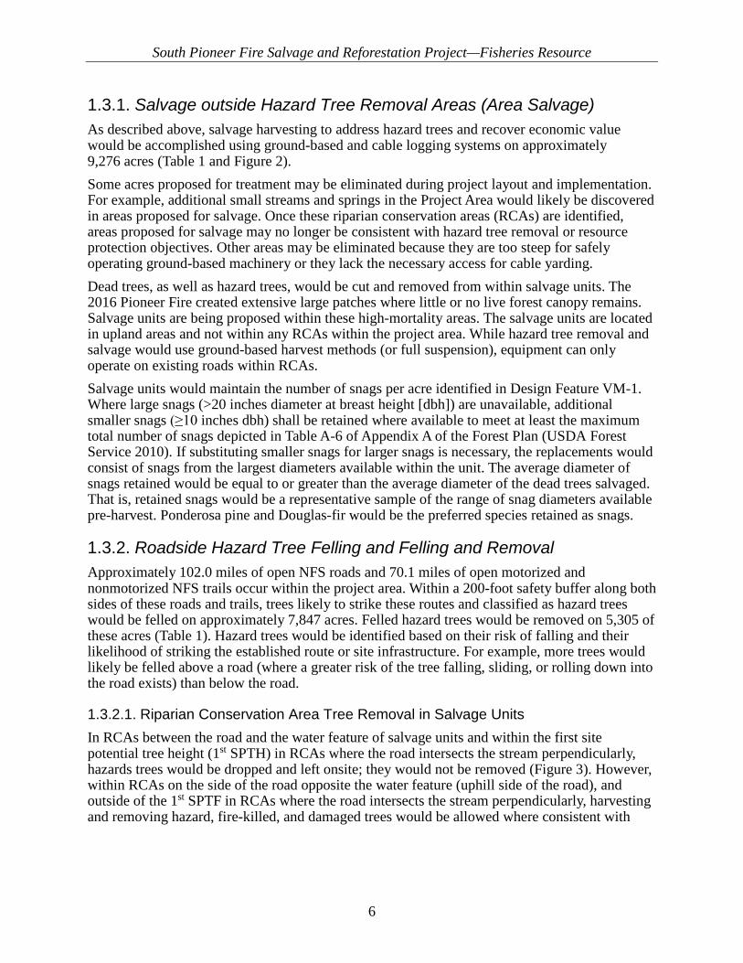
1.3.1. Salvage outside Hazard Tree Removal Areas (Area Salvage) As described above, salvage harvesting to address hazard trees and recover economic value would be accomplished using ground-based and cable logging systems on approximately 9,276 acres (Table 1 and Figure 2). Some acres proposed for treatment may be eliminated during project layout and implementation. For example, additional small streams and springs in the Project Area would likely be discovered in areas proposed for salvage. Once these riparian conservation areas (RCAs) are identified, areas proposed for salvage may no longer be consistent with hazard tree removal or resource protection objectives. Other areas may be eliminated because they are too steep for safely operating ground-based machinery or they lack the necessary access for cable yarding. Dead trees, as well as hazard trees, would be cut and removed from within salvage units. The 2016 Pioneer Fire created extensive large patches where little or no live forest canopy remains. Salvage units are being proposed within these high-mortality areas. The salvage units are located in upland areas and not within any RCAs within the project area. While hazard tree removal and salvage would use ground-based harvest methods (or full suspension), equipment can only operate on existing roads within RCAs. Salvage units would maintain the number of snags per acre identified in Design Feature VM-1. Where large snags (>20 inches diameter at breast height [dbh]) are unavailable, additional smaller snags (≥10 inches dbh) shall be retained where available to meet at least the maximum total number of snags depicted in Table A-6 of Appendix A of the Forest Plan (USDA Forest Service 2010). If substituting smaller snags for larger snags is necessary, the replacements would consist of snags from the largest diameters available within the unit. The average diameter of snags retained would be equal to or greater than the average diameter of the dead trees salvaged. That is, retained snags would be a representative sample of the range of snag diameters available pre-harvest. Ponderosa pine and Douglas-fir would be the preferred species retained as snags.
1.3.2. Roadside Hazard Tree Felling and Felling and Removal Approximately 102.0 miles of open NFS roads and 70.1 miles of open motorized and nonmotorized NFS trails occur within the project area. Within a 200-foot safety buffer along both sides of these roads and trails, trees likely to strike these routes and classified as hazard trees would be felled on approximately 7,847 acres. Felled hazard trees would be removed on 5,305 of these acres (Table 1). Hazard trees would be identified based on their risk of falling and their likelihood of striking the established route or site infrastructure. For example, more trees would likely be felled above a road (where a greater risk of the tree falling, sliding, or rolling down into the road exists) than below the road.
1.3.2.1. Riparian Conservation Area Tree Removal in Salvage Units In RCAs between the road and the water feature of salvage units and within the first site potential tree height (1st SPTH) in RCAs where the road intersects the stream perpendicularly, hazards trees would be dropped and left onsite; they would not be removed (Figure 3). However, within RCAs on the side of the road opposite the water feature (uphill side of the road), and outside of the 1st SPTF in RCAs where the road intersects the stream perpendicularly, harvesting and removing hazard, fire-killed, and damaged trees would be allowed where consistent with
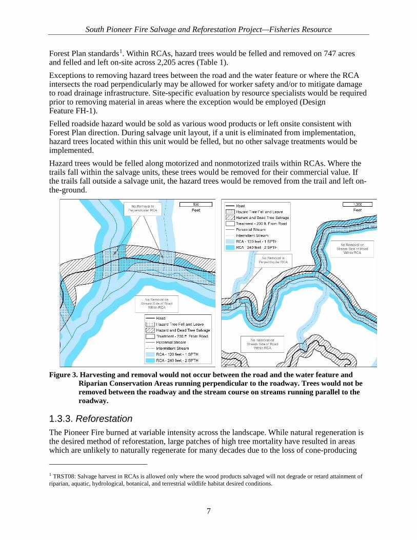
South Pioneer Fire Salvage and Reforestation Project—Fisheries Resource
7
Forest Plan standards1. Within RCAs, hazard trees would be felled and removed on 747 acres and felled and left on-site across 2,205 acres (Table 1). Exceptions to removing hazard trees between the road and the water feature or where the RCA intersects the road perpendicularly may be allowed for worker safety and/or to mitigate damage to road drainage infrastructure. Site-specific evaluation by resource specialists would be required prior to removing material in areas where the exception would be employed (Design Feature FH-1). Felled roadside hazard would be sold as various wood products or left onsite consistent with Forest Plan direction. During salvage unit layout, if a unit is eliminated from implementation, hazard trees located within this unit would be felled, but no other salvage treatments would be implemented. Hazard trees would be felled along motorized and nonmotorized trails within RCAs. Where the trails fall within the salvage units, these trees would be removed for their commercial value. If the trails fall outside a salvage unit, the hazard trees would be removed from the trail and left on-the-ground.
Figure 3. Harvesting and removal would not occur between the road and the water feature and
Riparian Conservation Areas running perpendicular to the roadway. Trees would not be removed between the roadway and the stream course on streams running parallel to the roadway.
1.3.3. Reforestation The Pioneer Fire burned at variable intensity across the landscape. While natural regeneration is the desired method of reforestation, large patches of high tree mortality have resulted in areas which are unlikely to naturally regenerate for many decades due to the loss of cone-producing 1 TRST08: Salvage harvest in RCAs is allowed only where the wood products salvaged will not degrade or retard attainment of riparian, aquatic, hydrological, botanical, and terrestrial wildlife habitat desired conditions.

South Pioneer Fire Salvage and Reforestation Project—Fisheries Resource
8
trees. Proposed reforestation activities would focus planting on larger patches of high tree mortality in the ponderosa pine and Douglas-fir types as well as key areas identified by other resources. Other areas have been identified to monitor for natural regeneration. If desired natural regeneration does not occur, then these areas may also be planted. Figure 4 identifies locations prioritized for reforestation planning within the project area. Based on monitoring of forest recovery within these locations, strategic sites (units) would be planted at historical densities using variable spacing to foster long-term restoration objectives identified in the Forest Plan. Reforestation would occur in areas with whitebark pine mortality (294 acres), recreation sites, and high priority aquatic habitats (37 acres) (Table 2 and Figure 4). The aquatic sites were identified by a combination of high soil burn severity, bull trout critical habitat, bull trout occupancy, and NorWeST/Coldwater Climate Shield information. Table 2. South Pioneer Reforestation Summary
Reforestation Acres Natural Regeneration 4,703 Tree Planting 12,571 Riparian Restoration 37 Whitebark Pine Reforestation 294 TOTAL 17,605
Planting would be accomplished by hand crews. Most sites would be planted in the spring, so some roads may need to be plowed to access planting units at appropriate times. Access roads are typically plowed March to April, although this timeframe varies from year to year depending on planting site elevations, road locations, and annual snow/weather conditions. Roads are typically plowed 2–3 weeks in advance of planting, leaving several inches of snow on their surface which then melts, allowing time for the road to dry out prior to use by planting crews. Whitebark pine planting would occur during the fall as would planting of more isolated areas.
1.3.4. Unauthorized Route Decommissioning Unauthorized routes (4.4 miles) are proposed to be decommissioned, including 3.2 miles to be used as temporary roads to implement proposed activities (Figure 4). See the “Temporary Road” section for a description of how unauthorized routes used as temporary roads would be decommissioned. Decommissioning of other unauthorized routes (1.0 miles) may consist of one or more of the following, depending on site-specific conditions: recontouring the entrance and first portion of the road, blocking the entrance with earthen barriers and/or rocks to deter motorized access, installing drainage features, placing woody debris on roadbed, ripping, seeding, or conifer tree planting.
South Pioneer Fire Salvage and Reforestation Project—Fisheries Resource
9
1.3.5. Associated Actions Implemented with the Proposed Action
1.3.5.1. Activity Fuels Management Trees would be yarded whole to the landing to reduce compaction and aid in soil amelioration. The tops, limbs, and branches would be hauled back and slash material utilized to minimize soil and water movement and promote restoration of soil-hydrologic functions associated with the construction of temporary roads, landings, and skid trails. Residual slash remaining on landings would be piled and burned. The piling and burning of slash could occur where needed to protect NFS improvements and facilities; address public safety; and maintain recreational access, use, and visual quality. No hand piling would occur below the road within RCAs, unless otherwise designated through site-specific evaluation.

South Pioneer Fire Salvage and Reforestation Project—Fisheries Resource
10
Figure 4. Proposed reforestation and location of unauthorized routes for decommissioning

South Pioneer Fire Salvage and Reforestation Project—Fisheries Resource
11
1.3.5.2. Temporary Roads Implementing this project would require approximately 3.6 miles of temporary roads to facilitate salvage harvest activities (Table 3). Temporary roads would be constructed to access landings and would be rehabilitated upon completion of all harvest activities. Temporary roads would be decommissioned after use by recontouring to the approximate shape of the surrounding terrain. In addition, the roads would have berms or debris placed near their entrance and along the first portion of the road to discourage use. These temporary road segments would generally be located on dry ridgetops and are not located in wet/moist areas. To minimize impacts to the environment and natural resources, 3.4 miles of unauthorized roads would be used as temporary roads. Approximately 0.2 miles of new temporary road would be constructed to access landings where existing system roads and old alignments are not adequate for accessing strategic locations. Figure 4 shows the possible locations of the temporary roads for this project. The exact locations of temporary roads may change during the layout phase of this project, but the overall mileage would be the same or less. Table 3. Summary of temporary road construction to facilitate vegetation management
Temporary Road to Facilitate Timber Harvest Miles Miles of Temporary Road (Outside of RCA) 3.4 Miles of Temporary Road (RCA) 0.2 Total 3.6
1.3.5.3. Haul Routes and Road Maintenance To support large trucks and equipment used to implement the proposed action, road maintenance is proposed on approximately 175 miles of existing NFS roads. Roads would continue to be maintained throughout the salvage harvest operations. The extent of work proposed varies on each road and can be split into 3 categories for the purpose of the effects analysis:
• Light Maintenance—Applicable to roads that receive road maintenance annually or roads that received the Road Drainage Reconstruction Treatment under BAER in 2016. Work typically includes road surface blading, ditch cleaning, and culvert cleaning as needed, and removing fallen trees or brush from the roadway. This type of maintenance is typical of a primary route or roadway open yearlong to motorized vehicles.
• Moderate Maintenance—Applicable to roads periodically receiving road maintenance that are still drivable by a high clearance vehicle. Work typically includes removal of vegetation from the road shoulders, road surface re-shaping and blading, ditch cleaning and culvert cleaning, replacement of deficient culverts or installation of new culverts, and removal of fallen trees from the roadway. This maintenance is typical of a secondary route or roadway open yearlong or seasonally to motorized vehicles, which may only be open for administrative access.

South Pioneer Fire Salvage and Reforestation Project—Fisheries Resource
12
• Heavy Maintenance—Applicable to roads that have not received any road maintenance in years and are too overgrown to drive, or ML 1 roads. The roadbed may be rutted and narrow from lack of surface blading, and brush may cover the entire road surface. Work typically includes removal of vegetation from the entire road surface, road surface widening and blading, slump and slide repair, ditch cleaning and culvert cleaning, replacement of deficient culverts or installation of new culverts, and the removal of fallen trees from the roadway. This maintenance level is typical of a tertiary route or roadway open seasonally to motorized vehicles or closed to all motorized use, such as an ML 1 road.
During haul, road maintenance occurs during active hauling operations and keeps the roads safe for travel. Work includes road surface blading, as-needed cleaning of ditch lines and ditch relief culverts, maintenance of structures such as bridges and cattleguards, and as-needed incidental roadside vegetation clearing. If a ML 1 road (closed road) is opened and used for project implementation, it would only be open to administrative use, including timber haul. If a unit drops from the project, the associated road work would be dropped as well.
1.4. Project Design Features The South Pioneer Fire Salvage and Reforestation Project has been designed to avoid or minimize undesirable impacts to resources, to the maximum extent practicable and will comply with all applicable laws, regulations, and direction. Compliance would be achieved by the development and implementation of project-level design features as well as any additional design features developed in response to scoping and ongoing effects analyses.
1.4.1. Standard Design Features (Including Best Management Practices) The interdisciplinary team (IDT) identified standard design features to minimize or avoid potential adverse effects from the proposed action. The design features are based on Forest Plan direction and policy, best available science, and site-specific evaluations and would be applied (except where specifically stated) as an integral part of project implementation. Section 208 of the Clean Water Act authorizes and encourages State and local management of nonpoint pollution sources, which include forest practices. This project incorporates best management practices (BMPs) to help meet the requirements of the Clean Water Act. The National Best Management Practices for Water Quality Management on National Forest System Lands…site-specific BMP prescriptions are developed based on the proposed activity, water quality objectives, soils, topography, geology, vegetation, climate, and other site-specific factors and are designed to avoid, minimize, or mitigate potential adverse impacts to soil, water quality, and riparian resources. State BMPs, regional Forest Service guidance, land management plan standards and guidelines, monitoring results, and professional judgment are all used to develop site-specific BMP prescriptions. Idaho Forest Practices Act rules are mandatory BMPs that protect, maintain, and enhance Idaho’s forests and maintain high water quality. All applicable BMPs would be applied to activities proposed in the South Pioneer Project area. Contract provisions required in timber sales are the mechanism by which BMPs are implemented during activities. Additionally, monitoring of BMPs occurs during and after harvest to ensure correct implementation and effectiveness.

South Pioneer Fire Salvage and Reforestation Project—Fisheries Resource
13
1.4.2. Project-specific Design Features In addition to the standard design features and BMPs identified above, project-specific design features would be applied on a site-by-site basis to avoid or minimize impacts to resources. For example, soil analyses may indicate the disturbance level in a specific area to be treated is approaching the threshold identified by Forest Plan soil standards. Design features, such as using slash mats, could be applied to that area to ensure compliance with Forest Plan soil standards. Another example might be where topography would require using an excavated skid trail or an skyline/tractor swing to remove hazard trees or other wood products in a safe and environmentally sound manner. These design features address conditions found on the ground during project activities and would be applied through applicable contract provisions, which would include standard and site-specific provisions. Additional project-specific design features or mitigation measures may be added based on scoping comments received or as identified during resource analyses completed this winter.
1.4.2.1. Fisheries, Hydrology, and Soil Resources (FH) FH-1. To maintain riparian functions and water quality, all perennial streams (year-round surface flow) have a designated 240 foot RCA width while intermittent streams (flows some part of the year and have defined bed and banks), springs, ponds, and wetlands have a designated 120 foot RCA width. Stream features are identified in the stream layer (Boise National Forest GIS Database) or as identified in the field. The following apply to the above-defined RCA widths:
• Salvage Dead Trees—No harvest will occur within RCAs associated with salvage harvest areas identified for the purpose of recovering economic value.
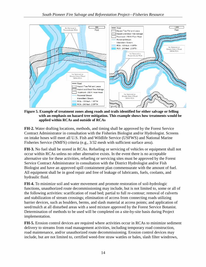
• Hazard and Dead Tree Salvage—Salvage and removal of hazard trees will occur within RCAs along roads and trails identified for hazard tree removal. Harvesting and removing road/trail-side hazard trees will occur on the side of the road or trail opposite the water feature (uphill side of the road) where they run parallel with the steam feature (Figure 5). Where RCAs intersect the road perpendicularly, no tree removal will be allowed with some limited exceptions2. No new landing construction will occur within RCAs, and mechanized equipment will be restricted to existing road prisms within the RCA.
• Hazard Tree Fell and Leave—Road/trail-side hazard trees that occur within RCAs between the road and the water feature (stream side of the road) or where the RCA intersects the road perpendicularly will be felled and left onsite (Figure 5) with some limited exceptions1.
2Removal or relocation of hazard trees may be allowed if falling and leaving onsite would result in one of two situations: 1) hazardous working conditions for felling operations (i.e., lack of escape routes or stacking of tree boles such that there is unpredictable movement when felled trees come to rest) or 2) downed trees would compromise road prisms, bridges, and/or drainage features associated with the road. The Forest or District Fish Biologist, Hydrologist, and/or Transportation Engineer will coordinate with the appropriate Timber Management Assistant to evaluate these areas to ensure trees can be removed without causing unacceptable effects to soil, water, riparian, or aquatic resources.
South Pioneer Fire Salvage and Reforestation Project—Fisheries Resource
14
Figure 5. Example of treatment zones along roads and trails identified for either salvage or felling
with an emphasis on hazard tree mitigation. This example shows how treatments would be applied within RCAs and outside of RCAs
FH-2. Water drafting locations, methods, and timing shall be approved by the Forest Service Contract Administrator in consultation with the Fisheries Biologist and/or Hydrologist. Screens on intake hoses will meet all U.S. Fish and Wildlife Service (USFWS) and National Marine Fisheries Service (NMFS) criteria (e.g., 3/32 mesh with sufficient surface area). FH-3. No fuel shall be stored in RCAs. Refueling or servicing of vehicles or equipment shall not occur within RCAs unless no other alternative exists. In the event there is no acceptable alternative site for these activities, refueling or servicing sites must be approved by the Forest Service Contract Administrator in consultation with the District Hydrologist and/or Fish Biologist and have an approved spill containment plan commensurate with the amount of fuel. All equipment shall be in good repair and free of leakage of lubricants, fuels, coolants, and hydraulic fluid. FH-4. To minimize soil and water movement and promote restoration of soil-hydrologic functions, unauthorized route decommissioning may include, but is not limited to, some or all of the following activities: scarification of road bed; partial to full re-contour; removal of culverts and stabilization of stream crossings; elimination of access from connecting roads utilizing barrier devices, such as boulders, berms, and slash material at access points; and application of seed/mulch at all disturbed areas with a seed mixture approved by the Forest Service Botanist. Determination of methods to be used will be completed on a site-by-site basis during Project implementation. FH-5. Erosion control devices are required where activities occur in RCAs to minimize sediment delivery to streams from road management activities, including temporary road construction, road maintenance, and/or unauthorized route decommissioning. Erosion control devices may include, but are not limited to, certified weed-free straw wattles or bales, slash filter windrows,

South Pioneer Fire Salvage and Reforestation Project—Fisheries Resource
15
and/or biodegradable erosion cloth. The District Hydrologist or Fisheries Biologist will consult with the Forest Service Contract Administrator in determining the most effective sediment control method. Erosion control materials will be allowed to deteriorate in place. FH-6. To maintain the condition of the roads and to minimize soil movement from road surfaces, snow removal shall be done in a manner to preserve and protect the roads to ensure safe and efficient travel as well as prevent unacceptable erosion damage to roads, streams, and adjacent lands:
• A minimum depth of 6 inches of snow must be left to protect roadways and bridges.
• During snow removal operations, banks shall not be undercut nor shall gravel or other road surfacing material be bladed off the roadway surface.
• Snow removal work also includes removing snow slides, minor earth slides, fallen timber, and boulders obstructing normal road surface width, including turnouts. All debris, except snow and ice that is removed from the road surface and ditch, will be deposited away from stream channels at approved locations.
• Drainages and culverts shall be kept functional during and following the roadway use. Any dirt or other inorganic materials cleaned from culvert inlets will be deposited away from stream channels at approved locations.
• Snow berms will not be left on the road surface. Berms left on the shoulder of the road will be removed and/or drainage holes shall be opened and maintained. Drainage holes shall be spaced as required to obtain satisfactory surface drainage without discharge on erodible fill slopes.
FH-7. To prevent degradation of previous and ongoing Burned Area Emergency Response (BAER) actions, the functionality of emergency actions implemented under BAER will be protected. BAER actions include hillslope seeding and mulching, road and trail drainage improvements, hillslope stabilization and motor vehicle access restrictions, hazard warning signs, and noxious weed/invasive plant treatments. Any damage to previously implemented BAER actions from the proposed action will be repaired within a reasonable timeframe, but not to exceed 72 hours. However, any damage to previously completed BAER actions will be repaired immediately if threats to human life and safety are expected; or damage to infrastructure related to BAER actions will be repaired immediately if the damage will result in resource impacts (e.g., culvert failure and water quality). Otherwise, damage or impairment of functionality will be repaired or corrected concurrent with erosion control activities needed for salvage harvest and felling of drop-and-leave hazard trees. FH-8. To minimize soil and water movement and promote the restoration of soil-hydrologic functions associated with the construction of temporary roads, landings, and skid trails, the following will be implemented upon completion of Project activities:
• Temporary Roads—Decommission temporary roads by full obliteration along entire length of disturbance. Upon completion of Project activities, all temporary roads used to implement Project activities will be reclaimed by ripping or scarifying compacted surfaces to a depth of 12 inches; re-contouring excavated segments to the original slope; and scattering slash or mulch to achieve effective ground cover over at least 50% of the reclaimed surface.
South Pioneer Fire Salvage and Reforestation Project—Fisheries Resource
16
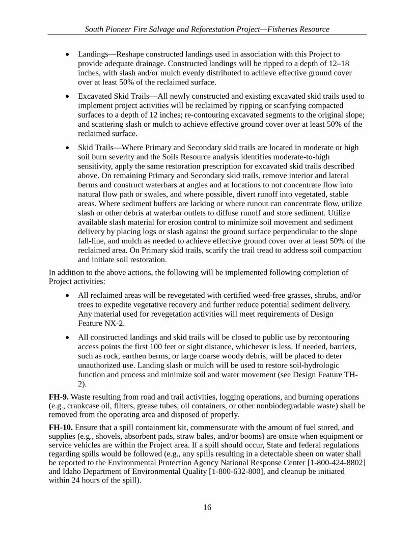
• Landings—Reshape constructed landings used in association with this Project to provide adequate drainage. Constructed landings will be ripped to a depth of 12–18 inches, with slash and/or mulch evenly distributed to achieve effective ground cover over at least 50% of the reclaimed surface.
• Excavated Skid Trails—All newly constructed and existing excavated skid trails used to implement project activities will be reclaimed by ripping or scarifying compacted surfaces to a depth of 12 inches; re-contouring excavated segments to the original slope; and scattering slash or mulch to achieve effective ground cover over at least 50% of the reclaimed surface.
• Skid Trails—Where Primary and Secondary skid trails are located in moderate or high soil burn severity and the Soils Resource analysis identifies moderate-to-high sensitivity, apply the same restoration prescription for excavated skid trails described above. On remaining Primary and Secondary skid trails, remove interior and lateral berms and construct waterbars at angles and at locations to not concentrate flow into natural flow path or swales, and where possible, divert runoff into vegetated, stable areas. Where sediment buffers are lacking or where runout can concentrate flow, utilize slash or other debris at waterbar outlets to diffuse runoff and store sediment. Utilize available slash material for erosion control to minimize soil movement and sediment delivery by placing logs or slash against the ground surface perpendicular to the slope fall-line, and mulch as needed to achieve effective ground cover over at least 50% of the reclaimed area. On Primary skid trails, scarify the trail tread to address soil compaction and initiate soil restoration.
In addition to the above actions, the following will be implemented following completion of Project activities:
• All reclaimed areas will be revegetated with certified weed-free grasses, shrubs, and/or trees to expedite vegetative recovery and further reduce potential sediment delivery. Any material used for revegetation activities will meet requirements of Design Feature NX-2.
• All constructed landings and skid trails will be closed to public use by recontouring access points the first 100 feet or sight distance, whichever is less. If needed, barriers, such as rock, earthen berms, or large coarse woody debris, will be placed to deter unauthorized use. Landing slash or mulch will be used to restore soil-hydrologic function and process and minimize soil and water movement (see Design Feature TH-2).
FH-9. Waste resulting from road and trail activities, logging operations, and burning operations (e.g., crankcase oil, filters, grease tubes, oil containers, or other nonbiodegradable waste) shall be removed from the operating area and disposed of properly. FH-10. Ensure that a spill containment kit, commensurate with the amount of fuel stored, and supplies (e.g., shovels, absorbent pads, straw bales, and/or booms) are onsite when equipment or service vehicles are within the Project area. If a spill should occur, State and federal regulations regarding spills would be followed (e.g., any spills resulting in a detectable sheen on water shall be reported to the Environmental Protection Agency National Response Center [1-800-424-8802] and Idaho Department of Environmental Quality [1-800-632-800], and cleanup be initiated within 24 hours of the spill).

South Pioneer Fire Salvage and Reforestation Project—Fisheries Resource
17
1.4.2.2. Timber Harvest TH-1. Snow plowing may occur on established groomed ski and snow machine trails within the project area and on all haul routes as needed to facilitate salvage harvest and hazard tree removal activities, except as stated in RE-4. TH-2. Transport yard trees whole to the landing and manufacture them at the landing to reduce compaction and aid in soil amelioration. After manufacturing, the tops/limbs/branches will be hauled back and utilized as slash material on skid trails within tractor/jammer units or utilized on temporary roads and landings. Apply slash to temporary roads or landings (see FH-8). TH-3. Limit the grade of constructed skid trails to a maximum of 30%. TH-4. Temporary roads and skid trails used to facilitate proposed mechanical treatments are either identified as new locations or aligned with existing unauthorized roads. The time between constructing and decommissioning each temporary road and skid trail will be minimized to the maximum extent practicable. Both activities (constructing and decommissioning) will generally occur during the same field season. However, additional mitigation (e.g., water bars/cross ditches, slash filter windrows, silt fencing, straw bales/wattles) will be applied to temporary roads and skid trails that remain operational/open over the winter to minimize soil erosion and sediment delivery during spring snowmelt and runoff.
1.4.2.3. Engineering/Transportation TR-1. Road maintenance will be performed on NFS roads to reduce resource impacts during implementation and improve watershed conditions. Road maintenance activities will include, but are not limited to, road prism blading, spot aggregate placement, drainage improvements, roadway clearing, and roadway ditch/culvert cleaning. TR-2. Magnesium chloride (MgCl2) will be applied to about 6 miles of NFS road 384 road to mitigate dust and increase visibility for public use. Applying MgCl2 will be prohibited within 6.1 meters (~20 feet) of designated critical bull trout habitat (i.e., Crooked River and Pikes Fork) and within 3.0 meters (~10 feet) of live water stream crossings within the project area. This mitigation is designed to protect listed bull trout and their habitat from direct entry of MgCl2 during application (wind or splash from vehicles travelling on roadway) as well as movement of MgCl2 ions over time that could indirectly enter habitat following application (run-off from rainstorm following treatment).
1.4.2.4. Vegetation Management VM-1. Retain at least the maximum number of snags post-implementation depicted in Table 4 (USDA Forest Service 2010a, Appendix A) within each size class where available by salvage harvest unit. Table 4. Minimum Snags Retained Post-Implementation (derived from Forest Plan, Appendix A
Table A-6 for the Salvage [Non-Hazard-Tree] PVGs (PVGs 1-4).
Snag Class PVG 1 PVG 2 PVG 3 PVG 4
Snags/Acre Snags/Acre Snags/Acre Snags/Acre 10–19.9 inches 0.5 2.7 4.1 2.7 >20 inches 2.3 3.0 2.8 2.1 Total 2.8 5.7 6.9 4.8 Minimum Height 15’ 30’ 30’ 30’

South Pioneer Fire Salvage and Reforestation Project—Fisheries Resource
18
• Where large snags (>20 inches dbh) are unavailable, additional snags (>10 inches dbh) shall be retained where available to meet at least the maximum total number snags per acre depicted in Table 4.
• If substituting smaller snags for the larger (>20 inches dbh) snag class is necessary, the replacements shall consist of snags from the largest diameters available.
• The average diameter of retention snags shall be equal to or greater than the average diameter of salvaged snags (i.e., retained snags will be a representative sample of the range of snag diameter at breast height pre-harvest).
• If a harvest unit includes both hazard tree salvage and salvage outside hazard tree removal areas, then the design feature for minimal snag retention shall be met for the entire harvest unit; however, snags shall be retained in the portion of the unit located away from the open road or trail where hazard trees are a concern.
• Snag species marked for retention will give preference to ponderosa pine first, and then Douglas-fir. In units where ponderosa pine and Douglas-fir are co-dominant, both species will be retained although ponderosa pine representation will be greater. Lodgepole pine snags may also contribute to minimum snags per acre standards in harvest units where lodgepole pine is a major seral component.
• Snags shall be retained in clumps as well as some individuals scattered across the harvest unit.
• A portion of the imminently dead trees (90% probability of mortality) shall be retained onsite to meet the minimum snag retention standard. The ‘portion’ retained should be similar to their representation in the salvage unit (i.e., if 10% of the salvageable trees fall within this group, then approximately 10% of the retained snags would come from this group.
VM-2. Bedding of sheep and salting of livestock in plantations will be prohibited until plantation trees have grown to a size that reduces their susceptibility to damage from livestock (Forest Plan Standard RAST08 [USDA Forest Service 2010a]). Livestock use should be discouraged within plantations until they have been certified, minimizing conflicts as outlined in Design Feature RM-1. VM-3. Livestock use should be discouraged in progeny sites, seed orchards, and plantations that have not been certified (Forest Plan Guideline RAGU06 [USDA Forest Service 2010a, p. III-48]). While livestock are present within the allotment and pasture(s) with reforestation units for up to 5 years following planting, the permittee is required to employ a herder/rider to either ensure livestock are not within reforestation units and/or to push livestock from units. If the permittee cannot keep livestock out of reforestation units, the permittee would be required to take non-use for resource protection in the project area with reforestation units for up to 5 years.
1.5. Forest Plan Direction The 2003 Forest Plan as amended in 2010 (hereafter referred to as the “2010 Forest Plan”) provides long-term management direction (standards and guidelines) to guide natural resource management activities on lands administered by the Forest (USDA Forest Service 2010). This direction provides the foundation for sustainable ecosystems and resilient watersheds that meet the Forest-wide multi-use goals and objectives. The Forest Plan (USDA Forest Service 2010,

South Pioneer Fire Salvage and Reforestation Project—Fisheries Resource
19
Chapter 3) describes location-specific management direction in terms of Management Areas and Management Prescription Categories (MPCs). See the Forest Plan for more direction on management area information related to desired condition. The project is located in the North Fork Boise River Management Area 7. Specific direction for this management area is described in the 2010 Forest Plan (USDA Forest Service 2010, p. III-180 to III-192). Management area objectives relevant to Soil, Watershed, Riparian, and Aquatic (SWRA) resources within the project area are listed in Table 5. Table 5. Management area objectives for soil, watershed, riparian, and aquatic (SWRA) resources
within the analysis area Objective Description
Objective 0725 Restore migration connectivity for bull trout throughout the management area by removing migration barriers caused by existing road design.
Objective 0726 Restore fish habitat by reducing sediment delivery and repairing instream structures, with emphasis on Pikes Fork, Beaver Creek, and Edna Creek.
Objective 0727 Initiate restoration of watershed conditions and fish habitat in the Pikes Fork and Upper Bear River subwatersheds to help strengthen local bull trout populations.
Objective 0728 Continue to design and implement road-related watershed restoration projects in the North Fork Boise River Recovery Area.
Objective 0729 Develop a schedule to inventory existing culverts to determine if they currently provide fish passage and prevent fish entrainment. Prioritize completion of the Beaver Creek, Big Owl Creek, Trapper Creek, Wren Creek, and Trail Creek inventories.
Guideline 0731 In the Beaver-Edna, Pikes Fork, Upper Crooked River, and Lower Crooked River Subwatersheds, existing roads should be reconstructed with effective cross-drain spacing and drain dip locations to route water into slope filtration rather than to first-order streams in order to reduce sediment delivery to bull trout habitat.
1.5.1. Soil, Water, Riparian, and Aquatic Desired Conditions The 2010 Forest Plan outlines the Forest-wide desired conditions for SWRA resources in Chapter III (USDA Forest Service 2010, p.18). See the 2010 Forest Plan for more direction on management area information related to desired condition.
1.5.2. Watershed and Aquatic Recovery Strategy and Aquatic Conservation Strategy The 2010 Forest Plan developed an eight component Aquatic Conservation Strategy (ACS) in which three of the components combine to form the basis of the Watershed and Aquatic Recovery Strategy (WARS). The WARS prioritizes forest-wide watershed and aquatic restoration planning. This information was taken from the WARS database (wscat), located in the Forest’s GIS database files. A “High” restoration prioritization includes watersheds that contain population or habitat strongholds for Chinook salmon, sockeye salmon, steelhead trout, bull trout, or native cutthroat trout or anadromous fish spawning; rearing habitat or highly isolated local population of bull trout or native cutthroat trout; a Total Maximum Daily Load (TMDL) Watershed Restoration Plan in place; or a municipal watershed (USDA Forest Service 2010). The ACS provides direction to maintain desired conditions and/or restore characteristics of healthy, functioning watersheds, riparian areas, and associated fish habitats (USDA Forest Service 2010a Appendix B, pp. B-47 through B-56). The ACS is a long-term strategy to restore and maintain the ecological health of watersheds and aquatic ecosystems contained within lands administered by the Forest.
South Pioneer Fire Salvage and Reforestation Project—Fisheries Resource
20
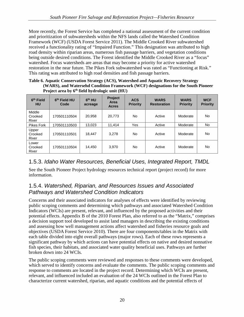
More recently, the Forest Service has completed a national assessment of the current condition and prioritization of subwatersheds within the NFS lands called the Watershed Condition Framework (WCF) (USDA Forest Service 2011). The Middle Crooked River subwatershed received a functionality rating of “Impaired Function.” This designation was attributed to high road density within riparian areas, numerous fish passage barriers, and vegetation conditions being outside desired conditions. The Forest identified the Middle Crooked River as a “focus” watershed. Focus watersheds are areas that may become a priority for active watershed restoration in the near future. The Pikes Fork subwatershed was rated as “Functioning at Risk.” This rating was attributed to high road densities and fish passage barriers. Table 6. Aquatic Conservation Strategy (ACS), Watershed and Aquatic Recovery Strategy
(WARS), and Watersehd Condition Framework (WCF) designations for the South Pioneer Project area by 6th field hydrologic unit (HU)
6th Field HU
6th Field HU Code
6th HU acreage
Project Area
Acres ACS
Priority WARS
Restoration WARS Priority
WCF Priority
Middle Crooked River
170501110504 20,958 20,773 No Active Moderate No
Pikes Fork 170501110503 13,023 11,414 Yes Active Moderate No Upper Crooked River
170501110501 18,447 3,278 No Active Moderate No
Lower Crooked River
170501110504 14,450 3,970 No Active Moderate No
1.5.3. Idaho Water Resources, Beneficial Uses, Integrated Report, TMDL See the South Pioneer Project hydrology resources technical report (project record) for more information.
1.5.4. Watershed, Riparian, and Resources Issues and Associated Pathways and Watershed Condition Indicators Concerns and their associated indicators for analyses of effects were identified by reviewing public scoping comments and determining which pathways and associated Watershed Condition Indicators (WCIs) are present, relevant, and influenced by the proposed activities and their potential effects. Appendix B of the 2010 Forest Plan, also referred to as the “Matrix,” comprises a decision support tool developed to assist land managers in describing the existing conditions and assessing how well management actions affect watershed and fisheries resource goals and objectives (USDA Forest Service 2010). There are four components/tables in the Matrix with each table divided into eight overall pathways (major rows). Each of these rows represents a significant pathway by which actions can have potential effects on native and desired nonnative fish species, their habitats, and associated water quality beneficial uses. Pathways are further broken down into 24 WCIs. The public scoping comments were reviewed and responses to these comments were developed, which served to identify concerns and evaluate the comments. The public scoping comments and response to comments are located in the project record. Determining which WCIs are present, relevant, and influenced included an evaluation of the 24 WCIs outlined in the Forest Plan to characterize current watershed, riparian, and aquatic conditions and the potential effects of

South Pioneer Fire Salvage and Reforestation Project—Fisheries Resource
21
proposed management activities on bull trout local populations, water quality, habitat access, habitat elements, channel conditions and dynamics, flow/hydrology, watershed conditions, and the integration of species and habitat conditions (USDA Forest Service 2010, Appendix B, p. B-1221). The pathways that had some or all associated WCIs determined to be present, relevant, and influenced were identified and carried into further analyses and discussion of effects associated with the watershed and fisheries resources.
1.6. Relevant Laws, Regulations and Policy
1.6.1. Federal Law The Endangered Species Act of 1973, as amended (16 U.S.C. 1531 et seq., hereinafter referred to as the Act)—Section 7 of the Endangered Species Act (ESA) directs federal departments and agencies to ensure that actions authorized, funded, or carried out by them are not likely to jeopardize the continued existence of any threatened or endangered species or result in the destruction or adverse modification of their critical habitats. The U.S. Fish and Wildlife Service (USFWS) maintains the current ESA Endangered, Threatened, Candidate, and Proposed species list and publishes the information in the Federal Register. The Snake River Basin Office of the USFWS provides the Forest with a species list via the Services iPaC website. The list generated from iPaC was used for this technical report for assessing Endangered, Threatened, Proposed, and Candidate Species (with associated Proposed and Designated Critical Habitats) under the jurisdiction of the USFWS. On March 6, 2017, the Idaho Fish and Wildlife Office of the USFWS provided a listing of ESA Endangered, Threatened, Candidate, and Proposed species which are documented to occur or for which habitat for the species occurs within the project area (USFWS 2017). The consultation code 01EIFW00-2017-SLI-0568 and event code 01EIFW00-2017-E-00953 were assigned to the letter submitted to the Idaho City Ranger District (RD) in response to the RD’s request for an update and confirmation of species to be considered. The ESA listed and proposed fish species for the Forest, Idaho City RD are presented inTable 7. No candidate fish species occur within the Idaho City RD. Detailed analysis is provided in the appropriate section of this document. Table 7. Endangered Species Act listed and proposed species for the Boise National Forest, Idaho
City Ranger District (Source: USFW 2014; Species Status and Determination of Effects)
1.6.1.1. Sensitive Fish Species The biological evaluation (analysis of effects and determinations) for sensitive species has been included in this document. The status and determination for sensitive fish species is displayed in Table 8.
Fish Species: Status: Bull Trout (Salvelinus confluentus) Threatened, and Designated Critical Habitat

South Pioneer Fire Salvage and Reforestation Project—Fisheries Resource
22
Table 8. Sensitive fish species for the Idaho City Ranger District, Boise National Forest Fish Species Status Habitat Present
Westslope Cutthroat Trout (Oncorhynchus clarki lewisi) Sensitive No
2. Analysis Process Pathways and Indicators Data and descriptions in this analysis were collected from a variety of sources: field data/notes/pictures collected by Hydrologists and Fisheries Biologists; the hydrology, forested vegetation, fire and fuels, transportation, recreation, soils, and recreation resource technical reports (available in the project record); the Becker Transportation Analysis; Idaho Department of Environmental Quality (IDEQ), Beneficial Use Reconnaissance Program (BURP) data; 2012 Integrated Report database (IDEQ, 2014); USFS Pacfish Infish Biological Opinion Effectiveness Monitoring (PIBO) data; USFS Rocky Mountain Research Station (RMRS) monitoring data; the Forest aquatics survey database (ASD); and Agency-wide, Forest, and District Geographic Information System (GIS) databases. Numerous field visits have occurred by several Forest personnel. Information was integrated in part through GIS mapping to portray spatial relationships between fish species, habitat, and conditions and activities that could affect long-term soil productivity, water quality beneficial uses, and fish and their habitat.
2.1. 1.7 Methodologies Methodologies used to determine effects on WCIs in this report include field reviews of the area used to review current resource conditions and effects associated with reforestation, review of the existing data described in section 1.6 above, review of applicable scientific literature, and professional assessment associated with the known cause and effect relationships of the project actions on the relevant and influenced WCIs. Field reviews consisted of walkthroughs of the area and associated stream reaches, wetlands, and floodplains with IDT members with intimate knowledge of the area conditions and proposed action. Field review assessments of applicable WCIs were conducted by the District Fisheries Biologist or ascertained from the data sources as indicated above. The Matrix (Appendix B of the 2010 Forest Plan) was used to assist in determining effects on WCIs and ensure compliance with Forest Plan Management Direction. The Canada lynx and wolverine analyses used GIS data for suitable and source habitat, updated with information gathered post-Pioneer Fire, as appropriate. Additional data, residing in corporate databases, that maintain wildlife species sightings and detections were also integrated in this analysis. Intersections of actions proposed with potential, suitable, and source habitat were used to assess magnitude, intensity, and duration of effects of actions proposed on species analyzed.
2.2. 1.8 Scale of Analysis For the purposes of this assessment, the subwatershed scale, unless otherwise stated, was used as the direct and indirect analysis area for depicting existing resource conditions and potential effects from implementation of reforestation. Baseline conditions for watershed condition indicators were compiled at the 6th hydrologic unit (HU) or subwatershed scale; however, for the
South Pioneer Fire Salvage and Reforestation Project—Fisheries Resource
23
analysis of potential direct, indirect, and cumulative effects to relevant watershed condition indicators, the subwatershed was used as the analysis area. This report analyzes project effects on all listed resources on NFS lands occurring within the subwatershed and vicinity of the project area. The project is located within portions of the following subwatersheds: Upper Crooked River (170501110501), Pikes Fork (170501110502), Middle Crooked River (170501110503), and Lower Crooked River (170501110504). While the Baseline Conditions addresses the full suite of WCIs from the Forest Plan, the effects analysis for this document will only analyze the relevant and influenced WCIs included in this document.
2.3. Assumptions The following assumptions were made for this analysis:
• The characterization of existing (baseline) conditions for analysis indicators described in the baseline discussion and tables contained Appendix C
• All project design features will be implemented in a timely and effective manner. Due to project design features limiting the types of harvest activities occurring within RCAs, only the following relevant and influenced WCIs are included in this analysis: local population size, growth, and survival; life history diversity and isolation; persistence and genetic integrity; temperature; sediment/turbidity; chemical contaminants; substrate embeddedness; pool frequency and quality; large woody debris; refugia (bull trout) stream bank condition; road density/location; change in peak/base flows; change in drainage network; disturbance history/disturbance regime; RCAs; and integration of habitat and species condition.
2.4. Pathway: Primary Indicators:
2.4.1. Indicator: Bull Trout Population Characteristics (Includes Local Population Size, Growth and Survival, Life History Diversity and Isolation, Persistence and Genetic Integrity WCIs)
• Concern: Vegetation Management (hazard tree felling and/or removal) in the RCA could result in falling trees within streams or rivers which may disturb bull trout.
• Methods: Qualitative assessment of bull trout populations using available data. Analysis includes number of acres near USFWS designated bull trout critical habitat.
• Concern: Vegetation Management (reforestation planting activities) in the RCA could disturb bull trout present at the time and place planting occurs.
• Methods: Qualitative assessment of bull trout populations using available data. Analysis includes number of acres near USFWS designated bull trout critical habitat.
• Concern: Transportation management (including temporary road construction, road decommissioning activities, and road maintenance) could result in direct/indirect effects to sediment based on exposed soils (Sediment WCI), large woody debris recruitment (LWD WCI), streambank condition (Streambank WCI), and chemicals near tributaries (Chemical Contamination WCI).

South Pioneer Fire Salvage and Reforestation Project—Fisheries Resource
24
• Methods: Qualitative assessment utilizing professional judgement included in the appropriate WCI.
2.4.2. Indicator: Temperature • Concern: Hazard tree felling in the RCA could reduce the remaining stream shade,
resulting in higher stream temperature near bull trout habitat.
• Methods: Quantitative analysis of tree densities See hydrology resource technical report located in the project record.
2.4.3. Indicator: Sediment/Turbidity and Substrate Embeddedness • Concern: Fine sediment could result in substrate embeddedness within areas utilized by
bull trout.
• Methods: Quantitative analysis (FS WEPP Road) was used to assess road maintenance. Qualitative assessment of temporary road construction, unauthorized road decommissioning, salvage harvest, roadside hazard tree felling and removal, and reforestation.
2.4.4. Indicator: Sediment/Turbidity and Substrate Embeddedness • Concern: Fine sediment could result in sedimentation/turbidity within areas utilized by
bull trout.
• Methods: Quantitative analysis (FS WEPP Road) was used to assess road maintenance. Qualitative assessment using professional judgement of temporary road construction, unauthorized road decommissioning, salvage harvest, roadside hazard tree felling and removal, and reforestation.
See hydrology resource technical report (available in the project record) for the Sediment/Turbidity WCI analysis.
2.4.5. Indicator: Chemical Contamination/Nutrients • Concern: Accidental spill of petroleum-based products inside the RCA.
• Concern: Magnesium chloride application on NFS roads near occupied or critical bull trout habitat.
• Methods: Qualitative assessment of chemical contaminants WCI using available data. Analysis includes number of acres in USFWS designated bull trout critical habitat.
2.4.6. Indicator: Large Woody Debris • Concern: Reduction of large woody debris (LWD) recruitment in the future as a result of
salvage tree harvest (Vegetation Management).
• Methods: Quantitative analysis using trees per acre within treatment stands.
• Methods: Qualitative assessment of amount of trees removed. Analysis includes number of acres in USFWS designated bull trout habitat.
South Pioneer Fire Salvage and Reforestation Project—Fisheries Resource
25
2.4.7. Indicator: Pool Frequency/Quality and Large Pools, Width/Depth Maximum Ratio
• Concern: Changes in LWD from hazard tree treatments could change the number, frequency, and formation of large, high-quality pools.
• Methods: Qualitative assessment of location of activities and effects to pool frequency/pool quality WCIs and bull trout critical habitat PCEs.
2.4.8. Indicator: Refugia • Concern: Proposed actions within the RCA near critical bull trout habitat and changes to
other WCIs could change overall habitat quality and suitability of cold water habitat for bull trout.
• Methods: Qualitative assessment of refugia WCI, and bull trout critical habitat PCEs using available data. Analysis includes actions near USFWS designated bull trout critical habitat.
2.4.9. Indicator: Average Maximum Width/Depth Ratio • Concern: Road-related activities could input fine sediment reducing max/width/depth of
streams.
• Methods: Qualitative assessment utilizing professional judgement of the proposed actions occurring near critical bull trout habitat.
2.4.10. Indicator: Streambank Condition • Concern: Mechanized equipment could destabilize streambanks. Removal of trees within
the RCA could contribute to bank instability and erosion.
• Methods: Qualitative assessment utilizing professional judgement of the location of the actions and distance from the activity to the stream. Analysis includes actions near USFWS designated bull trout critical habitat and critical habitat PCEs.
2.4.11. Indicator: Floodplain Connectivity • Concern: Road-related activities could constrain stream channels and restrict stream
access to floodplains in some channel types.
• Methods: Qualitative assessment utilizing professional judgement of the proposed actions effects on floodplains.
2.4.12. Indicator: Change in Peak/Base Flows • Concern: Compaction and de-vegetation could increase surface flows, modify timing and
intensity of snowmelt or modify soil infiltration rates and their effects on stream flows.
• Methods: Quantitative assessment of trees per acre with a qualitative assessment on effects of the proposed action.

South Pioneer Fire Salvage and Reforestation Project—Fisheries Resource
26
2.4.13. Indicator: Change in Drainage Network
• Concern: Road building and road maintenance could change the number of drainage points and the amount of runoff generated from existing road network.
• Methods: Qualitative assessment utilizing professional judgement of the proposed action effects on drainage network.
2.4.14. Indicator: Road Density and Location • Concern: Construction of temporary roads and skid trails and maintenance of existing
routes to support treatment activities could increase the number of drainage points and the amount of runoff generated from existing road network.
• Methods: Quantitiave and qualitative assessment of road densities within each subwatershed utilizing changes in road length and density
2.4.15. Indicator: Disturbance History/Disturbance Regime • Concern: Project-related actions over large areas could alter watershed processes and
functions related to natural disturbance.
• Methods: Qualitative assessment utilizing professional judgement of various project activities within the subwatershed.
2.4.16. Indicator: Riparian Conservation Areas • Concern: Vegetation treatment (hazard tree felling and removal) and road-related
activities could result in an overall change in RCA function by effecting other WCIs related to RCA health.
• Methods: Qualitative assessment utilizing professional judgement and effects to the other WCIs of various project activities within the RCA.
2.4.17. Indicator: Integration of Species and Habitat Conditions • Concern: Various project implementations within the RCA as part of the proposed actions
could affect integration of the biophysical and aquatic habitat conditions.
• Methods: Qualitative assessment utilizing professional judgement and effects to other biotic and abiotic indicators.
2.5. Alternatives One action alternative, the Proposed Action, was identified by the IDT to be analyzed in detail to determine its effects on the environment. The South Pioneer Project EA includes a complete description of the Proposed and No Action alternatives.

South Pioneer Fire Salvage and Reforestation Project—Fisheries Resource
27
2.6. Alternative A—No Action The No Action Alternative would not preclude activities already approved in this area or activities planned as separate projects. A list of ongoing and foreseeable future actions is described in the cumulative effects section. The No Action Alternative provides a baseline of current, postfire conditions against which to compare the effects of the Proposed Action. Under the No Action Alternative, none of the salvage operations and associated temporary road use, reforestation, or decommissioning of unauthorized roads would occur. Without the salvage operations, the economic value of forest products would not be recovered to support hazard tree removal and subsequent restoration, reforestation, and other recovery actions within the project area. Thus, the Agency would depend on annual funding appropriations to accomplish these tasks. In addition, without salvage operations limited contribution to employment and income in local communities would exist. As time passes, the number of hazard trees is anticipated to increase as more trees killed by the fire begin to fall apart or fall over. Most hazard trees will likely fall between 3 and 9 years following the fire. If these hazard trees are not removed, a safe and dependable transportation system free of unstable fire-affected trees or other hazards in areas of public and administrative use would not be established. Thus, absent the removal of hazard trees through salvage (as identified in the Proposed Action) to meet Forest Service Handbook (FSH) direction and policy to address hazard trees around NFS developed sites and along NFS roads and trails to remain open to public use (FSH 7709.59, section 41.7(2)(b)), assessments of hazard trees would be completed annually prior to opening site, trails, and roads to use. Hazard trees posing an imminent threat to human safety or infrastructure along open roads, trailheads, and developed sites would be felled using existing management direction, contingent on annual funding availability. This may mean that areas within the fire perimeter where funding levels would not allow hazard trees to be addressed within a current season, would remain closed to the public and agency personnel for extended periods of time until the hazard to public health and safety and/or infrastructure could be addressed. Tree mortality, which is anticipated to continue for several years, especially in moderate- and high-severity burn areas, could also impact timelines to reforest areas over time. This delay would result primarily from reduced access to reforestation areas due to road/trail closures where hazard trees could not be addressed within annual funding levels, as well as employee safety concerns within reforestation areas with abundant hazard trees. Without timely reforestation or ample natural regeneration, the project area may experience stands dominated by dense shrubs for several decades.
3. Affected Environment (Fisheries) 3.1. Scale of Analysis The following spatial and temporal scales are used for the effects analysis of South Pioneer Project. Spatially, direct, indirect, and cumulative effects were tracked at the subwatershed scale (6th field Hydrologic Unit Code—National Hydrography Dataset). The project area includes four subwatersheds: Upper Crooked River, Lower Crooked River, Middle Crooked River, and Pikes Fork. This scale was chosen because the spatial scale of proposed management activities (approximately 28,007 acres) is consistent with typical subwatershed scales (10,000–40,000 acres). Additionally, broader national and forest-specific watershed goals, such as those

South Pioneer Fire Salvage and Reforestation Project—Fisheries Resource
28
described in the WCF and ACS, use subwatershed scales for depicting resource conditions and functionality. Temporary (0–3 years), short-term (3–15 year), and long-term (15+ years) timeframes were used to depict effects to indicators. These timeframes were chosen to be consistent with Forest Plan Standards SWTS01 and SWTS04 (USDA Forest Service 2010). Actions occurring adjacent to occupied or designated critical bull trout habitat were also considered.
3.2. Riparian Conservation Area Delineations RCAs incorporate riparian areas along streams as well as wetlands and floodplains associated with stream systems and ponds, lakes, and reservoirs. Aquatic and riparian systems may be affected by adjacent land management activities. RCAs provide both a linkage and transitional habitat between hillslopes and upland terrestrial habitats and the aquatic habitats within the stream channels. The 2010 Forest Plan outlines criteria to aid IDTs in delineating RCAs for perennial and intermittent streams, ponds, lakes, reservoirs, and wetlands (USDA Forest Service 2010, Appendix B, “Guidance for the Delineation and Management of Riparian Conservation Areas”, pp. B-32 through B-41). The objective of RCA delineation is to provide boundaries around streams for which management activities must consider and maintain riparian processes and functions that are important to overall stream and aquatic habitat functionality. Individual management activities may affect riparian process and functions in different ways and magnitudes depending on the type of activity and its proximity to the stream channel, as well as the characteristics of the stream channel at that location. The following riparian functions and processes are important to properly functioning riparian areas (USDA Forest Service 2010):
• Stream shading
• Large woody debris recruitment
• Fine organic litter
• Bank stabilization
• Sediment control
• Nutrients and other dissolved materials
• Riparian microclimate and productivity
• Wildlife habitat
• Windthrow
• Importance of small streams
• Importance of hillslope steepness For the South Pioneer Project, RCAs have been identified by the IDT using Option 2 as described in the 2010 Forest Plan (USDA Forest Service 2010, Appendix B, pp. B-32 through B-41), which utilizes site potential tree heights (SPTHs) based on the dominant Potential Vegetation Group (PVG) in the tree stand (Table 9). Option 2 indicates that one SPTH is the RCA buffer distance for intermittent stream channels (as well as ponds, lakes, reservoirs, and wetlands) and two SPTH is the RCA buffer distance for perennial stream channels.

South Pioneer Fire Salvage and Reforestation Project—Fisheries Resource
29
Table 9. Riparian Conservation Area (RCA) delineations by water feature type Water Feature Type RCA buffer distance
Perennial Streams (and intermittent streams providing seasonal rearing and spawning habitat)
240
Intermittent Streams (not providing seasonal rearing and spawning habitat) 120 Ponds, lakes, and wetlands 120
3.3. Fisheries Resource
3.3.1. Fish Species
3.3.1.1. Bull Trout On June 10, 1998, the USFWS produced a final rule listing the Columbia River Basin distinct population segment (DPS) of bull trout as threatened under the ESA (USFWS 1998). The biology, ecology, population status, and habitat conditions of bull trout are described in the following documents:
• Bull Trout Recovery Plan (USFWS 2015);
• Ongoing Bull Trout Biological Assessment (Burton and Erickson 1999)
• Designation of Critical Habitat for the Klamath River and Columbia River Distinct Population Segments of Bull Trout (USFWS 2010).
3.3.1.1.1. Bull Trout Recovery Plan: The USFWS released a final Bull Trout Recovery Plan in compliance with Section 7 of the ESA. Each state within the historic range of bull trout has DPSs which are subdivided into six biologically based recovery units. Each recovery unit is further organized into multiple bull trout core areas, and each core area includes one or more local populations (USFWS 2015). The Upper Snake Recovery Unit includes the Boise River, Payette River, and Weiser River core areas. The Bull Trout Recovery Plan uses criteria such as habitat quality, historic documentation of presence, recent documentation of presence, land use, and presence of potentially competitive species. The recovery plan’s goal is to manage threats and ensure sufficient distribution and abundance to improve the status of bull trout throughout their extant range in the coterminous United States so that protection under the Act is no longer necessary. When this goal is achieved, the recovery team expects that (1) bull trout will be geographically widespread across representative habitats and demographically stable in each recovery unit; (2) the genetic diversity and diverse life history forms of bull trout will be conserved to the maximum extent possible; and (3) cold water habitats essential to bull trout will be conserved and connected. The primary strategy for bull trout recovery in the coterminous United States is to (1) conserve bull trout so that they are geographically widespread across representative habitats and demographically stable in six recovery units; (2) effectively manage and ameliorate the primary threats in each of six recovery units at the core area scale such that bull trout are not likely to become endangered in the foreseeable future; (3) build upon the numerous and ongoing conservation actions implemented on behalf of bull trout since their listing in 1999 and improve our understanding of how various threat factors potentially affect the species; (4) use that information to work cooperatively with our partners to design, fund, prioritize, and implement

South Pioneer Fire Salvage and Reforestation Project—Fisheries Resource
30
effective conservation actions in those areas that offer the greatest long-term benefit to sustain bull trout and where recovery can be achieved; and (5) apply adaptive management principles to implementing the bull trout recovery program to account for new information.
3.3.1.1.2. Current Bull Trout Conditions Stream data for this analysis within the project area comes from information stored in the Boise NF Fisheries Database.
Lower Crooked River
• Sampled n = 18; two bull trout <6 inches found
• USFWS designated critical bull trout habitat
• Bull trout utilize this river primarily as foraging, migration, and overwintering (FMO) habitat though young-of-year (YOY) have been sampled.
Middle Crooked River
• Bull trout environmental DNA (eDNA) detected in 2014 and 2016
• USFWS designated critical bull trout habitat
• Bull trout utilize this river as FMO habitat. Potential spawning and rearing habitat occurs in Edna, Beaver, and Little Beaver creeks.
• Subadults were captured in Edna Creek in 2016, providing strong evidence that spawning is occurring.
Upper Crooked River
• Sampled n = 66; 59 bull trout >6 inches found
• USFWS designated critical bull trout habitat
• Bull trout utilize the lower river as FMO habitat. Spawning and rearing occur in the upper subwatershed near Trapper Flat.
Pikes Fork of Crooked River
• Sampled n = 5; no bull trout were documented prior to 2001 in Banner Creek and Pikes Fork
• Idaho Department of Fish and Game (IDFG) sampled n = 11 (2003); no bull trout found.
• One positive and two negative detections of bull trout eDNA in 2015 (Rocky Mountain Research Station).
• Upper Pikes Fork is considered suitable but unoccupied bull trout spawning and rearing habitat.
• USFWS designated critical bull trout habitat
• Bull trout utilize lower Pikes Fork as FMO habitat
South Pioneer Fire Salvage and Reforestation Project—Fisheries Resource
31
Sawmill Creek
• Sampled n = 6 (1993–1999); no bull trout found.
• This creek is located within the Forest patch model for suitable but unoccupied bull trout habitat.
Banner Creek
• Sampled n = 10 (1993–2014); bull trout found
• This creek is located inside the Forest patch model for suitable but unoccupied bull trout habitat (see Figure 6).
• USFWS designated critical bull trout habitat
Beaver Creek
• Sampled n = 8 (1997–2006); no bull trout found
• The headwaters of this creek are located inside the Forest patch model for unsuitable bull trout habitat.
West Fork Beaver Creek
• Sampled n = 2 (1993, 2006); no bull trout found
• This creek is located inside the Forest patch model for unsuitable bull trout habitat.
Little Beaver Creek
• Sampled n = 5 (1993, 2006); no bull trout found
• This creek is located inside the Forest patch model for unsuitable bull trout habitat.
• No detection of bull trout eDNA in 2014 (Carim et al. 2015).
China Fork of Beaver Creek
• Sampled n = 2 (2006); no bull trout found
Edna Creek
• Sampled n = 7 (1993, 1995, 2006, 2014, 2016); subadult bull trout found
• A positive detection of bull trout eDNA in 2014 (Carim et al. 2015)
• Two positive and two negative detections of bull trout eDNA in 2015 (Rocky Mountain Research Station)
• Electrofishing sampling in 2016 found resident sub-adults present
Whoop Um Up Creek
• Sampled n = 2 (1993, 2015); no bull trout found
• A positive detection of bull trout eDNA in 2015 (Rocky Mountain Research Station)

South Pioneer Fire Salvage and Reforestation Project—Fisheries Resource
32
Lamar Creek
• Sampled n = 2 (1993); no bull trout found

South Pioneer Fire Salvage and Reforestation Project—Fisheries Resource
33
Figure 6. Management Indicator Specis (MIS) patches within Pioneer South project area

South Pioneer Fire Salvage and Reforestation Project—Fisheries Resource
34
3.3.1.2. Bull Trout Critical Habitat The designation of critical habitat identified Crooked River, Pikes Fork of the Crooked River, and Banner Creek as critical habitat for bull trout (USFWS 2010). Protecting bull trout critical habitat is essential to long-term recovery efforts. Bull trout appear to have more specific habitat requirements than other salmonids (Rieman and McIntyre 1993). Habitat characteristics, including water temperature, stream size, substrate composition, cover, and hydraulic complexity, have been associated with distribution and abundance (Rieman and McIntyre 1993; Jakober and MacMahon 1997). Bull trout exhibit patchy distributions because even, under pristine conditions, the required habitat components are not present throughout river basins. Stream temperature and substrate composition are important characteristics of suitable bull trout habitat. Bull trout have repeatedly been associated with the coldest stream reaches within basins. Very cold water is required for incubation (<8 degrees Celsius [°C]) (46 degrees Fahrenheit [°F]), and juvenile rearing appears to be restricted to areas with cold water (15 °C [59 °F]) (MBTSG 1998). However, because they can display several life history types within a single geographic area, they can also be found in larger, warmer river systems that may cool seasonally or provide migratory corridors and important forage bases. Many factors can limit the distribution of spawning and rearing habitat for bull trout: barriers, water temperature, interactions with nonnative fish species, geomorphic processes, or human disturbances. These factors are often not independent of one another. Management concerns regarding bull trout habitat include (1) sediment in spawning and rearing habitat; (2) water temperature; and (3) habitat connectivity.
High-quality bull trout habitat is typically characterized by abundant cover in the form of large wood, undercut banks, boulders, clean substrate for spawning, interstitial spaces large enough to conceal juvenile bull trout, and stable channels. Juveniles prefer larger substrate and deep pools along with other forms of complex cover (MBTSG 1998). Because habitat has been degraded in many basins and bull trout populations in these basins may be depressed, the fish may utilize less optimal habitat. Adult bull trout are top predators and, like other top predators, they require a large prey base and a large home range. Sub-adult and adult migratory bull trout move throughout and between basins in search of prey. Adult and sub-adult bull trout are largely piscivorous. Their food preferences include whitefish, smelt, sculpins, eggs drifting following redd construction, and other salmonids. Juvenile fish are benthic foragers and feed on drifting insects. Primary Constituent Elements (PCEs) as identified in the designation of critical habitat for bull trout (Federal Register Vol. 75/9 FR 2269) are those habitat components essential for the primary biological needs of foraging, reproducing, rearing of the young, dispersal, genetic exchange, or sheltering. The analysis of the proposed action effects on PCEs is located in section 3.7 of this document.
3.3.1.3. Westslope Cutthroat Trout Westslope cutthroat trout (O. clarki lewisi) are listed as a sensitive species by the Regional Forester (USDA Forest Service 2013). In 2000, the USFWS determined that listing of westslope cutthroat trout under the ESA was not warranted. Westslope cutthroat trout are not known to be native to the Boise River drainage (Behnke 1992). Any westslope cutthroat trout found in this drainage today are believed to be descendants of stocked fish. Consequently, no impact to westslope cutthroat trout or their habitat within their historical range would occur from this project, so they will not be discussed further in this document.

South Pioneer Fire Salvage and Reforestation Project—Fisheries Resource
35
3.3.1.4. Management Indicator Species Bull trout are the only fish Management Indicator Species (MIS) in the 2010 Forest Plan (USDA Forest Service 2010, Appendix E, p. E3).
3.3.1.5. Other Species Rainbow/redband trout (O. mykiss) have been found throughout the Boise River drainage. Redband trout are the native subspecies of rainbow trout, and are present in this drainage. However, other subspecies of rainbow trout have been stocked in the Boise River drainage over the years, and the various subspecies cannot be distinguished without genetic analysis. In addition, interbreeding between redband and nonnative subspecies complicates the population’s genetics. Various data from the Boise NF Aquatic Survey database and local district data have shown populations of whitefish (Prosopium sp.), cutthroat trout (Oncorhynchus clarki), dace (Rhinichthys sp.), and sculpin (Cottus sp.) are also found in the North Fork Boise River and various tributaries. Additionally, nonnative brook trout (Salvelinus fontinalis) have been found in the North Fork Boise River system (Aquatic database 2017).
3.4. Pathways and Watershed Condition Indicators (WCIs) The Pathways and Watershed Condition Indicators (WCIs) are an integrated suite of aquatic (including biophysical components), riparian (including riparian associated vegetation species), and hydrologic (including uplands) condition measures intended for use at a variety of scales. WCIs assist in determining the current condition of a subwatershed and should be used to help design appropriate management actions, or to alter or mitigate proposed and/or ongoing actions, to move subwatersheds toward desired conditions. WCIs represent a diagnostic means to determine factors of current condition and assist in determining future conditions associated with the direct, indirect, and cumulative effects associated with implementing management actions or natural restoration over time. The baseline matrix was updated to reflect the current conditions. A summary of the functional ratings in the Upper, Lower, and Middle Crooked River and Pikes Fork subwatersheds is included in the section below. Complete baseline tables for each subwatershed are presented in Appendix B.
3.4.1. Bull Trout Local Population Characteristics within Core Areas Reiman and others (1997) found that redband and bull trout may be temporarily displaced from small streams and isolated reaches following large stand-replacing wildfires on the Forest, but population returned to near or above prefire densities within 1–3 years. Species such as bull trout and redband appear to have been well adapted to such disturbances associated with wildfires. The population characteristics that provide resilience from wildfire effects and associated hydrologic events depend on large, well-connected and spatially complex habitats that can be lost or degraded through chronic or press effects of other land management activities. A critical element to resilience and persistence of many populations for these fish species is the restoration or maintenance of highly complex, well-connected habitats across the landscape.
South Pioneer Fire Salvage and Reforestation Project—Fisheries Resource
36
3.4.1.1. Local Population Size, Growth and Survival, Life History Diversity and Isolation, Persistence and Genetic Integrity,
3.4.1.1.1. Desired Conditions Local Population Size WCI—Mean total local population size or local habitat capacity is more than several thousand individuals. Adults in local population >500. All life stages are represented within the local population. Growth and Survival WCI—Local population has the resilience to recover from temporary or short-term disturbances or local population declines within 1 or 2 generations (5–10 years). The local population is characterized as increasing or stable. Life History Diversity and Isolation WCI—The migratory form is present and the local populations are in close proximity to each other. Migratory corridors and rearing habitat is in good-to-excellent condition. Neighboring local populations are large with high likelihood of producing surplus individuals or straying adults that will mix with other local populations. Persistence and Genetic Integrity WCI—Connectivity is high among multiple local populations with at least several thousand fish each. Each of the relevant local populations has a low risk of extinction. The probability of hybridization or displacement by competitive species is low to nonexistent.
3.4.1.1.2. Current Conditions Bull Trout Subpopulation Size, Growth and Survival, Life History Diversity and Isolation, and Persistence and Genetic Integrity—Middle Crooked River and Upper Crooked River are functioning at risk (FR) in all bull trout WCIs. Occupied spawning and rearing habitat was found in Edna Creek within the Middle Crooked River, and a strong local population exists in Upper Crooked River near Trapper Flats. Lower Crooked River, and Pikes Fork subwatersheds are functioning at unacceptable risk (FUR) in all bull trout WCIs because no local population of bull trout has been documented within these subwatersheds. Telemetry studies have documented migratory adults passing through the Lower and Middle Crooked River subwatersheds. Subadult bull trout were detected and brook trout are present throughout the Middle Crook River subwatershed. The upper North Fork Boise River local population is considered strong within the core area; neighboring local populations within the core area are not considered strong. Connectivity between these local populations is constrained by barriers. Eight fish presence/absence surveys were conducted in Edna Creek in 1993, 1995, 2006, and 2016. Environmental DNA (eDNA) is a new surveillance tool used to monitor genetic presence of an aquatic species by collecting a water sample and testing the water for DNA. One sample was collected in 2014 in Edna Creek, four samples were collected in 2015 in Edna Creek, and one sample was collected in Whoop ‘em Up Creek in 2015. These samples were sent to the Rocky Mountain Research Station in Missoula, Montana, for processing. All three samples were positive for bull trout eDNA (Carim et. al. 2015; Rocky Mountain Research Station 2015). Pikes Fork subwatershed is functioning at unacceptable risk (FUR) in all bull trout WCIs because only a few bull trout have been detected in Banner Creek within this subwatershed. Bull trout have not been positively detected using electrofishing survey methods. However, the Forest sampled Pikes Fork within the project area three times in 2015 using eDNA bull trout sampling techniques and discovered one positive detection (Rocky Mountain Research Station, 2015). The
South Pioneer Fire Salvage and Reforestation Project—Fisheries Resource
37
Bull Trout Recovery Plan (USFWS 2002) identified Pikes Fork as potential spawning and rearing habitat; in addition, the Forest bull trout patch model classified Pikes Fork as “suitable but unoccupied” habitat. Many barriers (culverts), as well as nonnative species (brook trout), occur within this subwatershed.
3.4.1.2. Temperature Desired Condition—7 day average maximum temperature in a reach during the following life history stages:
• Incubation: 2–5 °C or 35.6–41.0 °F
• Rearing: 4–12 °C or 39.2–53.6 °F
• Spawning: 4–9 °C or 39.2–48.2 °F
• Temperatures do not exceed 15 °C or 59.0 °F in areas used by adults during migration (no thermal barriers)
Current Condition—This indicator is functioning at unacceptable risk (FUR) for Lower Crooked River and Middle Crooked River subwatersheds and functioning at risk (FR) for the Upper Crooked River and Pikes Fork subwatersheds. Monitoring data from the Forest Service Rocky Mountain Research Station has indicated maximum weekly maximum temperatures (MWMT) average 15 °C with a minimum of 12.9 °C and a maximum of 19.6 °C for the Lower Crooked River and Middle Crooked River subwatersheds. Temperatures in the Upper Crooked River and Pikes Fork subwatershed have a mean of 14 °C with a minimum of 9.5 °C and a maximum of 19.1 °C. These data indicate cooler water in the headwaters with warmer water in lower reaches exceeding desirable salmonid life stage ranges. Estimating the Influence of the Pioneer Fire on Stream Shade Streams within subwatersheds experiencing a substantial amount of moderate-to-high burn intensity/severity within their RCAs are expected to experience a moderate increase in stream temperatures during the summer months for the first 1 to 3 years postfire due to loss of vegetation. Grasses and shrubs are expected to reestablish themselves on burned sites over the next 2 to 5 years and provide some cover. However, it will be many decades before the overstory tree component (conifers) provides shade similar to prefire levels. Fire-induced increases in subsurface water yield (due to reduced evapotranspiration and changes in soil permeability) and the associated decrease in stream temperatures may offset the stream shading losses to some degree. Postfire mean summer temperature increases of up to 10 °C have been recorded in Washington and Oregon (USDA Forest Service 2005). Amaranthus and others (1989) investigated stream shade following the Silver Complex fire (~98,900 acres) in Southern Oregon. Average postfire shade in this study was around 30% compared to an estimated 90% prefire. A considerable loss in shade lead to observed increases in maximum water temperature from 3.3 °C to 10 °C. The Pioneer Fire created similar losses in stream shadingpostfire. Even though we can model clearcutting to approximate the shade effects of fire, the model exaggerates the changes somewhat by showing a larger increase in temperature over a shorter reach than would be seen from a wildfire. This discrepancy is because, unlike clear cuts, fire often leaves standing dead vegetation, which increases stream shade over clear cutting. In Amaranthus and others (1989), postfire shade percentages were reduced from greater than 90% to approximately 30%. Of that remaining 30%, approximately 57% of postfire stream shade was
South Pioneer Fire Salvage and Reforestation Project—Fisheries Resource
38
provided by standing dead vegetation. Thus, in the post-Pioneer Fire environment where water temperatures will increase over prefire norms, considering the effects of removing standing dead in areas where they would provide shade is important. In unmanaged forests, stand density and composition may moderate the shading influence of trees, with trees closer to the stream channel and understory shrubs providing most stream shade. Pre- and postfire shade data were analyzed for streams within the Pioneer Fire perimeter on the Idaho City RD. These shade data were collected in summer and fall 2016 in the Becker Project area (which abuts Rock Creek to the southeast in Middle Crooked River and a small portion of Pikes Fork subwatersheds) using a Solar Pathfinder. See Appendix A for complete temperature analysis. These data, taken together with the aforementioned literature and postfire changes in solar radiation due to vegetation changes, suggest similar increases in solar radiation should be seen in streams which saw similar burn severities throughout the project area. Observed stream temperature changes reported in literature range from 1 °C to 10 °C; scientists have difficulty formulating general predictive factors for stream temperature changes from changes in solar radiation as each system is unique (Amaranthus, et al. 1989; Gravelle and Link 2006; Johnson 2004). The observations reported in literature suggest that the project area could see increases from 1 °C to 10 °C in summer maximum water temperatures because of the Pioneer Fire. These changes in stream shading could take from 3–10 years to recover (USDA Forest Service 2005).
3.4.1.3. Sediment/Turbidity and Substrate Embeddedness Desired Condition—In areas of spawning and incubation, substrate fines (˂0.85 millimeters [mm]) and surface fine (≤6mm) should not be more than 12%. Current Condition—The existing condition of the sediment/turbidity indicator is functioning at risk (FR) in the Upper and Lower Crooked River subwatersheds and functioning at unacceptable risk (FUR) in the Pikes fork and Middle Crooked subwatersheds. The primary influences contributing to these functionalities are the postfire condition associated with the 2016 Pioneer Fire and the existing network of roads. Throughout the project area, sediment delivery to streams is expected to be elevated by the disturbance associated with the Pioneer Fire (burned vegetation, hydrophobic soils, reduced interception and infiltration). The magnitude of sediment delivery associated with this disturbance is difficult to predict due to the stochastic nature of precipitation events and variable fire severity. A review of studies on postfire erosional processes by Shakesby and Doerr (2006) suggests that the potential for increased sediment yield following wildfire peaks within the first 1–3 years and may continue to be elevated for up to 10 years. Variability in erosion rates throughout the fire exists as a function of the amount of groundcover that has been consumed or altered. Groundcover protects soils by increasing infiltration and absorbing the erosive energy of raindrops and overland runoff. The amount of groundcover remaining after a fire is a primary control of postfire erosion rates (Benavides-Solorio and MacDonald 2005, Larsen et al. 2009). Intense heat from the fire can create water repellent soil layers and destroy soil structure, making the particles more easily detached and erodible. In some landscapes, debris flows following wildfires have an increased probability of occurrence. Debris flows can account for very large amounts of sediment, as compared to rill and gully erosion, which is moved from hillslopes through channel networks and delivered directly to larger order streams (Cannon et al. 2001). Evidence of the propensity for postfire debris flows and their effect on channel morphology in landscapes similar and adjacent to the project area have been well documented within the Boise

South Pioneer Fire Salvage and Reforestation Project—Fisheries Resource
39
and Payette River systems following fires in the 1980–90s (Benda et al. 2003, Pierce et al. 2004). Sediment derived from postfire hillslope erosion and debris flows can cause major channel reorganization and initiate the formation of new pools, bars, and spawning reaches. A wide range of substrate sizes may be input to the stream, not just contributions of fine sediment (<6 mm). Potential sediment yields from wildfire have been estimated throughout the Pioneer Fire area in conjunction with Burned Area Emergency Response Assessment (BAER) actions completed during fall 2016. A primary driver of postfire watershed response (both sediment yield and increases in peak flows) is soil burn severity (Parsons et al. 2010). A summary of soil burn severity for each of the affected subwatersheds within the project area are shown in Table 10. Contiguous areas of moderate and high soil burn severity within watersheds pose a greater risk of increased sediment yield. Table 10. Acres of Soil Burn Severity Class by Subwatershed
Subwatershed (acres)
Soil Burn Severity Class Upper Crooked River Middle Crooked River Lower Crooked River Pikes Fork Unburned/Very Low 11,827 2,822 11,311 3,442 Low 4,721 8,181 1,776 5,049 Moderate 1,743 8,390 1,290 3,818 High 155 1,564 162 714 Total 18,446 20,957 14,539 13,023
The 2016 BAER assessment included probabilistic sediment yields from hillslope erosion utilizing the ERMiT model (Robichaud et al. 2006) and the USGS Debris Flow Hazard Model (Staley et al. 2016), which is a combined probability and volume assessment of possible debris flow magnitude. Both modeling efforts use soil burn severity to inform sediment and debris flow probabilities. Sediment yield estimates from ERMiT indicate that the Pikes Fork and Middle Crooked River subwatersheds have the greatest risk of increased sediment delivery to streams (Table 11). Estimates of debris flow hazard for the South Pioneer Project area indicate the majority (85%) of basins have a low (0%–20%) probability of debris flow and only small percentage (<1%) have a high (80%–100%) probability of debris flow occurrence. This risk of debris flow is likely due to the limited amount of large contiguous patches of moderate and high soil burn severity and the gentle topography and shorter slope distances found within the project area. Table 11. 10% risk of exceeding erosion by subwatershed
Watershed Burned Acres Predicted Erosion (Tons) (10% risk of exceedance) Lower Crooked River 3,921 269.1 Middle Crooked River 20,458 9682.7 Pikes Fork 12,002 14342.8 Upper Crooked River 9,345 2882.5
Forest roads are well documented as sources of fine sediment (e.g., see Megahan and Kidd 1972; Megahan 1983; Megahan and Bonn 1989; Ketcheson and Megahan 1996; Madej 2001). Roads may directly affect natural sediment and hydrologic regimes by altering streamflow, sediment loading, sediment transport and deposition, channel morphology, channel stability, substrate composition, stream temperatures, water quality, and riparian conditions within a watershed (Quigley and Arbelbide 1997). Surface erosion from forest roads affects the fine sediment budget and may impose a chronic condition of sediment inputs to streams, directly affecting the stream

South Pioneer Fire Salvage and Reforestation Project—Fisheries Resource
40
substrate and the health of aquatic life (Luce et al. 2001). The road system within the project area is extensive with roads situated within RCAs. Existing sediment delivery from roads has been evaluated using the GRAIP_Lite model and is outlined in Table 12 (Nelson et al. 2014). While GRAIP_Lite is a GIS-based model with limitations on the ability to accurately predict locations and magnitude of sediment delivery, it does provide a method to estimate sediment delivery from roads that captures important information about the proximity of roads to streams, as well as road use, slope, and surfacing, and is more refined than simple metrics road density that have been commonly used in the past. Table 12. Expected sediment yield annually by subwatershed as modeled by GRAIP Lite
Subwatershed Miles of Roads GRAIP_Lite Sediment Delivery from roads (Tons/Yr) Pikes Fork 84.8 172.8 Upper Crooked 77.6 103.3 Lower Crooked 60.8 77.4 Middle Crooked 136.9 250.6
3.5. Flood events of May 2017 Current information indicates two roads within the project area were damaged (see Figure 7):
• NFS road 385 adjacent to Banner Creek in Section 29, T. 8 N., R. 8 E
• NFS road 312 adjacent to Pikes Fork in Section 28, T. 8 N., R. 8 E
3.5.1. National Forest System Road 385 NFS road 385 provides access to the Banner Mine area along Banner Creek. The road begins at the junction with NFS road 312 near Pikes Fork Creek and continues to the north along Banner Ridge, eventually connecting to State Highway 21 at the Banner Ridge Park n’ Ski parking lot (Figure 7). NFS road 385 is a Maintenance Level 2 road, maintained for high clearance vehicles as needed. About 6,100 feet of NFS road 385 was damaged; including a 72-inch culvert. A combination of record snow depths and runoff, record precipitation, and accumulations of large woody debris in the channel contributed to over-bank flows that inundated and flowed down segments of the road until it reached the culvert. The 72-inch aluminum culvert was displaced by the high stream flows and moved about 20 feet downstream. About 50 feet of roadbed length was washed away during the event. The outsloped drain dip, which was constructed just downstream of the culvert during BAER implementation in fall 2016, prevented the flow from continuing down the roadway in the ditchline, preventing additional damage to the road. Road maintenance will occur on sections of this damaged road segment consistent with the Proposed Action; except for the 72-inch culvert, which will be was analyzed under the Becker EIS. The melting of the above-normal snowpack along with precipitation events during April and May 2017 resulted in high stream flows which led to road damage on sections of the road near Banner Creek. The southernmost site is at a crossing of Banner Creek (Figure 7).
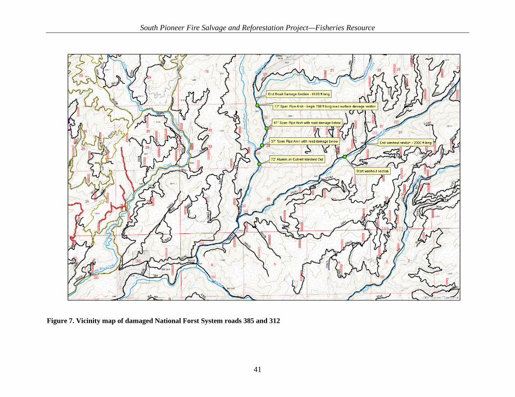
South Pioneer Fire Salvage and Reforestation Project—Fisheries Resource
41
Figure 7. Vicinity map of damaged National Forst System roads 385 and 312

South Pioneer Fire Salvage and Reforestation Project—Fisheries Resource
42
The next three culverts upstream on Banner Creek on NFS road 385 were affected by the high stream flows as well. The three culverts are still in place and functioning. The damage at the middle two culverts was limited to loss of some road surfacing material. The outsloped drain dips constructed just downgrade of the culverts during fall 2016 BAER implementation prevented the flow from continuing down the roadway in the ditchline, which would have led to additional damage to the road. Repair for these two sites involves hauling in material to fill in the ruts, volume estimates are 50–80 cubic yards per site. The uppermost site sustained damage to about 700 feet of roadway; this damage was caused by flow diverted from the Banner Creek channel. The channel became plugged with woody debris during the accelerated runoff event and road surfacing material was lost when the stream was flowing down the road. Approximately 500 cubic yards of material will be needed to complete road resurfacing. All repair work would stay within the existing road prism and would be accomplished by hauling new surfacing material in by dump truck, placing with a bulldozer, and installing drainage structures with an excavator. The road remained in its original location with no change in the design, but resurfacing would occur consistent with standard road maintenance to reduce potential for future surface erosion. All maintenance would occur within the actions already considered under the Proposed Action, to existing Forest Plan Standards. Road maintenance and hauling would occur north on NFS road 385, consistent with the Proposed Action to support the vegetation management activities. Road maintenance and haul associated with the proposed action would be adjusted to reflect the changed condition. The segment of NFS road 385 north of the 72-inch culvert will be returned to standard with road maintenance to facilitate haul north to State Highway 21 as described under the Proposed Action in the April 24, 2017, Biological Assessment of Effects on Endangered, Threatened, or Proposed Wildlife, Fish, and Plant Species for the Pioneer South Fire Salvage and Reforestation Project. Likewise, activities proposed south of the culvert will haul out south as previously planned. Additional sedimentation to unoccupied critical habitat in Banner Creek and Pikes Fork occurred from these events. However, post-fire effects of this kind were considered in the BAER 2016 assessment and the existing condition/environmental baseline for the Proposed Action in the BA. The potential for post-fire effects and associated increased sedimentation was addressed in the environmental baseline tables for Pikes Fork subwatershed in the BA and fisheries technical report. Even though post-fire effects have occurred, which increase sedimentation in Pikes Fork and Banner Creek, the sediment WCI was already Functioning at Unacceptable Risk (FUR), prior to the fire and these runoff events. These runoff events and associated road damage may have resulted in immeasurable and incremental degradation of the sediment WCI. However, post-fire effects such as these which were already considered in the baseline such as these cannot change the functional rating of the sediment WCI, though they may slightly alter the current trend of the sediment WCI in the Pikes Fork subwatershed. Natural recovery of the sediment WCI in the Pikes Fork subwatershed from post Pioneer Fire effects would now take incrementally longer, than if these specific events had not occurred, but it

South Pioneer Fire Salvage and Reforestation Project—Fisheries Resource
43
does not change the overall existing condition in any measureable or meaningful manner, nor were events of this kind an unexpected post fire effect not already considered. The moderate-level road maintenance that was scheduled will now be considered “heavy” road maintenance, due to the large amount of gravel that will be required to repair the road surface, which is currently native surface material. The addition of gravel substantially reduces surface erosion; and the project design features described in the Biological Assessment of Effects on Endangered, Threatened, or Proposed Wildlife, Fish, and Plant Species for the Pioneer South Fire Salvage and Reforestation Project (project record) will minimize the risk of delivery of sediment to water. Road maintenance work will likely have the same level of effects to sediment as was previously analyzed below. Proper maintenance on this road prism will decrease the rate of erosion with the improved surface. BMPs and project design features (FH-5, FH-8, FH-10) would minimize the potential for delivery of sediment to streams. Therefore, although the conditions of this road segment have changed, the analysis and conclusions of effects have not. No repair or actions associated with NFS road 312 is proposed; thus, it is now a part of the existing condition, and no repairs or maintenance is associated with the Proposed Action or foreseeable future actions. Sediment from this event reached Pike’s Fork (estimated 2,400 cubic yards of road surface total), however it’s not possible to determine how much actually reached Pikes Fork and was processed downstream. Many drainage features continued functioning and continued to route water and sediment off the road surface. Where drainage structures remained intact and functioning, sediment runout distances of up to 170 feet were observed, though the intact RCA vegetation was successful in trapping sediment in these areas before it reached Pikes Fork. It is important to note that RCA vegetation was successful in trapping sediment produced from drainage structures that remained functional. These field observations from massive events such as those that occurred on NFS road 312 serve to reinforce sediment travel distances modeled for the Proposed Action and reinforce the conclusion that any effects from the Proposed Action to bull trout and designated critical habitat would not change. These events also demonstrate the need for road maintenance under the Proposed Action in other portions of the Pioneer South action area to prevent future events of this kind. Adjusting treatments from hazard tree removal along NFS raod 312 to hazard tree fell and leave would result in incrementally less effect than the action described in the BA, and no material would be removed and would not result in any measurable change to any actions or effects previously analyzed. The modifications to the Proposed Action are components of the action already considered in the original BA. The changed condition (road damage) has incrementally degraded the sediment WCI in the Pikes Fork sub-watershed. However, that indicator was already FUR prior to the Pioneer Fire and these flood events, so the functional rating of the sediment WCI would not change. Project design features and other mitigations described in the BA would still be effective in preventing or limiting the potential for effects as discussed in the original BA. The above factors combined with field observations of the events, reinforces the original determination in the BA that the Proposed Action would not result in anything but a negligible and immeasurable increased risk of sedimentation from any road related actions as previously disclosed in the BA and draft fisheries technical report in the project record.

South Pioneer Fire Salvage and Reforestation Project—Fisheries Resource
44
3.5.1.1. Chemical Contaminants and Nutrients Desired Condition—Ideal conditions show low levels of chemical contamination from agricultural, industrial, and other sources. Also, ideal conditions show no excess nutrients and no 303(d) water quality limited water bodies. Current Condition—This indicator is functioning appropriately (FA) for the Upper Crooked, Middle Crooked, and Lower Crooked subwatersheds, and functioning at risk (FR) for the Pikes Fork subwatershed. No 303(d) listed streams or TMDLs occur within the project area (State of Idaho 2014). Sources of chemical contamination are limited in both subwatersheds with a couple exceptions. The area is an active sheep grazing allotment; however, water quality contamination by sheep has not been encountered during field visits within the analysis area. Numerous mining claims exist throughout the analysis area, but few large-scale mines exist, with the exception of the Banner Mine. Adit and spring discharge with elevated levels of arsenic that exceed state groundwater and drinking water standards has been documented at the Banner Mine in the Pikes Fork subwatershed (IDEQ 2008). The Pikes Fork subwatershed is functioning at risk (FR) due to this adit discharge. For more information see section 7.1 of the hydrology technical report (available in the project record).
3.5.1.2. Habitat Access
3.5.1.2.1. Physical Barriers Desired Condition—Any man-made barriers present in watershed allow upstream and downstream fish passage at all flows. Current Condition—There are 7 fish passage barriers within the project boundary in the Pikes Fork subwatershed and 16 within the Middle Crooked River subwatershed that do not pass all life stages at a range of flows. Several culverts within these subwatersheds are slated for replacement under the Becker decision. Additional culvert barriers exist within Idaho State jurisdiction occurring along State Highway 21. Pikes Fork and Middle Crooked River subwatersheds are functioning at unacceptable risk (FUR). Upper Crooked River has only one known barrier, where NFS road 384 crosses Willow Creek; therefore, that subwatershed is FR. No known barriers occur within the Lower Crooked River, which is FA.
3.5.1.3. Habitat Elements
3.5.1.3.1. Substrate Embeddedness Desired Condition—Dominant substrate is gravel or cobble (interstitial spaces clear), or ebeddedness is <20%. Current Condition—Substrate Embeddedness WCI is functioning at risk (FR) for all subwatersheds (see Sediment WCI). Substrate embeddedness is likely partially elevated from historical conditions.
3.5.1.3.2. Large Woody Debris Desired Condition—Adequate sources of large woody debris (LWD) exist for both long- and short-term recruitment in RCAs. Adequate sources are defined as >20 pieces per mile, >12 inches in diameter and >35 feet long. Current Condition—The LWD WCI is functioning appropriately (FA) for all subwatersheds. LWD within the Pikes Fork subwatershed averages 87 pieces/mile with a range of 0 to 240
South Pioneer Fire Salvage and Reforestation Project—Fisheries Resource
45
pieces/mile. LWD within the Middle Crooked River subwatershed averages 177 pieces/mile with a range of 0 to 430 pieces/mile. And LWD averages 228 pieces/mile within the Lower Crooked River and 60 pieces/mile in the Upper Crooked River.
3.5.1.3.3. Pool Frequency/Pool Quality/Large Pool Pool Frequency Desired Condition—Ideal conditions have good cover and cool water, and only minor reduction of pool volume by fine sediment. Large Poll and Pool Quality Desired Condition—Each reach has many large pools >3.28 feet. Pools have good cover and cool water, and only minor reduction of pool volume by fine sediment. Current Condition—Pool frequency in the subwatersheds is FR in Upper Crooked, Middle Crooked, and Lower Crooked Rivers and Pikes Fork subwatersheds with respect to the different stream sizes. However, pool quality measured by the abundance of pools greater than 1.0 meter in depth is functioning at risk (FR) in all subwatersheds. Increased erosion and sediment delivery to stream channels from roads and post wildfire events have reduced pool depths in all subwatersheds. For full details on current condition for all subwatersheds, see Appendix B.
3.5.1.3.4. Off-Channel Habitat Desired Condition—Watershed has many ponds, oxbows, backwaters, and other off-channel areas with cover. Current Condition—Streams within the Lower Crooked River, Pikes Fork, and Upper Crooked River subwatersheds are primarily Rosgen A and B type channels so off-channel habitat is limited but functioning appropriately (FA) for the channel types. The Middle Crooked River subwatershed has few oxbows and side channels. Overall, off-channel habitat is not abundant, mainly due to roads paralleling the channel and an artifact of the channel types in the subwatershed; therefore, this WCI is functioning at risk (FR). For full details on current condition for all subwatersheds, see Appendix B.
3.5.1.3.5. Refugia Desired Condition—Habitats capable of supporting strong and significant local populations are protected and are well distributed and connected for all life stages. Current Condition—The Upper Crooked River subwatershed is functioning appropriately (FA), while the Lower and Middle Crooked River subwatersheds are functioning at unacceptable risk (FUR) and Pikes Fork subwatershed is functioning at risk (FR). Six bull trout patches occur within the Crooked River 5th HUC. However, roads within the RCA, high stream temperatures, and poor connectivity within the Middle Crooked River subwatershed have resulted in little high quality refugia. High quality habitats capable of supporting significant local populations in the Pikes Fork 6th HUC are likely reduced from historical conditions. Positive bull trout detections have been documented in Pikes Fork, potential spawning and rearing habitat has been observed in this tributary. Most of the neighboring local populations are small. Connectivity is limited by culvert barriers.
South Pioneer Fire Salvage and Reforestation Project—Fisheries Resource
46
3.5.1.4. Channel Condition and Dynamics
3.5.1.4.1. Width/Depth Max Ratio Desired Condition—Average wetted width/maximum depth ratio in scour pools in a stream reach is ≤10. Current Condition—Stream channel maximum width to depth ratios are functioning appropriately (FA) in all subwatersheds. For full details on current conditions for all subwatersheds, see Appendix B.
3.5.1.4.2. Streambank Condition Desired Condition—More than 90% of any stream reach has stable banks. Current Condition—The Lower Crooked, Upper Crooked, and Pikes Fork subwatersheds are functioning appropriately (FA). The Middle Crooked River subwatershed is functioning at risk (FR). Past land management activities and resulting high road densities have contributed to this condition. For full details on the current conditions for all subwatersheds, see Appendix B.
3.5.1.4.3. Floodplain Connectivity Desired Condition—Within RCAs, floodplains and wetlands are hydrologically linked to the main channel. Overbank flows occur and maintain wetland/floodplain functions. Current Condition—Lower Crooked River subwatershed is functioning appropriately (FA). The Upper Crooked and Pikes Fork subwatersheds are functioning at risk (FR). The Middle Crooked River subwatershed is functioning at unacceptable risk (FUR). Extremely high RCA road densities have impacted floodplains and wetlands within all subwatersheds. For full details on current conditions for all subwatersheds, see Appendix B.
3.5.1.5. Flow/Hydrology
3.5.1.5.1. Change in Peak/Base Flows Desired Condition—Watershed hydrograph indicates peak flow, base flow, and flow timing characteristics comparable to an undisturbed watershed of a similar size, geomorphology and climatology. Current Condition Prefire Hydrologic Condition Changes in the timing and magnitude of flows are natural after a fire in the project area. Because flow changes are inversely proportional to stream order, the largest changes in flows are likely in the low order tributaries to Pikes Fork and Crooked River. The 2016 Pioneer Fire South BAER Hydrologic Assessment modeled postfire increases in flows in Crooked River for flood and infrastructure protection purposes (USDA Forest Service 2016a). Changes in forest vegetation resulting from management or natural events can affect the frequency and magnitude of rain-on-snow events, not just of the summer storm hydrograph (Harr 1986). Rain-on-snow events are common in the project area. Following a wildfire, the amount of solar radiation absorbed by the snowpack can increase because of vegetation canopy loss. Additionally, the snowpack albedo, or reflectance, can decrease from the presence of ash and detritus on the snow surface. These changes can result in increased snowmelt rates and earlier

South Pioneer Fire Salvage and Reforestation Project—Fisheries Resource
47
melting (Gleason et al. 2013). Changes in snowpack and melt timing, combined with rain-on-snow events, could affect water yield by increasing peak flows and their timing. Rain-on-snow and resulting peak flows are natural processes in the project area streams and have shaped the overall morphology and stability of stream channels in the area. The driving factors of watershed response to the Pioneer Fire in the project area will be the steep slopes, lack of effective ground cover, and loss of raindrop interception via the absence of vegetation canopy cover. Pikes Fork and Lower, Middle and Upper Crooked River subwatersheds burned with a mosaic of high, medium, and low soil burn severities (SBS) (Table 13). SBS pertains to heat on and just below the ground and is relevant for low plants and root and soil structures. Table 14 outlines vegetation mortality from the RAVG model by watershed. This model primarily measures loss in taller vegetation, such as tree canopy. Tree canopy loss, for example, happened mostly in the high and moderate SBS areas within the Pioneer Fire perimeter. Most of the project area sub-watersheds burnt at moderate and low SBS (Table 13). Much of the moderate severity (downward heat, into the soil) shown in Pikes Fork and Middle Crooked River burned at moderate and high intensity (upward heat into the vegetation), so that much of the vegetation in these areas was consumed. In this situation, a greater hydrologic response could be expected than the SBS alone would suggest. Given the burn intensities and burn severities outlined in Table 13 and Table 14, the hydrologic regime of the project area subwatersheds will be altered. Runoff timing, peak flows, and base flows are likely to be altered, which would change the baseline condition. Pre and postfire assessments for the Peak Flow/Base Flow WCI are outlined in Table 15. Table 13. Percent of Soil Burn Severity (SBS) class by 6th subwatershed and riparian conservation
area (RCA)
SBSa Lower
Crooked River (%)
Middle Crooked River (%)
Pikes Fork (%)
Upper Crooked River (%)
Total (%)
RCA Totals
(%) Unburned/Very Low 4.7 10.0 17.1 14.3 11.5 15.2 Outside Fire Perimeter 73.2 2.6 8.0 48.4 32.2 29.8 Low 12.4 36.7 36.9 26.1 28.4 33.8 Moderate 8.5 42.0 31.4 10.2 23.5 19.5 High 1.1 8.7 6.6 1.0 4.4 1.6 aMeasured at the ground surface and below ground. Applies to root structure and low vegetation.
Table 14. Percent vegetation loss by subwatershed, within the fire perimeter Vegetation Mortalitya
(%) Lower Crooked River
(%) Middle Crooked River
(%) Pikes Fork
(%) Upper Crooked River
(%) 0–25 2.35 8.25 6.20 7.28
25–50 1.01 4.41 2.41 2.53 50–75 0.85 4.18 1.93 1.84 75–100 3.18 21.59 9.96 6.38 Total 7.39 38.43 20.50 18.03
aMostly tree data; tall canopy changes
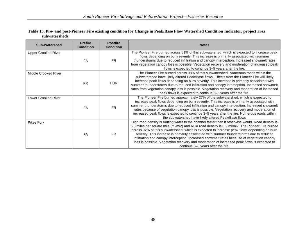
South Pioneer Fire Salvage and Reforestation Project—Fisheries Resource
48
Table 15. Pre- and post-Pioneer Fire existing condition for Change in Peak/Base Flow Watershed Condition Indicator, project area subwatersheds
Sub-Watershed Prefire Condition
Postfire Condition Notes
Upper Crooked River
FA FR
The Pioneer Fire burned across 51% of this subwatershed, which is expected to increase peak flows depending on burn severity. This increase is primarily associated with summer
thunderstorms due to reduced infiltration and canopy interception. Increased snowmelt rates from vegetation canopy loss is possible. Vegetation recovery and moderation of increased peak
flows is expected to continue 3–5 years after the fire. Middle Crooked River
FR FUR
The Pioneer Fire burned across 98% of this subwatershed. Numerous roads within the subwatershed have likely altered Peak/Base flows. Effects from the Pioneer Fire will likely increase peak flows depending on burn severity. This increase is primarily associated with
summer thunderstorms due to reduced infiltration and canopy interception. Increased snowmelt rates from vegetation canopy loss is possible. Vegetation recovery and moderation of increased
peak flows is expected to continue 3–5 years after the fire. Lower Crooked River
FA FR
The Pioneer Fire burned approximately 27% of the subwatershed, which is expected to increase peak flows depending on burn severity. This increase is primarily associated with
summer thunderstorms due to reduced infiltration and canopy interception. Increased snowmelt rates because of vegetation canopy loss is possible. Vegetation recovery and moderation of increased peak flows is expected to continue 3–5 years after the fire. Numerous roads within
the subwatershed have likely altered Peak/Base flows Pikes Fork
FA FR
High road density is routing water to the channel faster than it otherwise would. Road density is 6.5 miles per square mile (mi/mi2) and RCA road density is 8.2 mi/mi2. The Pioneer Fire burned across 92% of this subwatershed, which is expected to increase peak flows depending on burn
severity. This increase is primarily associated with summer thunderstorms due to reduced infiltration and canopy interception. Increased snowmelt rates because of vegetation canopy loss is possible. Vegetation recovery and moderation of increased peak flows is expected to
continue 3–5 years after the fire.

South Pioneer Fire Salvage and Reforestation Project—Fisheries Resource
49
3.5.1.5.2. Drainage Network Increase Desired Condition—Zero or minimum change in active channel length correlated with human caused disturbance. Current Condition—This indicator is functioning at unacceptable risk (FUR) in Pikes Fork and and Middle Crooked River subwatersheds. The Lower and Upper Crooked River subwatersheds are functioning at risk (FR) and have lower road densities. Road density in all subwatersheds is high, constituting a greater than moderate change in active channel length as roads act as a conduit to route water to stream channels. For full details on current conditions for all subwatersheds, see Appendix B.
3.5.1.6. Watershed Conditions
3.5.1.6.1. Road Density and Location Desired Condition—Ideal conditions consists of total road density ˂0.7 miles/square mile (mi/mi2) of the subwatershed and no roads within the RCA. Current Condition—Table 16 describes existing road densities in the analysis subwatersheds and compares them to post-project road density values.

South Pioneer Fire Salvage and Reforestation Project—Fisheries Resource
50
Table 16. Pre- and post-project road density including temporary road construction within and outside of riparian conservation areas (RCAs)
Subwatershed Existing Road Density (mi/mi2) Existing
Condition Functionality
Temporary Road Construction on Existing Road
Prism
Temporary Road Construction Not on Existing Road
Prism
Post Project Road Density
(mi/mi2) Post Project Functionality
Non-RCA RCA Non-RCA RCA
Upper Crooked River 2.75 0.22 Functioning at
unacceptable risk (FUR)
0 0 3.8 4.6 FUR
Middle Crooked River 3.8 7.5 FUR 3.4 0.2 3.87 7.55 FUR Lower Crooked River 3.1 2.1 FUR 0 0 3.1 2.1 FUR Pikes Fork 6.5 8.2 FUR 0 0 6.5 7.2 FUR

South Pioneer Fire Salvage and Reforestation Project—Fisheries Resource
51
3.5.1.6.2. Disturbance History Desired Condition—Ideal conditions consists of ˂15% Equivalent Clearcut Area (ECA) (entire watershed) with no concentration of disturbance in areas with landslide or landslide prone areas, and/or refugia, and/or RCAs. Current Conditions—Prior to the 2016 Pioneer Fire, all subwatersheds within the project were FR, due to ECAs >15% and/or concentrations of disturbance within RCAs (RCA road densities. Following the Pioneer Fire, this indicator is now functioning at unacceptable risk (FUR) for Pikes Fork and Lower and Upper Crooked River subwatersheds and FR for the Middle Crooked River subwatershed. The Pioneer Fire burned varying proportions of each subwatershed at varying severities and intensitieswithin the project boundary (see Table 15). While future fire risk is now lower than prefire conditions, postfire processes will be the dominant driver of future conditions within the project area. For full details on current conditions for all subwatersheds, see Appendix B.
3.5.1.6.3. Riparian Conservation Areas Desired Condition—The RCAs within the subwatershed have historic and occupied refugia for listed, sensitive or native/desired nonnative fish species which are present and provide adequate shade, LWD recruitment, sediment buffering, connectivity, and habitat protection to minimize adverse effects from land management activities (>80% intact). Current Condition—This indicator is functioning at risk (FR) in all subwatersheds. Past land management activities including logging, road construction, and mining have contributed to fragmented habitats and altered hydrologic, sediment, and temperature regimes. Some of these influences have recovered over time; however, roads and fish barriers at stream crossings continue to hinder attainment of desired conditions. Several other WCIs influence the condition of this WCI (e.g., LWD, Road Density, Temperature, Sediment, Refugia). The condition of those WCIs results in the overall RCA condition for this WCI. All RCAs within the subwatersheds have been impacted by the Pioneer Fire. SBS is a good indicator of how hot the fire burned (fire intensity/severity) and a barometer of the immediate and future fire effects related to vegetation, down woody debris, tree mortality, ground cover, streamside vegetation, and long-term soil productivity. However, the vast majority of the RCAs within the project area burned at low to moderate intensity (see Table 17). Much of the Lower Crooked River and Upper Crooked River RCAs were outside the fire perimeter. Thus, while RCAs were affected by the Pioneer Fire, they are largely intact with sufficient streamside vegetation and LWD. Data collected in December 2016 showed RCAs in good condition postfire. See RCA condition photos below (Figure 8, Figure 9, Figure 10, Figure 11, Figure 12). For details on current conditions for all subwatersheds, see Appendix B.

South Pioneer Fire Salvage and Reforestation Project—Fisheries Resource
52
Table 17. Soil Burn Severity (SBS) class within riparian conservation areas (RCAs) by subwatershed
SBS Class Lower Crooked River (%)
Middle Crooked River (%)
Pikes Fork (%)
Upper Crooked River (%)
High 1.1 8.7 6.6 1.0 Low 12.4 36.7 36.9 26.1 Moderate 8.5 42.0 31.4 10.2 Outside Fire Perimeter 73.2 2.6 8.0 48.4
Unburned/Very Low 4.7 10.0 17.1 14.3 Total 100.0 100.0 100.0 100.0
Figure 8. Riparian Conservation Area condition within the South Pioneer area post fire in 2016

South Pioneer Fire Salvage and Reforestation Project—Fisheries Resource
53
Figure 9. Riparian Conservation Area condition within the South Pioneer area post fire in 2016
Figure 10. Riparian Conservation Area condition within the South Pioneer area post fire in 2016

South Pioneer Fire Salvage and Reforestation Project—Fisheries Resource
54
Figure 11. Riparian Conservation Area condition within the South Pioneer area post fire in 2016
Figure 12. Riparin Conservation Area condition within the South Pioneer area post fire in 2016
3.5.1.6.4. Disturbance Regime Desired Condition—Disturbance resulting from land management activities are negligible or temporary. Streamflow regimes are appropriate to the local geomorphology, potential vegetation, and climatology, resulting in appropriate high-quality habitat and watershed complexity that
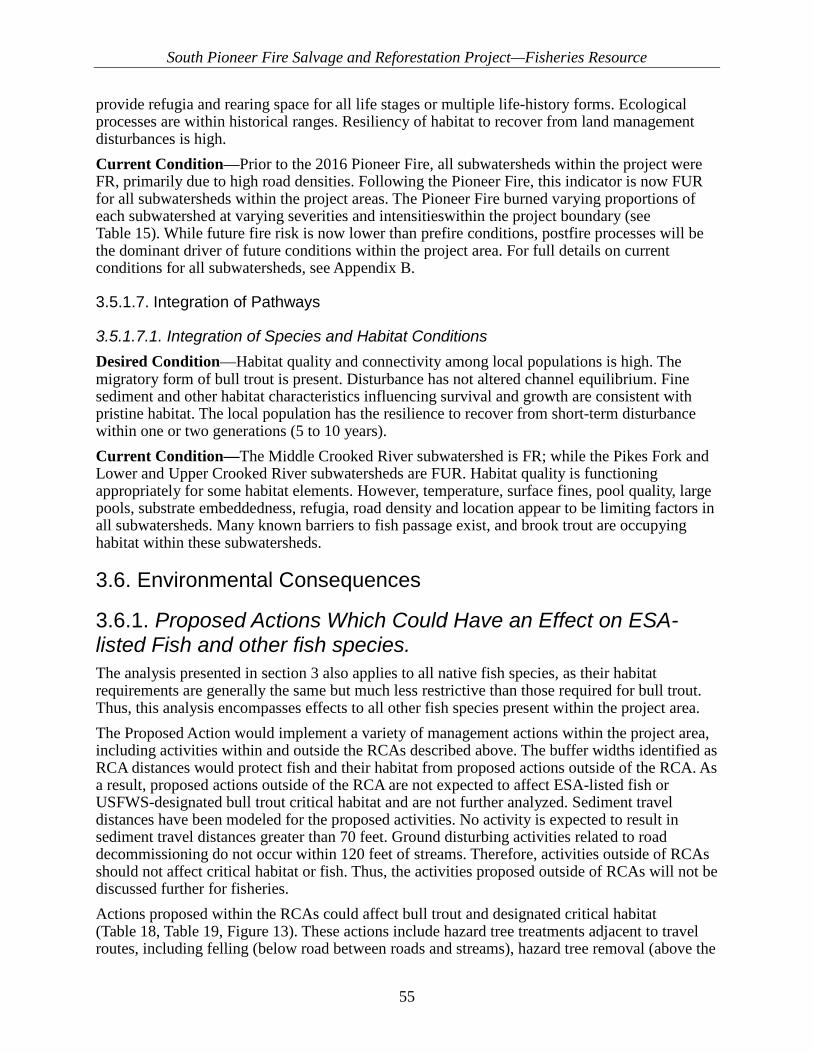
South Pioneer Fire Salvage and Reforestation Project—Fisheries Resource
55
provide refugia and rearing space for all life stages or multiple life-history forms. Ecological processes are within historical ranges. Resiliency of habitat to recover from land management disturbances is high. Current Condition—Prior to the 2016 Pioneer Fire, all subwatersheds within the project were FR, primarily due to high road densities. Following the Pioneer Fire, this indicator is now FUR for all subwatersheds within the project areas. The Pioneer Fire burned varying proportions of each subwatershed at varying severities and intensitieswithin the project boundary (see Table 15). While future fire risk is now lower than prefire conditions, postfire processes will be the dominant driver of future conditions within the project area. For full details on current conditions for all subwatersheds, see Appendix B.
3.5.1.7. Integration of Pathways
3.5.1.7.1. Integration of Species and Habitat Conditions Desired Condition—Habitat quality and connectivity among local populations is high. The migratory form of bull trout is present. Disturbance has not altered channel equilibrium. Fine sediment and other habitat characteristics influencing survival and growth are consistent with pristine habitat. The local population has the resilience to recover from short-term disturbance within one or two generations (5 to 10 years). Current Condition—The Middle Crooked River subwatershed is FR; while the Pikes Fork and Lower and Upper Crooked River subwatersheds are FUR. Habitat quality is functioning appropriately for some habitat elements. However, temperature, surface fines, pool quality, large pools, substrate embeddedness, refugia, road density and location appear to be limiting factors in all subwatersheds. Many known barriers to fish passage exist, and brook trout are occupying habitat within these subwatersheds.
3.6. Environmental Consequences
3.6.1. Proposed Actions Which Could Have an Effect on ESA-listed Fish and other fish species. The analysis presented in section 3 also applies to all native fish species, as their habitat requirements are generally the same but much less restrictive than those required for bull trout. Thus, this analysis encompasses effects to all other fish species present within the project area. The Proposed Action would implement a variety of management actions within the project area, including activities within and outside the RCAs described above. The buffer widths identified as RCA distances would protect fish and their habitat from proposed actions outside of the RCA. As a result, proposed actions outside of the RCA are not expected to affect ESA-listed fish or USFWS-designated bull trout critical habitat and are not further analyzed. Sediment travel distances have been modeled for the proposed activities. No activity is expected to result in sediment travel distances greater than 70 feet. Ground disturbing activities related to road decommissioning do not occur within 120 feet of streams. Therefore, activities outside of RCAs should not affect critical habitat or fish. Thus, the activities proposed outside of RCAs will not be discussed further for fisheries. Actions proposed within the RCAs could affect bull trout and designated critical habitat (Table 18, Table 19, Figure 13). These actions include hazard tree treatments adjacent to travel routes, including felling (below road between roads and streams), hazard tree removal (above the
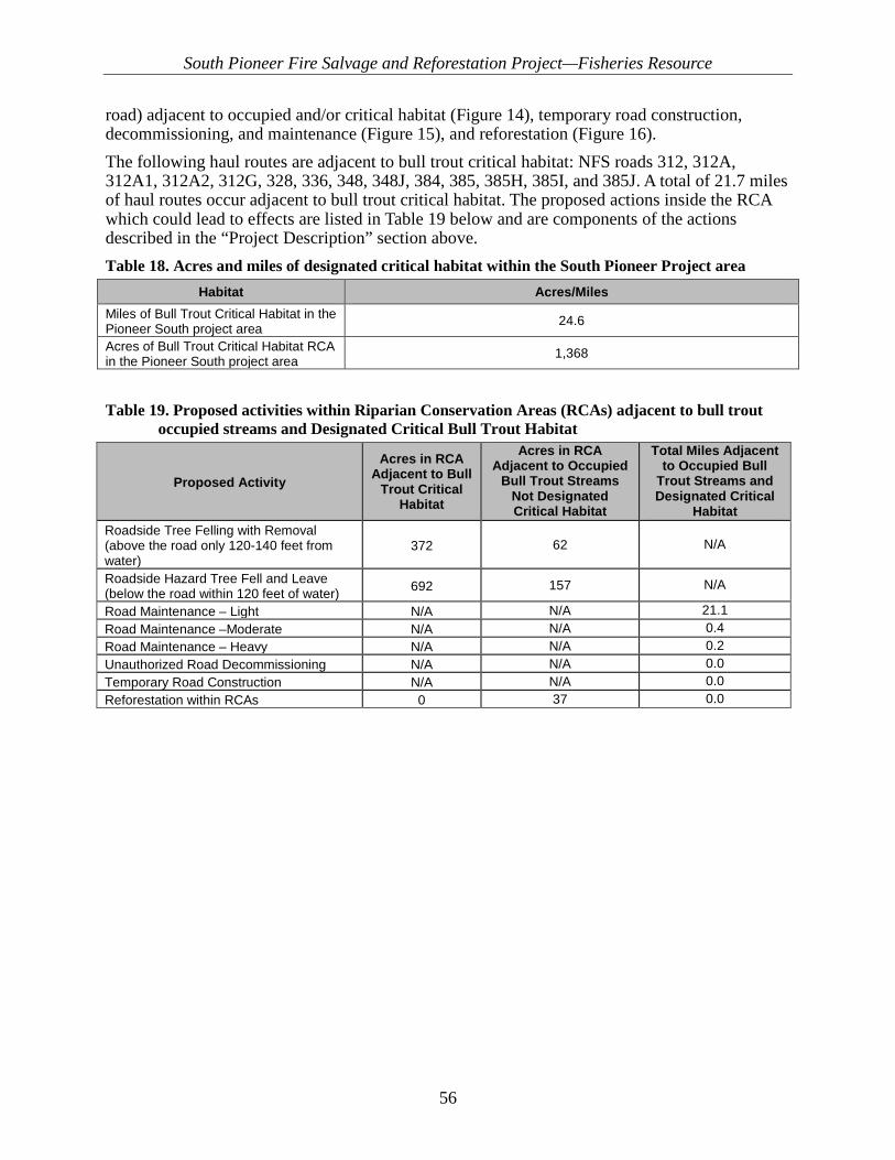
South Pioneer Fire Salvage and Reforestation Project—Fisheries Resource
56
road) adjacent to occupied and/or critical habitat (Figure 14), temporary road construction, decommissioning, and maintenance (Figure 15), and reforestation (Figure 16). The following haul routes are adjacent to bull trout critical habitat: NFS roads 312, 312A, 312A1, 312A2, 312G, 328, 336, 348, 348J, 384, 385, 385H, 385I, and 385J. A total of 21.7 miles of haul routes occur adjacent to bull trout critical habitat. The proposed actions inside the RCA which could lead to effects are listed in Table 19 below and are components of the actions described in the “Project Description” section above. Table 18. Acres and miles of designated critical habitat within the South Pioneer Project area
Habitat Acres/Miles Miles of Bull Trout Critical Habitat in the Pioneer South project area 24.6
Acres of Bull Trout Critical Habitat RCA in the Pioneer South project area 1,368
Table 19. Proposed activities within Riparian Conservation Areas (RCAs) adjacent to bull trout occupied streams and Designated Critical Bull Trout Habitat
Proposed Activity Acres in RCA
Adjacent to Bull Trout Critical
Habitat
Acres in RCA Adjacent to Occupied
Bull Trout Streams Not Designated Critical Habitat
Total Miles Adjacent to Occupied Bull
Trout Streams and Designated Critical
Habitat Roadside Tree Felling with Removal (above the road only 120-140 feet from water)
372 62 N/A
Roadside Hazard Tree Fell and Leave (below the road within 120 feet of water) 692 157 N/A
Road Maintenance – Light N/A N/A 21.1 Road Maintenance –Moderate N/A N/A 0.4 Road Maintenance – Heavy N/A N/A 0.2 Unauthorized Road Decommissioning N/A N/A 0.0 Temporary Road Construction N/A N/A 0.0 Reforestation within RCAs 0 37 0.0
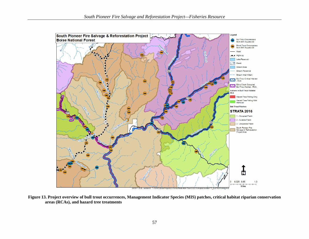
South Pioneer Fire Salvage and Reforestation Project—Fisheries Resource
57
Figure 13. Project overview of bull trout occurrences, Management Indicator Species (MIS) patches, critical habitat riparian conservation
areas (RCAs), and hazard tree treatments

South Pioneer Fire Salvage and Reforestation Project—Fisheries Resource
58
Figure 14. Hazard tree treatments adjacent to occupied and/or critical habitat

South Pioneer Fire Salvage and Reforestation Project—Fisheries Resource
59
Figure 15. Temporary road construction and decommissioning

South Pioneer Fire Salvage and Reforestation Project—Fisheries Resource
60
Figure 16. Proposed reforestation within the South Pioneer Fire Salvage and Reforestation Project area

South Pioneer Fire Salvage and Reforestation Project—Fisheries Resource
61
3.6.1.1. Assumptions specific to relevant and influenced WCIs Assumptions made for this analysis include:
• Assumptions associated with the characterization of existing (baseline) conditions for analysis indicators described in baseline discussion and tables contained Appendix B
• The assumption that all project design features would be implemented in a timely and effective manner.
Due to project design features limiting the types of harvest activities occurring within RCAs only the following relevant and influenced WCIs are included in this analysis: local population size, growth and survival, persistence and genetic integrity, temperature, sediment/turbidity, chemical contaminants, substrate embeddedness, pool frequency and quality, large woody debris, refugia (bull trout) stream bank condition, floodplain connectivity, road density/location, change in peak/base flows, change in drainage network, RCAs, and Integration of Habitat and Species Condition. Table 20 below summarizes the presence, relevance and influence of all WCIs, and their relation to the Direct and Indirect Effects in the following section. The hydrologists and fisheries biolgogists analyzed the proposed project actions, and determined which WCIs were a) present within the analysis area (RELEVANT), b) potentially effected (INFLUENCED), and c) present and potentially effected by the project actions (RELEVANT AND INFLUENCED). WCIs determined to be relevant and influenced were carried forward into detailed analysis of direct and indirect effects.

South Pioneer Fire Salvage and Reforestation Project—Fisheries Resource
62
Table 20. Watershed Condition Indicator (WCI) presence relevance and potential for influence within the project area
Pathways and WCIs WCI Present within the
Footprint of the Projecta
Statusb Discussion
Bull Trout Local Population Characteristics
Local Population Size Y RI May be indirectly effected by changes in habitat conditions. Hazard tree treatments could affect LWD in several timeframes adjacent to critical and occupied habitat.
Growth & Survival Y RI May be indirectly effected by changes in habitat conditions. Hazard tree treatments could affect LWD in several timeframes adjacent to critical and occupied habitat. Other habitat
WCI’s could indirectly effect this WCI. Life History Diversity and Isolation Y R No barriers of any kind will be affected by the proposed action in or near occupied or
critical habitat thus resident and migratory life forms will continue in the current condition. Persistence and Genetic Integrity Y R No aspects of the proposed action are proposed that could affect this WCI for bull trout.
Water Quality Temperature (Bull Trout) Y RI Removal of hazard trees within RCAs could affect summer maximum temperatures.
Sediment/Turbidity (Bull Trout) Y RI Road related actions could affect sedimentation adjacent to occupied and/or designated critical habitat.
Chemical Contaminants/Nutrients Y RI Chemicals or fuel could leak within RCA buffers.
Habitat Access Physical Barriers Y R No culverts are proposed to be replace.
Habitat Elements Substrate Embeddedness Y RI See sediment discussion Large Woody Debris Y RI Hazard tree treatments within RCAs could change LWD, or reduce potential LWD.
Pool Frequency and Quality Y RI Changes in LWD could result in changes to # of pools/mile, and formation of high quality pools. Sedimentation could reduce pool volumes.
Large Pools Y RI Changes in LWD could influence formation of large pools.
Off Channel Habitat Y R Activities within RCAs should not change off channel habitat characteristics as there will be no equipment off established roads.
Refugia (Bull Trout) Y RI Changes to other WCIs, could result in changes to the quality of existing bull trout habitat.
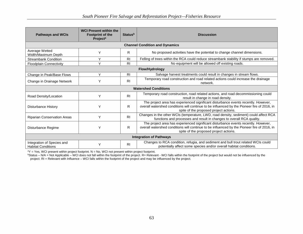
South Pioneer Fire Salvage and Reforestation Project—Fisheries Resource
63
Pathways and WCIs WCI Present within the
Footprint of the Projecta
Statusb Discussion
Channel Condition and Dynamics Average Wetted Width/Maximum Depth Y R No proposed activities have the potential to change channel dimensions.
Streambank Condition Y RI Felling of trees within the RCA could reduce streambank stability if stumps are removed. Floodplain Connectivity Y RI No equipment will be allowed off existing roads.
Flow/Hydrology Change in Peak/Base Flows Y RI Salvage harvest treatments could result in changes in stream flows.
Change in Drainage Network Y RI Temporary road construction and road related actions could increase the drainage network.
Watershed Conditions
Road Density/Location Y RI Temporary road construction, road related actions, and road decommissioning could result in change in road density.
Disturbance History Y R The project area has experienced significant disturbance events recently. However,
overall watershed conditions will continue to be influenced by the Pioneer fire of 2016, in spite of the proposed project actions.
Riparian Conservation Areas Y RI Changes in the other WCIs (temperature, LWD, road density, sediment) could affect RCA functions and processes and result in changes to overall RCA quality.
Disturbance Regime Y R The project area has experienced significant disturbance events recently. However,
overall watershed conditions will continue to be influenced by the Pioneer fire of 2016, in spite of the proposed project actions.
Integration of Pathways Integration of Species and Habitat Conditions Y RI Changes to RCA condition, refugia, and sediment and bull trout related WCIs could
potentially affect some species and/or overall habitat conditions. aY = Yes, WCI present within project footprint. N = No, WCI not present within project footprint. bStatus – N/A = Not Applicable – WCI does not fall within the footprint of the project. R= Relevant - WCI falls within the footprint of the project but would not be influenced by the
project. RI = Relevant with Influence – WCI falls within the footprint of the project and may be influenced by the project.

South Pioneer Fire Salvage and Reforestation Project—Fisheries Resource
64
3.7. Direct and Indirect Effects to WCIs A summary of effects for all indicators is summarized in Table 20 for the proposed action. More detailed information about potential impacts is given in the narratives below the tables. Table 21 details the potential temporary (0–3 years), short-term (3–15 years), and long-term (15+ years) impacts. In these columns, a “+” means an improvement in the condition of an indicator, not necessarily an increase in the number or measurement of an indicator. A “-“means a degradation in the condition of an indicator, not necessarily a decrease in the number or measurement of an indicator. An “o” means no impact on the indicator. An asterisk “*” following a “+” or “-“means the impact is immeasurable or negligible. Effects to WCI functionality class consists of M = Maintain (within functionality class), D=Degrade (change functionality class), NI = No Influence, I = Improve (change functionality class).
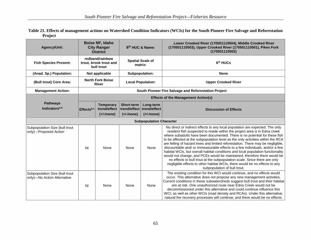
South Pioneer Fire Salvage and Reforestation Project—Fisheries Resource
65
Table 21. Effects of management actions on Watershed Condition Indicators (WCIs) for the South Pioneer Fire Salvage and Reforestation Project
Agency/Unit: Boise NF, Idaho
City Ranger District
6th HUC & Name: Lower Crooked River (170501110504), Middle Crooked River
(170501110503), Upper Crooked River (170501110501), Pikes Fork (170501110502)
Fish Species Present: redband/rainbow
trout, brook trout and bull trout
Spatial Scale of matrix: 6th HUCs
(Anad. Sp.) Population: Not applicable Subpopulation: None
(Bull trout) Core Area: North Fork Boise River Local Population: Upper Crooked River
Management Action: South Pioneer Fire Salvage and Reforestation Project
Pathways Indicatorsa,d
Effects of the Management Action(s)
Effectsb,c Temporary trend/effect (+/-/none)
Short-term trend/effect (+/-/none)
Long-term trend/effect (+/-/none)
Discussion of Effects
Subpopulation Character
Subpopulation Size (bull trout only)—Proposed Action
NI None None None
No direct or indirect effects to any local population are expected. The only resident fish suspected to reside within the project area is in Edna creek
where subadults have been documented. There is no potential for these fish to be affected at the subpopulation level as the only activities within the RCA are felling of hazard trees and limited reforestation. There may be negligible, discountable and/ or immeasurable effects to a few individuals, and/or a few habitat WCIs, but overall habitat conditions and local population functionality would not change, and PCEs would be maintained, therefore there would be
no effects to bull trout at the subpopulation scale. Since there are only negligible effects to other habitat WCIs, there would be no effects to any
subpopulation of bull trout. Subpopulation Size (bull trout only)—No Action Alternative
NI None None None
The existing condition for this WCI would continue, and no effects would occur. This alternative does not propose any new management activities.
Current conditions in these subwatersheds suggest bull trout and their habitat are at risk. One unauthorized route near Edna Creek would not be
decommissioned under this alternative and could continue influence this WCI; as well as other WCIs (road density and RCAs). Under this alternative, natural fire recovery processes will continue, and there would be no effects.

South Pioneer Fire Salvage and Reforestation Project—Fisheries Resource
66
Agency/Unit: Boise NF, Idaho
City Ranger District
6th HUC & Name: Lower Crooked River (170501110504), Middle Crooked River
(170501110503), Upper Crooked River (170501110501), Pikes Fork (170501110502)
Fish Species Present: redband/rainbow
trout, brook trout and bull trout
Spatial Scale of matrix: 6th HUCs
(Anad. Sp.) Population: Not applicable Subpopulation: None
(Bull trout) Core Area: North Fork Boise River Local Population: Upper Crooked River
Management Action: South Pioneer Fire Salvage and Reforestation Project
Pathways Indicatorsa,d
Effects of the Management Action(s)
Effectsb,c Temporary trend/effect (+/-/none)
Short-term trend/effect (+/-/none)
Long-term trend/effect (+/-/none)
Discussion of Effects
Growth and Survival (bull trout only)—Proposed Action
NI None None None
No direct or indirect effects to any local population are expected. The only resident fish suspected to reside within the project area is in Edna Creek
where subadults have been documented. There is no potential for these fish to be affected at the subpopulation level as the only activities within the RCA are felling of hazard trees and limited reforestation. There may be negligible, discountable, and/or immeasurable effects to a few individuals, and/or a few
habitat WCIs, but overall existing conditions for growth and survival would not change, and PCEs would be maintained, therefore there would be no effects to bull trout at the subpopulation scale. Since there are only negligible effects
to a few habitat WCIs, there can be no effects to any subpopulation of bull trout.
Growth and Survival (bull trout only)—No Action Alternative NI None None None The existing condition for this WCI would continue, and no effects would
occur. This alternative does not propose any new management activities.
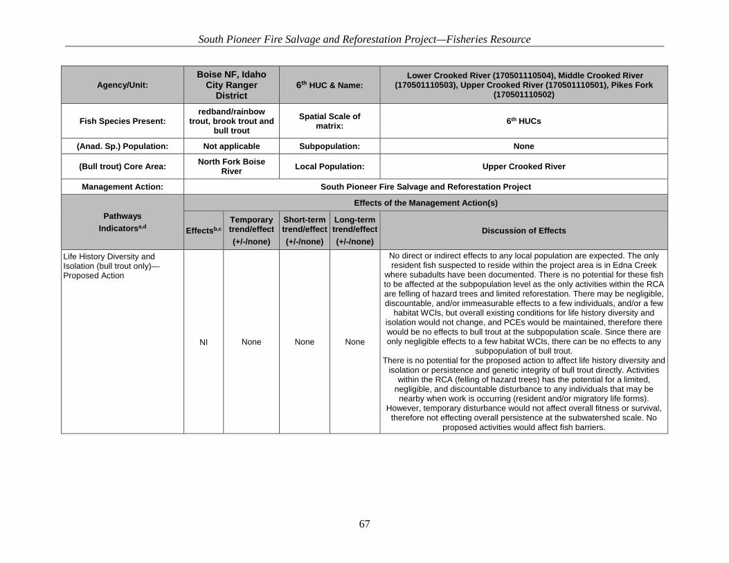
South Pioneer Fire Salvage and Reforestation Project—Fisheries Resource
67
Agency/Unit: Boise NF, Idaho
City Ranger District
6th HUC & Name: Lower Crooked River (170501110504), Middle Crooked River
(170501110503), Upper Crooked River (170501110501), Pikes Fork (170501110502)
Fish Species Present: redband/rainbow
trout, brook trout and bull trout
Spatial Scale of matrix: 6th HUCs
(Anad. Sp.) Population: Not applicable Subpopulation: None
(Bull trout) Core Area: North Fork Boise River Local Population: Upper Crooked River
Management Action: South Pioneer Fire Salvage and Reforestation Project
Pathways Indicatorsa,d
Effects of the Management Action(s)
Effectsb,c Temporary trend/effect (+/-/none)
Short-term trend/effect (+/-/none)
Long-term trend/effect (+/-/none)
Discussion of Effects
Life History Diversity and Isolation (bull trout only)—Proposed Action
NI None None None
No direct or indirect effects to any local population are expected. The only resident fish suspected to reside within the project area is in Edna Creek
where subadults have been documented. There is no potential for these fish to be affected at the subpopulation level as the only activities within the RCA are felling of hazard trees and limited reforestation. There may be negligible, discountable, and/or immeasurable effects to a few individuals, and/or a few
habitat WCIs, but overall existing conditions for life history diversity and isolation would not change, and PCEs would be maintained, therefore there would be no effects to bull trout at the subpopulation scale. Since there are only negligible effects to a few habitat WCIs, there can be no effects to any
subpopulation of bull trout. There is no potential for the proposed action to affect life history diversity and
isolation or persistence and genetic integrity of bull trout directly. Activities within the RCA (felling of hazard trees) has the potential for a limited,
negligible, and discountable disturbance to any individuals that may be nearby when work is occurring (resident and/or migratory life forms).
However, temporary disturbance would not affect overall fitness or survival, therefore not effecting overall persistence at the subwatershed scale. No
proposed activities would affect fish barriers.
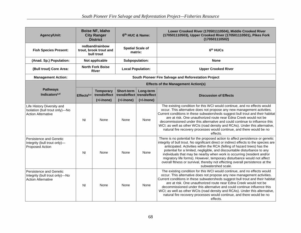
South Pioneer Fire Salvage and Reforestation Project—Fisheries Resource
68
Agency/Unit: Boise NF, Idaho
City Ranger District
6th HUC & Name: Lower Crooked River (170501110504), Middle Crooked River
(170501110503), Upper Crooked River (170501110501), Pikes Fork (170501110502)
Fish Species Present: redband/rainbow
trout, brook trout and bull trout
Spatial Scale of matrix: 6th HUCs
(Anad. Sp.) Population: Not applicable Subpopulation: None
(Bull trout) Core Area: North Fork Boise River Local Population: Upper Crooked River
Management Action: South Pioneer Fire Salvage and Reforestation Project
Pathways Indicatorsa,d
Effects of the Management Action(s)
Effectsb,c Temporary trend/effect (+/-/none)
Short-term trend/effect (+/-/none)
Long-term trend/effect (+/-/none)
Discussion of Effects
Life History Diversity and Isolation (bull trout only)—No Action Alternative
NI None None None
The existing condition for this WCI would continue, and no effects would occur. This alternative does not propose any new management activities.
Current conditions in these subwatersheds suggest bull trout and their habitat are at risk. One unauthorized route near Edna Creek would not be
decommissioned under this alternative and could continue to influence this WCI; as well as other WCIs (road density and RCAs). Under this alternative,
natural fire recovery processes would continue, and there would be no effects.
Persistence and Genetic Integrity (bull trout only)—Proposed Action
NI None None None
There is no potential for the proposed action to affect persistence or genetic integrity of bull trout. No significant direct or indirect effects to the species are
anticipated. Activities within the RCA (felling of hazard trees) has the potential for a limited, negligible, and discountable disturbance to any
individuals that may be nearby when work is occurring (resident and/or migratory life forms). However, temporary disturbance would not affect
overall fitness or survival, thereby not effecting overall persistence at the subwatershed scale.
Persistence and Genetic Integrity (bull trout only)—No Action Alternative
NI None None None
The existing condition for this WCI would continue, and no effects would occur. This alternative does not propose any new management activities.
Current conditions in these subwatersheds suggest bull trout and their habitat are at risk. One unauthorized route near Edna Creek would not be
decommissioned under this alternative and could continue influence this WCI; as well as other WCIs (road density and RCAs). Under this alternative,
natural fire recovery processes would continue, and there would be no effects.
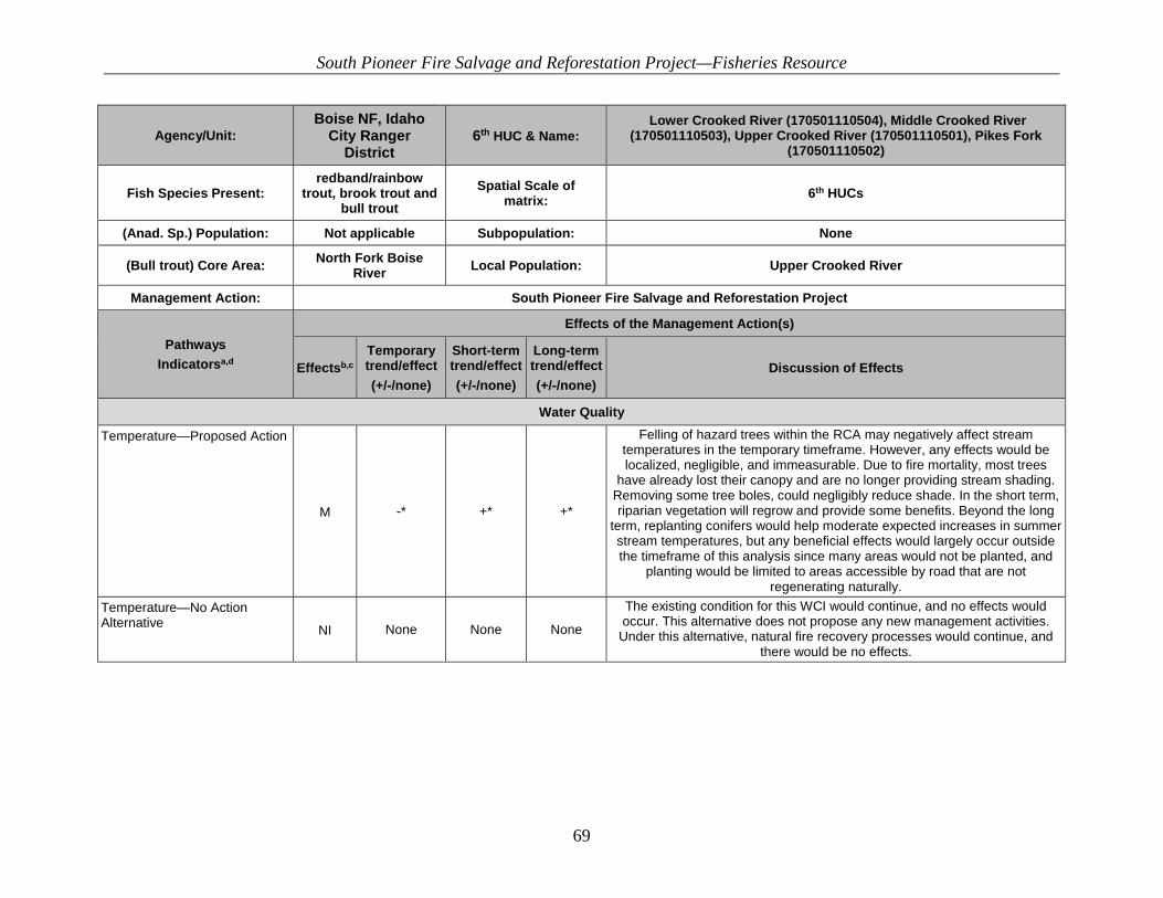
South Pioneer Fire Salvage and Reforestation Project—Fisheries Resource
69
Agency/Unit: Boise NF, Idaho
City Ranger District
6th HUC & Name: Lower Crooked River (170501110504), Middle Crooked River
(170501110503), Upper Crooked River (170501110501), Pikes Fork (170501110502)
Fish Species Present: redband/rainbow
trout, brook trout and bull trout
Spatial Scale of matrix: 6th HUCs
(Anad. Sp.) Population: Not applicable Subpopulation: None
(Bull trout) Core Area: North Fork Boise River Local Population: Upper Crooked River
Management Action: South Pioneer Fire Salvage and Reforestation Project
Pathways Indicatorsa,d
Effects of the Management Action(s)
Effectsb,c Temporary trend/effect (+/-/none)
Short-term trend/effect (+/-/none)
Long-term trend/effect (+/-/none)
Discussion of Effects
Water Quality
Temperature—Proposed Action
M -* +* +*
Felling of hazard trees within the RCA may negatively affect stream temperatures in the temporary timeframe. However, any effects would be localized, negligible, and immeasurable. Due to fire mortality, most trees
have already lost their canopy and are no longer providing stream shading. Removing some tree boles, could negligibly reduce shade. In the short term, riparian vegetation will regrow and provide some benefits. Beyond the long
term, replanting conifers would help moderate expected increases in summer stream temperatures, but any beneficial effects would largely occur outside the timeframe of this analysis since many areas would not be planted, and
planting would be limited to areas accessible by road that are not regenerating naturally.
Temperature—No Action Alternative NI None None None
The existing condition for this WCI would continue, and no effects would occur. This alternative does not propose any new management activities.
Under this alternative, natural fire recovery processes would continue, and there would be no effects.
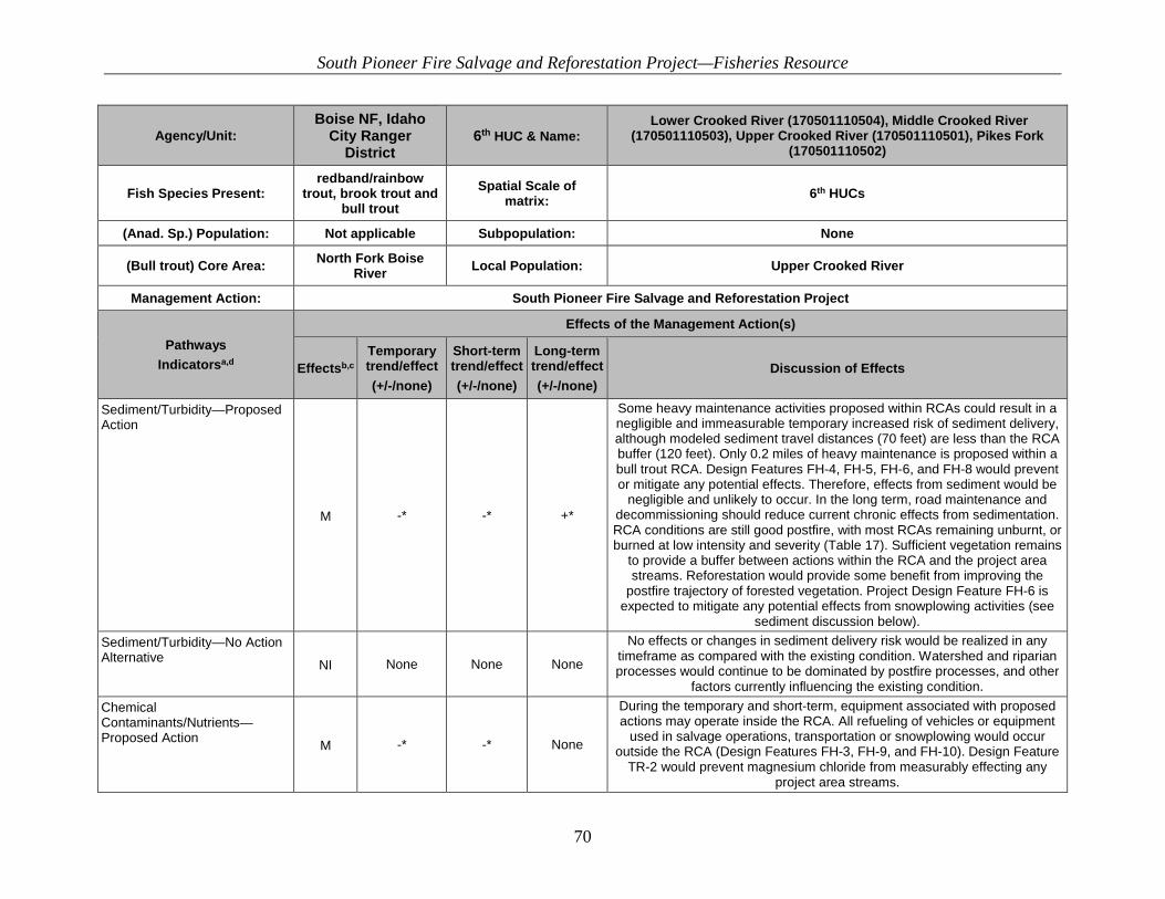
South Pioneer Fire Salvage and Reforestation Project—Fisheries Resource
70
Agency/Unit: Boise NF, Idaho
City Ranger District
6th HUC & Name: Lower Crooked River (170501110504), Middle Crooked River
(170501110503), Upper Crooked River (170501110501), Pikes Fork (170501110502)
Fish Species Present: redband/rainbow
trout, brook trout and bull trout
Spatial Scale of matrix: 6th HUCs
(Anad. Sp.) Population: Not applicable Subpopulation: None
(Bull trout) Core Area: North Fork Boise River Local Population: Upper Crooked River
Management Action: South Pioneer Fire Salvage and Reforestation Project
Pathways Indicatorsa,d
Effects of the Management Action(s)
Effectsb,c Temporary trend/effect (+/-/none)
Short-term trend/effect (+/-/none)
Long-term trend/effect (+/-/none)
Discussion of Effects
Sediment/Turbidity—Proposed Action
M -* -* +*
Some heavy maintenance activities proposed within RCAs could result in a negligible and immeasurable temporary increased risk of sediment delivery, although modeled sediment travel distances (70 feet) are less than the RCA buffer (120 feet). Only 0.2 miles of heavy maintenance is proposed within a bull trout RCA. Design Features FH-4, FH-5, FH-6, and FH-8 would prevent or mitigate any potential effects. Therefore, effects from sediment would be
negligible and unlikely to occur. In the long term, road maintenance and decommissioning should reduce current chronic effects from sedimentation. RCA conditions are still good postfire, with most RCAs remaining unburnt, or burned at low intensity and severity (Table 17). Sufficient vegetation remains
to provide a buffer between actions within the RCA and the project area streams. Reforestation would provide some benefit from improving the
postfire trajectory of forested vegetation. Project Design Feature FH-6 is expected to mitigate any potential effects from snowplowing activities (see
sediment discussion below). Sediment/Turbidity—No Action Alternative NI None None None
No effects or changes in sediment delivery risk would be realized in any timeframe as compared with the existing condition. Watershed and riparian processes would continue to be dominated by postfire processes, and other
factors currently influencing the existing condition. Chemical Contaminants/Nutrients—Proposed Action M -* -* None
During the temporary and short-term, equipment associated with proposed actions may operate inside the RCA. All refueling of vehicles or equipment
used in salvage operations, transportation or snowplowing would occur outside the RCA (Design Features FH-3, FH-9, and FH-10). Design Feature
TR-2 would prevent magnesium chloride from measurably effecting any project area streams.
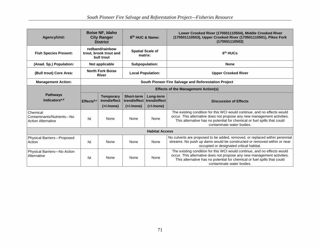
South Pioneer Fire Salvage and Reforestation Project—Fisheries Resource
71
Agency/Unit: Boise NF, Idaho
City Ranger District
6th HUC & Name: Lower Crooked River (170501110504), Middle Crooked River
(170501110503), Upper Crooked River (170501110501), Pikes Fork (170501110502)
Fish Species Present: redband/rainbow
trout, brook trout and bull trout
Spatial Scale of matrix: 6th HUCs
(Anad. Sp.) Population: Not applicable Subpopulation: None
(Bull trout) Core Area: North Fork Boise River Local Population: Upper Crooked River
Management Action: South Pioneer Fire Salvage and Reforestation Project
Pathways Indicatorsa,d
Effects of the Management Action(s)
Effectsb,c Temporary trend/effect (+/-/none)
Short-term trend/effect (+/-/none)
Long-term trend/effect (+/-/none)
Discussion of Effects
Chemical Contaminants/Nutrients—No Action Alternative NI None None None
The existing condition for this WCI would continue, and no effects would occur. This alternative does not propose any new management activities.
This alternative has no potential for chemical or fuel spills that could contaminate water bodies.
Habitat Access
Physical Barriers—Proposed Action NI None None None
No culverts are proposed to be added, removed, or replaced within perennial streams. No push up dams would be constructed or removed within or near
occupied or designated critical habitat. Physical Barriers—No Action Alternative NI None None None
The existing condition for this WCI would continue, and no effects would occur. This alternative does not propose any new management activities.
This alternative has no potential for chemical or fuel spills that could contaminate water bodies.

South Pioneer Fire Salvage and Reforestation Project—Fisheries Resource
72
Agency/Unit: Boise NF, Idaho
City Ranger District
6th HUC & Name: Lower Crooked River (170501110504), Middle Crooked River
(170501110503), Upper Crooked River (170501110501), Pikes Fork (170501110502)
Fish Species Present: redband/rainbow
trout, brook trout and bull trout
Spatial Scale of matrix: 6th HUCs
(Anad. Sp.) Population: Not applicable Subpopulation: None
(Bull trout) Core Area: North Fork Boise River Local Population: Upper Crooked River
Management Action: South Pioneer Fire Salvage and Reforestation Project
Pathways Indicatorsa,d
Effects of the Management Action(s)
Effectsb,c Temporary trend/effect (+/-/none)
Short-term trend/effect (+/-/none)
Long-term trend/effect (+/-/none)
Discussion of Effects
Habitat Elements
Substrate Embeddedness—Proposed Action
M -* -* +*
Some of the temporary road building and decommissioning activities could result in immeasurable and negligible temporary and short-term increases in sediment delivery, although modeled sediment travel distances (70 feet) are less than the RCA buffer (120 feet). In the long term, road maintenance and decommissioning should reduce current chronic effects from sedimentation. RCA conditions are still good postfire, with most RCAs remaining unburnt
having burned at low intensity and severity (Table 17). Sufficient vegetation remains to provide a buffer between actions within the RCA and the project
area streams. Replanting of riparian vegetation would provide a buffer to limit sediment inputs from hill slope processes postfire. Design Feature FH-6 is
sufficient to prevent any potential effects from snowplowing activities. Substrate Embeddedness—No Action Alternative
NI None None None
The existing condition and trend of substrate embeddedness throughout the project area would continue unchanged. No changes in sediment delivery
would be realized in any timeframe as compared with the existing condition. Existing sediment delivery associated with postfire conditions would continue to occur, as well as sediment delivery from roads throughout the project area.
South Pioneer Fire Salvage and Reforestation Project—Fisheries Resource
73
Agency/Unit: Boise NF, Idaho
City Ranger District
6th HUC & Name: Lower Crooked River (170501110504), Middle Crooked River
(170501110503), Upper Crooked River (170501110501), Pikes Fork (170501110502)
Fish Species Present: redband/rainbow
trout, brook trout and bull trout
Spatial Scale of matrix: 6th HUCs
(Anad. Sp.) Population: Not applicable Subpopulation: None
(Bull trout) Core Area: North Fork Boise River Local Population: Upper Crooked River
Management Action: South Pioneer Fire Salvage and Reforestation Project
Pathways Indicatorsa,d
Effects of the Management Action(s)
Effectsb,c Temporary trend/effect (+/-/none)
Short-term trend/effect (+/-/none)
Long-term trend/effect (+/-/none)
Discussion of Effects
Large Woody Debris—Proposed Action
M +* +* -*
In the temporary and short term, LWD could be increased by felling of hazard trees within the RCA. In the long term, replanting of conifers in the RCAs
would help maintain or improve the current trajectory for large wood within the limited areas in which RCA replanting is proposed but, overall, would not change the functional rating of this WCI. In the long term, it is possible there
could be a temporal gap at some locations near roads where high tree mortality occurred in the supply of sufficient LWD as seral vegetation dominates RCA areas (especially RCA areas receiving hazard tree
treatments). However, the LWD analysis in the discussion below shows that sufficient LWD will be available in all timeframes, so the functional rating for
this WCI would not change. Large Woody Debris—No Action Alternative NI None None None The natural postfire processes would continue on their current trajectory
described in the existing condition. Pool Frequency/ Pool Quality/ Large Pools—Proposed Action
M +* +* None
In the temporary and short term, hazard trees felled within the riparian could increase the creation of quality pools. In the long term, many of the hazard
trees felled could rot out. However, based on the LWD analysis, there should still be sufficient supply of LWD, which would likely prevent effects to this
WCI. Pool Frequency/ Pool Quality/ Large Pools—No Action Alternative
NI None None None The natural postfire processes would continue on their current trajectory
described in the existing condition.
Off-Channel Habitat—Proposed Action NI None None None
No activities are proposed that would affect any off-channel habitat. All equipment would operate from existing road prisms only (Design Feature FH-
1).
South Pioneer Fire Salvage and Reforestation Project—Fisheries Resource
74
Agency/Unit: Boise NF, Idaho
City Ranger District
6th HUC & Name: Lower Crooked River (170501110504), Middle Crooked River
(170501110503), Upper Crooked River (170501110501), Pikes Fork (170501110502)
Fish Species Present: redband/rainbow
trout, brook trout and bull trout
Spatial Scale of matrix: 6th HUCs
(Anad. Sp.) Population: Not applicable Subpopulation: None
(Bull trout) Core Area: North Fork Boise River Local Population: Upper Crooked River
Management Action: South Pioneer Fire Salvage and Reforestation Project
Pathways Indicatorsa,d
Effects of the Management Action(s)
Effectsb,c Temporary trend/effect (+/-/none)
Short-term trend/effect (+/-/none)
Long-term trend/effect (+/-/none)
Discussion of Effects
Off-Channel Habitat—No Action Alternative NI None None None This alternative does not propose any new management activities and would
therefore have no effect on this WCI. Refugia—Proposed Action
M -* -* +*
The proposed actions are expected to have negligible and immeasurable negative effects on this WCI during project implementation (hazard tree
felling, road maintenance, and road decommissioning) within the RCA in the temporary and short-term timeframes as other WCIs (such as sediment) are impacted temporarily during project implementation. Road maintenance and road decommissioning would reduce chronic, long-term sources of sediment.
Also in the long term, promoting mature tree growth and future LWD recruitment through planting in the watersheds would increase shading (lowering stream temperatures), create more channel complexity/pool
formation, and create future sediment storage capacity; all of which are critical components of bull trout core habitat areas.
Refugia—No Action Alternative
NI None None None
The existing condition would continue. Please refer to the project subwatershed baselines. The current conditions are occurring for a variety of reasons. No effects to other abiotic WCIs would occur under this alternative;
therefore, this WCI would remain unchanged.
South Pioneer Fire Salvage and Reforestation Project—Fisheries Resource
75
Agency/Unit: Boise NF, Idaho
City Ranger District
6th HUC & Name: Lower Crooked River (170501110504), Middle Crooked River
(170501110503), Upper Crooked River (170501110501), Pikes Fork (170501110502)
Fish Species Present: redband/rainbow
trout, brook trout and bull trout
Spatial Scale of matrix: 6th HUCs
(Anad. Sp.) Population: Not applicable Subpopulation: None
(Bull trout) Core Area: North Fork Boise River Local Population: Upper Crooked River
Management Action: South Pioneer Fire Salvage and Reforestation Project
Pathways Indicatorsa,d
Effects of the Management Action(s)
Effectsb,c Temporary trend/effect (+/-/none)
Short-term trend/effect (+/-/none)
Long-term trend/effect (+/-/none)
Discussion of Effects
Channel Condition and Dynamics
Max Width/Depth Ratio—Proposed Action
M None None +*
Long-term immeasurable improvements are expected from project activities. Replanting conifers in the RCA would improve the resilience of the channel to
resist future scour events by providing root holding strength. Also, road maintenance and road decommissioning inside the RCA would reduce
potential chronic sediment sources. Max Width/Depth Ratio—No Action Alternative
NI None None None
This alternative does not propose any new management activities and would therefore have no effect on this WCI. While actions under the proposed
action would not provide potential immeasurable and negligible improvements, neither would the No Action Alternative contribute to any
decline or trend. The current condition would remain in all timeframes and natural recovery would continue.
Streambank Condition—Proposed Action
M None +* +*
Immeasurable and negligible benefits would occur in the short and long term. In the short term, felling of hazard trees within the RCA would stimulate seral
shrub growth. Replanting conifers in the RCA would provide root holding strength and buffer stream banks to resist high flow and scour events and
effects from recreation and grazing pressures. Even when hazard trees are felled within RCAs, the stumps and root wads would remain for several years, providing root holding strength. Also, any logs placed near banks could potentially help buffer stream banks from postfire scour and higher
flows.

South Pioneer Fire Salvage and Reforestation Project—Fisheries Resource
76
Agency/Unit: Boise NF, Idaho
City Ranger District
6th HUC & Name: Lower Crooked River (170501110504), Middle Crooked River
(170501110503), Upper Crooked River (170501110501), Pikes Fork (170501110502)
Fish Species Present: redband/rainbow
trout, brook trout and bull trout
Spatial Scale of matrix: 6th HUCs
(Anad. Sp.) Population: Not applicable Subpopulation: None
(Bull trout) Core Area: North Fork Boise River Local Population: Upper Crooked River
Management Action: South Pioneer Fire Salvage and Reforestation Project
Pathways Indicatorsa,d
Effects of the Management Action(s)
Effectsb,c Temporary trend/effect (+/-/none)
Short-term trend/effect (+/-/none)
Long-term trend/effect (+/-/none)
Discussion of Effects
Streambank Condition—No Action Alternative
NI None None None
This alternative does not propose any new management activities and would, therefore, have no effect on this WCI. While the Proposed Action would not provide potential immeasurable and negligible improvements, neither would
the No Action Alternative contribute to any decline or trend. The current condition would remain in all timeframes and natural recovery would
continue. Floodplain Connectivity—Proposed Action
M None +* +*
No activities are proposed within stream channels. Existing road prisms would be used so the current condition would not change until the long term
when routes are decommissioned, which could negligibly enhance the hydrologic linkage of some floodplains where the decommissioned road
occurred next to streams. Floodplain Connectivity—No Action Alternative
NI None None None
This alternative does not propose any new management activities and would, therefore, have no effect on this WCI. While the Proposed Action would not provide potential immeasurable and negligible improvements, neither would
the No Action Alternative contribute to any decline or trend. The current condition would continue in all timeframes.
Flow/Hydrology
Change in Peak/Base Flows—Proposed Action
M none +* +*
In the temporary timeframe, road construction of temporary routes and road maintenance may increase flows, as the drainage network increases.
However, in the short and long term, road-related activities, including road decommissioning, would reduce overall road drainage and decrease surface
runoff. Replanting conifers in the uplands and RCAs would help attenuate flows over time as subwatersheds recover from the fire.

South Pioneer Fire Salvage and Reforestation Project—Fisheries Resource
77
Agency/Unit: Boise NF, Idaho
City Ranger District
6th HUC & Name: Lower Crooked River (170501110504), Middle Crooked River
(170501110503), Upper Crooked River (170501110501), Pikes Fork (170501110502)
Fish Species Present: redband/rainbow
trout, brook trout and bull trout
Spatial Scale of matrix: 6th HUCs
(Anad. Sp.) Population: Not applicable Subpopulation: None
(Bull trout) Core Area: North Fork Boise River Local Population: Upper Crooked River
Management Action: South Pioneer Fire Salvage and Reforestation Project
Pathways Indicatorsa,d
Effects of the Management Action(s)
Effectsb,c Temporary trend/effect (+/-/none)
Short-term trend/effect (+/-/none)
Long-term trend/effect (+/-/none)
Discussion of Effects
Change in Peak/Base Flows—No Action Alternative
NI None None None
This alternative does not propose any new management activities and would, therefore, have no effect on this WCI. While the Proposed Action would not provide potential immeasurable and negligible improvements, neither would
the No Action Alternative contribute to any decline or trend. The current condition would continue in all timeframes.
Change in Drainage Network—Proposed Action
M -* +* +*
Several temporary road construction, road decommissioning, and road maintenance activities are proposed which would measurably extend the length of the current drainage network. However, the effects to the WCI
would remain negligible at the scale of analysis. In the long term, all temporary roads and additional unauthorized travel routes would be
decommissioned and no longer be present on the landscape. Thus, a net benefit (in the long term) to this WCI is expected under the Proposed Action. While the effects to this WCI may be measurable, in terms of miles of road,
the effects would be negligible at the scale of analysis and would not change the functional rating of the subwatersheds for this WCI.
Change in Drainage Network—No Action Alternative
NI None None None
This alternative does not propose any new management activities and would, therefore, have no effect on this WCI. While the Proposed Action would not provide potential immeasurable and negligible improvements, neither would
the No Action Alternative contribute to any decline or trend. The current condition would continue in all timeframes.

South Pioneer Fire Salvage and Reforestation Project—Fisheries Resource
78
Agency/Unit: Boise NF, Idaho
City Ranger District
6th HUC & Name: Lower Crooked River (170501110504), Middle Crooked River
(170501110503), Upper Crooked River (170501110501), Pikes Fork (170501110502)
Fish Species Present: redband/rainbow
trout, brook trout and bull trout
Spatial Scale of matrix: 6th HUCs
(Anad. Sp.) Population: Not applicable Subpopulation: None
(Bull trout) Core Area: North Fork Boise River Local Population: Upper Crooked River
Management Action: South Pioneer Fire Salvage and Reforestation Project
Pathways Indicatorsa,d
Effects of the Management Action(s)
Effectsb,c Temporary trend/effect (+/-/none)
Short-term trend/effect (+/-/none)
Long-term trend/effect (+/-/none)
Discussion of Effects
Watershed Conditions
Road Density and Location—Proposed Action
M -* +* +*
In the temporary and short term, construction of temporary roads would measurably but negligibly increase the overall road density in the Middle
Crooked subwatershed. However, in the short and long term, all temporary roads and many unauthorized travel routes would be decommissioned and
no longer be present on the landscape. Under the Proposed Action, 0.2 miles of unauthorized road would be decommissioned within the Edna Creek RCA. Thus, a net benefit to this WCI is expected under the Proposed Action. While
the effects to this WCI may be measurable, in terms of miles of road, the effects would not be sufficient to change the current functional rating of the
subwatersheds for this WCI. Road Density and Location—No Action Alternative
M None None None
This alternative does not propose any new management activities and would, therefore, have no effect on this WCI. While the Proposed Action would not provide potential immeasurable and negligible improvements, neither would
the No Action Alternative contribute to any decline or trend. The current condition would remain in all timeframes and natural recovery would
continue. Disturbance History/Disturbance Regime—Proposed Action NI None None None
The Proposed Action has no potential to affect the current condition for these WCIs. The Pioneer Fire affected all subwatersheds on a large scale. Hazard
tree felling and salvage harvest will not affect the current trajectory of the subwatersheds. Within the area, vegetation and streams will continue to be
dominated by postfire processes despite the proposed activities.

South Pioneer Fire Salvage and Reforestation Project—Fisheries Resource
79
Agency/Unit: Boise NF, Idaho
City Ranger District
6th HUC & Name: Lower Crooked River (170501110504), Middle Crooked River
(170501110503), Upper Crooked River (170501110501), Pikes Fork (170501110502)
Fish Species Present: redband/rainbow
trout, brook trout and bull trout
Spatial Scale of matrix: 6th HUCs
(Anad. Sp.) Population: Not applicable Subpopulation: None
(Bull trout) Core Area: North Fork Boise River Local Population: Upper Crooked River
Management Action: South Pioneer Fire Salvage and Reforestation Project
Pathways Indicatorsa,d
Effects of the Management Action(s)
Effectsb,c Temporary trend/effect (+/-/none)
Short-term trend/effect (+/-/none)
Long-term trend/effect (+/-/none)
Discussion of Effects
Disturbance History/Disturbance Regime—No Action Alternative
NI None None None This alternative does not propose any new management activities and would, therefore, have no effect on this WCI. The current condition would remain in
all timeframes and natural recovery would continue. Riparian Conservation Areas—Proposed Action
M -* +* +*
Replanting of conifers within the RCAs could immeasurably improve some WCIs as indicated above, moving them incrementally toward the desired future condition. Overall, RCA condition could improve immeasurably and should improve faster than natural regeneration alone. In the temporary
timeframe, removing trees within the RCA could have a negligible negative effect on some RCA functions. However, due to postfire processes, it is likely that RCA condition would continue its current trajectory within the timeframe
of this analysis, and any further benefits from reforestation would occur beyond the timeframe of this analysis.
Riparian Conservation Areas—No Action Alternative NI None None None
This alternative does not propose any new management activities and would, therefore, have no effect on this WCI. The No Action Alternative would not contribute to any change or decline in trend. The current condition would
remain in all timeframes and natural recovery would continue.
South Pioneer Fire Salvage and Reforestation Project—Fisheries Resource
80
Agency/Unit: Boise NF, Idaho
City Ranger District
6th HUC & Name: Lower Crooked River (170501110504), Middle Crooked River
(170501110503), Upper Crooked River (170501110501), Pikes Fork (170501110502)
Fish Species Present: redband/rainbow
trout, brook trout and bull trout
Spatial Scale of matrix: 6th HUCs
(Anad. Sp.) Population: Not applicable Subpopulation: None
(Bull trout) Core Area: North Fork Boise River Local Population: Upper Crooked River
Management Action: South Pioneer Fire Salvage and Reforestation Project
Pathways Indicatorsa,d
Effects of the Management Action(s)
Effectsb,c Temporary trend/effect (+/-/none)
Short-term trend/effect (+/-/none)
Long-term trend/effect (+/-/none)
Discussion of Effects
Integration of Species and Habitat Conditions—Proposed Action
M None +* +*
The overall species and habitat situation for fisheries would not change in the temporary timeframe. While several WCIs may experience a negligible and immeasurable effect in the temporary timeframe, that does not necessarily equate to any change to the overall species and habitat condition for this WCI. Several WCIs and important habitat components that are currently
degraded from past disturbance and management actions, could immeasurably improve with the Proposed Action in the short and long term. Several (LWD, sediment, road density) would have potential immeasurable benefits to aquatic species habitat in the short- and long-term timeframes. However, the current situation for aquatic species and habitat conditions
would continue to be influenced by landscape-scale disturbance events, and the trajectory would not measurably or significantly change under the
proposed action. Integration of Species and Habitat Conditions—No Action Alternative NI None None None
This alternative does not propose any new management activities and would, therefore, have no effect on this WCI. While actions under the Proposed
Action would not provide potential immeasurable and negligible improvements, neither would the No Action Alternative contribute to any decline or trend. The current condition would continue in all timeframes.
a.Matrix checklist adapted from USFWS and NMFS1998. b.This displays the potential effects of the action on habitats or individuals, and not on the status of the entire local population/ watershed. I = Improve, M = Maintain, D = Degrade, N =
No Influence c: Trend effects: N = No trend, - = negative trend, + = positive trend, +/-=uncertain trend, may be positive or negative, * indicates negligible impact. Timeframe: For Alternative A: Long-term. For all action alternatives
South Pioneer Fire Salvage and Reforestation Project—Fisheries Resource
81
3.7.1.1. Population Characteristics
3.7.1.1.1. Local Population Size, Growth and Survival, Life History Diversity and Isolation, and Persistence and Genetic Integrity WCIs Mechanism of potential effect: direct effects to fish individuals and/or effects to other habitat WCIs could indirectly effect the population characteristics WCI.
Proposed Action No effects to bull trout subpopulation WCIs are expected in the temporary, short- or long-term timeframes under the Proposed Action. Some negligible changes to habitat-related WCIs would occur, but those changes would not affect the functional ratings of any habitat WCI or any population characteristics WCIs (see discussions of affected WCIs below). For the proposed actions, the analysis focused on actions within the RCA and, more importantly, within bull trout occupied streams and/or designated critical habitat. Actions occurring near Edna Creek in the Middle Crooked River subwatershed were analyzed because new data suggesting bull trout may be occupying Edna Creek. Potential mechanisms for indirect effects to bull trout could include effects to their prey base (terrestrial insects or macroinvertebrates) and to supporting habitat. Effects to the prey base are highly unlikely since no insecticide treatments are associated with the Proposed Action and most insects consumed by fish are associated with broadleaf shrub riparian vegetation that is overhanging the streams, not conifer species. Wipfli (1997) found that young growth broad-leaf riparian species provided fish with more terrestrial prey than old growth conifer riparian areas. Overhanging vegetation and broadleaf riparian species are not expected to be impacted by project activities. Additional mechanisms for indirect effects, such as increased fine sediment delivery, reduction in pool quality, use of magnesium chloride (MgCl2) for dust abatement application, or changes to water quality, are addressed below under the respective WCI. Potential temporary and short-term sediment delivery increases (detailed in the Sediment WCI section) are not expected to affect this WCI. Project design features and Forest Service National Best Management Practices (BMPs) should reduce the likelihood of exposed soils reaching streams. Potential effects from sediment on tributaries flowing into critical habitat are expected to be negligible because the stream network is expected to transport and store the temporary sediment increase throughout the channel reach during an annual range of streamflow velocities (Wohl 2000), reducing the potential for site-specific deposition in usable bull trout habitat. Over natural sediment that is delivered to tributaries is not expected to be in quantities which would affect downstream fish species or change habitat. Project implementation is planned over several years and should result in immeasurable amounts of sediment deposited over the implementation timeframe (temporary and short term), with immeasurable reductions in the long-term timeframe. Negligible and immeasurable sediment inputs from these proposed actions are not expected to hinder the biological integrity or productivity of Crooked River. Vegetation Management The proposed actions include hazard tree felling and/or removal treatments within the RCAs. Of the total RCA acres, approximately 1,368 RCA acres are adjacent to designated bull trout critical habitat. Of these 1,368 acres, 434 acres are proposed for hazard tree felling and removal above

South Pioneer Fire Salvage and Reforestation Project—Fisheries Resource
82
the road, and 849 acres are proposed for hazard tree fell and leave below the road within the RCAs adjacent to Crooked River, Banner Creek, Pikes Fork, and Edna Creeks. Hazard tree removal above the road would entail yarding whole trees downhill to the road using a partial or full suspension cable method. This action entails the logger walking the cable to the trees above the road and cable yarding the whole tree to the road (Design Feature TH-2). Yarding whole trees would have minimal impacts and soil disturbance because cable suspension methods would be used, and branches would be left on the tree to minimize disturbance during dragging. The buffer of the road and the RCA below the road between the road and the water should effectively protect project area streams from direct sediment as sediment travel distances were modeled at 70 feet. No other effects to this WCI are expected because the RCA buffer below the road should be sufficient to buffer bull trout and their habitat from effects associated with this action (FEMAT 1993, MK sediment travel distance model). Road Maintenance This activity would occur in RCAs along 21.7 miles within the Upper Crooked River, Middle Crooked River, Upper Crooked River, and Pikes Fork subwatersheds. Light maintenance, consisting of road surface blading, ditch cleaning, culvert cleaning as needed, and the removal of fallen trees from the roadway, is proposed on 21.1 miles. Additionally, 0.4 miles of moderate maintenance, consisting of removal of vegetation from the road shoulders, road surface re-shaping and blading, ditch and culvert cleaning, replacement of deficient ditch relief culverts or installation of new ditch relief culverts, and removal of fallen trees from the roadway, is also proposed. Finally, 0.2 miles of heavy maintenance is proposed within the RCA near occupied habitat in Edna Creek. Modeled sediment travel distances for heavy maintenance is 70 feet. So, little or no potential for sediment delivery would occur where road maintenance activities are proposed more than 70 feet away from water. The effects to this WCI are expected to be insignificant because project design features (FH-5) and implemented BMPs would mitigate potential effects. Temporary Road Construction Most temporary road construction is proposed outside of RCAs with only a short amount (0.2 mile) within an RCA (within 240 feet) adjacent to occupied habitat in Edna Creek The vegetation buffer between the temporary road construction and streams would decrease the likelihood that sediment or other effects from the construction would affect this WCI. Therefore, effects from this activity are expected to be insignificant. This activity would occur on existing road templates but would require some shaping of the existing road bed and some realignment. Project activities are proposed on 10.3 miles within the RCA. These roads are currently closed to all motorized use and in a state of storage. Therefore, effects to this WCI are not likely to occur based on the limited mileage and project design features (FH-4, FH-5, FH-8 and TH-4) effects would be discountable. Road Decommissioning The Proposed Action would reduce roads within the watershed and RCAs. Road decommissioning would include, but is not limited to, (FH-4) installing effective barriers to motorized vehicles and seeding with grass and forbs. The road section proposed for treatment is an unnamed road segment parallel to Edna Creek. This road decommissioning may temporarily have an immeasurable negative effect during project implementation. However effects are doubtful because this section of road is not within the RCA (240 feet from the creek) except for 0.2 miles. The modeled sediment travel distance (70 feet), along with project design features
South Pioneer Fire Salvage and Reforestation Project—Fisheries Resource
83
requiring sediment control devices and vegetation between the treatment and the creek, should filter sediment before it reaches the stream. The long-term improvements are expected to have an immeasurable positive effect to the sediment WCI in the long-term timeframe due to a reduction in sediment to streams. Any effects are expected to be negligible and discountable. These areas would regrow vegetation and promote large tree growth, contributing to less overall ground disturbance near streams. Within the area RCAs, this project proposes to decommission 3.6 miles of road; however, no road decommissioning is proposed within any RCA adjacent to designated critical habitat. The proposed hazard tree felling and road-related actions are not expected to affect bull trout subpopulation characteristics or their habitat (see Sediment WCI analysis). The rest of the actions would occur outside the RCA and are not expected to result in effects to bull trout or their habitat (see Sediment WCI for full analysis). Within all subwatersheds, road segments are proposed for management actions which could affect Crooked River, Banner Creek, Pikes Fork, and Edna Creek. Project design features and vegetation between the RCAs and streams are expected to retain sediment, which would protect bull trout and their habitat. As a result, no effects to bull trout subpopulations are expected.
No Action Alternative No influence. This alternative does not propose any new management activities. Current conditions in these subwatersheds suggest bull trout and their habitat is at risk. One unauthorized route near Edna Creek would not be decommissioned under this alternative and other factors would continue to influence the overall existing condition for bull trout subpopulation WCIs. The current limiting factors for the subpopulation and other bull trout WCIs would continue to maintain the current conditions. Post-fire processes would continue as described in the existing condition baselines in Appendix B.
3.7.1.2. Water Quality
3.7.1.2.1. Temperature (PCEs 2, 3, 5, & 8) Mechanism of potential effect: changes in tree cover resulting from replanting activities can modify stream temperature regimes.
Proposed Action Maintain. The Proposed Action includes activities which could affect stream shading; potentially affecting bull trout and designated bull trout critical habitat. Immeasurable changes in shade mean the magnitude of the effect is anticipated to be small, localized, insignificant, and discountable in the context of the analysis area. Please refer to the full analysis in Appendix A. The Proposed Action would maintain the functionality of the Temperature WCI because the Pioneer Fire has already reduced stream shade by removing canopy, and the trees proposed for removal contribute an insignificant portion of the remaining shade from standing dead trees. Reductions in stream shade would be concentrated within hazard treatment removal areas (near roads and infrastructure) and would not occur within general salvage areas. Within Upper, Middle, and Lower Crooked River and Pikes Fork subwatersheds, stream shading is expected to immeasurably decrease with hazard tree removal. The effect would be negligible in the temporary (0–3 years) and short-term (3–10 years) timeframes (from felling) because these trees have already lost their canopy, which provides 75%–90% of the shade component. The
South Pioneer Fire Salvage and Reforestation Project—Fisheries Resource
84
projected portion of shade area provided by the trees proposed for removal is negligible (~1.3% in one modeled scenario) in the context of postfire changes from the Pioneer Fire (which increased energy reaching the streams by a median 135% in the Becker Project area). Thus, the magnitude and effect of project activity–related changes to stream temperature is anticipated to be small, localized, and/or negligible in the context of the entire analysis area. Reforestation and riparian planting efforts would contribute, along with natural regeneration, to an immeasurable benefit this WCI by increasing stream shade in the short- and long-term (15+ yrs) timeframes. Felling Hazard Trees within Riparian Conservation Areas For hazard tree mitigation(s) along perennial streams, reducing hazard trees is not expected to measurably affect stream temperature. Generalized curves depicting microclimate and shade contributions to streams as a function of distance from the channel in STPHs (Figure 17) indicate that processes controlling stream shade and micro-climatic variables decrease exponentially with distance from the channel. Approximately 80 percent of effective shade comes from approximately 0.5 SPTH distance from the channel (60 feet in this case). Thus, the first SPTH (120 feet, in this analysis) is the most important for stream shading. A primary objective of minimizing tree falling in RCAs is to maintain the extent of remaining stream shade, and thus not further hinder movement toward desired conditions in the long term.
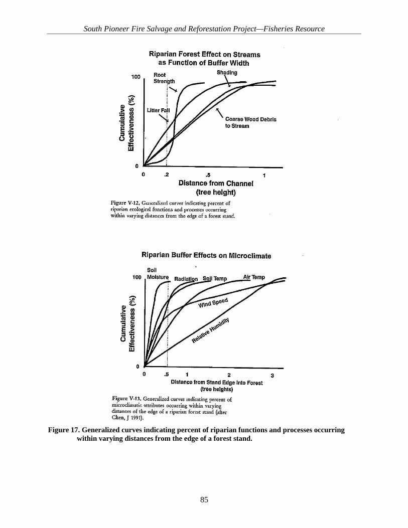
South Pioneer Fire Salvage and Reforestation Project—Fisheries Resource
85
Figure 17. Generalized curves indicating percent of riparian functions and processes occurring
within varying distances from the edge of a forest stand.
South Pioneer Fire Salvage and Reforestation Project—Fisheries Resource
86
No Action No influence. This alternative does not propose any new management activities, and no hazard tree felling would occur within RCAs under this alternative. The shade component hazard trees provide to streams would remain. Please see additional analysis in Appendix A. Post-fire processes would continue under this alternative, and the current trajectory for this WCI would not change from the existing condition described in the baseline table in Appendix B.
3.7.1.2.2. Sediment/Turbidity (PCEs 2, 3, 6, & 8) Mechanism of potential effect: Mechanized equipment and personnel can increase sediment by destabilizing stream banks. Road construction, reconstruction and snow plowing can route sediment to live water. This WCI is related to fish behavior, spawning and incubation habitat.
Proposed Action Maintain. The Proposed Action would maintain the existing functionality of the Sediment/Turbidity WCI in the temporary, short-term, and long-term timeframes. The risk of sediment delivery to streams is expected to immeasurably increase in the temporary and short-term timeframe associated with heavy road maintenance and use required to implement the PROPOSED ACTION. In the short and long-term timeframes, sediment delivery is anticipated to immeasurably decrease associated with decommissioning of unauthorized roads. The effects would be negligible due to the relatively small expected magnitude of change. In the temporary and short-term timeframes, sediment yield would be dominated by postfire processes, which are expected to result in large increases in sediment yield and possible major changes in stream channel characteristics as described above. A detailed discussion of each component of the proposed action and its effect on sediment delivery is discussed below.
Temporary Road Construction The proposed action includes constructing and using 3.37 miles of temporary roads. Temporary roads are only proposed within the Middle Crooked River subwatershed. All proposed temporary roads would be located on existing unauthorized road prisms with one exception: 0.2 miles of temporary road located outside of the RCA is proposed in the Middle Crooked subwatershed. Temporary roads are primarily proposed in areas outside of RCAs. However, two segments on existing road templates (totaling 0.13 miles) in the Edna Creek drainage intersect the RCA upslope from NFS road 351 located approximately 190 and 225 feet from Edna Creek. Where temporary road construction occurs within the RCA, Design Feature FH-5 requires erosion control devices, such as slash filter windrows or straw wattles, to minimize sediment delivery. Some ground disturbance is expected to occur from preparing these roads for log hauling. Blading the road surface as well as vegetation removal is expected. Water bars would be constructed at the appropriate location and spacing to reduce road surface erosion. The risk of sediment delivery is increased during road construction due to ground disturbance and soil exposure. However, sediment delivery to streams is not expected to occur from temporary road construction due to limited ground disturbance from utilizing existing road prisms and BMPs utilized to reduce erosion (erosion control devices, water bars) and because temporary roads are, generally, located outside RCAs (with two small exceptions). MK sediment delivery distance estimates indicate that these temporary road segments, located at 190 and 225 feet from Edna Creek, are outside of the anticipated sediment delivery distance (70 feet for heavy maintenance). After the completion of project activities, temporary roads would be

South Pioneer Fire Salvage and Reforestation Project—Fisheries Resource
87
decommissioned in manner that allows for revegetating the disturbed area as described in Design Feature FH-8. The effects of decommissioning these unauthorized routes are discussed in the the unauthorized road decommissioning section. Road Maintenance and Use In terms of erosion and sediment delivery to streams, contributions from roads are often much greater than that from all other land management activities combined, including log skidding and yarding (Gibbons and Salo 1973). Maintenance activities on roads are designed to ensure a functional travelway as well as maintain road drainage functionality. Road surface sediment production can be readily reduced by improving road drainage (MacDonald and Coe 2007). However, blading and ditch cleaning can increase the erodibility of the road prism by removing vegetation or breaking up armor layers on the road surface or ditch, resulting in increased sediment production. Additionally, increasing traffic on native surface roads increases sediment production, though the two are not necessarily multiplicative (Luce and Black 2001). Roads throughout the project area are in need of varying degrees of maintenance to facilitate implementation of the Proposed Action. The Proposed Action includes approximately 195 miles of road maintenance on existing NFS roads to support large trucks and equipment. Maintenance activities would include clearing brush from the road shoulders to improve sight distance, blading and shaping the road, cleaning ditches, maintaining or improving drainage structures, and improving the road surface. Some roads merely require routine blading and ditch cleaning, while others require more template reshaping and vegetation clearing, such as Maintenance Level (ML) 1 roads that have been closed to public use and are now being opened to facilitate project implementation. Levels of road maintenance have been broken out into light, moderate, and heavy maintenance. With respect to sediment production, light and moderate road maintenance would likely maintain or reduce existing potential for sediment delivery to streams. This assumption is valid because roads receiving light and moderate maintenance are generally open drivable roads with existing travelways that produce sediment and are subject to routine maintenance regimes. Maintaining the drainage on these roads is expected to remove ruts and reduce concentrated flow, which would reduce sediment production. Roads receiving heavy maintenance may also have drainage issues or rutting, but are generally stabilized by vegetation growth since the road has been closed to use, either administratively (such as ML 1 roads) or by growth of vegetation and lack of use. Road receiving heavy maintenance would likely have increased sediment production in the temporary or short-term timeframe due to vegetation removal and reshaping of the road surface template. Appropriate BMPs to minimize sediment delivery to streams would be implemented, such as slash filter windrows at the toe of fill slopes (Design Feature FH-5). Burroughs and King (1989) found that placing slash filter windrows at the base of road fills reduced sediment transport distances from 125 feet to 33 feet. Slash filter windrows were also found to trap up to 90% of sediment generated from the road prism. Heavy road maintenance occurring within RCAs adjacent to streams is of the highest concern as it is expected to temporarily increase the risk of sediment delivery to streams. Increases in the amount of traffic on native surface roads can increase the amount of sediment production, which has implications for log hauling proposed under the Proposed Action. Luce and Black (2001) suggest little difference exists in sediment yields between traffic and no traffic when ditches have recently been graded. Regular maintenance is expected to limit sediment production from increased traffic. Required contract specifications limit log hauling to dry conditions, by monitoring the formation of ruts, to minimize road damage and sediment production
South Pioneer Fire Salvage and Reforestation Project—Fisheries Resource
88
FS WEPP Road (Elliott et al. 2001) was used to run scenarios for conducting heavy maintenance on ML 1 roads which are currently closed. Pre-maintenance conditions assumed a 200-foot road segment with 4% grade and native surface, vegetated ditch, and no traffic. Post-maintenance conditions assumed the same road characteristics with high traffic and a bare ditch. Heavy maintenance increased sediment production from 7.5 lbs to 69 lbs with no mitigation practices. Adding gravel to the road surface and ditches reduced that amount of sediment to approximately 30 tons. As discussed above, sediment delivery to streams depends on the distance between the road and the stream, as well as the number of obstructions on the hillslope. Based on the work of Burroughs and King (1989), when erosion control measures are implemented as described in Design Feature FH-5, sediment delivery to streams and the distance sediment travels can be reduced. Based on literature and monitoring, it is generally assumed that the greatest risk of sediment delivery occurs where road segments are within 70 feet of streams. Heavy maintenance is proposed along approximately 23.7 miles of roads within the project area. Of these roads, 3.8 miles are located within RCAs. Roads within RCAs proposed for heavy maintenance occur adjacent to Banner Creek, China Fork and its tributaries and tributaries of Beaver Creek and Pikes Fork. Sediment travel distances estimated with the MK model indicate a likely sediment travel distance for heavy road maintenance as approximately 70 feet. Approximately 1.75 miles of heavy maintenance is proposed to occur within 70 feet of streams based on a GIS exercise. These areas would be the greatest concern for sediment delivery. Design Feature FH-5 would implement the use of erosion control measures along these locations to minimize sediment delivery. FS WEPP Road model runs indicate that for 1.75 miles of high-use road located near streams (<70 feet), approximately 0.4 tons of sediment could be delivered to streams. Additional sedimentation to unoccupied critical habitat in Banner Creek and Pikes Fork occurred from spring storm events in May 2017. However, post-fire effects of this kind were already considered in the BAER 2016 assessment and the existing condition/environmental baseline for the proposed action in the BA. The potential for post-fire effects and associated increased sedimentation was addressed in the environmental baseline tables for Pikes Fork subwatershed in the BA and fisheries technical report. Pioneer BAER 2016 implementation also addressed the increased potential for sedimentation and runoff events, as evidenced by the BAER road maintenance actions taken immediately post-fire, which prevented further damage to NFS road 385. Even though post-fire effects have occurred, which resulted in increased sedimentation in Pikes Fork and Banner Creek, the sediment WCI was already Functioning at Unacceptable Risk (FUR) prior to the fire and these runoff events. These runoff events and associated road damage may have resulted in immeasurable and incremental degradation of the sediment WCI. However, post-fire effects such as these which were already considered in the baseline so these do not change the functional rating of the sediment WCI, though they may slightly alter the current trend of the sediment WCI in the Pikes Fork subwatershed. Natural recovery of the sediment WCI in the Pikes Fork subwatershed from post Pioneer Fire effects will now take incrementally longer, than if these specific events had not occurred, but it does not change the overall existing condition in any measureable or meaningful manner, nor were events of this kind an unexpected post fire effect not already considered.

South Pioneer Fire Salvage and Reforestation Project—Fisheries Resource
89
It is important to note that if RCA vegetation is sufficient in trapping the majority of sediment produced from a massive event such what occurred on NFS road 312, then sediment travel distances modeled for the Proposed Action are reinforced by field observations of this event, and any effects from the Proposed Action to bull trout and designated critical habitat WOULD NOT CHANGE, nor would there be any change in the determinations made in the original BA. These events also demonstrate the need for road maintenance under the Proposed Action in other portions of the Pioneer South action area to prevent future events of this kind. Adjusting treatments along NFS road 312 from hazard tree removal to hazard tree fell and leave would result in incrementally less effect than the action described in the BA, but would not result in any measurable change to any actions or effects previously analyzed. The Proposed Action would result in a negligible and immeasurable increased risk of sedimentation from any road related actions as previously disclosed in the BA and draft fisheries report in the project record. Snowplowing may be used for access during salvage harvest and planting. If not done properly, snowplowing can disturb the road surface and/or reduce the drainage capacity in a way that causes increased erosion and risk of sediment delivery. Design Feature FH-6 describes BMPs associated with snowplowing that would be implemented to minimize the potential for sediment delivery. Unauthorized Road Decommissioning Road decommissioning would occur on approximately 4.4 miles of unauthorized roads within the project area. An estimated 3.4 miles of these roads would be used as temporary roads to facilitate project implementation prior to decommissioning. An estimated 1.03 miles of the proposed unauthorized road decommissioning falls within RCAs. No perennial or intermittent steam crossings are associated with these roads. A variety of treatment prescriptions may be used to decommission these routes and would be determined on a case-by-case basis during implementation (Design Feature FH-4). Erosion control methods, such as broadcasting slash or mulch and seeding, would be used to minimize erosion from exposed soils associated with the reclaimed road prism (Design Feature FH-5). With implementation of the proposed design features, and because there are no stream crossings associated with these roads, no measurable sediment delivery to streams is anticipated. Monitoring of decommissioned roads on the Payette National Forest by Nelson and others (2010) found that fully recontoured roads and restored stream crossings reduced chronic sediment delivery by 98% after 2 years. The residual sediment delivery from the decommissioned road was associated with stream crossings. In the long term, an overall reduction in sediment delivery, compared to the existing condition, is expected from unauthorized road decommissioning, especially where roads are located in RCAs. Salvage Harvest Approximately 3,971 acres of salvage tree harvest would occur as a part of the Proposed Action. Sediment production associated with salvage harvest units is primarily a function of the magnitude of ground cover alteration and soil compaction that occurs associated with activities of the logging operation and the rainfall intensity (Wagenbrenner 2015). Falling trees generally results in little-to-no ground disturbance when accomplished with hand fallers. Processing and yarding of material with skidders and tractor jammers increases the potential for ground disturbance and subsequent sediment delivery, depending on the extent of the disturbance from logging equipment. The greatest risk of sediment delivery is associated with ground-based harvest units, which use skid trails and or feller-buncher trails. No salvage units would occur within RCAs (Design Feature FH-1). Skid trails constructed within salvage units would be decompacted and recountoured and would include erosion control in the form of slash, mulch,
South Pioneer Fire Salvage and Reforestation Project—Fisheries Resource
90
and or seeding to minimize erosion (Design Feature FH-8). Wagenbrenner and others (2015) found that adding slash to skid trails reduced sediment delivery 5 to 50 times compared to untreated skid trails. Slash created during logging (from limbs and tops of trees) can provide additional ground cover that can reduce erosion (Shakesby et al. 1996). Sediment delivery to streams from salvage harvest units is not expected due to a combination of BMPs to reduce erosion from skid trails and by limiting salvage units to locations outside RCAs. MK sediment modeling and postfire salvage harvest monitoring results from Maloney and Thornton (1995) agree with the conclusion that sediment travel distances would be less than RCA buffer width for activities such as tractor jammer yarding and the construction of skid trails as described in the methodology and assumptions section. Existing and constructed landings would be utilized to facilitate processing and decking of cut trees and loading of log trucks for haul. Burning logging slash in excess of what is needed to facilitate rehabilitation may occur, if needed. Sediment production from the surface and cut and fill slopes of landings may occur due to exposed and/or compacted soils. Design Feature FH-1 limits new landing construction to areas outside of RCAs. Design Feature FH-8 requires all constructed landings to be reclaimed after use by reshaping, ripping, placing slash, and seeding. MK sediment modeling and postfire salvage harvest monitoring results from Maloney and Thornton (1995) indicate that RCA buffer distances designed for the project would be sufficient to provide adequate buffer distance to limit sediment delivery to streams. Monitoring data indicated that the longest observed sediment travel distance associated with landings was 108 feet, with an average of 46 feet. No sediment delivery to streams is expected from landing construction and use. Roadside Hazard Tree Felling and Removal Roadside hazard tree felling, with and without product removal, would occur along roads and trails throughout the project area. Hazard tree felling with product removal would occur on 5,305 acres. Hazard tree felling with no product removal would occur on 2,542 acres. Within RCAs, hazard tree felling with product removal would only occur on the uphill sides of roads which parallel the RCA (Design Feature FH-1), with some limited exceptions described in Design Feature FH-1. As described in the “Salvage Harvest” section, sediment production associated with salvage harvest is expected to be limited to locations which receive ground disturbance from logging equipment. Design Feature FH-1 limits the use of mechanized equipment (with the exception of chainsaws) to existing road prisms within RCAs. No skidders or feller-bunchers would operate off of existing roads within RCAs, which would result in minimal ground disturbance. Yarding of tree boles may cause some ground disturbance from dragging of trees with partial suspension, but sediment delivery from this activity would be minimized by applying residual tops and limbs back to the affected area. Roadside hazard tree salvage, with and without product removal, is not expected to result in sediment delivery to streams within the project area because minimal ground disturbance is expected within the RCA. Any ground disturbance that may occur in conjunction with product removal would be on the uphill side of the road which, in combination with slash application, would obstruct sediment travel. Where hazard trees are felled and removed, residual logging slash in the form of tops and limbs would be scattered back across the treated area, increasing groundcover and reducing the potential for erosion. There may be some limited hand piling and burning associated with roadside hazard tree felling where slash and tops of trees is in excess of what is needed to facilitate rehabilitation of ground disturbance. No additional sediment production is expected from this burning because the piles will be small and generally outside of RCAs or on the uphill sides of roads as described in Design Feature FH-1. Exceptions to remove trees within RCAs below the road include criteria to keep equipment on existing road prisms and prohibit skidding

South Pioneer Fire Salvage and Reforestation Project—Fisheries Resource
91
or dragging of logs with the intention to minimize ground disturbance and avoid sediment delivery. Within RCAs, landings utilized to process and deck logs during roadside hazard tree removal would be limited to existing wide spots in roads. Where roads are used for landings within RCAs, maintenance would occur to address any road drainage concerns as described in Design Feature TR-1. Project design features requiring the use of sediment control devices on all landings and total rehabilitation of all landings would prevent any potential sediment effects from using wide spots in the road as landings. Reforestation Approximately 12,571 acres of reforestation, tree planting, are proposed. Proposed reforestation activities would have a negligible effect on sediment yield due to the limited amount of ground disturbance that would occur from hand-planting trees. Snowplowing may occur in conjunction with reforestation activities and the anticipated effects are disclosed in the “Road Maintenance” section. Conclusion Sediment delivery to streams is difficult to predict in terms of absolute quantities due to the stochastic nature of precipitation events that drive runoff and erosion. Designated RCA buffers for project activities have been designed to minimize the potential for sediment delivery where possible. Observed and modeled sediment transport distances from similar postfire salvage harvest projects on the Forest suggest that the designated RCA buffers provide reasonable protection to streams from sediment delivery. Where sediment producing activities are proposed to occur within RCAs, such as road maintenance, sediment delivery would be minimized by applying design features and BMPs to reduce sediment production and delivery to streams. The Sediment/Turbidity WCI is expected to be maintained in all timeframes as a result of project activities. An increase in the risk of sediment delivery in the temporary (<3 yrs) and short-term (3–15 yrs) timeframe exists associated with road maintenance and log hauling activities where they occur within RCAs, especially where roads are near streams (<70 feet). In the long-term (15+ yrs) timeframe, risk of sediment delivery to streams would be reduced by decommissioning 3.2 miles of unauthorized routes.
No Action No influence. This alternative would maintain the existing condition and trend of sediment/turbidity throughout the project area. Under this alternative, none of the proposed actions would occur. No changes in sediment delivery would be realized in any timeframe as compared with the existing condition. Existing sediment delivery associated with postfire conditions would continue to occur, as well as sediment delivery from roads throughout the project area. The unauthorized roads that currently exist within the project area would not be decommissioned and would continue to be a source for sediment delivery.
3.7.1.2.3. Chemical Contamination/Nutrients (PCEs 1, 2, 3, & 8) Mechanism of potential effect: fuel or chemical use/spills could result in contamination above standards for state water quality.
Proposed Action—Magnesium Chloride Application Maintain. The Proposed Action includes design features intended to address the potential for chemical contamination of surface water from fuel and or chemical releases associated with equipment utilized to implement the Proposed Action. Fuel would not be stored in RCAs and
South Pioneer Fire Salvage and Reforestation Project—Fisheries Resource
92
refueling of equipment shall not occur within RCAs (FH-3). All waste associated with implementing management activities would be disposed of properly (FH-9). Spill containment would be onsite when equipment is working (FH-10). Any spills of fuel or chemicals occuring during implementation would be cleaned up completely. Therefore, effects to this WCI, bull trout, or their habitat are not expected, and any potential effects would be negligible and discountable. For complete analysis see Appendix B. Magnesium chloride (MgCl2) could be applied to NFS road 384 in an effort to control dust during commercial logging operations. This compound is a simple salt that can be found in natural brine deposits within the earth and is applied to NFS roads for dust control and surface stabilization. These natural products likely biodegrade in the environment, so toxic effects are expected to be minimal (EPA 2002). Numerous studies have been documented about chloride groundwater pollution, mainly in the northeastern United States. Most studies found that concentrations vary from season to season and year to year. Some freshwater fish exhibit a great deal of tolerance to salts in general and chloride in particular. One study showed that pike, bass, and perch can tolerate chloride levels exceeding 4,000 parts per million (ppm). Trout, however, could only withstand chloride levels of 400 ppm. In Colorado, Goodrich and others (2009a) found that roadside streams concentrations detected were below those reported to adversely affect fresh water aquatic organisms. Creeks within the project area would not likely have concentrations high enough to cause growth or survival problems for fish because Design Feature TR-2 prohibits application over live water road crossings. Goodrich (2009b) found that although chloride and magnesium were both extremely high close to the roads, both were dramatically lower 3.0 meters away from the road, and MgCl2 ions were detected in the soil matrix and vegetation up to 6.1 meters from the edge of the road. They speculated that the majority of ions remained in the road base with MgCl2 treatments, and a large proportion of those that did move off treated roads were either taken up by plant roots or moved further down into the soil profile. Therefore, the location of application and associated bull trout habitat along with applications of the design feature would protect ESA-listed fish species and their habitat from negative effects associated with applying MgCl2 within the project area.
Proposed Action—All Other Chemicals/Contaminants Maintain. The Proposed Action includes design features intended to address the potential for chemical contamination of surface water from fuel and or chemical releases associated with equipment utilized to implement the Proposed Action. Fuel would not be stored in RCAs and equipment refueling shall not occur within RCAs (FH-3). All waste associated with implementing management activities would be disposed of properly (FH-9). Spill containment would be onsite when equipment is working (FH-10). Any spills of fuel or chemicals that occur during implementation would be cleaned up completely. Therefore, effects to this WCI, bull trout, or their habitat are not expected, and any potential effects would be negligible and discountable. For complete analysis see Appendix A. The Proposed Action would maintain the Chemical Contaminants/Nutrients WCI in all timeframes, which is FA in the Upper Crooked, Middle Crooked, and Lower Crooked subwatersheds and FR in the Pikes Fork subwatershed. The Proposed Action incorporates design features intended to address the potential for chemical contamination of surface water from fuel and or chemical releases associated with equipment utilized to implement the proposed action.
South Pioneer Fire Salvage and Reforestation Project—Fisheries Resource
93
No Action—Magnesium Chloride Application and All Other Chemicals/Contaminants No Influence. This alternative would perpetuate the existing condition with regard to the Chemical Contaminants/Nutrients. None of the proposed activities would take place under this alternative and there would be no potential for chemical or fuel spills that could contaminate water bodies.
3.7.1.3. Habitat Access
3.7.1.3.1. Physical Barriers (PCE 2) Mechanism of potential effect: culvert barriers can be installed, removed or replaced during road related activities to support hazard tree treatments and salvage harvest.
Proposed Action No Influence. No culvert related activities are proposed within or near any occupied or bull trout critical habitat.
No Action No Influence. This alternative does not propose any new management activities; therefore, this WCI would continue to function at unacceptable risk (FUR) for all subwatersheds.
3.7.1.4. Habitat Elements
3.7.1.4.1. Substrate Embeddedness (PCEs 1, 3, & 6) Mechanism of potential effect: increased fine sediment can embed and cement larger stream substrate particles, reducing oxygen flow and surface area for macroinvertebrates in interstitial spaces.
Proposed Action Maintain. See Sediment WCI discussion above.
No Action No Influence. This alternative does not propose any new management activities; therefore, this WCI would consinute to function at unacceptable risk (FUR) for all subwatersheds.
3.7.1.4.2. Large Woody Debris (LWD) (PCE 4) Mechanism of potential effect: removal of trees within the RCA could reduce potential LWD and future recruitment.
Proposed Action Maintain. Based on data collected in 2016 and 2017, LWD is meeting Forest Plan objectives for streams within the project area. USDA Forest Service (1993) evaluates the effectiveness of buffer widths with respect to tree height and demonstrates that most LWD recruitment comes from within 1 SPTH from intermittent stream channels and 2 SPTH from the perennial stream channel. Proposed project activities would occur primarily in Potential Vegetation Group (PVG) 2 (USDA Forest Service

South Pioneer Fire Salvage and Reforestation Project—Fisheries Resource
94
2010, Appendix B, Table B-5) within 2 SPTH of 240 feet. No tree removal would occur between the road and the water feature (see Design Feature FH-1). An immeasurable beneficial effect to this WCI would occur in the temporary term. Large trees that are felled to meet project objectives may be felled in or across stream channels. In the short term, LWD would be increased within the RCA. Falling of hazard trees within RCAs would accelerate loading of LWD. In the long term (after 15 years), acting and potential LWD may decline as most dead trees have already fallen, and/or begun to decompose, which could create a gap in the long-term trajectory of LWD availability. After year 5, most trees that are going to fall, have already done so, and natural regeneration may not have begun yet due to seral processes of forested stands. However, stands within the RCA proposed for planting with conifers should have a shorter gap in the long term LWD supply. Within 5 years, the RCA stands proposed for planting should have established seedlings, though not yet large enough to become LWD. Planting would at least improve the trajectory and decrease the time necessary for the RCA stands to reach late seral conditions where LWD would again be plentiful. The Proposed Action could have a temporary and short-term positive, immeasurable effects on LWD recruitment and retention within RCAs by creating LWD through hazard tree treatments; replanting some stands within RCAs to create a long term source of LWD; and increasing overall stand health, stability, and resiliency. In the long term, there could be immeasurable and insignificant negative effects to this WCI after the existing LWD has been felled and/or fallen naturally and decomposed. Planting in RCAs would ameliorate this effect somewhat. However, only limited acreage is proposed for RCA planting (38 acres). There may be a lack of LWD in the long term and beyond as forested stands continue to recover from the 2016 Pioneer Fire. However, the proposed action will not retard attainment of the desired future condition for this WCI. Approximately 211 acres, encompassing both upper and lower Clear Creek, were selected for calculating the weighted trees per acre (Table 22) because the area is an RCA stream reach adjacent to occupied bull trout critical habitat in Clear Creek. This area captures a representative sample containing several factors that are common throughout the Proposed Action area: 1) PVG types 2) RCA actions (hazard tree felling and removal), 3) location adjacent to occupied critical habitat. The assumptions, analysis, and conclusions contained in this section also apply to the other bull trout streams throughout the project area Pikes Fork; Upper, Middle and Lower Crooked River; Banner Creek; and Edna Creek. The sample area described above contains 25.2 trees per acre (TPA) >12 inches dbh available to provide postfire LWD (25 TPA of “potential” LWD). Many of these trees would be felled and left under the Proposed Action for hazard tree treatments adjacent to travel routes on one side of the stream. Many of these trees may be felled in or near critical habitat streams. The recruitable acres per mile post fire was calculated as follows: (5,280 feet/mile*120 recruitable distance in feet)/43,560 feet2 per acre= 14.54 recruitable acres per mile*1 mile length of the stream segment = 14.54. Thus, LWD can be recruited into the stream from 14.54 total recruitable acres. To calculate the total number of trees that could possibly be recruited as postfire LWD, the recruitable acres (14.54) would be multiplied by the TPA (25.2). This calculation results in 336.4 trees that could possibly be recruited as postfire LWD.

South Pioneer Fire Salvage and Reforestation Project—Fisheries Resource
95
From Meleason and others (2002), the probability of a tree falling into the stream is 0.06 or 6%. Thus, the total number of calculated recruitable trees per stream mile >12 inches dbh is 336 times 0.06, which equals 22. This result would be above the Forest Plan requirement of 20 LWD pieces per stream mile. Where hazard tree felling occurs on the roadside of the stream, standing large trees may be felled, possibly creating LWD in the temporary and short term but reducing potential LWD in the long term. Where hazard tree felling occurs on the roadside of the stream, the post-treatment TPA (in contrast to postfire) would drop from 22 TPA to 5 TPA >12 inches dbh available to provide large wood. While hazard tree felling in the temporary and short term would increase acting LWD in the channel, in the long term and beyond, only 5 TPA would be left standing as potential LWD on the road side of the stream. This would reduce the LWD pieces per mile to 4 along one side of the stream, adjacent to the road. Thus, totaling both sides of the stream (treated and untreated) 26 LWD pieces per mile would be left post treatment, which is in excess of the Forest Plan standard (20 pieces per mile). LWD (trees >12 inches dbh) is a critical component of intermittent channels, providing sediment storage, nutrient sequestering, bank stabilization, flow deflection, and dissipation of stream energy which can protect channels from over-scour. Table 22. Weighted average trees per acre (TPA) for Clear Creek
Year Total Live
Live 0–
4.9"
Live 5.0–11.9"
Live 12–
19.9" Live
20.0"+ Total
Snags Snags
10–19.9"
Snags 20.0"+
Total TPA >12 inches
dbh 2016 Pre-Fire 731.3 647.3 61.4 16.5 6.1 131.8 1.7 0.5 24.8 2016 Post-Fire 33.7 22.1 8.2 2.1 1.3 824.8 19.4 2.4 25.2 2016 Post-Felling 33.0 20.9 8.7 2.1 1.3 288.8 1.3 0.1 4.8 2046 with Regenerationa 578.4 559.2 14.6 2.6 1.9 18.3 0.2 0.2 4.9 aincludes natural regeneration in PVGs 7 and 10, and planting in PVGs 1-4.
No Action No Influence. Current baseline data suggest all subwatershed are FA. After the Pioneer Fire, LWD values are expected to be elevated as trees slowly succumb to fire effects into 2021 and beyond. Recruitment would increase over the next 10–20 years as trees begin to fall post-Pioneer Fire. After an initial spike in years 5 to 9, LWD recruitment would decrease as postfire seral shrub succession processes dominate in formerly forested stands. Therefore, no effects are expected in any timeframe as a result of this alternative.
3.7.1.4.3. Pool Frequency/Pool Quality (PCE 4) Mechanism of potential effect—Changes in LWD from hazard tree treatments could change the number, frequency and formation of large high quality pools.
Proposed Action Maintain. Immeasurable positive effects to this WCI are possible. In general, the Proposed Action, specifically the hazard tree felling and removal within RCAs, could affect the number,
South Pioneer Fire Salvage and Reforestation Project—Fisheries Resource
96
frequency, and future formation of large, high-quality pool habitat in much the same way those actions would affect LWD. In the temporary and short term, hazard tree felling could immeasurably and negligibly increase LWD loading if some trees are felled into or across streams. An increase in LWD loading, especially of large trees >12inches dbh, could create large pools in the form of under scour or plunge pools. Lateral scour pools could form if portions of large trees or tops of trees fall into the stream. In the long term, many of the trees felled under the Proposed Action would likely rot out. However, based on the LWD analysis above, there should still be a sufficient long-term supply of LWD to provide continued pool formation, especially since the proposed hazard tree felling would only occur on one side of the stream, and replanting of conifers would occur where natural regeneration is not occurring.
No Action Alternative No Influence. Increased erosion and sediment delivery to stream channels from roads, human influence, and post-wildfire events could reduce pool depth and quality in all subwatersheds into the future. Since this alternative does not propose any new management activities to correct the factors contributing to the existing condition, the existing condition would continue, and those factors influencing the existing condition would continue on their current trajectory, with no changes.
3.7.1.4.4. Refugia (PCE 2) Mechanism of potential effect—Proposed actions within the RCA near critical bull trout habitat and changes to other WCIs could change overall habitat quality and suitability of cold water habitat for bull trout.
Proposed Action Maintain. The proposed actions are expected to have negligible, immeasurable, and discountable effects on this WCI during project implementation (hazard tree felling, road maintenance, and tree planting operations) within the RCA in the temporary and short-term timeframes. Promoting mature tree growth and future LWD recruitment through planting in the watershed could increase shading (lowering stream temperatures), contribute to channel complexity/pool formation, and contribute to future sediment storage capacity; all of which are critical components of bull trout core habitat areas. Additionally, road decommissioning within the RCA could reduce future sediment inputs and improve this WCI. The Proposed Action includes constructing 3.6 miles of temporary road. Of these 3.6 miles, none are located inside the RCA adjacent to bull trout occupied or critical bull trout habitat. As a result, the Proposed Action would have a negligible positive effect in the long-term timeframe by reducing current sources of chronic sedimentation, primarily in the Middle Crooked River subwatershed. Heavy road maintenance inside the RCA would occur on 0.2 miles of existing road templates near Edna Creek. Project design features (FH-1. FH-2, FH-5, and FH-8) would minimize any potential effects. Vegetation between the proposed activities and RCAs would decrease the likelihood that sediment from constructing temporary roads would reach streams. As a result, effects to this WCI from these activities are expected to localized, immeasurable, negligible, and discountable.
South Pioneer Fire Salvage and Reforestation Project—Fisheries Resource
97
No Action Refugia is a large-scale indicator based on the quality, uniqueness, and importance of habitat within the subwatersheds. This alternative does not propose any new management activities. The current conditions range from FA in Upper Crooked River to FUR in Middle Crooked River. The current functioning conditions are occurring for a variety of reasons, primarily due to high RCA road densities. This WCI would stay the same under the No Action Alternative.
3.7.1.5. Channel Condition and Dynamics
3.7.1.5.1. Average Wetted Width/Maximum Depth Ratio (PCEs 2, 4, & 5) Mechanism of potential effect—Mechanized equipment could destabilize stream banks and cause streams to widen. Sediment could fill stream pools, making stream channels shallow.
Proposed Action Maintain. Immeasurable improvement. The Proposed Action would maintain the existing functional rating of the Wetted Width/Maximum Depth Ratio WCI by implementing project design features. No significant negative effects to stream banks are expected since no mechanized equipment would be used off existing roads and planting would be done with hand tools only. The current functionality of this WCI is FA for all subwatersheds. Replanting vegetation and road-related decommissioning is expected to help protect stream banks from future scour events by providing root holding strength and buffers to overland flow. No actions are proposed within the MK sediment travel distance that would deliver sediment to streams. In all subwatersheds, long-term reductions from road maintenance and decommissioning may lead to negligible and immeasurable benefits to this WCI because road maintenance, road treatments (i.e., decommissioning, closure) may reduce potential sources of chronic road-related sediment. Thus, in the short and long term, the Proposed Action should immeasurably improve the current condition of this WCI.
No Action No Influence. Postfire processes would continue to dominate stream channel processes and geomorphological dynamics.
3.7.1.5.2. Streambank Condition (PCEs 1, 4, 5, & 6) Mechanism of potential effect—Mechanized equipment could destabilize stream banks. Removal of trees within the RCA could contribute to bank instability and erosion.
Proposed Action Maintain. The Proposed Action includes hazard tree felling, salvage harvest, and removal within RCAs (Figure 19). Project design features prohibit using equipment off existing road prisms, thus streambank condition is expected to be maintained in the temporary and short-term timeframes. A negligible and immeasurable positive effect could occur from this action in the long-term timeframe. This improvement would be attributed to an increase in LWD recruitment, which could promote streambank stability by contributing high-quality LWD.

South Pioneer Fire Salvage and Reforestation Project—Fisheries Resource
98
Salvage harvest would include cutting salvaged trees within the RCA above the road. Salvage harvest is not expected to have a measurable effect on this WCI because of the distance from the stream (120–240 feet) would be far greater than the root holding influence of even large diameter trees (see Figure 18). In general, the size of root holding influence for mature trees is directly related to their canopy diameter. Due to project objectives, which include public safety, there is no minimum distance from water in which hazard trees could be felled. Thus, it is possible, but unlikely, that hazard trees near the water’s edge could be felled if the tree could fall onto a travel way. The contribution of woody roots to stream bank stabilization was modeled for forested reaches and predicted to extend approximately one-half the average crown diameter (Figure 18) (Wu 1986). On average, 8-inch dbh trees within the project area average 8- to 10-foot crown diameters, thus root strength would only influence a 4- to 5-foot diameter area. Any hazard trees felled near the streams would have stumps and root wads left intact to rot in place. Thus, even trees that have been removed would continue to contribute root holding strength into the long term. The Proposed Action could have a short- and long-term negligible and immeasurable positive effect on stream bank stability by increasing LWD recruitment within RCAs and stimulating understory riparian shrub species by reducing competing conifers. See the environmental baseline tables (Appendix B) for the current streambank condition within the subwatershed. The desired condition for streambank stability is greater than 90% of any stream reach having stable banks, relative to the percent of inherent stable banks associated with a similar unmanaged stream system. Removing woody riparian vegetation with beneficial rooting characteristics can result in erosion of alluvial stream banks. Removing herbaceous vegetation can decrease retention and accumulation of sediment, possibly influencing floodplain soil development (Thorne 1990). Local alterations to riparian vegetation that affect bank stability and other geomorphic processes may have effects that extend downstream.

South Pioneer Fire Salvage and Reforestation Project—Fisheries Resource
99
Figure 18. Root holding strength in relation to distance from the channel. Source: FEMAT 1993.
No Action No Influence. This alternative does not propose any new management activities on or near streambanks. The existing conditions described in Appendix B are expected to continue.

South Pioneer Fire Salvage and Reforestation Project—Fisheries Resource
100
Figure 19. Riparian reforestation proposed for Edna Creek

South Pioneer Fire Salvage and Reforestation Project—Fisheries Resource
101
3.7.1.5.3. Floodplain Connectivity (PCEs 1, 3) Mechanism of potential effect—Road-related activities could constrain stream channels and restrict stream access to flood plains in some channel types.
Proposed Action Maintain. Most streams within the project area are confined Rosgen A or B channels with limited floodplains. Based on the limited RCA treatments proposed and lack of in-channel or streamside activities with the potential to affect the hydrological linkage of floodplains to the main channel, there would be no temporary effects to this WCI from the Proposed Action. The proposed decommissioning or closing of existing roads may immeasurably and negligibly enhance the hydrologic linkage of floodplains in the short- and long-term timeframes. However, most of these treatments are located outside of the RCA, so the location and extent of any potential benefits is uncertain.
No Action No Influence. This alternative does not propose any new management activities and would, therefore, have no effect on this WCI. RCA road densities are currently the main influence on this WCI, which would not change under the No Action Alternative. No positive benefits would occur from the No Action Alternative, nor would the current condition worsen in any way. The current trajectory of this WCI would remain unchanged.
3.7.1.6. Flow/Hydrology
3.7.1.6.1. Change in Peak/Base Flows (PCEs 1, 2, 5, 7, & 8) Mechanism of potential effect—Compaction and devegetation could increase surface flows, modify timing and intensity of snowmelt, or modify soil infiltration rates and their effects on stream flows.
Proposed Action Maintain. The Proposed Action would not significantly alter the Peak Flow/Base Flow WCI, because of the following:
• Hazard tree removal activities involve removing dead or dying trees in a relatively small area of the affected subwatersheds.
• Proposed temporary road construction would not appreciably change existing road densities in the analysis watersheds, and temporary roads would be decommissioned.
• Increased maintenance would maintain the functionality of the roads and their associated drainage features, thus no measurable change in peak and base flows, is expected.
• Decommissioning roads and unauthorized routes is generally seen as a watershed improvement, and decommissioning activities associated with the project would increase the functionality of the watershed over time.
The Middle Crooked River, Upper Crooked River, and Pikes Fork subwatersheds have all experienced significant vegetation loss (Table 23) which will likely alter the flow regime of those affected subwatersheds.
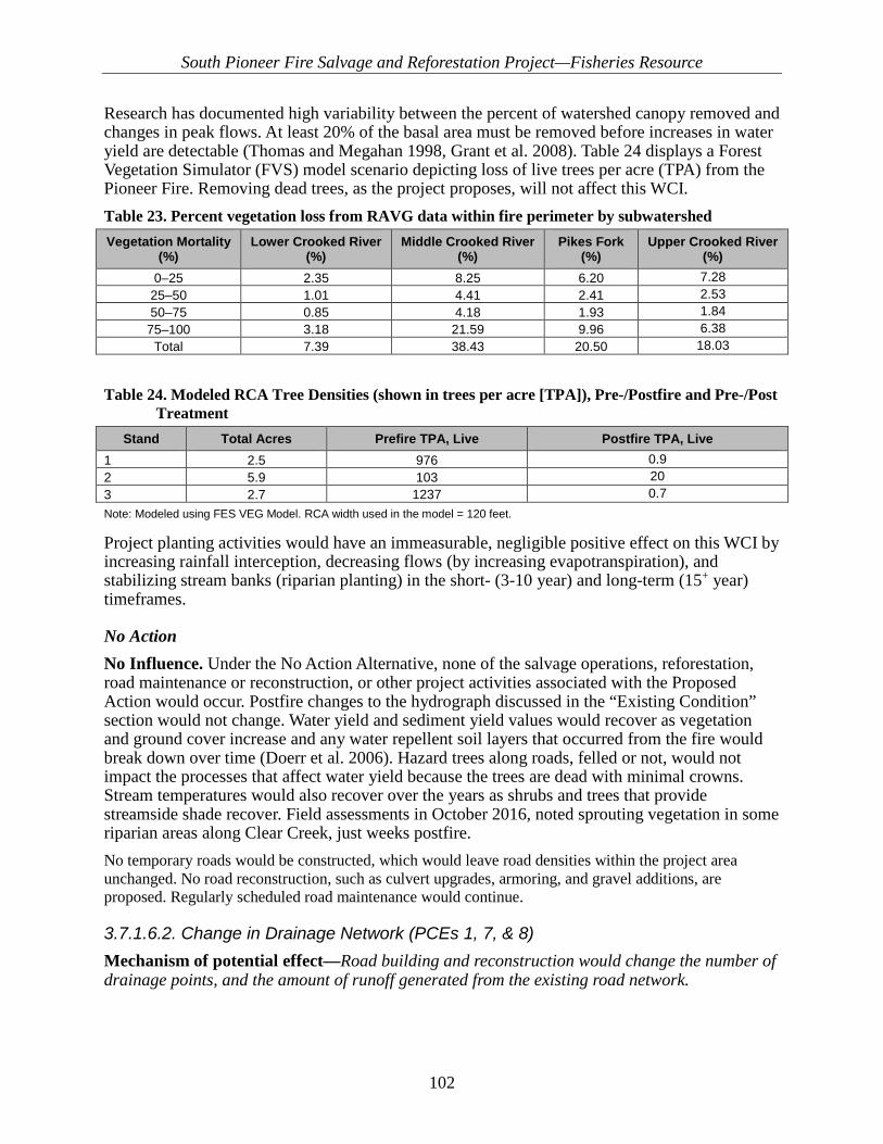
South Pioneer Fire Salvage and Reforestation Project—Fisheries Resource
102
Research has documented high variability between the percent of watershed canopy removed and changes in peak flows. At least 20% of the basal area must be removed before increases in water yield are detectable (Thomas and Megahan 1998, Grant et al. 2008). Table 24 displays a Forest Vegetation Simulator (FVS) model scenario depicting loss of live trees per acre (TPA) from the Pioneer Fire. Removing dead trees, as the project proposes, will not affect this WCI. Table 23. Percent vegetation loss from RAVG data within fire perimeter by subwatershed Vegetation Mortality
(%) Lower Crooked River
(%) Middle Crooked River
(%) Pikes Fork
(%) Upper Crooked River
(%) 0–25 2.35 8.25 6.20 7.28
25–50 1.01 4.41 2.41 2.53 50–75 0.85 4.18 1.93 1.84
75–100 3.18 21.59 9.96 6.38 Total 7.39 38.43 20.50 18.03
Table 24. Modeled RCA Tree Densities (shown in trees per acre [TPA]), Pre-/Postfire and Pre-/Post Treatment
Stand Total Acres Prefire TPA, Live Postfire TPA, Live 1 2.5 976 0.9 2 5.9 103 20 3 2.7 1237 0.7 Note: Modeled using FES VEG Model. RCA width used in the model = 120 feet.
Project planting activities would have an immeasurable, negligible positive effect on this WCI by increasing rainfall interception, decreasing flows (by increasing evapotranspiration), and stabilizing stream banks (riparian planting) in the short- (3-10 year) and long-term (15+ year) timeframes.
No Action No Influence. Under the No Action Alternative, none of the salvage operations, reforestation, road maintenance or reconstruction, or other project activities associated with the Proposed Action would occur. Postfire changes to the hydrograph discussed in the “Existing Condition” section would not change. Water yield and sediment yield values would recover as vegetation and ground cover increase and any water repellent soil layers that occurred from the fire would break down over time (Doerr et al. 2006). Hazard trees along roads, felled or not, would not impact the processes that affect water yield because the trees are dead with minimal crowns. Stream temperatures would also recover over the years as shrubs and trees that provide streamside shade recover. Field assessments in October 2016, noted sprouting vegetation in some riparian areas along Clear Creek, just weeks postfire. No temporary roads would be constructed, which would leave road densities within the project area unchanged. No road reconstruction, such as culvert upgrades, armoring, and gravel additions, are proposed. Regularly scheduled road maintenance would continue.
3.7.1.6.2. Change in Drainage Network (PCEs 1, 7, & 8) Mechanism of potential effect—Road building and reconstruction would change the number of drainage points, and the amount of runoff generated from the existing road network.
South Pioneer Fire Salvage and Reforestation Project—Fisheries Resource
103
Proposed Action Maintain. Several road-related activities are proposed that could measurably but negligibly increase the drainage network. This WCI would experience a temporary and short term measurable and negligible negative effect as temporary roads are constructed and existing routes are reconstructed to support proposed activities. In the long term, when vegetation treatments have been completed, all temporary roads would be decommissioned, along with several unauthorized routes. The result would be a net measurable but negligible improvement to this WCI in the long term. Temporary Road Construction The Proposed Action includes constructing 3.6 miles of temporary road; construction would occur with 0.2 miles within the RCA of Edna Creek. However, the most temporary roads would be constructed on existing (unauthorized) road prisms. Most of these existing road prisms have old and non-functional drainage systems. Thus, temporary road construction would increase the length of the drainage network until work is completed and the temporary roads are decommissioned. Opening of Maintenance Level (ML) 1 Roads The Proposed Action includes temporarily opening and reconstructing 48 miles of currently closed ML1 roads to support vegetation treatments. Of these 48 miles, 10.3 miles would occur within various RCAs, some adjacent to critical habitat. The level of maintenance necessary would vary (see sediment discussion). However, opening and using these previously closed routes would increase the existing drainage network in all subwatersheds. Road Decommissioning All temporary road segments proposed for construction (3.6 miles) to support vegetation treatments would be fully decommissioned once the project has been completed. Full obliteration would occur on each of these routes. Additional unauthorized routes would also be fully obliterated (1 mile) for a total of 4.6 miles of decommissioned routes. Temporary and Short-term Effects In the temporary and short-term timeframes, the drainage network would increase measurably, but negligibly, as temporary roads are constructed and ML 1 roads are opened and reconstructed to support proposed vegetation treatments. Thus, a measurable, but negligible, effect to the WCI would occur in both timeframes. As road maintenance and road reconstruction occurs to support the Proposed Action, new drainage features, new road miles, and roads with substandard drainage would be added to the existing drainage network for the project subwatersheds. The resulting increased runoff from road-related activities would increase the drainage network over the existing condition, but enough to change the functional rating. Thus, any effects, while measurable, would be negligible. Long-term Effects Once proposed vegetation treatments are completed, all temporary roads would be fully obliterated, ML 1 roads would once again be closed and allowed to revegetate naturally, and additional unauthorized routes would be fully obliterated. Thus, the drainage network in all subwatersheds would measurably decrease in this timeframe and beyond, and net beneficial but negligible effects to this WCI are expected.

South Pioneer Fire Salvage and Reforestation Project—Fisheries Resource
104
No Action No Influence. This alternative does not propose any new management activities. Currently, road density in all subwatersheds is very high, resulting in all subwatersheds FUR. The existing conditions is expected to continue. The No Action Alternative would not change the functional rating of this WCI, nor would it change the current trajectory.
3.7.1.7. Watershed Condition
3.7.1.7.1. Road Density and Location Mechanism of potential effect—Construction of new temporary road and skid trails, and reconstruction of existing routes for treatment activities could increase the number of drainage points and the amount of runoff generated from the existing road network.
Proposed Action Maintain. The Proposed Action would maintain the existing functionality of the Road Density and Location WCI as FUR in all four subwatersheds with a slight increase in road density (0.02 mi/mi2) in the temporary timeframe associated with new template temporary road construction and a reduction in road density in the short and long term associated with decommissioning all temporary roads and 1.0 miles of unauthorized roads not utilized for salvage operations (Table 25). There would be no effect to the indicator in the Upper Crooked, Lower Crooked, and Pikes Fork subwatersheds. Road density would be slightly improved in the Middle Crooked subwatershed from decommissioning 4.25 miles of unauthorized roads. The Proposed Action would decommission approximately 1.0 mile of unauthorized route not identified for use in implementing salvage harvest. An additional 3.25 miles of unauthorized routes that are identified for use as temporary roads to facilitate the implementation of salvage harvest would also be decommissioned after harvest is complete (Design feature FH-8). Decommissioning of these unauthorized roads would only occur within the Middle Crooked subwatershed and would decrease the road density from 3.9 mi/mi2 to 3.87 mi/mi2; RCA road density would be reduced from 7.57 to 7.55 mi/mi2 (Table 25).

South Pioneer Fire Salvage and Reforestation Project—Fisheries Resource
105
Table 25. Pre and post-project road density within and outside of riparian conservation areas (RCAs) with temporary road construction
Sub-watershed
Existing Road Density (mi/mi2) Existing Condition
Functionality
Temporary road
construction on existing road prism
Temporary Road
Construction not on
existing road prism
Post Project Road
Density (mi/mi2)
Post Project Functionality
Non-RCA RCA Non-RCA RCA
Upper Crooked River 2.75 0.22 FUR 0 0 3.8 4.6 FUR Middle Crooked River 3.8 7.5 FUR 3.4 0.2 3.87 7.55 FUR Lower Crooked River 3.1 2.1 FUR 0 0 3.1 2.1 FUR Pikes Fork 6.5 8.2 FUR 0 0 6.5 7.2 FUR
South Pioneer Fire Salvage and Reforestation Project—Fisheries Resource
106
No Action No Influence. This option would perpetuate the existing condition with regard to the Road Density and Location and WCI. None of the proposed activities would occur under this alternative, and there would be no change in road miles.
3.7.1.7.2. Disturbance History/Disturbance Regime Mechanism of potential effect—Project-related actions over large areas could alter watershed processes and functions related to natural disturbance.
Proposed Action The Disturbance History and Disturbance Regime WCIs effects analysis has been combined into a single section because the processes and effects associated with these indicators are often complementary. Disturbance processes are an important component of dynamic soil; water; and hydrologic, riparian, and aquatic habitats that determine the physical and biological capability within watersheds. In general, the Proposed Action has little potential to affect the current condition for these WCIs. The Pioneer Fire affected all subwatersheds on a large scale, and many WCIs are currently degraded from this large-scale disturbance. Hazard tree felling and salvage harvest would not affect the current trajectory of the subwatersheds, and area vegetation and streams would continue to be dominated by postfire processes despite the proposed activities. Road-related activities could potentially benefit some WCIs in the long term, but not at a scale large enough to affect overall watershed functions and processes.
No Action No Influence. This alternative does not propose any new management activities. The existing conditions is expected to continue.
3.7.1.7.3. Riparian Conservation Areas (PCEs 1, 3, 4, 5, & 7) Mechanism of potential effect—Treatment activities (hazard tree felling and removal) could result in an overall change in RCA function by effecting other WCIs related to RCA health.
Proposed Action Maintain. Overall RCA conditions would not change from implementing the Proposed Action. Postfire processes from the Pioneer Fire would continue to be the dominate influence on RCA conditions and recovery. Some immeasurable and insignificant effects to this WCI would occur in the temporary timeframe from road maintenance, road decommissioning, and hazard tree removal within RCAs. However, in the short- and long-term timeframes, there would be net immeasurable benefits from road decommissioning actions, improved road drainage functions, and planting of conifers within the RCAs. Vegetation Management Riparian areas have been effected to various degrees following the Pioneer Fire of 2016. However, in areas where RCAs burned at low-to-moderate intensity/severity, or remained unburned, RCAs continue to function and provide key components and ecosystem services in accordance with the existing conditions. Refer to Table 17 for a summary of post-fire RCA

South Pioneer Fire Salvage and Reforestation Project—Fisheries Resource
107
conditions. The proposed activities include RCA hazard tree treatments, road reconstruction, road maintenance, and road decommissioning. Hazard tree felling could provide LWD in the temporary and short term. Reforestation would help move the RCAs toward desired future conditions for forested vegetation. Felling of hazard trees within the RCA could also stimulate seral shrub growth and promote soil recovery by putting more trees on the ground faster than natural falling and decomposition. Promotion of seral shrub growth within the RCA and future LWD recruitment in the watershed would increase shading (lowering stream temperatures), channel complexity/pool formation, and sediment storage capacity; all of which are critical components of bull trout core habitat areas. During implementation of the vegetation management actions, insignificant effects are expected. In the short and long term timeframes, as project objectives enhance the growth of seral shrubs within RCAs, replanting will help move the RCAs towards recovery. Thus, negligible positive improvements are expected. These improvements would result in more vigorous, faster recovery of forested stands within the RCAs. Hazard tree felling and removal treatments would include cutting hazard trees above the road. No equipment would be allowed off existing roads in RCAs. Trees felled within the RCA in the 2nd SPTH would be yarded to existing roads using cables or tongs, and then removed. Soil disturbance would occur within the RCA above the roads from winching the trees to the existing roads. However, because the trees would be whole tree yarded, minimal disturbance is expected. In addition, the hydrology resource technical report states that MK sediment delivery length estimates for yarding activities were less than 1 SPTH (70 feet). Therefore, sediment associated with vegetation yarding operations is not expected to be delivered to streams. The remaining large trees within the 1st SPTH would likely still be available for LWD recruitment and would maintain the WCI functionally rating. Consequently, vegetation management disturbance to the RCA would result in insignificant effects in the temporary and short-term timeframes. Road Decommissioning The Proposed Action would reduce road density within the watershed and RCAs. Road decommissioning would include installing drainage features, installing effective barriers to motorized vehicles, and seeding with grass and forbs. The long-term improvements are expected to have an immeasurable positive effect to this WCI from a reduction in sediment to streams. These effects are expected to be insignificant. These areas will regrow vegetation and promote large tree growth, followed by less overall disturbance near streams. Road Maintenance Road maintenance is proposed in RCAs along 21.7 miles within the Upper Crooked River, Middle Crooked River, Lower Crooked River, and Pikes Fork subwatersheds. Light maintenance, consisting of surface blading, ditch cleaning, culvert cleaning as needed, and removal of fallen trees from the roadway, is proposed along 21.1 miles of road. Additionally, moderate maintenance, consisting of removal of vegetation from the road shoulders, road surface re-shaping and blading, ditch and culvert cleaning, replacement of deficient ditch relief culverts or installation of new ditch relief culverts, and the removal of fallen trees from the roadway, is proposed along 0.4 miles of road. Finally, heavy maintenance is proposed along 0.2 miles of road within the RCA near occupied habitat in Edna Creek. Modeled sediment travel distances for heavy maintenance is 70 feet. So, there would be little or no potential for sediment delivery where road maintenance activities occur more than 70 feet away from water. The effects to this WCI are expected to be insignificant because project design features (FH-1, FH-4, FH-5, FH-6,

South Pioneer Fire Salvage and Reforestation Project—Fisheries Resource
108
FH-7 and FH-8) and Forest Service Nationwide BMPs are expected to prevent or mitigate potential effects. Temporary Road Construction Most temporary road construction is proposed outside of RCAs with only a short amount (0.2 miles) proposed within an RCA (within 240 feet) adjacent to occupied habitat in Edna Creek (Figure 20). The vegetation buffer between the temporary road construction and streams would decrease the likelihood that sediment or other construction effects would affect this WCI. Therefore, effects from this activity are expected to be negligible.
No Action No Influence. This alternative would continue the existing condition regarding the RCA WCI. The risk is primarily due to high road densities within RCAs, which increase sediment delivery and reduce potential shade along streams. As a result, this WCI could continue to experience immeasurable negative effects in all timeframes.

South Pioneer Fire Salvage and Reforestation Project—Fisheries Resource
109
Figure 20. Temporary road construction and riparian planting near Edna Creek

South Pioneer Fire Salvage and Reforestation Project—Fisheries Resource
110
3.7.1.8. Integration of Pathways
3.7.1.8.1. Integration of Species and Habitat Conditions Mechanism of potential effect—Changes to the other WCIs, could change the overall fish species or aquatics situation either species or habitat related.
Proposed Action Maintain. The Proposed Action may have immeasurable and/or negligible positive and/or negative potential effects on multiple WCIs in all timeframes. These effects were determined to be negligible. Project design features would prevent or mitigate the potential for effects and reduce the likelihood that these actions affect bull trout or their critical habitat. In the temporary timeframe, removing trees within the RCA could degrade some RCA functions. However, due to postfire processes, the RCA condition would likely continue its current trajectory within the timeframe of this analysis. In the long-term timeframe, several benefits may be realized: sediment reduction from proper road maintenance, road decommissioning, promotion of seral shrub growth, and soil recovery. Planting conifers in the RCAs would improve future LWD recruitment, increase shading (lowering stream temperatures), benefit channel complexity/pool formation, and increase sediment storage capacity; all of which are critical components of bull trout habitat areas. Transportation Management As described in the Sediment WCI section, some risk of sedimentation could occur where heavy road maintenance activities occur within 70 feet of bull trout critical habitat. Effects from these actions would be minimized by design features related to RCAs (FH-1); specific work restrictions (FH-4, FH-5, FH-6, FH-8 and TH-4); and sediment controls (FH-5) Also, this project would reduce stream temperatures in the long-term by promoting streamside vegetative growth. Road maintenance has the potential to contribute to temporary sediment increases. These increases are included in the sediment analysis. Road maintenance activities are designed to prevent the deterioration of roads due to regular use and natural erosion. Road maintenance helps to limit sediment input and turbidity from road systems over time. However, maintenance activities themselves can contribute sediment to streams. The amount of fine sediment contributed is generally proportional to the frequency, timing, and intensity of maintenance; a road’s location on the landscape; and the quality and effectiveness of its drainage (e.g., ditchline extension, number of stream crossings). Mitigations in the project design features (FH-4, FH-5, and FH-8) have minimized this risk by requiring work be done in dry conditions, implementing sediment control measures, and not allowing side cast waste material within RCAs. These mitigations would be expected to decrease the likelihood of sediment delivery, disturbance of bull trout, or degraded habitat. Effects from these actions are expected to be negligible, immeasurable, and unlikely to occur and are, therefore, discountable. Road Maintenance This activity is proposed in RCAs along 21.7 miles within the Upper Crooked River, Middle Crooked River, Upper Crooked River, and Pikes Fork subwatersheds. Light maintenance, consisting of surface blading, ditch cleaning, culvert cleaning as needed, and removal of fallen trees from the roadway, is proposed along 21.1 miles of road. Additionally, moderate maintenance, consisting of removal of vegetation from the road shoulders, road surface re-shaping and blading, ditch and culvert cleaning, replacement of deficient ditch relief culverts or installation of new ditch relief culverts, and the removal of fallen trees from the roadway, is
South Pioneer Fire Salvage and Reforestation Project—Fisheries Resource
111
proposed along 0.4 miles of road. Finally, heavy maintenance is proposed along 0.2 miles of road within the RCA near occupied habitat in Edna Creek, and 1 mile of road within the RCA near critical habitat in Banner Creek (NFS road 385). Modeled sediment travel distances for heavy maintenance is 70 feet. There would be little or no potential for sediment delivery where road maintenance activities occur more than 70 feet away from water. The effects to this WCI are expected to be negligible because project design features (FH-1, FH-4, FH-5, FH-6, FH-7 and FH-8) and BMPs are expected to prevent or mitigate potential effects. Temporary Road Construction Temporary road construction is proposed outside of RCAs. Only 0.2 miles of temporary road construction on existing road templates would occur within the RCA of Edna Creek. The vegetation distance between temporary road construction and streams would decrease the likelihood that sediment from constructing temporary roads would reach streams. Analysis for the Sediment WCI concluded that a temporary road segment could contribute limited sediment in Edna Creek (see RCA discussion). Any potential for small amounts of sediment is expected to have negligible and insignificant effects on bull trout and is discountable.
No Action No Influence. This alternative does not propose any new management activities. As explained above, some WCIs would continue a negative trend until natural post fire recovery is complete. These WCIs could have a direct influence on integration of species and habitat conditions WCIs. As a result, this WCI could continue to experience immeasurable negative effects in all timeframes.
3.7.2. Direct and Indirect Effects to Designated Critical Bull Trout Habitat
3.7.2.1. Primary Constituent Elements Primary Constituent Elements (PCEs) as identified in the designation of Critical Habitat for Bull Trout (Federal Register Vol. 75/ 75 FR 2269), are those habitat components essential for the primary biological needs of foraging, reproducing, rearing of the young, dispersal, genetic exchange, or sheltering. Table 26 describes the PCE descriptions and corresponding WCI.

South Pioneer Fire Salvage and Reforestation Project—Fisheries Resource
112
Table 26. Primary Constituent Element (PCE) description and corresponding Watershed Condition Indicator (WCI)
PCE Number PCE Description Corresponding Pathway Indicator (WCI)
1
Springs, seeps, groundwater sources, and subsurface water connectivity (hyporehic flows) to contribute to water quality and quantity and
provide thermal refugia.
Sediment, Channel Conditions and Dynamics (wetted width/maximum depth ratio, stream bank condition, floodplain connectivity), riparian conservation areas.
2
Migratory habitats with minimal physical, biological, or water quality impediments between spawning, rearing, overwintering, and freshwater and marine foraging habitats, including but not
limited to permanent, partial, intermittent, or seasonal barriers.
Temperature, physical barriers, refugia.
3 An abundant food base, including terrestrial
organisms of riparian origin, aquatic macroinvertebrates, and forage fish.
Water quality (temperature, sediment, chemical and nutrient contaminants), Channel Conditions and
Dynamics (wetted width/maximum depth ratio, stream bank condition, floodplain connectivity), changes in
peak/base flows, riparian conservation areas
4
Complex river, stream, lake, reservoir, and marine shoreline aquatic environments and
processes with features such as large wood, side channels, pools, undercut banks and substrates,
to provide a variety of depths, gradients, velocities, and structure.
Habitat elements (substrate embeddedness, LWD, pools frequency and quality, large pools, off-channel
habitat, and refugia)
5 Water temperatures ranging from 2 to 15 C (36
to 59 F), with adequate thermal refugia available for temperatures at the upper end of this range.
Temperature
6
Substrates of sufficient amount, size, and composition to ensure success of egg and
embryo overwinter survival, fry emergence, and young-of-the-year and juvenile survival. A
minimal amount (e.g., less than 12 percent) of fine substrate less than 0.85 mm (0.03 in.) in
diameter and minimal embeddedness of these fines in larger substrates are characteristic of
these conditions.
Sediment, substrate embeddedness
7
A natural hydrograph, including peak, high, low, and base flows within historic and seasonal
ranges or, if flows are controlled, they minimize departures from a natural hydrograph.
Flow/Hydrology (Changes in Peak /Base flows and Drainage Network Increase)
8 Sufficient water quality and quantity such that
normal reproduction, growth, and survival are not inhibited.
Water Quality (Temperature, sediment, Chemical Contaminants and Nutrients)
9
Few or no nonnative predatory (e.g., lake trout, walleye, northern pike,
smallmouth bass; inbreeding (e.g., brook trout); or competitive (e.g., brown trout) species
present.
Persistence and Genetic Integrity
1) Springs, seeps, groundwater sources, and subsurface water connectivity (hyporehic flows) to contribute to water quality and quantity and provide thermal refugia. Maintain. Equipment would not leave existing road prisms, and no mechanism of potential effect to groundwater resources or subsurface water connectivity exists. No ground disturbance would occur within the first 120 feet of any water. RCA designations include all wetlands, seeps, and springs, so no road related actions would affect areas within 120 feet of any wetlands.

South Pioneer Fire Salvage and Reforestation Project—Fisheries Resource
113
The depth at which tree planting for reforestation within the RCA would occur is less than 12–16 inches. Thus, no subsurface or groundwater should be effected by planting activities within the riparian area. Surface expressions of groundwater (obvious springs and seeps) would be avoided to prevent disturbance to any wetland resources. In general, these areas are very small (less than 1/8th acre), naturally recover much faster, and should recover quickly on their own without the need for supplemental planting. 2) Migratory habitats with minimal physical, biological, or water quality impediments between spawning, rearing, overwintering, and freshwater and marine foraging habitats, including but not limited to permanent, partial, intermittent, or seasonal barriers. Maintain. No physical or water quality barriers exist or would be created by proposed riparian and upland activities. Water quality would not be impaired by sediment or turbidity, as no proposed activities are expected to deliver sediment to any stream channels. Sediment travel distances have been modeled for road-related actions at approximately 70 feet. Heavy maintenance would occur within 120 feet of stream channels. In the temporary timeframe, a slight risk exists that insignificant and immeasurable sediment could be delivered to stream channels. However, project design feature have been created to prevent and/or mitigate any potential effects from sediment delivery (FH-4, FH-5, FH-6, FH-8, and FH-10). Any effects from sediment would be unlikely to occur based on these design features, and the small amount of heavy road maintenance proposed (0.2 miles). Therefore, effects would be insignificant and discountable. Planting in riparian units could occur up to stream banks where necessary to mimic natural distribution. However, planting would be done with hand tools only. Ground disturbance is expected to be minimal and localized around the holes the plants are placed in. Scalping of the soil may occur, but is not expected to travel any significant distance and would not reach live water. No significant sediment is expected to be contributed from hand planting. Even on very steep slopes, sediment from negligible ground disturbance, such as scalping, normally cannot travel more than 5 feet downslope. Thus, no significant sediment from planting should be generated or delivered to live water, even in steep areas. Project design features specifying the methods and criteria for snowplowing would ensure snow and ice remain on the road surface or that roads are plowed far in advance of use to allow drying. Snowplowing for planting access would not generate sediment from the road surfaces. Not all roads within the project area would be utilized for access. 3) An abundant food base, including terrestrial organisms of riparian origin, aquatic macroinvertebrates, and forage fish. Maintain. Hazard tree felling below the road and associated placement of LWD in the stream and/or the RCA would increase activity associated with macroinvertebrates, potentially leading to similar effects as those described above. Removing hazard trees within the RCA would stimulate seral shrub growth, of which most species are broad-leaf deciduous. Deciduous vegetation provides exponentially more terrestrial insect habitat and abundance than riparian cover dominated by conifers. In turn, fish that bull trout consume as prey may benefit from an increase in deciduous cover.

South Pioneer Fire Salvage and Reforestation Project—Fisheries Resource
114
Since no mechanized equipment would operate off existing roads, little potential exists for elevated sediment to impact macroinvertebrates or reproduction for forage fish. The riparian planting activities would help reestablish riparian vegetation and not negatively affect the food base for bull trout. In the short and long term, there would be a positive effect to this PCE as planting riparian vegetation would increase the availability of terrestrial organisms and nutrient inputs, thus positively effecting aquatic macroinvertebrates. In turn, increased availability of aquatic macroinvertebrates would increase the food base for rainbow trout, mountain whitefish, and other fishes (bull trout prey), in turn increasing forage fish availability for bull trout. 4) Complex river, stream, lake, reservoir, and marine shoreline aquatic environments and processes with features such as large wood, side channels, pools, undercut banks and substrates, to provide a variety of depths, gradients, velocities, and structure. Maintain. Within hazard tree treatment areas adjacent to Pikes Fork, Banner Creek, Edna Creek, and along Crooked River, LWD could be placed in the streams where possible, which could affect several habitat components positively. Conversely, in some recreational areas adjacent to the same streams, there could be limited removal of some standing hazard trees. However, there will be no lack of LWD into the future, due to the sheer amount of standing dead trees along streams, particularly across the stream from treatment areas, including recreation sites. See LWD analysis above in the WCI discussion. Existing LWD within the stream channels would not be affected by the Proposed Action. Overall, channel complexity/structure and wetted width to depth ratios as well as usable habitat area should not be significantly affected by the proposed actions. No negative effects to existing bank stability or other bank features are expected. Even where hazard trees are felled near stream banks, the stumps and root wads would remain in place. No mechanized equipment would leave existing roads. Hand planting along banks would not cause bank disturbance from foot traffic; no significant effects would be expected from such a temporary and low intensity activity. Side channels or other special features would not be disturbed by project activities as mechanized equipment would not leave existing road prisms. In the short and long term, riparian planting would enhance bank stability and help conserve undercut banks by restoring streamside vegetation and providing root holding strength to stream banks. Existing LWD would not be affected. In the short term, LWD would increase as hazard trees are felled within the riparian, into the stream where feasible. In the long term, LWD availability would be enhanced from planting conifer species for a better distribution of age classes within and between stands within the riparian area. Riparian planting would be completed using hand tools only; no mechanized equipment would be used. Overall channel complexity and structure would not be degraded by the riparian planting actions as riparian plantings would not be a source of significant ground disturbance. Thus, no streambank or other channel features would be negatively affected by planting activities. In the short and long term, overall channel complexity and structure would be enhanced by increasing bank stability, protecting existing side channels and other special channel features, and increasing the availability of large wood.
South Pioneer Fire Salvage and Reforestation Project—Fisheries Resource
115
5) Water temperatures ranging from 2 to 15 °C (36 to 59 °F), with adequate thermal refugia available for temperatures at the upper end of this range. Maintain. Hazard tree felling activities would occur within the RCA adjacent to critical habitat. Hazard tree felling and/or removal is not expected to significantly alter this PCE, as the trees proposed for removal have already lost their canopy and do not contribute significant shade to critical habitat streams. Trees with live canopies would be left in all RCAs. In the long term, hazard tree removal and planting activities should result in benefits by enhancing the recovery of the RCA, allowing seral shrub vegetation to recover, and speeding the recovery of forested vegetation. 6) Substrates of sufficient amount, size, and composition to ensure success of egg and embryo overwinter survival, fry emergence, and young-of-the-year and juvenile survival. A minimal amount (e.g., less than 12%) of fine substrate less than 0.85 mm (0.03 inches) in diameter and minimal embeddedness of these fines in larger substrates are characteristic of these conditions. Maintain. Road-related actions, including reconstruction, decommissioning, snow plowing, and heavy maintenance, would occur within RCAs adjacent to bull trout critical habitat. However, design features (FH-4, FH-5, FH-6, FH-8, and FH-10) requiring sediment control devices, BMPs, and slash cover on all disturbed areas would mitigate any potential effects to this PCE. The longest modeled sediment travel distance, associated with heavy road maintenance, was 70 feet. Heavy maintenance is only expected to occur on 1.2 miles of road adjacent to critical habitat. No effects would occur where these activities occur more than 70 feet from the stream. Where these activities occur within 70 feet of the stream, the potential for an insignificant amount of sediment delivery to bull trout critical habitat could occur but is extremely unlikely based on project design features designed to prevent or mitigate effects from sediment (FH-4, FH-5, FH-6, FH-8, and FH-10). In the riparian planting units, planting could occur up to 15 feet from stream banks. However, planting will be done with hand tools only. Ground disturbance is expected to be negligible. No effects to substrate amount, size, or composition is expected. No significant sediment generation is expected from proposed planting activities. Only hand planting would occur with negligible surface disturbance. In the short and long term, proposed activities would reduce sediment generation to live water by helping restore riparian vegetation where it has been removed by fire and/or debris flows. 7) A natural hydrograph, including peak, high, low, and base flows within historic and seasonal ranges or, if flows are controlled, they minimize departures from a natural hydrograph. Maintain. The Proposed Action does not have the potential to significantly effect this PCE. Dead and dying trees, which do not affect evapotranspiration, would be removed in some areas. Road-related activities, including road maintenance, would increase the functional drainage from road runoff in many areas but not enough to significantly alter the magnitude, timing, or peak/base of flows. The hydrograph would continue to be dominated by postfire watershed processes associated with the Pioneer Fire of 2016. Under the Proposed Action, a slight immeasurable improvement is expected due to vegetation management activities and road decommissioning/closure activities.
South Pioneer Fire Salvage and Reforestation Project—Fisheries Resource
116
8) Sufficient water quality and quantity such that normal reproduction, growth, and survival are not inhibited. Maintain. Temperature, sediment, and other water quality factors would be maintained or negligibly altered in the temporary timeframe. Therefore, effects to this PCE are expected to be negligible. See water quality WCI discussion above for water quality narratives. Road surface improvements include water drafting operations to assist in road blading. Water drafting sites that could affect bull trout or their habitat occur in Edna Creek, Pikes Fork, and Crooked River. Water drafting without adequate screens can entrain small fish into the intake or trap them against the inlet screen when pumping. Effects from this action to bull trout individuals would be insignificant because Design Feature FH-2 requires a 3/32 screen size and appropriate surface area for the volume being pumped to avoid the possibility of impingement. Also, this mitigation would require a fish biologist and/or hydrologist to approve drafting sites. As a result, unnamed tributaries and streams not occupied by bull trout would be preferred over occupied or designated critical bull trout habitat. Furthermore, water trucks typically draft twice a day for support of road grading (3,000-gallon tank). Limitations on drafting capacity per site would ensure bull trout useable habitat is not altered. In fact, the percentage of the stream being drafted out in August (low flow) would be 0.49% for Edna Creek, 0.14% Pikes Fork, and 0.17% for Crooked River. This change in percentage would only occur during the period of drafting (approximately 20 minutes to fill tanker). This action is not expected have significant effects on this PCE. Water quantity would not be negatively affected by planting activities in any timeframe. No mechanism of effect exists by which hand planting on the shore could remove or add to the quantity of water already in the channel within the timeframe of this analysis. In the very long term (20+ years), reforestation would attenuate flows, moving them toward prefire conditions as ground water is lost to increased evapotranspiration as vegetation matures postfire. No significant disturbance would occur from hand planting trees and shrubs. Thus, no significant sediment would be generated to affect water quality. In the short and long term, water quality would be immeasurably improved by the Proposed Action. Planting riparian conifers would buffer sediment inputs from hillslope processes and bank instability as soils are affected by postfire precipitation events. 9) Few or no nonnative predatory (e.g., lake trout, walleye, northern pike, smallmouth bass; inbreeding (e.g., brook trout); or competitive (e.g., brown trout) species present. Maintain. Nonnative brook trout are present in tributaries in the Lower Crooked River, Middle Crooked River, and Pikes Fork subwatersheds. None of the project actions would change the current distribution or size of any bull trout or brook trout population. In general, any potential effects to habitat from RCA hazard tree removal would affect both species equally. Therefore, there would be no change to this PCE from the project actions.
3.7.3. Direct and Indirect Effects to Bull Trout Individuals
3.7.3.1. Effects to Immobile Life Stages of Bull Trout (eggs and alevins) Few spawning and rearing areas occur within the project area; most spawning occurs in the Upper Crooked River, well upstream of the project boundary. However, subadults have been found in Edna Creek near the proposed road decommissioning.

South Pioneer Fire Salvage and Reforestation Project—Fisheries Resource
117
In general, the Proposed Action has little potential to directly affect eggs in gravel or alevins (larval bull trout). No activities within the wetted channel or that affect any area within the water are proposed, and no equipment is allowed off existing road prisms.
3.7.3.2. Effects to Mobile Life Stages of Bull Trout (juveniles, sub-adults and adults) Areas occupied by mobile life stages of bull trout are scattered throughout the project area. The Lower and Middle Crooked Rivers are primarily FMO habitat (foraging, migratory and overwintering). Crooked River primarily acts as a migration corridor for fluvial fish migrating upstream from the North Fork Boise River to spawn in Upper Crooked River near Trapper Flat. Tributaries to Crooked River that are occupied and/or designated critical habitat (Edna Creek) likely support resident bull trout in the form of rearing juveniles and subadults. The headwaters of these streams are the likely spawning grounds for both resident and migratory life forms. In general, the proposed actions have little potential to directly affect mobile life stages of bull trout. However, some mobile life stage could be present year-round in any of the streams named above. Some of the above streams could have RCA hazard tree felling or planting occurring when bull trout are present. Thus, the primary mechanism of effect to resident or migratory life forms of bull trout would be in the form of disturbance from tree felling and reforestation activities. Tree felling or planting operations near the stream may disturb any bull trout that may be present at the time and place such operations occur. However, operations would occur in stages and not all stream segments occupied by bull trout would be affected at the same time, thus limiting the extent, severity, and intensity of effects. Disturbance would be limited to fallers or planting crews walking through riparian areas during normal operating hours (day time). Sudden movements or shadows on the water’s surface could spook any fish in the area, causing a single, short-duration, and low-intensity disturbance. Such a disturbance could lead to any fish nearby moving immediately to the nearest cover until the disturbance has ended. A single, short-duration event of this intensity is not likely to result in any significant effects to bull trout behavior. Bull trout are highly cryptic and nocturnal by nature, with subadults and adults favoring deep pools and undercut banks. It’s unlikely that any fish would be disturbed by such a short-duration and low-intensity disturbance, and the effects to behavior would be limited to a simple escape to the nearest cover. A temporary displacement could, but is unlikely to, result in a very short additional exposure to avian predators. Even if a mobile life stage bull trout were disturbed, any potential effects would be negligible, resulting in a temporary displacement from habitat within a very small localized area. Any fish present would be able to move freely upstream or downstream to other available habitats and return to the area after the disturbance has passed. A short-distance, temporary displacement of individuals in a limited area where work is occurring would not result in any significant effects to those individuals. Energy required for such a movement would not result in any potential for cumulative or delayed mortality, nor would such a small movement appreciably affect the reproductive success, survival, or fitness of any individuals. Since any potential effects to individuals would be insignificant and unlikely to occur, there would be no significant effects to any local population abundance, distribution, or viability.
South Pioneer Fire Salvage and Reforestation Project—Fisheries Resource
118
3.8. Cumulative Effects
3.8.1. Introduction All actions listed in the Cumulative Effects section (Appendix B of the Envrionmental Assessment) were considered and evaluated for presence, relevance and potential to influence any indicators or othwerwise effect the proposed action. For exxample the 2017Commerical Mushroom Harvest Permitting Project is a project implemented in June 2017 to permit the sale of 400 commercial use mushroom permits and associated activities on the Idaho City Ranger District. This action was considered under the cumulative effects for aquatics, but was not carried into detailed analysis as there was “no effect” to aquatic resources (see 2017 Commercial Mushroom Harvest Permitting Request Biological Assessment). Since there is no effect to aquatic resources from the mushroom permitting project, there can be no incremental, synergistic or cumulative effects with the projects considered in this cumulative effects section.
3.8.1.1. Scale of Analysis For the purposes of this assessment, the subwatersheds within the project area, unless otherwise stated, were used as the action area for cumulative effects on TESPC species and critical habitat from implementation of the Pioneer South project. This scale was chosen for the cumulative effects analysis area because it is the largest spatial extent that direct and indirect effects would be observed. Cumulative effects can occur when existing water resource and aquatic conditions from nonfederal activities reasonably certain to occur, are further affected by the proposed activities.
3.8.1.2. Landownership Since most of the project area is located on NFS lands, the intensity and scope of nonfederal actions on private land in relation to the proposed action is expected to be non-existent. Only a small amount of private land exists in Edna Creek and in the Upper Crooked River near Banner Creek.
3.8.1.3. Past and Present Actions Within the Upper, Lower, and Middle Crooked River and Pikes Fork subwatersheds, the following State, federal, and private activities are currently occurring and expected to continue in the future:
• Road maintenance and use
• Trail maintenance and use
• Camping at designated and dispersed campsites
• Sheep grazing allotments
• Snowmobile use
• Fishing and hunting
• Fuel wood gathering and Christmas tree cutting (private activities authorized by Forest Service permit)
South Pioneer Fire Salvage and Reforestation Project—Fisheries Resource
119
• Noxious weed control by biological control agents and chemical spraying (Boise County and Forest Service joint projects)
• Recreation (e.g., hiking, horseback riding, cross country skiing, kayaking)
• There are three sets of ongoing actions which were considered for cumulative effects for all WCI’s, but which do not have enough bearing on the effects discussed in this report to warrant a separate discussion under each WCI: Livestock Grazing, Minerals, and Mushroom picking.
• Livestock Grazing: The Pioneer Fire burned approximately 9,162 acres of the Boise Basin Sheep and Goat (S&G) allotment and 29,938 acres of the North Fork S&G allotment within the project area with variable intensities. The rangeland condition following the fire is in a state of recovery. Due to these changes in forage quality and quantity resulting from the 2016 Pioneer Fire, portions of the Boise Basin and North Fork S&G allotments would be rested until standards set forth in the Forest Plan and the South Pioneer BAER Report are met. The South Pioneer BAER Report management recommendation provides a rest period from livestock grazing for a minimum of two growing seasons within the affected allotments. After the specified rest period, the soil and vegetation conditions inside allotments affected by the fire would be assessed to determine the specific grazing strategies the rangeland can support for livestock grazing. Strategies would include livestock numbers, season of use, and trailing patterns. This means that the grazing activities in Project Area will be temporarily halted and will not overlap in time with the project activities. In the foreseeable future, once grazing returns, the standards for ground cover, compaction from livestock, and riparian protection that are already in effect as part of the annual operating instructions will continue to minimize the effects of grazing to the point that any impacts are immeasurable. We expect a positive watershed impact from keeping livestock out of the North Fork Boise River watershed within these allotments and allowing them to recover.
• Minerals: In general, mining claim density is low throughout the project area. Currently, there are 68 “active” claims located in the project area; most of which are located in and around the Crooked River and Banner Creek areas. “Active” in this definition means the paperwork is properly filed with the Bureau of Land Management, not necessarily that the claim owners are actively engaged in prospecting activities. None of these 68 claims have operations at the scale required to develop and submit a Plan of Operations; and only one is expected to do so in the reasonably foreseeable future.
• The majority of mining activity both past and present exists along Crooked River, Banner Creek, and the Banner Mine complex. On a smaller scale some mining activity also exists around the China Fork and Gold Fork Creek areas. Historically, the Banner Mine Complex was the largest producing silver mine in the upper Boise Basin. The Banner Mine was located in 1864 and shut down in 1921. Evidence of past activities, structures, waste dumps, and past timber removal, to support construction, are present throughout the area. Areas of bare mineral soil and exposed tailings piles are still visible and are continuing to erode and deliver sediment to Banner Creeks. Most of this land is private property, with no Federal actions proposed to occur. The CuMo mining operation is not within the project area, and is therefore not considered in the effects analysis.
South Pioneer Fire Salvage and Reforestation Project—Fisheries Resource
120
• Current activities consist primarily of placer mining for gold along these river corridors. Placer mining is accomplished without the aid of earth moving equipment i.e., pick, shovel, and gold pan. Most mining activity is conducted on a small scale and usually by weekend campers and the occasional week-long/vacation campers. Intermittent surface and underground exploration has occurred in recent past within the Banner Mine complex both on NFS lands as well as private lands. No plans for further development have been received by the Forest Service at this time.
• Mushroom picking: Fire can stimulate mushroom production, and when the right conditions follow fire there can be a substantial mushroom crop. The Pioneer Fire was one of the West’s only major fires in 2016, so without a wide choice of potentially high volume/ quality collection sites, interest levels from collectors are very high. The Boise National Forest is issuing permits for commercial mushroom picking in June of 2017. All commercial picking is confined to the Idaho City Ranger District. Personal use picking may occur, but it is not a federal action, and is therefore not included in the effects analysis.
• Although the area may see higher than normal interest in mushrooms until June 30, 2017 (when the permits expire), the impacts to the area are not expected to be measurable. No ground disturbing activities are being allowed for harvesting mushrooms (i.e., raking or other ground disturbance is prohibited); so no excess sediment will be delivered to watercourses. No canopy cover or vegetation removal activities within 300 ft. of a perennial stream or within 150 ft. of intermittent streams are being proposed for this project; so no changes in stream temperature will occur due to project activities. The project proposes to use existing disturbed areas for designated camping sites. These sites will be located a minimum of 150 feet from any watercourse. Additionally, the project proposes to provide trash disposal and pickup facilities; as well as portable restroom facilities. In addition to these measures, permitted commercial harvesters must use designated access routes between the campsites to the designated commercial picking areas. And, all mushroom harvesters must follow the rules of travel in the 2017 Motor Vehicle Use Maps. No motorized cross-country travel or travel on closed roads is allowed.
Past and ongoing management actions have been considered in describing the existing baseline conditions for all WCIs (see Appendix B). These actions are ongoing and have been considered in describing the existing conditions. As a result, there would be no additional or cumulative effects either indirectly or directly related to the planned management actions (all alternatives).
3.8.1.4. Foreseeable Future Actions The North Pioneer Fire Salvage and Reforestation Project was not considered as a cumulative effect because effects from that action would occur in the Payette River watershed while effects from the South Pioneer Project would occur in the Crooked River watershed. These two watersheds are spatially separate, drain into separate river basins, and contain different populations of bull trout. There can be no temporal or spatial, incremental, synergistic, or combined effects of implementing the South and North Pioneer Fire Salvage and Reforestation Projects. Direct, indirect, and cumulative effects are disclosed in the the fisheries technical reports for both projects.
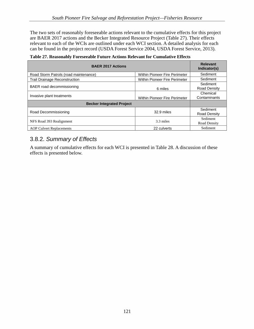
South Pioneer Fire Salvage and Reforestation Project—Fisheries Resource
121
The two sets of reasonably foreseeable actions relevant to the cumulative effects for this project are BAER 2017 actions and the Becker Integrated Resource Project (Table 27). Their effects relevant to each of the WCIs are outlined under each WCI section. A detailed analysis for each can be found in the project record (USDA Forest Service 2004, USDA Forest Service, 2013). Table 27. Reasonably Foreseeable Future Actions Relevant for Cumulative Effects
BAER 2017 Actions Relevant Indicator(s)
Road Storm Patrols (road maintenance) Within Pioneer Fire Perimeter Sediment Trail Drainage Reconstruction Within Pioneer Fire Perimeter Sediment
BAER road decommissioning 6 miles Sediment
Road Density
Invasive plant treatments Within Pioneer Fire Perimeter Chemical
Contaminants Becker Integrated Project
Road Decommissioning 32.9 miles Sediment
Road Density
NFS Road 393 Realignment 3.3 miles Sediment
Road Density AOP Culvert Replacements 22 culverts Sediment
3.8.2. Summary of Effects A summary of cumulative effects for each WCI is presented in Table 28. A discussion of these effects is presented below.

South Pioneer Fire Salvage and Reforestation Project—Fisheries Resource
122
Table 28. Summary of cumulative effects for South Pioneer Project effected Watershed Condition Indicators
Pathways Indicators a,
Cumulative Effects
Effects b, Temporary trend/effect (+/-/none)
Short-term trend/effect (+/-/none)
Long-term trend/effect (+/-/none)
Discussion of Effects
Subpopulation Size, Growth and Survival, Life History Diversity and Isolation, Persistence and Genetic Integrity.
NI None None None
No direct or indirect effects to any local population are expected. The only resident fish suspected to reside within the project area occur in Edna Creek where subadults have been documented. There is no potential for these fish to be affected at the subpopulation level as the only activities within the RCA are felling of hazard trees and limited reforestation.Negligible, discountable and/ or immeasurable effects to a few individuals
and/or a few habitat WCIs could occur, but overall habitat conditions and local population functionality would not change, and PCEs would be maintained. Therefore, there would be no
effects to bull trout at the subpopulation scale. Since only negligible effects are expected to other habitat WCIs, there would be no effects to any subpopulation of bull trout. Since
there would be no effects to this WCI from the Proposed Action, there can be no cumulative effects.
Temperature
M -* +* +* No vegetation treatments are proposed with the other considered actions (Becker Integrated Resource Project and BAER 2017). Thus, there will be no effects to this WCI from
combined actions.
Sediment/Turbidity/Substrate Embeddedness
M -* -* +* The other considered actions are expected to incrementally and additively effect this WCI in the same manner as the Proposed Action, which would result in a negligible and
immeasurable increase in effects. However, any immreasuralbe and/or incremental increase in effects from the combined effects of the three actions would not be enough to change the function rating of this WCI in any timeframe, and thus would not result in any significant effects. The actions would occur in spatially different areas and would be of the
same nature—low intensity/severity, and small scale.
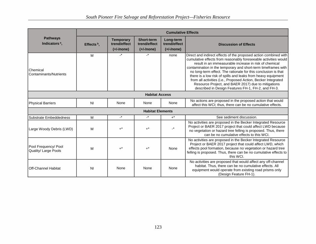
South Pioneer Fire Salvage and Reforestation Project—Fisheries Resource
123
Pathways Indicators a,
Cumulative Effects
Effects b, Temporary trend/effect (+/-/none)
Short-term trend/effect (+/-/none)
Long-term trend/effect (+/-/none)
Discussion of Effects
Chemical Contaminants/Nutrients
M -* -* none Direct and indirect effects of the proposed action combined with cumulative effects from reasonably foreseeable activities would
result in an immeasurable increase in risk of chemical contamination in the temporary and short-term timeframes with
no long-term effect. The rationale for this conclusion is that there is a low risk of spills and leaks from heavy equipment from all activities (i.e., Proposed Action, Becker Integrated
Resource Project, and BAER 2017) due to mitigations described in Design Features FH-1, FH-2, and FH-3.
Habitat Access
Physical Barriers NI None None None No actions are proposed in the proposed action that would affect this WCI; thus, there can be no cumulative effects.
Habitat Elements Substrate Embeddedness M -* -* +* See sediment discussion.
Large Woody Debris (LWD) M +* +* -*
No activities are proposed in the Becker Integrated Resource Project or BAER 2017 project that could affect LWD because no vegetation or hazard tree felling is proposed. Thus, there
can be no cumulative effects to this WCI.
Pool Frequency/ Pool Quality/ Large Pools M +* +* None
No activities are proposed in the Becker Integrated Resource Project or BAER 2017 project that could affect LWD, which
effects pool formation, because no vegetation or hazard tree felling is proposed. Thus, there can be no cumulative effects to
this WCI.
Off-Channel Habitat NI None None None
No activities are proposed that would affect any off-channel habitat. Thus, there can be no cumulative effects. All
equipment would operate from existing road prisms only (Design Feature FH-1).
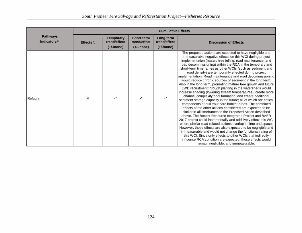
South Pioneer Fire Salvage and Reforestation Project—Fisheries Resource
124
Pathways Indicators a,
Cumulative Effects
Effects b, Temporary trend/effect (+/-/none)
Short-term trend/effect (+/-/none)
Long-term trend/effect (+/-/none)
Discussion of Effects
Refugia M -* -* +*
The proposed actions are expected to have negligible and immeasurable negative effects on this WCI during project
implementation (hazard tree felling, road maintenance, and road decommissioning) within the RCA in the temporary and short-term timeframes as other WCIs (such as sediment and
road density) are temporarily effected during project implementation. Road maintenance and road decommissioning
would reduce chronic sources of sediment in the long term. Also in the long term, promoting mature tree growth and future
LWD recruitment through planting in the watersheds would increase shading (lowering stream temperatures), create more
channel complexity/pool formation, and create additional sediment storage capacity in the future; all of which are critical
components of bull trout core habitat areas. The combined effects of the other actions considered are expected to be similar in all timeframes to the Proposed Action described
above. The Becker Resource Integrated Project and BAER 2017 project could incrementally and additively effect this WCI where similar road-related actions overlap in time and space. However, those effects are also expected to be negligible and immeasurable and would not change the functional rating of
this WCI. Since only effects to other WCIs that indirectly influence RCA condition are expected, those effects would
remain negligible, and immeasurable.

South Pioneer Fire Salvage and Reforestation Project—Fisheries Resource
125
Pathways Indicators a,
Cumulative Effects
Effects b, Temporary trend/effect (+/-/none)
Short-term trend/effect (+/-/none)
Long-term trend/effect (+/-/none)
Discussion of Effects
Channel Condition and Dynamics
Max Width/Depth Ratio M None None +*
Immeasurable improvements are expected in the long term as a result of project activities. Replanting conifers in the RCA would improve the resilience of the channel to resist future scour events by providing root holding strength. Also, road decommissioning inside the RCA would reduce potential
chronic sediment sources.
Streambank Condition M None +* +*
No replanting or RCA reforestation is proposed under the Becker Integrated Resource Project and BAER 2017 project. Therefore, there is no mechanism of effect by which future
foreseeable actions could incrementally or additively affect the Proposed Action.
Floodplain Connectivity M None +* +*
No activities are proposed within stream channels. Existing road prisms would be used so the current condition would not change until the long term when temporary and unauthorized
roads are decommissioned, which could negligibly enhance the hydrologic linkage of some floodplains where a
decommissioned road occurred next to streams. The effects from the other projects considered (Becker Integrated
Resource Project and BAER 2017) would be similar as roads are decommissioned. However, very few of these road are
within RCAs, thus any combined effects may be additive but would not change the functional rating of this WCI and would
remain negligible and immeasurable.

South Pioneer Fire Salvage and Reforestation Project—Fisheries Resource
126
Pathways Indicators a,
Cumulative Effects
Effects b, Temporary trend/effect (+/-/none)
Short-term trend/effect (+/-/none)
Long-term trend/effect (+/-/none)
Discussion of Effects
Flow/Hydrology Changes in Peak Flow/Base Flow
M +* +* none Effects would be from implementing BAER 2017 projects (aerial straw mulching). See discussion below.
Change in Drainage Network M - + + See discussion under Road Density
Watershed Conditions Road Density/Location M - + + See discussion under road density.
Disturbance History/Disturbance Regime NI None None None
The Proposed Action has no potential to affect the current condition for these WCIs. The Pioneer Fire of 2016 affected all
subwatersheds on a large scale. Hazard tree felling and salvage harvest would not affect the current trajectory of the
subwatersheds. Within the area, vegetation and streams would continue to be dominated by postfire processes despite the
proposed activities. Since there are no effects to this WCI, there can be no
cumulative effects.
Riparian Conservation Areas M -* +* +*
Replanting conifers within the RCAs could immeasurably improve some WCIs as indicated above, moving them
incrementally toward desired future condition. Overall, RCA condition could improve immeasurably and should improve
faster than natural regeneration alone. In the temporary timeframe, removing trees within the RCA could have a
negligible negative effect on some RCA functions. However, due to postfire processes, it is likely that RCA condition would
continue its current trajectory within the timeframe of this analysis, and any further benefits from reforestation would
occur beyond the timeframe of this analysis. For the combined actions considered with the Proposed Action, the effects would
be similar as similar WCIs that indirectly effect this WCI are affected in the same way for all road-related activities
proposed. The effects could be incremental and additive, but would not be sufficient to change the functional rating of this
WCI, primarily due to continued high RCA road densities. Thus, any combined effects would remain negligible, and
immeasurable.

South Pioneer Fire Salvage and Reforestation Project—Fisheries Resource
127
Pathways Indicators a,
Cumulative Effects
Effects b, Temporary trend/effect (+/-/none)
Short-term trend/effect (+/-/none)
Long-term trend/effect (+/-/none)
Discussion of Effects
Integration of Species and Habitat Conditions M None +* +*
The overall species and habitat situation for fisheries would not change in the temporary timeframe. While several WCIs may
experience a negligible and immeasurable effect in the temporary timeframe, that does not necessarily equate to any
change to the overall species and habitat condition for this WCI as those WCIs only indirectly effect RCAs or this WCI. Several
WCIs and important habitat components are currently degraded from past disturbance and management actions and could immeasurably improve with the Proposed Action in the short and long term. Several (LWD, sediment, road density)
would have potential immeasurable and negligible benefits to aquatic species habitat in the short- and long-term timeframes. However, the current situation for aquatic species and habitat conditions would continue to be influenced by landscape-scale disturbance events, and the trajectory would not measurably or
significantly change under the Proposed Action. Effects similar to the Proposed Action effects are expected
from the other actions considered (Becker Integrated Resource Project and BAER 2017). Each project could immeasurably and
incrementally affect other WCIs that indirectly influence this WCI. However, since effects to those other WCIs are either immeasurable and/or negligible, any effects to other WCIs,
even additively, would not be sufficient to change the functional rating of this WCI. The overall fisheries and habitat situation
would continue with immeasurable and negligible improvements from the combined implementation of all
projects. However, the existing condition would continue its current trajectory until nonnative invasive species and RCA
road densities can be addressed through other projects.
South Pioneer Fire Salvage and Reforestation Project—Fisheries Resource
128
Cumulative Effects
3.8.2.1. Population Characteristics
3.8.2.1.1. Local Population Size, Growth and Survival, Life History Diversity and Isolation, and Persistence and Genetic Integrity WCIs
Proposed Action No Effect. No effects to bull trout subpopulation WCIs associated with the proposed actions are expected. Some negligible and immeasurable changes to habitat-related WCIs would occur, but those changes would not affect the functional ratings of any of population characteristics WCIs. For the proposed actions, the analysis focused on actions within the RCA and, more importantly, within bull trout occupied streams and/or designated critical habitat. Actions occurring near Edna Creek in the Middle Crooked River subwatershed were analyzed because of new data suggesting bull trout may be occupying Edna Creek. No effects to bull trout subpopulations are expected in the temporary or short- or long-term timeframes associated with any of the proposed activities. Thus, there can be no cumulative effects.
No Action No Influence.
3.8.2.2. Water Quality
3.8.2.2.1. Temperature (PCEs 2, 3, 5, & 8) Mechanism of potential effect: changes in tree cover resulting from replanting activities can modify stream temperature regimes.
Proposed Action Past and ongoing management actions have been considered in describing the baseline existing condition for the Temperature WCI. No reasonably foreseeable future activities would be expected to effect (measurably increase or decrease) the Temperature WCI. Previously identified activities, such implementation of the Becker Integrated Resource Project and 2017 BAER activities are not expected to affect stream shade and/or stream temperature because these activities primarily occur outside of RCAs and would not result in reductions in streamside vegetation canopies that produce streamside shade. The Temperature (bull trout) WCI is functioning at unacceptable risk (FUR) in the Middle Crooked, Lower Crooked, and Pikes Fork sub-watersheds and FR in the Upper Crooked Sub-watershed. The Proposed Action would not further degrade the existing functionality of the Temperature (bull trout) WCI in the short and long term.
No Action Past and ongoing management actions have been considered in describing the baseline existing condition for the Temperature WCI. No reasonably foreseeable future activities would be expected to affect (measurably increase or decrease) the Temperature WCI. Previously identified activities, such implementation of the Becker Integrated Resource Project and 2017 BAER

South Pioneer Fire Salvage and Reforestation Project—Fisheries Resource
129
activities are not expected to affect stream shade and/or stream temperature because these activities primarily occur outside of RCAs and would not result in reductions in streamside vegetation canopies that produce streamside shade.
3.8.2.2.2. Sediment/Turbidity (PCEs 2, 3, 6, & 8) Mechanism of potential effect: Mechanized equipment and personnel can increase sediment by destabilizing stream banks. Road construction, reconstruction and snow plowing can route sediment to live water. This WCI is related to fish behavior, spawning and incubation habitat.
Proposed Action Past and ongoing management actions have been considered in describing the baseline existing condition for the Sediment WCI. Foreseeable future activities that may have any additional effects on the Sediment WCI include BAER activities planned for implementation during the 2017 field season. Unauthorized road stabilization, road drainage reconstruction, trail drainage reconstruction, and road storm patrols are planned. These activities are expected to reduce sediment delivery to streams and/or lessen the magnitude of postfire storm damage that may occur within the first year. The effects to the Sediment WCI associated with implementing road and trail-specific BAER work would be a temporary, immeasurable increase in the risk of sediment delivery from road and trail maintenance and road decommissioning and a short- and long-term decrease in the risk of sediment delivery from road and trail maintenance and decommissioning unauthorized roads. This decrease is assumed because these activities are intended to reduce the potential for failure and or rutting/gullying of road and trail infrastructure and consequent sediment delivery. Other reasonably foreseeable activities expected to occur include implementation of the Becker Integrated Restoration Project. The Becker project includes changes to the transportation system, including changes in maintenance level, road realignment (NFS road 393), and road decommissioning. An effects analysis associated with the Becker project (USDA Forest Service 2016) concluded that a temporary increase in the risk of sediment delivery to streams is expected from implementing transportation system changes associated with heavy maintenance (referred to as reconstruction), realignment, road decommissioning, and temporary roads. Temporary roads and heavy maintenance activities have been analyzed as direct and indirect effects for this project and are included in the direct and indirect effects analysis of the Proposed Action. Road decommissioning (33 miles are planned under the Becker project decision) and road realignment (NFS road 393) would be additional reasonably foreseeable activities that may result in cumulative effects. Sediment delivery associated with road decommissioning may increase where roads are near or where roads cross streams within the project area. Monitoring of decommissioned roads on the Payette National Forest by Nelson and others (2010) found that fully re-contoured roads and restored stream crossings reduced chronic sediment delivery by 98% after 2 years. The residual sediment delivery from the decommissioned road was associated with stream crossings. Twelve road/stream crossings (7 in the Middle Crooked and 5 in the Pikes Fork subwatersheds) would be decommissioned as part of the Becker project and 2017 BAER project. Minimal sediment delivery from decommissioning roads associated with either project is expected due to design criteria intended to minimize erosion and sediment delivery. The Becker project includes decommissioning 6.3 miles of road in the Middle Crooked subwatershed and 0.5 miles in the Pikes Fork subwatershed that are within 70 feet of streams. BAER activities include decommissioning 0.8 miles of roads within 70 feet of streams. Where roads are decommissioned within RCAs, project design features (FH-4 and FH-8) require erosion control measures, such as slash filter windrows, silt-fence, straw wattles, and/or straw mulch and seeding, to minimized

South Pioneer Fire Salvage and Reforestation Project—Fisheries Resource
130
erosion and sediment delivery to streams. In conjunction with decommissioning, realigning NFS road 393 would occur as part of the Becker project. This realignment includes utilizing existing road prisms and some new road construction. There is one stream/RCA crossing associated with this realignment that utilizes existing ML 1 roads; therefore, no measurable sediment delivery is expected to occur. Where roads are reconstructed within RCAs, project design features require erosion control measures, such as slash filter windrows, silt-fence, straw wattles, and/or straw mulch and seeding, to minimized erosion and sediment delivery to streams. All road construction is proposed outside of RCAs and not expected to result in sediment delivery to streams. For the Sediment WCI, when combined with direct and indirect effects of the Proposed Action, cumulative effects of past, present, and reasonably foreseeable activities indicate an expected immeasurable increase in the risk of sediment delivery. This increased risk of sediment delivery would be associated with ground disturbance involved with heavy road maintenance activities included in the Proposed Action, as well as road decommissioning and realignment associated with implementing the Becker project and 2017 BAER activities. Overall, the increased risk of sediment delivery from these activities is anticipated to be negligible in the temporary and/or short-term timeframes. The rationale for this conclusion is that design criteria (discussed above) associated with all activities would be utilized to minimize sediment delivery. In fact, these activities are expected to provide substantial measurable benefits by reducing chronic sediment inputs in the short and long-term timeframes. This reduction in sediment is achieved by reducing sediment sources in the form of decommissioning and realigning roads to be located out of RCAs.
No Action Past and ongoing management actions have been considered in describing the baseline existing condition for the Sediment WCI. Foreseeable future activities that may have any additional effects on the Sediment WCI include planned BAER activities to be implemented in the 2017 field season. Unauthorized road stabilization, road drainage reconstruction, trail drainage reconstruction, and road storm patrols are planned. These activities are expected to reduce sediment delivery to streams and/or lessen the magnitude of postfire storm damage that may occur within the first year. The effects to the Sediment WCI associated with implementing road- and trail-specific BAER work is an overall decrease in the risk of sediment delivery. This decrease is assumed because these activities are intended to reduce the potential for failure and or rutting/gullying of road and trail infrastructure and consequent sediment delivery. Other reasonably foreseeable activities include implementing the Becker Integrated Restoration Project ROD. The Becker project includes changes to the transportation system, including changes in maintenance level, road realignment, and road decommissioning. An effects analysis associated with the Becker project (USDA Forest Service 2016) concluded that a temporary increase in the risk of sediment delivery to streams is expected from implementing transportation system changes associated with heavy maintenance (referred to as reconstruction), realignment, road decommissioning, and temporary roads. Temporary roads and heavy maintenance activities have been analyzed as direct and indirect effects for this project and are included in the direct and indirect effects analysis of the Proposed Action. Road decommissioning (33 miles are planned under the Becker project Decision) and road realignment (NFS road 393) would be additional reasonably foreseeable activities that may result in cumulative effects. Sediment delivery associated with road decommissioning may be increased where roads cross streams within the project area. Monitoring of decommissioned roads on the Payette National Forest by Nelson and others (2010) found that fully re-contoured roads and restored stream crossings reduced chronic sediment delivery by 98% after 2 years. The residual sediment delivery from the
South Pioneer Fire Salvage and Reforestation Project—Fisheries Resource
131
decommissioned road was associated with stream crossings. Minimal sediment delivery from decommissioning roads associated with the Becker project is expected. In conjunction with decommissioning, realigning NFS road 393 would occur as part of the Becker project. This realignment includes utilizing existing road prisms and some new road construction. There is one stream/RCA crossing associated with this realignment that utilizes existing ML 1 roads; therefore, no additional sediment delivery is expected to occur. All new road construction is proposed outside of RCAs and not expected to result in sediment delivery to streams. Under the No Action Alternative, no direct and indirect effects would occur, and we do not anticipate cumulative effects to the Sediment/turbidity WCI that would measurably increase or decrease overall sediment yield.
3.8.2.2.3. Chemical Contamination/Nutrients (PCEs 1, 2, 3, & 8) Mechanism of potential effect: fuel or chemical use/spills could result in contamination above standards for state water quality.
Proposed Action Past and ongoing management actions have been considered in describing the baseline existing condition for the Chemical Contaminants/Nutrients WCI. Ongoing and reasonably foreseeable actions that may affect this indicator include 2017 BAER treatments, implementation of the Becker Integrated Restoration Project ROD, dispersed recreation, fire suppression, minerals exploration, weather modification, and noxious weed treatment. Baseline conditions have not identified effects to chemical contaminants from past activities, except for the Banner Mine. Design criteria are associated with these reasonably foreseeable activities to limit the risk of chemical contamination, thus the risk of chemical contamination associated with direct and indirect effects is expected to be low. As a result, there would be no additional or cumulative effects.
No Action Past and ongoing management actions have been considered in describing the baseline existing condition for the Chemical Contaminants/Nutrients WCI. Ongoing and reasonably foreseeable actions that may affect this indicator include 2017 BAER treatments, implementation of the Becker Integrated Restoration Project ROD, dispersed recreation, fire suppression, minerals exploration, weather modification, and noxious weed treatment. Baseline conditions have not identified effects to chemical contaminants from past activities. Design criteria are associated with these reasonably foreseeable activities to limit the risk of chemical contamination. Additionally, the risk of chemical contamination associated with direct and indirect effects does not exist under the No Action Alternative because no activities would occur. As a result, there would be no additional or cumulative effects.
3.8.2.3. Habitat Access
3.8.2.3.1. Physical Barriers (PCE 2) Mechanism of potential effect—Culvert barriers can be installed, removed or replaced during road related activities to support hazard tree treatments and salvage harvest.

South Pioneer Fire Salvage and Reforestation Project—Fisheries Resource
132
Proposed Action No Influence. No culvert related activities are proposed within or near any occupied or bull trout critical habitat. Since there are no direct or indirect effects, there can be no cumulative effects.
No Action No Influence. Several culvert replacements are proposed under the Becker project ROD which will measurably and positively influence this WCI. No effect to this WCI from the BAER 2017 work in the Pioneer South Project subwatersheds is anticipated. Therefore, since only one project would have any effect to this WCI, and there are no other proposed projects affecting this WCI, there can be no cumulative effect from the combined actions or the No Action.
3.8.2.4. Habitat Elements
3.8.2.4.1. Substrate Embeddedness (PCEs 1, 3, & 6) Mechanism of potential effect—Increased fine sediment can embed and cement larger stream substrate particles, reducing oxygen flow and surface area for macroinvertebrates in interstitial spaces.
Proposed Action Maintain. See sediment discussion above.
No Action No Influence. This alternative does not propose any new management activities; therefore, this WCI is continuing to function at unacceptable risk for all subwatersheds.
3.8.2.4.2. Large Woody Debris (LWD) (PCE 4) Mechanism of potential effect: removal of trees within the RCA could reduce potential LWD and future recruitment.
Proposed Action Maintain. The Becker Integrated Resource project and BAER 2017 activities do not propose any additional vegetation or hazard tree treatments within RCAs. Since there are no effects from other actions on this WCI, there can be no cumulative effects from the Proposed Action.
No Action No Influence. The Becker Integrated Resource project and BAER 2017 activities do not propose any additional vegetation or hazard tree treatments within RCAs. Under the No Action Alternative, no hazard tree treatments would occur. Since there are no effects from other actions on this WCI and no effects from the No Action Alternative, there can be no cumulative effects.
3.8.2.4.3. Pool Frequency/Pool Quality (PCE 4) Mechanism of potential effect—Changes in LWD from hazard tree treatments could change the number, frequency and formation of large high quality pools.

South Pioneer Fire Salvage and Reforestation Project—Fisheries Resource
133
Proposed Action Maintain. Immeasurable positive effects to this WCI are possible. In general, the proposed action, specifically hazard tree felling and removal within RCAs, could potentially affect the number, frequency, and future formation of large, high-quality pool habitat in much the same way those actions would affect LWD. However, no other actions are proposed under the Becker Integrated Resource Project or BAER 2017 activities that could affect LWD, so there will be no effects to this WCIs from those actions. Since no other actions are proposed that could affect LWD, there can be no additive or incremental effects from the other actions on the Proposed Action, thus there can be no cumulative effects.
No Action No Influence. No actions affecting Pool Frequency/Pool Quality are proposed for any of the other actions considered. Since no vegetation or hazard tree activities that could affect LWD or channel processes are proposed, there can be no cumulative effects to this WCI.
3.8.2.4.4. Refugia (PCE 2) Mechanism of potential effect—Proposed actions within the RCA near critical bull trout habitat and changes to other WCIs could change overall habitat quality and suitability of cold water habitat for bull trout.
Proposed Action Maintain. The proposed actions are expected to have negligible, immeasurable, and discountable effects on this WCI during project implementation (hazard tree felling, road maintenance, and tree planting operations) within the RCA in the temporary and short-term timeframes. Promoting mature tree growth and future LWD recruitment through planting in the watershed could increase shading (lowering stream temperatures), contribute to channel complexity/pool formation, and contribute to sediment storage capacity in the future; all of which are critical components of bull trout core habitat areas. Additionally, road decommissioning within the RCA could reduce future sediment inputs and improve this WCI. The Proposed Action includes constructing 3.6 miles of temporary road. Of these 3.6 miles, none are proposed inside the RCA adjacent to bull trout occupied or critical bull trout habitat. As a result, the Proposed Action would have a negligible positive effect in the long term by reducing current sources of chronic sedimentation, primarily in the Middle Crooked River subwatershed. Of the 3.6 miles of proposed road temporary road construction, 0.0 miles is proposed within the RCA. Heavy road maintenance inside the RCA would consist of 0.2 miles occurring on existing road templates near Edna Creek. Project design features (FH-1. FH-2, FH-5, and FH-8) would minimize any potential effects. Vegetation between the proposed activities and RCAs would decrease the likelihood that sediment from constructing temporary roads would reach streams. As a result, effects to this WCI from these activities are expected to be localized, immeasurable, negligible, and discountable.
No Action Refugia is a large-scale indicator based on the quality, uniqueness, and importance of habitat within the 6th HUCs. This alternative does not propose any new management activities. The
South Pioneer Fire Salvage and Reforestation Project—Fisheries Resource
134
current conditions range from FA in Upper Crooked River to FUR in Middle Crooked River. The current functioning conditions are occurring for a variety of reasons, primarily high RCA road densities. Thus, this WCI would stay the same or get worse under the No Action Alternative.
3.8.2.5. Channel Condition and Dynamics
3.8.2.5.1. Width to Depth Ratio (PCEs 2, 4, & 5) Mechanism of potential effect—Mechanized equipment could destabilize stream banks, and cause streams to widen. Sediment could fill stream pools, making stream channels shallow.
Proposed Action Maintain. Immeasurable improvement. The Proposed Action would maintain the existing functional rating of the Wetted Width/Maximum Depth Ratio WCI by implementing project design features. No significant negative effects to streambanks are expected since no mechanized equipment would be used off existing roads, and planting would be done with hand tools only. The current functionality of this WCI is FA to FR. Replanting vegetation and road-related decommissioning is expected to help protect stream banks from future scour events by providing root holding strength and buffers to overland flow. No actions are proposed within the MK sediment travel distance that would deliver sediment to streams. In all subwatersheds, long-term reductions from road maintenance and decommissioning may benefit this WCI because road maintenance, road treatments (i.e., decommissioning, closure) may reduce potential road-related sediment. Thus, in the short and long term, the Proposed Action should immeasurably improve the current condition of this WCI. No activities within the stream channel are proposed with any project, so there can be no cumulative effects to this WCI from the combined actions.
No Action No Influence. Post fire processes would continue to dominate stream channel processes and geomorphological dynamics.
3.8.2.5.2. Streambank Condition (PCEs 1, 4, 5, & 6) Mechanism of potential effect—Mechanized equipment could destabilize stream banks. Removal of trees within the RCA could contribute to bank instability and erosion.
Proposed Action Maintain. The proposed action includes hazard tree felling, salvage harvest, and removal within RCAs. Project design features prohibit the use of equipment off existing road prisms, thus streambank condition is expected to be maintained in the temporary and short-term timeframes. There could be a slight positive effect from this action in the long-term timeframe. This improvement would be attributed to an increase in LWD recruitment, which could promote streambank stability by contributing high-quality LWD. Salvage harvest would include cutting salvaged trees within the RCA above the road. Salvage harvest is not expected to have a measurable effect on this WCI because of the distance from the stream (120–240 feet) would be far greater than the root holding influence of even large diameter

South Pioneer Fire Salvage and Reforestation Project—Fisheries Resource
135
streams. In general, the size of root holding influence for mature trees is directly related to their canopy diameter. Due to project objectives, which include public safety, there is no minimum distance from water in which hazard trees could be felled. Thus, it is possible, but unlikely, that hazard trees near the water’s edge could be felled if the tree could fall onto a travelway. The contribution of woody roots to stream bank stabilization was modeled for forested reaches and predicted to extend approximately one-half the average crown diameter (Wu 1986). On average, 8-inch dbh trees within the project area average 8- to 10-foot crown diameters, thus root strength would only influence a 4- to 5-foot diameter area. Any hazard trees felled near the streams would have stumps and root wads left intact to rot in place. Thus, even trees that have been removed would continue to contribute root holding strength into the long term. The Proposed Action could have a short- and long-term negligible and immeasurable positive effect on stream bank stability by increasing LWD recruitment within RCAs and stimulating understory riparian shrub species by reducing competing conifers. See the environmental baseline tables (Appendix B) for the current streambank condition within the subwatershed. The desired condition for streambank stability is greater than 90% of any stream reach having stable banks, relative to the percent of inherent stable banks associated with a similar unmanaged stream system. Removing woody riparian vegetation with beneficial rooting characteristics can result in erosion of alluvial stream banks. Removing herbaceous vegetation can decrease retention and accumulation of sediment, possibly influencing floodplain soil development (Thorne 1990). Local alterations to riparian vegetation that affect bank stability and other geomorphic processes may have effects that extend downstream.
No Action No Influence. This alternative does not propose any new management activities on or near streambanks. The existing condition is expected to continue.
3.8.2.5.3. Floodplain Connectivity (PCEs 1, 3) Mechanism of potential effect—Road-related activities could constrain stream channels and restrict stream access to flood plains in some channel types.
Proposed Action Maintain. Most streams within the project area are confined Rosgen A or B channels, with limited floodplains. Based on the limited RCA treatments and lack of in-channel or streamside activities with the potential to affect the hydrological linkage of floodplains to the main channel, there would be no temporary effects to this WCI. The proposed decommissioning or closing of existing roads may enhance the hydrologic linkage of floodplains in the short- and long-term timeframes. Similar road-related activities (road decommissioning) are planned for both the Becker project and BAER 2017 activities. These actions would incrementally and additively affect this WCI in combination with the Proposed Action. There would be additional incremental effects to this WCI, but the combined effects would not be sufficient to change the functional rating of any of the affected subwatersheds in any timeframe.

South Pioneer Fire Salvage and Reforestation Project—Fisheries Resource
136
No Action No Influence. This alternative does not propose any new management activities and would therefore have no effect on this WCI. Similar road-related activities (road decommissioning) are planned for both the Becker project and BAER 2017 activities. The effects from those projects on one another would be similar to the effects from the Proposed Action; however, those negligible and immeasurable effects noted for the Proposed Action would not occur.
3.8.2.6. Flow/Hydrology
3.8.2.6.1. Change in Peak/Base Flows (PCEs 1,2,5,7 and 8) Mechanism of potential effect—Compaction and devegetation could increase surface flows, modify timing and intensity of snowmelt, or modify soil infiltration rates and their effects on stream flows.
Proposed Action Past and ongoing management actions have been considered in describing the baseline existing condition for the Peak Flow/Base Flow WCI. Foreseeable future activities that may have additional effects on this WCI include implementation of the Becker Project and BAER activities proposed for the 2017 field season. Unauthorized road stabilization, road decommissioning, road drainage reconstruction, trail drainage reconstruction, and road storm patrols are planned. These activities can increase infiltration and slow runoff. When combined with direct and indirect effects of the Proposed Action, immeasurable or negligible improvements to the water yield/ peak and base flow indicators would be expected in the short- and long-term timeframes. The rationale for this conclusion is that as roads are decommissioned and road drainage is improved, infiltration rate increases would reduce the effects these roads have on timing of peak flows, though the effect is expected to be immeasurable and/or negligible. No other reasonably foreseeable activities are expected to result in effects to this indicator that would measurably change peak flows or base flows.
No Action Past and ongoing management actions have been captured in the existing condition for the Peak Flow/Base Flow WCI. Foreseeable future activities that may have any incremental or additive effects on this WCI include BAER activities to be implemented in the 2017 field season. Unauthorized road stabilization, road drainage reconstruction, trail drainage reconstruction, and road storm patrols are planned. BAER-related road treatments are proposed to reduce overall watershed effects from increased runoff postfire. No other reasonably foreseeable activities are expected which would change this WCI.
3.8.2.7. Watershed Conditions
3.8.2.7.1. Road Density and Location Mechanism of potential effect—Construction of new temporary road and skid trails, and reconstruction of existing routes for treatment activities could increase the number of drainage points and the amount of runoff generated from the existing road network.

South Pioneer Fire Salvage and Reforestation Project—Fisheries Resource
137
Proposed Action Past and ongoing management actions have been considered in describing the baseline existing condition for the Road Density and Location WCI. Ongoing and reasonably foreseeable actions that may affect this indicator include 2017 BAER treatments and implementation of the Becker Integrated Resource Project ROD. Realigning NFS road 393 would result in 3.3 miles of road construction, mostly on existing road template. Additional NFS and non-NFS road decommissioning was identified to be implemented with the Pioneer South BAER Assessment (8.1 miles of unauthorized roads: 7.9 in the Pikes fork subwatershed, 0.2 in the Middle Crooked River subwatershed) and the Becker Integrated Resource Project (24.8 miles of NFS roads [20.8 miles in Middle Crooked River subwatershed, 4 miles in Pikes Fork subwatershed], 8.1 miles of unauthorized roads [all in Middle Crooked River subwatershed]). None of these actions have been physically implemented to date, however, all NFS roads identified for decommissioning under the Becker project ROD have been removed from the transportation system database and Motor Vehicle Use Map. The road density numbers described in the existing condition reflect the road miles existing after decommissioning associated with BAER and the Becker project ROD. Under the Proposed Action, an additional 4.25 miles of unauthorized road decommissioning would occur, all within the Middle Crooked subwatershed. Roads to be decommissioned under the Becker project RO and 2017 BAER activities would be physically implemented when feasible. Resulting road densities would be the same as reflected in the direct and indirect effects as shown in Table 21. When combined with the direct and indirect effects of the Proposed Action, reasonably foreseeable activities (Becker project and 2017 BAER activities) would increase road miles and road density (3.3 miles or 0.1 mi/mi2 in road density associated with realigning NFS road 393, and 0.2 miles or 0.02 mi/mi2 associated with constructing temporary roads as a part of the proposed action) in the temporary timeframe. In the short and long-term timeframes, road density would measurable decrease from decommissioning associated with the Proposed Action, Becker Project, and 2017 BAER activities.
No Action Past and ongoing management actions have been considered in describing the baseline existing condition for the Road Density and Location WCI. Ongoing and reasonably foreseeable actions that may affect this indicator include 2017 BAER treatments and implementation of the Becker Project ROD. Additional NFS and non-NFS road decommissioning was identified to be implemented with the Pioneer South BAER Assessment (8.1 miles of unauthorized roads: 7.9 in the Pikes Fork subwatershed, 0.2 in the Middle Crooked River subwatershed) and the Becker Project (24.8 miles of NFS roads [20.8 miles in Middle Crooked River subwatershed, 4 miles in Pikes Fork subwatershed], 8.1 miles of unauthorized roads [all in Middle Crooked River subwatershed]). Neither actions have been physically implemented to date, however, all NFS roads identified for decommissioning under the Becker decision have been removed from the transportation system database and Motor Vehicle Use Map. The road density numbers described in the existing condition reflect road miles existing after decommissioning associated with the BAER activities and Becker project. It is assumed that these actions will be implemented in the next 5–10 years. Under the No Action Alternative, no additional changes from the existing condition would occur and no cumulative effects would occur. Roads identified to be decommissioned from the Becker project and BAER treatments would be physically implemented when feasible.

South Pioneer Fire Salvage and Reforestation Project—Fisheries Resource
138
3.8.2.7.2. Riparian Conservation Areas (PCEs 1, 3, 4, 5, 7) Mechanism of potential effect—Treatment activities (hazard tree felling and removal) could result in an overall change in RCA function by effecting other WCIs related to RCA health.
Proposed Action Maintain. Overall RCA conditions would not change from implementing the Proposed Action. Postfire processes from the 2016 Pioneer Fire would continue to be the dominate influence on RCA conditions and recovery. There would be some immeasurable and insignificant effects to this WCI in the temporary timeframe from road maintenance, road decommissioning, and hazard tree removal within RCAs. However, in the short and long term, there would be net immeasurable benefits from road decommissioning actions, improved road drainage functions, and planting of conifers within the RCAs. Similar road-related activities (road decommissioning) are planned for the Becker project and 2017 BAER treatments. These actions would incrementally and additively affect this WCI in combination with the Proposed Action through indirect effects to other WCIs influencing overall RCA conditions. There would be additional incremental effects to this WCI, but the combined effects would not be sufficient to change the functional rating of any of the affected subwatersheds in any timeframe. Nor would the combined effects to this WCI be sufficient to indirectly affect fisheries resources because all indirect effects to other WCIs influencing this WCI are negligible. The overall habitat quality and RCA conditions would not change, thus there can be no cumulative effects to fisheries resources. The effects in all timeframes would be similar in extent, intensity, and duration to the Proposed Action alone; with immeasurable negligible negative effects in the temporary and short term and long-term immeasurable and negligible beneficial effects, with an overall potential net benefit from road decommissioning activities and reduced RCA road densities. Vegetation Management No vegetation-related actions are proposed under the Becker project and 2017 BAER activities. Thus, there can be no cumulative effects of these other actions combined with the Proposed Action concerning hazard tree felling within RCAs. Road Decommissioning The Proposed Action, Becker project, and 2017 BAER activities would reduce roads within the subwatersheds and RCAs. Road decommissioning would include installing drainage features, installing effective barriers to motorized vehicles, and seeding with grass and forbs. The combined actions would result in long-term improvements that are expected to have an immeasurable but negligible positive effect to this WCI because of reduced sediment to streams and an overall reduction in RCA road densities. These areas will regrow vegetation and promote large tree growth, followed by less overall disturbance near streams. However, the combined effects of road decommissioning under the three separate actions would be similar to the Proposed Action alone. While the combined effects of all three actions would incrementally improve the trajectory of this WCI when compared only to the Proposed Action, the improvement would not be enough to change the functional ratings of the subwatersheds. Thus, any combined effects, while beneficial in the long term, would remain immeasurable and negligible, but combined, the trajectory of improvement would occur.
South Pioneer Fire Salvage and Reforestation Project—Fisheries Resource
139
Road Maintenance This activity is proposed in RCAs along 21.7 miles within the Upper Crooked River, Middle Crooked River, Lower Crooked River, and Pikes Fork subwatersheds. Light maintenance, consisting of surface blading, ditch cleaning, culvert cleaning as needed, and removal of fallen trees from the roadway, is proposed along 21.1 miles of road. Additionally, moderate maintenance, consisting of removal of vegetation from the road shoulders, road surface re-shaping and blading, ditch and culvert cleaning, replacement of deficient ditch relief culverts or installation of new ditch relief culverts, and the removal of fallen trees from the roadway, is proposed along 0.4 miles of road. Finally, heavy maintenance is proposed along 0.2 miles of road within the RCA near occupied habitat in Edna Creek. Modeled sediment travel distances for heavy maintenance is 70 feet. So, there would be little or no potential for sediment delivery where road maintenance activities occur more than 70 feet away from water. The effects to this WCI are expected to be insignificant because project design features (FH-1, FH-4, FH-5, FH-6, FH-7 and FH-8) and BMPs are expected to prevent or mitigate potential effects. The effects from the Proposed Action combined with the Becker project and 2017 BAER activities would be similar in context, location, and intensity. When combined, the actions may be incrementally affected by the proposed action, and vice versa. However, the effects in all timeframes would remain immeasurable and negligible as all three actions combined would not be sufficient to change the functional rating of this WCI in any subwatershed. High RCA road densities would continue to influence RCA conditions until further restoration actions occur. Temporary Road Construction Most temporary road construction is proposed outside of RCAs with only a short amount (0.2 miles) proposed within an RCA (within 240 feet) adjacent to occupied habitat in Edna Creek. The vegetation buffer between the temporary road construction and streams would decrease the likelihood that sediment or other construction effects would affect this WCI. Therefore, effects from this activity are expected to be insignificant. Since the other road related actions from Becker EIS are considered in the baseline existing condition, there can be no cumulative effects from the combined projects on this WCI.
No Action No Influence. This alternative would continue the existing condition regarding the RCA WCI. The risk is primarily due to the high road densisites within RCAs, which increase sediment delivery and reduce potential shade along streams. As a result, this WCI could continue to experience immeasurable negative effects in all timeframes. The combined effects of the Becker project and 2017 BAER activities would be similar in context, location, and intensity. When combined, the actions may be incrementally affected by the each other, and vice versa. However, the effects in all timeframes would remain immeasurable and negligible as both actions combined would not be sufficient to change the functional rating of this WCI in any subwatershed. High RCA road densities would continue to influence RCA conditions until further restoration actions occur. Since there would be no effects from the Proposed Action, there can be no cumulative effects.
South Pioneer Fire Salvage and Reforestation Project—Fisheries Resource
140
3.8.2.8. Integration of Pathways
3.8.2.8.1. Integration of Species and Habitat Conditions Mechanism of potential effect—Changes to the other WCIs, could result in change to the overall fish species or aquatics situation either species or habitat related.
Proposed Action Maintain. The Proposed Action, when combined with the Becker project and 2017 BAER activities, may have immeasurable and/or negligible positive and/or negative potential effects on multiple WCIs that indirectly influence this WCI in all timeframes. These effects were determined to be negligible, some were measurable, but most were immeasurable. Project design features from all three considered actions would prevent or mitigate the potential for effects and reduce the likelihood that these actions affect fisheries resources and/or habitat. Overall habitat conditions and species assemblages would continue similar to the existing condition, with immeasurable and negligible effects to the other WCIs as listed above. In the long term, several negligible and immeasurable benefits to other WCIs influencing this WCI would be realized: sediment reduction from proper road maintenance, road decommissioning, promotion of seral shrub growth, and soil recovery. Assuming existing Forest Plan standards and guidelines are incorporated and continue to be implemented, RCA vegetative conditions would continue to be maintained or improve slowly over time, which would maintain fish and aquatic habitat and associated water quality beneficial uses. Since no undesirable effects are anticipated, no negative synergistic effects are anticipated from implementing this alternative and the reasonably certain future actions. However, due to postfire processes, the overall habitat and fisheries situation would likely continue on its current trajectory within the timeframe of this analysis. Transportation Management As described in the Sediment WCI section, some risk of sedimentation could occur where heavy road maintenance activities occur within 70 feet of bull trout critical habitat. Effects from these actions would be minimized by design features related to RCAs (FH-1), specific work restrictions (FH-4, FH-5, FH-6, FH-8 and TH-4), and sediment controls (FH5) Also, this project helps to reduce stream temperatures in the long term by promoting streamside vegetative growth. Road maintenance can contribute to temporary sediment increases. These increases are included in the sediment analysis. Road maintenance activities are designed to prevent the deterioration of roads due to regular use and natural erosion. In particular, road maintenance helps limit sediment input and turbidity from road systems over time. However, maintenance activities themselves can contribute sediment to streams. The amount of fine sediment contributed is generally proportional to the frequency, timing, intensity of maintenance, a road’s location on the landscape, and the quality and effectiveness of its drainage (e.g., ditchline extension, number of stream crossings). Mitigations in the project design features (FH-4, FH-5, and FH-8) have minimized this risk by requiring work be done in dry conditions, implementing sediment control measures, and not allowing side cast waste material within RCAs. These mitigations would be expected to decrease the likelihood of sediment delivery, disturbance of bull trout, or degraded habitat. Effects from these actions are expected to be negligible, immeasurable, and unlikely to occur and are, therefore, discountable. The combined effects of the three actions (Proposed Action, Becker project, and 2017 BAER activities) on the overall fisheries situation is expected to be immeasurable and negligible. While

South Pioneer Fire Salvage and Reforestation Project—Fisheries Resource
141
some WCIs may fluctuate within the temporary and short- and long-term timeframes from implementing all actions combined, the overall fisheries and habitat situations would not measurably change. No change is expected because measurable or immeasurable negligible effects from the three activities combined would result in only indirect effects of a similar extent, duration, and intensity to the Proposed Action on a few WCIs that indirectly influence this WCI. Because of the indirect, immeasurable, and negligible nature of the effects to other WCIs, there can be no significant effects to the overall fisheries and habitat situation under the Proposed Action in combination with the other actions. Road Maintenance This activity would occur on existing roads templates but would require some shaping of the existing road bed and some realignment (blading and installation of drainage features). Road maintenance is proposed on 10.3 miles within the RCA. These roads are currently closed to all motorized use and in a state of storage. Effects to sediment from this action could occur; however, based on the limited distance and project design features (FH-4, FH-5, FH-6, FH-8, and TH-4) and BMPs, the effects are expected to be insignificant and are discountable. Temporary Road Construction Temporary road construction is proposed outside of RCAs. Only 0.2 miles of temporary road construction on existing road templates is proposed within the RCA of Edna Creek. The vegetation distance between temporary road construction and streams would decrease the likelihood that sediment from constructing temporary roads would reach streams. The Sediment WCI analysis concluded that a temporary road segment could contribute limited sediment in Edna Creek (see RCA discussion). Any potential for small amounts of sediment is expected to have insignificant effects on bull trout and is discountable.
No Action No Influence. This alternative does not propose any new management activities. As explained above, some WCIs would be influenced from the combined effects of planned activities for the Becker project and 2017 BAER activities. The effects would be similar to the Proposed Action; however, incremental additional effects from the Proposed Action would not occur. Negligible and immeasurable effects would still occur as analyzed under the Becker project and BAER 2017 activities, but since there are no action proposed under this alternative, those two actions could not result in additive or additional effects than those under the proposed action.

South Pioneer Fire Salvage and Reforestation Project—Fisheries Resource
142
3.8.3. Summary of Determination of Effects
3.8.3.1. Dichotomous Key for Making ESA Determination of Effects Effects of the Pioneer South Salvage and Reforestation Project on Bull Trout (Salvelinus
confluentus) and Bull Trout Critical Habitat: 1. Are there any proposed/listed fish species and/or proposed/designated critical habitat in the
watershed or downstream from the watershed? NO ............................................................................................................................... No Effect YES............................................................................................................................... Go to 21 2. Will the proposed action (s) have any effect whatsoever1 on the species and/or critical
habitat? NO ............................................................................................................................... No Effect YES........................................................................................................... May Affect, Go to 3 3. Does the proposed action(s) have the potential to hinder attainment of relevant properly
functioning indicators (from matrix checklist)? NO ................................................................................................................................ Go to 4 YES ................................................................................................ Likely to Adversely Affect2 4. Does the proposed action (s) have the potential to result in “take”2 of proposed/listed fish
species or adverse affect or destruction/adverse modification of proposed/designated critical habitat?
a. There is a negligible (extremely low) probability of take of proposed/listed fish species or of adverse affect or destruction/adverse modification of proposed/designated critical habitat. ..................................................................... Not Likely to Adversely Affect
b. There is more than a negligible probability of take of proposed/listed fish species or of adverse affect or destruction/adverse modification of proposed/designated critical habitat. ....................................................................................................... Likely to Adversely Affect3
1 “Any effect whatsoever” includes small effects, effects that are unlikely to occur, and beneficial effects (all of which are recognized as “may affect” determinations).
A “no effect” determination is only appropriate if the proposed action will literally have no effect whatsoever on the species and/or critical habitat, not a small
effect, an effect that is unlikely to occur, or a beneficial effect.
2 “Take” - The ESA (Section 3) defines take as “to harass, harm, pursue, hunt, shoot, wound, trap, capture, collect, or attempt to engage in any such conduct”. The
USFWS (USFWS, 1994) further defines “harm” as “significant habitat modification or degradation that results in death or injury to listed species by
significantly impairing behavioral patterns such as breeding, feeding, or sheltering”, and “harass” as “actions that create the likelihood of injury to listed
species to such an extent as to significantly disrupt normal behavior patterns which include, but are not limited to, breeding, feeding or sheltering”. In 1999,
NMFS (64 FR 60727) further defined harm to include “spawning” and “rearing” as additional behavior patterns.
3 Document expected incidental take.
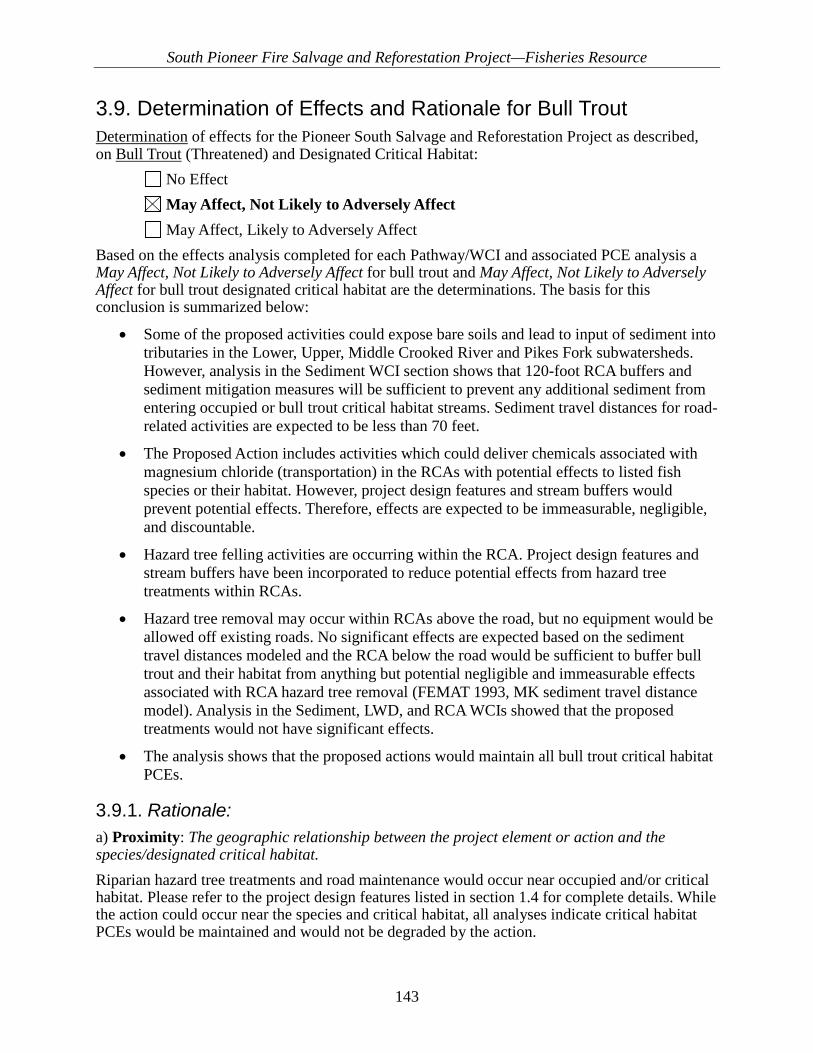
South Pioneer Fire Salvage and Reforestation Project—Fisheries Resource
143
3.9. Determination of Effects and Rationale for Bull Trout Determination of effects for the Pioneer South Salvage and Reforestation Project as described, on Bull Trout (Threatened) and Designated Critical Habitat: No Effect May Affect, Not Likely to Adversely Affect May Affect, Likely to Adversely Affect Based on the effects analysis completed for each Pathway/WCI and associated PCE analysis a May Affect, Not Likely to Adversely Affect for bull trout and May Affect, Not Likely to Adversely Affect for bull trout designated critical habitat are the determinations. The basis for this conclusion is summarized below:
• Some of the proposed activities could expose bare soils and lead to input of sediment into tributaries in the Lower, Upper, Middle Crooked River and Pikes Fork subwatersheds. However, analysis in the Sediment WCI section shows that 120-foot RCA buffers and sediment mitigation measures will be sufficient to prevent any additional sediment from entering occupied or bull trout critical habitat streams. Sediment travel distances for road-related activities are expected to be less than 70 feet.
• The Proposed Action includes activities which could deliver chemicals associated with magnesium chloride (transportation) in the RCAs with potential effects to listed fish species or their habitat. However, project design features and stream buffers would prevent potential effects. Therefore, effects are expected to be immeasurable, negligible, and discountable.
• Hazard tree felling activities are occurring within the RCA. Project design features and stream buffers have been incorporated to reduce potential effects from hazard tree treatments within RCAs.
• Hazard tree removal may occur within RCAs above the road, but no equipment would be allowed off existing roads. No significant effects are expected based on the sediment travel distances modeled and the RCA below the road would be sufficient to buffer bull trout and their habitat from anything but potential negligible and immeasurable effects associated with RCA hazard tree removal (FEMAT 1993, MK sediment travel distance model). Analysis in the Sediment, LWD, and RCA WCIs showed that the proposed treatments would not have significant effects.
• The analysis shows that the proposed actions would maintain all bull trout critical habitat PCEs.
3.9.1. Rationale: a) Proximity: The geographic relationship between the project element or action and the species/designated critical habitat. Riparian hazard tree treatments and road maintenance would occur near occupied and/or critical habitat. Please refer to the project design features listed in section 1.4 for complete details. While the action could occur near the species and critical habitat, all analyses indicate critical habitat PCEs would be maintained and would not be degraded by the action.

South Pioneer Fire Salvage and Reforestation Project—Fisheries Resource
144
There is potential for some individuals to experience limited disturbance from the proximity of activities within the riparian area. b) Probability: The likelihood that the species or habitat will be exposed to the biotic or abiotic effects of the proposed action on the indicator. As discussed above, all analyses indicate riparian areas would not be degraded by implementing the Proposed Action and, likewise, most indicators are improving slowly over time. Also, project design features would prevent delivery of sediment to streams from road maintenance actions and tree removal. No equipment would leave existing road prisms. Thus, the likelihood that bull trout or their habitat would be exposed to any indirect effects to abiotic indicators is extremely low. While activities within the RCA could disturb a mobile life stage of bull trout during RCA hazard tree treatments or RCA planting, the likelihood is very low. The probability is low because most, if not all, of the treatment areas are within 200 feet of roads and trails, which are regular sources of disturbance. Except for Edna Creek, the streams within the project area are primarily migratory corridors (Crooked River). Adult fluvial bull trout would be passing through the area and not likely to be stationary near where work is occurring. Bull trout are also very cryptic and nocturnal, favoring deep pools and undercut banks during daylight hours when work within the RCA would occur. Thus, it is possible but unlikely that any bull trout would suffer insignificant effects from a temporary, episodic, and low-intensity disturbance associated with work within the RCA during daylight hours. c) Magnitude: The severity and intensity of the effect. The severity and intensity of any effects of the Proposed Action to immobile life stages of bull trout would be insignificant because no actions are proposed within the channel. If activities occur within the RCA at locations where mobile life stages of bull trout may be present, the severity and intensity of any potential effect would be very low. Potential effects would be limited in scope to a single small area where treatments are occurring (less than 20 acres). Any potential disturbance would not occur frequently. A single low-intensity, one-time disturbance could occur when a specific RCA stand is treated. Even if a mobile life stage bull trout was disturbed by activity within the RCA adjacent to occupied or critical habitat, any potential effects would be insignificant, resulting in a temporary (see duration) displacement from habitat within a very small, localized (see distribution) area. Any fish present would be able to freely move upstream or downstream to other available habitat and return to the area after the disturbance has ended. A short-distance, temporary displacement of individuals from a small area where work is occurring during the day would not result in any significant effects to those individuals. Energy required for such a short movement would not result in any potential for cumulative or delayed mortality, nor would such a small movement appreciably affect the reproductive success, survival, or fitness of any individuals. Since any potential effects to individuals would be insignificant and unlikely to occur, there would be no significant effects to any local population abundance, distribution, or viability. d) Distribution: The geographic area in which the disturbance would occur (may be several small effects or one large effect). The geographic area in which the proposed action would occur is large (four subwatersheds); however, the area in which the species or habitat could potentially be affected is a fraction of a percentage of that area and would be limited to small, localized areas (RCA hazard tree and/or

South Pioneer Fire Salvage and Reforestation Project—Fisheries Resource
145
planting units) within the four subwatersheds adjacent to existing open roads along Crooked River, Banner Creek, Pikes Fork, and Edna Creek. e) Frequency: How often the effect would occur. The frequency of any potential effects of the Proposed Action to immobile life stages of bull trout would is low. No effects to immobile life stages would occur because no actions would occur within the channel. Potential disturbance to mobile life stages would be of low frequency. A single event could occur should activities proposed within RCAs occur close to an occupied stream while hazard tree felling or planting within an RCA unit occurs. Work within the unit would finish and the source of any potential disturbance would then pass. f) Duration: How long the effect would last. Potential categories include (a) short-term event whose effects subside immediately (pulse effect); (b) sustained, long-term effect, or chronic effect whose effects persist (press effect); and (c) permanent event that sets a new threshold for a species’ environment (threshold effect)…a “permanent event” is essentially a long-term press effect. The duration of any potential effects to the species or habitat would be categorized as an (a) short-term event. If any mobile life stages of bull trout were encountered by workers within the RCA, a temporary short-term disturbance to individuals present could result. This duration would be limited to the time it would take for any activities near the stream to be completed. Mobile life stages of bull trout would be able to immediately move away from the disturbance and return once it has passed. g) Timing: When the effect would occur in relation to the species’ life-history patterns. A single element of the Proposed Action (activities near occupied streams) could affect any mobile life stage of bull trout from early spring until late fall, through the pre-spawning and spawning periods. During this time (March to December), mobile life stages of bull trout could encounter workers within the RCA near streams. However, the probability, scope, extent, intensity, and severity of any potential effects is insignificant as discussed in a) through f) above. h) Nature: Effects of the action on elements of a species’ life cycle, population size or variability, or distribution; or on the primary constituent elements of critical habitat, including direct and indirect effects. Any potential effects from the Proposed Action on immobile life stages of bull trout is not expected as no actions are proposed within the stream channel. Thus, there would be no effects to the species early life cycle (eggs, alevins, fry), population size, variability, or distribution. The probability of any potential effects of the Proposed Action on mobile life stages of bull trout is expected to be very low. The low probability of any workers encountering a juvenile, subadult, or adult bull trout is very low due to the timing, frequency (spatially and temporally), distribution (across numerous subwatersheds), small localized extent of daily work, the low duration of any disturbance, and the low severity and intensity of any potential effects. If workers within the RCAs of streams at locations where they could encounter mobile life stages of bull trout, the severity and intensity of any potential effect would be low. Potential effects would be limited in scope and would not occur frequently see e) frequency above.

South Pioneer Fire Salvage and Reforestation Project—Fisheries Resource
146
Even if a mobile life stage bull trout were encountered by a worker or crew, any potential effects would be insignificant, resulting in a temporary (see duration) displacement from habitat within a very small localized (see distribution) area. Any fish present could avoid the disturbance by moving either upstream or downstream to other available habitats and could return to the area after the disturbance has passed. Any temporary displacement of individuals from a treatment areas where crews are working would not result in any significant effects to those individuals or local populations. Energy required for such a movement would not result in any potential for cumulative or delayed mortality, nor would such a small, short-duration movement appreciably affect the reproductive success, survival, or fitness of any individuals. Since any potential effects to individuals would be insignificant and very unlikely to occur, there would be no significant effects to any local population abundance, distribution, or viability. Also, due to project design features that prevent sedimentation and preserve large wood and other PCEs, there would be no significant adverse direct or indirect effects to the species critical habitat.
South Pioneer Fire Salvage and Reforestation Project—Fisheries Resource
147
4. Literature Cited Amaranthus, M. Jubas, H. Arthur, D. 1989. Stream Shading, Summer Streamflow and Maximum
Water Temperatures following Intense Wildfire in Headwater Streams. Presented at Symposium on Fire and Watershed Management. USDA Gen. Tech. Report PSW-109.
Arkle, R.S., Pilliod, D.S. 2010. Prescribed fires as ecological surrogates for wildfires: A stream and riparian perspective. Forest Ecology and Management 259: 893 -903.
Arno, Stephen F. 2001. Community types and natural disturbance processes. Pages 74-89 in: Tomback, D. F.; Arno, Stephen F.; Keane R. E., editors. Whitebark pine communities: ecology and restoration. Island Press, Washington, DC, USA.
Arno, Stephen F.; Hoff, Raymond. 1990. Pinus albicaulis Engelm. Whitebark pine. Pages 268-279 in: Silvics of North America. Vol. I. Conifers. Agriculture Handbook. USDA Forest Service.
Arnold J.L, and T.M. Koel. 2006. Bioassessment and water quality sampling of Middle Fork and Mammoth Crystal Spring, Yellowstone National Park, WY, 2002-2005. National Park Service. Yellowstone Center for Resources, Yellowstone National Park, Wyoming, YCR-2006-06 (2006).
Behnke, Robert. 1992. Native Trout of Western North America. American Fisheries Society Monograph 6. Bethesda, MD.
Benavides-Solario, J. and Macdonald, L. 2005. Measurement and Prediction of Post-Fire Erosion at the Hillslope Scale, Colorado Front Range. International Journal of Wildland Fire. 14. 457-474.
Benda L, Miller D, Bigelow P, Andrus K. 2003. Effects of post-wildfire erosion on channel environments, Boise River, Idaho. Journal of Forest Ecology and Management 178: 105–119.
Beschta, R. L., R. E. Bilby, G. W. Brown, L. B. Holtby, and T. D. Hofstra. 1987. Stream temperature and aquatic habitat: fisheries and forestry interactions. Streamsides Management: Forestry and Fishery Interaction. Seattle, Washington, University of Washington, College of Forest Research, pgs. 191-232.
Burrough, E.R. and J.G. King. 1989. Reduction of Soil Erosion on Forest Roads. General technical Report INT-264. US Department of Agriculture, Forest Service, Intermountain Research Station, Ogden, UT.
Burton, T.A. and J.R. Erickson. 1999 (February 12). Biological Assessment of Ongoing Actions South
Cadwallader, P.L., Eden A.K. and R.A. Hook. 1980. Role of streamside vegetation as a food source for Galaxias olidus Gunter (Pisces: Galaxidae). Australian Journal Marine and Freshwater Resources. 31:257-262.
Campbell, W., Morris, S. 1988. Hydrologic Response of the Pack River, Idaho, to the Sundance Fire. Northwest Science, Vol. 62. No. 4.

South Pioneer Fire Salvage and Reforestation Project—Fisheries Resource
148
Cannon, S.H., Kirkham, R.H., and Parise, M., 2001b, Wildfire-related debris-flow initiation processes, Storm King Mountain, Colorado: Geomorphology, v. 39, no. 3-4, p.171-188. Elliot, W. J. 2004. WEPP internet interfaces for forest erosion prediction. Jour. of the Amer. Water Res. Assoc. 40(2):299-309.
Carim, K., Schwartz M., McKelvey K., Young M., and T. Wilcox. 2015. Project: Environmental DNA sampling for detection of Bull Trout on the Boise National Forest, Idaho. USFS Rocky Mountain Research Station, Missoula, MT.
Chantwin, S., Howes D., Schwab B., and D. Swanston. 1994. A Guide for Management of Landslide – Prone Terrain in the Pacific Northwest. Land Management Handbook – RB (Canada): no. 18, pg. 220.
Doerr, S.H., Shakesby, R.A., Blake, W.H., [and others] 2006. Effects of differing wildfire severities on soil wettability and implications for hydrological response. J. Hydrol. 319, 295–311.
Dunham, J.B. and B.E. Rieman. 1999. Metapopulation structure of bull trout: influences of physical, biotic, and geometrical landscape characteristics. Ecological Applications 9:642-655.
FEMAT (Forest Ecosystem Management Assessment Team). 1993. Forest ecosystem management: an ecological, economic, and social assessment. Report of the FEMAT. U.S. Government Printing Office, Washington, D.C.
Furniss, M.J., T.D. Roelofs, and C.S. Yee. 1991. Road construction and maintenance. In: W.R. Meehan (editor) Influences of forest and rangeland management on salmonid fishes and their habitats. Special Publication 19. American Fisheries Society, Bethesda, Maryland.
Gibbons, D. R., and E. 0. Salo. 1973. An annotated bibliography of the effects of logging on fish of the western United States and Canada. United States Forest Service General Technical Report PNW-10.
Goodrich, B.A., Koski R.D., and W.R. Jacobi. 2009. Condition of Soils and Vegetation Along Roads Treated with Magnesium Chloride for Dust Suppression. Water Air Soil Pollut. 198:165-188
Goodrich, Koski, and Jacobi. 2009. Monitoring surface water chemistry near magnesium chloride dust suppressant treated roads in Colorado. Journal of Environmental Quality 38:2373-2381
Grant, G., S. Lewis, F. Swanson, J. Cissel, J. McDonnell. 2008. Effects of Forest Practices on Peak Flows and Consequent Channel Response: A State-of-Science Report for Western Oregon and Washington. Gen. Tech. Report PNW-GTR-760 USDA Forest Service.
Gravelle, J. and T. Link. 2007. Influence of timber harvesting on headwater peak stream temperatures of a northern Idaho watershed. Forest Science 53(2).
Gucinski, H., Furniss, M. J., Ziemer, R. R., Brookes, M. H., 2001. Forest roads: a synthesis of scientific information.Rep. PNWGTR-509. Portland, OR: U.S. Department of Agriculture, Forest Service, Pacific Northwest Research Station. 103 p.

South Pioneer Fire Salvage and Reforestation Project—Fisheries Resource
149
Haggerman, S.; Jones, M.; Gillespie, M.; Bradfield, G.; Durall, D. 1999. Effects of clear-cut logging on the diversity and persistence of ectomycorrhizae at a subalpine forest. Canadian Journal of Forest Research 29:1856-1870.
Harr, R. 1986. Effects of clearcutting on rain-on-snow runoff in western Oregon: a new look at old studies. Water Resources Research. Vol. 22 (7)
Ice G.G., Neary D.G., Adams P.W., 2004. Effects of wildfire on soils and watershed processes. Journal of Forestry 102, 16–20.
Idaho Fish and Wildlife Information System (IFWIS). 2014. Idaho Natural Heritage Data. Animal Conservation Database. Idaho Department of Fish and Game, Boise, ID. Accessed February 2014. [Digital data acquired under a limited use agreement. Individuals or entities seeking this information are referred to Idaho Department of Fish and Game, Boise, Idaho.]
Jakober, M.J. and T.E. McMahon. 1997. Role of Stream Ice on Fall and Winter Movements and Habitat Use by Bull Trout and Cutthroat Trout in Montana Headwater Streams. Transactions of the American Fisheries Society. 127:2 223-235.
Keane, Robert E.; Tomback, D.F.; Aubry, C.A.; Bower, A.D.; Campbell, E.M.; Cripps, C.L.; Jenkins, M.B.; Mahalovich, M.F.; Manning, M.; McKinney, S.T.; Murray, M.P.; Perkins, D.L.; Reinhart, D.P.; Ryan, C.; Schoettle, A.W.; Smith, C.M. 2012. A range-wide restoration strategy for whitebark pine (Pinus albicaulis). Gen. Tech. Rep. RMRS-GTR-279. Fort Collins, CO: U.S. Department of Agriculture, Forest Service, Rocky Mountain Research Station. 108 p.
Johnson, S.L. 2004. Factors influencing stream temperatures in small streams: substrate effects and a shading experiment. Canadian Journal of Fish and Aquatic Sciences. 61: 913–923.
Kellett, Michael. 2006. Bull Trout Patch Map. USDA Forest Service, Boise National Forest, Boise, ID.
Ketcheson, Gary L.; Megahan, Walter F. 1996. Sediment production and downslope sediment transport from forest roads in granitic watershedsPap. INT-RP-486. Ogden, UT: U.S. Department of Agriculture, Forest Service, Intermountain Research Station. 11 p.
King, J.G. 1989. Streamflow responses to road building and harvesting: a comparison with the equivalent clearcut area procedure. Res. Pap. INT-401. Ogden, UT: U.S. Department of Agriculture, Forest Service, Intermountain Research Station. 13 p.
Koehler, Gary M. 1990. Population and habitat characteristics of lynx and snowshoe hares in north central Washington. Zool. 68: 845-851.
Koehler, Gary M., and J. David Brittell. 1990. Managing spruce-fir habitat for lynx and snowshoe hares. Journal of Forestry.
Lloyd, R., Lohse, K. and Ferre, TPA. 2013. Influence of road reclamation techniques on forest ecosystem recovery. Frontiers in Ecology and the Environment11, No. 2.
Luce, C.H., Rieman, B.E., Dunham, J.B., Clayton, J.L., King, J.G., Black, T.A. 2001. Incorporating Aquatic Ecology into Decisions on Prioritization of Road Decommissioning. Water Resources Impact. American Water Resources Association.

South Pioneer Fire Salvage and Reforestation Project—Fisheries Resource
150
Luce, C.H. and Black, T.A. 1999. Sediment Production from Forest Roads in Western Oregon. Water Resources Research. Vol. 35 No. 8. Pp. 2561-2570.Luke Flory, PhD. Personal Communication, 3/1/2017. University of Florida Department of Agronomy. Invasive Species and Fire Ecology.
MacDonald LH, Coe DBR. 2008. Road sediment production and delivery: processes and management. In: Proceedings of the First World Landslide Forum, International Programme on Landslides and International Strategy for Disaster Reduction; p. 381–384. Tokyo: United Nations University.
Madej, M. A., 2001. Erosion and sediment delivery following removal of forest roads, Earth Surface Processes and Landforms, Vol. 26, pg. 175–190,
Maloney C. and Thornton J. 1995. Implementation and Effectiveness Monitoring of Best Management Practices and Soil and Water Conservation Measures within the Foothills Fire Salvage Logging Area 1992-1995. Boise National Forest. Boise, Idaho. 53 p.MBTSG (Montana Bull Trout Scientific Group).The relationship between land management activities and habitat requirements of bull trout. Montana Bull Trout Restoration Team, Helena, MT.
McCaughey, W. W.; Schmidt, W. C.; Shearer, R. C. 1985. Seed-dispersal characteristics of conifers in the inland mountain west. in: Proceedings from the Conifer tree seed in the Inland Mountain West symposium, Missoula, MT, USA.
McKelvey, Kevin S.; Steven W. Buskirk, and Charles J. Krebs. 2000. Theoretical Insights into the Population Viability of Lynx, Pages 21-37 In: Ruggiero et al. Ecology and Conservation of Lynx in the United States, USDA Forest Service, Rocky Mountain Research Station, General Technical Report RMRS-GTR-30WWW.
Megahan W. F. and Kidd W. J. 1972. Effects of Logging and Logging Roads on Erosion and Sediment Deposition In Steep Terrain in Central Idaho. Journal of Forestry. Pp 136-141.
Megahan, W. E, and C. C. Bohn. 1989. Progressive, long-term slope failure following road construction and logging onnoncohesive, granitic soils of the Idaho batholith. Pages 501-510 in W. W. Woessner and D. F. Potts, eds. Proceedings of the symposium, headwaters hydrology. American Water Resources Association, Bethesda, MD
Megahan, W. F. 1983. Hydrologic Effects of Clearcutting and Wildfire on Steep Granitic Slopes in Idaho. Water Resources Research. Vol. 19, No 3, pg. 811-819.
Minshall, G.W. 2003. Responses of stream benthic invertebrates to fire. Forest Ecology and Management. 178: 155–161.
Moore, R. Dan, D. L. Spittlehouse, and Anthony Story, 2005. Riparian Microclimate and Stream Temperature Response to Forest Harvesting: A Review. Journal of the American Water Resources Association (JAWRA) 41(4):813-834.
Morgan, P.; Bunting, S. C. 1990. Fire effects in whitebark pine forests. Pages 166-170 in: Schmidt, W. C.; McDonald, K. J., compilers. Proceedings—symposium on whitebark pine ecosystems: ecology and management of a high-mountain resource. General Technical Report INT-270, USDA Forest Service, Intermountain Research Station, Ogden, UT, USA.
South Pioneer Fire Salvage and Reforestation Project—Fisheries Resource
151
Neary, D. G.; Klopatek, C. C.; DeBano, L. F.; Folliott, P. F. 1999. Fire effects on belowground sustainability: a review and synthesis. Forest Ecology and Management 122:51-71.
Neary, Daniel G.; Ryan, Kevin C.; DeBano, Leonard F., eds. 2005. (revised 2008). Wildland fire in ecosystems: effects of fire on soils and water. Gen. Tech. Rep. RMRS-GTR-42-vol.4. Ogden, UT: U.S. Department of Agriculture, Forest Service, Rocky Mountain Research Station. 250 p.
Nelson N., Luce C., Black T., Cissel R., 2014 (DRAFT). GRAIP_Lite: A Tool for Large Scale Assessment of Road Erosion. U.S. Forest Service Research and Development, Department of Agriculture, Boise Idaho.
Nelson, N. Black, T. and Cissel, R. 2010. Monitoring Road Decommissioning in the Mann Creek Watershed. Payette National Forest. P. 31.
Parson, Annette; Robichaud, Peter R.; Lewis, Sarah A.; Napper, Carolyn; Clark, Jess T. 2010. Field guide for mapping post-fire soil burn severity. Gen. Tech. Rep. RMRS-GTR-243. Fort Collins, CO: U.S. Department of Agriculture, Forest Service, Rocky Mountain Research Station. 49 p.
Peterson, D., Agee, J., Aplet, G., Dykstra, D., Graham, R., [and others] 2009. Effects of Timber Harvest Following Wildfire in Western North America. USDA. PNW-GTR-776.
Pierce J.L., Meyer G.A. and Jull A.J.T (2004) Fire-induced erosion and millennial-scale climate change in northern ponderosa pine forests. Nature. 432: 87–90.
Quigley, T.M. and S.J. Arbelbide. 1997. An assessment of ecosystem components in the interior Columbia basin and portions of the Klamath and Great Basins. Fen. Tech. Rep. PNW-GTR-405. Portland, OR: U.S. Department of Agriculture, Forest Service, Pacific Northwest Research Station. 4 vol.
Reeves, G., Burnett, K. McGarry, E. 2003. Sources of large wood in the main stem of a fourth-order watershed in coastal Oregon. Can. J. For. Res. 33:1363-1370.
Reinwald, T. and Weems, S. 2016. Pioneer North BAER Assessment – Soils Report. Boise National Forest. p. 14.
Rhea, D.T., Gale, R.W., Orazio, C.E., Peterman, P.H., Harper, D.D., and Farag, A.M. (2005). Polycyclic aromatic hydrocarbons in water, sediment, and snow, from lakes in Grand Teton National Park, Wyoming. US. Geological Survey, Columbia Environmental Research Center (USGS-CERC).
Rieman, B.E. and J.D. McIntyre. 1993. Demographic and habitat requirements for conservation of bull trout. U.S. Forest Service, Intermountain Research Station. General Technical Report INT-302.
Rosgen, D. 1996. Applied River Morphology. Wildland Hydrology, Pagosa Springs, CO. State of Idaho. 2014. 2012 Integrated Report prepared by IDEQ and Approved by U.S. EPA in February 2014.

South Pioneer Fire Salvage and Reforestation Project—Fisheries Resource
152
Ruediger, Bill, Jim Claar, Steve Gniadek, Bryon Holt, Lyle Lewis, Steve Mighton, Bob Naney, Gary Patton, Tony Rinaldi, Joel Trick, Anne Vandehey, Fred Wahl, Nancy Warren, Dick Wenger, and Al Williamson, 2000. Canada lynx conservation assessment and strategy. USDA Forest Service, USDI Fish and Wildlife Service, USDI Bureau of Land Management, and USDI National Park Service. Forest Service Publication #R1-00-53, Missoula, MT. 142 pp.
Scaife, D. and S. Hoefer. 2011. Biological Assessment for Restoration Activities at Stream Crossings Affecting the Habitat of ESA-listed Species on National Forests and Bureau of Land Management Public Lands in Idaho. USDA Forest Service, Intermountain Region, Ogden, UT.
State of Idaho. 2008. Banner Mine Area (a.k.a. Banner, Crown Point, Wolverine, Panamin, Ritchie, Silver Chief, State of Idaho, Loppenberg) Preliminary Assessment Report. Idaho Department of Environmental Quality. Boise County.
Shakesby, R.; Boakes, D.; Coelho, C. [and others]. 1996. Limiting the soil degradational impacts of wildfire in pine and eucalyptus forests in Portugal: a comparison of alternative post-fire management practices. Applied Geography. 16(4): 337-355.
Shakesby R.A., Doerr S.H.. 2006. Wildfire as a hydrological and geomorphological agent Earth-Science Reviews, 74 (3–4) (2006), pp. 269–307.
Staley, D.M., Negri, J.A., Kean, J.W., Tillery, A.C., Youberg, A.M., 2016, Updated logistic regression equations for the calculation of post-fire debris-flow likelihood in the western United States: U.S. Geological Survey Open-File Report 2016-1106, 13 p.
State of Idaho. 2014. Idaho’s 2012 Integrated Report (Final) Idaho Department of Environmental Quality.
Stednick, J.D., 1996. Monitoring the effects of timber harvest on annual water yield. Journal of Hydrology 176: 79-95.
Thomas and Megahan. 1998. Peak flow responses to clear cutting and roads in small and large basins, western cascades, Oregon: a second opinion. Water Resources Research. Vol. 34. No. 12.USDA Forest Service. 2011. Watershed Condition Framework, A Framework for Assessing and Tracking Changes to Watershed Condition, FS-977.
USDA Forest Service. 2010. Land and Resource Management Plan for the Boise National Forest, 2003-2010 Integration, Volumes 1-2, amended July 2010, Boise National Forest, Boise, ID
USDA Forest Service. 2013a (December). Intermountain Region Proposed, Endangered, Threatened, and Sensitive Species Known/Suspected Distribution by Forest. USDA Forest Service, Intermountain Region, Ogden, UT.
USDA Forest Service. 2017a. Pioneer Fire 2016 Draft Emergency Consultation Biological Assessment. United States Forest Service, Region 4, Intermountain Region, Boise National Forest, Idaho City, Lowman and Emmett Ranger Districts. February 5, 2017. 182 pg
South Pioneer Fire Salvage and Reforestation Project—Fisheries Resource
153
USDA Forest Service. 2017b. Final 2017 Pioneer Fire BAER Proposed Actions. United States Forest Service, Region 4, Intermountain Region, Boise National Forest, Idaho City, Lowman and Emmett Ranger Districts. February 28, 2017. 123 pg
USDA Forest Service. 2017c. Aquatic Survey Database. Boise National Forest, Boise, ID. USDI Environmental Protection Agency. 2002. Potential Environmental Impacts of Dust
Suppressants: “Avoiding Another Times Beach”, an expert panel, Las Vegas, NV, May 30-31, 2002.
USDI Fish & Wildlife Service. 2015b. Endangered and Threatened Wildlife and Plants; Review of Native Species That Are Candidates for Listing as Endangered or Threatened; Annual Notice of Findings on Resubmitted Petitions; Annual Description of Progress on Listing Actions; Notice of Review. December 24, 2015. Federal Register Vol. 80(247), 80584-80614, US Fish and Wildlife Service Headquarters, Falls Church, VA. 32 pp.
USDI Fish & Wildlife Service. 2017. Endangered, Threatened, Proposed, and Candidate Species with Associated Proposed and Critical Habitats for South Pioneer Fire Salvage and Reforestation Project (01EIFW00-2017-SLI-0568). Boise County, Idaho. March 6, 2017. Idaho Fish and Wildlife Office. 8pp.
USDI Fish and Wildlife Service and USDC NMFS. 1998 (March). Endangered Species Consultation Handbook Procedures for Conducting Consultation and Conference Activities Under Section 7 of the Endangered Species Act. USDI Fish & Wildlife Service and USDC National Marine Fisheries Service.
USDI Fish and Wildlife Service. 1998. Endangered and Threatened Wildlife and Plants; Determination of Threatened Status for the Klamath River and Columbia River Distinct Population Segments of Bull Trout, Final Rule. Federal Register Vol. 63, No. 111, June 10, 1998, pp. 31647-31674.
USDI Fish and Wildlife Service. 2010. Bull Trout Critical Habitat Justification: Rational for why Habitat is Essential, and Documentation of Occupancy. U.S. Fish and Wildlife Service. Idaho Fish and Wildlife Office, Boise, ID.
USDI Fish and Wildlife Service. 2010b. Endangered and Threatened Wildlife and Plants; Revised Designation of Critical Habitat for Bull Trout in the Coterminous United States, Proposed rule, announcement of public hearing, and announcement of availability of draft economic analysis. Federal Register Vol. 75, No. 9, pp. 2270-2318.
USDI Fish and Wildlife Service. 2012. Biological Opinion for the Restoration Activities at Stream Crossings. US Fish and Wildlife Service. Idaho Fish and Wildlife Office, Boise, ID. 01EIFW00-2012-F-0015.
USDI Fish and Wildlife Service. 2015. Finalized Recovery Plan for the coterminous United States Population of Bull Trout (Salvelinus confluentus). September 28, 2015. Boise, Idaho. xiii + 195 pp.
USDI USFWS. 2016. Letter from USFWS - Updated list of threatened and endangered species that may occur in your proposed project location, and or may be affected by your proposed project. USDI USFWS, Idaho Fish and Wildlife Office, Boise, ID 83709. P. 7

South Pioneer Fire Salvage and Reforestation Project—Fisheries Resource
154
Wagenbrenner, J., MacDonald, L., Coats, R. [and others] 2015. Effects of post-fire salvage logging and a skid trail treatment on ground cover, soils, and sediment production in the interior western United States. Forest Ecology and Management 335 p. 176-193.
Waters, T.F. 1995. Sediment in streams: sources, biological effects, and control. American Fisheries Society Monograph 7.
Wipfli, M.S. 1997. Terrestrial invertebrates as salmonid prey and nitrogen sources in streams: contrasting old-growth and young-growth riparian forests in southeastern Alaska, U.S.A. Canadian Journal of Aquatic Sciences. 54:1259-1269.
Wohl, E. 2000. Mountain River. American Geophysical Union. Washington D.C. pp. 116-122. Yee, C.S. and T.D. Roeloefs. 1980. Planning Forest Roads to Protect Salmonid Habitat. In:
Influence of Forest and Rangeland Management in Western North America. USDA Forest Service, Pacific Northwest Forest and Range Experiment Station. GTR PNW-109.

South Pioneer Fire Salvage and Reforestation Project—Fisheries Resource
155
Appendix A—Assumptions and Methodologies Sediment/Turbidity WCI—Pioneer South Salvage and Reforestation
Methodology and Assumptions Several models have been used to estimate sediment yield associated with the existing postfire conditions within the analysis area (refer to the hydrology resource and soils resource technical reports in the project record). Monitoring data from previous postfire salvage harvest has also been referenced to characterize anticipated effects of the proposed action on sediment delivery. Best management practices (BMPs) and/or project design features have been developed to minimize sediment delivery to streams where possible. It is assumed that standard road and forestry BMPs are effective at reducing sediment production and delivery to streams under normal climatic conditions. Erosion events associated with infrequent high intensity rainstorms can occur and overwhelm standard BMPs. The Erosion Risk Management Tool (ERMiT) (Robichaud et al. 2006) was used by Burned Area Emergency Response (BAER) specialists to estimate erosion and sedimentation associated postfire conditions. ERMiT is a web-based application which provides a distribution of runoff-event erosion rates with the likelihood of exceeding these values. The United States Geological Survey (USGS) Emergency Assessment of Postfire Debris-Flow Hazard model (Staley et al. 2016) was utilized to evaluate the existing potential for changes in sediment yield from the Pioneer Fire. The GRAIP_Lite model (Nelson et al. 2014) was used to estimate the amount of current road sediment delivery occurring within the subwatersheds. GRAIP_Lite (Nelson et al., 2014) is a GIS based sediment delivery model for roads was developed by the U.S. Forest Service Rocky Mountain Research Station. GRAIP_Lite is a simplified version of the Geomorphic Roads Analysis and Inventory Package (GRAIP, Black et al., 2012, Cissel et al., 2012) that is designed to provide sediment delivery estimates utilizing existing geospatial information (road layers, stream networks, and digital elevation models) to simulate road erosion and probability of sediment delivery based on road segment slope, surface type, maintenance level, and proximity to the stream. GRAIP_Lite has been found to be a reliable predictor of sediment impacts from roads at large scales, but fails to accurately predict site specific road sediment delivery. The Megahan and Ketcheson (MK) sediment delivery model was used to estimate anticipated sediment travel distances associated with the proposed activities and develop Riparian Conservation Area (RCA) buffer distances designed to minimize sediment delivery to streams. The MK Sediment Delivery Model (Ketcheson and Megahan 1996, Megahan and Ketcheson, 1996 and Hoekstra et al., 1995) predicts sediment transport distance below newly constructed roads for coarse-grained granite materials eroded from disturbed surfaces in west-central Idaho. The MK sediment delivery model is empirical, based on prediction equations developed from linear regression analysis. The model has been adapted to estimate the sediment delivery lengths from timber harvest and prescribe fire using the same equations that estimate sediment travel distances from roads and using the base soil erosion rates as identified in the BOISED model (Reinig et al. 1991). A major weakness of the model is that uncertainty due to important climate processes such as precipitation amount and intensity cannot be specifically evaluated. Field data

South Pioneer Fire Salvage and Reforestation Project—Fisheries Resource
156
is collected to estimate the amount (total linear length of obstructions) that are perpendicular to diffuse or concentrated flow paths that may obstruct and slow sediment plumes. Monitoring of sediment delivery distances was completed during postfire salvage treatments after the Foothills Fire on the Mountain Home Ranger District of the Boise National Forest from 1992–1995 (Maloney and Thornton 1995). This monitoring compared modeled versus measured sediment delivery distances utilizing the MK sediment delivery model. Measured sediment delivery lengths for various activities are described in Table 29. Modeled sediment travel distances for the Foothills Fire Salvage Project at the 95% confidence interval were greater, in all cases, than the observed maximum sediment travel distance. The parameters used in the Foothills Fire Salvage MK modeling are reasonably transferred to the Pioneer Fire. Most soils within the area are granitic coarse-textured, low-cohesion soils with low water holding capacity. These soils are highly susceptible to erosion with the loss of ground cover and are typical of the Idaho Batholith. These are similar soils to the Pioneer Fire area and would have similar erosion rates. Obstruction lengths and slope angles utilized in the Foothills Fire MK modeling are also assumed to be similar to those found on the Pioneer Fire due to having similar topography and vegetation. Table 30 outlines MK modeling scenarios which were conducted during the planning process associated with the Becker Integrated Resource Project EIS (USDA Forest Service 2016). These modeling scenarios indicate that estimated sediment travel distances using MK are similar (in the case of landing construction and tractor skid roads) or longer (in the case of temporary road construction) than observed sediment delivery distances described by Maloney and Thornton (1995). This modeling effort was completed prior to burning by the Pioneer Fire and, therefore, may overestimate the existing length of obstructions after the Pioneer Fire. An attempt to validate postfire obstruction lengths using photographs and field observations of the burned area suggests that obstructions may be maintained or increased in some cases where burned trees are falling and root wads are present. Table 29. Measured and Modeled Sediment Travel Distances from the Foothills Fire Salvage Monitoring (Maloney and Thornton 1995)
Activity Observed Minimum
(feet)
Observed Maximum
(feet)
Observed Average
(feet) MK Modeled Travel Distance (feet)
(95%CI)
Landing Construction 9 108 46 352 Tractor Skid Roads 0 70 31 112 Tractor Yarding 0 <5 NR 40 Cable Yarding 0 <20 NR 26 Temporary Road Construction
0 42 <20 565
NR- Not Reported
South Pioneer Fire Salvage and Reforestation Project—Fisheries Resource
157
Table 30. Modeled Sediment Delivery Distances for the Becker Integrated Resource Project (USDA Forest Service 2016)
Activity Sediment Travel Distance (feet) (95% CI) Tractor skid road 85 Tractor yarding 8 Landings/Road Construction 111 Existing road—good 27 Existing road—moderate 31 Existing road—poor 40 Existing road—serious 61 New road construction 120 Road Maintenance (heavy) 70 Road Maintenance (light) 54 Landing (concentrated drain) 81
Because the sediment travel distances observed by Maloney and Thornton (1995) are almost an order of magnitude less than those modeled, we assume that project designated RCA buffers, as described in Design Feature FH-1 are sufficiently wide to prevent sediment delivery for project activities which occur outside RCAs (i.e., salvage harvest utilizing skid trails, cable yarding and constructed landings). RCA buffer distances are delineated using option 2, based on dominant potential vegetation group (PVG), from Appendix B of the Boise National Forest Land Resource Management Plan (Table 31; USDA Forest Service 2010). Most water features throughout the project area are perennial streams and would receive the 240-foot RCA buffer distance. Refer to the hydrology resource and soils resource technical reports in the project record for more detail on methodology and design feature effectiveness. Table 31. Riparian conservation area (RCA) buffer distances
Water Feature RCA buffer distance (feet) Perennial Streams (and intermittent streams providing seasonal rearing and spawning habitat)
240
Intermittent Streams (not providing seasonal rearing and spawning habitat) 120 Ponds, lakes, and wetlands 120
Temperature (Bull Trout)
Introduction Water temperature is a critical habitat component of streams. Removing streamside vegetation reduces stream shading, which increases solar radiation to streams. Increased solar radiation can increase stream temperature. Temperature increases of 2–9 degrees Celsius ( °C) can be problematic for salmonids and other cold water fish because warmer water increases the biological oxygen demand (BOD) in the stream, decreasing available oxygen. Wildfires, like the Pioneer Fire, can remove streamside vegetation and contribute directly to increases in stream temperatures. Postfire mean summer temperature increases of up to 10 °C have been recorded in Washington and Oregon (USDA Forest Service 2005). For example, Amaranthus and others (1989) investigated stream shade following the Silver Complex Fire (~98,900 acres) in Southern Oregon. Average postfire shade in this study was around 30%

South Pioneer Fire Salvage and Reforestation Project—Fisheries Resource
158
compared to an estimated 90% prefire. A considerable loss in shade leads to observed increases in maximum water temperature from 3.3 to 10 °C. The amount of direct solar radiation and the volume and surface area of water to be heated are the major factors governing changes in stream temperature (Amaranthus, et al., 1989); however, other factors can attenuate the magnitude of the change. The ability of riparian forests to provide shade to stream channels is a function of numerous site-specific factors, including vegetation composition, stand height, stand density, latitude (which determines solar angle), topography, stream width, and orientation of the stream channel. These factors influence how much incident solar radiation reaches the forest canopy and what fraction passes through to the water surface (Spence et al. 1996). For example, a cobble bed stream with large hyporheic exchange will not warm as easily as a bedrock stream with no groundwater influence (Johnson, 2004).
Methodology and Assumptions Stream shading and the quantity of solar radiation reaching the stream is a primary driver of water temperature changes. Changes in stream shade is used as an indicator of changes to stream temperature in lieu of direct, postfire temperature measurements, which are not available. Direct solar radiation measurements pre-and post-Pioneer Fire in the Becker Project area along with relevant literature to estimate stream shade changes from the fire were used to form the baseline, existing condition. Forest Vegetation Simulator (FVS) was used to model prefire live trees per acre (TPA) and postfire standing dead (TPA) and to estimate tree removal from the proposed action. FVS is a family of forest growth simulation models. It is a system of integrated analytical tools that is based upon a body of scientific knowledge developed from natural resources research and experience. FVS answers questions about how forest vegetation will change in response to natural succession, disturbances, and proposed management actions. Modeled vegetation data utilized for this analysis is intended to represent the entire stand and is not specific to the RCA distance. To model changes in TPA, three representative areas with representative PVGs were selected that had a high tree mortality as a result of the fire and resulted in very low residual live TPA. This was done to create a representative ‘worst case scenario.’ All three areas are within the first 120 feet of a stream and are proposed for fell and leave hazard tree treatment. All three areas are within high vegetation burn severity patches as represented by the RAVG data for basal area mortality greater than 75%. A high-severity wildfire was simulated through each area. To represent the hazard tree fell and leave treatment, 80% of the standing dead trees from between 8.0 and 16.0 inches diameter at breast height (DBH) were felled and 100% of standing dead trees with 16.0 inches DBH and larger were felled. The results of this modeling effort are outlined in Table 32 and Table 33.
Existing Condition Studies cited in the introduction have shown that where riparian and overstory shade have been lost, stream temperatures have increased. Thus, we expect that, because the Pioneer Fire burned riparian and overstory shade vegetation, stream temperatures will likely increase (1–10 °C) for some time (usually 1–5 years). Appendix B outlines the prefire baseline assessments (with desired conditions specific to bull trout) of the four subwatersheds within the project area and estimates the postfire condition. The recovery of streamside vegetation, over time, will mitigate fire-related temperature changes
South Pioneer Fire Salvage and Reforestation Project—Fisheries Resource
159
Estimating the Influence of the Pioneer Fire on Stream Shade Even though we can model clearcutting to approximate the shade effects of fire, the model exaggerates the changes somewhat by showing a larger increase in temperature over a shorter reach than would be seen from a wildfire. This is because, unlike clear cuts, fire often leaves standing dead vegetation. This standing dead vegetation increases stream shade over clear cutting. In Amaranthus and others (1989), postfire shade percentages were reduced from greater than 90% to approximately 30%. Of that remaining 30%, approximately 57% of postfire stream shade was provided by standing dead vegetation. Thus, in the post-Pioneer Fire environment where water temperatures will increase over prefire norms, it is important to consider the effects of removing standing dead in areas where they would provide shade. In unmanaged forests, stand density and composition may moderate the shading influence of trees, with trees closer to the stream channel and understory shrubs providing the majority of stream shade. Pre-and postfire shade data were analyzed for streams within the Pioneer Fire perimeter on the Idaho City Ranger District (Figure 1). These shade data were taken in the summer and fall of 2016 in the Becker Project area (which abuts Rock Creek to the southeast in Middle Crooked River and a small portion of Pikes Fork sub watersheds) using a Solar Pathfinder. Using a paired t-test, the observed increase in energy reaching the stream after the Pioneer Fire was significant to the p = .005 level. The box and whisker plot (Figure 1) displays the percent change in solar radiation (kWh/m2/day) to streams observed in the Becker Project area as a result of the Pioneer Fire. These data, taken together with the aforementioned literature and postfire changes in solar radiation due to vegetation changes, suggest that we would see similar increases in solar radiation in the streams throughout the project area which saw similar burn severities. Observed stream temperature changes seen in the literature range from 1–10 °C; scientists have difficulty formulating general predictive factors for stream temperature changes from changes in solar radiation as each system is unique (Amaranthus, et al., 1989; Gravelle and Link, 2006; Johnson, 2004). The observations in the literature and in Figure 1 suggest that the Project Area could see between 1 and 10 °C changes in summer maximum water temperatures from the Pioneer Fire. These changes in stream shading take from 3 to 10 years to recover (USDA, 2005). Table 32 uses GIS data from the Forest Service’s FVS model to estimate the density of live trees per acre (TPA) within one site potential tree height (SPTH) of streams in three example plots within the project area. Table 33 estimates the change in standing dead within RCAs from roadside hazard tree felling project activities. These are only modeled tree densities. Models are just one tool which assists in assessments, but models require assumptions, accurate input parameters, and expert judgement.
Environmental Consequences Of the activities proposed, the activity which is most likely to decrease stream shade (and therefore increase stream temperature) is hazard tree felling in RCAs. Other project activities, such as road maintenance, temporary road construction, and UA road decommissioning are not discussed here because they do not effect stream temperature.

South Pioneer Fire Salvage and Reforestation Project—Fisheries Resource
160
Direct and Indirect Effects—No Action
No Hazard Tree Felling in Riparian Conservation Areas As a result of implementing the no action alternative, no hazard tree felling would occur within RCAs. The shade component hazard trees provide to streams would remain. This is the reciprocal argument to that which is made next in “Felling Hazard Trees within RCAs.” The conclusion, however is similar: It is not likely that this shade component would cause a measurable decrease in stream temperature or an increase in the quality of the Temperature WCI. The section, “Felling Hazard Trees within RCAs” outlines the reasons for this in its analysis.
Cumulative Effects—No Action Past and ongoing management actions have been considered in describing the baseline existing condition for the Temperature WCI. There are no reasonably foreseeable future activities which we would expect to affect (measurably increase or decrease) the temperature indicator.
Direct and Indirect Effects—Proposed Action Stream temperature changes from project activities are expected to be immeasurably small (Table 32).
Felling Hazard Trees within Riparian Conservation Areas For hazard tree mitigation(s) along perennial streams, reducing canopy cover from hazard trees is not expected to measurably affect stream temperature. Generalized curves depicting microclimate and shade contributions to streams as a function of distance from the channel in STPHs indicate that processes controlling stream shade and micro-climatic variables decrease exponentially with distance from the channel. Approximately 80% of effective shade comes from approximately 0.5 SPTH distance from the channel (60 feet in this case). Thus, the first SPTH (120 feet, in this analysis) is the most important for stream shading. A primary objective of minimizing tree falling in RCAs is to maintain the extent of remaining stream shade, and thus not further hinder movement toward desired conditions in the long term.

South Pioneer Fire Salvage and Reforestation Project—Fisheries Resource
161
Figure A-1. Generalized curves indicating percent of riparian functions and processes occurring within varying distances from the edge of a forest stand (FEMAT, 1993).

South Pioneer Fire Salvage and Reforestation Project—Fisheries Resource
162
Table 32 uses GIS data from the Forest Service’s FVS model to estimate the density of live trees per acre (TPA) within one SPTH of streams in three example plots within the project area. 33 estimates the change in standing dead within RCAs from roadside hazard tree felling project activities. These are only modeled tree densities. Models are just one tool which assists in assessments, but models require assumptions and come with limitations. Figure A-1 illustrates that the median increase in annual solar radiation to streams in the Becker Project Area (on the Idaho City Ranger District) after the Pioneer Fire is approximately 135%. This is a total shade measurement, which includes all vegetation. The analysis below only includes non-canopy tree-based shade, which is just a portion of total stream shade components. Streamside and overhanging riparian vegetation, such as willows and alders, form the most immediate and dense stream shade component in smaller streams in the project area. The proportions of stream shade which come from trees varies by site and stream size. The influence of streamside, riparian overhanging vegetation in wider creeks, like Clear Creek will be less. While it is not possible to measure actual post-treatment shade in the planning stage, one can use existing data and professional judgement to approximate the change in the portion of stream shade potentially affected by the proposed activities. For this analysis, this component is called non-canopy, tree-based shade. Table 32 outlines live TPA pre- and postfire in modeled, example RCA stands from the FSV Model. Stand 1 exhibits 99.1% live tree mortality (loss). Stand two exhibits an 80% loss. Stand 3 exhibits a 99.3% loss. This is a proxy measure for canopy cover, and we assume that 75%–90% of shade comes from leaf and needle cover (Flory, personal communication). For example, in a stand in which there was 99.9% mortality, we assume 0% shade from leafy and needle cover, which would leave 10%–25% shade potential remaining. We can use the data in Table 32 and Table 33 to create a worst-case scenario from which to analyze the effects of the proposed action on shade. Weighted averages from Table 32 and Table 33, produce an 89% live tree mortality from the Pioneer Fire.3 We then assume that “mortality” means that all leaf and needle cover is removed, and that the maximum 25% shade (coming from standing dead trees) remains postfire, before hazard tree removal. Under the Proposed Action, the weighted average of the three stands after treatment, illustrates that up to 58% of the standing dead trees could potentially be felled and no longer available for shade.4 If one assumes that the standing dead trees contribute 25% of the shade that live trees contribute, and that all of that shade reaches the stream, then the Proposed Action would equate to a potential 1.3% reduction in shade from standing dead trees as a result of activities in this stand. This analysis may overestimate the number of trees to be felled because the model creates generalized stands and cannot delineate individual trees as hazardous. That said, this analysis is a worst-case scenario, and even if the percent shade reduction from the scenario was doubled, project activities could potentially decrease stream shade from standing dead trees by 2.6%. The overall stream shade change would be smaller because a large component of stream shade comes from streamside riparian vegetation; shade from standing dead trees is a small percentage of the overall shade apparatus of streams. We would not expect this kind of percent change in shade from the removal of standing dead to increase stream temperatures or degrade this WCI in way that is measurable over the effects of
3 Because of the variability in TPA estimates, weighted averages were used to create the scenario. 4 We assume no loss of non-canopy shade from the Pioneer Fire. This assumption would over-estimate the remaining-non-canopy shade component.

South Pioneer Fire Salvage and Reforestation Project—Fisheries Resource
163
the Pioneer Fire, which in this model decreased canopy shade to approximately 26% of pre-fire canopy-based shade. Figure 1 illustrates actual measured changes in total shade from the Pioneer Fire. Design Feature FH-1 is designed to protect RCA functions and minimize the loss of stream shade due to project activities. Table 32. Modeled RCA Tree Densities, Pre-/Postfire
Area PVG Total Acres Prefire TPA, Live Postfire TPA, Live 1 10 2.5 976 0.9 2 4 5.9 103 20 3 2 2.7 1237 0.7 Modeled using FES VEG Model. RCA width used in the model = 120 feet.
Table 33. Modeled riparian conservation area tree densities pre/post-treatment Area PVG Total Acres Postfire Standing Dead % Remaining, Post-Treatment
1 10 2.5 2167 64.4 2 4 5.9 100.5 31.4 3 2 2.7 1477 32.1 Modeled using FES VEG Model. RCA width used in the model = 120 feet.
Reforestation The Proposed Action includes reforestation efforts and riparian planting along portions of Edna Creek where the riparian area burned at moderate and high severity. We would expect that natural regeneration and planting in riparian areas would increase stream shade over time, and contribute to the recovery of stream temperatures in the analysis area.
Cumulative Effects Past and ongoing management actions have been considered in describing the baseline existing condition for the Temperature WCI. There are no reasonably foreseeable future activities which we would expect to affect (measurably increase or decrease) the temperature indicator. The proposed action would not further degrade the existing functionality of the Temperature (Bull Trout) WCI in the short and long-term which is functioning at unacceptable risk (FUR) in the Middle Crooked, Lower Crooked, and Pikes Fork sub-watersheds and FR in the Upper Crooked Sub-watershed.
Change in Peak Flows/Base Flows WCI
Introduction Removing forest canopy through fires, insects, and disease, or vegetation treatments can increase water yield and modify hydrographs (i.e., increased peak flows; altered base flows, altered timing of flows). This section describes the postfire existing condition of the project area watersheds and compares it to prefire conditions, where appropriate, to establish an existing condition. Fire affects hydrology by removing aboveground canopy and litter, and often by creating a water repellent (hydrophobic) soil layer. Soil water storage, interception, and evapotranspiration are reduced when vegetation and organic material on the soil surface is consumed by fire. Snow accumulation and melt can also be modified. The changes caused to these processes by the

South Pioneer Fire Salvage and Reforestation Project—Fisheries Resource
164
Pioneer Fire could potentially lead to increased peak flows and alter runoff timing and base flows within the project area. Water yield typically increases in the first year following fire, and then decreases with time as vegetation recovers (Peterson et al. 2009). Research has documented high variability the percent of watershed canopy removed and changes in peak flows, and has concluded that at least 20% of the basal area must be removed before increases in water yield are detectable (Thomas and Megahan 1998, Grant et al. 2008). Middle Crooked River, Upper Crooked River, and Pikes Fork have all experienced high vegetation loss (Table 38). Actual increases in peak flows are often confounded by natural variability. Campbell and Morris (1988) studied water yield after the 1967 Sundance Fire, which burned 26% of the Pack River drainage. Their research did not detect any increases in postfire water yield but did support a modified timing of the hydrograph with earlier peak flows. The authors suspect their results were complicated by the natural climate variability in the years after the fire. Not all effects of erosion and increased peak flows as a result of fires are necessarily detrimental, however. The stream systems in this area have evolved with the episodic disturbance from fires. Erosion from fires provides pulses of wood and coarse sediment that maintain productive habitats and nutrient cycling in the long run (Reeves et al. 2003, Minshall 2003).
Methodology and Assumptions This analysis relies on the North and South Pioneer BAER efforts (for burn severity), existing literature, some vegetation modeling (for burn intensities), and professional judgement. Post-event peak flow reconstruction carries with it an inherent amount of uncertainty due not only to reliance on field indicators that may not be entirely representative of encountered flows but also model uncertainty. Changes in observed postfire flows vary widely in the literature and are difficult to model. This sort of modeling effort is not necessary for the project planning stage. Thus, the analysis takes a more qualitative approach, disclosing prefire conditions, assessing postfire conditions to establish a baseline, and finally assessing the magnitude of project activities on the Peak/Base Flow indicator in light of the Pioneer Fire. That said, we expect the hydrograph to change for these burned subwatersheds. Runoff timing can be earlier, peak flows can be higher and shorter in duration, and base flows can change (or not) based on watershed-specific characteristics.
Existing Condition Desired Condition: Watershed hydrograph indicates peak flow, base flow, and flow timing characteristics comparable to an undisturbed watershed of a similar size, geomorphology and climatology. Prefire Hydrologic Condition Changes in the timing and magnitude of flows are natural after a fire in the project area. Because flow changes are inversely proportional to stream order, the largest changes in flows are likely in the low order tributaries to Clear Creek (USDA Forest Service 2005) and Crooked River. The 2016 Pioneer Fire South BAER Hydrologic Assessment modeled postfire increases in flows in Crooked River for flood and infrastructure protection purposes (USDA Forest Service 2016a). Changes in forest vegetation resulting from management or natural events can affect the frequency and magnitude of rain-on-snow events, not just of the summer storm hydrograph (Harr 1986). Rain-on-snow events are common in the project area. Following a wildfire, the amount of solar radiation absorbed by the snowpack can increase because of vegetation canopy loss.

South Pioneer Fire Salvage and Reforestation Project—Fisheries Resource
165
Additionally, the snowpack albedo, or reflectance, can decrease from the presence of ash and detritus on the snow surface. These changes can result in increased snowmelt rates and earlier melting (Gleason et al. 2013). Changes in snowpack and melt timing, combined with rain-on-snow events, could affect water yield by increasing peak flows and their timing. Rain-on-snow and resulting peak flows are natural processes in the project area streams and have shaped the overall morphology and stability of stream channels in the area. The driving factors of watershed response to the Pioneer Fire in the project area will be the steep slopes, lack of effective ground cover, and loss of raindrop interception via the absence of vegetation canopy cover. Clear and Rock Creeks burned with a mosaic of high, medium, and low soil burn severities (SBS) (Table 34). SBS pertains to heat on and just below the ground and is relevant for low plants and root and soil structures. Table 35 outlines vegetation mortality from the RAVG model by watershed. This model primarily measures loss in taller vegetation, such as tree canopy. Tree canopy loss, for example, happened mostly in the high and moderate SBS areas within the Pioneer Fire perimeter. Most of the project area sub-watersheds burnt at moderate and low SBS (Table 34). Much of the moderate severity (downward heat, into the soil) shown in Upper and Lower Clear Creek burned at moderate and high intensity (upward heat into the vegetation), so that much of the vegetation in these areas was consumed. In this situation, one would expect a greater hydrologic response than the SBS alone would suggest. Given the burn intensities and burn severities outlined in Table 34 and Table 35, the hydrologic regime of the project area subwatersheds will be altered. Runoff timing, peak flows, and base flows are likely to be altered, which would change the baseline condition. Table 34. Percent of Soil Burn Severity (SBS) class by 6th subwatershed and riparian conservation area (RCA)
SBSa Lower
Crooked River (%)
Middle Crooked River (%)
Pikes Fork (%)
Upper Crooked River (%)
Total (%)
RCA Totals
(%) Unburned/Very Low 4.7 10.0 17.1 14.3 11.5 15.2 Outside Fire Perimeter 73.2 2.6 8.0 48.4 32.2 29.8 Low 12.4 36.7 36.9 26.1 28.4 33.8 Moderate 8.5 42.0 31.4 10.2 23.5 19.5 High 1.1 8.7 6.6 1.0 4.4 1.6 aMeasured at the ground surface and below ground. Applies to root structure and low vegetation.
Table 35. Percent vegetation loss by subwatershed, within the fire perimeter Vegetation Mortalitya
(%) Lower Crooked River
(%) Middle Crooked River
(%) Pikes Fork
(%) Upper Crooked River
(%) 0–25 2.35 8.25 6.20 7.28 25–50 1.01 4.41 2.41 2.53 50–75 0.85 4.18 1.93 1.84 75–100 3.18 21.59 9.96 6.38 Total 7.39 38.43 20.50 18.03 aMostly tree data; tall canopy changes

South Pioneer Fire Salvage and Reforestation Project—Fisheries Resource
166
Appendix B – Subwatershed Exisiting Conditions Summaries The Table 36, Table 37, Table 38, and Table 39 provide a summary of baseline conditions for the subwatersheds in the Project Area.
South Pioneer Fire Salvage and Reforestation Project—Fisheries Resource
167
Table 36. Middle Crooked River 6th HUC Baseline. Agency/Unit: Boise National Forest
Idaho City Ranger District
HU Code & Name: Middle Crooked River 6th - 170501110504
Fish Species Present: Bull trout, rainbow trout, brook trout, sculpin spp.
Spatial Scale of Matrix: Middle Crooked River 6th
(Anad. Sp.) Population: None Subpopulation: N/A
(Bull trout) Core Area: North Fork Boise River Local Population: None – Occupied spawning/rearing habitat in Edna Creek.
Management Action(s): Pioneer Fire South Salvage and Reforestation Project
Pathways Indicatorsa, c Population and Environmental Baseline
Desired Condition Baselineb Discussion of Baseline –
Current Condition
Subpopulation Character
Subpopulation Size >500 adults FR-SR, M, PJ
Occupied spawning and rearing habitat exists in Edna Creek. One strata 1 patch and strata 3 bull trout patches within the Beaver-Edna 6th HUC. (BNF
Aquatic Survey Database) Bull trout environmental DNA (eDNA) was documented in Edna Creek in 2014 (Carim et al. 2015), and fish were captured
in 2016.
Growth and Survival Resilience to recover from short-term disturbances.
FR-SR, M, PJ
Single local population in Edna Creek Data related to grown and survial is not available. This population was just discovered in 2015.
Life History Diversity and Isolation
Migratory form present and local populations in close proximity.
FR-SR, M, PJ
Both resident and migratory life forms are present. Resident form present in Edna Creek. Telemetry studies have documented migratory adults passing
through this subwatershed in Crooked River. At least one strong local population is present within the Arrowrock core area (upper NF Boise River);
the other 13 local populations in the Core Area are not considered strong. Connectivity among some local populations in the core area is limited by
barriers (i.e. culvert barriers, Kirby Dam). (BNF Aquatic Survey Database)
Persistence and Genetic Integrity Connectivity is high among 5 or
more local populations w/ several thousand fish each.
FR- SR, M, PJ
The upper NF Boise River local population is considered strong within the core area. One BNF MIS patch is occupied (Edna Creek). Other neighboring local
populations within the core area are not considered strong. Migratory corridors and connectivity are partially limited by barriers within the core area. Brook trout are present in Crooked River, Pikes Fork and many areas of the North
Fork Boise River Core Area, but hybridization has not been documented. (BNF Aquatic Survey Database)

South Pioneer Fire Salvage and Reforestation Project—Fisheries Resource
168
Agency/Unit: Boise National Forest Idaho City Ranger
District
HU Code & Name: Middle Crooked River 6th - 170501110504
Fish Species Present: Bull trout, rainbow trout, brook trout, sculpin spp.
Spatial Scale of Matrix: Middle Crooked River 6th
(Anad. Sp.) Population: None Subpopulation: N/A
(Bull trout) Core Area: North Fork Boise River Local Population: None – Occupied spawning/rearing habitat in Edna Creek.
Management Action(s): Pioneer Fire South Salvage and Reforestation Project
Pathways Indicatorsa, c Population and Environmental Baseline
Desired Condition Baselineb Discussion of Baseline –
Current Condition
Water Quality
Temperature
7-day average maximum temp (MWMT) in reach during the
following life stages: incubation 2-5oC rearing 4-12oC
spawning 4-9oC adults <15oC
FUR-M,
Bull trout – FR. Temperatures exceed incubation, rearing, spawning and migratory limits.
RMRS Monitoring – MWMT n=14
mean 15.074
min 12.990
max 19.640 2016 Pioneer Fire reduced stream shade along several stream reaches based on pre and post fire shade monitoring conducted in June and September 2016. Reduction in shade expected to result in increased water temperatures along
streams burned. Recovery of streamside vegetation anticipated during 1-3 years post fire. Recovery of adjacent upland vegetation anticipated during 3-15
years post fire

South Pioneer Fire Salvage and Reforestation Project—Fisheries Resource
169
Agency/Unit: Boise National Forest Idaho City Ranger
District
HU Code & Name: Middle Crooked River 6th - 170501110504
Fish Species Present: Bull trout, rainbow trout, brook trout, sculpin spp.
Spatial Scale of Matrix: Middle Crooked River 6th
(Anad. Sp.) Population: None Subpopulation: N/A
(Bull trout) Core Area: North Fork Boise River Local Population: None – Occupied spawning/rearing habitat in Edna Creek.
Management Action(s): Pioneer Fire South Salvage and Reforestation Project
Pathways Indicatorsa, c Population and Environmental Baseline
Desired Condition Baselineb Discussion of Baseline –
Current Condition
Sediment <12% fines in gravel (<0.85mm) <20% surface fines (<6mm)
FUR – SR, M
(Fines<6mm ) Aquatic Survey Database. N=25
Mean=30.9% Median=34.7%
PIBO N=1 Mean=40% BURP N=10 Mean=46%
2016 Pioneer Fire expected to increase overall sediment yield to streams adjacent to moderate and high soil burn severity slopes. Sediment delivery
from hillslope erosion is likely to provide a range of substrate sizes. Sediment yields expected to measurably increase, particularly along streams with
adjacent road systems where riparian vegetation between road and stream has been burned. Sediment delivery from road prism erosion is expected to be mostly fine substrate sizes. Recovery of streamside vegetation anticipated
during 1-3 years post fire.
Chemical Contaminants/Nutrients
Low levels of chemical contamination or excess nutrients.
No 303(d) water quality limited water.
FA-SR,M, PJ
No 303 (d) listed waterbodies, few active mines within Middle Crooked 6th field HU.
Habitat Access
Physical Barriers No man-made fish barriers. FUR-SR,M
There are 16 known barriers within the Beaver-Edna 6th field HU that do not pass all life stages at a range of flows.
South Pioneer Fire Salvage and Reforestation Project—Fisheries Resource
170
Agency/Unit: Boise National Forest Idaho City Ranger
District
HU Code & Name: Middle Crooked River 6th - 170501110504
Fish Species Present: Bull trout, rainbow trout, brook trout, sculpin spp.
Spatial Scale of Matrix: Middle Crooked River 6th
(Anad. Sp.) Population: None Subpopulation: N/A
(Bull trout) Core Area: North Fork Boise River Local Population: None – Occupied spawning/rearing habitat in Edna Creek.
Management Action(s): Pioneer Fire South Salvage and Reforestation Project
Pathways Indicatorsa, c Population and Environmental Baseline
Desired Condition Baselineb Discussion of Baseline –
Current Condition
Habitat Elements
Substrate Embeddedness Embeddedness <20% FUR-PJ No core sampling or Wolman counts available. Considering the high amount of fines >6 mm I would expect percent embeddedness is very high.
Large Woody Debris >20 pieces/mile, >12 inches diameter, >35 feet long FA-SR
Mean=177 Range=0-430
n = 35 (BNF Aquatic Survey Database). LWD presented are in the >10cm size class and 2 meters in length (NCD).
Additional large woody debris surveys were conducted throughout the subwatershed following the 2016 Pioneer Fire. Of the 23 surveys completed,
16 sites exceeded desired conditions for LWD.
Pool Frequency and Quality
Width (m) # Pools/mile 0-1.5 39
1.5-3.0 60 3.0-4.6 49 4.6-6.1 39 6.1-9.1 23
9.1-10.7 18 10.7-12.2 10 12.2-19.8 9 19.8-30.5 4
FA- SR, PJ
Pool frequency = 106. n = 28 Aquatic Survey Database.
Even though pool frequency exceeds standards, there are many RCA roads, high sediment ratios and temperature exceed standards. Pool frequency is FA,
pool quality is FR.
Large Pool / Pool Quality Each reach has many large pools > 1 meter deep.
FR-SR, PJ
Few large pools, high sediment ratios, temperatures exceed standards. Aquatic Survey Database.
South Pioneer Fire Salvage and Reforestation Project—Fisheries Resource
171
Agency/Unit: Boise National Forest Idaho City Ranger
District
HU Code & Name: Middle Crooked River 6th - 170501110504
Fish Species Present: Bull trout, rainbow trout, brook trout, sculpin spp.
Spatial Scale of Matrix: Middle Crooked River 6th
(Anad. Sp.) Population: None Subpopulation: N/A
(Bull trout) Core Area: North Fork Boise River Local Population: None – Occupied spawning/rearing habitat in Edna Creek.
Management Action(s): Pioneer Fire South Salvage and Reforestation Project
Pathways Indicatorsa, c Population and Environmental Baseline
Desired Condition Baselineb Discussion of Baseline –
Current Condition
Off-Channel Habitat Watershed has many oxbows,
ponds, backwaters, and other off-channel areas with cover.
FR- PJ Watershed has few ponds oxbows and off channel areas. This is mainly the result of roads paralleling the channel and an artifact of the channel types in
the subwatershed.
Refugia
Habitats capable of supporting strong and significant local
populations are protected and are well distributed and connected.
FUR-M, PJ
There are six bull trout patches within the Crooked 5th field HU of which two are over 5,000 hectares (one strata 1 and one strata 2). Adequate refugia do not
exist within this 5th Field HU. Roads throughout watershed with many in RCAs, poor water quality, high temperatures and poor connectivity with functional
refugia in the core area.
South Pioneer Fire Salvage and Reforestation Project—Fisheries Resource
172
Agency/Unit: Boise National Forest Idaho City Ranger
District
HU Code & Name: Middle Crooked River 6th - 170501110504
Fish Species Present: Bull trout, rainbow trout, brook trout, sculpin spp.
Spatial Scale of Matrix: Middle Crooked River 6th
(Anad. Sp.) Population: None Subpopulation: N/A
(Bull trout) Core Area: North Fork Boise River Local Population: None – Occupied spawning/rearing habitat in Edna Creek.
Management Action(s): Pioneer Fire South Salvage and Reforestation Project
Pathways Indicatorsa, c Population and Environmental Baseline
Desired Condition Baselineb Discussion of Baseline –
Current Condition
Channel Condition and Dynamics
Width/Max. Depth Ratio <10 FA -SR WD ratio = 6. n = 28. Aquatic Survey Database.
Stream bank Condition >90% stable FR -SR 16% unstable. n = 10 Aquatic Survey Database. Land management activities in the past and resulting high road densities have contributed to this condition.
Floodplain Connectivity Within RCAs, floodplains and
wetlands are hydrologically linked to main channel.
FUR-PJ
Numerous roads have impacted the floodplains and wetlands within this 6th field HU. Most channels have are within confined valleys with step hillslopes
which have narrow floodplains. Beaver activity in Crooked river and Little Beaver have increased floodplain connectivity.
Flow/Hydrology
Change in Peak/Base Flows
Watershed hydrograph indicates, peak, base, and flow timing
comparable to a comparable undisturbed watershed.
FUR-PJ
Numerous roads within the subwatershed have likely altered Peak/Base flows. 2016 Pioneer Fire is expected to increase peak flows depending on burn
severity. This increase is primarily associated with summer thunderstorms due to reduced infiltration and canopy interception. Increased snowmelt rates due
to loss of vegetation canopy is possible. Vegetation recovery and moderation of increased peak flows is expected 3-5 years after the fire.
Drainage Network Increase Zero or minimum change in active
channel length correlated with human caused disturbance.
FUR-PJ
Many RCA roads, high road densities and in-sloped roads or rutted roads have likely elevated the drainage network. This WCI is evaluated in terms of a ratio of RCA road miles to stream miles. Using this metric, the functional rating for
this WCI is Functioning at Unacceptable Risk.

South Pioneer Fire Salvage and Reforestation Project—Fisheries Resource
173
Agency/Unit: Boise National Forest Idaho City Ranger
District
HU Code & Name: Middle Crooked River 6th - 170501110504
Fish Species Present: Bull trout, rainbow trout, brook trout, sculpin spp.
Spatial Scale of Matrix: Middle Crooked River 6th
(Anad. Sp.) Population: None Subpopulation: N/A
(Bull trout) Core Area: North Fork Boise River Local Population: None – Occupied spawning/rearing habitat in Edna Creek.
Management Action(s): Pioneer Fire South Salvage and Reforestation Project
Pathways Indicatorsa, c Population and Environmental Baseline
Desired Condition Baselineb Discussion of Baseline –
Current Condition
Watershed Conditions
Road Density and Location Total road density <0.7 mi/m2 of subwatershed; no roads within
RCAs FUR-SR Road Density 3.8 mi/m2.
RCA Road Density 7.5 mi/m2
Disturbance History
< 15% ECA with no concentration of disturbance in landslide or landslide prone areas; and/or
refugia, and/or RCAs
FUR-PJ
The 2016 Pioneer Fire burned across 97.6% of this subwatershed, a range of soil burn severity occurred throughout the subwatershed. The topography of this subwatershed does not include a high concentration of landside prone
areas. ECA = 4. GI rating = M. RCA road density = 9.2 mi/m2. ECA was calculated using timber and fire data from the forest plan. WSCAT data and Becker Veg
analysis.

South Pioneer Fire Salvage and Reforestation Project—Fisheries Resource
174
Agency/Unit: Boise National Forest Idaho City Ranger
District
HU Code & Name: Middle Crooked River 6th - 170501110504
Fish Species Present: Bull trout, rainbow trout, brook trout, sculpin spp.
Spatial Scale of Matrix: Middle Crooked River 6th
(Anad. Sp.) Population: None Subpopulation: N/A
(Bull trout) Core Area: North Fork Boise River Local Population: None – Occupied spawning/rearing habitat in Edna Creek.
Management Action(s): Pioneer Fire South Salvage and Reforestation Project
Pathways Indicatorsa, c Population and Environmental Baseline
Desired Condition Baselineb Discussion of Baseline –
Current Condition
Riparian Conservation Areas
The RCAs have historic and occupied refugia for listed, sensitive, native, or desired species. The RCA provides
adequate shade, LWD recruitment, sediment buffering, connectivity,
and habitat protection and connectivity to minimize adverse effects from land management
activities.
FR - SR, PJ
Due to high amounts of roads within RCAs, elevated fine sediment conditions and numerous physical barriers restricting fish migration.
Percent Soil burn Severity Classes for RCAs for 2016 Pioneer Fire
Disturbance Regime Disturbance resulting from land
management activities are negligible or temporary.
FUR- PJ O
The 2016 Pioneer Fire burned 97.6% of this subwatershed. A range of SBS occurred throughout the subwatershed. Local topography and landforms across the subwatersheds are not conducive to debris flow events. The
subwatershed is not subject to uncharacteristic wildfire.
South Pioneer Fire Salvage and Reforestation Project—Fisheries Resource
175
Agency/Unit: Boise National Forest Idaho City Ranger
District
HU Code & Name: Middle Crooked River 6th - 170501110504
Fish Species Present: Bull trout, rainbow trout, brook trout, sculpin spp.
Spatial Scale of Matrix: Middle Crooked River 6th
(Anad. Sp.) Population: None Subpopulation: N/A
(Bull trout) Core Area: North Fork Boise River Local Population: None – Occupied spawning/rearing habitat in Edna Creek.
Management Action(s): Pioneer Fire South Salvage and Reforestation Project
Pathways Indicatorsa, c Population and Environmental Baseline
Desired Condition Baselineb Discussion of Baseline –
Current Condition
Integration of Species and Habitat Conditions
Habitat quality and connectivity among local populations is high. The migratory form is present.
Disturbance has not altered channel equilibrium. Fine sediments and
other habitat characteristics influencing survival and growth are
consistent with pristine habitat. Local population is fluctuating
around equilibrium or is growing.
FR-PJ,O
Habitat quality may be reduced from post fire effects associated with the Pioneer Fire of 2016. The subwatersheds and connectivity between local
populations is impaired. Under current management conditions, habitat may not improve within two generations. However, both resident and migratory life forms are present, including newly discovered occupied spawning and rearing
habitat within Edna Creek.
a. Matrix checklist adapted from USFWS and NMFS 1998. b. FA = Functioning Appropriately, FR = Functioning at Risk, FUR = Functioning at Unacceptable Risk, PJ = Professional Judgment, SR = Surveys, M = Monitoring, O = Other c. Evaluated against local criteria where appropriate and available

South Pioneer Fire Salvage and Reforestation Project—Fisheries Resource
176
Table 37. Pikes Fork 6th HUC Baseline.
Agency/Unit: Boise National Forest
Idaho City Ranger District HU Code & Name: Pikes Fork 6th - 170501110503
Fish Species Present: Bull trout, rainbow trout, brook trout, sculpin spp.
Spatial Scale of Matrix: Pikes Fork 6th
(Anad. Sp.) Population: None Subpopulation: N/A
(Bull trout) Core Area: North Fork Boise River Local Population: None – Potential spawning/rearing habitat in Pikes Fork and Banner Creek.
Management Action(s): Pioneer Fire South Salvage and Reforestation Project
Pathways Indicators a, c Population and Environmental Baseline
Desired Condition Baselineb Discussion of Baseline –
Current Condition
Subpopulation Character
Subpopulation Size
>500 adults FUR-SR, PJ
Bull trout have been located in Banner Creek and Pikes Fork (5 sampling events from 1993 to 2001, no Bull trout detected since 2001, sampling has detected
numerous Brook Trout, BNF Aquatic Survey Database). The project area is within a bull trout patch that is classified as strata 2 (suitable but unoccupied).
Growth and Survival
Resilience to recover from short-term disturbances.
FUR - SR, PJ
Bull trout have been located in Banner Creek and Pikes Fork (5 sampling events from 1993 to 2001, no Bull trout detected since 2001, sampling has detected
numerous Brook Trout, BNF Aquatic Survey Database). The project area is within a bull trout patch that is classified as strata 2 (suitable but unoccupied).The USFWS Bull Trout Recovery Plan (2002) identified Pikes Forks as potential
spawning and rearing habitat. However, local habitat conditions are not currently suitable for bull trout spawning and rearing.
Life History Diversity and Isolation
Migratory form present and local populations in close proximity.
FUR- SR, PJ
Bull trout have been located in Banner Creek and Pikes Fork (5 sampling events from 1993 to 2001, no Bull trout detected since 2001, sampling has detected
numerous Brook Trout, BNF Aquatic Survey Database). The project area is within a bull trout patch that is classified as strata 2 (suitable but unoccupied).). The
closest migration bull trout population is located in the Crooked River.
Persistence and Genetic Integrity
Connectivity is high among 5 or more local populations w/ several
thousand fish each.
FUR-SR, PJ
There are many barriers (culverts) in this 6th HU that limit connectivity (2004 and 2003 BNF culvert Inventories). Brook trout are present within the 6th HU and
Pikes Fork, and within the core area. (BNF Aquatic Survey Database).

South Pioneer Fire Salvage and Reforestation Project—Fisheries Resource
177
Agency/Unit: Boise National Forest
Idaho City Ranger District HU Code & Name: Pikes Fork 6th - 170501110503
Fish Species Present: Bull trout, rainbow trout, brook trout, sculpin spp.
Spatial Scale of Matrix: Pikes Fork 6th
(Anad. Sp.) Population: None Subpopulation: N/A
(Bull trout) Core Area: North Fork Boise River Local Population: None – Potential spawning/rearing habitat in Pikes Fork and Banner Creek.
Management Action(s): Pioneer Fire South Salvage and Reforestation Project
Pathways Indicators a, c Population and Environmental Baseline
Desired Condition Baselineb Discussion of Baseline –
Current Condition
Water Quality
Temperature
7-day average maximum temp in reach during the following life
stages: incubation 2-5oC rearing 4-12oC
spawning 4-9 o C adults <15oC
FR- M, SR, PJ
RMRS Sentinel Temp Sites N=39
Mean MWMT=14.27o C Data indicates cooler water in headwater areas of the subwatershed with warming
in lower reaches exceeding desired conditions 2016 Pioneer Fire reduced stream shade along several stream reaches based on
pre and post fire shade monitoring conducted in June and September 2016. Reduction in shade expected to result in increased water temperatures along
streams burned. Recovery of streamside vegetation anticipated during 1-3 years post fire. Recovery of adjacent upland vegetation anticipated during 3-15 years
post fire.
Sediment
<12% fines in gravel (<6mm) <20% surface fines (<6mm)
FUR-SR, PJ
Boise ASD Pebble Counts N=28
Mean fines (<6mm)=52.8 2016 Pioneer Fire expected to increase overall sediment yield to streams adjacent to moderate and high soil burn severity slopes. Sediment yields
expected to measurably increase particularly along streams with adjacent road systems where riparian vegetation between road and stream has been burned.
Recovery of streamside vegetation anticipated during 1-3 years post fire.
Chemical Contaminants/Nutrients
Low levels of chemical contamination or excess nutrients.
No 303(d) water quality limited water.
FR – M, O
No 303(d) listed waters and no known chemical contamination issues in this subwatershed.

South Pioneer Fire Salvage and Reforestation Project—Fisheries Resource
178
Agency/Unit: Boise National Forest
Idaho City Ranger District HU Code & Name: Pikes Fork 6th - 170501110503
Fish Species Present: Bull trout, rainbow trout, brook trout, sculpin spp.
Spatial Scale of Matrix: Pikes Fork 6th
(Anad. Sp.) Population: None Subpopulation: N/A
(Bull trout) Core Area: North Fork Boise River Local Population: None – Potential spawning/rearing habitat in Pikes Fork and Banner Creek.
Management Action(s): Pioneer Fire South Salvage and Reforestation Project
Pathways Indicators a, c Population and Environmental Baseline
Desired Condition Baselineb Discussion of Baseline –
Current Condition
Physical Barriers No man-made fish barriers. FUR –
SR,PJ There are 11 fish passage barriers within the subwatershed. Seven fish passage barriers are planned for replacement with AOP structures as a result of the 2016
Becker Project Decision.
Substrate Embeddedness Embeddedness <20% FUR - PJ No core sampling or Wolman counts available. Considering the high amount of fines >6 mm would expect percent embeddedness is very high.
Large Woody Debris
>20 pieces/mile, >12 inches diameter, >35 feet long
FA – SR, PJ
N=37
Mean= 86.5 Considerable variability in survey results ranging from 0-240 pieces per mile. Data
are adjusted to convert LWD observations to pieces per mile. Longest survey reach is 0.25 miles and shortest is 0.02
(BNF Aquatic Survey Database). LWD presented are in the >10cm size class and 2 meters in length (NCD).
Additional large woody debris surveys were conducted throughout the subwatershed following the 2016 Pioneer Fire. Of the 6 surveys completed, 3
sites exceeded desired conditions for LWD.
Pool Frequency and Quality
Width (m) # Pools/mile 0-1.5 39
1.5-3.0 60 3.0-4.6 49 4.6-6.1 39 6.1-9.1 23
9.1-10.7 18 10.7-12.2 10 12.2-19.8 9 19.8-30.5 4
FR – PJ Large pool/pool quality/and pool frequency in this 6th HUC are limited by depth of the pools (average pool depth - 2.7 feet), pool temperature data, and fine
sediment within the pools.
South Pioneer Fire Salvage and Reforestation Project—Fisheries Resource
179
Agency/Unit: Boise National Forest
Idaho City Ranger District HU Code & Name: Pikes Fork 6th - 170501110503
Fish Species Present: Bull trout, rainbow trout, brook trout, sculpin spp.
Spatial Scale of Matrix: Pikes Fork 6th
(Anad. Sp.) Population: None Subpopulation: N/A
(Bull trout) Core Area: North Fork Boise River Local Population: None – Potential spawning/rearing habitat in Pikes Fork and Banner Creek.
Management Action(s): Pioneer Fire South Salvage and Reforestation Project
Pathways Indicators a, c Population and Environmental Baseline
Desired Condition Baselineb Discussion of Baseline –
Current Condition
Large Pool / Pool Quality Each reach has many large pools > 1 meter deep.
FR – SR, PJ
Off-Channel Habitat Watershed has many oxbows,
ponds, backwaters, and other off-channel areas with cover.
FA - PJ Tributaries within this 6th HU are Rosgen A and B channel types that don’t support much off-channel habitat. Off-channel habitat is limited but functioning
appropriately for the channel types.
Refugia
Habitats capable of supporting strong and significant local
populations are protected and are well distributed and connected.
FR-PJ Habitats capable of supporting significant local populations in the 6th HU are likely insufficient in size and number. No bull trout have been documented in the Pikes
Fork tributary, but potential spawning and rearing habitat has been observed. Most of the neighboring local populations are small. Connectivity is limited by
culvert barriers.
Width/Max. Depth Ratio <10 FA - SR, M
N=40, average W/D Ratio is 7
Stream bank Condition >90% stable FA-SR, M N=40, average of 95% stable banks
Floodplain Connectivity Within RCAs, floodplains and
wetlands are hydrologically linked to main channel.
FR – PJ Roads within RCAs have impacted floodplain connectivity. RCA road density is 8.2 mi/mi2, which is extremely high. Beaver activity along Pikes Fork Creek and
Banner Creek have increased floodplain connectivity.
Change in Peak/Base Flows
Watershed hydrograph indicates, peak, base, and flow timing
comparable to a comparable undisturbed watershed.
FR-O, SR High Road density is routing water to the channel faster than it otherwise would. Road density is 6.5 mi/mi2 and RCA road density is 8.2 mi/mi2. 2016 Pioneer Fire burned across 92% of this subwatershed. This is expected to increase peak flows
depending on burn severity. This increase is primarily associated with summer thunderstorms due to reduced infiltration and canopy interception. Increased
snowmelt rates due to loss of vegetation canopy is possible. Vegetation recovery and moderation of increased peak flows is expected 3-5 years after the fire.
Drainage Network Increase Zero or minimum change in active
channel length correlated with human caused disturbance.
FUR-O, SR
This WCI is FUR associated with high road densities. Road density is 6.5 mi/mi2 and RCA road density is 8.2 mi/mi2
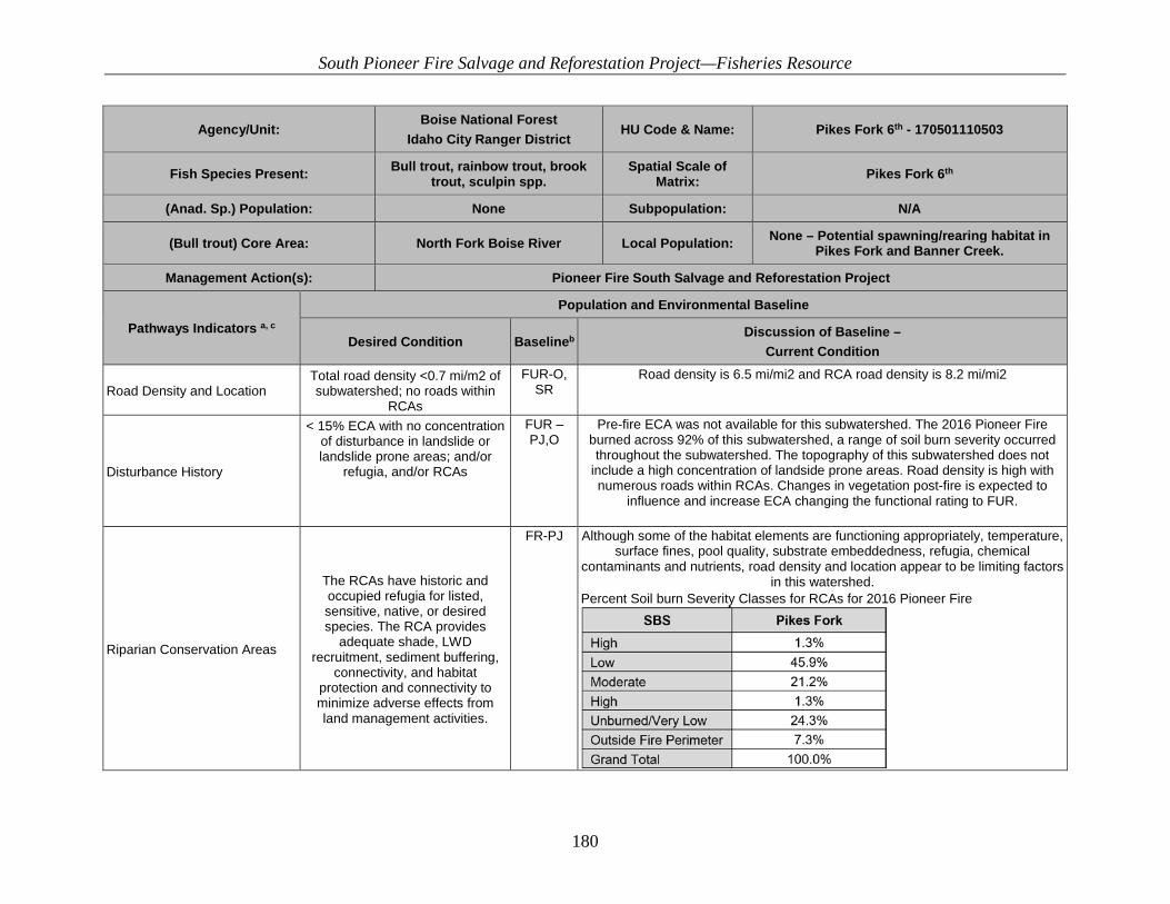
South Pioneer Fire Salvage and Reforestation Project—Fisheries Resource
180
Agency/Unit: Boise National Forest
Idaho City Ranger District HU Code & Name: Pikes Fork 6th - 170501110503
Fish Species Present: Bull trout, rainbow trout, brook trout, sculpin spp.
Spatial Scale of Matrix: Pikes Fork 6th
(Anad. Sp.) Population: None Subpopulation: N/A
(Bull trout) Core Area: North Fork Boise River Local Population: None – Potential spawning/rearing habitat in Pikes Fork and Banner Creek.
Management Action(s): Pioneer Fire South Salvage and Reforestation Project
Pathways Indicators a, c Population and Environmental Baseline
Desired Condition Baselineb Discussion of Baseline –
Current Condition
Road Density and Location Total road density <0.7 mi/m2 of subwatershed; no roads within
RCAs
FUR-O, SR
Road density is 6.5 mi/mi2 and RCA road density is 8.2 mi/mi2
Disturbance History
< 15% ECA with no concentration of disturbance in landslide or landslide prone areas; and/or
refugia, and/or RCAs
FUR – PJ,O
Pre-fire ECA was not available for this subwatershed. The 2016 Pioneer Fire burned across 92% of this subwatershed, a range of soil burn severity occurred throughout the subwatershed. The topography of this subwatershed does not
include a high concentration of landside prone areas. Road density is high with numerous roads within RCAs. Changes in vegetation post-fire is expected to
influence and increase ECA changing the functional rating to FUR.
Riparian Conservation Areas
The RCAs have historic and occupied refugia for listed, sensitive, native, or desired species. The RCA provides
adequate shade, LWD recruitment, sediment buffering,
connectivity, and habitat protection and connectivity to minimize adverse effects from land management activities.
FR-PJ Although some of the habitat elements are functioning appropriately, temperature, surface fines, pool quality, substrate embeddedness, refugia, chemical
contaminants and nutrients, road density and location appear to be limiting factors in this watershed.
Percent Soil burn Severity Classes for RCAs for 2016 Pioneer Fire
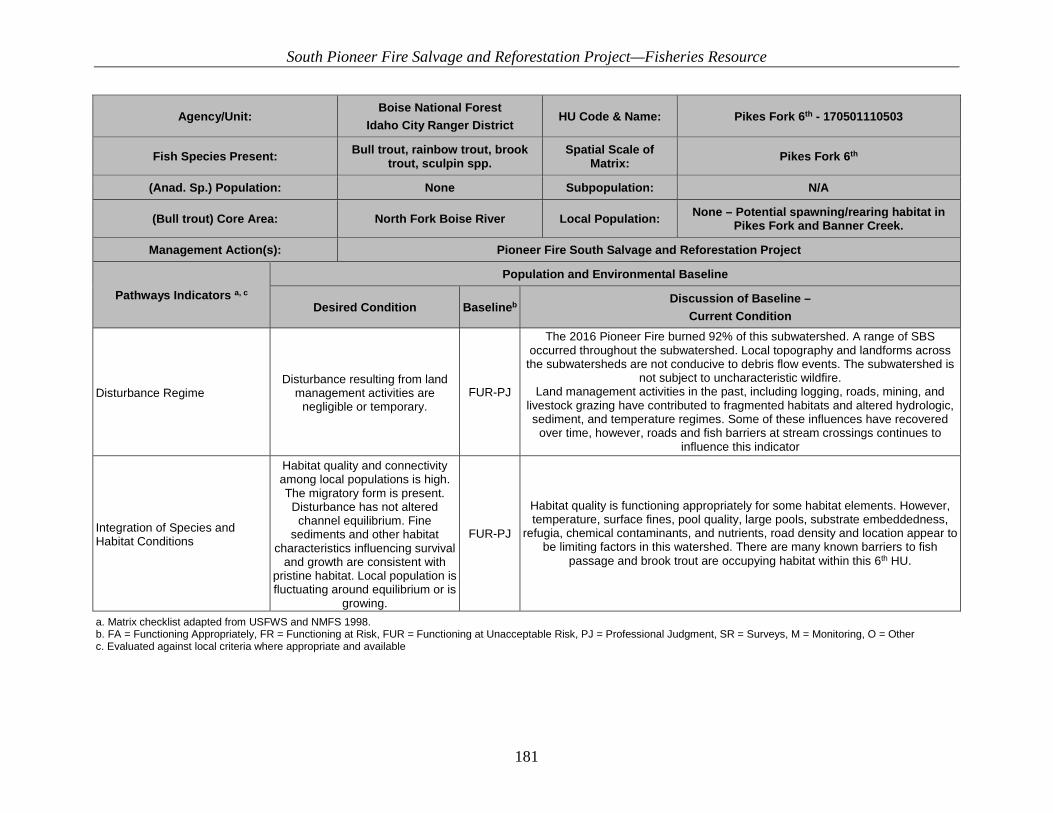
South Pioneer Fire Salvage and Reforestation Project—Fisheries Resource
181
Agency/Unit: Boise National Forest
Idaho City Ranger District HU Code & Name: Pikes Fork 6th - 170501110503
Fish Species Present: Bull trout, rainbow trout, brook trout, sculpin spp.
Spatial Scale of Matrix: Pikes Fork 6th
(Anad. Sp.) Population: None Subpopulation: N/A
(Bull trout) Core Area: North Fork Boise River Local Population: None – Potential spawning/rearing habitat in Pikes Fork and Banner Creek.
Management Action(s): Pioneer Fire South Salvage and Reforestation Project
Pathways Indicators a, c Population and Environmental Baseline
Desired Condition Baselineb Discussion of Baseline –
Current Condition
Disturbance Regime Disturbance resulting from land
management activities are negligible or temporary.
FUR-PJ
The 2016 Pioneer Fire burned 92% of this subwatershed. A range of SBS occurred throughout the subwatershed. Local topography and landforms across
the subwatersheds are not conducive to debris flow events. The subwatershed is not subject to uncharacteristic wildfire.
Land management activities in the past, including logging, roads, mining, and livestock grazing have contributed to fragmented habitats and altered hydrologic, sediment, and temperature regimes. Some of these influences have recovered
over time, however, roads and fish barriers at stream crossings continues to influence this indicator
Integration of Species and Habitat Conditions
Habitat quality and connectivity among local populations is high. The migratory form is present.
Disturbance has not altered channel equilibrium. Fine
sediments and other habitat characteristics influencing survival
and growth are consistent with pristine habitat. Local population is fluctuating around equilibrium or is
growing.
FUR-PJ
Habitat quality is functioning appropriately for some habitat elements. However, temperature, surface fines, pool quality, large pools, substrate embeddedness,
refugia, chemical contaminants, and nutrients, road density and location appear to be limiting factors in this watershed. There are many known barriers to fish
passage and brook trout are occupying habitat within this 6th HU.
a. Matrix checklist adapted from USFWS and NMFS 1998. b. FA = Functioning Appropriately, FR = Functioning at Risk, FUR = Functioning at Unacceptable Risk, PJ = Professional Judgment, SR = Surveys, M = Monitoring, O = Other c. Evaluated against local criteria where appropriate and available

South Pioneer Fire Salvage and Reforestation Project—Fisheries Resource
182
Table 38. Lower Crooked River 6th HUC baseline Table
Agency/Unit:
Boise National Forest
Idaho City Ranger District
HU Code & Name: 170501110201 Lower Crooked River 6th
Fish Species Present: Bull trout,
rainbow, sculpin spp., sucker spp.,
Mtn. Whitefish,
Spatial Scale of Matrix: 6th
(Anad. Sp.) Population: NA Subpopulation: NA
(Bull trout) Core Area: North Fork Boise River Local Population: Crooked River
Management Action(s): Pioneer Fire South Salvage and Reforestation Project
Pathways Indicators a, c
Population and Environmental Baseline
Desired Condition Baselineb Discussion of Baseline – Current Condition
Subpopulation Character Subpopulation Size >500 adults FUR- SR 18 E-fishing sites documented 2 bull trout under 6”.
Data in BNF Aquatic Survey Database. Growth and Survival Resilience to recover
from short-term disturbances.
FUR- SR It is not expected that local populations will improve within two generations Data in BNF Aquatic Survey Database.
Life History Diversity and Isolation Migratory form present and local
populations in close proximity.
FUR-SR Crooked River within this 6th field HUC is below 5000 feet and has few documented
bull trout. Data in BNF Aquatic Survey Database and BOR telemetry study.
Persistence and Genetic Integrity Connectivity is high among 5 or more
local populations w/ several thousand fish
each.
FUR- SR There are no known local populations of bull trout within the subwatershed. Brook trout have also been documented throughout the subwatersheds.

South Pioneer Fire Salvage and Reforestation Project—Fisheries Resource
183
Agency/Unit:
Boise National Forest
Idaho City Ranger District
HU Code & Name: 170501110201 Lower Crooked River 6th
Fish Species Present: Bull trout,
rainbow, sculpin spp., sucker spp.,
Mtn. Whitefish,
Spatial Scale of Matrix: 6th
(Anad. Sp.) Population: NA Subpopulation: NA
(Bull trout) Core Area: North Fork Boise River Local Population: Crooked River
Management Action(s): Pioneer Fire South Salvage and Reforestation Project
Pathways Indicators a, c
Population and Environmental Baseline
Desired Condition Baselineb Discussion of Baseline – Current Condition
Water Quality
Temperature
7-day average maximum temp in reach during the
following life stages: incubation 2-5oC rearing 4-12oC
spawning 4-9oC adults <15oC
FUR-PJ
From the limited available data, temperatures over 15 oC have been documented in Crooked River.
Data in BNF Stream Temperature Database The 2016 Pioneer Fire burned approximately 27% of the subwatershed, possibly
resulting in reduced shade along some reaches.
Sediment
<12% fines in gravel (<6mm)
<20% surface fines(<6mm)
FR-SR
Two survey points. BNF Aquatic survey database on Lower Wood Creek - 40% grid fines. IDEQ BURP program on Lower Crooked River - 8% fines (Wolman count)
The 2016 Pioneer Fire burned approximately 27% of the subwatershed. Increases in sediment yield are expected adjacent to moderate and high soil burn severity slopes.
Chemical Contaminants/Nutrients
Low levels of chemical
contamination or excess nutrients. No 303(d) water quality
limited water.
FA-SR, PJ
No chemical contamination documented. No 303d listed streams within the subwatershed.

South Pioneer Fire Salvage and Reforestation Project—Fisheries Resource
184
Agency/Unit:
Boise National Forest
Idaho City Ranger District
HU Code & Name: 170501110201 Lower Crooked River 6th
Fish Species Present: Bull trout,
rainbow, sculpin spp., sucker spp.,
Mtn. Whitefish,
Spatial Scale of Matrix: 6th
(Anad. Sp.) Population: NA Subpopulation: NA
(Bull trout) Core Area: North Fork Boise River Local Population: Crooked River
Management Action(s): Pioneer Fire South Salvage and Reforestation Project
Pathways Indicators a, c
Population and Environmental Baseline
Desired Condition Baselineb Discussion of Baseline – Current Condition
Habitat Access
Physical Barriers No man-made fish barriers. FA-SR
No known culvert barriers on Crooked River. All tributaries are small in size and may not provide quality habitat
Data in BNF culvert inventory database. Habitat Elements
Substrate Embeddedness Embeddedness <20% FR-PJ Considering the high amount of fines >6 mm percent embeddedness is also likely to
be high.
Large Woody Debris >20 pieces/mile, >12 inches diameter, >35
feet long FA-SR 228 mean.
Data in BNF Aquatic Survey Database.
Pool Frequency
Width (m) # Pools/mile 0-1.5 39
1.5-3.0 60 3.0-4.6 49 4.6-6.1 39 6.1-9.1 23
9.1-10.7 18 10.7-12.2 10 12.2-19.8 9 19.8-30.5 4
FA-SR 0-5’ – 208 mean.
5-10’ – 229 mean. Data in BNF Aquatic Survey Database.
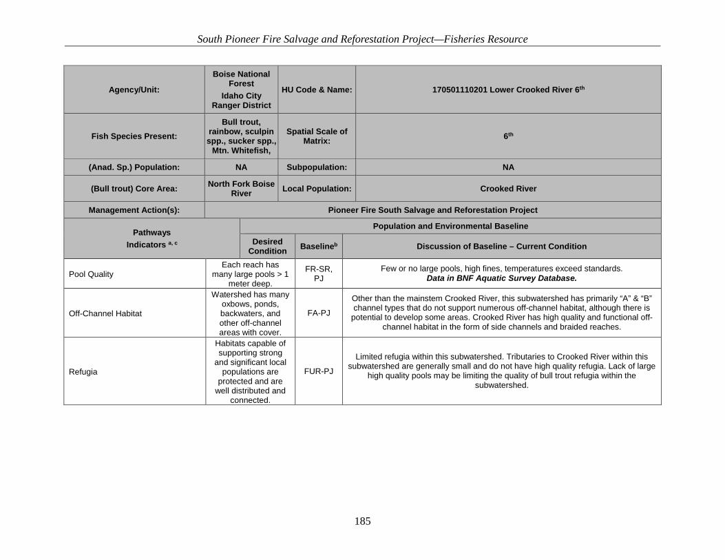
South Pioneer Fire Salvage and Reforestation Project—Fisheries Resource
185
Agency/Unit:
Boise National Forest
Idaho City Ranger District
HU Code & Name: 170501110201 Lower Crooked River 6th
Fish Species Present: Bull trout,
rainbow, sculpin spp., sucker spp.,
Mtn. Whitefish,
Spatial Scale of Matrix: 6th
(Anad. Sp.) Population: NA Subpopulation: NA
(Bull trout) Core Area: North Fork Boise River Local Population: Crooked River
Management Action(s): Pioneer Fire South Salvage and Reforestation Project
Pathways Indicators a, c
Population and Environmental Baseline
Desired Condition Baselineb Discussion of Baseline – Current Condition
Pool Quality Each reach has
many large pools > 1 meter deep.
FR-SR, PJ
Few or no large pools, high fines, temperatures exceed standards. Data in BNF Aquatic Survey Database.
Off-Channel Habitat
Watershed has many oxbows, ponds, backwaters, and other off-channel areas with cover.
FA-PJ
Other than the mainstem Crooked River, this subwatershed has primarily “A” & “B” channel types that do not support numerous off-channel habitat, although there is
potential to develop some areas. Crooked River has high quality and functional off-channel habitat in the form of side channels and braided reaches.
Refugia
Habitats capable of supporting strong
and significant local populations are
protected and are well distributed and
connected.
FUR-PJ
Limited refugia within this subwatershed. Tributaries to Crooked River within this subwatershed are generally small and do not have high quality refugia. Lack of large
high quality pools may be limiting the quality of bull trout refugia within the subwatershed.

South Pioneer Fire Salvage and Reforestation Project—Fisheries Resource
186
Agency/Unit:
Boise National Forest
Idaho City Ranger District
HU Code & Name: 170501110201 Lower Crooked River 6th
Fish Species Present: Bull trout,
rainbow, sculpin spp., sucker spp.,
Mtn. Whitefish,
Spatial Scale of Matrix: 6th
(Anad. Sp.) Population: NA Subpopulation: NA
(Bull trout) Core Area: North Fork Boise River Local Population: Crooked River
Management Action(s): Pioneer Fire South Salvage and Reforestation Project
Pathways Indicators a, c
Population and Environmental Baseline
Desired Condition Baselineb Discussion of Baseline – Current Condition
Channel Condition and Dynamics
Width/Depth Ratio <10 FA-SR 7.6 mean. Data in BNF Aquatic Survey Database.
Streambank Condition >90% FA- SR, PJ – Mean of 91.3% stable banks. Data in BNF Aquatic Survey Database.
Floodplain Connectivity
Within RCAs, floodplains and wetlands are
hydrologically linked to main channel.
FA-PJ Lower Crooked River has primarily “A” & “B” channel types that do not support
extensive floodplains and wetlands. Existing floodplains appear to be hydrologically connected.
Flow/Hydrology
Change in Peak/Base Flows
Watershed hydrograph indicates, peak, base, and flow timing comparable to
a comparable undisturbed watershed.
FR-PJ
The 2016 Pioneer Fire burned approximately 27% of the subwatershed. This is expected to increase peak flows depending on burn severity. This increase is
primarily associated with summer thunderstorms due to reduced infiltration and canopy interception. Increased snowmelt rates due to loss of vegetation canopy is possible. Vegetation recovery and moderation of increased peak flows is expected
3-5 years after the fire. Numerous roads within the subwatershed have likely altered Peak/Base flows

South Pioneer Fire Salvage and Reforestation Project—Fisheries Resource
187
Agency/Unit:
Boise National Forest
Idaho City Ranger District
HU Code & Name: 170501110201 Lower Crooked River 6th
Fish Species Present: Bull trout,
rainbow, sculpin spp., sucker spp.,
Mtn. Whitefish,
Spatial Scale of Matrix: 6th
(Anad. Sp.) Population: NA Subpopulation: NA
(Bull trout) Core Area: North Fork Boise River Local Population: Crooked River
Management Action(s): Pioneer Fire South Salvage and Reforestation Project
Pathways Indicators a, c
Population and Environmental Baseline
Desired Condition Baselineb Discussion of Baseline – Current Condition
Change in Drainage Network
Zero or minimum change in active channel length correlated with human caused
disturbance.
FR-PJ High road densities and in-sloped or rutted roads has likely elevated the drainage network.
Watershed Conditions
Road Density and Location
Total road density <0.7 miles/square
mile of subwatershed; no roads within RCAs
FUR-O 3.13 mi/mi2. RCA 2.14 mi/mi2 WCF Analysis completed in 2011
Disturbance History
< 15% ECA with no concentration of disturbance in
landslide or landslide prone areas; and/or
refugia, and/or RCAs
FUR-PJ, O, SR
Pre-fire ECA numbers were not available for this subwatershed. The 2016 Pioneer Fire burned across 27% of this subwatershed/A wide range of soil burn severity
occurred throughout the subwatershed. The topography of this subwatershed does not include a high concentration of landside prone areas. Changes in vegetation
post-fire is expected to influence and increase ECA changing the functional rating to FUR.

South Pioneer Fire Salvage and Reforestation Project—Fisheries Resource
188
Agency/Unit:
Boise National Forest
Idaho City Ranger District
HU Code & Name: 170501110201 Lower Crooked River 6th
Fish Species Present: Bull trout,
rainbow, sculpin spp., sucker spp.,
Mtn. Whitefish,
Spatial Scale of Matrix: 6th
(Anad. Sp.) Population: NA Subpopulation: NA
(Bull trout) Core Area: North Fork Boise River Local Population: Crooked River
Management Action(s): Pioneer Fire South Salvage and Reforestation Project
Pathways Indicators a, c
Population and Environmental Baseline
Desired Condition Baselineb Discussion of Baseline – Current Condition
Riparian conservation Areas
The RCAs have historic and occupied
refugia for listed, sensitive, native, or
desired species. The RCA provides
adequate shade, LWD recruitment,
sediment buffering, connectivity, and
habitat protection and connectivity to
minimize adverse effects from land
management activities.
FR - PJ
The watershed contains mostly migratory habitat along the Crooked River. Tributaries of the Crooked River are mostly small, steep, and lacking spawning habitat. RCA functions are likely functioning well due to lack of roads or other
disturbances. The 1994 Rabbit Creek fire and the 2016 Pioneer Fire burned most of the watershed. These fires may have altered some functionality of RCAs.
Percent Soil burn Severity Classes for RCAs for 2016 Pioneer Fire
Disturbance Regime
Disturbance resulting from land
management activities are negligible or temporary.
FUR-PJ
The 2016 Pioneer Fire burned 27% of this subwatershed. A range of SBS occurred throughout the subwatershed. Local topography and landforms across the
subwatersheds are not conducive to debris flow events. The subwatershed is not subject to uncharacteristic wildfire.

South Pioneer Fire Salvage and Reforestation Project—Fisheries Resource
189
Agency/Unit:
Boise National Forest
Idaho City Ranger District
HU Code & Name: 170501110201 Lower Crooked River 6th
Fish Species Present: Bull trout,
rainbow, sculpin spp., sucker spp.,
Mtn. Whitefish,
Spatial Scale of Matrix: 6th
(Anad. Sp.) Population: NA Subpopulation: NA
(Bull trout) Core Area: North Fork Boise River Local Population: Crooked River
Management Action(s): Pioneer Fire South Salvage and Reforestation Project
Pathways Indicators a, c
Population and Environmental Baseline
Desired Condition Baselineb Discussion of Baseline – Current Condition
Integration of Species and Habitat Conditions
Habitat quality and connectivity among local populations is high. The migratory
form is present. Disturbance has not
altered channel equilibrium. Fine
sediments and other habitat
characteristics influencing survival
and growth are consistent with
pristine habitat. Local population is
fluctuating around an equilibrium or is
growing.
FUR-PJ Overall RCA condition and sediment are expected to be negatively impacted from the Pioneer Fire of 2016. Connectivity is poor between local populations. Under
current management conditions, habitat may not improve within two generations.
a. Matrix checklist adapted from USFWS and NMFS 1998. b. FA = Functioning Appropriately, FR = Functioning at Risk, FUR = Functioning at Unacceptable Risk, PJ = Professional Judgment, SR = Surveys, M = Monitoring, O = Other c. Evaluated against local criteria where appropriate and available
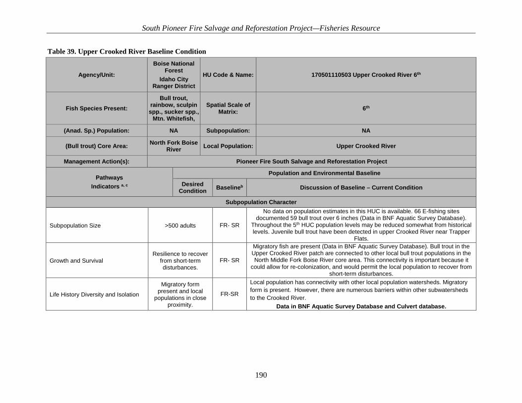
South Pioneer Fire Salvage and Reforestation Project—Fisheries Resource
190
Table 39. Upper Crooked River Baseline Condition
Agency/Unit:
Boise National Forest
Idaho City Ranger District
HU Code & Name: 170501110503 Upper Crooked River 6th
Fish Species Present: Bull trout,
rainbow, sculpin spp., sucker spp.,
Mtn. Whitefish,
Spatial Scale of Matrix: 6th
(Anad. Sp.) Population: NA Subpopulation: NA
(Bull trout) Core Area: North Fork Boise River Local Population: Upper Crooked River
Management Action(s): Pioneer Fire South Salvage and Reforestation Project
Pathways Indicators a, c
Population and Environmental Baseline
Desired Condition Baselineb Discussion of Baseline – Current Condition
Subpopulation Character
Subpopulation Size >500 adults FR- SR
No data on population estimates in this HUC is available. 66 E-fishing sites documented 59 bull trout over 6 inches (Data in BNF Aquatic Survey Database).
Throughout the 5th HUC population levels may be reduced somewhat from historical levels. Juvenile bull trout have been detected in upper Crooked River near Trapper
Flats.
Growth and Survival Resilience to recover
from short-term disturbances.
FR- SR
Migratory fish are present (Data in BNF Aquatic Survey Database). Bull trout in the Upper Crooked River patch are connected to other local bull trout populations in the North Middle Fork Boise River core area. This connectivity is important because it
could allow for re-colonization, and would permit the local population to recover from short-term disturbances.
Life History Diversity and Isolation
Migratory form present and local
populations in close proximity.
FR-SR
Local population has connectivity with other local population watersheds. Migratory form is present. However, there are numerous barriers within other subwatersheds to the Crooked River.
Data in BNF Aquatic Survey Database and Culvert database.
South Pioneer Fire Salvage and Reforestation Project—Fisheries Resource
191
Agency/Unit:
Boise National Forest
Idaho City Ranger District
HU Code & Name: 170501110503 Upper Crooked River 6th
Fish Species Present: Bull trout,
rainbow, sculpin spp., sucker spp.,
Mtn. Whitefish,
Spatial Scale of Matrix: 6th
(Anad. Sp.) Population: NA Subpopulation: NA
(Bull trout) Core Area: North Fork Boise River Local Population: Upper Crooked River
Management Action(s): Pioneer Fire South Salvage and Reforestation Project
Pathways Indicators a, c
Population and Environmental Baseline
Desired Condition Baselineb Discussion of Baseline – Current Condition
Persistence and Genetic Integrity
Connectivity is high
among 5 or more local populations w/ several
thousand fish each.
FR- SR
There is limited connectivity within the Crooked River drainage and good connectivity among multiple local populations within the North and Middle Fork Boise River. Brook
trout have been documented throughout many watersheds and hybridization or displacement could be occurring. Data in BNF Aquatic Survey Database.

South Pioneer Fire Salvage and Reforestation Project—Fisheries Resource
192
Agency/Unit:
Boise National Forest
Idaho City Ranger District
HU Code & Name: 170501110503 Upper Crooked River 6th
Fish Species Present: Bull trout,
rainbow, sculpin spp., sucker spp.,
Mtn. Whitefish,
Spatial Scale of Matrix: 6th
(Anad. Sp.) Population: NA Subpopulation: NA
(Bull trout) Core Area: North Fork Boise River Local Population: Upper Crooked River
Management Action(s): Pioneer Fire South Salvage and Reforestation Project
Pathways Indicators a, c
Population and Environmental Baseline
Desired Condition Baselineb Discussion of Baseline – Current Condition
Water Quality
Temperature
7-day average maximum temp in reach during the
following life stages: incubation 2-5oC rearing 4-12oC
spawning 4-9oC adults <15oC
FR-PJ
NorWest observed temperatures show 27 out of 37 sites, mainly near the headwaters, not exceeding 15° C MWMT. 10 out of 37 sites have exceeded 15° C
MWMT. Temperature exceeded 15° C. Thermal barriers are likely present. GIS database. 2016 Pioneer Fire likely reduced stream shade along some stream
reaches. Pre and post-fire shade monitoring conducted in the Middle Crooked subwatershed during June and September 2016 captured changes in streamside
shade in areas of moderate and high Soil Burn Severity. This reduction in shade is expected to result in increased water temperatures along streams where vegetation
burned. Recovery of streamside vegetation anticipated during 1-3 years post fire. Recovery of adjacent upland vegetation anticipated during 3-15 years post fire.

South Pioneer Fire Salvage and Reforestation Project—Fisheries Resource
193
Agency/Unit:
Boise National Forest
Idaho City Ranger District
HU Code & Name: 170501110503 Upper Crooked River 6th
Fish Species Present: Bull trout,
rainbow, sculpin spp., sucker spp.,
Mtn. Whitefish,
Spatial Scale of Matrix: 6th
(Anad. Sp.) Population: NA Subpopulation: NA
(Bull trout) Core Area: North Fork Boise River Local Population: Upper Crooked River
Management Action(s): Pioneer Fire South Salvage and Reforestation Project
Pathways Indicators a, c
Population and Environmental Baseline
Desired Condition Baselineb Discussion of Baseline – Current Condition
Sediment
<12% fines in gravel (<6mm)
<20% surface fines(<6mm)
FR-SR,PJ
26.9% mean. Data in BNF Aquatic Survey Database.
27% mean from IDEQ BURP Sites.
Numerous survey data indicate that a wide range of substrate sizes exist throughout
the subwatershed. The subwatershed is 46% inventoried roadless area. Main source of management related sediment is associated with the 348 and 384 roads
along the Crooked River and Willow Creek.
2016 Pioneer Fire burned 51% of this subwatershed. Post-fire erosion is expected to increase overall sediment yield to streams adjacent to moderate and high soil
burn severity slopes. Sediment delivery from hillslope erosion is likely to provide a range of substrate sizes. Sediment yields expected to measurably increase,
particularly along streams with adjacent road systems where riparian vegetation between road and stream has been burned. Recovery of streamside vegetation
anticipated during 1-3 years post fire.
Chemical Contaminants/Nutrients
Low levels of chemical
contamination or excess nutrients. No 303(d) water quality
limited water.
FA-SR, PJ
No chemical contamination documented. No 303d listed streams within the subwatershed.
South Pioneer Fire Salvage and Reforestation Project—Fisheries Resource
194
Agency/Unit:
Boise National Forest
Idaho City Ranger District
HU Code & Name: 170501110503 Upper Crooked River 6th
Fish Species Present: Bull trout,
rainbow, sculpin spp., sucker spp.,
Mtn. Whitefish,
Spatial Scale of Matrix: 6th
(Anad. Sp.) Population: NA Subpopulation: NA
(Bull trout) Core Area: North Fork Boise River Local Population: Upper Crooked River
Management Action(s): Pioneer Fire South Salvage and Reforestation Project
Pathways Indicators a, c
Population and Environmental Baseline
Desired Condition Baselineb Discussion of Baseline – Current Condition
Habitat Access
Physical Barriers No man-made fish barriers. FR-SR
The main-stem Crooked River has no connectivity issues. One culvert barrier exists on Willow Creek where it crosses the 384 road. Addressing passage at this culvert
would make this subwatershed FA. Habitat Elements
Substrate Embeddedness Embeddedness <20% FR-PJ Considering the high amount of fines >6 mm percent embeddedness is also likely to
be high.
Large Woody Debris >20 pieces/mile, >12 inches diameter, >35
feet long FA-SR
60 mean.
Data in BNF Aquatic Survey Database.
Additional large woody debris surveys were conducted throughout the subwatershed following the 2016 Pioneer Fire. Of the 5 surveys completed, 3 sites exceeded
desired conditions for LWD. No surveys were completed in the roadless portions of the subwatershed. 46% of the subwatershed is inventoried roadless area.
South Pioneer Fire Salvage and Reforestation Project—Fisheries Resource
195
Agency/Unit:
Boise National Forest
Idaho City Ranger District
HU Code & Name: 170501110503 Upper Crooked River 6th
Fish Species Present: Bull trout,
rainbow, sculpin spp., sucker spp.,
Mtn. Whitefish,
Spatial Scale of Matrix: 6th
(Anad. Sp.) Population: NA Subpopulation: NA
(Bull trout) Core Area: North Fork Boise River Local Population: Upper Crooked River
Management Action(s): Pioneer Fire South Salvage and Reforestation Project
Pathways Indicators a, c
Population and Environmental Baseline
Desired Condition Baselineb Discussion of Baseline – Current Condition
Pool Frequency
Width (m) # Pools/mile 0-1.5 39
1.5-3.0 60 3.0-4.6 49 4.6-6.1 39 6.1-9.1 23
9.1-10.7 18 10.7-12.2 10 12.2-19.8 9 19.8-30.5 4
FA-SR
0-5’ – 278 mean. 5-10’ – 283 mean.
10’-15’ – 126 mean. 15’-20’ – 130 mean.
Data in BNF Aquatic Survey Database. Even though pool frequency exceeds standards, there are many RCA roads, high sediment ratios and temperature exceed standards. Pool frequency is FA, pool
quality is FR.
Pool Quality Each reach has
many large pools > 1 meter deep.
FR-SR, PJ
IDEQ BURP data indicate several reaches with more than one large pool.
Off-Channel Habitat
Watershed has many oxbows, ponds, backwaters, and other off-channel areas with cover.
FA-PJ
Aerial imagery of roadless areas in the subwatershed indicate numerous areas with ponds, backwater, and other low energy areas.

South Pioneer Fire Salvage and Reforestation Project—Fisheries Resource
196
Agency/Unit:
Boise National Forest
Idaho City Ranger District
HU Code & Name: 170501110503 Upper Crooked River 6th
Fish Species Present: Bull trout,
rainbow, sculpin spp., sucker spp.,
Mtn. Whitefish,
Spatial Scale of Matrix: 6th
(Anad. Sp.) Population: NA Subpopulation: NA
(Bull trout) Core Area: North Fork Boise River Local Population: Upper Crooked River
Management Action(s): Pioneer Fire South Salvage and Reforestation Project
Pathways Indicators a, c
Population and Environmental Baseline
Desired Condition Baselineb Discussion of Baseline – Current Condition
Refugia
Habitats capable of supporting strong
and significant local populations are
protected and are well distributed and
connected.
FA-PJ
Adequate refugia does exist in the roadless area in the upper half of the Upper Crooked River 6thHUC.

South Pioneer Fire Salvage and Reforestation Project—Fisheries Resource
197
Agency/Unit:
Boise National Forest
Idaho City Ranger District
HU Code & Name: 170501110503 Upper Crooked River 6th
Fish Species Present: Bull trout,
rainbow, sculpin spp., sucker spp.,
Mtn. Whitefish,
Spatial Scale of Matrix: 6th
(Anad. Sp.) Population: NA Subpopulation: NA
(Bull trout) Core Area: North Fork Boise River Local Population: Upper Crooked River
Management Action(s): Pioneer Fire South Salvage and Reforestation Project
Pathways Indicators a, c
Population and Environmental Baseline
Desired Condition Baselineb Discussion of Baseline – Current Condition
Channel Condition and Dynamics
Width/Depth Ratio <10 FA-SR 9.1 mean. Data in BNF Aquatic Survey Database.
Streambank Condition >90% FA-PJ Mean of 8.7% unstable. In general, streambank condition is excellent Field
observations identified several areas where stream bank stability exceeds 10% with problems associated with roads. Data in BNF Aquatic Survey Database.
Floodplain Connectivity
Within RCAs, floodplains and wetlands are
hydrologically linked to main channel.
FR-PJ Overall floodplain connectivity is good throughout the subwatershed. Roads only impact a small portion of the subwatershed along the 348 and 384 Roads.
Flow/Hydrology
Change in Peak/Base Flows
Watershed hydrograph indicates, peak, base, and flow timing comparable to
a comparable undisturbed watershed.
FR-PJ
2016 Pioneer Fire burned across 51% of this subwatershed. This is expected to increase peak flows depending on burn severity. This increase is primarily
associated with summer thunderstorms due to reduced infiltration and canopy interception. Increased snowmelt rates due to loss of vegetation canopy is possible. Vegetation recovery and moderation of increased peak flows is expected 3-5 years
after the fire.
South Pioneer Fire Salvage and Reforestation Project—Fisheries Resource
198
Agency/Unit:
Boise National Forest
Idaho City Ranger District
HU Code & Name: 170501110503 Upper Crooked River 6th
Fish Species Present: Bull trout,
rainbow, sculpin spp., sucker spp.,
Mtn. Whitefish,
Spatial Scale of Matrix: 6th
(Anad. Sp.) Population: NA Subpopulation: NA
(Bull trout) Core Area: North Fork Boise River Local Population: Upper Crooked River
Management Action(s): Pioneer Fire South Salvage and Reforestation Project
Pathways Indicators a, c
Population and Environmental Baseline
Desired Condition Baselineb Discussion of Baseline – Current Condition
Change in Drainage Network
Zero or minimum change in active channel length correlated with human caused
disturbance.
FR-PJ
High road densities and in-sloped or rutted roads has likely elevated the drainage network.
Watershed Conditions
Road Density and Location
Total road density <0.7 miles/square
mile of subwatershed; no roads within RCAs
FUR-O
2.75 mi/mi2. WSCAT database.
Disturbance History
< 15% ECA with no concentration of disturbance in
landslide or landslide prone areas; and/or
refugia, and/or RCAs
FUR-O, SR
Pre-fire 7% ECA (FR) was calculated using timber and fire data from the 2011 Watershed Condition Framework Classification. 2016 Pioneer Fire burned across
51% of this subwatershed at varying intensities and severities. Changes in vegetation post-fire is expected to influence and increase ECA changing the
functional rating to FUR.
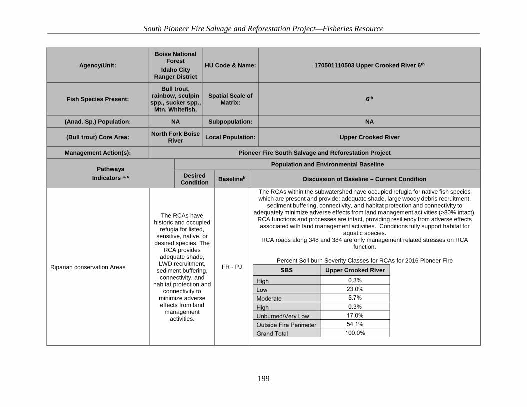
South Pioneer Fire Salvage and Reforestation Project—Fisheries Resource
199
Agency/Unit:
Boise National Forest
Idaho City Ranger District
HU Code & Name: 170501110503 Upper Crooked River 6th
Fish Species Present: Bull trout,
rainbow, sculpin spp., sucker spp.,
Mtn. Whitefish,
Spatial Scale of Matrix: 6th
(Anad. Sp.) Population: NA Subpopulation: NA
(Bull trout) Core Area: North Fork Boise River Local Population: Upper Crooked River
Management Action(s): Pioneer Fire South Salvage and Reforestation Project
Pathways Indicators a, c
Population and Environmental Baseline
Desired Condition Baselineb Discussion of Baseline – Current Condition
Riparian conservation Areas
The RCAs have historic and occupied
refugia for listed, sensitive, native, or
desired species. The RCA provides
adequate shade, LWD recruitment,
sediment buffering, connectivity, and
habitat protection and connectivity to
minimize adverse effects from land
management activities.
FR - PJ
The RCAs within the subwatershed have occupied refugia for native fish species which are present and provide: adequate shade, large woody debris recruitment,
sediment buffering, connectivity, and habitat protection and connectivity to adequately minimize adverse effects from land management activities (>80% intact).
RCA functions and processes are intact, providing resiliency from adverse effects associated with land management activities. Conditions fully support habitat for
aquatic species. RCA roads along 348 and 384 are only management related stresses on RCA
function.
Percent Soil burn Severity Classes for RCAs for 2016 Pioneer Fire

South Pioneer Fire Salvage and Reforestation Project—Fisheries Resource
200
Agency/Unit:
Boise National Forest
Idaho City Ranger District
HU Code & Name: 170501110503 Upper Crooked River 6th
Fish Species Present: Bull trout,
rainbow, sculpin spp., sucker spp.,
Mtn. Whitefish,
Spatial Scale of Matrix: 6th
(Anad. Sp.) Population: NA Subpopulation: NA
(Bull trout) Core Area: North Fork Boise River Local Population: Upper Crooked River
Management Action(s): Pioneer Fire South Salvage and Reforestation Project
Pathways Indicators a, c
Population and Environmental Baseline
Desired Condition Baselineb Discussion of Baseline – Current Condition
Disturbance Regime Disturbance resulting from land
management activities are negligible or temporary.
FUR-PJ
Management activities have altered ecological processes as shown by the above WCIs. High road densities and poor location are also responsible for localized
events. Habitat and ecological processes appear to be recovering. 2016 Pioneer Fire burned across 51% of this subwatershed.

South Pioneer Fire Salvage and Reforestation Project—Fisheries Resource
201
Agency/Unit:
Boise National Forest
Idaho City Ranger District
HU Code & Name: 170501110503 Upper Crooked River 6th
Fish Species Present: Bull trout,
rainbow, sculpin spp., sucker spp.,
Mtn. Whitefish,
Spatial Scale of Matrix: 6th
(Anad. Sp.) Population: NA Subpopulation: NA
(Bull trout) Core Area: North Fork Boise River Local Population: Upper Crooked River
Management Action(s): Pioneer Fire South Salvage and Reforestation Project
Pathways Indicators a, c
Population and Environmental Baseline
Desired Condition Baselineb Discussion of Baseline – Current Condition
Integration of Species and Habitat Conditions
Habitat quality and connectivity among local populations is high. The migratory
form is present. Disturbance has not
altered channel equilibrium. Fine
sediments and other habitat
characteristics influencing survival
and growth are consistent with
pristine habitat. Local population is
fluctuating around an equilibrium or is
growing.
FR-PJ
Habitat quality is good within the subwatershed. Impacts to RCA functions and processes occur within the lower portions of the subwatershed along Crooked River and Willow Creek associated with the 348 and 384 Roads. 2016 Pioneer Fire burned
approximately 51% of this subwatershed.
a. Matrix checklist adapted from USFWS and NMFS 1998. b. FA = Functioning Appropriately, FR = Functioning at Risk, FUR = Functioning at Unacceptable Risk, PJ = Professional Judgment, SR = Surveys, M = Monitoring, O = Other c. Evaluated against local criteria where appropriate and available