five-year review for the clean-fill dump operable unit
TRANSCRIPT

u s Army Corps of Engineers BALTIMORE DISTRICT
Five-year Review
for the
Clean-fill Dump Operable Unit
Fort George G. Meade
Anne Arundel County, Maryland
Prepared By: Engineering Division
U.S. Army Engineer District, Baltimore 10 South Howard Street Baltimore, MD 21201
and the
Fort Dix / Fort Meade BRAC Legacy Office , U.S. Army Garrison Fort Dix
5317 Snyder Lane Fort Dix, New Jersey, 08640-5501
SDMS DoclD 2109957
December 2005

EXECUTIVE SUMMARY
The Army Corps of Engineers-Baltimore District has conducted the first five-year review (review) of the Clean-fill Dump (CFD) operable unit (Site) at Fort George G. Meade (FGGM) in Anne Arundel County, Maryland. The operable unit includes a former solid waste landfill (CFD) and an area referred to as the Uncontrolled Waste Site (UWS) located along its southern boarder. The Site is part of 7,600-acres of former range and training land at FGGM that was transferred in 1991 to the U.S. Department of Interior, Fish and Wildlife Service. Because of existing environmental concerns at the Site, the Site was.excluded from the transfer. The 7,600-acres is currently referred to as the Patuxent Research Refiige-North Tract.
The Site is located partially within the boundaries of the downrange fan of former Firing Range 7, and was used approximately fi-om 1972 until 1985 for the disposal of miscellaneous debris such as stumps, trees, logs, concrete, construction debris, old appliances, and fill dirt. Material observed in the UWS includes tires, household appliances, drums, auto parts, electrical equipment, construction debris, and discarded storage tanks.
The purpose of this review is to evaluate the implementation and performance of the remedy in order to determine if the remedy is protective of human health and the environment. The Army conducted extensive environmental investigations at the Site to assess the impacts past Army activities had on the groundwater, soil, sediment, and surface water. Results of these investigations show that risks posed to workers, trespassers, and site visitors are within the United States Environmental Protection Agency's acceptable risk range of 10^ to 10"̂ ; however, certain metals and organic compounds were detected in excess of their federal maximum contaminant levels and/or risk-based criteria. The methods, findings, and conclusions of the review are described in this report. The triggering action for the review is the September 2000 Record of Decision Clean Fill Dump (CFD) Operable Unit, Fort George G. Meade Fort Meade, Maryland (ROD). The review was conducted in accordance with the Comprehensive Environmental Response, Compensation, and Liability Act §121 and the National Contingency Plan.
The review has found that the remedy (no further action with groundwater monitoring) was implemented in accordance with the requirements of the ROD, and is functioning as anticipated. The remedy is protective of human health and the environment, and complies with Federal and Maryland requirements that are applicable or relevant and appropriate. The institutional controls for the Site are described in the, July 2000 Action Memorandum Safety Precautions to be taken at Clean Fill Dump Fort George G. Meade, Maryland. The institutional controls include residential and groundwater use restrictions, and that future land use be compatible with the probable presence of unexploded ordnance. Unexploded ordnance is not part of this review, and will be addressed separately.
^

p s
%
UNITED STATES ENVIRONMENTAL PROTECTION AGENCY REGION III
1650 Arch Street ^ipRO^^*^ Philadelphia, Pennsylvania 19103-2029
May29,2007
U.S. Amiy Garrison Fort Dix ' ATTN: AFRC-FA-PWN (Paul V. Fluck) BRAC Environmental Coordinator 5317 Snyder Lane Fort Dix, NJ 08640-5501
Re: EPA Review of the Clean Fill Dump 5 Year Recurring Review Report Response to comments dated February 2007
Dear Mr. Fluck:
EPA has reviewed the above referenced document and concurs with the responses to the EPA comments dated November 30, 2006. EPA has no additional comments at this time.
EPA reserves all rights and authorities relating to information not contained or referenced in this document whether or not such information was known when this document was issued or discovered after such issuance.
If you have any questions or comments, please contact me at 410-305-2748.
Sincerely,
/ Robert W. Stroud, RPM 3HS11
cc: Rick Grills (MDE) Patience Nwanna (FMEO)
Printed on 100% recycled/recyclable paper with 100% post-consumer fiber and process chlorine free. Customer Service Hotline: 1-800-438-2474
<>

^^•'^°^''^^e^
^ ^ \ UNITED STATES ENVIRONMENTAL PROTECTION AGENCY S ^^ffy^ I REGION HI ^ ^ l | 6 » ^^ 1650 Arch Street
" ^ ^ P f ^ a ^ ^ ^ Philadelphia, Pennsylvania 19103-2029
November 30, 2006 '
U.S. Army Garrison Fort Dix ATrN: AFRC-FA-PWN (Paul V. Fluck) BRAC Envirormiental Coordinator ' 5317 Snyder Lane , Fort Dix, NJ 08640-5501 -
Re: Five Year Review of the Clean Fill Dump Operable Unit ("CFDOU") at Fort George G. Meade - - .
Dear Mr. Fluck: ,
Thank you for providing EPA Region III the opportunity to review and comment on the^Five " Year Review document for the CFDOU dated Deceniber 2005. The document was reviewed by EPA in accordance with the EPA Comprehensive Five-Year Review Guidance (OSWER No. 9355.7-03B-P), CERCLA § 121 (c) and the NCP 40 CFR § 300.430(f)(4)(ii).
General Comments
1. Pages 8- 9, Section 3.2, please chanjge Maryland Route 178 to Maryland Route 175.
2. Page 14, Table 5.4-1, please change FLecord of Decision (2002) to (2000) as the Record of Decision was signed in September 2000.
3. Page 15, please indicate which wells had RBC exceedances in the 2002 sampling event.
4. Page 17, last paragraph states that "concentrations of TCE and PCE in monitoring well CFD-3S are greatly reduced", however, Table 5.5-1 indicates that PCE rose from 25.8 ppb in 2002 to 47 ppm in 2004 and TCE rose from 12.4 ppm in 2002 to 14 ppm in 2004, please clarify this statement. ^
5. Page 28, Section 6.4, please verify that tlieir have been no changes in the toxicity factors for PCE in monitoring well CFD-3S.
6. Page 29, Section 7.0, please indicate which downgradient wells revealed levels of Cis-1,2-Dichloroethylene. Also, please list the wells that are being recommended for vinyl chloride testing. . -
Primed on 100% recycled/recyclable paper with 100% post-consumer fiber and process chlorine free. Customer Service Hotline: 1-800-438-2474
o

EPA concurs with the recommendations; follow up actions and the protectiveness statement in Sections 7.0 and 8.0 respectively. The next five year review for the Remedial Actions at the CFDOU is required by December 2010, five years from the date of this document.
' • , ^
EPA reserves all rights and authorities relating to information not contained or referenced in this document whether or not such information was known when this document was issued or discovered after such issuance.
This letter should accompany the subject document in the administrative record for the CFDOU. ,
If you have any questions or comments, please contact me at 410-305-2748.
C • Sincerely,
Robert W. Stroud, RPM 3HS11 .
cc: Andy Zarins (MDE) Patience Nwanna (FMEO)
o Printed on 100% recycled/recyclable paper with 100% post-consumer fiber and process chlorinefree^
Customer Service Hotline: 1-800-438-2474

TABLE OF CONTENTS
1.0 INTRODUCTION 1 2.0 SITE CHRONOLOGY :...2 3.0 BACKGROUND ...: .• 2
3.1 Physical Characteristics ! 2 3.1.1 Topography and Surface Water Drainage 7 3.1.2 Climatology , , 7 3.1.3 Geology and Hydrogeology '. 7
3.2 Land Resource Use-Past, Present, Future 8 3.3 History of Contamination 9 3.4 Initial Response 10 3.5 Basis for Taking Action .10
4.0 REMEDIAL ACTION .' II 4.1 Remedy Selection II 4.2 Remedy Implementation 11 4.3 Operation and Maintenance , 11
5.0 FIVE YEAR REVIEW PROCESS 12 5.1 Progress Since the Last Five-Year Review 12 5.2 Administrative Components 12 5.3 Community Involvement 13 5.4 Document Review '. : 14 5.5 Data Review and Trends 14 5.6 Site Inspection ; 26 5.7 Interviews .....26
6.0 FINAL SITE ANALYSIS 27 6.1 Question A: Is the Remedy Functioning as Intended by the Decision Document? 27 6.2 Question B: Are the Exposure Assumptions, Toxicity Data, Cleanup Levels, Remedy still
Valid? :. 28 6.3 Question C: Has any other Information come to light that could call into Question the
Protectiveness of the Remedy?.., , 28, 6.4 Technical Assessment and Summary of Remedy Protectiveness 28
7.0 ISSUES, RECOMMENDATIONS, AND FOLLOW-UPS 28 8.0 PROTECTIVENESS STATEMENTS 29 9.0 NEXT REVIEW 29 10.0 REFERENCES ^ 30
FIGURES
Figure 3-1 Fort Meade Location Map. 4 Figure 3-2 Fort Meade BRAC Parcel Map : 5, Figure 3-3 Clean-fill Dump Site Map 6
TABLES
Table 2-1 Site Chronology... ...2 Table 4.3-1 Long-term Groundwater Monitoring Costs 12 Table 5.2-1 Parties Who Provided Input to the Five-year Review 12 Table 5.4-1 Documents Reviewed 14

Table 5.5-1 Groundwater Results and Comparison to Screening Criteria 19 Table 5.5-la Calculation of USEPA Region 111 Risk-Based Criteria for Residential
Exposure to groundwater 21 Table 5.5-2 Historic Results for Chemicals that Currently Exceed Screening Criteria. .25
Table 5.5-3 Analytes Recommended for Sampling 26
APPENDiCIES
A Site Inspection
III

LIST OF ACRONYMS AND ABBREVIATIONS
ARAR BRAC CERCLA
CFD DCE FGGM LTGM MEC MCL MDE mg/L NCP NGVD NPL OU PCE PQLs PRG PRR RBC Rl RIA Rl/FS ROD TAL TCE TCL USAGE USAGE HTRW-CX
USAEC USEPA UWS VOCs
Applicable, or Relevant and Appropriate Requirements Base Realignment and Closure Comprehensive Environmental Response, Compensation, and Liability Act Clean-fill Dump Dichloroethylene Fort George G. Meade Long-Term Groundwater Monitoring Munitions and Explosives of Concern Maximum Contaminant Levels Maryland Department of the Environment Milligrams per liter National Contingency Plan National Geodetic Vertical Datum , National Priority List Operable Unit ^ Tetrachloroethylene Practical Quantitation Limits Preliminary Remedial Goals Patuxent Research Refiige Risk-Based Concentration Remedial Investigation Remedial Investigation Addendum Remedial Investigation/Feasibility Study Record of Decision Target Analyte List Trichloroethylene Target Compound List U.S. Army Corps of Engineers U.S. Army Corps of Engineers Hazardous, Toxic, and Radioactive Waste Center of Expertise U.S. Army Environmental Center U.S. Environmental Protection Agency Uncontrolled Waste Site Volatile Organic Compounds
IV

GLOSSARY
Applicable and Relevant and Appropriate Requirements: Applicable Requirements mean those cleanup standards, standards of control, and other substantive environmental protection requirements, criteria, or limitations promulgated under federal environmental or state environmental or facility siting law that specifically,address a hazardous substance, pollutant, contaminant, remedial action, location or other circumstance at a CERCLA site. Relevant and Appropriate Requirements mean those cleanup standards [that]... address problems or situations sufficiently similar to those encountered at the CERCLA site that their use is well suited to the particular site.
Administrative Record: A collection of documents containing all the information and reports generated during entire phase of investigation and cleanup at the Site and used to make a decision on the selection of a response action under CERCLA.
Carcinogenic Risk: Cancer risks are expressed as numbers refiecting the increased chance that a person will develop cancer if exposed to chemicals or substances. For example, USEPA's acceptable risk range for Superfund sites is 1 x 10" to 1 x 10" . This means that the probability of cancer should not be greater than I in 10,000 chances to a I in 1,000,000 chance above background.
Comprehensive Environmental Response, Compensation and Liability Act: A federal law, commonly referred to as the Superfund Program, passed in 1980 that provides for the cleanup and emergency response in connection with numerous existing inactive hazardous waste disposal sites that endanger public health and safety of the environment.
Ecological Risk Assessment: An evaluation of the risk posed to the environment if response actions are not performed.
EPA's Acceptable Risk Range (10^ to lO"*): Under the current EPA Superfijnd policy, acceptable exposure to carcinogens does not exceed the upper bound of the lifetime cancer risk range of 10"̂ and 10"̂
EPA Guidelines: Various regulatory values used to make the preliminary assessment of contamination. These guidelines were determined to be applicable or relevant during the remedial investigation process.
Exposure Pathways: Describes the course a chemical or physical agent takes from the source to the exposed individual. Elements of the exposure pathway are: (1) the source of the released chemical; (2) the medium e.g., soil; (3) a point of contact with the medium; and (4) an exposure route (e.g., ingestion, inhalation) at a contact point.
Groundwater: Water found beneath the earth's surface which fills pores between materials such as sand, soil, gravel, and bedrock. Groundwater often serves as a source of drinking water.

V •
Hazard Index: A number indicative of non-carcinogenic health effects which is the ratio to the existing level of exposure to an acceptable level of exposure. A value equal to or less than one indicates that the human population is not likely to experience adverse effects.
Human Health Risk Assessment: An evaluation of the risk posed to human health should remedial acfivifies not be implemented.
Inorganic: Chemical elements or compounds that do not contain carbon as the principal component. Inorganic includes minerals and metals such as aluminum, arsenic, chromium, copper, iron, lead mercury, nickel, and sodium.
Institutional Controls: Non-engineering measures- usually, but not always, legal controls intended to affect human activities in such a way to prevent or reduce exposure to hazardous substance or such conditions which pose a risk to human health or the environment. Controls, such as zoning and deed restrictions, which affect property to restrict access and /or land use.
Maximum Contaminant Level: The maximum of certain contaminants permitted in Drinking water supplied by a water system as set by EPA under Federal Safe Drinking Water Act.
National Priorities List EPA's list of the most serious uncontrolled hazardous waste sites identified for possible long-term remedial response. The list is based primarily on the score a site receives on the Hazard Ranking System. EPA'is required to update the list once a year.
National Oil and Hazardous Substances Pollution Contingency Plan: The regulation for Federal response actions under CERCLA commonly referred to as the National Contingency Plan, or NCP. The NCP sets forth the Hazard Ranking System and Establishes procedures and standards for responding to release of hazardous substances. The plan has been codified in Title 40 C.F.R. Part 300.
Operable Unit: A discrete portion of a site or a discrete action representing an incremental step in the investigation and remediation of hazardous substances at a facility.
Organic Compounds: Carbon and hydrogen-based compounds. Some organic liquids readily evaporate (volatilize) under atmospheric conditions. The term also encompasses petroleum compounds; including crude oil, natural gas liquids, liquefied natural gas, and synthetic gas ' usable for fuel.
Proposed Plan: The proposed plan presents'a proposed cleanup alternative and requests public input regarding the remedial alternatives analyzed.
Risk-Based Concentrations: Chemical concentrations, developed by EPA, corresponding to fixed levels i.e., life fime cancer risk of 10"̂ of risk in water, air, fish, tissue, and soil. .
Record of Decision: A legal document that describes the cleanup action or remedy selected for a site, the basis for the choice of that remedy, and^public comment on alternative remedies.
VI

Remedial Action: Implementation of plans and specifications developed as part of the design to remediate a site.
Remedial Investigation: Part of a study of a facility that supports the selection of a remedy for a site where hazardous substances have been" disposed. The Rl identifies the nature and extent of contamination at the facility.
Sediments: The sand or mud found at the bottom and sides of bodies of water, such as creeks, rivers, streams, lakes, swamps, and ponds. Sediments typically consist of soil, silt, clay, plant matter, and sometimes gravel.
Site Inspection: The SI determines if the site presents an immediate threat that requires prompt response action because the site may pose a threat to human health and/or the environment.
Superfund Amendments and Reauthorization Act: An amendment to CERCLA enacted in 1986. '
Surface Water: Bodies of water on the surface of the earth, such as rivers, lakes, and streams.
Water Table Aquifer: The upper most water bearing zone that exists under unconfined conditions.
vn

Clean-fill Dump Five-year Review
1.0 INTRODUCTION
The purpose of a five-year review is to evaluate the implementation and performance of the remedy in order to determine if the remedy is protective of human health and the environment. The methods, findings, and conclusions of the review are documented in the five-year review report. In addition, the five-year review report identifies issues found during the review, if any, and makes recommendations on how to address the issues.
U.S. Army Corps of Engineers-Baltimore District (USACE-Baltimore) prepared this five-year review report pursuant to the Comprehensive Environmental Response, Compensation, and Liability Act (CERCLA) § 121 and the National Contingency Plan (NCP). The Comprehensive Environmental Response, Compensation, and Liability Act §121 states:
If the President selects a remedial action that results in any hazardous substances, pollutants, or contaminants remaining at the site, the President shall review such remedial action no less often than each five years after the initiation of such remedial action to assure that human health and the environment are being protected by the remedial action being implemented. In addition, if upon such review it is the judgement of the President that action is appropriate at such site in accordance with section [104] or [106], the President shall take or require such action. The President shall report to the Congress a list of facilities for which such review is required, the results of all such , reviews, and any actions taken as a result of such reviews.
The United State Environmental Protection Agency interpreted this requirement further in the NCP; 40 Code of Federal Regulation (CFR) §300.430(f) (4)(ii), which^states:
If a remedial action is selected that results in hazardous substances, pollutants, or contaminants remaining at the site above levels that allow for unlimited use and unrestricted exposure, the lead agency shall review such action no less often than every five years after the initiation of the selected remedial action. .
The USACE-Baltimore has conducted a five-year review of the remedy implemented at the Clean-fill Dump Operable Unit (Site) at Fort George G. Meade (FGGM) in Laurel, Maryland. The review was conducted from April 2005 through November 2005. The methods, findings, and conclusions of the review are discussed in this Report, which is the first five-year review for the Site. The triggering action for this review is the September 2000 Record of Decision Clean Fill Dump (CFD) Operable Unit, Fort George G. Meade, Fort Meade, Maryland. A five-year review is required for the remedy at the Site because hazardous substances, pollutants, or contaminants will remain above levels that allow for unlimited use and unrestricted exposure.
The Site is approximately 18 acres and consists of the 12-acre (approximate) Clean-fill Dump (CFD) and the 6-acre (approximate) Uncontrolled Waste Site (UWS). The UWS is located on the southern boundary of the CFD.
Fort George G. Meade

Clean-fill Dump Five-year Review
2.0 SITE CHRONOLOGY c
Table 2-1, Site Chronology provides a chronology of the primary actions leading up to the current long-term groundwater monitoring program. ^
Table2-1
Site Chronology
Event Remedial Investigation/Feasibility Study (Rl/FS) Completed Remedial Investigation (Rl) and Rl Addendum CFD Proposed for placement on the National Priority List (NPL) NPL Listing Action Memorandum Proposed Plan Record of Decision Long-Temi Monitoring Plan
Date December 1992 1991, 1997 , April 1997 July 1998 July 2000 August 2000 September 2000 February 2002
3.0 BACKGROUND 3.1 Physical Characteristics
Fort George G. Meade is a United States (U.S.) Army installation located in Anne Arundel County, Maryland, approximately halfway between Washington, D.C. and Baltimore, Maryland, (Figure 3-1 and Figure 3-2). Fort George G. Meade was established by an act of Congress in 1917 as a training cantonment for troops during World War I. The U.S. Govemmait obtained 4,000 acres, most of which was then farm land, and named the installation Camp Meade in honor of Major General George G. Meade. In the 1940s', additional training areas were added that increased the size of the installation to 13,596 acres. The installation was selected for closure/realignment under the Base Realignment and Closure (BRAC) law, and in 1988 the Defense Authorization Ainendments arid BRAC mandated the closure of approximately 9,000 acres of Fort George G. Meade, encompassing the southernmost two-thirds of the installation (Figure 3-2). This land was previously used by the Army as an airfield (Tipton Army Airfield) and for range and training purposes. The land was transferred to the U.S. Department of Interior (DOI) and is now part the U.S. Fish and Wildlife Service's National Wildlife Refuge System, specifically the Patuxent Research Refuge-North Tract, and is managed primarily to support wildlife and wildlife habitat conservation. The 1991 Transfer Assembly for 7,600 of the 9,000-acres specifically excluded the Site until such time as the Army and DOI have determined that the Site is environmentally clean.
The Site is located in the southeastern portion of the BRAC parcel along Boundary Road (Figure 3-2). The Site covers approximately 18 acres and is located partially within the boundaries of the Firing Range 7 downrange fan (USAEC, 1993). The October \9^9 Enhanced Preliminary Assessment Report: Fort George G. Meade, Maryland indicates that the CFD was used approximately from 1972 until 1985 for the disposal of miscellaneous debris such as stumps, trees, logs, concrete, construction debris, old appliances, and fill dirt. Other material that also
Fort George G. Meade

Clean-fill Dump Five-year Review
may have been disposed at the site includes garbage, food wastes, cans, bottles, ash, and possibly some hazardous materials.
Uncontrolled dumping continued outside of the CFD perimeter well past 1985 when wastes stopped being placed in the CFD. This uncontrolled activity included sporadic surface dumping, primarily adjacent to the CFD and access roads, but also in the wetlands south of the CFD. The northern boundary of the CFD is a level dirt road that parallels its edge. Woods are located north and east of the CFD. Recreational fishing occurs at the nearby beaver pond and Little Patuxent River south and southwest of the CFD. The CFD measures approximately 800 feet along its longitudinal axis (from northwest to southeast) and approximately 500 feet across its transverse axis. Soil borings have revealed waste materials as deep as 16 feet. The CFD extends to the tree line and has a steep fill-face slope of at least 10 feet along its western and southern edges. Uncontrolled dumping has occurred in the areas south and north of the CFD. Although scattered debris can be found throughout the CFD, the area between the CFD and Boundary Road is generally referred to as the UWS. Material observed in the UWS includes tires, household appliances, drums, auto parts, electrical equipment, construction debris, and discarded storage tanks.
Fort George G. Meade

Clean-fill Dump Five-year Review
Figure 3-1 Fort Meade Location Map
Baltimore Fbrt M e a d e ^
IWashington, D C " ^
Fort George G. Meade

Clean-fill Dump Five-year Review
Figure 3-2 Fort Meade BRAC Parcel Map y
/ \ \ FORT GEORGE G . M E A D E ^98) / \ \ \
^ ^ ^ ^ — ^ \ \ \
ij'^----^^^ V -#̂ n/u^r /W\̂ \ / yf^ . " f A r c ^ ^ ^ 1 V Visitor
]^^^^T^ ' " / Tipton Airfield / ^ ^ (
( ^ - 4 J ^ % K S S ^ *"°" '
J i \ ^
« ^
P^\v >
P / j P A T u l ? d N T ^ i ^ f c A R £ ^ ^ > ^ a e a n V D u m p ,
/ >.Q ^< / 0 )N/
Wx^N. r~H/J ' ^ / v V
1 . HL
L \ M \ 1 X \ ^ ^ ^ ^ > ^ ^i>\ \ /V^—^ r '̂ '-Xv \ / ^ \ / \ \ V \ \̂ fi
\ ^ /V H \ L \ " \ V ^ JT^V ^>^^ / ~ \ W yv /
7_L /K \ /
FT. MEADE B R A C PARCELS
F RANGE MANAGEMENT A R E A S K ^ _
va ^ ^ ^ "
/ T X
1R
^ [
V ̂̂
© 1 MILE
/ . /
7v>v'— rWv v̂ 'x^
\
— Uncontrolled Waste Site
Fort George G. Meade

Clean-fill Dump Five-year Review
Figure 3-3 Clean-fill Dump Site Map
JLECOiQ: , .
• APPROXIMATE EXTENT OF CFD
' " SURFACE WATER
t^^^^rr ROAD'
m U WETLANDS
T T P - S A WELL POINT
T T F - e - ^ MONITORING WELL
400 Feet
Fort George G. Meade

Clean-fill Dump Five-year Review
3.1.1 Topography and Surface Water Drainage
Fort George G. Meade lies within the Coastal Plain Physiographic Province of Maryland, which is characterized by low rolling uplands and low-gradient streams. The topographic relief at the Site ranges from 120 feet North American Grid Vertical Datum (NGVD) in the northwest to less than 70 feet NGVD at its eastern boundary. The natural topography forms a groundwater divide along the northern and northeastern margin of the Site which continues south along the boundary road to the Little Patuxent River. This divide separates the Site from an unnamed stream and wetlands to the east. The topography in the area of the CDF has been modified by the filling activity. The fill material was placed on the ground surface in what may have been former topographic lows. There is a visible 10- to 20-foot scarp of fill material at the west, south, and southeast boundaries of the CFD. It is likely that at least the bottom portion of the fill is saturated during the wettest months of the year. The CFD exhibits approximately 10 feet of surface relief, with the steepest slope on the southeastern side, and a general slope to the south. Wetlands are ^ located both northeast and south of the CFD and the Little Patuxent River. These wetlands are largely overgrown and contain a significant amount standing water with poorly defined drainage channels. During past investigations (USAEC, 1992a, 1992b, and 1993), some water seepage from underlying soils was observed in at least two areas of the wetlands, one within 10 feet of the southern edge of the CFD. The area is drained by several unnamed streams and drainage swales, the most prominent of which are located several hundred feet northeast and approximately 500 feet southwest of the CDF. The Little Patuxent River is the major drainage way in the area, and is located approximately 1,200 feet south of the Site. Surface drainage is generally toward the river to the south and southeast.
3.1.2 Climatology '
The climate in the FGGM area is variable, influenced by the Chesapeake Bay and the Atlantic Ocean to the east and the Appalachian Mountains to the west. The winter weather is characterized primarily by cold, dry, continental-polar winds from the west and northwest and less frequent maritime tropical winds from the south and southwest, which brings warm, often humid air to the region. During the summer, the dominance of these two air masses is reversed and warm, humid weather dominates. Local weather data is compiled by the National Oceanic and Atmospheric Administration's Climatic Data center for the Baltimore-Washington Airport weather station. Annual precipitation averages about 40 inches per year. The distribution of precipitation is essentially even throughout the year although slightly lower averages are posted for the summer months. Historical average precipitation ranges between 2.8 and 3.5 inches for all months. The annual mean daily temperature for the FGGM area is 61°F, with adaily annual maximum of 72°F and a minimum of 45°F. Annual temperature extremes vary from -6 to 101°F.
3.1.3 Geology and Hydrogeology
Fort George G. Meade is located on the unconsolidated sands, clays, and silts of the Coastal Plain which were deposited from the Cretaceous to the Quaternary geologic periods. The Coastal Plain sediments dip and thicken to the east and southeast. Subsurface materials in the Site area consist primarily of interbedded sand, silt, and clay with some gravel of the Patapsco Formation and recent river alluyium and upland terrace deposits. All of these sediments are similar in
Fort George G. Meade

Clean-fill Dump , Five-year Review
lithology and constitute the upper hydrostratigraphic unit. The Site's shallow wells are screened in the uppermost sand layer encountered. Although it is unclear where Quaternary sediments end and the Patapsco sediments begin, for the purposes of this discussion, the water-table aquifer is referred to as the Lower Patapsco aquifer. The two "deep" wells are screened in a sand layer that underlies 5 to 10 feet of clay, but is still within the lower part of the Patapsco Formation. Based on the regional geologic setting and the hydraulic heads in the wells, it appears that the intervening clay may occur as discontinuous lenses. To a depth of approximately 100 feet, the stratigraphy is dominated by sands, with numerous clay and gravel interbeds. However, in an area of higher topography (near wells CFD-1, MWC-4, and WP-5), the lithology is dominated by clays. Itappears that these clays were eroded from the lower portions of the Site, especially in the area extending from well CFD-3D to the river. Due to the discontinuity of the clays, there is a hydraulic connection between geologic materials throughout the stratigraphic column to a depth of 100 feet.
Water table elevations vary by approximately 3 feet due to seasonal effects and local precipitation events. At the down-gradient (southern) side of the CFD, the depth to groundwater is approximately 1 foot. On the northern side, the depth to groundwater is approximately 40 feet. The hydraulic gradient in the shallow wells generally follows the topography and heads decrease in the direction of the Little Patuxent River. No river stage information is available; however, based on groundwater flow, it appears that the groundwater is recharging the river via base flow. The potentiometric levels (heads) observed in the two deep wells at the CFD are essentially the same as those observed in the shallow wells. The available data suggest that groundwater in the deeper portions of the Patapsco aquifer exists under semi-confined or unconfined conditions and the groundwater flow is parallel to the flow in the shallower levels of the aquifer.
Past studies (USAEC, 1992 and 1993) used slug tests and laboratory analyses to measure the hydraulic conductivity in various subsurface materials. The average hydraulic conductivity of samples collected from the screened intervals of five CFD wells is 2.48 X 10' centimeters per second (cm/sec). The hydraulic gradient was calculated to be 0.005 between two wells: CFD-3S and CFD-5. Assuming an effective porosity of 0.35, an average seepage velocity for the groundwater was calculated to be 3.54 X 10"̂ cm/sec or approximately 0.1 feet/day. Figure 3-3 shows the location of all wells at the Site. Although flow direction will vary with seasonal fluctuations in the water table, local shallow groundwater flow is controlled by the Little Patuxent River which serves as a "constant head" hydraulic boundary. Shallow groundwater flow is to the south, based on the hydraulic head contours. The southern wetlands appear to be receiving groundwater from underlying, shallow geologic deposits due to the upward hydraulic gradient and observed seepage from below. As only two deep wells are screened in the deeper portion of the Patapsco aquifer, the deep groundwater flow direction cannot be uniquely determined. However, assuming some degree.of communication between the higher and lower portion of the aquifer in this area, the data is consistent with a southerly flow direction toward the Little Patuxent River.
3.2 Land Resource Use-Past, Present, Future
The primary zoning classification in the Anne Arundel County Assessment District 4 (which includes FGGM) is residential, particularly low-density residential and agricultural/ residential. Commercial uses are permitted primarily in sections along Annapolis Road (Maryland Route
Fort George G. Meade

Clean-fill Dump Five-year Review
178), along the eastern edge of Robert Grain Highway, and in the Maryland City area west of the Baltimore-Washington Parkway.
The BRAC parcel is comprised of land management areas designated A-Z. Most of these areas have multiple uses with an emphasis placed on wildlife, fisheries, timber, and hunting management. The BRAC parcel can be divided into three principal land-use areas.
• The majority of the BRAC parcel has been transferred to the DOI and is now operated as the PRR-NT.
• Tipton Airfield, formerly known as Tipton Arrny Airfield, is located in the north-central portion of the BRAC parcel.
• The northeast comer of the BRAC parcel includes small arms firing ranges and stables.
Currently, the intended transferee for the Site is the DOI/FWS, which would include this land as part of the PRR-NT. The PRR-NT will continue to be used as a refuge for the foreseeable future.
There are two water supply wells at the PRR-NT that were installed by DOI. These wells are located at the Visitor Contact Station and Hunter Control Station (unpermitted). Both wells have been used without first being tested for the types of contaminants that could be associated with past Army operations. The FWS has more recently (July 1997 sampling) tested these wells for asbestos, dioxin, certain metals, volatile organic compounds (VOCs), semi-VOC, polychlorinated biphenyls, pesticides, and herbicides. The tests did not directly correspond to the USEPA's Target Compound List (TCL) and Target Analyte List (TAL) and did not include explosive compounds. Although the degree of third-party validation is unknown, the analytical detection limits appear to be sufficiently low to allow identification of contamination posing potential adverse risks to groundwater users. Contamination was not observed.
1
3.3 History of Contamination
Records indicate that from 1972 until 1985 miscellaneous debris such as stumps, trees, logs, concrete, construction debris, old appliances, and fill dirt were placed in the CFD. Other materials that also may have been disposed of include garbage, food wastes, cans, bottles, ash, and possibly some hazardous materials. Uncontrolled dumping at the UWS continued well past 1985 when wastes were no longer placed in the CFD. Materials placed in the UWS include tires, household appliances, drums, auto parts, electrical equipment, construction debris, and discarded storage tanks. ,.
The following chemical constituents were detected in the groundwater above the federal maximum contaminant level (MCL) and/or risk-based criteria (RBCs):
• tetrachloroethene (PCE), • trichloroethene (TCE), , • dichloroethene (DCE), • arsenic, • beryllium, and
Fort George G. Meade

Clean-fill Dump . - . Five-year Review
• bis (2-ethylhexyl) phthalate (probable laboratory contaminant).
The disposal of wastes at the CFD has resulted in groundwater contamination. The primary contaminant transport pathways are infiltration of rainwater that comes into contact with source material, and once in the groundwater, by advection with a dispersion component. Groundwater flow is to the south, toward the Little Patuxent River and a wetlands area. The distribution of chemical constituents in groundwater is centered along the groundwater flowpaths beginning at the monitoring well CFD-3 cluster and extending to monitoring well CFD-5 (just north of the river). Figure 3-3 Clean-fill Dump Site Map. The width of the contaminated groundwater is limited, and it does not extend to a depth of 40 feet in the area nearestthe suspected source. Investigation results show that risks posed to human health and the environment for workers, trespassers, and site visitors are within the USEPA's acceptable risk range of 10 to 10 .
3.4 Initial Response
The Site was proposed for the National Priorities List (NPL) on April 1, 1997, and finalized on the NPL on July 28, 1998. Several environmental investigations have been performed at FGGM, including an Enhanced Preliminary Assessment (USAEC, 1989), a study by the Maryland Department of Natural Resources (MDNR, 1990), an Rl (USAEC, 1992a), a Site hispection Study (USAEC, 1992b), a Draft Site Inspection Addendum that included an Environmental Impact Statement (EIS) and a Wetland Identification Study (USAGE, 1991). An Ordnance Survey of the 7,600-acre parcel, which included areas surrounding the CFD, was performed in 1995. Due to the presence of metallic debris, only a surface clearance was performed within the CFD boundary. The survey was completed in accessible areas and was performed to a maximum depth of six inches. No pre-ROD remedial actions or interim remedial actions have occurred at the Site. '
3,5 Basis for Taking Action
The Army conducted extensive environmental investigations to,assess the impacts past Army , activities had on site groundwater, soils, sediments, and surface waters. The following chemical constituents were detected in the groundwater above the MCLs and/or RBCs:
• tetrachloroethene, • trichloroethene, • dichloroethene, • arsenic, • beryllium, and • bis (2-ethylhexyl) phthalate (probable laboratory contaminant).
A hazard index of 2 was identified for the Upper Patapsco aquifer groundwater, but is primarily driven by inorganics and may not be site related. The compounds that were identified as potential risk drivers are TCE and PCE, and metals, including, arsenic, beryllium, chromium, copper, manganese, nickel, vanadium, and zinc. Many metals detected during the investigations
Fort George G. Meade

Clean-fill Dump Five-year Review
were found to be pervasive throughout FGGM, both in study areas, and in background samples of soil, sediments, surface water, and groundwater.
4.0 REMEDIAL ACTION 4.1 Remedy Selection
The selected remedy is no further action with groundwater monitoring.' The land-use controls for the Site are described in the July 2000 Action Memorandum Safety Precautions to be Taken at Clean Fill Dump Fort George G. Meade, Maryland v^hich include residential and groundwater . use restrictions, and that future land use be compatible with the probable presence of unexploded ordnance. Unexploded ordnance is not part of this five-year review and will be addressed separately. The selected remedy represents a final remedial action determination with regard to soils, groundwater, surface water, and sediments which together address the contamination at the Site.
4.2 Remedy Implementation
The February 2002 Long-term Groundwater Monitoring Plan for Clean Fill Dump (CFD) Operable Unit Fort George G. MeaJe describes the groundwater monitoring program, which began in 2002. Six monitoring wells (MWC-5, MWC-3, CFD-3S, WP-2, WP-6, CFD-5) are sampled every two years. The samples will be collected from the water-table aquifer (Lower Patapsco aquifer) and analyzed for TCL VOCs by method SW-846 8260B and TAL Metals by SW-846, 6010B, and mercury by SW-846, 7470a. The objective is to ensure that the no further action remedy continues to provide adequate protection to human health and the environment. Groundwater monitoring will continue until all constituents are below their respective MCL and/or RBCs.
The land-use controls stipulated in the 1991 Transfer Assembly are implemented by virtue of the document having been signed by the Grantor and Grantee.
4.3 Operation and Maintenance
The monitoring wells will be inspected for general condition and structural integrity prior to each LTGM sampling round. This inspection will include the following:
• Inspection of outer protective casing or flush-mount cover, well caps and locks, and concrete pad; and
• Inspection of inner cap and riser pipe.
The outer protective casing or flush-mount cover will be visually inspected to assess its structural integrity. Well caps and locks will be visually inspected to ensure that both are in place and functioning properly. The concrete pad will be visually inspected for the presence of cracks and settlement. The inner cap and riser pipe will be visually inspected to ensure that they are intact and fiinctioning properly. The LTGM program will be analyzed as part of the five-year review process to determine if the program is operating efficiently and cost effectively, and evaluate the frequency and need for continued monitoring.
Fort George G. Meade
Clean-fill Dump Five-year Review
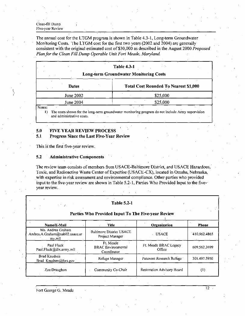
The annual cost for the LTGM program is shown in Table 4.3-1, Long-term Groundwater Monitoring Costs. The LTGM cost for the first two years (2002 and 2004) are generally consistent with the original estimated cost of $30,000 as described in the August 2000 Proposed Plan for the Clean Fill Dump Operable Unit Fort Meade, Maryland.
Table 4.3-1
Long-term Groundwater Monitoring Costs
Dates
June 2002
June 2004
Total Cost Rounded To Nearest $1,000
$25,000
$25,000 Notes:
1) The costs shown for the long-term groundwater monitoring program do not include Army supervision and administrative costs.
5.0 FIVE YEAR REVIEW PROCESS 5.1 Progress Since the Last Five-Year Review
This is the first five-year review.
5.2 Administrative Components
The review team consists of members from USACE-Baltimore District, and USAGE Hazardous, Toxic, and Radioactive Waste Center of Expertise (USAGE-CX), located in Omaha, Nebraska, with expertise in risk assessment and environmental compliance. Other parties who provided input to the five-year review are shown in Table 5.2-1, Parties Who Provided Input to the five-year review.
. . ^ • Table 5.2-1
Parties Who Provided Input To The Five-year Review ( •
Name/E-MaU Ms. Andrea Graham
Andrea. [email protected] my.mil
, Paul Fluck [email protected]
Brad Knudsen Brad Knudsen(a}fws.gov
Zoe Draughon
Title
Baltimore District USACE Project Manager
Ft. Meade BRAC Environmental
Coordinator
Refijge Manager
Community Co-Chair
Organization
. USACE
Ft. Meade BRAC Legacy Office
Patuxent Research Refuge
Restoration Advisory Board
Phone
410.962.4865
609.562.3699
301.497.5950
(I)
Fort George G. Meade 12

Clean-fill Dump Five-year Review ,
Table 5.2-1 :
Parties Who Provided Inpiit To The Five-year Review
Name/E-Mail Bob Stroud
stroud.robert(2),epa.eov
David Healy [email protected]
SherZaman Sher.Zaman@nf)h02.iisace.army.mil
Anisha J. Downs [email protected]
.mil
Title Federal Rernedial Project
Manager
State Project Manager
Baltimore, MD
Baltimore, MD
Organization
EPA
Maryland Department of Environment
USACE
USACE
Phone
410.305.2748
410.537.3344
410.962.3134
410.962.6730
Notes: l)Non-government phone numbers are not published.
From March to April 7, 2005, the review team established the review schedule whose components included:
Community Involvement; Document Review; Data Review; Site Inspection; Local Intervievvs; and
Five-year Review Report Development and Review.
The schedule extended through November 2005.
5.3 \ Community Involvement The public is being informed of the five-year review via a notice in a local newspaper (Baltimore Sun). The notice states that a recurring review is underway and will solicit members of the public to add their names as stakeholders if they wish. In addition, notice of the plan to perform the review was sent to the Fort Meade Restoration Advisory Board members.
After the draft five-year review report is complete, a notice will be placed in local newspapers to solicit comments from the public. A copy of the draft five-year review report will be included in the Administrative Record, which is available for public review. If the local community , response to the solicitation of comments is strong, a public meeting may be held in the surrounding community to encourage fiarther public participation in the review process and to address public questions and concerns. All public comments will be identified and responded to in the final five-year review report.
Fort George G. Meade 13

Clean-fill Eiump Five-year Review
5.4 Document Review
A review of relevant documents was performed for the five-year review. The list of documents reviewed is presented in Table 5.4-1, Documents Reviewed.
Table 5.4-1 Documents Reviewed
Documents and Information Source Remedial Investigation (1992) Remedial Investigation Addendum (1997)
Action Memorandum (2000)
Proposed Plan (2000)
Record of Decision (2002)
Long-Term Monitoring Plan (2002)
Summary of Contents Relevant to Five-year Review
Summarizes the Investigations conducted at Site. Addresses data gaps riemaining from the Rl and evaluates the extent and rate of migration of contaminants identified during the Rl. Also includes field investigation and an assessment of the resulting data, and risks to human health. Requests and documents the approval of proposed safety actions (institutional controls). The Proposed Plan states that the Army conducts long-term monitoring of the groundwater, and the selected remedy for the Site is protective of human health and the environment, and complies with federal and Maryland requirements that are applicable or relevant and appropriate.
Because this remedy will resuh in hazardous substances, pollutants, or contaminants remaining on-site above levels that allow for unlimited use and unrestricted exposure, a statutory review will be conducted within 5 years after the signing of the ROD to ensure that the remedy is and will continue to be protective of human health and the environment.
This decision document presents the selected remedial action for the Site and presents a.determination that no further action with groundwater monitoring is necessary to protect human health and the environment. The selected remedy represents a final,remedial action determination with respect to soils, groundwater, surface water, and sediments. This specifies the procedures to be used during the long-term groundwater monitoring at CFD, including inspection of the groundwater monitoring system, groundwater sarnpling, analysis, and reporting.
5.5 Data Review and Trends
In order to establish that the remedy is functioning as intended, a data review was performed to assess compliance with regulatory limits. The Fort Meade Environmental Partnership, which
Fort George G. Meade 14

Clean-fill Dump Five-year Review '
includes the Army, USEPA Region III, and Maryland Department of Environment, has selected six wells for groundwater monitoring every two years from the date the ROD was signed. The LTGM approach includes monitoring'of groundwater from the Lower Patapsco (water-table aquifer). The primary objective of the LTGM is to ensure that the remedy continues to provide adequate protection of human health and the environment. To accomplish this, groundwater monitoring will be conducted to demonstrate the following:
• contaminant concentrations are decreasing over time and new constituents are not appearing;
t
• contaminants are not migrating to potential off-site receptors; and
• metals concentrations are consistent with concentrations that are naturally occurring.
The following are the groundwater screening criteria for the LTGM program.
• National Primary Prinking Water Regulations, MCLs. These criteria are "legally enforceable standards that apply to public water systems [and] protect public health by limiting the levels of contaminants in drinking water" (USEPA, 2003). MCLs are published on USEPA's websiterwvvrw.epa.gov/safewater/mcl.htmV
• USEPA Region III Risk^Based Concentrations. Residential Groundwater Exposure. These criteria are health-protective chemical concentrations that are calculated using conservative residential exposure parameters, and are based on either a carcinogenic risk of lE-06 or a hazard index of 1, whichever produces a smaller RBC. The USEPA Region III RBC Table, April 2004 Update and associated documents are available at (http://www.epa.gov/reg3hwmd/risk/').
• Background Concentrations of Inorganics. Fort Meade aquifer-specific background concentrations for inorganics (USACE, 1998a and 1998b).
The 2002 Sampling Data
Maximum Contaminant Level Exceedance: Trichloroethylene: The MCL of 5 micrograms per liter (ug/1) is exceeded in monitoring well CFD-3S (12.4 ug/1), and down gradient in CFD-5 (11.2 ug/1). Both wells are screened at the shallow water table. These detections may not be related because this chemical was detected at a much lower concentration at the intermediate monitoring well WP-2. This detection in WP-2 (1.5 ug/1) is below both the MCL (5.0 ug/1) and the reporting limit (2.0 ug/1) for trichloroethylene.
RBC Exceedances: Tetrachloroethylene, TCE, arsenic, and iron were detected at concentrations exceeding RBCs.
Fort George G. Meade

Clean-fill Dump Five-year Review
Background Exceedances: The background concentrations selected for inorganics are the highest concentrations measured in the aquifer-specific background monitoring wells (USACE, 1998a and 1998b). The background monitoring well for the Lower Patapsco aquifer is well ODAMW-6D, located at the Ordnance Disposal/Demolition Area. Arsenic and iron exceeded RBCs and background concentrations. Calcium, magnesium, manganese, sodium, and zinc also exceeded the background concentrations although they did not exceed the MCL and RBC concentrations.
The 2004 Sampling Data
Maximum Contaminant Level Exceedances: Tetrachloroethylene: The MCL of 5 |j,g/l is exceeded in monitoring well CFD-3S (47 ng/1), which is screened at the shallow water table in the Lower Patapsco Formation. PCE was not detected in any other sample.
Trichloroethylene: The MCL of 5 jag/l is exceeded only in monitoring well CFD-3S (14 )j.g/l), which is screened at the shallow water table. TCE was detected in two other samples (CFD-5 and its duplicate), though at low, estimated concenfrations.
Aluminum: The MCL of 50 |u,g/l is exceeded only in monitoring well WP-2 (213 M.g/1), ' which is screened at the shallow water table. Aluminum was not detected in any other
sample.
Arsenic: The MCL of 10 ̂ g/1 is exceeded only in monitoring well CFD-5 (26.5 and 29.7 ^g/1 for the primary and duplicate samples, respectively), which is screened at the shallow water table. Arsenic was also detected in shallow well CFD-3S, though at a low, estimated concentration. ^
Iron: The MCL of 300 ^g/l is exceeded in shallow water table wells CFD-3S (5370 |4.g/l), WP-2 (795 ng/l), and CFD-5 (13,200 and 15,800 ^g/1 for the primary and duplicate samples, respectively), as well as in deep aquifer well WP-6 (560 |ig/l). Iron was not detected in other samples.
Manganese: The MCL of 50 ^g/l is exceeded in shallow water table wells CFD-3S (126 )iig/l), WP-2 (69.5 Mg/I), and CFD-5 (344 and 401 ng/l for the primary and duplicate samples, respectively). Manganese was also detected in deep aquifer wells MWC-3 and WP-6, though at much lower concentrations (28.3 and 26 |ig/l, respectively).
RBC Exceedances: Tetrachloroethylene: The RBC of 0.104 |ug/l is exceeded in shallow water table well CFD-3S (47 iag/1) only. PCE was not detected in any other sample.
Fort George G. Meade
Clean-fill Dump Five-year Review
Trichloroethylene: The RBC of 0.0264 |ug/l is exceeded in shallow water table wells CFD-3S (14 |ig/l) and CFD-5 (0.61 and 0.6 (j.g/1 for the primary and duplicate samples, respectively). TCE was not detected in any other samples.
Arsenic: The RBC of 0.0446 )a.g/l is exceeded in shallow water table wells CFD-3S (5.43 |j,g/l) and CFD-5 (26.5 and 29.7 jxg/l for the primary and duplicate samples, respectively). Arsenic was not detected in any other samples.
Iron: The RBC of 1100 )ig/l is exceeded in shallow water table wells CFD-3S (5370 ^g/1) and CFD-5 (13200 and 15800 ng/1 for the primary and duplicate samples, respectively). Iron was also detected in shallow well WP-2 and deep well WP-6, though at concentrations below the RBC.
('"
Background Exceedances: The background concentrations for inorganics are concentrations measured in an aquifer-specific background monitoring well (USACE, 1998a and 1998b). The background monitoring well for the Lower Patapsco aquifer is well 0DAMW-6D, located at the
. Ordnance Disposal/Demolition Area. Note that the background concentrations correspond to single analytical results rather than being the result of statistical analysis i.e., a 95% upper tolerance limit.
The following metals were detected above their corresponding background concentration:
• Arsenic, ^ • Barium, . • Calcium, • Cobalt, • Iron, • Magnesium, • Manganese, • Nickel,. • Potassium, • Sodium, and • Zinc.
Based on the 2002 and 2004 LTGM data (Table 5.5-1, Groundwater Results and Comparison to Screening Criteria), groundwater contamination appears to be of limited extent as indicated by distribution of exceeded levels in the groundwater screening criteria. The concentrations of TCE and PCE in monitoring well CFD-3S immediately down-gradient of the CFD are greatly reduced to either estimated concentrations (b-flagged), below the method detection limit, or non-detected. Concentrations at monitoring well CFD-5 adjacent to the Little Patuxent River, indicate lower organics concentration as shallow groundwater flows toward the river. The 2004 sampling data for PCE is slightly greater than in 2002 sampling event, but less than 1996 Remedial Investigation Addendum (RIA). The 2004 sampling data for TCE is greater than the 1996 RIA and the 2002 sampling event. In addition, aluminum, arsenic, iron, and manganese, four
17 Fort George G. Meade

Clean-fill Dump Five-year Review
commonly detected groundwater metals at the Site, are the inorganic parameters that exceeded the screening criteria. These exceedances were detected down-gradient of the CFD near the UWS, and may be associated with its contents. HistiDric results for chemicals that currently exceed screening criteria are presented in Table 5.5-2, Historic Results for Chemicals that Currently Exceed Screaiing Criteria. Because both VOCs and metals exceeded screening criteria, continued sampling and analysis for these constituents is recommended. The analytes recommended for sampling are shown in Table 5.5-3, Analytes Recommended for Sampling.
18 Fort George G. Meade

TABLE 5.5-1
Groundwater Results and Comparison to Screening Criteria Clean Fill Dump Operable Unit
Fort IMeade^ Maryland
Well
Sample Collection Date'' Screen Intenal (b8S) -Approximate screen depth below water tabic
UpRradient/Downwadicnt (U/D)
Field Paramelers Dissolved 0.\-ygen (pg/l) REDOX Potential (mv) pH Turbidity (NTU)
yolalite Organic Chemicals C1S-1.2-D1CHLOROETHENE TETRACHLOROETHENE TOLUENE ) TRANS-1.2-D1CHL0R0ETHENE TRICHLOROETHENE
Dissolved Melals ALUMINUM
• ARSENIC BARIUM CALCIUM COBALT COPPER IRON MAGNESIUM MANGANESE NICKEL POTASSIUM SODIUM VANADIUM ZINC
Screened at Water Table CFD-3S 6/3/2002 4 5-9.5
D
(b) (c) (d) <c)
8.20 -28
5.13 12
14.2 25.8
bdl bdl
124
bdl bdl
3810
3860 k ' w bdl
82.4
bdl UL w
87.3
CFD-3S 4/9/2004 4.5-9.5
D
6.6 .
< 1 , U < 1 U . 14
<200 U UL 0 5.43 J B 0
26 3520 19.8 B o
< I 0 U .5370 2750
126 35.3
<2000 U UL o 4290 < 10 U UL 0
65.8
WP-2 .
. 6/4/2002 2.5-S.5
D
0.08 -103.9
5.64 5
1.0 1. bdl
. bdl bdl 1.5 1
276 bdl
31400
938 bdl 54
bdl
bdl
WP-2
' 4/9/2004 2.5-5.5
D
AA
AA
A
AA
AA
CCCCC
.CCCC
213 • < 10 U UL 0
15.2 29400 5.56 I B 0 <10 U 795
3820
69.5 <20- U UL 0
2070 L 0 2450 6.11 J B 0 649 J B 0
CFD-5
6/4/2002 3 - 8
D
0.05 -50.5 6.24
28
3.9 bdl bdl
0.52 I 11.2
bdl
52200
13000 k w 5740
229
10000' L w
96.4
CFD-5
4/8/2004 3 - 8
D
1.7 <'l U <1 U 0.25 I
1.7 <1 U <1 U 0.25 • J 0.61 J
<200 U 26.5
26 99000 7.19 J < 10 U
UL 0 B 0
UL 0 13200 10300
344 <20 U 3570 15400 <10 U 67.5
UL 0
UL 0
Method Detection
Limit'"
1 . 1 1 1
1 i 1 1 1
200 10 10'
1000 10 10
200 1000
10 20
2000 1000
10 10
Scireninp Criteria 1 USEPA
Drinking Water Maximum
Contaminant
Uvel
70 5
1000 100
7(1 5
1000 100 5
50 10
2000
1000 300 ^
50
5000
USEPA Region 111 Risk-Based Criteria (4/051
Value"" Basis/Source"'
O.OOE+OO 0 OOE+00 O.OOE+00 O.OOE+OO Selected O.OOE+00 RBSC Basis/Sourcc{3)
6.08E+01 N/P/~ I.04E-0I C/O/O
7.47E+02 N / m l.OOE+02 N / 1 / -2.64E.02 C/E/E
3.65E+04 N/P 4.40E-02 C/1 2.56E+03' N/1
7.30E+O2 N/P 1.46E+03 N/H l.lOE+04 N/E
7.30E+02 N/1 7.30E+O2 N/1
3.65E+01 N/E 1.10E+<14 N/1
Background Concentration in Lower Patapsco
Aquifct"'
N/A N/A N/A N/A
N/A N/A N/A N/A N/A
2 13.4
5430 12.1
12.7 •574 45.1 13.6
3840 2850
51.9

TABLE 5.5-1 (Com.)
Groundwater Results and Comparison to Screening Cr i ter ia Clean Fi l l Dump Operable Unit
Fort Meade. Maryland
A/ell
Jampic Collection Date '"
Screen Interval (bgs)
^^^oximate screen depth below water table
^teld Paramettn Dissolved Oxygen f pg/l) REDOX Potential (mv)
pH Turbidity (NTU)
'ohiile Organic Chemicals ClS-1,2-DICHLOROETHENE TETRACHLOROETHENE ,
TOUJENE TRANS-l,2-DICHLORl)ETHENE TRICHLOROETHENE
r)isiohvd Melals /U.UWINIJM /ARSENIC
B /yyuM CALCIUM COBALT COPPER [RON -. MAGNESIUM MANGANESE NICKEL POTASSIUM SODIUM VAN/U3HJM
. ZINC
CFD-5DP
6/4/2002
3-8
D
9.05 18
4 44 • . 17
bJl bdl
bJl Kil IxU
bd] bJl
4100
bdl 5320 78.9'
5470 L w
35.4
CFD-SDP
4/8/2004
3-8
D
1 4 <1 U <1 U •
0 23 J
1 4 <1 U
<1 u 0 23 J
S«0-6SE.Wi,»5SIB
<200 U UL o jK-2'J>7*aW>i3flB5S!ni
29 9 117000 6 05 J B 0 <10 U UL 0
mctinmiamssaiaE 12200
tflnoiufflEswawK <20 U UL o
4270 18600 < 10 U UL o 7J5
Water Tshle MWC-5
6/3/2002
- 3 1 - 4 1
U
9 05 I 8
4.44 17
bdl bdj
bdl bJl IxU
bdl bdl
4100
bdl 5360 79.1
5400 L w
34 3
MWC-5
4/12/2004
31-41
U
< l U <1 U
< 1 U . < 1 U
< l U <l u <1 u <1 u < 1 [J
<200 U UL 0 < 10 • U UL 0 < 10 U UL 0
< lOOO U UL 0 < 1 0 U < 10 U tJL 0 <200 U
< 1000 (J . < 10 U ' UL 0 <20 U UL 0
<2000 U < 1000 U UL o
< 10 U UL o < 1 0 U Ul. o
-MWC-3
6/3/2002
29 - 39
27
' D
3.71 -1]
4.40 17
bJI Ml
bdl hdl bdl
bdl bdl
28IJO
hil bdl
26.2
bdl tX w
bdl
Ser^iKd Below Water Table MWC-3
. 4/9/2004
29-39
27
D
<1 U • <1 U
0.85 J < 1 U
< 1 U <1 U
0.85 J • < l U
<200 U UL 0 < 10 . U UL o 21.1 3400 10.7 B o
<10 U <:oo u tx 0 2340 28 3 < 2 0 U UL o 1320 J L o 8540 < 10 U UL 0 9.66 J B o
. WP-6
6/4/2002
44 -54
6
3.30 -59.2
4 25 25
bdl bdl
0.62 B X bdl IxU
bdl bdl
1220
378 k w bdl
193
bdl UL w
bdl
WP-6
4/12/2004
44-54
6
< l U <1 U .
3.9 <1- U
< l U < l U
3.9 • <1 U
<\ u
<200 U UL 0 < 10 U UL i
' 6.9 J 1800 B X 8 6 J B o 9 5 J L 0
mi6liBSt:fMf.lMl 980 J 26 IS 3
1300 J 3800 < 10 U UL 0 .44
. Melhod
Detection
Limit'"
1 1
1 1
1 1
1 1 1
200 10 10
1000 10 10
200 1000
10 20
' 2000 1000
10 10
USEPA
DiuJdng Water
Maximum
Contaminant
70 5
1000 100
70 5
1000 100 5
50 10
2000 •
-_ 1000
300
50
_ _ -5000
USEPA Region 111
Value'** Bans/Source'^'
0 OOE+00 OOOE+OO O.OOE+flO D.OOE+00
Selected O.OOE+OO RBSC .Basi3/Source(3)
6 08E+OI N/P/-104E-0I c / a v
7.47E+02 N/M 1.06E+<12 N/I/~ 2.64E-02 C/E/E
3.65E+04 N/P 4.46E-02 C/I 2.56E+03 N/I
-7 30E+O2 N/P . 1.46E+0! N/H
l.lOE+04 N/E
7.30E+O2 N/1 7.30E+O2 N/1
_ _ 3.65E+OI N/E
l.lOE+04 N/1
Background Concentration in
Lower Patapsco
Aquiler'"
• N/A N/A
N/A N/A
N/A N/A
N/A N/A N/A
134 5430 12.1
12.7 574 45.1 13.6
3840 2850.
_ 51.9
(a) AnalysiJ dales are in ihc labiiratory reports (Appendix A and B)' (h) All results are shown in unila or ^g/1. (c) Laboratory tlags:
D. The result is from a cbfuted sample. J: The analyte is posilively identified ani the rcsull is less than the
Reporting Limitbut less than tlie Method Deleciion Limit. U The analyte was not deleutiKj.
(d) Laboratory data v^alidation Hags:
UL- Not dctcclcd. quaniitalion limii is probably higher. B: Not detected substantially abow the lc\xl reported in laboratory • or field blanks.
K: Anatyte present Reported wluc may be biased high Actual \'aluc IS expected to be lower.
L Analyte present. Reported value muy be biased low Actual \-a]\x IS expected to be higher.
(e) Laboratory dita v-alidalion reason code'
o: Calibration blank contammalion
>: Field blank conionunation c' Calibraticoi failure, w Retention time failure
(0 Acorrprehensivclisi of MDLs in included in Appendix D.
(h) Key to Basis/Source
Variable X RBC [>pe
v. Oral toxicity criterion source, and ?,. Inhalation toxicity source,
where applicable
Possible Values :; = Carcinogenic ^ = Noncarcinogenic
£ = EPA-NCEA ProMsional Value 1 = IIEAST = IRIS
3 = Other » = USEPA Pro\isional Pecr-Revicwed
Value
(i) Background corKentralion of metals in the Lower Patapsco Aquifer are taken from (USACE 1998J and 1998b).
Key to Screening Criteria Exceedcnces:
^ ^ ^ i i ^ ^ Etceeds MCL. RBC. or Background ConcentiaUon
wAfre
MCL = Natior»l Primary Drinking Water Regulations, Maximum Contaminant Level RBC = USEPA Region 3 Riiik-Based Concentrationa - residential groundwater exposur
(g) See Table 5.5-1 A for deri\Tition of USBPA Rcgioi Risk-Based Criieria
III

TABLE 5.5-lA
Calculation of USEPA Region III Risk-Based Criteria (RBCs) for Residential Exposure to Groundwater Clean Fill Dump Operable Unit, Fort Meade, Maryland
CARCINOGENIC:
R B C M S / L =
-• -
TRx ATcxIOOOuR/ma
EFr X |(K X IFAadj x CPSi) + OFWadj x CPSo)l
wliere
TR ATc EFr
K
IFAadj CPSi
IFWadj CPSo
= = = -
= = -
Target risk Averaging ume, carcinogens Exposui« frequenc>'. residential
Volatilization factor
Inhalation factor, age-ajusted Inhalation carcinogenic polenc>' slope
Tap water ingestion factor, age-adjusted Oral carcinogenic potenc>' slope •>,
1 OOE-06 25550 350
0.5
11.66' Anal>1e specific 1.09
Analxle specific
(unilless) dajs days/^ear
Urn '
(nl'-year)/(kg-day)
risk/(mg/(kg-da>)) (L-year)/(kg-day)
risk/(mg/(kg-da>))
NON-CARCINOGENIC:
RBCue /L = THO X BWa X ATn X 1000 uc/mc
EFr X EDtot x |(K x IRAa/RfDi) + IRWa/RIDo|
/
w+iere .
THQ
BWa ATn
EFr
EDtot
K.
IRAa RIDi
IRWa RIDo
= = = =
= = = = ~
Target hazard quotient
Body weifihL adult Averaging lime, non-cajcinogens
Exposure frequency, residential
Exposure duration, residential (total)
Volatili7,ation factor
Inhalation tate. adult
Inhalation reference dose
Tap water ingestion rate, adult Oral reference dose
. 1.OOE+00
70 10950
350
30
0.5
20
Analyle specific
2 Analyle specific
(unitless)
kg dayii (EDlot«365)
days/>eai
yeai^
Urn'
nt/dav
mg/(kg-dav)
Uday nig/(kg-day)
Chem Class/AnalMe
Volatile Organic Chemicals CIS-I,2-DICHL0R0ETHENE .
TETRACHLOROETHENE
TOLUENE
TRANS-1.2-DTCHL0R0ETHENE
TRICHLOROETHENE
Total Metals ALUMINUM
ARSENIC
BARIUM
CALCIUM
COBALT
COPPER
IRON .
MAGNESIUM
CAS
I5S-59-2
127-18-4
108-88-3
" " 156-60-5
79-01-6
7429-90-5
7440-38-2
7440-39-3
7440-70-2
7440-48^
7440-50-8
. 7439-89-6
7439-95-4
Carcinoeenic
CPSo
-
5.40E-0I
_ -
4.00E-0I
• - •
I.50E+00
• -
---
• -
_
CPSi ' "
-2.00E-02
--
4 00E-01
n/a
n/a
n/a
n/a
n/a
n/a
n/a
n/a
RBSC?"
~ I.04E-01
_ -
2 64E-02
-. 4.46E-02
- •
-----
Non-carcinoeenic
RIDo
l.OOE-02
l.OOE-02
2.00E-01
2 00E-02
3.00E-04
.1.OOE+00
3.00E-O4
7.O0E-O2
• -
2 OOE-02
4 OOE-02
3.00E-0I
-
RfDi '"
I.40E-0I
• 1.I4E-01
-l.OOE-02
n/a
• n/a
ti/a
n/a
n/a
n/a
n/a
n/a .
RBSC'"
6.08E+01
2.69E+02
7.47E+02
I.22E+02
9.52EtO0
3.65E+04
l.lOE+01
2 56E+03
• -
7.30E+02
1.46Et03 •
l.lOE+04
-
Selected 1
RBSC
6.08E+01
1.04E-01
7.47E+02
I.22E+02
2.C4E-02
3.65E+04
4.4CE-02
2.56E+03
-7:30E+<)2
1.46E+03
.i.lOE+04
-
Basis/Source'"'*
N/P/~
C/O/0
• N/M
N / I / -
C/E/E
N/P
C/I
N/1
-N/P
N/H
N/E
_

TABLE 5.5-lA
Calculation of USEPA Region III Risk-Based Criteria (RBCs) for Residential Exposure to Groundwater Clear! Fill Dump Operable Unit, Fort Meade, Maryland
Chem Class/AnalMe
MANGANESE NICK£L /
POTASSIUM )
SODIUM
VANADIUM
ZINC
CAS
7439-96-5 7440-02-0
2023-69-5
7440-23-5 7440-62-2
7440-66-fi
CarcinoEenic
CPSo
-----
CPSi'"
n/a n/a
n/a
n/a
n/a
n/a
RBS(f-'
--- •
-• ~
-
Non-carcinoeenic RfDo
2.00E-02 2.O0E-O2
-- •
I.00E-03
3.00E-OI
RIDi'"
n/a
n/a
n/a-
n/a
n/a
n/a
RBSC'''
7.30E+02 7.30E+02
--
3.65E+0I
. l.lOE+04 .
Selected 1 RBSC
7.30E+02 7 30E+02
~ 3.05E+O1
l.lOE+04
Basis/Source'̂ *
N/I N/I
-. -
. N/E
N/I
Note: RBSC formulas and variable values taken from "EPA Region III Risk-Based ConcenUaUon Table: Technical Background Infonnaiion". available at http:/Avww.epa.gov/reg3hw7nd/risk/tech99.pdf
(1) Inhalation slope factors and reference doses presented and RBC volatilization terms calculated only for analytes having a HenT\''s Law constant greater than. 10' and a moleciJar weight less than 200 (USEPA. 1999). _ ,
(2) Oral potency slopes and reference doses are used for both oral and inhaled e\posiires for volatile compounds lacking inhalation values.
(3) Basis/soiu-ce is in the formal XA'/Z, where:
Variable X RBC type
V: Oral toxicity criterion source, and I: Inhalation toxicit>- sourtie,
wliere applicable source
Possible Values C = Carcinogenic N = Noncarcinogenic
E = EP A-NCEA Provisional Value H = HEAST [ = IRIS 0 = Other P = USEPA Provisional Peer-Reviewed
Value

TABLE 5.5-1 A
Calculation of Groundwater Screening Criteria from Recommended Daily Allowances / Adequate Intakes for Essential Nutrients
Clean Fill Dump Operable Unit, Fort Meade, Maryland
1 IGROUNDWATERCRITERU .
• V
Groundwater Screening =
. C^leria(^g/L) ^" '̂•'
""̂
RDA/AIxlOOOnR/niR
X EF X ED X year/365 days) / AT
Parameter Definition
. RDA/Al = Recommended Daily Allowance/Adequate Intake
IRw = Tap water ingestion rate
-adult resident -child resident - commercial/industrial
worker
EF = Exposure frequency
- residential - commercial/industrial
ED = Exposure duration
- adult resident - child resident - commercial/industrial
worker
AT ' = Averaging time
- adult resident -child resident - commercial/industrial
worker
Value
nutrient-specific
. 2
2
350 250
30 6 25
30 6 25
Units 1
ntg/day
L water/day L water/day L water/day
days/year. days/year
years years years
years years years

TABLE 5.5-1 A
Calculation of Groundwater Screening Criteria from Recommended Daily Allowances / Adequate Intakes for Essential Nutrients
Clean Fill Dump Operable Unit, Fort Meade, Maryland
Nutrient Reference CAS
Calcium Magnesium Potassium Sodium
(d) (d) (c). (c)
7440-70-2 7439-95-4 2023-69-5
. 7440-23-5
RDA/Ai' Adult
"' (mg/dav) Child
800 130 1600 400
210 30 500 120
Groundwater Screening Criteria (ng/L) |
Adult Resident
Child Resident
4.2E-H)5 6.8E-H)4 8.3E-K)5 2.1E-H)5
2.2E+05 3.1E-+<)4 5.2E-H)5 1.3E-H)5
Coirimercial/ Industrial
5.8E-K)5 9.5E+04 1.2EK)6 2.9E+05
Selected Criteria (Minimum)
2.2E+fl5 3.1E+04 5.2E+05 1.3E+05
(a) RDA/AIs for calcium and magnesium represent the lower end of the RDA/AI for persons 7 years old and over (adults) and 6 years old and under (children).
(b) RDA/AIs for potassium and sodium represent the lower end of the minimum requirement for healthy persons 7 years old and over (adults) and 6 years
old and iander (children). See Table 11-1 of reference (c) below.
(c) Recommended Dietary Allowances, 10th edition ©1989 by the National Academy of Sciences (National Academy Press, Washington. D.C.)
(d) Dietary Reference bitakes for Calcium, Phosphorus, Magnesium, Vitamin D, and nuoride. ©1997 by the Standing Committee on the Scientific Evaluation of Dietary Reference Intakes, Food and Nutrition Board, Institute of Medicine (National Academy Press, Washington, D.C.)

Clean-fill Dump Five-year Review
Table 5.5^2
Historic Results for Chemicals that Currently Exceed Screening Criteria
' I
Chemicals Maximum Detection (ug/1) Wells CFD-3S, CFD-5, MW(3-3, MWC-5, WP-2,
and WP-6 Only RIA,1992 RI,1996 2002
Sarnpling
TCL V O C s Tetrachloroethylene (PCE) Trichloroethylene (TCE)
37
5.4
60
8.4
25.8
12.4
2004 Sampling-
' '
47
14
Screening Criteria (ug/l)^'^
MCL RBC
5 .
5
.104
.0264
TAL Metals Aluminum
Arsenic Iron
Manganese
1 . . ,j MCL-Exceede
1 1 RBC-Exceede *MCL-Maximum Conta *RBC- EPA Region III '̂̂ MCLs and USEPA R
(not known)
62.8 (not
known) (not
known)
360
43.3 20,100 ..
178
276
31 13,000
1
229
d
d miriation Levels Risk- Based Conce egion III RBC sere
ntration ening values ar e presented for co
213
26.5 13,200
401
mparison
50
10 300
50
36,500
.0446 11,000
730
Fort George G. Meade 25

Clean-fill Dump Five-year Review
Table 5.5-3
Analytes Recommended for Sampling
Well ID CFD-3S " CFD-5 MWC-3 MWC-5 WP-2 WP-6
TCL VOCS X X X X X X
TAL Metals* X X X X X X
TAL-Target Analyte List c TCHarget Compound List VOC-Volatile Organic Compound / • TAL Metals samples will be filtered in the field.
5.6 Site Inspection
Inspections were conducted on May 11, 2005, by USACE (Appendix C). The purpose of the inspections was to assess the protectiveness of the remedy, and ability of the controlled entry points to restrict unauthorized access. Review of the property deed confirmed that a deed covenant had been filed. No significant issues have been identified at any time regarding the effect of frost heave, erosion, the condition of monitoring wells, and the enforcement of ICs.
The institutional controls that are in place include prohibitions on the use or disturbance of groundwater, except Tor conducting environmental studies, until cleanup levels are achieved, and any other activities or actions that might interfere with the implemented remedy. No activities were observed that would have violated the institutional controls. The site and surrounding area were undisturbed (locked and secure), and no new uses of groundwater were observed.
5.7 Interviews
Interviews were conducted with various parties associated with the Site via a questionnaire. Mr. Brad Knudsen, Patuxent Research Refuge Manager; Kim Gross and Allie Ginter, Ft. Meade BRAC Environmental Coordinator, responded to the questionnaire. Other Patuxent Research Refuge (PRR) workers were also interviewed on May 11, 2005. The Site is located in the PRR so there were no nearby residents that needed to be interviewed. No significant problems were identified during the interviews. However, Mr. Brad Knudsen noted that he is not familiar with the overall monitoring plan, and any accomplishments made thus far. Interview questions were also sent to Ms. Kim Gross and Ms. Allie Ginter. Future LTGM reports will be provided to the FWS.
Fort George G. Meade 26

Clean-fill Dump Five-year Review
6.0 FINAL SITE ANALYSIS 6.1 Question A: Is the Remedy Functioning as Intended by the Decision Document?
Yes: review of the LTGM program results, relevant documents, applicable, or relevant and appropriate requirements (ARARs), risk assumptions and the results of the on-site inspection indicates that the remedy is functioning as intended by the ROD. The remedy is no further action with groundwater monitoring to protect human health and the environment. Six wells (CFD-3S, CFD-5, MWC-3, MWC-5, WP-2, WP-6) are sampled every two years to monitor the concentrations of VOCs and metals.
The effective implementation of institutional controls has prevented exposure to or ingestion of contaminated groundwater. Operation and maintenance (O&M) of monitoring wells has been effective. O&M biannual costs are generally consistent with original cost estimates.
The institutional controls that are in place include prohibitions on the use or disturbance of groundwater until cleanup levels are achieved, except for environmental studies, and any other activities or actions that might interfere with the implemented remedy. No activities were observed that would have violated the institutional controls. The CFD area was undisturbed, and no new uses of groundwater were observed. There were signs posted to warn that the area is not to be accessed. The fence around the site is intact, in good repair, and securely locked.
There are opportunities for system optimization. As set forth in the ROD, groundwater monitoring wells will be sampled and analyzed every two years from the day the ROD was signed. The ROD also states that after completion of the groundwater monitoring, a comparison of the data will be made using statistical methods to determine if there have been any changes to groundwater quality due to the presence of contamination. Groundwater monitoring will be conducted to demonstrate that metals concentrations are consistent with concentrations-that are naturally occurring.
Based on the data reviewed, no comparison of the data were made using statistical methods to determine if there have been any changes to groundwater quality due to the presence of contamination. A statistical evaluation should be performed to compare down-gradient (site-related groundwater contamination) to up-gradient (background) concentrations. A statistical comparison of site and background groundwater would typically require on-going testing of multiple up-gradient background wells. If groundwater data that date to 1992 are available, there may be adequate data for some limited statistical evaluations of up-gradient and down-gradient results. However, if no data are available, adequate data should be collected in the future to perform a statistical evaluation. This seems critical for naturally-occurring metals that are present at concentrations that exceed risk-based decision limits. The risk-based decision limits will not be achieved and the termination of groundwater monitoring will be primarily dependent upon the background and site groundwater comparisons.
27 Fort George G. Meade

Clean-fill Dump , Five-year Review -
6.2 Question B: Are the Exposure Assumptions, Toxicity Data, Cleanup Levels, Remedy still Valid?
Yes: there have been no changes in the physical conditions of the site that would affect the' protectiveness of the remedy. The ARARs that still must be met at this time and that have been evaluated include the Safe Drinking Water Act (40 CFR 141.11-141.16) from which many of the groundwater cleanup levels were derived - (MCLs, and MCL Goals). Changes in exposure pathways, toxicity, and other contaminant characteristics used to develop the Human Health Risk Assessment included both current exposures (older child trespasser, adult trespasser) and potential future exposures (young and older future child resident, future adult resident and future adult worker). There have been no changies in the toxicity factors for the contaminants of concern that were used in the baseline risk assessment. These assumptions are considered to be conservative and reasonaible in evaluating risk and developing risk-based cleanup levels. No change to these assumptions or the cleanup levels developed from them is warranted.
6.3 Question C: Has any other Information come to light that could call into Question the Protectiveness of the Remedy?
No: there are no complete pathways from the contaminated groundwater to ecological receptors. Therefore, monitoring of ecological targets is not necessary. No weather related events have affected the protectiveness of the remedy. There is no other information that calls into question the protectiveness of the remedy.
6.4 Technical Assessment and Summary of Remedy Protectiveness
According to the data reviewed, the site inspection, and the interviews, the remedy is functioning as intended by the ROD. There have been no changes in the physical conditions of the site that would affect the protectiveness of the remedy. There have been no changes in the toxicity factors for the contaminants of concern that were used in the baseline risk assessment, and there has been no change to the standardized risk assessment methodology that could affect the protectiveness of the remedy. There is no other information that calls into question the protectiveness of the remedy.
7.0 ISSUES, RECOMMENDATIONS, AND FOLLOW-UPS
There are no immediate issues that impact the protectiveness of the remedy. Therefore, recommendations for the Site are to continue the LTGM program until MCLs/RBCs are achieved. , )
For any fijture sampling, it is recommended that the reporting limits for analytes be in compliance with the DoD Quality Systems Manual or the USACE "Shell" (EM 200-1 -3, Appendix I). The current reporting limits for select analytes are not in compliance with the USACE "Shell". The reporting limits should be at least three times greater than the corresponding maximum detection limits.
28 Fort George G. Meade

Clean-fill Dump Five-year Review
Cis-1, 2-Dichloroethylene is jjresent in some of the down-gradient wells. This indicates there is or was some reductive de-chlorination of DCE in the ground water. It is recommended that during the next sampling event the following chemical parameters be added to the list of those currently being done: TOC, Fe++, S04/SQ3, and N03/N02. This will provide information on the rate of TCE removal in the ground water from reductive de-chlorination and thus some information on the length of time it will take the ground water to meet MCLs. Also, it is recommended that concentration of vinyl chloride in the ground water be reported.
8.0 PROTECTIVENESS STATEMENTS
The remedy is expected to be protective of human health and the environment upon attainment of groundwater cleanup goals, through natural attenuation. In the interim, exposure pathways that could result in unacceptable risks are being controlled, and institutional confrols are preventing exposure to, or the ingestion of, contaminated groundwater. All threats at the Site have been addressed through gates and warning signs, and the implementation of institutional controls. Long-term protectiveness of the remedy will be verified using data obtained from the LTGM program. Current data indicate that the groundwater contamination remains on site. Additional sampling and analysis will be completed within.the next six months. Current monitoring data indicate that the remedy is fiinctioning as required. -
9.0 NEXT REVIEW
The next five-year review is required by September 2010, five years from the date of this review.
• ' ' • 29 Fort George G. Meade

Clean-fill Dump Five-year Review
lO.O REFERENCES
U.S. Army Environmental Center (USAEC), 1989. Enhanced Preliminary Assessment Report: Fort George G. Meade, Maryland. Final. Environmental Research Division, Argonne, IL. October 1989.
USAEC, 1992a. Fort George G. Meade Base Closure Parcel Site hispection Study, Vols. I and II. Final. EA Engineering, Science, and Technology, Inc. Sparks, MD 21152.
USAEC, 1992b. Fort George G. Meade Active Sanitary Landfill and Clean Fill Dump Remedial Investigation Report. Final. Kilmer, K., et. al.; EA Engineering, Science, and Technology, Inc., Sparks, MD, December 1992.
USAEC, 1993. Feasibility Study (FS) and Remedial hivestigation/Site hispection (RI/SI) Addendum for Fort George G.̂ Meade, Maryland. Final. Arthur D. Little, Inc., Cambridge, MA., November 1993.
USAEC, 1997. Remedial Investigation Addendum: Fort George G. Meade Feasibility Study and Remedial Investigation/Site Inspection Fort George G. Meade, Maryland. Final. Arthur D. Little, Inc. Cambridge, MA., May 1997
U.S. Army, 2000. Record of Decision Clean Fill Dump (CFD) Operable Unit. Fort George G. Meade. Fort Meade, Maryland. U.S. Army Fort George G. Meade, September 2000.
U.S. Army, Action Memorandum Safety Precautions to be taken at Clean Fill Dump Fort Meade George G. Meade, Maryland. Final.U.S. Army Fort George G. Meade. July 2000.
USEPA, Comprehensive Five Year Review Guidance. EPA 540-R-01-007,OSWER No. 9355.7-03B-P, Washington, D.C. 20460. Final. June 2001. ,
J
USACE, 1998a. Fort George G. Meade, Inactive Landfills 1, 2, 3, and Clean Fill Dump Rernedial Investigation Report. Final Document. ICF Kaiser, August 1998.
USACE, 1998b. Fort George G. Meade, Helicopter Hangar Area and Fire Training Area Remedial Investigation Report. Final Document. ICF Kaiser, October 1998.
USACE, Long-Term Biennial Groundwaer Monitoring Results for Clean Fill Dump (CFD) Operable Unit (OU) Spring 2002. Final. URS Corporation. July 2003.
USACE, Long-Term Biennial Groundwater Monitoring Resuhs for Clean Fill Dump (CFD) Operable Unit (OU) Spring 2004. Draft Final. URS Corporation. September 2004.
30 Fort George G. Meade

Clean-fill Dump Five-year Review
APPENDIX A
Site Inspection
• 31 Fort George G. Meade

Questionnaire - Group 1 Site Name: Clean Fill Dump, Fort G. Meade File No.;
Subject: Comprehensive Five-Year Review Date: 31 May 2005
Contact Information: Name: Allie Ginter Organization: Fort Meade
Telephone No:
Fax No:'̂
E-Mail Address:
Street Address: City:
State, Zip:
Questions and Comments
Background Information
1. What is your overall impression of the project? (general sentiment)
5 Year Review are required to assess current and future conditions.
2: What effects have site operations had on the surrounding community?
None that I am aware of
3. Are you aware of any community concerns regarding the site or its operation and administration? If so, please give details.
N o . " - ••
4. Are you aware of any events, incidents, or activities at the site such as vandalism, trespassing, or emergency responses from local authorities? If so, please give details.
No. ' \
5. Do you feel well informed about the site's activities and progress?
Yes. '

6. Do you have any comments, suggestions, or recommendations regarding the site's management or operation?
No. ' , '
State and Local Considerations
1. Have there been routine communications or activities (site visits, inspections, reporting activities, etc.) conducted by your office regarding the site? If so, please give purpose and results. • • '
No.
2. Have there been any complaints, violations, or other incidents related to the site requiring a response by your office? If so, please give details of the events and results of the responses.
No.
3. Do you feel well informed about the site's activities and progress?
Yes.
LTO/LTM Considerations
1. What is the current status of construction (e.g., budget and schedule)? None.
2. Have any problems been encountered which required, or will require, changes to this remedial design or the decision documents?
No.
3. Have any problems or difficulties been encountered which have impacted LTO/LTM progress or implementability? N o . • :
4. Do you have any comments, suggestions, or recommendations regarding the project (i.e., design, construction documents, constructability, rhanagement, regulatory agencies, etc)? No.

Perfornfiance
1. Is the remedy functioning as expected? How well is the remedy performing?
Since the site conditions have not changed I would not expect any changes in the monitoring of the site.
2. at does the monitoring data show? Are there any trends that show contaminant levels are decreasing?
Generally the same or decreasing trends. Please consult most recent monitoring report.
3. Is there a continuous on-site O&M presence? If so, please describe staff and activities. If there is not a continuous on-site presence, describe staff and frequency of site inspections and activities.
No.
4. Have there been any significant changes in the O&M requirements, maintenance schedules, or sampling routines since startup ̂ or in the last five years? If so, do they affect the protectiveness or effectiveness of the remedy? Please describe changes and impacts.
No.
5. Have there been unexpected O&M difficulties or costs at the site since startup or in the last five years? If so, please give details.
No. . '
6. Have there been opportunities to optimize O&M, or sampling efforts? Please describe changes and resultant or desired cost savings or improved efficiency.
No.


Questionnaire - Group 1 Site Name: Clean Fill Dump, Patuxent Research Refuge FUe No.:
Subject: Comprehensive Five -Year Review Date: May 15, 2005
Contact Information: Name: Brad Knudsen- Patuxent Research Refuge Manager
Organization: Patuxent Research Refuge
Telephone No: (301)497-5582 Fax No: (301)437-5765 E-Mail Address: Brad Knudsen-fws.eov
Street Address: city: State, Zip:
Questions and Comments
Background Information
1. What is your overall impression of the project? (general sentiment)
2. What effects have site operations had on the surrounding community?
None
3. Are you aware of any community concerns regarding the site or its operation and Administration? If so, please give details.
None
4. Are you aware of any events, incidents, or activities at the site such as vandalism, trespassing, or emergency responses from local authorities? If so, please give details.
No . ,
5. Do you feel well informed about the site's activities and progress? No, not really familiar with overall monitoring plan, and what has been accomplished to date.
6. Do you have any comments, suggestions, or recommendations regarding the site's management or operation? -
No

state and Local Considerations •
1. Have there been routine communications or activities (site visits, inspections, reporting Activities, etc.) Conducted by your office regarding the site? If so, please give purpose and Results.
2. Have there been any complaints, violations, or other incidents related to the site requiring a response by your office? If so, please give details of the events and results of the responses. ^
3 . Do you feel well informed
about the site's activities and progress? LTO/LTM Considerations
1. at is the current status of construction (e.g., budget and schedule)?
2. Have any problems been encountered which required, or will require, changes to this Remedial design or the decision documents? •
3. Have any problems or difficulties been encountered which have impacted LTO/LTM Progress or implement ability?
4. Do you have any comments, suggestions, or recommendations regarding the project (i.e., design, construction documents, constructability, management, regulatory agencies, etc)?

Performance . '
7. Is the remedy functioning as expected? How well is the remedy performing?
Yes, as far aslknow.
2. What does the monitoring data show? Are there any trends that show contaminant levels are decreasing?
There is no unacceptable risk to human health or to the environment, (from ROD)
3. Is there a continuous on-site O&M presence? If so, please describe staff and activities. If there is not a continuous on-site presence," describe staff and frequency of site inspections and activities.
N/A .
4. Have there been any significant changes in the O&M requirements, maintenance schedules, or sampling routines since startup or in the last five years? If so, do they affect the protectiveness or effectiveness of the remedy? Please describe changes and impacts.
N/A
5. Have there been unexpected O&M difficulties or costs at the site since startup or in the last five years? If so, please give details.
N/A •
6. Have there been opportunities to optimize O&M, or sampling efforts? Please describe Changes and resultant or desired cost savings or improved efficiency.
N/A '


Site Inspection Checklist
I. SITE INFORMATION
Site name: Clean Fill Dump Date of inspection: May 11. 2005
Location and Region: Ft Meade. MD Region III EPA ID:
Agency, ofYice, or company leading the five-year review: USAGE- Baltimore District
Weather/temperature: "" Clear, Fair
Remedy Includes: (Check all that apply) Landfill cover/containment X Monitored Access controls , Groundwater X Institutional controls Vertical Groundwater pump and treatment Surface water collection and treatment Other
natural attenuation containment barrier walls
J
Attachments: Inspection team roster attached X Site map attached
II. INTERVIEWS (Check all that apply) I. O&M site manager Brad Knudsen
Name Interviewed: at site at office by phone Phone no.
Refiige Manager 5/05 Title Date
iiiLci vicwcu. ai aiic at Uiin:c uv Uliuiic rnuiic inj. Problems, suggestions; X Report attached Interview was conducted with assistant manger. The assistant
manager forwarded the interview questions for clarification 2. O&M staff Dionne Briggs Refuge Manager_ 1/05
Interviewed: X at site at officeby phone Name Title
Phone no." Date
Problems, suggestions; G Report attached New to Position . could only respond to certain general question ihoiit the site. Forwarded the interview aiiestions to the Refiiee Manaepr to he comnletion.

Local regulatory authorities and response agencies (i.e., State and Tribal offices, emergency response otRce, police department, office of public health or environmental health, zoning office, recorder of deeds, or other city and county offices, etc.) FUl in all that apply.
Agency . Contact .
Problems; suggestions; G Report attached
Agency
Name Tide Date Phone no.
Contact
Problems; suggestions; G Report attached
Agency
Name Tide Date Phone'no.
Contact
Problems; suggestions; G Report attached
Agency
Name Tide Date Phone no.
Contact
Problems; suggestions; G Report attached Name Tide Date Phone no.
4. Other interviews (optional) Report attached. SEE APPENDIX

UL ON-SITE DOCUMENTS & RECORDS VERIFIED (Check all that applv) I.
2.
5.
1.
5.
5.
7.
8.
9.
10.
O&M Documents O&M manual Readily available As-built drawings Readily available Maintenance logs Readily available Remarks
Up to date Up to date Up to date
> Site-Specific Health and Safety Plan Readily available Contingency plan/emergency response pi^n Readily available Remarks
O&M and OSHA Training Records Remarks
Permits and Service Agreements Air discharge permit Effluent discharge Waste disposal, POTW Other permits Remarks
Gas Generation Records Remarks
Settlement Monument Records Remarks
Readily available
Readily available Readily available Readily available Readily available
Readily available 1
I
Readily available
Groundwater Monitoring Records Readily available Remarks 2004 Samnlina event in draft. All other samnlinc renorts
Leachate Extraction Records Remarks
Discharge Compliance Records Air Water (effluent) Remarks
Daily Access/Security Logs Remarks
Readily available
Readily available Readily available
Readily available
Up to date Up to date
Up to date \
Up to date Up to date Up to date Up to date
Jp to date N/A
Up to date
X Up to date are available.
Up to date
Up to date Up to date
Up to date
N/A N/A N/A
. • ,
N/A N/A
N/A
N/A N/A N/A
_ N/A
'
N/A
N/A
N/A
N/A N/A
,
N/A

IV. O&M COSTS
O&M Organization State in-house PRP in-house Federal Facility in -house ' Other
Contractor for State ' Contractor for PRP
Contractor for Federal Facility
O&M Cost Records Readily available Up to date Funding mechanism/agreement in place Driffinal O&M cost estimate Breakdown attached
Total'annual cost by year for review period if available
F r n m
From
From
From
From
Date
Date
Date
Date
F n
To
To
To
To
Date
Date
Date
Date
Total cost
Total cost
Total cost
Total cost
Breakdown attached
Breakdown attached
Breakdown attached
Breakdown attached
Breakdown attached Date Date Total cost
3. Unanticipated or Unusually High O&M Costs During Review Period Describe costs and reasons:
V. ACCESS AND INSTITUTIONAL CONTROLS X Applicable N/A
\.. Fencing
Fencing damaged Location shown on site map X Gates secured N/A Remarks Two gates, the first is the outer most secured and then the inner most is also locked for protection, There are signs warning there is no admittance.
B. Other Access Restrictions

1. X Signs and other security measures
Remarks Si'ns wamin^ no admittance.
Location shown oh site map N/A
C. Institutional Controls (ICs)
Implementation and enforcement Site conditions imply ICs not properly implemented Site conditions imply ICs not being fully enforced
. Ves X No N/A X Yes No N/A"
Type of monitoring (e.g., self-reporting, drive by) NSA drives through to check on the site
Frequency Every night. Day time checks are every other dav. Responsible party/agency . Cnntagt DionnpRripffS Manager
Name Title Date
Reporting is up-to-date Yes Reports are verified by the lead agency Yes
Specific requirements in deed or decision documents have been met Yes Violations have been reported Yes Other problems or suggestioiis:G Report attached _Report$ are only generated when a problem occurs.
No No
No No
Phone no.
N/A N/A
N/A N/A
Adequacy X ICs are adequate Remarks
ICs are inadequate N/A
D. General 1. Vandalism/trespassing Location shown on site map
vandalism XNo evident
Land use changes on site N/A Remarks
Land use changes off site G N/A Remarks Land is not used. There are no changes.
VI. GENERAL SITE CONDITIONS
A. Roads X Applicable N/A
1. Roads damaged Location shown on site map X Roads adequate N/A

Remarks Dirt Road
B. Other Site Conditions Remarks
- • .
• . ~
A. 1.
2.
3.
4.
5.
6.
7.
VII. LANDFILL COVERS Applicable
Landfill Surface
Settlement (Low spots) Location shown on site map Areal extent i Depth Remarks
Cracks Location shown on site map Lengths Widths Depths Remarks "
'-\
Erosion Location shown on site map Areal extent Depth Remarks
Holes Location shown on site map Areal extent Depth Remarks .
• X N/A
Settlement not evident
Cracking not evident
Erosion not evident
Holes not evident
Vegetative Cover Grass Cover properly established No signs of stress G Trees/Shrubs (indicate size and locations on a diagram) . ^ Remarks
•
Alternative Cover (armored rock, concrete, etc.) N/A Remarks
-sBulges Location shown on site map Areal extent Height
Bulges not evident

Remarks
8. Wet Areas/Water Damage Wet areas Ponding Seeps Soft subgrade Remarks
Wet areas/water damage not evident Location shown on site map Areal extent Location shown on site map Areal extent Location shown on site map Areal extent Location shov̂ Ti on site map Areal extent
Slope Instability Areal extent
Slides Location shown on site map No evidence of slope instability
Remarks
B. BenchesApplicable N/A (Horizontally constructed mounds of earth placed across a steep landfill side slope to interrupt the slope in order to slow down the velocity of surface runoff and intercept and convey the runoff to a lined channel.) <
Flows Bypass Bench Remarks
Location shown on site map N/A or okay
Bench Breached Remarks
Location shown on site map N/A or okay
Bench Overtopped Remarks
Location shown on site map N/A or okay
C. Letdown Channels Applicable N/A -
(Channel lined with erosion control mats, riprap, grout bags, or gabions that descend down the steep side slope of the cover and will allow the runoff water collected by the benches to move off of the landfill cover without creating erosion gullies.)
1- Settlement Areal extent
Location shown on site map Depth
No evidence of settlement
Remarks
2. Material Degradation Material type
Location shown on site map Areal extent
No evidence of degradation
Remarks

3. Erosion Location shown on site map No evidence of erosion Areal extent pepth Remarks
J

Undercutting Location shown on site map Areal extent Depth 2.
No evidence of undercutting
Remarks
5. Obstructions Type No obstructions Location shown on site map Areal extent S1Z£_
Remarks
Excessive Vegetative Growth Type No evidence of excessive growth Vegetation in channels does not obstruct flow Location shown on site map Areal extent Remarks
D. Cover PenetrationsApplicable N/A
1. Gas Vents Active G Passive Properly secured/locked G Functioning Routinely sampled. Evidence of leakage at penetration Needs Maintenance N / A • • '
Remarks
Good condition
Gas Monitoring Probes Properly secured/locked Functioning Routinely sampled Evidence of leakage at penetration Needs Maintenance Remarks .
Good condition N/A
Monitoring Welts (within surface area of landfill) Properly secured/locked Functioning Routinely sampled Good condition Evidence ofleakage at penetration Needs Maintenance N/A Remarks '
Leachate Extraction Wells Properly secured/locked Functioning Evidence ofleakage at penetration Remarks
Routinely sampled Good condition Needs Maintenance N/A
Settlement Monuments Located Remarks
Routinely surveyed N/A
E. Gas Collection and Treatment Applicable N/A
1. Gas Treatment Facilities Flaring Thermal destruction Good condition Needs Maintenance Remarks .
Collection for reuse
2. Gas Collection Wells, Manifolds and Piping Good condition Needs Maintenance Remarks \
Gas Monitoring Facilities (e.g., gas monitoring of adjacent homes or buildings)

Good condition Needs Maintenance N/A~ Remarks
F. Cover Drainage Layer Applicable N/A
1. Outlet Pipes Inspected Remarks
Functioning N/A
Outlet Rock Inspected Remarks
Functioning N/A
G. Detention/Sedimentation Ponds Applicable N/A
Siltation Areal extent Depth N/A Siltation not evident Remarks
Erosion Areal extent Depth Erosion not evident Remarks
Outlet Works Remarks
Functioning N/A
4. Dam Remarks
Functioning N/A
H. Retaining Walls Applicable N/A
1. Deformations Horizontal displacement
Location shown on site map Deformation not evident Vertical displacement
Rotational displacement Remarks
Degradation Location shown on site map Remarks
Degradation not evident
I. Perimeter Ditches/OffSite Discharge Applicable N/A
!• Siltation Location shown on site map Siltation not evident Areal extent Depth Remarks
Vegetative Growth Location shown on site map G Vegetation does not impede fiow Areal extent Type
N/A
Remarks
Erosion Location shown on site Areal extent Depth
map Erosion not evident
Remarks

Discharge Structure Functioning N/A Remarks
Vm. VERTICAL BARRIER WALLS Applicable N/A
Settlement Areal extent
Location shown on site map Settlement not evident Depth ] '
Remarks
Performance Monitoring Type of monitoring G Performance not monitored Frequency Evidence of breaching Head differential Remarks
C. Treatment SvstemApplicable N/A
1. Treatment Train (Check components that apply) Metalsremoval Oil/water separation Air stripping Carbon adsorbers Filters
Bioremediation
Additive (e.g.. chelation agent flocculent) Others Good condition Needs Maintenance Sampling ports properly marked and functional Sampling/maintenance log displayed and up to date Equipment properly identified Quantity of groundwater treated annually Quantity of surface water treated annually Remarks . -
Electrical Enclosures and Panels (properly rated and functional) N/A Good condition G Needs Maintenance Remarks .
Tanks, Vaults, Storage Vessels N/A Good condition Proper secondary containment Remarks
Needs Maintenance
Discharge Structure and Appurtenances N/A Good condition Needs Maintenance Remarks
5. Treatment Building(s) N/A Good condition (esp. roof and doorways) Chemicals and equipment properly stored Remarks
Needs repair
Monitoring Wells (pump and treatment remedy) Properly secured/locked Functioning Routinely sampled All required wells located Needs Maintenance N/A Remarks
Good condition

D. Monitoring Data 1. Monitoring Data
Is routinely submitted On time Is of acceptable quality
Monitoring data suggests: Groundwater plume is effectively contained Contaminant concentrations are declining
D. Monitored Natural Attenuation
1. Monitoring Wells (natural attenuation remedy) G Properly secured/locked G Functioning G Routinely sampled - G Good condition G All required wells located G Needs Maintenance " ^ ' ^ Remarks
X. OTHER REMEDIES
If there are remedies applied at the site which are not covered above, attach an inspection sheet describing the physical nature and condition of any facility associated with the remedy. An example would be soil vapor extraction. ••
XL OVERALL OBSERVATIONS
A. Implementation of the Remedy
Describe issues and observations relating to whether the remedy is effective and functioning as designed. Begin with a brief statement of what the remedy is to accomplish (i.e., to contain contaminant plume, minimize infiltration and gas emission, etc.).
B. Adequacy of O&M
Describe issues and observations related to the implementation and scope of O&M procedures. In particular, discuss their relationship to the current and long-term protectiveness of the remedy. .
C. Early Indicators of Potential Remedy Problems
Describe issues and observations such as unexpected changes in the cost or scope of O&M or a high frequency of unscheduled repairs, that suggest that the protectiveness of the remedy may be compromised in the future.

D.
• ) •
. . • •
Opportunities for Optimization
Describe possible opportunities for optimization in monitoring tasks or the operation of the remedy.
• - •
'
, '