flash floods guidelines - european...
TRANSCRIPT

EUROPEAN COMMISSION JOINT RESEARCH CENTRE
Institute for the Protection and Security of the Citizen Technological and Economic Risk Management Natural Risk Sector I-21020 Ispra (VA) Italy
NEDIES PROJECT
Guidelines on Flash Flood Prevention and Mitigation
Alessandro G. Colombo, Javier Hervás and Ana Lisa Vetere Arellano
2002 EUR 20386 EN

ii

NEDIES Series of EUR Reports on Lessons Learnt Alessandro G. Colombo (Editor): NEDIES Project - Lessons Learnt from Avalanche Disasters (pp. 14), Report EUR 19666 EN (2000). Alessandro G. Colombo (Editor): NEDIES Project - Lessons Learnt from Recent Train Accidents (pp. 28), Report EUR 19667 EN (2000). Alessandro G. Colombo (Editor): NEDIES Project - Lessons Learnt from Tunnel Accidents (pp. 48), Report EUR 19815 EN (2001). Alessandro G. Colombo and Ana Lisa Vetere Arellano (Editors): NEDIES Project - Lessons Learnt from Storm Disasters (pp. 45), Report EUR 19941 EN (2001). Chara Theofili and Ana Lisa Vetere Arellano (Editors): NEDIES Project - Lessons Learnt from Earthquake Disasters that Occurred in Greece (pp. 25), Report EUR 19946 EN (2001). Alessandro G. Colombo and Ana Lisa Vetere Arellano (Editors): NEDIES Project - Lessons Learnt from Flood Disasters (pp. 91), Report EUR 20261 EN (2002).
iii

iv

ABSTRACT
The NEDIES project is being conducted at Ispra by the Institute for the Protection and Security of the Citizen (IPSC), formerly the Institute for Systems, Informatics and Safety (ISIS), of the EC Directorate General Joint Research Centre (JRC). The objective of the project is to support the Commission Services of the European Communities, Member State Authorities and EU organisations in their efforts to prevent and prepare for natural disasters and accidents, and to manage their consequences.
A main NEDIES activity is to produce "guidelines" on natural disasters and accidents. The Natural Risk Sector was asked by the Civil Protection and Environmental Accidents Unit of DG Environment to prepare these guidelines on flash flood prevention and mitigation, based mainly on three DG Environment-funded projects (Drau-Fersina, Geul and PREMO ’98). Furthermore, flash floods are also one of the priority areas within the DG Environment Major Project on Prevention of Natural and Technological Disasters. These guidelines are mainly envisaged for decision-makers in the field of flash flood management, but can also be of interest to practitioners and the general public.
v

ACKNOWLEDGEMENTS
The NEDIES Team would like to thank Ernst Schulte of the Civil Protection and Environmental Accidents Unit of DG Environment for his comments and suggestions. The members of the EC Major Project on Prevention of Natural and Technological Hazards are also kindly acknowledged for their support.
vi

CONTENTS
ABSTRACT v ACKNOWLEDGEMENTS vi CONTENTS vii LIST OF TABLES xi LIST OF FIGURES xii 1. INTRODUCTION 1 2. THE ASSESSMENT OF RISK 3
2.1 Characterisation of the Area Concerned 3 2.1.1 Information domains 3 2.1.2 Tools 4
2.2 Hazard Analysis 4 2.2.1 Choice of the map scale and hazard intensity scale 4 2.2.2 Definition of hazard scenarios and construction of a basic map of Hazard 5
2.3 Assignment of Probability to each Reference Scenario 5 2.4 Hazard Assessment 6 2.5 Vulnerability Analysis 7 2.6 Risk Assessment 7
3. MEASURES TO COPE WITH RISK 10
3.1 Background 10 3.2 Structural Measures 12
3.2.1 Catchment-wide interventions 12 3.2.1.1 Agriculture and forestry actions 13
3.2.1.1.1 Cultivated lands 13 3.2.1.1.2 Turf forming plants 14 3.2.1.1.3 Woods 14
3.2.1.2 Water control works 14 3.2.1.2.1 Check dams 15
- Timber check dams 15 - Timber and loose stones check dams 15 - Dry check dams 15
3.2.1.2.2 Drainage ditches 15 - Timbered ditches 15 - Ditches made out of timber and stones 15
3.2.1.2.3 Surface drainage 15 - Drainage by fascines 15 - Filtering wedges 16
vii

3.2.1.2.4 Wattlings 16 3.2.1.2.5 Bench-terraces 16 3.2.1.2.6 Stone retention walls 16 3.2.1.2.7 Revegetation 16 3.2.1.2.8 Road system 16
- Channels 17 - Cross gutters 17
3.2.2 River training interventions 17 3.2.2.1 Transversal protection works 17
3.2.2.1.1 Check dams 17 - Cemented stone or concrete dams 18 - Gabion dams 18 - Wood or rocks and wood dams 18 - Dry stone/wall dams 18
3.2.2.1.2 Sills 19 - Concrete or stone sills 19 - Gabion sills 19 - Sills made of blocks or blocks anchored to ground or wood and rocks 19
3.2.2.1.3 Beam dams and screen dams 20 - Screen dams with vertical steel or concrete bars 20 - Beam dams with central pylon bars, vertical opening and horizontal steel bars 20
3.2.2.1.4 Groynes 21 - Concrete or cemented stones 21 - Gabions 21 - Prefabricated or natural blocks 22 - Rocks and cuttings or wood and cuttings 22
3.2.2.1.5 Channel-lining 22 - Concrete, cemented stones 23 - Gabions 23 - Wood and stones or wood 23
3.2.2.2 Longitudinal protection works 23 3.2.2.2.1 Artificial banks or dikes 23
- Earthfill embankments 24 - Cemented bricks, stones or concrete embankments 24
3.2.2.2.2 Bank erosion protection 25 - Base stones 25 - Anterior stakes 25 - Sunken fascine rolls 25 - Wattle works 26 - Log cribwall with branchlayers on one bank 26 - Live brush mattresses 26 - Cuttings/stakes 26 - Brushlayers 26 - Crib groynes with cuttings 26
3.2.2.2.3 Maintenance of the hydraulic cross section 27 - Cutting of vegetation 27
viii

- Reshaping of the hydraulic cross section 27 3.2.2.2.4 Maintenance of watercourses 28
3.2.3 Other flood control interventions 29 3.2.3.1 Passive flood control 29 3.2.3.2 Storm water retention basins 30 3.2.3.3 River corridor enhancement, rehabilitation and restoration 32
3.3 Non-Structural Measures 35 3.3.1 Risk acceptance 35
3.3.1.1 Toleration 36 3.3.1.2 Emergency response systems 36 3.3.1.3 Insurance 36
3.3.2 Risk reduction 39 3.3.2.1 Prevention strategies (Basin area management) 39
3.3.2.1.1 Delimitation of flood areas and securing of flood plains 39 3.3.2.1.2 Implementation of flood areas regulation 39
- Flood zonation and buffer zones 40 - Incentive policies on limited building in flood-prone areas 40 - Introduction and expansion of the legal basis of basin committees 40 - Introduction of Integrated Water Resources Management (IWRM) 40 - Improvement of legislation regarding dams 40
3.3.2.1.3 Application of financial measures 41 - Financial support to individuals and local
Communities 41 - Subsidisation of basin committees 42 - Subsidisation of farmers applying the "Principles of sustainable farming" 42
3.3.2.2 Mitigation strategies 43 3.3.2.2.1 Reduction of discharge through natural retention 43 3.3.2.2.2 Actions based on Monitoring, Warning and
Response Systems (MWRS) 43 3.4 Policy of Public Sensitisation 43
3.4.1 Advice regarding the public 45 3.4.1.1 Risk communication 45
3.4.1.1.1 Public alert and warning 45 - Regarding coordination of alert/warning
Infrastructure 46 - Regarding information systems of alert/warning infrastructure 46 - Regarding flood warning messages 47 - A tool to facilitate public alert and warning 48
3.4.1.1.2 Public awareness campaigns 49 3.4.1.2 Public education schemes 50
3.4.1.2.1 Teaching at schools 50 3.4.1.2.2 Drills 51
ix

3.4.1.3 Public participation: towards an integrated flash flood management approach 51
3.4.1.4 Self-help information against flash floods 51 3.4.1.4.1 Precautions to be taken in the event of an imminent flood 52 3.4.1.4.2 Precautions to be taken during a flood 52
3.4.2 Specific advice regarding farmers 52 3.4.2.1 Management of agricultural areas 53 3.4.2.2 Management of pasture areas 53 3.4.2.3 Management of forestry areas 53 3.4.2.4 Management of areas near water courses 53
3.4.3 Advice regarding the media 53 3.5 Prioritisation of Measures 54
4. CLOSING CONSIDERATIONS 57 REFERENCES 59 ANNEX 1 - List of terms linked to flash flood management 61 ANNEX 2 - A suggested classification of flash floods 63
x

LIST OF TABLES Tab. 2.2.1.a Hazard intensity scale, from Kienholz, 1996
(Fig. 3.5 in Ref. Drau-Fersina, 1999, modified) Tab. 2.3.a Probability level scale of a hazard scenario. Flooding of the Drau river
(Fig. 3.6 in Ref. Drau-Fersina, 1999, modified) Tab. 2.4.a Hazard level scale. Drau river, Greifenburg - Bruggen Stretch
(Fig. 3.8 in Ref. Drau-Fersina, 1999, modified) Tab. 2.5.a Vulnerability level scale as a function of land-use categories.
Drau and Fersina rivers (Fig. 3.11 in Ref. Drau-Fersina, 1999, modified)
Tab. 2.6.a Risk level scale. Drau river, Greifenburg - Bruggen Stretch (Fig. 3.16 in Ref. Drau-Fersina, 1999, modified)
Tab. 3.1.a Structural and Non-Structural Measures Tab. 3.1.b Holistic approach to flood management Tab. 3.2.3.3.a Measures to enhance, rehabilitate and restore river corridors
(Table 3.3.4.4 in PREMO'98, adapted from Saraiva, 1999) Tab. 3.3.1.1.a General Guidelines for an Emergency Plan
(p. 453, Nicolau in Horlick-Jones et al., 1994, modified) Tab. 3.3.1.1.b Typical Structure of a Disaster Plan
(p. 454, UNDRO, 1984, in Horlick-Jones et al., 1994) Tab. 3.3.2.1.3.a Possible financial support scheme for planning and building
(Tab. 3.2.4.a in PREMO ‘98) Tab. 3.3.2.1.3.b Possible financial support scheme for maintenance
(Tab. 3.2.4.b in PREMO ‘98) Tab. 3.3.2.1.3.c Possible financial support scheme based on a classification of river
course interventions categorised in decreasing importance (modified, p. 73 in PREMO, 1998)
Tab. 3.4.1.a Stages of flood management and related activities to improve communication to the public for a better public response.
Tab. 4.a Direction changes that should take place in emergency management (Hodges, 1999, in Emergency Management Australia website)
xi

LIST OF FIGURES Fig. 2.a A reference scheme of processes within risk assessment Fig. 2.2.2.a Basic hazard map. Drau river, Greifenburg - Bruggen Stretch
(Fig. 3.2 in Ref. Drau-Fersina, 1999, legend modified) Fig. 2.4.a Hazard map. Drau river, Greifenburg - Bruggen Stretch
(Fig. 3.9 in Ref. Drau-Fersina, 1999, legend modified) Fig. 2.6.a Risk map. Drau river, Greifenburg - Bruggen Stretch
(Fig. 3.17 in Ref. Drau-Fersina, 1999, legend modified) Fig. 3.2.2.1.1.a Example of cemented stone check dam
(Fig. 3.3.3.1.1 a in PREMO'98) Fig. 3.2.2.1.1.b Example of gabion check dam
(Fig. 3.3.3.1.1 c in PREMO'98) Fig. 3.2.2.1.1.c Example of rock and wood check dam
(Fig. 3.3.3.1.1 e in PREMO'98) Fig. 3.2.2.1.1.d Example of dry stone check dam
(Fig. 3.3.3.1.1 g in PREMO'98) Fig. 3.2.2.1.2.a Example of cemented stone sill
(Fig. 3.3.3.1.2 b in PREMO'98) Fig. 3.2.2.1.2.b Example of gabion sill
(Fig. 3.3.3.1.2 c in PREMO'98) Fig. 3.2.2.1.2.c Example of sill with blocks anchored to the ground
(Fig. 3.3.3.1.2 f in PREMO'98) Fig. 3.2.2.1.3.a Example of screen dam with vertical steel bars
(Fig. 3.3.3.1.3 a in PREMO'98) Fig. 3.2.2.1.3.b Example of beam dam with central pylon bar
(Fig. 3.3.3.1.3 c in PREMO'98) Fig. 3.2.2.1.3.c Example of beam dam with vertical opening
(Fig. 3.3.3.1.3 d in PREMO'98) Fig. 3.2.2.1.3.d Example of beam dam with horizontal steel bars
(Fig. 3.3.3.1.3 e in PREMO'98) Fig. 3.2.2.1.4.a Example of concrete groyne
(Fig. 3.3.3.1.4 a in PREMO'98) Fig. 3.2.2.1.4.b Example of gabion groyne
(Fig. 3.3.3.1.4 c in PREMO'98) Fig. 3.2.2.1.4.c Example of natural block groyne
(Fig. 3.3.3.1.4 e in PREMO'98) Fig. 3.2.2.1.4.d Example of wood and cuttings groyne
(Fig. 3.3.3.1.4 h in PREMO'98)
xii

Fig. 3.2.2.1.5.a Example of cemented-stone channel lining (Fig. 3.3.3.1.5 b in PREMO'98)
Fig. 3.2.2.1.5.b Example of gabion channel lining (Fig. 3.3.3.1.5 c in PREMO'98)
Fig. 3.2.2.1.5.c Example of wood and stone channel lining (Fig. 3.3.3.1.5 e in PREMO'98)
Fig. 3.2.2.2.1.a Example of earthfill embankment (Fig. 3.3.3.2.1 a in PREMO'98)
Fig. 3.2.2.2.1.b Example of cemented stone embankment (Fig. 3.3.3.2.1 d in PREMO'98)
Fig 3.2.2.2.2.a Example of sweeping water side including a number of natural protection elements (Fig. 3.3.3.2.2 b in PREMO'98)
Fig 3.2.2.2.2.b Top view of example of stone groyne with cuttings (Fig. 3.3.3.2.2 f in PREMO'98)
Fig. 3.2.2.2.3.a Example of reshaping of an embanked artificial channel (Fig. 3.3.3.3.2 d in PREMO'98)
Fig. 3.2.3.3.a Alternatives to fluvial systems management (p. 169 in PREMO'98) Fig. 3.4.1.a Information dissemination, public response and public participation Fig. 3.4.1.1.1.a Scheme of a possible role of MWRS in the policy of public sensitisation
xiii

1 INTRODUCTION
A flash flood can be defined as: “a flood that rises and falls quite rapidly with little or no advance warning, usually as a result of intense rainfall over a relatively small area” (www.weather.com, 2002). At the dawn of the 21st Century society is still vulnerable to flash floods despite the proliferation of advanced technologies. People are exposed to higher risks as cities are becoming megacities and economies are being nurtured by urbanisation. Flash floods are continuing to claim the lives of many people throughout the world. They also cause damage to property and infrastructure and incur economic losses.
Extreme flash floods strongly affect natural and built-in environments. Nowadays, there is a strong demand for building sites, along with agricultural land and sites for industrial exploitation, which result in the colonisation of flood plains. It is envisaged that this trend will continue in the future, and thus, is an issue that needs to be addressed in river basin management.
Time has shown that competent authorities generally respond to flooding events in two ways: actively immediately after a disaster, and passively in between disasters. Quick responses and high priorities characterise the former, whereas low priority and slow-to-no-action illustrate the latter. Furthermore, efforts generally tend to be curative, and thus are concentrated on emergency response and on recovery. However, preventive and mitigating strategies are gradually gaining more and more ground these past few years. They are the measures normally used to reduce both natural and technological risk and are of particular relevance in the case of flash floods. The former provide a very limited degree of freedom, i.e. to not physically build on flood-prone areas and to promulgate laws not to build in flood-prone areas, whilst the latter offer a myriad of combinations of all other structural and non-structural measures. However, it needs to be highlighted that vulnerability (due to urbanisation, complex infrastructure, information technology dependency, social gap, globalisation, etc.) is continuously increasing in the world. Thus, it is getting more and more difficult to apply prevention strategies, leading to the predominance of mitigation strategies geared towards risk reduction. These guidelines aim to describe prevention and mitigation measures to cope with flash floods, and are mainly addressed to decision-makers engaged in the various levels of the national, regional and local organisations involved in the management of disasters. It is expected that they could be of interest also to practitioners and to the general public. When dealing with flood management it is important to always take into consideration the existing legal framework. Due to the absence of European regulations in the area of flood management, coupled with the heterogeneity of legislation amongst EU countries, no considerations have been made in these guidelines. The NEDIES Team of the DG JRC was asked by the Civil Protection and Environmental Accidents Unit of DG Environment to prepare these guidelines. They mainly derive from three studies funded by the European Commission, which have recently been completed. These studies have been made available on CD-ROM and are entitled: Ecologically oriented flood and erosion management in alpine river basins (Upper Drau, Austria and Upper Fersina, Italy), (Drau-Fersina, 1999), Definition of environment-friendly measures to reduce the risk for flash floods in the Geul River catchment (Belgium and the Netherlands), (Geul River, 2000) and Prevention in the
1

mountains for protection in the valleys, with reference to experimental intervention in the pilot drainage basin of Civiglia Torrent (Massa and Carrara, Italy), (PREMO ‘98, 1999). The three studies deal with flash floods triggered by heavy rainfall on hilly or mountainous areas. These guidelines are structured in four chapters. Chapter 2 briefly recalls the processes to be accomplished to assess the risk of a flash flood. Chapter 3 discusses prevention and mitigation strategies, in terms of structural and non-structural measures, and is the core part of the document. In the last Chapter, some final considerations are made. Two Annexes complete the report. In Annex 1, the definition of some key terms of particular interest to flash flood management is given, along with some useful links regarding flash floods. In Annex 2, a classification of flash floods is suggested.
2
2 THE ASSESSMENT OF RISK
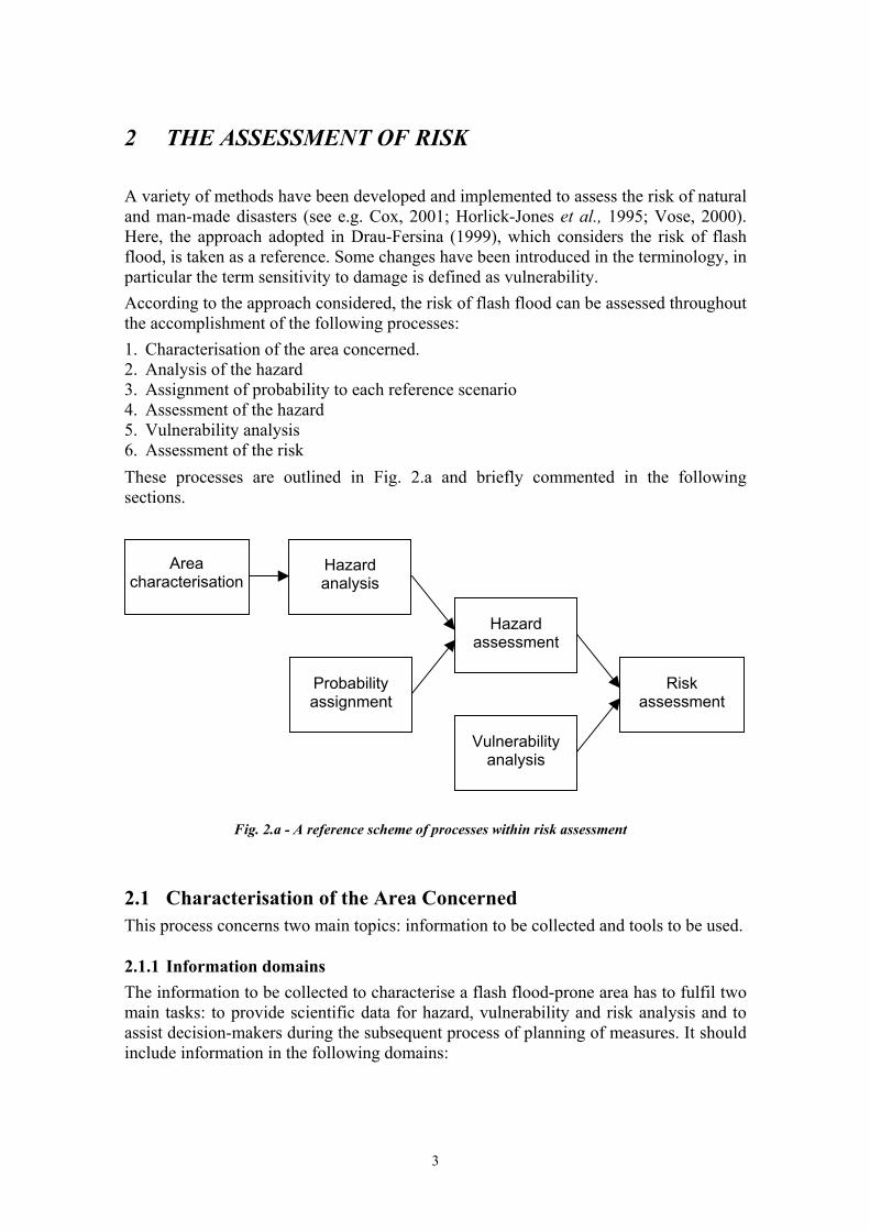
A variety of methods have been developed and implemented to assess the risk of natural and man-made disasters (see e.g. Cox, 2001; Horlick-Jones et al., 1995; Vose, 2000). Here, the approach adopted in Drau-Fersina (1999), which considers the risk of flash flood, is taken as a reference. Some changes have been introduced in the terminology, in particular the term sensitivity to damage is defined as vulnerability. According to the approach considered, the risk of flash flood can be assessed throughout the accomplishment of the following processes: 1. Characterisation of the area concerned. 2. Analysis of the hazard 3. Assignment of probability to each reference scenario 4. Assessment of the hazard 5. Vulnerability analysis 6. Assessment of the risk
These processes are outlined in Fig. 2.a and briefly commented in the following sections.
Vulnerability analysis
Probability assignment
Risk assessment
Hazard assessment
Area characterisation
Hazard analysis
Fig. 2.a - A reference scheme of processes within risk assessment
2.1 Characterisation of the Area Concerned This process concerns two main topics: information to be collected and tools to be used.
2.1.1 Information domains The information to be collected to characterise a flash flood-prone area has to fulfil two main tasks: to provide scientific data for hazard, vulnerability and risk analysis and to assist decision-makers during the subsequent process of planning of measures. It should include information in the following domains:
3

Geography. E.g. length of the river section, communes/provinces involved, peculiarities of the area and population.
•
•
•
•
•
•
•
• •
•
Geology and geomorphology. E.g. type of lithology (chalk, limestone, sandstone, clay, etc), stratigraphy within the study area, tectonic history (whether it is a heavily folded and faulted area or not), nature of river (bed width, inclination, bed load regime), history of the river and its related processes. Hydrology and hydraulics. E.g. air temperature, water temperature, annual precipitation, months of maximal and minimal precipitation, channel discharge, water level (mean annual and peak), bankfull discharge value, channel roughness, channel geometry, retention behaviour. Vegetation. E.g. vegetation class (closed tree canopy, open tree canopy, shrubland, dwarf shrubland, herbaceous vegetation, non-vascular vegetation, sparse vegetation). Land use. E.g. land use types (agricultural land, forest and other wooded land, built-up and related land, wet open land, dry open land with special vegetation cover, open land without or with insignificant vegetation cover). River engineering. E.g. check dams, bioengineering works, etc. (see also Section 3.2 on Structural Measures). Historical analysis of local flood events. E.g. analysis of the occurrence of historical floods (scientific journals, national and local databanks, newspapers, interviews from victims, damaged environment), analysis of the evidence of paeleofloods (study of post-flood geomorphology, size of allochtonous material, such as boulders, pebbles, soil, etc).
2.1.2 Tools Three main tools are to be considered to characterise the area subjected to flash floods:
A database for storage of general information. A Geographical Information System (GIS) for graphical representation of maps and spatial analysis. A set of computer programs for data processing (e.g. hydrological and hydraulic models).
2.2 Hazard Analysis This process includes the choice of the level of detail of the analysis (map scale and hazard intensity scale), the definition of hazard scenarios and the construction of a basic map of hazard.
2.2.1 Choice of the map scale and hazard intensity scale Before starting the data collection (see Section above), the scale of the maps to be used in the analysis must be selected and a scale for the hazard intensity defined. The two scales are linked, the choice is usually made between the following two alternatives:
- Medium level of detail (map scale in the range 1:10,000 to 1:100,000 and hazard intensity scale subdivided in 3 degrees ), or
4

- High level of detail (scale in the range 1:1,000 to 1:10,000 and hazard intensity scale subdivided in at least 4 degrees).
Obviously, the selection of the map scale and the definition of the number and significance of the hazard intensity degrees are subjective. Tab. 2.2.1.a, modified from Kienholz, 1996, shows an example of a scale of hazard intensity as a function of danger to the population. It considers three degrees (low, medium and high) of intensity.
Table 2.2.1.a - Hazard intensity scale
2.2.2 Definition of hazard scenarios and construction of a basic map of hazard
On the basis of the information required in Par. 2.1.1 and considering the level of detail portrayed in Par. 2.2.1, hazard scenarios are then defined, which identify hazard sources and weak points in the system. For example, in Ref. Drau-Fersina, 1999 the following two hazard scenarios where identified: "flooding as a result of channel overloading in the Charinthian section" and "flooding as a result of a dam failure in the section of East Tyrol". These scenarios are summarised in a basic map of hazard, which specifies the river detail concerned. See Fig. 2.2.2.a.
Fig. 2.2.2.a - Basic hazard map. Drau river, Greifenburg - Bruggen Stretch
2.3 Assignment of Probability to each Reference Scenario
Based on the "Hydrology and hydraulics" information collected, as mentioned in Par. 2.1.1, in particular, flooding frequency and water levels of a certain time of occurrence,
5
a scale of probability levels of the hazard scenarios is defined. See, e.g., Tab. 2.3.a that reports the probability level scale produced to analyse the floods of the Drau river (four levels of probability are defined: low, medium, high and very high). A probability level is then assigned to each hazard scenario.
Table 2.3.a - Probability level scale of a hazard scenario
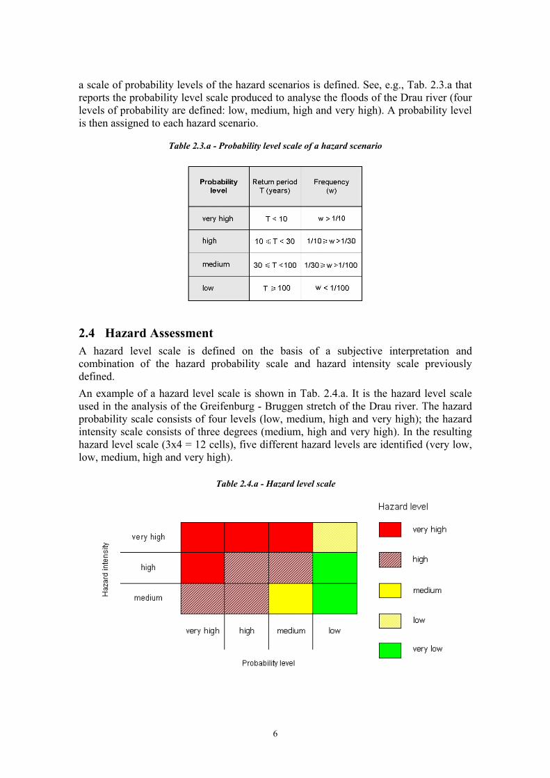
2.4 Hazard Assessment
A hazard level scale is defined on the basis of a subjective interpretation and combination of the hazard probability scale and hazard intensity scale previously defined.
An example of a hazard level scale is shown in Tab. 2.4.a. It is the hazard level scale used in the analysis of the Greifenburg - Bruggen stretch of the Drau river. The hazard probability scale consists of four levels (low, medium, high and very high); the hazard intensity scale consists of three degrees (medium, high and very high). In the resulting hazard level scale (3x4 = 12 cells), five different hazard levels are identified (very low, low, medium, high and very high).
Table 2.4.a - Hazard level scale
6

Starting from the basic map of hazard, and considering the hazard level scale, a hazard map is produced. See, e.g., Fig. 2.4.a that concerns the Greifenburg - Bruggen stretch of the Drau river.
Fig. 2.4.a summarises the hazard assessment of the event investigated.
Fig. 2.4.a - Hazard map. Drau river, Greifenburg - Bruggen Stretch
2.5 Vulnerability Analysis
There are various methods of determining vulnerability. In the example portrayed in this section, see Tab. 2.5.a, a vulnerability scale is defined via the consideration of the defined hazard scenarios and the information available regarding the damage to the population and environment. This example of the Drau and Fersina rivers has been conceived with reference to the land-use categories and land-uses of the area concerned. Five levels of vulnerability are established: very low, low, medium, high and very high.
2.6 Risk Assessment
A risk level scale is then defined as a function of the hazard level and vulnerability level. This scale is obtained by subjective judgement, just like the hazard level scale.
Tab. 2.6.a shows the risk level scale produced to assess the risk in the Greifenburg - Brugger stretch of the Drau river. Five levels of hazard (very low, low, medium, high and very high) and five levels of vulnerability (very low, low, medium, high and very high) were considered. The resulting risk level scale consists of 5x5 = 25 cells and includes five different levels of risk: very low, low, medium, high and very high.
7

Table 2.5.a - Vulnerability level scale as a function of land use categories
Table 2.6.a - Risk level scale. Drau river, Greifenburg - Bruggen Stretch
8

Finally, a risk map is produced, based on the basic hazard map and the risk level scale. See, e.g., Fig. 2.6.a (Fig. 3.17 of Ref. Drau-Fersina, 1999) that was produced for the Greifenburg - Brugger stretch of the Drau river. Fig. 2.7.b summarises the assessment of the risk of the event investigated.
Fig. 2.6.a - Risk map. Drau river, Greifenburg - Bruggen Stretch
9

3 MEASURES TO COPE WITH FLASH FLOODS
3.1 Background In flood management, there are two types of measures that can be used: structural and non-structural. Experience has shown that the common strategy to cope with floods has been the implementation of the former whereby civil works such as floodwalls, transversal protection works, embankments, conduits and reservoirs, have been constructed to protect the built-in environment up to an acceptable risk threshold. Structural measures (see Section 3.2) tend to mainly consider the hydrological and hydraulic implications of flooding, which generally are solved by choosing the alternative that maximises the expected net benefit. In addition, such measures can have a substantial impact on the riverine environment and ecology. Furthermore, while structural solutions contribute to flood reduction and protection, they also have other hidden “piggy-back” liabilities associated, such as the issue of their long-term value, their false sense of security, their possible environmental impact and costs related with their operation and maintenance. However nowadays, with the introduction of bioengineering techniques, some structural measures have become environmentally friendly. Bioengineering refers to the use of vegetation for civil engineering purposes. Bioengineering is defined by Kruedner (1951) as an engineering technique that applies biological knowledge when constructing earth and water structures and when dealing with unstable slopes and riverbanks. In bioengineering, plants and plant materials are used to act as live building materials on their own or in combination with inert natural building materials available on site. According to Schiechtl and Stern (1997), bioengineering is not a substitute but a necessary and sensible complement to the purely technical engineering construction methods. For these authors, the optimum use of natural methods and materials in the construction of watercourse protection works is only feasible if the envisaged methods fit harmoniously into the landscape. Planning and designing of these measures should bear in mind possible negative effects on watercourse dynamics and environment. Non-structural measures (see Section 3.3 and Section 3.4) on the other hand offer a variety of possibilities, ranging from land use planning to constructions and structure management codes, soil management and acquisition policies, insurance, perception and awareness, public information actions, emergency systems and post-catastrophe recovery, which contribute towards the mitigation of flood-related problems. The advantage of non-structural measures is that generally they are sustainable and also less expensive. On the other hand, they can only be efficient with the participation of a responsive population and an organised institutional network. The structural and non-structural measures discussed in this chapter are shown in Table 3.1.a. The former are mainly characterised by catchment wide interventions, river training interventions and other flood control interventions, whilst the latter consists of risk acceptance and risk reduction strategies.
10

Table 3.1.a – Structural and Non-Structural Measures
STRUCTURAL MEASURES (Section 3.2)
Catchment-wide interventions (agriculture and forestry actions and water control works) River training interventions Other flood control interventions (passive control, water retention basins and river corridor enhancement, rehabilitation and restoration)
RISK ACCEPTANCE To
lera
nce
stra
tegi
es
Toleration Emergency response systems Insurance
NON-
STRUCTURAL MEASURES*
(Section 3.3)
Prev
entio
n st
rate
gies
Delimitation of flood areas and securing of flood plains Implementation of flood areas regulation Application of financial measures
RISK REDUCTION
Miti
gatio
n st
rate
gies
Reduction of discharge through natural retention
Emergency actions based on Monitoring, Warning and Response Systems (MWRS)
Public information and education*
* Public Information and education are discussed in Section 3.4 Given the large number of high risk situations as well as the extremely high costs in terms of casualties and damages involved in flooding, the implementation of all the structural and non-structural measures aimed at its reduction becomes essential, requiring a holistic approach to be carried out. Holistic flood management is inter-disciplinary and multidisciplinary. Teamwork amongst actors active in this field is of utmost importance and involves a sequence of activities, which are briefly summed up in the Final Report of the RIBAMOD Concerted Action (Samuels, 1999) shown in Table 3.1.b. Although these guidelines do not cover post flood activities, it is necessary that the structural and non-structural measures proposed in this chapter, along with the example of a risk assessment methodology described in Chapter 2, be portrayed in the framework of the flood management cycle. This chapter aims to portray prevention and mitigating measures used in dealing with flash floods. In particular, Section 3.2 is dedicated to the structural measures, whilst Section 3.3 and Section 3.4 discuss non-structural measures. It is also necessary to stress the great importance of dissemination information and risk communication to the public. Thus, an entire section (Section 3.4) is dedicated to this topic, in the hope that great improvements can be made in this area. Lastly, with the aim to assist the user of these guidelines, Section 3.5 offers an example on how to choose and prioritise measures to cope with flash floods.
11

Table 3.1.b – Holistic approach to flood management: pre-, “during-” and post-flood activities
Pre-flood activities “During-flood” activities Post-flood activities Flood risk management for all causes of flooding and disaster contingency planning.
Detection of the likelihood of a flood forming (hydro-meteorology).
Relief for the immediate needs of those affected by the disaster.
Construction of physical flood defense infrastructure and implementation of forecasting and warning systems.
Forecasting of future river flow conditions from the hydro-meteorological observations.
Reconstruction of damaged buildings, infrastructure and flood defenses.
Land-use planning and management within the whole catchment.
Warning issued to the appropriate authorities and the public on the extent, severity and timing of the flood.
Recovery and regeneration of the environment and the economic activities in the flooded area.
Discouragement of inappropriate development within the flood plains.
Response by the public and the authorities.
Review of the flood management activities to improve the process and planning for future events in the area affected and more generally, elsewhere.
Public communication and education of flood risk and actions to take in a flood emergency.
3.2 Structural Measures Structural measures include different types of works and interventions aimed at either controlling flood or reducing flood peak. The former include flood defences constructed locally along watercourses and their corridors so as to contain the surplus of water, whilst the latter include catchment-wide interventions to reduce or delay runoff from rainstorms. Flood control measures include mainly water retention basins, river training interventions and enhancement, rehabilitation and restoration of the river corridor, whilst reduction and delay of runoff can be attained by adequate agriculture and forestry management practices, including also related works. 3.2.1 Catchment-wide interventions Catchment-wide interventions can be effective to decrease surface runoff and soil erosion and therefore to reduce flood peak. These interventions should consider a number of basic principles related to the main factors influencing runoff and erosion, namely soil, topography, land cover and use and farming practices. Soil properties such as texture, structure, organic matter content and pH directly affect soil permeability, and therefore infiltration and runoff. Topography greatly influences the energy of the water particles and therefore runoff speed and timing and erosive potential. Protective effects of the vegetable covering against surface runoff and soil erosion vary according to the vegetable species, which form the covering. In fact, the protective function of forest species is greater than that of fruit trees, and similarly, pasture herbaceous species provide a better protection than arable herbaceous species such as, for instance, cereals, corn and soybean.
12

In cultivated lands, comprising herbaceous and woody crops as well as tree plantations, surface runoff and erosion are greatly affected by farming practices such as tilling, surface laying-out, type of crops, covering duration, management of residues coming from previous cultivation and preservation of soil fertility. Thus, runoff coefficient is higher when ploughing is performed along the maximum gradient, whilst deep ploughing allows greater water retention and reduction of total runoff. Surface laying-out by means of drainage ditches is one of the most effective systems for surface runoff regulation, as is the use of forage crops and their rotation, whilst ensuring a greater soil covering duration. Also, increase of organic matter released in the soil improves the structure, and thus the physical features of the soil with respect to erosion. In more natural systems, distinct behaviour can be observed between natural turf forming plants, woods and abandoned lands. The former provides stability and resistance to the soil against erosion. In general, pastures provide higher protection against runoff and erosion than arable crops. However, inadequate exploitation of pastures such as an unsuitable livestock number with regard to grazing practices, as well as burning can have negative effects on vegetation retention capacity, thus increasing runoff and erosion. Woods contribute to regulate runoff and prevent soil erosion mainly because of interception from foliage and litter, greater speed of water infiltration and delayed concentration of water masses downhill. Rain interception is higher for evergreen species, while infiltration is higher in forests with no pastures and old plants. Finally, land abandonment generally results in a significant increase in permanent vegetable cover (mainly shrubs and turf), so insuring higher protection against erosion and runoff. Also, abandonment of forest land, especially in humid regions, can often cause a natural increase of forest cover therefore giving greater protection, although high precipitation can cause in some areas exceptional erosion and landslides. Based on the above principles, specific actions for agricultural and forest area management as well as for water control works in the catchment are presented in the following paragraphs.
3.2.1.1 Agriculture and forestry actions
3.2.1.1.1 Cultivated lands • Conserve quick hedges and existing agricultural lay out: dry walls, water storage
channels, terraces, etc. • Avoid the shaping of slopes aimed at changing the size of agricultural holdings. • Carry out periodical servicing of all water channels, especially of water mains, which
impound water from the ditches of agricultural holdings. • Favour permanent vegetation on water mains and ensure a sufficient section for
downflow. • Promote farming practices aimed at increasing organic matter in the soil by
manuring, rotation with improving crops and rational management of residues from previous crops.
• Build cross ditches with appropriate spacing, based on soil texture (e.g. higher for sand than for clay), and slope angle.
• Carry out crosswise tillage where possible, and in case tillage along the maximum gradient proves to be necessary, build cross ditches as well.
• Favour pluriannual rotation of crops planted both using the plough and without it, contouring crops and contour strip-cropping.
13

• Select crops that ensure longer covering, especially in rainy periods. • Stimulate the cultivation of species with a greater covering action (e.g. broadleaf
species and fast-growing species). • Favour grass growth on the entire surface, or at least on inter-rows, in case of tree
plantations.
3.2.1.1.2 Turf forming plants • Avoid conversion into arable lands where slope is high (e.g. greater than 25%). • Keep quick hedges and existing cultural lay out: dry walls, water impounding
channels, terraces, tracks; • Favour all cultural practices, which aim at increasing organic matter in the soil
(manuring). • Avoid pasture renewal through fires, since this reduces soil organic matter. • Regulate grazing through the correct assessment of optimum livestock number. • Ensure a more homogenous distribution of livestock within the grazing area by a
balanced spreading of livestock concentration spots (e.g. watering, feeding and standing spots).
• Use the rotation grazing method as much as possible.
3.2.1.1.3 Woods • Promote and favour forest management plans (see also Paragraphs 3.3.2.1.5
"Application of financial measures" and 3.4.2 "Specific advice regarding farmers"), including also long term transformation changes.
• Favour more evolved and ecologically stable type of woods, e.g. by stimulating the formation of woods with a more complex structure (woods of different age), or with a different composition (by increasing the rate of mixture of the species), or by increasing the biomass (transformation of coppices into high forests).
• Favour the planning of access to woods, taking into account the different management of woods.
• Favour coppice cuttings with minimum development along the maximum gradient. • Carry out coppice logging operations in non-rainy periods. • Design adequate skidding tracks/roads for logging. • Favour new roads useful to wide forest basins, thus servicing many users and
agricultural properties. • Increase the variability of coppice seedling bearers. • Favour the conversion from coppice to stable, mixed seedling forest where possible. • Favour mixed woods by thinning. • Favour uneven aged woods by increasing their structural complexity. • Favour forestry use in small areas (e.g. less than 5 hectares, and less than 5,000 m2 in
case of clear cutting). • Favour the increase of autochthonous forest species (through selection thinning). • Favour improvement and care of abandoned woods, possibly by conversion to
coppices or seedling. 3.2.1.2 Water control works Landowners and farmers can implement minor, inexpensive, environmentally friendly works to ensure an efficient protection from runoff. In these works, wood material is
14

most frequently used. This must be durable and mechanically resistant. Thus, larch is most widely used in mountain areas, whilst chestnut and Douglas fir are employed in warmer climates. When carrying out this works not only constructive aspects, materials, use and cost must be considered, but also maintenance, impact to the environment and ecological aspects. Main works are discussed in the following paragraphs.
3.2.1.2.1 Check dams Cross works positioned in drainage beds are useful both to retain coarse floating or suspended material and to rectify the gradient of the course. Main types of check dams are: • Timber check dams - They consist of boles fixed across dug ditches by nails and
stirrups. They are used in catchment areas and minor waterways, main drains of cross ditches, and those places where mechanisation is difficult and the material is available on the spot.
• Timber and loose stones check dams - They are built with chestnut or conifer boles, nails, and small homogeneous boulders for the face and variable-sized stones for the back filling. They are used in mountain stretches of waterways or main drains placed in steep slopes. They result in an insurmountable obstacle for ichtyiofauna.
• Dry check dams - They consist of homogeneously sized locally found stones, staggered in such a way that the largest diagonal of the dam is parallel to the axis of the torrent. They are used in gently sloping small catchment areas and drains. They might result in a possible obstacle for the ascension of fish.
From these works, timber check dams have the lowest cost.
3.2.1.2.2 Drainage ditches Coating and canalisation works are used especially in case of watercourses running in sloping and easily erodible substratum. Main types are: • Timbered ditches - They consist of ditches with chestnut boles laid down on the
bottom and along the walls of the ditch, fastened with fasteners and nails. They are mainly used as coating of small sized ditches and to protect main ditches from erosion. They enable greater draining speed of surface waters.
• Ditches made out of timber and stones - They consist of trapezium-shaped ditches with stones at the bottom and chestnut boles both crosswise and lengthwise the oblique ditch walls. They are used as main drains of surface and road ditches and to convey water from landslides. They make the draining speed of water increase. Their cost is slightly higher than that of timbered ditches.
3.2.1.2.3 Surface drainage It includes works aiming at improving surface water draining in slopes, where erosion due to runoff or to intrinsic water disarrangement makes it necessary to reduce the time of permanence of water. Main types are: • Drainage by fascines - This most common structure consists of tied faggots made up
of vegetable material (usually cuttings or branchwood of willow-trees), fixed to semicircular ditches dug along the maximum slope gradient. For deeper drainage pebbles should be laid down at the bottom. It is used in slopes prone to water stagnation and surface erosion. It favours growth of authoctonous vegetation.
15

• Filtering wedges - They consist of wedges dug at the base of the slopes, filled with coarse gravels and boulders and willow trees cuttings. They are used to stabilise the basis of slopes and to enhance water draining. Their cost is much higher than that of fascines.
3.2.1.2.4 Wattlings These structures form horizontal alignments on the slope, consisting of flexible pleached twigs fixed to the ground by cuttings of species which can take root. They are useful to reduce surface erosion in eroded slopes and landslides as well as to reclaim small landslides. Their cost is similar to that of fascines above.
3.2.1.2.5 Bench-terraces They consist of horizontal benches with a slight counterslope, filled with earth, branchwood and willow-tree cuttings in a special arrangement. Terraces are covered with the back-filling coming from the upper terrace. These works can strengthen slopes where numerous landslides occur and in soils prone to water stagnation. Their cost is slightly higher than that of wattlings or fascine-based drainage.
3.2.1.2.6 Stone retention walls They represent the most traditional handwork to strengthen small-sized slopes, especially in rural areas where ground was sloping and the material was easily available. It consists of stones making up vertical facing upstream, and an oblique facing downstream. The thickness at the top of the structure is lower than at its base. They can be used whenever it is necessary to strengthen small-sized slopes, or to change the gradient of slopes (terracing). Although always visible, these walls appear as part of the historical landscape.
3.2.1.2.7 Revegetation This measure enhances vegetation development, thus preventing sudden moisture variations, helping also to prevent erosion and shallow landslides. Main methods include water seeding, revegetation through turf, broadcast sowing with chaff and laying of grass coverage. Amongst these, water seeding is the most diffused and the less expensive revegetation method. It consists of spreading a mixture of water, seeds, organic fertiliser, ligands and soil ameliorating substances over a previously prepared seedbed by means of high-pressure sprinkling machines. This technique is used to completely revegetate bare areas including those due to erosion, landslides and excavation.
3.2.1.2.8 Road system There are two main types of small arrangements to canalise water discharge in roads and agricultural/forest paths:
16

• Channels - They are dug along roadsides. The side downstream conveys the water coming from cross gutters. Their surface can be coated with prefabricated plain concrete or with stones if necessary.
• Cross gutters - Gutters crossing the roadway, placed at variable distance and following the slope. They can be simple ditches of earth or be coated with boles cut into half and fixed to the gutter. They keep surface water away from the roadway itself.
3.2.2 River training interventions River training interventions are widely applied for prevention and mitigation of flash floods. Their main aim is to control and optimise the water discharge regime in watercourses by limiting its dynamic energy, therefore managing and controlling the morphological evolution of watercourses. These interventions also have the function of reducing solid transport and the natural processes of bed and bank erosion along the watercourses. In this section, additional emphasis is placed on the application, where possible, of techniques with a low impact on both the ecological aspects of river habitats and on the landscape. To this end, the use of vegetal species (bioengineering techniques) and rocky material available on the torrent bed should be pursued. This generally contributes to reducing pollutants in the flooding waters whilst creates or preserves natural corridors, which favour the diffusion and preservation of different living species within the riparian ecosystem. An overview of the most common flood prevention and mitigation structures and interventions along watercourses is given below. The various works have been originally classified according to their transversal and longitudinal position with respect to the watercourse. In general, combined interventions are more efficient than single ones. It should also be born in mind that these interventions should not cause non-mitigating environmental impacts nor have negative effects in adjacent watercourse reaches.
3.2.2.1 Transversal protection works
3.2.2.1.1. Check dams These are low structures built with erosion-resistant materials (stones, gabions, concrete, logs or other), which slow water flow and increase deposition. Check dams decrease the morphological gradient of the torrent bed. They reduce the water velocity during flood events by increasing the concentration time of the hydrographic basins and reducing the flood peak and solid transport capacity of the water flow. They also help mitigating erosion processes and controlling solid transport, so favouring the prevention of landslides on natural slopes and artificial banks. Check dams are often constructed in succession along the watercourse to provide stabilisation of the bed over long distances. Check dams usually require additional protection structures in the bed or on the banks to provide defence from undermining and breaking. Check dams may represent a physical barrier for the diffusion of fish along watercourses. To mitigate these effects their height should be low or, alternatively, ramps or lateral corridors should be built.
17
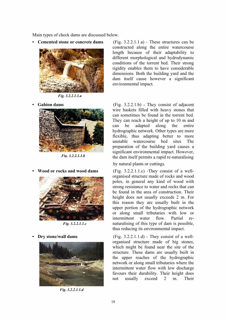
Main types of check dams are discussed below. Cemented stone or concrete dams (Fig. 3.2.2.1.1.a) - These structures can be
constructed along the entire watercourse length because of their adaptability to different morphological and hydrodynamic conditions of the torrent bed. Their strong rigidity enables them to have considerable dimensions. Both the building yard and the dam itself cause however a significant environmental impact.
•
•
•
•
Fig. 3.2.2.1.1.a
Gabion dams (Fig. 3.2.2.1.b) - They consist of adjacent wire baskets filled with heavy stones that can sometimes be found in the torrent bed. They can reach a height of up to 10 m and can be adapted along the entire hydrographic network. Other types are more flexible, thus adapting better to more unstable watercourse bed sites The preparation of the building yard causes a significant environmental impact. However, the dam itself permits a rapid re-naturalising Fig. 3.2.2.1.1.b
by natural plants or cuttings. Wood or rocks and wood dams (Fig. 3.2.2.1.1.c) -They consist of a well-
organised structure made of rocks and wood poles, in general any kind of wood with strong resistance to water and rocks that can be found in the area of construction. Their height does not usually exceeds 2 m. For this reason they are usually built in the upper portion of the hydrographic network or along small tributaries with low or intermittent water flow. Partial re-naturalising of this type of dam is possible, thus reducing its environmental impact.
Fig. 3.2.2.1.1.c
Dry stone/wall dams (Fig. 3.2.2.1.1.d) - They consist of a well-organised structure made of big stones, which might be found near the site of the structure. These dams are usually built in the upper reaches of the hydrographic network or along small tributaries where the intermittent water flow with low discharge favours their durability. Their height does not usually exceed 2 m. Their
Fig. 3.2.2.1.1.d
18

environmental impact is relatively low and have the lowest cost amongst check dams.
Out of these, those not made of cement or concrete are more flexible, thus adapting better to more unstable watercourse bed sites. They also integrate better in the natural environment.
3.2.2.1.2 Sills Sills are structures built across the bed of a stream to prevent scour or head cutting. They are used along river stretches with a medium-low morphological gradient subjected to bank and bed erosion (that may cause instability on natural and artificial embankments or on other existing hydraulic works), where the preservation of torrent bed elevations does not require the construction of check dams. Sills are usually accompanied with bank protection structures upstream to guarantee durability of their anchorage and prevent undermining of the embankment. Sills cause in general a low environmental impact because of their low height (often under the water surface). Amongst the most common types of sills discussed below, those using natural materials (wood, rocks or gabions) favour vegetation growth, thus permitting a higher integration with the watercourse environment than when using concrete. •
•
•
Concrete or stone sills (Fig. 3.2.2.1.2.a) - These have been the most commonly used sills so far because of ease of construction, despite having the highest cost. They can be constructed in all morphological conditions, especially in those of lower watercourse reaches. Gabion sills (Fig. 3.2.2.1.2.b) - Sills made of
gabions can be applied to many different hydrodynamic conditions. Their limited height allows for a considerable width. Sometimes, building of gabions can be carried out with the rocky materials available along the torrent beds.
Sills made of blocks or blocks anchored to ground or wood and rocks (Fig. 3.2.2.1.2.c)- They are mostly built in the upper mountainous reaches of watercourses or in sites with morphological constraints. In general, any kind of wood with strong resistance to water that can be found in the area of construction can be used, although it is recommended to use such species as larch, chestnut and natural or treated resinous plants.
Fig. 3.2.2.1.2.a
Fig. 3.2.2.1.2.b
Sills made of gabions or rocks and wood facilitate the hydraulic fitting along torrent beds with strong morphological modifications Fig. 3.2.2.1.2.c
19

in relation to the flexibility of their structures.
3.2.2.1.3 Beam dams and screen dams Their main aim is to retain rock, earth and vegetal material transported along the watercourse during strong alluvial events so as to reduce the downstream discharge effects and prevent the obstruction of narrow hydraulic sections, covered stretches or check dams with fixed outlets that could cause catastrophic flooding. These dams are constructed in alluvial fans, stretches with a steep slope, wooded areas and areas undergoing frequent mass movements (e.g. debris flows and mudflows), although most often in narrow torrent beds at the end of the valley before the alluvial fan or flat area. Most of the transported materials sediment in a retention basin or pool to be built, whose capacity must be based on the upstream watercourse and catchment characteristics. Beam dams and screen dams must be constructed with a strong structure in concrete, whilst the retention parts for sediments and vegetation may be built with different materials offering sufficient resistance against the impact stress caused by transported materials. Accompanying structures for protection of banks and foundations must also be built. In addition to regular maintenance work of the structure, the material filling the sedimentation basin or pool should be removed after flood events to recover its storage capacity. These structures produce a significant environmental impact, although they enable fish migration through their openings. The most common types of dams are the following: • Screen dams with vertical steel or concrete bars (Fig. 3.2.2.1.3.a) - They are used
mainly for retaining vegetal materials. Screen dams can be built in different reaches of watercourses. These dams offer a high resistance against the transported materials. Alternatively, dams with bars made of wood can be built along small torrents or agricultural or forest channels.
• Beam dams with central pylon bars (Fig. 3.2.2.1.3.b), vertical opening (Fig. 3.2.2.1.3.c) and horizontal steel bars (Fig. 3.2.2.1.3.d) - These dams are constructed with concrete and steel structures. Their main objective is to prevent mass transport that could affect urban areas.
Fig. 3.2.2.1.3.b Fig. 3.2.2.1.3.a
20

Fig. 3.2.2.1.3.c Fig. 3.2.2.1.3.d
3.2.2.1.4 Groynes Groynes are small dykes reaching from the bank into the river. They are mainly used to protect the riverbank from erosion or other protective structures from undermining by diverting the stream flow and dissipating its energy. Sedimentation between groynes is also favoured, thus creating natural banks that protect the riparian zones. Groynes are also built to recreate natural meandering condition in the watercourse beds. Groynes are usually concentrated along reaches with a medium-low morphological gradient. The number and distance of groynes is a function of their length, the watercourse hydraulic characteristics and the sediment discharge. Groynes cause a low environmental impact to watercourses because these structures are partially or completely submerged by water. When these structures stand out above the water level for long periods, revegetation by using bioengineering techniques contributes to reduce the environmental impact. The most common types of groynes consist of: • Concrete or cemented stones (Fig.
3.2.2.1.4.a) - They are usually adopted along torrent beds subjected to strong bank erosion and are usually carried out in the lower portion of watercourses. The short transversal dimension of groynes cause limited environmental impact on watercourses. However, they cannot be re-naturalised through bioengineering works. These groynes have the highest cost.
Fig. 3.2.2.1.4.a
• Gabions (Fig. 3.2.2.1.4.b) - Because of their flexibility, groynes made with gabions can be easily applied along torrent beds subjected to strong bank and bed erosion. They cause a limited environmental impact. Gabion groynes have the lowest cost.
Fig. 3.2.2.1.4.b
21

• Prefabricated or natural blocks (Fig. 3.2.2.1.4.c) - Groynes made with non-cemented prefabricated or natural rocks are usually built along the upper reach of watercourses. Natural blocks available inside the torrent bed can be used. They cause a low environmental impact, especially when using natural materials (rocks, woods, plants) by bioengineering techniques, hence allowing for revegetation.
• Rocks and cuttings or wood and cuttings (Fig. 3.2.2.1.4.d) - These groynes can be applied in different morphological and hydraulic conditions in order to solve small erosion-related problems involving the upper reach of watercourses. They can usually be constructed with materials available on site. It is recommended to reinforce them with steel cables and poles to ensure their resistance to water flow. They are easily vegetated and cause limited environmental impact.
Fig. 3.2.2.3.1.4.c
Fig. 3.2.2.1.4.d
3.2.2.1.5 Channel lining Channel lining concerns the protection of watercourse beds or banks against erosion by means of concrete, soil cement, rocks or bituminous or plastic material. Channel-lining works enable high water flow velocity. This ensures sediment load transport, thus preventing episodes of deposition and aggradation in the bed and avoiding erosion of torrent bed and banks. These works are recommended in catchments highly prone to erosion, especially in urban and alluvial fan reaches. They are also applicable to the regularisation and stabilisation of channel bed reaches prone to frequent divagations and altimetrical variations (e.g. torrential streams in semi-arid regions). Amongst the most common types of channel lining structures, those made of wood, stones and gabions permit to assure a longer durability because of their better flexibility with respect to foundation shifts and settlings. The realisation of channel lining works must be carried out only in particular conditions where there is need for defence and protection, since their construction produces a remarkable environmental impact on the stream reach, especially for concrete and cemented lining. The use of constructive typologies which make use of natural materials (wood, stones or gabions) reduces or minimises the environmental impact, ensuring both a partial revegetation of these structures and the continuity of interactions between the fluvial habitat and those surrounding it. The most common techniques and construction materials used for channel lining include:
22

• Concrete, cemented stones (Fig. 3.2.2.1.5.a) - Channel lining requires setting up strong building yard actions in order to reshape the water course and its hydraulic transversal sections. Use of concrete and cemented stones produces a strong environmental impact on the watercourse habitats, and implies the highest cost with respect to other channel lining works.
• Gabions (Fig. 3.2.2.1.5.b) - In some cases, carrying out of channel lining with gabions have involved long stretches of water courses subjected to erosion processes that produce frequent three-dimensional modification of their course. These interventions encompass strong building yard actions in order to reshape the watercourse and its hydraulic transversal sections. Consequently, they produce a strong environmental impact on the torrent habitats during the construction phase.
Fig. 3.2.2.1.5.a
Fig. 3.2.2.1.5.b
• Wood and stones or wood (Fig. 3.2.2.1.5.c) - Channel lining using rocks or woods are mainly applied where ecological and environmental respect requires using natural materials. This type of lining consents limited building yard actions fitting the intervention to the natural characteristics of the watercourse. Channel lining with rocks or wood, which are generally available locally, permit to re-naturalise the watercourse. Insertion of cuttings among the structure allows for stronger channel lining. Channel lining using wood and stones implies the lowest cost.
Fig. 3.2.2.1.5.c
3.2.2.2 Longitudinal protection works
3.2.2.2.1 Artificial banks or dikes Artificial banks may abound along the riverbed close to populated areas. They are usually planned in the central and lower reaches of watercourse, particularly in alluvial flat areas, in order to protect human settlements from flooding. These structures can also be applied in some specific cases to lead the water flow towards particular facilities or infrastructure (e.g. hydropower installations, railway crossings, highways, etc.). In order to ensure the stability and proper hydrogeological operation of artificial banks the construction of impermeable barriers inside or under them could be considered. Roads should be constructed along embankments to provide access for maintenance works. These interventions strongly modify the natural evolution of the river courses (meandering, formation of new bed), constraining the water within longitudinal
23

protective structures. As a result, a significant environmental impact is produced, especially on riparian habitats, since they cause the destruction of many natural aspects and habitats. In order to mitigate their environmental impact, the introduction of small groynes to favour the meandering of low water and other structures made of stones and woods that provide fish sheltering could be envisaged. Also, embankments built at an appropriate distance from the natural riverbanks and arranged with an irregular shape help the development of living species in riparian zones. Because of the higher energy of the water flow in reaches with these structures, special attention should be paid to the high danger to population and property in case of breaching. Based on the construction materials employed and functionality, two main types of longitudinal structures can be considered as follows: • Earthfill embankments (Fig. 3.2.2.2.1.a) - They are the most common longitudinal
structures built along the river courses because of their simple technical execution. Their transversal section is usually trapezoidal. Protective structures made with stones, gabions, concrete or other material can be applied at their inner toe to avoid erosion.
Fig. 3.2.2.2.1.a Fig. 3.2.2.2.1.b
High embankments can be prepared with different materials in the inner central and outer part of the structure so as to assure a low permeability during floods and reduce the groundwater flow. They usually include a step to increase the stability of the earthfill works. Earthfill embankments can be covered with natural vegetation to improve their environmental insertion. To this end, growing of grass or elastic shrubs is strongly preferred to large trees. Actions should also be taken to not allow the presence of animals that can produce holes.
• Cemented bricks, stones or concrete embankments (Fig. 3.2.2.2.1.b) - They consist of dikes made of cemented brick, stones or concrete, which are often applied in urban reaches of watercourses where there is not much space for building other structures. These structures can also be combined with an earthfill structure through the application of a wall structure on the top of an earthfill embankment. The cost of concrete embankments is much higher than that of earthfill ones. These types of embankments produce a significant environmental impact, especially in non-urban areas. Their preparation usually causes the destruction of ecological characteristics of riparian habitats.
24

3.2.2.2.2 Bank erosion protection Protection structures may be necessary along torrent stretches whose banks undergo erosive processes that can cause instability conditions both on natural, artificial banks or on steep slopes. Strong protection structures are specifically required for the defence of urban areas or to stabilise landslides. Their construction is usually coupled with that of transverse structures to guarantee their preservation. These structures cause a substantial modification of riverbanks and damage or destroy the riparian ecological conditions and habitats. Traditional bank protection works such as concrete walls and cemented stone and bricks can give way to the use of bioengineering techniques in small and medium sized basins. Vegetation-based structures however require in general more maintenance, often the cutting of vegetation. Basic bank protection measures having a low environmental impact include bank foot structuring, use of live material (resprouting vegetation), irregular bank line, room for succession, employment of locally suitable vegetation and creation of transverse structures. The main structural elements used for this purpose are presented below. It should be born in mind however that higher flood protection is provided when a number of these elements are jointly used (e.g. Fig 3.2.2.2.2.a).
Fig. 3.2.2.2.2.a - Example of sweeping water side including a number of natural protection elements
• Base stones - They hinder undermining and scouring, especially in case of watercourse deviation. They also provide fish sheltering.
• Anterior stakes- They are a support element to secure bank foot. • Sunken fascine rolls - They are employed to provide stabilisation of the slope toe in
a number of bioengineering measures such as fascine walls, fascine rows, etc. Sunken fascine rolls are especially used in cases where the bed shear stress is not too
25

high and blockstone bank protection is not considered suitable. Fascines rolls are more environmentally friendly than base stones, although less resistant.
• Wattle works - They are made of wood pickets driven into the ground and strong willow branches woven horizontally, alternately before and behind the pickets. Similarly to a fascine wall, a wattle fence enables to protect banks running vertically. It is used on watercourses with low bed shear stress and relatively straight course. The height of a wattle fence should not exceed 50 cm. Wattle work is very ecological, allowing the development of many habitats.
• Log cribwall with branchlayers on one bank - It is made of wood logs anchored and nailed together forming a crib, where the spaces are filled with willow fascines or stones on the waterside and earth on the inner side. The wooden crib provides high resistance to bed shear stress. It can be used in torrents with irregular flow of water and bed load transport and for banks that are heavily exposed to the action of sweeping waters. This structure provides a good habitat for zoobenthos.
• Live brush mattresses - They are made preferably of straight branches of brush willows laid down with their cuttings placed into the water and tied to wood pickets, covering the bank surface. Their closest end to water should also be secured by stones, poles, fascines or wattle fences. Brush mattresses provide the most effective method of bank stabilisation in the event of floods, especially in watercourses with higher bed shear stress values as well as for banks heavily subjected to the action of sweeping waters or erosion. They develop very quickly into a thick and functional bank vegetation. To enhance vegetation variety, rooted deciduous trees (such as alders, ash-trees, etc.) can be added to the willow cover, thus increasing their slope protection effect and ecological value.
• Cuttings/stakes - Their primary function is a firming effect on soil due to the growth of roots, although they can also be employed between stones. They provide good protection in the long-term, being normally used in combination with other measures.
• Brushlayers (“living brushes and combs”) - Living willow branches or living combs cuttings are planted into the soil. Alternatively, fascine bundles can also be used instead of loose willow branches. They are used to promote siltation and are able to protect small bank stretches affected by lateral erosion. Brushlayers, however, are not resistant to high bed shear stress and are therefore often employed in the spaces between more laborious and resistant live siltation works. Combs offer lower resistance than living brushes. This measure is also of ecological value.
• Crib groynes with cuttings (living groynes) (Fig 3.2.2.2.2.b) - These are transverse structures with respect to the flow direction, reaching from the bank towards the centre of the watercourse. They divert water towards the latter area whilst favour sedimentation in between groynes. These are thus used to provide protection and repair bank erosion. Different types of
Fig. 3.2.2.2.2.b
26

groynes can be built depending on the raw materials locally available (boulders/gravels, wood and live vegetation). These structures facilitate fish growth and the setting up of plant and animal habitats.
3.2.2.2.3 Maintenance of the hydraulic cross section Maintenance of the hydraulic cross section is essential to keep the functionality of structural works providing protection and regulation actions with respect to floods. Nowadays it is recommended to delineate transversal sections with an irregular profile, using blocks, bioengineering structures, groynes, sills or other structures, in order to guarantee the formation of different habitats, especially along natural channels with low human interference. Amongst the various possible maintenance works, cutting of vegetation and reshaping of the hydraulic cross section are the most common. • Cutting of vegetation
Cutting and consequent removal (or incineration) of natural vegetation growing along natural and artificial torrent beds aims to preserve the planned hydraulic cross sections, guarantee the nominal water discharge and avoid that flood waters can pick up and carry downstream a significant amount of vegetal material that may obstruct the watercourse bed in bridges and other critical sections, thus causing or increasing the outflow of flood waters. Cleaning up of natural vegetation is also important to permit easy access to the torrent bed and banks in order to allow other maintenance works of the existing hydraulic structures. Cutting of vegetation usually causes destruction of ecological and environmental properties of natural river habitats. Selective cutting of vegetation (e.g. thinning out of elements interfering with the water flow) should therefore be undertaken not only to reduce the flood water velocity and bank erosion but also to respect the continuity of these habitats along the watercourse. In any scenario, careful cutting must be considered to not facilitate erosion by flowing waters or vary the water velocity.
• Reshaping of the hydraulic cross section This operation permits to regulate the transversal and longitudinal course of the torrent bed subjected to morphological changes due to the presence of sediments and/or bank instability processes and to carry out planned hydraulic cross sections in order to guarantee flood discharges of a fixed return time period. Reshaping interventions are particularly necessary in torrent stretches subjected to aggradation because of high sedimentation rate. They could also be carried out in torrent stretches subjected to bed or bank erosion in combination with structural interventions to reduce erosion, such as check dams, sills, bank protection, etc, so as to stabilise their bed. These maintenance interventions should be directed towards the creation of hydraulic sections with a “natural” transversal shape, in order to recreate different riverine habitats. In some cases, reshaping interventions to favour the recreation of meandering courses should be undertaken. For example, in embanked artificial channels with geometrical transversal sections, where the reshaping action requires the removal of terrigenous and vegetal materials, maintenance interventions could be concluded by establishing morphological differences through the creation of
27

depressions, elevations and blocks in the torrent bed (Fig. 3.2.2.2.3 a). Maintenance of small areas with natural sediments and vegetation should also be promoted. All these actions create a meandering water flow, thus favouring the development of animal habitats (ichthyic, amphibian and terrestrial species). These interventions are usually carried out in the medium-low reaches of watercourses and in hilly and flat areas where the channels are frequently embanked or cross-urban areas. Reshaping can also be done along upper torrent reaches subjected to strong solid transport, that causes aggradation of the natural channel.
Fig. 3.2.2.2.3.a
Reshaping should be carried out together with cutting of vegetation because of speed and economical reasons. Reshaping of torrent channels usually causes a strong ecological and environmental impact on natural beds, producing the destruction, for long periods, of natural aspects of the watercourse.
3.2.2.2.4 Maintenance of watercourses Maintenance and restoration interventions along natural and artificial watercourses are necessary in order to assure the effectiveness of the entire hydrographic system and preserve its discharge capacity during strong alluvial events. Although maintenance works might appear in opposition to the conservation of watercourse ecological aspects, recent trends have focused on the adoption of techniques and methodologies, such as “water-care” and “water preservation” that can preserve ecological and environmental values and assure the functioning of ordinary maintenance works. General maintenance measures aim at attaining acceptable conditions in the watercourse as follows: • Non-interference with given water conditions. • Upkeep of watercourse reaches that are still in their natural state. • Protection of specific habitats. • Structural intervention for the improvement of the ecological function (e.g. activation
of old branches and creation of biotopes where necessary to comply with the ideal conditions established by environmental models).
• Flood damage prevention (e.g. local bank protection, constant stabilisation interventions and re-channelling of course deviation into the original bed).
• Measures to counter harmful influences on the whole system originating from the neighbourhood (e.g. protection against deposition of erosive materials and promotion of water-friendly exploitations).
• Upkeep and activation of floodplains (e.g. location of inundation areas and reduction of already existing regulation constructions according to exploitation practices of the surrounding land).
28

• Preservation and improvement of the stream as a whole (e.g. low-water channels, levy on restitution discharge and by-pass canals and fish ladders).
• Measures to control the bed load regime (through retention basins and check dams). Specific water-care ("tending") measures favour the organisation and development of the watercourse, its banks and inundation areas mainly from a biological point of view. They include: • Tending of bank vegetation. • Afforestation, reforestation and integration of plant species. • Rejuvenation of standing trees. • Protection of specific habitats. • Removal of waste, debris and quicksand. Flowing water preservation measures aim at maintaining certain conditions in the watercourse. They include: • Maintenance of a specific discharge cross section. • Local stabilisation of a determined bank line. • Servicing of structures and means for course regulation and flood control. 3.2.3 Other flood control interventions
3.2.3.1 Passive flood control Passive flood control refers to the avoidance of actions that increase flood discharge. Its main aim is to favour natural flow retention by interdisciplinary management of water and land resources along watercourses. In this context, preserving and improving general environmental conditions should be pursued. Since passive flood control requires investments and sometimes few structural interventions, it has been considered herein as a structural measure. A number of measures for passive flood control can be considered as follows: • Adaptation of cultivation in the neighbourhood of watercourses to the event of
flooding taking into account the resistance and susceptibility to damage of different crops.
• Transfer of local cultivations to safe areas. • Acquisition of land and structures that are more frequently subjected to floods. • Safeguard of available low land run-off zones, covered by woods, coppice and
grassland. • Development of forms of cultivation suitable for the local conditions in river plains. • No further construction in the flood plains. • Restoration of retention areas through withdrawal and displacement of dams as well
as reactivation of old arms. • Preservation of nature-like trenches and nature-friendly development of already
trained water systems. • Promotion of land suitable for water retention or needed for building flood protection
structures in land use plans.
29

• Setting up integral land consolidation procedures both to favour passive control and foster sustainable agricultural practices.
• Building or preservation of structures to slow runoff.
3.2.3.2 Stormwater retention basins Water Retention basins, also referred to as flood control dams, flood mitigation dams and water detention basins, are designed to hold stormwater runoff and release it slowly to prevent downstream flash flooding and stream erosion. Generally, they do not significantly reduce the total volume of surface runoff, but simply reduce peak flow rates by retaining runoff and releasing it at a regulated rate. Water can be held in retention basins for a short period of time before releasing it to the natural watercourse, or for a considerable time for agricultural, consumptive, aesthetic, recreational or other uses. Water retention also contributes to reduce the amount of pollutants transported by runoff. A stormwater retention basin can range from such a simple structure as the backwater effect behind a highway or road culvert, to a large reservoir with sophisticated control devices. Earth dams or embankments are most commonly employed to enclose the basin. The design of stormwater retention facilities should take into account a number of factors and variables, such as the location, size, stability and impermeability of the dam or embankment, the design of the elevation and capacity of the outlet work for releasing the retained water, the selection of a design rainfall event, volume of storage needed, maximum allowed release rate, and pollution control. Possible redesigning and relocating of water retention basins after serious flood events should also be considered. Apart from their economic and technical aspects, protective hydraulic installations should also safeguard and improve the ecological function of flowing waters. Water retention basins can be constructed either on the main watercourse or in flat areas close to this (i.e. a lateral basin). The latter require the construction of artificial embankments bounding the area where the flood water can be temporarily stored together with some technical devices and protective structures at the inlet and outlet points of flood waters. Lateral basins also require the availability of large surfaces in alluvial areas that are not occupied by urban or industrial activities, such as meadows and some agricultural and recreation areas. Degraded areas can also be used, thus improving their ecological value by preparing for animal habitats. Additional considerations regarding planning, design, operation and maintenance of water retention basins include: • Hydrological elements such as basin capacity or spillway should not be undersized.
Opposite to this, large retention facilities might cause a high ecological impact. • Correct hydraulic dimensioning of the operation facilities, similar to that for
conventional dams, including correct design of the bottom outlet, the spillway, the bypass and ancillary power conversion facilities, and possible additional structures for hydraulic power, irrigation, etc.
• Geological setting, including geotechnical properties of soils and groundwater conditions, especially in case of installations with permanent lakes.
30

• Ecological aspects such as ecological continuity of the flowing water, sediment accumulation and channel shaping downstream of the basin. The bottom outlet should be designed so as to minimise the interruption of the ecological continuum of the water flow. Also, wherever possible, the construction of retention installations should be accompanied by ecological compensating measures. Limnological development and successional use has to be analysed if a permanent lake is to be planned.
• The adoption of bioengineering criteria in these interventions must be considered to favour the restoring of natural conditions of river courses and consequently the increase of biodiversity within the riparian habitat in urban areas.
• Economic impact, with particular involvement of the population in the informative process. The population should also be informed about the planning concept at an early stage, considering their suggestions and reservations.
• Compliance with existing building regulations, health and safety of workers provisions and ecological standards.
• Commissioning, operation and maintenance phases should care for population safety in connection with urban and industrial development, land reclamation and new traffic routes, which usually emerge in the vicinity of retention basins.
• Areas subject to flooding during events with a return period of five years or higher are disqualified as arable land. At best, their use as grassland may be acceptable.
• Forest management should take into account particularly the resistance of the tree cover against floods as well as its fitness for the site. Also, any storage of timber in the retention area must be forbidden.
• Recreational facilities must either be positioned outside the retention area or be designed to withstand floods, or appropriate safety measures have to be taken.
• Possible use of basins for power generation, water replenishment and storage of drinking and service water must be secondary to its use as a flood retention basin. In general, any secondary use of such basins should not have a noticeable influence on their main purpose.
• If provision for habitats and nature conservation is made in the basins, natural succession must be the prime objective. Again, this use must be secondary to flood reduction.
• Existing retention basins, including warning facilities, must be kept in orderly condition and adjusted to current engineering standards based on revised hydrological and slope stability conditions.
• A qualified inspector for major retention basins and an overseer (e.g. a water licensee) for any type of basin should be appointed.
• Protection of earth dam surfaces against erosion and infiltration by surface water. To this end, a dense vegetation cover such as turf can be effective.
• Periodic checking and maintenance (and always after each storm) of dams or embankments, emergency spillway and outlet for erosion damage, piping, settling, seepage or slumping along the toe or around the barrel. Maintenance on the outside of the dam includes removing debris from around the inlet, mowing the embankment
31

to keep bushes and trees from becoming established, checking the outlet pipe for cracks or other damage and removing rodents that burrow into the dam.
• Sediments within the basin must be periodically removed and properly disposed in order to maintain the volume for storage of the flood water. As a rule of thumb, accumulations over one-half the design volume should not be allowed.
• The longitudinal structures enclosing the basin must be planned or adapted with maintenance roads in order to guarantee the accessibility to men and machines.
In addition to the general recommendations above, those specific to lateral retention basins include the following: • Their site should be located in the central and lower portion of catchments, where the
existence of flat areas permit to identify large surfaces for the storage of significant volumes of flood waters.
• Land planning of river catchments should identify bonds and prescriptions for preservation of areas that can potentially be used for the preparation of lateral retention basins.
• The entrance and exit points between the river course and the lateral retention basin must be arranged with protective structures in order to avoid erosion.
• Construction of artificial lakes, islands, the plantation of small wooded areas may also favour the colonisation of many different plant species.
3.2.3.3 River corridor enhancement, rehabilitation and restoration Angold (1993, in PREMO’98, 1999) and Budd (1987, in PREMO’98, 1999), consider as the river corridor not only the superficial draining system and its margins, but also the whole adjacent ecosystem where the riparian influence is felt, including the animal life. The river’s riparian system, consisting mainly of trees and shrubs, represents the main ecological corridor. The ecological role of the riparian vegetation must thus be taken into account in the interventions on the fluvial systems. In addition to its ecological function for aquatic habitats and terrestrial wildlife, this vegetation provides important socio-economic benefits (e.g. flood defence, scenic and aesthetic quality and leisure) as well as regulation of ecosystems (e.g. riverbed stability, erosion control, filtering/retention of sediments, flood defence, waste water treatment and pesticide control) Ecologically-oriented interventions in the riparian vegetation should in turn consider the following sylvicultural criteria: • Keeping a structure of vegetation of different ages that allows the presence of both a
shrub and a tree layer. • Periodic cuttings and selective thinning of the adult tree vegetation that presents
problems of stability and elimination of invading species in favour of autochthonous species and eventually valued species.
• Keeping shrubby vegetation if possible, since it can bend easily during floods and does not obstruct bridge sections.
In these transition areas the influence of periodical flooding processes, sedimentation and erosion can be felt. Structural measures of fluvial regularisation (e.g. large hydraulic infrastructures) aiming at improving water flow conditions, usually cause
32

environmental changes throughout the fluvial ecosystem, which can be reflected in the destruction of habitats’ vegetation, alteration of physic-chemical water characteristics and other modifications at the level of the whole ecosystem. Current methods for integrated management of river basins aim at the integration of conservation strategies and valorisation of fluvial systems, as alternatives to planning and management. Alternatives to fluvial systems management are considered in Fig. 3.2.3.3.a (Bonn, 1992 in PREMO ’98, 1999).
• Preservation or conservation • Restriction of land or resources use
• Mitigation – regulating activities such as regularisation, effluent captation or reception, considering the protection of natural values
• Recovery and restoring – establishing a reconversion process: recovery of water quality, of the hydrological regime, of habitat structures and riparian zones
• Abandonment
NATURAL SEMI-NATURAL
C O N S E R V A T I O N P E R S P E C T I V E S
Thanvabycousob•
•
•
•
DEGRADED
Figure 3.2.3.3.a - Alternatives to fluvial systems management
e overall interventions on river corridors should focus on maintenance, rehabilitation d restoration of well structured corridors consisting of wide lateral strips containing ried topographical elements such as mounts, depressions and marshes, and populated autochthonous grass, shrub and tree species. To this end, the interventions must nsider a collection of principles and technical methods that enable to conjugate the e of the resources with the conservation, valorisation, recovery and restoring jectives. Recommended interventions would accordingly include: Valorisation of the river corridor as a natural space through its association to parks, green areas and other open important urban spaces, including, for example, the development of parks alongside rivers. Valorisation of the corridor out of urban areas through its integration in natural parks and reserves. Actions towards absolving the maintenance of minor road systems along streams, riverbanks and canals should be taken. Projects should also consider the recreational function of riparian areas and the building of footpaths.
33
With regard to recovery and restoring of fluvial corridors four basic principles must be considered in the orientation of an intervention, in view of a landscape equilibrium Cabral (1980, 1989; in PREMO’98, 1999): • The functional continuity among the ecological elements that are more active in the
landscape, allowing the flux of energy and the circulation of materials and live beings.
• The elasticity or the adapting capacity to different situations. • The meandering, through the possibility of increasing limit surfaces among the
different landscape elements, corresponding to the maximisation of the riverfront effect.
• The increase of ecological activity in the ecosystem structural elements and in the capacity of its auto-regeneration.
The implementation of recovery and restoring strategies can be set into a combination of ten principles (adapted from Wasserwirtschaft in Bayern, 1989, in PREMO’98, 1999): 1. Ecological and functional “unity” (river bed, margins and flooding areas). 2. Measures to be implemented must maintain and, if possible, increase the structural
diversity of the river and its margins (“diversity”). 3. “Dynamic”- depends on erosion and sedimentation processes, its frequency and
duration, establishing the characteristics of the biotope associated to the fluvial system.
4. Establish solutions according to the specific situations and problems (“individuality”).
5. Respect the continuity of the fluvial system and of the linear biotopes associated (“continuity”).
6. “Orientated maintenance” of the development structure and the maturity of the biotopes.
7. “Integrated development” - consider the natural processes dynamic and evolution. 8. “Naturalistic conception” of constructions and use of traditional techniques. 9. Collaboration of an interdisciplinary team: development of a specific project for
each situation (“technical competences”). 10. Acquisition of land: definition of buffer zones (“availability of intervention area”). These principles can be applied in restoration of watercourses as follows (Bavarian Water Management, 1996).
Preservation of river banks in their pristine state, and promotion of their natural development. Protective hydraulic structures must focus on the protection of settlements and other crucial sites and structures in accordance with these objectives. In open country specific areas have to be made available to build the necessary zones between the river course, its surroundings and the landscape of the valley.
•
•
•
Application of measures for free development of the watercourses so that they can develop and modify their course and the habitats in the area of their riparian forests. Regulation of intervention to maintain the ecological functionality of the watercourse and riparian vegetation.
34

Measures to enhance, rehabilitate and restore river corridors are shown in Table 2.2.3.3.a (adapted from Saraiva, 1999 in PREMO'98, 1999)
Table 3.2.3.3.a Measures to enhance, rehabilitate and restore river corridors
Riverbed Margin Flooding area Cleaning and removal of obstructions
Cleaning and removal of obstructions, managing damaged trees
Cleaning and removal of obstructions
Recovery and restoring of natural conditions
Recovery and restoring of natural conditions
Recovery and restoring of natural conditions
Ecological and aesthetics valorisation
Ecological and aesthetics valorisation
Ecological and aesthetics valorisation
River-bed modification Re-vegetation plantings and seeding
Re-vegetation Plantings and seeding
Meandering Stabilisation, protection and/or natural, semi-natural and artificial revetment
Increasing of hydrological communication with the river-bed and the margins
Narrowing/Widening Plaiteds, reed rhizomes Level lowering Ecological flow regime Gabions, geo-textiles,
foundation-stones, etc., used with or without vegetal materials
Humid zones and increase of habitat diversity
Substratum modification Flow deflectors Flood retention basins Silt-traps Slope modelling Compartmentalisation systems Alternative river-beds Buffer strips
3.3 Non-structural measures When dealing with heavily anthropised areas, and in particular in urban areas, the need for non-structural measures becomes extremely high. Non-structural measures allow the control of the vulnerability component of flood risk. In an effort to dampen escalating flood losses and to reduce rising expenditures for structural protective works and because of concerns over their environmental costs, national, regional and local policy should favour non-structural alternatives to protection works.
Non-structural measures can be grouped into two categories: risk acceptance and risk reduction measures.
3.3.1 Risk acceptance Acceptable risk is defined as the “degree of human and material loss that is perceived by the community or relevant authorities as tolerable in actions to minimize disaster risk” (UNISDR Glossary, 1992).
Risk acceptance implies that a Government (local, regional or national) and a community accept the degree of human and material loss perceived due to a flash flood that could hit their area of jurisdiction in the short, medium and long term. Three types of risk acceptance strategies are described in this paragraph: toleration, emergency response systems and insurance.
35

3.3.1.1 Toleration Toleration of risk implies that a Competent Authority (local, regional or national) tolerates that flash floods occur. However, proactive initiative has not been carried out, other than, perhaps, a risk analysis (see example in Chapter 2) with regards to flash floods. In this case, it is very likely that the Competent Authority accepts the result of the risk assessment and does not promote any complementary activities. Although risk analysis is gradually gaining ground with Competent Authority routines, it still needs to become common practice.
3.3.1.2 Emergency response systems The use of emergency response systems implies that the Competent Authority (local, regional or national) is aware that their area of jurisdiction is prone to flash floods. A risk assessment and modeling, coupled with mapping is probably carried out, but flash floods will mainly be dealt with via the elaboration of emergency plans and using already existing structures.
All emergency plans (regional, district, local, etc.) should be based on a national emergency plan, in order to carry out the same doctrine of civil protection emergency operations within a particular country in a concerted manner. In general, the various public authorities taking part in the emergency plan will play a role related to their day-to-day responsibilities. They must prepare themselves according to the mission statements established in the emergency plan. In order to achieve this, it is necessary that each Competent Authority (local, regional, etc.) have its own emergency plan, accompanied by an operations manual. Furthermore, each collaborative unit, e.g. police, fire brigade, hospitals, etc. should also have its own emergency plan, accompanied by an operations manual.
Two examples of guidance documents to cope with emergencies are reported below. In Table 3.3.1.1.a, the information is presented in the form of “General Guidelines for an Emergency Plan” (Nicolau, 1995). In Table 3.3.1.1.b, the information is given as a “Typical Structure of a Disaster Plan” (UNDRO, 1991).
3.3.1.3 Insurance Insurance against flood damage should be an integral part of the risk acceptance. However, many countries still do not consider using flood insurance, due to its high costs. There is a diversity of the existing solutions to flood coverage. This is mainly due to the technical difficulties involved in providing insurance cover against flooding, differing views on the role of the state in managing the flood risk, and, last but not least, diverging perceptions of the dangers posed by flooding. The solutions in place range from unrestricted private insurance cover to state aid for flood victims. Insurance companies have various instruments available to cover the risk. Some examples are given below.
In combination with other natural perils. Flood risk is usually covered in combination with other natural perils in order to appeal to as many customers as possible, achieve maximum market penetration and minimise the risk of selection bias.
•
36

Table 3.3.1.1.a – General Guidelines for an Emergency Plan (modified from Nicolau in Horlick-Jones et al., 1995)
1. Introduction and Legal Basis 2. Objectives 3. The Hazards
3.1 General aspects 3.2 Special aspects
3.2.1 Vulnerability Analysis 3.2.2 Risk Assessment 3.2.3 Scenarios
4. General Co-ordination 4.1 Responsibilities (Definition and missions of each force, warning and alert
system) 4.2 Authority and chain of command
5. Central Control Group 5.1 Basic principles 5.2 Responsibilities 5.3 Press office
6. Intervention and Support Groups 6.1 Intervention
6.1.1 Evaluation and information 6.1.2 Search, rescue and relief 6.1.3 Population movement (e.g. definition of police plans for evacuation of
residential areas, Confinement and other population movements, etc.) 6.1.4 Health and disaster medicine 6.1.5 Law and order (e.g. preparation of Government/Parliament text to limit
constitutional rights, liberties and guarantees, if required) 6.1.6 Food, shelter and clothing (e.g. identification of site camps and other
structures for life support) 6.1.7 Transports, heavy and special equipment (main lifelines: roads, bridges,
railways, airports, etc.; building and infrastructure constructors, depots of building materials, fire fighters, etc.)
6.1.8 Supplies and warehouses (Inventory of means and resources, e.g. water supply, relief material, etc.)
6.1.9 Communications (e.g. Telecommunications System, armed forces, fire fighters, NGOs, Media, Press, radio networks, receiving stations via satellite)
6.2 Support 6.2.1 External assistance
6.2.1.1 Nomination of group of scientists and experts who will assess the disaster evolution, identify immediate needs and propose required measures for the recovery phase, including feedback on improved measures for the prevention phase)
6.2.1.2 Organisation of social assistance teams to perform social enquiry and to assist the victims (e.g. sporting and cultural activities to minimise social and psychological impacts)
6.2.2 Management of Voluntary Resettlement Agencies (Volags) 7. Operational Centres
7.1 Activation of the plan 7.2 Operations
7.2.1 Mobilisation (to activate relief forces external to the affected zone) 7.2.2 First two hours
8. Administration and Financial Regulations (e.g. disaster fund financed by state budget for immediate use, private donations)
9. Public Information 10. Annexes
Composition of
Responsibilities
Grouping of several insurance portfolios in a pool. Flood risk is spread amongst other insurance portfolios and is offered as a package. It also decreases the dangers to the insurer.
•
• Resilient reinstatement. Flood insurance is made available only to those floodplain residents that make an effort to make their houses more resilient to flooding, e.g. usage of flood resistant products and techniques when repairing a flood-damaged
37

property, installing electrical sockets one metre above the floor instead of just above the skirting board, etc.
Table3.3.1.1.b – Typical Structure of a Disaster Plan (UNDRO, 1991, in Horlick-Jones et al., 1994)
Introduction Legislative Authority Related Documents The Aim Definitions and Abbreviations The Country (Region, State) Topography Climate Demography Industry
Government Organisation The Threat History Natural events (by type) Industrial accidents, etc. (by type) Command and Coordination Powers and responsibilities at each level Command Authorities and posts Description and role of Emergency Service Planning Groups Arrangements for sectoral planning (Medical, Transport, Communications, etc.) External Assistance Arrangements and authority for requesting assistance
from outside the planning area) Emergency Operations Centres Activation of Organisation Warning Systems Receipt and dissemination of warnings Operational Information Counter Disaster Organisations Government Departments Department of Defense Local Government Voluntary Organisations Arrangements for Liaison Administration and Financial Procedures Supply Emergency Purchasing Procedures Powers of requisitioning Public Information Announcements (requiring action) Information releases Emergency broadcasting Multi-language broadcasts Sub-plans Communications; Police; Fire Services; Medical;
Rescue; Welfare; Housing; Public Works; Transport; Power; Registration and Tracing Service.
Generally, the insurance industry has trouble in offering proper flood insurance. The difficulty in dividing the risk fairly between the parties involved, i.e. the property owner, (re)insurer and the state, is to a large part attributable to the very different hazard potentials in play and to the differences in perception of these hazards. Furthermore, the system of insurance policies applied only on local level is far too expensive both for insurance companies and for private and public entities.
In order to overcome these problems the following recommendations would be necessary: ➾ A mandatory National or European insurance fund against natural hazards should be
established, so as to spread costs. This would follow the concept of joint sharing of burdens and it would reduce the costs of expensive disaster relief payments.
38
➾ The development of risk-oriented models for determining the implications of a flood hazard should be promoted and funded. Because of their present scarceness, their development would require funds that cannot be covered by premiums and could raise data-protection problems. Such information deficits on the part of insurers mean that inadequate risk premiums are charged or that there is a high risk of selection bias, if policyholders are free to choose their insurer.
3.3.2 Risk reduction The success in the management of flood areas depends on the selection of suitable measures, based on flood characteristics, physical and morphological characteristics of flood areas, economical and social conditions, political and environmental conditioning or flood control works planning. Structural measures cannot reach these objectives if they are used alone, thus non-structural measures such as land use control and planning may be tools to reduce flood risk but also to develop a "sustainable" approach to flood management. Risk reduction is one of the main goals in flash flood management. It can be dealt with in two ways: prevention strategies and mitigation strategies.
3.3.2.1 Prevention strategies (basin area management) The following paragraphs are key examples of non-structural prevention strategies.
3.3.2.1.1 Delimitation of flood areas and securing of flood plains This is achieved by enclosing flood catchment areas and ensuring that they are exploited only for activities that are compatible with the water regime as envisaged in regional policy prescriptions and in the provisions for the identification of new building land. This is to preserve and improve flood discharge and bed load transport to consequently head off remedying intervention. Flood zonation should be promoted so that water management authorities can draw up hazard and risk maps (see Chapter 2) for river regulation and torrent control interventions. Areas prone to a particular flash flood threshold event, such as the 30-year flood and the 100-year flood should be identified on the floodplain. On the risk maps, the surfaces that are not suited for settlement and transport purposes should be clearly marked. Potential damage areas of varying degrees should also be indicated on the maps (e.g. areas where floods can cause damage to constructions, areas where residual risk cannot be excluded). Flood plains should be indicated in each communal land use plan. This land enclosure procedure can be regarded as the traditional passive flood control method, i.e. to keep flood discharge areas clear of buildings so as to head off the need for remedying intervention (and uneconomic use of public money) at a later time. Furthermore, it must be ensured that valuable building land is free from flood risk.
3.3.2.1.2 Implementation of flood areas regulation Legislation at all levels (European, national, regional and local) with regards to flood-prone areas should be promoted where they exist and made where they are lacking. Furthermore, it can occur that legislation becomes outdated. Thus, it is necessary that current legislation regarding flash floods should be examined and if necessary, should be updated. This should be a continual process whereby legislation should be re-examined after each flash flood disaster. This way, any lessons learnt can be incorporated into the existing legal framework. These would catalyse and facilitate the
39

common use of risk reduction schemes. Examples of areas where regulation is required are portrayed below. • Flood zonation and buffer zones
Flood zonation based on hazard and risk maps (see Chapter 2) must become an integral part of any legislation regarding flash floods Regulation should also include the updating of these maps whenever land use may change or when structural measures (see Paragraph 3.2) are also set up in the territory. Setting up of buffer zones with building ban along specific areas such as streams, grassed waterways, etc. should be part of a legal framework.
• Incentive policies on limited building in flood-prone areas It is important that building in flood-prone areas should be better controlled. Incentive policies should be created and promulgated in order to achieve this. An example of such an incentive policy is the granting of permits (building licenses, etc.) that are linked to runoff conditions and relocation grants to move houses from the floodplain.
• Introduction and expansion of the legal basis of basin committees It is necessary that current legislation should incorporate flash floods-related issues within the framework of basin committees. This is important due to the inter-disciplinary implications that flash flood management has, with respect to the entire catchment and with integrated water resources management. This would facilitate dialogue between stakeholders and operations towards risk reduction.
• Introduction of Integrated Water Resources Management (IWRM) Flooding cannot be seen in isolation. It must be put into the context of IWRM. IWRM implies the coordinated development and management of water, land, and related resources by maximising economic and social welfare without compromising the sustainability of vital environmental systems (GWP, 1997).
Thus, in the light of IWRM, a catchment management approach to flash floods should be implemented. Existing institutional arrangements should gear towards this goal. There is a need to push for institutional developments, which could respond to the needs of specific areas, such as flash flood management, by taking into consideration a whole range of factors. These include: political structure, unity of the resource in a basin or aquifer, drawing up of a drainage plan for rainwater and/or surface water, communities to be served together with their needs, interests, customs and practices. Furthermore, it is essential that any attempt towards the fragmentation of IWRM practice should be discouraged, perhaps by incentive policies. • Improvement of legislation regarding dams
The potential hazard of dam-break causing flash floods is relatively high and usually involves an extensive area located downstream. Community Directives 85/337, 96/61 and 97/11 regarding environmental impact assessment include large dams among the type of works on which to carry out risk assessment, especially considering the possibility of dam break. However, national legislation may vary and can be subjected to updates and other conditions. It is essential that Governments assume a higher commitment as regards the responsibility for protecting the populations that are likely to be affected by dam-break accidents.
40

3.3.2.1.3 Application of financial measures There are several types of financial measures that can be carried out. Three types of such measures are discussed below. • Financial support to individuals and local communities
Financial support is often foreseen after the occurrence of flash flood disasters in order to aid both private owners and public structures. In these cases, National and Regional Administrations should promulgate specific regulations for the economic contributions, in order to cover, at least partially, private and public economic losses. These regulations should foresee either an economic contribution or a reduction of fiscal drag. Legislation, on the basis of the certified damages, should fix the economic contribution. Because of the recurrence of flash floods, the payment of economic contribution after each disaster would require great expenditures of public resources by the administrations. Depending of political structure and existing legislation of a country, there could be many ways of providing financial support to individuals and local communities.
Financial support for the planning, constructing and maintaining structural interventions could be shared among the different administrative levels: national, regional and local. The total amount could be divided into national, regional and local. Two examples are described below. Table 3.3.2.1.3.a is an example of possible financial burden sharing for the planning and building phases, whilst Table 3.3.2.1.3.b is an example for the maintenance phase. It is important to note that the percentages given below are only indicative and must be adjusted on a case-by-case basis. Another type of financial support approach is classifying interventions on river courses into distinct categories of decreasing importance, which could also regulate funding of hydraulic works of public interest. This classification would define who is to provide funds for the interventions and who must maintain them. It is important to note that the categorisation should be carried out on a case-by-case basis, according to the existing regulations of the country. An example of this classification mechanism is shown in Table 3.3.2.1.3.c.
Table 3.3.2.1.3.a – Possible financial support scheme for planning and building (PREMO ’98, 1999)
Projects National means (%) Regional means (%) Local applicants (%) Intervention in the interest of the local applicants
30 - 60
30 - 40
10 - 40
Nationwide federal rivers and border rivers
90 - 100 0 0- 10
Table 3.3.2.1.3.b – Possible financial support scheme for maintenance (PREMO ‘98, 1999)
Projects National means (%) Regional means (%) Local applicants (%) Intervention in the interest of the applicants
33 (1/3)
33 (1/3)
33 (1/3)
Nationwide federal rivers and border rivers
90 - 100 0 0- 10
41

Table 3.3.2.1.3.c – Possible financial support scheme based on a classification of river course interventions categorised in decreasing importance (PREMO ‘98, 1999. modified)
Category Description Funding Source Maintenance Source
1st
Hydraulic works that have as object the conservation of riverbeds of rivers that run along national boundaries
State
State
2nd
Works along embanked rivers and along their tributaries if they are embanked, as well as new channeling, deviation of river courses and related works.
50% State,12,5% Provincial
Administration/s, 37,5% by Public
bodies of lower levels.
50% State 12,5% Provincial
Administration/s, 37,5% by Public bodies of
lower levels
3rd
All works along water courses, not comprised in the first two categories, and that have at least one of the following objectives: a) defend railways, major road systems and other important works of public interest; b) improvement of the regime of water courses that already have works of the 1st or 2nd category; c) to prevent any flooding, overflowing, bank erosion and sedimentation that can cause damage to the territory and to settlements, or produce bogging of agricultural grounds.
50% State, 10%
Provincial Administration/s, 10%
by the Communal Administration/s, 30%
by a consortium of private landowners, which receive the
benefits.
100% consortium of private landowners
4th
Works that deal with riverbed improvement and containment of waters within rivers and torrents, that are not comprised in the previous categories
33.3% State, 16.7% Provincial
Administration/s, 50% established syndicates or consortia (e.g. Land
Reclamation Syndicate, Consortium
of Mountain Communes, etc.).
100% established syndicates or consortia
5th
Works that provide the defense of settlements against erosion and landslides
Communal Administration/s and partly by the private
landowners as a function of the benefits they receive. In cases where financial burden to the Administration/s is too high, the State could assist with a
maximum of 33.3% of the expenditure.
Communal Administration/s and partly by the private
landowners as a function of the benefits
they receive
6th
Hydraulic works along urbanised stretches
Communal Administrations,
according to the rules established by a
national or regional law.
100% Communal Administrations
• Subsidisation of basin committees
In order to deal with flooding in the context of IWRM (see 4th bullet of Paragraph 3.3.2.1.2), basin committees should be assisted by subsidisation in order to ensure the control and reduction of flash flood risk. This would contribute to a more sustainable management of flash floods.
• Subsidisation of farmers applying the “Principles of sustainable farming” Those farmers who practice sustainable farming such as: contour farming, strip cropping, limited fallow, land use and crops adapted to slope, terrace cultivation, etc.
42

should be assisted via subsidies so that they may continue to farm in this manner. This may also entice other farmers to farm in a sustainable manner.
3.3.2.2 Mitigation strategies The following paragraphs are key examples of non-structural mitigation strategies.
3.3.2.2.1 Reduction of discharge through natural retention In the framework of the studies on water flow carried out by catchment management experts, a crucial aspect is the early securing of areas for flood control purposes, so as to have them available in emergency situations. To this end, the following measures should be provided. •
•
•
•
Territories that are particularly suitable for water retention or that are needed to build earth dams or dikes should be singled out and marked as “devoted to special” purposes, which should also be reflected in the land use plans. Hydraulic engineering experts’ advice on passive flood control should be incorporated into regional development programmes and construction plans. This way, retention basins can be more easily identified and used for flash flood mitigation (retention basins are discussed in detail in Paragraph 3.2.3.2). It is of utmost importance to preserve natural retention areas and improve their state, although it is in contrast with the desire to employ them for industrial, economic, agricultural, settlement and transport purposes. Hence, specific regulations should be made so as to avoid exploitation conflicts that could arise. In order to facilitate flood control measures or any other intervention entailing reduction of the retention surface of a flood plain, compensation measures could be adopted and subsidisation could be introduced.
3.3.2.2.2 Actions based on Monitoring, Warning and Response Systems (MWRS) MWRS are real-time event reporting systems. Actions to cope with flash floods rely significantly on MWRS. They are another type of non-structural measures, which are concerned with data collection and processing.
All components of MWRS contribute towards the mitigation of flash floods. However, the monitoring system itself is the sustained set of actions that enables the reduction or elimination of risk from the flash flood and its effects. Depending on possible endangering risks perceived by the monitoring system (as above), procedures to respond to a potential crisis situation could then be defined. An example MWRS is illustrated in Figure 3.4.1.1.a. Each component of this system is explained in more detail in Paragraph 3.4.2.1, which describes the role of MWRS in risk communication to the public.
3.4 Policy of Public Sensitisation Sensitisation policies are also mitigation strategies. They are focused mainly on the general public (understood as everybody), but can also be specific for particular target groups. They range from awareness schemes to targeted education, along with training drills, etc.
43

Table 3.4.1.a – Stages of flood management and related activities to improve communication to the public for a better public response.
Timescale Stages of flood management Activities to improve risk communication to the public
Short-term (hours)
Flood detection and forecasting Flood alert and warning Flood control Emergency response (public and services)
Real-time flood warnings
Self-help actions during flood events
Medium-term (days - months)
Cleanup and repairs to infrastructure following flooding Dealing with social problems resulting from floods Handling insurance and compensation claims
Public awareness schemes to achieve more widespread and effective public response to flood warnings Participatory process whereby the public can give feedback into research priorities and decision-making Remedial and self-help actions following flood events
Long-term (months - years)
Acquisition of hydrological data sets Preparation of flood risk maps Operation and calibration of rainfall-runoff models Recommendations on applications for land-use changes in flood plains Riparian structural works
Public awareness schemes to achieve more widespread and effective public response to flood warnings Public education at all levels through appropriately designed education programmes Participatory process whereby the public can give feedback into research priorities and decision-making Remedial and self-help actions following flood events
The policy of public sensitisation generally requires actions in the short, medium and long term. Table 3.4.1.a allows the visualisation of activities that should be carried out to improve communication to the public according to main flood management stages in the short, medium and long term. Figure 3.4.1.a portrays the processes of information dissemination and public participation, which are crucial for an improved public response in flash flood management. In this section, focus will be given to public sensitisation, thus, in the short term, alert/warning and response actions are portrayed. With regards to flash flood management in the medium and long terms, public awareness schemes and public participation are discussed.
The section is subdivided into four parts. Paragraph 3.4.1 focuses on advice regarding the general public, whilst paragraph 3.4.2 offers specific advice regarding farmers. Lastly, advice regarding the Media is portrayed in Paragraph 3.4.3.
44

Figure 3.4.1.a – Information dissemination, public response and public participation
3.4.1 Advice regarding the public This paragraph has been divided into five key areas measures on risk communication via public alert and warning, risk communication via public awareness schemes, public education schemes, public participation and self-help information. The first two areas and the last area focus on measures to be carried out in the short term, i.e. during or just prior to an emergency situation. The third and fourth areas deal with measures for the medium and long terms, i.e. after and in preparation for a flash flood.
3.4.1.1 Risk communication Risk communication is a very crucial part of flash flood management, as it facilitates to what extent people can be helped and people can help themselves in times of crisis.
3.4.1.1.1 Public alert and warning In order to optimise short-term public alert and warning, three crucial aspects have to be carried out in an efficient manner: coordination, information systems and warning messages. The following measures should be implemented. It is important to note that some concepts, (e.g. the use of emergency radio bulletins, etc.) are shown from the coordination standpoint, as an information system, and also as a means to disseminate warning messages.
45

• Measures regarding coordination of alert/warning infrastructure It is essential that there be a smooth flow of information between a designated warning issuing authority and the public. For this to be achieved, the following measures have been carried out:
➾ Flood alerts and warnings should be directly attributable to the recognised issuing authority for them to believable.
➾ Clear lines of responsibility must be agreed in advance. ➾ Effective links between government departments responsible for the different
types of emergency should be created. ➾ An integration of services should be established at a European/
National/Community level where possible, such as: - a radio emergency frequency, where radio bulletins should be repeated more
frequently than at present, - an agreement on use of emergency warning signals so that increasingly mobile
population will not be confused as they travel within and between countries, - a task force to work towards a concept of emergency systems to: save
duplication of effort; share databases and cost of preparing them (country-wide GIS, population statistics and location); share alert systems and increase their capacity and capabilities (e.g. AVM, etc.); promote burden sharing of purchasing key equipment (secure radio systems).
• Measures regarding information systems of alert/warning infrastructure ➾ Flood alerts must be backed up by information systems which
- provide authenticity and confirmation of the original alert. - are available via a number of alternative routes. - have interactive facilities to enable site specific information to be obtained.
Currently the most suitable systems for this are: - telephone-based recorded voice systems - internet –based - teletext based
All of these systems should be retained and developed in parallel, and must be capable of operation during severe weather, taking advantage of new technological developments, as they become available e.g.: - digital tv, which should allow selective addressing of teletext on an area,
database or even individual basis. - cable tv has user’s postcode programmed into every set – develop systems to
disseminate information only to those postcodes at risk of flooding. - tv should incorporate visual information (e.g. meteorological forecast maps,
maps of expected flood extent, etc.) if possible. - make better use of teletext and establish permanent pages for emergency
information, and promote its use. - telefax and Internet information should be continuously updated to be effective
and should include practical information (e.g. meteorological forecast maps, weather radar maps, real-time rainfall data, predicted flood envelope, etc.).
46
➾ New networks, both for collection and dissemination of information should be designed for robustness and incorporate strategic redundancy (this favours ‘wireless’ systems which are less liable to disruption by floodwater – cellphone, satellite, radio, tv).
➾ A single local or regional official source to obtain information after a flood should be made aware to all households (e.g. telephone number or web site address where further information can be obtained). This would provide a means for confirmation of an initial alert.
➾ Websites should provide basic information that allows users to make their own decisions on their actions and consequences. Webpages should incorporate user counters to determine access rates and to identify the most frequently used pages as an aid to site updating.
Measures regarding flood warning messages • The formulation of flood warning messages is not straightforward, and raises a series of difficulties, which are central to risk communication. In order to overcome this, the following measures must be implemented.
➾ Flood concepts should be explained very clearly to the public. For instance, the public’s perception is often that the flood risk can be removed rather than be reduced; the concept of flood frequency and flood severity is made more difficult to understand by the use of technical terms such as ‘return period’. It is widely believed that a 1 in 100-year flood can only occur once every 100 years.
➾ Flood warnings should aim to provide a prior warning, minimum of at least two hours, to people in designated flood risk areas.
➾ Flood warnings should include a measure of the uncertainty of the event. ➾ Flood warnings should include a time element e.g. expected time to the local flood
peak in hours. If possible, factual information on the likely location, duration and depth of flooding should also be given.
➾ Flood warnings should carry more local information e.g. link warnings to known local features to help public assess their individual risk.
➾ Flood warnings should be better targeted to reflect the special needs of vulnerable groups: the elderly, the physically or mentally disadvantaged, and the effects of gender, ethnicity and of socio-economic differences. Involving local communities in the design of warning systems and messages, which reflect these differences, will increase understanding and response to warnings. Networking with local communities and working in partnership with them is recommended (See Paragraph 3.4.1.3).
➾ Warning dissemination works best where the receiving population is aware of the local hazard, the warning system and agencies, and actions to take if an event occurs.
➾ Warning messages need to alert members of the public to the potential risks posed by flooding such as the risks of driving or walking though flood waters.
➾ Technical and scientific language of professionals needs to be translated into ordinary language of the general public if messages are to be understood and acted upon.
➾ Flood warning agencies and the public need to be clear as to the level of warning service that can be provided within the technical and financial resources available.
47

➾ Radio and television (primarily local) are important Media both for issuing flood warnings and for updating information. Main problems include: - Continuing growth in channels and stations dilutes access to public unless
agreements are made with all available channels. - Insistence on editorial control over news bulletins can distort carefully worded
messages (need for ‘spin’). - Reluctance to interrupt scheduled programmes and timetables.
A tool to facilitate public alert and warning •
•
• •
In order to assist in carrying out public alert and warning, Monitoring, Warning and Response Systems (MWRS) are generally used. MWRS are real-time event reporting systems that play an important role in risk communication, being a very important means of modifying the vulnerability of communities to flood hazards in both unprotected areas and protected zones with flood risks. They should always be used to complement structural and other non-structural measures. A description of each of the components of a MWRS is given below. Monitoring Network (MN): consists of a telemetric network of sensors at the source that measure data (e.g. precipitation, water level, discharge, temperature, etc.). These are converted to specific electrical voltages. A multiplexer combines the voltages, along with timing data, into a single data stream for transmission to the distant receiver, such as a Data Management System (DMS). Upon reception, the data stream is separated into its original components and the data is displayed and processed according to the DMS user specifications. The sensors should be strategically set up in the catchment to be monitored so as to be able to obtain parameter values that are more representative of the catchment. MN must be set up with a relatively high density of stations, in order to increase the lead time for warning. Forecasting System (FS): consists of models (hydrological, hydraulic, etc.) that predict possible scenarios of potential flash flood events and to closely follow the evolution of key parameters that could trigger them. Data Management System (DMS): consists of a database used to collect monitoring and forecasting data and transform them into information. The information processed in the DMS (in a pre-established format) is then passed onto an Operational Crisis Management System (OCMS), where decisions are made. The DMS can be onsite, in a regional centre, or in few centres on different levels (from the site itself to the local, regional or state level). Operational Crisis Management System (OCMS): optimises warning time and quality of information given to occupants in the flood plain and also increases the efficiency of services geared to respond to the crisis. OCMS should have the overall vision of the crisis situation. It is the task of the OCMS to alert key action groups, which are part of the Response System (RS). Response System (RS): consists of action groups such as:
Police and Fire Brigade (e.g. assisting vulnerable groups such as the elderly, handicapped, etc., in flood-proofing their houses, evacuation procedures, etc.); Civil Protection Authorities (e.g. dissemination of targeted information, etc.); Voluntary groups (e.g. assisting the injured, allocating resources, etc.);
48

• •
Military (e.g. preparing sandbags, constructing temporary structures, etc.); Media (dissemination of information)
involved in assisting the public to cope with flash floods. Warning System (WS): ensures that alerts and warnings are delivered via a number of independent routes (Automatic Voice Messaging, TV, radio, Internet, etc.) to reach a higher proportion of those at risk. The targeted information derived from MWRS that is disseminated to the public should be presented in such a way to exclude the possibility of panic in the population. In this manner, an efficient public perception and organised public response can be achieved. An example of a possible MWRS scheme and its interrelations with the public is illustrated in Figure 3.4.1.1.1.a.
This paragraph is dedicated to issues regarding the dissemination of information to the public, on the Warning System and Response System of the MWRS network will be portrayed in detail.
Figure 3.4.1.1.1.a – Scheme of a possible role of MWRS in the policy of public sensitisation
3.4.1.1.2 Public awareness campaigns Building public awareness on flash flood risk is crucial to improving medium and long-term public response. The above-mentioned measures for public alert and warning are also used in public awareness schemes. In particular, many of the information systems used in the short term, are also used in the medium and long term (see also Paragraph
49

3.4.2.1. Some important measures for a sustainable flash flood awareness campaign are given below (Blythe et al, 2001). •
•
•
• • • •
•
•
•
•
•
•
•
• •
•
•
Include the following key points in flood awareness information: ➾ Nature of the local hazard. ➾ Unambiguous description of the flood warning system. ➾ Responsibilities of the main agencies (and their limitations). ➾ How/where to obtain further information at time of flooding. Use pictorial/iconic/colourful information as it is more readily remembered than text alone. Include clear behavioural information on what to do before, during and after a flood event, ideally with some prioritisation of actions in educational messages. Ensure coverage on national news programmes. Advertise in as many information systems as possible. Create interest by putting a week of public relations activities. Follow-up national mail shot to ensure that every household has basic information and has contact details to obtain further information. Clarify the key stages to follow by providing information on paper that is segmented into separate sheets. Created a flash-flood telephone service, which could be a menu driven automatic information system, but should also retain the option to speak to flash flood “consultants”. Made widely available regulations governing responsibilities and claims arising from a flash flood, as mechanisms for insurance vary greatly. Remind the public constantly of the risks of flooding and what actions to take as ‘one-off’ campaigns are not enough.
3.4.1.2 Public education schemes
3.4.1.2.1 Teaching at schools The key message is to seek the advice of teachers at an early stage as teaching methods change in time and between schools (Blythe et al., 2001).
It is essential that material be of immediate help to the teacher in applying the curricula. Concepts may have to be introduced within wider related subjects such as water resources management, water quality management, water ecosystems, human settlements etc. Introduction of information at school level must take careful consideration of different curricular requirements both by age and by country. Education at primary school level (7-11 year old) may be good starting point. For effective education, emphasis should be on visual messages, role-playing and fun. High quality products (text-based, video, internet, CD) should be widely accepted - these require realistic funding (e.g. video production, distribution to all schools). Starting point for schools could be production of basic ‘Fact Pack’ – a set of fact sheets, which photocopy easily and can be used as background information for a number of project areas.
50

3.4.1.2.2 Drills Flood warning occurs in real-time leaving little opportunity for those at risk to think-through their actions. The best method of ensuring that actions are effective is through rehearsal. This can be done: • •
•
3.4.1.4
literally, as practiced by emergency services. mentally, by working through prescribed check lists and charts designed specifically for public use. virtually, through role-playing which can be aided by watching realistic video/tv/film reconstructions. In the future, more widespread availability of ‘virtual reality’ technology may help to bring further realism to this learning/rehearsal process.
3.4.1.3 Public participation: towards an integrated flash flood management approach Flash flood management should be based on a participatory approach, involving planners and policy-makers at all levels and also the general public. Participatory approach involves raising awareness of flash flood risk amongst the general public who become involved in identifying needs, in identifying risks, in determining accepted risk levels and in developing solutions to better cope with flash floods. This can allow individuals and groups to exchange views and influence policies and decision-making. Although this process does not generally blend with the traditions of hierarchically organised emergency services, it can assist in the quality of policies and the efficiency of decision-making. This way, decisions are taken at the lowest appropriate level; with full public consultation and involvement in the planning and implementation of flash flood management plans. As a result, the acceptance of decisions made by government can be significantly enhanced.
Thus, there is an urgent need for participatory institutional mechanisms to be set up, in order to include a bottom-up approach in the dynamic and evolving process of flash flood management. An example of such a mechanism could be the establishment of links with community groups, so as to retrieve grass roots feedback on how to raise awareness and generate action at the local level.
Feedback from the public is important for decision-making and also for research purposes. Inter-disciplinary experts can gain valuable input from the public and can consequently pass on interpreted information to decision-makers (see Figure 3.4.1.a).
Self-help information against flash floods A key challenge that still remains is the provision of policies to catalyse the metamorphosis of flash flood awareness into flash flood resilience, as this process implies changing public attitudes and responses to such events.
The competent authorities are responsible for warning and informing the population in case of imminent danger and for the coordination of relief and rescue operations. However, all precautions taken by such Authorities would not be effective, if the public did not accept them and was not prepared to cooperate. Special attention must thus be given to thorough information dissemination and training of the public on self-protection. A checklist for the general public on how to cope with flash floods (before and during) is provided below (Munich Re, 1997).
51

3.4.1.4.1 • • •
• • •
•
•
•
3.4.1.4.2•
• •
•
•
•
Precautions to be taken in the event of an imminent flood Turn off gas and electricity. Pull out the plugs on electrical appliances. Put dangerous liquids, especially combustible ones, in a safe place and close containers securely. Tie down mobile containers containing inflammable or combustible liquids. Take important supplies, documents, and valuables to a higher place. Take furniture and mobile objects to upper floors; drive vehicles to places that will not be flooded. Have the following important supplies ready at a safe place: - food, drinking water - first-aid equipment, medicines - bucket, cloths, scrubbers - spades, shovels, tools - flashlights - covers and blankets - wooden planks, nails - sandbags, if available Put sandbags by exposed openings (basement windows, doors); secure objects that are in the open. Anchor tanks in the house or cellar properly to prevent them from floating or being carried away; extend tank ventilation pipes until they are above the maximum water level expected.
Precautions to be taken during flood Turn on a (battery-driven) radio in order to be able to better assess the situation (information or warnings from civil defense can save lives). Avoid areas that can be flooded suddenly. Leave areas immediately that are exposed to flooding (i.e. dips, low-lying areas, eroded areas, etc.). Avoid areas that are already flooded and fast-flowing sections; do not try to cross water courses on foot if the water is more than knee-deep. Check the depth of water in depressions and underpasses before driving through them in your car (the road bed under the water may be eroded); if your car gets stuck, abandon it immediately. Take additional care at night as dangers are often more difficult to recognise.
3.4.2 Specific advice regarding farmers This paragraph is dedicated to farmers as they have the capability of influencing runoff. In general, the following measures regarding land use should also be promoted amongst farmers: contour farming, strip cropping, limiting fallow, adapting land use and crops to slope, cultivation of terraces, creation of buffer zones, green belts and ground cover, mulching, etc.. All these measures contribute to long-term actions in flash flood management. Furthermore, specific measures are mentioned below, which should be included in plans and regulations for correct management of agricultural and forestry territories to be implemented on the catchment scale.
52

3.4.2.1 Management of agricultural areas It is important to underline the need to take into account particular criteria of management of agricultural areas: •
•
•
•
•
•
•
•
•
• • •
favouring utilisations of agricultural land that induce infiltration of water in the soil (for example, certain types of soil tillage, increase of the organic fraction, etc.); favouring the maintenance of agricultural layouts that reduce the phenomena of erosion and solid transport (crosswise tillage, grass covering, etc.); development of small scale drainage networks of superficial water that can prolong concentration time of rain water (holding of water in the ground); favouring utilisations of agricultural land that maintain the soil covered during the whole year (by means of right successions of cultivations).
3.4.2.2 Management of pasture areas For pasture areas it is necessary to regulate the density of animals as a function of the availability of resources.
3.4.2.3 Management of forestry areas It is necessary to:
favour a sustainable use of the woods taking its multifunctional nature into account (productive, protective, recreational, ecologic, landscape functions); maintain stability of woods from the ecologic point of view (mixed woods, woods of different age, etc.); favour the increase in area of wooded surfaces.
3.4.2.4 Management of areas near water courses It is important:
to include lateral bank strips along river and torrent beds functioning as buffer zones against intensive agricultural exploitation, and as sedimentation reservoirs along lateral branches; not to be isolated but be connected between each other by the enhancement of river corridors which represent the main, and sometimes the only, ecological corridors.
3.4.3 Advice regarding the Media “Disasters, crises and emergencies can strike suddenly and unexpectedly, anywhere and at any time. The causes may be sudden and unpredictable. One factor, however, is certain: the news Media will be close behind.” (Howarth, 1999)
The importance of media coverage in flash flood management is that in almost real-time, it promotes a needed level of awareness immediately after the situation occurs. It describes the event and highlights the human and environmental implications and impacts. Furthermore, the Media offers the opportunity to start a process of change, by triggering important questions, such as:
Why did this event happen? Who is responsible? What is being done to prevent it happening again?
53

Thus, those who are in charge are exposed to the public’s eye. Without that Media’s interest, individuals might not easily have a mechanism to bring the problem to a level of importance sufficient enough to propagate a wave of movement at Government level (e.g. members of Parliament, lobbyists, etc.). A negative aspect of the Media is the fact that poor quality news can be easily disseminated. In order to overcome this, it is essential to establish a framework of collaboration with a crisis team in the Media. Close partnership with them, coupled with a streamlined bureaucracy to access information would ensure smoother dissemination mechanisms. Thus targeted, more precise and more efficient information for the public can be filtered through the Media in this manner. In addition, this teamwork approach would also raise journalists’ awareness on flash flood issues.
Because the Media has direct access to households, they have an important role to play in crisis management. They are unlikely to be interested in the dissemination of flood education material except at the time when flooding is ‘news’. Targeted flash flood material should be prepared in advance to enable it to be released at these critical times.
Funds for public awareness campaigns should use tv or newspaper advertising, along with other cheaper methods. In addition, the timing of mail shots or similar information should be carefully planned to correspond to periods when the risk from flooding is high. Such information will have little impact if circulated during a dry summer period.
3.5 Prioritisation of Measures With view to flash flood risk reduction, it is necessary to prioritise measures according to potential flash flood scenarios. These measures will obviously vary on a case-by-case basis, as they are dictated by type of triggering mechanism (heavy rainfall, snowmelt, etc.), catchment characteristics (hydrogeology, geomorphology, etc.) and anthropological intervention (land use, impermeabilisation linked to urbanisation, etc.). The previous sections have been dedicated to describe structural and non-structural measures in flood management. This section is focused on assisting the user to choose flash flood measures to implement, according to the envisaged scenarios linked to a chosen catchment. What is described in this section is merely a general schematic example, which can be adapted to specific situations. The proposed example leading towards the prioritisation and implementation of measures is partially based on the three studies, Drau-Fersina (1999), Geul River (2002) and PREMO ’98 (1999). It is shown in Fig. 3.5.a. The first part of scheme requires the establishment of the boundary conditions of the task at hand (Step A). An example of such a task could be the reduction of flash flood risk in a densely populated area, with a fixed budget available. Once all stakeholders reach an agreement, data collection (Step B) can be initiated. The identification of possible measures to be used in flood risk reduction follows (Step C1). These measures are then grouped coherently (Step C2). The next phase is to develop scenarios (Step D1). This implies that the user must choose various sets of measures to input into models, which are used to assess flood risk levels (Step D2). Steps D1 and D2 are initially carried out without any measures; the output of this process is the “do nothing scenario”. Next, the user establishes the contents and number of scenarios required, which are consequently generated. The resulting scenarios are ranked (Step E), according to the envisaged priorities (boundary conditions) established
54

in Step A. The ranking identifies the scenario to be implemented. The last stage of this process is the implementation of the selected scenario (Step F), within the legal framework at the designated scale (municipal, provincial, regional, national or European).
(Step B) Data collection
(Step A) Establishment of boundary conditions (envisaged priorities) (e.g. flood risk reduction in a densely populated area with fixed budget)
(Step C2) Coherent grouping of measures
(Step C1) Identification and cataloguing of measures
(Step F) Implementation of the selected scenario
(Step E) Ranking of scenarios according to the envisaged priorities
(Step D2) Hydrological and hydraulic modelling and risk assessment
(Step D1) Development of scenarios
Fig. 3.5.a Scheme to prioritise measures to implement in flood management
An example of a scenario developed within Step D1 to cope with flash flood risk is portrayed in Table 3.5.a (PREMO, 1999, modified). The triggering mechanism proposed is heavy rainfall, which can lead to the inefficiency of the hydrographic network. It can be observed that the proposed scenario is made up of five types of structural measures and six types of non-structural measures. This set of measures would be parameters to input into the models, along with the relevant data collected (discharge, rainfall, catchment characterisrics, etc.) and the flood risk level would be calculated. If this scenario were to come first in the ranking of all scenarios considered, then it would be implemented within the catchment.
55

Table 3.5.a Example of a scenario (Step D1) to reduce flash flood risk triggered by heavy rainfall (PREMO, 1999, modified)
STRUCTURAL MEASURES
- Flood water retaining works Controlled flooding areas, retention basins, natural flooding areas, pools for waste water retention, etc. - Transversal protection works on streams Check dams, sills, groynes, etc. - Bank protection works
- Remodelling and clearing of hydraulic cross-section
- Hydraulic-forestal and hydraulic-agricultural works to increase retention and to slow down meteoric water on catchment slopes Small check dams, draining ditches, small channels, hydraulic intervention on forest roads, etc.
NON-STRUCTURAL MEASURES
- Identification and securing of land eligible for interventions - Zonation of flood-prone areas - Adjustment of town flood plans If flood plans do not exist, they should be formulated. - Alert systems people in flood-prone areas Monitoring network, meteorological data processing and verification, quick warning and alert systems, etc. - Insurance - Emergency management following flood event Local civil protection plans, civil protection measures, etc.
56

4 CLOSING CONSIDERATIONS
Flood management covers a number of phases: prevention and mitigation, preparedness, response and recovery. Too often, the response phase has received the most emphasis. More resources should be invested in prevention and mitigation strategies, which can result in lives being saved, injuries being minimised and damages to infrastructure and the economy being reduced. These guidelines have been mainly prepared to assist decision-makers in their quest to deal with complex flash flood phenomena. However, they are not meant to be prescriptive. Methodologies have been proposed and numerous flood management measures have been described, based mainly on three projects (Drau-Fersina, Geul River and PREMO ‘98) funded by the Civil Protection and Environmental Accidents Unit of DG Environment, European Commission. Based on these guidelines produced, the following considerations are suggested.
Firstly, planning and designing of structural measures should consider possible negative effects on watercourse dynamics and environment. To this end, the use of bioengineering works should be promoted. Furthermore, it is essential that structural measures, particularly bioengineering works be complemented with non-structural measures. Only their joint implementation can secure the adequate use of prevention and mitigation strategies. In addition, non-structural measures need to be effectively consolidated and implemented within a legal framework so that such strategies can be sustainable for the future.
Next, there is need to move from the classical reactive approach to prevention and mitigation of flash floods, to a more proactive approach. This is summarized in Table 4.a.
Table 4.a – Direction changes that should take place in emergency management (Hodges, 1999)
FROM TO
Hazard focus Vulnerability focus
Reactive strategies Proactive strategies
Single-agency responsibilities Multi-agency, whole-of-government coordination
Science/engineering approach Multi-disciplinary approach
Response management Risk management
Planning for communities Planning with communities
Communicating to communities Communicating with communities
Narrow disaster-management approach Broader public-safety context
Moreover, current approaches generally do not take full account of the difficulties that have to be faced. Legislation and administrative arrangements in a country tend to designate the responsibility for safety and protection of property to the emergency services, both before and during flash floods. However, the responsibility of prevention and mitigation strategies in a country is far wider than the emergency services.
57

Although, emergency services are also involved, responsibilities also lie with a wide number of government institutions at local, provincial, regional and national levels. More dialogue and collaboration between all involved institutions should be promoted.
Last but not least, it is essential that all stakeholders in flash flood management must not lose sight of the ultimate goal of these guidelines: to prioritise public safety against flash floods. People living in flash flood-prone areas demand to feel safe from such phenomena. They want a community where they are able to have emotional, social and economic well-being, in dynamic equilibrium with nature. Public safety can be carried out via the promotion and implementation of prevention and mitigation strategies.
58

REFERENCES Angold (1993, in Saraiva 1999, in PREMO ’98, 1999). Bavarian Water Management (1996, in PREMO ’98, 1999). Blythe K. et al. (2001). RIPARIUS - Risk of Inundation Planning And Response Interactive
User System Final Report. Bonn (1992 in PREMO ’98, 1999). Budd (1987, in Saraiva 1999, in PREMO ’98, 1999). Cabral (1980, 1989; in PREMO’98, 1999). Correia et al. (1993, in PREMO’98, 1999): Floods in Portugal, E.C. International Decade
for Natural Disaster Reduction, Lisbon, Portugal. Cox L.A. (2001): Risk Analysis - Foundations, Models and Methods. Kluwer Academic
Publishers, Dordrecht, Germany. Drau - Fersina (1999): Ecologically Oriented Flood and Erosion Management in Alpine
River Basins, Regional Government of Carinthia and Autonomous Province of Trento. Emergency Management Austrailia website (2001):
http://home.ema.gov.au/docs/2emanewscurrent/mediaspeeches/speeches/towardssafety.htm
Geul River – Dautrebande et al. (2000): Pilot Project for the definition of environment-friendly measures to reduce the risk for flash floods in the Geul River catchment (Belgium and the Netherlands).
GWP (1997): http://www.gwpforum.org Hodges (1999 in Emergency Management Austrailia website). Horlick-Jones T., Amendola A. and Casale R. (1995): Natural Risk and Civil Protection.
Proceedings of the International Conference on Natural Risk and Civil Protection organised by the Commission of the European Communities, held in Belgirate, Italy, 26-29 October 1993. E & FN Spon, London, UK.
Howarth (1999, in Harrison, 1999). Disasters and the Media: Macmillan Press Ltd, London.
Kruedener A. (1951): Ingenieurbiologie. Verl. E. Reinhardt, Munich-Basel. Lazarus, R. S. (1966). Psychological Stress and the Coping Process. Academic Press/
McGraw-Hill , New York. Nicolau J.A.S. (1994, in Horlick-Jones et al., 1995). Emergency Planning for Earthquakes
and Volcanoes. PREMO'98 – ARSIA et al. (1999): Prevention in the Mountains for Protection of the
Valleys – PREMO ’98 Final Report: Principles and guidelines for the environmental protection of drainage basins prone to flash floods.
59

Samuels P.G. (1999): River Basin Modelling, Management and Flood Mitigation – RIBAMOD Final Report.
Saraiva M. G. (1999 in PREMO'98, 1999): O Rio como Paisagem. PhD Dissertation in Landscape Architecture, FCG-FCT, Lisbon.
Schiechtl H.M. and Stern. R. (1997). Water Bioengineering Techniques for Watercourse Bank and Shoreline Protection. Blackwell Science, Oxford, UK.
UNDRO (1991, in Horlick-Jones et al., 1995 ): Mitigation Natural Disasters: Phenomena, Effects and Options, Geneve.
UNISDR Glossary (1992): http://www.unisdr.org/unisdr/glossaire.htm Vose D. (2000): Risk Analysis - A quantitative Guide. John Wiley & Sons, London, UK. Wasserwirtschaft in Bayern, (1989, in PREMO’98, 1999).
60

ANNEX 1 – KEY TERMS IN FLOOD MANAGEMENT∗
Acceptable risk Degree of human and material loss that is perceived by the community or relevant authorities as tolerable in actions to minimise disaster risk.
Flash flood Flood of short duration with a relatively high peak discharge. Causes inundation, and because of its nature is difficult to forecast.
Flood Significant rise of water level in a stream, lake, reservoir or a coastal region.
Mitigation Sustained actions taken to reduce or eliminate long-term risk to people, infrastructure and property from hazards and their effects; they are measures taken in advance of a disaster aimed at decreasing or eliminating its impact on society and environment.
Non-structural measures Actions to reduce the effects of floods using non-physical solutions (land-use planning, flood plain zoning, advance warning systems, flood insurance, etc.).
Preparedness Activities to ensure that people are ready for a disaster and respond to it effectively. Preparedness requires figuring out what will be done if essential services break down, developing a plan for contingencies, and practicing the plan. Prevention Activities designed to provide permanent protection from disasters. It includes engineering and other physical protective measures, and also non-structural (legislation, incentives, awareness raising, information dissemination, etc.) measures controlling land use and urban planning.
Recovery Reconstruction activities carried out after a disaster. They include rebuilding homes, businesses and public facilities; clearing debris; repairing roads, bridges and other important infrastructure; and sewer and other vital services.
Response Activities to address the immediate and short-term effects of an emergency or disaster. Response activities include immediate actions to save lives, protect property, and meet basic human needs.
Risk Expected losses (of lives, persons injured, property damaged, and economic activity disrupted) due to a particular event for a given area and reference period. Risk is obtained by combining hazard and vulnerability.
∗ These definitions have been mainly taken from UNISDR (1992).
61

Structural measures Actions to reduce the effects of floods using physical solutions (retention basins, embankments, dredging, diversions, flood-proofing, etc.).
Vulnerability Characteristics of a society in terms of its capacity to anticipate, cope with, resist, and recover from the impact of a natural hazard. It involves the combination of factors that determine the degree to which life, property, infrastructure and services are put at risk by a discrete and identifiable event (Blaikie et al, 1994, modified). Useful flash floods links: Bureau of Meteorology Australia http://www.bom.gov.au/weather/nsw/inside/sevwx/public/flashfact.shtml Cambridge Emergency Management Department http://www.ci.cambridge.ma.us/~EM/floodf.html Federal Emergency Management Agency http://www.fema.gov/library/floodf.htm Forces of Nature http://library.thinkquest.org/C003603/english/flooding/flashfloods.shtml International Arid Lands Consortium http://ag.arizona.edu/OALS/IALC/news-releases/pr15.html International Red Cross http://www.redcross.org/services/disaster/keepsafe/readyflood.pdf National Oceanic and Atmospheric Administration – Flash Flood sites http://www.crh.noaa.gov/mkx/owlie/flashflo.htm http://www.srh.noaa.gov/elp/swww/v5n1/flash_floods1.htm http://www.crh.noaa.gov/lmk/sev4.htm http://orbit-net.nesdis.noaa.gov/arad/ht/ff/index.html Oklahoma State University http://www.pp.okstate.edu/ehs/chapters/floods.htm Weather Eye http://weathereye.kgan.com/cadet/flood/
62

ANNEX 2 - A SUGGESTED CLASSIFICATION OF FLASH FLOODS
1. Flash floods caused by heavy rainfall in hilly or mountainous areas 2. Flash floods caused by snowmelt and rainfall in mountainous areas 3. Flash floods caused by heavy rainfall in arid and semi-arid areas (wadis) 4. Flash floods caused by rainfall on saturated ground (permeable catchments) 5. Flash floods linked to reservoir outbreak or overtopping:
i) landslide-driven ii) lahars (linked with volcanoes) iii) jokulhaups (linked to volcanic activity) iv) river or lake outbursts (ice dams) v) man-made dam–breaks
The Table below gives some examples of flash flood events, according to type and area at risk, which have occurred in Europe and the Mediterranean region.
Flash flood type
Areas generally at risk Examples
1 Mountainous and hilly areas (Alps, Appennines, Pyrenees, etc.)
Las Nieves campsite, Biescas, Spain (7 Aug 1996: 87 deaths, 14M€ damages) Tenerife, Spain (1 Apr 2002: 6 deaths) Bab El Oued, Algiers, Algeria (9-10 Oct 2001: over 300 deaths)
2 Mountainous and hilly areas (Alps, Appennines, Pyrenees, etc.)
NW Romania (3-6 Mar 2001: 0 deaths, 26M€ damages)
3 Southern Europe Soverato, Italy (9-10 Sep 2000: 28 deaths)
4 Areas on permeable catchments (e.g Chalk, Limestone, etc.)
Chichester, UK (Jan 1994: 0 deaths)
5(i) Across Europe Vajont Dam, Italy (9 Nov 1963: 1909 deaths)
5(ii) Volcanic areas No known recent occurrence in Europe
5(iii) Iceland Bardarbunga mountain, Vatnajokull Glacier, Iceland (4 Nov 1996: 0 deaths, approx. 20M€ damages)
5(iv) Northern Europe Ice dams often are formed in winter on rivers and lakes in Scandinavia and Iceland
5(v) Across Europe Malpasset Dam, France (1959: 433 deaths)
Stava Dam, Italy (July 1985: 268 deaths)
63

A schematic representation between some types of flash floods is shown in the figure below. It is mainly based on climatic and ground conditions.
Flash floods caused by heavy rainfall and/or snowmelt in mountainous or hilly areas
Jokulhaups and river ice dam break
Permeable catchmentflash floods
Arid/Semi arid regions
(Wadis)
64