flash floods in the himalayas and vulnerability analysis b. shrestha abshrestha@icimod ... ice...
TRANSCRIPT
Flash floods in the Himalayas and Flash floods in the Himalayas and vulnerability analysisvulnerability analysis
Arun B. [email protected]
International Centre for International Centre for Integrated Mountain Development
(ICIMOD)
The East and South East Asia Regional Seminar on Flood Hazard Mapping (FHM) 2007
Kuala Lumpur, 6-9 February 2007

OutlineOutline
1. About ICIMOD
2. Flash floods in the Hindu Kush-Himalayan (HKH) region
3. Glacial Lake Outburst Flood (GLOF)
4. GLOF vulnerability analysis• Case study
5. Conclusions

► ICIMOD is an international independent mountain learning and knowledge centre
► committed to improving the sustainable livelihoods of mountain peoples in the extended Himalayan region.
► ICIMOD serves HKH area – Afghanistan, Bangladesh, Bhutan, China, India, Myanmar, Nepal, and Pakistan.
► Founded in 1983, ICIMOD is based in Kathmandu, Nepal,
► Vision: Together with its partners and regional member countries, ICIMOD is committed to a shared vision of prosperous and secure mountain communities committed to peace, equity, and environmental sustainability.
► Mission: ICIMOD’s mission is to develop and provide integrated and innovative solutions, in cooperation with national, regional, and international partners, which foster action and change for overcoming mountain people’s economic, social, and physical vulnerability.
1. About ICIMOD1. About ICIMOD

About ICIMODAbout ICIMOD►River basins
■ Indus■ Ganges■ Brahmaputra■ Irrawaddy■ Salween■ Mekong■ Yangtze■ Yellow
WATER TOWERS OF SOUTH ASIA!Sustaining over 600 million people in the Region
HKH Region

Integrated ProgramsIntegrated Programs► IP1: Natural Resource Management (NRM) ► IP2: Agricultural and Rural Income Diversification
(ARID) ► IP3: Water, Hazards, and Environmental
Management (WHEM)■ 1: Water and Floods■ 2: Climate Change and Responses■ 3: Environmental Services
► IP4: Culture, Equity, Gender, and Governance (CEGG) ► IP5: Policy and Partnership Development (PPD) ► IP6: Information and Knowledge Management (IKM)
■ Mountain Natural Resources Information System (MENRIS)

Comparative Benefit of ICIMODComparative Benefit of ICIMOD
►Regional Organization
►Non-political
►Mountain related
►Transboundary Issues

2. Flash Floods in HKH2. Flash Floods in HKH►Flash floods are
■ sudden with little lead time■ usually violent, present high risk to life and
properties■ small scale■ short in duration
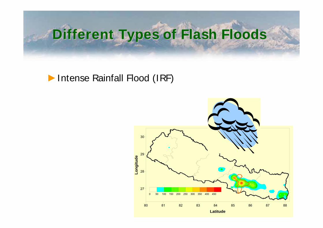
Different Types of Flash FloodsDifferent Types of Flash Floods
►Intense Rainfall Flood (IRF)
80 81 82 83 84 85 86 87 88
Latitude
27
28
29
30Lo
ngitu
de
0 50 100 150 200 250 300 350 400 450

►Glacial Lake Outburst Flood (GLOF)

Landslide Dam Outburst Flood (LDOF)Landslide Dam Outburst Flood (LDOF)
Yigong landslide dam outburst flood, Tibet, China
Damming: 9 April 2000Outburst: 10 June 2000

►Rapid Snow/Ice Melt Flood (RSMF)►Ice Dammed Lake Outburst Flood (IDLOF)
Common in Hindu Kushand Karakorum
Kande in Shyoksub-basin

Flash Flood Events In HKH Flash Flood Events In HKH RegionRegion

Characteristics of flash Characteristics of flash FloodsFloods► Rapid rise and fall in water level and
discharges (minutes)► Can occur any time in the year► Occurs mainly in headwater areas► Highly unpredictable, difficult to forecast► Most effective measure is early warning,
community preparedness and emergency measures

Himalaya the Third PoleHimalaya the Third Pole► Water reservoir in
frozen state► Deglaciation is
widespread► Retreating glaciers give
birth to glacial lakes► Glacial lakes might
burst out causing GLOFs
NEPALINDIA
CHINA
BANGLADESH
BHUTAN
±±Elevation
High : 8752
Low : 0N
3. Glacial Lake Outburst Flood3. Glacial Lake Outburst Flood

Glacier and glacial lakes in the Glacier and glacial lakes in the HKH regionHKH region
►There are 15,000 glaciers occupying 33,300 km2
►There are 8863 glacial lakes occupying 796 km2
►26 GLOF events have occurred in the past►There are more than 50 potentially dangerous
lakes in the HKH region

Glacier and glacial lakes in NepalGlacier and glacial lakes in Nepal
► There are more than 2300 glacial lake in Nepal
► There have been 25 GLOF events in Nepal or affecting Nepal (Shrestha and Shrestha, 2005)
► 20 glacial lakes have been identified as potential dangerous lakes (PDL; ICIMOD/UNEP, 2001)
► A GLOF carries enormous amount of water and debris and can be devastating for the downstream riparian communities
Glacier: AX010

4. GLOF vulnerability analysis4. GLOF vulnerability analysis
Flood risk Flood risk
Modified fromGoulby and Samuals
(2005)

Framework for GLOF Vulnerability Framework for GLOF Vulnerability AnalysisAnalysis
Colombo et al. (2002)

Area characterizationArea characterization
►Selection of area under question► Inventory of glaciers and glacial lakes►Lake development trend►Lake volume►Surrounding environment

Hazard IdentificationHazard Identification►Collecting information about the physical process
■ Hydrology■ Ice calving■ Buried ice in the moraine dam
►Dam properties■ Stability■ Karst areas■ piping
►Triggering mechanism■ Ice avalanche■ landslide

Hazard AssessmentHazard Assessment►Dam breach scenarios
■ Dam break modeling►Downstream Impact
■ Flood routing►Flood map for different breach scenarios

Vulnerability AnalysisVulnerability Analysis► Susceptibility and exposure► Physical vulnerability
■ Lithology■ Channel slope■ River meandering■ Land use
► Social Vulnerability■ Accessibility■ Health■ Communication■ Emergency response system■ Economic diversity■ Awareness, attitude …
► Total Vulnerability
Case StudyCase StudyImjaImja GLOFGLOF

Study AreaStudy AreaSagarmathaSagarmatha National park (SNP) and its Buffer ZoneNational park (SNP) and its Buffer Zone
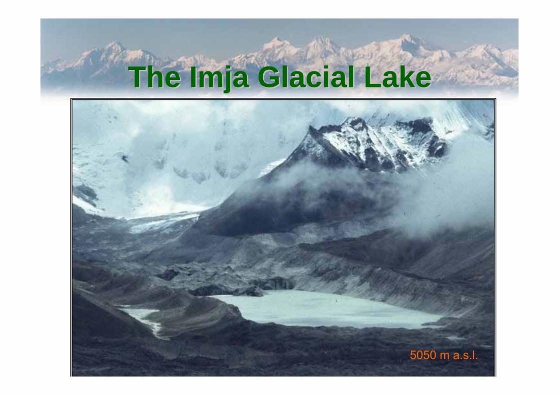
The The ImjaImja Glacial LakeGlacial Lake
5050 m a.s.l.

ImjaImja Lake DevelopmentLake Development15 December 1962 (Corona image) Area – 27,916 sqm.
15 October 1975 (Landsat MSS) Area – 309,573 sqm.
22 September 1992 (Landsat5 TM) Area – 635,945 sqm.
02 December 1983 (Space Shuttle) Area – 568,824 sqm.
11 December 1989 (Landsat5 TM) Area – 633,214 sqm
30 October 2000 (Landsat7 ETM+) Area – 775,065 sqm.
According to GEN/DHM ground survey of 2001 the surface area is 0.86 sq km
0 200 400 600 800 Km
0
10
30
50
70
90
m

Dig Dig TshoTsho Lake DevelopmentLake Development15 December 1962 (Corona image) Area – 201,172 sqm.
15 October 1975 (Landsat MSS) Area – 334,861 sqm.
11 December 1989 (Landsat5 TM) Area – 315,865 sqm
02 December 1983 (Space Shuttle) Area – 597,923 sqm.
22 September 1992 (Landsat5 TM) Area – 376,575 sqm.
30 October 2000 (Landsat7 ETM+) Area – 361,867 sqm.
3 0 3 6 91.5 km
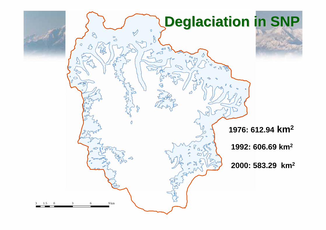
1976: 612.94 km2
1992: 606.69 km2
2000: 583.29 km2
DeglaciationDeglaciation in SNPin SNP

MethodologyMethodology►Geometric and topographic information
■ Topographic info from DEM (Dept. of Survey)■ Geometric info extracted using HEC GeoRAS■ Stream centreline and banks digitized using
IKONUS images►Lake information
■ Bathymetric survey of 2001■ Moraine topography: survey of 1994 and 2001■ Dig Tsho- data from literature (area and max depth)
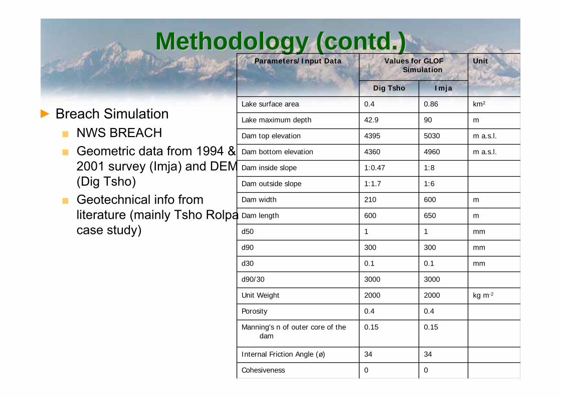
Methodology (contd.)Methodology (contd.)
► Breach Simulation■ NWS BREACH■ Geometric data from 1994 &
2001 survey (Imja) and DEM (Dig Tsho)
■ Geotechnical info from literature (mainly Tsho Rolpacase study)
00Cohesiveness
3434Internal Friction Angle (ø)
0.150.15Manning's n of outer core of the dam
0.40.4Porosity
kg m-220002000Unit Weight
30003000d90/30
mm0.10.1d30
mm300300d90
mm11d50
m650600Dam length
m600210Dam width
1:61:1.7Dam outside slope
1:81:0.47Dam inside slope
m a.s.l.49604360Dam bottom elevation
m a.s.l.50304395Dam top elevation
m9042.9Lake maximum depth
km20.860.4Lake surface area
ImjaDig Tsho
UnitValues for GLOF Simulation
Parameters/Input Data
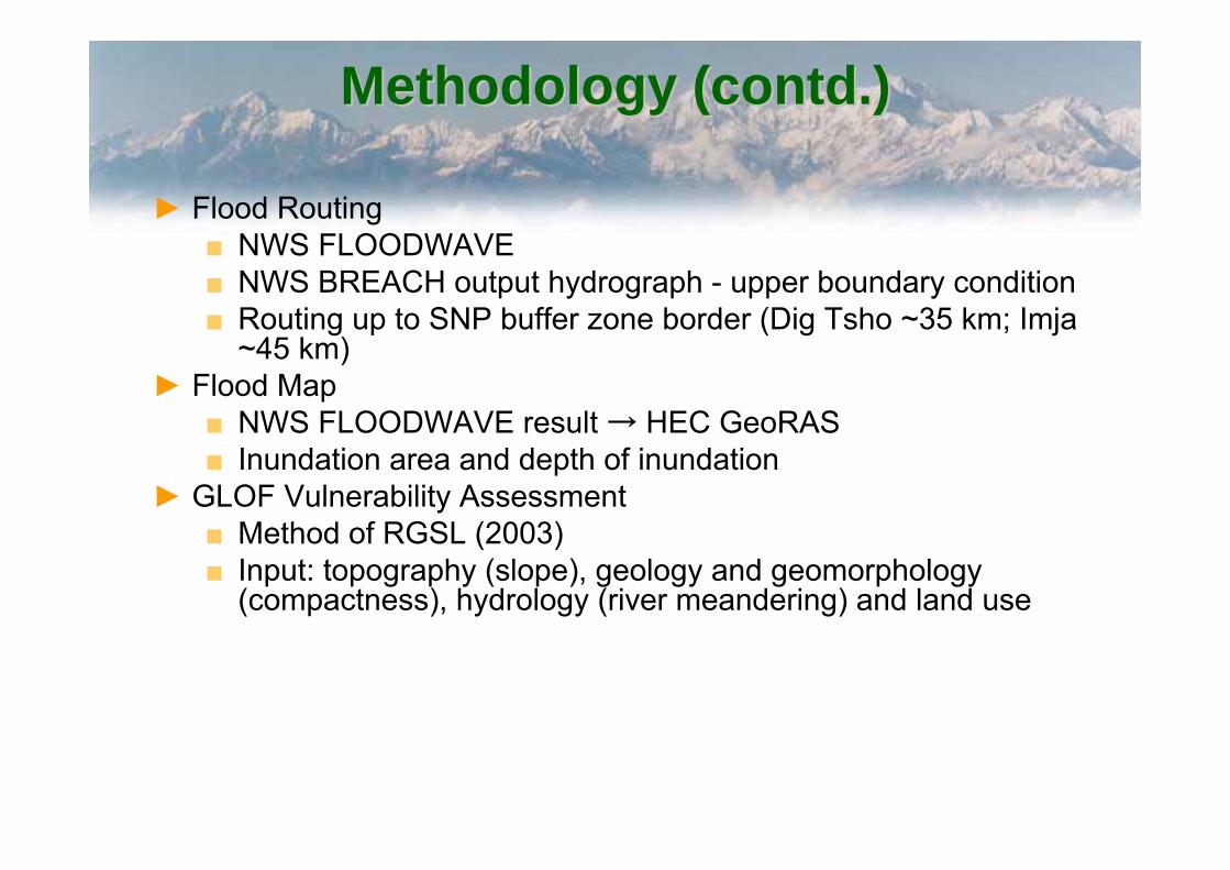
Methodology (contd.)Methodology (contd.)
► Flood Routing■ NWS FLOODWAVE■ NWS BREACH output hydrograph - upper boundary condition■ Routing up to SNP buffer zone border (Dig Tsho ~35 km; Imja
~45 km)► Flood Map
■ NWS FLOODWAVE result → HEC GeoRAS■ Inundation area and depth of inundation
► GLOF Vulnerability Assessment■ Method of RGSL (2003)■ Input: topography (slope), geology and geomorphology
(compactness), hydrology (river meandering) and land use

ResultsResults
300.5231.0mFinal Width of theTop of the Breach
65.235.0mFinal Depth of the Breach
4982.34373.6m a.s.l.Final Water Level
5030.64395.0m a.s.l.Initial Water Level
3.22.0hrDuration of the Outflow (Tout)
54635613m3s-1Maximum Outflow (Qmax)
ImjaDigTsho
UnitBreach Output
Main output of NWS BREACH
0
1000
2000
3000
4000
5000
6000
0.0 0.5 1.0 1.5 2.0 2.5 3.0 3.5
Dig Tsho
Imja
Dis
char
ge (m
3 s-1)
Time (hr)
Shrestha et al., 2006

Results (contd.)Results (contd.)
1000
2000
3000
4000
5000
6000Dig TshoImja
Dis
char
ge (m
3 s-1)
3
4
5
6
7
8
9Dig TshoImja Lake
01020304050
Floo
d D
epth
(m)
Distance from the outlet (km)
Qmax
Hmax
Shrestha et al., 2006
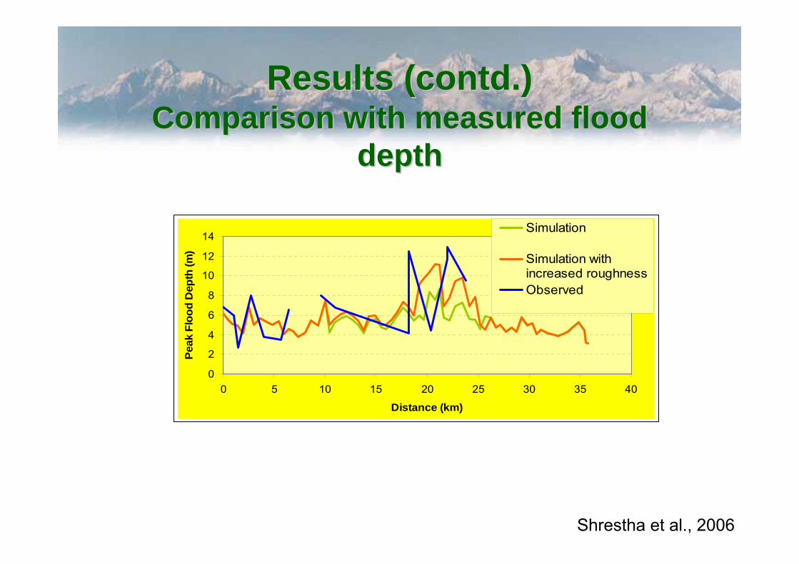
Results (contd.)Results (contd.)Comparison with measured flood Comparison with measured flood
depthdepth
0
2
4
6
8
10
12
14
0 5 10 15 20 25 30 35 40
Distance (km)
Peak
Flo
od D
epth
(m)
Simulation
Simulation withincreased roughnessObserved
Shrestha et al., 2006
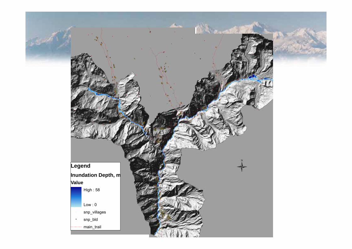
LegendInundation Depth, mValue
High : 58
Low : 0" snp_villages
snp_bld
main_trail
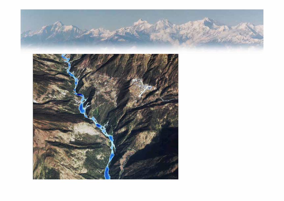

Results (contd.) Results (contd.)
5.71527533.6Nakchung
8.13529730.0Ghat
8.01530428.8Sano Gumela
7.76531027.6Thulo Gumela
8.47531526.4Gumela
9.29531625.2Bengkar
8.68532922.8Confluence
7.79535618.0Litho goth
6.76537414.4Panboche
5.77538212.0Orse
8.12538710.8Chure
5.8154018.4Dinboche
5.0654097.2Syalja goth
3.9254196.0Dhumsum
54580.0Imja lake outlet
Maximum Flood Depth (m)
Elevation (m a.s.l.)Time (min)Place
Imja lake

DambreakDambreak flood scenariosflood scenarios
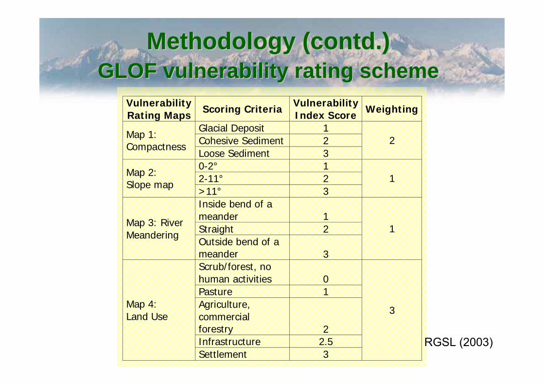
Methodology (contd.)Methodology (contd.)GLOF vulnerability rating schemeGLOF vulnerability rating scheme
Vulnerability Rating Maps Scoring Criteria Vulnerability
Index Score Weighting
Glacial Deposit 1 Cohesive Sediment 2 Map 1:
Compactness Loose Sediment 3
2
0-2° 1 2-11° 2 Map 2:
Slope map >11° 3
1
Inside bend of a meander 1 Straight 2
Map 3: River Meandering
Outside bend of a meander 3
1
Scrub/forest, no human activities 0 Pasture 1 Agriculture, commercial forestry 2 Infrastructure 2.5
Map 4: Land Use
Settlement 3
3
RGSL (2003)

Vulnerability AnalysisVulnerability Analysis

Total vulnerabilityTotal vulnerability
+
Physical Vulnerability Social Vulnerability
Total Vulnerability


ConclusionConclusion► HKH region is highly prone to flash floods► Capacity to manage the risk of flash flood is low► ICIMOD is supporting capacity building► FHM is important as a DS tool► Attempt to use GIS and hydrodynamic modeling to simulate GLOF
impact in Himalayan catchment► GLOF vulnerability analysis
■ Physical + Social vulnerability■ Community involvement
► Results- input for early warning system (EWS)► Several limitation: data, appropriate tool, ownership, etc► But most important thing is how the information is transferred to the
communities
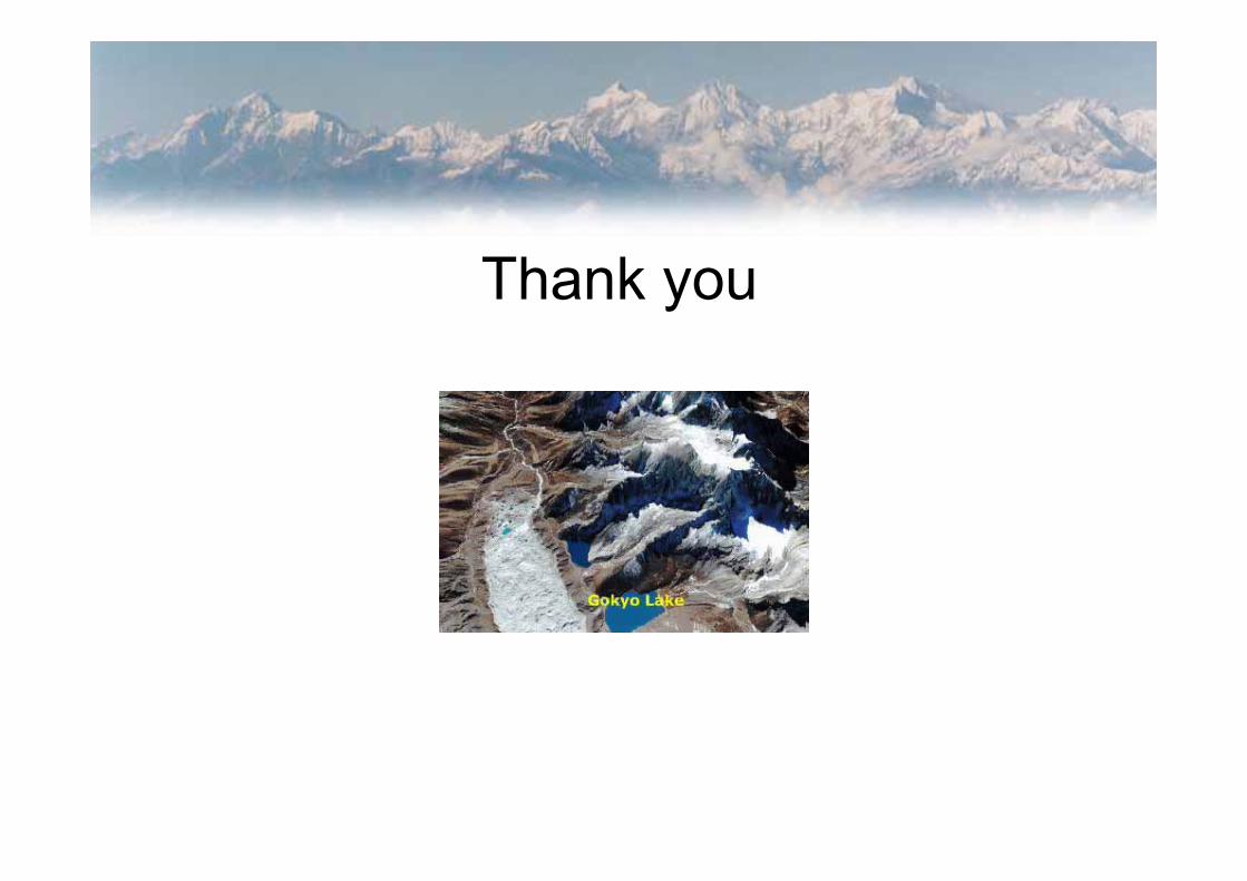
Thank you