fleet numerical meteorology & oceanography center€¦ · fleet numerical meteorology &...
TRANSCRIPT
Fleet Numerical Meteorology & Oceanography Center
Interdepartmental Hurricane Conference, 4-7 March 2012
Fleet Numerical… Supercomputing Excellence for Fleet Safety and Warfighter Decision Superiority…
FNMOC Collaborations in Tropical Cyclone Forecasting and Aids
Charles E. Skupniewicz1 Carey Dickerman1 Paul Wittmann1 David Ramsaur1 Isaac Ginnis2 Morris Bender3 Carolyn Reynolds4 James Doyle4 Buck Sampson4 Tom Murphree5
1 - Fleet Numerical Meteorology and Oceanography Center 2 - University of Rhode Island 3 - Geophysical Fluid Dynamics Laboratory 4 - Naval Research Laboratory Marine Meteorology Division 5 - Naval Postgraduate School
Fleet Numerical… Supercomputing Excellence for Fleet Safety and Warfighter Decision Superiority…
2
Topics
• NOGAPS / NAVGEM • Ensemble Forecast System • GFDN – focus on WPAC • COAMPS TC – new aid for intensity • WW3 TC OFCL – bogus wind fields • Advanced Climate Analysis and Forecast
System (ACAF) - climatological tropical statistics
Fleet Numerical… Supercomputing Excellence for Fleet Safety and Warfighter Decision Superiority… 3
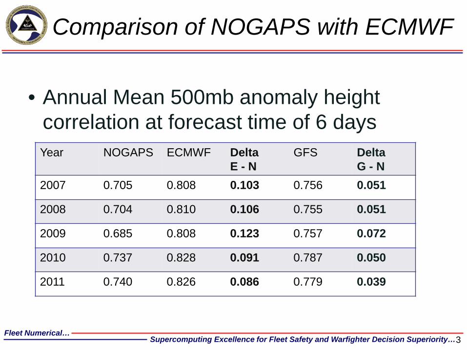
Comparison of NOGAPS with ECMWF
• Annual Mean 500mb anomaly height correlation at forecast time of 6 days Year NOGAPS ECMWF Delta
E - N GFS Delta
G - N 2007 0.705 0.808 0.103 0.756 0.051
2008 0.704 0.810 0.106 0.755 0.051
2009 0.685 0.808 0.123 0.757 0.072
2010 0.737 0.828 0.091 0.787 0.050
2011 0.740 0.826 0.086 0.779 0.039
Fleet Numerical… Supercomputing Excellence for Fleet Safety and Warfighter Decision Superiority…
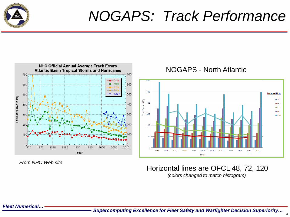
NOGAPS: Track Performance
4
NOGAPS - North Atlantic
Horizontal lines are OFCL 48, 72, 120 (colors changed to match histogram)
From NHC Web site
Fleet Numerical… Supercomputing Excellence for Fleet Safety and Warfighter Decision Superiority…
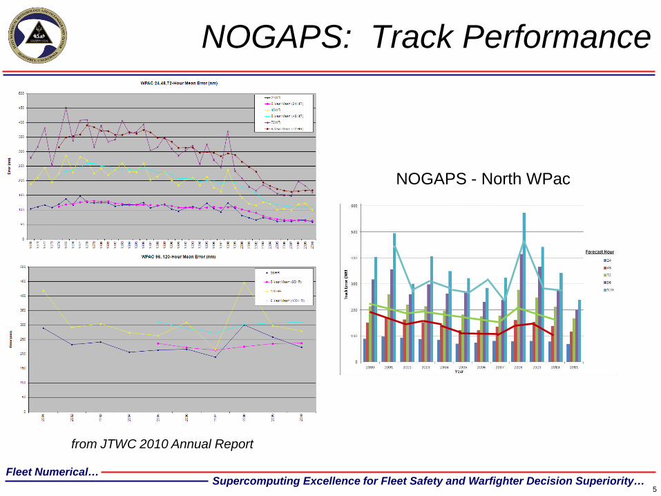
NOGAPS: Track Performance
5
NOGAPS - North WPac
from JTWC 2010 Annual Report
Fleet Numerical… Supercomputing Excellence for Fleet Safety and Warfighter Decision Superiority… 6
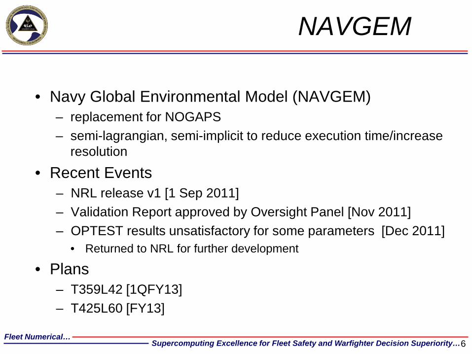
NAVGEM
• Navy Global Environmental Model (NAVGEM) – replacement for NOGAPS – semi-lagrangian, semi-implicit to reduce execution time/increase
resolution
• Recent Events – NRL release v1 [1 Sep 2011] – Validation Report approved by Oversight Panel [Nov 2011] – OPTEST results unsatisfactory for some parameters [Dec 2011]
• Returned to NRL for further development
• Plans – T359L42 [1QFY13] – T425L60 [FY13]
Fleet Numerical… Supercomputing Excellence for Fleet Safety and Warfighter Decision Superiority…
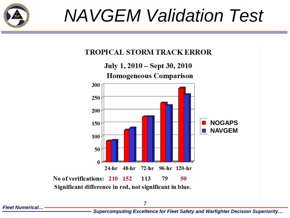
NAVGEM Validation Test
7
NOGAPS NAVGEM
Fleet Numerical… Supercomputing Excellence for Fleet Safety and Warfighter Decision Superiority…
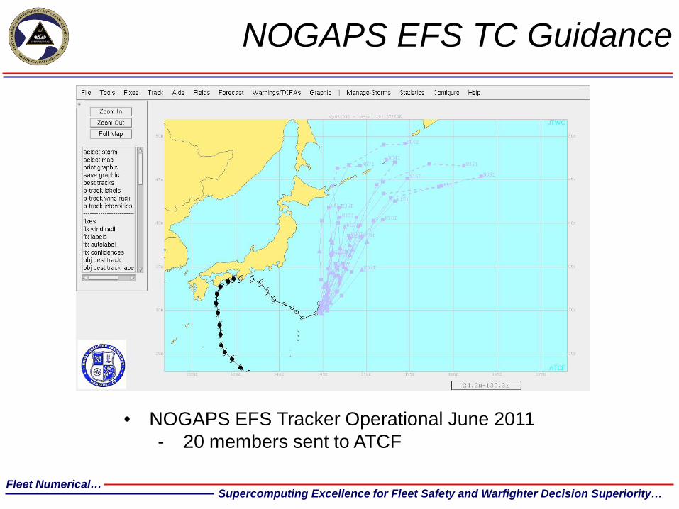
NOGAPS EFS TC Guidance
• NOGAPS EFS Tracker Operational June 2011 - 20 members sent to ATCF
Fleet Numerical… Supercomputing Excellence for Fleet Safety and Warfighter Decision Superiority… 9
Ensemble Forecast System • Recent Upgrades
– 9-Band Ensemble Transform initialization [Sep 2011] – Full set of NUOPC (FNMOC + NCEP) graphics available on Navy Enterprise Portal
Oceanography http://www.usno.navy.mil/FNMOC/ [Jan 2012] • Plans
– NAEFS/NUOPC multi-model products [3QFY12] • Add CMC members along with those from EFS and GFS
– Bias Corrected Fields using NCEP algorithm [3QFY12] – Increased resolution (T159 T239) [4QFY12]
• Preference is to use NAVGEM • Alternative is to use NOGAPS, with creativity
– E.g. T239 to 8 days, truncate to T159 for days 8 to 16 – Stochastic Forcing [FY13] – Verification and validation web page
• Winds and waves – Calculations operational [1 Feb 2012]
» Significant wave height, 2m temperature, 10m wind » Metrics as defined in NUOPC Metrics subcommittee
– Visualization on Navy Enterprise Portal Oceanography [3QFY12] • All forecast vs. observation metrics (except precipitation and clouds) [4QFY12] • Forecasts vs. analysis metrics [1QFY13]
Fleet Numerical… Supercomputing Excellence for Fleet Safety and Warfighter Decision Superiority…
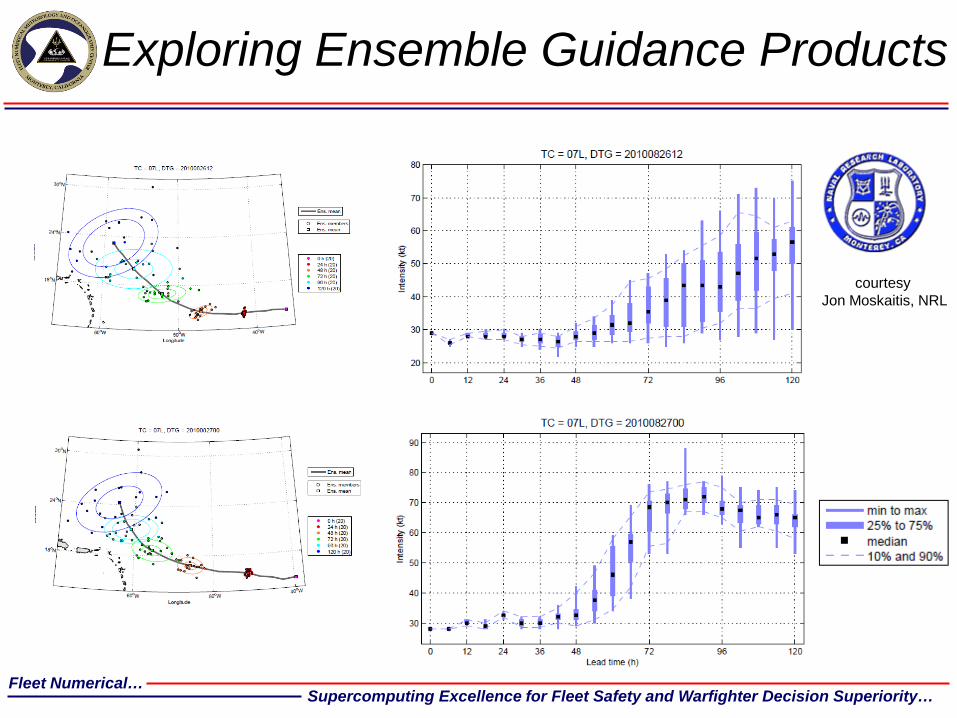
Exploring Ensemble Guidance Products
courtesy Jon Moskaitis, NRL
Fleet Numerical… Supercomputing Excellence for Fleet Safety and Warfighter Decision Superiority… 1
1
GFDN
• Recent Upgrades – Physics upgrade to align with NCEPs GFDL
• WestPac [15 Aug 2011] • EastPac and WestAtl [14 Sep 2011] • Rest of the world [29 Sep 2011]
– 3D Ocean coupling in Southern Hemisphere and Indian Ocean [Dec 2011] • Princeton Ocean Model
• Plans – Only maintenance for 2012
Fleet Numerical… Supercomputing Excellence for Fleet Safety and Warfighter Decision Superiority…
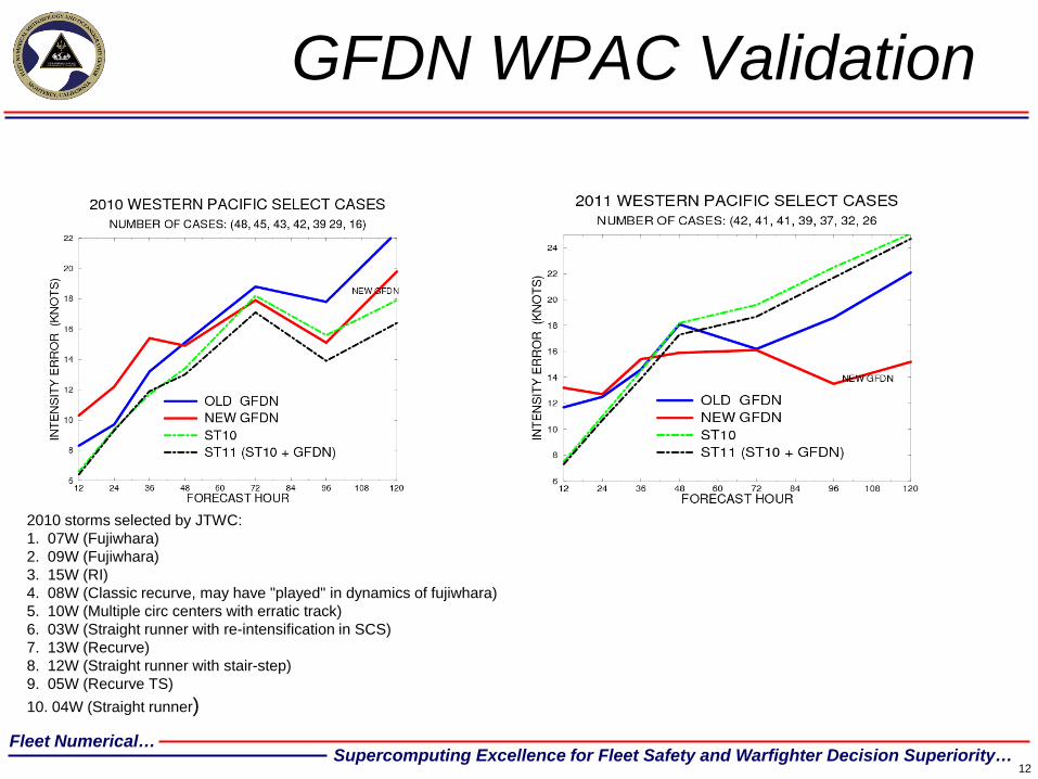
GFDN WPAC Validation
12
2010 storms selected by JTWC: 1. 07W (Fujiwhara) 2. 09W (Fujiwhara) 3. 15W (RI) 4. 08W (Classic recurve, may have "played" in dynamics of fujiwhara) 5. 10W (Multiple circ centers with erratic track) 6. 03W (Straight runner with re-intensification in SCS) 7. 13W (Recurve) 8. 12W (Straight runner with stair-step) 9. 05W (Recurve TS) 10. 04W (Straight runner)
Fleet Numerical… Supercomputing Excellence for Fleet Safety and Warfighter Decision Superiority…
13
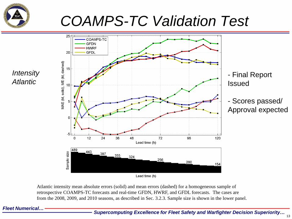
Atlantic intensity mean absolute errors (solid) and mean errors (dashed) for a homogeneous sample of retrospective COAMPS-TC forecasts and real-time GFDN, HWRF, and GFDL forecasts. The cases are from the 2008, 2009, and 2010 seasons, as described in Sec. 3.2.3. Sample size is shown in the lower panel.
COAMPS-TC Validation Test
Intensity Atlantic
- Final Report Issued - Scores passed/ Approval expected
Fleet Numerical… Supercomputing Excellence for Fleet Safety and Warfighter Decision Superiority…
14
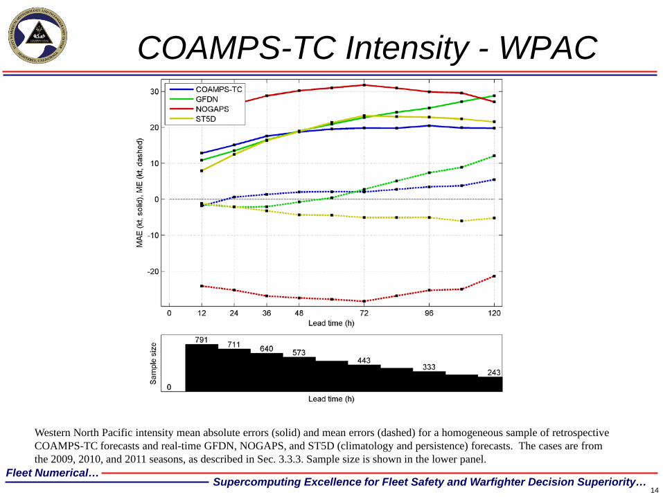
COAMPS-TC Intensity - WPAC
Western North Pacific intensity mean absolute errors (solid) and mean errors (dashed) for a homogeneous sample of retrospective COAMPS-TC forecasts and real-time GFDN, NOGAPS, and ST5D (climatology and persistence) forecasts. The cases are from the 2009, 2010, and 2011 seasons, as described in Sec. 3.3.3. Sample size is shown in the lower panel.
Fleet Numerical… Supercomputing Excellence for Fleet Safety and Warfighter Decision Superiority…
15
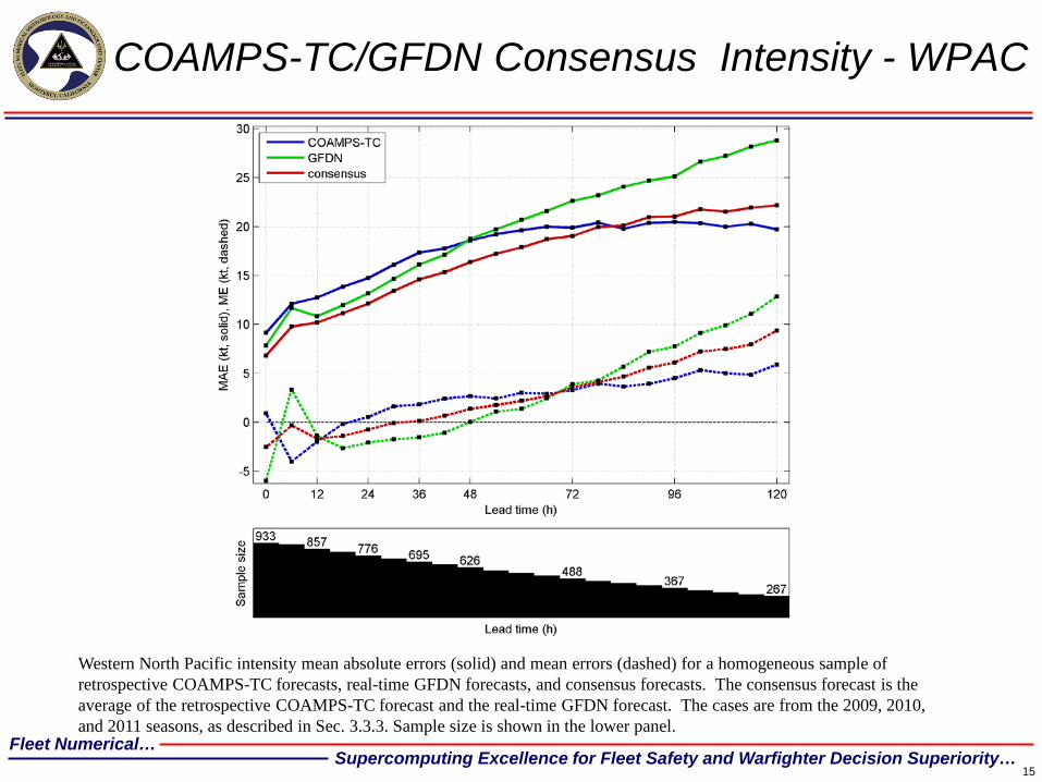
COAMPS-TC/GFDN Consensus Intensity - WPAC
Western North Pacific intensity mean absolute errors (solid) and mean errors (dashed) for a homogeneous sample of retrospective COAMPS-TC forecasts, real-time GFDN forecasts, and consensus forecasts. The consensus forecast is the average of the retrospective COAMPS-TC forecast and the real-time GFDN forecast. The cases are from the 2009, 2010, and 2011 seasons, as described in Sec. 3.3.3. Sample size is shown in the lower panel.
Fleet Numerical… Supercomputing Excellence for Fleet Safety and Warfighter Decision Superiority… 1
6
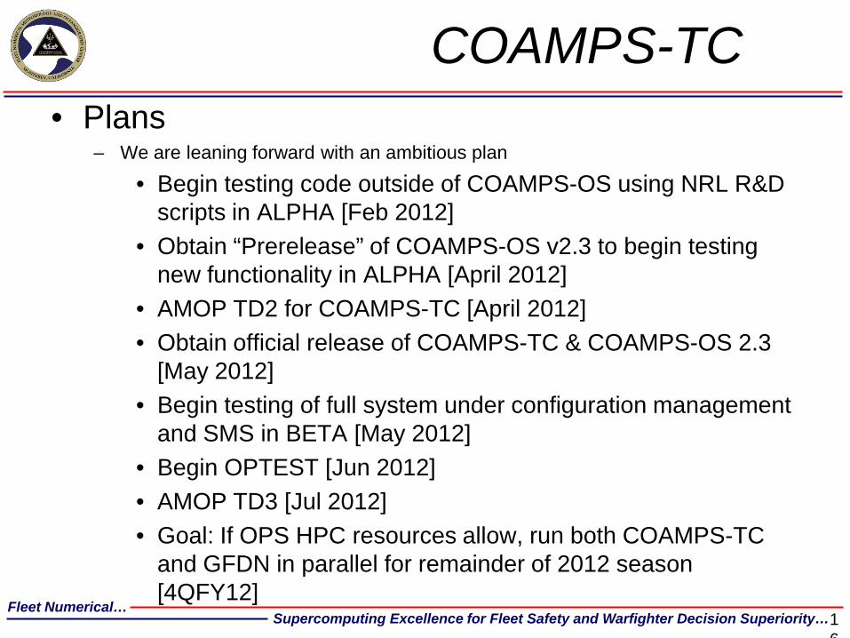
COAMPS-TC • Plans
– We are leaning forward with an ambitious plan
• Begin testing code outside of COAMPS-OS using NRL R&D scripts in ALPHA [Feb 2012]
• Obtain “Prerelease” of COAMPS-OS v2.3 to begin testing new functionality in ALPHA [April 2012]
• AMOP TD2 for COAMPS-TC [April 2012] • Obtain official release of COAMPS-TC & COAMPS-OS 2.3
[May 2012] • Begin testing of full system under configuration management
and SMS in BETA [May 2012] • Begin OPTEST [Jun 2012] • AMOP TD3 [Jul 2012] • Goal: If OPS HPC resources allow, run both COAMPS-TC
and GFDN in parallel for remainder of 2012 season [4QFY12]
Fleet Numerical… Supercomputing Excellence for Fleet Safety and Warfighter Decision Superiority…
WW3 TC-OFCL
NGPS and OFCL Position Errors
050
100150200250300350
0 24 48 72 96 120M
ean
Erro
r (n
mi)
(166) (131) (98) (72) (55) (41)
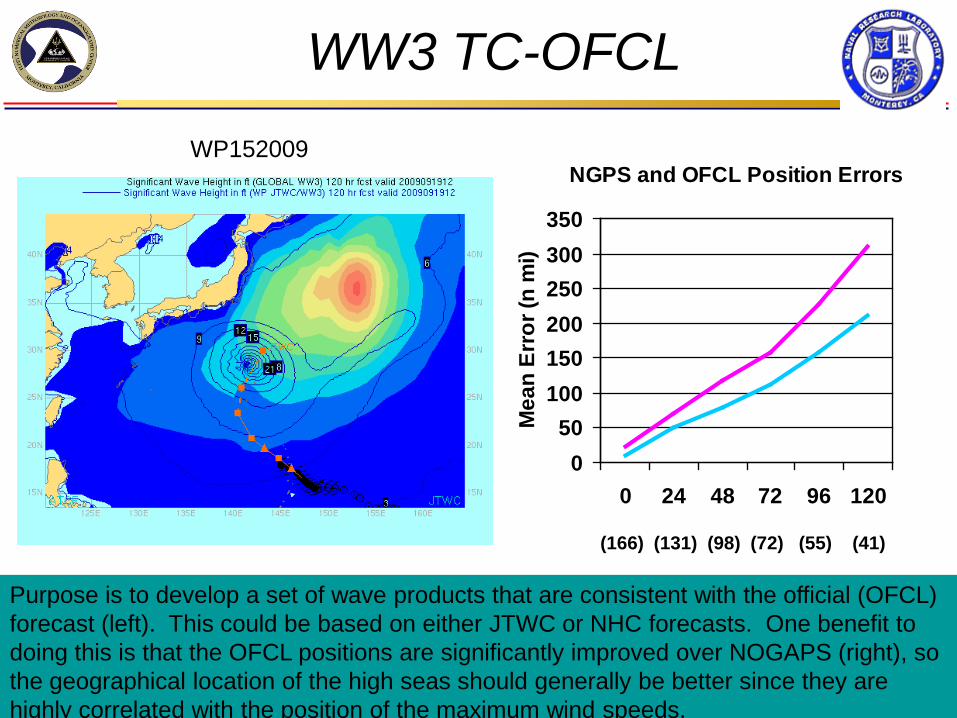
Purpose is to develop a set of wave products that are consistent with the official (OFCL) forecast (left). This could be based on either JTWC or NHC forecasts. One benefit to doing this is that the OFCL positions are significantly improved over NOGAPS (right), so the geographical location of the high seas should generally be better since they are highly correlated with the position of the maximum wind speeds.
WP152009
Fleet Numerical… Supercomputing Excellence for Fleet Safety and Warfighter Decision Superiority…
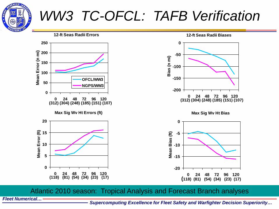
WW3 TC-OFCL: TAFB Verification
12-ft Seas Radii Errors
0
50
100
150
200
250
0 24 48 72 96 120
Mea
n Er
ror (
n m
i)
OFCL/WW3NGPS/WW3
12-ft Seas Radii Biases
-200
-150
-100
-50
0
0 24 48 72 96 120
Bia
s (n
mi)
(312) (304) (248) (185) (151) (107) (312) (304) (248) (185) (151) (107)
Atlantic 2010 season: Tropical Analysis and Forecast Branch analyses
Max Sig Wv Ht Errors (ft)
0
5
10
15
20
0 24 48 72 96 120
Mea
n Er
ror (
ft)
(118) (81) (54) (34) (23) (17)
Max Sig Wv Ht Bias
-20
-15
-10
-5
0
0 24 48 72 96 120M
ean
Bia
s (ft
)
(118) (81) (54) (34) (23) (17)
Fleet Numerical… Supercomputing Excellence for Fleet Safety and Warfighter Decision Superiority…
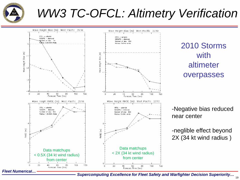
WW3 TC-OFCL: Altimetry Verification
19
Data matchups < 0.5X (34 kt wind radius)
from center
2010 Storms with
altimeter overpasses
-Negative bias reduced near center -neglible effect beyond 2X (34 kt wind radius )
Data matchups < 2X (34 kt wind radius)
from center
Fleet Numerical… Supercomputing Excellence for Fleet Safety and Warfighter Decision Superiority…
WW3 TC-OFCL Status
• Distribution through web site graphics (WXMAP),
METCAST/JMV
• Operational 15 May 2012
• Ensemble version TBD
20
Fleet Numerical… Supercomputing Excellence for Fleet Safety and Warfighter Decision Superiority…
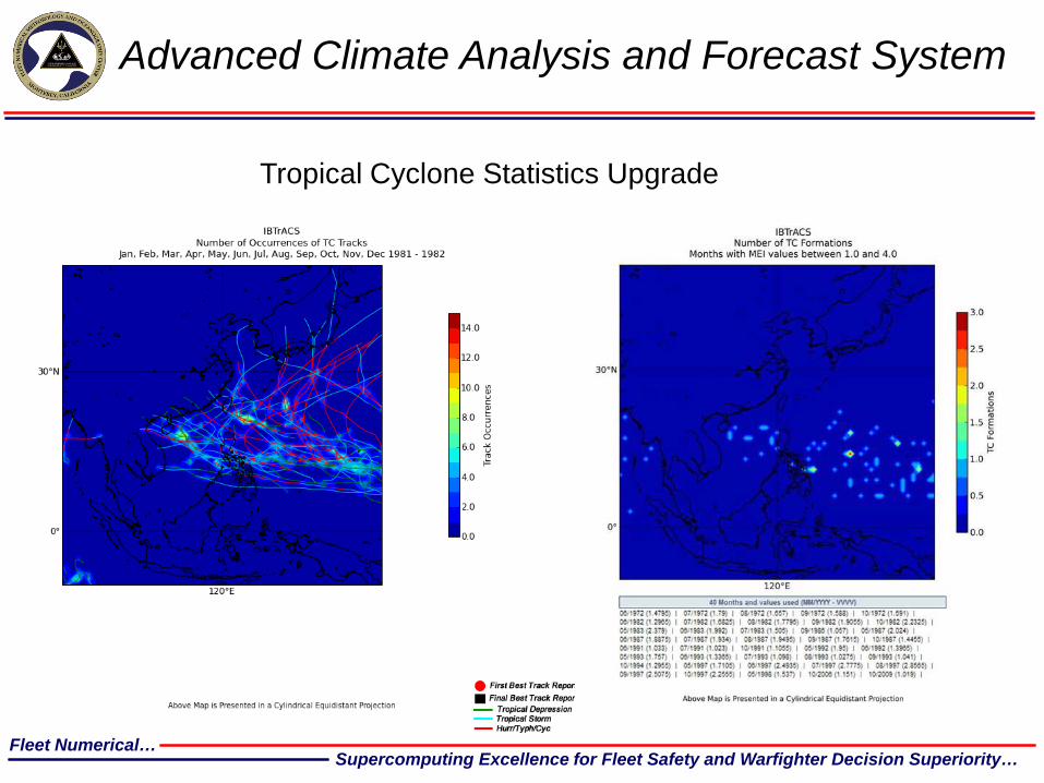
Advanced Climate Analysis and Forecast System
Tropical Cyclone Statistics Upgrade
Fleet Numerical… Supercomputing Excellence for Fleet Safety and Warfighter Decision Superiority…
ACAF: Tropical Cyclone Statistics
Period: 1970 – 2009. user selected time range and the temporal extent of the data. Basins: Preset to western North Pacific, eastern North Pacific, Atlantic, northern Indian Ocean, and Southern Hemisphere Products may be developed for any combination of these basins. Formations and Tracks: Products will be able to provide information on single or multiple formation locations and/or tracks (formation and initial track locations determined by first best track entries). Number of Occurrences: TC track, formations, tracks, and intensities by location Related Variables: User selectable overlays of TCs on fields of related variables (e.g., overlays of tracks on the corresponding surface winds and waves). Climate State Conditioning: filtering on tracks during El Nino, La Nina periods optional Output Options: JPEG, KML, NETCDF: TC names and intensity details provided at the best track report location. OPERATIONAL: MARCH 2012 – DOD website – Public web page TBD.